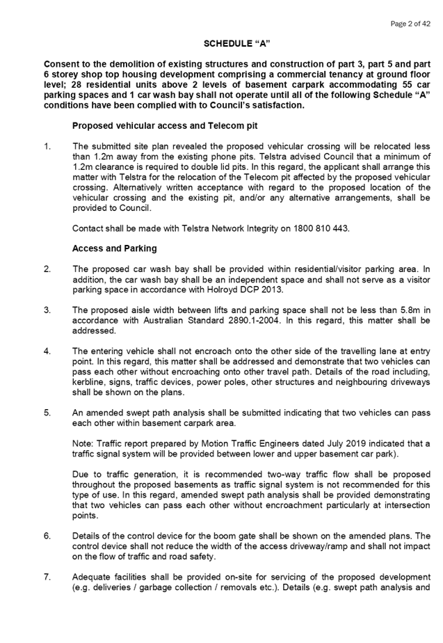
Cumberland Local Planning Panel Meeting
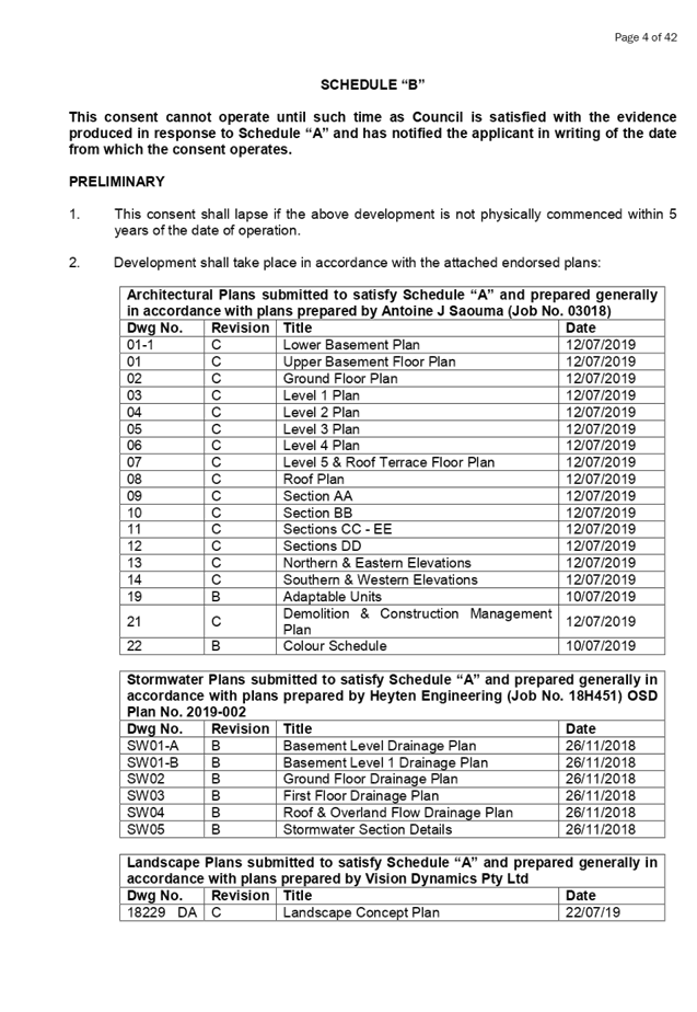
9 October 2019
A
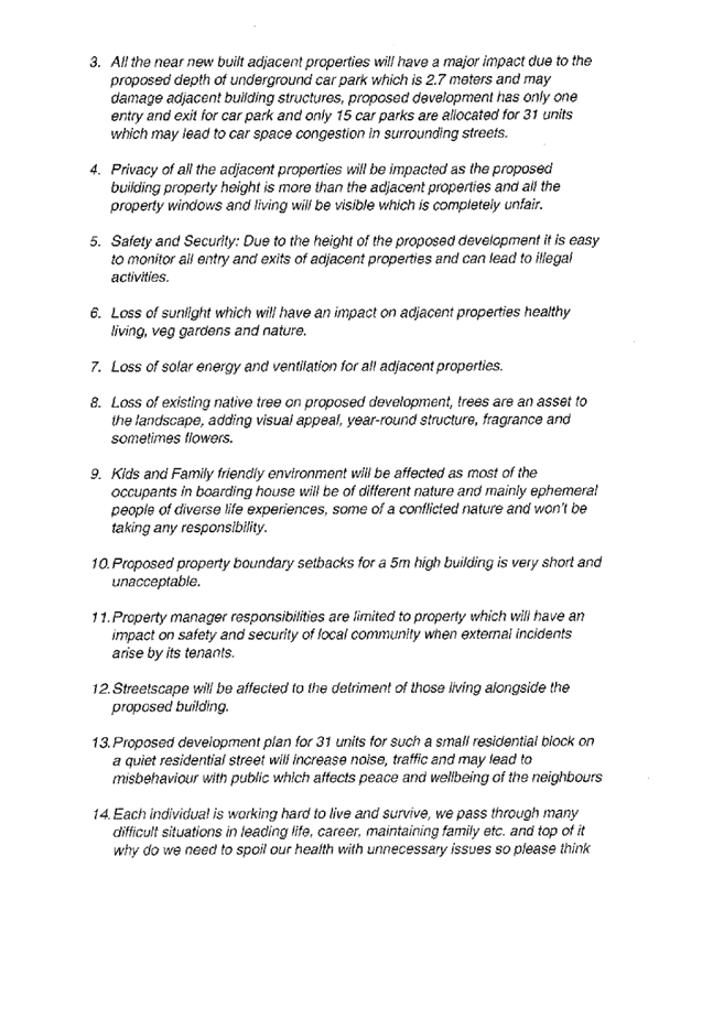
meeting of the Cumberland Local Planning Panel
will be held at 11:30am at the Merrylands Administration Building, 16
Memorial Avenue, Merrylands on Wednesday, 9 October 2019.
Business as below:
Yours faithfully
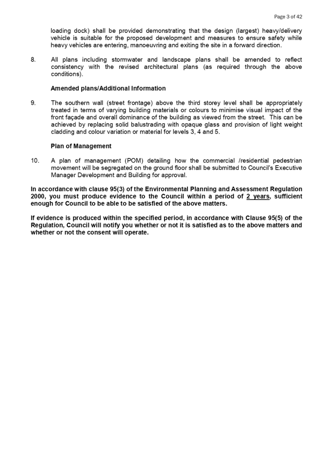
Hamish McNulty
General
Manager
ORDER OF BUSINESS
1. Receipt of Apologies
2. Confirmation of Minutes
3. Declarations of Interest
4. Address by invited
speakers
5. Reports:
- Development
Applications
- Planning
Proposals
6. Closed Session Reports
Cumberland Local Planning Panel Meeting
9 October 2019
CONTENTS
Report No. Name of Report Page
No.
Development Applications
LPP064/19... Section 4.55(1A)
Modification Application for 9-19 Mary Street, Auburn... 5
LPP065/19... Development Application -
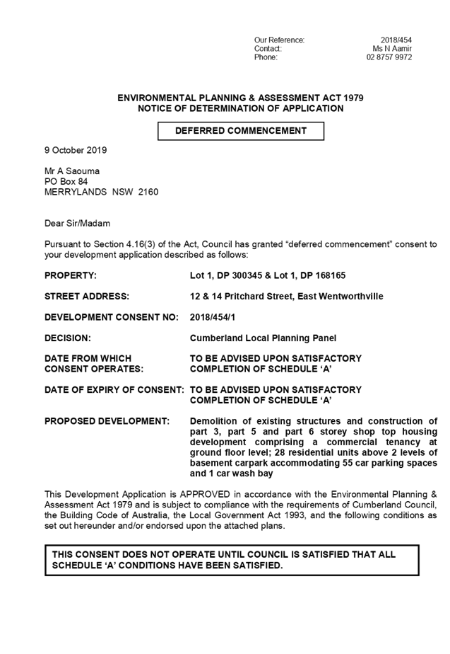
12 & 14 Pritchard Street, East Wentworthville 43
LPP066/19... Development Application -
96 Oramzi Road, Girraween.......................... 187
Cumberland Local Planning Panel Meeting
9 October 2019
Item No:
LPP064/19
Section
4.55(1A) Modification Application for 9-19 Mary Street, Auburn
Responsible
Division: Environment
& Planning
Officer: Executive
Manager Development and Building
File
Number: DA-92/2019
|
Application
lodged
|
11
September 2019
|
|
Applicant
|
Rolz
Group Pty Ltd
|
|
Owner
|
Group
As Pty Ltd
|
|
Application
No.
|
DA-92/2019
|
|
Description
of Land
|
9-19
Mary Street, AUBURN NSW 2144, Lot 26 Sec 4 DP 982836, Lot 25 Sec 4 DP 982836,
Lot 1319 DP 1241830
|
|
Approved
Development
|
Alterations
and additions to approved 12 storey mixed use building (DA-52/2017) at 13-19
Mary Street, Auburn including the construction of an additional 12 storey
mixed use building component at 9-11 Mary Street, Auburn which will
accommodate a total of 157 residential units (41 x 1 bedroom, 90 x 2 bedroom and
26 x 3 bedroom units), 5 x commercial suites, 1 x office suite over part 4
part 5 level basement for 285 vehicles
|
|
Proposed
Modification
|
Section
4.55(1A) modification application to modify Condition 7 to allow
consolidation of allotments to occur post Construction Certificate and prior
to the issue of the Occupation Certificate
|
|
Site
Area
|
2,727.86m2
|
|
Zoning
|
B4
– Mixed Use under the Auburn LEP 2010
|
|
Disclosure
of political donations and gifts
|
Nil
disclosure
|
|
Heritage
|
Yes
– Land is located in the vicinity of a heritage item.
|
|
Principal
Development Standards
|
FSR
(unchanged)
Permissible:
5:1
Proposed:
4.97:1
Height
of Building (unchanged)
Permissible:
38m
Proposed:
41m
|
|
Issues
|
Timing
of lot consolidation
|
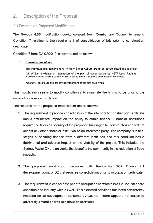
1. Development
Application No.DA-92/2019/A was received on 11 September 2019 for the Section
4.55(1A) modification to modify Condition 7 to allow consolidation of
allotments to occur post Construction Certificate and prior the issue of the
Occupation Certificate.
2. The
original development application, the subject of this modification, was
assessed by an Independent Town Planning Consultant on behalf of Council. The
Independent Town Planning Consultant recommended Condition 7 to allow
consolidation of allotments to occur post Construction Certificate and prior
the issue of the Occupation Certificate. This recommendation was not endorsed
by the Cumberland Local Planning Panel, and the application was determined by
the Panel, subject to the amended condition requiring the consolidation prior
to the Construction Certificate being issued.
3. The
s. 4.55(1A) application is recommended for conditional approval.
4. The
application is referred to the Panel as the proposal seeks to modify a
condition specifically amended by the Panel.
History
· DA-52/2017
was lodged with Council on 10 February 2017 for the demolition of existing
dwelling houses and the construction of a 12 storey mixed use development
comprising 105 residential units and 2 commercial tenancies over 4 levels of
basement parking at 13-19 Mary Street, Auburn.
· DA-52/2017
was granted deferred commencement consent on 21 December 2017.
· The
deferred commencement matters were completed and the consent became operative
on 13 April 2018. Construction has commenced on site.
·
A Complying Development Certificate was issued for the demolition of the
dwelling on No 11 Mary Street on 7 February 2017 and on No 9 Mary Street on 4
February 2019.
· DA-92/2019
was lodged on 25 March 2019.
· The
application was presented to the CLPP on 14 August 2019. The application was
deferred to be determined electronically as amendments were requested. In the
course of the electronic determination, the Panel amended Condition 7 requiring
the site to be amalgamated prior to issue of the construction certificate. The
CLPP determined the application on 3 September 2019.
· DA-92/2019
was lodged with Council on 11 September 2019
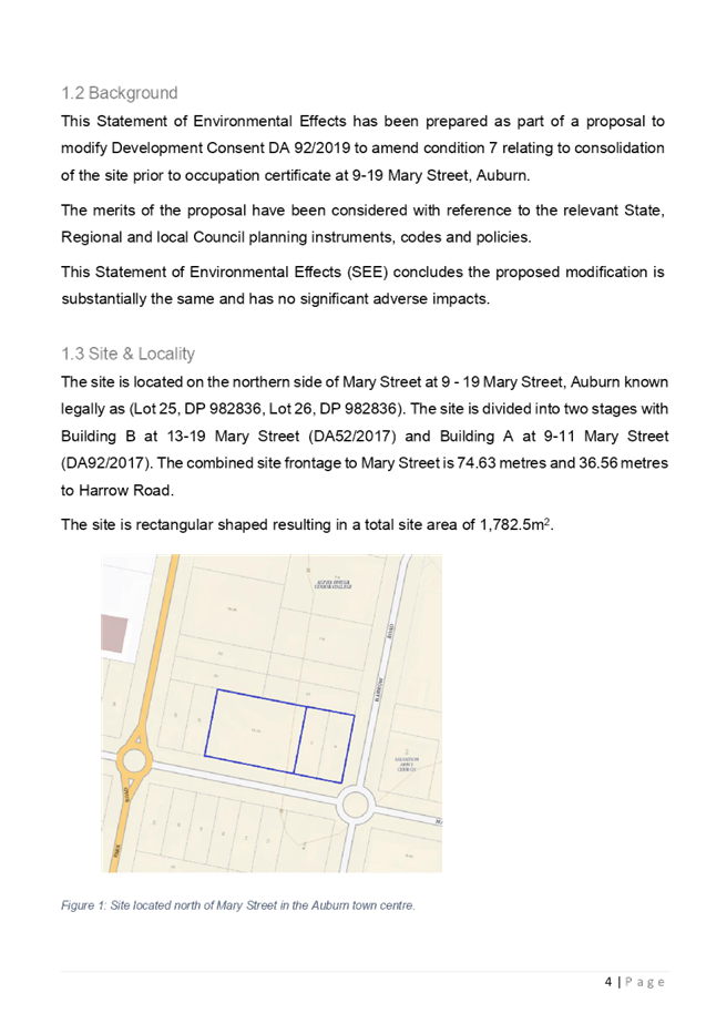
Subject Site and Surrounding
Area
The subject site is known as Lot
1319, DP 1241830 and Lots 25 and 26, DP 982836, No. 9-19 Mary Street
Auburn. The subject site is located on the northwest corner of Mary
Street and Harrow Road.
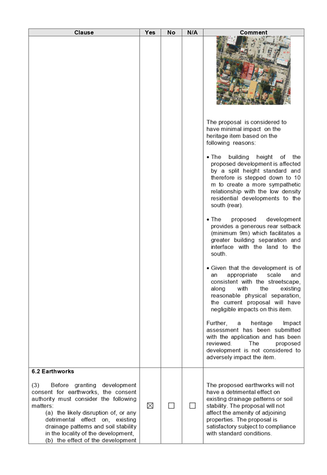
The location of the site is shown
at Figure 1. An aerial image of the site and surrounding area is at
Figure 2.
The site is situated within a
mixed use zone within the Auburn town centre and is approximately 400m walking
distance to Auburn railway station.
The site has a frontage to Mary
Street of 74.63m to the south and a frontage to Harrow Road of 36.56m to the
east. The site is generally rectangular in shape and has a total area of
2,727.86m2.
Part of the site comprising 13-19
Mary Street was approved under DA-52/2017 for the demolition of existing
dwelling houses and the construction of a 12 storey mixed use development
comprising 105 residential units and 2 commercial tenancies over 4 levels of
basement parking. Works have commenced on site.
No.9-11 Mary Street contains an
existing single storey brick dwelling and a detached brick garage. Demolition
of this dwelling has been approved under a separate CDC.
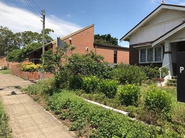
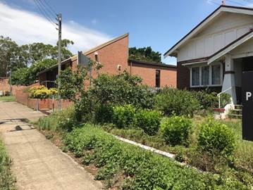
The site is adjoined by a single
dwelling and a townhouse building to the north. Land to the west is
developed with single storey cottages. A place of worship and commercial
buildings exist across Harrow Road to the east. Land across Mary Street
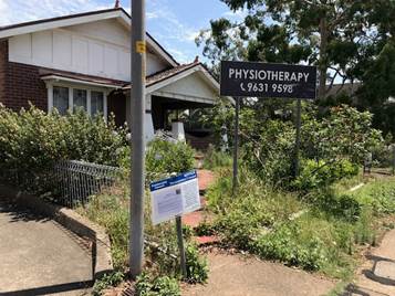
to the south is comprised of professional consulting rooms.
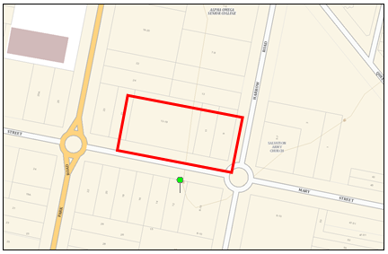
Figure
1 – Locality plan of subject site
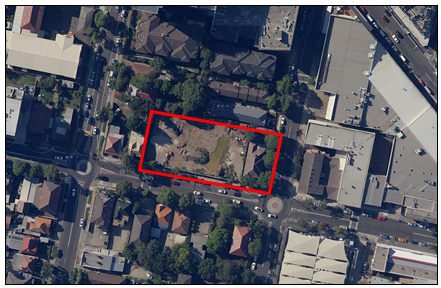
Figure
2 – Aerial view of subject site
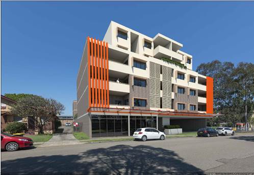
Description of the Proposed
Modification
Council has received a
modification application to DA-92/2019 at 9-19 Mary Street, Auburn. The
modification application proposes to amend Condition 7 of the consent to allow
for the consolidation of allotments to occur prior to the issue of the
occupation certificate as opposed to prior to the issue of the construction
certificate.
The recommended conditions to the
original consent included a consolidation conditions that requires the
allotments on site being 13-19 and 9-11 Mary Street to be consolidated prior to
the issue of the Occupation Certificate. The CLPP made an amendment to the
condition to require the consolidations of allotments to occur prior to the
issue of the Construction Certificate to ensure the orderly development of the
site as a whole.
The applicant has stated the
following reasons in support of amending condition 7:
1. The
requirement to provide consolidation of the site prior to construction
certificate has a detrimental impact on the ability to obtain finance.
Financial institutions require the title/s as security of the proposed building
to be constructed and will not accept any other financial institution as an
interested party. The company is in final stages of securing finance from a
different institution and this condition has a detrimental and adverse impact
on the viability of the project. This includes the Sydney Water Diversion works
that benefits the community in the reduction of flood impacts.
2. The
proposed modification complies with Residential part of Auburn DCP Clause 8.1
development control D2 that requires consolidation prior to occupation
certificate.
3. The
requirement to consolidate prior to occupation certificate is a Council
standard condition and industry wide as well. This standard condition has been
consistently imposed on all development consents by Council. There appears no
reason to adversely amend prior to construction certificate.
4. The
recommendation to consolidate at occupation certificate would enable the orderly
development of the whole site and ensure that the project is financed and
constructed accordingly.
5. The
site under construction known as Building B at 13-19 Mary Street will comply
with the BCA in terms of construction (eg fire rating) so that consolidation at
construction certificate is not required. There will be no adverse impact on
the construction of Building A at 9-11 Mary Street. The buildings when finished
will appear as a single structure; however, they will be two separate buildings
sharing common facilities such as driveway access, electricity substation,
loading dock and fire control panel and hydrant systems.
Planners Comments:
No objection is raised to the
proposed amendment to Condition 7. In addition to the reasons given above, it
is noted that the consolidation prior to Occupation Certificate would still
achieve the purpose of ensuring the orderly development of the site as a whole.
Furthermore, to ensure a separate
Occupation Certificate is not issued to 13-19 Mary Street, the Condition may be
amended to provide clarity on the required Occupation Certificate as follows:
The individual lots comprising
9-19 Mary Street Auburn are to be consolidated into a single lot. Written
evidence of registration of the plan of consolidation by NSW Land Registry
Service is to be submitted to Council prior to the issue of any occupation
certificate for DA-52/2017 and DA-92/2019 being 9-19 Mary Street, Auburn.
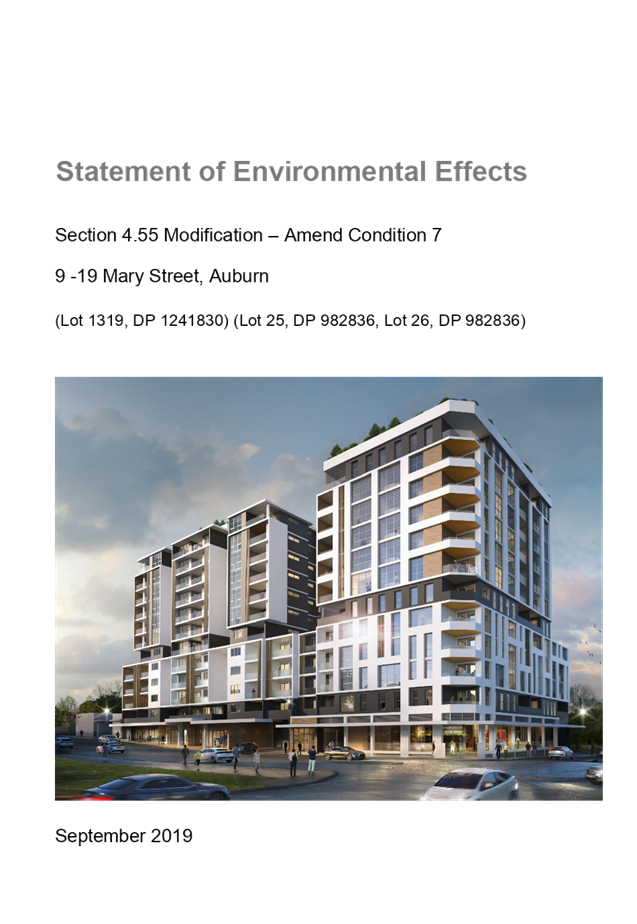
Applicants Supporting
Statement
The applicant has provided a
Statement of Environmental Effects dated September 2019 and was received by
Council on 11 September 2019 in support of the application.
Contact with Relevant
Parties
The assessing officer has been in
regular contact with the applicant throughout the assessment process.
Internal Referrals
The application was not required
to be referred to any internal Council teams for comment.
External Referrals
The application was not required
to be referred to any external teams for comment.
Planning Comments
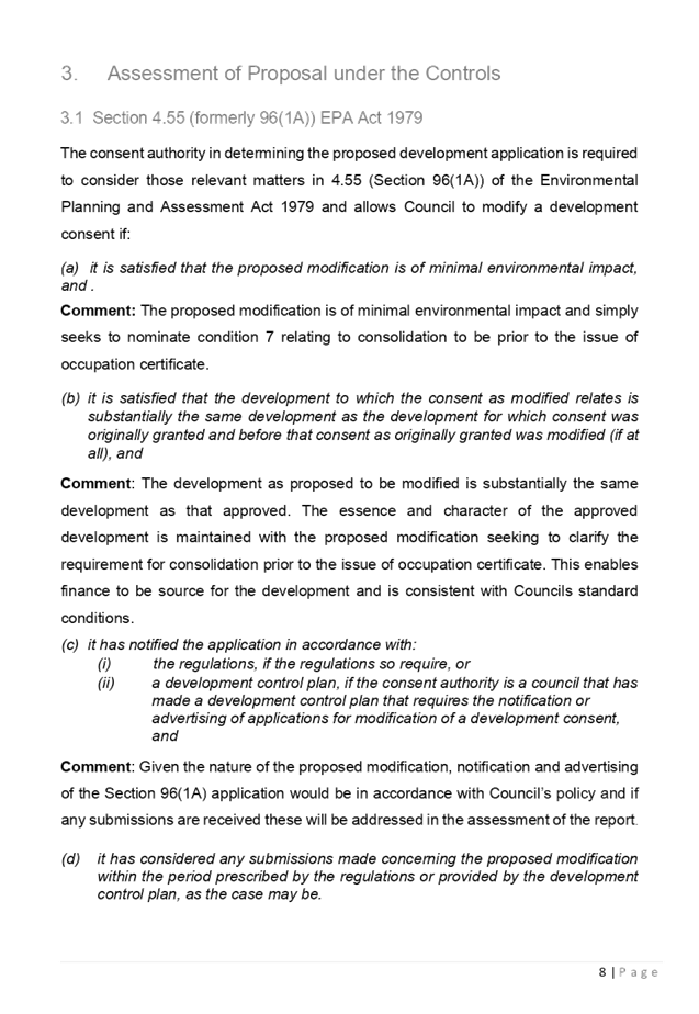
Section 4.55(1A):
|
Requirement
|
Comments
|
|
Proposed
modification is of minimal environmental impact
|
Proposed
modification is of minimal environmental impact
|
|
It is
satisfied that the development to which the consent as modified relates is
substantially the same development as the development for which the consent
was originally granted and before that consent as originally granted was
modified (if at all), and
|
The
development as proposed to be modified is substantially the same as the
original consent. That is, a mixed use development 12 storeys in height.
|
|
It has
notified the application in accordance with:
(i) the
regulations, if the regulations so require, or
(ii) a
development control plan, if the consent authority is a council that has made
a development control plan that requires the notification or advertising of
applications for modification of a development consent, and
|
See
discussion on “Public Notification” in this report.
|
|
It has
considered any submissions made concerning the proposed modification within
any period prescribed by the regulations or provided by the development
control plan, as the case may be.
|
See
discussion on “Public Notification” in this report.
|
The provisions of any
Environmental Planning Instruments (EP&A Act s4.15 (1)(a)(i))
State Environmental Planning
Policies
The proposed development is
affected by the following State Environmental Planning Policies:
(a) State
Environmental Planning Policy No. 55 – Remediation of Land (SEPP 55)
Clause 7 of SEPP 55 requires
Council to be satisfied that the site is suitable or can be made suitable to
accommodate the proposed development. The matters listed within Clause 7 have
been considered in the assessment of the original development application.
(b) Statement
Environmental Planning Policy No. 65 - Design Quality of Residential Apartment
Development (SEPP 65)
SEPP 65 applies to the development
as the building is 3 storeys or more, and contains more than 4 dwellings. A
design statement addressing the design quality principles prescribed by SEPP 65
was prepared by the project architect. Integral to SEPP 65 is the Apartment
Design Guide (ADG), which sets benchmarks for the appearance, acceptable
impacts and residential amenity of the development.
The modification proposed relates
to a condition only and does not alter the nature of the parent approval to the
extent that further non-compliances with the ADG are noted and therefore
performs satisfactorily.
(c) State
Environmental Planning Policy (Infrastructure) 2007 (ISEPP)
The provisions of the ISEPP 2007
have been considered in the assessment of the modification application.
(d) State
Environmental Planning Policy (Building Sustainability Index: BASIX) 2004
BASIX Certificate 1003324M dated
issued on 22 March 2019 prepared by Building Sustainability Assessments has
been submitted with Council for the parent application and is considered to be
satisfactory.
Regional Environmental Plans
The proposed development is
affected by the following Regional Environmental Plans:
(a) Sydney
Regional Environmental Plan (Sydney Harbour Catchment) 2005
The subject site is identified as
being located within the area affected by the Sydney Regional Environmental
Plan (Sydney Harbour Catchment) 2005. The proposed modification raises no issues
as no impact on the catchment is envisaged.
(Note: - the subject site is not
identified in the relevant map as ‘land within the ‘Foreshores and
Waterways Area’ or ‘Wetland Protection zone’, is not a
‘Strategic Foreshore Site’ and does not contain any heritage items.
Hence the majority of the SREP is not directly relevant to the proposed
development).
Local Environmental Plans
Auburn LEP 2010
The provision of the Auburn LEP
2010 is applicable to the modification application. It is noted that the
modification relates to a condition only and does not alter the assessment of
the parent DA.
The provisions of any proposed
instrument that is or has been the subject (EP&A Act s4.15 (1)(a)(ii))
The provisions of any
Development Control Plans (EP&A Act s4.15 (1)(a)(iii))
The Auburn Development Control
Plan 2010 (ADCP) provides guidance for the design and operation of development
to achieve the aims and objectives of the Auburn Local Environmental Plan 2010.
Local Centres, Residential Flat
Buildings, Parking & Loading, Access & Mobility and Stormwater Drainage
chapters of the ADCP 2010 are applicable to the development. The proposed
modifications do not alter the nature of the parent approval to the extent that
further non-compliances with this DCP are noted.
Furthermore, Clause 8.1 of the
Residential Part of the ADCP 2010 states that consolidation of allotments shall
occur prior to the issue of the Occupation Certificate. The modification to
condition 7 would make the proposal compliant with this control.
The provisions of any planning
agreement that has been entered into under section 7.4, or any draft planning
agreement that a developer has offered to enter into under section 7.4
(EP&A Act s4.15(1)(a)(iiia))
There is no draft planning
agreement associated with the subject Development Application.
The provisions of the
Regulations (EP&A Act s4.15 (1)(a)(iv))
The proposed development raises no
concerns as to the relevant matters arising from the Environmental Planning
and Assessment Regulations 2000 (EP&A Reg).
The Likely Environmental,
Social or Economic Impacts (EP&A Act s4.15 (1)(b))
It is considered that the proposed
modification will have no significant adverse environmental, social or economic
impacts in the locality.
The suitability of the site for
the development (EP&A Act s4.15 (1)(c))
The subject site and locality is
not known to be affected by any natural hazards or other site constraints
likely to have a significant adverse impact on the proposed development.
Accordingly, it is considered that the development is suitable in the context
of the site and surrounding locality.
Submissions made in accordance
with the Act or Regulation (EP&A Act s4.15 (1)(d))
|
Advertised (newspaper)
|
Mail
|
Sign
|
Not Required
|
Due to the nature of the
modification application the application was not required to be notified.
The public interest (EP&A
Act s4.15(1)(e))
In view of the foregoing analysis
it is considered that the development, if carried out subject to the conditions
set out in the recommendation below, will have no significant adverse impacts
on the public interest.
Section 7.11 (Formerly S94)
Contribution Towards Provision or Improvement of Amenities or Services
There are no proposed changes to
the number of units and therefore no additional S7.11 contribution is required.
Disclosure of Political
Donations and Gifts
The applicant and notification
process did not result in any disclosure of Political Donations and Gifts.
The modification application has
been assessed in accordance with the relevant requirements of the Environmental
Planning and Assessment Act 1979, SEPP 65 – Design Quality of
Residential Apartment Development, Auburn LEP 2010 and Auburn DCP 2010 and is
considered to be satisfactory for approval subject to modification of condition
7.
For these reasons, it is
considered that the proposal is satisfactory having regard to the matters of
consideration under Section 4.15 of the Environmental Planning and
Assessment Act 1979, and the development may be approved subject to
conditions.
There are no further consultation
processes for Council associated with this report.
There are no further financial
implications for Council associated with this report.
There are no policy implications
for Council associated with this report.
Communication /
Publications:
The final outcome of this matter
will be notified in the newspaper. The objectors will also be notified in
writing of the outcome.
|
That Modification Application
No. DA-92/2019/A to modify Condition 7 to allow consolidation of allotments
to occur post Construction Certificate and prior to the issue of the
Occupation Certificate on land at 9-19 Mary Street, AUBURN NSW 2144 be
approved, subject to the following appropriate modified condition:
A: Amend Condition 7 to read
as follows:
Consolidation of lots
The individual lots
comprising 9-19 Mary Street Auburn are to be consolidated into a single lot.
Written evidence of registration of the plan of consolidation by NSW Land
Registry Service is to be submitted to Council prior to the issue of any
occupation certificate for DA-52/2017 and DA-92/2019 being 9-19 Mary Street,
Auburn.
Reason:- to ensure the
orderly development of the site as a whole.
|
1. Draft
Notice of Determination ⇩ 
2. Statement
of Environmental Effects ⇩ 
3. CLPP
Minutes of determination ⇩
DOCUMENTS
ASSOCIATED WITH
REPORT LPP064/19
Attachment 1
Draft Notice of Determination
Cumberland Local Planning Panel Meeting
9 October 2019
DOCUMENTS
ASSOCIATED WITH
REPORT LPP064/19
Attachment 2
Statement of Environmental Effects
Cumberland Local Planning Panel Meeting
9 October 2019

DOCUMENTS
ASSOCIATED WITH
REPORT LPP064/19
Attachment 3
CLPP Minutes of determination
Cumberland Local Planning Panel Meeting
9 October 2019
Cumberland
Local Planning Panel Meeting
9 October 2019
Item No: LPP065/19
Development
Application - 12 & 14 Pritchard Street, East Wentworthville
Responsible
Division: Environment
& Planning
Officer: Executive
Manager Development and Building
File
Number: DA
2018/454/1
|
Application lodged
|
28 November 2018
|
|
Applicant
|
Antoine Saouma
|
|
Owner
|
ACHI Constructions Pty Ltd
|
|
Application No.
|
2018/454
|
|
Description of Land
|
12 & 14 Pritchard Street, East Wentworthville
|
|
Proposed Development
|
Demolition of existing structures and construction of part
3, part 5 and part 6 storey shop top housing development comprising a
commercial tenancy at ground floor level; 28 residential units above 2 levels
of basement carpark accommodating 55 car parking spaces and 1 car wash bay
(as amended)
|
|
Site Area
|
1379.6m2
|
|
Zoning
|
B2 – Local Centre
|
|
Principal Development Standards
|
Floor Space Ratio:
Max. 2:1
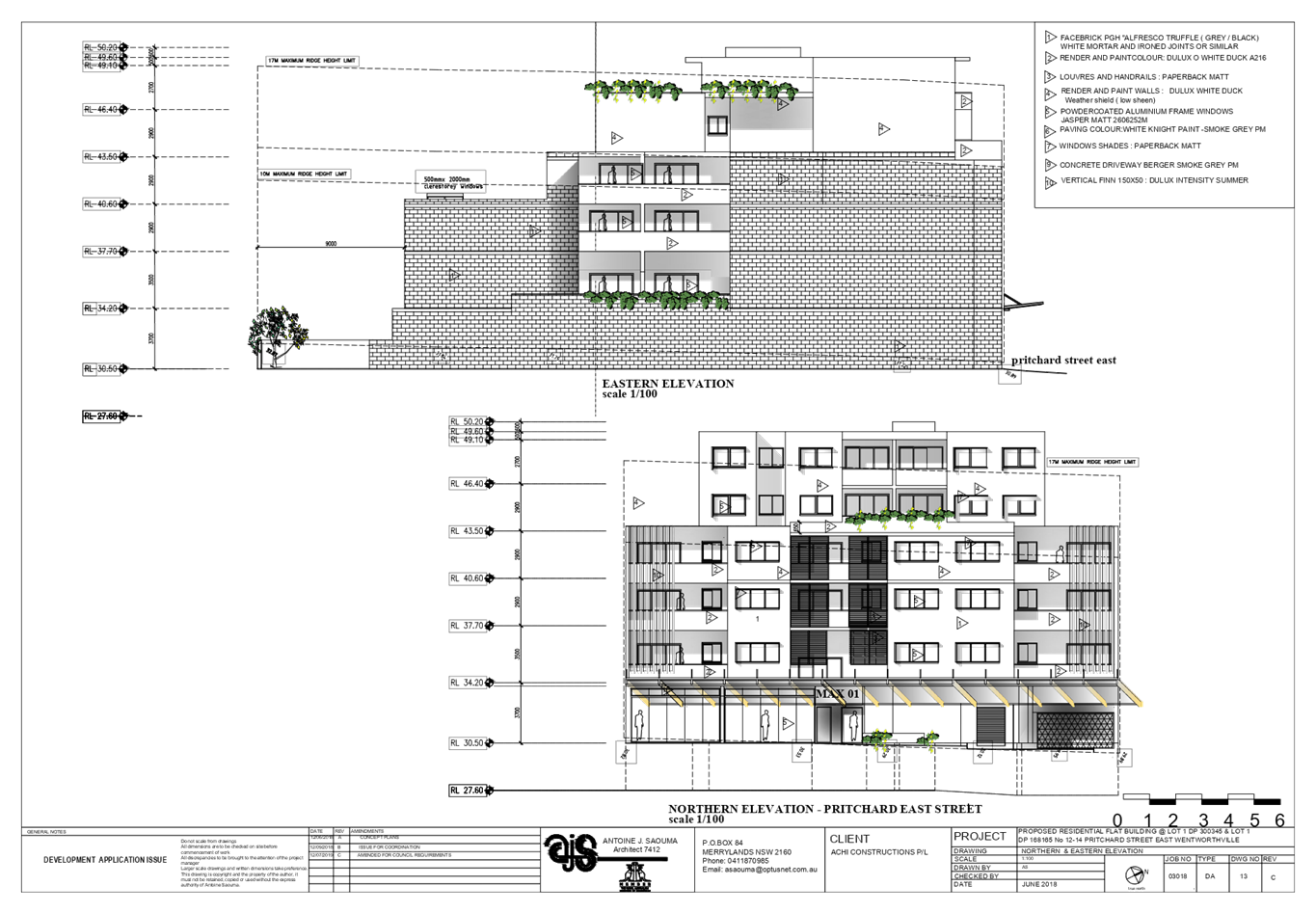
Height of Buildings:
Max. 17m
· Proposed:
18.8m to the parapet of upper
floor habitable spaces (10.5% variation); and
19.4m to the lift overrun (a
maximum variation of 14% sought)
· Clause 4.6
Written Variation Request submitted for the departure sought to building
height
|
|
Disclosure of political donations and gifts
|
Nil disclosure
|
|
Heritage
|
The subject site is not a heritage item but is
located within the vicinity of a local heritage item.
|
|
Issues
|
· Variation to
maximum 17m building height (HLEP 2013)
· Building
separation (ADG)
· Upper storey setback (HDCP 2013)
|
1. On
28 November 2018, development application (DA 2018/454) for the demolition of
existing structures and construction of a part 5, part 6 storey shop top
housing development over 2 levels of basement car parking accommodating 31
units and 47 parking spaces was lodged with Council.
2. The
application was publicly notified to adjoining and opposite owners, a notice
was placed in the local press and a notice placed on the site for 21 days from
9 January 2019 to 30 January 2019. In response, the application received no
submission.
3. The
application as lodged had numerical non-compliance to Floor Space Ratio (FSR)
standard in addition to other matters including building height, units internal
layout, access, parking and waste management and as such the application
was deferred seeking amended plans. Amended plans and information were provided
to Council on 25 July 2019. The design refinements resulted in the reduction of
the overall gross floor area of the development now complaint with the FSR
standard. The amended plans did not warrant re-notification.
4. The
application as amended proposes demolition of existing structures and
construction of part 3, part 5 and part 6 storey shop top housing development
comprising a commercial tenancy at ground floor level; 28 residential units
above 2 levels of basement carpark accommodating 55 car parking spaces and 1
car wash bay.
5. The
subject application has been assessed against the relevant provisions of the
Environmental Planning and Assessment Act 1979, State Environmental Planning
Policy No 65 – Design Quality of Residential Apartment Development (SEPP
65), Apartment Design Guide, Holroyd Local Environmental Plan 2013 (HLEP) and
Holroyd Development Control Plan 2013 (HDCP).
6. The
proposal seeks the following non-compliances which are considered supportable
as discussed in detail elsewhere in the report:
|
Control
|
Required
|
Proposed
|
% Variation
|
|
Building Height
|
Max. 17m
(HLEP 2013)
|
19.4m
|
(14%)
|
|
Building Separation
(Between habitable rooms and balconies)
|
9m ( 6th storey)
(ADG)
|
Min 4.5m provided for roof top communal area along the
eastern and western side boundaries.
|
Max 50%
|
|
Street wall height requiring an upper storey setback >
3 storeys
|
3m upper storey front setback along Pritchard Street
|
A varying setback of 0 to 3m provided for level 3
|
N/A
|
7. The
application is being reported to the Cumberland Local Planning Panel (CLPP) for
determination as it is a development with more than 4 storeys to which the
State Environmental Planning Policy No 65 – Design Quality of Residential
Apartment Developments applies.
8. The application is
recommended for Deferred Commencement approval subject to the conditions in the
draft determination at Attachment 4.
Introduction
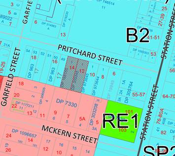
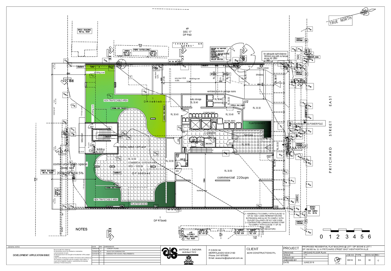
The subject site is known as 12
& 14 Pritchard Street, East Wentworthville, and is legally described as Lot
1, Deposited Plan (DP) 300345 and Lot 1, DP 168165. The site is located on the
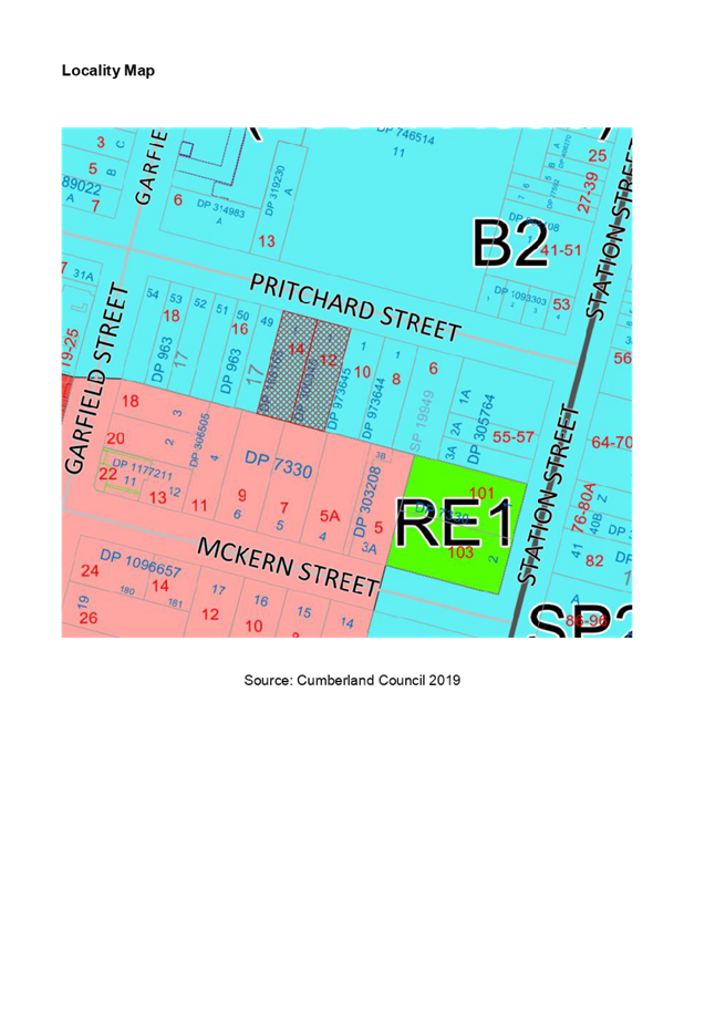
southern side of Pritchard Street within the B2 Local Centre zone. The site
forms a regular midblock with a total area of 1379.6m2 and a
combined frontage of 30m to Pritchard Street. The site has a fall of
approximately 1.5m from the rear to front. The site is currently occupied by a
Pathology Centre and a single storey dwelling. There is no significant
vegetation on site.
The subject site is located within
Wentworthville Town Centre and adjoins R2 Low Density Residential to the south.
The site is bounded by B2 zoned land to the north, east and west. There is a
transition occurring currently with higher density zoned sites being developed
into residential flat buildings further to the south. The wider locality
contains a mix of commercial and residential land uses.
The site, including Wentworthville
Town Centre, is the subject of a Council initiated Planning Proposal for
Wentworthville Centre Revitalisation Project to amend planning controls,
including increases to building height and floor space ratios (FSRs) and the
introduction of precinct specific development controls.

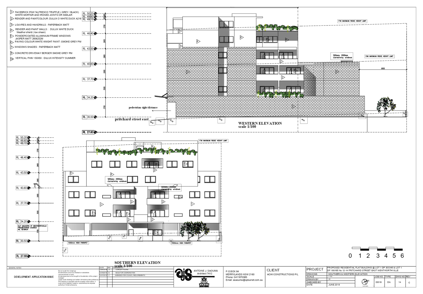
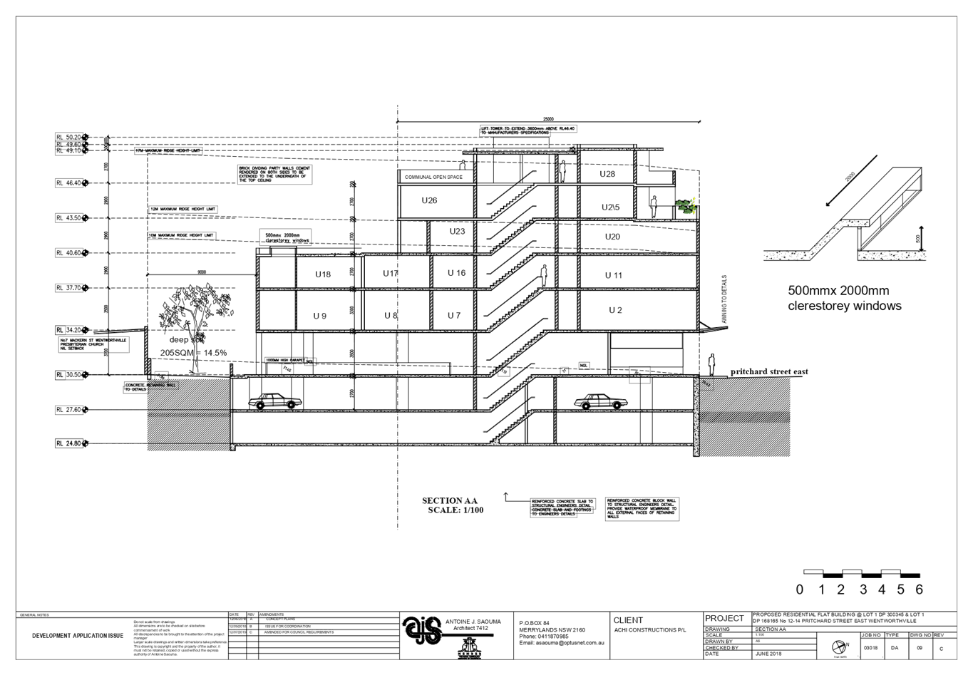
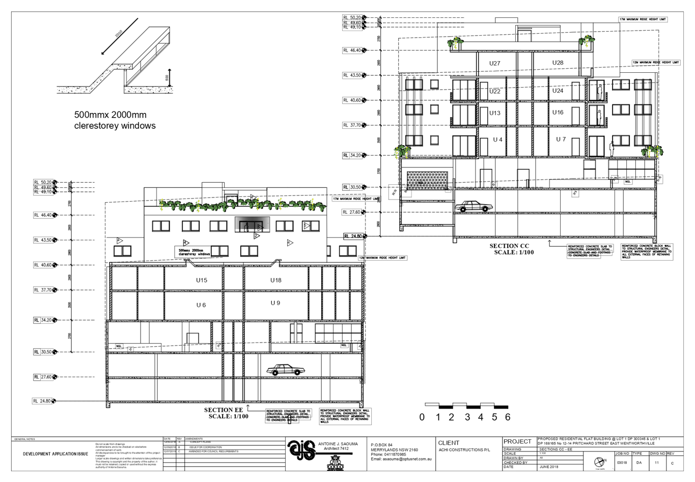
Figure
1 Aerial view of the locality with subject site (12 & 14 Pritchard Street, East
Wentworthville)
Figure
2 - Zoning map with subject site shown hatched. Source: Cumberland Council 2019
Figure
3, 4, 5 & 6 (12 & 14 Pritchard Street, East Wentworthville). Source:
Council 2019
Description of The Proposed
Development
DA 2018/454 as amended proposes
for the demolition of existing structures and construction of part 3, part 5
and part 6 shop top housing development comprising a commercial tenancy at
ground floor level; 28 residential units above 2 levels of basement carpark
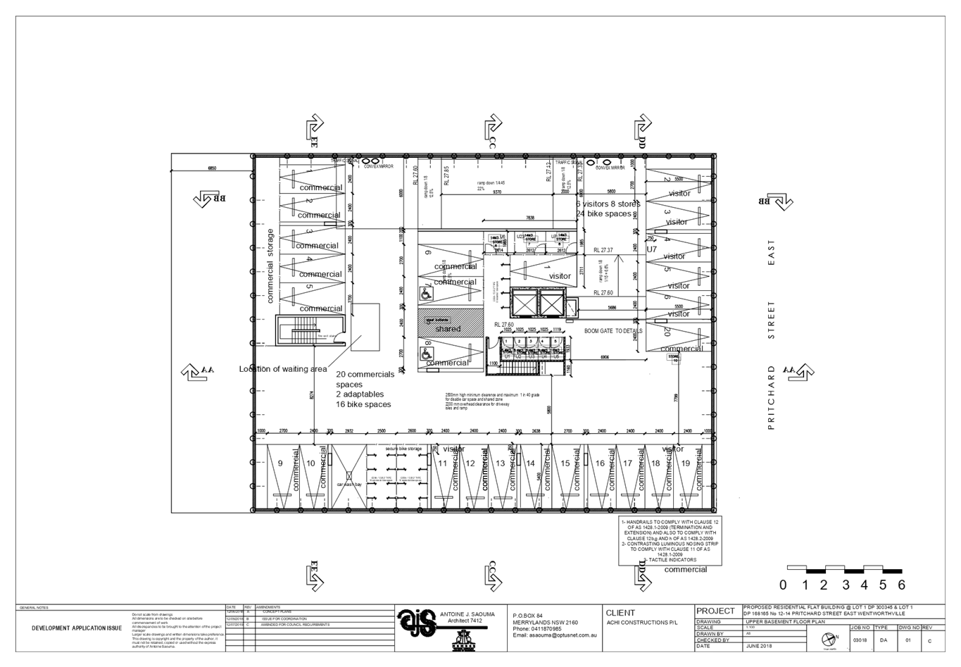
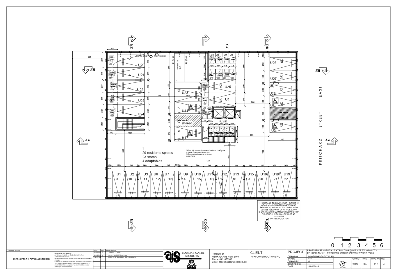
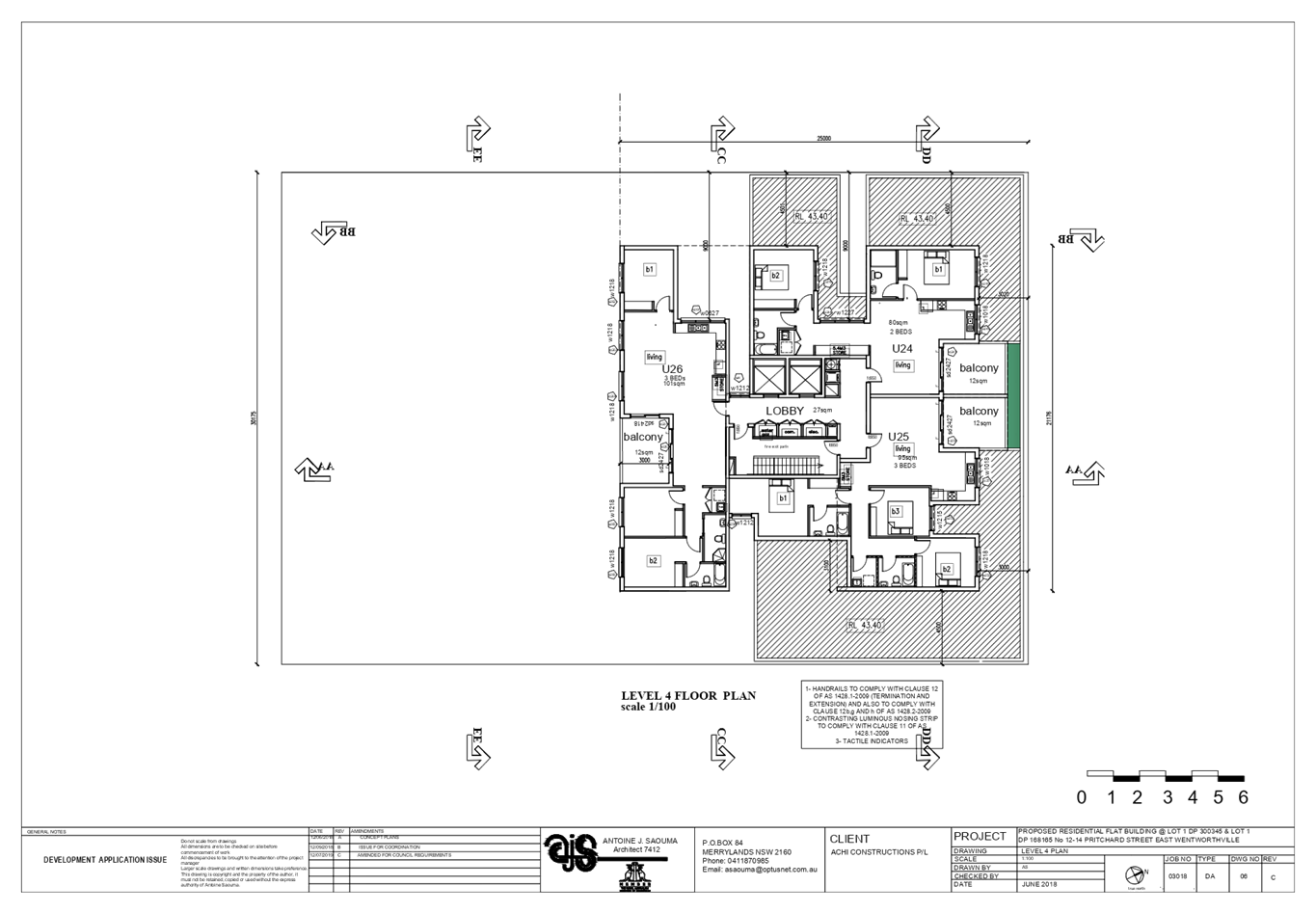
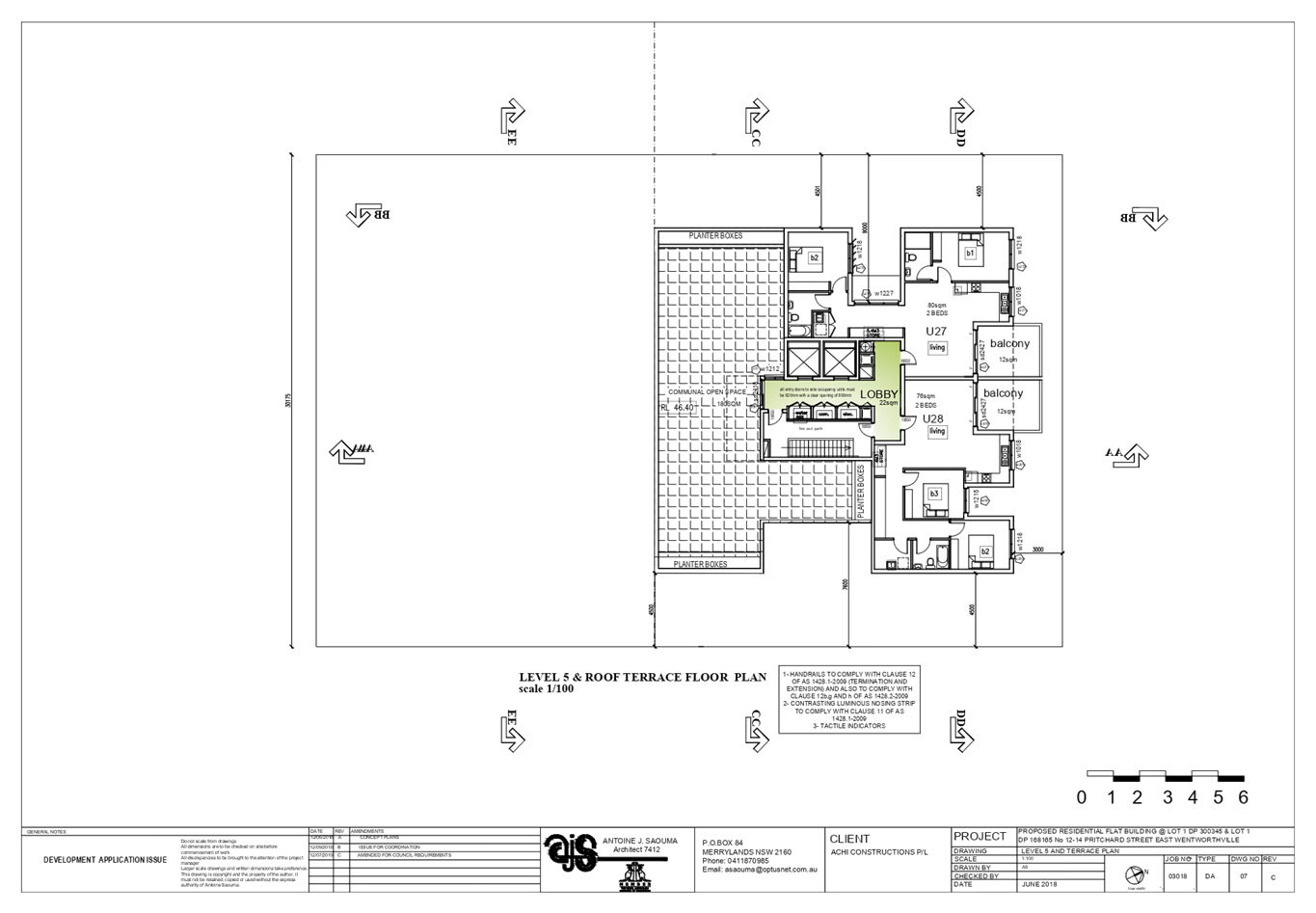
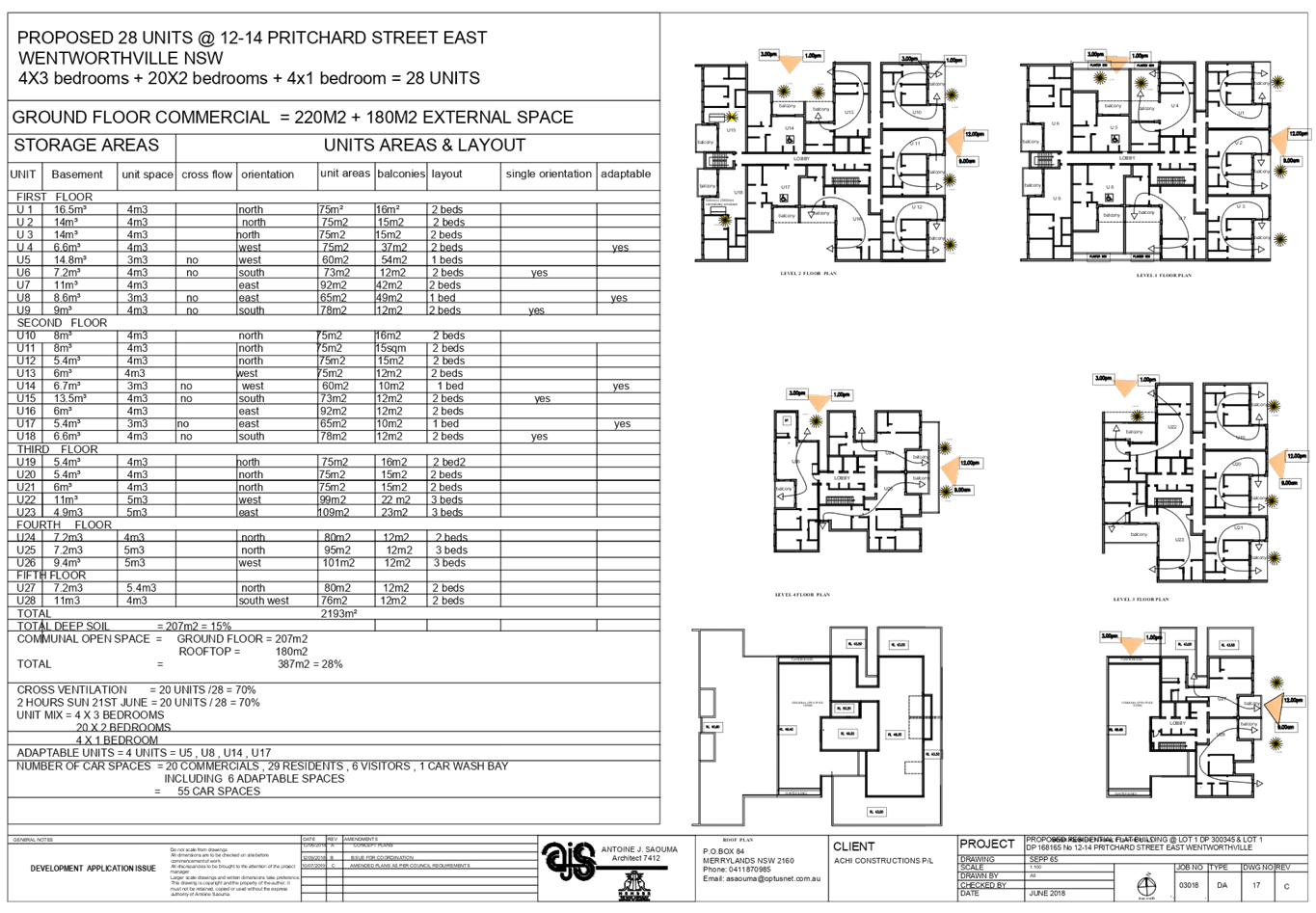
accommodating 55 car parking spaces and 1 car wash bay.
Key features of the development
proposal are as follows:-
|
Level
|
Details
|
|
Upper Basement
|
- 20
commercial spaces (including 2 accessible parking spaces)
- 6
visitor car spaces
- 16
bicycle spaces
- Storage,
lift and fire stairs
- 1
car wash bay
|
|
Lower basement
|
- 29
residential car spaces including 4 accessible parking spaces
- Storage,
lift and fire stairs
|
|
Ground floor
|
- Commercial tenancy with an area of
220m2,
- Commercial outdoor area (180m2)
- lobby
area with lift and stairwell core;
- Communal
open space;
- Bin
storage area
|
|
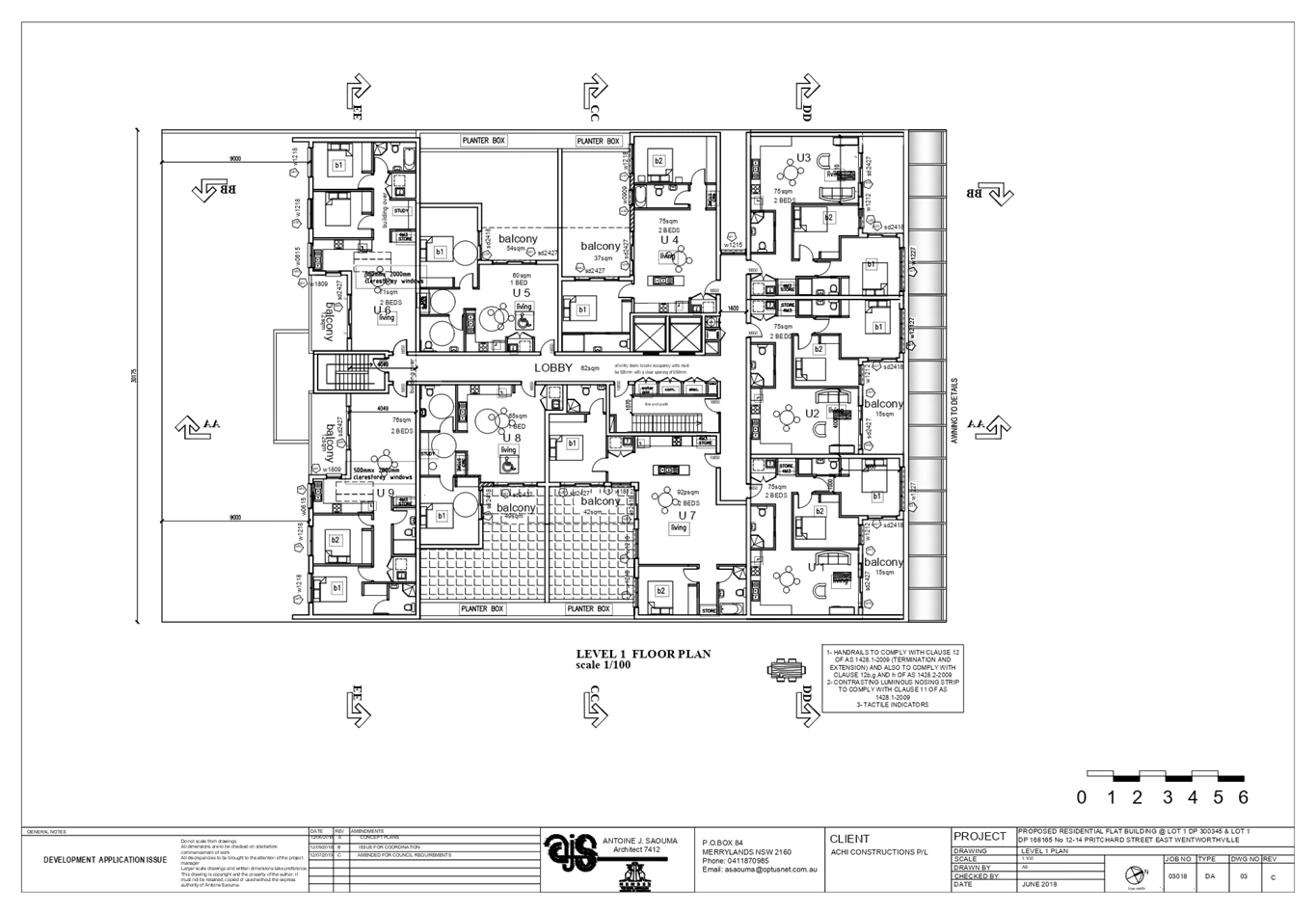
Level 1
|
- 9 residential units
|
|
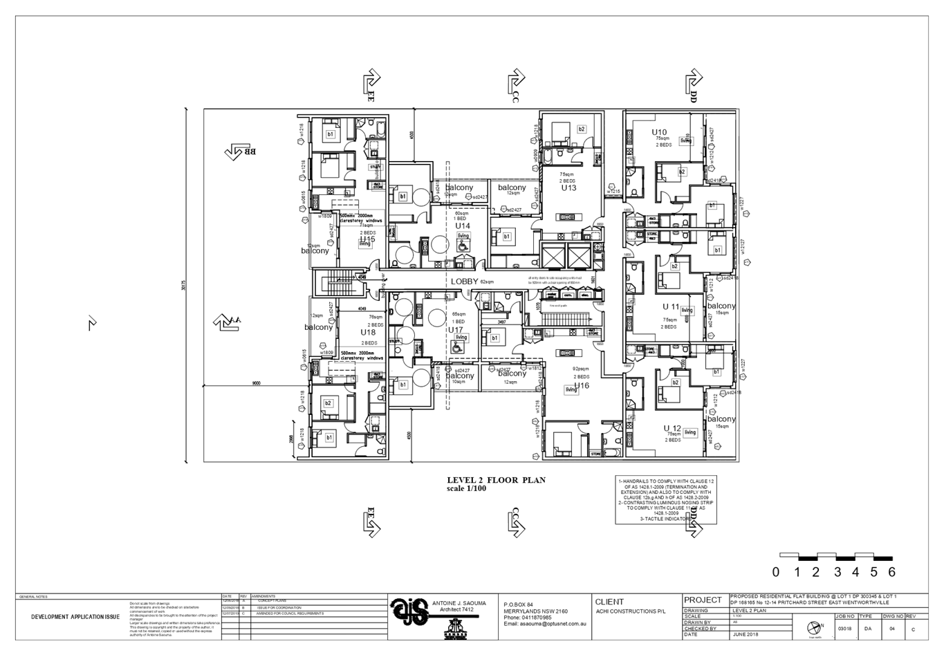
Level 2
|
- 9 residential units
|
|
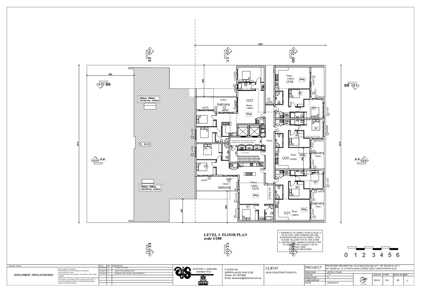
Level 3
|
- 5 residential units
|
|
Level 4
|
- 3 residential units
|
|
Level 5
|
- 2 residential units
- roof top communal open space
|
Access to the basement car park is
provided from a new vehicular crossing proposed on the north western section of
the subject site.
The dwelling mix of the proposal
is as follows:
· 4
x 1 bedroom units (14.3%);
· 20
x 2 bedroom units (71.4%); and
· 4
x 3 bedroom units (14.2%)
Figure
7 – Perspective of proposed development
Application History
|
Date
|
Action
|
|
28 November 2018
|
The subject development application (DA 2018/454) was
lodged with Council.
|
|
17 December 2018
|
The application was referred to the following internal and
external sections:
· Development
Engineering
· Traffic
Engineering
· Landscape and
Tree Management
· Environmental
Health Unit
· Waste Management
· Transgrid
· Endeavour Energy
· Cumberland
Police Area Command
|
|
9 January 2019 to 30 January 2019
|
Application placed on public notification. In response, no
submission was received.
|
|
27 June 2019
|
The application was deferred for the following reasons:
· Floor Space
Ratio
· Building height
· Units size and
layout/amenity
· Building
separation
· Traffic
engineering
· Waste
|
|
19 July 2019
|
Amended plans and additional information submitted to
Council, addressing the deferral letter dated 27 June 2019. The application
did not warrant re-notification as the amendments made did not result in a
greater environmental impact.
|
|
9 October 2019
|
Application referred to CLPP for determination.
|
Applicant’s Supporting
Statement
Statement of Environmental Effects
prepared by Think Planners Pty Ltd, dated 26 November 2018 was submitted in
support of the application.
The applicant has also submitted a
written request to vary the development standard for building height, prepared
by Think Planners dated 27 August 2019.
Contact With Relevant
Parties
The assessing officer has
undertaken an inspection of the subject site and has been in contact with the
applicant throughout the assessment process.
Internal Referrals
Development Engineer
The development application was
referred to Council’s Development Engineer for comment who has advised that
the development is supportable with regards to the proposed new vehicular
crossing and stormwater management, subject to deferred commencement
conditions.
Traffic Engineer
The development application was
referred to Council’s Traffic Engineer for comment who has advised that
the development is supportable in regards to parking, traffic management and
on-site parking provision in the basement level, subject to deferred
commencement conditions.
Tree Management Officer
The development application was
referred to Council’s Tree Management Officer for comment who has advised
that the development is supportable, subject to conditions.
Waste Management Officer
The development application was
referred to Council’s Waste Management Officer for comment who has advised
that the proposed waste management is supportable, subject to conditions.
Environmental Health Unit
The development application was
referred to Council’s Environmental Health Unit for comment who has
advised that the proposal is satisfactory, subject to conditions.
External Referrals
Transgrid
The development application was
referred to Transgrid for comment who has advised that the development is
supportable in regards to not affecting Transgrid’s asset.
Endeavour Energy
The development application was
referred to Endeavour Energy for comment who has advised that the development
is supportable in regards to electricity connection and sufficient clearance to
existing electricity asset, subject to conditions.
NSW Police
The application was referred to NSW
Police for comment regarding CPTED who has advised that the proposal is
satisfactory, subject to conditions.
Planning Assessment
The provisions of any
Environmental Planning Instruments (EP&A Act s4.15 (1)(a)(i))
The following Environmental
Planning Instruments are relevant to the assessment of the subject application:
(a) State
Environmental Planning Policy No. 55 – Remediation of Land
The requirement at Clause 7 of
SEPP No. 55 for Council to be satisfied that the site is suitable or can be
made suitable to accommodate the proposed development has been considered in
the following table:
|
Matters for consideration
|
Yes
|
No
|
N/A
|
|
Does the application involve
re-development of the site or a change of land use?
|
|
|
|
|
Is the development going to be
used for a sensitive land use (e.g.: residential, educational, recreational,
childcare or hospital)?
|
|
|
|
|
Does information available to
you indicate that an activity listed below has ever been approved, or
occurred at the site?
acid/alkali plant and
formulation, agricultural/horticultural activities, airports, asbestos
production and disposal, chemicals manufacture and formulation, defence
works, drum re-conditioning works, dry cleaning establishments, electrical
manufacturing (transformers), electroplating and heat treatment premises,
engine works, explosive industry, gas works, iron and steel works, landfill
sites, metal treatment, mining and extractive industries, oil
production and storage, paint formulation and manufacture, pesticide
manufacture and formulation, power stations, railway yards, scrap yards,
service stations, sheep and cattle dips, smelting and refining, tanning and
associated trades, waste storage and treatment, wood preservation.
|
|
|
|
|
Is the site listed on Council's
Contaminated Land Database?
|
|
|
|
|
Is the site subject to EPA
clean-up order or other EPA restrictions?
|
|
|
|
|
Has the site been the subject of
known pollution incidents or illegal dumping?
|
|
|
|
|
Does the site adjoin any
contaminated land/previously contaminated land?
|
|
|
|
|
Has the appropriate level of
investigation been carried out in respect of contamination matters for
Council to be satisfied that the site is suitable to accommodate the proposed
development or can be made suitable to accommodate the proposed development?
|
|
|
|
|
Details of contamination
investigations carried out at the site:
The site
is not identified in Council’s records as being contaminated. A site
inspection reveals the site does not have any obvious history of a previous
land use that may have caused contamination and there is no specific evidence
that indicates the site is contaminated. Council’s
Environmental Health Unit has assessed the application and considers the
proposal to be satisfactory, subject to conditions.
|
(b) State
Environmental Planning Policy (Vegetation in Non-Rural Areas) 2017
The site and neighbouring land
parcels have recently been cleared of all vegetation to facilitate future
residential development. As such, the SEPP does not apply.
(c) State
Environmental Planning Policy (Coastal Management) 2018
The subject site is not identified
as a coastal wetland and is not or land identified as “proximity area for
coastal wetlands”.
(d) State
Environmental Planning Policy (Building Sustainability Index: BASIX) 2004
An amended BASIX Certificate
975895M_04 dated 24 July 2019 with regard to the revised units’ numbers
and dwelling mix has been submitted. The submitted BASIX certificate achieves
target scores and is considered satisfactory. Conditions of Consent have
been applied requiring adherence to the BASIX Certificate requirements.
(e) State
Environmental Planning Policy No 65 – Design Quality of Residential
Apartment Development (SEPP 65)
The proposal is classified as a
shop top housing development and SEPP 65 applies. A design verification
statement signed by registered architect Antoine J. Saouma was submitted with
the application.
SEPP 65 sets 9 design quality
principles. The development has adequately addressed the principles in the
following way:
Figure
6 – SEPP 65 Design Quality Principles Table
|
ADG design
quality principle
|
Response
|
|
1. Context and neighbourhood character
|
The area is zoned to accommodate new development,
including shop top housing that is a permitted type of development within the
B2 zone. The existing character of the streetscape is in transition where
existing dwelling houses are being replaced with higher densities
development, such as shop top housing. The proposed development satisfies
Holroyd LEP 2013 objectives in that it will provide residential development
well integrated with the commercial uses. The siting of development has been
appropriately designed to minimise any potential overshadowing and visual
privacy impact to the adjoining properties by maintaining a buffer area at
the rear and side boundaries for communal open space.
|
|
2. Built form and scale
|
The development application is seeking consent for a part
3, part 5 and part 6 storey development over two levels of basement car
parking. The building has been designed to correspond with the existing
landform. At grade communal open space will assist in softening the built
form and minimise any potential overshadowing and visual privacy impact to
the adjoining properties.
|
|
3. Density
|
The subject site is well
located with respect to existing public transport and community
facilities. The design of the development provides for appropriate
separation between dwellings, supplemented by privacy treatment to balconies
and windows where necessary.
|
|
4. Sustainability
|
A BASIX Certificate and relevant reports have been
submitted with the development application. The certificates require
sustainable development features to be installed into the development. The
proposal will incorporate features relating to ESD in the design and
construction of the development inclusive of water efficient fixtures and
energy saving devices.
|
|
5. Landscape
|
Compliant landscape area has been provided, which will
provide appropriate level of amenity to the resident and consistent with the
environmental surrounds of the subject site.
|
|
6. Amenity
|
The proposal will deliver sufficient amenity to residents
of the building. The proposal generally achieves compliance with the ADG and
is considered to provide an appropriate level of amenity for future
residents. Suitable access is provided to all parts of the building, through
the efficient use of lift to access all levels.
|
|
7. Safety
|
Suitable and secure access is provided to all parts of the
building, through the efficient use of lift to access all levels.
|
|
8. Housing diversity and social interaction
|
The apartment mix is considered to be satisfactory. The
specifics of the building are:-
· 4 x 1 bedroom units (14.3%);
· 20 x 2 bedroom units (71.4%); and
· 4 x 3 bedroom units (14.2%)
The number of adaptable units proposed is considered
satisfactory with the provision of associated accessible car spaces.
|
|
9. Aesthetics
|
The proposed development has an attractive contemporary
appearance and utilises building elements that provide individuality to the
development without compromising the streetscape or detracting from the
appearance of existing surrounding development, subject to condition with
regard to provision of light weight material for the upper floors (above 3
storeys) in lieu of the solid brick cladding of the external façade to
provide articulation to the street frontage.
|
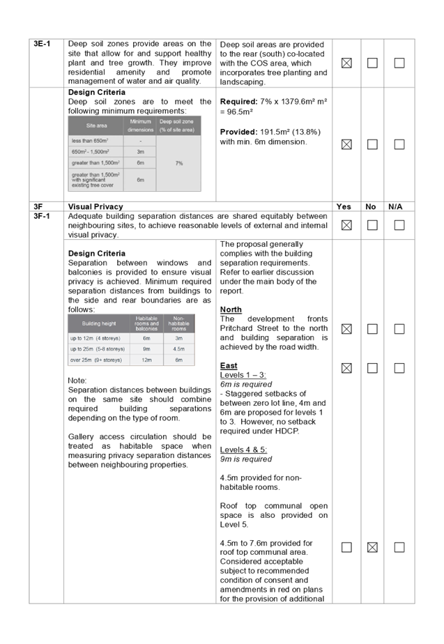
Pursuant to clause 28(2)(c) of
SEPP 65, a consent authority must consider the provisions of the Apartment
Design Guide (ADG) in the assessment of a residential flat development. A
comprehensive assessment against the Apartment Design Guide (ADG) controls is
provided at Attachment 1.
The proposal involves the
following non-compliances with the ADG controls.
|
No.
|
Control
|
Comments
|
Compliance
|
|
3F
|
Visual Privacy
|
Y
|
N
|
NA
|
|
3F-1
|
Design Criteria
Separation
between windows and balconies is provided to ensure visual privacy is
achieved. Minimum required separation distances from buildings to the side
and rear boundaries are as follows:

Note:
Separation distances between
buildings on the same site should combine required building separations
depending on the type of room.
Gallery access circulation should
be treated as habitable space when measuring privacy separation distances
between neighbouring properties.
|
The proposal generally complies with the building
separation requirements.
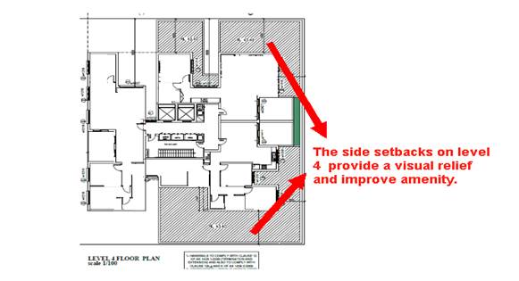
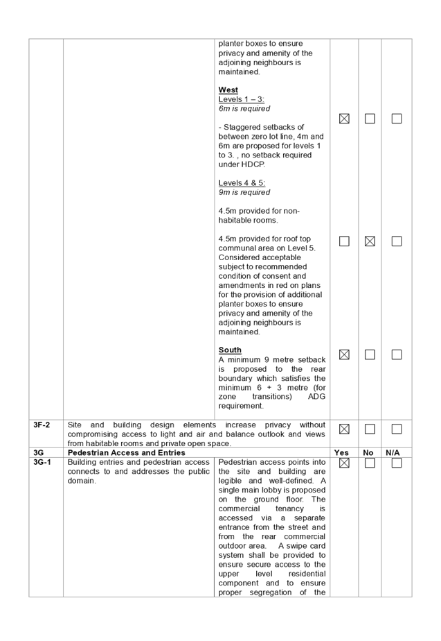
However, for level 5 (i.e; 6 storey) the following
is provided:
Level 5 communal open space:
9m is required
Roof top communal open space is provided on Level 5.
Min. 4.5m provided for roof top communal area along
the eastern and western boundaries.
Considered acceptable, subject to recommended condition of
consent for the provision of additional planter boxes to ensure privacy and
amenity of the adjoining neighbours is maintained.
|
|
|
|
(f) State
Environmental Planning Policy (Infrastructure) 2007
Clause 45 – Development
likely to affect an electricity transmission or distribution network
The development application was
referred to Endeavour Energy and TransGrid for comment, who raised no
objections, subject to conditions.
(g) Statement
Environmental Planning Policy No 19 - Bushland in Urban Areas
The proposal does not propose to
disturb bushland zoned or reserved for public open space.
(h) Sydney
Regional Environmental Plan (Sydney Harbour Catchment) 2005
The subject site is identified as
being located within the area affected by the Sydney Regional Environmental
Plan (Sydney Harbour Catchment) 2005. The proposed development raises no issues
as no impact on the catchment is envisaged.
Note: The subject site is not
identified in the relevant map as land within the ‘Foreshores and
Waterways Area’ or ‘Wetland Protection Zone’, is not a
‘Strategic Foreshore Site’ and does not contain any heritage items.
Hence the majority of the SREP is not directly relevant to the proposed
development.
(i) Holroyd
Local Environmental Plan 2013 (HLEP 2013)
The proposed development is
defined as a ‘shop top housing’ under the provisions of Holroyd
Local Environmental Plan (LEP) 2013. Shop top housing is a permissible land use
with consent under the B2 – Local Centre zoning applying to the land
under Holroyd LEP 2013.
The proposal seeks a variation to
Clause 4.3 – Height of Buildings that stipulates that the height of
building is not to exceed 17m on the subject site. The height control of
the subject site is split between 17m (at the front) and 10m (at the rear). The
proposal complies with the 10m height standard at the rear; however, seeks a
variation to a section of the front portion of the development.
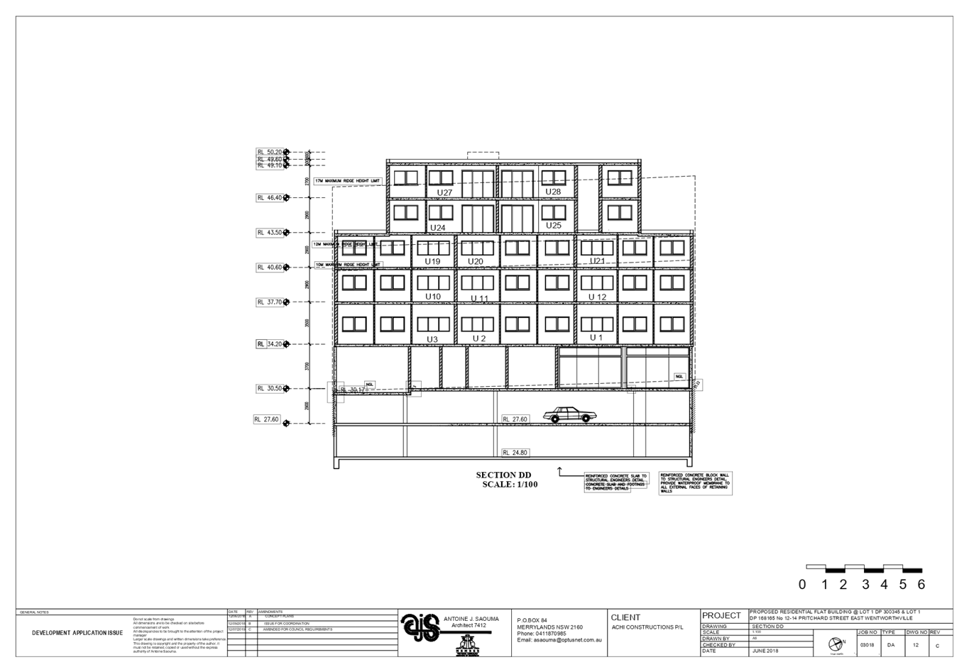
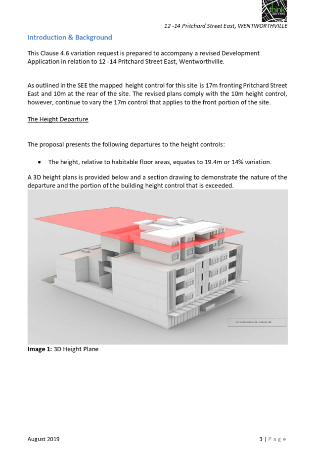
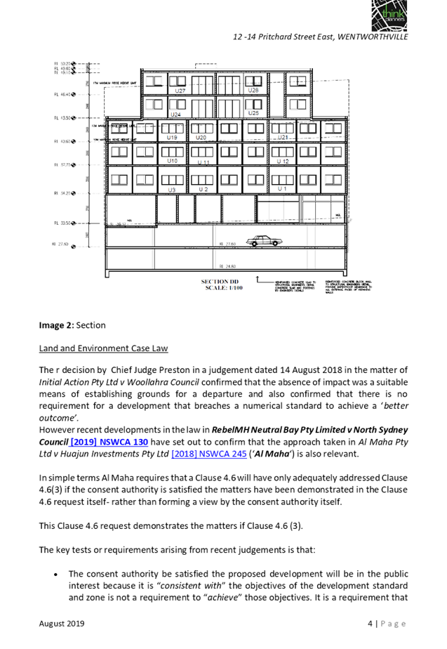
The proposed building has an
overall height of 18.8m (RL49.60) to the parapet of upper floor habitable
spaces and an overall height of 19.4m (RL50.20) to the lift overrun. The
proposal breaches the maximum overall height by 1.4m representing a maximum
variation of 14%.
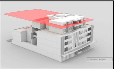
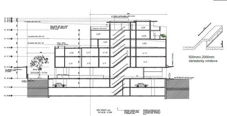
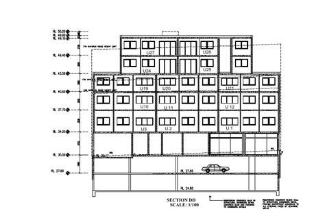
Figure
8, 9 & 10 – 3D Height Plan and Sections showing extent of height
variation sought
Clause 4.6 – Variation to
Building Height
Clause 4.6 allows the consent
authority to vary development standards in certain circumstances and provides
an appropriate degree of flexibility to achieve better design outcomes. The
consent authority may grant the exception as the Secretary’s concurrence
can be assumed where clause 4.6 is adopted as per the Department of Planning
Circular PS 18-003, dated 21 February 2018.
The applicant has submitted a
written request to vary the development standard for building height. Based on
various case laws established by the Land and Environment Court of NSW such as
Four2five P/L v Ashfield Council [2015] NSWLEC 9, Randwick City Council v
Micaul Holdings P/L [2016] NSW LEC7 and Zhang and anor v Council of the City of
Ryde [2016] NSWLEC 1179 and recent case law in RebelMH Neutral Bay Pty Limited
v North Sydney Council [2019] NSWCA 130, a 3 part assessment framework for a
variation request proposed under clause 4.6 has been considered and an
assessment of the proposed variance, following the 3 part test is discussed in
detail below.
The 3 preconditions which must be
satisfied before the application can proceed are as follows:
1. Is
the proposed development consistent with the objectives of the zone?
Applicant’s
justification:
The proposal ensures that the
desired mixed-use nature of the zone is augmented with the proposal providing
additional retail floor space and residential housing types to augment the
existing housing stock within the Wentworthville Town Centre whilst also aiming
to set the tone and scale for comparable future developments within the
locality.
In addition, the proposal will
provide a strong and identifiable built form that will firmly pronounce this
strategic gateway entrance point to the Wentworthville Town Centre for visitors
to the area and for those travelling along Pritchard Street. Therefore, the
proposed design concept with a four storey appearance will provide a built form
that is consistent with the permitted scale of development surrounding the
subject site and will incorporate a strong and identifiable building line.
Planner’s Comment:
Shop top housing development is a
permitted land use and the locality is undergoing a transition particularly to
support the increasing demand of housing within the close proximity of a public
transport hub and commercial centre. The proposed development is considered to
be consistent with the objectives of the B2- Local Centre zone.
2. Is
the proposed development consistent with the objectives of the development
standard which is not met?
Applicant’s
justification:
The current development proposal
is consistent with the underlying intent of the control based on the following
key points:
· The
overall height of the development presents as a compatible form of development
to the anticipated high density residential development that are emerging in
the locality, noting that the emerging character is for 6 storey shop top
housing developments. The upper levels of the proposal are recessed behind the
main building alignment to downplay visual dominance as viewed from the public
domain and adjoining residential properties.
· The
proportion of the building that protrudes above the 17m height limit contains
limited habitable floor space and presents with a dominant 4 storey building
design, reinforcing that the breach to the height standard does not result in
the development representing an overdevelopment of the site but rather a
suitable contextual response to the locational characteristics on the site in
order to achieve a suitable ground floor outcome with sufficient amenity for
the apartments at this level.
· The
proposed development incorporates a complying floor space ratio as per the
provisions of the HLEP 2013, which will ensure that the scale of the proposed
development will be appropriate and will be visually consistent with the
permitted building height with the upper levels recessed and designed using a
lighter design style to ensure a positive streetscape presentation.
· The
additional height does not generate any additional amenity impacts given the
location of the site and the surrounding site context.
· The
proposal has been carefully designed to ensure that no adverse visual or
acoustic amenity impacts will be created by the proposed building height along
site boundaries, as the upper levels are substantially recessed behind the
building perimeter.
· The
proposed articulation of the built form will ensure that the additional
building height will not be discernibly noticeable from street level and that
the proposed development will provide a strong and identifiable building line
that will pronounce the site’s prominent and strategic gateway entry
location at the edge of the Wentworthville Town Centre.
· The
proposal provides for a better planning outcome as the same density of
apartments could be achieved in a building that is squashed into 5 levels of
development with a bigger floor plate that would be less articulated and would
have more single aspect south facing apartments. Therefore, the response has
been to maximise the amenity of apartments.
· The
proposal has been designed to ensure that privacy impacts are mitigated against
and that the proposal will not obstruct existing view corridors.
· The
area has been identified as part of the Wentworthville Revitalisation Strategy
as being suitable for containing increased density and height. The
Wentworthville Centre Urban Design and Built Form Modelling prepared by
Architectus indicates that the site is suitable for heights of up to 8 storeys
fronting Pritchard Street East. This 6 storey building is compatible with the
likely future character that will emerge as this revitalisation strategy
progresses.
· The
proposal will not unreasonably impact on the significance of the heritage item
having regard to the detail in the submitted HIS.
· By
providing additional building height does not substantially contain habitable
floor space. The additional building height is a factor of the generous floor
to ceiling heights that are required as Council mandates the provision of
ground floor commercial/retail floor space. This results in the floor to
ceiling height at the ground level being 3.7m and the first floor is afforded a
3.5m floor to ceiling height.
As outlined above, the proposal
remains consistent with the underlying objectives of the control and, as such,
compliance is considered unnecessary or unreasonable in the circumstances. The
above discussion demonstrates that there are sufficient environmental planning
grounds to justify the minor departure from the control.
Planner’s comment:
The objectives of the building
height standard are to enable appropriate development density to be achieved
and to ensure that the height of the building is compatible with the existing
and desired future character of the locality. The proposal is compliant with
the maximum FSR standard, deep soil zone and communal open space
requirement. The proposal is considered to be of an appropriate bulk,
scale and height for the subject site which has been amended to address
concerns raised by Council in relation to the split height limits and provision
of terraced built form to provide an appropriate transition with the adjoining
low density residential zone at the rear.
The departure sought is considered
to be modest and does not unreasonably impact on adjoining properties. The
additional height does not result in the appearance of bulk when viewed from
the existing streetscape and would not impinge on the changing streetscape that
is anticipated for the immediate area. Given that the proposed development
responds to the site and does so without compromising relationships with
adjoining developments, the proposal is considered to be consistent with the
objectives of height requirements and development within the B2 zone.
3. a)
Is compliance with the development standard unreasonable or unnecessary in the
circumstances of the case?
Applicant’s
justification:
In accordance with the provisions
of this clause it is considered that compliance with the development standard
is unreasonable or unnecessary in the circumstances of the case as the
underlying objectives of the control are achieved.
Planner’s comment:
Council Officers are satisfied
that the proposed variation has been appropriately justified and can be
supported in this instance. The height breach is limited to an overall building
height of RL 49.60 to the fifth level habitable floor, and height of RL 50.20
for the top of the lift core. The additional height of the fifth level/sixth
storey will not be visually distracting from the adjacent streets and
properties noting the recessed upper levels. The departure sought is considered
to be modest and does not unreasonably impact on adjoining properties.
The height breach is primarily
related to the front section of the building that falls within the 17m height
limit, thus representing a smaller habitable floor plate on the fifth level
(the subject of noncompliance). It is noted that the gross floor area of the
two units on this floor equates to approximately 156m2. A similar
density could have been provided on the immediate lower level (fourth
level/fifth storey) by using the roof along the side boundaries (refer to the
figure below) which equates to an area of approximately 139m2,
thereby reducing the overall building height by providing a larger floor plate
of level 4. However, this would not have been a desirable planning outcome,
noting it would compromise the amenity of the residents and reduce the overall
visual relief by providing minimal articulation along the sides of the upper
floor levels.
Further, the additional height
does not result in the appearance of bulk when viewed from the existing
streetscape, does not result in additional overshadowing to the adjoining
properties because of the appropriate separation and staggered built form and
would not impinge on the desired future character of the area. It is
considered, therefore, that the non-compliance with the Development Standard is
not unreasonable or unnecessary in the circumstances of the case.
b)
Are there sufficient environmental planning grounds to justify contravening the
development standard and therefore is the applicant’s written
justification well founded?
The unique circumstances of the
case are considered to warrant support of the departure. Given that the
proposed development responds to the site and does so without unduly
compromising relationships with adjoining development, and does not unduly
compromise other relevant controls, the proposal is considered to be consistent
with the objectives of building height, and development within the B2 zone. In
this regard, the exception is well founded and can be supported.
Conclusion:
Council is satisfied that the
applicant’s written request has adequately addressed the matters required
to be demonstrated by clause 4.6 subclause (3). Council is further satisfied
that the proposed development will be in the public interest because it is consistent
with the objectives of the particular standard and the objectives for
development within the zone in which the development is proposed to be carried
out.
It is the view of Council officers
that the justification provided is satisfactory and, having considered the
application on its merit, the exception to the maximum building height
development standard is considered acceptable in this instance.
By way of reference only, it is
noted that under the draft Wentworthville Centre Revitalisation Planning
Proposal, the subject area is being identified for an increased building height
to 23m (compared to the current 17m) and FSR of 2.2:1 (current 2:1). The
planning proposal was exhibited in the middle of the year, with a further
report to be provided to Council.
An assessment against all the
relevant LEP provisions is provided at Attachment 2.
The provisions of any proposed
instrument that is or has been the subject of public consultation (EP&A Act
s4.15 (1)(a)(ii))
There are no draft SEPPs
applicable to the proposed development.
The provisions of any
Development Control Plans (EP&A Act s4.15 (1)(a)(iii))
(a) Holroyd
Development Control Plan 2013
HDCP 2013 contains general
controls which relate to all developments under Part A, and Residential Controls
under Part B.
A comprehensive HDCP compliance
table is attached to this report at Attachment 3. A summary of the DCP
non-compliances is provided in the following table.
|
Control
|
Provided
|
Complies
(Yes/No)
|
|
All floors >3 storeys to be setback 3m.
|
Level 3 (4th storey) = A varying setback from 0
to 3m provided.
Level 4 (5th storey) and level 5 (6th
storey) = A varying setback from 3 to 5.2m provided.
A 3 storey street wall has not been provided for level 3.
However, this is considered satisfactory, subject to imposition of condition
with regard to provision of lightweight materials/finishes for level 3 and
above to ensure satisfactory articulation and visual relief is presented to
street.
Levels 4 and 5 are provided with a 3m setback.
|
No – Acceptable in this instance.
|
Any planning agreement that has
been entered into under section 7.4, or any draft planning agreement that a
developer has offered to enter into under section 7.4 (EP&A Act s
4.15(1)(a)(iiia))
There is no planning agreement or
draft planning agreement associated with the subject Development Application.
The provisions of the
Regulations (EP&A Act s4.15 (1)(a)(iv))
Pursuant to clause 92 of the
Regulation, the provisions of AS 2601 must be considered in the case of a
development application for the demolition of a building. Standard conditions
are included in the draft determination to require the proposed demolition
works to be carried out in accordance with AS 2601.
The Likely Environmental,
Social or Economic Impacts (EP&A Act s4.15 (1)(b))
The likely environmental, social
and economic impacts of the development have been assessed and are considered
satisfactory.
The suitability of the site for
the development (EP&A Act s4.15 (1)(c))
The site is considered suitable
for the proposed development.
Submissions made in accordance
with the Act or Regulation (EP&A Act s4.15 (1)(d))
Advertised (newspaper) Mail Sign Not
Required
In accordance with Part E - Public
Participation of HDCP 2013, the proposal was publicly notified for a period of
21 days from 9 January 2019 to 30 January 2019. As a result of the
notification, no submission was received. Amended plans submitted did not
warrant re-notification of the proposal.
Section 7.11 of The
Environmental Planning & Assessment Act 1979
The subject development requires
the payment of contributions in accordance with Holroyd Section 94 Development
Contributions Plan 2013. A condition is imposed requiring the payment of
contributions.
In accordance with the currently
indexed rates for the Wentworthville Centre contribution area, the following
contributions apply:
· 4
x 1-bedroom dwellings = $35,060
· 20
x 2-bedroom dwellings = $296,440
· 4
x 3 bedroom dwellings = 40,000
· 220
m2 of non-residential development = $6,820
The required Section 7.11
contribution payable for the proposal is = $378,320.00
Note: This includes credit for the
existing 2 x 3-bedroom dwellings.
The Public Interest
The public interest is served by
permitting the orderly and economic use of land, in a manner that is sensitive
to the surrounding environment and has regard to the reasonable amenity
expectations of surrounding land users. In view of the foregoing analysis, it
is considered that approval of the proposed development would not be contrary
to the public interest.
Disclosure of Political
Donations And Gifts
The NSW Government introduced The
Local Government and Planning Legislation Amendment (Political Donations) Act
2008 (NSW). This disclosure requirement is for all members of the public
relating to political donations and gifts. The law introduces disclosure
requirements for individuals or entities with a relevant financial interest as
part of the lodgement of various types of development proposals and requests to
initiate environmental planning instruments or development control plans.
The application and notification
process did not result in any disclosure of Political Donations or Gifts.
The proposed development has been
assessed in accordance with the relevant requirements of the Environmental
Planning and Assessment Act 1979, State Environmental Planning Policy No 65
– Design Quality of Residential Apartment Development, Holroyd Local
Environmental Plan 2013 and the Holroyd Development Control Plan 2013 and is
considered to be satisfactory.
There are no further consultation
processes for Council associated with this report.
There are no further financial implications
for Council associated with this report.
There are no policy implications
for Council associated with this report.
Communication /
Publications:
The final outcome of this matter
will be notified in the newspaper. The objectors will also be notified in
writing of the outcome.
|
1. That
the Local Planning Panel approve the variation to the Development Standard
relating to building height as contained within Clause 4.3 of the Holroyd
Local Environmental Plan 2013 as the applicant’s Clause 4.6 objection
has adequately addressed the matters required to be demonstrated by Clause
4.6 (3) and the development will be in the public interest as it is
consistent with the objectives of the Height Standard and the objectives of
the B2 – Local Centre zone.
2. Development
Application 2018/454/1 for demolition of existing structures and construction
of part 3, part 5 and part 6 shop top housing development comprising a
commercial tenancy at ground floor level, 28 residential units above 2 levels
of basement carpark accommodating 55 car parking spaces and 1 car wash bay be
Approved via Deferred Commencement, subject to the attached conditions,
provided at Attachment 4.
3. The
applicant in respect to the application be notified of the determination of
the application.
|
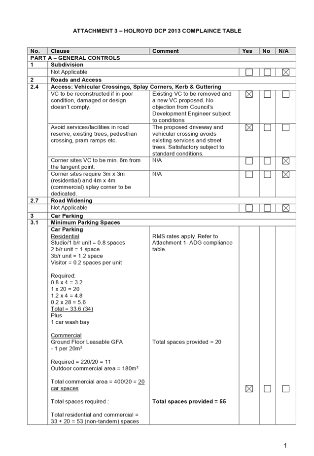
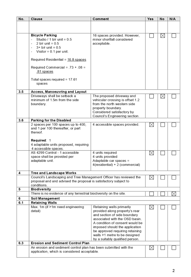
1. ADG
Compliance Table ⇩ 
2. HLEP
2013 Compliance Table ⇩
3. HDCP
2013 Compliance Table ⇩
4. Draft
Notice of Determination ⇩
5. Architectural
Plans ⇩ 
6. Shadow
Diagrams ⇩ 
7. Clause
4.6 Variation Request to Building Height ⇩ 
8. Locality
Map ⇩
DOCUMENTS
ASSOCIATED WITH
REPORT LPP065/19
Attachment 1
ADG Compliance Table
Cumberland Local Planning Panel Meeting
9 October 2019

DOCUMENTS
ASSOCIATED WITH
REPORT LPP065/19
Attachment 2
HLEP 2013 Compliance Table
Cumberland Local Planning Panel Meeting
9 October 2019
DOCUMENTS
ASSOCIATED WITH
REPORT LPP065/19
Attachment 3
HDCP 2013 Compliance Table
Cumberland Local Planning Panel Meeting
9 October 2019
DOCUMENTS
ASSOCIATED WITH
REPORT LPP065/19
Attachment 4
Draft Notice of Determination
Cumberland Local Planning Panel Meeting
9 October 2019
DOCUMENTS
ASSOCIATED WITH
REPORT LPP065/19
Attachment 5
Architectural Plans
Cumberland Local Planning Panel Meeting
9 October 2019
DOCUMENTS
ASSOCIATED WITH
REPORT LPP065/19
Attachment 6
Shadow Diagrams
Cumberland Local Planning Panel Meeting
9 October 2019
DOCUMENTS
ASSOCIATED WITH
REPORT LPP065/19
Attachment 7
Clause 4.6 Variation Request to Building Height
Cumberland Local Planning Panel Meeting
9 October 2019

DOCUMENTS
ASSOCIATED WITH
REPORT LPP065/19
Attachment 8
Locality Map
Cumberland Local Planning Panel Meeting
9 October 2019
Cumberland
Local Planning Panel Meeting
9 October 2019
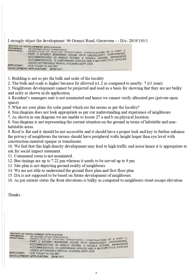
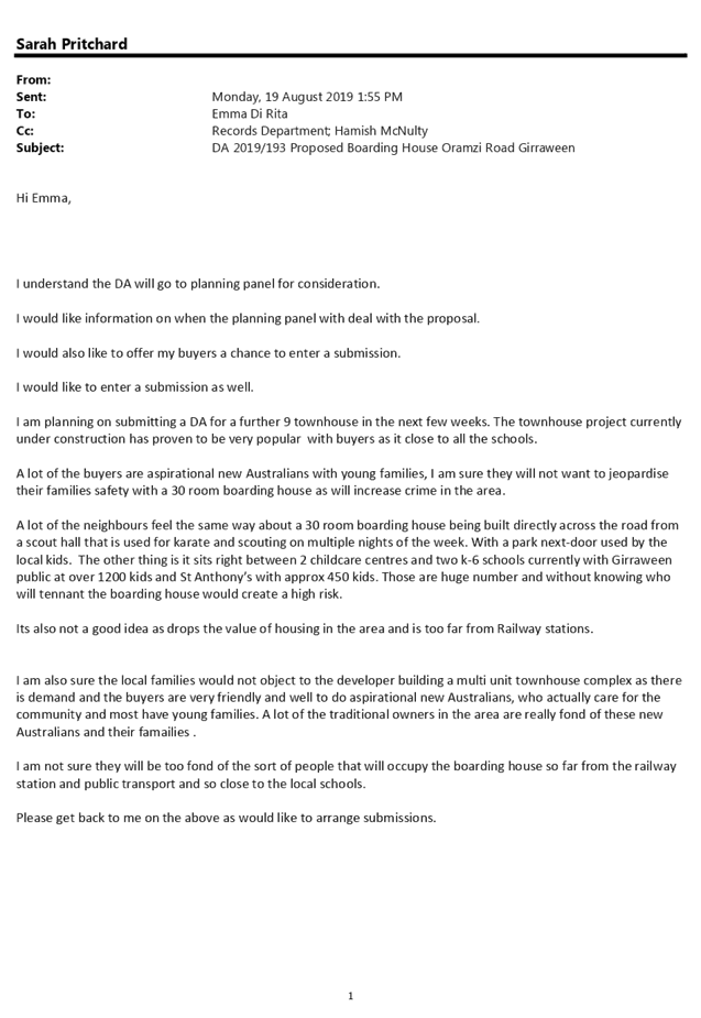
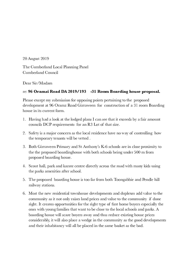
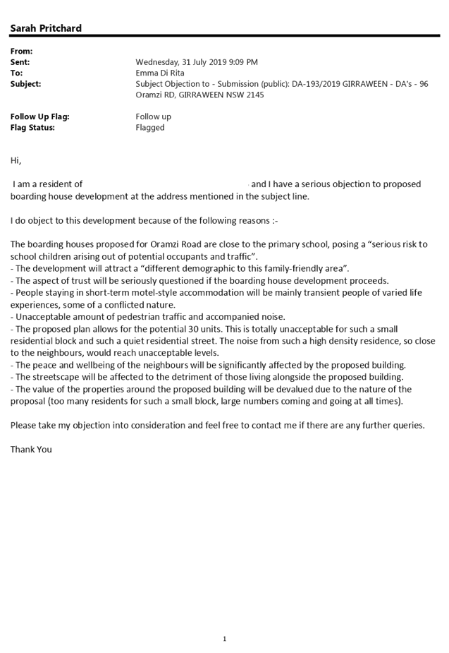
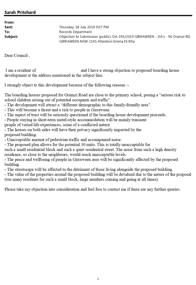
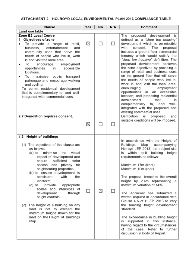
Item No: LPP066/19
Development
Application - 96 Oramzi Road, Girraween
Responsible
Division: Environment
& Planning
Officer: Executive
Manager Development and Building
File
Number: DA
2018/185/1
|
Application lodged
|
4 June 2019
|
|
Applicant
|
Yousif Al Salimy
|
|
Owner
|
Greenrest Pty Ltd &
Bluerest Pty Ltd & LCKL Management Pty Ltd
|
|
Application No.
|
DA 2019/193
|
|
Description of Land
|
96 Oramzi Road Girraween, Lot
83, DP 8768
|
|
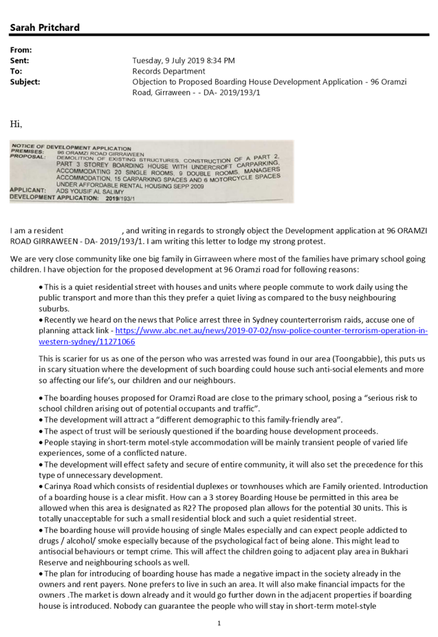
Proposed Development
(as amended)
|
Demolition of existing structures, construction of a Part
2, Part 3 storey boarding house with undercroft carparking, accommodating 20
single rooms, 9 double rooms, managers accommodation, totalling 30 rooms 15
carparking spaces and 6 motorcycle spaces under Affordable Rental Housing
SEPP 2009
|
|
Site Area
|
1226m2
|
|
Zoning
|
R3 – Medium Density
Residential
|
|
Disclosure of political
donations and gifts
|
Nil disclosure
|
|
Heritage
|
N/A
|
|
Principal
Development Standards
|
FSR – 0.7:1
Height of Building - 9m
|
|
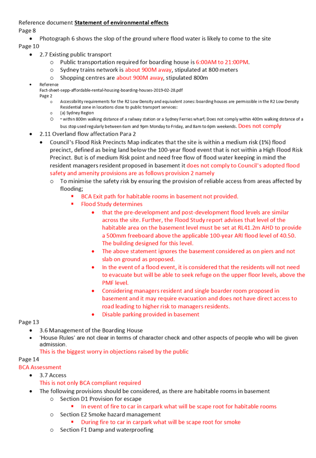
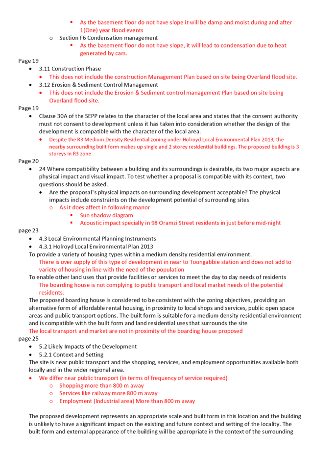
Issues
|
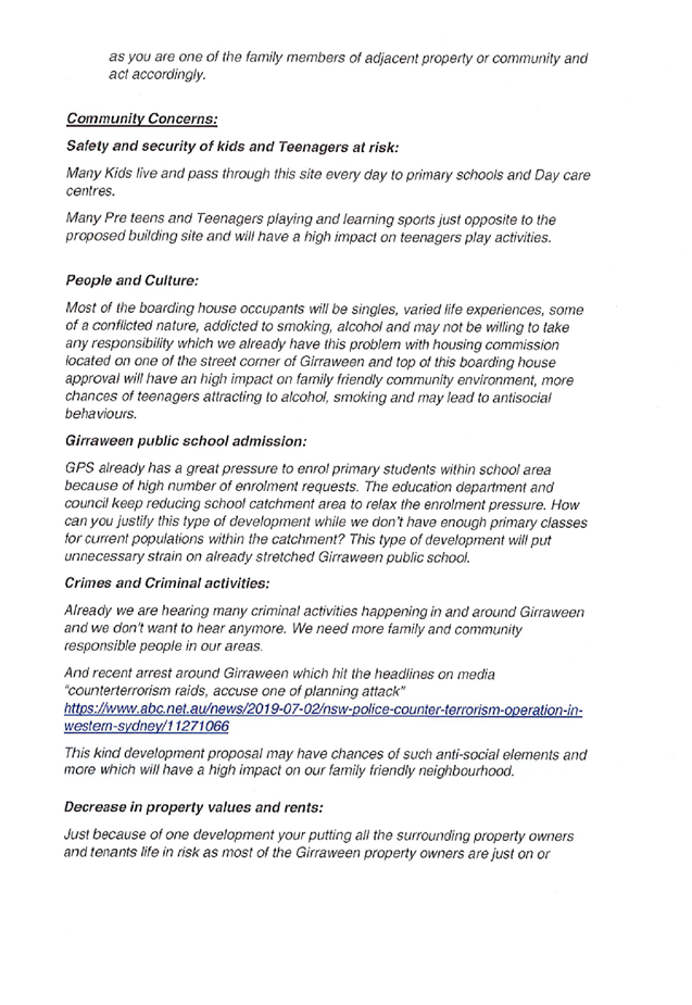
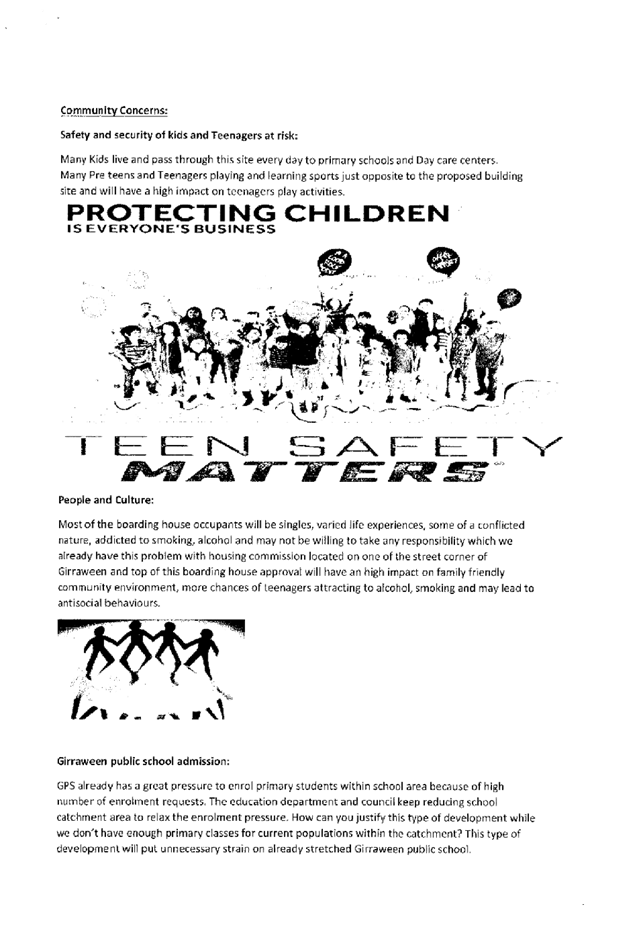
o Incompatibility
with the local character
o Excessive
building height
o HDCP
2013 non-compliances
o Inadequate
flood information
o Inadequate
on-site waste management
o 95
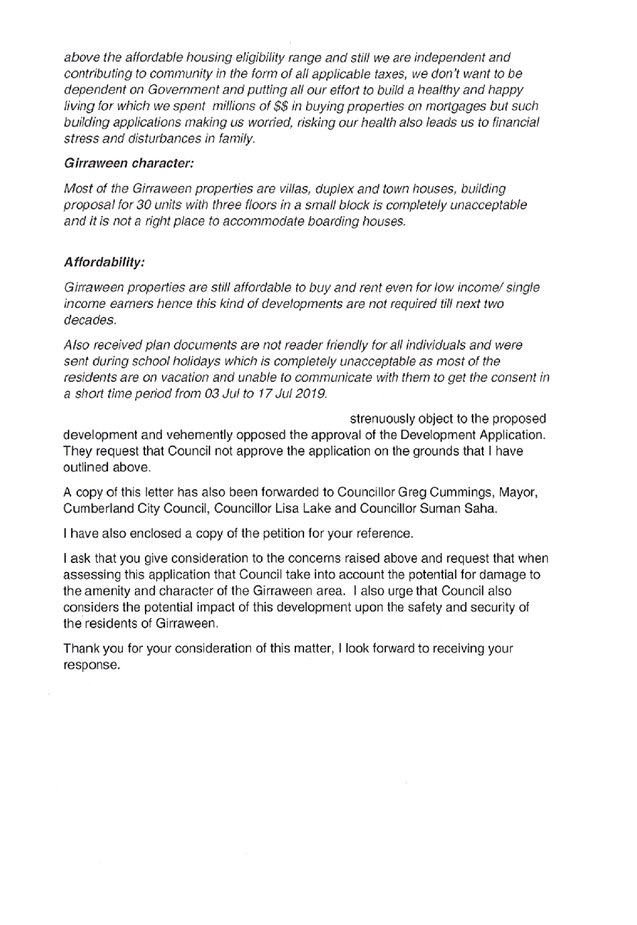
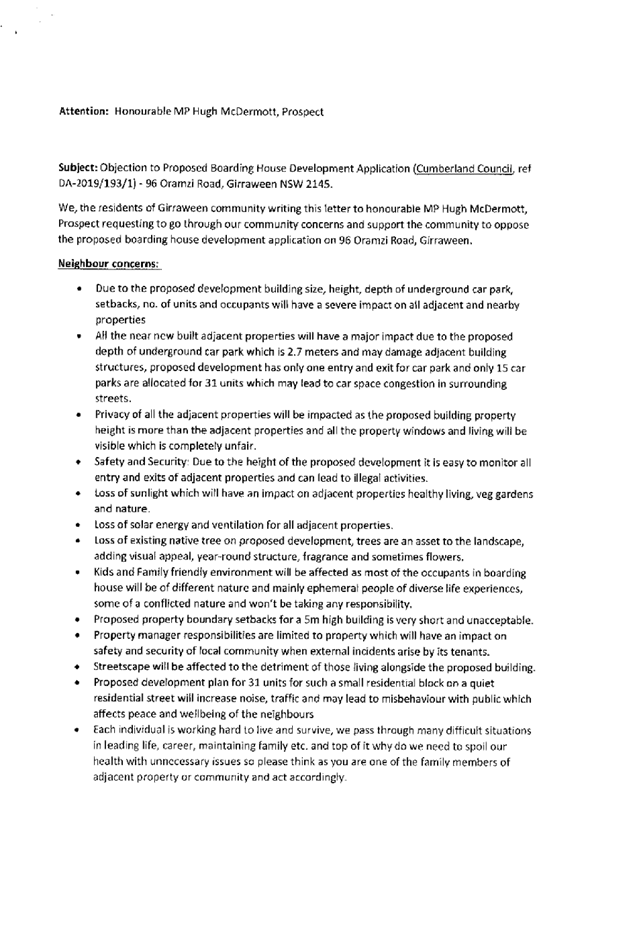
Public submissions, including 1 petition with 213 signatures
|
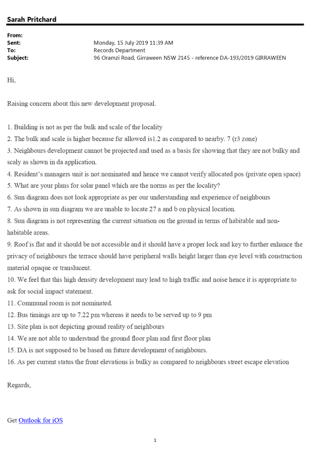
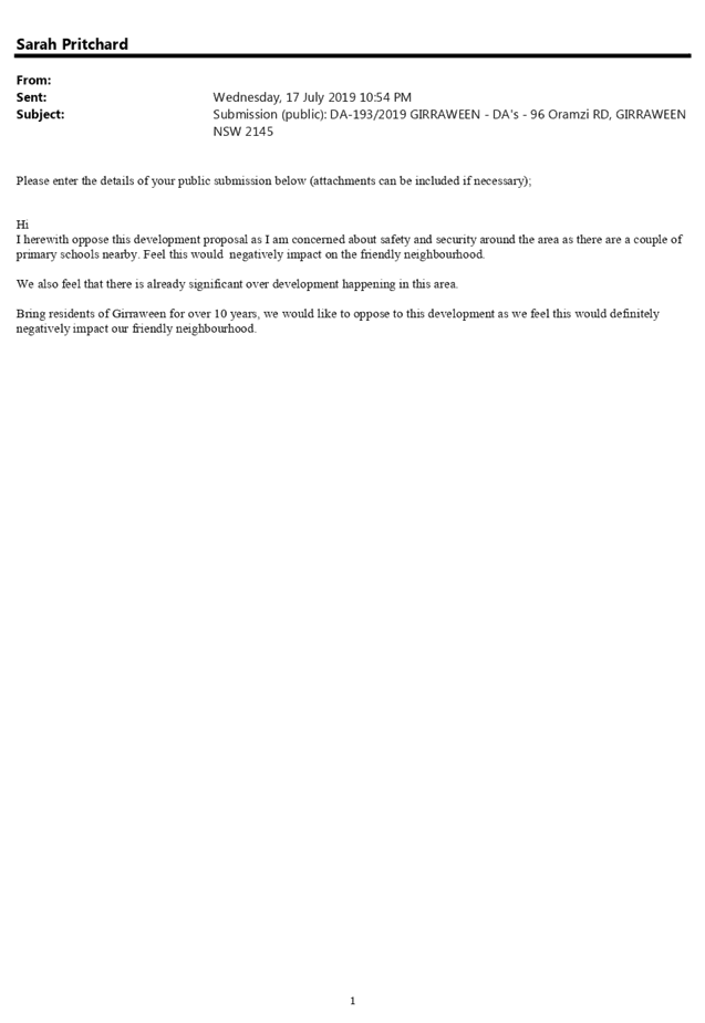
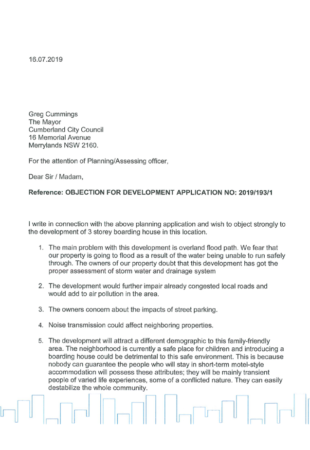
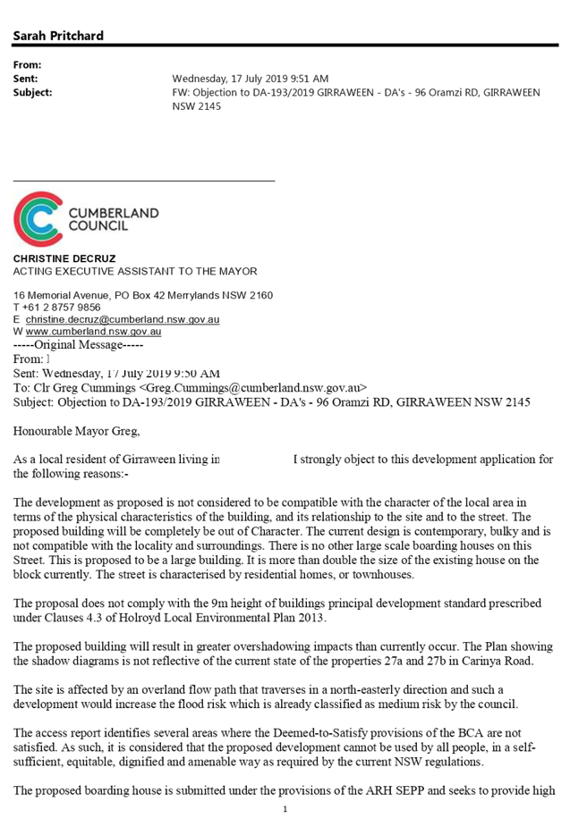
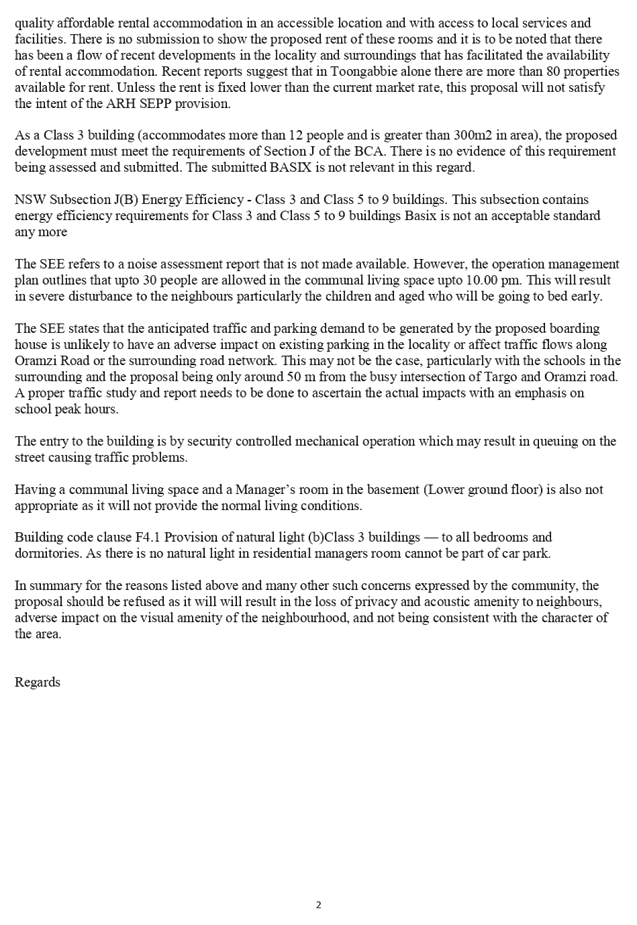
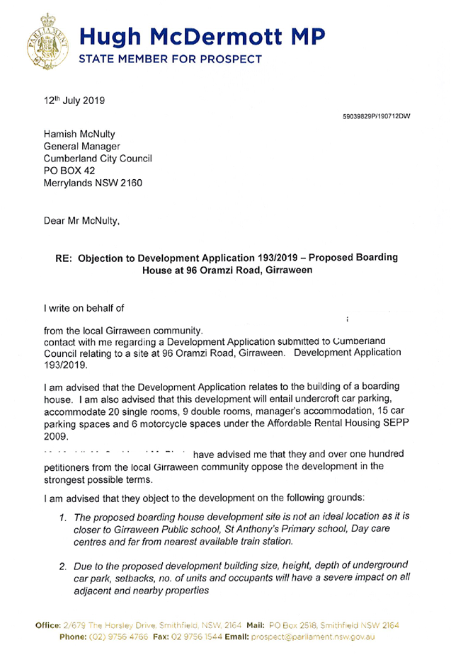
1. Development
Application No. 2019/193 was received on 4 June 2019 for the demolition of
existing structures, construction of a part 2, part 3 storey boarding house
with undercroft carparking, accommodating 20 single rooms, 9 double rooms,
manager’s accommodation, totalling 30 rooms, 15 carparking spaces and 6
motorcycle spaces, for 38 lodgers plus 1 manager under Affordable Rental
Housing SEPP 2009 at 96 Oramzi Road, Girraween.
2. The
application was publicly notified to occupants and owners of the adjoining
properties for a period of 14 days between 3 July 2019 and 17 July 2019. In
response, 95 submissions including 1 petition with 213 signatures were
received.
3. Due
to the large volume of public interest in the application, a public information
session was held on 2 September 2019.
4. Correspondence
was sent to the applicant on 6 September 2019 advising that the application
could not be supported, and inviting its withdrawal. That correspondence also
set out Council’s concerns with the application in detail. The issues
included character incompatibility, excessive height, insufficient clause 4.6
variation request, poor safety and security, visual privacy impacts, acoustic
impacts, non-complaint building design, inadequate flood study model,
inadequate on-site vehicle manoeuvring, BCA non-compliances and insufficient
on-site waste management.
5. No
response has been received from the applicant, addressing Council’s
request to withdraw.
6. The
proposal involves the following numerical non-compliances which are not
considered supportable as discussed elsewhere in this report:
|
Control
|
Required
|
Provided
|
% variation
|
|
9m building height (HLEP)
|
Maximum 9m
|
9.5m
|
5.6%
|
|
Side setback (HDCP)
|
Minimum 0.9m
|
Nil provided to western side property boundary
|
100%
|
|
No living area openings within 3m of a boundary
(HDCP)
|
Minimum 3m
|
Common room living area opening along the
eastern elevation is setback 2.6m from property boundary
|
13.3%
|
|
2 stories and 9m building height (HDCP)
|
Maximum 2 stories and 9m building height
|
3 story building with a 9.5m building height
|
50%
|
7. The
application is recommended for refusal for the reasons provided in the draft
determination.
8. The
application is referred to the Panel for determination due to the number of
public submissions received.
Subject Site And Surrounding
Area
The subject site is known as 96
Oramzi Road, Girraween. The legal description of the site is lot 83, DP 8768.
The site is zoned R3 – Medium Density Residential under the provisions of
HLEP 2013 (Holroyd Local Environmental Plan 2013), as are all surrounding
sites. The site has frontage of 20.115m to Oramzi Road, and total area of
1226m2.
The site slopes from the front to
the rear by approximately 2.7m. There are two existing large trees within the
rear yard and one large street tree in front of the site. One tree within the
rear yard and one street tree is proposed to be removed as part of the subject
application.
The site currently contains a
single storey dwelling house and an associated outbuilding. All existing
structures are proposed to be demolished as part of the development.
Surrounding sites are a mixture of one and two storey dwellings. On the
opposite side of Oramzi Road there is currently a Council Reserve, Karate Hall
and a mixture of one and two storey dwellings.
Figure
1 – Zoning map of subject site (Source: Cumberland Council)
Figure
2 – Aerial view of subject site (Source: Cumberland Council)
Figure
3 – Street view of subject site (Source: Google Maps)
Description of The Proposed
Development
The proposal is for demolition of
existing structures, construction of a part 2, part 3 storey boarding house
with undercroft carparking, accommodating 20 single rooms, 9 double rooms, 1
managers accommodation, for 38 lodgers plus 1 manager, 15 carparking spaces and
6 motorcycle spaces under Affordable Rental Housing SEPP 2009.
History
|
Date
|
Action
|
|
4 June
2019
|
Subject application lodged
with Council.
|
|
20 June
2019
|
Subject application referred
to Council’s internal departments and to NSW Police for review.
|
|
3 to 17
July 2019
|
Subject application publicly
notified. A total of 95 submissions including 1 petition with 213 signatures,
were received.
|
|
2
September 2019
|
Due to the high volume of
public interest, a public information session was held at Council Chambers,
inviting residents and objectors to voice their concerns and receive more
information about the proposed development.
|
|
6
September 2019
|
Correspondence sent to the
applicant advising that the proposal could not be supported, and inviting
withdrawal of the application. This correspondence set out Council’s
concerns with the application in detail.
|
|
9
October 2019
|
Referred to CLPP for
determination.
|
· A
deferred Commencement Consent was granted by Council on the 23 September 2016
for DA 2015/482 for construction of a multi dwelling housing development
comprising 7 units over basement parking accommodating 12 car parking spaces,
at the subject land. Schedule ‘A’ was satisfied on 10 May 2017 and
the consent become active. The consent was not acted.
· A
Pre-DA meeting was held on 24 October 2018 for a part 2, part 3 storey 28 rooms
boarding house for 38 lodgers and managers accommodation over 1 level of
basement for 16 car parking spaces and 6 motorcycles and 6 bicycles spaces
under ARH SEPP 2009. The Pre-DA notes provided following the meeting
highlighted significant non-compliances with ARH SEPP 2009, HLEP 2013 and HDCP
2013 and identified that the site was not suitable for that scale of
development.
Applicant’s Supporting
Statement
The applicant provided a Statement
of Environmental Effects prepared by Andrew Robinson Planning Services Pty LTD
dated 30 April 2019 in support of the application.
Contact With Relevant
Parties
The assessing officer has
undertaken an inspection of the subject site on the 3 July 2019 and has been in
regular contact with the applicant throughout the assessment process.
Internal Referrals
Development Engineering
The development application was
referred to Council’s Development Engineer for comment. The response
received 10 July 2019 advised that the submitted flood study model was not
satisfactory, however, the proposed stormwater concept design is
acceptable.
Traffic Engineering
The application was referred to
Council’s Traffic Engineer for comment. The response received 27 June
2019 indicates that the proposal has not submitted adequate information to
assess on-site vehicle manoeuvring.
Environmental Health
The development application was
referred to Council’s Environmental Health Officer for comment. The
response received on 4 July 2019 indicates that the acoustic report submitted
with the application was prepared in accordance with the NSW EPA Noise Policy
for Industry. Subject to compliance with the recommendations of the acoustic
report, and Council’s standard consent conditions, the EHO was satisfied
that the proposal would perform adequately in terms of its impacts on
surrounding properties during the use phases of the development.
Landscape and Tree Management
The application was referred to
Council’s Landscape and Tree Management Officer for comment. Response
received 8 July 2019 indicates that the proposed tree removal as detailed in
the submitted Arborist Report is supported, as well as support the proposed
landscape plan.
Waste Management
The development application was
referred to Council’s Waste Management Officer for comment. The response
received 28 August 2019 indicates that the proposed onsite waste management
arrangements are not practical. Council’s Waste Department did not
support the proposal in its current form.
Building Services Unit
The development application was
referred to Council’s Building Services Unit for comment. The response
received 5 August 2019 indicates that the proposal does not comply with parts
of the National Construction Code.
External Referrals
NSW Police
The application was referred to
NSW Police for a Safer by Design Evaluation. The response dated 2 July 2019
indicates that NSW Police have no objections and that the proposal rated
‘Low Risk’ with no further comments being made regarding associated
safety recommendations.
Planning Comments
The provisions of any
Environmental Planning Instruments (EP&A Act s4.15 (1)(a)(i))
State Environmental Planning
Policies
The proposed development is
affected by the following State Environmental Planning Policies:
(a) State
Environmental Planning Policy No. 55 – Remediation of Land (SEPP 55)
Clause 7 of SEPP 55 requires the
consent authority to be satisfied that the site is suitable or can be made
suitable to accommodate the proposed development. The matters listed within
Clause 7 have been considered in the assessment of the development application.
|
Matter for Consideration
|
Yes
|
No
|
|
Does the application involve re-development of the site or
a change of land use?
|
|
|
|
1.
Does the application involve
re-development of the site or a change of land use?
|
|
|
|
In the development going to be used for a sensitive land
use (e.g.: residential, educational, recreational, childcare or hospital)?
|
|
|
|
Does information available to you indicate that an
activity listed below has ever been approved, or occurred at the site?
acid/alkali plant and
formulation, agricultural/horticultural activities, airports, asbestos
production and disposal, chemicals manufacture and formulation, defence
works, drum re-conditioning works, dry cleaning establishments, electrical
manufacturing (transformers), electroplating and heat treatment premises,
engine works, explosive industry, gas works, iron and steel works, landfill
sites, metal treatment, mining and extractive industries, oil production and
storage, paint formulation and manufacture, pesticide manufacture and
formulation, power stations, railway yards, scrap yards, service stations,
sheep and cattle dips, smelting and refining, tanning and associated trades,
waste storage and treatment, wood preservation
|
|
|
|
Is the site listed on
Council’s Contaminated Land database?
|
|
|
|
Is the site subject to EPA
clean-up order or other EPA restrictions?
|
|
|
|
Has the site been the subject of
known pollution incidents or illegal dumping?
|
|
|
|
Does the site adjoin any
contaminated land/previously contaminated land?
|
|
|
|
Has the appropriate level of
investigation been carried out in respect of contamination matters for
Council to be satisfied that the site is suitable to accommodate the proposed
development or can be made suitable to accommodate the proposed development?
|
|
|
|
Details of contamination investigations carried out at
the site:
The site is not identified in
Council’s records as being subject to contamination. There is no
evidence available to suggest that either the subject site, or any adjacent
site, has ever been used for a potentially contaminating activity. No further
investigation is considered necessary in the circumstances. It is noted that
the application was accompanied with a Preliminary Site Investigation Report,
which has been reviewed by Council’s Environmental Heath Unit, who have
recommended imposition of conditions.
|
(b) State
Environmental Planning Policy (Vegetation in Non-Rural Areas) 2017
The proposal does not exceed the
biodiversity offsets scheme threshold. Therefore, the proposed vegetation
removal is considered acceptable. Refer to the DCP compliance table for further
comment.
(c) State
Environmental Planning Policy (Coastal Management) 2018
The subject site is not identified
as a coastal wetland and is not or land identified as “proximity area for
coastal wetlands”.
(d) State
Environmental Planning Policy (Building Sustainability Index: BASIX) 2004
BASIX Certificate number 1006932M
dated 24 April 2019 prepared by Eco Certificates Pty Ltd was submitted with the
application. The project achieves the target scores required for water and
energy and is consistent with the architectural plans.
(e) State
Environmental Planning Policy (Affordable Rental Housing) 2009
The proposed development is
defined as a ‘boarding house’ under the provisions of State
Environmental Planning Policy (Affordable Rental Housing) 2009. The
non-compliances with the ARH SEPP 2009 have been detailed in the following
table.
|
Clause
|
Yes
|
No
|
N/A
|
Comment
|
|
Part 2 New Affordable Rental Housing - Division 3
Boarding Houses
|
|
29 Standards that cannot be used
to refuse consent
(2) A consent authority
must not refuse consent to development to which this Division applies on any
of the following grounds:
|
|
building height
if the building height of
all proposed buildings is not more than the maximum building height permitted
under the environmental instrument for any building on the land
|
|
|
|
The proposed building height exceeds the maximum permitted
9 metres permitted under HELP 2013. A total building height of 9.5 metres has
been proposed. This is included as a reason for refusal in the draft
determination.
|
|
30A Character of local area
Consent must not be granted
unless the proposal is consistent with the character of the local area.
|
|
|
|
The proposal is not consistent with the character of the
local area and this is included as a reason for refusal in the draft
determination.
|
Character of the Local Area
A consent authority must not
consent to development for the purpose of a boarding house unless it has taken
into consideration whether the design of the development is compatible with the
character of the local area.
The ARH SEPP 2009 does not contain
any guidance for assessing whether a proposal is compatible with the character
of the local area. However, a planning principle for assessing compatibility in
the urban environment was established by Senior Commissioner Roseth of the Land
and Environment Court in the judgement for Project Venture Developments Pty Ltd
v Pittwater Council [2005] NSWLEC 191. This involves asking the following two
questions:
· Are
the proposal’s physical impacts on surrounding development acceptable?
The physical impacts include constraints on the development potential of
surrounding sites.
· Is
the proposal’s appearance in harmony with the buildings around it and the
character of the street?
A merit assessment of the
character of the local area should consider the following 3 steps:
· Step
1 – Identify the ‘local area’.
· Step
2 – Identify the character of the ‘local area’.
· Step
3 – Determine whether the design of the proposed development is
compatible with the character of the ‘local area’.
An assessment against each step is
provided below:
Step 1 – Identify the
‘local area’
The local area is identified in
Figure 4 below as the area within the yellow lines.
Step 2 – Identify the
character of the ‘local area’.
All sites within the local area
are zoned R3 – Medium Density Residential pursuant to HLEP 2013.
Whilst there are a number of one
and two storey dwellings within the locality, the area is transitioning to
medium density developments in accordance with the planning controls that
currently apply. The area is subject to a maximum height limit of 9m and
maximum floor space ratio (FSR) of 0.7:1. The emerging character of the area is
generally that of two storey dual occupancy developments and single / two
storey multi dwelling developments.
Step 3 – Determine
whether the design of the proposed development is compatible with the character
of the ‘local area’
The following questions assist in
determining whether a building is compatible with its surroundings:
· Are
the proposal’s physical impacts on surrounding development acceptable?
The physical impacts include
constraints on the development potential of surrounding sites.
In terms of the physical impacts
of the development:
o The development poses unacceptable
visual and acoustic privacy impacts to adjoining sites. Together, the visual
and acoustic privacy impacts in association with the 3 storey built form and
nil side setback result in unacceptable impacts for occupants of the existing
adjoining buildings and their future development potential.
· Is
the proposal’s appearance in harmony with the buildings around it and the
character of the street?
The subject site and surrounding
properties are subject to a maximum building height of 9m. Dwelling and dual
occupancy developments are permitted to have a maximum of 2 storeys, whilst
multi dwelling housing developments are permitted to be 2 storeys for the first
20m and then required to step down to 1 storey to the rear. Whilst the proposal
is not for multi dwelling housing, the controls in the DCP for multi dwelling
housing are helpful in establishing the desired future built form for the area.
The surrounding dwellings do not
protrude over the 9m building height limit, and the majority (including all the
buildings within the visual catchment of the subject site) have a maximum of 2
storeys. The proposal is part 2 / part 3 storeys, with a part of building
exceeding of 9.5m height standard. This building design is not in keeping with
the predominantly low to medium density character of the residential
development in the immediate vicinity of the site.
In summary, the design and
presentation of the proposed development, as well as its relationship to the
site and the surrounding developments, is not considered to be in harmony with
the character of the local area. This is included as a reason for refusal in
the draft determination.
(f) Holroyd
Local Environmental Plan 2013
HLEP 2013 applies to the proposed
development. The proposed development is permitted with consent in the R3
– Medium Density Residential zone that applies to the land. The non-compliances
with HELP 2013 have been detailed in the following table:
|
Clause
|
Yes
|
No
|
N/A
|
Comment
|
|
4.3 Height
of buildings
(1) The objectives of this clause are as follows:
(a) to minimise the visual impact of development and ensure
sufficient solar access and privacy for neighbouring properties,
(b) to ensure development is consistent with the landform,
(c) to provide appropriate scales and intensities of
development through height controls.
(2) The height of a building on any land is not to
exceed the maximum height shown for the land on the Height of Buildings Map.
|
|
|
|
The Height of Buildings Map indicates a maximum height of 9m
for this site.
The proposed development has a height of 9.5m which does
not comply with the height standard.
|
|
4.6 Exception of development
standards
(2) Development consent may, subject to this clause,
be granted for development even though the development would contravene a
development standard imposed by this or any other environmental planning
instrument.
|
|
|
|
The application accompanies a Clause 4.6 variation
request, seeking variation to the maximum building height limit of 9 m. This
variation request has not been supported by Council as there are no
identifiable planning gain and the variation is not considered in the public
standard. The height breach is included in the draft reasons for refusal.
|
|
6.4 Flood planning
This clause
applies to land at or below the flood planning level.
|
|
|
|
The subject site is
located below the flood planning level. On the basis of the information that
was submitted with the application, Council is not satisfied that the
proposal will not adversely affect local flood behaviour.
|
4.6 Exception of development
standards
The proposal involves a
non-compliance with the Height of Buildings standard. The proposal has a height
of 9.5 m (RL 50 – NGL 40.5) at the central portion of the building,
inclusive of the lift overrun and building roof, where the maximum height permitted
is 9 m. This represents a 5.6% departure from the standard.
The applicant submitted a written
request to vary the standard pursuant to clause 4.6 of the LEP. The relevant
provisions of clause 4.6 are considered in the following table.
|
4.6 Exceptions to development
standards
|
Comment
|
|
2.
(2) Development consent may, subject to this clause,
be granted for development even though the development would contravene a
development standard imposed by this or any other environmental planning
instrument. However, this clause does not apply to a development standard
that is expressly excluded from the operation of this clause.
|
The height of buildings development standard is not
expressly excluded from the operation of clause 4.6 and accordingly, consent
may be granted to the application despite the variation.
|
|
3.
(3) Development consent must not be granted for
development that contravenes a development standard unless the consent
authority has considered a written request from the applicant that seeks to
justify the contravention of the development standard by demonstrating:
4.
(a)
that compliance with the development standard is unreasonable or unnecessary
in the circumstances of the case, and
(b) That there are sufficient
environmental planning grounds to justify contravening the development
standard.
|
As stated above, the proposed development contravenes the
height of buildings development standard. A written request to vary the standard
was provided by the applicant, and this request seeks to justify the
contravention.
The applicant’s request includes the following
commentary:
· “the
extent of the non-compliance will not result in any adverse impacts on the
adjoining land uses with respect to overshadowing, loss of privacy,
inappropriate scale etc. and the proposed scale and massing of the building
is consistent with the existing and desired future character of the
locality”
· “the
non-compliance relates to the lift overrun and small portion of the roof and
on the north-eastern side of the building and does not seek to increase the
number of storeys or density of the development. As such, there is no nexus
between the height variation and the overall land use intensity”
The applicant contends that compliance with the standard
is unreasonable and unnecessary as the proposal satisfies the objectives of
the standard, notwithstanding the non-compliance. However, Council disagrees
with the above arguments due to the following reasons:
· The proposal has
multiple privacy impacts on adjoining sites and the proposal is not
consistent with the existing desired future character of the R3 locality.
· The proposal
does not comply with maximum number of storeys permitted within the R3 zone,
as required by HDCP 2013, resulting in the height non-compliance which
contributes to an over development of the site.
The applicant has not demonstrated that there are
sufficient environmental planning grounds to justify contravening the
standard as follows:
· The proposal
does not maintain an appropriate building scale for the location as it is out
of character to the locality and will have a negative relationship with
adjoining neighbouring properties.
· The proposal
will have unacceptable visual privacy impacts on neighbouring properties
|
|
5.
(4) Development consent must not be granted for
development that contravenes a development standard unless:
(a) the consent authority is satisfied that:
(i) the
applicant’s written request has adequately addressed the matters
required to be demonstrated by subclause (3), and
(ii) the proposed
development will be in the public interest because it is consistent with the
objectives of the particular standard and the objectives for development
within the zone in which the development is proposed to be carried out, and
6.
|
The Panel would not be satisfied that:
· the
applicant’s written request has adequately addressed the matters
required to be demonstrated by subclause (3) as detailed above, or
i)
· that the proposed
development is in the public interest as it is inconsistent with the
objectives of the height standard and the objectives of the R3 zone as
detailed below:
ii)
Objectives of the height standard are as follows:
(a) to minimise the
visual impact of development and ensure sufficient solar access and privacy
for neighbouring properties,
(b) to ensure
development is consistent with the landform,
(c) to provide
appropriate scales and intensities of development through height controls.
The proposal does not satisfy the objectives of the height
standard as visual privacy impacts for adjoining properties is not minimised.
The proposal does not satisfy the objectives of the zone
as the proposed development is not consistent with the landform and
surrounding developments.
The Panel would not be satisfied that the proposal is in
the public interest, as it does not satisfy the objectives of the standard,
and the objectives of the R3 zone.
|
|
7.
(b) the concurrence of the Secretary has been
obtained.
|
The concurrence of the Secretary can be assumed in the
present circumstances as the consent authority is a Local Planning Panel.
|
The provisions of any proposed
instrument that is or has been the subject of public consultation (EP&A Act
s4.15 (1)(a)(ii))
The proposed development is not
affected by any Draft Environmental Planning Instruments.
The provisions of any
Development Control Plans (EP&A Act s4.15 (1)(a)(iii))
The Holroyd Development Control
Plan (HDCP) 2013 provides guidance for the design and operation of development
to achieve the aims and objectives of the HLEP 2013.
A comprehensive assessment and
compliance table is provided at Attachment 3. The following table highlights
the DCP non-compliances, most of which are not considered supportable as
detailed below:
|
No.
|
Clause
|
Comment
|
Yes
|
No
|
N/A
|
|
PART A – GENERAL CONTROLS
|
|
8
|
Flood Prone Land
|
|
|
To provide prescriptive controls on the use and
development of land subject to various flood risk exposures, which reflect
the probability of the flood occurring and the potential hazard within
different areas.
|
Insufficient information has been provided to determine
the level of flood impact.
|
|
|
|
|
10
|
Safety and Security
|
|
|
Design new development to reduce the attractiveness of
crime by minimising, removing or concealing crime opportunities.
|
The proposed lower ground level and ground level have very
limited street surveillance, resulting in poor site safety and
security.
|
|
|
|
|
PART B – RESIDENTIAL CONTROLS
|
|
1.4
|
Visual Privacy
|
|
|
To provide a high level of visual and acoustic privacy for
residents and neighbours in dwellings and private open spaces
|
The proposed deign poses unacceptable visual privacy
concerns to adjoining sites.
There are inconsistencies between submitted documentation
which do not allow for a proper acoustic assessment. These privacy and
acoustic impacts are further discussed in attachment 3.
|
|
|
|
|
1.11
|
Vehicular Access and Driveways
|
|
|
Council favours the use of a central under-building access
with arrangement for cars to exit the property in a forward direction
|
Swept path diagrams have not
been submitted to Council to demonstrate if forward vehicle manoeuvring can
be achieved.
|
|
|
|
|
5.0
|
Multi Dwelling Housing
Whilst there are no specific DCP controls for boarding
houses in HDCP 2013, the controls for Multi Dwelling Housing in Part B
are relevant to the assessment in that they establish the desired future
character of the area with regard to building form and the relationship of
buildings to the site. Assessment of these controls is detailed in Attachment
3.
|
|
|
|
|
|
|
|
|
The provisions of any planning
agreement that has been entered into under section 7.4, or any draft planning
agreement that a developer has offered to enter into under section 7.4
(EP&A Act s4.15(1)(a)(iiia))
There is no planning agreement or
draft planning agreement associated with the subject application.
The provisions of the
Regulations (EP&A Act s4.15 (1)(a)(iv))
The regulations do not prescribe
any relevant matters for consideration, other than the provisions of AS2601. If
consent were to be granted, standard conditions could be imposed to require
demolition to be carried out in accordance with AS 2601.
The Likely Environmental,
Social or Economic Impacts (EP&A Act s4.15 (1)(b))
It is considered that the proposed
development will have adverse environmental impacts in the locality, having
regard to the excessive building height, visual and acoustic privacy impacts,
inadequate setbacks, and inappropriate built form. This is included as a reason
for refusal in the draft determination.
The suitability of the site for
the development (EP&A Act s4.15 (1)(c))
The subject site is not considered
suitable for the proposed development, having regard to the excessive building
height, visual and acoustic privacy impacts and inadequate setbacks impacts as
detailed elsewhere in the report. This is included as a reason for refusal in
the draft determination.
Submissions made in accordance
with the Act or Regulation (EP&A Act s4.15 (1)(d))
Advertised (newspaper) Mail Sign Not
Required
In accordance with Council’s
Notification requirements contained within Part E of the HDCP 2013, the
proposal was publicly notified for a period of 14 days between 3 July 2019 and
17 July 2019. The notification generated 95 submissions, including a petition
with 213 signatures, in respect of the proposal, with none disclosing a
political donation or gift. The issues raised in the public submissions are
addressed below:
Figure
5 – Submissions response table
|
Issue
|
Response
|
|
· Proposed
height does not comply with the maximum 9 m building height limit
|
The proposed development is seeking a variation to maximum
building height of 9 m. Council has not supported this variation request and
this has been included in the draft reason for refusal.
|
|
· Proximity to
local schools and childcare centres. Risk to children arising out of
potential occupants and traffic.
· Safety
concerns as site is located across from a community hall, park and karate
centre where local children play
|
The proposed use is a permissible land use under ARH SEPP 2009 and within the
R3 Medium Density Zone pursuant of HLEP 2013. There are no restrictions
within the Environmental Planning and Assessment ACT 1979 (EPAA 1979), the ARH SEPP 2009, HLEP 2013 or
other applicable legislation preventing boarding houses in close proximity of
schools, childcare centres, community halls and parks.
8.
Boarding house developments
generally do not raise any particular safety concerns for pedestrians and
neighbouring properties. The application was referred to NSW Police and their
response indicates that NSW Police have no objections and that the proposal
is rated as ‘Low Risk’ with no further comments being made
regarding associated safety recommendations.
|
|
· Local schools
are already overcrowded. This development will cause more pressure on the
local catchment area.
|
This is not a matter of consideration under Section 4.15
of the EPAA 1979.
|
|
Flood Study determines
· that
the pre-development and post-development flood levels are similar across the
site. Further, the Flood Study report advises that level of the habitable
area on the basement level must be set at RL41.2m AHD to provide a 500mm
freeboard above the applicable 100-year ARI flood level of 40.50. The
building designed for this level.
· The
above statement ignores the basement considered as on piers and not slab on
ground as proposed.
· In the
event of a flood event, it is considered that the residents will not need to
evacuate but will be able to seek refuge on the upper floor levels, above the
PMF level.
· Considering
managers resident and single boarder room proposed in basement and it may
require evacuation and does not have direct access to road leading to higher
risk to managers residents.
· Disable
parking provided in basement
|
The site is flood affected. Council’s engineers have
assessed the application and are not satisfied with the submitted flood study
report. This has been addressed in Council’s draft reasons for refusal.
|
|
· Proposed
underground OSD tanks – does Council support underground OSD tanks?
· Concerns
raised regarding OSD accuracy of OSD calculations.
· Is there an
existing stormwater easement on site? Will the site drain to the easement?
· How many
development sites can tap into an existing stormwater easement? Is the
existing pipe at the rear large enough to cater for this development?
|
Council’s engineers have confirmed that Council can
accept below ground OSD systems if the site is affected by flooding.
Council’s engineers have reviewed the OSD calculations and are
satisfied that they are in accordance with Council’s policy.
As the site slopes towards the rear, Council’s
engineers have confirmed that the site will drain to the existing 1.83m wide
easement located at the rear of the site. Detailed design and calculations
are required for the existing stormwater pipe capacity, which demonstrates
that the Council pipe has sufficient capacity. If the DA were to be approved
by Council this information would be imposed as a condition of consent,
requiring the information prior to issue of any Construction Certificate.
|
|
· Privacy
impacts from proposed development
· Proposed
development can overlook adjoining neighbours private open space areas
|
During the assessment of the application Council’s officers
identified potential privacy impacts to adjoining sites and these have been
included in the draft reasons for refusal.
|
|
· Noise and
acoustic impacts from proposed development
· How much
lighting / noise will be produced from the development?
iii)
|
The application has been accompanied with an acoustic
report which has been assessed by Council’s Environmental Health Unit,
who have no objections regarding noise impacts during the use of the
development, subject to conditions. The Plan of Management also sets out
specific measures which ensure noise mitigation to adjoining sites is
managed.
However, there are inconsistencies between the submitted
acoustic report and Plan of Management. This has been addressed in
Council’s draft reasons for refusal.
If the development were to be approved, conditions would
be imposed on the consent requiring lighting to be accordance with the
relevant Australian Standards.
|
|
· Girraween is
residential area with young families, why is this quiet street selected for a
boarding house?
· 30 units is
unacceptable for a small residential block.
· Proposed
development is out of character with the existing locality.
· Building is
not as per bulk and scale of the locality
· Overdevelopment:
the scale of this development is too large for the footprint of the land
dimensions.
· Aesthetics:
the building looks like a commercial office block, should be suitable into a
commercial zone.
|
The proposed use is a permissible land use and the
applicant is entitled to lodge a DA. However, during the assessment of the
application, Council officers determined that the proposal in its current
form is not suitable for the subject site, as the proposal is out of
character with the existing locality. This has been included in the draft
reasons for refusal.
|
|
· Does the
character assessment consider the existing demographic within the area?
|
The character assessment as required under ARH SEPP 2009 only considers
the character of the local area and the surrounding built forms.
|
|
· People
staying in short-term motel style accommodation will be mainly transient
people of varied life experiences, some of a conflicted nature.
· The boarding
house will provide housing of single males especially and can expect people
addicted to drugs / alcohol / smoke especially because of the physical fact
of being alone.
|
The proposed use is permissible on the subject land and
there are no legislative provisions for Council to reject a DA based on
social classification of people who may live there.
|
|
· Does Council
have any control over who can use / lease out rooms within the boarding
house?
· How can the
minimum short term stay of 3 months be policed?
· ‘House
Rules’ are not clear in terms of character check and other aspects of
people who will be given admission.
|
As a general comment, the operator of a boarding house is
free to determine and decide on any future prospective lodgers.
The boarding house manager is required to police the
minimum 3 month stay with future lodgers.
|
|
· Proposed
boarding house will increase crime, drugs, alcohol and terrorism within the
local area and effect safety of entire community.
· Aspect of
trust will be seriously questioned if the boarding house development
proceeds.
· Peace and
wellbeing of the neighbours will be significantly affected by the proposed
building.
|
9.
The application was referred to
NSW Police for a Safer by Design Evaluation. The response received indicates
that NSW Police have no objections and that the proposal rated ‘Low
Risk’ with no further comments being made regarding associated safety
recommendations.
The Plan of Management (POM) submitted with the
application specifies how the premises will operate and addresses
residents’ behaviour, house rules, noise, contact details of the onsite
manager and conflict resolution.
|
|
· Decrease in
property values, rent and affordability
|
This is not matters for consideration in the evaluation of
a development application pursuant to section 4.15 of the EPAA 1979.
|
|
· Who is this
accommodation for? There is no University in Girraween for student type
accommodation.
|
Whilst there are no set eligibility criteria for tenants,
a boarding house is a form of affordable housing and can be suitable for 1 or
2 person households.
|
|
· The
development will attract a different demographic to this family-friendly
area. Development will compromise family safety within the Girraween area.
|
The development will provide accommodation for 1 or 2
person households. This is not considered to compromise the safety of family
friendly area within Girraween.
|
|
· Increase to
parking, traffic and pedestrians on the street
· Is there a
requirement for the development to provide onsite visitor parking?
|
The application was accompanied with a Traffic Report
prepared by Terraffic Pty Ltd. The Report concludes that:
· The proposed
development will not have any noticeable or unacceptable effect on the road
network serving the site in terms of road network capacity or traffic-related
environmental effect.
The application was reviewed by Council’s Traffic
Engineer who had no objections in relation to this matter.
The ARH
SEPP 2009 requires each boarding room to provide 0.5 parking spaces
per each boarding room. With 30 boarding rooms proposed (including managers
room) a minimum of 15 parking spaces is to be provided on site. The proposal
complies with this requirement. There is no requirement under ARH SEPP 2009 to provide
visitors parking.
|
|
· If this
development goes ahead creates undesirable precedent for the area
· The
streetscape will be affected to the detriment of those living alongside by
the proposed building
|
Council is not satisfied with development in its current
form and therefore has recommended refusal.
|
|
· This is a
quiet residential street with houses and units where people commute to work
daily using the public transport and more than this they preferred a quiet
living compare to the busy neighbouring suburbs
· Carinya Road
which consists of residential duplexes or townhouses which are family
orientated. Introduction of a boarding house is clear misfit. How can a 3
storey boarding house be permitted in this area be allowed when this area is
designated as R3
|
Boarding houses are a permissible type of land use within
the R3 land zone under HLEP 2013 and ARH SEPP 2009. However, Council is not satisfied with the
proposal in its current form and therefore has recommended refusal of the
application.
The 3 storey element has formed part of Council’s
draft reasons for refusal.
|
|
· Council to
consider low income suburbs are as a better place for Affordable Housing
· Introducing
an ARH SEPP 2009 will attract low income owners to this specific area which
creates social inequality.
· I fear that
the building of an over-crowed guest house in Oramzi Road will be a retreat
to the bad old days and therefore I object most strongly to this development.
|
Boarding houses are a permissible type of land use within
the R3 zone under HLEP 2013 and ARH SEPP 2009.
The NSW State Government introduced the ARH SEPP 2009 to facilitate
the provision of affordable rental housing. The proposal seeks to provide
affordable housing in accordance with the requirements of the
SEPP.
|
|
· If approved
many families with kids will start moving away from this suburb.
· If this
development gets approved then the whole area should be rezoned so all
residents can get out.
|
This is not a matter for consideration under section 4.15
of the EPAA 1979.
|
|
· The proposed
boarding house development site is not an ideal location as it is far from the
nearest available train station
· The boarding
home needs to be closer to shops and amenities
· Shopping
centres are required to be a minimum 800m from the subject site. The proposal
does not comply with this requirement.
· 2.7 Existing
public transport
o Public transportation required
for boarding house is 6:00AM to 21:00PM.
o Sydney trains network is about
900M away, stipulated at 800 meters
o Shopping centres are about 900M
away, stipulated 800m
· Reference
Fact-sheet-sepp-affordable-rental-housing-boarding-houses-2019-02-28.pdf
Page 2
o Accessibility requirements for
the R2 Low Density and equivalent zones: boarding houses are permissible in
the R2 Low Density Residential zone in locations close to public transport
services:
o (a) Sydney Region
· Within 800m
walking distance of a railway station or a Sydney Ferries wharf; does not
comply within 400m walking distance of a bus stop used regularly between 6am
and 9pm Monday to Friday, and 8am to 6pm weekends. Does not comply.
· Bus timings
are up to 7.22pm where it needs to be served up to 9pm
|
ARH SEPP
2009 does not require boarding houses located in the R3 – Medium
Density Residential Zone to have any specific distances to train stations or
shops.
Proposed boarding houses located in the R2 – Low
Density Residential Zone require the site to be located within an
‘accessible area’. This is not the case for this subject
application as the site is located within the R3 – Medium Density Residential
Zone.
|
|
· Cumberland
interim affordable housing policy dated July 2017 on page 4 under the
paragraph requirement no. 2 “Short walking distance of rail stations
and high frequency stops for buses that use dedicated bus routes. These
locations will ensure good access to job opportunities and services for very
low moderate income households without car dependency”
· The super
seeding clause from SEP states that public transportation should be within
400 mts of the boarding house and hence we expect the bus to be serving
during the time of 6 am to 21 pm at least with a frequency of 1 hour whereas
bus route 705 the last starting time is 19.26 and expecting to finish much
before 21.00 hours at cannot be used for this particular development. Train
station is away by more than 400 mts from this development. Also
mentioning Statement of Environment Effect document by client Andrew Robinson
Planning Services PVT Limited on page 10 clause number 2.7. Titled Existing
public transport.
|
The application has been proposed under the ARH SEPP 2009, not
Cumberland Council’s Interim Affordable Housing Policy.
The ARH
SEPP 2009 does not require boarding houses located in the R3 –
Medium Density Residential Zone to have any specific distances to train
stations or shops.
|
|
· Surrounding
properties will be impacted by proposed depth of underground car park and
only 1 entry and exit for car park
|
If this application were to be approved, Council would
impose specific conditions of consent requiring all earthworks and excavation
to be in accordance with the relevant Austrian Standards and BCA. This would
be overseen by the appointed Principal Certifying Authority in charge of the
building construction.
Swept path diagrams were not submitted which demonstrate
vehicles can sufficiently pass one another at the top and bottom of the
driveway. This has been included in the draft reasons for refusal.
|
|
· Old plans for
shade diagrams used. 27C Carinya Road recently redeveloped as town
houses
|
This is noted and has been included in Council’s
draft reasons for refusal.
|
|
· Loss of
existing native tree in proposed development
· Landscape
plan has nominated certain trees which need to be protected. They may be in
adjoining property and their roots may get escaped during to the excavation
of basement leading to dead of such trees. We haven’t seen any
documents of how trees will be protected or replaced.
|
The application was accompanied by an Arboricultural
Assessment report and a landscape plan prepared by a qualified landscape
architect. Council’s tree management officer has reviewed the
application and has no objections to the proposed tree removal and tree
retention. If the application was to be approved, conditions would be imposed
on the consent ensuring the tree removal and tree protection is in accordance
with relevant Australian Standards.
|
|
· Proposed
boundary setbacks for a 5m high building is very short and unacceptable.
· What is the
required rear setback? Should it be 30% of the site?
· Can anyone
who puts a DA in also built to a zero lot boundary? Zero lot construction
needs easement for maintenance?
|
Considering the controls detailed in HDCP 2013 for multi
dwelling housing, a minimum 4m rear setback is required. The application
proposes a minimum 6m setback to the rear property boundary. This is
considered satisfactory.
Each DA submitted to Council is assessed on its own
merits. Council has not supported the proposed nil setback to the western
boundary and this has been included in the draft reasons for refusal.
The requirement for a 30% length of the site rear setback is
required for dual occupancy developments only.
|
|
· Residents
managers unit is not nominated and hence we cannot verify allocated POS
|
There is 1 allocated manager’s room on the lower
ground floor. POS has been allocated for the manager and the lodgers, in
accordance with the ARH SEPP
2009 requirements.
|
|
· Roof is flat
and it should not be accessible and it should have a proper lock and key to
further enhance privacy of neighbours
|
Plans do not detail any access to the roof.
|
|
· Communal room
is not nominated
|
The communal room has been nominated on the lower ground
floor.
|
|
· Residents
manager unit is attached to carpark which is not allowed as per BCA, due to
carbon monoxide emitted by cars, this may go into inhabited rooms and calls
for health hazard to the occupants.
· There is no
natural light in residential mangers room cannot be part of car park
|
The lower ground level is not a basement, rather an
undercroft area. Along the northern and eastern elevations of the
manager’s room, there are openings which allow for natural light and
ventilation to be achieved. If this DA were to be approved, Council would
impose conditions of consent requiring BCA compliance.
|
|
· Carpark slab
is not showing any slop so we suspect it may lead to water logging within
carparking, leading to health hazard like fungus developments, mosquito
breading, which are all health hazards especially to residents manager unit
|
The lower ground level has been incorporated into the
onsite stormwater drainage plan, which details sufficient drainage. This has
been reviewed by Council’s Development Engineering Department, who have
no objections.
|
|
· Geo-technical
report has suggested the slop of the batter has to be maintained so that the
neighbouring properties are not damaged.
|
The application proposes minimal cut and fill outside the
building envelope, complaint with HDCP 2013.
|
|
· Concerns for
noise during construction period
|
If the application were to be approved, Council would
impose conditions of consent requiring all construction to be in accordance
with the relevant Australian Standards and the BCA. This would be overseen by
the appointed Principal Certifying Authority.
|
|
· The proposal
intensities several areas where the Deemed-to-Satisfy provisions of the BCA
are not satisfied.
|
This has been assessed and formed part of the draft
reasons for refusal.
|
|
· As a Class 3
building (accommodates more than 12 people and is greater than 300m2 in
area), the proposed development must meet the requirements of Section J of
the BCA.
· BASIX is not
an acceptable standard anymore
|
A Class 3 building still needs to comply with the BASIX
requirements for water and energy. The current BASIX Certificate submitted
with the application is satisfactory in this regard. The provisions of
Section J of the BCA will be assessed at Construction Certificate stage, if
the application were to be approved by Council.
|
|
· What members
will be elected for the CLPP meeting?
· Can residents
speak to CLPP?
|
CLPP members are elected on a rotational basis.
Any person who made a submission will be notified about
the CLPP meeting. From here, they can register to address and speak to the
Panel members during the public session of the meeting.
|
|
· What happens
once decisions is received from applicant, will community be involved again?
|
At any stage of the DA assessment process, if amended
plans are received and they trigger re-notification in accordance with
Council’s policy, then residents and objectors will be re-notified.
Amended plans were not received in this case and,
therefore, all residents and objectors will be notified about the CLPP
meeting. From here, they can register to address and speak to the Panel
members during the public session of the meeting.
|
|
· Has fire
safety been considered?
|
If the application is to be approved, fire safety will
form part of the Construction Certificate.
|
|
· Are there any
other similar sites and developments like this is in the Cumberland area?
|
There are many sites within Cumberland Local Government
area with approved boarding houses.
|
|
· What are the
controls for floor space and site coverage? Does the proposal comply with
these requirements?
· Is the car
parking included in the floor space ratio calculation?
|
The maximum permitted FSR (floor space ratio) for the site
is 0.7:1. The development complies with this control. Car parking to meet the
consent authority’s requirements is not included in the FSR.
There are no specific controls for site coverage for
‘multi dwelling housing’ within the R3 zone. Although the DA is
not for multi dwelling housing, these controls are best used to assess the
subject application to form a better character consistency within the
immediate area.
|
|
· There should
be set controls for boarding houses in Council DCP.
|
Not a matter for consideration under Section 4.15 of the
Act.
|
|
· Is there a
solar access requirement for each boarding room?
· It does not
supply any solar Access to all southern rooms.
· It reduces
solar access to living areas of neighbours to 3 hours only
· Loss of
sunlight which will have an impact on adjacent properties health living, veg
gardens and nature
· Loss of solar
energy and ventilation for all adjacent properties
|
The ARH
SEPP does not have specific controls requiring each boarding room to
receive solar access. ARH
SEPP requires the common room to receive a minimum of 3 hours of
direct sunlight between 9am and 3pm in mid-winter. The application complies
with the requirement.
Council’s controls require all adjoining properties
to receive 3 hours of solar access between 9am and 4pm, during mid-winter.
The proposal complies with this requirement.
There are no solar panels located on the roofs of any
immediate adjoining dwellings. The proposal will not affect ventilation of
existing neighbouring dwellings.
|
|
· Inconsistencies
with the submitted flood report and geotechnical report, with regards to the
type and thickness of slab.
|
This is noted. However, if the DA were to be approved,
Council would impose specific conditions of consent requiring the slab to
comply with the relevant Australian Standards and this would also form part
of the Construction Certificate.
|
|
· How long till
this DA is determined?
|
This DA will be determined on the 9 October 2019, unless
further deferred by the Panel.
|
|
· Can the
applicant challenge Council’s final decision?
· Have any
boarding houses gone to Local Environmental Court before?
|
Any applicant has the right to appeal Council’s
final decision with the Land and Environmental Court (LEC) within 6 months
from date of determination.
There are instances where boarding house applications have
been subject to court appeals in the LEC.
|
|
· Does this
application need to be reviewed by Council’s design excellence panel?
|
No, the design excellence panel is for developments which
are 25m or more in building height.
|
|
· Why was the
application notified during the school holidays?
|
Council has a legal requirement to notify all applications
in a timely manner and in accordance with Council’s Notification
Policy. The application was notified in accordance with the next available
calendar dates.
|
|
· 3.11
Construction Phase
This does not
include the construction Management Plan based on site being Overland flood
site.
· 3.12 Erosion
& Sediment Control Management
This does not
include the Erosion & Sediment control management Plan based on site
being Overland flood site.
|
If this application was to be approved, Council would
impose specific conditions on the consent requiring all construction and
sediment control to be in accordance with the relevant Australian Standards
and Building Code of Australia. This would be overseen by the appointed
Principal Certifying Authority for the building.
|
The public interest (EP&A
Act s4.15(1)(e))
In view of the foregoing analysis
it is considered that the approval of the development application would be
contrary to the public interest.
Section 7.11 (Formerly S94)
Contribution Towards Provision or Improvement of Amenities or Services
The proposed development attracts
the payment of contributions in accordance with Holroyd Section 94
Contributions Plan 2013.
In accordance with the currently
indexed rates for the Toongabbie centre contribution area, the following
contributions apply to the proposal:
· 30
boarding rooms (6661 x 30) - $199,830
· Total
= $199,830
If consent were to be granted, a
condition could be imposed requiring the payment of the contributions prior to
the issue of a construction certificate.
Disclosure of Political
Donations And Gifts
The application and notification
process did not result in any disclosure of Political Donations or Gifts.
The development application has
been assessed in accordance with the relevant requirements of the Environmental
Planning and Assessment Act 1979, ARH SEPP 2009, HLEP 2013 and HDCP 2013. The
proposal is incompatible with the character of the local area, proposes an
excessive building height, and has many departures from HDCP 2013. The proposed
development is part 3 storeys and this is contrary to Council’s controls
within the R3 Medium Density Residential Zone and, therefore, the application
is recommended to be refused. Whilst a boarding house is permitted with consent
in the R3 zone, the design of the proposed development does not respond
appropriately to the site, is considered to be an over development of the site
and would have unacceptable impacts on the streetscape and on surrounding
properties.
There are no further consultation
processes for Council associated with this report.
There are no further financial
implications for Council associated with this report.
There are no policy implications
for Council associated with this report.
Communication /
Publications:
The final outcome of this matter
will be notified in the newspaper. The objectors will also be notified in
writing of the outcome.
|
1. That
the Local Planning Panel does not approve the variation to the Development
Standard relating to building height as contained within Clause 4.3 of the
Holroyd Local Environmental Plan 2013, as the applicant’s Clause 4.6
objection has not adequately addressed the matters required to be
demonstrated by Clause 4.6 (3) and the development will not be in the public
interest because it is inconsistent with the objectives of the Height
Standard.
2. That
Development Application No. 2019/193 for demolition of existing structures,
construction of a Part 2, Part 3 storey boarding house with undercroft car
parking, accommodating 20 single rooms, 9 double rooms, managers
accommodation, 15 car parking spaces and 6 motorcycle spaces under Affordable
Rental Housing SEPP 2009 on land at 96 Oramzi Road, Girraween be refused for
the reasons listed in the draft determination.
3.
That those persons who lodged a submission in respect of the application be
notified of the determination of the application.
|
1. ARH SEPP 2009
Compliance Table ⇩ 
2. HLEP
2013 Compliance Table ⇩ 
3. HDCP
2013 Compliance Table ⇩ 
4. Architectural
Plans ⇩ 
5. Redacted
Public Submissions - Part 1 ⇩
6. Clause
4.6 Variation Request ⇩
7. Draft
Notice of Determination ⇩
8. Redacted
Public Submissions - Part 2 ⇩
DOCUMENTS
ASSOCIATED WITH
REPORT LPP066/19
Attachment 1
ARH SEPP 2009 Compliance Table
Cumberland Local Planning Panel Meeting
9 October 2019
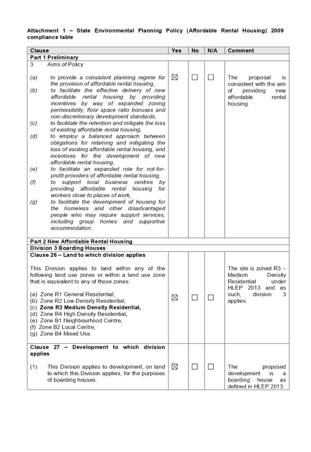
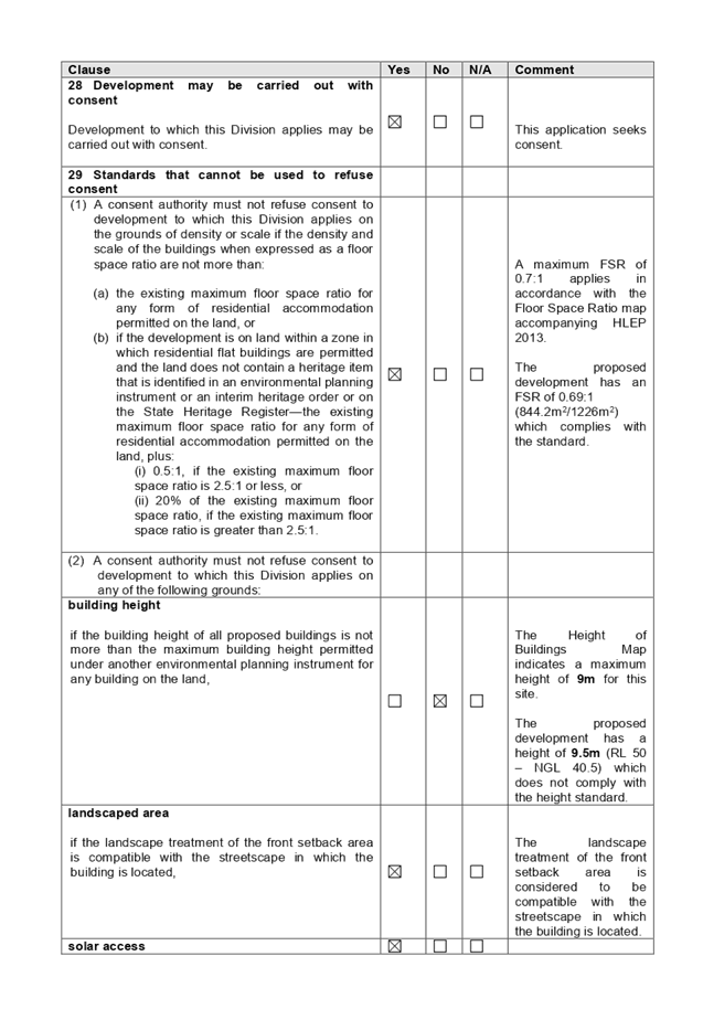
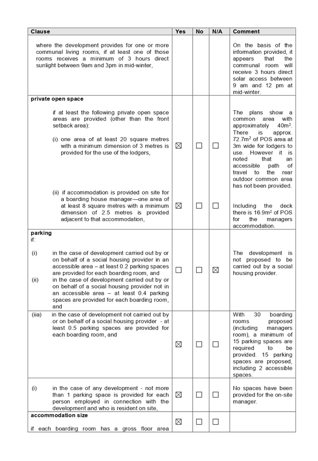
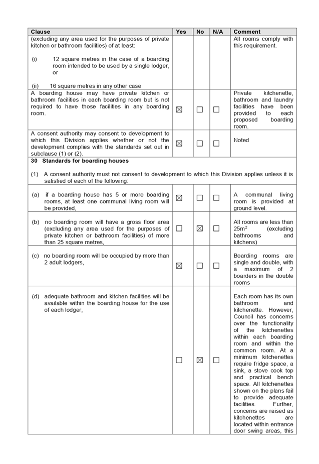
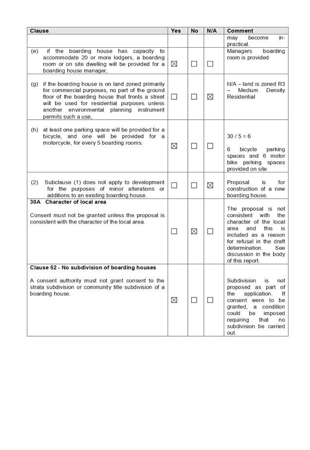
DOCUMENTS
ASSOCIATED WITH
REPORT LPP066/19
Attachment 2
HLEP 2013 Compliance Table
Cumberland Local Planning Panel Meeting
9 October 2019
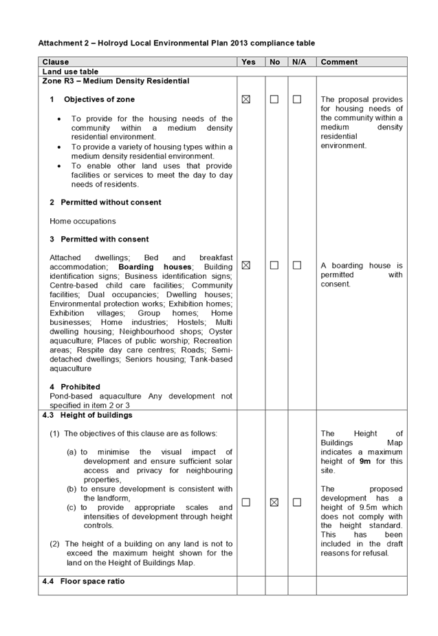
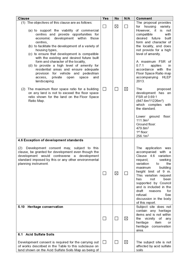
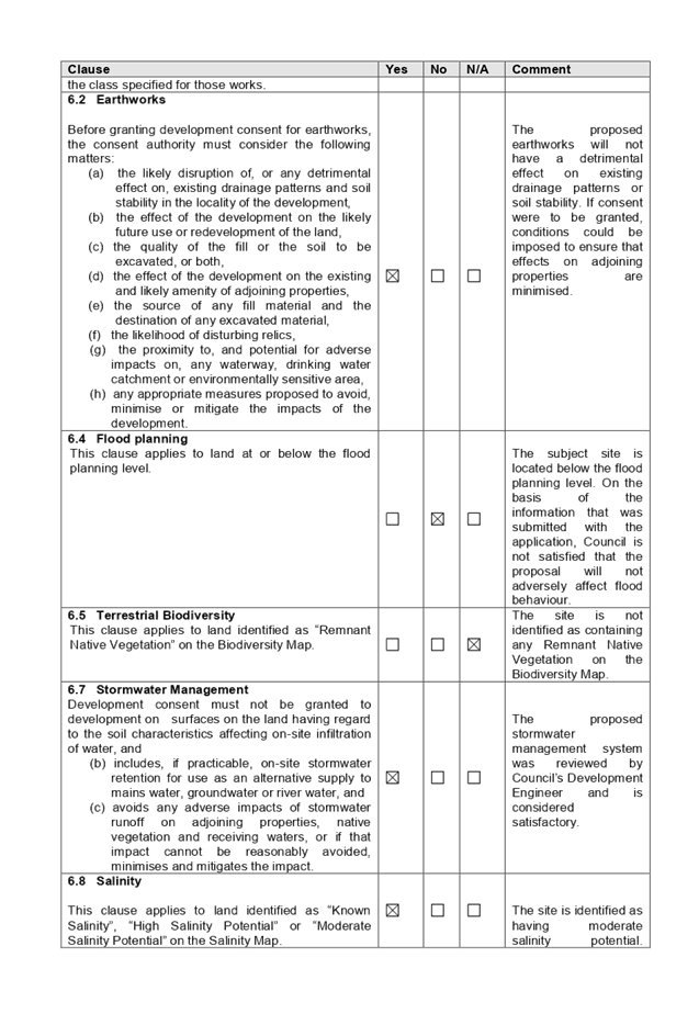

DOCUMENTS
ASSOCIATED WITH
REPORT LPP066/19
Attachment 3
HDCP 2013 Compliance Table
Cumberland Local Planning Panel Meeting
9 October 2019
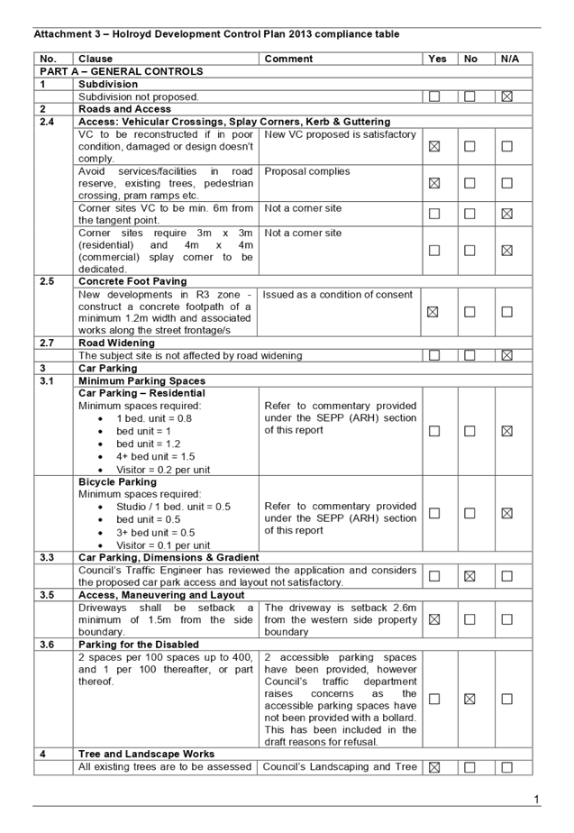
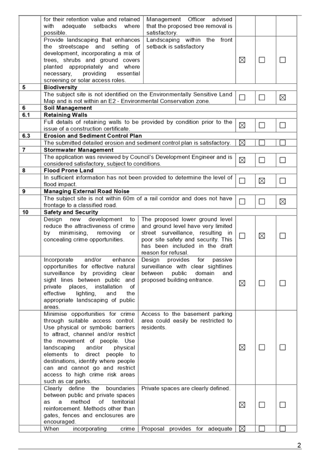
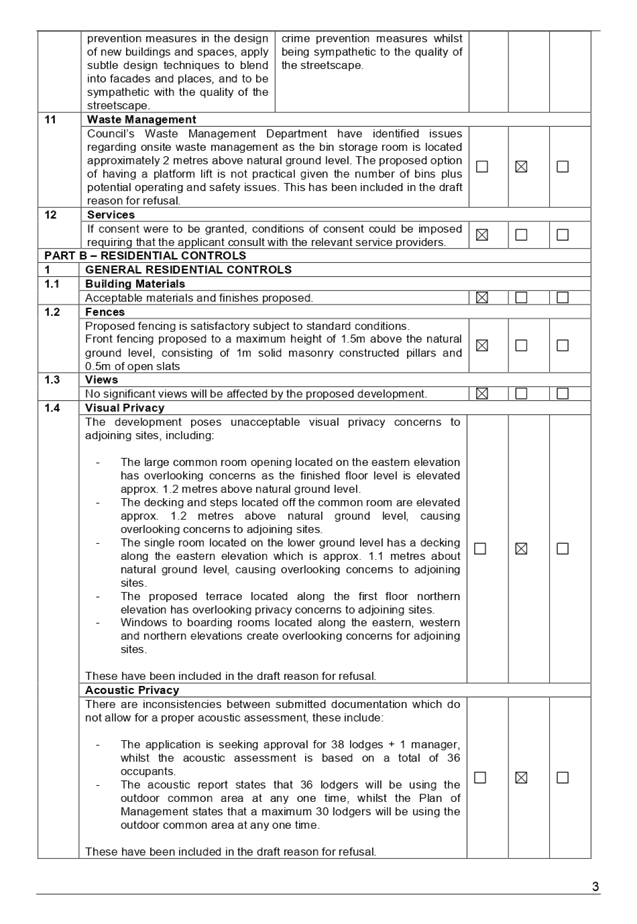
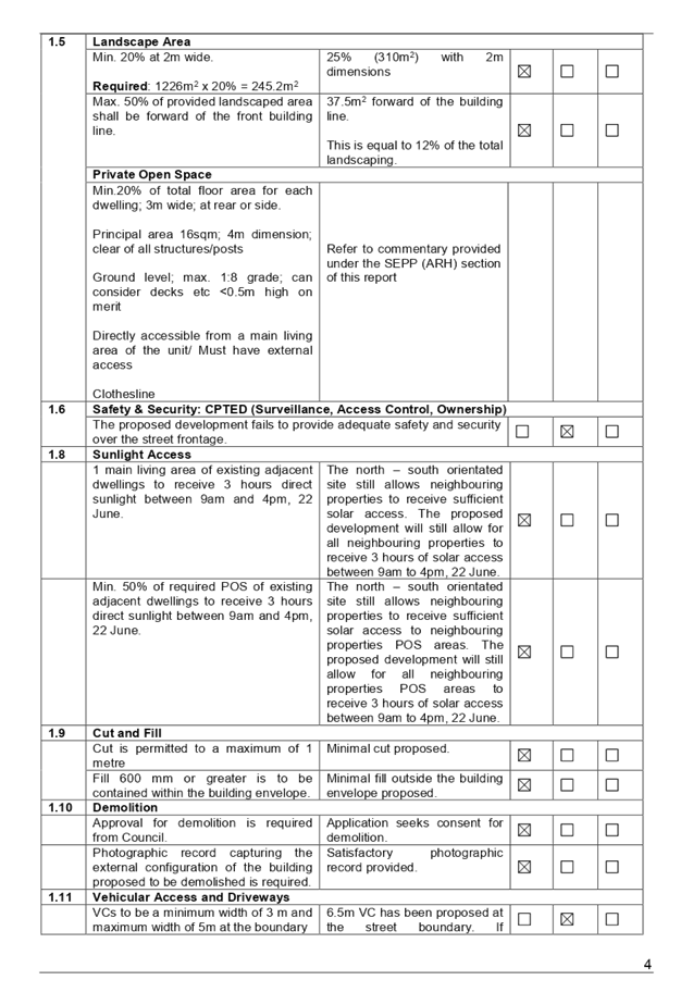
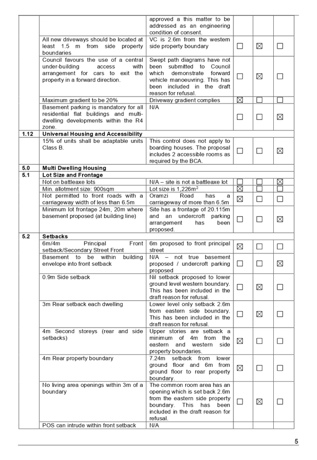
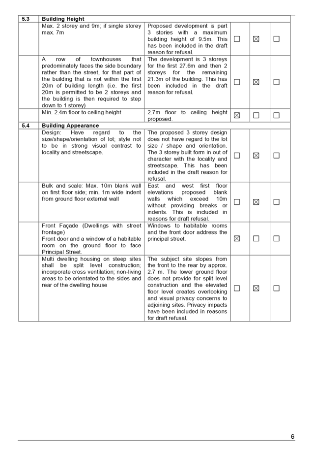
DOCUMENTS
ASSOCIATED WITH
REPORT LPP066/19
Attachment 4
Architectural Plans
Cumberland Local Planning Panel Meeting
9 October 2019
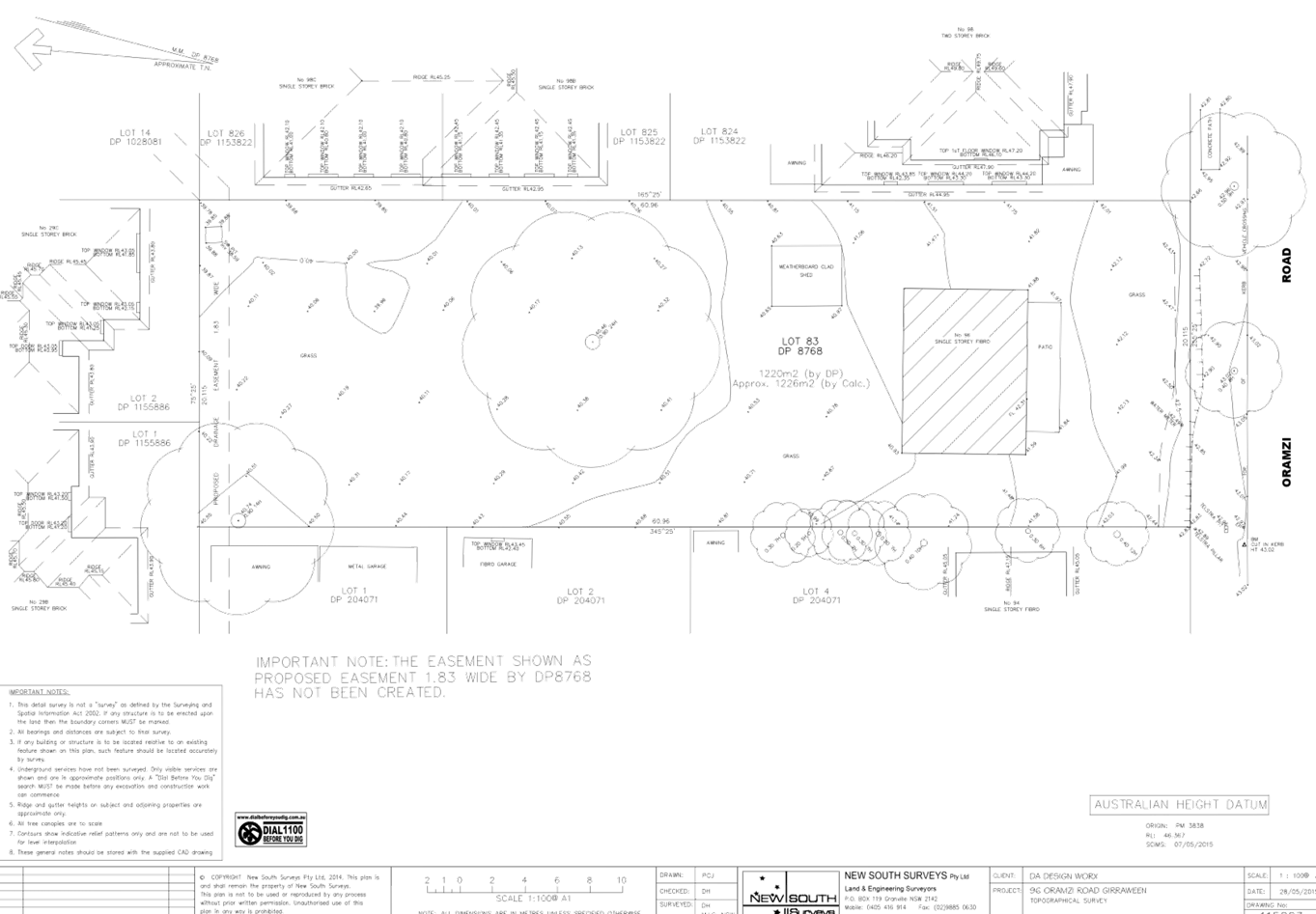
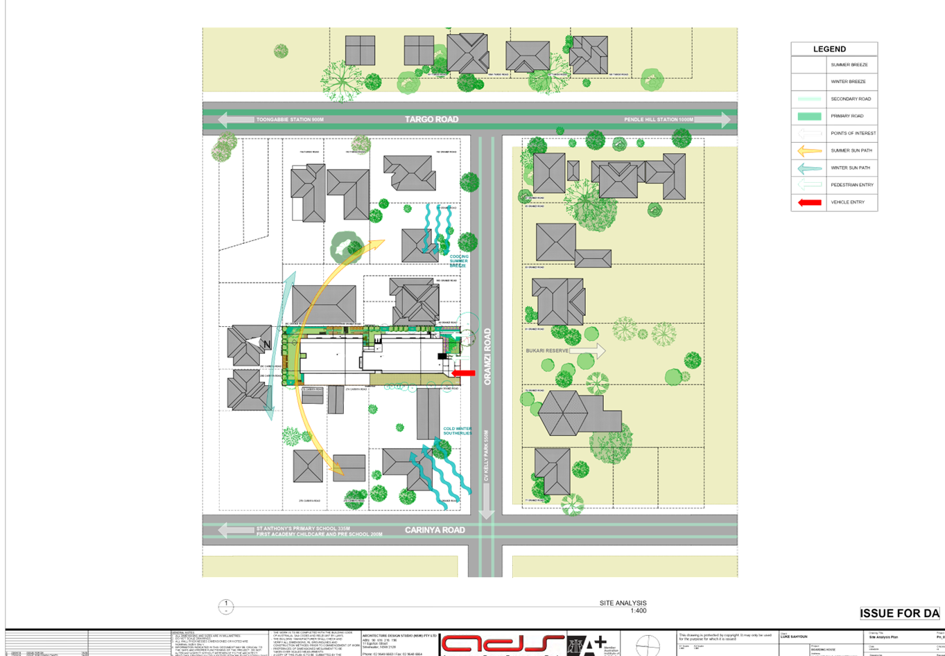

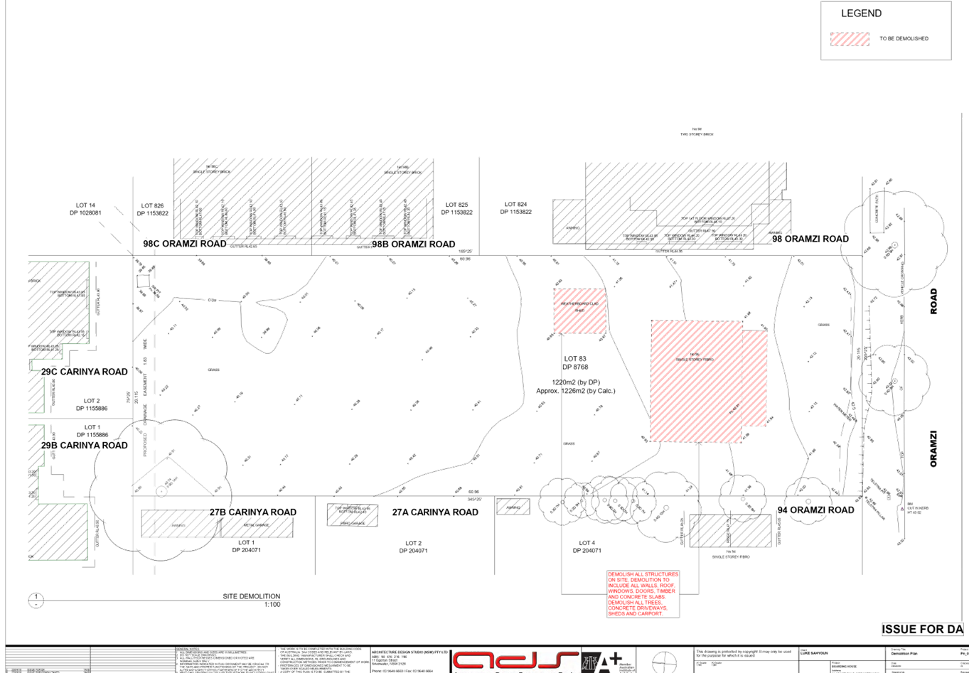
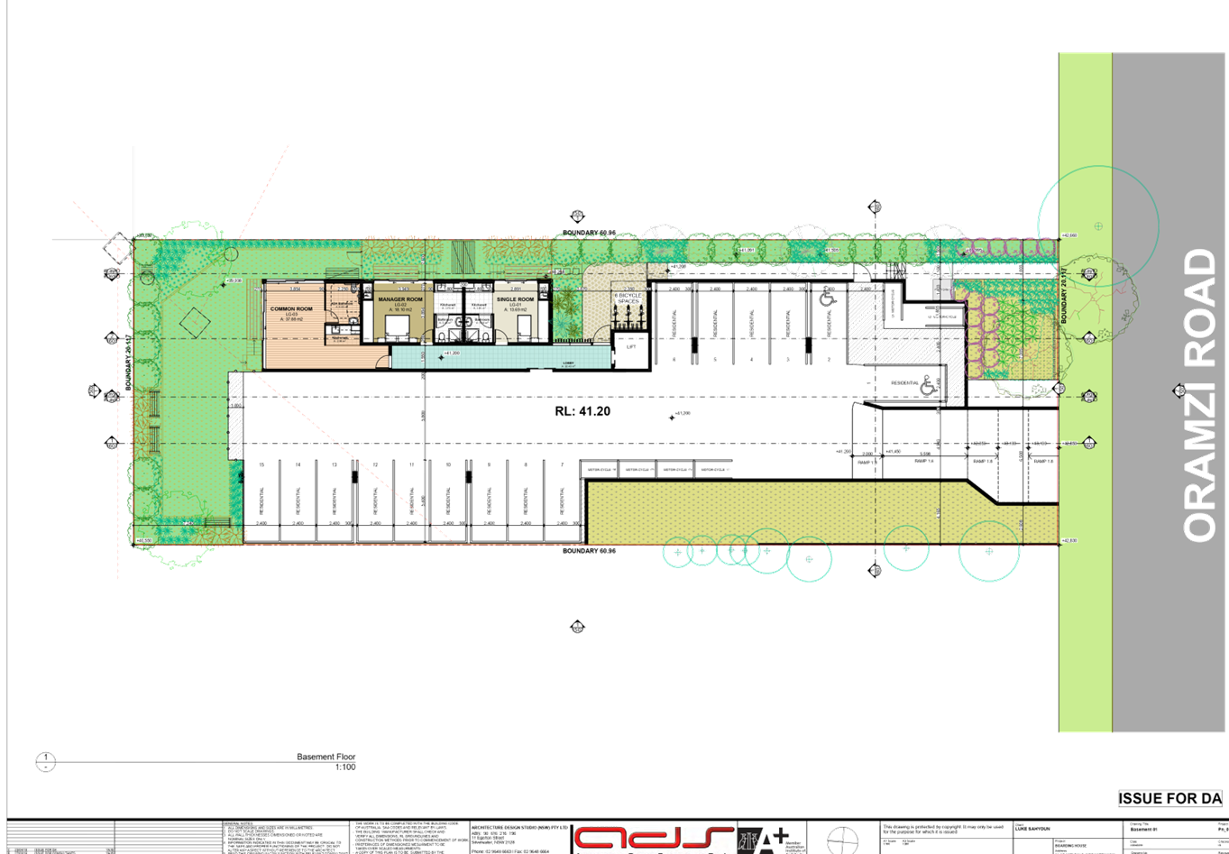
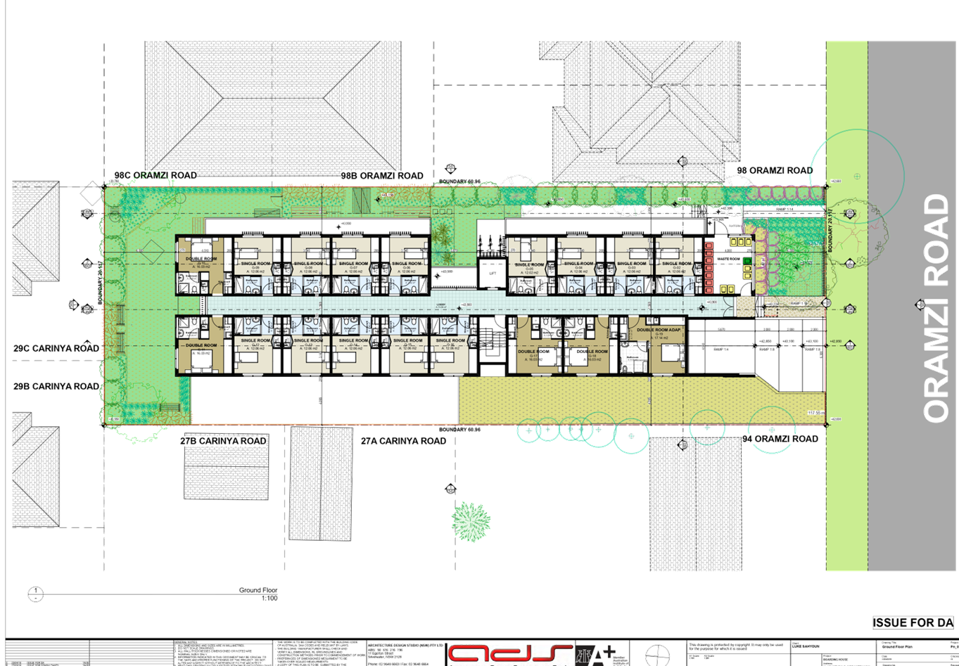
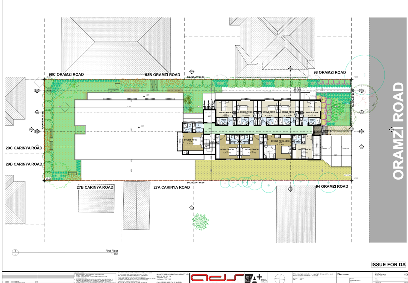
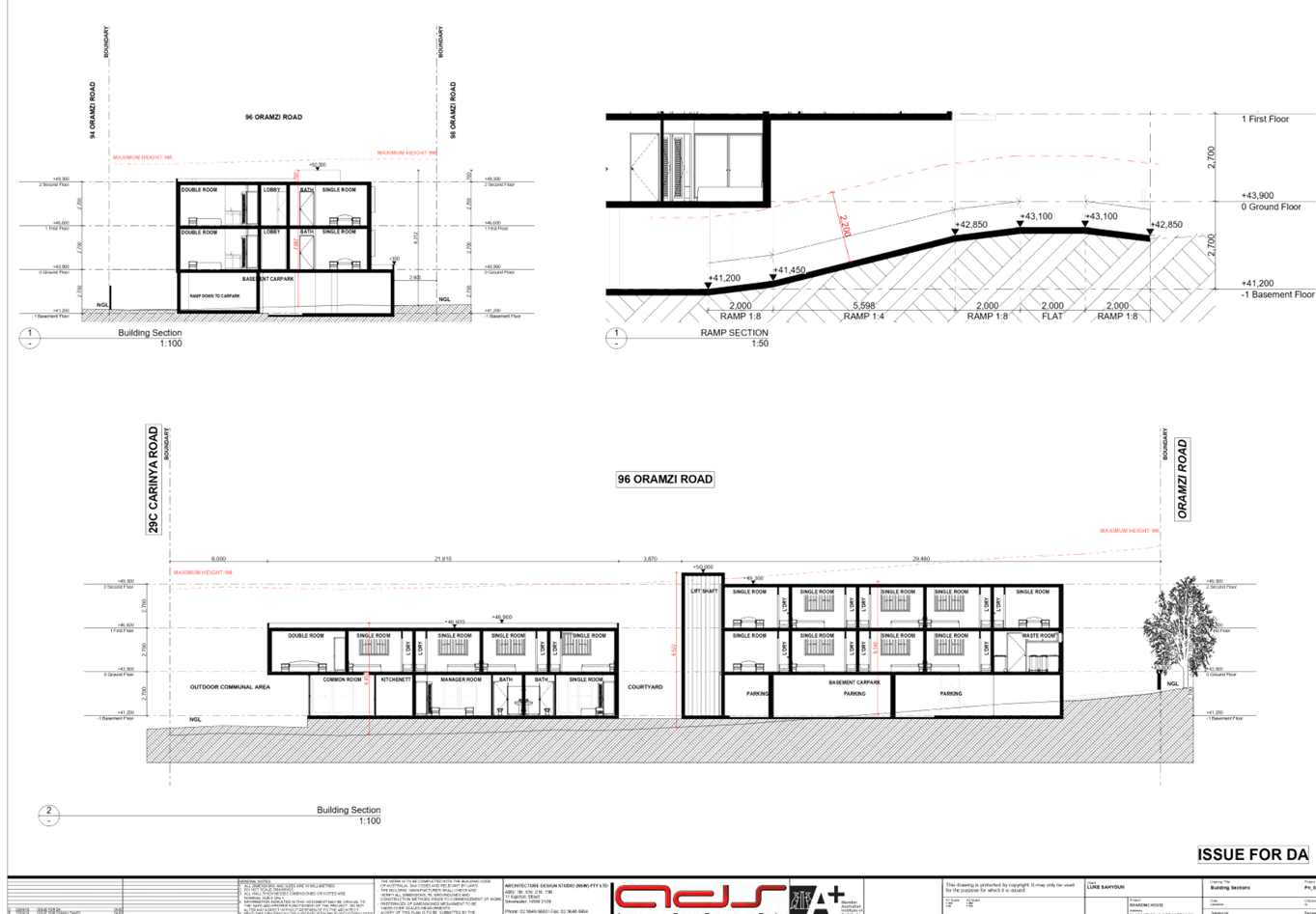
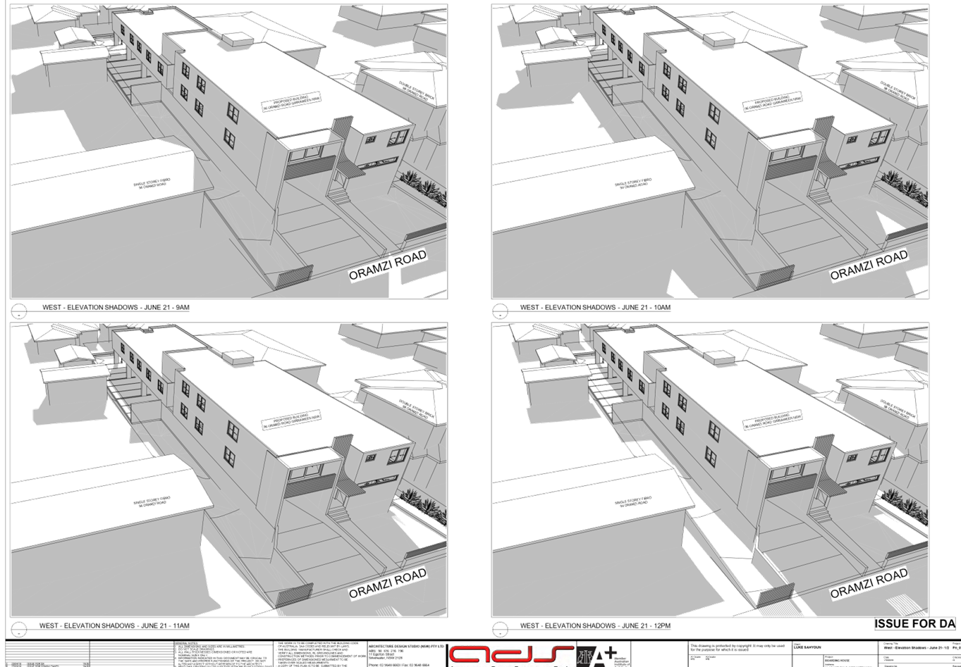
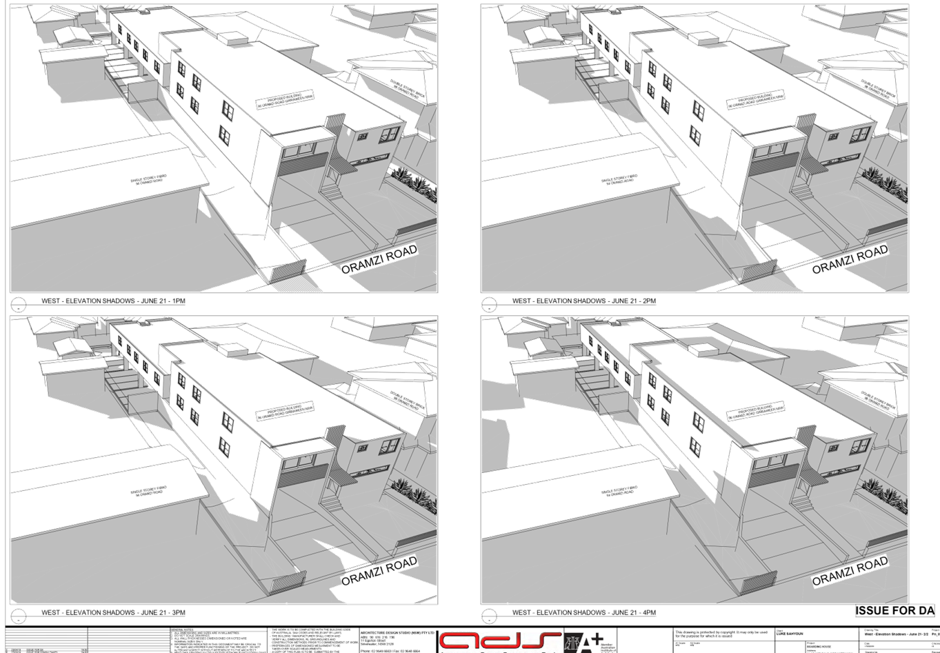
DOCUMENTS
ASSOCIATED WITH
REPORT LPP066/19
Attachment 5
Redacted Public Submissions - Part 1
Cumberland Local Planning Panel Meeting
9 October 2019

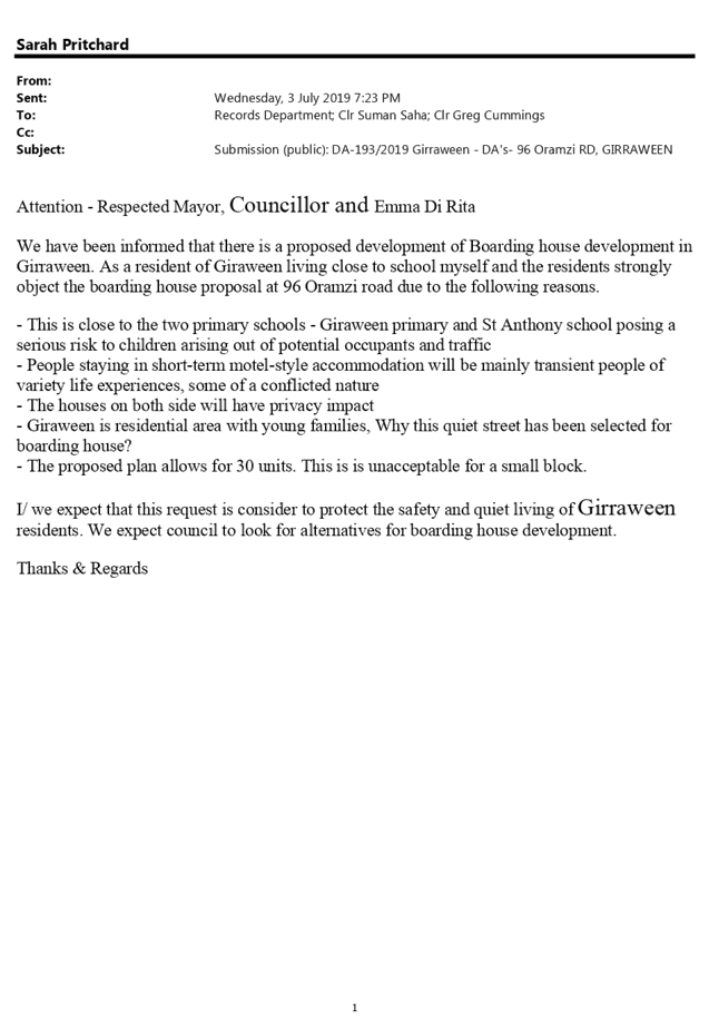

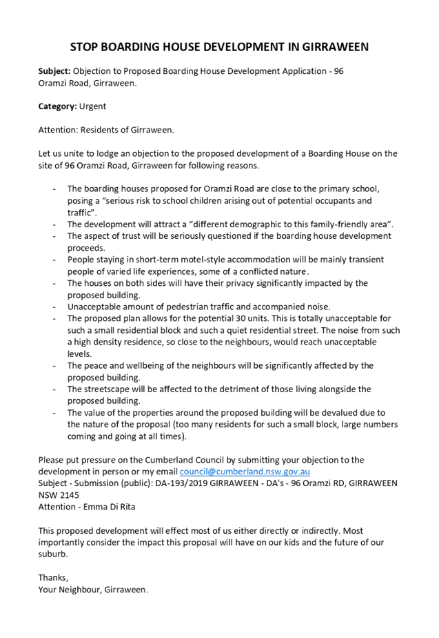


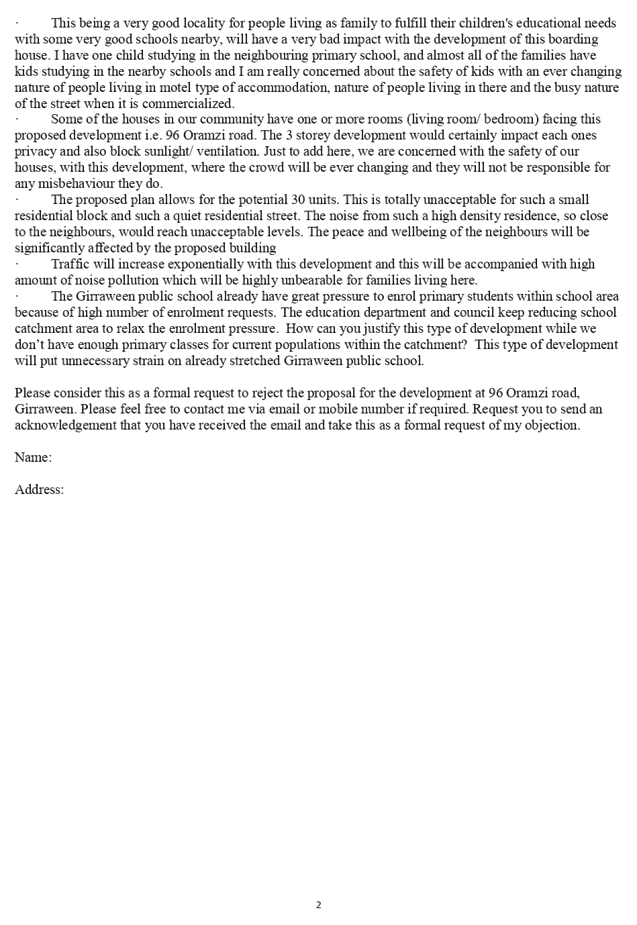


DOCUMENTS
ASSOCIATED WITH
REPORT LPP066/19
Attachment 6
Clause 4.6 Variation Request
Cumberland Local Planning Panel Meeting
9 October 2019
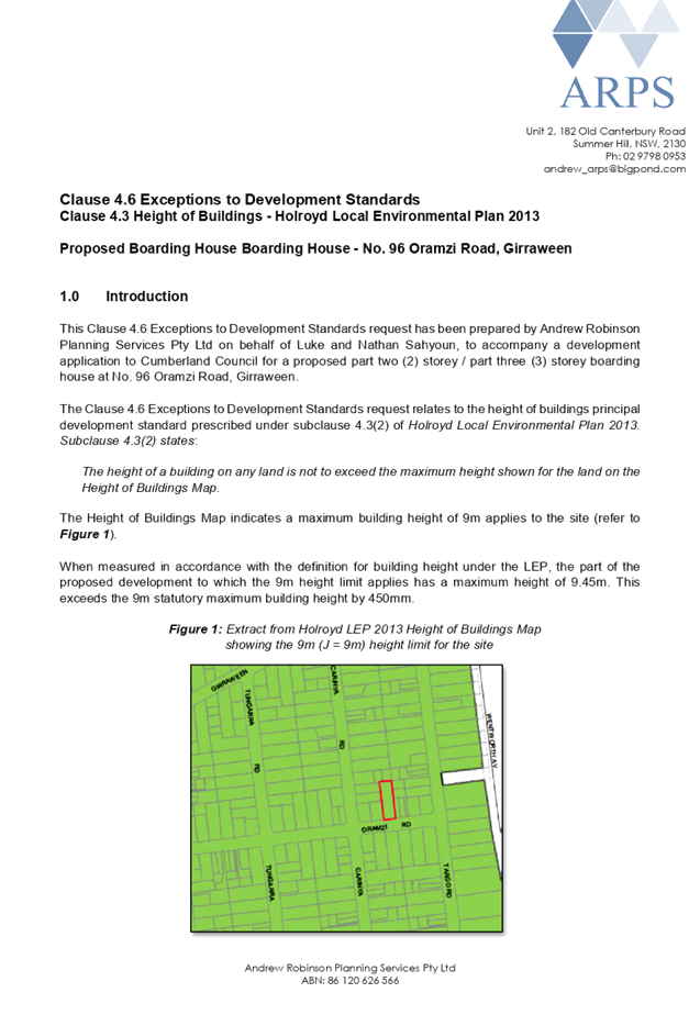
DOCUMENTS
ASSOCIATED WITH
REPORT LPP066/19
Attachment 7
Draft Notice of Determination
Cumberland Local Planning Panel Meeting
9 October 2019
DOCUMENTS
ASSOCIATED WITH
REPORT LPP066/19
Attachment 8
Redacted Public Submissions - Part 2
Cumberland Local Planning Panel Meeting
9 October 2019