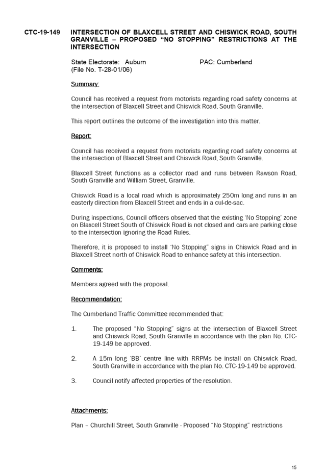
Council Meeting
Wednesday, 4 September 2019 at 6:30pm
Cumberland Council Chambers
Merrylands Service Centre, 16 Memorial Avenue, Merrylands
Council Meeting
Wednesday, 4 September 2019 at 6:30pm
Cumberland Council Chambers
Merrylands Service Centre, 16 Memorial Avenue, Merrylands
Councillor Contact Details
|
Granville Ward |
||
|
Clr Steve Christou |
0419 651 187 |
|
|
Clr Ola Hamed |
0405 070 007 |
|
|
Clr Joseph Rahme |
0418 995 471 |
|
|
Greystanes Ward |
||
|
Clr Greg Cummings (Mayor) |
0417 612 717 |
|
|
Clr Eddy Sarkis |
0418 306 918 |
|
|
Vacant |
- |
- |
|
Regents Park Ward |
||
|
Clr Ned Attie |
0419 583 254 |
|
|
Clr George Campbell |
0409 233 315 |
|
|
Clr Kun Huang |
0418 911 774 |
|
|
South Granville Ward |
||
|
Clr Glenn Elmore (Deputy Mayor) |
0418 459 527 |
|
|
Clr Paul Garrard |
0414 504 504 |
|
|
Clr Tom Zreika |
0449 008 888 |
|
|
Wentworthville Ward |
||
|
Clr Lisa Lake |
0418 669 681 |
|
|
Clr Suman Saha |
0419 546 950 |
|
|
Clr Michael Zaiter |
0418 432 797 |
|
For information on Council services and facilities please visit www.cumberland.nsw.gov.au
Council Meeting
4 September 2019
1 Opening Prayer / Acknowledgement of Country / National Anthem
2 Notice of Live Streaming of Council meeting
3 Apologies / Requests for Leave of Absence
4 Declarations of Pecuniary & Non Pecuniary Conflicts of Interest
5 Confirmation of Previous Minutes
C09/19-186 Minutes of the Ordinary Meeting of Council - 21 August 2019..... 5
Nil
7 Public Forum / Presentation of Petitions
8 Items Resolved by Exception
Nil
Nil
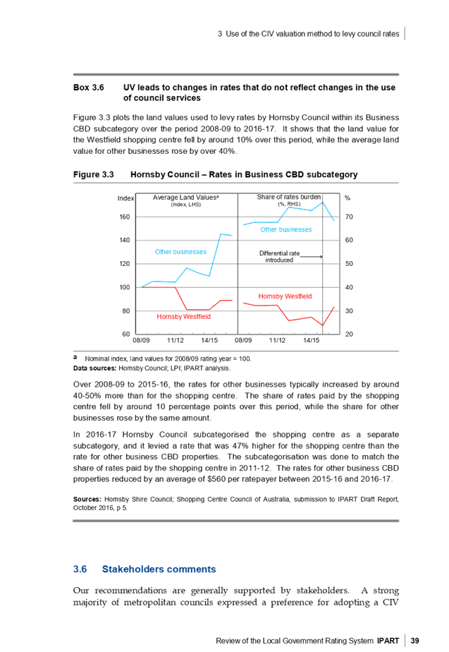
C09/19-187 IPART Review of the Local Government Rating System – Consultation 2019 23
C09/19-188 Adoption of Large Display Advertising Policy.............................. 255
Director Community Development
Nil
Director Environment & Planning
C09/19-189 Lidcombe Town Centre - Planning Controls Strategy................ 271
C09/19-190 Community Feedback on Cumberland's Heritage List............... 417
C09/19-191 Proposed Planning Controls for selected land uses and Part 6 of the new Cumberland Local Environmental Plan........................................ 439
C09/19-192 Proposed Planning Controls for the Land Use Table for Residential, Business and Industrial Zones of the new Cumberland Local Environmental Plan 475
C09/19-193 Proposed Planning Controls for Schedule 5 of the new Cumberland Local Environmental Plan.......................................................................... 521
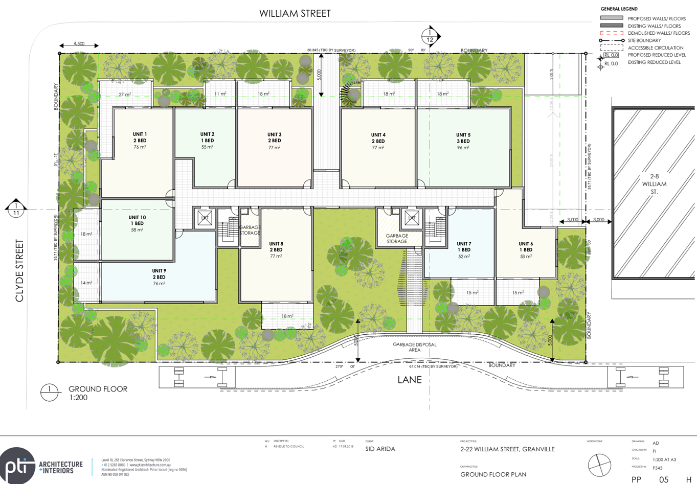
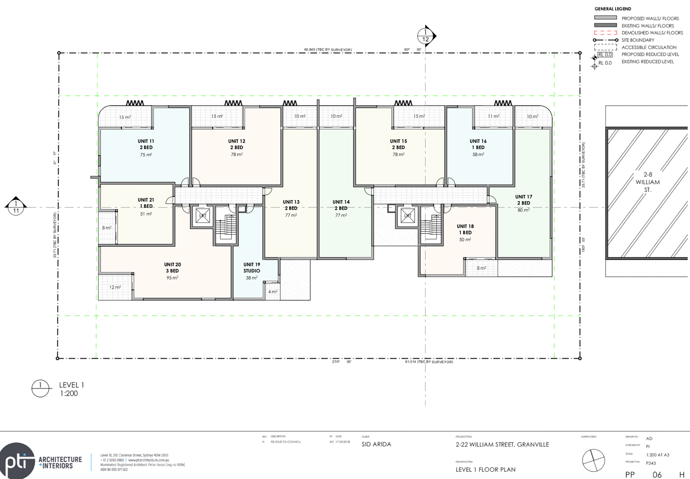
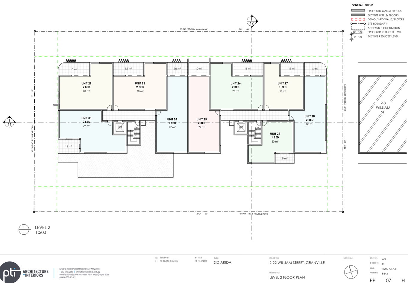
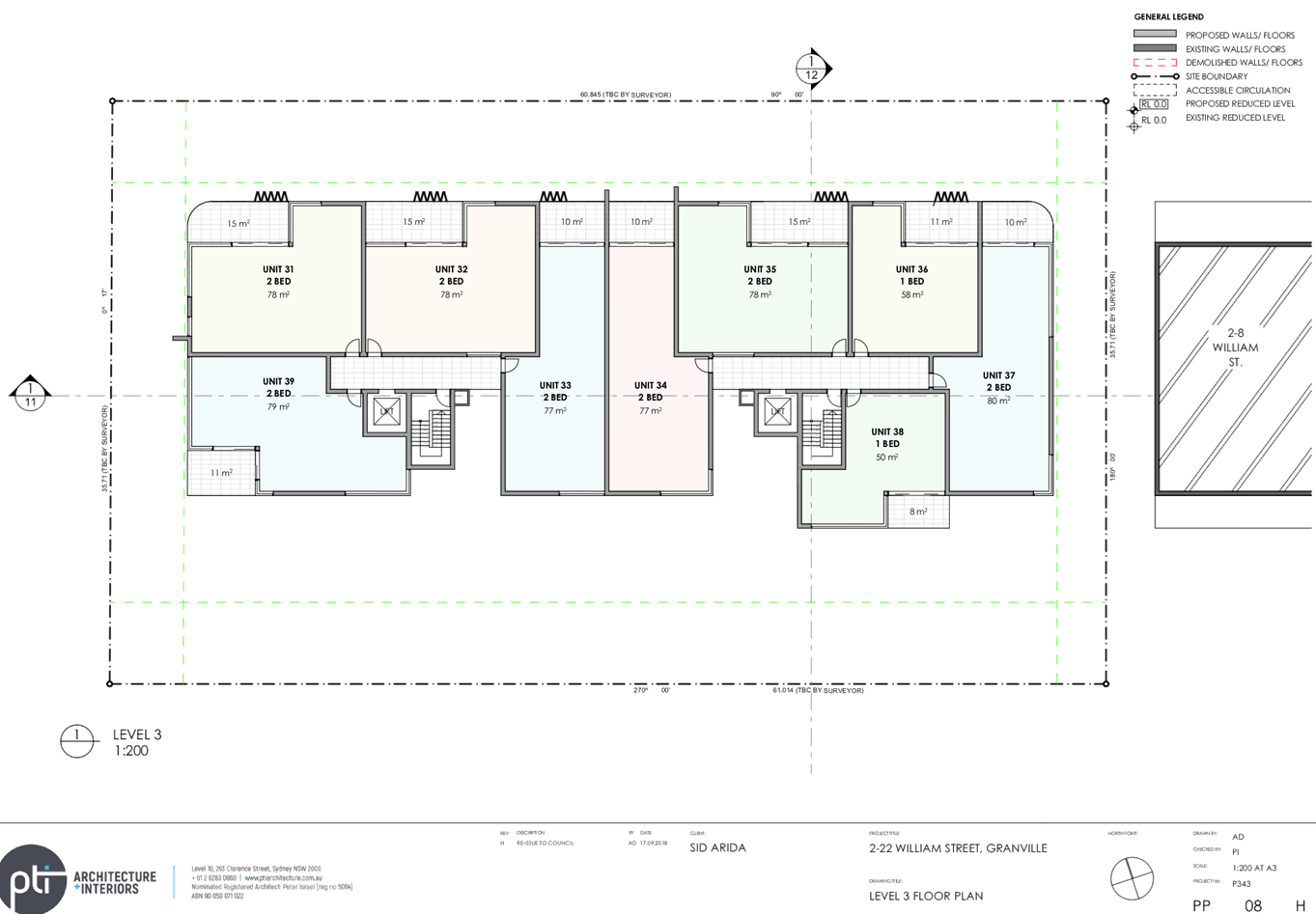
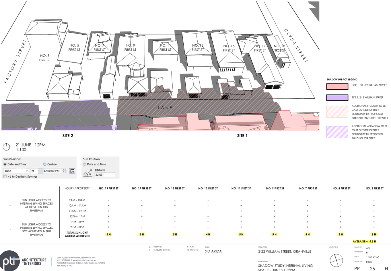
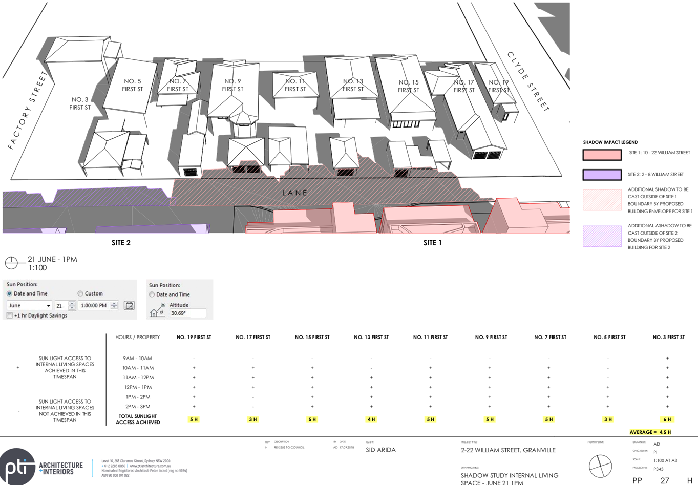
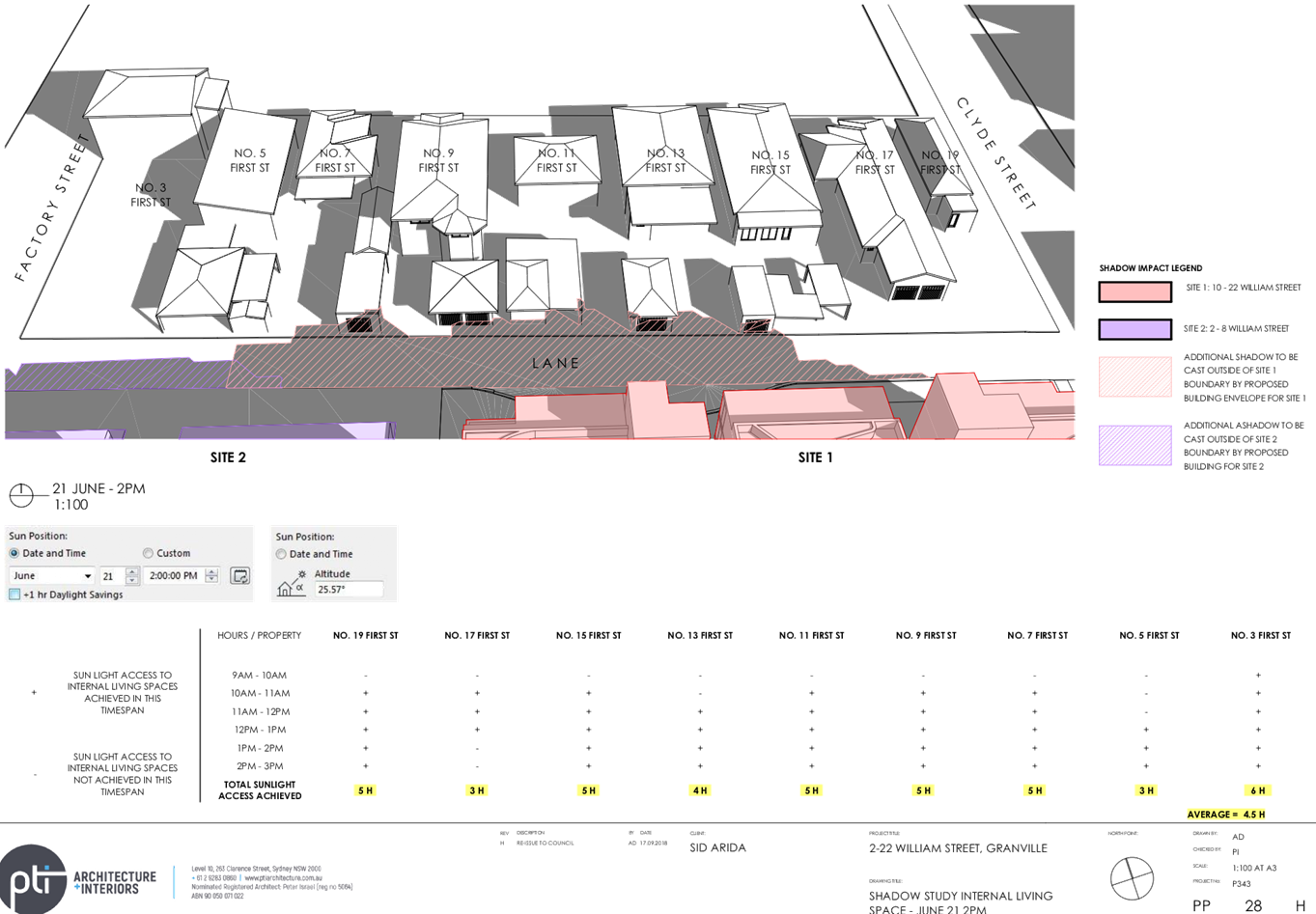
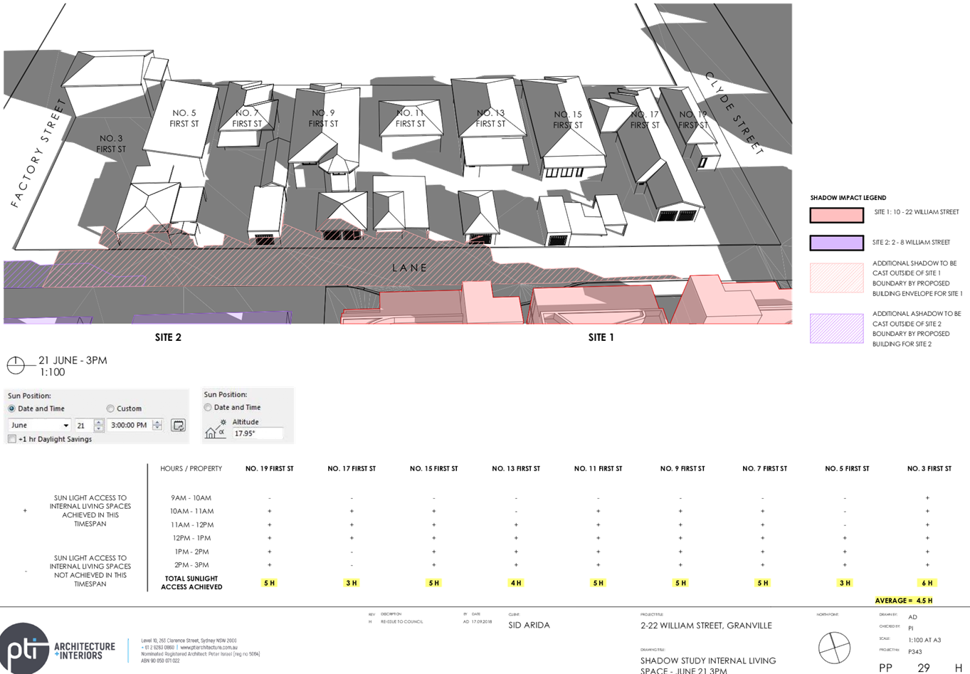
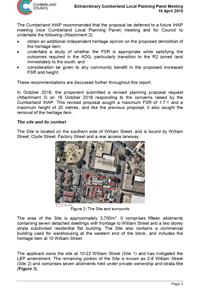
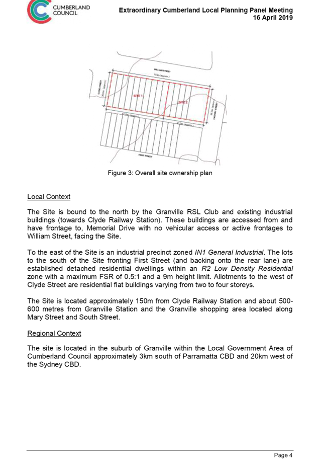
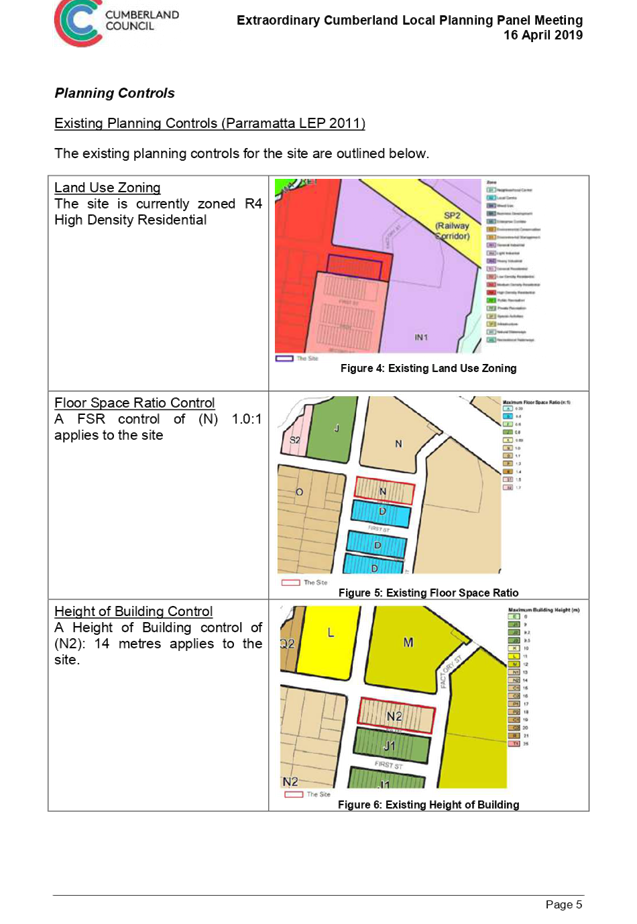
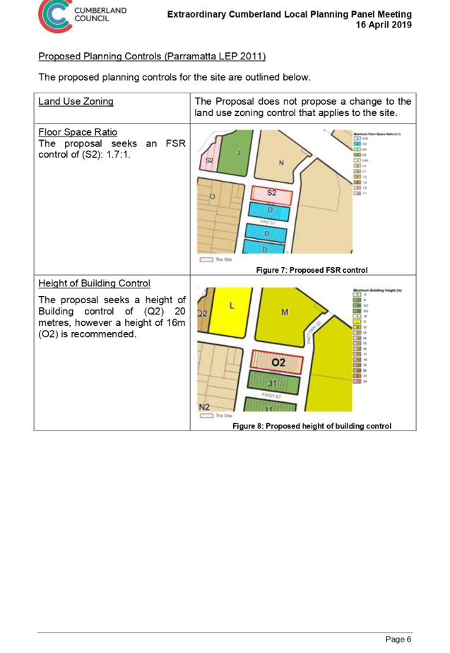
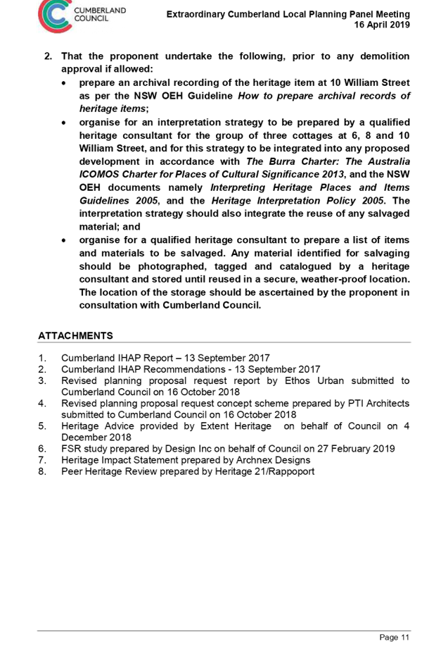
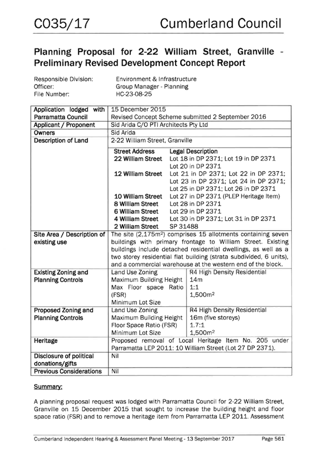
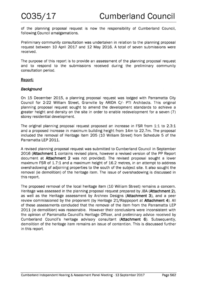
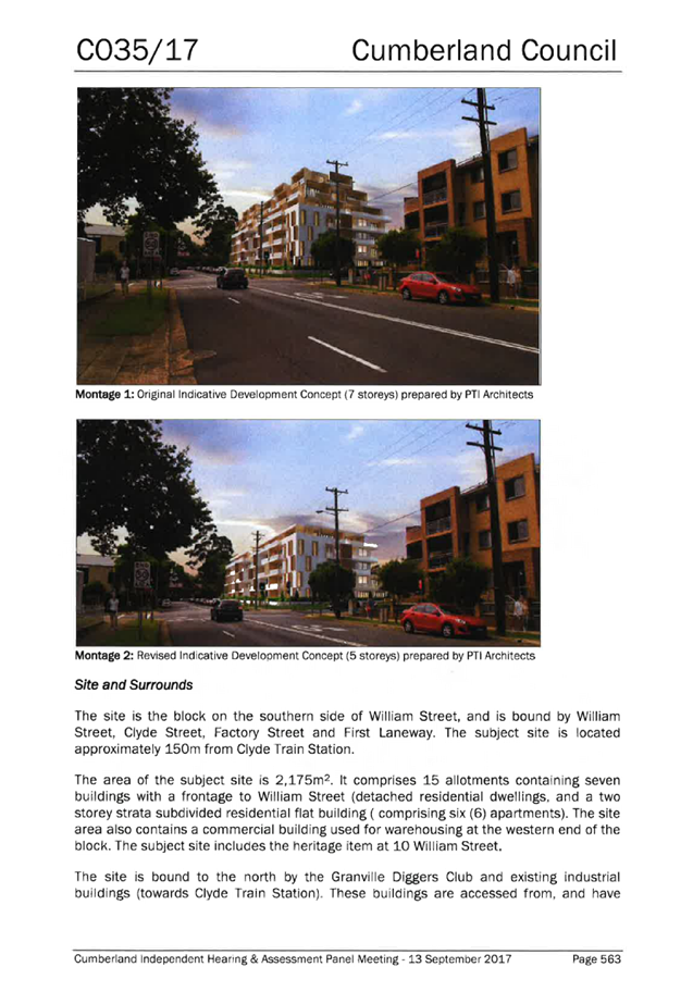
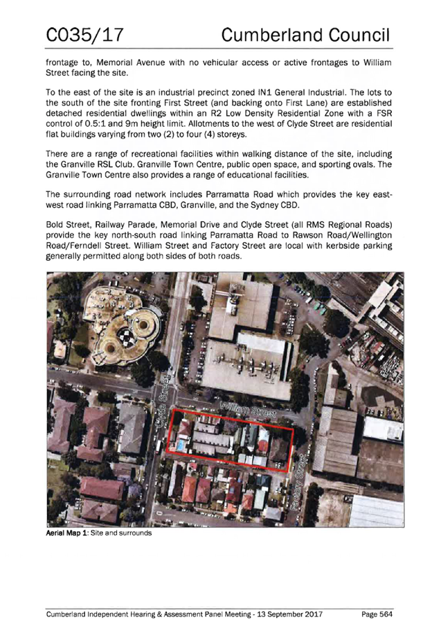
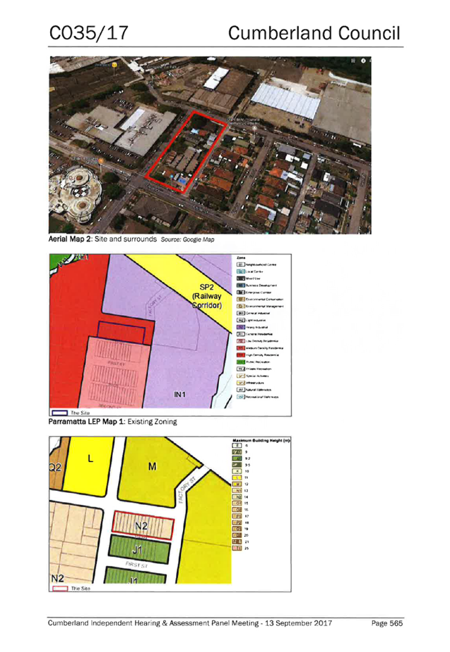
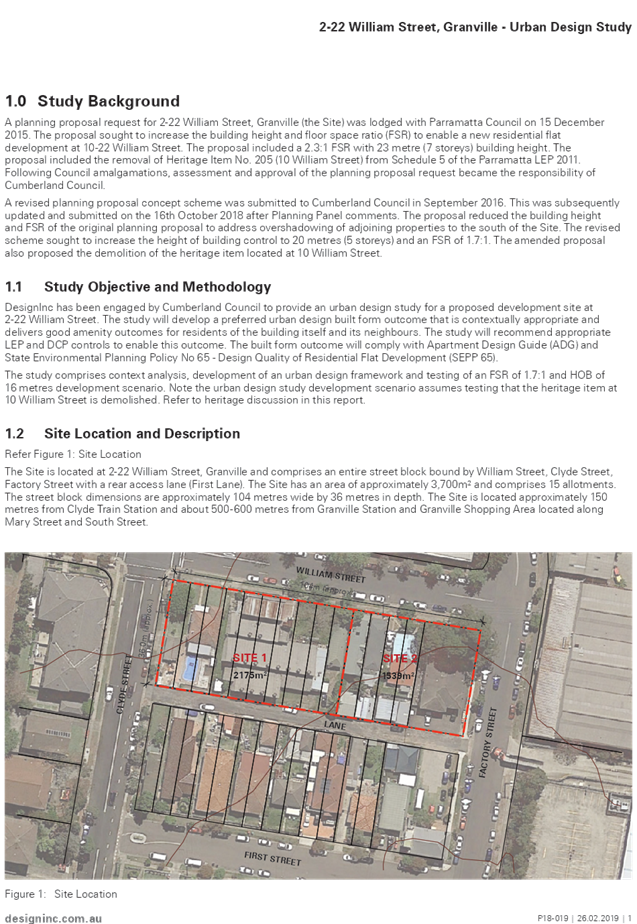
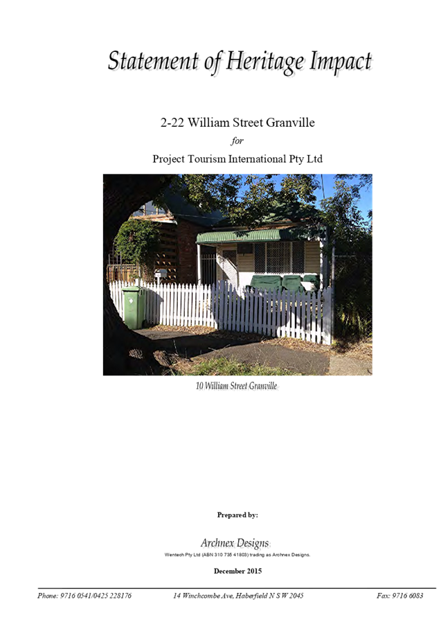
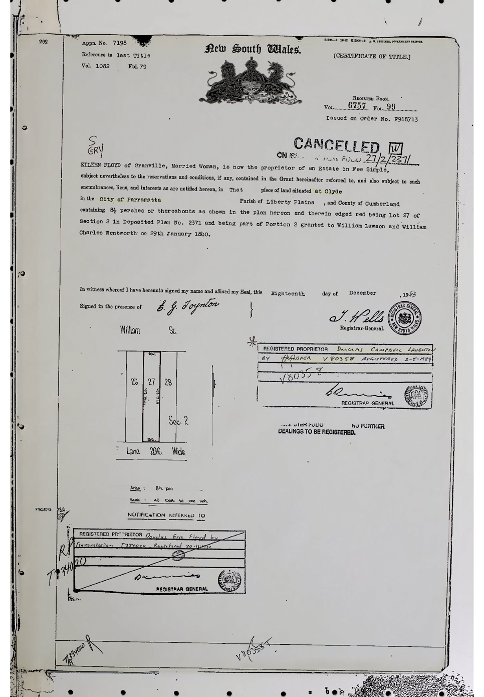
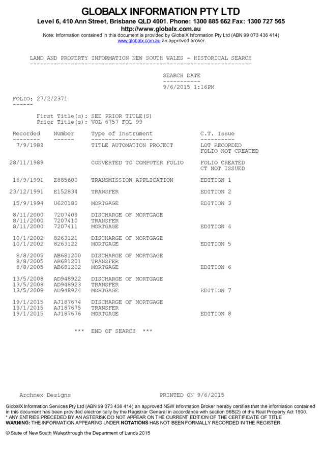
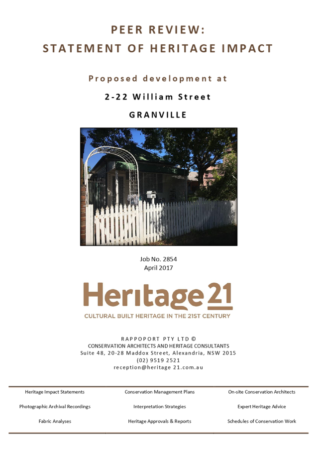
C09/19-194 Planning Proposal for 2-22 William Street, Granville.................. 559
C09/19-195 Planning Proposal for 2 Percy Street, Auburn............................. 811
C09/19-196 Compliance and Enforcement Policy and Guidelines............... 839
C09/19-197 Periodic payment request for DA-2014/111/1 for 14 Civic Avenue, Pendle Hill 865
C09/19-198 31 Garfield Street, Wentworthville - Request For Refund Of Development Contributions...................................................................................... 879
Director Works & Infrastructure
C09/19-199 Staff Allocations and Resources - Street and Town Centre Cleaning 883
C09/19-200 Classification of Land, 191-201 Pitt Street Merrylands, Lot 11 DP 1178684, As Operational Land for the purpose of entering into a Free Parking Agreeement 889
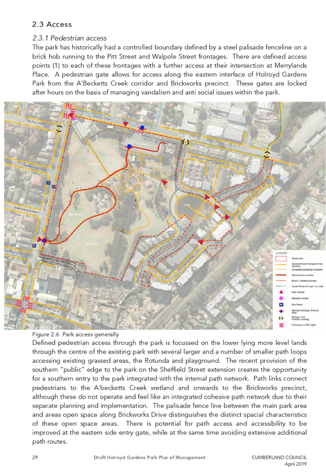
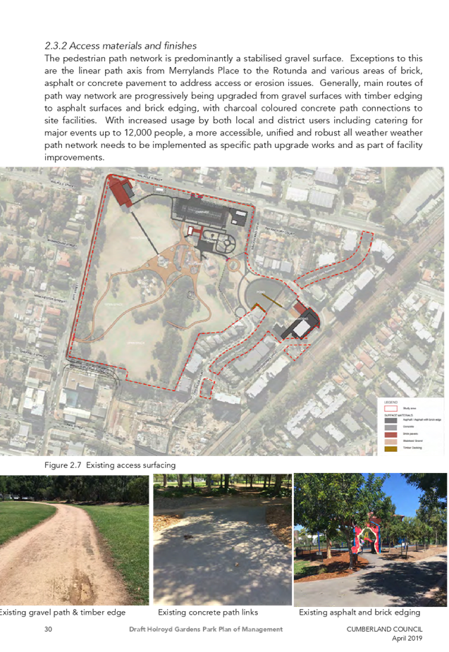
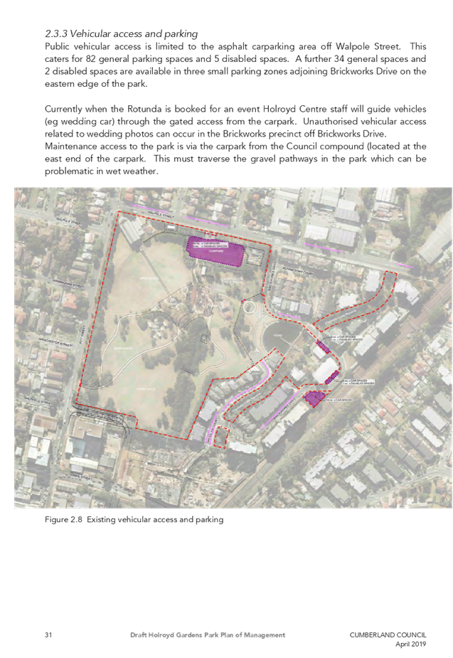
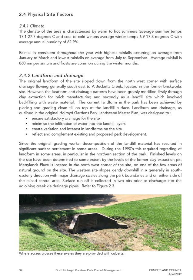
C09/19-201 Draft Holroyd Gardens Park Plan of Management...................... 929
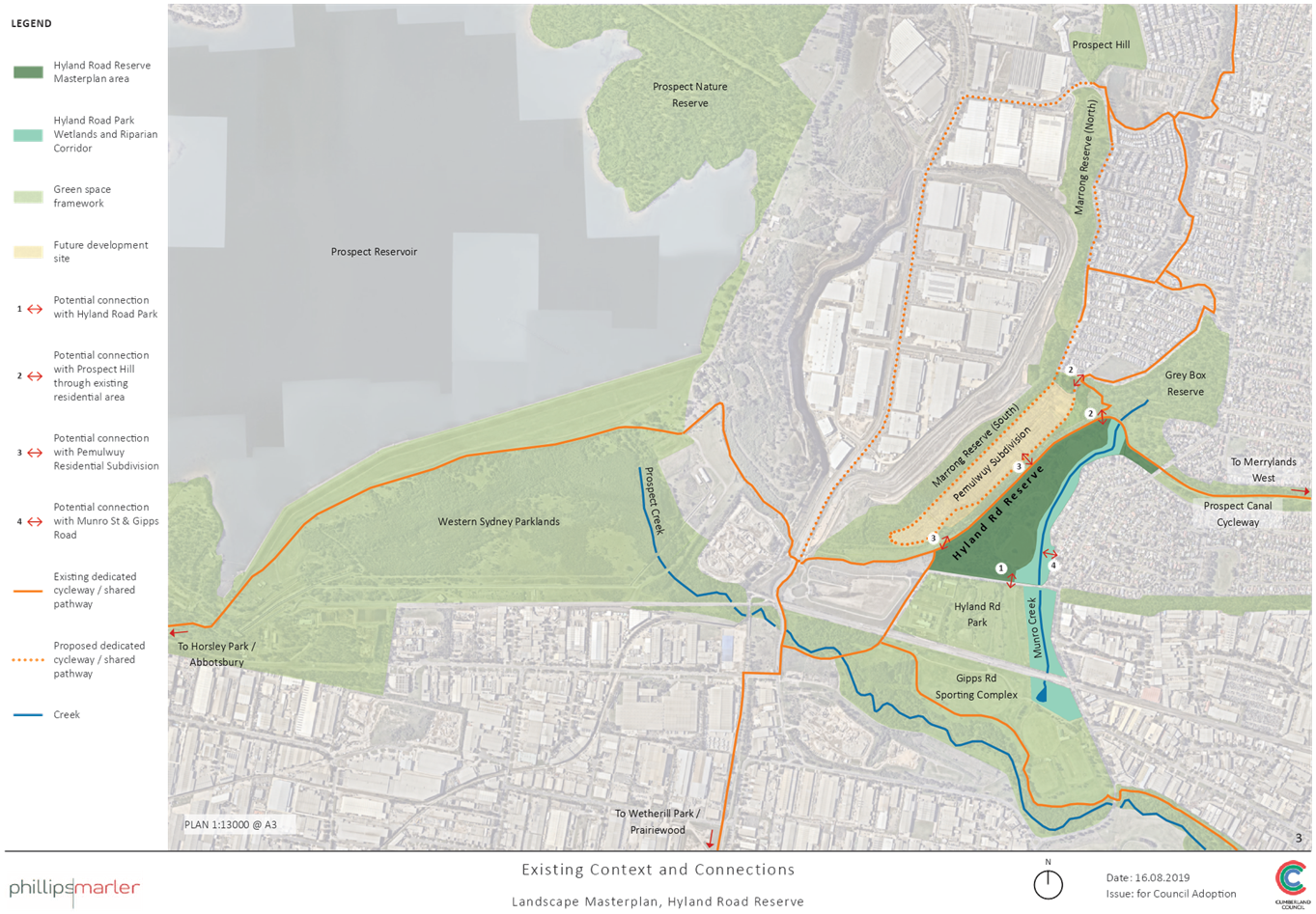
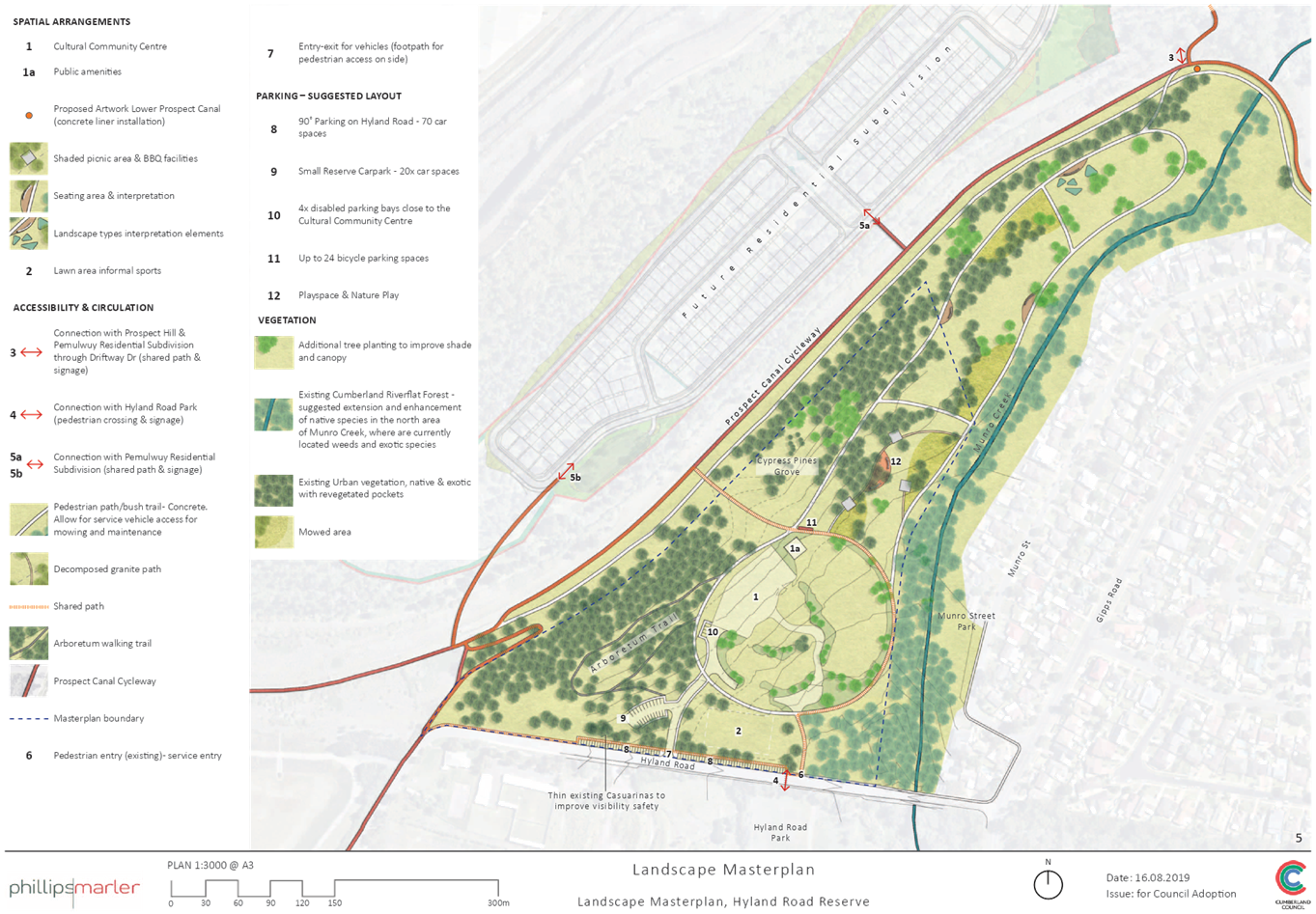
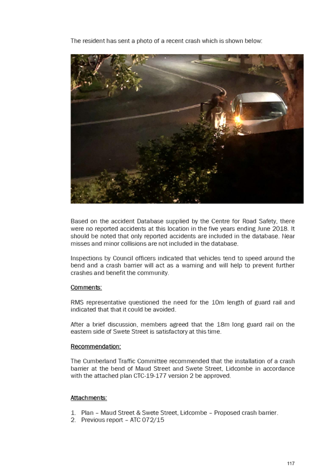
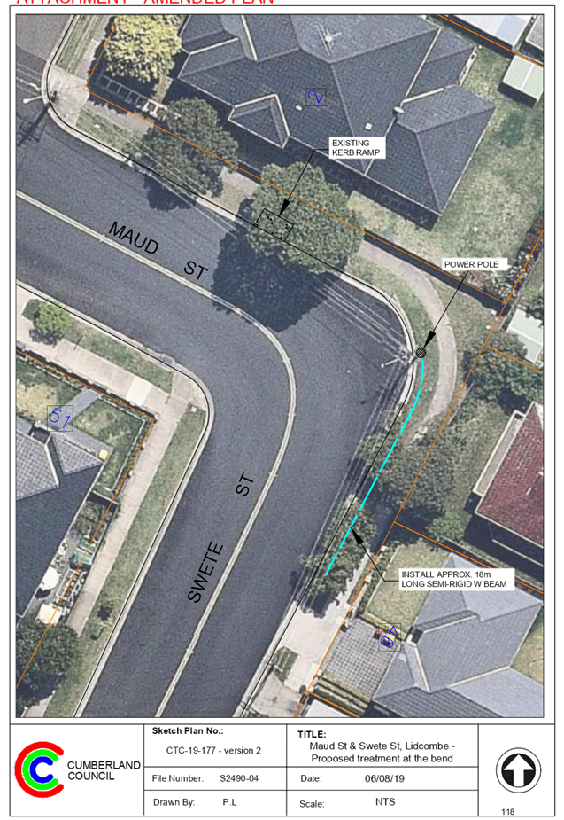
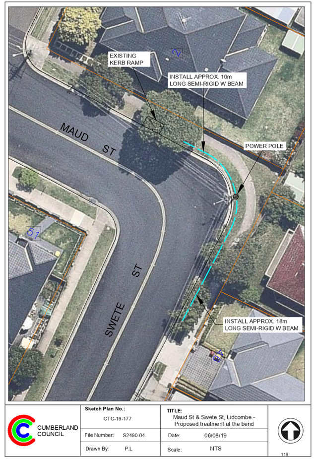
C09/19-202 Hyland Road Reserve - Adoption of Draft Master Plan............ 1051
10 Reports of Council Committees
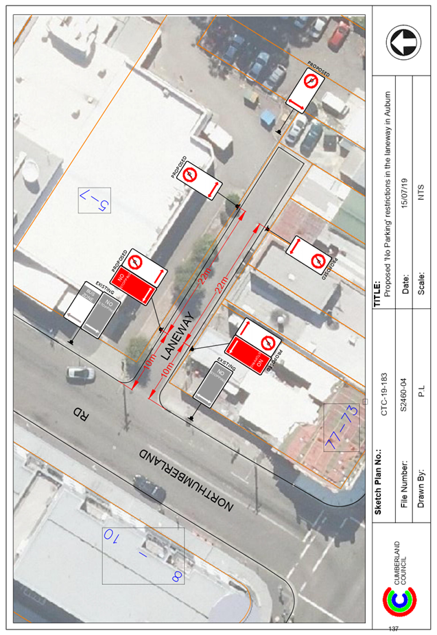
C09/19-203 Cumberland Traffic Committee - Minutes of Meeting held on 7 August 2019 1129
C09/19-204 Notice of Motion - Express Train line Routes – Granville, Auburn and Lidcombe Train Stations................................................................................... 1297
C09/19-205 Notice of Motion - Naming Proposal - Mona Park Sportsground 3 1299
C09/19-206 Notice of Motion - Service NSW Customer Service Centre – Merrylands 1301
C09/19-207 Notice of Motion - Westmead Residential Parking Supply...... 1303
C09/19-208 Notice of Motion - Dog Parks Granville Area.............................. 1305
Nil
Nil
Nil
16 Close
Council Meeting
4 September 2019
Item No: C09/19-186
Minutes of the Ordinary Meeting of Council - 21 August 2019
Responsible Division: Finance & Governance
Officer: Director Finance & Governance
|
That Council confirm the minutes of the Ordinary Meeting of Council held on 21 August 2019. |
Attachments
1. Draft
Minutes - 21 August 2019 ⇩ ![]()
DOCUMENTS
ASSOCIATED WITH
REPORT C09/19-186
Attachment 1
Draft Minutes - 21 August 2019
4 September 2019
Item No: C09/19-187
IPART Review of the Local Government Rating System – Consultation 2019
Responsible Division: Finance & Governance
Officer: Director Finance & Governance
File Number: HC-19-01-2/04
Community Strategic Plan Goal: Transparent and accountable leadership
Summary
The Independent Pricing and Regulatory Tribunal (IPART) carried out a series of reviews of the local government system. IPART’s final reports have now been released and the Minister of Local Government has invited Councils to make submissions on IPART’s Review of the Local Government Rating System report by 13 September 2019.
|
Recommendation That Council: 1. Note the information contained in this report. 2. Delegate authority to the General Manager to finalise the submission, and forward it to the Minister for Local Government as outlined in Attachment 1. |
Report
Council received a letter from the Minister of Local Government (see Attachment 2), which invited feedback on a series of reviews, undertaken by IPART, of the local government system. The letter, received on 21 June 2019, states:
“The reviews were commissioned to support the NSW Government’s long term commitment to ensuring a fair and equitable rating system, cutting red tape and reducing costs and delays for business and the community. They address a number of complex issues, including the current structure of the local government rating system, arrangements around rating exemptions and pensioner concessions, and a broad range of matters relating to local government regulation and compliance.”
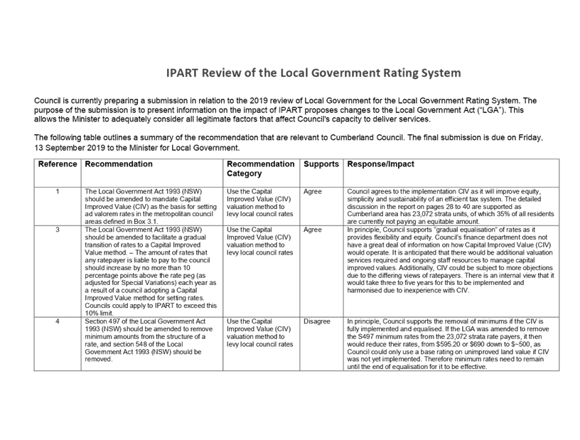
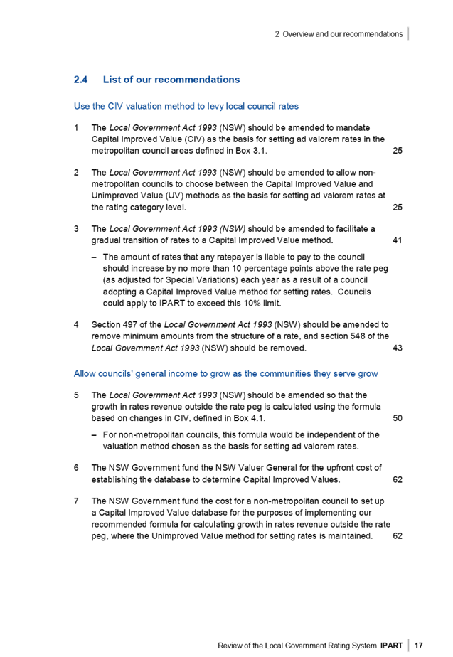
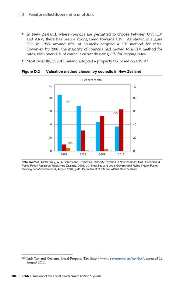
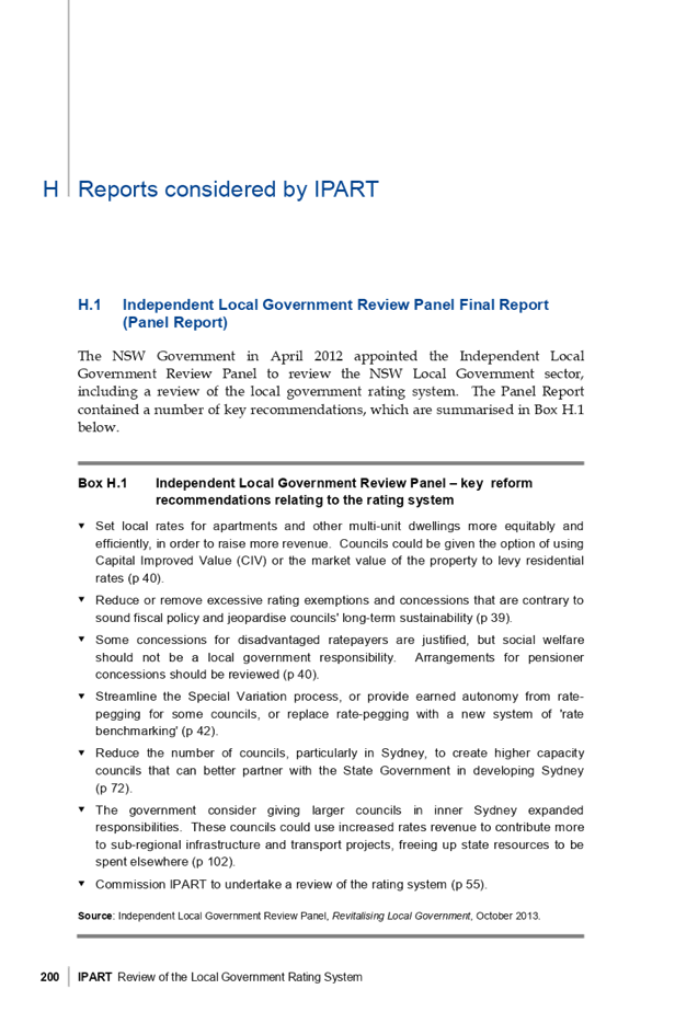
IPART’s Review of the Local Government Rating System presents 42 recommendations, all of which have been reviewed by Council. Attachment 2 contains IPART’s recommendations and Council’s feedback. There are some major changes accompanied by some sensible amendments. The ten major points, which will form the main part of Council’s submission, have been extracted and are shown in the below table.
The full report can be viewed in Attachment 3 of this Report.
|
Reference IPART (Page 16-21) |
Recommendation |
Agree/Disagree |
Comments |
|
1 |
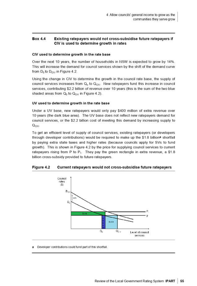
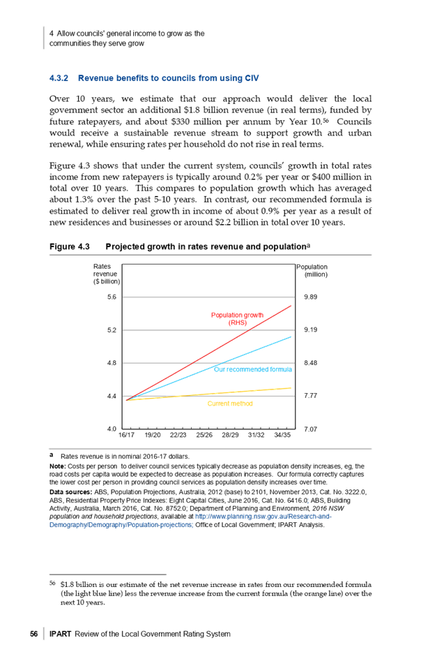
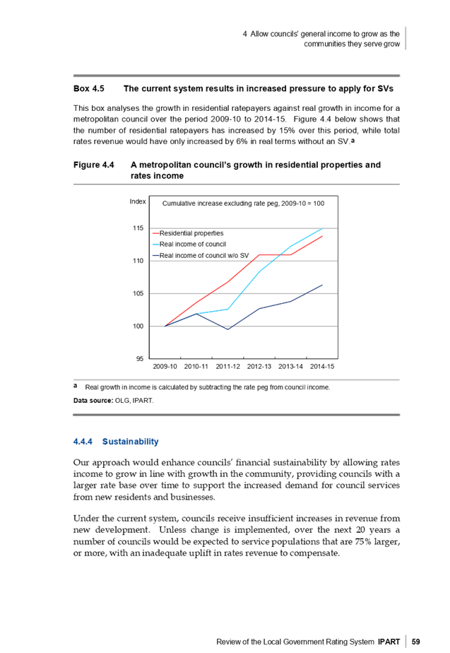
The Local Government Act 1993 (NSW) should be amended to mandate Capital Improved Value (CIV) as the basis for setting ad valorem rates in the metropolitan council areas defined in Box 3.1. |
Agree |
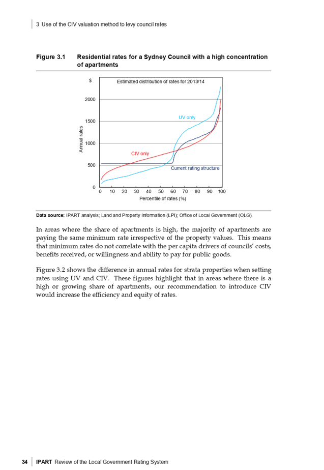
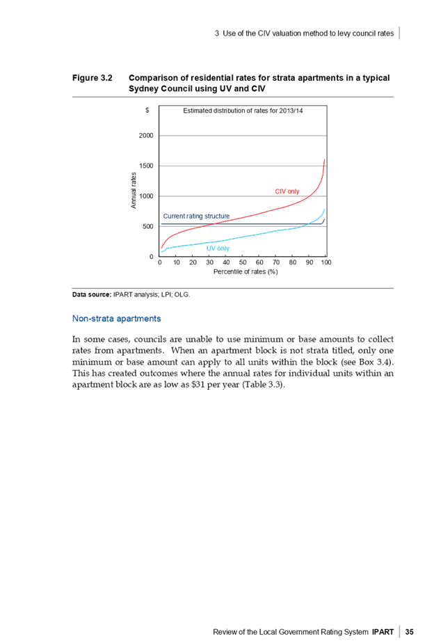
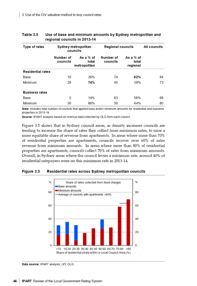
Council agrees to the implementation CIV as it will improve equity, simplicity and sustainability of an efficient tax system. The detailed discussion in the report on pages 28 to 40 are supported as Cumberland area has 23,072 strata units, of which 35% of all residents are currently not paying an equitable amount. |
|
3 |
The Local Government Act (“LGA”) should facilitate gradual transition of rates. Set a Maximum Cap of 10%. |
Agree |
See below |
|
4 |
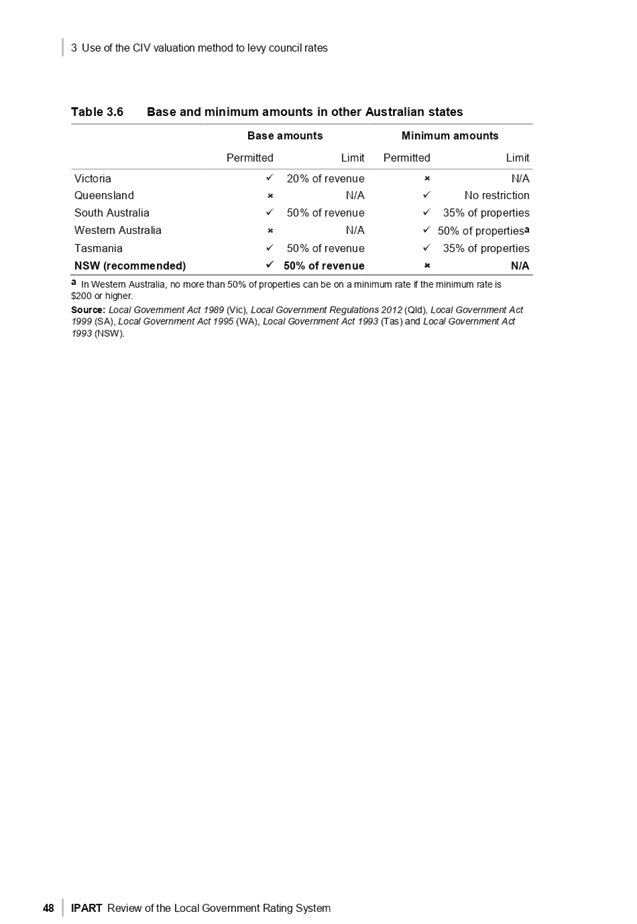
Section 497 LGA should be amended to remove minimums for the structure of a rate and Section 548 LGA be removed. |
Disagree |
See below |
|
6 |
The NSW Government fund the NSW Valuer General for the upfront cost of establishing the database to determine Capital Improved Values. |
Agree |
The transition to CIV will be an expensive exercise and Council will require an increase in rate cap or a grant to assist. |
Commentary on Reference 3 and 4
In principle, Council supports “gradual equalisation” of rates as it provides flexibility and equity. Council’s finance department does not have a great deal of information on how Capital Improved Value (CIV) would operate. It is anticipated that there would be additional valuation services required and ongoing staff resources to manage capital improved values. Additionally, CIV could be subject to more objections due to the differing views of ratepayers. There is an internal view that it would take three to five years for this to be implemented and harmonised due to inexperience with CIV.
In principle, Council supports the removal of minimums if the CIV is fully implemented and equalised. If the LGA was amended to remove the S497 minimum rates from the 23,072 strata rate payers, it then would reduce their rates, from $597 or $670 down to $500, as Council could only use a base rating on unimproved land value. Therefore minimum rates need to remain until the end of equalisation for it to be effective.
In relation to timing, Council should be conscious that the decision to implement could occur within the next 12 months, however there would not be enough information about CIV to undertake an analysis on the potential impacts. Therefore, Council is requesting the following amendment to the IPART recommendations:
· Following the completion of gradual equalisation of rates for CIV, sections 497 and 548 will be removed from LGA.
|
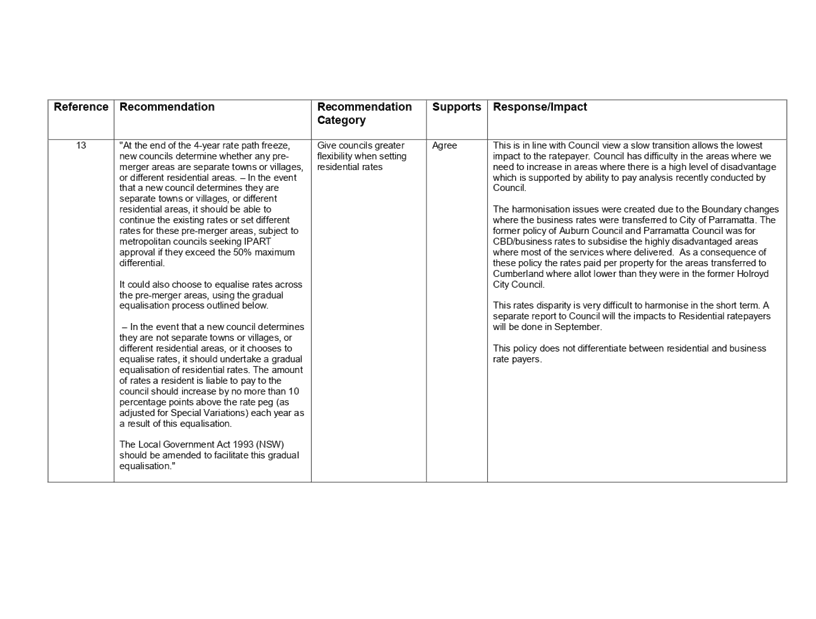
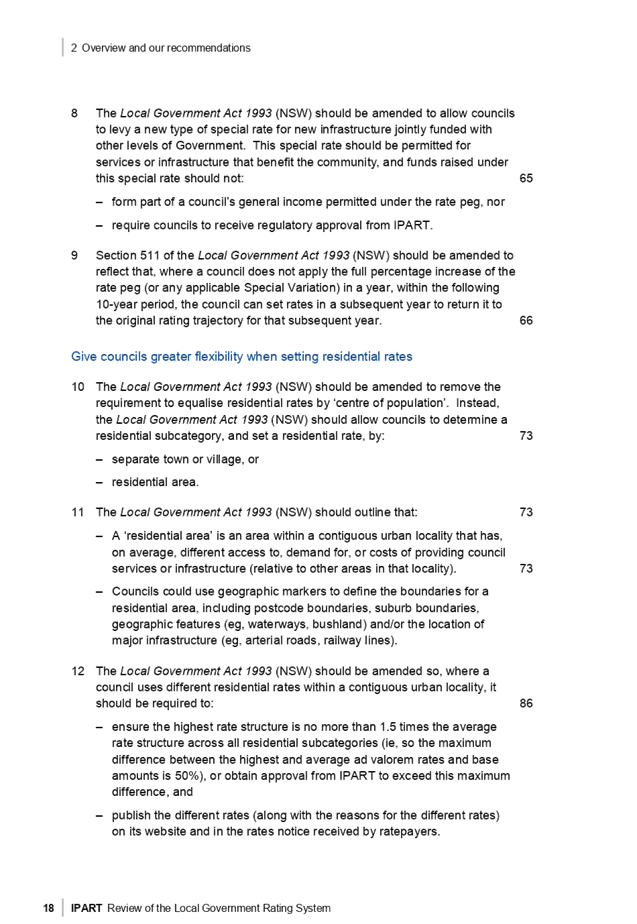
Reference IPART (Page 16-21) |
Recommendation |
Agree / Disagree |
Comments |
|||
|
13 |
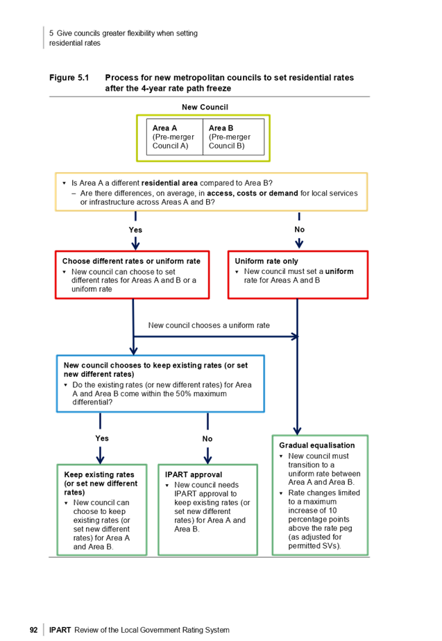
At the end of the 4-year rate path freeze, new councils determine whether any pre-merger areas are separate towns or villages, or different residential areas. – In the event that a new council determines they are not separate towns or villages, or different residential areas, or it chooses to equalise rates, it should undertake a gradual equalisation of residential rates. The amount of rates a resident is liable to pay to the council should increase by no more than 10 percentage points above the rate peg (as adjusted for Special Variations) each year as a result of this equalisation. The Local Government Act 1993 (NSW) should be amended to facilitate this gradual equalisation. |
Agree |
We will be discussing this in more detail at a later date.
This method of gradual equalisation will promote equity following the amalgamation.
Cumberland was adversely effected in the boundary changes. The Business rates which had previously subsidised the former areas of Auburn and Parramatta were transferred out and then 40,300 residents were transferred in. This has created rate and service disparity between the former areas.
Cumberland has a large amount of disadvantage when it comes to the ability to pay rates following the boundary changes and needs the gradual equalisation to address this issue. |
|||
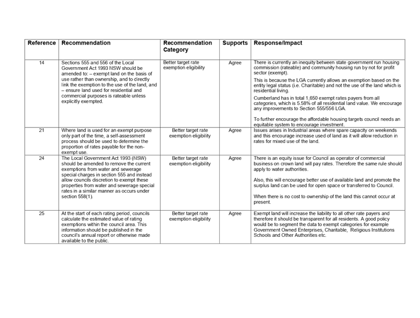
|
14 |
“Sections 555 and 556 of the Local Government Act 1993 NSW should be amended to:
– exempt land on the basis of use rather than ownership, and to directly link the exemption to the use of the land, and
– ensure land used for residential and commercial purposes is rateable unless explicitly exempted.” |
Agree |
There is currently an inequity between state government run housing commission (rateable) and community housing run by not for profit sector (exempt). This is because the LGA currently allows an exemption based on the entity legal status (i.e. Charitable) and not the use of the land which is residential living. Cumberland has in total 1,650 exempt rates payers from all categories, which is 5.58% of all residential land value. We encourage any improvements to Section 555/556 LGA.
To further encourage the affordable housing targets council needs an equitable system to encourage investment. |
|||
|
24 |
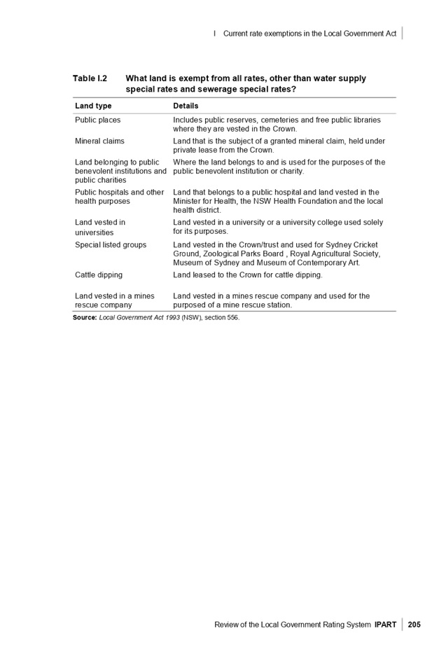
“The Local Government Act 1993 (NSW) should be amended to remove the current exemptions from water and sewerage special charges in section 555 and instead allow councils discretion to exempt these properties from water and sewerage special rates in a similar manner as occurs under section 558(1).” |
Agree |
This is an equity issue for Council as operators of commercial businesses on crown land will pay rates. Therefore the same rule should apply to water authorities.
Also, this will encourage better use of available land and promote the surplus land can be used for open space or transferred to Council.
|
|||
|
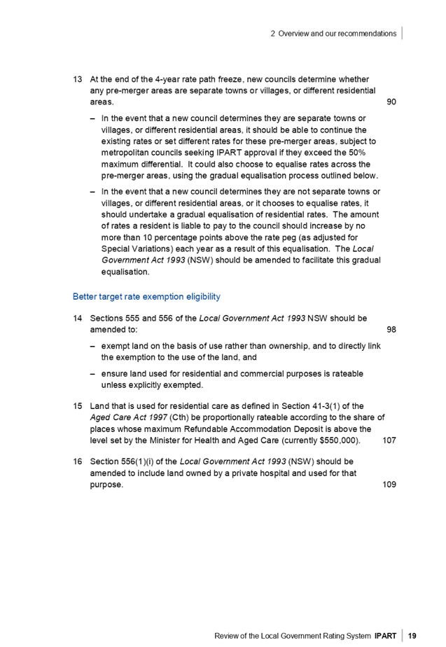
Reference IPART (Page 16-21) |
Recommendation |
Agree / Disagree |
Comments |
|||
|
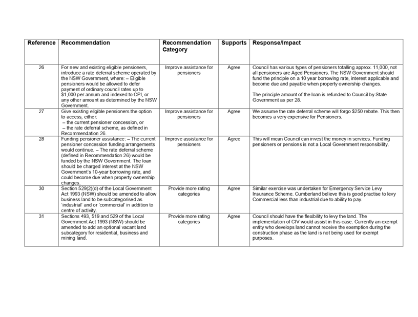
26-28 and 40 |
26) For new and existing eligible pensioners, introduce a rate deferral scheme operated by the NSW Government, where: – Eligible pensioners would be allowed to defer payment of ordinary council rates up to $1,000 per annum and indexed to CPI, or any other amount as determined by the NSW Government. 27) Give existing eligible pensioners the option to access, either: – the current pensioner concession, or – the rate deferral scheme, as defined in Recommendation 26.
28) Funding pensioner assistance: – The current pensioner concession funding arrangements would continue.
– The rate deferral scheme (defined in Recommendation 26) would be funded by the NSW Government. The loan should be charged interest at the NSW Government’s 10-year borrowing rate, and could become due when property ownership changes. |
Agree |
Council has 11,000 pensioners partially funded by the state government (not all are aged pensioners). We support the proposal for the NSW Government to fund pensioner rates deferrals based on a 10 year loan, interest applicable and become due and payable when property ownership changes. It should be noted that IPART recommends the loan is to be fully funded by the State Government.
In addition, Council supports the removal of the rate deferral scheme in the LGA. This is included as part of Recommendation 40 in the IPART report.
|
|||
|
30 |
Section 529(2)(d) of the Local Government Act 1993 (NSW) should be amended to allow business land to be subcategorised as ‘industrial’ and or ‘commercial’ in addition to centre of activity. |
Agree |
The Fire Service Levy for Insurance proposed this change and it is consistent with Council’s desire to have Business and Industrial rates separated to improve the equity in rating. |
|||
|
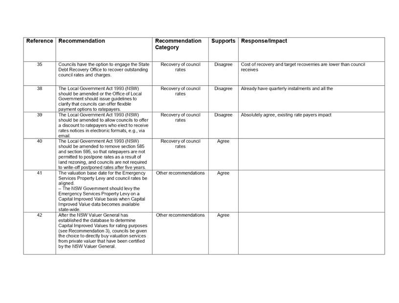
35 |
Councils have the option to engage the State Debt Recovery Office to recover outstanding council rates and charges.
|
Disagree |
Cost of recovery would increase and target recoveries are substantially lower than council currently achieves.
When you consider this along with Recommendation 36, it is foreseeable that forced sale of land would occur more often than it does. |
|||
Community Engagement
There are no consultation processes for Council associated with this report.
Policy Implications
There are no policy implications for Council associated with this report.
Risk Implications
There are no risk implications for Council associated with this report.
Financial Implications
There are no financial implications for Council associated with this report.
CONCLUSION
Council is supportive of IPART’s Review of the Local Government Rating System and, from the information available and the future workshops, remains positive about the direction of the reforms.
Attachments
1. Minister of
Local Government Correspondence ⇩ ![]()
2. Draft
Submission IPART ⇩ ![]()
3. Final
Report - Review of the Local Government Rating System ⇩ ![]()
DOCUMENTS
ASSOCIATED WITH
REPORT C09/19-187
Attachment 1
Minister of Local Government Correspondence
Attachment 3
Final Report - Review of the Local Government Rating System
4 September 2019
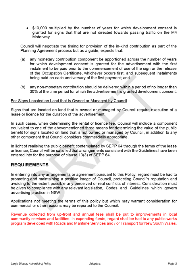
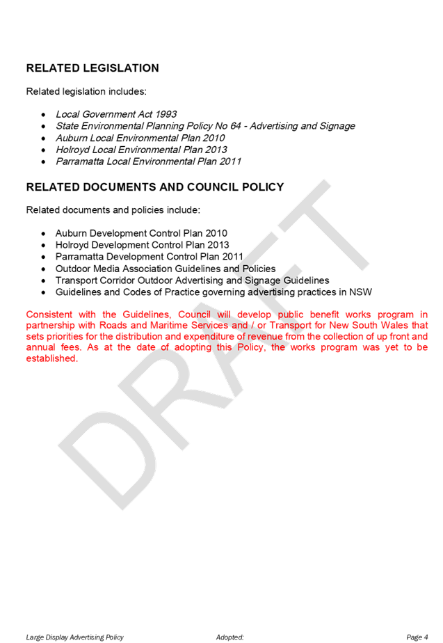
Item No: C09/19-188
Adoption of Large Display Advertising Policy
Responsible Division: Finance & Governance
Officer: Director Finance & Governance
File Number: L-02-01/03
Community Strategic Plan Goal: A strong local economy
Summary
This report recommends the adoption of the amended Large Display Advertising Policy following a period of public exhibition undertaken in line with the requirements of the Local Government Act 1993.
|
Recommendation That Council adopt the Large Display Advertising Policy as outlined in Attachment 1 of this report. |
Report
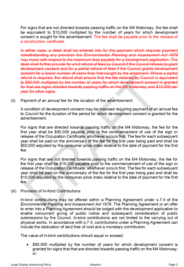
At the Ordinary Meeting of Council held on 3 July 2019, it was resolved that:
“1.Council place the Draft Large Display Advertising Policy on public exhibition for a period of 28 days with the following amendments:
a) After the words “conflicts of interest.” in the Requirements Section, add:
“Consideration must be given to compliance with any relevant legislation, Codes and Guidelines which govern advertising practice in NSW.”
b) Under “Related documents and Council Policy” add:
“Guidelines and Codes of Practice governing advertising practices in NSW.”
2. A report be provided back to Council following the conclusion of the exhibition period.”
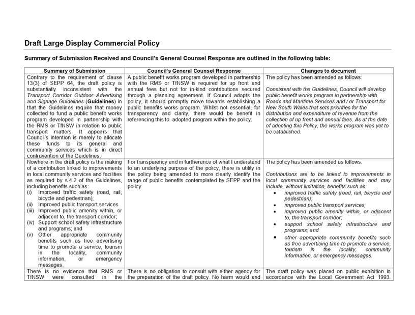
During the public exhibition period, Council received one (1) submission that contained feedback and suggestions for Council’s consideration.
Consequently, the submission that was received during public exhibition was considered by Council’s General Counsel and incorporated in the amended Policy as included under Attachment 1.
The summary of the submission received is also included under Attachment 2.
Community Engagement
The Draft Large Display Advertising Policy was placed on public exhibition for a period of 28 days from 10 July 2019 to 6 August 2019. It was advertised on Council’s website on the “Have Your Say” page and also in the following local newspaper publications:
- The Auburn Review (published on 16, 23 and 30 July 2019)
- The Parramatta Advertiser (published on 17, 24 and 31 July 2019)
Copies of the draft policy were made available at the Merrylands and Auburn Council Administration Centres.
Policy Implications
Council does not have an adopted policy in place that governs commercial advertising and outlines when and where it is appropriate.
Risk Implications
There are no risk implications for Council associated with this report.
Financial Implications
There are no financial risk implications for Council associated with this report. However, once the policy is adopted, Council will consider undertaking a tender process for large billboard advertising on four identified locations. The income generated from billboard advertising that is situated on Council’s owned and managed land will be used for the benefit of the community.
CONCLUSION
Council does not have an adopted policy for Large Display Advertising. Following the adoption of the Draft Large Display Advertising Policy, Council will undertake a tender process for large billboard advertising to generate income for the benefit of the community.
Attachments
1. Cumberland
Council Draft Large Display Advertising Policy ⇩ ![]()
2. Summary
of Submission ⇩ ![]()
DOCUMENTS
ASSOCIATED WITH
REPORT C09/19-188
Attachment 1
Cumberland Council Draft Large Display Advertising Policy
4 September 2019
Item No: C09/19-189
Lidcombe Town Centre - Planning Controls Strategy
Responsible Division: Environment & Planning
Officer: Director Environment & Planning
File Number: S-5740-02
Community Strategic Plan Goal: A resilient built environment
Summary
This report outlines the recommended planning controls strategy for the Lidcombe Town Centre. This approach supports better built form design outcomes that will contribute to the quality of amenity and public domain in the area.
The proposed planning controls include:
· changes to maximum heights in eight precincts within the town centre, to allow for improved building design while maintaining the existing floor space ratios at these precincts;
· changes to maximum heights and floor space ratios in four precincts, to provide a more consistent approach to planning controls at these locations; and
· changes to maximum heights, floor space ratios and land use zonings in four precincts, to support targeted urban development and provide a better transition in built form at the edges of the town centre.
The recommended planning controls for the Lidcombe Town Centre are supported by the Cumberland Local Planning Panel.
Subject to endorsement, the recommended planning controls will be included in the planning proposal for the new Cumberland Local Environmental Plan (LEP).
|
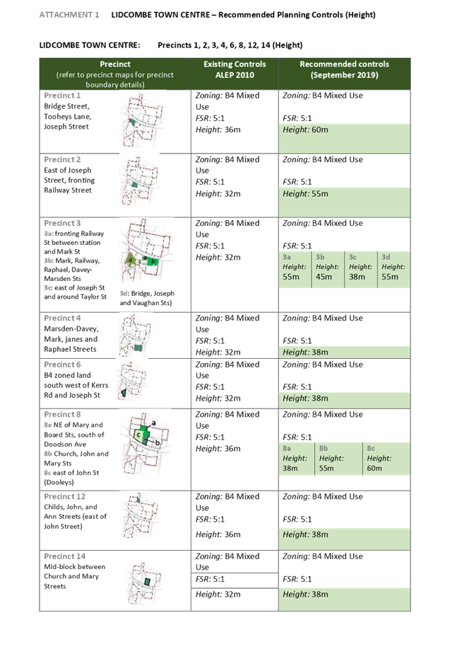
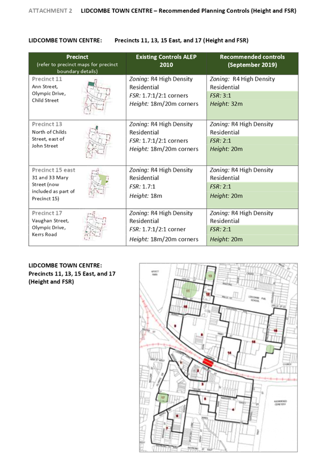
Recommendation That Council: 1. Endorse the proposed changes to maximum height controls for Precincts 1, 2, 3, 4, 6, 8, 12 and 14 for the Lidcombe Town Centre, as outlined in Attachment 1, which are supported by the Cumberland Local Planning Panel. 2. Endorse the proposed changes to maximum building height and floor space ratio controls in Precincts 11, 13, 15 East and 17 for the Lidcombe Town Centre, as outlined in Attachment 2, which are supported by the Cumberland Local Planning Panel. 3. Endorse the proposed changes to maximum height, floor space ratio and land use zoning controls in Precincts 7, 10, 15 and 16 for the Lidcombe Town Centre, as outlined in Attachment 3, which are supported by the Cumberland Local Planning Panel. 4. Note that the above items will be included in the planning proposal for the new Cumberland Local Environmental Plan. |
Report
Background
Council has undertaken work on a planning controls strategy for the Lidcombe Town Centre. The primary focus of this work is to better align the planning controls related to zoning, height and floor space ratios, which enables a broader range of building design options to be realised. This approach provides better opportunities for innovation in the built form of these town centres, and contributes to the quality of amenity and public domain within the Cumberland area.
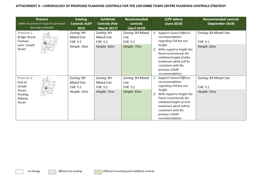
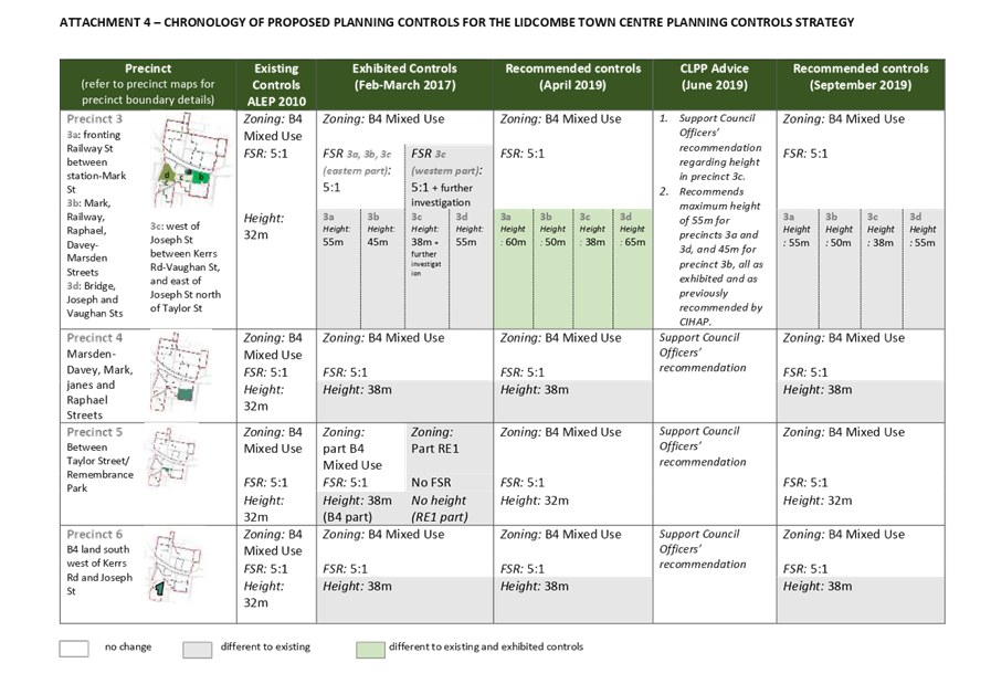
A chronology of the work undertaken on the planning controls strategy for Lidcombe Town Centre is provided in Table 1. Further background information from previous Council and Panel reports is provided in Attachments 5 and 6.
|
Former Auburn City Council |
|
|
2014 - 2015 |
Resolutions to increase heights in Lidcombe Town Centre. |
|
2015 - 2016 |
Preliminary Consultant work |
|
Cumberland Council |
|
|
May 2016 |
Council amalgamation – review of planning controls placed on hold |
|
September-October 2016 |
Internal work to finalise draft Strategy |
|
November 2016 |
Report to IHAP recommending exhibition of draft Strategy |
|
December 2016 |
Report to Council. Resolution to exhibit (Administrator) |
|
7 Feb – 8 March 2017 |
Exhibition of draft Strategy |
|
2017 – 2019 |
Analysis of issues raised in submissions and review of draft Strategy |
|
April 2019 |
Report to Council on proposed planning controls |
|
June 2019 |
Report to CLPP recommending proposed controls in Strategy |
|
September 2019 |
Report to Council on proposed planning controls |
Table 1: Chronology of planning controls strategy for Lidcombe Town Centre
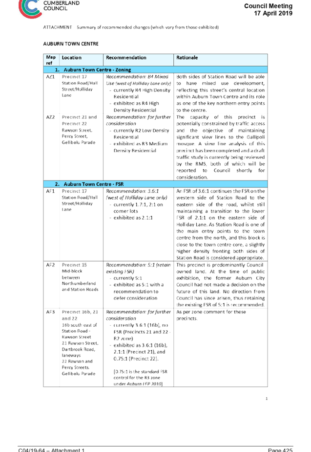
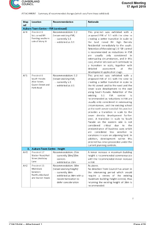
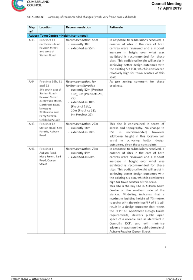
Council Meeting 17 April 2019
The planning controls strategy for the Lidcombe Town Centre was presented to Council on 17 April 2019. At this meeting, Council resolved a number of further items to be progressed prior to reporting again to Council. The items and status are provided in Table 2.
|
Resolution |
Status |
|
Council hold a workshop to consider the effect of any design excellence provision to be included in the Cumberland Local Environmental Plan on proposed planning controls for the Auburn and Lidcombe Town Centres |
Opportunities for design excellence provisions for Auburn and Lidcombe town centres discussed at Councillor briefing on 10 July 2019 |
|
In accordance with Council resolution 21.12.16, the Draft Auburn and Lidcombe Town Centres Strategy and submissions received by reported to the Cumberland Local Planning Panel for consideration and recommendation to Council |
Strategy considered by Cumberland Local Planning Panel on 20 June 2019 and advice provided for consideration to Council
Panel advice as a clarification on opportunities for design excellence bonuses received on 12 August 2019 |
|
A site visit of the Lidcombe and Auburn Town Centres be held with reference to the draft strategy |
Site visit of town centres held on 29 June 2019 |
|
The Auburn Town Centre Strategy and the Lidcombe Town Centre Strategy be reported to Council separately |
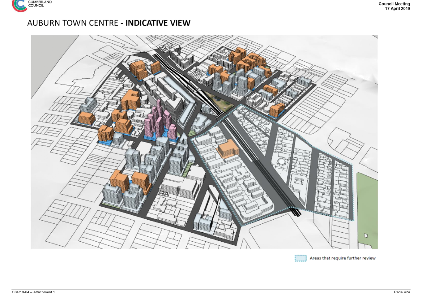
Separate reports to be provided to Council. This report covers the recommended planning controls strategy for the Lidcombe Town Centre. The planning controls strategy for Auburn Town Centre was reported to Council on 21 August 2019.
|
Table 2: Status of Items following Council Resolution in April 2019
Planning Controls Strategy for Lidcombe Town Centre
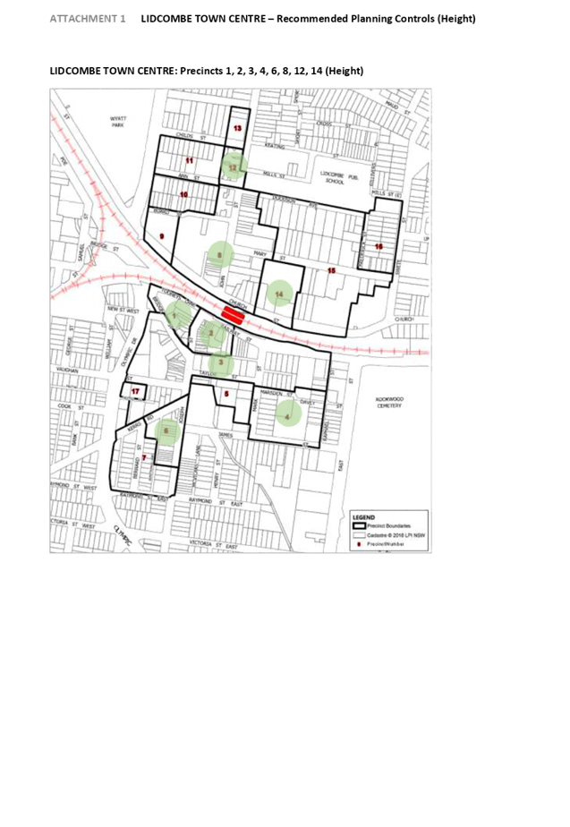
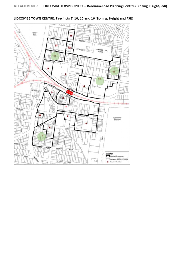
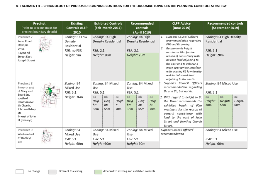
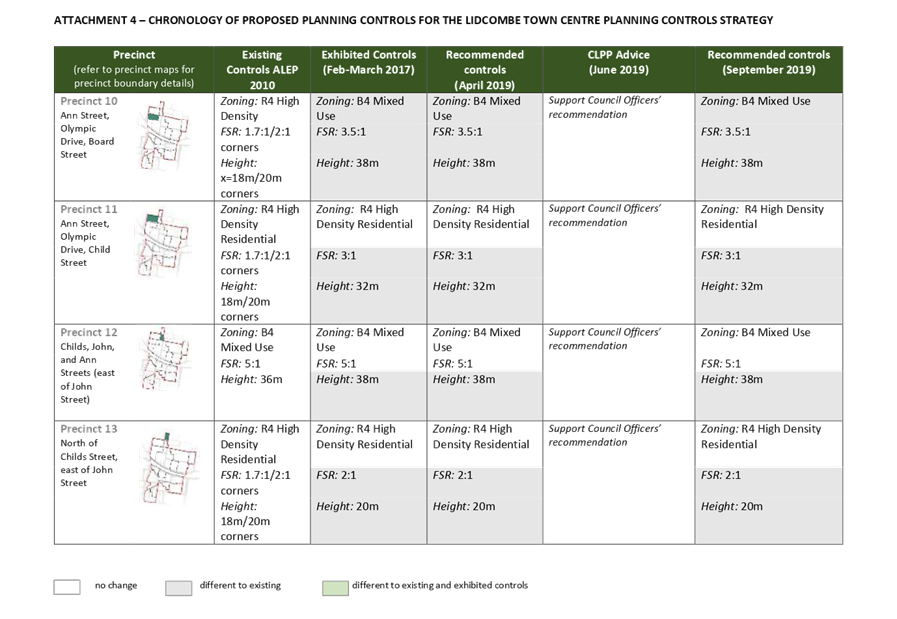
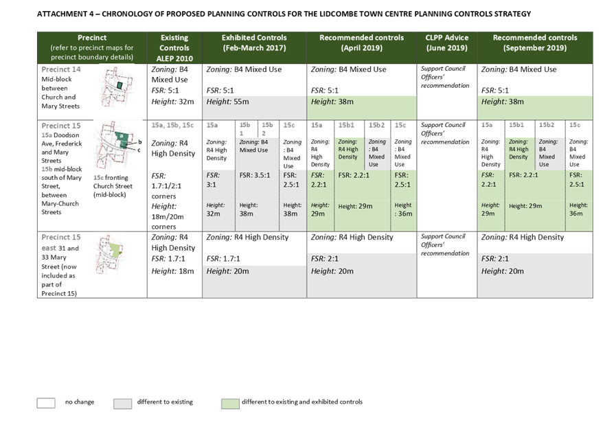
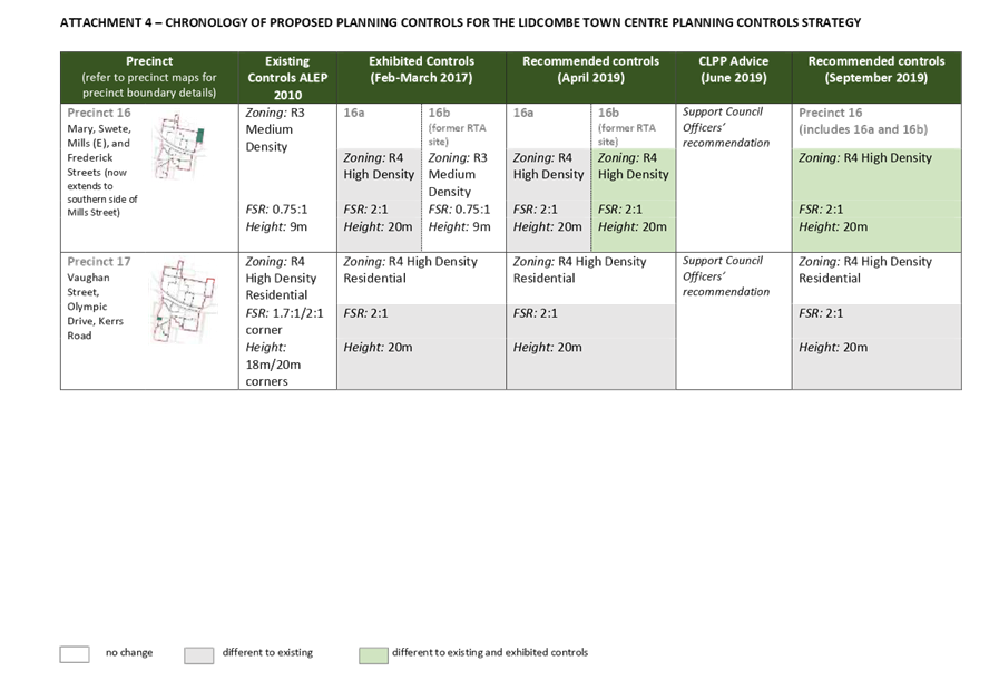
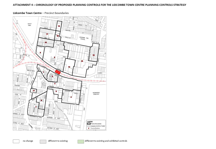
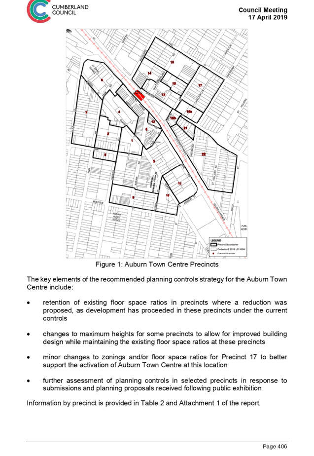
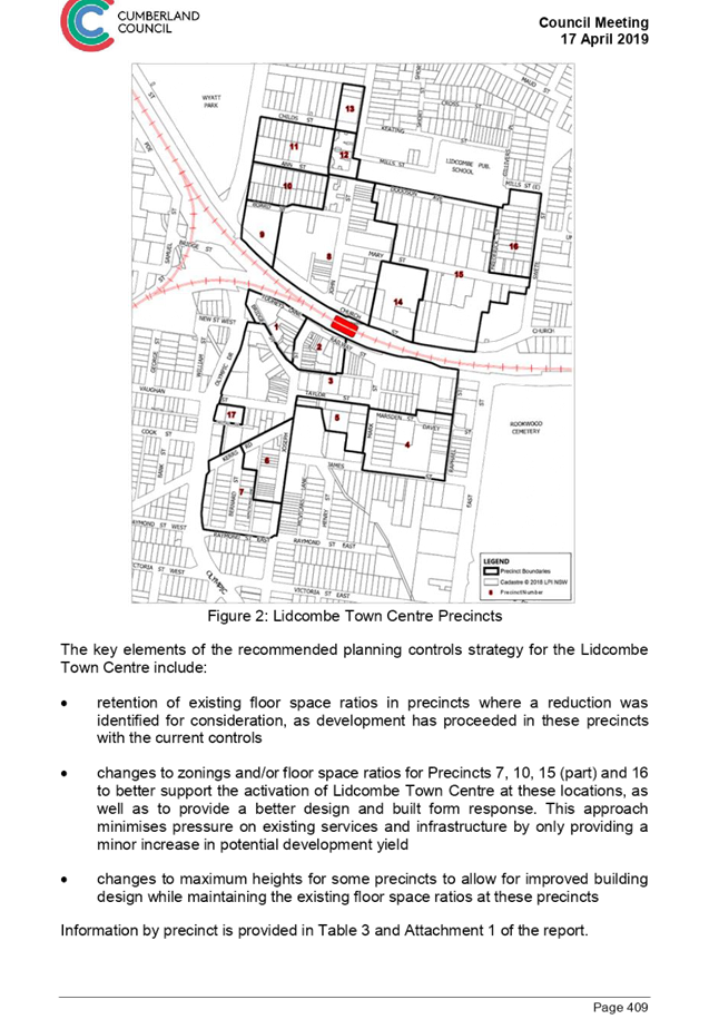
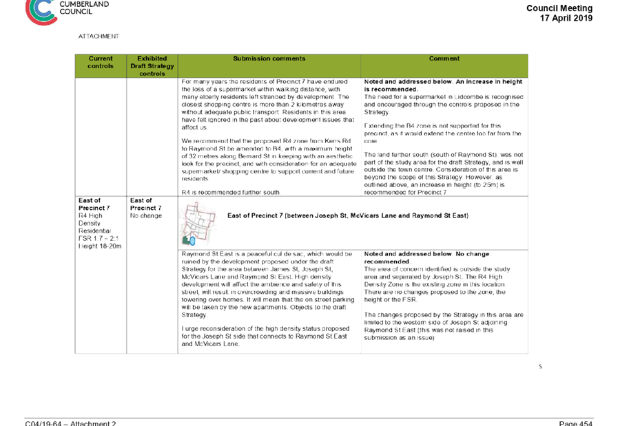
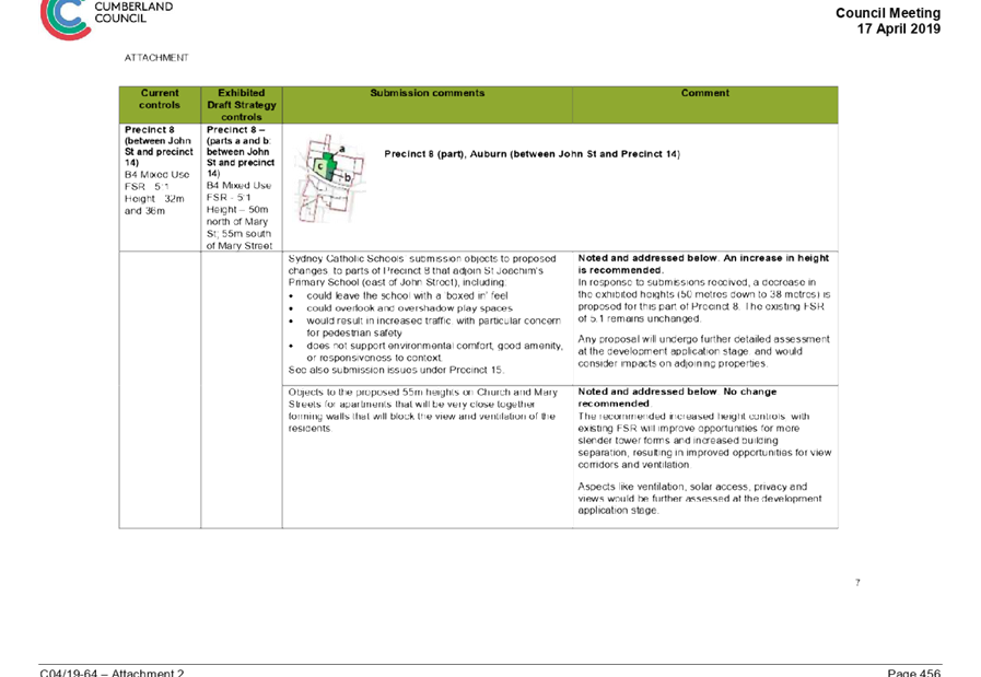
This work considered the planning controls for a number of precincts in the Lidcombe Town Centre, as outlined in Figure 1. A range of public submissions were received and considered for the various precincts in the town centre. Council has also reviewed development applications and building construction activity in the town centre since the public consultation period to ensure that the recommended planning controls respond to the current built form in the town centre.
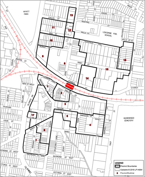
Figure 1: Lidcombe Town Centre Precincts
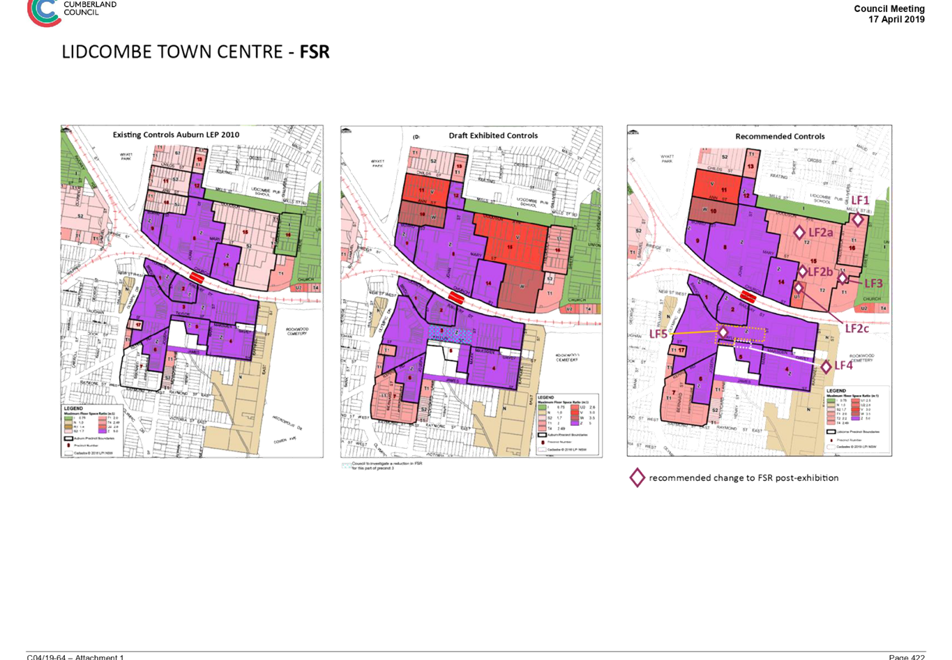
An important focus of the strategy is to better align maximum building heights with density (floor space ratios) provided under the current planning controls. This approach can provide better opportunities for built form within the projected dwelling capacity without increasing density. This approach is shown graphically in Figure 2.
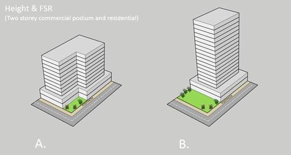
Figure 2: Indicative Building Design Options for a Site with Same Density Controls
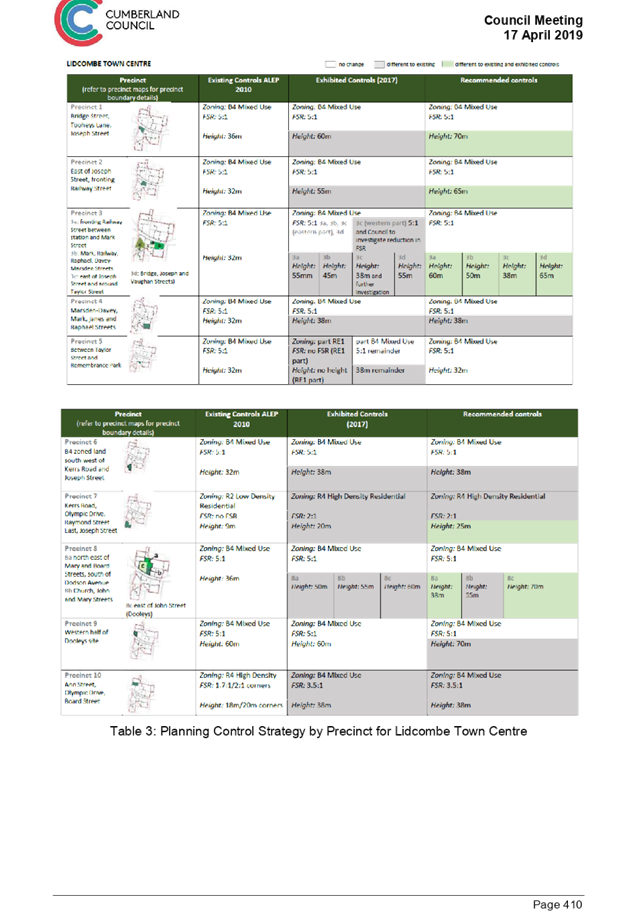
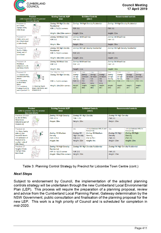
The key elements of the recommended planning controls strategy for the Lidcombe Town Centre include:
· changes to maximum heights in Precincts 1, 2, 3, 4, 6, 8, 12 and 14, to allow for improved building design while maintaining the existing floor space ratios at these precincts;
· changes to maximum heights and floor space ratios in Precincts 11, 13, 15 East and 17, to provide a more consistent approach to planning controls at these locations; and
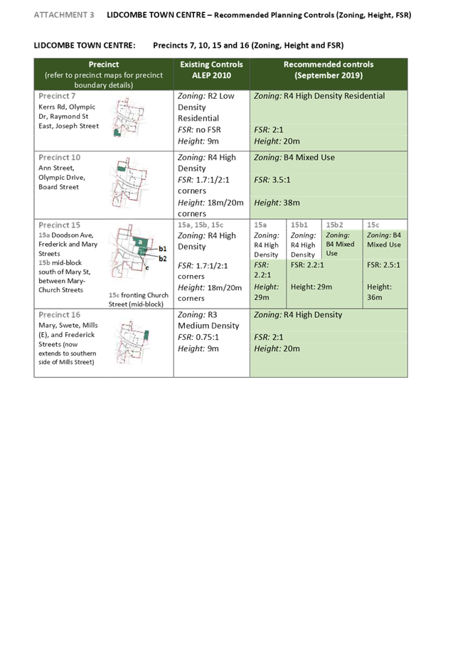
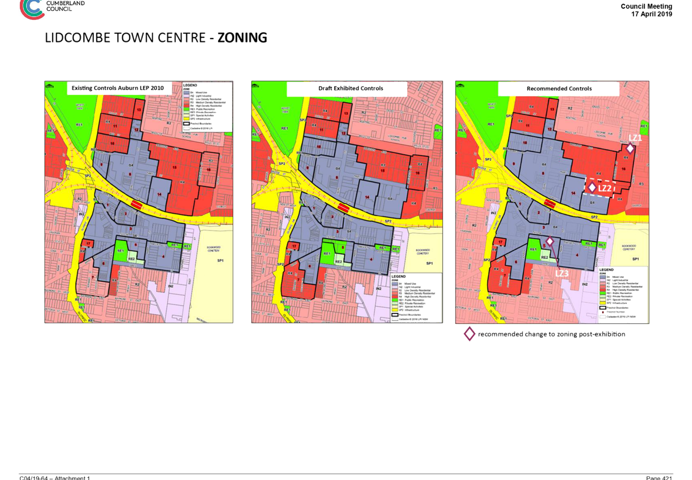
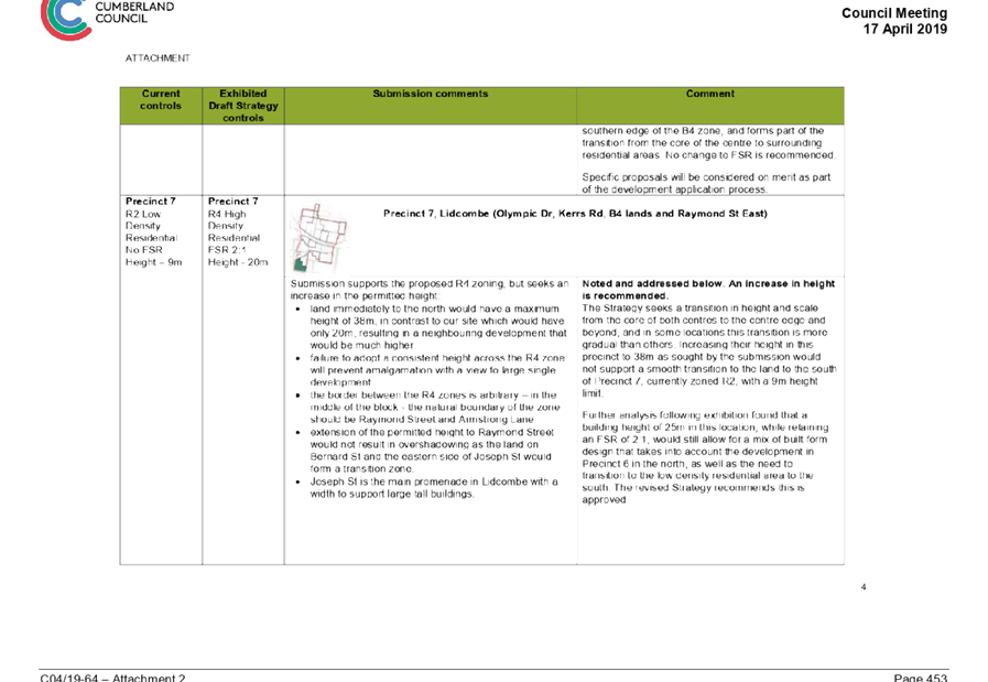
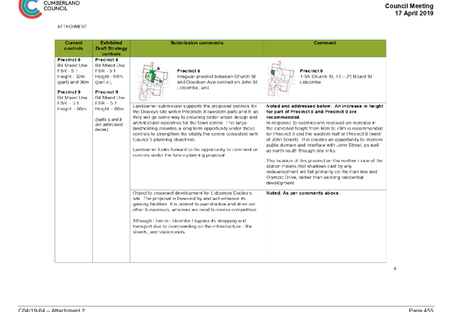
· changes to maximum heights, floor space ratios and land use zonings in Precincts 7, 10, 15 and 16, to support targeted urban development and provide a better transition in built form at the edges of the town centre.
It is estimated that the proposed targeted changes to the planning controls identified in Precincts 7, 10, 15 and 16 will provide for an estimated additional 370 dwellings beyond the projected dwelling capacity under existing controls for the Lidcombe Town Centre. The areas of additional development within the town centre are shown in Figure 3, and are estimated as follows, subject to take up rate and site amalgamations:
· Precinct 7: up to 100 additional dwellings, arising from the proposed change from low density to a lower scale form of higher density development;
· Precinct 10: up to 170 additional dwellings, arising from a targeted increase in height and floor space ratio planning controls;
· Precinct 15: up to 40 additional dwellings, arising from a targeted increase in height and floor space ratio planning controls; and
· Precinct 16: up to 60 additional dwellings, arising from the proposed change from medium density to higher density development.
It is noted that the estimated additional dwelling capacity in Precincts 10 and 15 may be used as commercial/retail floorspace instead of residential floorspace. The additional dwelling capacity in Precinct 10 may also include provision of seniors living housing.
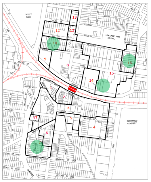
Figure 3: Location of Additional Dwellings under Recommended Planning Controls
Further details of the recommended planning controls in the Lidcombe Town Centre are outlined in Attachments 1 to 3 of this report. These recommendations are supported by the Cumberland Local Planning Panel.
No further changes to planning controls in the Lidcombe Town Centre are proposed in this report.
Planning Controls in the Remembrance Park Area
The draft Strategy for the Lidcombe Town Centre proposed that the land between Taylor Street and Remembrance Park (within Precinct 5) be rezoned to support open space. During the exhibition period, a submission was received from the landowner (Anglican Church) expressing concerns on the proposed rezoning and future plans for the redevelopment of this site. Following further discussions with Council and landowner, it is proposed to retain the current zoning at this location, to allow for further consideration by both parties to support future development plans and opportunities for additional open space at this location.
Council will also investigate mechanisms during the preparation of the new Cumberland Development Control Plan to ensure that planning controls support an increase in open space at this location.
Cumberland Local Planning Panel
The Cumberland Local Planning Panel met on 20 June 2019 to consider this matter, consistent with Council’s resolution of April 2019. Council officers subsequently sought advice from the Panel as a clarification on opportunities for design excellence bonuses on 12 August 2019. The report to the Panel and their advice is provided as Attachment 5.
The advice of the Panel was carefully considered in preparing the proposed planning controls for the Lidcombe Town Centre. The recommended planning controls outlined in the report are supported by the Panel. Opportunities for design excellence bonuses in the town centre will be considered as a separate stage of work following the completion of the new Cumberland Local Environmental Plan.
The Panel also provided a range of future suggestions regarding potential planning controls in the area. This will also be considered as part of the separate stage of work following the completion of the new Cumberland LEP.
Next Steps
Subject to endorsement, the proposed planning controls will be included in the planning proposal that is being prepared for the new Cumberland LEP. The planning proposal will be provided for consideration by Council prior to seeking a Gateway Determination by the Department of Planning, Industry and Environment. This is required to be undertaken by the end of September 2019.
Community Engagement
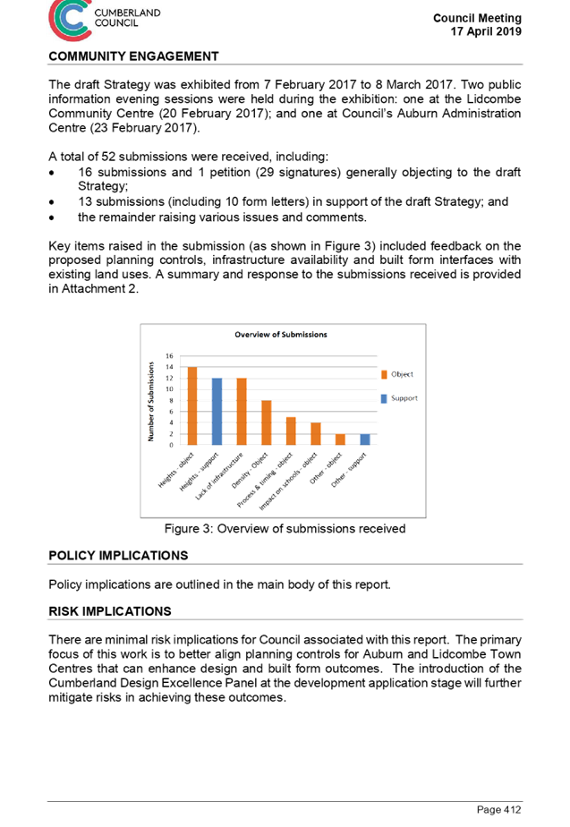
The draft Strategy was exhibited from 7 February 2017 to 8 March 2017. Two public information evening sessions were held during the exhibition: one at the Lidcombe Community Centre (20 February 2017); and one at Council’s Auburn Administration Centre (23 February 2017).
A total of 52 submissions were received, including:
· 16 submissions and 1 petition (29 signatures) generally objecting to the draft Strategy;
· 13 submissions (including 10 form letters) in support of the draft Strategy; and
· the remainder raising various issues and comments.
Key items raised included feedback on the proposed planning controls, infrastructure availability and built form interfaces with existing land uses. Further information is included in Attachment 6.
A public meeting was also held on 15 August 2019 at the Lidcombe Community Centre on the proposed planning controls in Lidcombe. Over 50 people recorded their attendance this meeting. Key issues raised at the meeting included:
· concerns about density and development within Lidcombe town centre;
· lack of infrastructure generally, and the inability of infrastructure to keep pace with growth;
· decreased public transport services, both bus and rail, to/from Lidcombe;
· traffic issues and congestion in and around Lidcombe Town Centre
· parking issues, including lack of off street parking, narrow streets in a number of locations within the town centre, need for more disabled parking spaces, and the possibility of a resident parking scheme;
· lack of pedestrian crossings generally, and particularly in John Street between the town centre and Parramatta Road;
· poor quality of footpaths within, and connecting to, the town centre;
· lack of diversity of shops and retail offering within the town centre;
· questions about protection of existing heritage items within the town centre;
· the future character of Lidcombe; and
· the anticipated timing of the proposed changes.
Subject to Council endorsement, further (statutory) consultation on the recommended planning controls for the Lidcombe Town Centre will be undertaken in early 2020 as part of the new Cumberland LEP.
Policy Implications
Policy implications are outlined in the main body of this report.
Risk Implications
There are minimal risk implications for Council associated with this report. The primary focus of this work is to better align planning controls for Lidcombe Town Centre that can enhance design and built form outcomes. The introduction of the Cumberland Design Excellence Panel at the development application stage will further mitigate risks in achieving these outcomes.
Financial Implications
There are minimal financial implications for Council associated with this report. The primary focus of this work is to better align planning controls for Lidcombe Town Centre that can enhance design and built form outcomes.
CONCLUSION
This report outlines the recommended planning controls strategy for the Lidcombe Town Centre to support better built form design outcomes that will contribute to the quality of amenity and public domain in the area. These recommendations are supported by the Cumberland Local Planning Panel. Subject to endorsement, the recommended planning controls will be included in the planning proposal for the new Cumberland LEP.
Attachments
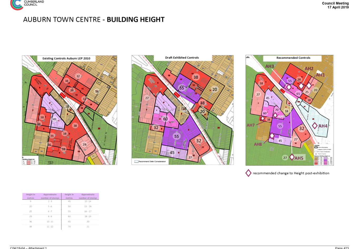
1. Recommended
Planning Controls Height for Lidcombe Town Centre ⇩ ![]()
2. Recommended
Planning Controls Height and FSR for Lidcombe Town Centre ⇩ ![]()
3. Recommended
Planning Controls Zoning for Lidcombe Town Centre ⇩ ![]()
4. Chronology
of proposed planning controls for the Lidcombe Town Centre Planning Controls
Strategy ⇩ ![]()
5. CLPP
Report (20 June 2019) and Panel Advice (20 June and 12 August 2019) ⇩ ![]()
6. Council
Report and Minutes on Auburn and Lidcombe Town Centres Planning Controls
Strategy (17 April 2019) ⇩ ![]()
DOCUMENTS
ASSOCIATED WITH
REPORT C09/19-189
Attachment 1
Recommended Planning Controls Height for Lidcombe Town Centre
Attachment 2
Recommended Planning Controls Height and FSR for Lidcombe Town Centre
Attachment 3
Recommended Planning Controls Zoning for Lidcombe Town Centre
Attachment 4
Chronology of proposed planning controls for the Lidcombe Town Centre Planning Controls Strategy
Attachment 5
CLPP Report (20 June 2019) and Panel Advice (20 June and 12 August 2019)
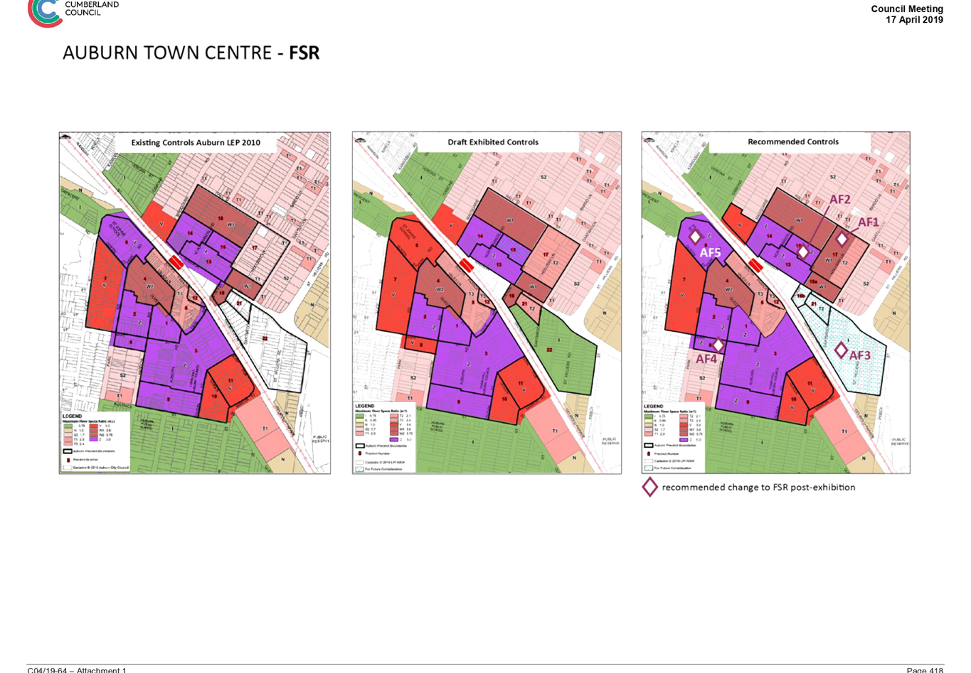
Attachment 6
Council Report and Minutes on Auburn and Lidcombe Town Centres Planning Controls Strategy (17 April 2019)
Council Meeting
4 September 2019
Item No: C09/19-190
Community Feedback on Cumberland's Heritage List
Responsible Division: Environment & Planning
Officer: Director Environment & Planning
File Number: SC604
Community Strategic Plan Goal: A resilient built environment
Summary
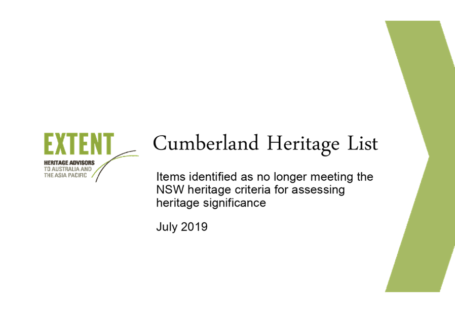
As part of strategic planning work to support the preparation of the Cumberland Local Environmental Plan (LEP), a heritage consultant has been engaged by Council to undertake a study to inform the Cumberland Heritage List. The first stage involved a review of existing heritage items to confirm that these items continue to meet the NSW heritage criteria for assessing heritage significance. The second stage will involve consideration of potential new heritage items or places for inclusion in the Cumberland Heritage List.
This report outlines the community feedback received by Council on the Cumberland Heritage List. The feedback received will be used to inform the scope of heritage items to be included in the new Cumberland LEP.
|
Recommendation That Council: 1. Note that seven submissions were received regarding the 10 items identified as no longer meeting the NSW heritage criteria for assessing heritage significance.
2. Note that 23 submissions were received regarding nominations of items and places for future heritage consideration.
3. Note that the community feedback received will be used to inform the scope of heritage items to be included in the new Cumberland Local Environmental Plan. |
Report
Cumberland Heritage Study
As part of the broader strategic work currently underway to support the preparation of a comprehensive Local Environmental Plan (LEP) for Cumberland, Council has engaged Extent Heritage to undertake a Local Government Area (LGA) wide Cumberland Heritage Study (Study). The Study consists of two stages:
· Stage 1 – Prepare a history of the LGA and review all existing heritage items (January – August 2019)
· Stage 2 – Identify and assess potential new heritage items (September 2019 – May 2020)
The first stage of the Study involved a review of all existing heritage items (including conservation areas) listed in the Auburn, Holroyd or Parramatta LEPs and located in the Cumberland LGA, and update the listing information as appropriate. Out of the more than 350 heritage items located within the Cumberland LGA and listed on the three LEPs, ten (10) properties were identified as no longer meeting the NSW heritage criteria for assessing heritage significance (Attachment 1). These were:
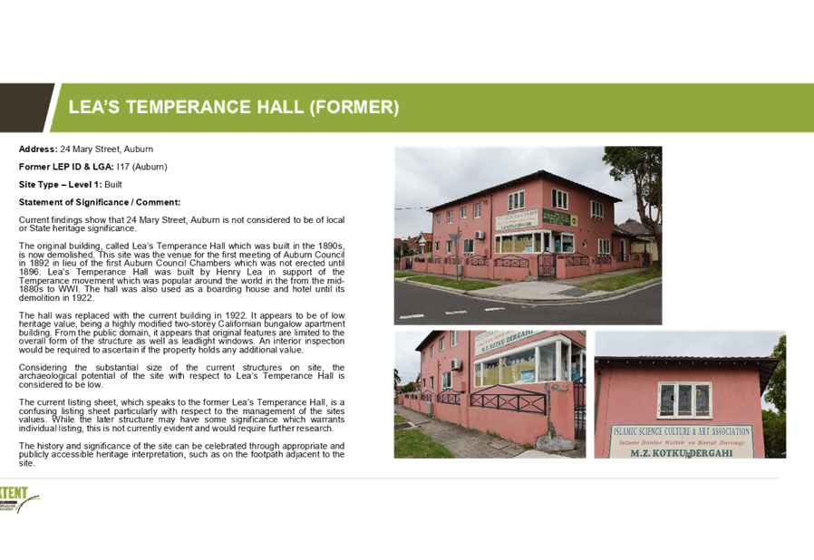
1. Lea's Temperance Hall (former), 24 Mary Street, Auburn
2. Conjoined Residences, 36 and 38 Jamieson Street, Granville
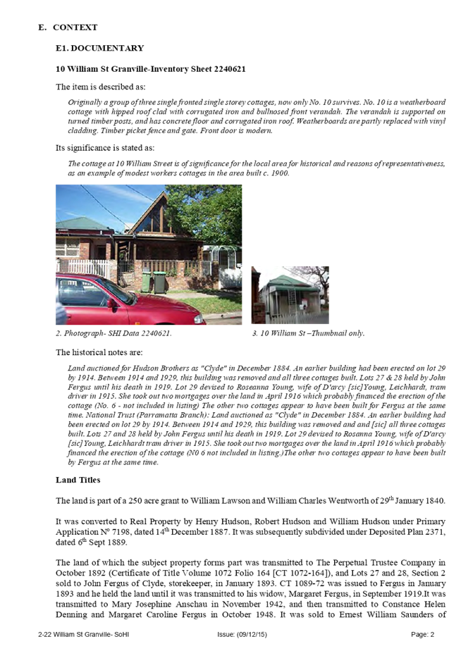
3. William Street Cottages Group, 10 William Street, Granville
4. Conjoined Residences, 9-11 Woodville Road, Granville
5. Federation Period Cottage, 4 Myall Street, Merrylands
6. Guildford Railway Station, Railway Terrace, Guildford
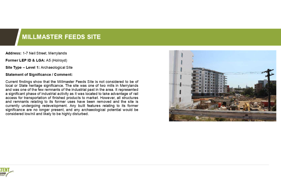
7. Millmaster Feeds Sites, 1-7 Neil Street, Merrylands (archaeological)
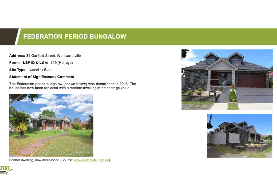
8. Federation Period Bungalow, 34 Garfield Street, Wentworthville
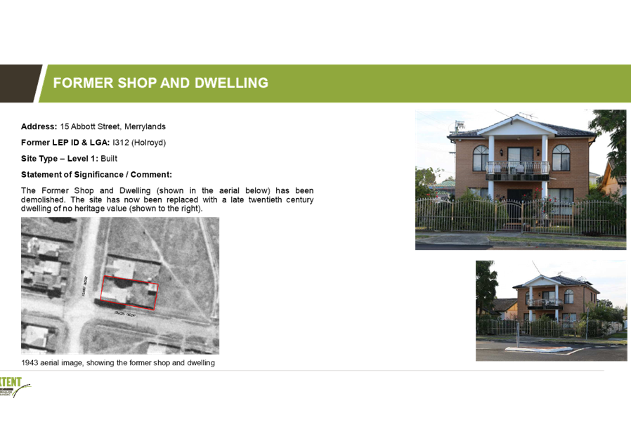
9. Former Shop and Dwelling, 15 Abbott Street, Merrylands
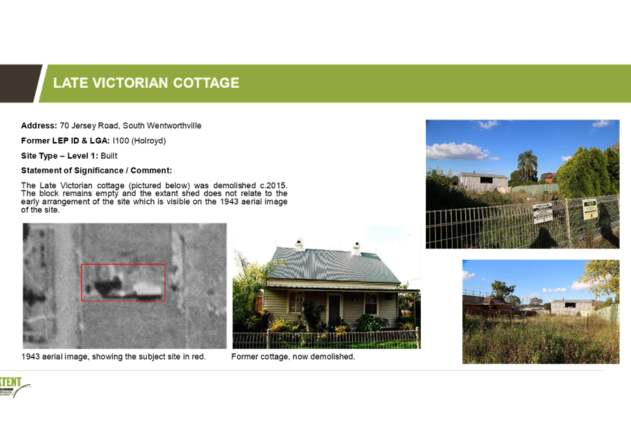
10. Late Victorian Cottage, 70 Jersey Road, South Wentworthville
The second stage of the study seeks to identify, assess, and make recommendations about potential new heritage items or places for future listing on the Cumberland Local Environmental Plan.
Community Feedback
Stage 1: Ten heritage items no longer meeting the NSW heritage criteria for heritage significance
Seven (7) submissions were received on the ten (10) heritage items currently listed in the Auburn, Holroyd and Parramatta LEPs but identified as no longer meeting the NSW heritage criteria for heritage significance. Four (4) submissions received were from the owners or on behalf of the owners of the identified heritage items.
Three (3) submissions were received on 24 Mary Street, Auburn. Out of these, one provided further information on the site, a submission on behalf of the owner supported the removal of the property as a local heritage item, and one submission recommended that the property be retained as a local heritage item.
The remaining four (4) submissions to other items supported the conclusions of the heritage consultant that these items are no longer of heritage significance. Three (3) of these submissions were received from the owners or on behalf of the owners of the identified heritage items.
Stage 2: Properties nominated for Council’s consideration for heritage listing
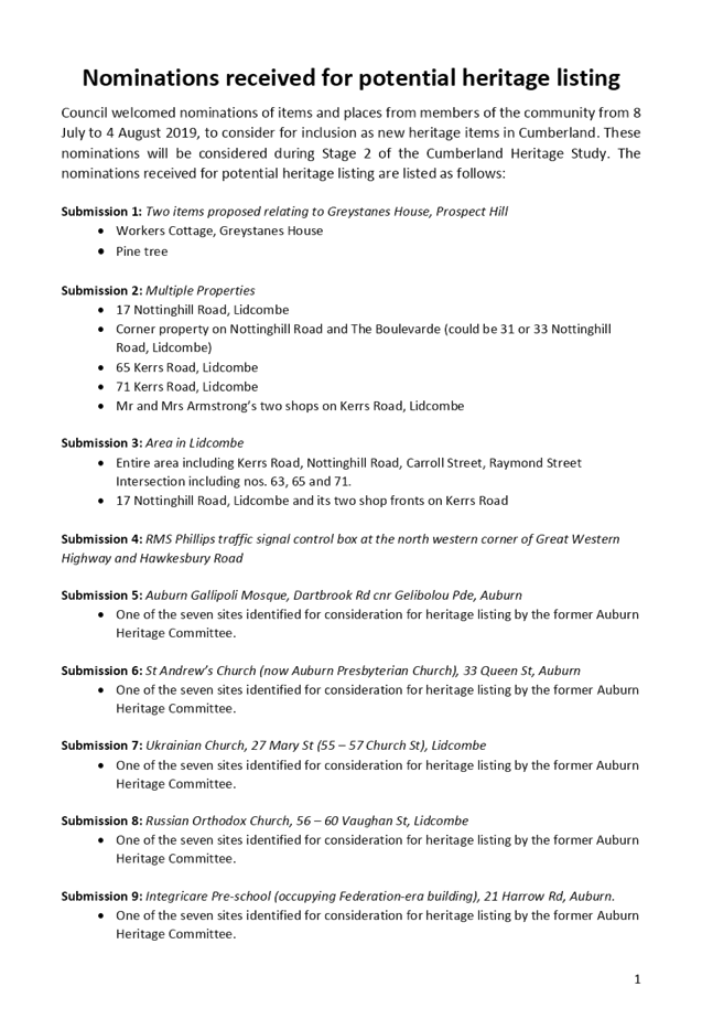
A total of 23 submissions were received providing nominations for heritage listing as part of Stage 2 of the heritage study. A list of the nominations made can be found in Attachment 2. These nominations will be considered by the heritage consultant as part of the Stage 2 component of the study.
Next Steps
Following a review of the submissions and receipt of additional information, no change to the heritage significance of the former Lea’s Temperance Hall at Auburn is proposed.
The work undertaken on Stage 1 of the Cumberland Heritage Study will inform the preparation of a new Local Environmental Plan (LEP) for the Cumberland area, which will bring together the three existing LEPs into a consolidated set of planning controls.
The outcomes of the work undertaken on Stage 2 of the Cumberland Heritage Study will be used to provide a report to Council. Any future heritage items that supported by Council can be included in the new Cumberland LEP through the preparation of a Council initiated planning proposal.
Community Engagement
A 28 day period for community feedback on the Cumberland Heritage List was provided from 8 July 2019 to 4 August 2019.
Information on the public consultation along with related documents was made available on Council’s Have Your Say page, at Council’s Auburn and Merrylands Services Centres, and at all Council libraries. Newspaper advertisements were also placed in the Council Corporate Page of the Auburn Review on 9 July 2019 and in the Parramatta Advertiser on 10 July 2019.
Letter notifications were sent to owners of all ten (10) properties identified as no longer meeting the NSW heritage criteria for heritage significance, to seek their feedback on the proposal.
A nomination form was also developed to allow the community to easily nominate items for Council’s consideration for potential heritage listing.
Policy Implications
Policy implications are outlined in the main body of the report.
Risk Implications
There are minimal risk implications for Council associated with this report.
Financial Implications
There are no financial implications for Council associated with this report.
CONCLUSION
As part of strategic planning work to support the preparation of the Cumberland LEP, a heritage consultant has been engaged by Council to undertaken a study to inform the Cumberland Heritage List. This report outlines the community feedback received by Council on the Cumberland Heritage List. The feedback received will be used to inform the scope of heritage items to be included in the new Cumberland LEP.
Attachments
1. Heritage
items identified as no longer meeting the NSW heritage criteria for heritage
criteria for heritage significance ⇩ ![]()
2. Nominations
received for potential heritage listing ⇩ ![]()
DOCUMENTS
ASSOCIATED WITH
REPORT C09/19-190
Attachment 1
Heritage items identified as no longer meeting the NSW heritage criteria for heritage criteria for heritage significance
Attachment 2
Nominations received for potential heritage listing
4 September 2019
Item No: C09/19-191
Proposed Planning Controls for selected land uses and Part 6 of the new Cumberland Local Environmental Plan
Responsible Division: Environment & Planning
Officer: Director Environment & Planning
File Number: S-5750-01
Community Strategic Plan Goal: A resilient built environment
Summary
The preparation of a new Cumberland Local Environmental Plan (LEP) is underway, with the focus on harmonising the planning controls of the three LEPs in operation across Cumberland into a single set of planning controls under a comprehensive LEP.
This report outlines some of the proposed planning controls to be included in the new Cumberland LEP. It recommends that Council endorse the planning approach for places of public worship and sex services premises, as well as local and site specific provisions. This information will be included in the planning proposal being prepared for the new LEP.
|
Recommendation That Council: 1. Endorse the planning approach for places of public worship to be included in the new Cumberland LEP, as provided in Attachment 1. 2. Endorse the planning approach for sex services premises to be included in the new Cumberland LEP, as provided in Attachment 2. 3. Endorse the local and site specific provisions to be included in Part 6 of the new Cumberland Local Environmental Plan, as provided in Attachment 3. 4. Note that the above items will be included in the planning proposal for the new Cumberland Local Environmental Plan. |
Report
Background
Cumberland Council is currently operating under three separate environmental planning instruments, known as a Local Environmental Plan (LEP), which represent the planning controls from the former Council area within Cumberland prior to amalgamation. These include:
i. Auburn LEP 2010, which applies to land in the former Auburn City Council area (eastern part of Cumberland);
ii. Parramatta LEP 2011, which applies to land in the former Parramatta City Council area (central part of Cumberland); and
iii. Holroyd LEP 2013, which applies to land in the former Holroyd City Council area (western part of Cumberland).
The current approach does not provide an integrated planning framework for the Cumberland area, with inconsistent planning controls in place, and is not aligned to current strategic plans and policies from Council and the NSW Government.
Changes to the Environmental Planning and Assessment Act 1979 in March 2018 require all metropolitan councils to review and amend their existing LEP to ensure it aligns with the relevant District Plan and Greater Sydney Region Plan. Cumberland has been identified as a priority council by the Greater Sydney Commission.
New Cumberland Local Environmental Plan (LEP)
The preparation of a new Cumberland LEP will be undertaken in the form of a planning proposal. The focus of the planning proposal for the new Cumberland LEP is harmonising the planning controls of the three LEPs in operation across Cumberland into a single set of planning controls under a comprehensive LEP.
The structure of the new Cumberland LEP is based on the Standard Instrument LEP, which is the principal template LEP provided by the NSW Government. Many clauses, provisions and schedules in the Standard Instrument LEP are compulsory and must be included in the new Cumberland LEP. However, there are some areas where Council has an ability to inform the scope and content on clauses, provisions and schedules to be included in the new LEP.
This report focuses on a range of proposed planning controls within the new Cumberland LEP, as shown in Figure 1. This includes:
· Land use table in regard to the specialised land uses of places of public worship and sex services premises
· Various local and/or site specific planning provisions
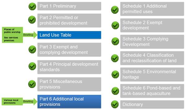
Figure 1: Proposed Planning Controls Covered in Council Report
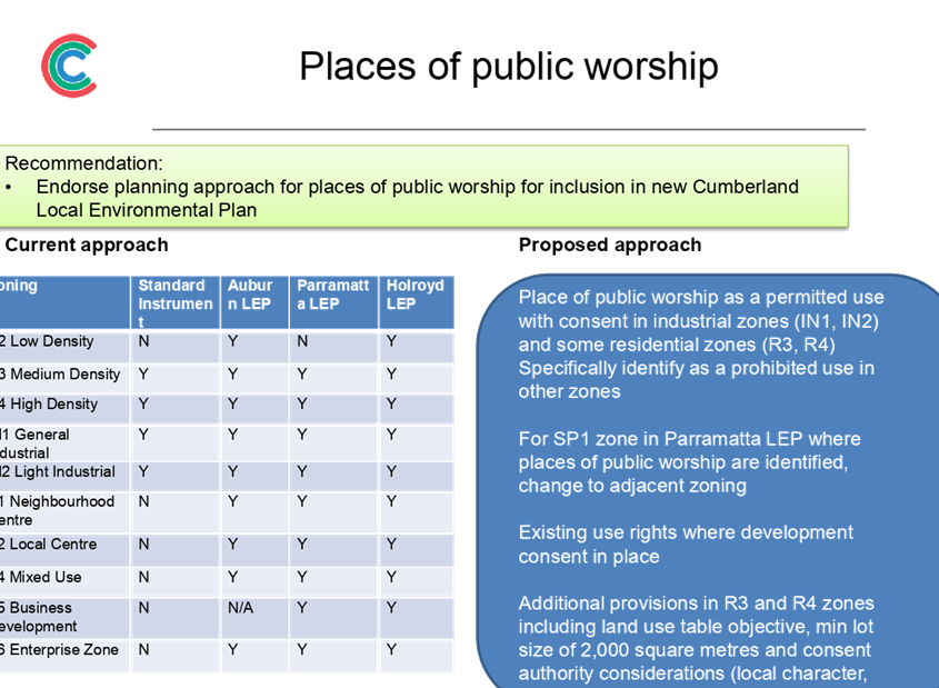
Places of public worship
Places of public worship in Cumberland are currently permissible in the IN1 zone under the Auburn LEP, the IN1 and IN2 zone in the Parramatta LEP and are prohibited in all zones in the Holroyd LEP.
It is recommended that Council endorse the following planning approach for places of public worship for inclusion in the new Cumberland LEP, as outlined in Attachment 1:
· Permit places of public worship with consent in the R3, R4, IN1 and IN2 zones.
· Specifically prohibit them in all other zones in the Cumberland LEP.
· For existing places of public worship zoned SP1 in the Parramatta LEP area, apply the surrounding zone. Existing use rights will apply where development consent is in place.
· Insert an additional objective in the Land Use Table for the R3 and R4 zones to ensure that places of public worship are located in a context and setting that minimises impacts on the amenity of a low density residential environment.
· Introduce new local provisions regarding places of public worship in R3 and R4 zones, including a minimum lot size of 2,000m2 for places of public worship and consent authority considerations.
Further consideration of planning controls for places of public worship will also be undertaken as part of the preparation for the new Cumberland Development Control Plan.
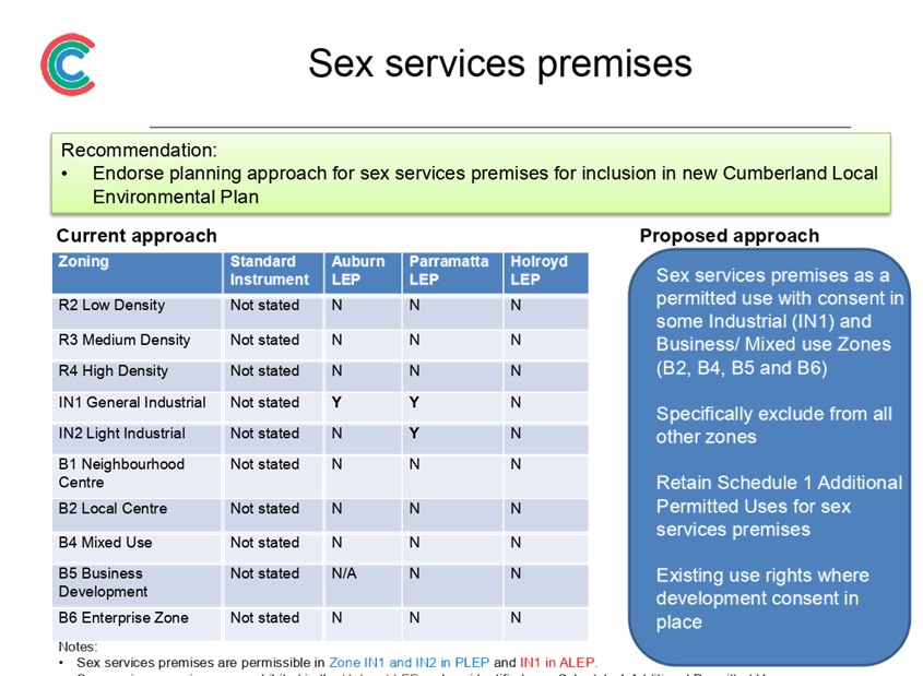
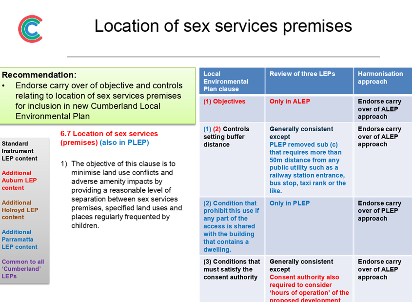
Sex services premises
Sex services premises in Cumberland are currently permissible in the IN1 zone under the Auburn LEP and in both the IN1 and IN2 zones under the Parramatta LEP. They are prohibited in all zones under the Holroyd LEP, with the exception of a handful of sites identified in Schedule 1 Additional permitted uses.
It is recommended that Council endorse the following planning approach for sex services premises for inclusion in the new Cumberland LEP, as outlined in Attachment 2:
· Permit sex services premises with consent in the IN1, B2, B4, B5 and B6 zones.
· Specifically prohibit them in all other zones in the Cumberland LEP.
· Retain permissibility of sex services premises on sites currently listed in Schedule 1 of the Holroyd LEP.
Further consideration of planning controls for sex services premises will also be undertaken as part of the preparation for the new Cumberland Development Control Plan.
Part 6: Local Provisions
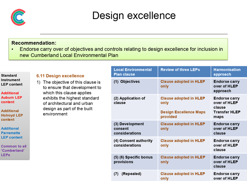
Part 6 of the new Cumberland LEP provides additional specialised provisions to address local issues. The proposed specialised provisions for inclusion in the new Cumberland LEP are based on the following general rules of retention:
· Existing local provisions and additional permitted uses will generally be retained
· Additional local provisions that address specific local circumstances where justified, such as a result of relevant planning components of Council’s local strategic planning
· Additional permitted use provisions may be used to allow certain land uses/development on land where they would otherwise be prohibited (subject to conditions)
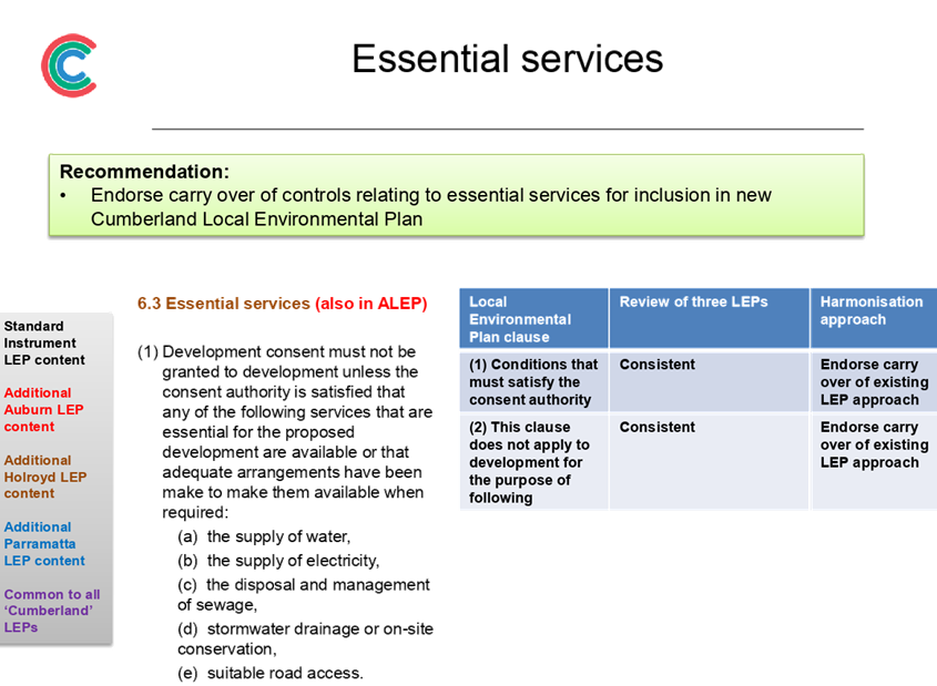
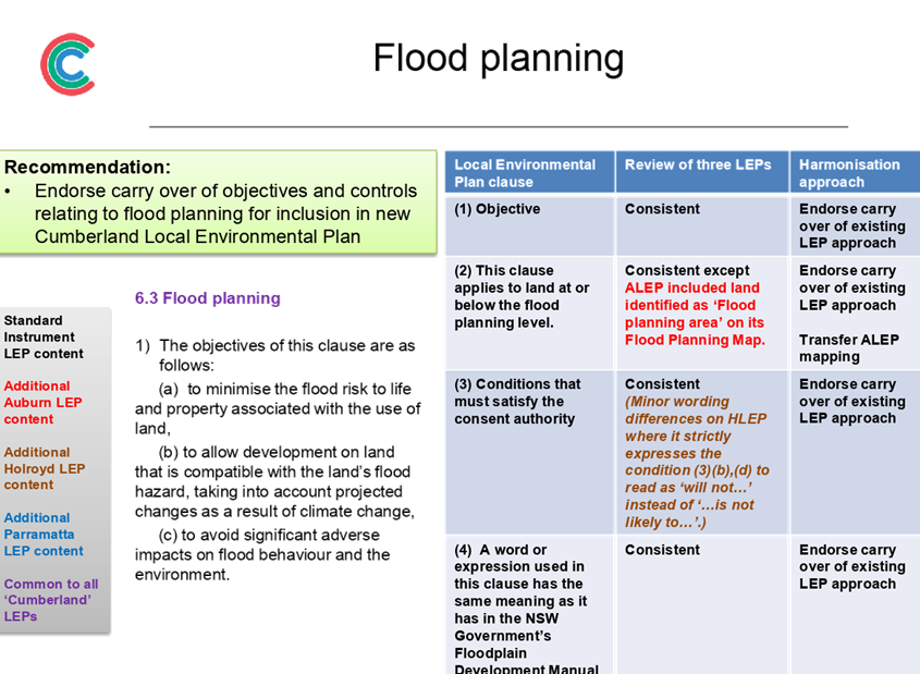
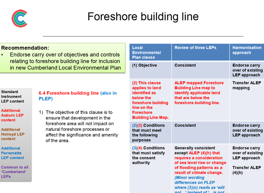
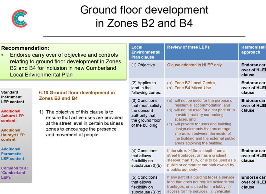
It is recommended that Council endorse a range of local and site specific provisions to be included in Part 6 of the new Cumberland LEP, as outlined in Attachment 3 and summarised in Table 1 below.
|
Local/site specific provision |
Recommendation for Council endorsement |
|
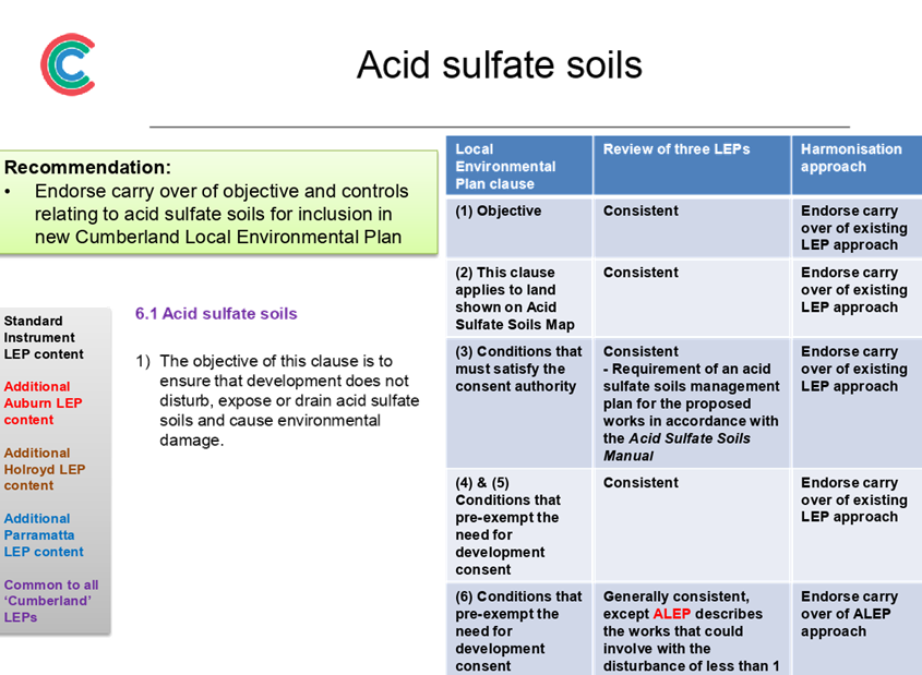
Acid sulfate soils |
Endorse carry over of objective and controls relating to acid sulfate soils for inclusion in new Cumberland Local Environmental Plan |
|
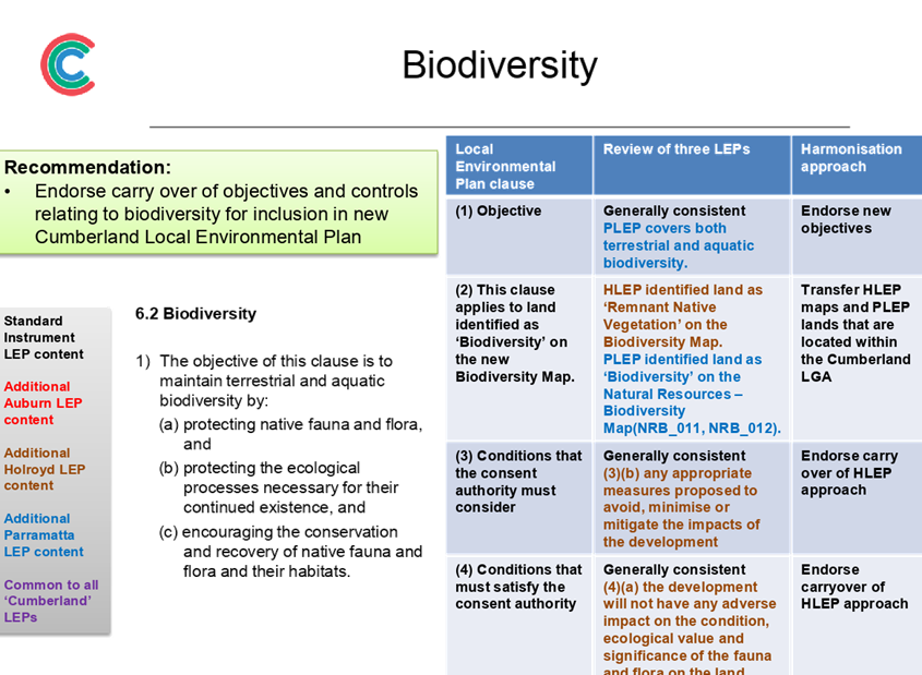
Biodiversity |
Endorse carry over of objectives and controls relating to biodiversity for inclusion in new Cumberland Local Environmental Plan |
|
Buffer area between industrial and residential zones |
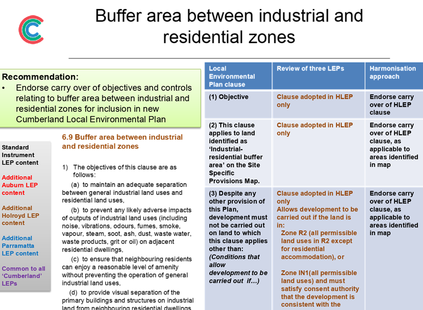
Endorse carry over of objectives and controls relating to buffer area between industrial and residential zones for inclusion in new Cumberland Local Environmental Plan |
|
Design excellence |
Endorse carry over of objectives and controls relating to design excellence for inclusion in new Cumberland Local Environmental Plan |
|
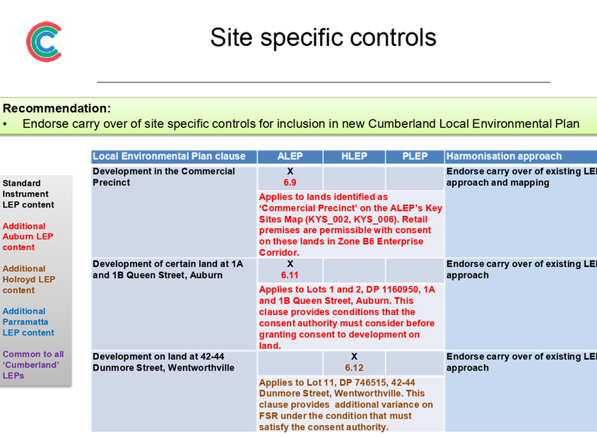
Development in the Commercial Precinct |
Endorse carry over of site specific controls for inclusion in new Cumberland Local Environmental Plan |
|
Development of certain land at 1A and 1B Queen Street, Auburn |
Endorse carry over of site specific controls for inclusion in new Cumberland Local Environmental Plan |
|
Development on land at 42-44 Dunmore Street, Wentworthville |
Endorse carry over of site specific controls for inclusion in new Cumberland Local Environmental Plan |
|
Earthworks |
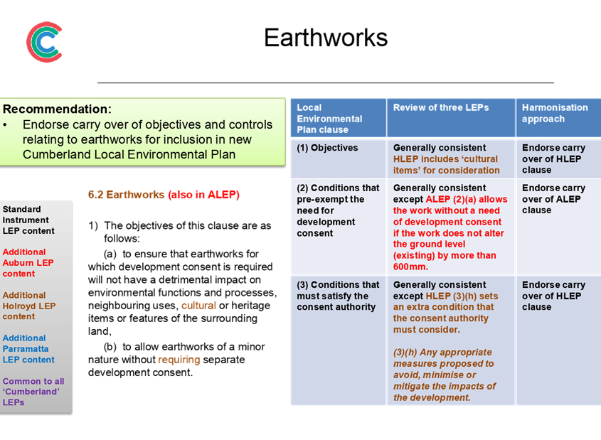
Endorse carry over of objectives and controls relating to earthworks for inclusion in new Cumberland Local Environmental Plan |
|
Essential services |
Endorse carry over of controls relating to essential services for inclusion in new Cumberland Local Environmental Plan |
|
Flood planning |
Endorse carry over of objectives and controls relating to flood planning for inclusion in new Cumberland Local Environmental Plan |
|
Foreshore building line |
Endorse carry over of objectives and controls relating to foreshore building line for inclusion in new Cumberland Local Environmental Plan |
|
Ground floor development in Zones B2 and B4 |
Endorse carry over of objective and controls relating to ground floor development in Zones B2 and B4 for inclusion in new Cumberland Local Environmental Plan |
|
Location of sex services premises |
Endorse carry over of objective and controls relating to location of sex services premises for inclusion in new Cumberland Local Environmental Plan |
|
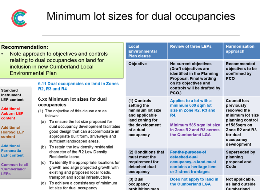
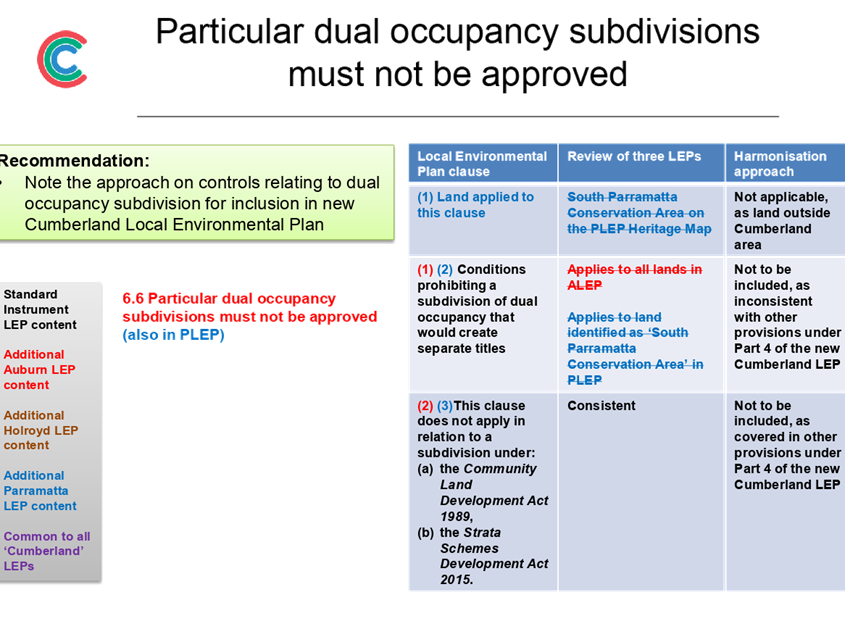
*Minimum lot area for low and medium density dual occupancy housing |
Note approach to objectives and controls relating to dual occupancies on land for inclusion in new Cumberland Local Environmental Plan |
|
Places of public worship in Zones R3 and R4 |
Endorse planning approach for places of public worship for inclusion in new Cumberland Local Environmental Plan |
|
Restricted premises |
Endorse carry over of controls relating to restricted premises for inclusion in new Cumberland Local Environmental Plan |
|
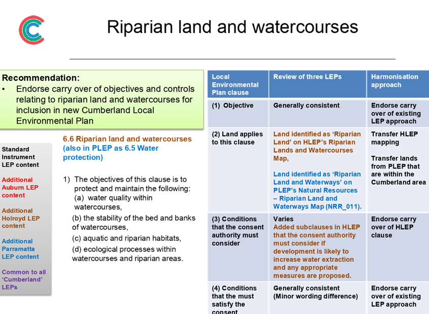
Riparian land and watercourses |
Endorse carry over of objectives and controls relating to riparian land and watercourses for inclusion in new Cumberland Local Environmental Plan |
|
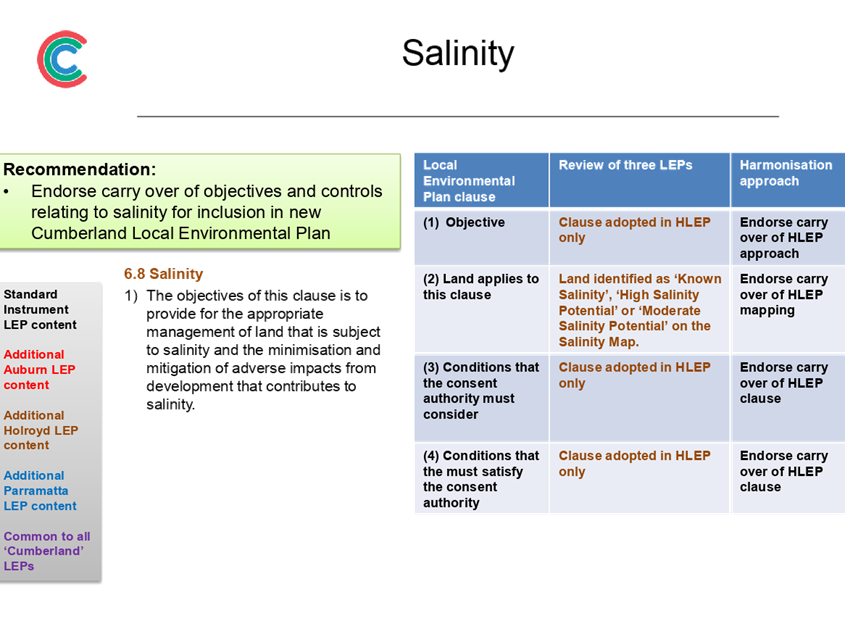
Salinity |
Endorse carry over of objectives and controls relating to salinity for inclusion in new Cumberland Local Environmental Plan |
|
Stormwater management |
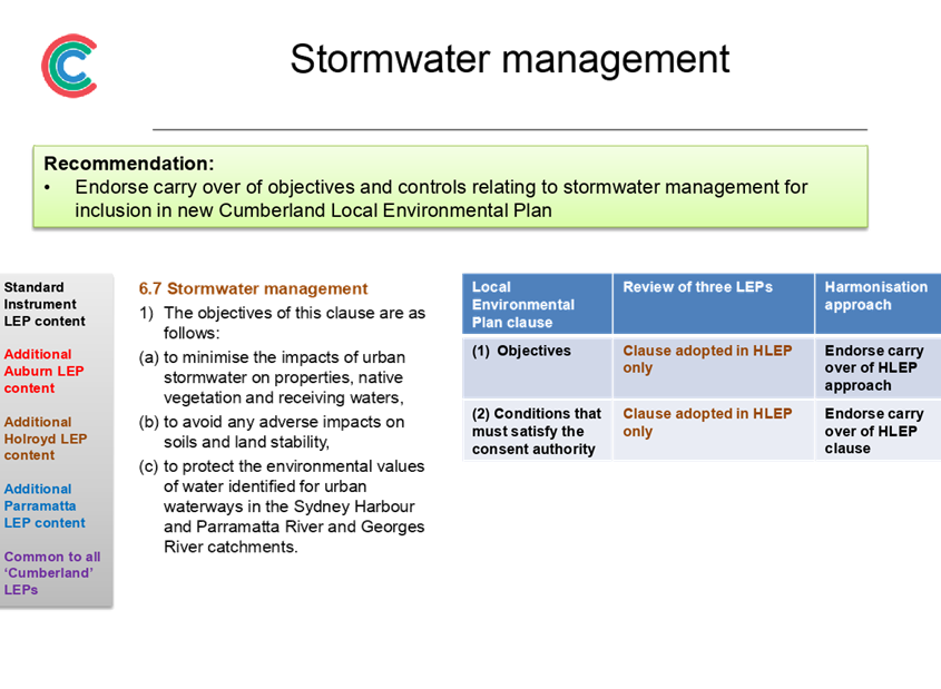
Endorse carry over of objectives and controls relating to stormwater management for inclusion in new Cumberland Local Environmental Plan |
|
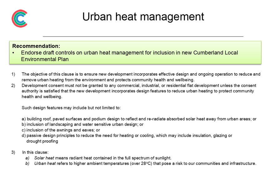
Urban heat management |
Endorse draft controls on urban heat management for inclusion in new Cumberland Local Environmental Plan |
* This clause will reflect the Council-led planning proposal to introduce a minimum lot area for low and medium density dual occupancy housing in the Auburn and Holroyd LEP areas. The planning proposal has been submitted to the Department of Planning, Industry and Environment for finalisation.
Table 1: Summary of Local and/or Site Specific Provisions for Council Endorsement
Next Steps
Subject to endorsement, the proposed planning controls will be included in the planning proposal that is being prepared for the new Cumberland LEP. The planning proposal will be provided for consideration by Council prior to seeking a Gateway Determination by the Department of Planning, Industry and Environment. This is required to be undertaken by the end of September 2019.
Community Engagement
An extensive consultation program is in place for the preparation of the new Cumberland LEP. The first stage is early consultation on the new LEP, which concluded on 30 August 2019, and represents pre-Gateway consultation in accordance with Council’s Planning Proposal Notification Policy. The second stage is formal consultation on the draft planning proposal for the new LEP in early 2020, subject to Gateway Determination by the Department of Planning, Industry and Environment.
Policy Implications
The preparation of the Cumberland Local Environmental Plan (LEP) is required under the Environmental Planning and Assessment Act 1979. The Cumberland LEP will also align with the strategic directions outlined in Council’s Community Strategic Plan and Draft Cumberland 2030: Our Local Strategic Planning Statement.
Risk Implications
Council is required to submit a planning proposal on the new Cumberland LEP by the end of September 2019. The release of funds from the grant is also linked to this milestone. Endorsement of the proposed planning controls will assist Council in meeting this milestone.
Financial Implications
Work undertaken on the Cumberland Local Environmental Plan (LEP), including strategic studies and planned community consultation activities, will be funded from the accelerated Local Environmental Plan Funding Grant provided by the NSW Government.
CONCLUSION
The preparation of a new Cumberland Local Environmental Plan (LEP) is underway. This report outlines some of the proposed planning controls to be included in the new Cumberland LEP. It recommends that Council endorse the planning approach for places of public worship and sex services premises, as well as local and site specific provisions as relevant to the Cumberland area. This information will be included in the planning proposal being prepared for the new LEP.
Attachments
1. Proposed
planning approach for places of public worship ⇩ ![]()
2. Proposed
planning approach for sex services premises ⇩ ![]()
3. Proposed
Planning Controls - Part 6 ⇩ ![]()
DOCUMENTS
ASSOCIATED WITH
REPORT C09/19-191
Attachment 1
Proposed planning approach for places of public worship
Attachment 2
Proposed planning approach for sex services premises
4 September 2019
Item No: C09/19-192
Proposed Planning Controls for the Land Use Table for Residential, Business and Industrial Zones of the new Cumberland Local Environmental Plan
Responsible Division: Environment & Planning
Officer: Director Environment & Planning
File Number: S-5750-01
Community Strategic Plan Goal: A resilient built environment
Summary
The preparation of a new Cumberland Local Environmental Plan (LEP) is underway, with the focus on harmonising the planning controls of the three LEPs in operation across Cumberland into a single set of planning controls under a comprehensive LEP.
This report outlines some of the proposed planning controls to be included in the new Cumberland LEP. It recommends that Council endorse the Land Use Table on residential, business and industrial zones as well as the carryover of the existing application of these zonings for properties covered under the LEP. This information will be included in the planning proposal being prepared for the new LEP.
|
Recommendation That Council 1. Endorse the Land Use Table for the residential, business and industrial zones to be included in the new Cumberland Local Environmental Plan, as provided in Attachments 1 to 10;
2. Endorse the carryover of the existing application of these zonings as currently mapped for properties covered under the new Cumberland Local Environmental Plan; and
3. Note that the above items will be included in the planning proposal for the new Cumberland Local Environmental Plan. |
Report
Background
Cumberland Council is currently operating under three separate environmental planning instruments, known as a Local Environmental Plan (LEP), which represent the planning controls from the former Council area within Cumberland prior to amalgamation. These include:
i. Auburn LEP 2010, which applies to land in the former Auburn City Council area (eastern part of Cumberland);
ii. Parramatta LEP 2011, which applies to land in the former Parramatta City Council area (central part of Cumberland); and
iii. Holroyd LEP 2013, which applies to land in the former Holroyd City Council area (western part of Cumberland).
The current approach does not provide an integrated planning framework for the Cumberland area, with inconsistent planning controls in place, and is not aligned to current strategic plans and policies from Council and the NSW Government.
Changes to the Environmental Planning and Assessment Act 1979 in March 2018 require all metropolitan councils to review and amend their existing LEP to ensure it aligns with the relevant District Plan and Greater Sydney Region Plan. Cumberland has been identified as a priority council by the Greater Sydney Commission.
New Cumberland Local Environmental Plan (LEP)
The preparation of a new Cumberland LEP will be undertaken in the form of a planning proposal. The focus of the planning proposal for the new Cumberland LEP is harmonising the planning controls of the three LEPs in operation across Cumberland into a single set of planning controls under a comprehensive LEP.
The structure of the new Cumberland LEP is based on the Standard Instrument LEP, which is the principal template LEP provided by the NSW Government. Many clauses, provisions and schedules in the Standard Instrument LEP are compulsory and must be included in the new Cumberland LEP. However, there are some areas where Council has an ability to inform the scope and content on clauses, provisions and schedules to be included in the new LEP.
This report focuses on the proposed Land Use Table for selected zonings within the new Cumberland LEP, as shown in Figure 1.
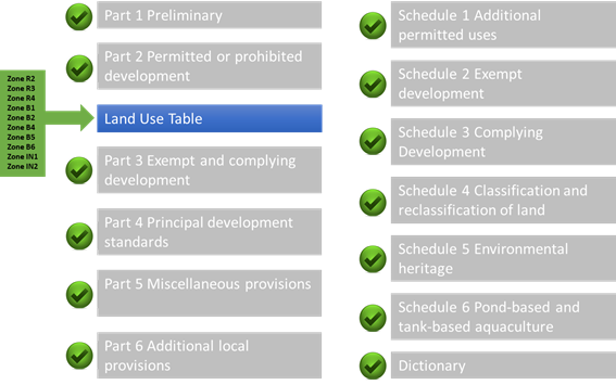
Figure 1: Proposed Planning Controls Covered in Council Report
Land Use Table
Part 2 of the LEP provides the land use zones and land use tables that apply in the Cumberland area. Council has previously endorsed the range of land use zones to be included in the new Cumberland LEP (refer Report Item No: C07/19-152, 17 July 2019).
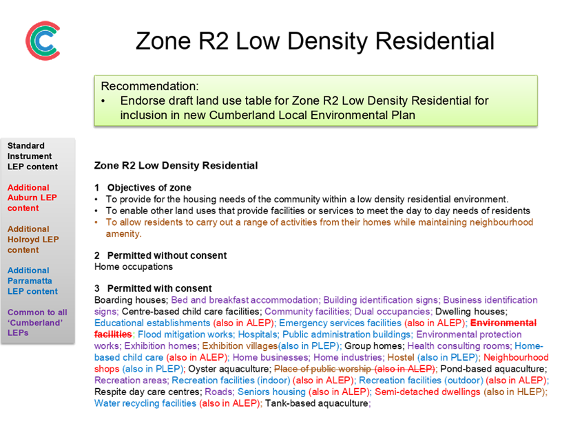
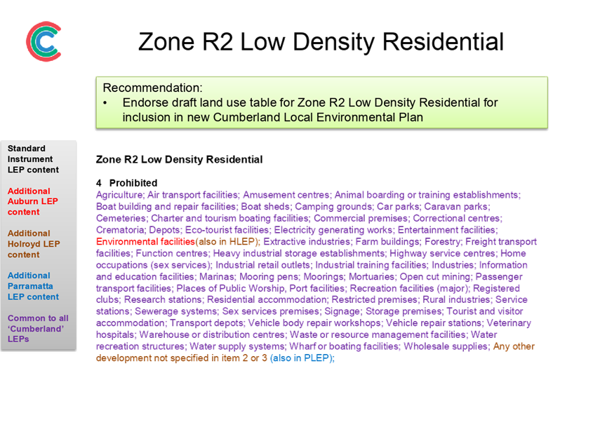
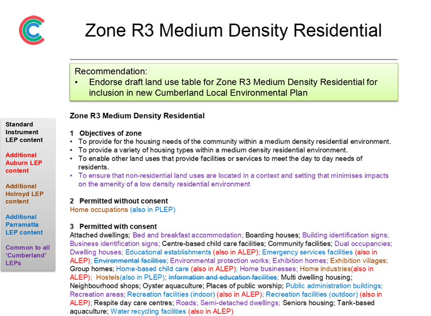
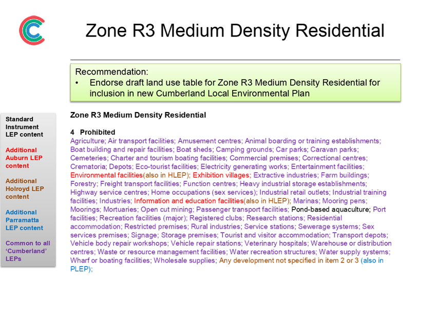
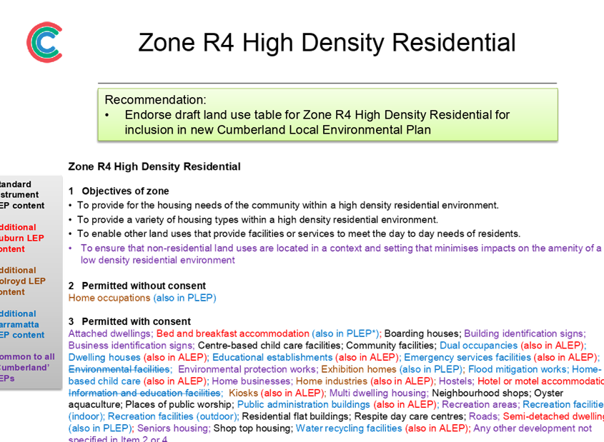
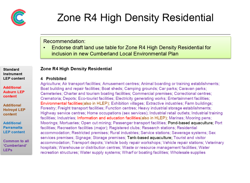
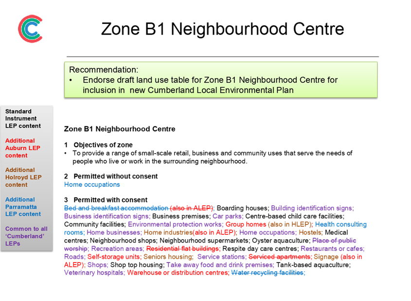
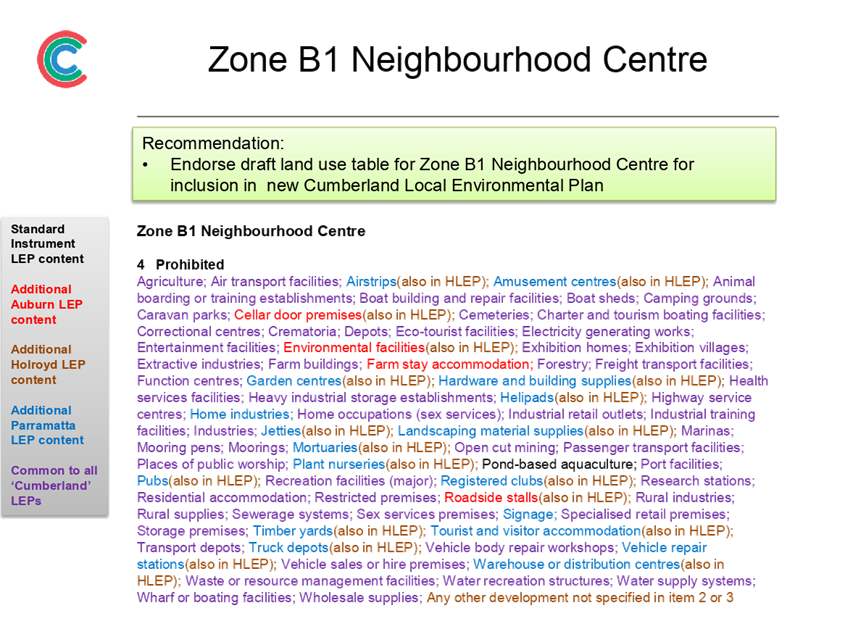
A Land Use Table has been prepared for the residential, business and industrial zones endorsed by Council for inclusion in the new Cumberland LEP. The Land Use Table identifies the objectives of each zone, as well as the permitted and prohibited land use activities that apply to each zone.
In preparing the Land Use Table, a general rule of permissibility retention has been used. This means that the permissible land uses in most zones in the new Cumberland LEP will be a combination of the permissible land uses of the existing LEPs that apply in the Cumberland area. For example, if a use is permissible within a zone under the current Auburn, Holroyd or Parramatta LEPs, it will generally be permitted within that zone under the new Cumberland LEP.
This report provides a recommended approach on the Land Use Table for the following land use zones:
• R2 Low Density Residential (Attachment 1)
• R3 Medium Density Residential (Attachment 2)
• R4 High Density Residential (Attachment 3)
• B1 Neighbourhood Centre (Attachment 4)
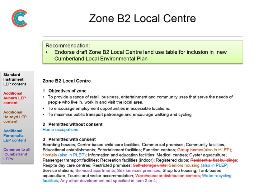
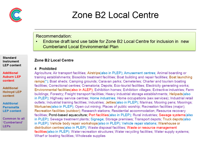
• B2 Local Centre (Attachment 5)
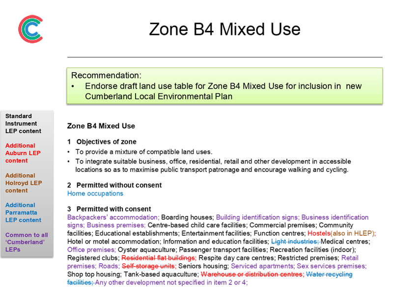
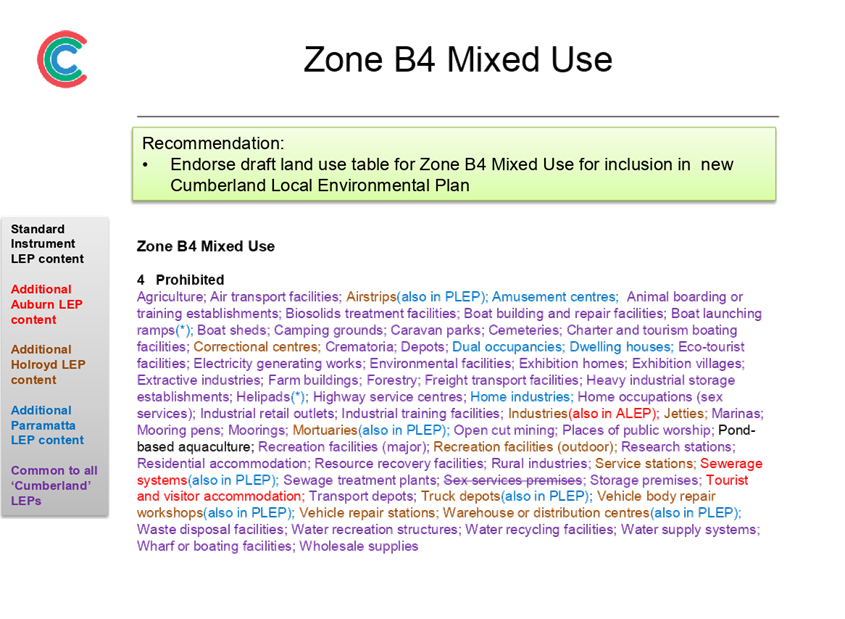
• B4 Mixed Use (Attachment 6)
• B5 Business Development (Attachment 7)
• B6 Enterprise Corridor (Attachment 8)
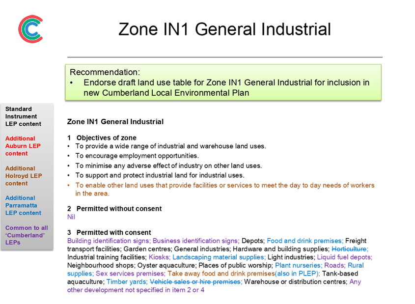
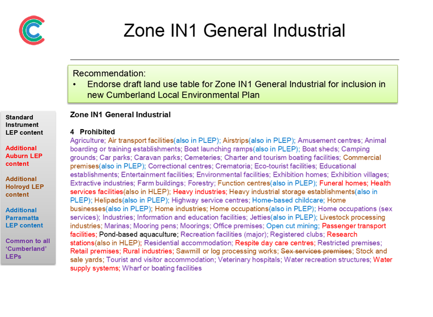
• IN1 General Industrial (Attachment 9)
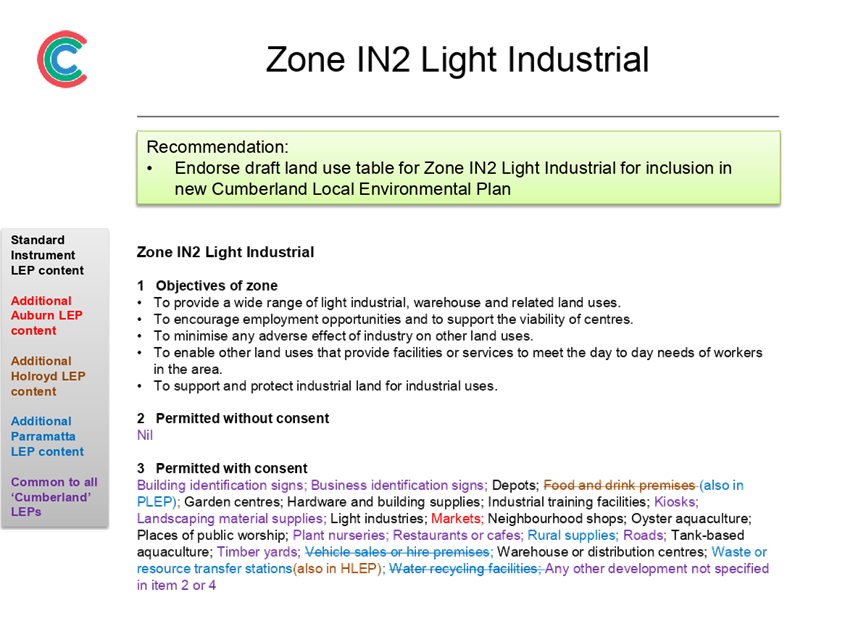
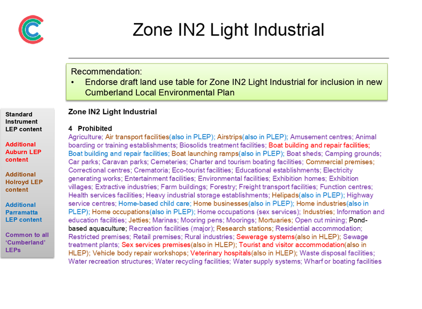
• IN2 Light Industrial (Attachment 10)
Carry over of existing application of zones
It is recommended that Council also endorse the carry over of the existing application of these zones for the new Cumberland LEP Land Zoning Maps. This approach will retain the status-quo for the majority of properties in the Cumberland area, with the existing zoning of properties to remain unchanged.
In instances where changes are required to be made, these will be based on reports previously considered and endorsed by Council, or may be reported in the future for consideration by Council.
Next Steps
Subject to endorsement, the proposed planning controls will be included in the planning proposal that is being prepared for the new Cumberland LEP. The planning proposal will be provided for consideration by Council prior to seeking a Gateway Determination by the Department of Planning, Industry and Environment. This is required to be undertaken by the end of September 2019.
Community Engagement
An extensive consultation program is in place for the preparation of the new Cumberland LEP. The first stage is early consultation on the new LEP, which is currently underway until the end of August 2019, and represents pre-Gateway consultation in accordance with Council’s Planning Proposal Notification Policy. The second stage is formal consultation on the draft planning proposal for the new LEP in early 2020, subject to Gateway Determination by the Department of Planning, Industry and Environment.
Policy Implications
The preparation of the Cumberland Local Environmental Plan (LEP) is required under the Environmental Planning and Assessment Act 1979. The Cumberland LEP will also align with the strategic directions outlined in Council’s Community Strategic Plan and Draft Cumberland 2030: Our Local Strategic Planning Statement.
Risk Implications
Council is required to submit a planning proposal on the new Cumberland LEP by the end of September 2019. The release of funds from the grant is also linked to this milestone. Endorsement of the proposed planning controls will assist Council in meeting this milestone.
Financial Implications
Work undertaken on the Cumberland Local Environmental Plan (LEP), including strategic studies and planned community consultation activities, will be funded from the accelerated Local Environmental Plan Funding Grant provided by the NSW Government.
CONCLUSION
The preparation of a new Cumberland Local Environmental Plan (LEP) is underway. This report outlines some of the proposed planning controls to be included in the new Cumberland LEP. It recommends that Council endorse the Land Use Table on special purpose, recreation, environment protection and waterway zones, as well as the carryover of the existing application of these zonings for properties covered under the LEP. This information will be included in the planning proposal being prepared for the new LEP.
Attachments
1. Proposed land
use table - Zone R2 Low Density Residential ⇩ ![]()
2. Proposed
land use table - Zone R3 Medium Density Residential ⇩ ![]()
3. Proposed
land use table - Zone R4 High Density Residential ⇩ ![]()
4. Proposed
land use table - Zone B1 Neighbourhood Centre ⇩ ![]()
5. Proposed
land use table - Zone B2 Local Centre ⇩ ![]()
6. Proposed
land use table - Zone B4 Mixed Use ⇩ ![]()
7. Proposed
land use table - Zone B5 Business Development ⇩ ![]()
8. Proposed
land use table - Zone B6 Enterprise Corridor ⇩ ![]()
9. Proposed
land use table - Zone IN1 General Industrial ⇩ ![]()
10. Proposed
land use table - Zone IN2 Light Industrial ⇩ ![]()
DOCUMENTS
ASSOCIATED WITH
REPORT C09/19-192
Attachment 1
Proposed land use table - Zone R2 Low Density Residential
Attachment 2
Proposed land use table - Zone R3 Medium Density Residential
Attachment 3
Proposed land use table - Zone R4 High Density Residential
Attachment 4
Proposed land use table - Zone B1 Neighbourhood Centre
Attachment 5
Proposed land use table - Zone B2 Local Centre
Attachment 6
Proposed land use table - Zone B4 Mixed Use
Attachment 7
Proposed land use table - Zone B5 Business Development
Attachment 8
Proposed land use table - Zone B6 Enterprise Corridor
Attachment 9
Proposed land use table - Zone IN1 General Industrial
Attachment 10
Proposed land use table - Zone IN2 Light Industrial
4 September 2019
Item No: C09/19-193
Proposed Planning Controls for Schedule 5 of the new Cumberland Local Environmental Plan
Responsible Division: Environment & Planning
Officer: Director Environment & Planning
File Number: S-5750-01
Community Strategic Plan Goal: A resilient built environment
Summary
The preparation of a new Cumberland Local Environmental Plan (LEP) is underway, with the focus on harmonising the planning controls of the three LEPs in operation across Cumberland into a single set of planning controls under a comprehensive LEP.
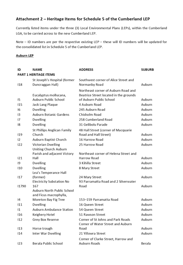
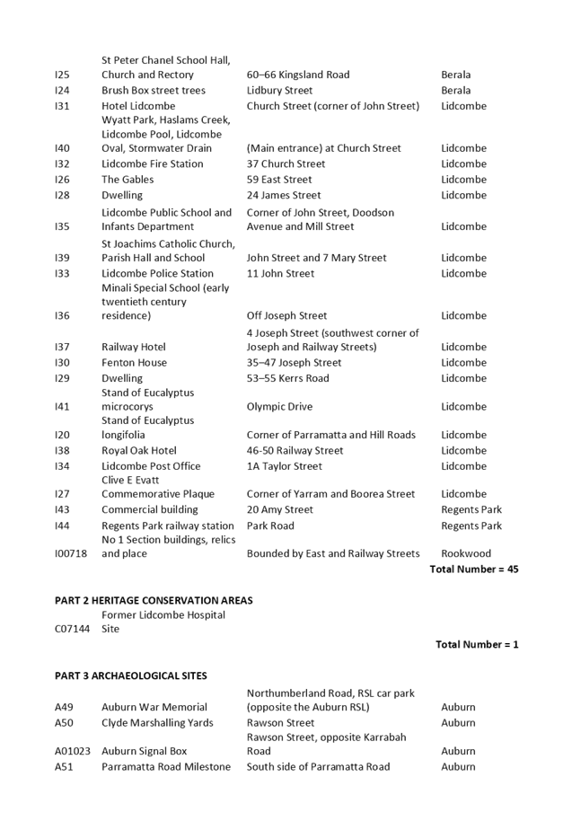
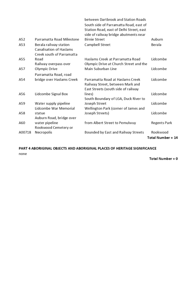
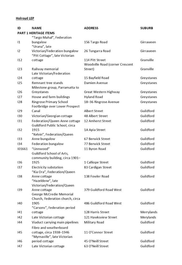
This report outlines the content of heritage items proposed to be included in the Cumberland LEP. It recommends that Council endorse the carryover of all existing heritage listings in the Cumberland area identified in the Auburn, Holroyd and Parramatta LEPs, with the exception of nine items assessed as no longer meeting the NSW heritage criteria for assessing heritage significance. These items have been considered by an independent heritage consultant and community feedback sought on the exclusion of these heritage items from the Cumberland LEP.
The endorsed heritage items will be included in the planning proposal being prepared for the new LEP.
|
Recommendation That Council: 1. Endorse the exclusion of the following heritage items from Schedule 5 of the Cumberland Local Environmental Plan, as they no longer meet the NSW heritage criteria for assessing heritage significance: a. 36 and 38 Jamieson Street, Granville b. 10 William Street, Granville c. 9-11 Woodville Road, Granville d. 4 Myall Street, Merrylands e. Guildford Railway Station, Railway Terrace, Guildford f. 1-7 Neil Street, Merrylands (Millmaster Feeds Site) g. 34 Garfield Street, Wentworthville h. 15 Abbott Street, Merrylands i. 70 Jersey Road, South Wentworthville 2. Endorse that all other existing heritage items in the Cumberland area, as listed in Schedule 5 of the Auburn, Holroyd and Parramatta LEPs and provided in Attachment 2, be included in the new Cumberland Local Environmental Plan. 3. Note that the heritage items in Attachment 2 will be included in the planning proposal for the new Cumberland Local Environmental Plan. |
Report
Background
Cumberland Council is currently operating under three separate environmental planning instruments, known as a Local Environmental Plan (LEP), which represent the planning controls from the former Council area within Cumberland prior to amalgamation. These include:
I. Auburn LEP 2010, which applies to land in the former Auburn City Council area (eastern part of Cumberland)
II. Parramatta LEP 2011, which applies to land in the former Parramatta City Council area (central part of Cumberland)
III. Holroyd LEP 2013, which applies to land in the former Holroyd City Council area (western part of Cumberland)
The current approach does not provide an integrated planning framework for the Cumberland area, with inconsistent planning controls in place, and is not aligned to current strategic plans and policies from Council and the NSW Government.
Changes to the Environmental Planning and Assessment Act 1979 in March 2018 require all metropolitan councils to review and amend their existing LEP to ensure it aligns with the relevant District Plan and Greater Sydney Region Plan. Cumberland has been identified as a priority Council by the Greater Sydney Commission. has been identified as a priority Council by the Greater Sydney Commission.
New Cumberland Local Environmental Plan (LEP)
The preparation of a new Cumberland LEP will be undertaken in the form of a planning proposal. The focus of the planning proposal for the new Cumberland LEP is harmonising the planning controls of the three LEPs in operation across Cumberland into a single set of planning controls under a comprehensive LEP.
The structure of the new Cumberland LEP is based on the Standard Instrument LEP, which is the principal template LEP provided by the NSW Government. Many clauses, provisions and schedules in the Standard Instrument LEP are compulsory and must be included in the new Cumberland LEP. However, there are some areas where Council has an ability to inform the scope and content on clauses, provisions and schedules to be included in the new LEP.
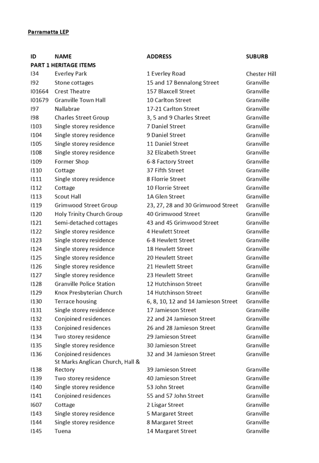
This report focuses on Schedule 5 of the LEP, which is a listing of all heritage items in the Cumberland area.
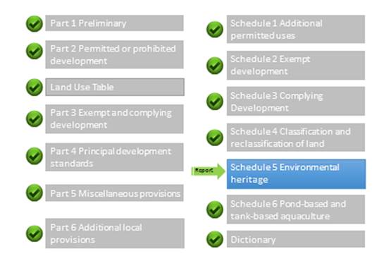
Figure 1: Proposed Planning Controls Covered in Council Report
Schedule 5: Environmental heritage
This schedule provides a list of local heritage items identified in the area, and includes items, places and conservation areas. There are currently more than 350 heritage items listed for the Cumberland area, and are documented in the Auburn, Holroyd and Parramatta LEPs. Identification on this list provides statutory protection through the LEP and other planning controls.
Cumberland Council has engaged Extent Heritage to undertake a Local Government Area (LGA) wide Heritage Study. The LGA Heritage Study consists of two stages:
· Stage 1 – Prepare a history of the LGA and review all existing listed heritage items (January – September 2019)
· Stage 2 – Identify and assess potential new heritage items (September 2019 – May 2020)
The first stage of the project involved a review of all existing heritage items (including conservation areas) listed in the three LEPs for the LGA and updated listing information as appropriate. This stage also identified any existing items that were assessed as no longer meeting the NSW heritage criteria for assessing heritage significance.
The criteria used to assess heritage significance included the following:
· An item is important in the course, or pattern, or the cultural or natural history of the local area.
· An item has strong or special association with the life or works of a person, or group of persons, of importance in the cultural or natural history of the local area.
· An item is important in demonstrating aesthetic characteristics and/or a high degree of creative or technical achievement in the local area.
· An item has strong or special association with a particular community or cultural group in the local area for social, cultural or spiritual reasons.
· An item has potential to yield information that will contribute to an understanding of the cultural or natural history of the local area.
· An item possesses uncommon, rare or endangered aspects of the cultural or natural history of the local area.
· An item is important in demonstrating the principal characteristics of a class of the local area’s:
- cultural or natural places; or
- cultural or natural environments.
The items listed in Table 1 were assessed as no longer meeting the criteria for heritage significance. Further information is provided in Attachment 1. It is recommended that these are excluded from the new Cumberland LEP.
|
# |
Address and Item # (LEP) |
Reason for not retaining as listed heritage item |
|
1 |
36 and 38 Jamieson Street Granville I137(Parramatta) |
While the dwelling pair relates to the concurrent purchase and development of land within Jamieson Street, the dwelling has been heavily modified to a point where significant fabric has been lost and the overall street presentation reduces the quality of the significance of the Granville Conservation Area – Civic Precinct. |
|
2 |
10 William Street Granville William Street Cottages Group I205 (Parramatta) |
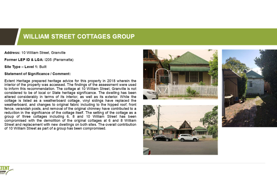
The dwelling has been altered considerably in terms of its interior, as well as its exterior. The setting of the cottage as a group of three cottages including 6, 8 and 10 William Street has been compromised with the demolition of the original cottages at 6 and 8 William Street and replacement with new dwellings on both sites. |
|
3 |
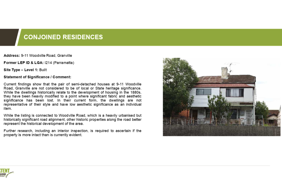
9-11 Woodville Road, Granville I214 (Parramatta) |
While the dwellings historically relate to the development of housing in the 1880s, they have been heavily modified to a point where significant fabric and aesthetic significance has been lost. In their current form, the dwellings are not representative of their style and have low aesthetic significance as an individual item. |
|
4 |
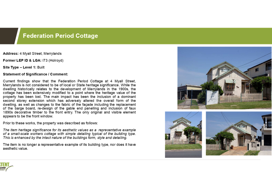
4 Myall Street, Merrylands |
While the dwelling historically relates to the development of Merrylands in the 1900s, the cottage has been extensively modified to a point where the heritage value of the property has been lost. The main impact has been the inclusion of a dominant second storey extension which has adversely altered the overall form of the dwelling, as well as changes to the fabric of the façade |
|
5 |
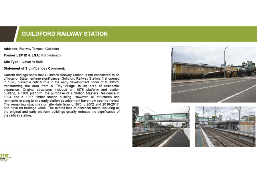
Guildford Railway Station Railway Terrace, Guildford I43 (Holroyd) |
Original structures included an 1876 platform and station building, a 1891 platform, the purchase of a Station Masters Residence in 1924 and a 1937 timber station building. However, all structures and remnants relating to this early station development have now been removed. The remaining structures on site date from c.1970, c.2002 and 2016-2017, and have no heritage value |
|
6 |
1-7 Neil Street, Merrylands Millmaster Feeds Site A5 (Holroyd) |
All structures and remnants relating to its former uses have been removed and the site is currently undergoing redevelopment. Any built features relating to its former significance are no longer present, and any archaeological potential would be considered low/nil and likely to be highly disturbed. |
|
7 |
34 Garfield Street, Wentworthville I129 (Holroyd) |
The Federation period bungalow was demolished in 2016. The house has now been replaced with a modern dwelling of no heritage value. |
|
8 |
15 Abbott Street, Merrylands Former shop and dwelling I312 (Holroyd) |
The Former Shop and Dwelling has been demolished. The site has now been replaced with a late twentieth century dwelling of no heritage value. |
|
9 |
70 Jersey Road, South Wentworthville I100 (Holroyd) |
The Late Victorian cottage was demolished c.2015. The block remains empty and the extant shed does not relate to the early arrangement of the site which is visible on the 1943 aerial image of the site. |
Table 1: Heritage Items to be excluded from the New Cumberland LEP
Next Steps
Subject to endorsement, the proposed planning controls will be included in the planning proposal that is being prepared for the new Cumberland LEP. The planning proposal will be provided for consideration by Council prior to seeking a Gateway Determination by the Department of Planning, Industry and Environment. This is required to be undertaken by the end of September 2019.
Community Engagement
An extensive consultation program is in place for the preparation of the new Cumberland LEP. The first stage is early consultation on the new LEP, which is currently underway until the end of August 2019, and represents pre-Gateway consultation in accordance with Council’s Planning Proposal Notification Policy. The second stage is formal consultation on the draft planning proposal for the new LEP in early 2020, subject to Gateway Determination by the Department of Planning, Industry and Environment.
In addition, community feedback was sought on the proposed exclusion of heritage items from the new Cumberland LEP. A total of seven (7) submissions were received from the community and property owners.
Policy Implications
The preparation of the Cumberland Local Environmental Plan (LEP) is required under the Environmental Planning and Assessment Act 1979. The Cumberland LEP will also align with the strategic directions outlined in Council’s Community Strategic Plan and Draft Cumberland 2030: Our Local Strategic Planning Statement.
Risk Implications
Council is required to submit a planning proposal on the new Cumberland LEP by the end of September 2019. The release of funds from the grant is also lined to this milestone. Endorsement of the proposed planning controls will assist Council in meeting this milestone.
Financial Implications
Work undertaken on the Cumberland Local Environmental Plan (LEP), including strategic studies and planned community consultation activities, is being funded from the accelerated Local Environmental Plan Funding Grant provided by the NSW Government.
CONCLUSION
The preparation of a new Cumberland Local Environmental Plan (LEP) is underway. This report outlines the proposed heritage listings for the new LEP. It recommends that Council endorse the carryover of all existing heritage listings in the Cumberland area identified in the Auburn, Holroyd and Parramatta LEPs, with the exception of nine items assessed as no longer meeting the NSW heritage criteria for assessing heritage significance. These items have been considered by an independent heritage consultant and community feedback sought on the exclusion of these heritage items from the Cumberland LEP. The recommended heritage items will be included in the planning proposal being prepared for the new LEP.
Attachments
1. Initial
Assessment of heritage items nominated to be excluded from Cumberland LEP ⇩ ![]()
2. Heritage
Items for Schedule 5 of the Cumberland LEP ⇩ ![]()
DOCUMENTS
ASSOCIATED WITH
REPORT C09/19-193
Attachment 1
Initial Assessment of heritage items nominated to be excluded from Cumberland LEP
Attachment 2
Heritage Items for Schedule 5 of the Cumberland LEP
4 September 2019
Item No: C09/19-194
Planning Proposal for 2-22 William Street, Granville
Responsible Division: Environment & Planning
Officer: Director Environment & Planning
File Number: SC183
Community Strategic Plan Goal: A resilient built environment
Summary
This planning proposal seeks to amend the planning controls at 2-22 William Street, Granville, as follows:
· amend the Floor Space Ratio control from 1:1 to 1.7:1
· increase the Height of Building control from 14 metres to 16 metres
· remove the local heritage item I205, known as 10 William Street, Granville (Lot 27 DP 2371), from Schedule 5 of the Parramatta Local Environmental Plan 2011.
This proposal has been placed on preliminary public exhibition (pre-Gateway), and was reported to the Cumberland Independent Hearing and Assessment Panel in September 2017 and to the Cumberland Local Planning Panel in April 2019. The Panel supported the Council Officer’s recommendation. The planning proposal has also been considered by the Cumberland Heritage Committee.
Community feedback was also sought on the local heritage item at this location, as part of consultation for the Cumberland Heritage Study being undertaken to support the new Cumberland Local Environmental Plan.
It is recommended that the planning proposal be forwarded to the Department of Planning, Industry and Environment for a Gateway Determination.
Should a Gateway Determination be received, further work on a site-specific Development Control Plan and Voluntary Planning Agreement will be undertaken, and a further report provided to Council.
|
Recommendation That Council: 1. Prepare a planning proposal for 2-22 William Street, Granville, with the following land use and built form controls: a. Floor Space Ratio of 1.7:1 b. Height of Building control of 16 metres c. Removal of local heritage item I205 known as 10 William Street (Lot 27 DP 2371) from Schedule 5 of the Parramatta Local Environmental Plan 2011.
2. Endorse that the planning proposal for 2-22 William Street, Granville, be forwarded to the Department of Planning, Industry and Environment for a Gateway Determination.
3. Prepare a Development Control Plan to provide further planning controls for the site, should a Gateway Determination be received.
4. Prepare a Voluntary Planning Agreement to derive public benefit, should a Gateway Determination be received. |
Report
Background
On 15 December 2015, a planning proposal was lodged with Parramatta Council for 2-22 William Street, Granville by Sid Arida C/- PTI Architects. This proposal originally sought to amend the development standards in the Parramatta Local Environmental Plan 2011 (LEP) to achieve a greater height and density on the site to enable the development of a seven (7) storey residential development.
The original planning proposal (December 2015) sought an increase in Floor Space Ratio (FSR) from 1:1 to 2.3:1, and an increase in maximum building height from 14m to 23m (approximately seven storeys). The original proposal also included the removal of Heritage Item I205 (No. 10 William Street) from Schedule 5 of the Parramatta LEP 2011.
The original planning proposal was transferred to Cumberland Council following Council amalgamation in May 2016.
In September 2016, a revised planning proposal was lodged with Council. The revised planning proposal sought a lower maximum FSR of 1.7:1 and a maximum height of 19.2 metres (five storeys), in an attempt to address the overshadowing of adjoining properties to the south of the site. It also sought the removal of the heritage item at 10 William Street.
In October 2018, the proponent submitted a further revised planning proposal (Attachment 1), responding to the concerns raised by the Cumberland Independent Hearing and Assessment Panel in September 2017. This further revised proposal sought a maximum FSR of 1.7:1, a maximum height of 20 metres and removal of the heritage item.
The status of the planning proposal is provided in Figure 1.
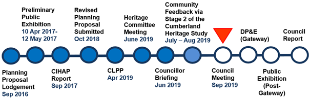
Figure 1: Planning proposal status
The Site and its Context
The site is located on the southern side of William Street, and is bound by William Street, Clyde Street, Factory Street and a rear access laneway (Figure 2).
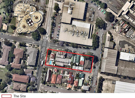
Figure 2: The site and surrounds
The area of the site is approximately 3,700m2. It comprises fifteen allotments containing seven detached dwellings with frontage to William Street and a two storey strata subdivided residential flat building. The site also contains a commercial building used for warehousing at the western end of the block, and includes the heritage item at 10 William Street. The applicant owns the site at 10-22 William Street (Site 1) and has instigated the LEP amendment. The remaining portion of the site is known as 2-8 William Street (Site 2) and comprises seven allotments held under private ownership and strata title (Figure 3).

Figure 3: Overall site ownership pattern
Local Context
The site is bound to the north by the Granville RSL Club and existing industrial buildings (towards Clyde Railway Station). These buildings are accessed from and have frontage to, Memorial Drive with no vehicular access or active frontages to William Street, facing the site.
To the east of the site is an industrial precinct zoned IN1 General Industrial. The lots to the south of the Site fronting First Street (and backing onto the rear lane) are established detached residential dwellings within an R2 Low Density Residential zone with a maximum FSR of 0.5:1 and a 9m height limit. Allotments to the west of Clyde Street are residential flat buildings varying from two to four storeys.
The site is located approximately 150m from Clyde Station, and about 600 metres from Granville Station and the Granville shopping area located along Mary Street and South Street.
Regional Context
The site is located in the suburb of Granville within the Local Government Area of Cumberland Council. The site is approximately 3km south of Parramatta CBD and 20km west of the Sydney CBD.
Planning Proposal
Current Planning Controls
Parramatta LEP 2011 applies to the site. The site is currently zoned R4 High Density Residential with a maximum Height of Building control of 14m and a Floor Space Ratio control of 1:1. This is shown in Figures 4 to 6.
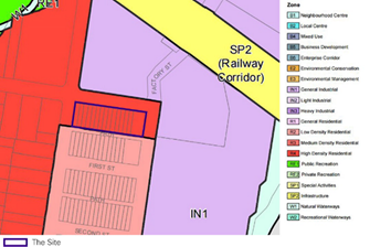
Figure 4: Current Zoning of R4 High Density Residential
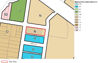
Figure 5: Current FSR (N = 1:1)

Figure 6: Current Height of Buildings (N2 = 14 metres)
Proposed Planning Controls
The planning proposal seeks to facilitate an increase in the floor space ratio (FSR) for the site from 1:1 to 1.7:1, and the maximum building height for the site from 14m to 20m (five storeys). A height of 16m (O2) is recommended, however. This is shown in Figures 7 to 8.
![]()
![]()
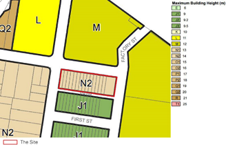
Figure 7: Proposed Height of Buildings (O2 = 16 metres)
![]()
![]()

Figure 8: Proposed Floor Space Ratio (S2 = 1.7:1)
Strategic Merit Assessment
Land is currently zoned for High Density Development
There is merit in progressing the planning proposal to a Gateway Determination, as the area is already zoned to permit the development of residential flat buildings. The planning proposal is seeking to amend the current built form controls and to remove the heritage item.
Heritage
There is strategic merit in progressing the planning proposal to a Gateway Determination. Consultants engaged to provide independent heritage advice for Council concluded that the proposed demolition of 10 William Street, Granville, could occur:
· as the cottage is the only remaining item of the group of three (both 6 and 8 William Street have been compromised with the demolition of the original cottages and replacement with new dwellings on both sides), and it is an ordinary example of a weatherboard cottage. Retention and conservation works including adaptive reuse or restoration would increase its aesthetic value as an item, but would not significantly add to its contribution to the wider streetscape, where as an example of historic values, it is quite isolated;
· as two other groups of weatherboard cottages at 115-119 and 170-178 William Street are in intact condition, and each group is cohesive in its contribution to the streetscape, providing better examples of interpretation of the residential context of the area. Therefore, the retention of the cottage at 10 William Street, which is the only remaining house of the original group of three cottages, does not represent an intact group of cottages as in the case of the other two groups, nor provide enough evidence for interpretation of the former group;
· if archival recording of the cottage at 10 William Street is undertaken prior to any demolition approved and allowed as per the NSW OEH Guideline How to prepare archival records of Heritage Items;
· if an interpretation strategy is prepared by a qualified heritage consultant for the group of three cottages at 6, 8 and 10 William Street, which reflects the historical, social and cultural significance of the group, and this strategy be integrated into any proposed development. The strategy should also refer to the other weatherboard cottage groups along William Street. The interpretation strategy should be prepared in accordance with The Burra Charter: The Australia ICOMOS Charter for Places of Cultural Significance 2013, and the NSW OEH documents namely Interpreting Heritage Places and Items Guidelines 2005, and the Heritage Interpretation Policy 2005. The interpretation strategy should be prepared and submitted at the same time as the Development Application for the proposed development at 2-22 William Street is submitted to Cumberland Council; and
· if all demolition works undertaken consider salvage of any original elements of the building. The list of items and materials to be salvaged should be developed by a qualified heritage consultant. Any material which is identified for salvaging should be photographed, tagged and catalogued by a heritage consultant and stored until reused in a secure, weather-proof location. The location of the storage should be ascertained by the proponent in consultation with Cumberland Council. It is also recommended that the interpretation strategy integrate the reuse of any salvage material.
Independent heritage advice on the planning proposal is provided in Attachment 4.
Overshadowing
The proposed height control of 20 metres is not supported due to overshadowing impacts on land directly to the south. However, there is strategic merit in progressing the planning proposal to the next phase of assessment with a 16 metre Height of Building control as:
· the Floor Space Ratio study that was undertaken to address the Cumberland IHAP (Attachment 5) concluded that an Floor Space Ratio of 1.7:1 and a height of 16.2m will deliver good amenity outcomes for the residents of the buildings and its neighbours, particularly for the properties to the south;
· the study demonstrated that a compliant Apartment Design Guide and site-specific Development Control Plan option would ensure that there is no additional overshadowing impact to Nos. 11 and 13 First Street after 1pm, which is an improvement on the impacts generated by the further revised planning proposal at a proposed height of 20m; and
· 16 metres is comparable with many other areas zoned R4 across Cumberland, and is considered to provide an appropriate scale of development in this location.
Central City District Plan
There is strategic merit in forwarding this planning proposal to the Department of Planning, Industry and Environment for a Gateway Determination as it can be considered to be consistent with the following Planning Priorities of the Central City District Plan:
· C5. Providing housing supply, choice and affordability, with access to jobs and services: The planning proposal provides for additional dwellings in close proximity to a large range of employment and services in Parramatta CBD, and will help meet Cumberland Council’s 5-year dwelling target of 9,530.
· C6. Creating and renewing great places and local centres, and respecting the District’s heritage: The planning proposal facilitates redevelopment of an existing urban site including communal open space areas, presenting opportunities for social interaction.
· C9. Delivering integrated land use and transport planning and a 30-minute city:
The planning proposal supports this priority by placing housing in a location less than 30 minutes by public transport from Parramatta CBD.
Greater Sydney Region Plan
There is strategic merit in forwarding this planning proposal to the Department of Planning, Industry and Environment for a Gateway Determination as it can be considered to be consistent with the following Planning Directions of the Greater Sydney Region Plan:
· A City for People and Housing the City: The planning proposal provides additional housing in Granville and will contribute to the supply and diversity of housing in the area.
· A well-connected city: The planning proposal supports this objective by placing new housing in a location less than 30 minutes by public transport from jobs and services.
Cumberland Local Planning Panel
The revised planning proposal (September 2016 proposal) was reported to the then Cumberland Independent Hearing and Assessment Panel (IHAP) meeting on 13 September 2017 (Attachment 3). The Cumberland IHAP recommended that the planning proposal be deferred to a future IHAP meeting (now Cumberland Local Planning Panel) and for Council to undertake the following:
· obtain an additional independent heritage opinion on the proposed demolition of the heritage item;
· undertake a study of whether the FSR is appropriate while satisfying the outcomes required in the ADG, particularly transition to the R2 zoned land immediately to the south; and
· consideration be given to any community benefit in the proposed increased FSR and height.
The further revised planning proposal (October 2018 proposal), together with the additional work undertaken by Council, was reported to the Cumberland Local Planning Panel on 16 April 2019 (Attachment 2). The report recommended that:
· Council proceed with the preparation of a planning proposal for 2-22 William Street, Granville (Lots 18 – 31 DP 2371 and SP 31488), with the following development standards:
· a floor space ratio of 1.7:1; and
· a maximum building height of 16m;
· a voluntary planning agreement be negotiated between Council and the Proponent to ensure a public benefit is derived from the uplift value that this planning proposal will achieve.
· Council prepare site specific development controls that prohibit rooftop communal open space, specify the maximum number of storeys, and ensures an appropriate transition in built form between the higher density development on the site and neighbouring low density dwellings.
· the proponent undertake the following, prior to any demolition approval if allowed:
· prepare an archival recording of the heritage item at 10 William Street as per the NSW OEH Guideline How to prepare archival records of heritage items;
· organise for an interpretation strategy to be prepared by a qualified heritage consultant for the group of three cottages at 6, 8 and 10 William Street, and for this strategy to be integrated into any proposed development in accordance with The Burra Charter: The Australia ICOMOS Charter for Places of Cultural Significance 2013, and the NSW OEH documents namely Interpreting Heritage Places and Items Guidelines 2005, and the Heritage Interpretation Policy 2005. The interpretation strategy should also integrate the reuse of any salvaged material; and
· organise for a qualified heritage consultant to prepare a list of items and materials to be salvaged. Any material identified for salvaging should be photographed, tagged and catalogued by a heritage consultant and stored until reused in a secure, weather-proof location. The location of the storage should be ascertained by the proponent in consultation with Cumberland Council.
The Panel supported the recommendation of Council officers (Attachment 2).
Recommended Planning Controls
A summary of the recommended planning controls for the proposal is provided in Table 1. This is based on a review of the proponent’s proposed planning controls by Council officers and advice from the Cumberland Local Planning Panel.
|
Planning Controls (Parramatta LEP 2011) |
Existing Controls |
Proponent’s Proposed Controls (October 2018) |
Council Officers’ Recommended Controls |
Cumberland Local Planning Panel Advice |
Recommended Planning Controls |
|
Zoning |
R4 High Density Residential |
R4 High Density Residential |
R4 High Density Residential |
R4 High Density Residential |
R4 High Density Residential |
|
Height of Building |
14 metres |
20 metres |
16 metres |
16 metres |
16 metres |
|
Floor Space Ratio |
1:1 |
1.7:1 |
1.7:1 |
1.7:1 |
1.7:1 |
|
Heritage Item |
Item I205 identified |
Remove |
Remove |
Remove |
Remove |
Table 1: Recommended planning controls for the proposal
Next Steps
It is recommended that the planning proposal be forwarded to the Department of Planning, Industry and Environment for a Gateway Determination.
Should a Gateway Determination be received, further work on a Development Control Plan will be undertaken to complement the planning proposal for the site. This will include controls to support an appropriate transition in built form between the higher density development on the site and neighbouring low density dwellings, guidance regarding the maximum number of storeys, and restrictions on rooftop communal open space. A further report will be provided to Council.
Should the planning proposal proceed to a Gateway Determination, negotiations on the public offer will be progressed and captured through a Voluntary Planning Agreement. A further report on the Voluntary Planning Agreement will be provided to Council.
Community Engagement
Preliminary public exhibition of the revised planning proposal (September 2016 proposal) was undertaken by Cumberland Council between 10 April 2017 and 12 May 2017, in accordance with Council’s notification policy.
The further revised planning proposal (October 2018 proposal) was reported to the Cumberland Heritage Committee on 11 June 2019. No concerns were raised by the committee.
Community feedback was also sought on 10 William Street, Granville, which was one of ten (10) heritage items identified in Stage 1 of the Cumberland Heritage Study as no longer meeting the NSW Heritage Office’s criteria for heritage significance. A consultation period was held from 8 July 2019 to 4 August 2019. No objections were received by the community to the removal of 10 William Street, Granville, from Schedule 5 of the Parramatta LEP 2011.
Policy Implications
Policy implications for Council are outlined in the main body of the report.
Risk Implications
There are minimal risk implications for Council associated with this report.
Financial Implications
Financial implications for Council are outlined in the main body of the report.
CONCLUSION
It is recommended that the planning proposal for 2-22 William Street, Granville be forwarded to the Department of Planning, Industry and Environment for a Gateway Determination. This recommendation is being made as:
· the area is currently zoned to permit the development of residential flat buildings;
· the planning proposal will facilitate the re-development of an underutilised site in close proximity to the Clyde and Granville Stations;
· the amendment of the current built form controls and removal of the heritage item at 10 William Street will result in a better urban design outcome;
· the recommended height of 16 metres is considered to generate an appropriate scale of development in this location; and
· the planning proposal is generally consistent with the strategic directions set by the Central City District Plan and the Greater Sydney Region Plan.
Should a Gateway Determination be received, further work on a site-specific Development Control Plan and Voluntary Planning Agreement will be undertaken, and a further report provided to Council.
Attachments
1. Revised
Planning Proposal Request Report and Concept Scheme submitted to Cumberland
Council on 16 October 2018 ⇩ ![]()
2. Cumberland
Local Planning Panel Report and Minutes – 16 April 2019 ⇩ ![]()
3. Cumberland
IHAP Report and Recommendations – 13 September 2017 ⇩ ![]()
4. Heritage
Advice Provided by Extent Heritage on behalf of Council on 4 December 2018 ⇩ ![]()
5. FSR
study prepared by Design Inc on behalf of Council on 27 February 2019 ⇩ ![]()
6. Heritage
Impact Statement prepared by Archnex Designs ⇩ ![]()
7. Peer
Heritage Review prepared by Heritage 21/Rappoport P/L ⇩ ![]()
DOCUMENTS
ASSOCIATED WITH
REPORT C09/19-194
Attachment 1
Revised Planning Proposal Request Report and Concept Scheme submitted to Cumberland Council on 16 October 2018
DOCUMENTS
ASSOCIATED WITH
REPORT C09/19-194
Attachment 2
Cumberland Local Planning Panel Report and Minutes – 16 April 2019
Attachment 3
Cumberland IHAP Report and Recommendations – 13 September 2017
Attachment 4
Heritage Advice Provided by Extent Heritage on behalf of Council on 4 December 2018
DOCUMENTS
ASSOCIATED WITH
REPORT C09/19-194
Attachment 5
FSR study prepared by Design Inc on behalf of Council on 27 February 2019
Attachment 6
Heritage Impact Statement prepared by Archnex Designs
DOCUMENTS
ASSOCIATED WITH
REPORT C09/19-194
Attachment 7
Peer Heritage Review prepared by Heritage 21/Rappoport P/L
4 September 2019
Item No: C09/19-195
Planning Proposal for 2 Percy Street, Auburn
Responsible Division: Environment & Planning
Officer: Director Environment & Planning
File Number: PP-2/2017
Community Strategic Plan Goal: A resilient built environment
Summary
This planning proposal seeks to add ‘Educational Establishments’ as an additional permitted use at 2 Percy Street, Auburn. There is also a State Significant Development (SSD) application for a school on the site that will be assessed and determined by the Department of Planning, Industry and Environment.
As required by Council’s resolution and the Gateway Determination, the planning proposal has been publicly exhibited for a period of 28 days. This report outlines the feedback received during exhibition.
A public benefit offer has also been made by the applicant for the site. This offer is fair and reasonable, and also consistent with Council’s Planning Agreements Policy.
It is recommended that the planning proposal be forwarded to the Department of Planning, Industry and Environment for finalisation and gazettal. It is also recommended that the public offer is endorsed in-principle, and that it is captured through a condition of approval for the SSD application.
|
Recommendation That Council: 1. Forward the planning proposal for 2 Percy Street, Auburn, to the Department of Planning, Industry and Environment for finalisation and gazettal.
2. Endorse in-principle the public benefit offer by the applicant, as provided in Attachment 4, subject to the gazettal of the planning proposal and approval of the State Significant Development Application for the site by the Department of Planning, Industry and Environment.
3. Endorse that the preparation and execution of a Voluntary Planning Agreement for the public benefit offer be included as a condition of approval by the Department of Planning, Industry and Environment for the State Significant Development Application on the site. |
Report
Background
A planning proposal request for land at 2 Percy Street, Auburn, was lodged with Council in May 2017. This request sought to introduce ‘educational establishment’ as an additional permissible use, via an amendment to Schedule 1 of the Auburn Local Environmental Plan 2010 (Auburn LEP 2010).
In February 2018, a Gateway Determination was issued that required a number of conditions to be addressed prior to proceeding to public exhibition. These conditions were met and in July 2019, Council endorsed the public exhibition of the planning proposal.
The proponent has also lodged a State Significant Development (SSD) application with Planning, Industry and Environment to permit a school for up to 750 students on the site.
The status of the planning proposal is provided in Figure 1
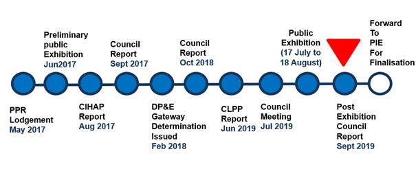
Figure 1 Planning Proposal Status
Public Exhibition of Planning Proposal
Public Submissions
165 public submission were received during the exhibition period. 163 submissions were in support of the International Maarif School. Two submissions did not provide comment. No submissions objected to the planning proposal or the operation of a school.
No direct planning issues were raised in the submissions received. The issues raised in the submission were general comments supporting the operation of a school and included:
· There is a need for more schools to support the growing school aged population in Auburn
· There is an urgent demand for this school and parents are eagerly waiting to transfer their children to the new Auburn campus from Turella
· Students currently endure long travel times to attend the school in Turella and the proposed school at 2 Percy Street will assist to reduce travel times.
· General support for the education provided by the International Maarif School
A summary of the key issues raised in the submissions is included as Attachment 1 to this report.
Public Authority Consultation
The Gateway Determination required Council to consult with the following public authorities:
· Department of Education
· Environment, Energy and Science (Former Office of Environment and Heritage)
· Crown Lands
Additional consultation with Transport for NSW and Roads and Maritime Services was not required, as the Gateway Determination required consultation with these authorities prior to public exhibition, and any issues were resolved prior to the planning proposal being publicly exhibited.
The Crown Lands submission did not raise any objection to the planning proposal.
The Department of Environment, Energy and Science identified issues in relation to the number of students to be accommodated for a school on the site, as well as a range of other matters. The issues identified are not relevant to the planning proposal, as they relate specifically to the SSD application.
No submission was received from the Department of Education.
Further information on public authority submissions is provided in Attachment 2.
Public Benefit Offer
As reported to Council on 3 July 2019, a public benefit offer through a Voluntary Planning Agreement with Council is being pursued under the SSD application instead of the planning proposal as originally sought.
Council obtained an independent valuation of the potential increase in residual land value arising from the planning proposal (Attachment 3). In accordance with Council policy, the total value of development contributions to be made under a planning agreement will be equivalent to 50% of the increase in residual land value arising from the development proposal.
An offer has been made by the applicant to provide a monetary contribution that reflects 50% of the increase in residual land value arising from the development proposal (Attachment 4). The offer by the applicant is fair and reasonable, and is also consistent with Council’s Planning Agreements Policy. It is proposed that the contribution funding derived from the public benefit offer be used to upgrade facilities in Wyatt Park.
It is also recommended that the preparation and execution of a Voluntary Planning Agreement for the public benefit offer be included as a condition of approval by the Department of Planning, Industry and Environment for the State Significant Development Application on the site. This will provide certainty on the approach moving forward for the public benefit offer in relation to the planning proposal and SSD application. This approach is also supported by the applicant (Attachment 5).
Next Steps
Subject to Council endorsement, the following activities will be undertaken to complete the planning proposal process:
· The planning proposal will be forwarded to the Department of Planning, Industry and Environment for finalisation and gazettal
· Council provides a formal submission to the Department of Planning, Industry and Environment regarding the inclusion of a condition regarding the preparation of a Voluntary Planning Agreement as part of the SSD application
· The SSD application is assessed and determined by the Department of Planning, Industry and Environment
· Should the SSD application be approved, a Voluntary Planning Agreement will be negotiated between the proponent and Council
Community Engagement
The planning proposal was exhibited from Wednesday 17 July 2019 to Sunday 18 August 2019.
Letters were sent to nearby landowners, a notice on Council’s Have Your Say Page and an advertisement placed in Auburn Review, informing the public of the exhibition of the Planning Proposal. The exhibition material, including the Planning Proposal, was available for view, on Councils website, at Cumberland Council’s Administration buildings in Auburn and Merrylands, and in the Auburn Library.
Policy Implications
The planning proposal will result in an amendment to the Auburn LEP 2010 upon finalisation and gazettal.
Risk Implications
There are minimal risk implications for Council associated with this report.
Financial Implications
Financial implications are outlined in the main body of the report.
CONCLUSION
This planning proposal seeks to add ‘Educational Establishments’ as an additional permitted use at 2 Percy Street, Auburn. There is also a State Significant Development (SSD) application for a school on the site that will be assessed and determined by the Department of Planning, Industry and Environment.
The planning proposal has been publicly exhibited for a period of 28 days, and no public submission received objecting to the proposal. A public benefit offer has also been made by the applicant for the site. This offer is fair and reasonable, and also consistent with Council’s Planning Agreements Policy.
It is recommended that the planning proposal be forwarded to the Department of Planning, Industry and Environment for finalisation and gazettal. It is also recommended that the public benefit offer is endorsed in-principle, and that it is captured through a condition of approval for the SSD application.
Attachments
1. Summary of
public submissions ⇩ ![]()
2. Public
authority submissions ⇩ ![]()
3. Property valuation report (confidential)
4. Letter to Cumberland Council re: VPA Offer for 2 Percy Street, Auburn (confidential)
5. Letter
to Cumberland Council re: VPA conditions of Approval ⇩ ![]()
DOCUMENTS
ASSOCIATED WITH
REPORT C09/19-195
Attachment 1
Summary of public submissions
Attachment 5
Letter to Cumberland Council re: VPA conditions of Approval
4 September 2019
Item No: C09/19-196
Compliance and Enforcement Policy and Guidelines
Responsible Division: Environment & Planning
Officer: Director Environment & Planning
File Number: E40-05
Community Strategic Plan Goal: A resilient built environment
Summary
Council’s Compliance and Enforcement Policy is due for reconsideration by Council and will be accompanied by the Compliance and Enforcement Guideline. Council officers are recommending refinements to the Compliance and Enforcement Guideline to facilitate best practice and respond to feedback from the community and stakeholders. It is recommended that the Policy and Guideline be placed on public exhibition and a report provided back to Council following the conclusion of the exhibition period.
|
Recommendation That Council place the Compliance and Enforcement Policy and Compliance and Enforcement Guideline on public exhibition for a period of 28 days, with a report to be provided back to Council following the conclusion of the exhibition period. |
Report
Context
In March 2017, the current Compliance and Enforcement Policy was adopted by Council. A Compliance and Enforcement Guideline was also developed to support the implementation of the Policy. The Guideline provides assistance to Council officers and the community with regard to the implementation of Council’s Compliance and Enforcement Policy.
This Guideline applies to the management and investigation of unlawful activity, and any enforcement action required in relation to unlawful activity within the local government area for which Council is the appropriate regulatory authority.
Council’s Compliance and Enforcement Policy is due for reconsideration by Council and will be accompanied by the Compliance and Enforcement Guideline. The Compliance & Enforcement Policy remains unchanged; however, Council officers are recommending refinements to the Compliance and Enforcement Guideline and supporting operational tools to facilitate best practice and respond to feedback from the community and stakeholders. These are further outlined below.
Compliance and Enforcement Guidelines
It is proposed that the Compliance and Enforcement Guideline specifically empowers the formation and operation of the Compliance Review Panel (CRP). The role of the CRP is to:
a) Ensure openness and transparency in the decision making process with regard to enforceable Directions, Notice & Orders.
b) Ensure openness and transparency in the decision making process with regard to Penalty Notices, where Revenue NSW refers a Penalty Infringement Notice (PIN) to Council for direction.
c) Ensure a balanced assessment is made against each representation to a PIN, Direction, Notice, Order and that State Guidelines and Council Policies are consistently and fairly considered and applied;
d) Ensure consistent outcomes on PIN, Directions, Notice, Order matters.
The existence and function of the CRP is intended to provide a clear signal to the community that Council is determined about accountability and transparency in its role as a regulatory decision maker.
The CRP charter has now been revised such that determinations made by the Compliance Review Panel (CRP) are final and cannot be appealed except through statutory appeal processes in the Courts.
Further revision also addresses the composition of the Panel, now to consist of 5 members, three of whom will have voting rights and be drawn from Council Directorates outside of those accommodating regulatory teams. Regulatory Managers will make up the other two places on the Panel; however, will provide technical advice only.
The CRP will also invite Council’s General Counsel or a solicitor or barrister to review all matters before the panel, either prior to or during a CRP meeting, and give appropriate legal advice.
Supporting Tools for Council Officers
In addition to the Guideline, compliance and enforcement activities are also supported by operational tools for officers to undertake their duties. Refinements are proposed in these tools to better clarify determinations in enforcement actions, including the type of deterrent enforcement to be undertaken and enhanced peer review mechanisms for Class 1 and 10 developments.
Community Engagement
The Policy will be publicly consulted with the community for 28 days.
Policy Implications
Policy implications are outlined in the main body of the report.
Risk Implications
The proposed improvements to the Compliance and Enforcement Guidelines will better mitigate risks to Council and improve transparency of processes for the community and stakeholders. The Policy was reported to the Council’s Audit, Risk and Improvement Committee on 26 August 2019, with the revised Policy receiving positive feedback of the committee.
Financial ImplicatioNS
There are no financial implications for Council associated with this report.
CONCLUSION
Council officers are recommending that Council endorse the public exhibition of the unaltered Compliance and Enforcement Policy and the refined Compliance & Enforcement Guideline for a period of 28 days such that feedback from the community and stakeholders can be received and responded to. A further report following the exhibition period will be provided to Council.
Attachments
1. Draft
Compliance and Enforcement Policy ⇩ ![]()
2. Draft
Compliance and Enforcement Guideline ⇩ ![]()
DOCUMENTS
ASSOCIATED WITH
REPORT C09/19-196
Attachment 1
Draft Compliance and Enforcement Policy
4 September 2019
Item No: C09/19-197
Periodic payment request for DA-2014/111/1 for 14 Civic Avenue, Pendle Hill
Responsible Division: Environment & Planning
Officer: Director Environment & Planning
File Number: DA/2014/111/1
Community Strategic Plan Goal: A strong local economy
Summary
Council has received a request, through a section 4.55(1A) development modification application, on the timing of development contribution payments for development at 14 Civic Avenue, Pendle Hill. The request is for the timing of development contribution payments to be amended from prior to Construction Certificate to a periodic payment plan, with 50% to be paid prior to the Construction Certificate for stage 3 building works and the remaining 50% to be paid prior to the first Occupation Certificate.
Council has assessed the application and it is recommended that the request for periodic payment be declined, as justification is not provided for a periodic payment of monetary contributions.
|
Recommendation That Council decline the request for periodic payment of development contributions for the development application at 14 Civic Avenue, Pendle Hill. |
Report
Background
Council received a s4.55 (1A) application to modify a Condition of Consent (Condition #15) with regard to timing of s.7.11 contribution payments for development at 14 Civic Avenue, Pendle Hill (DA/2014/111/1).
The modification is for the timing of development contribution payments to be amended from prior to Construction Certificate to a periodic payment plan as follows: 50% to be paid prior to the Stage 3 Construction Certificate of Blocks A & B and 50% to be paid prior to the first Occupation Certificate.
At present the application has a condition of consent (condition #15) to pay contribution prior to the issuing of a construction certificate. At the time of development consent the monetary contributions payable is $865,668 and subject to indexation.
Policy Framework
Under the Holroyd Contributions Plan 2013, Council may (at its absolute discretion and in accordance with this Plan) defer payment of any development contribution to such time as it thinks fit, or permit payment of any development undertaken by way of instalments it thinks fit.
The Plan identifies that requests for periodic payments (by instalments) of monetary contributions be made to Council in writing with the lodgement of a development application, and that periodic payment of the contribution should not prejudice the timing or the manner of the provision of local infrastructure included in this Plan’s works schedules.
Council Meeting of 17 July 2019
A report was provided to Council on the request on 17 July 2019. At the time, Council officers recommended that the request be declined, with a primary reason that the request is inconsistent with Council policy, based on a resolution at the Extraordinary Meeting of Cumberland Council on 19 May 2016.
At the Ordinary Meeting of Council on 17 July 2019, Council resolved to refer the request from the proponent back to Council staff for reconsideration of the matter meeting.
Assessment of Request for Periodic Payment of Development Contributions
Council officers have assessed the request for periodic payment of development contributions. The application is not supported for the following reasons:
· The applicant’s submission does not provide any reasons, explanation or justification for a periodic payment of monetary contributions
· At time of submitting the original development application, the proponent did not specify a staging plan and the applicant did not make a request for periodic payments by instalments in writing to Council with the lodgement of the original development application
· Delayed or periodic payment is likely to impact the funding source to deliver infrastructure identified in the contributions plan
Next Steps
Following Council’s decision on the request, the section 4.55 (1A) development modification application to modify a Condition of Consent (Condition #15) with regard to timing of development contribution payments for development at 14 Civic Avenue, Pendle Hill (DA/2014/111/1) will be finalised and determined in accordance with Council delegations.
Community Engagement
There are no consultation processes for Council associated with this report.
Policy Implications
The recommendation to Council is consistent with the current policy framework.
Risk Implications
There are minimal risks to Council if the recommendation to decline the request for periodic payment of development contributions is supported.
However, if the request for periodic payment is supported by Council, the risk implications include:
· Council is setting a precedent to accept periodic payments without a justification
· Council is likely to receive an increase in applications for periodic payment
· Deferred or periodic payments delay Council’s ability to deliver infrastructure
· Council inherit the financial risk of infrastructure delivery should the development becomes incomplete
· There is no mechanism to apply a bond or guarantee on the periodic payment of contributions, as Council has no powers over the financial obligation on the developer or landowner once a Construction Certificate has been issued.
Financial Implications
Financial implications are outlined in the main body of the report.
CONCLUSION
Council has received a request, through a development modification application, on the timing of development contribution payments for development at 14 Civic Avenue, Pendle Hill. Council has assessed the application and it is recommended that the request for periodic payment be declined, as justification is not provided for a periodic payment of monetary contributions.
Attachments
1. Statement of
Environmental Effects ⇩ ![]()
DOCUMENTS
ASSOCIATED WITH
REPORT C09/19-197
Attachment 1
Statement of Environmental Effects
4 September 2019
Item No: C09/19-198
31 Garfield Street, Wentworthville - Request For Refund Of Development Contributions
Responsible Division: Environment & Planning
Officer: Director Environment & Planning
File Number: 2014/555/3
Community Strategic Plan Goal: A resilient built environment
Summary
Council has received a request, through a section 4.55(1A) development modification application, on a rationalisation of development contribution fees for development at 31 Garfield Street, Wentworthville. This request is on the basis of a change in the mix of development at the location. There is a difference in contributions payable that is in favour of the applicant, which would result in a refund if supported by Council.
Council has assessed the application and sought legal advice on the matter, as development contributions have already been paid for the application. It is recommended that the request for a refund be supported.
|
Recommendation That Council support the rationalisation of Section 7.11 contributions for DA 2014/555/1, resulting in a refund of development contributions to the applicant. |
Report
Context
Council has received a Section .4.55(1A) (DA 2014/555/3) modification application, seeking to modify Condition No. 13 of Development Consent No. 2014/555/1 which relates to Section 7.11 development contributions payable. The proposal seeks to rationalise Section 7.11 contribution fees payable for the three residential flat building development approved the then Sydney West Joint Regional Planning Panel under Development Consent No. 2014/555/1.
Condition 13 of DA 2014/555/1, which the subject modification seeks to amend, reads as below:
Section 94 Contribution
13. “Prior to the issue of a Construction Certificate, a monetary contribution imposed under section 94 of the Environmental Planning and Assessment Act 1979 and Holroyd Section 94 Development Contributions Plan 2013, for 2 x 1 b/r dwellings, 115 x 2 b/r dwellings and 80 x 3 b/r dwelling (minus credit for the existing 3 x 3 b/r dwellings) is to be paid to Council. At the time of this development consent, the current rate of the contribution is $3,118,828. The amount of the contribution will be determined at the time of payment in accordance with the s94 Contributions Plan.”
Policy Framework
The Holroyd Contributions Plan 2013 currently provides the framework for development contributions in the Wentworthville area. The plan does not provide any information on refunds of development contributions.
Assessment of Application
The application seeks a rationalisation of Section 7.11 contribution fees to reflect the change in the mix of development at the location. While there is no change in the total number of dwellings, the key change is the reduction in the number of three bedroom dwellings and a commensurate increase in the number of studio and one bedroom dwellings, as shown in Table 1.
|
DA2014/555/1 (Original development application) |
DA2014/555/2 Modified development application |
|
Block A – 5 storeys - 37 x 2 bedroom units - 31 x 3 bedroom units - Total – 68 units
Block B – part 5 & 6 storeys - 2 x 1 bedroom units - 45 x 2 bedroom units - 22 x 3 bedroom units - Total – 69 units
Block C – part 5 & part 7 storeys - 33 x 2 bedroom units - 27 x 3 bedroom units Total – 60 units |
Block A – 5 storeys - 10 x 1 bedroom units - 55 x 2 bedroom units - 5 x 3 bedroom units - Total – 70 units Block B – part 5 & 6 storeys - 1 x studio unit - 15 x 1 bedroom units - 43 x 2 bedroom units - 10 x 3 bedroom units - Total – 69 units Block C – part 5 & part 7 storeys - 11 x studio units - 5 x1 bedroom units - 37 x 2 bedroom units - 5 x 3 bedroom units Total – 58 units |
|
Grand Total – 197 units |
Grand Total – 197 units |
Table 1: Change in dwelling mix for development
Development contributions of $2,858,184.44 were paid in 2017 for the original application, taking into account the conditions of approval and the offset from the Voluntary Planning Agreement for the provision of a pedestrian walkway to provide improved local access.
An assessment of contributions for the modified development identifies a contribution amount of $2,307,193. This represents a difference of $551,043 in favour of the applicant.
Council officers have also sought legal advice on the matter (Attachment 1).
The Section 4.55(1A) application as submitted is supported for the following reasons:
· The application seeks to reconcile the approved bedroom/units with the development contributions payable by amending Condition No. 13 under Development Consent No. 2014/555/1. This is considered reasonable as the proposal will rationalise the development contributions payable with the dwelling mix of the approved development.
· A refund of any overpayment made for the approved development on this basis is considered reasonable.
Council also note that the Holroyd Contributions Plan has sufficient reserves to return the funds.
Next Steps
Following Council’s decision on the request, the section 4.55 (1A) development modification application to modify a Condition of Consent (Condition #13) with regard to development contributions for development at 31 Garfield Street, Wentworthville (DA/2014/555/3) will be finalised and determined in accordance with Council delegations.
Community Engagement
There are no consultation processes for Council associated with this report.
Policy Implications
Policy implications are outlined in the main body of the report.
Risk Implications
The application is an uncommon occurrence, and risk implications are considered to be minimal. Further guidance will be included in future contribution plans, providing greater clarity to Council, industry and the community.
Financial Implications
Financial implications for Council are outlined in the main body of the report. Council also note that the Holroyd Contributions plan has sufficient reserves to return the funds.
CONCLUSION
Council has received a request, through a development modification application, on the rationalisation of development contributions for development at 31 Garfield Street, Wentworthville. Council has assessed the application and sought legal advice on the matter, as development contributions have already been paid for the application. It is recommended that the request for a refund be supported.
Attachments
Council Meeting
4 September 2019
Item No: C09/19-199
Staff Allocations and Resources - Street and Town Centre Cleaning
Responsible Division: Works & Infrastructure
Officer: Director Works & Infrastructure
File Number: HC-27-03-2
Community Strategic Plan Goal: A clean and green community
Summary
This report provides a response to the Notice of Motion C03/19-39 in relation to the details of the current and proposed allocation of staff and resources for Council’s Street and Town Centre Cleaning Program and actions being taken in relation to the management of shopping trolleys.
|
Recommendation That the report be received. |
Report
At its meeting of 20 March 2019, Council resolved that:
“1. A report including but not limited to the following, be provided to Council regarding staff allocations and resources that are currently in use for Street and Town Centre cleaning along with verge mowing and the general state of the LGA:
a) The number of staff Council employs to undertake the general cleaning of the LGA including any contractors used;
b) The number of teams and what area they look after including the number of streets they are responsible for;
c) The number of street sweepers council owns and where and when they are deployed including how often they are used;
d) Which town centres are cleaned and how often;
e) The cost of implementing an LGA wide verge mowing service for the community or alternative solutions;
f) The number of staff and/or teams required to increase the current level of services to an acceptable standard;
g) Any equipment required to increase the current level of services to an acceptable standard;
h) A draft service model to distribute cleaning staff and crews across the LGA according to need;
i) The cost implications for increasing the required resources above to meet community expectations; and
j) Investigate a strategy to better manage the issue of abandoned shopping trolleys.
2. The report includes an LGA wide total amount for the above and also has the results divided in 3 parts with respect to items 1, 2 and 3.
3. The division of the 3 parts will be the East of the LGA from Rookwood Cemetery to the Duck River, the centre of the LGA being the former Woodville Ward and the West of the LGA from the Merrylands Railway Line to Prospect Reservoir.
4. The report does not include waste collection services of domestic and commercial waste bins.
5. If required, the report includes the staff recommendation for future expansion of the cleaning services to our Town Centres and the wider LGA for budget purposes.”
The following information is provided to Council in response to this Notice of Motion.
Council employs 68 staff including Supervisors to undertake the general cleaning of the Council area. This includes the functions of street cleaning, sweeper driving, waste compactor driving (emptying street and park litter bins), toilet and barbeque cleaning and graffiti removal but excludes staff undertaking litter collection in parks and reserves and work undertaken by Council’s waste collection contractor URM to collect illegally dumped rubbish.
Council’s Cleansing Unit is currently made up of two teams, the Town Centres Team which includes day and night shifts and the City Services Team, which consists of a team servicing the area east of the ‘Inner West & Leppington Line’ train line and a team servicing the area west of that train line. The East area encompasses 700 streets and the West area encompasses 868 streets. This does not account for the length of streets, the type of land use adjacent to those streets and therefore, the intensity of street cleaning required. Details of allocation of staff resources is provided in the following table.
Table 1: Allocation of Staff Resources
|
Activity |
East Area |
West Area |
Shared |
Total |
|
Litter Crew |
16.6 |
7 |
|
23.6 |
|
BBQ Cleaning /Graffiti |
1 |
2 |
|
3 |
|
Mechanical Sweeping |
|
|
5 |
5 |
|
Stormwater Pit Cleaning |
|
|
2 |
2 |
|
Toilet Cleaning |
2 |
|
|
2 |
|
Reactive Cleaning |
4 |
|
|
4 |
|
Litter Bin Collections |
4 |
5 |
|
9 |
|
Night Shift Town Centre Cleaning |
|
|
13.4 |
13.4 |
|
Supervisory Staff |
1 |
1 |
4 |
6 |
|
Total |
|
|
|
68 |
Council currently operates seven mechanical street sweeping vehicles (sweepers) ranging in capacity from 5m3 to 5.6m3. One sweeper is primarily dedicated to cleaning storm water pits. The remaining six street sweepers are used across the Council area by both the Town Centres Team and the City Services Team.
These sweepers are used daily by both day and night shift teams to clean all of Council’s Town Centres seven days per week. Streets surrounding the town centres and main arterial roads are swept daily or weekly depending on the requirement of particular streets.
The cleaning of Town Centres includes blowing litter off the footpath and sweeping the streets with the mechanical sweepers. Street litter bins are also emptied daily. Footpaths, street furniture and litter bins are washed weekly. In addition, staff attend the Town Centres during the day with staff based in Auburn and Merrylands Town Centres to maintain these areas.
A separate report was provided to Council at its meeting of 1 May 2019 in regard to the Verge Mowing Services.
Council engaged a consultant to undertake a review of the current street cleaning program. The review found:
· The standard of cleaning to be generally good in the high profile areas but there is a lack of service standards for areas outside the town centres so the approach of the former Councils has driven the standard.
· The structure of the cleansing operations is not integrated across all teams and the supervisory structure is not optimal.
· The service is geared primarily for Monday to Friday operations and staffing levels are driven by manually based working practices.
· The span of hours does not provide for a good coverage of staff, the focus is on reactive work during the day, mechanical sweeping is a major issue and weed management needs more attention.
· There is an overspend on budget, reliance on overtime and use of casual staff.
· There is a greater scope to utilise mechanical sweepers, there is an option to use smaller sweepers for footpaths and Council’s steam units are inefficient and not reliable.
To address these issues the review recommends the introduction of a three shift pattern, including a day shift, afternoon shift and night shift. This will increase the cleansing team’s capacity to service the area over the 24 hour period and utilise plant and equipment more consistently. The review has also identified opportunities to redeploy some staff currently undertaking manual litter collection and utilise them in the operations of the mechanical sweepers to increase usage and coverage.
As part of Council’s current restructure, the Cleansing Team has been aligned under the City Services Maintenance Team which enables a greater integration of Council’s maintenance functions. In part this will improve the management of weed control in laneways and public domain maintenance. It is also proposed to introduce a number of teams with capacity to respond to issues requiring urgent response.
The review has also recommended a change in the composition of the equipment utilised by the Cleansing Team, particularly changing the type of sweepers used to include some smaller model sweepers that can be used on footpaths and manoeuvre around parked vehicles. A draft service model for the three shift pattern is provided in the chart below.
Chart 1: Proposed Three Shift Work Pattern
In regard to the management of shopping trolleys, Council staff have been contacting local retailers to reaffirm their obligations in relation to the collection of their shopping trolleys.
Retailers are advised that they are expected to implement an effective trolley management system which encourages and ensures the retention of trolleys within the retailer’s premises or the shopping centre in which the retailer’s premises are located (including its car park). This may take the form of a deposit or refund scheme whereby a deposit is paid by each trolley user to encourage it to be returned or an effective trolley containment system whereby a radio signal or any other safe and effective method of activation is installed to prevent trolleys being taken outside a prescribed area.
To minimise the need for Council to impound shopping trolleys or take other enforcement action, Council also expects retailers to provide adequate trolley collection services supported by a public education program to inform their customers (through clearly visible signage, pamphlets and other effective means) that trolleys should not be removed from the retailer's premises or shopping centre where the retailer's premises are located (including its car park), and that penalties apply for abandoning trolleys in public places, and ensure that all trolleys are marked or labelled in such a manner that Council can easily ascertain the owner of the trolley.
Where shopping trolleys are found to be abandoned in public areas Council may instruct the retailer to organise the collection of the trolley as a matter of urgency, impound the trolley and charge an appropriate fee or serve a penalty notice on the person found committing an offence in relation to the abandonment of a trolley or leaving a trolley unattended under the Impounding Act or POEO Act.
Community Engagement
There are no consultation processes for Council associated with this report.
Policy Implications
There are no policy implications for Council associated with this report.
Risk Implications
There are no risk implications for Council associated with this report.
Financial Implications
Provision has been made in the 2019/2020 budget to fund the proposed allocation of staff and resources as outlined in this report.
CONCLUSION
Council has recently undertaken a review of its street cleaning program and a number of recommendations are proposed to be implemented as part of Council’s current restructure. This includes the reallocation of staff resources and an adjustment to the existing service works.
Attachments
Nil
Council Meeting
4 September 2019
Item No: C09/19-200
Classification of Land, 191-201 Pitt Street Merrylands, Lot 11 DP 1178684, As Operational Land for the purpose of entering into a Free Parking Agreeement
Responsible Division: Works & Infrastructure
Officer: Director Works & Infrastructure
File Number: HC-11-16-9/02
Community Strategic Plan Goal: A safe accessible community
Summary
Council has received correspondence from the landowner (The Trust Company Limited and Stockland Trust Management Limited) of Stockland Mall (known as 191-201 Pitt Street, Merrylands Lot 11 DP 1178684) requesting that Council enter into a Free Parking Agreement.
Discussions have commenced with a representative of The Trust Company Limited and Stockland Trust Management Limited on the terms and conditions for a Free Parking Agreement. Should Council assume control of the land pursuant to the proposed Free Parking Agreement, the land must be classified under the Local Government Act 1993 as either operational land or community land. Public notice of a proposed resolution to classify land is required and it is therefore recommended that Council give notice, of intent to classify the land as operational land.
|
Recommendation That Council: 1. Accept the application to enter into a Free Parking Agreement with The Trust Company Limited and Stockland Trust Management Limited; 2. Give public notice for a period of 28 days, for submissions of the intended resolution to classify the land as operational land for the purposes of entering into a Free Parking Agreement with the land owner. 3. Receive a further report on the proposed Free Parking Agreement, following the 28 day period of the Public Notice. |
Report
Council has received correspondence from the landowner (The Trust Company Limited and Stockland Trust Management Limited) of Stockland Mall (known as 191-201 Pitt Street, Merrylands Lot 11 DP 1178684) requesting that Council enter into a Free Parking Agreement for the dedicated public carpark area only, located at ground level and accessed by Pitt Street, Merrylands. This proposal does not include areas that are subject to a fee payable after three hours.
The Local Government Act 1993 (LGA) allows Council to enter into a Free Parking Agreement with private landowners, under section 650 (6). Before Council enters into a Free Parking Agreement or within 3 months of doing so, it may resolve to classify the land as operational land. Public notice of a proposed classification of land must take place for a period not less than 28 days during which submissions may be made to the council. Failure to resolve that the land be classified as operational land within 3 months of the entering the Free Parking Agreement results in the land being taken to be classified as community land.
In March 2013 Council’s Solicitor provided legal advice (see attachment 3) regarding the development of a Free Parking Agreement. Although this legal advice was provided for Council when previously considering a Free Parking Agreement with Stockland Merrylands (at that time), a review of that information by Cumberland’s General Counsel, confirms that it remains current and the process outlined above is appropriate.
In the assessment of any application for a Free Parking Agreement, Council should consider what measures have been undertaken by the landowner, is there a genuine need to assist the landowner and does the landowner understand the implications of entering into a Free Parking Agreement.
The Trust Company Limited and Stockland Trust Management Limited will be required within 14 days of the signing of the Agreement, to carry out a safety audit of the car park and the recommendations of the audit must be implemented at the owner’s cost. Council’s sign shop will then be engaged (also at the owner’s cost) to prepare and install signage in the car park indicating the following parking restrictions:
· Unrestricted parking (288 spaces).
· Disabled parking (4 spaces).
· Entry Signage indicating LGA s650 parking restrictions apply.
Some of the main issues affecting this area are the parking by commuters, builders from development sites and nearby businesses which can restrict the available parking for shoppers and forcing them onto surrounding streets. In addition vehicles are parking over pedestrian crossings, across safety barricades and parking other vehicles in, all of which are safety issues for pedestrians and drivers alike.
Entering into this Free Parking Agreement will not require an increase in the number of Parking Patrol Officers (PPO), as the Stockland site can be included in current monitoring of the Merrylands Town Centre. In this regard, Council in their preliminary discussions have made it clear that the frequency of patrols in the Stockland car park area will not be such that it is to the detriment of the remainder of the Cumberland Council area.
Community Engagement
It is recommended that Council accept the application to enter into a Free Parking Agreement with the Trust Company Limited and Stockland Trust Management Limited for Stockland. Further, that Council give public notice for a period of 28 days for submissions of the intended resolution to classify the land as operational land for the purposes of entering into a Free Parking Agreement with the land owner.
Policy Implications
There are no policy implications for Council associated with this report.
Risk Implications
There are no risk implications for Council associated with this report.
Financial Implications
There are no financial implications for Council associated with this report.
CONCLUSION
It is recommended that Council accept the application to enter into a Free Parking Agreement with The Trust Company Limited and Stockland Trust Management Limited for Stockland Mall for the dedicated public carpark area only, located at ground level that is accessed from Pitt Street, Merrylands. Further, that Council give public notice for a period of 28 days for submissions of the intended resolution to classify the land as operational land for the purposes of entering into a Free Parking Agreement with the land owner.
Attachments
1. Stockland
Merrylands Free Parking Agreement - Draft ⇩ ![]()
2. Carpark
Map - Dedicated Public Carpark ⇩ ![]()
3. Legal
Advice from Council's Solicitor - Free Parking Agreement ⇩ ![]()
4. Free
Parking Agreement Factsheet ⇩ ![]()
DOCUMENTS
ASSOCIATED WITH
REPORT C09/19-200
Attachment 1
Stockland Merrylands Free Parking Agreement - Draft
Attachment 3
Legal Advice from Council's Solicitor - Free Parking Agreement
4 September 2019
Item No: C09/19-201
Draft Holroyd Gardens Park Plan of Management
Responsible Division: Works & Infrastructure
Officer: Director Works & Infrastructure
File Number: PK-HOLGA-5
Community Strategic Plan Goal: A great place to live
Summary
Cumberland Council has recently completed a process to prepare a Draft Plan of Management (POM), incorporating a Landscape Masterplan, in accordance with Council’s legislative obligations under the NSW Local Government Act 1993, for Holroyd Gardens Park in Holroyd.
This report details the results of submissions received during the public exhibition period, and recommends the adoption of the Draft Holroyd Gardens Park Plan of Management.
|
Recommendation That Council adopt the Holroyd Gardens Park Plan of Management, as included in Attachment 1 and 2 of this report. |
Report
At the Ordinary Meeting of Council held on 15 May 2019, Council resolved to place the Draft Holroyd Gardens Park Plan of Management on public exhibition for community feedback in accordance with Section 38 of the Local Government Act 1993 (Min. 525).
Council received 6 submissions during the 42 day exhibition period. A summary of all submissions received and Council’s response to each submission is tabled in Attachment 4 of this report.
Subsequently, Council has now addressed all community feedback and recommends the Draft Holroyd Gardens Park Plan of Management, as included in Attachment 1 and 2 of this report be approved.
Proposed Amendments
It is proposed that a minor amendment is made to the draft documents, to remove references to a dog off-leash facility, as detailed under changes to document in Attachment 4, Summary of Submissions.
There are no other significant issues that warrant modification or the re-exhibition of the Draft Holroyd Gardens Park Plan of Management.
Land Categorisation
In accordance with Section 36 of the Local Government Act 1993, and the outcome of the preparation process and public hearing, the Draft Plan of Management categorises community land within the study area as Park, Watercourse, General Community Use, and Area of Cultural Significance.
Community Engagement
The public exhibition of draft plans of management and the undertaking of a public hearing is required to confirm the category of community land, in accordance with the legislative provisions of the Local Government Act 1993.
The draft documents were placed on public exhibition for a total of 42 days, commencing on Thursday 20 June and concluding on Wednesday 31 July 2019.
The exhibition period comprised the required 28 day period for public exhibition, with an additional 14 days to allow the community to respond and provide a submission.
Details of the public exhibition and public hearing were notified to the community and stakeholders through:
· Advertisements published in the Auburn Review on Tuesday, 18 June and the Parramatta Advertiser on Wednesday,19 June 2019
· Invitations emailed to primary stakeholders
· Site notification signs at 6 locations within the parkland area
· Notifications distributed to all residential and commercial properties within a 400 metre radius around the parkland area
· Council’s ‘Have your say’ online web page provided further information and downloadable copies of the draft documents
All notifications invited community feedback by post, email or online. Hard copies were also made available at Council’s Merrylands customer service counter and library.
There were 175 visits to the ‘Have Your Say’ community engagement page and 65 downloads of the document from Council’s website during the public exhibition period.
In accordance with Section 47G of the Local Government Act 1993, Council appointed a consultant to preside over the public hearing, which was held from 6.00pm to 7.30pm at the Merrylands Service Centre, on Thursday, 4 July 2019.
The public hearing was attended by two community members, a Council Officer and the consultant. Details of the public hearing are included in the consultants’ Public Hearing Report (Attachment 3).
Policy Implications
There are no policy implications for Council associated with this report.
Risk Implications
Adoption of the draft Holroyd Gardens Park Plan of Management will ensure Council is compliant with its obligations under with the Local Government Act 1993.
Financial Implications
Improvement works identified in the Holroyd Gardens Park Plan of Management under 4.6 Action List will be considered in the development of Council’s capital works programs.
CONCLUSION
The draft documents have been prepared by Council to guide the ongoing management and development of Holroyd Gardens Park and associated areas of adjacent open space, in accordance with its legislative obligations.
The Draft Holroyd Gardens Park Plan of Management, incorporating a Landscape Masterplan, is recommended to be adopted by Council.
Attachments
1. Draft Holroyd
Gardens Park Plan of Management ⇩ ![]()
2. Draft
Holroyd Gardens Park Landscape Masterplan ⇩ ![]()
3. Public
Hearing Report ⇩ ![]()
4. Summary
of Submissions ⇩ ![]()
DOCUMENTS
ASSOCIATED WITH
REPORT C09/19-201
Attachment 1
Draft Holroyd Gardens Park Plan of Management
Attachment 2
Draft Holroyd Gardens Park Landscape Masterplan
4 September 2019
Item No: C09/19-202
Hyland Road Reserve - Adoption of Draft Master Plan
Responsible Division: Works & Infrastructure
Officer: Director Works & Infrastructure
File Number: PK-HYLAR-1
Community Strategic Plan Goal: A great place to live
Summary
Cumberland Council has recently completed a process to prepare an updated Landscape Masterplan for Hyland Road Reserve to guide the future use and development of the Reserve.
This report details the results of submissions received during the public exhibition period, and recommends the adoption of the landscape masterplan and its inclusion in the current Plan of Management; Gipps Road & Hyland Road Regional Parklands Plan of Management (2013).
|
Recommendation That Council: 1. Adopt the Hyland Road Reserve Masterplan as included in Attachment 1 of this report. 2. The Gipps Road and Hyland Road Regional Parklands Plan of Management (2013) is updated to include the revised Masterplan (Attachment 3). |
Report
At the Ordinary Meeting of Council held on 8 April 2019, Council resolved to place the Draft Hyland Road Reserve Master Plan on public exhibition for community feedback in accordance with Section 38 of the Local Government Act 1993.
Council received 30 submissions including 7 direct letters and 23 ‘Have Your Say’ submissions during the 42 day exhibition period. A summary of all submissions received and Council’s response to each submission is tabled in Attachment 2 of this report.
Subsequently, Council has now addressed all community feedback and recommends the Draft Hyland Road Reserve Master Plan, as included in Attachment 1 of this report be approved.
Proposed Amendments
It is proposed that a minor amendment is made to the draft documents based on the submissions received during the exhibition period, these are;
· to remove the direct walking path link to Munro Street to the Reserve
· to include a play space and nature play area in the plan
· Further increase tree planting in the Reserve.
There are no other significant issues that warrant modification or the re-exhibition of the Draft Hyland Road Reserve Master Plan.
Community Engagement
The draft documents were placed on public exhibition commencing on Friday, 26 April and concluded on Monday 17 June 2019.
The exhibition period comprised the required 28 day period for public exhibition, with an additional 14 days to allow the community to respond and provide a submission.
Details of the public exhibition were notified to the community and stakeholders through:
· Advertisements published in the Auburn Review on Tuesday 7 May 2019 and the Parramatta Advertiser on Wednesday 8 May 2019
· Notifications distributed to all properties within a 400 metre radius around the reserve area
· Council’s ‘Have Your Say’ online web page provided further information and downloadable copies of the draft documents.
· An open public stakeholder forum was held on Tuesday, 14 May 2019 at Allan G Ezzy Main Hall with a presentation by staff and the plan consultant.
All notifications invited community feedback by post, email or online. Hard copies were also made available at Council’s Merrylands customer service counter and library.
There were 292 visits to the ‘Have your Say’ community engagement page during the public exhibition period and 130 downloads of the document from Council’s website during the public exhibition period.
The public forum on 14 May 2019 was attended by 6 members of the community. Following a presentation of the draft landscape masterplan by the consultant an open discussion on current issues, opportunities and potential risks occurred.
Policy Implications
There are no implications for existing Council policies and no requirement to create new policies as a result of this report.
Risk Implications
There are no risk implications for Council associated with this report
Financial Implications
Actions and elements identified in the Hyland Road Reserve Masterplan will be considered in the development of Council’s future Capital Works programs and will be funded by Council revenue and developer contributions, as well as grant funding contributions when available.
CONCLUSION
The Draft Hyland Road Reserve Masterplan has been prepared to guide the ongoing management and development of Hyland Road Reserve in compliance with the Gipps Road and Hyland Road Regional Parklands Plan of Management (2013) and the requirements of the NSW Local Government Act (1993).
This report recommends that the Draft Hyland Road Reserve Masterplan is adopted and incorporated in the current Plan of Management (2013).
Attachments
1. Draft
Landscape Masterplan, Hyland Road Reserve ⇩ ![]()
2. Summary
of Submissions ⇩ ![]()
3. Gipps
Road and Hyland Road Regional Parklands Plan of Management ⇩ ![]()
DOCUMENTS
ASSOCIATED WITH
REPORT C09/19-202
Attachment 1
Draft Landscape Masterplan, Hyland Road Reserve
Attachment 3
Gipps Road and Hyland Road Regional Parklands Plan of Management
Council Meeting
4 September 2019
Item No: C09/19-203
Cumberland Traffic Committee - Minutes of Meeting held on 7 August 2019
Responsible Division: Works & Infrastructure
Officer: Director Works & Infrastructure
File Number: T-28-02/08
Community Strategic Plan Goal: A safe accessible community
Summary
This report presents the minutes of the Cumberland Traffic Committee meeting held on 7 August 2019.
|
Recommendation That the minutes of the Cumberland Traffic Committee meeting held on 7 August 2019 be received and the recommendations contained therein be approved. |
Report
A meeting of the Cumberland Traffic Committee was held on 7 August 2019. The minutes are presented for Council’s approval.
Community Engagement
Community consultation will occur in accordance with the recommendations of each report.
Policy Implications
There are no policy implications for Council associated with this report.
Risk Implications
There are no risk implications for Council associated with this report.
Financial Implications
The expenditure of funds associated with implementing the recommendations of each report will be allocated from Council’s current traffic facility construction budget.
Attachments
1. Minutes of
the Cumberland Traffic Committee meeting 7 August 2019 ⇩ ![]()
DOCUMENTS
ASSOCIATED WITH
REPORT C09/19-203
Attachment 1
Minutes of the Cumberland Traffic Committee meeting 7 August 2019
Council Meeting
4 September 2019
Item No: C09/19-204
Notice of Motion - Express Train line Routes – Granville, Auburn and Lidcombe Train Stations
Councillor: Steve Christou
File Number: SC483
Summary
Pursuant to Notice, Councillor Christou submitted the following Motion.
|
Notice of Motion That Council write to the NSW Premier and Transport Minister in conjunction with the Local State Members for Granville and Auburn, Ms Julia Finn and Ms Lynda Voltz, enquiring as to when the Express Train line routes will be reinstated at Granville, Auburn, and Lidcombe Train Stations. |
Resourcing Implications
Council can prepare the proposed correspondence within existing staff resourcing.
General Manager Advice
Council can prepare the proposed correspondence within existing staff resourcing.
Attachments
Nil
Council Meeting
4 September 2019
Item No: C09/19-205
Notice of Motion - Naming Proposal - Mona Park Sportsground 3
Councillor: Steve Christou
File Number: SC483
Summary
Pursuant to Notice, Councillor Christou submitted the following Motion.
|
Notice of Motion That Council: 1. Mona Park Sportsground 3 be named after Mr Mike Wood, the long term Auburn Shire District Cricket Club Secretary; and 2. The proposal be placed on public exhibition for 28 days. |
Resourcing Implications
There are no resource implications associated with this Notice of Motion.
General Manager Advice
A report will be provided to Council in December 2019 following the completion of the public exhibition period.
Attachments
Nil
Council Meeting
4 September 2019
Item No: C09/19-206
Notice of Motion - Service NSW Customer Service Centre – Merrylands
Councillor: Steve Christou
File Number: SC483
Summary
Pursuant to Notice, Councillor Christou submitted the following Motion.
|
Notice of Motion That Council write to the NSW Premier enquiring as to when the Service NSW Customer Service Centre at Merrylands will be delivered as promised at the State Election. |
Resourcing Implications
Council can prepare the proposed correspondence within existing staff resourcing.
General Manager Advice
Council can prepare the proposed correspondence within existing staff resourcing.
Attachments
Nil
Council Meeting
4 September 2019
Item No: C09/19-207
Notice of Motion - Westmead Residential Parking Supply
Councillor: Suman Saha
File Number: SC486
Summary
Pursuant to Notice, Councillor Saha submitted the following Motion.
|
Notice of Motion That Council: 1. Receive a report on the current supply and status of the existing residential parking scheme and timed limited on street parking within the Westmead precinct East and West of Hawkesbury Road. 2. That Council undertake a parking survey in the streets between Hawkesbury, Bridge Road, Church Avenue and the Great Western Highway Westmead, identifying the saturation rate, usage and the number of available on street car parking spaces. 3. That the report include, if feasible, opportunities to improve on street car parking for residents. |
Resourcing Implications
This report can be provided with existing Council resources.
General Manager Advice
This report will be submitted to Council in November 2019.
Attachments
Nil
Council Meeting
4 September 2019
Item No: C09/19-208
Notice of Motion - Dog Parks Granville Area
Councillor: Joseph Rahme
File Number: SC486
Summary
Pursuant to Notice, Councillor Rahme submitted the following Motion.
|
Notice of Motion That Council: 1. Provide a report identifying potential locations of installing and constructing new dog parks within the current open space areas of Granville Ward. 2. The report provide detailed costings of constructing the dog parks in the selected locations. |
Resourcing Implications
This report can be provided with existing resources.
General Manager Advice
This report will be submitted to Council in December 2019.
Attachments
Nil