Extraordinary Cumberland Local Planning
Panel Meeting
24 July 2019
An
Extraordinary Meeting of Cumberland Local Planning Panel will be held at 11:30am at the
Merrylands Administration Building, 16 Memorial Avenue, Merrylands on Wednesday,
24 July 2019.
Business as below:
Yours faithfully
Hamish McNulty
General
Manager
ORDER OF BUSINESS
1.
Receipt of Apologies
2.
Declaration of Interest
3.
Address by invited speakers
4.
Reports
- Development
Applications
- Planning
Proposals
5. Closed
Session Reports
Extraordinary Cumberland Local Planning
Panel Meeting
24 July 2019
CONTENTS
Report No. Name of Report Page
No.
Development Applications
ELPP049/19 Development Application for
7 Linden Street Toongabbie........................... 5
ELPP050/19 Development Application for
2 Kingsland Road, Berala.......................... 131
ELPP051/19 Development Application for
9-19 Mary Street, Auburn........................... 257
ELPP052/19 Development Application for
14, 16 & 18 Good Street, Westmead......... 479
Extraordinary Cumberland Local Planning
Panel Meeting
24 July 2019
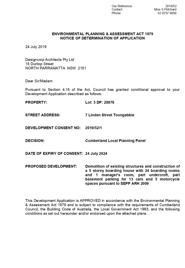
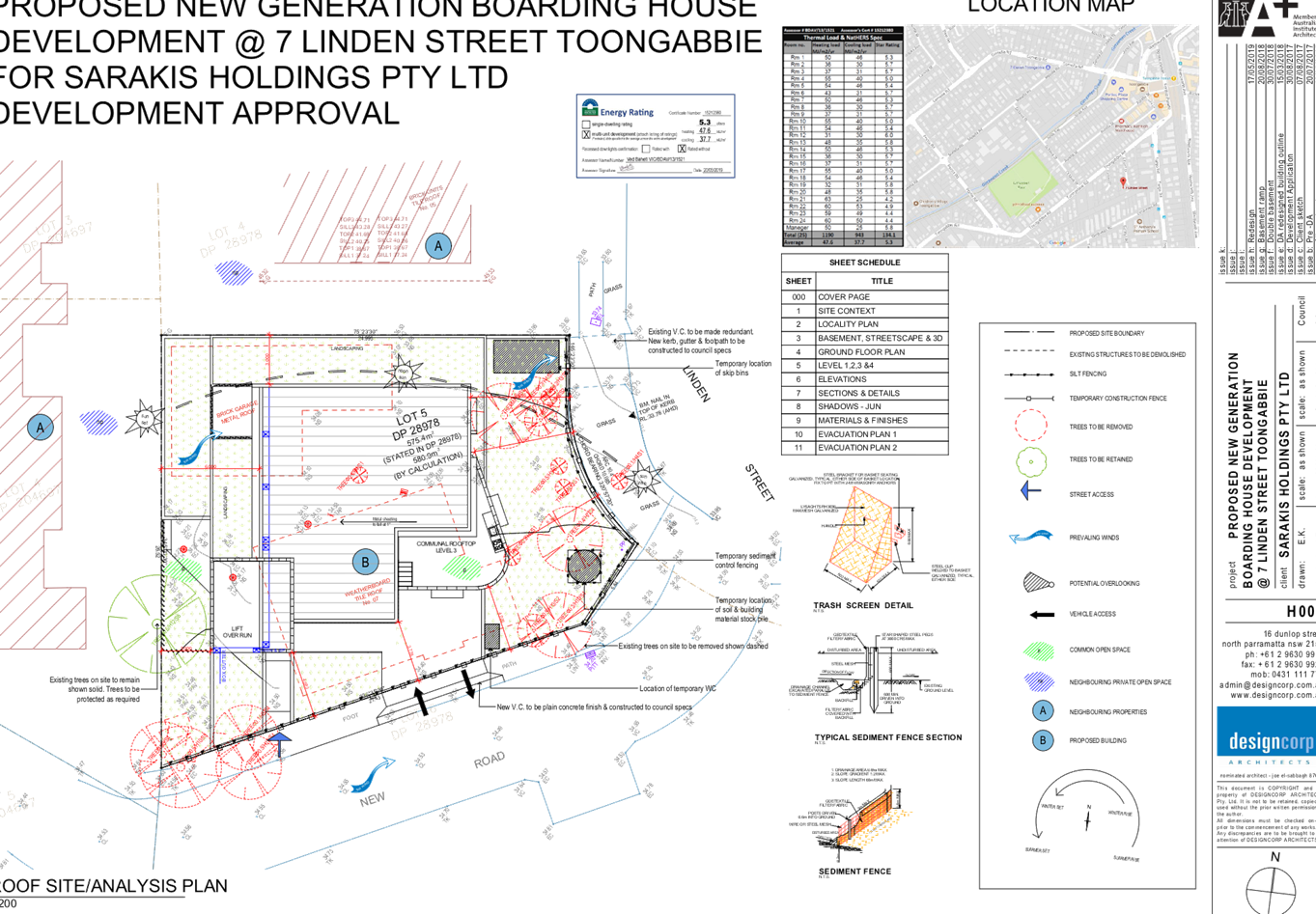
Item
No: ELPP049/19
Development
Application for 7 Linden Street Toongabbie
Responsible
Division: Environment
& Planning
Officer: Executive
Manager Development and Building
File
Number: 2019/52
|
Application lodged
|
4 March 2019
|
|
Applicant
|
Designcorp Architects Pty Ltd
|
|
Owner
|
Sarakis Holdings Pty Ltd
|
|
Application No.
|
2019/52
|
|
Description of Land
|
7 Linden Street Toongabbie
|
|
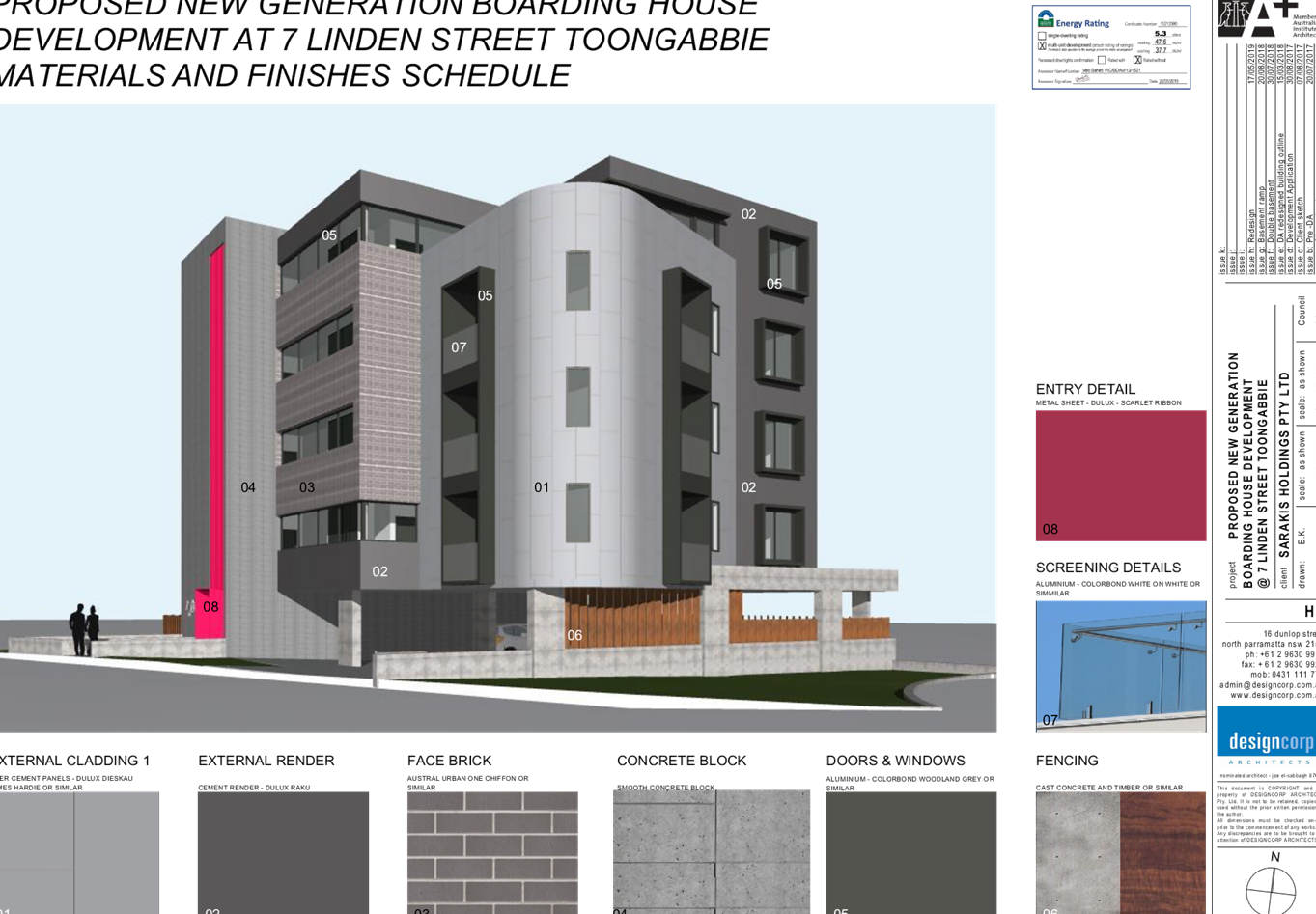
Proposed Development
|
Demolition of existing
structures and construction of a 5 storey boarding house with 24 boarding
rooms and 1 manager's room, part undercroft, part basement parking for 13
cars and 5 motorcycle spaces pursuant to SEPP ARH 2009
|
|
Site Area
|
580.9 m2
|
|
Zoning
|
R4 – High Density
|
|
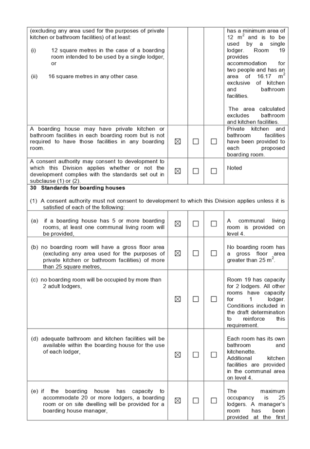
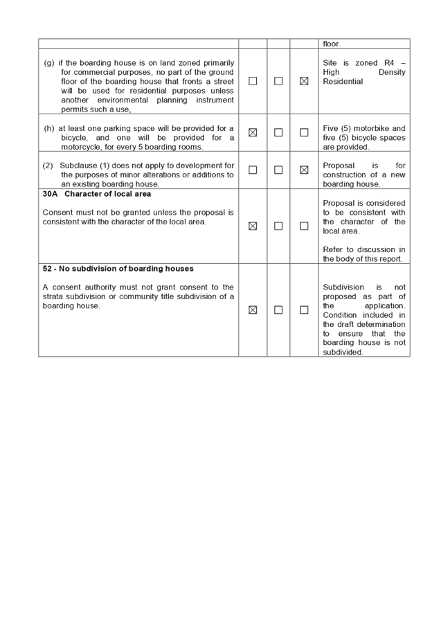
Principal development standards
|
Height of Buildings – 15 m
Floor Space Ratio – 1.2:1 (1.7:1 with SEPP ARH
bonus)
|
|
Disclosure of political donations and gifts
|
Nil disclosure
|
|
Heritage
|
Subject site is not within the vicinity of any
heritage item or heritage conservation area
|
|
Issues
|
Public submissions (19)
|
1. The
subject application was lodged on 4 March 2019 and notified to surrounding
properties from 3 April to 17 April 2019.
2. Nineteen
submissions were received during the notification period.
3. The
application was deferred on 1 May 2019 and amended plans were submitted on 22
May 2019. The amended plans did not require re-notification.
4. The
submissions raised concerns regarding building height, suitability of the site
for the proposed development, insufficient parking, crime and antisocial
behaviour.
5. The
application is being reported to the Cumberland Local Planning Panel (CLPP) for
determination due to the number of public submissions received.
6. The
application has been assessed against the relevant provisions of the
Environmental Planning and Assessment Act 1979, State Environmental Planning
Policy (Affordable Rental Housing) 2009, Holroyd Local Environmental Plan
(HLEP) 2013 and Holroyd Development Control Plan (HDCP) 2013.
7. The
application involves the following numerical non-compliances with the relevant
planning controls which are considered supportable as discussed elsewhere in
the report.
|
Control
|
Required
|
Proposed
|
% Variation
|
|
Landscaping forward of the building line
|
Maximum 50% (109.75m2)
|
74 % (172.8 m2)
|
57%
|
|
Site coverage
|
Maximum 30% (174.27m2)
|
50.4 % (292.8 m2)
|
68%
|
|
Secondary street setback
|
4 m
|
3.7 m
|
7.5%
|
|
Rear setback
|
Min G-L3 20% (5.38 m)
Min L4 30% (8.01 m)
|
3 m
3 m
|
44.2%
62.5%
|
|
Side setback
|
3 m
|
0 m (to undercroft car park)
|
100%
|
|
Building separation
|
9 m
|
7.5 m
|
72%
|
|
Upper storey setback
|
Additional 3 m
|
0 m
|
100%
|
|
Number of storeys
|
Maximum 4
|
5
|
20%
|
|
Floor to ceiling height
|
Minimum 2.7 m
|
2.5-2.6
|
7%
|
8. The
application is recommended for approval subject to the conditions provided in
the draft determination.
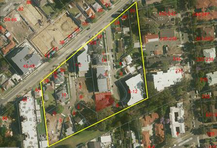
Subject Site and Surrounding
Area
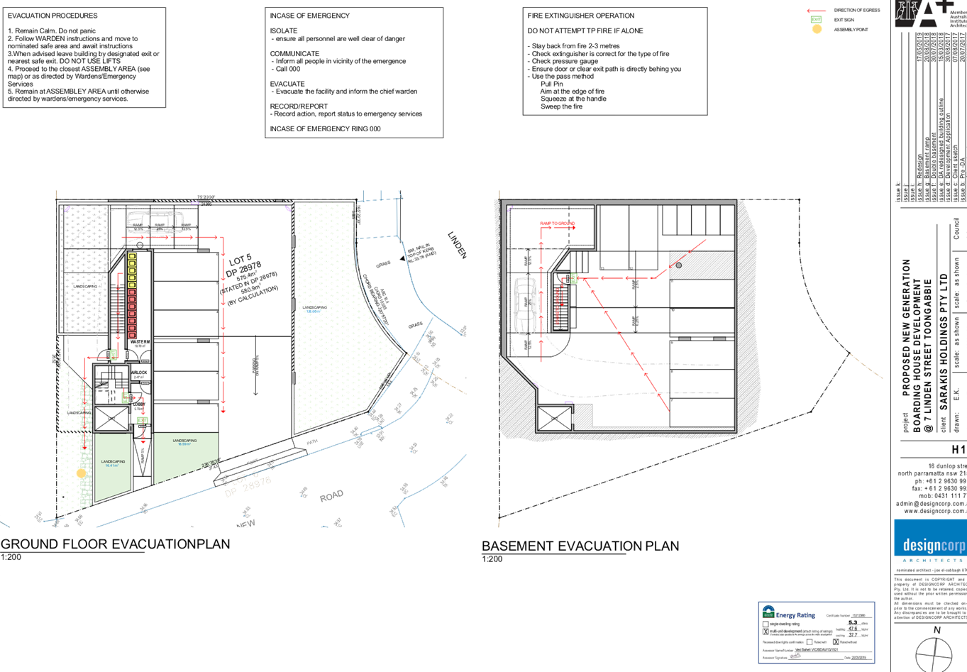
The subject site is known as 7
Linden Street, Toongabbie and is legally described as Lot 5 in DP 28978. The
site is located on the western side of Linden Street and is approximately 500
metres south west of Toongabbie Town Centre. The site is zoned R4 – High
Density Residential, as are the surrounding sites. The site is irregular in
shape with a frontage of approximately 14 m to the curved section of Linden
Street, and a site area of 580.9m². The site currently contains a single
storey dwelling house and associated outbuildings.
There are existing flat building
developments to the north, the west, and on the opposite side of Linden Street
to the east. A new laneway has recently been constructed linking Linden Street
with Harvey Place. Beyond the laneway, to the south is ‘Keene Park’
- a Council reserve.
The subject site is isolated in
that it does not meet the minimum frontage requirement for a residential flat
building development, and there are no opportunities for amalgamation with neighbouring
properties.
Consent was granted on 15 February
2016 (subject to deferred commencement conditions) for demolition of existing
structures and construction of a 5 storey residential flat building with 8
units at the subject site. The deferred commencement conditions were satisfied
and the consent became operational on 2 March 2016. However, a construction
certificate has not been issued for the approved development and the consent
has now lapsed.
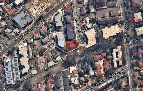
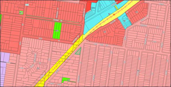
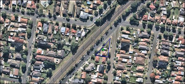
Aerial
view of the locality with subject site shown hatched. Source: Cumberland
Council 2019
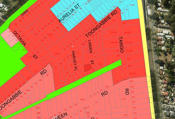
Zoning
map with subject site shown hatched. Source: Cumberland Council 2019
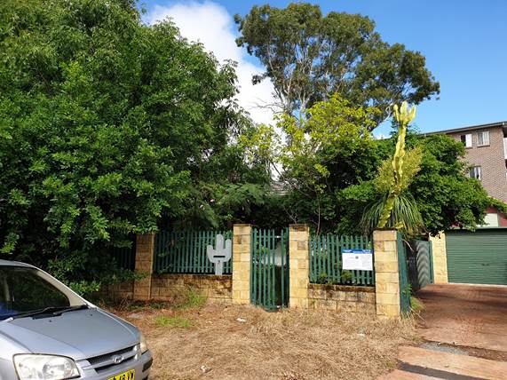
Subject
site – view from Linden Street. Source: Cumberland Council 2019
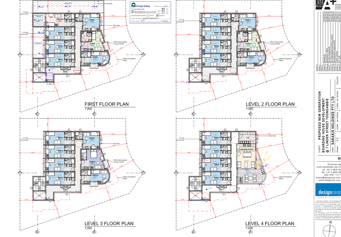
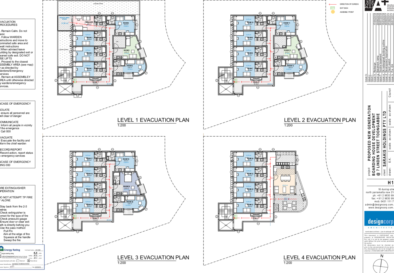
Description of the Proposed
Development
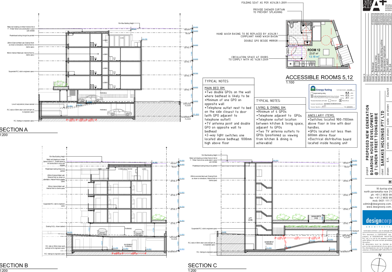
DA 2019/52 proposes demolition of
existing structures, construction of a 5 storey boarding house with 24 boarding
rooms and 1 manager’s room, part undercroft, part basement parking for 13
cars, and 5 motorcycles pursuant to SEPP ARH.
Key features of the development
proposal are as follows:-
|
Basement
|
Seven car spaces and five motorcycle spaces
|
|
Ground level
|
Six car spaces, lobby, and waste storage room. Vehicular
and pedestrian access is provided via the laneway.
|
|
First Floor
|
Six boarding rooms including one adaptable room, and
manager’s accommodation. All boarding rooms contain ensuite bathrooms
and kitchenette facilities.
|
|
Second Floor
|
Seven boarding rooms including one adaptable room.
All boarding rooms contain ensuite bathrooms and kitchenette facilities.
|
|
Third Floor
|
Seven boarding rooms, all including ensuite bathroom and
kitchenette facilities.
|
|
Fourth Floor
|
Four boarding rooms, a communal room, communal laundry
facilities and a terrace area including BBQ facilities.
|
The proposed development is
serviced by lift and stair access to each level.
History
|
Date
|
Action
|
|
15 February 2016
|
DA 2015/561 approved for construction of a 5 storey
residential flat building with 8 units on the subject site
|
|
14 September 2017
|
DA 2017/385 was lodged with Council seeking consent for
construction of a boarding house with 29 rooms plus manager’s room,
with at grade parking for 7 cars on the subject site.
|
|
26 January 2018
|
DA 2017/385 deferred due to non-compliances with SEPP ARH,
HLEP 2013 and HDCP 2013 planning controls and standards.
|
|
1 June 2018
|
SEPP ARH was amended to require a minimum of 0.5 car
spaces per boarding room in the case of development not carried out by or on
behalf of a social housing provider
|
|
3 July 2018
|
DA 2017/385 deferred due to non-compliance with the new
parking rate in the SEPP ARH
|
|
31 July 2018
|
Amended plans submitted by the applicant providing for an
additional level of car parking, to be accessed by car lift
|
|
24 October 2018
|
DA 2017/385 refused by CLPP
|
|
15 February 2019
|
Development consent 2015/561 lapsed
|
|
4 March 2019
|
DA 2019/52 (subject application) lodged with Council
|
|
27 March 2019
|
DA 2019/52 referred to the following internal sections for
comment:
· Engineering
· Waste Management
· Environmental
Health Unit
· Landscaping
|
|
3 to 17 April 2019
|
DA 2019/52 was placed on public notification for 14 days.
Council received 19 submissions in respect of the proposal during the
notification period.
|
|
1 May 2019
|
The application was deferred seeking additional
information and amended plans.
|
|
22 May 2019
|
Amended plans and additional information submitted to
Council. The amended plans were not required to be renotified.
|
|
24 July 2019
|
Application referred to CLPP for determination.
|
Applicant’s Supporting
Statement
A Statement of Environmental
Effects (SEE) prepared by Think Planners dated 27 February 2019 was submitted
with the application.
Contact with Relevant
Parties
The assessing officer has
undertaken an inspection of the subject site and has been in contact with the
applicant throughout the assessment process.
Internal Referrals
Development Engineering
The development application was
referred to Council’s Development Engineer for comment. The response
received 16 April 2019 indicates that the proposal is satisfactory, subject to
a number of deferred commencement conditions. The amended plans submitted by
the applicant satisfactorily addressed the issues raised by the Engineer and
confirmation was provided on 31 May 2019 that the application can be approved,
subject to standard conditions.
Traffic Engineering
The application was referred to
Council’s Traffic Engineer for comment. The response received 12 April
2019 recommends deferral of the application. The issues raised by the Traffic
Engineer were satisfactorily addressed in the applicant’s response to the
deferral letter
Environmental Health
The development application was
referred to Council’s Environmental Health Officer for comment. The
response received on 4 April 2019 indicates that the proposal is satisfactory,
subject to conditions requiring compliance with the recommendations of the
acoustic report, and legislation relating to boarding houses.
Landscape and Tree Management
The application was referred to
Council’s Landscape and Tree Management Officer for comment. Concerns
were raised regarding impact on the tree located on the adjacent property. The
amended arborist report satisfactorily addressed these concerns.
Waste Management
The development application was
referred to Council’s Waste Management Officer for comment. The response
received 9 April 2019 indicates that the proposal is satisfactory. No
conditions were recommended.
External Referrals
NSW Police – referral
pending
The application was referred to
NSW Police for comment. No response was received.
Planning Comments
The provisions of any
Environmental Planning Instruments (EP&A Act s4.15 (1)(a)(i))
The following Environmental
Planning Instruments are relevant to the assessment of the subject application:
(a) State
Environmental Planning Policy No 55 – Remediation of Land (SEPP 55)
The requirement at clause 7 of
SEPP 55 for Council to be satisfied that the site is suitable or can be made
suitable to accommodate the proposed development has been considered in the
following table:
|
Matter for Consideration
|
Yes
|
No
|
|
Does the application involve re-development of the site or
a change of land use?
|
|
|
|
i)
Does the application involve
re-development of the site or a change of land use?
|
|
|
|
In the development going to be used for a sensitive land
use (e.g.: residential, educational, recreational, childcare or hospital)?
|
|
|
|
Does information available to you indicate that an
activity listed below has ever been approved, or occurred at the site?
acid/alkali plant and
formulation, agricultural/horticultural activities, airports, asbestos
production and disposal, chemicals manufacture and formulation, defence
works, drum re-conditioning works, dry cleaning establishments, electrical
manufacturing (transformers), electroplating and heat treatment premises,
engine works, explosive industry, gas works, iron and steel works, landfill
sites, metal treatment, mining and extractive industries, oil production and
storage, paint formulation and manufacture, pesticide manufacture and
formulation, power stations, railway yards, scrap yards, service stations,
sheep and cattle dips, smelting and refining, tanning and associated trades,
waste storage and treatment, wood preservation
|
|
|
|
Is the site listed on
Council’s Contaminated Land database?
|
|
|
|
Is the site subject to EPA
clean-up order or other EPA restrictions?
|
|
|
|
Has the site been the subject of
known pollution incidents or illegal dumping?
|
|
|
|
Does the site adjoin any
contaminated land/previously contaminated land?
|
|
|
|
Has the appropriate level of
investigation been carried out in respect of contamination matters for
Council to be satisfied that the site is suitable to accommodate the proposed
development or can be made suitable to accommodate the proposed development?
|
|
|
|
Details of contamination investigations carried out at
the site:
The site is
currently used for residential purposes and has been for many years. The site
is not identified in Council’s records as being subject to
contamination. There is no evidence available to suggest that either the
subject site, or any adjacent site, has ever been used for a potentially
contaminating activity. No further investigation is considered necessary in
the circumstances.
|
(a) State
Environmental Planning Policy (Vegetation in Non-Rural Areas) 2017
The proposal does not involve the
clearing of any native vegetation. As such, the SEPP does not apply.
(b) State
Environmental Planning Policy (Coastal Management) 2018
The subject site is not identified
as a coastal wetland and is not or land identified as “proximity area for
coastal wetlands”.
(c) State
Environmental Planning Policy (Building Sustainability Index: BASIX) 2004
BASIX certificate 1017407M dated
22 May 2019 was submitted with the amended application. The proposal achieves
the target scores for energy, water and thermal comfort and relevant
commitments are shown on the architectural plans.
(d) State
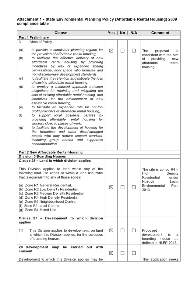
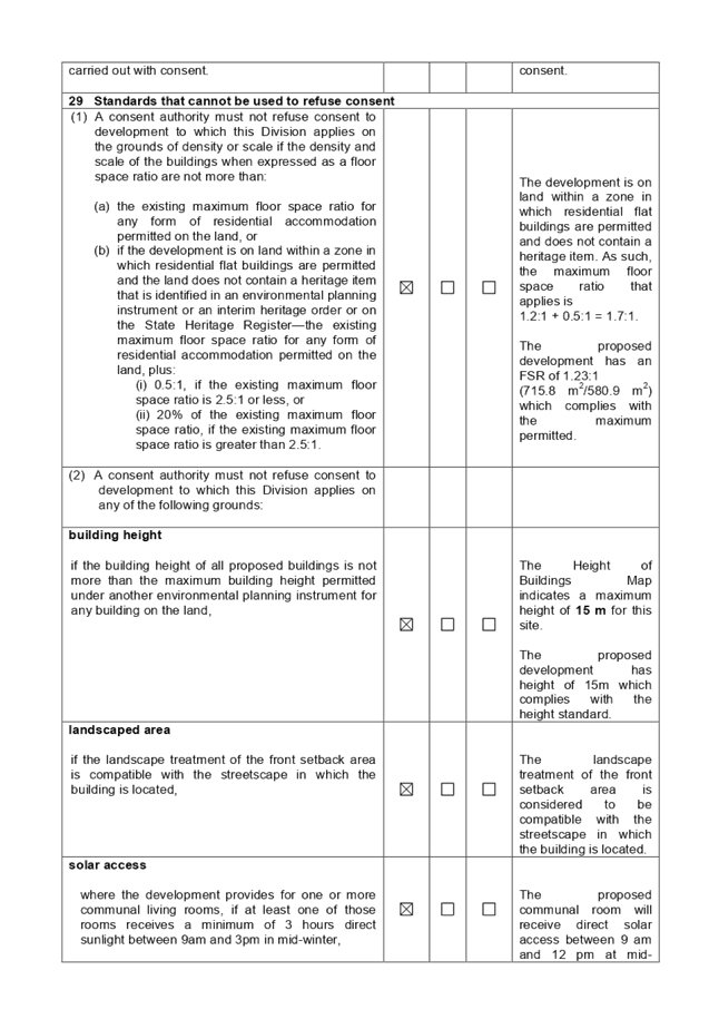
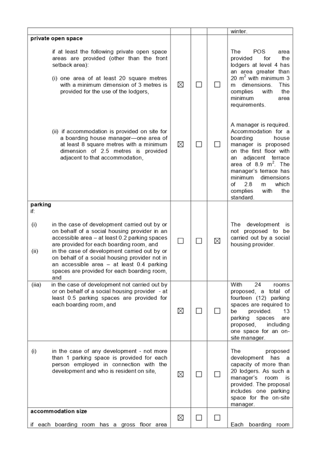
Environmental Planning Policy (Affordable Rental Housing) 2009
The proposed development is
defined as a ‘boarding house’ under the provisions of State
Environmental Planning Policy (Affordable Rental Housing) 2009. The
proposal complies with the relevant provisions of the SEPP, as detailed in the
compliance table provided at attachment 1.
Character of the Local Area
A consent authority must not
consent to development for the purpose of a boarding house unless it has taken
into consideration whether the design of the development is compatible with the
character of the local area.
The SEPP (ARH) does not contain
any guidance for assessing whether a proposal is compatible with the character
of the local area. However, a planning principle for assessing compatibility in
the urban environment was established by Senior Commissioner Roseth of the Land
and Environment Court in the judgement for Project Venture Developments Pty Ltd
v Pittwater Council [2005] NSWLEC 191. This involves asking the following two
questions:
· Are
the proposal’s physical impacts on surrounding development acceptable?
The physical impacts include constraints on the development potential of
surrounding sites.
· Is
the proposal’s appearance in harmony with the buildings around it and the
character of the street?
A merit assessment of the
character of the local area should consider the following 3 steps:
· Step 1 –
Identify the ‘local area’.
· Step 2 –
Identify the character of the ‘local area’.
· Step 3 –
Determine whether the design of the proposed development is compatible with the
character of the ‘local area’.
An assessment against each step is
provided below:
Step 1 – Identify the
‘local area’
The local area is identified in
the map below as the area within the yellow lines.
Step 2 – Identify the
character of the ‘local area’.
All sites within the local area
are zoned R4 – High Density Residential under HLEP 2013.
Whilst there are a number of one
and two storey dwellings within the locality, the area is transitioning to
higher density developments in accordance with the planning controls that
currently apply. The area is subject to a maximum height limit of 15 m and
maximum floor space ratio (FSR) of 1.2:1. The emerging character of the area is
generally that of small to medium sized (4 storey) residential flat buildings.
Step 3 – Determine
whether the design of the proposed development is compatible with the character
of the ‘local area’
The following questions assist in
determining whether a building is compatible with its surroundings:
· Are
the proposal’s physical impacts on surrounding development acceptable?
The physical impacts include
constraints on the development potential of surrounding sites.
In terms of the physical impacts
of the development:
o The proposal does not restrict the
development potential of any adjoining site as they have all been developed
already for residential flat buildings.
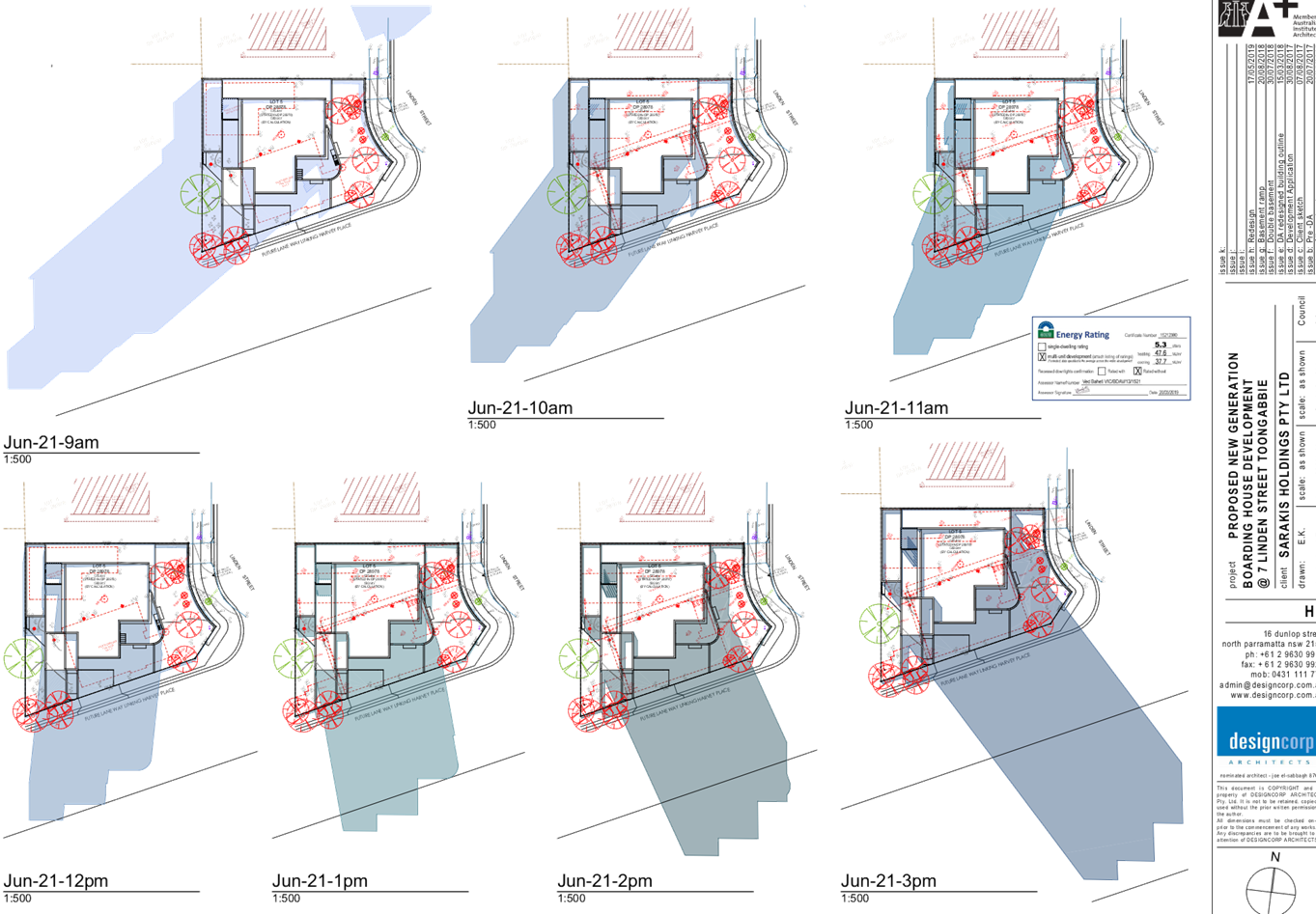
o The shadows cast by the proposed
development will fall mainly to the new laneway which is located directly
adjacent to the southern boundary.
o There will be some overshadowing
impact on the communal open space area of the newly constructed residential
flat building at 3-4 Harvey Place. However, it is considered that this area is
vulnerable to overshadowing due to the limited setback of the new flat building
and orientation of the site. Given that the proposal complies with the applicable
height and FSR standards, limited overshadowing of the adjacent site is
considered acceptable.
· Is
the proposal’s appearance in harmony with the buildings around it and the
character of the street?
The scale of the proposed building
is consistent with the anticipated character of residential buildings in the
area. The building has been designed to fit within the approved building
footprint of the residential flat building approved pursuant to DA 2015/561.
The proposal also complies with the 15 m height of buildings standard which
applies to the site.
The setback to Linden Street is
compliant with the 6 m control, and the relationship of the building to the
site is consistent with that of the surrounding developments. Whilst the
proposal is one storey higher than surrounding developments, it is compliant
with the height of buildings standard, and the location of the site at the
bottom of the street ensures that overshadowing of neighbouring properties is
minimised.
The proposal provides for
horizontal and vertical articulation to both façades, with window
shades, small balconies, and the level 4 terrace adding visual interest and
depth to the building.
In summary, the design and
presentation of the proposed development is considered to be in harmony with
the character of the local area.
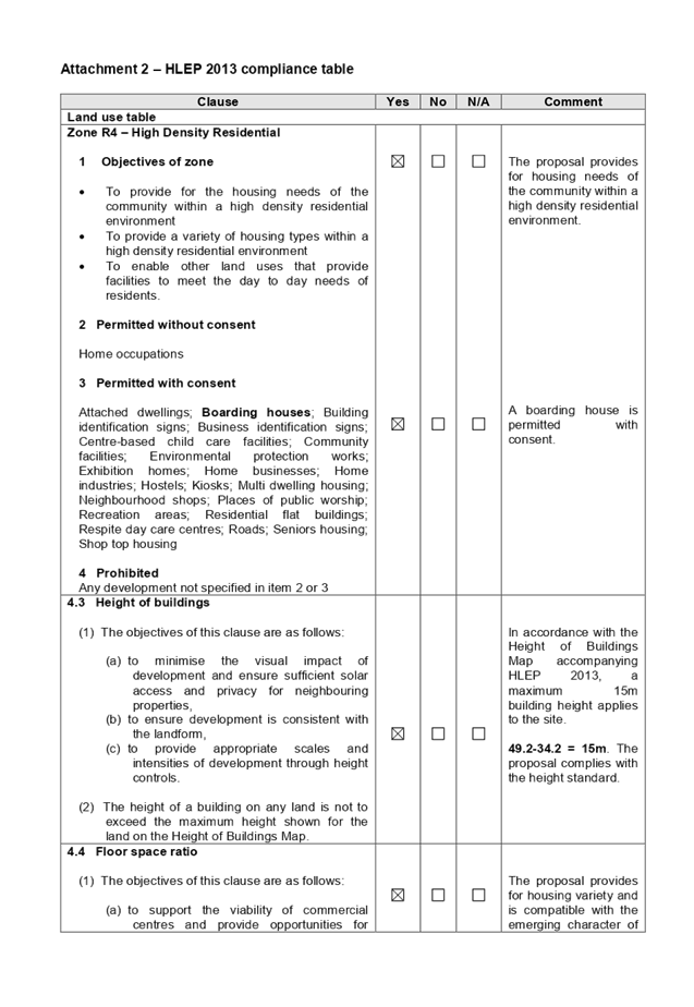
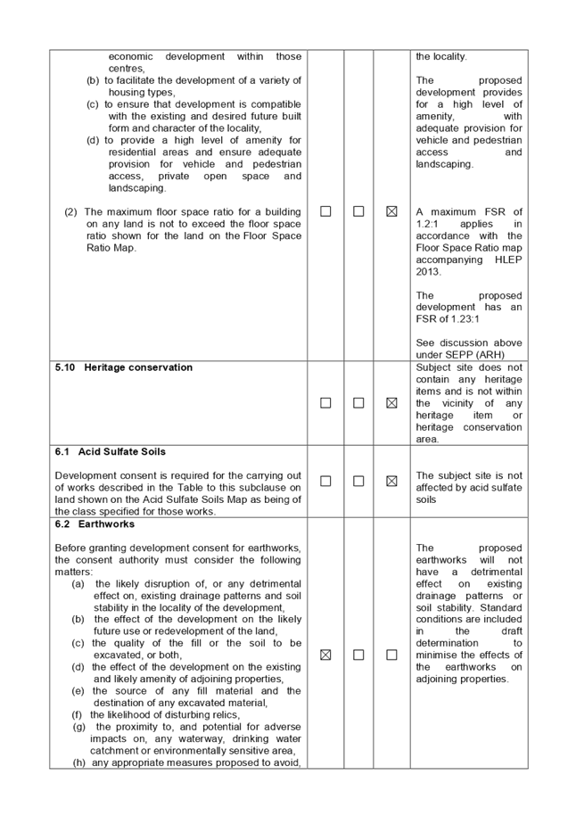
(e) Holroyd
Local Environmental Plan 2013 (HLEP 2013)
The proposed development is
defined as a ‘boarding house’ under the provisions of HLEP 2013.
Boarding houses are permitted with consent in the R4 – High Density
Residential zone which applies to the land.
The proposal complies with all
applicable HLEP development standards. A detailed compliance table is provided
at attachment 2.
The provisions of any proposed
instrument that is or has been the subject of public consultation (EP&A Act
s4.15 (1)(a)(ii))
The proposed development is not
affected by any draft Environmental Planning Instruments.
The provisions of any
Development Control Plans (EP&A Act s4.15 (1)(a)(iii))
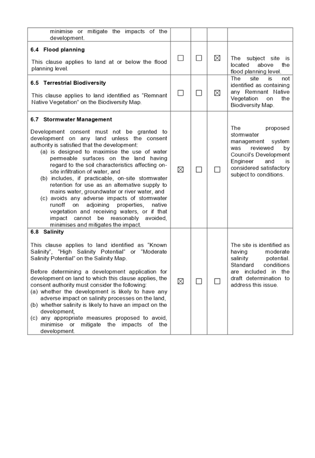
(a) Holroyd
Development Control Plan 2013
HDCP 2013 contains general
controls which relate to all developments under Part A. Whilst there are no
specific DCP controls for boarding houses in HDCP 2013, the controls for
residential flat buildings in Part B and the Town Centre Controls in Part L are
relevant to the assessment of the subject application in that they establish
the desired character of the area with regard to building form and the
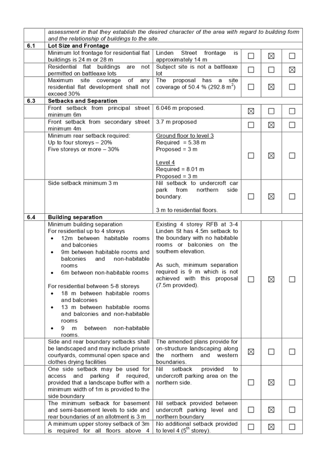
relationship of buildings to the site.
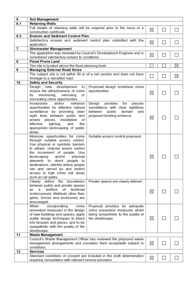
A comprehensive HDCP compliance
table is attached to this report at attachment 3. A summary of the
non-compliances with the relevant DCP provisions is provided in the following
table.
|
No.
|
Clause
|
Comment
|
Yes
|
No
|
N/A
|
|
PART B – RESIDENTIAL CONTROLS
|
|
1
|
GENERAL
RESIDENTIAL CONTROLS
|
|
1.5
|
Landscape Area
|
|
|
Max. 50% of provided
landscaped area shall be forward of the front building line.
|
74 % of the landscaping
proposed is within the front setback. Compliance with this control would be
difficult in the circumstances as the site has dual frontages. Amended plans
provide for additional landscaping above the car park level which limits the extent
of the non-compliance and serves to soften the appearance of the development
from the neighbouring properties. In the circumstances, this is considered
acceptable despite the numerical non-compliance.
|
|
|
|
|
6.0
|
Residential Flat Buildings
Whilst there are no specific DCP controls for boarding
houses in HDCP 2013, the controls for residential flat buildings in Part B
and Town Centre Controls in Part L are relevant to the assessment in that
they establish the desired character of the area with regard to building form
and the relationship of buildings to the site.
|
|
6.1
|
Lot Size and Frontage
|
|
|
Minimum lot frontage for residential flat buildings is 24
m or 28 m
|
The Linden Street frontage is approximately 14 m which is
less than the minimum stipulated for residential flat development. The site
is isolated and there are no opportunities for amalgamation with adjacent
properties.
|
|
|
|
|
|
Maximum site coverage of any residential flat development
shall not exceed 30%
|
The proposal has a site coverage of 50.4 % (292.8 m2).
Given that the proposal provides adequate space for vehicular access and
on-site detention, compliance with this control is considered to be
unnecessary.
|
|
|
|
|
6.3
|
Setbacks and Separation
|
|
|
Front setback from secondary street minimum 4 m
|
3.7 m proposed to the secondary frontage. Most elements of
the building comply with the 4 m control. The minor non-compliance is
confined to a small section of the building and would be visually
imperceptible.
|
|
|
|
|
|
Minimum rear setback required:
Up to four storeys – 20%
Five storeys or more – 30%
|
Ground floor to level 3
Required = 5.38 m
Proposed = 3 m
Level 4
Required = 8.01 m
Proposed = 3 m
The proposed setbacks at levels 1-3 are comparable to the
setbacks of the existing flat buildings at 3-4 Harvey Place, and 3 Linden
Street.
The additional setback at the upper level is not
considered necessary in this instance due to the lack of adverse
overshadowing impacts on adjacent dwellings from the current design.
The proposal satisfies the objectives of the setback
controls by responding appropriately to the location and dimensions of the
site, managing visual and acoustic privacy impacts, and minimising
overshadowing of adjacent properties.
|
|
|
|
|
|
Side setback minimum 3 m
|
Nil setback to undercroft car park from northern side
boundary.
The non-compliance is limited to the undercroft car park
area adjoining the northern boundary. The impacts of the non-compliance are
minimised, with on-structure planting above the car parking area.
Remainder of the building complies with the 3 m control.
|
|
|
|
|
6.4
|
Building separation
|
|
|
Minimum building separation
For residential up to 4 storeys
· 12m between
habitable rooms and balconies
· 9m between
habitable rooms and balconies and non-habitable rooms
· 6m between
non-habitable rooms
For residential between 5-8 storeys
· 18 m between
habitable rooms and balconies
· 13 m between habitable
rooms and balconies and non-habitable rooms
· 9 m between
non-habitable rooms.
|
Existing 4 storey RFB at 3-4 Linden St has 4.5 m setback
to the boundary with no habitable rooms or balconies on the southern
elevation.
As such, minimum separation required is 9 m which is not
achieved with this proposal (7.5m provided).
Given the constraints of the isolated site and the lack of
visual or acoustic privacy impacts, the proposed building separation is
considered acceptable.
|
|
|
|
|
|
One side setback may be used for access and parking if required,
provided that a landscape buffer with a minimum width of 1m is provided to
the side boundary
|
Nil setback provided to undercroft parking area on the
northern side.
Considered satisfactory as discussed above.
|
|
|
|
|
|
The minimum setback for basement and semi-basement levels
to side and rear boundaries of an allotment is 3 m
|
Nil setback provided between undercroft parking level and
northern boundary.
Considered satisfactory as discussed above.
|
|
|
|
|
|
A minimum upper storey setback of 3 m is required for all
floors above 4 storeys.
|
No additional setback provided to level 4 (5th
storey).
This is considered acceptable as there are no adverse
overshadowing impacts associated with the non-compliance. And given the
location of the site at the end of the street, where all neighbouring sites
have already been developed, there is no precedent value in accepting the
non-compliance in this instance.
|
|
|
|
|
|
Minimum floor to ceiling heights of 2.7 m required for
habitable rooms
|
2.9 m slab to slab will not achieve 2.7 m ceiling heights.
See comment below.
|
|
|
|
|
|
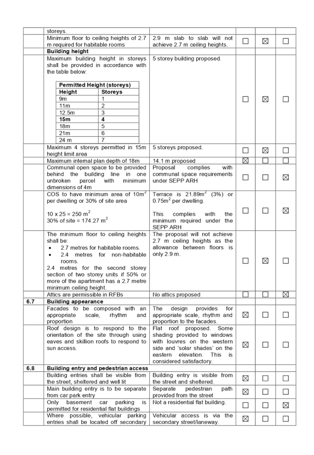
Building height
|
|
|
|
|
|
|
Maximum building height in
storeys shall be provided in accordance with the table below:
|
Permitted Height
(storeys)
|
|
Height
|
Storeys
|
|
9m
|
1
|
|
11m
|
2
|
|
12.5m
|
3
|
|
15m
|
4
|
|
18m
|
5
|
|
21m
|
6
|
|
24 m
|
7
|
|
5 storey building proposed.
The proposal complies with the 15 m height standard that
applies pursuant to HLEP 2013.
Surrounding properties have already been developed for
residential flat buildings and as such, there is no precedent value in
approving a non-compliance in this instance.
|
|
|
|
|
|
The minimum floor to ceiling
heights shall be:
· 2.7
metres for habitable rooms.
· 2.4
metres for non-habitable rooms.
2.4 metres for the second storey section of two storey
units if 50% or more of the apartment has a 2.7 metre minimum ceiling height.
|
The proposal will not achieve 2.7 m ceiling heights as the
allowance between floors is only 2.9 m.
The proposal will comply with minimum floor to ceiling
heights required under the National Construction Code (NCC) and will allow
for adequate internal amenity.
|
|
|
|
|
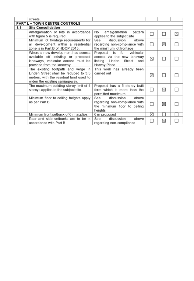
PART L – TOWN CENTRE CONTROLS
|
|
|
The maximum building storey limit of 4 storeys applies to
the subject site.
|
See discussion above regarding non-compliance with maximum
number of storeys.
|
|
|
|
|
|
Minimum floor to ceiling heights apply as per Part B
|
See discussion above regarding non-compliance with the
minimum floor to ceiling heights.
|
|
|
|
|
|
Rear and side setbacks are to be in accordance with Part B
|
See discussion above regarding non-compliance with side
and rear setbacks.
|
|
|
|
|
|
|
|
|
|
|
|
Council’s Social
Impact Assessment Policy
Under Council’s Social
Impact Assessment (SIA) Policy, a Social Impact Comment is required to be
submitted for this type of development. The proposal is, however, exempt from
the requirement to provide a Comprehensive Social Impact Assessment as there
are fewer than 50 dwellings proposed.
A Social Impact Comment was
submitted with the application and concludes that the proposed development will
not have unreasonable/ negative social impacts in the locality. A Plan of
Management (POM) was submitted with the application and includes measures to
mitigate impacts in the locality. The POM is included as an endorsed document
in the consent and additional conditions are included to require compliance
with, and periodic review of the POM.
The provisions of any planning
agreement that has been entered into under section 7.4, or any draft planning
agreement that a developer has offered to enter into under section 7.4
(EP&A Act s4.15(1)(a)(iiia))
There is no planning agreement or
draft planning agreement associated with the subject Development Application.
The provisions of the
Regulations (EP&A Act s4.15 (1)(a)(iv))
Pursuant to clause 92 of the
regulation, the provisions of AS2601 – Demolition of structures must be
considered in the case of a development application involving the demolition of
a building. Standard conditions are included in the draft determination to
require that demolition be carried out in accordance with AS 2601.
The Likely Environmental,
Social or Economic Impacts (EP&A Act s4.15 (1)(b))
The likely environmental, social
and economic impacts of the development have been considered in the assessment
of the application. As discussed in detail elsewhere in the report, the impacts
in the locality are considered acceptable.
The suitability of the site for
the development (EP&A Act s4.15 (1)(c))
The site is considered to be
suitable for the proposed development.
Submissions made in accordance
with the Act or Regulation (EP&A Act s4.15 (1)(d))
Advertised (newspaper) Mail Sign
Not Required
In accordance with Part E Public
Participation of HDCP 2013, the proposal was publicly notified for a period of
14 days from 3 April to 17 April 2019. As a result of the notification, Council
received 19 public submissions.
The issues raised in the public
submissions are addressed in the following table.
|
Issue
|
Response
|
|
Parking
· Insufficient
parking provided on site
· Non-compliance
with Council parking requirements
|
The proposal complies with the minimum number of parking
spaces required for this type of development under SEPP ARH as detailed
elsewhere in this report. A consent authority cannot refuse an application
for reasons relating to parking if it complies with the minimum number of
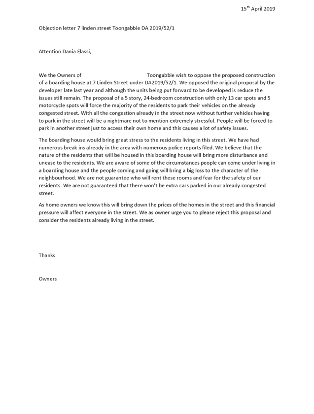
spaces required under the SEPP.
|
|
Safety
· Heightened crime
risk associated with transient population
· Anti-social
activity
· Risk to safety
of young children
· Pedestrian
safety
|
There is no information available to suggest that boarding
houses cause risks to public safety or are associated with criminal or
anti-social activity.
A Plan of Management (POM) was submitted with the
application. This document deals with matters such as maintenance and use of
common areas, waste management, emergency procedures and resolution of
complaints. The POM is included as an endorsed document at condition 2 of the
draft determination. Subject to compliance with the POM and the recommended
conditions of consent, there would be no unreasonable impacts on the local
community arising from the construction and occupation of a boarding house as
proposed.
The application was referred to NSW Police for review, and
no concerns were raised regarding the design of the development, or the
nature of the proposed use.
The proposed building addresses both street frontages,
providing appropriate passive surveillance of the public domain. The design
also provides for appropriate access control and territorial reinforcement.
|
|
Devaluation of properties
|
This is not a matter for consideration in the evaluation
of a development application pursuant to section 4.15 of the Environmental
Planning & Assessment Act 1979.
|
|
· 5 storey out of
character with locality (max.4)
· (Excessive)
height
· Proposed
building is out of proportion to the site
· Overshadowing
(from 5th storey)
· Streetscape
impact of a 5 storey building
|
Whilst the proposal does not comply with the maximum
number of storeys control permitted under HDCP 2013, it does comply with the
HLEP 2013 height of buildings standard, which allows a maximum height of 15
m. The design of the building is considered to be compatible with the
emerging character of the area, having regard to the setbacks, façade
treatment, and landscaping of the site.
The proposal will not affect solar access to the living
areas or private open spaces of existing dwellings.
|
|
Privacy impacts from additional storey.
|
The top level of the development accommodates four west
facing boarding rooms, and east facing communal laundry and living areas. The
four boarding rooms will have full height privacy screens, and the physical
separation from the east facing communal areas to the existing flat building
at 8-12 Linden Street is 20-30 m. This exceeds the ADG building separation
requirements and is considered adequate to maintain visual privacy for all
properties.
|
|
· Impact on waste
collection and efficient operation of the local road network from additional
cars parking in the street
· Pedestrian
safety
|
The proposal has been reviewed by Council’s Traffic
Engineering and Waste Management section and is considered satisfactory
subject to conditions.
The proposal complies with relevant Australian Standards,
and will not have any adverse impact on pedestrian safety.
|
|
· Uncertainty
around future occupants (target market?)
· People with
criminal history and financial or social instability may reside in the
boarding house
|
The proposal is for a boarding house with 24 rooms and
manager’s accommodation. The facility is not being proposed by a social
housing provider, and the operator will be free to select tenants in
accordance with their commercial interests.
|
|
Noise from additional vehicle movements
|
Subject to compliance with the provisions of the POM and
Council’s standard consent conditions, there would be no unreasonable
impacts in the locality in terms of noise resulting from the proposed
development.
|
|
BASIX certificate is incorrect (all dwellings have the
same thermal load)
|
The applicant’s Accredited Assessor advised that a
default average thermal load was used for the original BASIX assessment, as
Section J of the BCA applies to energy provisions. The applicant provided a
new BASIX certificate and assessor certificate with the amended application.
The amended certificate is consistent with the architectural plans and
heating and cooling loads have been provided for each room.
|
|
Suitability of the site for the proposed use
· Proximity to
children’s play area
· Proximity to
existing schools
|
The subject site is located a short distance from the
shops, services and public transport available in Toongabbie Town Centre and
as such is well located to accommodate this type of development.
The subject site is zoned R4 – High Density
Residential and boarding houses are permitted with consent on the land
pursuant to HLEP 2013 and SEPP ARH.
There are no controls in either the SEPP ARH or HDCP 2013
that would restrict the location of boarding houses due to proximity to
existing schools or children’s play areas.
|
|
Social impacts
· Existing
residents are mainly families with small children
· Boarding house
attracts short term residents who may not be held responsible for
misbehaviour
· No guarantee
that target market as identified in the documentation submitted with the
application will be the people who end up living in the boarding house
· Potential for
drug addicts and alcoholics to reside in the boarding house
· impacts on
community
|
Provision of affordable rental housing is not incompatible
with other residential uses. There is no evidence available to suggest that
boarding houses pose safety risks for young families or small children.
Existing problems with criminal or anti-social behaviour
in Toongabbie are matters for the Police and are not relevant to the
assessment of the subject application.
Subject to compliance with the applicant’s POM (as
described above), there would be no unreasonable impacts on the local
community arising from the construction and occupation of a boarding house as
proposed.
|
The public interest (EP&A
Act s4.15(1)(e))
The public interest is served by
permitting the orderly and economic use of land, in a manner that is sensitive
to the surrounding environment and has regard to the reasonable amenity
expectations of land users. In view of the foregoing analysis, it is considered
that approval of the proposed development would not be contrary to the public
interest.
Section 7.11 (Formerly S94)
Contribution towards Provision or Improvement of Amenities or Services
The subject development attracts
contributions in accordance with Holroyd Section 94 Development Contributions
Plan 2013. In accordance with the currently indexed rates for the Toongabbie
Centre contribution area, the following contributions apply:
· 25
rooms at $6,621 per person (room) = $172,146
· credit
for the existing 3 bedroom dwelling = $20,000
The current rate of the
contribution is $145,525. A condition is included in the draft determination
requiring payment of development contributions prior to the issue of a
construction certificate.
Disclosure of Political
Donations and Gifts
The application and notification
process did not result in any disclosure of Political Donations or Gifts.
The development application has
been assessed in accordance with the relevant requirements of the Environmental
Planning and Assessment Act 1979, State Environmental Planning Policy
(Affordable Rental Housing) 2009, Holroyd Local Environmental Plan 2013 and the
Holroyd Development Control Plan 2013 and is considered to be satisfactory.
There are no further consultation
processes for Council associated with this report.
There are no further financial
implications for Council associated with this report.
There are no policy implications
for Council associated with this report.
Communication /
Publications:
The final outcome of this matter
will be notified in the newspaper. The objectors will also be notified in
writing of the outcome.
|
That DA
2019/52 for demolition of existing structures and construction of a 5 storey
boarding house with 24 boarding rooms and 1 manager's room, part undercroft,
part basement parking for 13 cars and 5 motorcycle spaces pursuant to SEPP
ARH 2009 be approved subject to the conditions provided in the draft notice
of determination.
|
1. SEPP
ARH Compliance Table ⇩ 
2. HLEP
2013 Compliance Table ⇩
3. HDCP
2013 Compliance Table ⇩ 
4. Draft
Notice of Determination ⇩ 
5. Architectural
Plans ⇩ 
6. Redacted
Public Submissions ⇩
DOCUMENTS
ASSOCIATED WITH
REPORT ELPP049/19
Attachment 1
SEPP ARH Compliance Table
Extraordinary Cumberland Local Planning
Panel Meeting
24 July 2019
DOCUMENTS
ASSOCIATED WITH
REPORT ELPP049/19
Attachment 2
HLEP 2013 Compliance Table
Extraordinary Cumberland Local Planning
Panel Meeting
24 July 2019
DOCUMENTS
ASSOCIATED WITH
REPORT ELPP049/19
Attachment 3
HDCP 2013 Compliance Table
Extraordinary Cumberland Local Planning
Panel Meeting
24 July 2019
DOCUMENTS
ASSOCIATED WITH
REPORT ELPP049/19
Attachment 4
Draft Notice of Determination
Extraordinary Cumberland Local Planning
Panel Meeting
24 July 2019


DOCUMENTS
ASSOCIATED WITH
REPORT ELPP049/19
Attachment 5
Architectural Plans
Extraordinary Cumberland Local Planning
Panel Meeting
24 July 2019
DOCUMENTS
ASSOCIATED WITH
REPORT ELPP049/19
Attachment 6
Redacted Public Submissions
Extraordinary Cumberland Local Planning
Panel Meeting
24 July 2019


Extraordinary
Cumberland Local Planning Panel Meeting
24 July 2019
Item No: ELPP050/19
Development
Application for 2 Kingsland Road, Berala
Responsible
Division: Environment
& Planning
Officer: Executive
Manager Development and Building
File
Number: DA-103/2019
|
Application
lodged
|
27 March 2019
|
|
Applicant
|
Regent 888 Pty Ltd
|
|
Owner
|
Regent 888 Pty Ltd
|
|
Application
No.
|
DA-103/2019
|
|
Description
of Land
|
2 Kingsland Road, BERALA
NSW 2141 (Lot 1 in DP 652505)
|
|
Proposed
Development
|
Demolition of existing
dwelling house and construction of a 2 storey boarding house development
comprising 12 boarding rooms and on site car parking for 6 vehicles
|
|
Site
Area
|
708.20sqm
|
|
Zoning
|
R2 Low Density Residential
|
|
Disclosure
of political donations and gifts
|
Nil disclosure
|
|
Heritage
|
No – ‘Berala Train
Station’ is identified as an archaeological site in Auburn Local
Environmental Plan 2010 and is located approximately 49m north of the subject
site.
|
|
Principal
Development Standards
|
Auburn LEP
2010
- Height of
Buildings (9m) – 7.7m
|
|
Issues
|
- Character
of the area
- Submissions
|
1. Development
Application No.103/2019 was received on 20-Jun-2019 for the ‘Demolition
of existing dwelling house and construction of a 2 storey boarding house
development comprising 12 boarding rooms and on site car parking for 6
vehicles’.
2. The
application was publicly notified to occupants and owners of the adjoining
properties for a period of fourteen (14) days between 16 April 2019 and 30
April 2019. In response, three (3) petitions specifying a total of 16, 43 and
66 signatures respectively and two (2) individual submissions were received
objecting to the development.
3. Council
issued a deferral letter to the applicant on 8 May 2019 identifying issues with
the development and to request additional information.
4. On
24 May 2019, additional information in response to the deferral letter was
submitted to Council.
5. On
30 May 2019, the applicant was advised of concerns raised in the petitions and
individual submissions and that design amendments should be undertaken to
address these concerns. The applicant provided a response indicating their wish
for the development application to be determined in its current form.
6. The
development as proposed is deemed to be inconsistent with the requirement at clause
30A ‘Character of local area’ of State Environmental Planning
Policy (Affordable Rental housing) 2009 with regard to the Kingsland Road
frontage. Private open space is defined by solid 1.8m high perimeter fencing is
located within the setback to Kingsland Road and is considered to disrupt the
visual continuity of the street. In order to address this inconsistency, it is
considered appropriate to impose a deferred commencement condition to reduce
the visual bulk of the fence and provide perimeter plantings of sufficient
height to provide screening of the private open space.
7. The
application has been referred to the Cumberland Local Planning Panel (CLPP) for
determination due to the submissions received.
8. The
application is recommended for Deferred Commencement approval.
Subject Site and Surrounding
Area
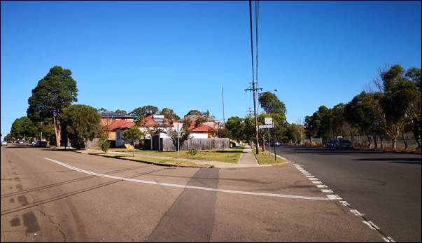
The subject site is located on the
corner of Kingsland Road and Campbell Street. The site is triangular in shape
and enjoys unimpeded access to northern sunlight.
Surrounding development consists
of predominantly single and two storey dwelling houses and contemporary two
storey dual occupancy development. A rail corridor is located on the other side
of Campbell Street and the entrance to Berala train station is located
approximately 360m to the north and as such is identified as being located in
an ‘accessible area’.
Berala train station is identified
as an archaeological site (Item A53) under Schedule 5 of Auburn Local
Environmental Plan 2010 and is located within the Berala Town Centre. The town
centre is located within walking distance from the site and possesses a range
of retail and commercial uses including a Woolworths supermarket and a
hotel/pub (Berala Hotel).
Figure
1 – Locality Plan of subject site
Figure
2 – Aerial view of subject site
Figure
3 – View of the subject site looking southwest from the corner of
Kingsland Road and Campbell Street
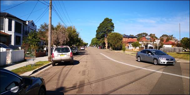
Figure
4 – View of the Kingsland Road frontage
Description of the Proposed
Development
Council has received a development
application for ‘Demolition of existing dwelling house and construction
of a 2 storey boarding house development comprising 12 boarding rooms and on
site car parking for 6 vehicles.
Demolition
An older style single storey
dwelling of modest proportions, two small onsite trees and a single detached
garage is proposed to be removed from the site.
Construction
The boarding house proposes three
(3) double rooms and nine (9) single rooms to accommodate a maximum of fifteen (15)
lodgers. The ground floor contains a common room which provides direct access
to private open space situated within the front setback of the building to
Kingsland Road.
An open at grade parking area
accessed from Campbell Street is situated adjacent to the building and
accommodates parking for six (6) vehicles (including two (2) disabled spaces).
Designated parking areas are also provided for motorcycles and bicycles. A
standalone waste storage facility is situated adjacent to the Campbell Street
boundary and is obscured in part by landscaping.
New trees and landscaping is
proposed throughout the setback areas, the perimeter of the parking area and
the northern tip of the site.
History
PL-56/2018 - Demolition of
existing structures and construction of a two storey boarding house comprising
13 boarding rooms.
Applicants Supporting
Statement
The applicant has provided a
Statement of Environmental Effects prepared by Think Planners dated 15 March
2019 and was received by Council on 27 March 2019 in support of the
application.
Contact with Relevant
Parties
The assessing officer has
undertaken a site inspection of the subject site and surrounding properties and
has been in regular contact with the applicant throughout the assessment
process.
Internal Referrals
Development Engineer
The development application was
referred to Council’s Development Engineer for comment who has advised
that the development proposal is satisfactory and therefore can be supported
subject to conditions of consent. It is recommended that a deferred
commencement condition be imposed to require amended plans to be submitted to
Council in order to address On-Site Detention (OSD) and flood affectation of
the site.
Building Surveyor
The development application was
referred to Council’s Building Surveyor for comment who has advised that
the development is satisfactory and therefore can be supported.
Environment and Health
The development application was
referred to Council’s Environment and Health Officer for comment who has
advised that the development proposal is satisfactory and therefore can be
supported subject to recommended conditions of consent.
Waste Management
The development application was
referred to Council’s Waste Management Officer for comment who has
advised that the development proposal is satisfactory and therefore can be
supported.
External Referrals
NSW Police
The development application was
referred to NSW Police for comment who has advised that the development
proposal is satisfactory subject to a number of recommendations which are
included in the attached Draft Conditions.
Planning Comments
The provisions of any
Environmental Planning Instruments (EP&A Act s4.15 (1)(a)(i))
State Environmental Planning
Policies
The proposed development is
affected by the following State Environmental Planning Policies:
(a) State
Environmental Planning Policy No. 55 – Remediation of Land (SEPP 55)
Clause 7 of SEPP 55 requires
Council to be satisfied that the site is suitable or can be made suitable to
accommodate the proposed development. The matters listed within Clause 7 have
been considered in the assessment of the development application.
|
Matter for Consideration
|
Yes/No
|
|
Does the application involve re-development of the site or
a change of land use?
|
Yes
No
|
|
Does
the application involve re-development of the site or a change of land use?
|
Yes
No
|
|
In the development going to be used for a sensitive land
use (e.g.: residential, educational, recreational, childcare or hospital)?
|
Yes
No
|
|
Does information available to you indicate that an
activity listed below has ever been approved, or occurred at the site?
acid/alkali plant and
formulation, agricultural/horticultural activities, airports, asbestos
production and disposal, chemicals manufacture and formulation, defence
works, drum re-conditioning works, dry cleaning establishments, electrical
manufacturing (transformers), electroplating and heat treatment premises,
engine works, explosive industry, gas works, iron and steel works, landfill
sites, metal treatment, mining and extractive industries, oil production and
storage, paint formulation and manufacture, pesticide manufacture and
formulation, power stations, railway yards, scrap yards, service stations,
sheep and cattle dips, smelting and refining, tanning and associated trades,
waste storage and treatment, wood preservation
|
Yes
No
|
|
Is the site listed on
Council’s Contaminated Land database?
|
Yes
No
|
|
Is the site subject to EPA
clean-up order or other EPA restrictions?
|
Yes
No
|
|
Has the site been the subject of
known pollution incidents or illegal dumping?
|
Yes
No
|
|
Does the site adjoin any
contaminated land/previously contaminated land?
|
Yes
No
|
|
Has the appropriate level of
investigation been carried out in respect of contamination matters for
Council to be satisfied that the site is suitable to accommodate the proposed
development or can be made suitable to accommodate the proposed development?
|
Yes
No
|
|
Details of contamination investigations carried out at the
site:
The
site is not identified in Council’s records as being contaminated. A
site inspection reveals the site does not have any obvious history of a
previous land use that may have caused contamination and there is no specific
evidence that indicates the site is contaminated. The subject site is
currently used for residential purposes and contamination is not expected.
Council’s Senior Environmental Health Officer has recommended the
imposition of a number of non-standard conditions of consent including the
preparation of a Hazardous Materials Survey and compliance with its
recommendations.
|
(b) State
Environmental Planning Policy (Infrastructure) 2007 (ISEPP)
The provisions of the ISEPP 2007
have been considered in the assessment of the development application.
Clause 87 – Impact of
rail noise or vibration on non-rail development
The application is subject to
clause 87 of the ISEPP as the site is located approximately 19m away from a
rail corridor and is therefore likely to be adversely affected by rail noise or
vibration.
As the development is for the
purpose of residential accommodation, an Acoustic Report (prepared by
Envirotech Environmental and Engineering Consultancy Services and dated 8 May
2019) was submitted. The report was reviewed by Council’s Senior
Environmental Health Officer who considers the development to be satisfactory
subject to the recommendations contained in the Acoustic Report.
(c) State
Environmental Planning Policy (Vegetation in Non-Rural Areas) 2017
The proposal does not exceed the
biodiversity offsets scheme threshold. Therefore, the proposed vegetation
removal is considered acceptable. Please refer to the DCP compliance table for
further discussion.
(d) State
Environmental Planning Policy (Coastal Management) 2018
The subject site is not identified
as a coastal wetland or land identified as “proximity area for coastal
wetlands” or land identified as such by the Coastal Vulnerability Area
Map.
(e) State
Environmental Planning Policy (Building Sustainability Index: BASIX) 2004
BASIX Certificate 1014336M issued
on 22 May 2019 prepared by Taylor Smith Consulting has been submitted with
Council and is considered to be satisfactory.
(f) State
Environmental Planning Policy (Affordable Rental Housing) 2009
Clause 30A Character of the
local area
Division 3 of the SEPP contains
provisions and development standards that apply to development for the purpose
of a boarding house. The development as proposed is considered to be
inconsistent with the relevant provisions and development standards of the
instrument at clause ‘30A Character of the local area’. This clause
specifies that ‘a consent authority must take into consideration whether
the design of the development is compatible with the character of the local
area’.
In order to determine the
compatibility of the proposal, an assessment of the character of the area and
application of the ‘character test’ for development derived from
the planning principle 11209 of 2005 Project Venture Development’s Pty
Ltd v Pittwater Council has been undertaken.
Part A – Identify the
local area
The extent of land use surrounding
the subject site is shown in Figure 6.
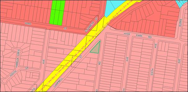
Figure
6 – Land use zone map
Part B – Determine the
character of the local area
The subject site is situated on a
corner and has two street frontages (Campbell Street to the west and Kingsland
Road to the east).
Campbell Street is characterised
by low density housing ranging from single and two storey detached dwellings
and dual occupancy developments, the footprints of which are staggered along
the eastern side of the street. A rail corridor is located along the western
side of the street. Development on Kingsland Road consists of a mix of old and new
detached dwelling houses both sides of the road. In comparison to Campbell
Street the pattern of development is uniform with regard to street setbacks and
appearance due to the rectangular shape of the lots.
The site is located in close
proximity to the interface with R3 Medium Density Residential zoned land to the
north (as shown in Figure 6). It is envisaged that this area will undergo
transition through the establishment of multi-dwelling housing.
Part C – Determine if the
development is compatible with the character of the local area
In order to determine the
compatibility of the development with the established character of a local
area, the ‘character test’ derived from the Planning Principle,
11209 of 2005 Project Venture Development’s Pty Ltd v Pittwater Council
can be applied. The character test determines the compatibility of a
development by asking whether the physical impacts of the proposal on
surrounding development is acceptable and secondly, whether or not the
appearance of the development is in harmony with the buildings around it and
the character of the area. These questions are discussed in detail below.
· Are
the physical impacts of the proposal on surrounding development acceptable?
The physical impacts of the
proposal are assessed with regard to the impact of the development on the
amenity of surrounding properties. Amenity in this instance is defined as solar
access and privacy. With regard to solar access, it is acknowledged that the
development will shadow the property to the south. However the scale of the
impact is considered reasonable based on the orientation of the block (the
impacted property possesses a northern side boundary). Furthermore, the
submitted sun shadow diagrams indicate that the dwellings on the neighbouring property
will receive sufficient sunlight at varying times throughout the day.
In terms of privacy, it is noted
that the finished floor level of the ground floor is raised significantly above
existing ground level and will pose direct views into the private open spaces
of the neighbouring property to the south. This impact can be addressed by
imposing a condition of consent to require privacy measures to be incorporated
in the development. These privacy measures include the installation of 1.5m
high obscure glazing to all windows on the south elevation of the development.
The physical impact of the
proposal on surrounding development is therefore considered reasonable subject
to the imposition of the recommended condition of consent.
· Is
the appearance of the proposal in harmony with surrounding development and the
character of the area?
The development proposes to locate
private open space defined by 1.8m high boundary fencing within the front
setback area to Kingsland Road. The siting of this space is considered to be
visually inconsistent with the streetscape of Kingsland Road which is
characterised by a relatively uniform pattern of development.
In order the improve the visual
harmony of the development within the streetscape of Kingsland Road to a
satisfactory level, it is recommended that a number of design changes to the
perimeter fencing and landscaping be undertaken as part of the deferred
commencement conditions. In this regard, the perimeter fencing surrounding the
private open space shall be reduced in height from 1.8m to 1.5m and shall be a
semi-transparent palisade design. In addition, in order to maintain privacy for
residents of the development, landscaping (as recommended by Council’s
Tree Officer) that is 1.8m high at the time of planting shall be provided along
the perimeter of the private open space.
Subject to the abovementioned
design changes, the development is considered to be in harmony with the
surrounding development and the character of the area.
Regional Environmental Plans
The proposed development is
affected by the following Regional Environmental Plans:
(a) Sydney
Regional Environmental Plan (Sydney Harbour Catchment) 2005
The subject site is identified as
being located within the area affected by the Sydney Regional Environmental Plan
(Sydney Harbour Catchment) 2005. The proposed development raises no issues as
no impact on the catchment is envisaged.
Local Environmental Plans
The provision of the Auburn Local
Environmental Plan 2010 is applicable to the development proposal. It is noted
that the development achieves compliance with the key statutory requirements of
the ALEP 2010 and the objectives of the R2 Low Density Residential zone.
(a) Permissibility:-
The proposed development is
defined as a “boarding house” and is permissible in the R2 Low
Density Residential zone with consent.
”boarding
house” means a building that:
(a) is
wholly or partly let in lodgings, and
(b) provides
lodgers with a principal place of residence for 3 months or more, and
(c) may
have shared facilities, such as a communal living room, bathroom, kitchen or
laundry, and
(d) has
rooms, some or all of which may have private kitchen and bathroom facilities,
that accommodate one or more lodgers,
but does not include
backpackers’ accommodation, a group home, hotel or motel accommodation,
seniors housing or a serviced apartment.
The relevant matters to be
considered under ALEP 2010 and the applicable clauses for the proposed
development are summarised below. A comprehensive LEP assessment is contained
in Appendix B.
Figure
7 – Auburn LEP 2010 Compliance Table
|
Clause/Development Standard
|
Comment
|
Compliance
|
|
4.3 Height of Buildings
Maximum permitted building height is 9m
|
The subject site is limited to a maximum building height
of 9m as per ALEP 2010.
The development is compliant with a maximum building
height of 7.7m.
|
Yes
|
The provisions of any proposed
instrument that is or has been the subject (EP&A Act s4.15 (1)(a)(ii))
The proposed development is not
affected by any relevant Draft Environmental Planning Instruments.
The provisions of any
Development Control Plans (EP&A Act s4.15 (1)(a)(iii))
The Auburn DCP 2010 provides
guidance for the design and operation of development to achieve the aims and
objectives of the Auburn LEP 2010.
A comprehensive assessment and
compliance table is contained in Attachment 7.
The following table highlights
non-compliances with the DCP, which relate to setback of upper levels of a
development which face a southern side boundary. The variations sought are
considered satisfactory on merit in this instance:
Figure
8 – Auburn DCP 2010 Compliance Table
|
Clause
|
Control
|
Proposed
|
Complies
|
|
6.2 Solar amenity
|
D3 The upper level of new two storey dwellings shall be
setback 3m from the southern boundary where the development has overshadowing
impacts on the north-facing roof of the adjoining property.
|
A 900mm setback to the southern side boundary is proposed
to the upper level of the development.
|
No but acceptable on merit as:-
- the development is generally
compliant with the objectives and requirements specified under clause
‘6.2 Solar amenity’ of Council’s Detached Dwellings and
Dual Occupancy DCP; and
- the neighbouring property is
located on a northern side boundary to the subject site and in this regard,
extending the setback to comply will not decrease the impact of overshadowing
to significant degree.
|
As indicated in the compliance
table above, the proposed development departs from the control at D3 of clause
6.2 which relates to the solar amenity provisions of Council’s Detached
Dwellings and Dual Occupancy Development Control Plan.
Irrespective of this departure, it
is considered that the proposal performs adequately from an environmental
planning viewpoint and may be supported for the reasons discussed in the table.
The provisions of any planning
agreement that has been entered into under section 7.4, or any draft planning
agreement that a developer has offered to enter into under section 7.4
(EP&A Act s4.15(1)(a)(iiia))
There is no draft planning
agreement associated with the subject Development Application.
The provisions of the
Regulations (EP&A Act s4.15 (1)(a)(iv))
The proposed development raises no
concerns as to the relevant matters arising from the Environmental Planning and
Assessment Regulations 2000 (EP&A Reg).
The Likely Environmental,
Social or Economic Impacts (EP&A Act s4.15 (1)(b))
It is considered that the proposed
development will have no significant adverse environmental, social or economic
impacts in the locality.
The suitability of the site for
the development (EP&A Act s4.15 (1)(c))
The subject site and locality is
not known to be affected by any natural hazards or other site constraints
likely to have a significant adverse impact on the proposed development.
Accordingly, it is considered that the development is suitable in the context
of the site and surrounding locality.
Submissions made in accordance
with the Act or Regulation (EP&A Act s4.15 (1)(d))
|
Advertised (newspaper)
|
Mail
|
Sign
|
Not Required
|
In accordance with Council’s
Notification requirements contained within the Auburn DCP 2010, the proposal
was publicly notified for a period of 14 days between 16 April 2019 and 30
April 2019. In response, three (3) petitions specifying a total of 16, 43 and
66 signatures respectively and two (2) individual submissions were received
objecting to the development.
A discussion of the matters raised
in the petitions and individual submissions are discussed in the below table.
|
Issue
|
Planners Comment
|
|
The development fails to meet the R2 zone objectives
|
The development proposes a ‘boarding house’
which is a permissible form of development in the R2 Low Density Residential
zone as prescribed in Auburn Local Environmental Plan 2010. The development
is considered to be consistent with the objectives of the land use zone as it
provides for additional housing in the area.
|
|
The development will exacerbate the lack of on-street
parking and increase traffic in the area which will compromise safety.
|
The development provides onsite parking which complies
with the parking requirement under clause 29 of State Environmental Planning
Policy (Affordable Rental Housing) 2009. Council’s Senior
Development Engineer has assessed the traffic and parking implications of the
development and has raised no issue. On this basis, the impact of the
development on traffic and the availability of on-street parking is not
considered to be unreasonable in this instance.
|
|
The development is incompatible with the design of homes
in the street.
|
The bulk and scale and siting of the development is
generally compliant with Council’s development controls, with the
exception of the private open space private which is situated within the
front setback to Kingsland Road.
In order to improve the visual
compatibility of the development within the Kingsland Road streetscape, the
private open space is recommended to be relocated to the setback area facing
Campbell Street. Preference is given to this relocation given the
comparatively irregular building pattern that exists within Campbell Street.
|
|
There is no onsite supervisor or manager.
|
Clause 30 of State Environmental Planning Policy
(Affordable Rental Housing) 2009 specifies that the provision of
accommodation for an onsite manager is not required unless the capacity of a
boarding house exceeds 20 lodgers. As the development provides for a maximum
capacity of 15 lodgers, this requirement does not apply.
|
|
There is inadequate public transport available to the site
as the train service terminates at Lidcombe.
|
The entrance to Berala train station is located in close
walking distance to the subject site (approximately 360m) and provides access
to four lines operating within the Sydney metropolitan area and beyond. The
development site is considered to be adequately serviced by public
transport.
|
|
There are no floor plans identifying that 12 units can be
accommodated on the site.
|
The internal layout of residential proposals cannot be
placed on public exhibition in accordance with ‘Schedule 1- Section
3’ of the Government Information (Public Access) Regulation 2009.
|
|
Based on the floor plans it is not possible to determine if
there is an alternative fire escape from the first floor.
|
Council’s Building Surveyor has assessed the
development and has raised no issue with regard to fire egress.
|
|
1.8m high fencing is proposed by the development which
will obscure vision for drivers and increase the risk of vehicle accidents.
|
The proposed boundary fencing does not extend to the
corner of the site and the proposed driveway accessed from Campbell Street is
offset a significant distance from this corner. For these reasons, the fencing
would not significantly obscure sightlines of motorists driving through the
area.
|
|
Both buildings to the left of the proposed development
will be significantly overshadowed by the development.
|
It is acknowledged that shadow will be cast over the neighbouring
property to the south by the development. However, the extent of the
shadowing is not considered to be unreasonable particular given the
orientation of the block. It is further noted that the building envelope of
the development is generally compliant with the standards relating to the
massing and siting of the development prescribed by Council’s LEP and
DCP.
|
|
There are
inconsistencies in the exhibited documentation of the development. The Plan
of Management specifies a capacity of 90 lodgers and parking for 20 vehicles.
|
A revised Plan of
Management has been submitted by the applicant which has addressed this
inconsistency.
|
|
Will the tenants have
disabilities, mental health issues or addictions?
|
The anticipated tenants
of the boarding house typically include singles, retirees, students and young
couples who cannot afford the cost of renting standard residential
properties.
|
The public interest (EP&A
Act s4.15(1)(e))
In view of the foregoing analysis
it is considered that the development, if carried out subject to the conditions
set out in the recommendation below, will have no significant adverse impacts
on the public interest.
Section 7.11 (Formerly S94)
Contribution Towards Provision or Improvement of Amenities or Services
This part of the Act relates to
the collection of monetary contributions from applicants for use in developing
key local infrastructure.
Comments:
The development requires the
payment of contributions in accordance with Council’s Section 94
Contributions Plans.
The calculation is based on:
· 12 boarding rooms.
As at 1 July 2019, the fee payable
is $38,976.82. This figure is subject to indexation as per the relevant plan.
The draft determination attached includes a condition requiring payment of the
contribution prior to issue of a Construction Certificate.
Disclosure of Political
Donations and Gifts
The applicant and notification
process did not result in any disclosure of Political Donations and Gifts.
The development application has
been assessed in accordance with the relevant requirements of the Environmental
Planning and Assessment Act 1979, relevant SEPPS and the Auburn LEP and DCP
and is considered to be satisfactory for approval subject to conditions.
The proposed development is
appropriately located within the R2 Low Density Residential zone under the
relevant provisions of the Auburn LEP. The proposal is consistent with all
statutory and non-statutory controls applying to the development. The
development is considered to perform adequately in terms of its relationship to
its surrounding built and natural environment, particularly having regard to
impacts on adjoining properties.
For these reasons, it is
considered that the proposal is satisfactory having regard to the matters of
consideration under Section 4.15 of the Environmental Planning and
Assessment Act 1979, and the development may be approved subject to
conditions.
There are no further consultation
processes for Council associated with this report.
There are no further financial
implications for Council associated with this report.
There are no policy implications
for Council associated with this report.
Communication /
Publications:
The final outcome of this matter
will be notified in the newspaper. The objectors will also be notified in
writing of the outcome.
|
1. That
Development Application No. DA-103/2019 for Demolition of existing dwelling
house and construction of a 2 storey boarding house development comprising 12
boarding rooms and on site car parking for 6 vehicles on land at 2 Kingsland
Road, Berala be granted deferred commencement approval subject to attached
conditions.
2. Persons
whom have lodged a submission in respect to the application be notified of
the determination of the application.
|
1. Draft Notice
of Determination ⇩ 
2. Architectural
Plans ⇩ 
3. Landscape
Plans ⇩ 
4. Stormwater/Engineering
Plans ⇩ 
5. Plan
of Management ⇩
6. State
Environmental Planning Policy Assessment ⇩ 
7. Development
Control Plan Assessment ⇩
8. Submissions
Received ⇩ 
DOCUMENTS
ASSOCIATED WITH
REPORT ELPP050/19
Attachment 1
Draft Notice of Determination
Extraordinary Cumberland Local Planning
Panel Meeting
24 July 2019
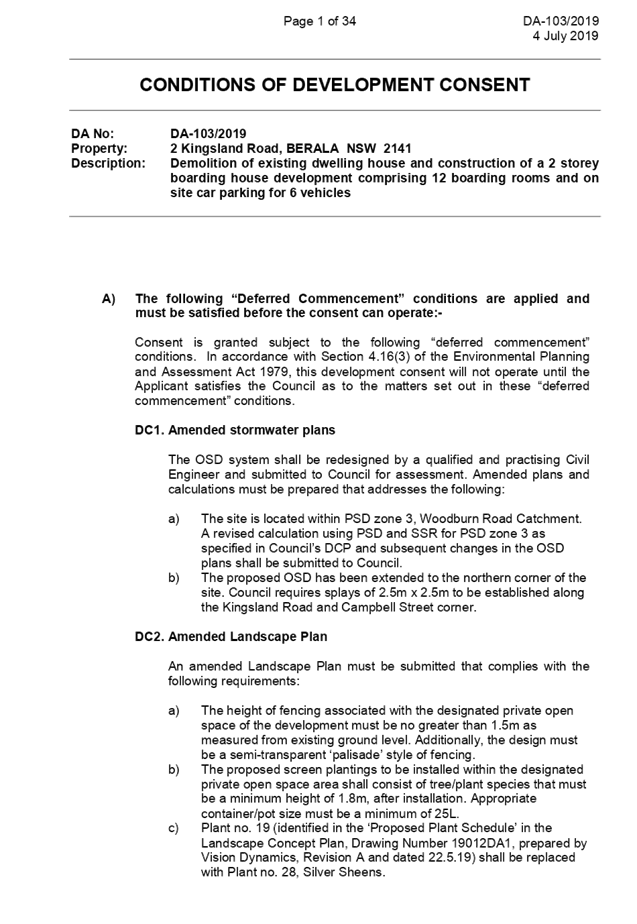
DOCUMENTS
ASSOCIATED WITH
REPORT ELPP050/19
Attachment 2
Architectural Plans
Extraordinary Cumberland Local Planning
Panel Meeting
24 July 2019
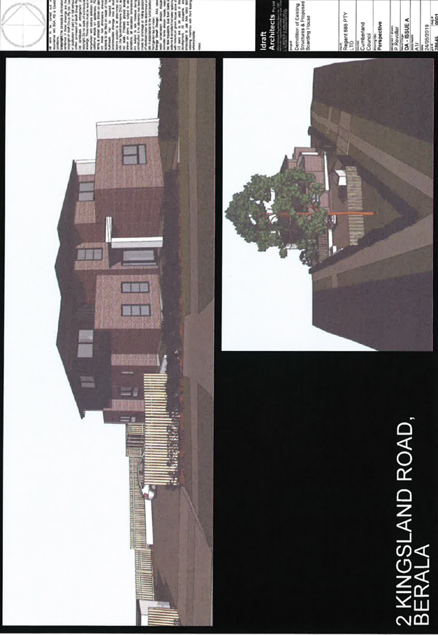
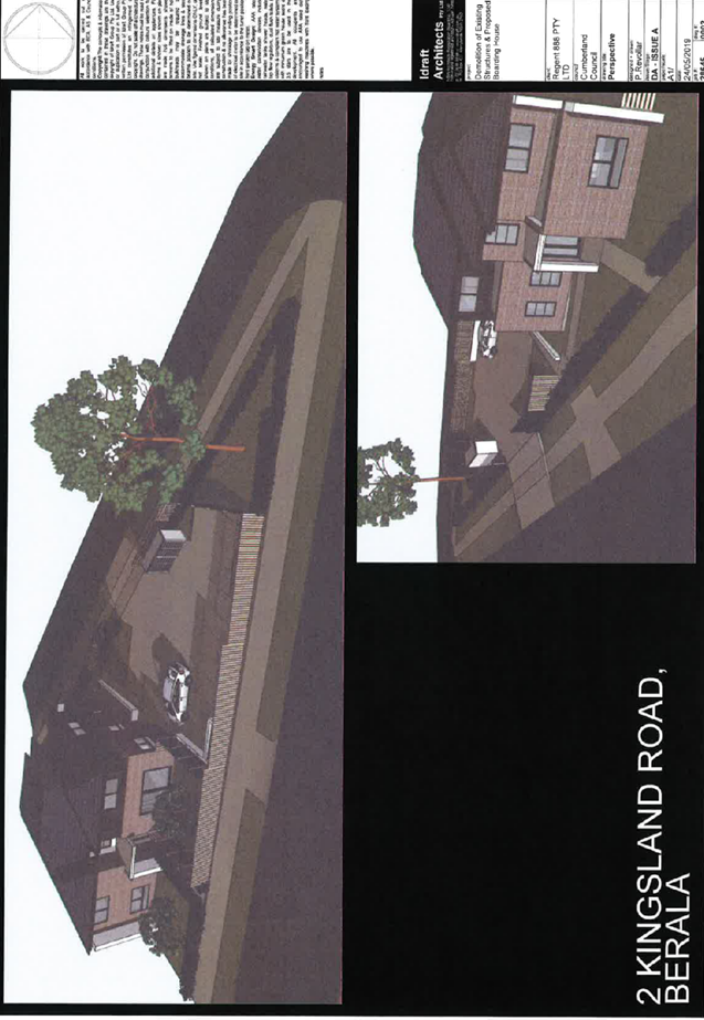
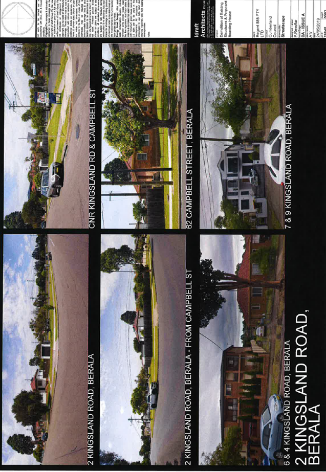
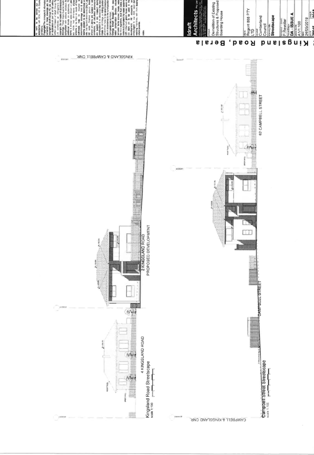
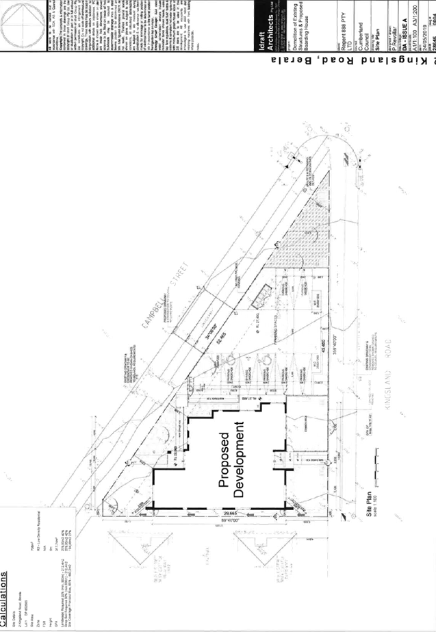
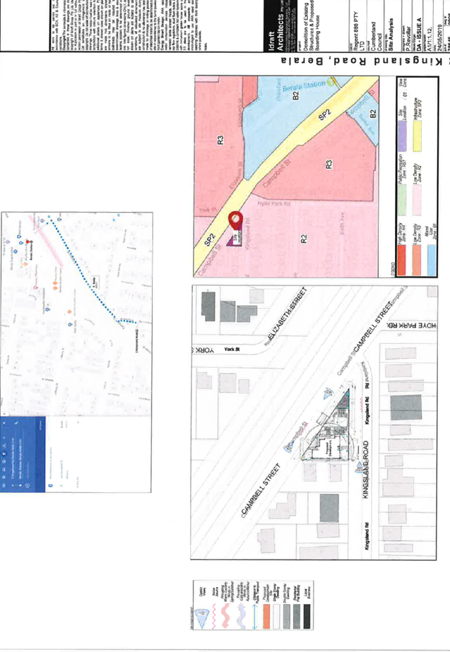
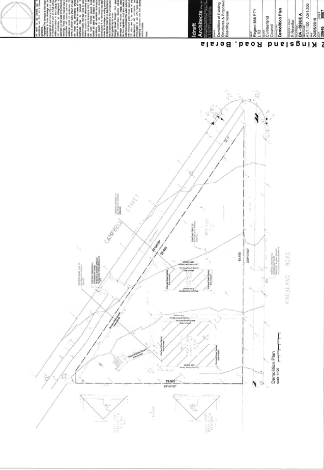
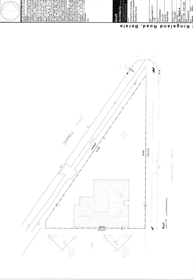
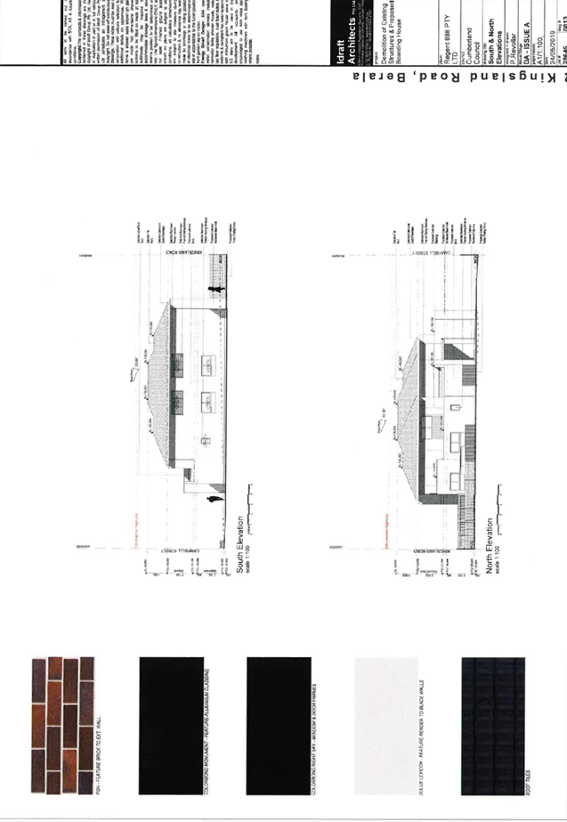
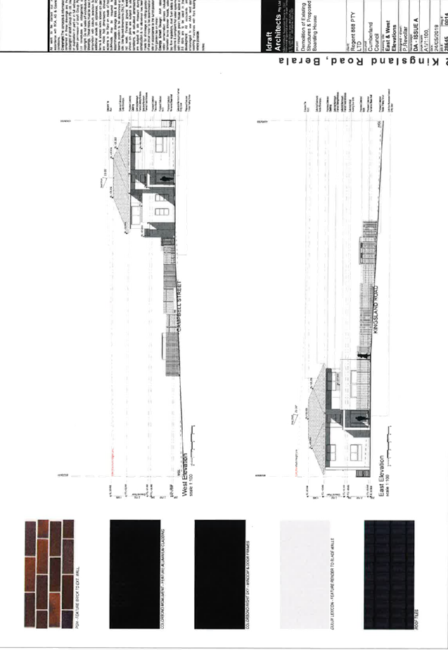
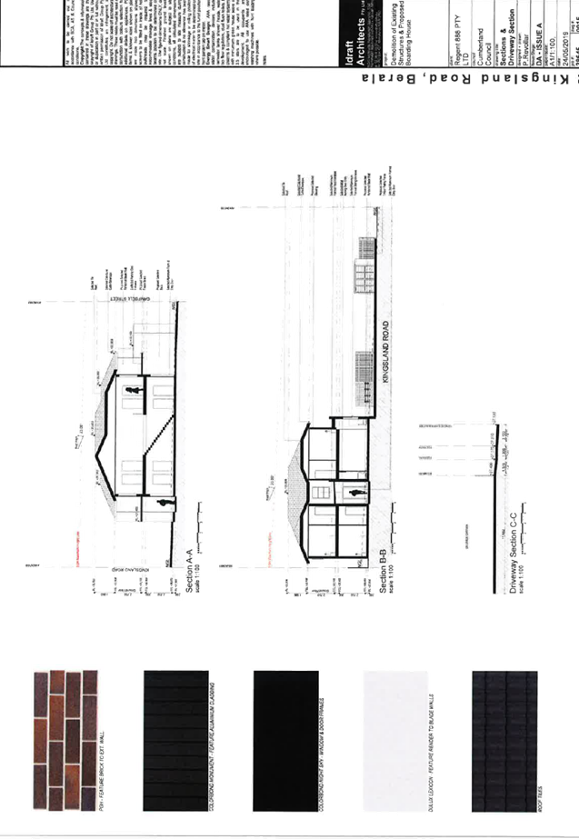
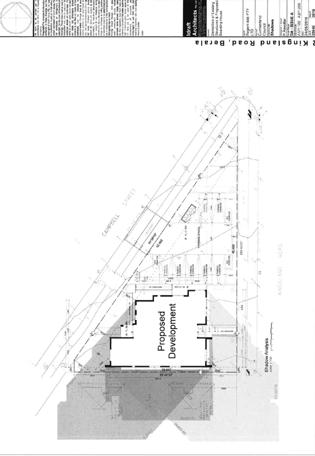
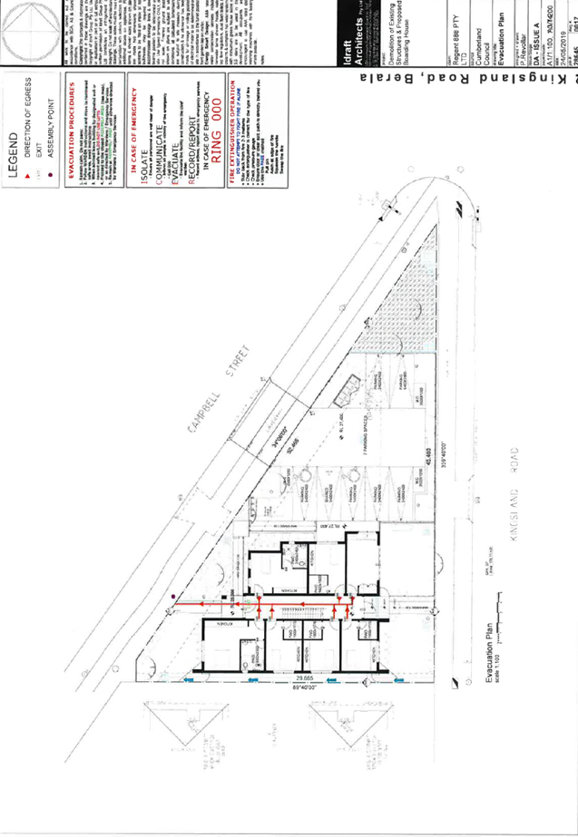
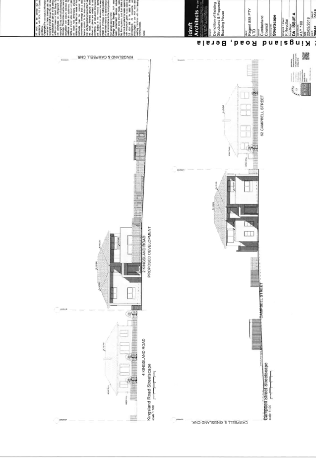
DOCUMENTS
ASSOCIATED WITH
REPORT ELPP050/19
Attachment 3
Landscape Plans
Extraordinary Cumberland Local Planning
Panel Meeting
24 July 2019
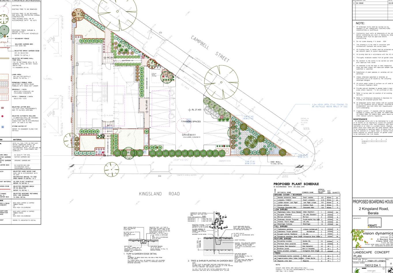
DOCUMENTS
ASSOCIATED WITH
REPORT ELPP050/19
Attachment 4
Stormwater/Engineering Plans
Extraordinary Cumberland Local Planning
Panel Meeting
24 July 2019
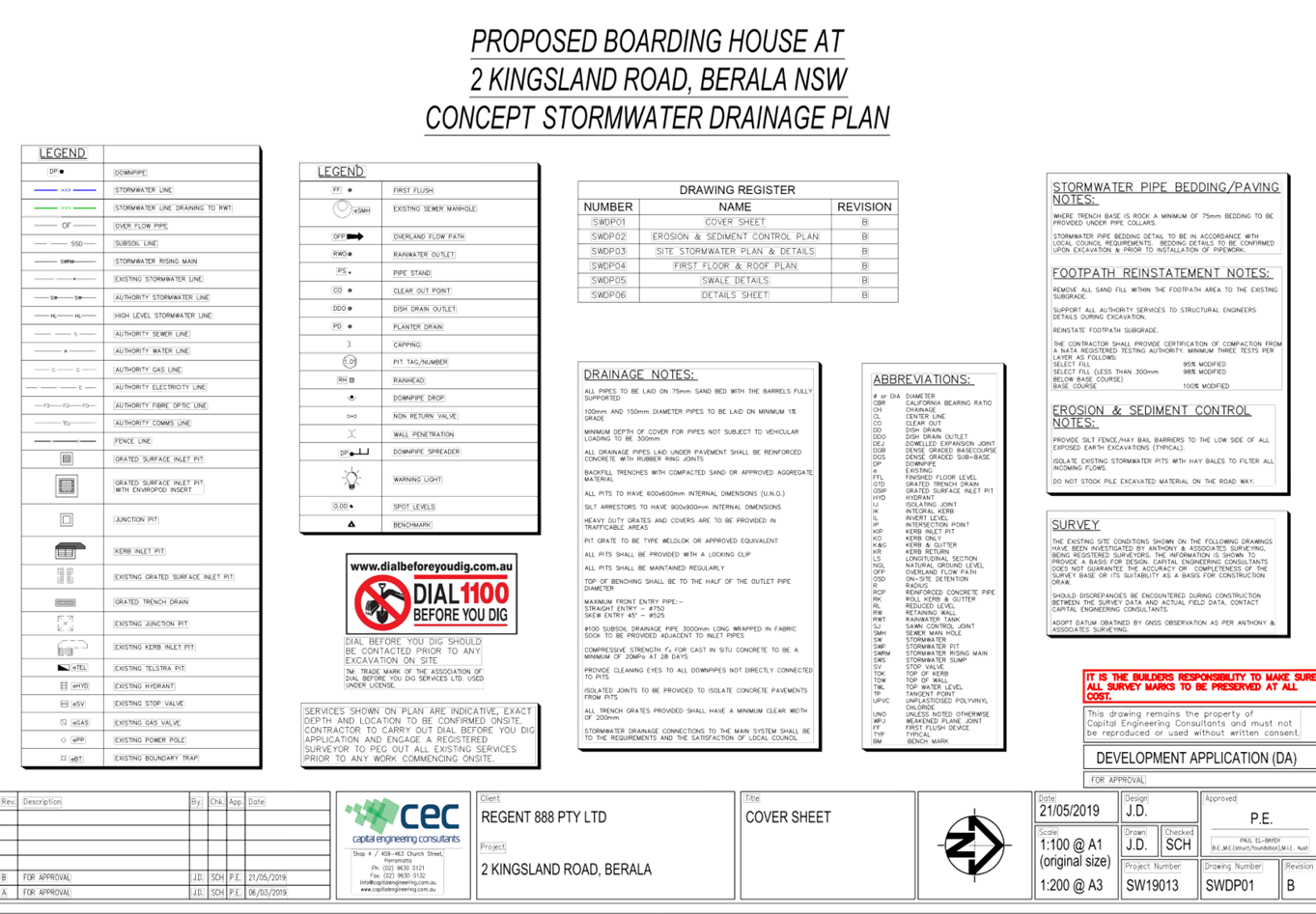
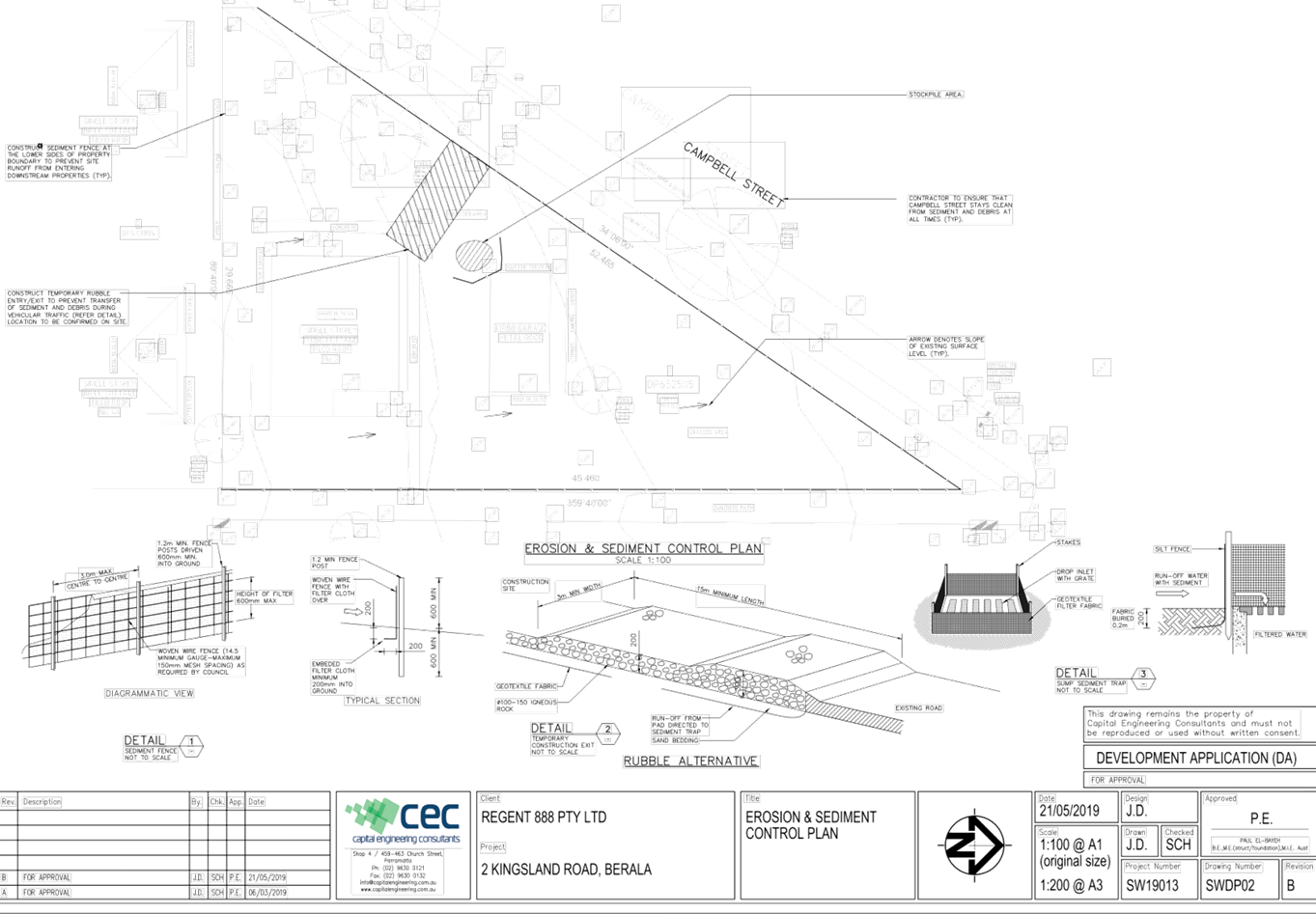
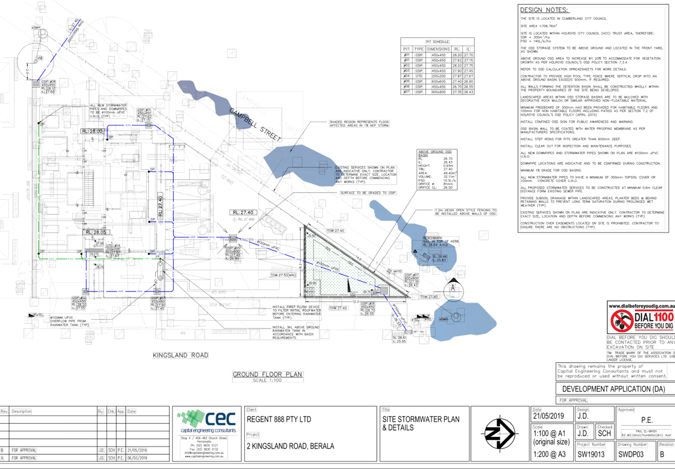
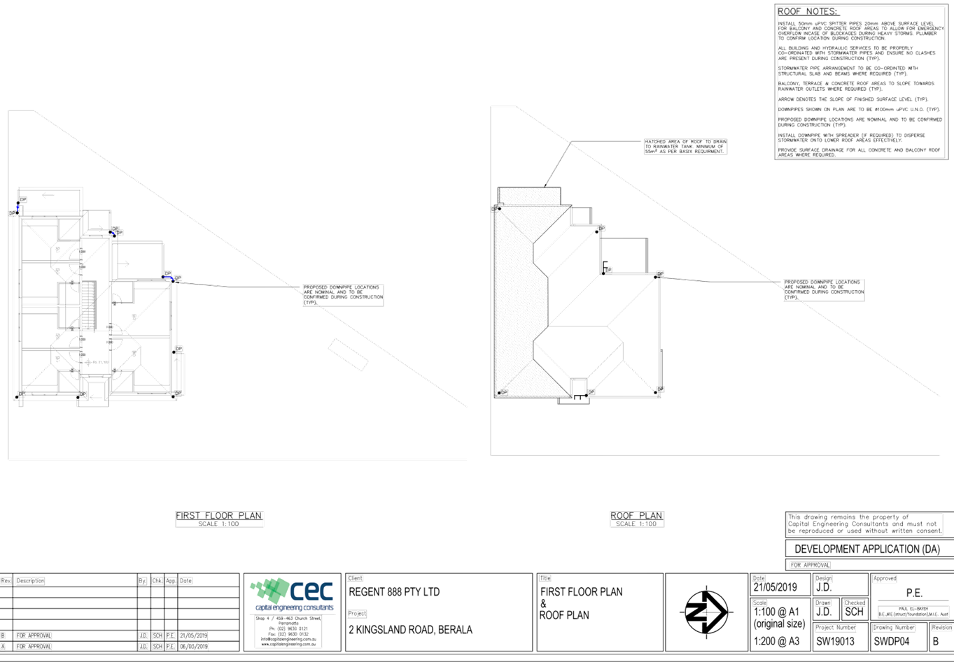
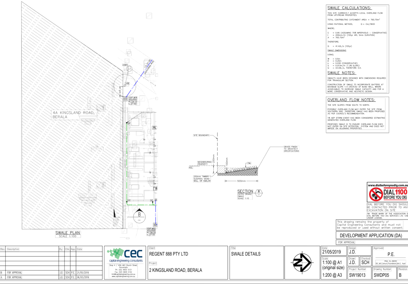
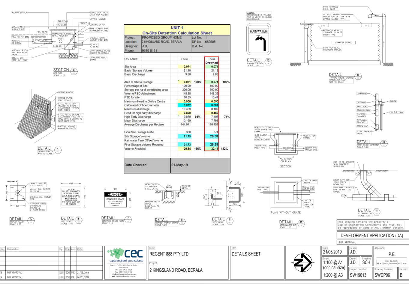
DOCUMENTS
ASSOCIATED WITH
REPORT ELPP050/19
Attachment 5
Plan of Management
Extraordinary Cumberland Local Planning
Panel Meeting
24 July 2019

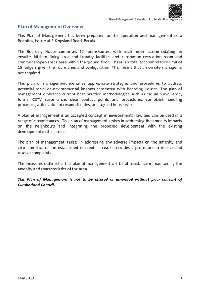


DOCUMENTS
ASSOCIATED WITH
REPORT ELPP050/19
Attachment 6
State Environmental Planning Policy Assessment
Extraordinary Cumberland Local Planning
Panel Meeting
24 July 2019
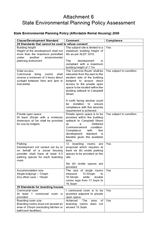
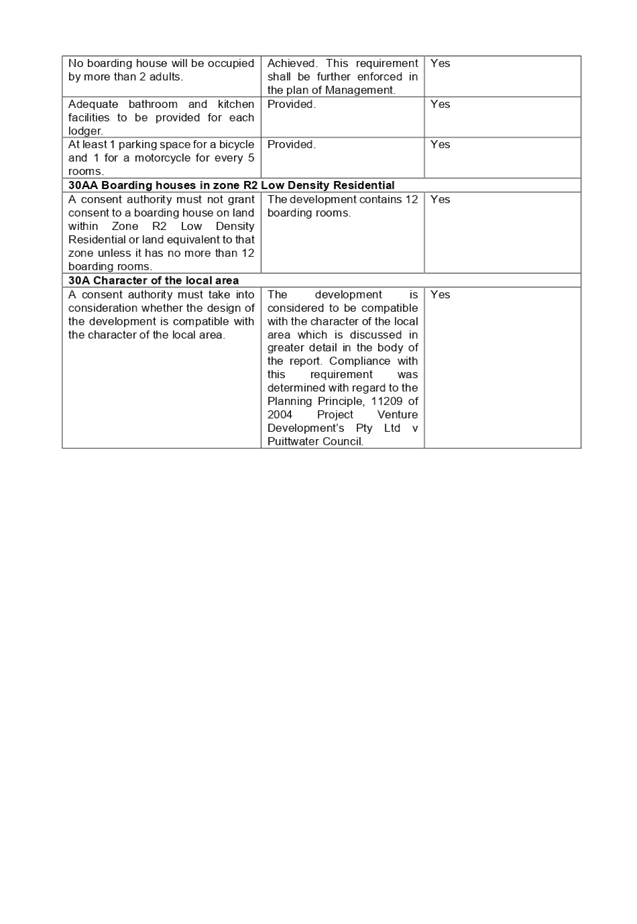
DOCUMENTS
ASSOCIATED WITH
REPORT ELPP050/19
Attachment 7
Development Control Plan Assessment
Extraordinary Cumberland Local Planning
Panel Meeting
24 July 2019
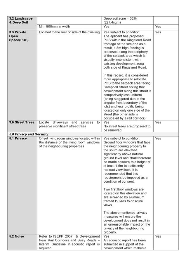
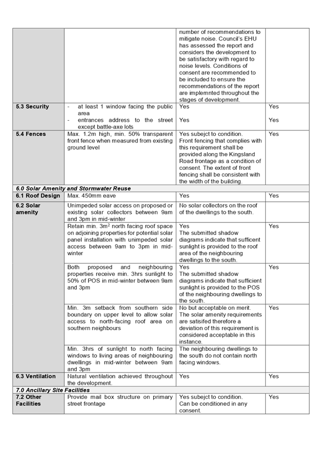
DOCUMENTS
ASSOCIATED WITH
REPORT ELPP050/19
Attachment 8
Submissions Received
Extraordinary Cumberland Local Planning
Panel Meeting
24 July 2019
Extraordinary Cumberland Local Planning
Panel Meeting
24 July 2019
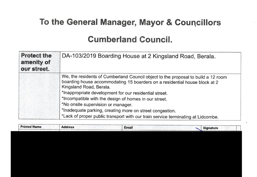
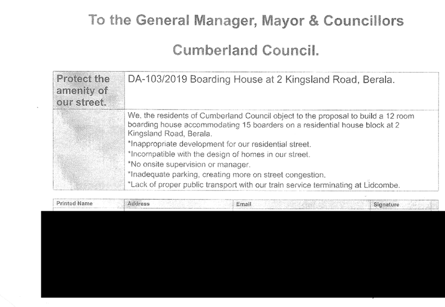
Extraordinary Cumberland Local Planning
Panel Meeting
24 July 2019
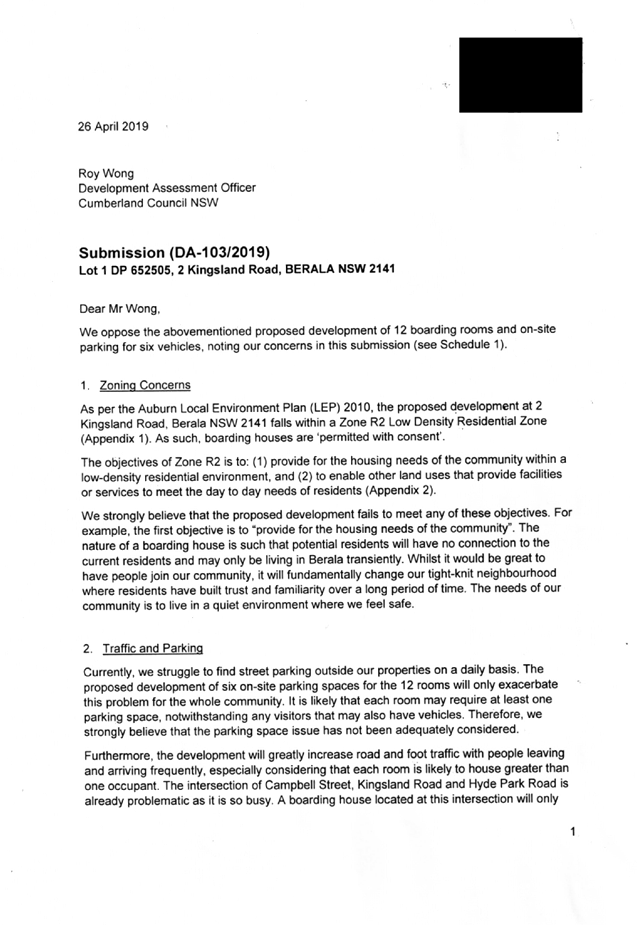


Extraordinary Cumberland Local Planning
Panel Meeting
24 July 2019
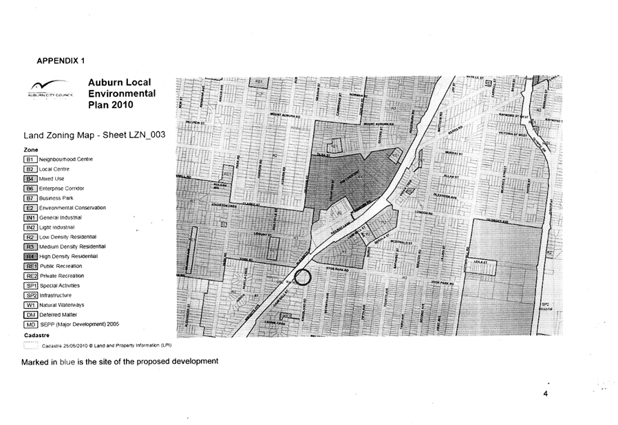
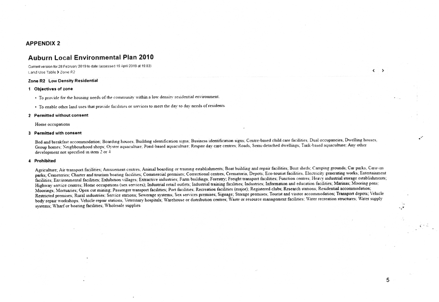
Extraordinary Cumberland Local Planning
Panel Meeting
24 July 2019
Item No: ELPP051/19
Development
Application for 9-19 Mary Street, Auburn
Responsible
Division: Environment
& Planning
Officer: Executive
Manager Development and Building
File
Number: DA-92/2019
|
Application
lodged
|
25
March 2019
|
|
Applicant
|
Rolz
Group Pty Ltd
|
|
Owner
|
Group
As Pty Ltd
|
|
Application
No.
|
DA-92/2019
|
|
Description
of Land
|
9-19
Mary Street, AUBURN NSW 2144, Lot 26 Sec 4 DP 982836, Lot 25 Sec 4 DP 982836,
Lot 1319 DP 1241830
|
|
Proposed
Development
|
Alterations
and additions to approved 12 storey mixed use building (DA-52/2017) at 13-19
Mary Street, Auburn including the construction of an additional 12 storey
mixed use building component at 9-11 Mary Street, Auburn which will
accommodate a total of 157 residential units (41 x 1 bedroom, 90 x 2 bedroom
and 26 x 3 bedroom units), 5 x commercial suites, 1 x office suite over part
4 part 5 level basement for 285 vehicles
|
|
Site
Area
|
2,727.86m2
|
|
Zoning
|
B4
– Mixed Use under the Auburn LEP 2010
|
|
Disclosure
of political donations and gifts
|
Nil
disclosure
|
|
Heritage
|
Yes
– Land is located in the vicinity of a heritage item.
|
|
Principal
Development Standards
|
FSR
Permissible:
5:1
Proposed:
4.97:1
Height
of Building
Permissible:
38m
Proposed:
41m
|
|
Issues
|
Building
setbacks to the northern boundary (ADG)
Building
height (LEP)
Matters
raised in submissions
|
1. Development
Application No. 92/2019 was received on 25 March 2019 for the construction of
an additional 12 storey mixed use building component at 9-11 Mary Street,
Auburn. The DA also proposes a number of alterations and additions to a
12 storey mixed use building which was approved by DA-52/2017 at 13-19 Mary
Street, Auburn. The works at 9-11 Mary Street will result in an expansion
of the approved development at 13-19 Mary Street.
2. In
total, the proposed development will provide 157 residential units (41 x 1
bedroom, 90 x 2 bedroom and 26 x 3 bedroom units), 5 x commercial suites and 1
x office suite over a part 4 and part 5 level basement for 288 vehicles.
3. The
application was publicly notified to occupants and owners of the adjoining
properties for a period of 14 days between 16 April 2019 and 30 April 2019. In
response, 3 submissions were received.
4. The
subject site is situated across the road from a dwelling at 8 Mary Street which
is a heritage item in the Auburn Local Environmental Plan 2010 as Heritage Item
I10.
5. The
proposed development involves a number of variations to relevant planning
controls as follows:
|
Control
|
Required
|
Provided
|
% variation
|
|
Deep soil areas (ADG)
|
190.95m2
|
Nil
|
100%
|
|
Visual Privacy (ADG)
|
6m to 4th
floor
9m to 5th
floor
12m to 9th
floor and above
|
Nil
Nil
9m
|
100%
100%
25%
|
|
Solar access (ADG)
|
No more than 15% of
apartments to receive no solar access
|
17.8%
|
2.8%
|
|
Building height (LEP)
|
38m
|
41m
|
8%
|
6. The
application is recommended for Approval subject to the conditions as provided
in the attached schedule.
7. The
application is referred to the Panel as State Environmental Planning Policy
No.65 - Design Quality of Residential Apartment Development applies to the
development. The building is more than 4 storeys in height.
Subject Site and Surrounding
Area
The subject site is known as Lot
1319, DP 1241830 and Lots 25 and 26, DP 982836, No. 9-19 Mary Street
Auburn. The subject site is located on the northwest corner of Mary
Street and Harrow Road.
The location of the site is shown
at Figure 1. An aerial image of the site and surrounding area is at
Figure 2.
The site is situated within a
mixed use zone within the Auburn town centre and is approximately 400m walking
distance to Auburn railway station.
The site has a frontage to Mary
Street of 74.63m to the south and a frontage to Harrow Road of 36.56m to the
east. The site is generally rectangular in shape and has a total area of
2,727.86m2.
Part of the site comprising 11-19
Mary Street has been cleared under DA-52/2017. No.9 Mary Street contains
an existing single storey brick dwelling and a detached brick garage.
The site is adjoined by a single
dwelling and a townhouse building to the north. Land to the west is
developed with single storey cottages. A place of worship and commercial
buildings exist across Harrow Road to the east. Land across Mary Street
to the south is comprised of professional consulting rooms.
Figure 1 – Locality Plan
of subject site
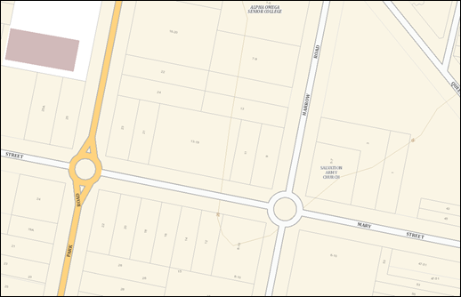
Figure 2 – Aerial view of
subject site
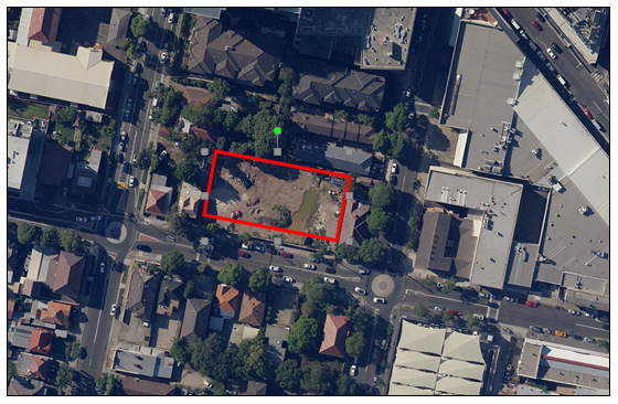
Figure 3 – Street view of
subject site showing No.9 Mary Street in foreground
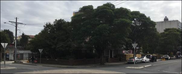
Description of the Proposed
Development
Council has received a development
application for the construction of an additional 12 storey mixed use building
component at 9-11 Mary Street, Auburn. The DA also proposes a number of
alterations and additions to a 12 storey mixed use building which was approved
by DA-52/2017 at 13-19 Mary Street, Auburn. The works at 9-11 Mary Street
will result in an expansion of the approved development at 13-19 Mary Street.
In total, the proposed development
will provide 157 residential apartments as follows:
|
|
1 bedroom
|
2 bedroom
|
3 bedroom
|
TOTAL
|
|
13 - 19
Mary Street
|
41
|
42
|
22
|
105
|
|
9 - 11
Mary Street
|
-
|
48
|
4
|
52
|
|
TOTAL
|
41
|
90
|
26
|
157
|
A total of 16 accessible
apartments are provided.
The proposed extension carries
through the 5 storey podium and proposes an additional tower on the corner of
Mary Street and Harrow Road. The proposed extension carries through the
colours, materials and form of the approved component.
The total residential GFA across
all sites is 12,756.72m2.
The proposed development will
provide 5 commercial tenancies with a combined GFA of 716.1m2 at
ground level fronting Mary Street and Harrow Road and 1 office suite of 80.5m2
fronting Mary Street at ground level.
The total GFA of the development
is 13,553.32m2 which results in an FSR of 4.97:1.
A basement car park is provided
over 5 levels and the ground floor which will provide for 274 residential car
parking spaces, 14 commercial car parking spaces, bicycle parking, residential
storage, waste rooms and loading facilities.
Approval for the internal fit-out
and use of the commercial tenancies and associated signage will be sought under
separate applications.
The demolition of existing
structures situated on 9 and 11 Mary Street was approved as complying
development under separate applications and as such demolition does not form
part of this DA.
History
DA-52/2017 was lodged with Council
on 10 February 2017 for the demolition of existing dwelling houses and the construction
of a 12 storey mixed use development comprising 105 residential units and 2
commercial tenancies over 4 levels of basement parking at 13-19 Mary Street,
Auburn.
DA-52/2017 was granted deferred
commencement consent on 21 December 2017.
The deferred commencement matters
were completed and the consent became operative on 13 April 2018.
Demolition and excavation
commenced after that.
The subject DA-92/2019 was lodged
on 25 March 2019.
An initial assessment identified a
number of matters that required amended plans and additional information,
particularly:
· Building
separation and visual privacy under the ADG;
· Design
changes to emphasise the corner of the building;
· Provision
of a car wash bay;
· Management
of residential waste; and
· Stormwater
and flooding matters.
Those matters were communicated to
the Applicant on 29 April 2019.
The Applicant met with Council and
its consulting town planner on 8 May 2019 to discuss the above matters.
Amended plans were received on 16
May 2019.
Further amendments were requested
on 11 June 2019 with regard to residential waste management.
Final amended plans were received
on 12 June 2019 which satisfactorily addressed those outstanding matters.
Applicants Supporting
Statement
The applicant has provided a
Statement of Environmental Effects prepared by The Planning Hub dated 25 March
2019 and was received by Council on 25 March 2019 in support of the
application.
Contact with Relevant
Parties
The consulting planner carrying
out the assessment has undertaken a site inspection of the subject site and
surrounding properties. Council’s officer with carriage of the DA
has been in regular contact with the applicant throughout the assessment
process.
Internal Referrals
Development Engineer
The development application was referred
to Council’s Development Engineer for comment who has advised that the
development proposal is satisfactory and can be supported subject to
recommended conditions of consent.
Environment and Health
The development application was
referred to Council’s Environment and Health Officer for comment who has
advised that the development proposal is satisfactory and can be supported,
subject to recommended conditions of consent.
In particular, conditions of
consent are to be imposed regarding acoustic certification, mechanical
ventilation of commercial tenancies and the basement car park, demolition and
pollution control.
Waste Management
The development application was
referred to Council’s Waste Management Officer for comment who has
advised that the development proposal is satisfactory. A concern was
raised that the approved component of the development and the component proposed
by the subject DA had different waste management systems. The most recent
plans ensure consistency throughout the entire development. The waste
management system involves a “walk down” system as opposed to waste
rooms on each floor which has implications for amenity and ongoing
cleaning. Waste chutes on larger buildings are not preferred due to
maintenance needs as well as the need to educate residents as to the proper use
of the chutes to ensure blockages do not occur. The development can be
supported, subject to recommended conditions of consent.
External Referrals
Ausgrid
The development application was
referred to Ausgrid for comment who has advised that the proposal is
satisfactory, subject to conditions being imposed about the proximity of works
to overhead powerlines and underground cables.
NSW Police
The development application was
referred to the Flemington Local Area Command who have advised that the
proposed development is satisfactory, subject to conditions of consent to
ensure adequate security, safety and reduced opportunities for criminal
activity.
Planning Comments
The provisions of any
Environmental Planning Instruments (EP&A Act s4.15 (1)(a)(i))
State Environmental Planning
Policies
The proposed development is
affected by the following State Environmental Planning Policies:
(a) State
Environmental Planning Policy No. 55 – Remediation of Land (SEPP 55)
Clause 7 of SEPP 55 requires
Council to be satisfied that the site is suitable or can be made suitable to
accommodate the proposed development. The matters listed within Clause 7 have
been considered in the assessment of the development application.
|
Matter for Consideration
|
Yes/No
|
|
Does the application involve re-development of the site or
a change of land use?
|
Yes
No
|
|
Does
the application involve re-development of the site or a change of land use?
|
Yes
No
|
|
In the development going to be used for a sensitive land
use (e.g.: residential, educational, recreational, childcare or hospital)?
|
Yes
No
|
|
Does information available to you indicate that an
activity listed below has ever been approved, or occurred at the site?
acid/alkali plant and
formulation, agricultural/horticultural activities, airports, asbestos
production and disposal, chemicals manufacture and formulation, defence
works, drum re-conditioning works, dry cleaning establishments, electrical
manufacturing (transformers), electroplating and heat treatment premises,
engine works, explosive industry, gas works, iron and steel works, landfill
sites, metal treatment, mining and extractive industries, oil production and storage,
paint formulation and manufacture, pesticide manufacture and formulation,
power stations, railway yards, scrap yards, service stations, sheep and
cattle dips, smelting and refining, tanning and associated trades, waste
storage and treatment, wood preservation
|
Yes
No
|
|
Is the site listed on
Council’s Contaminated Land database?
|
Yes
No
|
|
Is the site subject to EPA
clean-up order or other EPA restrictions?
|
Yes
No
|
|
Has the site been the subject of
known pollution incidents or illegal dumping?
|
Yes
No
|
|
Does the site adjoin any
contaminated land/previously contaminated land?
|
Yes
No
|
|
Has the appropriate level of
investigation been carried out in respect of contamination matters for
Council to be satisfied that the site is suitable to accommodate the proposed
development or can be made suitable to accommodate the proposed development?
|
Yes
No
|
|
Details of contamination
investigations carried out at the site:
The
land at 13-19 Mary Street was the subject to a Preliminary Site Investigation
during the assessment of DA-52/2017 and was found to be suitable for the
proposed use.
A
Preliminary Site Investigation report prepared by EIAustralia was submitted
with the application to consider land at Nos. 9-11 Mary Street. The report
did not reveal any potential matters of concern with regard to contamination
and concludes that the site is suitable for its intended use.
Council’s
Environmental Health Officer has reviewed the reports and determined that the
site is suitable to support such a development, given that the report
provides that the site is suitable for the proposed use.
Conditions
are to be imposed regarding unexpected finds during excavation.
|
(b) Statement
Environmental Planning Policy No. 65 - Design Quality of Residential Apartment
Development (SEPP 65)
SEPP 65 applies to the development
as the building is 3 storeys or more, and contains more than 4 dwellings. A
design statement addressing the design quality principles prescribed by SEPP 65
was prepared by the project architect. Integral to SEPP 65 is the Apartment
Design Guide (ADG), which sets benchmarks for the appearance, acceptable
impacts and residential amenity of the development.
Following a detailed assessment of
the proposal against the provisions of SEPP 65 and the ADG, it is considered
the proposal is generally compliant with the exception of the provision of deep
soil areas, building separation and solar access. These variations are
discussed below:
· 3E-1
– Deep Soil
The ADG requires 7% of a site area
be provided as deep soil. The proposed development does not propose any
deep soil areas due to the provision of the basement carpark.
The approved component of the
development did not propose deep soil areas. This was supported on the
basis that deep soil zones are difficult to provide in mixed use developments
town centre situations. The proposed development provides generous common
open space areas at ground and rooftop levels which incorporate tree planting
for amenity.
· 3F-1
– Visual Privacy
The ADG requires minimum required
separation distances from buildings to the side and rear boundaries are as
follows:
|
Building height
|
Habitable rooms & balconies
|
Non habitable rooms
|
|
Up to 12m
(4 storeys)
|
6m
|
3m
|
|
Up to 25m
(5-8 storeys)
|
9m
|
4.5m
|
|
Over 25m
(9 + storeys)
|
12m
|
6m
|
The proposal provides setbacks to
the northern boundary as follows:
|
Floor
|
Required
|
Provided
|
Complies?
|
|
Ground
|
Nil
|
Nil
|
Yes
|
|
1
|
6m
|
Nil
|
No
|
|
2
|
6m
|
Nil
|
No
|
|
3
|
6m
|
Nil
|
No
|
|
4
|
9m
|
Nil
|
No
|
|
5
|
9m
|
9m
|
Yes
|
|
6
|
9m
|
9m
|
Yes
|
|
7
|
9m
|
9m
|
Yes
|
|
8
|
12m
|
9m
|
No
|
|
9
|
12m
|
9m
|
No
|
|
10
|
12m
|
9m
|
No
|
|
11
|
12m
|
9m
|
No
|
The nil setback up to the 5th
floor is considered appropriate in the town centre location, where it can be
expected that future development to the north would similarly develop to that
boundary up to a height of five floors.
Above the 5th floor, a 9m setback
is provided. The Design Guidance provided in the ADG notes that generally
one step in the built form as the height increases due to building separations
is desirable. The separation proposed avoids additional steps so as not
to cause a 'ziggurat' appearance.
The reduced setback does not result
in overshadowing of adjoining properties.
Privacy has been maintained by
fronting living rooms towards Harrow Road and providing bedrooms on the western
elevation. Those bedrooms are provided with fixed louvers to maintain
privacy between those rooms and the adjoining land.
· 4A-1
– Solar Access
The ADG provides that no more than
15% of apartments should receive no solar access. The proposed
development provides 28 apartments that receive no solar access which equates
to 17.8%.
It should be noted that those
apartments that receive nil solar access are all located in the building that
has already been approved. All apartments within the component proposed
by the subject DA receive compliant solar access. In other words, the
subject proposal does not increase the number of apartments that receive no
solar access and reduces the proportion of apartments that receive no solar
access.
A comprehensive assessment against
SEPP 65 and the ADG is contained in Appendix A.
(c) State
Environmental Planning Policy (Infrastructure) 2007 (ISEPP)
The provisions of the ISEPP 2007
have been considered in the assessment of the development application.
Clause 45 - Development likely
to affect an electricity transmission or distribution network
The subject development occurs
within 5 metres of an overhead electricity power line. As such, the consent
authority is required to give written notice to an electricity supply
authority.
The DA was referred to Ausgrid who
have responded with conditions of consent.
(d) State
Environmental Planning Policy (Vegetation in Non-Rural Areas) 2017
The proposal does not exceed the
biodiversity offsets scheme threshold. Therefore, the proposed vegetation
removal is considered acceptable. Please refer to the DCP compliance table for
further discussion.
(e) State
Environmental Planning Policy (Building Sustainability Index: BASIX) 2004
BASIX Certificate 1003324M dated
issued on 22 March 2019 prepared by Building Sustainability Assessments has
been submitted with Council and is considered to be satisfactory.
Regional Environmental Plans
The proposed development is
affected by the following Regional Environmental Plans:
(a) Sydney
Regional Environmental Plan (Sydney Harbour Catchment) 2005
The subject site is identified as
being located within the area affected by the Sydney Regional Environmental
Plan (Sydney Harbour Catchment) 2005. The proposed development raises no issues
as no impact on the catchment is envisaged.
(Note: - the subject site is not
identified in the relevant map as ‘land within the ‘Foreshores and
Waterways Area’ or ‘Wetland Protection zone’, is not a
‘Strategic Foreshore Site’ and does not contain any heritage items.
Hence the majority of the SREP is not directly relevant to the proposed
development).
Local Environmental Plans
Auburn LEP 2010
The provision of the Auburn LEP
2010 is applicable to the development proposal. It is noted that the
development achieves compliance with the key statutory requirements of the
Auburn LEP 2010 and the objectives of the B4 Mixed Use zone.
(a) Permissibility:-
The proposed development is
defined as “shop top housing” and is permissible in the B4 Mixed
Use zone with consent.
“Shop
top housing” is defined by the Auburn LEP 2010 as:
one or more dwellings located
above ground floor retail premises or business premises
All proposed apartments are above
ground floor retail or business premises and, as such, the development meets
that definition. In any event, residential flat buildings are also
permitted with consent on land zoned B4 Mixed Use by the Auburn LEP 2010.
The relevant matters to be
considered under Auburn LEP 2010 and the applicable clauses for the proposed
development are summarised below. A comprehensive LEP assessment is contained
in Appendix B.
Figure 4 – Auburn 2010
Compliance Table
|
DEVELOPMENT STANDARD
|
COMPLIANCE
|
DISCUSSION
|
|
4.3 Height of Buildings
Maximum 38m
|
No
|
The proposed development
provides a maximum height of 41m. A Clause 4.6 variation has been
provided and is discussed in this report.
|
|
4.4 Floor Space Ratio
Maximum 5:1
|
Yes
|
The FSR is compliant at 4.97:1
|
(b) Clause
4.6 – Variation to Building Height
Clause 4.6 allows the consent
authority to vary development standards in certain circumstances and provides
an appropriate degree of flexibility to achieve better design outcomes. The
consent authority may grant the exception as the Secretary’s concurrence
can be assumed where clause 4.6 is adopted as per the Department of Planning
Circular PS 18-003, dated 21 February 2018.
The applicant has submitted a
written request to vary the development standards for building height under
Clause 4.3. Based on various case laws established by the Land and
Environment Court of NSW such as Four2five P/L v Ashfield Council [2015] NSWLEC
9, Randwick City Council v Micaul Holdings P/L [2016] NSW LEC7 and Zhang and
anor v Council of the City of Ryde [2016] NSWLEC 1179, a 3 part assessment
framework for a variation request proposed under clause 4.6 has been considered
and an assessment of the proposed variance, following the 3 part test is
discussed in detail below.
The 3 preconditions which must be
satisfied before the application can proceed are as follows:
1. Is
the proposed development consistent with the objectives of the zone?
|
Objective
|
Applicant’s justification
|
Planner’s comment
|
|
To provide a mixture of compatible land uses
|
The proposed development provides a compatible land use
that is consistent with the future character of the Auburn Town Centre.
|
Agreed.
The proposal is compatible with the emerging character of
the Auburn town centre.
|
|
To integrate suitable business, office, residential,
retail and other development in accessible locations so as to maximise public
transport patronage and encourage walking and cycling
|
The proposed development provides high density mixed-use
development in an accessible location that maximises public transport
patronage and encourages non-vehicular transport.
|
Agreed.
The proposed development is located within an accessible
location and in proximity to the range of services available in the Auburn
town centre.
|
|
To encourage high density residential development
|
The proposal consists of a high-density residential
development that is consistent with the future character of the area, whilst
providing for the housing needs of the wider community
|
This is a higher order objective of the zone itself.
The proposed development is not antipathetic to that
objective.
|
|
To encourage appropriate businesses that contribute to
economic growth
|
The proposed development will generate demand and
opportunities for businesses to service the area and contribute to the
economic growth of the area. The commercial tenancies within the development
will provide additional floor space for businesses in the growing Auburn Town
Centre.
|
Agreed.
|
|
To achieve an accessible, attractive and safe public
domain
|
The proposed development contributes to creating an
accessible, attractive and safe public domain. The development will provide
opportunities for passive surveillance and create a vibrant street.
|
Agreed. The development will help to activate the
south western part of the Auburn town centre.
|
2. Is
the proposed development consistent with the objectives of the development
standard which is not met?
|
Objective
|
Applicant’s justification
|
Planner’s comment
|
|
To establish a maximum height of buildings to enable appropriate
development density to be achieved
|
The proposal consists of a high-density mixed-use
development that meets the desired future character of the area. The height
exceedance is due to the built form response to the flood planning level on
the site and the provision of a high amenity communal open space that allows
the development to provide a high-density development whilst providing
appropriate amenity to residents. The area of exceedance does not contain any
habitable residential space and the area of exceedance will not be visually
prominent.
|
Agreed.
The breach of the height control is not the result of the
exceedance of the FSR and as such the density is appropriate.
|
|
To ensure that the height of buildings is compatible
with the character of the locality
|
The height of the proposed development is consistent with
the changing character and desired future character of the Auburn Town
Centre. The proposed development is consistent with the built form approved
under DA-52/2017 and will provide an integrated and consistent
streetscape.
|
Agreed.
The proposal is consistent with the built form approved
under DA-52/2017.
|
3. a)
Is compliance with the development standard unreasonable or unnecessary in
the circumstances of the case?
|
Applicant’s justification
|
Planner’s comment
|
|
The proposal maintains the future higher density-built
form that is at a scale comparative to neighbouring buildings of the
site’s location within the Auburn Town Centre. The numeric increase in
building height for the proposed development is approximately 3m, which is a
result of designing the development to respond to the site’s food
planning level and providing communal open space on the roof to increase the
amenity of the development for residents. This increase is considered
reasonable in the context of the site and its ability to result in no adverse
impacts on adjoining neighbours.
|
The Clause 4.6 variation has met the first of the
“Wehbe methods” to demonstrate that compliance with a development
standard is unreasonable or unnecessary in the circumstances of the case by
demonstrating that the objective of the controls are met notwithstanding the
breach.
|
b) Are there sufficient
environmental planning grounds to justify contravening the development standard
and therefore is the applicant’s written justification well founded?
|
Applicant’s justification
|
Planner’s comment
|
|
The proposed development is consistent with the objectives
of the zone and the objectives of the building height control.
|
While agreed, this is one of the tests of Clause 4.6
rather than an environmental planning ground.
|
|
The proposal does not result in any adverse impact from
adjoining properties.
|
Agreed. A lack of impact is one environmental
planning ground.
|
|
The height variation equates to a maximum 3m for a minor
portion of the building and is not visually prominent
|
It is agreed that the height variation is not visually
prominent and would not read as different to a compliant development.
|
|
The area of exceedance is for the provision of a lift
overrun and communal open space, not containing any habitable space.
|
It is agreed that a benefit arising from the breach is the
provision of common open space which adds amenity for the residents.
|
The environmental planning grounds
are considered to be sufficient to justify the breach, noting that the minor
nature of the breach.
Conclusion:
Council is satisfied that the
applicant’s written request has adequately addressed the matters required
to be demonstrated by clause 4.6 subclause (3). Council is further
satisfied that the proposed development will be in the public interest because
it is consistent with the objectives of the particular standard and the
objectives for development within the zone in which the development is proposed
to be carried out.
It is the view of Council officers
that justification provided is satisfactory and having considered the
application on its merit, the exception to the maximum building height
development standard is considered acceptable in this instance.
The provisions of any proposed
instrument that is or has been the subject (EP&A Act s4.15 (1)(a)(ii))
(a) Draft
State Environmental Planning Policy (Environment)
The draft SEPP relates to the
protection and management of our natural environment with the aim of
simplifying the planning rules for a number of water catchments, waterways,
urban bushland, and Willandra Lakes World Heritage Property. The changes
proposed include consolidating the following seven existing SEPPs:
· State
Environmental Planning Policy No. 19 – Bushland in Urban Areas
· State
Environmental Planning Policy (Sydney Drinking Water Catchment) 2011
· State
Environmental Planning Policy No. 50 – Canal Estate Development
· Greater
Metropolitan Regional Environmental Plan No. 2 – Georges River Catchment
· Sydney
Regional Environmental Plan No. 20 – Hawkesbury-Nepean River (No.2-1997)
· Sydney
Regional Environmental Plan (Sydney Harbour Catchment) 2005
· Willandra
Lakes Regional Environmental Plan No. 1 – World Heritage Property.
The draft policy will repeal the
above existing SEPPs and certain provisions will be transferred directly to the
new SEPP, amended and transferred, or repealed due to overlaps with other areas
of the NSW planning system.
Changes are also proposed to the
Standard Instrument – Principal Local Environmental Plan. Some provisions
of the existing policies will be transferred to new Section 117 Local Planning
Directions where appropriate.
The provisions of any
Development Control Plans (EP&A Act s4.15 (1)(a)(iii))
The Auburn DCP 2010 provides
guidance for the design and operation of development to achieve the aims and
objectives of the Auburn LEP 2010
A comprehensive assessment and
compliance table is contained in Appendix C.
The proposed development has been
assessed against the Residential Flat Buildings provisions and the Local
Centres provisions of the Auburn DCP.
The proposed development complies
with the provisions of those parts of the Auburn DCP 2010 and is considered
acceptable from an environmental planning viewpoint.
The provisions of any planning
agreement that has been entered into under section 7.4, or any draft planning
agreement that a developer has offered to enter into under section 7.4
(EP&A Act s4.15(1)(a)(iiia))
There is no draft planning
agreement associated with the subject Development Application.
The provisions of the
Regulations (EP&A Act s4.15 (1)(a)(iv))
The proposed development raises no
concerns as to the relevant matters arising from the Environmental Planning and
Assessment Regulations 2000 (EP&A Reg).
The Likely Environmental,
Social or Economic Impacts (EP&A Act s4.15 (1)(b))
It is considered that the proposed
development will have no significant adverse environmental, social or economic
impacts in the locality.
The suitability of the site for
the development (EP&A Act s4.15 (1)(c))
The subject site and locality is
not known to be affected by any natural hazards or other site constraints
likely to have a significant adverse impact on the proposed development.
Accordingly, it is considered that the development is suitable in the context
of the site and surrounding locality.
Submissions made in accordance
with the Act or Regulation (EP&A Act s4.15 (1)(d))
|
Advertised (newspaper)
|
Mail
|
Sign
|
Not Required
|
In accordance with Council’s
Notification requirements contained within the Auburn DCP 2010, the proposal
was publicly notified for a period of 14 days between 16 April 2019 and 30
April 2019. The notification generated three submissions in respect of the
proposal with no disclosing a political donation or gift. The issues raised in
the public submissions are summarised and commented on as follows:
Figure 5 – Submissions
summary table
|
Issue
|
Planner’s comment
|
|
The house at No.9 Mary Street
should be retained. While it is not listed as a heritage item, it has
features that are uncommon in Auburn and is the last Federation style house
on the block. No heritage assessment of No.9 Mary Street has been
carried out.
|
No.9
Mary Street is not listed as an item of environmental heritage in the Auburn
LEP. As a result of not being listed as a heritage item, the Applicant was
not required to carry out a heritage assessment.
It should also be noted that the
subject DA does not seek consent for the demolition of that dwelling, rather,
the demolition of existing structures on No.9 and No.11 Mary Street was
approved as complying development under CDC/D9K003B1 and CDC/D7K019D1.
|
|
The proposal is an overdevelopment of the site.
|
The proposal is permissible within the zone.
Although the proposed development involves a minor breach
of the maximum building height, the development is within the maximum FSR
established for the land and is generally compliant with the relevant
controls of the ADG, LEP and DCP.
|
|
The development will dominate
the streetscape.
|
The proposed development is in
keeping with the emerging character that is anticipated by the zoning, FSR
and height controls for the site.
The additional component is a
logical approach to developing the two remaining lots at 9-11 Mary Street to
ensure that the development that wraps around the corner has some uniformity
with the approved development in Mary Street.
Further, the development is
provided in two towers above a podium which provides modulation to the built
form.
|
|
Cumulative impact of residential
flat development in Auburn.
|
The Auburn town centre is well
located with regard to road and rail networks and is well served with a range
of retail opportunities and commercial services. The development is
permissible and is in keeping with the density controls in place for the town
centre.
|
The matters raised within the
submissions do not warrant refusal of the proposed development.
The public interest (EP&A
Act s4.15(1)(e))
In view of the foregoing analysis
it is considered that the development, if carried out subject to the conditions
set out in the recommendation below, will have no significant adverse impacts
on the public interest.
Section 7.11 (Formerly S94)
Contribution Towards Provision or Improvement of Amenities or Services
This part of the Act relates to
the collection of monetary contributions from applicants for use in developing
key local infrastructure.
Comments:
The development requires the
payment of contributions in accordance with Council’s Section 94
Contributions Plans.
The calculation is based on:
As at 30 June 2019, the fee
payable is $299,855.39. This figure is subject to indexation as per the
relevant plan. The draft determination attached includes a condition requiring
payment of the contribution prior to issue of a Construction Certificate.
Disclosure of Political
Donations and Gifts
The applicant and notification
process did not result in any disclosure of Political Donations and Gifts.
The development application has
been assessed in accordance with the relevant requirements of the Environmental
Planning and Assessment Act 1979, SEPP 65 – Design Quality of Residential
Apartment Development, Auburn LEP 2010 and Auburn DCP 2010 and is considered to
be satisfactory for approval subject to conditions.
The proposed development is
appropriately located within the B4 Mixed Use zone under the relevant
provisions of the Auburn LEP 2010; however, variations in relation to the
separation of buildings to the northern boundary under the ADG and the maximum
height of buildings under the Auburn LEP 2010 are sought.
Having regard to the assessment of
the proposal from a merit perspective, the Panel may be satisfied that the
development has been responsibly designed and provides for acceptable levels of
amenity for future residents. It is considered that the proposal successfully
minimises adverse impacts on the amenity of neighbouring properties. Hence the
development, irrespective of the departures noted above, is consistent with the
intentions of Council’s planning controls and represents a form of
development contemplated by the relevant statutory and non-statutory controls
applying to the land.
For these reasons, it is
considered that the proposal is satisfactory having regard to the matters of
consideration under Section 4.15 of the Environmental Planning and Assessment
Act 1979, and the development may be approved subject to conditions.
There are no further consultation
processes for Council associated with this report.
There are no further financial
implications for Council associated with this report.
There are no policy implications
for Council associated with this report.
Communication /
Publications:
The final outcome of this matter
will be notified in the newspaper. The objectors will also be notified in
writing of the outcome.
|
1. That
Development Application No. DA-92/2019 for Alterations and additions to
approved 12 storey mixed use building (DA-52/2017) at 13-19 Mary Street,
Auburn including the construction of an additional 12 storey mixed use
building component at 9-11 Mary Street, Auburn which will accommodate a total
of 157 residential units (41 x 1 bedroom, 90 x 2 bedroom and 26 x 3 bedroom
units), 5 x commercial suites, 1 x office suite over part 4 part 5 level
basement for 288 vehicles on land at 9-19 Mary Street, AUBURN NSW 2144 be
granted Approval subject to attached conditions.
2. Persons
whom have lodged a submission in respect to the application be notified of
the determination of the application.
|
1. Draft Notice
of Determination ⇩ 
2. Architectural
Plans ⇩ 
3. Stormwater/Engineering
Plans ⇩
4. Submissions
Received ⇩ 
5. Locality
Map ⇩
6. Appendix
A, B, C ⇩ 
DOCUMENTS
ASSOCIATED WITH
REPORT ELPP051/19
Attachment 1
Draft Notice of Determination
Extraordinary Cumberland Local Planning
Panel Meeting
24 July 2019
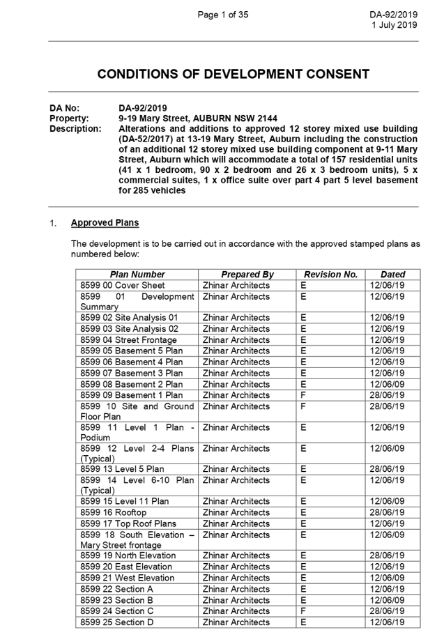
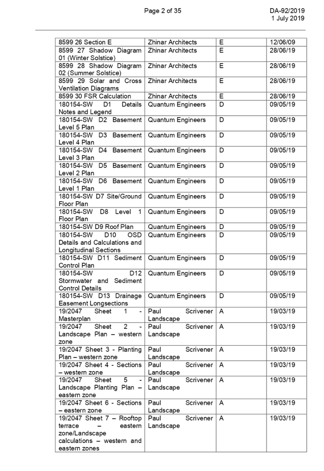
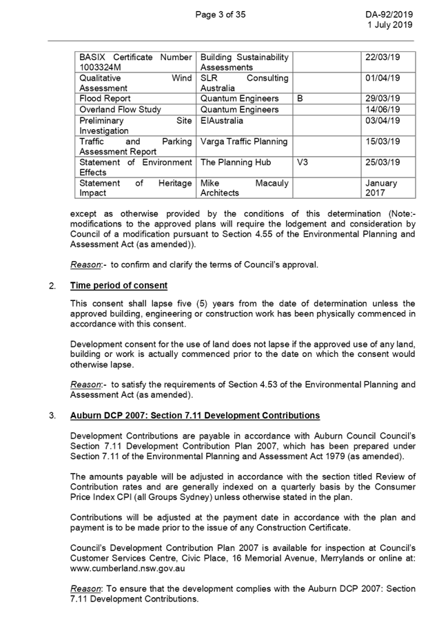
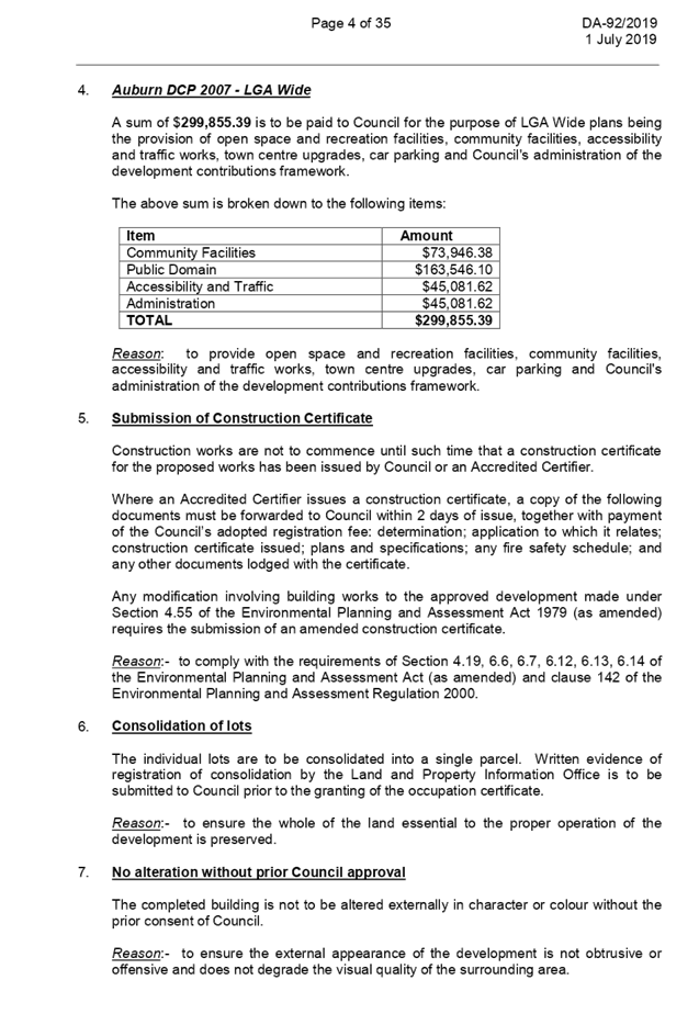
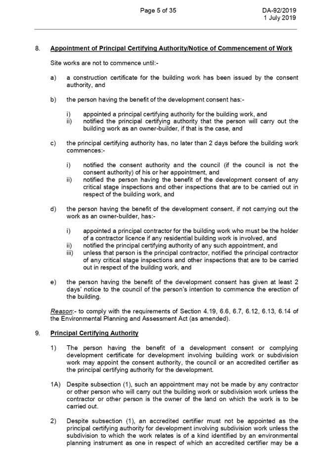
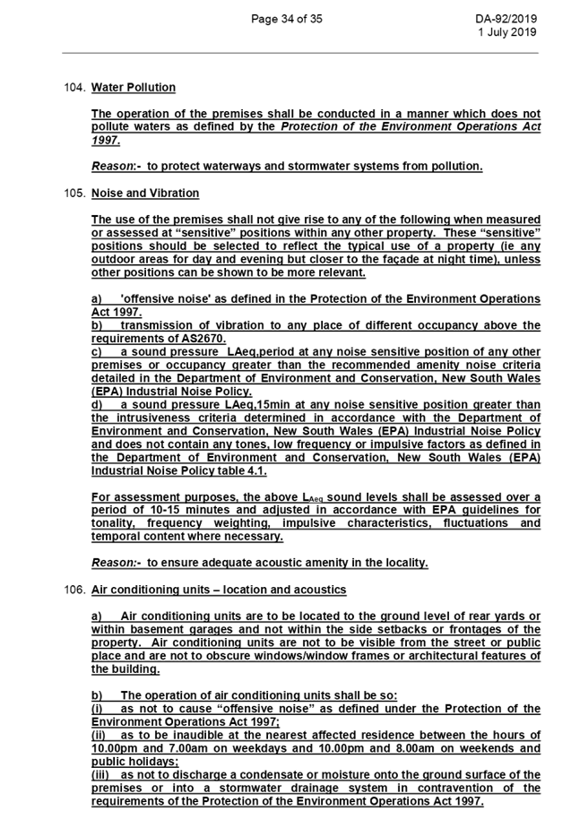

DOCUMENTS
ASSOCIATED WITH
REPORT ELPP051/19
Attachment 2
Architectural Plans
Extraordinary Cumberland Local Planning
Panel Meeting
24 July 2019
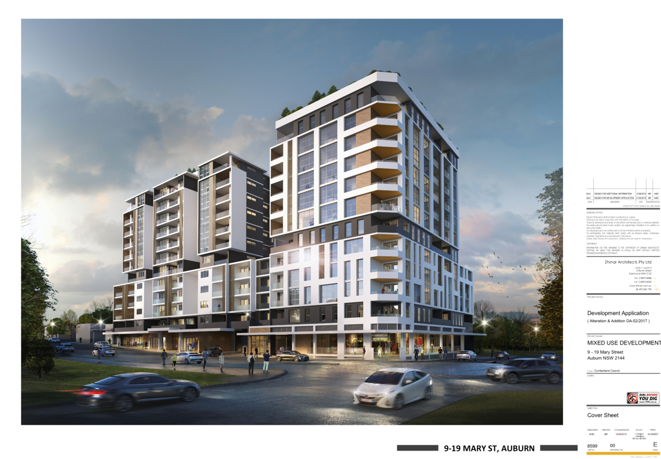
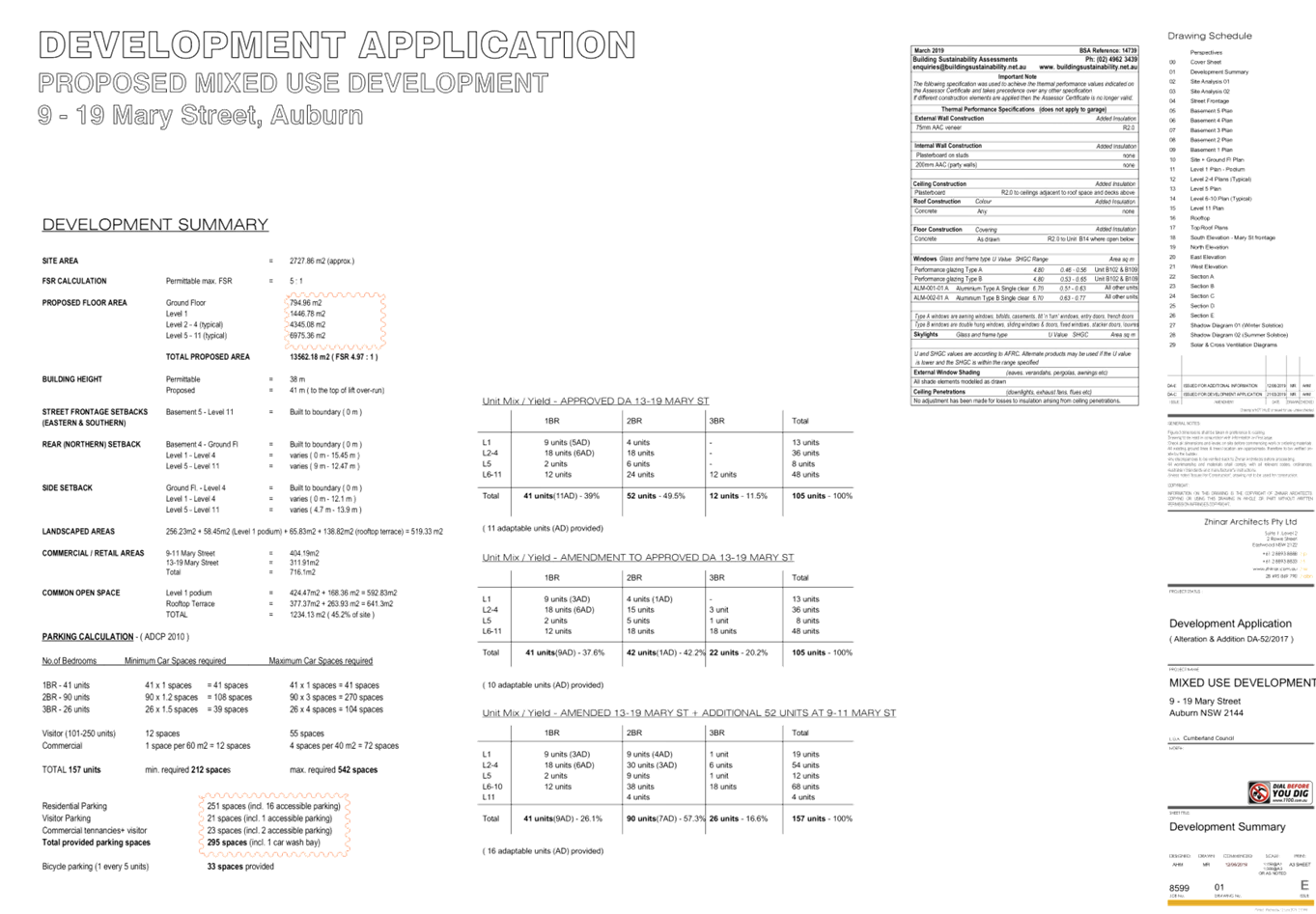
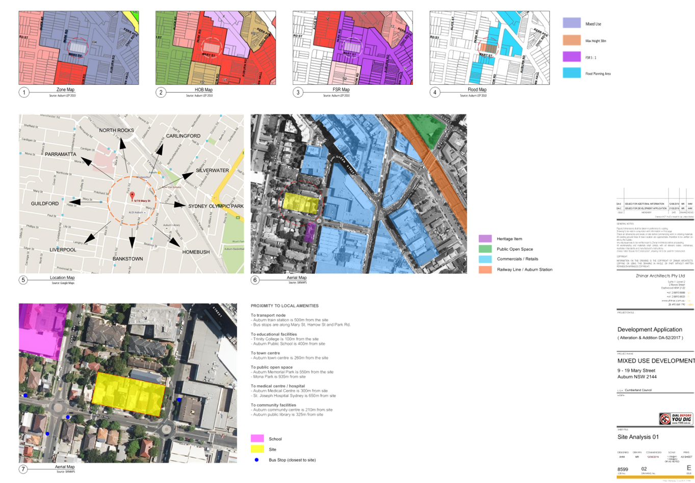
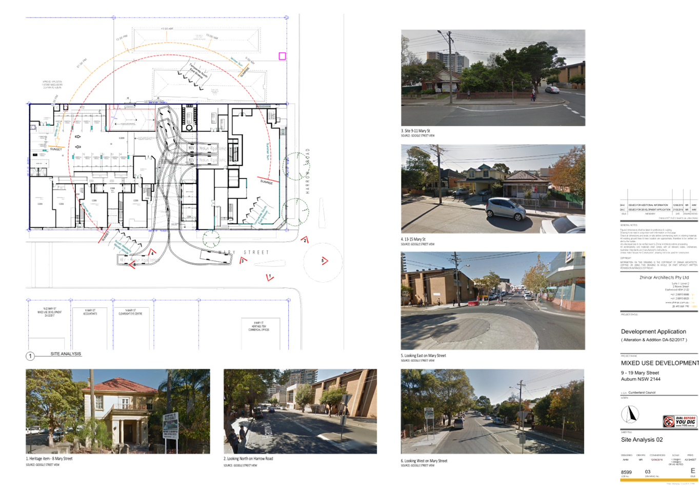
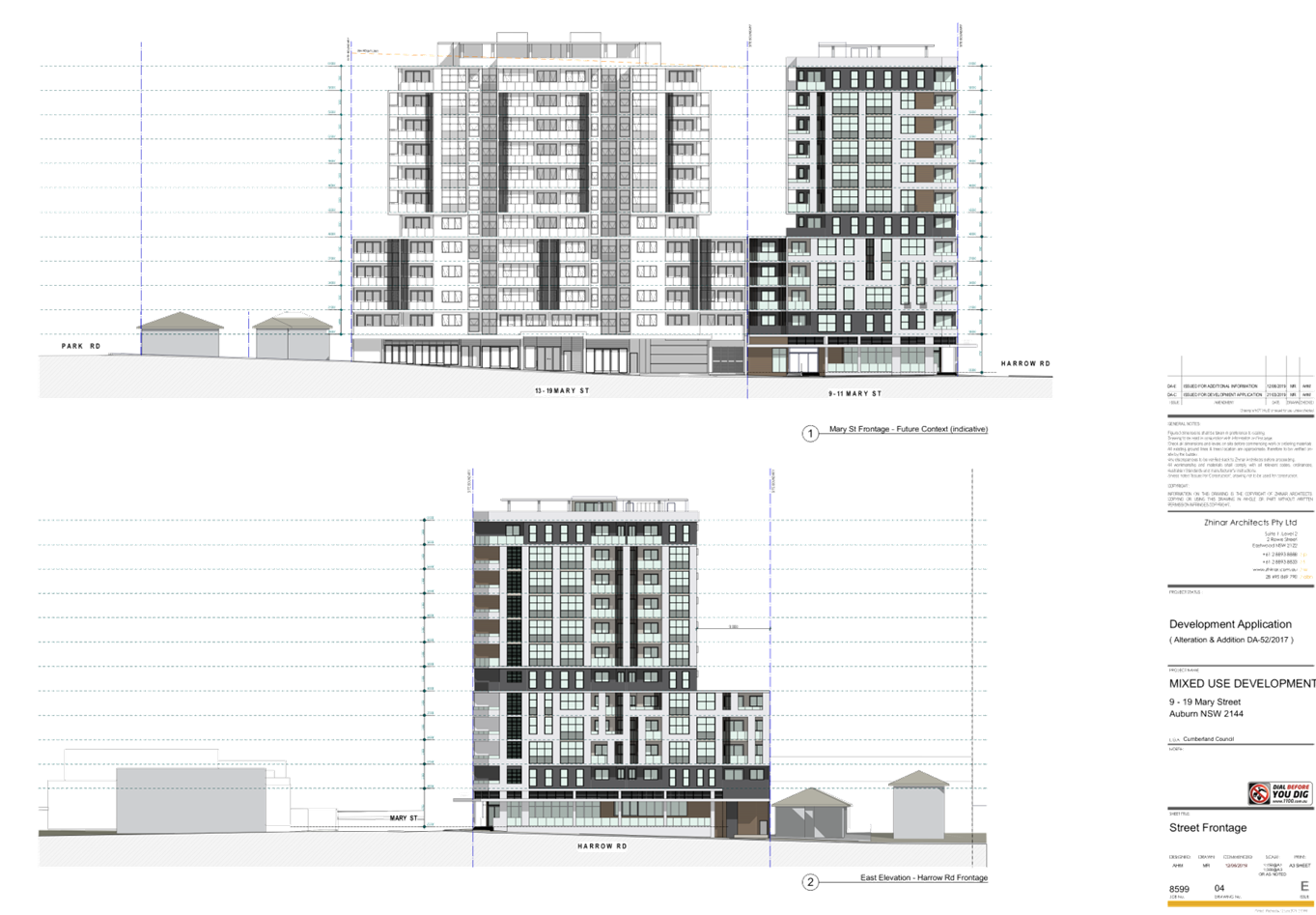
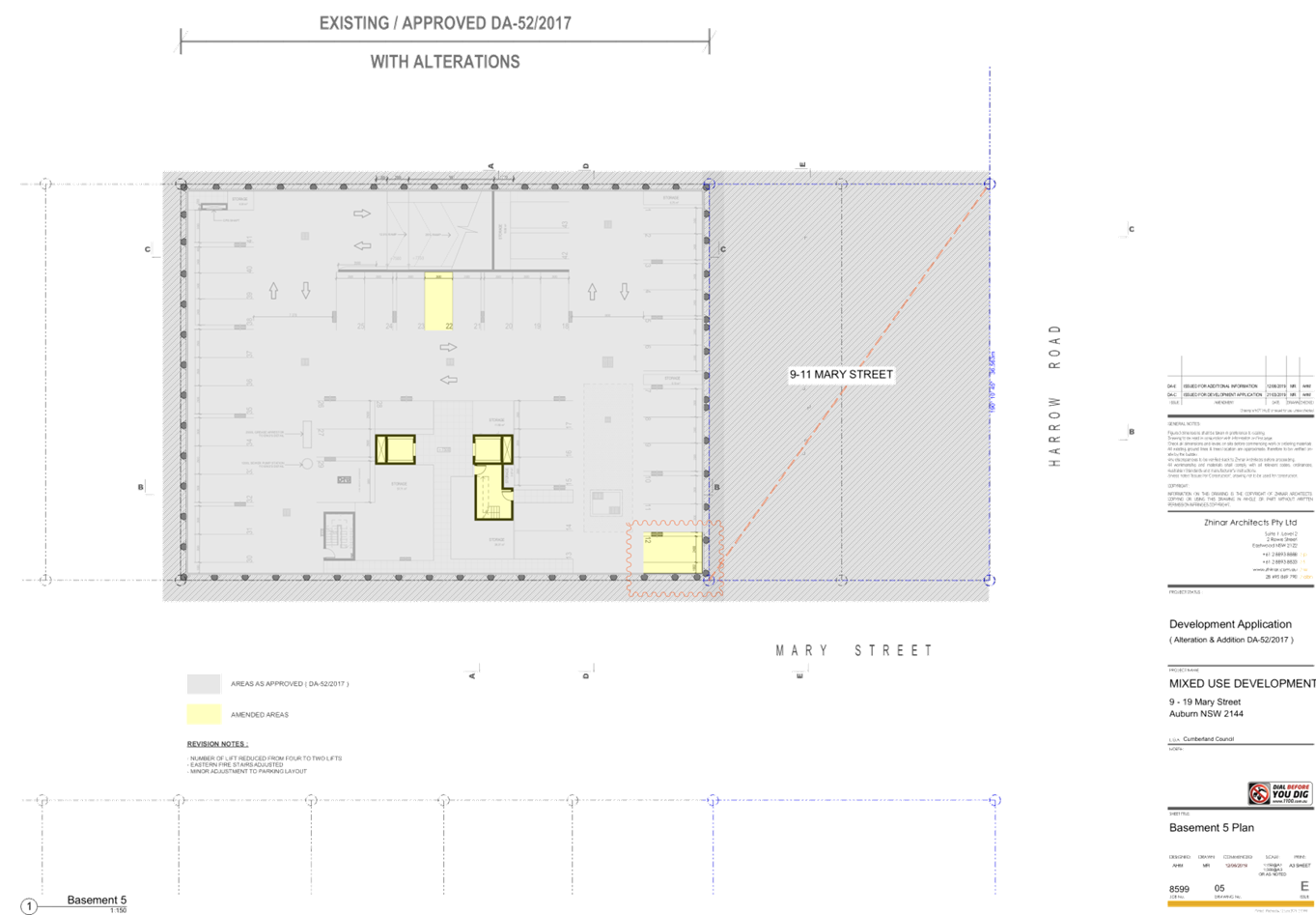
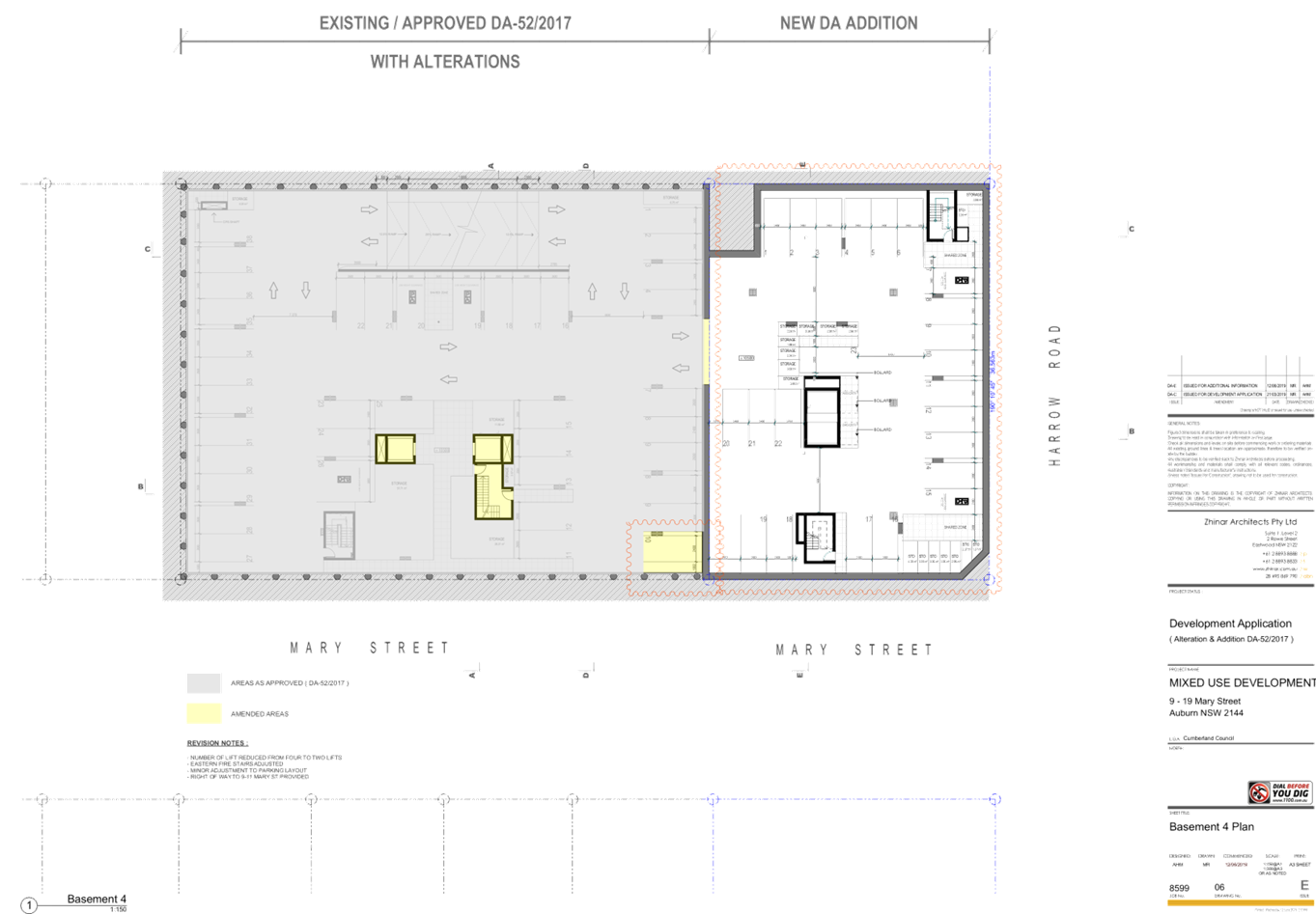


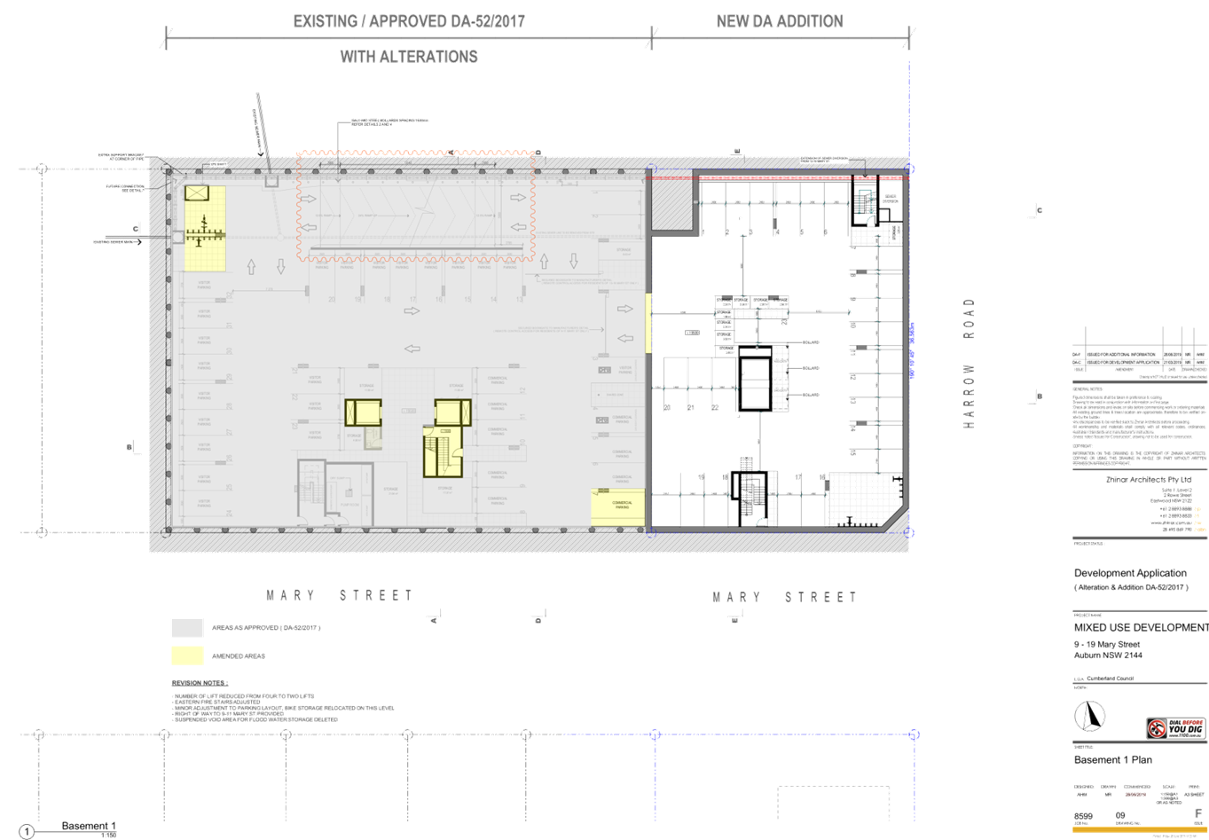
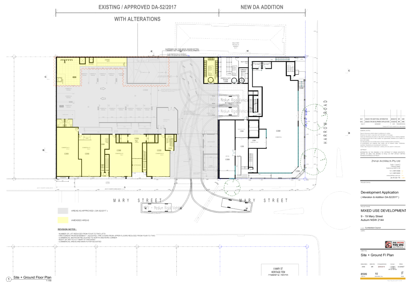
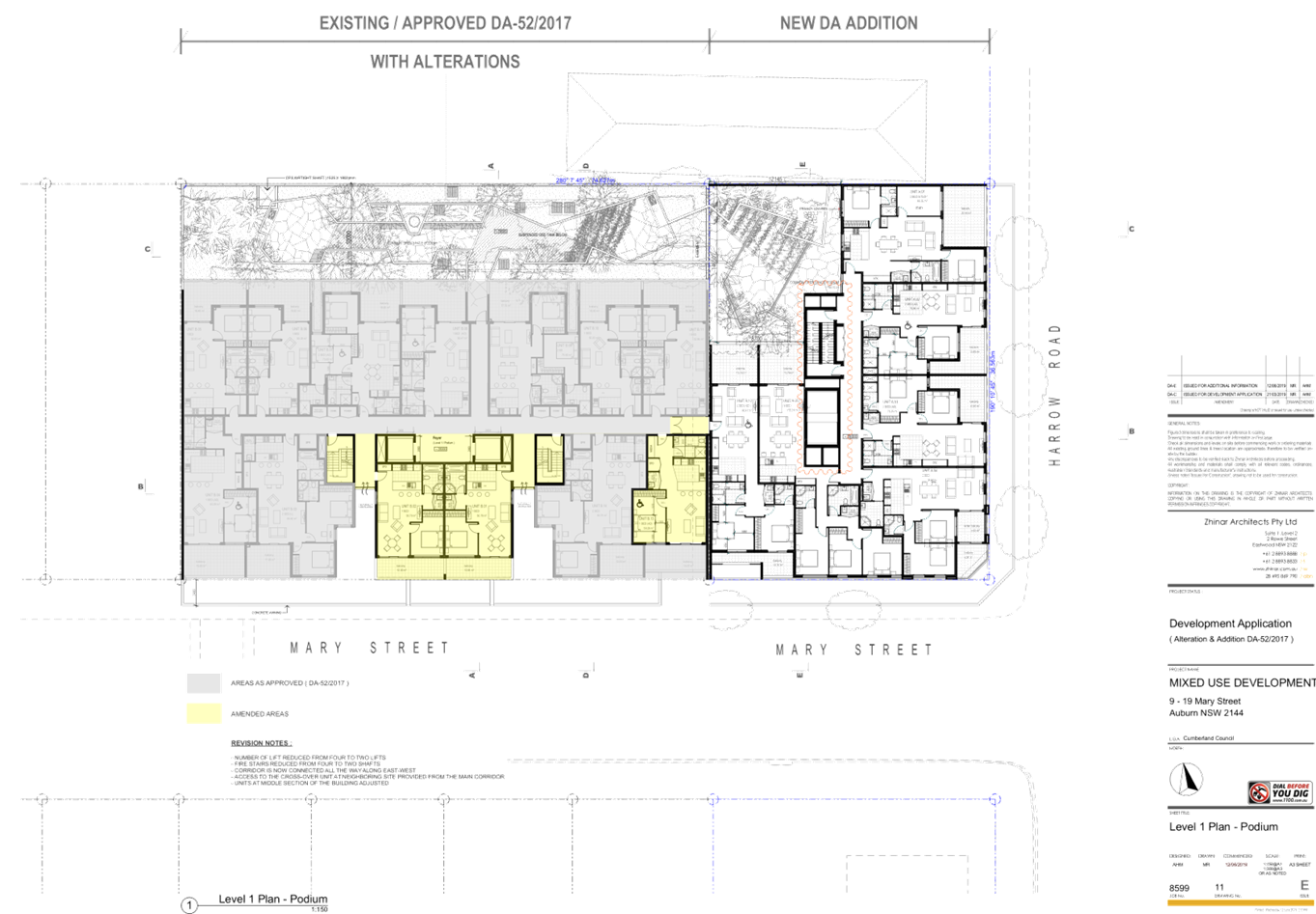
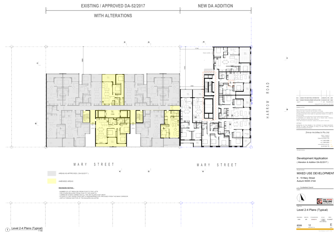
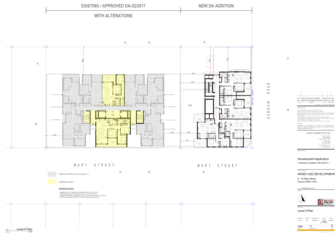
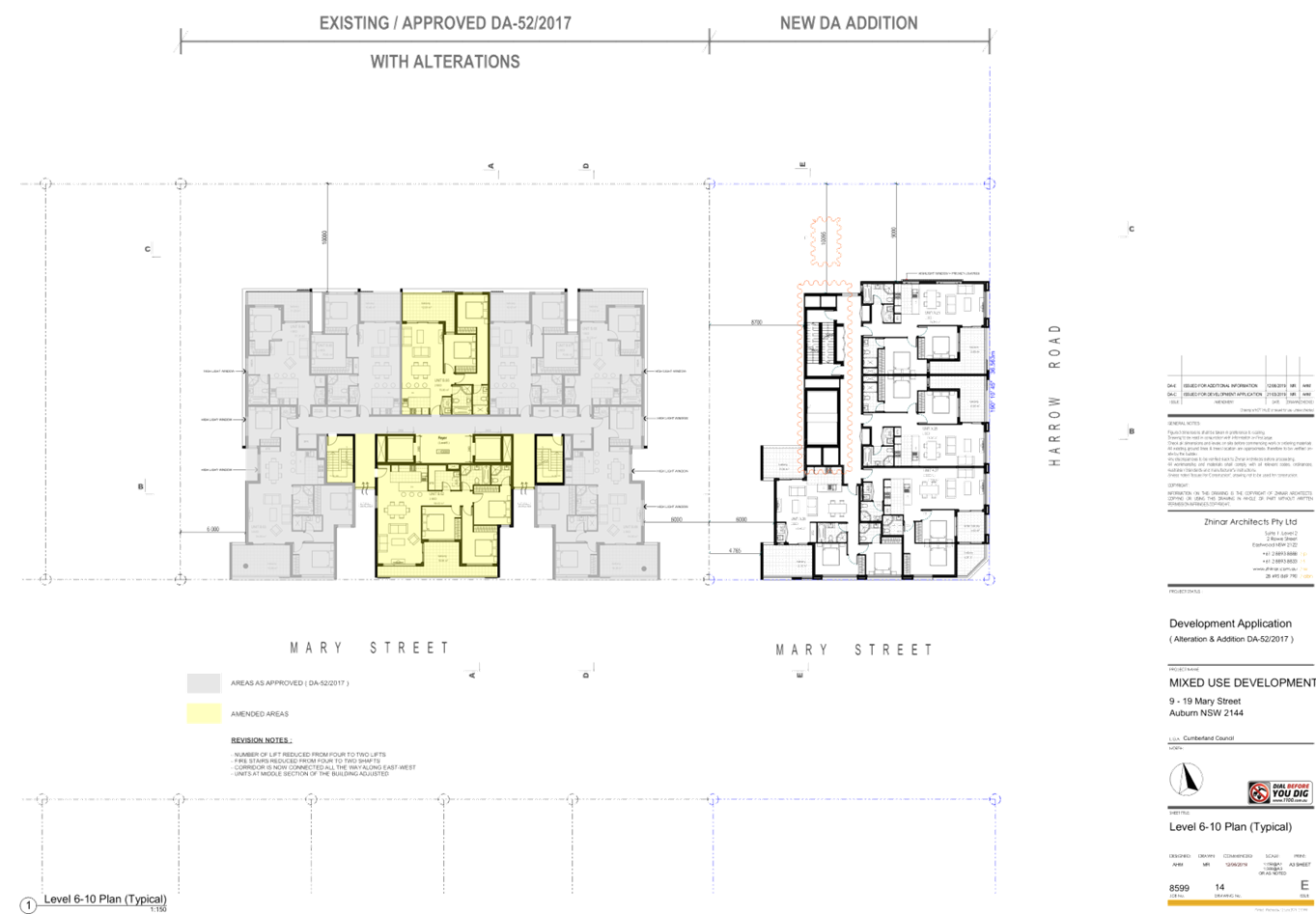
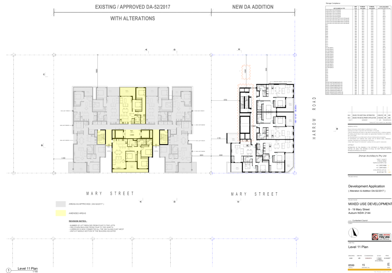
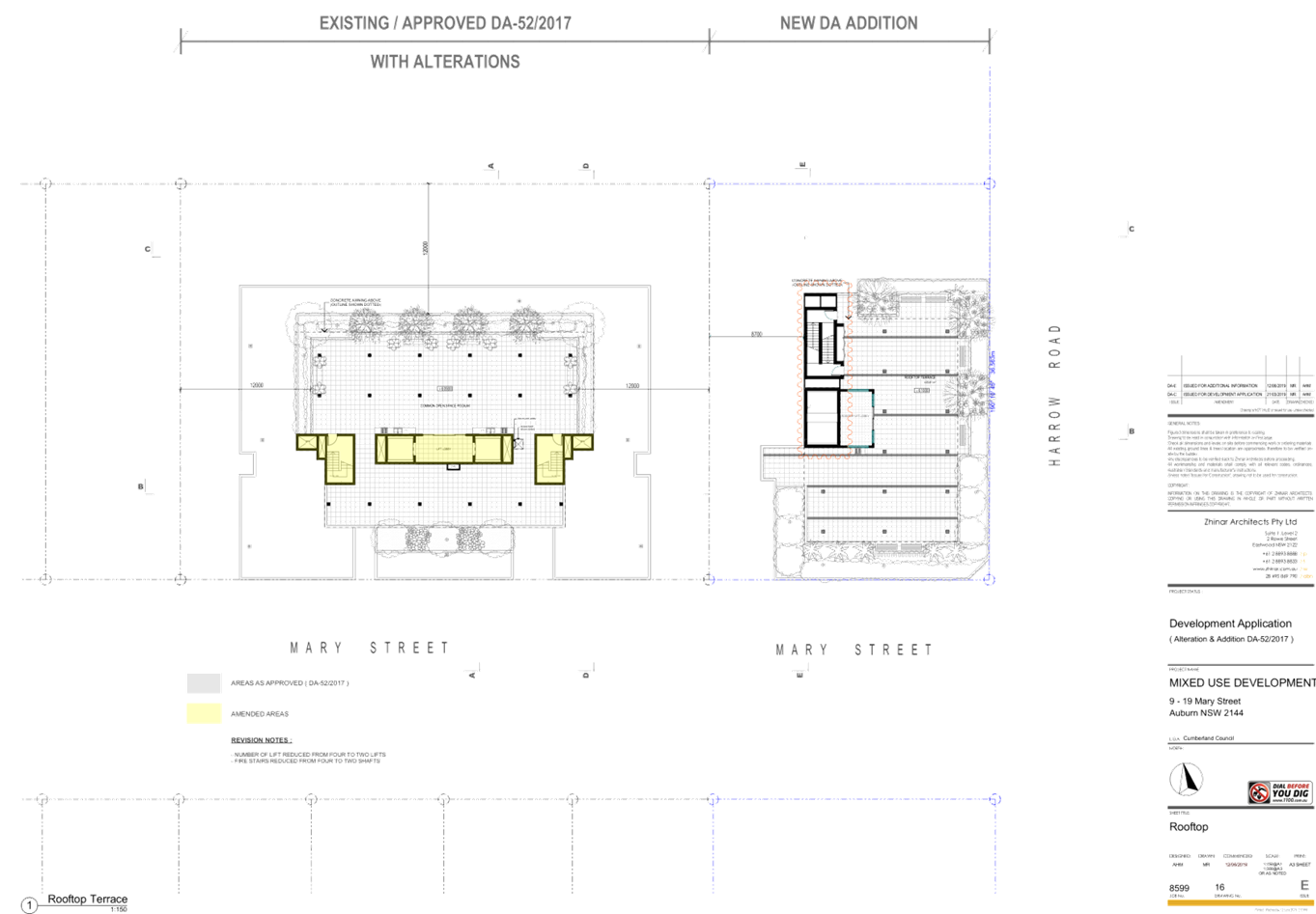
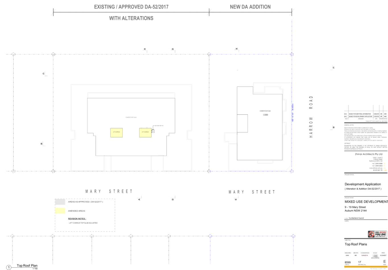
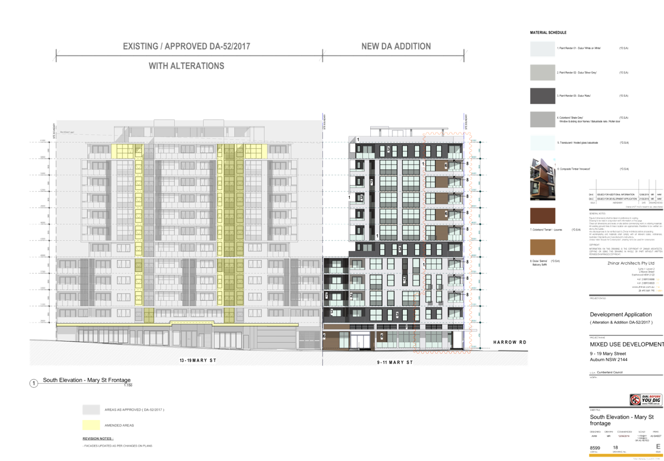
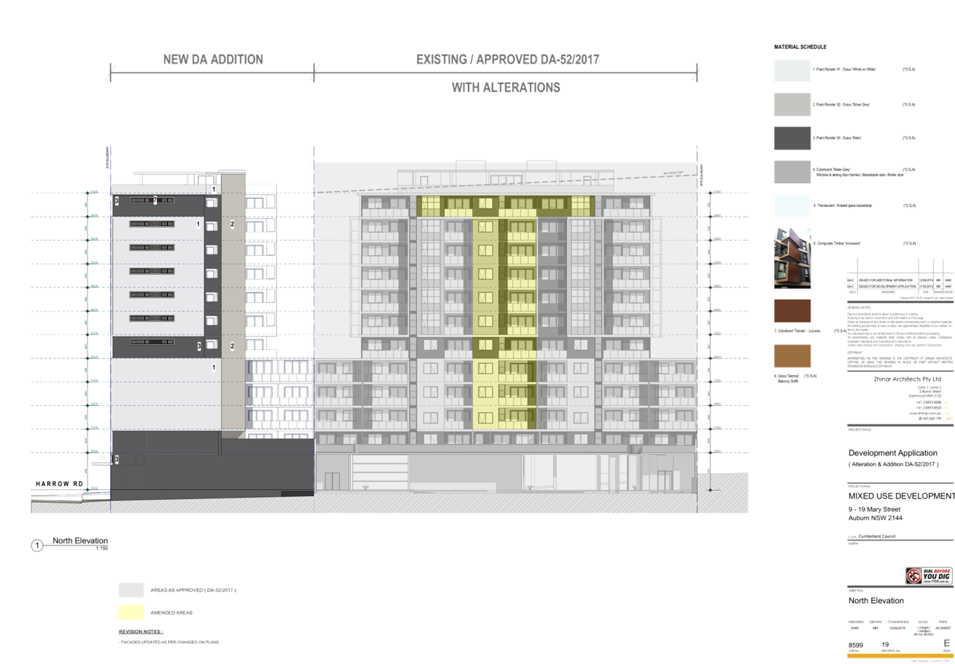
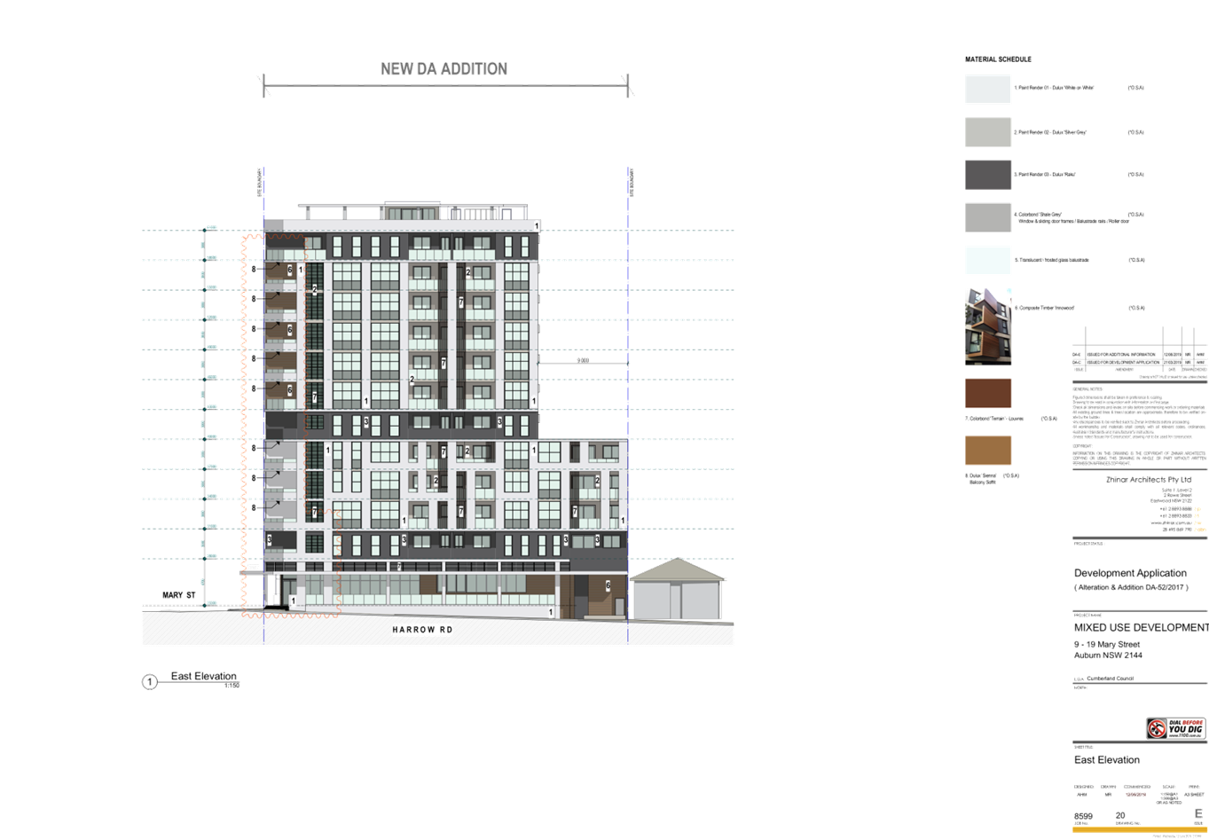
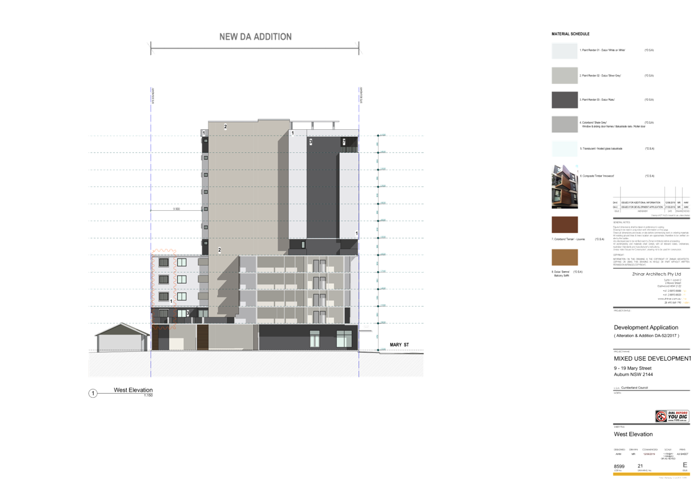
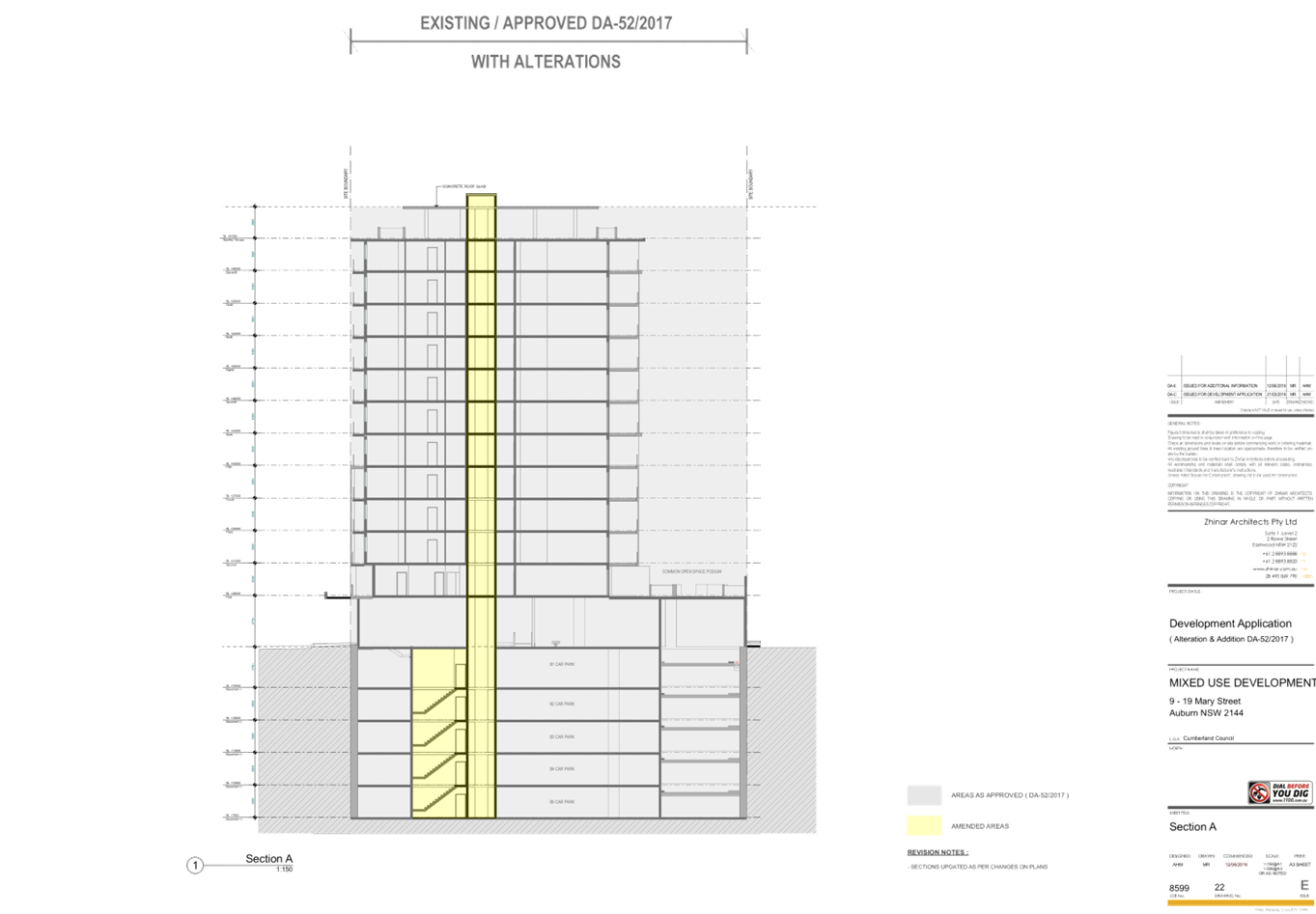
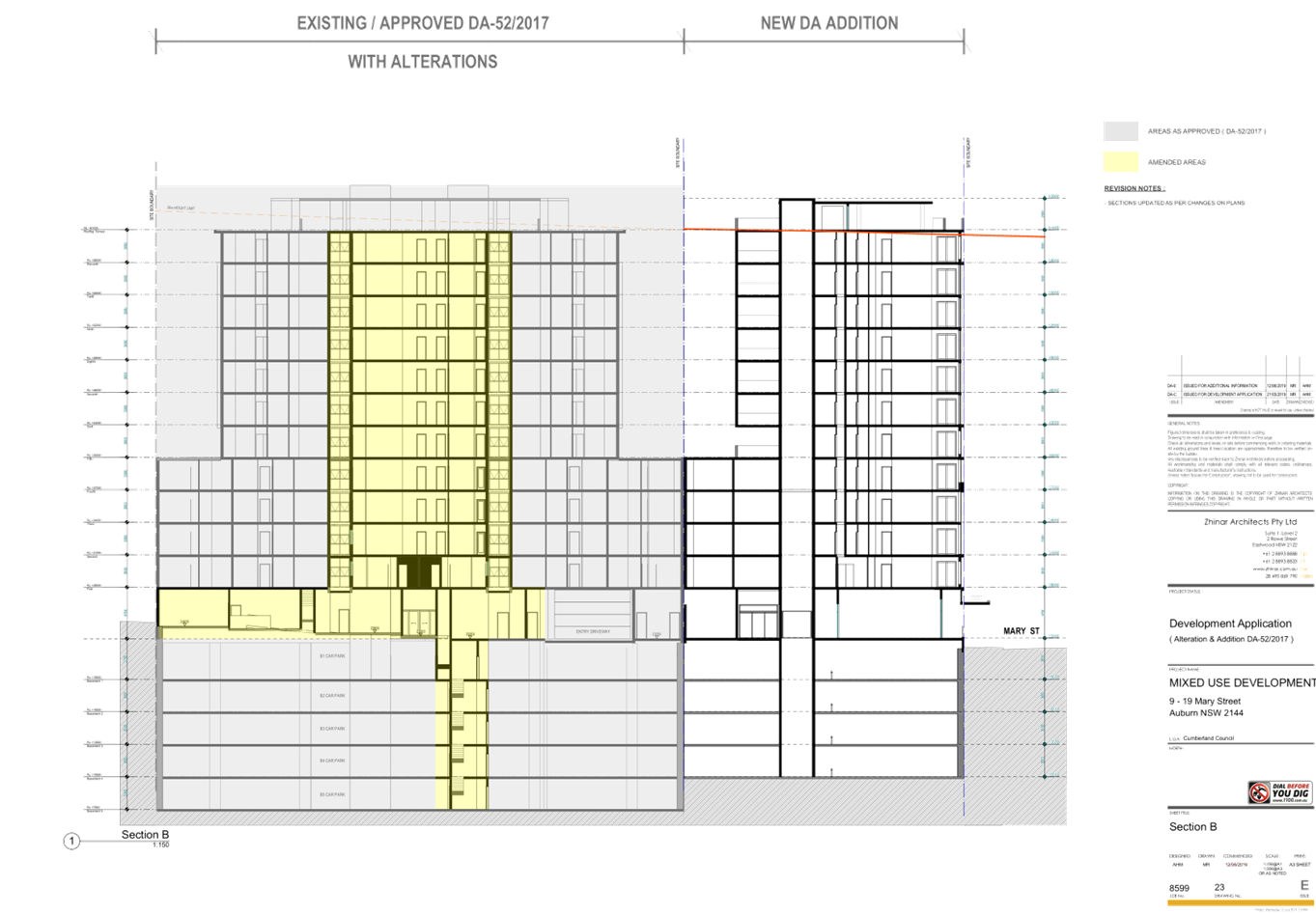
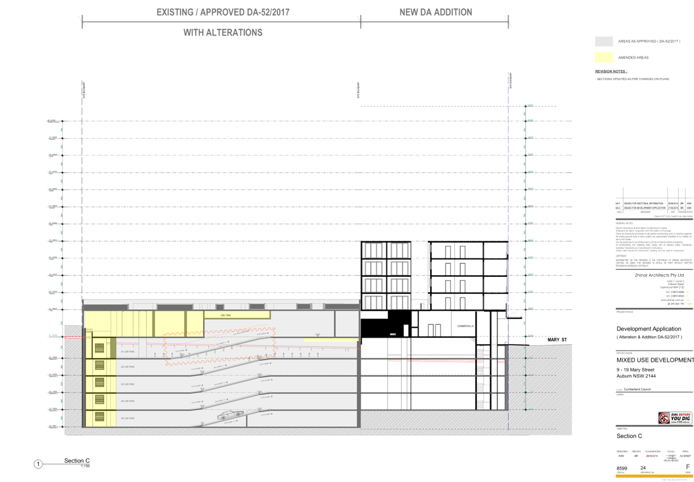
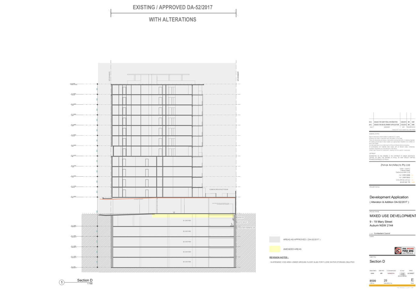
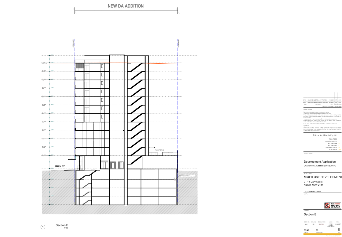
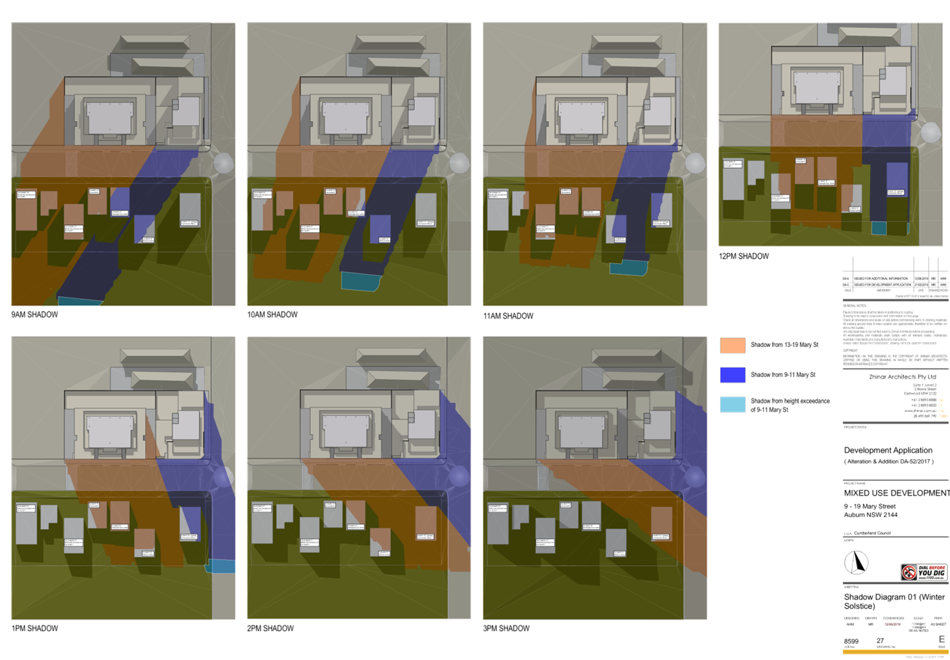
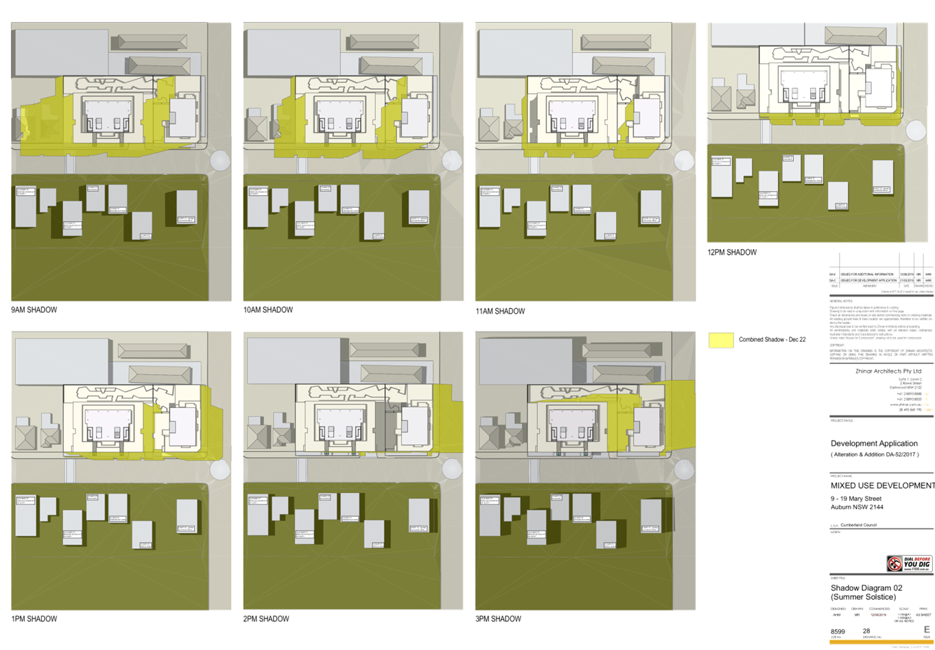
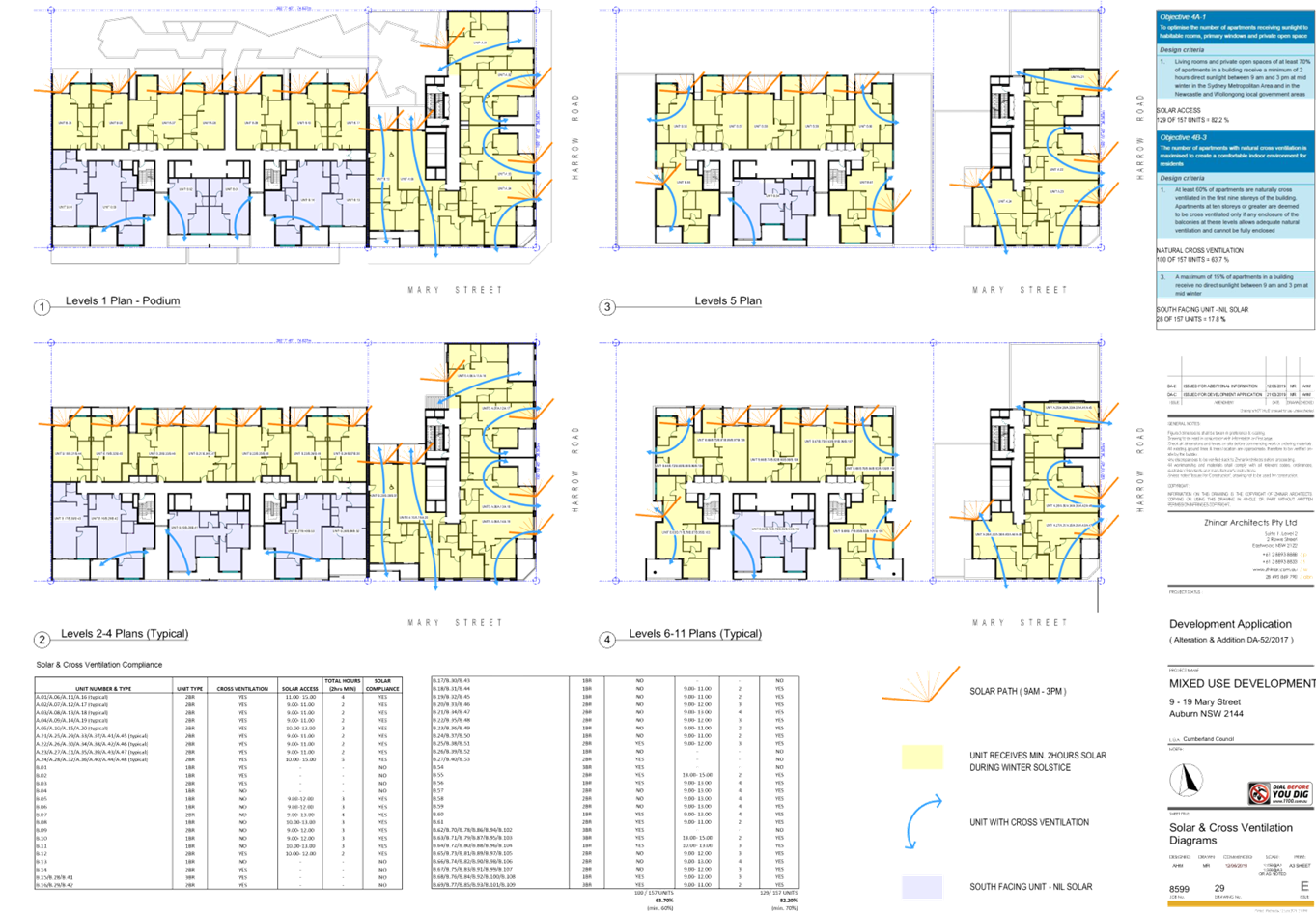
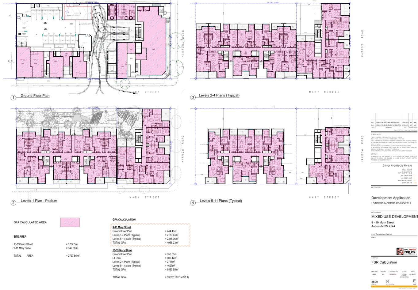
DOCUMENTS
ASSOCIATED WITH
REPORT ELPP051/19
Attachment 3
Stormwater/Engineering Plans
Extraordinary Cumberland Local Planning
Panel Meeting
24 July 2019
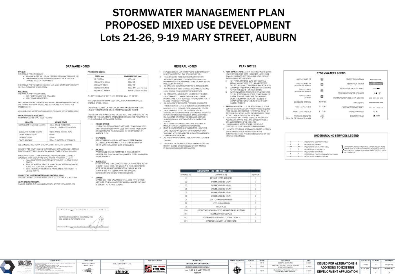
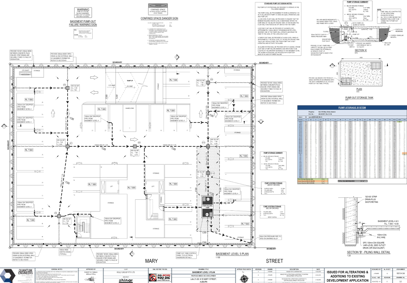
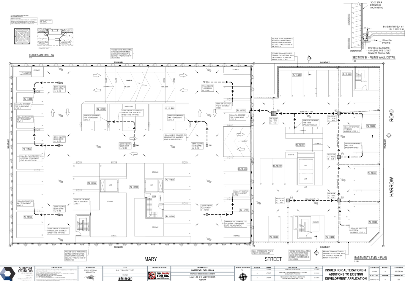
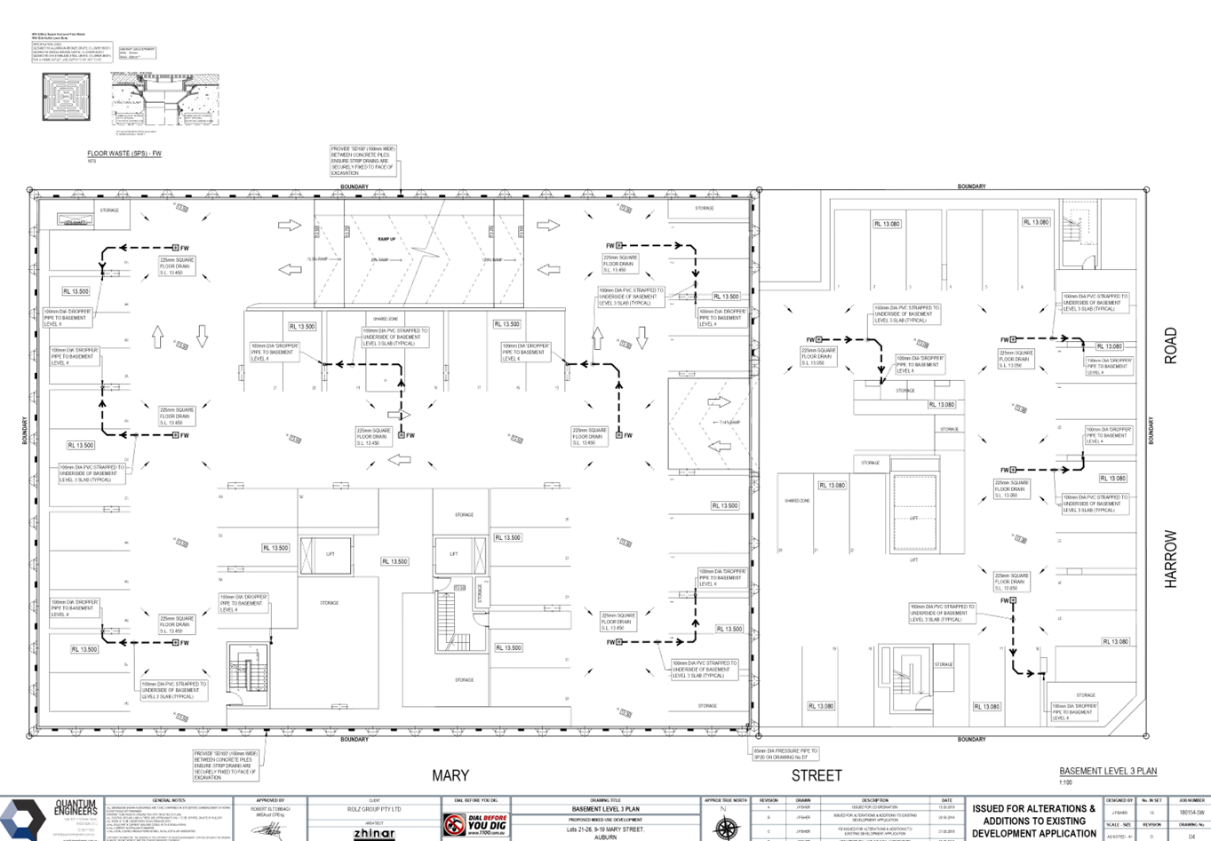
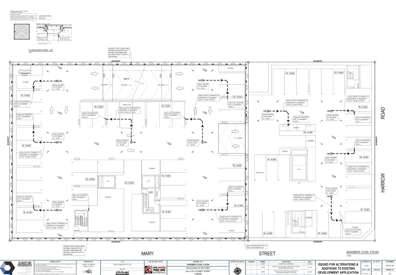
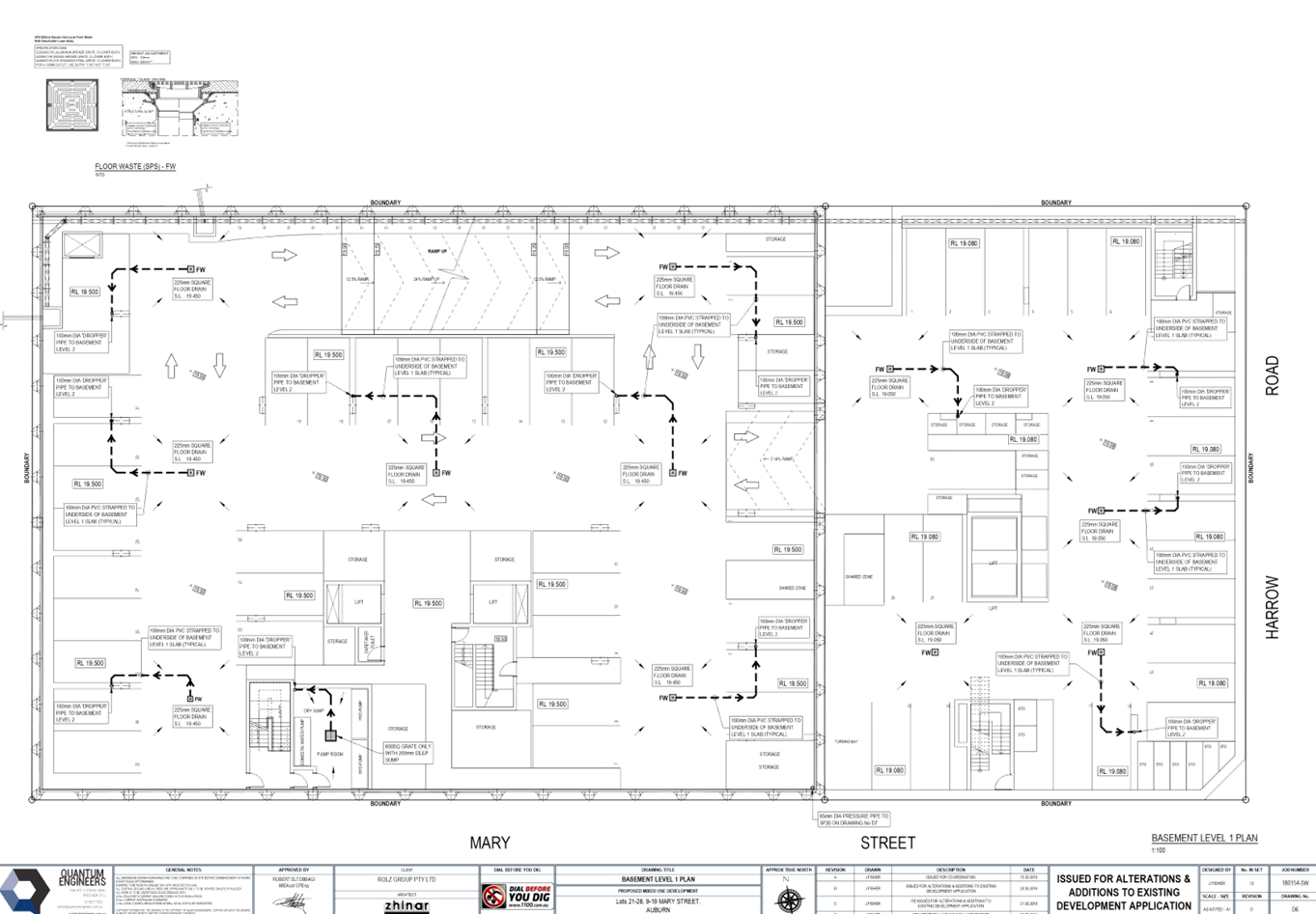
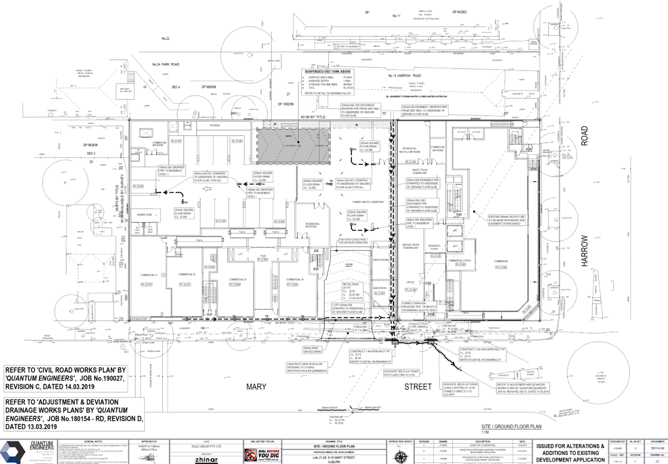
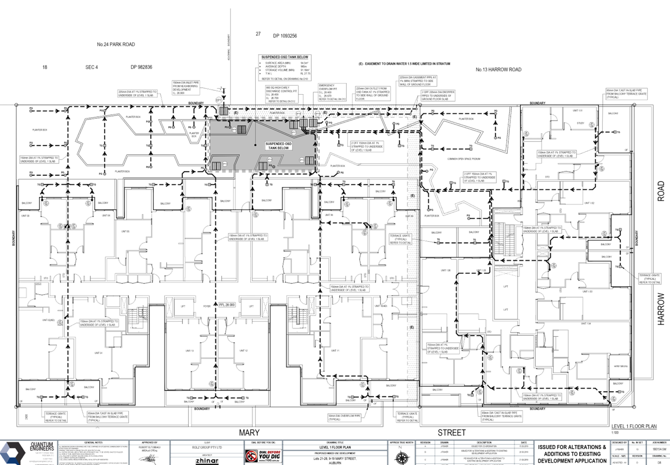
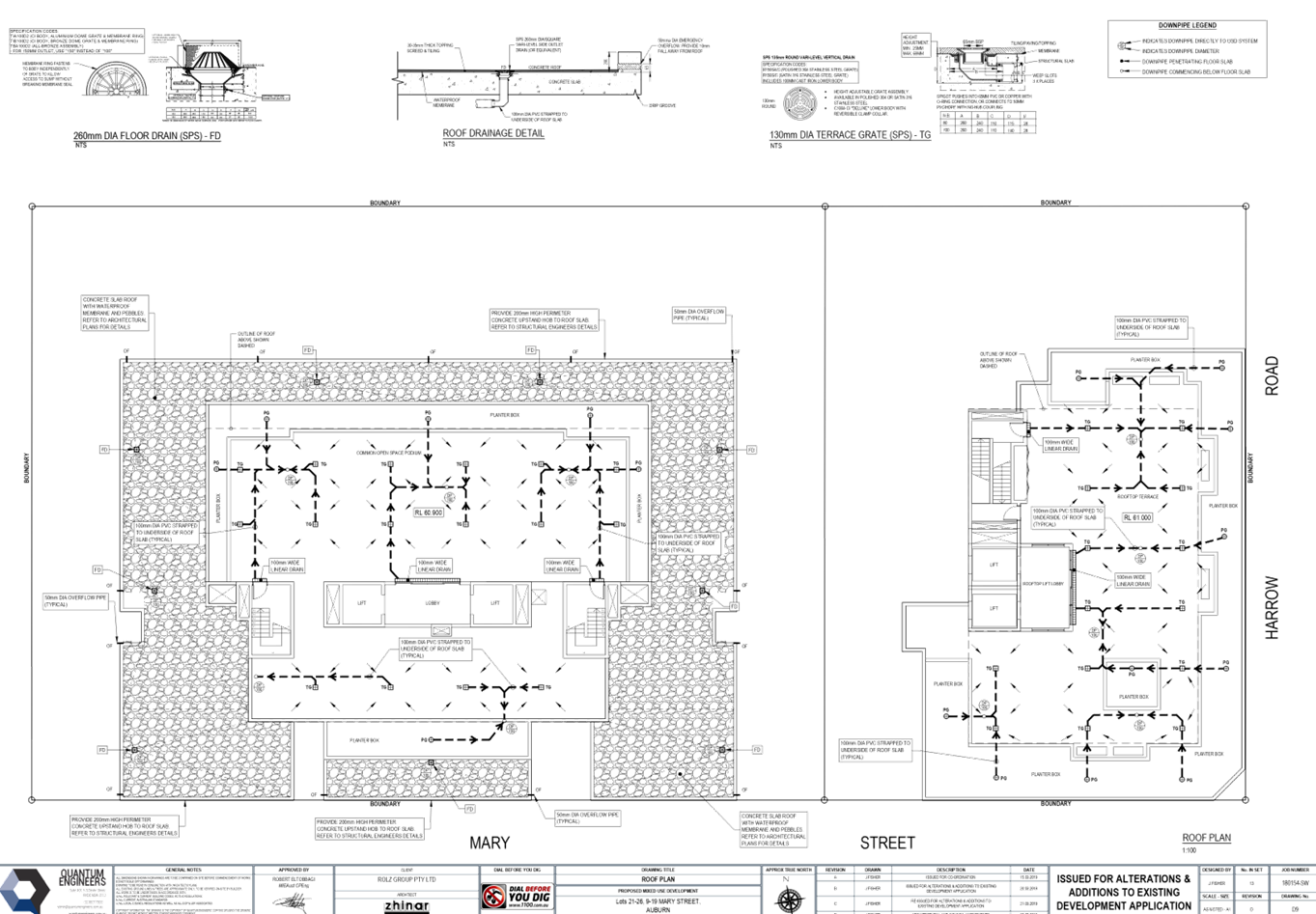
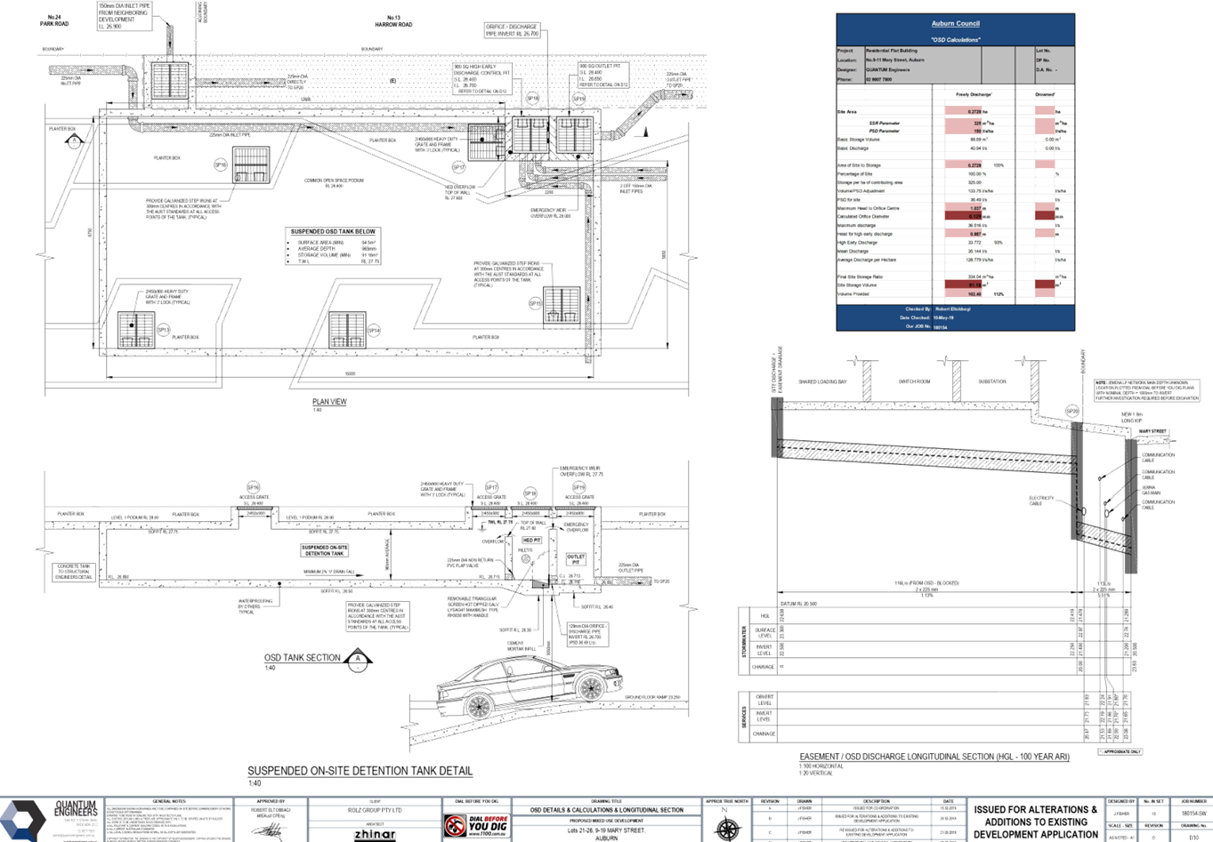
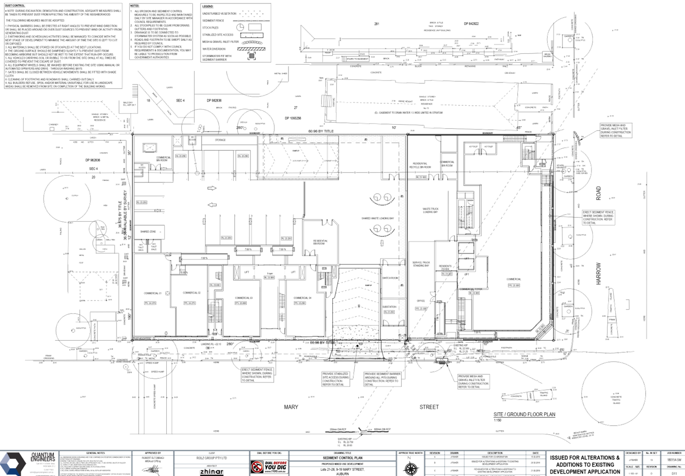
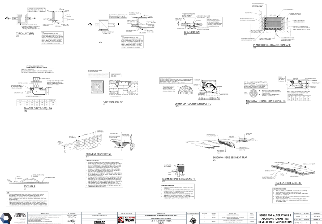
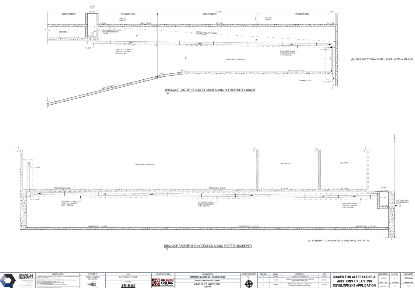
DOCUMENTS
ASSOCIATED WITH
REPORT ELPP051/19
Attachment 4
Submissions Received
Extraordinary Cumberland Local Planning
Panel Meeting
24 July 2019
DOCUMENTS
ASSOCIATED WITH
REPORT ELPP051/19
Attachment 5
Locality Map
Extraordinary Cumberland Local Planning
Panel Meeting
24 July 2019
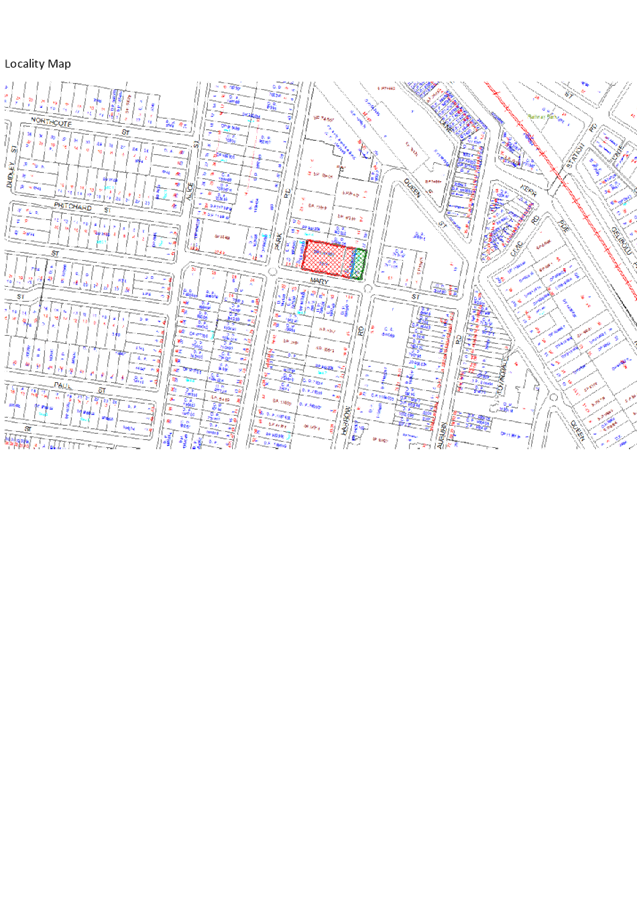
DOCUMENTS
ASSOCIATED WITH
REPORT ELPP051/19
Attachment 6
Appendix A, B, C
Extraordinary Cumberland Local Planning
Panel Meeting
24 July 2019
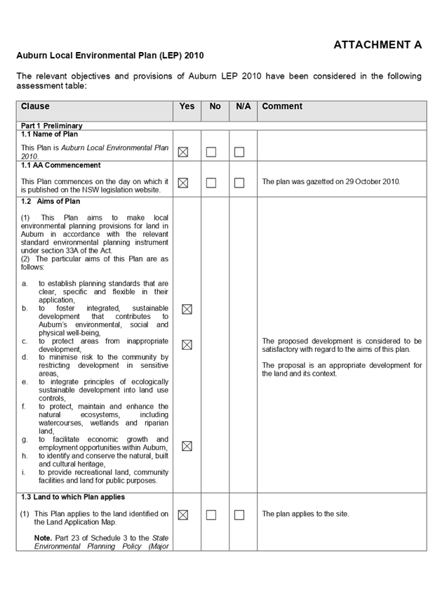
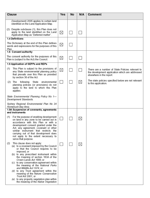
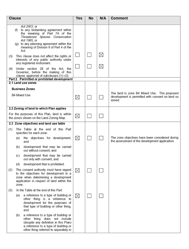
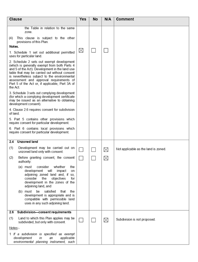
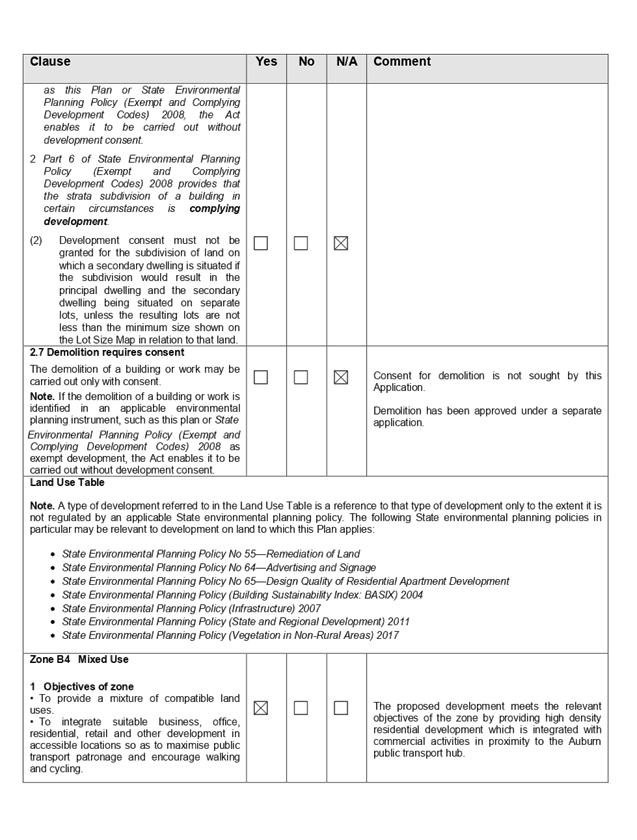
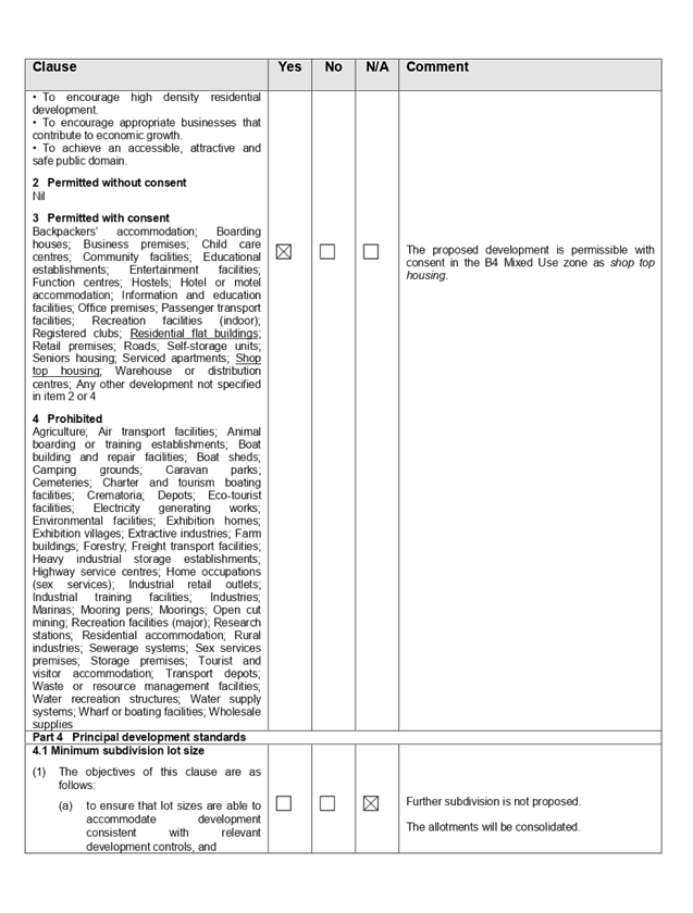
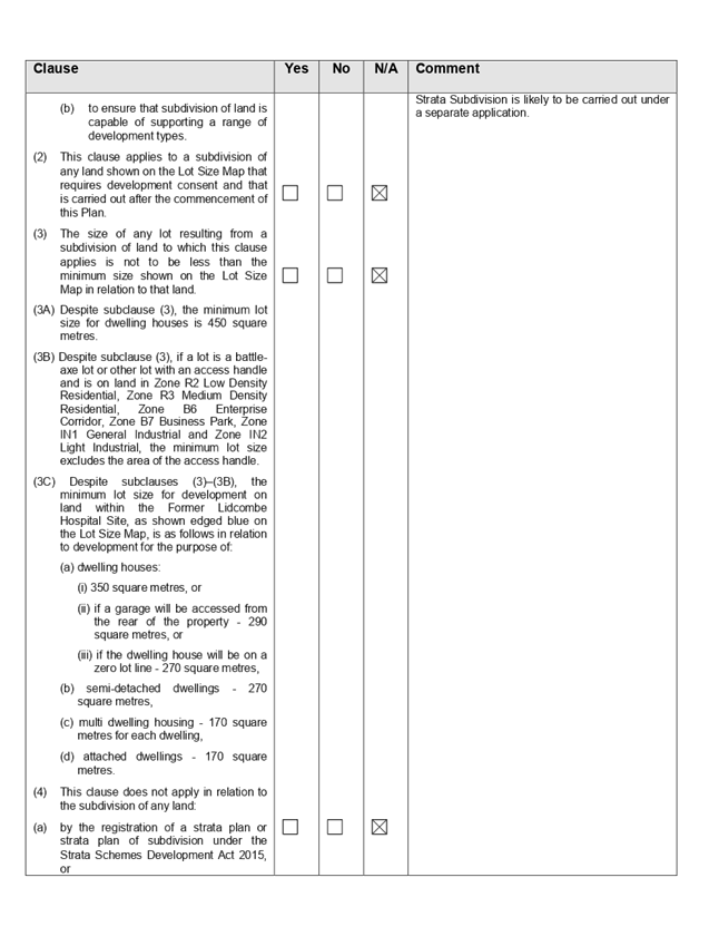
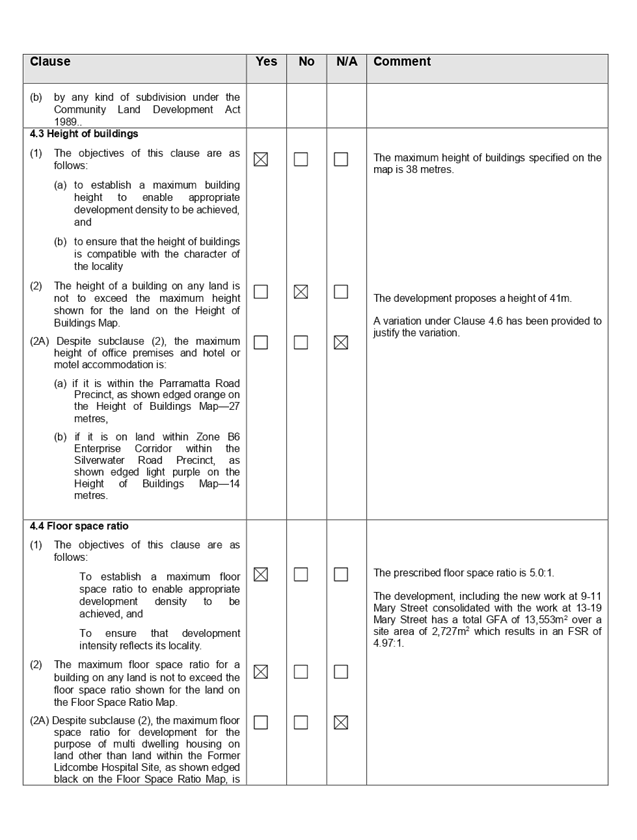
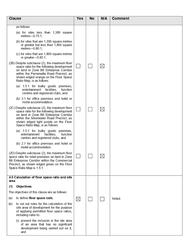
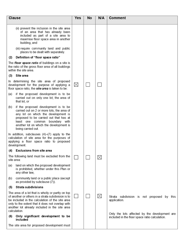
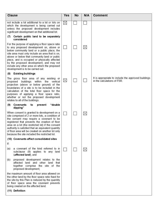
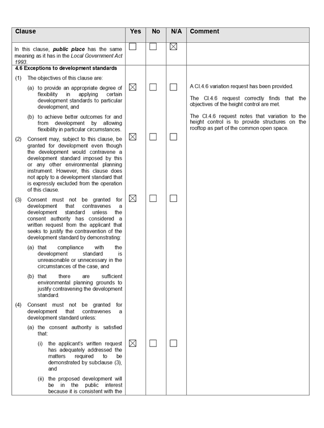
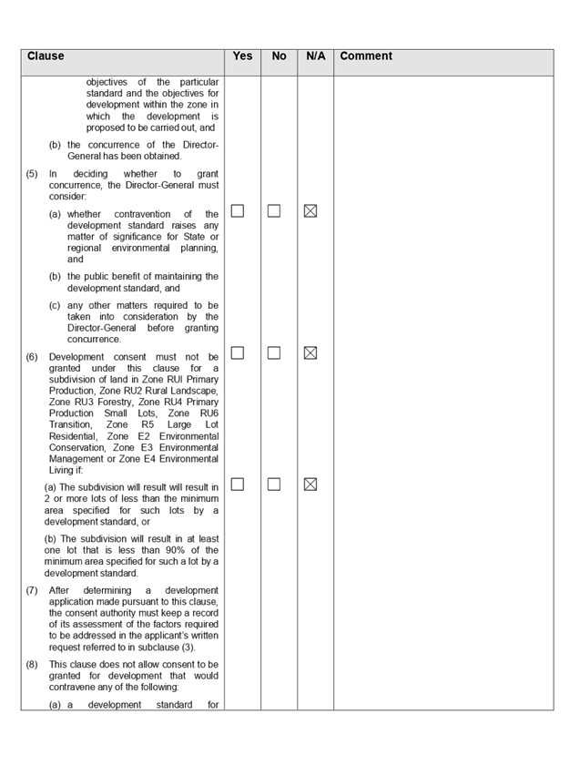
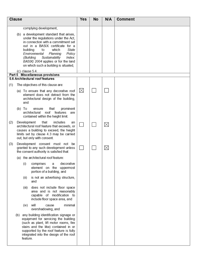
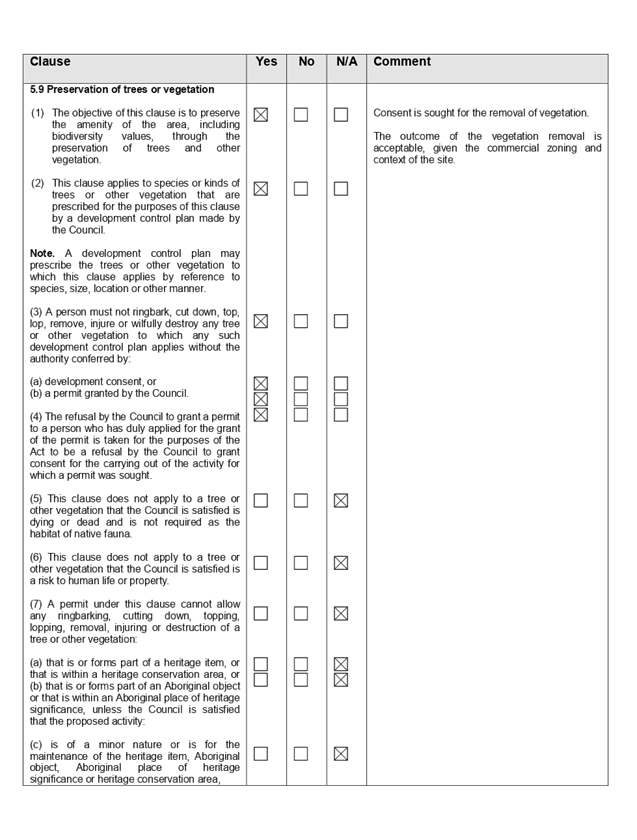
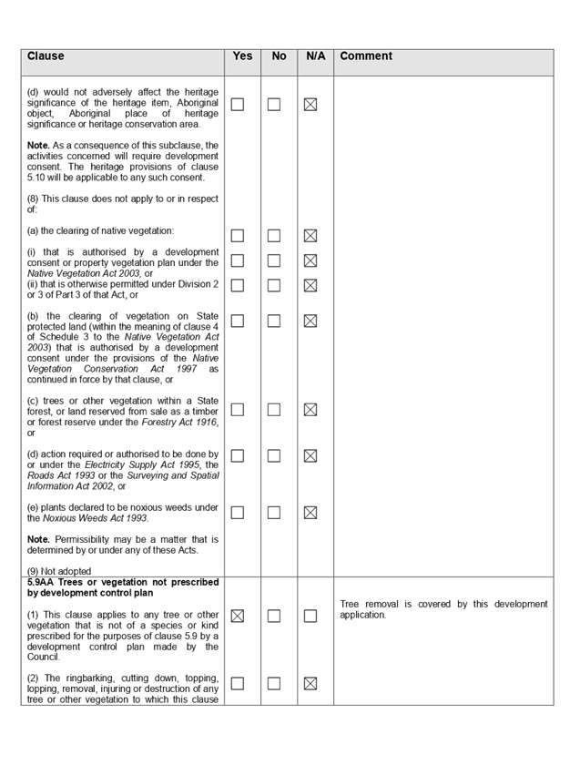
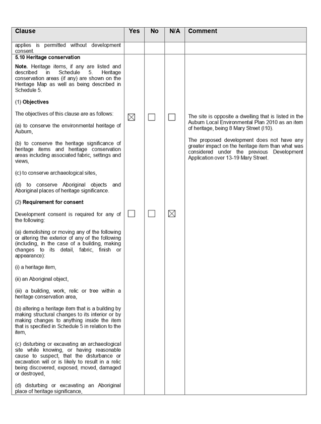
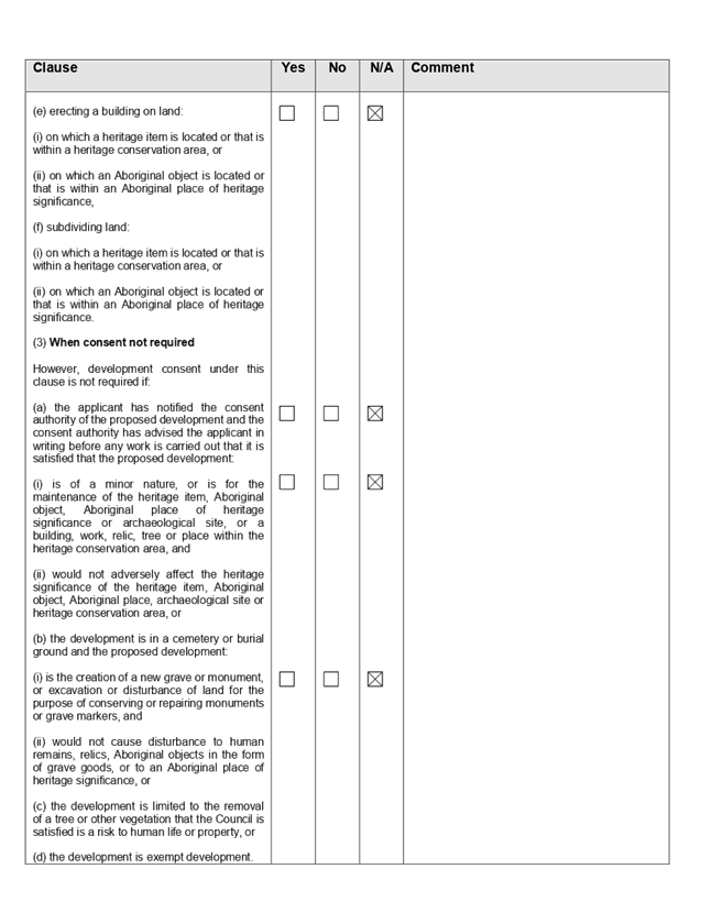
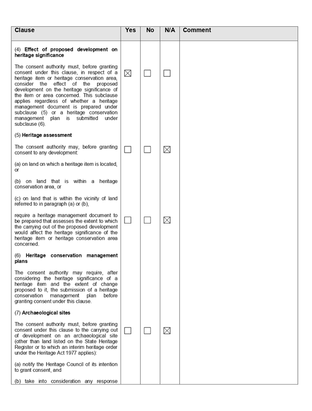
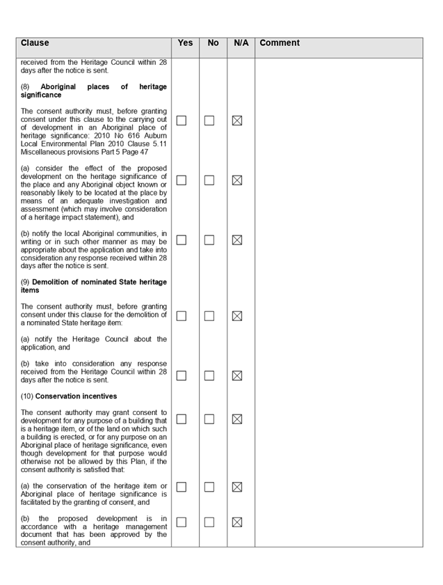
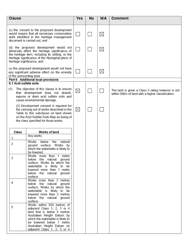
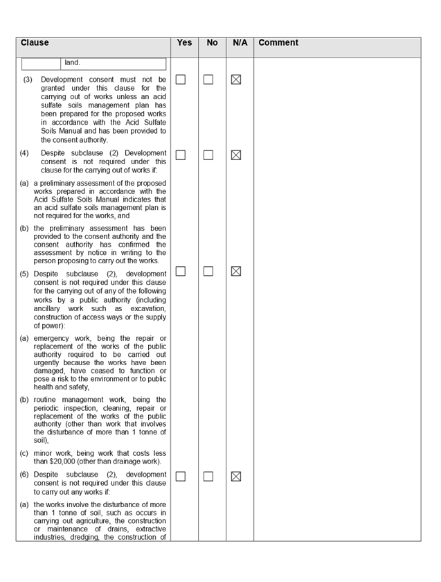
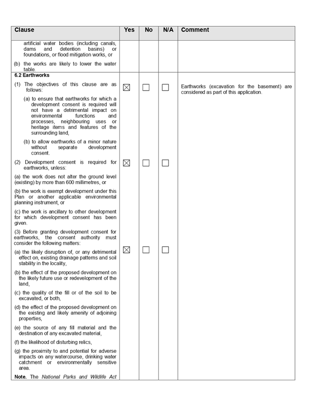
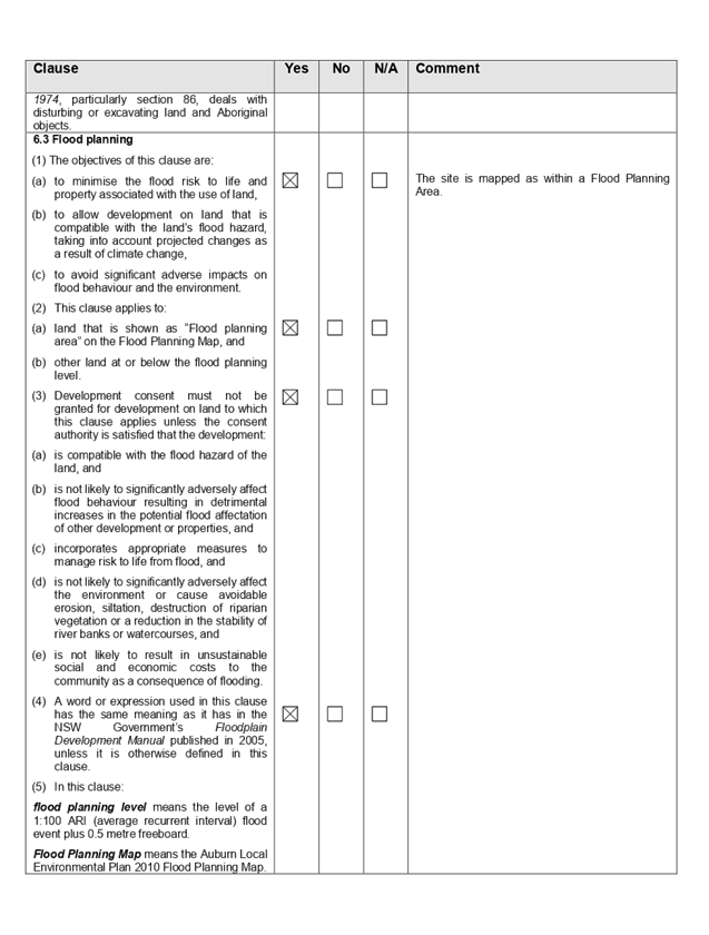
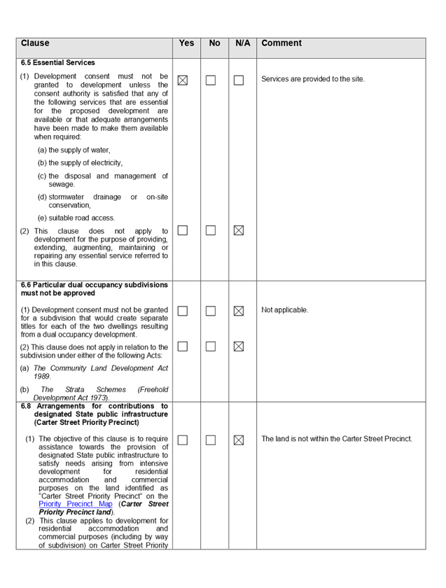
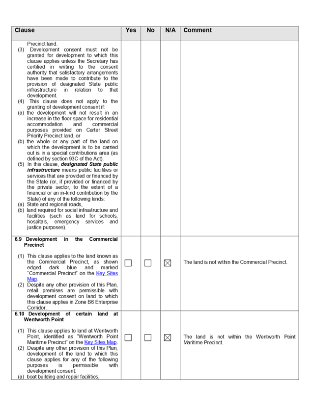
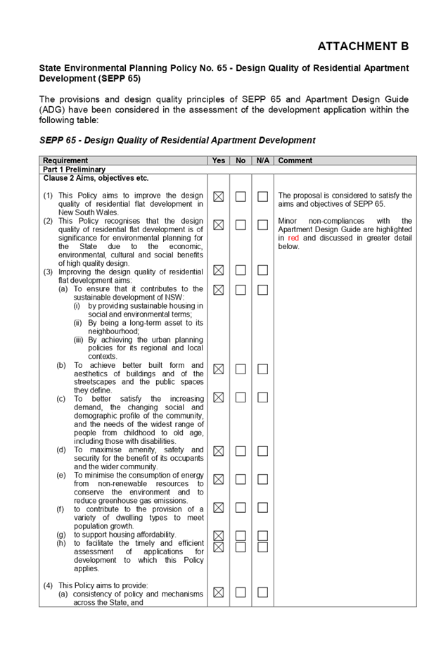
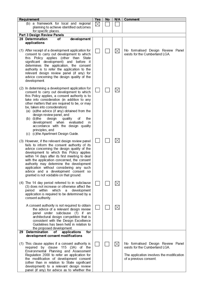
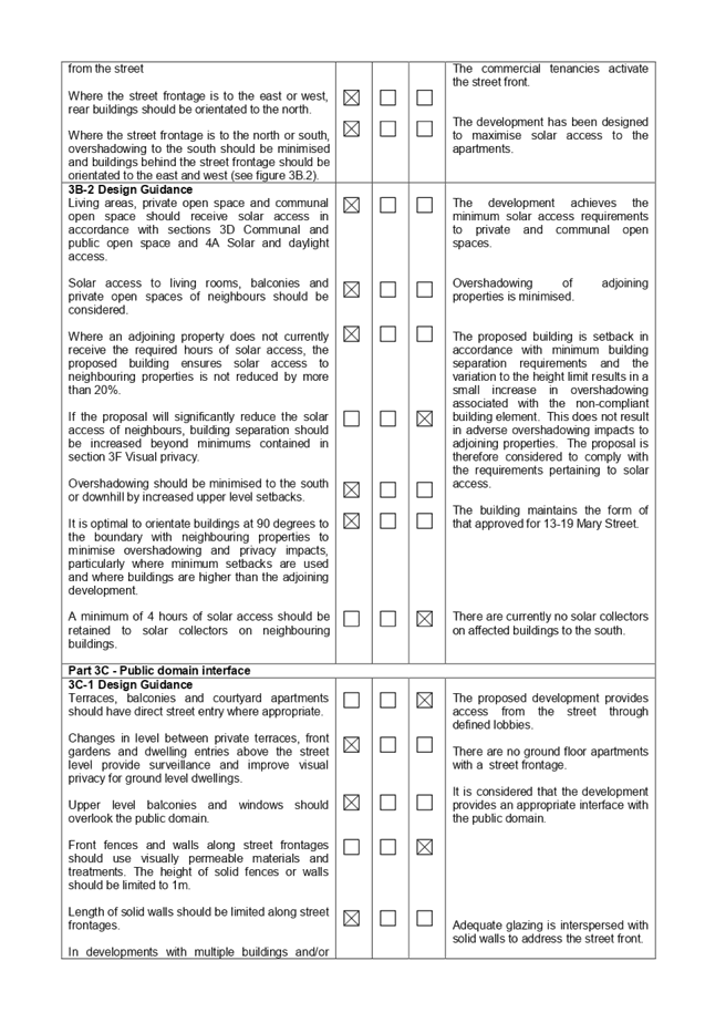
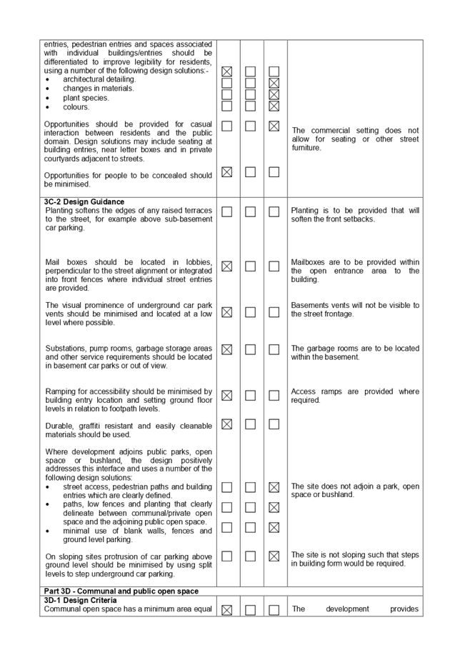
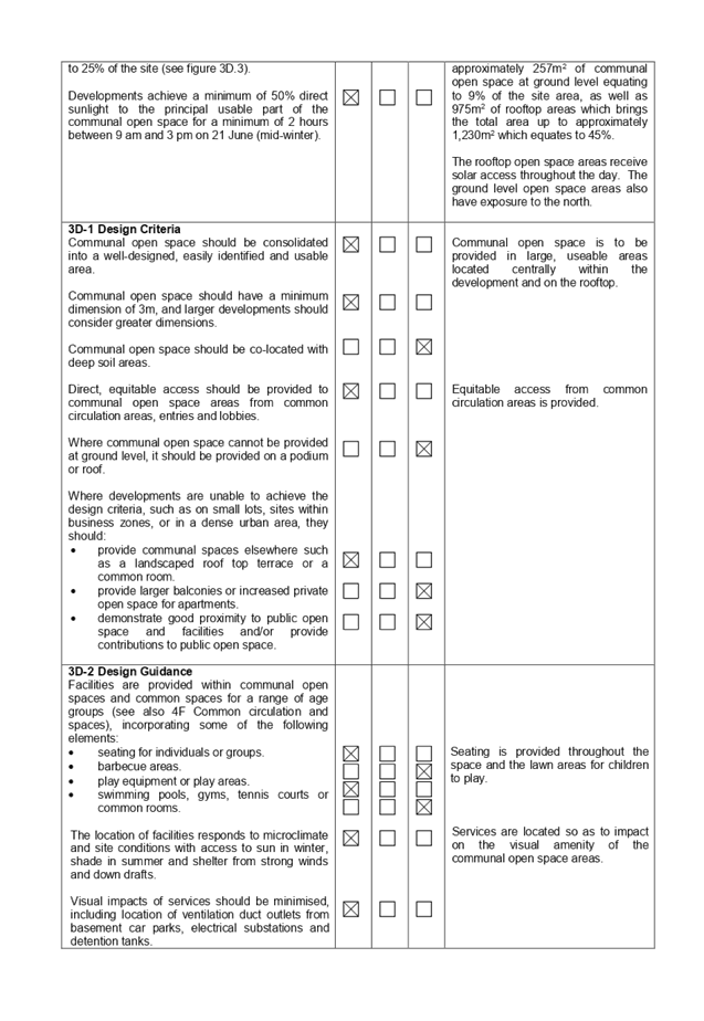
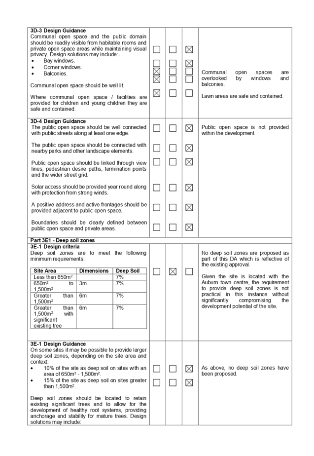
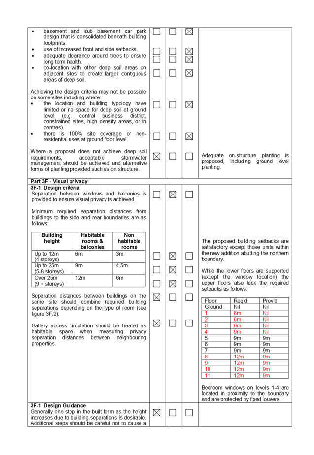
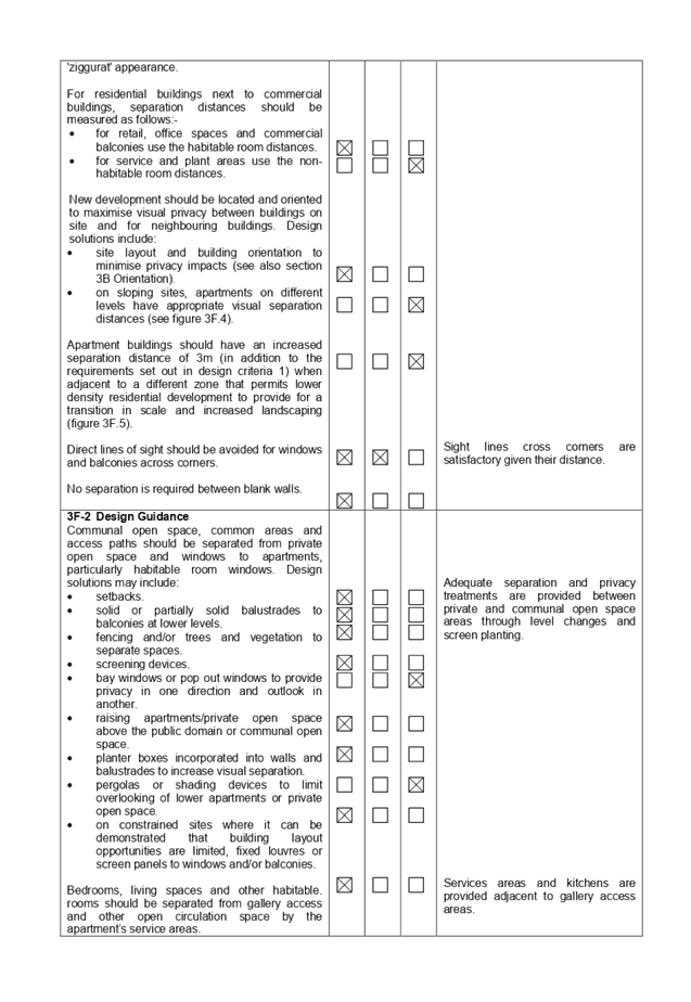
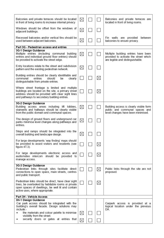
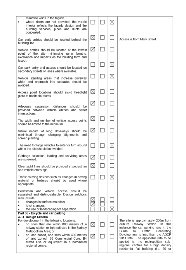
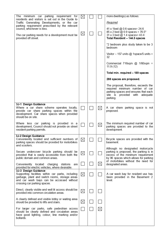
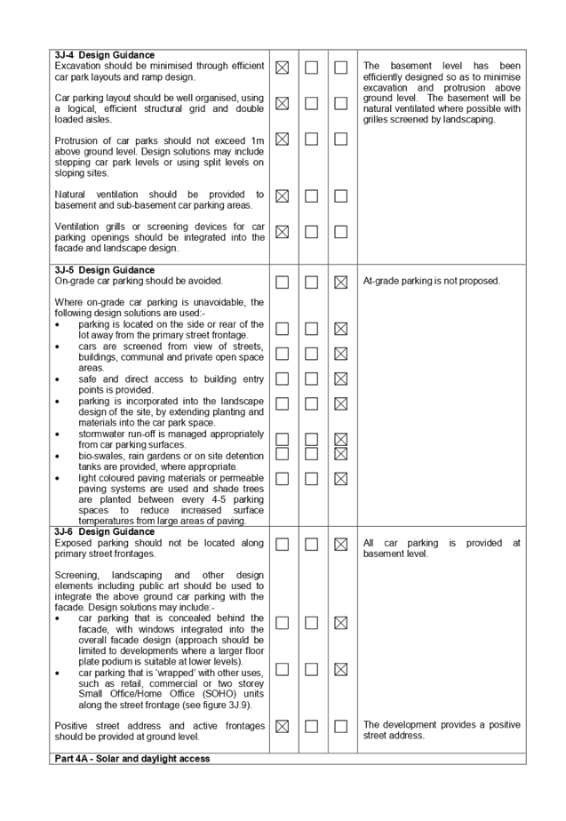
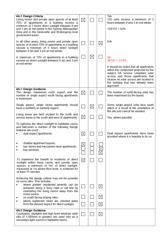

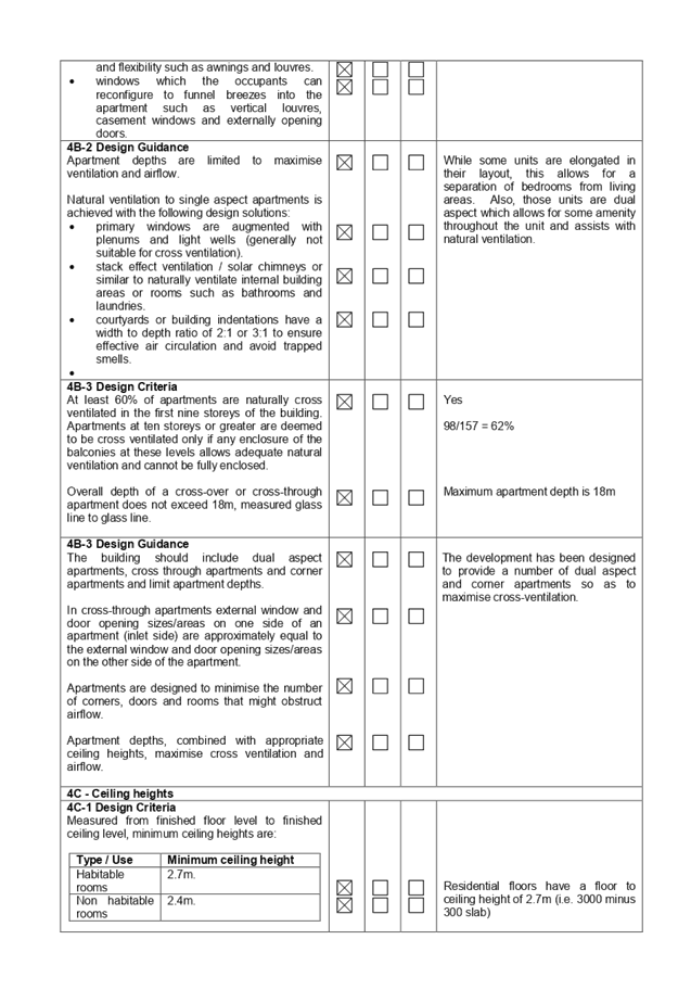
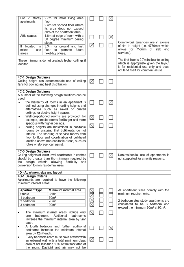
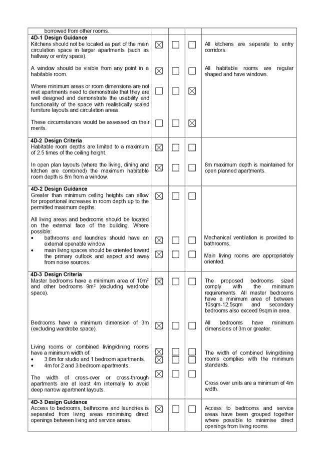
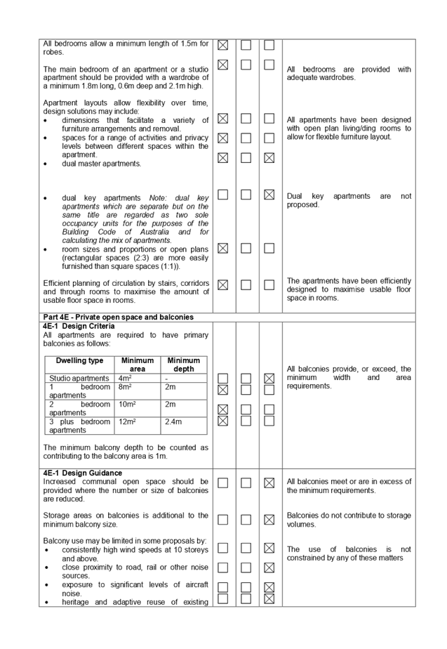
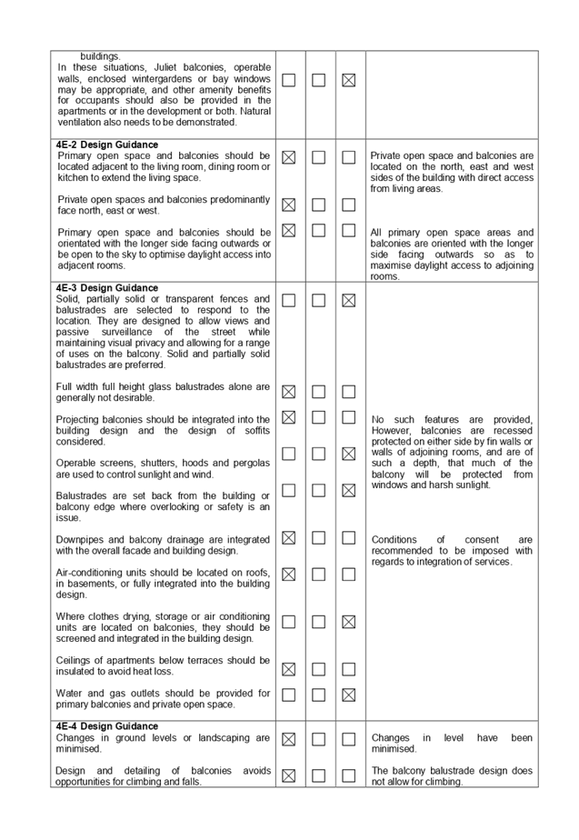
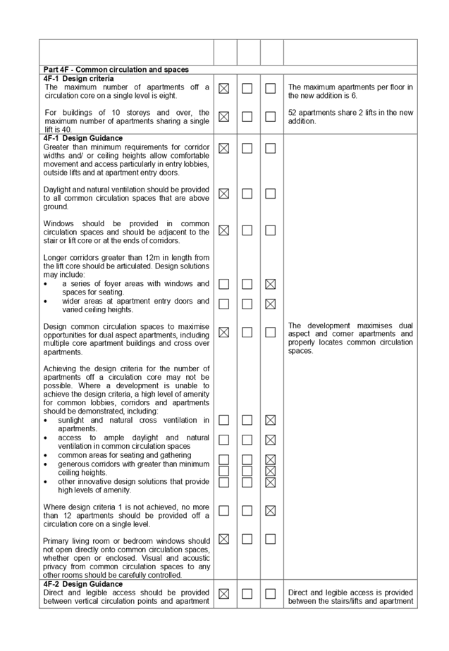
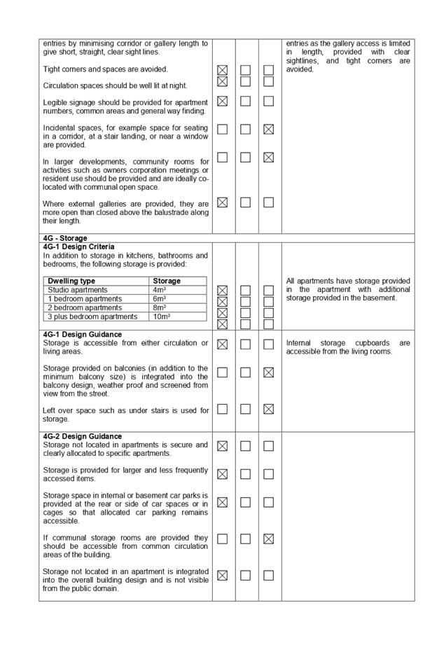
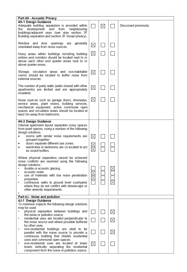
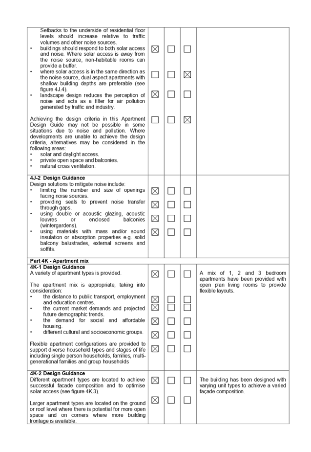
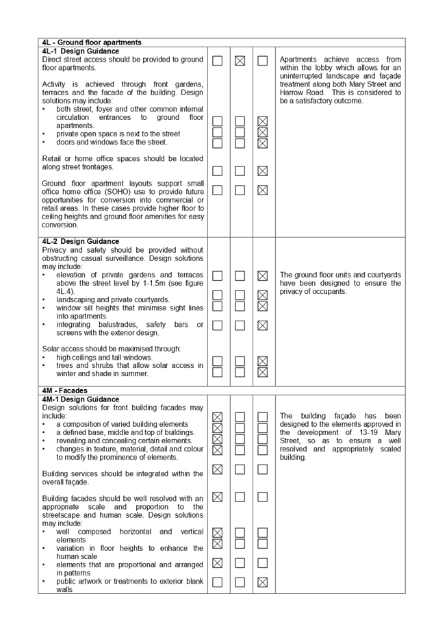
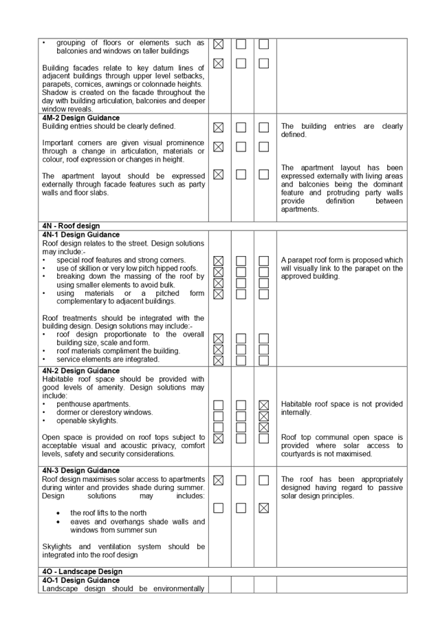
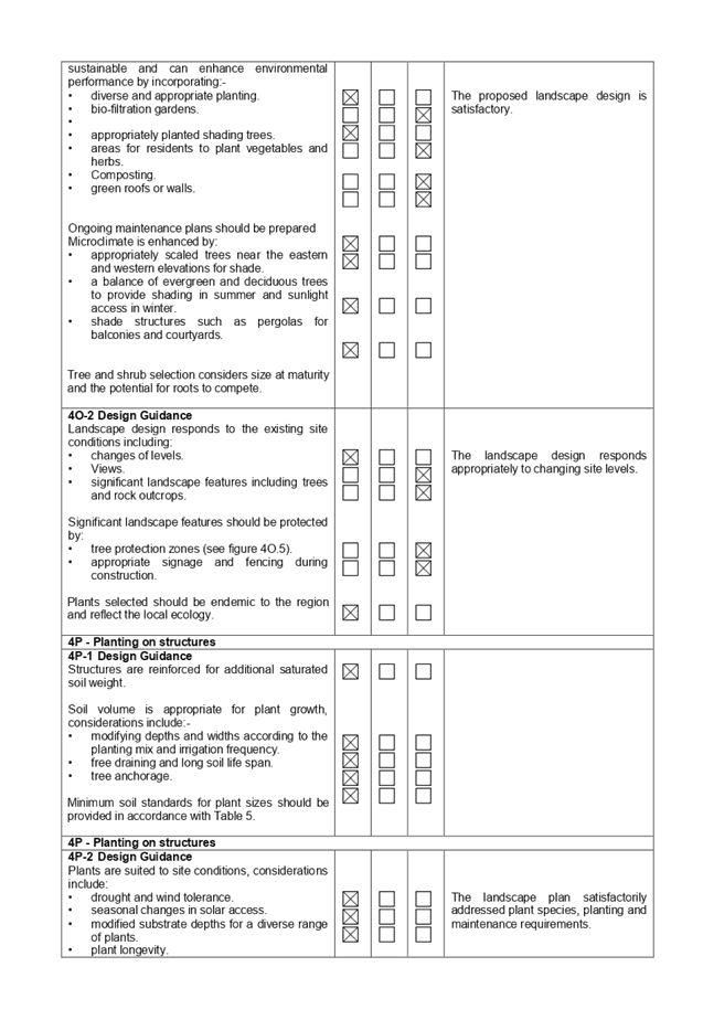
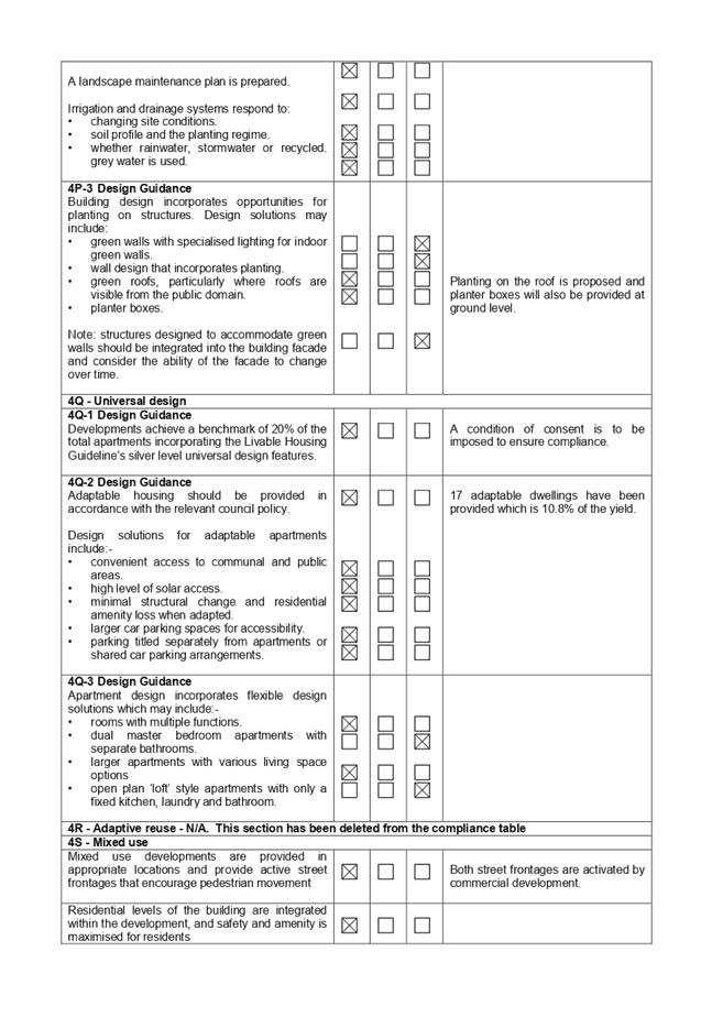
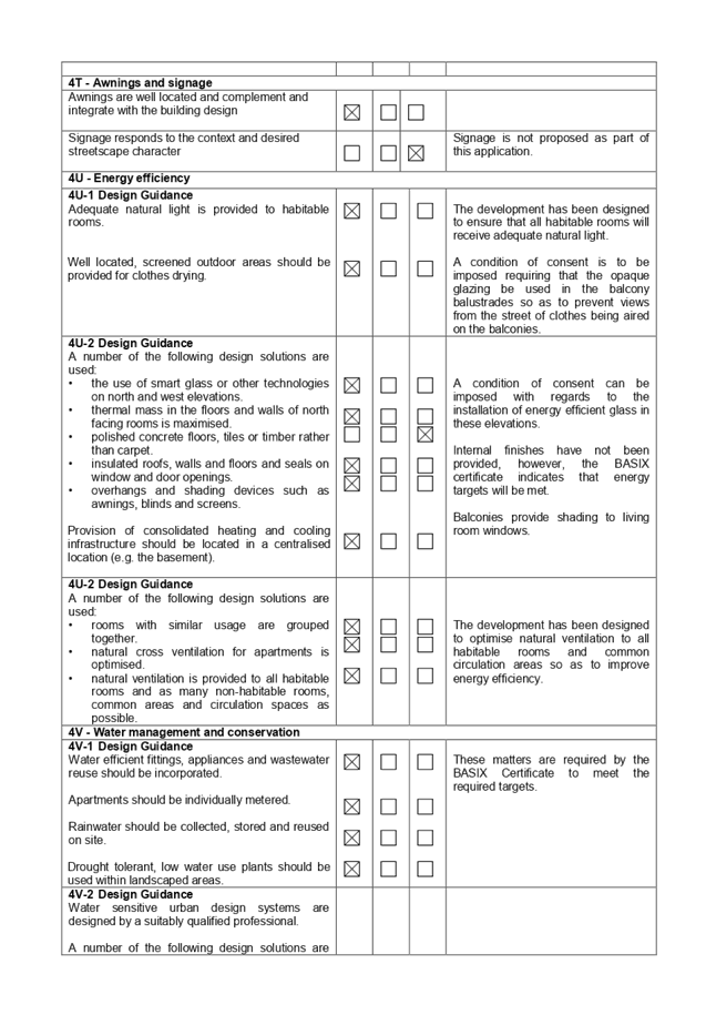
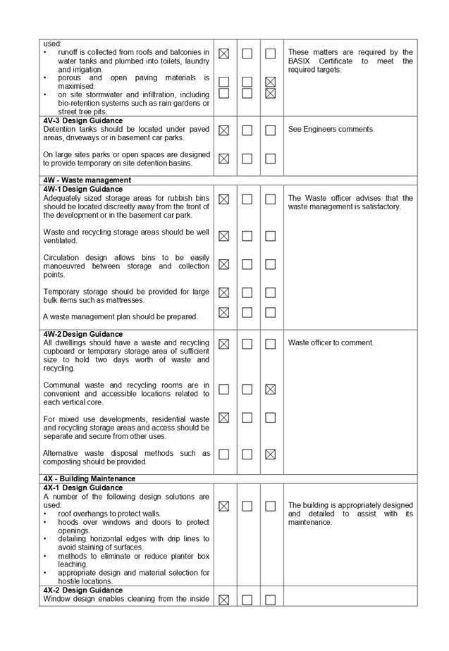
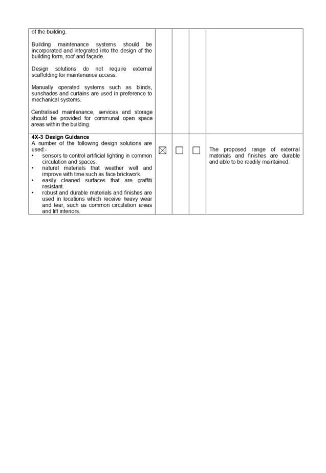
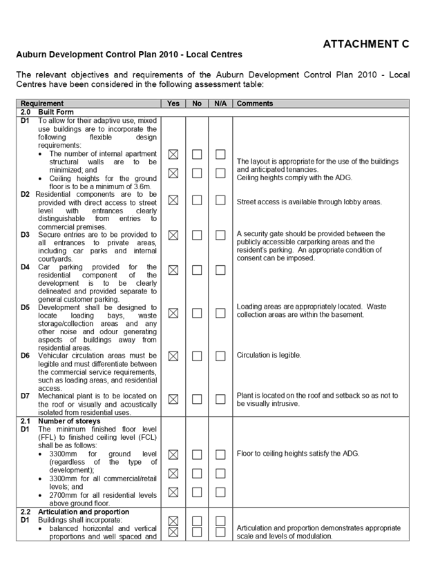
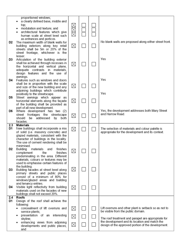
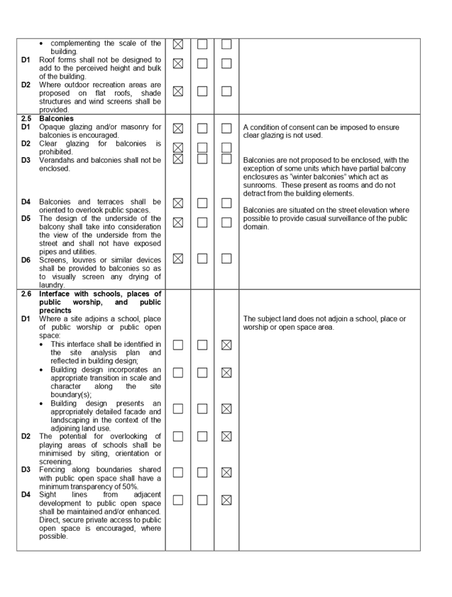
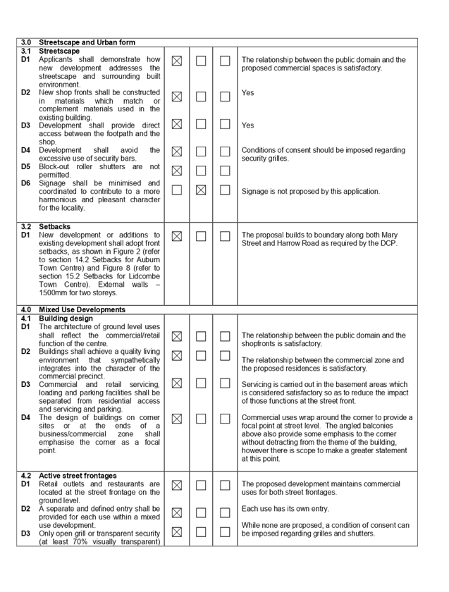
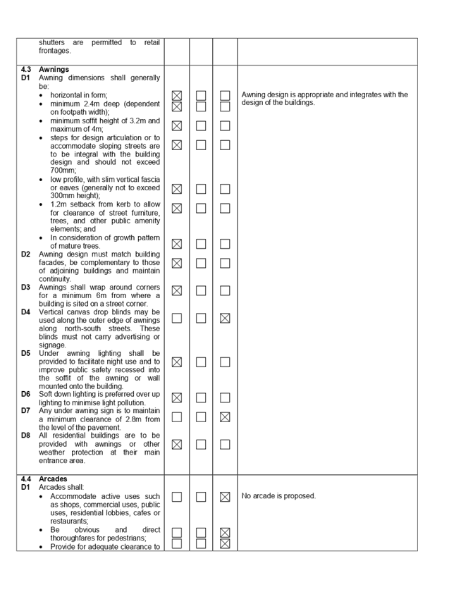
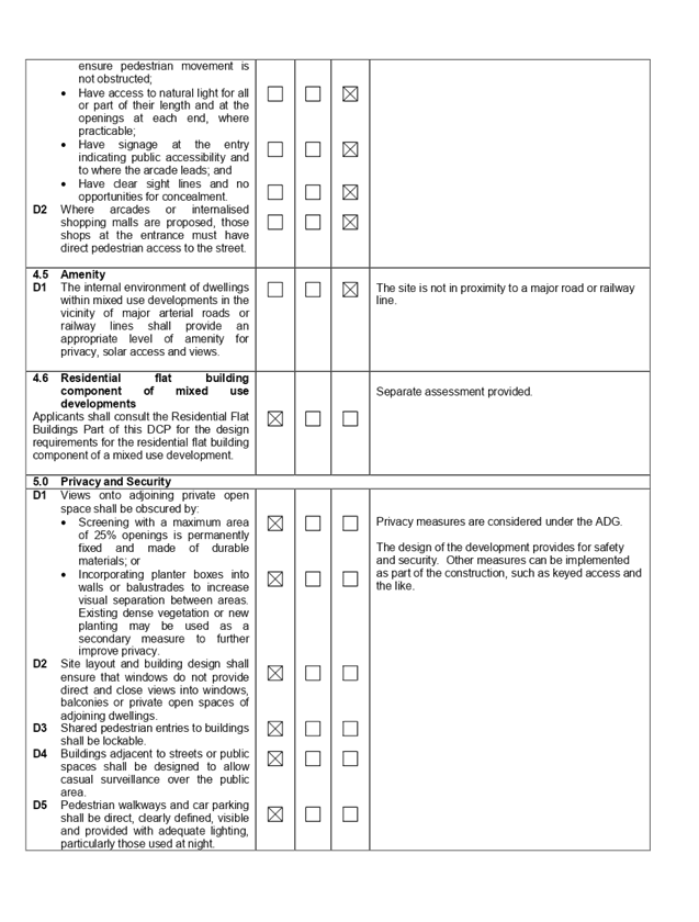
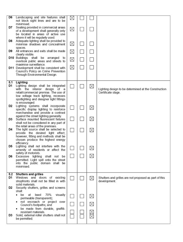
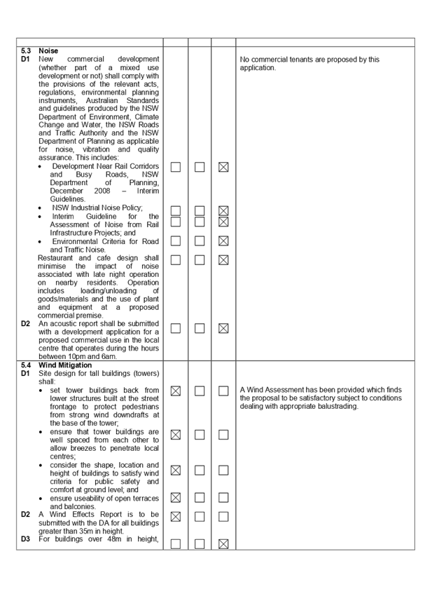
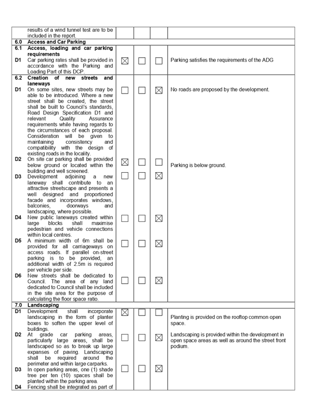
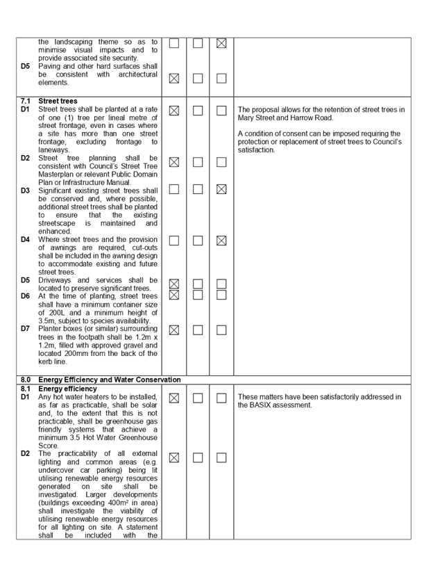
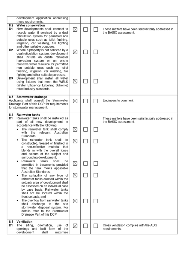
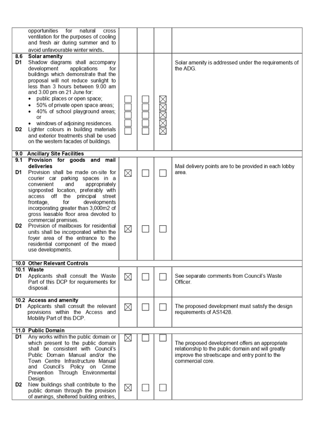
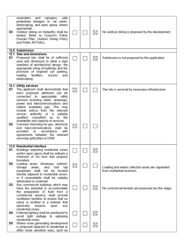
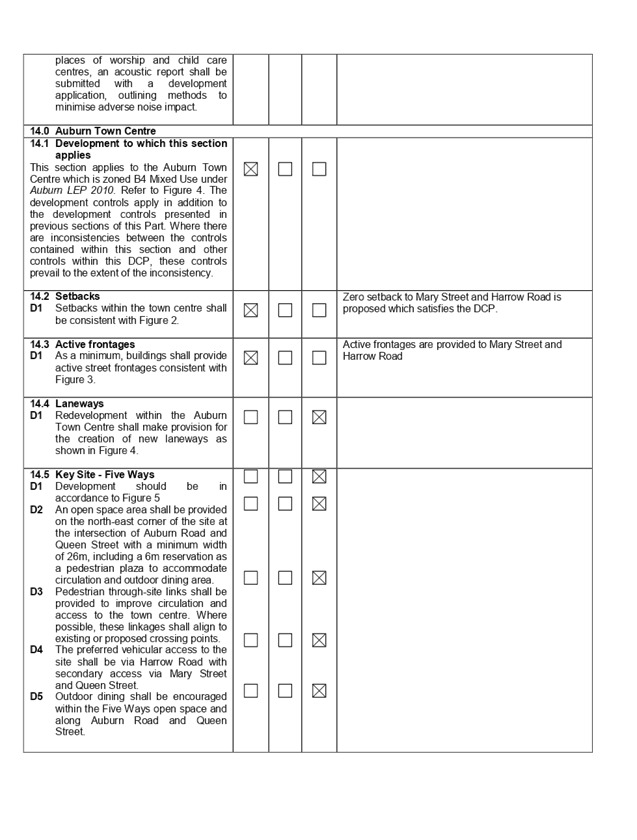
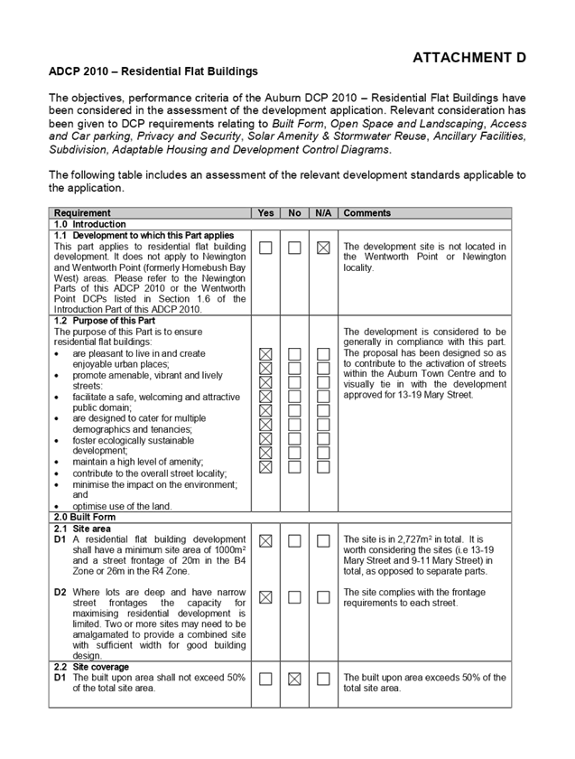
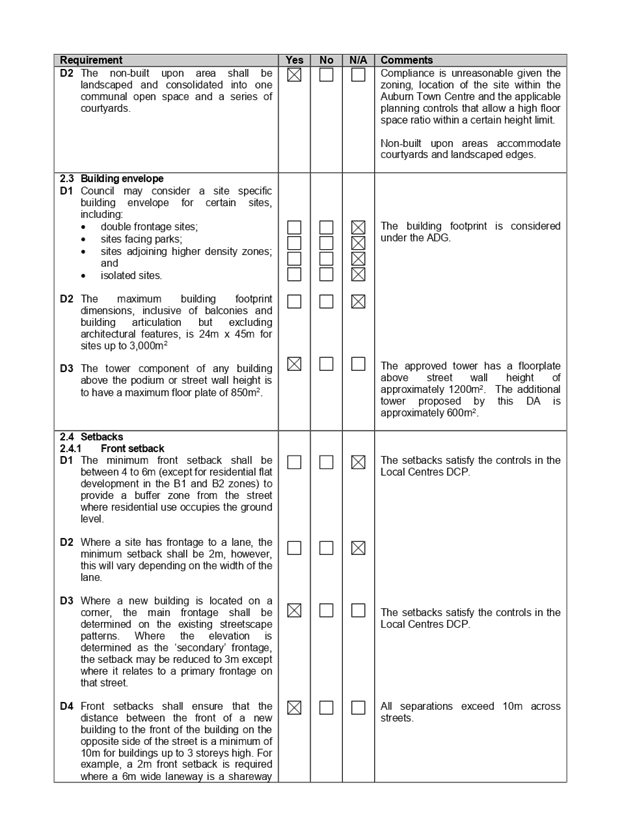
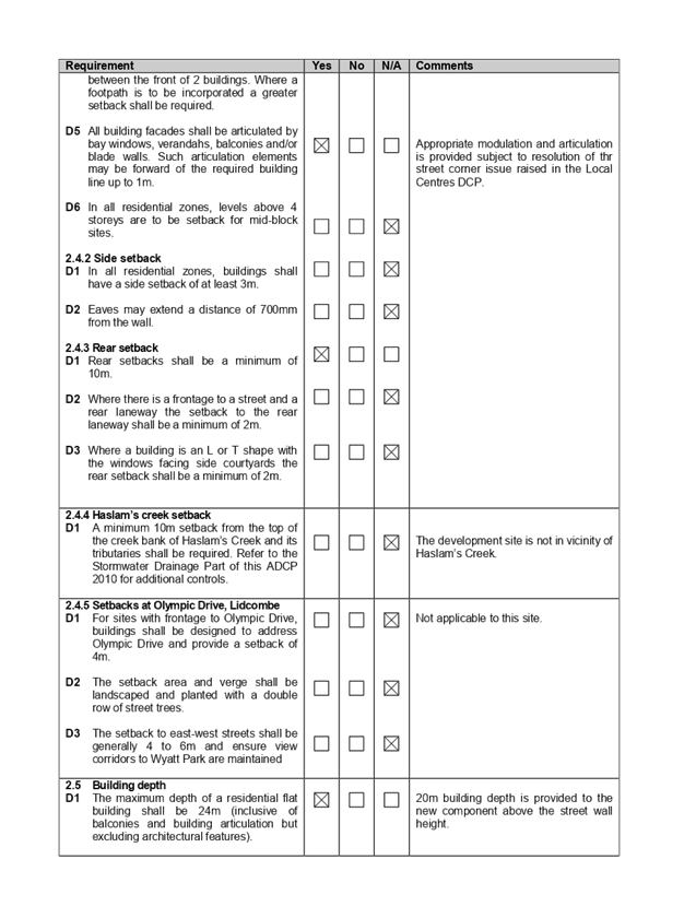
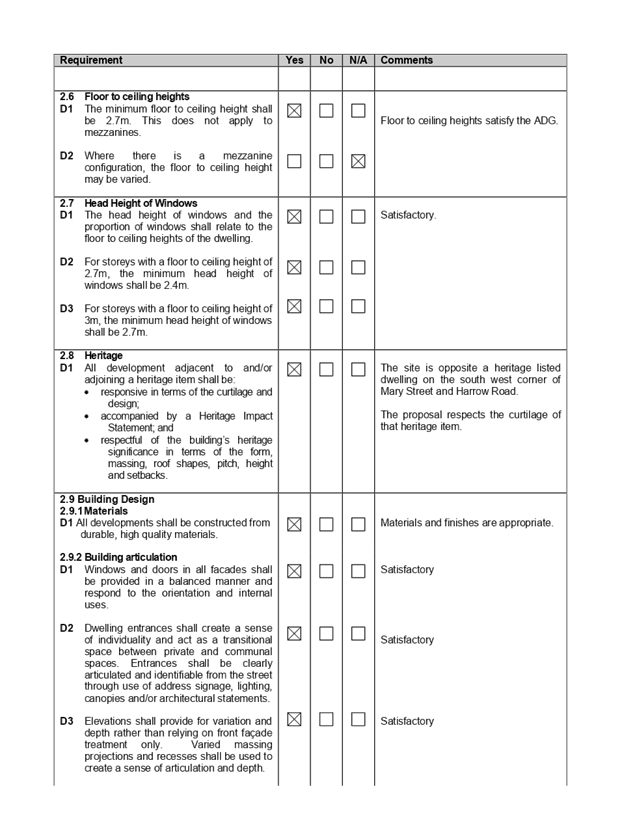
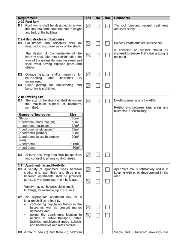
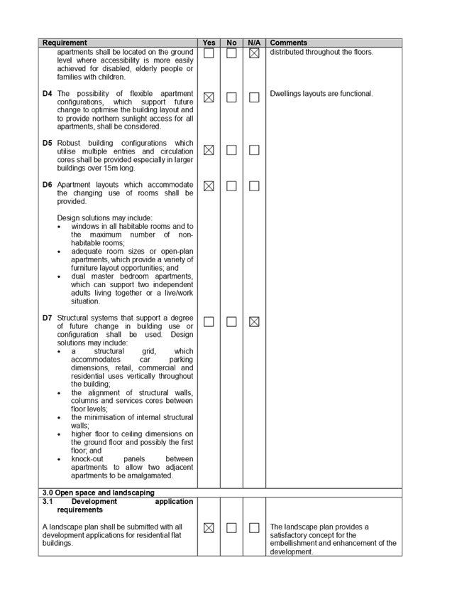
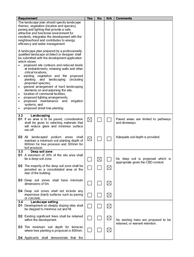
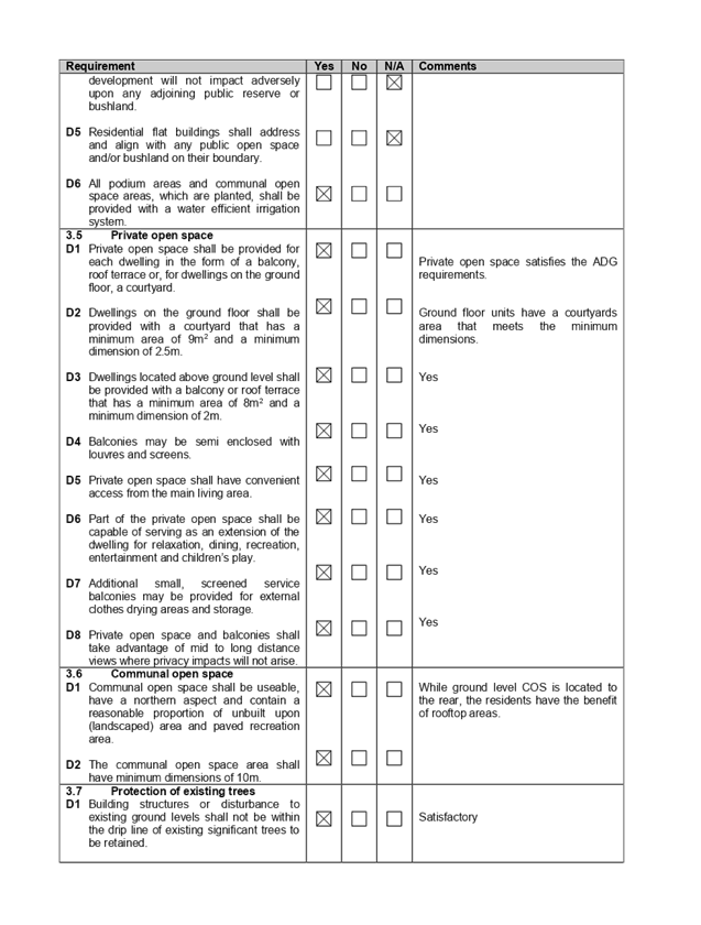
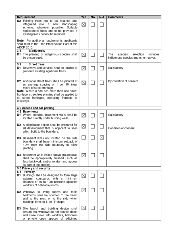
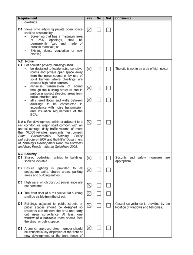
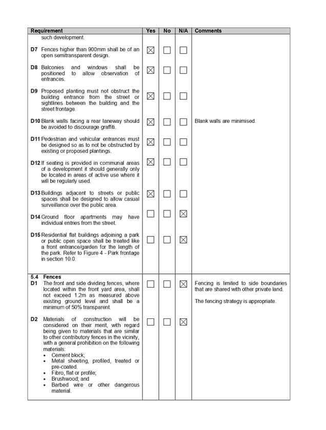
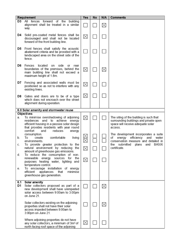
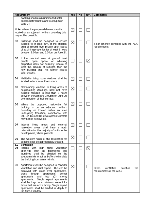
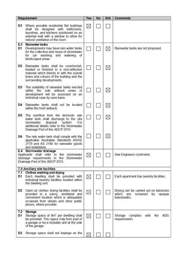
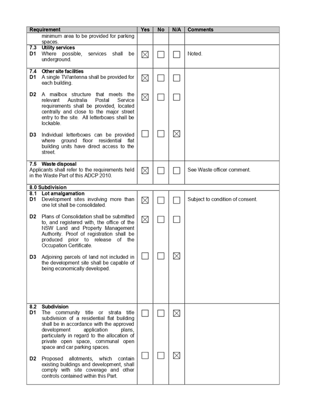

Extraordinary
Cumberland Local Planning Panel Meeting
24 July 2019
Item No: ELPP052/19
Development
Application for 14, 16 & 18 Good Street, Westmead
Responsible
Division: Environment
& Planning
Officer: Executive
Manager Development and Building
File
Number: DA
2019/3
|
Application lodged
|
8 January 2019
|
|
Applicant
|
Zhinar Architects
|
|
Owner
|
Good 888 Pty Ltd
|
|
Application No.
|
2019/3
|
|
Description of Land
|
14, 16 & 18 Good Street, Westmead
|
|
Proposed Development
|
Demolition of existing structures and construction of a
six (6) storey residential flat building, comprising 38 residential units,
over two (2) levels of basement containing 39 car parking spaces and 1 car
wash bay pursuant to State Environmental Planning Policy (Affordable Rental
Housing) 2009 – ARH SEPP
|
|
Site Area
|
1,812.10m2
|
|
Zoning
|
R4 – High Density Residential
|
|
Principal Development Standards
|
Floor Space Ratio:
Max. 1.5:1
Proposed 1.806:1 (this includes a bonus ARH FSR of
30.6%)
Height of Buildings:
Max. 21m
· Proposed: 22.2m
(5.7% variation sought)
· Clause 4.6
Written Variation Request submitted for the departure sought to building
height
|
|
Disclosure of political donations and gifts
|
Nil disclosure
|
|
Heritage
|
The subject site is not a heritage item but is
located within the vicinity of a local heritage item.
|
|
Issues
|
· Variation to
maximum 21m building height (HLEP 2013)
· Solar Access
(ARH SEPP and HDCP 2013)
· Building
separation (ADG)
· Site coverage
(HDCP 2013)
· Upper storey setback (HDCP 2013)
|
1. On
8 January 2019, development application (DA 2019/3) for the demolition of
existing structures and construction of a six (6) storey residential flat
building, comprising 38 residential units, over two (2) levels of basement
containing 39 car parking spaces and 1 car wash bay pursuant to State Environmental
Planning Policy (Affordable Rental Housing) 2009 was lodged with Council.
2. The
application was publicly notified to adjoining and opposite owners, a notice
was placed in the local press and a notice placed on the site for 21 days from
13 February 2019 to 6 March 2019. In response, the application received one
submission, objecting to the proposed development.
3. The
subject application has been assessed against the relevant provisions of the
Environmental Planning and Assessment Act 1979, State Environmental Planning
Policy (Affordable Rental Housing) 2009, State Environmental Planning Policy No
65 – Design Quality of Residential Apartment Development (SEPP 65),
Apartment Design Guide, Holroyd Local Environmental Plan 2013 (HLEP) and
Holroyd Development Control Plan 2013 (HDCP).
4. The
proposal seeks the following non-compliances which are considered supportable
as discussed in detail elsewhere in the report:
|
Control
|
Required
|
Proposed
|
% Variation
|
|
Building Height
|
Max. 21m
(HLEP 2013)
|
22.2m to top of lift
core
|
(5.7%)
|
|
Building Separation
(Between habitable rooms and balconies)
|
6m (4 storeys)
9m (5 storeys)
(ADG)
|
Min 5.5m for the balconies (4 storeys)
Min. 6m for the balconies (5 & 6 storeys)
|
10%
33.3%
|
|
Solar Access -
Min. 3 hours (9am to
3pm) mid-winter
|
70% of units
(ARH SEPP)
|
66% (25 units)
|
6%
|
|
Site coverage
|
30% (543.63m²)
(HDCP 2013)
|
35.8% (648.73m²)
|
19.3%
|
|
Rear setback
30% of site length - 5 storey
|
12m
(HDCP 2013)
|
Varying setback of 12m to 9.5m(min)
|
20.8%
|
|
Street wall height requiring an upper storey setback >
4 storeys
|
Additional 3m upper storey front setback along Good
Street
(i.e. 9m to Good Street)
|
Min 8.3m for levels 4 and 5.
|
7.8%
|
|
Sunlight access to the adjoining future proposed
development
|
Min. 3 hours (9am to
4pm) 22 June
|
Min.1 hour to units 2 and 5 (out of 33 units) for future
proposed RFB at 8-12 Good Street, Westmead
|
66.6% for 2 units out of 33 units.
|
5. The
application is being reported to the Cumberland Local Planning Panel (CLPP) for
determination as it is a development with more than 4 storeys to which the
State Environmental Planning Policy No 65 – Design Quality of Residential
Apartment Developments applies.
6. The
application is recommended for Deferred Commencement approval, subject to the
conditions in the draft determination at Attachment 5.
Introduction
The subject site is known as 14 -
18 Good Street, Westmead, and is legally described as Lot 10, 11 and 12 in
Deposited Plan 9675. The site is located on the western side of Good Street
within the R4 High Density Residential zone. The site forms a regular midblock
with a total area of 1812.10m2 and a combined frontage of 45.11m to Good
Street. The site has a fall of approximately 2.3m from the front to rear. The
site is currently occupied by detached dwelling houses, ancillary structures
and vegetation.
The subject site and neighbouring
allotments are zoned R4 – High Density Residential. The site is bounded
by a recently constructed 6 storey residential flat building to its northern
boundary and a vacant land parcel with an approved DA consent for a multi storeyed
flat building to its southern boundary and a low density housing to the west.
The eastern side of Good Street falls under City of Parramatta Local Government
Area (LGA) and comprises of higher density residential development including
older style residential flats. There is a transition occurring currently
with higher density zoned sites being developed into residential flat
buildings.
Figure
1 Aerial view of the locality with subject site (14 -18 Good Street, Westmead)
Figure
2 - Zoning map with subject site shown hatched. Source: Cumberland Council 2019
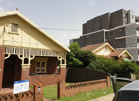
Figure
3 – No.16 Good Street. Source: Council 2019
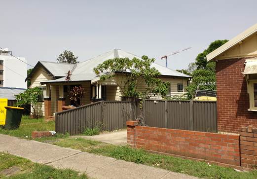
Figure
4:14 -18 Good Street. Source: Council 2019
Description of the proposed
development
DA 2019/3 proposes for the
demolition of existing structures and construction of a six (6) storey
residential flat building, comprising 38 residential units, over two (2) levels
of basement containing 40 parking spaces pursuant to State Environmental
Planning Policy (Affordable Rental Housing) 2009.
Key features of the development
proposal are as follows:-
|
Level
|
Details
|
|
Basements B1 & B2
|
40 residential car spaces (including 6 accessible parking
spaces and
1 car wash bay)
21 bicycle spaces
3 motorcycle parking spaces
Storage, plant room, lift and fire stairs
|
|
Ground floor level
|
7 residential units
Communal Open Space
|
|
Level 1
|
7 residential units
|
|
Level 2
|
7 residential units
|
|
Level 3
|
7 residential units
|
|
Level 4
|
5 residential units
|
|
Level 5
|
5 residential units
|
Access to the basement car park is
provided from a new vehicular crossing proposed on the southern section of the
subject site.
The dwelling mix of the proposal
is as follows:
· 1
x 1 bedroom units (2.6%);
· 34
x 2 bedroom units (89.5%); and
· 3
x 3 bedroom units (7.9%).
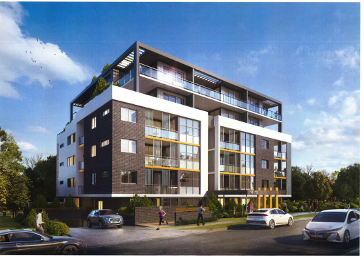
Figure
5 – Perspective of proposed development –Good Street frontage
Applicant History
|
Date
|
Action
|
|
8 January 2019
|
The subject development application (DA 2019/3) was lodged
with Council.
|
|
5 February 2019
|
The application was referred to the following internal and
external sections:
· Development
Engineering
· Traffic
Engineering
· Landscape and
Tree Management
· Environmental
Health Unit
· Rates &
Street Numbering
· Waste Management
· Transgrid
· Endeavour Energy
· Cumberland
Police Area Command
|
|
13 February 2019 to 6 March 2019
|
Application placed on public notification. In response,
one submission was received.
|
|
31 May 2019
|
The application was deferred for the following reasons:
· Apartment size
and layout
· Sunlight access
· Floor space
ratio
· Building
separation
· Traffic
engineering
|
|
13 June 2019
|
Amended plans and additional information submitted to
Council, addressing the deferral letter dated 31 May 2019. The application
did not warrant re-notification as the amendments made did not result in a
greater environmental impact.
|
|
24 July 2019
|
Application referred to CLPP for
determination.
|
Applicant’s supporting
statement
Statement of Environmental Effects
prepared by Think Planners Pty Ltd, dated 20 December 2018 was submitted in
support of the application.
Contact with relevant
parties
The assessing officer has
undertaken an inspection of the subject site and has been in contact with the
applicant throughout the assessment process.
Internal referrals
Development Engineer
The development application was
referred to Council’s Development Engineer for comment who has advised
that the development is supportable with regards to the proposed new vehicular
crossing and stormwater management, subject to deferred commencement conditions.
Traffic Engineer
The development application was
referred to Council’s Traffic Engineer for comment who has advised that
the development is supportable in regards to parking, traffic management and
on-site parking provision in the basement level, subject to conditions.
Tree Management Officer
The development application was
referred to Council’s Tree Management Officer for comment who has advised
that the impact of the development on the trees on the adjoining properties
requires further detail and this is managed by way of deferred commencement
conditions.
Waste Management Officer
The development application was
referred to Council’s Waste Management Officer for comment who has
advised that the proposed waste management is supportable subject to
conditions.
Environmental Health Unit
The development application was
referred to Council’s Environmental Health Unit for comment who has
advised that the proposal is satisfactory subject to conditions of consent
which have been imposed within the draft conditions of consent.
External Referrals
Transgrid
The development application was
referred to Transgrid for comment who has advised that the development is
supportable in regards to not affecting Transgrid’s asset.
Endeavour Energy
The development application was
referred to Endeavour Energy for comment who has advised that the development
is supportable in regards to electricity connection and sufficient clearance to
existing electricity asset, subject to conditions.
NSW Police
The application was referred to
NSW Police for comment regarding CPTED. Response dated 12 June 2019 indicates
that the proposal is satisfactory subject to conditions.
Planning Assessment
The provisions of any
Environmental Planning Instruments (EP&A Act s4.15 (1)(a)(i))
The following Environmental
Planning Instruments are relevant to the assessment of the subject application:
(a) State
Environmental Planning Policy (Affordable Rental Housing) 2009
The application has been submitted
under Part 2 New affordable rental housing – Division 1 In-fill
affordable housing of the ARH SEPP. It should be noted that the proposal fully
complies with the key planning controls contained within the ARH SEPP including
site area, landscaped area, parking, accommodation size and prescribed standards
for in-fill affordable housing. A comprehensive assessment against ARH SEPP is
attached to this report – Attachment 1.
14 Standards that cannot be
used to refuse consent
(1) (e)
solar access
If living rooms and private
open spaces for a minimum of 70 per cent of the dwellings of the development
receive a minimum of 3 hours direct sunlight between 9am and 3pm in mid-winter.
A consent authority must not
refuse consent to development if the solar access to the proposed development
satisfies the above requirements. The development however will receive 3 hours
direct sunlight between 9am and 3pm in mid-winter only to 66% of the dwellings,
or 25 units. Non-compliance with the solar access provision is supported in
this instance, given the proposal continues to satisfy Part 4A-1 of the
Apartment Design Guide for solar and daylight access, in which 2 hours direct
sunlight between 9am and 3pm in mid-winter will be provided to 79% or 30 units.
16A Character of local area
A consent authority must not
consent to development to which this Division applies unless it has taken into
consideration whether the design of the development is compatible with the
character of the local area. The SEPP (ARH) does not contain any guidance for
assessing whether a proposal is compatible with the character of the local
area. However, a planning principle for assessing compatibility in the urban
environment was established by Senior Commissioner Roseth of the Land and
Environment Court in the judgement for Project Venture Developments Pty Ltd v
Pittwater Council [2005] NSWLEC 191. This involves asking the following two
questions:
· Are
the proposal’s physical impacts on surrounding development acceptable?
The physical impacts include constraints on the development potential of
surrounding sites.
· Is
the proposal’s appearance in harmony with the buildings around it and the
character of the street?
A merit assessment of the
character of the local area should consider the following 3 steps:
· Step 1 –
Identify the ‘local area’.
· Step 2 –
Determine the character of the ‘local area’.
· Step 3 –
Determine whether the design of the proposed development is compatible with the
character of the ‘local area’.
An assessment against each step is
provided below:
Step 1 – Identify the
local area.
The local area is identified in
the map below.
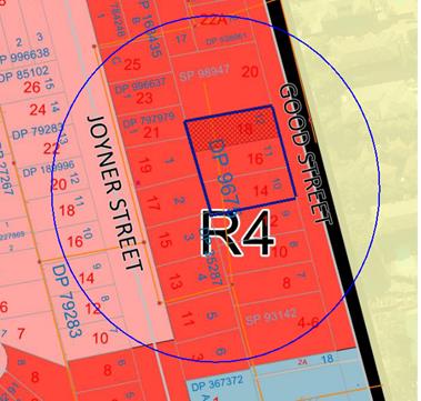
Figure
6 – Local Area catchment
The zoning of the broader locality
and immediate area comprises R4 High Density Residential, R2 Low Density
Residential (further along western side of the site, and B6 Enterprise Corridor
under the Holroyd Local Environmental Plan (HLEP) 2013.
Present Character of the area
The character of the local area
comprises the visual catchment of regular shaped allotments viewed from and
surrounding the subject site, which includes:-
1. Recently
constructed 6 storey residential flat building located on the northern side of
the site (20 -22 Good Street);
2. An
approved Development Consent (DC 2015/222) for a 5 storey residential flat
buildings located on the southern side of the site (8 -12 Good Street );
3. Proposed
5 storey residential flat building currently under assessment at 11 - 17 Joyner
Street (DA 2019/141) located at the rear of the subject site; and
4. Low
density housing development on the western side facing Joyner Street; and
5. Higher
density residential development to the east of Good Street, which falls under
Parramatta Local Government Area.
Future Character of the area
The locality is in transition
particularly to support the increasing demand of affordable housing within the
close proximity of public transport hub and major commercial centre. The
transition issue is clear with regard to FSR, height and setbacks for the proposed
development. It is considered that the height, bulk and scale of the proposed
development is similar to the recently completed and newer residential flat
buildings being constructed and would not be inconsistent with the desired
future character of the locality.
Step 2 - Determine if the
development is compatible with the character of the local area.
In accordance with the Land and
Environment Court’s ‘Planning Principle’ and case law
compatibility is best defined as ‘capable of existing together in
harmony’. In order to test compatibility two questions are to be
considered. These questions, as well as a response to each, are provided below:
· Are
the proposal’s physical impacts on surrounding development acceptable?
The physical impacts include constraints on the development potential of
surrounding sites.
The height, FSR and landscaping of
the proposed development are designed to maintain the harmony within the
streetscape, whilst contributing to the site context and constraint. The height
of building breaches the 21m height limit requirement for part of the roof and
the lift core as discussed later in the report. However, the development
does not pose any unreasonable overshadowing impacts on adjoining
properties. The proposal being a permissible land use, meets the FSR
requirement (in accordance with ARH SEPP, subject to the imposition of
conditions) and contributes to the provision of affordable housing within the
close proximity of public transport hub and major commercial centre. Appropriate
setbacks and privacy treatments are provided to minimise any adverse impacts to
the adjoining properties. The building is appropriately articulated to
complement the existing and changing streetscape within the local area. Whilst
the development will result in overshadowing to the approved future residential
flat development (DC 2015/222) on the southern side (8-12 Good Street), the
impacts are not considered unreasonable given this is a function of the
allotment orientation and R4 context. The overall design represents the form of
development that is envisaged under the planning controls. Refer to further
discussion under DCP section of the report.
· Is
the proposal’s appearance in harmony with the buildings around it and the
character of the street?
To be compatible, a development
should contain, or at least respond to the key aesthetic elements that make up
the character of the surrounding area. The size of the basement maximises
landscaping and deep soil zones on site. The front setbacks are generous and
consistent with the existing streetscape. The proposal is considered to
maintain an appropriate residential character which is consistent with the
streetscape. As indicated, the local area has an established high density
residential built form, as such, the proposed development is not considered to
be inconsistent with the existing streetscape character of the immediate area
surrounding the subject site.
In conclusion, the proposal will
maintain the harmony within the general streetscape, and suitably fits in the
local character of the locality.
(b) State
Environmental Planning Policy No 65 – Design Quality of Residential
Apartment Development (SEPP 65)
The proposal is classified as a
residential apartment development and SEPP 65 applies. A design verification
statement signed by registered architect Ian Conry was submitted with the
application.
SEPP 65 sets nine design quality
principles. The development has adequately addressed the principles in the
following way:
Figure 7 – SEPP 65 Design
Quality Principles Table
|
ADG design quality principle
|
Response
|
|
1. Context and neighbourhood
character
|
The area is zoned to accommodate
new development, including residential flat building that is a permitted type
of development within the R4 zone. The existing character of the streetscape
is in transition where existing dwelling houses are being replaced with
higher densities development, such as residential flat buildings. The
proposed development satisfies Holroyd LEP 2013 objectives in that it will
provide a variety of housing type within a high density environment. The
siting of development has been appropriately designed to minimise any
potential overshadowing and visual privacy impact to the adjoining properties
by maintaining a buffer area at the rear and side boundaries for communal
open space.
|
|
2. Built form and scale
|
The development application is
seeking consent for a 6 storey residential flat buildings over two levels of
basement car parking. The building has been designed to correspond with the
existing landform. At grade communal open space will assist in softening the
built form and minimise any potential overshadowing and visual privacy impact
to the adjoining properties.
|
|
3. Density
|
The subject
site is well located with respect to existing public transport and community
facilities. The proposal includes an affordable housing component that allows
for a maximum bonus FSR of 0.5:1 over the LEP standard for the site.
The design of the development provides for appropriate separation between
dwellings, supplemented by privacy treatment to balconies and windows where
necessary.
|
|
4. Sustainability
|
A BASIX Certificate and relevant
reports have been submitted with the development application. The
certificates require sustainable development features to be installed into
the development. The proposal will incorporate features relating to ESD in
the design and construction of the development inclusive of water efficient
fixtures and energy saving devices.
|
|
5. Landscape
|
Compliant landscape area has
been provided, which will provide appropriate level of amenity to the
resident and consistent with the environmental surrounds of the subject site.
|
|
6. Amenity
|
The proposal will deliver
sufficient amenity to residents of the building. The proposal achieves
compliance with the ADG in this regard which contains many amenity controls.
The building design incorporates access and circulation, apartment layouts,
floor area, ceiling height, private open space, common open space, energy
efficiency rating, adaptability and diversity, safety, security and site
facilities. The proposal is considered to generally comply with the ADG and
HDCP 2013 which contains numerous amenity controls. Suitable access is provided
to all parts of the building, through the efficient use of lift to access all
levels. The development is considered to provide an appropriate level of
amenity for future residents.
|
|
7. Safety
|
Suitable and secure access is
provided to all parts of the building, through the efficient use of lift to
access all levels.
|
|
8. Housing diversity and
social interaction
|
The apartment mix is considered
to be satisfactory. The specifics of the building are:-
1 x 1 bedroom apartments.
34 x 2 bedroom apartments.
3 x 3 bedroom apartments.
The number of adaptable units
proposed is considered satisfactory with the provision of associated
accessible car spaces.
|
|
9. Aesthetics
|
The residential flat building
has an attractive contemporary appearance and utilises building elements that
provide individuality to the development without compromising the streetscape
or detracting from the appearance of existing surrounding development. The
building responds well in this regard with its provision of good aesthetics
through the use of high quality materials, attention to detail in its
internal spaces and how it addresses the street frontage. The building
provides an appropriate response to the existing and likely future character
of the locality.
|
Pursuant to clause 28(2)(c) of SEPP
65, a consent authority must consider the provisions of the Apartment Design
Guide (ADG) in the assessment of a residential flat development. A
comprehensive assessment against the Apartment Design Guide (ADG) controls is
provided at Attachment 2.
The proposal involves the
following non-compliances with the ADG controls.
|
No.
|
Control
|
Comments
|
Compliance
|
|
3F
|
Visual
Privacy
|
|
|
|
|
3F-1
|
Design
Criteria
Separation between windows and balconies is provided to
ensure visual privacy is achieved. Minimum required separation distances from
buildings to the side and rear boundaries are as follows:
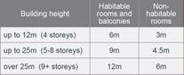
Note:
Separation
distances between buildings on the same site should combine required building
separations depending on the type of room.
Gallery
access circulation should be treated as habitable space when measuring
privacy separation distances between neighbouring properties.
|
The proposal generally complies
with the building separation requirements. However, balconies/POS of level 4 Units
(30 and 31) along the northern elevation do not
comply. Notwithstanding, Council considers
this issue can be resolved by way of deferred commencement condition and
amendments in red on the plans, requiring design amendments for the
respective balconies to provide the required separation.
Unit 33 balcony along the
southern elevation does not comply. However, planter boxes and privacy screen
provided which is considered acceptable in this instance.
Levels 1 – 3
6m is required
Northern boundary:
5.7m from the balconies of units
9, 6 & 23. Minor encroachment is acceptable as no adverse amenity
impacts.
Southern boundary:
5.6m
proposed from the balconies of units 13, 20
& 27.
Levels 4 & 5
9m is required
Northern boundary:
Between
6m to 7.4m from the balconies 30 & 31.
Southern boundary:
Between
7.8m to 8.4m from the balconies of units 29 & 33.
Minimum
8m from the balcony of unit 34 (level 5).
Condition has been imposed to
amend the balcony design of the respective units to ensure these comply with
the building separation requirement.
|
|
|
|
|
4E
|
Private
Open Space and Balconies
|
|
|
|
|
4E-1
|
For
apartments at ground level or on a podium or similar structure, a private
open space is provided instead of a balcony. It must have a minimum area of
15 m2 and a minimum depth of 3 m.
|
As
mentioned above, a condition has been imposed to reduce the balcony size of
some units to ensure compliance with building separation requirement. This
will result in reduction of the primary balcony size of unit 30 to 10m2.
However, there is a secondary balcony with an area of 12m2. This
equates to a total balcony area of 22m2 which is sufficient.
As
such, the minor deficiency in the primary balcony area is considered
satisfactory.
|
|
|
|
|
|
|
|
|
|
|
(c) State
Environmental Planning Policy (Infrastructure) 2007
Clause 45 – Development
likely to affect an electricity transmission or distribution network
The development application was
referred to Endeavour Energy and TransGrid for comment, who raised no
objections, subject to conditions.
(d) State
Environmental Planning Policy No 55 – Remediation of Land (SEPP 55)
The requirement at clause 7
of SEPP 55 for Council to be satisfied that the site is suitable or can be made
suitable to accommodate the proposed development has been considered in the
following table:
|
Matter
for consideration
|
Yes
|
No
|
|
Does the application involve re-development of the site or
a change of land use?
|
|
|
|
Is the development going to be used for a sensitive land
use (e.g. residential, educational, recreational, childcare or hospital)?
|
|
|
|
Does information available to you indicate that an
activity listed below has ever been approved, or occurred at the
site?
acid/alkali plant and formulation,
agricultural/horticultural activities, airports, asbestos production and
disposal, chemicals manufacture and formulation, defence works, drum
re-conditioning works, dry cleaning establishments, electrical manufacturing
(transformers), electroplating and heat treatment premises, engine works,
explosive industry, gas works, iron and steel works, landfill sites,
metal treatment, mining and extractive industries, oil production and
storage, paint formulation and manufacture, pesticide manufacture and
formulation, power stations, railway yards, scrap yards, service stations,
sheep and cattle dips, smelting and refining, tanning and associated trades,
waste storage and treatment, wood preservation
|
|
|
|
Is the site listed on Council's Contaminated land
database?
|
|
|
|
Is the site subject to EPA clean-up order or other EPA
restrictions?
|
|
|
|
Has the site been the subject of known pollution incidents
or illegal dumping?
|
|
|
|
Does the site adjoin any contaminated land/previously
contaminated land?
|
|
|
|
Has the appropriate level of investigation been carried
out in respect of contamination matters for Council to be satisfied that the
site is suitable to accommodate the proposed development or can be made
suitable to accommodate the proposed development?
|
|
|
|
Details of contamination investigations carried out at
the site:
The site is not identified in Council’s records as
being subject to contamination. There is no evidence available to suggest
that the site has ever been used for a potentially contaminating activity. No
further investigation is considered necessary in the circumstances.
|
(e) State
Environmental Planning Policy (Building Sustainability Index: BASIX) 2004
BASIX certificate 985498M dated 20
December 2018 was submitted with the original plans. The submitted BASIX
certificate achieves target scores and is consistent with the architectural
plans. Conditions of Consent have been applied requiring adherence to the BASIX
Certificate requirements.
Regional Environmental Plans
(Deemed State Environmental Planning Policies)
(f) Statement
Environmental Planning Policy No 19 - Bushland in Urban Areas
The proposal does not propose to
disturb bushland zoned or reserved for public open space.
(g) State
Environmental Planning Policy (Vegetation in Non-Rural Areas) 2017
The proposal includes removal of
existing trees within the subject site. However, this does not exceed the
biodiversity offsets scheme threshold and the majority of the trees on site are
exempt species. Therefore, the proposed vegetation removal is considered
acceptable. Refer to the HDCP 2013 compliance table at attachment 3 for further
comment regarding the proposed tree removal.
(h) State
Environmental Planning Policy (Coastal Management) 2018
The subject site is not identified
as a coastal wetland nor is it ‘land identified as “proximity area
for coastal wetlands” as per Part 2, Division 1 of the SEPP Coastal
Management 2018.
(i) Holroyd
Local Environmental Plan 2013 (HLEP 2013)
The proposed development is
defined as a ‘residential flat building’ under the provisions of
HLEP 2013. Residential flat buildings are permitted with consent in the R4
– High Density Residential zone which applies to the land.
The proposal seeks a variation to
Clause 4.3 – Height of Buildings that stipulates that the height of
building is not to exceed 21m on the subject site.
The proposed building has an
overall height of 22.2m (RL 55.30.) to the top of the lift core and RL 54.70 to
the top of the structures associated with the roof top communal open
space. The proposal breaches the overall height by 1.2m representing a
maximum variation of 5.7%. The majority of the height breach is associated with
the roof of the building and the top of the lift core.
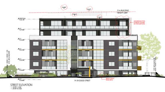
Figure
8 – Elevation Plan showing extent of height variation sought
Clause 4.6 – Variation
to Building Height
Clause 4.6 allows the consent
authority to vary development standards in certain circumstances and provides
an appropriate degree of flexibility to achieve better design outcomes. The
consent authority may grant the exception as the Secretary’s concurrence
can be assumed where clause 4.6 is adopted as per the Department of Planning
Circular PS 18-003, dated 21 February 2018.
The applicant has submitted a
written request to vary the development standard for building height. Based on
various case laws established by the Land and Environment Court of NSW such
as Four2five P/L v Ashfield Council [2015] NSWLEC 9, Randwick City Council v
Micaul Holdings P/L [2016] NSW LEC7 and Zhang and anor v Council of the City of
Ryde [2016] NSWLEC 1179, a 3 part assessment framework for a variation
request proposed under clause 4.6 has been considered and an assessment of the
proposed variance, following the 3 part test is discussed in detail below.
The 3 preconditions which must be
satisfied before the application can proceed are as follows:
1. Is
the proposed development consistent with the objectives of the zone?
Applicant’s
justification:
The proposal ensures that the
high-density nature of the zone is retained and there is not a significant
change to the character of the locality. In addition, the proposal complements
and enhances the local streetscape by virtue of the careful siting of the
development.
Planner’s comment:
Residential flat buildings are a
permitted land use and the locality is undergoing a transition particularly to
support the increasing demand of affordable housing within the close proximity
of public transport hub and major commercial centre. The proposed development
is considered to be consistent with the objectives of the R4 High Density
Residential zone.
2. Is
the proposed development consistent with the objectives of the development
standard which is not met?
Applicant’s
justification:
The development seeks to depart
from the height control noting that the proposal remains consistent with the objectives
of the clause and is a more appropriate outcome on the site because of the
following:
- Non-compliance
is minor in nature with the majority of the building being compliance with the
building height control and with the lift and stairwell overrun recessed its
impact to the streetscape is negligible as it will be visually unnoticeable
when viewed from the street level.
- Due
to the minor nature of the variation, it will not have any adverse amenity
impacts. In this regard it is noted:
o The variation will be visually
unnoticeable and will have no adverse impact on the physical bulk, height or
scale of the development;
o The variation will not lead to a
reduction in solar penetration on site or to adjoining properties nor will it
lead to sunlight loss or overshadowing;
o The proposed variation will not lead
to view loss or interrupt on views to and from the site;
o The proposed variation will not lead
to a reduction in privacy afforded to existing residents or future residents of
the proposal.
- The
proposal has been designed to ensure that privacy impacts are mitigated that
the proposal will not obstruct existing view corridors.
- The
proposed development will permit the site to develop to its full zoning
potential whilst complementing the future vision envisioned for the site by
providing a residential flat building that provides good address to the street
frontage and complying with key planning controls applying to the proposal.
- The
proposal is not located within a low density area and the proposal represents
an appropriate built form on site.
As outlined above, the proposal
remains consistent with the underlying objectives of the control and, as such,
compliance is considered unnecessary or unreasonable in the circumstances. The
above discussion demonstrates that there are sufficient environmental planning
grounds to justify the minor departure from the control.
Planner’s comment:
The objectives of the building
height standard are to enable appropriate development density to be achieved
and to ensure that the height of the building is compatible with the character
of the locality as outlined above. The proposal is compliant (subject to
conditions) with the maximum inclusive of the bonus provision under the ARH
SEPP. The increased height does not result in an additional level for
residential use, as it comprises portion of the roof structures and the top of
the lift core.
The departure sought is considered
to be modest and does not unreasonably impact on adjoining properties. The
additional height does not result in the appearance of bulk when viewed from
the existing streetscape and would not impinge on the changing streetscape that
is anticipated for the immediate area. Given that the proposed development
responds to the site and does so without compromising relationships with
adjoining development, overshadowing to the property at the southern side (8-12
Good Street) is acceptable and does not unduly compromise other relevant
controls, the proposal is considered to be consistent with the objectives of
height requirements and development within the R4 zone.
3. a)
Is compliance with the development standard unreasonable or unnecessary in the
circumstances of the case?
Applicant’s
justification:
In accordance with the provision s
of this clause it is considered that compliance with the development standard
is unreasonable and unnecessary in the circumstances of the case as the
underlying objectives of the control are achieved.
Planner’s comment:
Council Officers are satisfied
that the proposed variation has been appropriately justified and can be
supported in this instance. The height breach is limited to an overall building
height of RL 54.70 for the rooftop communal open space, and height of RL 55.30
for the top of the lift core. The additional height of the lift core will not
be visible from the adjacent streets and properties. The proposed variation to
the development standard is necessary for the structure containing the lift
core and in order to achieve required FFLs, and is consistent with the scale of
the development within the R4 zone located in the immediate vicinity of the
site. The departure sought is considered to be modest and does not unreasonably
impact on adjoining properties. The additional height does not result in the
appearance of bulk when viewed from the existing streetscape, would not impinge
on the changing streetscape that is anticipated for the immediate area and does
not result in additional overshadowing to the adjoining properties. It is
considered, therefore, that the non-compliance with the Development Standard is
not unreasonable or unnecessary in the circumstances of the case.
b) Are there sufficient environmental
planning grounds to justify contravening the development standard and therefore
is the applicant’s written justification well founded?
The unique circumstances of the
case are considered to warrant support of the departure. Given that the
proposed development responds to the site and does so without unduly
compromising relationships with adjoining development, and does not unduly
compromise other relevant controls, the proposal is considered to be consistent
with the objectives of building height, and development within the R4 zone. In
this regard, the exception is well founded and can be supported.
Conclusion:
Council is satisfied that the
applicant’s written request has adequately addressed the matters required
to be demonstrated by clause 4.6 subclause (3). Council is further satisfied
that the proposed development will be in the public interest because it is consistent
with the objectives of the particular standard and the objectives for
development within the zone in which the development is proposed to be carried
out.
It is the view of Council Officers
that justification provided is satisfactory and having considered the
application on its merit, the exception to the maximum building height
development standard is considered acceptable in this instance.
An assessment against all the
relevant LEP provisions is provided at Attachment 3.
The provisions of any proposed
instrument that is or has been the subject of public consultation (EP&A Act
s4.15 (1)(a)(ii))
There are no draft SEPPs
applicable to the proposed development.
The provisions of any
Development Control Plans (EP&A Act s4.15 (1)(a)(iii))
(a) Holroyd
Development Control Plan 2013
HDCP 2013 contains general
controls which relate to all developments under Part A, and Residential
Controls under Part B.
A comprehensive HDCP compliance
table is attached to this report at Attachment 4. A summary of the DCP
non-compliances is provided in the following table.
|
Control
|
Provided
|
Complies
(Yes/No)
|
|
Sunlight Access:
1 main living area of existing adjacent dwellings to
receive 3 hours direct sunlight between 9am and 4pm, 22 June
|
The adjoining
southern site (8-12 Good Street) is currently vacant. However a development
application (DA 2016/222) has been approved for a 5 storey residential flat
building. The solar access diagrams submitted with the application indicate
that some of the proposed future units living areas windows are provided
along the northern elevation which will be overshadowed by the subject
development.
ii)
The solar access diagrams submitted
with the application depict 1 hour of solar access is achieved to the
adjoining proposed development units 02 (G.F) and unit 05 (L1) between 9am
and 10am.
iii)
However, this is
considered to be reasonable based on the following merits:
iv)
The site is zoned R4 High Density
Residential with a building height control permitting 6 storey development on
the subject site and the adjoining site;
· The non-compliance is a function of the allotment
orientation as No.8-12 is located immediately to the south of the site which means that avoiding overshadowing impacts, whilst
enabling development for a residential flat building proposal is not possible
without delivering a significant underdevelopment on the subject site;
· The setbacks
exceed the 3m control in Holroyd DCP 2013 and the upper levels are further
stepped back to maximise separation to the adjoining
developments. Therefore it is not possible to achieve the
required levels of solar access, even when fully complying with the building
separation and building height requirements.
· The impact of the proposal on a future residential flat
building would only be limited to a few units on ground floor and
level 1 and would not preclude compliance with the ADG requirement of 70% of
units to achieve 2 hours solar access;
· It is
considered that the additional overshadowing is acceptable when having regard
to the lot orientation, design of the development proposal that meets the
building envelope controls. Therefore the variation has merit on planning
grounds, and is considered supportable.
|
No – Acceptable in this instance.
|
|
Max site coverage 30%, or
543.63m²
|
35.8% (648.73m²) non-compliance is considered
acceptable given that the proposal still achieves adequate provision of deep
soil planting, landscaping, driveways, communal open space and OSD system.
|
No – Acceptable in this instance.
|
|
Rear setback
30% of site length, or 12m
for 5 storey
|
Varying setback of 12m to 9.5m(min), non-compliance is
considered acceptable given that the setbacks satisfy with the ADG
requirements, as discussed above.
|
No – Acceptable in this instance.
|
|
All floors >4 storeys to be setback 3m.
|
The proposed development provides a varying upper storey
setback of 9m to 8.3m (min) to Good Street. This is considered acceptable
noting it provides articulation and visual relief to the upper levels of the
building. In addition, the proposed articulation and setback is generally
consistent with the approved developments on the adjoining sites.
|
No – Acceptable in this instance.
|
Any planning agreement that has
been entered into under section 7.4, or any draft planning agreement that a
developer has offered to enter into under section 7.4 (EP&A Act s
4.15(1)(a)(iiia))
There is no planning
agreement or draft planning agreement associated with the subject Development
Application.
The provisions of the
Regulations (EP&A Act s4.15 (1)(a)(iv))
Pursuant to clause 92 of the
Regulation, the provisions of AS 2601 must be considered in the case of a
development application for the demolition of a building. Standard conditions
are included in the draft determination to require the proposed demolition
works to be carried out in accordance with AS 2601.
The Likely Environmental,
Social or Economic Impacts (EP&A Act s4.15 (1)(b))
The likely environmental, social
and economic impacts of the development have been assessed and are considered
satisfactory.
The suitability of the site for
the development (EP&A Act s4.15 (1)(c))
The site is considered suitable
for the proposed development.
Submissions made in accordance
with the Act or Regulation (EP&A Act s4.15 (1)(d))
Advertised (newspaper) Mail
Sign Not Required
In accordance with Part E - Public
Participation of HDCP 2013, the proposal was publicly notified for a period of
21 days from 13 February 2019 to 6 March 2019. As a result of the notification,
one submission was received. Amended plans submitted did not warrant
re-notification of the proposal.
The issues raised in the public
submission are summarised and commented on as follows:
i) Building
area to land size is too small and would adversely affect the community visual
outlook.
Comment: The proposal is defined
as a “Residential Flat Building” which is a permissible land use
under the subject site R4- High Density Residential zoning. The proposed
development is considered appropriate for the site and commensurate in bulk and
scale with the neighbouring developments and the desired future character
envisaged for the locality.
Also, the proposal sits
comfortably in the streetscape and incorporates architectural features and articulation
to minimise any adverse visual intrusiveness of the building. It is considered
that no significant views are blocked by the development.
ii) The
development shall have a larger front yard area and shall not be built so close
to the street.
Comment: The proposal complies
with the front setback requirements in accordance with Holroyd Development
Control Plan 2013. There is substantial planting proposed along the street
frontage which enhances the streetscape and provides area for passive recreation.
Section 7.11 of the
Environmental Planning & Assessment Act 1979
The subject development requires
the payment of contributions in accordance with Holroyd Section 94 Development
Contributions Plan 2013. A condition is imposed requiring the payment of
contributions.
In accordance with the currently
indexed rates for the Mays Hill Centre contribution area, the following
contributions apply:
· 1
x 1-bedroom dwellings = $8,399.64
· 34
x 2-bedroom dwellings = $482,978.67
The required Section 7.11
contribution payable for the proposal is $491,378.00
Note: This includes Credit for the
existing 3 x 3-bedroom dwellings.
The public interest
The public interest is served by
permitting the orderly and economic use of land, in a manner that is sensitive
to the surrounding environment and has regard to the reasonable amenity expectations
of surrounding land users. In view of the foregoing analysis, it is considered
that approval of the proposed development would not be contrary to the public
interest.
Disclosure of Political
Donations and Gifts
The NSW Government introduced The
Local Government and Planning Legislation Amendment (Political Donations) Act
2008 (NSW). This disclosure requirement is for all members of the public
relating to political donations and gifts. The law introduces disclosure
requirements for individuals or entities with a relevant financial interest as
part of the lodgement of various types of development proposals and requests to
initiate environmental planning instruments or development control plans.
The application and notification
process did not result in any disclosure of Political Donations or Gifts.
The proposed development has been
assessed in accordance with the relevant requirements of the Environmental
Planning and Assessment Act 1979, State Environmental Planning Policy
(Affordable Rental Housing) 2009, State Environmental Planning Policy No 65
– Design Quality of Residential Apartment Development, Holroyd Local
Environmental Plan 2013 and the Holroyd Development Control Plan 2013 and is
considered to be satisfactory.
There are no further consultation
processes for Council associated with this report.
There are no further financial
implications for Council associated with this report.
There are no policy implications
for Council associated with this report.
Communication /
Publications:
The final outcome of this matter
will be notified in the newspaper. The objectors will also be notified in
writing of the outcome.
|
1. That
Development Application 2019/3/1 for the demolition of existing structures
and construction of a six (6) storey residential flat building, comprising 38
residential units, over two (2) levels of basement containing 39 parking
spaces and 1 car wash bay pursuant to State Environmental Planning
Policy (Affordable Rental Housing) 2009 was lodged with Council, be Approved
via Deferred Commencement, subject to the attached conditions, provided at
Attachment 5.
2. That
the applicant and those persons who lodged a submission in respect to the
application be notified of the determination of the application.
|
1. SEPP ARH 2009
Compliance Table ⇩ 
2. ADG
Compliance Table ⇩
3. HLEP
2013 Compliance Table ⇩ 
4. HDCP
2013 Compliance Table ⇩
5. Draft
Notice of Determination ⇩
6. Architectural
Plans ⇩ 
7. Shadow
Diagrams ⇩
8. Accompanying
Clause 4.6 Variation Request to Building Height ⇩
9. Locality
Map ⇩
10. Submission
(1) ⇩
DOCUMENTS
ASSOCIATED WITH
REPORT ELPP052/19
Attachment 1
SEPP ARH 2009 Compliance Table
Extraordinary Cumberland Local Planning
Panel Meeting
24 July 2019
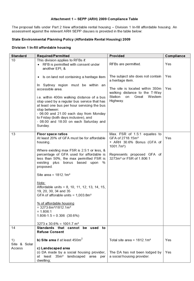
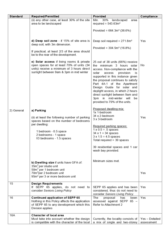
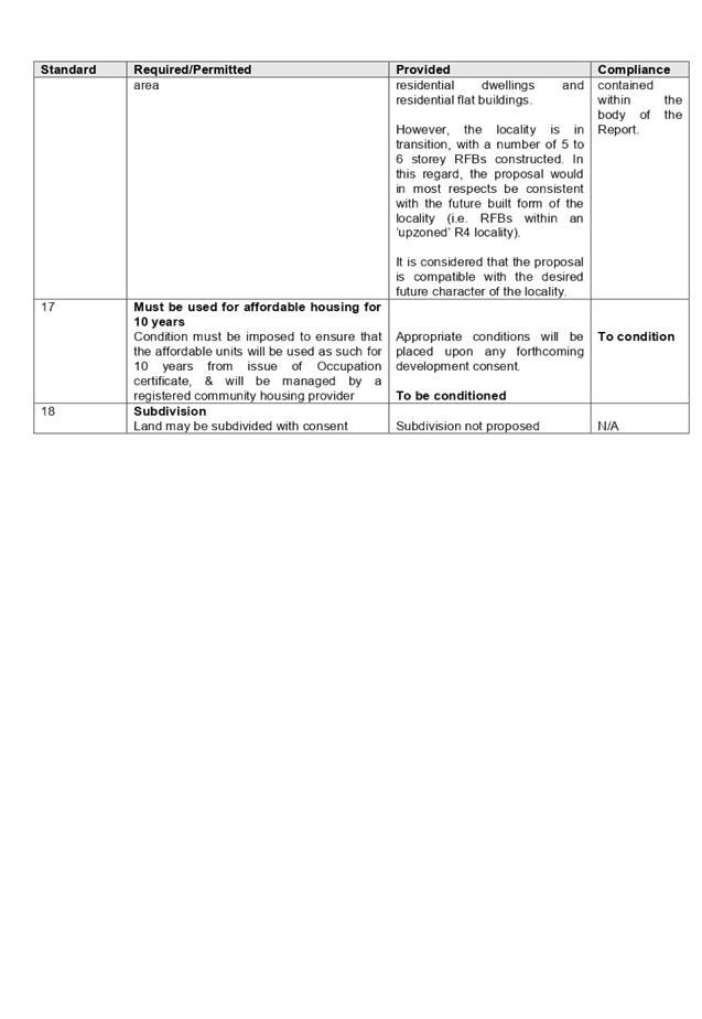
DOCUMENTS
ASSOCIATED WITH
REPORT ELPP052/19
Attachment 2
ADG Compliance Table
Extraordinary Cumberland Local Planning
Panel Meeting
24 July 2019
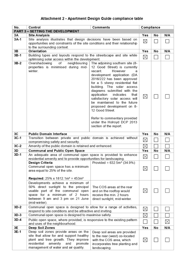
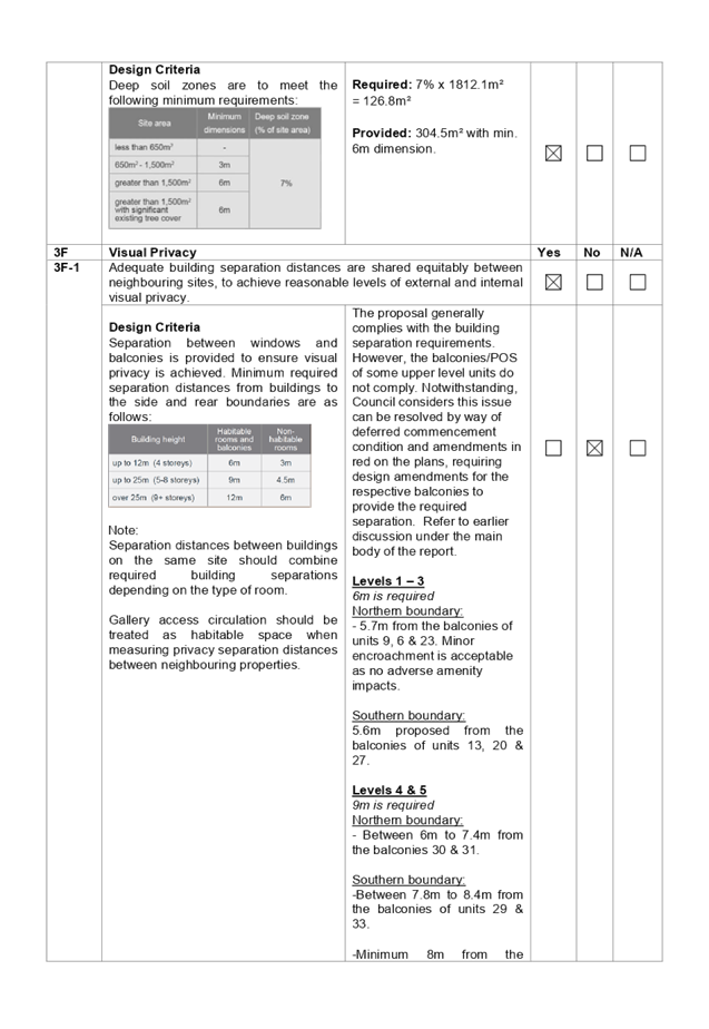
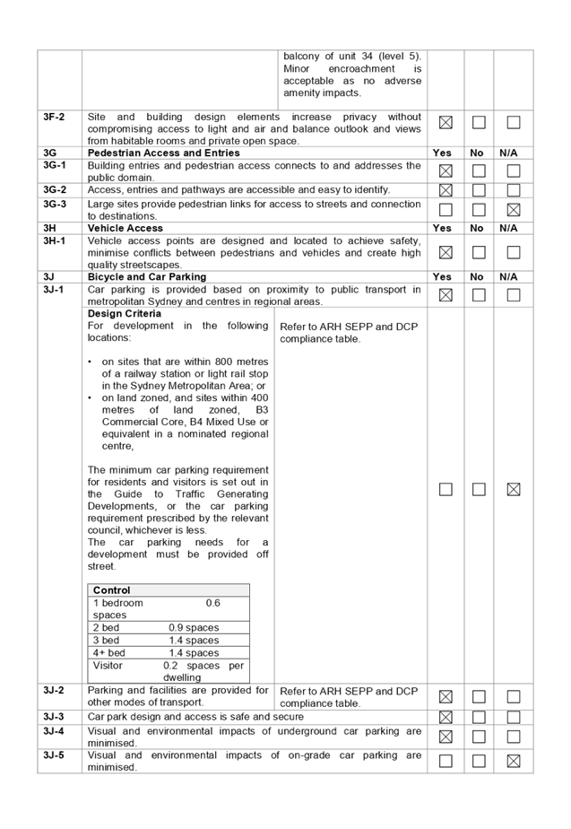
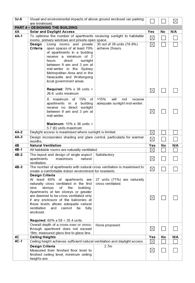
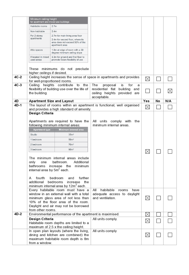
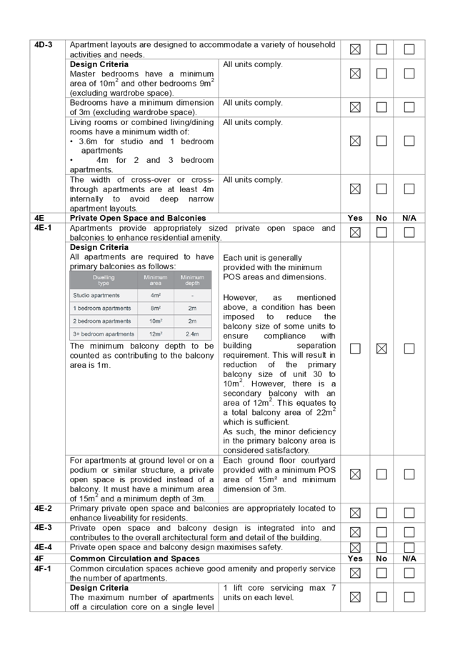
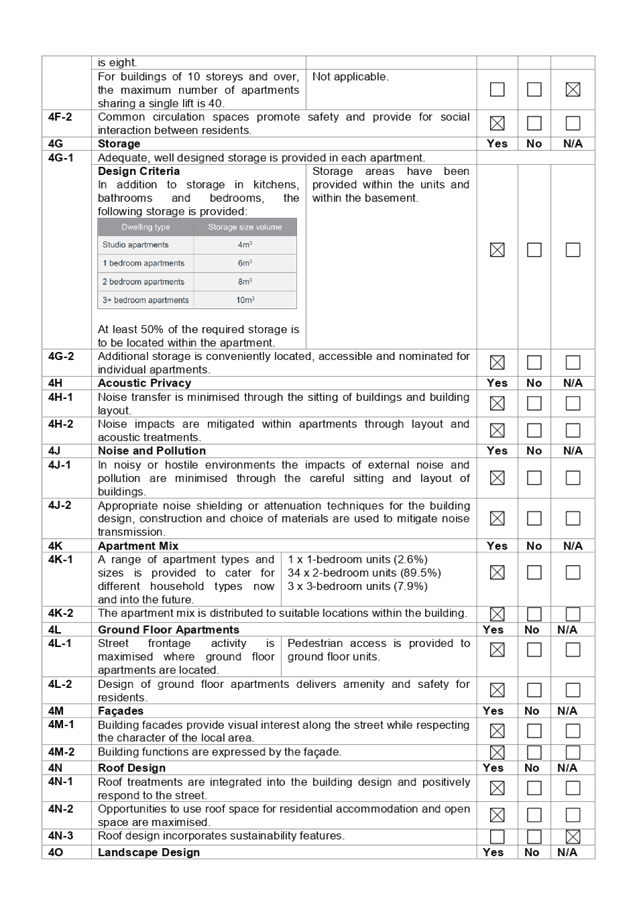
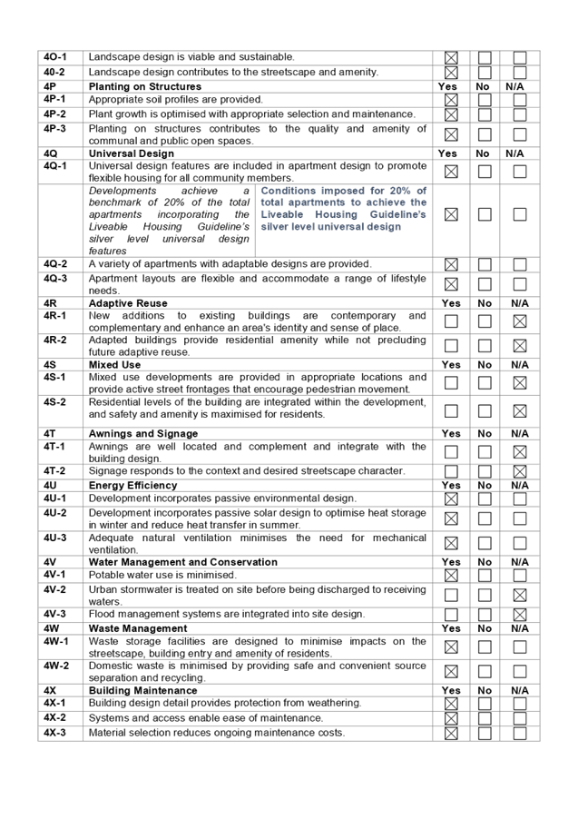
DOCUMENTS
ASSOCIATED WITH
REPORT ELPP052/19
Attachment 3
HLEP 2013 Compliance Table
Extraordinary Cumberland Local Planning
Panel Meeting
24 July 2019
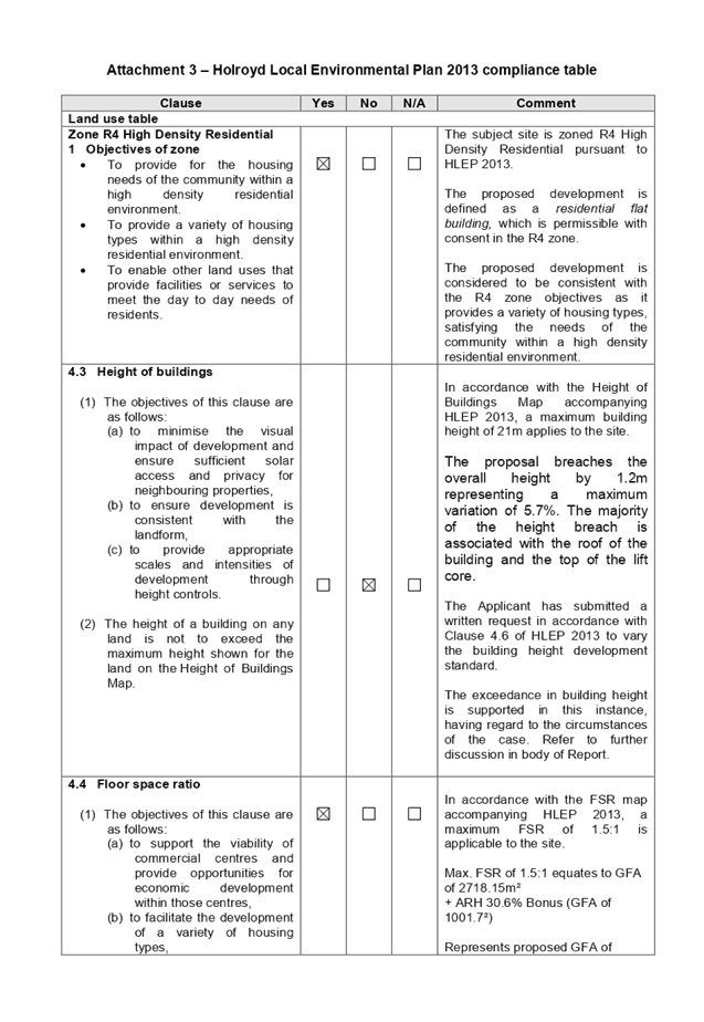
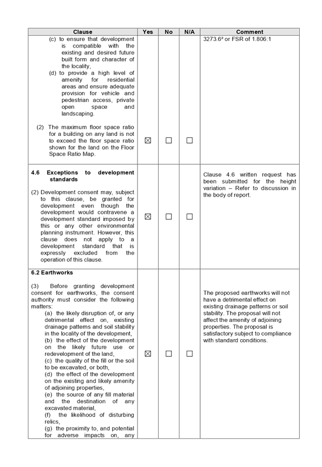
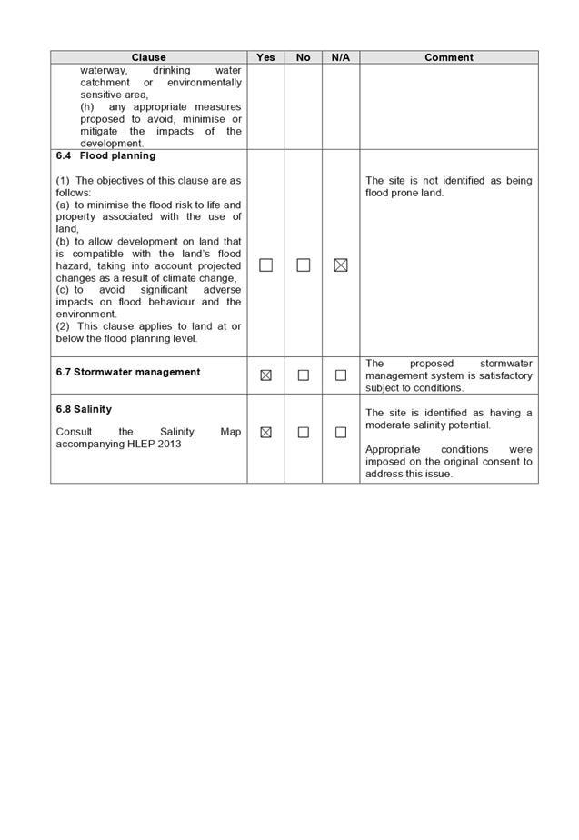
DOCUMENTS
ASSOCIATED WITH
REPORT ELPP052/19
Attachment 4
HDCP 2013 Compliance Table
Extraordinary Cumberland Local Planning
Panel Meeting
24 July 2019
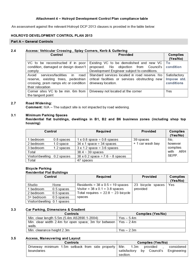
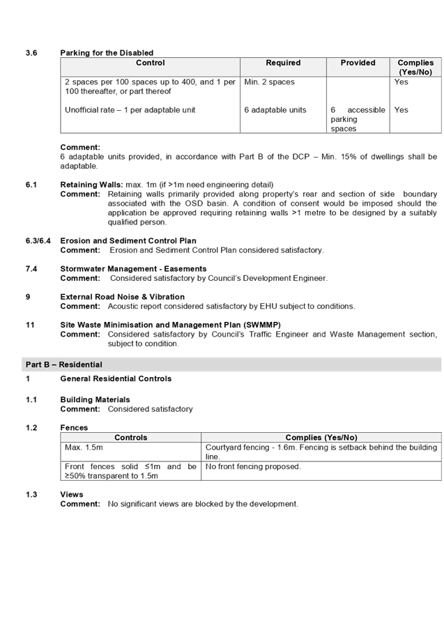
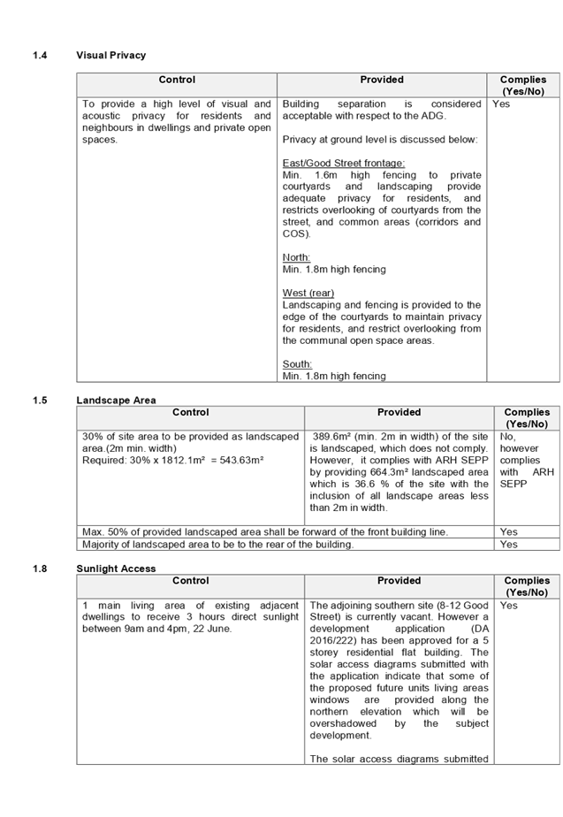
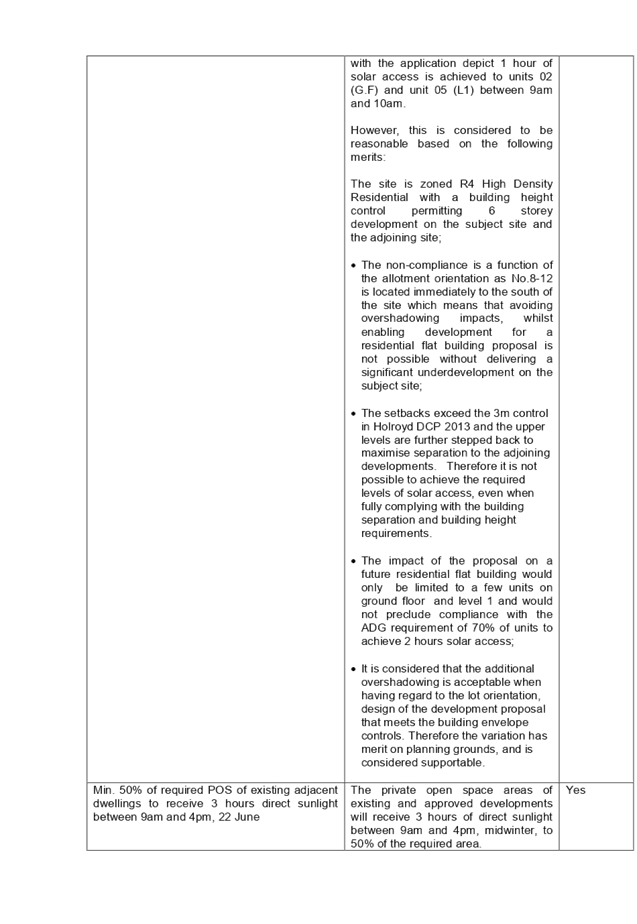
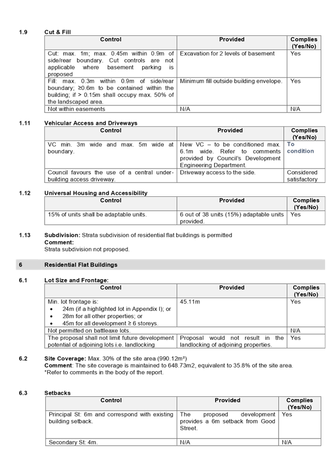
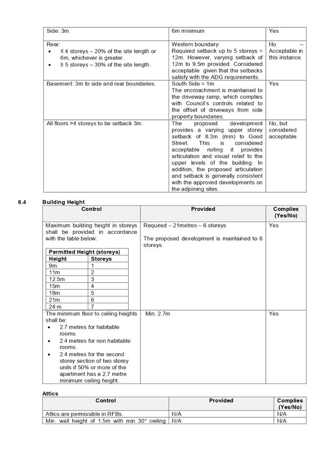
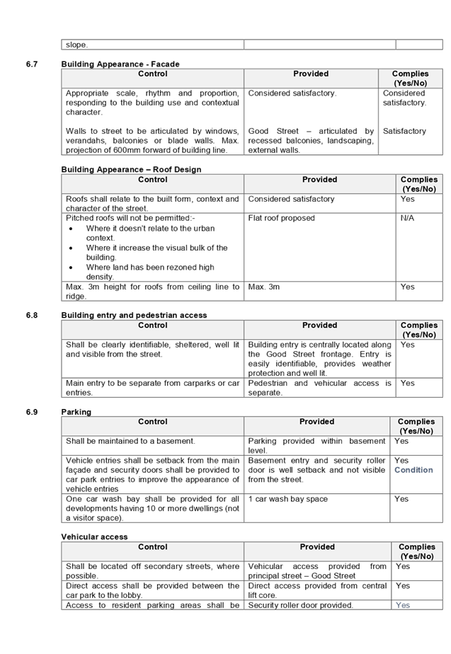
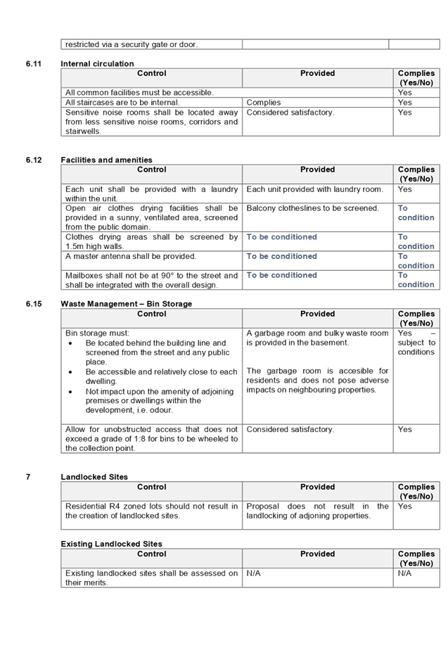

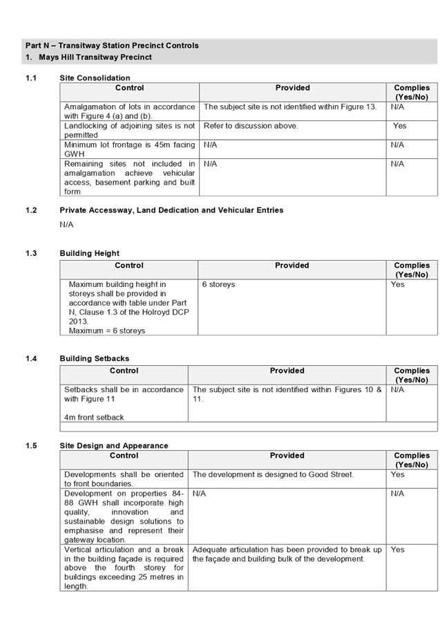
DOCUMENTS
ASSOCIATED WITH
REPORT ELPP052/19
Attachment 5
Draft Notice of Determination
Extraordinary Cumberland Local Planning
Panel Meeting
24 July 2019
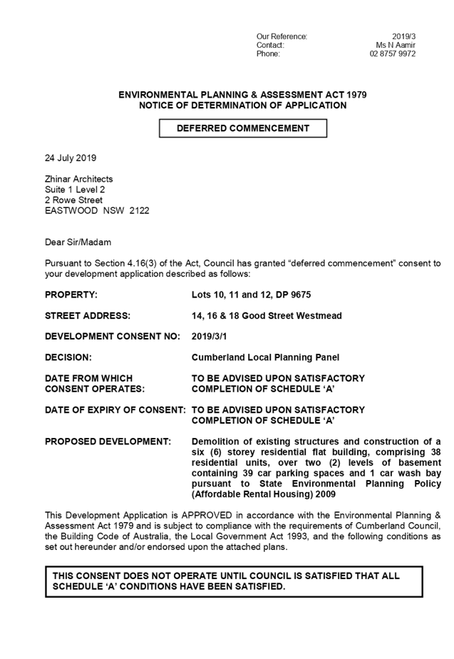
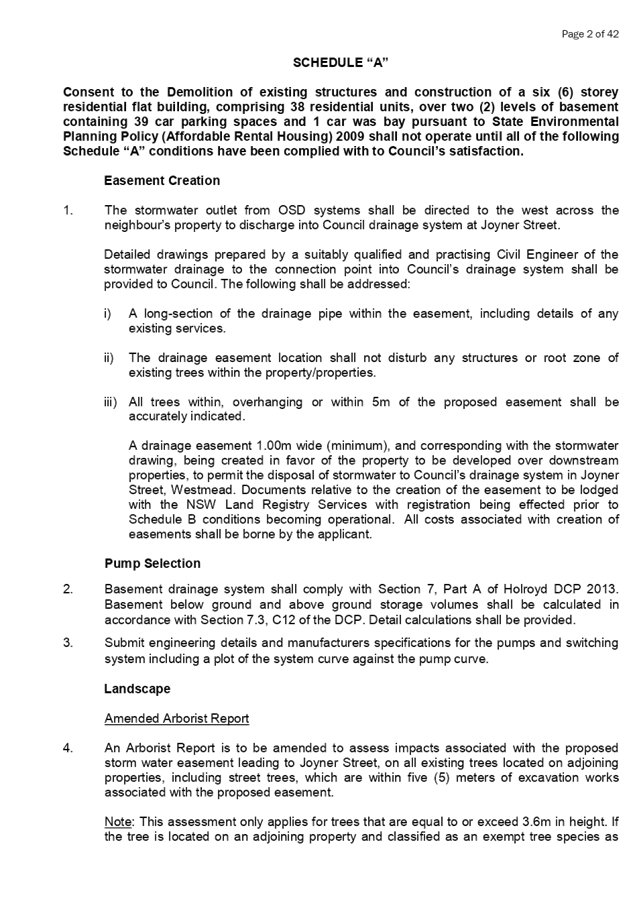
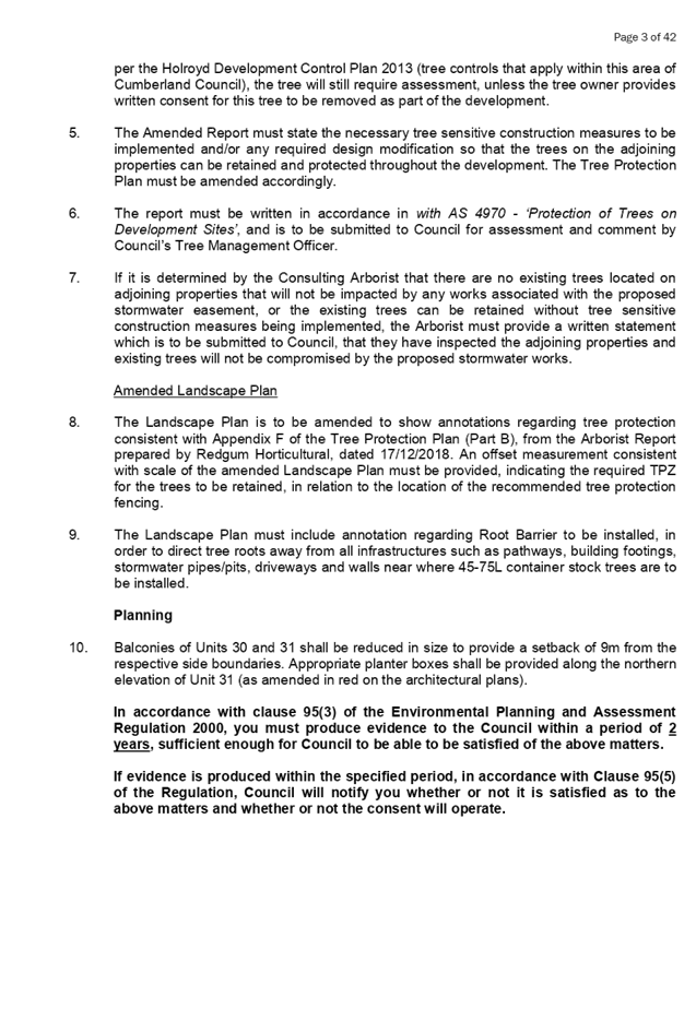
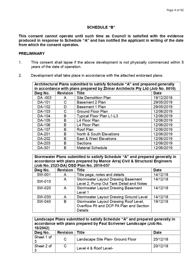
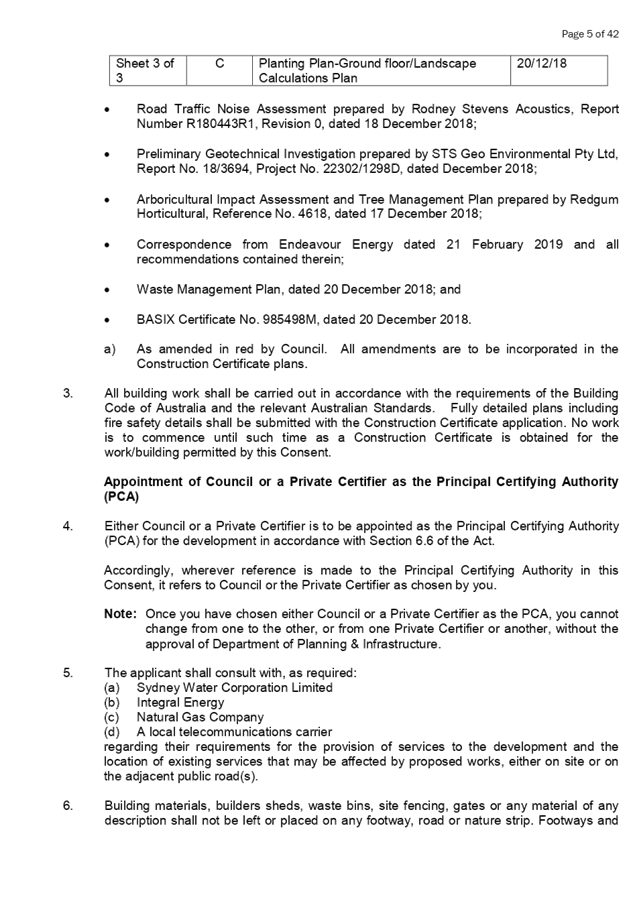

DOCUMENTS
ASSOCIATED WITH
REPORT ELPP052/19
Attachment 6
Architectural Plans
Extraordinary Cumberland Local Planning
Panel Meeting
24 July 2019
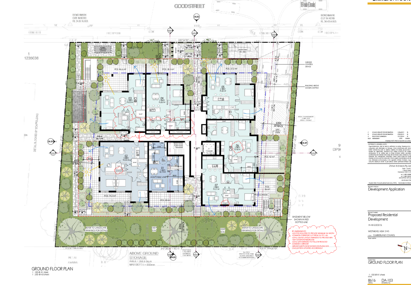
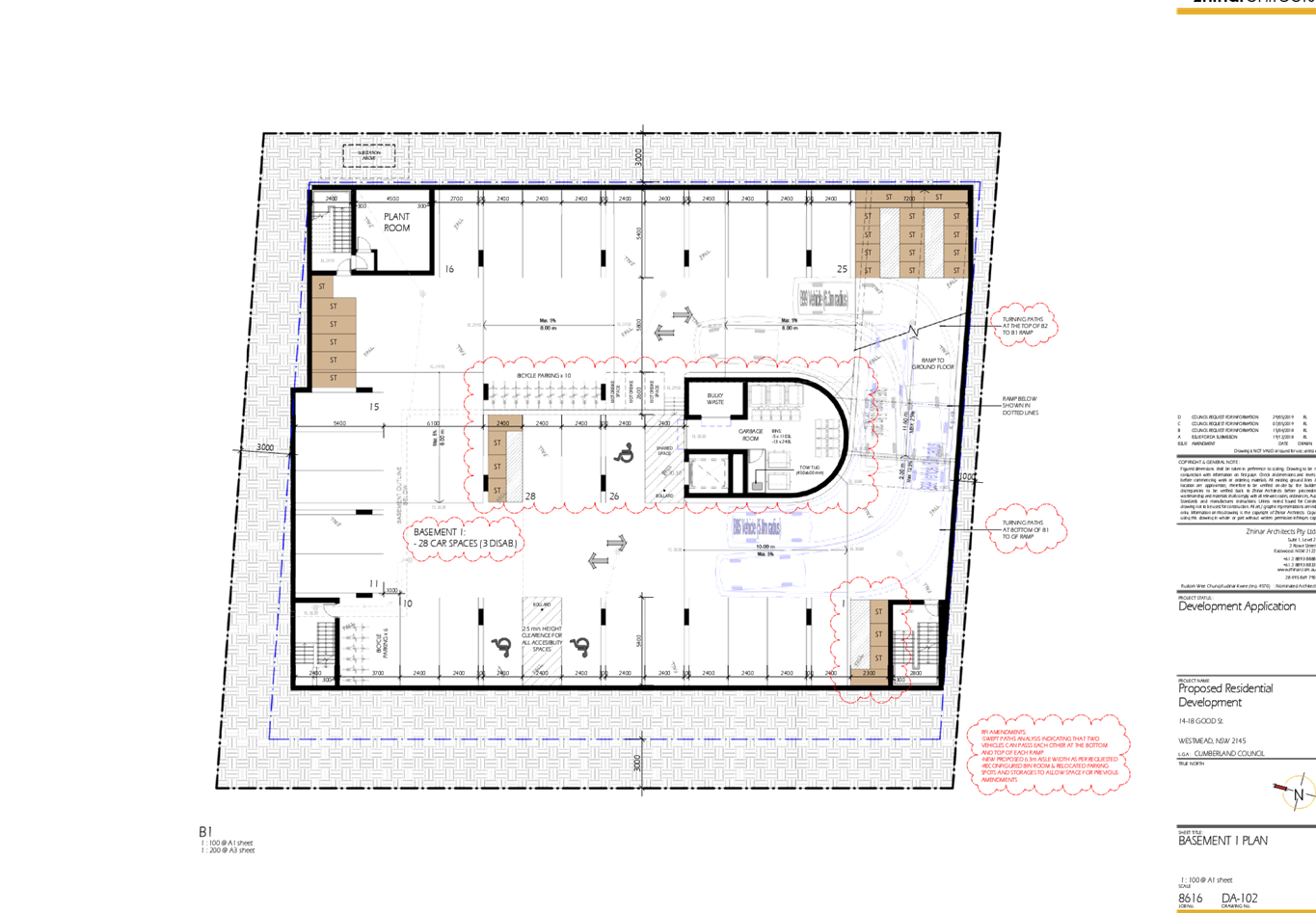
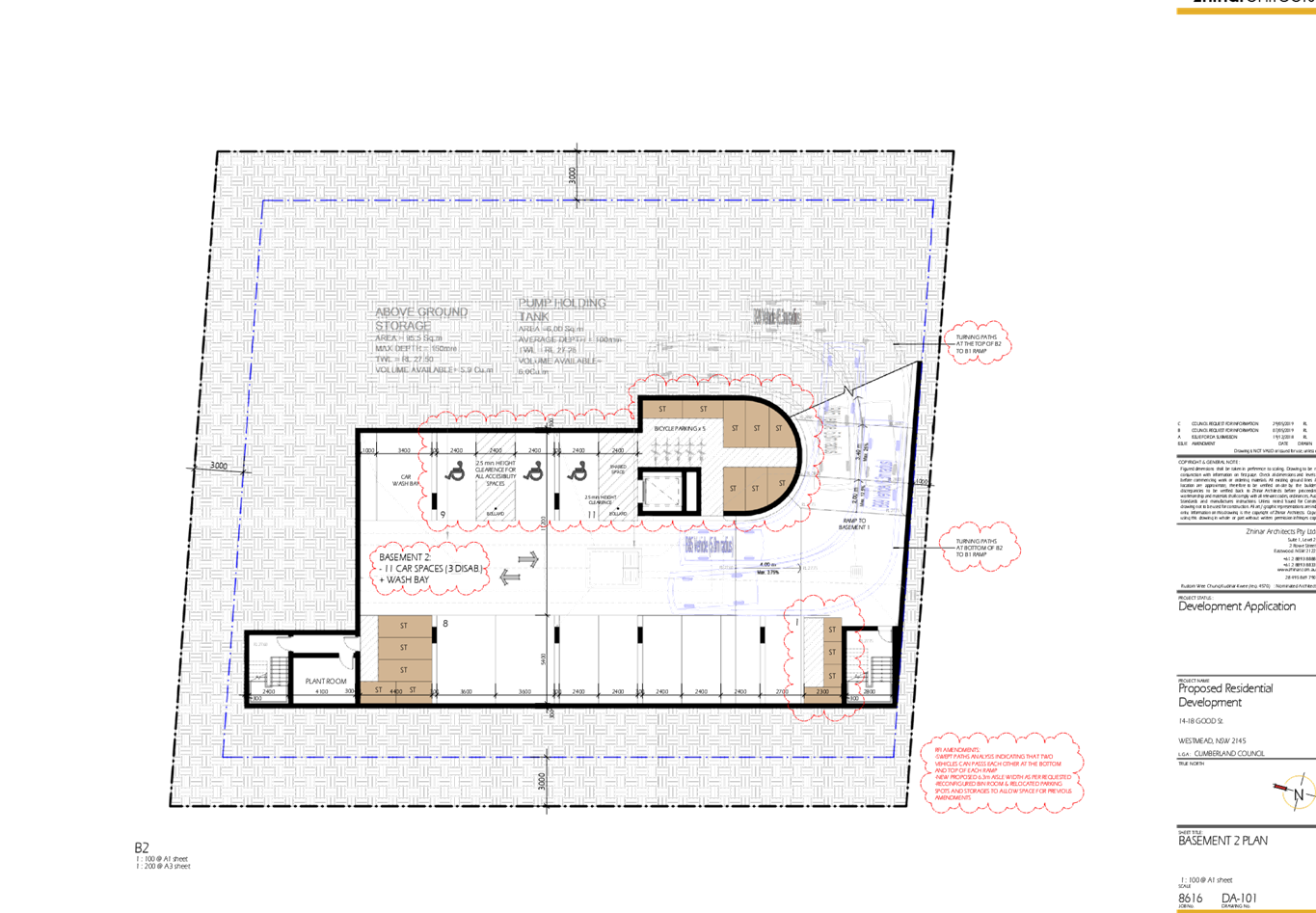
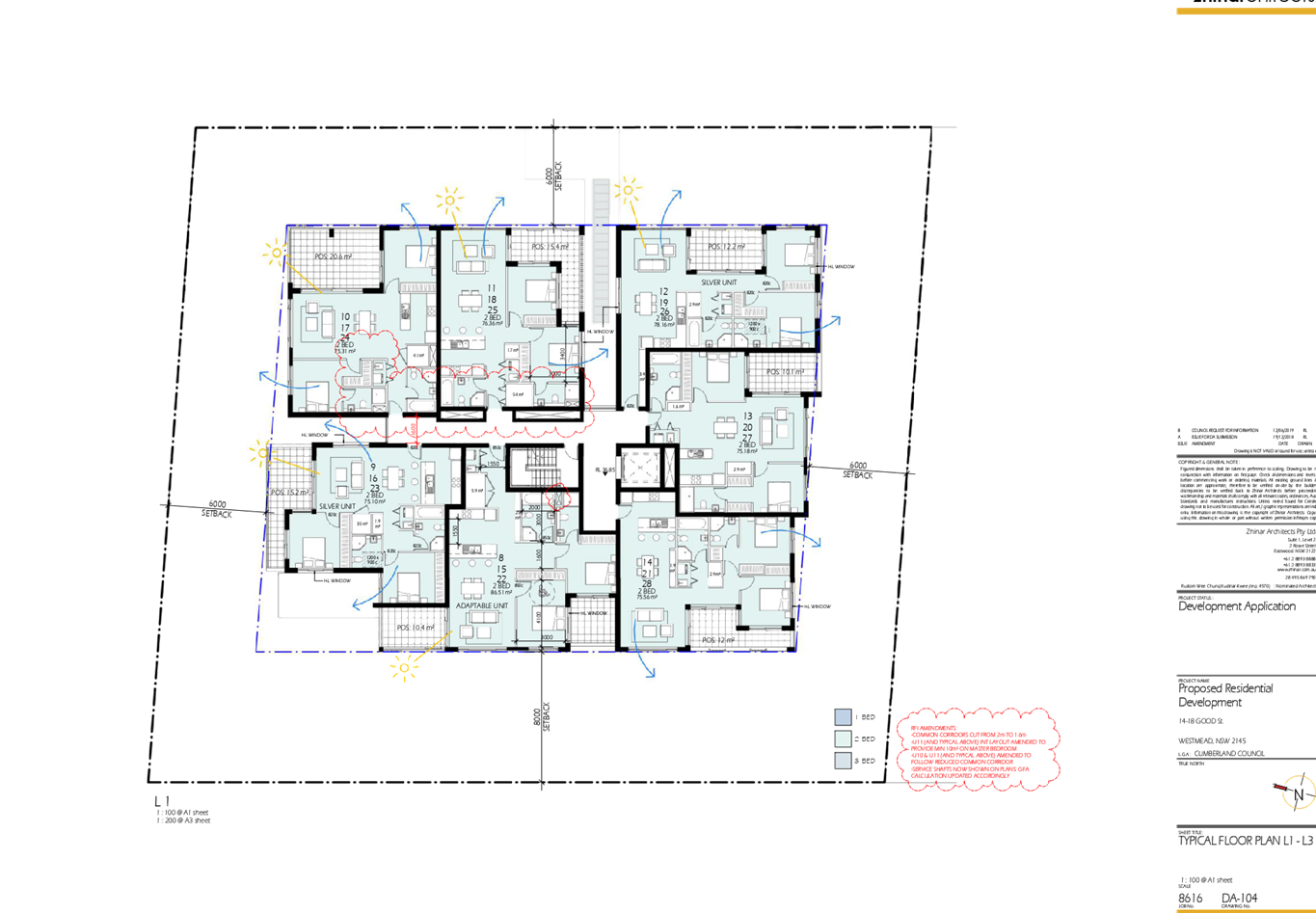
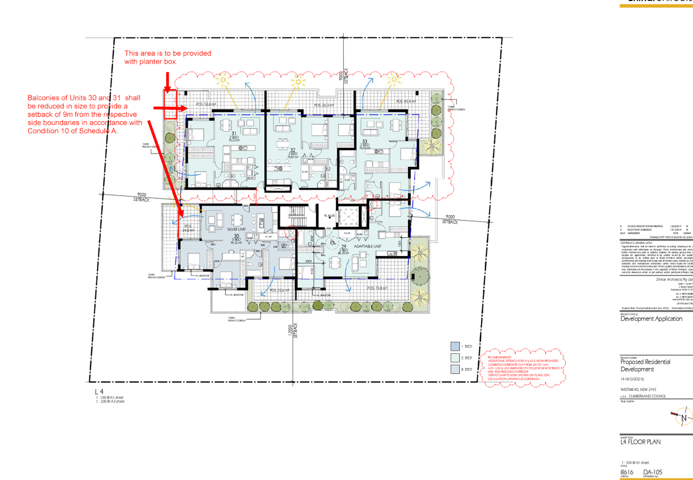
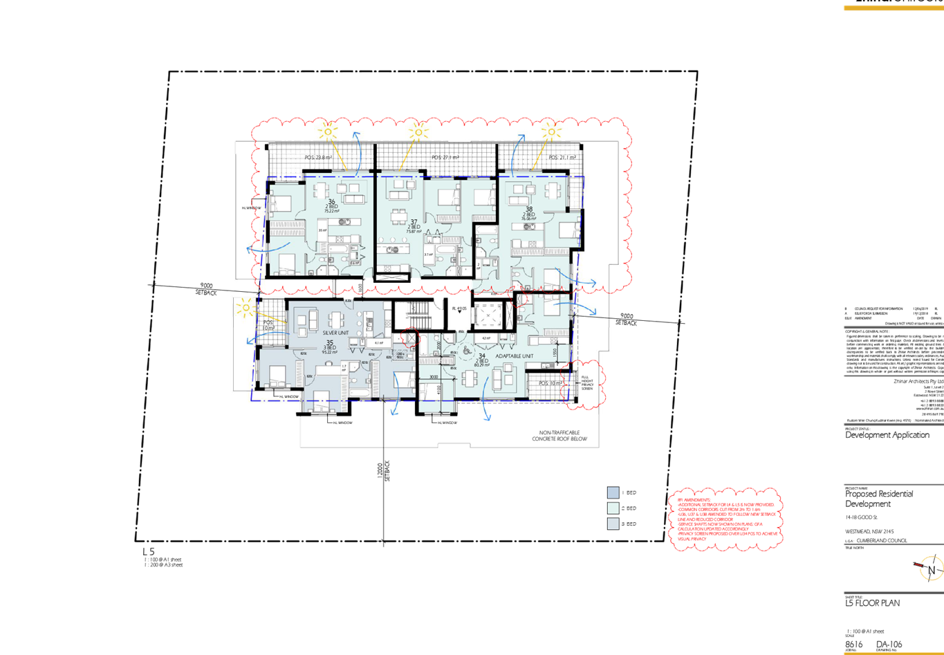
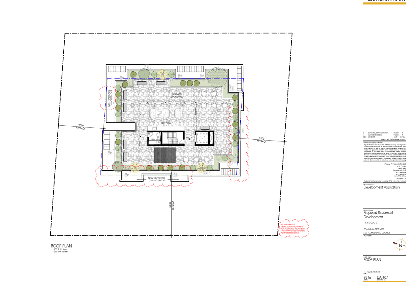
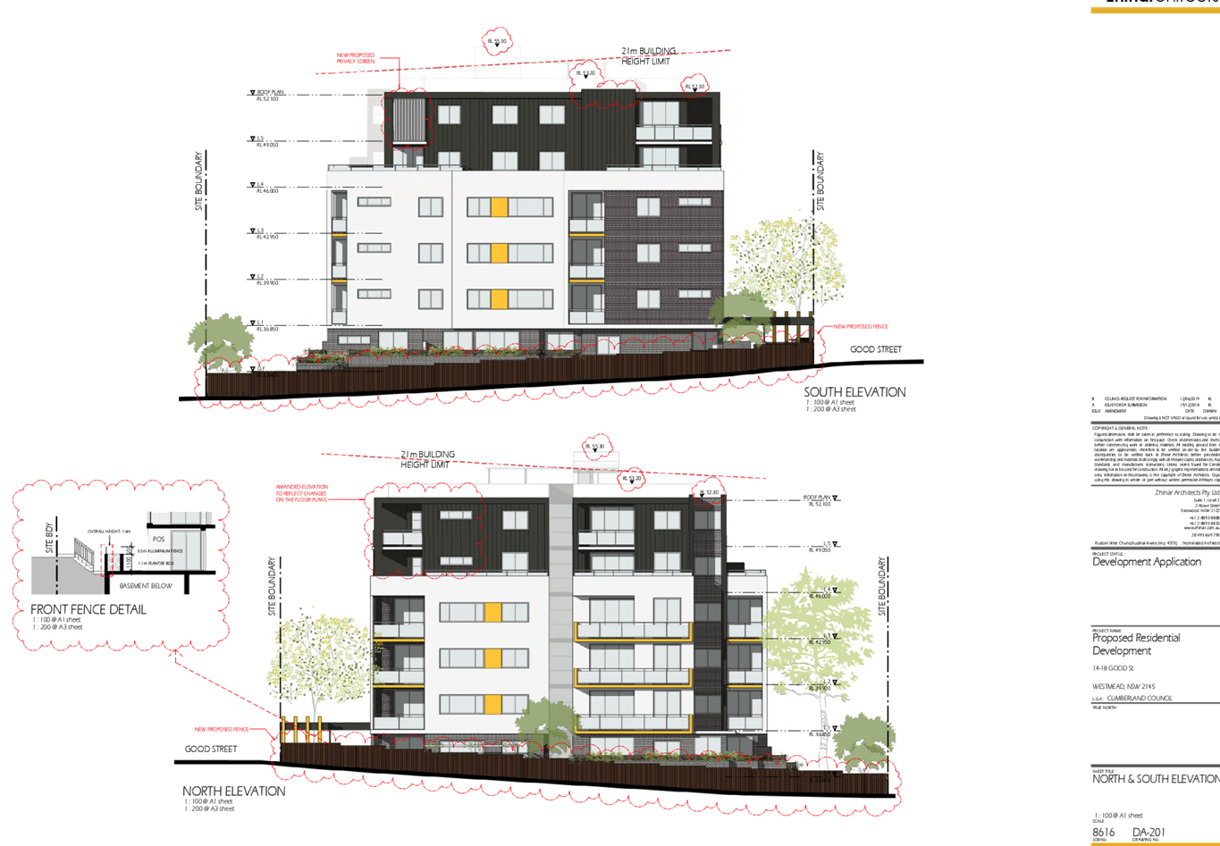
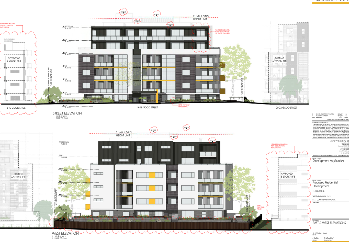
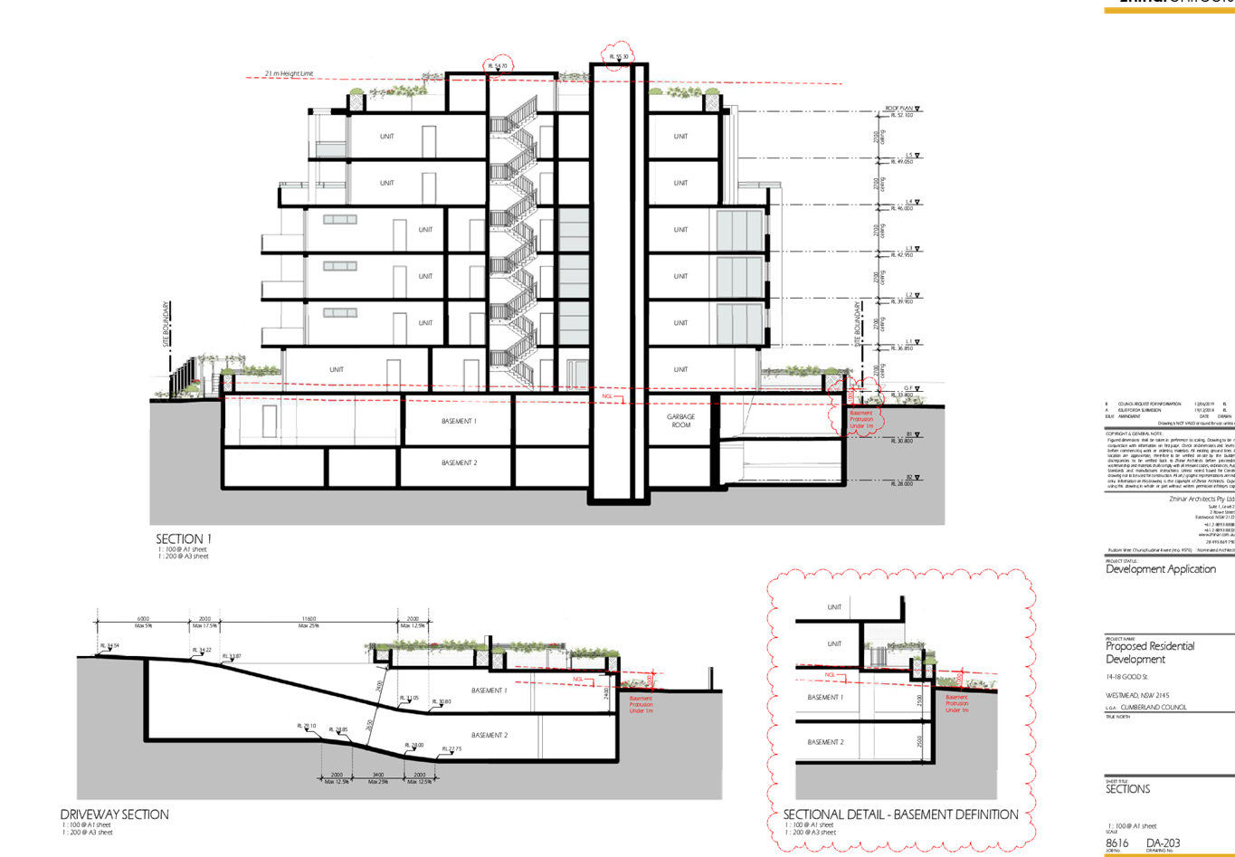
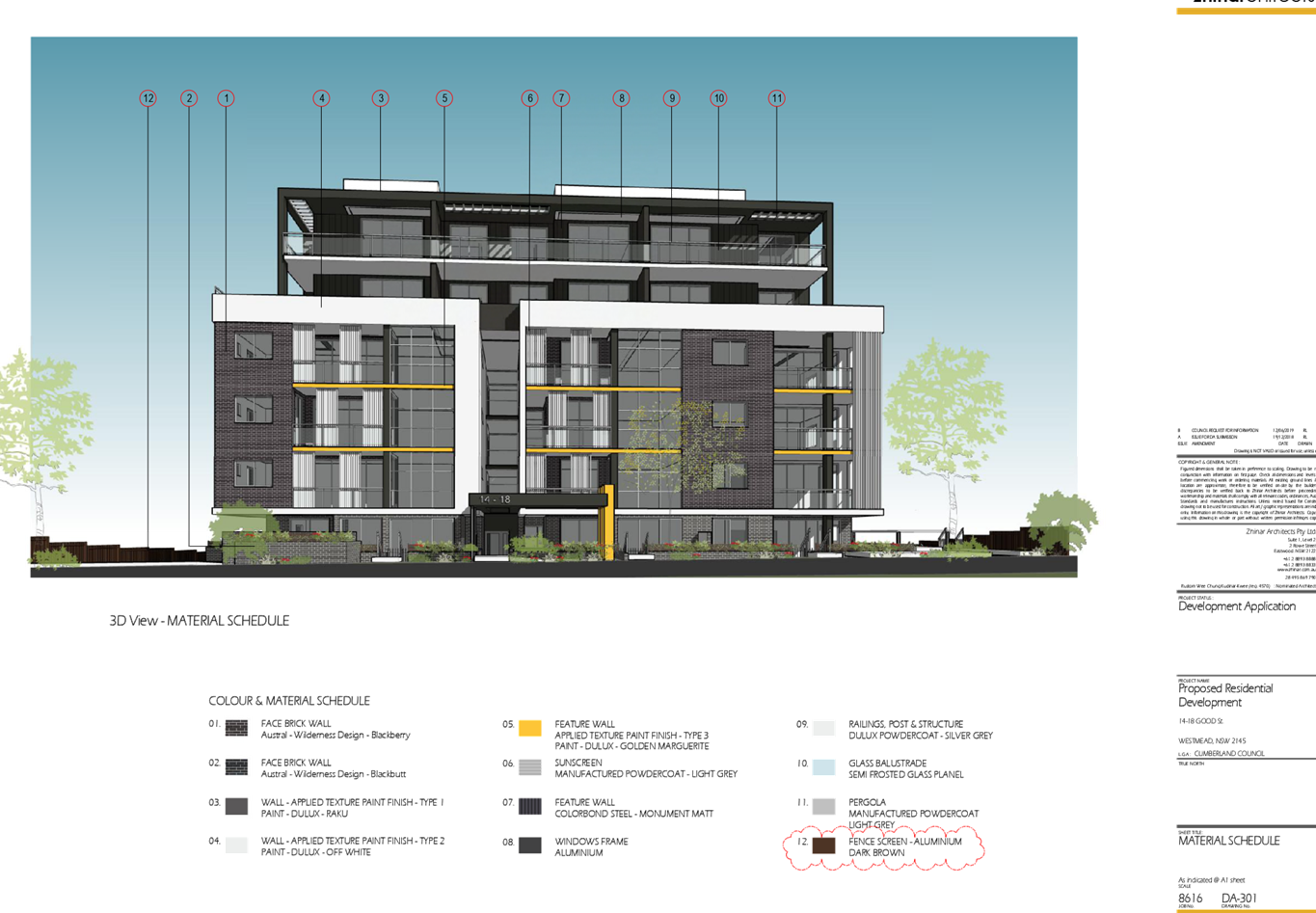
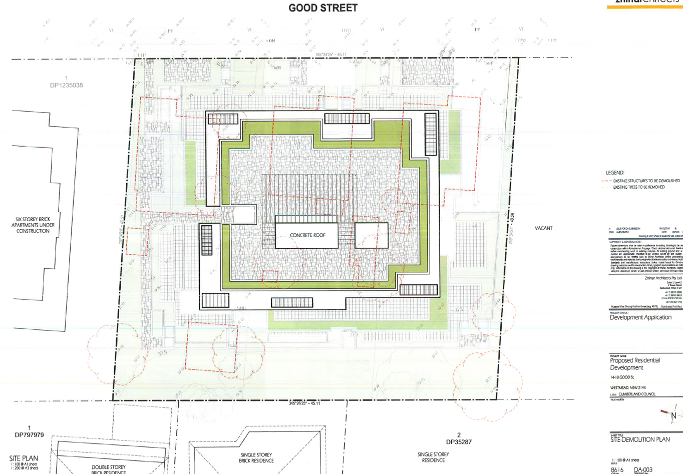
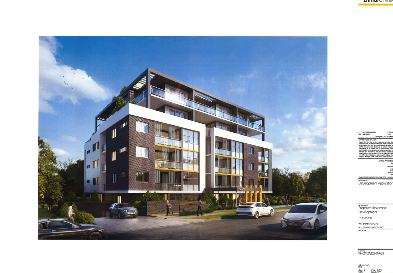
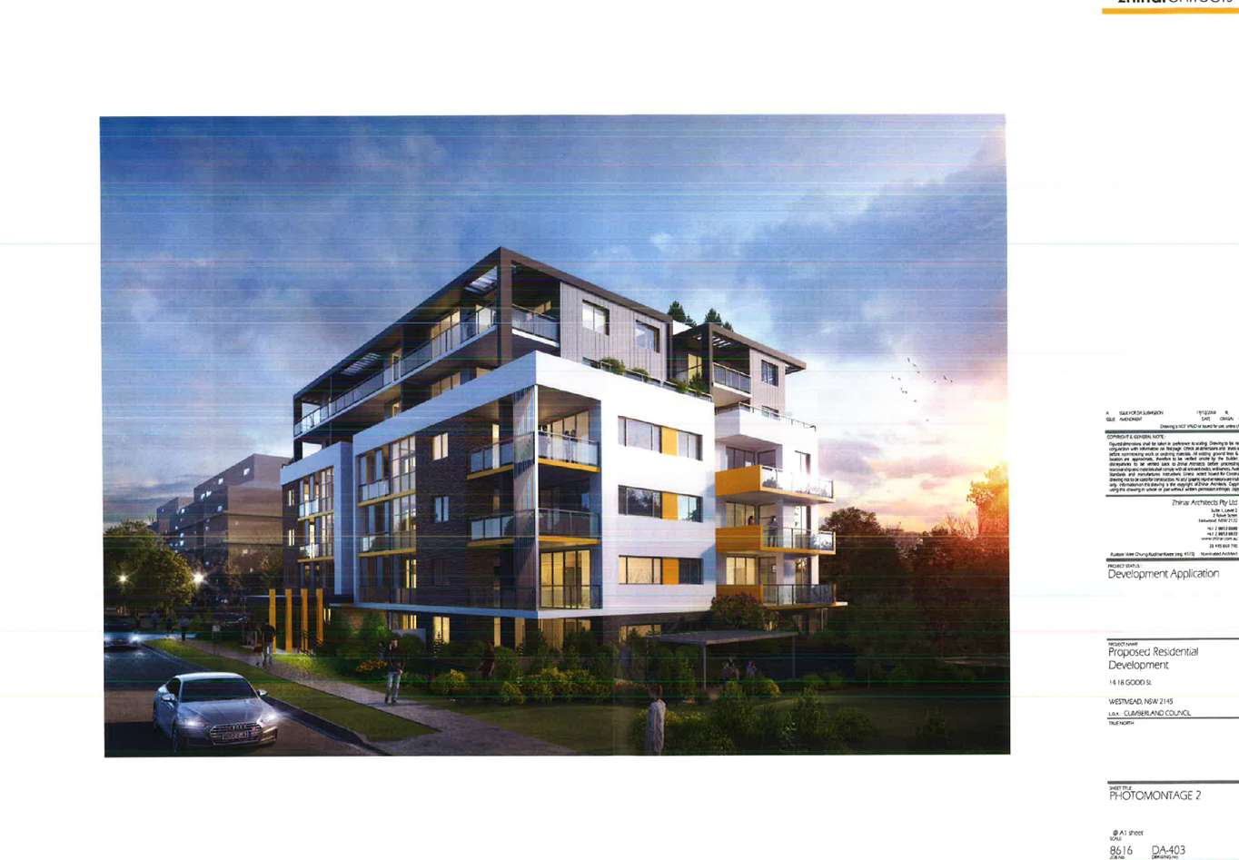
DOCUMENTS
ASSOCIATED WITH
REPORT ELPP052/19
Attachment 7
Shadow Diagrams
Extraordinary Cumberland Local Planning
Panel Meeting
24 July 2019
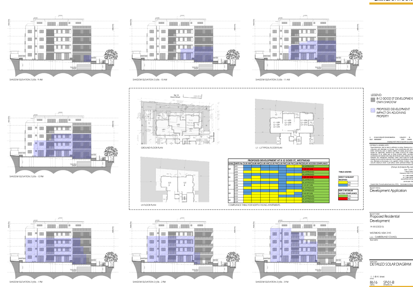
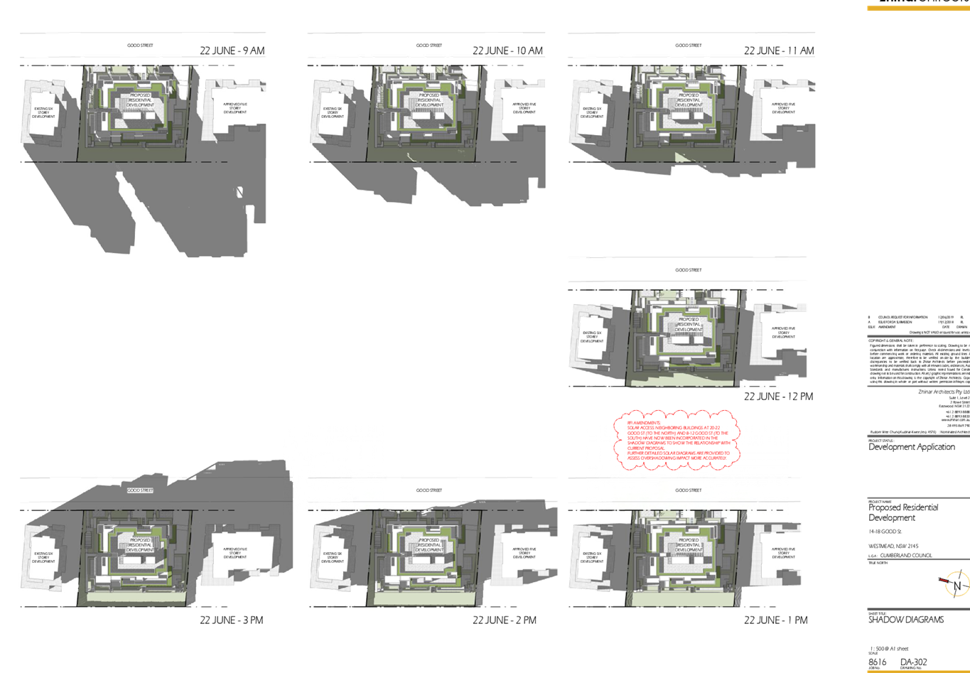
DOCUMENTS
ASSOCIATED WITH
REPORT ELPP052/19
Attachment 8
Accompanying Clause 4.6 Variation Request to Building Height
Extraordinary Cumberland Local Planning
Panel Meeting
24 July 2019
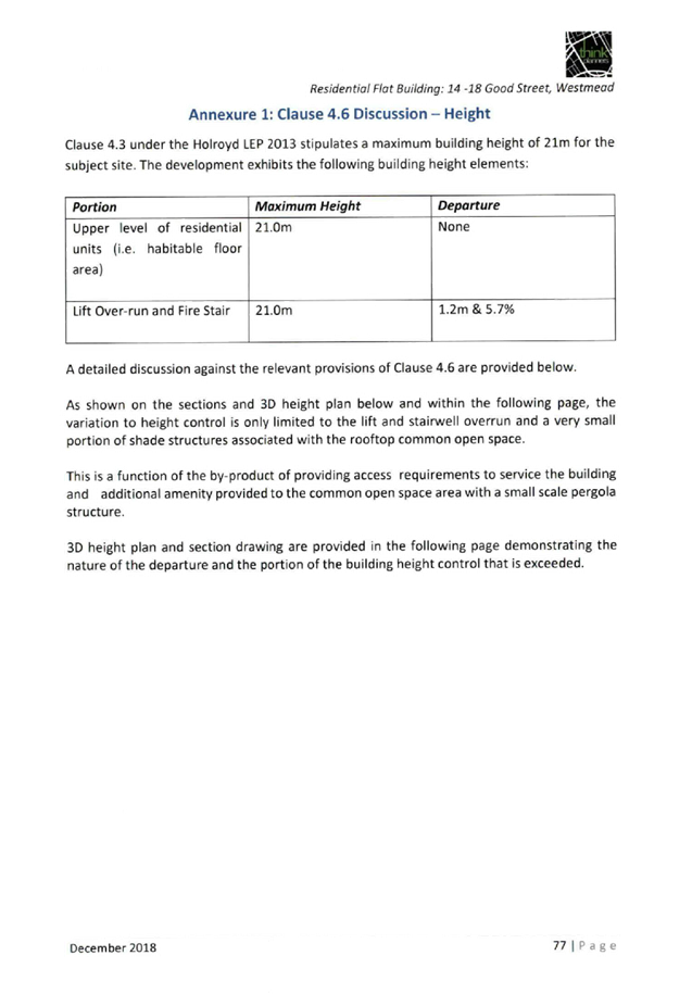
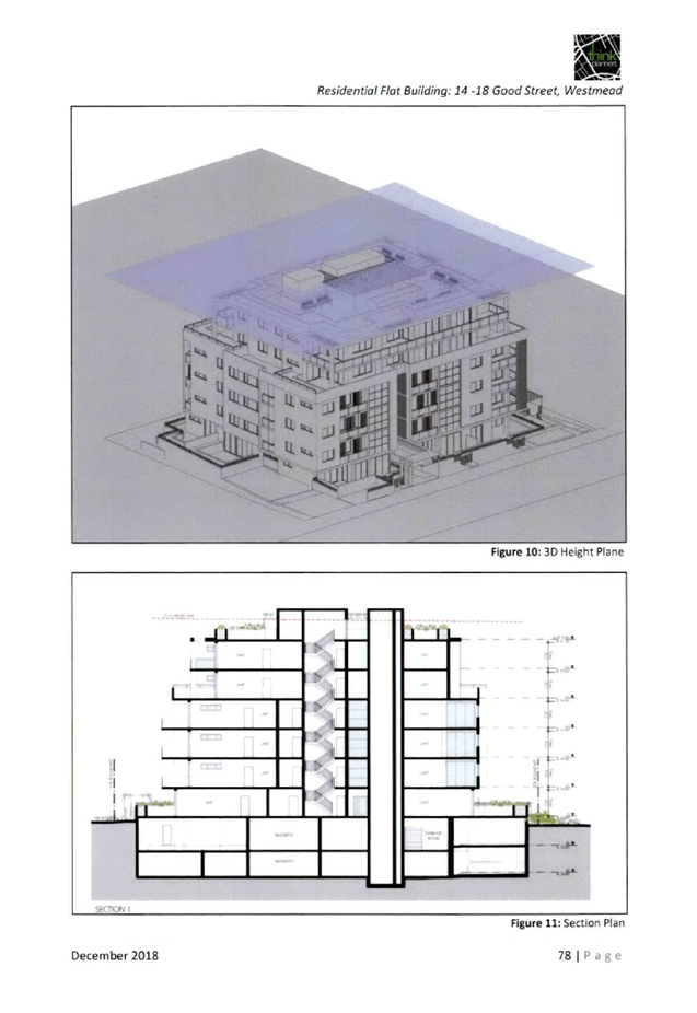
DOCUMENTS
ASSOCIATED WITH
REPORT ELPP052/19
Attachment 9
Locality Map
Extraordinary Cumberland Local Planning
Panel Meeting
24 July 2019
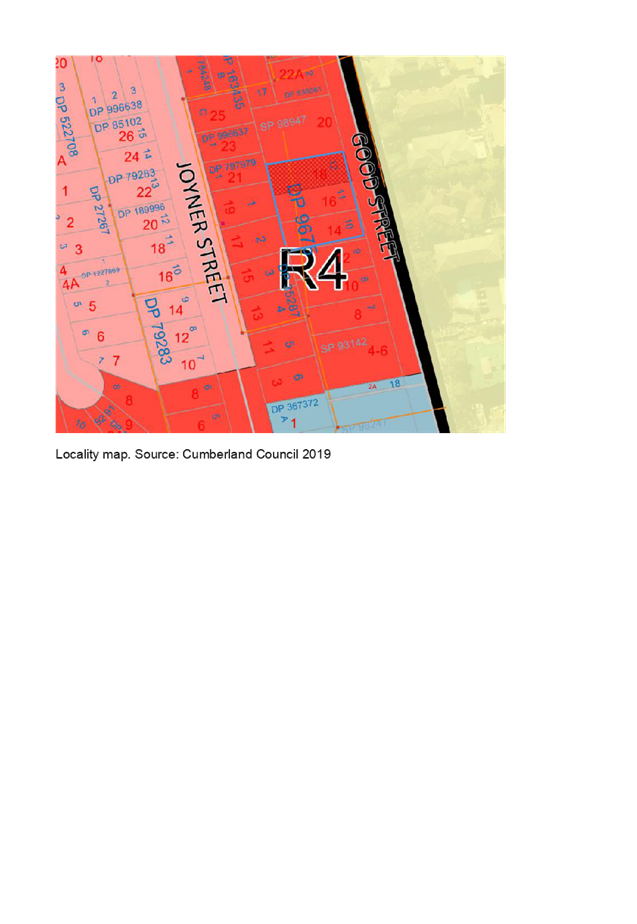
DOCUMENTS
ASSOCIATED WITH
REPORT ELPP052/19
Attachment 10
Submission (1)
Extraordinary Cumberland Local Planning
Panel Meeting
24 July 2019