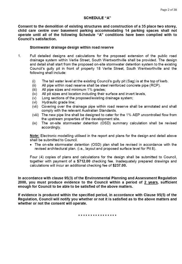
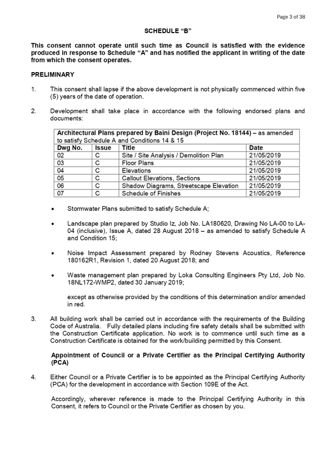
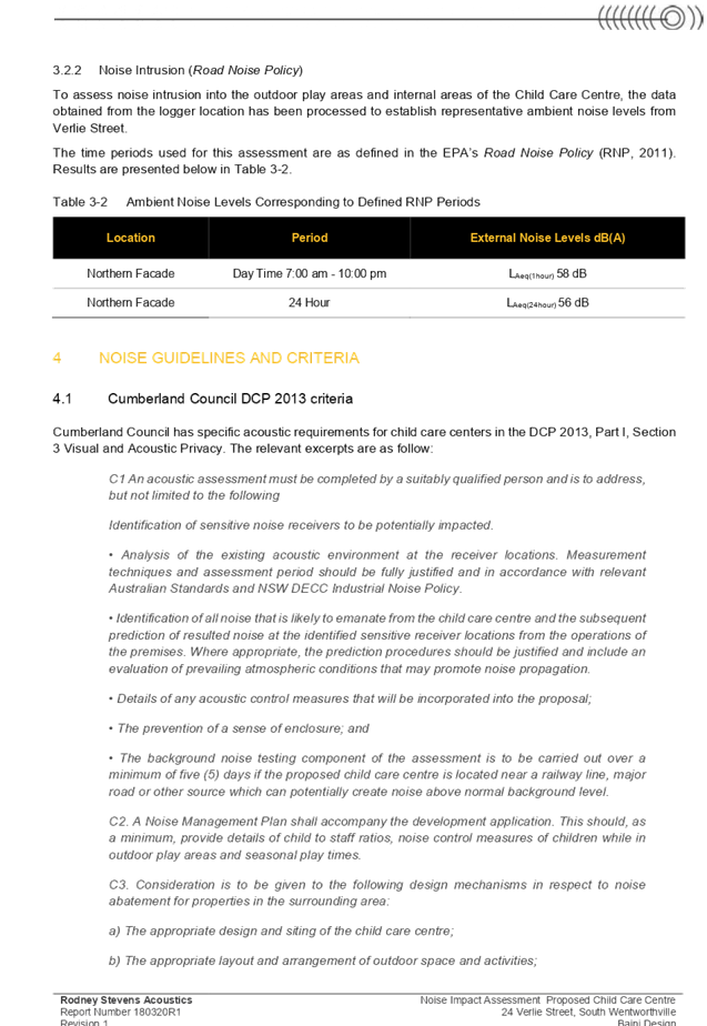
Extraordinary Cumberland Local Planning
Panel Meeting
26 June 2019
An
Extraordinary Meeting of Cumberland Local Planning Panel will be held at 11:30am at the
Merrylands Administration Building, 16 Memorial Avenue, Merrylands on Wednesday,
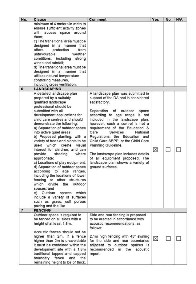
26 June 2019.
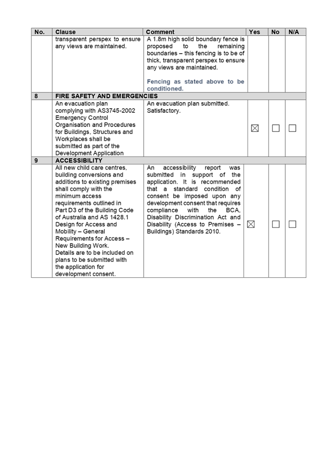
Business as below:
Yours faithfully
Hamish McNulty
General
Manager
ORDER OF BUSINESS
1.
Receipt of Apologies
2.
Declaration of Interest
3.
Address by invited speakers
4.
Reports
- Development
Applications
- Planning
Proposals
5. Closed
Session Reports
Extraordinary Cumberland Local Planning
Panel Meeting
26 June 2019
CONTENTS
Report No. Name of Report Page
No.
Development Applications
LPP046/19... Development Application
for 24 Verlie Street, South Wentworthville...... 11
LPP047/19... Development Application
for 2 Blaxcell Street, Granville......................... 219
LPP048/19... Section 4.55(2)
Modification for 1/72-78 Percival Road, Smithfield....... 341
Extraordinary
Cumberland Local Planning Panel Meeting
26 June 2019
Item No: LPP046/19
Development
Application for 24 Verlie Street, South Wentworthville
Responsible
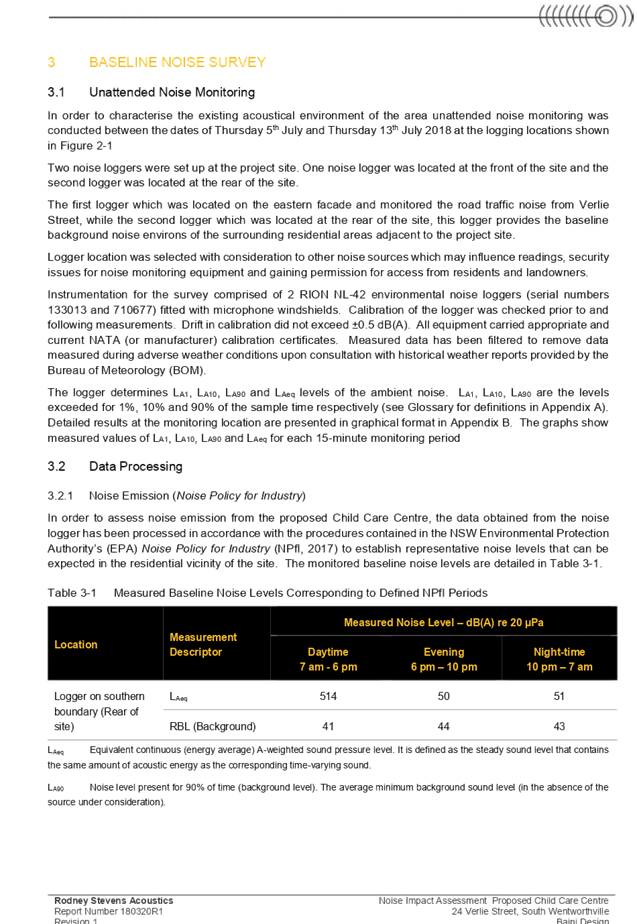
Division: Environment
& Planning
Officer: Executive
Manager Development and Building
File
Number: DA
2018/357/1
|
Application lodged
|
4 October 2018
|
|
Applicant
|
Baini Design
|
|
Owner
|
Mr G & Mrs R Ishac
|
|
Application No.
|
2018/357/1
|
|
Description of Land
|
24
Verlie Street, South Wentworthville (Lot 33 in DP16442)
|
|
Proposed Development
(as amended)
|
Demolition of existing
structures, construction of a two storey building for use as a 35 place child
care facility over basement car parking
|
|
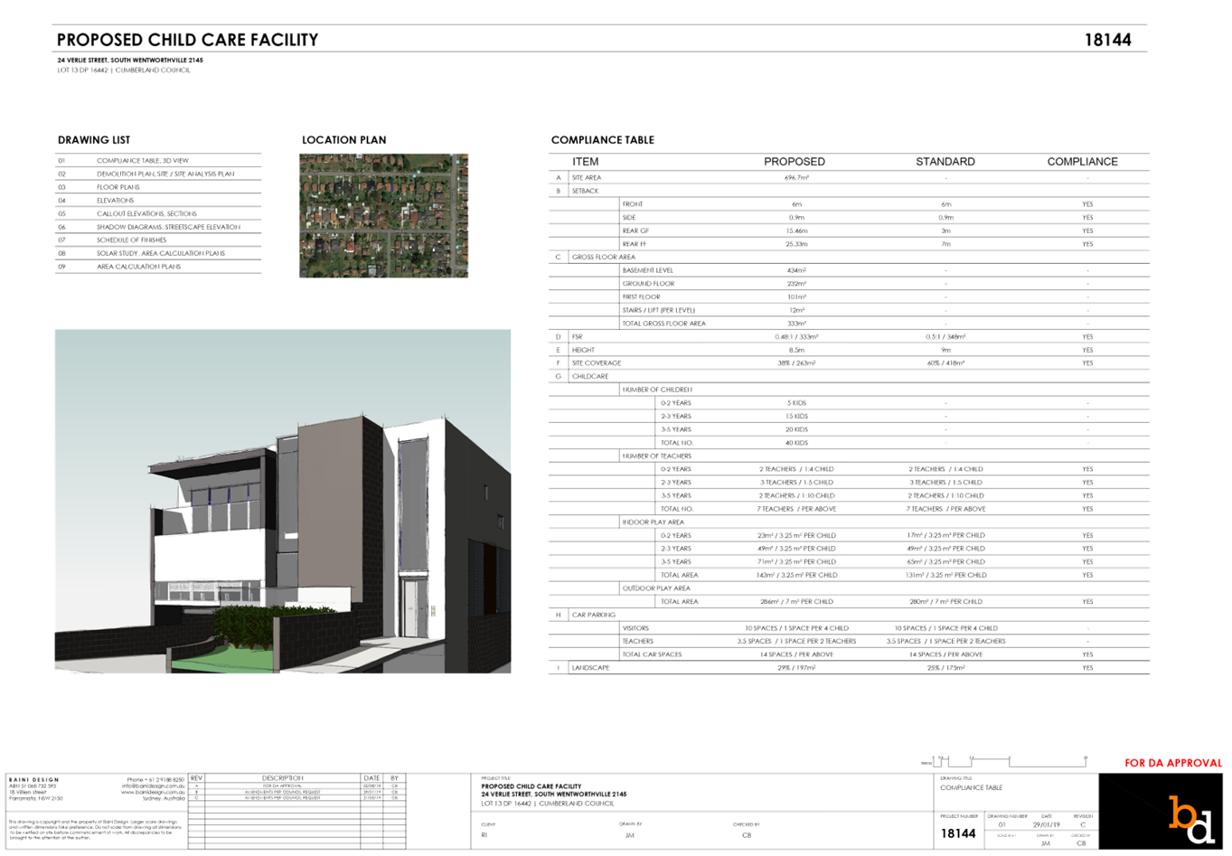
Site Area
|
696.7m2
|
|
Zoning
|
R2 – Low Density
Residential
|
|
Principal Development
Standards
|
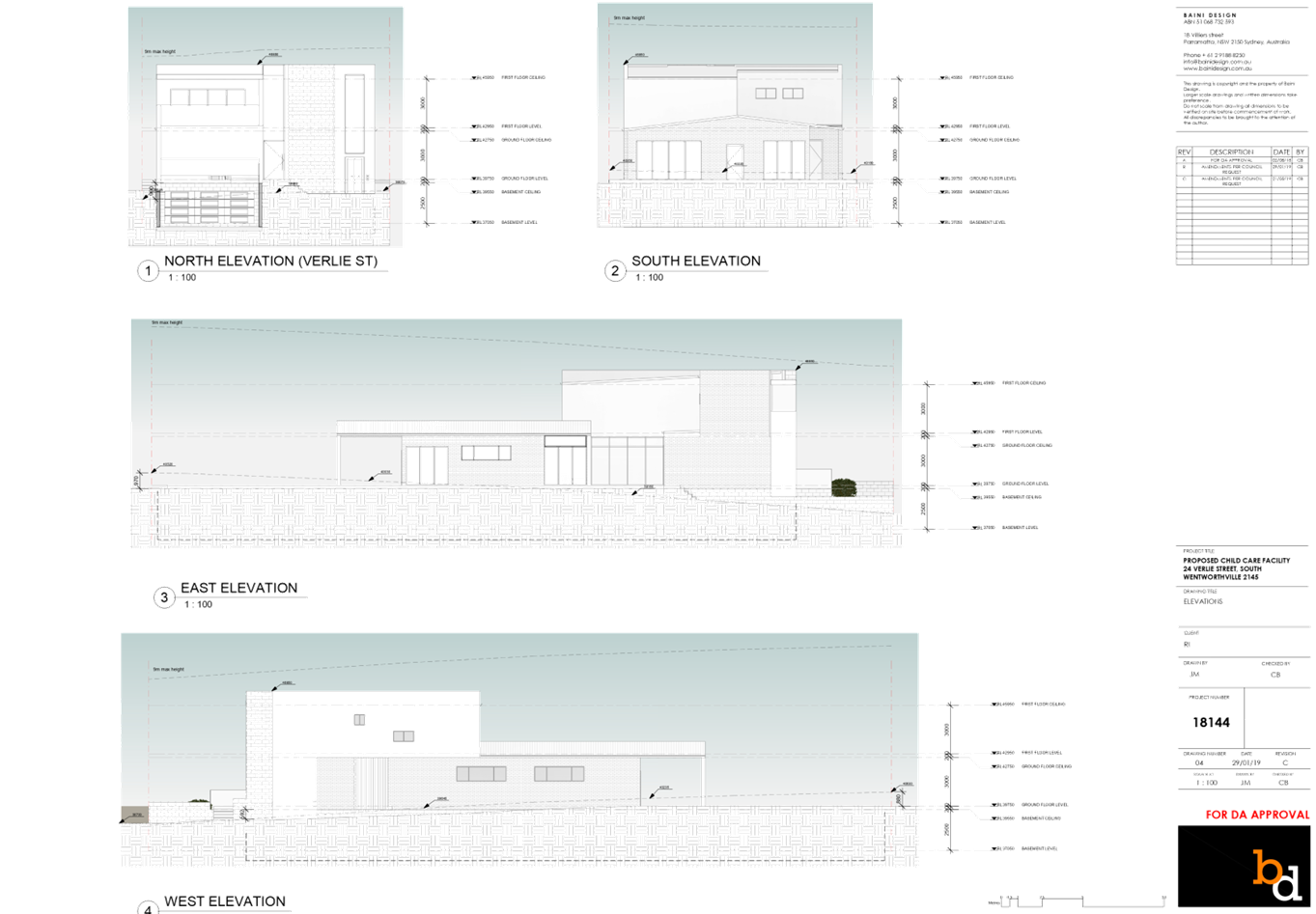
· Floor Space Ratio – 0.5:1 (HLEP
2013)
· Height of Buildings – 9m (HLEP
2013)
|
|
Disclosure of political
donations and gifts
|
Nil
disclosure
|
|
Heritage
|
The subject site does not contain a heritage item,
is not located within the vicinity of the heritage item or heritage
conservation area.
|
|
Issues
|
- Number
of children and outdoor unencumbered space
- Site
frontage
- Landscape
area
|
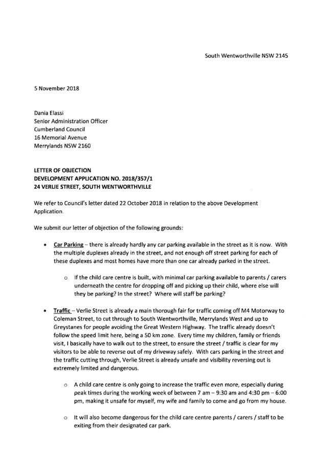
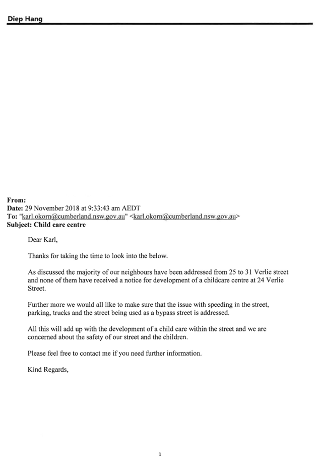
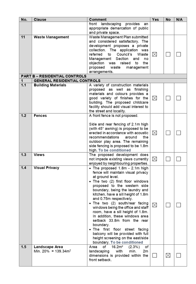
1. Development
Application 2018/357/1 was received on 4 October 2018 for the demolition of
existing structures and construction of a two storey building for use as a 43
place child care facility over basement car parking.
2. In
accordance with Part E – Public Participation of Holroyd Development
Control Plan 2013, the application was publicly notified to adjoining and
opposite owners, a notice was placed in the local press and a notice placed on
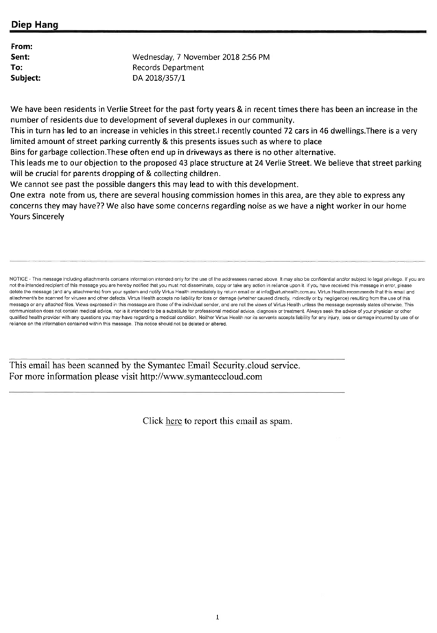
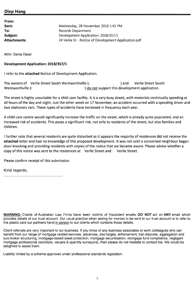
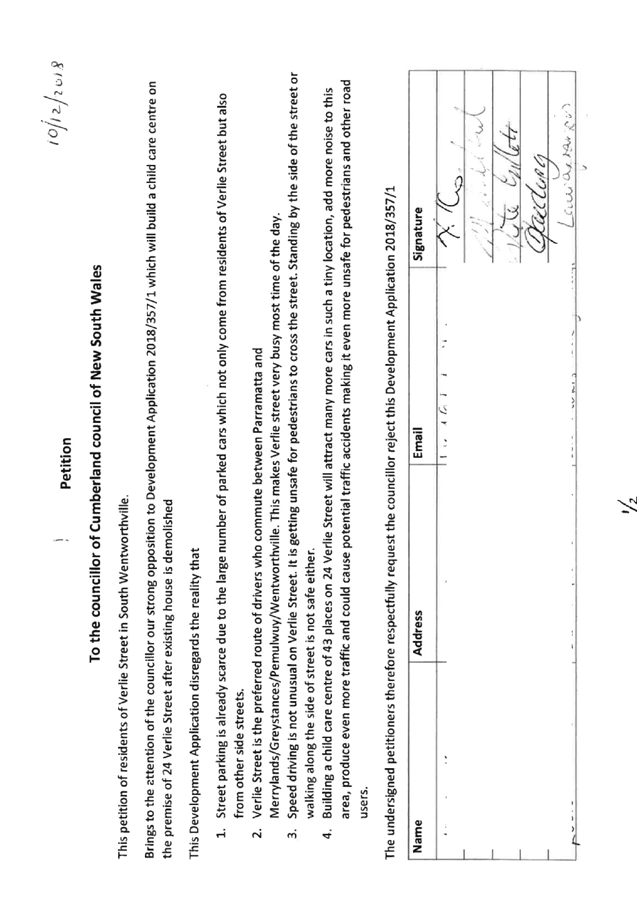
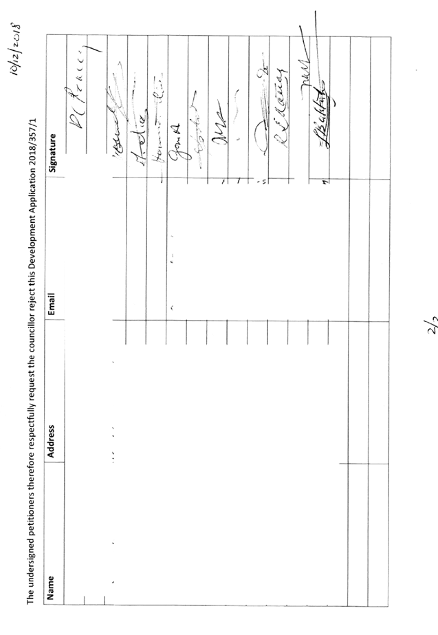
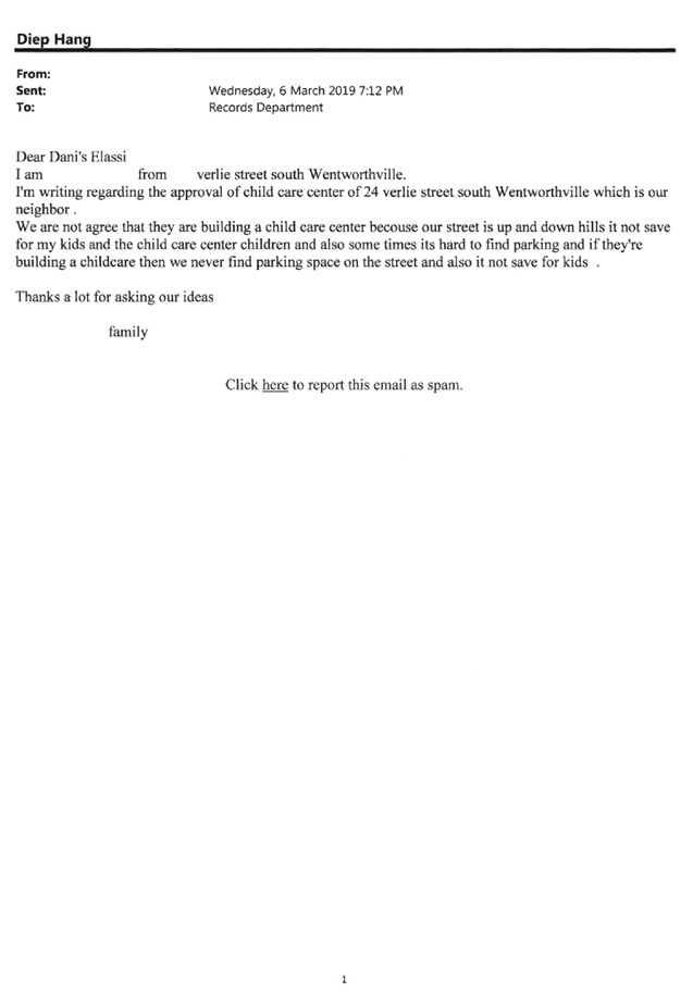
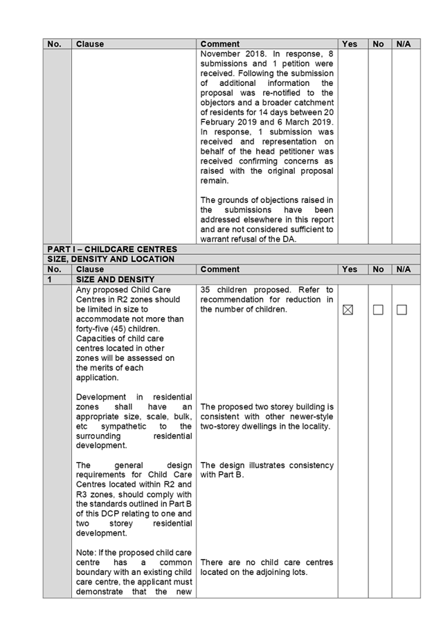
the site for 14 days from 24 October 2018 to 7 November 2018. In response, 8
submissions and 1 petition were received.
3. Council
through its assessment identified a number of concerns with the proposal, and
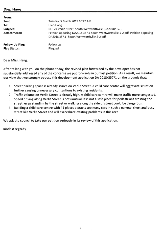
requested amended plans and additional information on 6 December 2018.
4. Amended
plans and additional information (children placement reduced to 41) were
received on 31 January 2019 addressing some of Council’s concerns. The
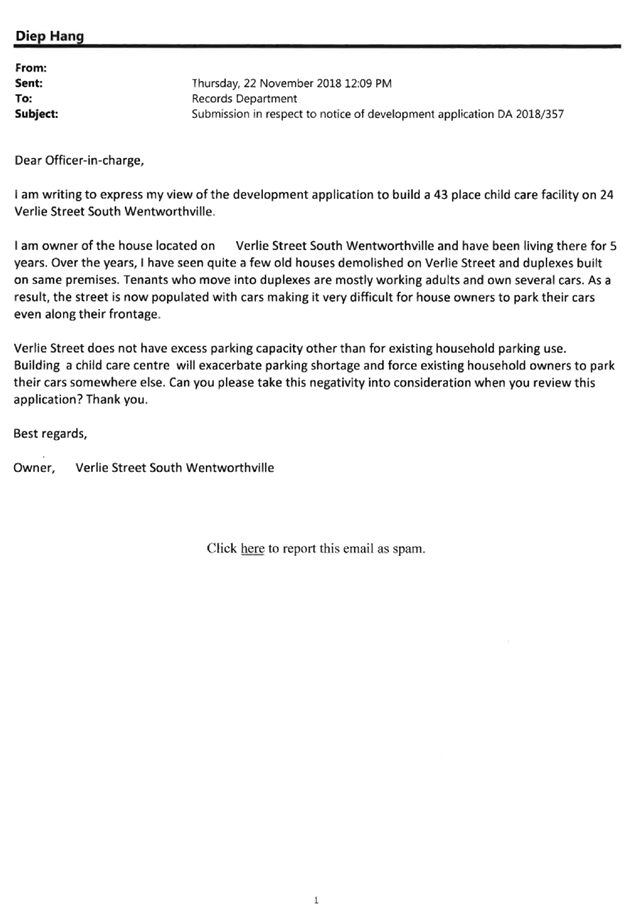
proposal was publicly re-notified for 14 days from 20 February 2019 and 6 March
2019 in line with the original notification period, however re-notification was
sent to a broader catchment of residents comprising all properties within the
block bound by Friend Street, Frances Street, Verlie Street and Coleman Street,
as well as properties located on the northern side of Verlie Street; following
concerns raised during the initial notification period. In response, 1
submission was received and representation on behalf of the head petitioner was
received confirming concerns as raised with the original proposal remain.
5. The
application was deferred on 16 May 2019 to further reduce children placement to
correspond with the provided unencumbered outdoor space and address traffic
matters. Amended plans received reduced children placement for the centre to 40.
Amended plans did not warrant re-notification of the proposal.
6. There
are non-compliances with the proposed development having considered the
provisions of State Environmental Planning Policy (Educational Establishments
and Child Care Facilities) 2017, Child Care Planning Guideline (the Guideline)
2017, and Holroyd Development Control Plan 2013 (HDCP).
7. The
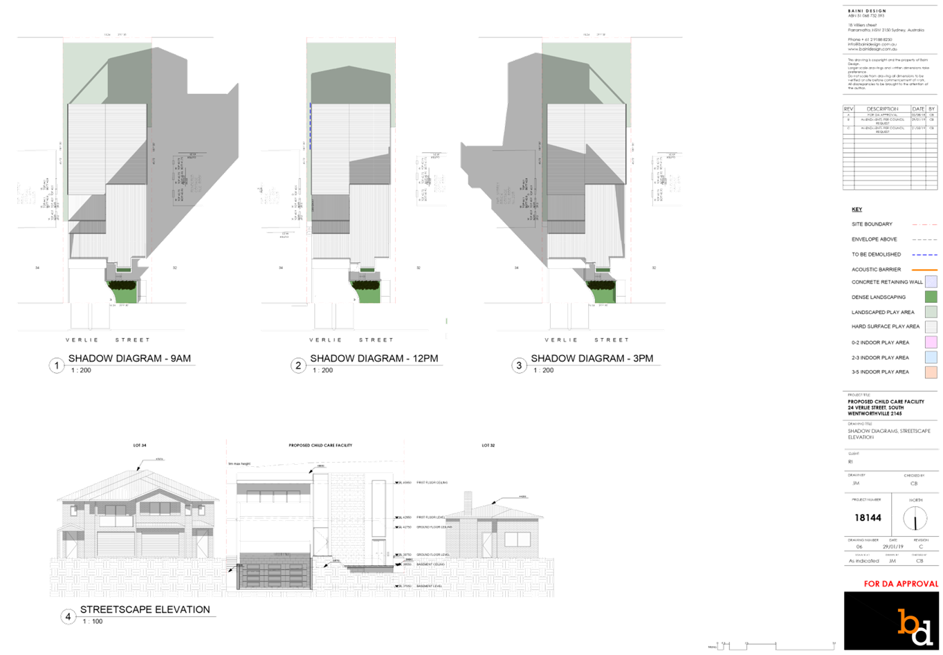
proposed development seeks following notable variations:
|
Control
|
Required
|
Provided
|
% variation
|
|
Number of
children and outdoor unencumbered space
(regulation
108 and part 4.9 the Guideline)
|
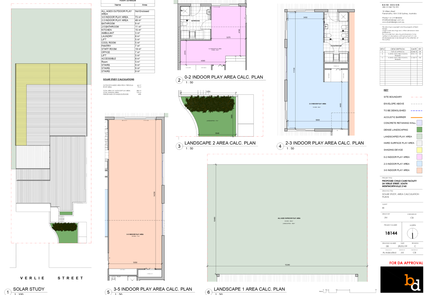
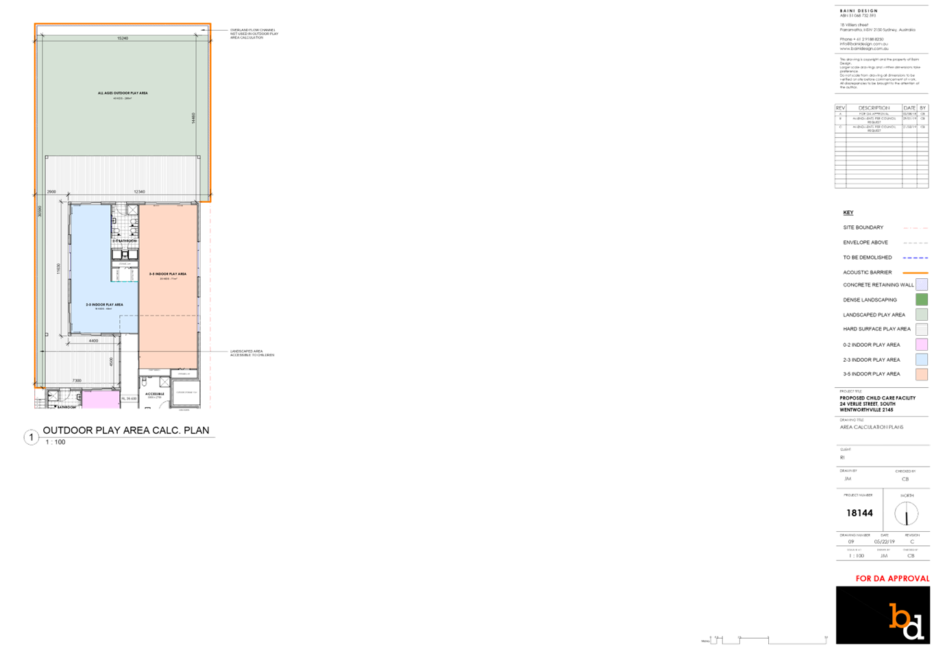
7m² x 40 = 280m²
|
Assessing officer’s calculation =
247m²
(excluding OSD pits, landscape buffer, retaining walls
and dense planting)
247m² / 7 = 35.28 children
Recommendation = reduce number
of children to 35
|
11.8%
|
|
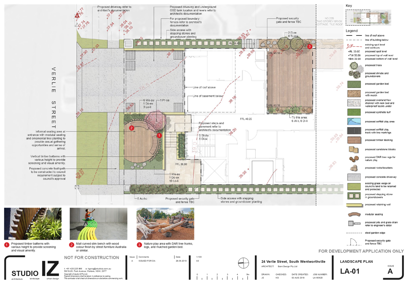
Landscape
area
(DCP)
|
Min. 20% = 139.34m2
|
16.2m² (2.3%)
|
88.4%
|
|
Setbacks from
side boundary (DCP)
|
Driveway – 1.5m
|
Driveway – 1.4m
|
6.7%
|
|
Min. site
frontage (DCP)
|
20m
|
15.24m
|
23.8%
|
8. The
application has been referred to the Cumberland Local Planning Panel (CLPP) for
determination due to the number of submissions received during the notification
periods.
9. It
is recommended that the application be approved for a maximum of 35 children
(due to the available unencumbered outdoor space/play area) subject to
conditions provided in the Draft Notice of Determination held at Attachment 1.
Subject Site And Surrounding
Area
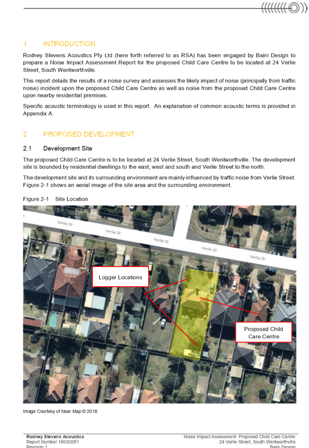
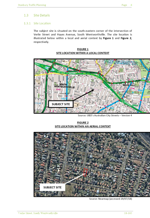
The subject site is known as 24
Verlie Street, South Wentworthville, and is legally described as Lot 33 in DP
16442. The site is located on the southern side of Verlie Street. The site is a
rectangular block with a frontage of 15.24m, depth of 45.72m and a total site
area of 696.7m². The site is currently occupied by a detached dwelling
house and garage. Adjoining the subject subject site directly to the east and
west is an attached two storey dual occupancy and single storey dwelling
respectively. The immediate area is characterised by low density housing. The
subject site and all adjoining properties are zoned R2 Low Density Residential.
Properties located on the northern side of Verlie Street are zoned R3 Medium
Density Residential.
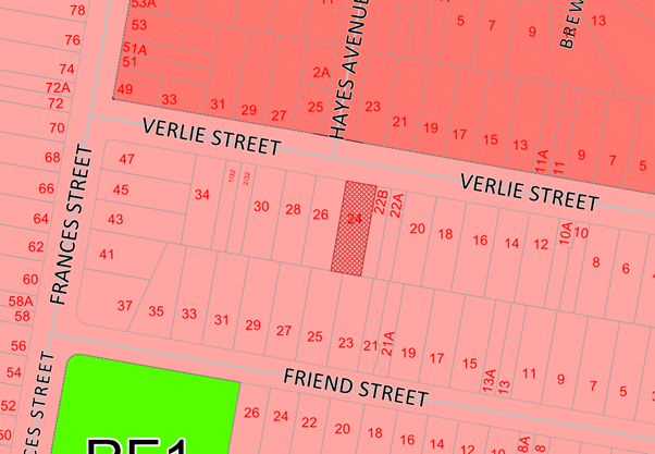
Zoning
Map – Subject site hatched in red.
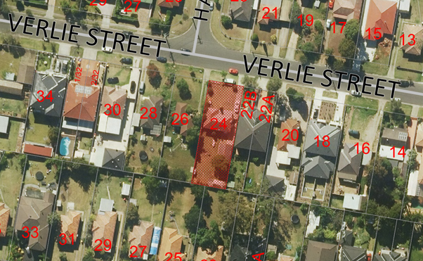
Aerial
Plan – Subject site hatched in red
Site
photo
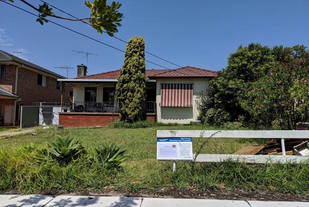
24
Verlie Street, South Wentworthville
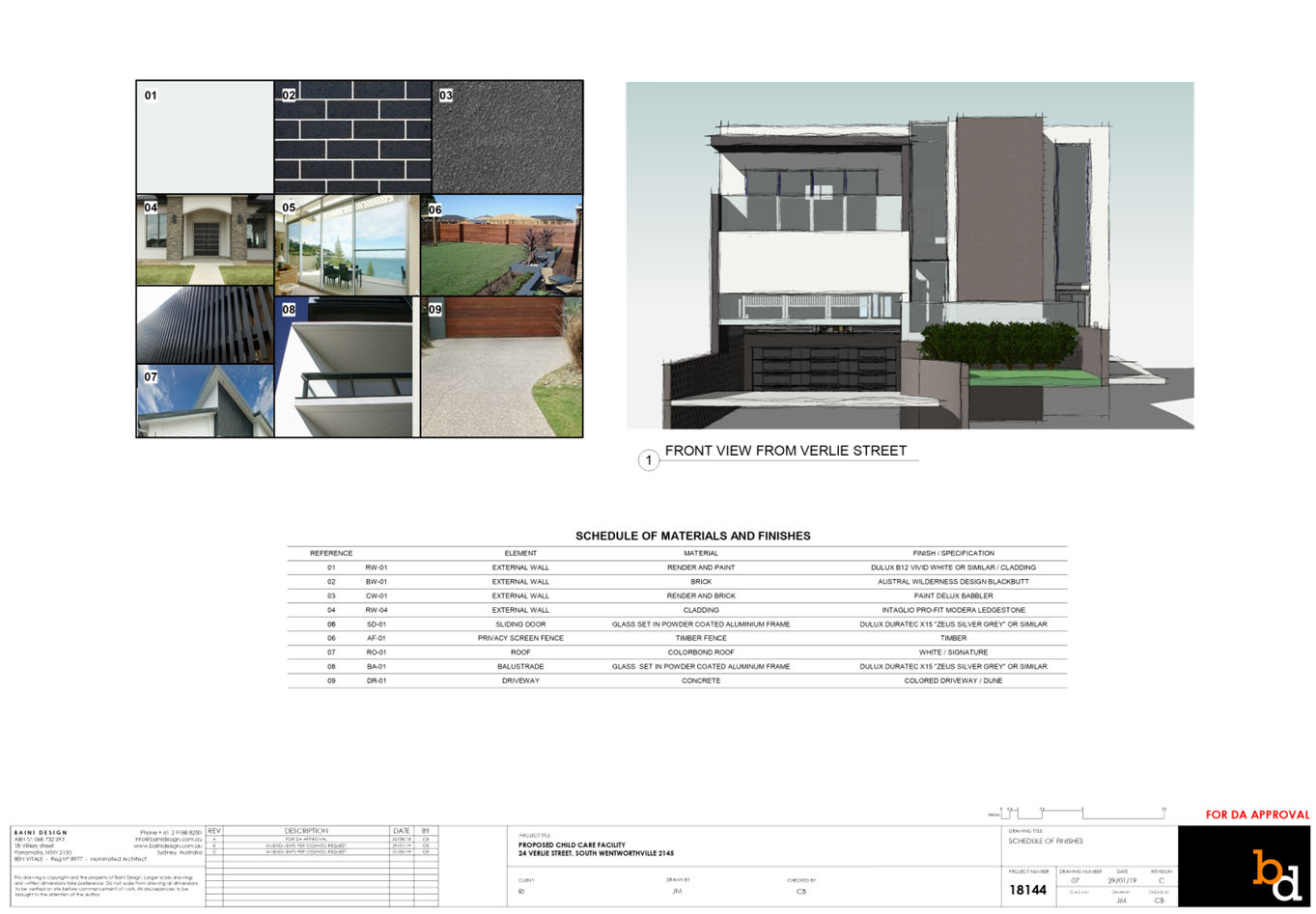
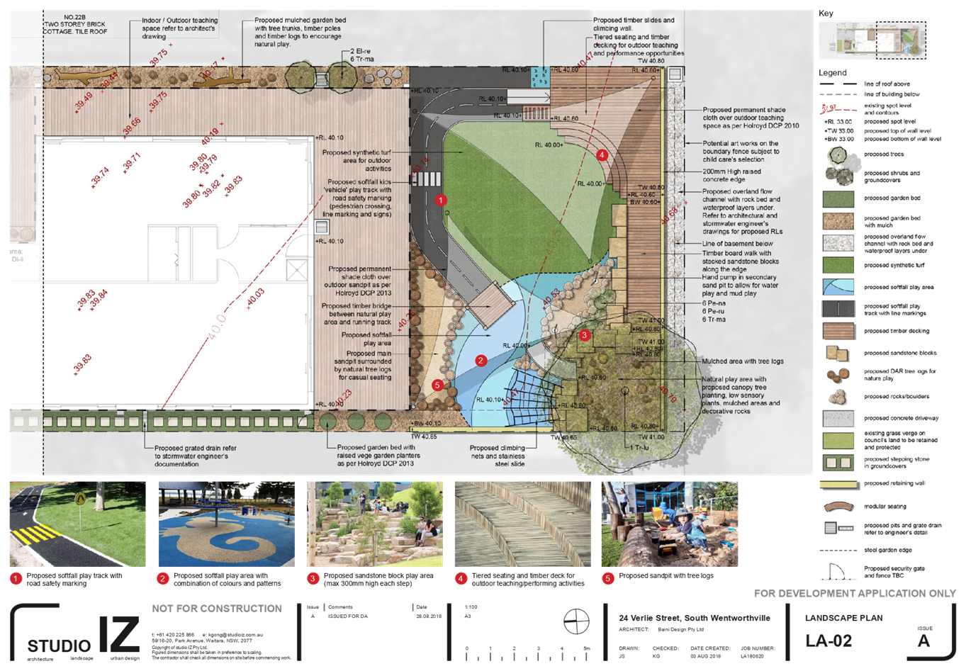
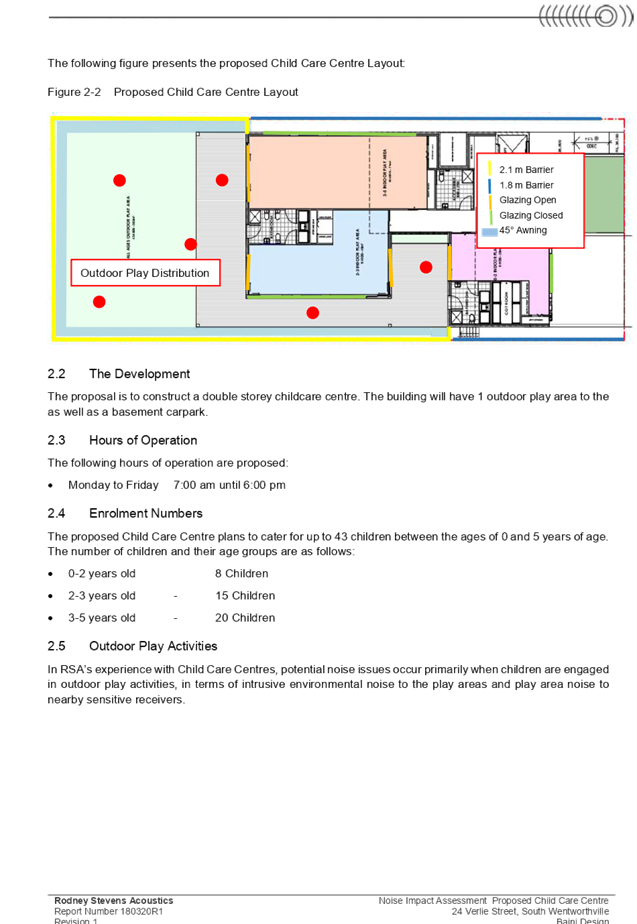
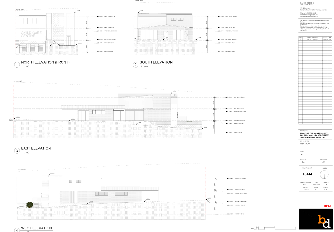
Description of The Proposed
Development
The proposed development, as
amended, involves the demolition of existing structures and construction of a
two storey, 35 place child care centre over basement parking accommodating 14
parking spaces.
Key features of the development
proposal are as follows:-
· Demolition
of the existing dwelling and garage.
· Construction
of a two-storey child care facility accommodating 35 children.
· Construction
of a basement level car parking area accommodating 14 car parking spaces, for
staff and visitors (including 1 accessible space) and bin room.
· The
facility (as amended) will accommodate 35 children, as follows:
o 4
children – 0-2 yrs
o 13
children – 2-3 yrs
o 18
children – 3-5 yrs
· The
proposed centre will operate from 7.00am to 6.00pm Monday to Friday, and will
employ 7 staff.
· The
ground floor level contains toilets, storage and indoor and outdoor play areas.
· The
first floor level contains office, toilet, staff room, kitchen, laundry,
storage and balcony facing Verlie Street.
· There
is no signage proposed as part of the application.
History
|
Date
|
Action
|
|
4/10/2018
|
Development Application 2018/357 was lodged.
|
|
16/10/2018
|
The application was
reviewed by Council’s DA Review team (DART)
|
|
19/10/2018
|
The application was referred to Council’s internal
departments for review.
|
|
24/10/2018 to 7/11/2018
|
The application was publicly
notified to adjoining and opposite owners, a notice was placed in the local
press and a notice placed on the site for 14 days. In response, 8 submissions
and 1 petition were received.
|
|
6/12/2018
|
Application was deferred due to non-compliances with SEPP
(Educational Establishments and Child Care Facilities) 2017, Child Care
Planning Guideline 2017, Holroyd Development Control Plan 2013, as well as
traffic and environmental health matters.
|
|
17/12/2018
|
Application deferred to address stormwater matters.
|
|
31/01/2019
|
Amended plans and
additional information were received by Council, reducing children placement
to 41.
|
|
20/02/2019 to 6/03/2019
|
The application was renotified to a broader catchment, a notice was placed in the local press and a notice
placed on the site for 14 days. In response, 1 submission was received and
representation on behalf of the head petitioner was received confirming
concerns as raised with the original proposal remain.
|
|
16/05/2019
|
Application deferred to reduce children placement and
address traffic matters.
|
|
22/05/2019
|
Amended plans submitted were received by Council reducing
children placement to 40.
|
|
26/06/2019
|
Application referred to CLPP for determination.
|
Applicant’s Supporting
Statement
The applicant provided a Statement
of Environmental Effects prepared by Think Planners Pty Ltd dated 4 October
2018 in support of the application.
Contact With Relevant
Parties
The assessing officer has
undertaken a site inspection of the subject site and surrounding properties and
has been in regular contact with the applicant throughout the assessment
process.
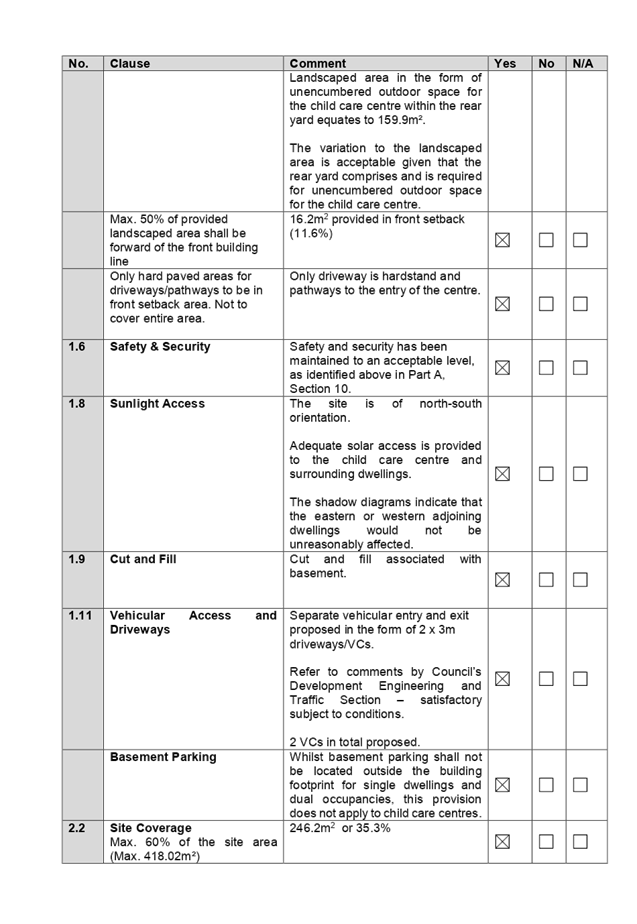
Internal Referrals
Development Engineer
The development application was
referred to Council’s Development Engineer for comment who has advised
that the development is supportable in regards to flood mitigation measures,
and the provision of on-site detention, subject to conditions.
Traffic Engineer
The development application was
referred to Council’s Traffic Engineer for comment who has advised that
the development is supportable in regards to traffic management, and on-site
parking provision in the basement level, subject to conditions.
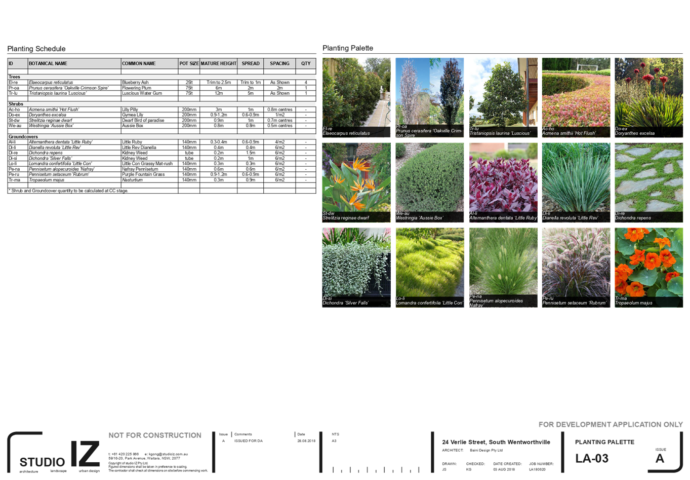
Tree Management Officer
The development application was
referred to Council’s Tree Management Officer for comment who has advised
that the development is supportable in regards to the removal of the street
tree and property tree within the rear yard, protection of existing trees on
the adjoining properties, and replacement tree planting subject to conditions.
Waste Management Officer
The development application was
referred to Council’s Waste Management Officer for comment who has
advised that the development is supportable in regards to provision of bin tug,
bin storage room, and waste collection and management plan, subject to
conditions.
Environmental Health Officer
The development application was
referred to Council’s Environmental Health Officer for comment who has
advised that the development is supportable in regards to fit-out for food
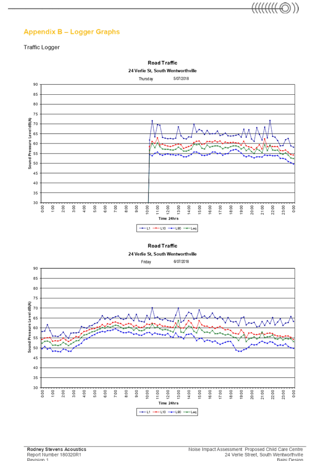
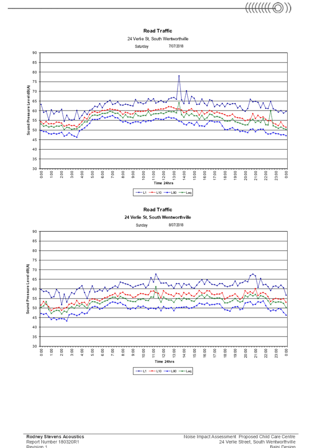
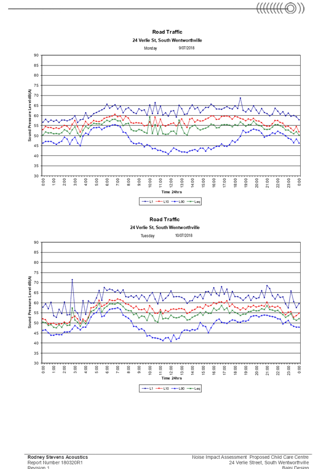
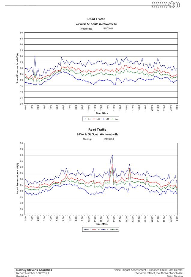
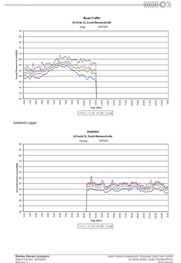
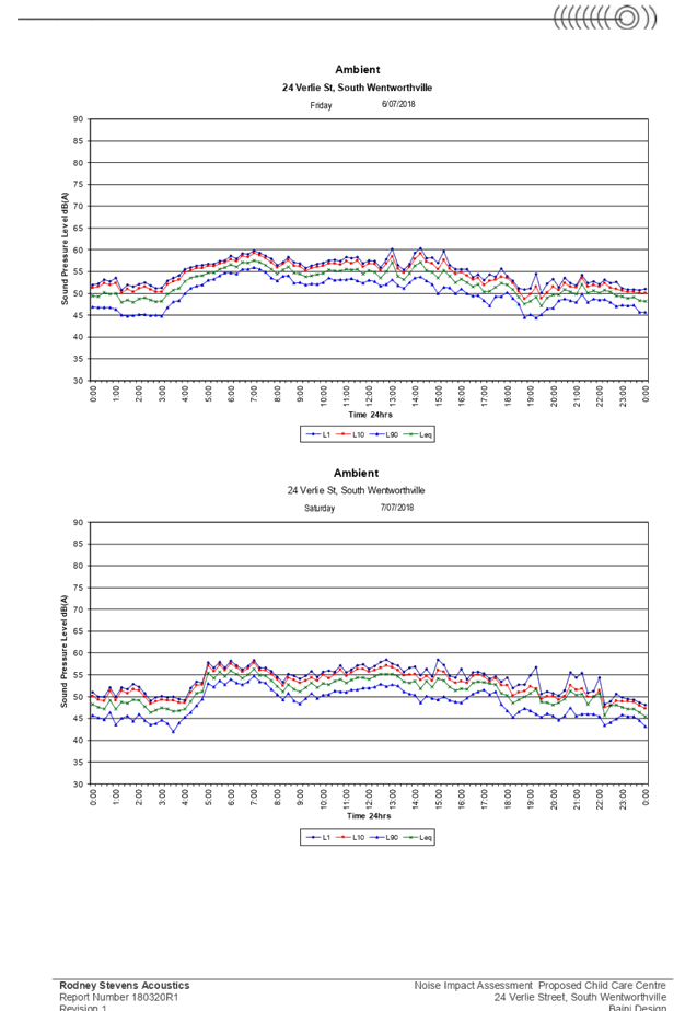
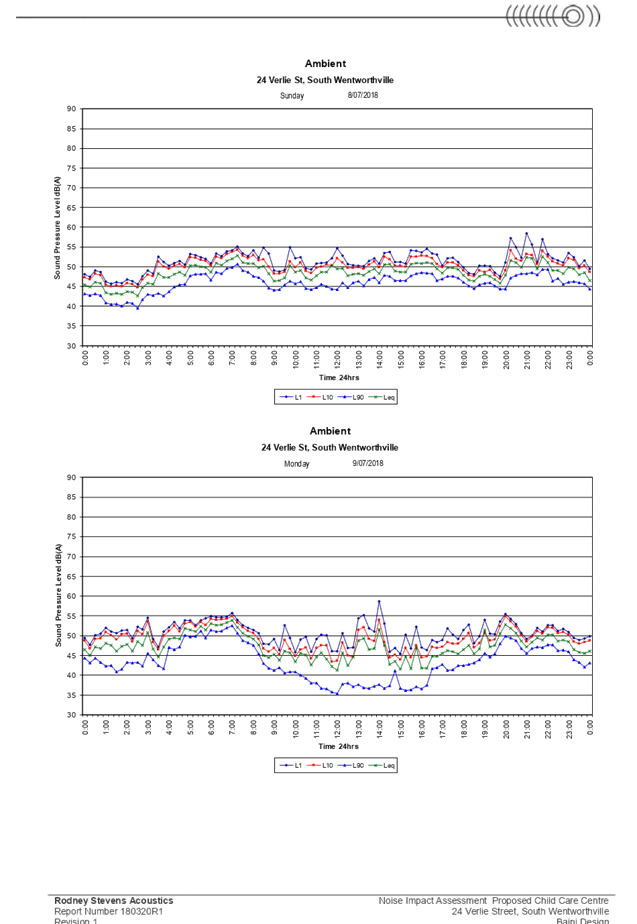
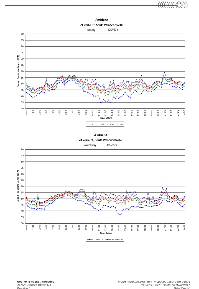
preparation area, acoustic assessment, noise management plan, noise attenuation
measure, soil assessment, and site contamination, subject to conditions.
Children’s Services
The development application was
referred to Council’s Children’s Services section for comment who
has advised that the development is supportable in regards to compliance with
the provisions of Education and Care Services National Regulations and Law,
subject to conditions.
External Referrals
N/A
Planning Comments
The provisions of any
Environmental Planning Instruments (EP & A Act, s4.15(1)(a)(i))
State Environmental Planning
Policies
The proposed development is
affected by the following State Environmental Planning Policies:
(a) State
Environmental Planning Policy No. 55 – Remediation of Land
The requirement at Clause 7 of
SEPP No. 55 for Council to be satisfied that the site is suitable or can be made
suitable to accommodate the proposed development has been considered in the
following table:
|
Matters for consideration
|
Yes
|
No
|
N/A
|
|
Does the application involve
re-development of the site or a change of land use?
|
|
|
|
|
Is the development going to be
used for a sensitive land use (e.g.: residential, educational, recreational,
childcare or hospital)?
|
|
|
|
|
Does information available to
you indicate that an activity listed below has ever been approved, or
occurred at the site?
acid/alkali plant and formulation,
agricultural/horticultural activities, airports, asbestos production and
disposal, chemicals manufacture and formulation, defence works, drum
re-conditioning works, dry cleaning establishments, electrical manufacturing
(transformers), electroplating and heat treatment premises, engine works,
explosive industry, gas works, iron and steel works, landfill sites,
metal treatment, mining and extractive industries, oil production and
storage, paint formulation and manufacture, pesticide manufacture and
formulation, power stations, railway yards, scrap yards, service stations,
sheep and cattle dips, smelting and refining, tanning and associated trades,
waste storage and treatment, wood preservation.
|
|
|
|
|
Is the site listed on Council's
Contaminated Land Database?
|
|
|
|
|
Is the site subject to EPA
clean-up order or other EPA restrictions?
|
|
|
|
|
Has the site been the subject of
known pollution incidents or illegal dumping?
|
|
|
|
|
Does the site adjoin any
contaminated land/previously contaminated land?
|
|
|
|
|
Has the appropriate level of
investigation been carried out in respect of contamination matters for
Council to be satisfied that the site is suitable to accommodate the proposed
development or can be made suitable to accommodate the proposed development?
|
|
|
|
|
Details of contamination
investigations carried out at the site:
In relation to clause 7(4) of SEPP 55, the land concerned
is not located within an investigation area (clause 7(4)(a)), development for
a purpose referred to in Table 1 of the Contaminated Land Planning Guidelines
is not known to have been carried out on the land (clause 7(4)(b), and
historic zoning controls of the land did not make lawful the carrying out of
activities nominated in Table 1. Based on these considerations, clauses 7(2) and 7(3) of SEPP 55 have no
application. The site is not identified in Council’s records as being
contaminated. A site inspection reveals the site does not have any obvious
signs or history of a previous land use that may have caused contamination
and there is no specific evidence that indicates the site is contaminated. On
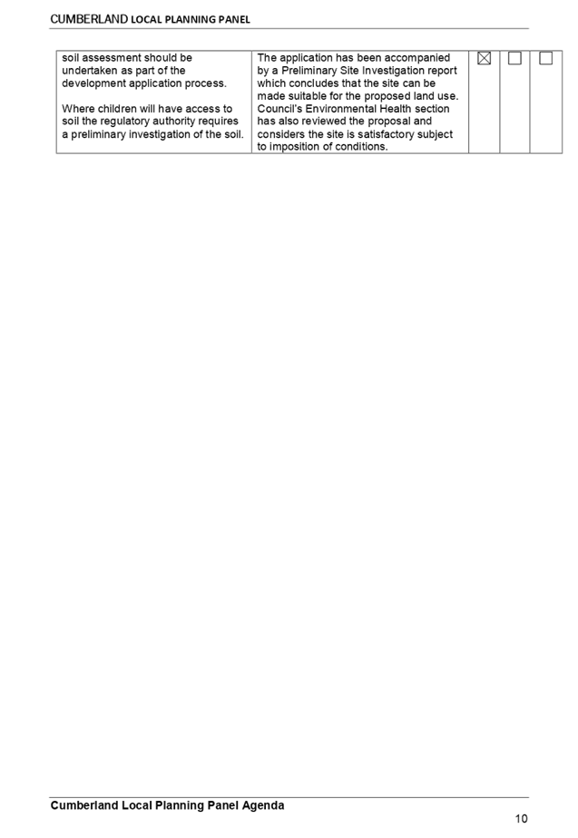
this basis, SEPP 55 has no further application. Notwithstanding, a soil assessment report is
required in accordance with the Child Care Planning Guideline issued by NSW
Department of Planning and Environment. The application has been accompanied
by a Preliminary Site Investigation report which
concludes that the site can be made suitable for the proposed land use.
Council’s Environmental Health section has also reviewed the proposal
and considers the site is satisfactory subject to imposition of conditions.
|
(b) State
Environmental Planning Policy (Educational Establishments and Child Care
Facilities) 2017
The relevant provisions of the
SEPP have been considered in the assessment of the Application.
It is noted that State
Environmental Planning Policy (Educational Establishments And Child Care
Facilities) 2017 commenced on 1 September 2017. The SEPP applies to any
proposals for new schools or child care centres or proposed alterations and
additions to existing centres. The relevant provisions of the SEPP have been
considered in the assessment of the Application.
A comprehensive assessment and
compliance table is attached to this report in Appendix A, which indicates that
there are non-compliances with the SEPP 2017 with regard to number of children
proposed and outdoor unencumbered space as under:
|
· Control
|
· Required
|
· Provided
|
|
· Number
of children and outdoor unencumbered space (regulation 108 SEPP 2017 and part
4.9 the Guideline)
|
7m² x 40 = 280m²
|
The application indicates that
an unencumbered area of 286m² is provided. However, this has not taken
consideration of OSD pits, retaining walls and dense planting. The assessment
officer’s calculation of the unencumbered outdoor space equates to
247m². This will accommodate only 35 children. This report recommends a
condition to be imposed on any consent granted for a reduction in the number
of children to 35.
|
(c) Statement
Environmental Planning Policy No 19 - Bushland in Urban Areas
The subject site does not adjoin
land zoned or reserved for public open space. The proposal does not propose to
disturb bushland zoned or reserved for public open space.
(d) State
Environmental Planning Policy (Vegetation in Non-Rural Areas) 2017
Removal of one (1) existing street
tree and one (1) property tree within the rear yard is proposed as part of this
application. Council’s Tree Management Officer has reviewed the proposal
and raised no objections to tree removal subject to the impositions of
conditions requiring the planting of a replacement street tree and one tree
within the rear yard. In addition, the proposal does not exceed the
biodiversity offsets scheme threshold. Therefore, the proposed vegetation
removal is considered acceptable.
Regional Environmental Plans
(Deemed State Environmental Planning Policies)
(e) Sydney
Regional Environmental Plan (Sydney Harbour Catchment) 2005
The subject site is identified as
being located within the area affected by the Sydney Regional Environmental
Plan (Sydney Harbour Catchment) 2005. The proposed development raises no issues
as no impact on the catchment is envisaged.
Note: The subject site is not
identified in the relevant map as land within the ‘Foreshores and
Waterways Area’ or ‘Wetland Protection Zone’, is not a
‘Strategic Foreshore Site’ and does not contain any heritage items.
Hence the majority of the SREP is not directly relevant to the proposed
development.
Local Environmental Plans
(a) Holroyd
Local Environmental Plan (LEP) 2013
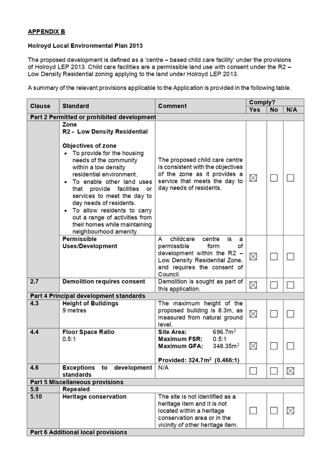
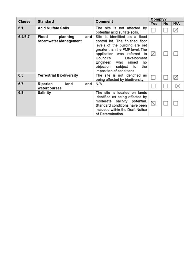
The proposed development is defined
as a ‘centre based child care facility’ under the provisions of
Holroyd Local Environmental Plan (LEP) 2013. Centre based child care facilities
are a permissible land use with consent under the R2 – Low Density
Residential zoning applying to the land under Holroyd LEP 2013.
A comprehensive assessment and
compliance table is attached to this report in Appendix B which demonstrates
the development proposal’s compliance with the relevant planning controls
that are applicable to the site under the Holroyd LEP 2013.
The provisions of any draft
Environmental Planning Instruments (EP & A Act Section 4.15(1)(a)(ii))
The proposed development is not
affected by any relevant Draft Environmental Planning Instruments.
The provisions of any
Development Control Plans (Environmental Planning & Assessment Act Section
4.15(1)(a)(iii))
(b) Holroyd
Development Control Plan (HDCP) 2013
The Holroyd DCP 2013 provides
guidance for the design and operation of development within Holroyd to achieve
the aims and objectives of Holroyd LEP 2013.
The proposed development is
generally compliant with the relevant provisions. Parts A, B & I apply to
the proposal. A comprehensive assessment and compliance table is attached to
this report at Appendix C which demonstrates the development proposal’s
compliance with the relevant planning controls that are applicable to the site.
The assessment provided in
Appendix C indicates that there are some minor non-compliances with the HDCP
2013 with regard to car parking, landscape area, and basement and driveway
setbacks, which are discussed in the following section:
|
No.
|
Clause
|
Comment
|
Yes
|
No
|
N/A
|
|
PART A – GENERAL
CONTROLS
|
|
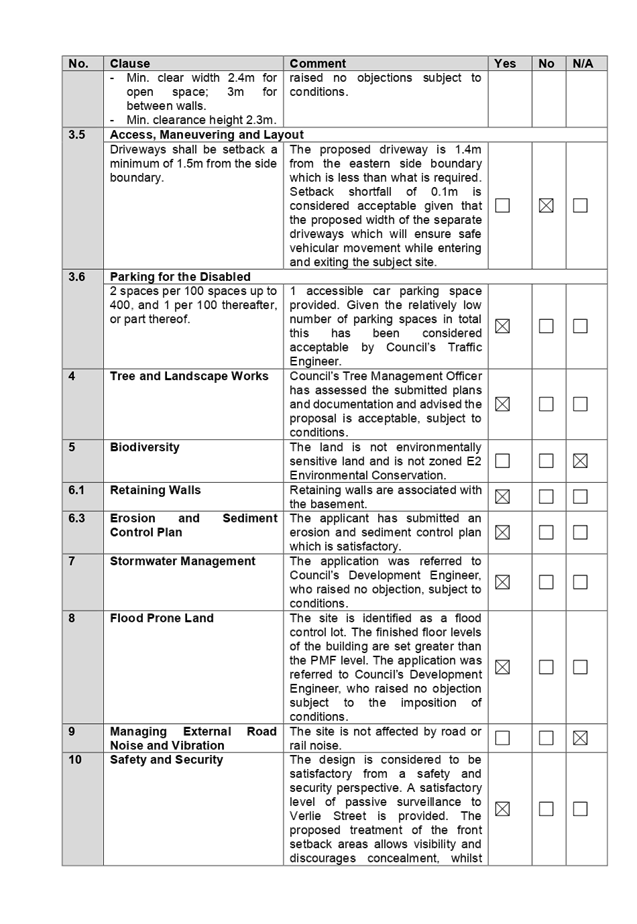
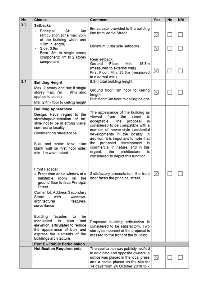
3.5
|
Access, Manoeuvring and Layout
|
|
Driveways shall be setback a minimum of 1.5m from the side
boundary.
|
The proposed driveway is setback 1.4m from the eastern
side boundary which is less than what is required. Setback shortfall of 0.1m
is considered acceptable given the provision of separate driveways which will
ensure safe vehicular movement while entering and exiting the site.
|
|
|
|
|
PART B – RESIDENTIAL
CONTROLS
|
|
1
|
GENERAL RESIDENTIAL CONTROLS
|
|
1.5
|
Landscape Area
Min. 20% = 139.34m2
|
Area of 2.3%
(16.2m²) is provided with min. 2m dimension.
Landscaped area in the form of
unencumbered outdoor space for the child care centre within the rear yard
equates to 159.9m².
Variation to the required landscaped area is acceptable
given that the rear yard comprises the unencumbered outdoor space for the
child care centre, which cannot be calculated as landscaped area.
|
|
|
|
|
PART I – CHILDCARE
CENTRES
|
|
1
|
SIZE, DENSITY AND LOCATION
|
|
|
Site Frontage
The minimum site frontage for a
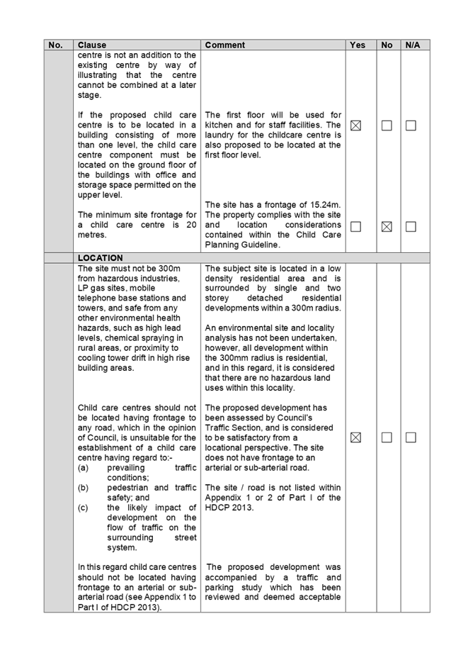
child care centre is 20 metres.
|
The site has a frontage of
15.24m. The deficiency of the property’s site frontage is considered
supportable as the proposal (as amended) generally complies with relevant
requirements for child care centres in terms of provision and quality of play
spaces, amenity impacts of the centre, provision of parking and compatibility
with surrounding properties. In addition, the subject property complies with
site and location considerations contained within the Child Care Planning
Guideline.
|
|
|
|
Any planning agreement that has
been entered into under section 93F, or any draft planning agreement that a
developer has offered to enter into under section 93F (EP & A Act
s79C(1)(a)(iiia))
There are no draft planning
agreements or planning agreements associated with the subject Application.
The provisions of the
Regulations (Environmental Planning & Assessment Act Section
4.15(1)(a)(iv))
The proposed development raises no
concerns as to the relevant matters arising from the Environmental Planning
& Assessment Regulations 2000.
Section 4.15 (1)(a)(v) - any
coastal zone management plan (within the meaning of the Coastal Protection Act
1979)
There is no Coastal Zone
Management Plan applicable for the site.
The Likely Environmental,
Social or Economic Impacts (EP & A Act s4.15(1)(b))
The likely impacts of the
development have been considered in the assessment of the application and it is
considered that the proposed development will have no significant adverse
environmental, social or economic impacts in the locality.
The suitability of the site for
the development (EP & A Act s4.15(1)(c))
The site is considered suitable to
accommodate the proposed development. The proposed development has been assessed
in regard to its environmental consequences and having regard to this
assessment, it is considered that the development is suitable in the context of
the site and surrounding locality.
Submissions made in accordance
with the Act or Regulation (EP & A Act s4.15C(1)(d))
Advertised (newspaper) Mail Sign Not Required
In accordance with Part E - Public
Participation of the Holroyd DCP 2013, the application was publicly notified to
adjoining and opposite owners, a notice was placed in the local press and a
notice placed on the site for 14 days from 24 October 2018 to 7 November 2018.
In response, 8 submissions and 1 petition were received.
Amended plans received was
publicly re-notified for 14 days from 20 February 2019 and 6 March 2019 in line
with the original notification period, however re-notification was sent to a
broader catchment comprising all properties within the block bound by Friend
Street, Frances Street, Verlie Street and Coleman Street, as well as properties
located on the northern side of Verlie Street; following concerns raised during
the initial notification period. In response, 1 submission was received and
representation on behalf of the head petitioner was received confirming
concerns as raised with the original proposal remain.
The issues raised in the public
submissions and concerns raised in the petition are summarised and commented on
as follows:
|
Concern
|
Comment
|
|
1. Traffic and parking
There will not be enough car parking spaces to
service the child care centre, traffic peak times within AM/PM are to be
considered as this will affect pedestrian safety, traffic flow and
availability of parking in Verlie Street.
|
Under the Holroyd
Development Control Plan 2013, the required parking rate for child care
centres is 1 space per 4 children and 1 space per 2 staff, which equates to
total of 12 spaces (3 staff and 9 visitor spaces) required for the reduced 35
children placement. This rate has been provided on site, which takes into
account staff and visitor parking demands. The proposal provides 4 staff and
10 visitor parking spaces which equates to 1 additional staff and 1
additional visitor parking space within the basement, which assists with
providing additional parking off Verlie Street.
It
is noted that Council’s rate of 1 car space per 4 children is
consistent with the recently introduced NSW State Government document
entitled Child Care Planning Guideline, in which the rate of 1 space
per 4 children encompasses the whole centre including all staff.
A
condition is to be imposed to ensure that ratio of staff and visitor parking
is allocated accordingly, which is at least 14 spaces for on-site parking
spaces (surplus of 2 spaces) based on 35 children. The proposed parking
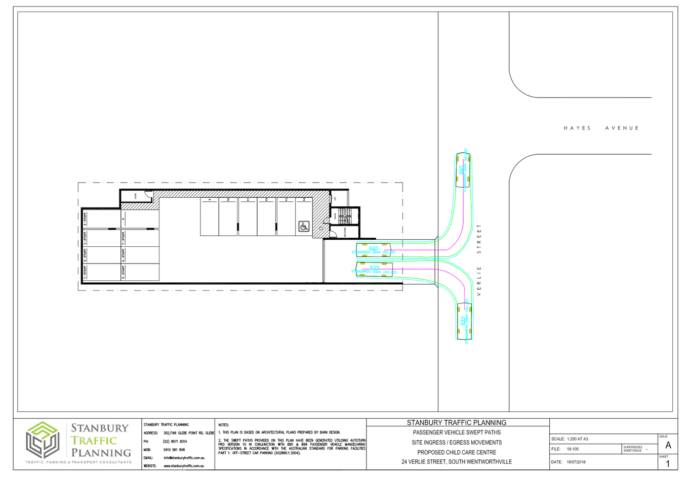
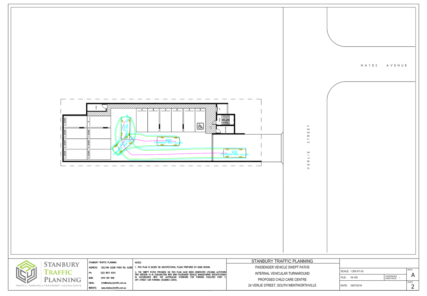
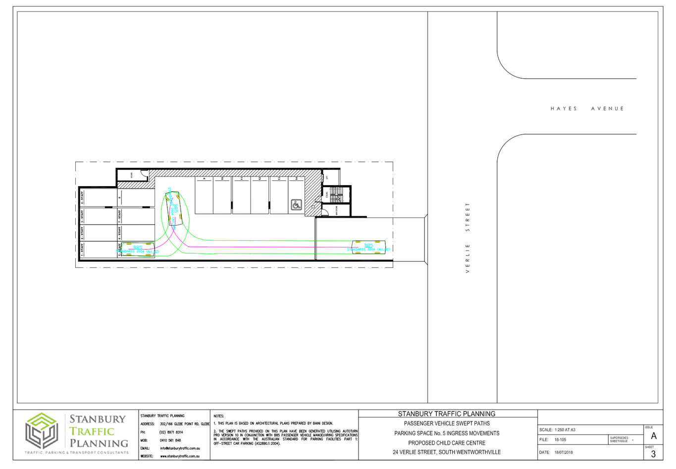
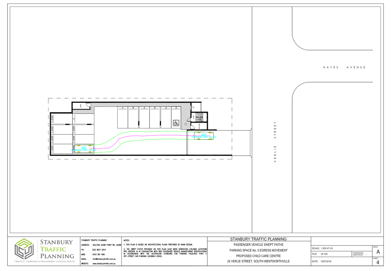
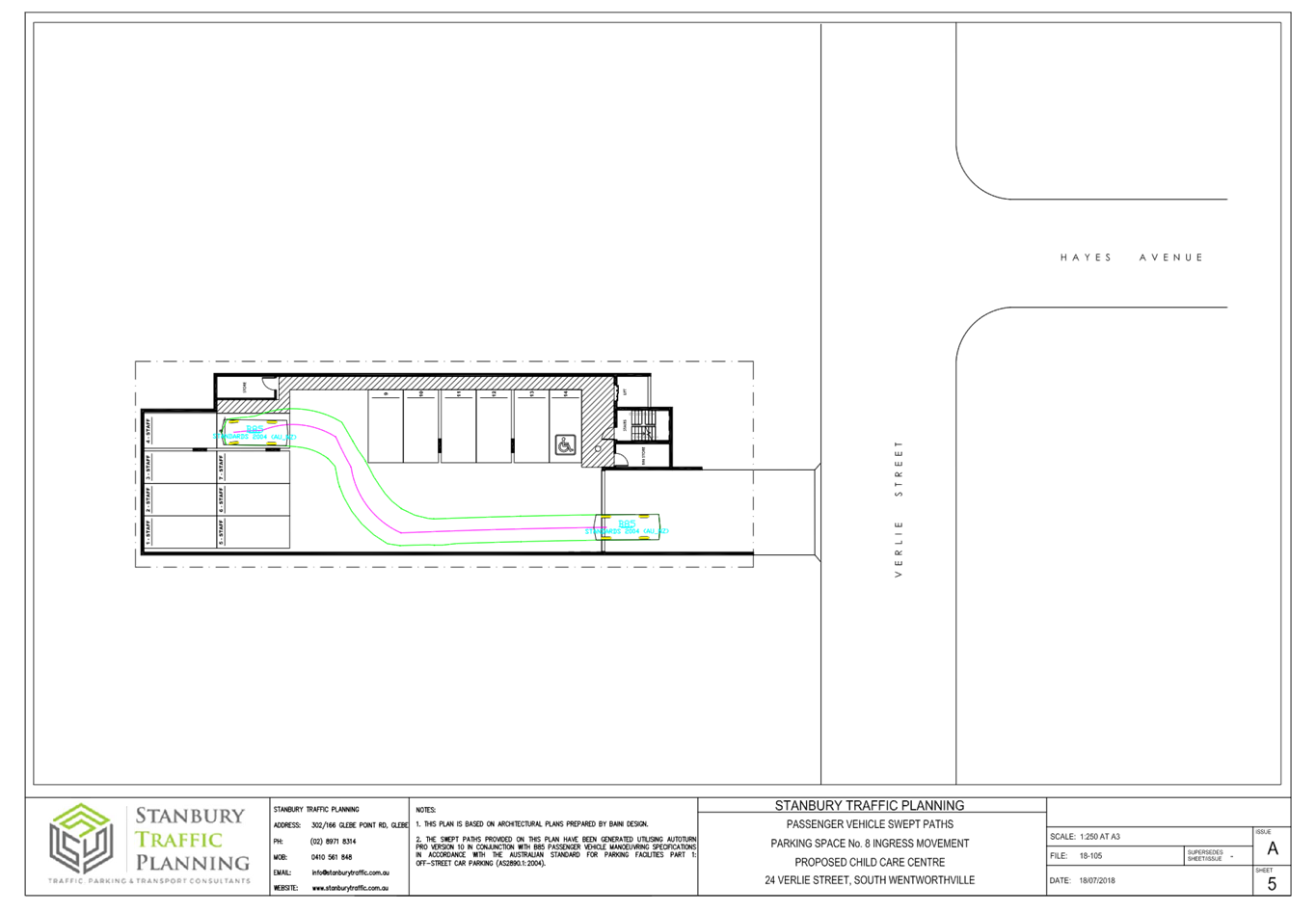
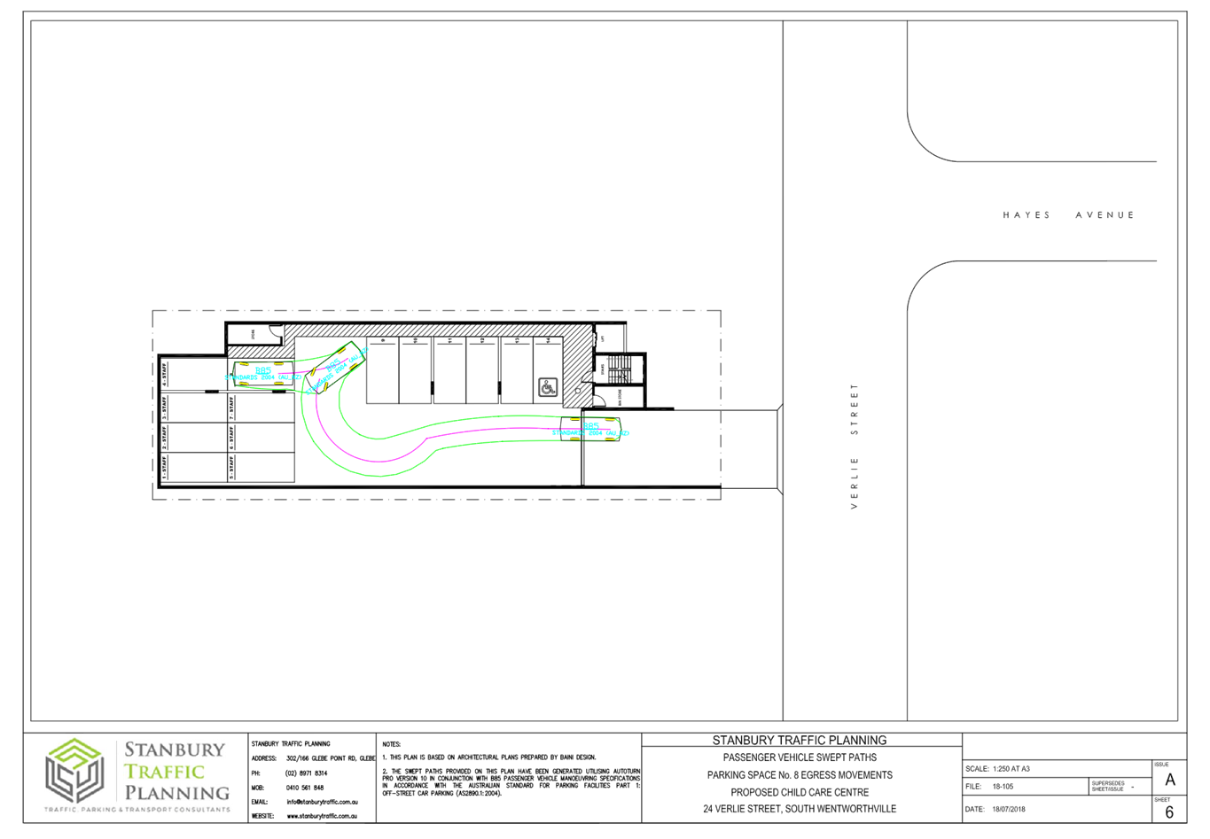
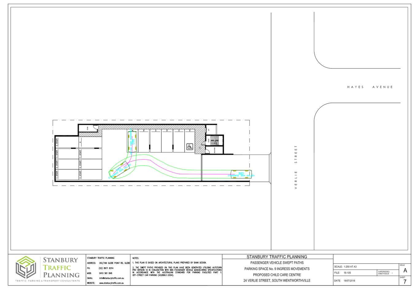
arrangement and swept path have been reviewed by Council’s Traffic
Engineer and considered satisfactory, subject to conditions.
The submitted traffic report
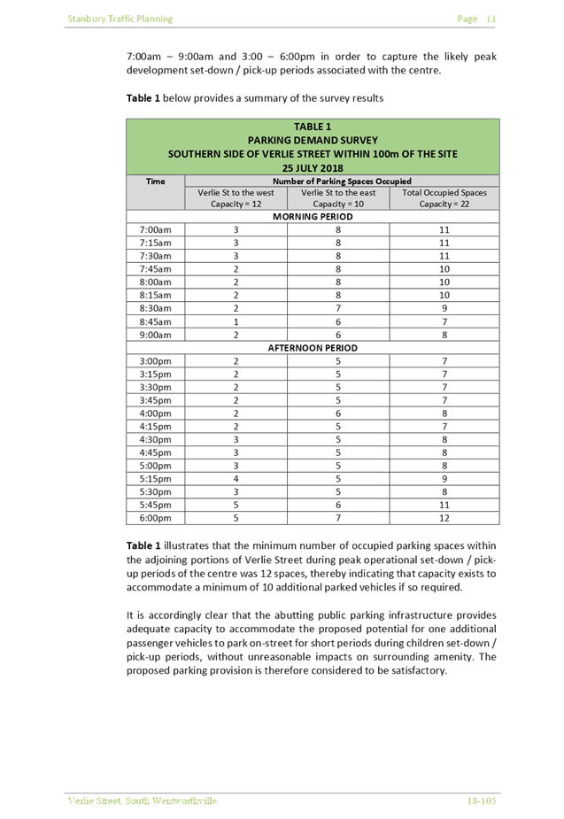
has been carried out based on surveys during peak times AM and PM between
7.00am – 9.00am and 4.00pm – 6.00pm on 25 July 2018 (Wednesday). Council
noted the additional traffic to be generated by the proposal and the findings
from the Traffic and Parking Impact Assessment Report. The proposed development
is a low trip generator and can be accommodated in the locality without
affecting performance of on Verlie Street, or on the existing road network
with respect to delays or queues of nearby intersections, and complies with
Council’s parking requirements.
The provision of separate
driveways for entry and exit allow all vehicles to enter and leave in a
forward direction and provide adequate sight distance. It is envisaged that
motorists will be capable of entering and exiting the site in a safe and efficient
manner. In addition, there is a 1.2m separation distance between the two
driveways which also provide pedestrians a safe refuge area to wait to cross
when vehicles enter and exit the basement.
An additional condition is
included to ensure any front fencing will allow clear sightlines for
vehicular access. The number of parking spaces provided is considered
acceptable and appropriate to meet the parking demand of the proposed centre
without placing unacceptable demands on the availability of parking within
the locality or on the local street network.
The entry/exit driveway is at
an obvious location that will not be missed by parents and caregivers. The
parents and caregivers will be regular visitors to the centre knowing in
advance the location of car parking. An Operational Management Plan (OMP)
shall be enforced by way of conditions to encourage the use of the basement
parking facility. All pickup and drop-off is expected to take place within
the basement and it is not considered to create any adverse impact on the
public space.
Given the operation of the
child care centre will be wholly contained in the subject site, disruption to
any emergency and garbage vehicles access onto Verlie Street is not
anticipated.
|
|
2.
Noise
The
proposed child care centre will be a noise nuisance to surrounding
properties. Design of acoustic fencing location, height and thickness are not
acceptable. Location of mechanical ventilation will impact neighbouring
properties. Noise management plan will not effective in reducing noise.
|
The design of acoustic
fencing location, height and thickness, contained within the submitted Noise
Impact Assessment have been reviewed by Council’s Environmental Health
Officer and are considered satisfactory to comply with the relevant noise
control provisions. The acoustic report demonstrates that the proposed centre
can be accommodated on the site without noise nuisance to adjoining and
surrounding properties, as the noise generated from both indoor and outdoor
play activities can comply with the relevant environmental noise guidelines
with the imposition of a Noise Management Plan submitted with the application
and the installation of relevant noise mitigation measures such as acoustic
fencing. The acoustic consultant recommendation shall
be captured within the required Noise Management Plan.
The centre is proposed
to operate from 7.00am to 6.00pm Monday to Friday. The
acoustic assessment also has had regard to noise generated from mechanical
plant, car park emissions and indoor activities, which only occur during the
operation of child care centre.
Conditions are to be imposed in the consent to avoid any breaches to
the required noise threshold, including noise management to be incorporated
in the OMP.
|
|
3.
Disturbance to neighbouring properties – asbestos exposure during
demolition and subsidence from basement excavation.
|
The concerns raised have been
reviewed in the assessment of the subject application.
Should the building to be
demolished be found to be wholly or partly clad with asbestos cement,
approval to commence demolition will not be given until Council is satisfied
that all measures are in place so as to comply with WorkCover’s
document “Your Guide to Working with Asbestos”, and demolition
works must at all times comply with its requirements. Demolition works
involving the removal and disposal of asbestos cement must only be undertaken
by contractors who hold a current WorkCover “Demolition Licence”
and a current WorkCover “Class 2 (Restricted) Asbestos Licence”.
In addition, all asbestos laden waste, including asbestos cement flat and
corrugated sheets must be disposed of at a tipping facility licensed by the
Environment Protection Authority (EPA). Conditions are imposed requiring the
removal of asbestos to be in accordance with the relevant Australian
Standards and health and safety requirements.
Excavation of basement is subject
to conditions imposed to ensure that structural integrity of the adjoining
properties is maintained.
In addition, the Applicant is
required to carry out a dilapidation report of adjoining properties prior to
the commencement of any construction works to determine if underpinning and
supportive measures are required to ensure that there is no subsidence as a
result of the proposal.
|
|
4.
The proposed child care centre is not suitable for the street.
|
The site permits the construction
of the child care centre, and the proposed bulk and scale complies with built
form requirements contained within Holroyd DCP 2013. The unsuitability of the
site for a child care centre due to traffic and parking impacts outlined in
submissions received have been reviewed by Council’s Traffic Section
and deemed satisfactory. The subject site satisfies the site and location
criteria under the Child Care Planning Guideline and relevant
regulations stipulated under the Educational Establishments and Child Care
Facilities SEPP 2017 as discussed in the body of this report.
|
|
5.
Notification of DA not received by all residents on Verlie Street
|
The application was publicly notified to adjoining and opposite owners, a
notice was placed in the local press and a notice placed on the site for 14
days from 24 October 2018 to 7 November 2018, in accordance with Part E
– Public Participation of Holroyd Development Control Plan 2013.
Concerns
were raised with respect to the extent of properties notified of the
application during the initial notification period. Having regard to concerns
raised, amended plans received were publicly re-notified for 14 days from 20
February 2019 and 6 March 2019 in line with the original notification period;
however, re-notification was sent to a broader catchment of residents
comprising all properties within the block bound by Friend Street, Frances
Street, Verlie Street and Coleman Street, as well as properties located on
the northern side of Verlie Street.
|
The public interest (EP & A
Act s4.15(1)(e))
The public interest is served by
permitting the orderly and economic development of land, in a manner that is
sensitive to the surrounding environment and has regard to the reasonable
amenity expectations of surrounding land users. In view of the foregoing
analysis it is considered that the development, if carried out subject to the
conditions set out in the Draft Notice of Determination, will have no significant
adverse impacts in the locality.
Section 7.11 Contribution
Towards Provision or Improvement of Amenities or Services
This part of the Act relates to
the collection of monetary contributions from applicants for use in developing
key local infrastructure. The development does not require the payment of
contributions in accordance with Holroyd Section 94 Contributions Plan 2013.
Disclosure of Political
Donations And Gifts
The NSW Government introduced The
Local Government and Planning Legislation Amendment (Political Donations) Act
2008 (NSW). This disclosure requirement is for all members of the public
relating to political donations and gifts. The law introduces disclosure
requirements for individuals or entities with a relevant financial interest as
part of the lodgement of various types of development proposals and requests to
initiate environmental planning instruments or development control plans.
The application and notification
process did not result in any disclosure of Political Donations and Gifts.
The Application has been assessed
in accordance with the relevant requirements of the Environmental Planning and
Assessment Act 1979, State Environmental Planning Policy No. 55 –
Remediation of Land, State Environmental Planning Policy (Educational
Establishments and Child Care Facilities) 2017, Education and Care Services
National Regulations, Holroyd Local Environmental Plan 2013 and the Holroyd
Development Control Plan 2013 and is considered to be satisfactory for
approval, subject to reduction in number of children to 35 (to comply with the
outdoor unencumbered space) and the draft conditions.
There are no further consultation
processes for Council associated with this report.
There are no further financial
implications for Council associated with this report.
There are no policy implications
for Council associated with this report.
Communication /
Publications:
The final outcome of this matter
will be notified in the newspaper. The objectors will also be notified in
writing of the outcome.
|
1. That
Development Application 2018/357/1 for demolition of existing structures and
construction of a two storey, 35 place child care centre over basement
parking accommodating 14 parking spaces on land at 24 Verlie Street, South
Wentworthville be approved under Deferred Commencement, subject to the
attached conditions, provided at Attachment 1.
2. That
the applicant and those persons who lodged a submission in respect of the
application be notified of the determination of the application.
|
1. Draft
Notice of Determination ⇩ 
2. Architectural
Plans Internal ⇩
3. Architectural
Plans External ⇩
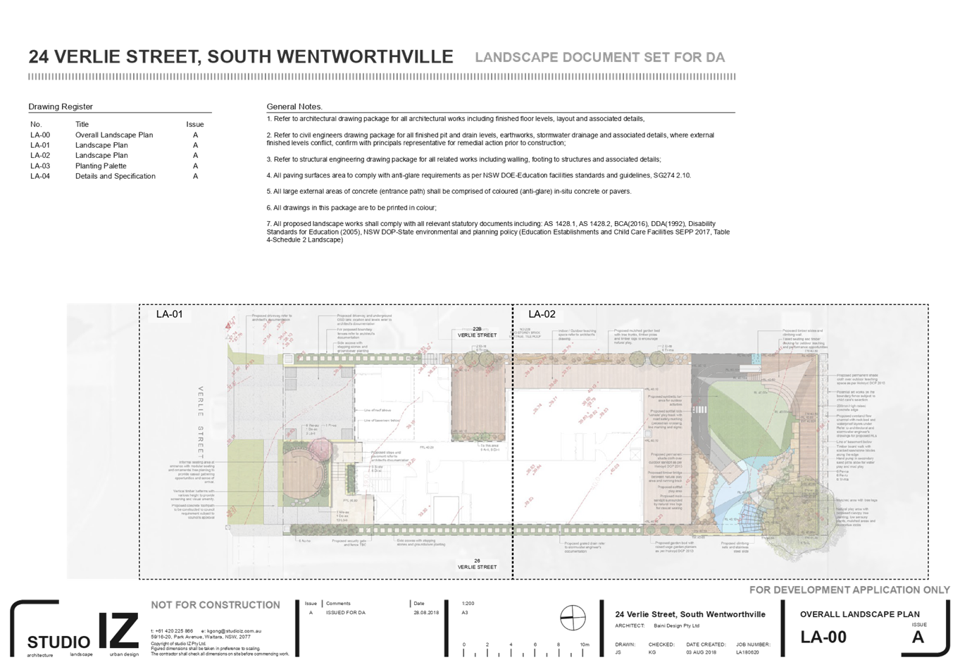
4. Landscape
Plan ⇩ 
5. Noise
Impact Assessment ⇩
6. Traffic
& Parking Assessment & Addendum Statement ⇩ 
7. Submissions
& Petition ⇩
8. Appendix
A - State Environmental Planning Policy (Educational Establishments & Child
Care Facilities) 2017 ⇩
9. Appendix
B - Holroyd Local Environmental Plan 2013 ⇩ 
10. Appendix
C - Holroyd Development Control Plan 2013 ⇩
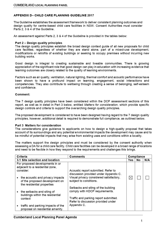
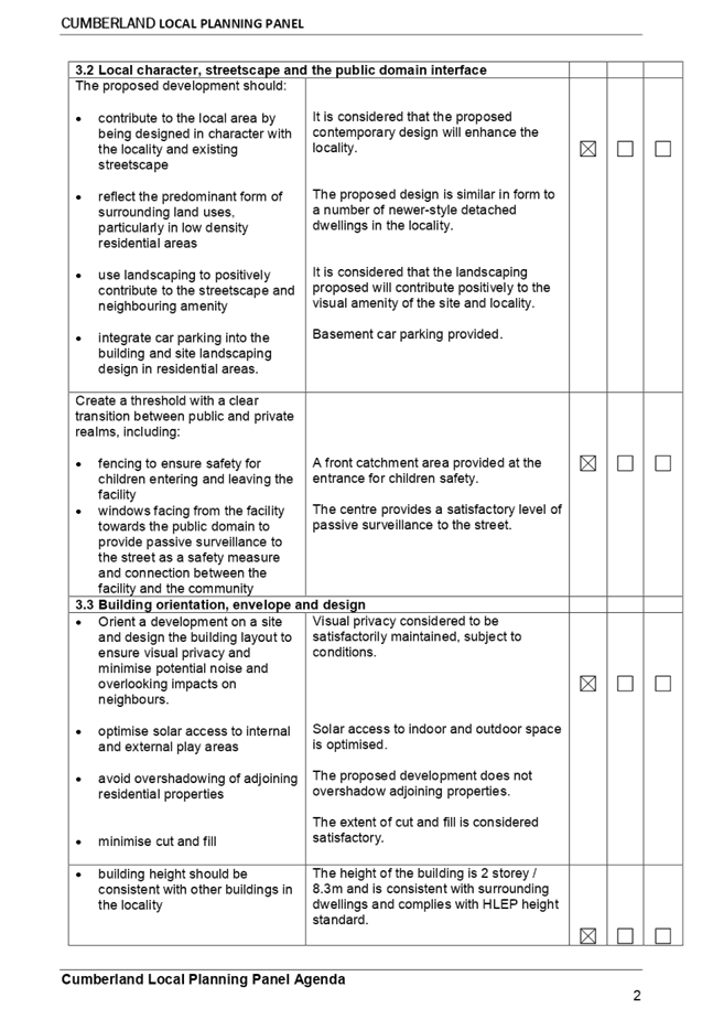
11. Appendix
D -Child Care Planning Guideline 2017 ⇩
DOCUMENTS
ASSOCIATED WITH
REPORT ELPP046/19
Attachment 1
Draft Notice of Determination
Extraordinary Cumberland Local Planning
Panel Meeting
26 June 2019

DOCUMENTS
ASSOCIATED WITH
REPORT ELPP046/19
Attachment 2
Architectural Plans Internal
Extraordinary Cumberland Local Planning
Panel Meeting
26 June 2019
DOCUMENTS
ASSOCIATED WITH
REPORT ELPP046/19
Attachment 3
Architectural Plans External
Extraordinary Cumberland Local Planning
Panel Meeting
26 June 2019
DOCUMENTS
ASSOCIATED WITH
REPORT ELPP046/19
Attachment 4
Landscape Plan
Extraordinary Cumberland Local Planning
Panel Meeting
26 June 2019
DOCUMENTS
ASSOCIATED WITH
REPORT ELPP046/19
Attachment 5
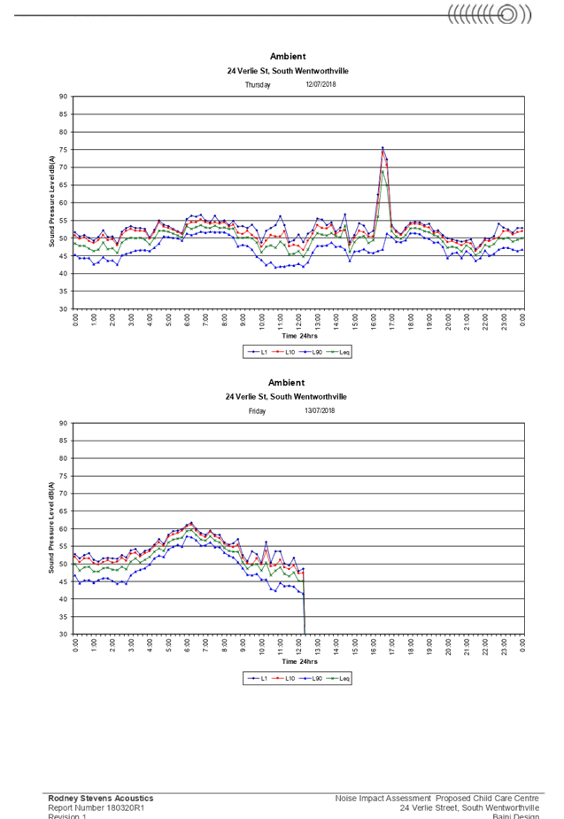
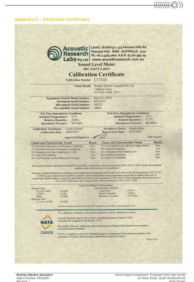
Noise Impact Assessment
Extraordinary Cumberland Local Planning
Panel Meeting
26 June 2019


DOCUMENTS
ASSOCIATED WITH
REPORT ELPP046/19
Attachment 6
Traffic & Parking Assessment & Addendum
Statement
Extraordinary Cumberland Local Planning
Panel Meeting
26 June 2019


Extraordinary Cumberland Local Planning
Panel Meeting
26 June 2019
Extraordinary Cumberland Local Planning
Panel Meeting
26 June 2019

Extraordinary Cumberland Local Planning
Panel Meeting
26 June 2019
DOCUMENTS
ASSOCIATED WITH
REPORT ELPP046/19
Attachment 7
Submissions & Petition
Extraordinary Cumberland Local Planning
Panel Meeting
26 June 2019


DOCUMENTS
ASSOCIATED WITH
REPORT ELPP046/19
Attachment 8
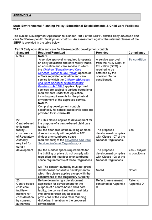
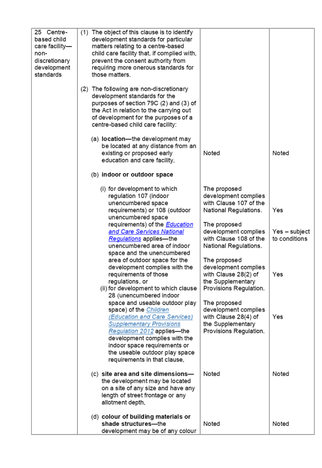
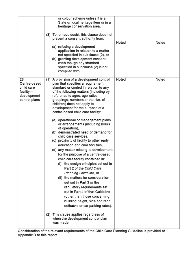
Appendix A - State Environmental Planning Policy
(Educational Establishments & Child Care Facilities) 2017
Extraordinary Cumberland Local Planning
Panel Meeting
26 June 2019
DOCUMENTS
ASSOCIATED WITH
REPORT ELPP046/19
Attachment 9
Appendix B - Holroyd Local Environmental Plan 2013
Extraordinary Cumberland Local Planning
Panel Meeting
26 June 2019
DOCUMENTS
ASSOCIATED WITH
REPORT ELPP046/19
Attachment 10
Appendix C - Holroyd Development Control Plan 2013
Extraordinary Cumberland Local Planning
Panel Meeting
26 June 2019
DOCUMENTS
ASSOCIATED WITH
REPORT ELPP046/19
Attachment 11
Appendix D -Child Care Planning Guideline 2017
Extraordinary Cumberland Local Planning
Panel Meeting
26 June 2019
Extraordinary
Cumberland Local Planning Panel Meeting
26 June 2019
Item No: LPP047/19
Development
Application for 2 Blaxcell Street, Granville
Responsible
Division: Environment
& Planning
Officer: Executive
Manager Development and Building
File
Number: DA-529/2017
|
Application lodged
|
15 December 2017
|
|
Applicant
|
Nabil Georges Farah
|
|
Owners
|
Mrs T G Farah, Mr J G Farah, Mr N G Farah, Mr M G
Farah, and Mrs T Morched
|
|
Application No.
|
DA-529/2017
|
|
Description of Land
|
2 Blaxcell Street, Granville
|
|
Proposed Development
|
Demolition of existing structures and construction of a 3
storey building and 4 storey building comprising 23 residential units and 2
commercial tenancies over 4 levels of basement parking.
|
|
Site Area
|
2,710m2
|
|
Zoning
|
B4 Mixed Use
|
|
Disclosure of political donations and gifts
|
Nil disclosure
|
|
Heritage
|
The subject site is not a heritage item, nor is it
located within a heritage conservation area.
i)
The subject site is located within the vicinity of 2 heritage
items, which are as follows:-
· 1A Glen
Street, Granville – Scout Hall; and
· 104 South
Street, Granville – Uniting Church.
|
|
Principal Development Standards
|
Floor Space Ratio
Permissible: 1.5:1
Proposed: 1.01:1
|
Height of Buildings
Permissible: 15m
Proposed:
17.1m
|
|
Issues
|
· Height of
Buildings
· Rear Setbacks
|
|

Figure
1 – Perspective from William Street, looking south-west (Source: Design
Cubicle, 2019)
Figure 2
– Perspective from William Street, looking south (Source: Design Cubicle,
2019)
Figure
3 – Perspective from Blaxcell Street, looking west (Source: Design
Cubicle, 2019)
Council is in receipt of a
Development Application from Nabil Georges Farah seeking approval for
demolition of existing structures and construction of a 3 storey building and 4
storey building comprising 23 residential units and 2 commercial tenancies over
4 levels of basement parking at 2 Blaxcell Street, Granville. The Development
Application Architectural Plans are provided as Attachment 1 to this report.
The site is affected by flooding,
and is listed as being within a floodway and a high hazard area. The
development has been assessed by Council’s Development Engineer to be acceptable,
subject to conditions.
The Development Application was
publicly notified for a period of 21 days from 16 January 2018 to 6 February
2018. In response, no submissions were received.
The site is zoned B4 Mixed Use,
pursuant to the Parramatta Local Environmental Plan (PLEP) 2011. Mixed
use development, comprising residential flat buildings and commercial premises
are permissible with development consent in the B4 Mixed Use zone.
The proposal is consistent with
the aims and objectives of State Environmental Planning Policy (State and
Regional Development) 2011, State Environmental Planning Policy No. 55
(Remediation of Land), State Environmental Planning Policy No. 65 –
Design Quality of Residential Apartment Development, State Environmental Planning
Policy (Infrastructure) 2007, State Environmental Planning Policy (Building
Sustainability Index: BASIX) 2004, Sydney Environmental Plan (Sydney Harbour
Catchment) 2005, Parramatta Local Environmental Plan (PLEP) 2011, Draft SEPP
(Environment), and Parramatta Development Control Plan (PDCP) 2011.
The Development Application was
referred for comments externally to Roads and Maritime Services and Endeavour
Energy, to which the application was supported. The application was also
referred externally to WaterNSW, and concurrence sought due to site dewatering
in conjunction with the development. General Terms of Approval were
subsequently issued.
The Development Application was
referred for comments internally to Council’s Development Engineer, Tree
Management Officer, Environmental Health Officer, and Public Art Coordinator,
to which the application is supported.
The proposed development has been
assessed against the relevant matters for consideration pursuant to Section
4.15 of the Environmental Planning and Assessment Act, 1979, including likely
impacts, the suitability of the site for the development, and the public
interest, and the proposed development is considered appropriate.
The variations sought via the
subject modification application are as follows:
|
Control
|
Required
|
Provided
|
% Variation
|
|
Height of Buildings
|
Max. 15m
|
17.1m
|
14%
|
|
Rear Setbacks
|
Min. 9m
|
3.5m
|
61.11%
|
The application is being reported
to the Cumberland Local Planning Panel for determination, as it is a
development with more than 4 storeys to which State Environmental Planning
Policy No. 65 – Design Quality of Residential Apartment Developments
applies, and the exceedance to the height of buildings development standard
exceeds 10%.
In light of the above, it is
recommended that the Cumberland Local Planning Panel approve the Development
Application, subject to the draft Notice of Determination provided at
Attachment 3 to this report.
Subject Site And Surrounding
Area
The subject site is known as 2
Blaxcell Street, Granville, and is legally described as Lot 1, DP 794229. The
site is irregularly shaped, and has a frontage of 26.69 metres to Blaxcell
Street and a frontage of 48.815 metres to William Street. The total site area
is 2,710sqm, and is illustrated in Figure 4 below:
Figure
4 - Location Map (Source: Cumberland Council, 2019)
The subject site is currently
built upon, occupied by a service station, with no existing trees or vegetation
present on the subject site.
The surrounding locality is
characterised as follows:
· North
i)
35 Enid Avenue, Granville – 6 storey residential flat
building.
ii)
107 South Street, Granville – Part 1 / part 2 storey
commercial premises.
iii)
· East
iv)
54 William Street, Granville – Part 1, part 2 storey medium
density development.
v)
· South
vi)
4-6 Blaxcell Street, Granville – Single storey community
centre.
vii)
· West
viii) Duck
Creek corridor
ix)
64 William Street, Granville – 4 storey residential flat
building.
The topography of the site is
maintained to a 2.9% gradient, with a 1.67 metre fall from north to south-south
west. The site is affected by flooding, and is listed as being within a
floodway and a high hazard area.
An existing 9 metre wide easement
for water supply transverses the site in a north-east, south-west alignment,
with the easement benefited by Sydney Water.
The site is zoned B4 – Mixed
Use, pursuant to the Parramatta Local Environmental Plan (PLEP) 2011, with an
interface to the R4 - High Density Residential zone to the north, east and
south of the site, as shown in Figure 5 below:
Figure
5 – Zoning Map (Source: Cumberland Council, 2019)
The subject site is situated to
the west of Blaxcell Street and south of William Street. Figure 6 below
illustrates an aerial perspective of the site and the general surroundings.
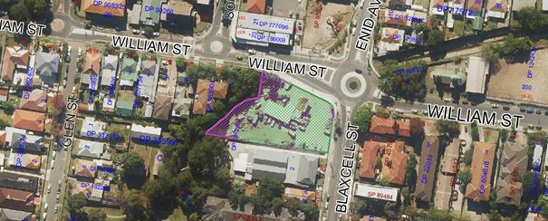
Figure
6 – Aerial Photo (Source: Cumberland Council, 2018)
The subject site is located within
the vicinity of 2 heritage items, which are as follows:-
· 1A
Glen Street, Granville – Scout Hall; and
x)
· 104
South Street, Granville – Uniting Church.
Description of The Proposed
Development
The proposal is for demolition of
existing structures and construction of a 3 storey building and 4 storey
building comprising 23 residential units and 2 commercial tenancies over 4
levels of basement parking.
Specific details of the proposed
development are as follows:
Built Form
The proposal comprises a 4 storey
building known as Building 1, and 3 storey building known as Building 2, with
ground floor commercial tenancies, totalling 116m², residential units to
the rear of Building 1, and residential units above both buildings. In detail:
Building
1: The ground floor comprises a single commercial tenancy with a central
common area, dual cores accessed via a lift and stairwell, with 3 residential
units and residential bin area. The remaining 3 storeys above propose a total
of 18 units, consisting of 6 units within each floor, above which the roof
level comprises a communal open space area.
Building
2: The ground floor comprises a single commercial tenancy with a central
common area and core, accessed via a stairwell, with separate commercial and
residential bin areas. The remaining 2 storeys above propose a total of 2
units, consisting of 1 unit within each floor.
The proposed development, as
measured to both Blaxcell Street and William Street, maintains a 3 metre
setback, with a side setback varying between 3 metres and 7.755 metres, as
measured from the southern boundary, and rear setback varying between 3.5
metres and 9 metres.
Parking (Basement Levels)
|
|
Basement 1
|
Basement 2
|
Basement 3
|
Basement 4
|
Total
|
|
Residential Parking
|
Nil
|
8
~5 visitor
|
12 spaces
~2 accessible
|
11 spaces
~2 accessible
|
31 spaces
|
|
Commercial
Parking
|
10 spaces
~1 accessible
|
3 spaces
~1 accessible
|
Nil
|
Nil
|
13 spaces
|
|
Bicycle Parking
|
Nil
|
Nil
|
7 spaces
|
7 spaces
|
14 spaces
|
Residential Apartment Mix
|
|
Building 1
|
Building 2
|
Total
|
|
1 Bedroom
|
4
|
Nil
|
4
|
|
2 Bedroom
|
7
|
2
|
9
|
|
3 Bedroom
|
10
|
Nil
|
10
|
|
|
Total
|
23
|
|
|
|
|
|
Access Arrangements
Pedestrian access to the
development is maintained from Blaxcell Street and William Street. A dual core
arrangement is designed to Building 1, designed to maintain access to the
basement levels, ground floor commercial tenancy and residential units, and
residential units above. A single core arrangement is designed to Building 2,
designed to maintain access to the ground floor commercial tenancy and
residential units above. Access to the basement from Building 2 is impeded by
the existing 9 metre wide easement for water supply which transverses the site,
with access maintained through the cores designed to building 1.
Communal Open Space
The proposal maintains the 3
communal open space areas, designed to the area between Building 1 and Building
2, the area to the north and north-west of Building 1, and within the roof
level of Building 1. The overall communal open space area is designed to be
1,180.9m², equivalent to 49% of the site area.
Applicants Supporting
Statement
The applicant has provided a
Statement of Environmental Effects prepared by Planning Direction Pty Ltd dated
December 2017, and was received by Council on 15 December 2017 in support of
the application.
Following design revisions, an
amended Statement of Environmental Effects prepared by Planning Direction Pty
Ltd dated February 2019, was lodged, which was received by Council on 20
February 2019 in support of the application.
Contact With Relevant
Parties
The assessing officer has
undertaken an inspection of the subject site and has been in contact with the
applicant throughout the assessment process.
Internal Referrals
Development Engineer
The Development Application was
referred to Council’s Development Engineer for comments, as the site is
affected by flooding, and so as to review the submitted stormwater plans.
Council’s Development Engineer has advised the proposed development is
supportable, subject to the imposition of deferred commencement conditions, to
resolve flood, stormwater and waste management matters, which have been imposed
within the draft Notice of Determination provided as Attachment 3 to this
report.
Tree Management Officer
The Development Application was
referred to Council’s Tree Management Officer for comments, noting the
existing street trees, and so as to review the submitted landscape plans.
Council’s Tree Management Officer has advised the proposed development is
supportable, subject to standard conditions of consent, which have been imposed
within the draft Notice of Determination provided as Attachment 3 to this
report.
Environmental Health Officer
The Development Application was
referred to Council’s Environmental Health Officer for comments, noting
the present use as a service station, as so as to review the submitted Detailed
Site Investigation, Remedial Action Plan, Geotechnical Investigation, and
Acoustic Report. Council’s Environmental Health Officer has advised the
proposed development is supportable, subject to standard conditions of consent,
which have been imposed within the draft Notice of Determination provided as
Attachment 3 to this report.
Public Art Coordinator
The Development Application was
referred to Council’s Public Art Coordinator for comments, so as to
review the submitted Public Art Plan. Council’s Public Art Coordinator
has advised the submitted Public Art Plan is acceptable, subject to standard
conditions of consent, which have been imposed within the draft Notice of
Determination provided as Attachment 3 to this report.
External Referrals
WaterNSW
The Development Application was
referred to WaterNSW for comments, and concurrence sought due to site
dewatering in conjunction with the development. General Terms of Approval were
subsequently issued.
Roads and Maritime Services
The Development Application was
referred to Roads and Maritime Services for comments who has advised the
proposed development is supported.
Endeavour Energy
The Development Application was
referred to Endeavour Energy for comments who has advised the proposed
development is supported.
Planning Comments
Section 4.15 of the
Environmental Planning and Assessment Act 1979 (EP & A Act)
The provisions of any
Environmental Planning Instruments (EP & A Act s4.15 (1)(a)(i))
The following Environmental
Planning Instruments are relevant to the assessment of the subject modification
application:
(a) State
Environmental Planning Policy No 55 – Remediation of Land (SEPP 55)
The requirement at Clause 7 of
SEPP No. 55 for Council to be satisfied that the site is suitable or can be
made suitable to accommodate the proposed development has been considered in
the following table:
|
Matters for consideration
|
Yes
|
No
|
N/A
|
|
Does the application involve re-development of the site or
a change of land use?
|
|
|
|
|
Is the development going to be used for a sensitive land
use (e.g.: residential, educational, recreational, childcare or hospital)?
|
|
|
|
|
Does information available to you indicate that an
activity listed below has ever been approved, or occurred at the
site?
acid/alkali plant and formulation,
agricultural/horticultural activities, airports, asbestos production and
disposal, chemicals manufacture and formulation, defence works, drum
re-conditioning works, dry cleaning establishments, electrical manufacturing
(transformers), electroplating and heat treatment premises, engine works,
explosive industry, gas works, iron and steel works, landfill sites,
metal treatment, mining and extractive industries, oil production and
storage, paint formulation and manufacture, pesticide manufacture and
formulation, power stations, railway yards, scrap yards, service stations,
sheep and cattle dips, smelting and refining, tanning and associated trades,
waste storage and treatment, wood preservation.
|
|
|
|
|
Is the site listed on Council's Contaminated Land Database?
|
|
|
|
|
Is the site subject to EPA clean-up order or other EPA
restrictions?
|
|
|
|
|
Has the site been the subject of known pollution incidents
or illegal dumping?
|
|
|
|
|
Does the site adjoin any contaminated land/previously
contaminated land?
|
|
|
|
|
Has the appropriate level of investigation been carried
out in respect of contamination matters for Council to be satisfied that the
site is suitable to accommodate the proposed development or can be made
suitable to accommodate the proposed development?
|
|
|
|
|
Details of contamination investigations carried out at
the site:
The site is identified in Council’s records as being
contaminated. A Detailed Site Investigation has been prepared by Aargus Pty
Ltd, which has been submitted with the Development Application. The author of
the report concludes that the risk to human health and the environment
associated with soil / groundwater contamination at the site is low with the
site being suitable for the proposed development, subject to the submission
of a Remediation Action Plan. A
Remediation Action Plan (RAP) has subsequently been prepared by Aargus Pty
Ltd, with the authors concluding the site can be rendered suitable for the
proposed development, if remediation is carried out in accordance with the
submitted RAP.
Council’s
Environmental Health Officer has reviewed the Detailed Site Investigation,
and associated RAP, and is satisfied that the information has been prepared
in accordance with the NSW EPA Guidelines for Consultants Reporting on
Contaminated Sites and NSW EPA (2006, 2nd Edition)
“Guidelines for the NSW Site Auditor Scheme.
|
(b) State
Environmental Planning Policy No 65 – Design Quality of Residential
Apartment Development (SEPP 65)
SEPP 65 and the associated
Apartment Design Guide (ADG) apply to the assessment of the subject application
as it includes residential flat buildings that are 3 storeys or more in height
and contain more than 4 dwellings.
The Development Application has
been accompanied by a Design Verification Statement from a Registered
Architect. The proposed development has been assessed to comply with the
requirements of SEPP 65 and the ADG. A comprehensive assessment against the ADG
is contained in Attachment 4 to this report.
(c) State
Environmental Planning Policy (Infrastructure) 2007 (ISEPP)
The provisions of the ISEPP 2007
have been considered in the assessment of the Development Application.
Clause 45 - Development likely
to affect an electricity transmission or distribution network
The subject development occurs
within 5 metres of an overhead and underground electricity power lines. As
such, the Consent Authority is required to give written notice to an
electricity supply authority. The Development Application was referred to
Endeavour Energy, who advised the proposal is supported.
Clause 85 – Development
adjacent to railway corridors
The application is not subject to
clause 85 of the ISEPP, as the subject site is not located adjacent to a
railway corridor.
Clause 86 – Excavation
in, above, below or adjacent to rail corridors
The application is not subject to
clause 86 of the ISEPP as the proposed redevelopment of the site does not
involve excavation to a depth of at least 2m below ground level (existing) on
land within 25m (measured horizontally) of a rail corridor.
Clause 87 – Impact of
rail noise or vibration on non-rail development
The application is not subject to
clause 87 of the ISEPP as the site is not in or adjacent to a rail corridor,
and is not likely to be adversely affected by rail noise or vibration.
Clause 101 – Frontage to
classified road
The application is not subject to
clause 101 of the ISEPP as the site does not have a frontage to a classified
road.
Clause 102 – Impact of
road noise or vibration on non-road development
The application is not subject to
clause 102 of the ISEPP as the annual average daily traffic volume of Blaxcell
Street and William Street are less than 40,000 vehicles.
Clause 104 – Traffic
generation developments
The application is not subject to
clause 104 of the ISEPP as the proposal does not trigger the requirements for
traffic generating developments listed in Schedule 3 of the ISEPP.
(d) State
Environmental Planning Policy (Building Sustainability Index: BASIX) 2004
A BASIX Certificate has been
lodged as a part of the Development Application. An amended BASIX Certificate
was not lodged with the subject application, which have been imposed as a
condition within the draft Notice of Determination provided as Attachment 3 to
this report.
(e) State
Environmental Plan (Sydney Harbour Catchment) 2005
The subject site is identified as
being located within the area affected by the Sydney Environmental Plan (Sydney
Harbour Catchment) 2005. The proposed development raises no issues, as no
impact on the catchment is envisaged.
Note: The subject site is not
identified in the relevant map as land within the ‘Foreshores and
Waterways Area’ or ‘Wetland Protection Zone’, is not a
‘Strategic Foreshore Site’ and does not contain any heritage items.
Hence the majority of the State Environmental Plan is not directly relevant to
the proposed development.
(f) Parramatta
Local Environmental Plan 2010 (PLEP 2011)
The provision of the PLEP 2011 is
applicable to the development proposal. It is noted that the development
achieves compliance with the key statutory requirements of the PLEP 2011 and
the objectives of the B4 – Mixed Use zoning, with the exception of the
height of building development standard, which is discussed below.
Permissibility
· The
proposed development is defined as a mixed use development, comprising
residential flat buildings and commercial premises, and is permissible in the
B4 – Mixed Use zone with consent.
Mixed use development means a
building or place comprising 2 or more different land uses
Residential flat building means a
building containing 3 or more dwellings, but does not include an attached
dwelling or multi dwelling housing.
Note. Residential flat building is
a type of residential accommodation.
Commercial premises means any of
the following:
(a) Business
premises,
(b) Office
premises,
(c) Retail
premises.
The relevant matters to be
considered under PLEP 2011 and the applicable clauses for the proposed
development are summarised below. A comprehensive LEP assessment is contained
in Attachment 5 to this report.
|
Development Standard
|
Proposed
|
Compliance
|
|
Height of Buildings
15 metres
|
17.1 metres.
A Clause 4.6 Statement has been submitted,
justifying the contravention. Refer to commentary below.
|
No
|
|
Floor Space Ratio
1.5:1
|
1.01:1.
|
Yes
|
Clause 4.6 – Variation
to Height of Buildings Development Standard
· Clause
4.6 allows the consent authority to vary development standards in certain
circumstances, and provides an appropriate degree of flexibility to achieve
better design outcomes. The consent authority may grant the exception as the
Secretary’s concurrence can be assumed where clause 4.6 is adopted as per
the Department of Planning Circular PS 18-003, dated 21 February 2018.
The applicant has submitted a
written request to vary the height of buildings development standard. Based on
various case laws established by the Land and Environment Court of NSW such as
Four2five P/L v Ashfield Council [2015] NSWLEC 9, Randwick City Council v
Micaul Holdings P/L [2016] NSW LEC7 and Zhang and anor v Council of the City of
Ryde [2016] NSWLEC 1179, a 3 part assessment framework for a variation request
proposed under clause 4.6 has been considered and an assessment of the proposed
variance, following the 3 part test, is discussed in detail below.
The 3 preconditions which must be
satisfied before the application can proceed are as follows:
1. Is
the proposed development consistent with the objectives of the zone?
The proposed development is
considered to be consistent with the B4 – Mixed use zone objectives, as
it provides a mixture of compatible uses, integrates commercial and residential
in an accessible location, and providing high density residential development.
2. Is
the proposed development consistent with the objectives of the development
standard which is not met?
The objectives of
Clause 4.6 is to ensure that a maximum building height is established to enable
the appropriate development density to be achieved, and to ensure buildings are
compatible with the character of the locality. The extent of the exceedance is
limited to the lift overrun, parapet walls, planter boxes and bathroom
facilities associated with the rooftop communal open space area, with habitable
floor space maintained below the height limit. Therefore the built form is
consistent with the density and desired future character of the area.
3. a)
Is compliance with the development standard unreasonable or unnecessary in the
circumstances of the case? And;
Strict compliance with the
development standard in this instance is considered to be unreasonable and
unnecessary in this instance as:
- The extent
of the exceedance is limited to the lift overrun, parapet walls, planter boxes
and bathroom facilities associated with the rooftop communal open space area.
The habitable floor space is maintained below the height limit.
- The
exceedance is a result of the flood affectation of the site, and the
requirement to raise the building to respond to minimum freeboard levels.
- The
variation will not result in noticeable bulk, height or scale, as viewed from
the public domain, and will not result in additional solar access, view loss or
privacy.
- The
development is of an acceptable architectural design, which will contribute to
the streetscape and visual amenity of the area.
b) Are there sufficient
environmental planning grounds to justify contravening the development standard
and therefore is the applicant’s written justification well founded?
The unique circumstances of the
case are considered to warrant support of the departure. Given that the
proposed development responds to the site and does so without unduly
compromising relationships with adjoining development, and does not unduly
compromise other relevant controls, the proposal is considered to be consistent
with the objectives of the height of buildings development spaces, and
development within the B4 Mixed Use zone. In this regard, the exception is well
founded and can be supported.
Conclusion
Council is satisfied that the
applicant’s written request has adequately addressed the matters required
to be demonstrated by clause 4.6 subclause (3). Council is further satisfied
that the proposed development will be in the public interest, as it is
consistent with the objectives of the particular standard and the objectives for
development within the zone in which the development is proposed to be carried
out.
It is the view of Council officers
that justification provided is satisfactory and having considered the
application on its merit, the exception to the maximum height of buildings
development standard is considered acceptable in this instance.
The provisions of any Proposed
Instruments (EP & A Act s4.15 (1)(a)(ii))
The following draft Environmental
Planning Instruments are relevant to the assessment of the subject modification
application:
(a) Draft
State Environmental Planning Policy (Environment)
The draft SEPP relates to the
protection and management of our natural environment with the aim of
simplifying the planning rules for a number of water catchments, waterways,
urban bushland, and Willandra Lakes World Heritage Property. The changes
proposed include consolidating the following seven existing SEPPs:
· State
Environmental Planning Policy No. 19 – Bushland in Urban Areas.
· State
Environmental Planning Policy (Sydney Drinking Water Catchment) 2011.
· State
Environmental Planning Policy No. 50 – Canal Estate Development.
· Greater
Metropolitan Regional Environmental Plan No. 2 – Georges River Catchment.
· Sydney
Regional Environmental Plan No. 20 – Hawkesbury-Nepean River (No.2-1997).
· Sydney
Regional Environmental Plan (Sydney Harbour Catchment) 2005.
· Willandra
Lakes Regional Environmental Plan No. 1 – World Heritage Property.
The draft policy will repeal the
above existing SEPPs and certain provisions will be transferred directly to the
new SEPP, amended and transferred, or repealed due to overlaps with other areas
of the NSW planning system.
As noted within the assessment
above under the heading ‘State Environmental Plan (Sydney Harbour
Catchment) 2005’, the proposed development raises no issues, as no impact
on the catchment is envisaged.
The provisions of any
Development Control Plans (EP & A Act s4.15 (1)(a)(iii))
The following Development Control
Plans are relevant to the assessment of the subject modification application:
(a) Parramatta
Development Control Plan 2011 (PDCP 2011)
The PDCP 2011 applies to the
subject site. The proposed development has been assessed to comply with the
provisions of the PDCP 2011, with the exception of the rear setback standard,
which is discussed below. A comprehensive assessment against the provisions of
the PDCP 2011 is contained in Attachment 6 to this report.
Rear Setback
· The
Parramatta DCP 2011 requires a minimum rear setback of 9 metres. In this
regard, the rear setback complies with the 9 metre requirement, with the
exception of a small area, with the setback maintained to a minimum 3.5 metres.
A statement has been provided
within the submitted Statement of Environmental Effects, in response to the
above variation, which is noted as follows:
The subject site is unique with
Duck Creek being the rear boundary. The site configuration, the flooding
considerations, and easement affecting the site have generated the built form.
The intent of provision a reasonable setback is met with the provision of
substation deep soil planting opportunities. The proposal represents a vast
improvement in terms of landscape opportunity, relative to the existing site
circumstance. [Furthermore], the proposed setbacks do not give rise to adverse
impacts to adjoining properties.
The Applicant’s written
justification submitted to the variation of rear setback is considered well
founded, and supportable on its merits. Council also notes that the variation
is a result of the irregular site boundary, with the non-compliance limited to
the area of the site where the boundary diverges from the general alignment of
the middle of the concrete channel, and instead tapers into the site.
Furthermore, the proposed development has been designed to comply with the
Apartment Design Guide design criteria related to building separation, and as
such, the proposal achieves reasonable levels of visual and acoustic privacy
within the development and to adjoining properties.
The provisions of any planning
agreement that has been entered into under section 7.4, or any draft planning
agreement that a developer has offered to enter into under section 7.4 (EP
& A Act s4.15(1)(a)(iiia))
There is no planning agreement or
draft planning agreement associated with the subject Development Application.
The provisions of the
Regulations (EP & A Act s4.15 (1)(a)(iv))
The proposed development raises no
concerns as to the relevant matters arising from the Environmental Planning and
Assessment Regulations 2000 (EP & A Regs).
The Likely Environmental,
Social or Economic Impacts (EP & A Act s4.15 (1)(b))
It is considered that the proposed
development will have no significant adverse environmental, social or economic
impacts in the locality.
The suitability of the site for
the development (EP & A Act s4.15 (1)(c))
It is considered that the
development is suitable in the context of the site and surrounding locality.
Submissions made in accordance
with the Act or Regulation (EP & A Act s4.15 (1)(d))
Advertised (newspaper) Mail Sign
Not
Required
In accordance with Council’s
notification requirements contained within the PDCP 2011, the proposal was
publicly notified for a period of 21 days from 16 January 2018 to 6 February
2018. In response, no submissions were received.
The public interest (EP & A
Act s4.15(1)(e))
The public interest is served by
permitting the orderly and economic use of land, in a manner that is sensitive
to the surrounding environment and has regard to the reasonable amenity
expectations of surrounding land users. In view of the foregoing analysis, it
is considered that approval of the proposed development would not be contrary
to the public interest.
Section 7.11 (Formerly S94
Contributions)
The subject development requires
the payment of contributions in accordance with Parramatta Development
Contributions Plan (Amendment No. 5). In accordance with the currently indexed
rates, the following, the current rate of the required contribution is
$100,223.06. The draft Notice of Determination at Attachment 3 includes a
recommendation to reflect the above contributions.
Disclosure of Political
Donations And Gifts
The NSW Government has introduced
disclosure requirements for individuals or entities with a relevant financial
interest as part of the lodgement of various types of development proposals and
requests to initiate environmental planning instruments or development control
plans.
The application and notification
process did not result in any disclosure of Political Donations or Gifts.
The proposed development has been assessed
against the matters for consideration listed in Section 4.15 of the EP & A
Act, 1979, and is considered to be satisfactory. Any likely impacts of the
development have been satisfactorily addressed and the proposal is considered
to be in the public interest.
The proposed development is
consistent with the objectives of Parramatta LEP 2011, and is permissible in
the zone with Development Consent. A Clause 4.6 Variation Statement has been
submitted, justifying the contravention to the height of buildings development
standard, which is considered supportable on its merits. The proposal also
complies with the Parramatta DCP 2011, with the exception of the rear setback
provision, which is considered supportable on its merits.
There are no further consultation
processes for Council associated with this report.
There are no further financial
implications for Council associated with this report.
There are no policy implications
for Council associated with this report.
Communication /
Publications:
The final outcome of this matter
will be notified in the newspaper. The objectors will also be notified in
writing of the outcome.
|
That Development Application
529/2017 seeking demolition of existing structures and construction of a 3
storey building and 4 storey building comprising 23 residential units and 2
commercial tenancies over 4 levels of basement parking at 2 Blaxcell Street,
Granville, be Approved, subject to the conditions contained within the draft
Notice of Determination provided as Attachment 3 to this report.
|
1. Architectural
Plans ⇩ 
2. Clause
4.6 Variation Statement ⇩ 
3. Draft
Notice of Determination ⇩ 
4. SEPP
65 Apartment Design Guide Compliance Assessment ⇩
5. Parramatta
Local Environmental Plan 2011 Compliance Assessment ⇩ 
6. Parramatta
Development Control Plan 2011 Compliance Assessment ⇩
DOCUMENTS
ASSOCIATED WITH
REPORT ELPP047/19
Attachment 1
Architectural Plans
Extraordinary Cumberland Local Planning
Panel Meeting
26 June 2019
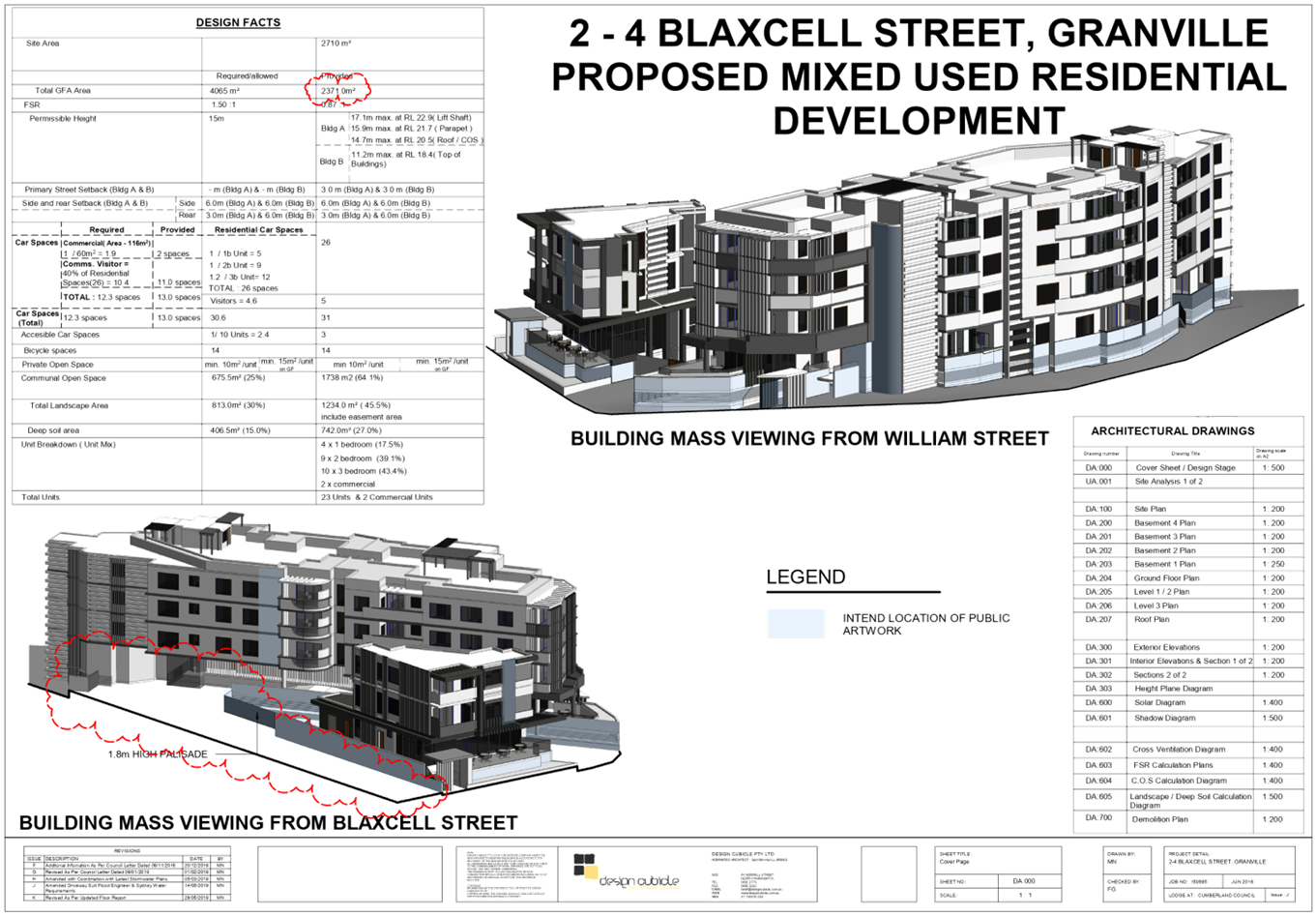
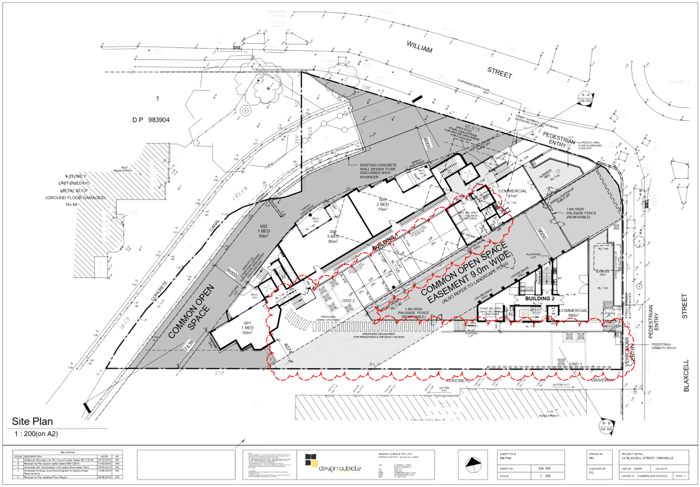
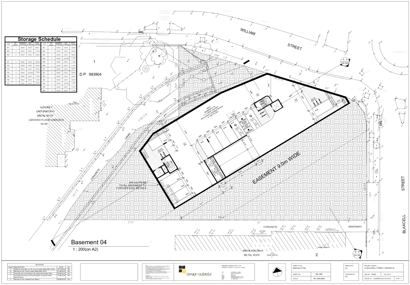
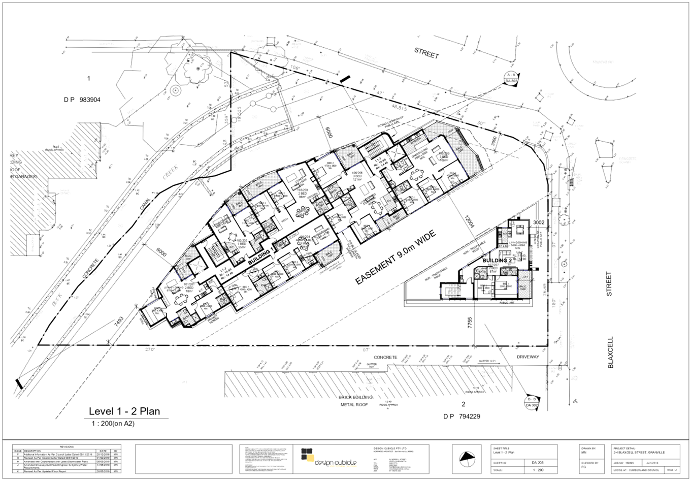
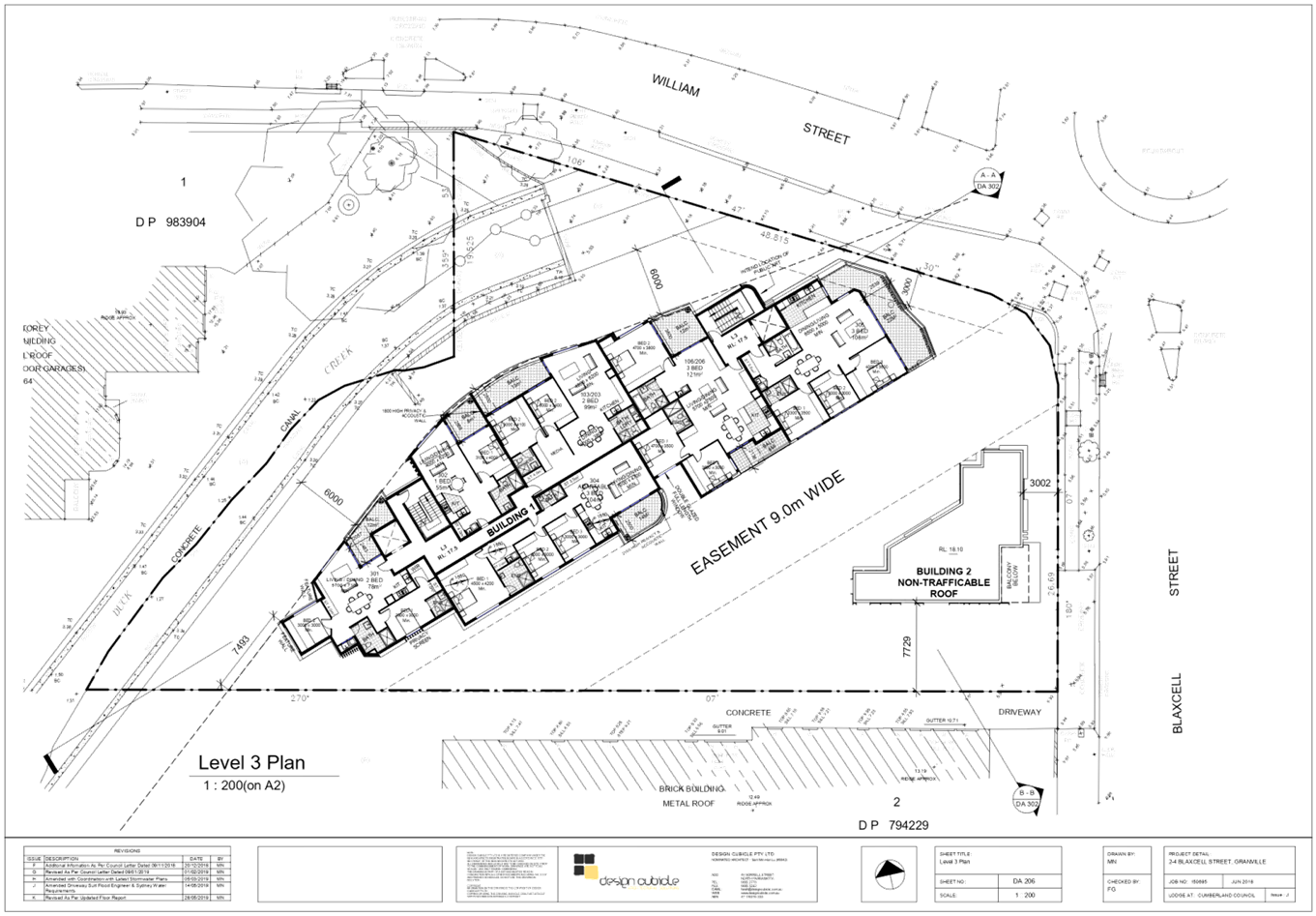
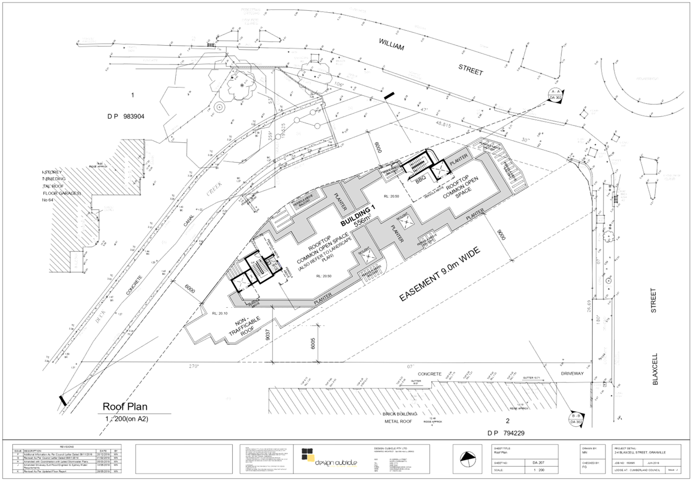
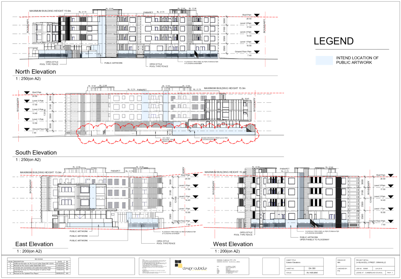
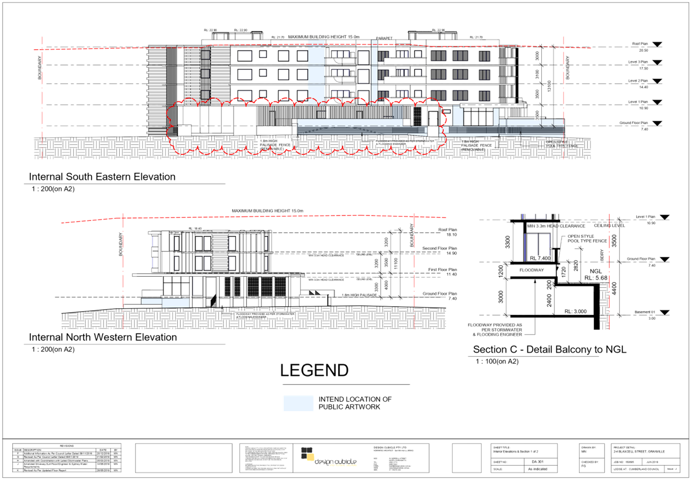
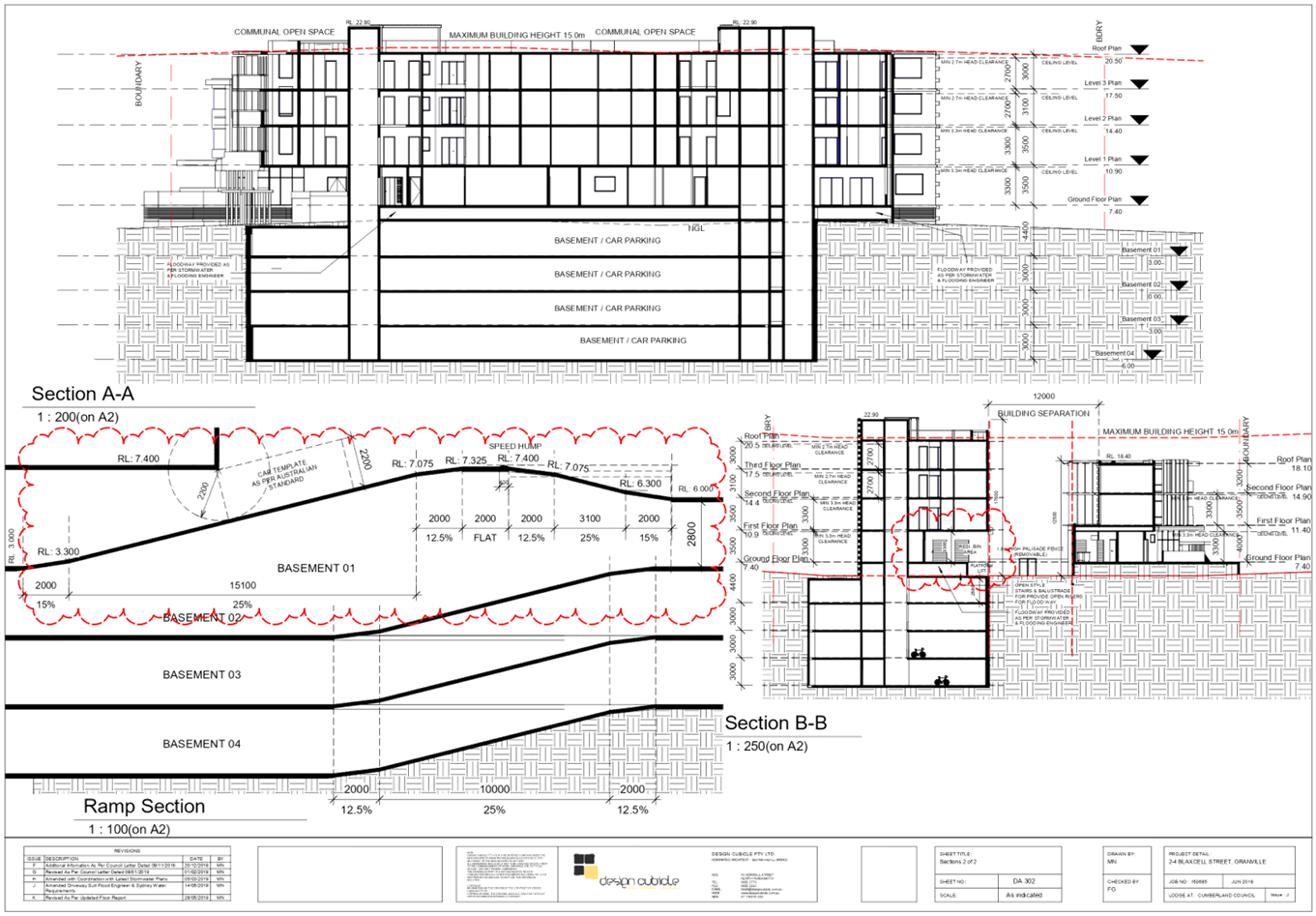
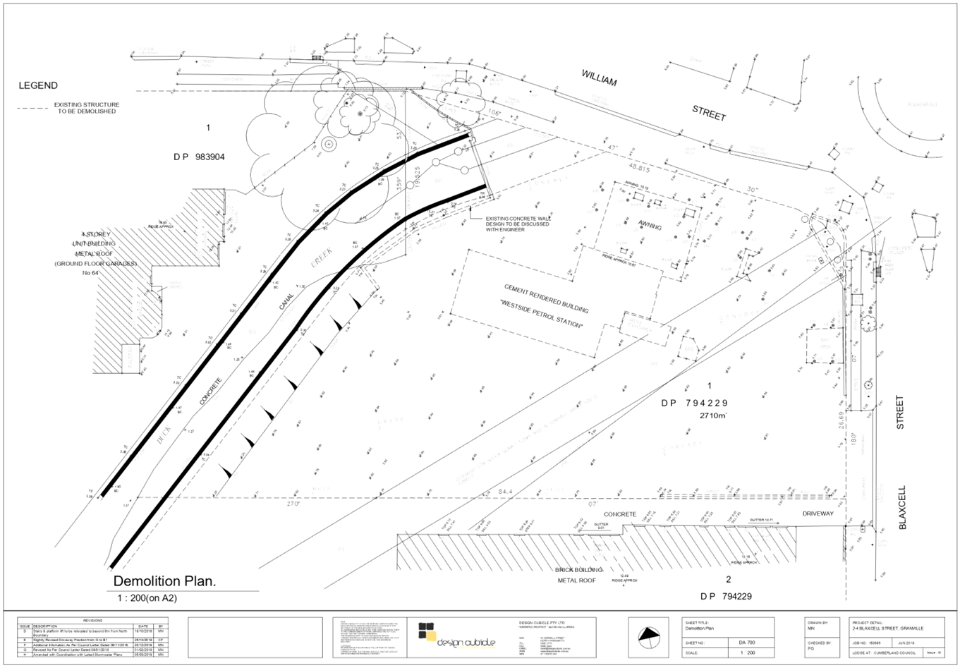
DOCUMENTS
ASSOCIATED WITH
REPORT ELPP047/19
Attachment 2
Clause 4.6 Variation Statement
Extraordinary Cumberland Local Planning
Panel Meeting
26 June 2019
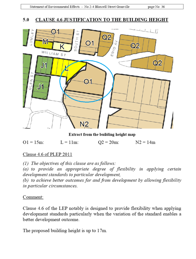
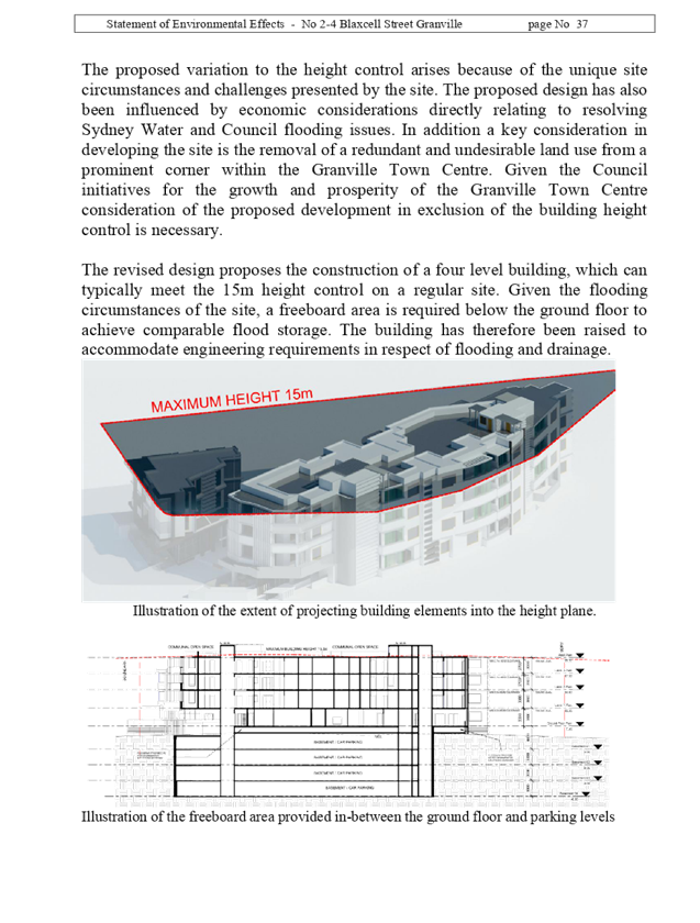
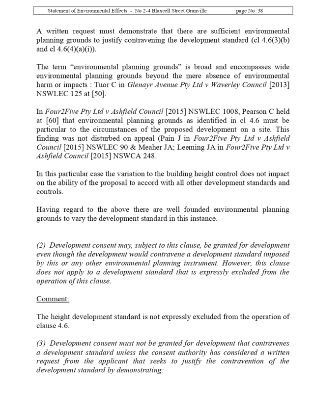
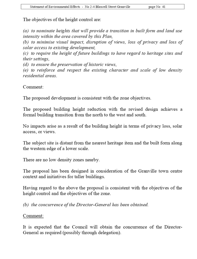
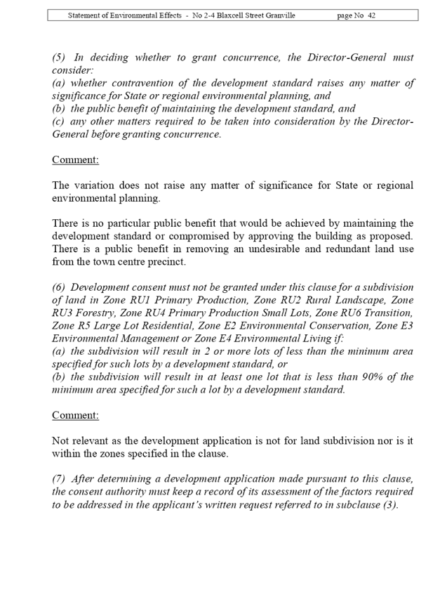
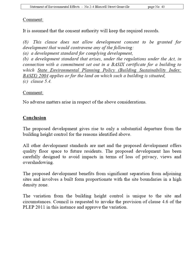
DOCUMENTS
ASSOCIATED WITH
REPORT ELPP047/19
Attachment 3
Draft Notice of Determination
Extraordinary Cumberland Local Planning
Panel Meeting
26 June 2019
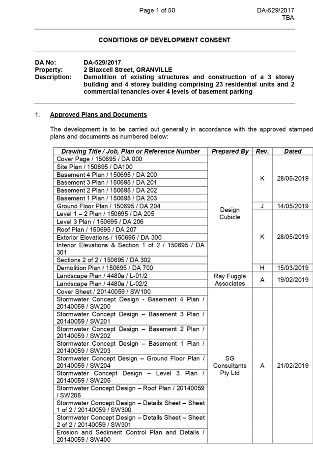
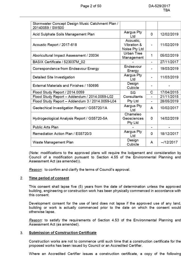
DOCUMENTS
ASSOCIATED WITH
REPORT ELPP047/19
Attachment 4
SEPP 65 Apartment Design Guide Compliance Assessment
Extraordinary Cumberland Local Planning
Panel Meeting
26 June 2019
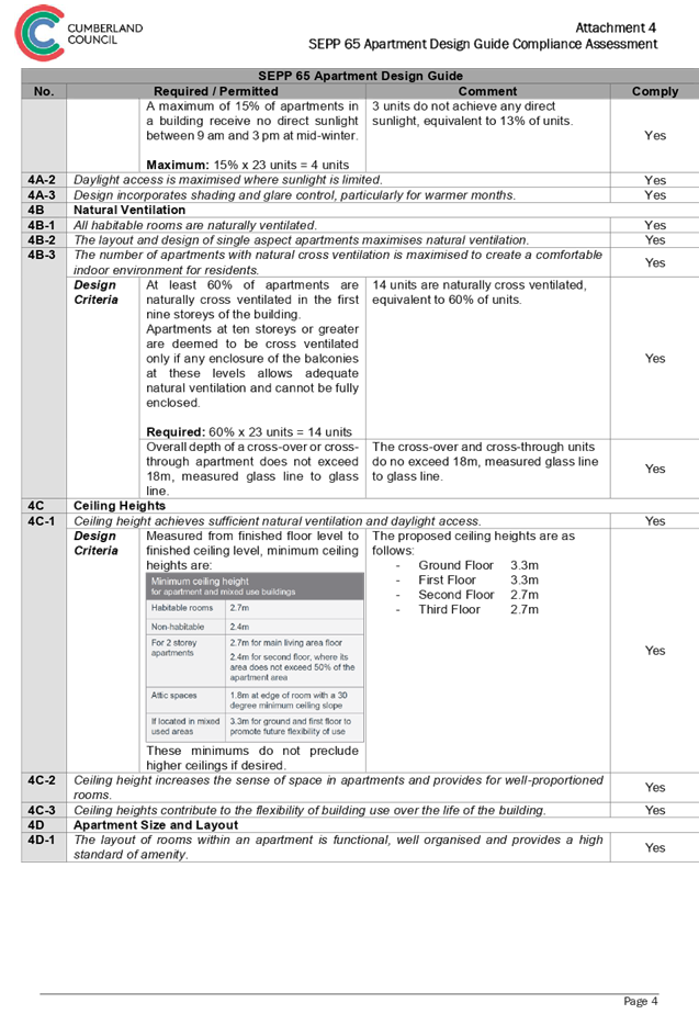
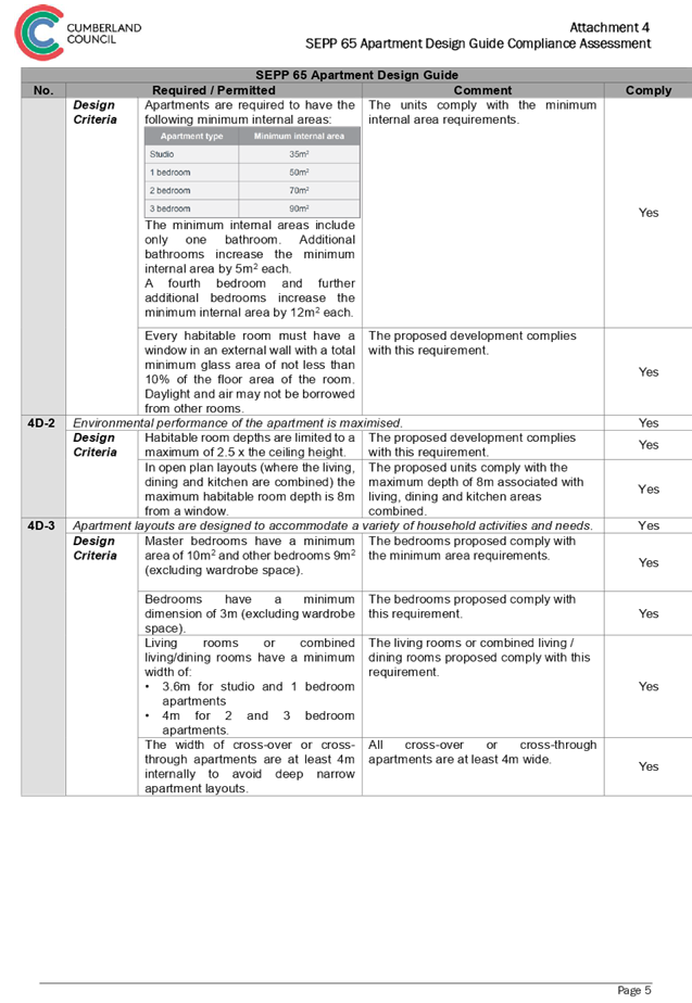
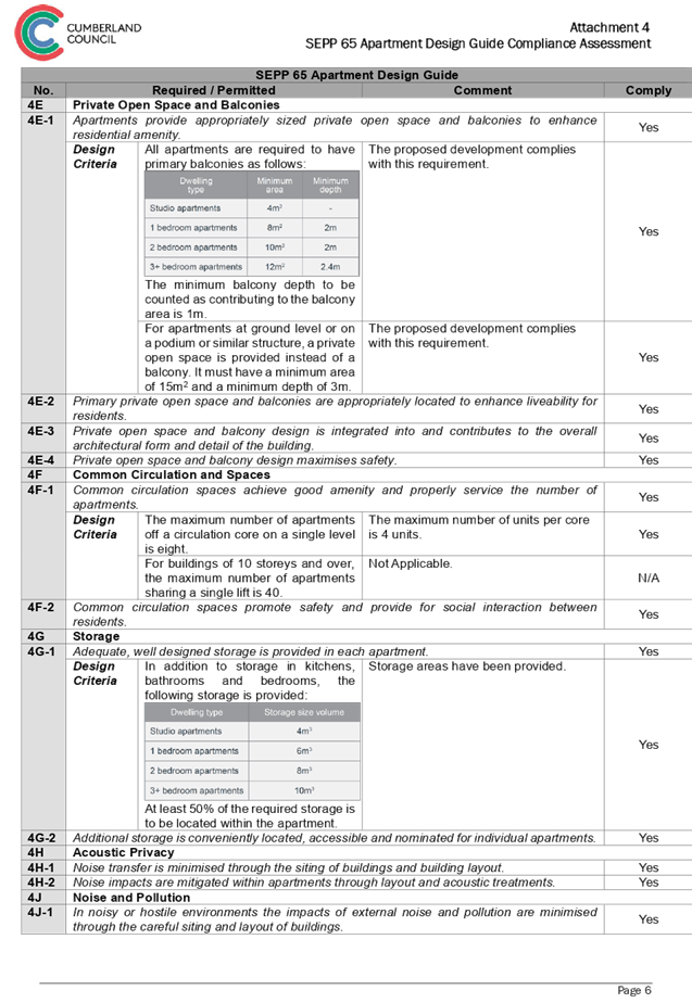
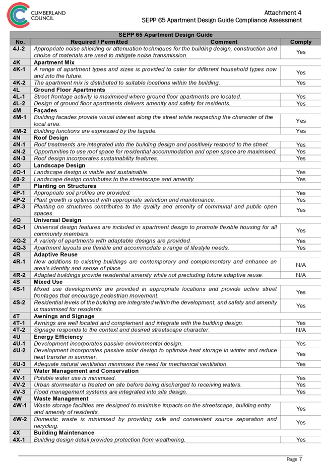

DOCUMENTS
ASSOCIATED WITH
REPORT ELPP047/19
Attachment 5
Parramatta Local Environmental Plan 2011 Compliance
Assessment
Extraordinary Cumberland Local Planning
Panel Meeting
26 June 2019
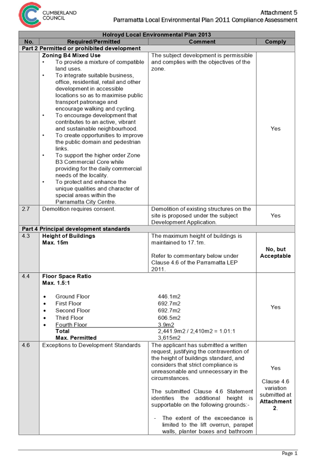
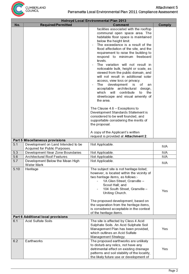
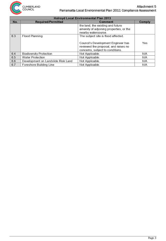
DOCUMENTS
ASSOCIATED WITH
REPORT ELPP047/19
Attachment 6
Parramatta Development Control Plan 2011 Compliance Assessment
Extraordinary Cumberland Local Planning
Panel Meeting
26 June 2019
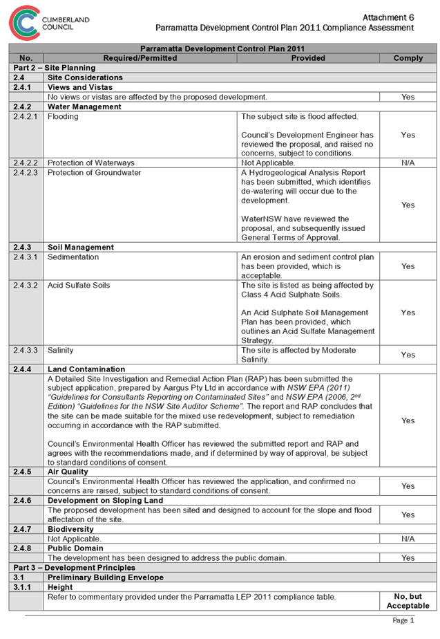
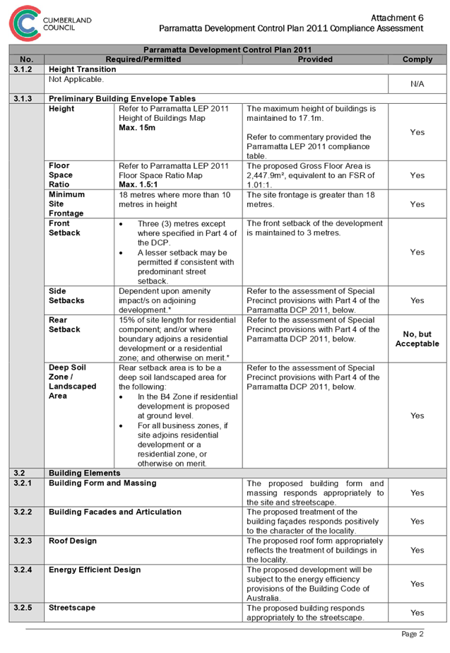
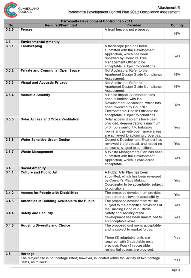
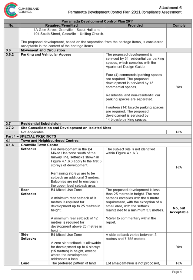
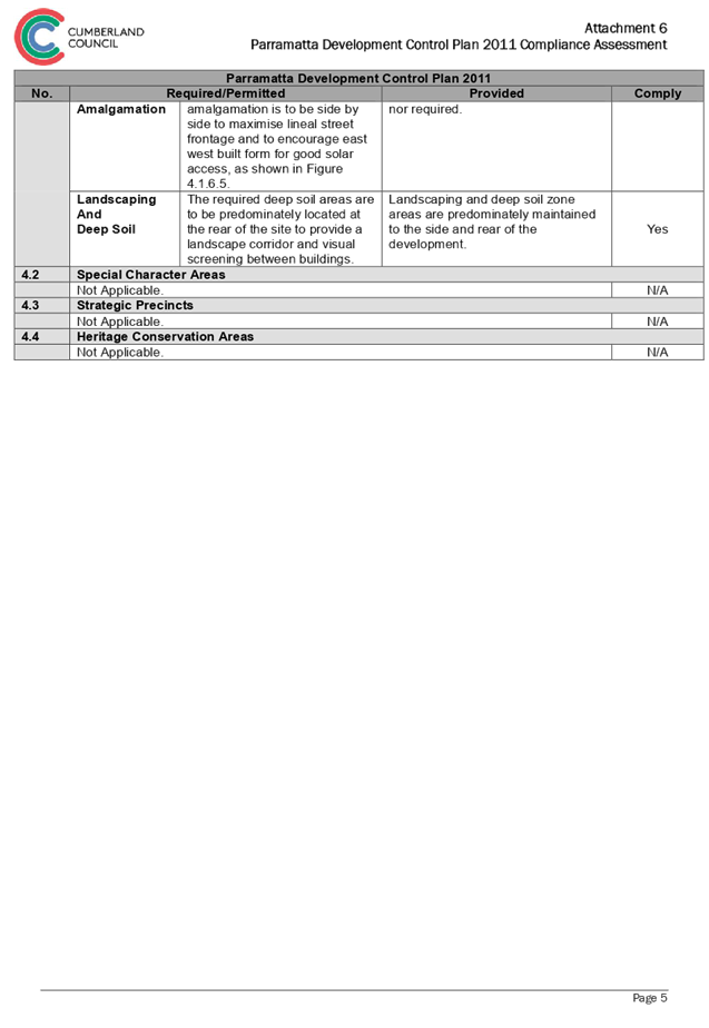
Extraordinary
Cumberland Local Planning Panel Meeting
26 June 2019
Item No: LPP048/19
Section
4.55(2) Modification for 1/72-78 Percival Road, Smithfield
Responsible
Division: Environment
& Planning
Officer: Executive
Manager Development and Building
File
Number: DA
2010/206/5
|
Application lodged
|
5 April 2019
|
|
Applicant
|
Ms H H Cui C/O Weir
Phillips Heritage & Planning
|
|
Owner
|
Ms H H Cui
|
|
Application No.
|
2010/206/5
|
|
Description of Land
|
Lot 1 in SP37361;
1/72-78 Percival Road, Smithfield
|
|
Proposed Development
|
Section 4.55(2) modification for the internal alterations
and additions to an existing brothel, including the extension of the
mezzanine level to relocate kitchen and introduce a staff lounge, introduce
three (3) additional service rooms to a total of nine (9) and increase the
number of staff to a total of ten (10).
|
|
Site Area
|
15,348.2m2
|
|
Zoning
|
IN1 – General Industrial
|
|
Principal
Development Standards
|
Minimum Lot Size:
1200sqm – No change sought
|
|
Disclosure of political donations and gifts
|
Nil disclosure
|
|
Heritage
|
The subject site does not contain a heritage item,
is not located within the vicinity of a heritage item or within a heritage
conservation area.
|
|
Issues
|
· Car Parking
· Essential
Services Maintenance
· Evacuation
Procedures
|
1. DA2010/206/1
was lodged on 6 May 2010 for internal alterations of an existing industrial
unit and fitout of premises and use as a brothel. This application was approved
via Council on 21 January 2011.
2. DA2010/206/2
was lodged on 31 December 2010 seeking minor internal alterations including
additional room to an approved brothel. This application was rejected by DART
on 6 January 2011 for lack of Owners Consent, from the Strata Management of
SP37361.
3. DA2010/206/3
was lodged on 12 January 2011 for approving minor internal alterations to
brothel. This application was approved 21 January 2011.
4. DA2010/206/4
was lodged on 15 February 2012 for approving deletion of Condition 9 and
amendment to condition 50 to remove the trial period of the operation of the
brothel approved. This application was approved 12 July 2012.
5. The
subject modification application is for internal alterations and additions to
an existing brothel, including the extension of the mezzanine level to relocate
kitchen and introduce a staff lounge, introduce additional service rooms to a
total of nine and increase the number of staff to a total of ten.
6. The
application was notified to surrounding properties from 8 to 22 May 2019, a
site notice was placed on the site and was advertised in the local paper. No
submissions were received as a result of the notification.
7. The
application is being reported to the Cumberland Local Planning Panel (CLPP) for
determination as it is a sensitive development type being for the purpose of
sex services premises.
8. The
subject application has been assessed against the relevant provisions of the
Environmental Planning and Assessment Act 1979, Holroyd Local Environmental
Plan 2013 and the Holroyd Development Control Plan 2013.
9. No
variations are sought by the subject application.
10. The
application is recommended for approval subject to the conditions in the draft
determination at Attachment 3.
Subject Site And Surrounding
Area
The subject site is known as Unit
1 72-80 Percival Road, Smithfield and is legally described as Lot 1 in SP
37361. The subject site is located on the western side of Percival Road. The
site is irregular in shape with a frontage of 65.3m to Percival Road an eastern
boundary of 67.72m, a northern boundary of 233.34m and a southern side boundary
dimension of 236.45m and a total site area of 15,348.2m2. The site is occupied
by the existing approved single and two storey industrial style buildings. The
subject unit is located in the north-western corner of the subject site and
within a two storey industrial style building. The surrounding vicinity is
occupied by industrial estates of one – two storey construction,
accommodating various sized estates and various industrial uses.
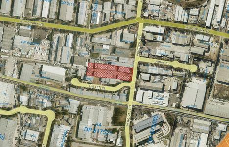
Aerial
view of the locality with subject site shown hatched. Source: Cumberland
Council 2019
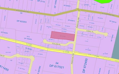
Zoning
map. Source: Cumberland Council 2019
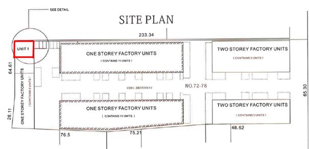
Site
Layout with subject site shown outlined in red. Source: DS Group Constructions
as edited by Cumberland Council 2019
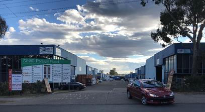
Site
frontage to Percival Road. Source: Cumberland Council 2019
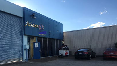
Subject
Site within Industrial Unit Development. Source: Cumberland Council 2019
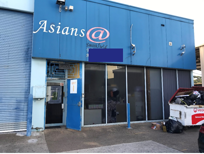
Subject
Industrial Unit Frontage. Source: Cumberland Council 2019
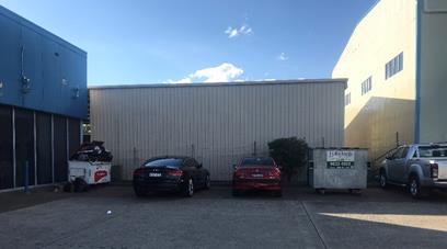
Subject
Industrial Unit Parking Arrangement. Source: Cumberland Council 2019
Description of Proposed
Development
The existing approval for the
subject brothel (DA2010/206 and subsequent modifications) permits the operation
24 hours, 7 days a week. It provides six service rooms across two stories with
7 staff (6 sex workers and 1 receptionist/manager and includes 5 car parking
spaces, three external and two internal spaces
The proposed modification seeks to
reconfigure the ground level and increase the floor space of the first
floor/mezzanine level of the brothel so as to increase the number of service
rooms from 6 to 9 and provide reconfigured staff facilities (inclusive of a
kitchen). The proposal seeks to increase staff numbers from 7 to 10 (9 sex
workers and 1 receptionist/manager) in accordance with increasing the service
rooms. The proposal retains the existing approved car parking provision.
Specifically the works proposed
are:
· Demolition
of unauthorised works including:
o Walls of small room to south of
entry lobby;
o Partition on south side of kitchen.
· Rectification
of unauthorised work:
o Wall between laundry and garage;
o Kitchen bench
o Door to service room 6
· Construction
Ground Floor:
o New second stair to upper level;
o Convert staff rest room to service
room (no 8) and add WC, basin and shower;
o Convert Waiting Room 4 to service
room (no 7) and add WC, basin and shower;
o Convert the Personnel Kitchen to
service room (no 9) and add WC, basin and shower;
o Enlarge laundry.
· Construction
First Floor:
o Infill existing void above garage to
create a staff lounge;
o Provide a new bathroom adjacent the
staff lounge
o Provide a new staff kitchen to the
western end of the staff lounge;
o Relocate the bathroom facilities in
Service Room 4 to the northern wall to allow a corridor adjacent the A/C room
to provide access to the new staff lounge.
o New second stair to ground floor.
Site History
|
Date
|
Action
|
|
21 January 2011
|
DA 2010/206/1 for Internal alterations of an existing
industrial unit and fitout of premises and use as a brothel approved. Notice
of Determination can be viewed
at Attachment 7.
|
|
06 January 2011
|
DA 2010/206/2 for S96(2) application seeking minor internal
alterations including additional room to an approved brothel rejected by DART
for lack of Owners Consent. Notice of Rejection can be viewed at Attachment 8.
|
|
21 January 2011
|
DA 2010/206/3 for S96 (1A) application approving minor
internal alterations to brothel approved. Notice of Determination can be viewed at Attachment 9.
|
|
15 February 2012
|
DA 2010/206/4 for S96(1A) modification approving deletion
of Condition 9 and amendment to condition 50 to remove the trial period of
the operation of the brothel approved. Notice of Determination can be viewed at Attachment 10.
|
Application History
|
Date
|
Action
|
|
5 April 2019
|
DA 2010/206/5 lodged with Council
|
|
29 April 2019
|
The application was referred externally to:
- New South Wales Police
The application was referred internally to:
- Environmental Health Unit
- Building Services Unit
|
|
8 to 22 May 2019
|
Application placed on public notification for 14 days
|
|
26 June 2019
|
Application referred to CLPP for determination
|
Applicant’s Supporting
Statement
A Statement of Environmental
Effects prepared by Weir Phillips Heritage and Planning, dated 29 March 2019
was submitted with the subject modification application and can be viewed at
Attachment 4.
Further to this an amended Plan of
Management has been submitted to support the subject modification application
and can be viewed at Attachment 5.
Contact With Relevant
Parties
The assessing officer has
undertaken an inspection of the subject site and has been in contact with the
applicant throughout the assessment process.
Internal Referrals
Environmental Health
Satisfactory subject to conditions
applied under previous consent and additional standard and non-standard
conditions of consent.
Building Services Unit
Satisfactory subject to conditions
applied under previous consent and additional conditions relating to fire
safety.
External Referrals
New South Wales Police
The application was referred to
NSW Police for comment who advised that the operation is deemed low crime risk.
Accordingly, the NSW Police provided no further comment or conditions.
Planning Assessment
Section 4.55(2) of the
Environmental Planning and Assessment Act 1979 (EP & A Act)
Pursuant to Section 4.55(2), a
consent authority may, on application being made by the applicant or any other
person entitled to act on a consent granted by the consent authority and
subject to and in accordance with the regulations, modify the consent if:
|
Requirement
|
Comment
|
|
(a) It is satisfied that the development to which
the consent as modified relates is substantially the same development as the
development for which the consent was originally granted and before that
consent as originally granted was modified (if at all), and
|
The development as proposed to
be modified is substantially the same as the development for which consent
was originally granted. The proposal provides for internal fit out changes
and increase in staff numbers to the approved brothel.
|
|
(b) it has consulted with the relevant Minister,
public authority or approval body (within the meaning of Division 4.8) in
respect of a condition imposed as a requirement of a concurrence to the
consent or in accordance with the general terms of an approval proposed to be
granted by the approval body and that Minister, authority or body has not,
within 21 days after being consulted, objected to the modification of that
consent, and
|
The modified proposal was referred to NSW Police for
comment. No objections were raised by the referral bodies beyond conditions
recommended to be imposed.
|
|
(c) it has notified the application in
accordance with:
(i) the regulations,
if the regulations so require, or
(ii) a development
control plan, if the consent authority is a council that has made a
development control plan that requires the notification or advertising of applications
for modification of a development consent, and
|
The application was notified for 14 days from 8 to 22 May
2019, in accordance with HDCP 2013.
|
|
(d) it has considered any submissions made
concerning the proposed modification within the period prescribed by the
regulations or provided by the development control plan, as the case may be.
Subsections (1) and (1A) do not apply to such a
modification.
|
No submissions were received in response to the
notification period.
|
|
(3) In determining an application for
modification of a consent under this section, the consent
authority must take into consideration such of the matters referred to in
section 4.15(1) as are of relevance to the development the subject of the
application.
|
The provisions of the applicable EPIs are discussed elsewhere in this
report.
The
provisions of the applicable DCP are discussed elsewhere in this report.
There are no planning agreements or draft planning
agreements related to this application.
There are no relevant matters referred to in the
regulations.
The likely impacts of the development as proposed to be
modified are considered satisfactory.
The site is considered to be suitable for the development
as proposed to be modified.
No submissions
were received as a result of the notification.
Approval of the
subject application is not contrary to the public interest.
|
|
(4) The modification of a development
consent in accordance with this section is taken not to be the granting of
development consent under this Part, but a reference in this or any other Act
to a development consent includes a reference to a development consent as so
modified.
|
(a) Noted
|
Section 4.15 of the
Environmental Planning and Assessment Act 1979 (EP & A Act)
Environmental Planning
Instruments
The following Environmental
Planning Instruments are relevant to the assessment of the subject application:
(a) State
Environmental Planning Policy No 55 – Remediation of Land (SEPP 55)
The requirement at clause 7 of
SEPP 55 for Council to be satisfied that the site is suitable or can be made
suitable to accommodate the proposed development was considered under the
original application. The proposed modifications do not include any building or
ground works which will raise any new concerns about potential contamination.
(b) Holroyd
Local Environmental Plan 2013 (HLEP 2013)
The proposal is defined as
‘sex services premises’ under the provisions of HLEP 2013.
‘Sex Services Premises’ are not permissible within the IN1 –
General Industrial zone which applies to the land. However, under Clause 12 of
Schedule 1 Additional Permitted Uses the use of certain land at Smithfield
including the subject site, permits development for the purposes of sex
services premises with development consent.
The proposed modifications do not
result in any change to the maximum lot size, which is the only development
standard applicable to the subject site.
The site is identified as being of
moderate salinity but as the proposed modifications do not include any building
or ground works which will raise any new concerns about potential salinity
levels on site.
Attachment 1 contains a full
assessment against the HELP 2013.
Development Control Plans
(a) Holroyd
Development Control Plan 2013
HDCP 2013 contains general
controls which relate to all developments under Part A, and Part D contains
Planning Controls for Brothels. Below is a discussion of the relevant provisions
of the HDCP2013, Attachment 2 contains a full assessment against the planning
controls for Sex Services Premises.
|
8.5.
Health and Building
|
Yes
|
No
|
N/A
|
|
C6. Ensure all essential
services are serviced by a suitably qualified person and a Certificate of Compliance
must be forwarded to Council annually.
|
Condition of consent to be applied requiring such.
|
|
|
|
|
C7. Establish and signpost
evacuation procedures with instructions, and carry out emergency drills on a
regular (minimum 3 monthly) basis. Ensure adequate general maintenance of all
work buildings and structures. This should cover, for example, electrical
safety and maintenance of floors to avoid trip hazards.
|
Condition of consent to be applied requiring such.
|
|
|
|
As outlined above, the subject
proposal does not include adequate documentation for servicing of essential
services or details of evacuation procedures. Accordingly, if an approval is to
be granted imposition of conditions of consent to ensure compliance with these
provision is sought.
Car Parking
The subject application proposes
to maintain the existing on site car parking provisions of two internal tandem
car spaces and three external car parking spaces. This achieves compliance with
the minimum required car parking number of 5 spaces inclusive of one disabled
space as indicated on the approved plans and proposed plans.
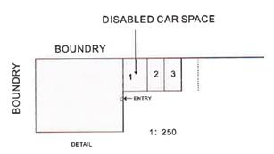
External
Car Parking Arrangement Source: DS Group Constructions
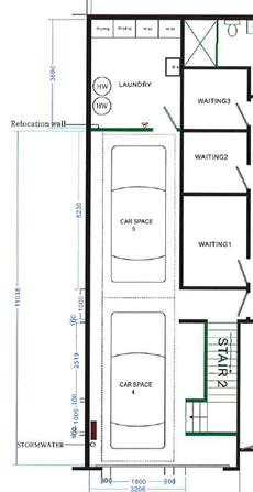
Internal
Car Parking Arrangement Source: DS Group Constructions
During the assessing
officer’s site visit to the site it was noted that Unit 7 within the
Industrial Estate Development is being utilised as an overflow of additional
car parking spaces. The subject application makes no mention of such an
arrangement and accordingly this use of Unit 7 has not been assessed.
Despite this, if the applicant
were to seek approval for such a parking arrangement on the site, a new
development application would need to be lodged to support such an arrangement.
An application would require the submission of architectural plans and owners
consent in addition to engineering plans demonstrating the provision of
adequate sized car parking spaces and ability to ensure manoeuvrability in and
out of the industrial unit.
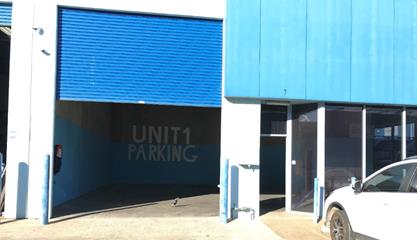
Additional
Car Parking Area for subject tenancy within Unit 7 (not included in subject
application). Source: Cumberland Council 2019
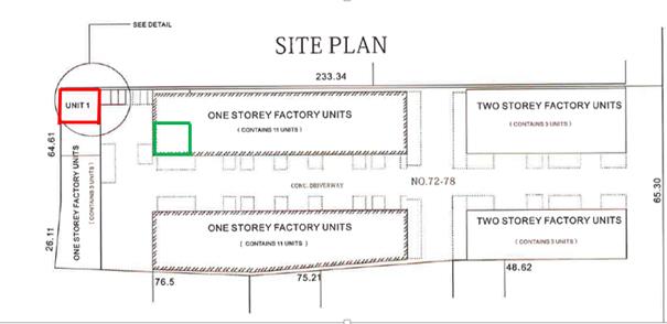
Site
Layout with subject site (Unit 1) shown in red outline and Unit 7’s
approximate location outline in green. Source: DS Group Constructions as edited
by Cumberland Council 2019
Any planning agreement that has
been entered into under section 7.4, or any draft planning agreement that a
developer has offered to enter into under section 7.4
There is no planning agreement or
draft planning agreement associated with the subject Development Application.
The provisions of the
Regulations
The regulations do not proscribe
any relevant matters for consideration.
Any coastal zone management
plan (within the meaning of the Coastal Protection Act 1979)
There is no Coastal Zone
Management Plan applicable to the subject site.The likely impacts of the
development
The likely environmental, social
and economic impacts of the development have been assessed and are considered
satisfactory.
The suitability of the site for
the development
The site is considered suitable
for the proposed development.
Submissions made in accordance
with the Act or Regulation
Advertised (newspaper) Mail Sign Not
Required
In accordance with Part E - Public
Participation of HDCP 2013, the proposal was publicly notified for a period of
14 days between 8 and 22 May 2019. As a result of the notification, Council
received no public submissions.
Section 7.11 of The
Environmental Planning & Assessment Act 1979
The subject development does not
attract development contributions in accordance with Holroyd Section 94
Development Contributions Plan 2013.
Accordingly no condition was
imposed on the original consent requiring payment of contributions, nor is
there any condition required to be imposed under the subject application.
The Public Interest
The public interest is served by
permitting the orderly and economic use of land, in a manner that is sensitive
to the surrounding environment and has regard to the reasonable amenity
expectations of surrounding land users. In view of the foregoing analysis, it
is considered that approval of the proposed development would not be contrary
to the public interest.
Disclosure of Political
Donations And Gifts
The NSW Government has introduced
disclosure requirements for individuals or entities with a relevant financial
interest as part of the lodgement of various types of development proposals and
requests to initiate environmental planning instruments or development control
plans.
The application and notification
process did not result in any disclosure of Political Donations or Gifts.
The development application has
been assessed in accordance with the relevant requirements of the Environmental
Planning and Assessment Act 1979, Holroyd Local Environmental Plan 2013 and the
Holroyd Development Control Plan 2013 and is considered to be satisfactory.
There are no further consultation
processes for Council associated with this report.
There are no further financial implications
for Council associated with this report.
There are no policy implications
for Council associated with this report.
Communication /
Publications:
The final outcome of this matter
will be notified in the newspaper. The objectors will also be notified in
writing of the outcome.
|
That Development Application
2010/206/5 for modification for the internal alterations and additions to an
existing brothel, including the extension of the mezzanine level to relocate
kitchen and introduce a staff lounge, introduce additional service rooms and
increase the number of staff be approved subject to the conditions within the
draft notice of determination provided at Attachment 3.
|
1. HLEP 2013
Compliance Table ⇩ 
2. HDCP
2013 Compliance Table ⇩ 
3. Draft
Notice of Determination ⇩ 
4. Architectural
Plans ⇩ 
5. Statement
of Environmental Effects ⇩ 
6. Plan
of Management ⇩
7. DA
2010/206 - Notice of Determination of Application ⇩ 
8. DA
2010/206/2 - Notice of Rejection of Application ⇩
9. DA
2010/206/3 - Notice of Determination of Application ⇩
10. DA
2010/206/4 - Notice of Determination of Application ⇩
DOCUMENTS
ASSOCIATED WITH
REPORT ELPP048/19
Attachment 1
HLEP 2013 Compliance Table
Extraordinary Cumberland Local Planning
Panel Meeting
26 June 2019
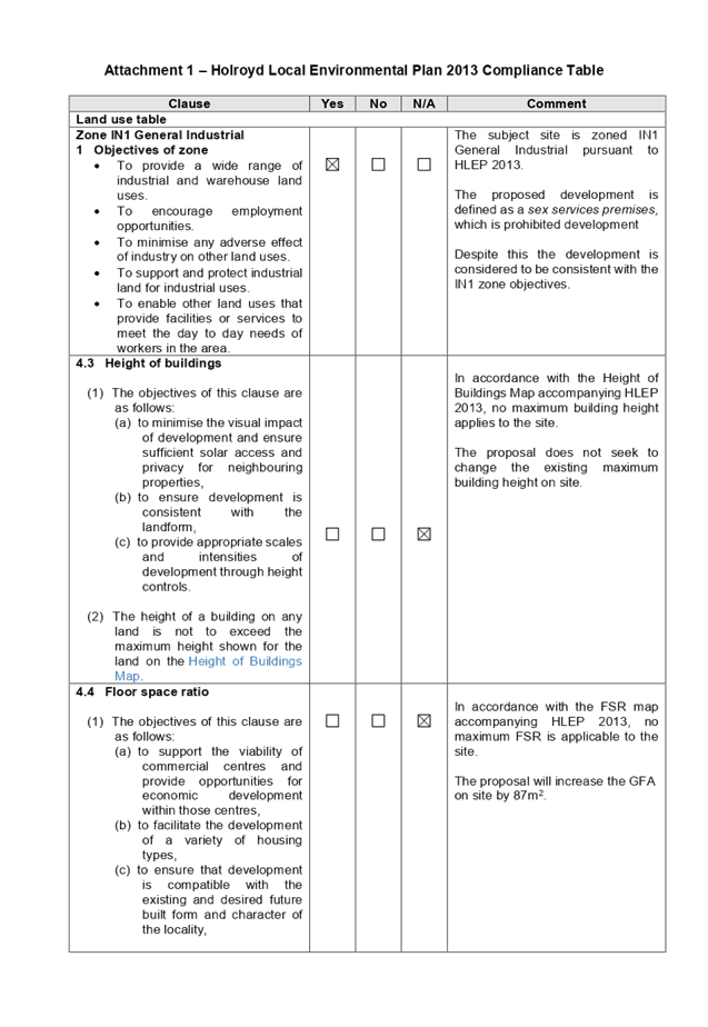
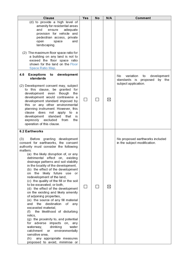
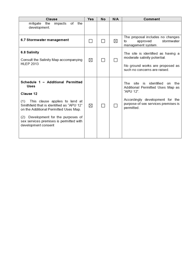
DOCUMENTS
ASSOCIATED WITH
REPORT ELPP048/19
Attachment 2
HDCP 2013 Compliance Table
Extraordinary Cumberland Local Planning
Panel Meeting
26 June 2019
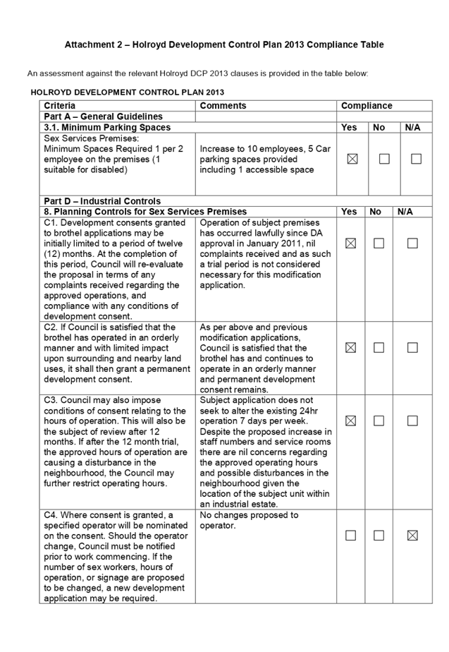
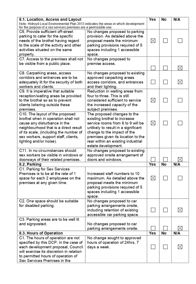

DOCUMENTS
ASSOCIATED WITH
REPORT ELPP048/19
Attachment 3
Draft Notice of Determination
Extraordinary Cumberland Local Planning
Panel Meeting
26 June 2019
Our Reference: 2010/206/5
Contact: Ms
C L Burke
Phone: 02
8757 9970
26
June 2019
Ms
H H Cui
103
Hudson Street
HURSTVILLE
NSW 2220
Dear
Sir/Madam
PREMISES:
1/72-78 PERCIVAL ROAD SMITHFIELD
SECTION
96(2) MODIFICATION TO DEVELOPMENT CONSENT NO. 2010/206/1
S96(2)
MODIFICATION NO. 2010/206/5
I
refer to your application lodged on 5 April 2019 seeking amendment to
Development Consent 2010/206/1 issued for internal alterations of an
existing industrial unit and fitout of premises and use as a brothel.
The modification seeks internal alterations and additions to an existing
brothel, including the extension of the mezzanine level to relocate kitchen and
introduce a staff lounge, introduce three (3) additional service rooms to a
total of nine (9) and increase the number of staff to a total of ten (10).
Pursuant
to Section 4.55(2) of the Environmental Planning & Assessment Act, 1979,
Council grants approval for the modifications sought.
Accordingly,
Development Consent 2010/206/1 is amended as follows:-
Condition
2 is amended to read as follows:
2. Development
shall take place in accordance with the attached endorsed plans:
· Architectural plans prepared by 3D Archplan, Drawing
No. A10-01, Issue 2, Dated 22 July, 2010, Drawing No. A10-02, Issue 3, Dated 22
July, 2010, Drawing No. A10-03, Issue 2, Dated 22 July, 2010, and Drawing No.
A10-04, Issue 1, Dated 28 April, 2010;
· Waste Management Plan dated 1 May, 2010; and
· Brothel Plan of Management dated May 2010 prepared by
FK Planning Group;
a) As amended in red by
Council. All amendments are to be incorporated in the Construction Certificate
plans.
As
amended by the following plans and documents approved by application
2010/206/3, dated 21 January 2011:
· Architectural plans prepared by 3D Archplan, Drawing
Numbers: A10-01, A10-02, A10-03 and A10-03, Issue 4 dated 24 December 2010
· Waste Management Plan dated 1 May, 2010; and
· Brothel Plan of Management dated May 2010 prepared by
FK Planning Group.
As
amended by the following plans and documents approved by application
2010/206/5, dated 26 June 2019:
· Architectural plans prepared by DS Group
Constructions, Project No. 02-19, Drawing Numbers: 1 – 5, Issue C dated
11/02/2019;
· Waste Management Plan received by Council on 5 April
2019; and
· Plan of Management for Sex Services Premises at Unit
1, 72 Percival Road, Smithfield
Condition
15a – 15c are to be inserted to read as follows:
Fire
Safety Upgrading of Existing Buildings - Fire Safety Report Required
15a. The levels of fire safety
for the premises are to be reviewed and upgraded where required. A report
prepared by an appropriately qualified person (A1 Accredited Certifier -
Unrestricted) in accordance with the requirements of Australian Standard
4655-2005 is to be submitted to the Principal Certifying Authority (PCA),
prior to the issue of a Construction Certificate. The measures that are
identified as required in this report for fire safety upgrading works are to be
included in the Construction Certificate.
Please
be advised that the fire safety report must detail the measures considered
appropriate:
· to satisfy the relevant performance requirements of
the Building Code of Australia;
· to protect persons using the building;
· to facilitate their egress from the building in the
event of fire;
· to prevent the fire;
· to Suppress fire;
· to restrict the spread of fire; and
· to ensure or promote the safety of persons in the
event of fire.
Air
Conditioning
15b. Details and specifications
for the mechanical ventilation
system complying with the Australian Standard are to be submitted and approved
by Council.
Building
Certificate
15c. A Building Certificate
application is to be lodged with and approved by Council for the unauthorised
works carried out on site.
Condition
36a is to be inserted to read as follows:
Asbestos
Cement Sheeting
36a. i) All asbestos cement
sheeting must be removed by contractors with an appropriate licence issued by
WorkCover and who are familiar with asbestos removal prior to the commencement
of:-
(a) Recladding
or brick veneering of any building where the existing walls to be covered are
currently clad with asbestos cement;
OR
(b) Construction
work where new work abuts existing asbestos cement sheeting and/or where parts
of the existing building clad with asbestos cement sheeting are to be altered
or demolished.
Removal
must be carried out strictly in accordance with WorkCover’s “Your Guide to Working with Asbestos” (copy
attached).
ii) All
asbestos laden waste, including asbestos cement flat
and corrugated sheets must be disposed of at a tipping facility licensed by the
Environment Protection Authority (EPA).
Note: The
person responsible for disposing of the above asbestos waste is to telephone
the EPA on (02) 9995 5000 or Council’s Waste Officer on (02) 9840
9715 to determine the location of a tip licensed to received asbestos. Upon
completion of tipping operations the applicant shall lodge with the Council,
all receipts issued by the receiving tip as evidence of proper disposal.
iii) Within fourteen (14) days of completion of renovation or
recladding or brick veneering works where asbestos cement sheeting was removed,
the applicant shall submit to Council an asbestos clearance certificate prepared
by a NATA accredited occupational hygienist.
Note: To
find a list of NATA accredited facilities visit the NATA website at www.nata.asn.au and under ‘Find a Facility or Lab’ type
in ‘asbestos identification’ in ‘keywords’ then click
on ‘chemical testing’ in NSW then click on the search
button. A list of laboratories will be produced which you can
contact for the purpose of having a clearance certificate issued.
Condition
49a is to be inserted to read as follows:
Fire
Safety Upgrading of Existing Buildings - Fire Safety Report Required
49a. The measures that are
identified as required in the report for fire safety upgrading works as per
Condition 15a are to be implemented prior to the issue of an Occupation
Certificate.
Condition
51 is to be amended to read as follows:
51. The brothel
shall be operated at all times in accordance with the endorsed plan of
management (POM) dated March 2019. Should any changes occur to the Plan
of Management, a copy is to be submitted to Cumberland Council’s
Environmental Health Department. In this regards, the following matters shall
be addressed:
· A 24 hour contact number is to be provided to Council
· An Incident Log (or computerised record) shall be
maintained in which are recorded details of any details of any incident or
complaint regarding the use (including time, date, nature of
incident/complaint, name and contact number of complainant). The Incident Log
shall record action taken in response to reports and the outcome achieved.
· The Incident Log shall be submitted to Council on a 6
monthly basis for Council’s records.
· The operator of the brothel shall prepare, on an
annual basis (on the anniversary of the date of the Occupation Certificate) a
report that reviews the POM and identifies the need to modify/update the POM.
The updated POM shall not remove any existing requirement of the POM unless it
is necessary to provide an adequate response to an identified issue and the
reasons are documented in the report. Copy of the report and undated POM shall
be submitted to Council for its records.
Condition
64a is to be inserted to read as follows:
64a. Liquid and solid wastes
generated on the site shall be collected, transported and disposed of in
accordance with the Protection of the Environment Operation Act 1997.
Records shall be kept of all liquid and solid waste disposal from the site, and
be made available to Council Officers on request.
Condition
65a is to be inserted to read as follows:
65a. Used condoms shall be
double bagged in plastic and placed in an approved waste receptacle within a
storage area on the premises whilst awaiting disposal.
Condition 73 be amended to
read as follows:
73. Each room.
Cubicles, booths or the like shall contain its own sanitary facilities
(including toilet, shower/bath and a wash hand basin) for the use of both sex
workers and clients. Each room used for the provision of sexual services
must be provided with separate sanitary facilities, directly accessible from
that room, for the use of both sex workers and their clients. Such facilities
shall comprise a toilet, shower and hand wash basin supplied with hot and cold
water under mains pressure, mixed through a common outlet. Each hand wash basin
shall be supplied with liquid soap and disposable hand towels.
Condition
73a is to be inserted to read as follows:
73a. Sanitary facilities must
be provided in accordance with the Building Code of Australia 2006.
Condition
81a-81e are to be inserted to read as follows:
Safety and Amenity
81a. A hospital grade disinfectant and liquid styptic shall
be used for cleaning floors and wet surfaces. All equipment and furnishings
shall be cleaned and disinfected in accordance with the NSW Health Department
Guidelines.
81b. Towels and linen shall be
stored in receptacles made of impervious material.
81c. The activity and any
building, or work associated with, or carried out in connection with the
activity, must comply with the Health & Safety Guidelines for Brothels in
NSW published by the WorkCover Authority of NSW and NSW Health Department.
81d. Lighting and ventilation
must be provided in accordance with the Building Code of Australia.
81e. Access to the premises is
to be granted to Council Environmental Health officers whilst the premises is
in operation for the purposes of a health compliance inspection.
Condition
89a and 89b are to be inserted to read as follows:
Emergency Procedures
89a. All essential services on
site are to be serviced by a suitably qualified person and a Certificate of
Compliance must be forwarded to Council annually.
89b. Evacuation procedures
must be established and adequately signposted. Regular emergency drills are to
be carried out regularly (minimum 3 monthly basis).
All
other conditions of Development Consent 2010/206/1, Modifications 2010/206/3
and 2010/206/4 remain unchanged.
Section
8.9 of the Environmental Planning & Assessment Act 1979 confers upon an
applicant, dissatisfied with Council’s determination of an application
made pursuant to Section 4.55(2) a right of appeal to the Land and Environment
Court.
Section
8.2 of the Act provides that an applicant may request, within 28 days of the
date of determination of the Section 4.55(2) Application, that the Council
review its determination (this does not apply to designated development). A fee
is required for this review.
If
you have any further enquiries please contact Ms C L Burke of Council’s
Environment and Planning Department on 02 8757 9970, Monday to Friday.
Yours
faithfully,
Karl Okorn
EXECUTIVE MANAGER DEVELOPMENT AND BUILDING
DOCUMENTS
ASSOCIATED WITH
REPORT ELPP048/19
Attachment 4
Architectural Plans
Extraordinary Cumberland Local Planning
Panel Meeting
26 June 2019
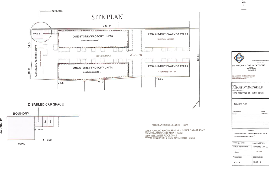
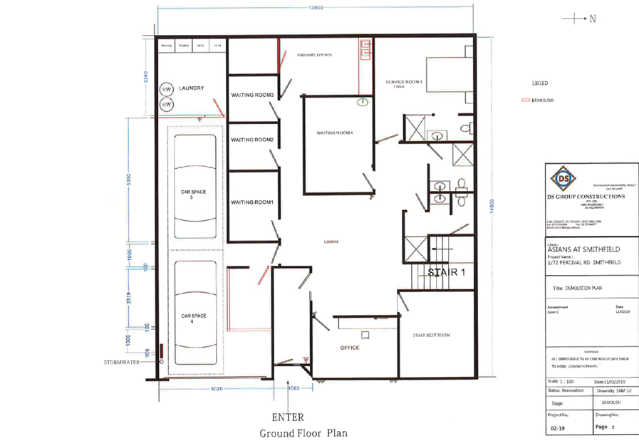
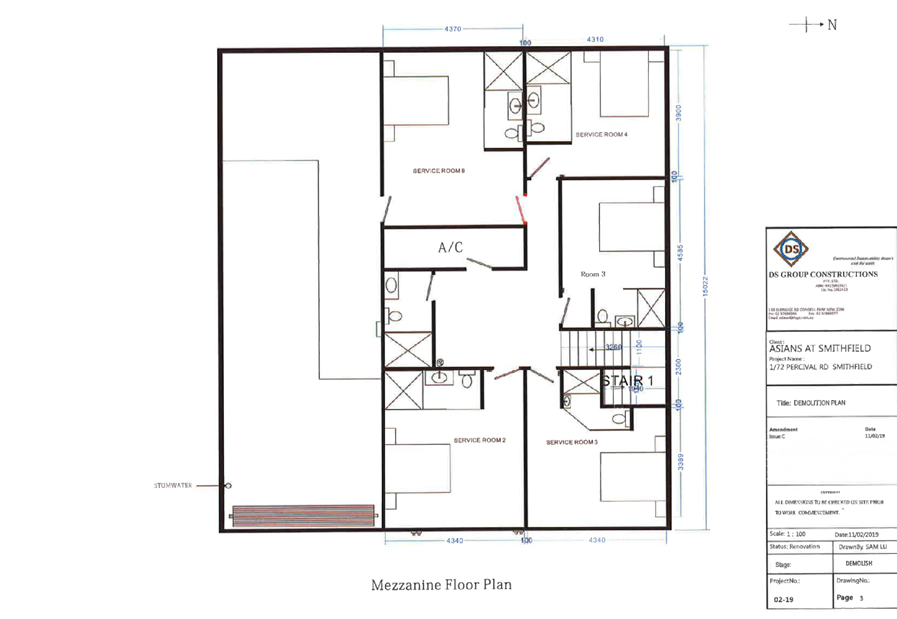
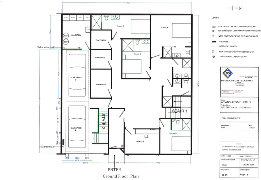
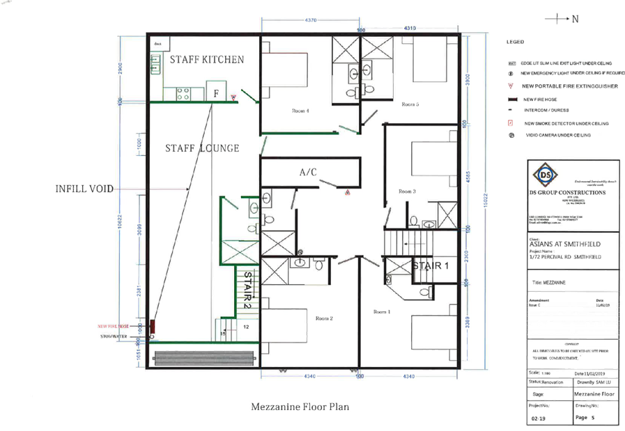
DOCUMENTS
ASSOCIATED WITH
REPORT ELPP048/19
Attachment 5
Statement of Environmental Effects
Extraordinary Cumberland Local Planning
Panel Meeting
26 June 2019
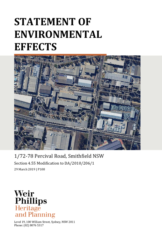
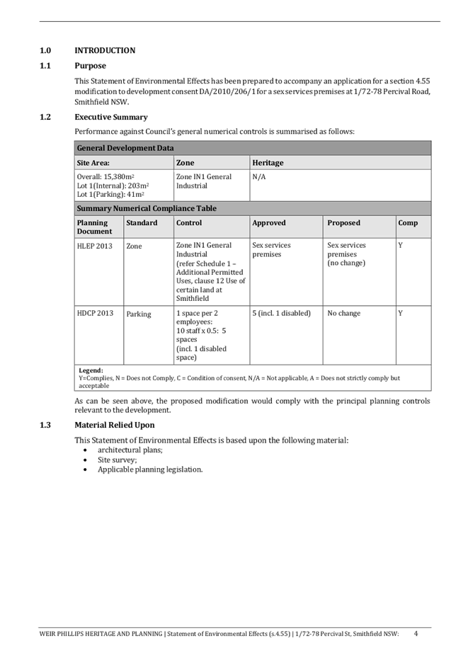
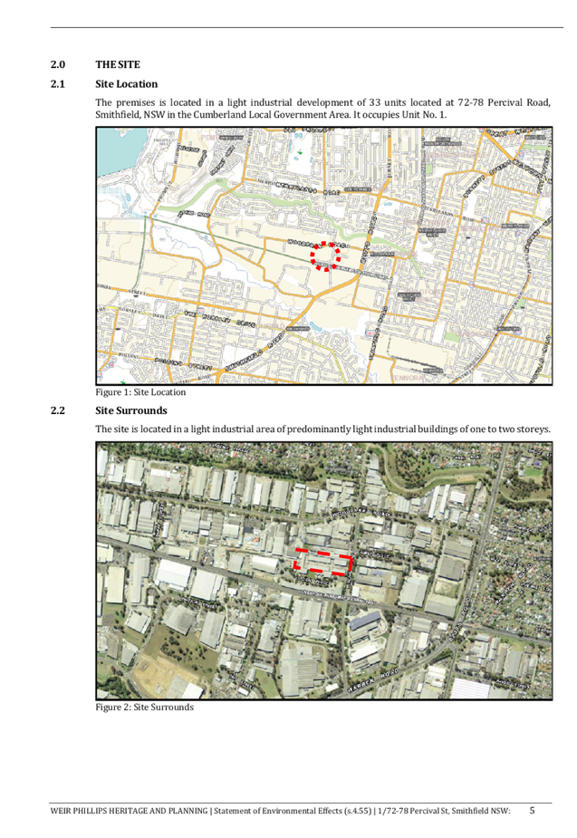
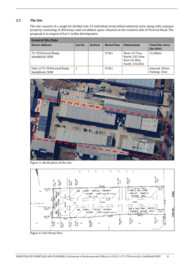
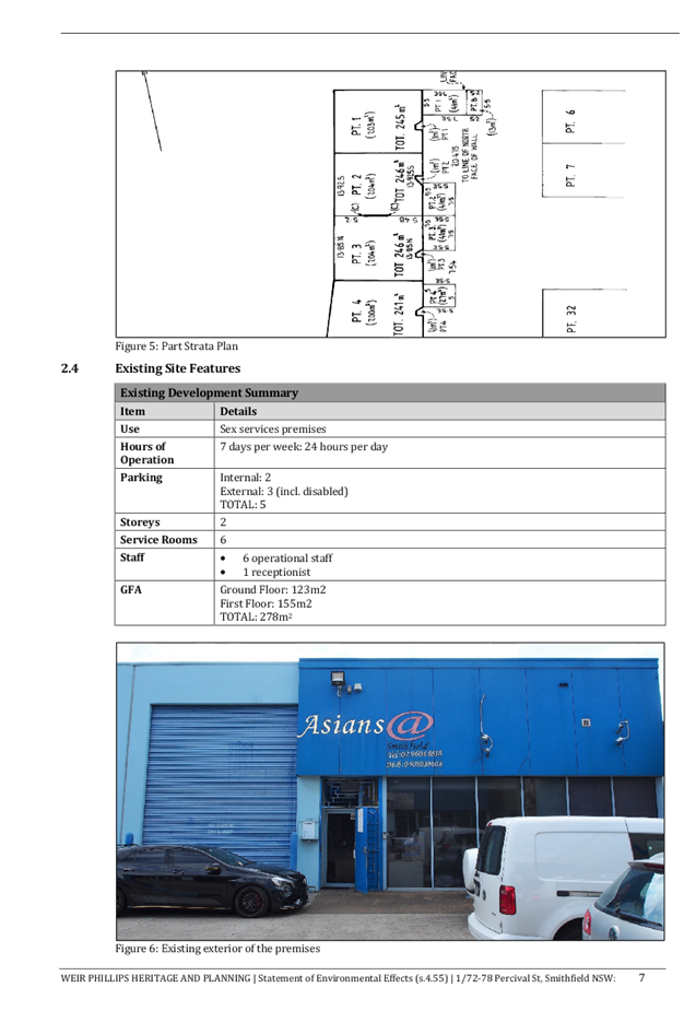
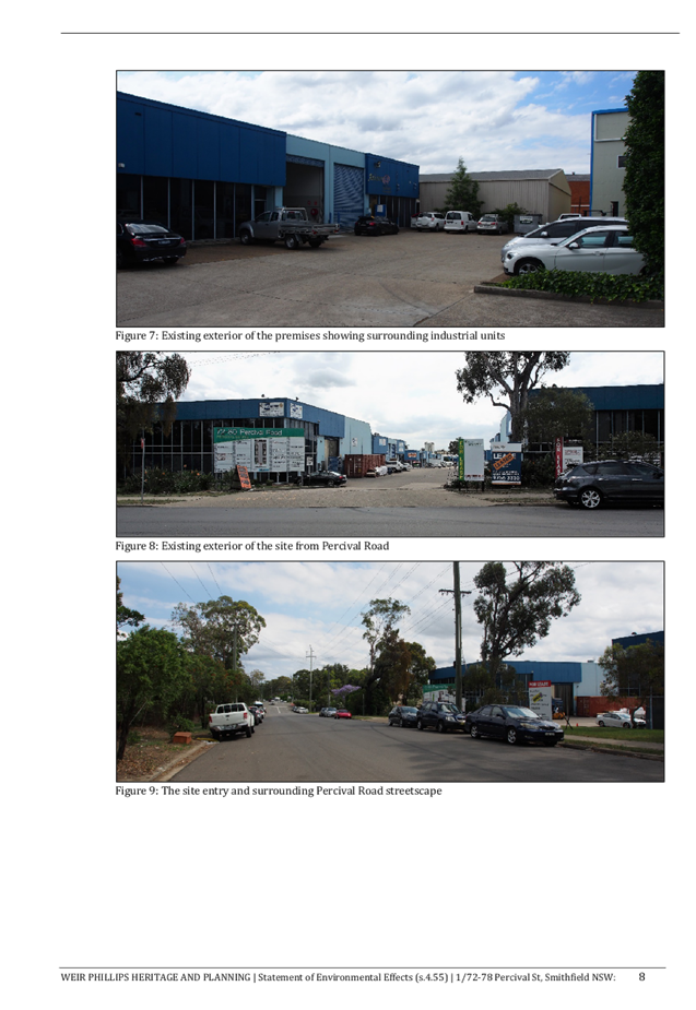
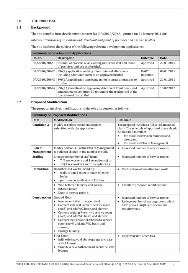
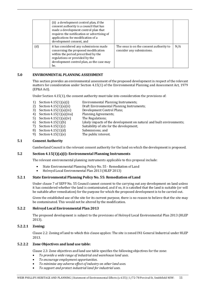
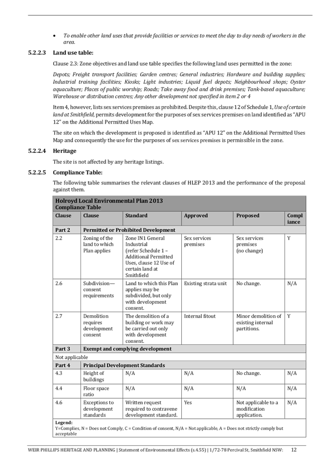
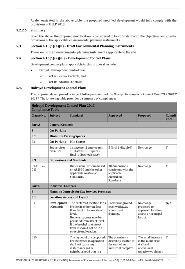
DOCUMENTS
ASSOCIATED WITH
REPORT ELPP048/19
Attachment 6
Plan of Management
Extraordinary Cumberland Local Planning
Panel Meeting
26 June 2019
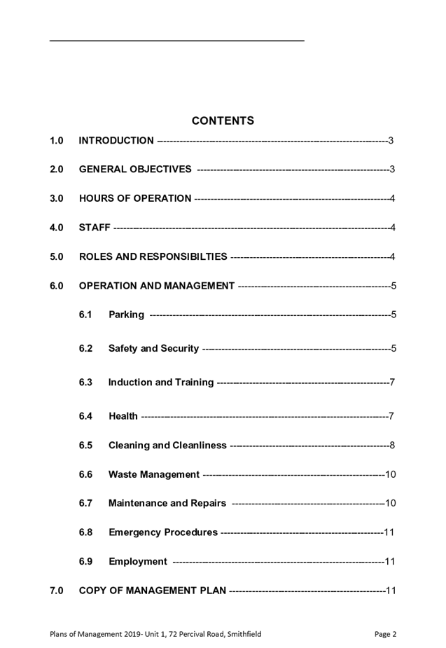
DOCUMENTS
ASSOCIATED WITH
REPORT ELPP048/19
Attachment 7
DA 2010/206 - Notice of Determination of Application
Extraordinary Cumberland Local Planning
Panel Meeting
26 June 2019


DOCUMENTS
ASSOCIATED WITH
REPORT ELPP048/19
Attachment 8
DA 2010/206/2 - Notice of Rejection of Application
Extraordinary Cumberland Local Planning
Panel Meeting
26 June 2019
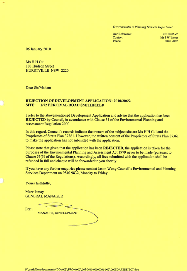
DOCUMENTS
ASSOCIATED WITH
REPORT ELPP048/19
Attachment 9
DA 2010/206/3 - Notice of Determination of Application
Extraordinary Cumberland Local Planning
Panel Meeting
26 June 2019
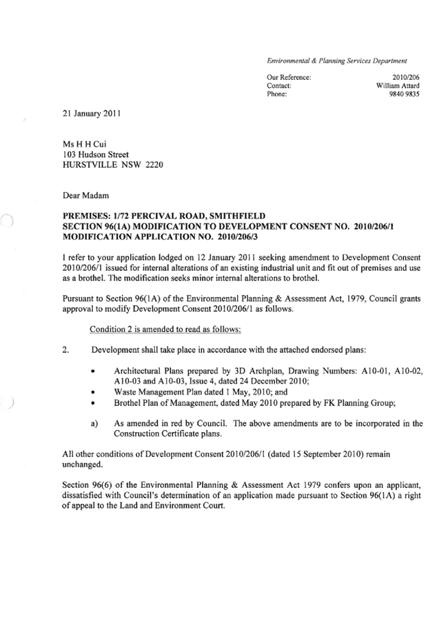

DOCUMENTS
ASSOCIATED WITH
REPORT ELPP048/19
Attachment 10
DA 2010/206/4 - Notice of Determination of Application
Extraordinary Cumberland Local Planning
Panel Meeting
26 June 2019