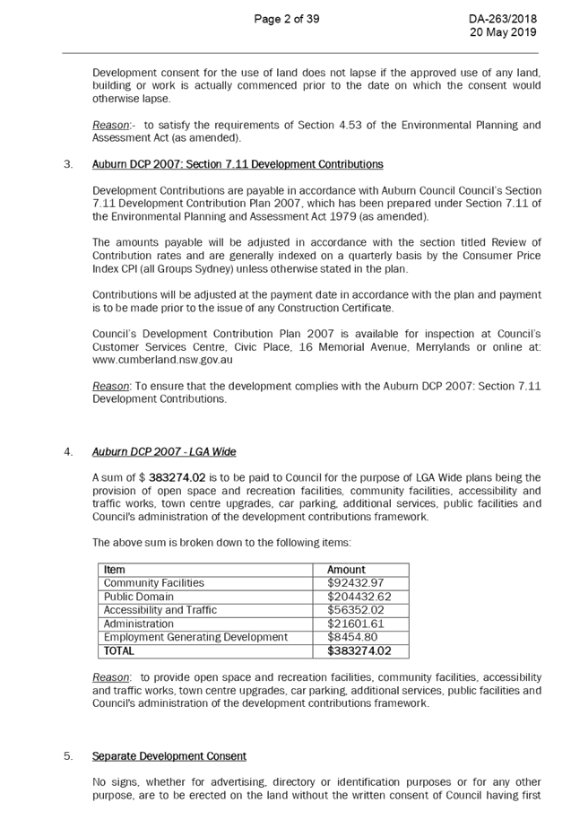
Cumberland Local Planning Panel Meeting
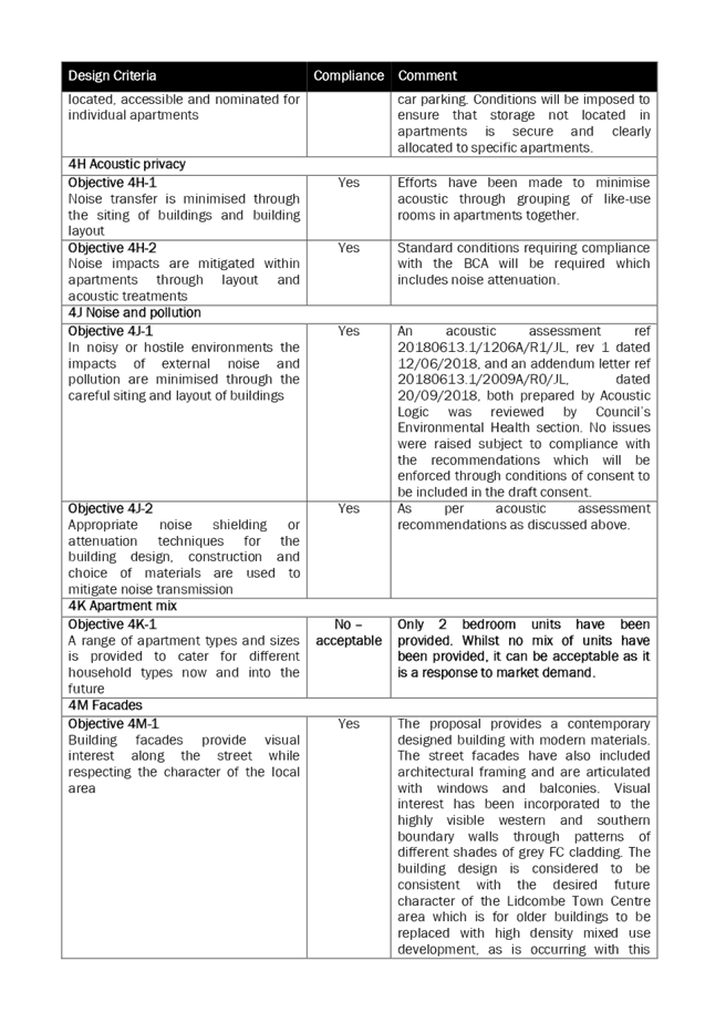
12 June 2019
A
meeting of the Cumberland Local Planning Panel
will be held at 11:30am at the Merrylands Administration Building, 16
Memorial Avenue, Merrylands on Wednesday, 12 June 2019.
Business as below:
Yours faithfully
Hamish McNulty
General
Manager
ORDER OF BUSINESS
1. Receipt of Apologies
2. Confirmation of Minutes
3. Declarations of Interest
4. Address by invited
speakers
5. Reports:
- Development
Applications
- Planning
Proposals
6. Closed Session Reports
Cumberland Local Planning Panel Meeting
12 June 2019
CONTENTS
Report No. Name of Report Page
No.
Development Applications
LPP039/19... Development Application
for 20-24 Bridge Street, Lidcombe....................... 5
LPP040/19... Development Application
for 9 McCredie Road, Guildford West............ 169
LPP041/19... Development Application
for Adjacent to 28A Campbell Street, Berala. 309
LPP042/19... Development Application
for Adjacent to 174 Woodburn Road, Berala 369
LPP043/19... Development Application
for 14 Hilltop Road, Merrylands....................... 439
Cumberland Local Planning Panel Meeting
12 June 2019
Item No:
LPP039/19
Development
Application for 20-24 Bridge Street, Lidcombe
Responsible
Division: Environment
& Planning
Officer: Manager
Development Assessment
File
Number: DA-263/2018
|
Application
lodged
|
29-Aug-2018
|
|
Applicant
|
Moma Architects
|
|
Owner
|
Y L Pty Limited and Bridge
Street Projects Pty Ltd
|
|
Application
No.
|
DA-263/2018
|
|
Description
of Land
|
20-24 Bridge Street, LIDCOMBE,
Lot 692 DP 557863, Lot 691 DP 557863
|
|
Proposed
Development
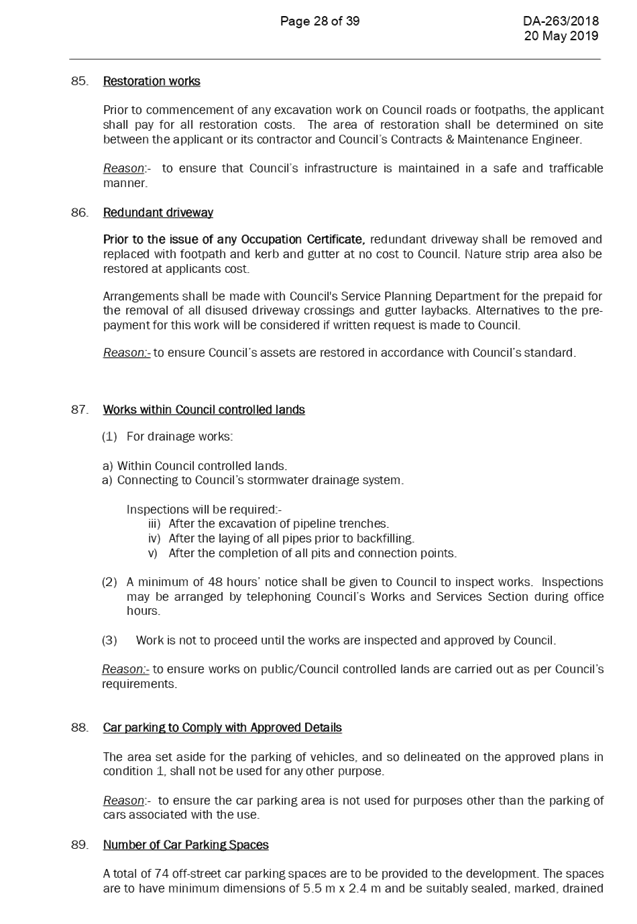
|
Demolition of existing
structures and the construction of an 11 storey shop top housing development,
comprising of 3 commercial tenancies and 60 residential units over 4 levels
of basement parking and lot consolidation
|
|
Site
Area
|
1095.68m2
|
|
Zoning
|
Zone B4 Mixed Use
|
|
Disclosure of political
donations and gifts
|
Nil disclosure
|
|
Heritage
|
No
|
|
Issues
|
Height, deep soil zone,
building separation, floor to ceiling height, podium level private open space
|
1. Development
Application No.DA-263/2018 was received on 29-Aug-2018 for the demolition of
existing structures and the construction of an 11 storey shop top housing
development, comprising of 3 commercial tenancies and 60 residential units over
4 levels of basement parking and lot consolidation.
2. The
application was publicly notified to occupants and owners of the adjoining
properties for a period of 14 days between 11 September 2018 and 25 September
2018. In response, one submission were received. The application was renotified
for a period of 14 days between 8 and 22 January 2019 and one re-submission was
received.
3. The
key variations to the planning controls are as follows:
|
Control
|
Required
|
Provided
|
% variation
|
|
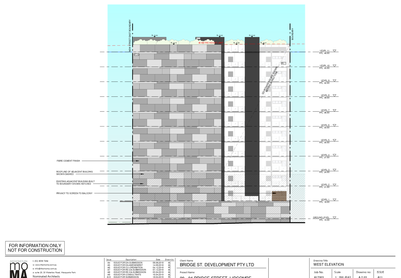
Height
|
36m
|
37.5m
|
4.2%
|
|
Building separation
[Note:
taken to be half the minimum separation distance measured to the boundary to
distribute the building separation equally between sites.]
|
Up
to 4 storeys (approximately 12m):
· 12m
between habitable rooms/balconies;
5
to 8 storeys (approximately 25m):
· 18m
between habitable rooms/balconies;
9+
storeys (over 25m):
· 24m
between habitable rooms/balconies;
|
Main non-compliances to
the southern side are as follows:
Level 1 – 4 =
5.555m
Levels 5 – 8 =
5.5m
Levels 9+ = 5.555 to
11.02m
|
7.4%
38.9 %
8.2 to 53.7%
|
|
Deep soil zone
|
7% (76.7sqm)
|
Nil
|
100%
|
4. The
application is recommended for conditional approval subject to the conditions
as provided in the attached schedule.
5. The
application is referred to the Panel as the proposal is considered to be
sensitive development as it relates to a development to which SEPP65 applies
and is 4 or more storeys.
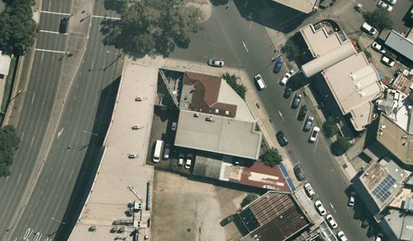
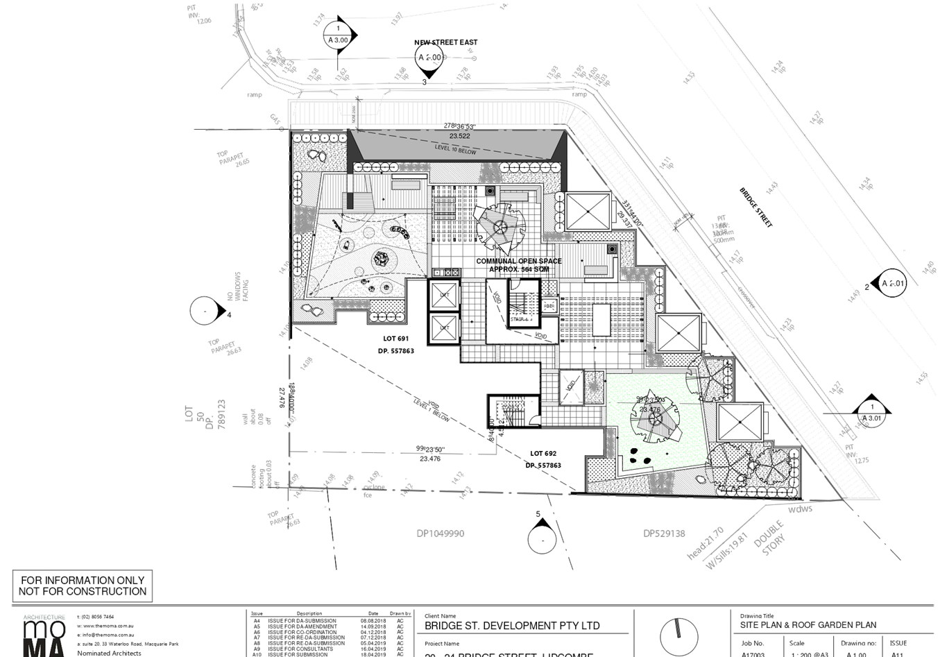
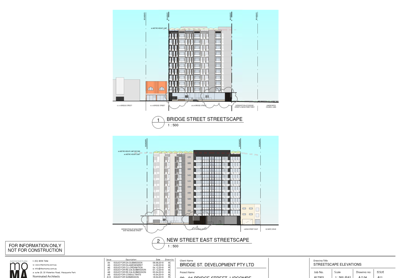
Subject Site and Surrounding
Area
The site is identified as Lot 691
and 692 DP 557863, known as 20-24 Bridge Street, Lidcombe. The subject site is
located on the western side of Bridge Street between Vaughan Street to the
south and New Street to the north. The site is irregular in shape with an
eastern front boundary measuring 39.4 m, western rear boundary measuring 30.77m
and southern side boundary measuring 47.38 m and northern secondary boundary to
New Street measuring 23.522m. The site has an area of 1095.68 m2 and is
generally flat.
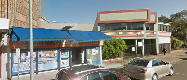
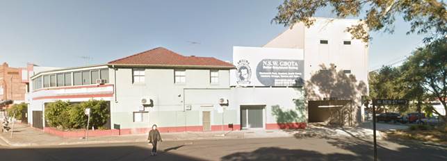
20 Bridge Street is occupied by a
single storey retail shop and 22-24 Bridge Street is occupied by a two-storey
commercial building with at grade parking accessed from Bridge Street.
The subject site is adjoined mixed
use and commercial development to the south, the Renaissance reception and
event centre to the west, Lidcombe Library and the commuter carpark to the
north and east. Lidcombe railway station lies to the north-east and the rail
line and Bridge St Gardens is to the north of the site. The site is within the
Lidcombe Town Centre and is characterised by a variety of residential
developments including commercial and mixed commercial / residential
development.
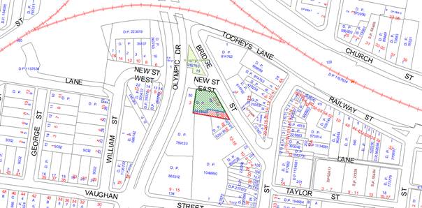
Figure
1 – Locality Plan of subject site
Figure
2 – Aerial view of subject site
Description of the Proposed
Development
Council has received a development
application for demolition of existing structures and the construction of an 11
storey shop top housing development, comprising of 3 commercial tenancies and
60 residential units over 4 levels of basement parking and lot consolidation
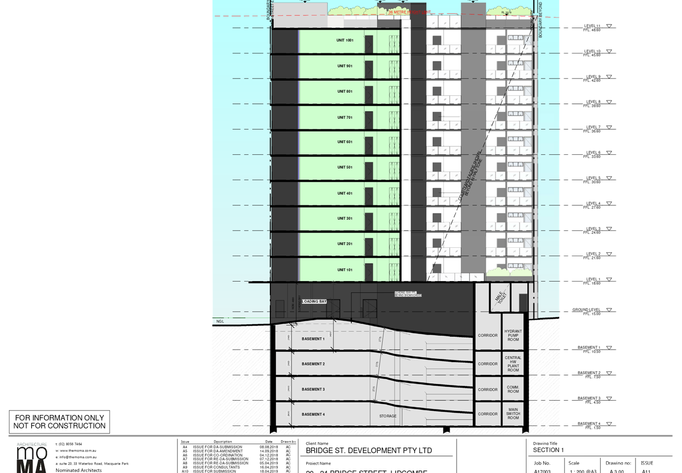
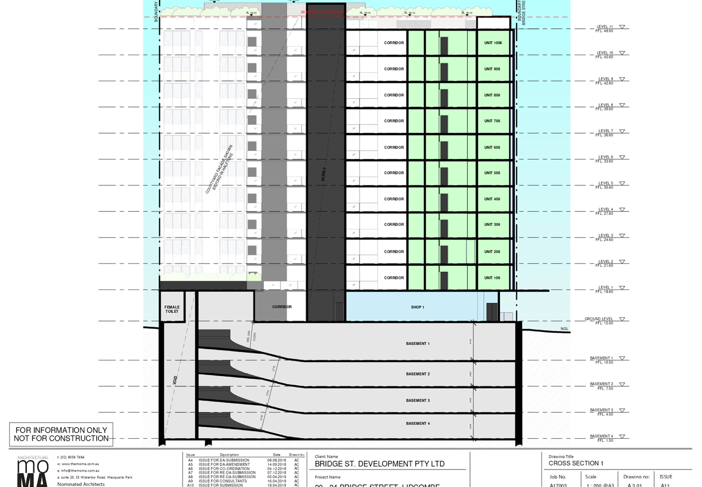
and includes:
· Summary
of components within the mixed use building including:-
i)
o 3 commercial tenancies on the ground
floor
o Total of 60 x 2 bedroom units (all
units are 2 bedroom units)
o 6 adaptable units - Units 01 on
levels 1 to 6 are adaptable units
o 74 car parking spaces to support all
uses
The detailed breakdown of the
proposal is as below:
Demolition
· Demolition
of all existing structures on the site including commercial buildings, shops
and at-grade parking.
· Removal
of vegetation from site.
Construction
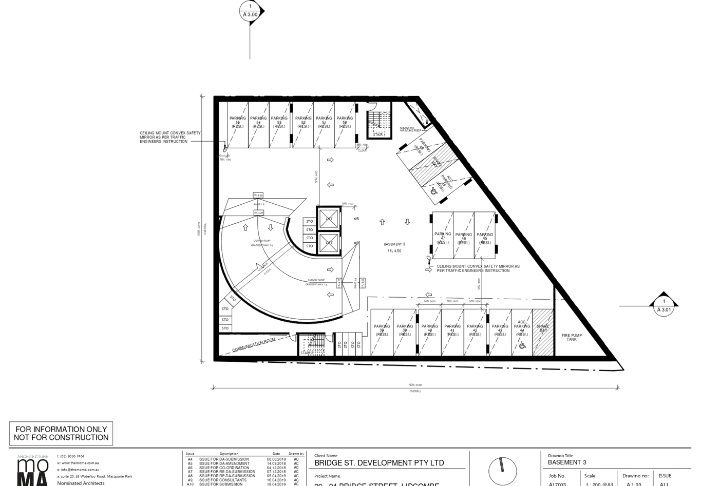
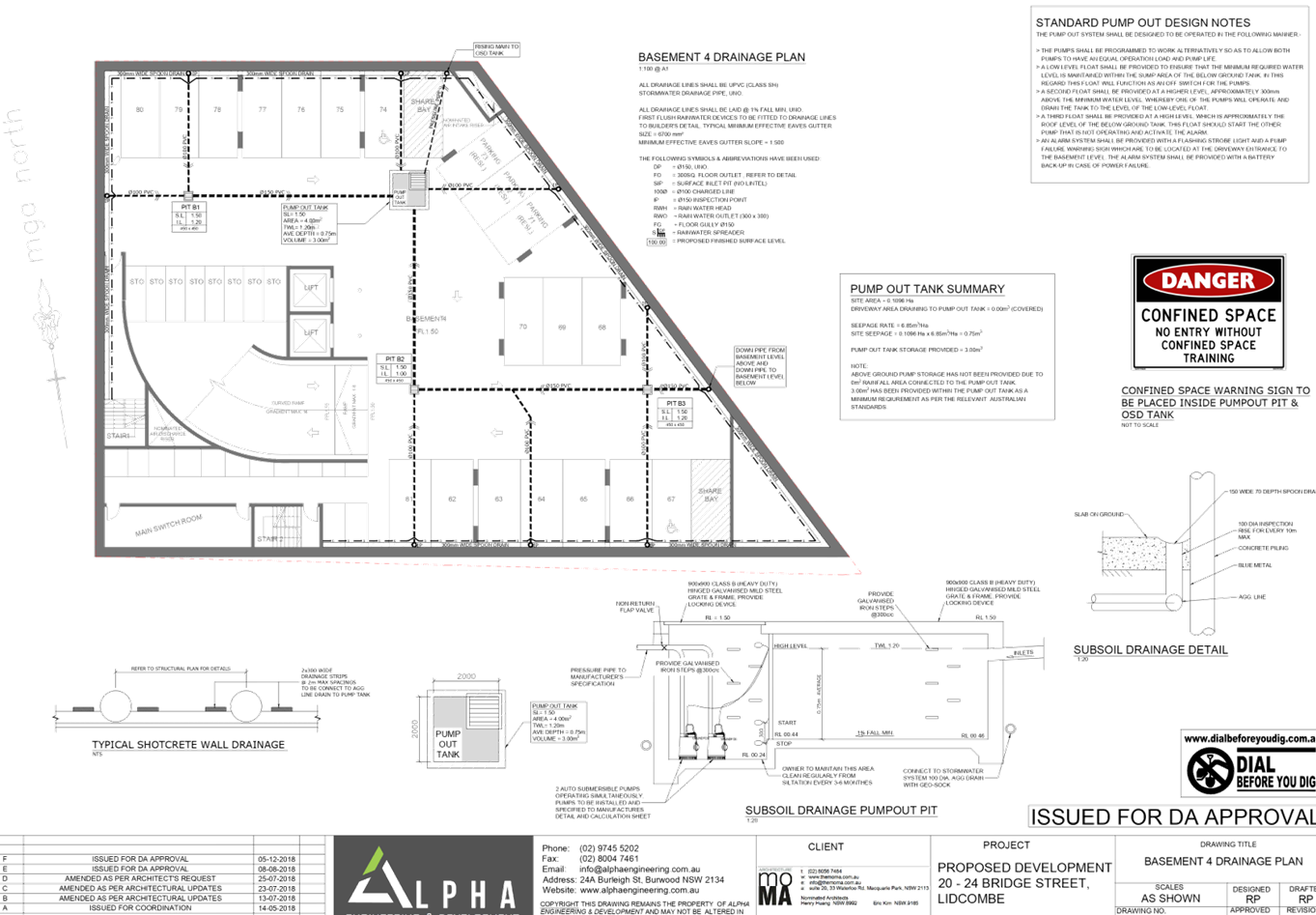
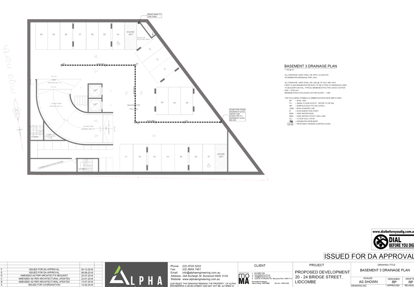
Basement 4:
· 19
resident car parking spaces (including 1 accessible space)
· 36
residential storage areas
· Main
switch room
· Two
stairs and two lifts have been provided to access the levels above.
Basement 3:
· 18
resident car parking spaces (including 2 accessible spaces)
· 12
residential storage spaces
· Communication
room
· Two
stairs and two lifts have been provided to access the levels above.
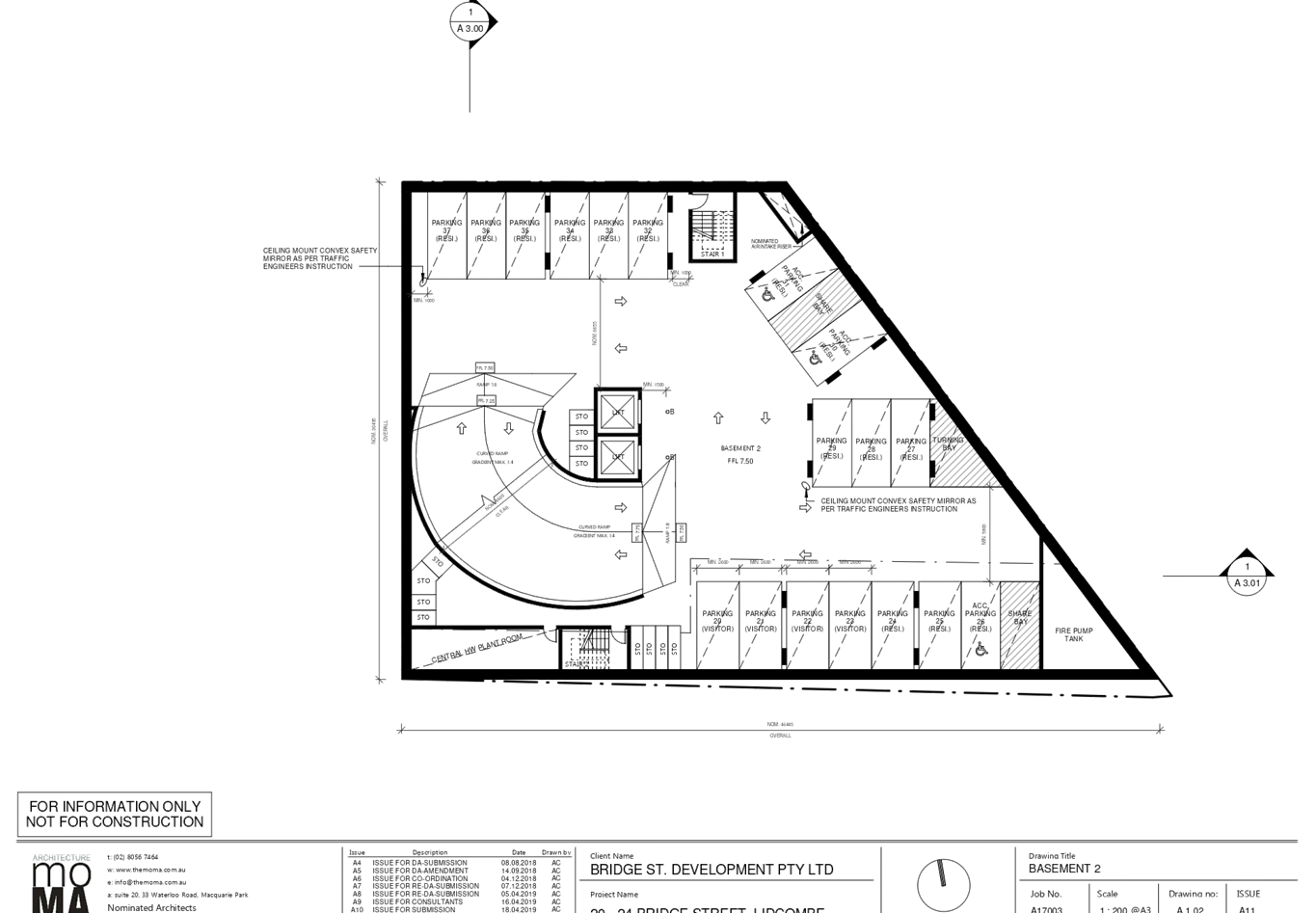
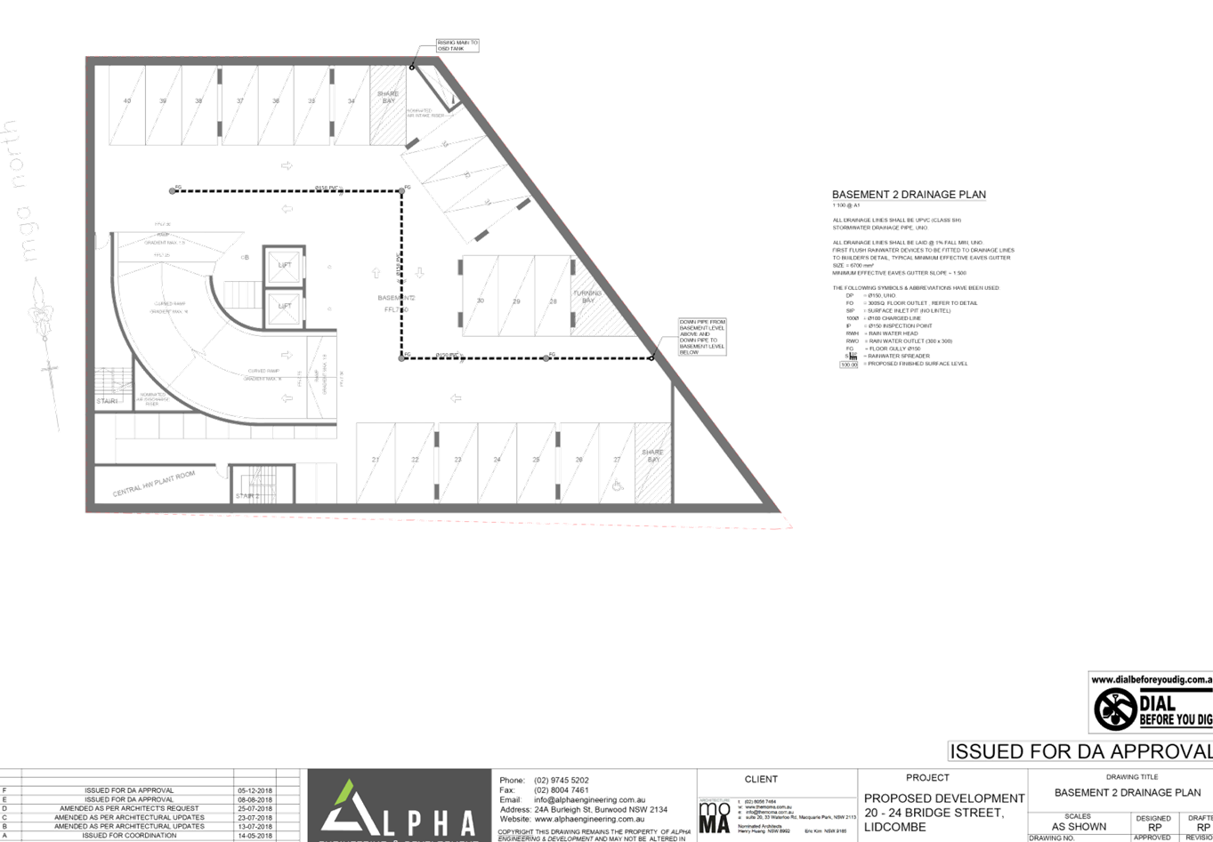
Basement 2:
· 14
resident car parking spaces (including 3 accessible spaces)
· 4
visitor spots for the residential component
· 12
residential storage spaces
· Central
hot water plant room
· Two
stairs and two lifts have been provided to access the levels above.
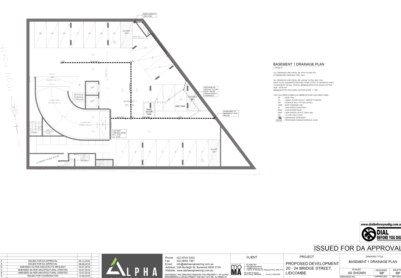
Basement 1:
· 5
commercial car parking spaces (including 1 accessible space)
· 8
visitor parking spaces
· 6
residential car parking spaces.
· Hyrdrant
pump room
· 12
bicycle parking spaces
· Two
stairs and two lifts have been provided to access the levels above.
Ground level:
· 3
commercial premises oriented to Bridge Street
· Separate
commercial and residential garbage rooms, bulky waste storage in the
residential garbage room and a waste loading bay with access to New Street
East.
· Commercial
amenities
· Separated
residential lobby
· Accessible
pedestrian ramp from street
Level 1:
· 6
x 2 bedroom units, each with ensuite, bathroom, laundry, storage, balcony and
open kitchen / living / dining. Southern unit 6 has 2 balconies, one to the
east and west.
· Unit
01 is adaptable and Unit 05 is silver level
· South-western
communal circulation and open space.
Level 2 to 6 (on each level):
· 6
x 2 bedroom units, each with ensuite, bathroom, laundry, storage, balcony and
open kitchen / living / dining. Southern unit 6 has 2 balconies, one to the
east and west.
· Unit
01 is adaptable and Unit 05 is silver level
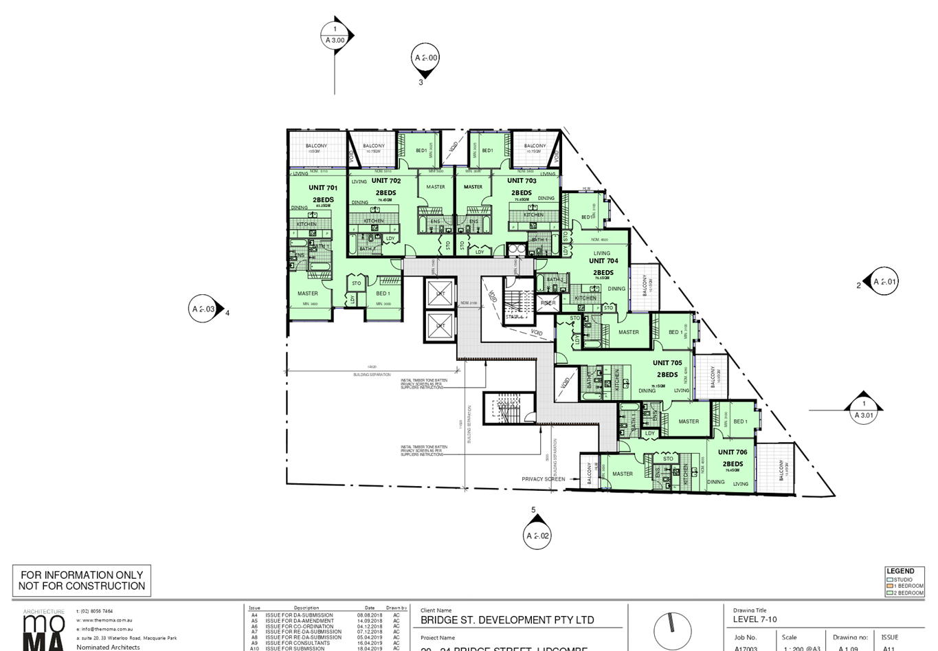
Level 7 to 10 (on each level):
· 6
x 2 bedroom units, each with ensuite, bathroom, laundry, storage, balcony and
open kitchen / living / dining. Southern unit 6 has 2 balconies, one to the
east and west.
Open circulation is provided to
the communal corridors.
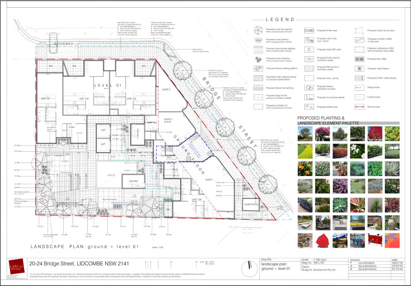
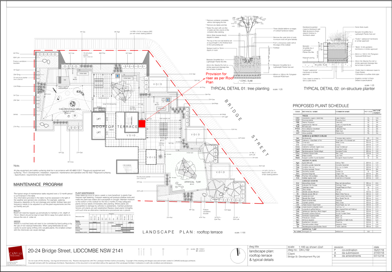
Roof:
· Landscaped
communal open space with BBQ area, seating and shade sails.
History
Site History
A review of Council’s
records indicates recent relevant previous applications on the site are:
· PL-6/2018:
Demolition of existing structures and construction of a 10 storey building
comprising 4 commercial tenancies, 70 residential apartments and basement
parking – completed 6 April 2018
Applicants Supporting
Statement
The applicant has provided a Statement
of Environmental Effects in support of the application prepared by Think
Planners dated 27 August 2018 which was received by Council on 29 August 2018.
Contact with Relevant
Parties
The assessing officer has
undertaken a site inspection of the subject site and surrounding properties and
has been in regular contact with the applicant throughout the assessment
process.
Internal Referrals
Development Engineer
The development application was
referred to Council’s Development Engineer for comment who has advised
that the development proposal may be supported subject to recommended
conditions of consent including conditions related to requiring an updated
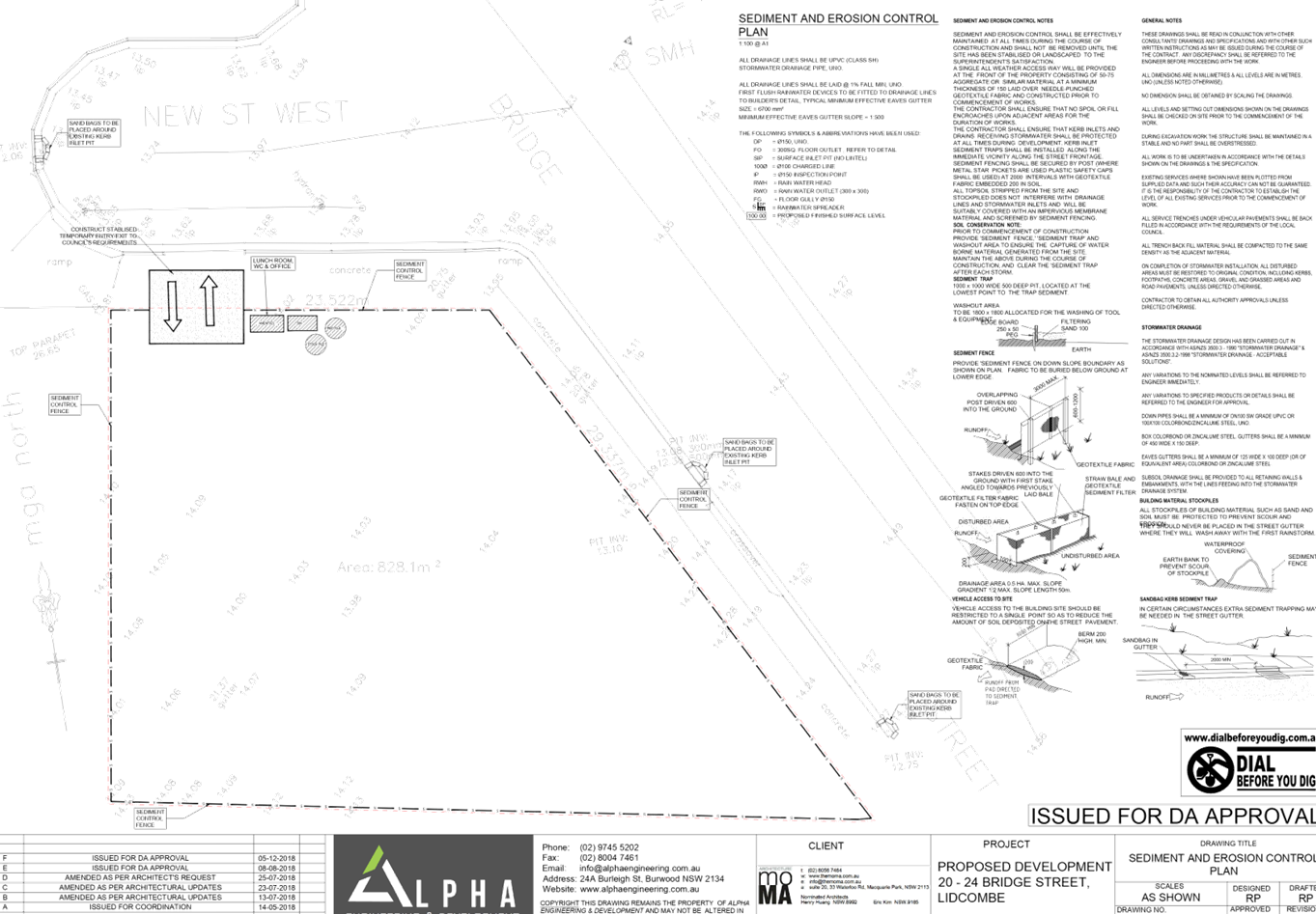
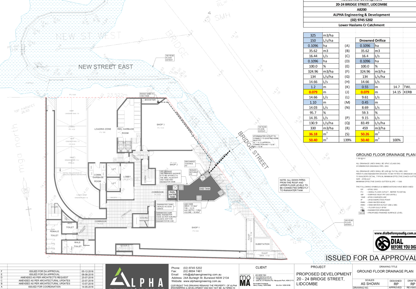
flood impact report and stormwater plans as well as other stormwater drainage
and parking design conditions.
Environment and Health
The development application was
referred to Council’s Environment and Health Officer for comment who has
advised that the development proposal is satisfactory subject to imposition of
recommended conditions of consent, if supported. These conditions include
requirements for amended plans demonstrating provisions for mechanical
ventilation of cooking equipment for ground floor shops which vents and extends
through the rooftop.
Landscape Architect
The development application was referred
to Council’s Landscape Architect for comment who has advised that the
landscape plan is satisfactory.
External Referrals
The application was not required
to be referred to any external government authorities for comment.
Planning Comments
The provisions of any
Environmental Planning Instruments (EP&A Act s4.15 (1)(a)(i))
Regional Environmental Plans
The proposed development is
affected by the following Regional Environmental Plans:
(a) Sydney
Regional Environmental Plan (Sydney Harbour Catchment) 2005
The subject site is identified as
being located within the area affected by the Sydney Regional Environmental
Plan (Sydney Harbour Catchment) 2005. The proposed development raises no issues
as no impact on the catchment is envisaged.
State Environmental Planning
Policies
The proposed development is
affected by the following State Environmental Planning Policies:
(a) State
Environmental Planning Policy No. 55 – Remediation of Land (SEPP 55)
Clause 7 of SEPP 55 requires
Council to be satisfied that the site is suitable or can be made suitable to
accommodate the proposed development. The matters listed within Clause 7 have
been considered in the assessment of the development application.
|
Matter for Consideration
|
Yes/No
|
|
Does
the application involve re-development of the site or a change of land use?
|
Yes
No
|
|
In the development going to be used for a sensitive land
use (e.g.: residential, educational, recreational, childcare or hospital)?
|
Yes
No
|
|
Does information available to you indicate that an
activity listed below has ever been approved, or occurred at the site?
acid/alkali plant and
formulation, agricultural/horticultural activities, airports, asbestos
production and disposal, chemicals manufacture and formulation, defence
works, drum re-conditioning works, dry cleaning establishments, electrical
manufacturing (transformers), electroplating and heat treatment premises,
engine works, explosive industry, gas works, iron and steel works, landfill
sites, metal treatment, mining and extractive industries, oil production and
storage, paint formulation and manufacture, pesticide manufacture and
formulation, power stations, railway yards, scrap yards, service stations,
sheep and cattle dips, smelting and refining, tanning and associated trades,
waste storage and treatment, wood preservation
|
Yes
No
|
|
Is the site listed on
Council’s Contaminated Land database?
|
Yes
No
|
|
Is the site subject to EPA
clean-up order or other EPA restrictions?
|
Yes
No
|
|
Has the site been the subject of
known pollution incidents or illegal dumping?
|
Yes
No
|
|
Does the site adjoin any
contaminated land/previously contaminated land?
|
Yes
No
|
|
Details of contamination investigations carried out at the
site:
The subject development has
been supported by a Detailed Site Investigation, rep E23835.E02_Rev2,
prepared by eiaustralia and dated 13 September 2018. The report concluded
that soils are suitable for the proposed development subject to
recommendations in section 12 of the report. The application was referred to
Council’s Environment Health Officers for comment that raised no
concerns to the subject development and supporting documentation, subject to
the imposition of conditions. Specifically the following;
· Demolition
of buildings and then excavation of site soils is to be undertaken in
accordance with the recommendations contained at Section 12 of the Detailed
Site Investigation Report prepared by EI Australia, their reference
E23835.E02_Rev2 dated 13 September 2018.
Council officers can therefore
be satisfied that the provisions of Clause 7 of the SEPP have been
satisfactorily addressed and consent can be granted.
|
|
Has the appropriate level of
investigation been carried out in respect of contamination matters for
Council to be satisfied that the site is suitable to accommodate the proposed
development or can be made suitable to accommodate the proposed development?
|
Yes
No
|
(a) State
Environmental Planning Policy (Infrastructure) 2007 (ISEPP)
The provisions of the ISEPP 2007
have been considered in the assessment of the development application.
Clause 87 – Impact of
rail noise or vibration on non-rail development and Clause 102 – Impact
of road noise or vibration on non-road development
The site is approximately 90m from
the Lidcombe railway corridor to the north and 15m from Olympic Drive to the
west which is a classified road with annual average daily traffic volume of
more than 20,000 vehicles. The application is subject to clause 87 and 102 of
the ISEPP as it is likely to be adversely affected by rail and road noise or
vibration. The applicant has submitted an Acoustic Assessment, ref
20180613.1/1206A/R1/JL, rev 1, and a supplementary letter regarding ventilation
of sole occupancy rooms, ref 20180613.1/2009A/R0/JL, dated 20/09/2018, both
prepared by Acoustic Logic (T072585/2018 and T065888/2018) to determine
appropriate measures which need to be taken to protect residential amenity. As
part of the assessment, consideration was given to the ISEPP and Department of
Planning’s Development Near Rail Corridors and Busy Roads – Interim
Guidelines and the required residential noise levels which are to be achieved.
Section 4.3 of the report provided construction recommendations including
glazing and door, external wall, ventilation and roof materials and design to
ensure that the noise levels in the SEPP and relevant guidelines are achieved.
The application was referred to Council’s Environmental Health officers
for comment and no objections were raised subject to conditions to comply with
the acoustic report recommendations and certification of acoustic
constructions. It is therefore considered that appropriate measures will be
taken to comply with ISEPP requirements for residential noise amenity.
(b) State
Environmental Planning Policy (Vegetation in Non-Rural Areas) 2017
N/A – No significant
vegetation removal is proposed. Only some small shrubs in planters exist on
site.
(c) State
Environmental Planning Policy (Coastal Management) 2018
The subject site is not identified
as a coastal wetland or land identified as “proximity area for coastal
wetlands” or land identified as such by the Coastal Wetlands and Littoral
Rainforest Area Map.
(d) State
Environmental Planning Policy (Building Sustainability Index: BASIX) 2004
BASIX Certificate 952517M_03 dated
issued on 17 April 2019 prepared by Outsource Ideas P/l has been submitted with
Council and is considered to be satisfactory. The BASIX Certificate lists
measures to satisfy BASIX requirements which have been incorporated into the
proposal. If supported, a standard condition is recommended ensuring the
measures detailed in the BASIX Certificate are implemented.
(e) Statement
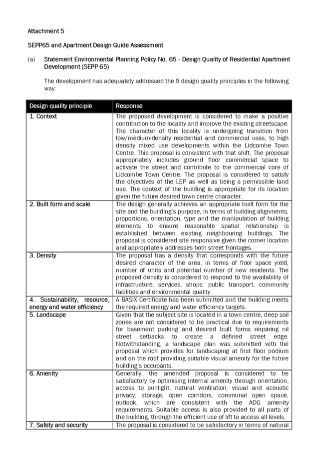
Environmental Planning Policy No. 65 - Design Quality of Residential Apartment
Development (SEPP 65)
SEPP 65 applies to the residential
flat building part of the development as the building is 3 storeys or more, and
contains more than 4 dwellings. A design statement addressing the 9 design
quality principles prescribed by SEPP 65 was prepared by the project architect
and submitted. Integral to SEPP 65 is the Apartment Design Guide (ADG), which
sets benchmarks for the appearance, acceptable impacts and residential amenity
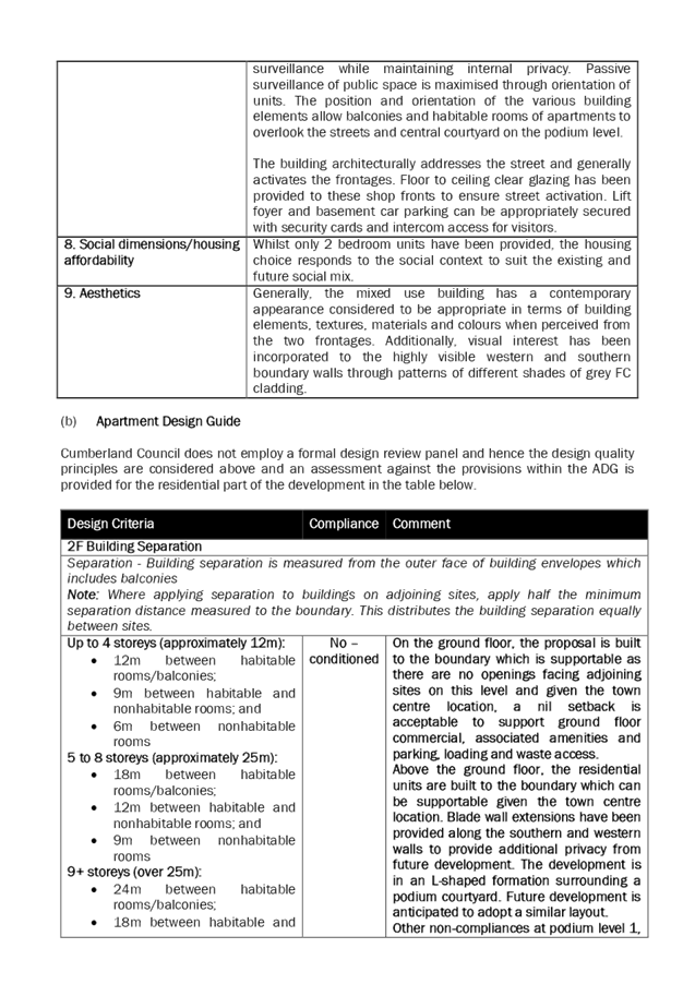
of the development as shown below. A full assessment is in attachment 5.
|
Design Criteria
|
Compliance
|
Comment
|
|
2F Building Separation
|
|
Separation - Building
separation is measured from the outer face of building envelopes which
includes balconies
Note: Where
applying separation to buildings on adjoining sites, apply half the minimum
separation distance measured to the boundary. This distributes the building
separation equally between sites.
|
|
9+ storeys (over 25m):
· 24m
between habitable rooms/balconies;
· 18m
between habitable and nonhabitable rooms; and
· 12m
between nonhabitable rooms
|
No
– acceptable
|
On the ground floor, the
proposal is built to the boundary which is supportable as there are no
openings facing adjoining sites on this level and given the town centre
location, a nil setback is acceptable to support ground floor commercial,
associated amenities and parking, loading and waste access.
Above the ground floor, the
residential units are built to the boundary which can be supportable given
the town centre location. Blade wall extensions have been provided along the
southern and western walls to provide additional privacy from future
development. The development is in an
L-shaped formation surrounding a podium courtyard. Future development is
anticipated to adopt a similar layout.
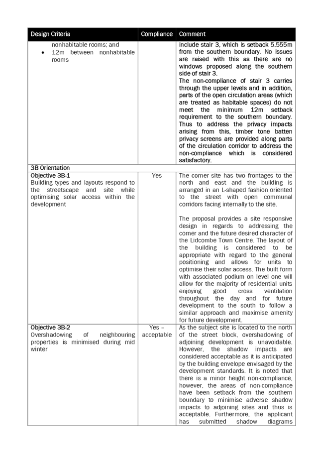
Other non-compliances at
podium level 1, include stair 3, which is setback 5.555m from the southern
boundary. No objections are raised with this as there are no windows proposed
along the southern side of stair 3.
The non-compliance of stair
3 carries through the upper levels and in addition, parts of the open
circulation areas (which are treated as habitable spaces) do not meet the minimum
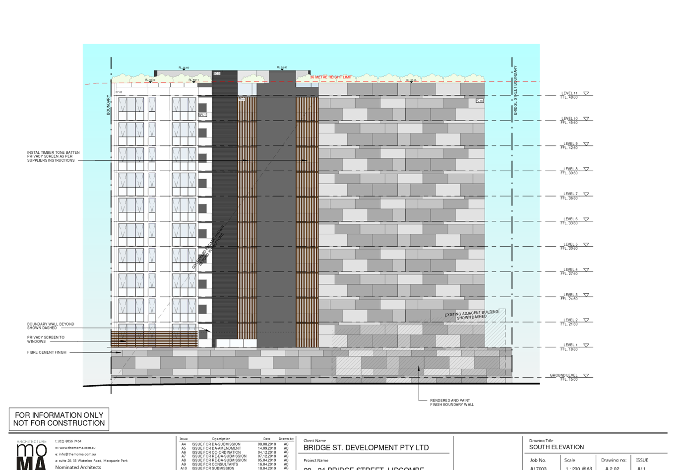
12m setback requirement to the southern boundary. Thus to address the privacy
impacts arising from this, timber tone batten privacy screens are provided
along parts of the circulation corridor to address the non-compliance which
is considered satisfactory.
|
|
Objective 3B-2
Overshadowing of neighbouring
properties is minimised during mid-winter
|
Yes
– acceptable
|
As the subject site is located
to the north of the street block, overshadowing of adjoining development is
unavoidable. However, the shadow impacts are considered acceptable as it is
anticipated by the building envelope envisaged by the development standards.
It is noted that there is a minor height non-compliance, however, the areas
of non-compliance have been setback from the southern boundary to minimise
adverse shadow impacts to adjoining sites and thus is acceptable.
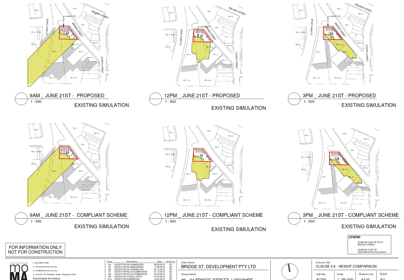
Furthermore, the applicant has submitted shadow diagrams comparing a height
compliant scheme against the proposal which demonstrates that there are
negligible additional shadow impacts arising from the height non-compliance.
The shadow will move from overshadowing the function centre and Olympic Drive
in the morning to mainly shadowing the mid-block open hardstand parking area
and then will move over the low scale mixed commercial development fronting
Bridge Street in the afternoon. As the shadow moves throughout the day in
midwinter, future development to the south will likely have sufficient solar
access either in the morning or afternoon.
|
|
3D Communal and public open
space
|
|
COS should have a minimum
dimension of 3m.
Where COS cannot be
provided at ground level, it should be provided on a podium or roof.
|
|
Objective 3D-1
An adequate area of communal
open space is provided to enhance residential amenity and to provide
opportunities for landscaping
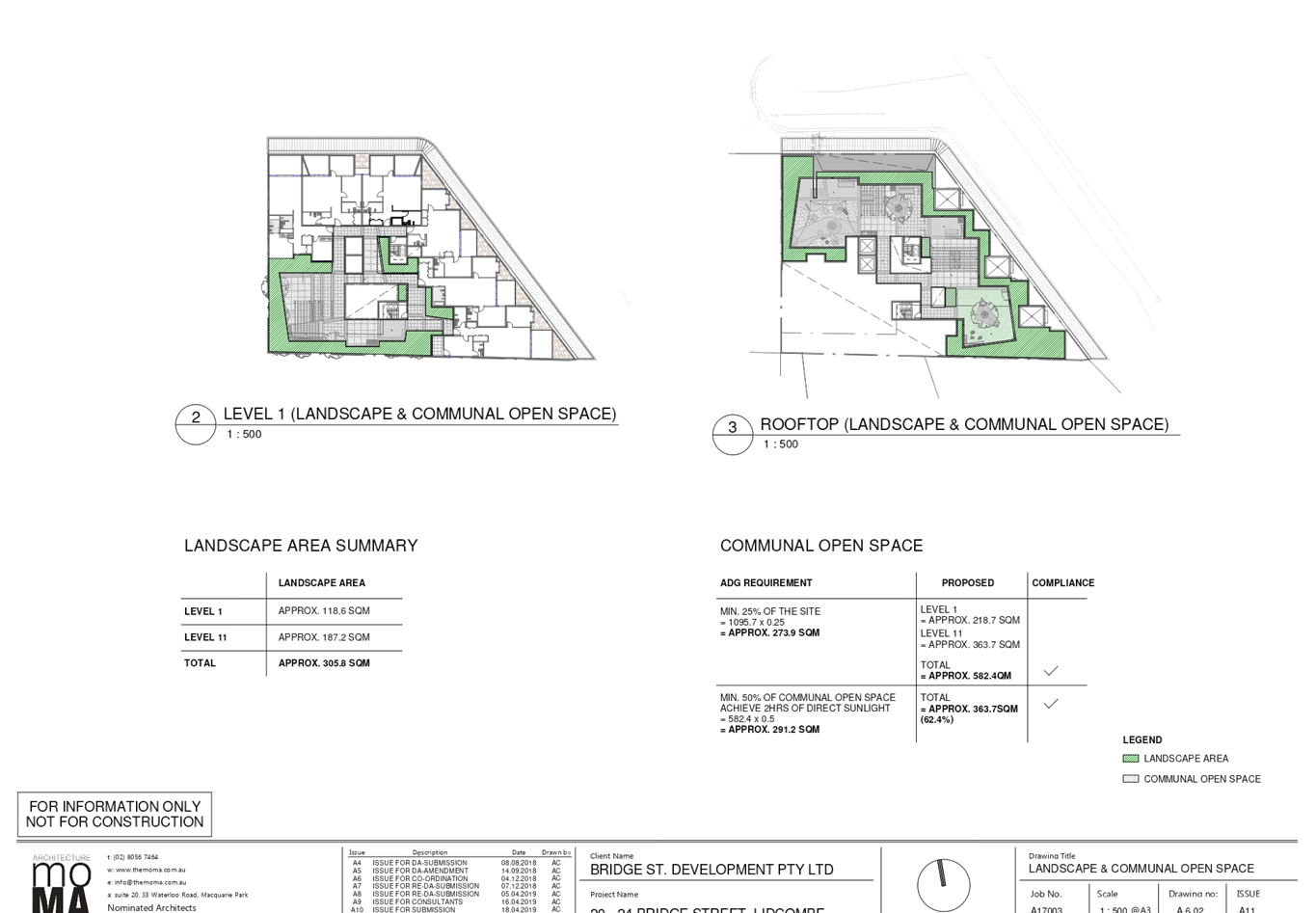
Design criteria
· Communal
open space has a minimum area equal to 25% of the site (see figure 3D.3)
· Developments
achieve a minimum of 50% direct sunlight to the principal usable part of the
communal open space for a minimum of 2 hours between 9 am and 3 pm on 21 June
(mid-winter)
|
Yes
Yes
Yes
|
The communal open space
includes bbq areas, seating, pergolas and suitable landscaping for the
enjoyment of residents.
Proposed common open space =
750.1m2 (68.5%) (inclusive of 230.5sqm on the level 1 podium and
the remainder being on the roof top)
69.27% of the common open
space, being that located on the roof, receives solar amenity throughout the
day in midwinter.
|
|
3E Deep soil zones
|
|
Objective 3E-1
Deep soil zones provide areas
on the site that allow for and support healthy plant and tree growth. They
improve
residential amenity and
promote management of water and air quality
Design criteria
1. Deep soil zones are to meet
the following minimum requirements:
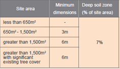
|
No
– acceptable
|
Nil proposed.
The non-compliance is
considered acceptable given the Town Centre nature of the site as the need to
provide a functional basement carpark and commercial uses at ground floor
makes the deep soil requirements difficult to achieve.
The proposal does however,
propose a substantial area of landscaped common space upon at various levels
including level 1 podium and roof top which is considered acceptable.
|
|
3F Visual privacy
|
|
Separation - Building
separation is measured from the outer face of building envelopes which
includes balconies
Note: Where
applying separation to buildings on adjoining sites, apply half the minimum
separation distance measured to the boundary. This distributes the building
separation equally between sites.
Separation between windows
and balconies is provided to ensure visual privacy is achieved.
Adjoining a different zone
with a less density, add 3.0m.
Retail, office spaces and
commercial balconies use habitable room separation.
No separation is required
between blank walls.
|
|
Objective 3F-1
Adequate building separation
distances are shared equitably between neighbouring sites, to achieve
reasonable levels of external and internal visual privacy
Design criteria
1. Separation between windows
and balconies is provided to ensure visual privacy is achieved. Minimum
required separation distances from buildings to the side and rear boundaries
are as follows:
Note: Separation distances
between buildings on the same site should combine required building
separations
depending on the type of room
(see figure 3F.2)
Gallery access circulation
should be treated as habitable space when measuring privacy separation
distances between neighbouring properties
|
No
– acceptable
No
– acceptable
|
See discussion under 2F.
Visual privacy has been addressed through privacy screening where there is
insufficient building separation.
|
|
Objective 3F-2
Site and building design
elements increase privacy without compromising access to light and air and
balance outlook and views from habitable rooms and private open space
|
Yes
|
A combination of privacy
screening, highlight windows and landscaping have been employed at the
interface of residential units and public circulation/ communal areas at the
podium level and above. Windows have been provided where possible to improve
ventilation, provide outlook and maximise solar access to habitable spaces on
the residential levels.
|
|
3J Bicycle and car parking
|
|
Objective 3J-1
Car parking is provided based
on proximity to public transport in metropolitan Sydney and centres in
regional areas
Design criteria
1. For development in the
following locations:
· on
sites that are within 800 metres of a railway station or light rail stop in
the Sydney Metropolitan Area; or
· on
land zoned, and sites within 400 metres of land zoned, B3 Commercial Core, B4
Mixed Use or equivalent in a nominated regional centre
the minimum car parking
requirement for residents and visitors is set out in the Guide to Traffic
Generating Developments, or the car parking requirement prescribed by the
relevant council, whichever is less
The car parking needs for a
development must be provided off street
|
Yes
Yes
|
The ADG requires parking to be provided for the
residential component as follows:
60 x 2br (0.9/unit) = 54 spaces are required
12 visitor spaces required (0.2/unit)
Total required: 66 spaces required
Total provided: 69 residential and visitor spaces provided
There is sufficient parking
provision on site to accommodate both residential and commercial uses on site
as discussed under the DCP (see Appendices).
|
|
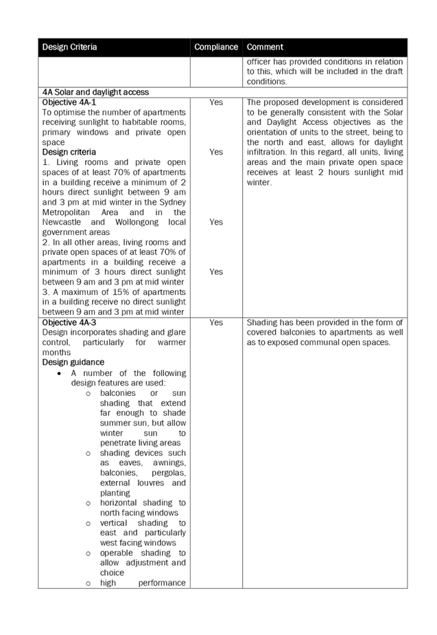
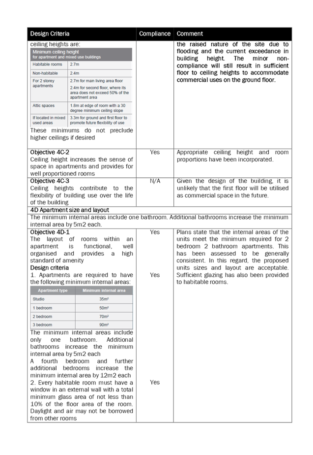
4A Solar and daylight
access
|
|
Objective 4A-1
To optimise the number of
apartments receiving sunlight to habitable rooms, primary windows and private
open space
Design criteria
1. Living rooms and private
open spaces of at least 70% of apartments in a building receive a minimum of
2 hours direct sunlight between 9 am and 3 pm at mid-winter in the Sydney
Metropolitan Area and in the Newcastle and Wollongong local government areas
2. In all other areas, living
rooms and private open spaces of at least 70% of apartments in a building
receive a minimum of 3 hours direct sunlight between 9 am and 3 pm at
mid-winter
3. A maximum of 15% of
apartments in a building receive no direct sunlight between 9 am and 3 pm at
mid-winter
|
Yes
Yes
Yes
Yes
|
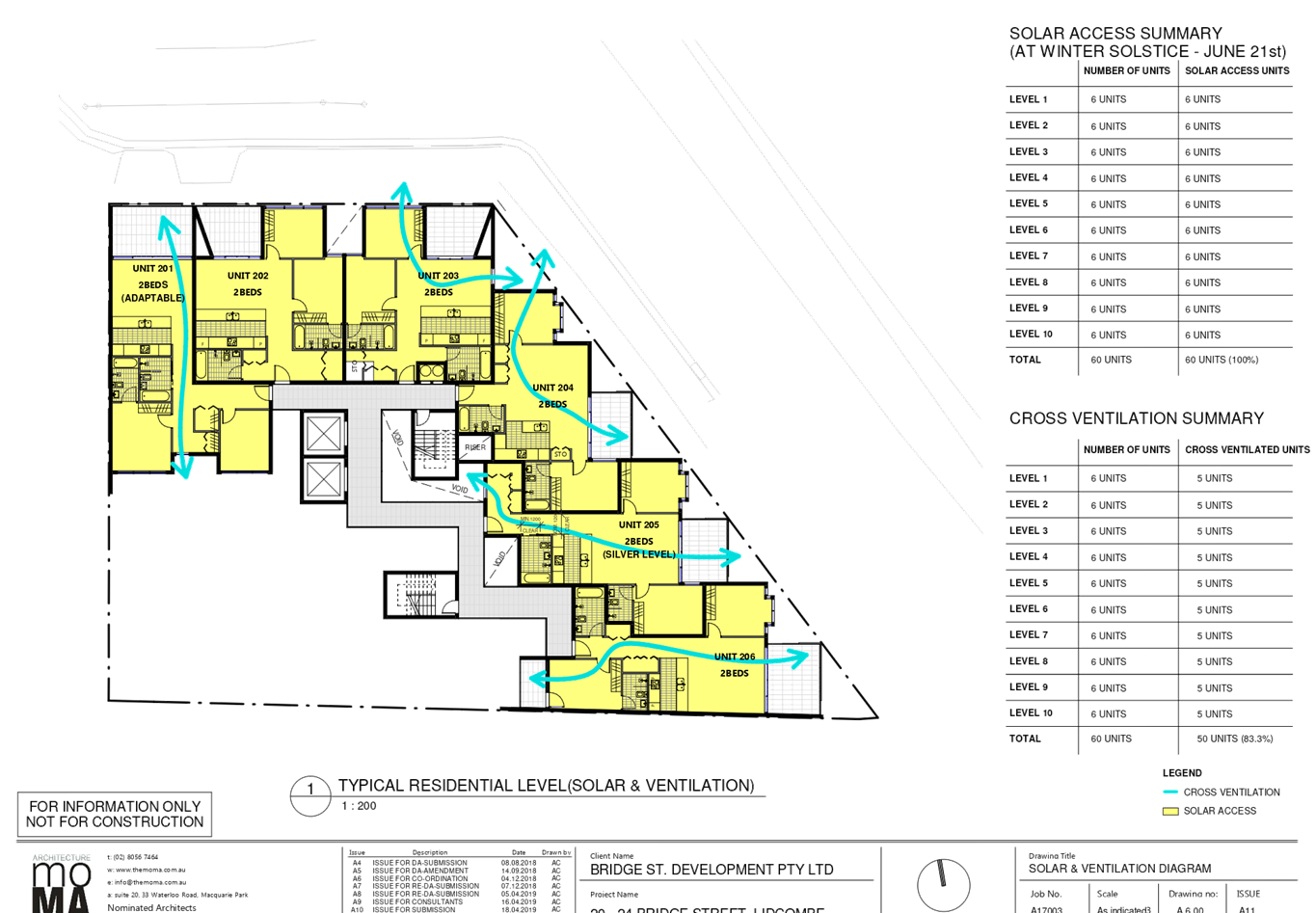
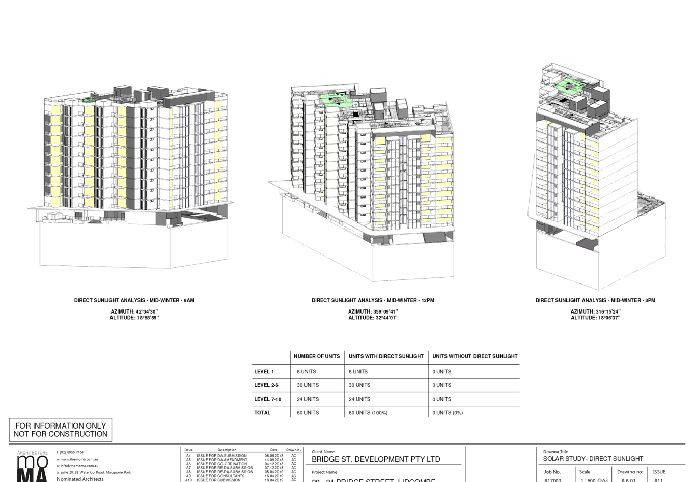
The proposed development is
considered to be generally consistent with the Solar and Daylight Access
objectives as the orientation of units to the street, being to the north and
east, allows for daylight infiltration. In this regard, all units, living
areas and the main private open space receives at least 2 hours sunlight
mid-winter.
|
|
4B Natural ventilation
|
|
Objective 4B-3
The number of apartments with
natural cross ventilation is maximised to create a comfortable indoor
environment for residents
Design criteria
1. At least 60% of apartments
are naturally cross ventilated in the first nine storeys of the building.
Apartments at ten storeys or greater are deemed to be cross ventilated only
if any enclosure of the balconies at these levels allows adequate natural
ventilation and cannot be fully enclosed
2. Overall depth of a
cross-over or cross-through apartment does not exceed 18m, measured glass
line to glass line
|
Yes
Yes
N/A
|
83.3% of units are naturally
cross ventilated (50/60 units)
|
|
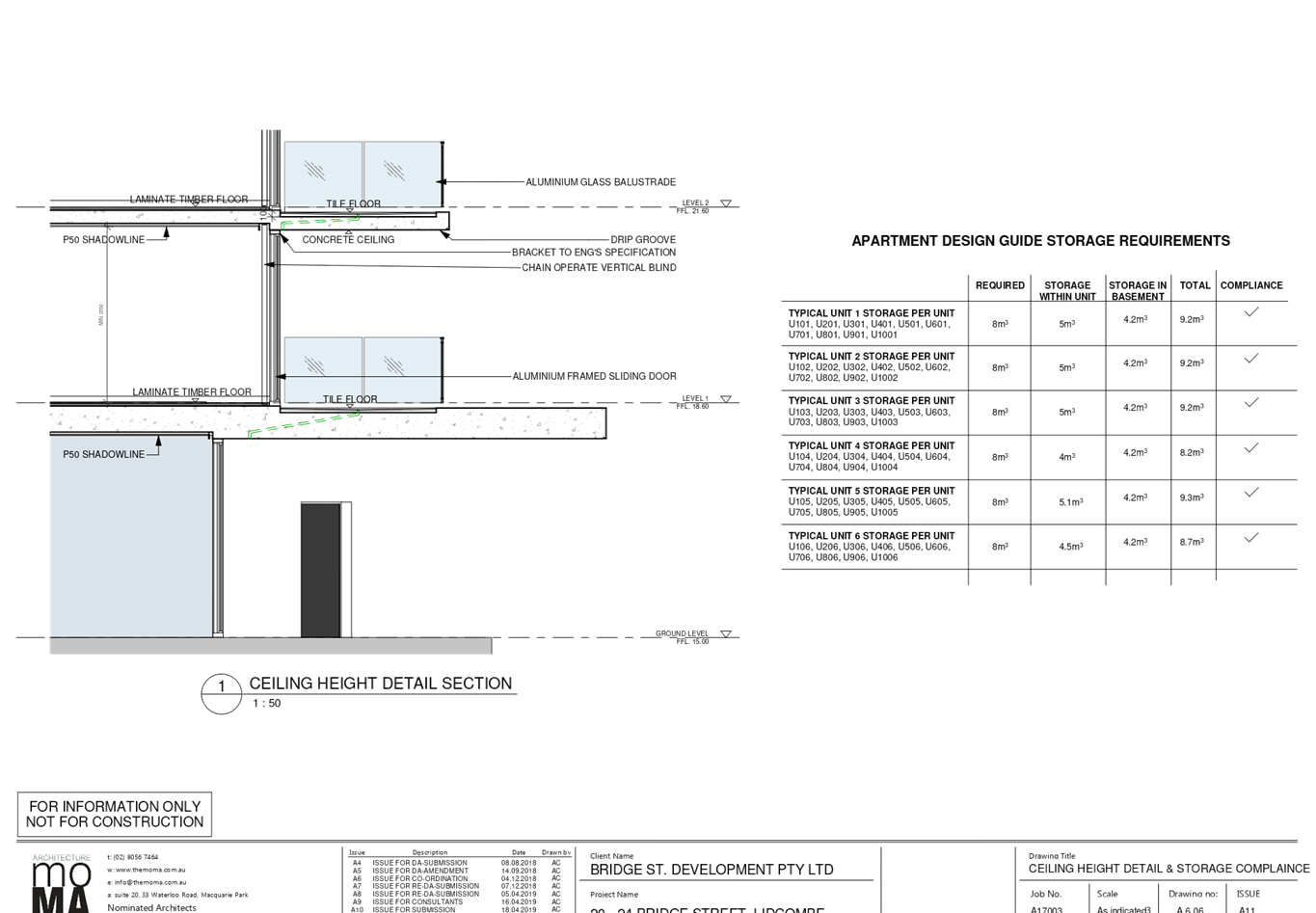
4C Ceiling heights
|
|
Objective 4C-1
Ceiling height achieves
sufficient natural ventilation and daylight access
Design criteria
1. Measured from finished
floor level to finished ceiling level, minimum ceiling heights are:
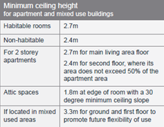
These minimums do not preclude
higher ceilings if desired
|
Yes
No
– acceptable
|
Sections have been provided
showing that a 2.7m floor to ceiling height is achieved for the residential
units. However, the ground floor use only provides 3.1m floor to ceiling.
This minor non-compliance can be supported given the raised nature of the site
due to flooding and the current exceedance in building height. The minor
non-compliance will still result in sufficient floor to ceiling heights to
accommodate commercial uses on the ground floor.
|
|
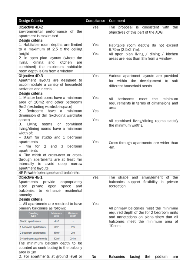
4E Private open space and
balconies
|
|
Objective 4E-1
Apartments provide
appropriately sized private open space and balconies to enhance residential
amenity
Design criteria
1. All apartments are required
to have primary balconies as follows:
The minimum balcony depth to
be counted as contributing to the balcony area is 1m
2. For apartments at ground
level or on a podium or similar structure, a private open space is provided
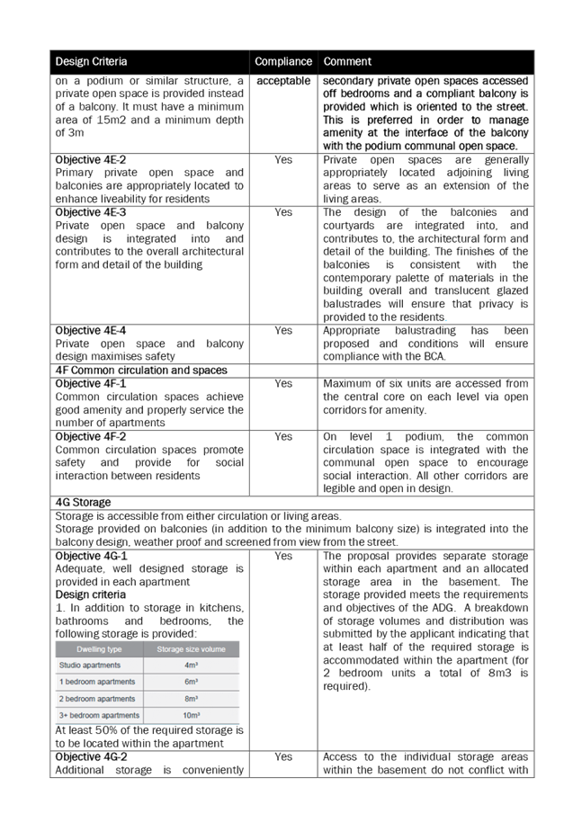
instead of a balcony. It must have a minimum area of 15m2 and a minimum depth
of 3m
|
Yes
Yes
No
– acceptable
|
The shape and arrangement of
the balconies support flexibility in private recreation.
All primary balconies meet the
minimum required depth of 2m for 2 bedroom units and annotations on plans
show that all balconies meet the minimum area of 10sqm.
Balconies facing the podium
are secondary private open spaces accessed off bedrooms and a compliant
balcony is provided which is oriented to the street. This is preferred in
order to manage amenity at the interface of the balcony with the podium
communal open space.
|
|
|
|
|
Local Environmental Plans
Auburn Local Environmental Plan
2010 (ALEP)
The provisions of Auburn LEP 2010
are applicable to the development proposal. It is noted that the development
generally achieves compliance with the key statutory requirements and zone
objectives of the B4 Mixed Use zone which seek to:
· To
provide a mixture of compatible land uses.
· To
integrate suitable business, office, residential, retail and other development
in accessible locations so as to maximise public transport patronage and
encourage walking and cycling.
· To
encourage high density residential development.
· To
encourage appropriate businesses that contribute to economic growth.
· To
achieve an accessible, attractive and safe public domain.
The proposal is well located
within walking distance of Lidcombe railway station and town centre. The mixed
use development is considered appropriate within the zone as ground floor
commercial assists in activating the town centre and expanding the commercial
core of Lidcombe Town Centre. The proposed high density residential component
is suitably located near transport, shops and services.
Permissibility:-
The proposal is defined as shop
top housing, which is permitted with consent in the zone. Shop top housing
means one or more dwellings located above ground floor retail premises or
business premises.
The relevant matters to be
considered under Auburn Local Environmental Plan 2010 for the proposed
development are outlined below.
Figure 4 – Auburn LEP
2010 Compliance Table
|
Provision
|
Compliance
|
Comment
|
|
Part 4 Principal
development standards
|
|
4.3 Height of buildings
· 36m
|
No
|
The proposed height of 37.5m
is non-compliant and a clause 4.6 exception to the development standards has
been submitted with the application, as discussed in detail below.
|
|
4.4
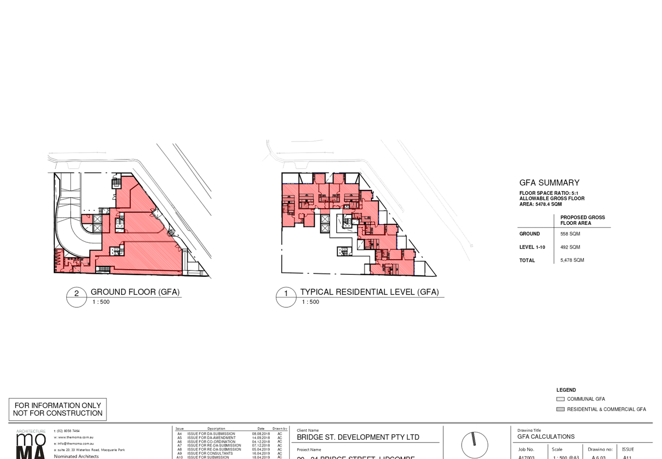
Floor space ratio
· 5:1
|
Yes
|
The proposed FSR is 5:1
(2478sqm) as proposed.
|
|
4.6
Exceptions to development standards
|
See discussion
|
The application is accompanied by a written request
pursuant to clause 4.6 of the LEP to vary the height development standard. A
detailed discussion of the variation to the development standard is presented
below this table.
|
|
Part 6 Additional local
provisions
|
|
6.1 Acid sulfate
soils
· Class
5
|
Yes
|
The proposed development does
not involve the carrying of works within 500m of adjacent class 1-4 land that
is below 5m AHD and by which the watertable is likely to be lowered below 1m
AHD. No further investigation is necessary in this instance.
|
|
6.2 Earthworks
|
Yes
|
Earthworks associated with the
basement are proposed. The basement excavation is located within the
boundaries of the site and is not considered to have a detrimental impact on
environmental functions and processes, neighbouring uses, cultural or
heritage items or features of the surrounding land. Standard conditions of
consent will be imposed regarding the excavation. The proposal has been
considered against the criteria of the Clause and is satisfactory, subject to
conditions of consent.
|
|
6.3 Flood planning
|
Yes
– conditioned
|
The application was referred
internally to Council’s Engineers who has provided recommended
conditions to be imposed to address the flood related issues which have been
included in the draft conditions of consent.
|
The following is a detailed
discussion of the issues identified in the compliance table above in relation
to the Auburn LEP 2010.
Exceptions to Development
Standards
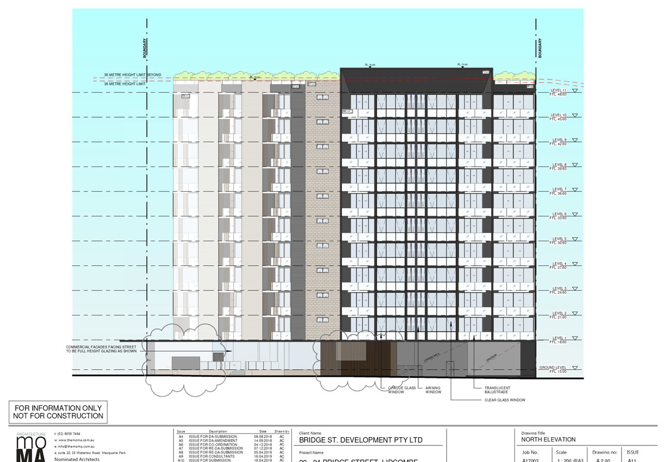
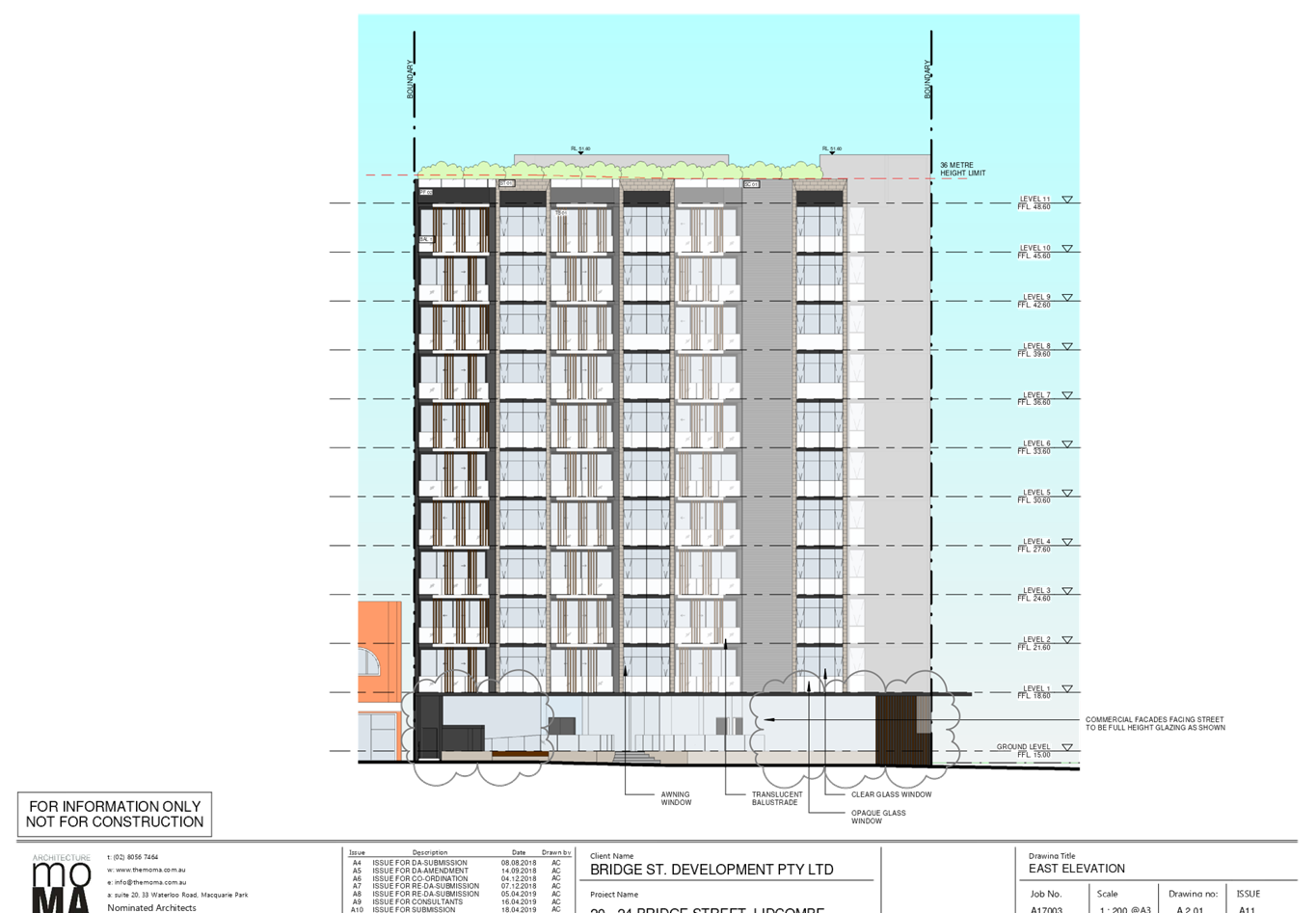
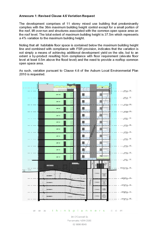
Clause 4.3 Height of buildings
The proposal has an overall
building height of 37.5m, which exceeds the height of buildings development
standard of 36m prescribed under clause 4.3 of Auburn LEP 2010 by 1.5m or 4.2%.
A written request pursuant to
clause 4.6 of Auburn LEP 2010 has been made, seeking to vary the development
standard. The justification presented in the written request is summarised as
follows:
· The
habitable floor space is contained below the maximum building height line and
the development complies with the FSR provision which indicates that the
variation is not to achieve additional development yield on site.
· The
height results from compliance with floor level requirements above the flood
level and provision of rooftop common open space area.
· The
development is predominantly consistent with the building height except for a
small portion of the roof form, lift over-run and structures associated with
the communal open space areas within the roof level.
· The
development proposal is consistent with the intent of the height control with
the primary portion of the height non-compliance limited to a parapet and lift
overrun with all habitable floor space below the height limit.
· The
building incorporates high-quality design with articulated façades to
its street frontages with a mixture of quality external finishes and materials.
The proposal will contribute positively to the streetscape and visual amenity
of the area.
· The
increased height is a response to flooding inundation.
· The
variation is minor and will be visually unnoticeable given its recessed
location and will have no adverse impact on the physical bulk, height or scale
of the development as viewed from the street.
· The
variation will not lead to a reduction in solar penetration on site or to
adjoining properties nor will it lead to sunlight loss or overshadowing.
· The
proposed variation will not lead to a reduction in privacy afforded to existing
residents or future residents of the proposal.
· The
proposal has been designed to comply with the maximum permitted FSR on the site
and complies with key controls pertaining to setbacks, and car parking which
indicates an appropriate scale of development on the site.
· The
minor non-compliance to the height control has no impact on the setting of any
items of environmental heritage or view corridors.
· The
proposal ensures that the mixed-use nature of the zone is retained with the
proposal aiming to be consistent with the upscaling of the built form within the
immediate locality and delivers a mixed-use development in proximity to public
transport and expands the delivery of housing.
· The
proposal is responding to its prominence on a key corner. The departure from
the height control is acceptable in the circumstances given the underlying
objectives are achieved and it will not set an undesirable precedent for future
development within the locality.
· The
proposed development meets the underlying intent of the control and is a
compatible form of development that does not result in unreasonable
environmental amenity impacts.
· The
proposal will not have any adverse effect on the surrounding locality in the
context of the current planning controls, which is characterised by residential
and mixed-use development of comparable height and character. The proposal
promotes the economic use and development of the land consistent with its zone
and purpose.
The relevant matters to be
considered under clause 4.6 of the LEP are addressed below:
· Clause 4.6 (3)
(a) that compliance with the development standard is unreasonable or
unnecessary in the circumstances of the case,
The objectives of the height
standard relevant to the proposal are:
(a) to establish a
maximum height of buildings to enable appropriate development density to be
achieved, and
(b) to ensure that the
height of buildings is compatible with the character of the locality.
The heights nominated in the LEP
are well considered and appropriate and provides for a higher height near the
Olympic Drive corridor where the subject site is located. The non-compliance as
identified in the applicant’s written statement is for a roof parapet,
lift over-run and structures associated with the rooftop communal open space
areas but confining the habitable spaces within the maximum height limit thus
addressing the intention of the objectives.
Given the overall height of the
structure, the minor non-compliance is unlikely to have significant visual impact
as viewed from the street and surrounding development. The proposal is
considered to be compatible with the desired future character of the locality
as assessed in this report.
· Clause 4.6 (3)
(b) that there are sufficient environmental planning grounds to justify
contravening the development standard.
The proposal, as discussed above,
is considered able to comply with the objectives of the height development
standard as the majority of the height is compliant and the resulting built
form responds to the desired character of the local area. It has been assessed
in the report that the proposal has demonstrated that the scale of the
development is able to preserve the environmental amenity of neighbouring
properties and minimise adverse impacts on the amenity of the locality. The
non-compliant roof structures also services and supports use of the roof top
communal open space which enhances amenity for the residents of the development
and is in a location supported by the ADG. The roof parapet to the architectural
framing which exceeds the height standard can be supported as it is located on
the northern elevation and thus is unlikely to result in significant additional
amenity impact to adjoining sites. The area of non-compliance is also setback
from the southern boundary thus mitigating adverse solar impacts to southern
properties.
The proposal complies with the
maximum allowable FSR and has a bulk and scale that addresses the streetscape
corner, which is acceptable in terms of the requirements of the relevant
controls. Accordingly it is considered there are sufficient planning grounds to
justify contravening the standard in this instance.
· Clause 4 (a)
(i) the applicant’s written request has adequately addressed the matters
required to be demonstrated by subclause (3), and
The applicant’s written
request is considered to have adequately addressed the matters required under
clause 4.6 and the proposal is considered able to meet the objectives of the
standard.
· Clause 4 (a)
(ii) the proposed development will be in the public interest because it
is consistent with the objectives of the particular standard and the objectives
for development within the zone in which the development is proposed to be
carried out
The proposed development is
considered to be in the public interest as it satisfies the objectives of the
height standard, as discussed previously, and also the objectives of the zone
(as discussed in the LEP table above). The proposal is considered to be in the
public interest as the proposal seeks to replace low scale commercial with shop
top housing consistent with the town centre environment.
The objectives in the LEP indicate
the future desired character of the area and the proposed building reflects
that character. The proposal is generally consistent with the built form and
scale of the future character of the town centre and the proposed building is
of a contemporary form which is well articulated for visual interest. The
proposal is consistent with the objectives of the development standard and the
B4 zone. The applicant’s written request is considered to be satisfactory
for the proposed development, considering the building has been designed to
minimise adverse amenity impact upon the adjoining neighbours and the
streetscape. Hence whilst the proposal exceeds the height standard, it is
considered to be in the public interest given the above assessment.
It is the view of Council Officers
that justification provided is satisfactory and having considered the
application on its merit, the exception to the maximum building height
development standard is considered acceptable in this instance.
The provisions of any proposed
instrument that is or has been the subject (EP&A Act s4.15 (1)(a)(ii))
(a) Draft
State Environmental Planning Policy (Environment)
The draft SEPP relates to the
protection and management of our natural environment with the aim of
simplifying the planning rules for a number of water catchments, waterways,
urban bushland, and Willandra Lakes World Heritage Property. The changes proposed
include consolidating the following seven existing SEPPs:
· State
Environmental Planning Policy No. 19 – Bushland in Urban Areas
· State
Environmental Planning Policy (Sydney Drinking Water Catchment) 2011
· State
Environmental Planning Policy No. 50 – Canal Estate Development
· Greater
Metropolitan Regional Environmental Plan No. 2 – Georges River Catchment
· Sydney Regional
Environmental Plan No. 20 – Hawkesbury-Nepean River (No.2-1997)
· Sydney Regional
Environmental Plan (Sydney Harbour Catchment) 2005
· Willandra Lakes
Regional Environmental Plan No. 1 – World Heritage Property.
The draft policy will repeal the
above existing SEPPs and certain provisions will be transferred directly to the
new SEPP, amended and transferred, or repealed due to overlaps with other areas
of the NSW planning system.
Changes are also proposed to the
Standard Instrument – Principal Local Environmental Plan. Some provisions
of the existing policies will be transferred to new Section 117 Local Planning
Directions where appropriate.
The provisions of any
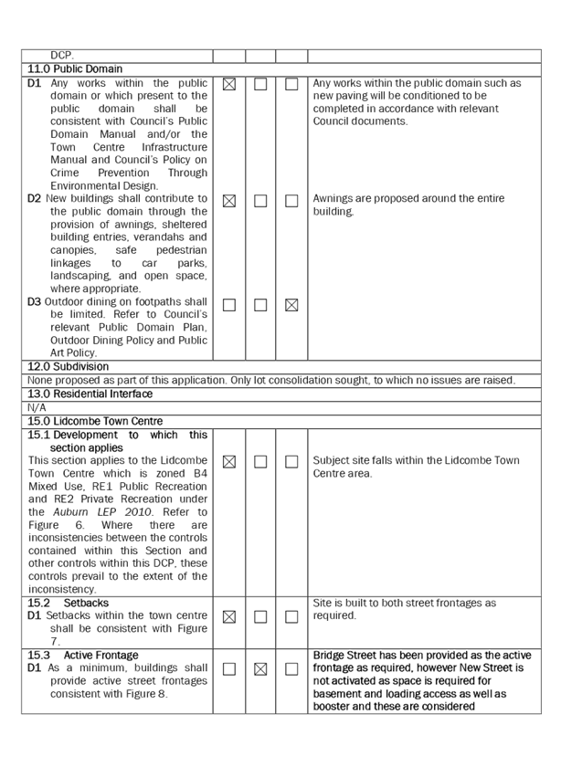
Development Control Plans (EP&A Act s4.15 (1)(a)(iii))
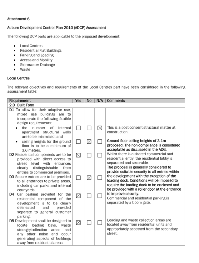
A full ADCP 2010 analysis is
attached as Attachment 6 to this report. The proposal complies with the
requirements of the ADCP 2010, with the exception of the following issues in
the Local Centres part, which are considered acceptable on merit as discussed
below:
Figure 6 – Excerpts of
non-compliances from Auburn DCP 2010 Local Centres part
|
Section
|
Control
|
Complies
|
Comment
|
|
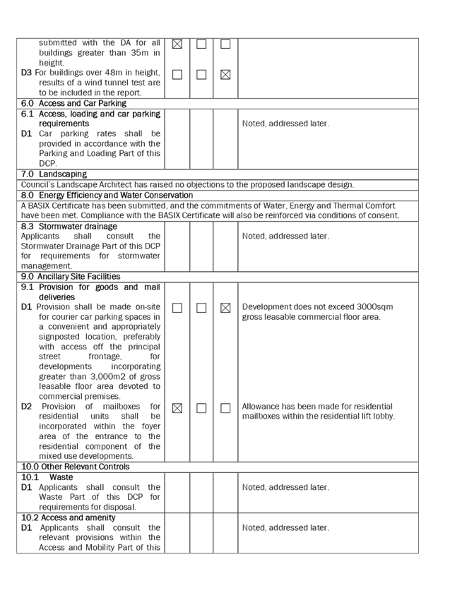
2.0 Built Form
|
D1 Ceiling heights for the ground floor is to be a minimum
of 3.6 metres
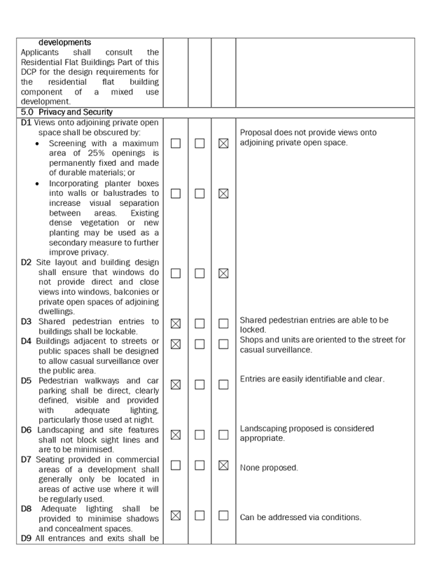
D3 Secure entries are to be provided to all entrances to
private areas, including car parks and internal courtyards.
|
N
N
|
3.1m floor to ceiling height proposed for ground floor
commercial. Non-compliance has been previously addressed under 4C of the ADG.
The proposal is generally considered to provide suitable
security to all entries within the development with the exception of the
loading dock. Conditions will be imposed to require the loading dock to be
enclosed and be provided with a roller door at the entrance to improve
security.
|
|
2.1 Number of storeys
|
D1 The minimum finished floor level (FFL) to finished
ceiling level (FCL) shall be as follows:
· 3300mm for
ground level (regardless of the type of development);
· 3300mm for all
commercial/retail levels
|
N
|
3.1m floor to ceiling height proposed for ground floor
commercial. Non-compliance has been previously addressed under 4C of the ADG.
|
|
2.2 Articulation and proportion
|
D6 Where development has two (2) street frontages the
streetscape should be addressed by both facades.
|
N
|
The development is oriented to Bridge Street being the
primary frontage whilst New Street has been utilised as a secondary frontage
and accommodates parking and loading access. This is acceptable as New Street
is a dead-end street and it is considered more appropriate to locate
vehicular access from that street.
|
|
3.0 Streetscape and Urban form
|
D3 Development shall provide direct access between the
footpath and the shop.
|
N
|
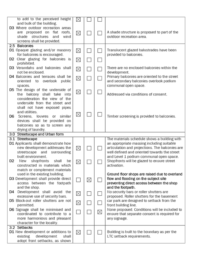
Ground floor shops are raised due to overland flow and
flooding on the subject site preventing direct access between the shop and
the footpath.
|
|
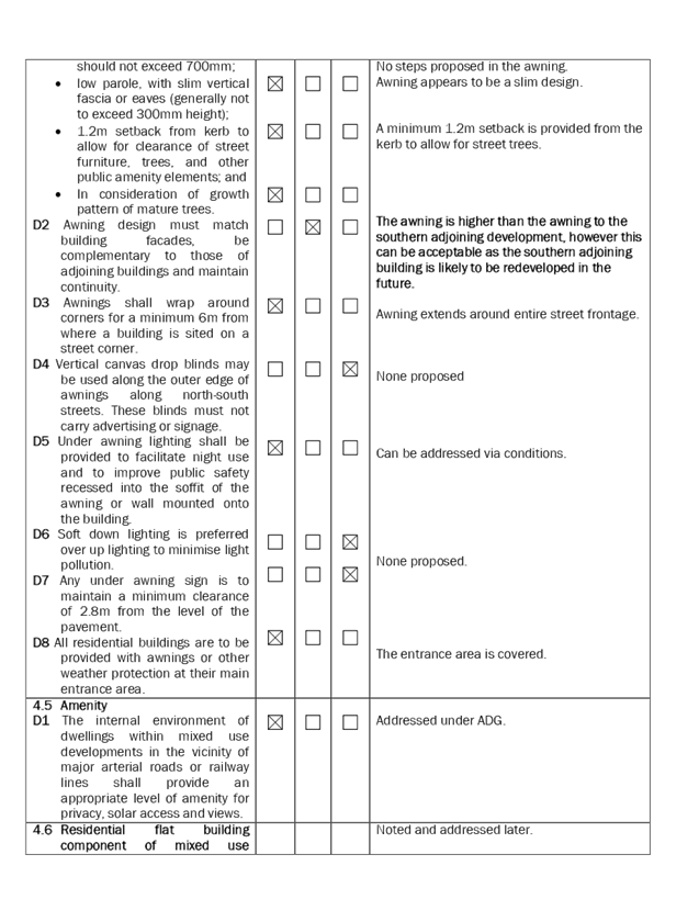
4.3 Awnings
|
D1 minimum soffit height of 3.2m and maximum of 4m
D2 Awning design must match building facades, be
complementary to those of adjoining buildings and maintain continuity
|
N
N
|
Soffit height of awning = 4.3m which exceeds the maximum.
However this can be supported as the awning matches the slab level between
the ground and first floor with the exceedance due to raised ground floor
being in response to the flood affectation of the site.
The awning is higher than the awning to the southern
adjoining neighbour, however this can be acceptable as the southern adjoining
building is likely to be redeveloped in the future.
|
|
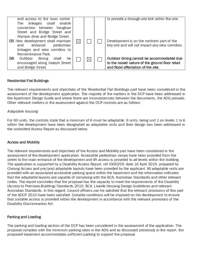
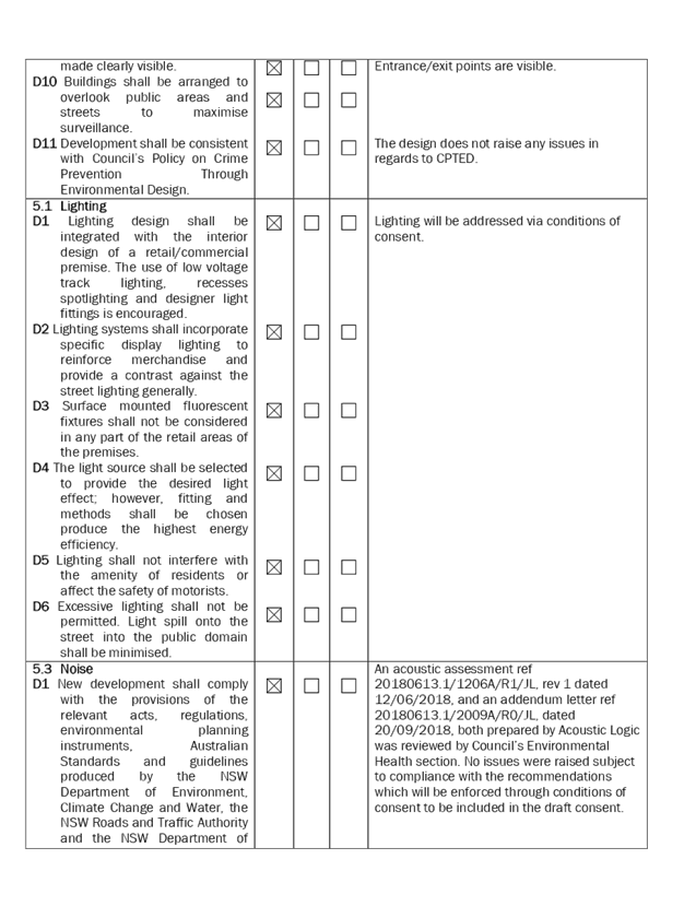
15.3 Active Frontage
|
D1 As a minimum, buildings shall provide active street
frontages consistent with Figure 8.
|
N
|
Bridge Street has been provided as the active frontage as
required, however New Street is not activated as space is required for
basement and loading access as well as booster and these are considered
appropriately located on New Street given that it is a cul-de-sac.
|
|
15.10 Site
5 - Bridge Street
|
D6 Outdoor dining shall be encouraged along Joseph Street
and Bridge Street.
|
N
|
Outdoor dining cannot be accommodated due to the raised
nature of the ground floor retail due to the flood affectation of the site.
|
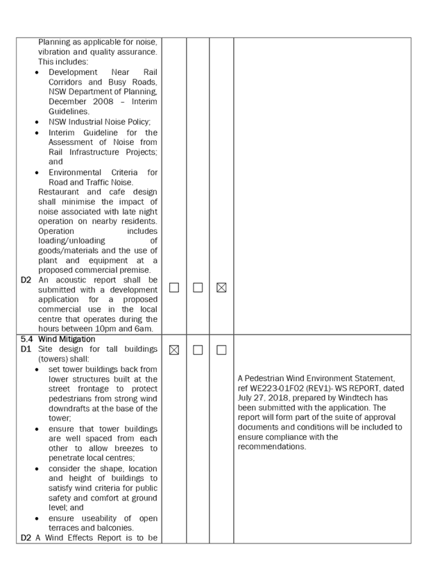
The provisions of any planning
agreement that has been entered into under section 7.4, or any draft planning
agreement that a developer has offered to enter into under section 7.4
(EP&A Act s4.15(1)(a)(iiia))
There is no draft planning
agreement associated with the subject Development Application.
The provisions of the
Regulations (EP&A Act s4.15 (1)(a)(iv))
The proposed development raises no
concerns as to the relevant matters arising from the Environmental Planning and
Assessment Regulations 2000 (EP&A Reg).
The Likely Environmental,
Social or Economic Impacts (EP&A Act s4.15 (1)(b))
It is considered that the proposed
development will have no significant adverse environmental, social or economic
impacts in the locality.
The suitability of the site for
the development (EP&A Act s4.15 (1)(c))
The subject site and locality is
not known to be affected by any natural hazards or other site constraints
likely to have a significant adverse impact on the proposed development.
Accordingly, it is considered that the development is suitable in the context of
the site and surrounding locality.
Submissions made in accordance
with the Act or Regulation (EP&A Act s4.15 (1)(d))
|
Advertised (newspaper)
|
Mail
|
Sign
|
Not Required
|
In accordance with Council’s
Notification requirements contained within the Auburn DCP 2010, the proposal
was publicly notified for a period of 14 days between 11 September 2018 and 25
September 2018 and renotified 8 and 22 January 2019. The original notification
generated one submission from RMS who made a submission as an adjoining
landowner, which is addressed below. Further letters from RMS in relation to
the amended plans stated that they did not raise any issues with the modified
proposal.
Figure 5 – Submissions
summary table
|
Issue
|
Planners Comment
|
|
The layout of the proposed car
parking areas associated with the subject development (including driveways,
grades, turn paths, sight distance requirements, aisle widths, aisle lengths
and, parking bay dimensions) should be in accordance with AS 2890.1-2004.
|
Council’s Development
Engineers have assessed the proposed parking, loading and access arrangements
and have not raised any issues in relation to compliance with the Australian
Standards.
|
|
All vehicles are to enter and
exit the site in a forward direction
|
This has been achieved for the
development and will be reinforced via conditions of consent.
|
|
A Construction Traffic
Management Plan detailing construction vehicle routes, number of trucks,
hours of operation, access arrangements and traffic control should be
submitted to Council for determination prior to the issue of the construction
certificate.
|
This will be addressed via
conditions of consent.
|
|
All works/regulatory signposting
associated with the proposed development are to be at no cost to Roads and
Maritime.
|
This will be addressed via
conditions of consent.
|
The public interest (EP&A
Act s4.15(1)(e))
In view of the foregoing analysis
it is considered that the development, if carried out subject to the conditions
set out in the recommendation below, will have no significant adverse impacts
on the public interest.
Section 7.11 (Formerly S94)
Contribution towards Provision or Improvement of Amenities or Services
This part of the Act relates to
the collection of monetary contributions from applicants for use in developing
key local infrastructure.
Comments:
The development requires the
payment of contributions in accordance with Council’s Section 94
Contributions Plans.
The calculation is based on:
· 60 x 2 bed
· $845,480.90
employment generating development (commercial cost of works)
As at 17 May 2019, the fee payable
is $383,274.02. This figure is subject to indexation as per the relevant plan.
The draft determination attached includes a condition requiring payment of the
contribution prior to issue of a Construction Certificate.
Disclosure of Political
Donations and Gifts
The applicant and notification
process did not result in any disclosure of Political Donations and Gifts.
The development application has
been assessed in accordance with the relevant requirements of the Environmental
Planning and Assessment Act 1979, relevant SEPPs and the Auburn LEP and DCP
and is considered to be satisfactory for approval subject to conditions.
The proposed development is
appropriately located within a B4 Mixed Use zone under the provisions of the
Auburn LEP, however variations in relation to the height under the LEP is
sought. Other minor non-compliances with the ADG and Council’s controls have
been discussed in the body of this report.
Having regard to the assessment of
the proposal from a merit perspective, Council may be satisfied that the
development has been responsibly designed and provides for acceptable levels of
amenity for future residents and satisfactorily incorporates ground floor
commercial to activate the town centre location. It is considered that the
proposal successfully minimises adverse impacts on the amenity of neighbouring
properties. Hence the development, irrespective of the departures noted in the
report, is consistent with the intentions of Council’s planning controls
and represents a form of development contemplated by the relevant statutory and
non-statutory controls applying to the land.
For these reasons, it is
considered that the proposal is satisfactory having regard to the matters of
consideration under Section 4.15 of the Environmental Planning and
Assessment Act 1979, and the development may be approved subject to
conditions.
There are no further consultation
processes for Council associated with this report.
There are no further financial
implications for Council associated with this report.
There are no policy implications
for Council associated with this report.
Communication /
Publications:
The final outcome of this matter
will be notified in the newspaper. The objectors will also be notified in
writing of the outcome.
|
1. That
Development Application No. DA-263/2018 for demolition of existing structures
and the construction of an 11 storey shop top housing development, comprising
of 3 commercial tenancies and 60 residential units over 4 levels of basement
parking and lot consolidation on land at 20-24 Bridge Street, Lidcombe be
approved subject to attached conditions.
2. Persons
whom have lodged a submission in respect to the application be notified of
the determination of the application.
|
1. Draft
Notice of Determination ⇩ 
2. Architectural,
Landscape and Survey Plans ⇩ 
3. Stormwater/Engineering
Plans ⇩ 
4. Clause
4.6 – Exception to the Development Standards ⇩ 
5. SEPP65
and Apartment Design Guide Assessment ⇩ 
6. Development
Control Plan Assessment ⇩
7. Submissions
Received ⇩
DOCUMENTS
ASSOCIATED WITH
REPORT LPP039/19
Attachment 1
Draft Notice of Determination
Cumberland Local Planning Panel Meeting
12 June 2019


DOCUMENTS
ASSOCIATED WITH
REPORT LPP039/19
Attachment 2
Architectural, Landscape and Survey Plans
Cumberland Local Planning Panel Meeting
12 June 2019
DOCUMENTS
ASSOCIATED WITH
REPORT LPP039/19
Attachment 3
Stormwater/Engineering Plans
Cumberland Local Planning Panel Meeting
12 June 2019
DOCUMENTS
ASSOCIATED WITH
REPORT LPP039/19
Attachment 4
Clause 4.6 – Exception to the Development
Standards
Cumberland Local Planning Panel Meeting
12 June 2019

DOCUMENTS
ASSOCIATED WITH
REPORT LPP039/19
Attachment 5
SEPP65 and Apartment Design Guide Assessment
Cumberland Local Planning Panel Meeting
12 June 2019
DOCUMENTS
ASSOCIATED WITH
REPORT LPP039/19
Attachment 6
Development Control Plan Assessment
Cumberland Local Planning Panel Meeting
12 June 2019


DOCUMENTS
ASSOCIATED WITH
REPORT LPP039/19
Attachment 7
Submissions Received
Cumberland Local Planning Panel Meeting
12 June 2019

Cumberland
Local Planning Panel Meeting
12 June 2019
Item No: LPP040/19
Development
Application for 9 McCredie Road, Guildford West
Responsible
Division: Environment
& Planning
Officer: Manager
Development Assessment
File
Number: DA
2018/481/1
|
Application
lodged
|
17 December 2018
|
|
Applicant
|
Nabih Mannah
|
|
Owner
|
Danny Bourchdan & Raymond
Bourchdan
|
|
Application
No.
|
DA-2018/481/1
|
|
Description
of Land
|
9 McCredie Road, Guildford
West (Lots 59, 60 & 61, all Section 1, all DP 1210)
|
|
Proposed
Development
|
Demolition of existing
structures and construction of 3 x 2 storey attached dwellings
|
|
Site
Area
|
Lot 59 – 199.4m2
Lot 60 – 197.5m2
Lot 61 - 195.6m2
(All by calculation)
|
|
Zoning
|
R3 Medium Density Residential
Zone
|
|
Disclosure
of political donations and gifts
|
Nil disclosure
|
|
Heritage
|
No
|
|
Issues
|
Nil
|
1. Development
Application No. DA-2018/481/1 was received on 17 December 2018 for the
demolition of existing structures and construction of 3 x 2 storey attached
dwellings.
2. The
application was publicly notified to occupants and owners of the adjoining and
opposite properties for a period of 21 days from 6 February 2019 to 27 February
2019. The development application was also advertised in the local newspaper
with a site notice erected at the front of the site. In response, the application
received 3 submissions.
3. The
variations sought for the proposal includes:
|
Control
|
Required
|
Provided
|
Variation
|
|
1.9 Maximum depth of
cut outside the building envelope
|
C7. Cut is to be limited to 450mm where it is within 900mm of the rear or
side boundaries.
|
A maximum cut depth of
750mm is proposed near the eastern rear side boundary.
|
66.6%
Variation
The maximum
depth of cut for the development which is approximately 750mm along the
eastern rear boundary of the site (Lot 61) is considered acceptable. Having
considered topographic conditions of the subject site, privacy of adjoining
developments and soil management, the cut is considered appropriate in this
instance. Following review of the proposal, Council’s Development
Engineer raised no objections to the depth of cut in terms of stormwater
runoff. Accordingly, there are no expected adverse impacts on neighbouring
properties in terms of soil loss, privacy, solar access or stormwater runoff.
|
|
4.3 Maximum external
side wall height.
|
C2. The external side
wall height shall be a maximum of 7 metres.
|
The proposal achieves
a maximum external side wall height of 7.8m on the eastern elevation of the
dwelling on Lot 61.
|
Variation
– 11.43%
The
proposed development achieves a maximum external side wall height of 7.8m on
the eastern elevation. It is also noted that a maximum external side wall
height of 7.6m representing a variation of 8.57% is proposed for the western
elevation. The non-compliance is located in the front third of the
development, the material impacts will be limited to minor overshadowing and
visual impacts at the front sections of adjoining developments.
Notwithstanding this, the development ensures compliant solar access and
privacy for existing and future residents and the public domain. It also
responds to the desired scale and character of the street and local area.
Noting the impacts are minimal and the variation relatively minor, the
non-compliance is considered reasonable in this instance.
|
4. The
application is recommended for deferred commencement approval subject to the
conditions as provided in the attached schedule.
5. The
application is referred to the Cumberland Local Planning Panel as one of the
two owners of the subject site is a Council staff member.
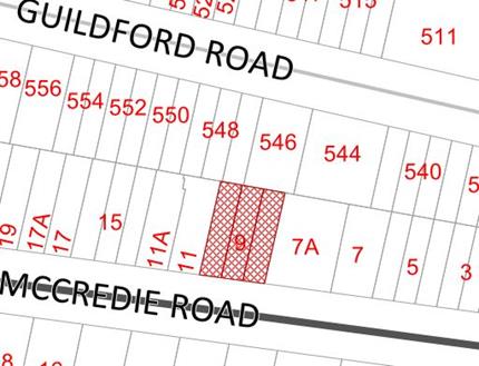
Subject Site And Surrounding
Area
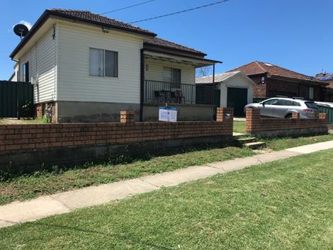
The subject site is known as 9
McCredie Road, Guildford West. The site comprises of 3 lots and is legally
described as Lot: 59 Section: 1 DP: 1210, Lot: 60 Section: 1 DP: 1210 and Lot:
61 Section: 1 DP: 1210.
The site is located on the
northern side of McCredie Road within the R3 Medium Density Residential zone.
The site comprises of 3 slightly irregular shaped allotments each with 6.745m
frontages to McCredie Road and the following lot sizes:
· Lot
59 - 199.4m2
· Lot
60 – 197.5m2
· Lot
61 - 195.6m2
The site currently contains a
single storey dwelling house, a detached secondary dwelling and a detached
garage. The site exhibits a cross fall of approximately 2metres from the
north-western to the south-western corner of the site.
Adjoining developments to the
subject site include a single storey dwelling house of brick finish to the east
at No. 7A McCredie Road and a semi-detached dwelling to the west at Nos. 11 and
11A McCredie Road. Detached single storey and two storey dwellings also adjoin
the site to the north and north-west off Guildford Road.
Figure
1 – Locality Plan of subject site
Figure
2 – Aerial view of subject site
Figure
3 – Street view of subject site
Description of The Proposed
Development
Council has received a development
application for the Demolition of existing structures and construction of 3 x 2
storey attached dwellings.
Key features of the development
proposal are as follows:-
· Demolition
of existing structures on site including a single storey dwelling house, a
detached secondary dwelling and a detached garage; and
· Construction
of 3 x 2 storey attached dwellings incorporating:
Ground Floor
· Entry
patio;
· A
single garage;
· Toilet;
· Laundry;
· Walk
in pantry (wip), storage;
· Dining
room/kitchen/living room; and
· Outdoor
alfresco/bbq area.
First Floor
· A
total of 4 bedrooms (including 1 bedroom with an ensuite and walk in robe);
· Bathroom
with toilet;
· Rear
balconies; and
· Front
balconies facing McCredie Road.
History
|
Date
|
Action
|
|
17
December 2018
|
The Development Application was lodged for the demolition
of existing structures and construction of 3 x 2 storey attached dwellings.
|
|
30 January
2019
|
The Development Application was referred to
Council’s internal Development Engineering, Environmental Health,
Landscape and Rates departments for review.
|
|
6 February
2019 to 27 February 2019
|
Application was placed on public notification for 21 days.
3 submissions were received.
|
|
23 March
2019
|
Council issued a letter to the applicant, requesting
design changes to the proposal.
|
|
12 June
2019
|
Application referred to CLPP for determination.
|
Applicants Supporting Statement
The applicant has provided a
Statement of Environmental Effects prepared by Nabih Mannah dated December 2018
and was received by Council on 17 December 2018 in support of the application.
Contact With Relevant
Parties
The assessing officer has undertaken
a site inspection of the subject site and surrounding properties and has been
in regular contact with the applicant throughout the assessment process.
Internal Referrals
Development Engineer
The development application was
referred to Council’s Development Engineer for comment who has advised
that the proposal is satisfactory subject to deferred commencement conditions.
Environmental Health Officer
The development application was
referred to Council’s Environmental Health Officer for comment who has
advised that the proposal is satisfactory subject to conditions.
Landscape
The development application was
referred to Council’s Landscape Officer for comment who has advised that
the proposal is satisfactory subject to deferred commencement conditions.
Rates – House Numbers
The application was referred to
Council’s Rates Officer for comment who has raised no objections to the
proposed development, subject to conditions of consent.
Planning Comments
The provisions of any
Environmental Planning Instruments (EP& A Act s4.15 (1)(a)(i))
State Environmental Planning
Policies
The proposed development is
affected by the following State Environmental Planning Policies:
(a) State
Environmental Planning Policy No. 55 – Remediation of Land (SEPP 55)
The site is not identified in
Council’s records as being contaminated. A site inspection reveals the
site does not have any obvious history of a previous land use that may have
caused contamination and there is no specific evidence that indicates the site
is contaminated. The subject site is currently used for residential purposes
and contamination is not expected.
(b) State
Environmental Planning Policy (Infrastructure) 2007
The provisions of the
Infrastructure SEPP (ISEPP) 2007 have been considered in the assessment of the
development application.
Clause 45 - Development likely
to affect an electricity transmission or distribution network
The subject development does not
incorporate basement excavation in proximity (within 2 metres) to an
electricity distribution pole nor does the development occur within 5 metres of
an overhead electricity power line. As such, the Consent Authority is not
required to give written notice to an electricity supply authority.
Clause 85 – Development
adjacent to railway corridors
The application is not subject to
clause 85 of the ISEPP as the site is not in or adjacent to a rail corridor.
Clause 86 – Excavation
in, above, below or adjacent to rail corridors
The application is not subject to
clause 86 of the ISEPP as the proposed redevelopment of the site does not
involve excavation to a depth of at least 2m below ground level (existing), on
land within, below or above a rail corridor, or within 25m (measured
horizontally) of a rail corridor.
Clause 87 – Impact of
rail noise or vibration on non-rail development
The application is not subject to
clause 87 of the ISEPP as the site is not in or adjacent to a rail corridor nor
is likely to be adversely affected by rail noise or vibration:
Clause 101 – Frontage to
classified road
The application is not subject to
clause 101 of the ISEPP as the site does not have frontage to a classified
road.
Clause 102 – Impact of
road noise or vibration on non-road development
The application is not subject to
clause 102 of the ISEPP as the average daily traffic volume is less than 20,000
vehicles on McCredie Road.
Clause 104 – Traffic
generation developments
The application is not subject to
clause 104 as the proposal does not trigger the requirements for traffic
generating developments listed in Schedule 3 of the ISEPP.
(c) Statement
Environmental Planning Policy No 19 - Bushland in Urban Areas
The subject site does not adjoin
land zoned or reserved for public open space.
(d) State
Environmental Planning Policy (Vegetation in Non-Rural Areas) 2017
Yes – The proposal does not
exceed the biodiversity offsets scheme threshold. Therefore, the proposed
vegetation removal is considered acceptable. Please refer to the DCP compliance
table for further discussion.
(e) State
Environmental Planning Policy (Coastal Management) 2018
The subject site is not identified
as a coastal wetland or land identified as “proximity area for coastal
wetlands” or land identified as such by the Coastal Vulnerability Area
Map.
(f) State
Environmental Planning Policy (Building Sustainability Index: BASIX) 2004
BASIX Certificate Nos. 973962S,
974393S and 974502S all issued on 12 December 2018 have been submitted with
Council. The BASIX Certificates have been reviewed and are considered to be
satisfactory.
Local Environmental Plans
Holroyd Local Environmental
Plan (HLEP) 2013
The provisions of the HLEP 2013 is
applicable to the development proposal. It is noted that the development
achieves compliance with the key statutory requirements of the HLEP 2013 and
the objectives of the R3 Medium Density Residential Zone.
· Permissibility:-
The proposed development is
defined as a “attached dwelling” and is permissible in the R3 zone
with consent.
attached
dwelling means a building containing 3 or more dwellings, where:
(a)each dwelling
is attached to another dwelling by a common wall, and
(b) each of the
dwellings is on its own lot of land, and
(c) none of the
dwellings is located above any part of another dwelling
The relevant matters to be
considered under the HLEP 2013 and the applicable clauses for the proposed
development are summarised below.
Figure
4 – Holroyd LEP 2013 Compliance Table
|
DEVELOPMENT STANDARD
|
COMPLIANCE
|
DISCUSSION
|
|
4.1 Minimum subdivision lot size
Min. 900sqm
|
N/A
|
The proposal does not propose subdivision of land.
|
|
4.3 Height of Buildings
Max. 9m
|
Yes
|
The maximum height is 8.1 metres
|
|
4.4 Floor
Space Ratio
Max. 0.7:1 for each lot
|
Yes
|
Lot 59 – With a site area of 199.4m² the floor
area is 139.3m2 which equates to an FSR of 0.70:1
Lot 60 – With a site area of 197.5m2, the
floor area is 136.8m2 which equates to an FSR of 0.69:1
Lot 61 – With a site area of 195.6m2, the
floor area is 136.9m2, which equates to an FSR of 0.7:1
|
|
4.6 Exceptions to development standards
|
N/A
|
N/A
|
|
5.10 Heritage conservation
|
N/A
|
The site is not heritage listed, does not adjoin a
heritage item nor is it located in the vicinity of a heritage conservation
area.
|
|
6.1 Acid
sulfate soils
|
N/A
|
The site is not affected by Acid Sulfate Soils
|
|
6.2
Earthworks
|
Yes
|
Minor earthworks with no detrimental
impacts
|
|
6.4 Flood
planning
|
N/A
|
The site is not identified as being flood prone.
|
|
6.5 Terrestrial Biodiversity
|
N/A
|
There is no evidence of any
terrestrial biodiversity on the site
|
|
6.6 Riparian land and watercourses
|
N/A
|
The site is not identified as
riparian land or in vicinity of a watercourse.
|
|
6.7 Stormwater management
|
Yes
|
The Application was referred to Council’s
Development Engineer for comment who has recommended deferred commencement conditions of consent.
|
|
6.8 Salinity
|
Yes
|
The site is located on land
identified as being affected by moderate salinity. Appropriate conditions of consent have been included
within the draft conditions of consent, relating to salinity.
|
The provisions of any proposed
Environmental Planning Instruments (EP& A Act s4.15 (1)(a)(ii))
· Draft
State Environmental Planning Policy (Environment)
The draft SEPP relates to the
protection and management of our natural environment with the aim of
simplifying the planning rules for a number of water catchments, waterways,
urban bushland, and Willandra Lakes World Heritage Property. The changes
proposed include consolidating the following seven existing SEPPs:
- State
Environmental Planning Policy No. 19 – Bushland in Urban Areas
- State
Environmental Planning Policy (Sydney Drinking Water Catchment) 2011
- State
Environmental Planning Policy No. 50 – Canal Estate Development
- Greater
Metropolitan Regional Environmental Plan No. 2 – Georges River Catchment
- Sydney
Regional Environmental Plan No. 20 – Hawkesbury-Nepean River (No.2-1997)
- Sydney
Regional Environmental Plan (Sydney Harbour Catchment) 2005
- Willandra
Lakes Regional Environmental Plan No. 1 – World Heritage Property.
The draft policy will repeal
the above existing SEPPs and certain provisions will be transferred directly to
the new SEPP, amended and transferred, or repealed due to overlaps with other
areas of the NSW planning system.
Changes are also proposed to the Standard
Instrument – Principal Local Environmental Plan. Some provisions of the
existing policies will be transferred to new Section 9.1 Directions by the
Minister where appropriate.
The proposed development is not
affected by any relevant Draft Environmental Planning Instruments.
The provisions of any
Development Control Plans (EP& A Act s4.15 (1)(a)(iii))
Holroyd Development Control
Plan (HDCP) 2013
The provisions of the HDCP 2013 is
applicable to the development proposal. It is noted that the development
achieves general compliance with the key controls of the HDCP 2013. The
following Parts of the HDCP 2013 are applicable to the proposed development:
· Part
A - General Controls
· Part
B - Residential Controls
·
·
Figure 5 – Holroyd DCP 2013 Compliance Table
|
Clause
|
Control
|
Proposed
|
Complies
|
|
Part A – General Controls
|
|
1
|
Subdivision
|
|
|
|
The proposal does not involve subdivision
of land.
|
N/A
|
|
2
|
Roads and Access
|
|
|
Proposed vehicular crossings (VC) and driveways are along
the southern front boundary of the site. The driveway and vehicular crossing
will provide access to the single garages.
New VC’s and driveways are
considered satisfactory.
|
Yes
|
|
3
|
Car Parking
|
|
3.1
|
Minimum Parking Spaces
1 car parking
space per dwelling (1 undercover)
|
The development proposes a single garage
for each dwelling and sufficient stacked parking on the driveway.
|
Yes
|
|
4
|
Tree and Landscape Works
|
|
|
The development application was referred to
Council’s Tree Management Officer who has provided comments and
conditions. Accordingly, deferred commencement conditions have been imposed
to provide protection for the existing Jacaranda
mimosifolia located on the adjoining property at
no. 7A McCredie Road. Other tree and landscaping conditions have also
been provided.
|
Yes
|
|
5
|
Biodiversity
|
|
|
There is no evidence of any terrestrial biodiversity on
the site.
Therefore, these provisions are not applicable.
As shown on Council’s Biodiversity Map, the site is
not affected by ‘biodiversity’.
|
N/A
|
|
6
|
Soil Management
|
|
6.2
|
Site
Contamination and Land Filling
|
The site is not identified in
Council’s records as being contaminated.
A site inspection reveals that the
site does not have any obvious history of a previous land use that may have
caused contamination and there is no specific evidence that indicates the
site is contaminated.
The subject site is currently used
for residential purposes and contamination is not expected.
|
N/A
|
|
6.4
|
Erosion and Sediment Control
Plan
|
Submitted Erosion and Sediment Control
Plan is considered to be satisfactory.
|
Yes
|
|
6.5
|
Salinity Management
|
The site is located on land identified as being affected
by moderate salinity.
Appropriate conditions of consent have
been included within the draft conditions of consent, relating to salinity.
|
Yes
|
|
7
|
Stormwater Management
|
|
|
The submitted stormwater plan has been reviewed by
Council’s Development Engineering department and is subject to deferred
commencement conditions.
|
Yes
|
|
8.
|
Flood Prone Land
|
|
|
As shown on Council’s Flood Map, the site is not
identified as flood prone land.
|
N/A
|
|
9.
|
Managing external road noise and vibration
|
|
|
The site is located off McCredie Road which is nominated
as a classified road under the HDCP 2013 which is affected by road noise.
Noting that the development application is accompanied by an acoustic report,
Council’s Environmental Health Officer has reviewed the report and
recommended appropriate noise/acoustic conditions.
|
Yes
|
|
10.
|
Safety and Security
|
|
|
The front entry, windows to habitable rooms and balconies
address the street frontage to provide a high level of surveillance.
Therefore, safety and security is considered to be satisfactory.
|
Yes
|
|
11.
|
Waste Management
|
|
|
The submitted Waste Management Plan is
considered to be satisfactory.
|
Yes
|
|
12.
|
Services
|
|
|
Water, sewer, overhead electricity and telephone
facilities are available to the proposed units.
|
Yes
|
|
Part B- Residential Controls
|
|
1.1
|
Building Materials
|
|
|
Building materials for new
residential development and for additions to existing residential development
must be compatible with the streetscape and character of its locality.
|
Facades
are well articulated with appropriate materials for the character of the
streetscape.
|
Yes
|
|
1.2
|
Fences
|
|
|
Front fence- maximum height of 1.5m,
maximum 1m solid.
|
A front fence height of 1m is proposed.
|
Yes
|
|
1.3
|
Views
|
|
|
Where
significant and/or district views are currently enjoyed, or where views may
be reasonably created, the design of development shall be designed to
minimise the obstruction of such views.
|
The subject proposal does not
obstruct the currently enjoyed views of adjoining properties.
|
Yes
|
|
1.4
|
Privacy
|
|
|
The
windows of dwellings are to be located so they do not provide direct and
close views into the windows of habitable rooms and private open spaces of
adjoining dwellings.
|
North Elevation:
The rear ground floor level of the
proposal is sufficiently setback.
Subject to conditions, 3x 1.5m high fixed
privacy screens shall be attached to the northern elevation of the 3 rear
facing first floor balconies for Lots 59, 60 and 61.
The north facing first floor level
windows belong to bedrooms which are considered as low use rooms and will not
have any significant privacy impacts.
Western Elevation
With exception of the garage, a minimum
1.19m side setback is provided between the ground living room windows and the
western side boundary. The window sill heights of the laundry (W2) -1.6m
kitchen (W3)-1.5m and living room (W4)-2.1m are also considered acceptable in
terms of protecting visual privacy. Further, conditions of consent are
recommended to provide a 1.8m high boundary fence along the western boundary
to protect privacy.
Western Elevation of dwelling on
Lot 61
The development proposes no openings at
this elevation, both on the ground floor and first floor. As such, there are
no privacy concerns from the elevation.
Eastern Elevation of the dwelling on
Lot 61
The 1m side building setback provided is
considered acceptable. Further, the finished floor level of the development
on the ground floor is such that the imposition of a condition in the consent
for a 1.8m high boundary fence to be erected in consultation with the
neighbour will ameliorate any immediate privacy impacts from the ground floor
living area on the eastern adjoining property.
In regards to the first floor, the
windows on this elevation belong to bedrooms and bathrooms which are low use
rooms as such will not have any significant privacy impacts. As such the
privacy impacts of the eastern elevation of the dwelling on Lot 61 is
considered acceptable.
Eastern elevation of dwelling on Lot
60
The development proposes a 1.07m side
setback at this elevation. Noting that the elevation will have an interface
with no openings on the ground floor or first floor to the dwelling on Lot
61, there are no immediate privacy concerns. A condition of consent requiring
that a 1.8m high side fence be installed in consultation with the owners of
the immediate adjoining property on the boundary is also recommended.
|
Yes – Subject to conditions
|
|
|
Balconies shall not extend
beyond the required setback.
|
The setbacks which are measured between
the outer edge of the balconies and the front and rear boundary line all
exceed the minimum setback required for an attached dwelling
development.
|
Yes
|
|
Balconies to the rear facades
of attached dwellings may be permitted, where they are a maximum of 2 metres
wide, 10m2 in area.
|
Design change conditions are to be
imposed for reduction of the rear first floor balcony size of the dwelling on
Lot 60 to comply.
The rear first floor balcony sizes for
the dwellings on Lots 59 and 61 are both less than 10m2and less
than 2m wide.
|
Yes
|
|
|
All balconies and decks higher
than 800mm above existing ground level shall incorporate
privacy measures to ensure
that the privacy of surrounding residents is not unduly reduced,
|
Design change conditions are imposed on
the development requiring that fixed 1.5m high privacy screens above finished
floor level are attached to each of the 3 rear facing first floor balconies.
This is considered appropriate to protect privacy of adjoining developments
given the setbacks provided for the development.
|
Yes
|
|
|
Window
sills shall have a maximum height of 1500mm are required in ground floor
living areas located higher than 1 metre above existing ground level and
within 6 metres of the property boundary.
Note:
•
The placing of windows shall be based on the detailed site analysis prepared
for the development proposal.
•
The use of windows which are narrow, translucent or obscured for upper floors
and bathrooms is recommended.
•
Further design controls for screening residential flat buildings are
contained in section 6 of this Part.
|
The development is not located
higher than 1m above ground level.
|
Yes
|
|
|
Where
a proposed deck overlooks outdoor living areas of adjacent dwellings,
suitable screening is to be provided, at a minimum height of 1500mm.
|
Given the finished floor level
heights of the alfresco areas along the side and rear setbacks provided, a
1.8m side and rear fence is considered appropriate to protect the privacy and
reduce overlooking impacts on adjoining properties.
|
Yes
|
|
|
Landscaping
shall be designed to provide screening and filtering for control of privacy
and to reduce overlooking of dwellings.
|
The landscaping design proposed
for the development incorporates trees and shrubs along the side and rear
boundaries to reduce the privacy impacts.
|
Yes
|
|
|
Developments
shall utilise the site and building layout to maximise the potential for
acoustic privacy by providing adequate building separation within the
development and from neighbouring buildings.
|
The internal layouts of the
development is considered appropriate for acoustic privacy. The building
separation also provided considers the acoustic privacy of neighbouring
properties which is acceptable.
|
Yes
|
|
|
Air
conditioners, swimming pool pumps and the like are not to exceed 5dba above
background noise levels and should not be audible from habitable rooms of
neighbouring dwellings.
Note:
Air conditioners, swimming pool pumps and the like shall comply with the
protection of the environment operations act and noise regulation.
|
The development consent will
include relevant conditions to ensure the air conditioners do not exceed 5dba
above background noise levels.
|
Yes
|
|
1.5
|
Landscaping and open
space
|
|
|
Landscaped area shall be a
minimum of 2 metres wide and is to be, where possible, at ground level.
|
The landscaped area for the
proposed development has a minimum width of 2 metres.
|
Yes
|
|
|
No
more than 50% of the provided landscaped area shall be forward of the front
building line.
|
The landscaped area for the
proposal is predominantly in the rear yard of the proposed development.
|
Yes
|
|
|
Only
hard paved areas for the purposes of driveways and pathways will be permitted
within the front setback area, and shall be kept to a minimum. Hard paved
areas shall not cover the entire front setback area.
|
The hard paved areas for the
front setbacks of the proposed dwellings only constitute driveways and
pathways as hard paved areas. All other areas in the front yard are covered
with deep soil landscaping.
|
Yes
|
|
|
Where an access driveway is located on the side boundary
or where an internal roadway is to be provided, a landscape strip of 1 metre
shall be provided.
|
The
access driveway for each dwelling has a landscape strip of 1 metre along the
western and eastern side boundaries.
|
Yes
|
|
|
The
% of the total site area to be provided as landscape area for each
residential development
type
shall be as follows:
•
20%- Dwelling house, dual occupancy and attached housing development
on lots less than 600m2.
|
The subject application proposes
the following landscape areas for the development:
Lot 59 – 21.36% (42.6m2)
of landscaped area for the subject site at a minimum width of 2 metres.
Lot 60 – 21.6% (42.7m2)
of landscaped area for the subject site at a minimum width of 2 metres.
Lot 61 – 21.7% (42.5m2)
of landscaped area for the subject site at a minimum width of 2 metres.
|
Yes
|
|
|
• Only be located at the rear or side of the
dwelling
• Be at located ground level. Structures such as
decks proposed to be included as private open spaces, which are equal to or
less than 500mm above ground level dwelling, and complies with all other
criteria, may be considered by Council based upon their merits.
• Minimise overlooking opportunities and shall not
decrease the visual privacy of neighbouring development.
• Accommodate both passive and active recreation
uses.
• Must be directly accessible from a main living
area of the dwelling (i.e. lounge/dining/rumpus room).
• Provided for the exclusive use of the occupant(s)
of the dwelling house;
• Include an area for external clothes drying with
good solar access where possible, which is not visible from a public area.
•
Shall not be steeper than a 1:8 gradient. For steeply sloping sites, Council
may consider terrace type stepping, which must have a length to width ratio
no greater than 3:1.
|
The
proposed private open space area for each dwelling:
- Is
located at the rear of the subject site;
- Is
located at ground level;
- Does
not impact on the privacy of adjoining properties, subject to conditions of
consent;
- Is
directly accessible from the main living room;
- Is
for the use of the occupants of the attached dwellings;
- Has
sufficient area for clothes drying not visible from the street with adequate
solar access; and
Is not steeper than a 1:8
gradient.
|
Yes
|
|
|
Rear private open space areas are to have external access
either through an associated garage or directly from a common area in order
to facilitate maintenance of the private open space and storage of garbage
bins.
|
- The
private open space area for Lots 59 and 60 can be accessed from the side
boundaries through the respective garages for maintenance. The private open
space of Lot 61 can also be accessed directly from the eastern side boundary
which can be utilised to maintain the area and for the storage of garbage
bins.
|
Yes
|
|
|
Private
open space shall be provided at ground level in a single tract with a minimum
dimension of not less than 3.0 metres.
|
The proposed private open space
area for each unit is at ground level with a minimum width greater than 3m.
|
Yes
|
|
|
Principal
private open space shall have a minimum dimension of 4 metres, have direct
access from a major living area of the dwelling and be clear of all
structures, including posts.
|
The principal private open space
for each dwelling has a minimum dimension greater than 4 metres, is directly
accessible from the main living room and is clear of all structures.
|
Yes
|
|
|
15%
of the total site area is to be provided as private open space for dwelling
house, dual occupancy and attached housing developments and this shall
include a principal area of 25m2.
|
The
proposed private open spaces for the Lots area as below:
Lot
59- 25.9%- 51.7m2
Lot
60- 25.7% - 50.7m2
Lot
61- 22.3% - 43.6m2
The
principal private open spaces proposed are as below:
Lot
59- 33m2 with 4m width
Lot
60- 31m2 with 4m width
Lot
61- 31m2 with 4m width
Accordingly, the proposal
provides adequate private open space and principal private open spaces for
all the units.
|
Yes
|
|
1.6
|
Safety and security
|
|
|
The front door of a development should either be visible
from the street or internal roadway, or overlooked by a window, and should be
clearly visible from the driveway.
|
The front door and first floor balconies of all the units
are visible from the street and the driveways which helps maintain safety and
security. The study window for Lot 60 is also visible from the street. The
design is considered to be consistent with the CPTED principles and therefore
considered acceptable.
|
Yes
|
|
|
Blank walls along street frontages
are prohibited.
|
No blank walls are
proposed along the street frontage.
|
Yes
|
|
|
Landscaping
that may allow would-be intruders to hide shall be avoided.
|
The landscaping within the front
will not allow intruders the opportunity to hide.
|
Yes
|
|
1.7
|
Building and site sustainability
|
|
|
Residential building designs should incorporate the
following design principles for achieving a
more sustainable home:
• Effective building Orientation- attempt to take
advantage of northerly aspects, where possible.
• Energy efficient building materials should be
used
• Design to allow for cross ventilation- through
window size, placement and ventilation.
• Create sustainable landscaping - deciduous trees
on north side of dwelling and the planting of vegetable gardens.
• Window Protection- through external shading
devices.
• Draughtproofing and weathersealing- to prevent
potential air leaks.
•
Effective use of natural light- dwellings should be designed so that
artificial lighting is not needed during the day.
|
The
subject development is designed to achieve a sustainable home through:
- The
placement of windows to improve natural lighting;
- The
window placements to maximise natural ventilation;
- Adequate
landscaping; and
- The
rainwater tanks to satisfy water sustainability.
3 BASIX Certificates for the
development accompany the application detailing the compliance with the
sustainable building design requirements under the BASIX Scheme.
|
Yes
|
|
|
The
design and location of stormwater drainage structures, such as detention and
rainwater tanks, is to be integrated with the landscape design and fencing
for the site. Above ground structures should not be visually intrusive.
|
The proposed above ground rainwater tanks which are
located in the rear yard are integrated with the landscape design and are not
visually intrusive.
|
Yes
|
|
|
All roofing shall be
provided with adequate gutter and downpipes connected to roof water drainage
systems.
|
The proposed development is provided with adequate gutter
and downpipes connected to drainage systems as assessed by Council’s
Development Engineer.
|
Yes
|
|
|
Full details of proposed rainwater tanks shall be
submitted with a Development Application for approval. Details are to include
(as a minimum):
• Rainwater tanks shown on all plans, including
floor plans and elevations,
• the configuration of inlet/outlet pipe and
overflow pipe,
• the storage capacity, dimensions, structural
details and proposed materials, and
• the purposes for which the tank is intended to be
used, that is for washing machine use, toilet use and outdoor watering use.
|
The details outlined
in this provision have been met and detailed on the plans accompanying the
application.
|
Yes
|
|
|
Rainwater tanks that are to be connected to toilets and
washing machines and for outdoor water use are required (minimum 1 per
dwelling) and must be located to the side or rear of the dwelling for single
dwelling houses.
|
The BASIX commitments
as stipulated in the BASIX certificates for the proposed development requires
that at least an 800L rainwater tank is provided for each unit. The proposed
rainwater tanks are situated in their respective rear yards of the lots.
|
Yes
|
|
1.8
|
Sunlight access
|
|
|
Residential development
shall be designed to have as minimal impact as possible on the sunlight
access and amenity obtained by existing adjacent properties and their
dwellings.
|
The proposed development has been
designed to have minimal impact on the sunlight access and amenity of the
adjoining properties.
|
Yes
|
|
|
Applications for proposed
dwellings shall demonstrate design mechanisms provided to ensure sunlight
access to the proposed dwellings.
|
The proposed dwellings ensure sunlight access to the main
living areas of the dwellings are achieved through the placement of east,
west and north facing openings.
The private open
space of each dwelling has a direct north facing aspect which will receive
adequate solar access.
|
Yes
|
|
|
New
dwellings shall be designed to ensure direct sunlight access for a minimum of
3 hours between 9.00am and 4.00pm at the winter solstice (22 June) is
provided to at least one main
living
area of the proposed dwelling/s.
|
Lot 59
The north and west facing living area openings will receive 3
hours of solar access between 9am and 4pm during the winter solstice.
Lot 60
The north facing living area openings will receive 3 hours of
solar access between 9am and 4pm at winter solstice.
Lot 61
The north and east facing living area openings
will receive 3 hours of solar access between 9am and 4pm during the winter
solstice.
|
Yes
|
|
|
The
shadow effect from a proposed development on existing adjacent dwellings must
be such that a minimum of 3 hours of direct sunlight between 9.00am and
4.00pm at the winter solstice (22 June) is to be provided to at least one
main living area of existing dwellings.
|
Given the north-south site orientation of the subject
site, the massing of the development will still enable the dining/living area
of the eastern adjoining property at No. 7A McCredie Road at the rear will
receive the required solar access in mid-winter.
The
dining/living area of the western adjoining property at No. 11 McCredie Road
at the rear will continue to receive the required solar access in mid-winter.
|
Yes
|
|
|
A minimum of 50% of the
required private open space areas of the proposed dwellings and any adjacent
dwellings shall have access to 3 hours of direct sunlight between 9.00am and
4.00pm at the winter solstice (22 June).
|
Lot 59- 50% of required POS
= 15m2 receives at least 3 hours solar access from 9am to 4pm.
Lot 60 - 50% of required
POS = 14.8m2 receives 3 hours solar access from 9am to 4pm.
Lot 61 - 50% of required
POS = 14.7m2 receives 3 hours solar access from 9am to 4pm.
The eastern adjoining
property at No. 7A McCredie Road will continue to receive the required solar
access to 50% of its required POS in mid-winter.
The western adjoining property at No. 11 McCredie Road
will continue to receive the required solar access to 50% of its required POS
in mid-winter.
|
Yes
|
|
|
Where sunlight is achieved through east and west facing
windows, shading devices should be provided on those elevations for
protection from the summer sun.
|
Solar access will be mainly
achieved through the north, facing openings of the proposed dwellings which
will be shaded by the roof of the terrace area during summer.
|
Yes
|
|
|
Proposed
development should endeavour not to overshadow any existing solar panels on
adjacent properties.
|
The
immediate adjoining properties at Nos 7A & 11 McCredie Road do not have
any solar panels installed.
|
N/A
|
|
1.9
|
Cut and fill
|
|
|
Development is should be designed and constructed to
integrate with the natural topography of the site.
|
The proposed attached dwelling development is integrated
with the natural topography of the site with moderate cut proposed.
|
Yes
|
|
|
Fill, up to 300mm, is
permitted within 900mm of side or rear boundaries.
|
No fill is proposed within 900mm of the side or rear
boundary.
|
Yes
|
|
|
Fill, 600mm or greater is to
be contained within the building envelope.
|
All fill proposed is contained within the building
envelope.
|
Yes
|
|
|
Cut is permitted to a maximum
of 1 metre.
|
The proposal involves a maximum cut of 750mm which is to
be contained along the eastern boundary of the site (Lot 61). The cut
proposed is considered acceptable given the topographic condition of the
site.
|
Yes
|
|
|
Cut is
to be limited to 450mm where it is within 900mm of the rear or side
boundaries.
|
The maximum depth of cut
for the development is approximately 750mm along the rear eastern boundary of
the site (Lot 61) which is considered acceptable. Accordingly, there are no
expected adverse impacts on neighbouring properties in terms of soil loss, privacy,
solar access or stormwater runoff.
|
No but acceptable
|
|
1.10
|
Demolition
|
|
|
Approval for the demolition of a dwelling, addition or
outbuilding to a dwelling is required from Council.
|
Approval for the demolition of the existing structures is
being sought under the subject application.
|
Yes
|
|
|
If the
demolition involves removing asbestos, compliance with Council’s
Asbestos Cement
Policy for the safe removal
and disposal is required.
|
The proposed demolition works will be managed and will be
conditioned to be in compliance with Workcover’s Asbestos Cement
Policy.
|
Yes
|
|
1.11
|
Car parking and roads
|
|
|
Garages are to be a maximum
of 6 metres clear width or 50% of the width of the buildings street elevation
whichever is the lesser.
|
The proposal provides the
following garage widths:
Lot 59 – 2.5m
Lot 60 – 2.5m
Lot 61 – 2.5m
Accordingly, the respective
widths of the garage are all less than 6m and measure at the following
percentages comparative to the street elevation of the proposal:
Lot 59 – 37.3%
Lot 60 – 37.3%
Lot 61 – 37.3%
The garage widths proposed are considered appropriate.
|
Yes
|
|
|
Garages
and carports at grade are to be located a minimum of 1000mm behind the front
wall of the building or 5.5 metres from the street boundary, whichever is
greater.
|
The proposed garages are
all setback 5.5 metres from the street boundary and 1.07 metre behind their
front wall of the building.
|
Yes
|
|
|
Where
the width of the proposed dwelling house or detached dual occupancy is
greater than 12 metres, garages and carports may extend 1.5m from the
building façade.
|
The proposed garages are
proposed behind the building line of the dwellings.
|
Yes
|
|
|
The size of any garage shall
be no more than a maximum of 40m2. If the proposed garage is to be greater
than 40m2, any area in excess of this will be considered to be
floor space.
|
The garages proposed for Lots 59, 60 and 61 do not exceed
20m2in size. Accordingly, the areas of the garages were excluded
in the calculation of Floor Space Ratio as required by the HLEP 2013.
|
Yes
|
|
|
A
lockable storage closet for each dwelling should be provided within the
garage.
|
Lockable storage areas are
provided within the proposed garages. This is considered acceptable.
|
Yes
|
|
|
For dwelling houses, dual
occupancy and multi dwelling housing, parking in the case of each dwelling
shall be separately accessible.
|
Separate access is provided to the garages of each
dwelling.
|
Yes
|
|
|
Vehicular access points are to
be minimised and should not break the continuity of the streetscape.
|
The vehicular access point proposed as part of the
application is along McCredie Road which will not break the continuity of the
streetscape.
|
Yes
|
|
|
Vehicle
crossing/s shall be a minimum width of 3 metres (5 metres for single
dwellings and dual occupancies that propose double or adjacent garages) and a
maximum width of 5 metres at the boundary line. A width up to 6 metres can be
considered for multi-unit complexes. Generally only one vehicular crossing
will be permitted per site.
|
The proposal involves
provision of 3x 3m vehicular crossings for each unit. Accordingly,
Council’s Development Engineer raised no objections. Noting that the
proposed vehicular access will not break the continuity of the streetscape,
it is considered acceptable.
|
Yes
|
|
|
All new
driveways should be located at least 1 metre away from the side property
boundaries.
|
All 3 driveways are setback
greater than 1 metre from sitde property boundaries.
|
Yes
|
|
|
The
maximum gradient for a driveway should be 20%, or 1:5.
|
The proposed driveway
gradients are less than 20% or 1:5.
|
Yes
|
|
1.12
|
Universal
Housing and Accessibility
|
|
|
Each unit provides for facilities on ground floor for
people with a disability.
|
Yes
|
|
1.13
|
Subdivision
|
|
|
Allotment orientation should ensure that living and
private open space areas of any dwelling can be orientated to the north and
that dwellings can be positioned so that the possible overshadowing impact on
existing or future adjoining buildings can be minimised.
|
N/A – The proposal does not involve subdivision. The
subject allotments have been historically subdivided.
|
N/A
|
|
|
Council will allow the Torrens
subdivision of dual occupancies and the strata subdivision of multi dwelling
development subject to compliance with all other related controls contained
in this DCP.
|
N/A
|
N/A
|
|
4.1
|
Attached and Small Lot Housing
|
|
|
The minimum lot size for each dwelling is 200m2.
|
The subject lots are of the following sizes by
calculation:
Lot 59- 199.4m2
Lot 60 – 197.5m2
Lot 61 – 195.6m2
Given that the development application is made on existing
allotments and does not involve subdivision or resubdivision, the lot size
areas are considered acceptable. Further, the lot sizes represent very minor
non-compliances with the development control and will not adversely impact on
the streetscape, amenity and safe access to the development.
|
Yes
|
|
|
Attached and Small lot housing
are not permitted on battleaxe allotments.
|
The subject lots do not constitute battleaxe allotments.
|
Yes
|
|
|
Attached housing is not
permitted on the ‘bulb’ section of a cul-de-sac.
|
The subject lots are not located in a cul-de-sac nor on
the bulb section of a cul-de-sac.
|
Yes
|
|
|
Existing allotments shall have
a minimum frontage of 6 metres at the building line.
|
The 3 existing subject lots all have widths of 6.745m by
calculation in the submitted Survey Plan
|
Yes
|
|
|
A minimum lot frontage of 6.5
metres at the building line is required after subdivision.
|
The proposal does not involve any form of subdivision.
Notwithstanding this, the subject site achieves a 6.5m frontage width at the
building line on all 3 allotments.
|
Yes
|
|
4.2
|
Setbacks
|
|
|
The minimum setback from the principal street frontage
shall be 4 metres. The maximum front setback is 5.5m.
|
The proposal provides the
following front setbacks between the southern front boundary and the front
building alignments of the dwellings:
Lot 59 – 5.5m
Lot 60 – 5.5m
Lot 61 – 5.5m
|
Yes
|
|
|
Garages shall be setback 1m
behind the main façade, or 5.5m from the front boundary, whichever is
greater, of each dwelling.
|
The proposal provides 1.07m
setbacks for all 3 garages.
|
Yes
|
|
|
For a corner allotment, the
minimum setback from the secondary street frontage shall be 4 metres, except
where adjacent residential development is close to the boundary, in which
case the setback may be similar to that which exists.
|
The subject allotments do not constitute corner
allotments.
|
N/A
|
|
|
Basement car parks are not to
extend beyond the building envelope into the front setback, and are not
permitted for lots less than 8 metres in length.
|
The proposal does not involve provision of basement car
parking.
|
N/A
|
|
|
The
minimum side setback for remaining external side elevations shall be 900mm.
|
The proposal provides nil
setbacks for all the garages with the exception of Lot 61 where a 1m side
setback is provided. The remaining external side elevations achieve the
following minimum side setbacks:
Lot 59 – Ranging from
nil to 1.19m (West)
Lot 60 – Ranging from
nil to 1.07m (East)
Lot 61 – 1m (East)
|
Yes
|
|
|
Dwellings
shall be built to at least one boundary (within 150mm of the boundary).
|
Lot 59 – Eastern
boundary & western boundary for the garage are built to one side
boundary.
Lot 60 – Eastern
Boundary, though the single garage is built to the boundary.
Lot 61 – Western
boundary.
The proposed massing of the
building to the boundaries are considered acceptable as they are consistent
with the desired character of the street.
|
Yes
|
|
|
The
minimum rear setback is 3 metres for each dwelling.
|
The proposal provides the
following rear setbacks for the dwellings:
Lot 59 – 4.9m
Lot 60 – 4.6m
Lot 61 – 4.67m
|
Yes
|
|
|
Any
elevation that is within 900mm of a boundary shall not contain any openings
associated with the main living area.
|
The proposal does not
provide any elevations that is within 900mm of a boundary associated with a
main living area. To protect privacy, the proposal is subject to conditions
requiring a 1.8m high side/rear fences.
|
Yes
|
|
4.3
|
Height
|
|
|
The minimum floor to ceiling height for all development
shall be 2.4 metres.
|
The proposal provides minimum floor to ceiling heights of
2.7m for all 3 dwellings.
|
Yes
|
|
|
The external side wall height
shall be a maximum of 7 metres.
|
The proposal achieves a maximum external side wall height
of 7.8m on the eastern elevation of the dwelling on Lot 61.
|
No – However considered acceptable on merit. (See
Summary)
|
|
|
Attics are permitted in
attached housing only where they comply with all other height and floor to ceiling
height requirements.
|
N/A- The design of the proposal does not incorporate any
attics
|
N/A
|
|
4.4
|
Building Appearance and Facilities
|
|
|
The
design of a attached housing shall have regard to the size, shape and
orientation of the
allotment
the dwelling is to be located on in relation to:
•
the position of the dwelling on the allotment,
•
opportunities for solar access,
•
the maximisation of private open space, and
• minimising the
potential for overlooking.
|
The proposed development is considered
acceptable having regard to size, shape and orientation of the subject
allotments. The bulk and scale of the development is proportionate to the
subject allotments. The streetscape is appropriately considered in the design
of the building and fits into the theme of the desired character of the
vicinity. A good level of amenity in terms of sunlight access, private open
spaces and privacy is also provided for the development and does not inhibit
the amenity of neighbouring properties.
|
Yes
|
|
|
Dwelling design and its architectural
style is to interpret and respond and not be in strong
visual contrast to the
positive character of the locality, including setbacks, height, and dominant
patterns, textures and
compositions of buildings and their elements such as roof shape, pitch
and
overhangs, entry porches, verandas, balconies and terraces, materials,
finishes, fixtures, patterns, fenestrations, colours and detailing and the
location and proportion of windows and doors.
|
The contemporary architectural design is not out of character
with that of the streetscape. The immediate vicinity is characterised by
varying architectural styles and various building typologies ranging from
dwelling houses, dual occupancies and multi dwelling developments.
The proposed dwellings will
be consistent with the siting of developments on allotments within the
immediate visual catchment and wider locality. The built form, setbacks and
architectural elements will not detract from the existing street character
given the variance in building stock and architectural style along McCredie
Road. Accordingly, the proposal is consistent with the desired character of
the vicinity.
|
Yes
|
|
|
Building articulation on side
facades built to the boundary is not required.
|
The building articulation on side facades built to the
boundaries are considered acceptable.
|
Yes
|
|
|
Whilst Council encourages
innovative design, it is important that key character defining design
elements such as setbacks, height, roof form, detailing and materials visible
from public areas and adjoining properties, are not in strong visual contrast
with buildings in the vicinity.
|
The contemporary building design is considered acceptable
as key character elements of the development such as setbacks, height, form,
detailing and materials are in keeping with the existing theme of the street.
Noting that architectural styles and building typologies within the vicinity
vary, the proposed design is considered acceptable.
|
Yes
|
|
|
Building design is to enhance
the existing built character by translating into contemporary design
solutions the themes found in the neighbourhood.
|
The design of the building is will positively contribute
to the streetscape given the architectural design which provides an
acceptable level of amenities. The landscape quality also appropriately
complements the development.
|
Yes
|
|
|
Dwellings shall orientate the
dwelling entry and at least one window to a habitable room overlooking all
public domain areas on the ground floor.
|
The design considers street surveillance by providing
street facing entries and balconies. This enables overlooking of the public
domain on the ground floor and first floor of the development.
|
Yes
|
|
|
Complex roof forms shall be
avoided.
|
The contemporary flat roof form provided for the
development is considered acceptable as varying roof forms exist along
McCredie Road. As such, the proposed roof form is acceptable and will not
detract from streetscape quality.
|
Yes
|
|
|
Housing on steep or sloping
blocks shall be built as a split level construction.
|
Given the topographic conditions of the site, which
exhibits a fall from rear to front, the proposal incorporates a step
architectural design which corresponds to the fall of the land.
|
Yes
|
|
|
The internal layout of the
dwelling shall incorporate cross ventilation.
|
The internal layouts and placement of openings for the
proposed development incorporate cross ventilation.
|
Yes
|
|
|
Bathrooms, ensuites, laundries
and walk in wardrobes shall be located to the side and rear of the dwelling.
|
The internal layout of the dwellings place bathrooms,
ensuites, laundries and walk in robes to the side and rear portions of the
development.
|
Yes
|
|
|
Bin Storage areas shall be
provided in a convenient location at the front of the dwelling, behind the
building line, suitably screened from the street or any public place.
|
The proposed development provides suitable space for the
storage of bins behind the building line inside the garages of Lots 59 and
60. Ample bin storage space suitably screened from the street is also
available for Lot 61 along the eastern boundary.
|
Yes
|
|
|
The location of bin storage
shall not impact upon the amenity of adjoining dwellings.
|
The proposed location of bin storage is considered
acceptable and not expected to have any adverse impact on neighbourhood
amenity.
|
Yes
|
|
|
A storage facility shall be
provided in a location accessible from the front setback area, with minimum
dimensions of 2 x 3 metres.
|
The development provides storage spaces in the garage,
which is directly accessed from the front setback area. Whilst the storage
spaces in the garage do not measure at 2x3m, other storage spaces are
available in the development in the form of walk in pantries and walk in
robes
|
Yes
|
|
|
The maximum width of a garage
door for small lot dwellings is 2.5 metres.
|
All the 3 proposed garage doors achieve a maximum width of
2.5m
|
Yes
|
As indicated in the compliance
table above, the proposed development generally complies with the provisions of
Council’s DCP subject to conditions of consent with the exception of the
maximum height of external side wall and maximum depth of cut.
4.15(1)(a)(iiia) - any planning
agreement that has been entered into under part 7.4, or any draft planning
agreement that a developer has offered to enter into under part 7.4, and
There is no draft planning
agreement associated with the subject Development Application.
The provisions of the
Regulations (EP& A Act s4.15 (1)(a)(iv))
The proposed development raises no
concerns as to the relevant matters arising from the Environmental Planning
& Assessment Regulation 2000.
The Likely Environmental,
Social or Economic Impacts (EP& A Act s4.15 (1)(b))
It is considered that the proposed
development will have no significant adverse environmental, social or economic
impacts on the locality.
The suitability of the site for
the development (EP&A Act s4.15 (1)(c))
The subject site and locality is
not known to be affected by any natural hazards or other site constraints
likely to have a significant adverse impact on the proposed development.
Accordingly, the site can be said to be suitable to accommodate the proposal.
The proposed development has been assessed in regard it its environmental
consequences and having regard to this assessment, it is considered that the
development is suitable in the context of the site and surrounding locality.
Submissions made in accordance
with the Act or Regulation (EP&A Act s4.15 (1)(d)
Advertised (newspaper) Mail Sign Not
Required
In accordance with Council’s
Notification requirements contained within the Holroyd DCP 2013, the proposal
was publicly exhibited for a period of 21 days from 6 February 2019 and 27
February 2019. 3 submissions were received.
The issues raised in the
submission have been considered as follows;
Submission 1
Concern 1: Non-conforming
lot size for Attached & Small Lot Housing.
Comment: The subject lot
sizes as indicated on the submitted Survey Plan prepared by Frankham
Engineering Surveys, dated 31 January 2018 are outlined as below:
|
LOT NUMBER
|
LOT SIZE BY DP
|
LOT SIZE BY CALCULATION
|
VARIATION (%)
(Lot size by calculation)
|
|
Lot 59
|
196m2
|
199.4m2
|
0.3%
|
|
Lot 60
|
196m2
|
197.5m2
|
1.25%
|
|
Lot 61
|
189.7m2
|
195.6m2
|
2.2%
|
Recognising that the site has been
pegged and dimensions checked by a registered surveyor as of 31 January 2018,
Council relies on the newly calculated lot sizes for the assessment of the
proposal.
Notwithstanding this, each of the
3 existing allotment sizes by calculation do not comply with the minimum 200m2
stipulated by the HDCP 2013 for Attached & Small Lot Housing development.
The lot sizes as shown in the table above are however considered acceptable for
the following reasons:
· The
development application proposes construction of attached housing on 3 existing
lots and does not involve subdivision or resubdivision of any of the 3 lots.
·
· The
extent of the variations are considered to range from negligible to minor as
indicated in the table above. Also, notwithstanding the lot sizes, the width of
all the allotments comply with the minimum 6m required under the HDCP 2013.
Accordingly, the existing lots will permit a development afforded with an
appropriate level of urban design consistent with the desired character of the
neighbourhood whilst also allowing for a good level of amenity for future
occupants and adjoining residences.
It is also noted that the R3
Medium Density Residential zone of the subject sites permit attached dwelling
developments. Further, the design, form and scale of the development will fit
into the theme of the streetscape of the vicinity. The immediate visual
catchment along McCredie Road consists of varying building typologies (i.e.
dwelling houses, dual occupancies and multi dwelling housing development) with
a good level of landscape quality in front yards. Accordingly, the proposed
development is in keeping with this character.
Given the reasons above, it is
considered that the existing lot sizes are acceptable and will help provide an
appropriate development in the locality.
Concern 2: Inappropriate
finished floor levels for the dwellings on Lots 59 and 60.
Comment: The development
proposes minimum finished floor level of 33.330m AHD for all the 3 units at the
rear. Noting that a stepping design is implemented in the development, a
slightly higher finished floor level is achieved at the rear portion of the
development to complement the slope of the site to the street. The finished
floor levels present limited material impacts on neighbouring developments in
terms of visual bulk, overshadowing, visual privacy and soil composition. As
discussed above, the finished floor level of the proposed development is
considered acceptable.
Concern 3: Visual Privacy
Comment: With exception of the
garage, a minimum 1.19m side setback is provided between the ground living room
windows and the western side boundary which adjoins the semi-detached dwelling
at 11 McCredie Road. The western elevation windows which interface the eastern
side of 11 McCredie Road consists of windows and their corresponding sill
heights:
· Laundry
(W2) -1.6m
· Kitchen
(W3)-1.5m
· Living
room (W4) -2.1m
Given the above sill heights and
that a condition is imposed to install a 1.8m high boundary fence in
consultation with the adjoining neighbour and the first floor windows belong to
low activity rooms, the immediate privacy issues are ameliorated. Accordingly, the
visual privacy impact from the proposed development is considered acceptable.
Concern 4: Maximum height
of external side wall
Comment: The proposed
development achieves a maximum external side wall height of 7.6m on the western
elevation of the dwelling on Lot 59 and not 8.2m as suggested. Recognising that
the extent of the variation is located in the front third of the development,
the material impacts on neighbouring properties is expected to be minor and
limited to overshadowing and visual impacts at the front sections of adjoining
developments. Notwithstanding this, the development ensures compliant solar
access and privacy for existing and future residents and the public domain. It
also responds to the desired scale and character of the street and local area.
Noting the impacts are minimal and the variation relatively minor, the
non-compliance is considered reasonable in this instance.
Concern 5: Inappropriate
front & side setbacks for dwelling on Lot 59 and structural soundness of
the western elevation of the development.
Comment: The HDCP 2013 sets
maximum front setbacks for attached dwelling developments at 5.5m and also
requires a minimum side setback of 900mm. However, to better establish street
character, the HDCP requires that dwellings be built to at least one boundary
(within 150mm of the boundary). The development proposes to build the garage to
the western side boundary whilst providing a 900mm setback for the remaining
elongation of the ground floor. The first floor west elevation is also setback
1.19m from the western boundary. In regards to the front setback, the
development complies with the HDCP 2013. The front setback is considered
compatible with the established streetscape. The finished floor level of the
development is considered acceptable and not expected to adversely impact the
structural soundness of the development and neighbouring developments. The
proposed development complies with the solar access requirements contained in
the HDCP 2013 as such is considered acceptable. Conditions are imposed in the
consent for the development to comply with the Building Code of Australia (BCA)
to ensure the structural integrity of the dwellings.
Concern 6: Overshadowing
impacts on 11 McCredie Road
Comment: The proposed
development complies with the HDCP 2013 in terms of minimum solar access
requirements into the private open spaces and main living areas of adjoining
developments. The overshadowing impacts of the development is considered minor
given the north-south orientation of the site. Whilst it is acknowledged that
the eastern elevation rooms of the immediate western adjoining development will
be impacted by shadows in the early hours of the winter solstice, it will
receive sunlight from midday through to the end of the day. This exceeds the
minimum 3 hours required by the HDCP 2013.
Concern 7: Side wall length
exceeding 10m
Comment: The control for
first floor side walls not to exceed 10m without articulation under the HDCP
2013, only applies to dwelling house and dual occupancy developments and not
for attached dwelling developments on small lots. Notwithstanding this, the
proposed design is acceptable, having considered, character of the street,
bulk, scale and form. The development is also well articulated and complemented
with a good mix of colours and finishes and window openings to enhance the
appearance.
Concern 8: Excessive floor
space ratio (FSR)
Comment: The first
submission package for the development application consisted of architectural
plans that exceeded the maximum gross floor area. Following initial assessment
and deferral of the development application, the applicant submitted a set of
revised plans that comply with the development standard. Accordingly, the gross
floor area of the proposal is satisfactory having been revised to comply with
the FSR.
Concern 9: Common wall
between dwellings on Lot 59 and 60.
Comment: The common wall
between Lot 59 and 60 does not encroach into the front setback as suggested.
Rather, a common feature wall is provided between Lots 59 and 60 which presents
as an articulation feature in the street. As such, it enhances the
architectural presentation of the development along McCredie Road.
Concern 10:
Stormwater/rainwater runoff/no stormwater plans on Council’s website
Comment: The application
was referred to Council’s Development Engineer for review who has noted
that the stormwater concept plan is deemed satisfactory. Notwithstanding this,
deferred commencement conditions have been recommended in terms of On-site
Detention. Following a conversation with the objector, the proposed stormwater
concept plan which was erroneously omitted for display on DA tracker was
published for public viewing.
Concern 11: Adverse impacts
of the proposal on on-street parking and streetscape
Comment: Council’s
Development Engineer raised no objections to the impacts of the development
application on street parking following review. In regards to streetscape, the
proposal is considered consistent with the exiting street character and
provides a design that will be consistent with the desired character of the
vicinity.
Submission 2
Concern 1: Non-conforming
lot size for Attached & Small Lot Housing.
Comment: The subject lot
sizes as indicated on the submitted Survey Plan prepared by Frankham
Engineering Surveys, dated 31 January 2018 are outlined as below:
|
LOT NUMBER
|
LOT SIZE BY DP
|
LOT SIZE BY CALCULATION
|
VARIATION (%)
(Lot size by calculation)
|
|
Lot 59
|
196m2
|
199.4m2
|
0.3%
|
|
Lot 60
|
196m2
|
197.5m2
|
1.25%
|
|
Lot 61
|
189.7m2
|
195.6m2
|
2.2%
|
Recognising that the site has been
pegged and dimensions checked by a registered surveyor as of 31 January 2018,
Council relies on the newly calculated lot sizes for the assessment of the
proposal.
Notwithstanding this, each of the
3 existing allotment sizes by calculation do not comply with the minimum 200m2
stipulated by the HDCP 2013 for Attached & Small Lot Housing development.
The lot sizes as shown in the table above are however considered acceptable for
the following reasons:
· The
development application proposes construction of attached housing on 3 existing
lots and does not involve subdivision or resubdivision of any of the 3 lots.
· The
extent of the variations are considered to range from negligible to minor as
indicated in the table above. Also, notwithstanding the lot sizes, the width of
all the allotments comply with the minimum 6m required under the HDCP 2013.
Accordingly, the existing lots will permit a development afforded with an
appropriate level of urban design consistent with the desired character of the
neighbourhood whilst also allowing for a good level of amenity for future
occupants and adjoining residences.
It is also noted that the R3
Medium density Residential zone of the subject sites permit attached dwelling
developments. Further, the design, form and scale of the development will fit
into the theme of the streetscape of the vicinity. The immediate visual catchment
along McCredie Road consists of varying building typologies (i.e. dwelling
houses, dual occupancies and multi dwelling housing development) with a good
level of landscape quality in front yards. Accordingly, the proposed
development is in keeping with this character.
Given the reasons above, it is
considered that the existing lot sizes are acceptable and will help provide an
appropriate development in the locality.
Concern 2: Inappropriate
finished floor levels for the proposed dwellings.
Comment: The development
proposes minimum finished floor level of 33.330m AHD for all the 3 units at the
rear. Noting that a stepping design is implemented in the development, a
slightly higher finished floor level is achieved at the rear portion of the
development to complement the slope of the site to the street. The finished
floor levels present limited material impacts on neighbouring developments in
terms of visual bulk, overshadowing, visual privacy and soil composition. As
discussed above, the finished floor level of the proposed development is
considered acceptable.
Concern 3: Maximum height
of external side wall
Comment: The proposed
development achieves a maximum external side wall height of 7.8m on the eastern
elevation of the dwelling on Lot 61. Recognising that the extent of the
variation is located in the front third of the development, the material
impacts on neighbouring properties is expected to be minor and limited to
overshadowing and visual impacts at the front sections of adjoining
developments. Notwithstanding this, the development ensures compliant solar
access and privacy for existing and future residents and the public domain. It
also responds to the desired scale and character of the street and local area.
Noting the impacts are minimal and the variation relatively minor, the
non-compliance is considered reasonable in this instance.
Concern 4: Visual Privacy
and Safety
Comment: The development
provides a minimum 1m side setback along the eastern elevation which complies
with the minimum requirements under the HDCP 2013. The eastern elevation
windows which interface with the western side of the adjoining eastern property
consists of windows and their corresponding sill heights and doors:
· Garage
window – 1.1m (Low activity room)
· Laundry
(W2) -1.2m (Low activity room)
· Kitchen
(W4)- 1m - Subject to 1.8m high boundary fence
· Living
room (W5&6) – Subject to 1.8m high boundary fence
· Garage
door for side access
· Laundry
door for side access
Given the above sill heights and
the imposition of a condition requiring a 1.8m high boundary fence, the
immediate privacy issues are considered to be ameliorated. Accordingly, the
visual privacy impact from the development is considered acceptable. In regards
to safety and security, the proposed development is considered acceptable as it
generally complies with CPTED principles contained in the HDCP 2013. Also, the
proposal is not expected to inhibit the safety and security of adjoining
developments.
Concern 5: Side wall length
exceeding 10m
Comment: The control for
first floor side walls not to exceed 10m without articulation under the HDCP
2013, only applies to dwelling house and dual occupancy developments and not
for small lot housing developments. Notwithstanding this, the proposed design
is acceptable, having considered, character of the street, bulk, scale and
form. The development is also well articulated and complemented with a good mix
of colours and finishes and window openings to enhance the appearance.
Concern 6: Allotment size
of Lot 61
Comment: As discussed in
Concern 1, Council relies on the surveyors calculated lot sizes for the
assessment of the proposal. Notwithstanding the minor non-conformity with 200m2
required of involving subdivision or resubdivision, Lot 61 is an existing
Torrens title lot which will provide the development adequate site
opportunities for an appropriate level of urban design consistent with the
desired character of the neighbourhood which also allows for a good level of
amenity for future occupants and adjoining residences.
Concern 7: Excessive floor
space ratio (FSR)
Comment: The first
submission package for the development application consisted of architectural
plans that exceeded the maximum gross floor area. Following initial assessment
and deferral of the development application, the applicant submitted a set of
revised plans that comply with the development standard. Accordingly, the gross
floor area of the proposal is satisfactory having been revised to comply with
the FSR.
Concern 8: Common wall
between dwellings on Lot 59 and 60
Comment: The common wall
between Lots 59 and 60 does not encroach into the front setback as suggested.
Rather, a common feature wall is provided between Lots 59 and 60 which presents
as an articulation feature in the street. As such, it enhances the
architectural presentation of the development along McCredie Road.
Submission 3
Concern 1: Non-conforming
lot size for Attached & Small Lot Housing.
Comment: The subject lot
sizes as indicated on the submitted Survey Plan prepared by Frankham
Engineering Surveys, dated 31 January 2018 are outlined as below:
|
LOT NUMBER
|
LOT SIZE BY DP
|
LOT SIZE BY CALCULATION
|
VARIATION (%)
(Lot size by calculation)
|
|
Lot 59
|
196m2
|
199.4m2
|
0.3%
|
|
Lot 60
|
196m2
|
197.5m2
|
1.25%
|
|
Lot 61
|
189.7m2
|
195.6m2
|
2.2%
|
Recognising that the site has been
pegged and dimensions checked by a registered surveyor as of 31 January 2018,
Council relies on the newly calculated lot sizes for the assessment of the
proposal.
Notwithstanding this, each of the
3 existing allotment sizes by calculation do not comply with the minimum 200m2
stipulated by the HDCP 2013 for Attached & Small Lot Housing developments. The
lot sizes as shown in the table above are however considered acceptable for the
following reasons:
· The
development application proposes construction of attached housing on 3 existing
lots and does not involve subdivision or resubdivision of any of the 3 lots.
· The
extent of the variations are considered to range from negligible to minor as
indicated in the table above. Also, notwithstanding the lot sizes, the width of
all the allotments comply with the minimum 6m required under the HDCP 2013.
Accordingly, the existing lots will permit a development afforded with an
appropriate level of urban design consistent with the desired character of the
neighbourhood whilst also allowing for a good level of amenity for future
occupants and adjoining residences.
It is also noted that the R3
Medium density Residential zone of the subject sites permit attached dwelling
developments. Further, the design, form and scale of the development will fit
into the theme of the streetscape of the vicinity. The immediate visual
catchment along McCredie Road consists of varying building typologies (i.e.
dwelling houses, dual occupancies and multi dwelling housing development) with
a good level of landscape quality in front yards. Accordingly, the proposed
development is in keeping with this character.
Given the reasons above, it is
considered that the existing lot sizes are acceptable and will help provide an
appropriate development in the locality.
Concern 2: Maximum height
of external side wall
Comment: The proposed
development achieves a maximum external side wall height of 7.6m on the western
elevation of the dwelling on Lot 59 and not 8.2m as suggested. Recognising that
the extent of the variation is located in the front third of the development,
the material impacts on neighbouring properties is expected to be minor and
limited to overshadowing and visual impacts at the front sections of adjoining
developments. Notwithstanding this, the development ensures compliant solar
access and privacy for existing and future residents and the public domain. It
also responds to the desired scale and character of the street and local area.
Noting the impacts are minimal and the variation relatively minor, the
non-compliance is considered reasonable in this instance.
Concern 3: Overshadowing
impacts on western adjoining development
Comment: The proposed
development complies with the HDCP 2013 in terms of minimum solar access
requirements into the private open spaces and main living areas of adjoining
developments. It is noted that there are no overshadowing impacts on the
development at 11A McCredie Road given the distance from the proposed
development.
Concern 4: Side wall length
exceeding 10m
Comment: The control for
first floor side walls not to exceed 10m without articulation under the HDCP
2013, only applies to dwelling house and dual occupancy developments and not
small lot housing developments. Notwithstanding this, the proposed design is
acceptable, having considered, character of the street, bulk, scale and form.
The development is also well articulated and complemented with a good mix of
colours and finishes and window openings to enhance the appearance.
Concern 5: Excessive floor
space ratio (FSR)
Comment: The first
submission package for the development application consisted of architectural
plans that exceeded the maximum gross floor area. Following initial assessment
and deferral of the development application, the applicant submitted a set of
revised plans that comply with the development standard. Accordingly, the gross
floor area of the proposal is satisfactory having been revised to comply with
the FSR.
Concern 6: Common wall
between dwellings on Lot 59 and 60
Comment: The common wall
between Lots 59 and 60 does not encroach into the front setback as suggested.
Rather, a common feature wall is provided between Lots 59 and 60 which presents
as an articulation feature in the street. As such, it enhances the
architectural presentation of the development along McCredie Road.
Concern 7: Adverse impacts
of the proposal on on-street parking and streetscape
Comment: Council’s
Development Engineer raised no objections to the impacts of the development
application on street parking following review. In regards to streetscape, the
proposal is considered consistent with the existing street character and
provides a design that will be consistent with the desired character of the
vicinity.
The public interest (EP& A
Act s4.15(1)(e))
The public interest is served by
permitting the orderly and economic development of land, in a manner that is sensitive
to the surrounding environment and has regard to the reasonable amenity
expectations of surrounding land users. In view of the foregoing analysis it is
considered that the development, if carried out subject to the conditions set
out in the recommendation below, will have no significant adverse impacts on
the public interest.
Section 7.11 (Formerly S94)
Contribution Towards Provision or Improvement of Amenities or Services
This part of the Act relates to
the collection of monetary contributions from applicants for use in developing
key local infrastructure. The Act reads as follows:
(1) If
a consent authority is satisfied that development for which development consent
is sought will or is likely to require the provision of or increase the demand
for public amenities and public services within the area, the consent authority
may grant the development consent subject to a condition requiring:
(a) the
dedication of land free of cost, or
(b) the payment
of a monetary contribution, or both.
(2) A
condition referred to in subsection (1) may be imposed only to require a
reasonable dedication or contribution for the provision, extension or
augmentation of the public amenities and public services concerned.’
Comments: The development
would require the payment of contributions in accordance with Council’s
Section 94 Contributions Plans. It is recommended that conditions be imposed on
any consent requiring the payment of these contributions prior to the issue of any
construction certificate for the development.
The calculation is based on 3 x 4
bedroom dwellings. As of 12 June 2019, the fee payable is $24,360.00 with a
credit for one existing dwelling. This figure is subject to indexation as per
the relevant plan.
Disclosure of Political
Donations And Gifts
The NSW Government introduced The
Local Government and Planning Legislation Amendment (Political Donations) Act
2008 (NSW). This disclosure requirement is for all members of the public
relating to political donations and gifts. The law introduces disclosure
requirements for individuals or entities with a relevant financial interest as
part of the lodgement of various types of development proposals and requests to
initiate environmental planning instruments or development control plans.
The applicant and notification
process did not result in any disclosure of Political Donations and Gifts.
The development application has
been assessed in accordance with the relevant requirements of the Environmental
Planning and Assessment Act 1979, Holroyd LEP 2013 and Holroyd DCP 2013 and is
considered to be satisfactory for deferred commencement approval subject to
conditions.
The proposed development is
appropriately located within the R3 medium density residential zone under the
relevant provisions of Holroyd LEP 2013. The proposal is consistent with all
statutory and non-statutory controls applying to the development. Minor
non-compliances with Council controls has been discussed in the body of this
report. The development is considered to perform adequately in terms of its
relationship to its surrounding built and natural environment, particularly
having regard to impacts on adjoining properties.
For these reasons, it is
considered that the proposal is satisfactory having regard to the matters of
consideration under Section 4.15 of the Environmental Planning and Assessment
Act, 1979, and the development may be approved by deferred commencement subject
to conditions.
There are no further consultation
processes for Council associated with this report.
There are no further financial
implications for Council associated with this report.
There are no policy implications
for Council associated with this report.
Communication /
Publications:
The final outcome of this matter
will be notified in the newspaper. The objectors will also be notified in
writing of the outcome.
|
1. That
Development Application No. 2018/481/1 for the demolition of existing structures
and construction of 3 x 2 storey attached dwellings on land at 9 McCredie
Road, Guildford West be granted deferred commencement approval subject to
attached conditions in the attached schedule.
|
1. Draft Notice
of Determination ⇩ 
2. Architectural
Plans ⇩ 
3. Redacted
Submission 1 ⇩
4. Redacted
Submission 2 ⇩ 
5. Redacted
Submission 3 ⇩
6. Landscape
Plan ⇩ 
7. Stormwater
Plan ⇩
8. Shadow
Diagram ⇩
9. Acoustic
Report ⇩
DOCUMENTS
ASSOCIATED WITH
REPORT LPP040/19
Attachment 1
Draft Notice of Determination
Cumberland Local Planning Panel Meeting
12 June 2019
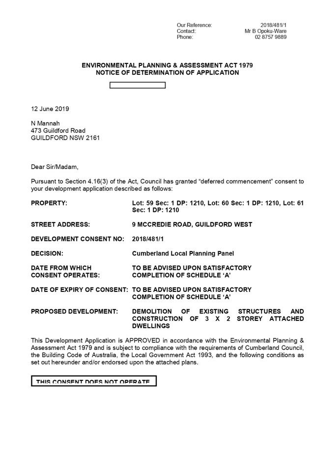
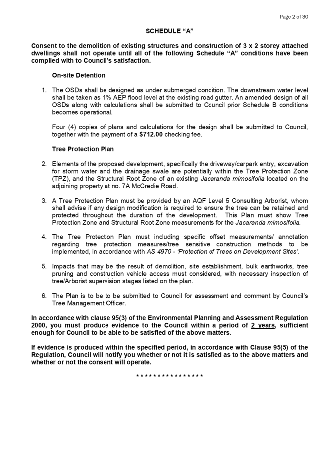
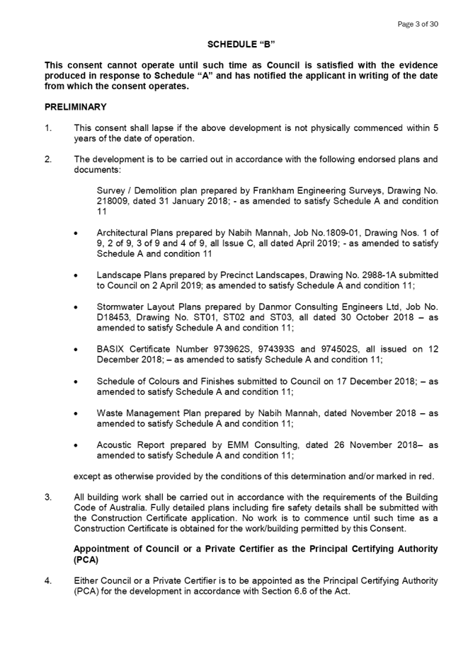


DOCUMENTS
ASSOCIATED WITH
REPORT LPP040/19
Attachment 2
Architectural Plans
Cumberland Local Planning Panel Meeting
12 June 2019
Cumberland Local Planning Panel Meeting
12 June 2019
DOCUMENTS
ASSOCIATED WITH
REPORT LPP040/19
Attachment 3
Redacted Submission 1
Cumberland Local Planning Panel Meeting
12 June 2019
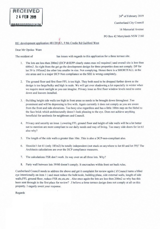
DOCUMENTS
ASSOCIATED WITH
REPORT LPP040/19
Attachment 4
Redacted Submission 2
Cumberland Local Planning Panel Meeting
12 June 2019
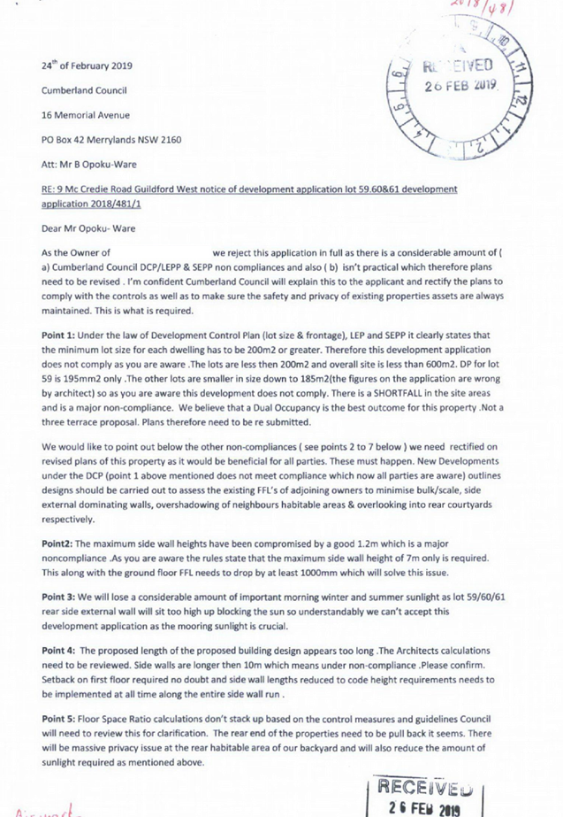
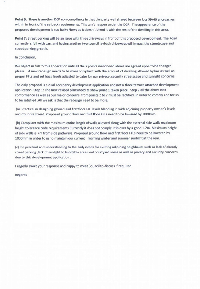
DOCUMENTS
ASSOCIATED WITH
REPORT LPP040/19
Attachment 5
Redacted Submission 3
Cumberland Local Planning Panel Meeting
12 June 2019
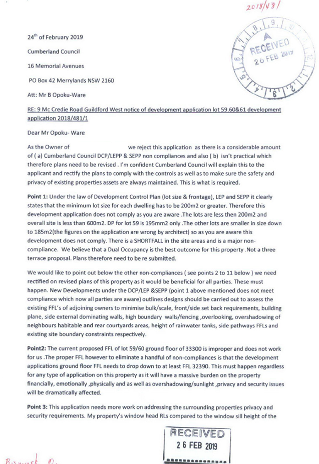
DOCUMENTS
ASSOCIATED WITH
REPORT LPP040/19
Attachment 6
Landscape Plan
Cumberland Local Planning Panel Meeting
12 June 2019
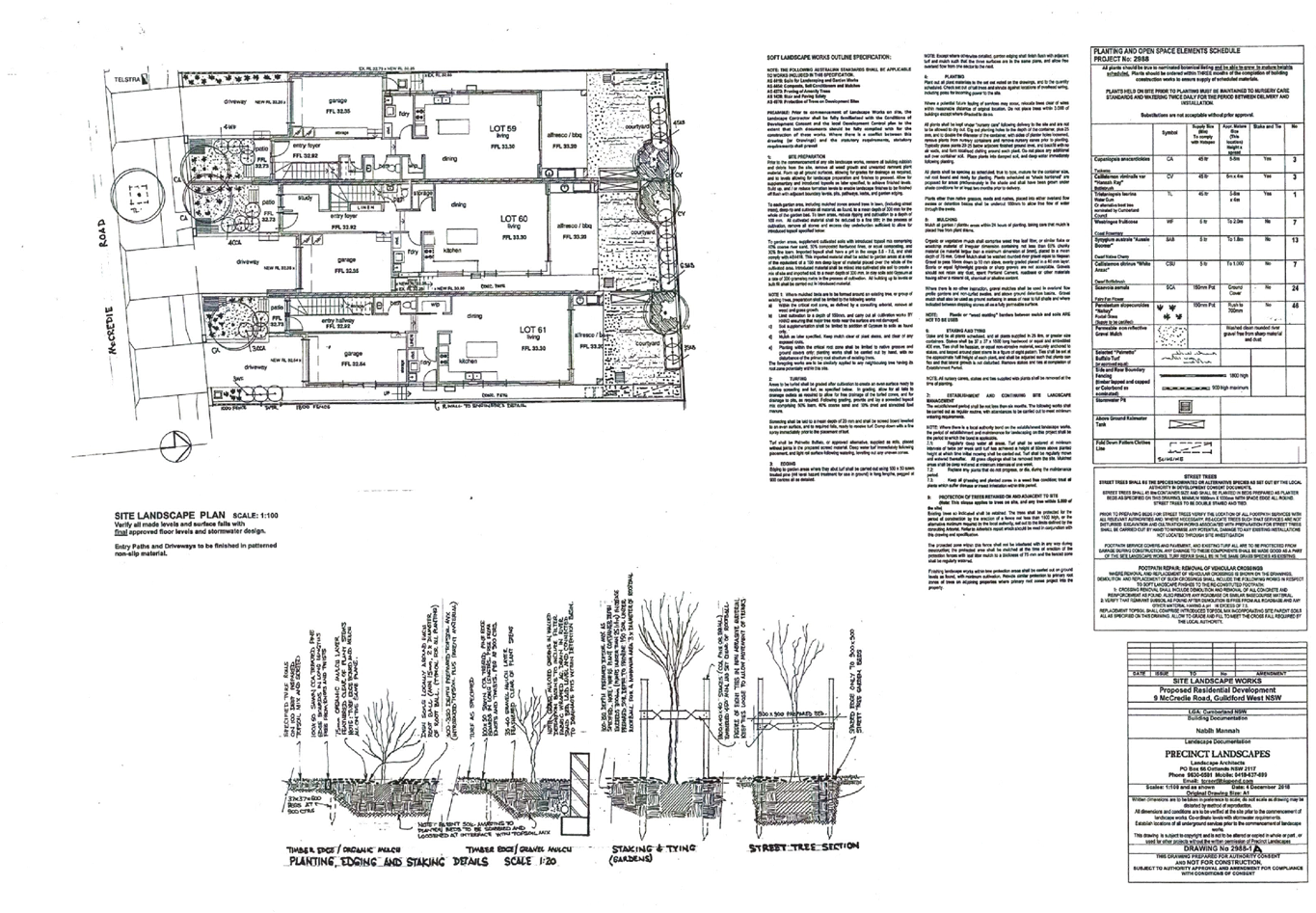
DOCUMENTS
ASSOCIATED WITH
REPORT LPP040/19
Attachment 7
Stormwater Plan
Cumberland Local Planning Panel Meeting
12 June 2019
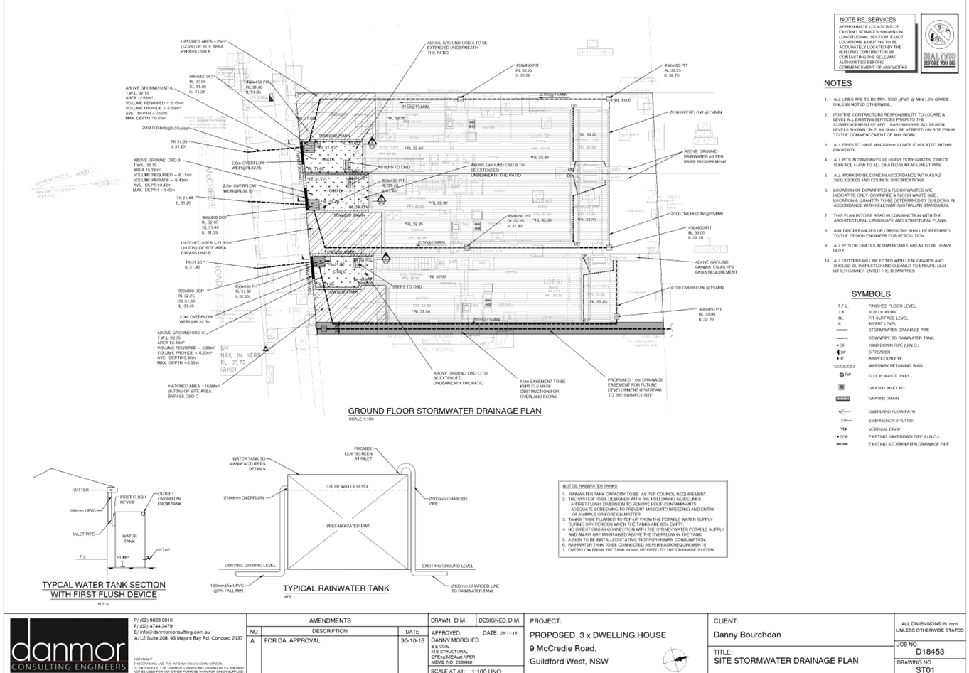
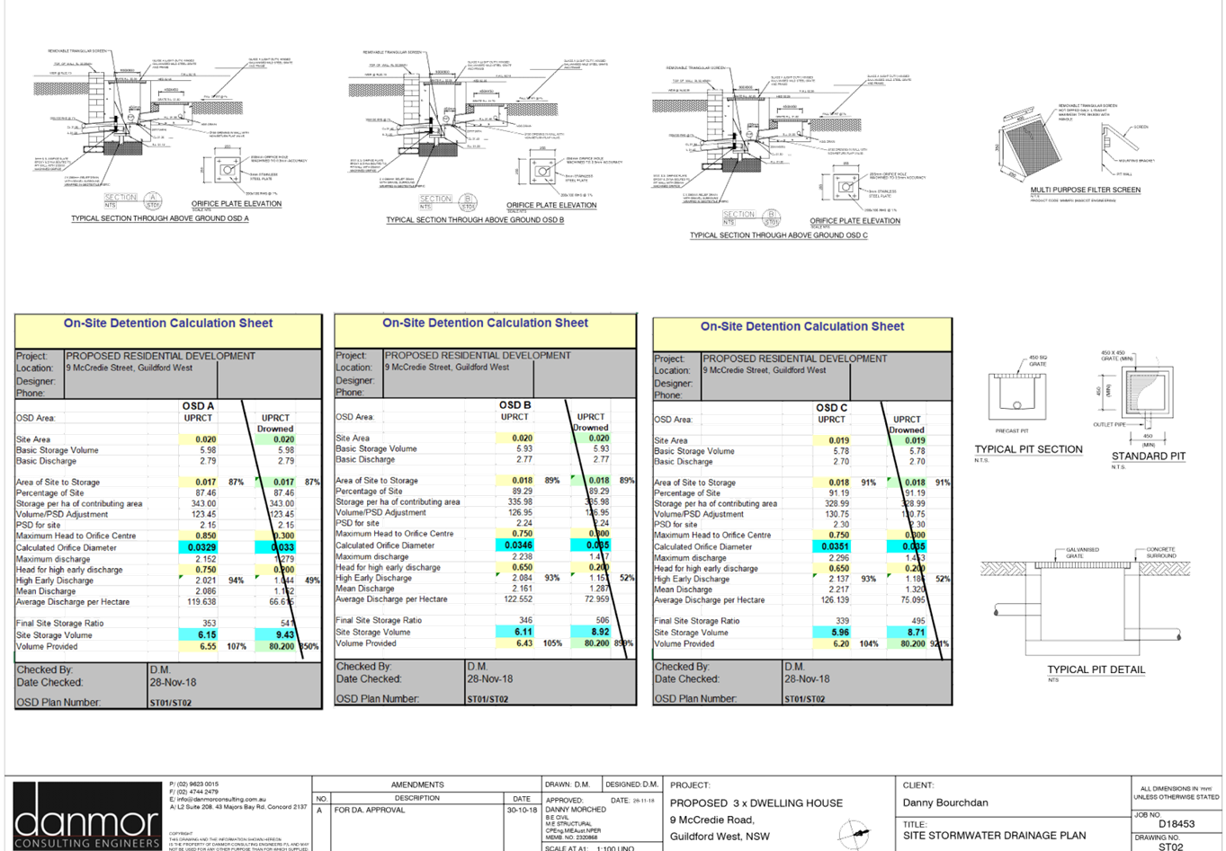
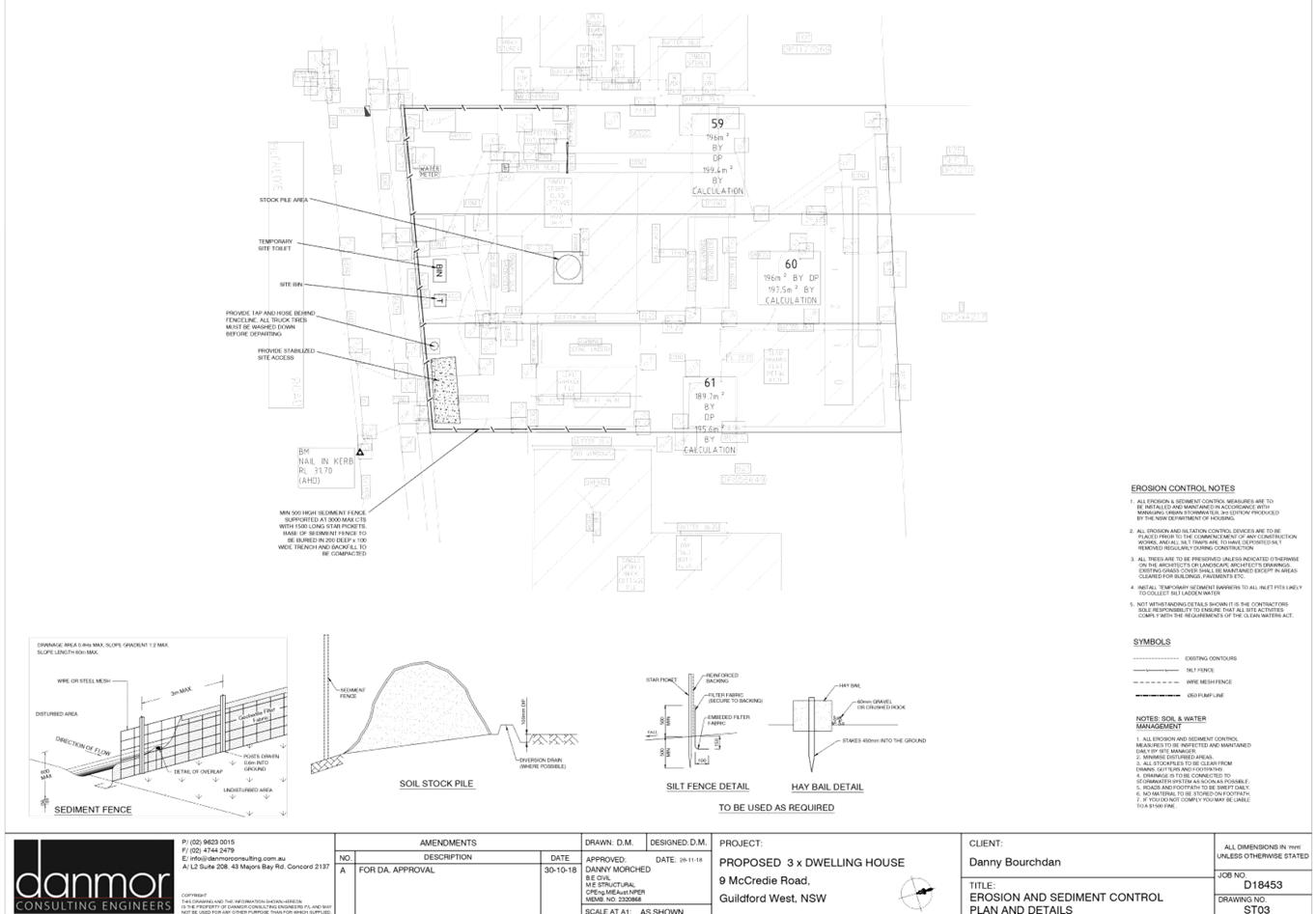
DOCUMENTS
ASSOCIATED WITH
REPORT LPP040/19
Attachment 8
Shadow Diagram
Cumberland Local Planning Panel Meeting
12 June 2019
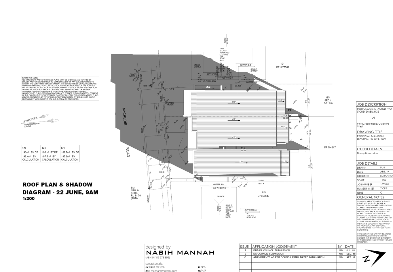
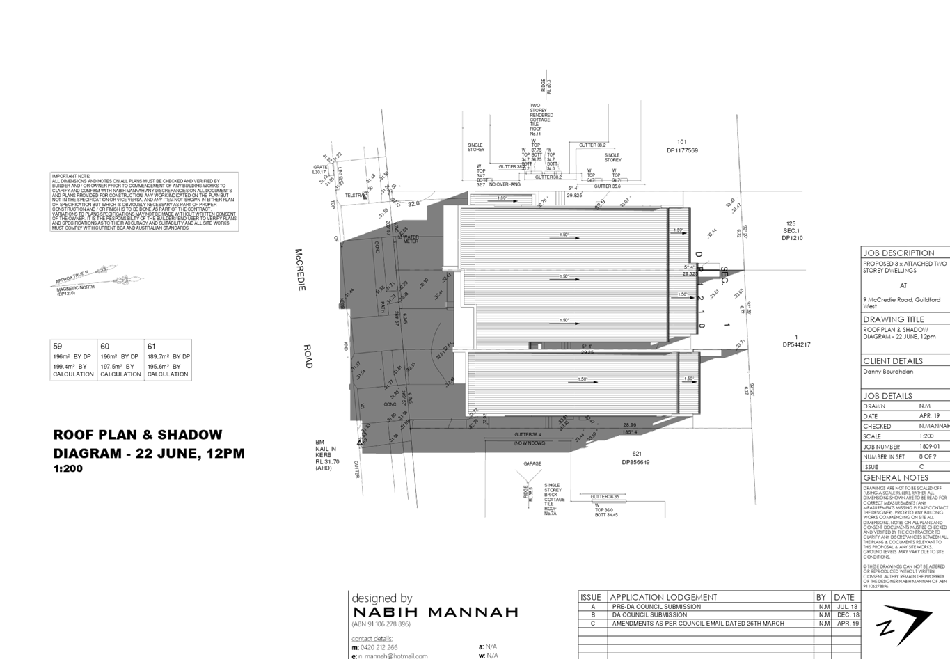
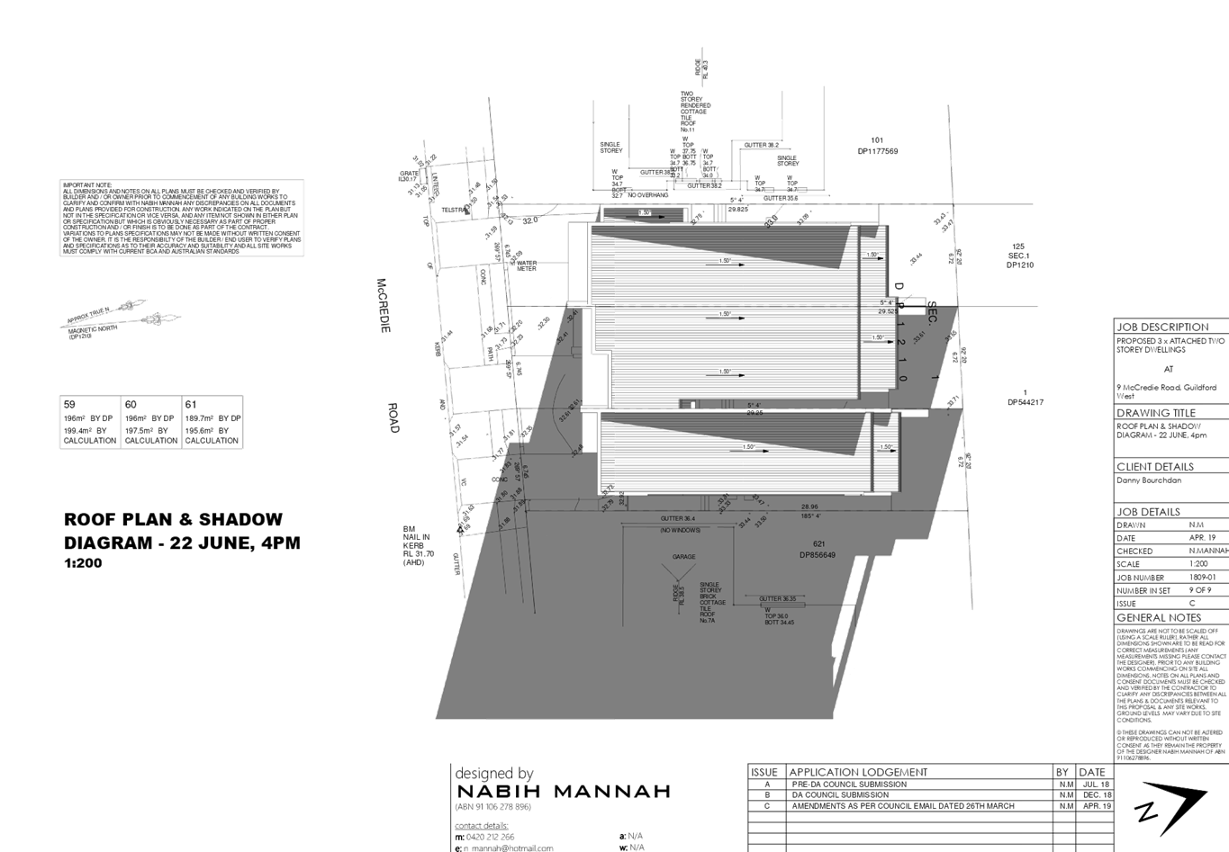
DOCUMENTS
ASSOCIATED WITH
REPORT LPP040/19
Attachment 9
Acoustic Report
Cumberland Local Planning Panel Meeting
12 June 2019
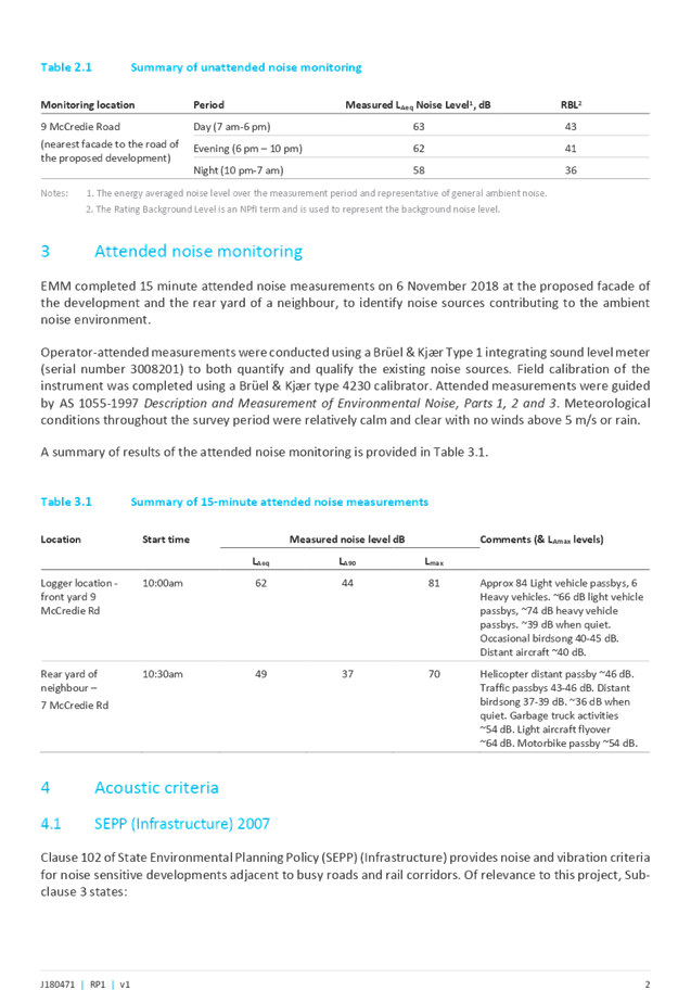
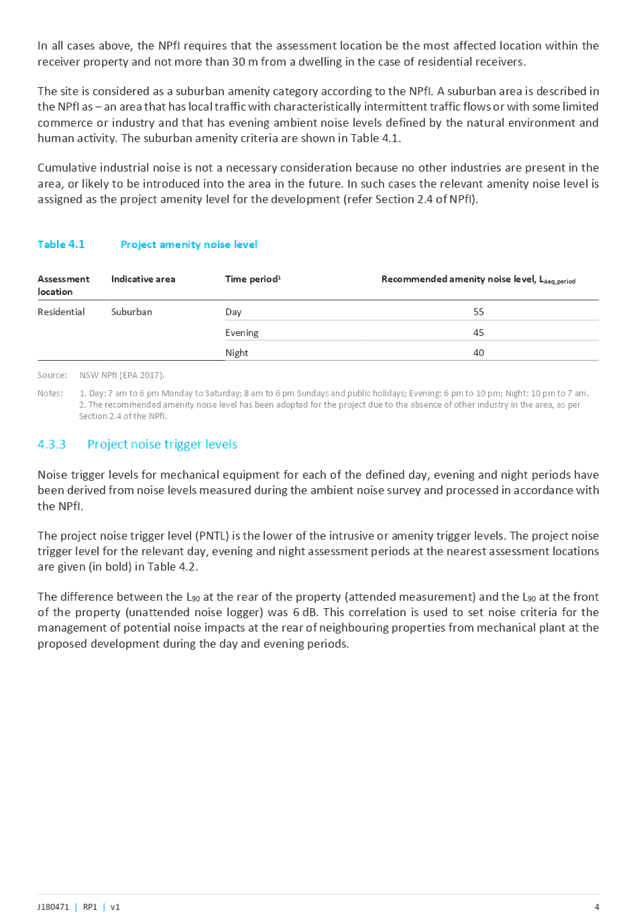
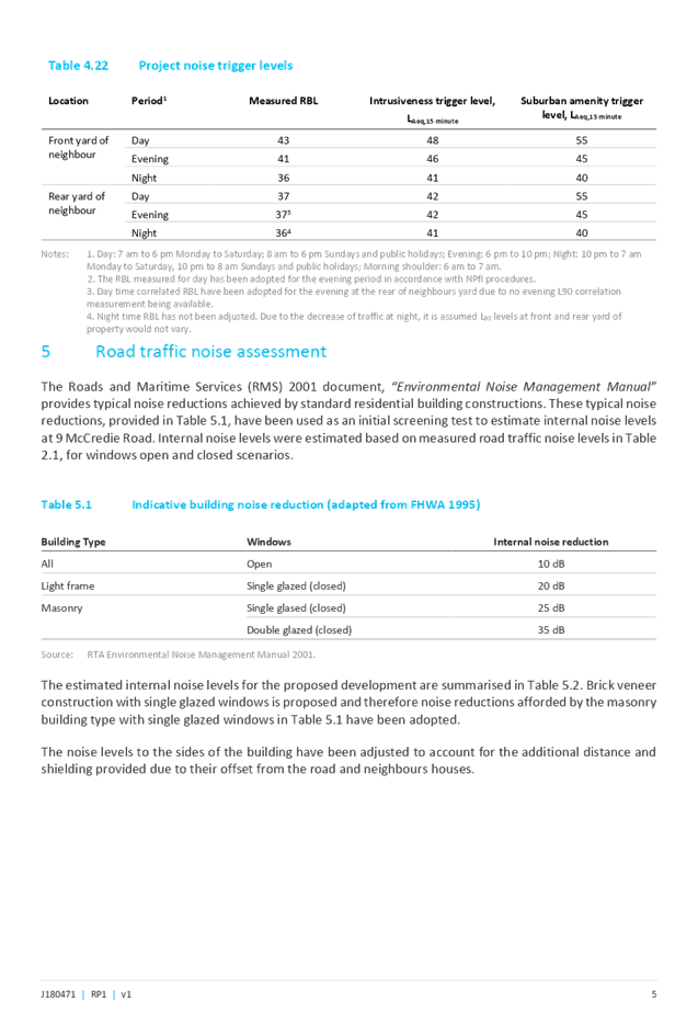
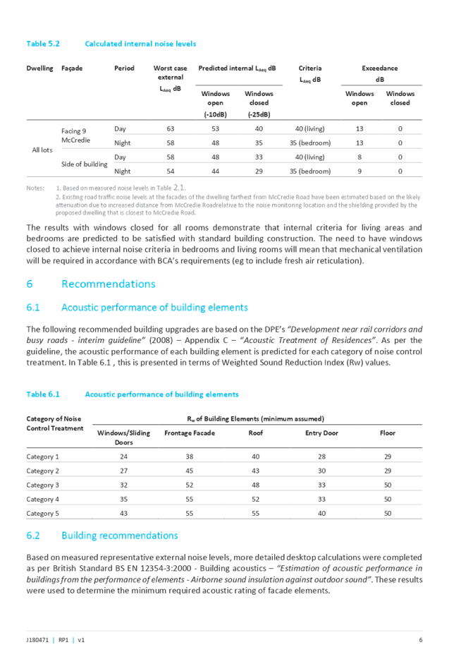

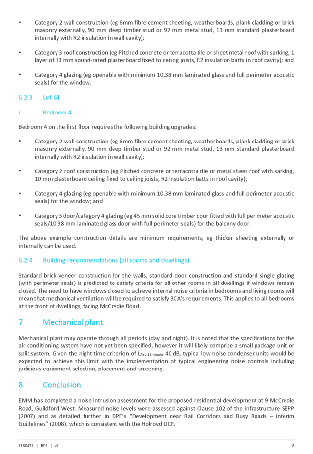


Cumberland Local Planning Panel Meeting
12 June 2019
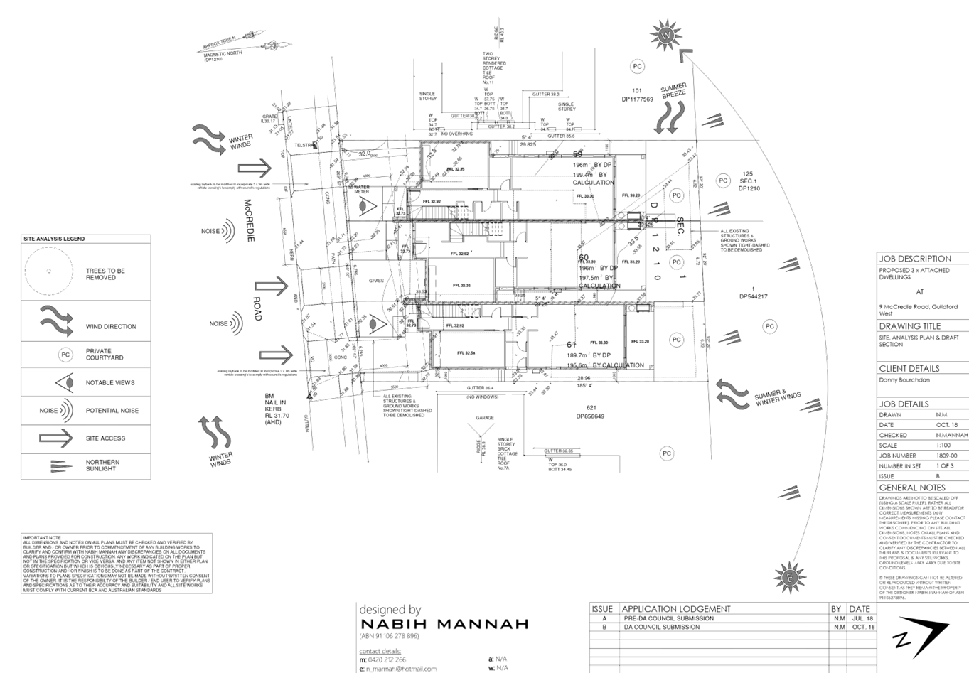
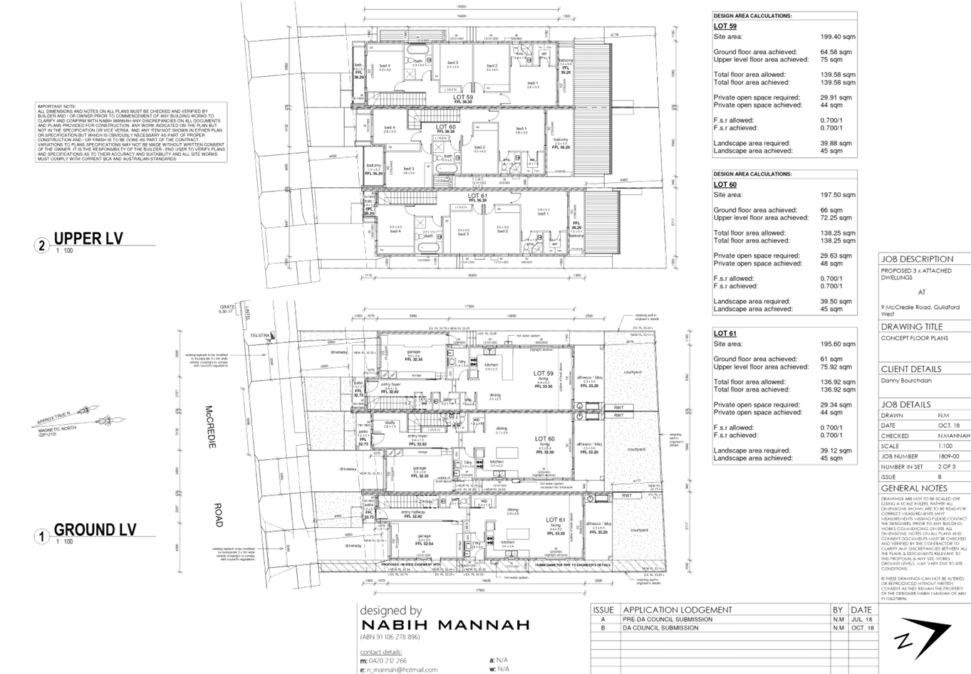
Cumberland Local Planning Panel Meeting
12 June 2019

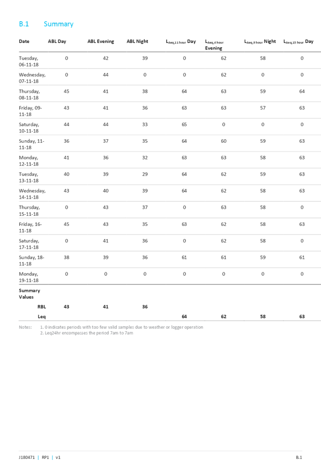
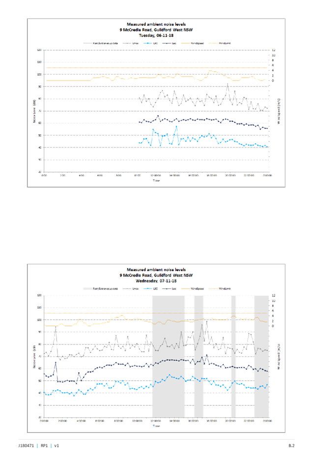
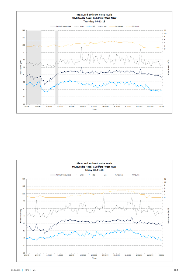
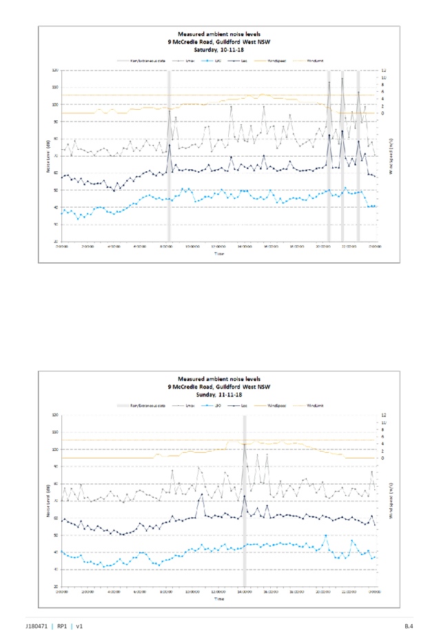
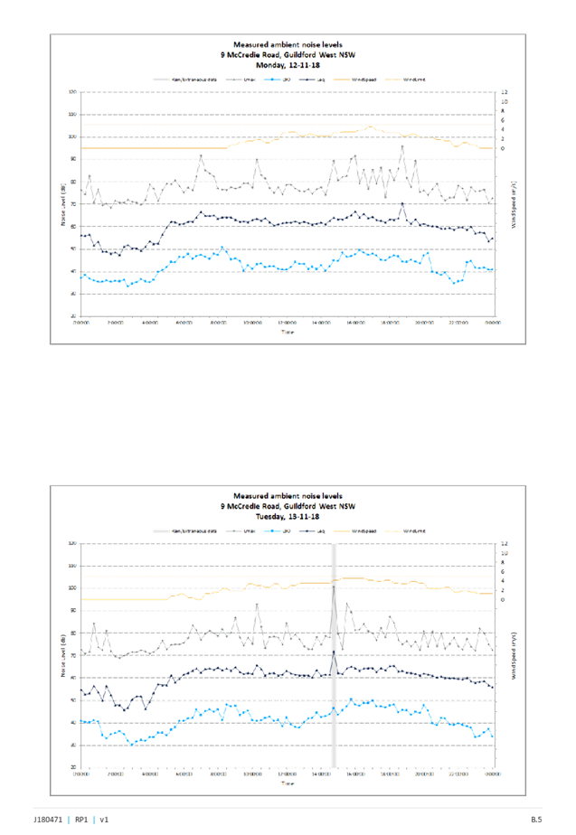
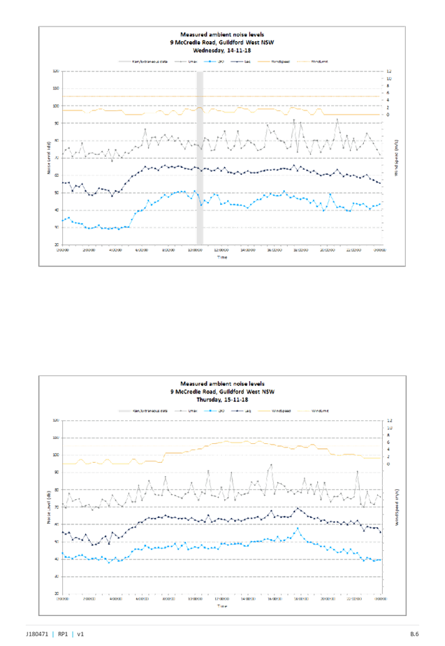
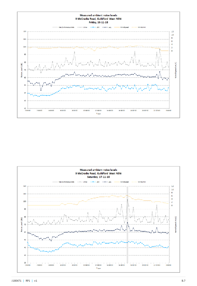
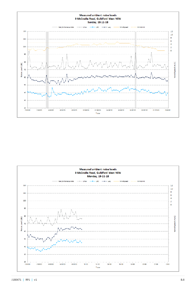
Cumberland Local Planning Panel Meeting
12 June 2019
Item No: LPP041/19
Development
Application for Adjacent to 28A Campbell Street, Berala
Responsible
Division: Environment
& Planning
Officer: Manager
Development Assessment
File
Number: DA-63/2019
|
Application lodged
|
20 March 2019.
|
|
Applicant
|
Jcdecaux Australia P/L.
|
|
Owner
|
Cumberland Council.
|
|
Application No.
|
DA-63/2019.
|
|
Description of Land
|
Adjacent to 28A Campbell
Street Berala.
|
|
Proposed Development
|
Use of a digital display sign
affixed to a Telstra payphone for third party advertising.
|
|
Site Area
|
N/A.
|
|
Zoning
|
B2 Local Centre Zone.
|
|
Disclosure of political
donations and gifts
|
Nil disclosure.
|
|
Heritage
|
No.
|
|
Principal Development
Standards
|
Floor space ratio
Permissible floor space
ratio:- 2:0.
Proposed:- Nil.
And:
Height of Building
Permissible:- 14 metres
Proposed: Not applicable. No
building is proposed.
|
|
Issues
|
Submissions.
|
1. Development
Application No.DA-63/2019 was received by Council on the 20 March 2019 for use
of a digital display sign affixed to a Telstra payphone for third party
advertising.
2. The
application was publicly notified to occupants and owners of the adjoining
properties for a period of fourteen (14) days between Tuesday 30 April and
Tuesday 14 May 2019. In response, twenty (20) submissions were received.
3. There
are no variations to the planning controls.
4. The
development application is recommended for approval subject to conditions as
provided within the attached schedule.
5. The
application is referred to the Panel for determination as this proposal is
considered to be contentious development.
Subject Site And Surrounding
Area
The site is situated close to the
intersection of Campbell Street with Burke Avenue. The locality is situated
south of a railway line and railway station but within the southern portion of
the Berala Town Centre. There is a group of shops situated at 19 to 37 Burke
Avenue and 28 and 28A Campbell Street that defines the southern portion of the
Berala Town Centre.
The remainder of the locality on
the southern side of the railway line is residential in nature.
The Berala Railway Station is
situated along the northern side of Campbell Street to the north. A Woolworths
Supermarket and a small number of specialty shops is situated on a site to the
immediate north of the railway station being Lot 100 in DP 1177777 which is
known as 157 Woodburn Road Berala.
A pedestrian tunnel and pathway
links the southern portion of the Berala Town Centre with the remainder of the
town centre to the north.
The Berala Railway Station is
identified as an archaeological feature (Item Number A53) within the Auburn
Local Environmental Plan 2010.
There is presently one Telstra
payphone situated at the front of 28A Campbell Street that will be replaced
with a new payphone. The replacement payphone to the site does not require
development consent.
The site and immediate locality is
also subject to flooding during a 1 in 100 year flood event; however, flooding
is not an issue for a public payphone or an advertising panel attached to such
a structure.
There is also a foreshore building
line applying to land situated along the northern side of Campbell Street and
this occurs because there is a stormwater channel situated between the roadway
that forms Campbell Street and the Berala Railway Station. The site is not
within the foreshore building line.
The location of the site is shown
below.
The
aerial photo of the site is shown below.
A
photo of the site is provided below.
Description of The Proposed
Development
Council has received a development
application for consent to install third party advertising arising from the
upgrade to Telstra’s payphone infrastructure and technology. The third
party advertising will be integrated into an upgraded public payphone to be
installed under Schedule 3 of the Telecommunications Act 1997. A new
replacement payphone will be established at the front of the site known as 28A
Campbell Street Berala which does not require consent.
The Smart City payphone including
electronic display screen will be initially installed under Schedule 3 of the
Telecommunications Act 1997.
The subject development application
is limited to the third party advertising content change only. The applicant is
requesting that a 15 year consent be issued for the third party advertising on
a static electronic display screen within the exempt payphone structure.
The third party advertising will
be displayed on a screen that has an area of 2.36 square metres and with
dimensions of 1.973 metres x 1.2 metres. The proposed sign will display six (6)
advertisements per minute.
There will also be a screen within
the payphone that will display Telstra advertising. The advertising content for
this screen will not require development consent.
The luminance of the main
advertising screen will not exceed a maximum of 0.25 cd/per square metre.
Applicants Supporting
Statement
The applicant has provided a
Statement of Environmental Effects prepared by Urbis and dated March 2019. The
report was submitted with the development application on March 20 2019.
Contact With Relevant
Parties
The assessing officer has
undertaken a site inspection of the subject site and surrounding properties and
has been in regular contact with the applicant throughout the assessment
process.
Internal Referrals
Council’s Properties
Department
The development application was
referred to Council’s Properties Department for land owners consent.
Council’s Properties Department has authorised the development
application to permit third party advertising on Council land being the
pedestrian footpath.
External Referrals
The development application was
not required to be referred to any external government authorities for comment.
Planning Comments
Permissibility
The site is within zone B2
“Local Centre” which permits signage with consent.
The payphone structure has been
defined by the applicant as a low impact facility pursuant to Clause 3.1 of the
Telecommunications (Low Impact Facilities) Determination 2018. As per Clause
3.1, the installation of the payphone structure would not require consent from
Council if all relevant provisions of the determination were satisfied.
In consideration of this, the
Panel would only be approving of the signage under the Auburn Local
Environmental Plan 2010. Furthermore:-
· No
consent is required for the public payphone.
· Council’s
consent is required for the use of signage for third party advertising.
· Council’s
Properties Department has given owners consent for the lodgement of the
development application.
The provisions of any
Environmental Planning Instruments (EP&A Act s4.15 (1)(a)(i))
State Environmental Planning
Policies
The proposed development is
affected by the following State Environmental Planning Policies:
(a) State
Environmental Planning Policy No. 55 - Remediation of Land
The requirement at clause 7 of
SEPP No 55 for Council to be satisfied that the site is suitable or can be made
suitable to accommodate the proposed development has been considered in the
following table:-
|
Matter for
Consideration
|
Yes/No
|
|
Does the application involve re-development of the site or
a change of land use?
|
Yes
No
|
|
Is the development going to be used for a sensitive land
use (eg: residential, educational, recreational, childcare or hospital)?
|
Yes
No
|
|
Does information available to you indicate that an
activity listed below has ever been approved, or occurred at the site?
acid/alkali plant and
formulation, agricultural/horticultural activities, airports, asbestos
production and disposal, chemicals manufacture and formulation, defence
works, drum re-conditioning works, dry cleaning establishments, electrical
manufacturing (transformers), electroplating and heat treatment premises,
engine works, explosive industry, gas works, iron and steel works, landfill
sites, metal treatment, mining and extractive industries, oil production and
storage, paint formulation and manufacture, pesticide manufacture and
formulation, power stations, railway yards, scrap yards, service stations,
sheep and cattle dips, smelting and refining, tanning and associated trades,
waste storage and treatment, wood preservation
|
Yes
No
|
|
Is the site listed on
Council’s Contaminated Land database?
|
Yes
No
|
|
Is the site subject to EPA
clean-up order or other EPA restrictions?
|
Yes
No
|
|
Has the site been the subject of
known pollution incidents or illegal dumping?
|
Yes
No
|
|
Does the site adjoin any
contaminated land/previously contaminated land?
|
Yes
No
|
|
Details of contamination investigations carried out at
the site:
The site is identified as a public footpath and the
development application is for content signage within an electronic signage
panel attached to a telephone booth. No excavation work is required. Given
the nature of the development application, it is considered that the
development sought is acceptable for the purpose of the State Policy.
|
|
Has the appropriate level of investigation been carried
out in respect of contamination matters for Council to be satisfied that the
site is suitable to accommodate the proposed development or can be made
suitable to accommodate the proposed development?
|
Yes
No
|
|
|
|
(b) State
Environmental Planning Policy (Infrastructure) 2007
A public payphone is exempt
development for the purpose of Schedule 3A of State Environmental Planning
Policy “Infrastructure” 2007 (Item 15) if it meets certain
criteria. In this situation, the payphone is meeting the criteria of Item 15
and as such development consent for the payphone is not required. No further
assessment using the State Policy is required.
(c) State
Environmental Planning Policy No. 64 - Advertising and Signage
The provisions of SEPP 64 have
been considered in the following compliance table:-
|
Requirement
|
Yes
|
No
|
N/A
|
Comment
|
|
Part 1 - Preliminary
|
|
Clause 3(1)(a)(i) Aims, objectives
Signage is compatible with the desired amenity and
visual character of an area.
|
|
|
|
It is considered that the signage (Content) is
satisfactory.
|
|
Clause 3(1)(a)(ii), Aims, objectives
Signage provides effective communication in suitable
locations.
|
|
|
|
Third party advertising as well as content change is
proposed.
An internal screen will display Telstra advertising but
the content does not require Council consent.
An advertising panel will be installed to the rear of the
payphone for third party advertising. The content displayed will be non
Telstra advertising (third party) advertising.
The panel will display a maximum of six (6) advertisements
per minute with an instantaneous transition time. The content will be
illuminated with images being no greater than 2,500 cd/ square metres.
Content will vary depending on what is advertised.
The type of advertising proposed is considered as being
acceptable.
|
|
Clause 3(1)(a)(iii), Aims objectives
Signage is high quality design and finish.
|
|
|
|
Old technology is being replaced with new advertising
technology. It is considered that signage is of high quality design and
finish.
|
|
Clause
3(1)
(b) to
regulate signage (but not content) under Part 4 of the Act, and
(c) to
provide time-limited consents for the display of certain advertisements, and
(d) to
regulate the display of advertisements in transport corridors, and
(e) to ensure
that public benefits may be derived from advertising in and adjacent to
transport corridors.
|
|
|
|
The applicant has requested a time limited consent of
fifteen (15) years for the development application which should be supported.
Council’s Property Department has raised no
objection to the time limitation consent that is sought.
|
|
Clause 4 - Definitions
|
|
|
|
Definition:- The SEPP defined the proposal as
“Advertisement” which means “Signage to which
Part 3 applies”.
Given that the LED screen is not a business identification
or a building identification sign an assessment is required using Part 3
where applicable.
|
|
Part 2 - Signage Generally
|
|
Clause 8 Granting of consent to signage
A consent authority must not grant consent to an
application to display signage unless:
(a) that
signage is consistent with the objectives of the Policy at clause 3(1)(a)
(b) (b)
that the signage satisfies the assessment criteria specified in Schedule 1
|
|
|
|
Compliance is achieved.
|
|
Part 3 - Advertisements (this part does not apply
to business identification signs, building identification signs, signage
that, or the display of which, is exempt development under an EPI, signage on
vehicles)
|
|
Clause 10 - Prohibited advertisements
(1) Despite the
provisions of any other environmental planning instrument, the display
of an advertisement is prohibited on land that is an environmentally
sensitive area, heritage area (excluding railway stations), natural or other
conservation area, open space, waterway, residential (but not a mixed
residential and business zone or similar zone), scenic protection area,
national park, nature reserve
(2) This clause does not apply to the following:
(a) The Mount Panorama Precinct.
(b) The display of an advertisement at a public
sporting facility situated on land zoned public recreation under an EPI being
an advertisement that provides information about the sponsors of the teams or
organisations using the sporting facility or about the products of those
sponsors.
|
|
|
|
The site is not situated within an environmentally
sensitive area of Berala.
The Berala Railway Station situated along the northern
side of Campbell Road is identified as an archaeological feature (Item Number
A53) within the Auburn Local Environmental Plan 2010.
The screen will not impact onto the nearby archaeological
heritage listed item.
It is considered that an archaeological impact statement
is not required.
|
|
12. Consent authority
For the purposes of this Policy, the consent authority
is:
(a) the council of a
local government area in the case of an advertisement displayed in the local
government area (unless paragraph (c), (d) or (e) applies), or
(b) the Maritime
Authority of NSW in the case of an advertisement displayed on a vessel, or
(c) the Minister for
Planning in the case of an advertisement displayed by or on behalf of RailCorp,
NSW Trains, Sydney Trains, Sydney Metro or Transport NSW on a railway
corridor, or
(d) the Minister for
Planning in the case of an advertisement displayed by or on behalf of the RMS
on:
(i) a
road that is a freeway or tollway (under the Roads Act 1993 or associated
road use land that is adjacent to such a road, or
(ii) a
bridge constructed by or on behalf of the RMS on any road corridor, or
(iii) land
that is owned, occupied or managed by the RMS, or
(e) the Minister for Planning
in the case of an advertisement displayed on transport corridor land
comprising a road known as the Sydney Harbour Tunnel, the Eastern
Distributor, the M2 Motorway, the M4 Motorway, the M5 Motorway, the M7
Motorway, the Cross City Tunnel or the Lane Cove Tunnel, or associated road
use land that is adjacent to such a road.
|
|
|
|
Council is the consent authority
for advertising content for third party advertising in this situation.
|
|
Clause 13
1. A consent authority must not grant consent to an
application to display an advertisement unless the advertisement or
advertising structure as the case requires:
(a) is
consistent with the objectives of the Policy at clause 3(1)(a)
(b) has
been assessed by the consent authority in accordance with the assessment
criteria in Schedule 1 and the proposal is acceptable in terms of its impacts
and
(c) satisfies
any other relevant requirements of this Policy.
2. If the Minister for Planning is the consent
authority or clause 18 or 24 applies to the case, the consent authority must
not grant consent to an application to display an advertisement to which this
Policy applies unless the advertisement or the advertising structure, as the
case requires:
(a) is consistent with the
objectives of this Policy as set out in clause 3 (1) (a), and
(b) has been assessed by the
consent authority in accordance with the assessment criteria in Schedule 1
and in the Guidelines and the consent authority is satisfied that the
proposal is acceptable in terms of:
(i) design, and
(ii) road safety, and
(iii) the public benefits to be
provided in connection with the display of the advertisement, and
(c) satisfies any other relevant
requirements of this Policy.
(3) In addition, if clause 18
or 24 applies to the case, the consent authority must not grant consent
unless arrangements that are consistent with the Guidelines have been entered
into for the provision of the public benefits to be provided in connection
with the display of the advertisement.
|
|
|
|
The sign panel is determined as being acceptable to the
location.
The development application is limited to the third party
advertising content change only. The third party advertising will be
displayed on a screen that is 1.973 metres tall, and 1.2 metres wide (Area
2.367 square metres).
The sign panel is within or forms part of a payphone
operated by Telstra. The site is within a pedestrian thoroughfare of Campbell
Road and there will be minimal impact or disruption to traffic flows within
Campbell Road or nearby Burke Avenue.
Subclause 2 will not apply to the development application
because Clause 18 or 24 does not apply to the development application.
The screen within the payphone will display Telstra
advertising content and such advertising does not require Council consent.
Note:-
The Transport Corridor Outdoor Advertising and Signage Guidelines do not
require consideration because the telephone booth is not situated within a transport
corridor and the panel the subject of this application is not affected by
Clause 18 or 24 of the State Policy.
|
|
Clause 14 Duration of Consents
(1) A consent granted under this part ceases to be in
force:
(a) on
the expiration of 15 years after the date on which the consent becomes
effective and operates
(b) if a
lesser period is specified by the consent authority, that lesser period
(2) The consent authority may specify a period less
than 15 years only if:
(a) before
the commencement of this Part, the consent authority had adopted a policy of
granting consents in relation to applications to display advertisements for a
lesser period and the duration of the consent authority is consistent with
that policy
(b) the
area in which the advertisement is undergoing change in accordance with an
EPI that aims to change the nature and character of development and where the
proposed advertisement would be inconsistent with that change
(c) (c)
the specification of a lesser period if required by another provision of this
Policy.
|
|
|
|
No objection is raised to the fifteen (15) year consent
that is sought by the applicant.
|
|
Clause 16 Transport corridor land
(1) Despite the
provisions of any other environmental planning instrument, the display of an
advertisement on transport corridor land is permissible with development
consent in the following cases:
(a) the display of an
advertisement by or on behalf of RailCorp, NSW Trains, Sydney Trains, Sydney
Metro or Transport NSW on a railway corridor,
(b) the display of an
advertisement by or on behalf of the RMS on:
(i) a road that is a
freeway or tollway (under the Roads Act 1993 or associated road use land that
is adjacent to such a road, or
(ii) a bridge
constructed by or on behalf of the RMS on any road corridor, or
(iii) land that is
owned, occupied or managed by the RMS and that is within 250 metres of a
classified road,
(c) the display of an
advertisement on transport corridor land comprising a road known as the
Sydney Harbour Tunnel, the Eastern Distributor, the M2 Motorway, the M4
Motorway, the M5 Motorway, the M7 Motorway, the Cross City Tunnel or the Lane
Cove Tunnel, or associated road use land that is adjacent to such a road.
(2) Before
determining an application for consent to the display of an advertisement in
such a case, the Minister for Planning may appoint a design review panel to
provide advice to the Minister concerning the design quality of the proposed
advertisement.
(3) The Minister
must not grant consent to the display of an advertisement in such a case
unless:
(a) the relevant local
council has been notified of the development application in writing and any
comments received by the Minister from the local council within 28 days have
been considered by the Minister, and
(b) the advice of any
design review panel appointed by the Minister has been considered by the
Minister, and
(c) the Minister is
satisfied that the advertisement is consistent with the Guidelines.
(4) This clause does not apply to the display of an
advertisement if the Minister determines that display of the advertisement is
not compatible with surrounding land use, taking into consideration any
relevant provisions of the Guidelines.
|
|
|
|
Clause 16 will not apply to the development application
because the advertising panel and payphone is not situated within land
designated as a transport corridor.
|
|
Clause 17 Advertisements with display area greater than
20m2 or higher than 8m above ground
(2) The display of an advertisement to which this
clause applies is advertised development for the purposes of the Act
(3) The consent authority must not grant consent to an
application under this clause unless:
(a) the
applicant has provided an impact statement that addressed the assessment criteria
in Schedule 1 and the consent authority is satisfied that the proposal is
acceptable in terms of its impacts and
(b) the
application has been advertised in accordance with s79A of the Act
(c) At
the same time as advertisement, a copy of application was given to the RMS
(if it is an advertisement to which clause 18 applies)
|
|
|
|
Clause 17 will not apply to the development application.
In particular:-
· The screen within the telephone booth has dimensions
of 900 mm x 225 mm and occupying an area of 0.202 square metre. The screen
does not require Council consent as third party advertising is not proposed.
· The larger panel has dimensions of 1,973 mm x
1,200 mm and occupying an area of 2.36 square metres.
The screen to which third party advertising is proposed
is less than 20 square metres in area and less than 8 metres in height.
|
|
Clause 18 Advertisements greater than 20m2
and within 250m of, and visible from, a classified road
(2) Consent must not be granted without the concurrence
of the RMS
(3) In
deciding whether or not concurrence should be granted, RMS must take into
consideration:
(a) the impact of the display of the
advertisement on traffic safety, and
(b) the Guidelines.
(c) (Repealed)
(4) If
RMS has not informed the consent authority within 21 days after the copy of
the application is given to it under clause 17 (3) (c) (ii) that it has
granted, or has declined to grant, its concurrence, RMS is taken to have
granted its concurrence.
(5) Nothing
in this clause affects clause 16.
(6) This
clause does not apply when the Minister for Planning is the consent
authority.
|
|
|
|
Clause 18 will not apply to the development application.
|
|
Clause 19 Advertising display area greater than 45m2
(a) No
consent must be granted to the display of an advertisement with an advertising
display area greater than 45m2 unless a DCP is in force that has
been prepared on the basis of an advertising display analysis for the
relevant area or precinct
(b) In
the case of the display of an advertisement on transport corridor land, the consent
authority is satisfied that the advertisement is consistent with the
Guidelines.
|
|
|
|
Clause 19 is not relevant to the development
application.
|
|
Clause 20 Location of certain names and logos
(1) The name or logo of the person who owns or leases
an advertisement or advertising structure may appear only within the
advertising display area
(2) If the advertising display area has no border or
surrounds, any such name or logo is to be located:
(a) within
the advertisement, or
(b) within
a strip below the advertisement that extends for the full width of the
advertisement
(3) The area of any such name or logo must not exceed
0.25m2
(4) The area of any such strip is to be included in
calculating the size of the advertising display area
|
|
|
|
All technology and logos associated with the electronic
screen and third party advertising is integrated within the exempt structure.
There are no logos within the frames or devices to be erected.
|
|
Clause 23 Freestanding advertisements
(1) Consent
may only be granted of the advertising structure on which the advertisement
is displayed does not protrude above the dominant skyline, including any
buildings, structures or tree canopies when viewed from ground level when
viewed from ground level within a visual catchment of 1km.
(2) This clause does not prevent the consent
authority, in the case of a freestanding advertisement on land within a rural
or non-urban zone, from granting consent to the display of the advertisement
under clause 15.
|
|
|
|
A free standing structure is not proposed.
|
|
Schedule 1 Assessment Criteria
|
|
Character of the area
|
|
Is the proposal compatible with the existing or desired
future character of the area or locality in which it is proposed to be
located?
|
|
|
|
The character and nature of the locality will not be
changing. The immediate locality is characterised by commercial and retail
land uses and high levels of pedestrian movement. The signage content is
compatible with the locality.
|
|
Is the proposal consistent with a particular theme for
outdoor advertising in the area or locality?
|
|
|
|
There is no advertising theme for the locality.
|
|
Special areas
|
|
Does the proposal detract from the amenity or visual
quality of any environmentally sensitive areas, heritage areas, natural or
other conservation areas, open space areas, waterways, rural landscapes or
residential areas?
|
|
|
|
The Berala Railway Station situated along the northern
side of Campbell Road is identified as an archaeological feature (Item Number
A53) within the Auburn Local Environmental Plan 2010.
The screen will not impact onto the nearby archaeological
heritage listed item.
The site is not within an environmental sensitive area,
heritage area, natural or other conservation area.
|
|
Views and vistas
|
|
Does the proposal obscure or compromise important
views?
|
|
|
|
The proposal will not impact onto any existing views or
vistas.
|
|
Does the proposal dominate the skyline and reduce the
quality of vistas?
|
|
|
|
The panel will not dominate the skyline or reduce the
quality of vistas.
|
|
Does the proposal respect the viewing rights of other
advertisers?
|
|
|
|
There are no other advertisers on site affected by the
change to the panel.
|
|
Streetscape, setting or landscape
|
|
Is the scale, proportion and form of the proposal
appropriate for the streetscape, setting or landscape?
|
|
|
|
The advertising content will be integrated within an
exempt payphone within a commercial location being a footpath adjacent to
shops and associated businesses. The advertising content will have no
additional impacts in terms of scale, proportion and form.
|
|
Does the proposal contribute to the visual interest of
the streetscape, setting or landscape?
|
|
|
|
|
|
Does the proposal reduce clutter by rationalising and
simplifying existing advertising?
|
|
|
|
There is no clutter of signage proposed.
|
|
Does the proposal screen unsightliness?
|
|
|
|
There is no unsightliness to screen.
|
|
Does the proposal protrude above buildings, structures
or tree canopies in the area or locality?
|
|
|
|
The panel or content of advertising will not impact on the
built form of the exempt payphone or surrounding buildings.
|
|
Does the proposal require ongoing vegetation
management?
|
|
|
|
No ongoing management of vegetation is required.
|
|
Site and building
|
|
Is the proposal compatible with the scale, proportion
and other characteristics of the site or building, or both, on which proposed
signage is to be located?
|
|
|
|
The proposed signage is compatible with the subject
site’s character, and surrounding area.
|
|
Does the proposal respect important features of the
site or building, or both?
|
|
|
|
This is achieved.
|
|
Does the proposal show innovation and imagination in
its relationship to the site or building or both?
|
|
|
|
|
|
Associated devices and logos with advertisements and
advertising structures
|
|
Have any safety devices, platforms, lighting devices or
logos been designed as an integral part of the signage or structure on which
it is displayed?
|
|
|
|
All logos associated with the electronic displays screen
and third party advertising are already integrated within the exempt
structure.
|
|
Illumination
|
|
Would illumination result in unacceptable glare?
|
|
|
|
The new panel will be illuminated but illumination is not
considered excessive.
|
|
Would illumination affect safety for pedestrians,
vehicles or aircraft?
|
|
|
|
|
|
Would illumination detract from the amenity of any
residence or other form of accommodation?
|
|
|
|
|
|
Can the intensity of the illumination be adjusted, if
necessary?
|
|
|
|
The electronic display screen have inbuilt light sensors
that measure the ambient light around the structure that gradually adjusts
the screen brightness based on the need for light. The adjustments occur
within small increments to avoid dramatic change in illuminance levels.
The luminance will never exceed 0.25 cd/ square metre.
Additionally, the screens will not contain flourescent
bulbs or spotlights.
An appropriate condition is provided within the
recommendation addressing illuminance levels.
|
|
Is the illumination subject to a curfew?
|
|
|
|
|
|
Safety
|
|
Would the proposal reduce the safety for any public
road?
|
|
|
|
The sign and content will not interfere with traffic or
pedestrian flows.
|
|
Would the proposal reduce the safety for pedestrians or
bicyclists?
|
|
|
|
|
|
Would the proposal reduce the safety for pedestrians,
particularly children, by obscuring sight lines from public areas?
|
|
|
|
|
Regional Environmental Plans
The proposed development is
affected by the following Regional Environmental Plans:
(a) Sydney
Regional Environmental Plan (Sydney Harbour Catchment) 2005
The subject site is identified as
being located within the area affected by the Sydney Regional Environmental
Plan (Sydney Harbour Catchment) 2005. The proposed development raises no issues
as no impact on the catchment is envisaged.
(Note:- the subject site is not
identified in the relevant map as ‘land within the ‘Foreshores and
Waterways Area’ or ‘Wetland Protection zone’, is not a
‘Strategic Foreshore Site’ and does not contain any heritage items.
Hence the majority of the SREP is not directly relevant to the proposed
development).
Local Environmental Plans
Auburn Local Environmental Plan
2010
The provisions of the Auburn Local
Environmental Plan 2010 are applicable to the development application.
The land is within zone B2 Local
Centre which permits signage with consent. In this regard, the development
sought is best considered as being signage. Signage is defined as:-
“Signage means any sign,
notice, device, representation or advertisement that advertises or promotes any
goods, services or events and any structure or vessel that is principally
designed for, or that is used for, the display of signage, and includes any of
the following:-
(a) an
advertising structure,
(b) a
building identification sign,
(c) a
business identification sign,
but does not
include a traffic sign or traffic control facilities”.
Signage is not identified as being
prohibited within the zone. It is identified that the proposal achieves
compliance with the key statutory requirements of the Auburn Local
Environmental Plan 2010 and the objectives of the B2 Local Centre zone.
The relevant matters to be
considered under the Auburn Local Environmental Plan 2010 are summarised below.
A comprehensive LEP assessment is contained in Appendix A.
|
DEVELOPMENT
STANDARD
|
COMPLIANCE
|
DISCUSSION
|
|
4.3 Height of Buildings
14 metres.
|
Yes
|
A building is not proposed and building height is
generally not relevant in this instance.
However, the advertising panel will have dimensions of
1.973 metres x 1.2 metres and will be positioned 754 mm above the footpath
level.
The top of the sign panel screen will be no higher than
approximately 2.47 metres above the footpath level.
|
|
4.4
Floor Space Ratio
2:0
|
N/A
|
Not applicable for signage.
|
|
5.10 Heritage conservation
|
Yes
|
The Berala Railway Station situated along the northern
side of Campbell Road is identified as an archaeological feature (Item Number
A53) within the Auburn Local Environmental Plan 2010.
The advertising content
earmarked for the signage panel will have no known impact towards the
heritage archaeological item. It is considered that the signage panel is
acceptable when taking into account the proximity of the heritage item to the
payphone and subsequent advertising content.
|
The provisions of any proposed
instrument that is or has been the subject (EP&A Act s4.15 (1)(a)(ii))
The development is not affected by
any draft Environmental Planning Instruments.
The provisions of any
Development Control Plans (EP&A Act s4.15 (1)(a)(iii))
The Auburn Development Control
Plan provides guidance for the design and operation of development to achieve
the aims and objectives of the Auburn Local Environmental Plan 2010. It is
identified that the provisions will have limited applicability to the
development as follows.
Advertising and Signage
The only provision relevant to the
development application is the “Advertising and Signage” chapter of
the Auburn Development Control Plan 2010. In this regard:-
· Part
2.0 (Subpart D1) - Advertising and Signage shall be consistent with State Environmental
Planning Policy 64 “Advertising and Signage”.
· Part
3.0 (Subpart D1) - Advertising shall be displayed in English but may include a
translation in another language.
The evidence provided by Telstra
in this application would indicate that compliance would be achieved for the
advertising content that would be displayed. Furthermore, it is also identified
that the advertising content would be compliant with State Environmental
Planning Policy 64 “Advertising and Signage”.
The provisions of any planning
agreement that has been entered into under section 7.4, or any draft planning
agreement that a developer has offered to enter into under section 7.4
(EP&A Act s4.15(1)(a)(iiia))
There is no draft planning
agreement associated with the subject Development Application.
The provisions of the
Regulations (EP&A Act s4.15 (1)(a)(iv))
The proposed development raises no
concerns as to the relevant matters arising from the Environmental Planning and
Assessment Regulations 2000 (EP&A Reg).
The Likely Environmental,
Social or Economic Impacts (EP&A Act s4.15 (1)(b))
It is considered that the proposed
development will have no significant adverse environmental, social or economic
impacts in the locality.
The suitability of the site for
the development (EP&A Act s4.15 (1)(c))
The subject site and locality is
not known to be affected by any natural hazards or other site constraints
likely to have a significant adverse impact on the proposed development.
Accordingly, it is considered that the development is suitable in the context
of the site and surrounding locality.
Submissions made in accordance
with the Act or Regulation (EP&A Act s4.15 (1)(d))
Advertised (newspaper) Mail Sign Not Required
In accordance with Council’s
Notification requirements contained within the Auburn Development Control Plan 2010
the proposal was publicly notified for a period of fourteen (14) days between
Tuesday 30 April and Tuesday 14 May 2019. The notification generated twenty
(20) form submissions in respect of the proposal. The issues raised are the
same as follows:
1- Digital
signage is a road hazard to cars and pedestrians and will create a distraction
to both pedestrians and drivers and add to excessive clutter of the
streetscape.
Comments
The development application is
seeking third party advertising within a payphone that is being replaced at the
same location.
There is already an electronic
advertising panel situated at the site close to the pedestrian crossing. The
new replacement sign panel and signage would not be excessive in size (2.36
square metres). The proposed sign:-
· Is
not expected to change traffic conditions in the locality.
· Create
adverse traffic conditions.
· Impair
traffic flows within the locality.
· Will
not impair pedestrian movements or worsen the operations of the adjoining
street corner.
· Will
not add to clutter that will contribute to a deterioration of the immediate
road network.
· Will
have an acceptable level of illumination in which light levels would be
controlled based on the need for light.
Proposed condition 3 addresses the
operation of the signage including lighting and display of messages.
The public interest (EP&A
Act s4.15(1)(e))
In view of the foregoing analysis
it is considered that the development, if carried out subject to the conditions
set out in the recommendation below, will have no significant adverse impacts
on the public interest.
Section 7.11 (Formerly S94)
Contribution Towards Provision or Improvement of Amenities or Services
The development does not require
the payment of contributions in accordance with Council’s Section 94
Contributions Plans.
Disclosure of Political
Donations And Gifts
The applicant and notification
process did not result in any disclosure of Political Donations and Gifts.
The development application has
been assessed in accordance with the relevant requirements of the Environmental
Planning and Assessment Act 1979, State Environmental Planning Policy 64
“Advertising and Signage”, the Auburn Local Environmental Plan 2010
and the Auburn Development Control Plan 2010. The development sought is
considered as being satisfactory for approval subject to conditions.
The proposed development is
appropriately located within the B2 Local Centres Zone under the relevant
provisions of the Auburn Local Environmental Plan 2010. The proposal is
consistent with all statutory and non-statutory controls applying to the
development. The development is considered to perform adequately in terms of
its relationship to its surrounding built and natural environment, particularly
having regard to impacts on adjoining properties.
For these reasons, it is
considered that the proposal is satisfactory having regard to the matters of
consideration under Section 4.15 of the Environmental Planning and Assessment
Act 1979, and the development may be approved subject to conditions.
There are no further consultation
processes for Council associated with this report.
There are no further financial
implications for Council associated with this report.
There are no policy implications
for Council associated with this report.
Communication /
Publications:
The final outcome of this matter
will be notified in the newspaper. The objectors will also be notified in
writing of the outcome.
|
1. That
Development Application Number 63/2019 for use of a digital display sign
affixed to a Telstra payphone for third party advertising on land adjacent to
28A Campbell Street Berala be approved subject to attached conditions.
2. Persons
whom have lodged a submission in respect to the application be notified of
the determination of the application.
|
1. Draft Notice
of Determinaiton ⇩ 
2. Architectural
Plans ⇩ 
3. Submission
received ⇩
4. Appendix
A ⇩
DOCUMENTS
ASSOCIATED WITH
REPORT LPP041/19
Attachment 1
Draft Notice of Determinaiton
Cumberland Local Planning Panel Meeting
12 June 2019
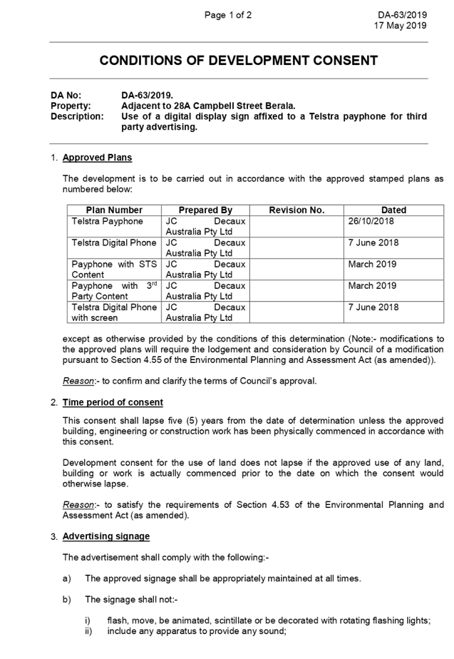
DOCUMENTS
ASSOCIATED WITH
REPORT LPP041/19
Attachment 2
Architectural Plans
Cumberland Local Planning Panel Meeting
12 June 2019
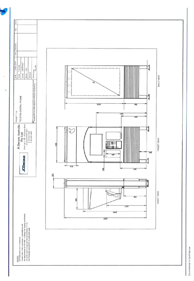
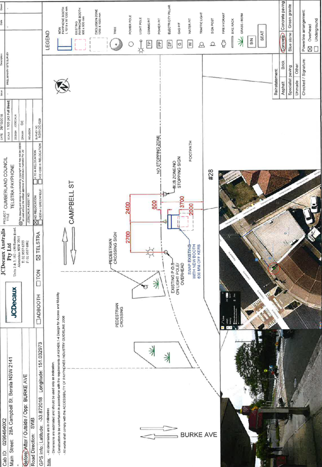
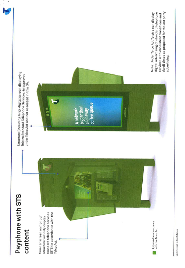
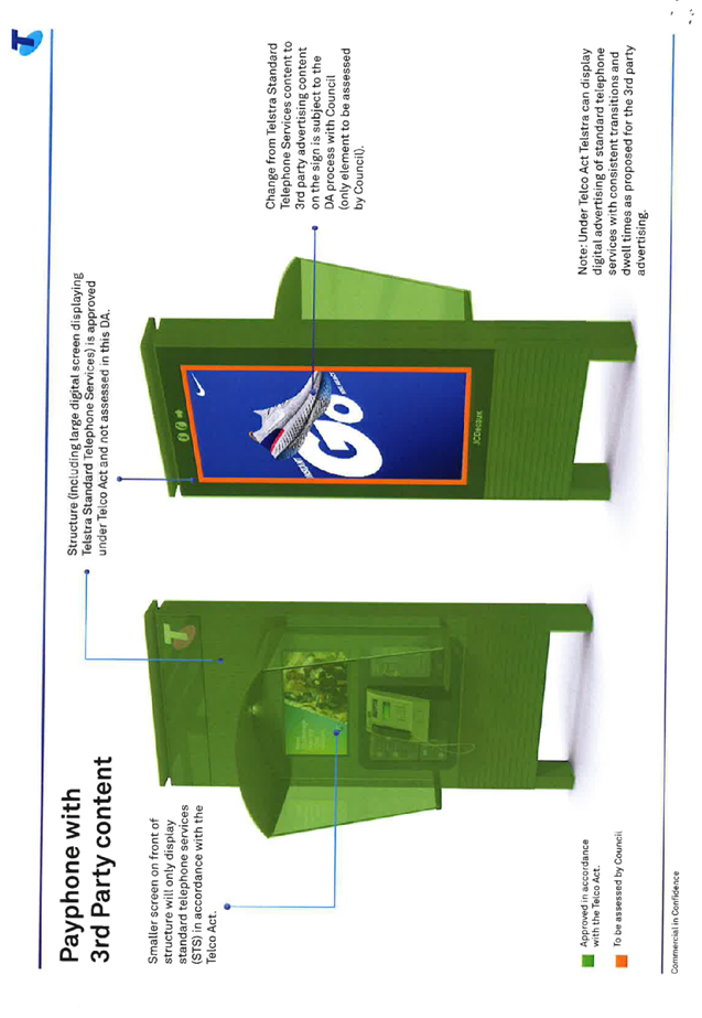
DOCUMENTS
ASSOCIATED WITH
REPORT LPP041/19
Attachment 3
Submission received
Cumberland Local Planning Panel Meeting
12 June 2019

DOCUMENTS
ASSOCIATED WITH
REPORT LPP041/19
Attachment 4
Appendix A
Cumberland Local Planning Panel Meeting
12 June 2019

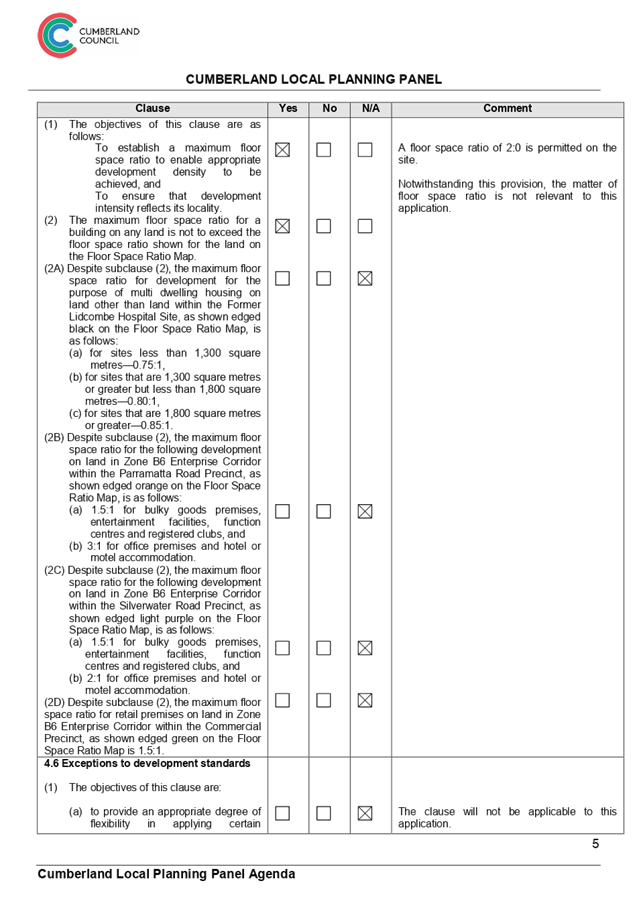
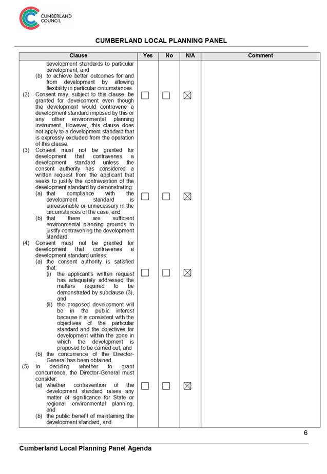
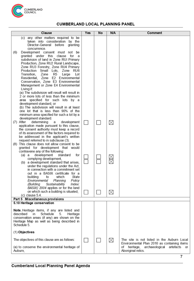
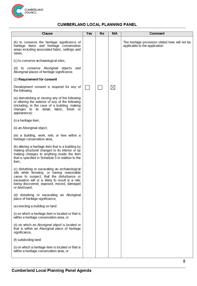
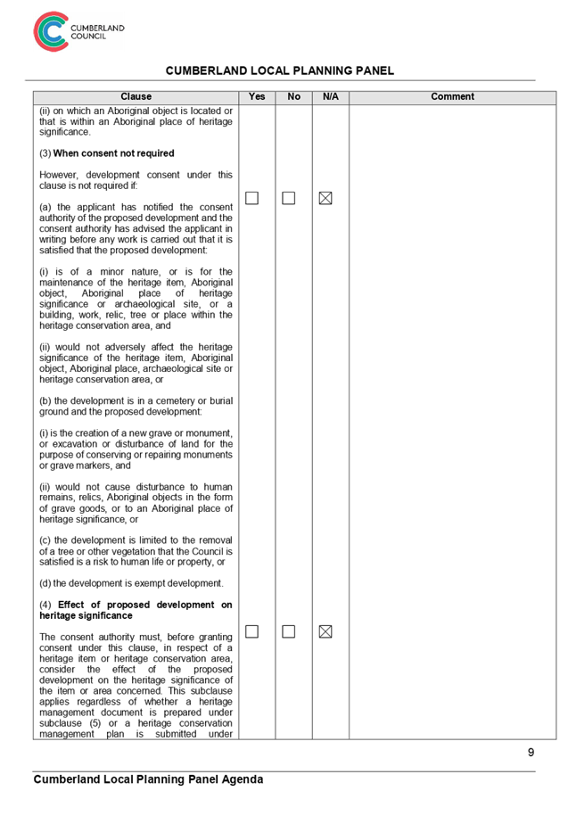
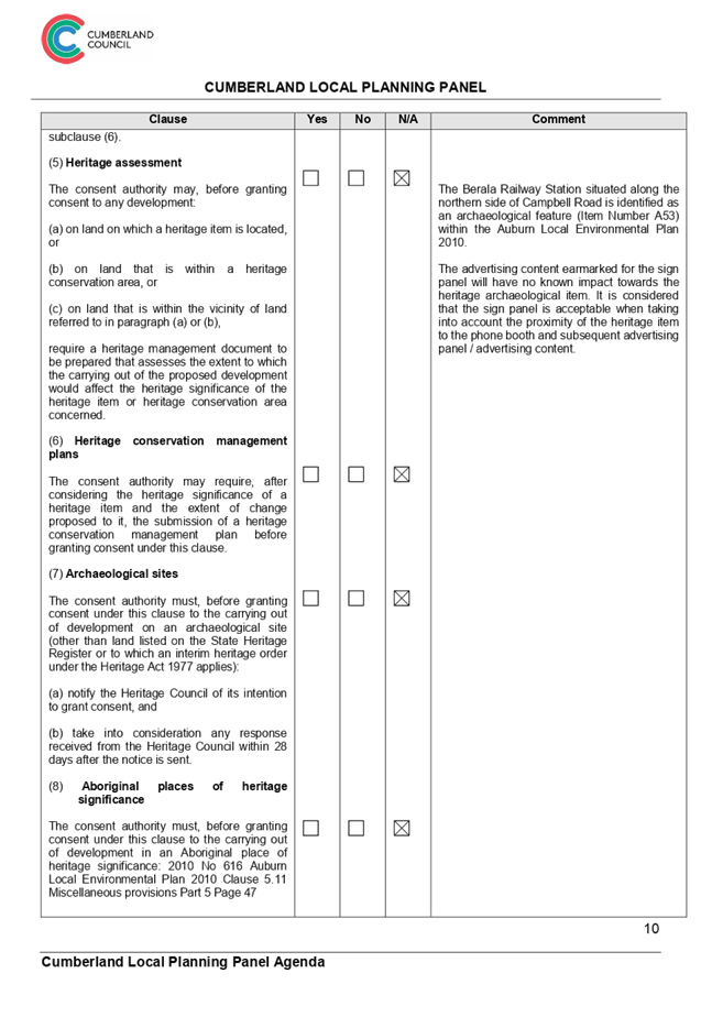

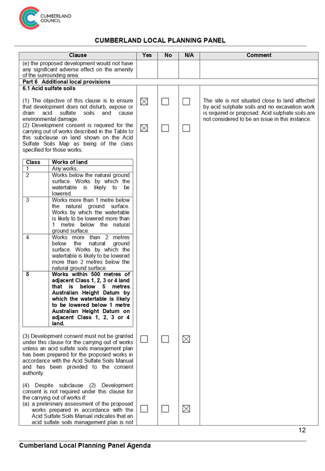
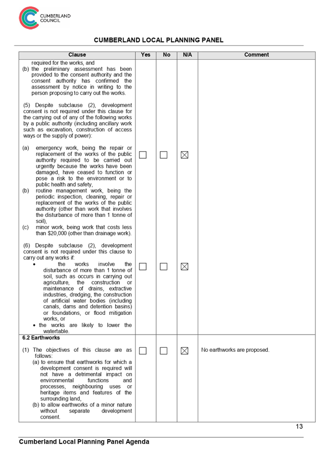
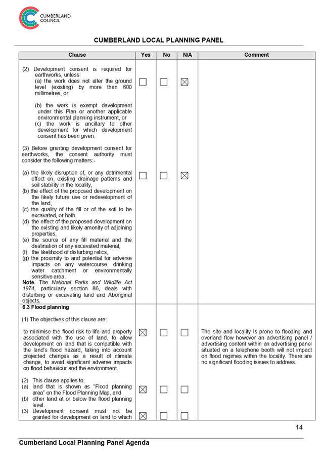
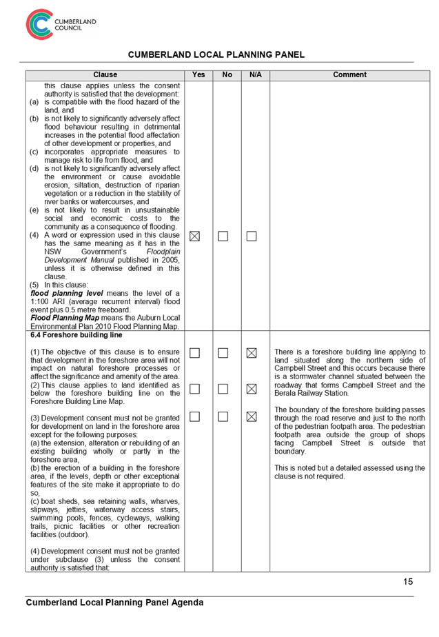
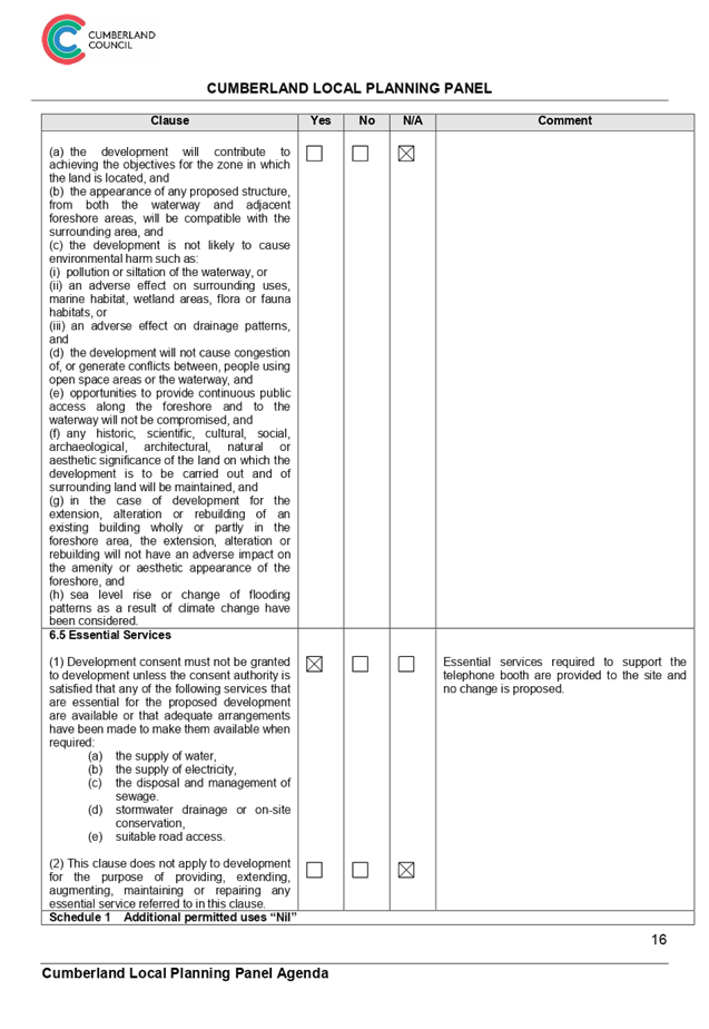

Cumberland
Local Planning Panel Meeting
12 June 2019
Item No: LPP042/19
Development
Application for Adjacent to 174 Woodburn Road, Berala
Responsible
Division: Environment
& Planning
Officer: Manager
Development Assessment
File
Number: DA-83/2019
|
Application lodged
|
22 March 2019.
|
|
Applicant
|
Jcdecaux Australia P/L.
|
|
Owner
|
Cumberland Council.
|
|
Application No.
|
DA-83/2019.
|
|
Description of Land
|
Adjacent to 174 Woodburn Road
Berala.
|
|
Proposed Development
|
Use of a digital display sign
affixed to a Telstra payphone for third party advertising.
|
|
Site Area
|
N/A.
|
|
Zoning
|
B2 Local Centre Zone.
|
|
Disclosure of political
donations and gifts
|
Nil disclosure.
|
|
Heritage
|
No.
|
|
Principal Development
Standards
|
Floor space ratio
Permissible floor space
ratio:- 2:0.
Proposed:- Nil.
And:
Height of Building
Permissible:- 14 metres
Proposed: Not applicable. No
building is proposed.
|
|
Issues
|
Submissions.
|
1. Development
Application No.DA-83/2019 was received by Council on the 22 March 2019 for use
of a digital display sign affixed to a Telstra payphone for third party
advertising.
2. The
application was publicly notified to occupants and owners of the adjoining
properties for a period of fourteen (14) days between Tuesday 30 April and
Tuesday 14 May 2019. In response, thirteen (13) submissions were received.
3. There
are no variations to the planning controls.
4. The
development application is recommended for deferred commencement approval
subject to conditions as provided within the attached schedule.
5. The
application is referred to the Panel for determination as this proposal is
considered to be contentious development.
Subject Site And Surrounding
Area
The site is situated on the
northern side of Woodburn Road adjacent to shops and adjacent to the intersection
of Crawford Street with Woodburn Road.
There are shops and small
businesses situated at street addresses 174 to 188 Woodburn Road that forms
part of the Berala Town Centre. There are residential apartment buildings to
the north of the shops but separated from the shops by Nicol Lane that connects
Crawford Street with Elizabeth Street.
The Berala Woolworths Supermarket
and the Berala Hotel and an associated car park is situated on land to the
south of Woodburn Road.
There is presently one Telstra
payphone situated on the footpath of Crawford Street adjacent to the shops at
170 - 172 Woodburn Road but this payphone will be relocated to the new site.
The site and immediate locality is
not subject to flooding and there are no heritage listed items within the
immediate vicinity of the site.
The
location of the site is shown below.
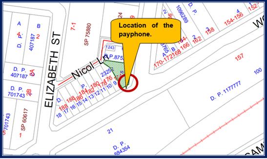
The
aerial photo of the site is shown below.
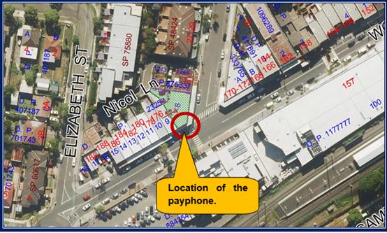
A
photo of the site is provided below.
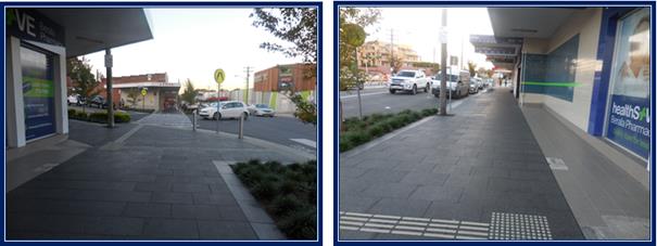
Description of The Proposed
Development
Council has received a development
application for consent to install third party advertising arising from the
upgrade to Telstra’s payphone infrastructure and technology. The third
party advertising will be integrated into a public payphone which will be
installed subject to the provision of the Telecommunication (Low Impact
Facilities) Determination 2018.
A new payphone will be established
at the front of the site known as 174 Woodburn Road Berala. This will be
achieved by relocating the existing phone from outside 172 Woodburn Road to the
new location and upgrading the device.
The subject development
application is limited to the third party advertising content change only. The
applicant is requesting that a 15 year consent be issued for the third party
advertising on a static electronic display screen within the payphone structure
at the site.
The third party advertising will
be displayed on a screen that has an area of 2.36 square metres and with
dimensions of 1.973 metres x 1.2 metres. The proposed sign will display six (6)
advertisements per minute.
There will also be a screen within
the telephone booth that will display Telstra advertising. The advertising
content for this screen will not require development consent.
The luminance of the main
advertising screen will not exceed a maximum of 0.25 cd/per square metre.
Applicants Supporting
Statement
The applicant has provided a
Statement of Environmental Effects prepared by Urbis and dated March 2019. The
report was submitted with the development application on March 22 2019.
Contact With Relevant
Parties
The assessing officer has
undertaken a site inspection of the subject site and surrounding properties and
has been in regular contact with the applicant throughout the assessment
process.
Internal Referrals
Council’s Properties
Department
The development application was
referred to Council’s Properties Department for land owners consent.
Council’s Properties Department has authorised the development
application to permit third party advertising on Council land being the pedestrian
footpath.
External Referrals
The development application was
not required to be referred to any external government authorities for comment.
Planning Comments
Permissibility
The site is within zone B2
“Local Centre” which permits signage with consent.
The payphone structure has been
defined by the applicant as a low impact facility pursuant to Clause 3.1 of the
Telecommunications (Low Impact Facilities) Determination 2018. As per Clause
3.1, the installation of the payphone structure would not require consent from
Council if all relevant provisions of the determination were satisfied.
In consideration of this, the
Panel would only be approving of the signage under the Auburn Local
Environmental Plan 2010. Furthermore:-
· No
consent is required for a low impact facility.
· Council’s
consent is required for the use of signage for third party advertising.
· Council’s
Properties Department has given owners consent for the lodgement of the
development application.
The applicant will be required to
demonstrate to Council that a payphone structure has been erected prior to the
operation of any consent issued and an appropriate deferred commencement
consent condition is provided addressing the matter.
The provisions of any
Environmental Planning Instruments (EP&A Act s4.15 (1)(a)(i))
State Environmental Planning
Policies
The proposed development is
affected by the following State Environmental Planning Policies:
(a) State
Environmental Planning Policy No. 55 - Remediation of Land
The requirement at clause 7 of
SEPP No 55 for Council to be satisfied that the site is suitable or can be made
suitable to accommodate the proposed development has been considered in the
following table:
|
Matter for
Consideration
|
Yes/No
|
|
Does the application involve re-development of the site or
a change of land use?
|
Yes
No
|
|
Is the development going to be used for a sensitive land
use (eg: residential, educational, recreational, childcare or hospital)?
|
Yes
No
|
|
Does information available to you indicate that an
activity listed below has ever been approved, or occurred at the site?
acid/alkali plant and
formulation, agricultural/horticultural activities, airports, asbestos
production and disposal, chemicals manufacture and formulation, defence
works, drum re-conditioning works, dry cleaning establishments, electrical
manufacturing (transformers), electroplating and heat treatment premises,
engine works, explosive industry, gas works, iron and steel works, landfill
sites, metal treatment, mining and extractive industries, oil production and
storage, paint formulation and manufacture, pesticide manufacture and
formulation, power stations, railway yards, scrap yards, service stations,
sheep and cattle dips, smelting and refining, tanning and associated trades,
waste storage and treatment, wood preservation
|
Yes
No
|
|
Is the site listed on
Council’s Contaminated Land database?
|
Yes
No
|
|
Is the site subject to EPA
clean-up order or other EPA restrictions?
|
Yes
No
|
|
Has the site been the subject of
known pollution incidents or illegal dumping?
|
Yes
No
|
|
Does the site adjoin any
contaminated land/previously contaminated land?
|
Yes
No
|
|
Details of contamination investigations carried out at
the site:
The site is identified as a public footpath and the
development application is for content signage within an electronic signage
panel attached to a telephone booth. No excavation work is required. Given
the nature of the development application, it is considered that the
development sought is acceptable for the purpose of the State Policy.
|
|
Has the appropriate level of investigation been carried
out in respect of contamination matters for Council to be satisfied that the
site is suitable to accommodate the proposed development or can be made
suitable to accommodate the proposed development?
|
Yes
No
|
|
|
|
(b) State
Environmental Planning Policy (Infrastructure) 2007
A public payphone is exempt
development for the purpose of Schedule 3A of State Environmental Planning
Policy “Infrastructure” 2007 (Item 15) if it meets certain
criteria. In this situation, the applicant will be required to demonstrate to
Council that a payphone structure has been erected prior to the operation of
any consent issued and an appropriate deferred commencement consent condition
is provided addressing the matter.
(c) State
Environmental Planning Policy No. 64 - Advertising and Signage
The provisions of SEPP 64 have
been considered in the following compliance table:
|
Requirement
|
Yes
|
No
|
N/A
|
Comment
|
|
Part 1 - Preliminary
|
|
Clause 3(1)(a)(i) Aims, objectives
Signage is compatible with the desired amenity and
visual character of an area.
|
|
|
|
It is considered that the signage (Content) is
satisfactory.
|
|
Clause 3(1)(a)(ii), Aims, objectives
Signage provides effective communication in suitable
locations.
|
|
|
|
Third party advertising as well as content change is
proposed.
An internal screen will display Telstra advertising but
the content does not require Council consent.
An advertising panel will be installed to the rear of the
telephone phone booth for third party advertising. The content displayed will
be non Telstra advertising (third party) advertising.
The panel will display a maximum of six (6) advertisements
per minute with an instantaneous transition time. The content will be
illuminated with images being no greater than 2,500 cd/ square metres.
Content will vary depending on what is advertised.
The type of advertising proposed is considered as being
acceptable.
|
|
Clause 3(1)(a)(iii), Aims objectives
Signage is high quality design and finish.
|
|
|
|
Old technology is being replaced with new advertising
technology. It is considered that signage is of high quality design and
finish.
|
|
Clause
3(1)
(b) to
regulate signage (but not content) under Part 4 of the Act, and
(c) to
provide time-limited consents for the display of certain advertisements, and
(d) to
regulate the display of advertisements in transport corridors, and
(e) to ensure
that public benefits may be derived from advertising in and adjacent to
transport corridors.
|
|
|
|
The applicant has requested a time limited consent of
fifteen (15) years for the development application.
Council’s Property Section has raised no objection
to the time limitation consent that is sought.
|
|
Clause 4 - Definitions
|
|
|
|
Definition:- The SEPP defined the proposal as
“Advertisement” which means “Signage to which
Part 3 applies”.
Given that the LED screen is not a business identification
or a building identification sign an assessment is required using Part 3
where applicable.
|
|
Part 2 - Signage Generally
|
|
Clause 8 Granting of consent to signage
A consent authority must not grant consent to an
application to display signage unless:
(a) that
signage is consistent with the objectives of the Policy at clause 3(1)(a)
(b) (b)
that the signage satisfies the assessment criteria specified in Schedule 1
|
|
|
|
Compliance is achieved.
|
|
Part 3 - Advertisements (this part does not apply
to business identification signs, building identification signs, signage
that, or the display of which, is exempt development under an EPI, signage on
vehicles)
|
|
Clause 10 - Prohibited advertisements
(1) Despite the
provisions of any other environmental planning instrument, the display
of an advertisement is prohibited on land that is an environmentally
sensitive area, heritage area (excluding railway stations), natural or other
conservation area, open space, waterway, residential (but not a mixed
residential and business zone or similar zone), scenic protection area,
national park, nature reserve
(2) This clause does not apply to the following:
(a) The Mount Panorama Precinct.
(b) The display of an advertisement at a public
sporting facility situated on land zoned public recreation under an EPI being
an advertisement that provides information about the sponsors of the teams or
organisations using the sporting facility or about the products of those
sponsors.
|
|
|
|
The site is not situated within an environmentally
sensitive area of Berala and there are no heritage listed items close by to
the site.
It is considered that a heritage report is not required.
|
|
12. Consent authority
For the purposes of this Policy, the consent authority
is:
(a) the council of a
local government area in the case of an advertisement displayed in the local
government area (unless paragraph (c), (d) or (e) applies), or
(b) the Maritime
Authority of NSW in the case of an advertisement displayed on a vessel, or
(c) the Minister for
Planning in the case of an advertisement displayed by or on behalf of
RailCorp, NSW Trains, Sydney Trains, Sydney Metro or Transport NSW on a
railway corridor, or
(d) the Minister for
Planning in the case of an advertisement displayed by or on behalf of the RMS
on:
(i) a
road that is a freeway or tollway (under the Roads Act 1993 or associated
road use land that is adjacent to such a road, or
(ii) a
bridge constructed by or on behalf of the RMS on any road corridor, or
(iii) land
that is owned, occupied or managed by the RMS, or
(e) the Minister for
Planning in the case of an advertisement displayed on transport corridor land
comprising a road known as the Sydney Harbour Tunnel, the Eastern
Distributor, the M2 Motorway, the M4 Motorway, the M5 Motorway, the M7
Motorway, the Cross City Tunnel or the Lane Cove Tunnel, or associated road
use land that is adjacent to such a road.
|
|
|
|
Council is the consent authority
for advertising content for third party advertising in this situation.
|
|
Clause 13
1. A consent authority must not grant consent to an
application to display an advertisement unless the advertisement or
advertising structure as the case requires:
(a) is
consistent with the objectives of the Policy at clause 3(1)(a)
(b) has
been assessed by the consent authority in accordance with the assessment
criteria in Schedule 1 and the proposal is acceptable in terms of its impacts
and
(c) satisfies
any other relevant requirements of this Policy.
2. If the Minister for Planning is the consent
authority or clause 18 or 24 applies to the case, the consent authority must
not grant consent to an application to display an advertisement to which this
Policy applies unless the advertisement or the advertising structure, as the
case requires:
(a) is consistent with the
objectives of this Policy as set out in clause 3 (1) (a), and
(b) has been assessed by the
consent authority in accordance with the assessment criteria in Schedule 1
and in the Guidelines and the consent authority is satisfied that the
proposal is acceptable in terms of:
(i) design, and
(ii) road safety, and
(iii) the public benefits to be
provided in connection with the display of the advertisement, and
(c) satisfies any other relevant
requirements of this Policy.
(3) In addition, if clause 18
or 24 applies to the case, the consent authority must not grant consent
unless arrangements that are consistent with the Guidelines have been entered
into for the provision of the public benefits to be provided in connection
with the display of the advertisement.
|
|
|
|
The sign panel is determined as being acceptable to the
location.
The development application is limited to the third party
advertising content change only. The third party advertising will be
displayed on a screen that is 1.973 metres tall, and 1.2 metres wide (Area
2.367 square metres).
The sign panel is within or forms part of a phone booth
operated by Telstra. The site is within a pedestrian thoroughfare of Woodburn
Road (The footpath) and there will be minimal impact or disruption to traffic
flows within Woodburn Road and adjacent Crawford Street.
Subclause 2 will not apply to the development application
because Clause 18 or 24 does not apply to the development application.
The screen within the telephone booth will display
Telstra advertising content and such advertising does not require Council
consent.
Note:-
The Transport Corridor Outdoor Advertising and Signage Guidelines do not
require consideration because the payphone is not situated within a transport
corridor and the panel the subject of this application is not affected by
Clause 18 or 24 of the State Policy.
|
|
Clause 14 Duration of Consents
(1) A consent granted under this part ceases to be in
force:
(a) on
the expiration of 15 years after the date on which the consent becomes
effective and operates
(b) if a
lesser period is specified by the consent authority, that lesser period
(2) The consent authority may specify a period less
than 15 years only if:
(a) before
the commencement of this Part, the consent authority had adopted a policy of
granting consents in relation to applications to display advertisements for a
lesser period and the duration of the consent authority is consistent with
that policy
(b) the
area in which the advertisement is undergoing change in accordance with an
EPI that aims to change the nature and character of development and where the
proposed advertisement would be inconsistent with that change
(c) (c)
the specification of a lesser period if required by another provision of this
Policy.
|
|
|
|
No objection is raised to the fifteen (15) year consent
that is sought by the applicant.
|
|
Clause 16 Transport corridor land
(1) Despite the
provisions of any other environmental planning instrument, the display of an
advertisement on transport corridor land is permissible with development
consent in the following cases:
(a) the display of an
advertisement by or on behalf of RailCorp, NSW Trains, Sydney Trains, Sydney
Metro or Transport NSW on a railway corridor,
(b) the display of an
advertisement by or on behalf of the RMS on:
(i) a road that is a
freeway or tollway (under the Roads Act 1993 or associated road use land that
is adjacent to such a road, or
(ii) a bridge
constructed by or on behalf of the RMS on any road corridor, or
(iii) land that is
owned, occupied or managed by the RMS and that is within 250 metres of a
classified road,
(c) the display of an
advertisement on transport corridor land comprising a road known as the
Sydney Harbour Tunnel, the Eastern Distributor, the M2 Motorway, the M4
Motorway, the M5 Motorway, the M7 Motorway, the Cross City Tunnel or the Lane
Cove Tunnel, or associated road use land that is adjacent to such a road.
(2) Before
determining an application for consent to the display of an advertisement in
such a case, the Minister for Planning may appoint a design review panel to
provide advice to the Minister concerning the design quality of the proposed
advertisement.
(3) The Minister
must not grant consent to the display of an advertisement in such a case
unless:
(a) the relevant local
council has been notified of the development application in writing and any
comments received by the Minister from the local council within 28 days have
been considered by the Minister, and
(b) the advice of any
design review panel appointed by the Minister has been considered by the
Minister, and
(c) the Minister is
satisfied that the advertisement is consistent with the Guidelines.
(4) This clause does not apply to the display of an
advertisement if the Minister determines that display of the advertisement is
not compatible with surrounding land use, taking into consideration any
relevant provisions of the Guidelines.
|
|
|
|
Clause 16 will not apply to the development application
because the advertising panel and payphone is not situated within land
designated as a transport corridor.
|
|
Clause 17 Advertisements with display area greater than
20m2 or higher than 8m above ground
(2) The display of an advertisement to which this
clause applies is advertised development for the purposes of the Act
(3) The consent authority must not grant consent to an
application under this clause unless:
(a) the
applicant has provided an impact statement that addressed the assessment criteria
in Schedule 1 and the consent authority is satisfied that the proposal is
acceptable in terms of its impacts and
(b) the
application has been advertised in accordance with s79A of the Act
(c) At
the same time as advertisement, a copy of application was given to the RMS
(if it is an advertisement to which clause 18 applies)
|
|
|
|
Clause 17 will not apply to the development application.
In particular:-
· The screen within the telephone booth has dimensions
of 900 mm x 225 mm and occupying an area of 0.202 square metre. The screen
does not require Council consent as third party advertising is not proposed.
· The larger panel has dimensions of 1,973 mm x
1,200 mm and occupying an area of 2.36 square metres.
The screen to which third party advertising is proposed
is less than 20 square metres in area and less than 8 metres in height.
|
|
Clause 18 Advertisements greater than 20m2
and within 250m of, and visible from, a classified road
(2) Consent must not be granted without the concurrence
of the RMS
(3) In
deciding whether or not concurrence should be granted, RMS must take into
consideration:
(a) the impact of the display of the
advertisement on traffic safety, and
(b) the Guidelines.
(c) (Repealed)
(4) If
RMS has not informed the consent authority within 21 days after the copy of
the application is given to it under clause 17 (3) (c) (ii) that it has
granted, or has declined to grant, its concurrence, RMS is taken to have
granted its concurrence.
(5) Nothing
in this clause affects clause 16.
(6) This
clause does not apply when the Minister for Planning is the consent
authority.
|
|
|
|
Clause 18 will not apply to the development application.
|
|
Clause 19 Advertising display area greater than 45m2
(a) No
consent must be granted to the display of an advertisement with an advertising
display area greater than 45m2 unless a DCP is in force that has
been prepared on the basis of an advertising display analysis for the
relevant area or precinct
(b) In
the case of the display of an advertisement on transport corridor land, the consent
authority is satisfied that the advertisement is consistent with the
Guidelines.
|
|
|
|
Clause 19 is not relevant to the development
application.
|
|
Clause 20 Location of certain names and logos
(1) The name or logo of the person who owns or leases
an advertisement or advertising structure may appear only within the
advertising display area
(2) If the advertising display area has no border or
surrounds, any such name or logo is to be located:
(a) within
the advertisement, or
(b) within
a strip below the advertisement that extends for the full width of the
advertisement
(3) The area of any such name or logo must not exceed
0.25m2
(4) The area of any such strip is to be included in
calculating the size of the advertising display area
|
|
|
|
All technology and logos associated with the electronic
screen and third party advertising is integrated within the exempt structure.
There are no logos within the frames or devices to be erected.
|
|
Clause 23 Freestanding advertisements
(1) Consent
may only be granted of the advertising structure on which the advertisement
is displayed does not protrude above the dominant skyline, including any
buildings, structures or tree canopies when viewed from ground level when
viewed from ground level within a visual catchment of 1km.
(2) This clause does not prevent the consent
authority, in the case of a freestanding advertisement on land within a rural
or non-urban zone, from granting consent to the display of the advertisement
under clause 15.
|
|
|
|
A free standing structure is not proposed.
|
|
Schedule 1 Assessment Criteria
|
|
Character of the area
|
|
Is the proposal compatible with the existing or desired
future character of the area or locality in which it is proposed to be
located?
|
|
|
|
The character and nature of the locality will not be
changing. The immediate locality is characterised by commercial and retail
land uses and high levels of pedestrian movement. The signage content is
compatible with the locality.
|
|
Is the proposal consistent with a particular theme for
outdoor advertising in the area or locality?
|
|
|
|
There is no advertising theme for the locality.
|
|
Special areas
|
|
Does the proposal detract from the amenity or visual
quality of any environmentally sensitive areas, heritage areas, natural or
other conservation areas, open space areas, waterways, rural landscapes or
residential areas?
|
|
|
|
The site is not within an environmental sensitive area,
heritage area, natural or other conservation area.
There are no heritage listed items close by to the site.
|
|
Views and vistas
|
|
Does the proposal obscure or compromise important
views?
|
|
|
|
The proposal will not impact onto any existing views or
vistas.
|
|
Does the proposal dominate the skyline and reduce the
quality of vistas?
|
|
|
|
The panel will not dominate the skyline or reduce the
quality of vistas.
|
|
Does the proposal respect the viewing rights of other
advertisers?
|
|
|
|
There are no other advertisers on site affected by the
change to the panel.
|
|
Streetscape, setting or landscape
|
|
Is the scale, proportion and form of the proposal
appropriate for the streetscape, setting or landscape?
|
|
|
|
The advertising content will be integrated within an
exempt structure within a commercial location being a footpath adjacent to
shops and associated businesses. The advertising content will have no
additional impacts in terms of scale, proportion and form.
|
|
Does the proposal contribute to the visual interest of
the streetscape, setting or landscape?
|
|
|
|
|
|
Does the proposal reduce clutter by rationalising and
simplifying existing advertising?
|
|
|
|
There is no clutter of signage proposed.
|
|
Does the proposal screen unsightliness?
|
|
|
|
There is no unsightliness to screen.
|
|
Does the proposal protrude above buildings, structures
or tree canopies in the area or locality?
|
|
|
|
The panel or content of advertising will not impact on the
built form of the exempt telephone booth or surrounding buildings.
|
|
Does the proposal require ongoing vegetation
management?
|
|
|
|
No ongoing management of vegetation is required.
|
|
Site and building
|
|
Is the proposal compatible with the scale, proportion
and other characteristics of the site or building, or both, on which proposed
signage is to be located?
|
|
|
|
The proposed signage is compatible with the subject
site’s character, and surrounding area.
|
|
Does the proposal respect important features of the
site or building, or both?
|
|
|
|
This is achieved.
|
|
Does the proposal show innovation and imagination in
its relationship to the site or building or both?
|
|
|
|
|
|
Associated devices and logos with advertisements and
advertising structures
|
|
Have any safety devices, platforms, lighting devices or
logos been designed as an integral part of the signage or structure on which
it is displayed?
|
|
|
|
All logos associated with the electronic displays screen
and third party advertising are already integrated within the exempt
structure.
|
|
Illumination
|
|
Would illumination result in unacceptable glare?
|
|
|
|
The new panel will be illuminated but illumination is
considered not excessive.
|
|
Would illumination affect safety for pedestrians,
vehicles or aircraft?
|
|
|
|
|
|
Would illumination detract from the amenity of any
residence or other form of accommodation?
|
|
|
|
|
|
Can the intensity of the illumination be adjusted, if
necessary?
|
|
|
|
The electronic display screen have inbuilt light sensors
that measure the ambient light around the structure that gradually adjusts
the screen brightness based on the need for light. The adjustments occur
within small increments to avoid dramatic change in illuminance levels.
The luminance will never exceed 0.25 cd/ square metre.
Additionally, the screens will not contain flourescent
bulbs or spotlights.
An appropriate condition is provided within the
recommendation addressing illuminance levels.
|
|
Is the illumination subject to a curfew?
|
|
|
|
|
|
Safety
|
|
Would the proposal reduce the safety for any public
road?
|
|
|
|
The sign and content will not interfere with traffic or
pedestrian flows.
|
|
Would the proposal reduce the safety for pedestrians or
bicyclists?
|
|
|
|
|
|
Would the proposal reduce the safety for pedestrians,
particularly children, by obscuring sight lines from public areas?
|
|
|
|
|
Regional Environmental Plans
The proposed development is
affected by the following Regional Environmental Plans:
(a) Sydney
Regional Environmental Plan (Sydney Harbour Catchment) 2005
The subject site is identified as
being located within the area affected by the Sydney Regional Environmental
Plan (Sydney Harbour Catchment) 2005. The proposed development raises no issues
as no impact on the catchment is envisaged.
(Note: - the subject site is not
identified in the relevant map as ‘land within the ‘Foreshores and
Waterways Area’ or ‘Wetland Protection zone’, is not a
‘Strategic Foreshore Site’ and does not contain any heritage items.
Hence the majority of the SREP is not directly relevant to the proposed development).
Local Environmental Plans
Auburn Local Environmental Plan
2010
The provisions of the Auburn Local
Environmental Plan 2010 are applicable to the development application.
The land is within zone B2 Local
Centre which permits signage with consent. In this regard, the development
sought is best considered as being signage. Signage is defined as:-
“Signage means any sign,
notice, device, representation or advertisement that advertises or promotes any
goods, services or events and any structure or vessel that is principally
designed for, or that is used for, the display of signage, and includes any of
the following:-
(a) an
advertising structure,
(b) a
building identification sign,
(c) a
business identification sign,
but does not
include a traffic sign or traffic control facilities”.
Signage is not identified as being
prohibited within the zone. It is identified that the proposal achieves
compliance with the key statutory requirements of the Auburn Local
Environmental Plan 2010 and the objectives of the B2 Local Centre zone.
The relevant matters to be
considered under the Auburn Local Environmental Plan 2010 are summarised below.
A comprehensive LEP assessment is contained in Appendix A.
|
DEVELOPMENT
STANDARD
|
COMPLIANCE
|
DISCUSSION
|
|
4.3 Height of Buildings
14 metres.
|
Yes
|
A building is not proposed and building height is
generally not relevant in this instance.
However, the advertising panel will have dimensions of
1.973 metres x 1.2 metres and will be positioned 754 mm above the footpath
level.
The top of the sign panel screen will be no higher than
approximately 2.47 metres above the footpath level.
|
|
4.4
Floor Space Ratio
2:0
|
N/A
|
Not applicable for signage.
|
|
5.10 Heritage conservation
|
Yes
|
The site is not within an environmental sensitive area, heritage
area, natural or other conservation area.
There are no heritage
listed items close by to the site.
|
The provisions of any proposed
instrument that is or has been the subject (EP&A Act s4.15 (1)(a)(ii))
The development is not affected by
any draft Environmental Planning Instruments.
The provisions of any
Development Control Plans (EP&A Act s4.15 (1)(a)(iii))
The Auburn Development Control
Plan provides guidance for the design and operation of development to achieve
the aims and objectives of the Auburn Local Environmental Plan 2010. It is
identified that the provisions will have limited applicability to the
development as follows.
Advertising and Signage
The only provision relevant to the
development application is the “Advertising and Signage” chapter of
the Auburn Development Control Plan 2010. In this regard:-
· Part
2.0 (Subpart D1) - Advertising and Signage shall be consistent with State
Environmental Planning Policy 64 “Advertising and Signage”.
· Part
3.0 (Subpart D1) - Advertising shall be displayed in English but may include a
translation in another language.
The evidence provided by Telstra
in this application would indicate that compliance would be achieved for the
advertising content that would be displayed. Furthermore, it is also identified
that the advertising content would be compliant with State Environmental
Planning Policy 64 “Advertising and Signage”.
The provisions of any planning
agreement that has been entered into under section 7.4, or any draft planning
agreement that a developer has offered to enter into under section 7.4
(EP&A Act s4.15(1)(a)(iiia))
There is no draft planning
agreement associated with the subject Development Application.
The provisions of the
Regulations (EP&A Act s4.15 (1)(a)(iv))
The proposed development raises no
concerns as to the relevant matters arising from the Environmental Planning and
Assessment Regulations 2000 (EP&A Reg).
The Likely Environmental,
Social or Economic Impacts (EP&A Act s4.15 (1)(b))
It is considered that the proposed
development will have no significant adverse environmental, social or economic
impacts in the locality.
The suitability of the site for
the development (EP&A Act s4.15 (1)(c))
The subject site and locality is
not known to be affected by any natural hazards or other site constraints
likely to have a significant adverse impact on the proposed development.
Accordingly, it is considered that the development is suitable in the context
of the site and surrounding locality.
Submissions made in accordance
with the Act or Regulation (EP&A Act s4.15 (1)(d))
Advertised (newspaper) Mail Sign Not Required
In accordance with Council’s
Notification requirements contained within the Auburn Development Control Plan
2010 the proposal was publicly notified for a period of fourteen (14) days
between Tuesday 30 April and Tuesday 14 May 2019. The notification generated
thirteen (13) x form submissions in respect of the proposal. The issues raised
are the same as follows:
1- Digital
signage is a road hazard to cars and pedestrians and will create a distraction
and add to excessive clutter of the streetscape.
Comments
The development application is
seeking third party advertising within a payphone that is upgraded and
relocated from its present position adjacent to 172 Woodburn Road to a site
adjacent to 174 Woodburn Road. Hence there is already an electronic advertising
panel situated at this intersection but at a different location.
The new replacement sign panel and
signage would not be excessive in size (2.36 square metres).
The proposed sign:-
· Is
not expected to change traffic conditions in the locality.
· Create
adverse traffic conditions.
· Impair
traffic flows within the locality.
· Will
not impair pedestrian movements or worsen the operations of the adjoining
street corner.
· Will
not add to clutter that will contribute to a deterioration of the immediate
road network.
· Will
have an acceptable level of illumination in which light levels would be
controlled based on the need for light.
Proposed condition 3 addresses the
operation of the signage including lighting and display of messages.
The public interest (EP&A
Act s4.15(1)(e))
In view of the foregoing analysis
it is considered that the development, if carried out subject to the conditions
set out in the recommendation below, will have no significant adverse impacts
on the public interest.
Section 7.11 (Formerly S94)
Contribution Towards Provision or Improvement of Amenities or Services
The development does not require
the payment of contributions in accordance with Council’s Section 94
Contributions Plans.
Disclosure of Political
Donations And Gifts
The applicant and notification
process did not result in any disclosure of Political Donations and Gifts.
The development application has
been assessed in accordance with the relevant requirements of the Environmental
Planning and Assessment Act 1979, State Environmental Planning Policy 64
“Advertising and Signage”, the Auburn Local Environmental Plan 2010
and the Auburn Development Control Plan 2010. The development sought is
considered as being satisfactory for deferred commencement consent subject to
conditions.
The proposed development is
appropriately located within the B2 Local Centres Zone under the relevant
provisions of the Auburn Local Environmental Plan 2010. The proposal is
consistent with all statutory and non-statutory controls applying to the
development. The development is considered to perform adequately in terms of
its relationship to its surrounding built and natural environment, particularly
having regard to impacts on adjoining properties.
For these reasons, it is
considered that the proposal is satisfactory having regard to the matters of
consideration under Section 4.15 of the Environmental Planning and Assessment
Act 1979, and the development may be approved as deferred commencement consent
subject to conditions.
There are no further consultation
processes for Council associated with this report.
There are no further financial
implications for Council associated with this report.
There are no policy implications
for Council associated with this report.
Communication /
Publications:
The final outcome of this matter
will be notified in the newspaper. The objectors will also be notified in
writing of the outcome.
|
1. That
Development Application Number 83/2019 for use of a digital display sign
affixed to a Telstra payphone for third party advertising on land adjacent to
174 Woodburn Road Berala be approved as deferred commencement consent subject
to attached conditions.
2. Persons
whom have lodged a submission in respect to the application be notified of
the determination of the application.
|
1. Draft Notice
of Determination ⇩ 
2. Architectural
Plans ⇩ 
3. Submissions
Received ⇩ 
4. Appendix
A ⇩
DOCUMENTS
ASSOCIATED WITH
REPORT LPP042/19
Attachment 1
Draft Notice of Determination
Cumberland Local Planning Panel Meeting
12 June 2019
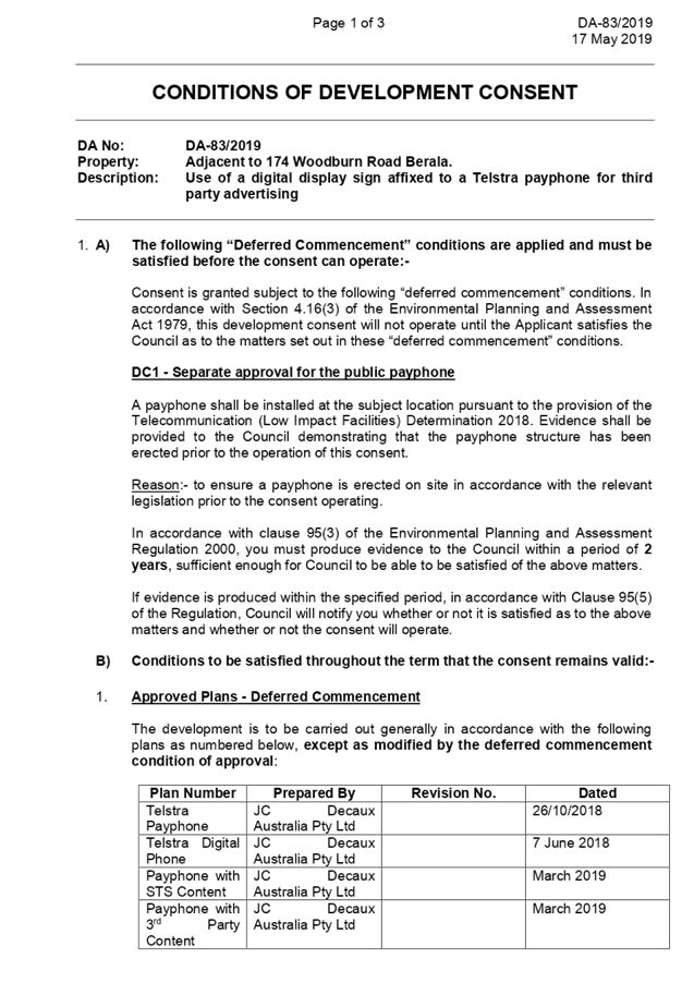
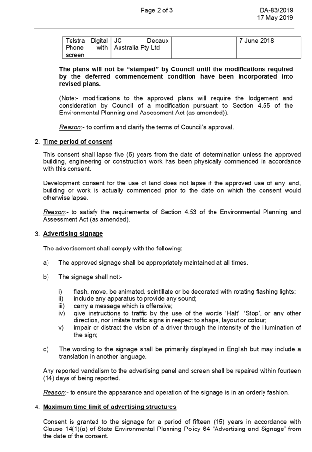
DOCUMENTS
ASSOCIATED WITH
REPORT LPP042/19
Attachment 2
Architectural Plans
Cumberland Local Planning Panel Meeting
12 June 2019
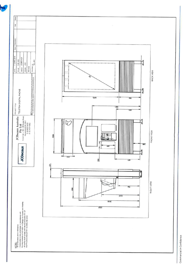
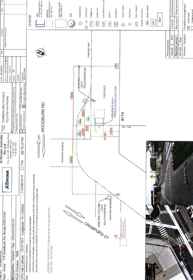
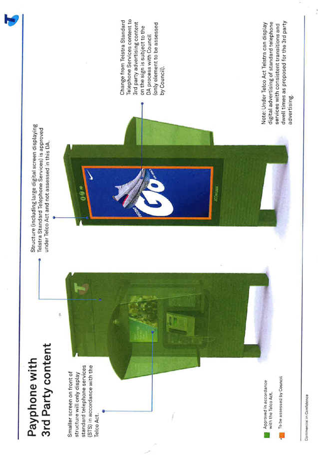
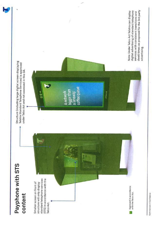
DOCUMENTS
ASSOCIATED WITH
REPORT LPP042/19
Attachment 3
Submissions Received
Cumberland Local Planning Panel Meeting
12 June 2019


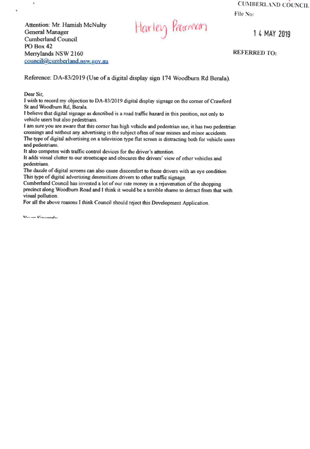


DOCUMENTS
ASSOCIATED WITH
REPORT LPP042/19
Attachment 4
Appendix A
Cumberland Local Planning Panel Meeting
12 June 2019
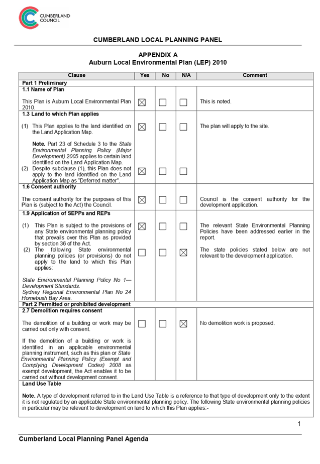
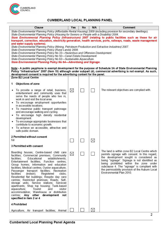
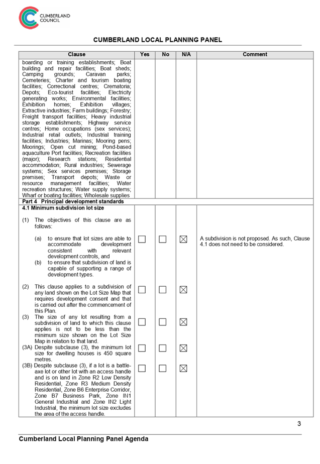


Cumberland
Local Planning Panel Meeting
12 June 2019
Item No: LPP043/19
Development
Application for 14 Hilltop Road, Merrylands
Responsible
Division: Environment
& Planning
Officer: Manager
Development Assessment
File
Number: DA
2018/416/1
|
Application lodged
|
8 November 2018
|
|
Applicant
|
George Andary
|
|
Owner
|
Mr G and Mrs J Andary
|
|
Application No.
|
2018/416/1
|
|
Description of Land
|
14
Hilltop Road, Merrylands (Lot 84 in DP 5296)
|
|
Proposed Development
|
Demolition of
existing structures; construction of a 4 storey shop top housing development
comprising 50 place child care centre on the ground floor; 1 commercial
tenancy, and 14 residential units above 2 levels of basement parking accommodating
41 car parking spaces.
|
|
Site Area
|
1380m².
|
|
Zoning
|
B1 Neighbourhood Centre
|
|
Principal Development
Standards
|
· Floor Space Ratio – 1.2 :1 (HLEP
2013)
· Height of Buildings – 14m
|
|
Disclosure of political
donations and gifts
|
Nil
disclosure
|
|
Heritage
|
No
|
|
Issues
|
- Number
of children and outdoor unencumbered space
- Car
parking ratio
- Landscape
area
|
1. Development
Application 2016/289 was approved on 14 July 2017 for Demolition of existing
structures; construction of a 4 storey shop top housing development comprising
1 commercial tenancy; 16 residential units above basement parking accommodating
26 carparking spaces
2. A
S96(2) modification 2016/289/2 was approved on 23 March 2018 for alterations
and additions including 2 additional residential units, conversion of the
ground floor commercial tenancy into 2 tenancies and additional parking spaces
totalling 18 residential units and 29 parking spaces.
3. Development
Application 2018/416/1 (subject of this report) was received on 8 November 2018
for demolition of existing structures; construction of a 4 storey shop top
housing development comprising 60 place child care centre on the ground floor;
1 commercial tenancy, and 14 residential units above 2 levels of basement
parking accommodating 41 car parking spaces.
4. The
application was publicly notified to adjoining and opposite owners, a notice
was placed in the local press and a notice placed on the site for 14 days from
21 November 2018 to 5 December 2018. In response, one (1) submission was
received.
5. Council
through its assessment identified a number of concerns with the proposal, and
requested amended plans and additional information on 7 February 2019.
6. Amended
plans and additional information were received on 25 February 2019 addressing
some of Council’s concerns.
7. The
proposed development seeks following notable variations:
|
Control
|
Required
|
Provided
|
% variation
|
|
Building
Separation
|
Under the
Apartment Design Guide, separation between windows and balconies is required
to ensure acoustic and visual privacy is achieved. Minimum separation
distances for buildings up to four storeys from buildings to the side and
rear boundaries shall be 6m.
|
Minimum separation of 6m is required. All elevations vary
from 0m – 6m.
Refer to commentary provided
under Appendix D, Part C, 1.4 of the Holroyd DCP 2013.
-
|
Up to 100% variance
|
|
Number of
children and outdoor unencumbered space
-
|
Under the State Environmental Planning Policy (Educational
Establishments and Child Care Facilities)2017
Regulation 108 and part 4.9 the Guideline
7m²x 57 = 399m²
|
404.87m²
(including pedestrian walkway on
the eastern elevation)
Assessing officer’s
calculation = 354.3m²/7(excluding the walkway on the eastern elevation)
= 50.6 children
Recommendation = reduce number
of children to 50
|
12.3%
|
|
Building Height
|
Under
the Holroyd Development Control Plan, the maximum building height in storeys
shall be 3 storeys.
|
The development proposes 4 storeys.
Refer to commentary provided
under Appendix D, Part C, 1.3 of the Holroyd DCP 2013.
|
25%
|
|
Location
|
Under the Holroyd Development
Control Plan, child care centres should not
be located having frontage to an arterial or sub-arterial road (see Appendix
1 to Part I of HDCP 2013).
|
Hilltop Road is listed within
Appendix 2 of Part I of the HDCP 2013 as unsuitable road for Child care
centre.
Refer to commentary provided
under Appendix D, Part I of the Holroyd DCP 2013.
|
100%
|
8. The
application is being reported to the Cumberland Local Planning Panel (CLPP) for
determination as it is a development incorporating 4 storeys and is affected by
the State Environmental Planning Policy No 65 – Design Quality of
Residential Apartment Developments applies.
9. It
is recommended that the application be approved for a maximum of 50 children
(due to the available unencumbered outdoor space/play area) subject to
conditions provided in the Draft Notice of Determination held at Attachment 1.
Subject Site And Surrounding
Area
The subject site is known as 14
Hilltop Road, Merrylands, and is legally described as Lot 84 in DP 5296. The
site is a regular block with a frontage of 25.945m, depth of 67.32m on the
eastern boundary and 68.365m on the western boundary and a total site area of
1380m².
The site is located on the
southern side of Hilltop Road. The subject site and part of adjoining
properties on the eastern side are zoned B1 Neighbourhood Centre and part R3
Medium Density Residential. The adjoining properties to the west and south are
zoned R3 Medium Density Residential Zones. Properties directly opposite the
site to the north are zoned R2 Low Density Residential.
Existing improvements on the site
include a single-storey dwelling house and a shed. Adjoining development on the
eastern side contains a single storey medical centre and development on the
western side contains a single storey place of public worship (church).
Area hatched in red
is 14 Hilltop Road, Merrylands (Locality)
14
Hilltop Road, Merrylands (Aerial)
Site
photo
Description of The Proposed
Development
The proposed development, as
amended involves demolition of existing structures; construction of a 4 storey
shop top housing development comprising 1 commercial tenancy; 14 residential
units above 2 levels of basement parking accommodating 41 car parking spaces.
Key features of the development
proposal are as follows:-
· Demolition
of the existing dwelling.
Basement Level
· Car
parking in the basement (two levels) as follows:
ii)
- 21
(3 disabled) space for residential
- 3
Visitor space
- 14
(1 disabled) space for the childcare facility
- 3
commercial space
Total car space
= 41 car space
- 1
Carwash space
- 9
bicycles space
- Separate
commercial and residential lift
- Fire
stairs
- Storage
space for residential units
Ground Floor
· Waste
bins at grade:
- 9
General Bins and 6 recyclable bins, totalling 15 bins for residential
- 5
General bins and 5 recyclable bins, totalling 10 bins for child care facility
and commercial premises
· Childcare
facility:
- The
proposed childcare will accommodate 50 children
- The
proposed centre will operate from 7am to 6.00pm Monday to Friday
- 20
Children in the 2-3 year bracket and 30 children in the 3-6 year bracket
- A
total of 8 staff will be employed (this excludes any staff associated with
administration and food preparation)
· Commercial
area:
- One
commercial tenancy of 37.91m²
- Loading
bay for commercial tenancy
· Substation
· Separate
commercial and residential lift
· Fire
stairs
2nd Floor
· 1
(adaptable) x 1 bedroom unit
· 6
(1 adaptable) x 2 bedroom units
· Residential
lift
3rd Floor
· 1
(adaptable) x 1 bedroom unit
· 4
x 2 bedroom units
· 1
x 3 bedroom unit
· Communal
Open space
· Residential
lift
4th Floor
· 1
x 4 bedroom unit (penthouse)
· Communal
Open Space
· Residential
lift
History
|
Date
|
Action
|
|
24 February 2016
|
Pre Development Advisory PDA/200 was held for construction
of a 4 storey mixed use building over basement parking accommodating 19 units
and 32 car parking spaces.
|
|
14 July 2017
|
Development Application 2016/289 was approved for
Demolition of existing structures; construction of a 4 storey shop top
housing development comprising 1 commercial tenancy; 16 residential units
above basement parking accommodating 26 carparking spaces
|
|
23 March 2018
|
A S96(2) modification 2016/289/2 was approved for
alterations and additions including 2 additional residential units,
conversion of the ground floor commercial tenancy into 2 tenancies and
additional parking spaces totalling 18 residential units and 29 parking
spaces
|
|
25 July 2018
|
Pre Development Advisory Application PDA/777 was held for
modification to an approved shop top housing development (DA/2016/289) via
the lodgement of an amending Development Application, to incorporate a 58
place child care centre within the ground floor. Also associated changes to
the residential units in terms of the common open space area, additional
basement level and parking, and the consolidation of a number of units at the
top level to form a penthouse
|
|
25 October 2018
|
Development Application 2018/366 was rejected by the
Development Application Review Team (DART) due to insufficient information.
|
|
08 November 2018
|
Development Application 2018/416 was lodged for demolition of existing structures;
construction of a 4 storey shop top housing development comprising 60 place
child care centre on the ground floor; 1 commercial tenancy, and 14
residential units above 2 levels of basement parking accommodating 41 car
parking spaces.
|
|
14 November 2018
|
The application was referred to Council’s internal
departments for review.
|
|
21 November 2018 to 05
December 2018
|
The application was publicly
notified to adjoining and opposite owners, a notice was placed in the local
press and a notice placed on the site for 14 days. In response, 1 submission
was received.
|
|
7 February 2019
|
Application was deferred due to non-compliances with SEPP
(Educational Establishments and Child Care Facilities) 2017, Child Care
Planning Guideline 2017, Holroyd Local Environmental Plan 2013, and Holroyd Development
Control Plan 2013.
|
|
25 February 2019
|
Amended plans and additional information were received by
Council. In response to the issues raised, the primary change being to reduce
the number of childcare placements to 57. The amended application was not
considered to be notified.
|
|
26 February 2019
|
The application was re-referred to Council’s
internal departments for review.
|
|
12 June 2019
|
Application referred to CLPP for determination.
|
Applicant’s Supporting
Statement
The applicant provided a Statement
of Environmental Effects prepared by Think Planners Pty Ltd dated 1 October
2018 and 25 February 2019 in support of the application.
Contact With Relevant
Parties
The assessing officer has
undertaken a site inspection of the subject site and surrounding properties and
has been in regular contact with the applicant throughout the assessment
process.
Internal Referrals
Development Engineer
The development application was
referred to Council’s Development Engineer for comment who has advised
that the development is supportable in regards to stormwater measure, and
on-site detention provision, subject to deferred commencement conditions.
Traffic Engineer
The development application was
referred to Council’s Traffic Engineer for comment who has advised that
the development is supportable in regards to traffic management and median
island works, subject to deferred commencement conditions.
Tree Management Officer
The development application was
referred to Council’s Tree Management Officer for comment who has advised
that the development is supportable in regards to protection of existing trees
on the adjoining properties, subject to conditions.
Waste Management Officer
The development application was
referred to Council’s Waste Management Officer for comment who has
advised that the development is supportable in regards to bin storage room, and
waste collection and management plan.
Environmental Health Officer
The development application was
referred to Council’s Environmental Health Officer for comment who has
advised that the development is supportable in regards to fit-out for food
preparation area, acoustic assessment, noise management plan, noise attenuation
measure, soil assessment, and site contamination, subject to conditions.
Children’s Services
The development application was
referred to Council’s Children’s Services section for comment who
has advised that the development is supportable in regards to compliance with
the provisions of Education and Care Services National Regulations and Law, subject
to conditions.
External Referrals
Endeavour Energy
The development application was
referred to Endeavour Energy for comment who has advised that the development
is satisfactory. However, a letter from the Applicant states that the proposed
distance of the substation from the proposed childcare facility may cause
Electromagnetic Radiation (EMR) levels generated by the proposed substation.
According the letter recommends testing on the location once both facilities
are constructed would be required to confirm the levels present. To ensure
safety measures are taken into account, a condition prior to the occupation of
the childcare centre has been imposed.
Transgrid
The development application was
referred to Transgrid for comment who has advised that the development is
supportable.
Planning Comments
The provisions of any
Environmental Planning Instruments (EP & A Act, s4.15(1)(a)(i))
State Environmental Planning
Policies
The proposed development is
affected by the following State Environmental Planning Policies:
(a) State
Environmental Planning Policy No. 55 – Remediation of Land
The requirement at Clause 7 of
SEPP No. 55 for Council to be satisfied that the site is suitable or can be
made suitable to accommodate the proposed development has been considered in
the following table:
|
Matters for consideration
|
Yes
|
No
|
N/A
|
|
Does the application involve
re-development of the site or a change of land use?
|
|
|
|
|
Is the development going to be
used for a sensitive land use (e.g.: residential, educational, recreational,
childcare or hospital)?
|
|
|
|
|
Does information available to
you indicate that an activity listed below has ever been approved, or
occurred at the site?
acid/alkali plant and
formulation, agricultural/horticultural activities, airports, asbestos
production and disposal, chemicals manufacture and formulation, defence
works, drum re-conditioning works, dry cleaning establishments, electrical
manufacturing (transformers), electroplating and heat treatment premises,
engine works, explosive industry, gas works, iron and steel works, landfill
sites, metal treatment, mining and extractive industries, oil
production and storage, paint formulation and manufacture, pesticide
manufacture and formulation, power stations, railway yards, scrap yards,
service stations, sheep and cattle dips, smelting and refining, tanning and
associated trades, waste storage and treatment, wood preservation.
|
|
|
|
|
Is the site listed on Council's
Contaminated Land Database?
|
|
|
|
|
Is the site subject to EPA
clean-up order or other EPA restrictions?
|
|
|
|
|
Has the site been the subject of
known pollution incidents or illegal dumping?
|
|
|
|
|
Does the site adjoin any
contaminated land/previously contaminated land?
|
|
|
|
|
Has the appropriate level of
investigation been carried out in respect of contamination matters for
Council to be satisfied that the site is suitable to accommodate the proposed
development or can be made suitable to accommodate the proposed development?
|
|
|
|
|
Details of contamination
investigations carried out at the site:
In relation to clause 7(4) of SEPP 55, the land of
concerned is not located within an investigation area (clause 7(4)(a)),
development for a purpose referred to in Table 1 of the Contaminated Land
Planning Guidelines is not known to have been carried out on the land (clause
7(4)(b), and historic zoning controls of the land did not make lawful the
carrying out of activities nominated in Table 1. Based on these considerations, clauses 7(2) and 7(3)
of SEPP 55 have no application. The site is not identified in Council’s
records as being contaminated. A site inspection reveals the site does not
have any obvious signs or history of a previous land use that may have caused
contamination and there is no specific evidence that indicates the site is
contaminated. On this basis, SEPP 55 has no further application. Notwithstanding, a soil assessment report is
required in accordance with the Child Care Planning Guideline issued by NSW
Department of Planning and Environment. The
proposal is considered satisfactory, subject to imposition of condition with
regard to submission of a soil assessment report prior to issue of
construction certificate.
|
(b) State
Environmental Planning Policy (Building Sustainability Index: BASIX) 2004
The application is accompanied
with BASIX Certificate 738748M_03 prepared by Taylor Smith Consulting issued on
3 October 2018 has been submitted. This certificate is a revision of
certificate number 738748M lodged on 15 July 2016 with application 2016/289/1.
A deferred commencement condition will be imposed for a new BASIX certificate
for DA/2018/416/1.
The BASIX Commitments specified in
the BASIX Certificate shall be nominated on the architectural drawings and will
need to be incorporated into the construction and fit-out of the development. A
condition to require the BASIX commitments to be implemented in the
construction of the development has been included in the draft conditions of
consent.
(c) Statement
Environmental Planning Policy No. 65 - Design Quality of Residential Apartment
Development (SEPP 65)
SEPP 65 applies to the development
as the building is 3 storeys or more, and contains more than 4 dwellings. A
design statement addressing the design quality principles prescribed by SEPP 65
was prepared by the project architect. Integral to SEPP 65 is the Apartment
Design Guide (ADG), which sets benchmarks for the appearance, acceptable
impacts and residential amenity of the development.
A comprehensive assessment against
SEPP 65 and the ADG is contained in Appendix A. The proposal involves the following
non-compliances with the ADG controls.
|
Control
|
Required
|
Provided
|
|
Visual Privacy/Acoustic/ Separation
|
Separation
between windows and balconies is provided to ensure visual privacy is
achieved. Minimum required separation distances from buildings to the side
and rear boundaries are as follows:
Building
Height = 12m / 4 storeys
- Habitable Rm / Balc. = 6m
- Non-Habitable Rm = 3m
Building
Height = 25m / 5-8 storeys
- Habitable Rm / Balc. = 9m
- Non-Habitable Rm = 4.5m
Note: Separation distances between buildings on the
same site should combine required building separations depending on the type
of room.
Gallery
access circulation should be treated as habitable space when measuring
privacy separation distances between neighbouring properties.
|
Northern Elevation (Hilltop Road)
Ground Floor – 0m
2nd Storey – 0m
3rd Storey – 0m
4th Storey – 2.99m
Eastern Elevation (Interfaces 12 Hilltop Road, 98 and
100 Burnett Street)
Ground Floor – 3m – 5.8m
2nd Storey – 0m – 6m
3rd Storey – 0m – 6m
4th Storey – 0m – 6m
Southern elevation (Interfaces 37 Richardson Street)
Ground Floor – 13,675m
2nd Storey – 13,675m
3rd Storey – 13,675m
4th Storey – 13,675m
Western elevation (Interfaces 16 Hilltop Road)
Ground Floor – 2 -6m
2nd Storey – 0m – 6.225m
3rd Storey – 0m – 6m
4th Storey – 0m – 6m
Refer to commentary provided
under Appendix D, Part C, 1.4 of the Holroyd DCP 2013.
|
(d) State
Environmental Planning Policy (Educational Establishments and Child Care
Facilities) 2017
The relevant provisions of the
SEPP have been considered in the assessment of the Application.
It is noted that State
Environmental Planning Policy (Educational Establishments and Child Care
Facilities) 2017 commenced on 1 September 2017. The SEPP applies to any
proposals for new schools or child care centres or proposed alterations and
additions to existing centres. The relevant provisions of the SEPP have been
considered in the assessment of the Application.
A comprehensive assessment and
compliance table is attached to this report in Appendix B, which indicates that
there are non-compliances with the SEPP 2017 with regard to number of children
proposed and outdoor unencumbered space as under:
|
- Control
|
- Required
|
- Provided
|
|
- Number
of children and outdoor unencumbered space (regulation 108 SEPP 2017 and part
4.9 the Guideline)
|
7m²x 57 = 399m²
|
The application indicates that
an unencumbered area of 404.87m² is provided (including pedestrian
walkway on the eastern elevation).
Assessing officer’s
calculation = 354.3m² (excluding the walkway on the eastern elevation) =
50.6 children
This report recommends a
condition to be imposed on any consent granted seeking a reduction in number
of children to 50.
|
(e) Statement
Environmental Planning Policy No 19 - Bushland in Urban Areas
The subject site does not adjoin
land zoned or reserved for public open space. The proposal does not propose to
disturb bushland zoned or reserved for public open space.
(f) State
Environmental Planning Policy (Vegetation in Non-Rural Areas) 2017
No vegetation removal is proposed.
Regional Environmental Plans
(Deemed State Environmental Planning Policies)
(g) Sydney
Regional Environmental Plan (Sydney Harbour Catchment) 2005
The subject site is identified as
being located within the area affected by the Sydney Regional Environmental
Plan (Sydney Harbour Catchment) 2005. The proposed development raises no issues
as no impact on the catchment is envisaged.
Note: The
subject site is not identified in the relevant map as land within the
‘Foreshores and Waterways Area’ or ‘Wetland Protection
Zone’, is not a ‘Strategic Foreshore Site’ and does not
contain any heritage items. Hence the majority of the SREP is not directly
relevant to the proposed development.
Local Environmental Plans
(a) Holroyd
Local Environmental Plan (LEP) 2013
The proposed development is
defined as a ‘shop top housing’ and ‘centre based child care
facility’ under the provisions of Holroyd Local Environmental Plan (LEP)
2013. Shop top housing and Centre based child care facilities are a permissible
land use with consent under the B1 Neighbourhood Centre zone applying to the
land under Holroyd LEP 2013.
“shop top housing means one
or more dwellings located above ground floor retail premises or business
premises”
The development proposes a child
care facility and 1 commercial tenancy on the ground floor level. The child
care facility is not a “retail premises” or “business
premises”, however, the centre provides a service directly to members of
the public on a regular basis. For most centres, members of the public are
unable to walk in off the street and have their child minded. Rather, it is
usual that that the child needs to be registered and attendance is subject to
availability within the centre.
It is noted the development also
has a commercial tenancy on the ground floor which would be capable of being
used as such and accordingly, the development satisfies the definition of
“shop top housing”. The commercial tenancy is 37.91m² in area.
The size of the commercial tenancy may create restrictions on the type of
commercial use the tenancy may operate in the future. It is not necessary that
the retail or business premises occupy the whole of the ground floor or the
entire footprint for the dwellings above.
In Affinity Property Investment
Pty Ltd v Wollongong City Council [2017] NSWLEC 1756 (albeit by way of a s.34
agreement), the Court approved 1 retail/business premises and a child care
centre on the ground floor and 44 apartments above.
A comprehensive assessment and
compliance table is attached to this report in Appendix C which demonstrates
the development proposal’s compliance with the relevant planning controls
that are applicable to the site under the Holroyd LEP 2013.
The provisions of any draft
Environmental Planning Instruments (EP & A Act Section 4.15(1)(a)(ii))
The proposed development is not
affected by any relevant Draft Environmental Planning Instruments.
The provisions of any
Development Control Plans (Environmental Planning & Assessment Act Section
4.15(1)(a)(iii))
(b) Holroyd
Development Control Plan (HDCP) 2013
The Holroyd DCP 2013 provides
guidance for the design and operation of development within Holroyd to achieve
the aims and objectives of Holroyd LEP 2013.
The proposed development is
generally compliant with the relevant provisions. Parts A, B & I apply to
the proposal. A comprehensive assessment and compliance table is attached to
this report at Appendix D which demonstrates the development proposal’s
compliance with the relevant planning controls that are applicable to the site.
The assessment provided in
Appendix D indicates that there are some minor non-compliances with the HDCP
2013 which are discussed in the following section:
|
No.
|
Clause
|
Comment
|
Yes
|
No
|
N/A
|
|
PART C – COMMERCIAL DEVELOPMENT
|
|
1.3
|
Building Height
|
|
|
Maximum building height in storeys shall be provided in
accordance with the table below:
|
Permitted Height (storeys)
|
|
Height
|
Storeys
|
|
10m
|
1
|
|
11m
|
2
|
|
12.5m
|
2
|
|
14m
|
3
|
|
17m
|
4
|
|
20m
|
5
|
|
23m
|
6
|
|
26m
|
7
|
|
29m
|
8
|
|
32m
|
9
|
|
38m
|
11
|
|
41m
|
12
|
|
50m
|
15
|
|
53m
|
16
|
|
65m
|
20
|
|
The Holroyd Development Control
Plan states the maximum building height in storeys shall be 3 storeys for the
subject site. The development proposes 4 storeys which does not comply with
the prescriptive requirement. The 4 storey mixed used development is considered
acceptable in this instance because it is located at the western edge of a
neighbourhood commercial precinct. The scale and design is sympathetic to the
future streetscape of the area. It is noted that DA/2016/289/1 had previously
approved a 4 storey building. Therefore the current application is keeping
consistent with the approved number of storeys. Furthermore, the overall
height of the building complies with Holroyd Local Environmental Plan.
Therefore the proposal is considered satisfactory.
|
|
|
|
|
PART I –
CHILDCARE CENTRES
|
|
1
|
Location
|
|
|
|
|
|
|
Child care centres should not be
located having frontage to any road, which in the opinion of Council, is
unsuitable for the establishment of a child care centre having regard to:-
(a) prevailing traffic conditions;
(b) pedestrian and traffic safety; and
(c) the likely impact of development on the flow of traffic
on the surrounding street system.
In this regard child care
centres should not be located having frontage to an arterial or sub-arterial
road (see Appendix 1 to Part I of HDCP 2013).
As a general guide the roads identified in Appendix 2 are
also considered by Council to be generally unsuitable for the establishment
of child care centres, without special consideration firstly being given to
the prevailing traffic conditions. All applications are to be supported by a
Traffic and Parking Report prepared by a suitably qualified person addressing
the above issues to Council’s satisfaction.
|
Hilltop Road is listed within
Appendix 2 of Part I of the HDCP 2013 as unsuitable road for Child care
centre.
As a general guide the roads
identified in Appendix 2 are also considered by Council to be generally
unsuitable for the establishment of child care centres, without special
consideration being given to the prevailing traffic conditions. All
applications are to be supported by a Traffic and Parking Report, prepared by
a suitably qualified person addressing the issues to Council’s
satisfaction.
The proposed development was
accompanied by a traffic and parking study which suggests a median island on
Hilltop Road, to prevent any right turn movement and this has been reviewed
and deemed acceptable by Council’s Traffic Engineering department
subject to deferred commencement conditions.
|
|
|
|
|
|
|
|
|
|
|
Section 4.15(1)(a)(iiia) - any
planning agreement that has been entered into under section 93F, or any draft
planning agreement that a developer has offered to enter into under section
93F, and
There are no draft planning
agreements or planning agreements associated with the subject application.
The provisions of the
Regulations (Environmental Planning & Assessment Act Section
4.15(1)(a)(iv))
The proposed development raises no
concerns as to the relevant matters arising from the Environmental Planning
& Assessment Regulations 2000.
Section 4.15 (1)(a)(v) - any
coastal zone management plan (within the meaning of the Coastal Protection Act
1979)
There is no Coastal Zone
Management Plan applicable for the site.
The Likely Environmental,
Social or Economic Impacts (EP & A Act s4.15(1)(b))
The likely impacts of the
development have been considered in the assessment of the application and it is
considered that the proposed development will have no significant adverse
environmental, social or economic impacts in the locality.
The suitability of the site for
the development (EP & A Act s4.15(1)(c))
The site is considered suitable to
accommodate the proposed development. The proposed development has been
assessed in regard to its environmental consequences and having regard to this
assessment, it is considered that the development is suitable in the context of
the site and surrounding locality.
Submissions made in accordance
with the Act or Regulation (EP & A Act s4.15C(1)(d))
Advertised (newspaper) Mail Sign Not Required
In accordance with Part E - Public
Participation of the Holroyd DCP 2013, the application was publicly notified to
adjoining and opposite owners, a notice was placed in the local press and a
notice placed on the site for 14 days from 21 November 2018 to 5 December 2018.
In response, 1 (one) submission was received.
The issues raised in the public
submission is summarised and commented on as follows:
|
- Concern
|
- Comment
|
|
Concerns raised
regarding potential privacy impacts on adjoining properties
|
The proposed development is
considered to provide appropriate separation to the adjoining properties that
will in turn achieve reasonable levels of external and internal visual
privacy for future residents and residents of adjoining properties.
The communal open space on the 3rd
and 4th storey will require privacy treatment. Accordingly, a
condition will be imposed for provision of a privacy screen with a minimum
height of 1.5m above the finished floor level to wrap around the communal
open space on the 3rd and 4th floor, which will
maintain privacy.
|
|
Over development
|
The proposed development is
permitted with consent on the subject site and the uses are compliant with
the relevant controls and standards.
|
|
Concerns raised
regarding the effects of electromagnetic energy on the health and safety of
local residents and also the patrons of the child care centre from the power
substation.
|
The application was referred to Transgrid and Endeavour
energy for comments for the proposed substation. Accordingly, the substation
is considered satisfactory. To ensure duty of care, Council will impose a
condition for electric and magnetic field measurement detailing any effects
of the proposed substation on the child care centre, and any mitigation
measures required. Testing on the location once both facilities are
constructed would be required to confirm the levels present prior to the
operation of the childcare centre.
|
|
Concerns raised that
the development would create traffic impacts for the local area and in
particular, the intersection of Hilltop Road and Burnett Street.
|
Due to the provision of the
required on-site parking spaces, it is considered that traffic generated by
this development will not adversely affect the existing traffic in the
street. The proposed development was accompanied by
a traffic and parking study which suggests a median island on Hilltop Road,
to prevent any right turn movement and this has been reviewed and deemed
acceptable by Council’s Traffic Engineering Unit, subject to deferred
commencement conditions.
|
|
Concerns
raised that the proposed child care centre will be a noise nuisance to
surrounding properties. In particular the outdoor play area, height of
acoustic fencing and mechanical plant equipment.
|
Council’s
Environmental Health Unit has assessed the proposed development having regard
to the acoustic reports submitted and considers the development to be
satisfactory subject to the implementation of acoustic measures recommended
within those reports.
The acoustic report
demonstrates that the proposed centre can be accommodated on the site without
noise nuisance to adjoining and surrounding properties, as the noise
generated from both indoor and outdoor play activities can comply with the
relevant environmental noise guidelines with the imposition of a noise
management plan submitted with the application and the installation of
relevant noise mitigation measures such as acoustic fencing. The acoustic
consultant recommendation is captured within the
Noise Management Plan.
Conditions are to be imposed in the consent to avoid any breaches to
the required noise threshold, including noise management to be incorporated
in the Operational Management Plan.
|
|
Garbage
and waste management
|
The plans include a bin room at grade to
accommodate garbage bins and recycling bins. The bin store room is
accessible via the lift or stairs and via the rear door and side setback area
or street. The proposed waste arrangements have been reviewed by
Council’s waste services who advised that waste arrangements are
satisfactory.
|
The public interest (EP & A
Act s4.15(1)(e))
The public interest is served by
permitting the orderly and economic development of land, in a manner that is
sensitive to the surrounding environment and has regard to the reasonable
amenity expectations of surrounding land users. In view of the foregoing
analysis it is considered that the development, if carried out subject to the
conditions set out in the Draft Notice of Determination, will have no significant
adverse impacts in the locality.
Section 7.11 of The
Environmental Planning & Assessment Act 1979
The subject development requires
the payment of contributions in accordance with Holroyd Section 94 Development
Contributions Plan 2013.
In accordance with the currently
indexed rates for the Mays Hill Centre contribution area, the following
contributions apply:
· 2
x 1 bedroom dwellings - $5,144 x 2 = $10,288
· 10
x 2 bedroom dwellings – $8,700 x 10 = $87,000
· 2
x 3 bedroom dwellings or more – $12,180 x 2 = $24,360
· minus
credit for the existing 1 x 3 bedroom dwellings – $12,180
At the time of this development
consent, the current rate of the contribution is $109,468. The Draft
Determination at attachment 1 includes a condition to require payment of contributions
prior to the issue of a construction certificate.
Disclosure of Political
Donations and Gifts
The NSW Government introduced The
Local Government and Planning Legislation Amendment (Political Donations) Act
2008 (NSW). This disclosure requirement is for all members of the public
relating to political donations and gifts. The law introduces disclosure
requirements for individuals or entities with a relevant financial interest as
part of the lodgement of various types of development proposals and requests to
initiate environmental planning instruments or development control plans.
The application and notification
process did not result in any disclosure of Political Donations and Gifts.
The Application has been assessed
in accordance with the relevant requirements of the Environmental Planning and
Assessment Act 1979, State Environmental Planning Policy 65 – Design
Quality of Residential Apartment Development, State Environmental Planning
Policy No. 55 – Remediation of Land, State Environmental Planning Policy
(Educational Establishments and Child Care Facilities) 2017, Education and Care
Services National Regulations, Apartment Design Guide, Holroyd Local
Environmental Plan 2013 and the Holroyd Development Control Plan 2013 and is
considered to be satisfactory for approval subject to reduction in number of
children to 50 (to comply with the outdoor unencumbered space) and the draft
conditions.
There are no further consultation
processes for Council associated with this report.
There are no further financial
implications for Council associated with this report.
There are no policy implications
for Council associated with this report.
Communication /
Publications:
The final outcome of this matter
will be notified in the newspaper. The objectors will also be notified in
writing of the outcome.
|
1. That
Development Application 2018/416/1 for demolition of existing structures;
construction of a 4 storey shop top housing development comprising 50 place
child care centre on the ground floor; 1 commercial tenancy, and 14
residential units above 2 levels of basement parking accommodating 41 car
parking spaces on land at 14 Hilltop Road, Merrylands, be Approved, subject
to the deferred commencement conditions, provided at Attachment 1.
2. That
the applicant and those persons who lodged a submission in respect of the
application be notified of the determination of the application.
|
1. Draft Notice
of Determination ⇩
2. Architectural
Plans - Site Plan ⇩
3. Architectural
Plans - Perspectives ⇩
4. Architectural
Plans - Roof Plan ⇩
5. Architectural
Plans - Elevations ⇩
6. Architectural
Plans - Floor Plan ⇩
7. Landscape
Plan ⇩
8. Stormwater
Plan ⇩
9. Acoustic
Report and Noise Management Plan ⇩ 
10. Traffic
Report ⇩
11. Plan
of Management ⇩
12. Endeavour
Energy Comments ⇩
13. Submission
⇩
DOCUMENTS
ASSOCIATED WITH
REPORT LPP043/19
Attachment 1
Draft Notice of Determination
Cumberland Local Planning Panel Meeting
12 June 2019


DOCUMENTS
ASSOCIATED WITH
REPORT LPP043/19
Attachment 2
Architectural Plans - Site Plan
Cumberland Local Planning Panel Meeting
12 June 2019
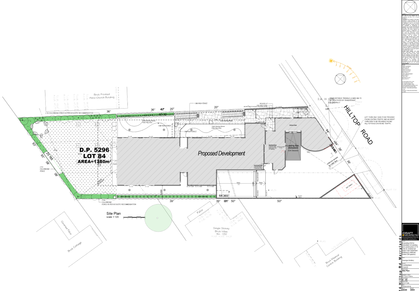
DOCUMENTS
ASSOCIATED WITH
REPORT LPP043/19
Attachment 3
Architectural Plans - Perspectives
Cumberland Local Planning Panel Meeting
12 June 2019
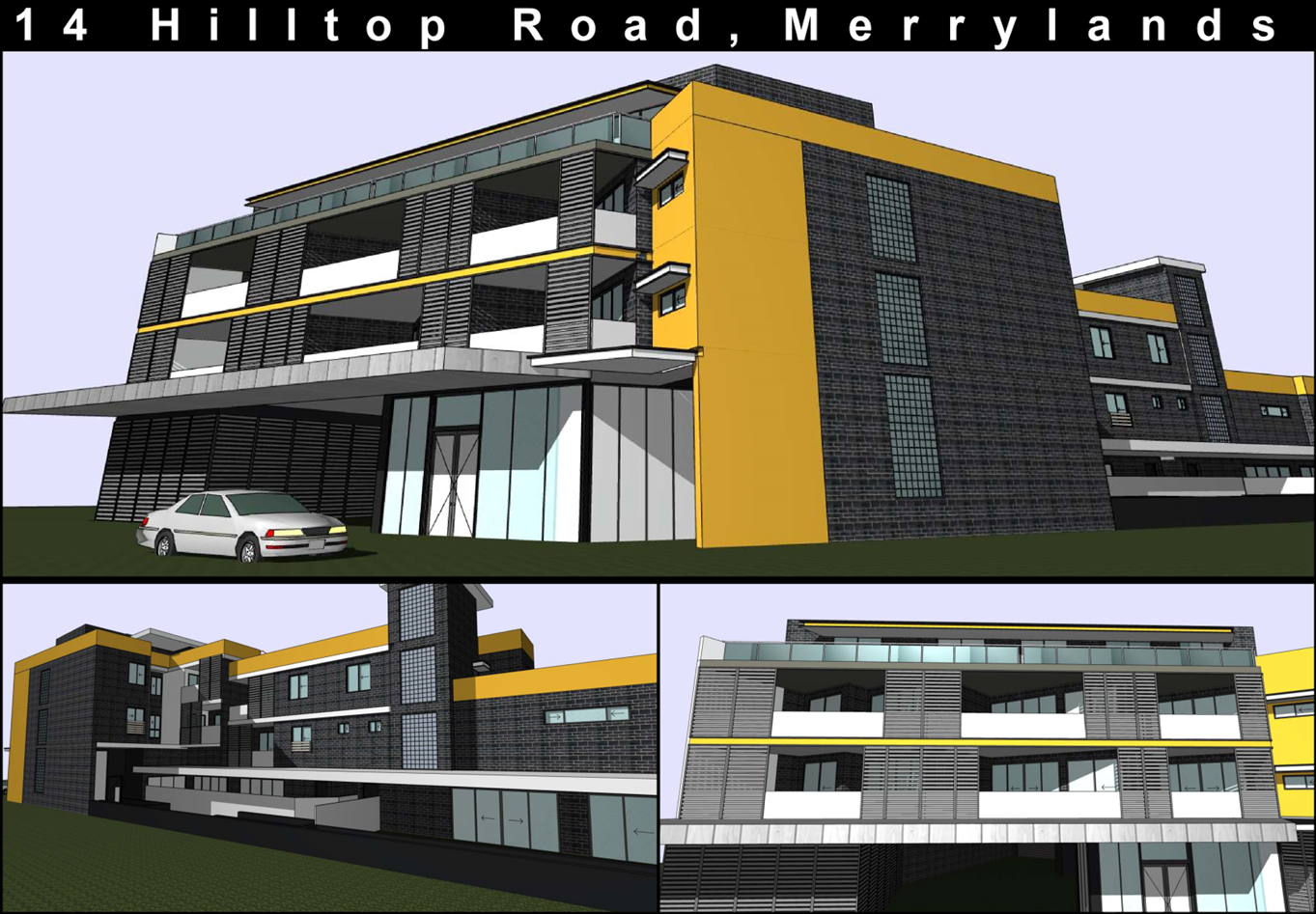
DOCUMENTS
ASSOCIATED WITH
REPORT LPP043/19
Attachment 4
Architectural Plans - Roof Plan
Cumberland Local Planning Panel Meeting
12 June 2019
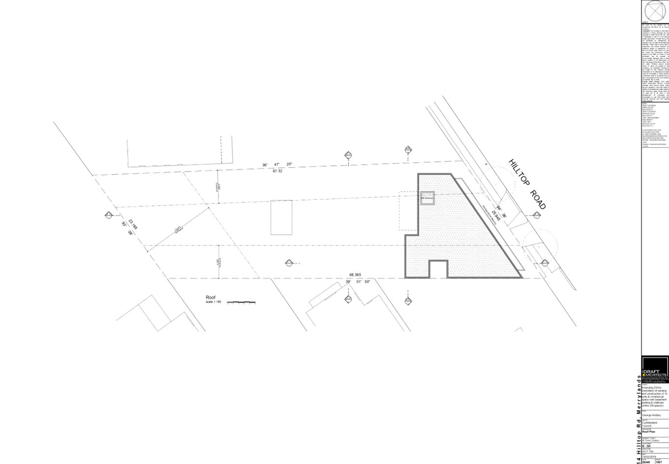
DOCUMENTS
ASSOCIATED WITH
REPORT LPP043/19
Attachment 5
Architectural Plans - Elevations
Cumberland Local Planning Panel Meeting
12 June 2019
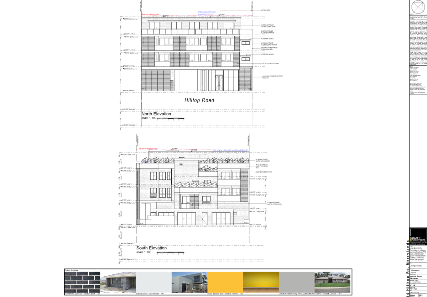
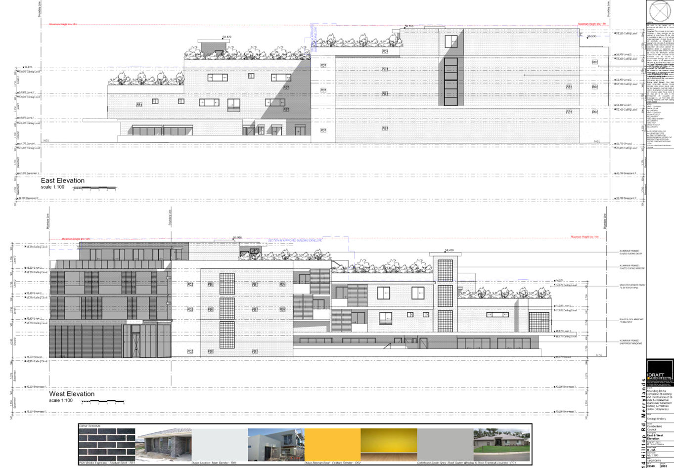
DOCUMENTS
ASSOCIATED WITH
REPORT LPP043/19
Attachment 6
Architectural Plans - Floor Plan
Cumberland Local Planning Panel Meeting
12 June 2019
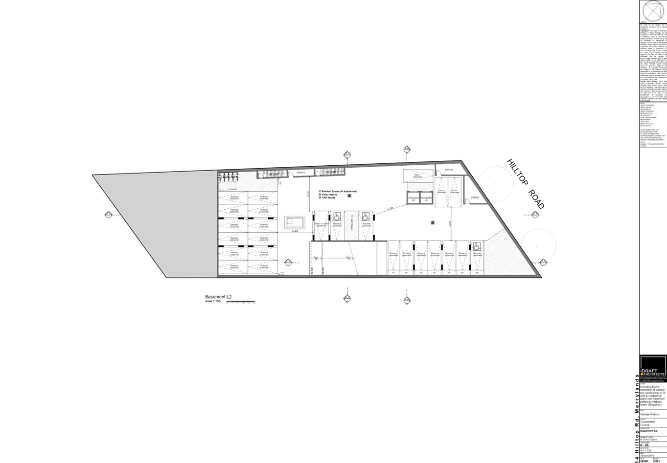
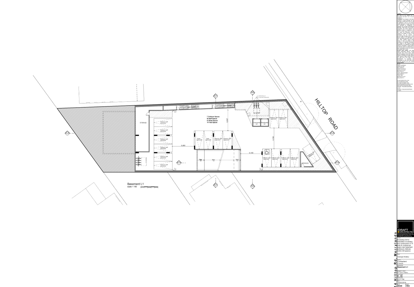
DOCUMENTS
ASSOCIATED WITH
REPORT LPP043/19
Attachment 7
Landscape Plan
Cumberland Local Planning Panel Meeting
12 June 2019
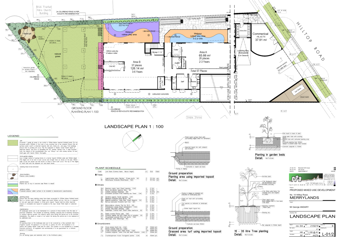
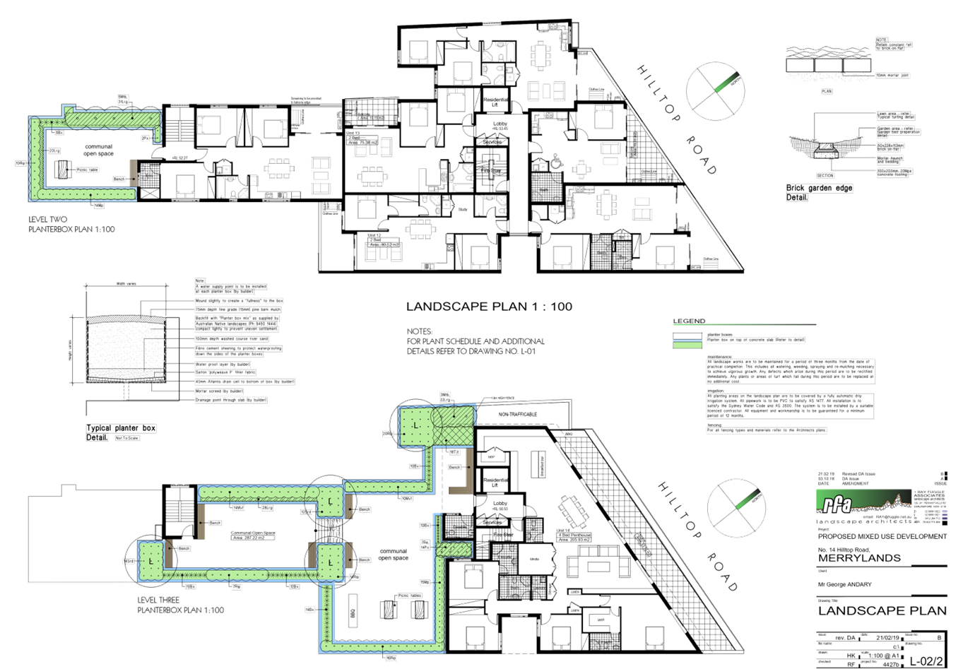
DOCUMENTS
ASSOCIATED WITH
REPORT LPP043/19
Attachment 8
Stormwater Plan
Cumberland Local Planning Panel Meeting
12 June 2019
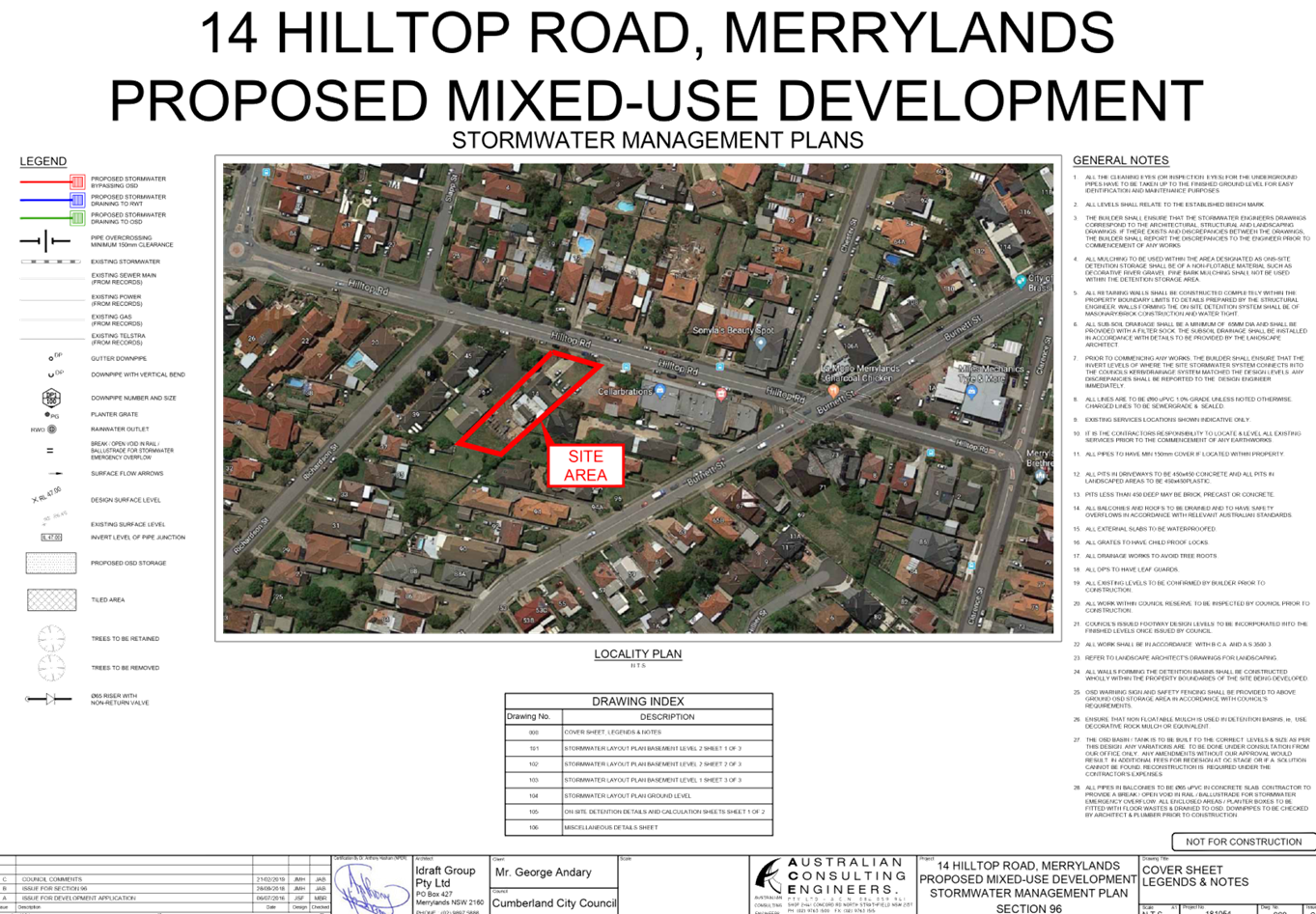
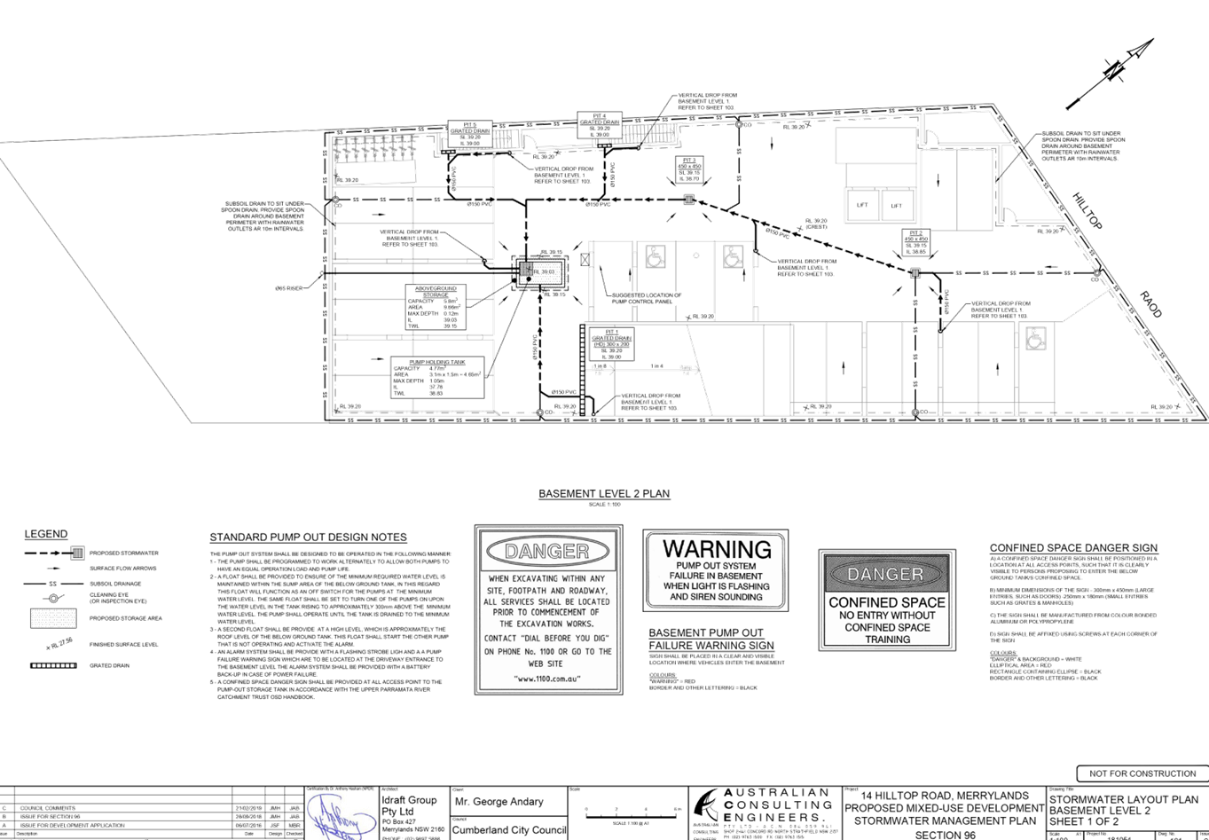
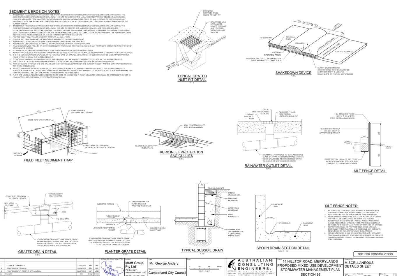
DOCUMENTS
ASSOCIATED WITH
REPORT LPP043/19
Attachment 9
Acoustic Report and Noise Management Plan
Cumberland Local Planning Panel Meeting
12 June 2019

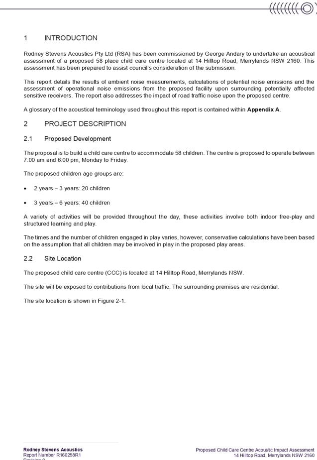


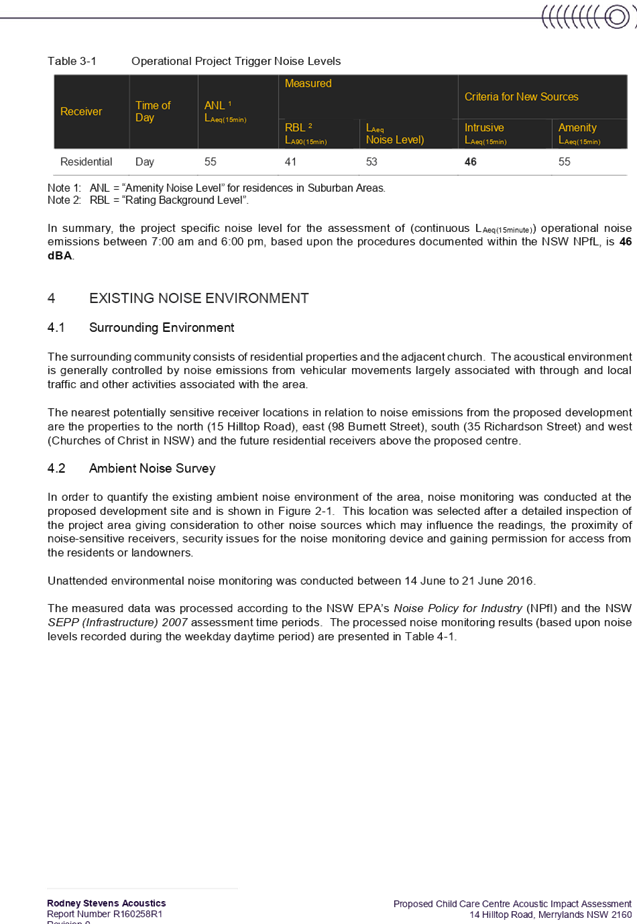
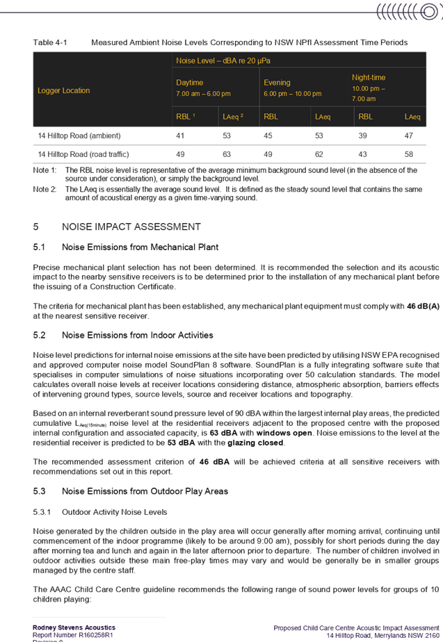

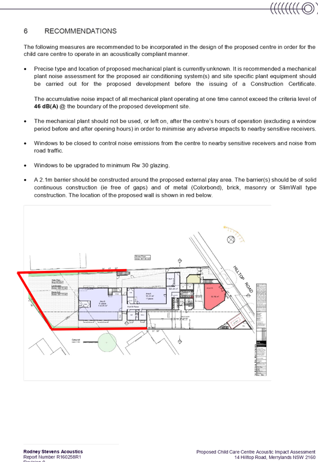

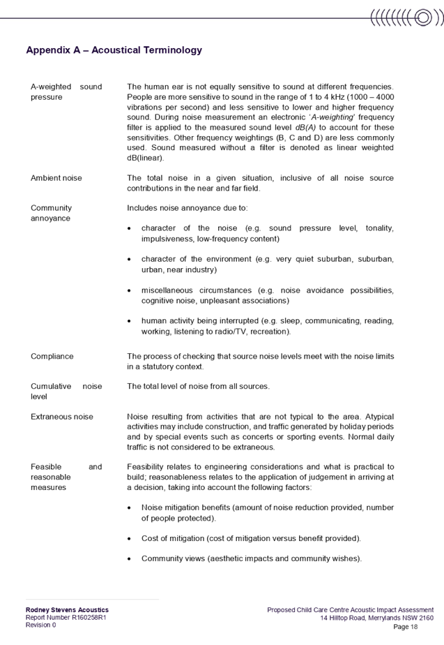
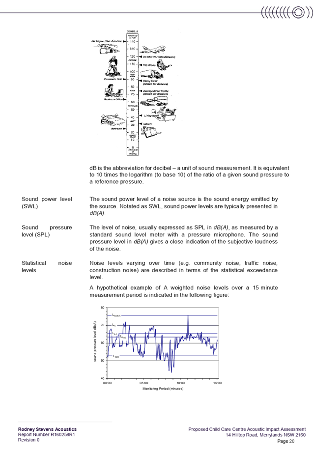
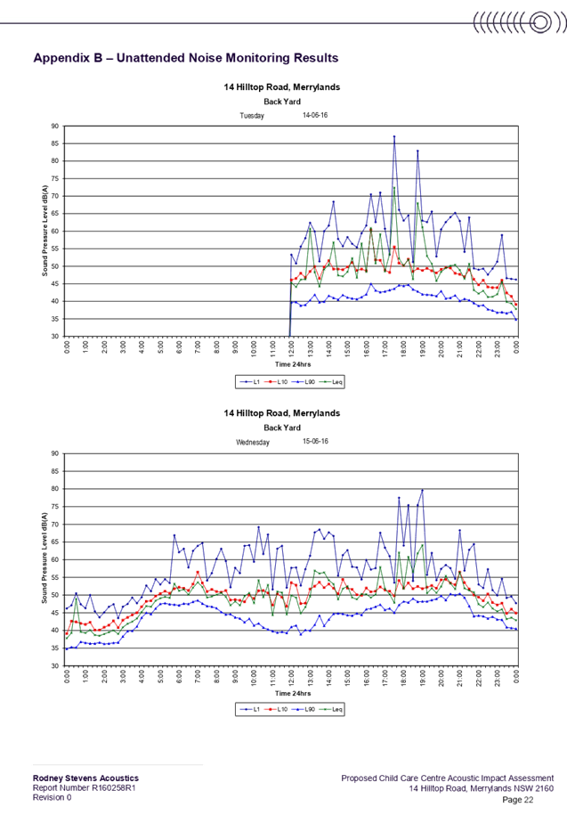
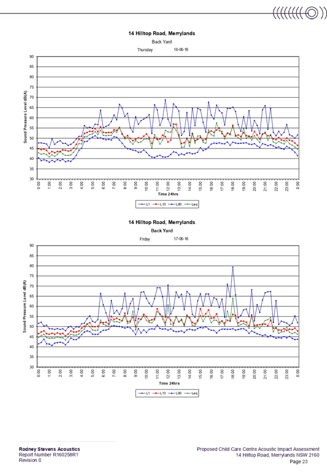
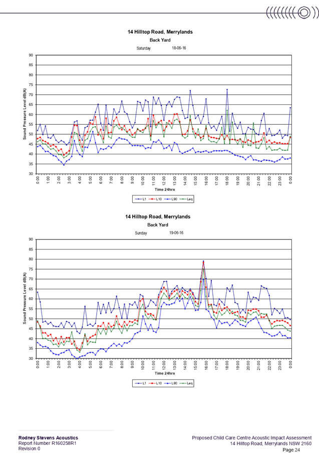
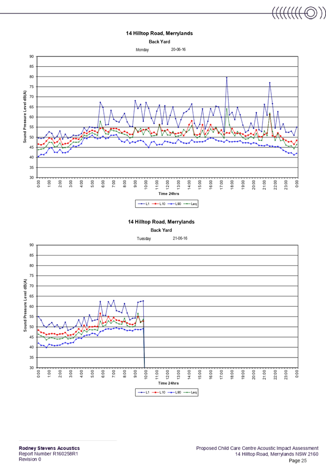
DOCUMENTS
ASSOCIATED WITH
REPORT LPP043/19
Attachment 10
Traffic Report
Cumberland Local Planning Panel Meeting
12 June 2019
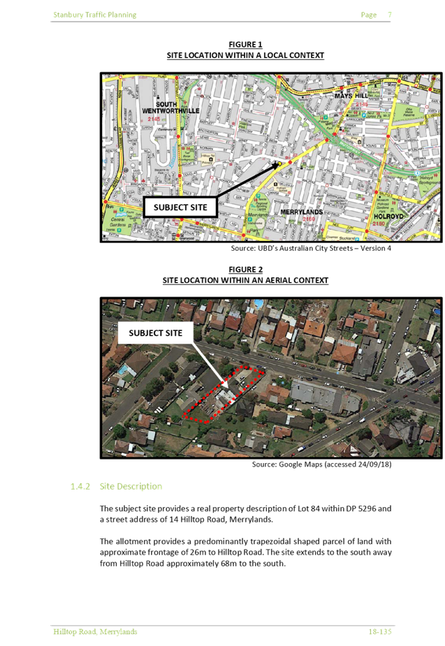
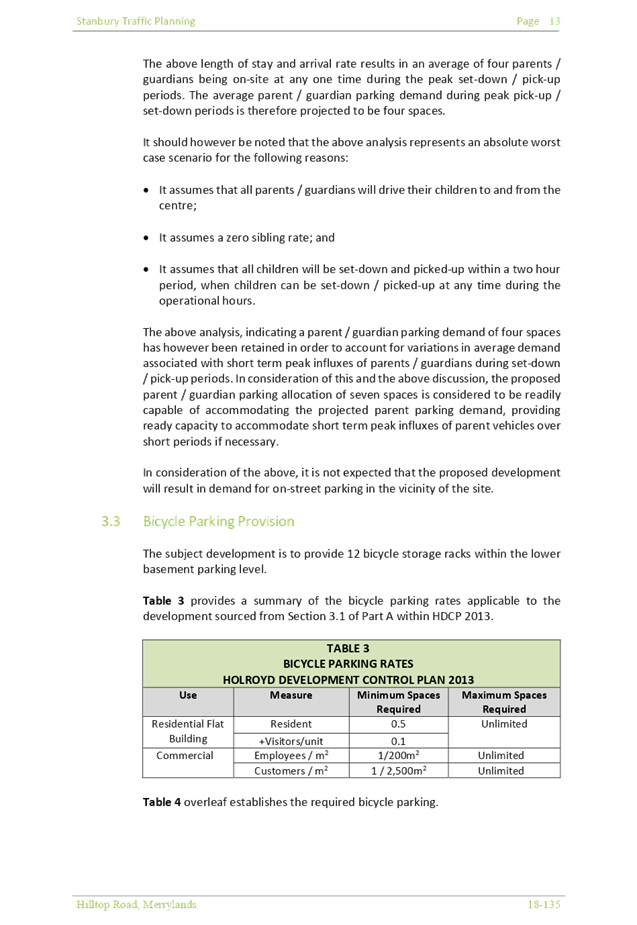
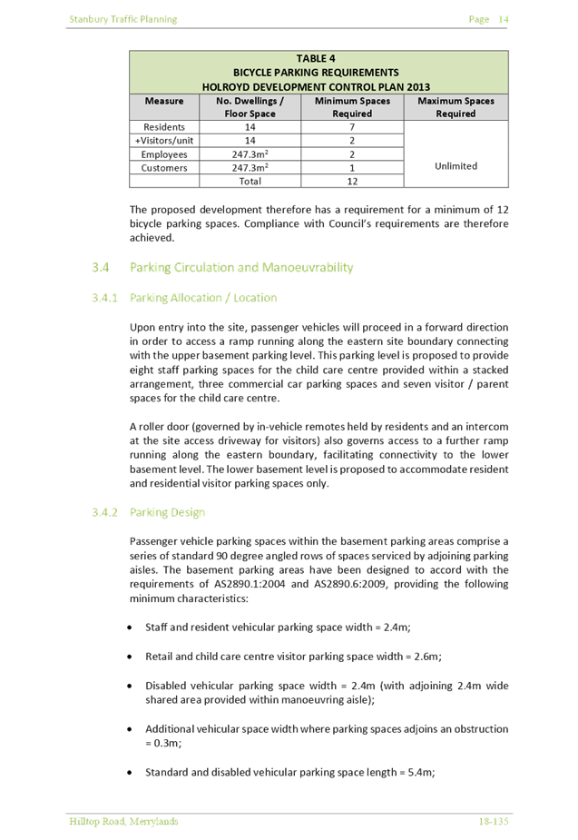
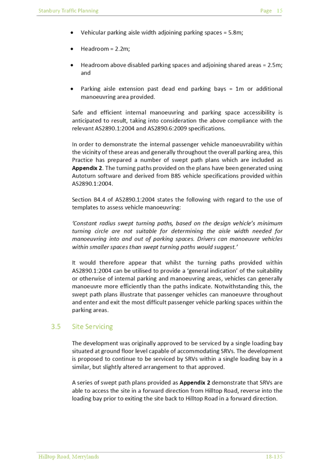
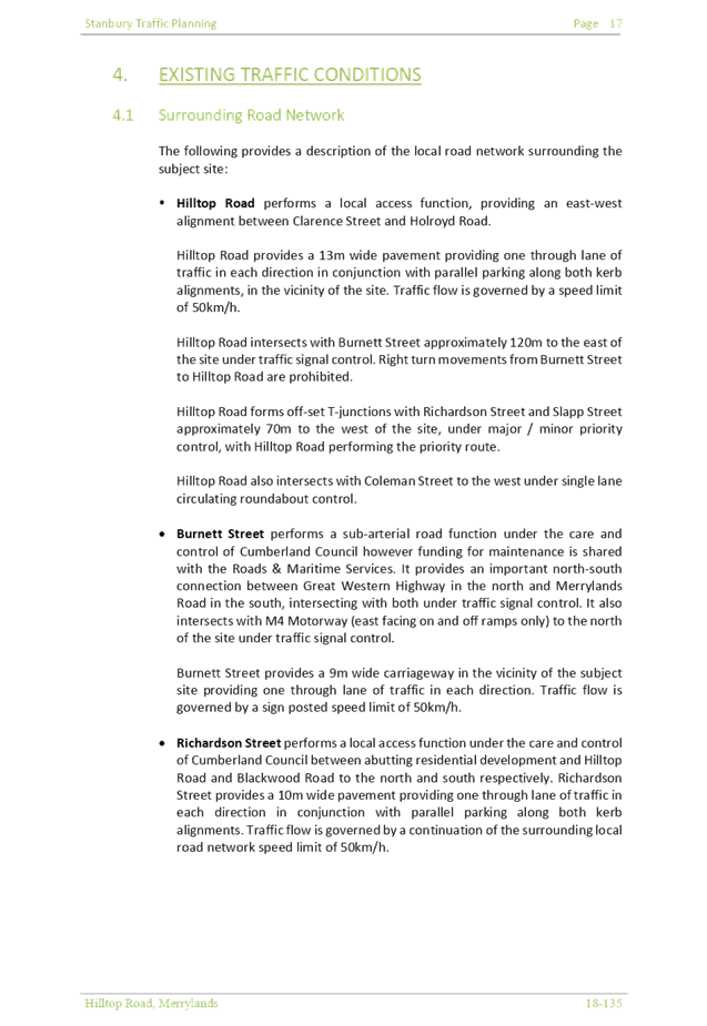

Cumberland Local Planning Panel Meeting
12 June 2019
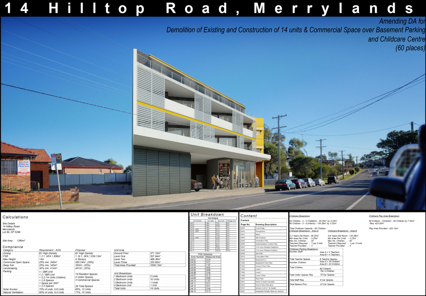
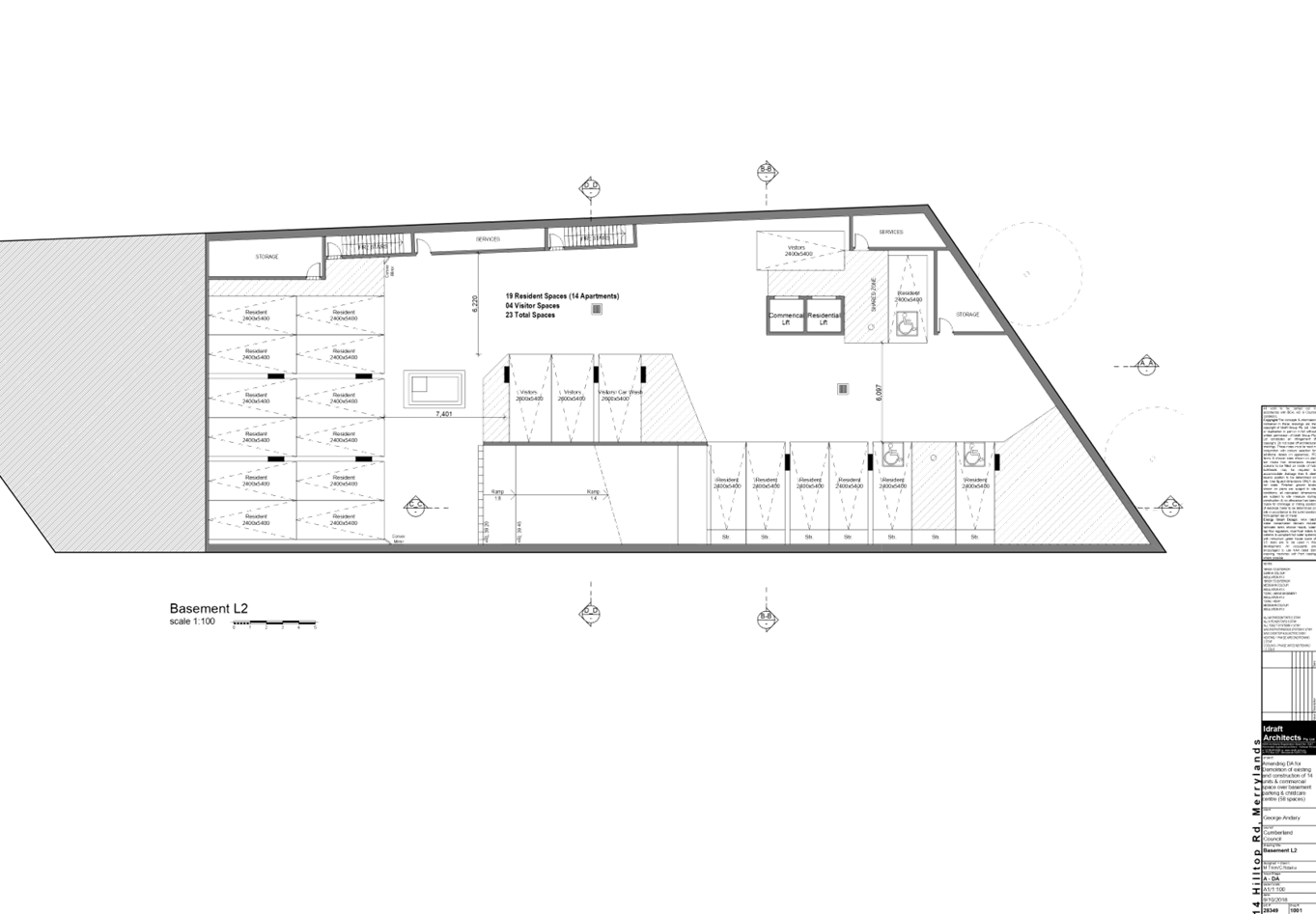
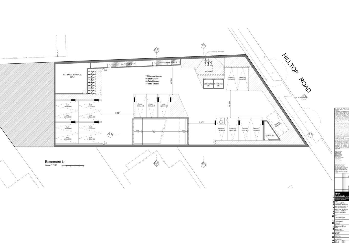
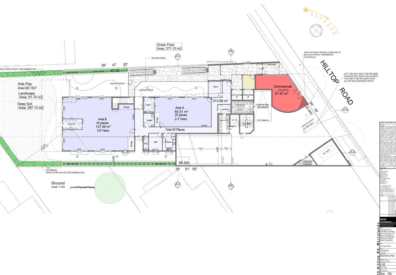
Cumberland Local Planning Panel Meeting
12 June 2019

Cumberland Local Planning Panel Meeting
12 June 2019
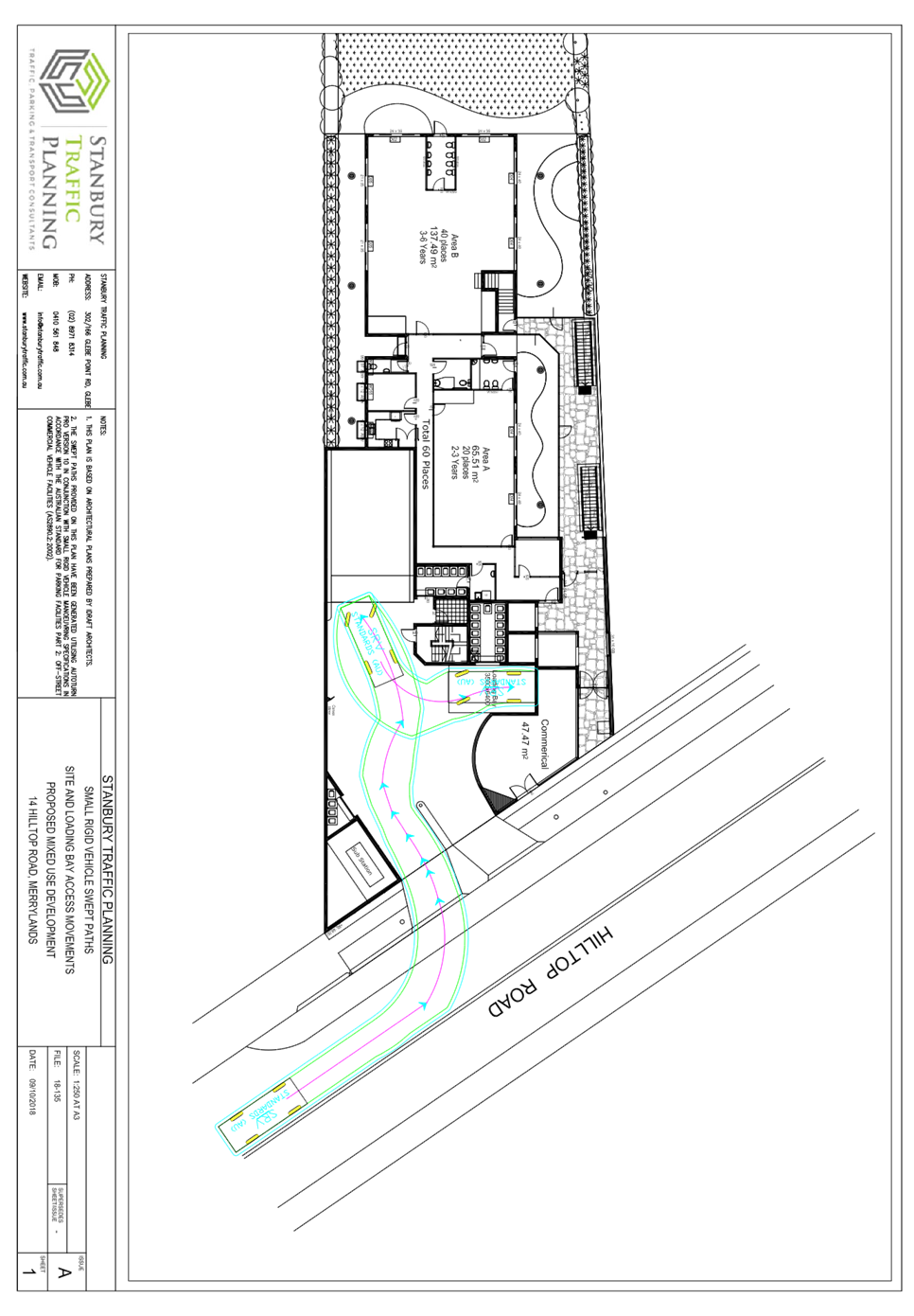
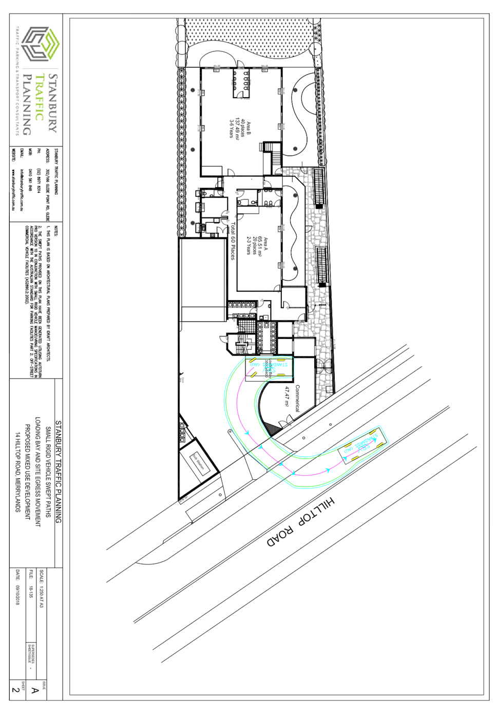
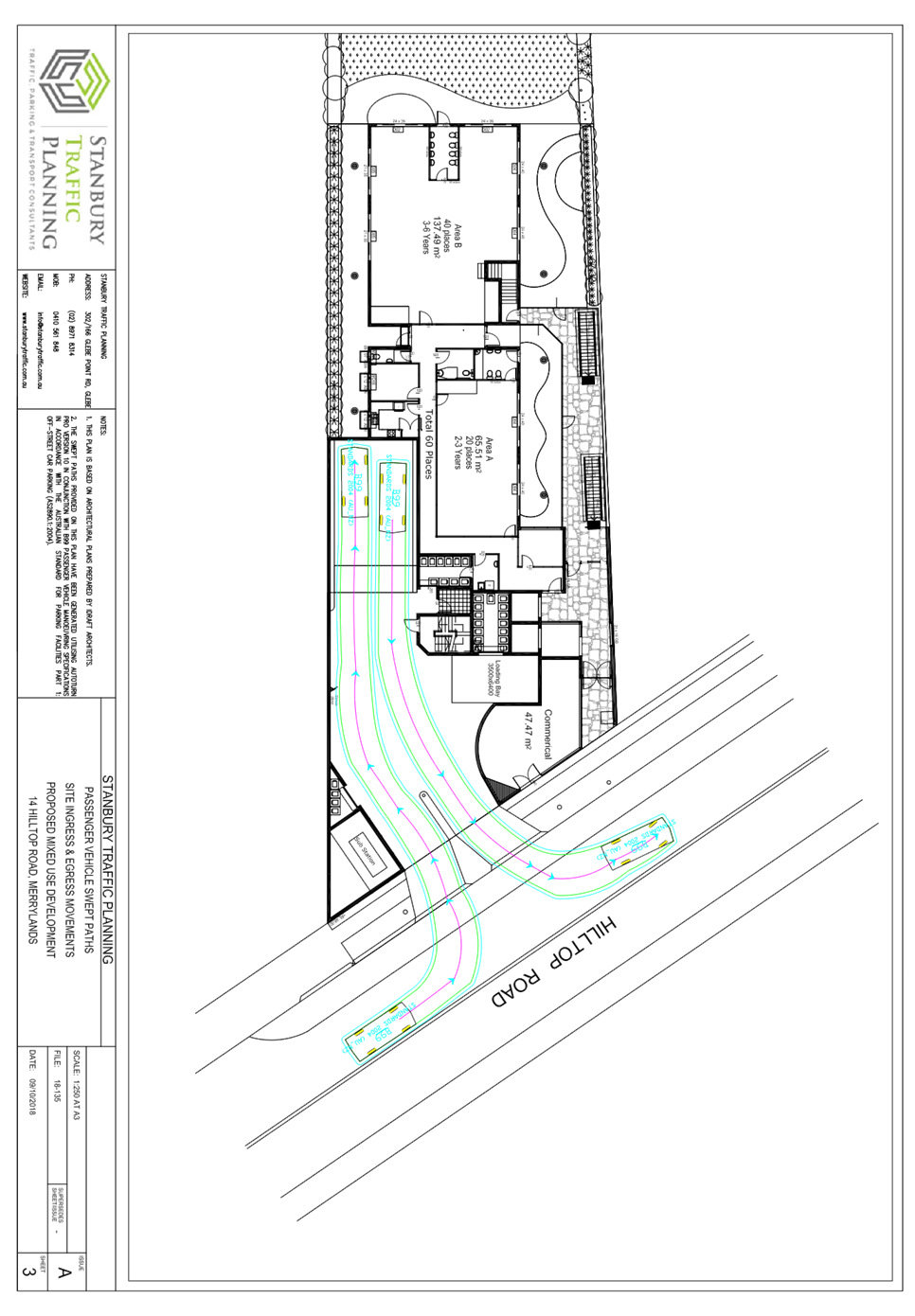
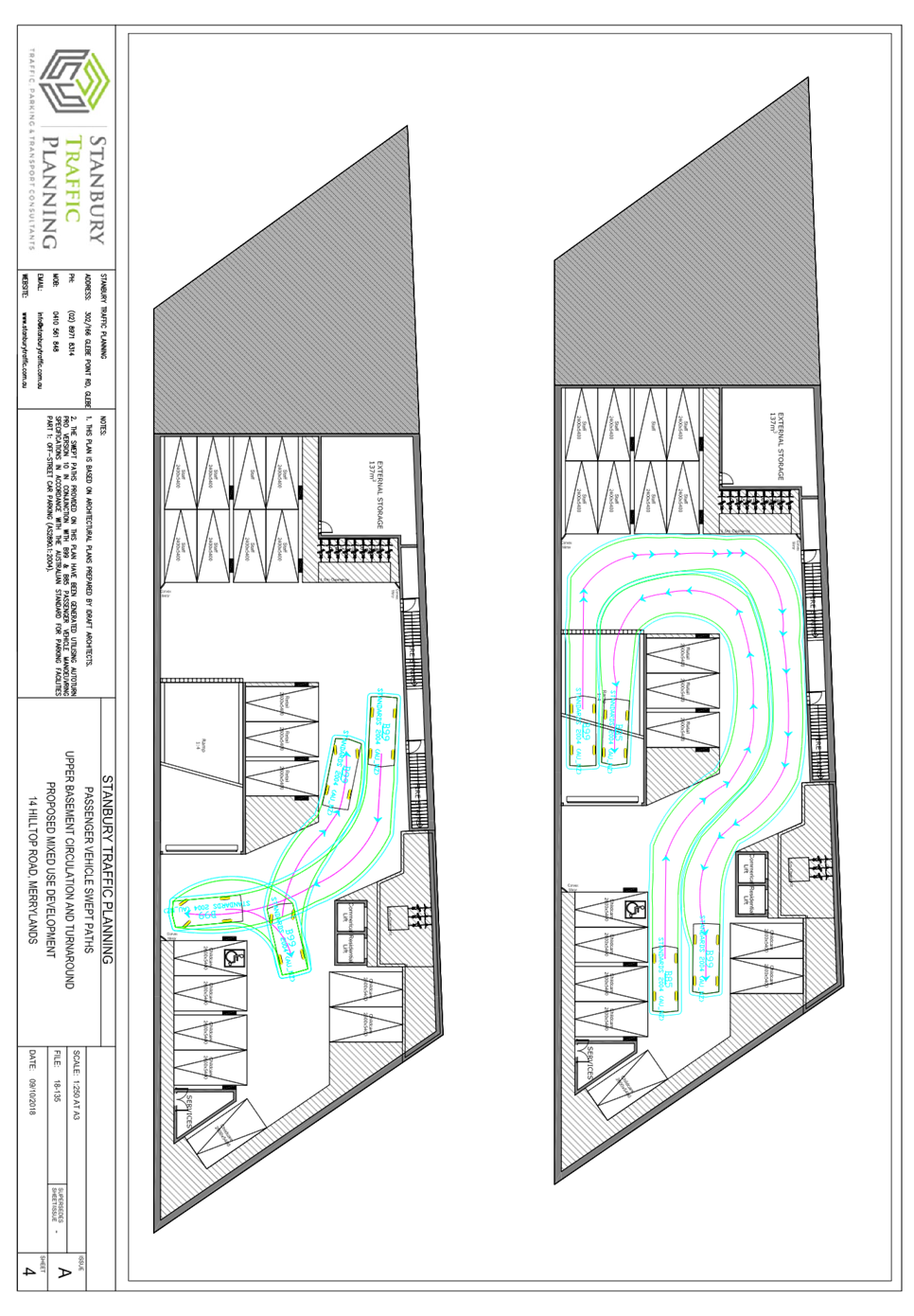
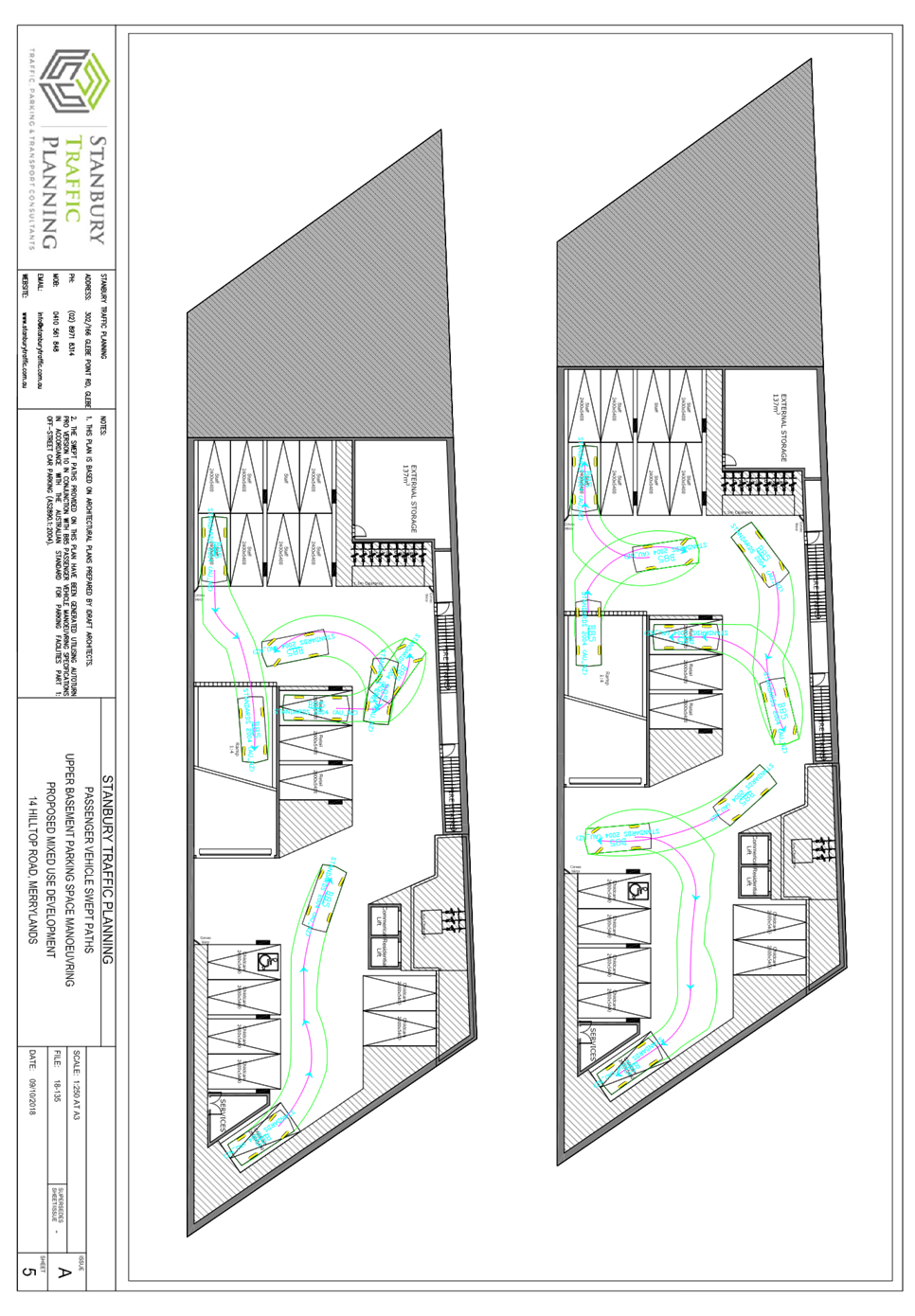
DOCUMENTS
ASSOCIATED WITH
REPORT LPP043/19
Attachment 11
Plan of Management
Cumberland Local Planning Panel Meeting
12 June 2019


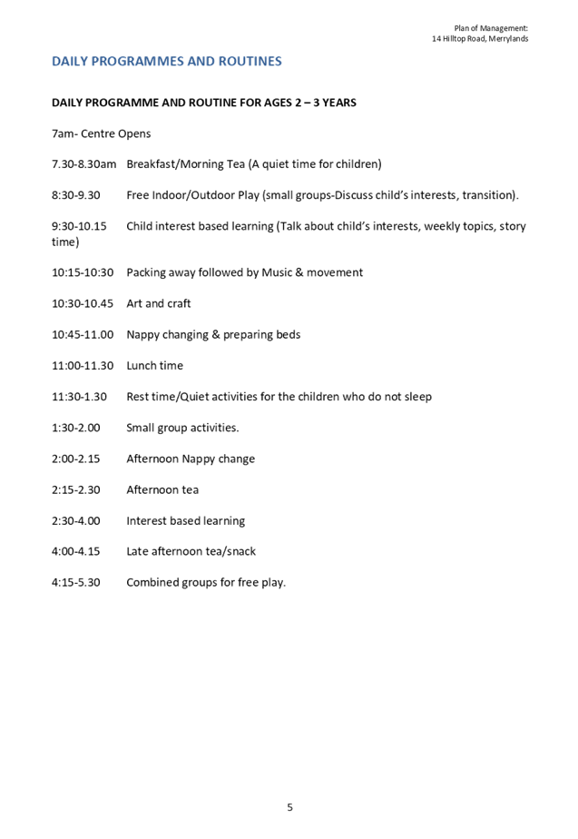
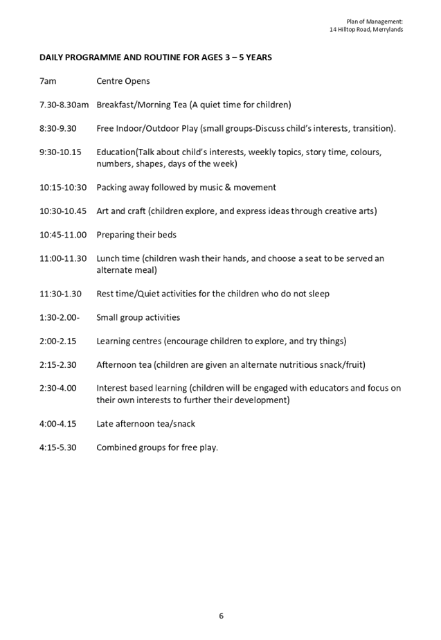
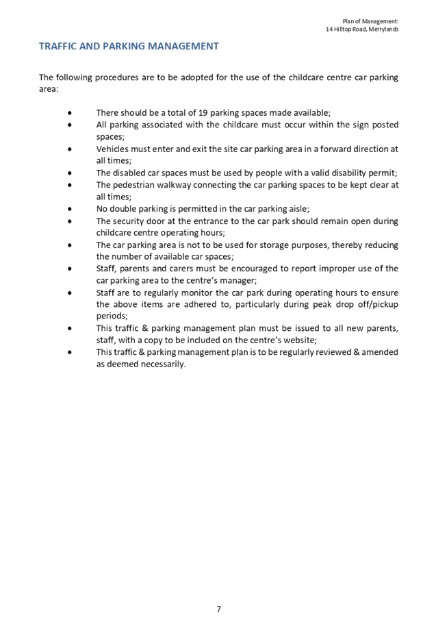

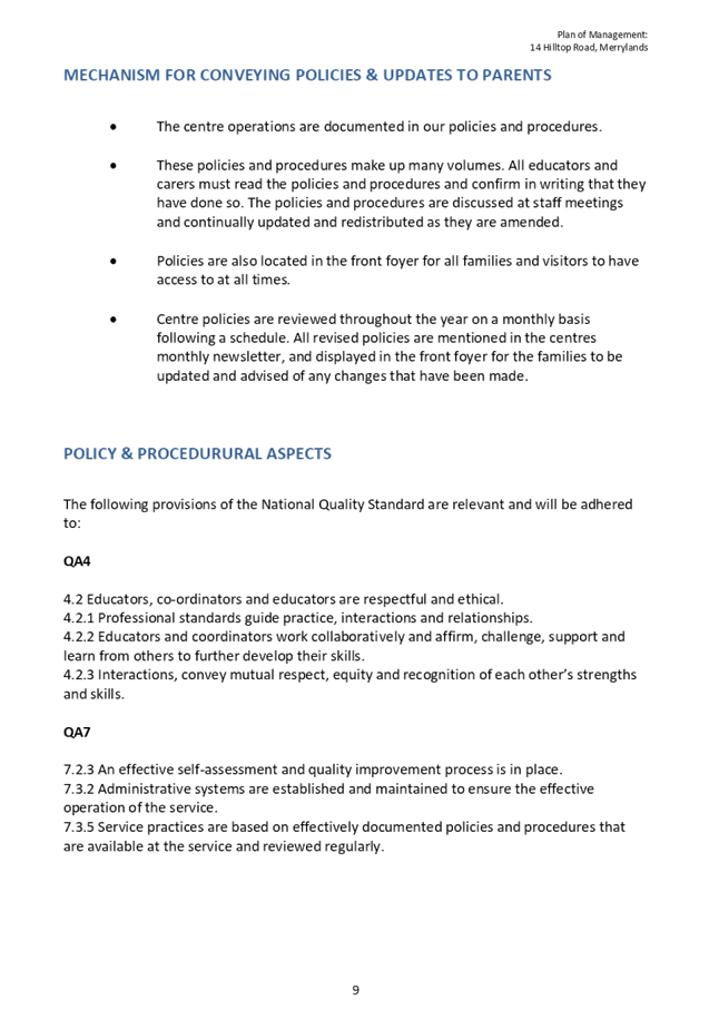


Cumberland Local Planning Panel Meeting
12 June 2019
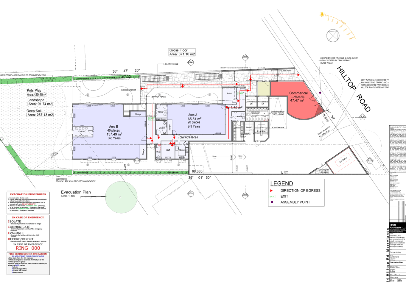
DOCUMENTS
ASSOCIATED WITH
REPORT LPP043/19
Attachment 12
Endeavour Energy Comments
Cumberland Local Planning Panel Meeting
12 June 2019


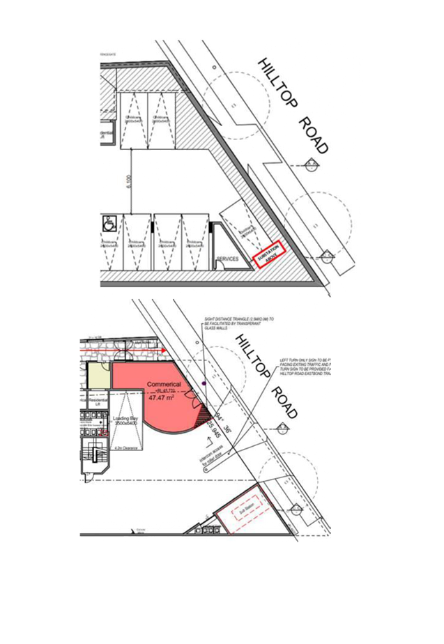
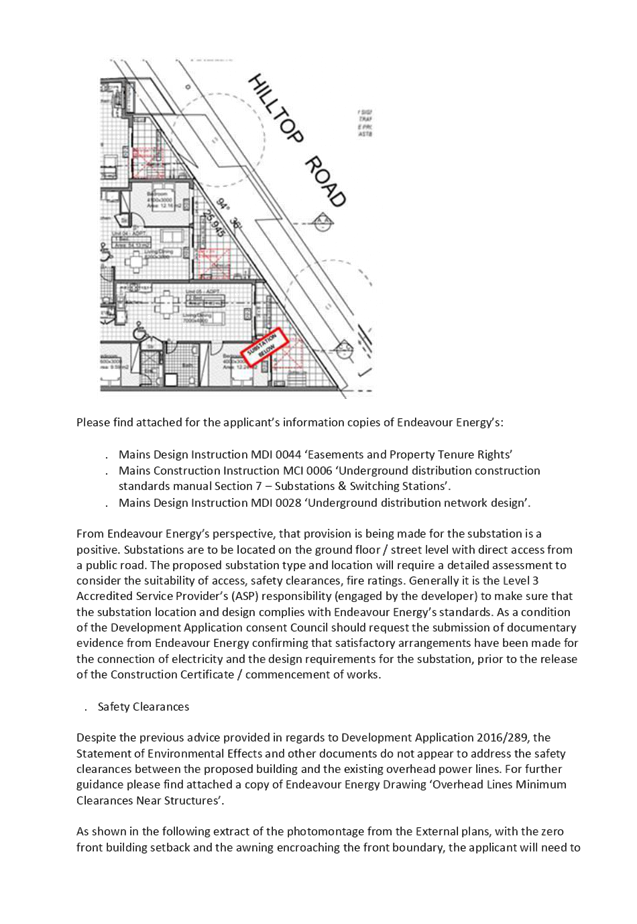
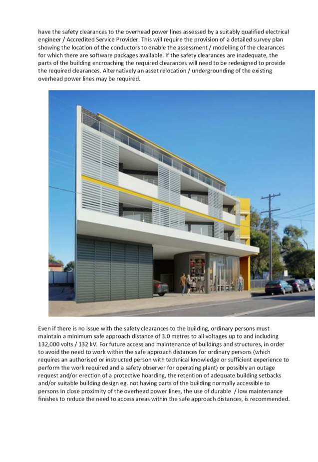
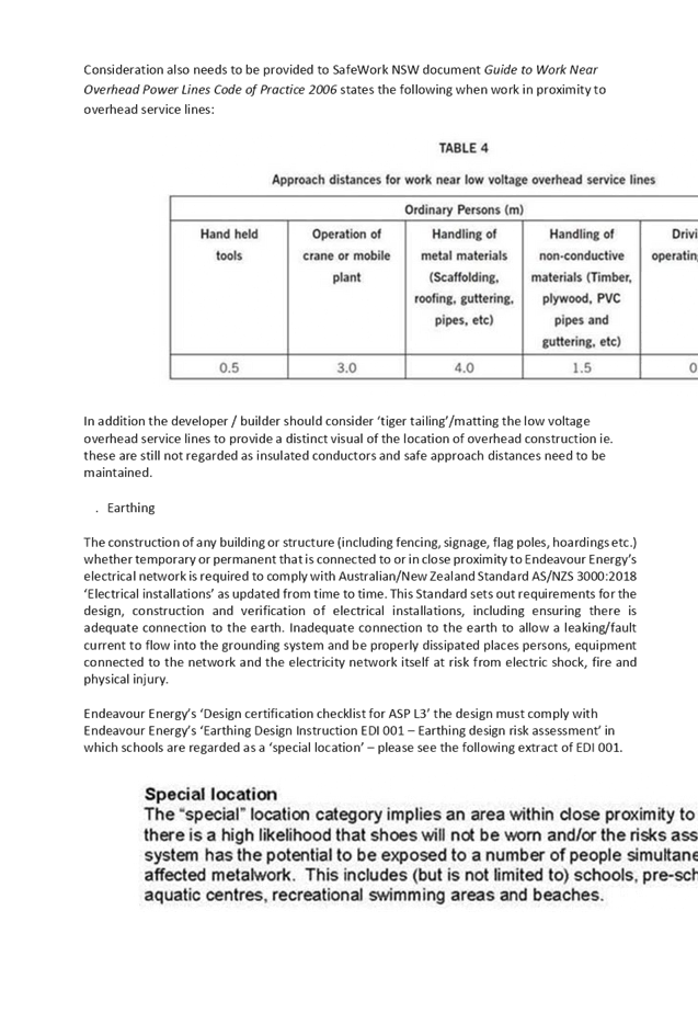

DOCUMENTS
ASSOCIATED WITH
REPORT LPP043/19
Attachment 13
Submission
Cumberland Local Planning Panel Meeting
12 June 2019