Council Meeting
Wednesday, 19 June 2019 at 6:30pm
Cumberland Council Chambers
Merrylands Service Centre, 16 Memorial Avenue, Merrylands
Council Meeting
Wednesday, 19 June 2019 at 6:30pm
Cumberland Council Chambers
Merrylands Service Centre, 16 Memorial Avenue, Merrylands
Councillor Contact Details
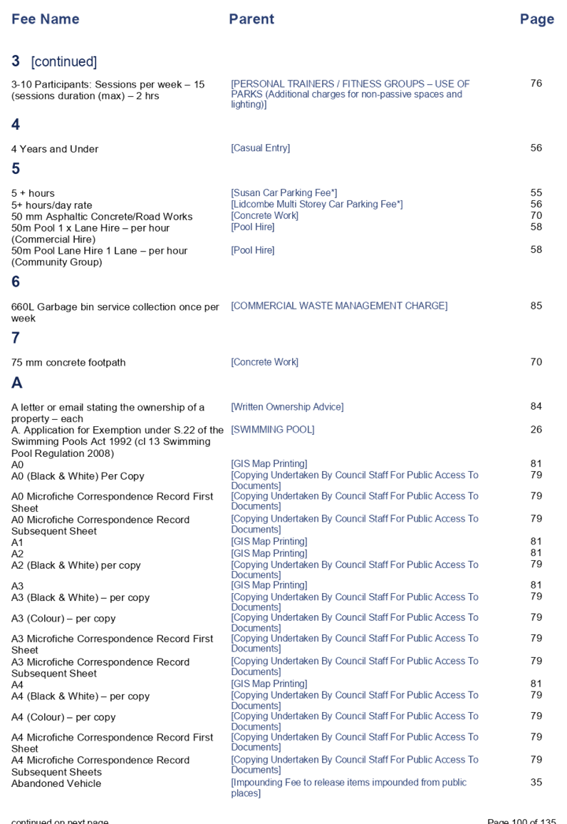
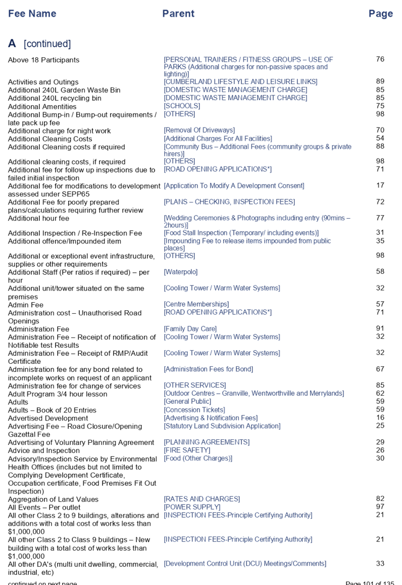
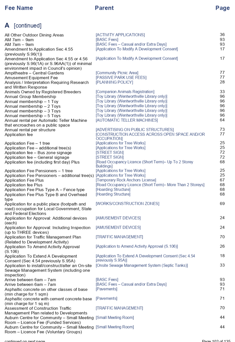
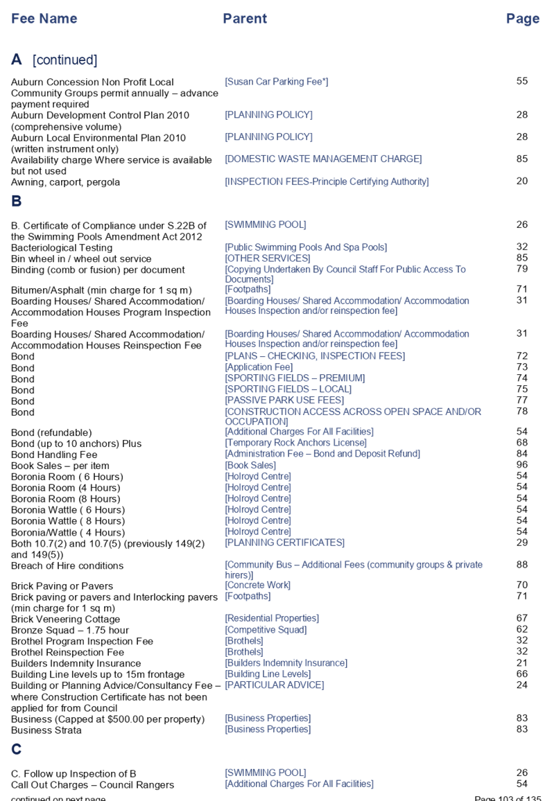
|
Granville Ward |
||
|
Clr Steve Christou |
0419 651 187 |
|
|
Clr Ola Hamed |
0405 070 007 |
|
|
Clr Joseph Rahme |
0418 995 471 |
|
|
Greystanes Ward |
||
|
Clr Greg Cummings (Mayor) |
0417 612 717 |
|
|
Clr Ross Grove |
0418 987 241 |
|
|
Clr Eddy Sarkis |
0418 306 918 |
|
|
Regents Park Ward |
||
|
Clr Ned Attie |
0419 583 254 |
|
|
Clr George Campbell |
0409 233 315 |
|
|
Clr Kun Huang |
0418 911 774 |
|
|
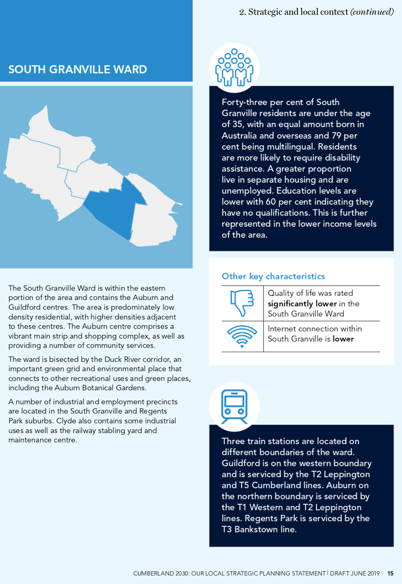
South Granville Ward |
||
|
Clr Glenn Elmore (Deputy Mayor) |
0418 459 527 |
|
|
Clr Paul Garrard |
0414 504 504 |
|
|
Clr Tom Zreika |
0449 008 888 |
|
|
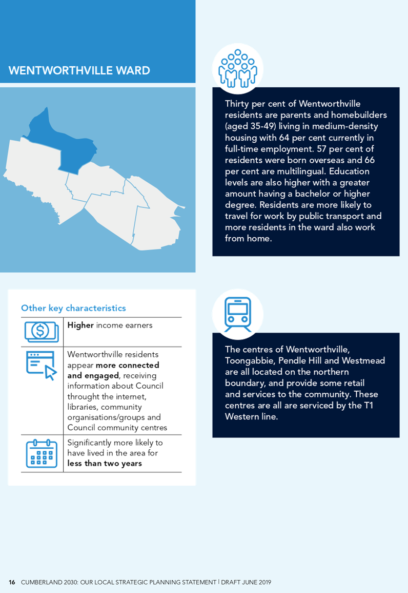
Wentworthville Ward |
||
|
Clr Lisa Lake |
0418 669 681 |
|
|
Clr Suman Saha |
0419 546 950 |
|
|
Clr Michael Zaiter |
0418 432 797 |
|
For information on Council services and facilities please visit www.cumberland.nsw.gov.au
Council Meeting
19 June 2019
1 Opening Prayer / Acknowledgement of Country / National Anthem
2 Notice of Live Streaming of Council meeting
3 Apologies
4 Declarations of Pecuniary & Non Pecuniary Conflicts of Interest
5 Confirmation of Previous Minutes
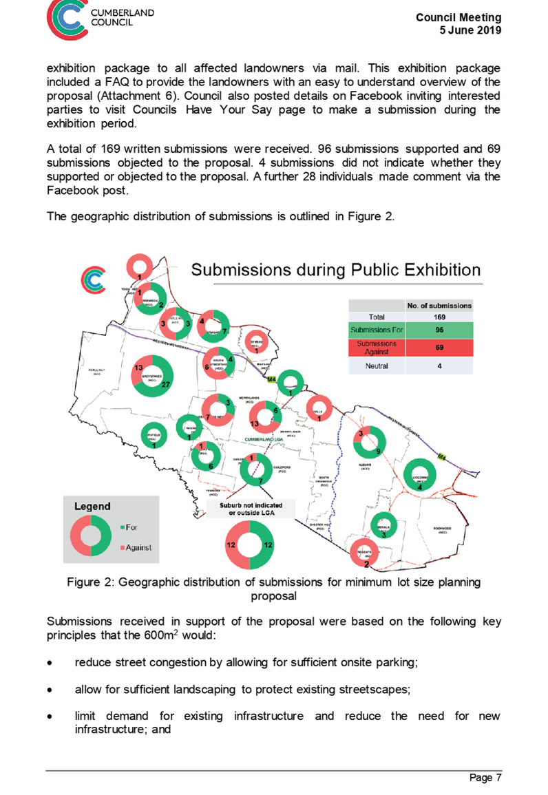
C06/19-105 Minutes of the Ordinary Meeting of Council - 05 June 2019. 5
Nil
7 Public Forum / Invited Speakers
8 Items Resolved by Exception
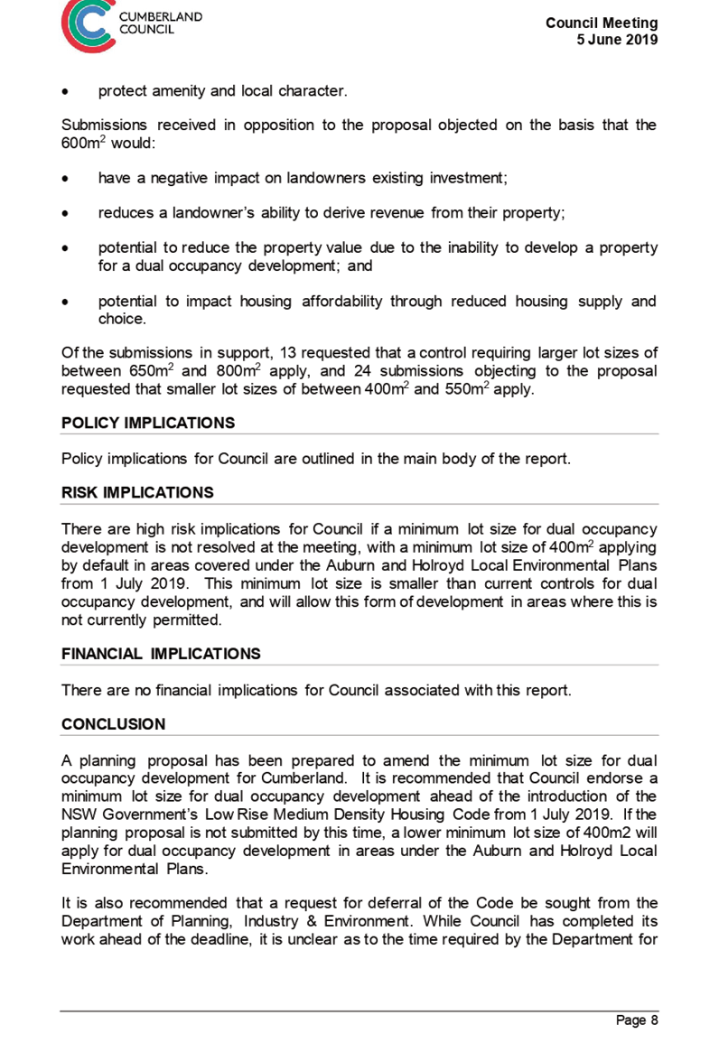
Nil
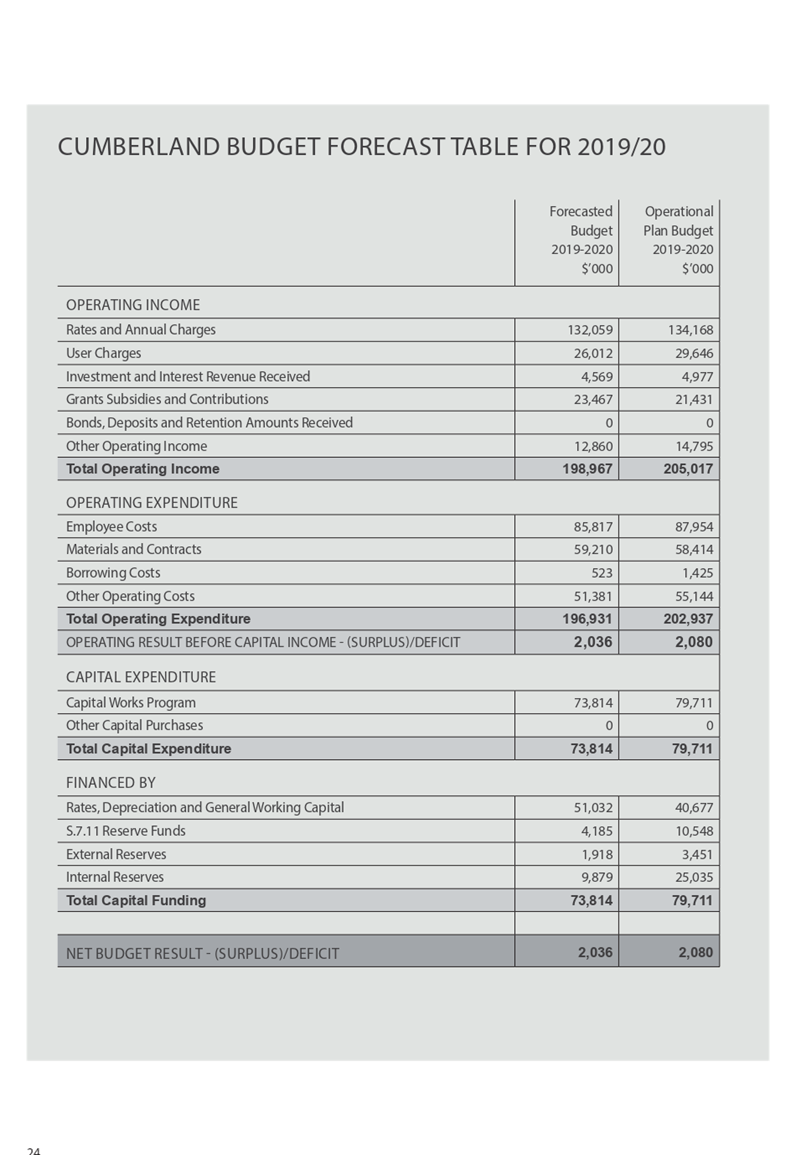
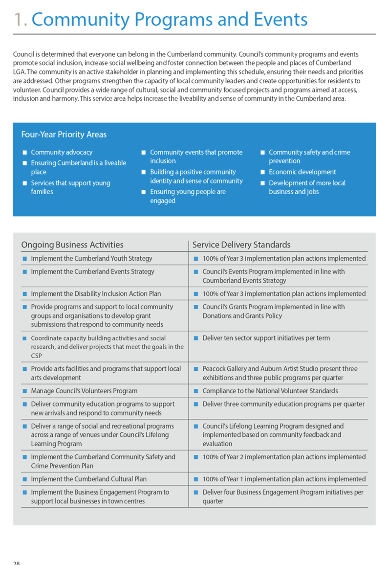
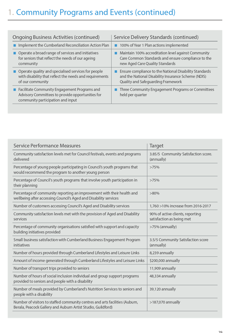
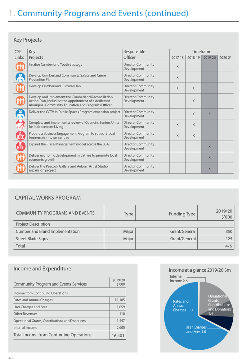
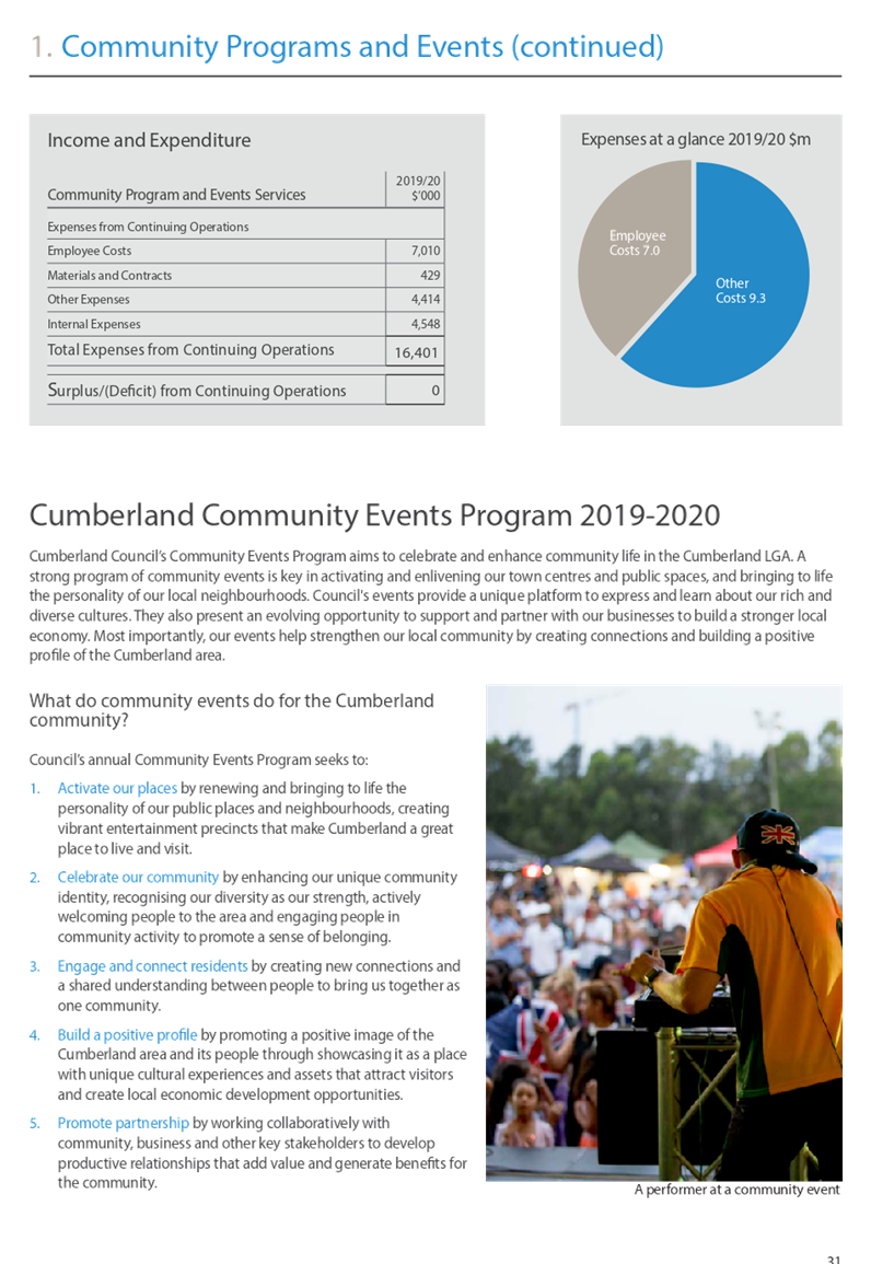
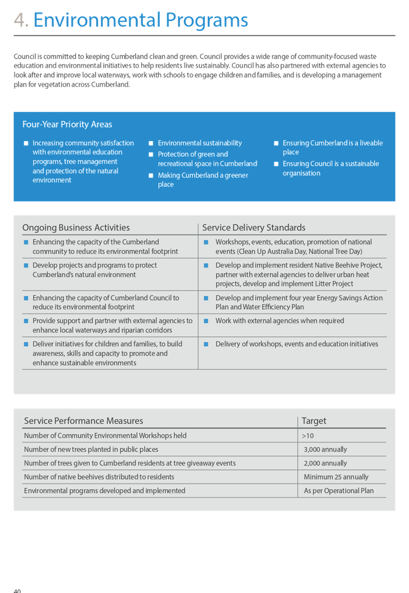
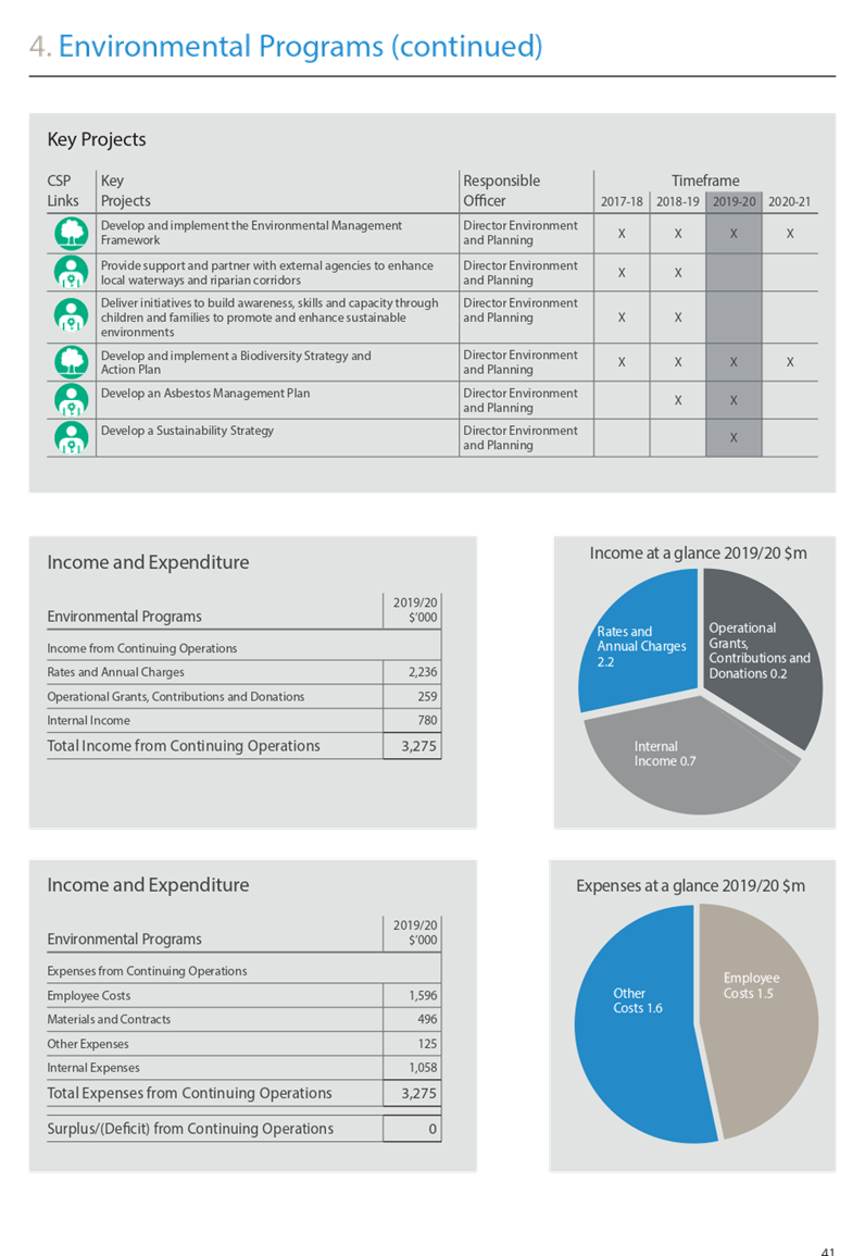
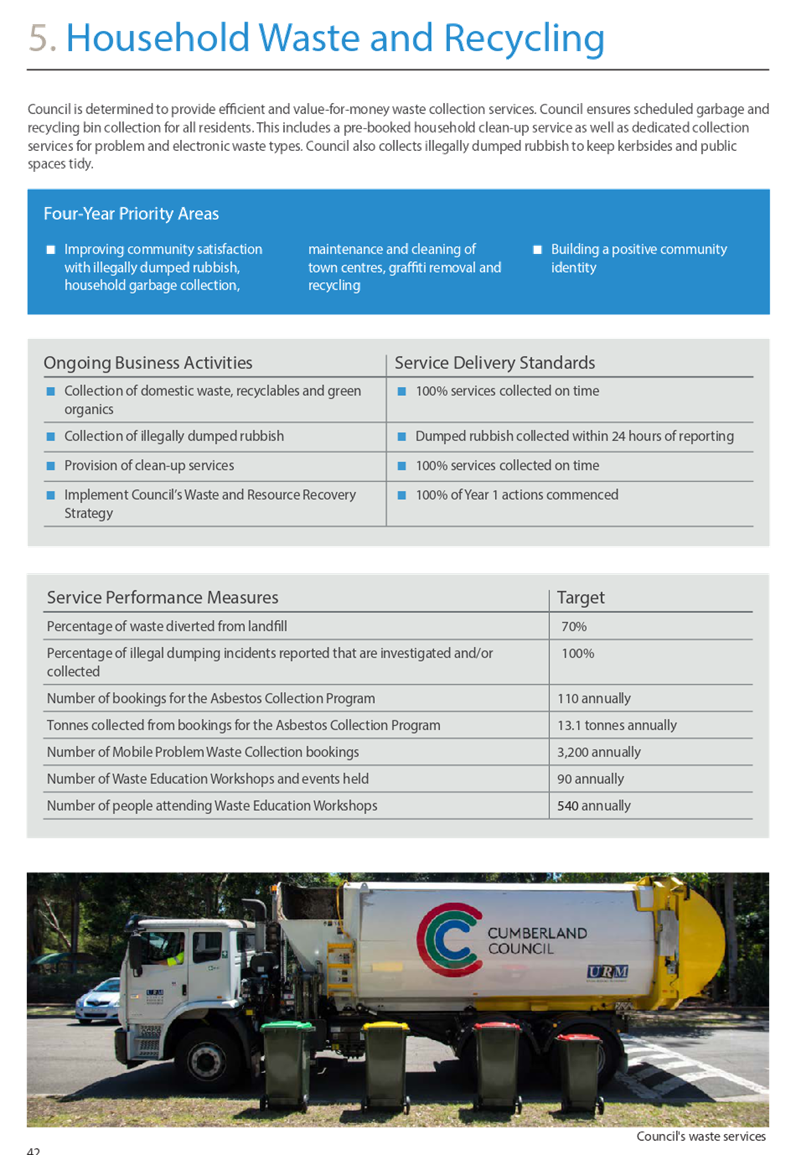
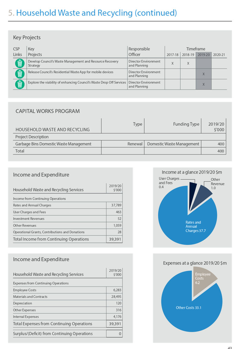
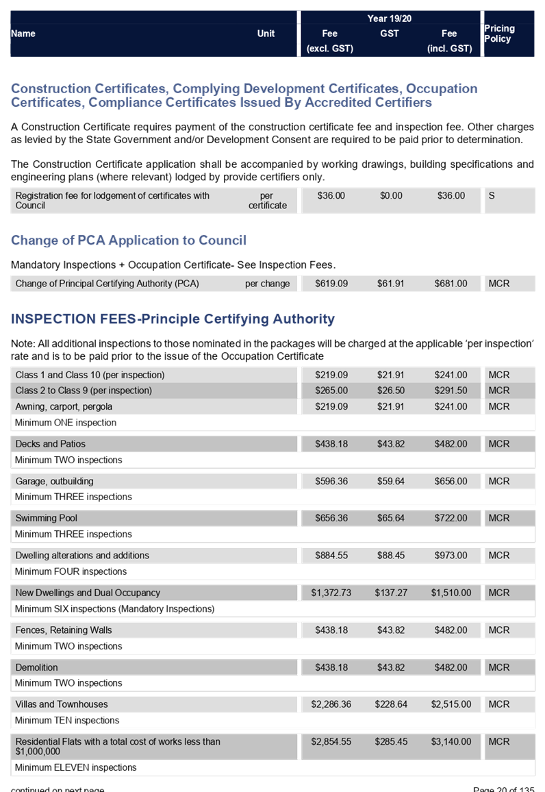
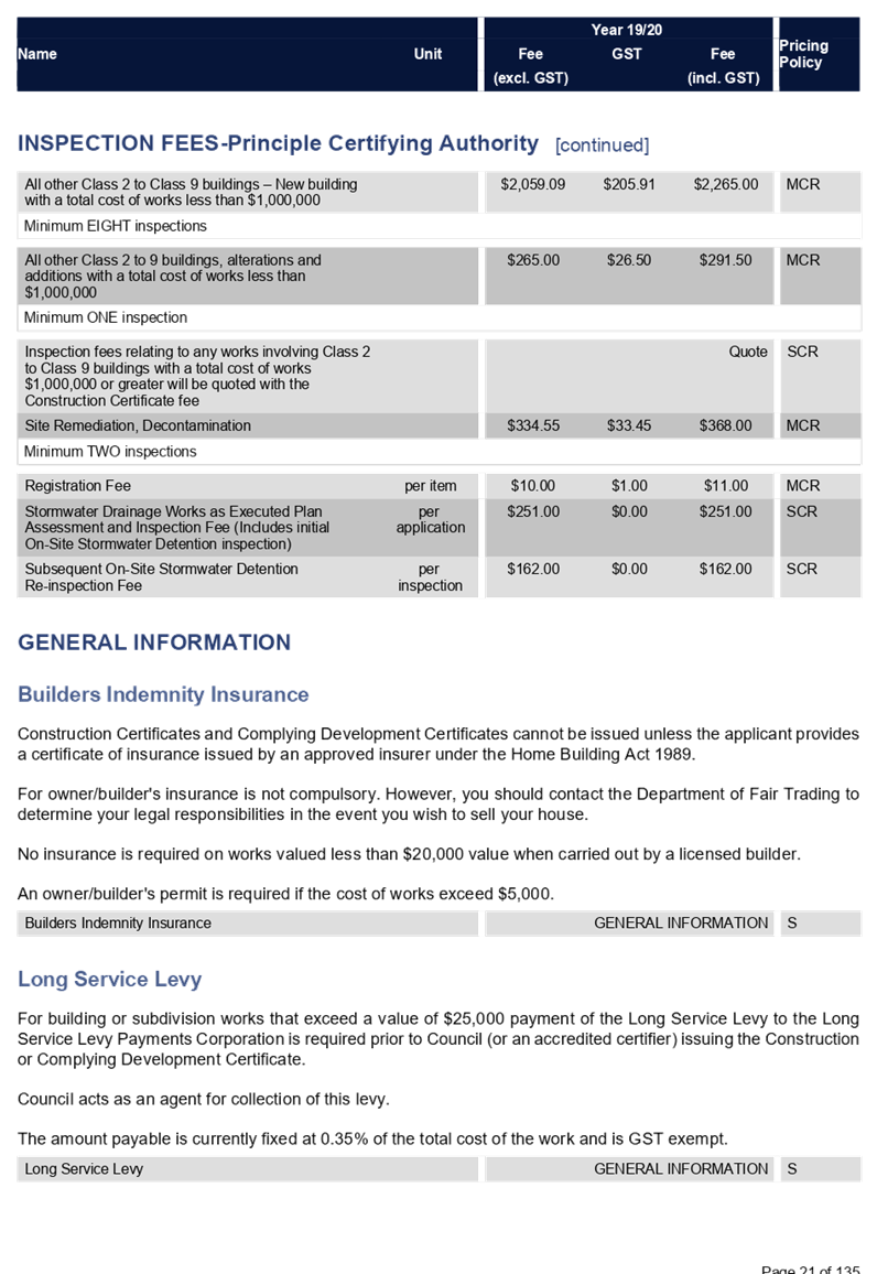
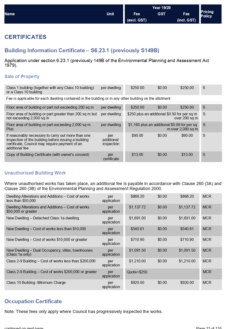
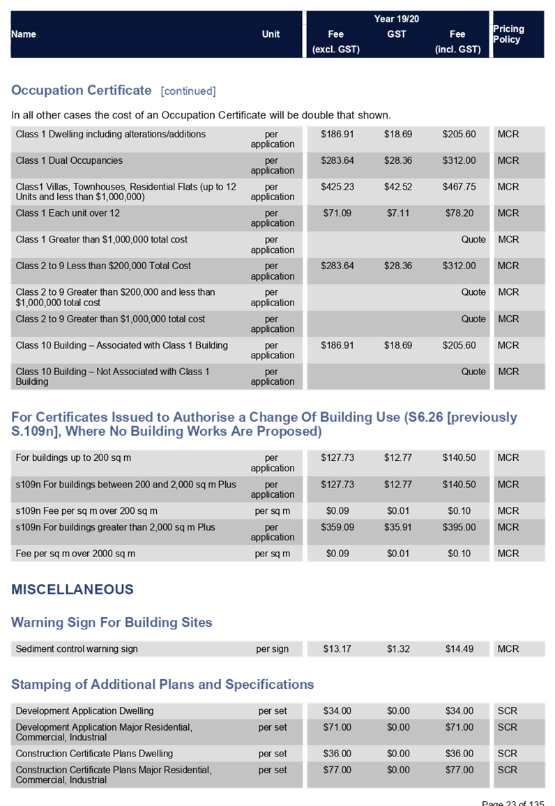
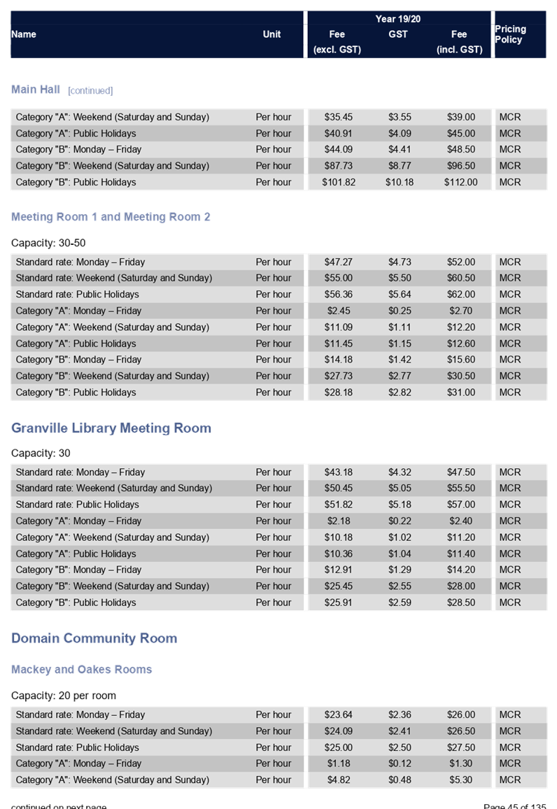
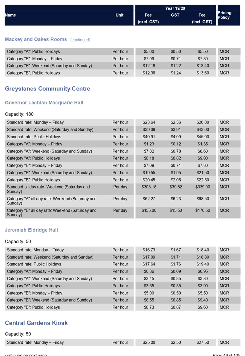
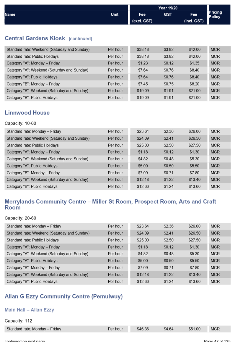
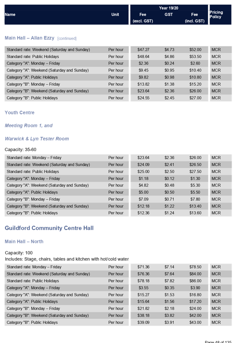
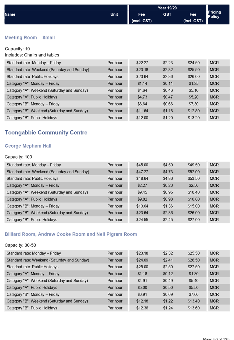
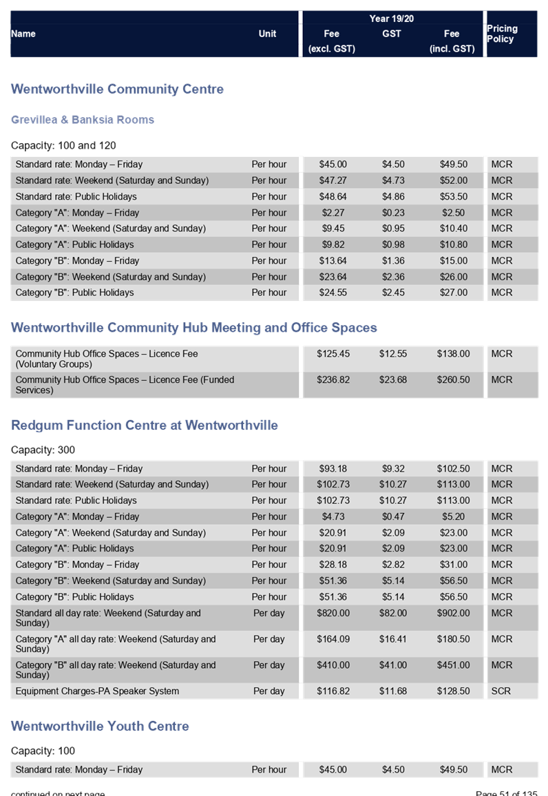
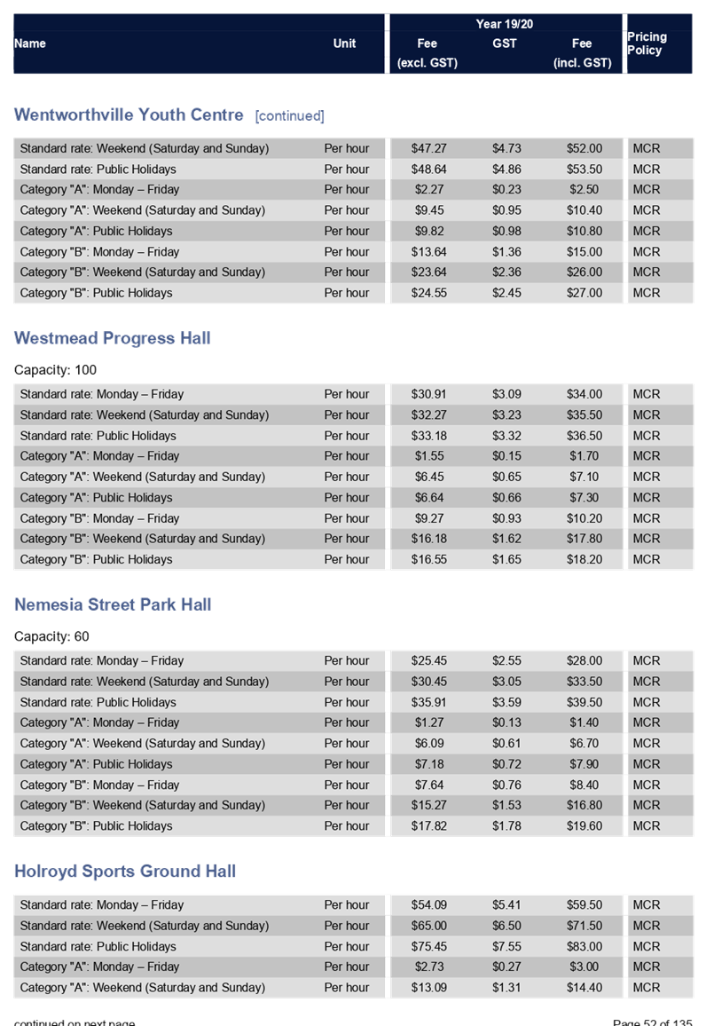
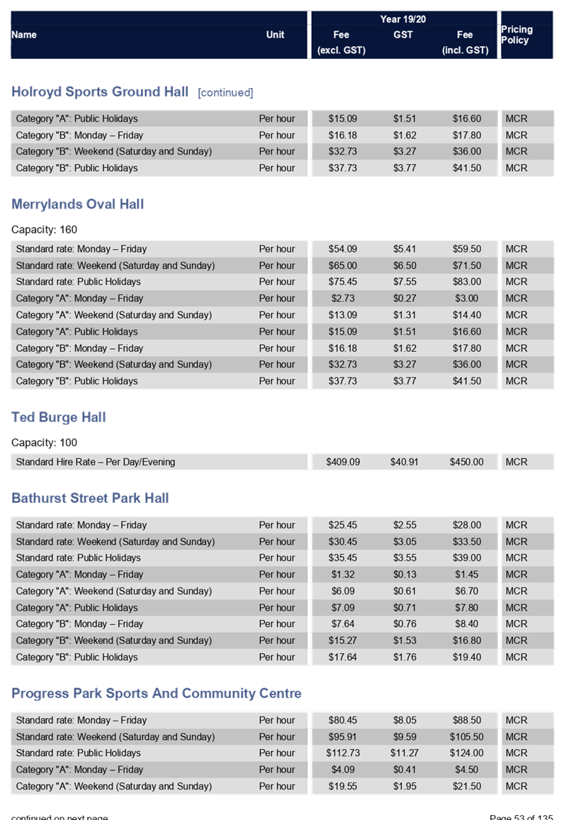
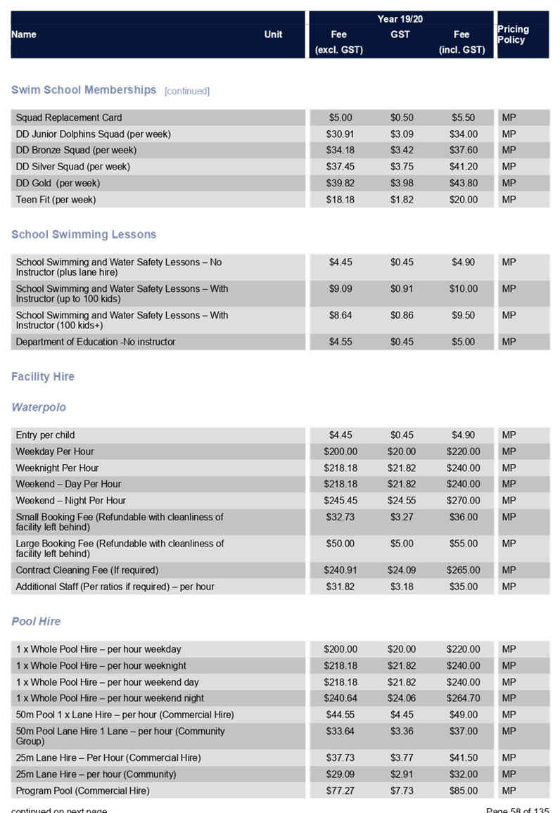
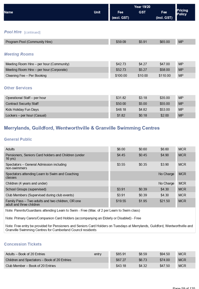
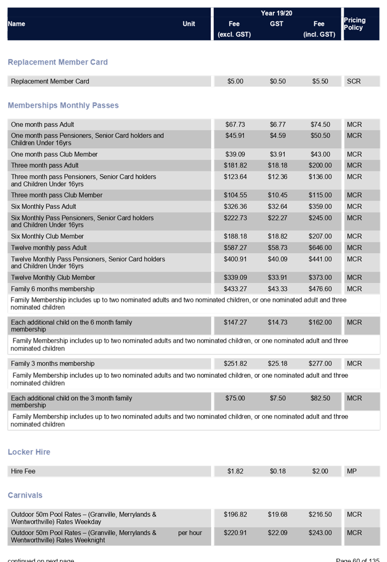
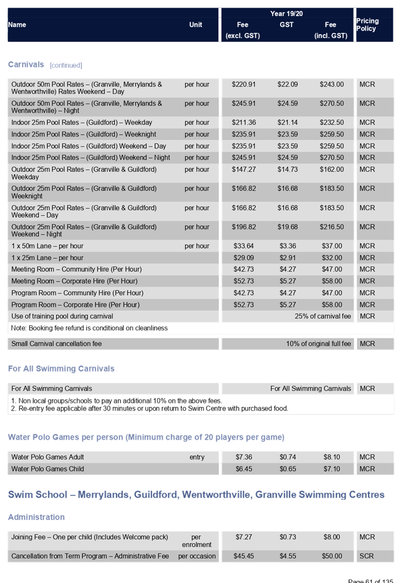
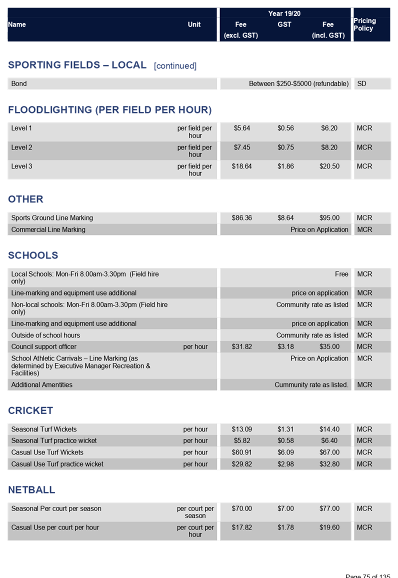
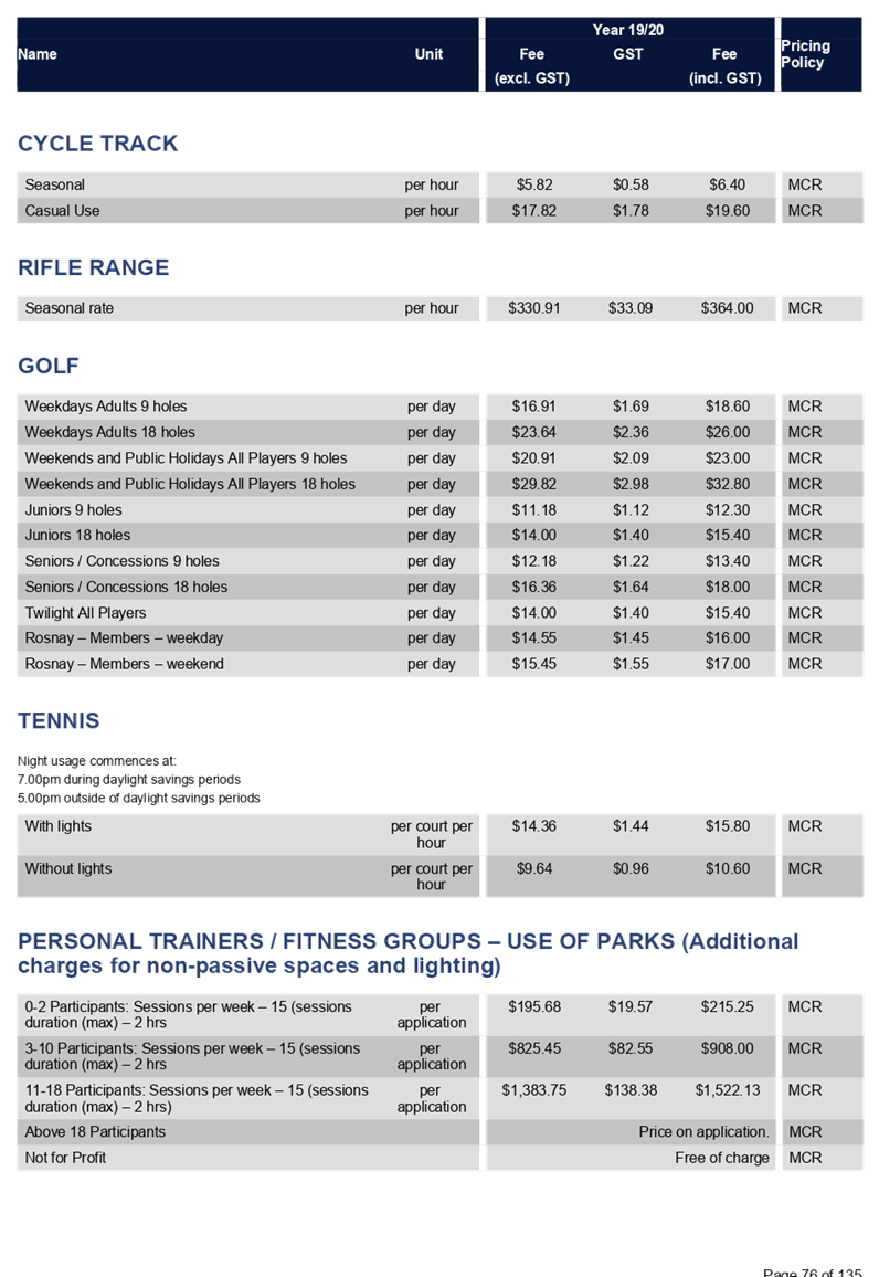
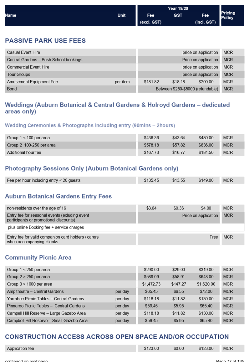
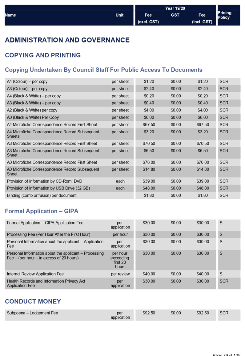
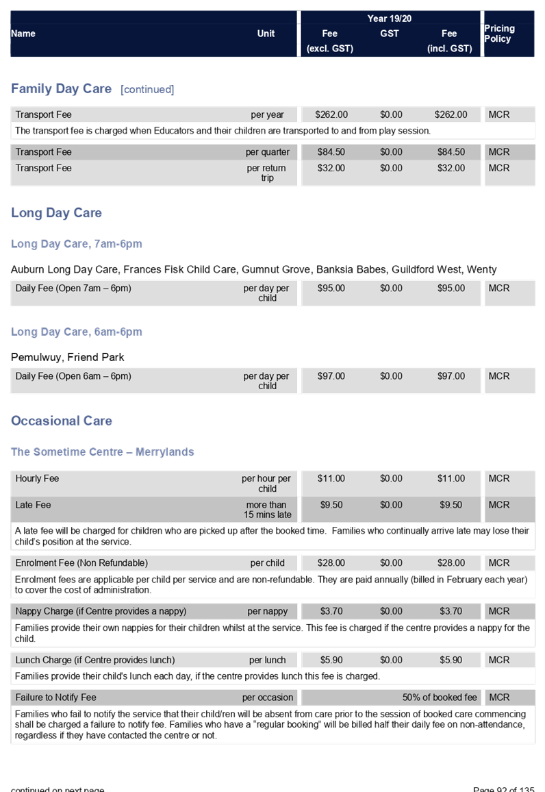
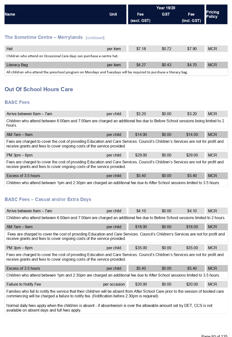
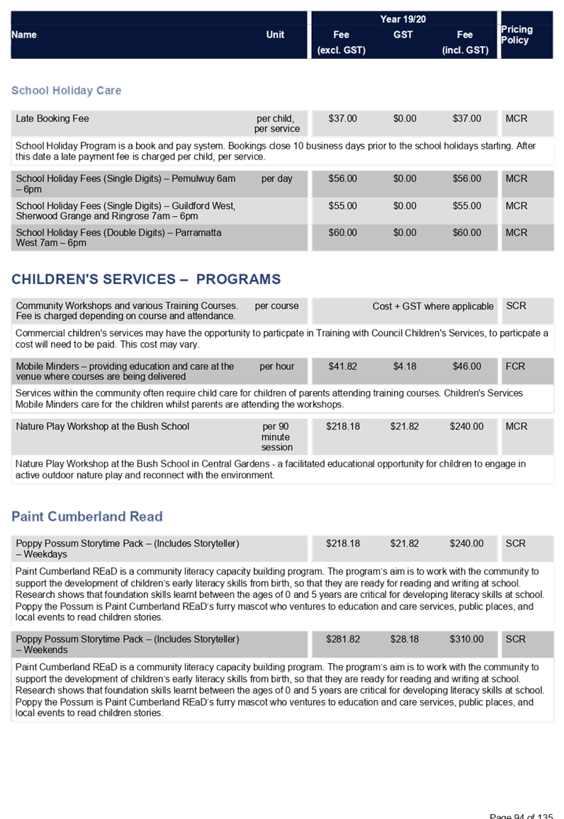
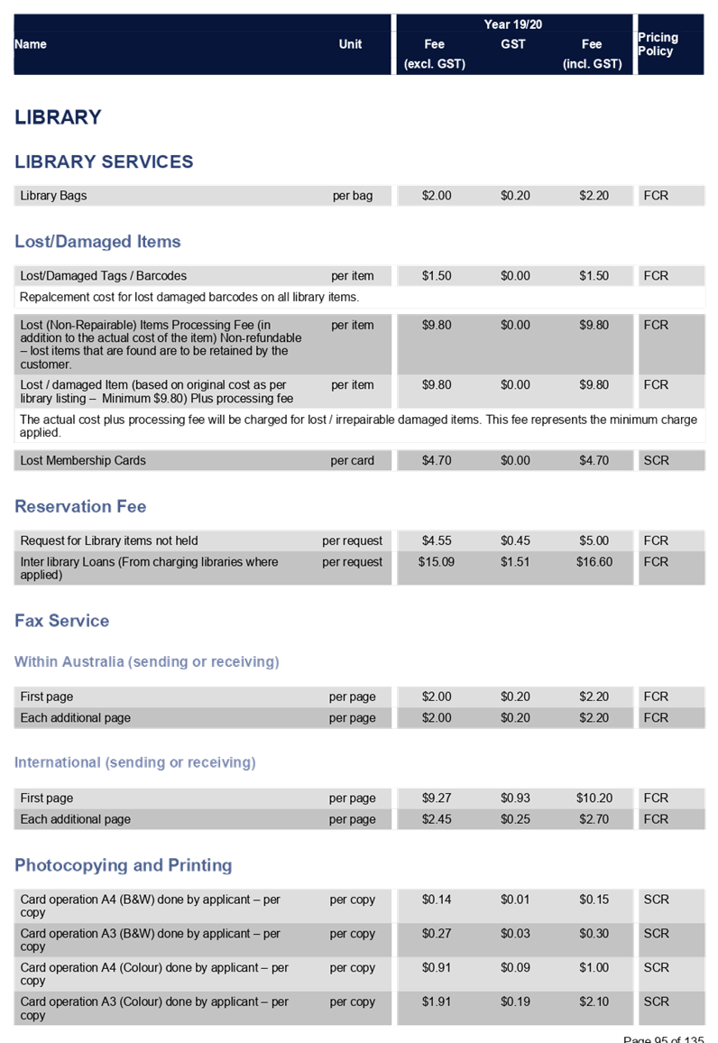
C06/19-106 Adoption of the Operational Plan and Fees and Charges for 2019-20 - Post Exhibition................................................. 15
C06/19-107 Making Rates and Fixing Charges 2019/20..................... 247
C06/19-108 Review of Dividing Fences Policy.................................... 255
C06/19-109 Parramatta Road Urban Amenity Improvement Program - Land Acquisition for Auburn Park Expansion................... 263
C06/19-110 Investment Report - May 2019....................................... 267
Director Community Development
Nil
Director Environment & Planning
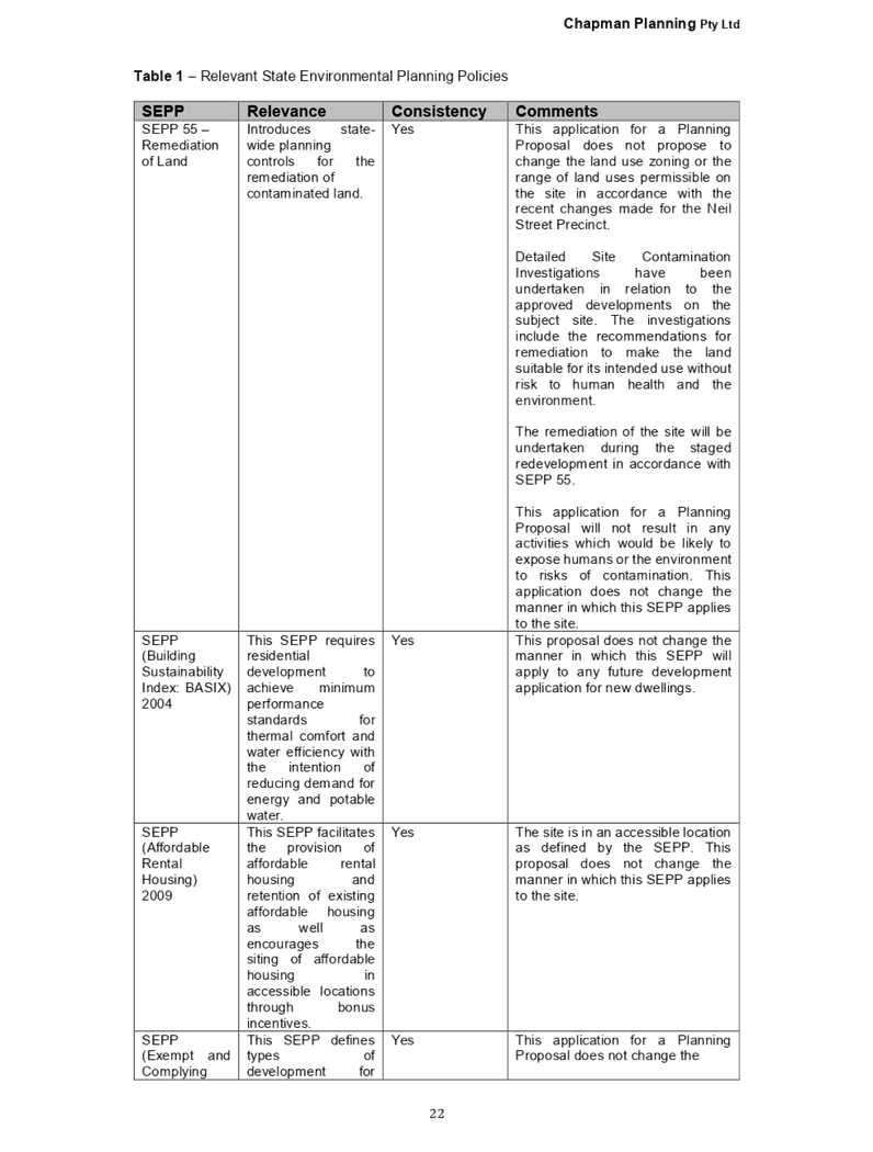
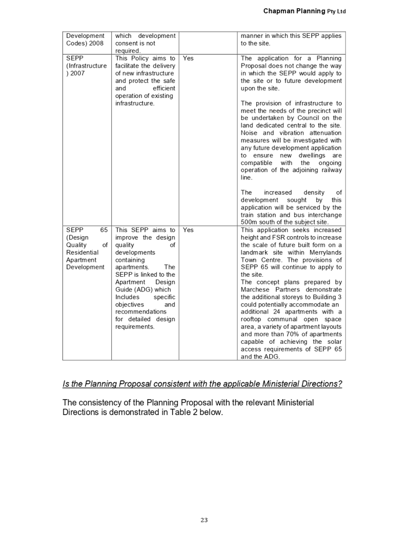
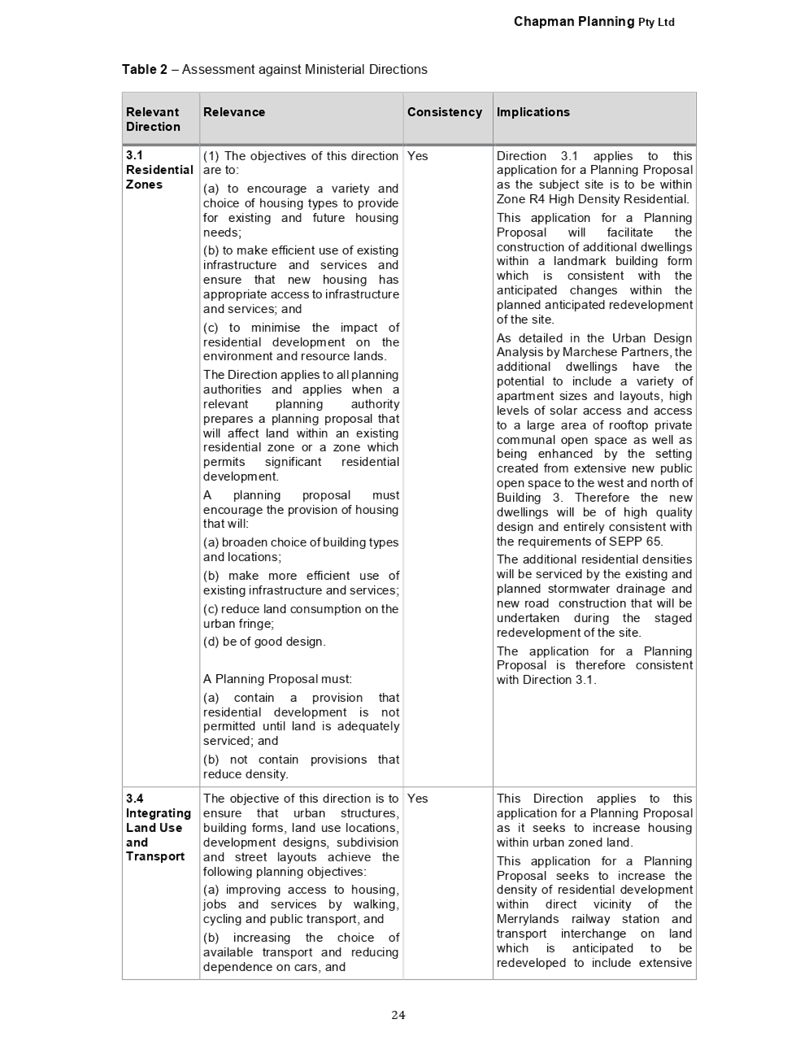
C06/19-111 Draft Cumberland 2030: Our Local Strategic Planning Statement.................................................................................. 291
C06/19-112 Planning Proposal Request for 1-11 Neil Street, Merrylands.................................................................... 357
C06/19-113 Road Naming Report - New Public Roads Proposed Within The Neil Street Precinct................................................. 419
C06/19-114 Road Naming Report - New Public Roads Proposed Within the Subdivision Of Lot 12 Dp 1175686, Palmer Street, Guildford West.......................................................................................... 435
Director Works & Infrastructure
C06/19-115 Proposed Closure of Benaud Street laneway, Greystanes 451
C06/19-116 Response to Notice of Motion - (Min. 378 C12/18-254) Progress Park Toilet Block............................................. 459
Nil
Nil
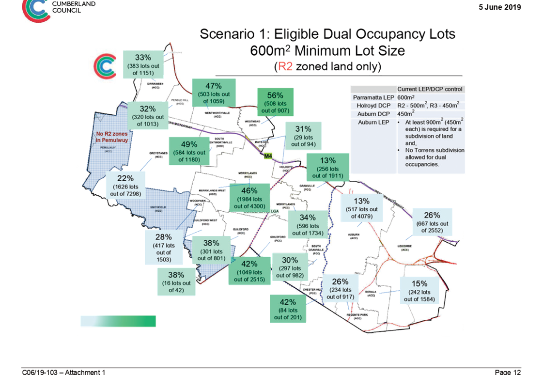
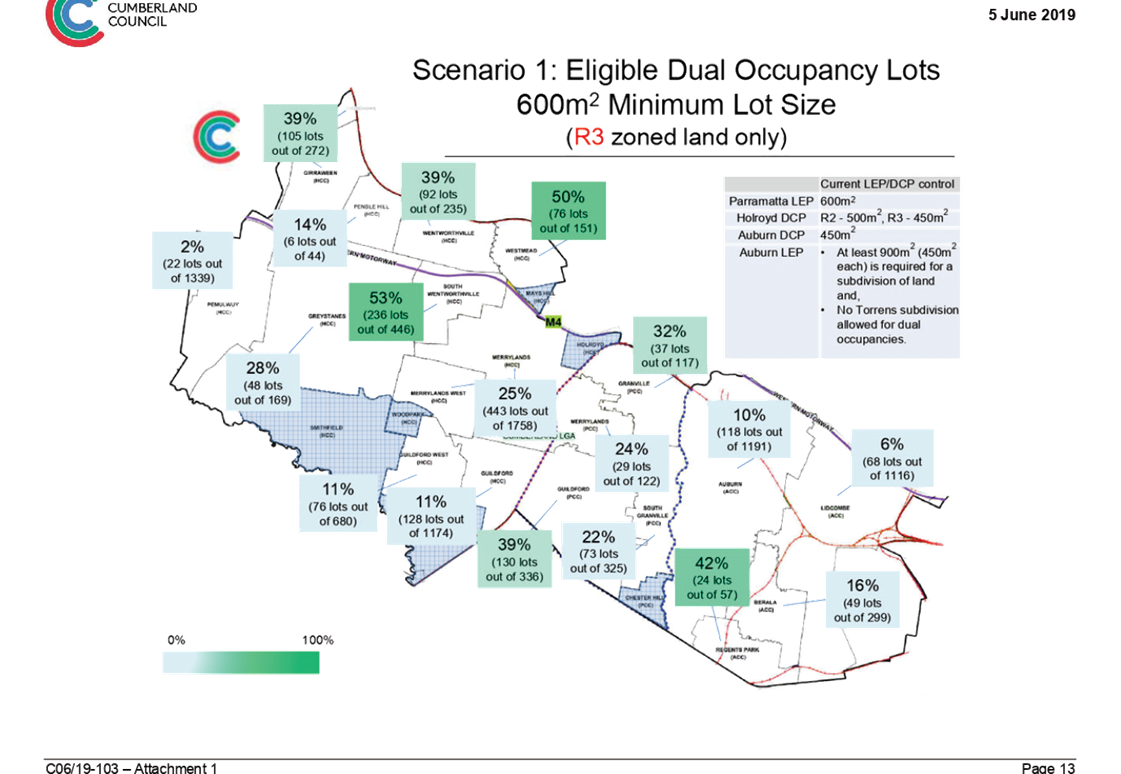
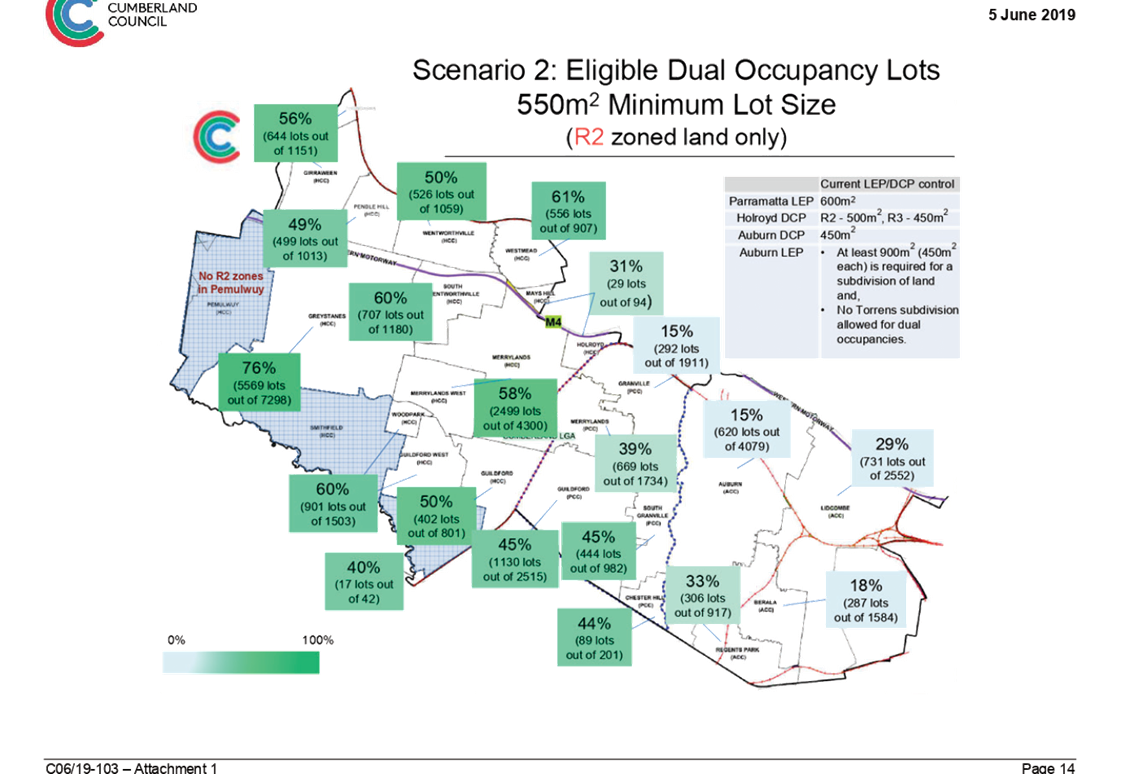
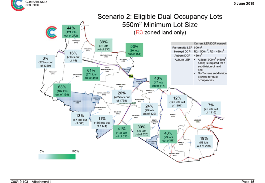
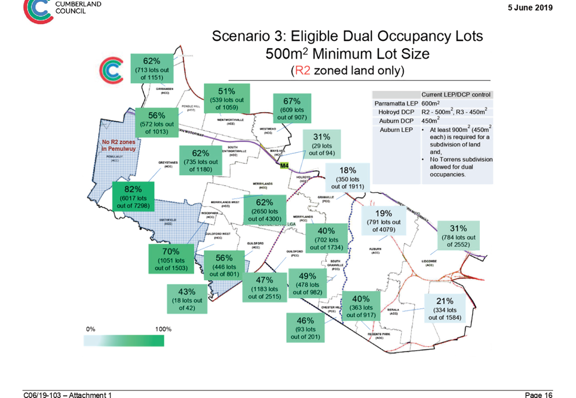
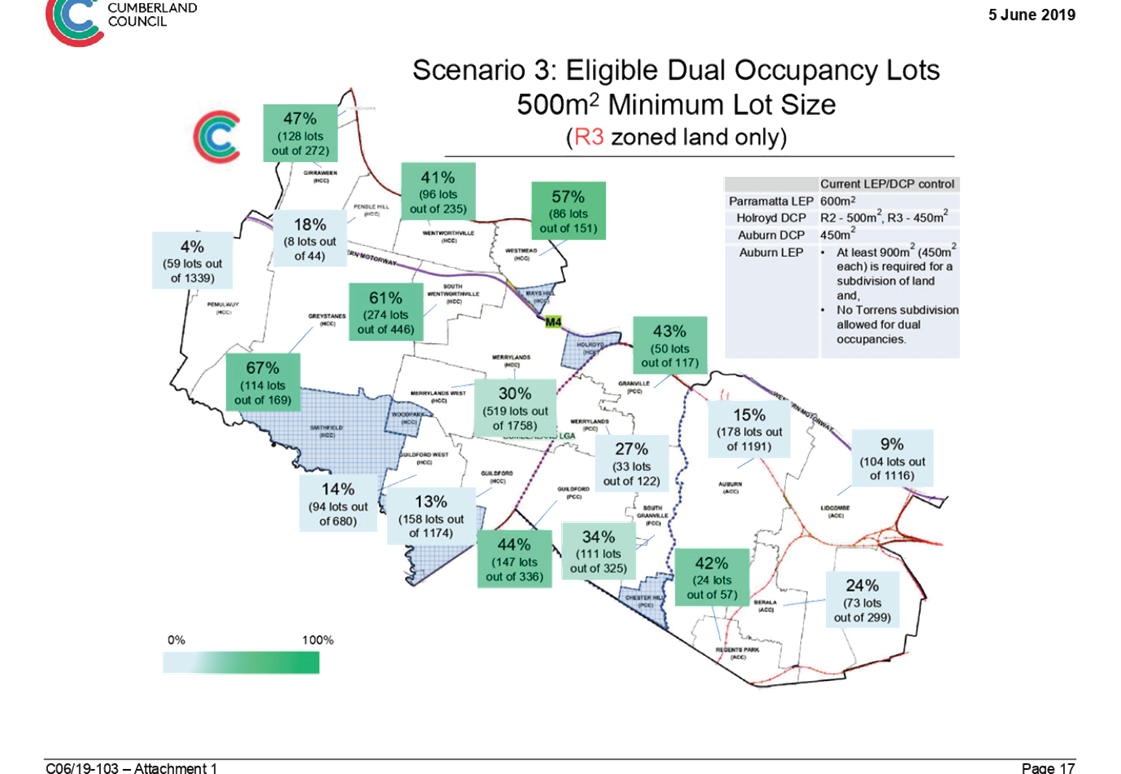
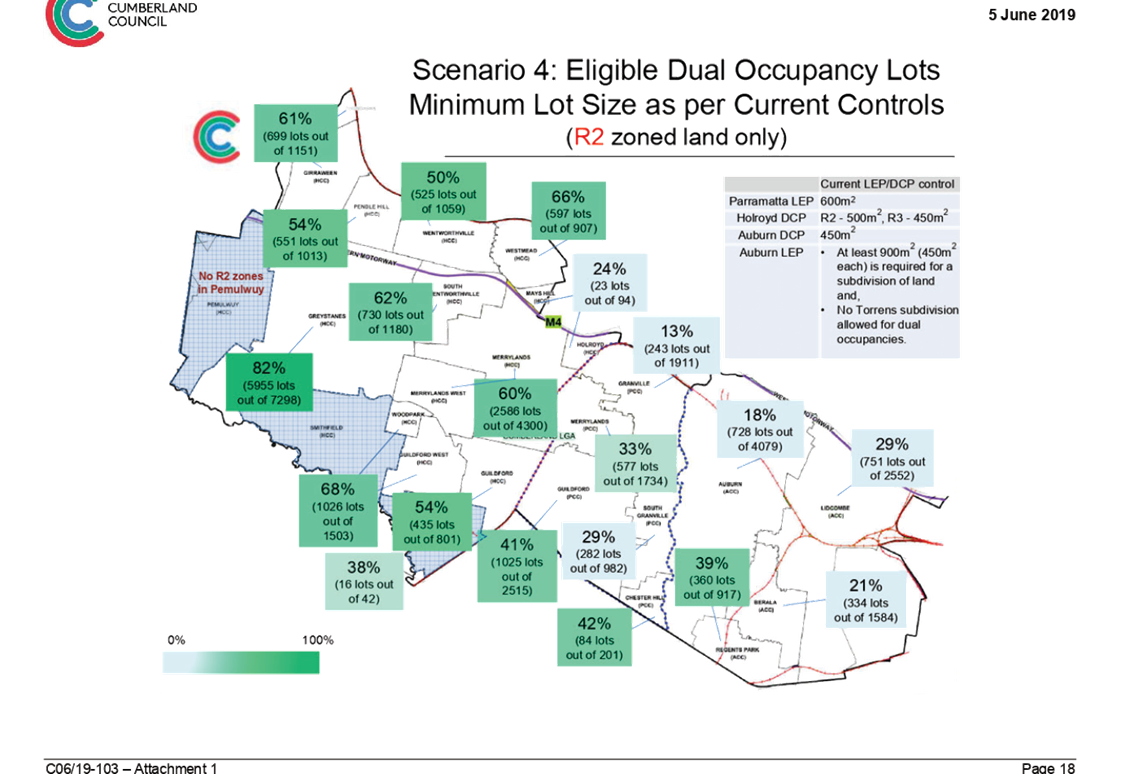
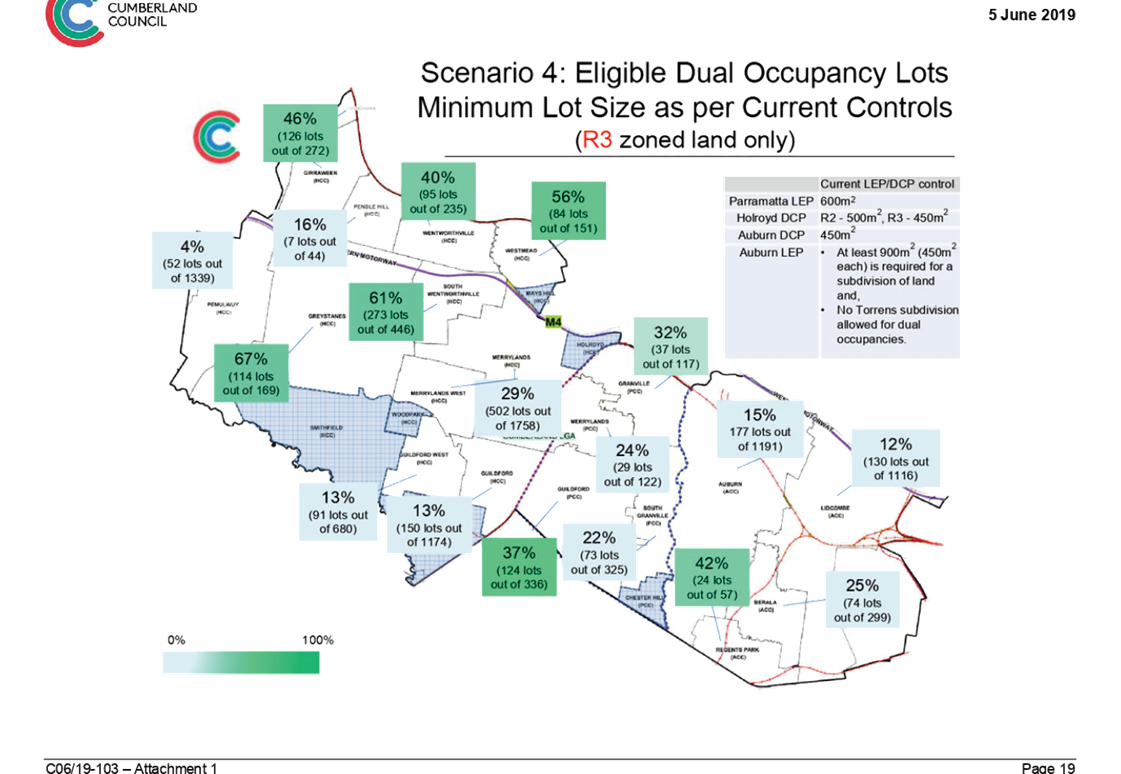
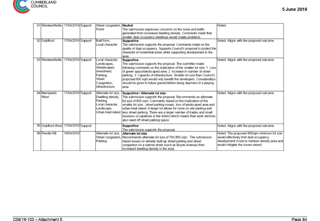
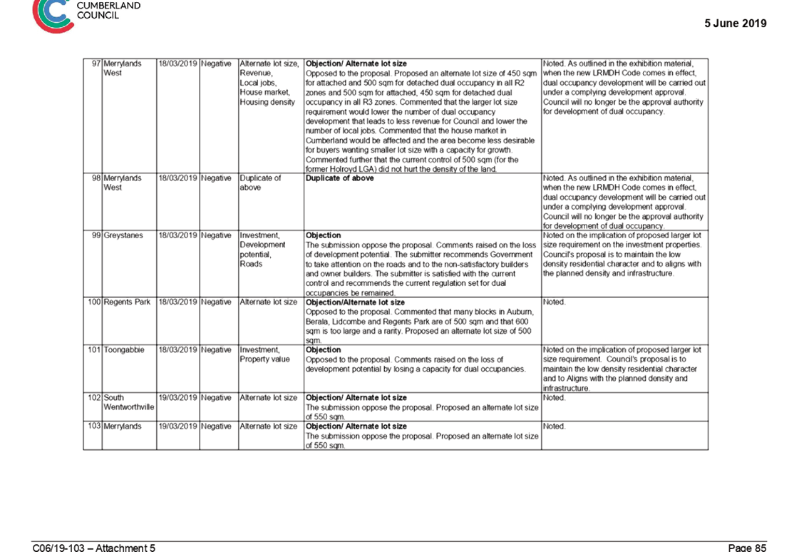
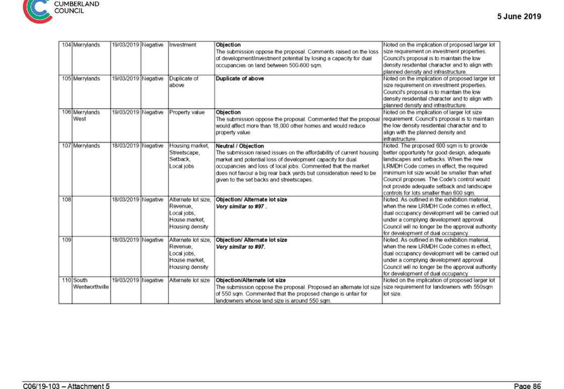
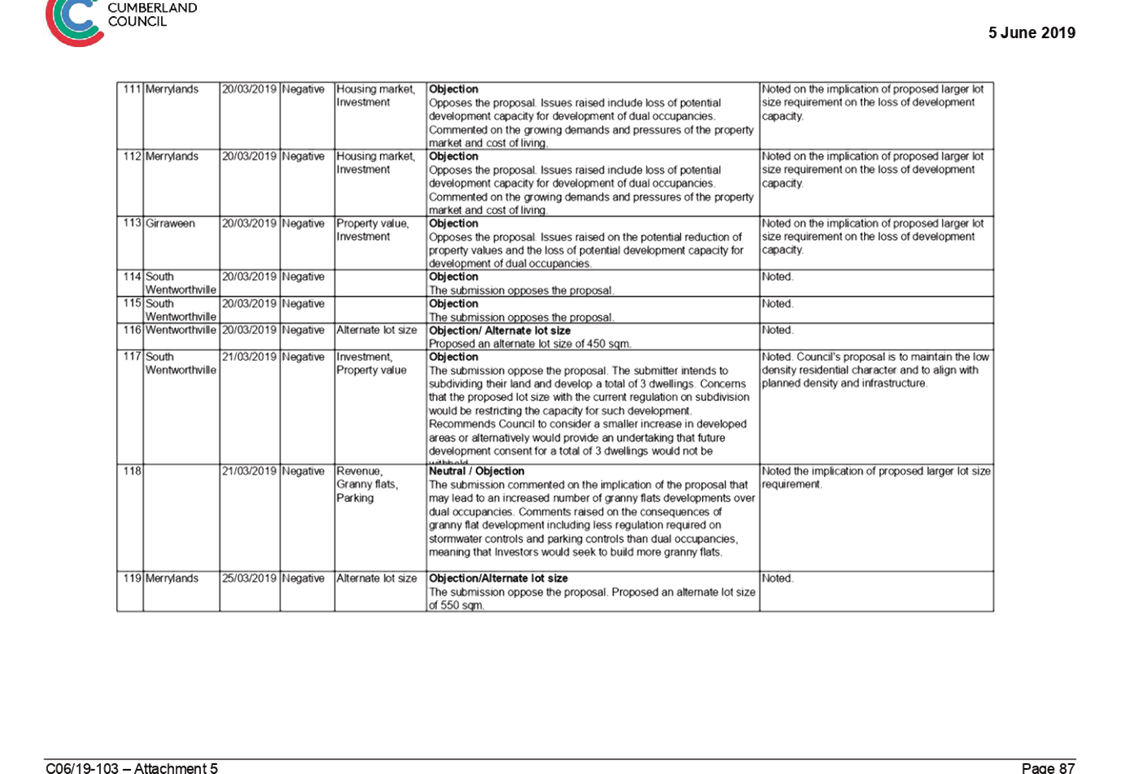
RES06/19-2 Notice of Rescission - Planning Proposal - Minimum Lot Area for Low and Medium Dual Occupancy Housing................ 467
Nil
Nil
C06/19-117 Resident Request for Hardship Assistance - Dividing Fence Adjoining Council Land
Note: Included in Closed Council in accordance with Section 10A(2)(b) of the Local Government Act as the information involves discussion in relation to the personal hardship of a resident or ratepayer.
C06/19-118 Proposed Expansion of TPG Contract - Private Cloud Infrastructure as a service
Note: Included in Closed Council in accordance with Section 10A(2)(d)(ii) and (f) of the Local Government Act as the information involves information that would, if disclosed, confer a commercial advantage on a competitor of the council and details of systems and/or arrangements that have been implemented to protect council, councillors, staff and Council property.
C06/19-119 Response to Notice of Motion - Cumberland Council Administration Building
Note: Included in Closed Council in accordance with Section 10A(2)(c) of the Local Government Act as the information involves information that would, if disclosed, confer a commercial advantage on a person with whom the Council is conducting (or proposes to conduct) business.
C06/19-120 Operational Agreement for the Auburn Ruth Everuss Aquatic Centre
Note: Included in Closed Council in accordance with Section 10A(2)(c) of the Local Government Act as the information involves information that would, if disclosed, confer a commercial advantage on a person with whom the Council is conducting (or proposes to conduct) business.
Council Meeting
19 June 2019
Item No: C06/19-105
Minutes of the Ordinary Meeting of Council - 05 June 2019
Responsible Division: Finance & Governance
Officer: Director Finance & Governance
|
That Council confirm the minutes of the Ordinary Meeting of Council held on 5 June 2019. |
Attachments
1. Draft
Minutes - 5 June 2019 ⇩ ![]()
DOCUMENTS
ASSOCIATED WITH
REPORT C06/19-105
Attachment 1
Draft Minutes - 5 June 2019
19 June 2019
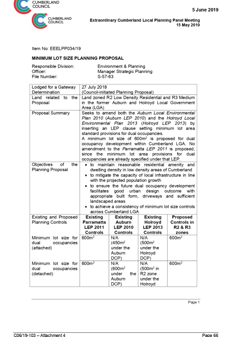
Item No: C06/19-106
Adoption of the Operational Plan and Fees and Charges for 2019-20 - Post Exhibition
Responsible Division: People & Performance
Officer: Manager Corporate Planning
File Number: S-57-50
Community Strategic Plan Goal: Transparent and accountable leadership
Summary
This report recommends the adoption of the final version of the Operational Plan and Fees and Charges for 2019-20 following a period of public exhibition.
At the 1 May 2019 Ordinary Council meeting, Council resolved to place the Draft Operational Plan and Fees and Charges 2019-20 on public exhibition for community feedback.
Subsequently, Council received 4 external submissions and a number of internal administrative submissions.
Once adopted, the Operational Plan 2019-20 will set out the principle activities Council plans to undertake during the year as well as the budget, capital works, rates and schedule of fees and charges for the year.
|
Recommendation That Council adopt the Operational Plan and Fees and Charges for 2019-2020. |
Report
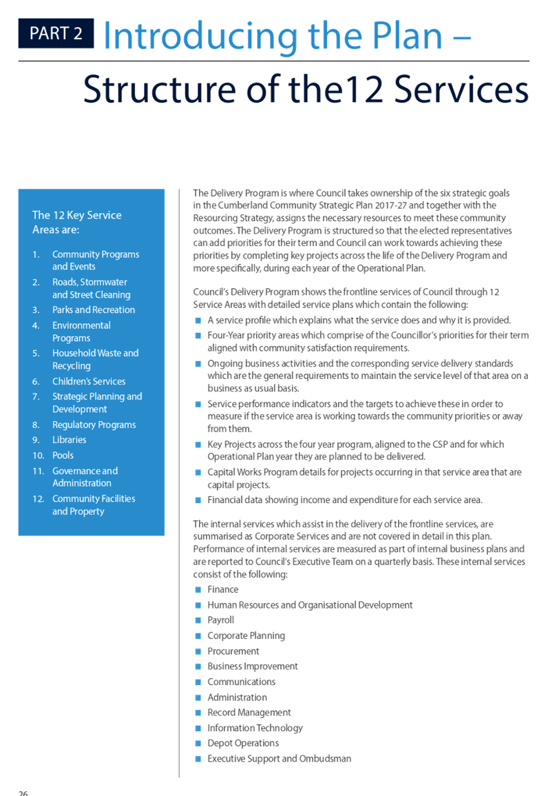
The recommended Operational Plan 2019-20 sets out the annual set of principle activities council will undertake through its 12 Key Service Areas, the budget, the capital works program and the rates statement for the 2019-20 year. The pricing policy and register of fees and charges that are part of the Operational Plan have been produced as a separate document for ease of use (see Attachment 2).
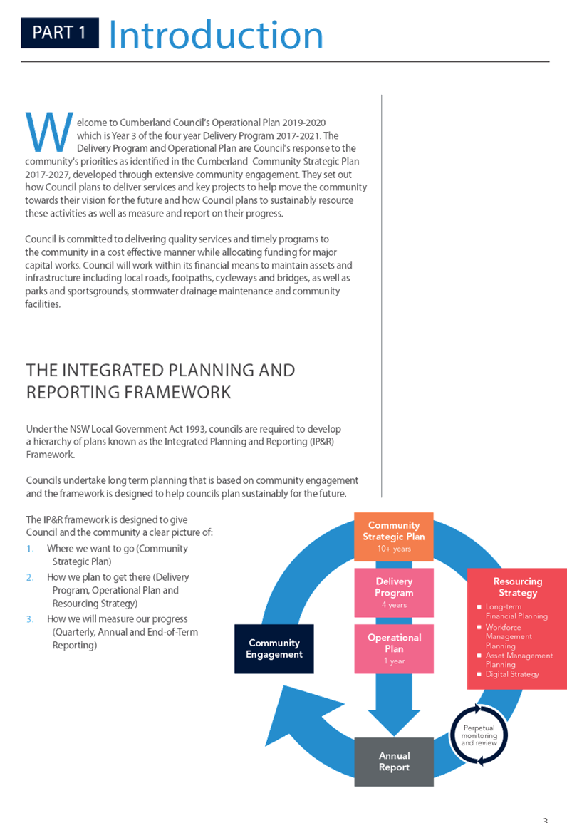
The Operational Plan 2019-20 forms part of the Council’s Integrated Planning framework. This Plan will also update the 4 year Delivery Program, and together with the Resourcing Strategy will enable Council to help realise the Cumberland Community Strategic Plan 2017-2027. This satisfies the Local Government Act 1993 Integrated Planning and Reporting requirements of Council.
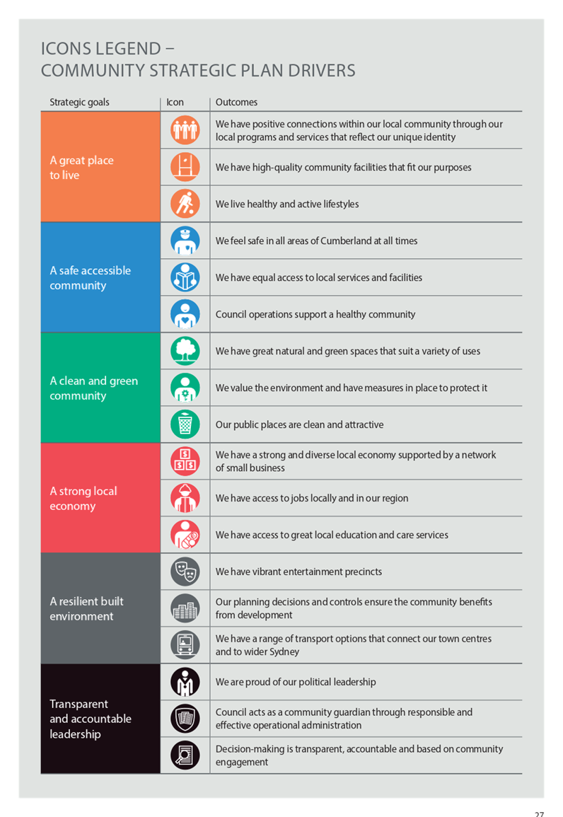
The Delivery Program 2017-21 and annual Operational Plans are communicated to the community through 12 Key Service Areas. Each of these service areas have the annual Key Projects that will be delivered, a list of ongoing business activities, income and expenditure for the service and key performance indicators. The Key Projects relate directly to an Outcome in the CSP, giving a clear line of sight from the Project, up to the expected Outcome, to the Strategic Goal and ultimately the vision that the community has for Cumberland’s future. These Key Projects along with the budget, capital works program, pricing policy and fees and charges constitute the annual Operational Plan.
2019-20 Focus Areas
This year there is an emphasis on raising service levels, particularly in the areas of bookings, customer service, facilities, development application processing times and the general cleanliness of Cumberland neighbourhoods.
Submissions Received
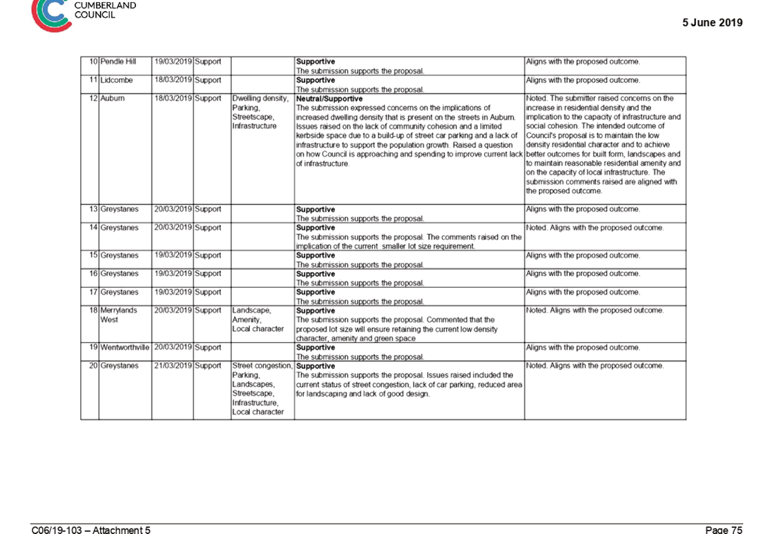
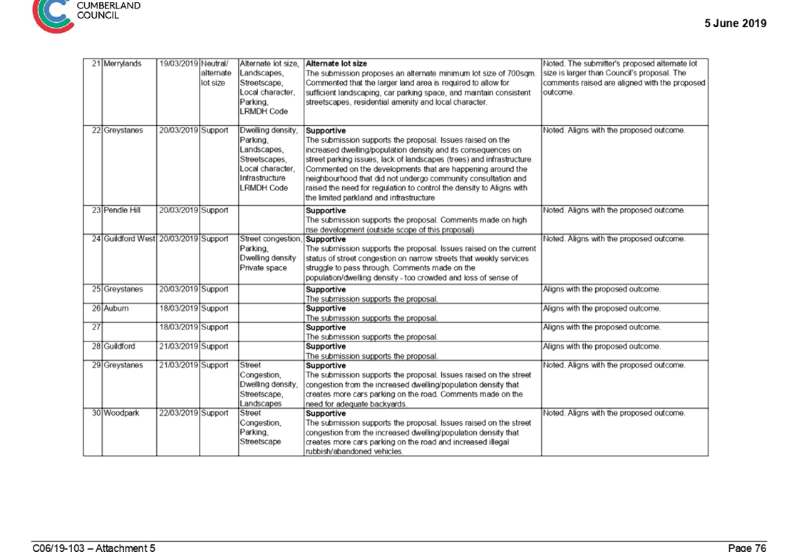
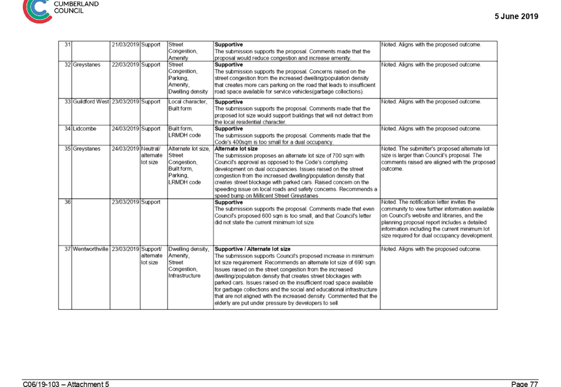
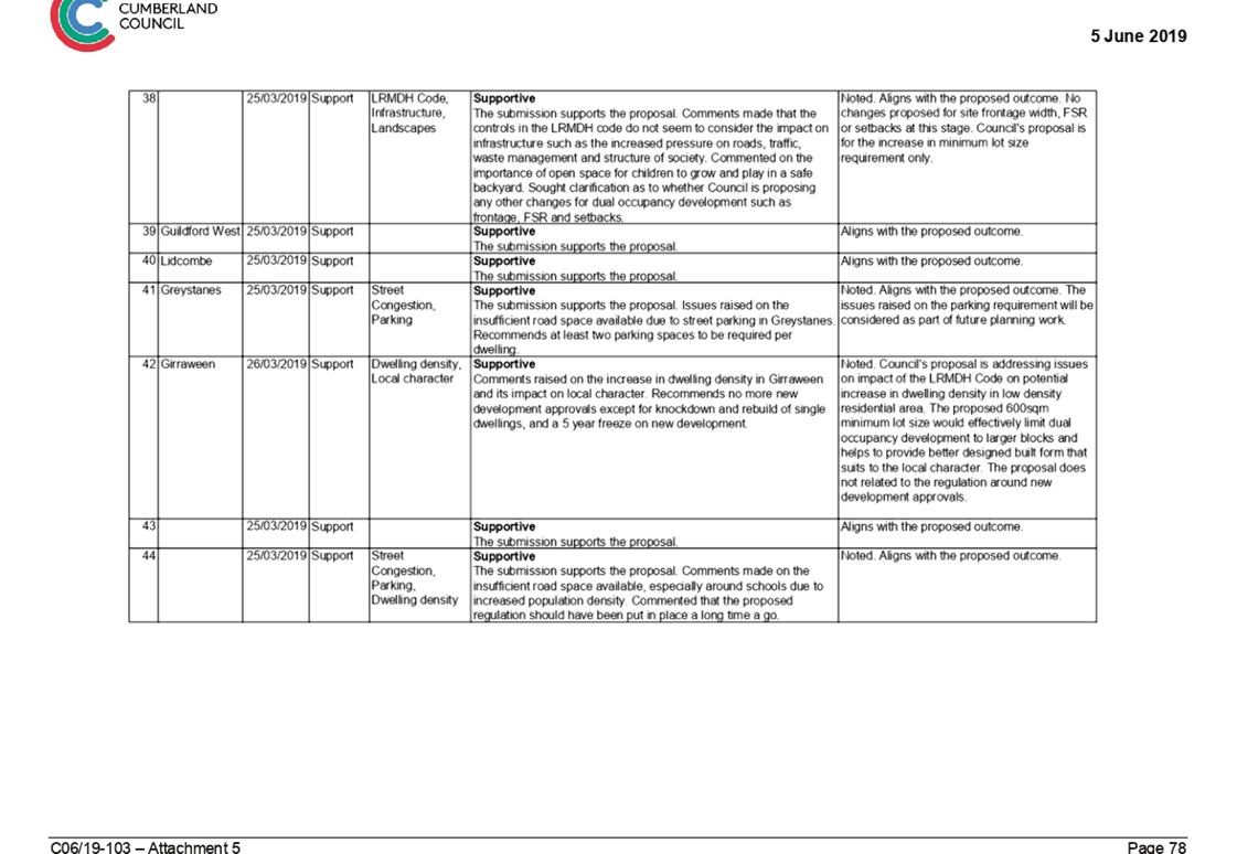
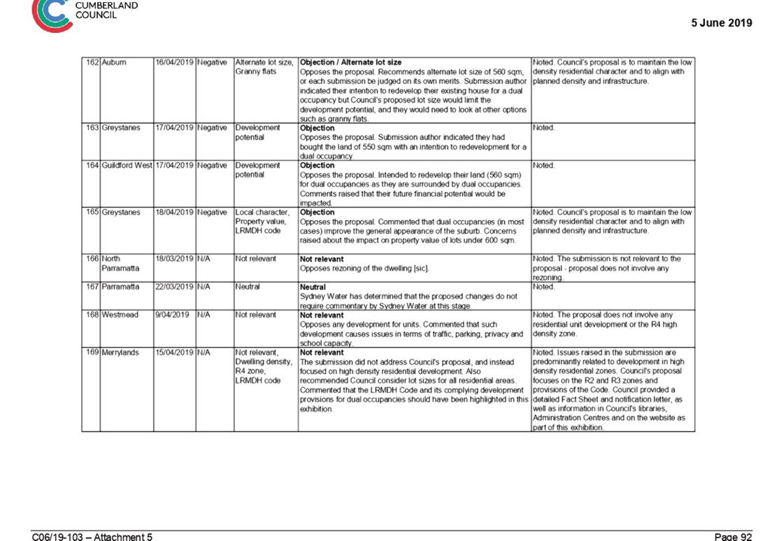
During exhibition, Council received four submissions from the community. The submissions covered a range of topic across both the Draft Operational Plan 2019-20 and the Fees and Charges 2019-20. Submissions included both comments and questions and all were taken into consideration in the finalisation of the Plan. Some submissions resulted in a change to the plan. A summary table of the submissions is below. All submissions have received a formal and detailed response from Council.
|
Sub. No. |
Comments / Suggestions |
Council response |
Changes to document |
|
1 |
Pemulwuy vacation care should be clarified. A double digits childcare centre closer to Greystanes is needed. |
Pemulwuy Out of School Hours operates a before and after school care program, the school holiday program does not operate from this centre as Council currently operates four school holiday programs that are not fully utilised.
Council notes the comments regarding Greystanes and can consider a double digits program in the future. |
N |
|
2 |
Inconsistencies in the use of S94 and S711. |
Noted, references to this funding source in the document have been changed to ‘Development Contributions’ |
Y |
|
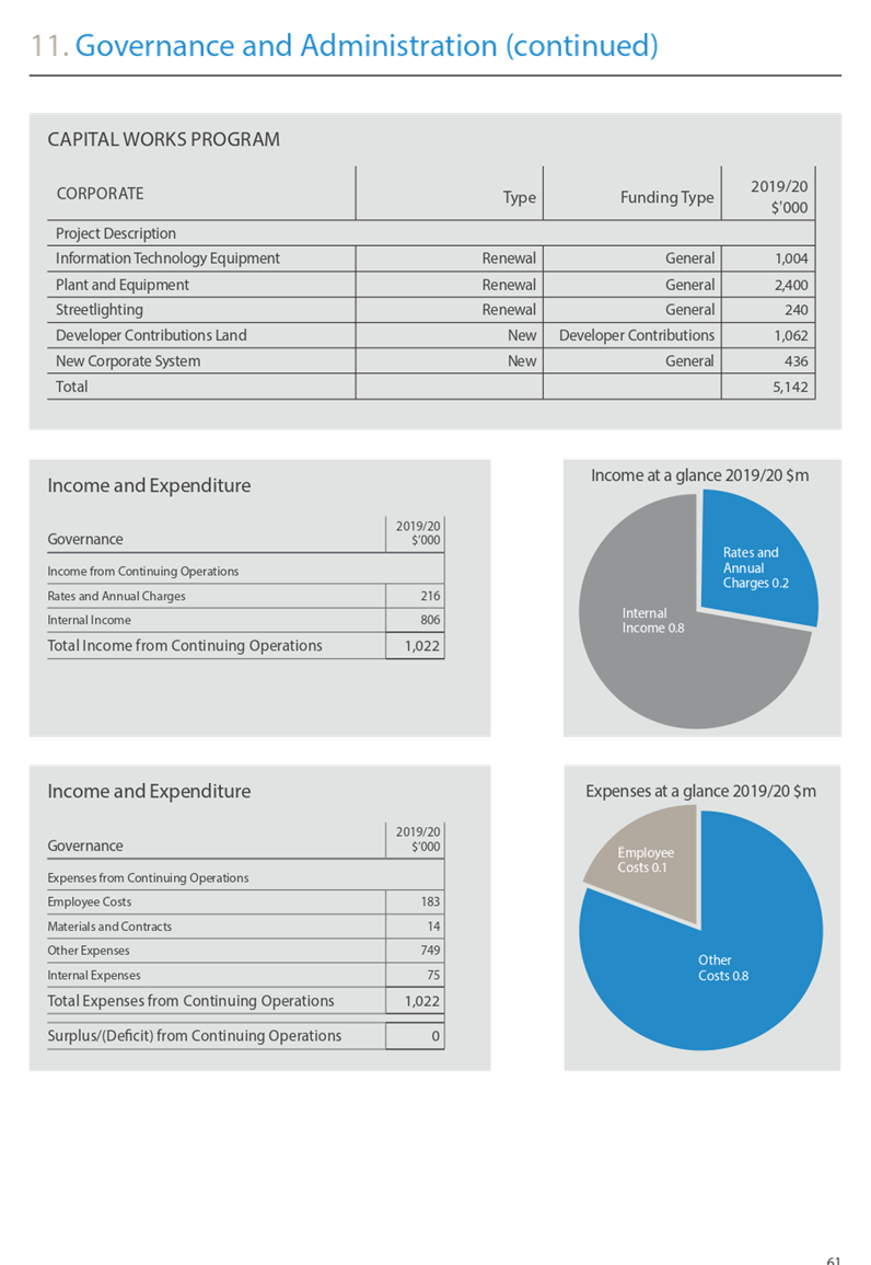
What is the true cost of providing governance and administration? |
$43m, recouped through internal charges to deliver a net funding surplus of $2m. |
N |
|
|
Supplied map of rating categories does not show all categories and subcategories. |
Map did show rating categories, a separate table showed the different Ad valorem amounts for the former Council Areas. Council will make this clearer in future year’s documents. |
N |
|
|
3 |
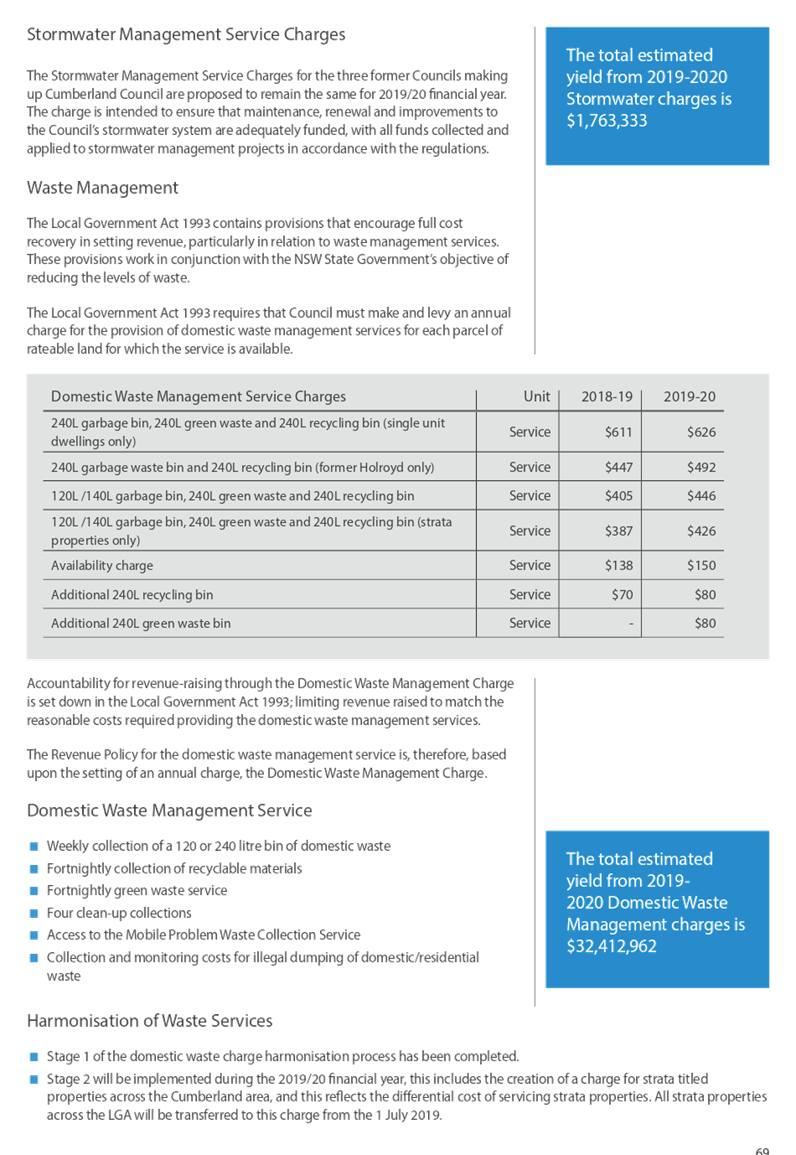
Objection to the increase in Domestic Waste Management charges |
The revenue raised through the application of the domestic waste management charge is limited to matching the reasonable costs of providing the waste services.
Council is also implementing the second stage of harmonising the waste services and the associated domestic waste management charges, inherited from the previous councils.
The changes to the waste services provided do not represent a reduction in service. |
N |
|
4 |
General comments regarding design of the document and questions about the structure of the plan. |
Projects are updated throughout the year through the quarterly reporting process. Council’s current staffing levels are to address target service levels. |
N |
|
Questions about Council’s Place Management function. |
There will be one Place Liaison Team Leader and four Place Liaison Officers in 2019-20. The Place Liaison Team Leader will also be allocated a ward in addition to team leader responsibilities to ensure a consistent level of service is provided across all five Wards. These are new roles, but are being funded by the existing Draft budget 2019-20 and savings made as a result of the organisation structure review currently being implemented.
|
N |
|
|
Questions about the planning of Council’s events. |
Community groups are able to promote their events on Council’s Community Events Web Page but must contact Council and provide the relevant information about their event. Linnwood House were invited to be part of Council’s recent Cumberland Local Festival, which enabled Council to offer additional promotional support to the ‘Open Day and Tour’ held in May 2019. Councillors are aware of Council run events and provided with relevant information to attend events. Councillors were briefed on the proposed Cumberland Events Program for 2019-20 prior to inclusion in the Draft Operational Plan.
|
N |
|
|
Queries regarding the Roads, Stormwater and Waste Service provision. |
The Merrylands CBD Revitalisation project is listed in the Plan in pages 34 and 64. |
N |
|
|
Concern about Council’s beehive program |
Council does not currently have any hives located in units. |
N |
|
|
Questions about childcare occupancy rates and Children and Family Services Strategy. |
Attendance target rates appear to be low as the percentage is calculated on the approved number of places. Council plans the available spaces to meet future needs of the community. |
N |
|
|
Concern about the development contributions and KPIs for Development Assessment. |
Cumberland has recently introduced a Design Excellence Panel (DEP) to provide early design advice on key projects within the Cumberland Local Government Area. The DEP, in conjunction with the Cumberland Local Planning Panel, will contribute to achieving consistency in the decision making process for development applications.
|
N |
|
|
Questions about Council’s regulation of outdoor dining. |
Matter has been prioritised and Councillors were briefed in March 2019. |
N |
|
|
Comments about capital funding for Libraries and questions about changes to Library fees. |
Noted, wording has been changed to improve the description of the library collection. |
Y |
|
|
Questions about rates and infrastructure backlog |
Information on Council’s infrastructure backlog is reported in the Annual Report. |
N |
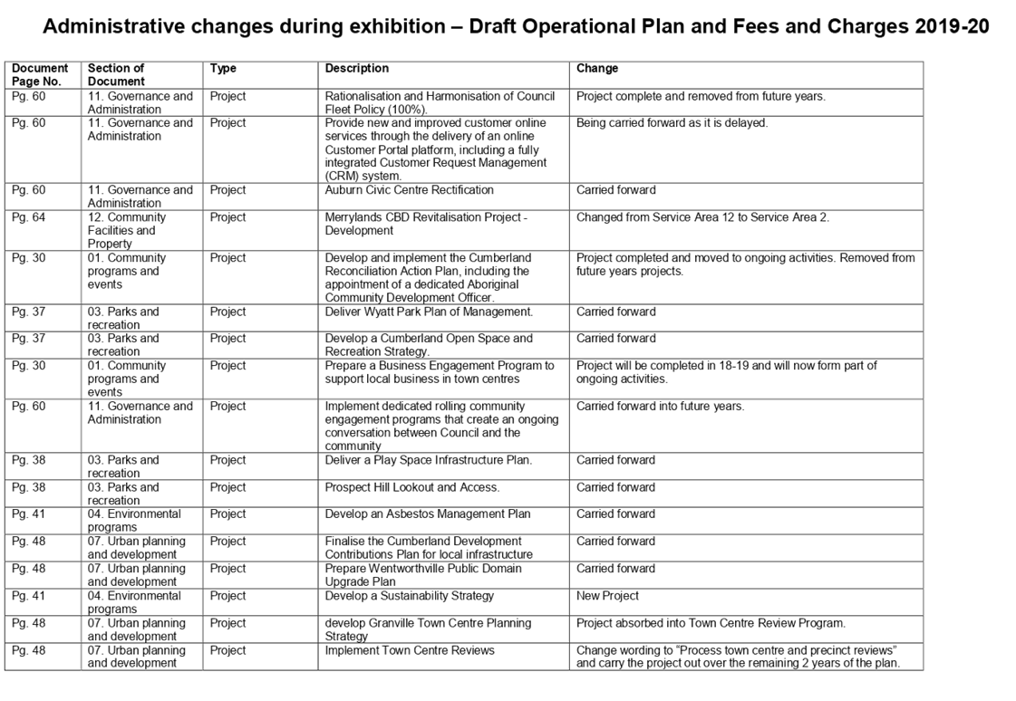
Changes while on exhibition
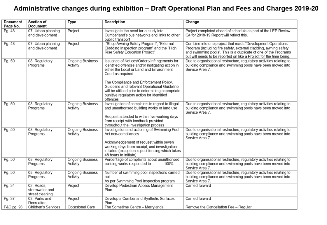
In addition to submissions from the public, there were also a number of internal administrative submissions received. These are outlined in Attachment 3. These changes exclude minor grammatical changes throughout both documents that have been made and that did not change intent of documents.
Reporting Progress on the Plan
The implementation of the Operational Plan 2019-20 will be reported quarterly to Council and the Community as is current practice. If new projects are started as a result of resolutions of Council, or if projects are require termination, these will be formalised through the Quarterly Reports to Council. This information will also be presented yearly in the Annual Report, providing a high level of accountability and transparency around the implementation of Council’s key planning document.
Community Engagement
The Draft Operational Plan and Fees and Charges for 2019-20 were reported to Council on 1 May 2019 and exhibited for 28 days from 3 May 2019 to 30 May 2019 during which time Council encouraged community feedback on the draft documents and received many valuable questions, comments and views from residents.
During the engagement period, Council heavily promoted the opportunity that the community had to comment on the draft Plan. Engagement was undertaken in a number of ways that included social media, other online mediums, advertisements in English and multiple non-English newspapers, invitations to engage face to face, and promotion in Council’s libraries and customer service centres.
As a result, the draft plan received high exposure. A summary of the engagement is provided below:
· 464 users visited the draft plan on Have Your Say
· 2 of these contributed via a response and all were verified via an email address
· 200 document downloads
· 4,787 people reached on social media
· Advertisements placed in local newspapers across multiple languages
· 4 formal submissions across both documents
Four formal submissions have been received in response to the exhibition of the Draft Plan. A summary of submissions and Council’s response has been provided above in this Report.
Council has formally responded to all respondents who made a submission and notified them of the consideration of this item at this Council meeting.
Policy Implications
The Operational Plan 2019-20 will set the major policy direction for Cumberland Council from 1 July 2019 to 30 June 2020. This plan includes the principal activities, budget, capital works, pricing policy, and fees and charges (separate document) for this period. Major changes to these forecast activities and expenditure requires Council approval and re-exhibition to the public for 28 days.
Risk Implications
By not adopting the Operational Plan, in accordance with the Local Government Act 1993, Council would be at risk of failing its obligations under the Integrated Planning and Reporting provisions. Council would also fail to set the rates for the coming year, and not be able to charge updated fees or charges for its services and facilities.
Financial Implications
There are no financial implications for Council associated with this report.
CONCLUSION
The Operational Plan 2019-20 gives the community a clear picture of the principle activities Council plans to undertake during the year and how it plans to fund them. The planning of these proposed activities has been informed by community engagement, the community’s priorities from the Community Strategic Plan, elected representative priorities and from feedback received during public exhibition. Council engaged the community extensively during the exhibition period and received positive and constructive submissions across a range of issues. All community submissions and resulting changes to the plan were considered during the finalisation of the draft plan.
Attachments
1. Cumberland Council
Operational Plan 2019-20 ⇩ ![]()
2. Cumberland
Council Fees and Charges 2019-20 ⇩ ![]()
3. Administrative
submissions ⇩ ![]()
DOCUMENTS
ASSOCIATED WITH
REPORT C06/19-106
Attachment 1
Cumberland Council Operational Plan 2019-20
Attachment 2
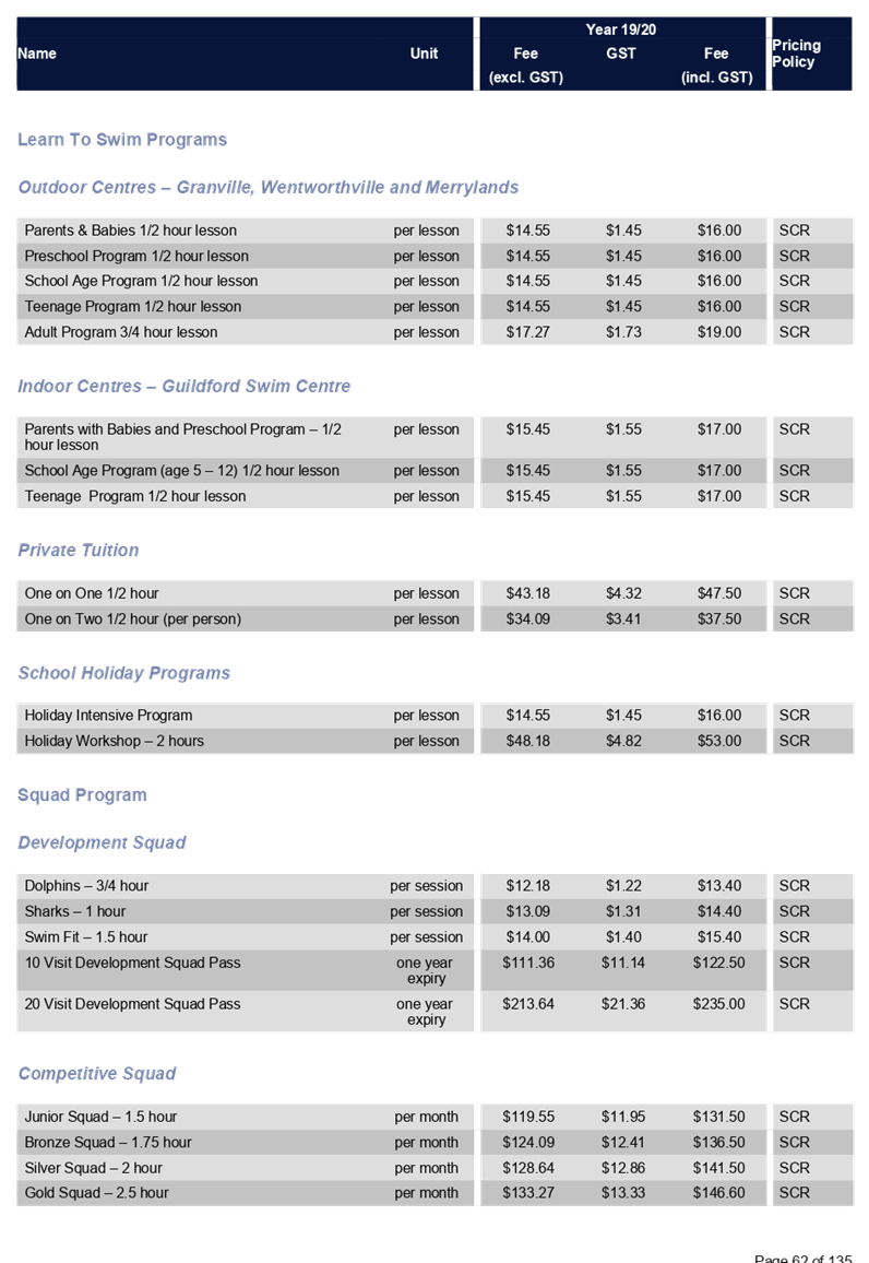
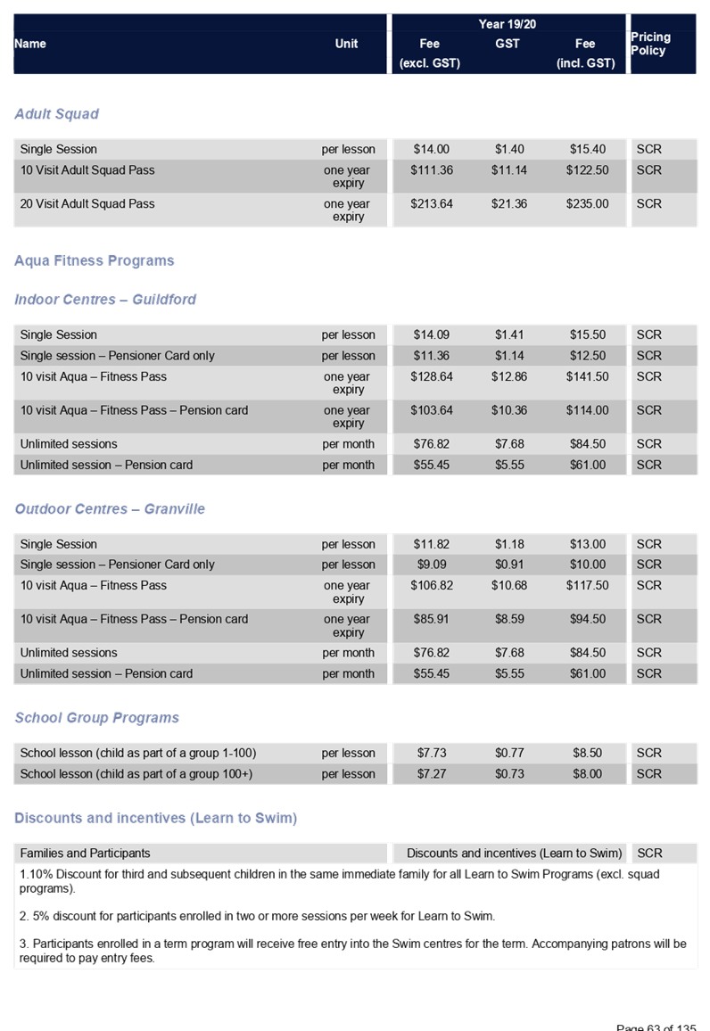
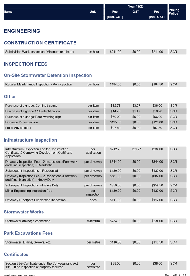
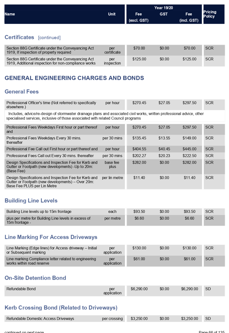
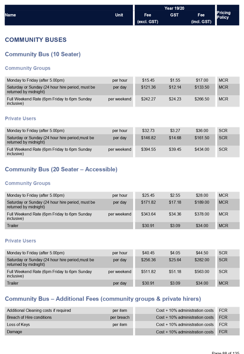
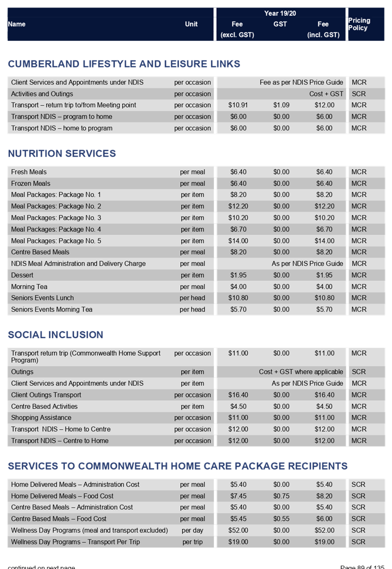
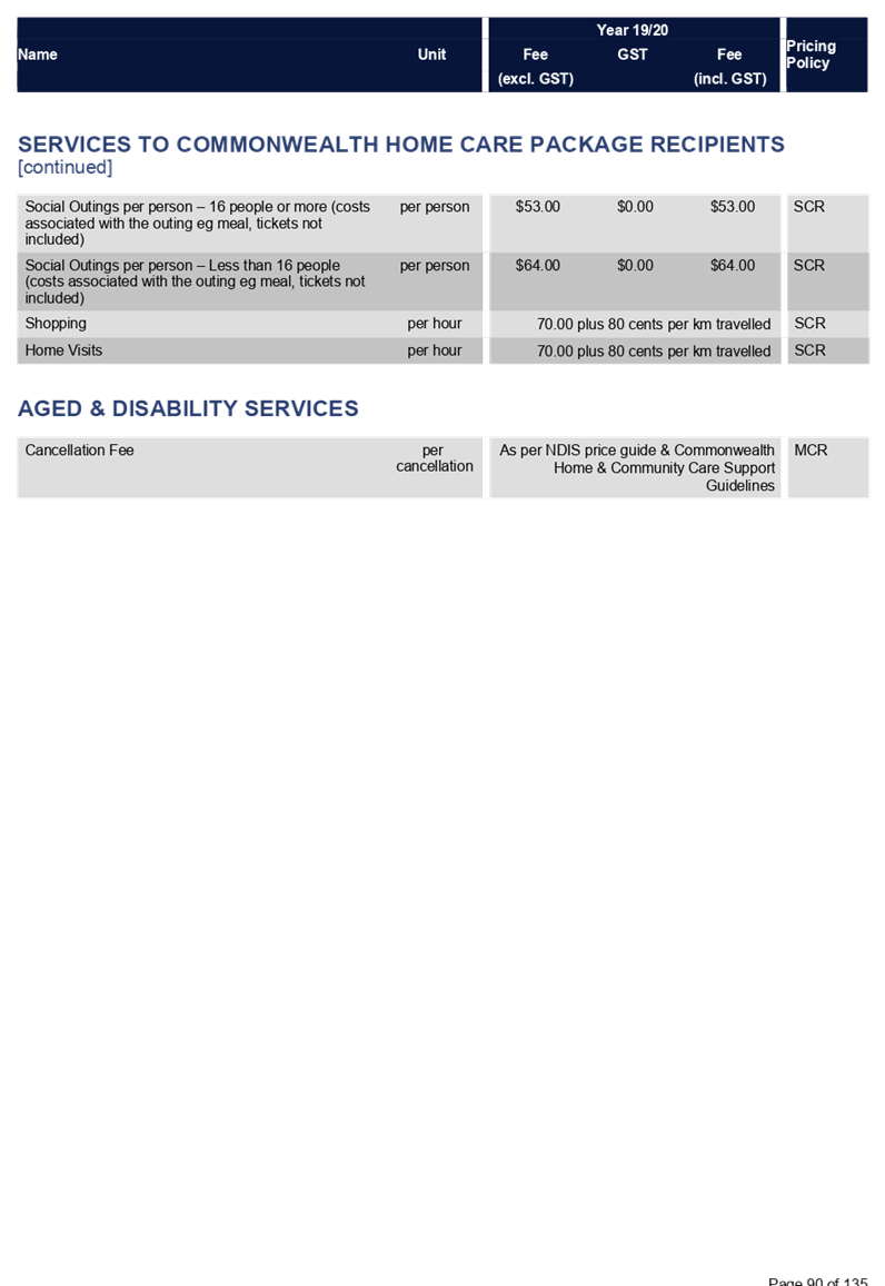
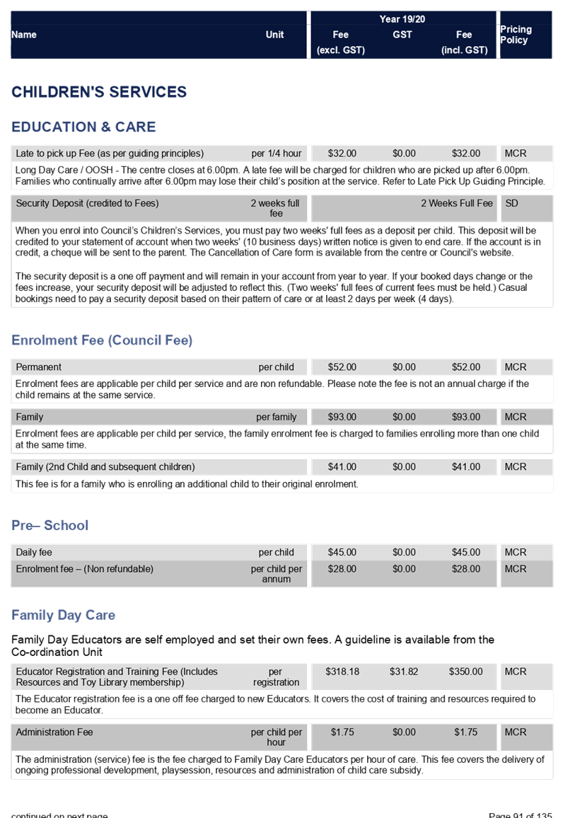
Cumberland Council Fees and Charges 2019-20
19 June 2019
Item No: C06/19-107
Making Rates and Fixing Charges 2019/20
Responsible Division: Finance & Governance
Officer: Director Finance & Governance
File Number: FY-04
Community Strategic Plan Goal: Transparent and accountable leadership
Summary
The purpose of this report is to make the rates and fixing of charges for the period 1 July 2019 to 30 June 2020.
|
Recommendation
1. That Council makes the Rates and Charges for the following rating structures for the 2019/2020 rating year in accordance with Chapter 15, parts 4 and 5 of the Local Government Act 1993: and adopt the overdue Rates and Charges interest rate of 7.5%.
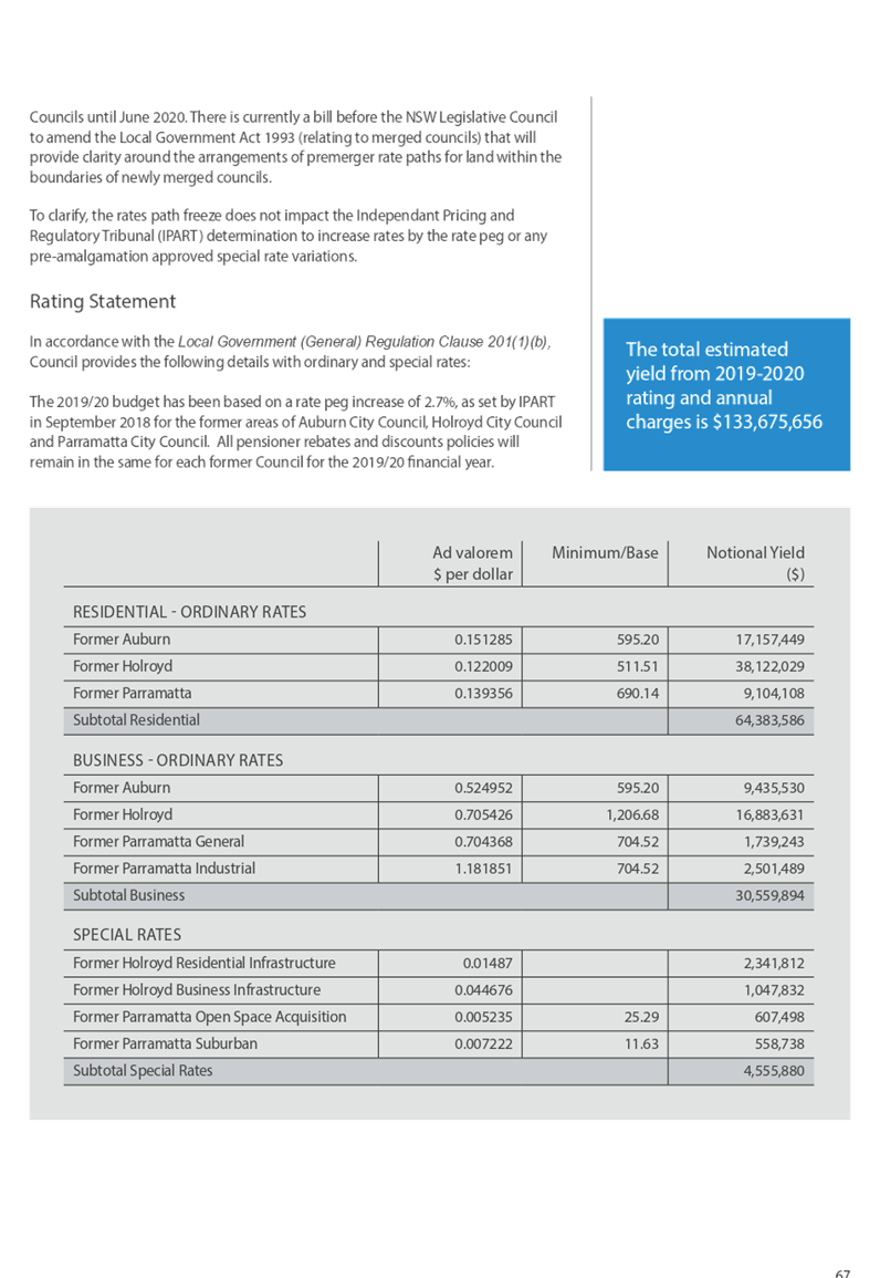
Former Auburn City Council Rate Path
An ordinary residential rate of zero point one five one two eight five (0.151285) cents in the dollar on the land value of all rateable land categorised as Residential in the former Auburn City Council. The minimum ordinary rate shall be five hundred and ninety five dollars and twenty cents ($595.20) per assessment and be made and levied for the rating year 1 July 2019 to 30 June 2020.
An ordinary business amount shall be zero point five two four nine five two (0.524952) cents in the dollar applied to the land value on all parcels of Business in the former Auburn City Council. The minimum ordinary rate shall be five hundred and ninety five dollars and twenty cents ($595.20) per assessment and be made and levied for the rating year 1 July 2019 to 30 June 2020.
Former Holroyd City Council Rate Path
An ordinary residential rate of zero point one two two zero zero nine (0.122009) cents in the dollar on the land value of all rateable land categorised as Residential in the former Holroyd City Council, together with a residential base rate of $511.51 per assessment be made and levied for the rating year of 1 July 2019 to 30 June 2020. An ordinary business rate of zero point seven zero five four two six (0.705426) cents in the dollar on the value of all rateable land categorised as Business in the former Holroyd City Council, subject to a minimum charge of $1,206.68per assessment be made and levied for the rating year 1 July 2019 to 30 June 2020.
A special infrastructure rate of zero point zero one four eight seven (0.014870) cents in the dollar on the land value of all rateable land categorised as Residential in the former Holroyd City Council and levied for the rating year 1 July 2019 to 30 June 2020.
A special infrastructure rate of zero point zero four four six seven six (0.044676) cents in the dollar on the land value of all rateable land categorised as Business in the former Holroyd City Council be made and levied for the rating year 1 July 2019 and 30 June 2020.
Former Parramatta City Council Rate Path
An ordinary residential rate of zero point one three nine three five six (0.139356) cents in the dollar on the land value of all rateable land categorised as Residential in the former Parramatta City Council. The minimum ordinary rate shall be six hundred and ninety dollars and fourteen cents ($690.14) per assessment and be made and levied for the rating year 1 July 2019 to 30 June 2020.
An ordinary business amount shall be zero point seven zero four three six eight (0.704368) cents in the dollar applied to the value of all rateable land categorised as Business General under the former Parramatta City Council. The minimum ordinary rate shall be seven hundred and four dollars and fifty two cents ($704.52) per assessment and be made and levied for the rating year 1 July 2019 to 30 June 2020.
An industrial business amount shall be one point one eight one eight five one (1.181851) cents in the dollar applied to the land value of all rateable land categorised as Business ICA under the former Parramatta City Council. The minimum ordinary rate shall be seven hundred and four dollars and fifty two cents ($704.52) per assessment and be made and levied for the rating year 1 July 2019 to 30 June 2020.
A special Open Space and Acquisition Embellishment rate amount shall be zero point zero zero five two three five (0.005235) cents in the dollar applied to the land value on all parcels of rateable land categorised under the former Parramatta City Council. Together with a base rate of $25.29 per assessment be made and levied for the rating year of 1 July 2019 to 30 June 2020.
A special Suburban Infrastructure rate amount shall be zero point zero zero seven two two two (0.007222) cents in the dollar applied to the land value on all parcels of rateable land categorised under the former Parramatta City Council. Together with a base rate of $11.63 per assessment be made and levied for the rating year of 1 July 2019 to 30 June 2020.
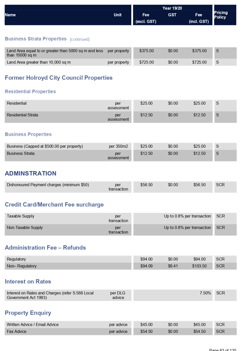
2. That the short names of each form of rate and charge pursuant to Section 453 of the Act, shall be as follows:
Ordinary Rates - Res Ord Rate - Res Base Amt - Res Min Rate - Bus Ord Rate - Bus Min Rate - Bus Ind Rate
Special Rates - O. S. A. & E. Spec Rate - Suburban Infrastructure Spec Rate
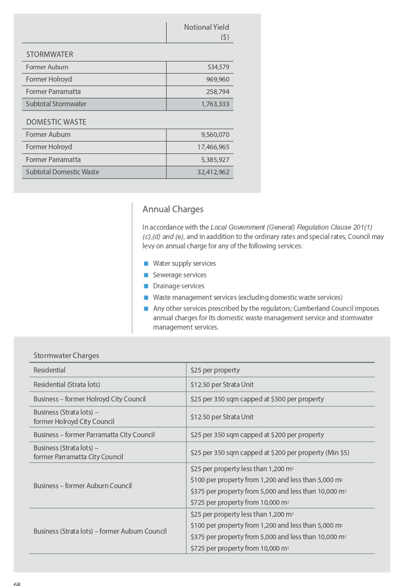
Stormwater Management Service Charges - Stormwater Management Service Charges for residential and business parcels of land shall be known by the name of Stormwater Management Charge. - Waste Management Service Charges for residential rateable land shall be known by the name of DWM Charge.
CUMBERLAND COUNCIL PENSIONER REBATE POLICY
Former Auburn Council Rate Path
That pensioner rate rebates continue to apply with eligible pensioners receiving a rebate on their Rates and Domestic Waste Management Charge, to a maximum of $250.00
Former Holroyd Council Rate Path
That pensioner rate rebates continue to apply with eligible pensioners receiving a rebate on their Rates and Domestic Waste Management Charge, to a maximum of $250.00, plus an additional pensioner voluntary rebate of $15.00 per assessment in accordance with former Holroyd City Council’s policy.
Former Parramatta City Council Rate Path
That pensioner rate rebates continue to apply with eligible pensioners receiving a rebate on their Rates and Domestic Waste Management Charge, to a maximum of $250.00, plus an additional $100.00 to eligible pensioners in accordance with former Parramatta City Council’s policy.
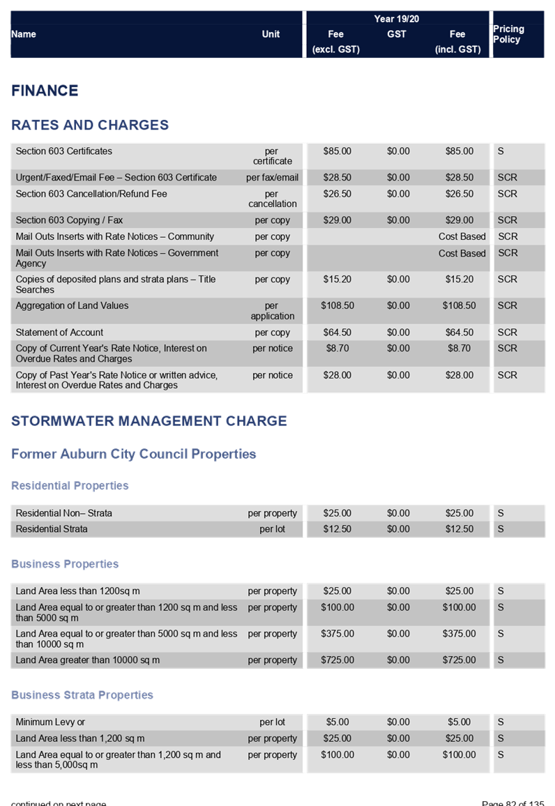
3. That the following Stormwater Management Levy be adopted:
Former Auburn City Council rate path
Residential non-strata $25 per property Residential strata $12.50 per property
Business Stormwater
Business Strata Stormwater
Former Holroyd City Council and Parramatta City Council Rate Path
4. That Council include in the Draft 2019/2020 Operational Budget the following Domestic Waste/ Recycling Service Charge for 2019/2020:
|
Report
Rating Statement
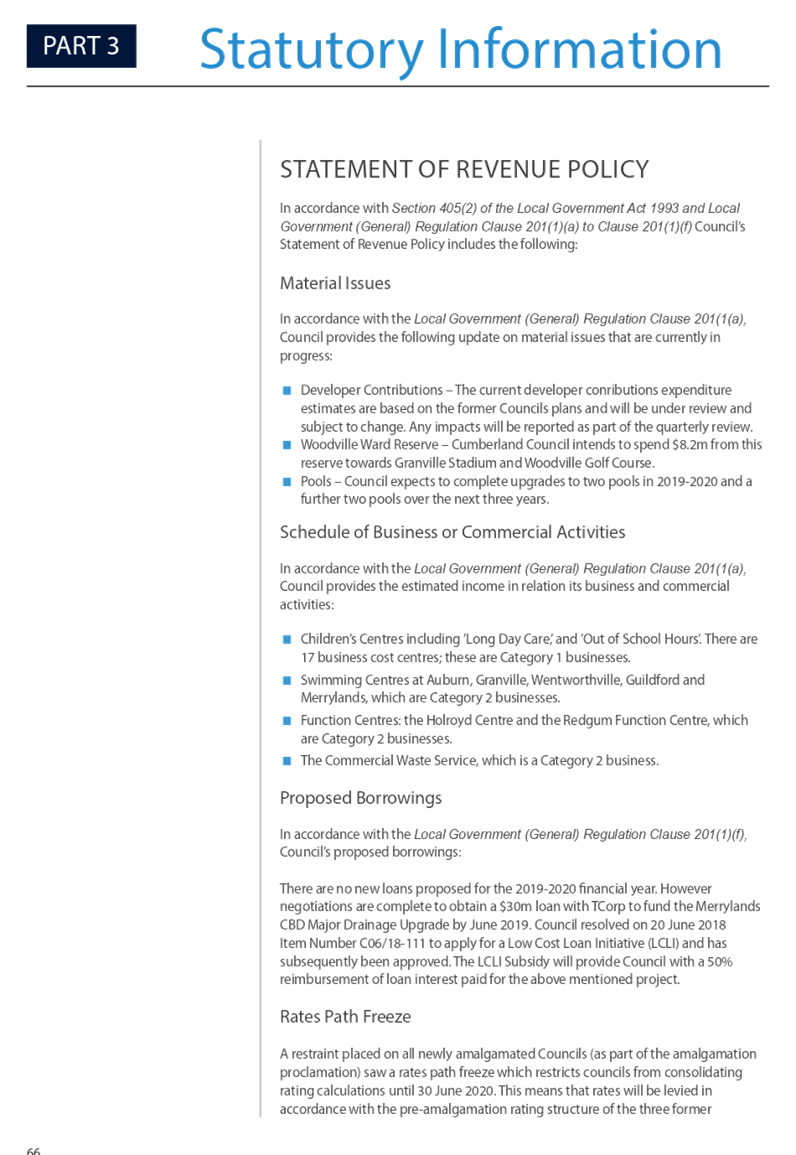
The 2019/2020 budget is based on the rate peg increase of 2.7% which was set by IPART in December 2018.
Due to the adoption of Section 218CB of the Local Government Act, there is a restraint placed on all newly amalgamated councils which results in a rates path freeze. This freeze restricts councils from consolidating rating calculations until 30 June 2020. Therefore, rates will be in accordance with the pre-amalgamation rating structure of the three former Councils until June 2020.
To clarify, the rates path freeze does not impact the IPART determination to increase rates by the rate peg or any special rate variations approved pre-amalgamation.
Below is a summary of the rates for each of the former councils.
Community Engagement
In accordance with the Local Government Act 1993 and Local Government (General) Regulation 2005, the proposed Rates and Changes must be placed on public exhibition for 28 days. The relevant documents were placed on public exhibition for 28 days.
The Draft Operational Plan and Fees and Charges for 2019/20 were reported to Council on 1 May 2019 and exhibited for 28 days from 3 May 2019 to 30 May 2019 May during which time Council encouraged community feedback on the draft documents and received many valuable opinions, questions and comments from residents and community groups.
Four formal submissions have been received in response to the exhibition of the Draft Plan. A summary of submissions and Council’s response has been provided above in a separate Report “Adoption of Operational Plan and Fees and Charges for 2019-2020 Post Exhibition”.
Policy Implications
There are no policy implications for Council associated with this report.
Risk Implications
There are no risk implications for Council associated with this report.
Financial Implications
It is crucial that this recommendation is adopted by 30 June 2019 to allow Council to issue rates statements before 31 July 2019.
CONCLUSION
This report recommends the adoption of Cumberland Council’s Rates and Annual Fees following public exhibition as prescribed in the Local Government (General) Regulations 2005.
Attachments
Nil
Council Meeting
19 June 2019
Item No: C06/19-108
Review of Dividing Fences Policy
Responsible Division: Finance & Governance
Officer: Director Finance & Governance
File Number: HC-06-09-48
Community Strategic Plan Goal: Transparent and accountable leadership
Summary
This report presents the revised Dividing Fences Policy in accordance with its adopted policy review date requirements, and recommends the revised version, Dividing Fences Hardship Policy, be placed on public exhibition for 28 days.
|
Recommendation That Council: 1. Approve the revised Dividing Fences Hardship Policy being placed on public exhibition for 28 days. 2. Adopt the Policy post exhibition if no adverse submissions are received. |
Report
The current Dividing Fences Policy has been reviewed in accordance with its adopted policy review date. A number of changes have been recommended to provide a more consistent approach and improve outcomes for the community.
Below is a summary of the recommended changes:
· Retitling of Policy to Dividing Fences Hardship Policy, to allow for a clearer understanding as to the intent of the Policy.
· Introduction of a new criteria for larger fences erected adjoining Council property. For new or replacement fencing over 50 lineal metres, eligible applicants can apply for a 25% maximum total contribution under hardship. This is an increase on the maximum $1,000 per application available currently and provides the opportunity for greater support to the community.
· Introduction of minimum requirements to demonstrate hardship, in accordance with the provisions of the adopted Hardship Policy currently applicable to all financial/rating hardship applications.
· Introduction of a requirement to provide 3 quotations for fencing, with Council’s contribution based on the most cost-effective option.
· New requirement that Council will only consider financial hardship applications where the existing fence is in a state of disrepair or poor condition.
Community Engagement
The revised Policy will be placed on public exhibition for 28 days, with notification provided in local print media and on Council’s ‘Have Your Say’ web page.
Policy Implications
If adopted, the revised version of the Policy will supersede the currently adopted version.
Risk Implications
This revised Policy ensures that all financial hardship applications relating to fences adjoining Council land are treated in a consistent and equitable fashion. The Policy also ensures that Council is being proactive in protecting its own assets and land holdings, by supporting adjoining land owners in financial hardship circumstances to ensure boundary fencing is safe.
Financial Implications
Dependant on the volumes of applications received, there may be minor financial implications associated with this report which would be factored into the budget review process. Based on current request volumes, the amount is anticipated to be very minor and can be budgeted within the existing Property Leasing and Transactions business unit budget.
CONCLUSION
The Dividing Fences Policy has now been reviewed in accordance with its policy review date and the above changes are recommended to ensure the Policy is fair and equitable to eligible residents applying for hardship. It is now recommended that the revised version be placed on public exhibition and, if no adverse submissions are received, adopted following this process.
Attachments
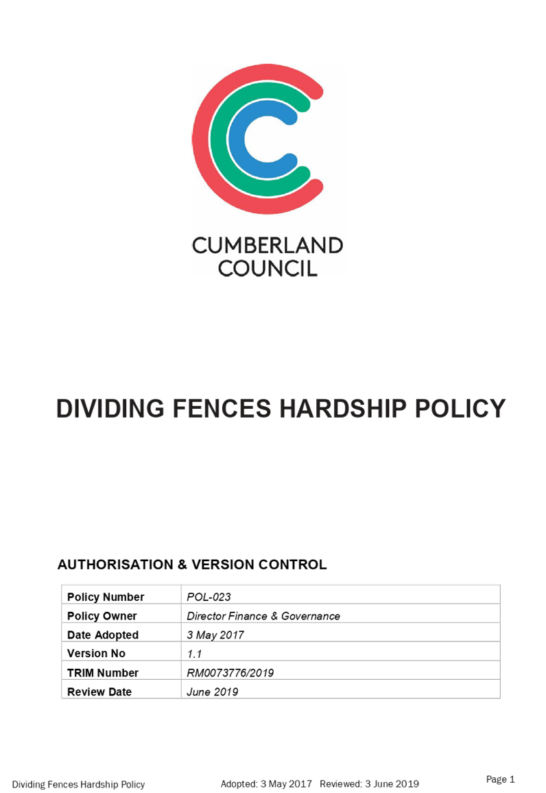
1. Dividing Fences
Hardship Policy ⇩ ![]()
DOCUMENTS
ASSOCIATED WITH
REPORT C06/19-108
Attachment 1
Dividing Fences Hardship Policy
19 June 2019
Item No: C06/19-109
Parramatta Road Urban Amenity Improvement Program - Land Acquisition for Auburn Park Expansion
Responsible Division: Finance & Governance
Officer: Director Finance & Governance
File Number: L-02-35
Community Strategic Plan Goal: A great place to live
Summary
As part of the Parramatta Road Urban Amenity Improvement Program (PRUAIP), Council received funding grants for the acquisitions of seven properties, being 43, 45, 47, 49, 51, 53 and 55 Karrabah Road, Auburn to facilitate an extension of Auburn Park.
This report seeks Council’s approval to compulsorily acquire the four remaining properties, and make the necessary application to the Minister for Local Government and the Governor.
|
Recommendation That Council: 1. Endorse the acquisitions of 45, 47, 49 and 55 Karrabah Road, Auburn by compulsory process for the purposes of expanding Auburn Park. 2. Approve and authorise the necessary application to be made to the Minister for Local Government and the Governor. 3. Delegate authority to the General Manager to execute all documents associated with the acquisition of these properties. 4. Give public notice of its intention to classify all seven properties (43, 45, 47, 49, 51, 53 and 55 Karrabah Road, Auburn) as Community Land in accordance with the provisions of section 34 of the Local Government Act 1993 and make the classification if no adverse submissions are received. |
Report
Background
At the Ordinary Meeting of Council held on 21 February 2018, Council considered Item No: C02/18-20, Parramatta Road Urban Amenity Improvement Program Grant Acceptance, and subsequently resolved:
“That subject to satisfactory legal review of the funding deed that Council accept the stage 1 grant allocation of $9,816,059 for the Parramatta Road Urban Amenity Improvement Program from the Greater Sydney Commission.”
Subsequent to the resolution, Council entered into a funding deed for the stage 1 grant allocation of $9,816,059 with $8,962,500 allocated for the acquisitions of seven properties to facilitate the extension of Auburn Park.
Council officially commenced
negotiations with the affected property owners on
8 May 2018, when Council sent letters duly notifying the affected property
owners that their properties had been identified for acquisition and invited
them to enter into negotiations for the sale of their properties to Council as
the acquiring authority.
Pursuant to section 10A(2) of the Land Acquisition (Just Terms Compensation) Act 1991 (the Act), Council “is to make a genuine attempt to acquire the land by agreement for at least 6 months before giving a proposed acquisition notice”. The minimum period for negotiation to acquire the properties by agreement expired on 8 November 2018. Despite this, Council continued negotiations with the affected property owners beyond this date and made genuine attempts to acquire the land by agreement to discharge its duty under section 10A(2) of the Act.
To date, Council has reached agreement with three property owners and contracts have been exchanged on the purchases of 43, 51 and 53 Karrabah Road, Auburn.
Council was unable to reach agreement with the remaining four property owners, being 45, 47, 49 and 55 Karrabah Road, Auburn. The legal firm representing three of the affected property owners has requested that Council seek the approval of the Minister for Local Government for the proposed acquisition notices to be issued.
On the basis that Council has exercised its obligation under section 10A(2) of the Act, and the request from the legal firm acting on behalf of the three affected property owners to initiate the compulsory acquisition process, this report recommends that Council endorse the compulsory acquisition of the four remaining properties, being 45, 47, 49 and 55 Karrabah Road, Auburn, and authorise the making of an application to the Minister for Local Government and the Governor.
Community Engagement
All affected property owners have been extensively consulted in relation to the acquisitions of their properties.
Council will undertake its normal consultation process with relevant stakeholders and the community as part of the Auburn Park Masterplan redevelopment.
Policy Implications
There are no policy implications for Council associated with this report.
Risk Implications
There are no risk implications for Council associated with this report.
Financial Implications
In July 2017, Council requested $10,000,000 in the stage 1 funding for the Karrabah Road land acquisition project, however Council only received a funding allocation of $8,962,500 for the acquisitions of seven properties.
On 21 May 2019, representatives of Council, Department of Planning and Roads, and Maritime Services met to discuss the additional funds required to acquire the remaining four properties. Council was advised that they can request additional funding for the land acquisition project, however the total PRUAIP is capped at $198m and that additional funding will only be allocated if there are funds available through savings or efficiencies made across the entire program. Any request for additional funding would also require ministerial approval.
Should Council’s request for additional funding be declined, Council may have to top up funding from its own funds through Section 7.11 contributions. It is estimated that an additional $650,000 may be required to acquire the remaining properties. This estimate is based on the valuations received by Council and the property owners.
CONCLUSION
Whilst Council’s resolution of 21 February 2018 provides sufficient authority for the compulsory acquisition of the properties, the application to the Office of Local Government (OLG) for compulsory acquisition approval requires a copy of the Council resolution authorising the making of an application to the Minister for Local Government and the Governor, and a report to Council recommending the compulsory acquisition of these properties.
Attachments
Nil
Council Meeting
19 June 2019
Item No: C06/19-110
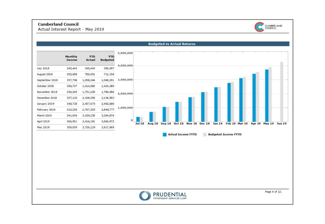
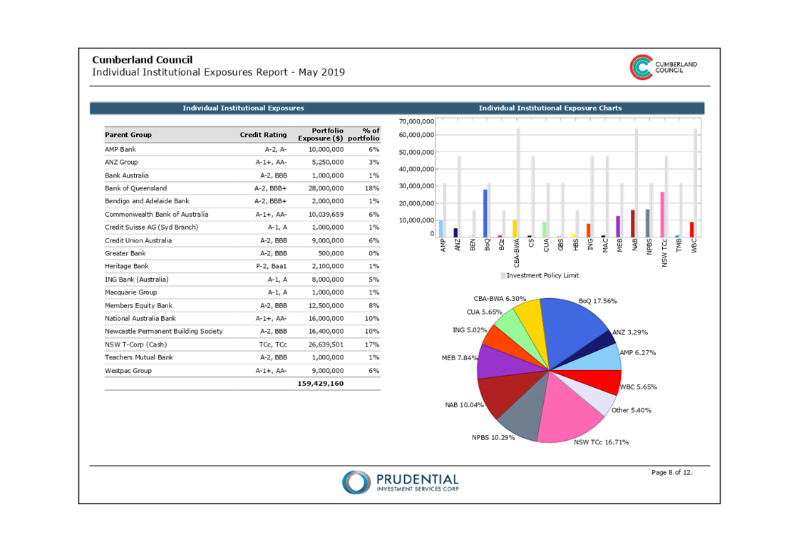
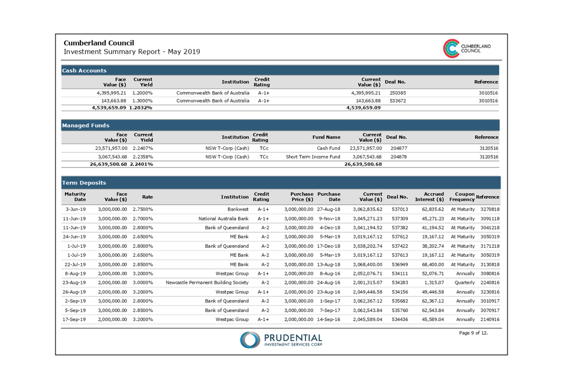
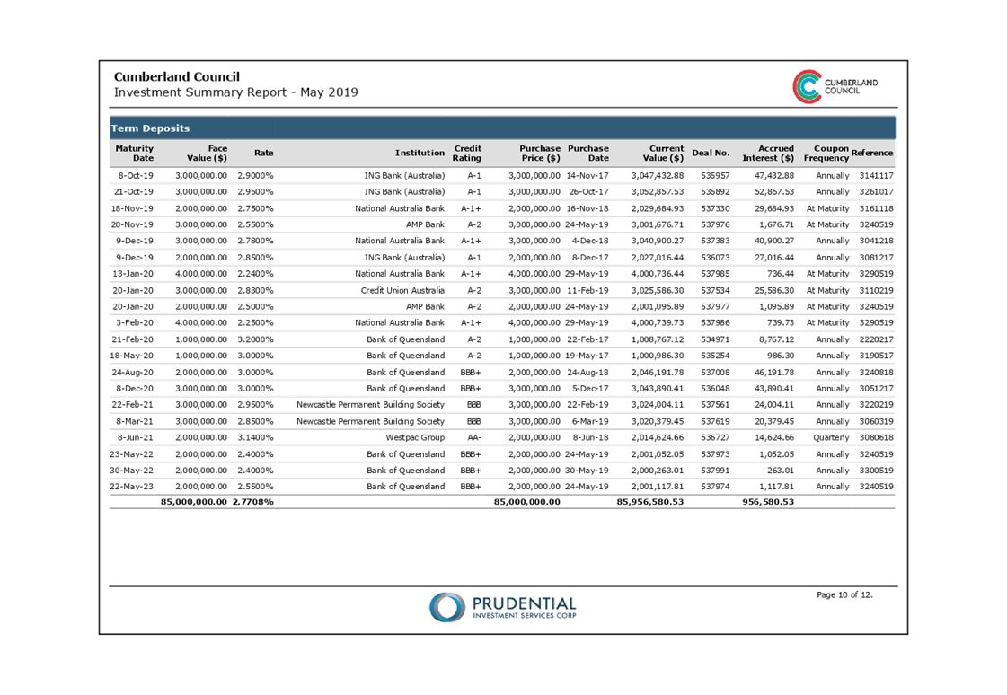
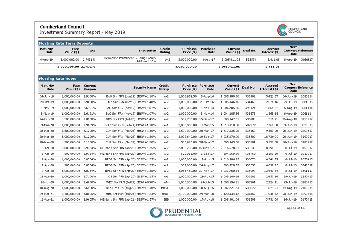
Investment Report - May 2019
Responsible Division: Finance & Governance
Officer: Director Finance & Governance
File Number: A-05-01/05
Community Strategic Plan Goal: Transparent and accountable leadership
Summary
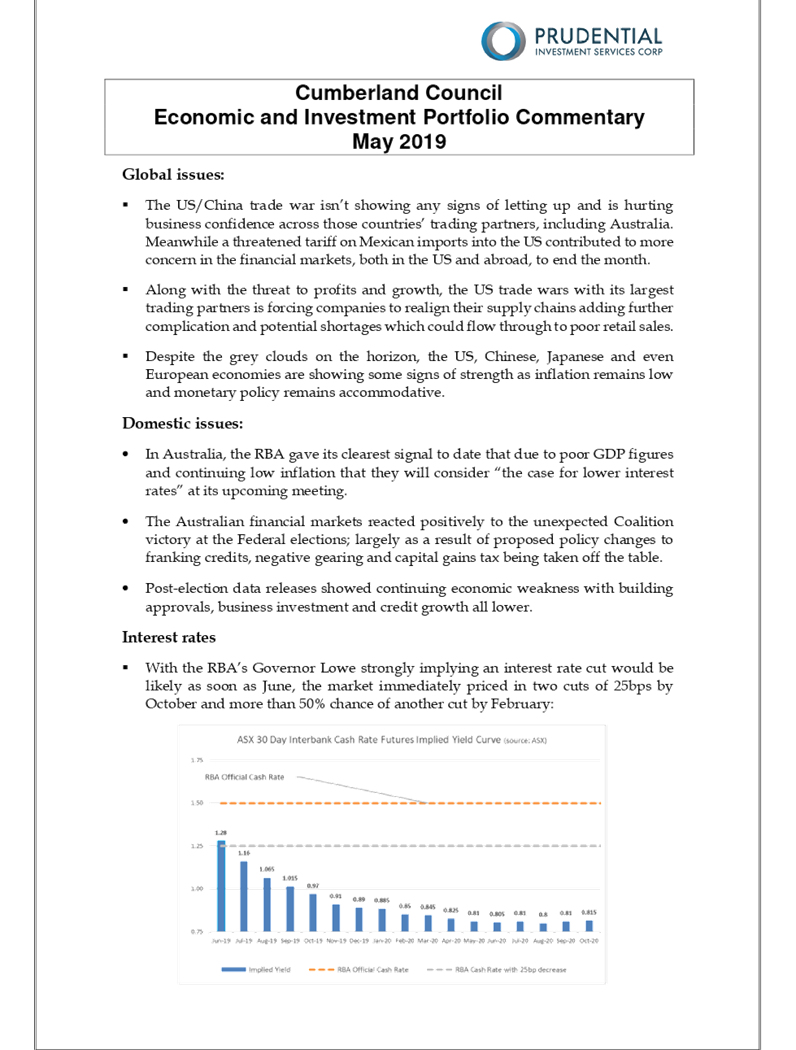
This is a report provides an update on the performance of Council’s investment portfolio to 31 May 2019. There has been an increase in the balance of Cash held by $34m predominately due to the receipt of Low Cost Loan for $30m. The subsidised net costs to the loan is lower than the current yield, which means there is no cost to Council for drawing down the money.
|
Recommendation:
That Council receive the May 2019 Investment Report. |
Report
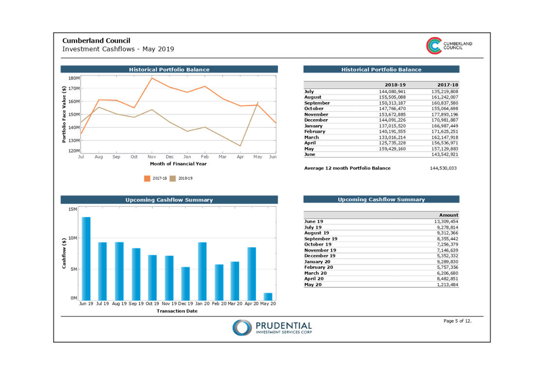
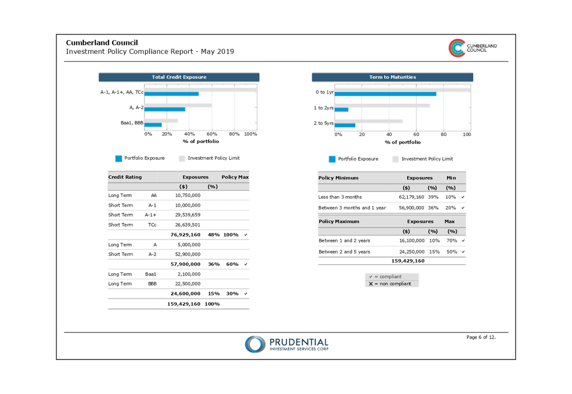
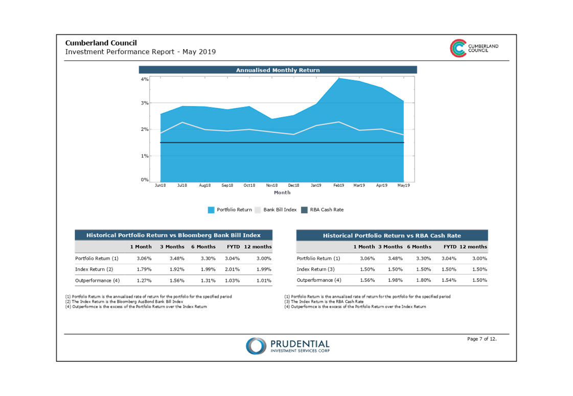
Included in this report are the following items that highlight Council’s investment portfolio performance for the month, year-to-date to 31 May 2019 and an update of the investment environment.
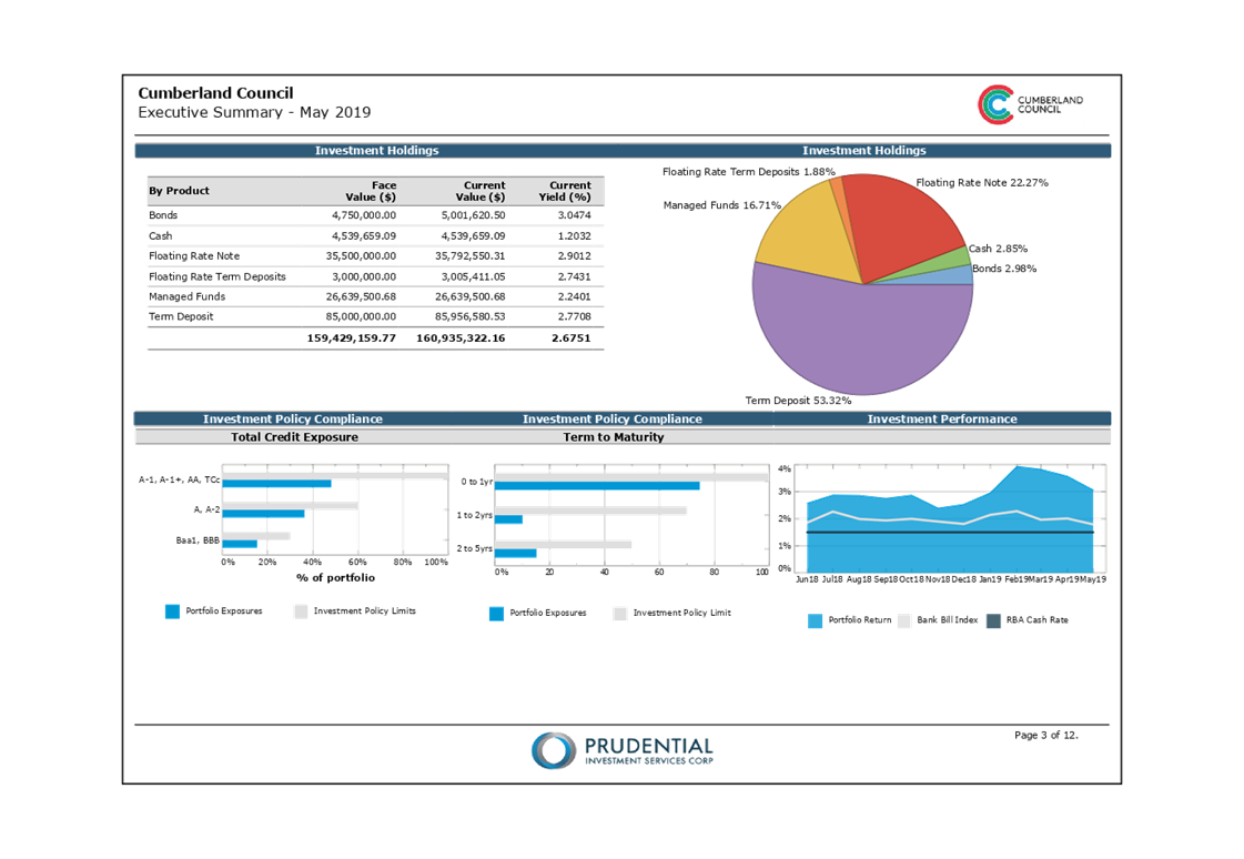
Council Investments as at 31 May 2019
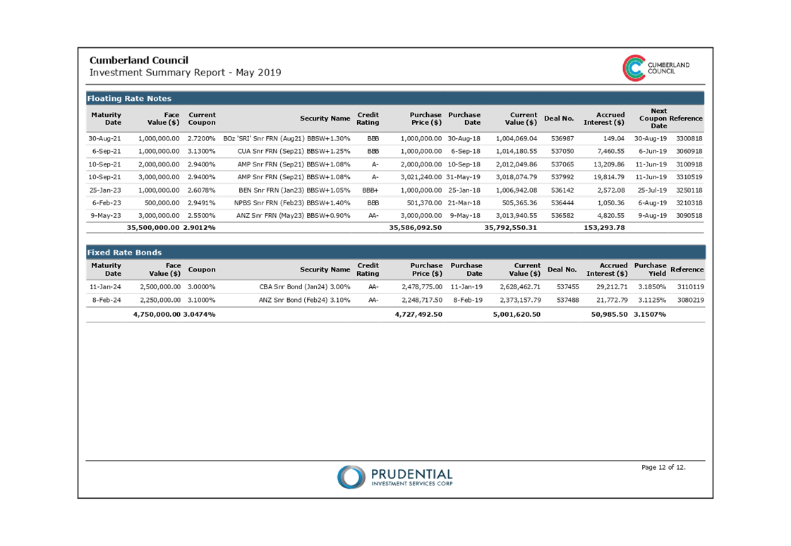
Council’s investment portfolio has a current market value of $160,935,322. This represents a premium of $1,506,162 above the face value of the portfolio being $159,429,160 and generates a 2.68% average purchase yield. The following table reflects Council’s holding in various investment categories:
Investment Portfolio Performance
The investment returns for the month year-to-date of 31 May 2019 outperformed the current month benchmark and exceeded the year-to-date benchmark.
Performance – Current Month 31 May 2019
For the month of May, Council‘s portfolio generated interest earnings of $309,939. This is $46,158 lower than the budget of $356,097 and outperformed the AusBond Bank Bill Index by 1.27%, as detailed below:

Performance – Year-to-date 31 May 2019
For the year-to-date, Council‘s portfolio generated interest earnings of $3,726,129. This is $190,940 lower than the budget of $3,917,069 and outperformed the AusBond Bank Bill Index by 1.03%, as per below:

Community Engagement
There are no consultation processes for Council associated with this report.
Policy Implications
There are no policy implications for Council associated with this report.
Risk Implications
To manage risk, key criteria are incorporated into Cumberland Council’s investment making decisions, as detailed below:
Preservation of Capital
The requirement for preventing losses in an investment portfolio’s total value (considering the time value of money).
Diversification
Setting limits to the amounts invested with a particular financial institution or government authority to reduce credit risk.
Credit risk
The risk that an investment of Council fails to pay the interest and/or repay the principal of an investment.
Maturity risk
The longer the term of the investment, the greater the exposure to potential changes in interest rates, market volatility and credit quality of an issuer.
Financial Implications
There are no financial implications for Council associated with this report.
CONCLUSION
Council hereby certifies that the investments listed above have been made in accordance with Section 625 of the Local Government Act 1993, Clause 212 of the Local Government (General) Regulation 2005 and Council’s Investment Policy.
Attachments
1. Investment Summary
Report May 2019 ⇩ ![]()
2. Economic
and Investment Portfolio Commentary May 2019 ⇩ ![]()
DOCUMENTS
ASSOCIATED WITH
REPORT C06/19-110
Attachment 1
Investment Summary Report May 2019
Attachment 2
Economic and Investment Portfolio Commentary May 2019
19 June 2019
Item No: C06/19-111
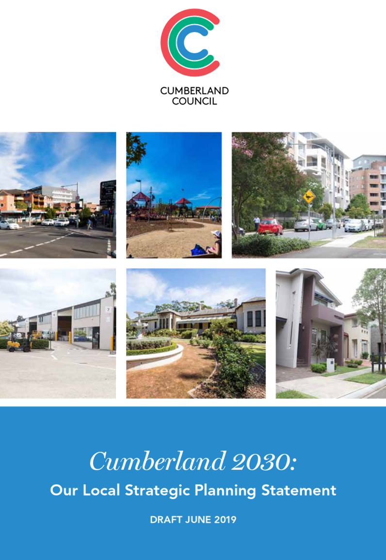
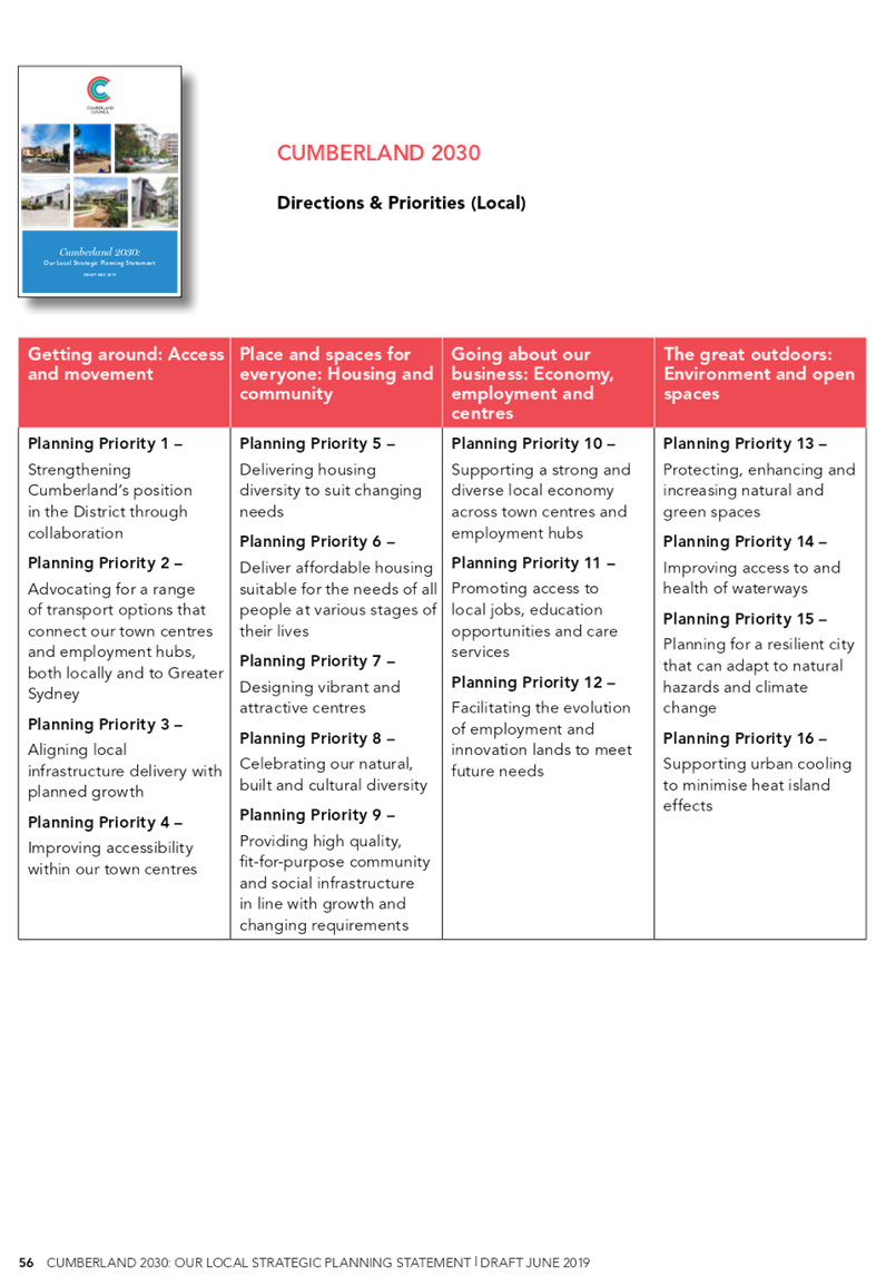
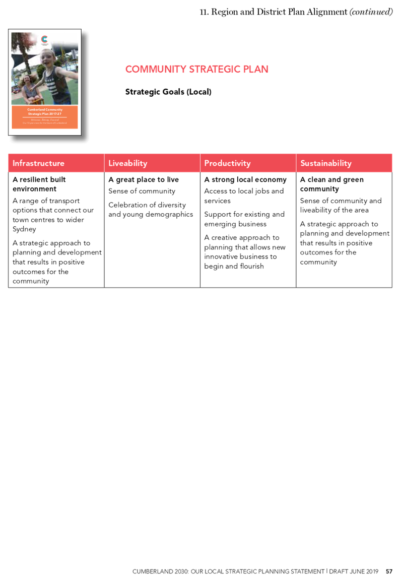
Draft Cumberland 2030: Our Local Strategic Planning Statement
Responsible Division: Environment & Planning
Officer: Director Environment & Planning
File Number: SUB543
Community Strategic Plan Goal: A resilient built environment.
Summary
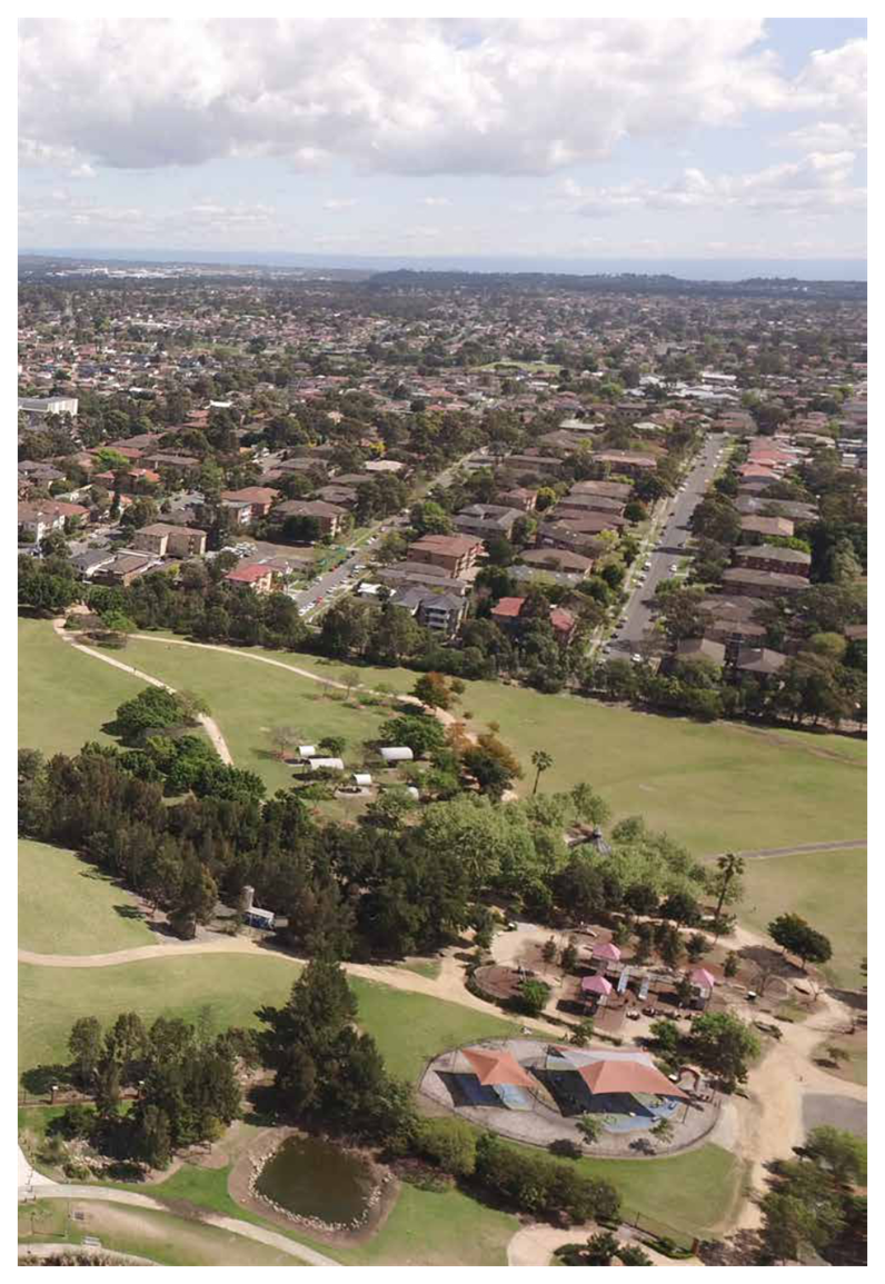
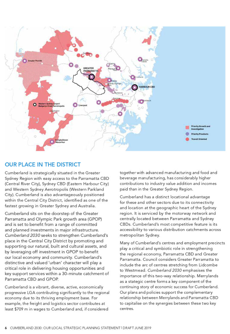
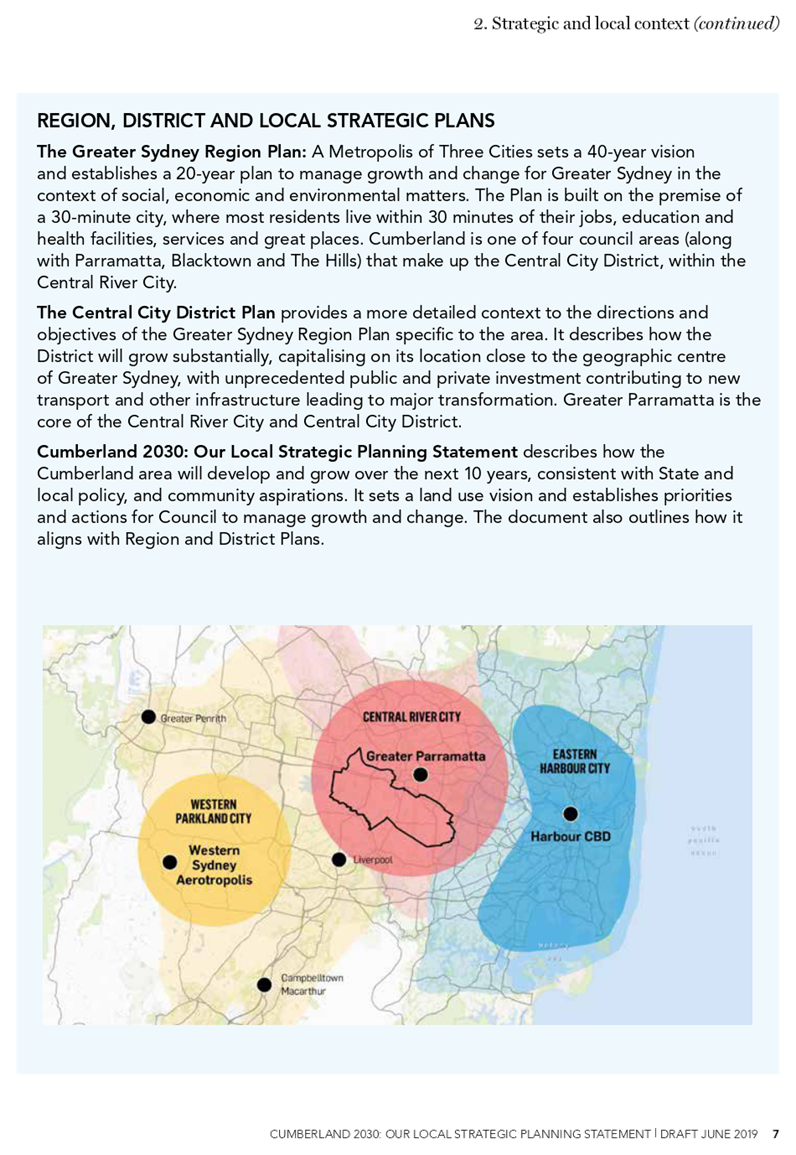
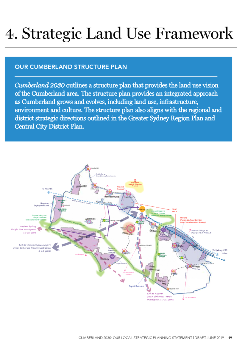
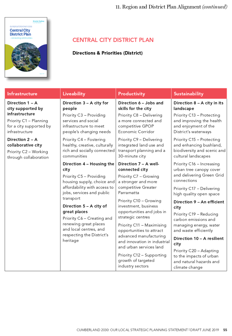
The Draft Cumberland 2030: Our Local Strategic Planning Statement has been prepared to provide strategic direction and a coordinated approach to effectively manage growth and development in the Cumberland area. It sets a land use vision and structure plan, and identifies priorities and actions to support the vision. The statement also aligns to the Greater Sydney Commission’s Central City District Plan.
The development of the Draft Cumberland 2030: Our Local Strategic Planning Statement has been undertaken in close collaboration with the Greater Sydney Commission. An assurance review was undertaken by the Greater Sydney Commission during this phase, with Cumberland Council one of a select number of councils across metropolitan Sydney to be given a green light rating. Both the Chief Commissioner and the Central City District Commissioner spoke highly of Cumberland’s work to date during the assurance review.
It is recommended that the Draft Cumberland 2030: Our Local Strategic Planning Statement be placed on public exhibition for an extended period beyond the minimum period of 28 days, with a report provided back to Council following the conclusion of the exhibition period.
|
Recommendation That Council place the Draft Cumberland 2030: Our Local Strategic Planning Statement on public exhibition, with a report to be provided back to Council following the conclusion of the exhibition period. |
Report
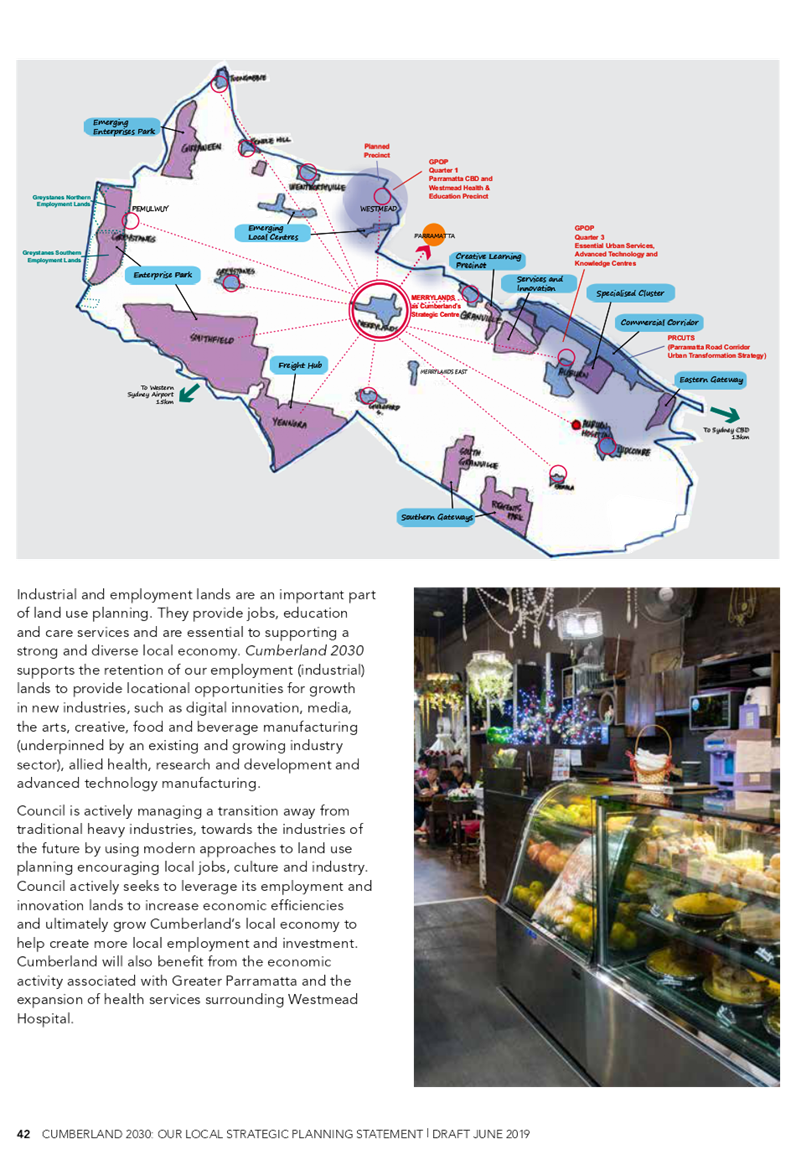
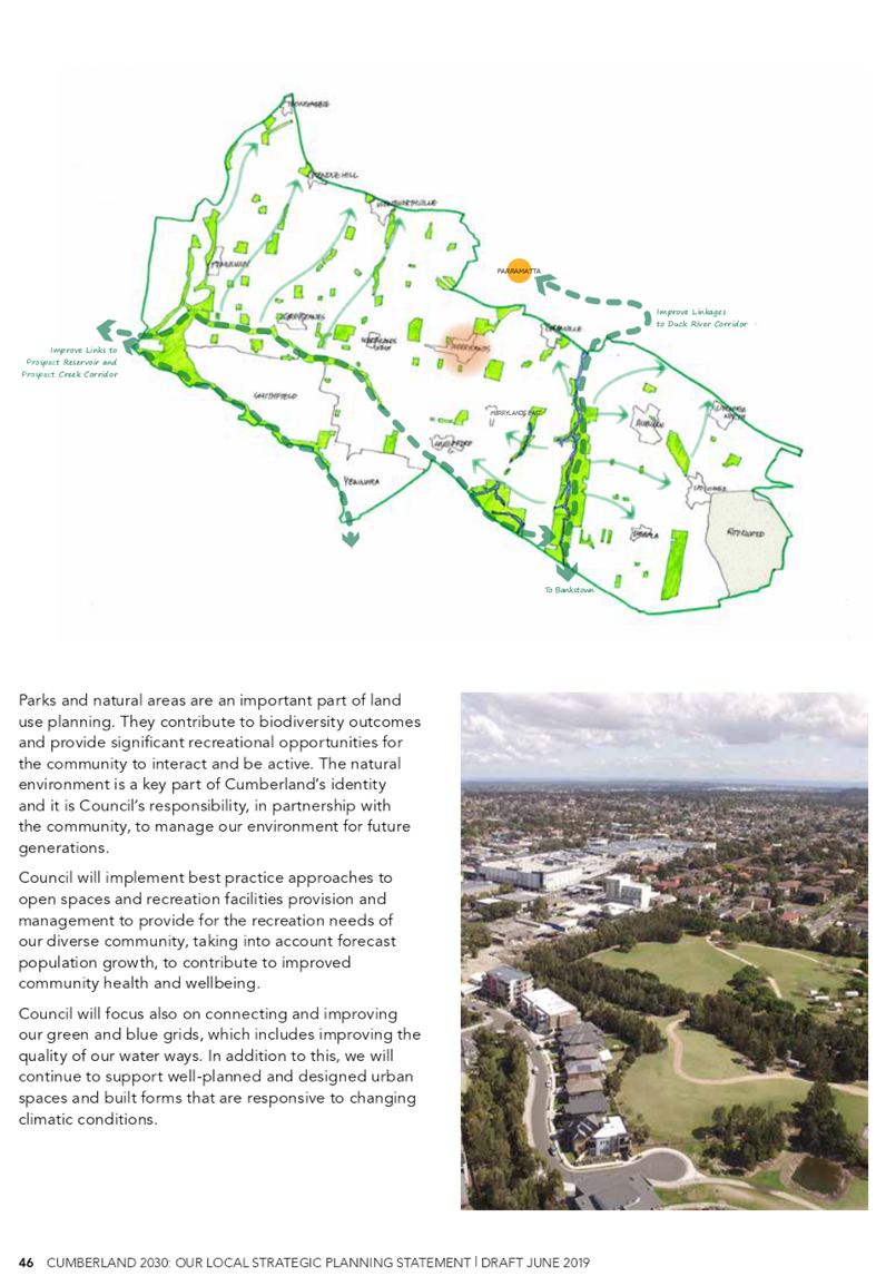
The Draft Cumberland 2030: Our Local Strategic Planning Statement has been prepared to provide strategic direction and a coordinated approach to effectively manage growth and development in the Cumberland area. It sets a land use vision and structure plan, and identifies priorities and actions to support the vision. The statement is also aligned to the Greater Sydney Commission’s Central City District Plan.
A land use vision is identified in the Draft Cumberland 2030: Our Local Strategic Planning Statement. This vision is: Cumberland is a diverse and inclusive community, offering easy access to jobs and services, with places and spaces close to home that take advantage of our natural, built and cultural heritage.
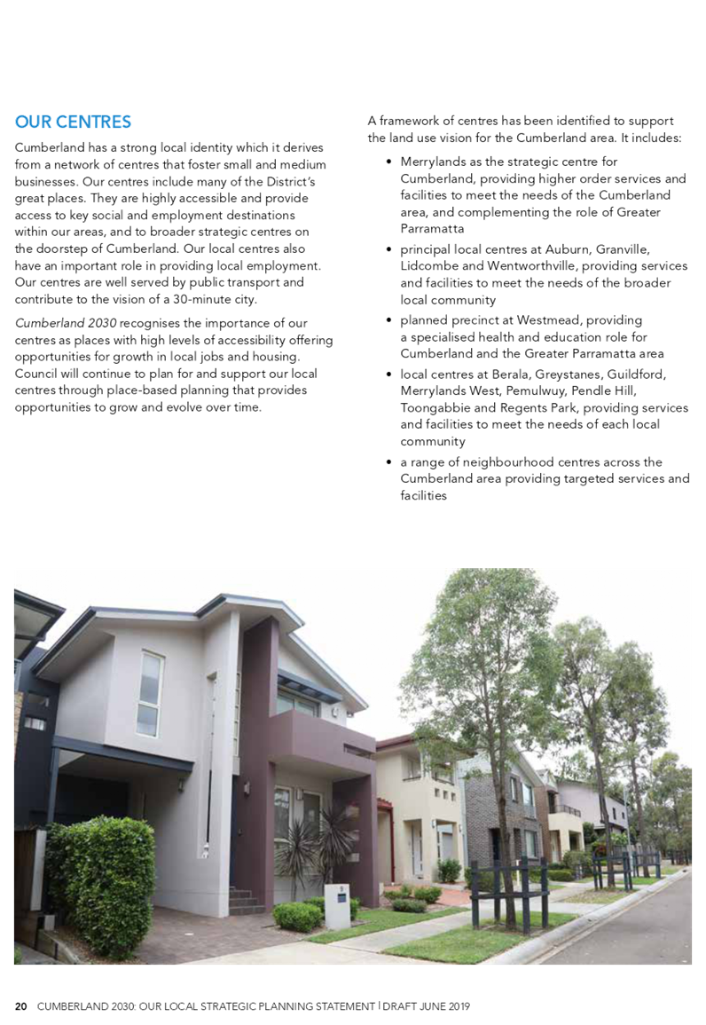
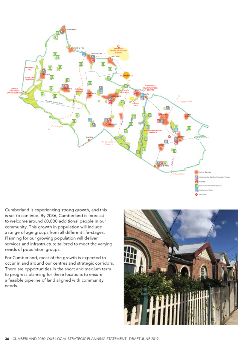
The proposed structure plan establishes a framework to support the land use vision for Cumberland. This includes:
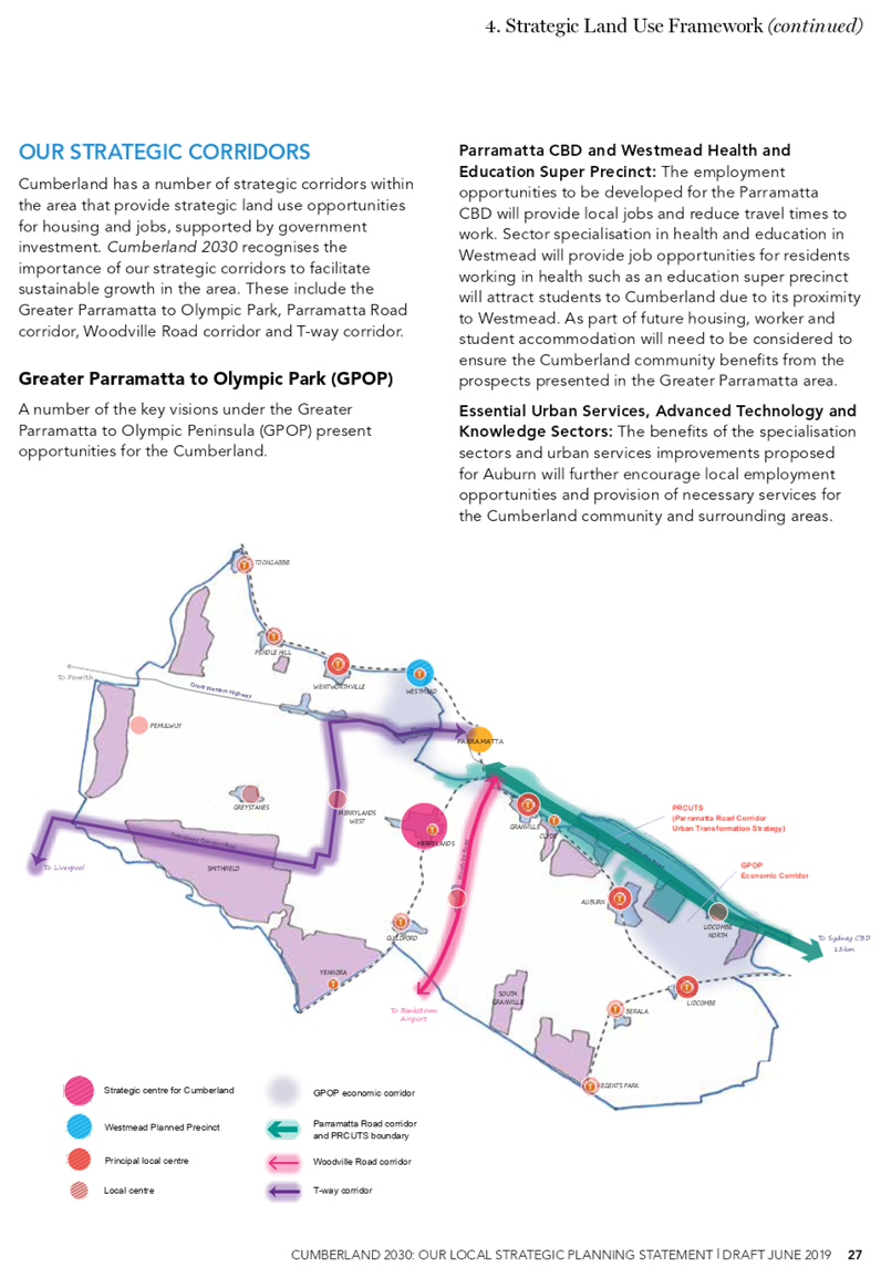
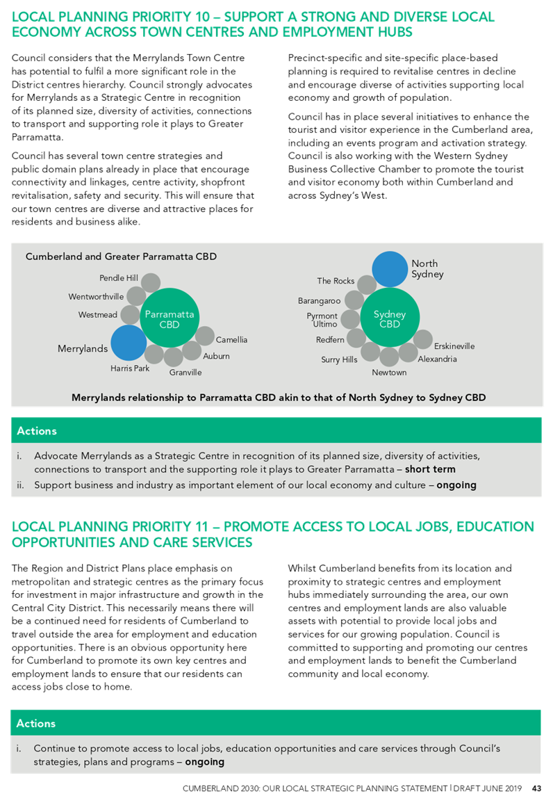
• Merrylands as the strategic centre for Cumberland, providing higher order services and facilities to meet the needs of the Cumberland area, and complementing the role of Greater Parramatta.
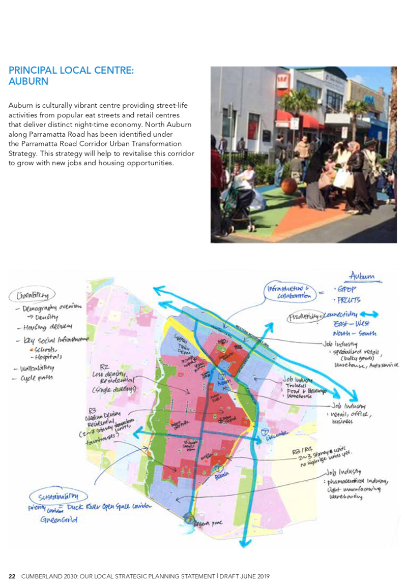
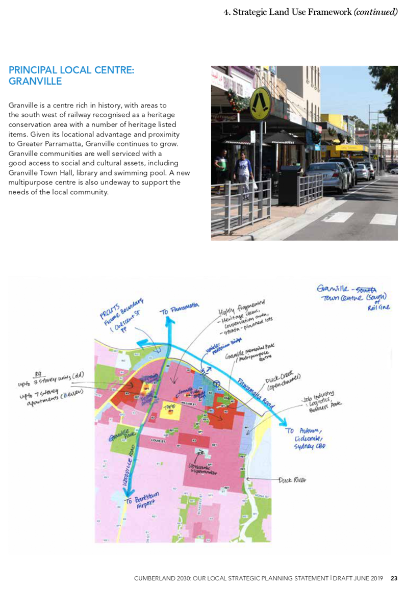
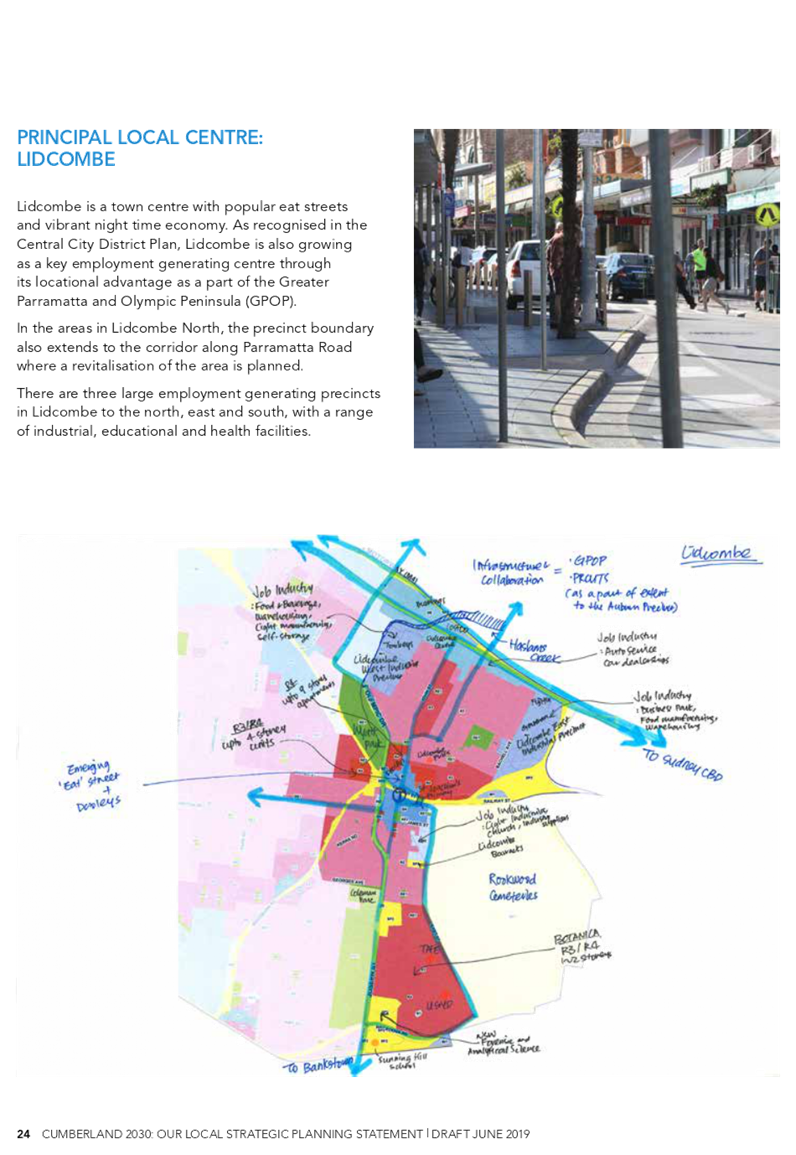
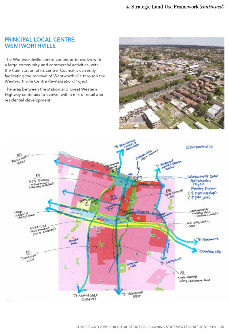
• Principal local centres at Auburn, Granville, Lidcombe and Wentworthville, providing services and facilities to meet the needs of the broader local community.
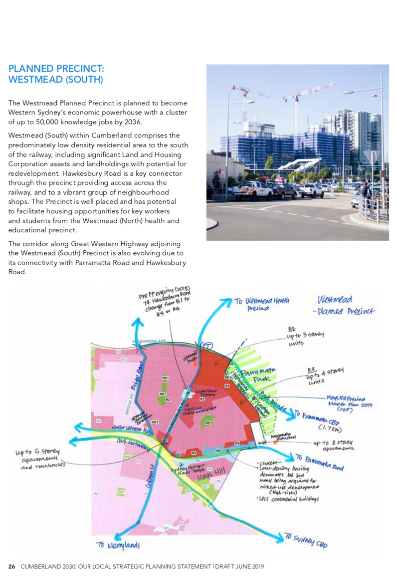
• A planned precinct at Westmead, providing a specialised health and education role for Cumberland and the Greater Parramatta area.
• Local centres at Berala, Greystanes, Guildford, Merrylands West, Pemulwuy, Pendle Hill, Toongabbie and Regents Park, providing services and facilities to meet the needs of each local community.
• A range of neighbourhood centres across the Cumberland area providing targeted services and facilities.
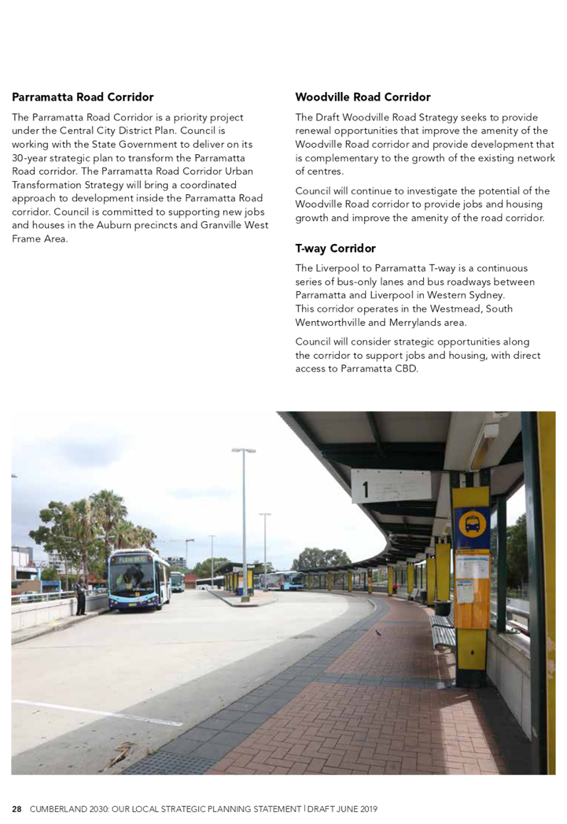
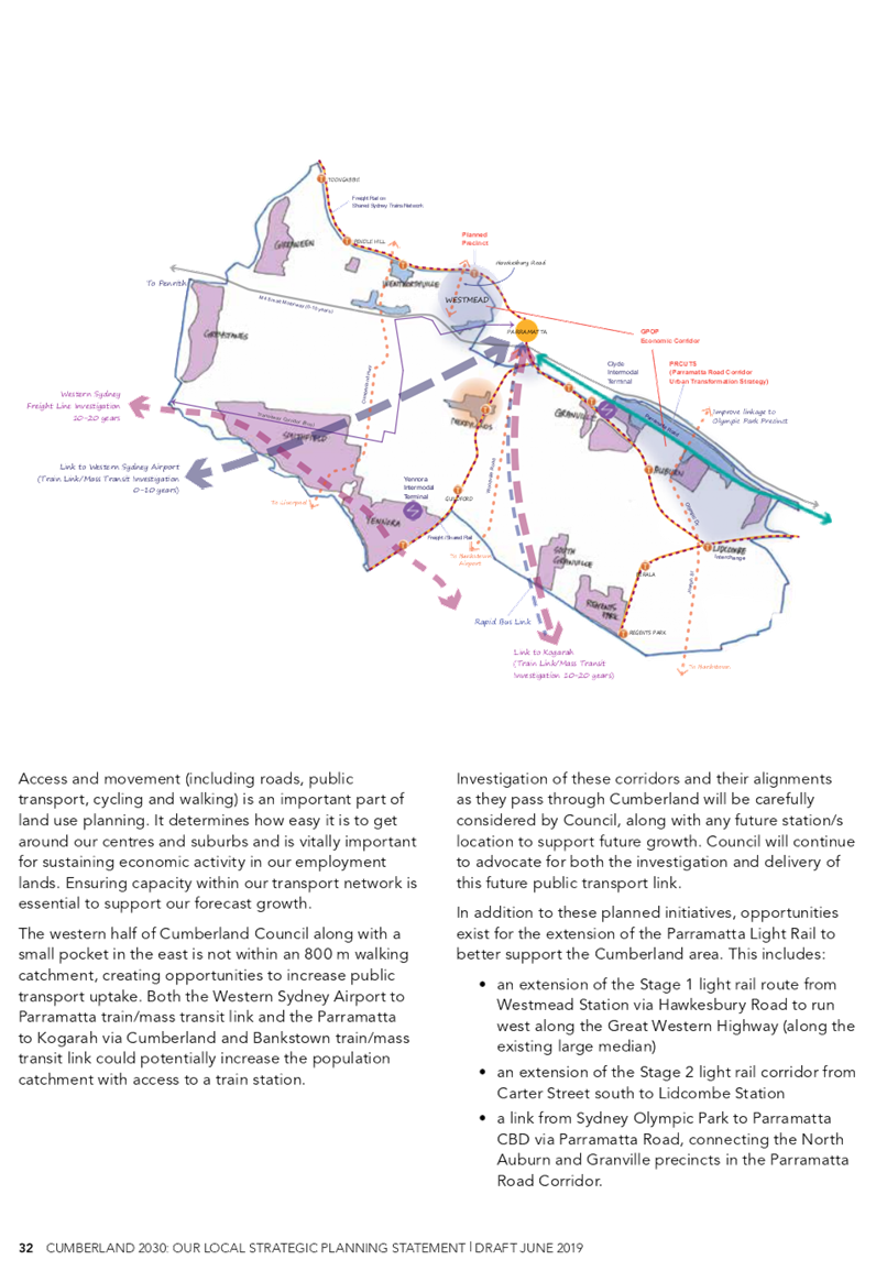
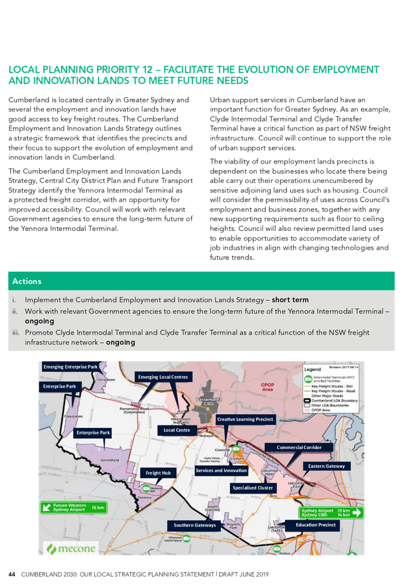
• Identification of strategic corridors that provide land use opportunities for housing and jobs in Cumberland, supported by government investment. These include the Greater Parramatta to Olympic Park corridor, Parramatta Road corridor, Woodville Road corridor and T-way corridor.
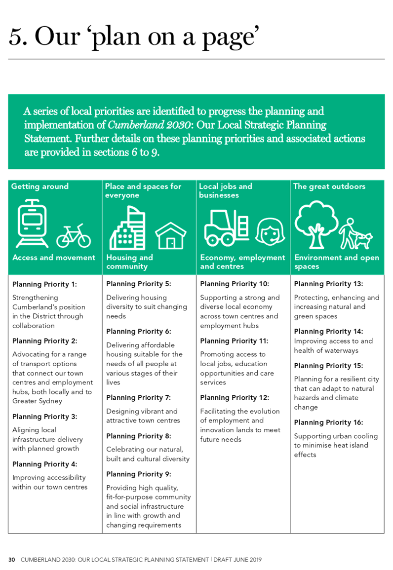
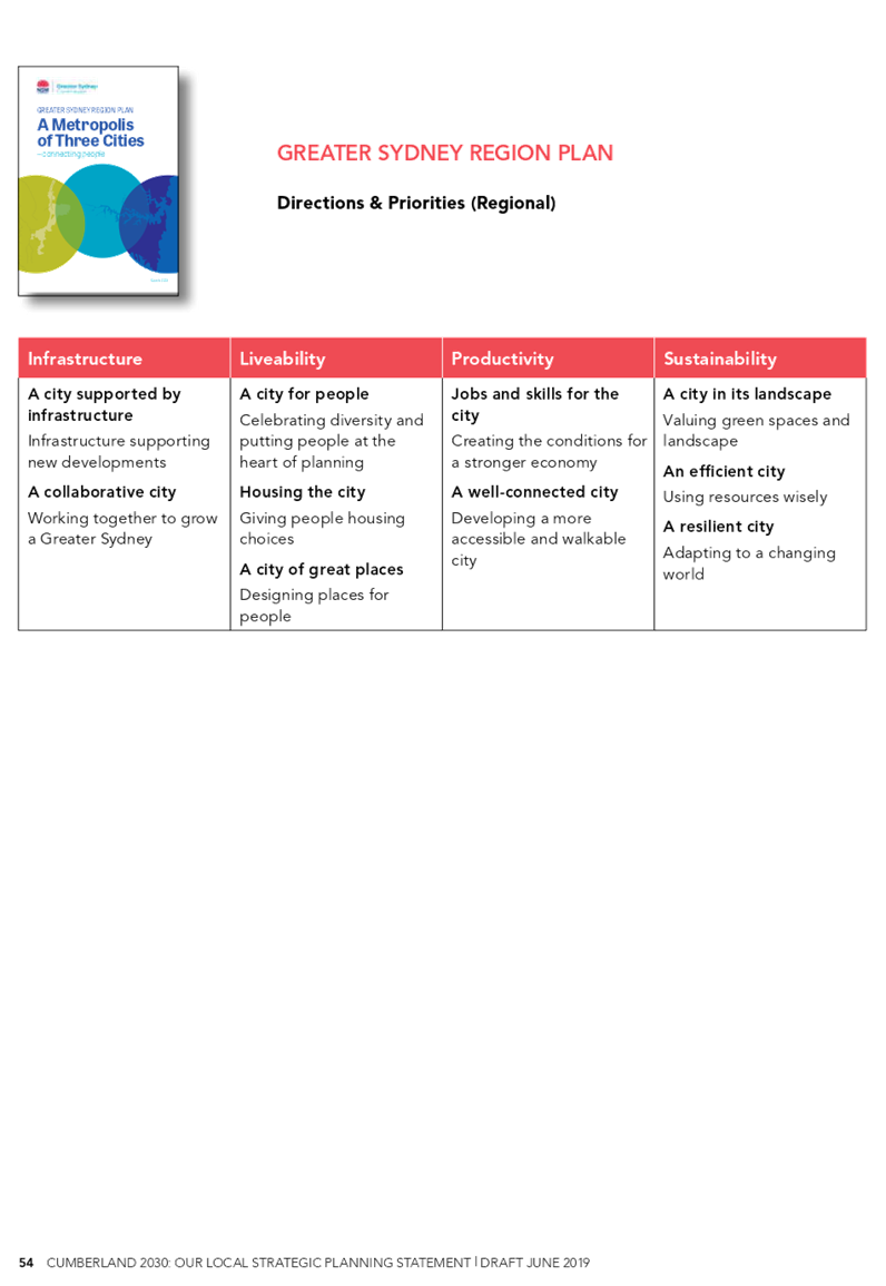
A number of planning priorities and actions are also identified to progress the vision and structure plan, aligned to the key themes identified in the Central City District Plan. These themes are:
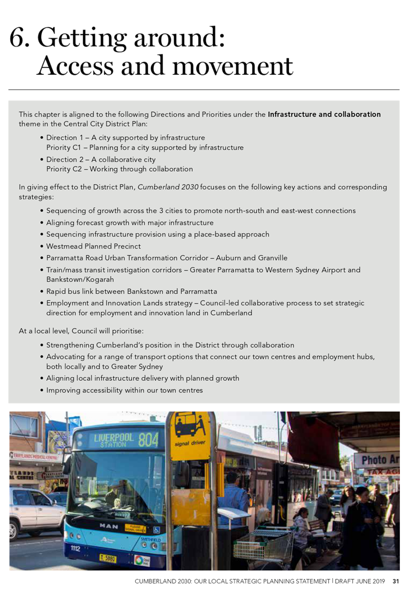
• Getting around: Access and movement (Infrastructure).
• Places and spaces for everyone: Housing and community (Liveability).
• Going about our business: Economy, employment and centres (Productivity).
• The great outdoors: Environment and open space (Sustainability).
The Draft Cumberland 2030: Our Local Strategic Planning Statement has been prepared in close collaboration with the Greater Sydney Commission. An assurance review was undertaken by the Greater Sydney Commission during this phase, with Cumberland Council one of a select number of councils across metropolitan Sydney to be given a green light rating. Both the Chief Commissioner and the Central City District Commissioner spoke highly of Cumberland’s work to date during the assurance review.
Community Engagement
The Draft Cumberland 2030: Our Local Strategic Planning Statement will be placed on public exhibition for an extended period beyond the minimum period of 28 days. An extensive communication and engagement program will be undertaken to ensure we receive feedback from a broad range of stakeholders and the community.
A series of face-to-face ‘drop-in’ sessions will be held in each of the five Council Wards. These sessions will be held early in the exhibition period and designed to raise awareness about the purpose of the statement and encourage the community to give feedback on the key themes, priorities and draft vision through Council’s ‘Have Your Say’ web page (although there will be the ability to collect feedback directly).
Two facilitated Community Information and Feedback Sessions will also be held, one each at Auburn and Merrylands. These sessions will be comprehensive in their approach, seeking to inform and consult with key stakeholders and the community, and specifically test and seek feedback on the draft Cumberland 2030: Our Local Strategic Planning Statement. Information will be made available in print and digital formats and staff will be available to provide advice and to facilitate the collection of feedback.
All of these engagement sessions will be staffed by Council officers and include bilingual educators.
In addition to the above, we will utilise a variety of different platforms to reach and engage with key stakeholders and the Cumberland community, including:
· Social Media: Facebook, Instagram, Twitter and LinkedIn. These platforms provide vital tools for communicating to stakeholders within the Cumberland LGA. The confined geographic nature of the Cumberland area allows for cost-effective dissemination of information; moreover, it allows for a two-way conversation.
· Digital: Information will be provided on Council’s main website and ‘Have Your Say’ page.
· Traditional Media: Advertisements will be placed in local papers. This continues to be an effective method of reaching elderly residents.
· Printed collateral: A range of posters, leaflets and corflute display boards will be created to support the plan.
· Newsletter: Council’s external e-news.
Policy Implications
The preparation of the Draft Cumberland 2030: Our Local Strategic Planning Statement is required under the Environmental Planning and Assessment Act 1979. The statement will also inform the preparation of the new Cumberland Local Environmental Plan and Development Control Plan.
The Draft Cumberland 2030: Our Local Strategic Planning Statement also complements the strategic directions and priorities outlined in Cumberland Council’s Community Strategic Plan.
Risk Implications
The funding agreement for Council’s accelerated Local Environmental Plan Funding Grant requires the exhibition of the Draft Cumberland 2030: Our Local Strategic Planning Statement to commence in July 2019. While Council has been recently advised by the Department of Planning, Industry & Environment that a three month extension for exhibition is available, the preference is to proceed on the originally scheduled milestone for public exhibition in July 2019. This will ensure that Council has sufficient time to prepare and finalise the new Cumberland Local Environmental Plan by mid 2020. The recent advice from the Department also confirms that the mid 2020 milestone for the LEP will not be extended.
Financial Implications
Work undertaken on the Draft Cumberland 2030: Our Local Strategic Planning Statement, including planned community consultation activities, will be funded from Council’s accelerated Local Environmental Plan Funding Grant.
CONCLUSION
The Draft Cumberland 2030: Our Local Strategic Planning Statement has been prepared to provide strategic direction and a coordinated approach to effectively manage growth and development in the Cumberland area. It has been prepared in close collaboration with the Greater Sydney Commission.
It is recommended that the Draft Cumberland 2030: Our Local Strategic Planning Statement be placed on public exhibition for an extended period beyond the minimum period of 28 days, with a report provided back to Council following the conclusion of the exhibition period.
Attachments
1. Draft Cumberland
2030: Our Local Strategic Planning Statement ⇩ ![]()
DOCUMENTS
ASSOCIATED WITH
REPORT C06/19-111
Attachment 1
Draft Cumberland 2030: Our Local Strategic Planning Statement
19 June 2019
Item No: C06/19-112
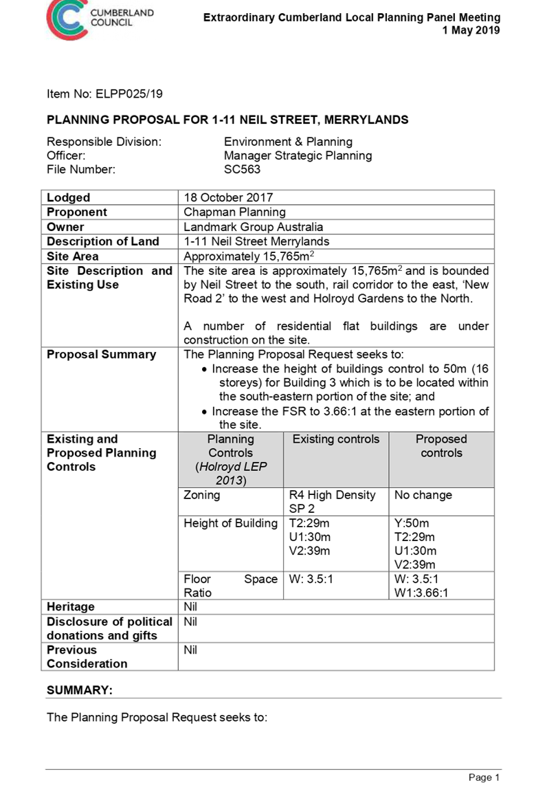
Planning Proposal Request for 1-11 Neil Street, Merrylands
Responsible Division: Environment & Planning
Officer: Director Environment & Planning
File Number: SC563
Community Strategic Plan Goal: A resilient built environment
Summary
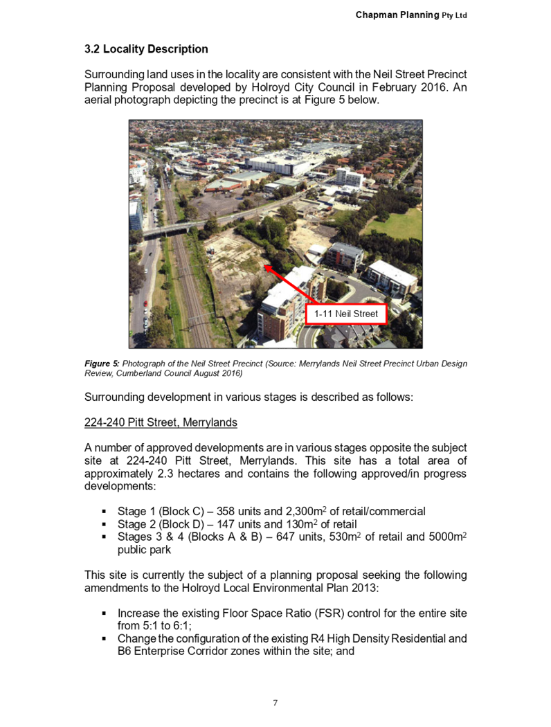
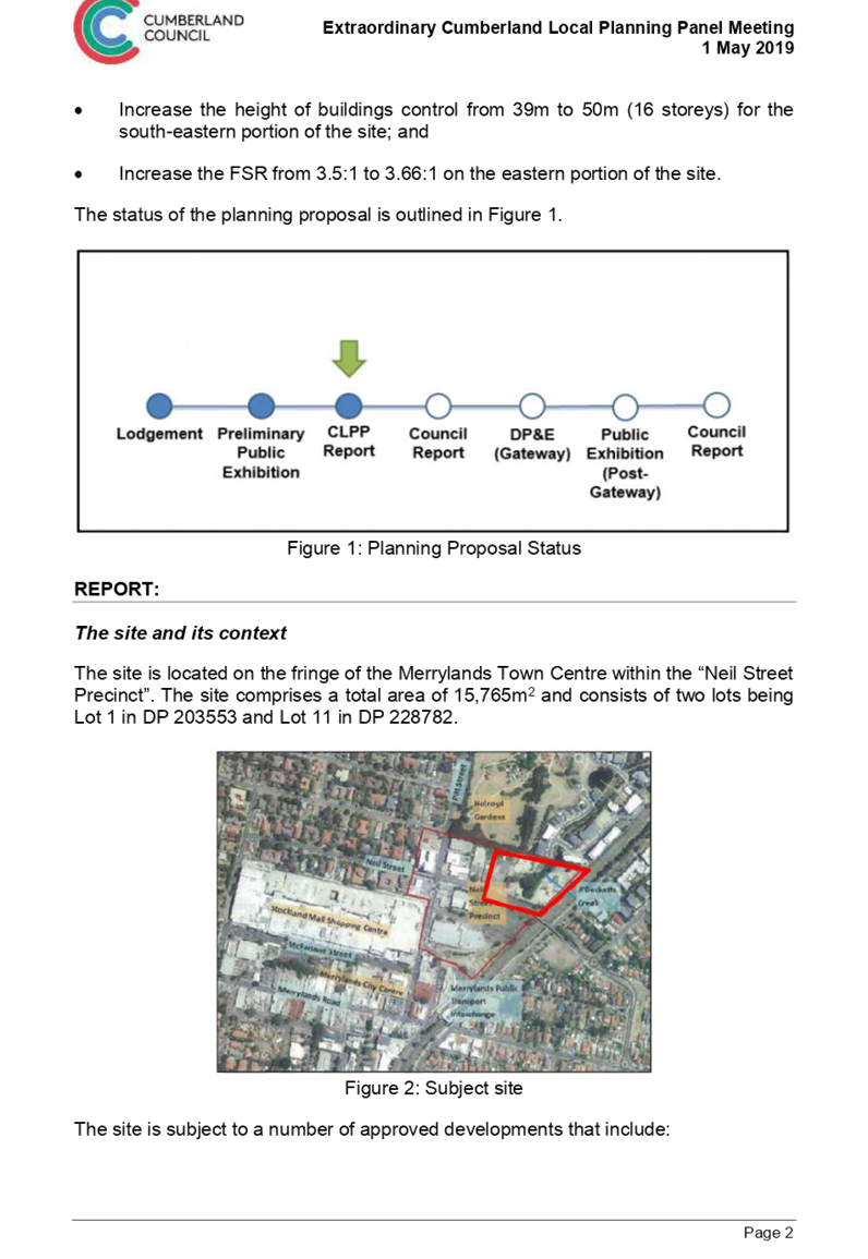
This planning proposal seeks to increase the height of buildings control from 39m to 50m (16 storeys) for the south-eastern portion of the site; and increase the FSR from 3.5:1 to 3.66:1 on the eastern portion of the site.
The proposal has been placed on preliminary public exhibition (pre-Gateway), and was reported to the Cumberland Local Planning Panel in May 2019 with a recommendation to proceed to the next stage for a Gateway Determination. The Panel supported the Council officer recommendation.
It is recommended that the planning proposal be forwarded to the Department of Planning, Industry & Environment for a Gateway Determination.
|
Recommendation That Council: 1. Prepare a planning proposal for 1-11 Neil Street, Merrylands, with the following built form controls: · Floor Space Ratio of 3.66:1 on the eastern portion of the site; and · Height of Building control of 50 metres on the south-eastern portion of the site 2. Endorse that a planning proposal for 1-11 Neil Street, Merrylands, be forwarded to the Department of Planning, Industry and Environment for a Gateway Determination. |
Report
Background
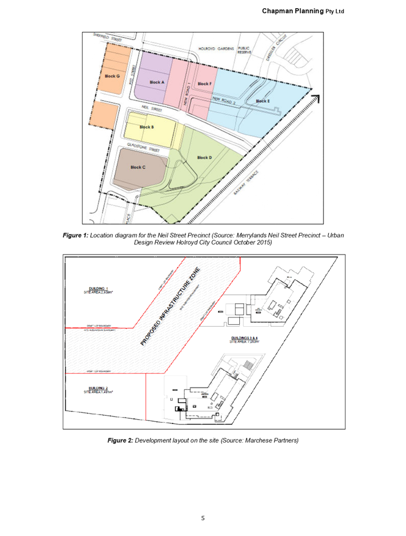
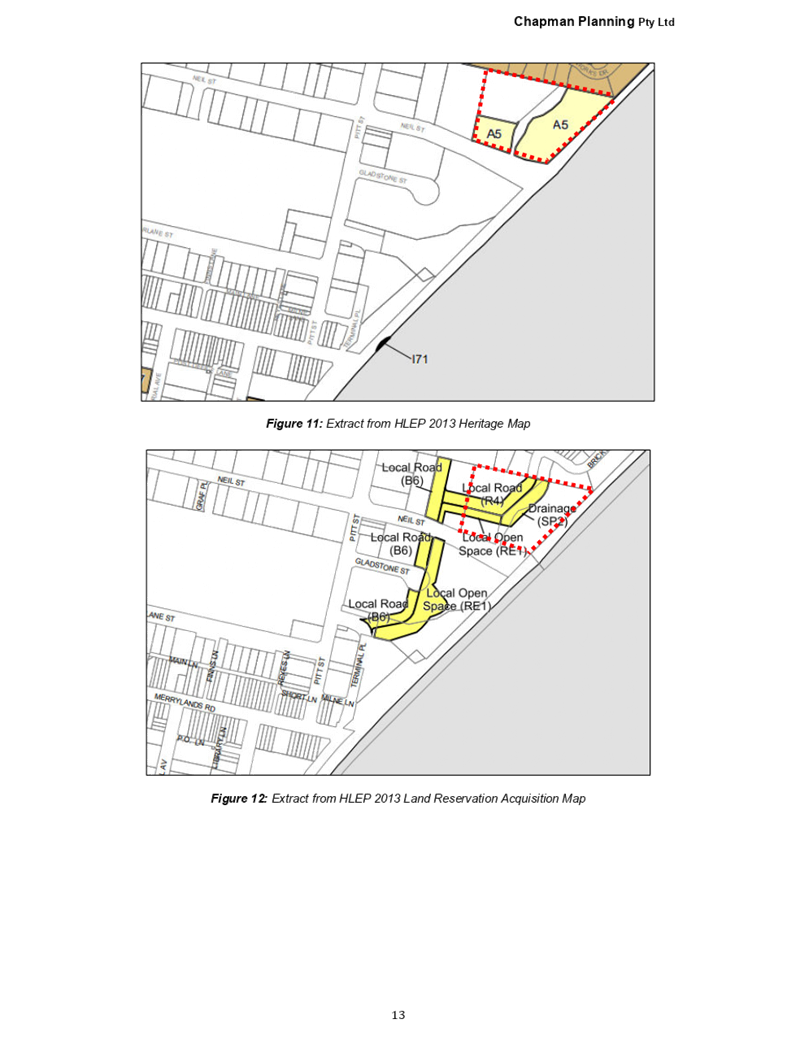
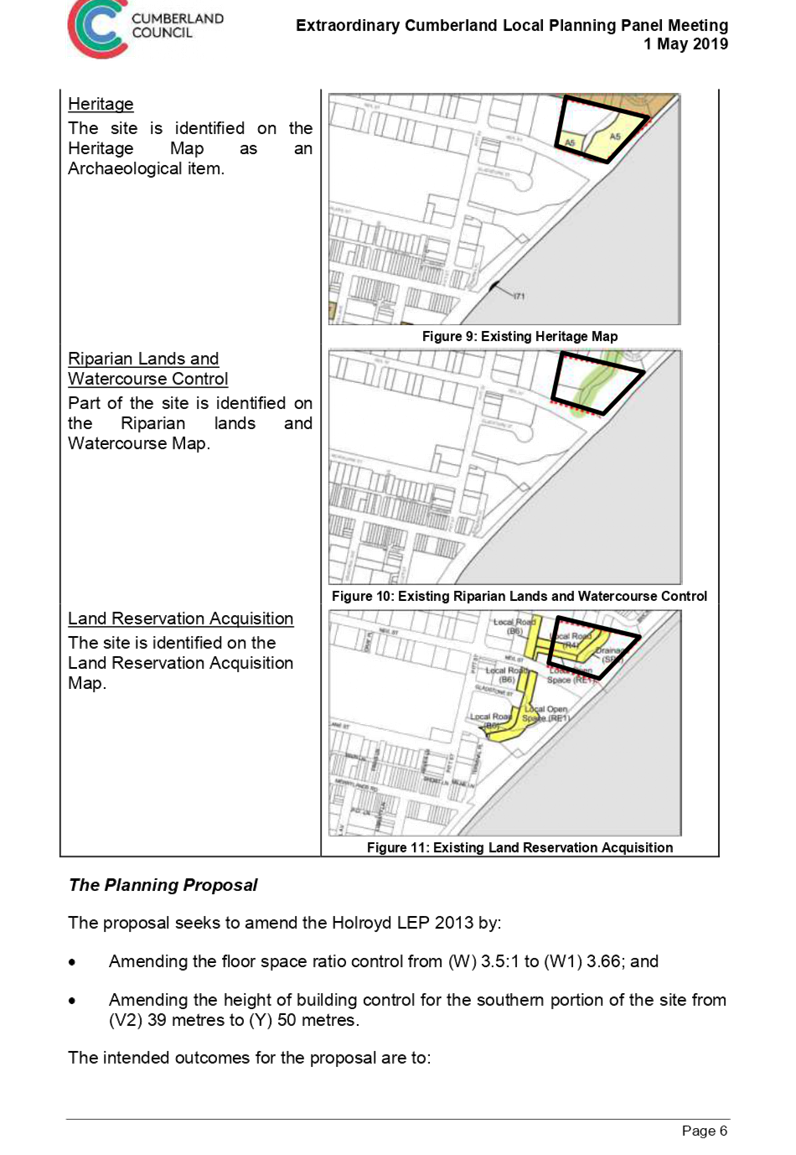
The planning proposal was submitted to Council in July 2018. The proposal sought to amend the built form controls of Holroyd LEP 2013 that apply to 1-11 Neil Street, Merrylands by:
· Increase the height of buildings control from 39m (12 storeys) to 50m (16 storeys) for the south-eastern portion of the site.
· Increase the FSR from 3.55:1 to 3.66:1 on the eastern portion of the site
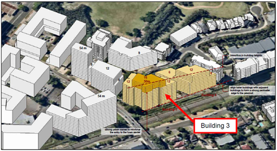
Figure 1 Indicative concept for the planning proposal
The status of the planning proposal is provided in Figure 2 below.
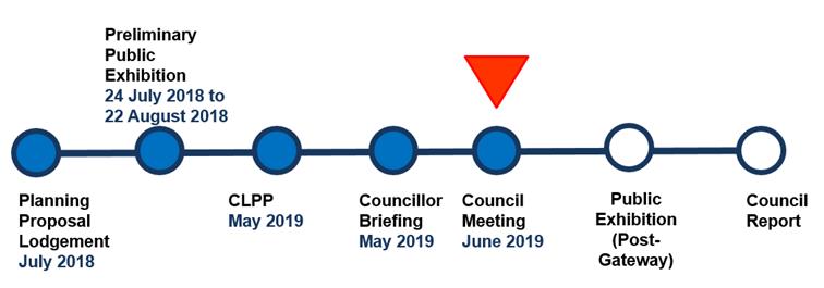
Figure 2 Planning proposal status
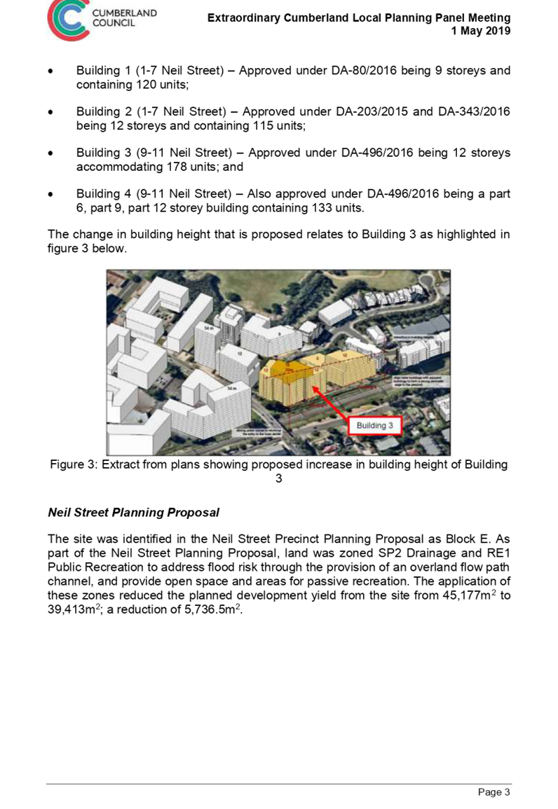
The Site and its Context
The site is located on the fringe of the Merrylands Town Centre within the Neil Street Precinct. The site has a total area of 15,765m2 and consists of two lots being Lot 1 in DP 203553 and Lot 11 in DP 228782.
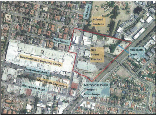
Figure 3 the site
The site is subject to a number of approved developments that include:
· Building 1 (1-7 Neil Street) – approved under DA-80/2016, being 9 storeys and containing 120 units.
· Building 2 (1-7 Neil Street) –approved under DA-203/2015 and DA-343/2016, being 12 storeys and containing 115 units.
· Building 3 (9-11 Neil Street) – approved under DA-496/2016, being 12 storeys accommodating 178 units.
· Building 4 (9-11 Neil Street) – also approved under DA-496/2016, being a part 6, part 9, and part 12 storey building containing 133 units.
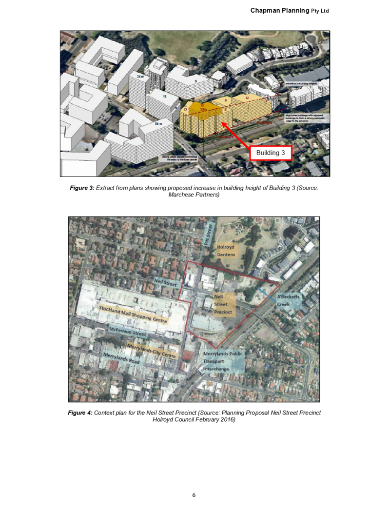
This Planning Proposal relates to “Building 3” as shown in Figure 1.
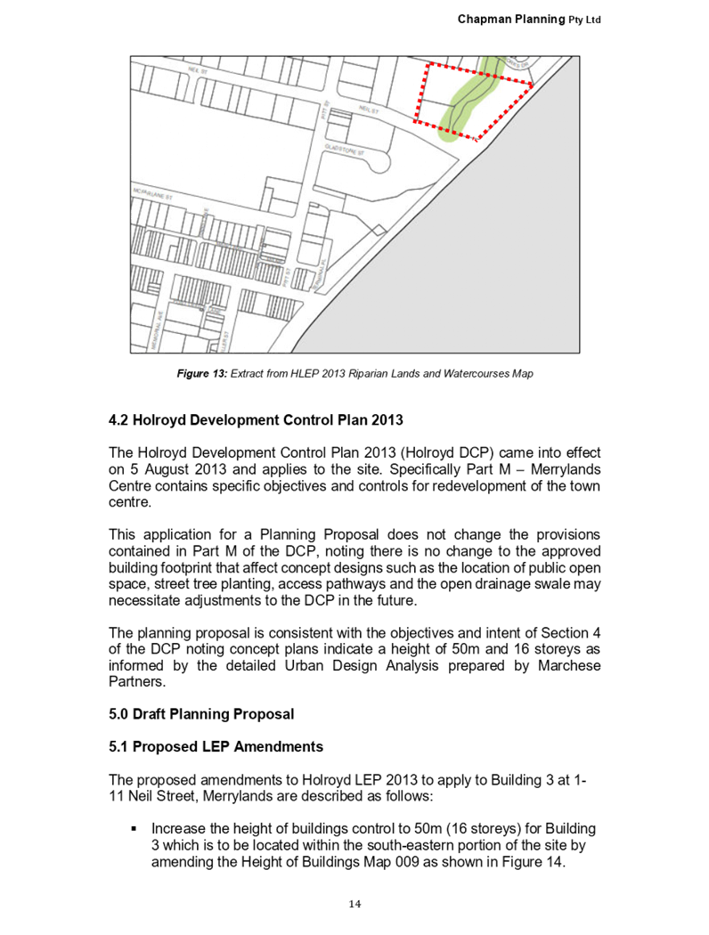
Neil Street Planning Proposal
The site was identified in the Neil Street Precinct Planning Proposal as Block E. As part of the Neil Street Precinct Planning Proposal, land was zoned SP2 – Drainage and RE1 Public Recreation to address flood risk through the provision of an overland flow path channel, and provide open space and areas for passive recreation. The application of these zones reduced the planned development yield from the site from approximately 45,200m2 to approximately 39,400m2; a reduction of approximately 5,700m2. An assessment of the submissions received and the proposal was undertaken, and this was reported to the Cumberland IHAP meeting on 13 September 2017 (Attachment 1).
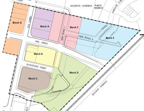
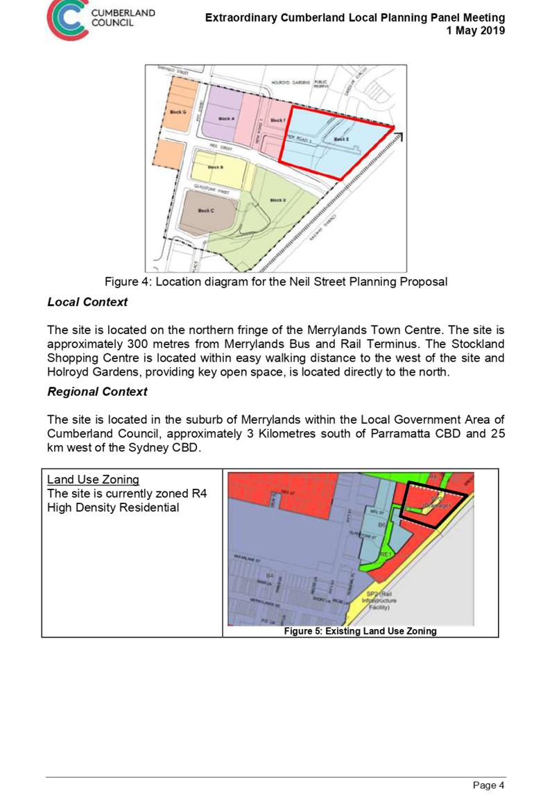
Figure 4 Location diagram for the Neil Street Planning Proposal
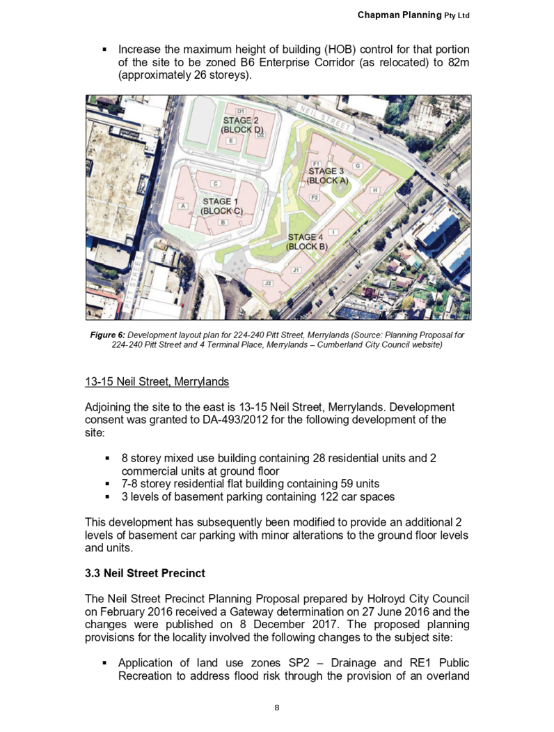
Local Context
The site is located on the northern fringe of the Merrylands Town Centre. The site is approximately 300 metres from Merrylands Bus and Rail Terminus. The Stockland Shopping Centre is located within easy walking distance to the west of the site and Holroyd Gardens, providing key open space, is located directly to the north.
Regional Context
The site is located in the suburb of Merrylands, approximately 3 kilometres south of Parramatta CBD and 25 kilometres west of the Sydney CBD.
Planning Proposal
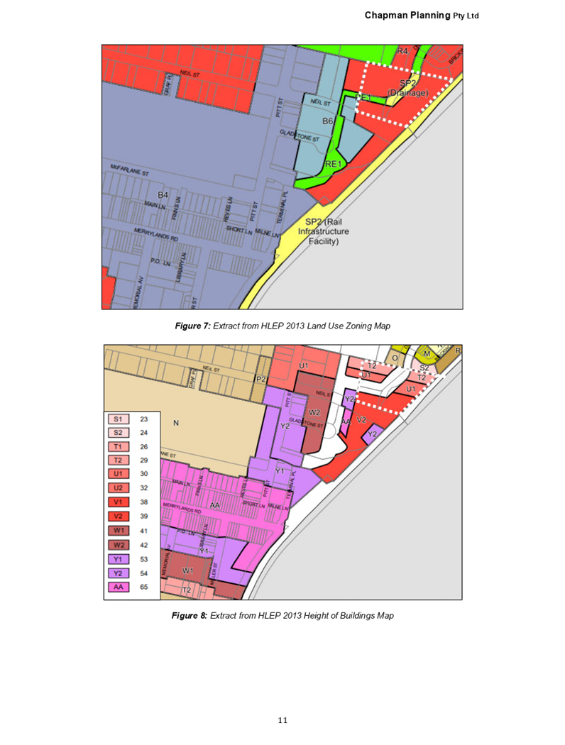
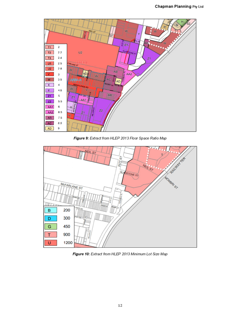
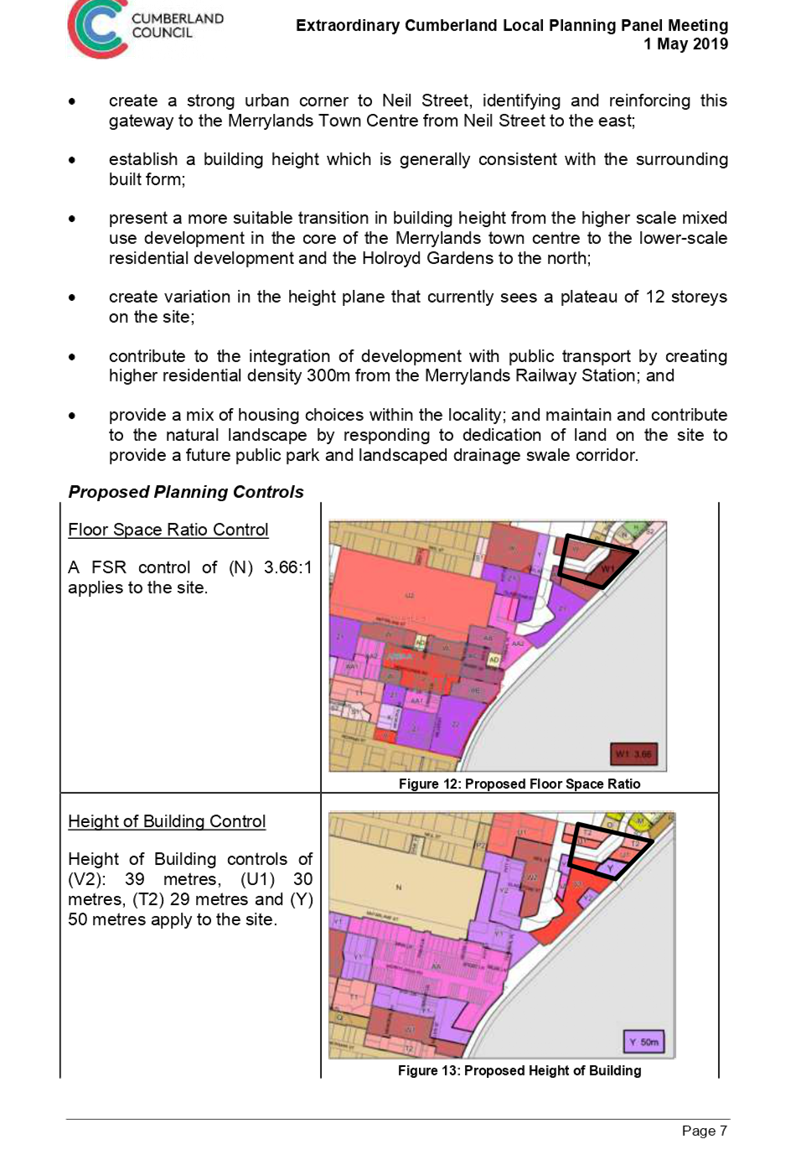
Current Planning Controls
Holroyd LEP 2013 applies to the site. The site is currently zoned R4 High Density Residential, with a maximum Height of Building controls of 39 metres, 30 metres and 29 metres and a Floor Space Ratio control of 3.5:1. This is shown in Figures 5 to 7.
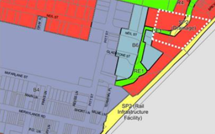
Figure 5 Current Zoning
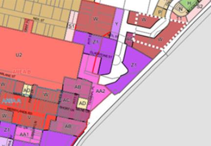
Figure 6 Current Floor Space Ratio (W=3.5:1)
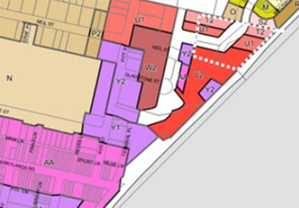
Figure 7 Current Height of Buildings (V2 =39, U1=30 and T2=29)
Proposed Planning Controls
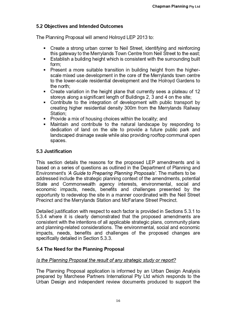
The planning proposal seeks to change the maximum height of building control for the southern portion of the site from 39 metres to 50 metres and change the FSR that applies to the site from 3.5:1 to 3.66:1 to facilitate the construction of a taller tower element on the southern portion of the site. This is shown in Figures 8 and 9.
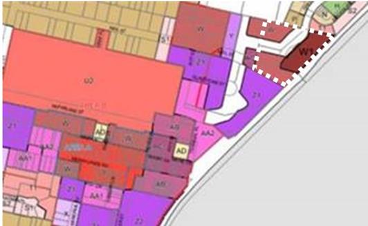
Figure 8 Proposed FSR (W1=3.66:1)
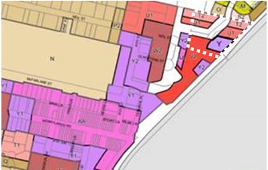
Figure 9 Proposed Height of Buildings (Y=50)
Strategic Merit Assessment
Capacity of Existing Planning Controls
There is merit in progressing the planning proposal to the next phase of assessment, as the proposal does not exceed the development yield that was planned for the site under the Merrylands Town Centre Urban Design Review 2015 and the Neil Street Planning Proposal.
The planning proposal increases the floor area by approximately 4,300m2 resulting in a Gross Floor Area across the site of 44,400m2. This development yield is within the planned development yield of the original Neil Street Masterplan and subsequent LEP that allowed 45,100m2 of Gross Floor Area across the site. The additional floor area on Building 3 seeks to compensate for the dedication of land to Council for SP2 Drainage and RE1 Public Recreation uses.
Traffic and Transport Impacts
There is merit in progressing the proposal to the next phase of assessment as the proposal does not exceed the planned development yield for the site. Traffic and transport considerations, impacts and mitigation measures have previously been addressed by the Neil Street Planning Proposal.
Open Space Provision
There is merit in progressing the proposal to the next phase of assessment as there is not a need to provide additional open space within the Neil Street precinct, as the proposal does not increase the planned development yield of the site. Importantly, the open space requirements for this proposal have previously been addressed by the Neil Street Planning Proposal, which see a portion of this site being used for open space.
Flooding
There is merit in progressing the proposal to the next phase of assessment as flood migration measures were identified as part of the Neil Street Planning Proposal and are being implemented through DAs that apply to the site.
Central City District Plan
There is strategic merit in progressing this proposal to the next phase of assessment as consistent with the following Planning Priorities of the Central City District Pan:
· Planning Priority C2: Planning for a city supported by infrastructure – the proposal seek to rezone land close to key existing infrastructure such as the Merrylands Bus and Rail Interchange.
· Planning Priority C5: Providing housing supply, choice and affordability with access to jobs, services and public transport – the planning proposal seeks to deliver additional jobs and housing in Merrylands city centre, Cumberland’s key commercial centre. The site is also accessible to all of the jobs, service and public transport of the Parramatta CBD.
Greater Sydney Region Plan
There is strategic merit on progressing this proposal to the next phase of assessment as the proposal consistent with the following Planning Directions in the Greater Sydney Region Plan:
· City supported by infrastructure – the site is well connected to public transport infrastructure. The site and surrounds have been identified for increased density of commercial and residential development with the Neil Street Precinct LEP Amendments and Merrylands Station and McFarlane Street Precinct Planning Proposal.
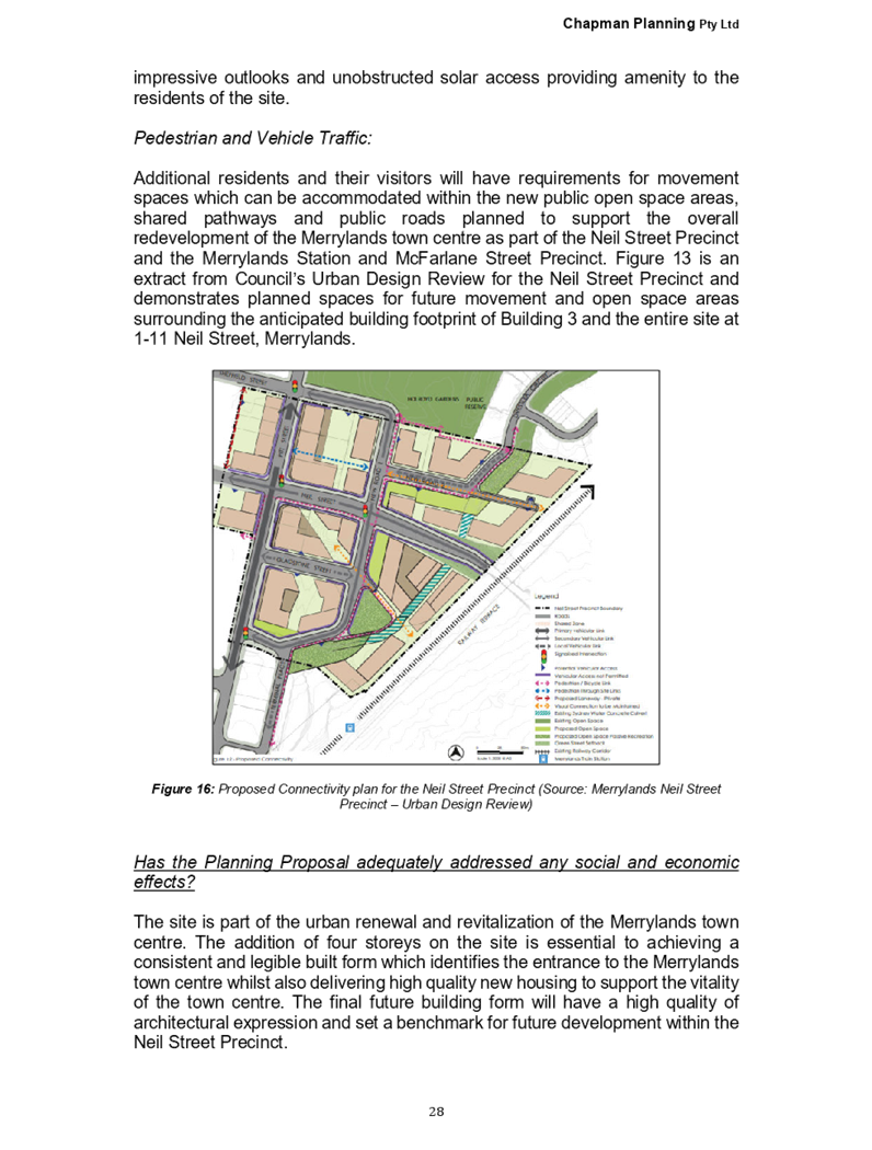
· City for its people – the future development will facilitate active uses and opportunities for social interaction. The landmark building will assist people to navigate through the town centre.
· Housing in the city – the proposal will provide new housing adjacent to Merrylands railway station and set within a network of new roads and pathways.
· An efficient city – the proposal has potential to reduce transport costs and emissions by increasing the resident population with access to public transport and within walking distance of an established town centre.
Cumberland Local Planning Panel
The planning proposal was reported to the Cumberland Local Planning Panel on 1 May 2019. The Panel recommended that this matter be reported to Council, seeking a resolution to forward the planning proposal for a Gateway Determination (Attachment 2).
Recommended Planning Controls
A summary of the recommended planning controls for the proposal is provided in Table 1. This is based on a review of the proponent’s proposed planning controls by Council officers and advice from the Cumberland Local Planning Panel.
|
Planning Controls (Holroyd LEP 2013) |
Existing Controls |
Proponent’s Proposed Controls |
Cumberland Local Planning Panel Advice |
Recommended Planning Controls |
|
Zoning |
R4 High Density Residential |
R4 High Density Residential |
R4 High Density Residential |
R4 High Density Residential |
|
Height of Building |
29 Metres 30 Metres 39 Metres |
29 Metres 30 Metres 39 Metres 50 Metres |
29 Metres 30 Metres 39 Metres 50 Metres |
29 Metres 30 Metres 39 Metres 50 Metres |
|
Floor Space Ratio |
3.5:1 |
3.66:1 |
3.66:1 |
3.66:1 |
Table 1 Recommended Planning Controls
Public Benefit Offer
The applicant has submitted a public benefit offer to Council for the additional uplift provided by the proposal, and this would be captured through a Voluntary Planning Agreement. The offer is for a contribution to the cost of street lighting works in the Neil Street Precinct that are required to be undertaken by Council. Should Council decide to proceed with a Gateway Determination, further negotiations will be undertaken to ensure that the public benefit offer is based on 50% of the uplift arising from the proposal, which aligns with Council’s Planning Agreements Policy.
Community Engagement
The proposal was publicly exhibited (pre-Gateway) for a period of 30 days from 24 July 2018 to 22 August 2018 in accordance with Cumberland Council’s Planning Proposal Notification Policy. In response to the exhibition, Council received no submissions.
Policy Implications
Policy implications for Council are outlined in the main body of the report.
Risk Implications
There are minimal risk implications for Council associated with this report.
Financial Implications
Should the planning proposal proceed to a Gateway Determination, negotiations on the public offer will be progressed and captured through a Voluntary Planning Agreement. A further report on the Voluntary Planning Agreement will be provided to Council.
CONCLUSION
It is recommended that the planning proposal for 1-11 Neil Street, Merrylands be forwarded to the Department of Planning, Industry and Environment for a Gateway Determination. This recommendation is being made as the proposal does not exceed the planned development yield of the Merrylands Town Centre Urban Design Review and the Neil Street Planning Proposal.
Attachments
1. Planning Proposal ⇩ ![]()
2. CLPP
Minutes - 1 May 2019 ⇩ ![]()
3. CLPP
Report - 1 May 2019 ⇩ ![]()
DOCUMENTS
ASSOCIATED WITH
REPORT C06/19-112
Attachment 1
Planning Proposal
19 June 2019
Item No: C06/19-113
Road Naming Report - New Public Roads Proposed Within The Neil Street Precinct
Responsible Division: Environment & Planning
Officer: Director Environment & Planning
File Number: HC-23-11-18
Community Strategic Plan Goal: A resilient built environment
Summary
This report recommends to proceed with the adoption and gazettal of new road names within the Neil Street Precinct, Merrylands, following a period of public exhibition. The recommended road names are McLeod Road and Dressler Way.
|
Recommendation
That Council:
1. Adopt the new road names for the Neil Street Precinct, Merrylands.
2. Gazette the new road names of McLeod Road and Dressler Way. |
Report
In December 2018, Council resolved to place the naming of new roads within the Neil Street Precinct, Merrylands, on public exhibition for a period of 28 days for public comment, with a report to be to be returned to Council following the public exhibition period.
The road naming proposal was publicly exhibited from Wednesday 27 February 2019 through to Wednesday 10 April 2019 and one submission was received. This submission understood the reasons submitted for changing Dressler Court to Dressler Way but disagreed with the claim that it should change.
Following the public exhibition and consideration of submissions, it is recommended that the proposed road names of McLeod Road and Dressler Way be adopted and gazetted. Council has also received the concurrence of the Geographical Names Board for the naming of these new roads.
Community Engagement
Community engagement undertaken for the proposed road names is outlined in the main body of the report.
Policy Implications
There are no policy implications for Council associated with this report.
Risk Implications
There are no risk implications for Council associated with this report.
Financial Implications
There are no financial implications for Council associated with this report.
CONCLUSION
The naming of new roads within the Neil Street Precinct, Merrylands, was placed on public exhibition and one submission was received. Following the public exhibition and consideration of submissions, it is recommended that the proposed road names of McLeod Road and Dressler Way be adopted and gazetted.
Attachments
1. Council Report - 19
December 2018 ⇩ ![]()
2. Council
Minutes - 19 December 2018 ⇩ ![]()
3. Submission
⇩ ![]()
DOCUMENTS
ASSOCIATED WITH
REPORT C06/19-113
Attachment 1
Council Report - 19 December 2018
19 June 2019
Item No: C06/19-114
Road Naming Report - New Public Roads Proposed Within the Subdivision Of Lot 12 Dp 1175686, Palmer Street, Guildford West
Responsible Division: Environment & Planning
Officer: Director Environment & Planning
File Number: 2017/52/1
Community Strategic Plan Goal: A resilient built environment
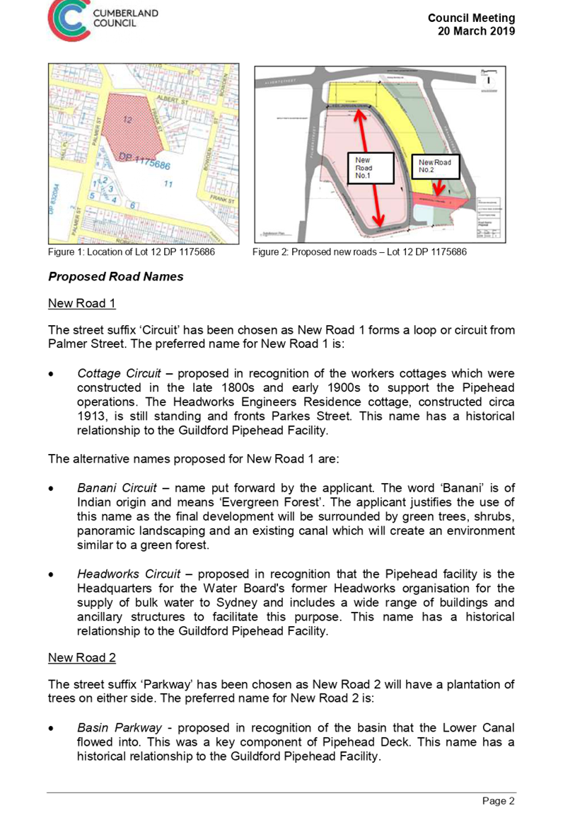
Summary
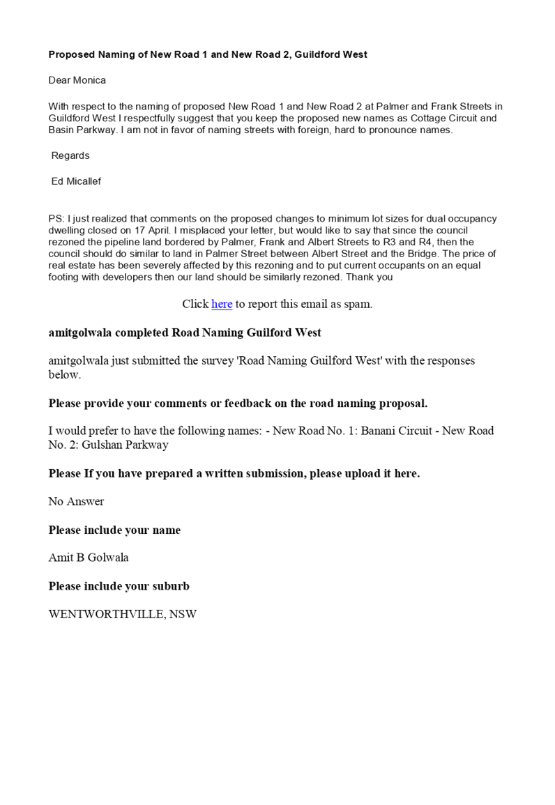
This report recommends to proceed with the adoption and gazettal of new road names within the subdivision of Lot 12 1175686 Palmer Street, Guildford West, following a period of public exhibition. The recommended road names are Cottage Circuit for New Road 1 and Basin Parkway for New Road 2.
|
Recommendation
That Council:
1. Adopt the new road names for the subdivision of Lot 12 1175686 Palmer Street, Guildford West.
2. Gazette the new road names of Cottage Circuit for New Road 1 and Basin Parkway for New Road 2. |
Report
In March 2019, Council resolved to place the naming of new roads within the subdivision of Lot 12 1175686 Palmer Street, Guildford West, on public exhibition for a period of 28 days for public comment, with a report to be returned to Council following the public exhibition period.
The road naming proposal was publicly exhibited from Wednesday 17 April 2019 through to Friday 24 May 2019 and two submissions were received. One submission supported the preferred names of Cottage Circuit for New Road 1 and Basin Parkway for New Road 2. The other submission put forward a preference of the alternative road names of Banani Circuit for New Road 1 and Gulshan Parkway for New Road 2.
Following the public exhibition and consideration of submissions, it is recommended that the proposed road names of Cottage Circuit for New Road 1 and Basin Parkway for New Road 2 be adopted and gazetted. Council has also received the concurrence of the Geographical Names Board for the naming of these new roads.
Community Engagement
Community engagement undertaken for the proposed road names is outlined in the main body of the report.
Policy Implications
There are no policy implications for Council associated with this report.
Risk Implications
There are no risk implications for Council associated with this report.
Financial Implications
There are no financial implications for Council associated with this report.
CONCLUSION
The naming of new roads within the subdivision of Lot 12 1175686 Palmer Street, Guildford West, was placed on public exhibition and two submissions were received. Following the public exhibition and consideration of submissions, it is recommended that the road names of Cottage Circuit for New Road 1 and Basin Parkway for New Road 2 be adopted and gazetted.
Attachments
1. Council Minutes
– 20 March 2019 ⇩ ![]()
2. Council
Report - 20 March 2019 ⇩ ![]()
3. Submissions
⇩ ![]()
DOCUMENTS
ASSOCIATED WITH
REPORT C06/19-114
Attachment 1
Council Minutes – 20 March 2019
19 June 2019
Item No: C06/19-115
Proposed Closure of Benaud Street laneway, Greystanes
Responsible Division: Works & Infrastructure
Officer: Director Works & Infrastructure
File Number: GS-069-MC
Community Strategic Plan Goal: Transparent and accountable leadership
Summary
Council has received representations on behalf of residents of Benaud Street and Cumberland Road, Greystanes requesting Council’s consideration for the closure of a pedestrian laneway that currently connects Benaud Street with Cumberland Road in Greystanes. Legal advice has been sought from Council’s General Counsel in relation to the process to be followed should Council wish to consider closure of the pedestrian laneway, which is included in the body of this report.
|
Recommendation That Council: 1. Undertake a consultation process with potentially affected residents as detailed within this report, in relation to the proposed closure of the pedestrian laneway at the eastern end of Benaud Street, Greystanes. 2. Report back to Council on the outcome of community consultation, with a recommendation as to whether Council should consider proceeding with the formal notification process under s.38B of the Roads Act 1993. |
Report
Background
Council has received representations on behalf of residents who reside at the eastern end of Benaud Street, Greystanes and on Cumberland Road requesting Council’s consideration for the closure of a pedestrian laneway that currently connects Benaud Street with Cumberland Road in Greystanes.
The reasons provided in support of this request primarily relate to that of antisocial behaviour from individuals traversing through the pedestrian laneway, including damage to adjoining owners’ property, safety of those residents and alleged illegal activities including the use of drugs and alcohol. The submission received also suggests that the laneway is not required by the general public for local access.
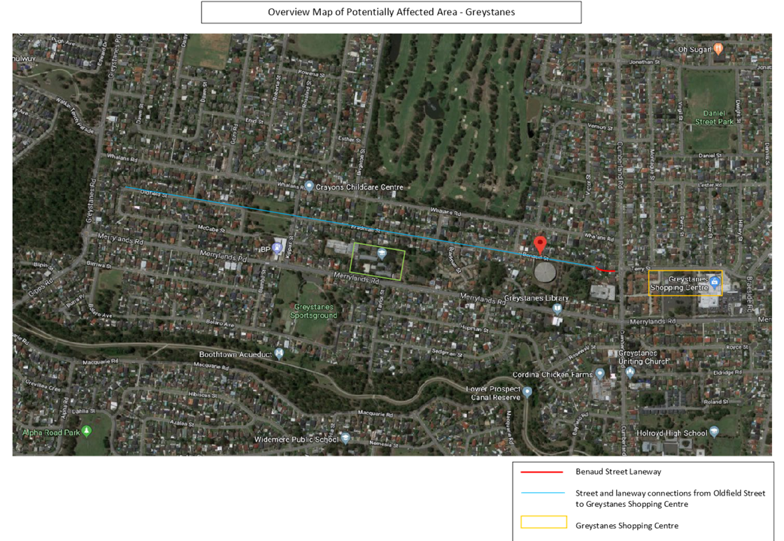
The subject laneway has been in existence since 8 November 1990 and provides part of a larger pedestrian link through cluster developments to the west as far as Oldfield Street and McCabe Street, in addition to Greystanes Public School. This pedestrian link is therefore intended to reduce pedestrian traffic along the busier Whalans Road and Merrylands Road and subsequent travel distance for residents wishing to access Greystanes Shopping Centre to the east (refer to attachment 1).
In considering the potential closure of this laneway, advice has been sought from Council’s General Counsel in relation to the process to be followed. This advice is provided below.
General Counsel Advice
1. The laneway is a public road. Council is the roads authority for the lane under the Roads Act 1993 (the Act).
2. Under s.38A of the Act, Council may propose the closure of a council public road if:
(a) the road is not reasonably required as a road for public use (whether for present or future needs), and
(b) the road is not required to provide continuity for an existing road network, and
(c) if the road provides a means of vehicular access to particular land, another public road provides lawful and reasonably practicable vehicular access to that land.
3. Paragraph (c) has no application in this case as the laneway in question provides pedestrian access only. Paragraphs (a) and (b) are subjective matters to be determined. If there is doubt as to whether the lane is reasonably required for public use and for continuity, then it may be appropriate to consult those persons potentially affected by the closure. Alternatively, Council could form a preliminary opinion that (a) and (b) are satisfied and proceed with the required notification process under s.38B.
4. Section 38B provides that Council must cause notice of the proposed road closure:
(a) to be published in a local newspaper, and
(b) to be given to:
(i) all owners of land adjoining the road, and
(ii) all notifiable authorities, and
(iii) an owner or occupier of land that will suffer a material loss of access because of the closure.
5. Notifiable authorities as nominated in the Roads Act and associated regulations are listed below. It is noted that some of the listed departmental and office names have changed since the recent State Government election.
(a) the electricity supply network operator,
(b) a gas supply network operator,
(c) the Secretary of the Department of Planning and Environment,
(d) the Secretary of the Department of Industry,
(e) Transport for NSW,
(f) Sydney Metro,
(g) the State Transit Authority,
(h) Roads and Maritime Services,
(i) the Commissioner of Fire and Rescue NSW,
(j) the Commissioner of the NSW Rural Fire Service,
(k) Sydney Water,
(l) the Forestry Corporation,
(m) Local Land Services, and
(n) the Office of Environment and Heritage.
6. Section 38B(2) prescribes that the notice must identify the road that is proposed to be closed, must state that any person is entitled to make submissions to the council with respect to the closing of the road, and must indicate the manner in which, and the period (being at least 28 days) within which, any such submission should be made.
7. After considering any submissions received, the Council may, by publishing a notice in the Gazette, close the road – s.38D(1). However, if one or more of the notifiable authorities has formerly objected under s.38C(2), then s.38D(2) prevents the closure of the road until the authority or authorities have withdrawn the objection/s, or following appeal by the Council, the Land and Environment Court has set aside the objection/s.
8. Upon publication of the notice in the gazette, the laneway would cease to be a public road, with the rights of passage and access concurrently extinguished.
9. Upon closure, the road would be vested in Council (s.38E(2)(a)) as operational land, unless prior to that vesting, the Council had resolved that it would be community land.
10. Persons listed under s.38B(1)(b) – refer to paragraph 6 above, have a right of appeal to the Land and Environment Court against a decision of the Council to close a road.
In considering the process outlined above and potential number of residents that may be affected by the closure of the laneway, it is considered pertinent for Council to first undertake a community consultation process to determine if the closure of the gateway has merit. This report therefore recommends that Council commence an appropriate consultation process with the potentially affected community.
Community Engagement
This report recommends that a consultation process be carried out with residents who may be affected by the proposed closure of the laneway. This consultation process will include:
· Public exhibition of the proposal, including publication in local newspapers and on Council’s website.
· Signage on the entrances to the subject laneway, providing notice of the proposed closure and directing residents to Council’s website for further information.
Policy Implications
There are no policy implications for Council associated with this report.
Risk Implications
There are no risk implications for Council associated with this report.
Financial Implications
There are no financial implications for Council associated with this report, other than minor advertising costs that can be met from the current budget allocations.
CONCLUSION
Consideration is being given to a submission requesting the closure of a pedestrian laneway at the eastern end of Benaud Street, Greystanes. Given the potential impact of this laneway closure with pedestrian linkages to the east and west, it is recommended that Council commence a consultation process with the potentially affected community. Depending upon the outcome of this community consultation, a further report can then be prepared to Council indicating whether closure of the laneway should be pursued by way of commencing the required notification process under s.38B of the Roads Act 1993.
Attachments
1. Overview Map of
Potentially Affected Area ⇩ ![]()
DOCUMENTS
ASSOCIATED WITH
REPORT C06/19-115
Attachment 1
Overview Map of Potentially Affected Area
19 June 2019
Item No: C06/19-116
Response to Notice of Motion - (Min. 378 C12/18-254) Progress Park Toilet Block
Responsible Division: Works & Infrastructure
Officer: Director Works & Infrastructure
File Number: PKP03-04
Community Strategic Plan Goal: A great place to live
Summary
This report provides a response to the Notice of Motion – Progress Park Toilet Block resolved at the Ordinary Meeting of Council on 5 December 2018 (Min.378 C12/18-254).
|
Recommendation That Council receive and note the report. |
Report
At the Ordinary meeting of Council on the 5 December 2018, Council considered the Notice of Motion – Progress Park Toilet Block (Min.378-C12/18-254) for the construction of a stand-alone public toilet in Progress Park. Council resolved the following;
1. Council will prepare a report on the feasibility of installing a standalone toilet block at Progress Park; and
2. If such a project is deemed to be feasible by the Council, that funds be drawn off either the capital works budget or the Woodville Fund.”
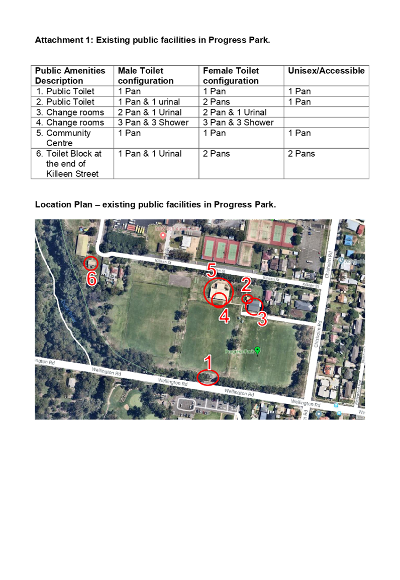
Progress Park is made up of three sports fields, a small playground, practice cricket nets and adjoins the Duck River Corridor. The park has four separate buildings that contain public amenities, inclusive of toilet facilities. Additionally, there is another building nearby in the community picnic area at the end of Killeen Street, which also includes toilets.
Attached to this report (Attachment 1) is a map showing the current layout of the facilities within Progress Park.
Progress Park is part of the Duck River Corridor and is an important regional active and passive network of open space. It serves active sports activities, passive recreation, picnics and playground usage.
Council officers have conducted an assessment of the area to determine the current provision of public amenities and benchmarked this provision of public amenities against those found in similar sized sports grounds in the Cumberland LGA.
|
Location |
Description |
Available Amenities |
|
Progress Park |
Three sports fields, a small playground and practice cricket nets |
4 public amenity buildings+1 nearby in the community picnic area at the end of Killeen street |
|
Ray Marshall Reserve |
Three sports fields, 1 mini field, half court, practice cricket nets |
1 public amenity building |
|
Princes Park |
Two sports fields, 4 mini fields, picnic facilities, medium size playground |
1 public amenity building |
|
Mona Park |
Four sports fields, practice cricket nets, half court, medium size playground, bike safety course |
2 public amenities buildings
|
|
Merrylands Park |
Four sports fields, 3 Basketball courts, walking track, cycle track, 4 tennis courts |
3 public amenities buildings |
|
Webbs Avenue Park |
Four sports fields, dog off-leash area |
2 public amenities buildings |
|
Girraween Park |
3 sports fields, small playground |
1 public amenities building |
The above table highlights that Progress Park currently has an adequate supply of public amenities in comparison to other similar sportsgrounds.
However, should Council choose to construct a new amenity building within Progress Park, the following initial construction costs would be applicable:
|
CONSTRUCTION COSTS |
||
|
Description |
Estimation |
Comment |
|
Pre-fab stand-alone Toilet block |
$92,000.00 |
1x caretaker restroom, 2x unisex disabled cubicle, 1x store room. |
|
Construction cost / preliminaries |
$55,000.00 |
Excavation, traffic control, concrete & landscaping works, etc. |
|
Plumbing works |
$55,000.00 |
Including fittings & fixtures. |
|
Electrical works |
$25,000.00 |
Switchboard, internal & external lighting |
|
Project Management & Design |
$22,700.00 |
|
|
Sub-total |
$249,700.00 |
|
|
Contingency (15%) |
$37,455.00 |
|
|
TOTAL |
$287,155.00 |
|
Council officers have also given consideration to the upcoming commencement of the Duck River Strategic Master Plan and Plan of Management. These plans will help inform facility improvement priorities across the entire Duck River corridor and will allow Council to determine a suitable strategic approach for the provision of public amenities across the identified area.
In consideration of this, it is recommended that a final decision on the construction of any additional public toilets be delayed until the Strategic Masterplan has been prepared through a consultative process with all user groups who use the active and passive components of the park.
Community Engagement
A Community Engagement Plan will be developed for both the Duck River Strategic Masterplan and Public Amenities Strategy projects which will include engagement with sports clubs and associations and park hirers, including those who utilise Progress Park and the surrounding areas.
Policy Implications
There are no policy implications for Council associated with this report.
Risk Implications
There are no risk implications for Council associated with this report.
Financial Implications
Currently all capital projects are committed for 2019/20 and there are no funds available without deferring other Capital Works projects.
CONCLUSION
In terms of public amenity infrastructure, this report identifies that Progress Park is currently well serviced in comparison to other similar sized sports grounds within the LGA. It is recommended that any future additions to the park should be considered in conjunction with the development of the Duck River Strategic Masterplan Plan which will help inform facility improvement priorities across the entire Duck River corridor.
Attachments
1. Location Plan of
Existing Facilities - Progress Park ⇩ ![]()
DOCUMENTS
ASSOCIATED WITH
REPORT C06/19-116
Attachment 1
Location Plan of Existing Facilities - Progress Park
19 June 2019
Item No: RES06/19-2
Notice of Rescission - Planning Proposal - Minimum Lot Area for Low and Medium Dual Occupancy Housing
Councillor/s: Ned Attie, Eddy Sarkis and Tom Zreika
File Number: S-57-63
|
Notice of Rescission Pursuant to Notice, Councillors Attie, Sarkis and Zreika move the following Resolution of Council 5/06/19 (Item C06/19-103) be rescinded: That Council: 1. Endorse a minimum lot size planning control of 600m2 with a 2.5% variance for dual occupancy development across the Cumberland local government area. 2. Endorse the planning proposal and forward it to the Department of Planning, Industry & Environment for finalisation and gazettal of the associated amendments to the Auburn Local Environmental Plan 2010 and the Holroyd Local Environmental Plan 2013. 3. Endorse the resolved minimum lot size planning control for dual occupancy development for inclusion in the new Cumberland Local Environmental Plan. 4. Request a deferral on the Code from the Department of Planning, Industry & Environment until the endorsed minimum lot size for Council comes into effect. |
Signed:
Councillor Ned Attie
Councillor Eddy Sarkis
Councillor Tom Zreika
Attachments
1. C06/19-103 -
Planning Proposal - Minimum Lot Area for Low and Medium Dual Occupancy Housing ⇩ ![]()
DOCUMENTS
ASSOCIATED WITH
REPORT RES06/19-2
Attachment 1
C06/19-103 - Planning Proposal - Minimum Lot Area for Low and Medium Dual Occupancy Housing