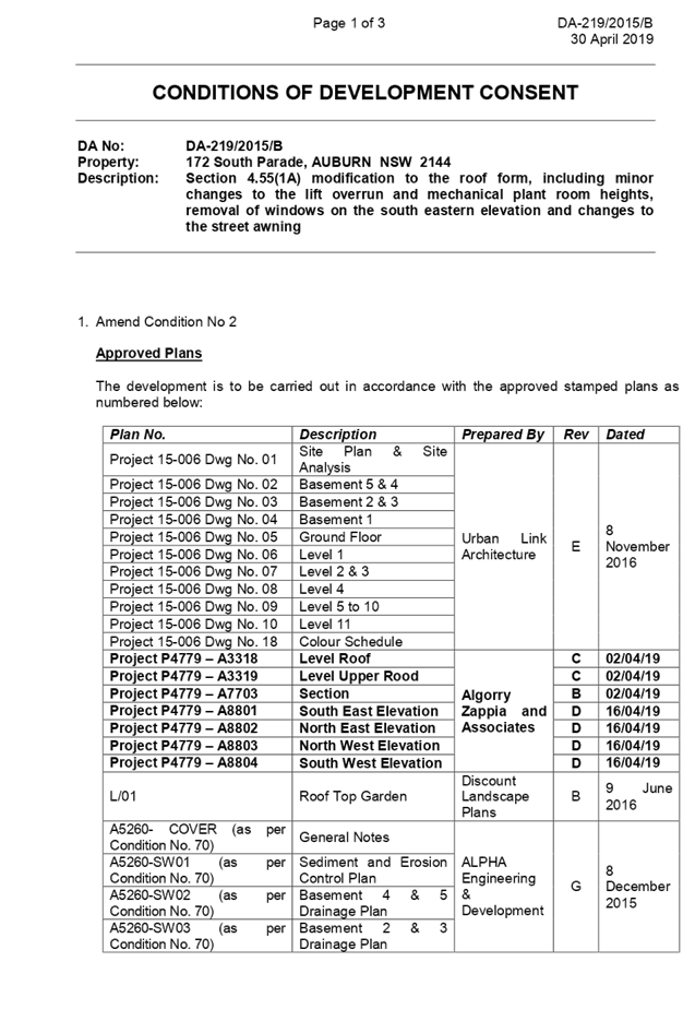
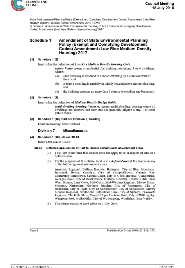
Extraordinary Cumberland Local Planning Panel Meeting
15 May 2019
Development Application for 322 Railway Terrace, Guildford
Responsible Division: Environment & Planning
Officer: Manager Development Assessment
File Number: DA-441/2017
|
Application lodged |
19 October 2017. |
|
Applicant |
Form Architects. |
|
Owner |
Mrs M Saliba and Mr A Saliba. |
|
Application No. |
DA-441/2017. |
|
Description of Land |
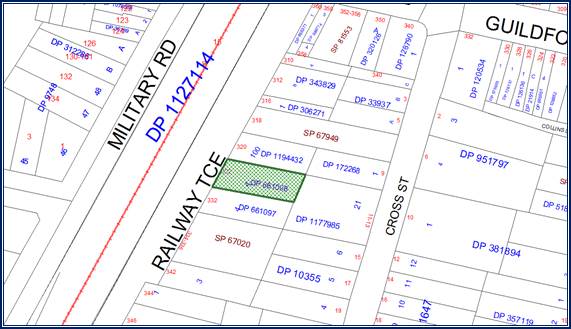
Lot 4 DP 661098, 322 Railway Terrace Guildford. |
|
Proposed Development |
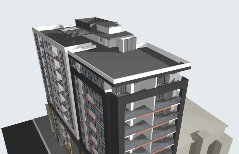
Demolition of an existing building and construction of a 5 storey mixed use development comprising a ground floor commercial tenancy, a ground floor residential apartment and four levels of apartments above including a two storey split level basement car park under State Environmental Planning Policy Affordable Rental Housing 2009. |
|
Site Area |
674.5 Square metres. |
|
Zoning |
B4 Mixed Use under Parramatta Local Environmental Plan 2011. |
|
Principal Development Standards |
Floor space ratio - 1.4:1 (For affordable Housing Bonus 0.428:1) Total FSR - 1.828:1. Height of buildings - 17 metres. |
|
Disclosure of political donations and gifts |
Nil disclosure. |
|
Heritage |
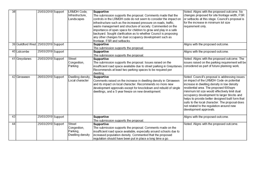
Number 332 to the immediate south is listed as a heritage item being a former bakery. |
|
Issues |
Site width. Building separation. |
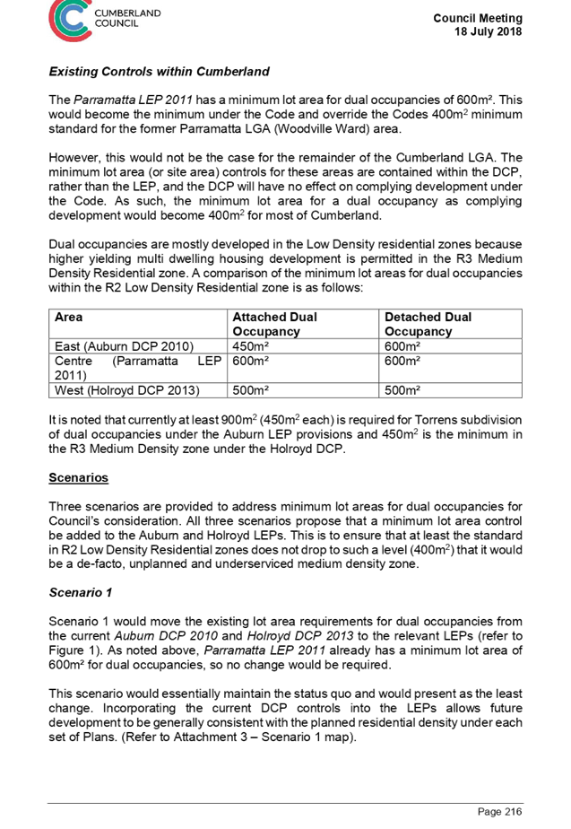
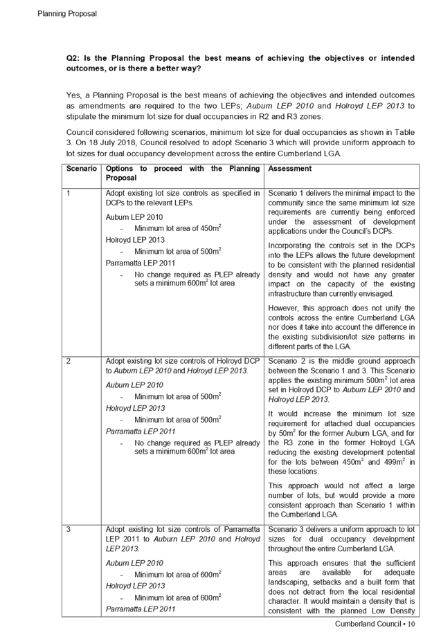
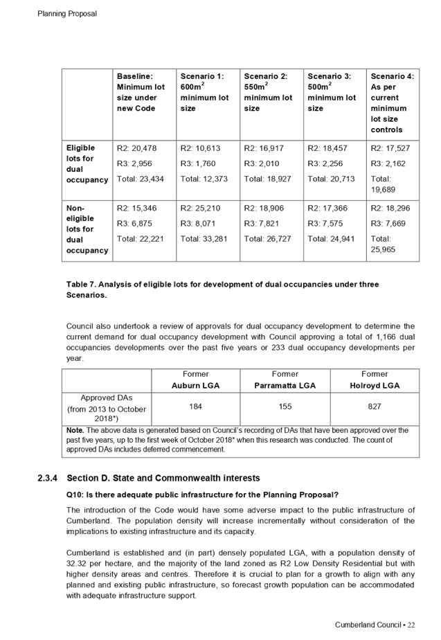
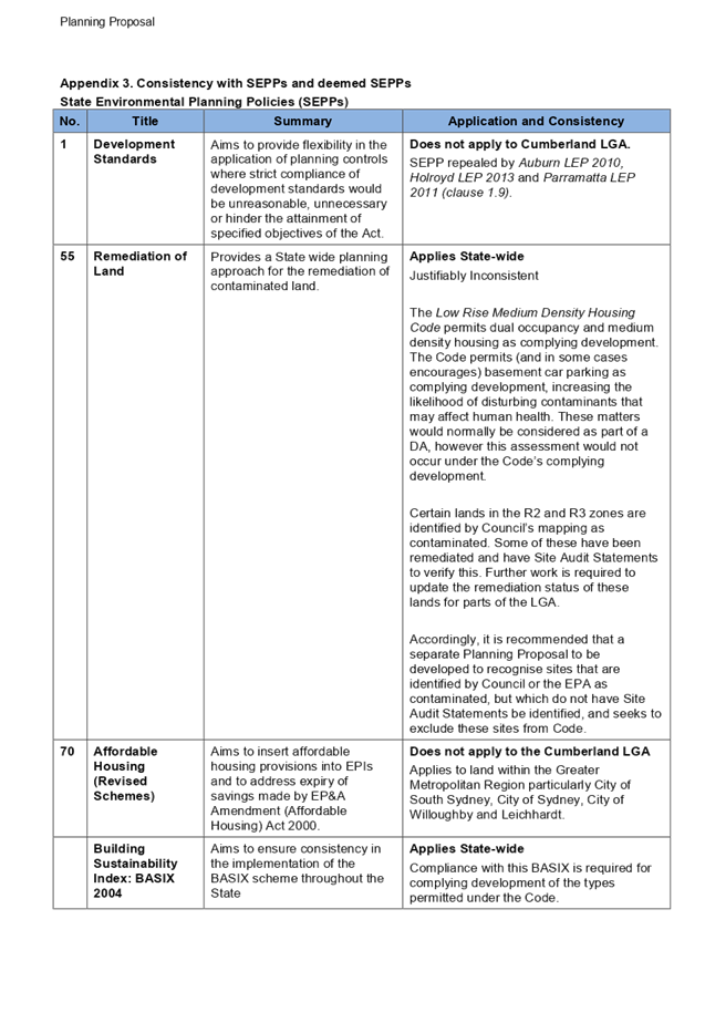
Summary:
1. Development application 441/2017 was received by Council on the 19 October 2017 for demolition of an existing building and construction of a 5 storey mixed use development comprising a ground floor commercial tenancy, a ground floor apartment and four levels of apartments above including a basement car park under State Environmental Planning Policy Affordable Rental Housing 2009.
2. The application was publicly notified to occupants and owners of nearby properties from December 5 2017 to 2 January 2018 and there were no submissions to the development sought.
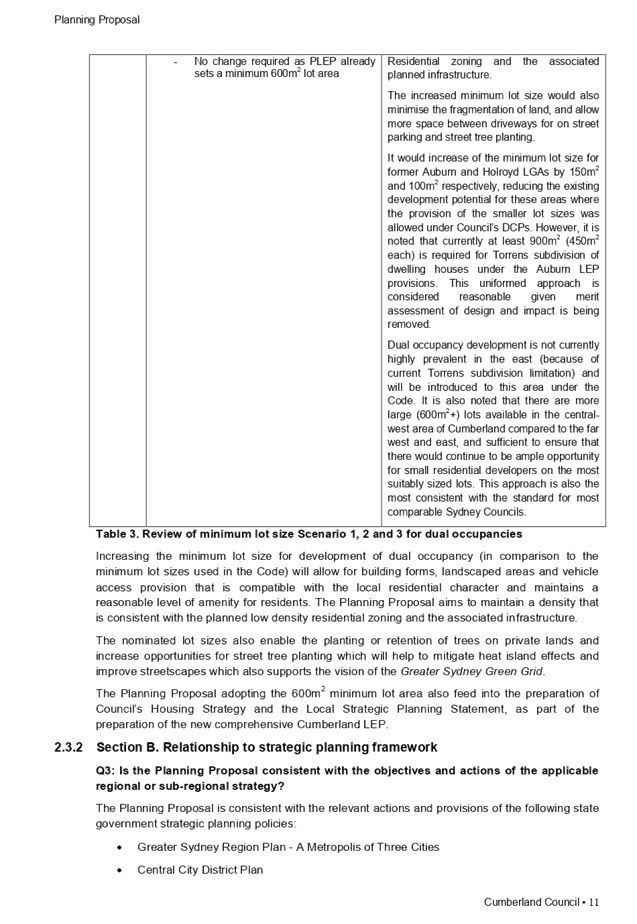
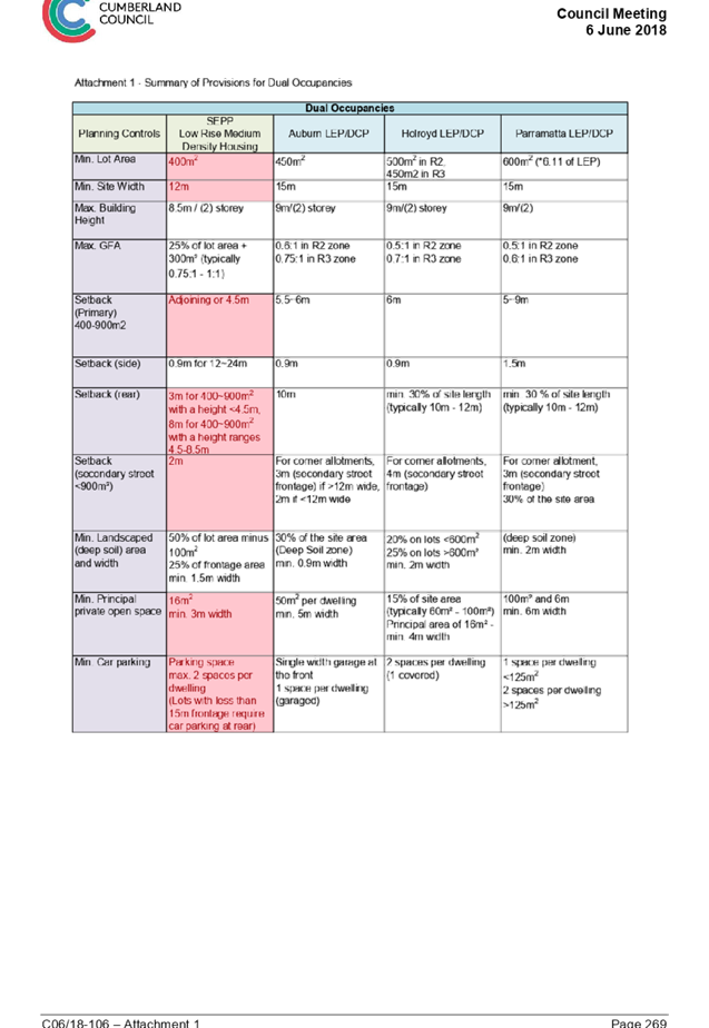
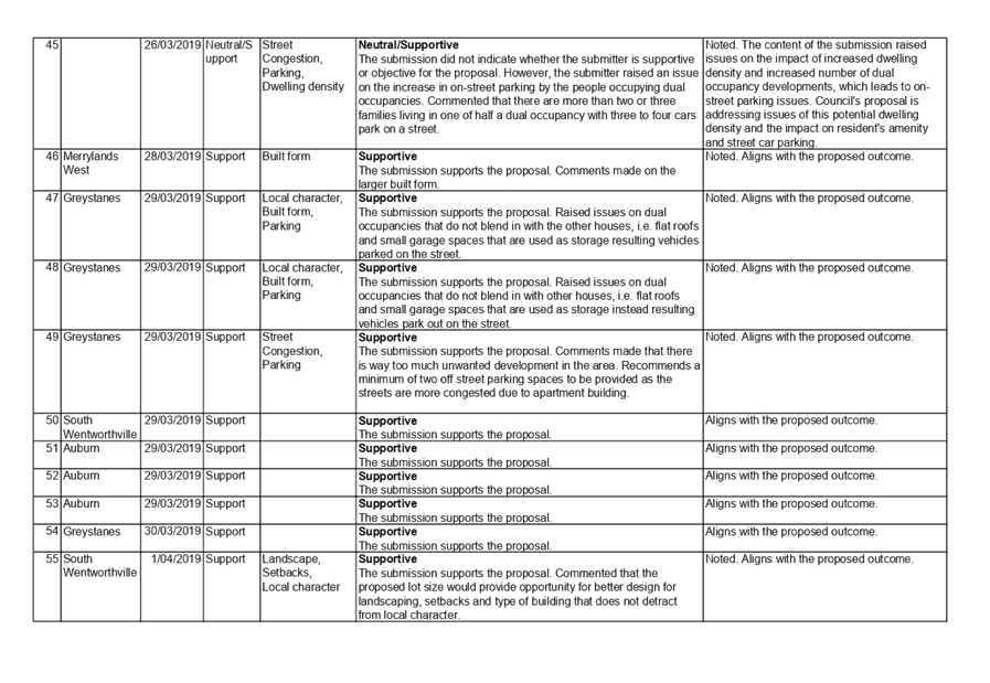
3 The variations to the planning controls are as follows:-
|
Control |
Required |
Provided |
% variation |
|
Clause 14(1)(c)(ii) of State Environmental Planning Policy “Affordable Rental Housing - Landscaped area. |
Landscaped area - 30% of the site to be landscaped. |
Landscaping is 124 square metres or 18.38% of the site.
|
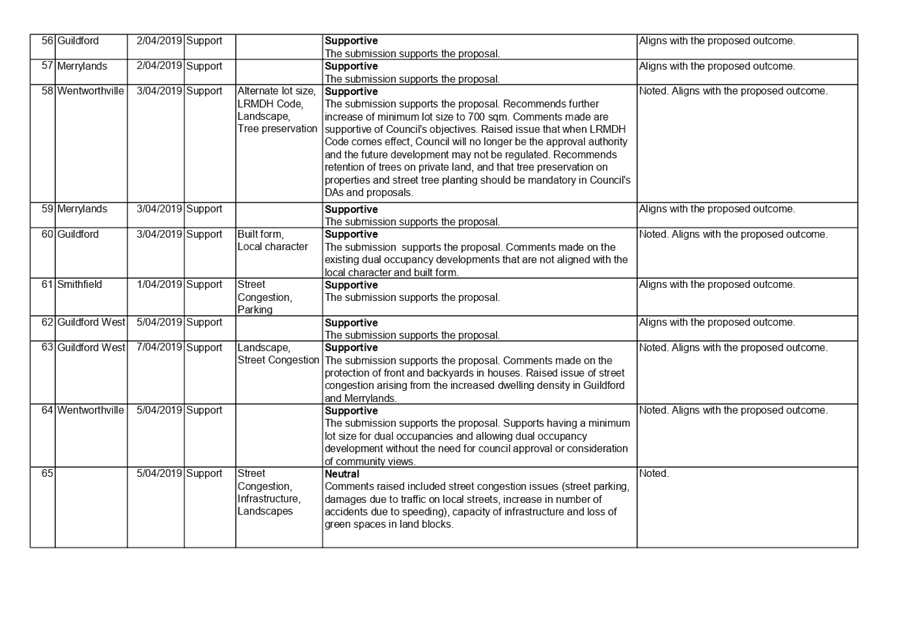
38.6%. |
|
Clause 14(1)(d)(i) of State Environmental Planning Policy “Affordable Rental Housing - Deep soil zone. |
At least 15% to be a deep soil zone. |
46.2 square metres or 6.85% of the site.
|
54.3%. |
|
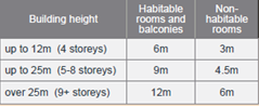
Part 2F - Building envelopes (Building separation) distances of the Apartment Design Guide. |
Up to four storeys (approximately 12 metres)
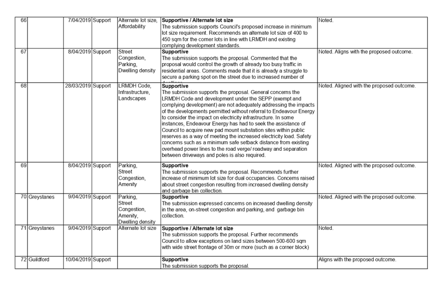
· 12m between habitable rooms / balconies; · 9m between habitable and non-habitable rooms; and 6m between non-habitable rooms.
Five to eight storeys (approximately 25 metres):
· 18m between habitable rooms / balconies; · 12m between habitable and non-habitable rooms; and 9m between non-habitable rooms.
At the boundary between a change in zone from apartment buildings to a lower density area, building separation should be increased by 3 metres.
Up to four storeys (approximately 12 metres)
· 15m between habitable rooms / balconies; · 12m between habitable and non-habitable rooms; and 9m between non-habitable rooms.
Five to eight storeys (approximately 25 metres):
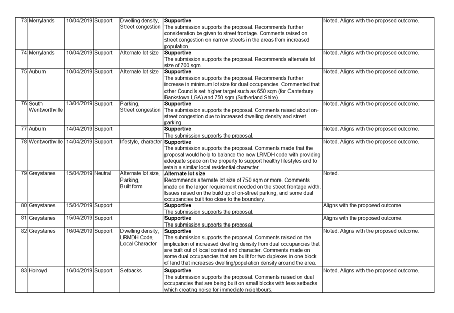
· 21m between habitable rooms / balconies; · 15m between habitable and non-habitable rooms; and 12m between non-habitable rooms. |
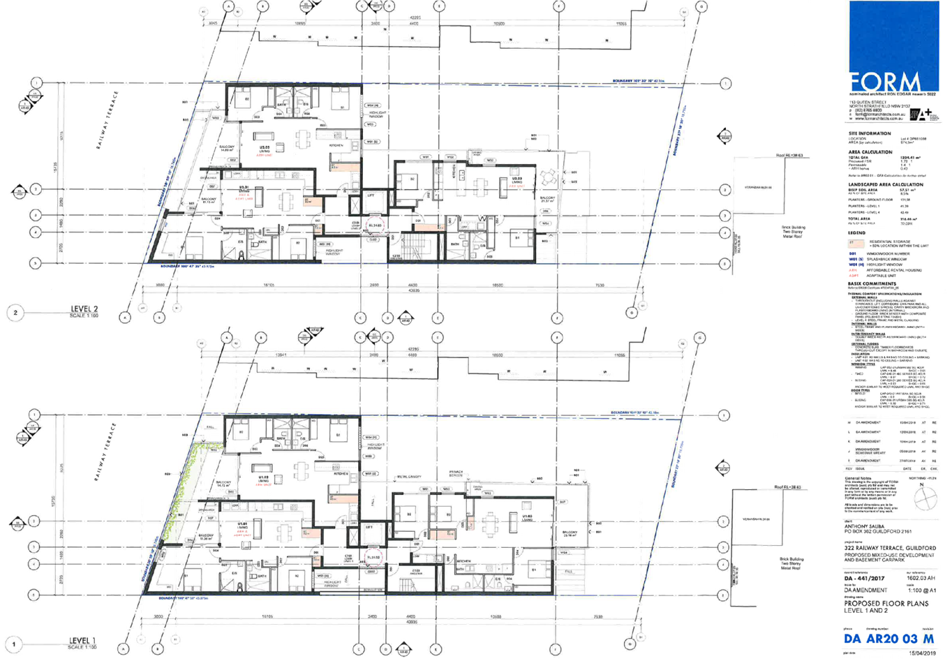
A balcony on Level 1 attached to Apartment U1.03 is setback 4 metres from the southern boundary.
The north facing balconies of apartments U1.03, U2.03 and U3.03 are setback 5.9 metres from northern boundary.
Kitchen window of Apartment U4.02 setback 6.4 metres from boundary.
The north facing balcony of apartment U4.02 is setback 5.9 metres from northern boundary.
Ground floor rear apartment is setback 5 metres from rear.
Level 4 apartment is setback 9.2 metres at rear. Level 4 balcony setback 8.1 metres from rear. |
Up to 33.3%.
1.7%.
28.8%.
34.5%.
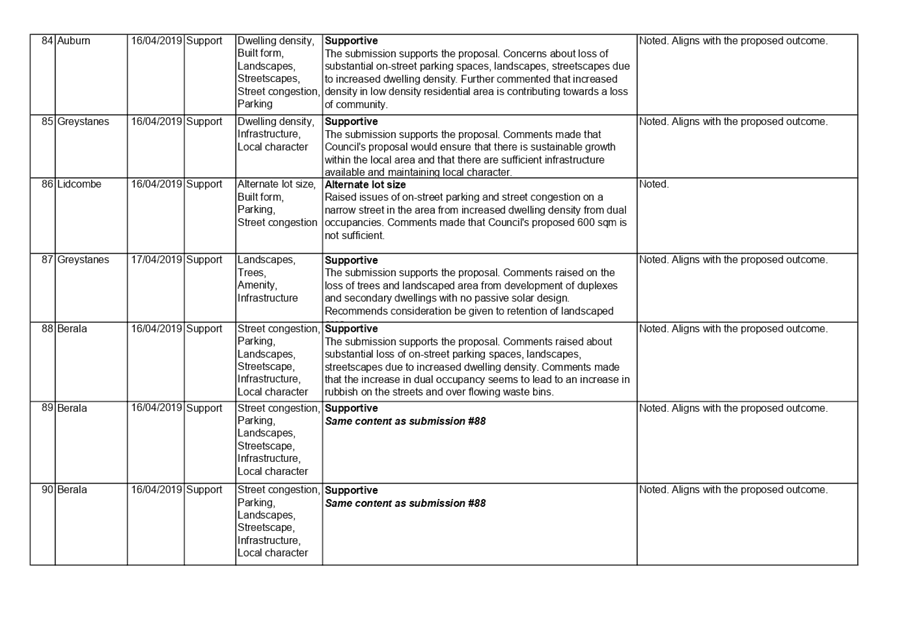
33.4%.
12.4%.
22.8%.
|
|
Part 3E - Deep soil zone Apartment Design Guide |
Minimum 7% of a site. |
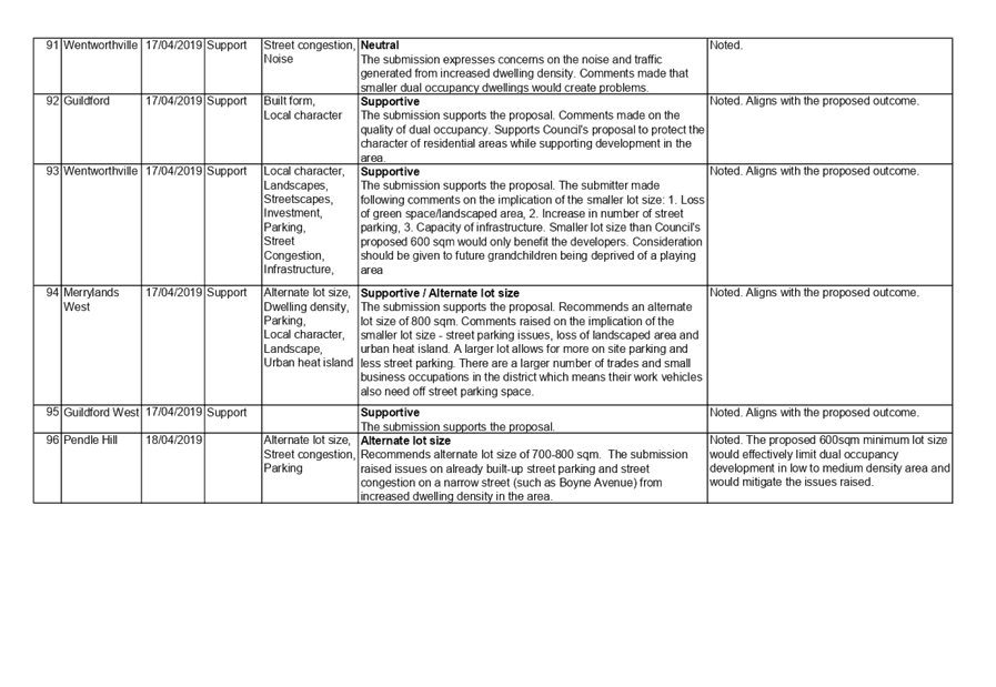
6.85% of the site. |
2.2%. |
|
Part 3F - Visual Privacy - Apartment Design Guide |
Separation between windows and balconies be provided to ensure visual privacy is achieved. |
Balconies of units U3.02 and 4.01 setback 4.6 to 6.6 metres from a bedroom and 7.6 metres from a kitchen window. |
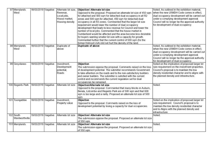
15.6%. |
|
Part 3.1 of the Parramatta DCP (Table B3.1.3.11) concerning site width. |
18 Metres. |
16.75 metres. |
1.25 metres or 9.3%. |
|
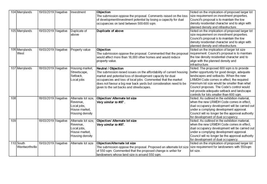
Part 3.3.3 of the Parramatta DCP (Visual privacy). |
A minimum building separation of 12 metres be provided between habitable rooms. |
7 metres. |
A variation of up to 5 metres exists (58.4%) |
4. The application is recommended for deferred commencement consent subject to conditions as provided in the attached schedule.
The development application is referred to the Panel as the proposal is considered to be sensitive development.
Report:
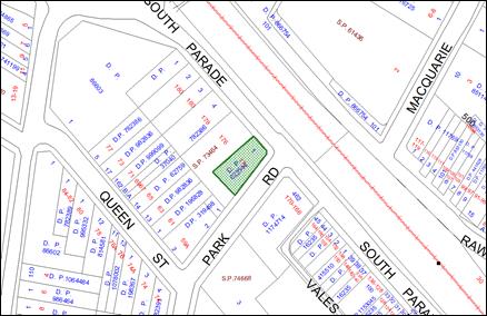
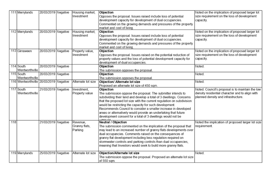
Subject Site and Surrounding Area
The site has the shape of a trapezoid but has varying dimensions as follows:-
· Northern boundary 42.295 metres.
· Southern boundary 43.975 metres.
· Eastern boundary 15.735 metres.
· Western boundary 16.75 metres.
This provides a site area of 674.5 metres.
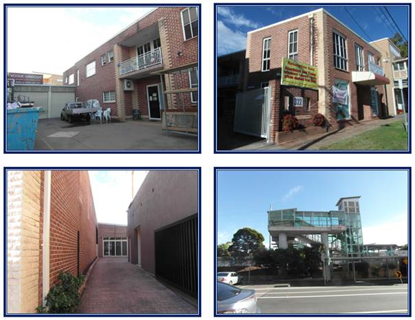
A two storey brick commercial / residential building exists on site. There is a single storey attached double garage at the rear and vehicle access is provided from Railway Terrace.
The site is within zone B4 Mixed use under the Parramatta Local Environmental Plan 2011.
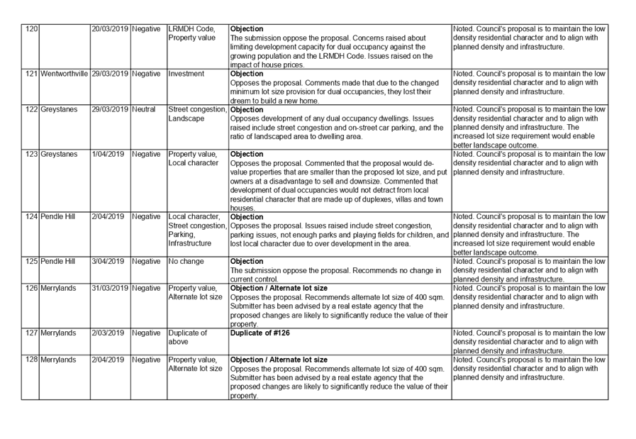
A number of site constraints are identified within the immediate locality surrounding the site as follows:-
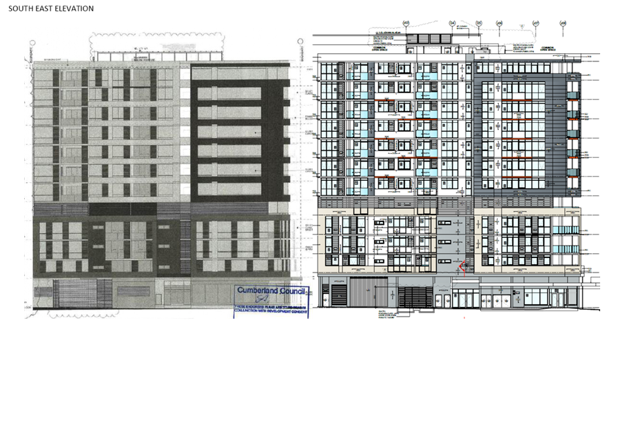
· Number 332 to the immediate south is a commercial premise but listed as a local heritage item - Number I232 being a former bakery shop.
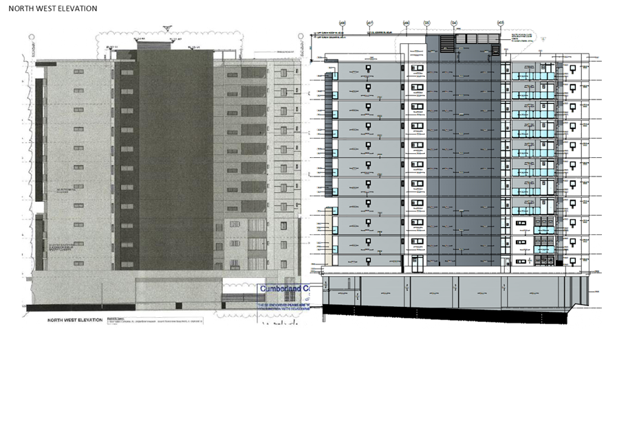
· Land to the rear at 11 to 13 Cross Street is within zone R4 (High Density Residential) and a residential apartment building has been constructed across that site. The building on that site is setback 7 metres from the rear property boundary.
· A five storey mixed use development has recently been constructed across number 320 Railway Terrace to the immediate north.
The site is within that part of the Guildford Town Centre that is undergoing change which is evident from the number of developments that have or are occurring.
The main street of Guildford is located less than 100 metres north of the site. The shopping centre supports two local supermarkets for local shopping needs for the residents.
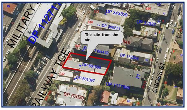
The location of the site is shown below.
The aerial photo of the site is shown below.
Photos of the site are provided below.
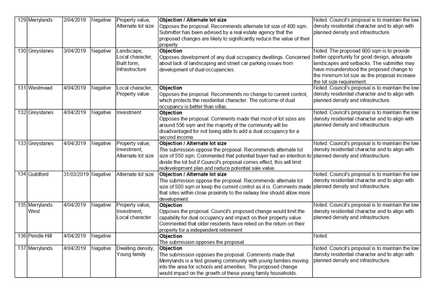
Description of the Proposed Development
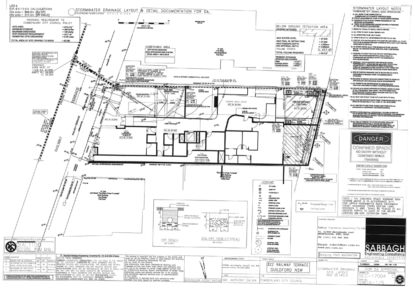
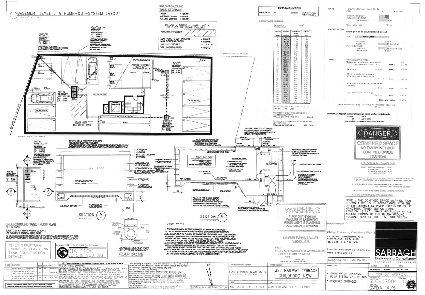
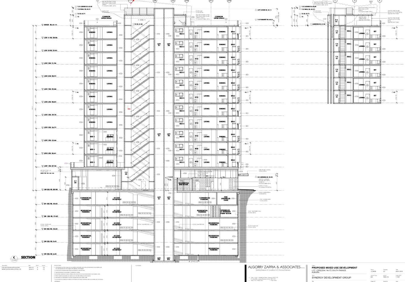
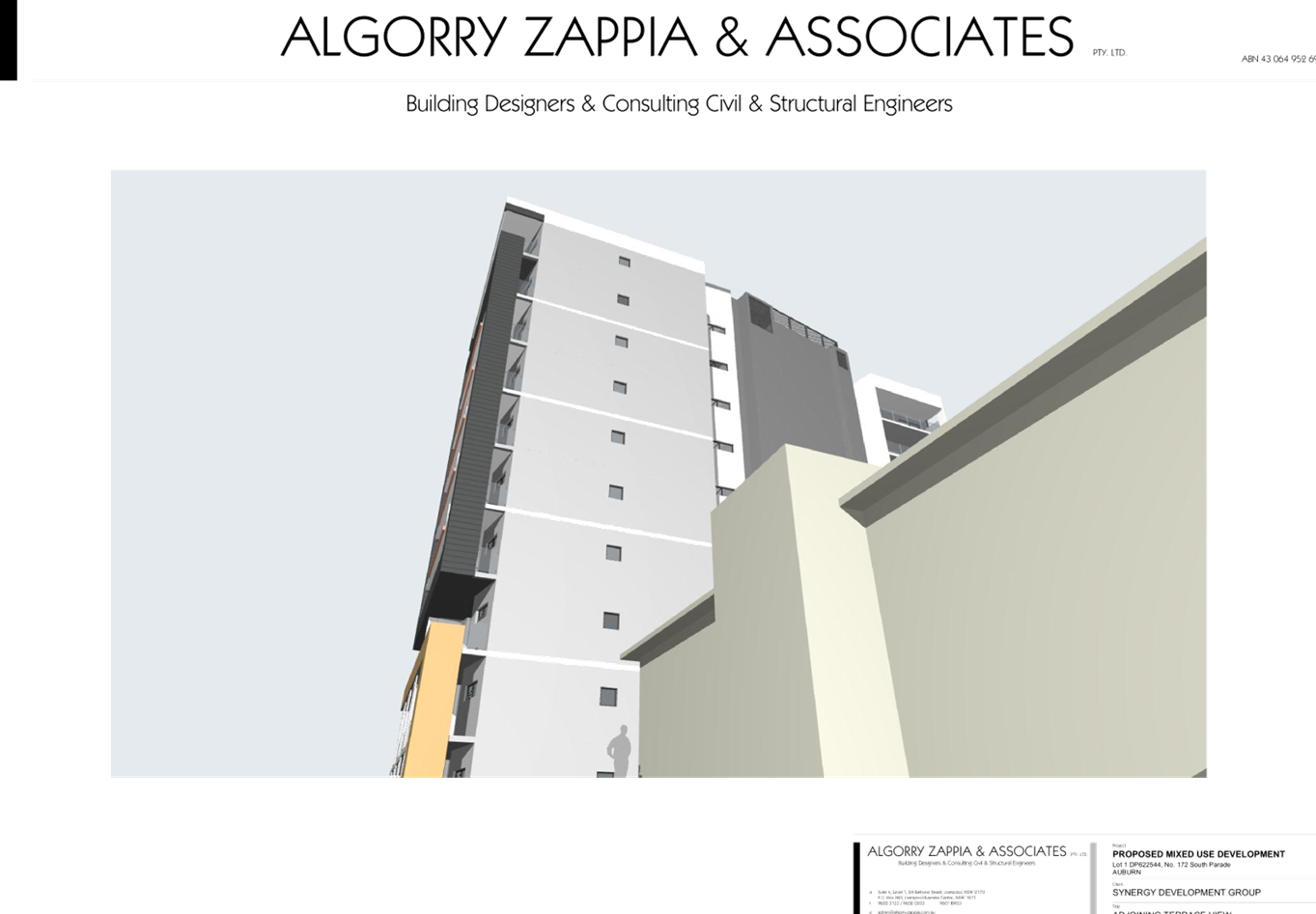
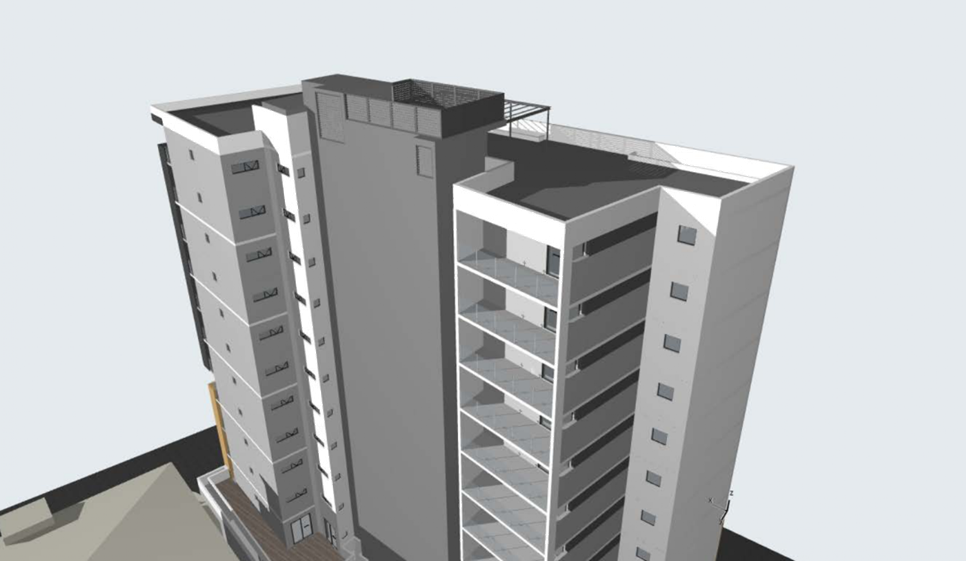
Development application Number 441/2017 is proposing the demolition of the existing buildings and construction of a five storey mixed use development encompassing commercial and residential uses on the ground floor with four levels of residential apartments above. A two storey (Split level) basement car park for eighteen (18) vehicles to support the development will also be constructed with vehicle access from Railway Terrace.
The following is proposed.
Demolition
The building on site will be demolished and excavation work will be undertaken. Excavation work is expected to extend down to 8.2 metres below the natural ground level to a minimum RL level of 19.04 metres AHD for the lift shaft.
Basement car park
A two level, split level basement car park will be constructed on site with room for the following:-
· Eighteen (18) vehicles. Of the total of eighteen spaces, two of the car spaces are earmarked for people with disabilities and two are designated for the commercial / retail unit.
· Provision of twelve storage cages.
· Provision for parking six bikes.
· Provision of a lift and stair access.
Construction of a five storey building
A five storey mixed use building is proposed to be constructed comprising of one commercial tenancy and twelve (12) apartments as follows:-
Ground floor
The ground floor comprises one commercial / retail tenancy occupying an area of 58.76 square metres and one two bedroom apartment at the rear.
The ground floor is also serviced with a separate bin store area for the residents and for the commercial / retail unit, a common open space area and lift access.
First floor
The first floor comprises 2 x 2 bedroom and 1 x 3 bedroom apartments including lift and stairwell access.
Second floor
The second floor comprises 3 x 2 bedroom apartments including lift and stairwell access.
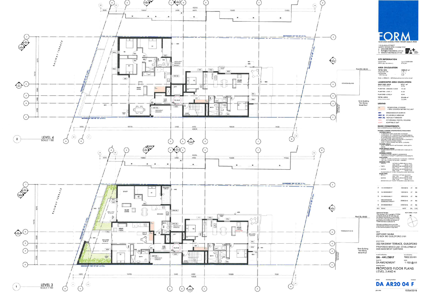
Third floor
The third floor comprises 1 x 1 bedroom apartments, 1 x 1 bedroom and study apartment and 1 x 2 bedroom apartment including lift and stairwell access.
Fourth floor (Top floor)
The fourth storey comprises 1 x 3 bedroom and 1 x 2 bedroom apartments. A lift and stairwell core is provided to level four.
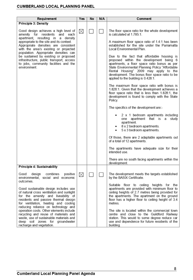
Number of apartments
There are twelve apartments within the development as follows:-
· 2 x 1 bedroom apartments.
· 8 x 2 bedroom apartments.
· 2 x 3 bedroom apartments.
Other features
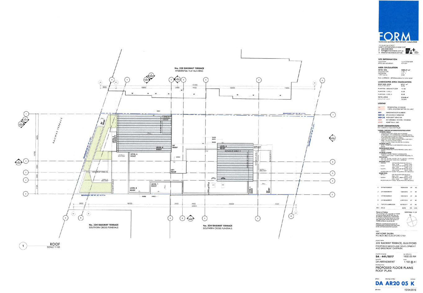
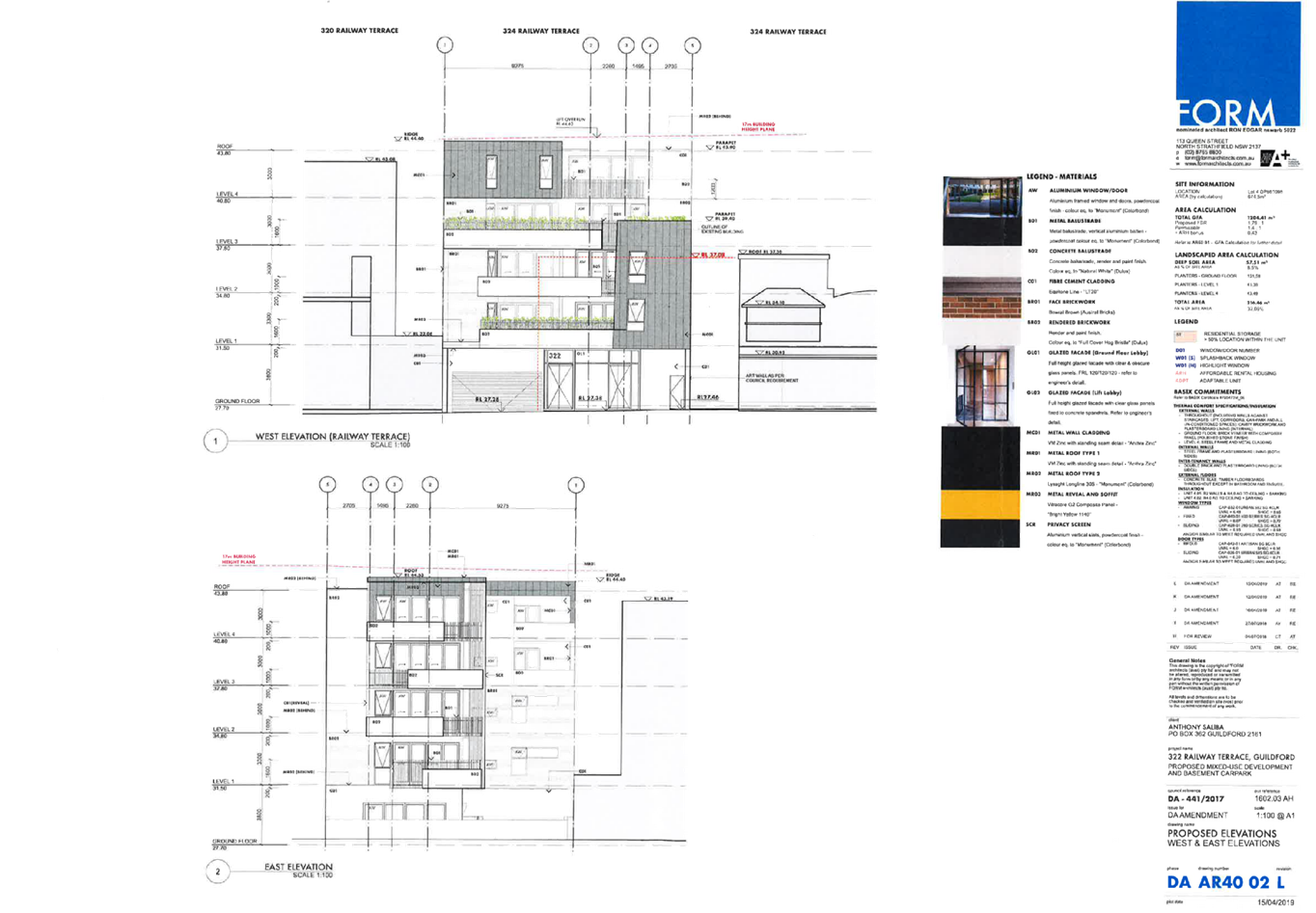
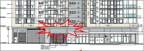
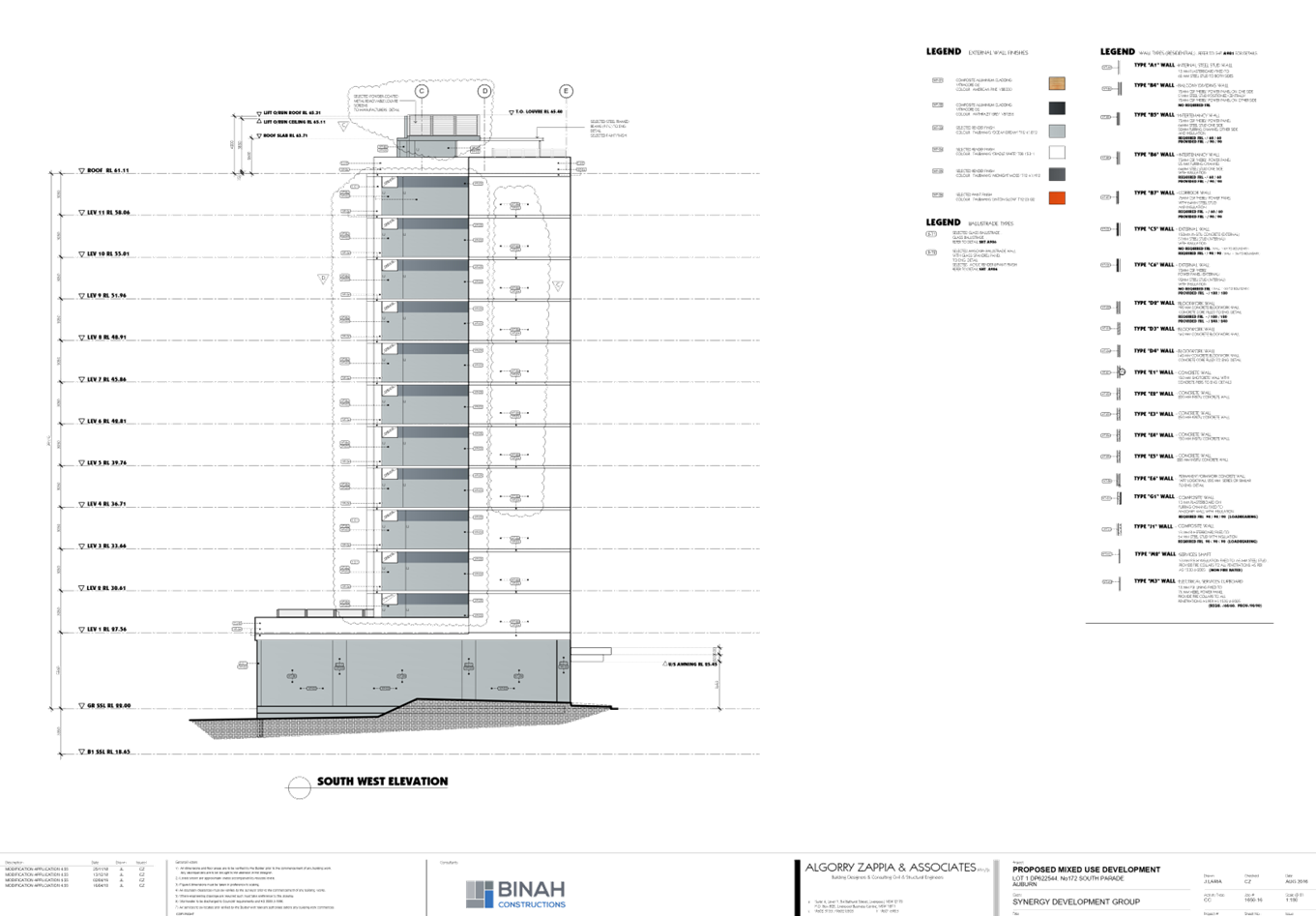
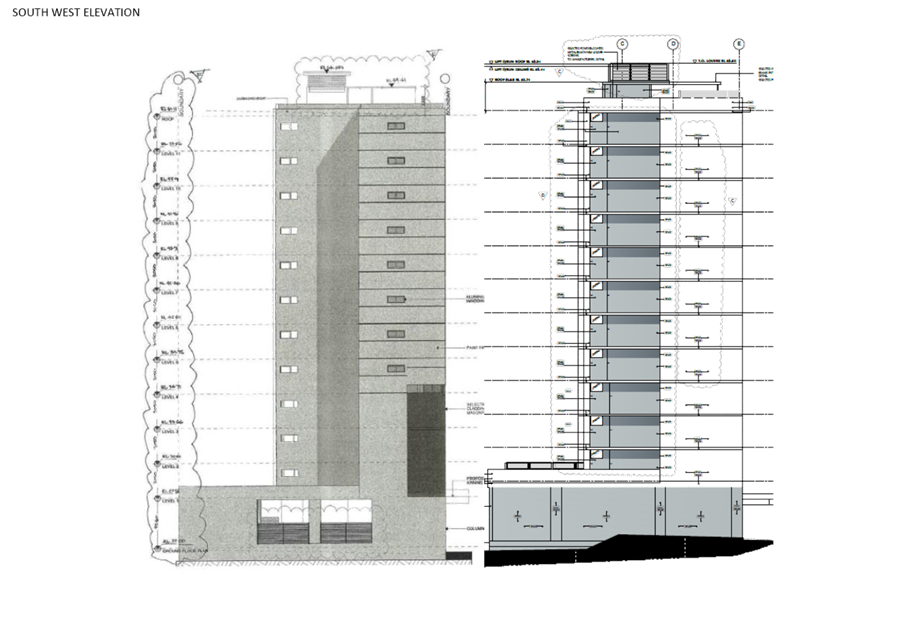
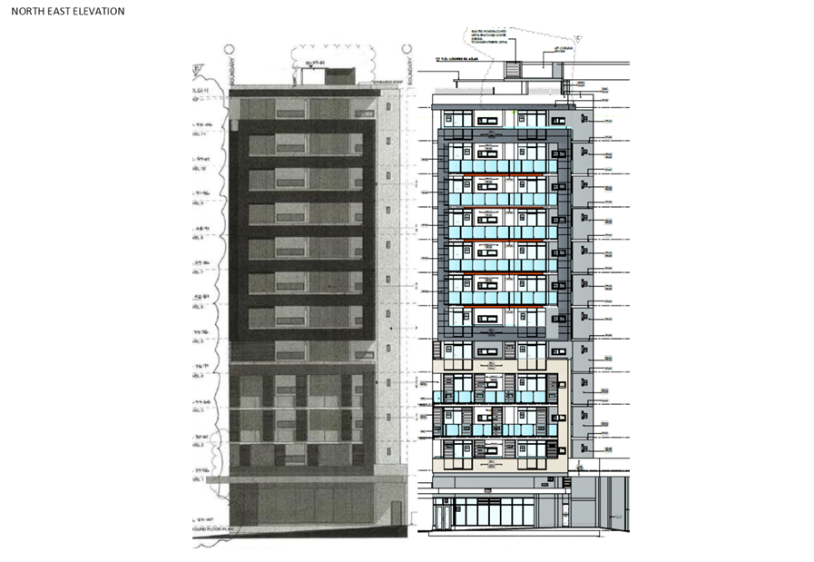
The development has a maximum height of 16.9 metres when measured from the natural ground level to the topmost roof ridge of the building and lift over run.
The proposed floor space ratio is 1.785:1. A higher floor space ratio is being requested because the development is supporting affordable housing under State Environmental Planning Policy “Affordable Rental Housing” 2009.
There is 515.8 square metres of floor area within the development that is designated as affordable rental housing comprising of six apartments. The affordable housing apartments are U1.01, U1.02, U2.01, U2.02, U 2.03 and U3.03.
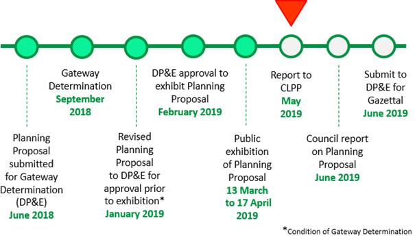
History
30 June 2016
A pre lodgement is held at Council where a number of issues were discussed including:-
· Permissibility of having affordable housing within a mixed use development.
· Floor space ratio.
· Height.
· Design and built form.
· Traffic issues within and external to the site.
19 October 2017
The development application is lodged to the Council for assessment and ultimately determination.
5 December 2017
Following extensive assessment, a number of issues were identified and correspondence was issued requesting the applicant to undertake certain modifications to the development to address matters of permissibility and compliance with the local planning controls.
The application was publicly notified to occupants and owners of nearby properties from December 5 2017 to 2 January 2018 and there were no submissions to the development sought.
27 July 2018
Modified concept plans were submitted to the Council on July 27 2018 for discussion purposes and advice.
24 August 2018
Modified architectural plans were lodged on August 24 2018 for assessment.
24 October 2018
Stormwater plans were lodged with Council for assessment.
5 February 2019
Following a meeting with the applicants engineers and Council engineers, further amendments were required to the ramp access.
The applicant lodged amended plans on February 11 2019 to address the engineering concerns.
11 April 2019
The applicant lodged amended plans addressing concerns raised at a meeting of Monday 1 April 2019. The plans are the subject of this report.
Applicants Supporting Statement
The applicant has provided a Statement of Environmental Effects prepared by Willana Associates and dated August 2017. This was received on 19 October 2017.
Contact with Relevant Parties
The assessing officer has undertaken a site inspection of the subject site and surrounding properties and has been in regular contact with the applicant throughout the assessment process.
Internal Referrals
The development application was referred to the following departments:-
Development Engineer
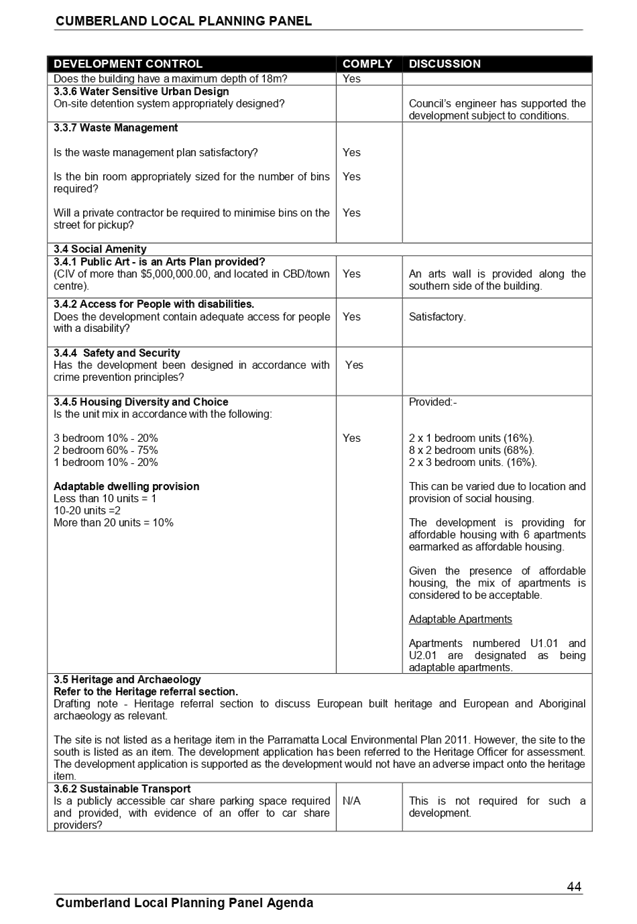
As per the memorandum dated 20 April 2019, the development application is supported subject to conditions. It is identified that the basement access ramp will require further minor modification being a reduction of the southern access ramp grade. This may be addressed as a condition (Proposed Condition 50) for approval by the panel.
Environment and Health
The development application was referred to Council’s Environment and Health Officer for comment who has advised that the development is satisfactory. The development is supported subject to conditions addressing demolition work, amenity, noise and waste management.
Heritage Officer
As per correspondence dated 7 December 2017, the proposed development:-
· Has a building line that is aligned with or set back to the heritage item.
· Uses a neutral or complimentary colours compared to the heritage item.
· Appears to use some building materials similar to that of the building at 320 Railway Terrace.
· The laneway provides a visual and physical break with the heritage item.
The development is considered as being acceptable from a heritage perspective and may be supported. There are no conditions provided by the heritage officer.
External Referrals
The development application was referred to Sydney Trains because concurrence consent is required as per Clause 86 of State Environmental Planning Policy “Infrastructure” 2007. As per written advice dated 27 July 2018, Sydney Trains will grant concurrence to the development proposed subject to deferred commencement conditions and subject to operational conditions. The conditions must be included into the consent otherwise Sydney Trains will not grant concurrence to the development application.
Planning Comments
The provisions of any Environmental Planning Instruments (EP&A Act s4.15 (1)(a)(i))
State Environmental Planning Policies
The proposed development is affected by the following State Environmental Planning Policies:
State Environmental Planning Policy “Infrastructure” 2007
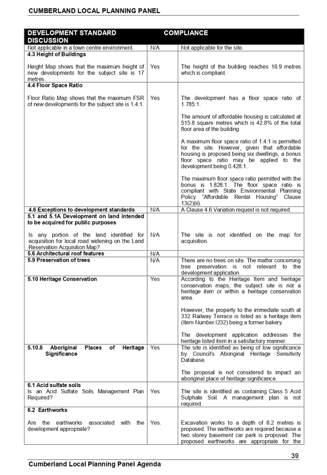
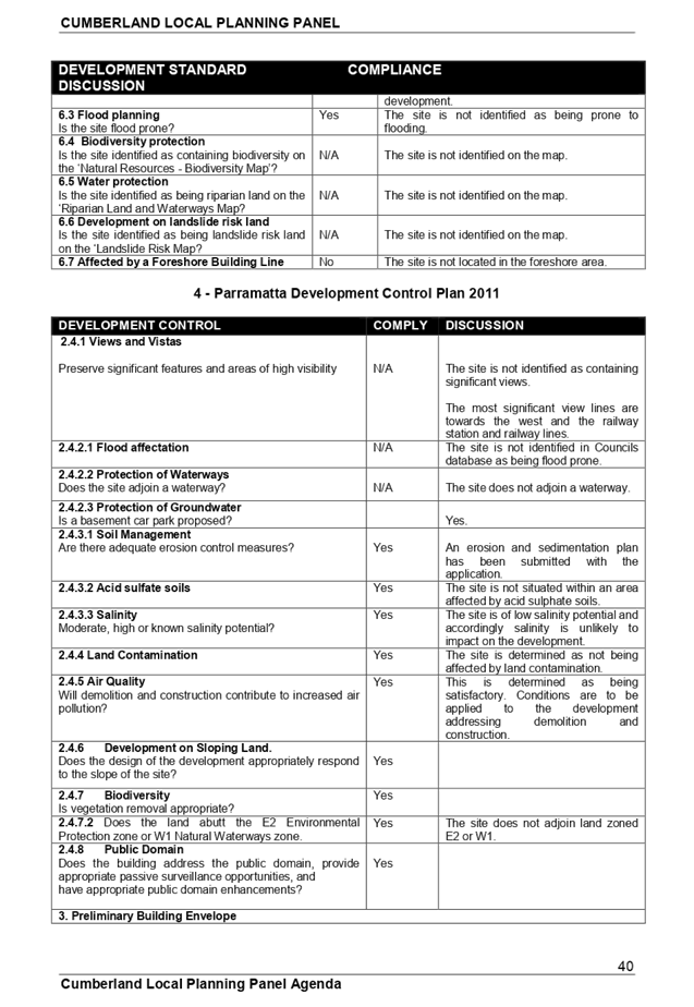
The provisions of SEPP (Infrastructure) 2007 have been considered in the assessment of the development application. The site is situated 20 metres from the rail corridor and as a result, Clause 85, 86 and 87 of State Environmental Planning Policy Infrastructure 2007 will apply to the development.
Clause 85 - Development immediately adjacent to rail corridors
The development application was referred to Sydney Trains for written advice on 5 December 2017. As per correspondence dated 27 July 2018, Sydney trains will grant concurrence to the development subject to conditions. The conditions provided address the use of a crane in the vicinity of the railway line.
Clause 86 - Excavation in, above or adjacent to rail corridors
The site is within 25 metres of the Rail corridor and excavation to a depth greater than 2 metres is occurring on site. As such, the development application requires concurrence from Sydney Trains. The development application has been referred to Sydney Trains for concurrence with the matter being addressed under Clause 85 above.
Clause 87 - Impact of rail noise or vibration on non-rail development
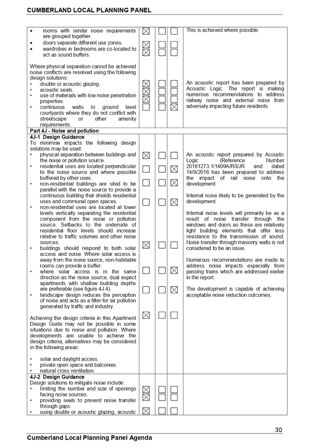
Clause 87 will apply to the development because the site is situated less than 25 metres from the rail corridor which is situated opposite the site on the western side of Railway Terrace.
There will be apartments facing the railway line and there will be an impact from passing trains.
The interim guidelines for ‘Development near Rail Corridors and Busy Roads’ Page 15 provides a guide to the level of assessment required when noise sensitive developments are located in the vicinity of rail lines. Zone A and B are indicative acoustic assessment zones where sensitive land uses are likely to be affected. The railway line is used for transporting freight and passengers. In this regard:-
· Zone A is 40 metres.
· Zone B is 80 metres.
The development falls within Zone A and a detailed noise assessment is required.
The matter of railway noise has been considered and an acoustic report has been prepared by Acoustic Logic and dated 14/9/2016. The report addresses noise in an appropriate manner and proposed condition 22(e) addresses noise in an appropriate manner.
State Environmental Planning Policy 55 “Remediation of Land”
The requirement at clause 7 of SEPP No. 55 for Council to be satisfied that the site is suitable or can be made suitable to accommodate the proposed development has been considered in the following table:-
|
Matter for Consideration |
Yes/No
|
|
|
Does the application involve re-development of the site or a change of land use? |
Yes No |
|
|
Is the development going to be used for a sensitive land use (eg: residential, educational, recreational, childcare or hospital)? |
Yes No |
|
|
Does information available to you indicate that an activity listed below has ever been approved, or occurred at the site? acid/alkali plant and formulation, agricultural/horticultural activities, airports, asbestos production and disposal, chemicals manufacture and formulation, defence works, drum re-conditioning works, dry cleaning establishments, electrical manufacturing (transformers), electroplating and heat treatment premises, engine works, explosive industry, gas works, iron and steel works, landfill sites, metal treatment, mining and extractive industries, oil production and storage, paint formulation and manufacture, pesticide manufacture and formulation, power stations, railway yards, scrap yards, service stations, sheep and cattle dips, smelting and refining, tanning and associated trades, waste storage and treatment, wood preservation |
Yes No
|
|
|
Is the site listed on Council’s Contaminated Land database? |
Yes No |
|
|
Is the site subject to EPA clean-up order or other EPA restrictions? |
Yes No |
|
|
Has the site been the subject of known pollution incidents or illegal dumping? |
Yes No |
|
|
Does the site adjoin any contaminated land/previously contaminated land? |
Yes No |
|
|
Details of contamination investigations carried out at the site:
A preliminary contamination assessment prepared by Geotechnique Pty Ltd and dated 20 January 2017 was submitted with the application. The report did not reveal any potential matters of concern with regard to contamination and concludes that the site is suitable for its intended use.
Council’s Environmental Health Officer has reviewed the reports and determined that the site is suitable to support such a development given that the report provides that the site is suitable for the proposed use. |
||
|
Has the appropriate level of investigation been carried out in respect of contamination matters for Council to be satisfied that the site is suitable to accommodate the proposed development or can be made suitable to accommodate the proposed development? |
Yes No |
|
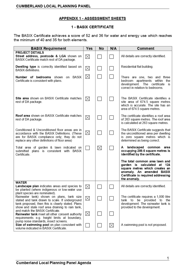
State Environmental Planning Policy “Building Sustainability Index” 2004
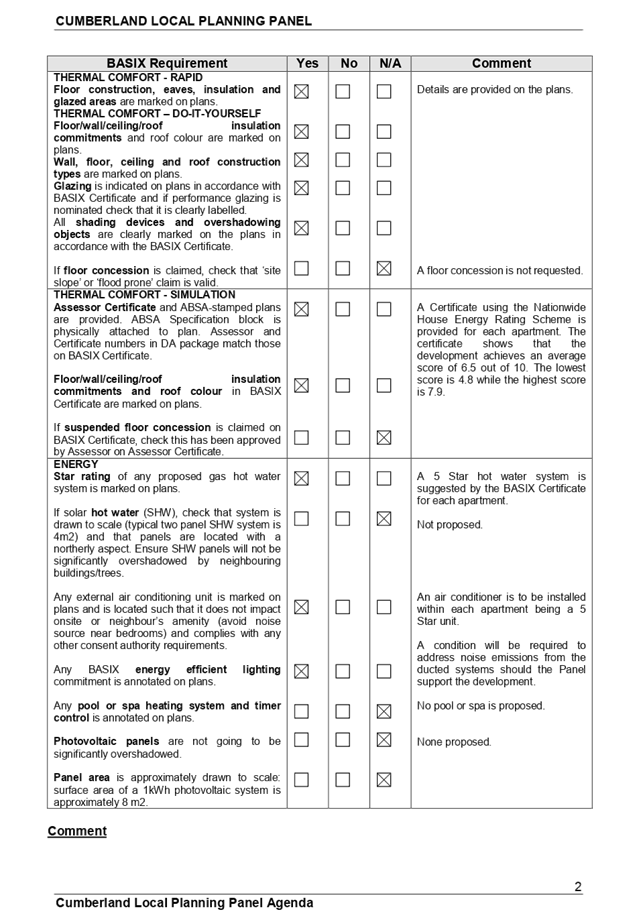
The BASIX Certificate has been assessed and determined as being mostly satisfactory. There is a minor anomaly relating to “common area landscape”. The matter is addressed is Condition 22(f) attached to the recommendation for approval by the Panel.
State Environmental Planning Policy “Affordable Rental Housing” 2009.
The relevant provisions are assessed below.
|
Yes |
No |
N/A |
Comment |
|
|
10 Development to which Division applies
(1) This Division applies to development for the purposes of dual occupancies, multi dwelling housing or residential flat buildings if:
(a) the development concerned is permitted with consent under another environmental planning instrument, and (b) the development is on land that does not contain a heritage item that is identified in an environmental planning instrument, or an interim heritage order or on the State Heritage Register under the Heritage Act 1977.
(2) Despite subclause (1), this Division does not apply to development on land in the Sydney region unless all or part of the development is within an accessible area.
(3) Despite subclause (1), this Division does not apply to development on land that is not in the Sydney region unless all or part of the development is within 400 metres walking distance of land within Zone B2 Local Centre or Zone B4 Mixed Use, or within a land use zone that is equivalent to any of those zones. |
|
|
|
The development is determined as being permitted with consent in the B4 Mixed Use zone under the Parramatta Local Environmental Plan 2011.
The land does not contain a heritage item. However, a heritage listed item is situated on land to the immediate south at 332 Railway Terrace.
The land is situated within an accessible area.
|
|
13 Floor space ratios
(1) This clause applies to development to which this Division applies if the percentage of the gross floor area of the development that is to be used for the purposes of affordable housing is at least 20 per cent. (2) The maximum floor space ratio for the development to which this clause applies is the existing maximum floor space ratio for any form of residential accommodation permitted on the land on which the development is to occur, plus: (a) if the existing maximum floor space ratio is 2.5:1 or less: (i) 0.5:1—if the percentage of the gross floor area of the development that is used for affordable housing is 50 per cent or higher, or (ii) Y:1—if
the percentage of the gross floor area of the development that is used for
affordable housing is less than 50 per cent, AH is the percentage of the gross floor area of the development that is used for affordable housing. Y = AH ÷ 100 or (b) if the existing maximum floor space ratio is greater than 2.5:1: (i) 20 per cent of the existing maximum floor space ratio—if the percentage of the gross floor area of the development that is used for affordable housing is 50 per cent or higher, or (ii) Z per
cent of the existing maximum floor space ratio—if the percentage of the
gross floor area of the development that is used for affordable housing is
less than 50 per cent, AH is the percentage of the gross floor area of the development that is used for affordable housing. Z = AH ÷ 2.5 (3) In this clause, gross floor area does not include any car parking (including any area used for car parking). Note.
Other areas are also excluded from the gross floor area, see the definition of gross floor area contained in the standard instrument under the Standard Instrument (Local Environmental Plans) Order 2006. |
|
|
|
The development has a floor space ratio of 1.785:1.
The amount of affordable housing is calculated at 515.8 square metres which is 42.8% of the total floor area of the building.
A maximum floor space ratio of 1.4:1 is permitted for the site. However, given that affordable housing is proposed being six dwellings, a bonus floor space ratio may be applied to the development being 0.428:1.
The maximum floor space ratio with the bonus is 1.828:1.
The development is compliant with the floor space ratio provision.
This is noted. |
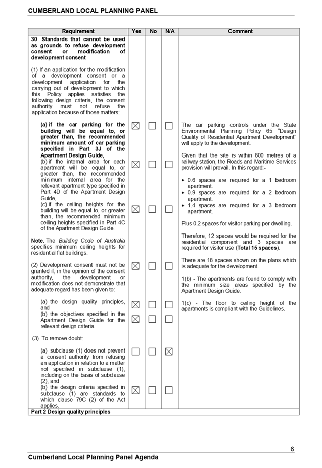
|
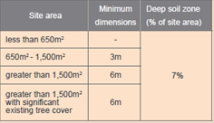
14 Standards that cannot be used to refuse consent (1) Site and solar access requirements A consent authority must not refuse consent to development to which this Division applies on any of the following grounds: (a) (Repealed) (b) site area if the site area on which it is proposed to carry out the development is at least 450 square metres, (c) landscaped area if: (i) in the case of a development application made by a social housing provider—at least 35 square metres of landscaped area per dwelling is provided, or (ii) in any other case—at least 30 per cent of the site area is to be landscaped, (d) deep soil zones if, in relation to that part of the site area (being the site, not only of that particular development, but also of any other associated development to which this Policy applies) that is not built on, paved or otherwise sealed: (i) there is soil of a sufficient depth to support the growth of trees and shrubs on an area of not less than 15 per cent of the site area (the deep soil zone), and (ii) each area forming part of the deep soil zone has a minimum dimension of 3 metres, and (iii) if practicable, at least two-thirds of the deep soil zone is located at the rear of the site area,
(e) solar access if living rooms and private open spaces for a minimum of 70 per cent of the dwellings of the development receive a minimum of 3 hours direct sunlight between 9am and 3pm in mid-winter. |
|
|
|
The site occupies an area of 674.5 square metres.
Subclause (b)(i) will not apply to the development because the applicant is not a social housing provider.
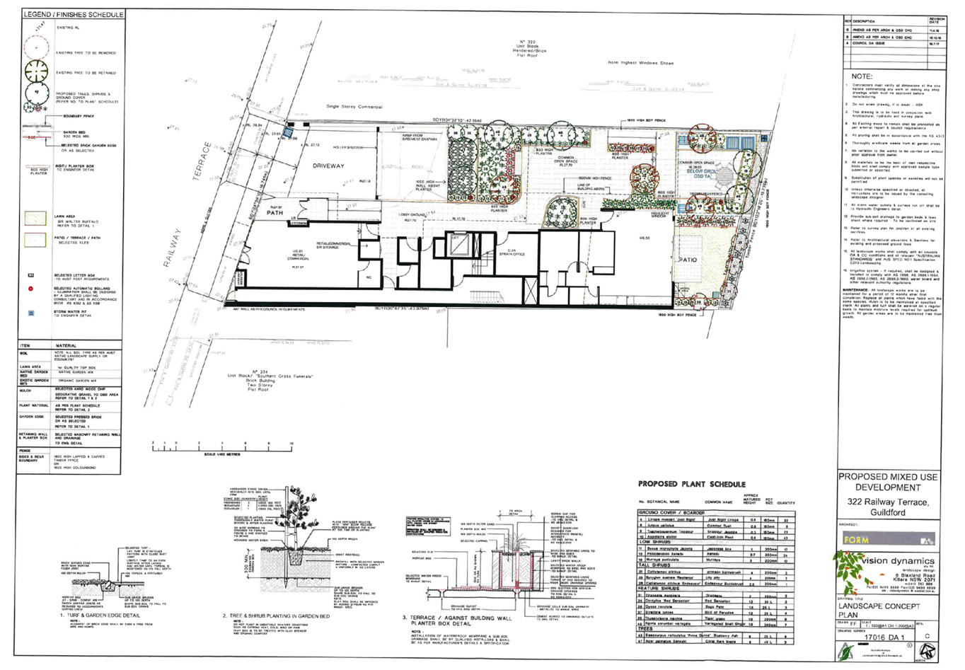
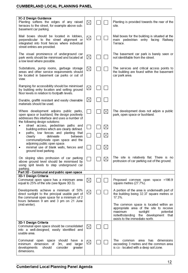
At least 124 square metres (18.38%) of the site is landscaped. The variation is 38.6%
The deep soil zone on site occupies 46.2 square metres or 6.85% of the site. The variation is 54.3%.
Comments on landscaping and deep soil:
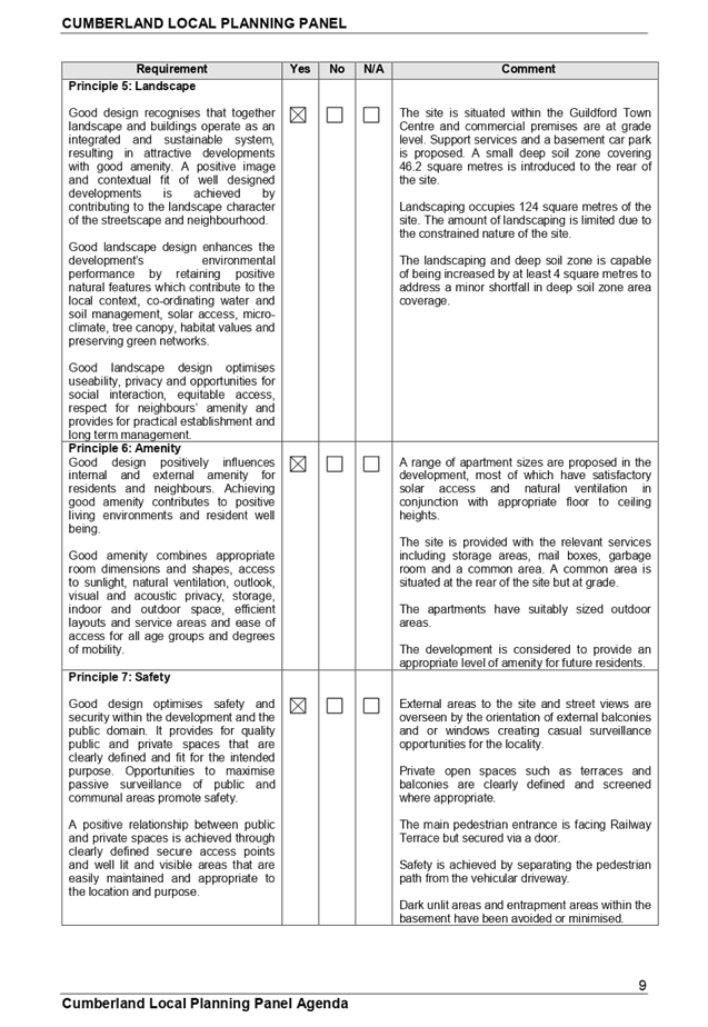
The site is situated within a commercial strip with a zero front setback. Development along Railway Terrace has little or no landscaped area at the front or rear. The development is introducing landscaping into the site and consistent with the newer developments within the locality.
Furthermore, the site is within a town centre location where it is difficult to provide landscaping and deep soil zone at grade.
This development provides adequate amenity and services for the residents and as such, it is considered appropriate to support the variation identified.
Additionally, the Apartment Design Guide requires a minimum of 7% of a site to be landscaped as deep soil zone and it is identified that compliance with this provision is almost achieved. |
|
14 Standards that cannot be used to refuse consent
(2) General A consent authority must not refuse consent to development to which this Division applies on any of the following grounds: (a) parking if: (i) in the case of a development application made by a social housing provider for development on land in an accessible area—at least 0.4 parking spaces are provided for each dwelling containing 1 bedroom, at least 0.5 parking spaces are provided for each dwelling containing 2 bedrooms and at least 1 parking space is provided for each dwelling containing 3 or more bedrooms, or (ii) in any other case—at least 0.5 parking spaces are provided for each dwelling containing 1 bedroom, at least 1 parking space is provided for each dwelling containing 2 bedrooms and at least 1.5 parking spaces are provided for each dwelling containing 3 or more bedrooms,
(b) dwelling size if each dwelling has a gross floor area of at least:- (i) 35 square metres in the case of a bedsitter or studio, or (ii) 50 square metres in the case of a dwelling having 1 bedroom, or (iii) 70 square metres in the case of a dwelling having 2 bedrooms, or (iv) 95 square metres in the case of a dwelling having 3 or more bedrooms. (3) A consent authority may consent to development to which this Division applies whether or not the development complies with the standards set out in subclause (1) or (2). |
|
|
|
The development application is not made by a social housing provider.
Parking required:
2 x 1br = 1.2 spaces. 8 x 2br = 7.2 spaces. 2 x 3br = 2.8 spaces.
12 resident spaces are required. 3 visitor spaces required as per ADG.
Minimum 15 spaces required for the residential portion of the development. There are 18 spaces shown on the plans. There is adequate car parking provided for the development.
|
|
16A Character of local area
A consent authority must not consent to development to which this Division applies unless it has taken into consideration whether the design of the development is compatible with the character of the local area. |
|
|
|
See discussion below.
|
|
17 Must be used for affordable housing for 10 years (1) A consent authority must not consent to development to which this Division applies unless conditions are imposed by the consent authority to the effect that: (a) for 10 years from the date of the issue of the occupation certificate: (i) the dwellings proposed to be used for the purposes of affordable housing will be used for the purposes of affordable housing, and (ii) all accommodation that is used for affordable housing will be managed by a registered community housing provider, and (b) a restriction will be registered, before the date of the issue of the occupation certificate, against the title of the property on which development is to be carried out, in accordance with section 88E of the Conveyancing Act 1919, that will ensure that the requirements of paragraph (a) are met. (2) Subclause (1) does not apply to development on land owned by the Land and Housing Corporation or to a development application made by, or on behalf of, a public authority. |
|
|
|
Proposed Conditions 18, 19 and 20 attached to the Recommendation addresses such matters for approval by the Panel.
|
|
18 Subdivision
Land on which development has been carried out under this Division may be subdivided with the consent of the consent authority. |
|
|
|
Strata subdivision of the development is not proposed under this application. |
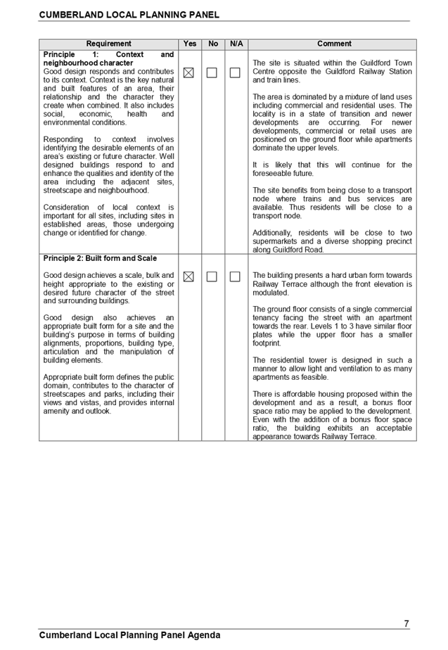
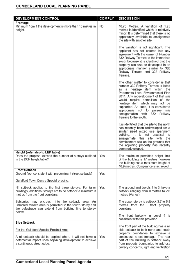
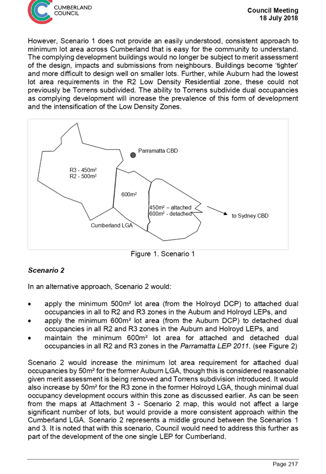
Clause 16A - Character of local area:
The SEPP requires Council to consider whether the design of the development is compatible with the character of the local area. There are no guidelines associated with the SEPP to provide Council with guidance in the determination of what is compatible development with the character of the local area. However, the Land and Environment Court has issued a planning principle on this matter that is a useful guide for the purposes of this assessment. The character assessment for the current proposal is provided in the following section:-
Part A - Identify the local area
The local area for the purposes of this application is shown on the zoning map below:-
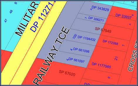
The Guildford Railway Station lies to the west of Railway Terrace and the Guildford Town Centre lies to the north. Land to the east is within zone R4 High density Residential and apartment buildings are changing the landscape character of the locality.
Part B - Determine the character of the local area.
The site is within the B4 Mixed Use zone and land to the east is within the R4 High Density Residential zone. The area is in a state of transition and there are properties not yet developed in accordance with the density standards. The predominant building type along Railway Terrace is mixed use with commercial premises on the ground floor and residential accommodation on the upper levels. Further to the north, commercial and retail properties dominate.
The pattern of development along Railway Terrace is a street wall with zero side setbacks and zero or minimal front setbacks which is common for a suburban commercial shopping area. The proposed development will maintain the setback pattern.
Part C - Determine if development is compatible with the character of the local area.
Compatibility within the urban environment is an issue that has been given detailed consideration by the Land and Environment Court. In the decision of Project Ventures Development Pty Limited and Pittwater Council, the Senior Commissioner of the Court was asked to consider the process of deciding whether a building is compatible with its surroundings. This led to the development of a Planning Principle that planners could refer to as a guide on this particular issue.
The planning principle states there are two important aspects of compatibility that need to be satisfied:
1. Are the proposal’s physical impacts on surrounding development acceptable?
Physical impacts generally include noise, overlooking, overshadowing and constraining development potential.
In terms of the physical impacts of the development, the following points are made:
a) Noise impacts are reduced through siting usable communal areas to the rear away from the street.
b) Privacy impacts to the adjoining developments especially to the north are generally mitigated.
c) The proposal will not impact on the development potential of adjoining sites by unduly constraining them through site design.
d) The subject site has an east to west orientation. Submitted shadow diagrams show that the shadows will fall across a commercial site. There are no adverse shadow impacts to residential properties.
2. Is the proposal’s appearance in harmony with the buildings around it and the character of the street?
It is identified that the locality is being transformed to higher density living. This is occurring because the area is or adjacent to a town centre with train and bus services being available. It is considered that the development is appropriate for the locality and for the town centre.
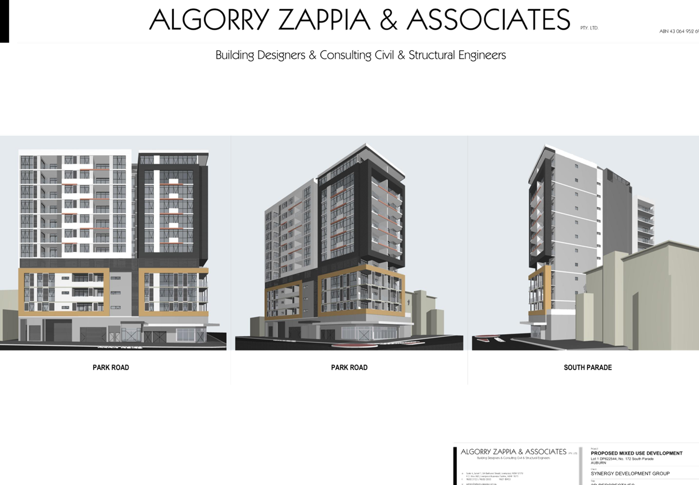
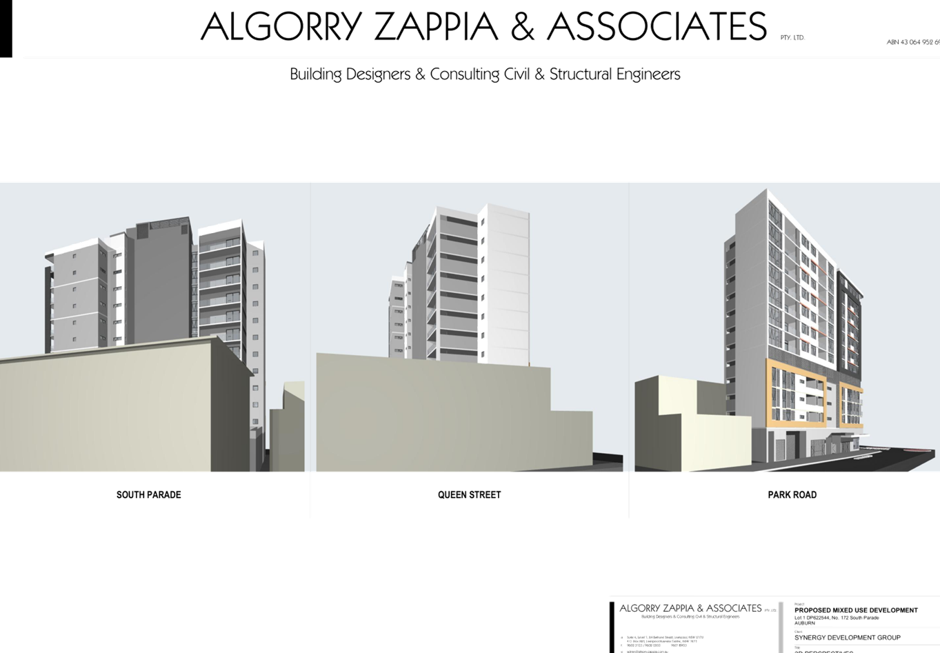
To be considered compatible, a development should contain or at least respond to the essential elements that make up the character of the surrounding area. It is identified that newer developments along Railway Terrace are permitted to be 5 storeys in height or 17 metres. Furthermore, developments to the rear facing Cross Street are also permitted to be 17 metres in height.
The proposed building is consistent with the height limit imposed for the site.
The top two storeys are recessed further from the street to reduce its prominence within the streetscape and to introduce a variation to the design. There are variations to the building separation controls contained within the Apartment Design Guide but the variations have been minimised as much as possible given the constraints of the site. The development is also found to respect the heritage listed shop to the south at 332 Railway Terrace.
It is concluded that the development is compatible with the locality.
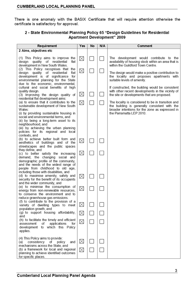
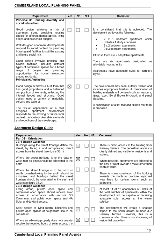
Statement Environmental Planning Policy No. 65 - Design Quality of Residential Apartment Development (SEPP 65)
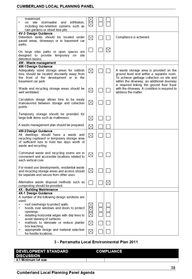
State Environmental Planning Policy 65 - “Design Quality of Residential Apartment Development” applies to the development because the building is 3 or more storeys in height and contains more than 4 dwellings. A design statement addressing the design quality principles prescribed by SEPP 65 has been prepared by the project architect. Integral to SEPP 65 is the Apartment Design Guide (ADG), which sets benchmarks for the appearance, acceptable impacts and residential amenity of the development as shown below. A detailed assessment is at Appendix A.
|
Design Criteria |
Compliance |
Comment |
|
|
Part 2 |
|||
|
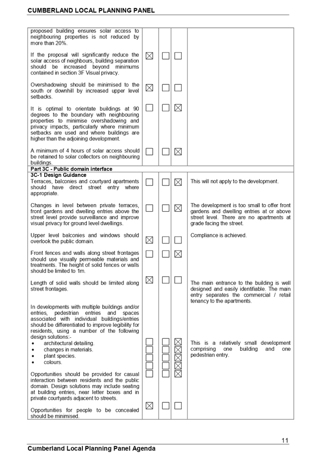
2F Building Separation |
|||
|
Separation - Building separation is measured from the outer face of building envelopes which includes balconies Note: Where applying separation to buildings on adjoining sites, apply half the minimum separation distance measured to the boundary. This distributes the building separation equally between sites. |
|||
|
Up to 4 storeys (approximately 12m): · 12m between habitable rooms/balconies; · 9m between habitable and nonhabitable rooms; and · 6m between nonhabitable rooms Up to 8 storeys (approximately 25m): · 18m between habitable rooms/balconies; · 12m between habitable and nonhabitable rooms; and · 9m between nonhabitable rooms
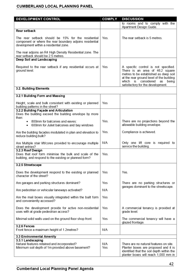
Rear setback
At the boundary between a change in zone from apartment buildings to a lower density area, building separation should be increased by 3 metres.
Up to four storeys (approximately 12 metres)
· 15m between habitable rooms / balconies; · 12m between habitable and non-habitable rooms; and 9m between non-habitable rooms.
Five to eight storeys (approximately 25 metres):
· 21m between habitable rooms / balconies; · 15m between habitable and non-habitable rooms; and 12m between non-habitable rooms.
(Apply half the minimum separation). |
Yes
Yes
Yes
Yes
No
No
Yes
Yes
Yes
Yes
No
No
Yes
No
No
Yes
No
No Yes Yes No
|
To the Southern boundary
Ground floor - 0 metres for the ground floor with a solid wall situated on the boundary.
Levels to 1 - 3 on the boundary with a solid wall.
A corridor is setback 3 metres from the southern boundary and features obscured glazed panel.
Level 4 is on the boundary with a solid wall featuring to the south.
A balcony on Level 1 at the rear attached to Apartment U1.03 is setback 4 metres (Variation 33.3%).
The balconies on Level 2, 3 and 4 attached to the rear are setback 2.8 metres from the southern boundary (Variation 46% to 69%).
To the Northern boundary
Ground floor - 6.8 metres for the habitable room being a solid wall and 8.6 metres for the bedrooms.
Levels 1, 2 and 3
Apartments U1.02, U2.02 and U3.02 are on the boundary and solid walls feature.
Living area windows of Apartments U1.03, U2.03 and U3.03 are setback 7 metres.
The windows kitchens of Apartments U2.03, U3.03 are setback 6.4 metres.
Bedroom windows of Apartments U1.03, U2.03 and U3.03 are setback 6.4 metres.
Level 4 Apartment U4.02
Living area window is setback 7 metres from the boundary (Variation is 22%).
The kitchen window of the apartment is setback 6.4 metres from the boundary (Variation 28.8%).
A bedroom window is setback 6.4 metres from the boundary.
Balconies for Levels 1 to 4
Balconies of apartments U1.03, U2.03, U3.03 and U4.02 are setback 5.9 metres (Variation 1.7% to 34.5%).
Rear of the building
Ground floor 5 metres to boundary and 12 metres to adjoining building (Variation 33.4%).
Levels 1 to 3 apartments - 7.6 to 9.5 metres.
Level 4 apartment - 9.2 metres (Variation 12.4%).
Balconies
Level 1 - 5.9 metres (Variation 21.3%). Level 2 - 7.7 metres. Level 3 - 8.1 metres. Level 4 - 8.1 metres (Variation 22.8%).
Comments
The applicant has achieved an appropriate level of compliance given the width and location of the site within the Guildford Town Centre.
The building at 320 Railway Terrace to the north has been built with habitable rooms facing south at a distance of 3 to 4 metres from the southern property boundary which did not comply with the Residential Flat Design Code building separation requirements which has compromised compliance.
If this application were to be supported, appropriate louvres would be required for certain balconies to address privacy. |
|
|
Part 3 |
|||
|
3C Public domain interface |
|||
|
Objective 3C-1 Transition between private and public domain is achieved without compromising safety and security. |
Yes
|
Appropriate delineation between the private and public domain is provided. In this regard, there is a door separating the public and private domain. The secure door would be accessible to residents of the building. |
|
|
3D Communal and public open space |
|||
|
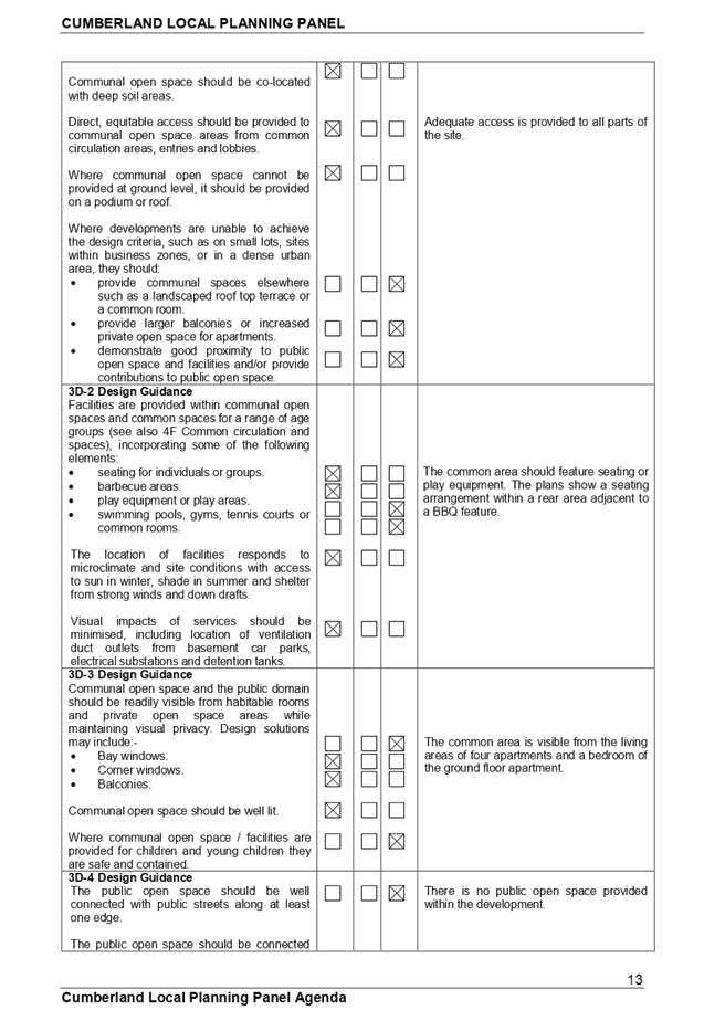
COS should have a minimum dimension of 3m. Where COS cannot be provided at ground level, it should be provided on a podium or roof. |
|||
|
Design criteria · Communal open space has a minimum area equal to 25% of the site (see figure 3D.3) · Developments achieve a minimum of 50% direct sunlight to the principal usable part of the communal open space for a minimum of 2 hours between 9 am and 3 pm on 21 June (mid winter) |
Yes
Yes
|
Proposed common open space = 186.9 square metres (27.7%).
A portion of the area is underneath part of the building being 32.37 square metres or 17.3%.
|
|
|
3D1 Direct equitable access should be provided to communal open space areas from common circulation areas, entries and lobbies. |
Yes |
All parts of the site have appropriate access. |
|
|
3E Deep soil zones |
|||
|
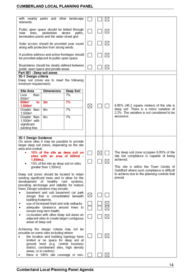
Design criteria 1. Deep soil zones are to meet the following minimum requirements:
|
No.
|
6.85% (46.2 square metres) of the site is deep soil zone.
The deep soil zone has dimensions of 3 metres x 3 metres.
Comments
The matter has been addressed within Clause 14 of State Environmental Planning Policy “Affordable Rental Housing” 2009 above. In this regard, it is considered appropriate to support the development as the variation is calculated at 2.2% which is minor. |
|
|
3F Visual privacy |
|||
|
Separation - Building separation is measured from the outer face of building envelopes which includes balconies Note: Where applying separation to buildings on adjoining sites, apply half the minimum separation distance measured to the boundary. This distributes the building separation equally between sites. Separation between windows and balconies is provided to ensure visual privacy is achieved. Adjoining a different zone with a less density, add 3.0m. Retail, office spaces and commercial balconies use habitable room separation. No separation is required between blank walls. |
|||
|
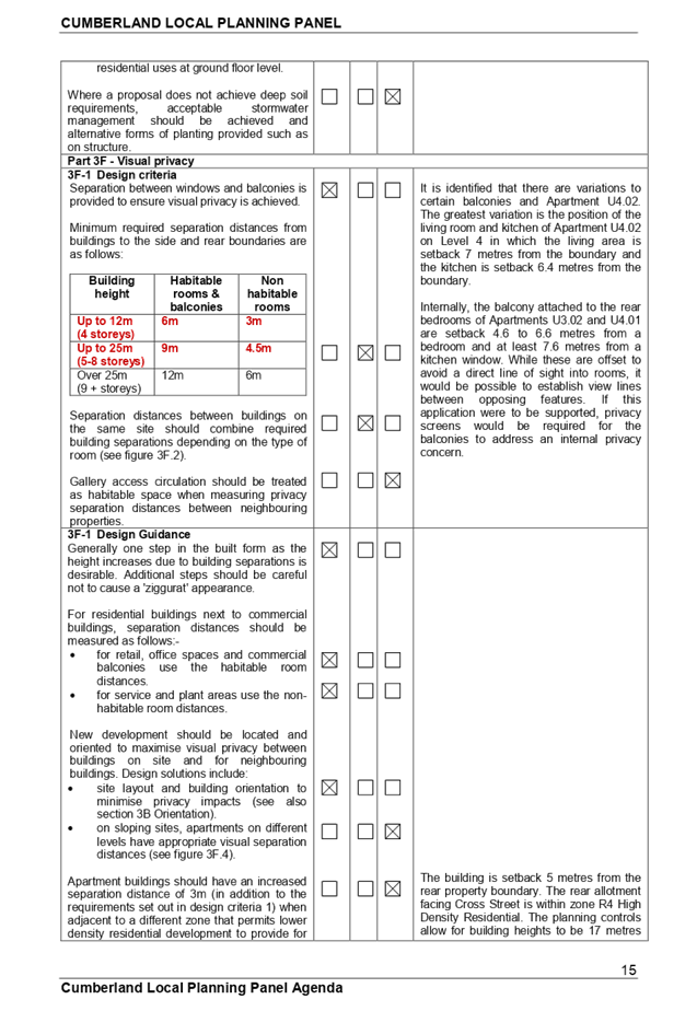
Design criteria 1. Separation between windows and balconies is provided to ensure visual privacy is achieved. Minimum required separation distances from buildings to the side and rear boundaries are as follows:
Note: Separation distances between buildings on the same site should combine required building separations depending on the type of room (see figure 3F.2) Gallery access circulation should be treated as habitable space when measuring privacy separation distances between neighbouring properties. |
No
|
Building separation to the adjoining allotments is addressed in detail under 2F above. It is identified that there are variations to certain balconies and Apartment U4.02. The greatest variation is the position of the living room and kitchen windows of Apartment U4.02 on Level 4 in which the living area is setback 7 metres from the boundary and the kitchen is setback 6.4 metres from the boundary.
Internally, the balcony attached to the rear bedrooms of Apartments U3.02 and U4.01 are setback 4.6 to 6.6 metres from a bedroom and at least 7.6 metres from a kitchen window. While these are offset to avoid a direct line of sight into rooms, it would be possible to establish view lines between opposing features. Proposed condition 40 attached to the recommendation addresses such matters. |
|
|
Bedrooms, living spaces and other habitable rooms should be separated from gallery access and other circulation space by the apartments service areas. |
Yes |
The north facing ground floor bedroom windows of the ground floor apartment are facing towards the external apartment entry area which in turn faces the common space. The private outdoor space is fenced by a fence and gate 1.8 metres in height. |
|
|
3J Bicycle and car parking |
|||
|
Objective 3J-1 Car parking is provided based on proximity to public transport in metropolitan Sydney and centres in regional areas Design criteria 1. For development in the following locations: · on sites that are within 800 metres of a railway station or light rail stop in the Sydney Metropolitan Area; or · on land zoned, and sites within 400 metres of land zoned, B3 Commercial Core, B4 Mixed Use or equivalent in a nominated regional centre the minimum car parking requirement for residents and visitors is set out in the Guide to Traffic Generating Developments, or the car parking requirement prescribed by the relevant council, whichever is less The car parking needs for a development must be provided off street. |
Yes |
The development application is not made by a social housing provider.
Parking required:
2 x 1br = 1.2 spaces. 8 x 2br = 7.2 spaces. 2 x 3br = 2.8 spaces.
12 resident spaces are required. 3 visitor spaces required as per ADG.
Minimum 15 spaces required for the development. There are 18 spaces shown on the plans. There is adequate car parking provided for the development. |
|
|
Part 4 |
|||
|
4A Solar and daylight access |
|||
|
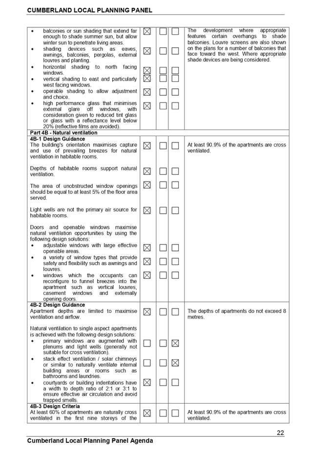
Design criteria 1. Living rooms and private open spaces of at least 70% of apartments in a building receive a minimum of 2 hours direct sunlight between 9 am and 3 pm at mid winter in the Sydney Metropolitan Area and in the Newcastle and Wollongong local government areas. 2. In all other areas, living rooms and private open spaces of at least 70% of apartments in a building receive a minimum of 3 hours direct sunlight between 9 am and 3 pm at mid winter 3. A maximum of 15% of apartments in a building receive no direct sunlight between 9 am and 3 pm at mid winter. |
Yes
N/A
Yes
|
90.9% (11 of 12) of units receive at least 2 hours mid winter. The proposal is consistent with the remaining objectives of this part of the ADG ensuring that daylight access is satisfactory.
9.1% of the apartments (1 apartment) will receive less than 2 hours of sunlight at the winter solstice. |
|
|
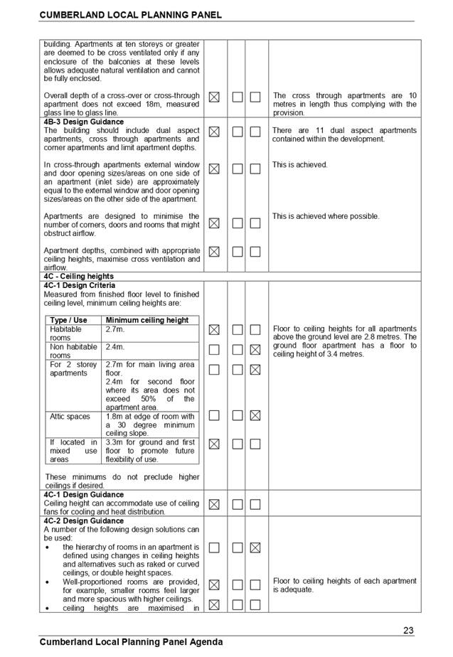
Design criteria 1. At least 60% of apartments are naturally cross ventilated in the first nine storeys of the building. Apartments at ten storeys or greater are deemed to be cross ventilated only if any enclosure of the balconies at these levels allows adequate natural ventilation and cannot be fully enclosed. 2. Overall depth of a cross-over or cross-through apartment does not exceed 18m, measured glass line to glass line. |
Yes
Yes |
At least 90.9% of the apartments are cross ventilated.
The cross through apartments are 10 metres in length. |
|
|
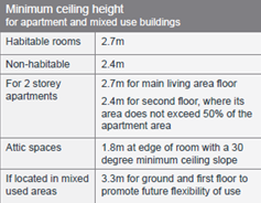
4C Ceiling heights |
|||
|
Design criteria 1. Measured from finished floor level to finished ceiling level, minimum ceiling heights are:
These minimums do not preclude higher ceilings if desired. |
Yes
|
The ceiling heights within all units comply with the minimum 2.8m requirement.
The ground floor apartment is 3.4 metres in height. |
|
|
4D Apartment size and layout |
|||
|
The minimum internal areas include one bathroom. Additional bathrooms increase the minimum internal area by 5m2 each. |
|||
|
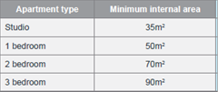
Design criteria 1. Apartments are required to have the following minimum internal areas:
The minimum internal areas include only one bathroom. Additional bathrooms increase the minimum internal area by 5m2 each A fourth bedroom and further additional bedrooms increase the minimum internal area by 12m2 each 2. Every habitable room must have a window in an external wall with a total minimum glass area of not less than 10% of the floor area of the room. Daylight and air may not be borrowed from other rooms. |
Yes
Yes |
The apartments range in size from 60.37 to 72.7 square metres for the one bedroom apartments, 83.9 square metres to 88.27 square metres for the two bedrooms apartments and 99.9 to 110 square metres for the three bedroom apartments. This demonstrates that all the apartments exceed the minimum area quoted at this Part.
|
|
|
Kitchens should not be located as part of the main circulation space in larger apartments (such as hallways or entry space). |
Yes |
Satisfactory. |
|
|
Design criteria 1. Habitable room depths are limited to a maximum of 2.5 x the ceiling height 2. In open plan layouts (where the living, dining and kitchen are combined) the maximum habitable room depth is 8m from a window |
Yes
Yes
|
Habitable room depths do not exceed 6 m (2.5x2.8m). The maximum depth is 7.8 metres. |
|
|
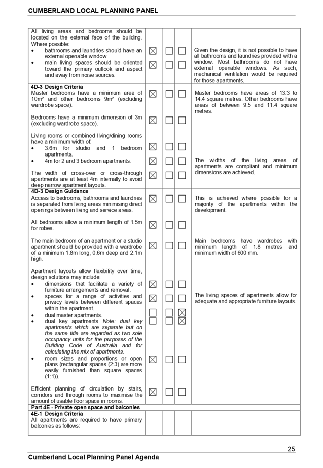
Design criteria 1. Master bedrooms have a minimum area of 10m2 and other bedrooms 9m2 (excluding wardrobe space) 2. Bedrooms have a minimum dimension of 3m (excluding wardrobe space) 3. Living rooms or combined living/dining rooms have a minimum width of: • 3.6m for studio and 1 bedroom apartments • 4m for 2 and 3 bedroom apartments 4. The width of cross-over or cross-through apartments are at least 4m internally to avoid deep narrow apartment layouts |
Yes
Yes
|
All bedrooms meet the minimum area requirements.
All bedrooms meet the minimum 3m dimension.
The living rooms of the various apartments have adequate size. |
|
|
4E Private open space and balconies |
|||
|
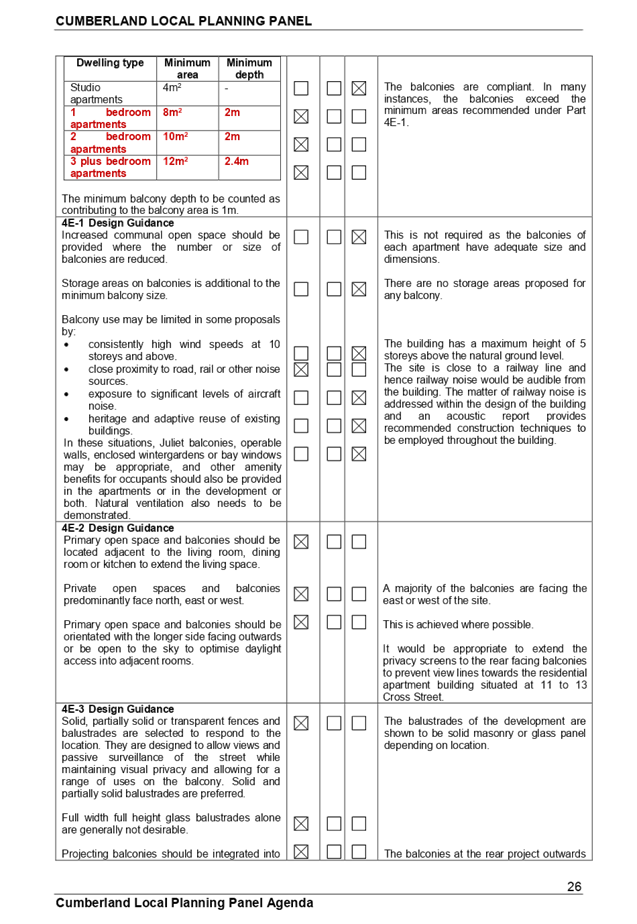
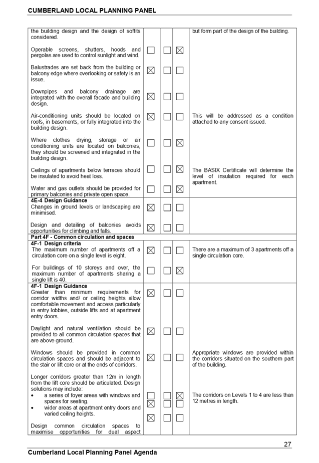
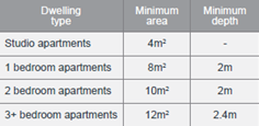
Design criteria 1. All apartments are required to have primary balconies as follows:
The minimum balcony depth to be counted as contributing to the balcony area is 1m
2. For apartments at ground level or on a podium or similar structure, a private open space is provided instead of a balcony. It must have a minimum area of 15m2 and a minimum depth of 3m |
Yes
Yes |
All the balconies and private open space are compliant.
The upper level apartments are provided with main terraces or balconies that occupy 11.13 square metres to 25.4 square metres. Apartments numbered U3.02 and U4.01 are provided with a second smaller balcony attached to bedrooms for additional amenity. |
|
|
4F Common circulation and spaces |
|||
|
Design criteria 1. The maximum number of apartments off a circulation core on a single level is eight. 2. For buildings of 10 storeys and over, the maximum number of apartments sharing a single lift is 40. |
Yes
N/A |
Maximum of 3 units are accessed from the central core on each level.
|
|
|
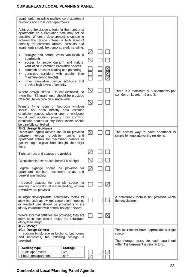
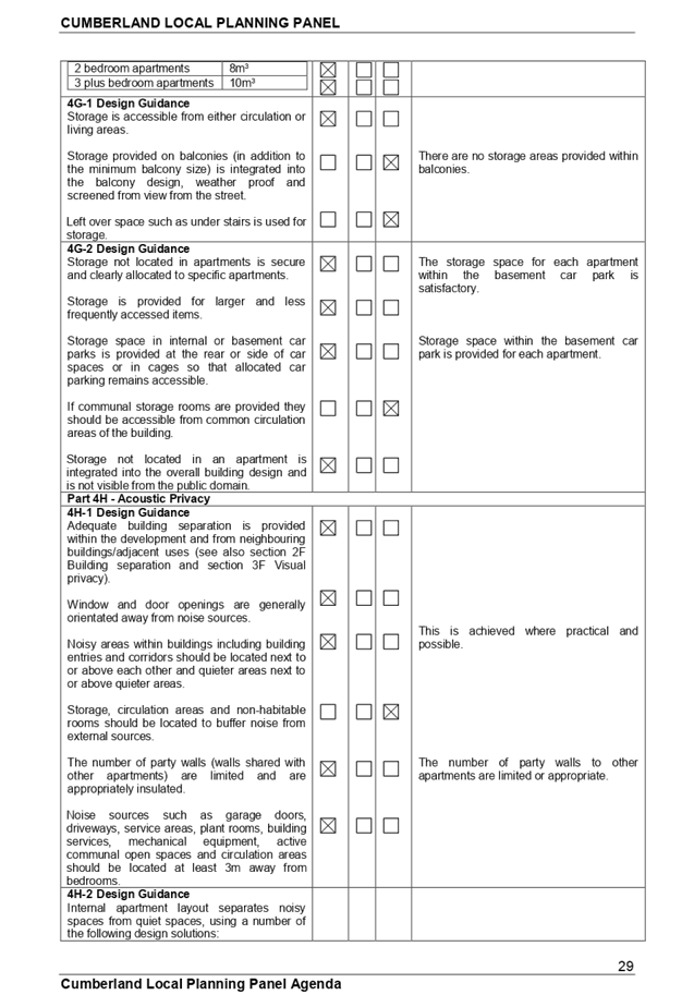
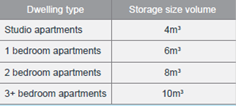
4G Storage |
|||
|
Storage is accessible from either circulation or living areas. Storage provided on balconies (in addition to the minimum balcony size) is integrated into the balcony design, weather proof and screened from view from the street. |
|||
|
Design criteria 1. In addition to storage in kitchens, bathrooms and bedrooms, the following storage is provided:
At least 50% of the required storage is to be located within the apartment |
Yes
|
The proposal provides adequate internal storage within each apartment and separate storage for each unit within the basement. The storage provided meets the requirements and objectives of the ADG. |
|
|
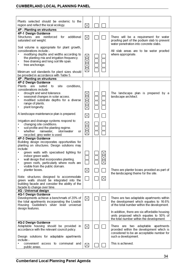
4Q Universal design |
|||
|
Design guidance · Developments achieve a benchmark of 20% of the total apartments incorporating the Liveable Housing Guideline's silver level universal design features |
Yes |
There are two adaptable apartments within the development which equates to 16.6% of the total number within the development.
In addition, there are five affordable housing units proposed which equates to 41.6% of the total number within the development. |
|
|
There should be convenient access to communal and public areas. |
Yes |
Satisfactory. |
|
Regional Environmental Plans
The proposed development is affected by the following Regional Environmental Plans:
(a) Sydney Regional Environmental Plan (Sydney Harbour Catchment) 2005
The site is located within the Sydney Harbour Catchment area and SREP (Sydney Harbour Catchment) 2005 is applicable to the development application. The development application raises no issues as to consistency with the requirements and objectives of the planning instrument and associated development control plan.
(Note:- the subject site is not identified in the relevant map as ‘land within the ‘Foreshores and Waterways Area’ or ‘Wetland Protection zone’, is not a ‘Strategic Foreshore Site’ and does not contain any heritage items. Hence the majority of the SREP is not directly relevant to the proposed development).
Parramatta Local Environmental Plan 2011
The provisions of the Parramatta Local Environmental Plan 2011 are applicable to the development application. A mixed use development is a permitted development within the zone subject to consent.
In addition, the Parramatta Local Environmental Plan 2011 defines a “Mixed use development” as “A building or place comprising 2 or more different land uses”. A mixed use development is permitted with consent.
The relevant matters to be considered under the Parramatta Local Environmental Plan 2011 and the applicable clauses for the proposed development are summarised below. A comprehensive LEP assessment is contained in Appendix 1.
|
DEVELOPMENT STANDARD |
COMPLIANCE |
DISCUSSION |
|
4.3 Height of Buildings - 17 Metres.
Proposed 16.9 metres. |
Yes. |
Compliance is achieved. |
|
4.4 Floor Space Ratio - 1.4:1
For affordable housing, a bonus floor space ratio of 0.428:1 exists. As such, an increase of floor space ratio to 1.828:1 may be supported. |
Yes |
The floor space ratio of the building is calculated at 1.785:1.
|
|
4.6 Exceptions to development standards |
N/A |
Not required. |
|
Clause 5.10 Heritage Conservation.
The development is occurring to the immediate north of number 332 Railway Terrace which is listed as heritage item Number I232 in the Parramatta Local Environmental Plan 2011.
The development has potential to affect the building at 332 Railway Terrace. The shop is a former bakery being two storeys in height with an awning at the front. The shop is significant for the locality for historical reasons and a representative example of Federation shops within the local area. |
Yes |
The development is considered as being acceptable from a heritage perspective and may be supported. |
The provisions of any proposed instrument that is or has been the subject (EP&A Act s4.15 (1)(a)(ii))
Draft State Environmental Planning Policy (Environment)
The development is not affected by any draft environmental planning instrument.
The provisions of any Development Control Plans (EP&A Act s4.15 (1)(a)(iii))
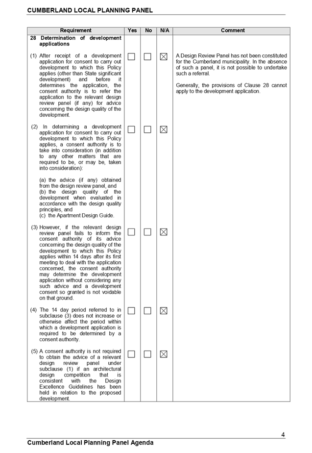
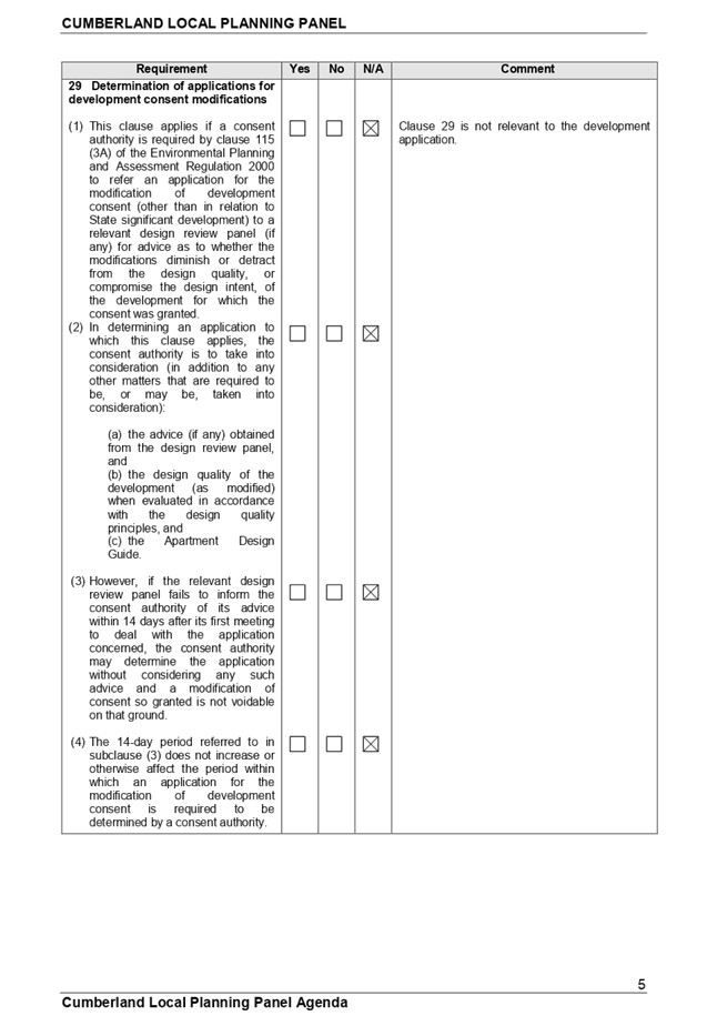
The Parramatta Development Control Plan 2011 is relevant to the development application however many provisions are overridden by State Environmental Planning Policy “Affordable Rental Housing” 2009, State Environmental Planning Policy 65 “Design Quality of Residential Apartment Development” and the associated Apartment Design Guide.
The variations are outlined in the table below and a detailed assessment is at Appendix 1.
|
Control |
Compliance |
Discussion |
|
Frontage Minimum 18m if the development is more than 10 metres in height. |
No
|
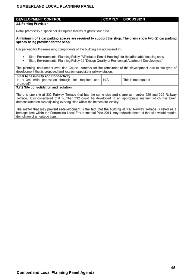
16.75 metres with a variation of 1.25 metres.
Comment
Number 332 Railway Terrace is listed as a heritage item within the Parramatta Local Environmental Plan 2011. Any redevelopment of that site would require demolition of the heritage item which may not be supported. As such, it is considered appropriate not to pursue site amalgamation with 332 Railway Terrace to the south.
It is identified that the site to the north has recently been redeveloped for a similar sized mixed use apartment building. It is not practical to amalgamate this site with the development site on the grounds that the adjoining property has recently been redeveloped. |
|
Height (refer also to LEP table) Does the proposal exceed the number of storeys outlined in the DCP height table? |
Yes |
The maximum permitted height limit of the building is 17 metres however the building has a maximum height of 16.9 metres. Compliance is achieved.
|
|
3.3.3 Visual Privacy
The minimum separation between habitable rooms and balconies is 12 metres up to and including the third storey and 18 metres above the third storey. |
No
|
The matter concerning building separation is discussed under the Apartment Design Guide at Part 2F.
|
|
3.4.2 Access for people with disabilities
Equitable access be provided for people with a disability. |
Yes |
Access throughout the site is satisfactory. |
|
3.6 Parking provision
Retail premises.
1 space per 30 square metres of gross floor area.
Require a minimum of 2 car spaces for a shop of 58.7 square metres in floor area. |
Yes |
Two spaces are provided. |
Part 4.1 to Part 4.3 - Special Precinct Guildford Town Centre
The site is situated within the Guildford Town Centre which is a special precinct. As such, additional development controls will apply to the development. The development is found to be compliant with the relevant provisions.
The provisions of any planning agreement that has been entered into under section 7.4, or any draft planning agreement that a developer has offered to enter into under section 7.4 (EP&A Act s4.15(1)(a)(iiia))
There is no draft planning agreement associated with the subject Development Application.
The provisions of the Regulations (EP&A Act s4.15 (1)(a)(iv))
The proposed development raises no concerns as to the relevant matters arising from the Environmental Planning and Assessment Regulations 2000 (EP&A Reg).
4.15(1)(a)(v) - any coastal zone management plan (within the meaning of the Coastal Protection Act 1979)
There is no Coastal Zone Management Plan applicable for the Cumberland Council area.
The likely environmental, social or economic impacts (EP&A Act s4.15 (1)(b))
The site is constrained which has limited the development potential of the allotment of land. However, it is identified that the form of development is appropriate for the site and locality and one that is generally consistent with most of the planning controls that apply to the land notwithstanding the site constraints.
The suitability of the site for the development (EP&A Act s4.15 (1)(c))
The subject site and locality is not known to be affected by any natural hazards or other site constraints likely to have a significant adverse impact on a future development.
The site is constrained which has limited the development potential of the allotment of land. It is identified that the site is capable of supporting the development in the form as shown. As such, the development may be supported.
Submissions made in accordance with the Act or Regulation (EP&A Act s4.15 (1)(d))
Advertised (newspaper) Mail Sign Not Required
In accordance with the Parramatta Development Control Plan, the proposal was publicly exhibited for a period of twenty one (21) days between Tuesday 5 December 2017 and Tuesday 2 January 2018. There were no submissions to the development application.
The public interest (EP&A Act s4.15(1)(e))
The public interest is served by permitting the orderly and economic development of land, in a manner that is sensitive to the surrounding environment and has regard to the reasonable amenity expectations of surrounding land users. In view of the foregoing analysis it is considered that the development should be supported in its current form.
Section 7.11 (Formerly S94) Contribution Towards Provision or Improvement of Amenities or Services
This part of the Act relates to the collection of monetary contributions from applicants for use in developing key local infrastructure. The Act reads as follows:-
‘(1) If a consent authority is satisfied that development for which development consent is sought will or is likely to require the provision of or increase the demand for public amenities and public services within the area, the consent authority may grant the development consent subject to a condition requiring:
(a) the dedication of land free of cost, or
(b) the payment of a monetary contribution, or both.
(2) A condition referred to in subsection (1) may be imposed only to require a reasonable dedication or contribution for the provision, extension or augmentation of the public amenities and public services concerned.’
Comments:
A Section 7.11 Contribution is applicable to the development that is sought. For the development within the Woodville Ward, the contribution amount is 1% of the cost of works. The contribution amount is $40,362.73. The matter is addressed within proposed Condition 3 for approval by the Panel.
Disclosure of Political Donations and Gifts
The applicant and notification process did not result in any disclosure of Political Donations and Gifts.
The NSW Government introduced The Local Government and Planning Legislation Amendment (Political Donations) Act 2008 (NSW). This disclosure requirement is for all members of the public relating to political donations and gifts. The law introduces disclosure requirements for individuals or entities with a relevant financial interest as part of the lodgement of various types of development proposals and requests to initiate environmental planning instruments or development control plans.
The applicant and notification process did not result in any disclosure of Political Donations and Gifts.
Conclusion:
The development application has been assessed in accordance with the relevant requirements of the Environmental Planning and Assessment Act 1979, State Environmental Planning Policy “Affordable Rental Housing” 2009, State Environmental Planning Policy 65 “Design Quality of Residential Apartment Development” and the Associated “Apartment Design Guide”, the Parramatta Local Environmental Plan 2011 and the Parramatta Development Control Plan 2011 and is considered as being satisfactory for approval.
Having regard to the relevant matters of consideration under Section 4.15 of the Environmental Planning and Assessment Act 1979, it is considered that the proposed development is acceptable for the reasons as outlined within the report. It is recommended that the development be given deferred commencement consent subject to conditions.
Consultation:
There are no further consultation processes for Council associated with this report.
Financial Implications:
There are no further financial implications for Council associated with this report.
Policy Implications:
There are no policy implications for Council associated with this report.
Communication / Publications:
The final outcome of this matter will be notified in the newspaper. The objectors will also be notified in writing of the outcome.
|
That Development Application 441/2017 for “Demolition of an existing building and construction of a 5 storey mixed use development comprising a ground floor commercial tenancy, a ground floor residential apartment and four levels of apartments above including a two storey split level basement car park” under State Environmental Planning Policy Affordable Rental Housing 2009 be approved as deferred commencement consent subject to conditions as outlined in the attachment provided. |
Attachments
1. Draft
Conditions of Consent ⇩ ![]()
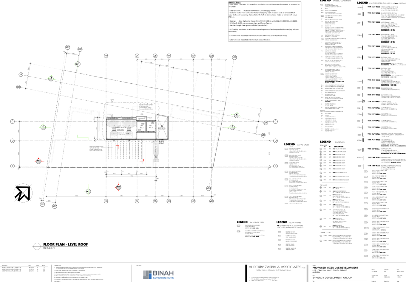
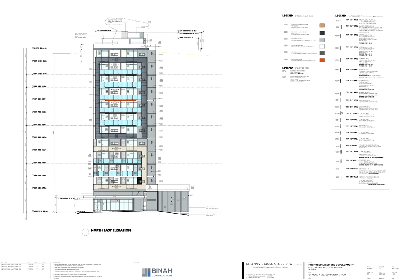
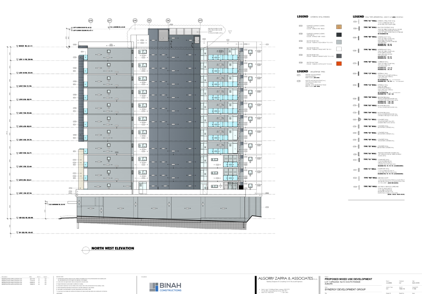
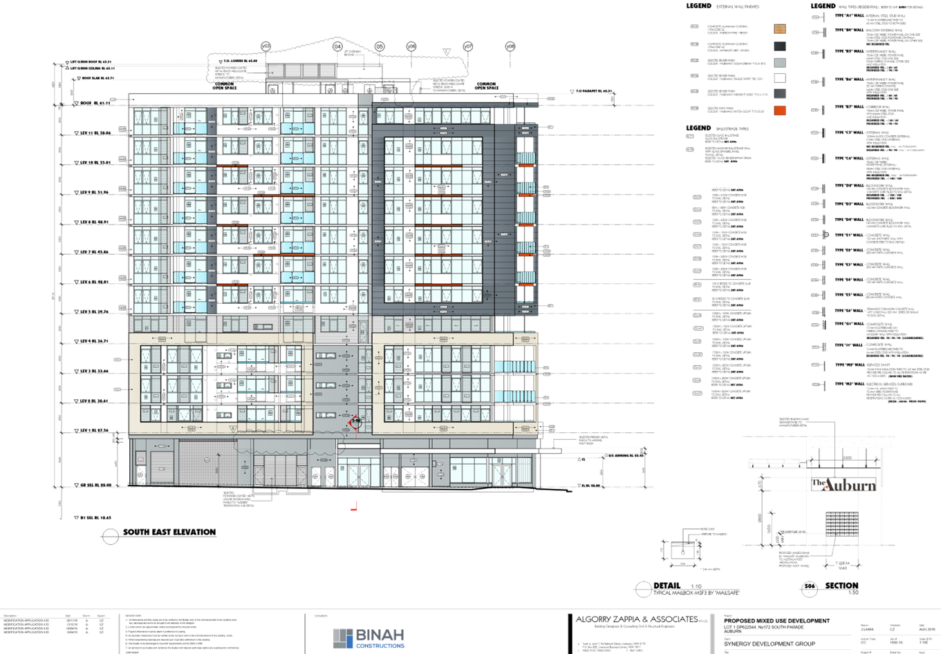
2. Architectural
Plans ⇩ ![]()
3. Stormwater
/ Engineering Plans ⇩ ![]()
4. Landscape
Plan ⇩ ![]()
5. Appendix
Assessment Sheet ⇩ ![]()