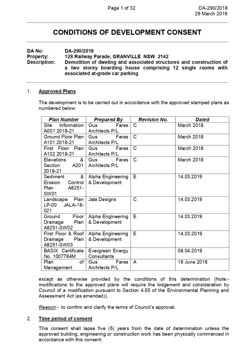
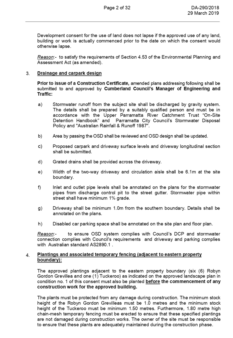
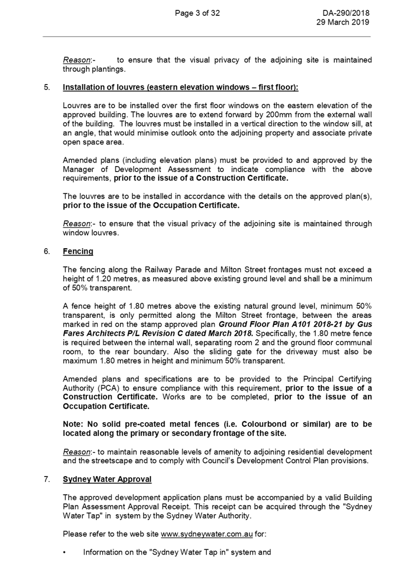
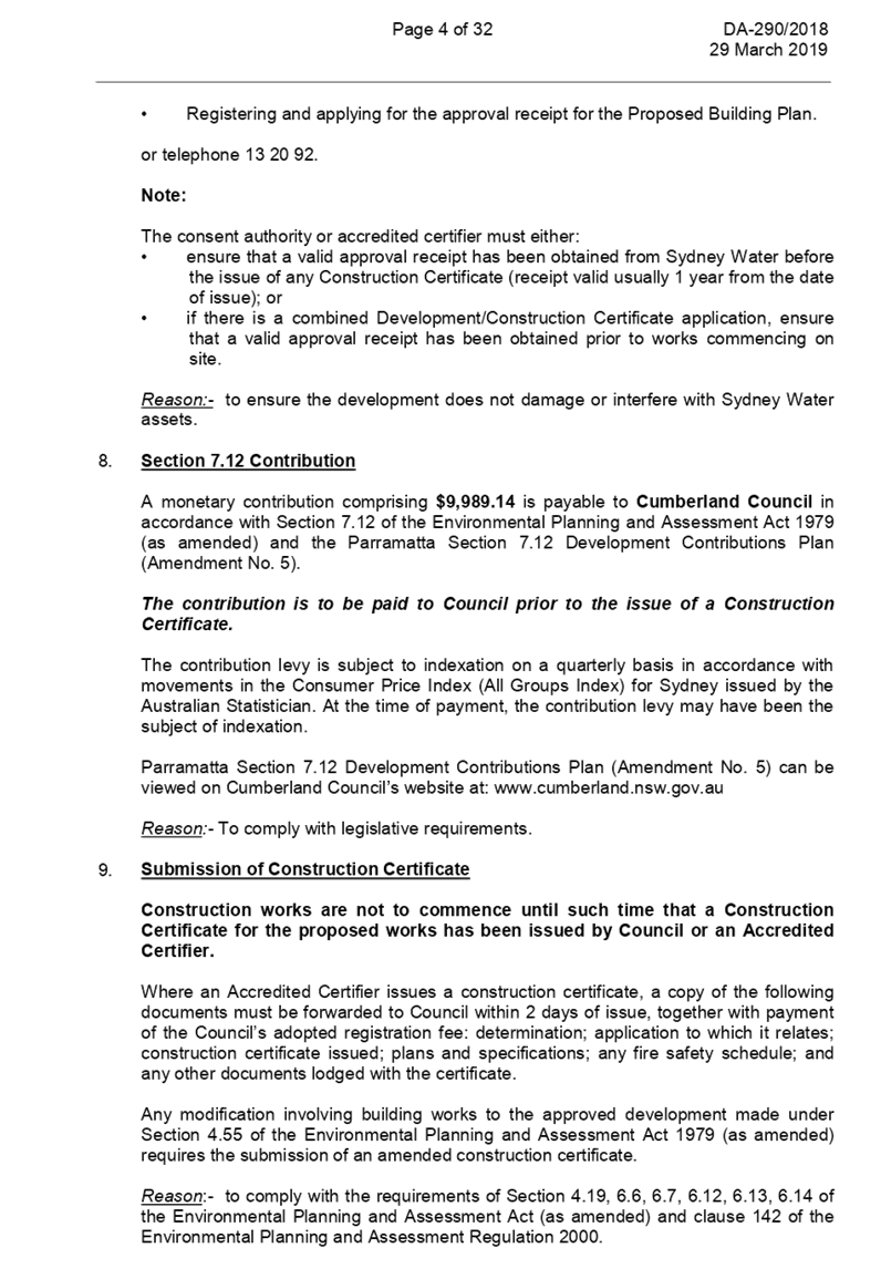
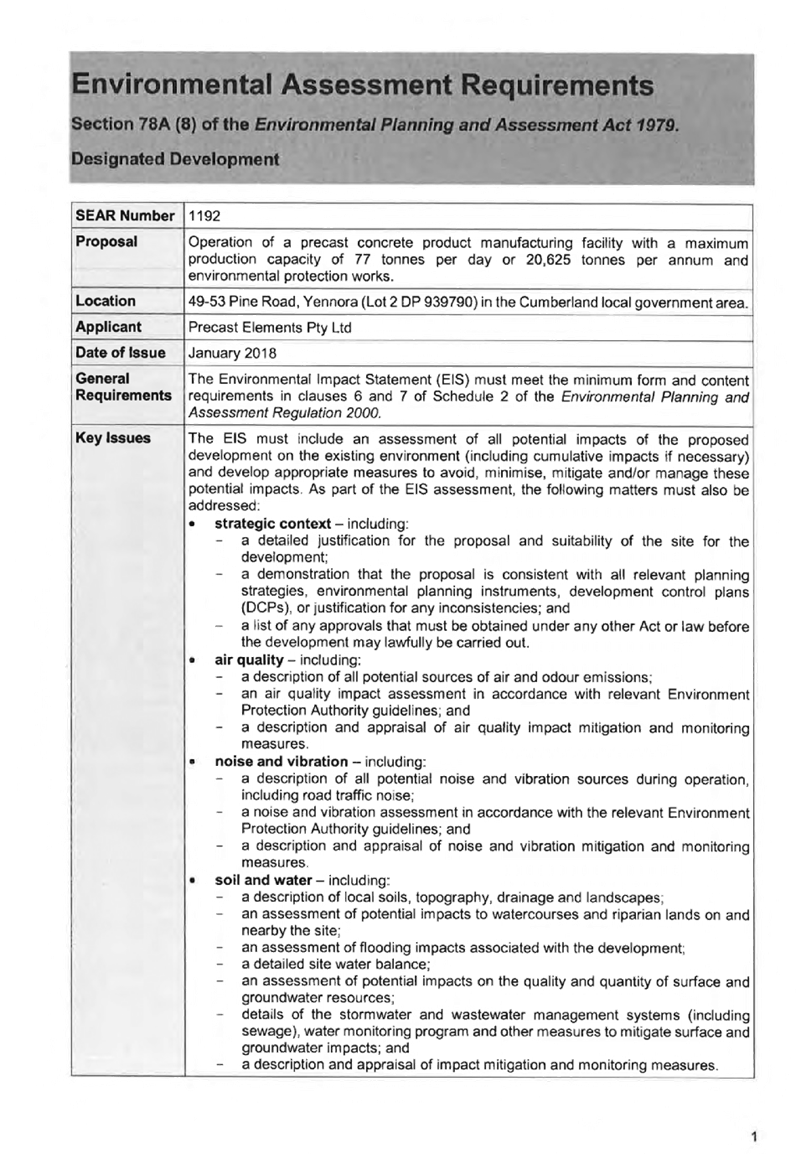
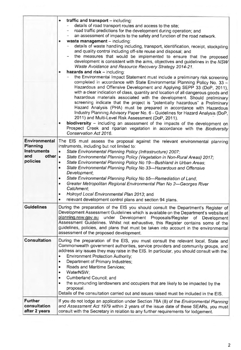
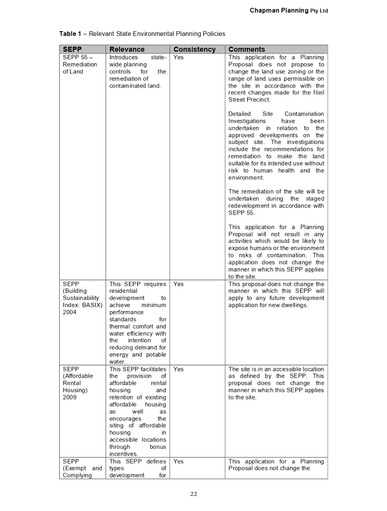
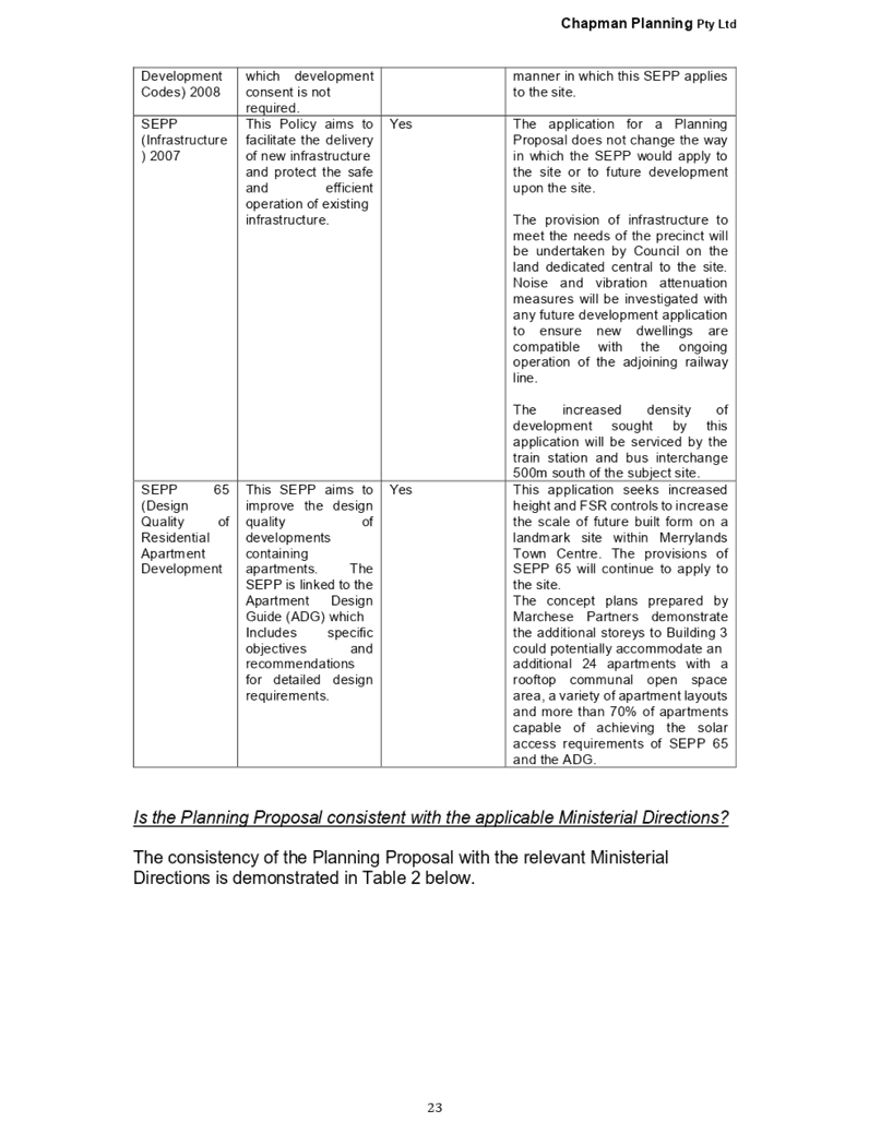
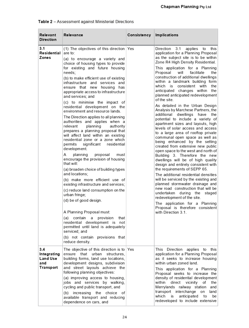
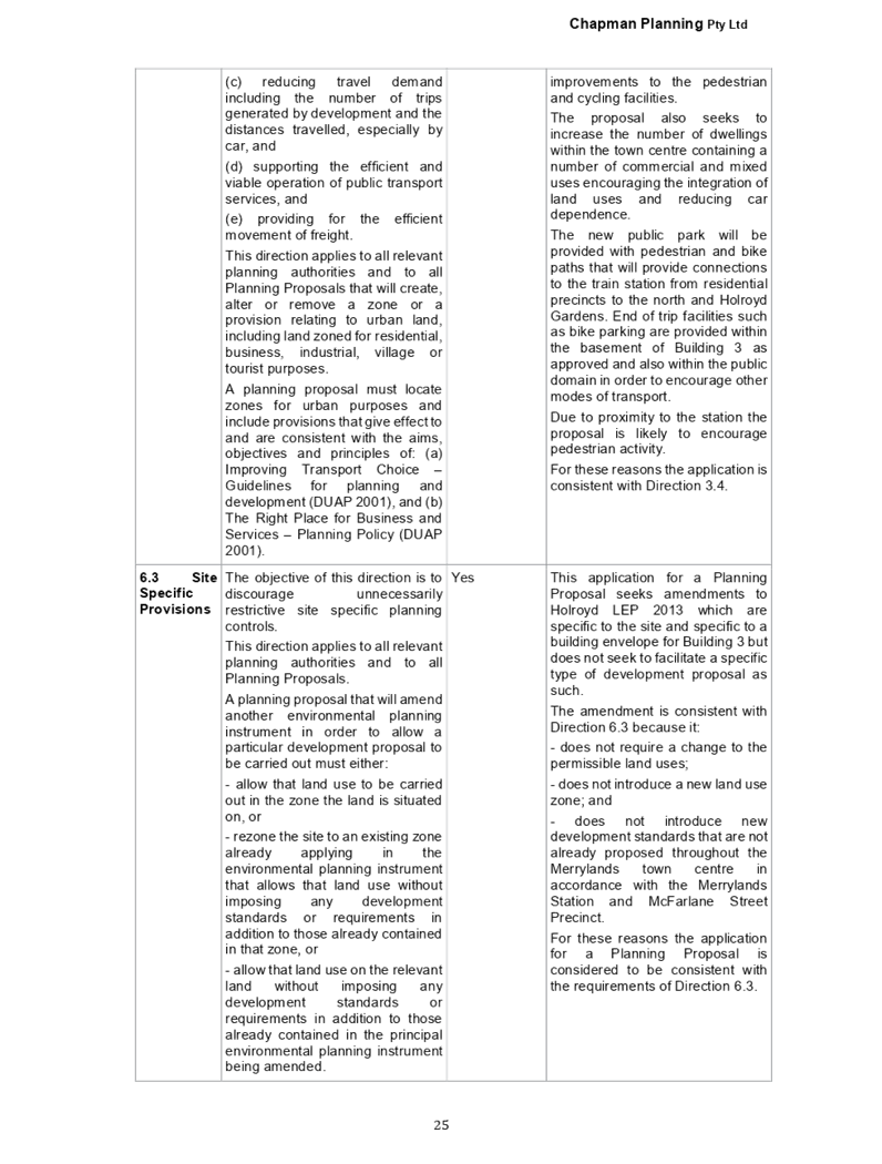
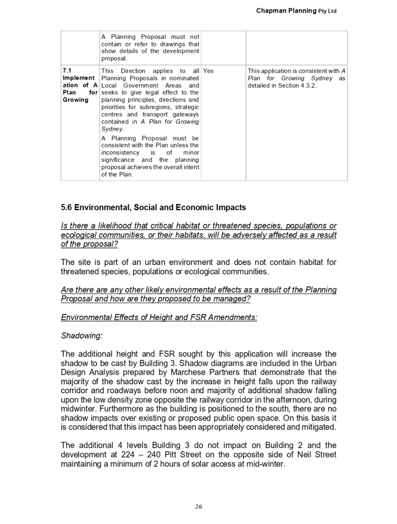
Extraordinary Cumberland Local Planning
Panel Meeting
1 May 2019
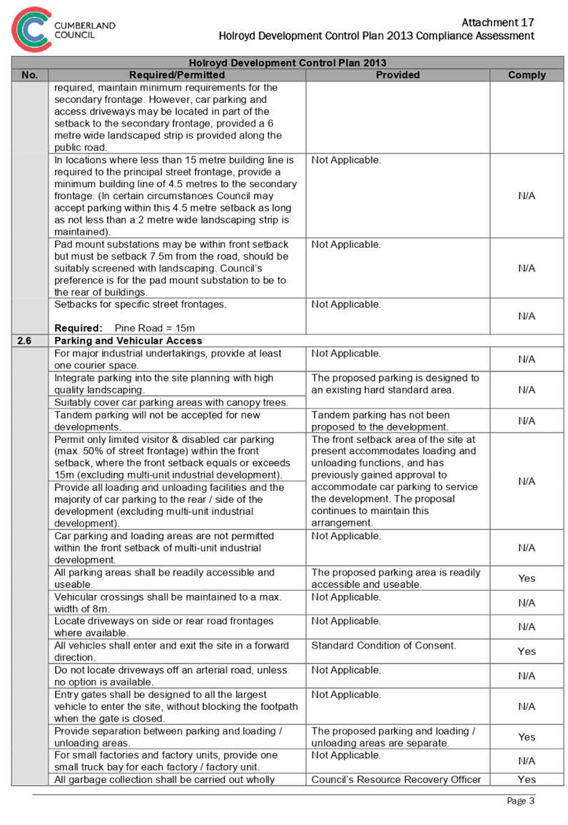
Item No: EELPP023/19
Development
Application - 128 Railway Parade, Granville
Responsible
Division: Environment
& Planning
Officer: Manager
Development Assessment
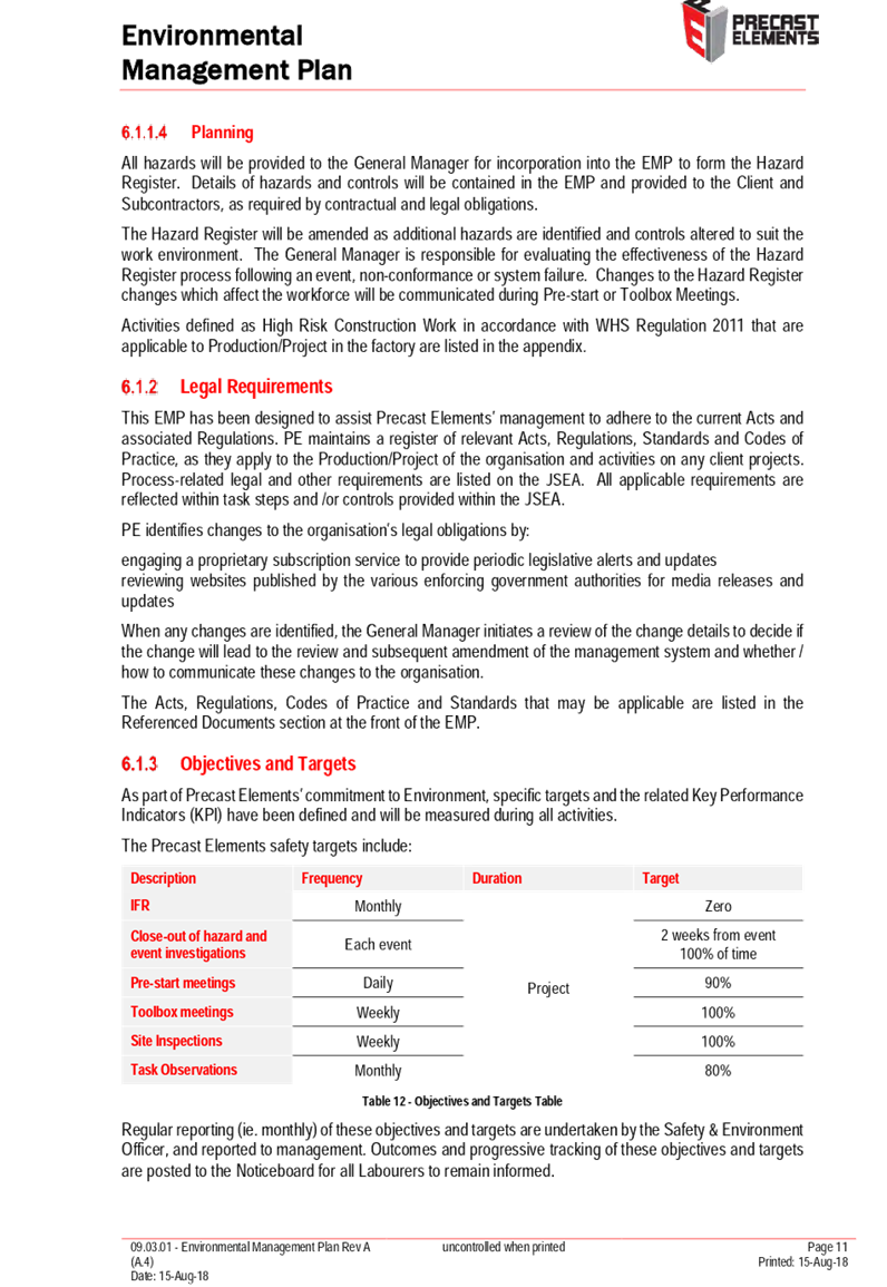
File
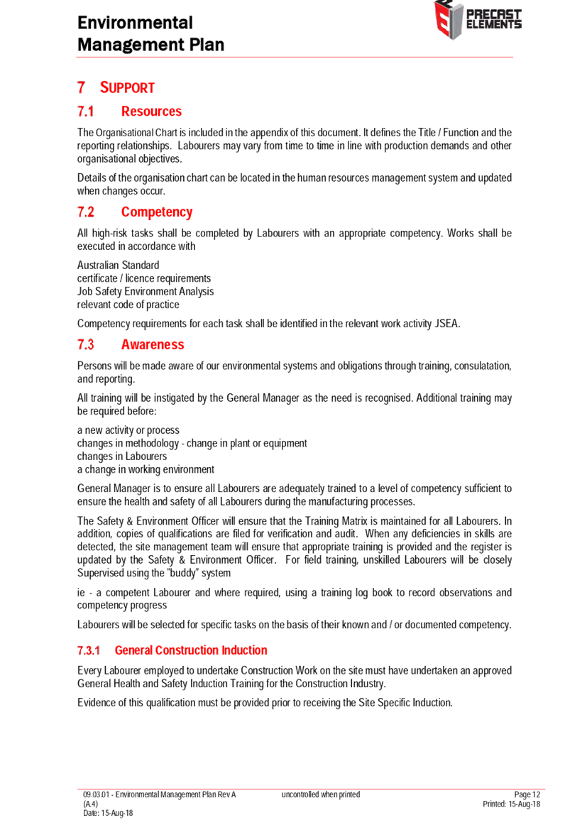
Number: DA-290/2018
|
Application
lodged
|
21 September 2018
|
|
Applicant
|
Mr T Rizk
|
|
Owner
|
Mr T G Rizk and Mrs V M Rizk
|
|
Application
No.
|
DA-290/2018
|
|
Description
of Land
|
128 Railway Parade,
GRANVILLE NSW 2142, Lot 1 DP 712492
|
|
Proposed
Development
|
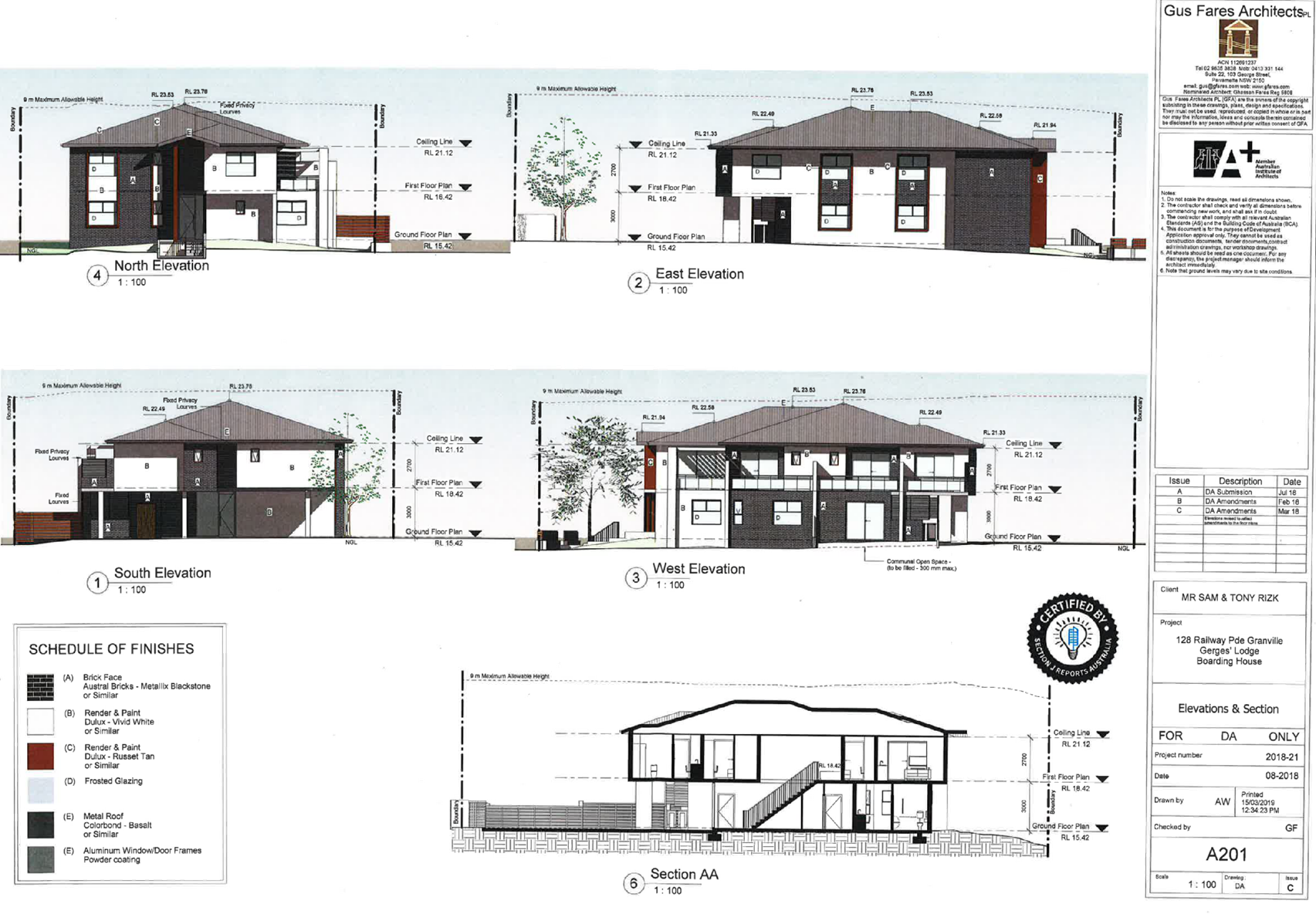
Demolition of dwelling and
associated structures and construction of a two storey boarding house comprising
12 single rooms with associated at-grade car parking
|
|
Site
Area
|
816.80m2
|
|
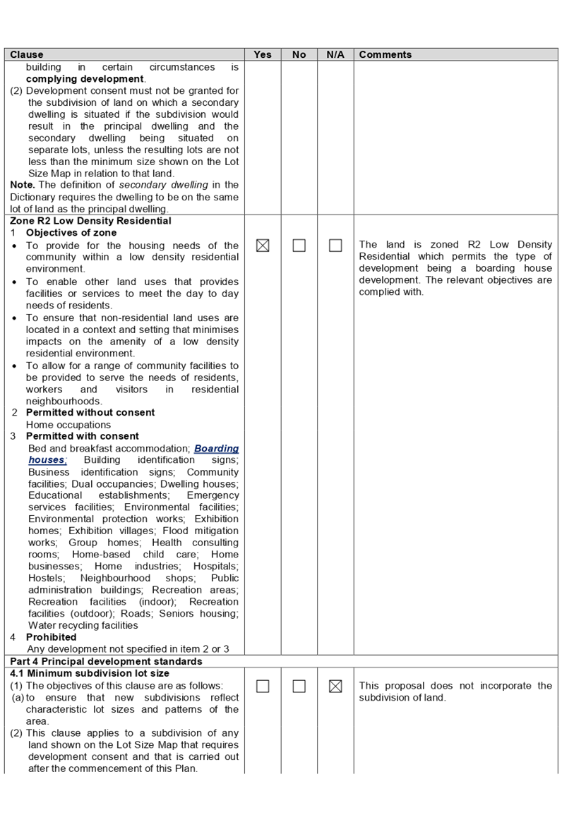
Zoning
|
R2 Low Density Residential
(PLEP 2011)
|
|
Disclosure
of political donations and gifts
|
Nil disclosure
|
|
Heritage
|
No
|
|
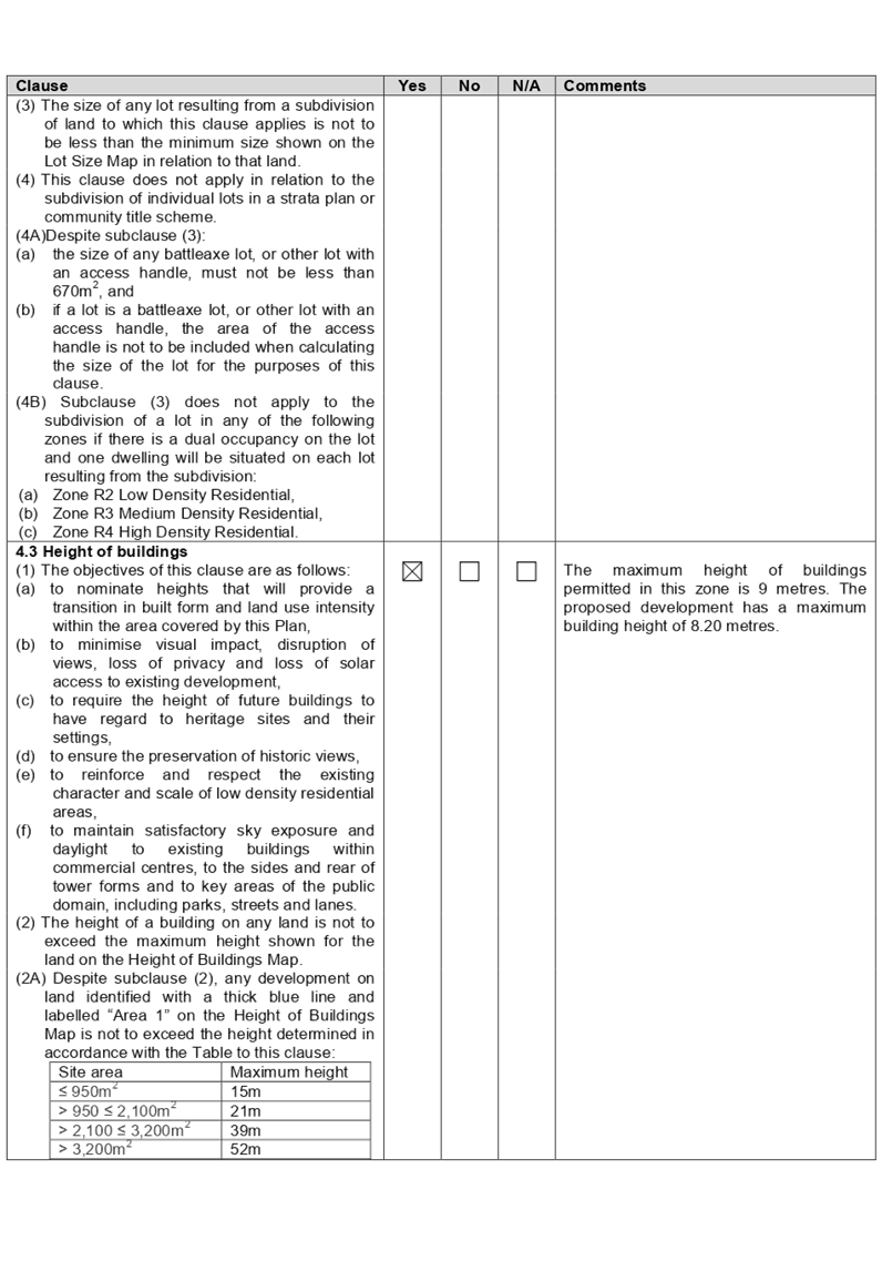
Principal
Development Standards
|
Parramatta LEP 2011;
Height of Building
Permissible: 9 metres
Proposed: 8.20 metres
AND
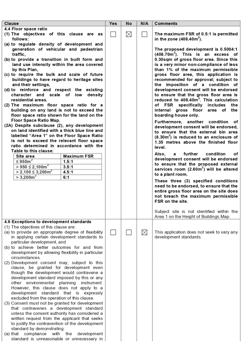
Floor Space Ratio
Permissible: 0.5:1 (408.40sqm)
Proposed: 0.5:1 (408.40sqm)
|
|
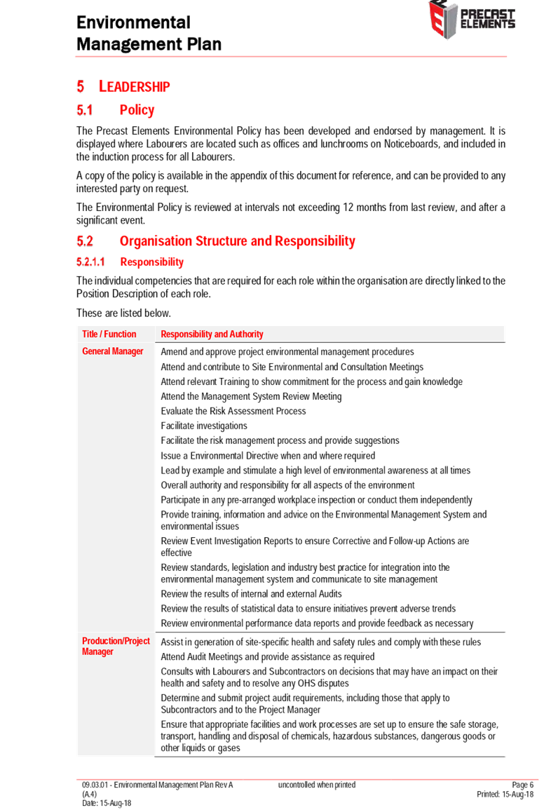
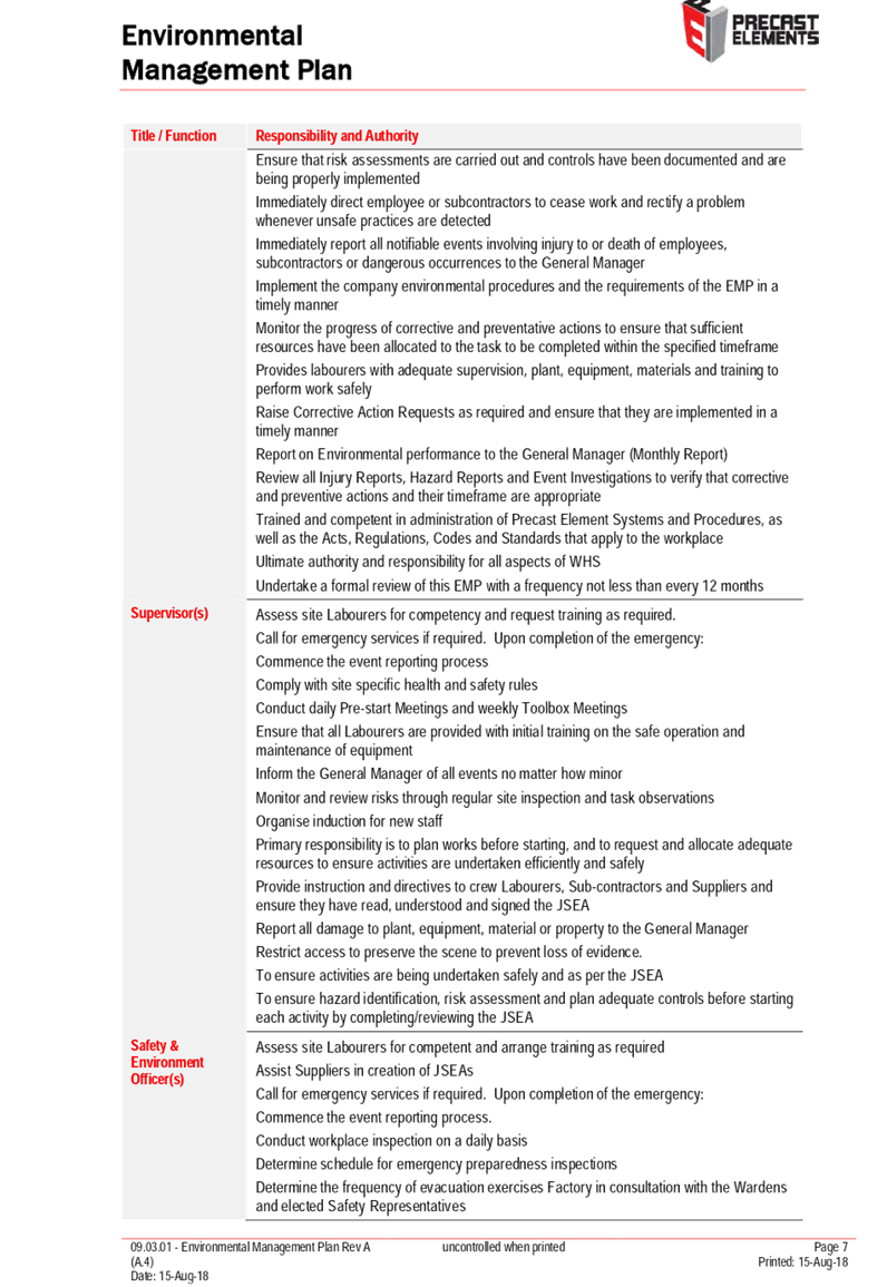
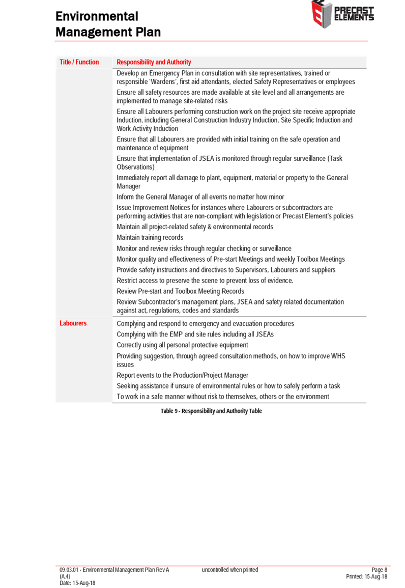
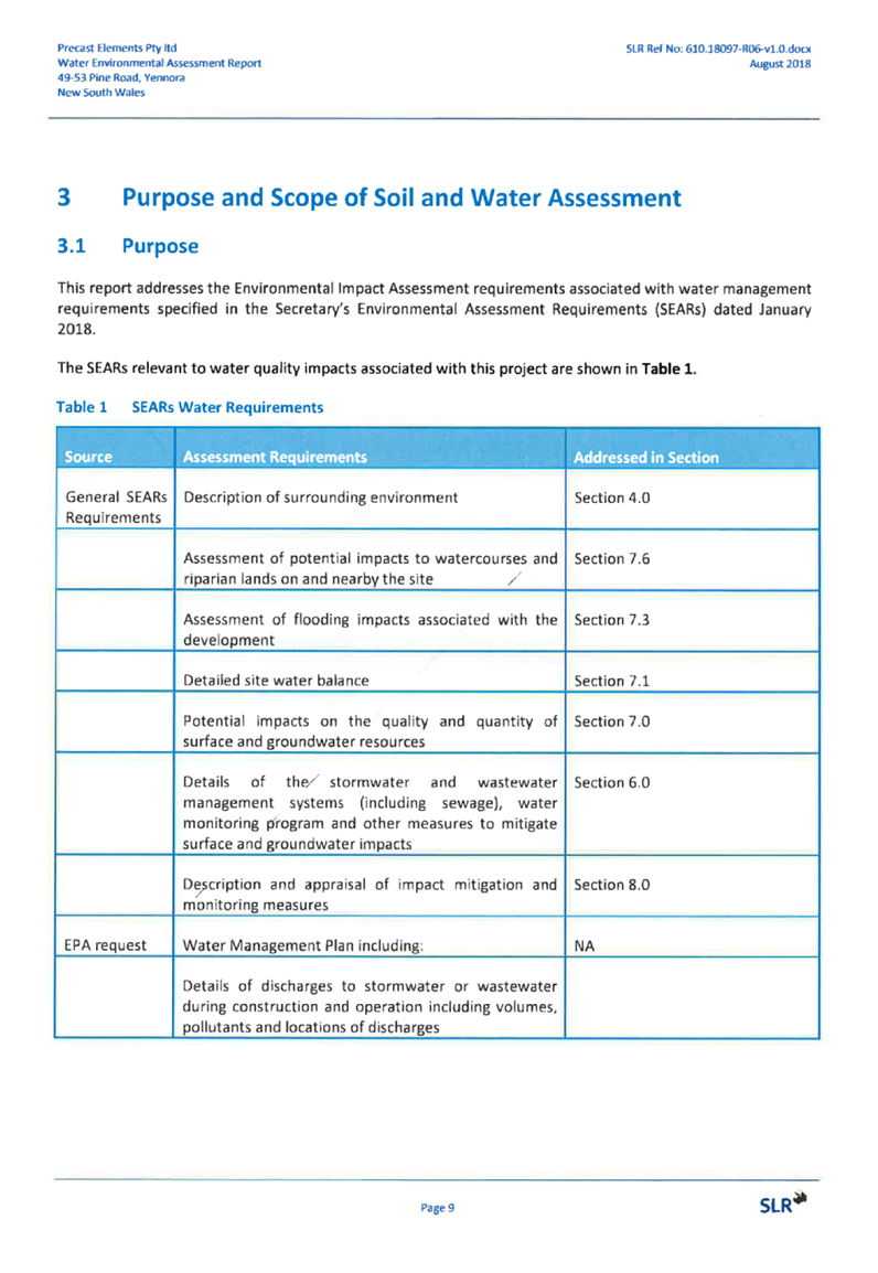
Issues
|
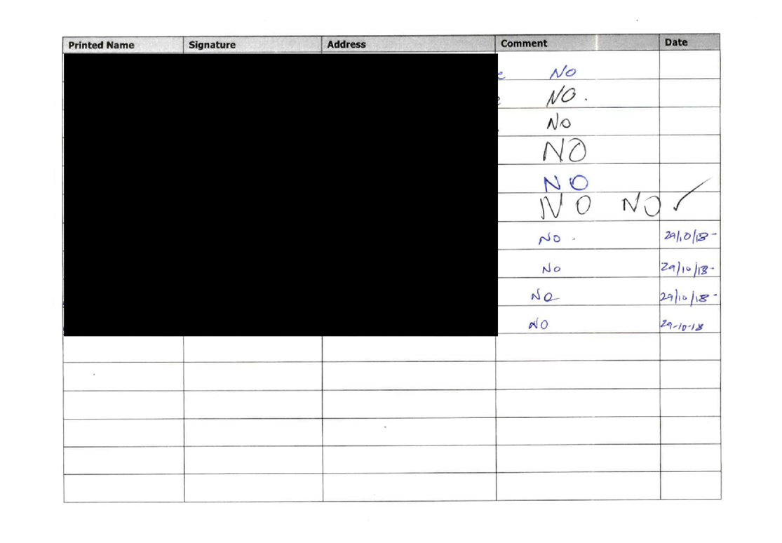
Submissions
|
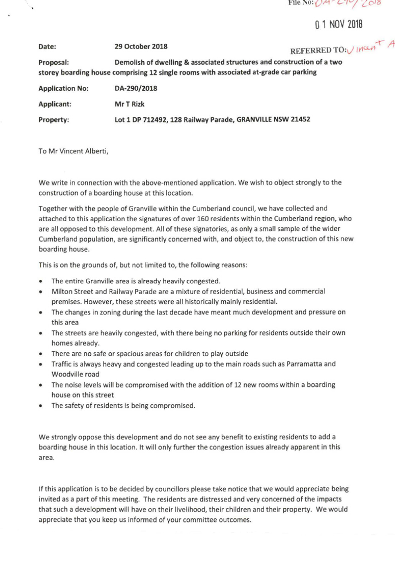
1. Development
Application No. 290/2018 was received on 21 September 2018 for the demolition
of dwelling and associated structures and construction of a two storey boarding
house, comprising 12 single rooms with associated at-grade car parking.
2. The
application was publicly notified to occupants and owners of the adjoining
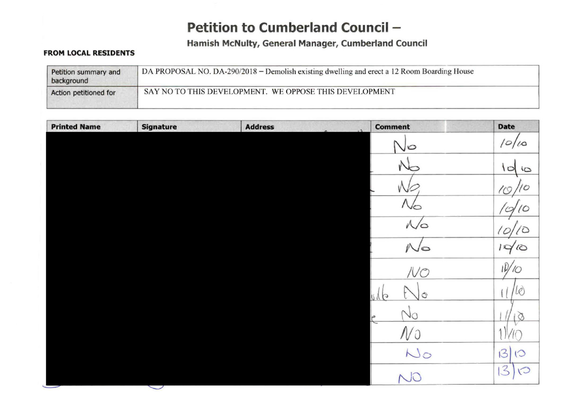
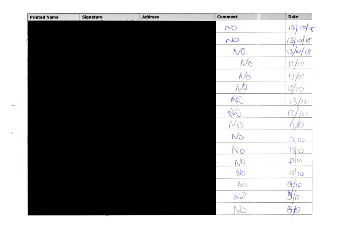
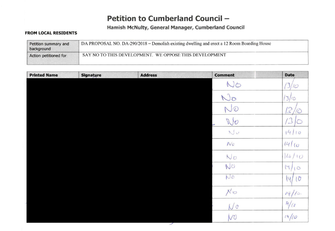
properties for a period of 21 days, between 9 October 2018 to 30 October 2018.
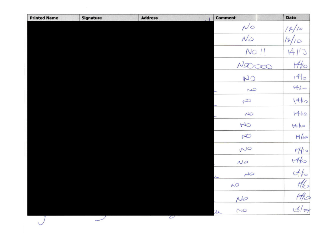
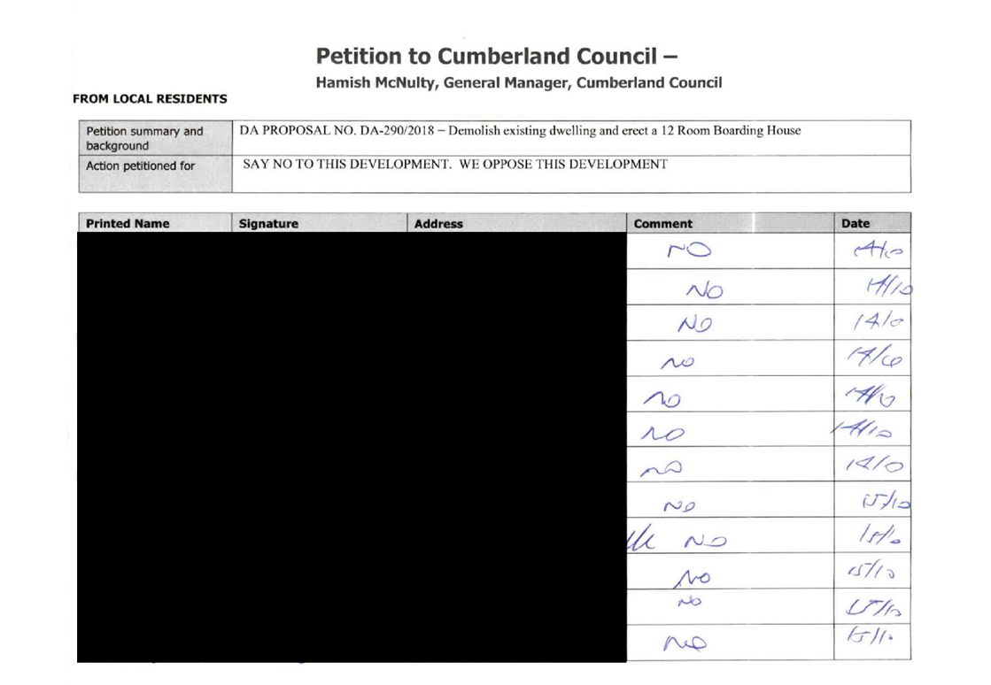
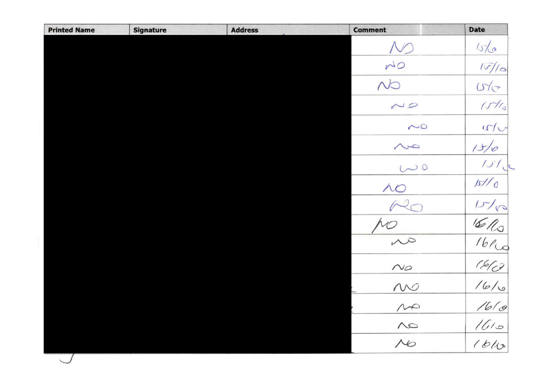
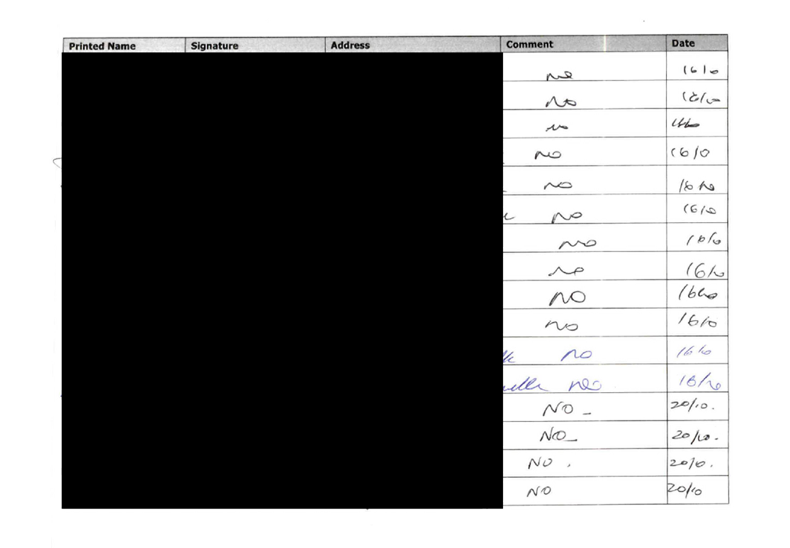
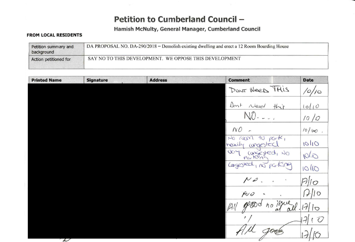
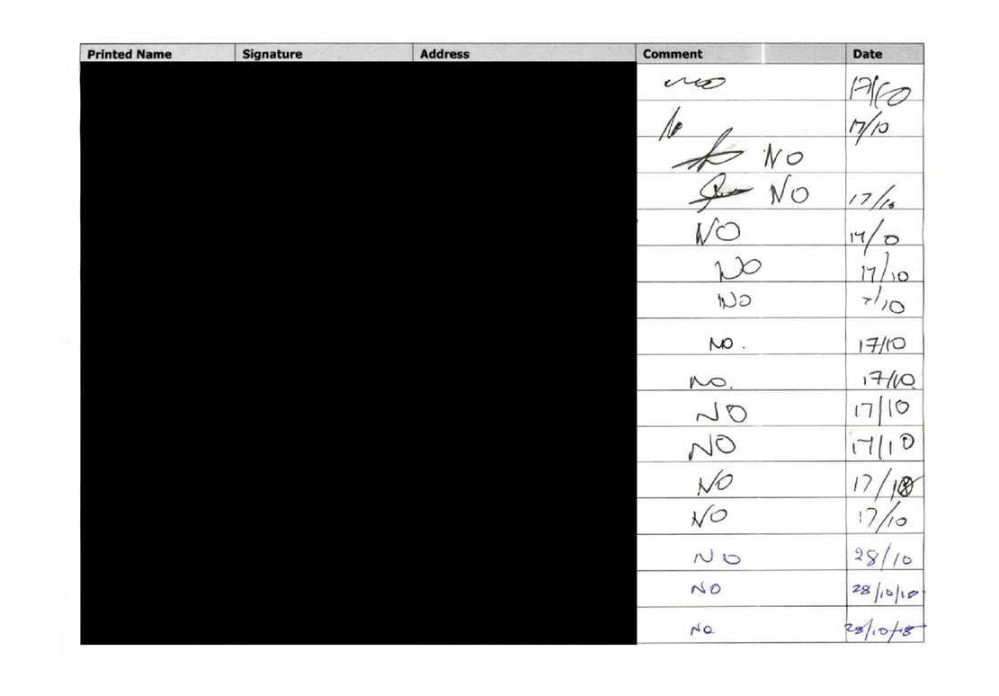
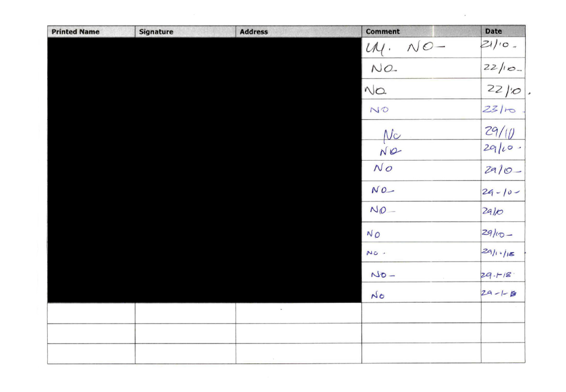
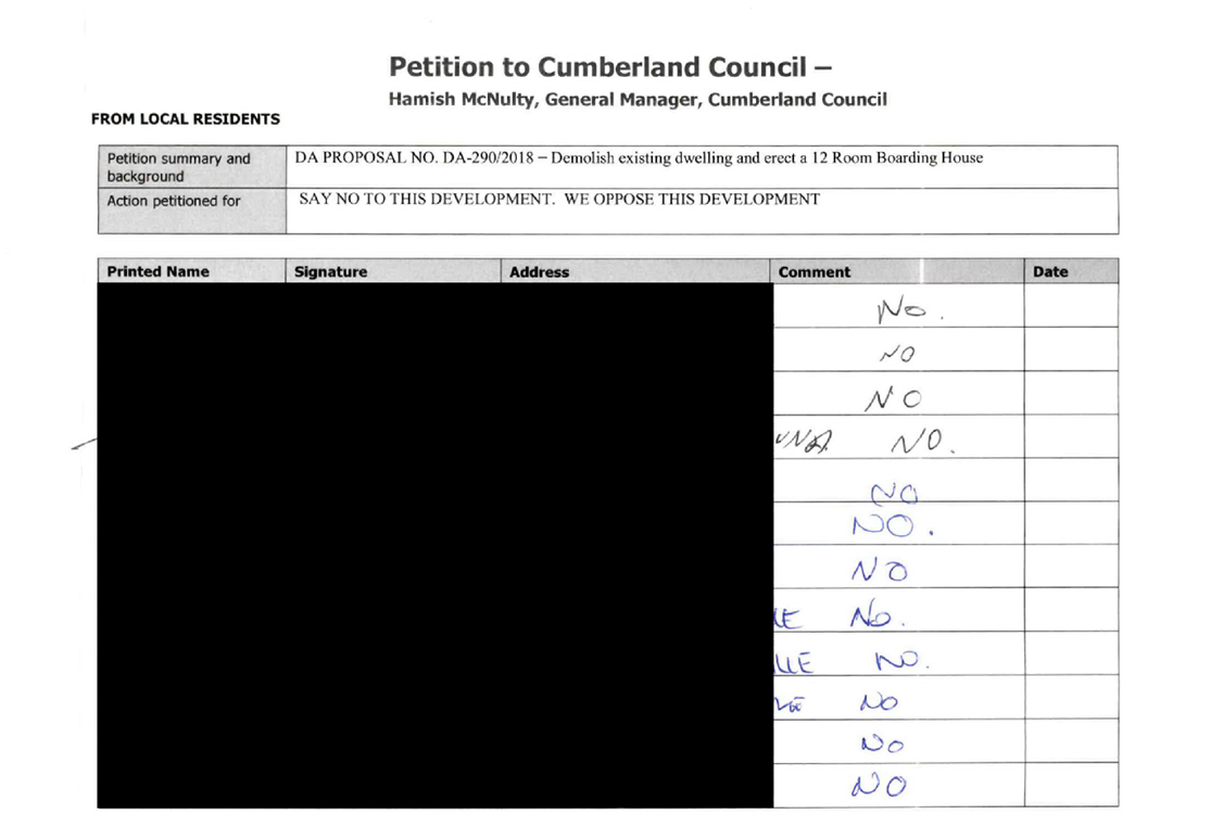
In response, two (2) submissions were received, including a petition with over
100 signatures objecting to the proposal.
3. There
are no significant variations to the planning controls.
4. The
application is recommended for approval, subject to conditions as provided in
the attached schedule.
5. The
application is referred to the Panel as the proposal is considered to be
contentious development.
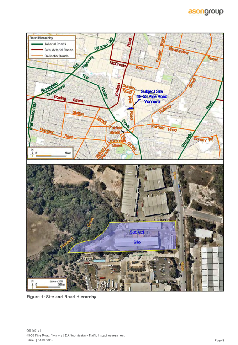
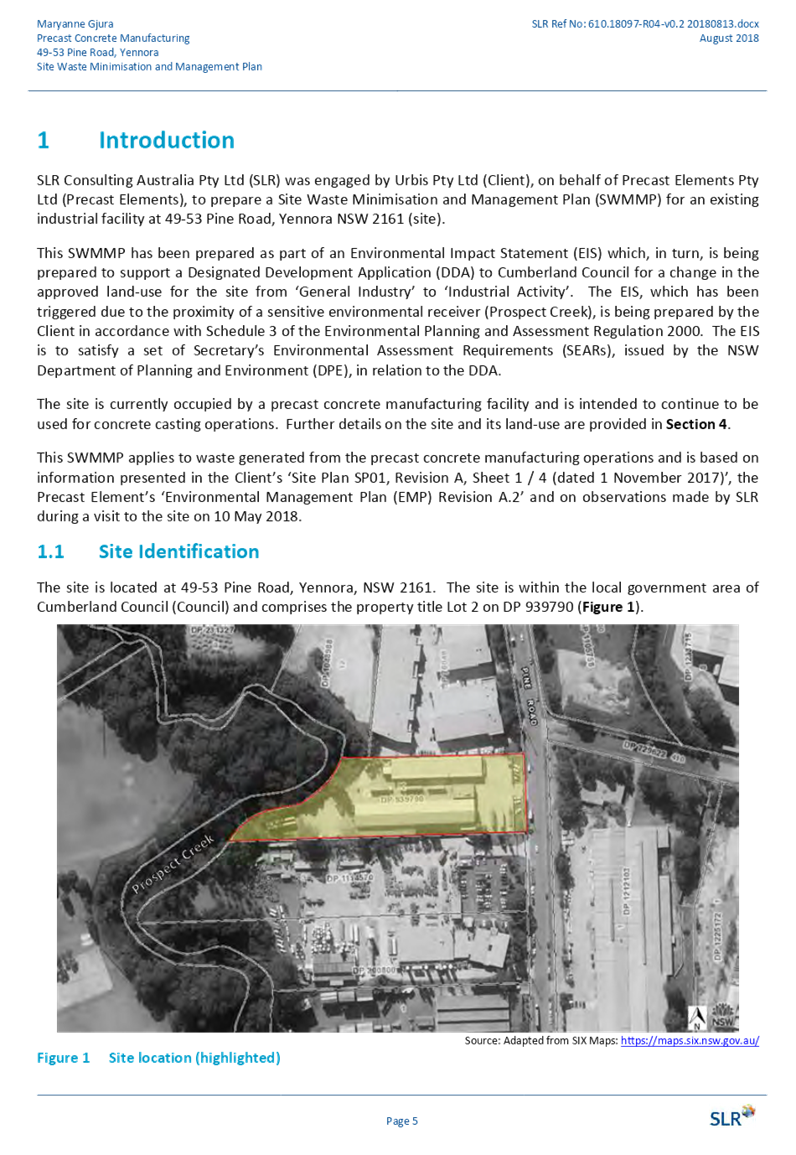
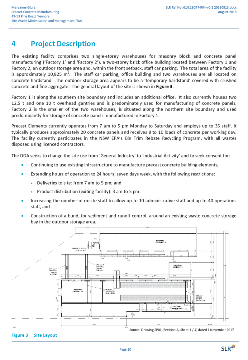
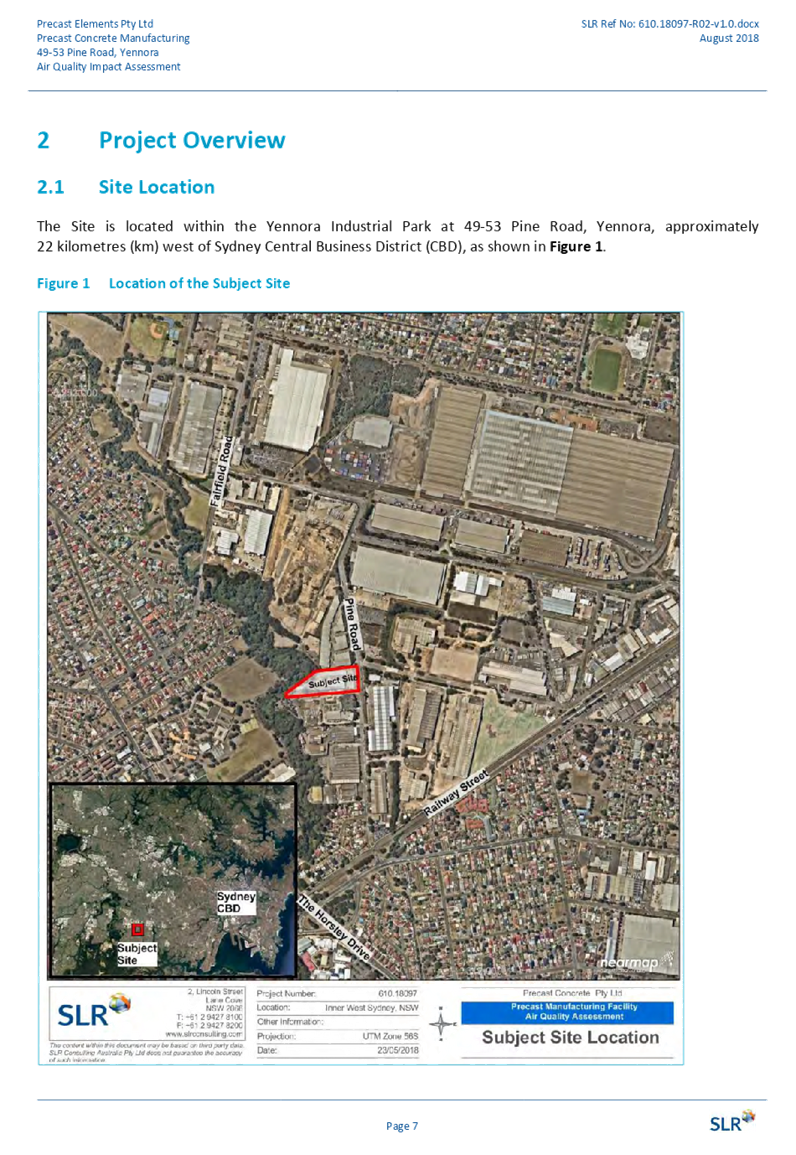
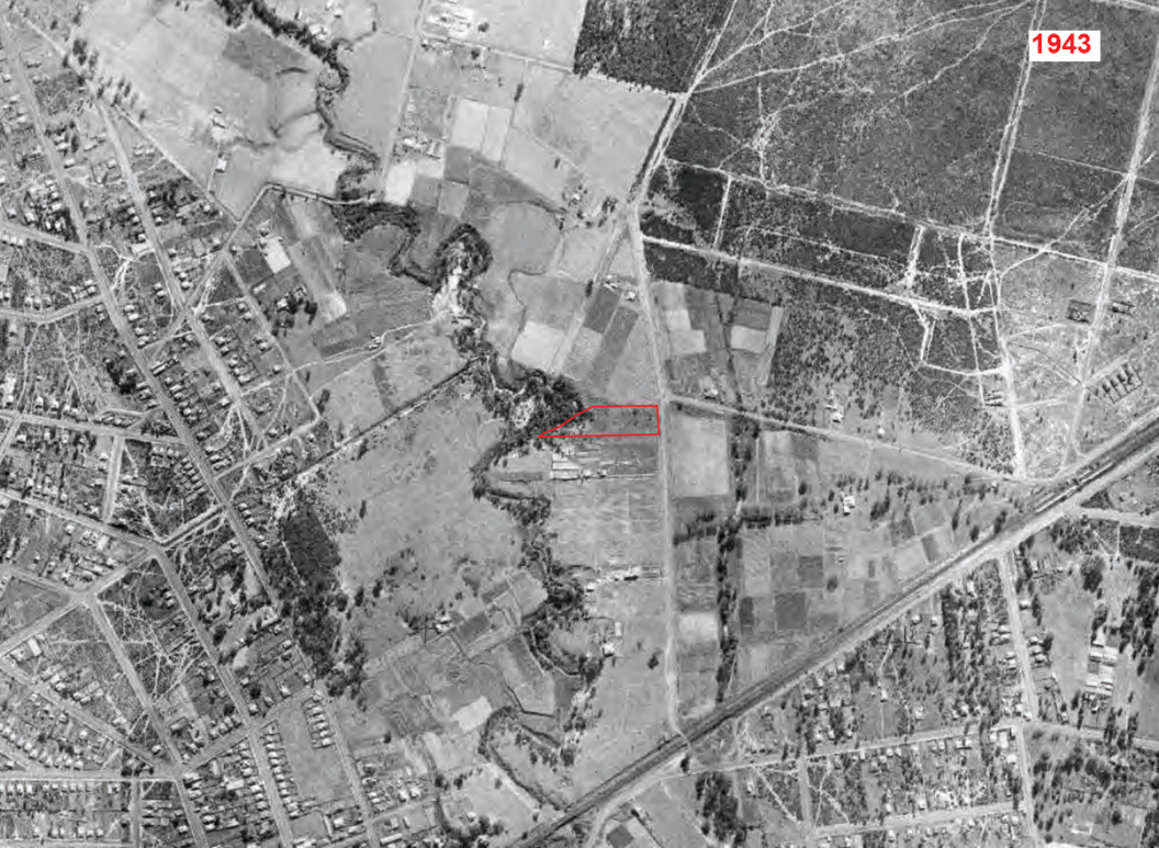
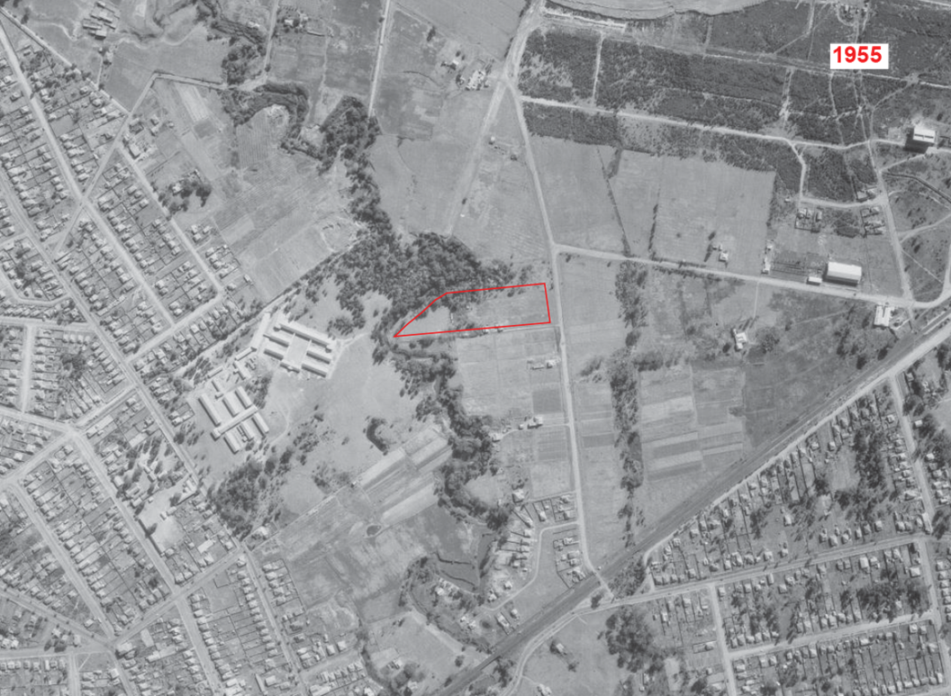
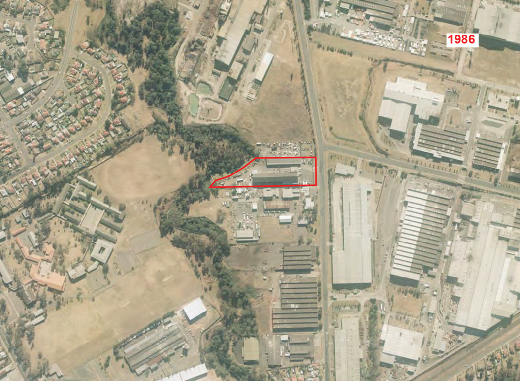
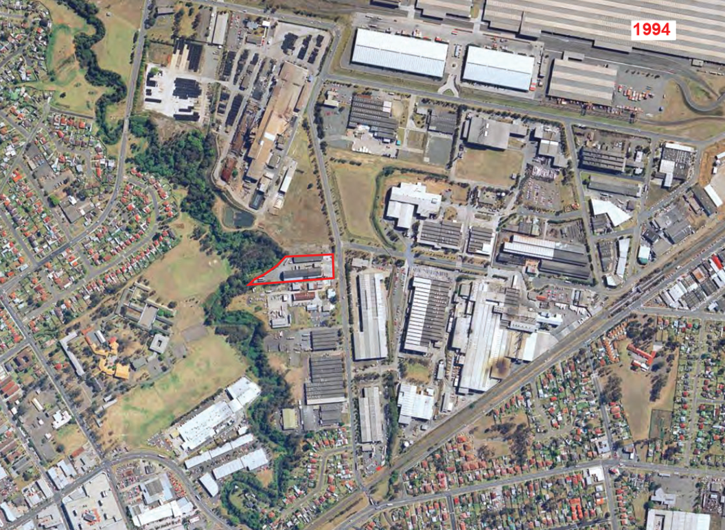
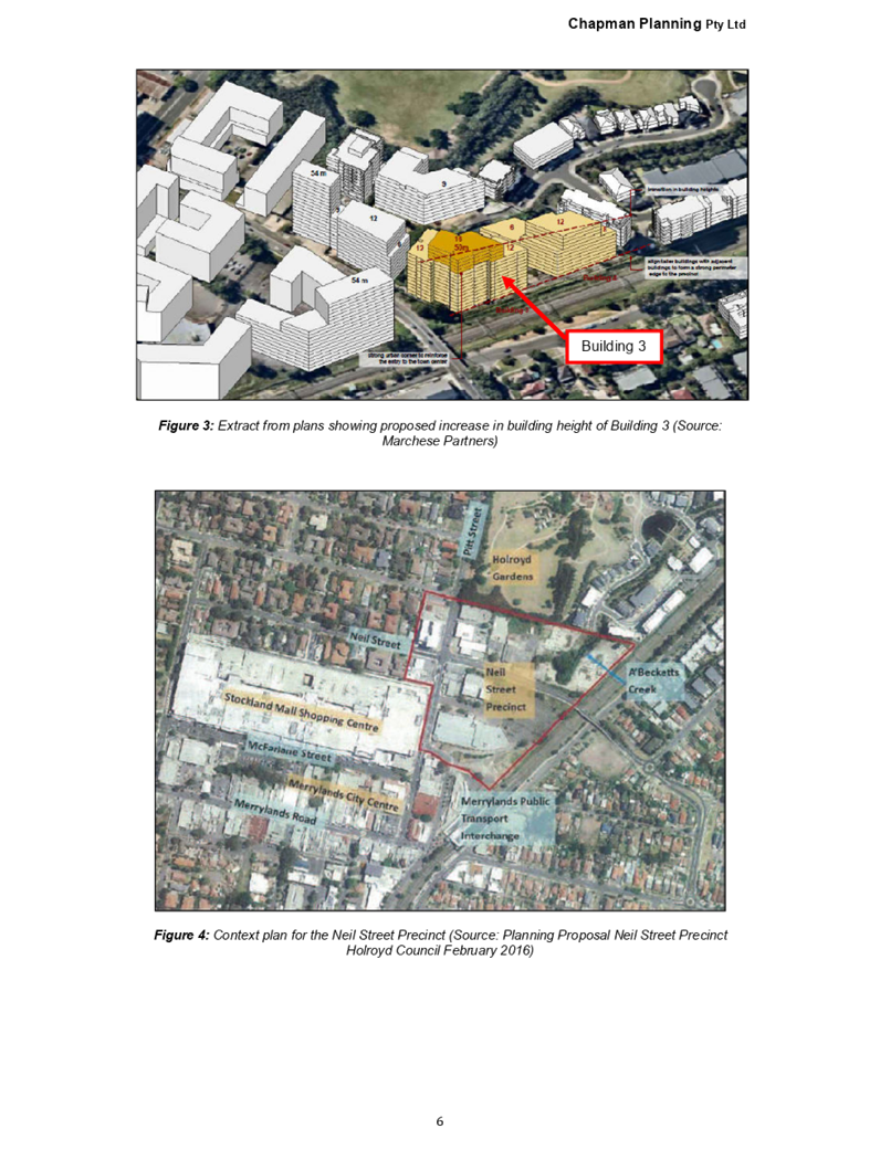
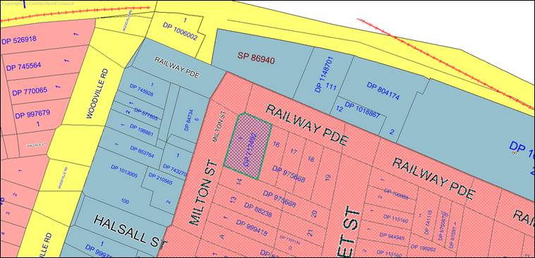
Subject Site and Surrounding
Area
The site forms Lot 1 DP 712492 and
is known as 128 Railway Parade, GRANVILLE NSW 2142. The site has an area of
816.80m2, with a frontage to Railway Parade of 19.329 metres and secondary
street frontage to Milton Street of 34.138 metres. The site has a fall of
approximately 710mm from rear to front.
A site inspection of the premises
carried out on the 8 October 2018 confirmed that the site is currently occupied
by a single storey dwelling and ancillary feature, such as a garage and a
carport. Access to the site is available via both street frontages. The
locality is characterised by a variety of developments, including a mix of
older single storey dwellings and newer two storey residences, mixed-use
developments and industrial buildings. The railway corridor is located close to
the north of the site and Woodville Road is also located close to the west of
the site.
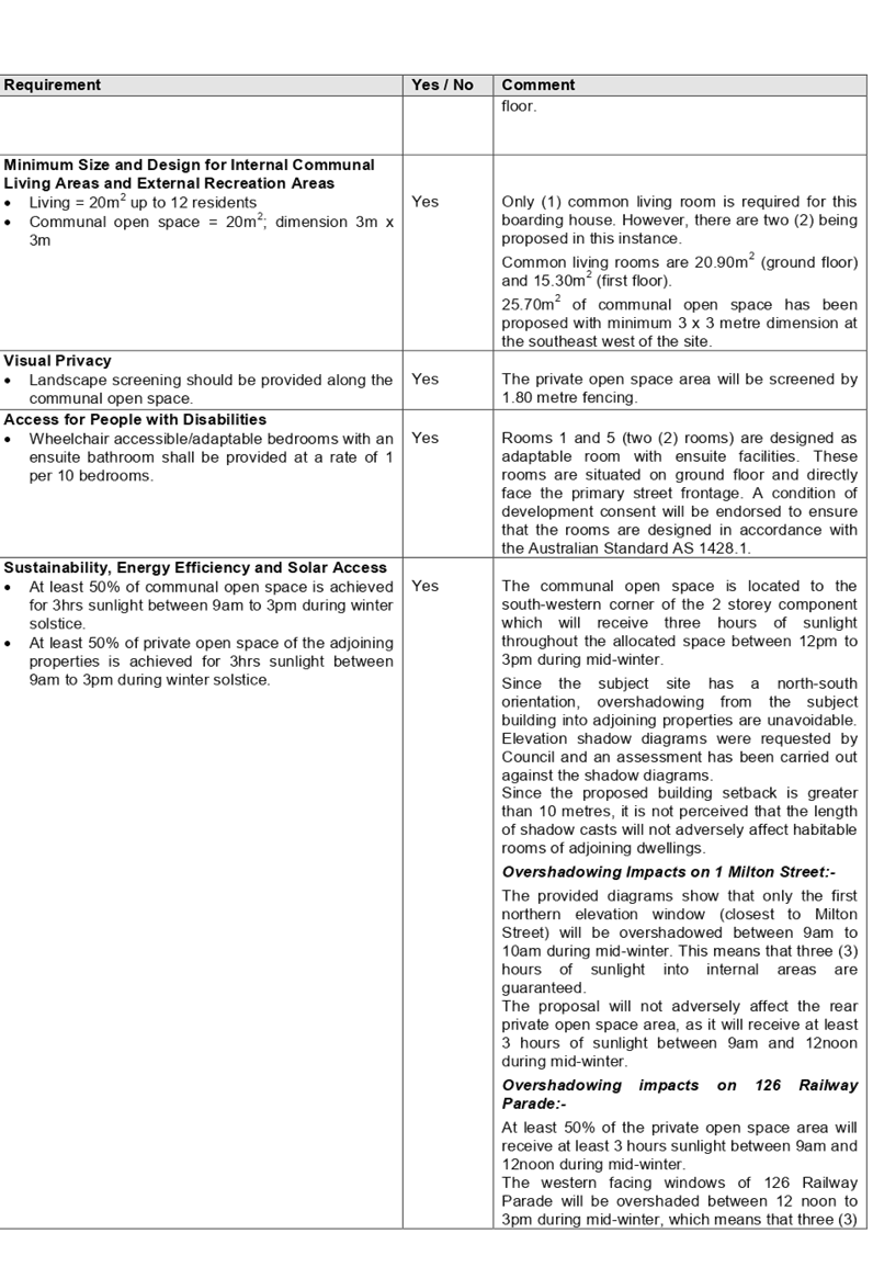
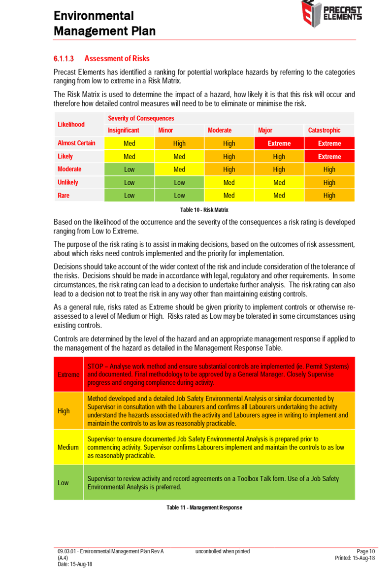
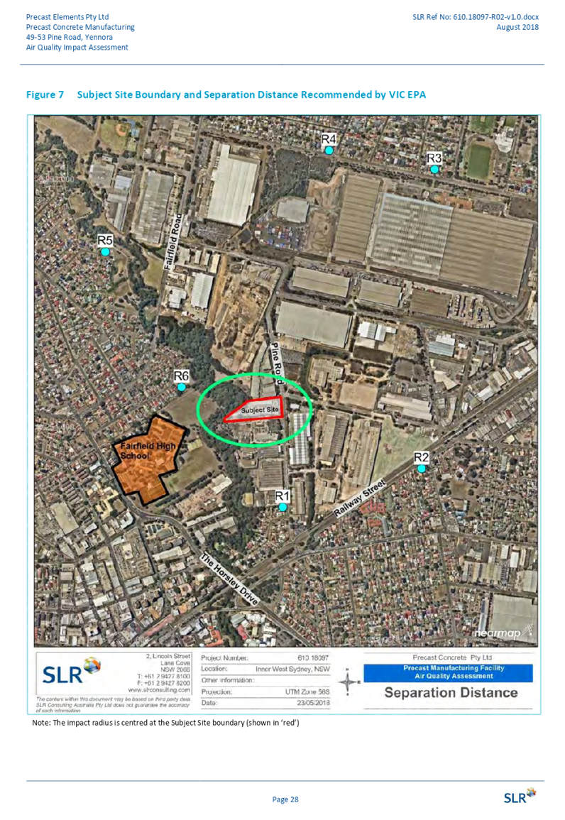
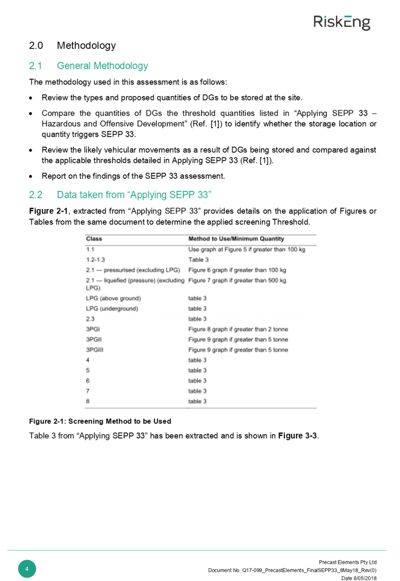
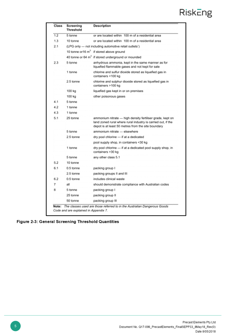
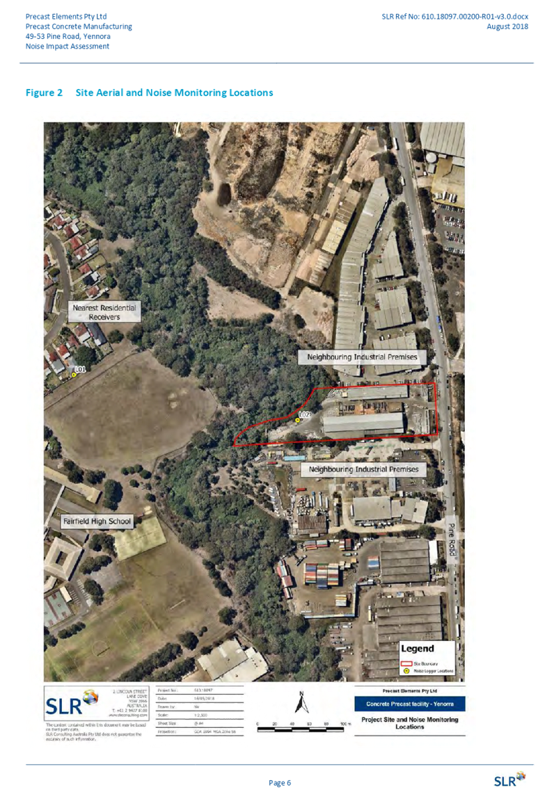
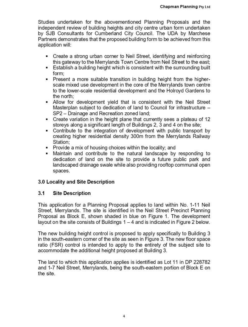
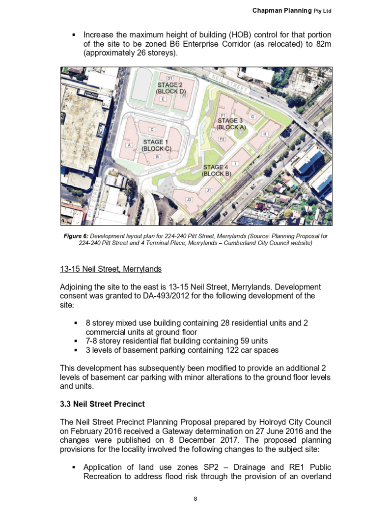
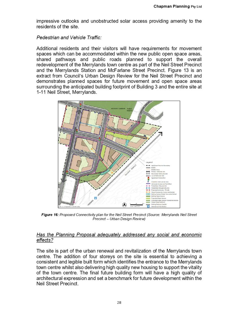
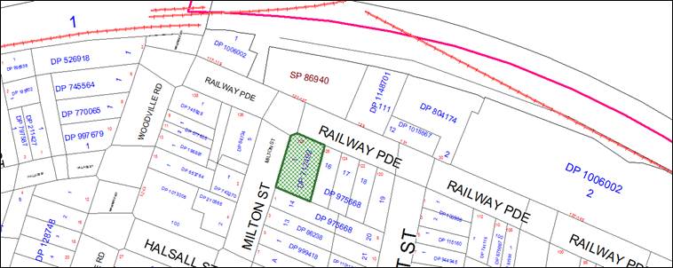
Figure
1 – Locality Plan of subject site
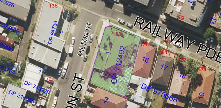
Figure
2 – Aerial view of subject site
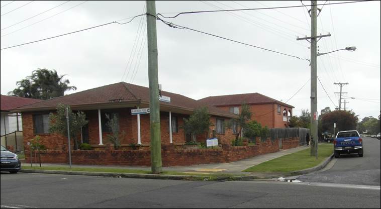
Figure
3 – Street view of subject site
Across the road from the site on
opposite ends of Milton Street and Railway Parade are B6 “Enterprise
Corridor” zoned land-uses. Milton Street comprises of primarily single
storey dwellings on the eastern side of the roadway and industrial premises on
the western side of the roadway. Immediately opposite the site on the opposite
side of Railway Parade includes a mixed-use development located over multiple
properties; such as food and drink premises, residential apartments as well as
a place of public worship, known as “Voice to the Nations”.
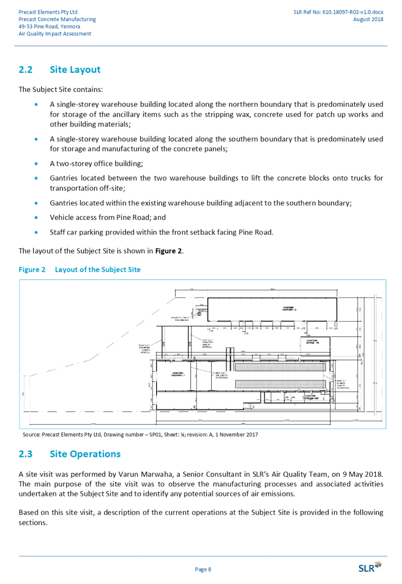
Description of The Proposed
Development
Council is in receipt of a
development application, seeking approval for the demolition of the dwelling
and associated structures and the construction of a two storey boarding house,
comprising 12 single rooms with associated at-grade car parking. The detailed
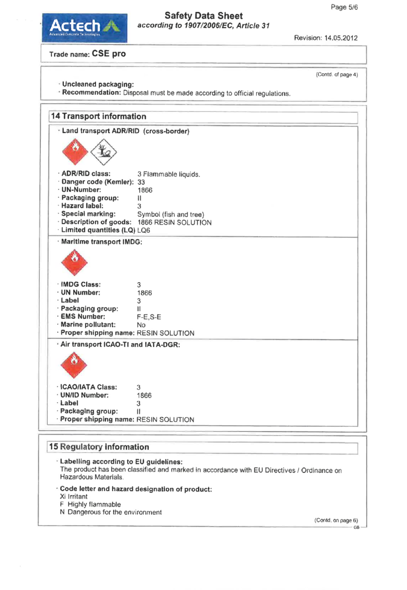
breakdown of the proposal is as below:-
Demolition:
· Existing
dwelling house, garage and awning.
· Removal
of existing vehicular crossover over Railway Parade.
Construction:
· New
two (2) storey boarding house.
· At-grade
car parking at the rear of the site, accessible via a new vehicular crossover
over the Milton Street (secondary street frontage). There are six (6) car
spaces proposed; including three (3) spaces for bicycles and three (3) spaces
for motorcycles.
· Boarding
house to consist of twelve (12) bedrooms. A single lodger is proposed for each
bedroom.
· Boarding
house includes two (2) communal living rooms and a shared laundry.
· Boarding
house includes an external enclosed waste bin area and a services room.
Applicants Supporting Statement
The applicant has provided a
Statement of Environmental Effects prepared by Think Planners Pty. Ltd. dated
the 27 July 2018 was received in support of the application.
Contact with Relevant
Parties
The assessing officer has
undertaken a site inspection of the subject site and surrounding properties and
has been in regular contact with the applicant throughout the assessment
process.
Internal Referrals
Building Surveyor
Council’s Building Surveyor
has provided the comments. No objections were raised subject to conditions of
development consent; that the proposed building is constructed under a Class 3
classification as per the Building Code of Australia (BCA).
Development Engineer
Council’s Development
Engineer has provided comments, pertaining to the proposed stormwater drainage
system (including the provision of the on-site stormwater detention) and the
parking design and the associated vehicular access/egress. It has been advised
that the development proposal is satisfactory and therefore can be supported,
subject to conditions of development consent.
Environment and Health
Council’s Health and
Environmental Officer provided comments who has advised that the development
proposal is satisfactory and therefore can be supported, subject to recommended
conditions of consent to ensure that potential noise form the development is
mitigated.
Landscape Officer
The development application was
referred to Council’s Landscape Officer for comment who has advised that
the development proposal is satisfactory, since there is substantial
landscaping and plantings proposed on the site and therefore can be supported
subject to recommended conditions of consent.
External Referrals
NSW Police
Comments were provided from the
Cumberland Police Area Command. A risk assessment was carried out and a low
risk rating was indicated for this locality. In this regard, there are no
concerns regarding the above proposal, provided that conditions of development
consent pertaining to appropriate safety and security measures are implemented
to the development.
Planning Comments
The provisions of any
Environmental Planning Instruments (EP&A Act s4.15 (1)(a)(i))
State Environmental Planning
Policies
The proposed development is
affected by the following State Environmental Planning Policies:
a) State
Environmental Planning Policy No. 55 – Remediation of Land (SEPP 55)
Clause 7 of SEPP 55 requires
Council to be satisfied that the site is suitable or can be made suitable to
accommodate the proposed development. The matters listed within Clause 7 have
been considered in the assessment of the development application.
|
Matter for Consideration
|
Yes/No
|
|
Does the application involve re-development of the site or
a change of land use?
|
Yes No
|
|
Is the development going to be used for a sensitive land
use (e.g.: residential, educational, recreational, childcare or hospital)?
|
Yes No
|
|
Does information available to you indicate that an
activity listed below has ever been approved, or occurred at the site?
acid/alkali plant and
formulation, agricultural/horticultural activities, airports, asbestos
production and disposal, chemicals manufacture and formulation, defence
works, drum re-conditioning works, dry cleaning establishments, electrical
manufacturing (transformers), electroplating and heat treatment premises,
engine works, explosive industry, gas works, iron and steel works, landfill
sites, metal treatment, mining and extractive industries, oil production and
storage, paint formulation and manufacture, pesticide manufacture and
formulation, power stations, railway yards, scrap yards, service stations,
sheep and cattle dips, smelting and refining, tanning and associated trades,
waste storage and treatment, wood preservation.
|
Yes No
|
|
Is the site listed on
Council’s Contaminated Land database?
|
Yes No
|
|
Is the site subject to EPA
clean-up order or other EPA restrictions?
|
Yes No
|
|
Has the site been the subject of
known pollution incidents or illegal dumping?
|
Yes No
|
|
Does the site adjoin any
contaminated land/previously contaminated land?
|
Yes No
|
|
Details of contamination
investigations carried out at the site:
The subject site has no history of any contamination.
There are no concerns regarding possible land contamination and the risk to
human health on the site.
|
|
Has the appropriate level of
investigation been carried out in respect of contamination matters for
Council to be satisfied that the site is suitable to accommodate the proposed
development or can be made suitable to accommodate the proposed development?
|
Yes
No
|
b) State
Environmental Planning Policy No. 55 – Remediation of Land (SEPP 55)
Rail corridor - The application
has been assessed in accordance with clauses 87 and 88 of this SEPP. It has
been identified that the rail corridor is located further than twenty (25)
metres away from the subject site. Also, penetration of the ground is no greater
than two (2) metres deep, below the existing natural ground surface. The rail
corridor will not have any visual or amenity impact on the proposal. The
development will need to be carried out in accordance with the recommendations
made in the acoustic report, by Far West Consulting Reference no. 193465 dated
the 27 February 2019, to ensure that noise impacts surrounding the development
are mitigated through appropriate measures in the building design.
Classified roadway - The
application has been assessed in accordance with clause 102 of this SEPP. It
has been identified that a classified road (Woodville Road) is located within
100 metres from the subject site. However, the site is not immediately adjacent
to the roadway, nor does the site have an immediate street frontage to the
roadway. The classified road will not have any visual or amenity impact on the
proposal.
c) State
Environmental Planning Policy (Vegetation in Non-Rural Areas) 2017
The proposal does not exceed the
biodiversity offsets scheme threshold. Therefore, the proposed vegetation
removal is considered acceptable. Please refer to the DCP compliance table for
further discussion.
d) State
Environmental Planning Policy (BASIX) 2004
BASIX Certificate 1007784M issued
on the 8 April 2019 has been submitted. The BASIX Certificate lists measures to
satisfy BASIX requirements which have been incorporated into the proposal. A
standard condition is also recommended to be imposed ensuring the measures
detailed in the BASIX Certificate are implemented.
e) State
Environmental Planning Policy (Affordable Rental Housing) 2009
The relevant objectives and
provisions of SEPP (ARH) 2009 have been considered in the following assessment
table:
|
Requirement
|
Yes/No
|
Comments
|
|
Part 1 Preliminary
|
|
3 Aims
of Policy
The aims of
this Policy are as follows:
(a) to
provide a consistent planning regime for the provision of affordable rental
housing,
(b) to
facilitate the effective delivery of new affordable rental housing by
providing incentives by way of expanded zoning permissibility, floor space
ratio bonuses and non-discretionary development standards,
(c) to
facilitate the retention and mitigate the loss of existing affordable rental
housing,
(d) to
employ a balanced approach between obligations for retaining and mitigating
the loss of existing affordable rental housing, and incentives for the
development of new affordable rental housing,
(e) to
facilitate an expanded role for not-for-profit-providers of affordable rental
housing,
(f) to
support local business centres by providing affordable rental housing for
workers close to places of work,
(g) to
facilitate the development of housing for the homeless and other
disadvantaged people who may require support services, including group homes
and supportive accommodation.
|
Y
|
The development is not inconsistent with the aims of this
policy.
|
|
Part 2 New affordable rental housing
|
|
Division 3 Boarding houses
|
|
26 Land
to which Division applies
This Division applies to land
within any of the following land use zones or within a land use zone that is
equivalent to any of those zones:
(a) Zone R1 General
Residential,
(b) Zone R2 Low
Density Residential,
(c) Zone R3 Medium
Density Residential,
(d) Zone R4 High
Density Residential,
(e) Zone B1
Neighbourhood Centre,
(f) Zone B2 Local
Centre,
(g) Zone B4 Mixed
Use.
|
Y
|
The subject site is zoned R2 Low Density Residential Zone
as identified in the PLEP 2011.
|
|
27 Development
to which Division applies
(1) This Division
applies to development, on land to which this Division applies, for the
purposes of boarding houses.
(2) Despite subclause
(1), this Division does not apply to development on land within Zone R2 Low
Density Residential or within a land use zone that is equivalent to that zone
in the Sydney region unless the land is within an accessible area.
(3) Despite subclause
(1), this Division does not apply to development on land within Zone R2 Low
Density Residential or within a land use zone that is equivalent to that zone
that is not in the Sydney region unless all or part of the development is
within 400 metres walking distance of land within Zone B2 Local Centre or
Zone B4 Mixed Use or within a land use zone that is equivalent to any of
those zones.
|
Y
|
The development is proposed on land zoned R2 Low Density
Residential in the Sydney region. This division applies to the development as
the land is located within an accessible area.
The site is 793.20 metres from the southern entrance to
Granville Railway Station.
The site is also within 400 metres of public bus stop(s),
ID numbers 2142233 and 2142234) serviced with a regular bus route (907
Bankstown to Parramatta), that operates at least one bus per hour between 6am
and 9pm, Monday to Friday, 8am to 6pm, Saturday and Sunday.
|
|
28 Development
may be carried out with consent
Development to which this
Division applies may be carried out with consent.
|
Y
|
This clause does not apply.
|
|
29 Standards
that cannot be used to refuse consent
(1) A consent authority
must not refuse consent to development to which this Division applies on the
grounds of density or scale if the density and scale of the buildings when
expressed as a floor space ratio are not more than:
(a) the existing
maximum floor space ratio for any form of residential accommodation permitted
on the land, or
(b) if the
development is on land within a zone in which no residential accommodation is
permitted—the existing maximum floor space ratio for any form of
development permitted on the land, or
(c) if the development
is on land within a zone in which residential flat buildings are permitted
and the land does not contain a heritage item that is identified in an
environmental planning instrument or an interim heritage order or on the
State Heritage Register—the existing maximum floor space ratio for any
form of residential accommodation permitted on the land, plus:
(i) 0.5:1, if the
existing maximum floor space ratio is 2.5:1 or less, or
(ii) 20% of the
existing maximum floor space ratio, if the existing maximum floor space ratio
is greater than 2.5:1.
(2) A consent authority
must not refuse consent to development to which this Division applies on any
of the following grounds:
(a) building
height if the building height of all proposed buildings is not more than the
maximum building height permitted under another environmental planning
instrument for any building on the land,
(b) landscaped
area if the landscape treatment of the front setback area is compatible
with the streetscape in which the building is located,
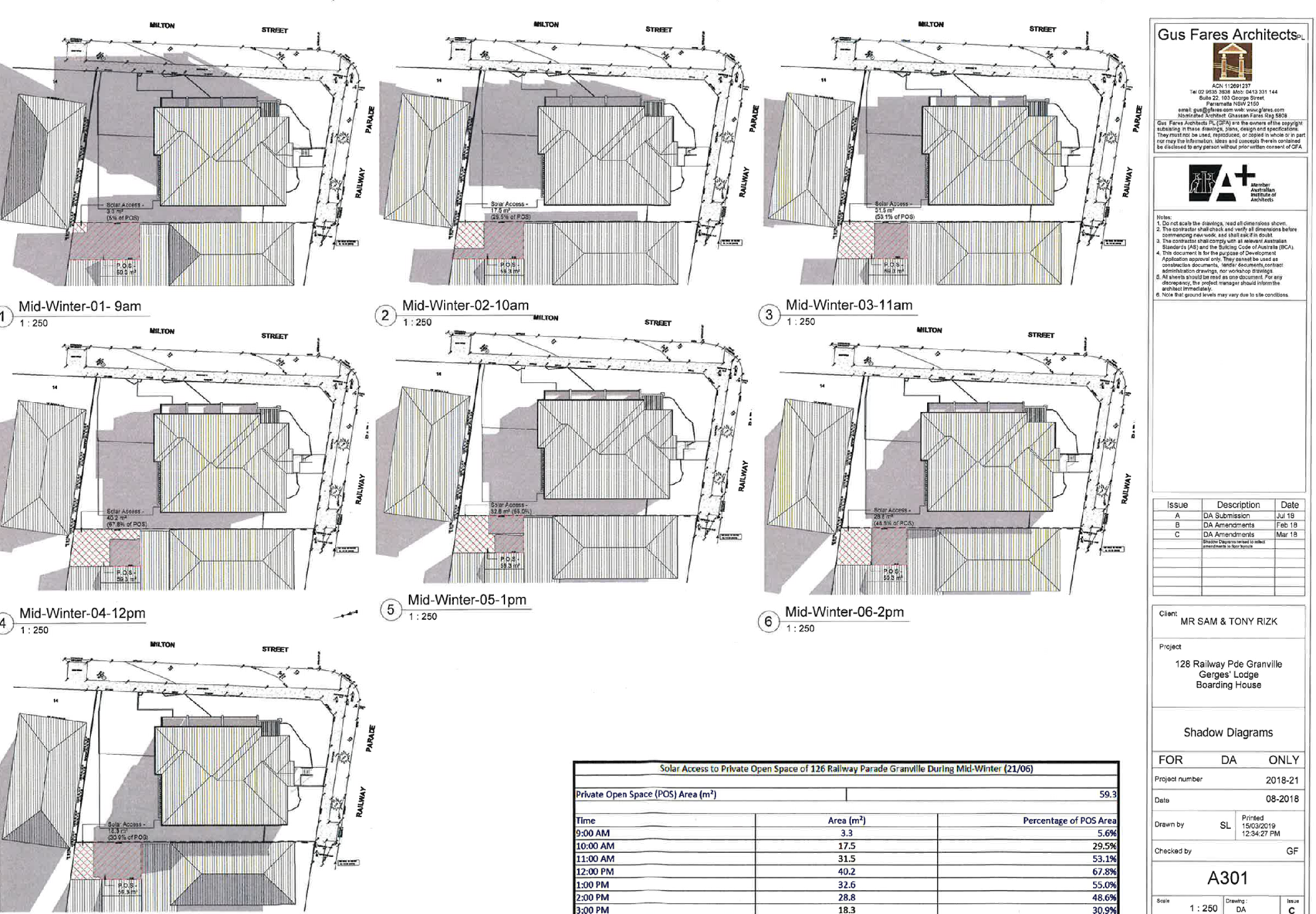
(c) solar access
where the development provides for one or more communal living rooms, if
at least one of those rooms receives a minimum of 3 hours direct sunlight
between 9am and 3pm in mid-winter,
(d) private open
space if at least the following private open space areas are provided
(other than the front setback area):
(i) one area of at
least 20 square metres with a minimum dimension of 3 metres is provided for
the use of the lodgers,
(ii) if
accommodation is provided on site for a boarding house manager—one area
of at least 8 square metres with a minimum dimension of 2.5 metres is
provided adjacent to that accommodation,
(e) parking if:
(i) in the case of
development carried out by or on behalf of a social housing provider in an
accessible area—at least 0.2 parking spaces are provided for each
boarding room, and
(ii) in the case of
development carried out by or on behalf of a social housing provider not in
an accessible area—at least 0.4 parking spaces are provided for each
boarding room, and
(iia) in the case
of development not carried out by or on behalf of a social housing
provider—at least 0.5 parking spaces are provided for each boarding
room, and
(iii) in the case
of any development—not more than 1 parking space is provided for each
person employed in connection with the development and who is resident on
site,
(f) accommodation
size if each boarding room has a gross floor area (excluding any area
used for the purposes of private kitchen or bathroom facilities) of at least:
(i) 12 square
metres in the case of a boarding room intended to be used by a single lodger,
or
(ii) 16 square
metres in any other case.
(3) A boarding house may
have private kitchen or bathroom facilities in each boarding room but is not
required to have those facilities in any boarding room.
(4) A consent authority
may consent to development to which this Division applies whether or not the
development complies with the standards set out in subclause (1) or (2).
|
Y
N/A
N/A
Y
Y
Y
Y
N/A
N/A
N/A
Y
N/A
Y
N/A
Y
Y
|
Compliant. See discussion under the LEP.
Residential accommodation is permitted on the land.
Residential flat buildings are not permissible on the
site.
The proposed building height is compliant with the LEP
height development standards.
Landscaping in the front yard has been provided and is
compatible with the streetscape.
The communal area that faces the secondary street frontage
will receive minimum three hours of sunlight, between the hours of 9am to 3pm
during mid-winter.
Private open space for lodgers has been provided at the
rear of the site and is found to be compliant with the required area and
dimensions.
A separate private open space area is not required for a
boarding house manager.
Development is not carried out by or on behalf of a social
housing provider.
As the
boarding house is for a private housing provider with twelve (12) bedrooms
proposed, the number of parking spaces required is six (6) spaces, (12 x 0.5
= 6 spaces).
There is no parking required on the site for those people
employed by the boarding house.
All twelve (12) rooms are single rooms and all meet the
minimum gross floor area.
All boarding rooms have private bathroom and kitchen
facilities.
Noted.
|
|
30 Standards
for boarding houses
(1) A consent authority
must not consent to development to which this Division applies unless it is
satisfied of each of the following:
(a) if a boarding
house has 5 or more boarding rooms, at least one communal living room will be
provided,
(b) no boarding
room will have a gross floor area (excluding any area used for the purposes
of private kitchen or bathroom facilities) of more than 25 square metres,
(c) no boarding
room will be occupied by more than 2 adult lodgers,
(d) adequate
bathroom and kitchen facilities will be available within the boarding house
for the use of each lodger,
(e) if the boarding
house has capacity to accommodate 20 or more lodgers, a boarding room or on
site dwelling will be provided for a boarding house manager,
(f) (Repealed)
(g) if the boarding
house is on land zoned primarily for commercial purposes, no part of the
ground floor of the boarding house that fronts a street will be used for
residential purposes unless another environmental planning instrument permits
such a use,
(h) at least one
parking space will be provided for a bicycle, and one will be provided for a
motorcycle, for every 5 boarding rooms.
(2) Subclause (1) does
not apply to development for the purposes of minor alterations or additions
to an existing boarding house.
|
Y
Y
Y
Y
Y
N/A
Y
N/A
|
A communal room is proposed at ground floor level and an
additional communal room on first floor. These rooms are proposed to be
available to all lodgers.
The gross floor area for each boarding room is no more
than 17.0m2 and must be occupied by maximum one (1) adult lodger,
as per the details provided in the plan of management.
The boarding house is proposed to accommodate a maximum of
12 lodgers. Accordingly, a boarding room for a boarding house manager is not
required.
The land is not primarily zoned for commercial purposes.
12 boarding rooms three (3) spaces for bicycles and three
(3) spaces for motorcycles and have been provided.
This application is for a new boarding house.
|
|
30AA Boarding
houses in Zone R2 Low Density Residential
A consent authority must not
grant development consent to a boarding house on land within Zone R2 Low
Density Residential or within a land use zone that is equivalent to that zone
unless it is satisfied that the boarding house has no more than 12 boarding
rooms.
|
N/A
|
Under the savings provisions, this clause is not
applicable to this application as this application was made before the
commencement of these provisions which were introduced as part the 2019
amendments to the SEPP. Additionally, the site is zoned R2 and thus this
clause is not applicable.
|
|
30A Character
of local area
A consent authority must not
consent to development to which this Division applies unless it has taken
into consideration whether the design of the development is compatible with
the character of the local area.
|
Y
|
See discussion below.
|
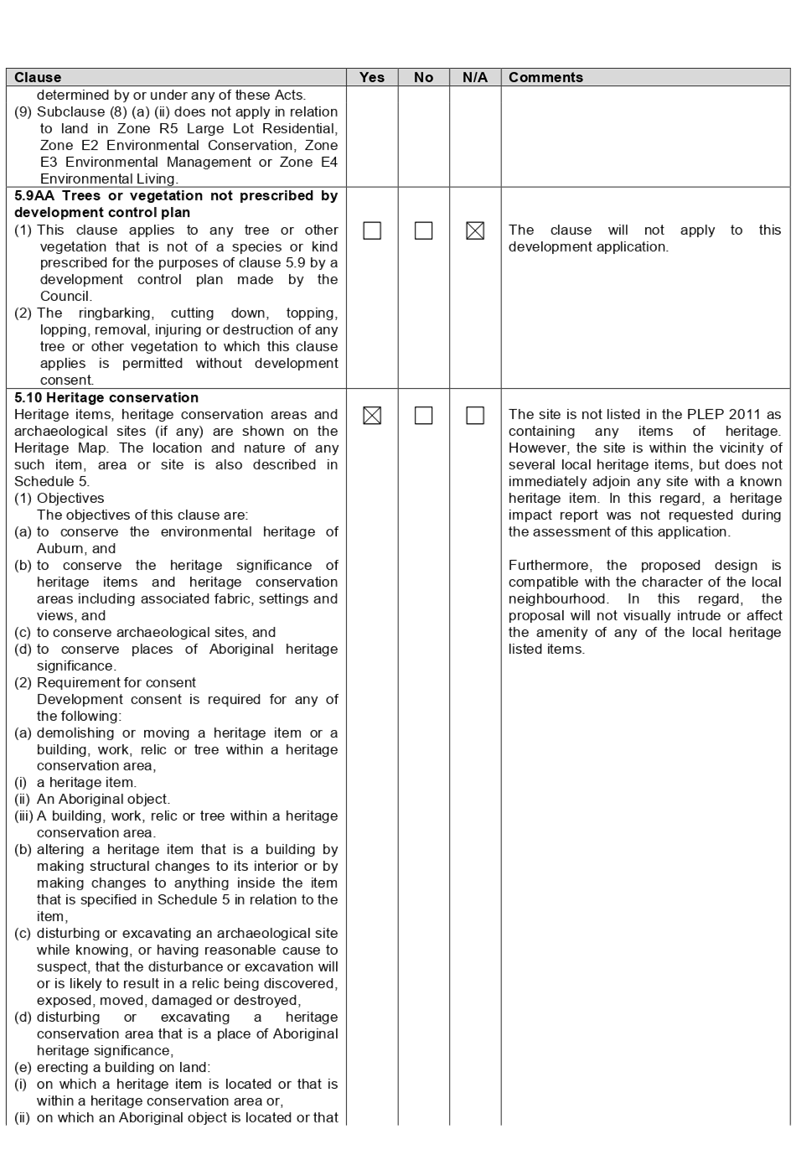
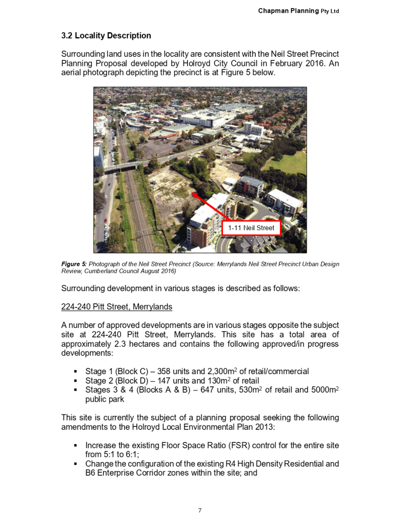
Clause 30A - Character of local
area:
The SEPP requires Council to
consider whether the design of the development is compatible with the character
of the local area. The NSW Land and Environment Court have issued a planning
principle known as “compatibility in the urban environment”, which
is a useful guide for the purposes of this assessment. The character assessment
for the current proposal is provided in the following section:
Part A – Identify the
local area
The local area for the purposes of
this application is outlined on the zoning map below:
Figure
4 – location of subject site within the R2 Low Density Residential zone
Part B – Determine the character
of the local area
The identified character area is
within the zone “R2 Low Density Residential” and contains primarily
one and two storey residential dwelling houses. In terms of urban design, the
area is undergoing transition and it is likely that the existing older building
stock of single dwellings will be redeveloped within the R2 areas to
incorporate a mixture of 2 storey residential dwellings of modern construction.
The ‘B6 Enterprise Corridor’ zone lies to the north and to the west
of the site. The built form in this B6 zone consists of industrial/warehouse
buildings and residential flat buildings. The future built form in the
surrounding area is likely to consist of a mix of residential dwellings and
warehouses.
Part C – Determine if
development is compatible with character of the local area
In the decision of Project
Ventures Development Pty Limited vs Pittwater Council (2005), the planning
principle states that there are two important aspects of compatibility that
need to be satisfied. An explanation about the proposal’s compatibility
with the surrounding urban environment is detailed below:
1. Are
the proposal’s physical impacts on surrounding development acceptable?
The physical impacts generally
include overlooking, overshadowing and constraining development potential. In
terms of the physical impacts of the development, the following points are
made:-
· The
privacy impacts are mitigated through the use of adequate building separation
and privacy treatment.
i)
· The
proposal will not impact on the development potential of adjoining sites by
isolating or by unduly constraining them as the proposal is within an existing
allotment on a street corner.
ii)
· A
minimum of 50% of each of the private open space areas for these two (2)
adjoining properties will receive natural lighting between the hours of 9am to
12noon during mid-winter.
iii)
· The
proposed northern and eastern elevations allow for passive surveillance
opportunities and an interface with the primary and secondary street frontages.
iv)
· The
proposal is a purpose built boarding house development, which has utilised
architectural and design treatments to ameliorate the amenity impacts on
neighbouring properties.
v)
2. Is
the proposal’s appearance in harmony with the buildings around it and the
character of the street?
The predominant building types
within the local area are one and two storey residential dwelling houses,
industrial buildings and a mixed-use development. To be considered compatible,
a development should contain or at least respond to the essential elements that
make up the character of the surrounding area. The proposed pitched roof form
is consistent with the architectural style of the existing housing stock in the
vicinity. The proposed two storey building form and materials and finishes are
considered to be in harmony with the emerging surrounding development. The
front façade has been designed with balanced fenestration on both sides
of the principal entrance that will harmonise the development to be consistent
with a new two (2) storey dwelling in a low density residential zone. Also,
since the site adjoins the land-use zone of “B6 Enterprise
Corridor”, the site is within proximity of buildings with other
classifications and designs; which means that the proposed two (2) storey
building is not an unreasonable design in this locality.
The proposed front setback is also
consistent with immediately adjoining development. The proposal is also
considered to be in keeping with the future desired character of the area as
defined in the planning controls that apply to the site, as discussed elsewhere
in this report. In this regard, the proposal is considered to be visually
compatible within this context, and responds to the varied elements and has
been designed in a manner that is similar to a two storey dwelling or dual
occupancy development, and is therefore in harmony with the rest of the two (2)
streetscapes of Railway Parade and Milton Street.
Local Environmental Plans
Parramatta Local Environmental
Plan (PLEP) 2011
The provision of Parramatta Local
Environmental Plan 2011 is applicable to the development proposal. The proposal
is consistent with the objectives of the “R2 Low Density Residential
Zone” and is noted that the development achieves compliance with the key
statutory requirements of the PLEP.
Permissibility:-
The proposed development is
defined as a “boarding house” and is permissible in the R2 –
Low Density Residential zone.
Boarding house means a building
that:
a) is
wholly or partly let in lodgings, and
b) provides
lodgers with a principal place of residence for 3 months or more, and
c) may
have shared facilities, such as a communal living room, bathroom, kitchen or
laundry, and
d) has
rooms, some or all of which may have private kitchen and bathroom facilities,
that accommodate one or more lodgers,
but does not include
backpackers’ accommodation, a group home, hotel or motel accommodation,
seniors housing or a serviced apartment.
Note. Boarding houses are a type
of residential accommodation - see the definition of that term in this
Dictionary.
The relevant matters to be
considered under Parramatta Local Environmental Plan 2011 and the applicable
clauses for the proposed development are summarised below. A comprehensive LEP
assessment is contained in Appendix A.
|
Provision
|
Compliance
|
Comment
|
|
Part 1 Preliminary
|
|
1.2 Aims of Plan
|
Yes
|
The proposal is not
inconsistent with regards to the aims of the plan.
|
|
Part 2 Permitted or prohibited
development
|
|
2.7 Demolition requires
development consent
|
Yes
|
The application seeks
demolition of structures on site, which is permissible with consent.
|
|
Part 4 Principal
development standards
|
|
4.3 Height of buildings
· 9m
|
Yes
|
The proposed height is 8.20
metres.
|
|
4.4
Floor space ratio
· 0.75:1
|
Yes
|
The proposed FSR is 0.5:1
(408.40sqm)
|
|
Part 6 Additional local
provisions
|
|
6.1 Acid sulfate
soils
· Class
5
|
Yes
|
The site is within 500m of
Class 1, 2, 3, or 4 land. However, the proposal is does not include works
below 5 metres Australian Height Datum (AHD). In this regard, an acid
sulphate soil management plan is not required.
|
The provisions of any proposed
instrument that is or has been the subject (EP&A Act s4.15 (1)(a)(ii))
The proposed development is not
affected by any relevant Draft Environmental Planning Instruments.
The provisions of any
Development Control Plans (EP&A Act s4.15 (1)(a)(iii))
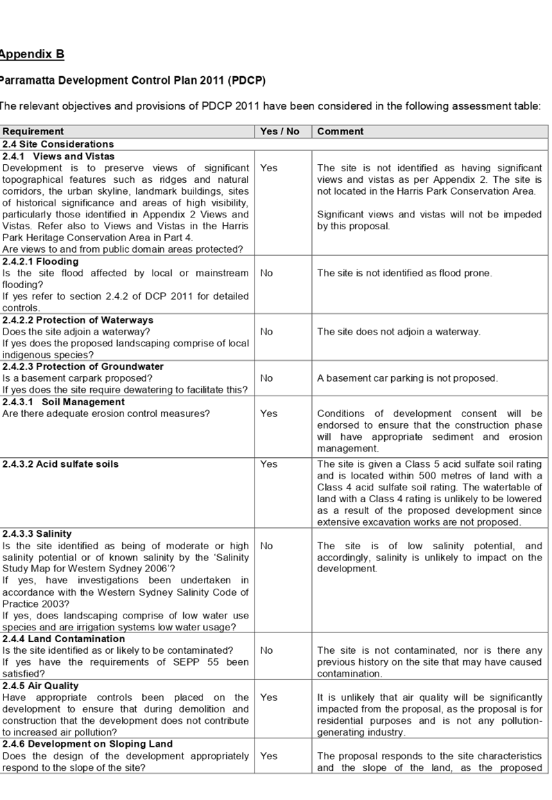
Parramatta Development Control
Plan 2011
The Part 5.1.4 ‘Planning
Controls for Boarding Houses’ provides guidance for the design and
operation of Boarding Houses, to achieve the aims and objectives of the
Parramatta Local Environmental Plan 2011. A comprehensive assessment and
compliance table against all other applicable DCP controls, relating to
Boarding Houses, is contained in Appendix B of this report.
The provisions of any planning
agreement that has been entered into under section 7.4, or any draft planning
agreement that a developer has offered to enter into under section 7.4
(EP&A Act s4.15(1)(a)(iiia))
There is no draft planning
agreement associated with the subject Development Application.
The provisions of the
Regulations (EP&A Act s4.15 (1)(a)(iv))
The proposed development raises no
concerns as to the relevant matters arising from the Environmental Planning and
Assessment Regulations 2000 (EP&A Reg).
The Likely Environmental,
Social or Economic Impacts (EP&A Act s4.15 (1)(b))
It is considered that the proposed
development will have no significant adverse environmental, social or economic
impacts in the locality.
The suitability of the site for
the development (EP&A Act s4.15 (1)(c))
The subject site and locality is
not known to be affected by any natural hazards or other site constraints
likely to have a significant adverse impact on the proposed development.
Accordingly, it is considered that the development is suitable in the context
of the site and surrounding locality.
Submissions made in accordance
with the Act or Regulation (EP&A Act s4.15 (1)(d))
Advertised (newspaper) Mail Sign Not Required
In accordance with Council’s
Notification requirements contained within the Parramatta Development Control
Plan 2011, the proposal was publicly notified for a period of 21 days between
the 9 October 2018 to the 30 October 2018. The notification generated two (2)
submissions, in which one (1) submission included a petition with 100 signatures
against the proposal. The issues raised in the public submissions are
summarised and commented on as follows:-
|
Issue
|
Response
|
|
Lack of car parking in the area
|
The proposal provides for six (6) car parking spaces, 3
motorcycle parking spaces and 3 bicycle spaces, complying with the minimum
parking rates for vehicles, motorcycles and bicycles required under State
Environmental Planning Policy (Affordable Rental Housing) 2009.
|
|
Increased traffic in the area
|
The use is not considered a traffic generating development
as per Schedule 3 in the State Environmental Planning Policy (Infrastructure)
2007. The proposal is not likely to create increased traffic impacts in the
local road network.
|
|
Proximity to schools and educational establishments
|
Boarding Houses are permissible with development consent
within the R2 Low Density Residential zone pursuant to the Parramatta Local
Environmental Plan 2011, as so are educational establishments.
|
|
Type of residents
|
The leasing of rooms to lodgers will be at the discretion
of the managing agent and is to be registered in accordance with the Boarding
Houses Act 2012 and Boarding Houses Regulation 2013. Furthermore, a condition
of development consent will be endorsed to ensure that a CCTV security system
is installed in order to capture any possible anti-social behaviour.
|
|
Unacceptable bulk and scale
|
The proposed boarding house has a built form, bulk and
scale consistent with a two storey dwelling house which is consistent with
newer development constructed in this area. As detailed in the SEPP (ARH)
2009 section, the proposed development is in keeping with the existing and
proposed mixed-use character of the area.
|
|
Overlooking and privacy
|
Side facing windows have a 3.0 metres setback from the
eastern boundary. The first floor windows on the eastern elevation first will
have fixed frosted glass panels up to a height of 1.60 metres above the
finished floor level. Bathroom windows face the rear boundary, which have
raised sill-heights of 1.60 metres above the finished floor level.
A condition of development consent has also been
recommended to ensure that the proposed plantings adjacent to the eastern
property boundary (six (6) Robyn Gordon Grevillea and one (1) Tuckeroo) are
to be planted before the commencement of any construction work on the site.
The intent of this condition is to allow plant establishment and growth
during the construction phase of the project and prior to the occupation of
the building commencing. This will assist in the provision of screening
between the proposed eastern elevation and the eastern adjoining property of
126 Railway Parade.
A further condition is also recommended requiring the
provision of fixed louvres to be installed over the first floor windows on
the eastern elevation of the proposed building. The louvres shall be
installed at an angle so as to minimise overlooking into the adjoining
property, whilst still permitting northern solar access into the first floor
windows of the proposed upper level rooms.
|
|
Location Criteria
|
The site is within the accessible area criteria for the
ARH SEPP and the PDCP2011, being within 800 metres to Granville Railway
Station. In this regard, the site having two (2) frontages and situated on
the edge of a residential zoning is considered appropriate for a Boarding
House.
|
The public interest (EP&A
Act s4.15(1)(e))
In view of the foregoing analysis
it is considered that the development as proposed would not be consistent with
the public interest.
Section 7.12 (Formerly S94a)
Fixed Development Consent Levies
This part of the Act relates to
the collection of monetary contributions from applicants for use in developing
key local infrastructure.
Comments:
The development would require the
payment of contributions in accordance with City of Parramatta Council Section
94A Development Contributions Plan (Amendment No. 5). The calculation is based
on a 1% levy on the cost of works. As at the 22 March 2018, the fee payable is
$9,989.14. This figure is subject to indexation as per the relevant plan.
Disclosure of Political
Donations And Gifts
The applicant and notification
process did not result in any disclosure of Political Donations and Gifts.
The development application has
been assessed in accordance with the relevant requirements of the Environmental
Planning and Assessment Act 1979, State Environmental Planning Policy No. 55
– Remediation of Land, State Environmental Planning Policy
(Infrastructure) 2007, State Environmental Planning Policy (Building
Sustainability Index: BASIX) 2004, State Environmental Planning Policy
(Affordable Rental Housing) 2009, Sydney Regional Environmental Plan (Sydney
Harbour Catchment) 2005, Parramatta Local Environmental Plan 2011 and
Parramatta Development Control Plan 2011 and is considered to be satisfactory
for approval subject to conditions.
The proposed development is
appropriately located within the R2 – Low Density Residential zone under
the relevant provisions of the Parramatta Local Environmental Plan 2011. The
proposal is consistent with all statutory and non-statutory controls applying
to the development. Minor non-compliances with Council’s controls have
been discussed in the body of this report. The development is considered to
perform adequately in terms of its relationship to its surrounding built and
natural environment, particularly having regard to impacts on adjoining
properties.
For these reasons, it is
considered that the proposal is satisfactory having regard to the matters of
consideration under Section 4.15 of the Environmental Planning and Assessment
Act 1979, and the development may be approved subject to conditions.
There are no further consultation
processes for Council associated with this report.
There are no further financial
implications for Council associated with this report.
There are no policy implications
for Council associated with this report.
Communication /
Publications:
The final outcome of this matter
will be notified in the newspaper. The objectors will also be notified in
writing of the outcome.
|
1.
That Development Application No. DA-290/2018 for
the demolition of dwelling and associated structures and construction of a
two storey boarding house comprising 12 single rooms with associated at-grade
car parking, on land at 128 Railway Parade, GRANVILLE NSW 2142 be
approved subject to the attached conditions.
2. Persons
whom have lodged submissions in respect to the application are to
be notified of the determination of the application.
|
1. Draft
Notice of Determination ⇩ 
2. Architectural
Plans ⇩
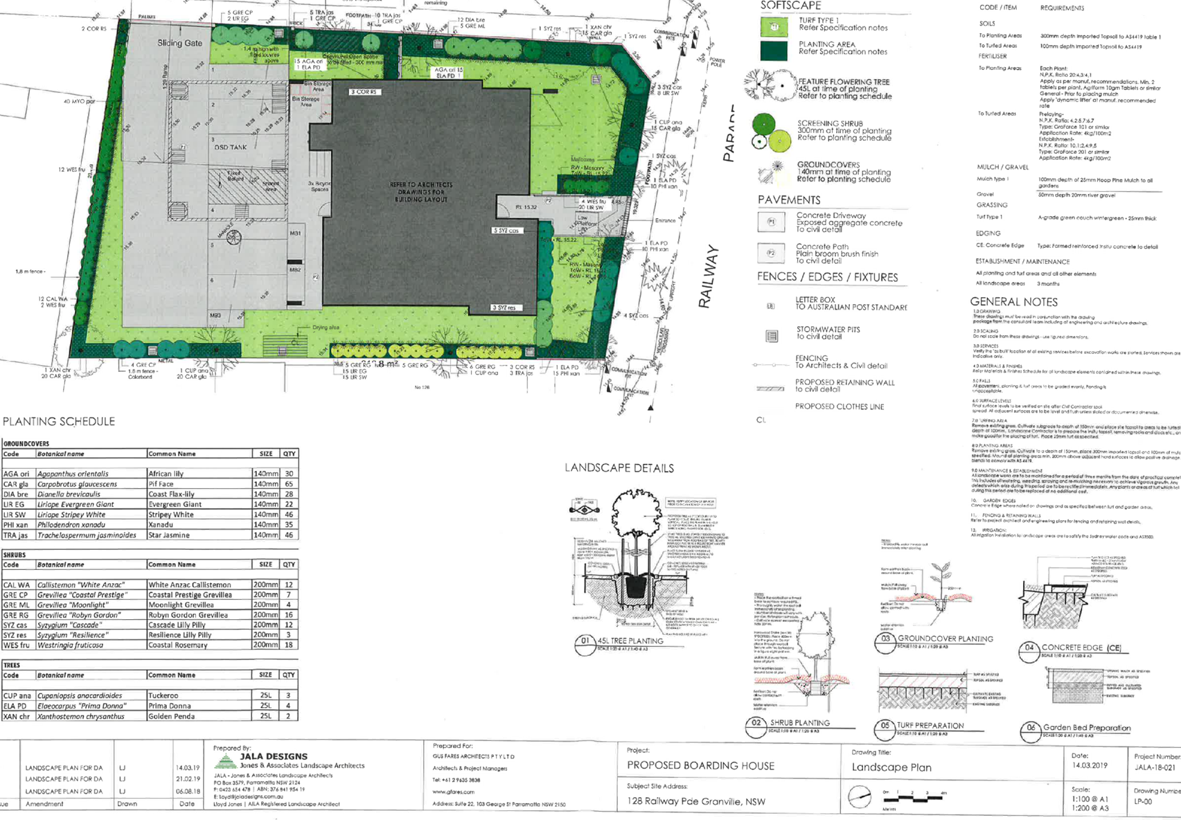
3. Landscape
Plan ⇩
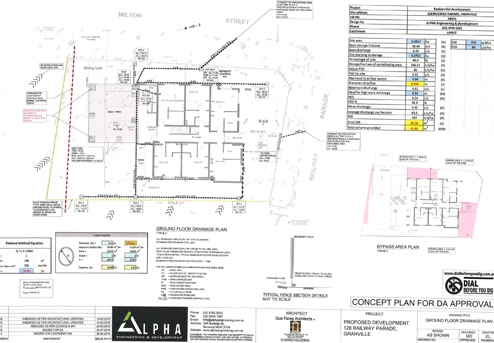
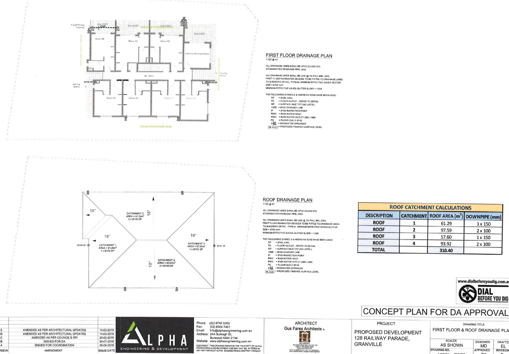
4. Stormwater
Plans ⇩
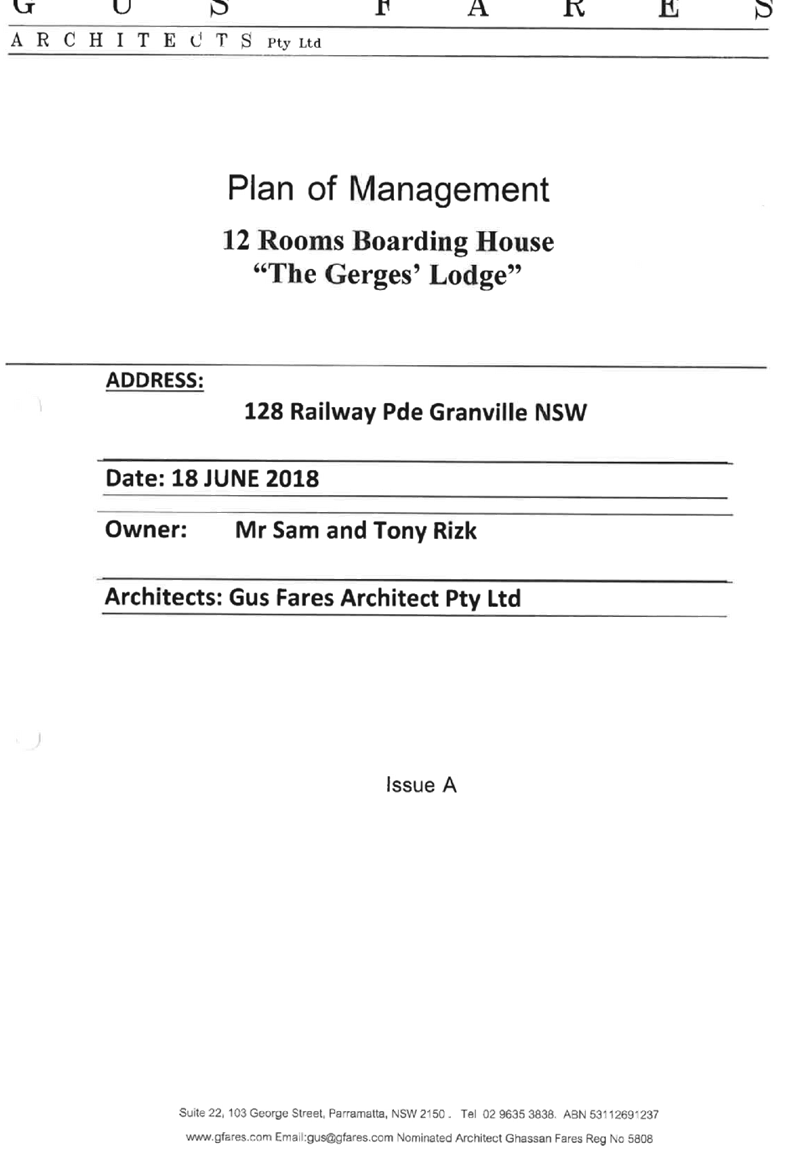
5. Plan
of Management ⇩
6. Submissions
Received ⇩
7. Parramatta
Local Environmental Plan 2011 - Compliance Table ⇩
8. Parramatta
Development Control Plan 2011 - Compliance Table ⇩
Extraordinary
Cumberland Local Planning Panel Meeting
1 May 2019
Item
No: EELPP024/19
Development
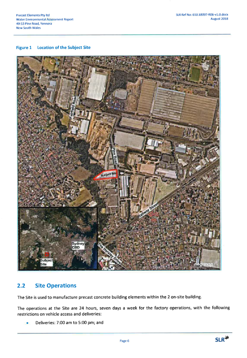
Application - 49-53 Pine Road, Yennora
Responsible
Division: Environment
& Planning
Officer: Manager
Development Assessment
File
Number: DA
- 2018/297/1
|
Application lodged
|
17 August 2018
|
|
Applicant
|
Urbis Pty Ltd c/- Precast Elements Pty Ltd
|
|
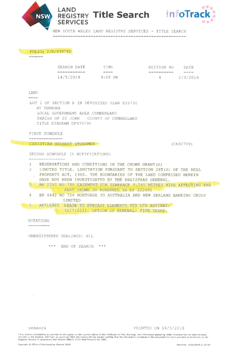
Owner
|
Dr C H Stoermer
|
|
Application No.
|
2018/297/1
|
|
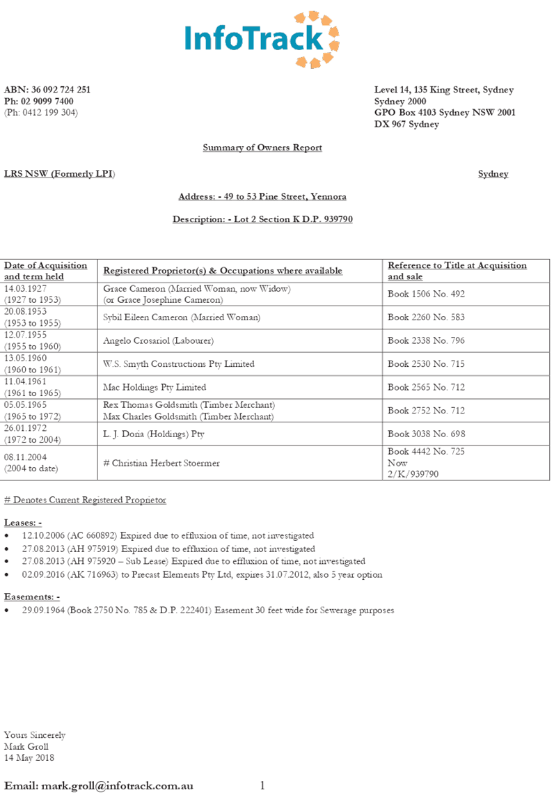
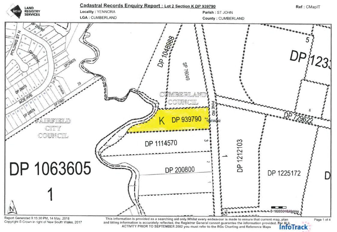
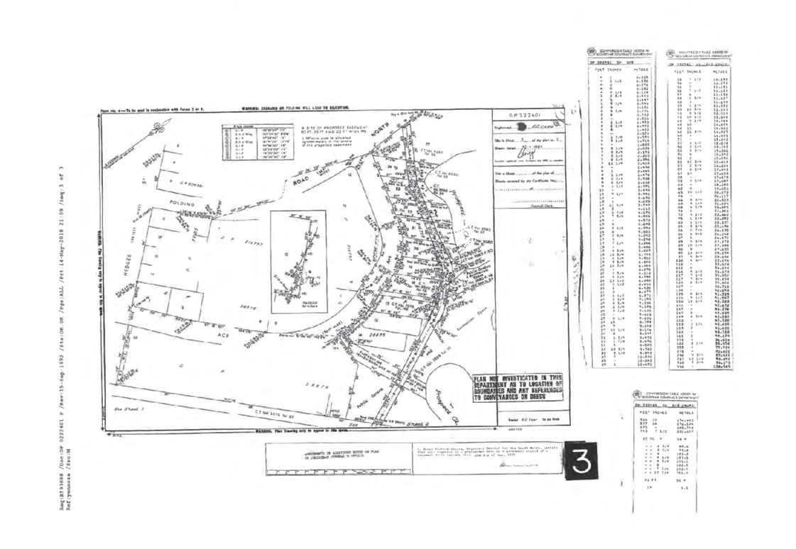
Description of Land
|
Lot 2, Section K, DP 939790
49 – 53 Pine Road, Yennora
|
|
Proposed Development
|
Retrospective approval for the change of use of an
existing industrial premises to manufacturing of concrete panels with
associated parking
|
|
Site Area
|
10,825m2
|
|
Zoning
|
IN1 General Industrial, and E2 Environmental
Conservation
|
|
Disclosure of political donations and gifts
|
Nil disclosure
|
|
Heritage
|
The subject site does not contain a heritage item,
is not located within a heritage conservation area, nor within the vicinity
of a heritage item.
|
|
Principal Development Standards
|
Floor Space Ratio
No Applicable
Development Standard
|
Height of Buildings
No
Applicable
Development
Standard
|
|
Issues
|
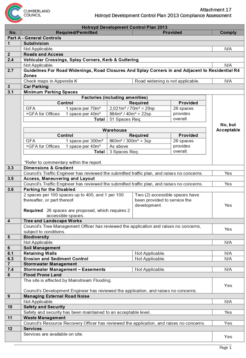
Car Parking
|
|
|
|
|
|
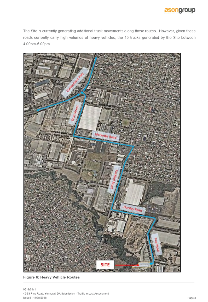
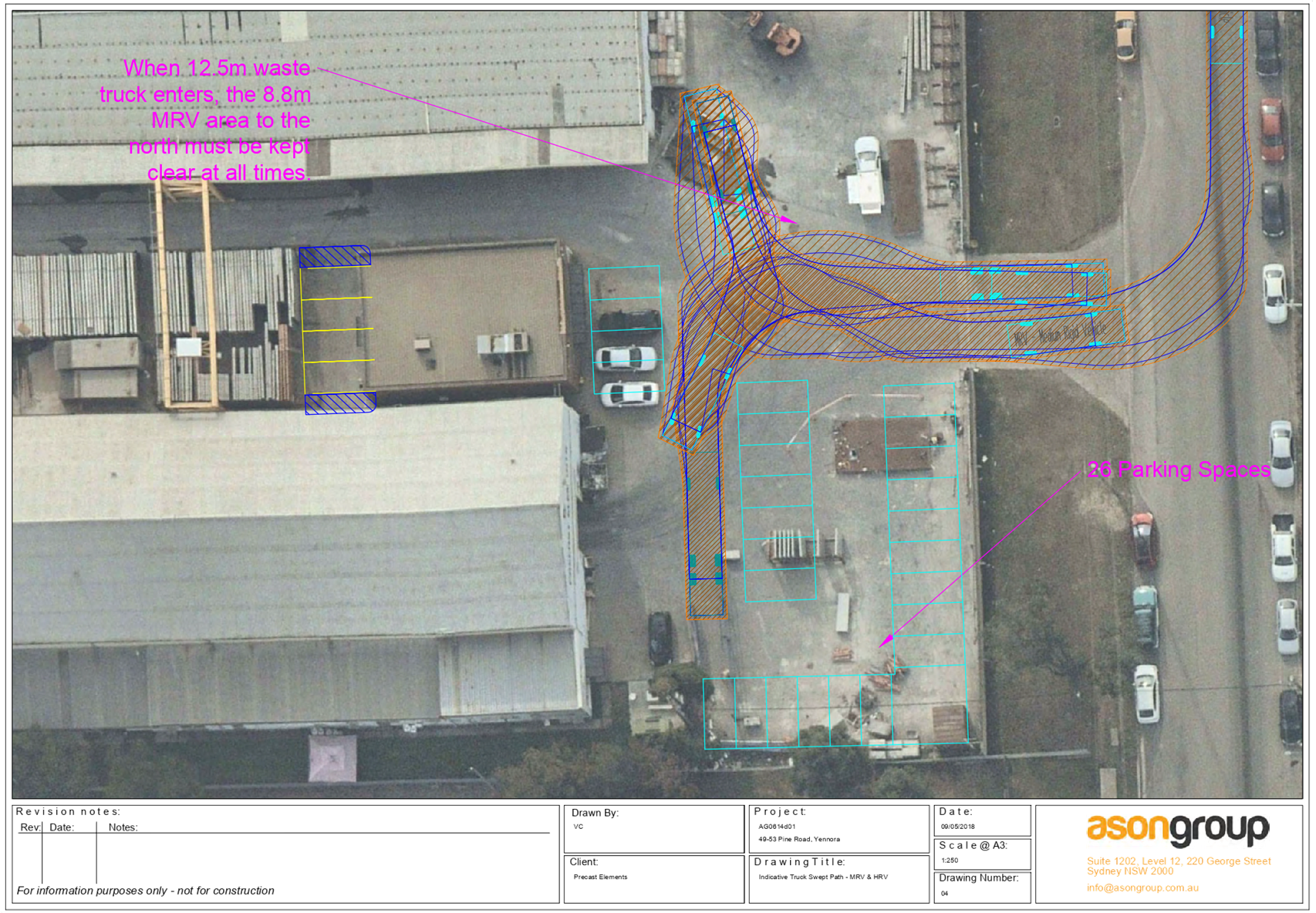
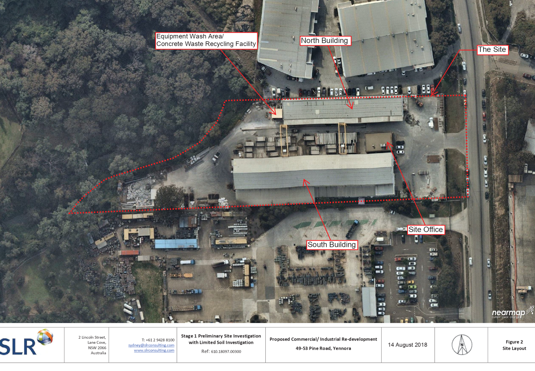
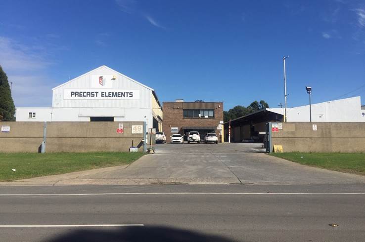
Figure 1 – Photo of the
Site, Looking West (Source: Cumberland Council, 2019)
Summary:
Council is in receipt of a
Development Application from Urbis Pty Ltd c/- Precast Elements Pty Ltd seeking
retrospective approval for the change of use of an existing industrial premises
to manufacturing of concrete panels with associated parking at 49 - 53 Pine
Road, Yennora. The Development Application Architectural Plans are provided as
Attachment 1 to this report.
The subject development is
classified as ‘Integrated Development’ under the Water Management
Act, 2000, due to the proximity of the proposed use to the natural watercourse,
Prospect Creek. The development has been assessed by the Department of Primary
Industries - Office of Water, and confirmed to be a ‘Controlled Activity
Approval’, however, due to the existing hardstand area to the rear of the
site, does not necessitate General Terms of Approval (GTA’s).
The subject development is also
classified as ‘Designated Development’ under the Environmental
Planning and Assessment Regulations, 2000, due to the site being within 100
metres of a natural waterbody, Prospect Creek, and within 250 metres of a
residential zone not associated with the development, located to the west of
the site. An Environmental Impact Statement has been prepared in accordance with
the Secretary’s Environmental Assessment Requirements (SEARs). The
development has been assessed by the Department of Planning and Environment,
and confirmed there are no issues of State or Regional significant that apply
to the proposal, identifying no specific condition requirements for the
proposal.
The Development Application was
publicly notified for a period of 30 days from 12 September 2018 to 12 October
2018 in accordance with the Environmental Planning and Assessment Regulations,
2000, requirements associated with ‘Designated Development’ and
‘Advertised Development’. In response, no submissions were
received.
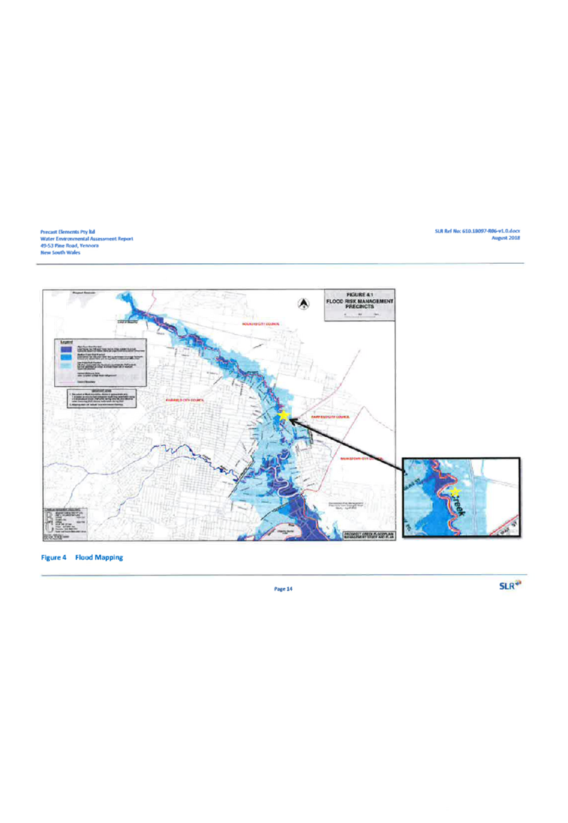
The site is affected by Mainstream
Flooding. The development has been assessed by Council’s Development
Engineer to be acceptable, noting no building works are proposed.
The site is zoned Part IN1 General
Industrial, and Part E2 Environmental Conservation, pursuant to the Holroyd
Local Environmental Plan (HLEP) 2013, with the subject use limited to the land
zoned IN1 General Industrial. Industrial activity is permissible with
development consent in the IN1 General Industrial zone.
The proposal is consistent with
the aims and objectives of Environmental Planning and Assessment Regulations,
2000, Water Management Act, 2000, State Environmental Planning Policy No. 55
(Remediation of Land), Greater Metropolitan Regional Environmental Plan No. 2
– Georges River Catchment (Deemed SEPP), Holroyd Local Environmental Plan
(HLEP) 2013, Draft SEPP (Environment), and Holroyd Development Control Plan (HDCP)
2013.
The Development Application was
referred for comments externally to Department of Planning and Environment,
Department of Primary Industries - Office of Water, and Endeavour Energy, and
internally to Council’s Development Engineer, Traffic Engineer, Tree
Management Officer, Environmental Health Officer, Resource Recovery Officer,
and Building Surveyor, to which the application is supported.
The proposed development has been
assessed against the relevant matters for consideration pursuant to Section
4.15 of the Environmental Planning and Assessment Act, 1979, including likely
impacts, the suitability of the site for the development, and the public
interest, and the proposed development is considered appropriate.
The variations sought via the
subject application are as follows:
|
vi) Control
|
vii) Required
|
viii) Provided
|
ix) %
Variation
|
|
x)
Car Parking
|
xi)
Min. 54 spaces
|
xii)
26 spaces
|
xiii) 51.85%
|
The application is being reported
to the Cumberland Local Planning Panel (CLPP) for determination, as the subject
development is classified as ‘Designated Development’ under the
Environmental Planning and Assessment Regulations, 2000.
In light of the above, it is
recommended that the Cumberland Local Planning Panel Approve the Development
Application, subject to the Draft Notice of Determination provided at
Attachment 15 to this report.
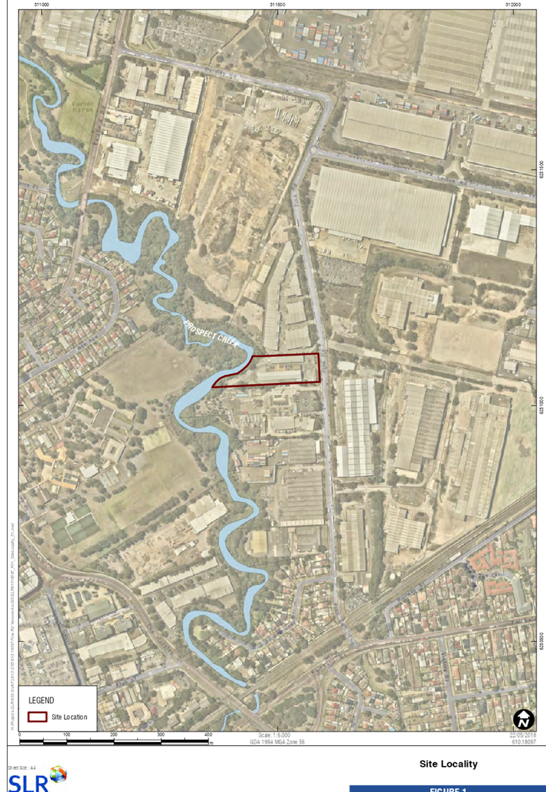
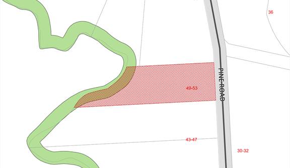
Subject Site and Surrounding
Area
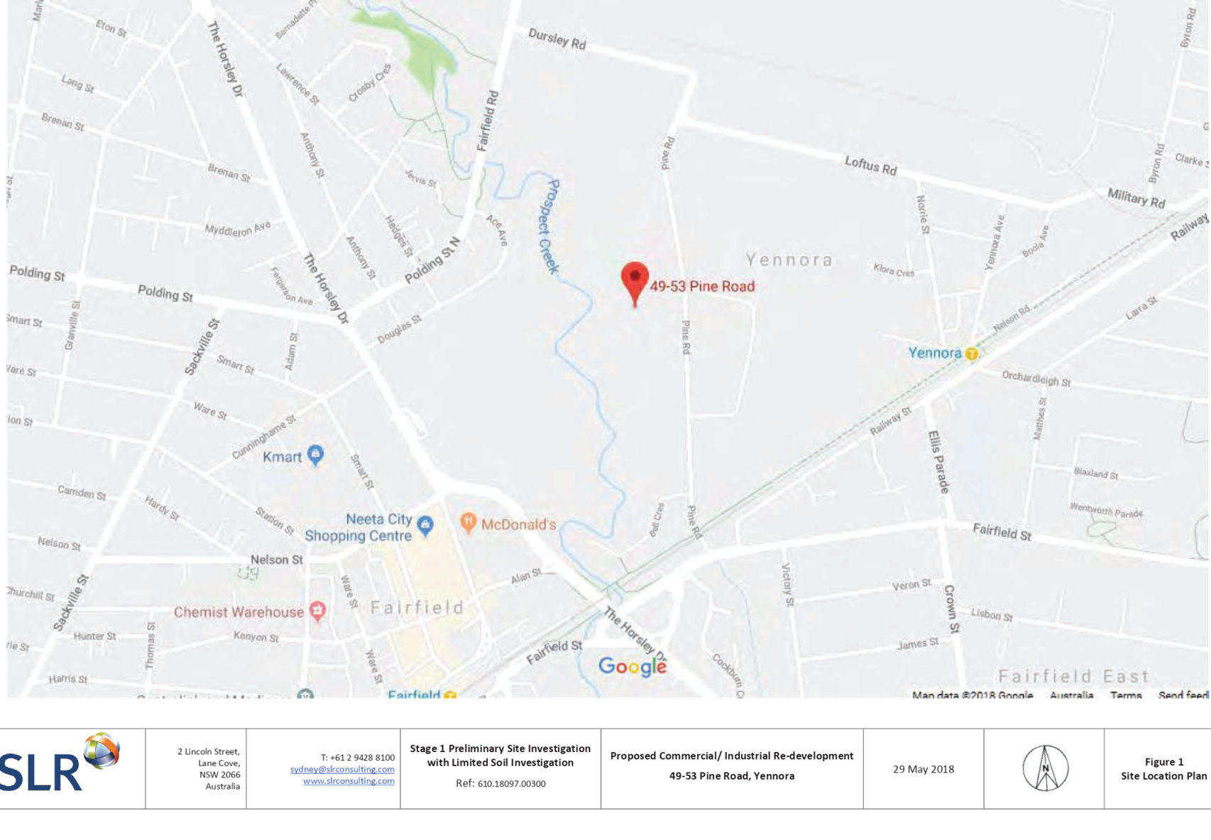
The subject site is known as 49 -
53 Pine Road, Yennora, and is legally described as Lot 2, Section K, and DP
939790. The site is an irregular mid-block, and has a frontage of 60.35 metres
to Pine Road, and depth of 132.510 metres along the northern boundary and
226.695 metres along the southern boundary. The western (rear) boundary of the
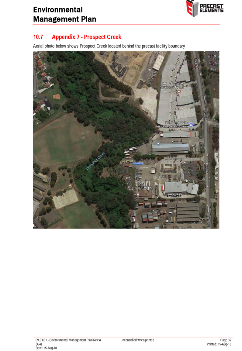
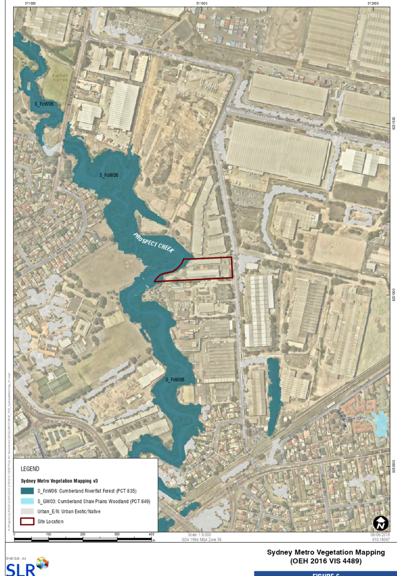
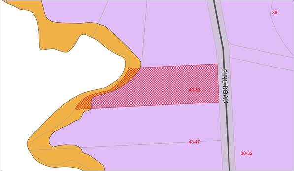
site adjoins Prospect Creek. The total site area is 10,825sqm, and is illustrated
in Figure 2 below:
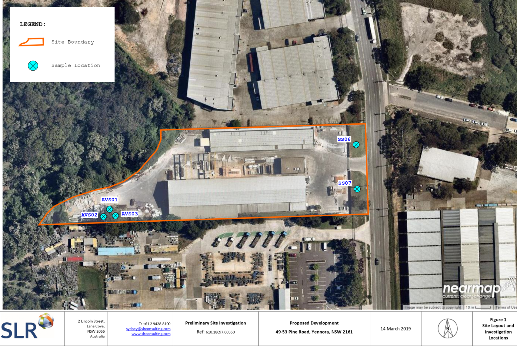
Figure
2 - Location Map (Source: Cumberland Council, 2018)
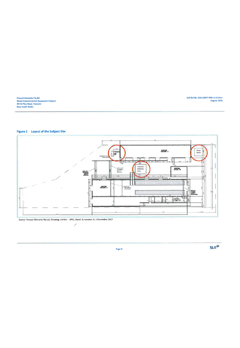
The subject site currently
contains:
· A
single storey warehouse located along the northern boundary.
· A
single storey warehouse located along the southern boundary, gantries within.
· Two
storey office building between the existing warehouse buildings.
· Gantries
between the existing warehouse buildings.
· Existing
trees and vegetation, predominately maintained to the rear of the site within
the E2 Conservation zone, which are unaffected by the proposal.
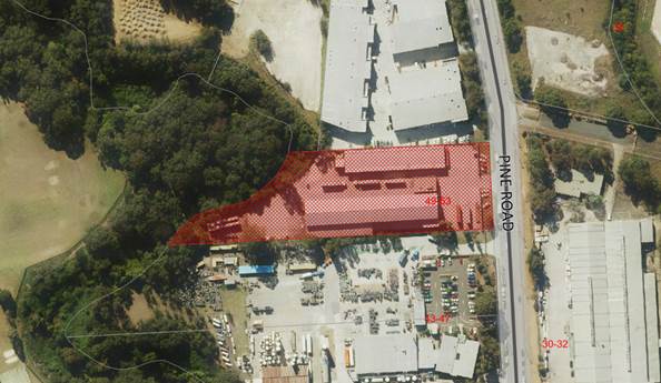
The surrounding locality is
characterised as follows:
· North
55 - 61 Pine Road, Yennora – Industrial, warehouse and
commercial tenancies.
· East 32
Pine Road, Yennora – Warehouse and distribution centre.
· South
43 - 47 Pine Road, Yennora – Production and distribution
centre.
· West
Prospect Creek (natural waterway) with bordering vegetation, with Fairfield
High School and associated sport fields beyond.
The topography of the site is
maintained to a 0.08% gradient, with a 2 metre fall across the site from East
to West. The site is affected by Mainstream Flooding.
The subject site is situated on
the western side of Pine Road. Figure 3 below illustrates an aerial perspective
of the site and the general surroundings.
Figure
3 – Aerial Photo (Source: Cumberland Council, 2018)
The site is zoned Part IN1 General
Industrial, and Part E2 Environmental Conservation, pursuant to the Holroyd
Local Environmental Plan (HLEP) 2013, with the subject use limited to the land
zoned IN1 General Industrial, as shown in Figure 4 below:
Figure 4 –
Zoning Map (Source: Cumberland Council, 2018)
The subject site does not contain
a heritage item, is not located within a heritage conservation area, nor within
the vicinity of a heritage item.
Description of The Proposed
Development
The proposal is for retrospective
approval for the change of use of an existing industrial premises to
manufacturing of concrete panels with associated parking.
Specific details of the proposed
development, as outlined within the Applicant’s Environmental Impact
Statement (EIS), prepared by Urbis, dated 17 August 2018, are as follows:
Nature of the Use
Precast Elements produced a
maximum of 75 tonnes of concrete product per day, with an annual production
capacity of 20,625 tonnes.
The northern warehouse is capable
of manufacturing 400m² of concrete panels per day.
The storage capacity is presently
for 190 panels inside and a further provision of 240 panels outside. The main
warehouse is serviced by 2 x 12.5t and a 1 x 10t overhead gantries.
The southern warehouse is utilised
for the manufacturing of small precast items up to 5t in weight.
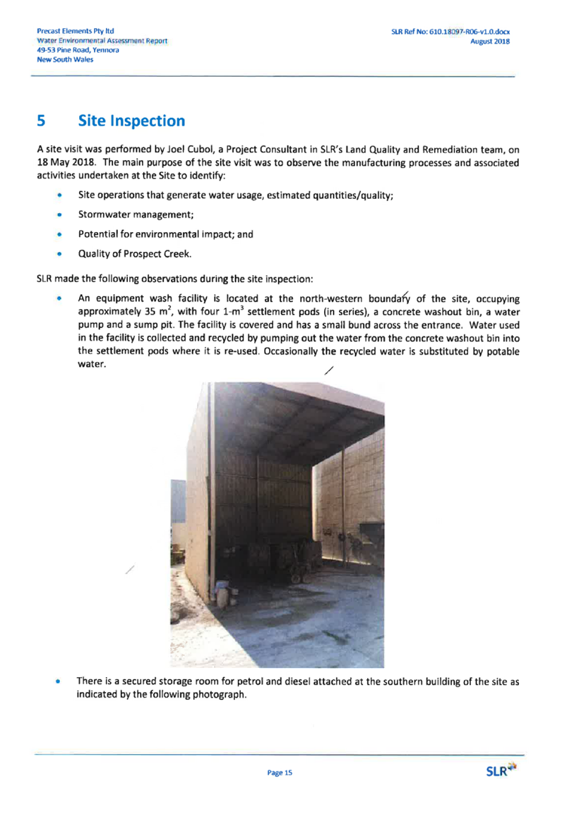
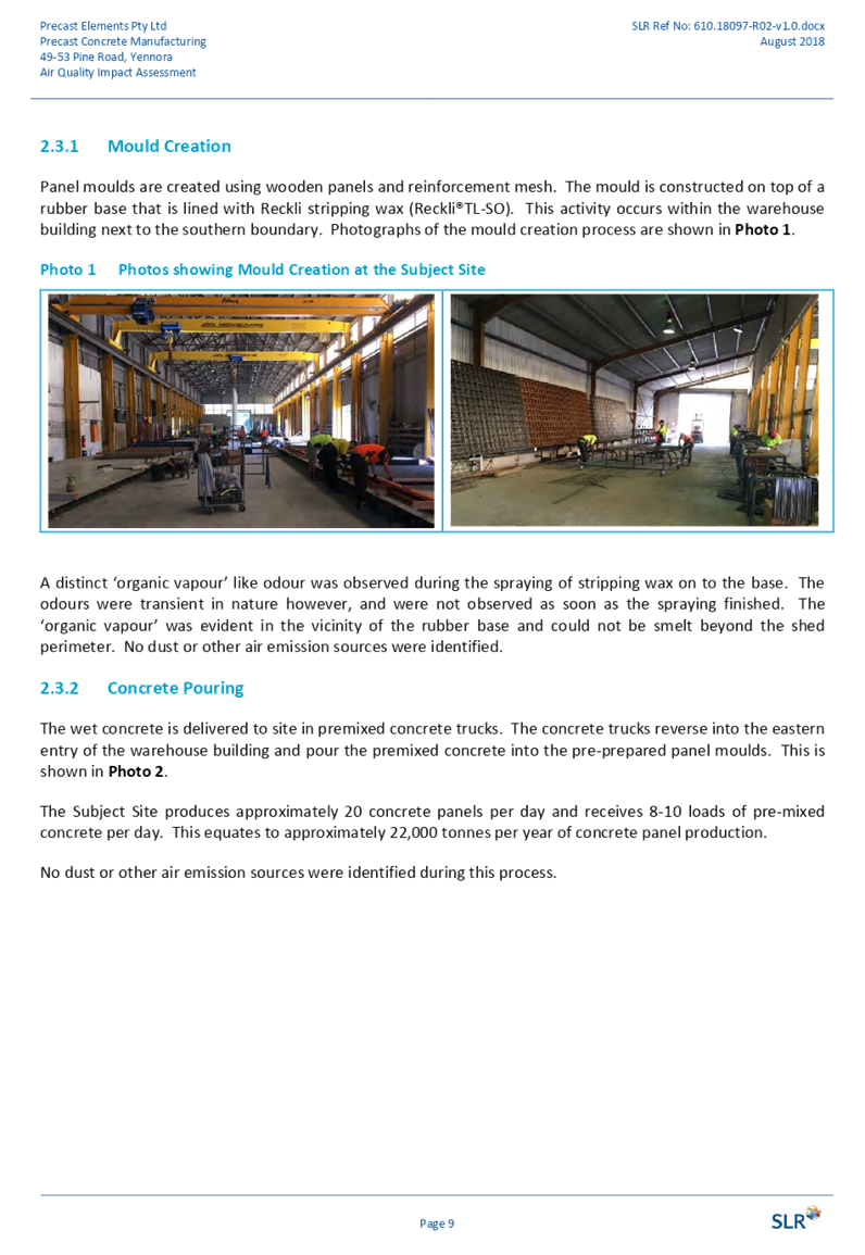
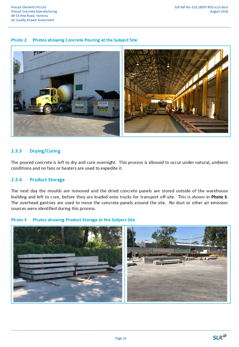
Concrete is delivered to the site
in premixed concrete trucks, the trucks reverse into the eastern entry of the
warehouse and pours the premixed concrete into the pre-prepared panel moulds.
Panel moulds are created in the
southern warehouse using wooden planes and reinforced mesh. The mould is
constructed on top of a rubber base that is lined with Reckli stripping wax.
The poured concrete is left to dry
and cure overnight, which occurs under natural conditions, without the need for
artificial heating or cooling. The following day the dry moulds are removed
from the warehouse via the gantries and stored outside and left to cure before
being loaded onto trucks for transport off site.
Hours of Operation
Precast Elements seeks consent for
the following operating hours:
· 24
hours, seven days’ a week for the warehouse, with the following
restrictions on vehicle access and deliveries:
- Deliveries:
7am to 5pm; and
- Product
distribution (leaving the site): 3am to 5pm.
Whilst the general operating hours
are 4am – 7pm, Precast Elements needs expanded operating hours to respond
to market demand. 24 hour operation is typical of manufacturing companies, and
reflects the shift work nature of the business operations.
Staff
Precast elements has fluid staff
arrangements which respond to market demand. On a general basis, Precast
Elements employs 35 permanent staff, on a shift basis, as outlined below:
· 5
people – 4am to 1pm.
· 13
people – 6am to 3pm.
· 12
people – 8am to 5pm.
· 5
people – 10am to 7pm.
Vehicular Access
Vehicular access to the site is
via the existing 16m wide vehicular cross over to Pine Road in the east. The
proposed use of the site will maintain the existing vehicular access. It is
proposed that light and medium rigid vehicles will circulate the site along
hardstand areas around the warehouse to the hard stand area to the west of the
buildings.
All vehicles are able to enter and
exit in a forward direction.
Parking
The site currently contains nine
formalised car parking spaces within the eastern front setback (inside the
fence). Four car spaces are located to the east of the office building and five
car spaces are located within the south east corner of the site.
Planner’s Comment: Following
Council’s assessment of the Application, a Deferral of Determination
letter was issued on 15 February 2019, which sought a plan which outlines the
provision of additional parking on site to service the development. The
Application was subsequently amended on 18 March 2019 to include the provision
of additional parking on site, supported by a Traffic Plan, which outlined the
provision of 26 spaces within the front setback area.
Loading Facilities
All loading and unloading will
take place within the existing warehouses.
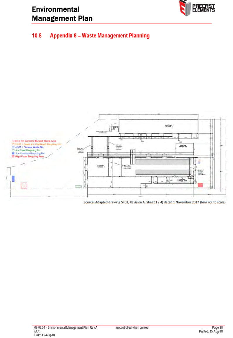
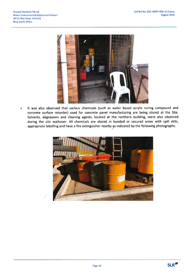
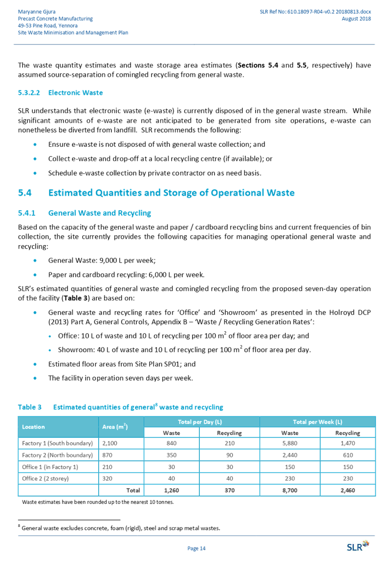
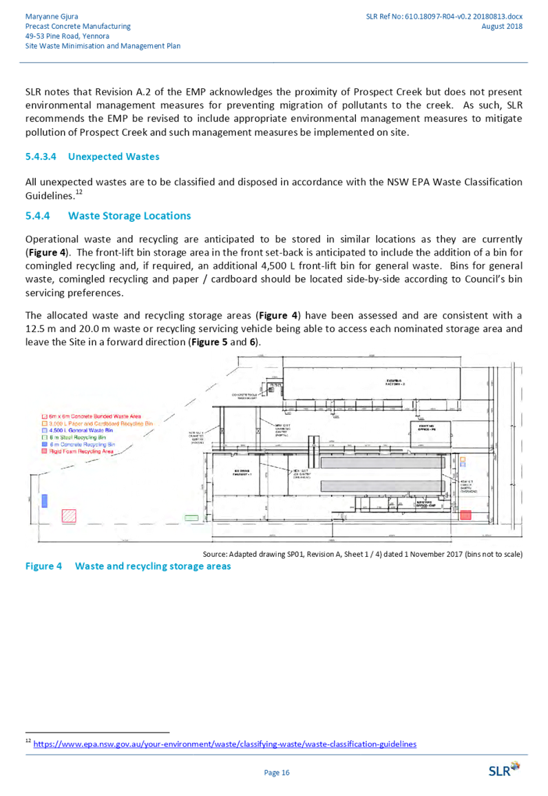
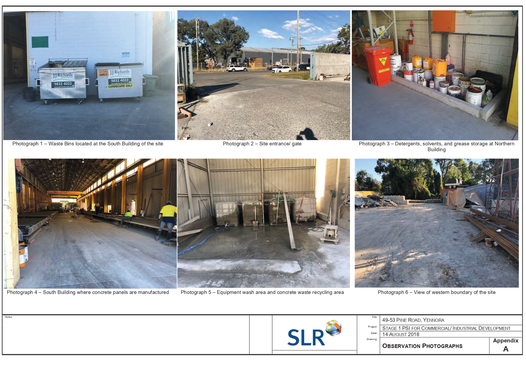
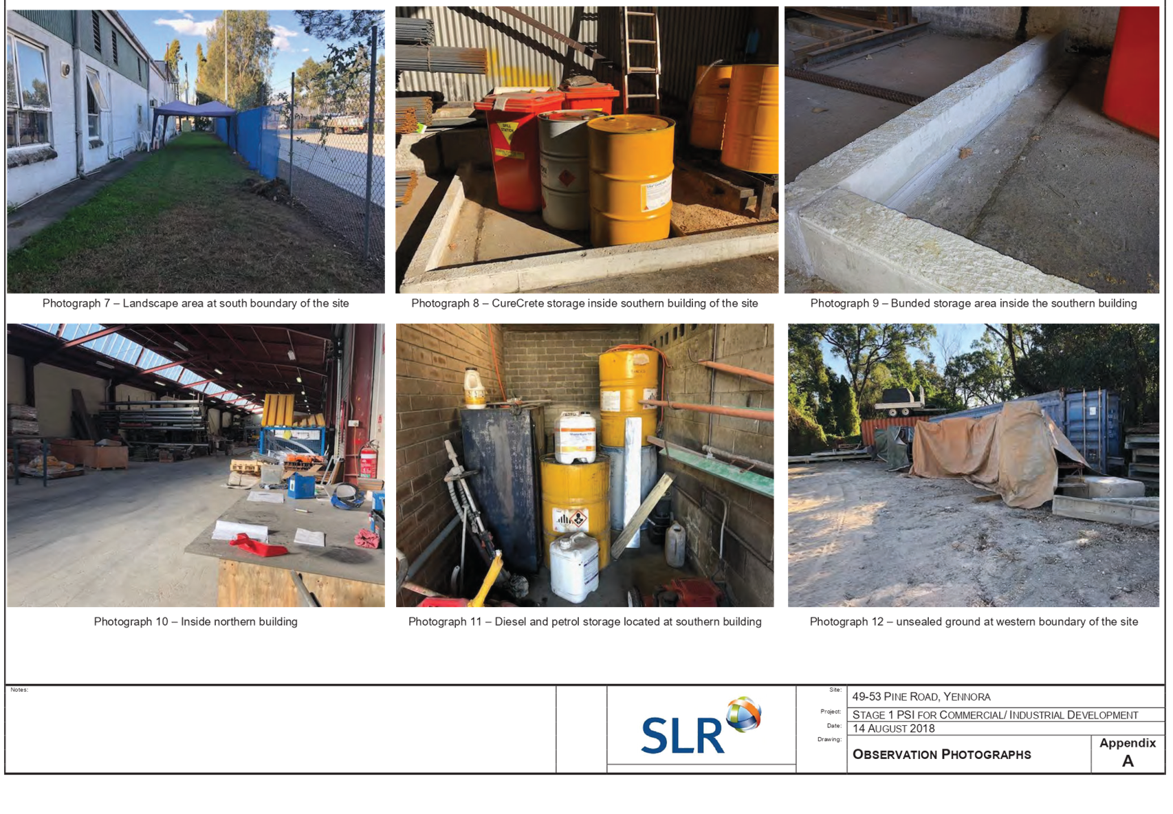
Waste Management
Precast Elements participates in
the Bin Trim Rebate Recycling Programs through the NSW Environmental Protection
Authority, will all waste generated by production disposed of using a licensed
contractor. The site provides a number of forms of waste, with the following
waste practices undertaken on site.
· 3,000L paper
recycling bin (6m in area), collected fortnightly by a front lifting truck;
· 4,500L general
waste (8m in area), collected 3 times per week by a front lifting truck;
· Rigid foam
recycling area, collected fortnightly by a front lifting truck;
· 6m concrete
recycle bin, collected monthly by a reversing truck 20m+;
· 6m steel recycle
bin, collected monthly by a reversing truck 20m+; and
· Concrete bunded
waste area (6m x 6m in area), collected by a concrete truck that reverses into
the area.
Applicants Supporting
Statement
The applicant has provided an
Environmental Impact Statement, prepared by Urbis, dated 17 August 2018, which
was received by Council on 17 August 2018 in support of the application.
Additional correspondence was
received by Urbis dated 18 March 2019 in response to Council’s request
for amended plans and additional information.
Contact With Relevant
Parties
The assessing officer has
undertaken an inspection of the subject site and has been in contact with the
applicant throughout the assessment process.
Internal Referrals
Development Engineer
The Development Application was
referred to Council’s Development Engineer for comments as the site is
subject to Mainstream flooding. Councils Development Engineer has advised that
the proposed development is supported without the imposition of conditions,
noting no building works are proposed.
Traffic Engineer
The Development Application was
referred to Council’s Traffic Engineer for comments, who has advised that
the traffic arrangement is supportable, subject to standard conditions of
consent, which have been imposed within the draft Notice of Determination
provided as Attachment 15 to this report.
Council’s Traffic Engineer
further identified the provision of 26 off-street parking spaces is supported,
subject to the addition of 15 car parking spaces being provided between the
existing warehouse buildings. Refer to commentary provided under the heading
Car Parking within the Planning Comments section below, for further discussion.
Tree Management Officer
The Development Application was
referred to Council’s Tree Management Officer for comments, noting the
existing trees on site, who has advised that the proposed development is
supportable, subject to the imposition of a condition to ensure the large
mature Eucalyptus Tereticornis (Forest Red Gum) is to remain isolated from all
works associated with the proposed use. A condition has been imposed within the
draft Notice of Determination provided as Attachment 15 to this report.
Environmental Health Officer
The Development Application was
referred to Council’s Environmental Health Officer for comments, noting
the proposed use, who has advised that the proposed development is supportable,
subject to standard conditions of consent, which have been imposed within the
draft Notice of Determination provided as Attachment 15 to this report.
Resource Recovery Officer
The Development Application was
referred to Council’s Resource Recovery Officer for comments, noting the
proposed waste management arrangements, who has advised that the proposed
development is supportable.
Building Surveyor
The Development Application was
referred to Council’s Building Surveyor for comments, who has advised
that the proposed development is supportable, subject to standard conditions of
consent, which have been imposed within the draft Notice of Determination
provided as Attachment 15 to this report.
External Referrals
Department of Planning and
Environment
The Development Application was
referred to the Department of Planning and Environment for comments, noting the
proposed development is classified as ‘Designated Development’ under
the Environmental Planning and Assessment Regulations, 2000, due to the site
being within 100 metres of a natural waterbody, Prospect Creek, and within 250
metres of a residential zone not associated with the development, located to
the west of the site. The Department of Planning and Environment has assessed
the application, and confirmed there are no issues of State or Regional
significant that apply to the proposal, identifying no specific condition
requirements.
Department of Primary
Industries – Office of Water
The Development Application was
referred to the Department of Primary Industries – Office of Water for
comments, noting the proposed development is classified as ‘Integrated
Development’ under the Water Management Act, 2000, due to the proximity
of the proposed use to the natural watercourse, Prospect Creek. The Department
of Primary Industries - Office of Water has confirmed the development requires
a ‘Controlled Activity Approval’, however, due to the existing
hardstand area to the rear of the site, does not necessitate General Terms of
Approval (GTA’s).
Endeavour Energy
The Development Application was
referred to Endeavour Energy for comments who has advised that the proposed
development is supported.
Planning Comments
Section 4.15 of the Environmental
Planning and Assessment Act 1979 (EP & A Act)
The provisions of any
Environmental Planning Instruments (EP & A Act s4.15 (1)(a)(i))
The following Environmental
Planning Instruments are relevant to the assessment of the subject modification
application:
a) State
Environmental Planning Policy No. 55 – Remediation of Land (SEPP 55)
The requirement at Clause 7 of
SEPP 55 for Council to be satisfied that the site is suitable or can be made
suitable to accommodate the proposed development has been considered in the
following table:
|
Matters for consideration
|
Yes
|
No
|
N/A
|
|
Does the application involve re-development of the site or
a change of land use?
|
|
|
|
|
Is the development going to be used for a sensitive land
use (e.g.: residential, educational, recreational, childcare or hospital)?
|
|
|
|
|
Does information available to you indicate that an
activity listed below has ever been approved, or occurred at the
site?
acid/alkali plant and formulation,
agricultural/horticultural activities, airports, asbestos production and
disposal, chemicals manufacture and formulation, defence works, drum
re-conditioning works, dry cleaning establishments, electrical manufacturing
(transformers), electroplating and heat treatment premises, engine works,
explosive industry, gas works, iron and steel works, landfill sites,
metal treatment, mining and extractive industries, oil production and
storage, paint formulation and manufacture, pesticide manufacture and
formulation, power stations, railway yards, scrap yards, service stations,
sheep and cattle dips, smelting and refining, tanning and associated trades,
waste storage and treatment, wood preservation.
|
|
|
|
|
Is the site listed on Council's Contaminated Land
Database?
|
|
|
|
|
Is the site subject to EPA clean-up order or other EPA
restrictions?
|
|
|
|
|
Has the site been the subject of known pollution incidents
or illegal dumping?
|
|
|
|
|
Does the site adjoin any contaminated land/previously
contaminated land?
|
|
|
|
|
Has the appropriate level of investigation been carried
out in respect of contamination matters for Council to be satisfied that the
site is suitable to accommodate the proposed development or can be made
suitable to accommodate the proposed development?
|
|
|
|
|
Details of contamination investigations carried out at
the site:
The site is not
identified in Council’s records as being contaminated, however, the
site adjoins 55 & 63 Pine Road, Yennora, and is directly opposite 32 Pine
Road, Yennora, which have previously been issued Site Audit Statements.
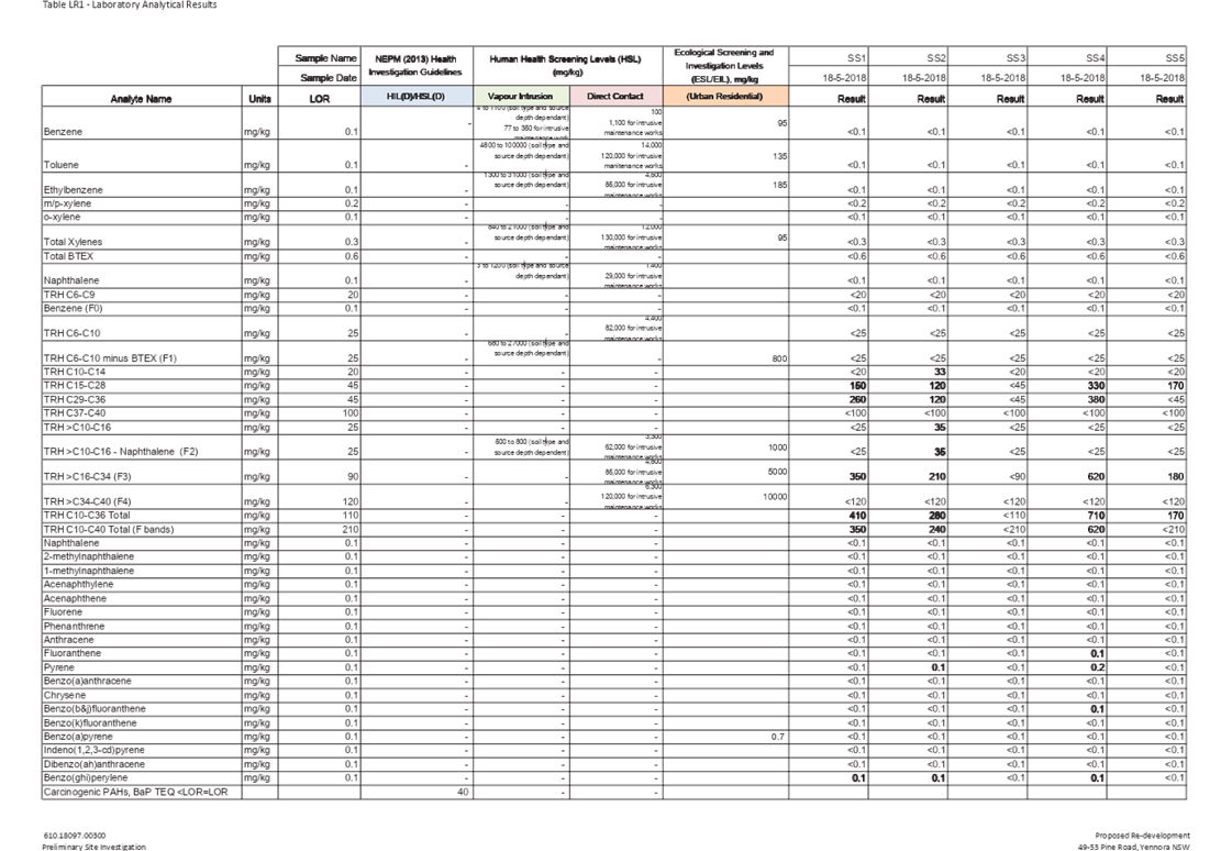
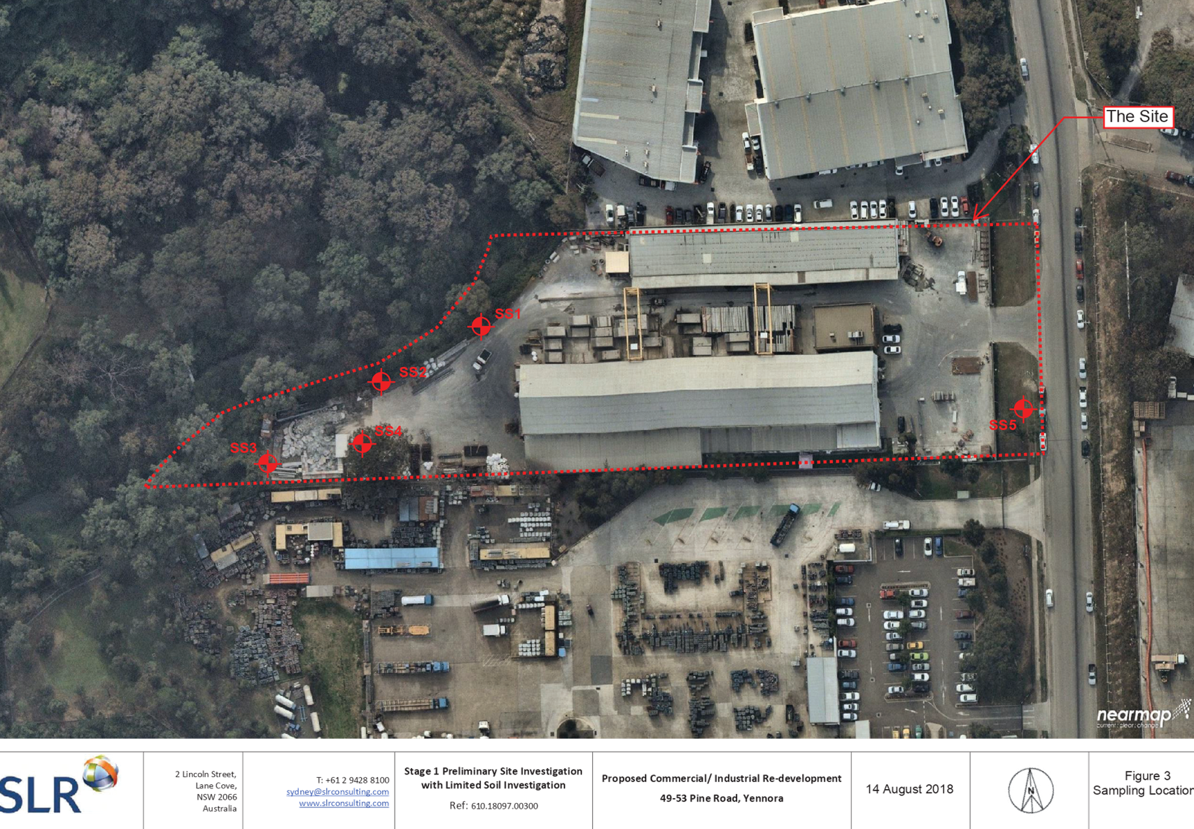
A Preliminary Site
Investigation has been submitted with the subject application, prepared by
SLR Consulting Australia Pty Ltd, in accordance with the NSW EPA Guidelines
for Consultants Reporting on Contaminated Sites and the National
Protection of the Environment (Assessment of Site Contamination) Measure
(2013 Amendment). The report concludes:
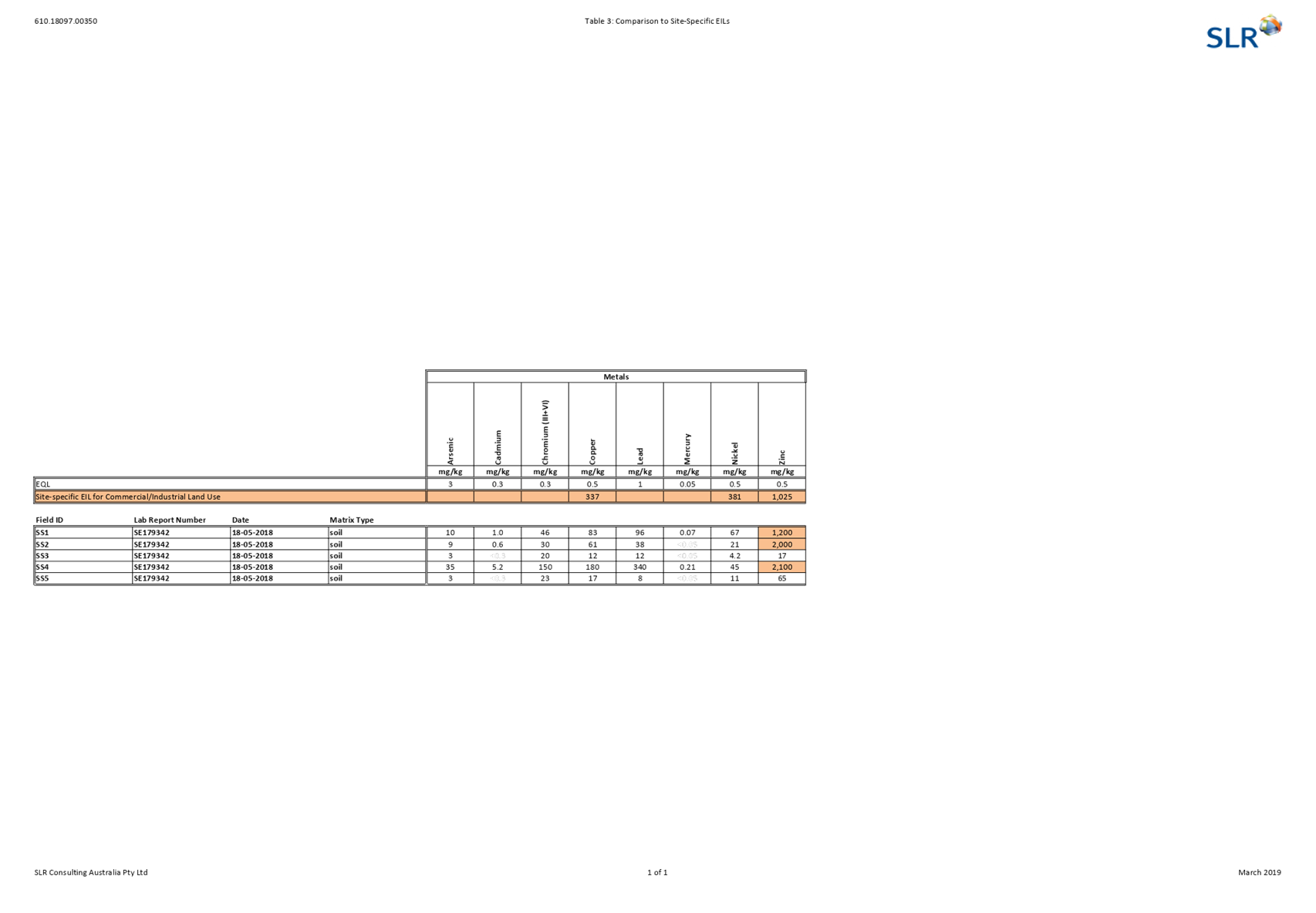
· The potential for significant, widespread
contamination to be present at the site is considered to be low;
· The site is considered suitable for the
proposed change of land use (from general industrial to industry activity);
and
· A Stage 2 Detailed Site Investigation is not
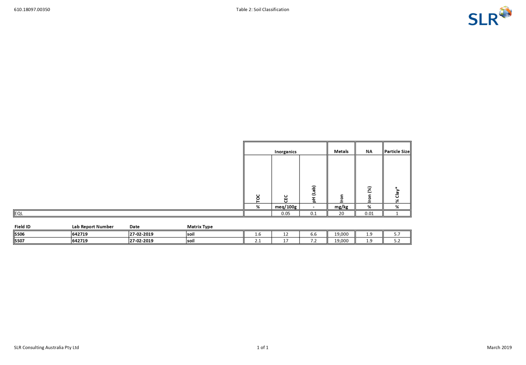
warranted, however, further assessment is required:
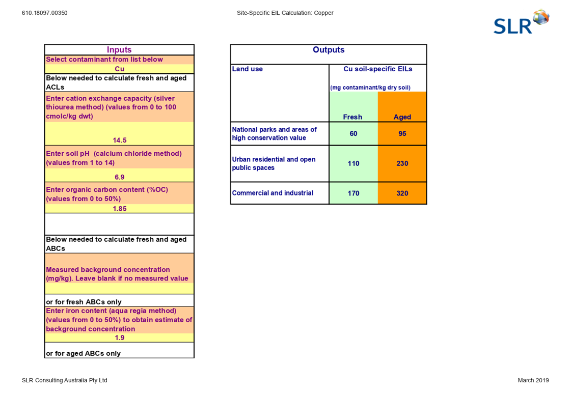
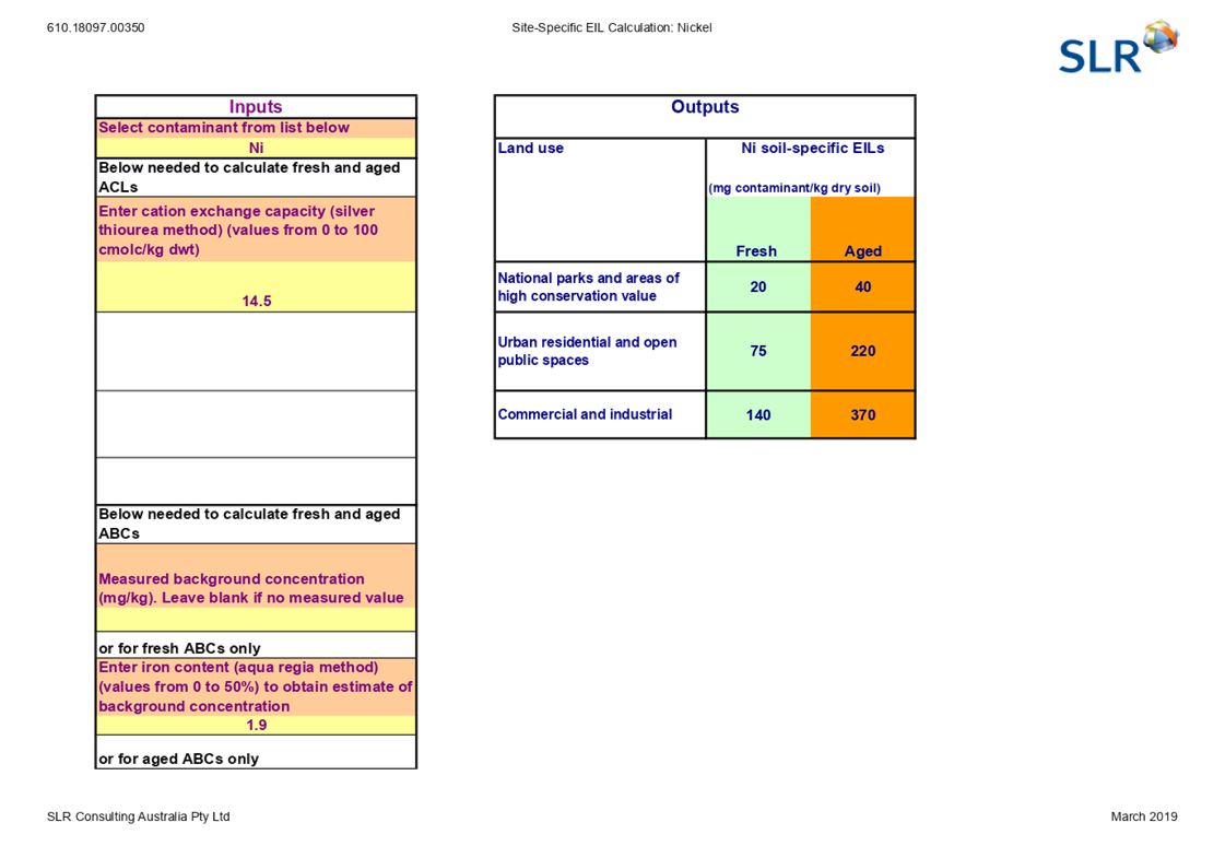
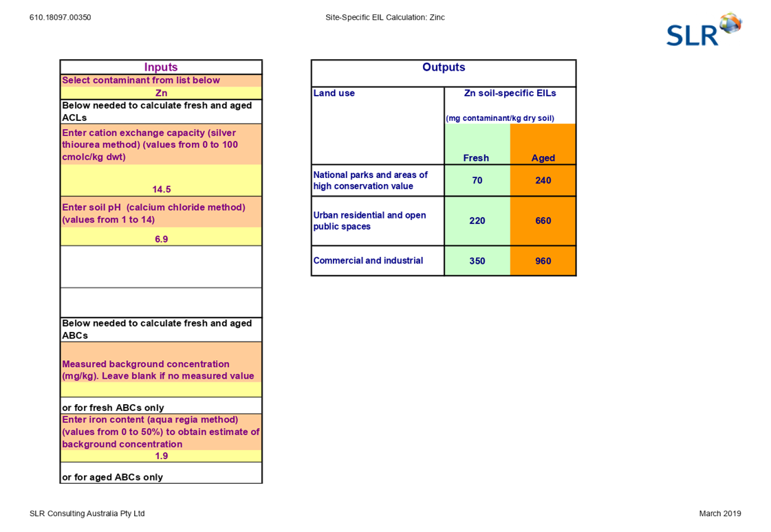
- An assessment to include clay content and pH
analysis to determine the site specific Ecological Investigation Levels (EIL)
limit to be used for metal concentrations;
- Further soil sampling to confirm whether zinc
concentrations in soil are above the EIL limit for a commercial / industrial
land scenario; and
xiv)
- Asbestos quantification to confirm that the
asbestos identified within the exposed site soils is below the NEPM (2013)
guideline limit for a commercial / industrial land use scenario.
Following Council’s assessment of the Application, a
Deferral of Determination letter was issued on 15 February 2019, requesting
the above noted assessment be undertaken, and the findings be submitted to
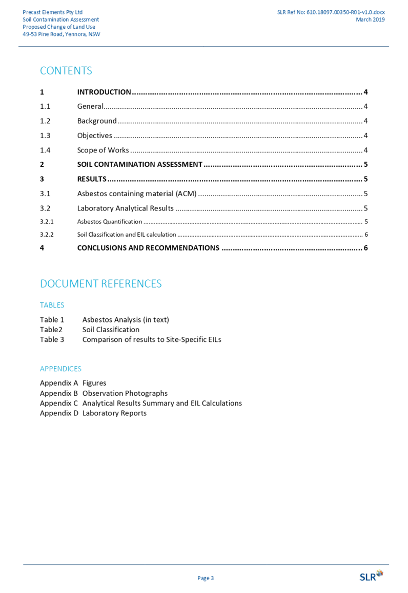
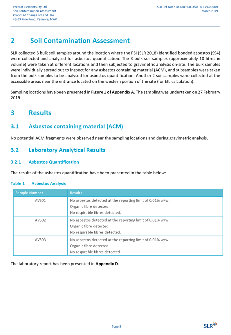
Council. A Soil Contamination Assessment prepared by SLR Consulting Australia
Pty Ltd was subsequently submitted, which concluded:
· Asbestos in the soil does not exceed the
relevant human health criteria for a commercial / industrial setting; and
· Although zinc concentrations have been detected
at concentrations above the site-specific EIL limit for commercial /
industrial land use, it is considered that the potential for significant,
widespread contamination to be present at the site to be low. Further, the
zinc concentrations are significantly below the human health guideline for an
industrial setting and therefore these concentrations are not considered to
impact the suitability of the site for its intended use.
Council’s
Environmental Health Officer has advised that the subject site is suitable
for the proposed use, subject to standard conditions of consent, which have
been imposed within the draft Notice of Determination provided as Attachment
15 to this report.
|
|
|
|
b) Greater
Metropolitan Regional Environmental Plan No. 2 – Georges River Catchment
(Deemed SEPP)
The subject site is identified as
being located within the area affected by the Greater Metropolitan Regional
Environmental Plan No. 2 - Georges River Catchment (Deemed SEPP). An assessment
of the proposal has revealed:
· The
subject site is not affected by acid sulphate soils;
· The
proposed development does not disturb the bank or foreshore along the Georges
Rives tributaries;
· The
proposal will not increase flooding or stormwater runoff;
· Discharging
of industrial waste is not proposed;
· The
proposal will not cause land degradation by way of erosion, sedimentation,
pollution, salinity or acidity; and
· The
proposal will not cause adverse impacts to the sensitive natural environments
within the catchment area.
The proposed development has been
assessed by the Department of Primary Industries - Office of Water, who raises
no issues, as no impact on the catchment is envisaged, noting the existing
hardstand area to the rear of the site.
c) Holroyd
Local Environmental Plan 2013 (HLEP 2013)
The provision of the HLEP 2013 is
applicable to the development proposal. It is noted that the development
achieves compliance with the statutory requirements of the HLEP 2013.
Permissibility
· The
site is zoned Part IN1 General Industrial, and Part E2 Environmental Conservation,
pursuant to the Holroyd Local Environmental Plan (HLEP) 2013, with the subject
use limited to land zone IN1 General Industrial. The proposed development is
permissible with consent.
Industrial activity means
the manufacturing, production, assembling, altering, formulating, repairing,
renovating, ornamenting, finishing, cleaning, washing, dismantling,
transforming, processing, recycling, adapting or servicing of, or the research
and development of, any goods, substances, food, products or articles for
commercial purposes, and includes any storage or transportation associated with
any such activity.
No Development Standards related
to Height of Building and Floor Space Ratio are applicable to the subject site.
A comprehensive LEP assessment is contained in Attachment 16 to this report.
The provisions of any Proposed
Instruments (EP & A Act s4.15 (1)(a)(ii))
The following draft Environmental
Planning Instruments are relevant to the assessment of the subject modification
application:
a) Draft
State Environmental Planning Policy (Environment)
The draft SEPP relates to the
protection and management of our natural environment with the aim of
simplifying the planning rules for a number of water catchments, waterways,
urban bushland, and Willandra Lakes World Heritage Property. The changes
proposed include consolidating the following seven existing SEPPs:
· State
Environmental Planning Policy No. 19 – Bushland in Urban Areas.
· State
Environmental Planning Policy (Sydney Drinking Water Catchment) 2011.
· State
Environmental Planning Policy No. 50 – Canal Estate Development.
· Greater
Metropolitan Regional Environmental Plan No. 2 – Georges River Catchment.
· Sydney
Regional Environmental Plan No. 20 – Hawkesbury-Nepean River (No.2-1997).
· Sydney
Regional Environmental Plan (Sydney Harbour Catchment) 2005.
· Willandra
Lakes Regional Environmental Plan No. 1 – World Heritage Property.
The draft policy will repeal the
above existing SEPPs and certain provisions will be transferred directly to the
new SEPP, amended and transferred, or repealed due to overlaps with other areas
of the NSW planning system.
As noted within the assessment
above under the heading ‘Greater Metropolitan Regional Environmental Plan
No. 2 - Georges River Catchment (Deemed SEPP)’, the proposed development
has been assessed by the Department of Primary Industries - Office of Water,
who raises no issues, as no impact on the catchment is envisaged, noting the
existing hardstand area to the rear of the site.
The provisions of any Development
Control Plans (EP & A Act s4.15 (1)(a)(iii))
The following Development Control
Plans are relevant to the assessment of the subject modification application:
a) Holroyd
Development Control Plan 2013 (HDCP 2013)
The HDCP 2013 applies to the
subject site. The proposed development has been assessed and found to comply
with the provisions of the HDCP 2013, with the exception of car parking, which
is discussed below. A comprehensive assessment against the provisions of the
HDCP 2013 is contained in Attachment 17 to this report.
Car Parking
· The
HDCP 2013 requires the following minimum car parking spaces to service the
development:
|
Control
|
Required
|
|
Office Gross Floor Area 1
space per 40m²
|
884m² / 40m² = 22 spaces
|
|
Factories Gross Floor Area 1 space per
70m²
|
2,021m² / 70m² = 29 spaces
|
|
Warehouse Gross Floor Area 1 space per 300m²
|
860m² / 300m² = 3 spaces
|
|
Total
|
54 spaces
|
In this regard, the application is supported by the
provision of 26 car parking spaces within the front setback area, which results
in a shortfall of 28 car parking spaces.
A Traffic Impact Assessment Report prepared by Ason Group,
dated 14 August 2018 has been submitted with the application, which notes the
following regarding car parking:
Noting that the development is
existing, the detailed operation requirements is already known, and the travel
behaviour of employees is understood. Thus, the parking requirement has been
based on a first principles assessment to account for the unique and known
characteristics of the proposal.
Based on a maximum of 35 employees
present on-site at any one time, 35 parking spaces would need to be provided.
However, Ason Group has been advised that approximately 35% of staff members
commute to work via public transport, notable via train (with the train station
a 1.3km walk from the site). This would result in approximately 23 employees
commuting to work via private vehicle.
In addition, it has been advised
that there are a number of employees who car share. RMS Guide data details that
industrial workers’ private vehicles have an average occupancy of 1.26
persons. Applying this occupancy rate to the 23 employees commuting via private
vehicle, would equate to a demand of 18 spaces.
Therefore, 26 formal parking
spaces are to be provided on site, which would accommodate the additional
operation parking demands of the proposed development. Noting that on-site
observations recorded 21 vehicles parked on-site, the balance of 5 parking
spaces would generally accommodate visitor parking and any additional staff
demand that was not observed during the site inspections, noting that some
staff currently park on-street. This results in a net benefit to on-street
parking capacities.
The application was referred to Council’s Traffic
Engineer, who identified the provision of 26 off-street parking spaces is
supported, subject to the addition of 15 car parking spaces being provided
between the existing warehouse buildings.
Subsequently, a plan was prepared and issued to the
Applicant, which reflected the above, with the following response issued:
It is not physically possible to
provide dual use parking within the operational zone.
The location of the parking
proposed by Council’s Traffic Engineer is within the operation zone,
which includes the use of gantries that traverse along the full extent of this
area. Parking in this location would interfere with the day-to-day operations
and ultimately result in an operational hazard.
In this regard, conditions of consent have been imposed
within the Draft Notice of Determination contained in Attachment 15:
· Restricting
the number of employees to 35 persons; and
· Requiring
the preparation of a Traffic and Transport Management Plan which identifies a
strategy in the event that employees journey to work patterns change, and the
demand for on-site parking increases.
Noting the above, the variation to the car parking standard
is supported on merits, as the development is consistent with the objective
under Part A, Clause 3.1 – Minimum Parking Spaces of the HDCP 2013, those
being:
O1. To ensure that adequate and convenient off-street
parking facilities are provided for all vehicles generated by the various types
of development.
O2. To ensure that off-street parking facilities do
not interfere with traffic flow and safety in adjacent streets or endanger
pedestrian traffic on or off the site.
O3. To limit traffic generation associated with
private vehicle use, in order to encourage public transport, walking and
cycling, as alternative forms of transport, where possible.
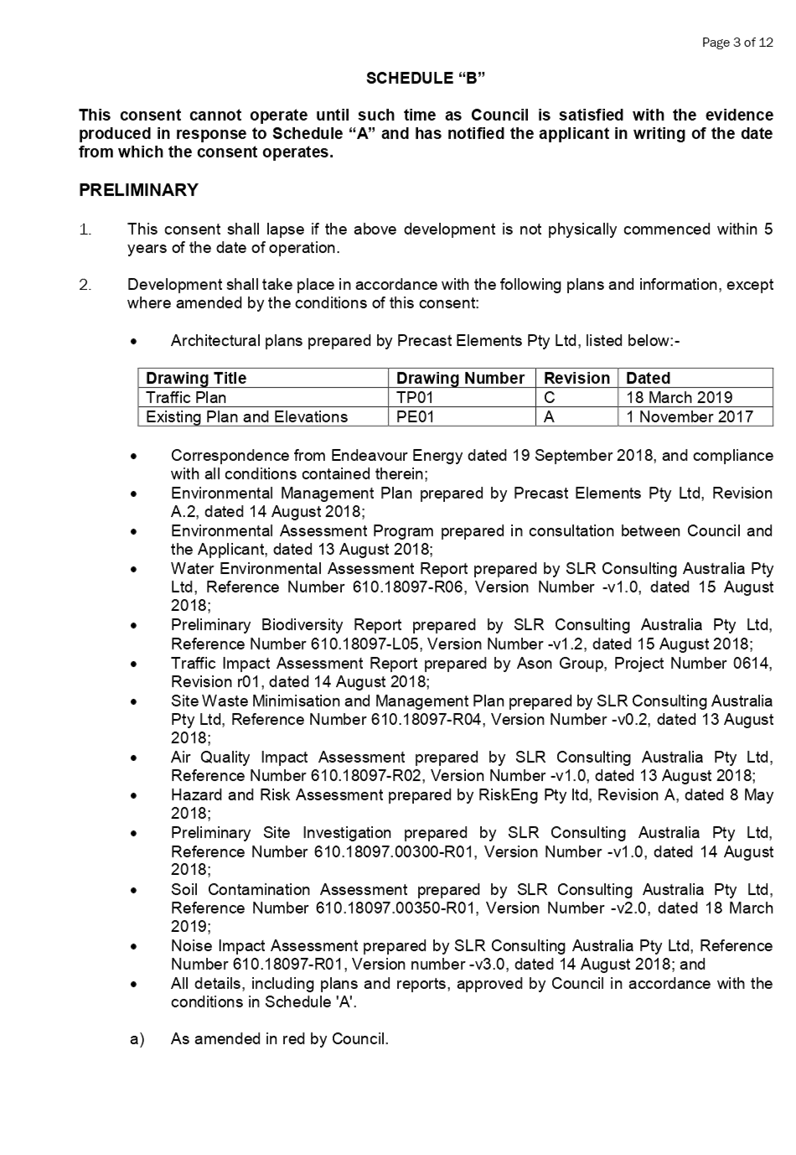
The provisions of any Planning Agreement that has been
entered into under Section 7.4, or any Draft Planning Agreement that a
Developer has Offered to Enter into under Section 7.4 (EP & A Act
s4.15(1)(a)(iiia))
There is no planning agreement or draft planning agreement
associated with the subject Development Application.
The provisions of the Regulations (EP & A Act s4.15
(1)(a)(iv))
In accordance with Schedule 3, Part 1, Clause 14 –
Concrete Works of the Environmental Planning and Assessment Regulations, 2000
(The Regulations), the proposed development is identified as ‘Designated
Development’, noting the use relates to the manufacture of concrete
products, and the site is located within 100 metres of a natural waterbody,
Prospect Creek, and within 250 metres of a residential zone not associated with
the development, located to the west of the site. The Regulations defines
concrete works as:
14 Concrete works
(1) Concrete
works that produce pre-mixed concrete or concrete products and:
a) that
have an intended production capacity of more than 150 tonnes per day or 30,000
tonnes per year of concrete or concrete products, or
b) that
are located:
(i) within
100 metres of a natural waterbody or wetland, or
(ii) within
250 metres of a residential zone or dwelling not associated with the
development.
(2) This
clause does not apply to concrete works located on or adjacent to a
construction site exclusively providing material to the development carried out
on that site:
a) for
a period of less than 12 months, or
b) for
which the environmental impacts were previously assessed in an environmental
impact statement prepared for that development.
An Environmental Impact Statement (EIS) has been prepared in
accordance with the Secretary’s Environmental Assessment Requirements
(SEARs). The development has been assessed by the Department of Planning and
Environment, and confirmed there are no issues of State or Regional significant
that apply to the proposal, identifying no specific condition requirements for
the proposal.
The likely Environmental, Social or Economic Impacts (EP
& A Act s4.15 (1)(b))
It is considered that the proposed development will have no
significant adverse environmental, social or economic impacts in the locality.
The Suitability of the Site for the Development (EP &
A Act s4.15 (1)(c))
It is considered that the development is suitable in the
context of the site and surrounding locality.
Submissions made in accordance with the Act or Regulation
(EP & A Act s4.15 (1)(d))
Advertised (newspaper) Mail
Sign
Not Required
In accordance with public participation requirements of the
Environmental Planning and Assessment Regulations, specifically Clauses 78 and
89 related to ‘Designated Development’ and ‘Advertised
Development’, the proposal was publicly notified for a period of 30 days
from 12 September 2018 to 12 October 2018. In response, no submissions were
received.
Amended plans were received during the process of the
application, which, due to the minor nature of the changes proposed, and as no
submissions were received during the first notification period, re-notification
was not warranted.
The public interest (EP & A Act s4.15(1)(e))
The public interest is served by permitting the orderly and
economic use of land, in a manner that is sensitive to the surrounding
environment and has regard to the reasonable amenity expectations of
surrounding land users. In view of the foregoing analysis, it is considered
that approval of the proposed use would not be contrary to the public interest.
Section 4.46 of the Environmental Planning and
Assessment Act 1979 (EP & A Act)
Due to the proposed development being within 40 metres of a
natural watercourse, Prospect Creek, which adjoins the sites western boundary,
the subject development is classified as ‘Integrated Development’
pursuant to Clause 4.46 of the EP & A Act, requiring approval under the
Water Management Act, 2000.
In accordance with Clause 91 – Activity Approvals of
the Water Management Act, 2000, the proposed use necessitates a
‘Controlled Activity Approval’.
Controlled activity means:
(a) the
erection of a building or the carrying out of a work (within the meaning of the
Environmental Planning and Assessment Act 1979), or
(b) the
removal of material (whether or not extractive material) or vegetation from
land, whether by way of excavation or otherwise, or
xv)
(c) the
deposition of material (whether or not extractive material) on land, whether by
way of landfill operations or otherwise, or
xvi)
(d) the
carrying out of any other activity that affects the quantity or flow of water
in a water source.
A Water Environmental Assessment Report prepared by SLR
Consulting Australia Pty Ltd, dated 15 August 2018, has been submitted with the
application, which notes that the development and current management measures
observed will adequately control impacts related to:
· Groundwater;
· Soil
contamination; and;
· Stormwater
run-off peak flow rates and volumes.
Therefore, the following controls are required to be
implemented, which include:
· Management
and operation of the bunded wash area is described, implemented and audited
under the Site’s Environmental Management Plan, this will ensure bunds
are kept clean of sediment when not in use and bunded areas are used
appropriately by staff.
xvii)
· Undertake
bunding adequacy assessment and implement findings / recommendations of the
report to ensure bund capacity and positioning is adequate.
xviii)
· Management
of first flush stormwater collected in the bunded areas during rain events.
The development has been assessed by the Department of Primary
Industries - Office of Water, and confirmed the development requires a
‘Controlled Activity Approval’, however, due to the existing
hardstand area to the rear of the site, does not necessitate General Terms of
Approval (GTA’s).
Section 7.11 (Formerly S94 Contributions)
The subject development does not require the payment of
contributions in accordance with Holroyd Section 94 Development Contributions
Plan 2013.
Disclosure of Political Donations and Gifts
The NSW Government has introduced disclosure requirements
for individuals or entities with a relevant financial interest as part of the
lodgement of various types of development proposals and requests to initiate
environmental planning instruments or development control plans.
The application and notification process did not result in
any disclosure of Political Donations or Gifts.
The proposed development has been
assessed against the matters for consideration listed in Section 4.15 of the EP
& A Act, 1979, and is considered to be satisfactory. Any likely impacts of
the development have been satisfactorily addressed and the proposal is
considered to be in the public interest.
The proposed development is
consistent with the objectives of HLEP 2013, and is permissible in the zone
with Development Consent. The proposal also complies with the HDCP 2013, with
the exception of the car parking requirements, with the variation considered
supportable on its merits.
There are no further consultation
processes for Council associated with this report.
There are no further financial
implications for Council associated with this report.
There are no policy implications
for Council associated with this report.
Communication /
Publications:
The final outcome of this matter
will be notified in the newspaper. The objectors will also be notified in
writing of the outcome.
|
That Development Application
2018/297/1 seeking retrospective approval for the change of use of an existing
industrial premises to manufacturing of concrete panels with associated
parking at 49 - 53 Pine Road, Yennora, be Approved, subject to the conditions
contained in Attachment 15 of this report.
|
1. Architectural Plans
⇩
2. SEARS
Requirements ⇩
3. Survey
Plan ⇩
4. Environmental
Management Plan ⇩
5. Environmental
Assessment Program ⇩
6. Water
Environmental Assessment Report ⇩
7. Preliminary
Biodiversity Report ⇩
8. Traffic
Impact Assessment Report ⇩
9. Site
Waste Minimisation and Management Plan ⇩
10. Air
Quality Impact Assessment ⇩
11. Hazards
and Risk Assessment ⇩
12. Preliminary
Site Investigation ⇩
13. Soil
Contamination Assessment ⇩
14. Noise
Impact Assessment ⇩
15. Draft
Notice of Determination ⇩
16. Holroyd
Local Environmental Plan 2013 Compliance Assessment ⇩
17. Holroyd
Development Control Plan 2013 Compliance Assessment ⇩
Extraordinary
Cumberland Local Planning Panel Meeting
1 May 2019
Item No:
ELPP025/19
Planning
Proposal for 1-11 Neil Street, Merrylands
Responsible
Division: Environment
& Planning
Officer: Manager
Strategic Planning
File
Number: SC563
|
Lodged
|
18 October 2017
|
|
Proponent
|
Chapman Planning
|
|
Owner
|
Landmark Group Australia
|
|
Description of Land
|
1-11 Neil Street Merrylands
|
|
Site Area
|
Approximately 15,765m2
|
|
Site Description and Existing Use
|
The site area is approximately 15,765m2 and is
bounded by Neil Street to the south, rail corridor to the east, ‘New
Road 2’ to the west and Holroyd Gardens to the North.
A number of residential flat buildings are under
construction on the site.
|
|
Proposal Summary
|
The Planning Proposal Request seeks to:
· Increase the
height of buildings control to 50m (16 storeys) for Building 3 which is to be
located within the south-eastern portion of the site; and
· Increase the FSR
to 3.66:1 at the eastern portion of the site.
|
|
Existing and
Proposed Planning Controls
|
Planning Controls
(Holroyd LEP 2013)
|
Existing controls
|
Proposed controls
|
|
Zoning
|
R4 High Density
SP 2
|
No change
|
|
Height of Building
|
T2:29m
U1:30m
V2:39m
|
Y:50m
T2:29m
U1:30m
V2:39m
|
|
Floor Space Ratio
|
W: 3.5:1
|
W: 3.5:1
W1:3.66:1
|
|
Heritage
|
Nil
|
|
Disclosure of political donations and gifts
|
Nil
|
|
Previous Consideration
|
Nil
|
The Planning Proposal Request
seeks to:
· Increase
the height of buildings control from 39m to 50m (16 storeys) for the
south-eastern portion of the site; and
· Increase
the FSR from 3.5:1 to 3.66:1 on the eastern portion of the site.
The status of the planning
proposal is outlined in Figure 1.
Figure 1: Planning
Proposal Status
The site and its context
The site is located on the fringe
of the Merrylands Town Centre within the “Neil Street Precinct”.
The site comprises a total area of 15,765m2 and consists of two lots
being Lot 1 in DP 203553 and Lot 11 in DP 228782.
Figure 2: Subject
site
The site is subject to a number of
approved developments that include:
· Building
1 (1-7 Neil Street) – Approved under DA-80/2016 being 9 storeys and
containing 120 units;
· Building
2 (1-7 Neil Street) – Approved under DA-203/2015 and DA-343/2016 being 12
storeys and containing 115 units;
· Building
3 (9-11 Neil Street) – Approved under DA-496/2016 being 12 storeys
accommodating 178 units; and
· Building
4 (9-11 Neil Street) – Also approved under DA-496/2016 being a part 6,
part 9, part 12 storey building containing 133 units.
The change in building height that
is proposed relates to Building 3 as highlighted in figure 3 below.
Figure
3: Extract from plans showing proposed increase in building height of Building
3
Neil
Street Planning Proposal
The site was identified in the
Neil Street Precinct Planning Proposal as Block E. As part of the Neil Street
Planning Proposal, land was zoned SP2 Drainage and RE1 Public Recreation to
address flood risk through the provision of an overland flow path channel, and
provide open space and areas for passive recreation. The application of these
zones reduced the planned development yield from the site from 45,177m2
to 39,413m2; a reduction of 5,736.5m2.
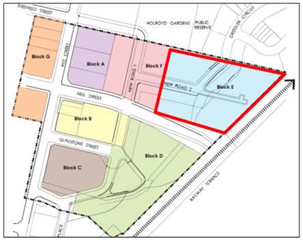
Figure
4: Location diagram for the Neil Street Planning Proposal
Local Context
The site is located on the
northern fringe of the Merrylands Town Centre. The site is approximately 300
metres from Merrylands Bus and Rail Terminus. The Stockland Shopping Centre is
located within easy walking distance to the west of the site and Holroyd
Gardens, providing key open space, is located directly to the north.
Regional Context
The site is located in the suburb
of Merrylands within the Local Government Area of Cumberland Council,
approximately 3 Kilometres south of Parramatta CBD and 25 km west of the Sydney
CBD.
|
Land Use
Zoning
The
site is currently zoned R4 High Density Residential
|
Figure 5: Existing Land Use Zoning
|
|
Floor Space
Ratio Control
A
FSR control of (W) 3.5:1 applies to the site.
|
Figure 6: Existing Floor Space Ratio
|
|
Height of
Building Control
A Height of Building controls
of (V2): 39 metres, (U1) 30 metres and (T2) 29 metres apply to the site.
|
Figure 7: Existing Height of Building
|
|
Minimum Lot
Size Control
A Minimum Lot Size Control of (T) 900m2 applies
to the site.
|
 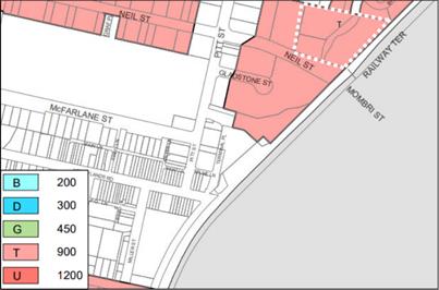
Figure 8: Existing Minimum Lot Size
|
|
Heritage
The site is
identified on the Heritage Map as an Archaeological item.
|
 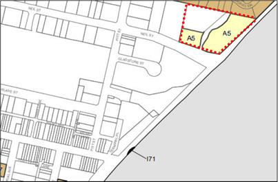
Figure 9: Existing Heritage Map
|
|
Riparian Lands and Watercourse Control
Part of the
site is identified on the Riparian lands and Watercourse Map.
|
 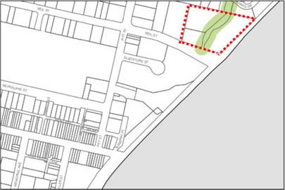
Figure 10: Existing Riparian Lands and Watercourse
Control
|
|
Land Reservation Acquisition
The site is identified on the Land Reservation
Acquisition Map.
|
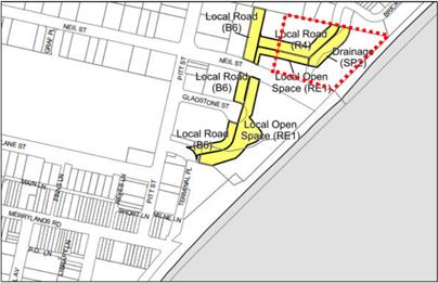
Figure 11: Existing Land Reservation Acquisition
|
The Planning Proposal
The proposal seeks to amend the
Holroyd LEP 2013 by:
· Amending
the floor space ratio control from (W) 3.5:1 to (W1) 3.66; and
· Amending
the height of building control for the southern portion of the site from (V2)
39 metres to (Y) 50 metres.
The intended outcomes for the
proposal are to:
· create
a strong urban corner to Neil Street, identifying and reinforcing this gateway
to the Merrylands Town Centre from Neil Street to the east;
· establish
a building height which is generally consistent with the surrounding built
form;
· present
a more suitable transition in building height from the higher scale mixed use
development in the core of the Merrylands town centre to the lower-scale
residential development and the Holroyd Gardens to the north;
· create
variation in the height plane that currently sees a plateau of 12 storeys on
the site;
· contribute
to the integration of development with public transport by creating higher
residential density 300m from the Merrylands Railway Station; and
· provide
a mix of housing choices within the locality; and maintain and contribute to
the natural landscape by responding to dedication of land on the site to
provide a future public park and landscaped drainage swale corridor.
Proposed Planning Controls
|
Floor Space Ratio Control
A FSR control of (N) 3.66:1
applies to the site.
|
 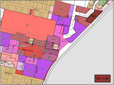
Figure 12: Proposed Floor Space Ratio
|
|
Height of Building Control
Height of Building controls of
(V2): 39 metres, (U1) 30 metres, (T2) 29 metres and (Y) 50 metres apply to
the site.
|
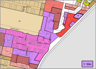
Figure 13: Proposed Height of Building
|
Strategic Merit Assessment
Capacity of existing planning
controls
There is merit
in progressing the planning proposal to the next phase of assessment, as the
proposal does not exceed the development yield that was planned for the site
under the Merrylands Town Centre Urban Design Review 2015 and the Neil Street
Planning Proposal.
The planning proposal increases
the floor area by 4,292m2 resulting in a Gross Floor Area across the
site of 44,437m2. This development yield is within the planned
development yield of the original Neil Street Masterplan and subsequent LEP
that allowed 45,177m2 of Gross Floor Area across the site. The
additional floor area on Building 3 purely compensates for the dedication of
land to Council for SP2 Drainage and RE1 Public Recreation uses.
Traffic and Transport Impacts
There is merit
in progressing the proposal to the next phase of assessment as the proposal
does not exceed the planned development yield for the site. Traffic and
transport considerations, impacts and mitigation measures have previously been
addressed by the Neil Street Planning Proposal.
Open Space Provision
There is merit
in progressing the proposal to the next phase of assessment as there is not a
need to provide additional open space within the Neil Street precinct, as the
proposal does not increase the planned development yield of the site.
Importantly, the open space requirements for this proposal have previously been
addressed by the Neil Street Planning Proposal, which see a portion of this
site being utilised for open space.
Flooding
There is merit
in progressing the proposal to the next phase of assessment as flood migration
measures were identified as part of the Neil Street Planning Proposal and are
being implemented through DAs that apply to the site.
A Metropolis of Three
Cities - Greater Sydney Region Plan
There is strategic merit on
progressing this proposal to the next phase of assessment as the proposal
consistent with the following Planning Directions in a Metropolis of Three
Cities:
· City
supported by infrastructure – the site is well connected to public
transport infrastructure. The site and surrounds have been identified for
increased density of commercial and residential development with the Neil
Street Precinct LEP Amendments and Merrylands Station and McFarlane Street
Precinct Planning Proposal.
· City
for its people – the future development will facilitate active uses and
opportunities for social interaction. The landmark building will assist people
to navigate through the town centre.
· Housing
in the City – the proposal will provide new housing adjacent to
Merrylands railway station and set within a network of new roads and pathways.
· An
efficient city – the proposal has potential to reduce transport costs and
emissions by increasing the resident population with access to public transport
and within walking distance of an established town centre.
Consistency with the
Central City District Plan
There is strategic merit in
progressing this proposal to the next phase of assessment as consistent with
the following Planning Priorities of the Central City District Pan:
· Planning
Priority C2 Planning for a city supported by infrastructure – the
proposal seek to rezone land close to key existing infrastructure such as the
Merrylands Bus and Rail Interchange.
· Planning
Priority C5 Providing housing supply, choice and affordability with access to
jobs, services and public transport – the planning proposal seeks to
deliver additional jobs and housing in Merrylands Town Centre,
Cumberland’s key Commercial Centre. The site is accessible to all of the
jobs, service and public transport of the Parramatta CBD
It is recommended that the
Planning Proposal be reported to Council seeking a resolution that the Proposal
be forwarded to the Department of Planning and Industry for a gateway
determination. This recommendation is being made as the proposal does not
exceed the planned development yield of the Merrylands Town Centre Urban Design
Review 2015 and the Neil Street Planning Proposal.
The proposal was publicly
exhibited (pre-Gateway) for a period of 30 days from 24 July 2018 to 22 August
2018 in accordance with Cumberland Council’s Planning Proposal
Notification Policy.
In response to the exhibition,
Council received no submissions.
The Planning Proposal Request was
submitted with the relevant fee. There are no further financial implications
for Council associated with this report.
This
report recommends that this matter be reported to Council for further
consideration. Should Council resolved to forward this planning proposal to the
Department of Planning and Industry for a Gateway Determination, there will be
policy implications associated with the subsequent stages of the planning
proposal process. These will be outlined in subsequent Council reports.
Communication /
Publications:
The final outcome of this matter
will be notified in the newspaper. The objectors will also be notified in
writing of the outcome.
|
That Cumberland Local Planning Panel (CLPP)
recommend:
That a Planning Proposal Request be reported to Council
seeking a resolution to forward a planning proposal to the Department of
Planning and Industry for a Gateway Determination.
|
1. Proponent’s
Planning Proposal Report ⇩