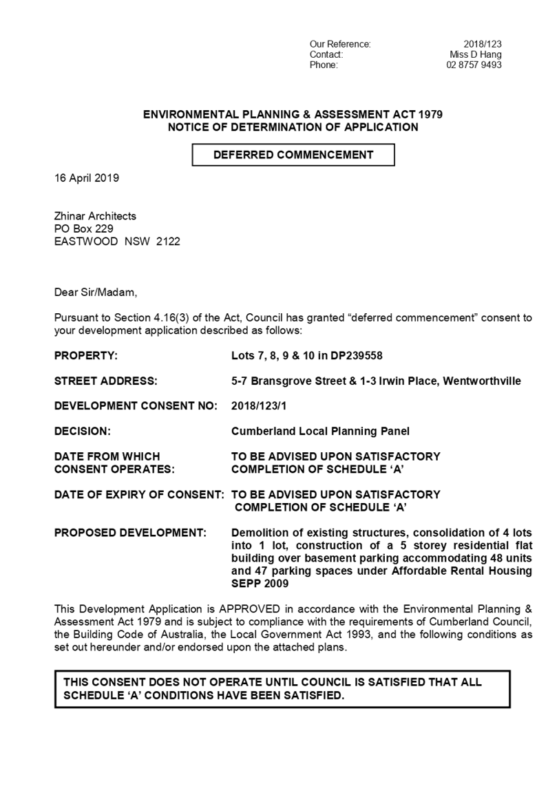
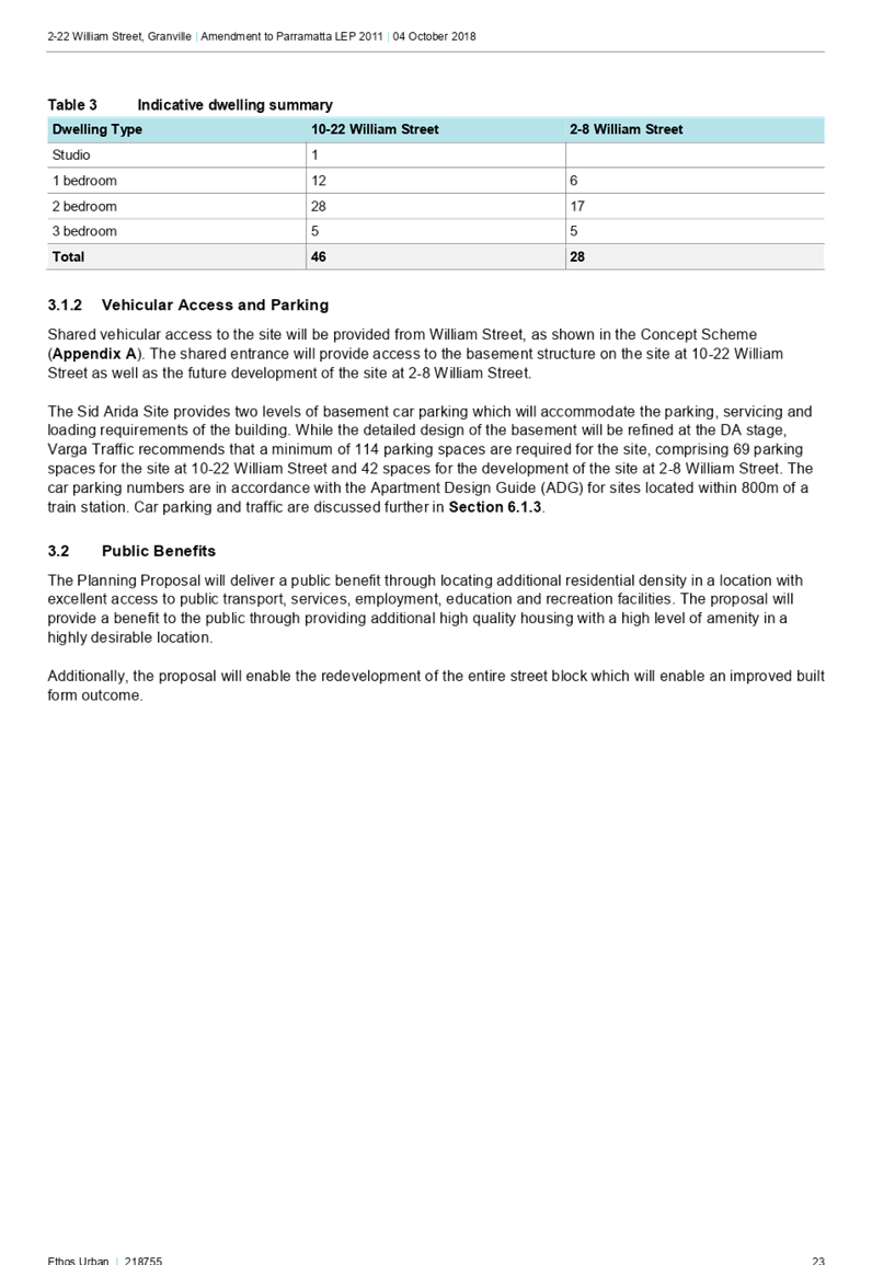
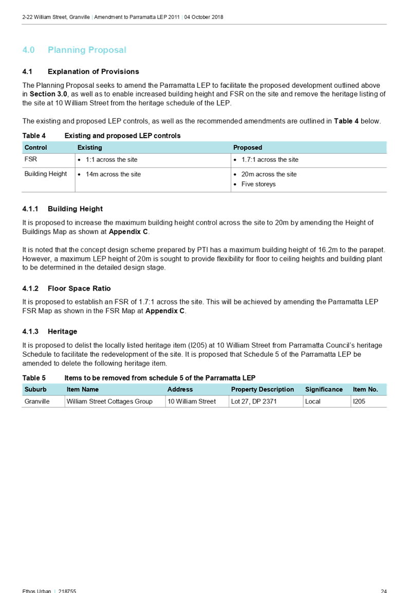
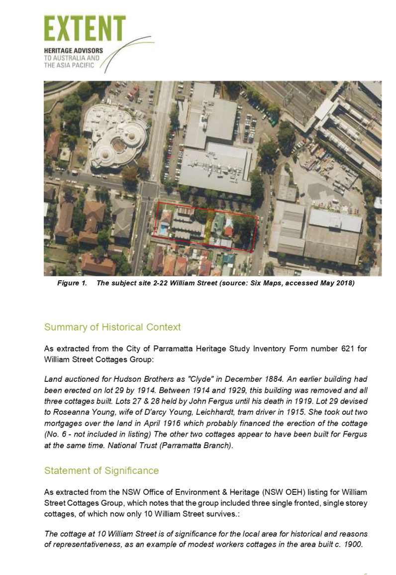
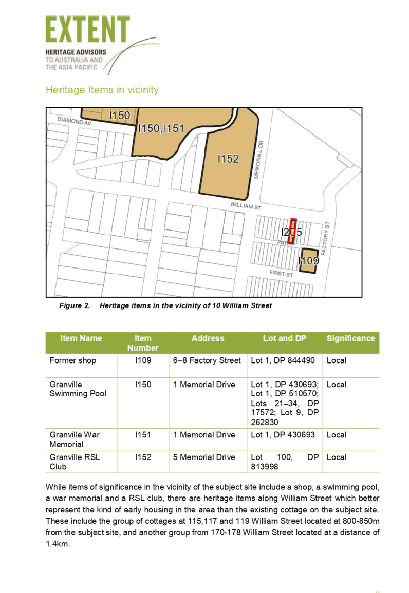
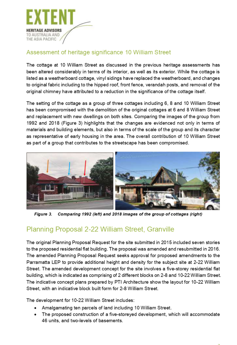
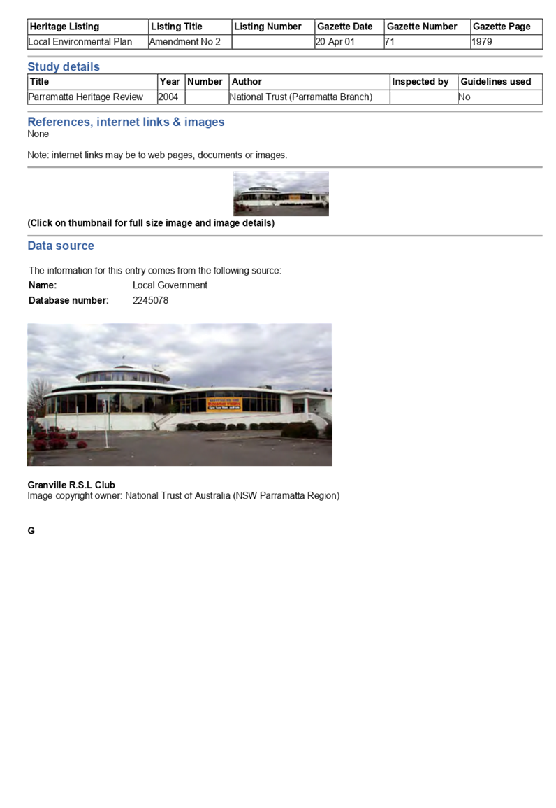
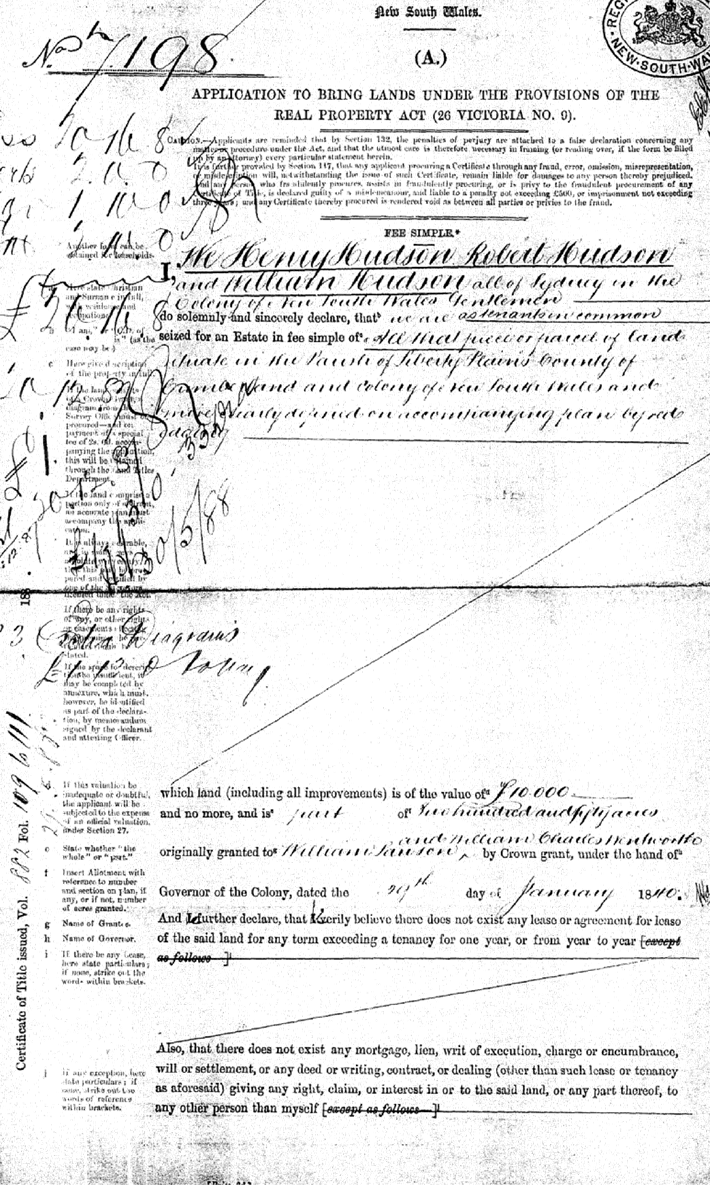
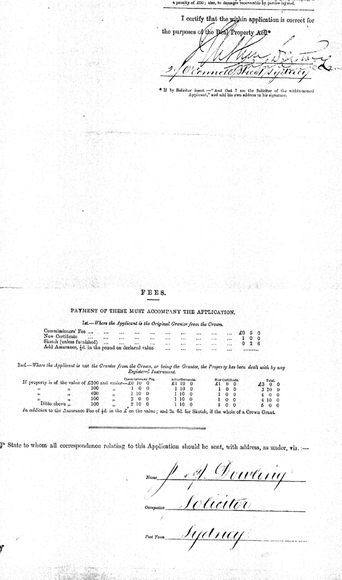
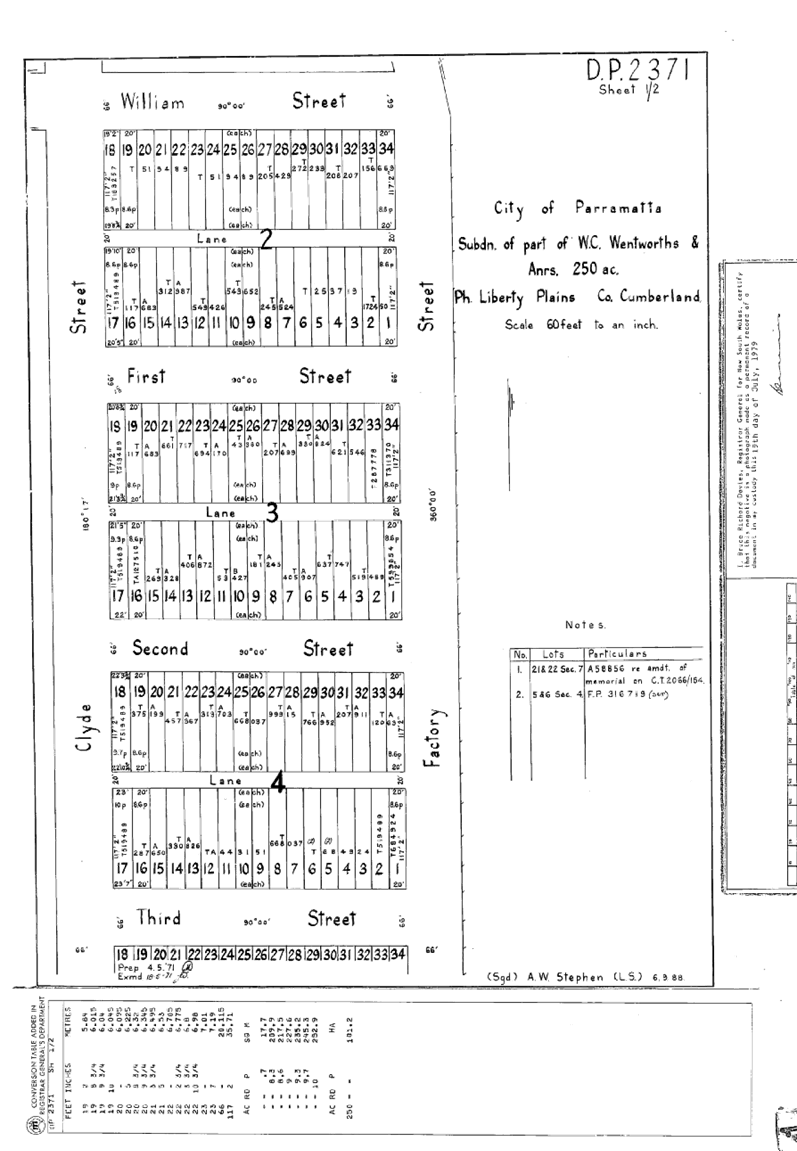
Extraordinary
Cumberland Local Planning Panel Meeting
16 April 2019
Item No: ELPP020/19
Development
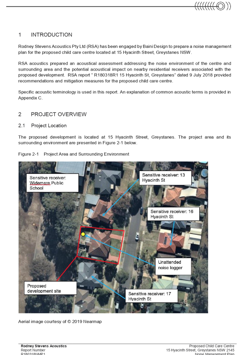
Application 5-7 Bransgrove Street and 1-3 Irwin Place, Wentworthville
Responsible
Division: Environment
& Planning
Officer: Manager
Development Assessment
File
Number: DA
2018/123/1
|
Application lodged
|
13 April 2018
|
|
Applicant
|
Zhinar Architects
|
|
Owner
|
Wehbe Management Services Pty Ltd
|
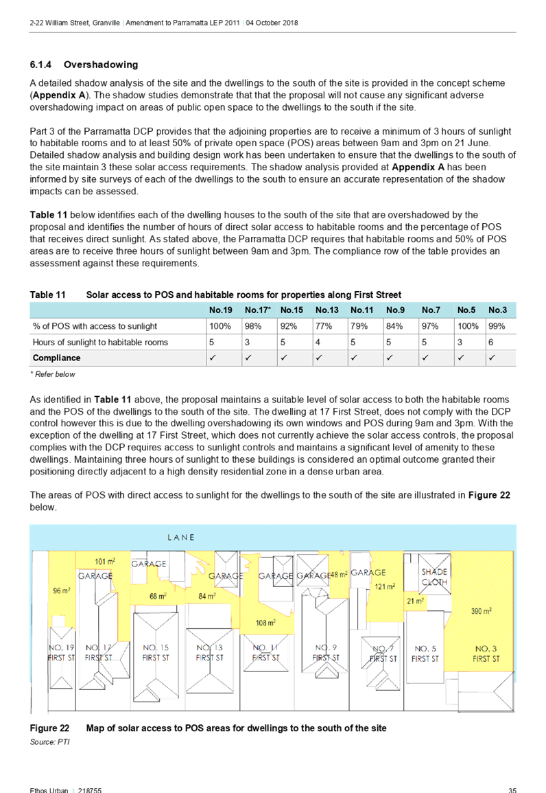
|
Application No.
|
2018/123/1
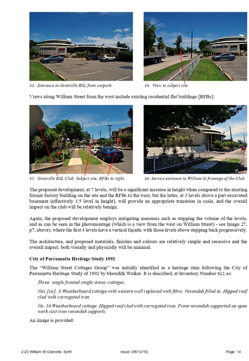
|
|
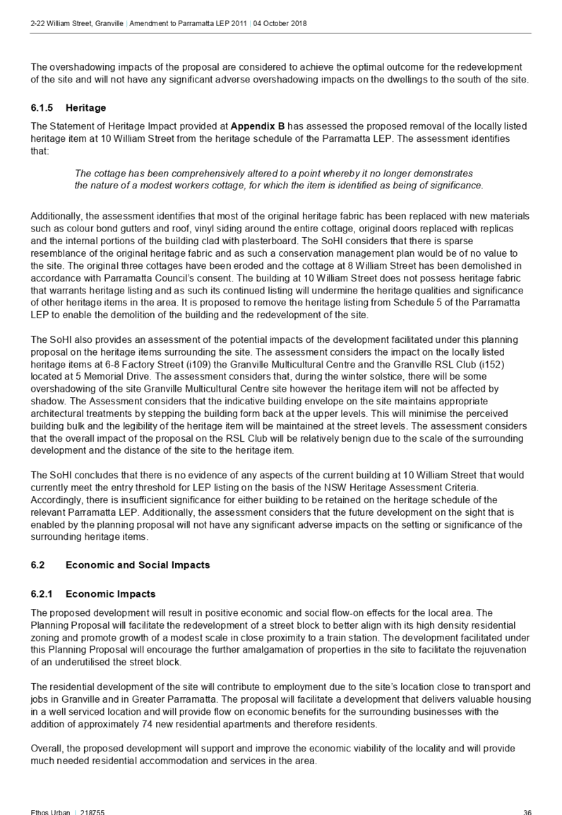
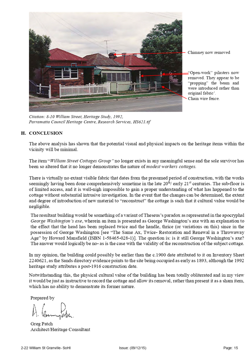
Description of Land
|
5-7
Bransgrove Street & 1-3 Irwin Place, Wentworthville
|
|
Proposed Development
|
Demolition of existing structures, consolidation of 4 lots
into 1 lot, construction of a 5 storey residential flat building over
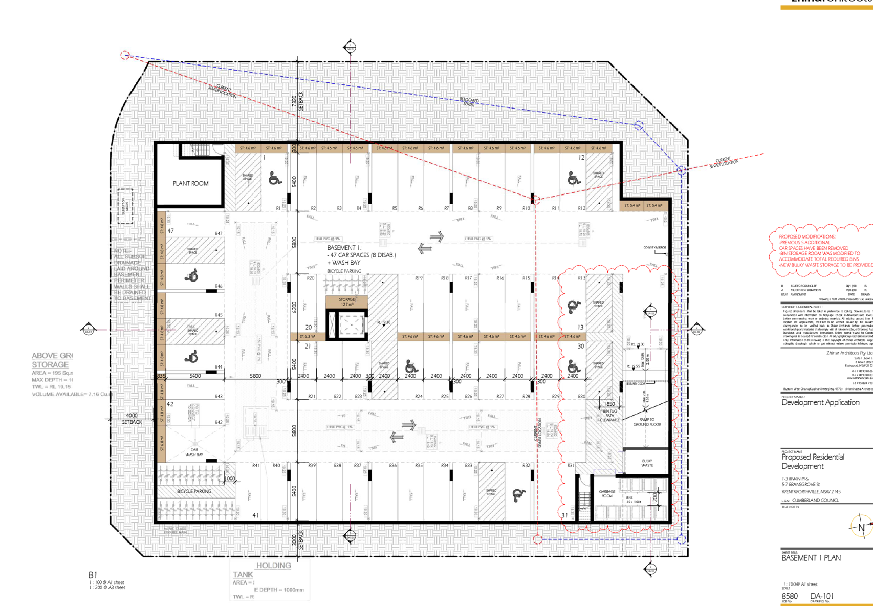
basement parking accommodating 48 units and 47 parking spaces under
Affordable Rental Housing SEPP 2009
|
|
Site Area
|
2,395m²
|
|
Zoning
|
R4 High Density Residential
|
|
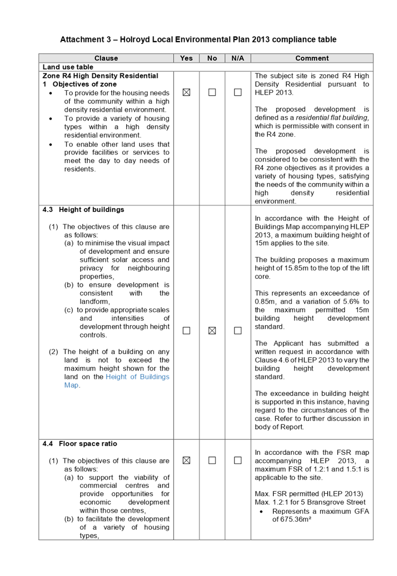
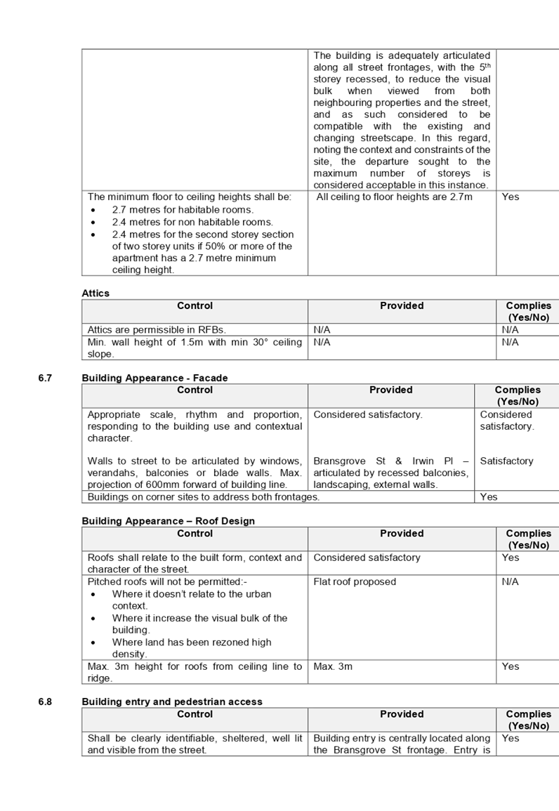
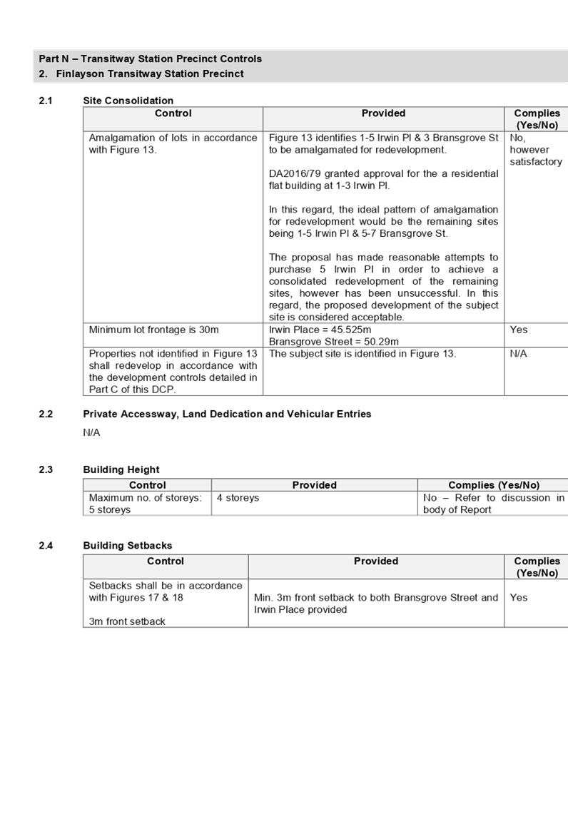
Principal Development Standards
|
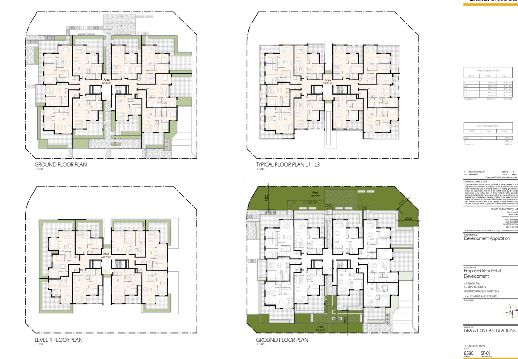
Floor Space Ratio:
Max. 1.2:1 for 5 Bransgrove Street
· Represents a maximum GFA of 675.36m²
Max. 1.5:1 for 7 Bransgrove Street & 1-3 Irwin
Place
· Represents a maximum GFA of
2,748.3m²
+ ARH 26.55% Bonus (represents GFA of 635.87m²)
Represents a total GFA of 4,050.75m² or FSR of
1.69:1
Height of Buildings:
Max. 15m across the entire subject site
· Proposed Max. 15.85m (5.6% variation
sought)
· Clause 4.6 Written Variation Request
submitted for the departure sought to building height
|
|
Disclosure of political donations and gifts
|
Nil disclosure
|
|
Heritage
|
The subject site does not contain a heritage item,
located within the vicinity of the heritage item or heritage conservation
area.
|
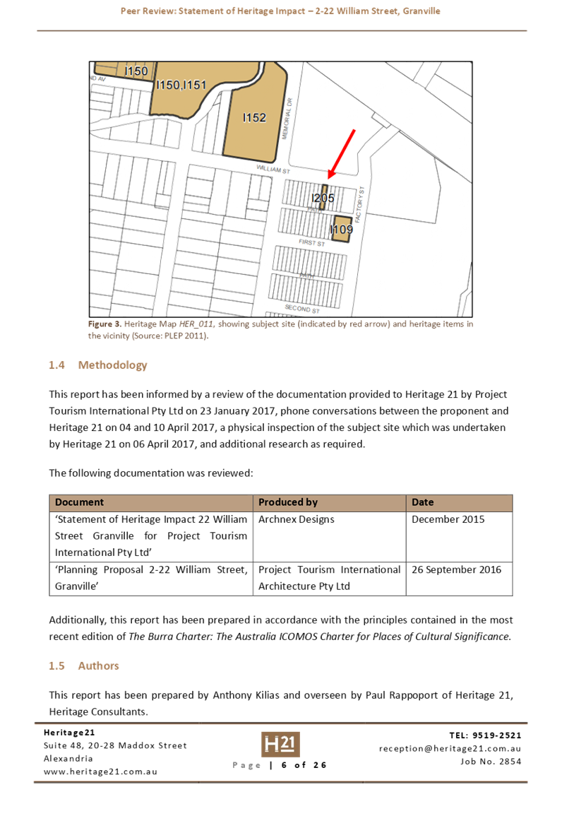
|
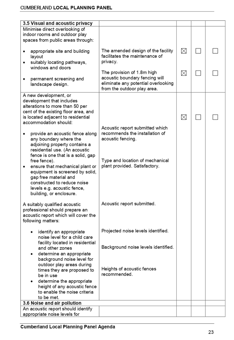
Issues
|
· Variation to maximum 15m
building height (HLEP 2013)
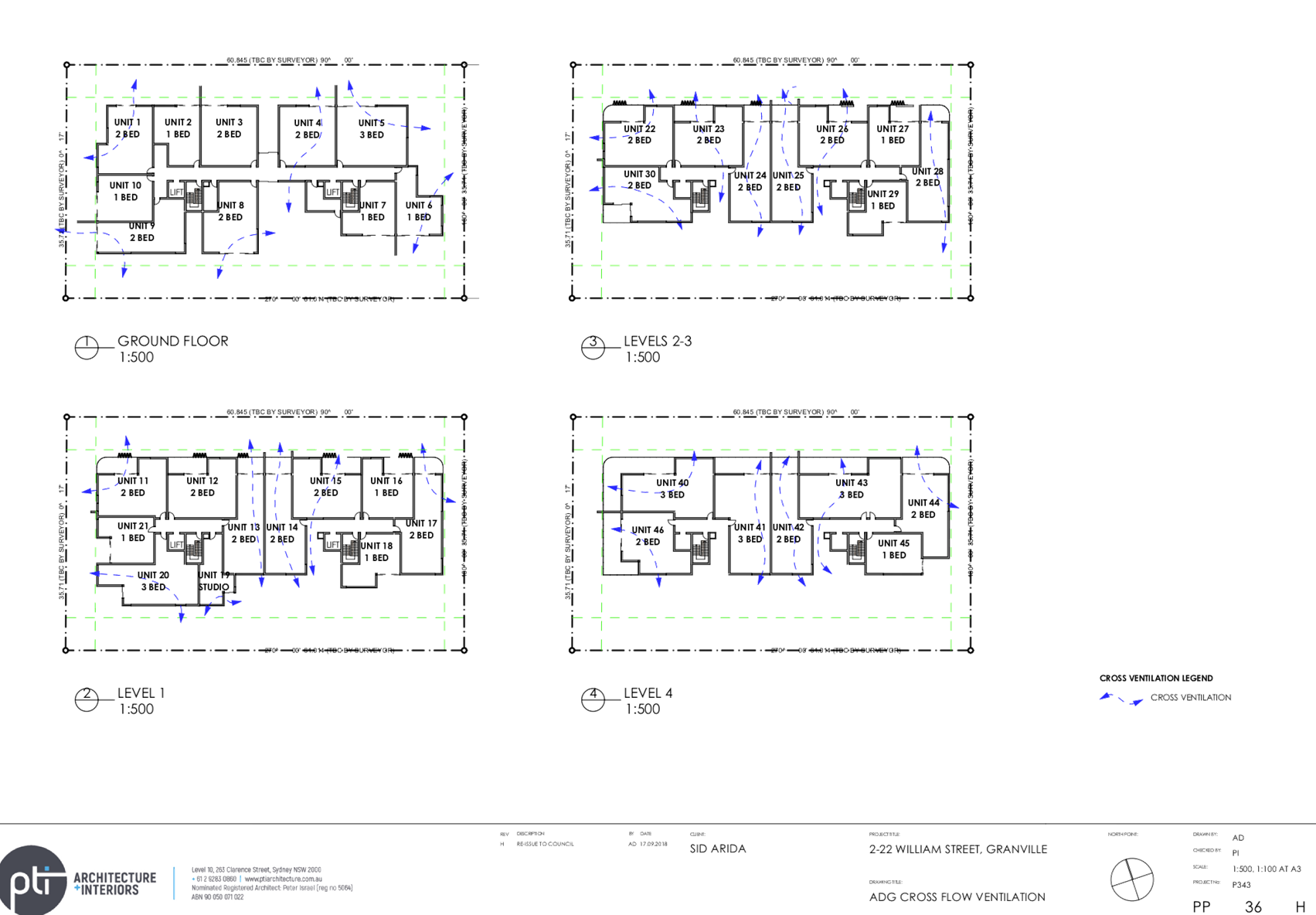
· Communal Open Space (ADG)
· Visual Privacy / Building
Separation (ADG)
· Maximum number of storeys
limit (HDCP 2013)
|
On 13 April 2018, development
application (DA2018/123) for the demolition of existing structure,
consolidation of 4 lots into 1 lot, construction of a 5 storey residential flat
building over basement parking accommodating 48 units and 47 parking spaces
under Affordable Rental Housing SEPP 2009 was lodged with Council.
The application was publicly
notified to adjoining and opposite owners, a notice was placed in the local
press and a notice placed on the site for 21 days from 2 May 2018 to 23 May
2018. In response, the application received no submissions.
The application was deferred on 1
May 2018 requesting additional information relating to site isolation and a
revised QS Report. Additional information confirmed that reasonable and genuine
attempts have been made to purchase the isolated property being No. 5 Irwin
Place, and that the CIV of the affordable component of the proposal did not
exceed $5 million to require determination by Sydney West Central Planning
Panel.
The application was deferred on 18
October 2018 to address FSR, concept plans for isolated site, communal open
space, natural ventilation, internal apartment layouts, private open space,
common circulation core, and stormwater and waste management matters. Amended
plans and supporting statements provided additional affordable units, and
incorporated modifications to address matters raised. Amended plans did not
warrant re-notification of the proposal.
The subject application has been
assessed against the relevant provisions of the Environmental Planning and
Assessment Act 1979, State Environmental Planning Policy No 65 – Design
Quality of Residential Apartment Development (SEPP 65), State Environmental
Planning Policy (Affordable Rental Housing) 2009 (SEPP ARH), Holroyd
Local Environmental Plan 2013 (HLEP), Apartment Design Guide and Holroyd
Development Control Plan 2013 (HDCP).
The proposal seeks the following
non-compliances which are considered supportable as discussed in detail
elsewhere in the report:
|
Control
|
Required
|
Proposed
|
% Variation
|
|
Building Height
|
i)
Max. 15m (HLEP 2013)
|
Max. 15.72m to the
roof of the building
Max. 15.85m to top of
lift core
|
4.8% - 5.6%
|
|
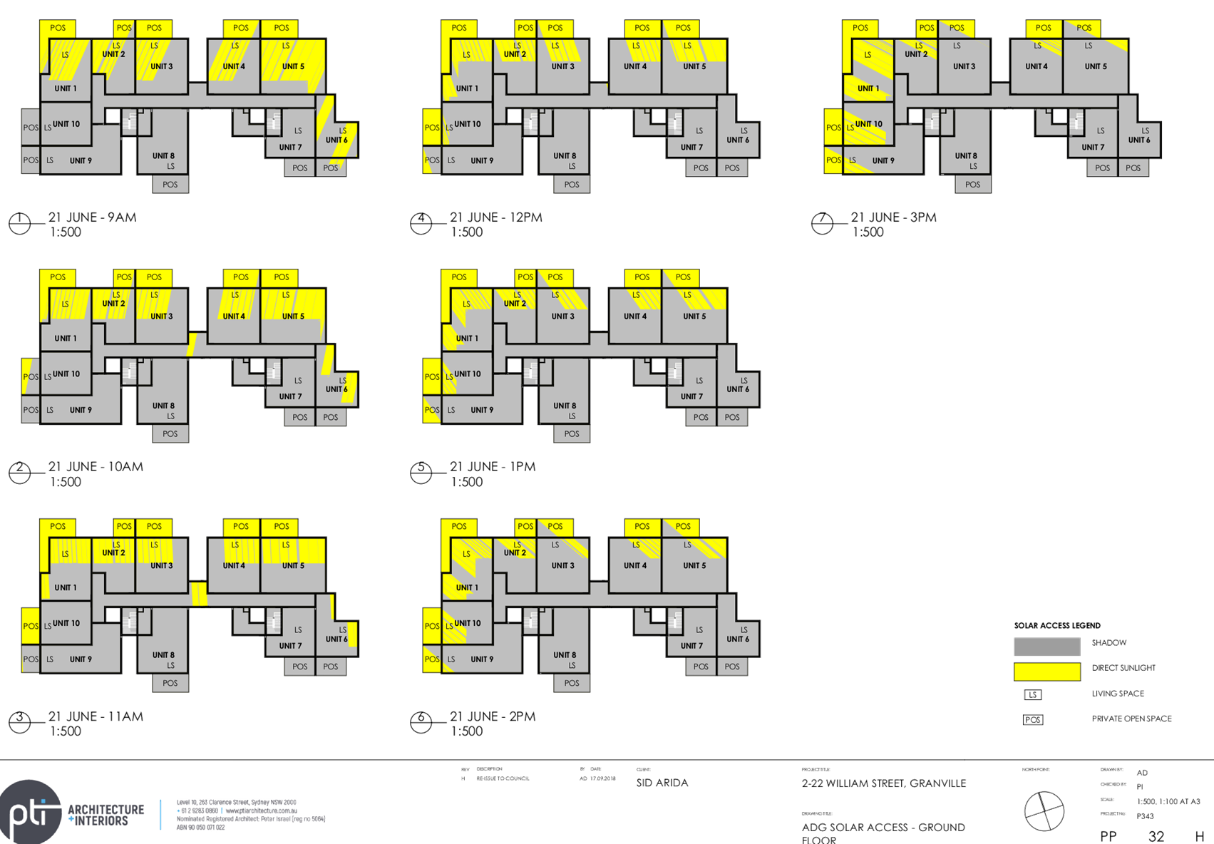
Communal Open Space
|
598.75m² (25%)
|
427.4m² (17.8%)
|
28.6%
|
|
Maximum Building Storey Limit
|
4 Storeys
|
5 Storeys
|
20%
|
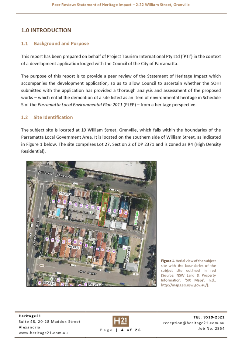
The application is being reported
to the Cumberland Local Planning Panel (CLPP) for determination as it is a
development with more than 4 storeys to which the State Environmental Planning
Policy No 65 – Design Quality of Residential Apartment Developments applies.
The application is recommended for
approval subject to the conditions in the draft determination at Attachment 5.
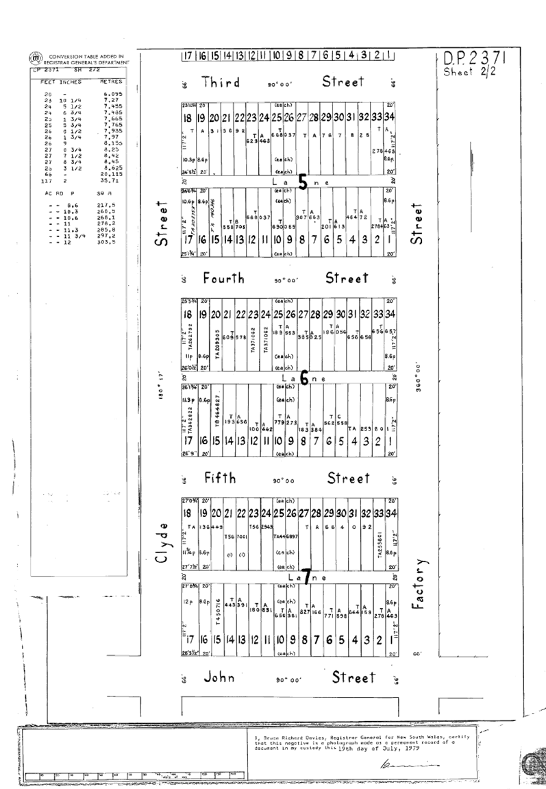
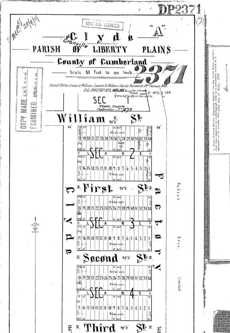
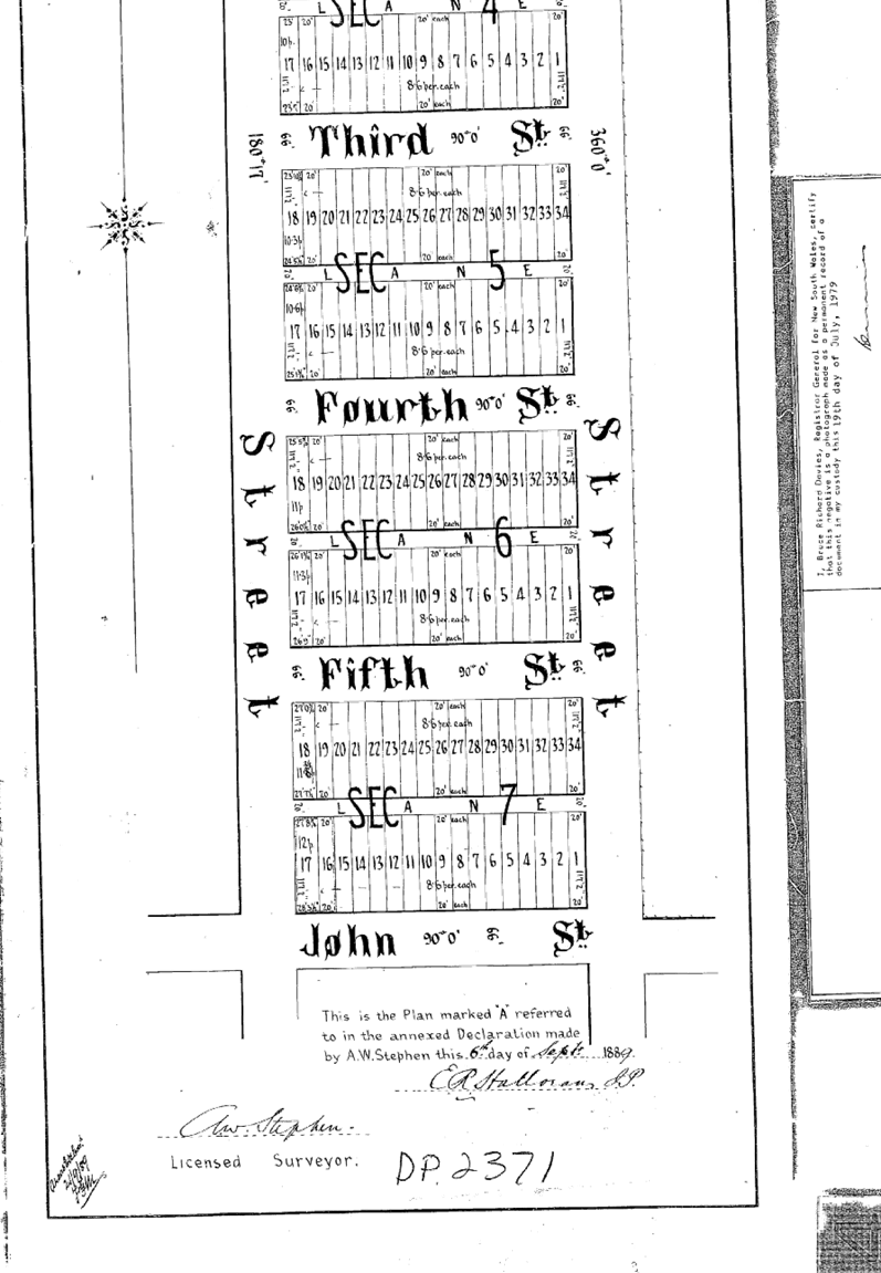
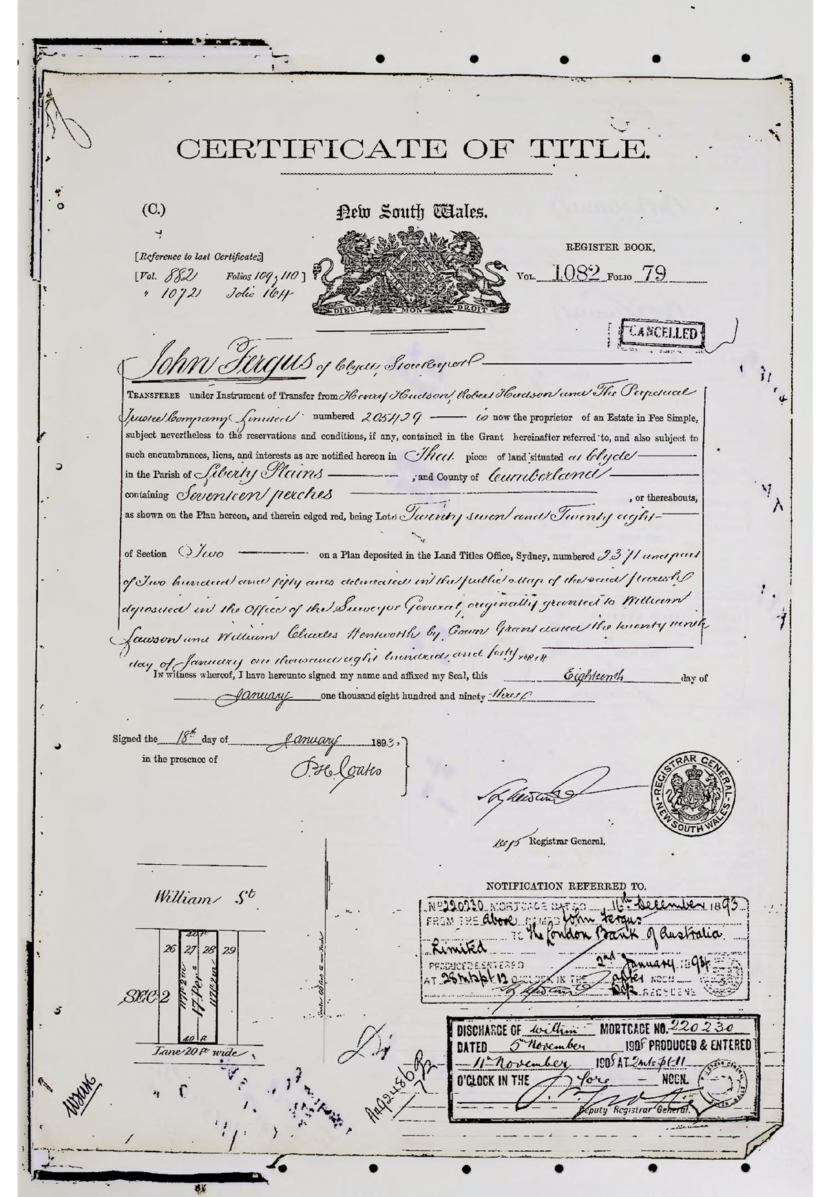
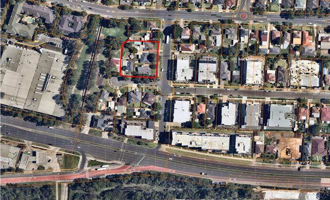
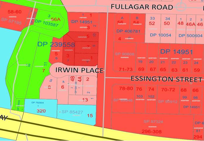
Subject Site And Surrounding
Area
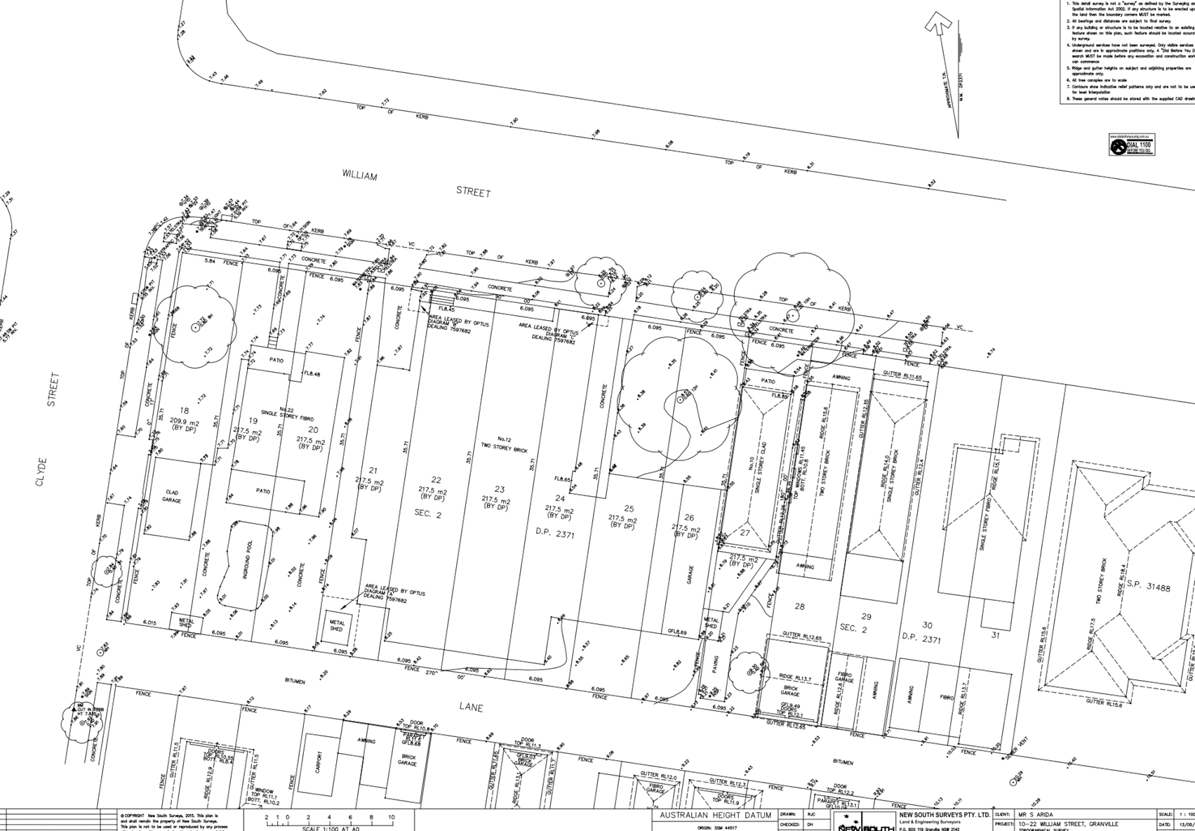
The subject site is known as 5-7
Bransgrove Street & 1-3 Irwin Place, Wentworthville; and is legally
described as Lots 9 & 10 in DP239558 and Lots 7 & 8 in DP239558. The
site has an area of 2,395m2 and frontage of 45.52m to Irwin Place and 50.29m to
Bransgrove Street. The property is currently occupied by detached dwelling
houses, ancillary structures and vegetation.
The site is located within the
Finlayson Transitway Station Precinct, located approximately 150m north of
Great Western Highway.
The subject site and neighbouring
allotments directly to the north and east are zoned R4 – High Density
Residential. Properties located on the southern side of Irwin Place are zoned
R2 – Low Density Residential. To the west of the site is Irwin Place
Park. The existing developments surrounding the subject site are mostly
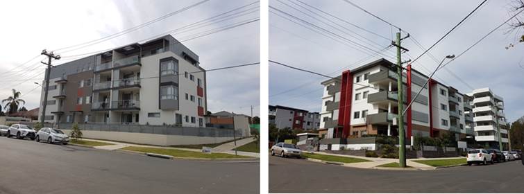
detached dwellings, noting that a residential flat building has been approved
at 1-3 Bransgrove Street (DA2016/79). However, the locality is transitioning to
higher density development consistent with the planning controls that currently
apply, and evident with the recently constructed development in the area.
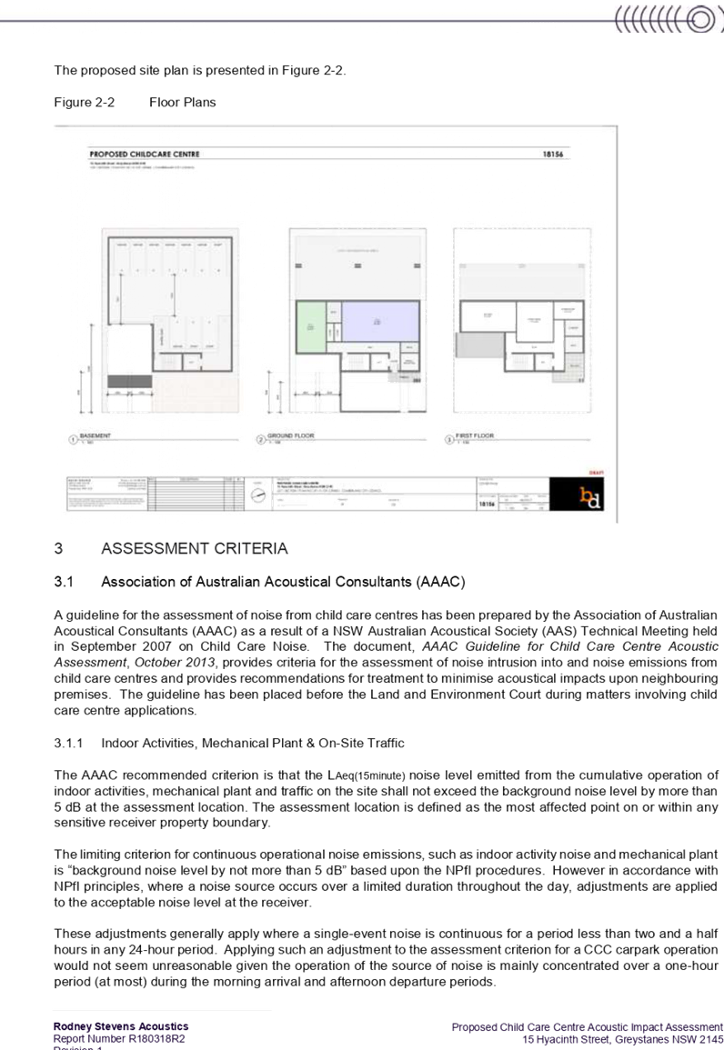
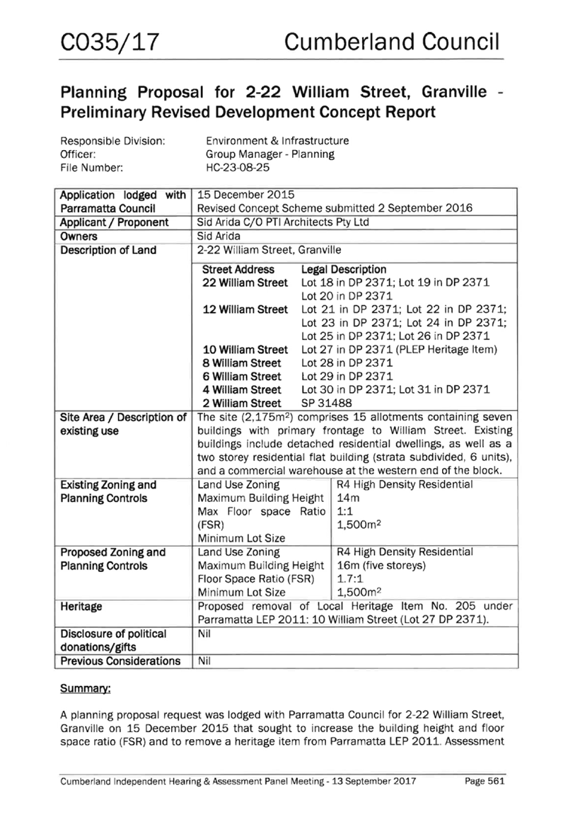
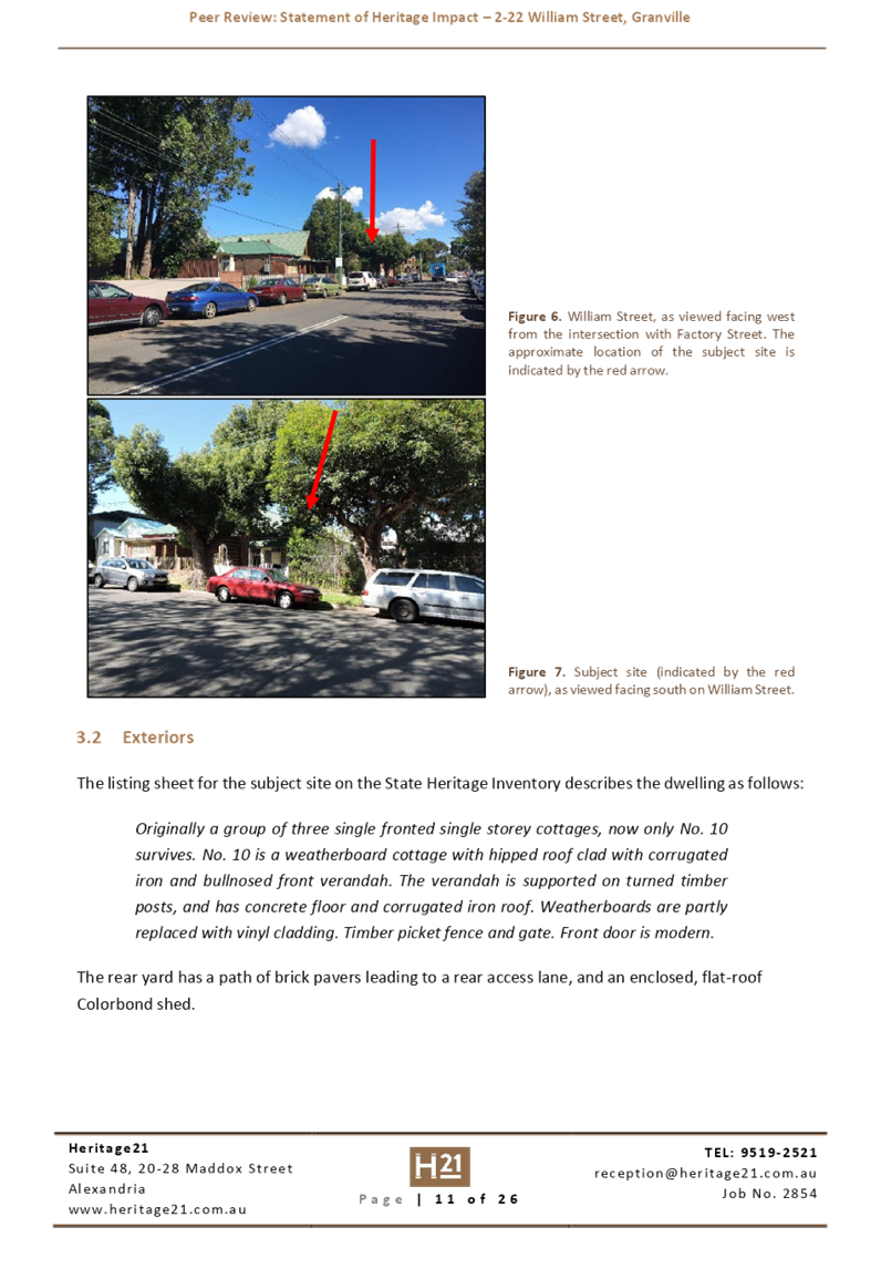
Figure
1 - Aerial view of the locality with subject site shown highlighted in red.
Source: NearMap 29 December 2018
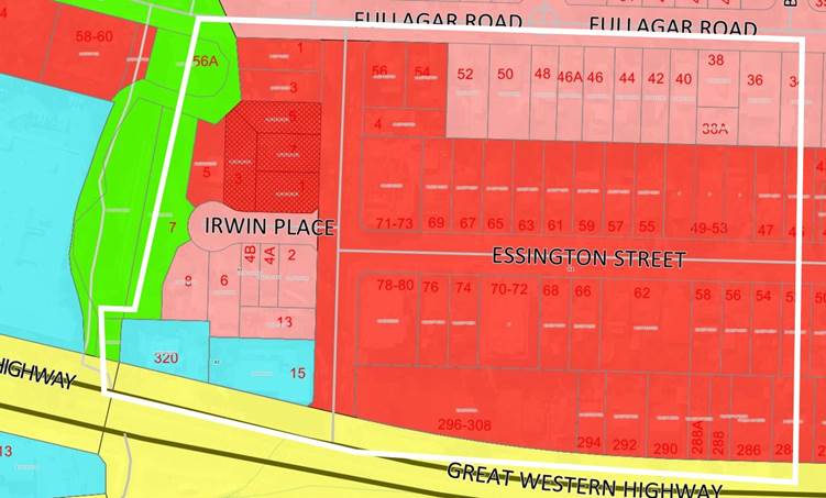
Figure
2 – Zoning map with subject site shown hatched. Source: Cumberland
Council 2018
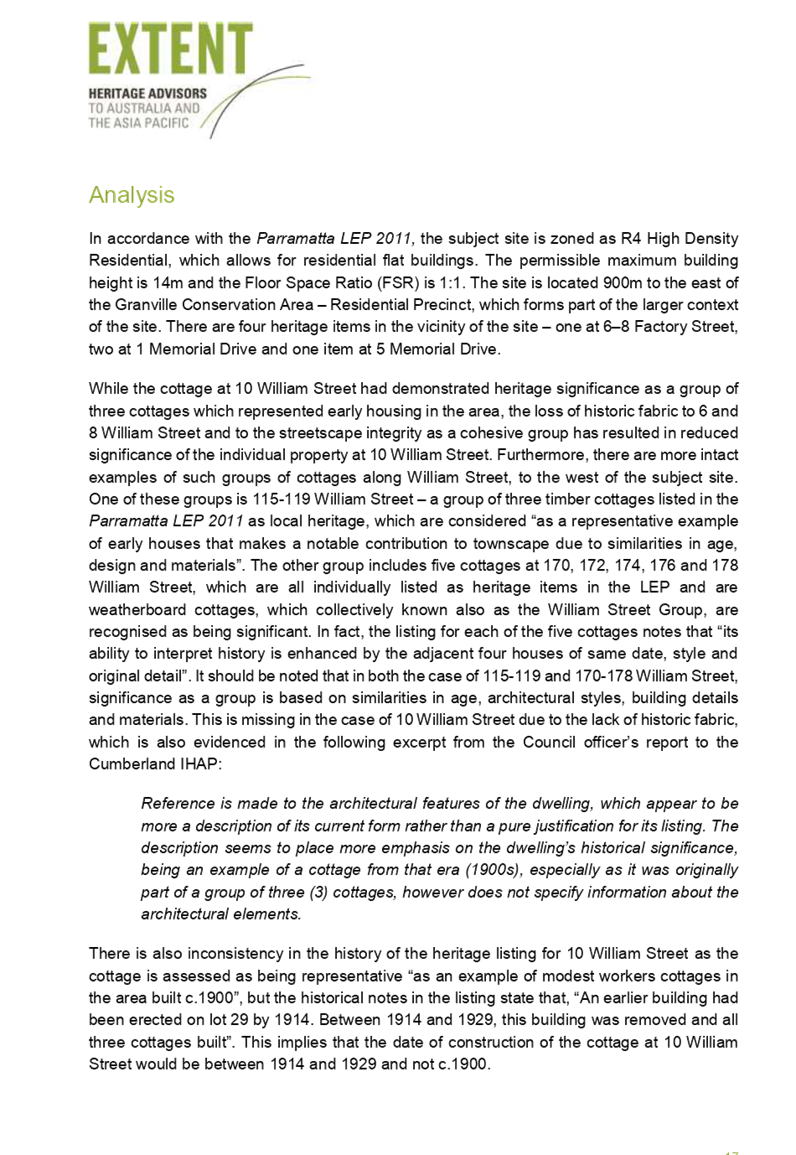
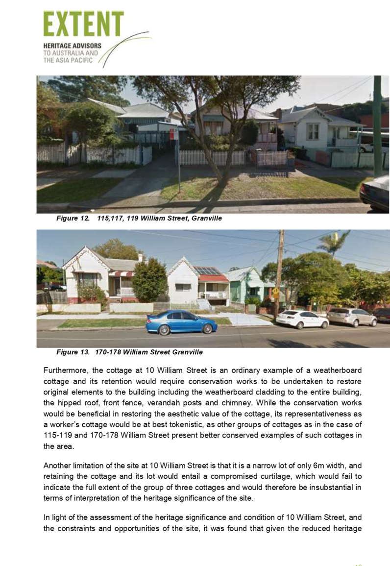
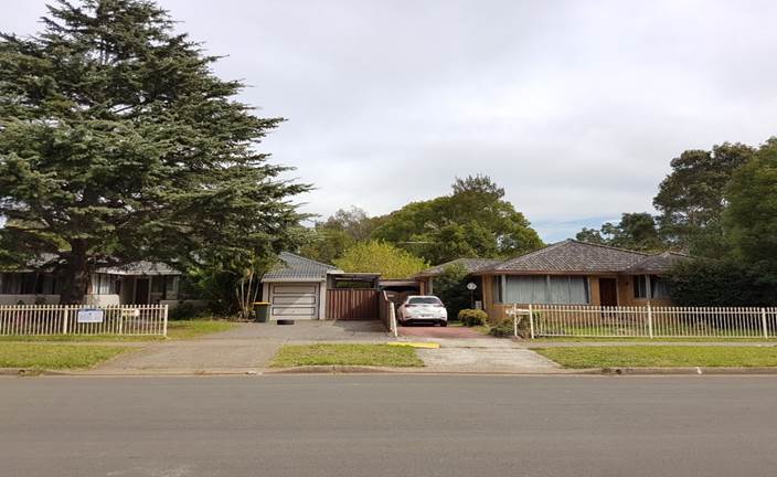
Figure
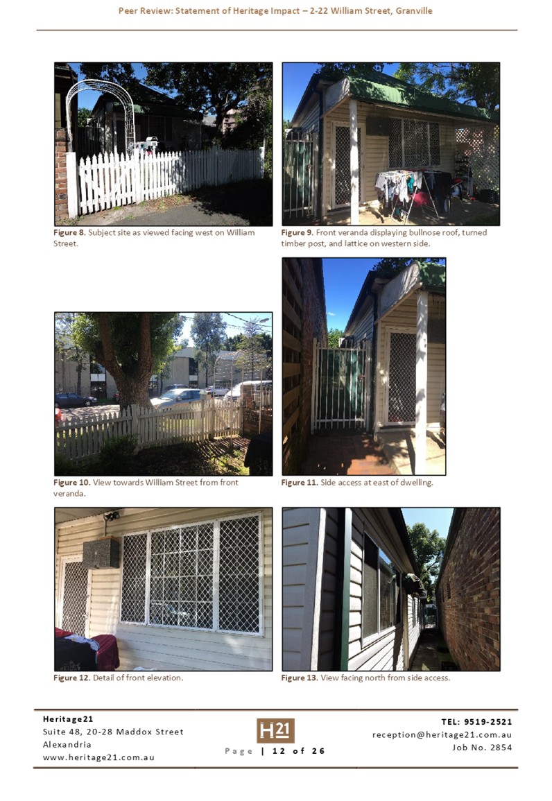
3 – Left: No. 7 Bransgrove Street; Right: No. 5 Bransgrove Street.
Source: Cumberland Council 2018
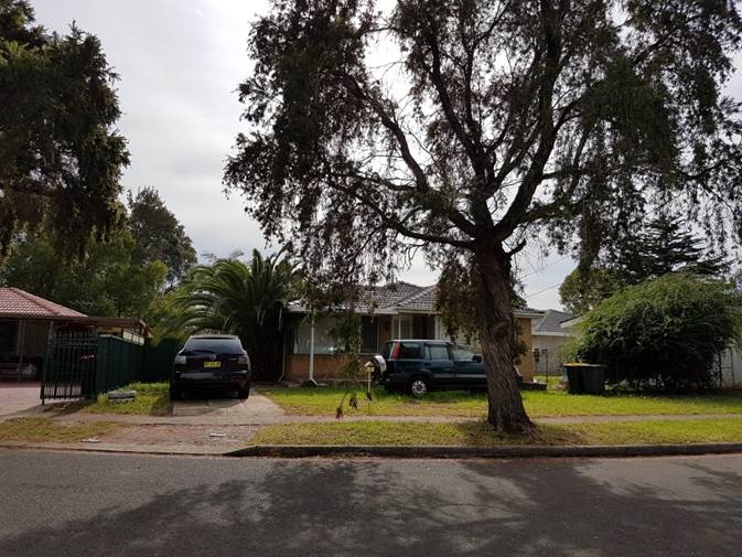
Figure
4 – No. 3 Irwin Place. Source: Cumberland Council 2018
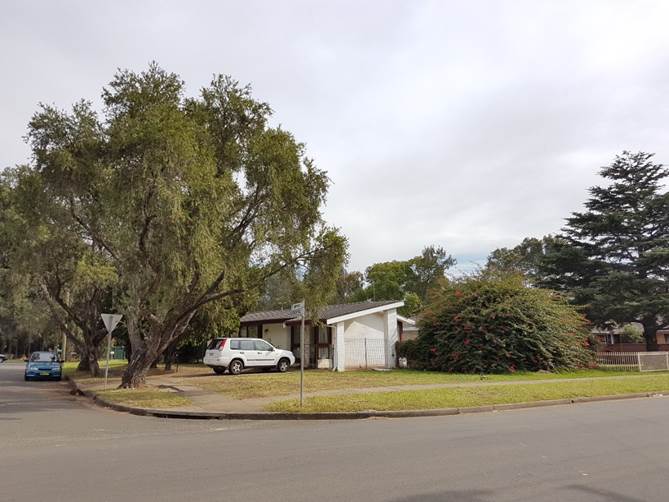
Figure
5 – No. 1 Irwin Place (corner of Irwin Place & Bransgrove Street).
Source: Cumberland Council 2018
Description of The Proposed
Development
DA 2018/123 seeks consent for
Demolition of existing structures, consolidation of 4 lots into 1 lot,
construction of a 5 storey residential flat building over basement parking
accommodating 48 units and 47 parking spaces under Affordable Rental Housing
SEPP 2009.
Key features of the development
proposal are as follows:-
|
Level
|
Details
|
|
Basement
|
47 residential car spaces (including 8 accessible parking
spaces)
1 car wash bay
29 bicycle spaces
Garbage room and bulky waste storage, plant room, lift and
fire stairs
|
|
Ground level
|
10 residential units
Communal Open Space with BBQ and seating areas, and
playground
|
|
Level 1
|
10 residential units
|
|
Level 2
|
10 residential units
|
|
Level 3
|
10 residential units
|
|
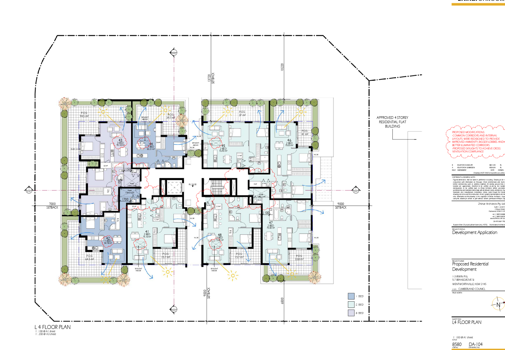
Level 4
|
8 residential units
|
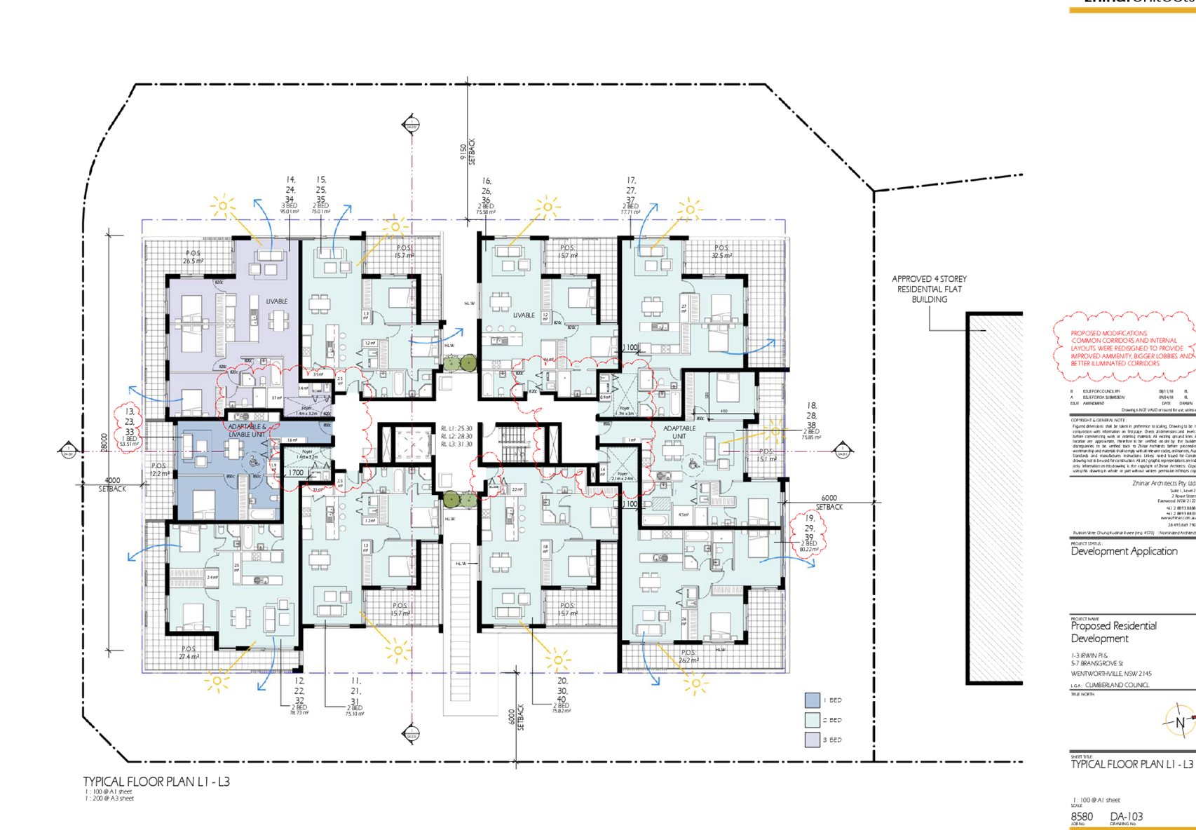
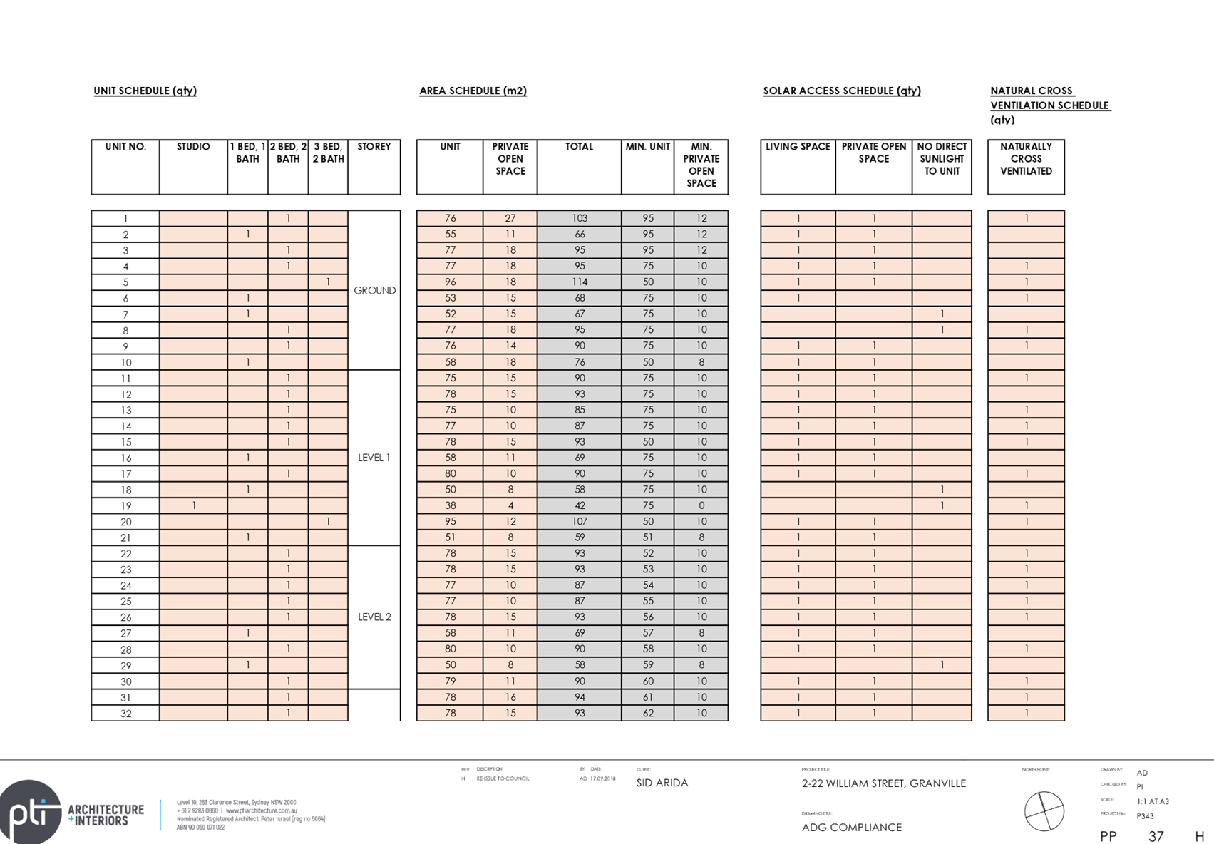
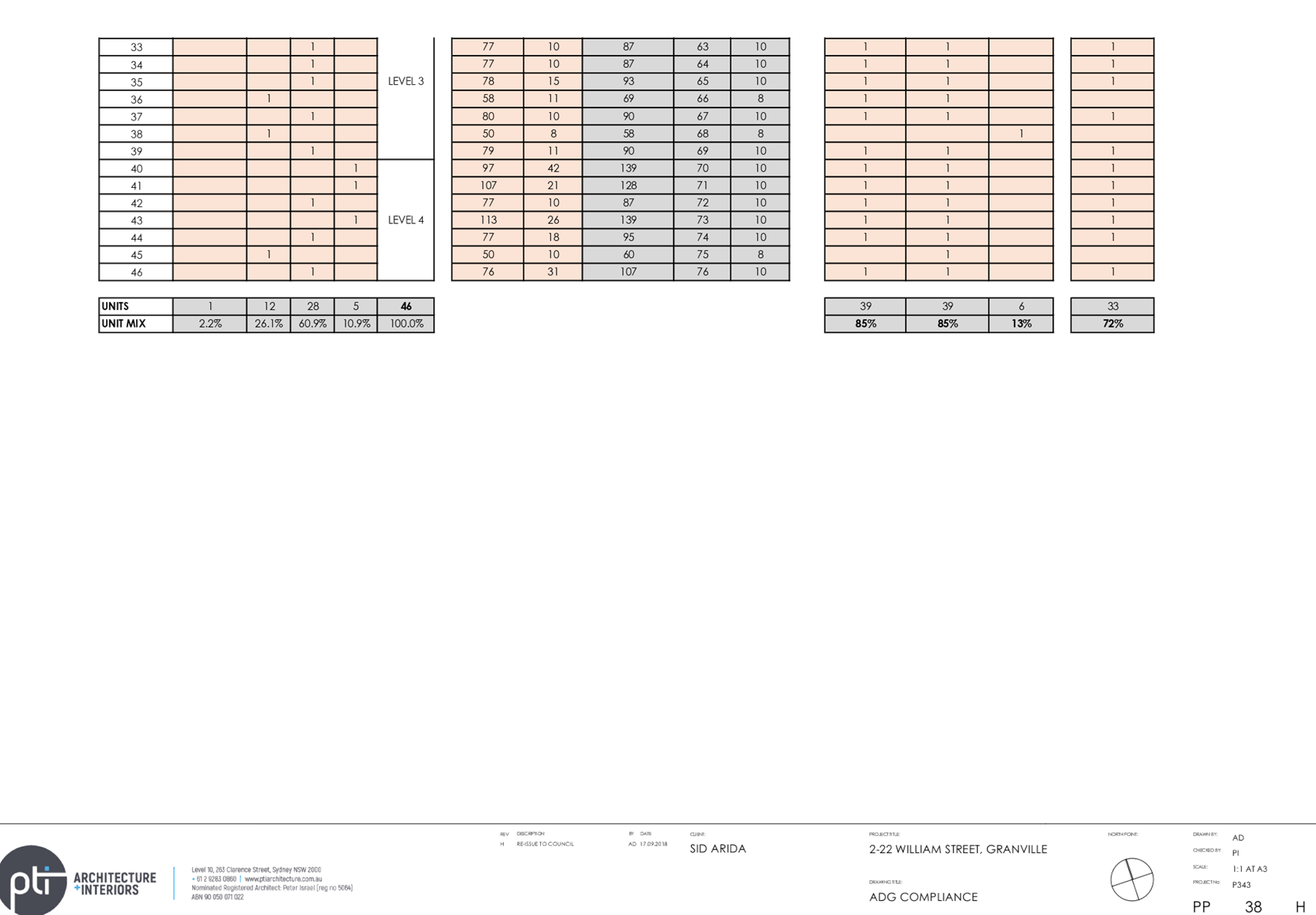
The dwelling mix of the proposal
is as follows:
· 7
x 1-bedroom units (15%)
· 36
x 2-bedroom units (75%)
· 5
x 3-bedroom units (10%)
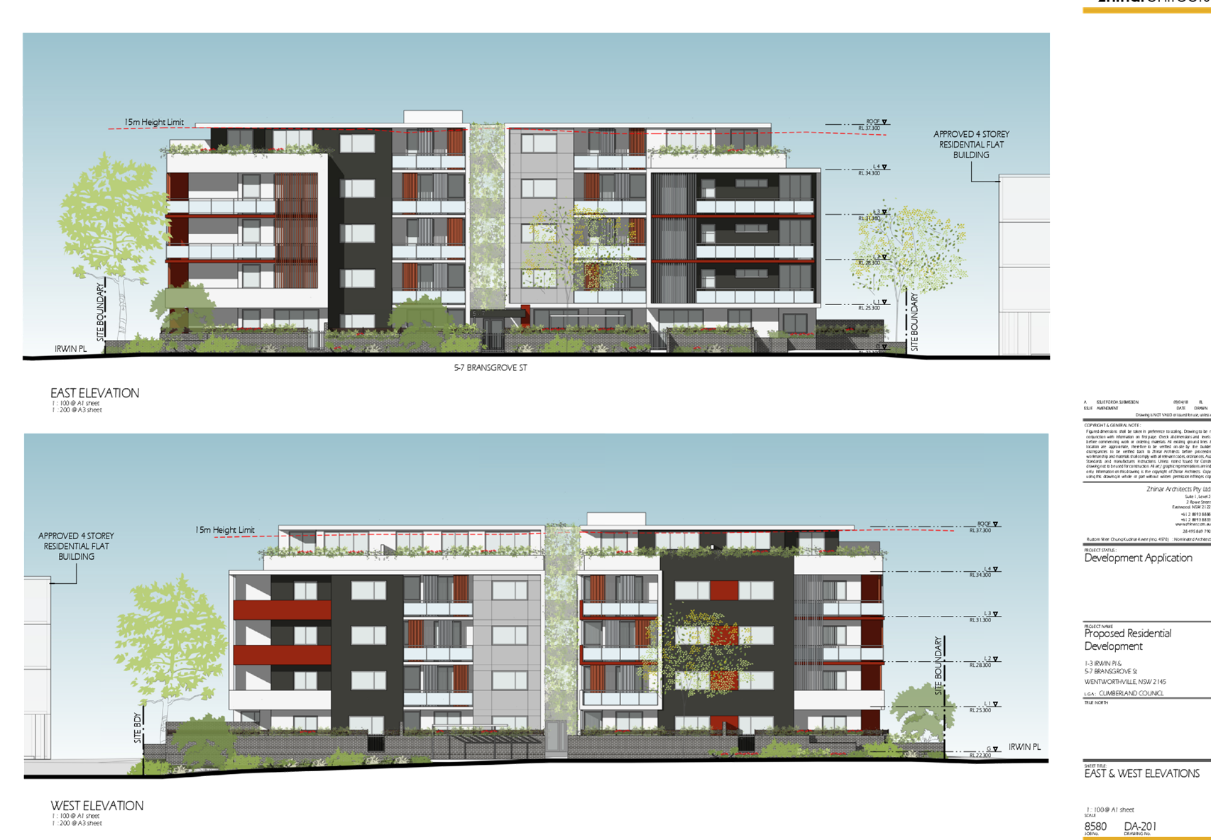
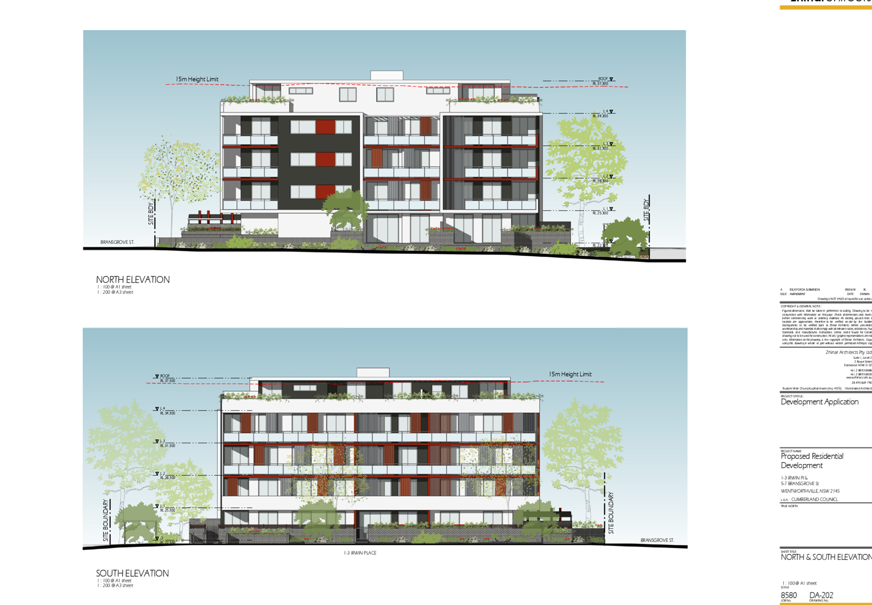
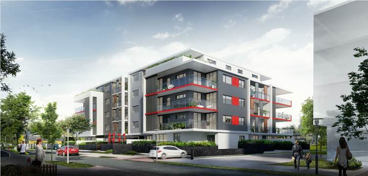
Figure 6 – Perspective of proposed development –
Bransgrove Street frontage
History
|
Date
|
Action
|
|
13 April 2018
|
The subject development application was lodged with
Council.
|
|
23 April 2018
|
The application was referred to the following internal and
external sections:
· Development
Engineering
· Traffic
Engineering
· Landscape and
Tree Management
· Environmental
Health
· Waste Management
· Cumberland
Police Area Command
· Transgrid
· Endeavour Energy
|
|
2 May 2018 to 23 May 2018
|
Application placed on public notification. In response, no
submissions were received.
|
|
1 May 2018
|
Application deferred requesting additional information
relating to site isolation and a revised QS Report.
|
|
7 May 2018
|
Additional information submitted and re-referred for
review.
|
|
18 October 2018
|
Application deferred to address FSR, concept plans for
isolated site, communal open space, natural ventilation, internal apartment
layouts, private open space, common circulation core, stormwater and waste
management matters.
|
|
9 November 2018
|
Additional information submitted for review.
|
|
16 April 2019
|
Application referred to CLPP for determination.
|
Applicant’s
Supporting Statement
A Statement of
Environmental Effects prepared by Think Planners dated 10 April 2018 was
submitted with the application.
A written request to
vary the building height standard, prepared in accordance with Clause 4.6 of
HLEP 2013 by Think Planners, dated 10 April 2018, in support of the
application.
Contact With
Relevant Parties
The assessing officer
has undertaken an inspection of the subject site and has been in contact with
the applicant throughout the assessment process.
Internal Referrals
Development Engineer
The development
application was referred to Council’s Development Engineer for comment
who has advised that the development is supportable in regards to overland
flood mitigation measure, and on-site detention provision, subject to
conditions.
Tree Management
Officer
The development
application was referred to Council’s Tree Management Officer for comment
who has advised that the development is supportable in regards to protection of
existing trees on the adjoining properties, subject to conditions.
Traffic Engineer
The development
application was referred to Council’s Traffic Engineer for comment who
has advised that the development is supportable in regards to traffic
management, and on-site parking provision in the basement level, subject to
conditions.
Environmental Health
Officer
The development
application was referred to Council’s Environmental Health Officer for
comment who has advised that the development is supportable in regards to
acoustic assessment and measures, and site contamination, subject to
conditions.
Waste Management
Officer
The development
application was referred to Council’s Waste Management Officer for
comment who has advised that the development is supportable in regards to
provision of bin tug, bin storage room, and waste collection and management
plan, subject to conditions.
External Referrals
Transgrid
The development
application was referred to Transgrid for comment pursuant to Clause 45 of
State Environmental Planning Policy (Infrastructure) 2007 for comment, who
advised that the development is supportable, and no conditions are recommended
to be imposed.
Endeavour Energy
The development
application was referred to Endeavour Energy for comment pursuant to Clause 45
of State Environmental Planning Policy (Infrastructure) 2007 for comment, who
advised that the development is supportable, subject to conditions.
Cumberland Police
Local Area Command
The development
application was referred to Cumberland Police Local Area Command for comment in
order to facilitate the incorporation of Crime Prevention through Environmental
Design (CPTED) principles into the proposal. The proposal is considered
supportable, subject to conditions.
Planning Comments
Section 4.15 of the
Environmental Planning and Assessment Act 1979
State
Environmental Planning Policies
The following
Environmental Planning Instruments are relevant to the assessment of the
subject application:
(a) State
Environmental Planning Policy (Affordable Rental Housing) 2009 (ARH SEPP)
The proposal falls under
Part 2 New affordable rental housing – Division 1 In-fill affordable
housing.
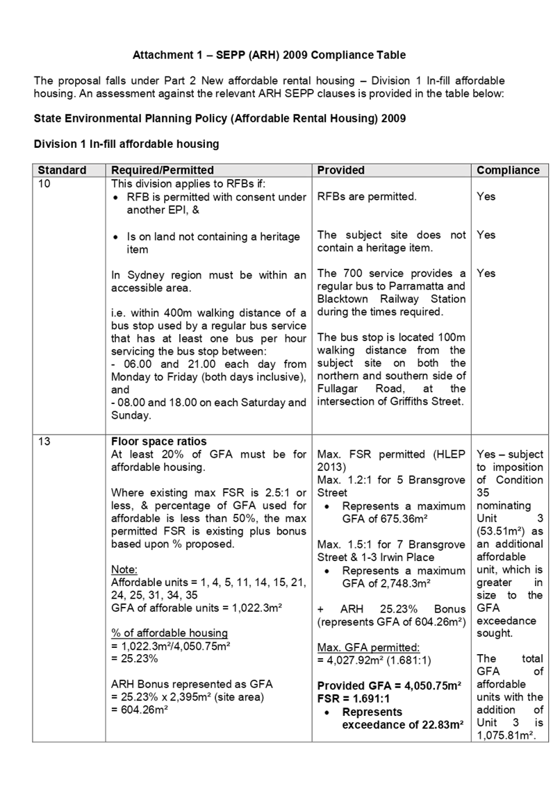
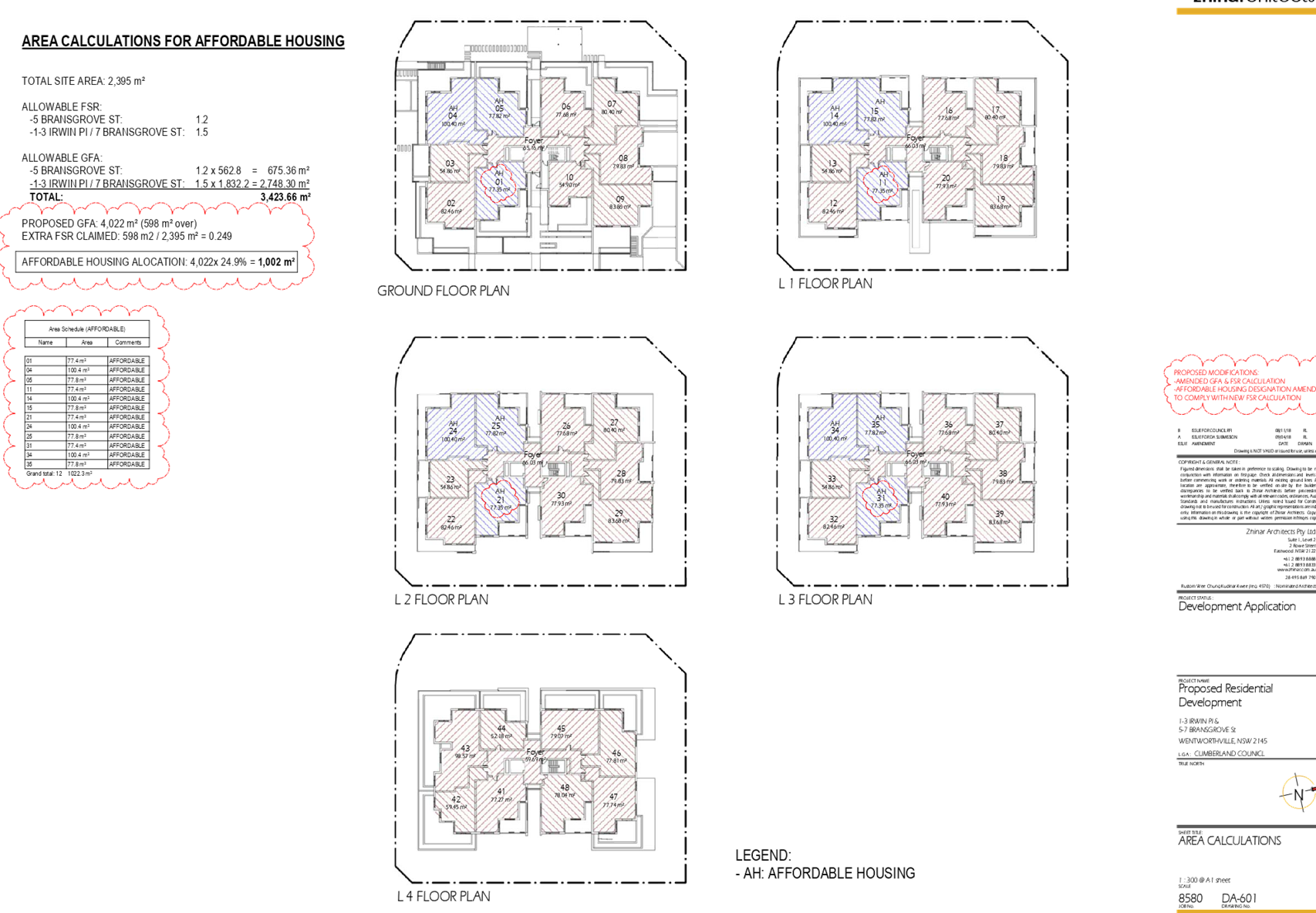
13 Floor space ratios
(1) This
clause applies to development to which this Division applies if the percentage
of the gross floor area of the development that is to be used for the purposes
of affordable housing is at least 20 per cent.
Max. FSR permitted (HLEP
2013)
Max. 1.2:1 for 5
Bransgrove Street
· Represents
a maximum GFA of 675.36m²
Max. 1.5:1 for 7
Bransgrove Street & 1-3 Irwin Place
· Represents
a maximum GFA of 2,748.3m²
+ ARH 25.23% Bonus
(represents GFA of 604.26m²)
Max. GFA permitted:
= 4,026.24m²
(1.681:1)
Provided GFA =
4,050.75m²
FSR = 1.691:1
Represents exceedance of
22.83m²
The proposal is compliant
subject to the imposition of condition nominating Unit 3 (53.51m²) as an
additional affordable unit, which is greater in size to the GFA exceedance
sought. The total GFA of affordable units with the addition of Unit 3 is
1,075.81m².
A comprehensive
assessment against ARH SEPP is attached to this report – Attachment 1.
It should be noted that
the proposal fully complies with the key planning controls contained within the
ARH SEPP including site area, landscaped area, parking, accommodation size and
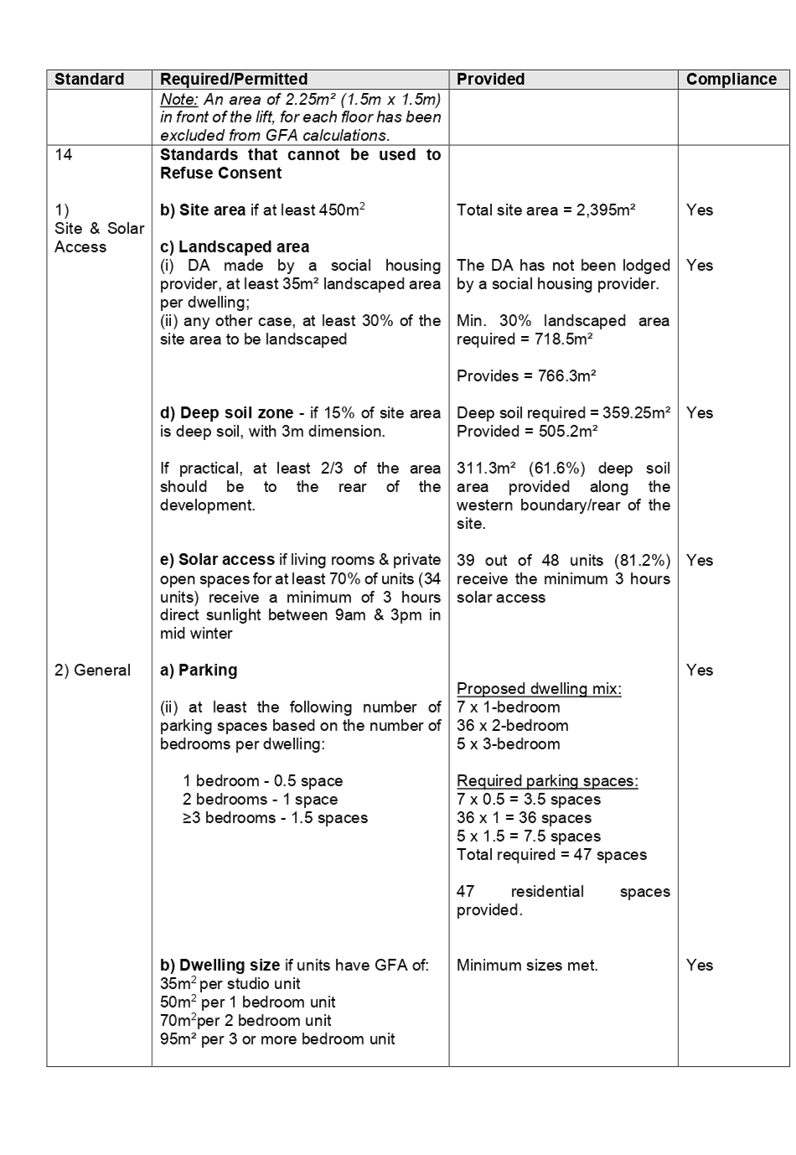
prescribed standards for in-fill affordable housing.
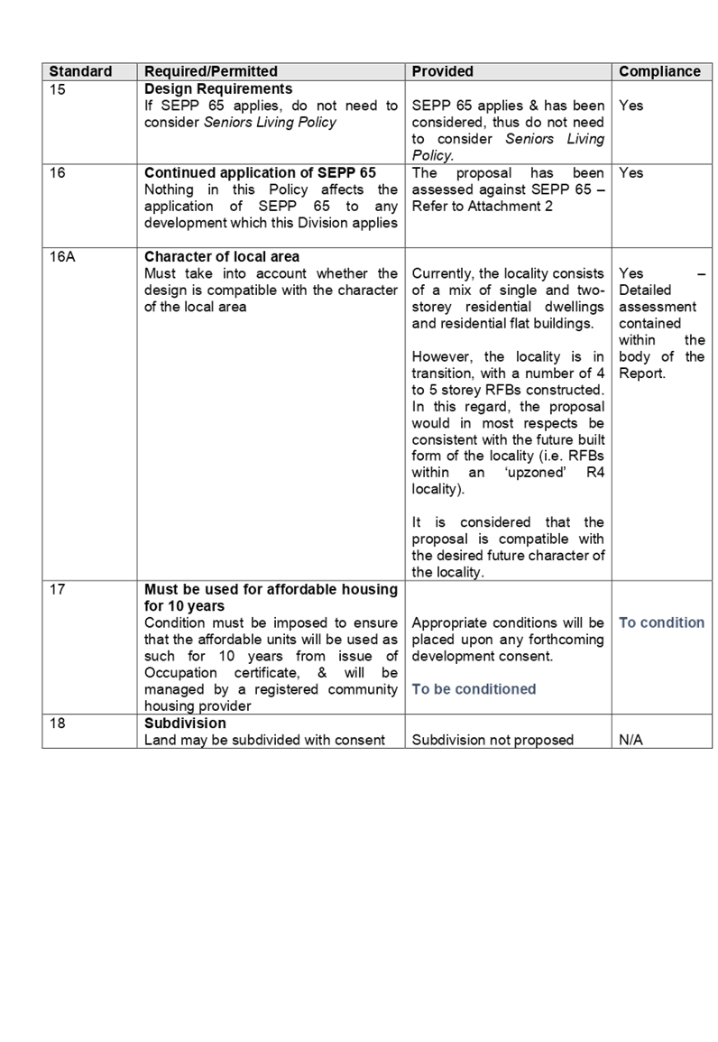
16A Character of
local area
A consent authority must
not consent to development to which this Division applies unless it has taken
into consideration whether the design of the development is compatible with the
character of the local area. The SEPP (ARH) does not contain any guidance for
assessing whether a proposal is compatible with the character of the local
area. However, a planning principle for assessing compatibility in the urban
environment was established by Senior Commissioner Roseth of the Land and
Environment Court in the judgement for Project Venture Developments Pty Ltd v
Pittwater Council [2005] NSWLEC 191. This involves asking the following two
questions:
· Are
the proposal’s physical impacts on surrounding development acceptable?
The physical impacts include constraints on the development potential of surrounding
sites.
· Is
the proposal’s appearance in harmony with the buildings around it and the
character of the street?
A merit assessment of
the character of the local area should consider the following 3 steps:
· Step
1 – Identify the ‘local area’.
· Step
2 – Determine the character of the ‘local area’.
· Step
3 – Determine whether the design of the proposed development is
compatible with the character of the ‘local area’.
An assessment against
each step is provided below:
Step 1 –
Identify the local area.
This assessment
identifies the local area as primarily the visual catchment of the site
(hatched in red) as viewed from within the site and directly adjacent to the
site on the street which is defined by the yellow line in Figure 7, and white
line in Figure 8 below:
The local area
Figure 7 – Local Area catchment as identified on Aerial Map 2016
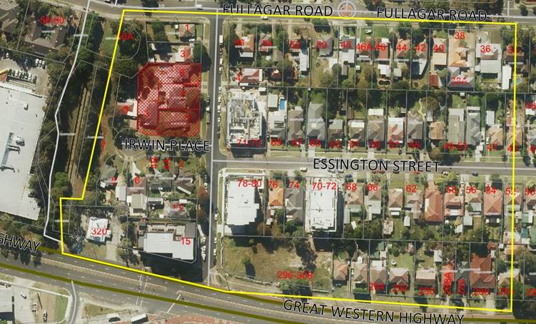
Figure 8 – Local Area catchment as identified on Zoning Map
Step 2 –
Determine the character (present and future) of the local area.
The zoning of the
broader locality and immediate area comprises R4 High Density Residential, R2
Low Density Residential, RE1 Public Recreation and B2 under the Holroyd Local
Environmental Plan (HLEP) 2013.
Present Character of
the area
The character of the
local area comprises the visual catchment of regular shaped allotments viewed
from and surrounding the subject site, which includes:-
1. Existing
recently constructed 4 storey residential flat buildings located both corners
of Bransgrove Street and Essington Street (71-73 Essington St & 78-80
Essington St);
2. Detached
dwelling houses and attached dual occupancy development located on the southern
side of Irwin Place;
3. Irwin
Place Park located at the bulb of Irwin Place;
4. Detached
dwelling houses located on both corners of Bransgrove Street and Fullagar Road
(1-3 Bransgrove St, 4 Bransgrove St & 54-56 Fullagar Rd);
5. Existing,
recently completed, and under construction 4 storey residential flat buildings
located on both sides of Essington Street;
6. Mixed
use 4 storey building at 15 Bransgrove Street (corner Great Western Highway);
7. Existing
6 storey residential flat building at 296-300 Great Western Highway (corner
Bransgrove St);
8. Existing
5 storey residential flat building at 296-298 Great Western Highway;
9. Residential
flat buildings (5 storey) currently under construction at 288A-290 Great
Western Highway and 280-282 Great Western Highway.
Figure
9 – Left: 71-73 Essington St; Right: 78-80 Essington St / 296-300 Great
Western Highway to the rear.
Figure
10 – Left: Irwin Place as viewed from Bransgrove St; Right: Irwin Place
Park
Future Character of the area
The locality is in transition
particularly to support the increasing demand of affordable housing within the
close proximity of public transport hub and major commercial centre. The
transition issue is clear with regard to FSR, height and setbacks for the proposed
development. It is considered that the height, bulk and scale of the proposed
development is similar to the recently completed and newer residential flat
buildings being constructed and would not be inconsistent with the desired
future character of the locality.
The proposed development may pose
some impacts on the residential amenity currently enjoyed by the occupants of
the properties located on the southern side of Irwin Place and 1-3 Bransgrove
Street. However, these impacts are not unreasonable and are consistent with
impacts that would result from the form of development envisaged under the
planning controls noting the varying zoning of properties located on the
northern and southern side of Irwin Place. Appropriate privacy measures are proposed
for the northern elevation and western elevation of the proposed development to
minimise any adverse impacts to the approved residential flat building at 1-3
Bransgrove Street and future development of 5 Irwin Place.
In this regard, the area is
undergoing transition with considerable development that will change the
existing character of the area. The proposed development is consistent with the
form of development and the desired future character envisaged under these
planning controls.
Step 3 - Determine if the
development is compatible with the character of the local area.
In accordance with the Land and
Environment Court’s ‘Planning Principle’ and case law
compatibility is best defined as ‘capable of existing together in
harmony’. In order to test compatibility two questions are to be
considered. These questions, as well as a response to each, are provided below:
· Are
the proposal’s physical impacts on surrounding development acceptable?
The physical impacts include constraints on the development potential of
surrounding sites.
The height, FSR and landscaping of
the proposed development are designed to maintain the harmony within the
streetscape, whilst contributing to the site context and constraint. The height
of building facing both Bransgrove Street and Irwin Place breach the 15m height
limit requirement for part of the roof and the lift core. The proposal being a
permissible land use, meets the FSR requirement (in accordance with ARH SEPP,
subject to the imposition of conditions) and contributes to the provision of
affordable housing within the close proximity of public transport hub and major
commercial centre. Appropriate setbacks and privacy treatments are provided to
minimise any adverse impacts to the adjoining properties. The fifth storey does
not comply with maximum number of storeys as prescribed in Part N of HDCP 2013,
however, the proposed development is located on a corner allotment and is
appropriately articulated to complement the existing and changing streetscape
within the local area. Also being on a corner allotment and of a north-south
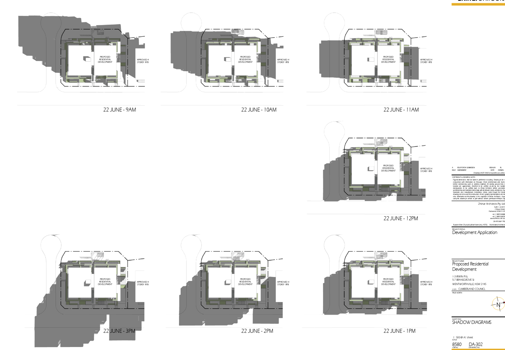
orientation, overshadowing is acceptable and consistent with that envisaged
under the planning controls.
· Is
the proposal’s appearance in harmony with the buildings around it and the
character of the street?
To be compatible, a development
should contain, or at least respond to the key aesthetic elements that make up
the character of the surrounding area. The size of the basement maximises
landscaping and deep soil zones on site. The front setbacks are generous and
consistent with the existing streetscape. The proposal is considered to
maintain an appropriate residential character which is consistent with the
streetscape. As indicated, the local area has an established high density
residential built form, as such, the proposed development is not considered to
be inconsistent with the existing streetscape character of the immediate area
surrounding the subject site.
In conclusion, the proposal will
maintain the harmony within the general streetscape, and suitably fits in the
local character of the locality.
(b) State
Environmental Planning Policy No 65 – Design Quality of Residential
Apartment Development (SEPP 65)
The proposal is classified as a
residential apartment development and SEPP 65 applies. A design verification
statement signed by registered architect Ian Conry was submitted with the
application. A comprehensive assessment against the Apartment Design Guide
(ADG) controls is provided at Attachment 2.
The following table sets out the
ADG non-compliances.
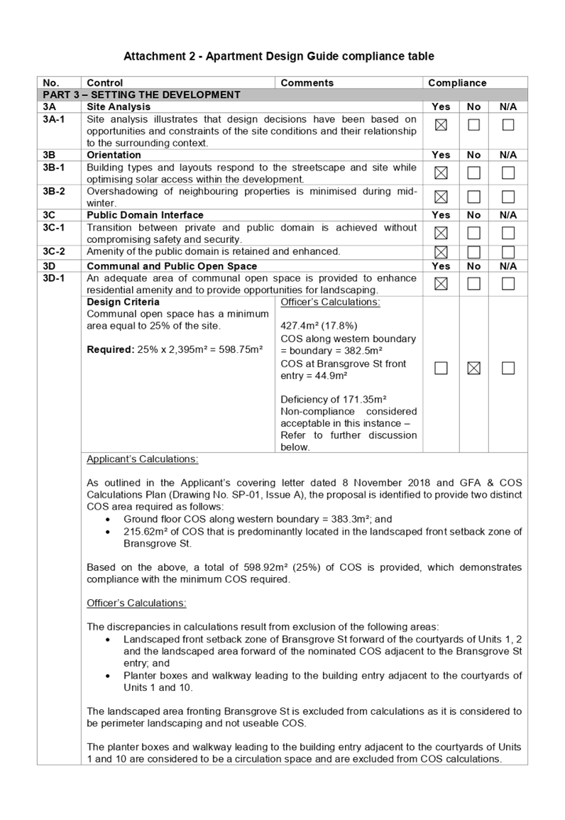
|
3D
|
Communal and Public Open
Space
|
Yes
|
No
|
N/A
|
|
3D-1
|
An adequate area of communal
open space is provided to enhance residential amenity and to provide
opportunities for landscaping.
|
|
|
|
|
Design Criteria
Communal open space has a
minimum area equal to 25% of the site.
Required: 25% x
2,395m² = 598.75m²
|
Officer’s Calculations:
427.4m² (17.8%)
COS along western
boundary = boundary = 382.5m²
COS at Bransgrove St front entry = 44.9m²
Deficiency of 171.35m²
Non-compliance considered acceptable in this instance
–
Refer to further discussion below.
|
|
|
|
|
Applicant’s Calculations:
As outlined in the Applicant’s covering letter dated
8 November 2018 and GFA & COS Calculations Plan (Drawing No. SP-01, Issue
A), the proposal is identified to provide two distinct COS area required as
follows:
· Ground floor COS
along western boundary = 383.3m²; and
· 215.62m² of
COS that is predominantly located in the landscaped front setback zone of
Bransgrove St.
Based on the above, a total of 598.92m² (25%) of COS
is provided, which demonstrates compliance with the minimum COS required.
Officer’s Calculations:
The discrepancies in calculations result from exclusion of
the following areas:
· Landscaped front
setback zone of Bransgrove St forward of the courtyards of Units 1, 2 and the
landscaped area forward of the nominated COS adjacent to the Bransgrove St
entry; and
· Planter boxes
and walkway leading to the building entry adjacent to the courtyards of Units
1 and 10.
The landscaped area fronting Bransgrove St is excluded
from calculations as it is considered to be perimeter landscaping and not
useable COS.
The planter boxes and walkway leading to the building
entry adjacent to the courtyards of Units 1 and 10 are considered to be a
circulation space and are excluded from COS calculations.
In this regard, based on the above, the total COS provided
by the proposal is calculated to be a total of 427.4m², which represents
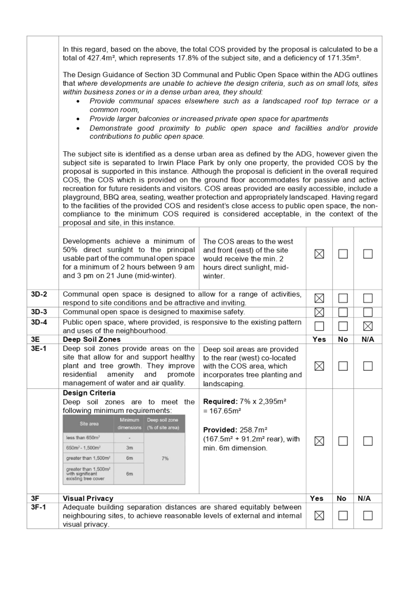
17.8% of the subject site, and a deficiency of 171.35m².
The Design Guidance of Section 3D Communal and Public Open
Space within the ADG outlines that where developments are unable to
achieve the design criteria, such as on small lots, sites within business
zones or in a dense urban area, they should:
· Provide
communal spaces elsewhere such as a landscaped roof top terrace or a common
room,
· Provide
larger balconies or increased private open space for apartments
· Demonstrate
good proximity to public open space and facilities and/or provide
contributions to public open space.
The subject site is identified as a dense urban area as defined by the ADG,
however given the subject site is separated to Irwin Place Park by only one
property, the provided COS by the proposal is supported in this instance.
Although the proposal is deficient in the overall required COS, the COS which
is provided on the ground floor accommodates for passive and active
recreation for future residents and visitors. COS areas provided are easily
accessible, include a playground, BBQ area, seating, weather protection and
appropriately landscaped. Having regard to the facilities of the provided COS
and resident’s close access to public open space, the non-compliance to
the minimum COS required is considered acceptable, in the context of the
proposal and site, in this instance.
|
|
|
|
|
|
|
|
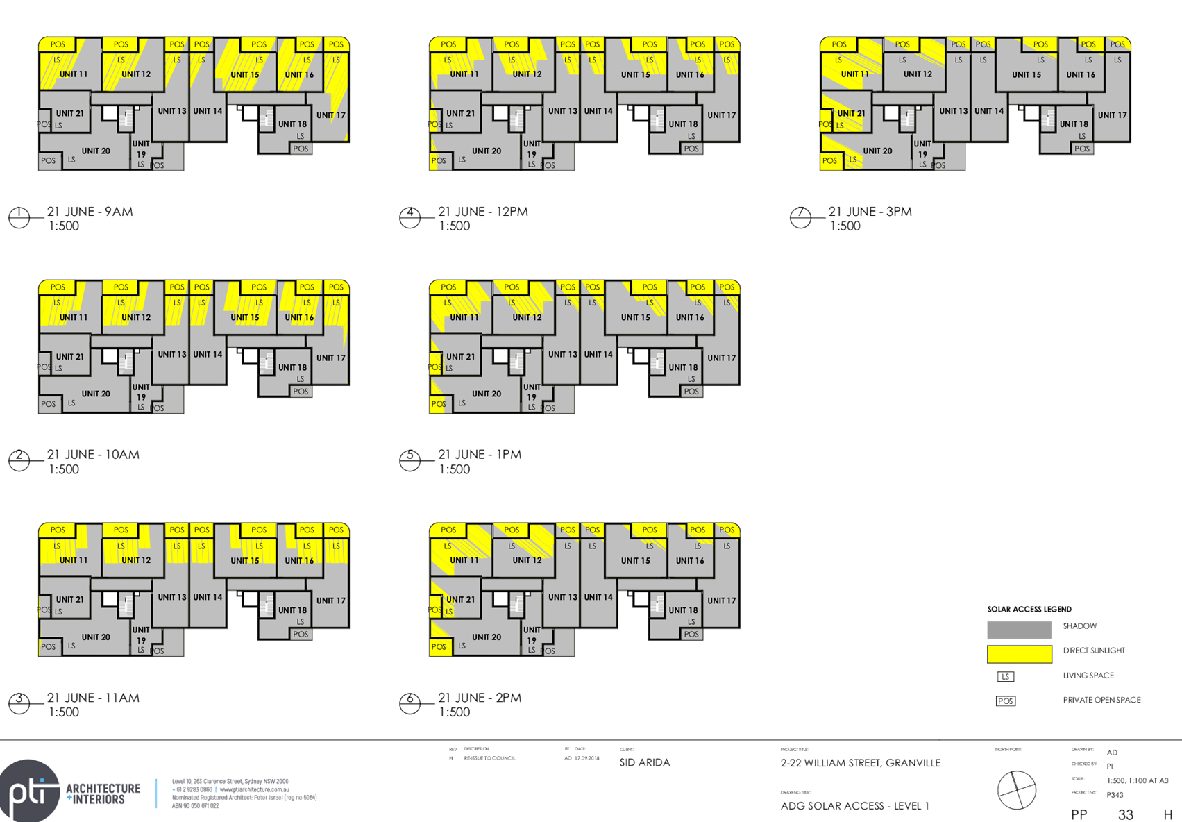
3F
|
Visual Privacy
|
Yes
|
No
|
N/A
|
|
3F-1
|
Adequate building separation
distances are shared equitably between neighbouring sites, to achieve
reasonable levels of external and internal visual privacy.
|
|
|
|
|
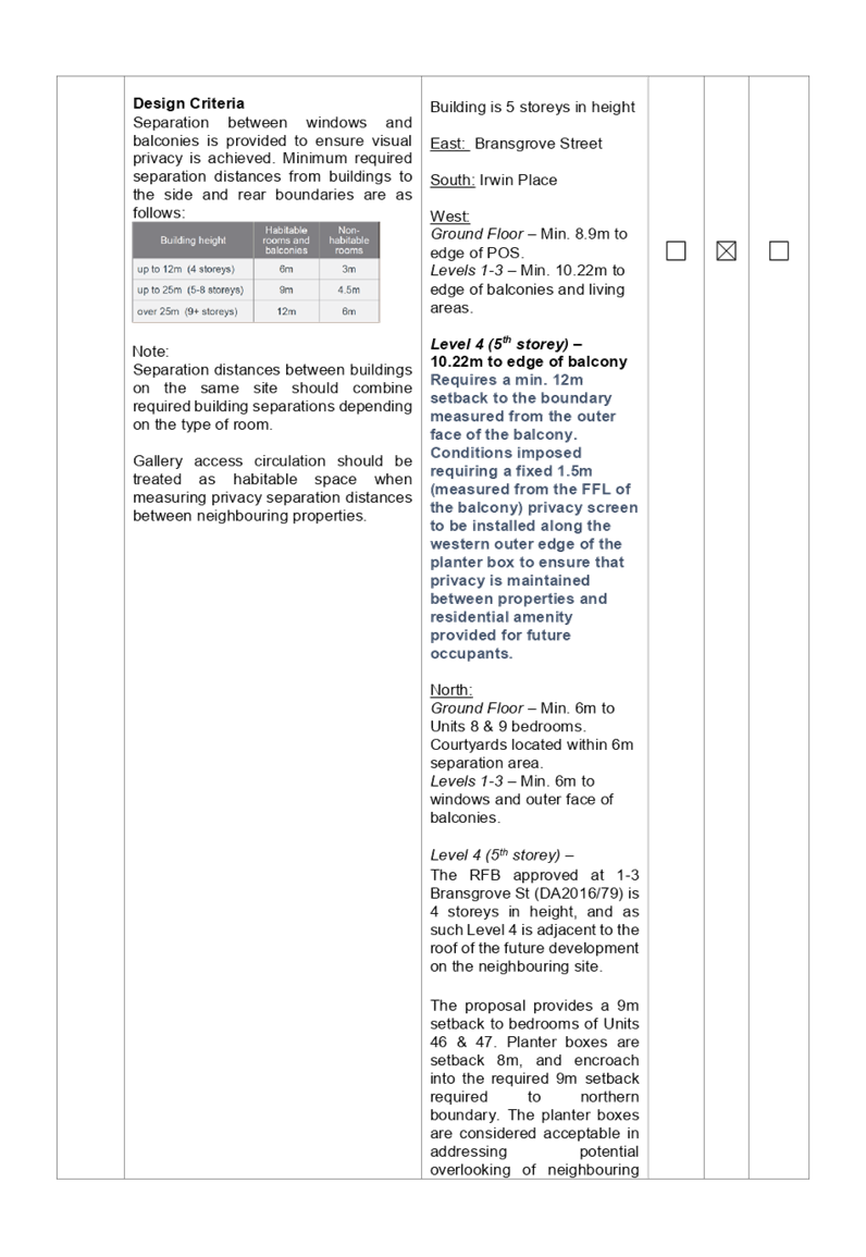
Design Criteria
Separation
between windows and balconies is provided to ensure visual privacy is
achieved. Minimum required separation distances from buildings to the side
and rear boundaries are as follows:
Note:
Separation distances between
buildings on the same site should combine required building separations
depending on the type of room.
Gallery access circulation should
be treated as habitable space when measuring privacy separation distances
between neighbouring properties.
|
Level 4 (5th storey) – 10.22m
to edge of balcony
Requires a min. 12m setback
to the boundary measured from the outer face of the balcony.
Conditions imposed
requiring a fixed 1.5m (measured from the FFL of the balcony) privacy screen
to be installed along the western outer edge of the planter box to ensure
that privacy is maintained between properties and residential amenity
provided for future occupants.
Satisfactory subject to
imposition of conditions.
|
|
|
|
|
|
|
|
|
|
(c) State
Environmental Planning Policy (Infrastructure) 2007
Clause 45 – Development
likely to affect an electricity transmission or distribution network
The development application was
referred to Endeavour Energy for comment, who raised no objections, subject to
recommendations.
Clause 102 – Impact of
road noise or vibration on non-road development
The subject site is located
approximately 100m from Great Western Highway. The proposal is for the purposes
of residential accommodation. In accordance with Clause 102, an Acoustic Report
was submitted with the application. Council’s Environmental Health Officer
has reviewed the Acoustic Report and advises that the proposal is satisfactory
subject to the imposition of conditions requiring appropriate measures to be
implemented to ensure noise levels to bedrooms and living areas are acceptable.
(d) State
Environmental Planning Policy No 55 – Remediation of Land (SEPP 55)
The requirement at Clause 7 of
SEPP No. 55 for Council to be satisfied that the site is suitable or can be
made suitable to accommodate the proposed development has been considered in
the following table:
|
Matters for consideration
|
Yes
|
No
|
N/A
|
|
Does the application involve
re-development of the site or a change of land use?
|
|
|
|
|
Is the development going to be
used for a sensitive land use (e.g.: residential, educational, recreational,
childcare or hospital)?
|
|
|
|
|
Does information available to
you indicate that an activity listed below has ever been approved, or
occurred at the site?
acid/alkali plant and
formulation, agricultural/horticultural activities, airports, asbestos
production and disposal, chemicals manufacture and formulation, defence
works, drum re-conditioning works, dry cleaning establishments, electrical
manufacturing (transformers), electroplating and heat treatment premises,
engine works, explosive industry, gas works, iron and steel works, landfill
sites, metal treatment, mining and extractive industries, oil
production and storage, paint formulation and manufacture, pesticide
manufacture and formulation, power stations, railway yards, scrap yards,
service stations, sheep and cattle dips, smelting and refining, tanning and
associated trades, waste storage and treatment, wood preservation.
|
|
|
|
|
Is the site listed on Council's
Contaminated Land Database?
|
|
|
|
|
Is the site subject to EPA
clean-up order or other EPA restrictions?
|
|
|
|
|
Has the site been the subject of
known pollution incidents or illegal dumping?
|
|
|
|
|
Does the site adjoin any contaminated
land/previously contaminated land?
|
|
|
|
|
Has the appropriate level of
investigation been carried out in respect of contamination matters for
Council to be satisfied that the site is suitable to accommodate the proposed
development or can be made suitable to accommodate the proposed development?
|
|
|
|
|
Details of contamination
investigations carried out at the site:
The site
is not identified in Council’s records as being contaminated. A site
inspection reveals the site does not have any obvious history of a previous
land use that may have caused contamination and there is no specific evidence
that indicates the site is contaminated. In this regard, an environmental
site assessment is not required for the proposal.
Council’s
Environmental Health Officer has also reviewed the proposal, and considers
the proposed development to be satisfactory subject to the imposition of
conditions requiring works to stop should any unexpected finds be found
during demolition or construction works.
|
(e) State
Environmental Planning Policy (Building Sustainability Index: BASIX) 2004
BASIX certificate 906088M dated 5
April 2018 was submitted with the amended plans. The certificate achieves
target scores and is consistent with the architectural plans.
Regional Environmental Plans
(Deemed State Environmental Planning Policies)
(f) Sydney
Regional Environmental Plan (Sydney Harbour Catchment) 2005
The subject site is identified as
being located within the area affected by the Sydney Regional Environmental
Plan (Sydney Harbour Catchment) 2005. The proposed development raises no issues
as no impact on the catchment is envisaged.
Note: The subject site is not
identified in the relevant map as land within the ‘Foreshores and
Waterways Area’ or ‘Wetland Protection Zone’, is not a
‘Strategic Foreshore Site’ and does not contain any heritage items.
Hence the majority of the SREP is not directly relevant to the proposed
development.
Local Environmental Plans
(g) Holroyd
Local Environmental Plan 2013 (HLEP 2013)
The proposal is defined as a
‘residential flat building’ (building containing 3 or more
dwellings, does not include an attached dwelling or multi dwelling housing)
under the provisions of HLEP 2013. Residential flat building is permitted with
consent in the R4 – High Density Residential zone which applies to the
land.
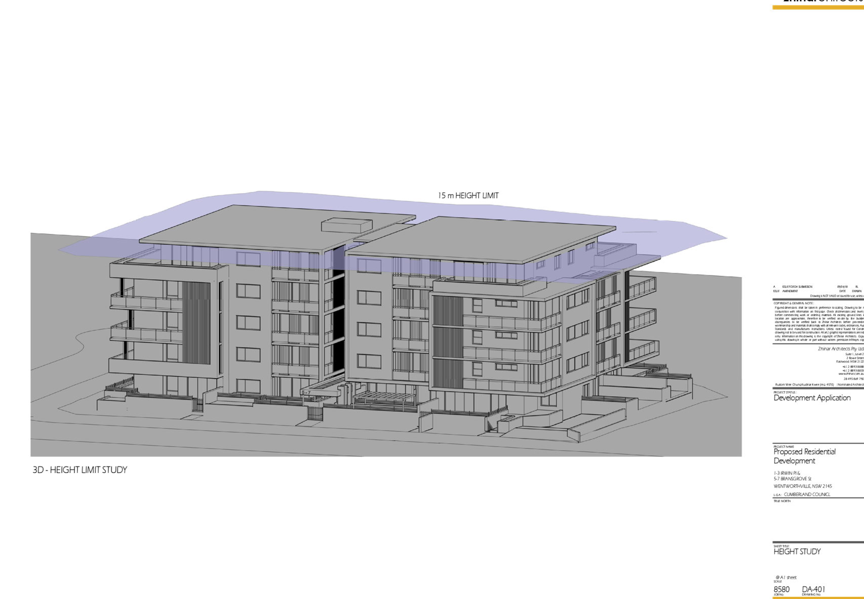
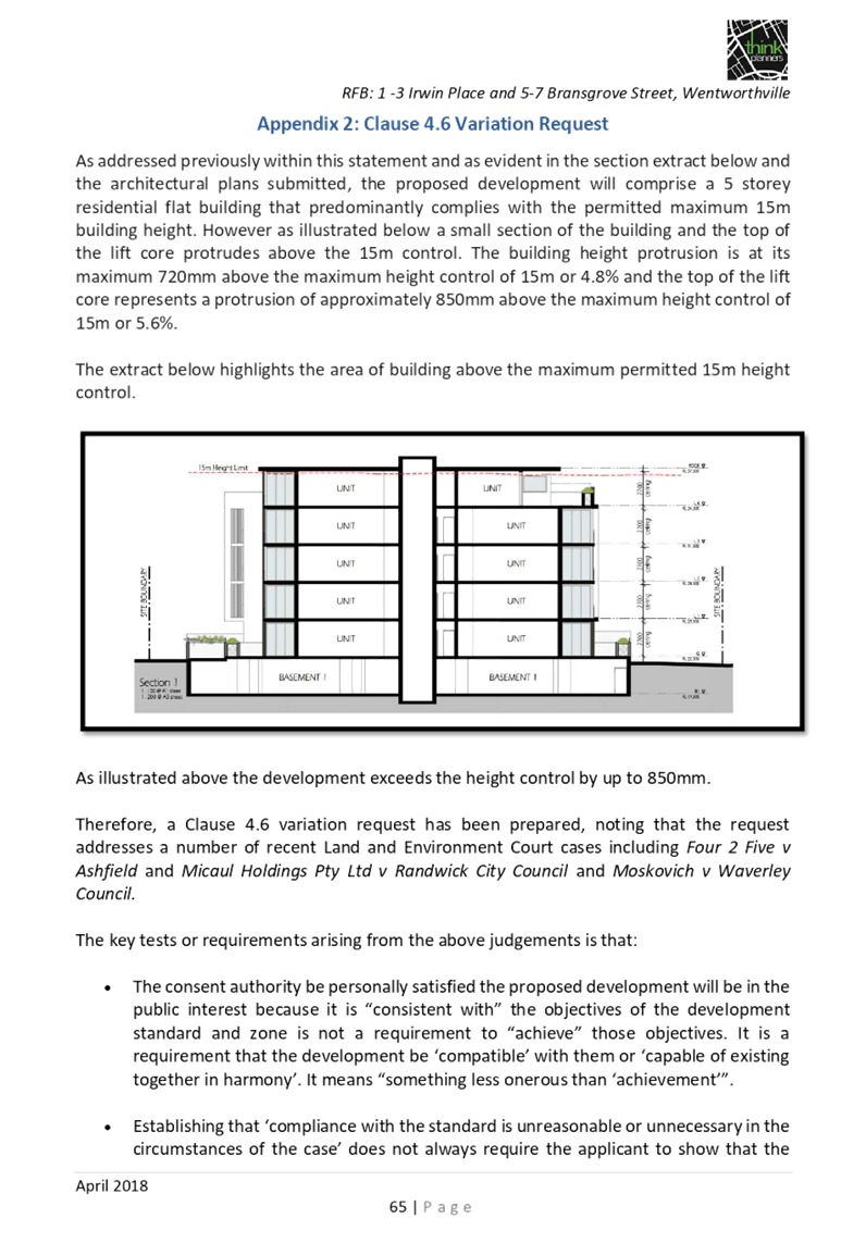
The proposal seeks a variation to
Clause 4.3 – Height of Buildings that stipulates that the height of
building is not to exceed 15m on the subject site.
The proposed building has an
overall height of 15.72m (RL) to the roof of the building, 15.85 m (RL) to the
top of the lift core. The proposal breaches the height by 0.72m to the roof of
the building, and 0.85m to the lift core representing variations of 4.8% and
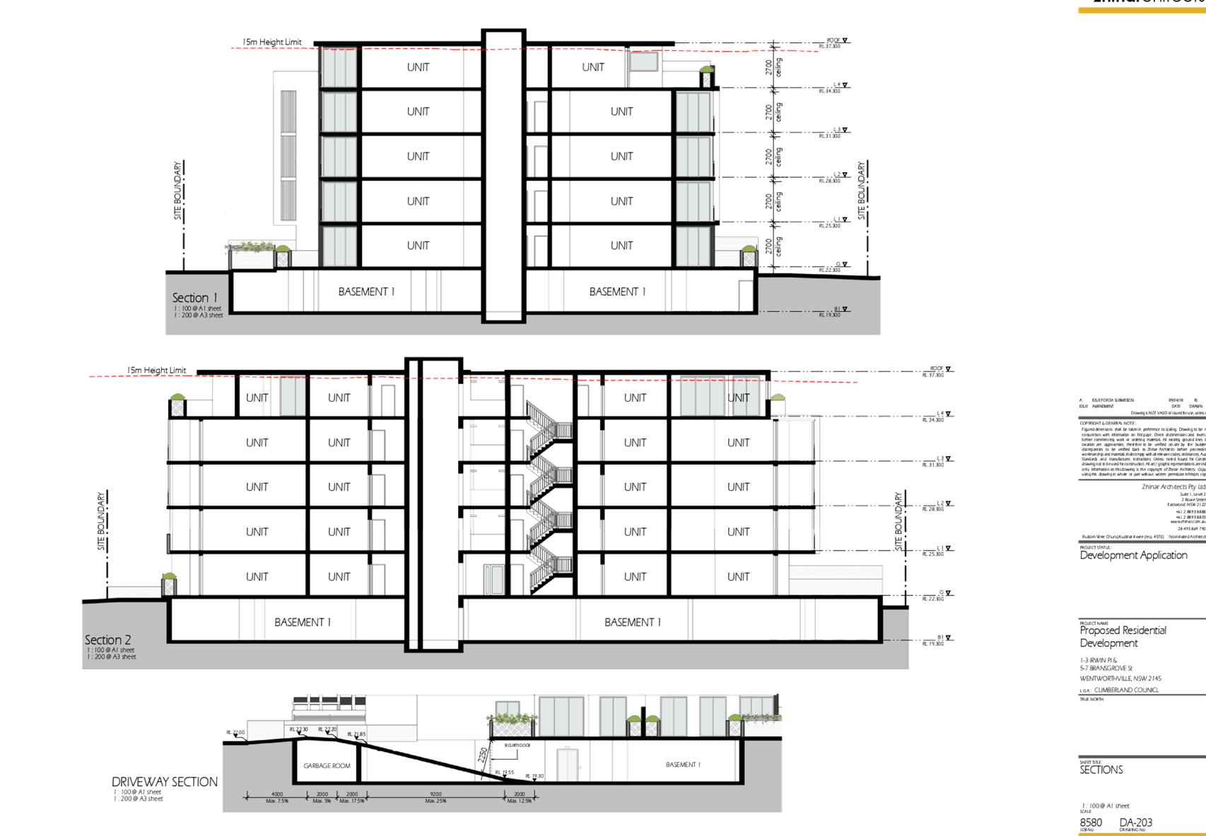
5.6% respectively. The majority of the height breach is associated with the
roof of the building and the top of the lift core.
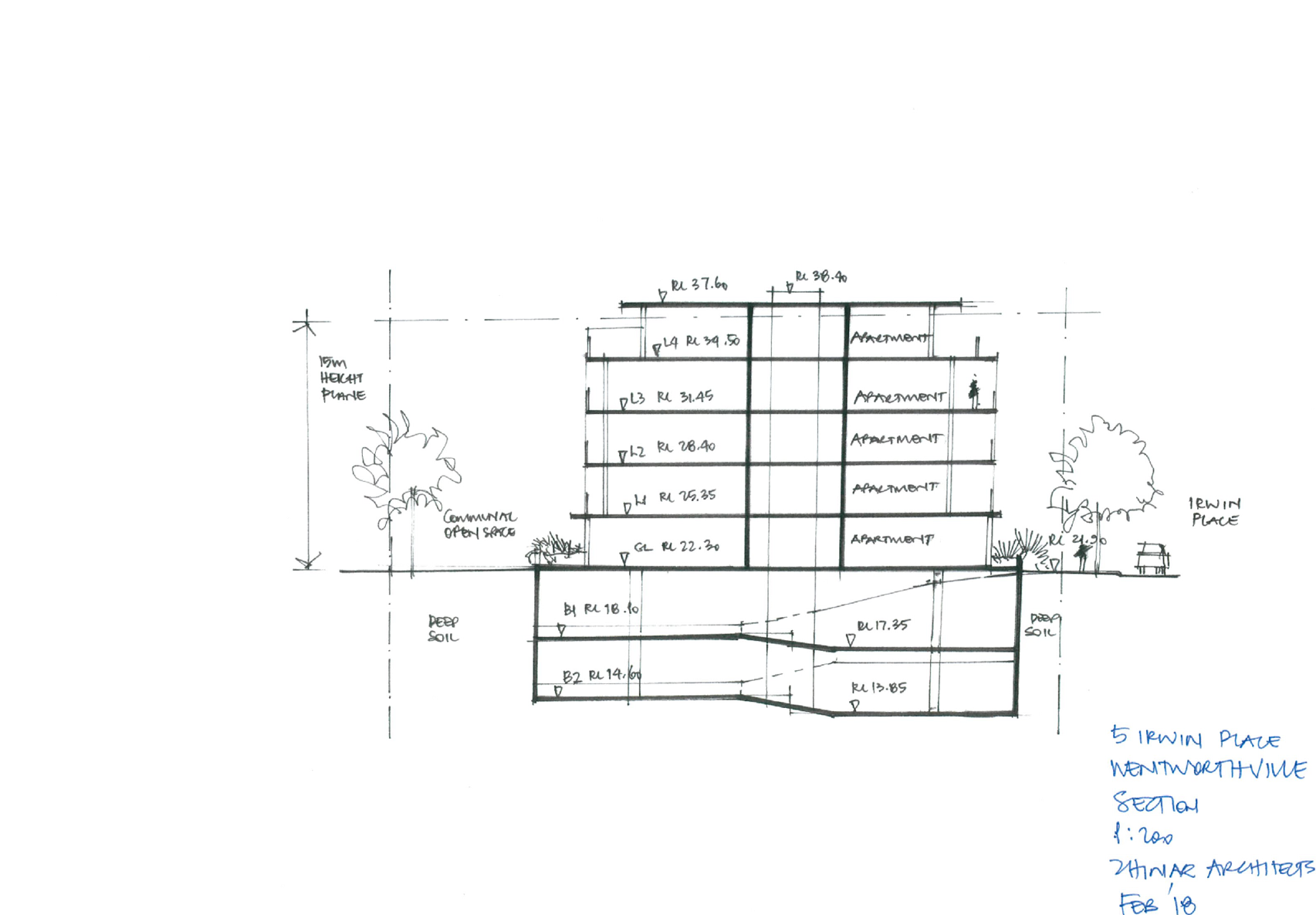
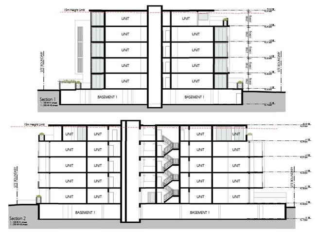
Figure
11 – Section Plan showing extent of height variation sought
Clause 4.6 – Variation to
Building Height
Clause 4.6 allows the consent
authority to vary development standards in certain circumstances and provides
an appropriate degree of flexibility to achieve better design outcomes. The
consent authority may grant the exception as the Secretary’s concurrence
can be assumed where clause 4.6 is adopted as per the Department of Planning
Circular PS 18-003, dated 21 February 2018.
The applicant has submitted a
written request to vary the development standard for building height –
Refer to Attachment 8.
Based on various case laws
established by the Land and Environment Court of NSW such as Four2five P/L v
Ashfield Council [2015] NSWLEC 9, Randwick City Council v Micaul Holdings P/L
[2016] NSW LEC7 and Zhang and anor v Council of the City of Ryde [2016] NSWLEC
1179, a 3 part assessment framework for a variation request proposed under
clause 4.6 has been considered and an assessment of the proposed variance,
following the 3 part test is discussed in detail below.
The 3 preconditions which must be
satisfied before the application can proceed are as follows:
1. Is
the proposed development consistent with the objectives of the zone?
Applicant’s
justification:
The proposal ensures that the high
density nature of the zone is retained and there is not a significant change to
the character of the locality. In addition, the proposal complements and
enhances the local streetscape by virtue of the careful siting of the
development.
Planner’s Comment:
Whilst residential flat buildings
are a permitted land use, the locality is undergoing a transition particularly
to support the increasing demand of affordable housing within the close
proximity of public transport hub and major commercial centre. The proposed
development is considered to be consistent with the objectives of the R4 high
Density Residential zone.
2. Is
the proposed development consistent with the objectives of the development
standard which is not met?
Applicant’s
justification:
The current development proposal
seeks to depart from the height control for small portions of the upper storey
of the building and the top of liftcore. Despite this, the proposal remaining
consistent with the objectives of the clause and is a more appropriate outcome
on the site because of the following:
· The
overall height of the development presents as a compatible form of development
with only a small component of the upper level of the building and top of the
lift core exceeding the height limit. This upper level of the building is
recessed in so that the top of the building will be less visually prominent
when viewed from the street level and the height protrusion will not be visible
from the adjoining properties which aligns with the intent of the planning
controls contained within Holroyd LEP 2013.
· The
subject site is affected by the 1% AEP meaning that minimum floor levels for
both non habitable and habitable rooms are set as a minimum above the flood
level. This results in the building being pushed higher than it would
otherwise, meaning the overall building height is pushed slightly above the
maximum permitted under the LEP. Ensuring the flood levels are complied with
protects the safety of residents from future flooding events.
· If
the additional floorspace permitted under the LEP was to be provided at ground
level then minimum setbacks to adjoining properties may not be able to be
achieved and the resulting impact on adjoining properties would be greater.
Providing more floorspace at ground level is far more undesirable than
providing a modest recessed upper level of the building. The potential impact
on flooding levels may also be exacerbated if additional built form were to be
provided at ground level, this would also be a less desirable outcome than
providing a small component of the building on the fifth level which is significantly
recessed in from the lower levels to ensure the impact of the development is
minimised.
· The
portion of the building that exceeds the height control is not intended to gain
additional floorspace as the application demonstrates, the proposal is compliant
with the maximum floorspace ratio of 1.73:1. The additional building height is
merely a response to the site's flooding constraints in that the building
needed to be lifted to provide a floor level compliant with the Council's
flooding controls.
· It
is also noted that the proposal will not obstruct existing view corridors as
compared to a compliant built form.
· The
fifth storey of the building is recessed from the front setback 8m and more
than 9m from both side setbacks. This enables there to be a fifth level or
useable floorspace as permitted by the maximum floorspace ratio under the LEP
while at the same time minimising the visual impact of this level of the
building. The upper level will be barely detectable from the street level
ensuring the development has no negative impact on this residential
streetscape.
· The
extent of variation does not contribute to any increase in overshadowing (hence
the extent of impact is as per the impact generated by the permitted building
envelope).
· The
minor non-compliance to the height control has no unacceptable impact on the
setting of any items of environmental heritage or view corridors.
As outlined above the proposal
remains consistent with the underlying objectives of the control and as such
compliance is considered unnecessary or unreasonable in the circumstances. The
above discussion demonstrates that there are sufficient environmental planning
grounds to justify the minor departure from the control.
Planner’s comment:
The objectives of the building
height standard are to enable appropriate development density to be achieved
and to ensure that the height of the building is compatible with the character
of the locality as outlined above. The proposal is compliant (subject to
conditions) with the maximum inclusive of the bonus provision under the ARH
SEPP. The increased height does not achieve any additional level for
residential use, and comprises portions of Level 4 ceiling, the roof of the
building and the top of the lift core.
The subject site is also identified
to be impacted by the 1% AEP storm event, and as such the proposal is required
to achieve minimum FFLs above the 1% AEP flood plus 500mm freeboard. In this
regard, the building is raised higher in response to the conditions of the site
and to achieve the required FFLs, which has contributed to the non-compliance
with the maximum building height standard.
The departure sought is considered
to be modest and does not unreasonably impact on adjoining properties. The
additional height does not result in the appearance of bulk when viewed from
the existing streetscape and would not impinge on the changing streetscape that
is anticipated for the immediate area. Given that the proposed development
responds to the site and does so without compromising relationships with
adjoining development, and does not unduly compromise other relevant controls,
the proposal is considered to be consistent with the objectives of height
requirements and development within the R4 zone.
3. a)
Is compliance with the development standard unreasonable or unnecessary in the
circumstances of the case?
Applicant’s
justification:
Strict compliance with the
prescriptive building height requirement is unreasonable and unnecessary in the
context of the proposal and its particular circumstances. The proposed
development meets the underlying intent of the control and is a compatible form
of development that does not result in unreasonable environmental amenity
impacts.
Planner’s comment:
Council Officers are satisfied
that the proposed variation has been appropriately justified and can be
supported in this instance. The height breach is limited to an overall building
height of RL 37.4 for the roof of the building, and height of RL 38.25 for the
top of the lift core. The additional height of the lift core will not be
visible from the adjacent streets and properties. The proposed variation to the
development standard is necessary for the structure containing the lift core
and in order to achieve required FFLs, and is consistent with the scale of the
development within the R4 zone located in the immediate vicinity of the site.
The departure sought is considered to be modest and does not unreasonably
impact on adjoining properties. The additional height does not result in the
appearance of bulk when viewed from the existing streetscape and would not
impinge on the changing streetscape that is anticipated for the immediate area.
It is considered, therefore, that the non-compliance with the Development
Standard is unreasonable or unnecessary in the circumstances of the case.
b) Are there sufficient
environmental planning grounds to justify contravening the development standard
and therefore is the applicant’s written justification well founded?
The unique circumstances of the
case are considered to warrant support of the departure. Given that the
proposed development responds to the site and does so without unduly
compromising relationships with adjoining development, and does not unduly
compromise other relevant controls, the proposal is considered to be consistent
with the objectives of building height, and development within the R4 zone. In
this regard, the exception is well founded and can be supported.
Conclusion:
Council is satisfied that the
applicant’s written request has adequately addressed the matters required
to be demonstrated by clause 4.6 subclause (3). Council is further satisfied
that the proposed development will be in the public interest because it is
consistent with the objectives of the particular standard and the objectives for
development within the zone in which the development is proposed to be carried
out.
It is the view of Council Officers
that justification provided is satisfactory and having considered the
application on its merit, the exception to the maximum building height
development standard is considered acceptable in this instance.
An assessment against all the
relevant LEP provisions is provided at Attachment 3.
Draft Environmental Planning
Instruments
The proposed development is not
affected by any draft Environmental Planning Instruments.
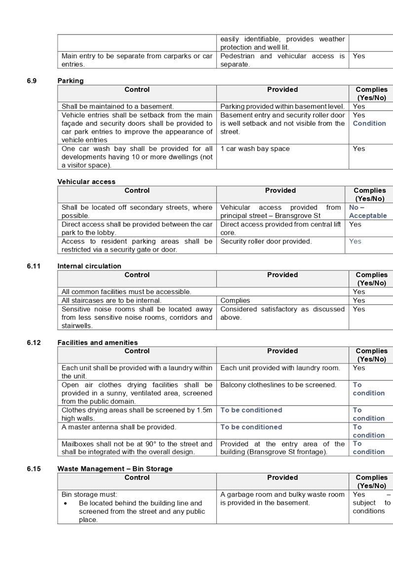
Development Control Plans
(a) Holroyd
Development Control Plan 2013
HDCP 2013 contains general
controls which relate to all developments under Part A, residential controls
under Part B, and transitway station precinct controls under Part N.
A comprehensive HDCP compliance
table is attached to this report at Attachment 4. A summary of the DCP
non-compliances is provided in the following table.
Building Height
|
Control
|
Provided
|
Complies
(Yes/No)
|
|
Maximum building height in
storeys shall be provided in accordance with the table below:
|
Permitted Height
(storeys)
|
|
Height
|
Storeys
|
|
9m
|
1
|
|
11m
|
2
|
|
12.5m
|
3
|
|
15m
|
4
|
|
18m
|
5
|
|
21m
|
6
|
|
24 m
|
7
|
|
Required – 15 metres – 4 storeys
The proposal is 5 storeys in height, and exceeds the maximum number of storeys permitted, with
also minor encroachments (max. 0.85m exceedance) to the maximum 15m building
height permitted.
The departure to the number of
storeys is considered acceptable as the proposal presents a built form of an
appropriate bulk and scale for the site, noting that the area is undergoing
transition.
The building is adequately articulated along all street
frontages, with the 5th storey recessed, to reduce the visual bulk
when viewed from both neighbouring properties and the street, and as such
considered to be compatible with the existing and changing streetscape. In
this regard, noting the context and constraints of the site, the departure
sought to the maximum number of storeys is considered acceptable in this
instance.
|
No – Acceptable in this instance.
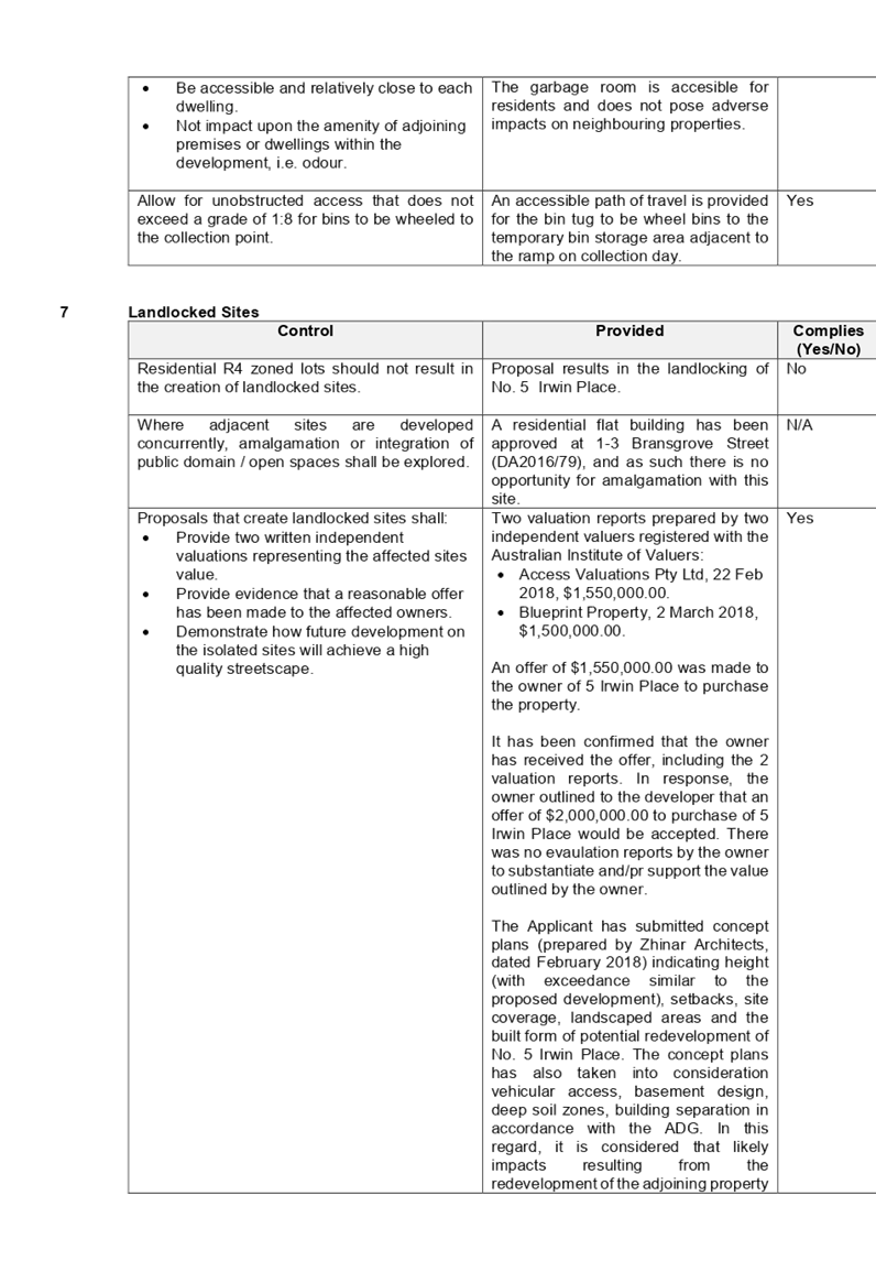
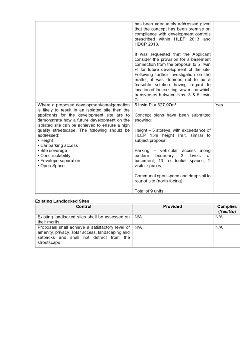
|
Any planning agreement that has
been entered into under section 7.4, or any draft planning agreement that a
developer has offered to enter into under section 7.4
There is no planning agreement or
draft planning agreement associated with the subject Development Application.
The provisions of the
Regulations
The regulations do not proscribe
any relevant matters for consideration.
Any coastal zone management
plan (within the meaning of the Coastal Protection Act 1979)
There is no Coastal Zone
Management Plan applicable to the subject site.
The likely impacts of the
development
The likely environmental, social
and economic impacts of the development have been assessed and are considered
satisfactory.
The suitability of the site for
the development
The site is considered suitable
for the proposed development.
Submissions made in accordance
with the Act or Regulation
Advertised (newspaper) Mail Sign
Not Required
In accordance with Part E - Public
Participation of HDCP 2013, the proposal was publicly notified from 2 May 2018
to 23 May 2018. As a result of the notification, no submissions were received.
Amended plans submitted did not warrant re-notification of the proposal.
Section 7.11 of The
Environmental Planning & Assessment Act 1979
The subject development requires
the payment of contributions in accordance with Holroyd Section 94 Development
Contributions Plan 2013. A condition is imposed requiring the payment of
contributions.
In accordance with the currently
indexed rates for the South Wentworthville Centre contribution area, the
following contributions apply:
· 7
x 1-bedroom dwellings – $9,431 x 7 = $66,017
· 36
x 2-bedroom dwellings – $15,950 x 36 = $574,200
· 5
x 3-bedroom dwellings – $20,000 x 5 = $100,000
· credit
for the existing 4 x 3-bedroom dwellings = $80,000
The required Section 7.11
contribution payable for the proposal is $660,217.
The Public Interest
The public interest is served by
permitting the orderly and economic use of land, in a manner that is sensitive
to the surrounding environment and has regard to the reasonable amenity
expectations of surrounding land users. In view of the foregoing analysis, it
is considered that approval of the proposed development would not be contrary
to the public interest.
Disclosure of Political
Donations and Gifts
The NSW Government introduced The
Local Government and Planning Legislation Amendment (Political Donations) Act
2008 (NSW). This disclosure requirement is for all members of the public
relating to political donations and gifts. The law introduces disclosure requirements
for individuals or entities with a relevant financial interest as part of the
lodgement of various types of development proposals and requests to initiate
environmental planning instruments or development control plans.
The application and notification
process did not result in any disclosure of Political Donations or Gifts.
Conclusion:
The proposed development has been assessed in accordance with the
relevant requirements of the Environmental Planning and Assessment Act 1979,
State Environmental Planning Policy (Affordable Rental Housing) 2009, State
Environmental Planning Policy No 65 – Design Quality of Residential
Apartment Development, Holroyd Local Environmental Plan 2013 and the Holroyd
Development Control Plan 2013 and is considered to be satisfactory.
Consultation:
There are no further consultation
processes for Council associated with this report.
There are no further financial
implications for Council associated with this report.
There are no policy implications
for Council associated with this report.
Communication /
Publications:
The final outcome of this matter
will be notified in the newspaper. The objectors will also be notified in
writing of the outcome.
|
ii)
1. That
Development Application 2018/123/1 for which seeks consent for demolition of
existing structures, consolidation of 4 lots into 1 lot, construction of a 5
storey residential flat building over basement parking accommodating 48 units
and 47 parking spaces under Affordable Rental Housing SEPP 2009, be approved
under Deferred Commencement, subject to the attached conditions, provided at
Attachment 5.
|
1. SEPP
ARH 2009 Compliance Table ⇩ 
2. ADG
Compliance Table ⇩
3. HLEP
2013 Compliance Table ⇩
4. HDCP
2013 Compliance Table ⇩
5. Draft
Notice of Determination ⇩
6. Internal
Architectural Plans ⇩
7. External
Architectural Plans ⇩
8. Clause
4.6 Variation Request to Building Height ⇩
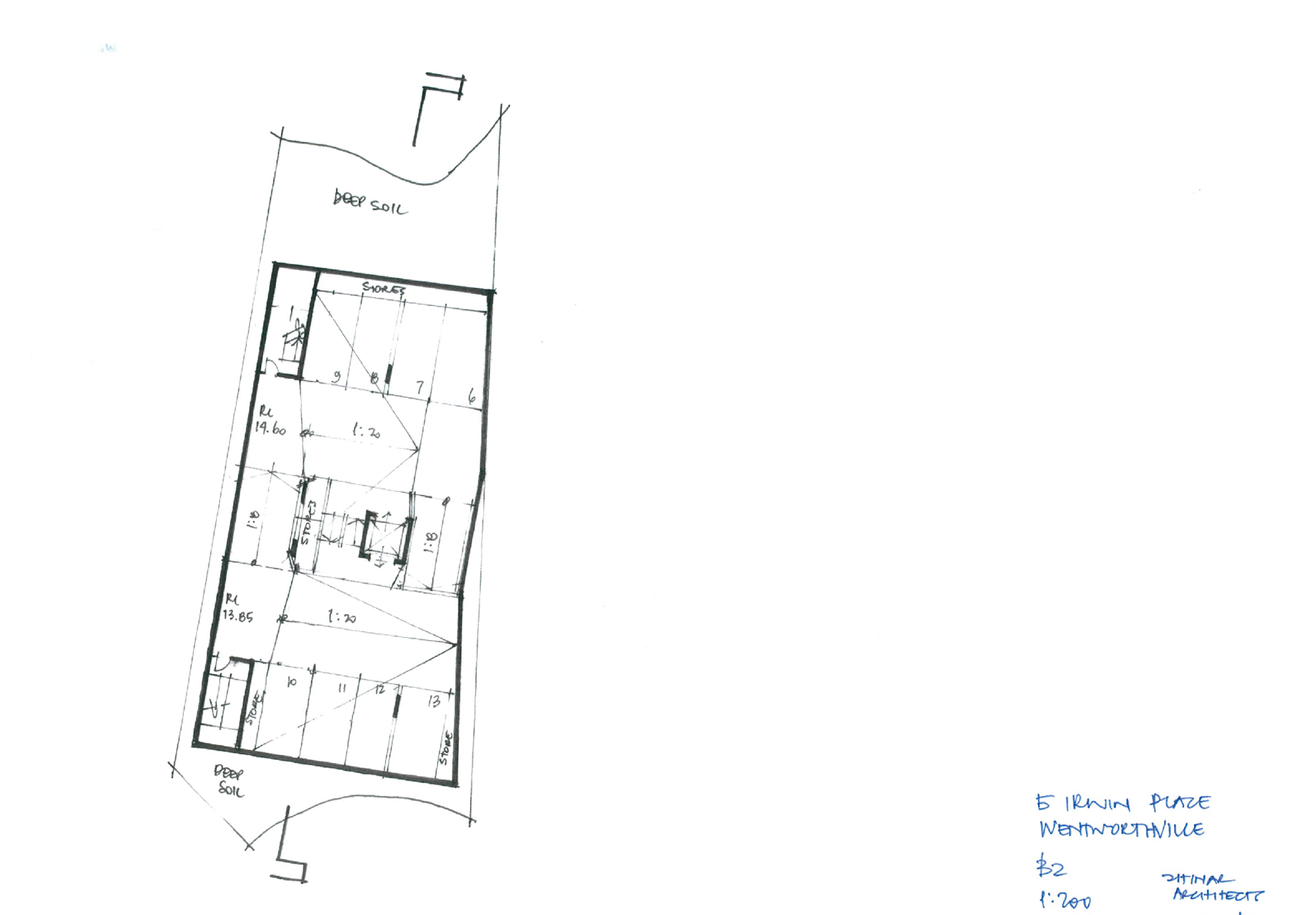
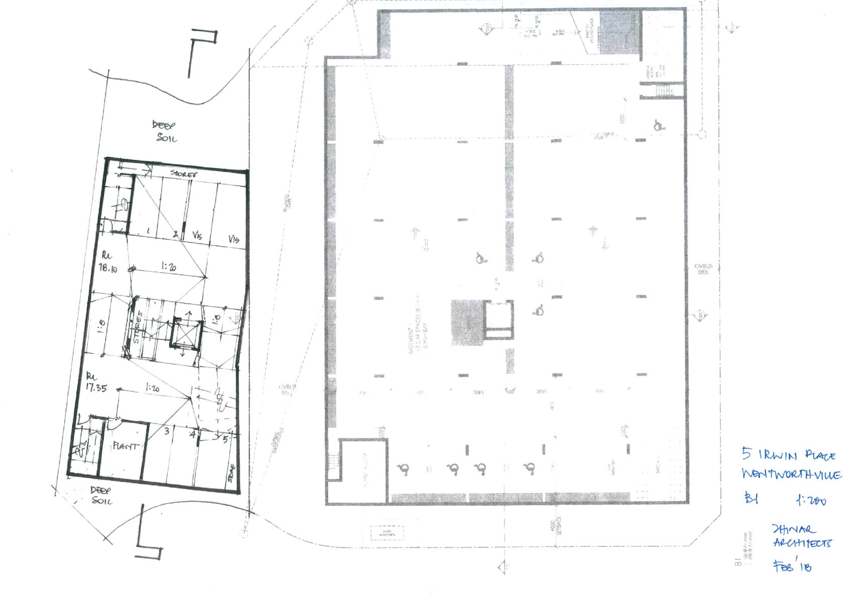
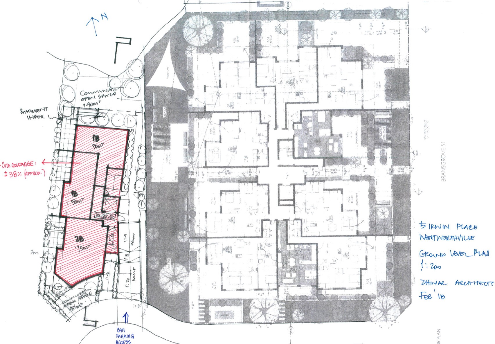
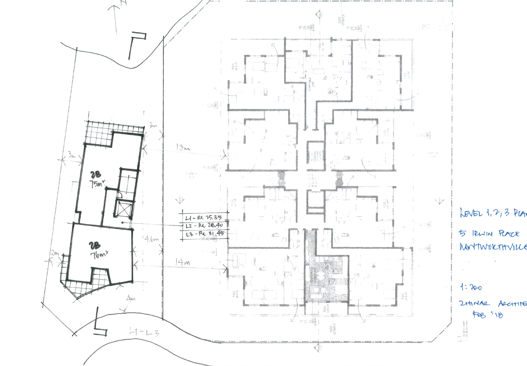
9. Concept
plans for Potential Redevelopment of No. 5 Irwin Place ⇩
Extraordinary
Cumberland Local Planning Panel Meeting
16 April 2019
Item No: ELPP021/19
Development
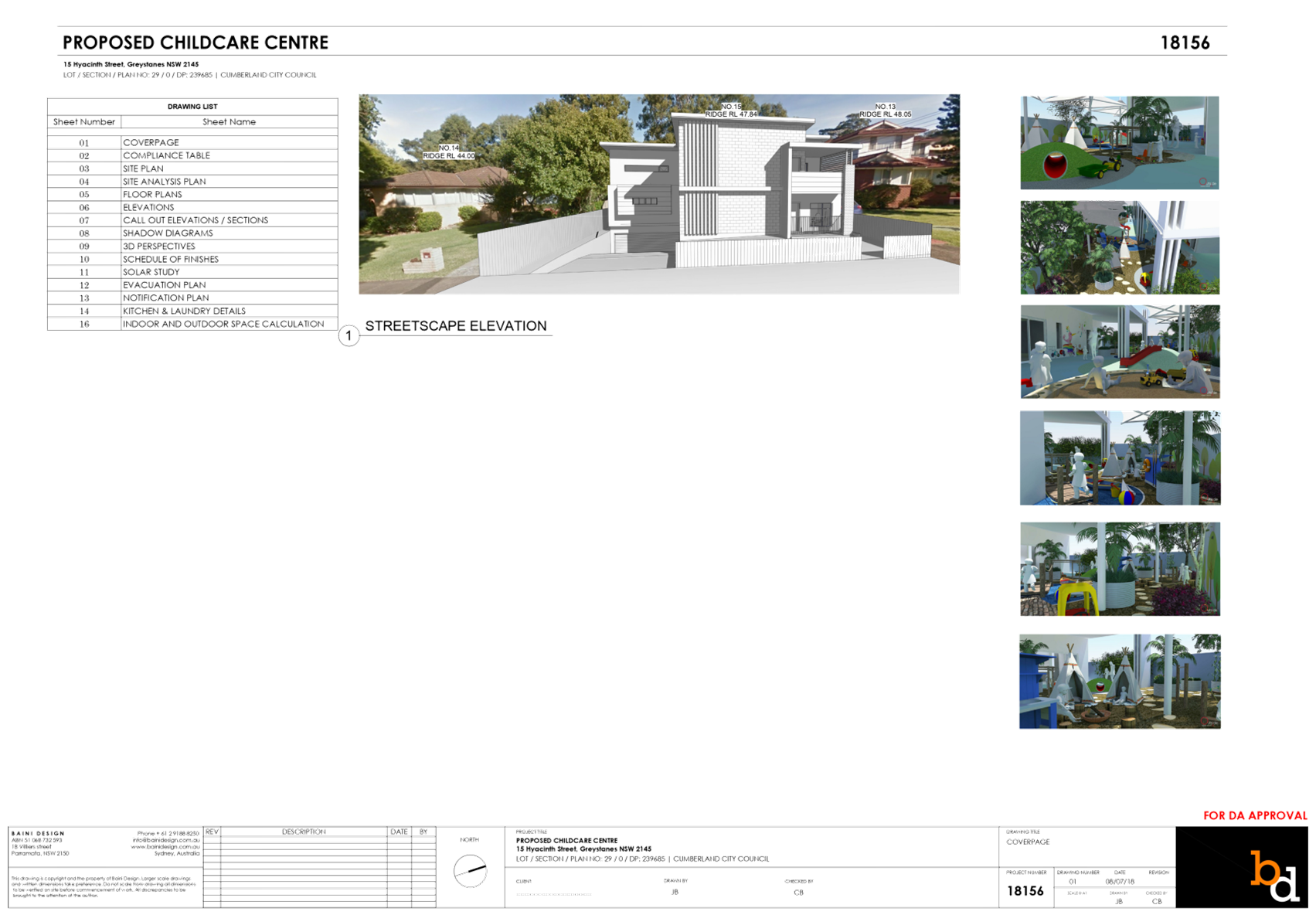
Application for 15 Hyacinth Street, Greystanes
Responsible
Division: Environment
& Planning
Officer: Manager
Development Assessment
File
Number: DA
2018/284/1
|
Application lodged
|
10 August 2018
|
|
Applicant
|
Baini Design
|
|
Owner
|
Ishak Group Holdings Pty
Ltd
|
|
Application No.
|
2018/284/1
|
|
Description of Land
|
15
Hyacinth Street, Greystanes (Lot 29 in DP 239685)
|
|
Proposed Development
|
Demolition of
existing structures and construction of a two storey, 30 place child care
centre over basement parking accommodating 10 parking spaces
|
|
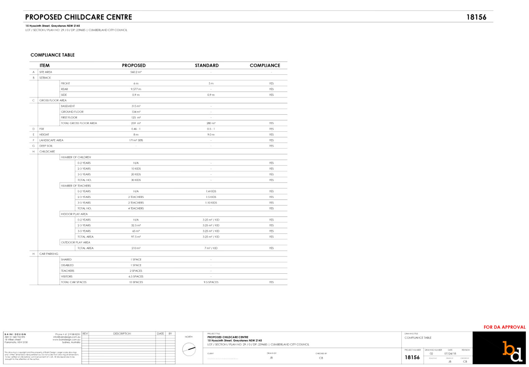
Site Area
|
560.2m2
|
|
Zoning
|
R2
– Low Density Residential
|
|
Principal Development
Standards
|
· Floor Space Ratio – 0.5:1 (HLEP
2013)
· Height of Buildings – 9m
|
|
Disclosure of political
donations and gifts
|
Nil
disclosure
|
|
Heritage
|
No
|
|
Issues
|
- Number
of children and outdoor unencumbered space
- Car
parking ratio
- Landscape
area
- Basement
and driveway setbacks
|
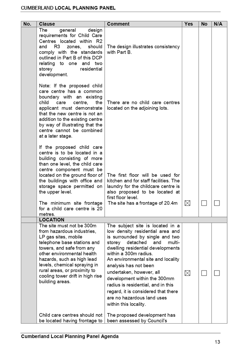
1. Development
Application 2018/284/1 was received on 10 August 2018 for the demolition of
existing structures and construction of a two storey, 30 place child care
centre over basement parking accommodating 10 parking spaces.
2. The
application was publicly notified to adjoining and opposite owners, a notice
was placed in the local press and a notice placed on the site for 14 days from
12 September 2018 to 26 September 2018. In response, 18 submissions (3 support
letters and 15 objections) were received.
3. On
8 November 2018 a public information session was held at
Cumberland Council.
4. Council
through its assessment identified a number of concerns with the proposal, and
requested amended plans and additional information on 4 February 2019.
5. Amended
plans and additional information were received on 4 March 2019 addressing some
of Council’s concerns. The proposal was publicly re-notified for 14 days
from 8 March 2019 to 22 March 2019. In response, 11 submissions against the
proposal were received.
6. There
are non-compliances with the proposed development having considered the
provisions of State Environmental Planning Policy (Educational Establishments
and Child Care Facilities) 2017, Child Care Planning Guideline (the Guideline)
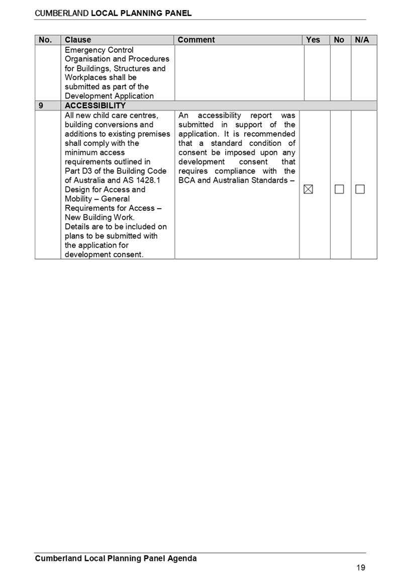
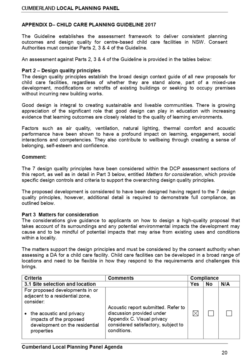
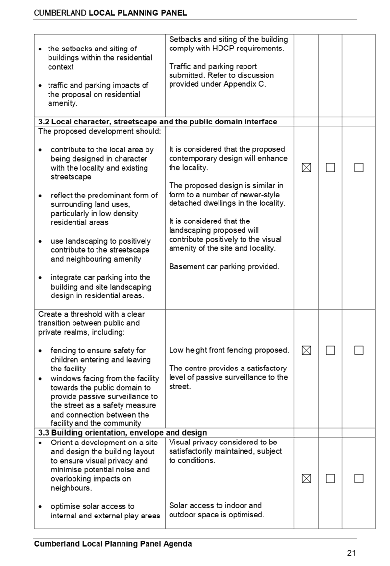
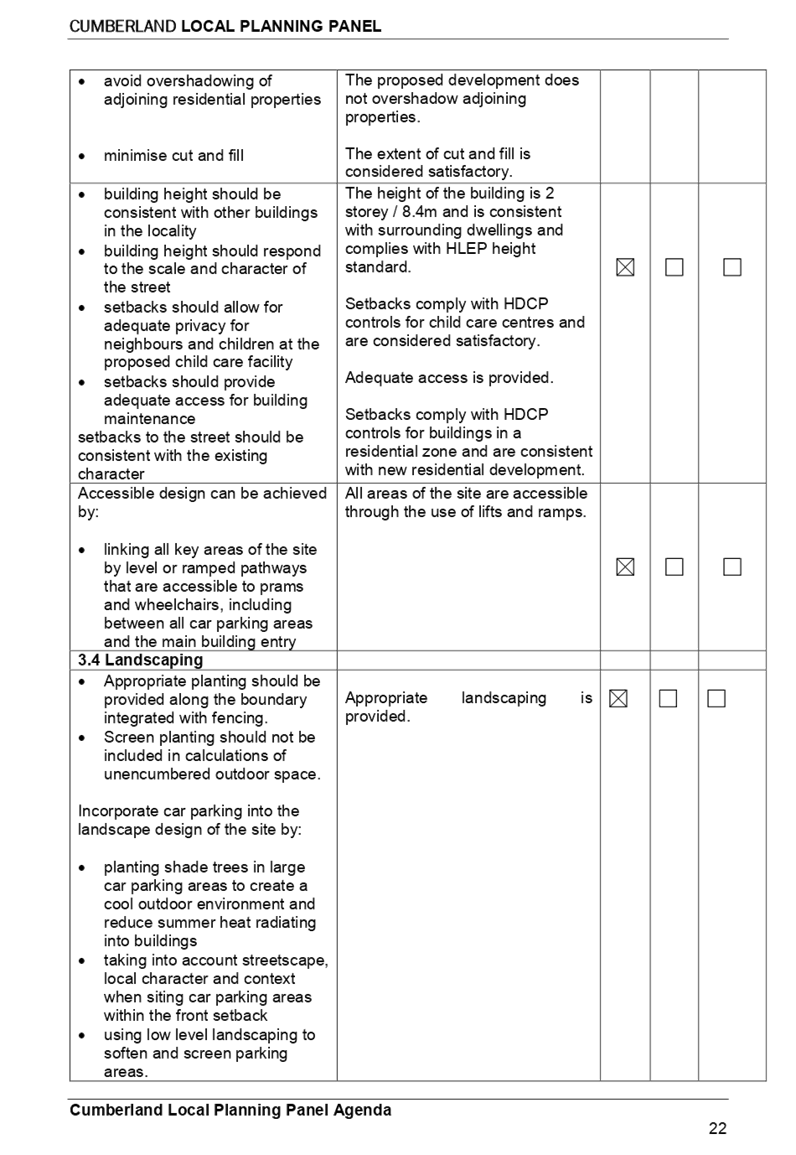
2017, and Holroyd Development Control Plan 2013 (HDCP).
7. The
proposed development seeks following notable variations:
|
Control
|
Required
|
Provided
|
%age variation
|
|
(a) Number
of children and outdoor unencumbered space
(b) (regulation
108 and part 4.9 the Guideline)
|
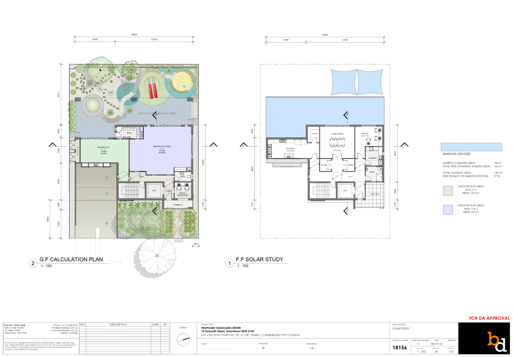
7m²x 30 = 210m²
|
210m²
(including storage shed, OSD
pits, open swale channel, retaining walls and dense planting)
Assessing officer’s
calculation = 185.5m²/7 = 26.5 children
Recommendation = reduce number
of children to 26
|
11.6%
|
|
Landscape
area
|
Min. 20% = 112.04m2
|
13.78% (77.2m²)
|
31%
|
|
Setbacks from
side boundary (DCP)
|
Basement – 900mm
Driveway – 1.5m
|
Basement – 415mm (north)
Driveway – 1.2m
|
53.8%
20%
|
8. The
application has been referred to the Cumberland Local Planning Panel (CLPP) for
determination due to the number of submissions received during the notification
period.
9. It
is recommended that the application be approved for a maximum of 26 children
(due to the available unencumbered outdoor space/play area) subject to
conditions provided in the Draft Notice of Determination held at Attachment 1.
Subject Site And Surrounding
Area
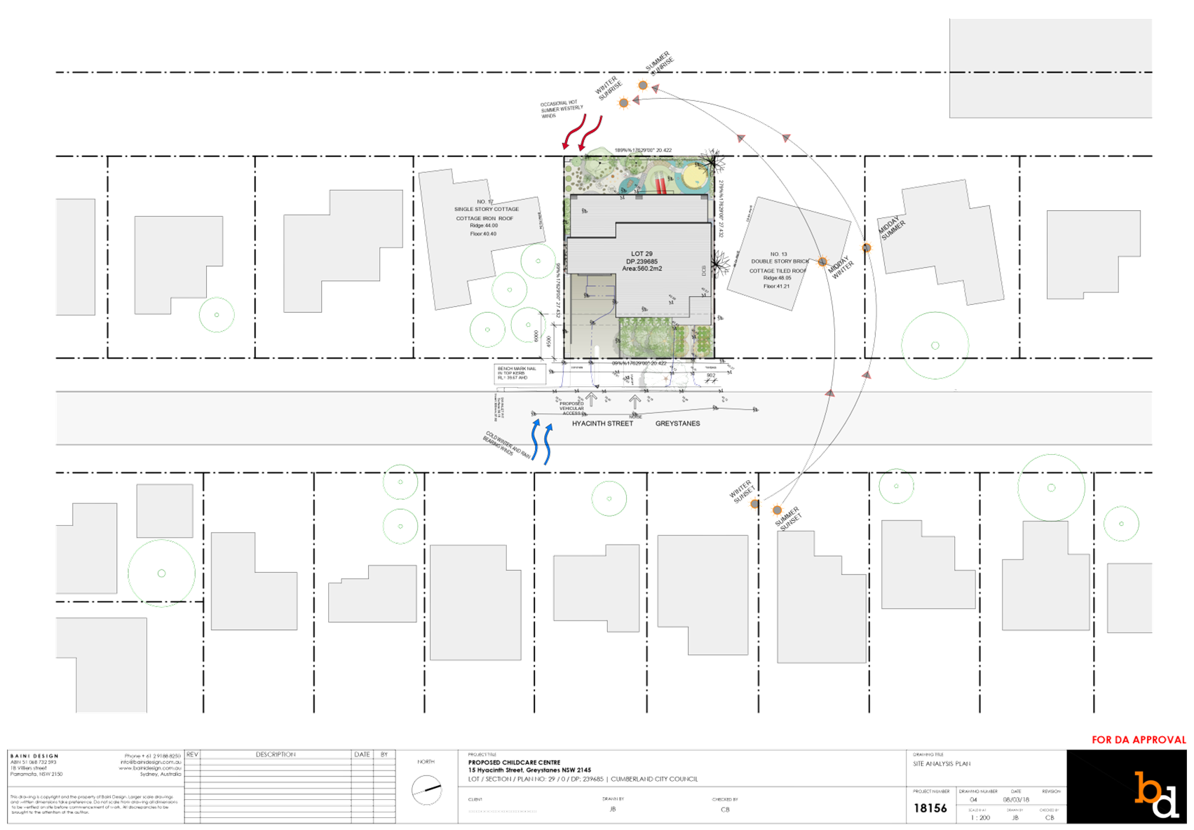
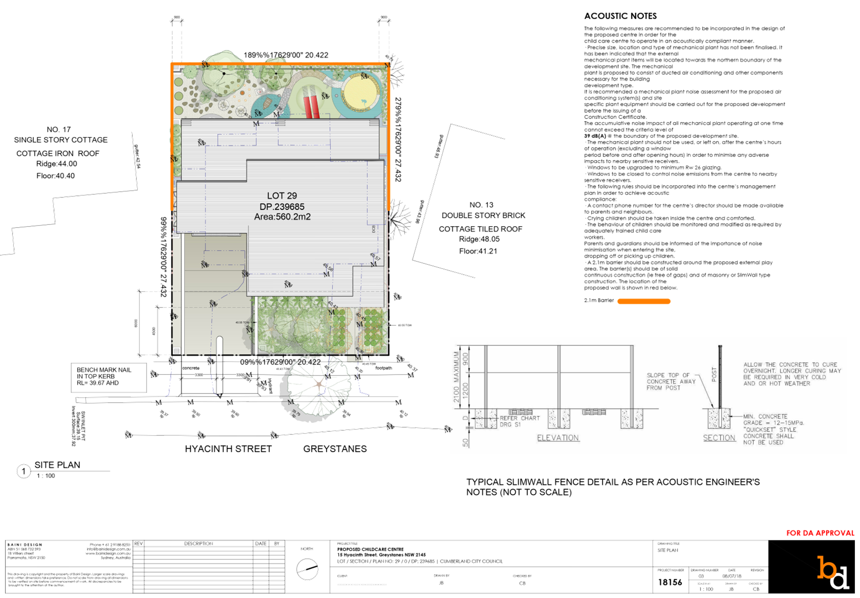
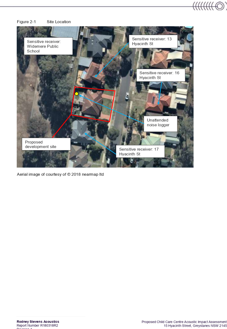
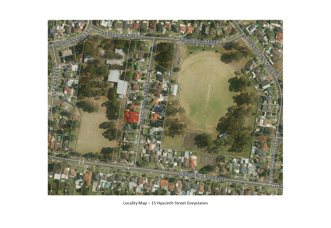
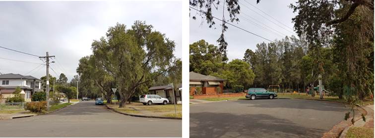
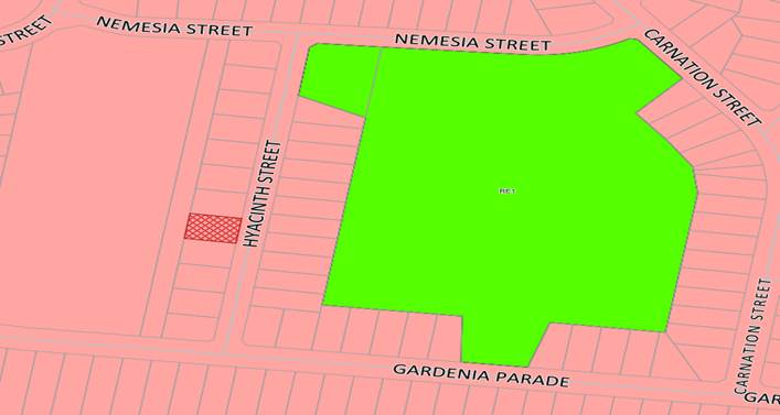
The subject site is known as 15
Hyacinth Street, Greystanes, and is legally described as Lot 29 in DP 239685.
The site is located on the western side of Hyacinth Street. The site is a
rectangular block with a frontage of 20.4m, depth of 27.4m and a total site
area of 560.2m². Existing improvements on the site include a single-storey
dwelling with attached carport on the southern side. Adjoining developments
consist of one to two storey detached dwelling houses with landscaped front
setbacks. Widemere Public School directly adjoins the subject site and shares
its rear boundary. Council’s Nemesia Street Park is located 100m walking
distance towards the north-eastern side of the site. The subject site and all
of adjoining properties are zoned R2 Low Density Residential.
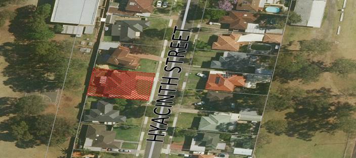
Locality
Plan
Area hatched in red is 15 Hyacinth Street, Greystanes
(Locality)
Aerial
Plan
15
Hyacinth Street, Greystanes (Aerial)
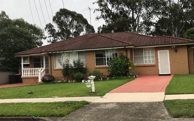
Site
photo
15
Hyacinth Street, Greystanes
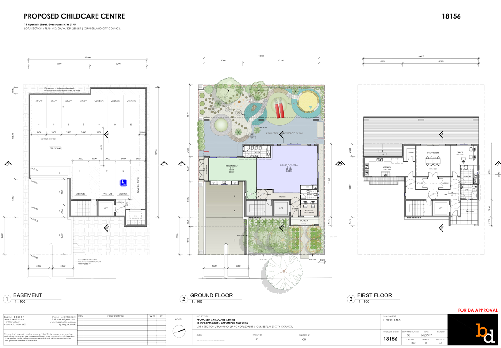
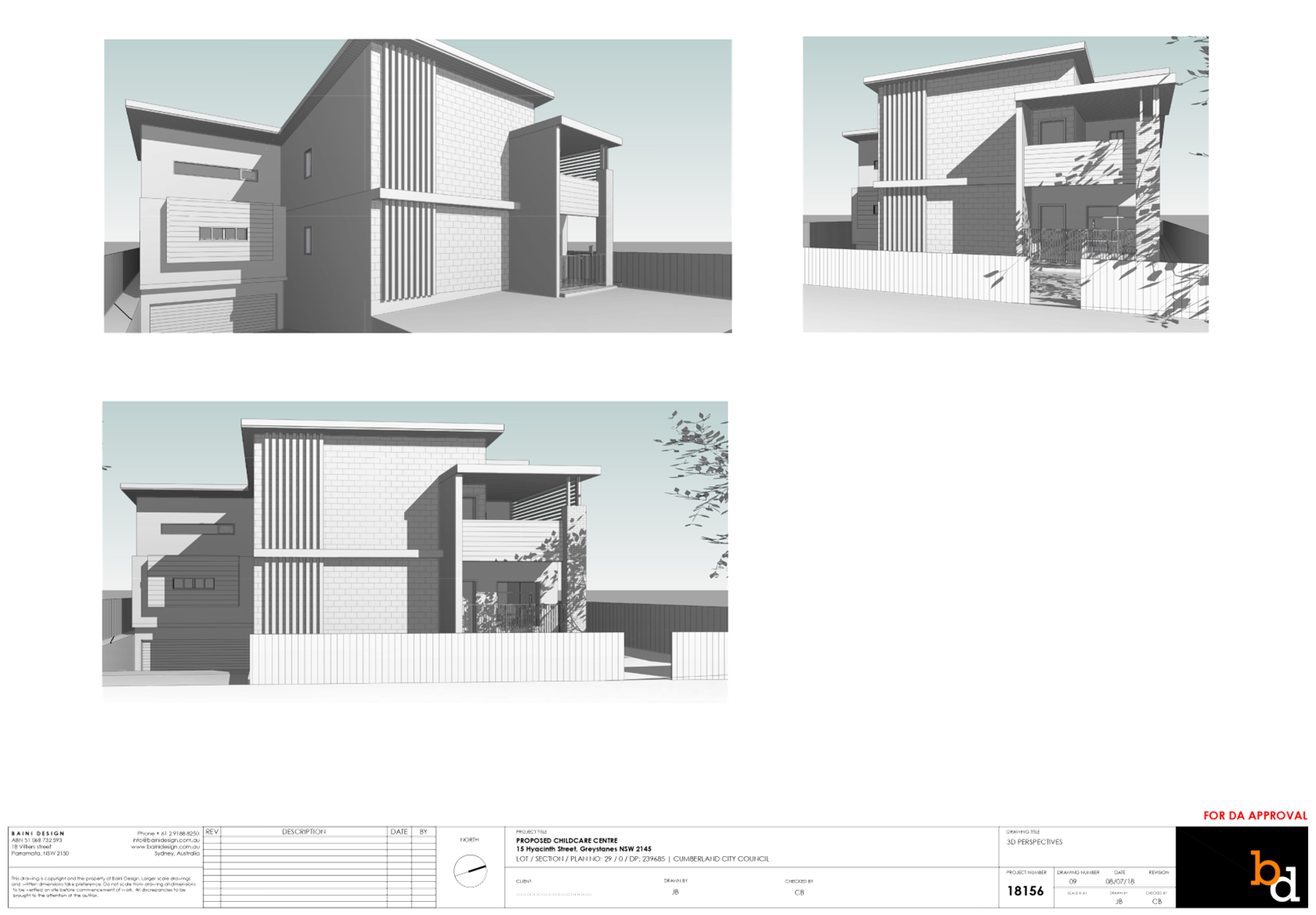
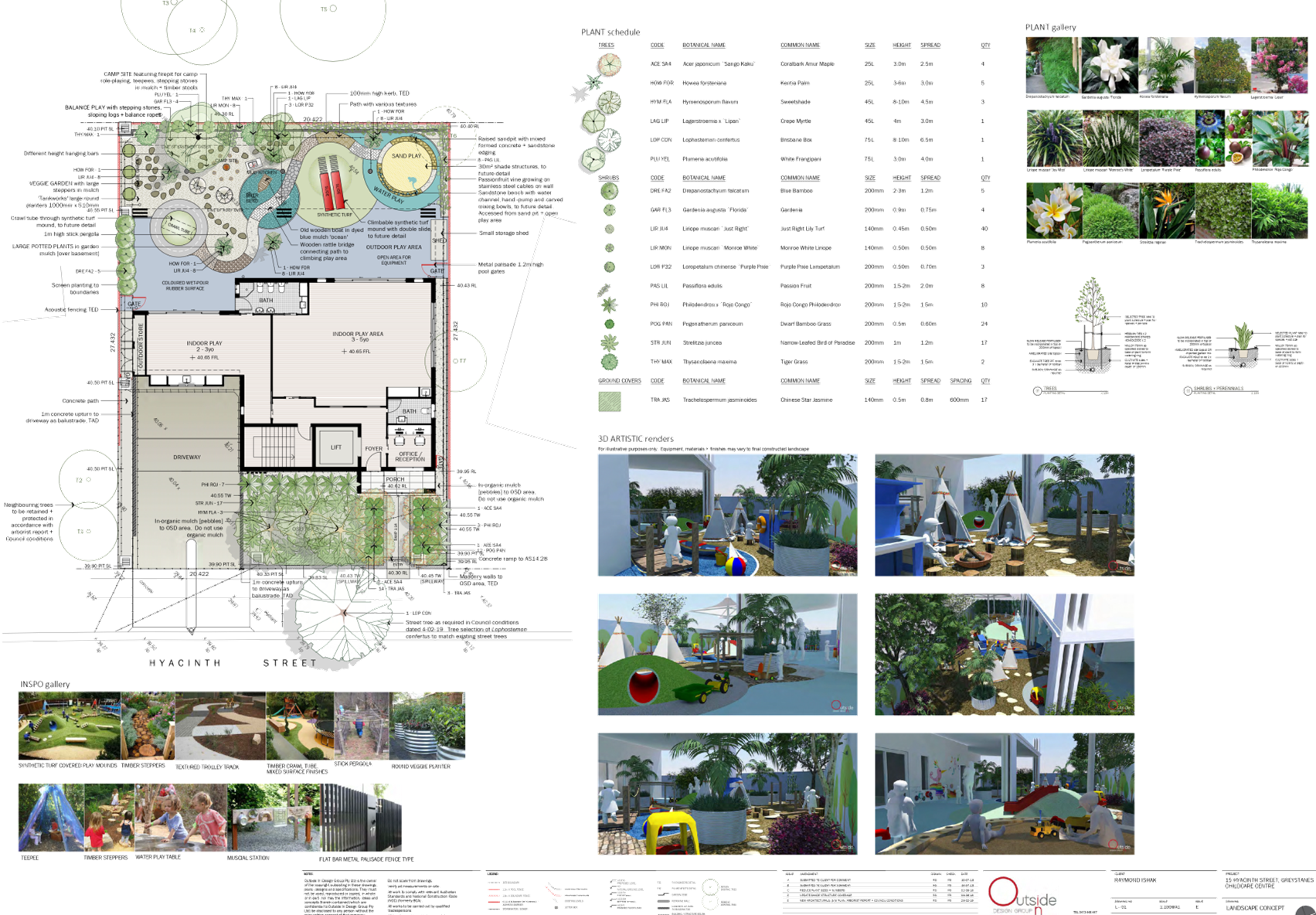
Description of The Proposed
Development
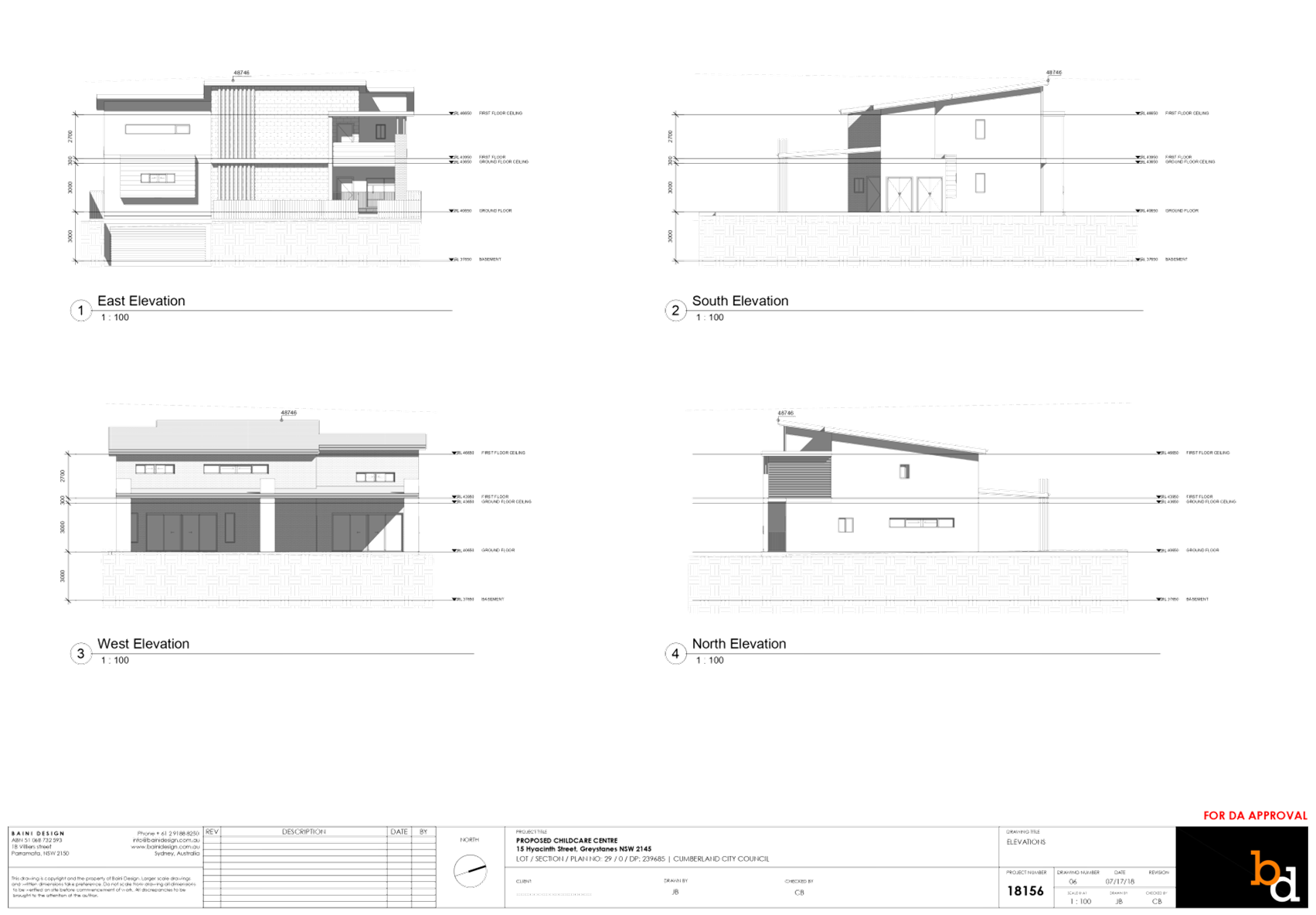
The proposed development, as amended,
involves the demolition of existing structures and construction of a two
storey, 30 place child care centre over basement parking accommodating 10
parking spaces.
Key features of the development
proposal are as follows:-
· Demolition
of the existing dwelling and carport.
· Construction
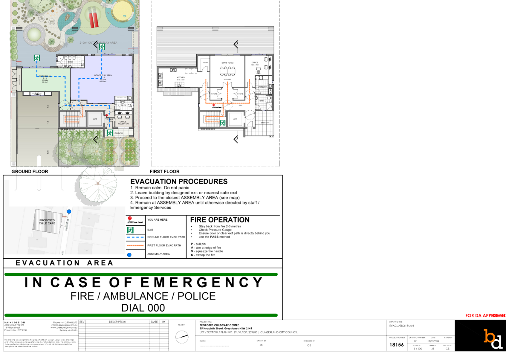
of a two-storey child care facility accommodating 30 children.
· Construction
of a basement level car parking area accommodating 10 car parking spaces, for
staff and visitors (including 1 accessible space) and bin room.
· The
facility will accommodate 30 children, as follows:
o 10 children – 2-3 yrs
o 20 children – 3-5 yrs
· The
proposed centre will operate from 7.00am to 6.00pm Monday to Friday, and will
employ 4 staff.
· The
ground floor level contains office, toilets, storage and indoor and outdoor
play areas.
· The
first floor level contains office, toilet, staff room, kitchen, laundry,
storage and balcony facing Hyacinth Street.
· There
is no signage proposed as part of the application.
· Above
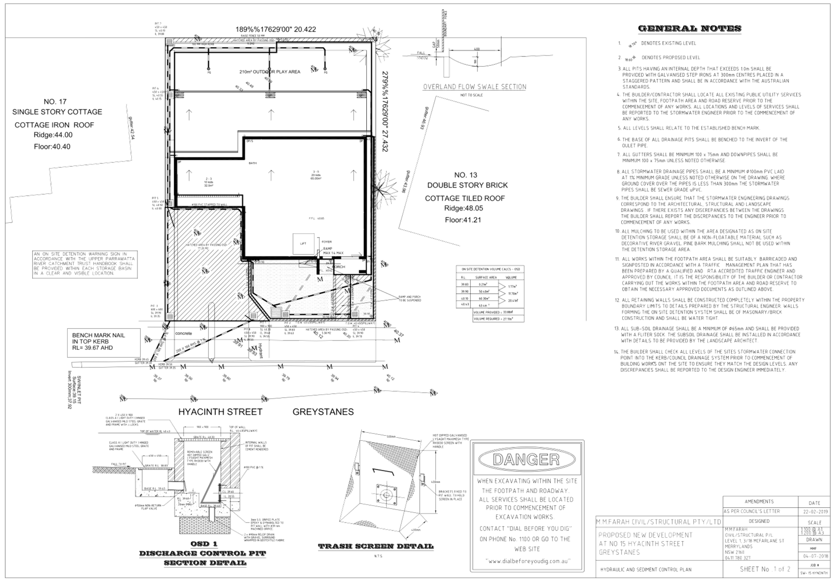
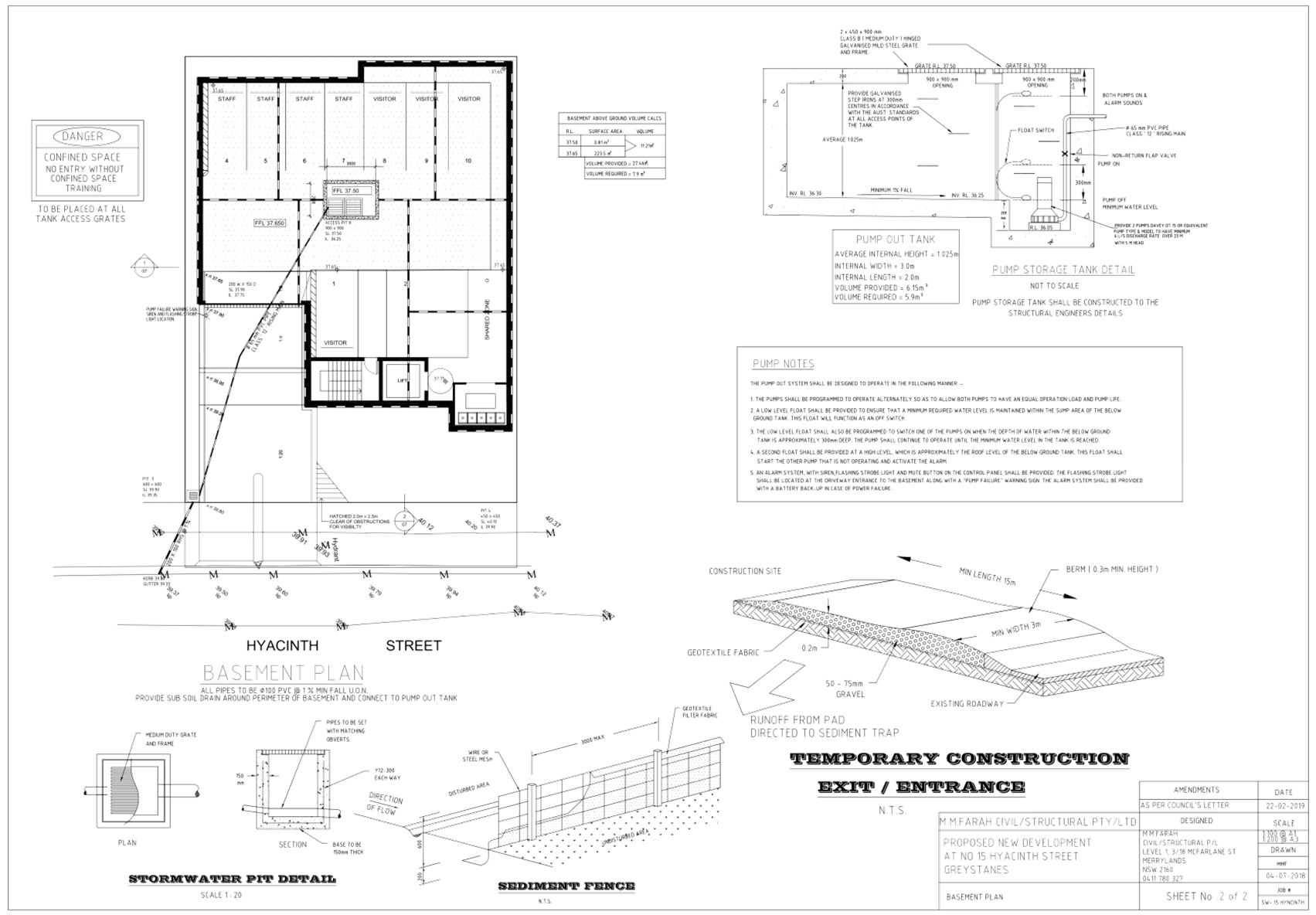
ground OSD system and open swale channel are proposed on site.
History
|
Date
|
Action
|
|
10/08/2018
|
Development Application 2018/283 was lodged.
|
|
3/09/2018
|
The application was
reviewed by Council’s DA Review team (DART)
|
|
3/09/2018
|
The application was referred to Council’s internal
departments for review.
|
|
12/09/2018 to
26/09/2018
|
The application was publicly
notified to adjoining and opposite owners, a notice was placed in the local
press and a notice placed on the site for 14 days. In response, 18
submissions including 3 support letters and 15 objections were received.
|
|
8/11/2018
|
Public information session was
held at Cumberland Council.
|
|
4/02/2019
|
Application was deferred due to non-compliances with SEPP
(Educational Establishments and Child Care Facilities) 2017, Child Care
Planning Guideline 2017, Holroyd Local Environmental Plan 2013, and Holroyd Development
Control Plan 2013.
|
|
4/03/2019
|
Amended plans and
additional information were received by Council.
|
|
8/03/2019 to 22/03/2019
|
The application was placed on public re-notification for 7
days, during which time 11 submissions were received.
|
|
16/04/2019
|
Application referred to CLPP for determination.
|
Applicant’s Supporting
Statement
The applicant provided a Statement
of Environmental Effects prepared by Think Planners Pty Ltd dated 2 August 2018
and 7 March 2019 in support of the application.
Contact with Relevant
Parties
The assessing officer has
undertaken a site inspection of the subject site and surrounding properties and
has been in regular contact with the applicant throughout the assessment
process.
Internal Referrals
Development Engineer
The development application was
referred to Council’s Development Engineer for comment who has advised
that the development is supportable in regards to overland flood mitigation
measure, and on-site detention provision, subject to conditions.
Traffic Engineer
The development application was
referred to Council’s Traffic Engineer for comment who has advised that
the development is supportable in regards to traffic management, and on-site
parking provision in the basement level, subject to conditions.
Parks Officer
The development application was
referred to Council’s Parks Officer for comment who has advised that the
development is located within the vicinity of Council’s park and is
supportable, subject to conditions.
Tree Management Officer
The development application was
referred to Council’s Tree Management Officer for comment who has advised
that the development is supportable in regards to protection of existing trees
on the adjoining properties, subject to conditions.
Waste Management Officer
The development application was
referred to Council’s Waste Management Officer for comment who has
advised that the development is supportable in regards to provision of bin tug,
bin storage room, and waste collection and management plan, subject to conditions.
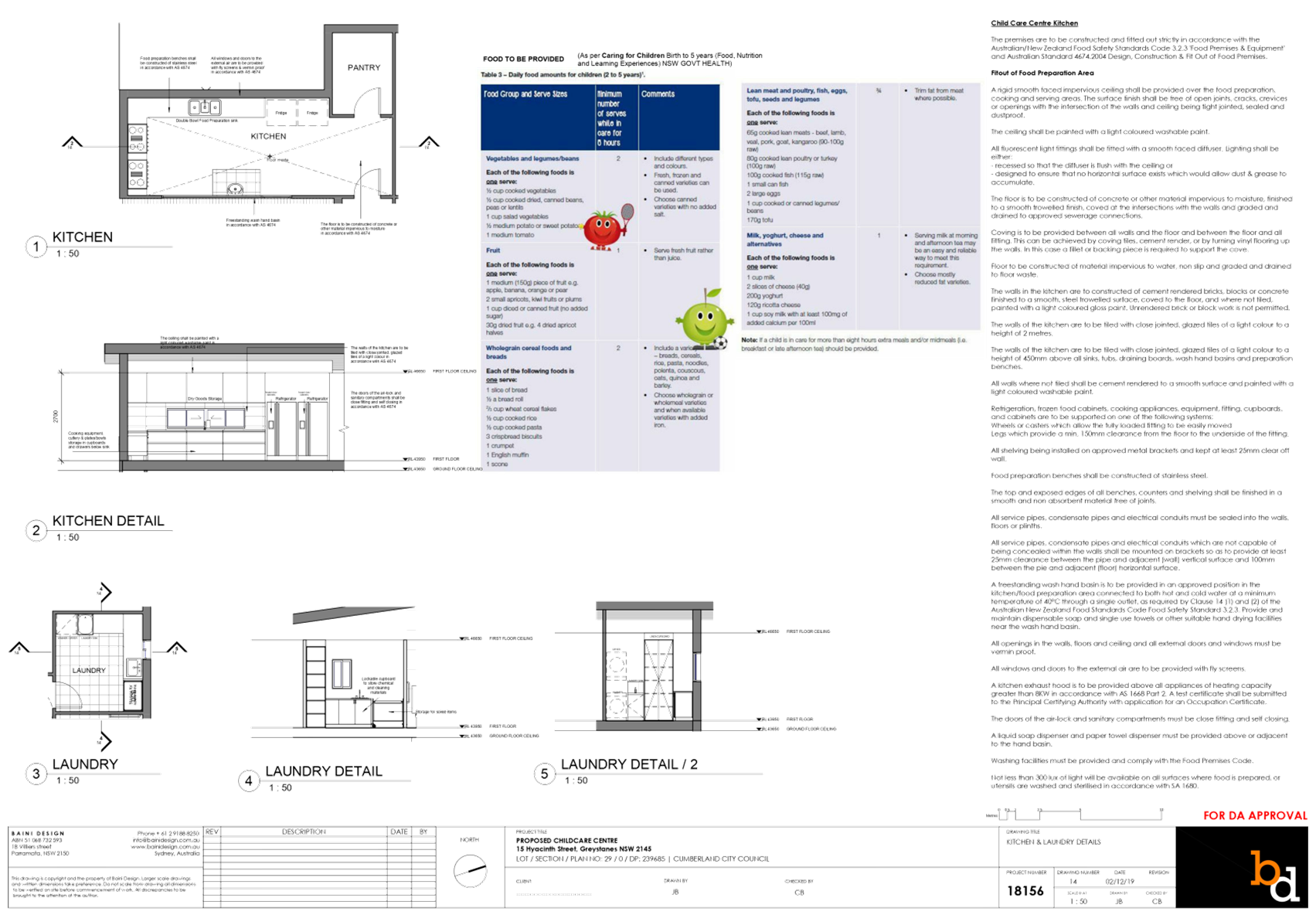
Environmental Health Officer
The development application was
referred to Council’s Environmental Health Officer for comment who has
advised that the development is supportable in regards to fit-out for food
preparation area, acoustic assessment, noise management plan, noise attenuation
measure, soil assessment, and site contamination, subject to conditions.
Children’s Services
The development application was
referred to Council’s Children’s Services section for comment who
has advised that the development is supportable in regards to compliance with
the provisions of Education and Care Services National Regulations and Law,
subject to conditions.
External Referrals
N/A
Planning Comments
The provisions of any
Environmental Planning Instruments (EP & A Act, s4.15(1)(a)(i))
State Environmental Planning
Policies
The proposed development is
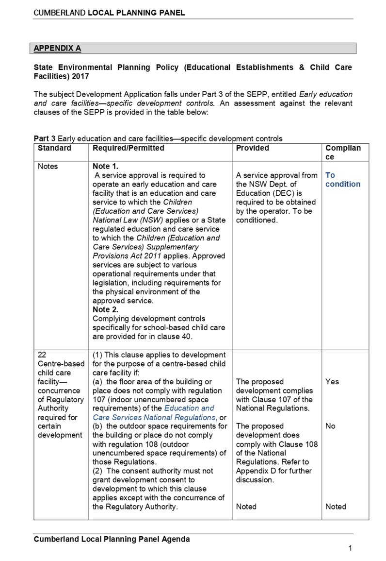
affected by the following State Environmental Planning Policies:
(a) State
Environmental Planning Policy No. 55 – Remediation of Land
The requirement at Clause 7 of
SEPP No. 55 for Council to be satisfied that the site is suitable or can be
made suitable to accommodate the proposed development has been considered in
the following table:
|
Matters for consideration
|
Yes
|
No
|
N/A
|
|
Does the application involve
re-development of the site or a change of land use?
|
|
|
|
|
Is the development going to be
used for a sensitive land use (e.g.: residential, educational, recreational,
childcare or hospital)?
|
|
|
|
|
Does information available to
you indicate that an activity listed below has ever been approved, or
occurred at the site?
acid/alkali plant and
formulation, agricultural/horticultural activities, airports, asbestos
production and disposal, chemicals manufacture and formulation, defence
works, drum re-conditioning works, dry cleaning establishments, electrical
manufacturing (transformers), electroplating and heat treatment premises,
engine works, explosive industry, gas works, iron and steel works, landfill
sites, metal treatment, mining and extractive industries, oil
production and storage, paint formulation and manufacture, pesticide
manufacture and formulation, power stations, railway yards, scrap yards,
service stations, sheep and cattle dips, smelting and refining, tanning and
associated trades, waste storage and treatment, wood preservation.
|
|
|
|
|
Is the site listed on Council's
Contaminated Land Database?
|
|
|
|
|
Is the site subject to EPA
clean-up order or other EPA restrictions?
|
|
|
|
|
Has the site been the subject of
known pollution incidents or illegal dumping?
|
|
|
|
|
Does the site adjoin any
contaminated land/previously contaminated land?
|
|
|
|
|
Has the appropriate level of
investigation been carried out in respect of contamination matters for
Council to be satisfied that the site is suitable to accommodate the proposed
development or can be made suitable to accommodate the proposed development?
|
|
|
|
|
Details of contamination
investigations carried out at the site:
In relation to clause 7(4) of SEPP 55, the land of
concerned is not located within an investigation area (clause 7(4)(a)),
development for a purpose referred to in Table 1 of the Contaminated Land
Planning Guidelines is not known to have been carried out on the land (clause
7(4)(b), and historic zoning controls of the land did not make lawful the
carrying out of activities nominated in Table 1. Based on these considerations, clauses 7(2) and 7(3)
of SEPP 55 have no application. The site is not identified in Council’s
records as being contaminated. A site inspection reveals the site does not
have any obvious signs or history of a previous land use that may have caused
contamination and there is no specific evidence that indicates the site is
contaminated. On this basis, SEPP 55 has no further application. Notwithstanding, a soil assessment report is
required in accordance with the Child Care Planning Guideline issued by NSW
Department of Planning and Environment. The
proposal is considered satisfactory subject to imposition of condition with
regard to submission of a soil assessment report prior to issue of
construction certificate.
|
(b) State
Environmental Planning Policy (Educational Establishments and Child Care
Facilities) 2017
The relevant provisions of the
SEPP have been considered in the assessment of the Application.
It is noted that State
Environmental Planning Policy (Educational Establishments And Child Care
Facilities) 2017 commenced on 1 September 2017. The SEPP applies to any
proposals for new schools or child care centres or proposed alterations and
additions to existing centres. The relevant provisions of the SEPP have been
considered in the assessment of the Application.
A comprehensive assessment and
compliance table is attached to this report in Appendix A, which indicates that
there are non-compliances with the SEPP 2017 with regard to number of children
proposed and outdoor unencumbered space as under:
|
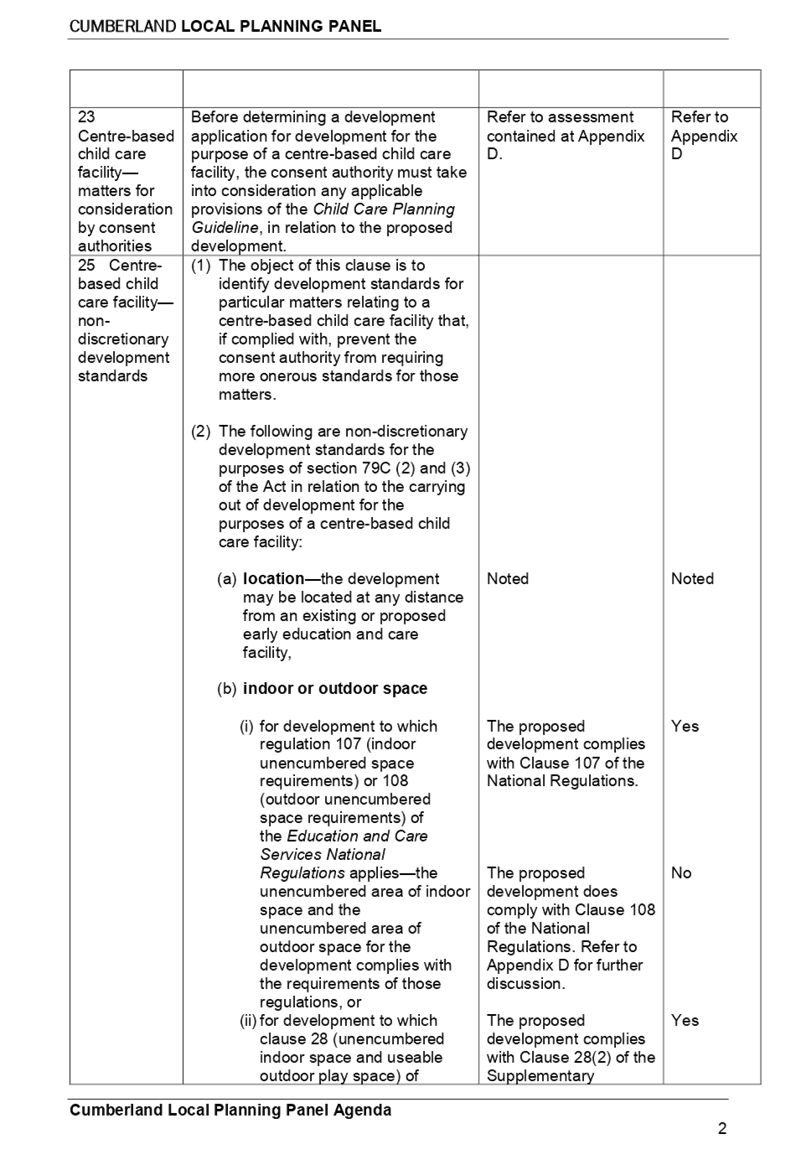
(c) Control
|
(d) Required
|
(e) Provided
|
|
(f) Number
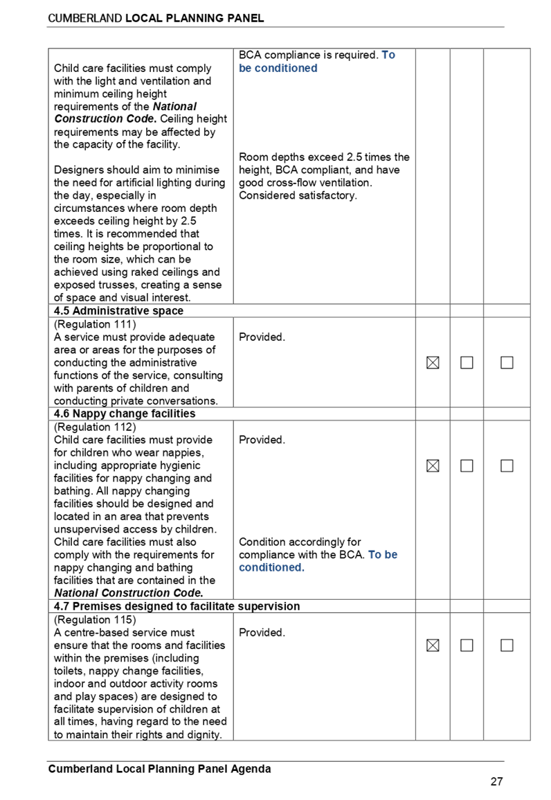
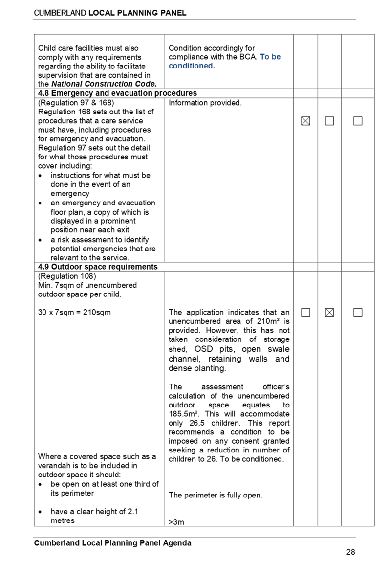
of children and outdoor unencumbered space (regulation 108 SEPP 2017 and part
4.9 the Guideline)
|
7m²x 30 = 210m²
|
The application indicates that
an unencumbered area of 210m² is provided. However, this has not taken
consideration of OSD pits, open swale channel, retaining walls and dense
planting. The assessment officer’s calculation of the unencumbered
outdoor space equates to 185.5m². This will accommodate only 26.5
children. This report recommends a condition to be imposed on any consent
granted seeking a reduction in number of children to 26.
|
(c) Statement
Environmental Planning Policy No 19 - Bushland in Urban Areas
The subject site does not adjoin
land zoned or reserved for public open space. The proposal does not propose to
disturb bushland zoned or reserved for public open space.
(d) State
Environmental Planning Policy (Vegetation in Non-Rural Areas) 2017
No vegetation removal is proposed.
Regional Environmental Plans
(Deemed State Environmental Planning Policies)
(e) Sydney
Regional Environmental Plan (Sydney Harbour Catchment) 2005
The subject site is identified as
being located within the area affected by the Sydney Regional Environmental
Plan (Sydney Harbour Catchment) 2005. The proposed development raises no issues
as no impact on the catchment is envisaged.
Note: The subject site is not
identified in the relevant map as land within the ‘Foreshores and
Waterways Area’ or ‘Wetland Protection Zone’, is not a
‘Strategic Foreshore Site’ and does not contain any heritage items.
Hence the majority of the SREP is not directly relevant to the proposed
development.
Local Environmental Plans
(a) Holroyd
Local Environmental Plan (LEP) 2013
The proposed development is
defined as a ‘centre based child care facility’ under the
provisions of Holroyd Local Environmental Plan (LEP) 2013. Centre based child
care facilities are a permissible land use with consent under the R2 –
Low Density Residential zoning applying to the land under Holroyd LEP 2013.
A comprehensive assessment and
compliance table is attached to this report in Appendix B which demonstrates
the development proposal’s compliance with the relevant planning controls
that are applicable to the site under the Holroyd LEP 2013.
The provisions of any draft
Environmental Planning Instruments (EP & A Act Section 4.15(1)(a)(ii))
The proposed development is not
affected by any relevant Draft Environmental Planning Instruments.
The provisions of any
Development Control Plans (Environmental Planning & Assessment Act Section
4.15(1)(a)(iii))
(b) Holroyd
Development Control Plan (HDCP) 2013
The Holroyd DCP 2013 provides
guidance for the design and operation of development within Holroyd to achieve
the aims and objectives of Holroyd LEP 2013.
The proposed development is
generally compliant with the relevant provisions. Parts A, B & I apply to
the proposal. A comprehensive assessment and compliance table is attached to
this report at Appendix C which demonstrates the development proposal’s
compliance with the relevant planning controls that are applicable to the site.
The assessment provided in Appendix
C indicates that there are some minor non-compliances with the HDCP 2013 with
regard to car parking, landscape area, and basement and driveway setbacks,
which are discussed in the following section:
|
No.
|
Clause
|
Comment
|
Yes
|
No
|
|
|
N/A
|
|
|
|
PART A – GENERAL
CONTROLS
|
|
2
|
|
|
Roads and Access
|
|
3
|
|
|
Car Parking
|
|
3.1
|
|
|
Minimum Parking Spaces
|
|
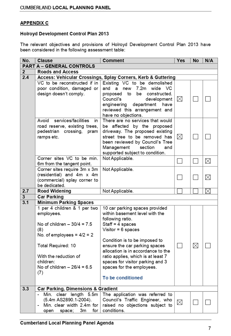
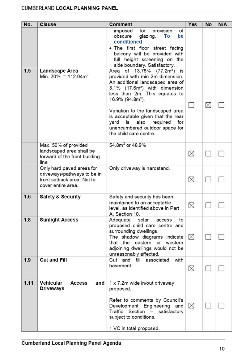
1 per 4 children & 1 per
two employees.
No
of children – 30/4 = 7.5 (8)
No.
of employees = 4/2 = 2
Total
Required: 10
With the reduction of
children:
No
of children – 26/4 = 6.5 (7)
|
10
car parking spaces provided within basement level with the following ratio.
Staff
= 4 spaces
Visitor
= 6 spaces
Condition
is to be imposed to ensure the car parking spaces allocation is in accordance
to the ratio applies, which is at least 7 spaces for visitor parking and 3
spaces for the employees.
To be conditioned
|
|
|
|
|
|
|
3.5
|
|
|
Access, Manoeuvring and Layout
|
|
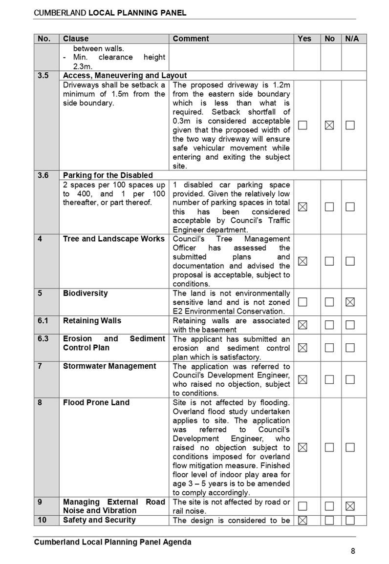
Driveways shall be setback a minimum of 1.5m from the side
boundary.
|
The proposed driveway is setback 1.2m from the eastern
side boundary which is less than what is required. Setback shortfall of 0.3m
is considered acceptable given the proposed width of the two way driveway
will ensure safe vehicular movement.
|
|
|
|
|
|
|
|
|
PART B – RESIDENTIAL
CONTROLS
|
|
1
|
|
|
GENERAL RESIDENTIAL CONTROLS
|
|
1.5
|
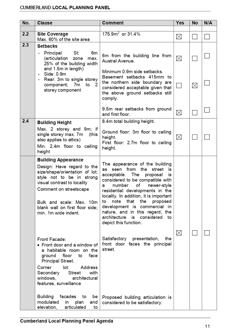
Landscape Area
Min. 20% = 112.04m2
|
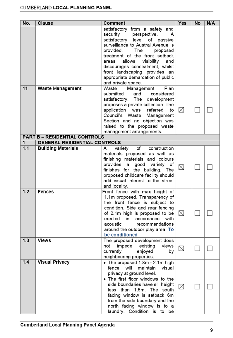
Area of 13.78%
(77.2m²) is provided with min 2m dimension. An additional landscaped
area of 3.1% (17.6m²) with dimension less than 2m. This equates to 16.9%
(94.8m²).
Variation to the landscaped area is acceptable given that
the rear yard is also required for unencumbered outdoor space for the child
care centre.
|
|
|
|
|
|
|
2.3
|
Setbacks
- Side: 0.9m
|
Minimum 0.9m side setbacks provided on the ground level.
Basement setback 415mm to the northern side boundary is
considered acceptable given that the above ground level setbacks still
comply.
|
|
|
|
|
|
|
|
|
|
|
|
|
|
|
|
Any planning agreement that has
been entered into under section 93F, or any draft planning agreement that a
developer has offered to enter into under section 93F (EP & A Act
s79C(1)(a)(iiia))
There are no draft planning
agreements or planning agreements associated with the subject Application.
The provisions of the
Regulations (Environmental Planning & Assessment Act Section
4.15(1)(a)(iv))
The proposed development raises no
concerns as to the relevant matters arising from the Environmental Planning
& Assessment Regulations 2000.
Section 4.15 (1)(a)(v) - any
coastal zone management plan (within the meaning of the Coastal Protection Act
1979)
There is no Coastal Zone
Management Plan applicable for the site.
The Likely Environmental,
Social or Economic Impacts (EP & A Act s4.15(1)(b))
The likely impacts of the
development have been considered in the assessment of the application and it is
considered that the proposed development will have no significant adverse
environmental, social or economic impacts in the locality.
The suitability of the site for
the development (EP & A Act s4.15(1)(c))
The site is considered suitable to
accommodate the proposed development. The proposed development has been
assessed in regard to its environmental consequences and having regard to this
assessment, it is considered that the development is suitable in the context of
the site and surrounding locality.
Submissions made in accordance
with the Act or Regulation (EP & A Act s4.15C(1)(d))
Advertised (newspaper) Mail
Sign
Not
Required
In accordance with Part E - Public
Participation of the Holroyd DCP 2013, the application was publicly notified to
adjoining and opposite owners, a notice was placed in the local press and a
notice placed on the site for 14 days from 12 September 2018 to 26 September
2018. In response, 18 submissions including 3 support letters and 15 objections
were received. Following the submission of additional information the proposal
was re-notified to the objectors and the adjoining and opposite owners for 14
days between 8 March 2019 and 22 March 2019. Eleven (11) additional submissions
were received as a result of the re-notification.
The issues raised in the public
submissions and public information session are summarised and commented on as
follows:
|
Concern
|
Comment
|
|
1. Bulk and scale
The building is out
of character, not consistent with the aesthetic of the street, not located in
an appropriate zone for commercial/business use, proposing front fencing,
excessive in size, and a large 2 storey with underground parking far exceeds
the typical housing in low density area.
|
The proposed development may not
appear as any other dwelling house within the street as it is designed as a
childcare centre; however it is not considered out of character with the
immediate area. It is noted that the R2 zoned area is undergoing a transition
and older housing stock is in the process of being replaced by
contemporary-style development.
The proposed FSR of 0.47:1 does
not exceed the maximum FSR of 0.5:1 that applies to housing development in
the vicinity and on the subject site. The proposal has been assessed against
the Holroyd DCP 2013 Part B controls for dwelling house and it is considered
satisfactory, including setbacks. The proposed site coverage and height in
conjunction with FSR that nominate the building envelope and bulk and scale
thus complies. Refer to compliance table in Appendix B and C.
The proposed basement parking has
been designed to ensure that it will not dominate the building appearance as
the basement entry is setback 12.2m from the front boundary.
The proposal includes the
construction of a low fencing to the height of 1.1m within the front
boundary, which is generally acceptable for a child care centre. The proposed
development will be compatible with the streetscape of the existing low
density residential area.
The proposed development with its
commercial nature is a permissible land use within the R2 Low Density
Residential zone. The proposed development has demonstrated that it is
capable to maintain acoustic and privacy amenity of the neighbouring
properties in its operation, subject to conditions imposed. Therefore The
proposal is considered suitable for the subject site.
|
|
2. Traffic and parking
There will not be enough car parking spaces to
service the child care centre, narrow 7m width street, insufficient swept
path, no turning point, and basement design not complying with the Australian
Standards, traffic peak times within AM/PM are to be considered as this will
affect pedestrian safety, traffic flow and availability of parking in
Hyacinth Street. Access by emergency vehicles and garbage pick-up.
|
Under the Holroyd
Development Control Plan 2013, the required parking rate for child care
centres is 1 space per 4 children and 1 space per 2 staff, which equates to
total of 10 spaces required for 30 children. This rate has been provided on
site, which takes into account staff and visitor parking demands.
It
is noted that Council’s rate of 1 car space per 4 children is
consistent with the recently introduced NSW State Government document
entitled Child Care Planning Guideline, in which the rate of 1 space
per 4 children encompasses the whole centre including all staff.
Condition
is to be imposed to ensure that ratio of staff and visitor parking is
allocated accordingly, which is at least 7 spaces for visitor parking based
on 26 children. The proposed parking arrangement and swept path have been
reviewed by Council’s Traffic Engineer and considered satisfactory,
subject to conditions.
Updated traffic report has
been carried out based on surveys during peak times AM and PM between 7.00am
– 9.30am and 2.30pm – 6.00pm on 21 February 2019. Council noted
the additional traffic to be generated by the proposal and the findings from
the Traffic and Parking Impact Assessment Report. The proposed development is
a low trip generator and can be accommodated in the locality without
affecting performance of existing 7m width street, delays or queues of nearby
intersections, and complies with Council’s parking requirements.
With the provision of two way
driveway allowing all vehicles to enter and leave in a forward direction and
a good sight distance, it is envisaged that motorists will be capable of
entering and exiting the site in a safe and efficient manner. Additional
condition is included to ensure any front fencing will allow clear sightlines
for vehicular access. The number of parking spaces provided is
considered acceptable and appropriate to meet the parking demand of the
proposed centre without placing unacceptable demands on the availability of
parking within the locality or on the local street network.
The entry/exit driveway is at
an obvious location that will not be missed by parents and caregivers. The
parents and caregivers will be regular visitors to the centre knowing in
advance the location of car parking. Operational management plan (OMP) and
installation of “no stopping” zone by way of conditions are to be
imposed to encourage the use of basement parking facility. All pickup and drop-off
is expected to take place within the basement and it is not considered to
create any adverse impact on the public space.
Given the operation of the
child care centre will be wholly contained in the subject site, disruption to
any emergency and garbage vehicles access onto Hyacinth Street is not
anticipated.
|
|
3.
Privacy
Top
level balcony will overlook adjoining properties and deprived the
resident’s privacy.
|
The first floor windows
to the side boundaries have sill height less than 1.5m. The south facing
window is setback 6m from the side boundary and the north facing window is to
a laundry. Condition is to be imposed for provision of obscure glazing to all
first floor windows to a minimum height of 1.5m above finished floor level.
The street facing balcony is provided with full height screening on the side
boundary, which will maintain privacy.
|
|
4.
Noise
The
proposed child care centre will be a noise nuisance to surrounding
properties. Design of acoustic fencing location, height and thickness are not
acceptable. Location of mechanical ventilation will impact neighbouring
properties. Noise management plan will not effective in reducing noise.
|
Design of acoustic
fencing location, height and thickness, and updated acoustic assessment
report and noise management plan have been reviewed by Council’s
Environmental Health officer and are considered satisfactory to comply with
the relevant noise control provisions. The acoustic report demonstrates that
the proposed centre can be accommodated on the site without noise nuisance to
adjoining and surrounding properties, as the noise generated from both indoor
and outdoor play activities can comply with the relevant environmental noise
guidelines with the imposition of a noise management plan submitted with the
application and the installation of relevant noise mitigation measures such
as acoustic fencing. The acoustic consultant recommendation
is captured within the Noise Management Plan.
Further acoustic assessment has been provided on the use of mechanical
plant to be mounted on the roof, which could be used only during the
operation of child care centre.
Conditions are to be imposed in the consent to avoid any breaches to
the required noise threshold, including noise management to be incorporated
in the OMP.
|
|
5.
Disturbance to neighbouring properties - basement excavation, trees outside
the subject site during excavation, fencing replacement, vandalism/break in,
and devalue properties. Combined environmental factors (traffic, noise,
sewage, water, stormwater) with recently approved child care centre at 15
Camellia Street.
|
The concerns raised have been
reviewed in the assessment of the subject application. Excavation of basement
is subject to conditions imposed to ensure that structural integrity of the
adjoining properties is maintained.
The health of existing trees
located within the adjoining properties has been considered and conditions
are to be imposed to ensure that the integrity of these trees is to be
protected during construction.
Replacement of dividing fence
between the adjoining properties is a civil matter to be determined by the
involved parties under the Dividing Fence Act.
Additional condition is to be
imposed to ensure the construction of acoustic fencing will be situated
within the subject site.
Criminal activities may occur
regardless in any type of development and should be reported to the Police
for action. Devaluation of property is not a consideration under Section 4.15
of the EP&A Act.
The child care centre at 15
Camellia Street has addressed the required criteria applying specifically to
the site. The subject application has also been submitted with supporting
documentation and was found to be satisfactory, as discussed within the body
of this report. Cumulative environmental factors are not anticipated from
both of child care centres.
Sewerage and water facilities are
subject to conditions imposed to ensure adequate facility will be provided.
|
|
6.
Childcare Planning Guideline
The
proposal fails to meet the requirements of the NSW Government Childcare
Planning Guideline dated August 2017.
|
Design of the centre has
considered the provision of light and ventilation into indoor play area,
including extensive west facing openings into the outdoor play area. The site
location proposed permits the construction of the child care centre and the
proposed bulk and scale comply with Council’s DCP requirements. Lack of
demand for the actual child care centre is not a matter, which would warrant
refusal of an application that satisfies the criteria under the relevant
regulations.
|
|
7.
Flooding
|
Site is not affected by flooding.
Overland flood study undertaken applies to site. The application was referred
to Council’s Development Engineer, who raised no objection subject to
conditions imposed for overland flow mitigation measure. Finished floor level
of indoor play area for age 3 – 5 years is to be amended to comply
accordingly.
|
The Application has been assessed
in accordance with the relevant requirements of the Environmental Planning and
Assessment Act 1979, State Environmental Planning Policy No. 55 –
Remediation of Land, State Environmental Planning Policy (Educational
Establishments and Child Care Facilities) 2017, Education and Care Services
National Regulations, Holroyd Local Environmental Plan 2013 and the Holroyd
Development Control Plan 2013 and is considered to be satisfactory for approval
subject to reduction in number of children to 26 (to comply with the outdoor
unencumbered space) and the draft conditions.
There are no further consultation
processes for Council associated with this report.
There are no further financial
implications for Council associated with this report.
There are no policy implications
for Council associated with this report.
Communication /
Publications:
The final outcome of this matter
will be notified in the newspaper. The objectors will also be notified in
writing of the outcome.
|
1. That
Development Application 2018/284/1 for demolition of existing structures and
construction of a two storey, 26 place child care centre over basement
parking accommodating 10 parking spaces on land at 15 Hyacinth Street,
Greystanes, be Approved, subject to the attached conditions, provided at
Attachment 1.
2. That
the applicant and those persons who lodged a submission in respect of the
application be notified of the determination of the application.
|
1. Draft Notice of
Determination ⇩
2. Architectural
Plans Internal ⇩
3. Architectural
Plans External ⇩
4. Landscape
Plan ⇩
5. Acoustic
Report ⇩
6. Noise
Management Plan ⇩
7. Redacted
Public Submission ⇩
8. Locality
Map ⇩
9. Appendix
A - SEPP Educational Establishments and Child Care Facilities 2017 ⇩
10. Appendix
B - HLEP 2013 ⇩
11. Appendix
C - HDCP 2013 ⇩
12. Appendix
D - Child Care Planning Guideline 2017 ⇩
Extraordinary
Cumberland Local Planning Panel Meeting
16 April 2019
Item No:
ELPP022/19
Planning
Proposal Request for 2-22 William Street, Granville
Responsible
Division: Environment
& Planning
Officer: Manager
Strategic Planning
File
Number: SC183
|
Lodged
|
Revised Planning Proposal submitted on 16 October
2018.
|
|
Proponent
|
Sid Arida C/O PTI Architects Pty Ltd
|
|
Owner
|
Sid Arida
|
|
Description of Land
|
2-22 William Street, Granville
(Lots 18 to 21 in DP 2371 and SP 31488)
|
|
Site Area
|
Approximately 3,700m2
|
|
Site Description and
Existing Use
|
The Site comprises 15 allotments containing seven (7)
buildings with primary frontage on William Street, comprising of detached
residential dwellings, a two storey residential flat building and a
commercial warehouse.
|
|
Proposal Summary
|
Seeks to amend the Parramatta
Local Environmental Plan 2011 (Parramatta LEP 2011) by:
increasing
the maximum building height from 14m to 20m (five storeys),
increasing
the floor space ratio (FSR) from 1:1 to 1.7:1,
removing
the local heritage item no. I205 known as 10 William Street (Lot 27 DP 2371)
from Schedule 5 of the Parramatta LEP 2011.
|
|
Existing and Proposed
Planning Controls
|
Planning Controls
(Parramatta LEP
2011)
|
Existing controls
|
Proposed controls
|
|
Height of Building
|
14m
|
20m (five-storeys)
|
|
Floor Space Ratio
|
1:1
|
1.7:1
|
|
Heritage
|
Seeks to remove the local heritage item no. I205 from
the Parramatta LEP 2011 as outlined above.
|
|
Disclosure of
political donations and gifts
|
Nil
|
|
Previous
Consideration
|
This planning proposal was previously considered by
the Cumberland IHAP on 13 September 2017.
|
This report provides an overview
of a revised planning proposal submitted to Council on 16 October 2018 that
addresses recommendations made by the Cumberland IHAP at its 13 September 2017
meeting. The revised planning proposal seeks to amend the height and FSR
controls for the subject site, and remove the existing heritage item at 10 William Street. This report outlines the
findings of the additional expert heritage peer review and FSR modelling advice
undertaken on behalf of Council in response to the 2017 recommendations of the
Cumberland IHAP. The report recommends proceeding with an FSR control of 1.7:1,
a lower maximum building height of 16m, and removal of the heritage item as
outlined in the independent heritage advice.
The status of the planning proposal is outlined in Figure 1.

Figure 1: Planning Proposal Status
Background
On 15 December 2015, a Planning Proposal Request (the
Proposal) was lodged with Parramatta Council for 2-22 William Street, Granville
by Sid Arida C/- PTI Architects. This Proposal originally sought to amend the
development standards in the Parramatta LEP 2011 to achieve a greater
height and density on the site to enable the development of a seven (7) storey
residential development.
The original proposal (December 2015) sought an increase in
FSR from 1:1 to 2.3:1 and an increase in maximum building height from 14m to
23m (approximately seven storeys). The original proposal also included the
removal of Heritage Item I205 (No. 10 William Street) from Schedule 5 of the Parramatta
LEP 2011.
This planning proposal was transferred to Cumberland Council
following the May 2016 Council amalgamations and a revised concept scheme was
lodged with Cumberland Council in September 2016. The revised proposal sought a
lower maximum FSR of 1.7:1 and a maximum height of 19.2 metres (five storeys),
in an attempt to address the overshadowing of adjoining properties to the south
of the site. It also sought the removal of the heritage item at 10 William
Street.
Preliminary public exhibition of the revised September 2016
concept scheme was undertaken by Cumberland Council between 10 April 2017 and
12 May 2017, in accordance with Council’s notification policy.
An assessment of the submissions received and the proposal
was undertaken, and this was reported to the Cumberland IHAP meeting on 13
September 2017 (Attachment 1).
The Cumberland IHAP recommended that the proposal be
deferred to a future IHAP meeting (now Cumberland Local Planning Panel) meeting
and for Council to undertake the following (Attachment 2):
· obtain
an additional independent heritage opinion on the proposed demolition of the
heritage item;
· undertake
a study of whether the FSR is appropriate while satisfying the outcomes
required in the ADG, particularly transition to the R2 zoned land immediately
to the south; and
· consideration
be given to any community benefit in the proposed increased FSR and height.
These recommendations are discussed further throughout this
report.
In October 2018, the proponent submitted a revised planning
proposal request (Attachment 3) on 16 October 2018 responding to the concerns
raised by the Cumberland IHAP. This revised proposal sought a maximum FSR of
1.7:1 and a maximum height of 20 metres, and like the previous proposal, it
also sought the removal of the heritage item.
The site and its context
The Site is located on the
southern side of William Street, and is bound by William Street, Clyde Street,
Factory Street and a rear access laneway.
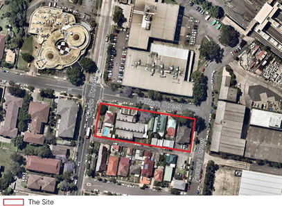
Figure 2: The Site and surrounds
The area of the Site is approximately 3,700m2. It
comprises fifteen allotments containing seven detached dwellings with frontage
to William Street and a two storey strata subdivided residential flat building.
The Site also contains a commercial building used for warehousing at the
western end of the block, and includes the heritage item at 10 William Street.
The applicant owns the site at 10-22 William Street (Site 1)
and has instigated the LEP amendment. The remaining portion of the Site is
known as 2-8 William Street (Site 2) and comprises seven allotments held under
private ownership and strata title (Figure 3).
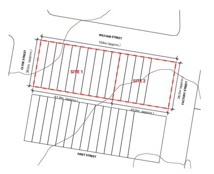
Figure 3: Overall site ownership plan
Local Context
The Site is bound to the north by
the Granville RSL Club and existing industrial buildings (towards Clyde Railway
Station). These buildings are accessed from and have frontage to, Memorial
Drive with no vehicular access or active frontages to William Street, facing
the Site.
To the east of the Site is an industrial precinct zoned IN1
General Industrial. The lots to the south of the Site fronting First Street
(and backing onto the rear lane) are established detached residential dwellings
within an R2 Low Density Residential zone with a maximum FSR of 0.5:1
and a 9m height limit. Allotments to the west of Clyde Street are residential
flat buildings varying from two to four storeys.
The Site is located approximately
150m from Clyde Railway Station and about 500-600 metres from Granville Station
and the Granville shopping area located along Mary Street and South Street.
Regional Context
The site is located in the suburb
of Granville within the Local Government Area of Cumberland Council
approximately 3km south of Parramatta CBD and 20km west of the Sydney CBD.
Planning Controls
Existing Planning Controls (Parramatta LEP 2011)
The existing planning controls for the site are
outlined below.
|
Land Use
Zoning
The site is currently zoned R4
High Density Residential
|
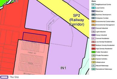
Figure 4: Existing Land Use Zoning
|
|
Floor Space
Ratio Control
A FSR control of (N) 1.0:1 applies
to the site
|
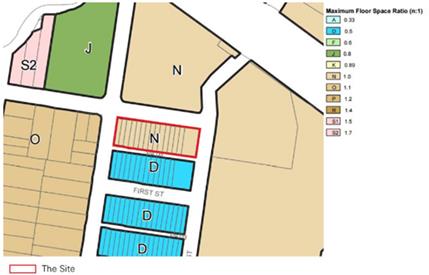
Figure 5: Existing Floor Space Ratio
|
|
Height of
Building Control
A Height of Building control of
(N2): 14 metres applies to the site.
|
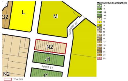
Figure 6: Existing Height of Building
|
Proposed Planning Controls (Parramatta LEP 2011)
The proposed planning controls for the site are
outlined below.
|
Land Use Zoning
|
The Proposal does not propose a change to the land use
zoning control that applies to the site.
|
|
Floor Space Ratio
The proposal seeks an FSR control of (S2): 1.7:1.
|
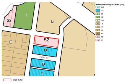
Figure 7: Proposed FSR control
|
|
Height of Building Control
The proposal seeks a height of Building control of
(Q2) 20 metres, however a height of 16m (O2) is recommended.
|
Figure 8: Proposed height of building control
|
Strategic Merit
Land is currently zoned for High Density
There is merit in progressing the Proposal to the next
phase of assessment as the area is already zoned to permit the development of
residential flat buildings. The planning proposal is seeking to amend the
current built form controls and to remove the heritage item.
Cumberland IHAP recommendations
There is merit in progressing the Proposal to the next
phase of assessment as the proposal has been revised to address the
recommendations of the CIHAP.
Community Benefit
The CIHAP
required consideration be given to any community (public) benefit in the
proposed increase in height and FSR. The uplift in residential floor space as a
result of an increase in FSR and height for Site 1 is approximately 1530m2.
Under Council’s Planning Agreements Policy, Council seeks to capture 50%
of the value uplift. It is recommended that Council commence discussion with
the proponent on community (public) benefit arising from the proposal.
Heritage
The is strategic merit in progressing the proposal to the
next phase of assessment, as the consultants engaged to provide independent
heritage advice for Council concluded that the proposed demolition of 10
William Street, Granville, could occur:
· as
the cottage is the only remaining item of the group of three (both 6 and 8
William Street have been compromised with the demolition of the original
cottages and replacement with new dwellings on both sides), and it is an
ordinary example of a weatherboard cottage. Retention and conservation works including
adaptive reuse or restoration would increase its aesthetic value as an item,
but would not significantly add to its contribution to the wider streetscape,
where as an example of historic values, it is quite isolated;
· two
other groups of weatherboard cottages at 115-119 and 170-178 William Street are
in intact condition, and each group is cohesive in its contribution to the
streetscape, providing better examples of interpretation of the residential
context of the area. Therefore, the retention of the cottage at 10 William
Street, which is the only remaining house of the original group of three
cottages, does not represent an intact group of cottages as in the case of the
other two groups, nor provide enough evidence for interpretation of the former
group;
· if
archival recording of the cottage at 10 William Street is undertaken prior to
any demolition approved and allowed as per the NSW OEH Guideline How to prepare
archival records of Heritage Items;
· if
an interpretation strategy be prepared by a qualified heritage consultant for
the group of three cottages at 6, 8 and 10 William Street, which reflects the
historical, social and cultural significance of the group, and this strategy be
integrated into any proposed development. The strategy should also refer to the
other weatherboard cottage groups along William Street. The interpretation
strategy should be prepared in accordance with The Burra Charter: The
Australia ICOMOS Charter for Places of Cultural Significance 2013, and the
NSW OEH documents namely Interpreting Heritage Places and Items Guidelines
2005, and the Heritage Interpretation Policy 2005. The
interpretation strategy should be prepared and submitted at the same time as
the Development Application for the proposed development at 2-22 William Street
is submitted to Cumberland Council; and
· if
all demolition works undertaken consider salvage of any original elements of
the building. The list of items and materials to be salvaged should be developed
by a qualified heritage consultant. Any material which is identified for
salvaging should be photographed, tagged and catalogued by a heritage
consultant and stored until reused in a secure, weather-proof location. The
location of the storage should be ascertained by the proponent in consultation
with Cumberland Council. It is also recommended that the interpretation
strategy integrate the reuse of any salvage material.
The independent heritage advice on the proposal is
provided in Attachment 5.
In addition to the specialist heritage peer review
advice provided to Council, opportunities to incorporate a mechanism to capture
the requirements outlined above will be explored as part of the new
comprehensive Cumberland LEP.
Overshadowing
The proposed height control of 20 metres is not supported
due to overshadowing impacts on land directly to the south. However, there is
merit in progressing the proposal to the next phase of assessment with a 16
metre Height of Building control as:
· the
FSR study that was undertaken to address the Cumberland IHAP (Attachment 6)
concluded that an FSR of 1.7:1 and a height of 16.2m will deliver good amenity
outcomes for the residents of the buildings and its neighbours, particularly
the properties to the south;
· the
study demonstrated that a compliant ADG and DCP option would ensure that there
is no additional overshadowing impact to Nos. 11 and 13 First Street after 1pm,
which is an improvement on the impacts generated by planning proposal request
at a proposed height of 20m; and
· 16
metres is comparable with many other areas zoned R4 across Cumberland, and is
considered to provide an appropriate scale of development in this location.
Central City District Plan
There is strategic merit in
forwarding this proposal to DP&E for a Gateway Determination as the
proposal can be considered to be consistent with the following Planning
Priorities of the Central City District Plan:
· C5.
Providing housing supply, choice and affordability, with access to jobs and
services: the proposal provides for additional dwellings in close proximity
to a large range of employment and services in Parramatta CBD
· C6.
Creating and renewing great places and local centres, and respecting the
District’s heritage: the proposal facilitates redevelopment of an
existing urban site including communal open space areas, presenting
opportunities for renewal and social interaction; and
· C9.
Delivering integrated land use and transport planning and a 30-minute city:
the proposal
supports this priority by placing housing in a location less than 30 minutes by
public transport (bus) from Parramatta CBD.
Greater Sydney Region Plan
There is strategic merit in
forwarding this proposal to DP&E for a Gateway Determination as the
proposal can be considered to be consistent with the following Planning
Directions of the Greater Sydney Region Plan:
· A
City for People and Housing the City: the proposal provides additional
housing capacity in Granville and will contribute to supply and diversity and
of housing in the area; and
· A
well-connected city: the proposal supports this objective by placing new
housing in a location less than 30 minutes by public transport from jobs and
services; and
Summary of Planning Proposal Controls
A summary of the evolution of the proposed
planning proposal controls to this point is provided below.
|
|
Existing Controls (Parramatta LEP)
|
Planning Proposal (Cumberland September 2016)
|
Revised Planning Proposal October 2018)
|
Recommended Controls
|
|
FSR
|
1:1
|
1:7:1
|
1:7:1
|
1:7:1
|
|
Height
|
14m
|
19.2m
|
20m
|
16m
|
|
Heritage
|
10 William
Street listed as Heritage item I205 in Schedule 5 of the Parramatta
LEP
|
Remove 10
William Street from Schedule 5 of the Parramatta LEP
|
Remove 10
William Street from Schedule 5 of the Parramatta LEP
|
Remove 10
William Street from Schedule 5 of the Parramatta LEP
|
It is recommended that the
proposal be reported to Council seeking a resolution that the proposal be
forwarded to DP&E for a Gateway Determination. This recommendation is being
made as:
· the
area is currently zoned to permit the development of residential flat
buildings. The planning proposal is purely seeking a better urban design
outcome by amending the current built form controls and removing the heritage
item; and
· the
recommended height of 16 metres is considered to generate an appropriate scale
of development in this location.
The proposal is also generally consistent with the strategic
directions set by the Central City District Plan and the Greater Sydney Region
Plan.
There are no further consultation
processes for Council associated with this report.
There are no further financial
implications for Council associated with this report.
This
report recommends that this matter be reported to Council for further
consideration.
Should
Council resolve to forward this planning proposal to the DP&E for a Gateway
Determination, there will be a number of policy implications associated with
the subsequent stages of the planning proposal process. These will be outlined
in subsequent Council reports.
Communication /
Publications:
The final outcome of this matter
will be notified in the newspaper. The objectors will also be notified in
writing of the outcome.
|
That:
1. Council proceed with the preparation of a
Planning Proposal for 2-22 William Street, Granville (Lots 18 – 31 DP
2371 and SP 31488), with the following development standards:
· a
floor space ratio of 1.7:1; and
· a
maximum building height of 16m;
2. That the proponent undertake the
following, prior to any demolition approval if allowed:
· prepare
an archival recording of the heritage item at 10 William Street as per the
NSW OEH Guideline How to prepare archival records of heritage items;
· organise
for an interpretation strategy to be prepared by a qualified heritage
consultant for the group of three cottages at 6, 8 and 10 William Street, and
for this strategy to be integrated into any proposed development in
accordance with The Burra Charter: The Australia ICOMOS Charter for Places
of Cultural Significance 2013, and the NSW OEH documents namely Interpreting
Heritage Places and Items Guidelines 2005, and the Heritage
Interpretation Policy 2005. The interpretation strategy should also
integrate the reuse of any salvaged material; and
· organise
for a qualified heritage consultant to prepare a list of items and materials
to be salvaged. Any material identified for salvaging should be photographed,
tagged and catalogued by a heritage consultant and stored until reused in a
secure, weather-proof location. The location of the storage should be
ascertained by the proponent in consultation with Cumberland Council.
|
1. Cumberland IHAP
Report – 13 September 2017 ⇩ 
2. Cumberland
IHAP Recommendations - 13 September 2017 ⇩
3. Revised
planning proposal request report by Ethos Urban submitted to Cumberland Council
on 16 October 2018 ⇩ 
4. Revised
planning proposal request concept scheme prepared by PTI Architects submitted
to Cumberland Council on 16 October 2018 ⇩
5. Heritage
Advice provided by Extent Heritage on behalf of Council on 4 December
2018 ⇩
6. FSR
study prepared by Design Inc on behalf of Council on 27 February 2019 ⇩
7. Heritage
Impact Statement prepared by Archnex Designs ⇩
8. Peer
Heritage Review prepared by Heritage 21/Rappoport ⇩