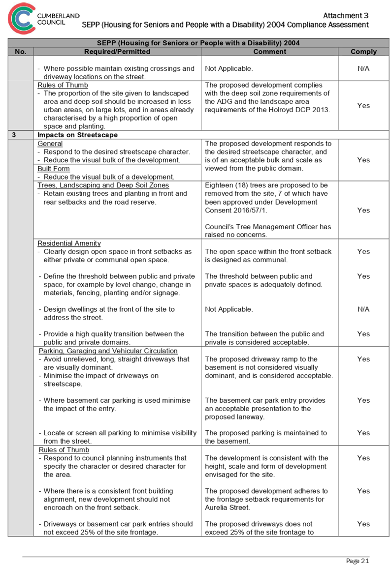
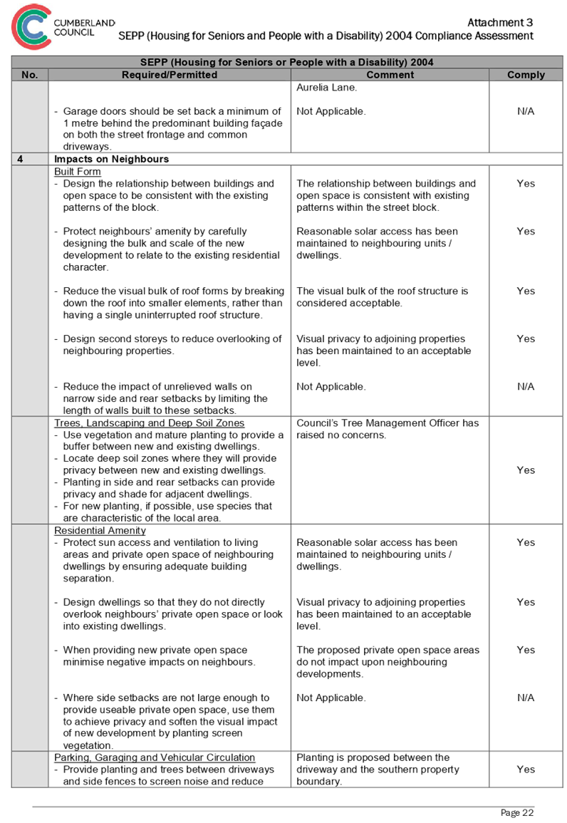
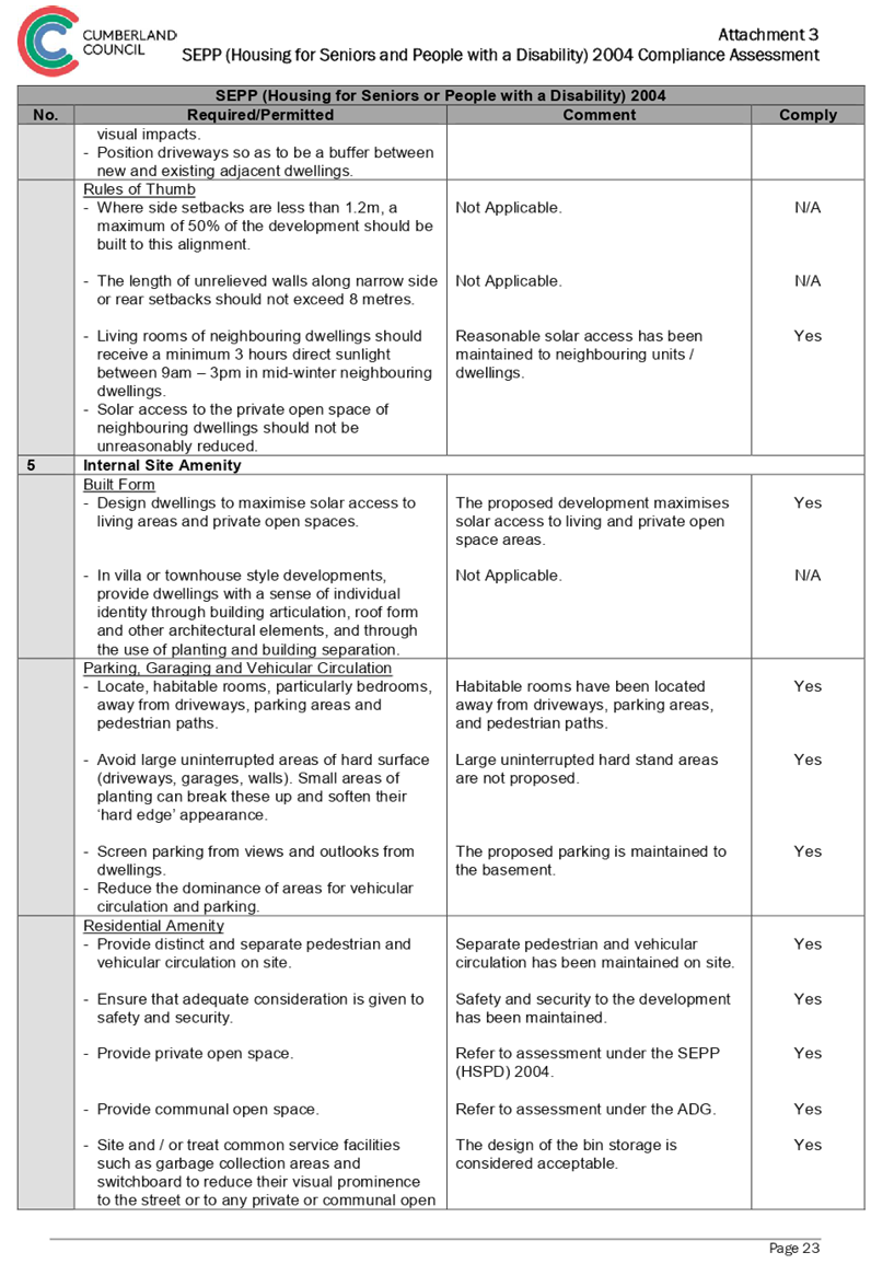
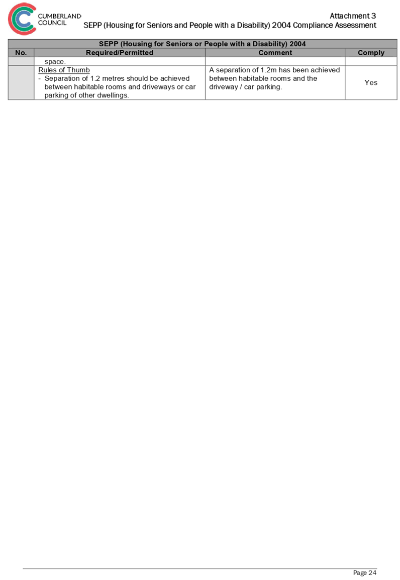
Cumberland Local Planning Panel Meeting
13 February 2019
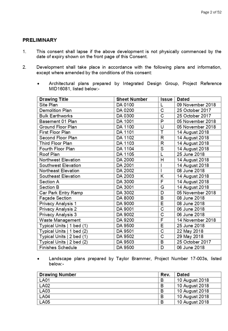
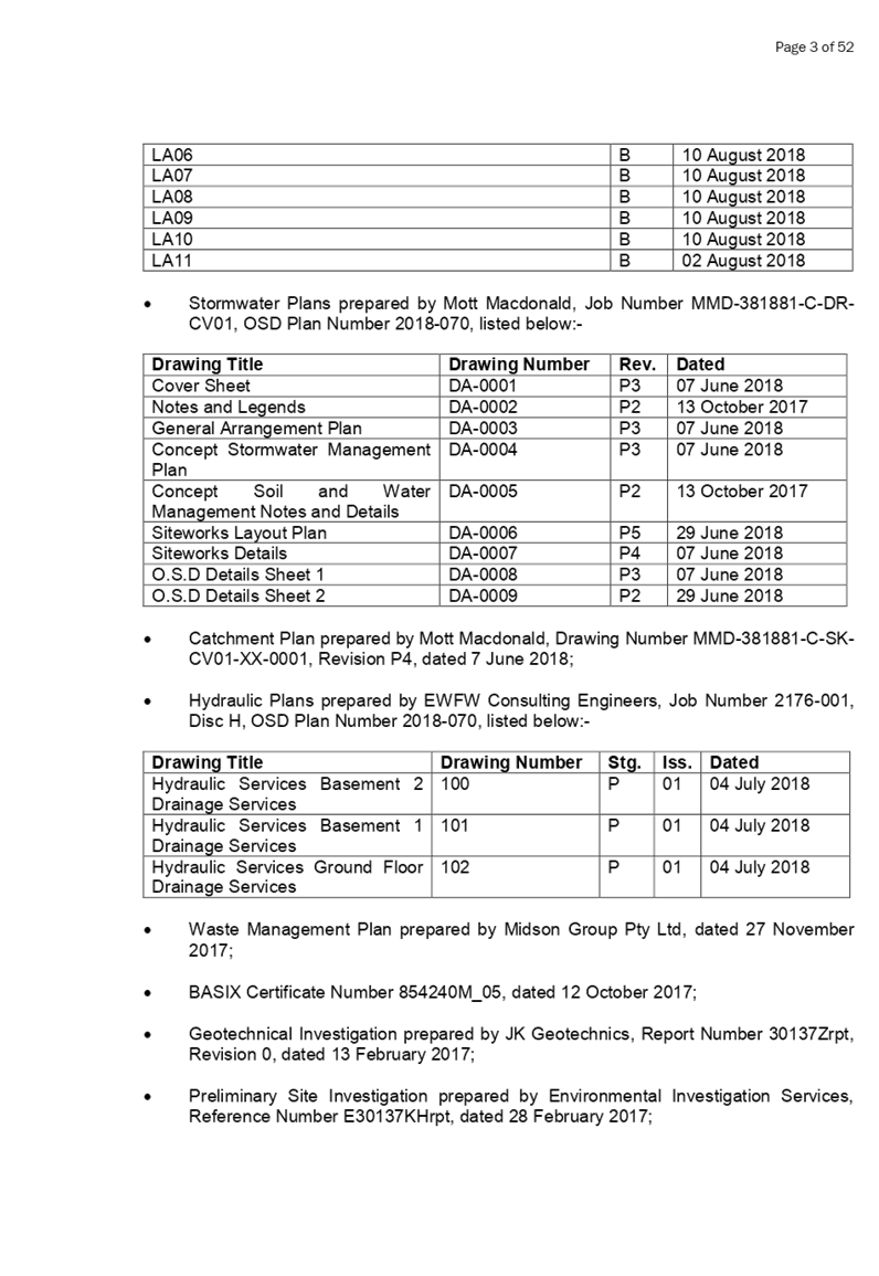
Item No:
LPP003/19
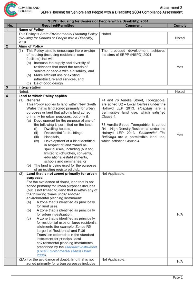
Development
Application at 74,76 & 78 Aurelia Street, Toongabbie
Responsible
Division: Environment
& Planning
Officer: Manager
Development Assessment
File
Number: 2017/513/1
|
Application lodged
|
1 December 2017
|
|
Applicant / Owner
|
Our Lady of Consolation Aged Care Services
|
|
Application No.
|
2017/513/1
|
|
Description of Land
|
74, 76 & 78 Aurelia Street, Toongabbie
|
|
Proposed Development
|
Demolition of existing structures, consolidation of 3 lots
into 1 lot, construction of a part 4, part 5 storey mixed use development
containing seniors housing in the form of 38 self-contained dwellings and a
medical centre over two levels of basement parking accommodating 37 parking
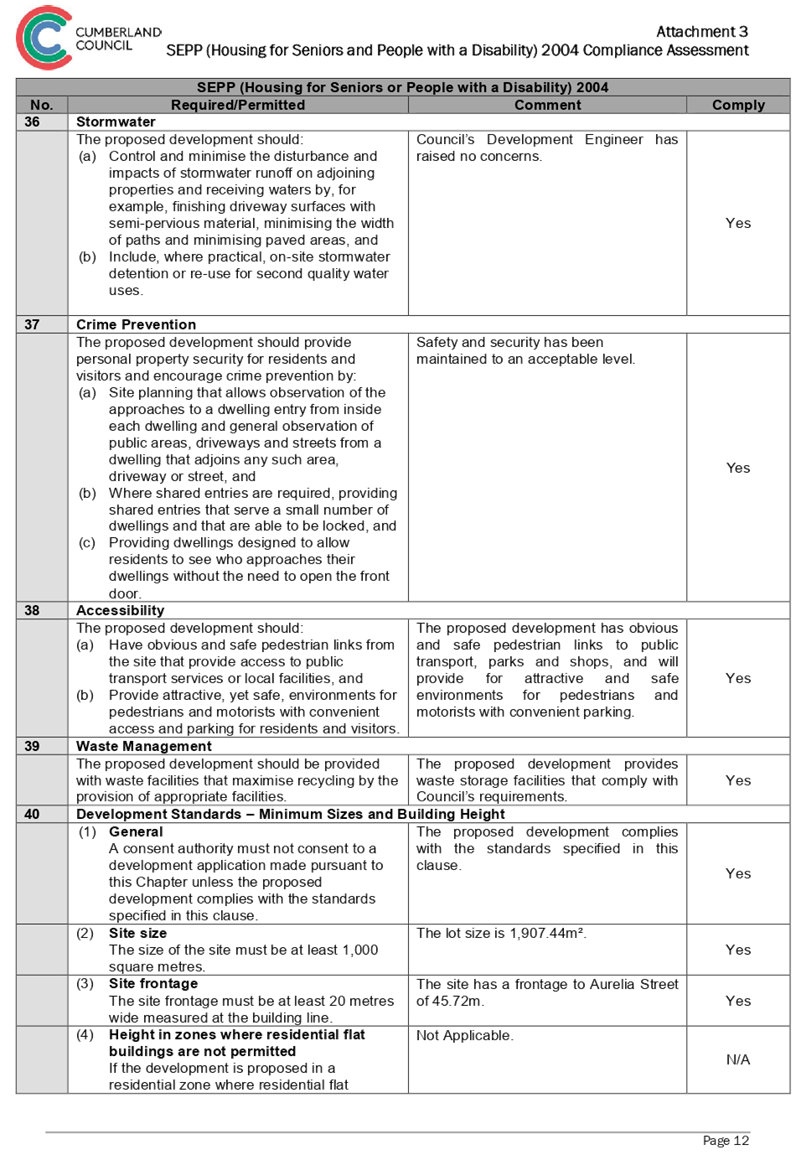
spaces under Housing for Seniors or People with a Disability SEPP 2004.
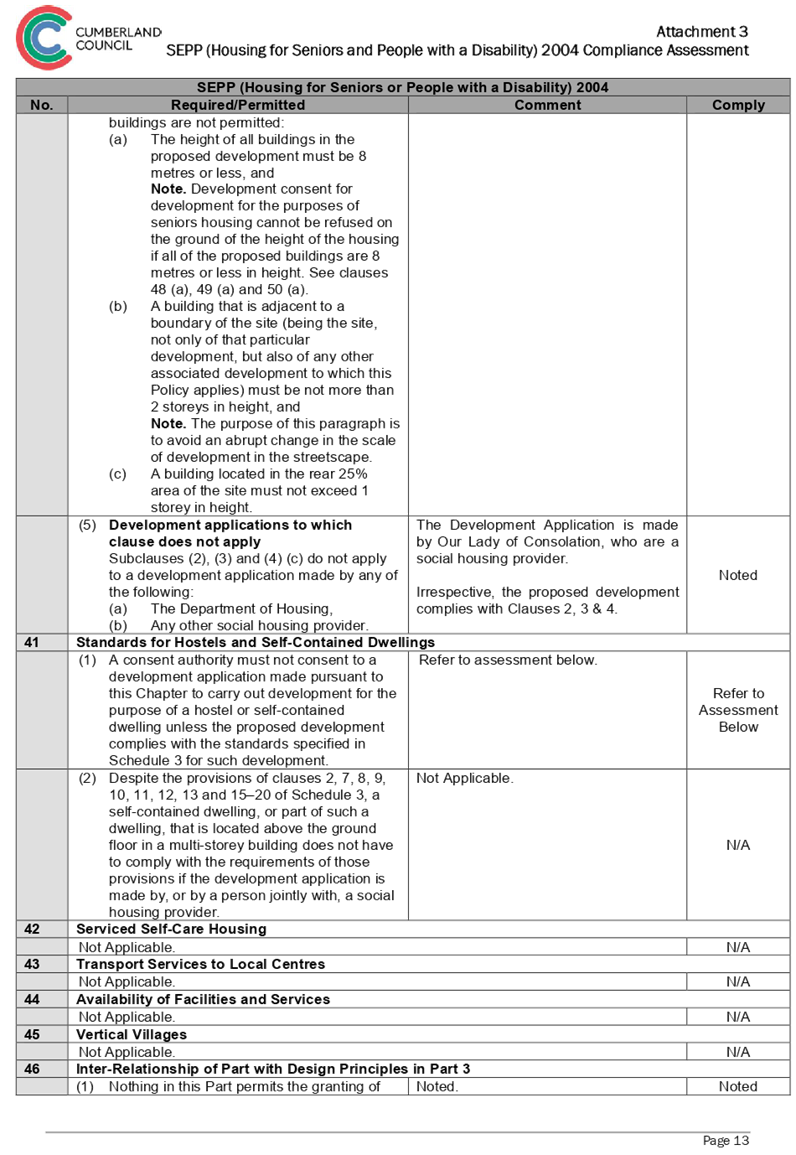
|
|
Site Area
|
1,907.44m2
|
|
Zoning
|
74 & 76 Aurelia Street, Toongabbie – B2 Local
Centre
78 Aurelia Street, Toongabbie – R4 High
Density Residential
|
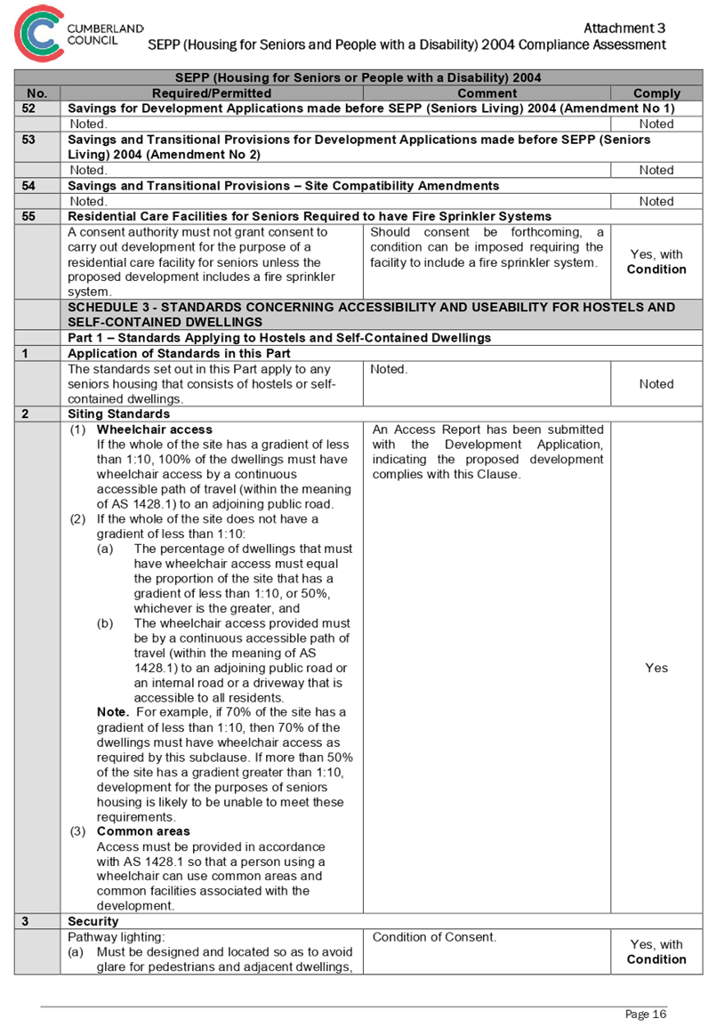
|
Disclosure of political donations and gifts
|
Nil disclosure
|
|
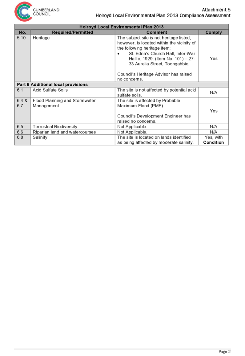
Heritage
|
The subject site is not a heritage item, nor is it
located within a heritage conservation area.
The subject site is located within the vicinity
of a local heritage item known as St Edna’s Church Hall –
Inter-war Hall, circa 1929 (Item No. 101), located at 27-33 Aurelia
Street, Toongabbie.
|
|
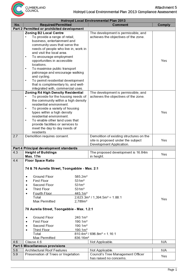
Principal Development Standards
|
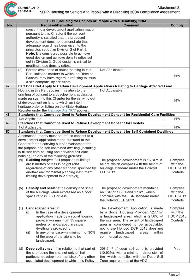
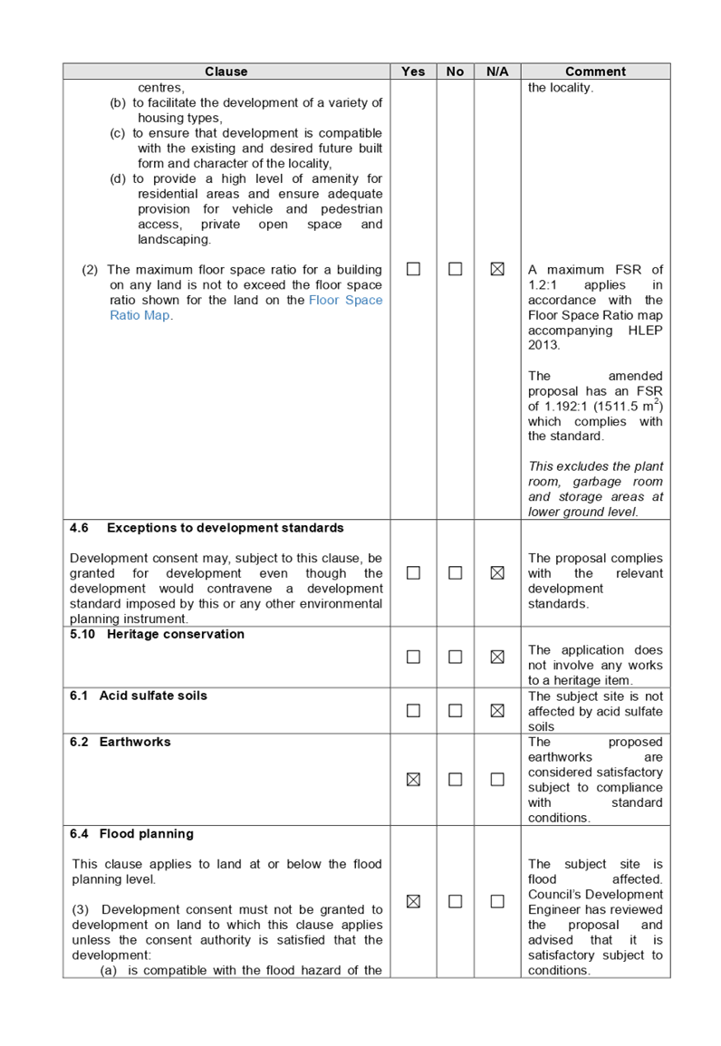
Floor Space Ratio
Permissible: 2:1 and 1.2:1
Proposed: 1.88:1 and 1.16:1
Height of Buildings
Permissible: 17m
Proposed: 16.84m
|
|
Issues
|
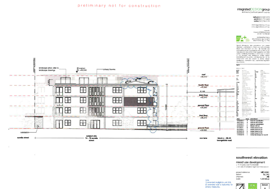
· Building separation
· Ceiling heights
· Number of units per core
· Building height in storeys
· Street wall height
|
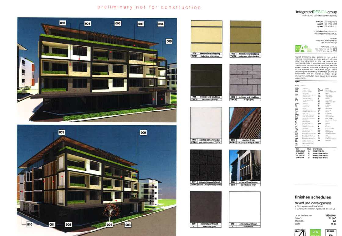
Figure 1 – Perspective
From Aurelia Street, Looking East (Source: Idg, 2018)
Summary:
Council is in receipt of a
Development Application from Our Lady of Consolation Aged Care Services seeking
approval for demolition of existing structures, consolidation of 3 lots into 1
lot, construction of a part 4, part 5 storey mixed use development containing
seniors housing in the form of 38 self-contained dwellings and a medical centre
over two levels of basement parking accommodating 37 parking spaces under Housing
for Seniors or People with a Disability SEPP 2004 at 74, 76 & 78 Aurelia
Street, Toongabbie. The Development Application Architectural Plans are
provided as Attachment 1 to this report.
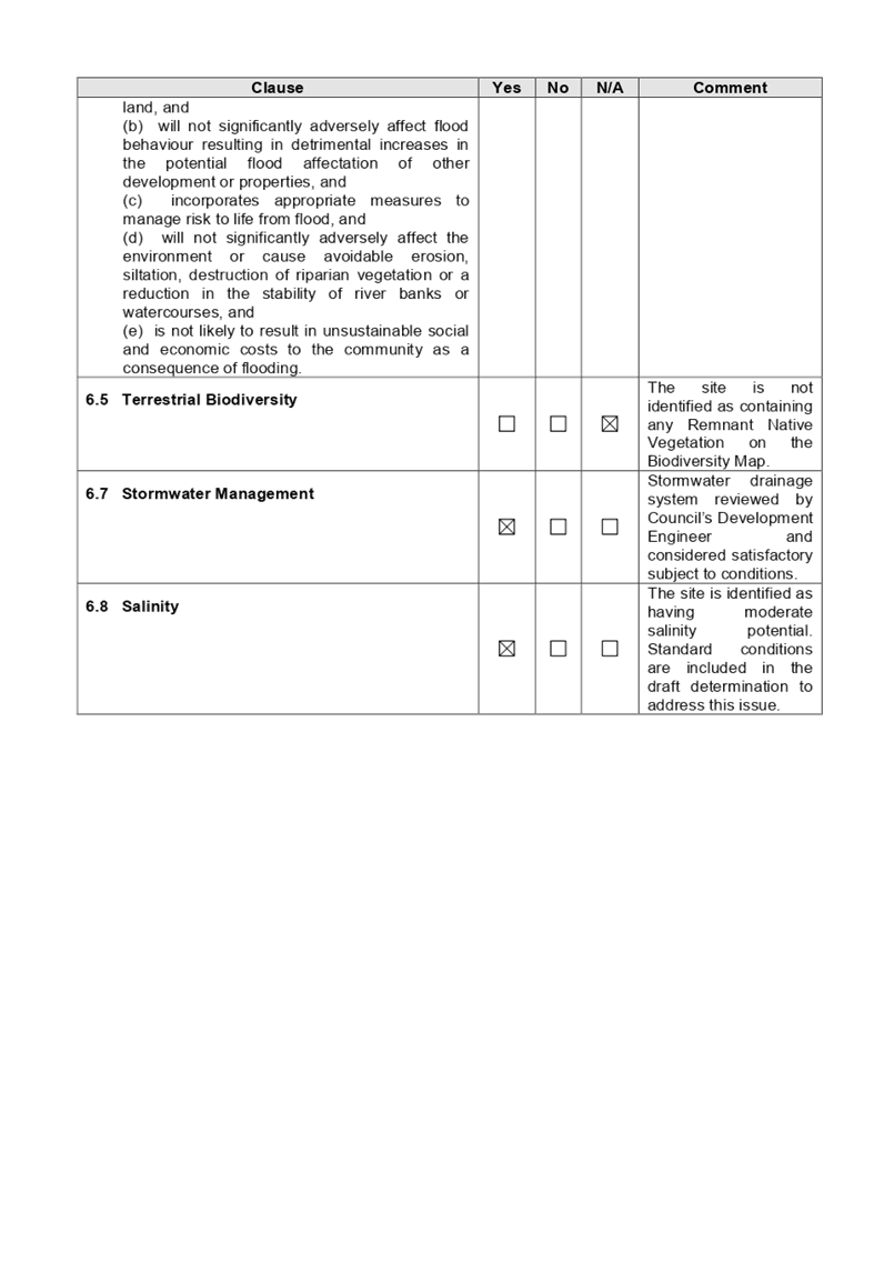
The site is affected by Probable
Maximum Flood (PMF). The development has been assessed by Council’s
Development Engineer to be acceptable, subject to standard conditions.
The Development Application was
publicly notified for a period of 35 days from 20 December 2017 to 24 January
2018, inclusive of an additional 14 days, accounting for the Christmas / New
Year period. In response, no submissions were received.
The site is zoned B2 Local Centre
associated with the properties 74 & 76 Aurelia Street, Toongabbie, and
zoned R4 High Density Residential associated with the property 78 Aurelia
Street, Toongabbie, pursuant to the Holroyd Local Environmental Plan (HLEP)
2013. A Residential Flat Building is permissible with development consent
in the R4 – High Density Residential zone, and Shop Top Housing, is
permissible with development consent in the B2 – Local Centre zone.
The proposal is consistent with
the aims and objectives of State Environmental Planning Policy No. 55
(Remediation of Land), State Environmental Planning Policy (Housing for Seniors
or People with a Disability) 2004, State Environmental Planning Policy No. 65
– Design Quality of Residential Apartment Development, State
Environmental Planning Policy (Infrastructure) 2007, State Environmental
Planning Policy (Building Sustainability Index: BASIX) 2004, Sydney
Environmental Plan (Sydney Harbour Catchment) 2005, Holroyd Local Environmental
Plan (HLEP) 2013, Draft SEPP (Environment), and Holroyd Development Control
Plan (HDCP) 2013.
The Development Application was
referred for comments externally to Endeavour Energy, and internally to
Council’s Development Engineer, Traffic Engineer, Tree Management
Officer, Heritage Consultant, Environmental Health Officer, and Resource
Recovery Officer, to which the application is supported.
The proposed development has been
assessed against the relevant matters for consideration pursuant to Section
4.15 of the Environmental Planning and Assessment Act, 1979, including likely
impacts, the suitability of the site for the development, and the public
interest, and the proposed development is considered appropriate.
The variations sought via the
subject application are as follows:
|
Control
|
Required
|
Provided
|
% Variation
|
|
Building separation
|
Min. 6m
|
3.9m & 5m
|
16.6% - 35%
|
|
Ceiling heights
|
3.3m
|
2.75m
|
16.6%
|
|
Number of units per core
|
Max. 8
|
10
|
25%
|
|
Building height in storeys
|
Max. 4 storeys
|
5 storeys
|
25%
|
|
Street wall height
|
Max. 3 storey
|
4 storeys
|
33.3%
|
The application is being reported
to the Cumberland Local Planning Panel (CLPP) for determination, as it is a
development with more than 4 storeys to which the State Environmental Planning
Policy No 65 – Design Quality of Residential Apartment Developments
applies.
In light of the above, it is
recommended that the Cumberland Local Planning Panel Approve the Development
Application, subject to the Draft Notice of Determination provided at
Attachment 2 to this report.
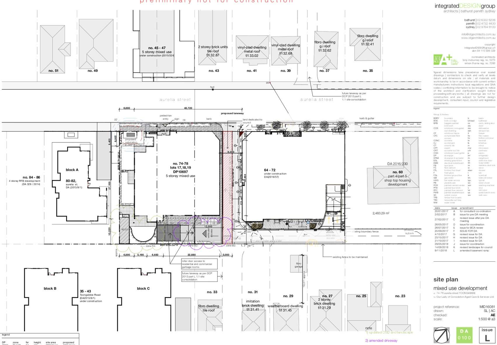
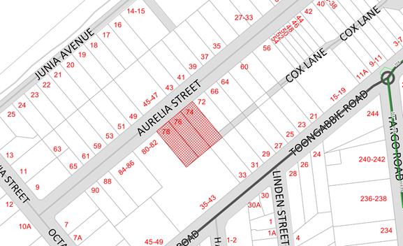
Subject Site and Surrounding
Area
The subject site is known as 74,
76, & 78 Aurelia Street, Toongabbie, and is legally described as Lots 17,
18 and 19, Deposited Plan 10697. The site is a regular mid-block, and has a
frontage of 45.72 metres to Aurelia Street, and depth of 45.72 metres. The
total site area is 1,907.44sqm, and is illustrated in Figure 2 below:
Figure
2 - Location Map (Source: Cumberland Council, 2018
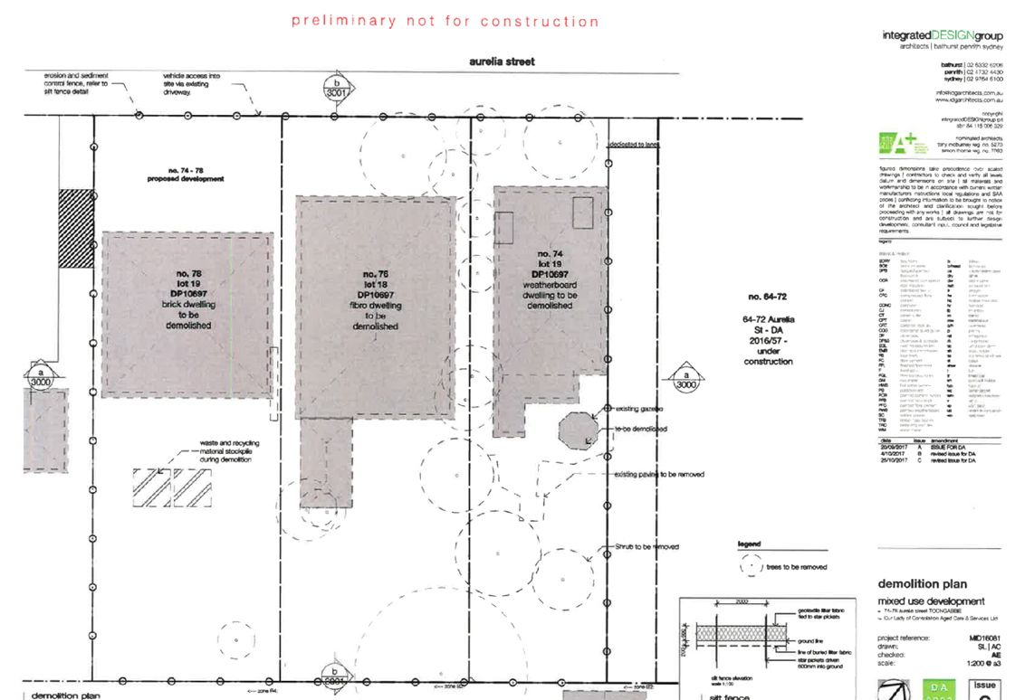
The subject site currently
contains a weatherboard dwelling on 74 Aurelia Street, Toongabbie, fibro
dwelling on 76 Aurelia Street, Toongabbie, and 2 storey brick dwelling on 78
Aurelia Street, Toongabbie, all with ancillary structures. Sixteen (16)
existing trees and shrubs are present on the subject site, which are proposed
to be removed.
The surrounding locality is
characterised as follows:
· North
43 & 45 Aurelia Street, Toongabbie – 5 storey mixed use development
under construction.
· East 64,
66 & 72 Aurelia Street, Toongabbie – Part 4 / Part 5 storey mixed use
development.
· South
& West 80 & 82 Aurelia Street and 35 - 43 Toongabbie
Road, Toongabbie – 3 x 4 storey residential flat buildings.
The topography of the site is
maintained to a 1.5% gradient, with a 1 metre fall from North West to South
East. The site is affected by Probable Maximum Flood (PMF).
The site is zoned B2 Local Centre
associated with the properties 74 & 76 Aurelia Street, Toongabbie, and
zoned R4 High Density Residential associated with the property 78 Aurelia
Street, Toongabbie, pursuant to the Holroyd Local Environmental Plan (LEP)
2013, as shown in Figure 3 below:
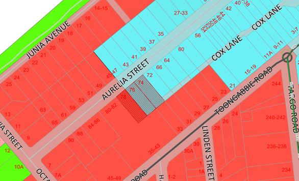
Figure
3 – Zoning Map (Source: Cumberland Council, 2018)
The subject site is situated to
the south of Aurelia Street. Figure 4 below illustrates an aerial perspective
of the site and the general surroundings.
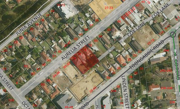
Figure
4 – Aerial Photo (Source: Cumberland Council, 2018)
The subject site is located within
the vicinity of a heritage item, known as St Edna’s Church Hall –
Inter-war Hall, circa 1929 (Item No. 101), located at 27-33 Aurelia Street,
Toongabbie.
Figure 5 below illustrates the
location of the heritage item listed above:
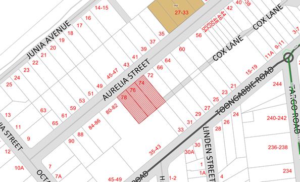
Figure
5 – Heritage Map (Source: Cumberland Council, 2018)
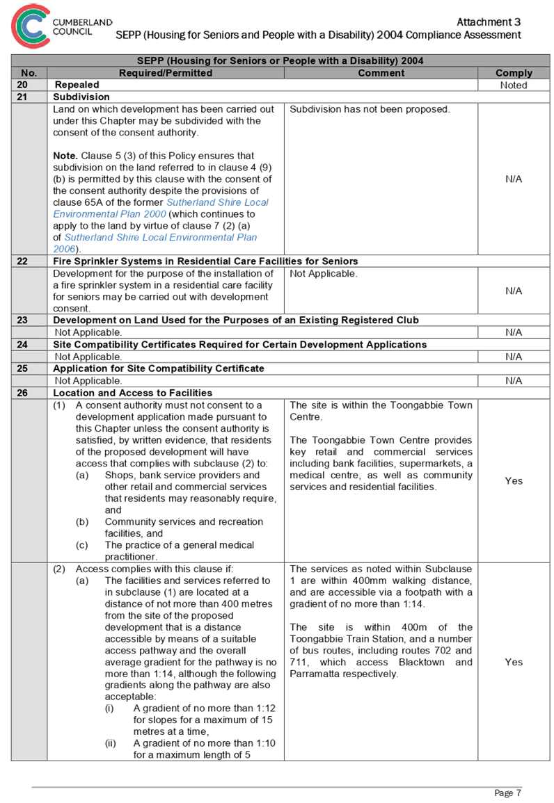
The site is within 400 metres
walking distance to the Wentworthville town centre which is located to the East
of the subject site. Wentworthville town centre provides key retail and
commercial services including bank facilities, supermarkets and a medical
centre.
The site is within 400m of the
Toongabbie Train Station, and a number of bus routes, including routes 702 and
711, which access Blacktown and Parramatta respectively.
Description of The Proposed
Development
The proposal is for demolition of
existing structures, consolidation of 3 lots into 1 lot, construction of a part
4, part 5 storey mixed use development containing seniors housing in the form
of 38 self-contained dwellings and a medical centre over two levels of basement
parking accommodating 37 parking spaces under Housing for Seniors or People
with a Disability SEPP 2004.
Specific details of the proposed development
are as follows:
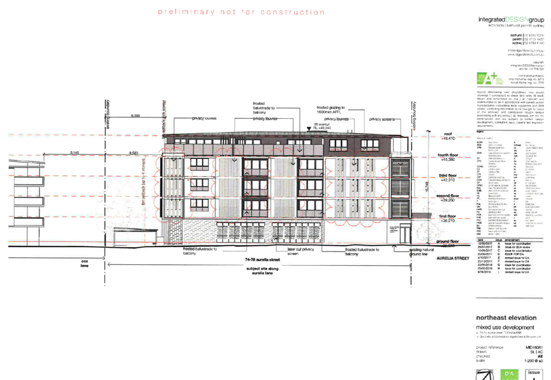
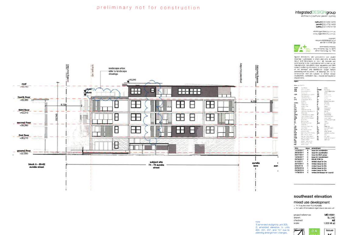
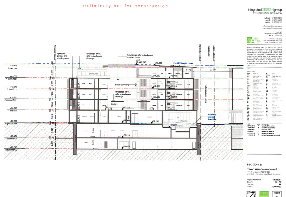
Built Form
The proposal comprises a 5 storey
mixed use building, with ground floor medical centre and hydrotherapy pool, 3
independent living units, and independent living units within the floors above.
The proposed building, as measured to Aurelia Street, maintains a nil setback
within 74 & 76 Aurelia Street, and 6 metre setback within 78 Aurelia
Street. A setback of 5 to 6 metres is maintained to the north-eastern boundary
(inclusive of the Aurelia laneway extension), 9 metres to the south-eastern
boundary, and 3.9 to 6 metres to the north-western boundary.
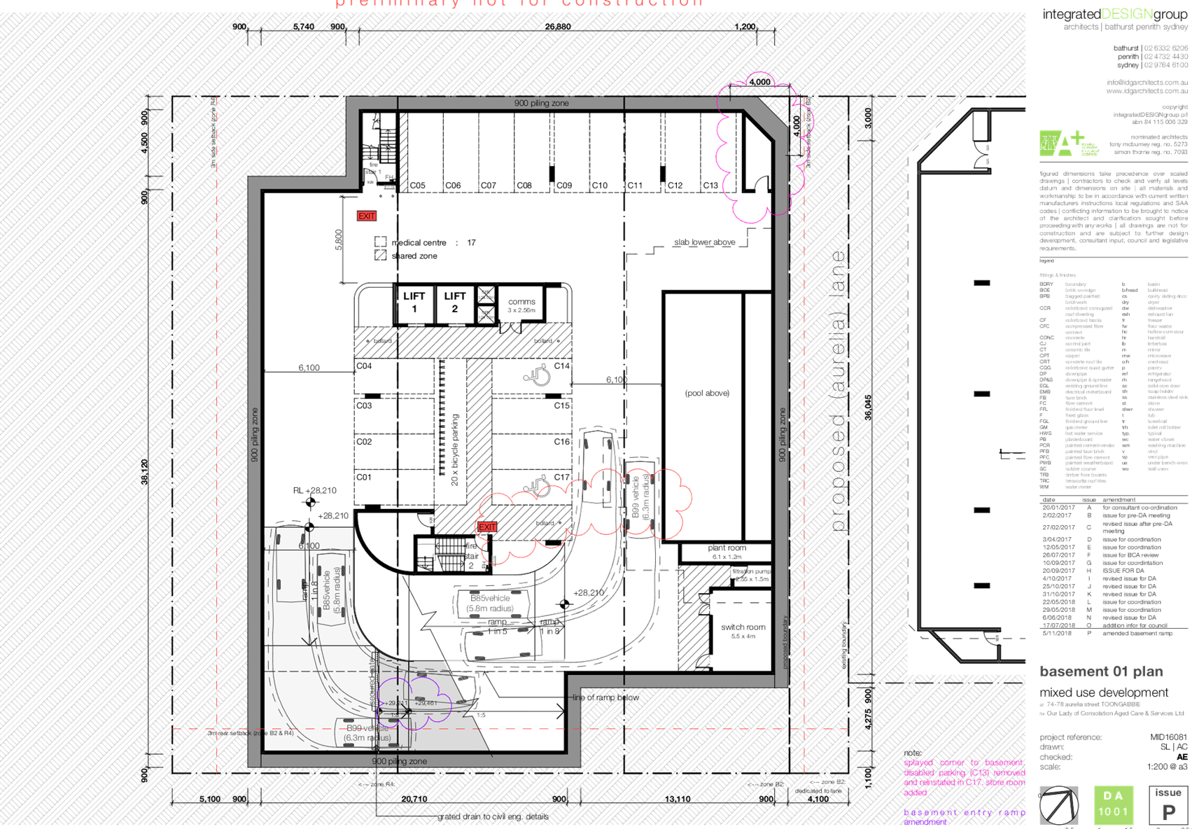
Parking (Basement Levels)
|
|
Basement 1
|
Basement 2
|
Total
|
|
Residential Parking
|
0 spaces
|
18 spaces
(11 accessible)
|
18 spaces
|
|
Retail / Commercial
|
17 spaces
(2 accessible)
|
2 spaces
|
19 spaces
|
|
Bicycle Parking
|
20 spaces
|
5 spaces
|
25 spaces
|
Independent Living Apartment
Mix
|
|
Building
|
Total
|
|
1 Bedroom
|
29
|
29
|
|
2 Bedroom
|
9
|
9
|
|
3 Bedroom
|
0
|
0
|
|
|
Total
|
38
|
|
|
|
|
Access Arrangements
Pedestrian access to the
development is maintained from Aurelia Street. A single core is maintained to
the residential portion of the development, designed to maintain access to the
basement levels and independent living apartments above. The medical centre and
hydrotherapy pool are accessible also from Aurelia Street, with access also
maintained from the basement level car park through the central core.
The proposed development includes
an extension to Aurelia Lane along the north-eastern portion of the site,
maintained to a 4 metre width, which connects Aurelia Street with Cox Lane.
Vehicular access, including loading and unloading functions, is maintained to
Aurelia Lane.
Communal Open Space
The proposal maintains the primary
communal open space areas to a communal courtyard area within first floor, and
rooftop garden. Breakout spaces are also maintained to the central courtyard
within levels 2 and 3, with the overall areas designed to be 486.72m².
Applicants Supporting
Statement
The applicant has provided a
Statement of Environmental Effects prepared by Smyth Planning dated 29 November
2017 and was received by Council on 1 December 2017 in support of the
application.
Additional correspondence was
received by Smyth Planning dated 14 June 2018, 26 June 2018, 5 July 2018, 21
August 2018, and 15 November 2018 in response to Council’s request for
amended plans and additional information.
Contact with Relevant
Parties
The assessing officer has
undertaken an inspection of the subject site and has been in contact with the
applicant throughout the assessment process.
Internal Referrals
Development Engineer
The Development Application was
referred to Council’s Development Engineer for comments, who has advised
that the proposed development is supportable, subject to standard conditions of
consent, which have been imposed within the draft Notice of Determination
provided as Attachment 2 to this report.
Traffic Engineer
The Development Application was
referred to Council’s Traffic Engineer for comments, who has advised that
the proposed development is supportable, subject to standard conditions of
consent, which have been imposed within the draft Notice of Determination
provided as Attachment 2 to this report.
Tree Management Officer
The Development Application was referred
to Council’s Tree Management Officer for comments, who has advised that
the proposed development is supportable, subject to standard conditions of
consent, which have been imposed within the draft Notice of Determination
provided as Attachment 2 to this report.
Environmental Health Officer
The Development Application was
referred to Council’s Environmental Health Officer for comments, who has
advised that the proposed development is supportable, subject to standard
conditions of consent, which have been imposed within the draft Notice of
Determination provided as Attachment 2 to this report.
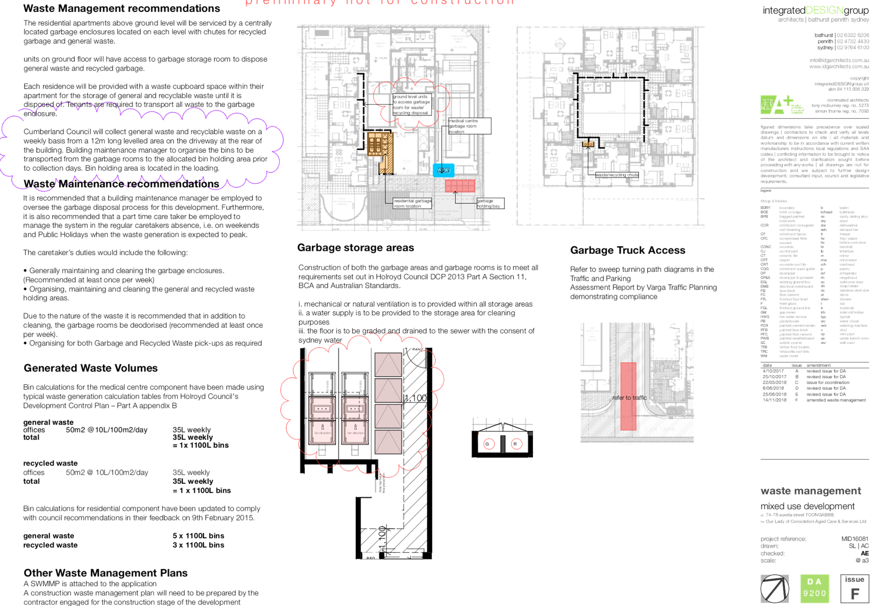
Resource Recovery Officer
The Development Application was
referred to Council’s Resource Recovery Officer for comments, who has
advised that the proposed development is supportable, subject to standard
conditions of consent, which have been imposed within the draft Notice of
Determination provided as Attachment 2 to this report.
Heritage Consultant
The Development Application was
referred to Council’s Heritage Consultant for comments, who has advised
that the proposed development is supportable, as it does not negatively impact
upon the surrounding heritage item.
External Referrals
Endeavour Energy
The Development Application was
referred to Endeavour Energy for comments who has advised that the proposed
development is supported.
Planning Comments
Section 4.15 of the
Environmental Planning and Assessment Act 1979 (EP & A Act)
The provisions of any
Environmental Planning Instruments (EP & A Act s4.15 (1)(a)(i))
The following Environmental
Planning Instruments are relevant to the assessment of the subject modification
application:
(a) State
Environmental Planning Policy No 55 – Remediation of Land (SEPP 55)
The requirement at Clause 7 of
SEPP No. 55 for Council to be satisfied that the site is suitable or can be
made suitable to accommodate the proposed development has been considered in
the following table:
|
Matters for consideration
|
Yes
|
No
|
N/A
|
|
Does the application involve re-development of the site or
a change of land use?
|
|
|
|
|
Is the development going to be used for a sensitive land
use (e.g.: residential, educational, recreational, childcare or hospital)?
|
|
|
|
|
Does information available to you indicate that an
activity listed below has ever been approved, or occurred at the site?
acid/alkali plant and formulation,
agricultural/horticultural activities, airports, asbestos production and
disposal, chemicals manufacture and formulation, defence works, drum
re-conditioning works, dry cleaning establishments, electrical manufacturing
(transformers), electroplating and heat treatment premises, engine works,
explosive industry, gas works, iron and steel works, landfill sites,
metal treatment, mining and extractive industries, oil production and
storage, paint formulation and manufacture, pesticide manufacture and
formulation, power stations, railway yards, scrap yards, service stations,
sheep and cattle dips, smelting and refining, tanning and associated trades,
waste storage and treatment, wood preservation.
|
|
|
|
|
Is the site listed on Council's Contaminated Land
Database?
|
|
|
|
|
Is the site subject to EPA clean-up order or other EPA
restrictions?
|
|
|
|
|
Has the site been the subject of known pollution incidents
or illegal dumping?
|
|
|
|
|
Does the site adjoin any contaminated land/previously
contaminated land?
|
|
|
|
|
Has the appropriate level of investigation been carried
out in respect of contamination matters for Council to be satisfied that the
site is suitable to accommodate the proposed development or can be made
suitable to accommodate the proposed development?
|
|
|
|
|
Details of contamination investigations carried out at
the site:
The site is not
identified in Council’s records as being contaminated. A site
inspection reveals the site does not have any obvious history of a previous land
use that may have caused contamination and there is no specific evidence that
indicates the site is contaminated. The subject site is currently used for
residential purposes and contamination is not expected.
|
(b) State
Environmental Planning Policy (Housing for Seniors or People with a Disability)
2004
SEPP (Housing for Seniors or
People with a Disability) 2004 aims to provide access to affordable housing for
older people, people with disability and those on low income.
The proposed development has been
assessed and found to comply with the provisions of the SEPP (Housing for
Seniors or People with a Disability) 2004. A comprehensive assessment against
the provisions of the SEPP (Housing for Seniors or People with a Disability)
2004 has been undertaken, and is provided at Attachment 3.
(c) State
Environmental Planning Policy No 65 – Design Quality of Residential
Apartment Development (SEPP 65)
SEPP 65 and the associated
Apartment Design Guide (ADG) apply to the assessment of the subject application
as it includes residential flat buildings that are 3 storeys or more in height
and contain more than 4 dwellings.
The Development Application has
been accompanied by a Design Verification Statement from a Registered Architect.
The proposed development has been assessed and found to comply with the
requirements of SEPP 65 and the ADG, with the exception of building separation,
ceiling heights, and the maximum number of units per core, which is discussed
below. A comprehensive assessment against the ADG is contained in Attachment 4
to this report.
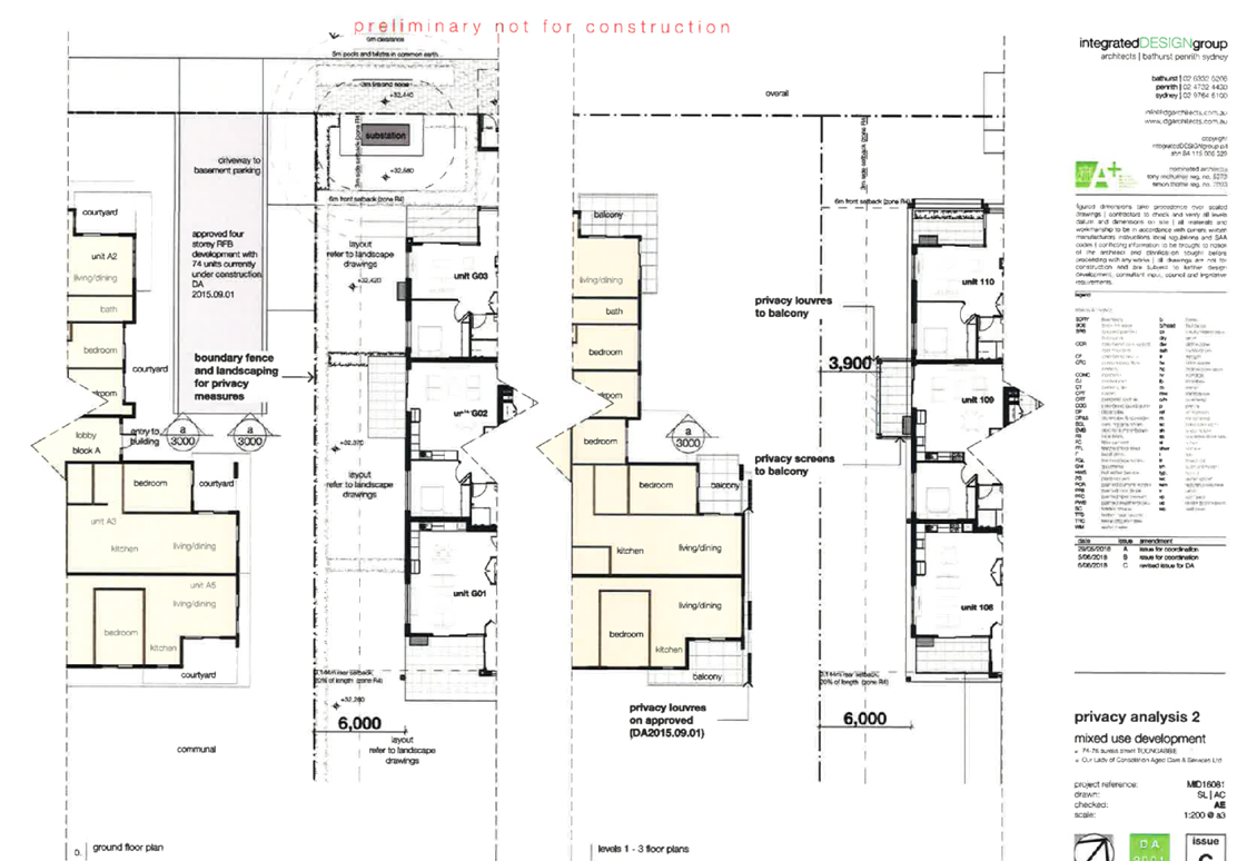
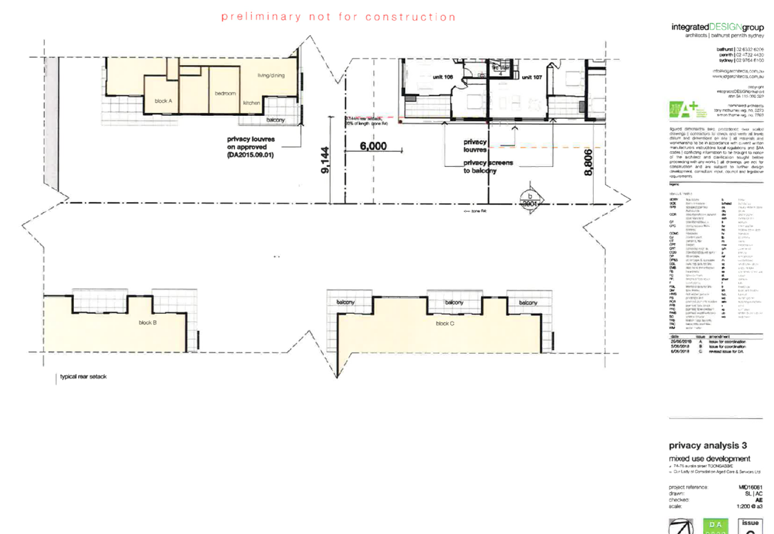
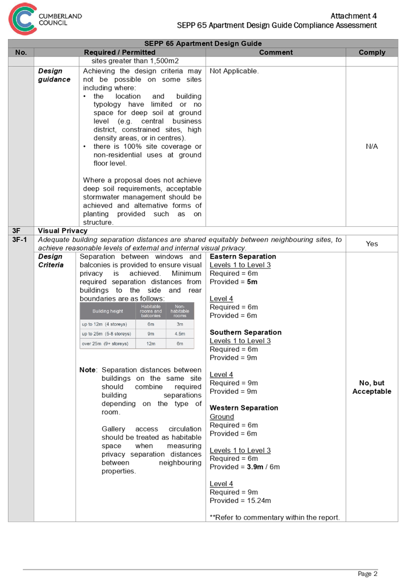
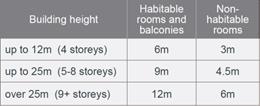
Building Separation
· The
ADG requires a minimum separation distance for buildings to side and rear
boundaries of 6 metres, for the first four storeys, as measured to habitable
rooms and balconies. In this regard, the following variations are noted:
· Along
the north-eastern elevation of the building, a setback of 5 metres has been
designed to balconies of Units 103, 106, 203, 206, 303 and 306, and the living
rooms of Units 104, 105, 204, 205, 304, and 305; and
· Along
the south-western elevation of the building, a setback of 3.9 metres has been
designed to the balconies of Units 109, 209, and 309.
The proposed variations achieve
the aims and objectives of the ADG, and are considered supportable on their
merits, noting:
· The
projecting elements have been designed to achieve the required amount of solar
access to the development, due to the orientation of the site, and minimum
balcony sizes, as per the ADG. The areas in question provide articulation to a
façade, which would otherwise be continuous in form, and void of visual
interest.
· Privacy
screening has been designed to the living room and balcony areas in question,
and where possible, openings and balconies have been offset from those of
adjoining developments. In the case of the balconies along the south-western
elevation, a separation in excess of 12 metres, as measured building to
building, has been achieved.
Ceiling Heights
· The
ADG requires the first floor of a mixed use building to have a floor to ceiling
height measuring 3.3 metres. In this regard, the floor to ceiling height
associated with first floor is maintained to 2.75 metres.
A statement has been provided by
the Applicant, in response to the above variation, which is noted as follows:
A 3.3m ceiling height would
impose additional costs without any social / economic benefit. The purpose of
the senior’s housing development is to provide much needed affordable
rental housing specifically designed to seniors who need low cost rental
housing in a town centre, close to transport and services which may otherwise
be unaffordable for this vulnerable part of the community. The development is
to be owned and managed by a charity aged care organisation who will provide
seniors support services to the residents, so that unnecessarily increasing
construction costs is not in the public interest.
The Applicant’s written
justification submitted to the variation of ceiling heights is considered well
founded, and supportable on its merits. Council is also not aware of any market
demand for first floor level commercial uses, and the proposed floor to ceiling
heights are consistent with recently approved developments within the locality.
Number of Units per Core
· The
ADG requires the maximum number of apartments off a circulation core on single
level to be eight. In this regards, the maximum number of units per core on
levels 1, 2 and 3, is maintained to 10 units.
A statement has been provided by
the Applicant, in response to the above variation, which is noted as follows:
The ADG is written on the basis
of “residential flat buildings” which may be occupied by residents
who may have no social connection. In contrast, the development is intended to
facilitate social connection by providing opportunities within each floor level
(e.g. small nooks for table / seating and larger communal areas with community
facilities to promote socialisation of the elderly residents, many of whom will
be single and / or without supporting family members). The development is
proposed for rental by less affluent seniors, and is not proposed to be strata
subdivided / owner occupied. Thus facilitating any / all opportunities for
social interaction is an important design objective for this type of
development. The provision of 2 x lifts per floor (in effect 1 lift serving 5
units), will minimise wait times and provides a “spare lift” in the
event that a lift is closed for maintenance. Thus having 10 not 8 units per
floor combined with 2 x lifts is considered to be a positive feature of the
development.
The Applicant’s written
justification submitted to the variation of number of units per core is
considered well founded, and supportable on its merits.
(d) State
Environmental Planning Policy (Infrastructure) 2007 (ISEPP)
The provisions of the ISEPP 2007
have been considered in the assessment of the Development Application.
Clause 45 - Development likely
to affect an electricity transmission or distribution network
The subject development occurs
within 5 metres of an overhead electricity power line and the proposed
development also includes a substation. As such, the Consent Authority is
required to give written notice to an electricity supply authority. The
Development Application was referred to Endeavour Energy, who advised that the
modified development proposal is supported.
(e) State
Environmental Planning Policy (Building Sustainability Index: BASIX) 2004
A BASIX Certificate has been
lodged as a part of the Development Application. The BASIX certificate indicates
that the development has been designed to achieve the required water, thermal
comfort and energy scores.
(f) State
Environmental Plan (Sydney Harbour Catchment) 2005
The subject site is identified as
being located within the area affected by the Sydney Environmental Plan (Sydney
Harbour Catchment) 2005. The proposed development raises no issues, as no
impact on the catchment is envisaged.
Note: The subject site is not
identified in the relevant map as land within the ‘Foreshores and
Waterways Area’ or ‘Wetland Protection Zone’, is not a
‘Strategic Foreshore Site’ and does not contain any heritage items.
Hence the majority of the State Environmental Plan is not directly relevant to
the proposed development.
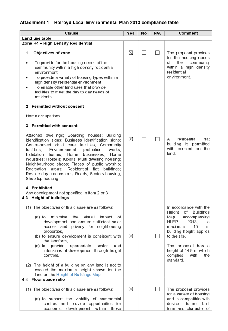
(g) Holroyd
Local Environmental Plan 2013 (HLEP 2013)
The provision of the HLEP 2013 is
applicable to the development proposal. It is noted that the development
achieves compliance with the key statutory requirements of the HLEP 2013 and
the objectives of the B2 Local Centre and R4 High Density Residential zoning.
Permissibility
· The
site is zoned B2 Local Centre associated with the properties 74 & 76
Aurelia Street, Toongabbie, and zoned R4 High Density Residential associated
with the property 78 Aurelia Street, Toongabbie. The proposed development is defined
as a mixed use development, comprising seniors housing across the site, and a
ground floor medical centre within 74 & 76 Aurelia Street, Toongabbie. The
proposed development is permissible with consent.
Mixed use development means a
building or place comprising 2 or more different land uses.
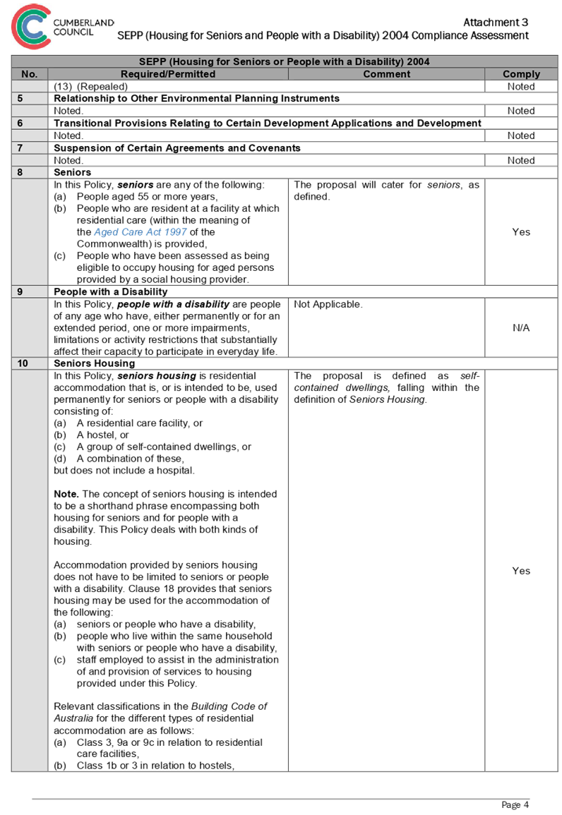
Seniors housing means a building
or place that is:
(a) a
residential care facility, or
(b) a
hostel within the meaning of clause 12 of State Environmental Planning Policy
(Housing for Seniors or People with a Disability) 2004, or
(c) a
group of self-contained dwellings, or
(d) a
combination of any of the buildings or places referred to in paragraphs
(a)–(c),
and that is, or
is intended to be, used permanently for:
(e) seniors
or people who have a disability, or
(f) people
who live in the same household with seniors or people who have a disability, or
(g) staff
employed to assist in the administration of the building or place or in the
provision of services to persons living in the building or place,
but does not include a hospital.
Note. Seniors
housing is a type of residential accommodation.
Medical centre means premises that
are used for the purpose of providing health services (including preventative
care, diagnosis, medical or surgical treatment, counselling or alternative
therapies) to out-patients only, where such services are principally provided
by health care professionals. It may include the ancillary provision of other
health services.
Note: Medical centres are a type
of health services facility.
The relevant matters to be
considered under HLEP 2013 and the applicable clauses for the proposed
development are summarised below. A comprehensive LEP assessment is contained
in Attachment 5 to this report.
|
Development Standard
|
Proposed
|
Compliance
|
|
Height of Buildings
17 metres (Across the site)
|
16.84 metres
|
Yes
|
|
Floor Space Ratio
74 & 76 Aurelia – 2:1
78 Aurelia – 1.2:1
|
1.88:1
1.16:1
|
Yes
|
The provisions of any Proposed
Instruments (EP & A Act s4.15 (1)(a)(ii))
The following draft Environmental
Planning Instruments are relevant to the assessment of the subject modification
application:
(a) Draft
State Environmental Planning Policy (Environment)
The draft SEPP relates to the
protection and management of our natural environment with the aim of
simplifying the planning rules for a number of water catchments, waterways,
urban bushland, and Willandra Lakes World Heritage Property. The changes
proposed include consolidating the following seven existing SEPPs:
· State
Environmental Planning Policy No. 19 – Bushland in Urban Areas.
· State
Environmental Planning Policy (Sydney Drinking Water Catchment) 2011.
· State
Environmental Planning Policy No. 50 – Canal Estate Development.
· Greater
Metropolitan Regional Environmental Plan No. 2 – Georges River Catchment.
· Sydney
Regional Environmental Plan No. 20 – Hawkesbury-Nepean River (No.2-1997).
· Sydney
Regional Environmental Plan (Sydney Harbour Catchment) 2005.
· Willandra
Lakes Regional Environmental Plan No. 1 – World Heritage Property.
The draft policy will repeal the
above existing SEPPs and certain provisions will be transferred directly to the
new SEPP, amended and transferred, or repealed due to overlaps with other areas
of the NSW planning system.
As noted within the assessment
above under the heading ‘State Environmental Plan (Sydney Harbour
Catchment) 2005’, the proposed development raises no issues, as no impact
on the catchment is envisaged.
The provisions of any
Development Control Plans (EP & A Act s4.15 (1)(a)(iii))
The following Development Control
Plans are relevant to the assessment of the subject modification application:
(a) Holroyd
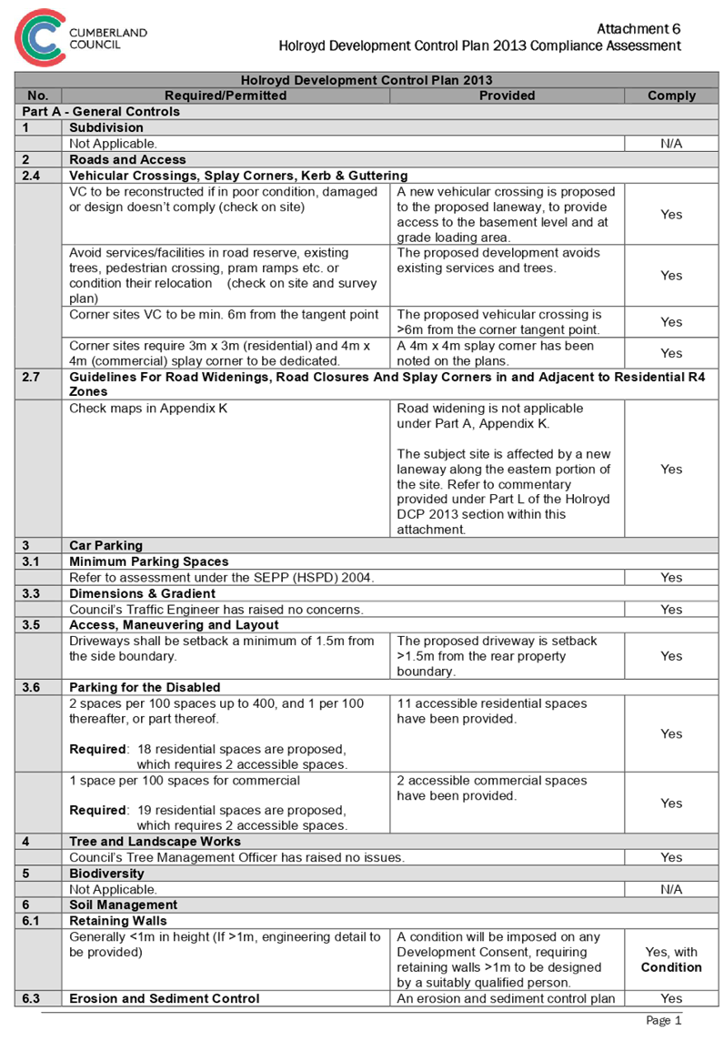
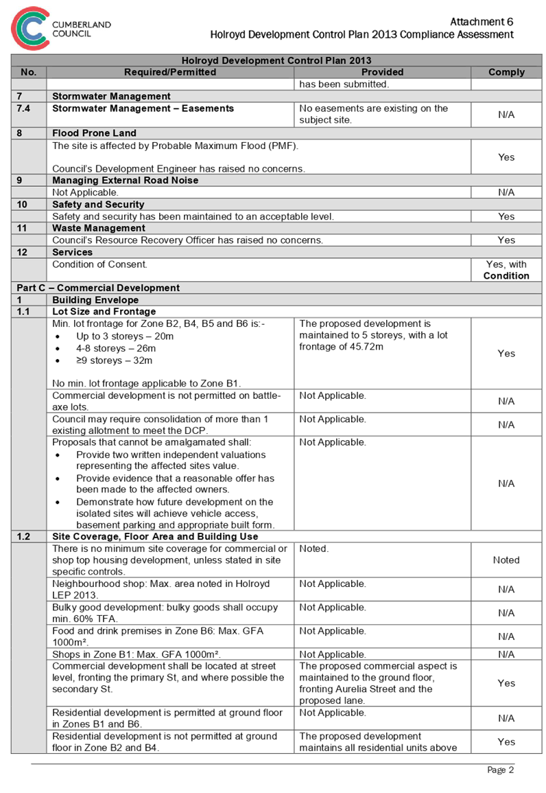
Development Control Plan 2013 (HDCP 2013)
The HDCP 2013 applies to the
subject site. The proposed development has been assessed and found to comply
with the provisions of the Holroyd DCP 2013, with the exception of the maximum
building height in storeys, and street wall height, which is discussed below. A
comprehensive assessment against the provisions of the Holroyd DCP 2013 is
contained in Attachment 6 to this report.
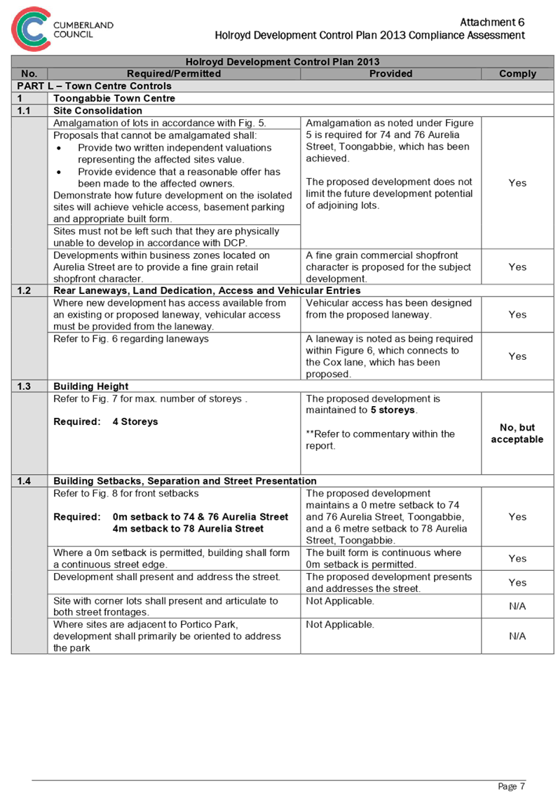
Building Height in Storeys
· The
HDCP 2013 requires the maximum building height in storeys to be 4 storeys,
where a maximum permitted building height under the Holroyd LEP 2013 is 17
metres, to which the subject site benefits from. In this regard, the proposal
is maintained to 5 storeys.
The proposed variation achieve the
aims and objectives of the Holroyd DCP 2013, and is considered supportable on
its merits, noting:
· The
proposal is compliant with the Holroyd LEP 2013 height of building development
standard, with a measurement of 16.84 metres.
· The
built form responds to character of the area, in particular recently approved
developments to the immediate north and east of the site, as listed below:
· North
43 & 45 Aurelia Street, Toongabbie – 5 storey mixed use development
under construction.
· East 64,
66 & 72 Aurelia Street, Toongabbie – Part 4 / Part 5 storey mixed use
development.
Street Wall Height
· The
HDCP 2013 requires the proposed development to adhere to an upper storey
setback above the 3rd floor. In this regard, the proposed development maintains
a 4th storey street wall height, and upper storey setback to the 5th storey.
The proposed variation achieve the
aims and objectives of the Holroyd DCP 2013, and is considered supportable on
its merits, noting recently approved surrounding developments do no adhere to
an upper storey setback above the 3rd floor, rather, they typically provide an
upper storey setback to the 5th storey. This is prevalent in the case of the
adjoining eastern mixed use development at 64, 66 & 72 Aurelia Street,
Toongabbie, and directly opposite mixed use development at 43 & 45 Aurelia
Street, Toongabbie. As such, the development is considered to provide an
acceptable presentation, which is consistent with the future streetscape of
Aurelia Street.
The provisions of any planning
agreement that has been entered into under section 7.4, or any draft planning
agreement that a developer has offered to enter into under section 7.4 (EP
& A Act s4.15(1)(a)(iiia))
There is no planning agreement or
draft planning agreement associated with the subject Modification Application.
The provisions of the
Regulations (EP & A Act s4.15 (1)(a)(iv))
The proposed development raises no
concerns as to the relevant matters arising from the Environmental Planning and
Assessment Regulations 2000 (EP & A Regs).
The Likely Environmental,
Social or Economic Impacts (EP & A Act s4.15 (1)(b))
It is considered that the proposed
development will have no significant adverse environmental, social or economic
impacts in the locality.
The suitability of the site for
the development (EP & A Act s4.15 (1)(c))
The subject site and locality is
not known to be affected by any natural hazards or other site constraints
likely to have a significant adverse impact on the proposed development.
Accordingly, it is considered that the development is suitable in the context
of the site and surrounding locality.
Submissions made in accordance
with the Act or Regulation (EP & A Act s4.15 (1)(d))
Advertised (newspaper) Mail Sign
Not
Required
In accordance with Council’s
Notification requirements contained within the Holroyd DCP 2013, the proposal
was publicly notified for a period of 35 days from 20 December 2017 to 24
January 2018, inclusive of an additional 14 days, accounting for the Christmas
/ New Year period. In response, no submissions were received.
Amended plans were received during
the process of the application, which, due to the minor nature of the changes
proposed, and lack of submissions received during the first notification, did
not warrant re-notification.
The public interest (EP
& A Act s4.15(1)(e))
The public interest is served by
permitting the orderly and economic use of land, in a manner that is sensitive
to the surrounding environment and has regard to the reasonable amenity
expectations of surrounding land users. In view of the foregoing analysis, it
is considered that approval of the proposed development would not be contrary
to the public interest.
Section 7.11 (Formerly S94
Contributions)
The subject development requires
the payment of contributions in accordance with Holroyd Section 94 Development
Contributions Plan 2013. In accordance with the currently indexed rates for the
Toongabbie Centre contribution area, the following contributions apply:
· 442.3m2
of commercial gross floor area x $13 = $5,749.90
The current rate of the required
contribution is $5,749.90. The draft Notice of Determination provided as
Attachment 2 includes a recommendation to impose the contribution amount.
9.2 In accordance with
Ministerial Direction ‘Environmental Planning and Assessment Act 1979
(Revocation of Direction in force under Section 94E and Direction under Section
94E)’, dated 14 September 2017, the seniors living component of the
subject development is exempt from payment of Section 7.11 contributions, as
the Application is made under SEPP (Housing and Seniors or People with a
Disability) 2004, by a social housing provider.
Disclosure of Political
Donations and Gifts
The NSW Government has introduced
disclosure requirements for individuals or entities with a relevant financial
interest as part of the lodgement of various types of development proposals and
requests to initiate environmental planning instruments or development control
plans.
The application and notification
process did not result in any disclosure of Political Donations or Gifts.
The proposed development has been
assessed against the matters for consideration listed in Section 4.15 of the EP
& A Act, 1979, and is considered to be satisfactory. Any likely impacts of
the development have been satisfactorily addressed and the proposal is
considered to be in the public interest.
The proposed development is
consistent with the objectives of Holroyd LEP 2013, and is permissible in the
zone with Development Consent. The proposal also complies with the Holroyd DCP
2013, with the exception of the maximum building height in storeys, and street
wall height requirements, with the variation considered supportable on its
merits.
There are no further consultation
processes for Council associated with this report.
There are no further financial
implications for Council associated with this report.
There are no policy implications
for Council associated with this report.
Communication /
Publications:
The final outcome of this matter
will be notified in the newspaper. The objectors will also be notified in
writing of the outcome.
|
That Development Application
2017/513/1 seeking demolition of existing structures, consolidation of 3 lots
into 1 lot, construction of a part 4, part 5 storey mixed use development
containing seniors housing in the form of 38 self-contained dwellings and a
medical centre over two levels of basement parking accommodating 37 parking
spaces under Housing for Seniors or People with a Disability SEPP 2004
at 74, 76 & 78 Aurelia Street, Toongabbie, be Approved, subject to the
conditions contained in Attachment 2 of this report.
|
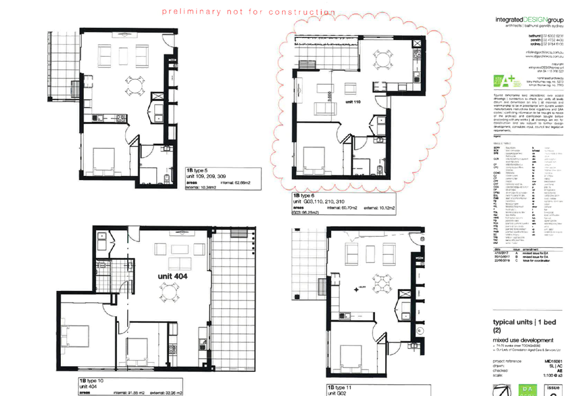
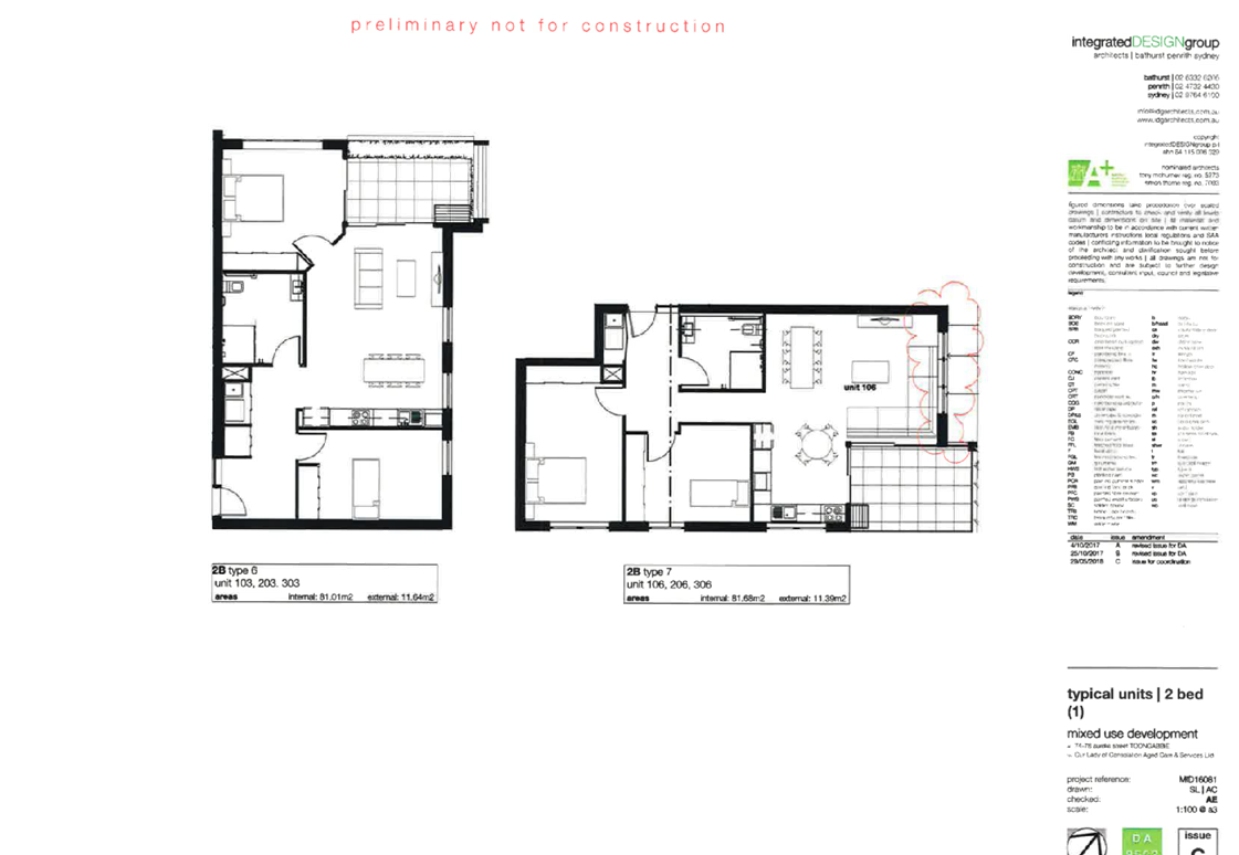
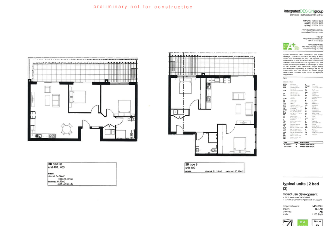
1. Architectural
Plans ⇩ 
2. Draft
Notice of Determination ⇩
3. SEPP
(Housing for Seniors and People with Disability) 2004 Compliance Assessment ⇩
4. SEPP
65 Apartment Design Guide Compliance Assessment ⇩
5. Holroyd
Local Environmental Plan 2013 Compliance Assessment ⇩
6. Holroyd
Development Control Plan 2013 Compliance Assessment ⇩
Cumberland
Local Planning Panel Meeting
13 February 2019
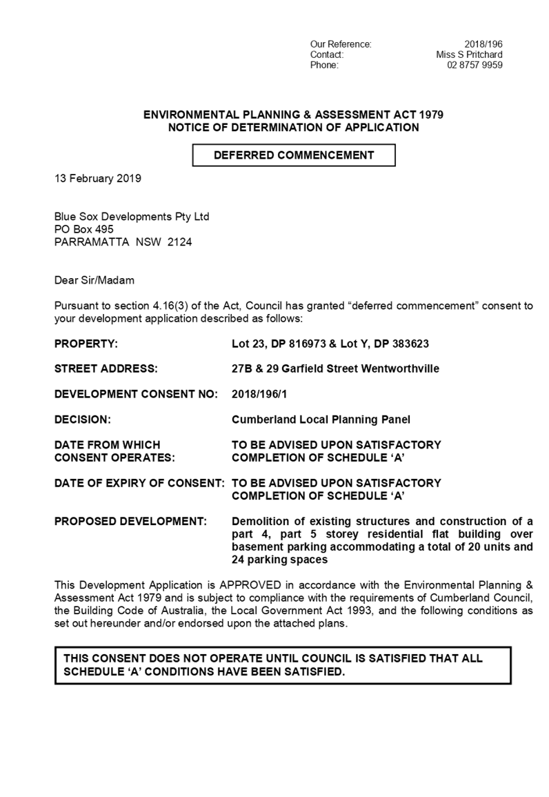
Item No: LPP004/19
Development
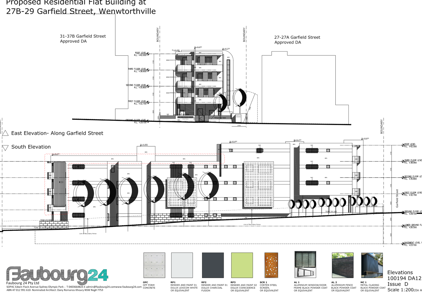
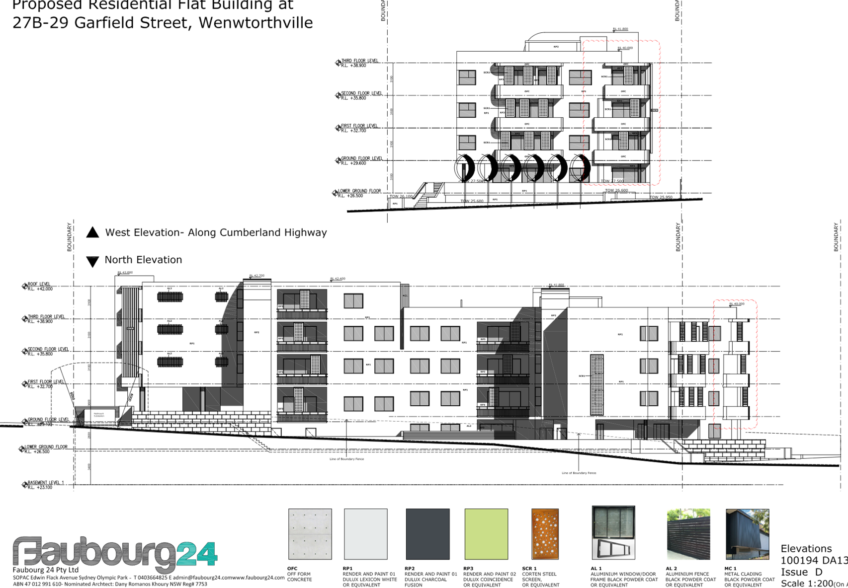
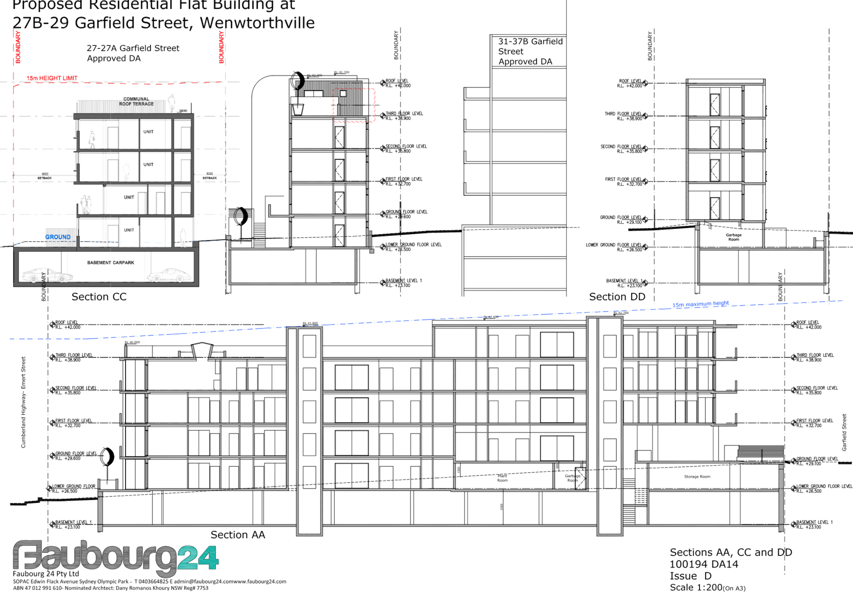
Application for 27B & 29 Garfield Street, Wentworthville
Responsible
Division: Environment
& Planning
Officer: Manager
Development Assessment
File
Number: 2018/196
|
Application lodged
|
8 June 2018
|
|
Applicant
|
Blue Sox Developments Pty Ltd
|
|
Owner
|
Blue Sox Developments Pty Ltd
|
|
Application No.
|
2018/196
|
|
Description of land
|
27B & 29 Garfield Street Wentworthville
|
|
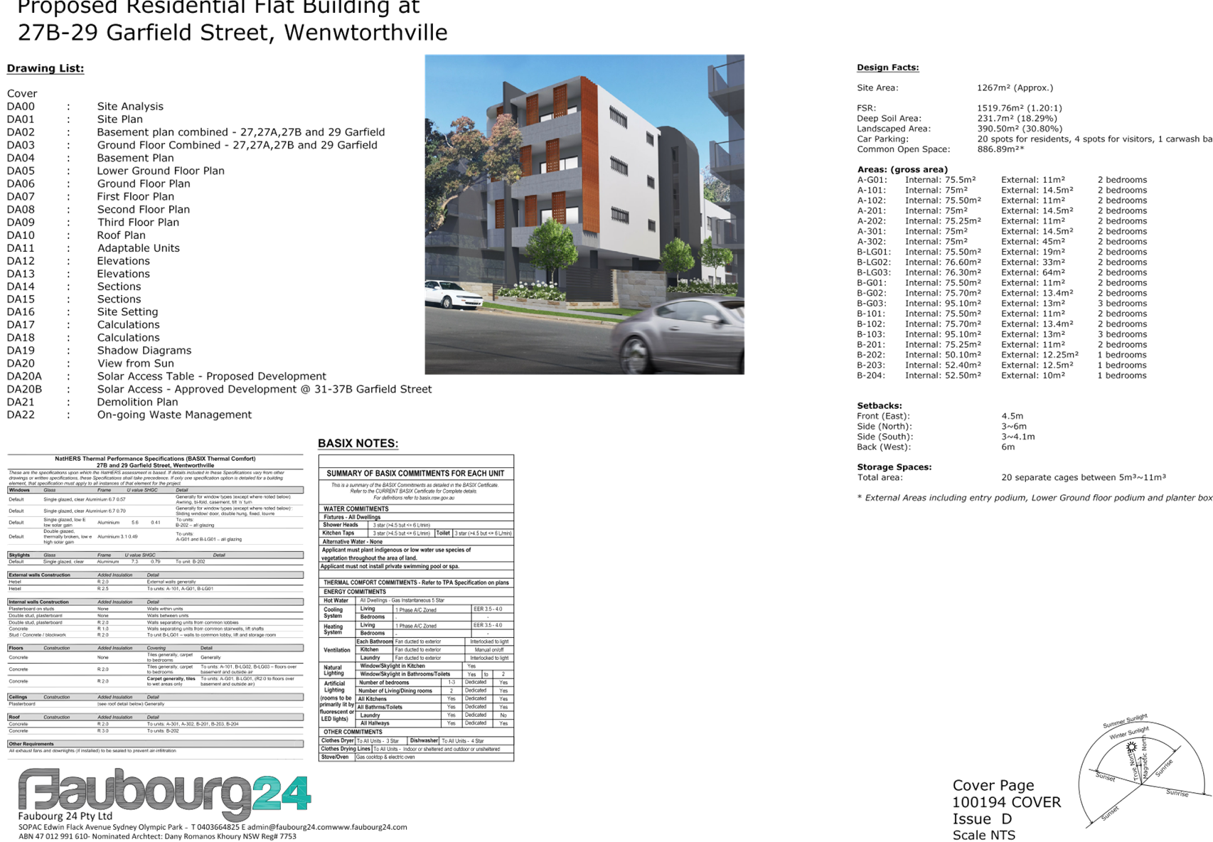
Proposed development
|
Demolition of existing structures and construction of a
part 4, part 5 storey residential flat building over basement parking
accommodating a total of 20 units and 24 parking spaces
|
|
Site area
|
1267.2 m2
|
|
Zoning
|
R4 – High Density Residential
|
|
Disclosure of political donations and gifts
|
Nil disclosure
|
|
Heritage
|
The site is not a heritage item and is not located
within a heritage conservation area
|
|
Principal development standards
|
Height of Buildings – 15 m
Floor Space Ratio – 1.2:1
|
|
Issues
|
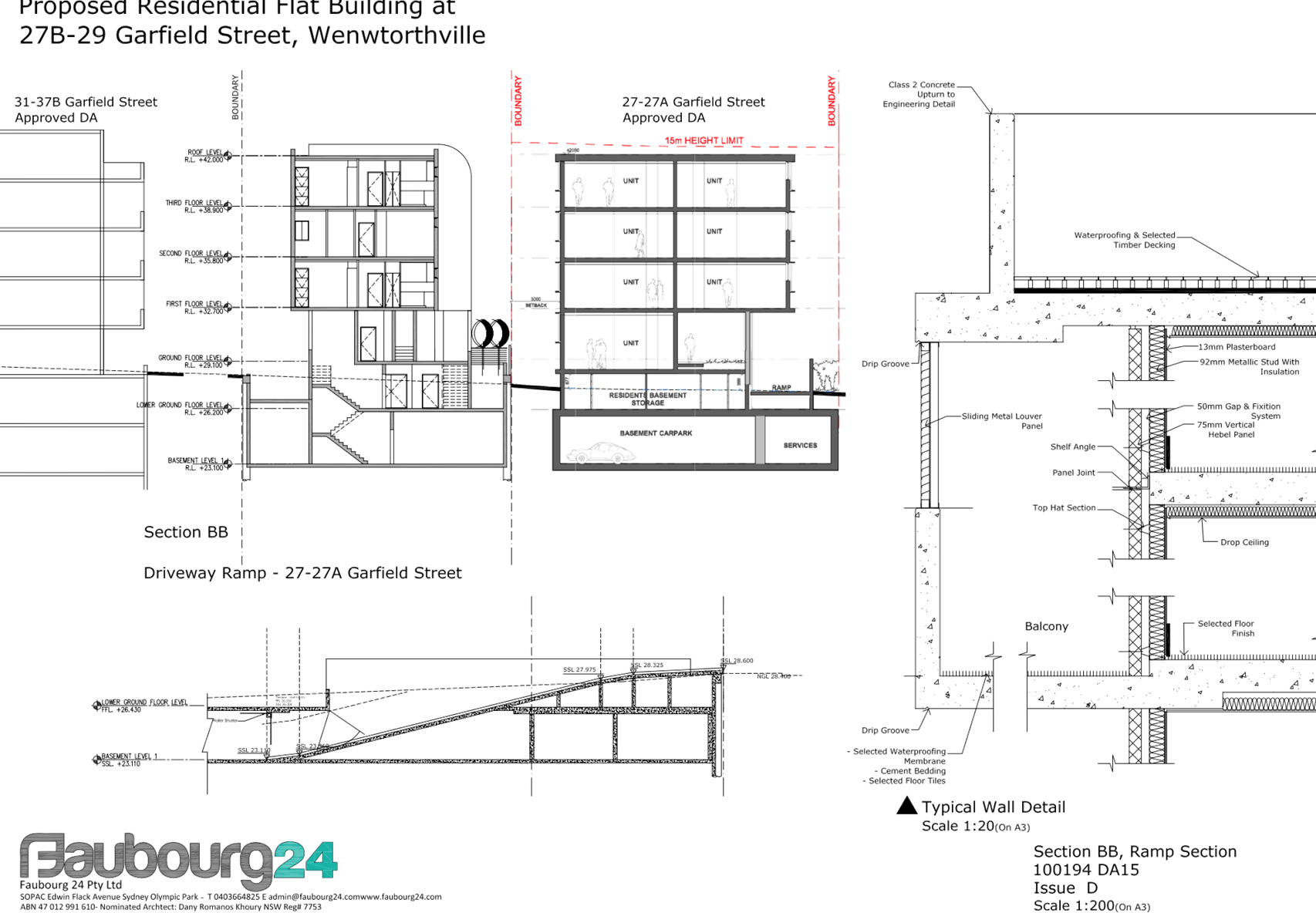
· Building separation
· Landscape non-compliance
· Overshadowing
|
1. The
subject application was lodged on 8 June 2018 and notified to surrounding
properties from 27 June to 18 July 2018. No submissions were received.
2. The
application was deferred on 28 November 2018 due to non-compliances with the
FSR standard, ADG apartment size controls, visual bulk of the proposal,
inappropriate privacy treatment to habitable rooms, and inconsistencies between
the landscape and stormwater plans. Additional information was also sought
regarding overshadowing of the approved development to the south.
3. Additional
information and amended plans to address the deferral items were submitted on
18 December 2018. The amended plans provided for compliance with the FSR
standard as a result of relocation of the waste storage area and plant room,
and deletion of the lobby at lower ground floor. The amended plans also
addressed the majority of the concerns regarding ADG non-compliances. The
amended plans were not required to be renotified as there were no additional
impacts resulting from the amendments.
4. Further
information was requested and received from the applicant in January 2019 to
address concerns regarding overshadowing of the approved development to the
south of the subject site.
5. The
site is isolated in that it does not meet the minimum frontage required for a
residential flat development. However, there are no reasonable opportunities
for amalgamation with adjacent sites.
6. The
application is being reported to the Cumberland Local Planning Panel (CLPP) for
determination as it is a development with more than 4 storeys to which the
State Environmental Planning Policy No 65 – Design Quality of Residential
Apartment Developments applies.
7. The
subject application has been assessed against the relevant provisions of the
Environmental Planning and Assessment Act 1979, State Environmental Planning
Policy No 65 – Design Quality of Residential Apartment Development,
Holroyd Local Environmental Plan (HLEP) 2013 and Holroyd Development Control
Plan (HDCP 2013).
8. The
application involves the following numerical non-compliances which are
considered supportable as discussed in detail elsewhere in the report:
|
Control
|
Required
|
Proposed
|
% Variation
|
|
Building separation
(ADG)
|
9 m
|
3 m
|
66%
|
|
Living room width (ADG)
|
4 m
|
3.72 m
|
7%
|
|
POS for ground floor
units (ADG)
|
15 m2 with 3 m min dimensions
|
14 m2 with minimum 3 m dimensions
|
6%
|
|
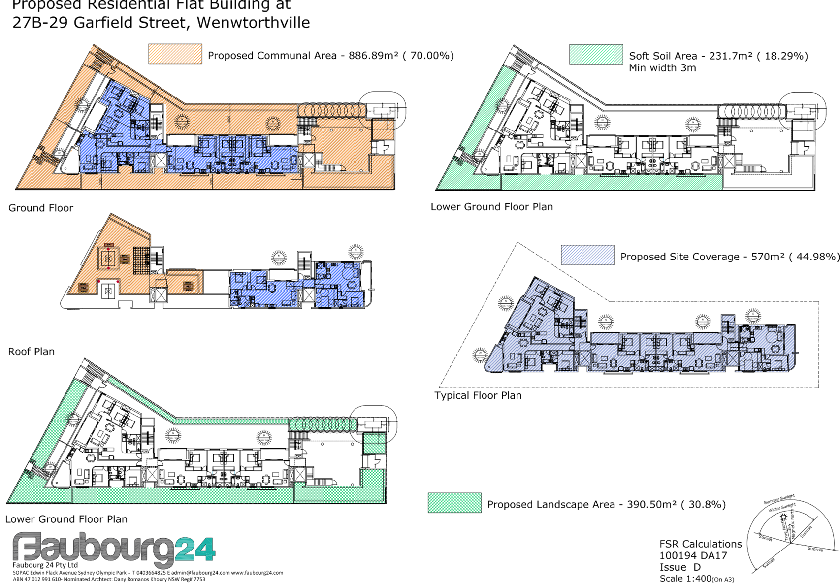
Landscape area (DCP)
|
30% (380.6 m2)
|
13.7% (174.4 m2)
|
54%
|
|
Lot frontage (DCP)
|
Minimum 24 m
|
16.52 m
|
31%
|
|
Site coverage (DCP)
|
Max 30% (1782.3 m2)
|
38% (1897.73m2)
|
6.4%
|
|
Front setback (DCP)
|
6 m
|
4.505
|
24.9%
|
|
Rear setback (DCP)
|
20% (14.579 m)
|
7.6% (5.6 m)
|
61.5%
|
|
Side setback (DCP)
|
3 m
|
2.5 m
|
16%
|
|
Basement setback (DCP)
|
3 m
|
0 m
|
100%
|
|
Number of storeys
|
4
|
5 (technical non-compliance due to basement protrusion)
|
20%
|
9. The
application is recommended for approval subject to the conditions in the draft
determination at attachment 4.
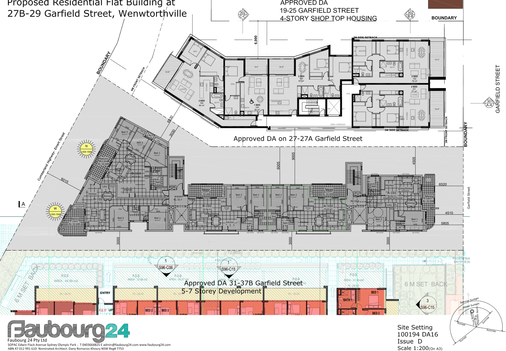
Subject Site and Surrounding
Area
The subject site is known as 27B
& 29 Garfield Street Wentworthville and is legally described as lot 23 in
DP 816973 and lot Y in DP 383623. The site has an area of 1267.2 m2 and
frontage of 16.52 m to Garfield Street and 31.755 m to Emert Street (Cumberland
Highway). The site is located opposite the intersection of Garfield Street and
McKern Street. There is currently a single storey dwelling located on each of
the existing sites. There are a number of established trees on the subject site
and within the adjacent road reserve. The site falls approximately 4 m towards
the western boundary.
The site is zoned R4 – High
Density Residential, as are neighbouring sites to the north and south. The land
on the opposite side of Garfield Street is zoned R2 – Low Density
Residential.
The subject site does not contain
any heritage items and is not within a heritage conservation area. However,
there are a number of local heritage items within proximity of the subject
site. There is significant physical separation between the subject site and the
local heritage items and the proposed development will have no impact on the
setting or significance of any of the items.
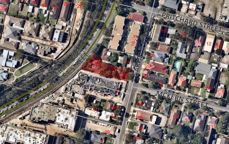
Aerial
view of the locality with subject site shown hatched. Source: Cumberland
Council 2018
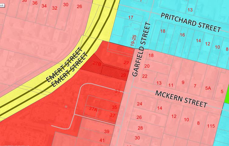
Zoning
map with subject site shown hatched. Source: Cumberland Council 2018
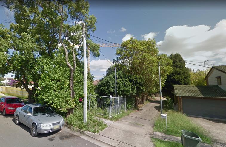
Subject
site – view from Garfield Street. Source: Google Maps 2018
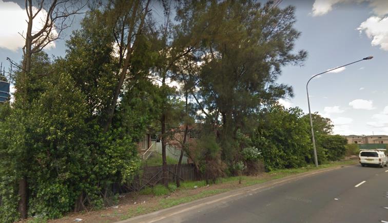
Subject
site – Emert Street frontage. Source: Google Maps 2018
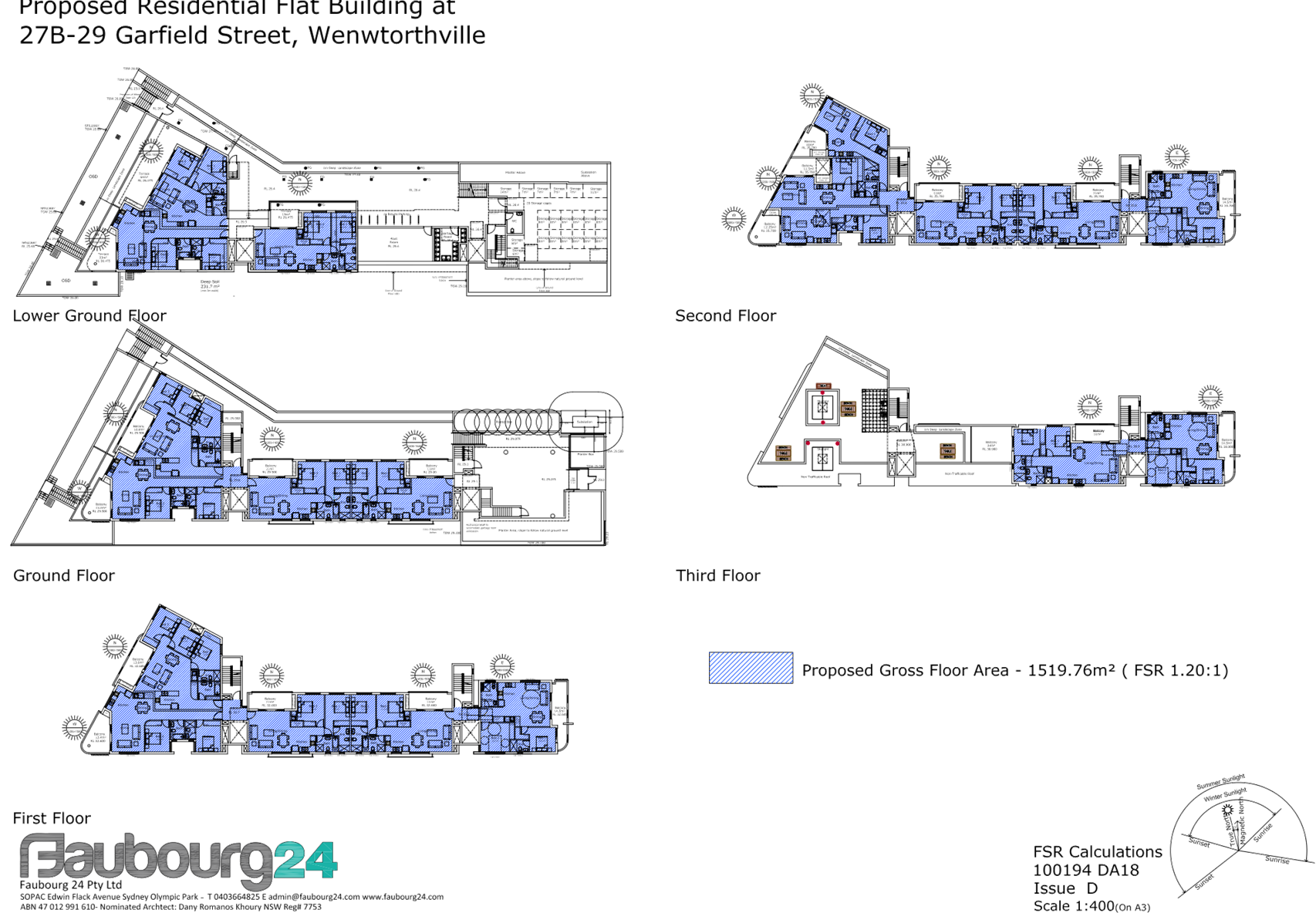
Description of the Proposed
Development
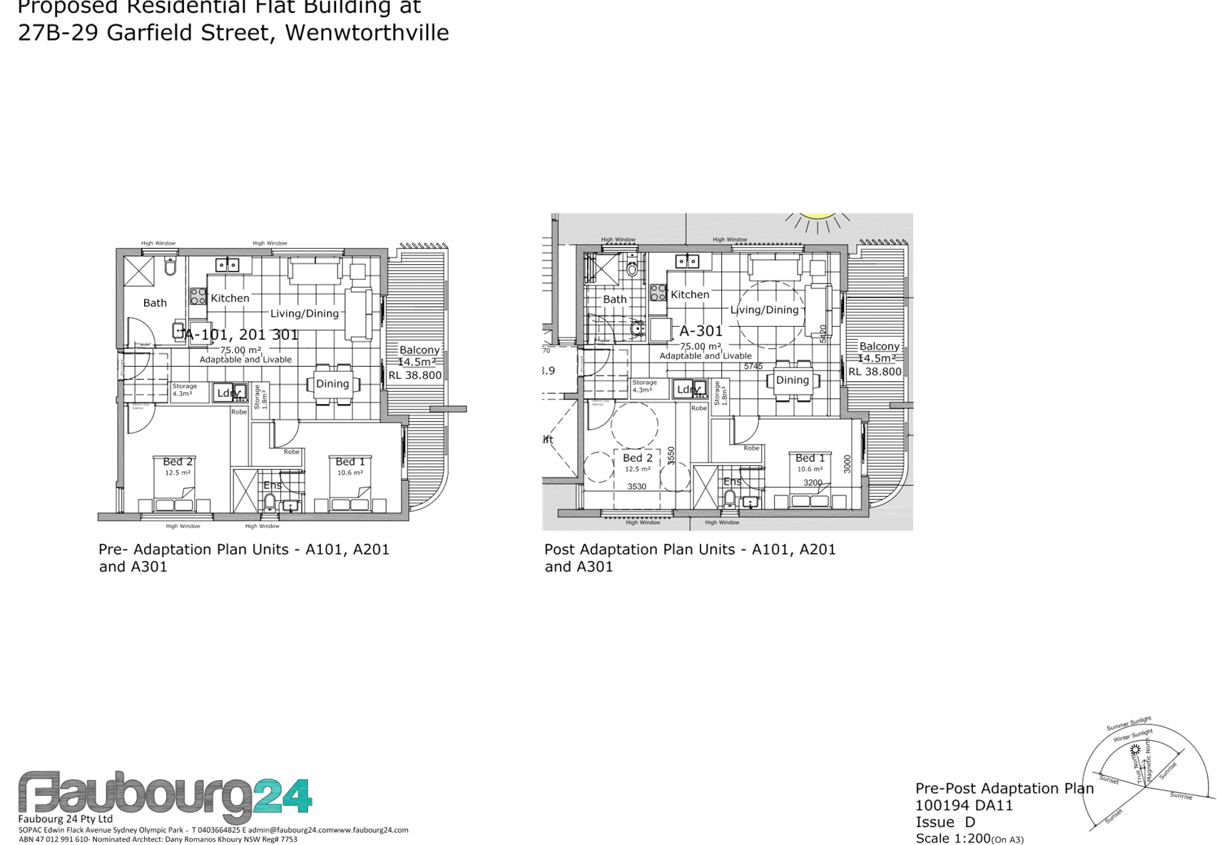
DA 2018/196 proposes demolition of
existing structures and construction of a part 4, part 5 storey residential
flat building over basement parking accommodating a total of 20 units and 24
parking spaces.
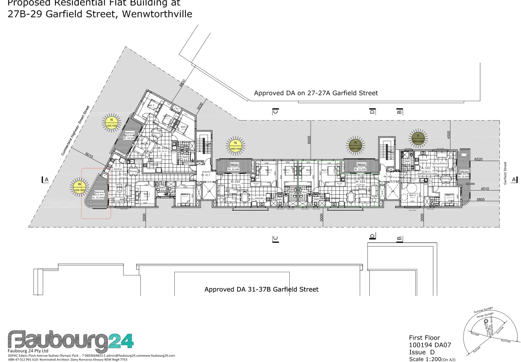
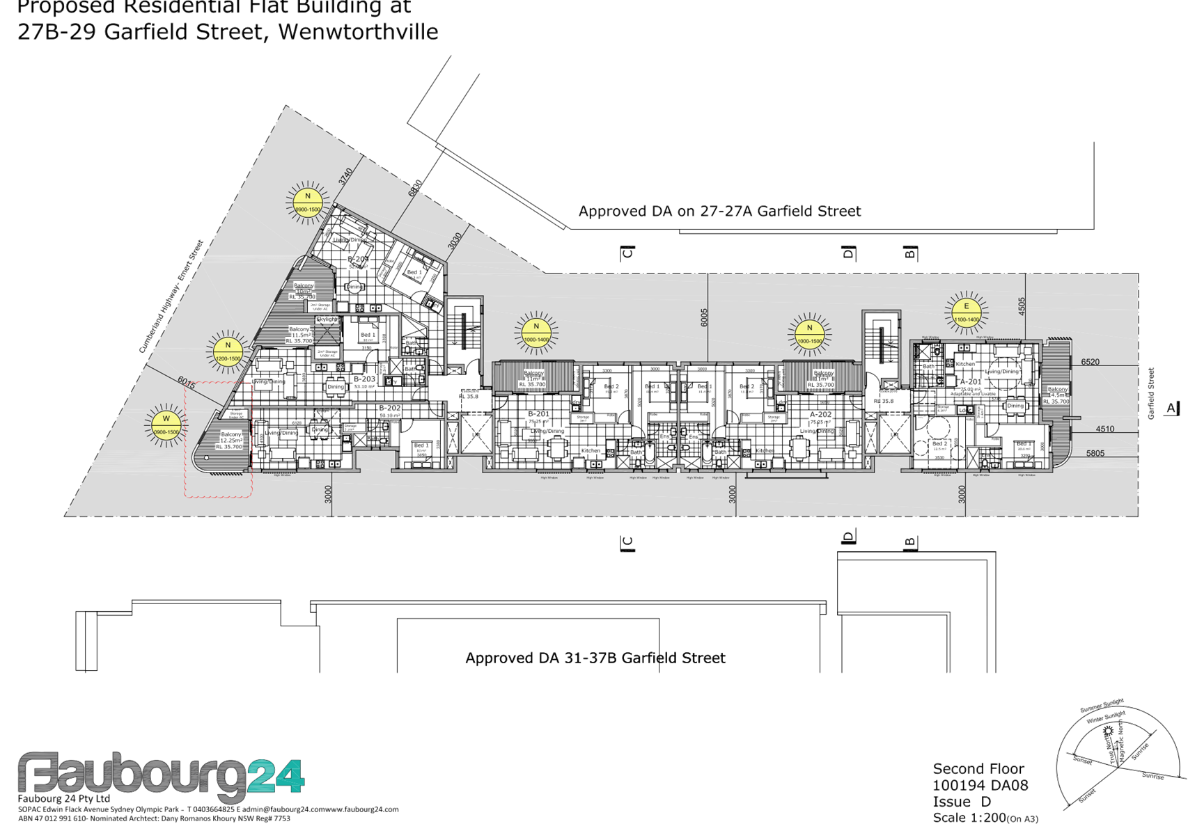
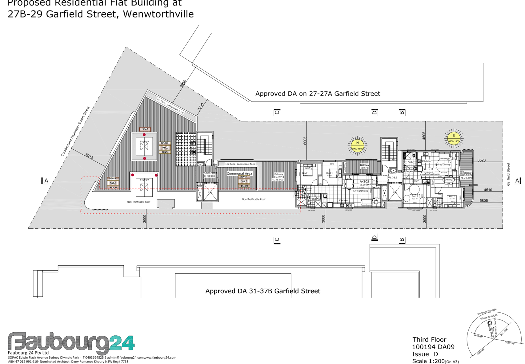
Key features of the development
proposal are as follows:-
|
Level
|
Details
|
|
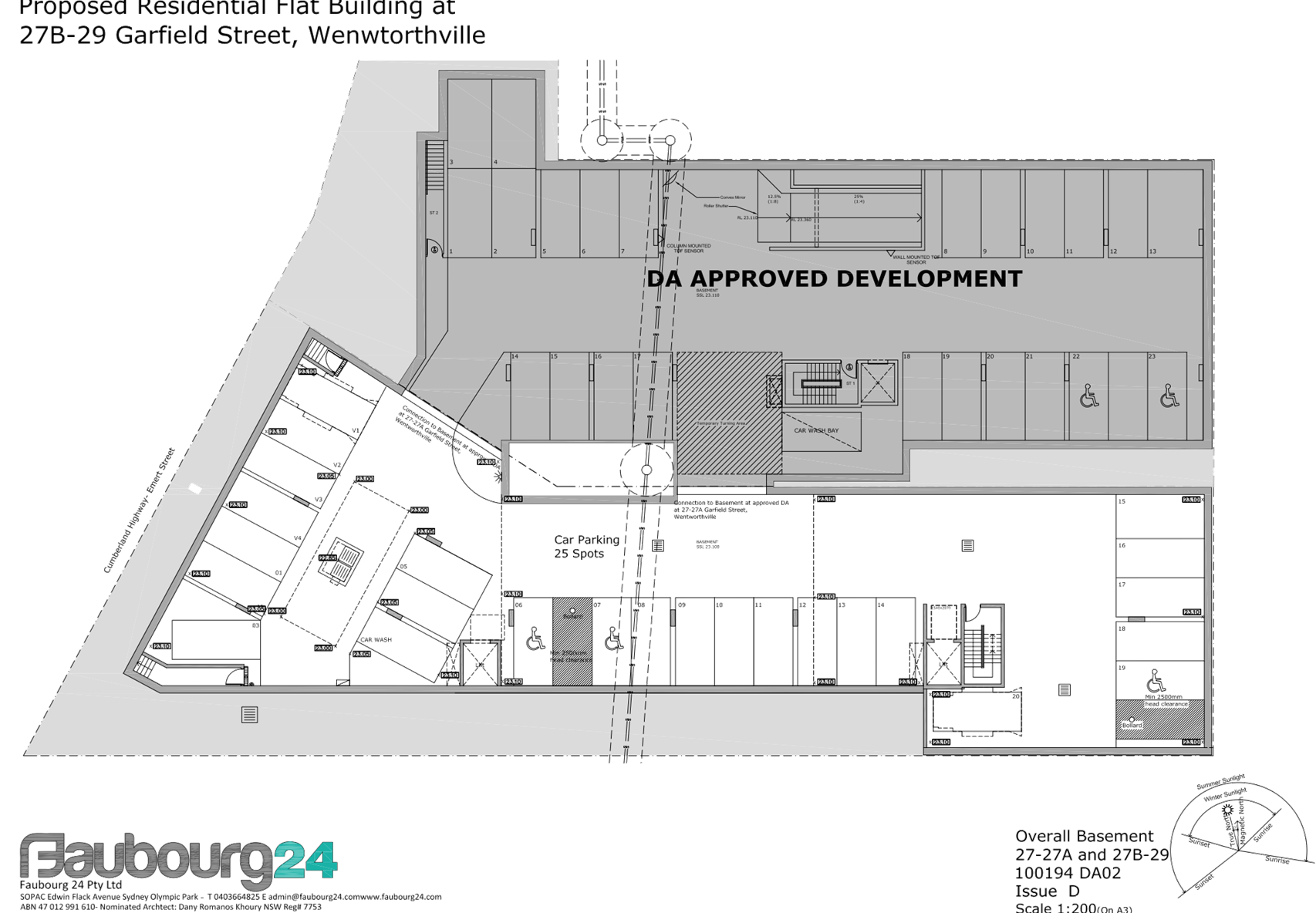
Basement
|
24 car parking spaces including 3 accessible spaces and 1
car wash bay
|
|
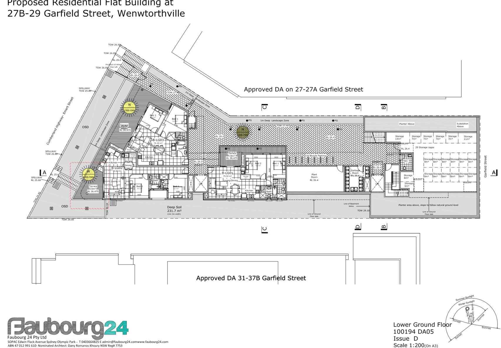
Lower ground
|
3 x 2 bedroom units, plant room, bicycle storage, garbage
room, and storage room
|
|
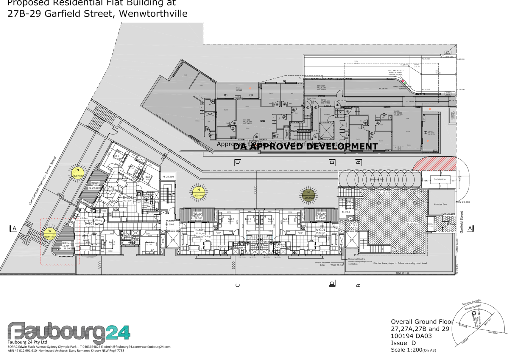
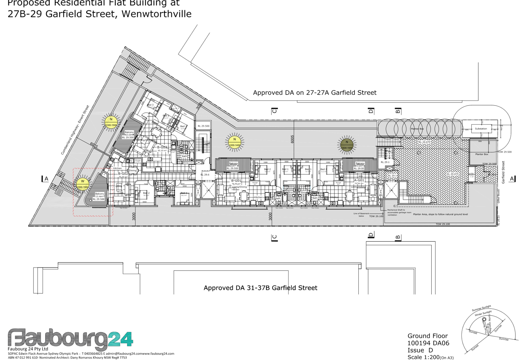
Ground floor
|
3 x 2 bedroom units and 1 x 3 bedroom unit
|
|
First floor
|
4 x 2 bedroom units and 1 x 3 bedroom unit
|
|
Second floor
|
3 x 2 bedroom units and 3 x 3 bedroom units
|
|
Third floor
|
2 x 2 bedroom units and rooftop communal open space area
|
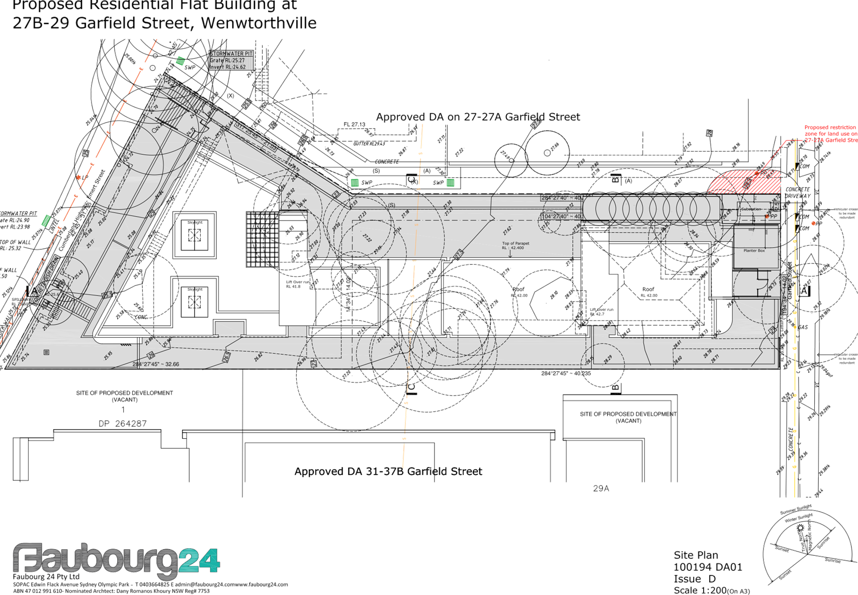
Access to the basement car park is
provided from 27-27A Garfield Street which is burdened by a right of
carriageway benefitting the subject site.
The proposed apartment mix is as
follows:
· 3
x 1 bedroom (15%)
· 15
x 2 bedroom (75%)
· 2
x 3 bedroom (10%)
Application History
The subject site was isolated as a
result of the approval of DA 2016/478 for development of 27 and 27A Garfield
Street (now 27 Garfield Street). That application was lodged concurrently with
DA 2016/474 for development of 29 Garfield Street which was also subsequently
approved by Council.
During the assessment of those
applications, valuations were prepared and submitted to Council for the
remaining lot (27B Garfield Street), which at that time was owned by the
Department of Housing. Concept plans for development of 27B as an isolated site
were also submitted for assessment. Council was satisfied at the time of
approving DA 2016/474 and DA 2016/478 that the applicant had made reasonable
attempts to acquire 27B Garfield Street but had been unsuccessful, and that it
was possible to develop both 27B and 29 as separate lots.
Since that time, the applicant has
acquired 27B and is now proposing to develop that lot in conjunction with 29
Garfield Street. A pre-DA meeting was held with the applicant in February 2018
and at that time it was suggested that the applicant explore the possibility of
developing all 3 lots (27, 27B and 29 Garfield Street) in one scheme. The
applicant indicates in their Statement of Environmental Effects that the approved
development at 27 Garfield Street has progressed significantly in the time it
has taken to acquire 27B Garfield Street, and for that reason a consolidated
scheme for all lots is not reasonably possible at this point.
|
Date
|
Action
|
|
4 November 2016
|
DA 2016/474 lodged with Council, seeking consent for a
5-storey residential flat building comprising 9 units at 29 Garfield
Street
|
|
7 November 2016
|
DA 2016/478 lodged with Council, seeking consent for a
part 4 / part 5 storey residential flat building comprising 19 units at
27 & 27A Garfield Street
|
|
7 November 2017
|
DA 2016/478 approved under delegated authority
|
|
28 November 2017
|
DA 2016/474 approved under delegated authority
|
|
30 November 2017
|
Blue Sox Development Pty Ltd acquires 27B Garfield Street
from Department of Housing
|
|
28 February 2018
|
Pre-DA meeting held to discuss proposed redevelopment of
27B & 29 Garfield Street
|
|
8 June 2018
|
DA 2018/196 (subject application) lodged with Council
|
|
20 June 2018
|
Subject application referred to the following internal
sections:
· Development
Engineering
· Waste Management
· Environmental
Health
· Landscaping
|
|
20 June 2018
|
Subject application referred to the following external
agencies:
· Endeavour Energy
· Transgrid
· NSW Police
|
|
27 June to 18 July 2018
|
Subject application placed on public notification for 21
days
|
|
28 November 2018
|
Application deferred seeking additional information and
amended plans
|
|
18 December 2018
|
Amended plans and additional information received by
Council
|
|
18 January 2019
|
Additional information regarding overshadowing of the
adjacent site requested from the applicant
|
|
30 January 2019
|
Amended plans and shadow diagrams received from the
applicant
|
|
13 February 2019
|
Application referred to CLPP for determination
|
Applicant’s Supporting
Statement
A Statement of Environmental
Effects prepared by Think Planners dated 31 May 2018 was submitted with the
application.
Additional correspondence in
response to the deferral items prepared by Think Planners dated 15 December
2018 was submitted in support of the amended application.
Contact with Relevant
Parties
The assessing officer has
undertaken an inspection of the subject site and has been in contact with the
applicant throughout the assessment process.
Internal Referrals
Development Engineering
The application was referred to
Council’s Development Engineer for comment. Response received 26 November
2018 indicates that the proposal is satisfactory subject to conditions,
including a deferred commencement condition requiring the registration of a
drainage easement in favour of the subject site. The conditions recommended by
the Engineer are included in the draft determination.
Landscape and Tree Management
The application was referred to Council’s
Landscape and Tree Management Officer for comment. Response received 7 January
2019 indicates that the proposed tree removal and landscape works are
satisfactory subject to conditions. The conditions recommended by the Landscape
Officer are included in the draft determination.
Environmental Health
The application was referred to
Council’s Environmental Health Unit for comment. Concerns were raised
regarding the lack of provision for mechanical ventilation of the waste storage
room and basement car park. These matters were satisfactorily addressed by the
applicant with the amended plans.
Waste Management
The application was referred to
Council’s Waste Management Unit for comment. The response received 23
August 2018 recommends that the waste storage area be relocated to the basement
with provision made for a bin tug to transfer the bins to the street. In this
instance, transferring the bins through the driveway is not possible or
practical as access to the basement is provided through the adjacent site; and
the right of carriageway does not include a right to transfer waste. The
proposed waste arrangements are considered satisfactory and will be a matter
for management by the owners’ corporation.
External Referrals
Endeavour Energy
The application was referred to
Endeavour Energy for comment pursuant to clause 45 of the SEPP Infrastructure.
The response received 9 July 2018 indicates that Endeavour Energy does not
object to the proposal. The response also indicated some concerns regarding
encroachments into the fire restriction area for the padmount substation. This
matter was addressed by the applicant with the amended proposal.
NSW Police
The application was referred to
NSW Police for comment regarding CPTED. Response dated 2 July 2018 indicates
that the proposal is satisfactory subject to conditions.
NSW Roads and Maritime Services
The application was referred to
RMS for comment pursuant to clause 101 of the SEPP Infrastructure. Response
received 1 July 2018 indicates that the proposal is satisfactory subject to
conditions.
Planning Assessment
The provisions of any
Environmental Planning Instruments (EP&A Act s4.15 (1)(a)(i))
The following Environmental
Planning Instruments are relevant to the assessment of the subject application:
(a) State
Environmental Planning Policy No 55 – Remediation of Land (SEPP 55)
The requirement at clause 7
of SEPP 55 for Council to be satisfied that the site is suitable or can be made
suitable to accommodate the proposed development has been considered in the
following table:
|
Matter
for consideration
|
Yes
|
No
|
|
Does the application involve re-development of the site or
a change of land use?
|
|
|
|
Is the development going to be used for a sensitive land
use (e.g. residential, educational, recreational, childcare or hospital)?
|
|
|
|
Does information available to you indicate that an
activity listed below has ever been approved, or occurred at the
site?
acid/alkali plant and formulation,
agricultural/horticultural activities, airports, asbestos production and
disposal, chemicals manufacture and formulation, defence works, drum
re-conditioning works, dry cleaning establishments, electrical manufacturing
(transformers), electroplating and heat treatment premises, engine works,
explosive industry, gas works, iron and steel works, landfill sites,
metal treatment, mining and extractive industries, oil production and
storage, paint formulation and manufacture, pesticide manufacture and
formulation, power stations, railway yards, scrap yards, service stations,
sheep and cattle dips, smelting and refining, tanning and associated trades,
waste storage and treatment, wood preservation
|
|
|
|
Is the site listed on Council's Contaminated land
database?
|
|
|
|
Is the site subject to EPA clean-up order or other EPA
restrictions?
|
|
|
|
Has the site been the subject of known pollution incidents
or illegal dumping?
|
|
|
|
Does the site adjoin any contaminated land/previously
contaminated land?
|
|
|
|
Has the appropriate level of investigation been carried
out in respect of contamination matters for Council to be satisfied that the
site is suitable to accommodate the proposed development or can be made
suitable to accommodate the proposed development?
|
|
|
|
Details of contamination investigations carried out at
the site:
The site is not identified in Council’s records as
being subject to contamination. There is no evidence available to suggest
that the site has ever been used for a potentially contaminating activity. No
further investigation is considered necessary in the circumstances.
|
(b) State
Environmental Planning Policy (Building Sustainability Index: BASIX) 2004
BASIX certificate 926540M dated 27
May 2018 was submitted with the application. The proposal achieves the target
scores for energy, water and thermal comfort and relevant commitments are shown
on the architectural plans.
(c) State
Environmental Planning Policy No 65 – Design Quality of Residential
Apartment Development (SEPP 65)
The proposal is classified as a
residential apartment development and SEPP 65 applies. A design verification
statement signed by registered architect Dany Ramanos Khoury was submitted with
the application.
The design quality principles from
Schedule 1 of the SEPP are considered in the following table:
|
Design quality principle
|
Response
|
|
1. Context and
neighbourhood character
|
The design
represents an appropriate response to the context of the site in terms of the
limited frontage and sloping topography.
The proposed
development will provide a positive addition to the streetscape, and is
compatible with the developments that are currently under construction on
surrounding sites.
The generous
communal open space provision and landscaping within the setbacks will
provide good amenity for the residents of the proposed development, as well
as softening the appearance of the proposal from adjacent sites.
|
|
2. Built form and
scale
|
The scale, bulk
and height of the proposal appropriate for the site and are consistent with
the desired future character of the area; as evidenced by compliance with the
height and FSR standards for the site.
The alignment
and proportions of the building help to define the public domain and
contribute to streetscape character, internal amenity and outlook.
|
|
3. Density
|
The subject
site is well located with respect to existing public transport and community
facilities. The proposal complies with the FSR standard for the site and the
design of the development provides for appropriate separation between
dwellings, supplemented by privacy treatment to balconies and windows where
necessary.
|
|
4. Sustainability
|
A BASIX certificate was submitted with the application,
demonstrating that the building meets the applicable thermal comfort, energy
efficiency and water efficiency targets.
The proposal provides for adequate deep soil zones which
will allow for groundwater recharge and establishment of vegetation.
|
|
5. Landscape
|
A landscape plan was submitted with the proposal. The
landscaping options are considered to be adequate. The proposed landscaping
will provide suitable visual amenity for the future occupants of the
development and a suitable landscape setting for the building within the
streetscape is also proposed.
|
|
6. Amenity
|
The proposed development optimizes internal amenity
through appropriate room dimensions, layout of the units, access to sunlight,
and natural ventilation. Visual and acoustic privacy concerns are managed
with privacy screens, highlight windows and other treatments without
compromising the outlook and amenity of the proposed units. Consideration has
also been given to service areas and storage to ensure the functionality of
the development as a whole.
|
|
7. Safety
|
The proposal is considered to be satisfactory in terms of
providing casual surveillance to the public domain and communal areas whilst
maintaining privacy for the proposed units.
Public areas are well defined and access within the
development is appropriately restricted to ensure safety of residents.
|
|
8. Housing diversity
and social interaction
|
The proposal provides for a mix of apartment sizes and
layouts. The variety of communal open spaces and the design of the common
circulation spaces will encourage social interaction among residents.
|
|
9. Aesthetics
|
The proposal provides for a
balanced composition of building elements with a variety of colours and
textures. The external presentation of the building reflects the internal
layout and structure, and the visual bulk is broken up with indentations and
offsets on each façade.
|
Pursuant to clause 28(2)(c) of
SEPP 65, a consent authority must consider the provisions of the Apartment
Design Guide (ADG) in the assessment of a residential flat development.
The proposal involves the
following non-compliances with the ADG controls.
|
No.
|
Control
|
Comments
|
Compliance
|
|
PART 3 –
SITING THE DEVELOPMENT
|
|
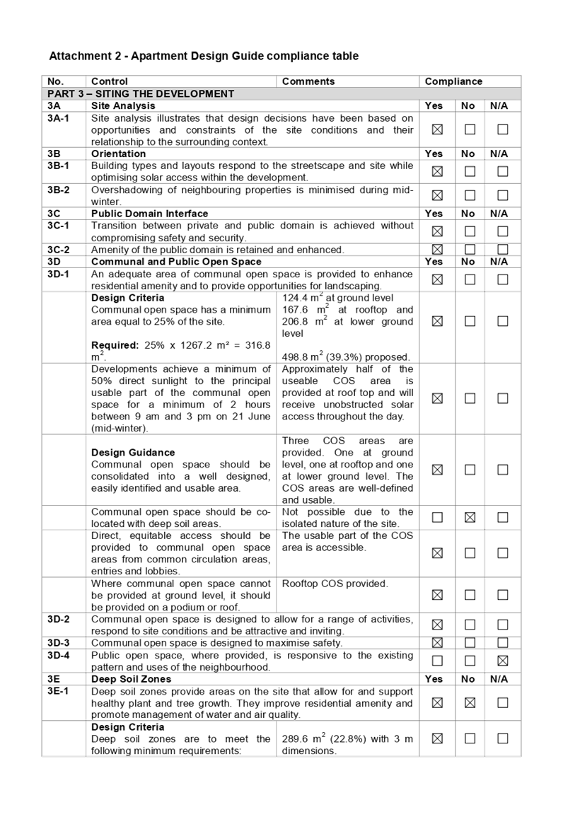
3D
|
Communal and Public Open
Space
|
Yes
|
No
|
N/A
|
|
3D-1
|
Communal open space should be
co-located with deep soil areas.
|
Not possible in this instance due to the isolated nature
of the site.
|
|
|
|
|
3F
|
Visual Privacy
|
|
|
|
|
3F-1
|
Design Criteria
Separation
between windows and balconies is provided to ensure visual privacy is achieved.
Minimum required separation distances from buildings to the side and rear
boundaries are as follows:
Note:
Separation distances between
buildings on the same site should combine required building separations
depending on the type of room.
Gallery access circulation
should be treated as habitable space when measuring privacy separation
distances between neighbouring properties.
|
North
6m required at levels LG-3
3.74 m proposed.
Rooftop
9 m required
3.03 m proposed
East
N/A street facing
South
6m required at levels LG-3.
2.4 m proposed
Rooftop
9 m required
3m proposed
West
N/A street facing
The non-compliances are to the
northern and southern elevations with the proposal providing
|
|
|
|
|
PART 4 – DESIGNING
THE BUILDING
|
|
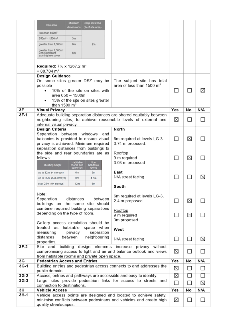
4D
|
Apartment Size and Layout
|
|
|
|
|
4D-3
|
Living rooms or
combined living/dining rooms have a minimum width of:
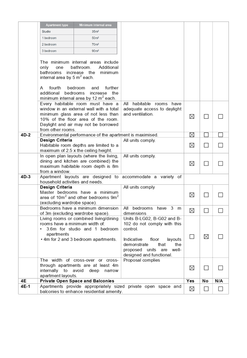
• 3.6m for studio and 1
bedroom apartments
• 4m for 2 and 3 bedroom apartments.
|
Units B-LG02, B-G02
and B-102 do not comply with this control (2 bedroom apartment with 3.72 m
living room width).
Indicative floor
layouts demonstrate that the proposed units are well-designed and functional.
|
|
|
|
|
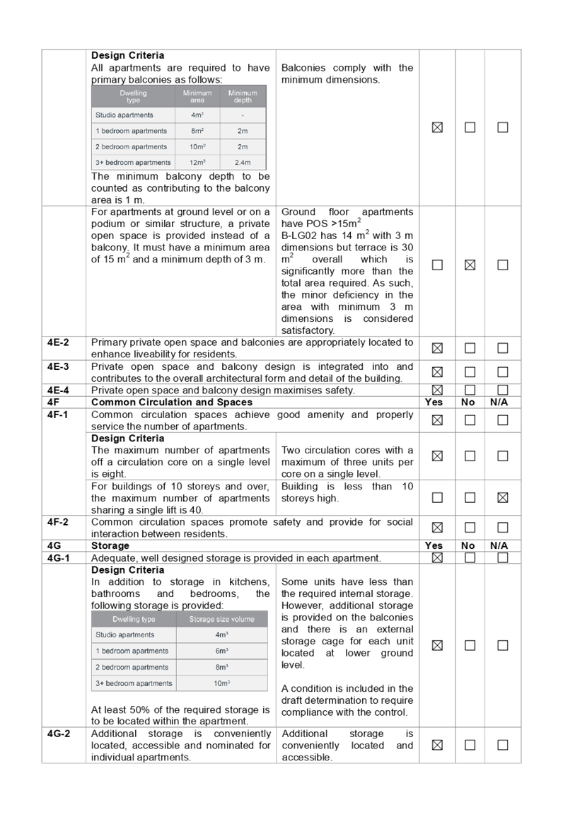
4E
|
Private
Open Space and Balconies
|
|
|
|
|
4E-1
|
For
apartments at ground level or on a podium or similar structure, a private
open space is provided instead of a balcony. It must have a minimum area of
15 m2 and a minimum depth of 3 m.
|
Ground
floor apartments have POS >15m2
B-LG02
has 14 m2 with 3 m dimensions but terrace is 30 m2
overall which is significantly more than the total area required. As such,
the minor deficiency in the area with minimum 3 m dimensions is considered
satisfactory.
|
|
|
|
|
4L
|
Ground Floor Apartments
|
|
|
|
|
4L-1
|
Street frontage activity is
maximised where ground floor apartments are located.
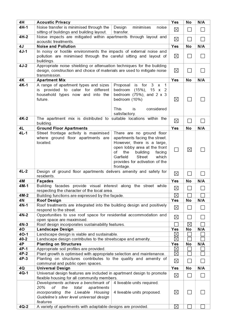
|
There are no ground floor
apartments facing the street. However, there is a large covered lobby area at
the front of the building facing Garfield Street which provides for
activation of the frontage.
Provision of ground floor
apartments is not considered possible in this case given the limited site
width.
|
|
|
|
|
|
|
|
|
|
|
A comprehensive ADG assessment is
provided at attachment 2.
(d) State
Environmental Planning Policy (Infrastructure) 2007
The provisions of the
Infrastructure SEPP (ISEPP) 2007 have been considered in the assessment of the
development application.
Clause 45 - Development likely
to affect an electricity transmission or distribution network
The proposed development does not
incorporate basement excavation in proximity (within 2 metres) to an
electricity distribution pole nor does the development occur within 5 metres of
an overhead electricity power line. As such, the Consent Authority is not
required to give written notice to an electricity supply authority.
The proposal provides for a new
padmount substation within the Garfield Street setback. As such, the
application was referred to Endeavour Energy for comment. See discussion above
regarding the Endeavour Energy response.
Clause 101 – Frontage to
classified road
Clause 101 applies as the site has
frontage to Emert Street (Cumberland Highway) which is a classified road. The
Panel can be satisfied that;
· vehicular
access to the land is provided by a road other than the classified road, and
· the
safety, efficiency and ongoing operation of the classified road will not be
adversely affected by the development, and
· the
development has been appropriately designed to ameliorate potential traffic
noise within the site arising from the adjacent classified road. See comments
above regarding referral to Environmental Health.
Clause 102 – Impact of
road noise or vibration on non-road development
Clause 102 applies as the average
daily traffic volume of Emert Street is more than 20,000 vehicles and the
proposal is for residential accommodation that is likely to be adversely
affected by road noise and vibration.
The DPI Interim Guideline for
development near rail corridors and busy roads has been considered in the
assessment of the application.
Subject to implementation of the
recommendations of the acoustic report, the relevant LAeq levels as specified
at clause 102, subclause 3 will not be exceeded.
Clause 104 – Traffic
generating developments
Clause 104 does not apply as the
proposal does not constitute traffic generating development as defined at
Schedule 3.
(e) Statement
Environmental Planning Policy No 19 - Bushland in Urban Areas
The proposal does not propose to
disturb bushland zoned or reserved for public open space.
(f) State
Environmental Planning Policy (Vegetation in Non-Rural Areas) 2017
The proposal includes removal of
all existing trees within the subject site. However, this does not exceed the
biodiversity offsets scheme threshold and the majority of the trees on site are
exempt species. Therefore, the proposed vegetation removal is considered
acceptable. Please refer to the HDCP 2013 compliance table at attachment 3 for
further comment regarding the proposed tree removal.
(g) State
Environmental Planning Policy (Coastal Management) 2018
The subject site is not identified
as a coastal wetland nor is it ‘land identified as “proximity area
for coastal wetlands” as per Part 2, Division 1 of the SEPP Coastal
Management 2018.
(h) Holroyd
Local Environmental Plan 2013 (HLEP 2013)
The proposed development is
defined as a ‘residential flat building’ under the provisions of
HLEP 2013. Residential flat buildings are permitted with consent in the R4
– High Density Residential zone which applies to the land.
The proposal complies with all
applicable development standards under HLEP 2013. A comprehensive LEP
compliance table is provided at attachment 1.
The provisions of any proposed
instrument that is or has been the subject of public consultation (EP&A Act
s4.15 (1)(a)(ii))
There are no draft SEPPs
applicable to the proposed development.
The provisions of any
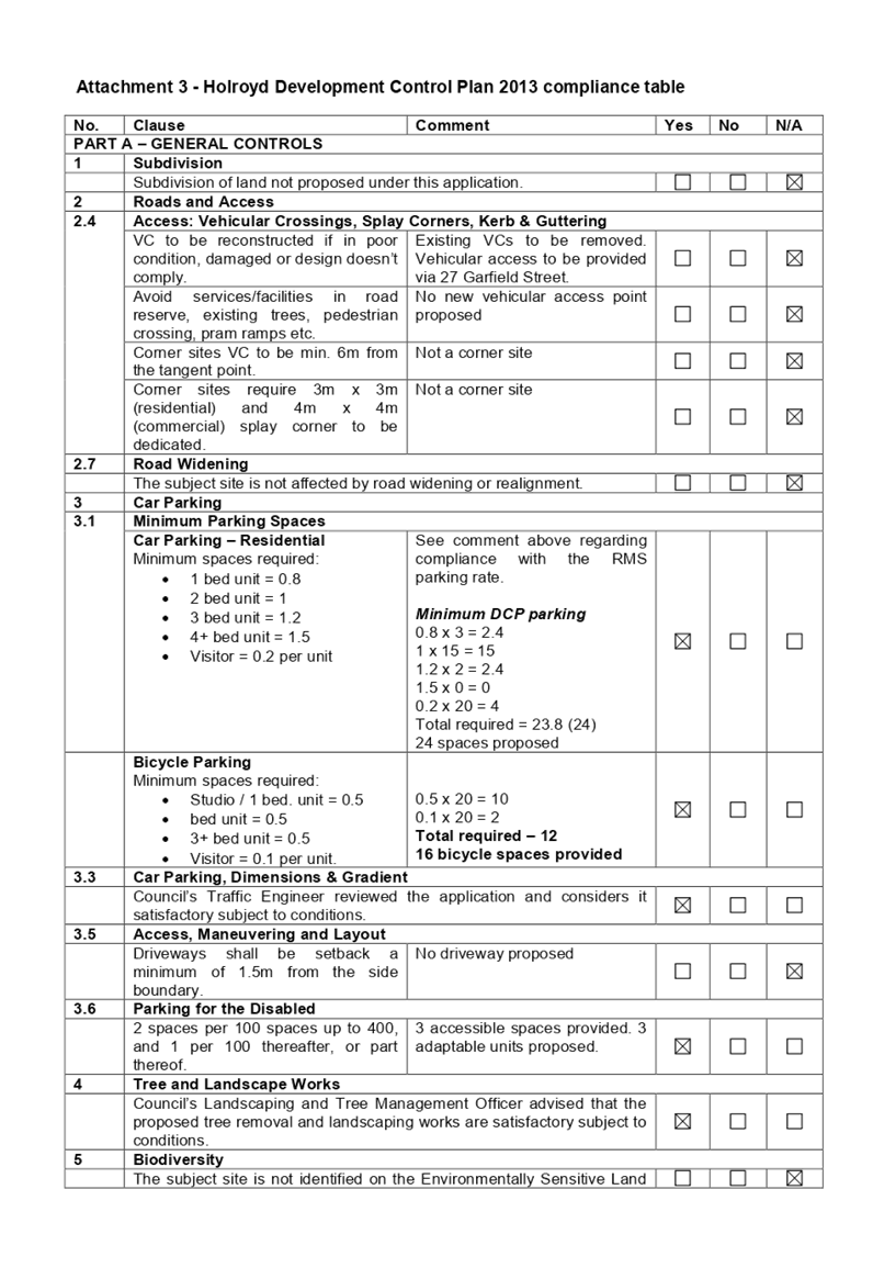
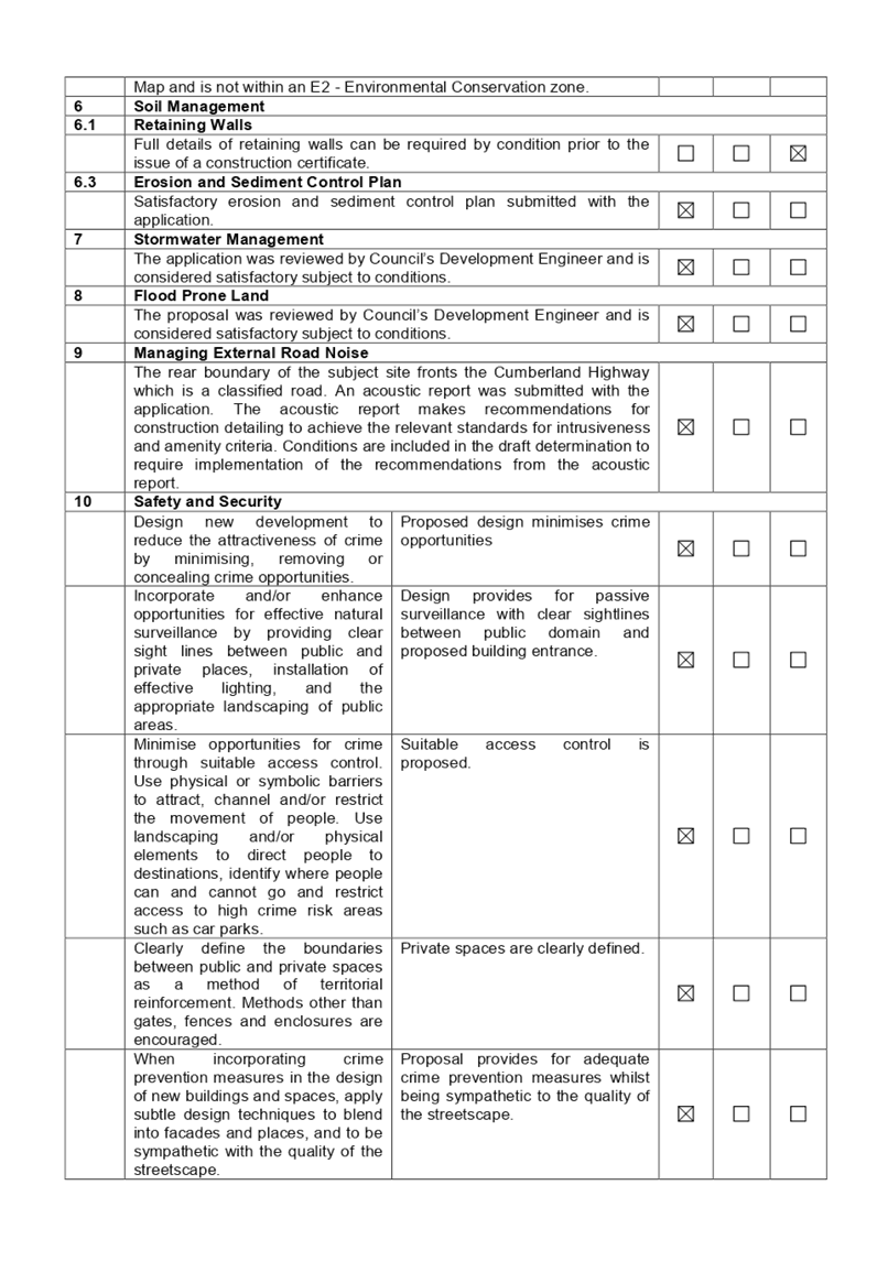
Development Control Plans (EP&A Act s4.15 (1)(a)(iii))
(a) Holroyd
Development Control Plan 2013
HDCP 2013 contains general
controls which relate to all developments under Part A, and Residential
Controls under Part B.
A comprehensive HDCP compliance
table is attached to this report at attachment 3. A summary of the DCP
non-compliances is provided in the following table.
|
No.
|
Clause
|
Comment
|
Yes
|
No
|
N/A
|
|
PART B – RESIDENTIAL CONTROLS
|
|
1
|
GENERAL
RESIDENTIAL CONTROLS
|
|
1.5
|
Landscape Area
|
|
|
Min. 30% for a residential
flat building.
Required: 1267.2 x 30%
= 380.6 m2
|
174.4 m2 (13.7%). Given the isolated nature of
the site and the compliant COS provided, the non-compliance is considered
supportable in this instance.
|
|
|
|
|
1.8
|
Sunlight Access
|
|
|
1 main living area of existing adjacent dwellings to
receive 3 hours direct sunlight between 9am and 4pm, 22 June.
|
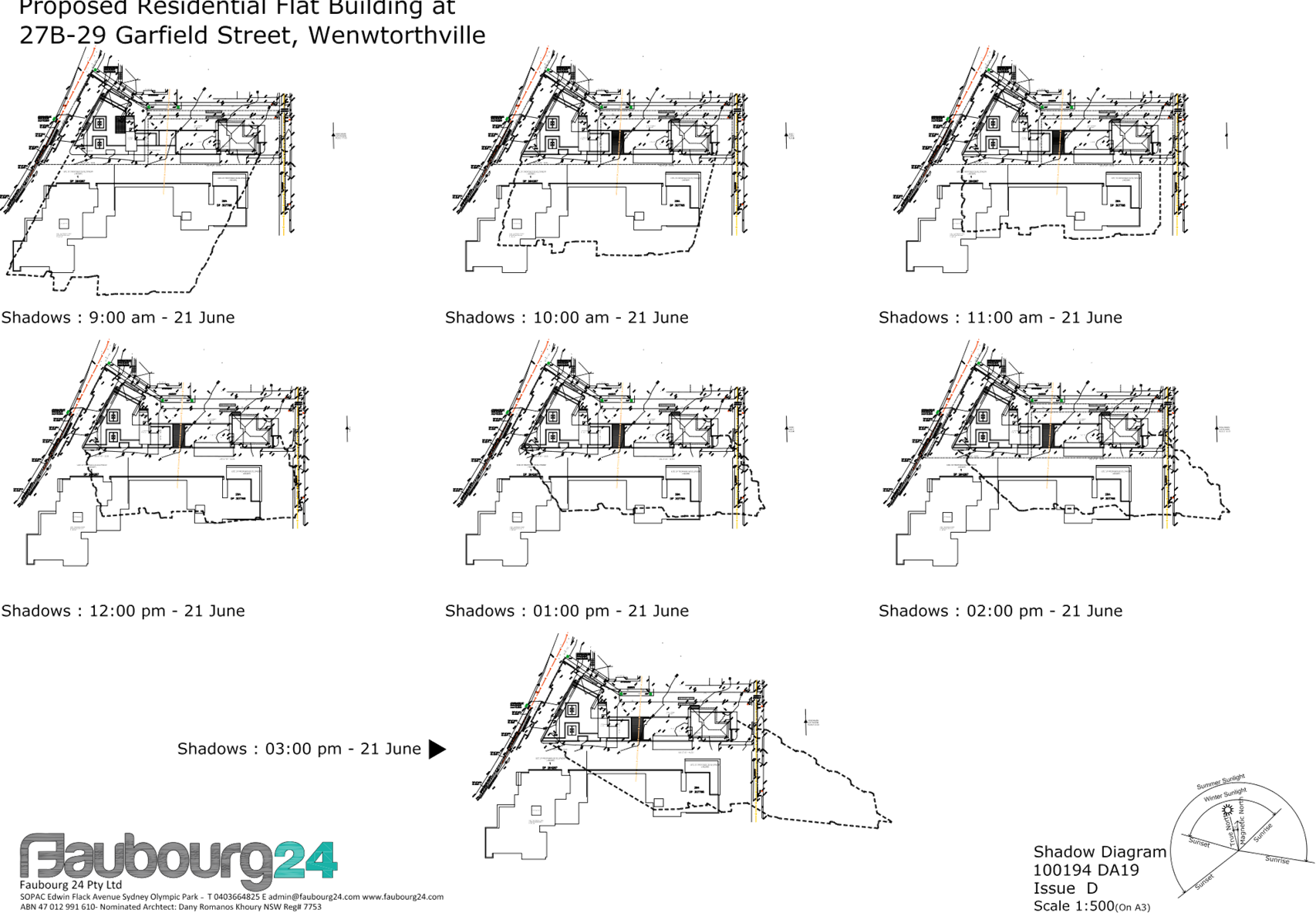
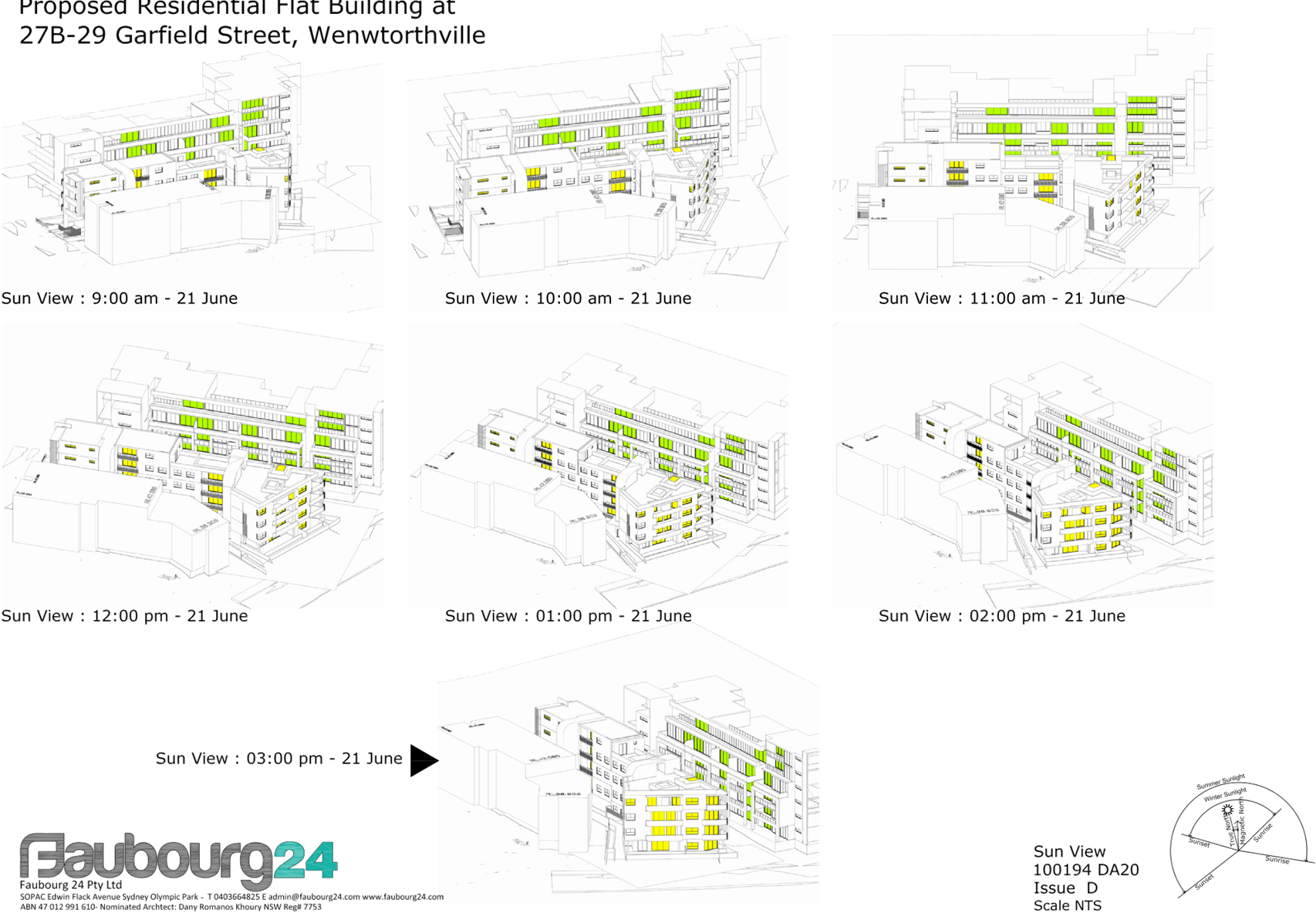
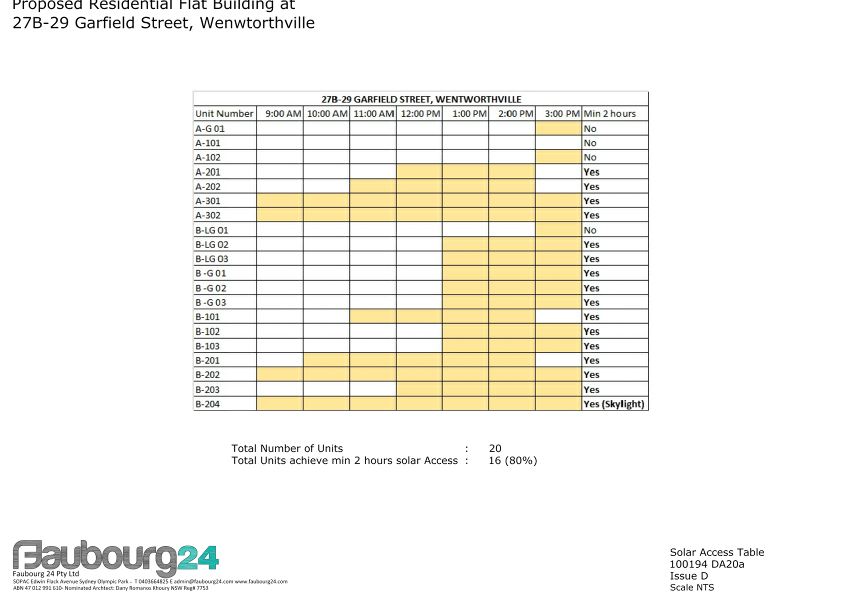
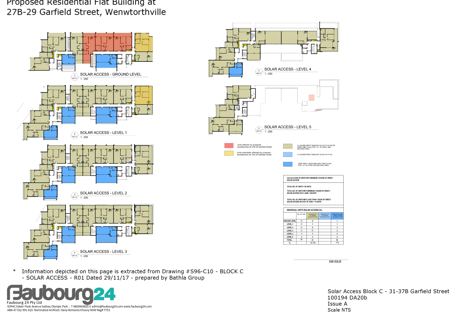
Shadow diagrams provided
indicate that 4 of the ground floor units in block C of the approved
development at 31-37B Garfield Street (currently under construction) will
receive no solar access at mid-winter as a result of the proposed
development.
Block C has a total of 58
units and as approved, 60.3% of those will receive 2+ hours of direct solar
access at mid-winter. As a result of the proposed development, this will
reduce to 53% of units in that building.
It is considered that the
proposal is satisfactory despite the non-compliance in this instance. Being
located at ground level, the affected units are vulnerable to overshadowing,
and given the isolated nature of the subject site, some shadow impact is
inevitable. The applicant has demonstrated that the design minimises
overshadowing of the adjacent site and it is considered that maintaining
solar access to the ground floor units at Block C, 31 Garfield Street would
require a substantial reduction in the number of units that could be provided
on the subject site. This may also result in a non-compliance with the ADG
requirement for 70% of the proposed units to receive 2+ hours of solar
access.
|
|
|
|
|
|
Min. 50% of required POS of existing adjacent dwellings to
receive 3 hours direct sunlight between 9am and 4pm, 22 June.
|
Shadow diagrams provided
indicate that 4 of the ground floor units in Block C of the approved
development at 31-37B Garfield Street will receive no solar access to their
POS areas at mid-winter as a result of the proposed development.
This non-compliance is
considered supportable in the circumstances for the reasons detailed above.
|
|
|
|
|
6.0
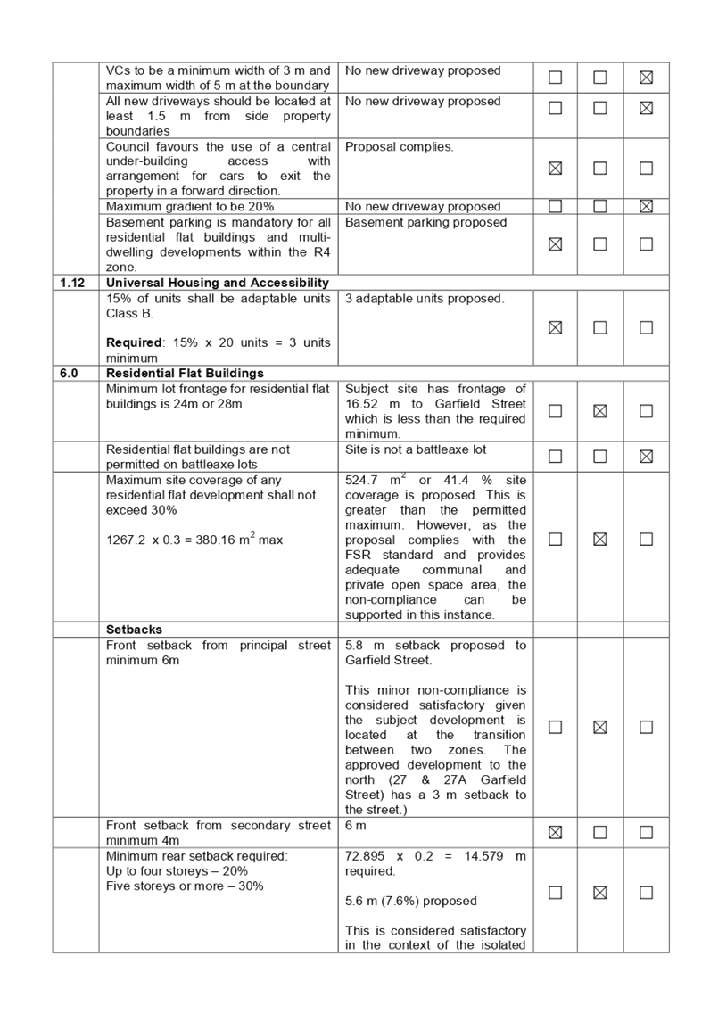
|
Residential Flat Buildings
|
|
|
Minimum lot frontage for residential flat buildings is 24m
or 28m
|
Subject site has frontage of 16.52 m to Garfield Street
which is less than the required minimum.
There are no reasonable opportunities for amalgamation
with adjacent sites and the proposed design has demonstrated satisfactory
levels of amenity can be achieved for the subject site, and adjoining
developments despite the limited site width.
|
|
|
|
|
|
Maximum site coverage of any residential flat development
shall not exceed 30%
1267.2 x 0.3 = 380.16 m2 max
|
524.7 m2 or 41.4 % site coverage is proposed.
This is greater than the permitted maximum. However, as the proposal complies
with the FSR standard and provides adequate communal and private open space
area, the non-compliance can be supported in this instance.
|
|
|
|
|
|
Setbacks
|
|
|
|
|
|
|
Front setback from principal street minimum 6m
|
5.8 m setback proposed to Garfield Street.
This minor non-compliance is considered satisfactory given
the subject development is located at the R4-B2 zone interface. The approved
development to the north (27 & 27A Garfield Street) has a 3 m setback to
the street, and the approved development to the south has a 6 m setback.
Accordingly, the proposed setback responds appropriately to the context of
the site.
|
|
|
|
|
|
Minimum rear setback required:
Up to four storeys – 20%
Five storeys or more – 30%
72.895 x 0.2 = 14.579 m required
|
5.6 m (7.6%) rear setback proposed.
This is considered satisfactory in the context of the
isolated site, and given that the rear boundary adjoins Cumberland Highway.
There are no unreasonable overshadowing impacts on the neighbouring
properties.
|
|
|
|
|
|
Side setback minimum 3m
|
2.5 m proposed to the northern and southern boundaries.
This non-compliance is satisfactory as it is confined to a
very small portion of the building (blank wall to eastern stairwell, and
screened portion of the balconies to the west facing units).
Varying setbacks are proposed to the northern and southern
boundaries at all levels, with the majority of the building complying with
the side setback control.
There are no privacy impacts associated with the
non-compliance and no overshadowing impacts on adjoining properties.
|
|
|
|
|
|
Basement setback to side and rear boundaries minimum 3m
|
The proposed basement has a nil setback to the northern
side boundary. This is considered satisfactory in the context of the isolated
site. It is also necessary in the circumstances to have a nil setback to the
northern boundary to facilitate access via the adjacent site. The proposal
complies with the minimum deep soil requirements and will not result in any
impacts on trees on adjacent sites.
|
|
|
|
|
|
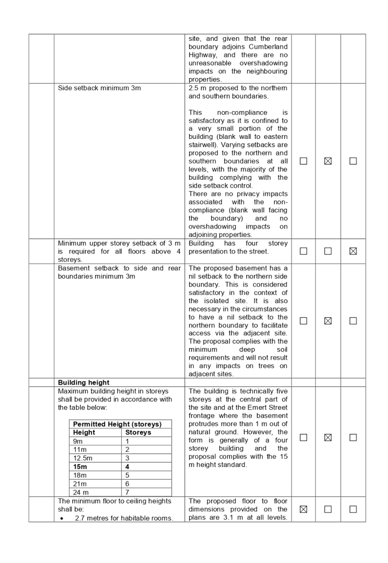
Building height
|
|
|
|
|
|
|
Maximum building height in
storeys shall be provided in accordance with the table below:
|
Permitted Height
(storeys)
|
|
Height
|
Storeys
|
|
9m
|
1
|
|
11m
|
2
|
|
12.5m
|
3
|
|
15m
|
4
|
|
18m
|
5
|
|
21m
|
6
|
|
24 m
|
7
|
|
The building is technically five storeys at the central
part of the site and at the Emert Street frontage where the basement
protrudes more than 1 m out of natural ground. However, the form is generally
of a four storey building and the proposal complies with the 15 m height
standard. The presentation to Garfield Street is 4 storeys and is in keeping
with the approved developments on adjacent sites.
|
|
|
|
|
|
|
|
|
|
|
|
Any planning agreement that has
been entered into under section 7.4, or any draft planning agreement that a
developer has offered to enter into under section 7.4 (EP&A Act s
4.15(1)(a)(iiia))
There is no planning agreement or
draft planning agreement associated with the subject Development Application.
The provisions of the
Regulations (EP&A Act s4.15 (1)(a)(iv))
Pursuant to clause 92 of the
Regulation, the provisions of AS 2601 must be considered in the case of a
development application for the demolition of a building. Standard conditions
are included in the draft determination to require the proposed demolition
works to be carried out in accordance with AS 2601.
The Likely Environmental,
Social or Economic Impacts (EP&A Act s4.15 (1)(b))
The likely environmental, social
and economic impacts of the development have been assessed and are considered
satisfactory.
The suitability of the site for
the development (EP&A Act s4.15 (1)(c))
The site is considered suitable
for the proposed development.
Submissions made in accordance
with the Act or Regulation (EP&A Act s4.15 (1)(d))
Advertised (newspaper) Mail Sign
Not Required
In accordance with Part E - Public
Participation of HDCP 2013, the proposal was publicly notified for a period of
21 days between 27 June and 18 July 2018. As a result of the notification, no
submissions were received.
The public interest (EP&A
Act s4.15(1)(e))
The public interest is served by
permitting the orderly and economic use of land, in a manner that is sensitive
to the surrounding environment and has regard to the reasonable amenity
expectations of surrounding land users. In view of the foregoing analysis, it
is considered that approval of the proposed development would not be contrary
to the public interest.
Section 7.11 (Formerly S94)
Contribution Towards Provision or Improvement of Amenities or Services
The subject development requires
the payment of contributions in accordance with Holroyd Section 94 Development
Contributions Plan 2013.
In accordance with the currently
indexed rates for the Wentworthville centre contribution area, the following
contributions apply:
· 3
x 1 bedroom dwellings – 8,674 x 3 = $26,022
· 15
x 2 bedroom dwellings –14,669 x 15 = $220,035
· 2
x 3 bedroom dwellings – 20,000 x 2 = $40,000
· minus
credit for the existing 1 x 2 bedroom and 1 x 3 bedroom dwellings –
$34,669
At the time of this development
consent, the current rate of the contribution is $251,388. The draft
determination at attachment 4 includes a condition to require payment of
contributions prior to the issue of a construction certificate.
Disclosure of Political
Donations and Gifts
The application and notification
process did not result in the disclosure of any Political Donations or Gifts.
The development application has
been assessed in accordance with the relevant requirements of the Environmental
Planning and Assessment Act 1979, Holroyd Local Environmental Plan 2013 and the
Holroyd Development Control Plan 2013 and is considered to be satisfactory.
Whilst there are a number of non-compliances with the development controls
under the ADG and HDCP 2013, these are mostly considered to be a result of the
site isolation. Overshadowing and privacy impacts resulting from the limited
setbacks and separation have been appropriately managed and minimised. The
presentation of the proposed development to the street is considered to respond
appropriately to location of the site, approved developments on the adjacent
sites, and the restricted frontage.
There are no further consultation
processes for Council associated with this report.
There are no further financial implications
for Council associated with this report.
There are no policy implications
for Council associated with this report.
Communication /
Publications:
The final outcome of this matter
will be notified in the newspaper. The objectors will also be notified in
writing of the outcome.
|
That Development Application 2018/196 for demolition of
existing structures and construction of a part 4, part 5 storey residential
flat building over basement parking accommodating a total of 20 units and 24
parking spaces be approved subject to the conditions within the draft notice
of determination provided at attachment 4.
|
1. HLEP 2013
Compliance Table ⇩
2. ADG
Compliance Table ⇩
3. HDCP
2013 Compliance Table ⇩
4. Draft
Notice of Determination ⇩
5. Architectural
Plans ⇩