4 June 2025
4 June 2025
A meeting of the Traffic Committee will be held at 9:30 AM at the Merrylands Administration Building, 16 Memorial Avenue, Merrylands on Wednesday, 4 June 2025.
Business as below:
Yours faithfully
Peter J. Fitzgerald
General Manager
ORDER OF BUSINESS
1. Apologies
2. Declarations of Interest
3. Confirmation of Previous Minutes endorsed by Council
4. Summary of Reports.......................................................................................................... 5
5. Reports
- Part 1 - Recommended for Approval under Delegated Authority
- Part 2 - Recommendation to Council
CONTENTS
Report No. Name of Report Page No.
Part 1 - Recommended for Approval under Delegated Authority
CTC-25-099 KIMBERLEY STREET, MERRYLANDS – APPLICATION FOR ‘WORKS ZONE’ SIGNAGE...................................................................................... 29
CTC-25-100 FACTORY STREET AND ITS INTERSECTIONS WITH SIDE STREETS, GRANVILLE – PROPOSED INTERSECTION TREATMENTS........ 35
CTC-25-101 MERRYLANDS ROAD, MERRYLANDS – PROPOSED RELOCATION OF EXISTING BUS STOP............................................................................. 45
CTC-25-102 LYTTON STREET AND JORDAN STREET, WENTWORTHVILLE – PROPOSED ‘NO STOPPING’ RESTRICTIONS................................. 55
CTC-25-103 MONTEREY STREET AND HAMILTON STREET, SOUTH WENTWORTHVILLE – PROPOSED ‘NO STOPPING’ RESTRICTIONS AND LINE MARKING........................................................................................ 63
CTC-25-104 CALLIOPE STREET AND BYRON ROAD, GUILDFORD – PROPOSED INTERSECTION TREATMENT.............................................................. 69
CTC-25-105 FAIRFIELD ROAD, GUILDFORD WEST – PROPOSED PARKING RESTRICTIONS....................................................................................... 77
CTC-25-106 HARROW ROAD, AUBURN - PROPOSED ‘NO PARKING WEDDING OR FUNERAL VEHICLES EXCEPTED’ SIGNAGE................................... 83
CTC-25-107 OXFORD STREET, GUILDFORD – PROPOSED EXTENSION OF EXISTING 'NO STOPPING' RESTRICTION........................................ 95
CTC-25-108 HOWE STREET, WESTMEAD – PROPOSED PARKING RESTRICTIONS 101
CTC-25-109 MAGOWAR ROAD, GIRRAWEEN – PROPOSED ‘NO STOPPING’ PARKING RESTRICTIONS.................................................................. 107
CTC-25-110 PERCY STREET, AUBURN - PROPOSED ‘NO STOPPING’ SIGNAGE 119
CTC-25-111 MAGOWAR ROAD AT MACKLIN STREET AND WYENA ROAD, PENDLE HILL – PROPOSED ‘NO STOPPING’ RESTRICTIONS AND LINE MARKING 125
CTC-25-112 ELVINA STREET AND GOZO ROAD, GREYSTANES – PROPOSED ‘NO STOPPING’ RESTRICTIONS AND LINE MARKING....................... 137
CTC-25-113 STURT STREET, SMITHFIELD – PROPOSED 1/2 P TIMED PARKING AND 'NO STOPPING' RESTRICTIONS....................................................... 145
CTC-25-114 BENNETT STREET, WENTWORTHVILLE – PROPOSED AMENDMENTS TO EXISTING PARKING RESTRICTIONS....................................... 167
CTC-25-115 IRIS STREET, GUILDFORD – PROPOSED PARKING RESTRICTIONS 179
CTC-25-116 PERCY STREET, AUBURN – PROPOSED PARKING RESTRICTIONS ASSOCIATED WITH A DEVELOPMENT APPLICATION............... 187
CTC-25-117 ALBERT STREET AND FRANK STREET, GUILDFORD – ROAD SAFETY CONCERNS............................................................................................ 195
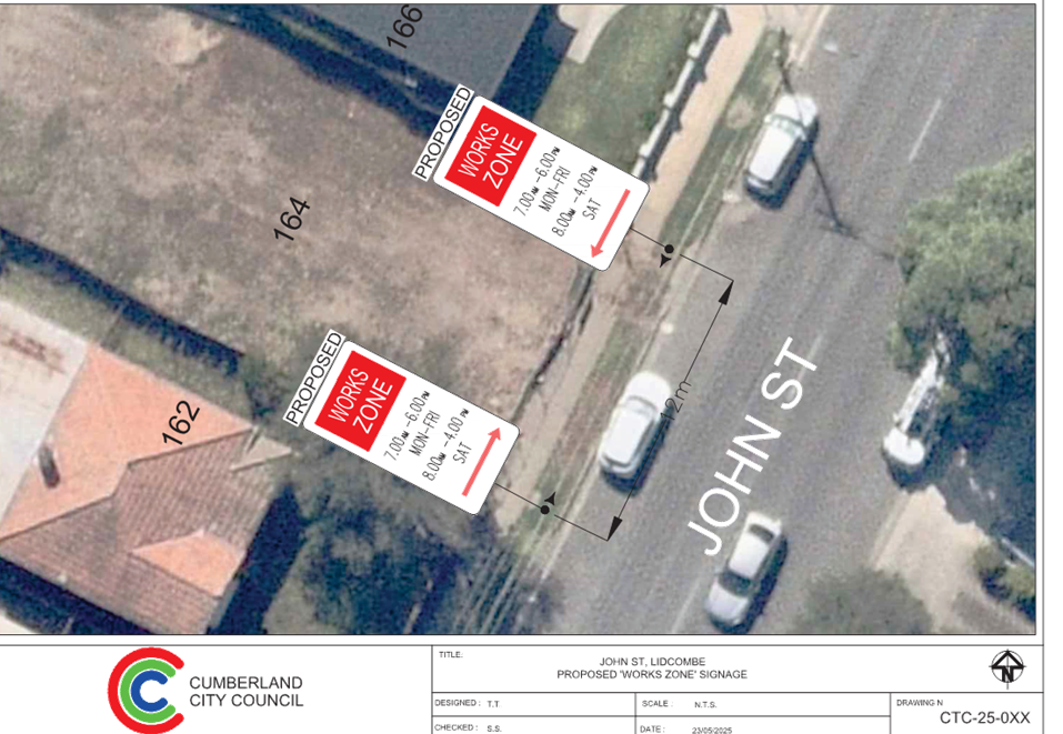
CTC-25-118 JOHN ST, LIDCOMBE – APPLICATION FOR ‘WORKS ZONE’ SIGNAGE 203
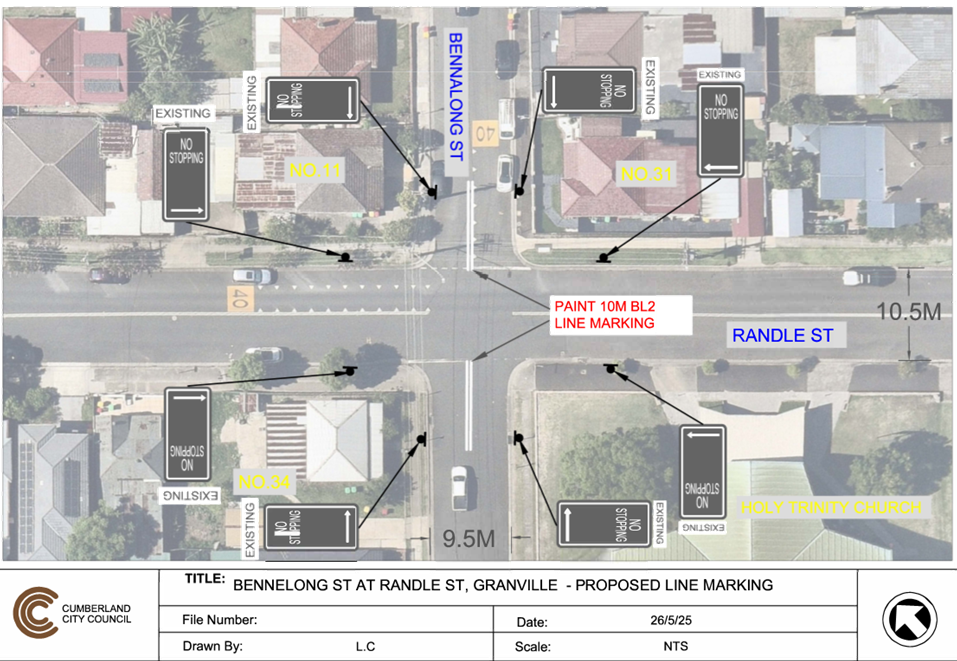
CTC-25-119 RANDLE STREET AND BENNALONG STREET, GRANVILLE – ROAD SAFETY CONCERNS........................................................................... 209
Part 2 - Recommendation to Council
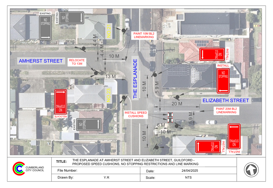
CTC-25-120 THE ESPLANADE, ELIZABETH STREET AND AMHERST STREET, GUILDFORD - ROAD SAFETY CONCERNS.................................... 219
CTC-25-121 VAUGHAN STREET, LIDCOMBE – REQUEST FOR MEDIAN ISLAND OUTSIDE MCDONALD’S DRIVEWAY............................................... 227
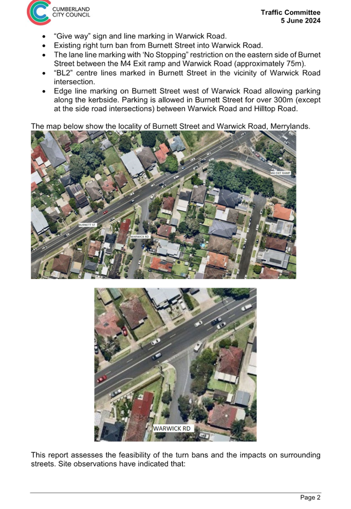
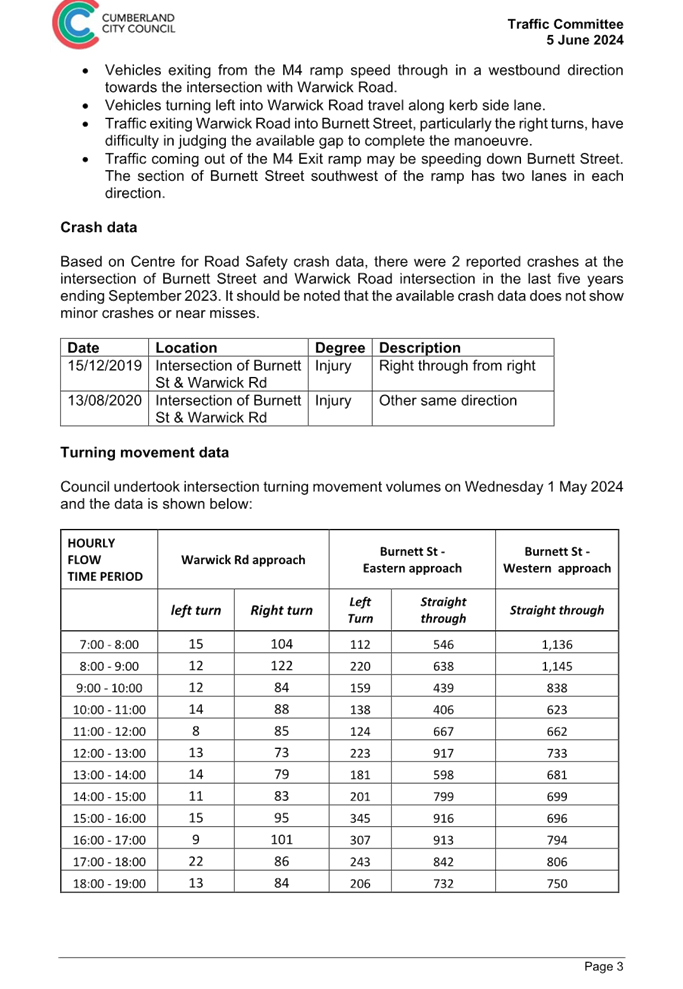
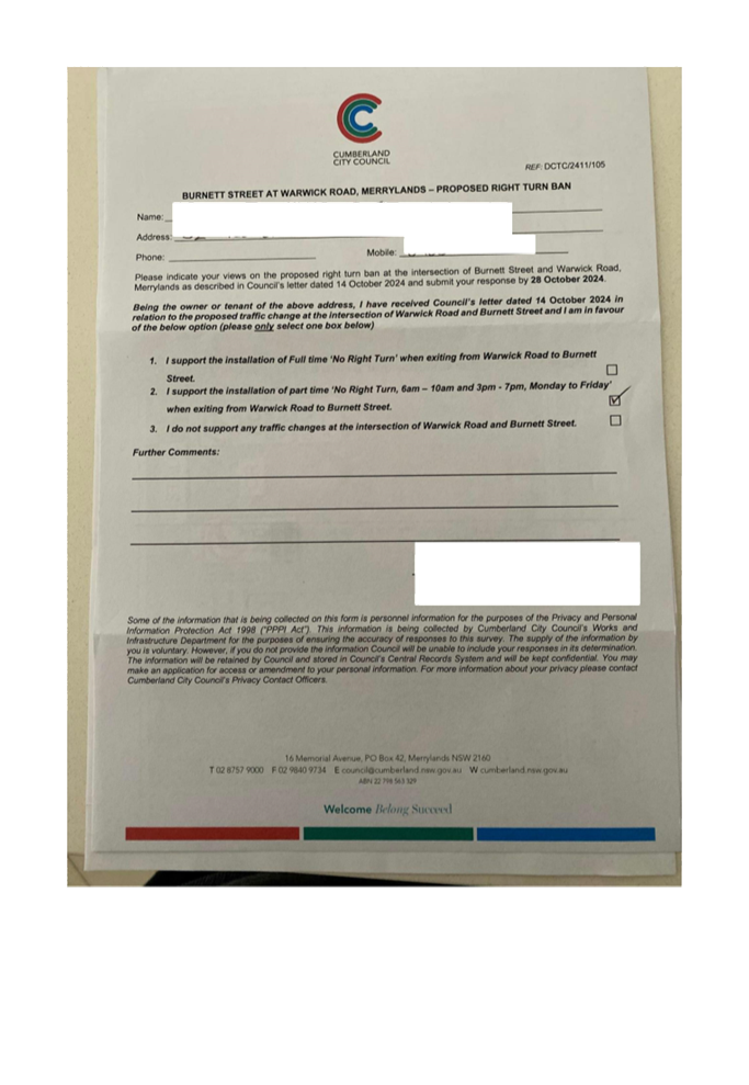
CTC-25-122 WARWICK ROAD & BURNETT STREET, MERRYLANDS – REQUEST FOR BANNING TURNING MOVEMENTS AT THE INTERSECTION.... 235
CTC-25-123 OLD PROSPECT ROAD AND ETTALONG STREET, GREYSTANES – TEMPORARY ROAD CLOSURES ASSOCIATED WITH ‘OUR LADY QUEEN OF PEACE FESTA’................................................................ 315
CTC-25-124 BRISTOL STREET, MERRYLANDS WEST – ROAD SAFETY CONCERNS 317
CTC-25-125 HARGRAVE ROAD, AUBURN – PROVISION OF A PEDESTRIAN CROSSING OUTSIDE AUBURN HOSPITAL.................................... 321
CTC-25-126 OCTAVIA STREET, TOONGABBIE – PROVISION OF A PEDESTRIAN CROSSING AT THE INTERSECTION WITH AURELIA STREET. 325
CTC-25-127 TALBOT ROAD, GUILDFORD - PROPOSED PEDESTRIAN FENCING 335
CTC-25-128 OLYMPIC DRIVE, LIDCOMBE – PROPOSED SAFETY FENCE.. 343
CTC-25-129 PRINCES STREET AND KING STREET, GUILDFORD WEST – PROPOSED ROUNDABOUT............................................................... 351
CTC-25-130 EXCELSIOR STREET, WYNYARD STREET AND EVE STREET, GUILDFORD - ROAD SAFETY CONCERNS - CONSULTATION RESULT 355
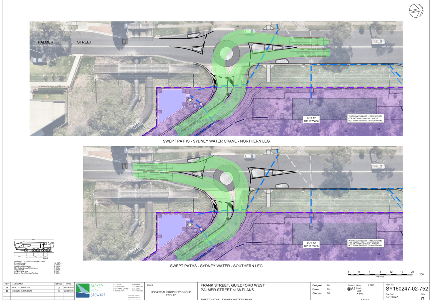
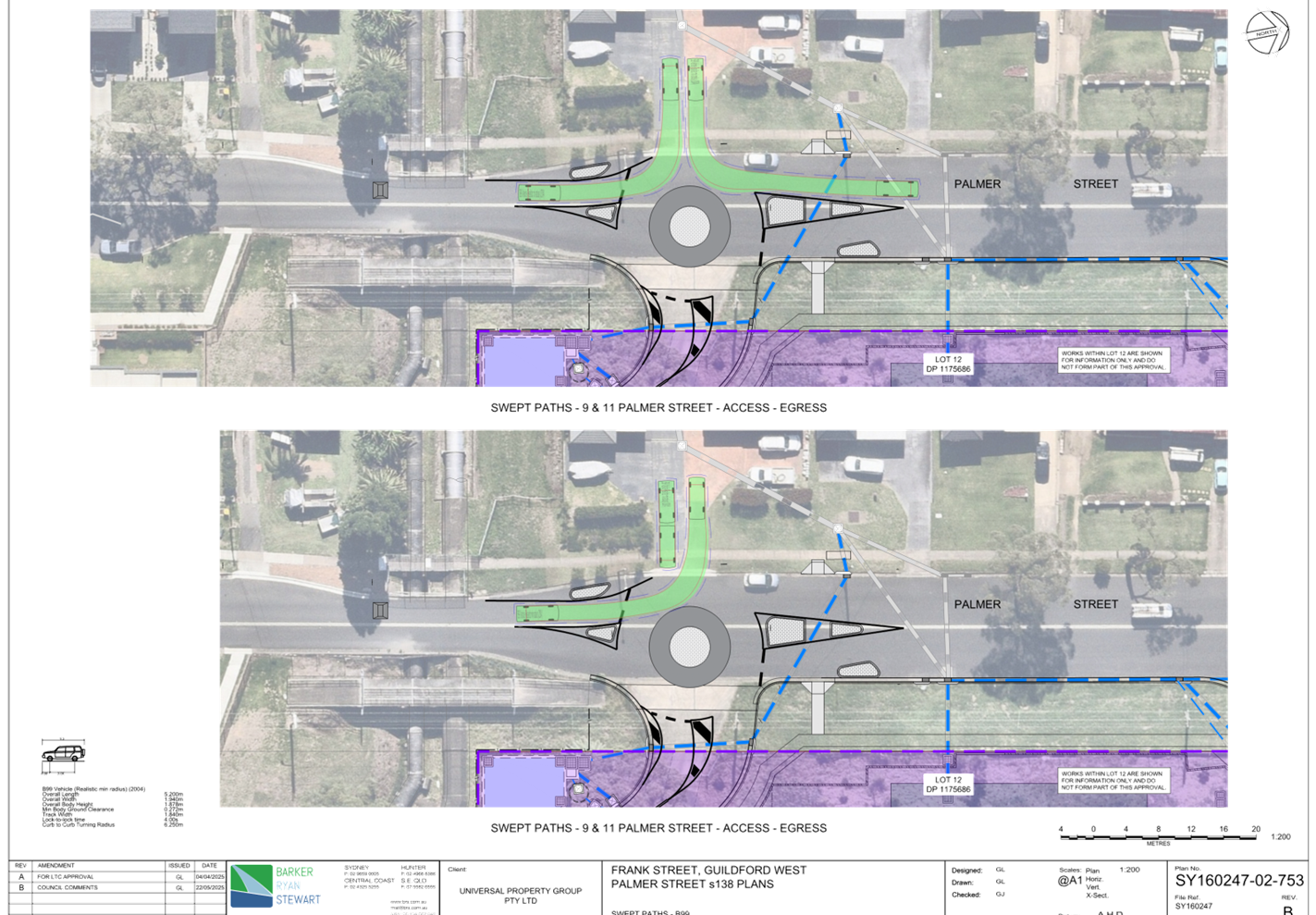
CTC-25-131 PALMER STREET, GUILDFORD WEST – PROPOSED ROUNDABOUT AND PEDESTRIAN CROSSING......................................................... 367
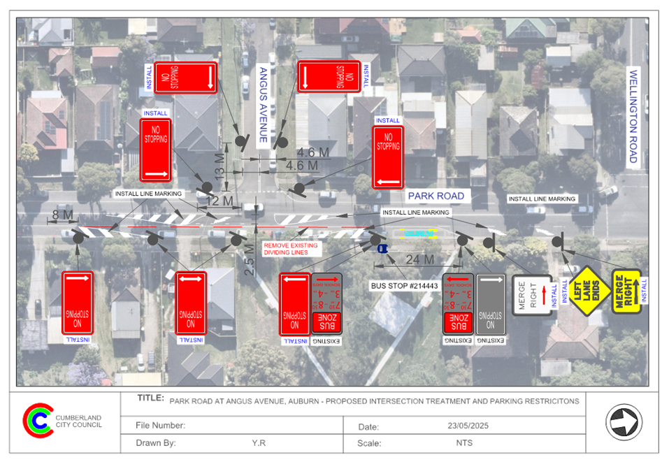
CTC-25-132 PARK ROAD AND ANGUS AVENUE, AUBURN – PROPOSED INTERSECTION TREATMENT............................................................ 385
CTC-25-133 PARK ROAD AT MOUNT AUBURN ROAD AND ANGUS AVENUE, AUBURN – PROPOSED ROUNDABOUT......................................... 391
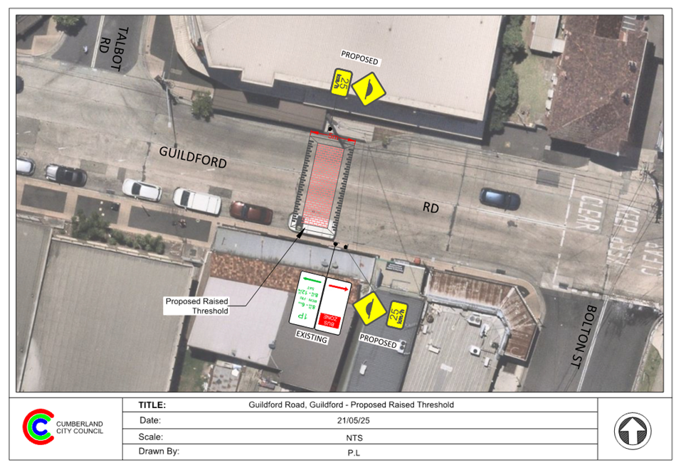
CTC-25-134 GUILDFORD ROAD, GUILDFORD – ROAD SAFETY CONCERNS 399
4 June 2025
Summary of Reports
Part 1 - Recommended for Approval under Delegated Authority
|
Item # |
Title |
Electorate |
Police Area Command (PAC) |
||||
|
Fairfield |
Granville |
Prospect |
Auburn |
Cumberland |
Auburn |
||
|
CTC-25-099 |
KIMBERLEY STREET, MERRYLANDS – APPLICATION FOR ‘WORKS ZONE’ SIGNAGE |
|
´ |
|
|
´ |
|
|
CTC-25-100 |
FACTORY STREET AND ITS INTERSECTIONS WITH SIDE STREETS, GRANVILLE – PROPOSED INTERSECTION TREATMENTS |
|
´ |
|
|
´ |
|
|
CTC-25-101 |
MERRYLANDS ROAD, MERRYLANDS – PROPOSED RELOCATION OF EXISTING BUS STOP |
|
´ |
|
|
´ |
|
|
CTC-25-102 |
LYTTON STREET AND JORDAN STREET, WENTWORTHVILLE – PROPOSED ‘NO STOPPING’ RESTRICTIONS |
|
´ |
|
|
´ |
|
|
CTC-25-103 |
MONTEREY STREET AND HAMILTON STREET, SOUTH WENTWORTHVILLE – PROPOSED ‘NO STOPPING’ RESTRICTIONS AND LINE MARKING |
|
´ |
|
|
´ |
|
|
CTC-25-104 |
CALLIOPE STREET AND BYRON ROAD, GUILDFORD – PROPOSED INTERSECTION TREATMENT |
|
´ |
|
|
´ |
|
|
CTC-25-105 |
FAIRFIELD ROAD, GUILDFORD WEST – PROPOSED PARKING RESTRICTIONS |
|
´ |
|
|
´ |
|
|
CTC-25-106 |
HARROW ROAD, AUBURN - PROPOSED ‘NO PARKING WEDDING OR FUNERAL VEHICLES EXCEPTED’ SIGNAGE |
|
|
|
´ |
|
´ |
|
CTC-25-107 |
OXFORD STREET, GUILDFORD – PROPOSED EXTENSION OF EXISTING 'NO STOPPING' RESTRICTION |
|
´ |
|
|
´ |
|
|
CTC-25-108 |
HOWE STREET, WESTMEAD – PROPOSED PARKING RESTRICTIONS |
|
´ |
|
|
´ |
|
|
CTC-25-109 |
MAGOWAR ROAD, GIRRAWEEN – PROPOSED ‘NO STOPPING’ PARKING RESTRICTIONS |
|
|
´ |
|
´ |
|
|
CTC-25-110 |
PERCY STREET, AUBURN - PROPOSED ‘NO STOPPING’ SIGNAGE |
|
|
|
´ |
|
´ |
|
CTC-25-111 |
MAGOWAR ROAD AT MACKLIN STREET AND WYENA ROAD, PENDLE HILL – PROPOSED ‘NO STOPPING’ RESTRICTIONS AND LINE MARKING |
|
|
´ |
|
´ |
|
|
CTC-25-112 |
ELVINA STREET AND GOZO ROAD, GREYSTANES – PROPOSED ‘NO STOPPING’ RESTRICTIONS AND LINE MARKING |
|
|
´ |
|
´ |
|
|
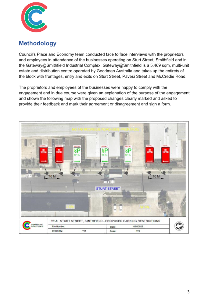
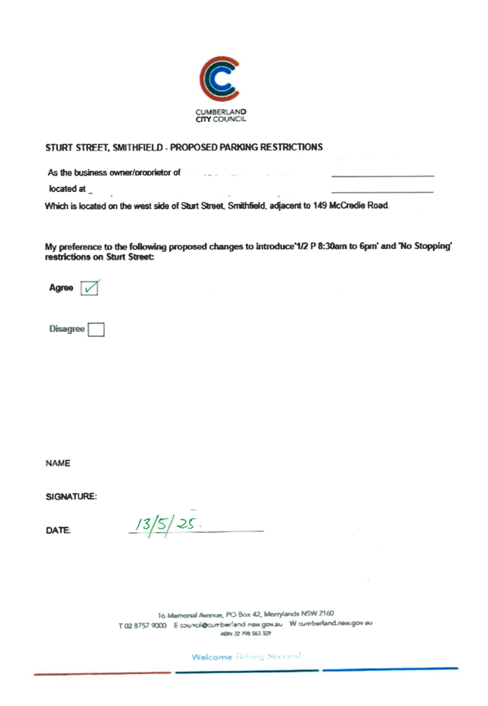
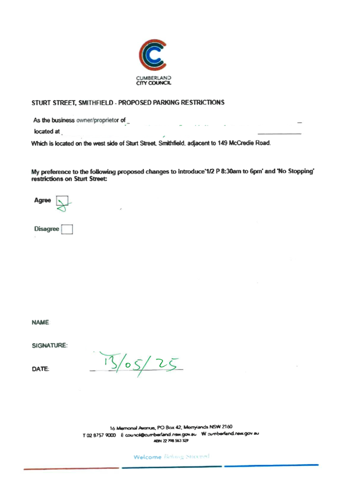
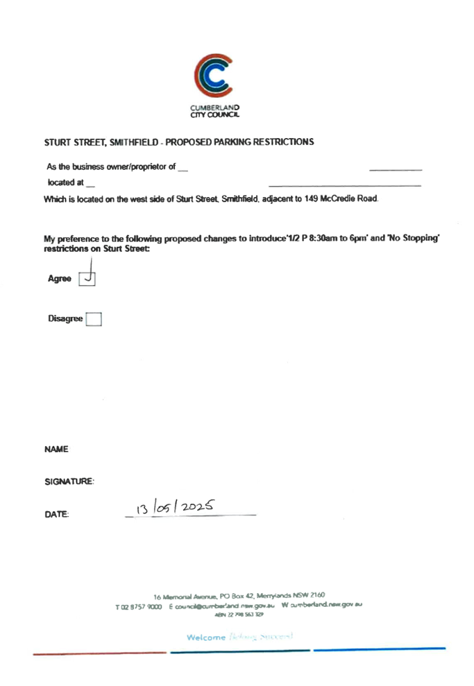
CTC-25-113 |
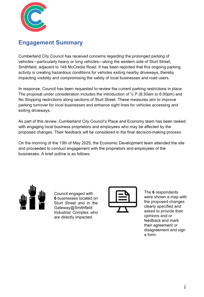
STURT STREET, SMITHFIELD – PROPOSED 1/2 P TIMED PARKING AND 'NO STOPPING' RESTRICTIONS |
|
´ |
|
|
´ |
|
|
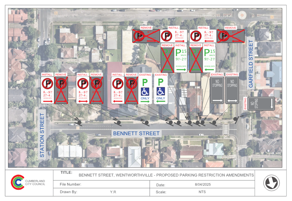
CTC-25-114 |
BENNETT STREET, WENTWORTHVILLE – PROPOSED AMENDMENTS TO EXISTING PARKING RESTRICTIONS |
|
|
´ |
|
´ |
|
|
CTC-25-115 |
IRIS STREET, GUILDFORD – PROPOSED PARKING RESTRICTIONS |
|
´ |
|
|
´ |
|
|
CTC-25-116 |
PERCY STREET, AUBURN – PROPOSED PARKING RESTRICTIONS ASSOCIATED WITH A DEVELOPMENT APPLICATION |
|
|
|
´ |
|
´ |
|
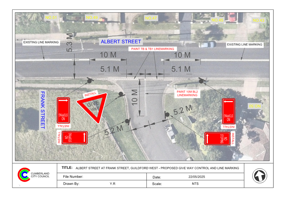
CTC-25-117 |
ALBERT STREET AND FRANK STREET, GUILDFORD – ROAD SAFETY CONCERNS |
|
´ |
|
|
´ |
|
|
CTC-25-118 |
JOHN ST, LIDCOMBE – APPLICATION FOR ‘WORKS ZONE’ SIGNAGE |
|
|
|
´ |
|
´ |
|
CTC-25-119 |
RANDLE STREET AND BENNALONG STREET, GRANVILLE – ROAD SAFETY CONCERNS |
|
´ |
|
|
|
|
Part 2 - Recommendation to Council
|
Item # |
Title |
Electorate |
Police Area Command (PAC) |
||||
|
Fairfield |
Granville |
Prospect |
Auburn |
Cumberland |
Auburn |
||
|
CTC-25-120 |
THE ESPLANADE, ELIZABETH STREET AND AMHERST STREET, GUILDFORD - ROAD SAFETY CONCERNS |
|
´ |
|
|
´ |
|
|
CTC-25-121 |
VAUGHAN STREET, LIDCOMBE – REQUEST FOR MEDIAN ISLAND OUTSIDE MCDONALD’S DRIVEWAY |
|
|
|
´ |
|
´ |
|
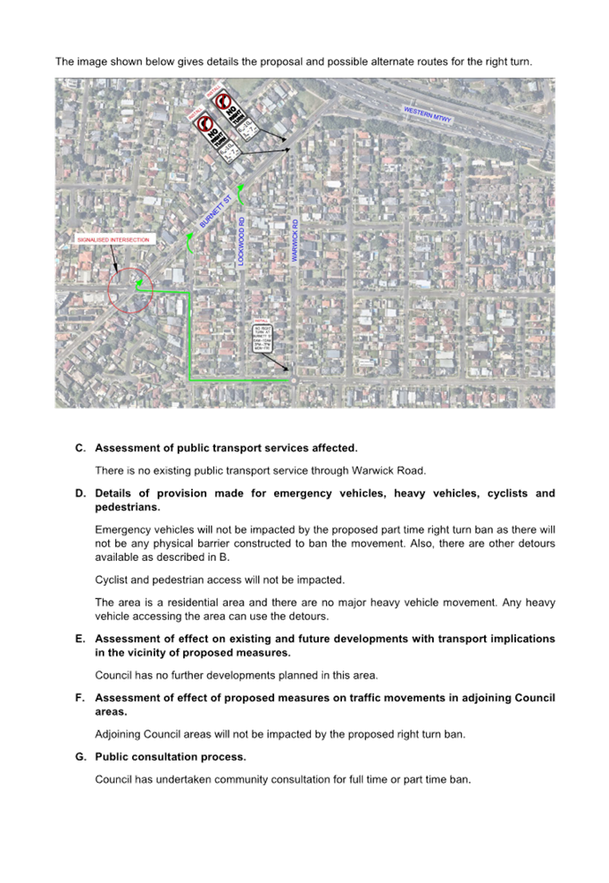
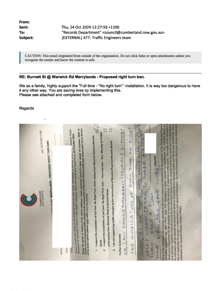
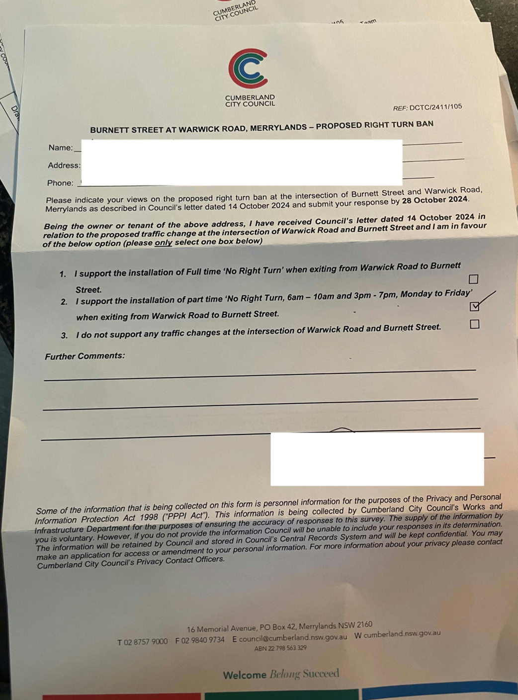
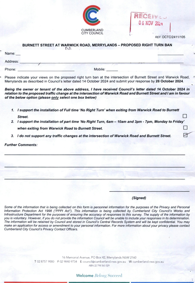
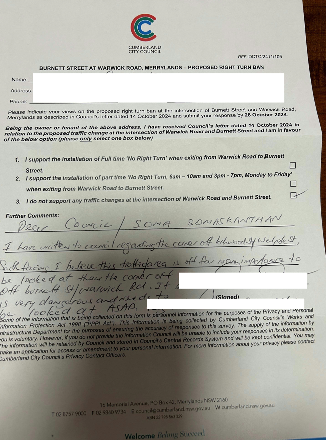
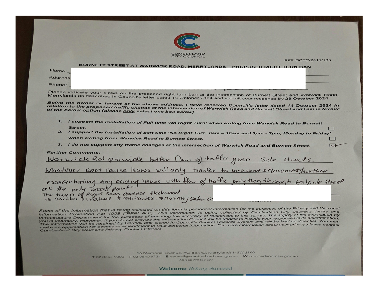
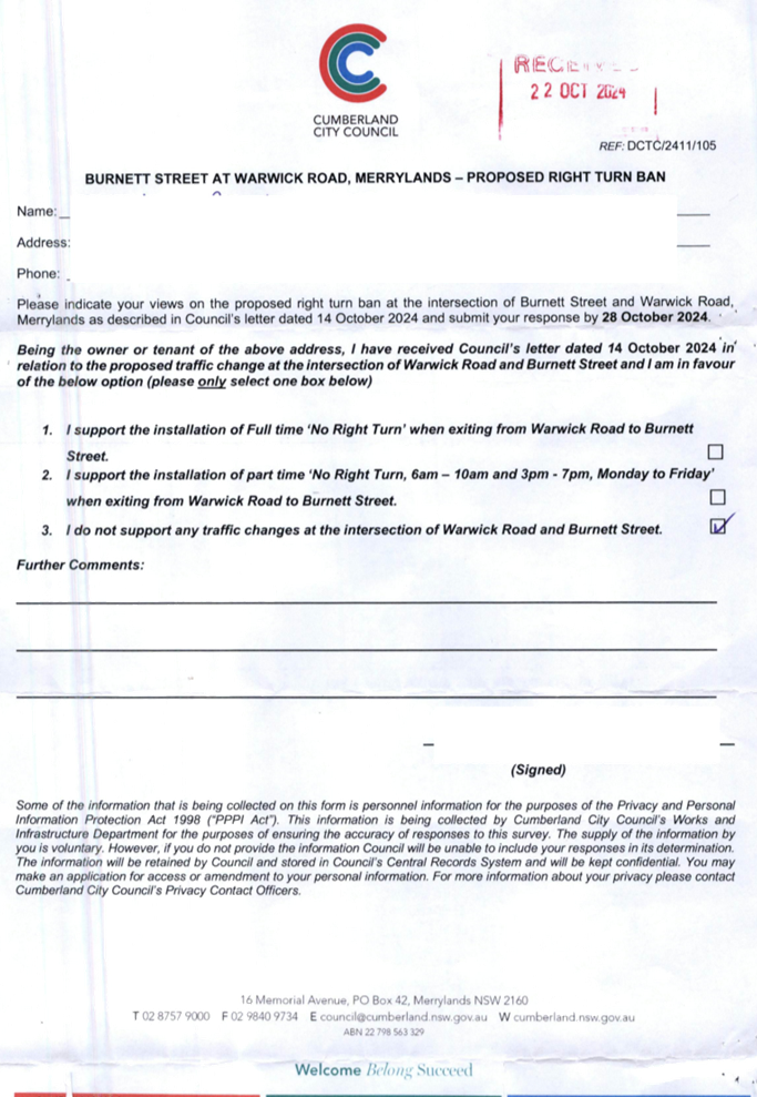
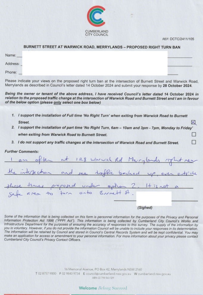
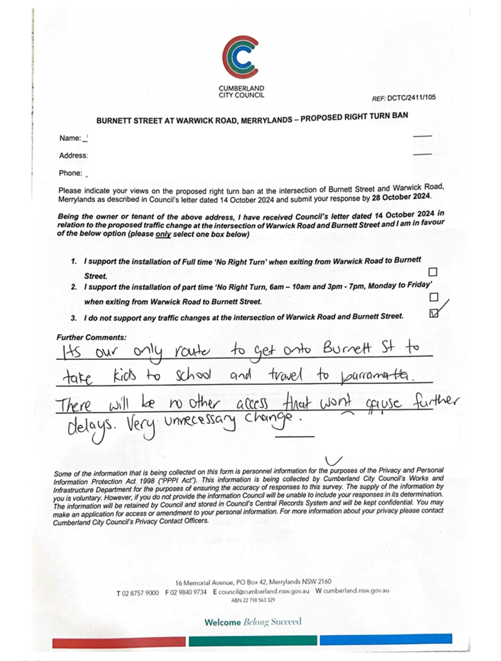
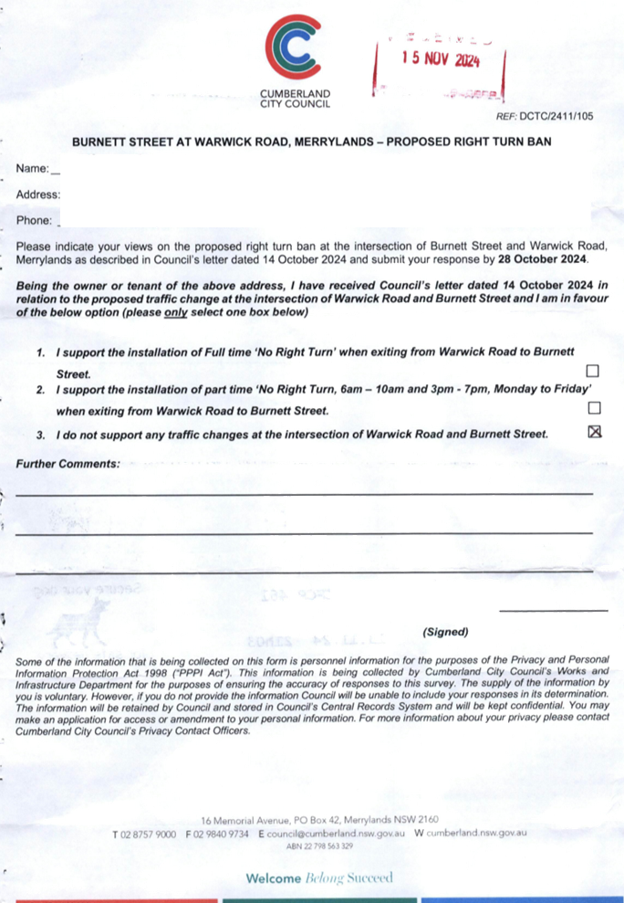
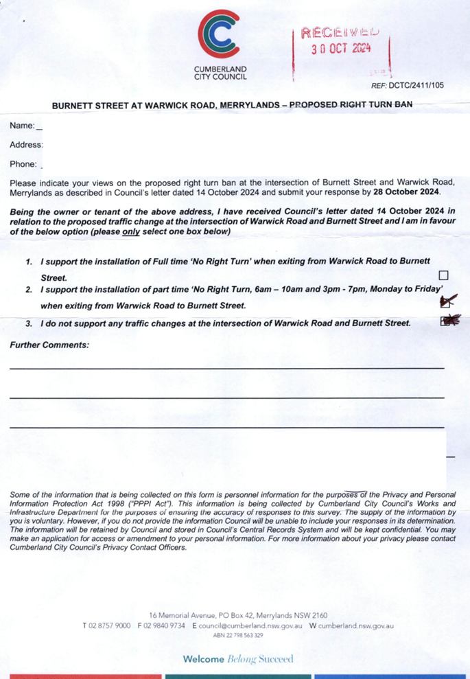
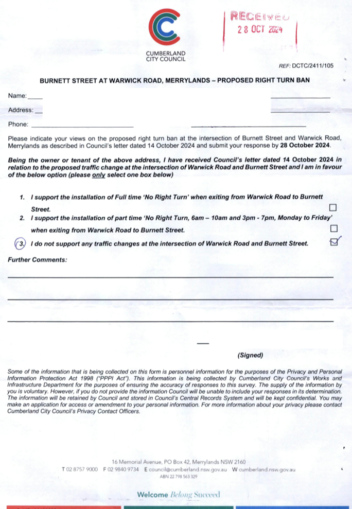
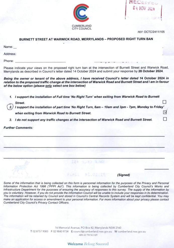
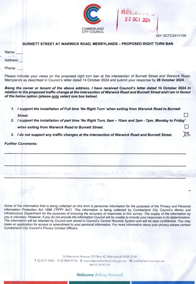
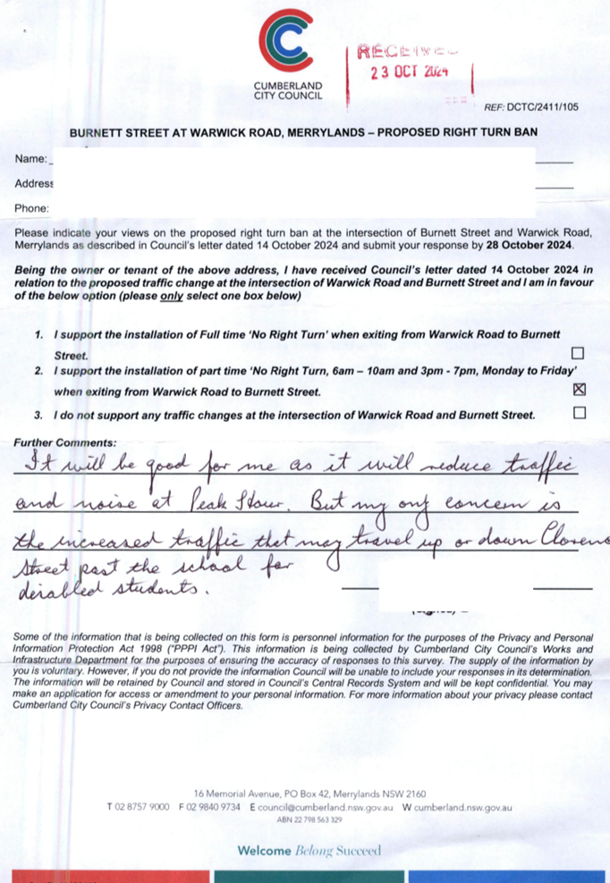
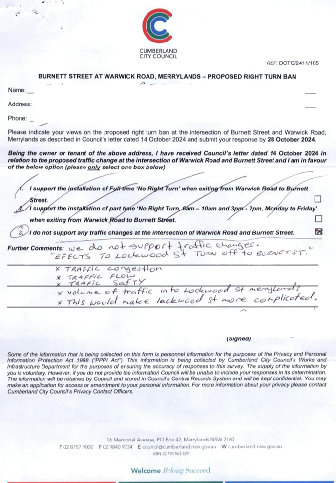
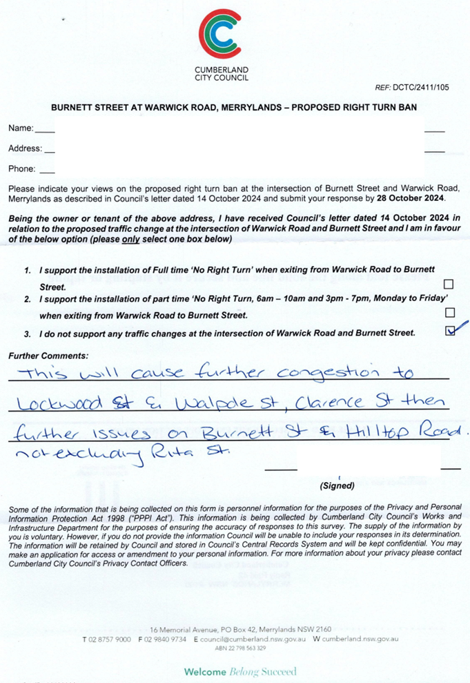
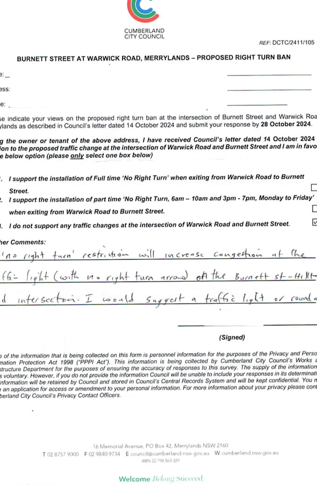
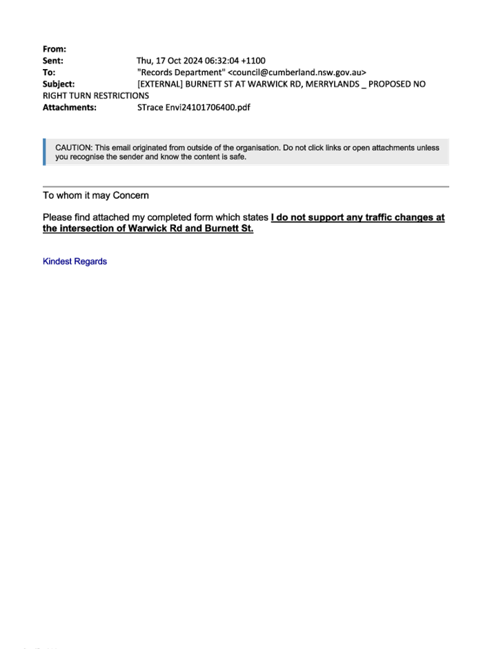
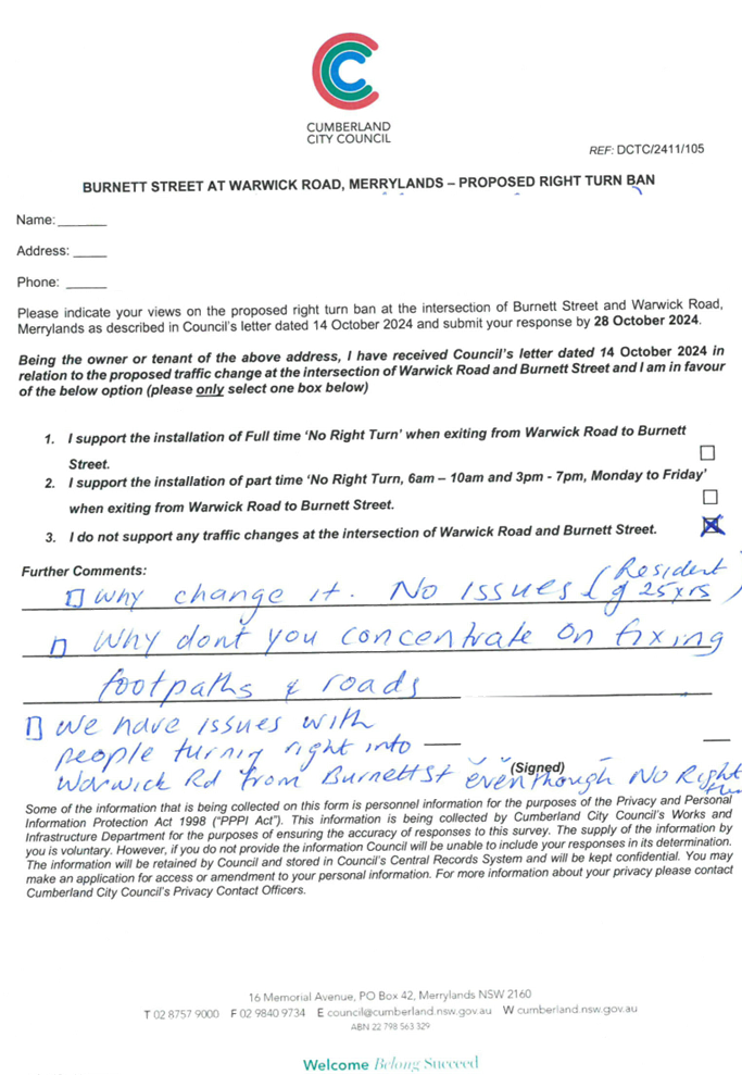
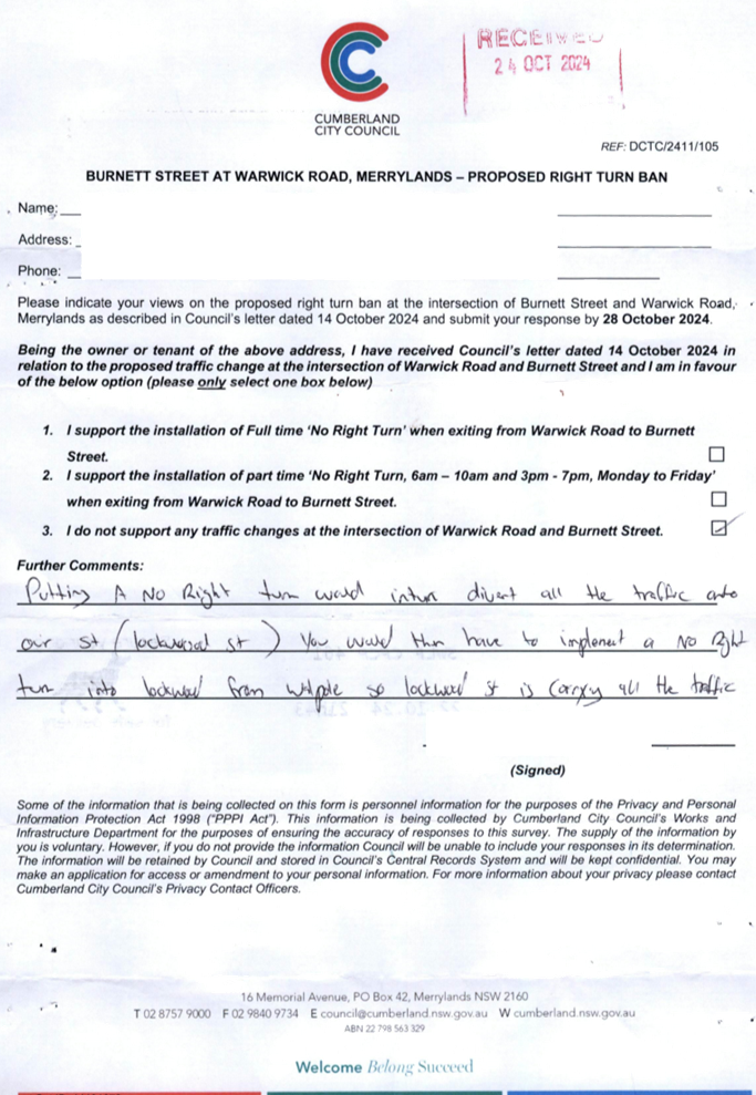
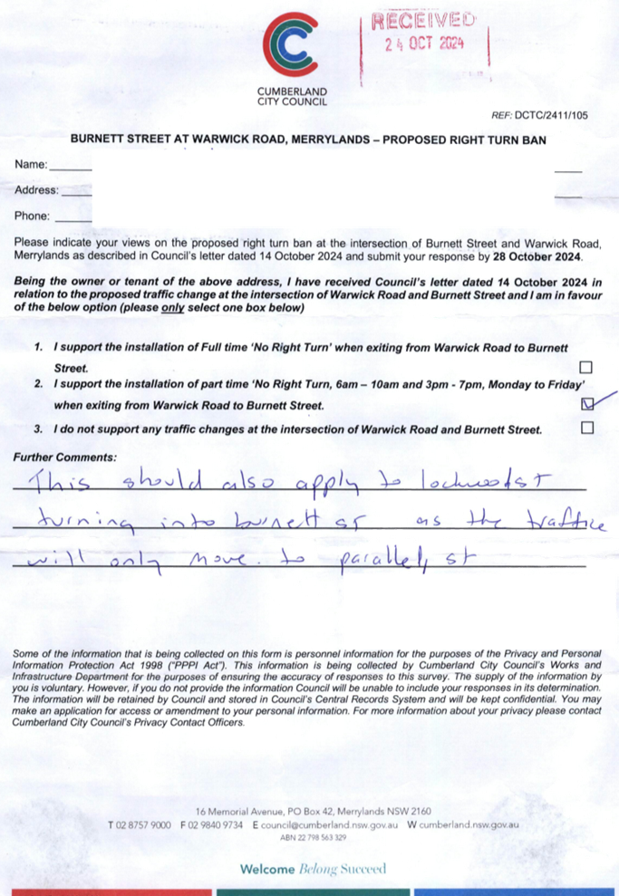
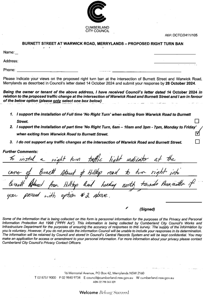
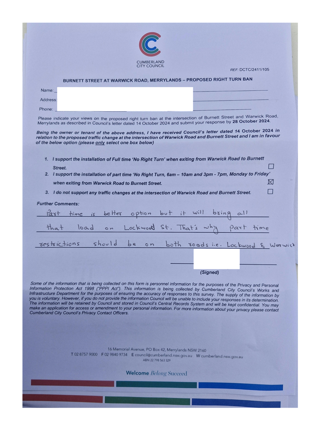
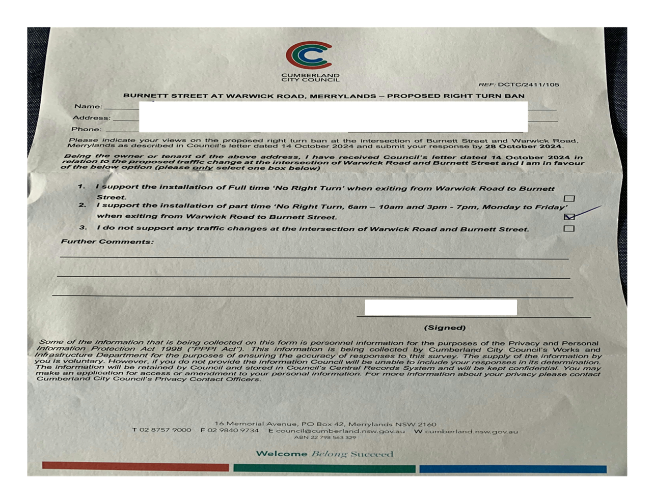
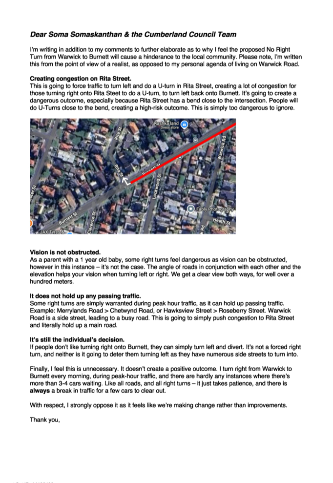
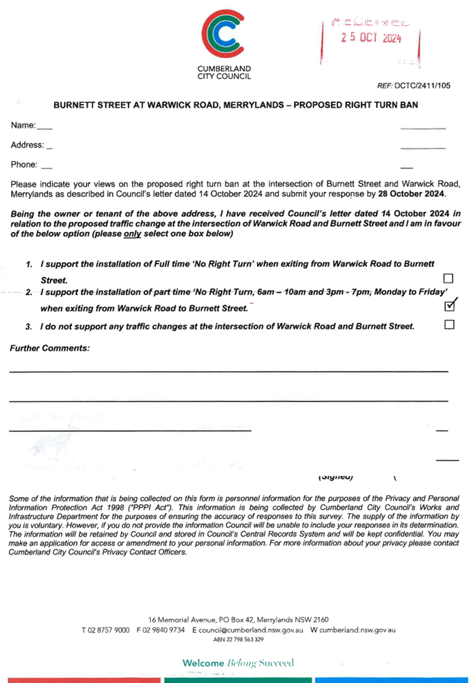
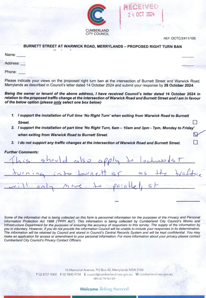
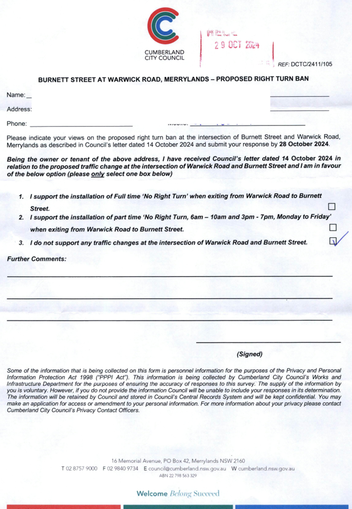
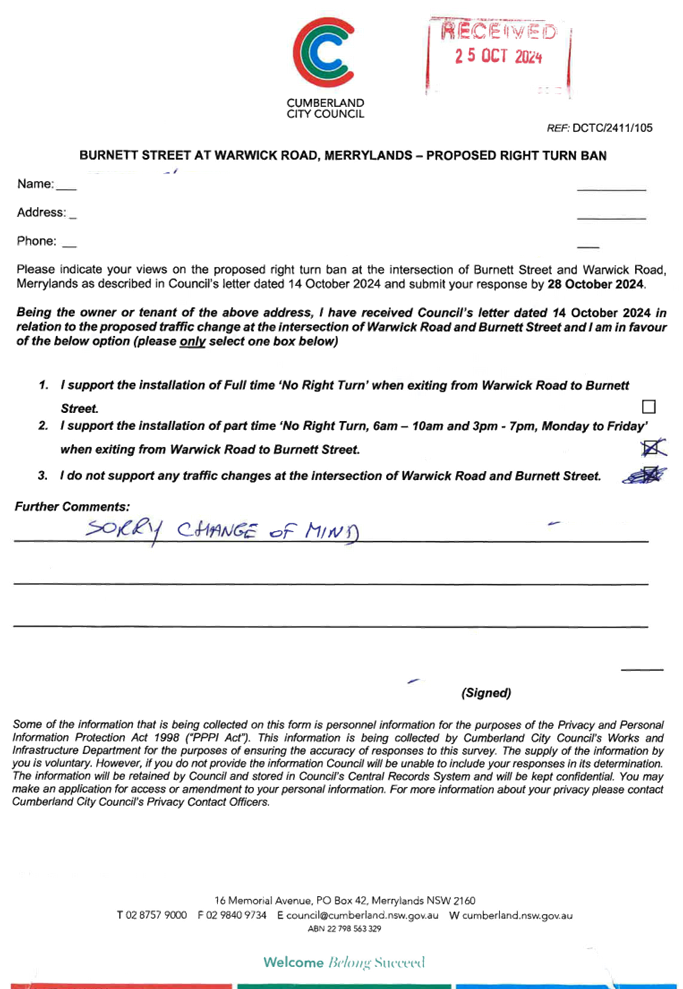
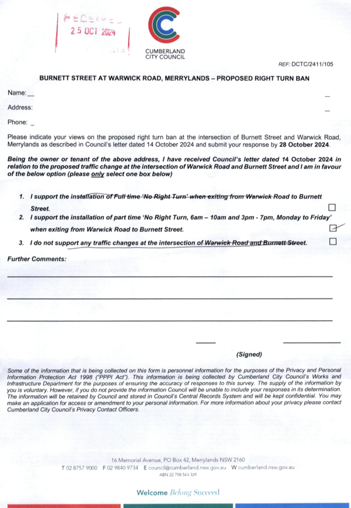
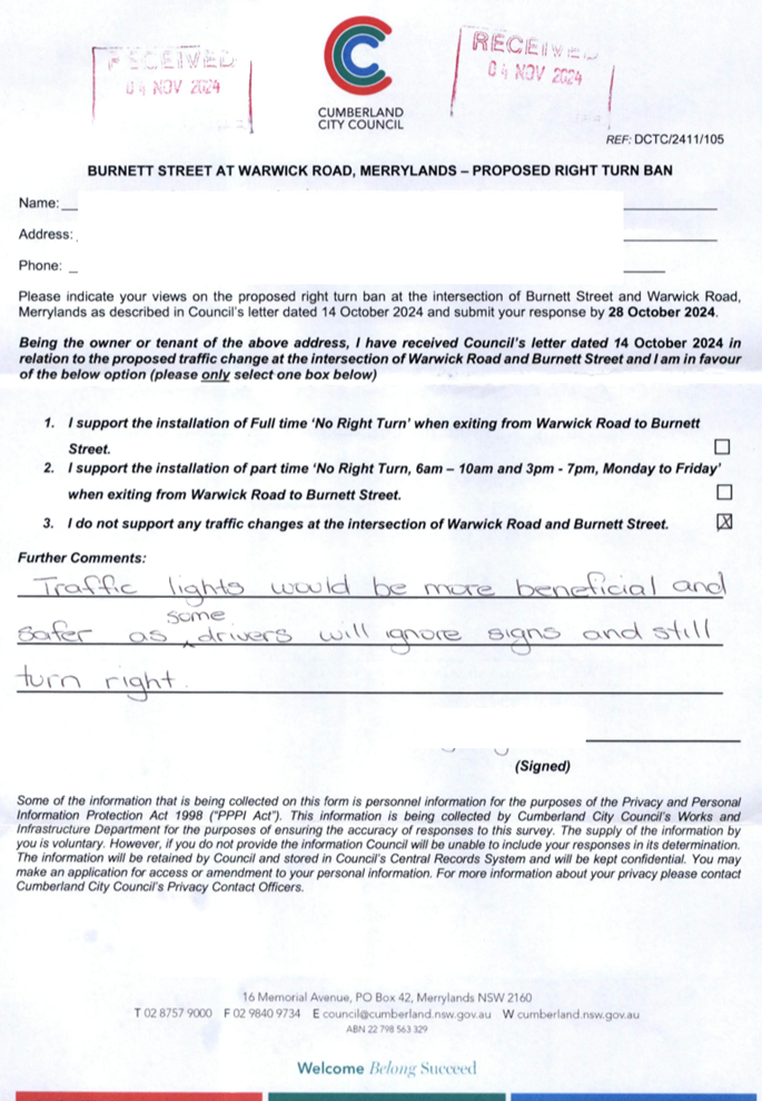
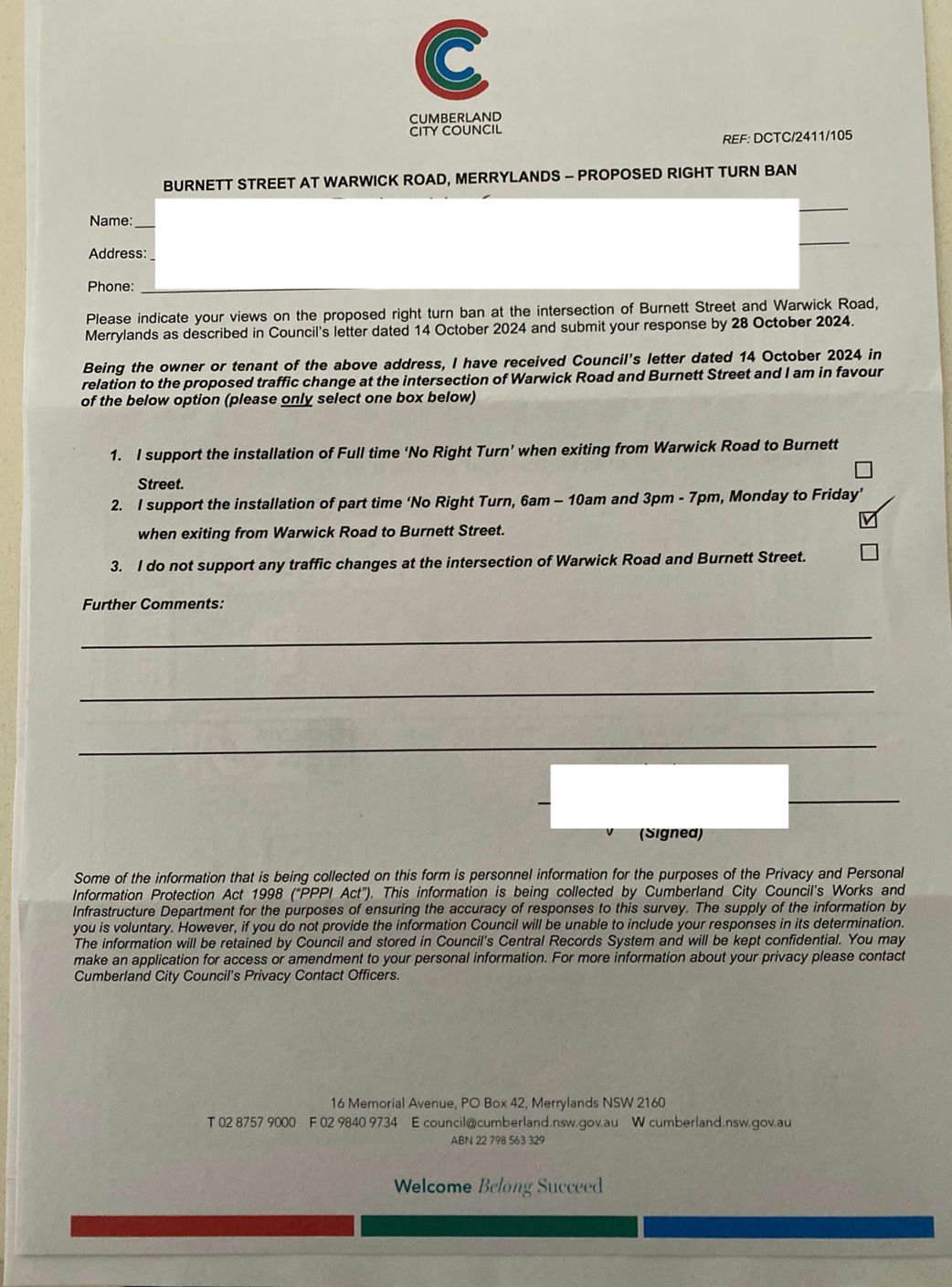
CTC-25-122 |
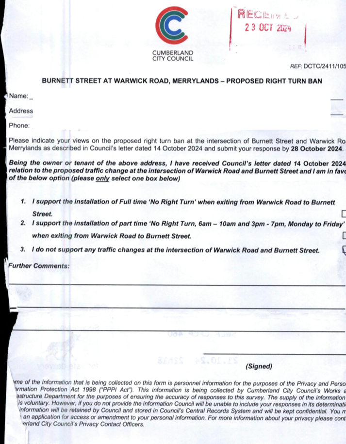
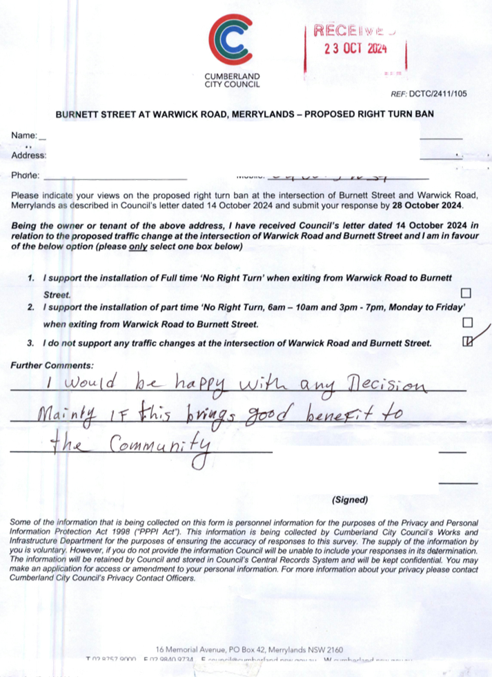
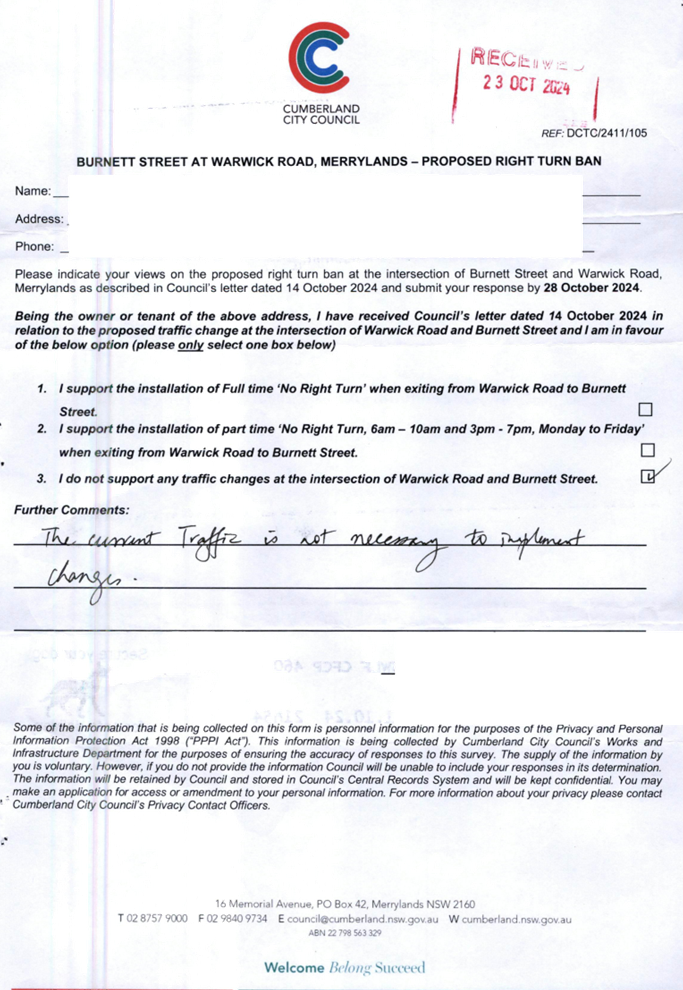
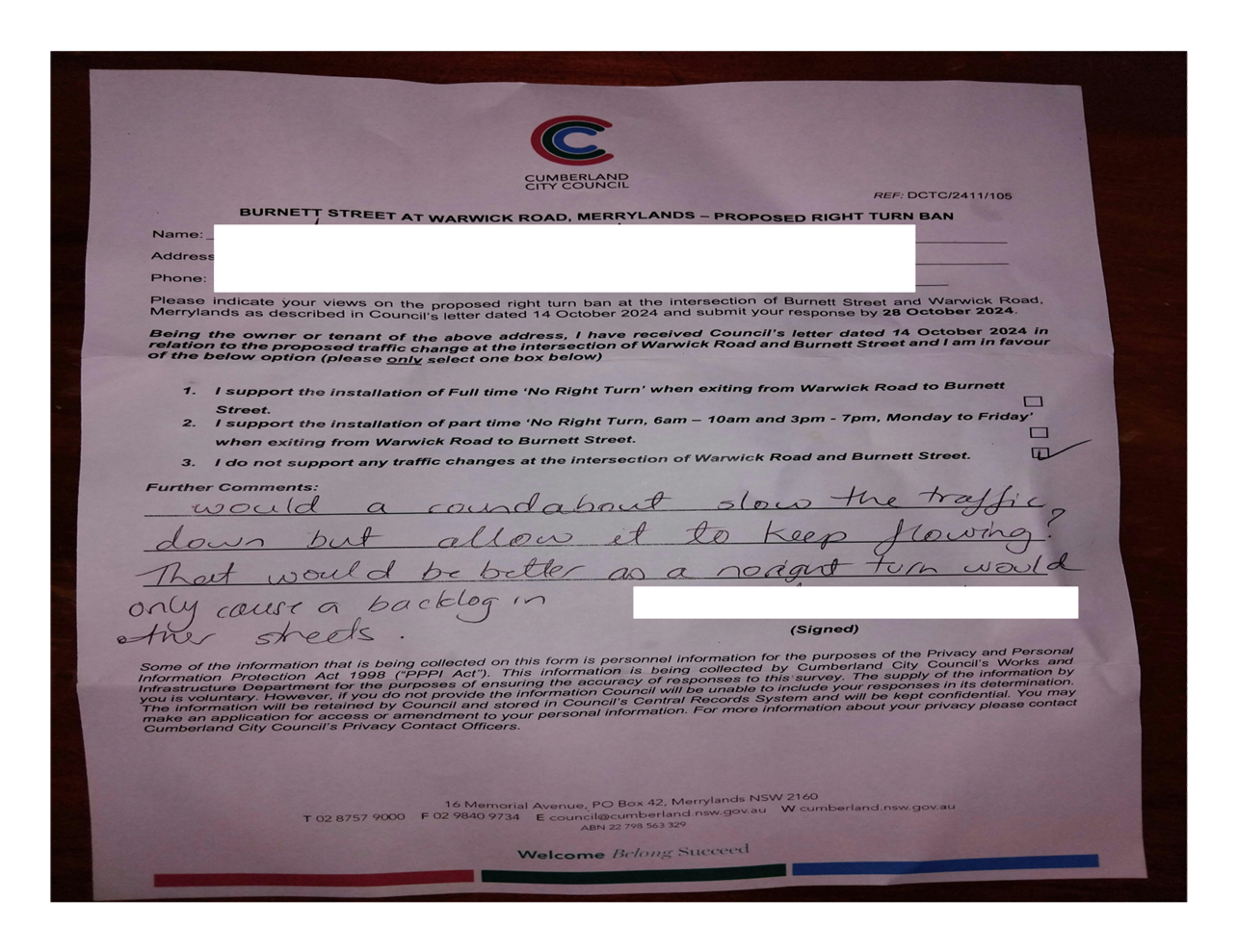
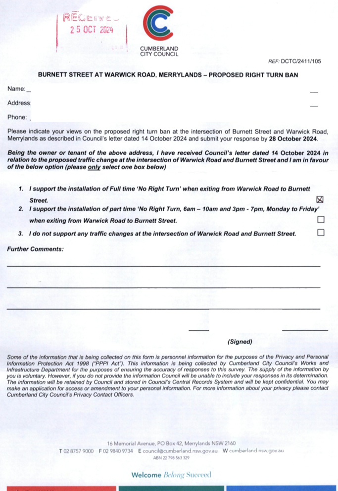
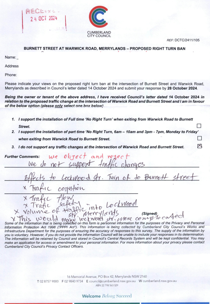
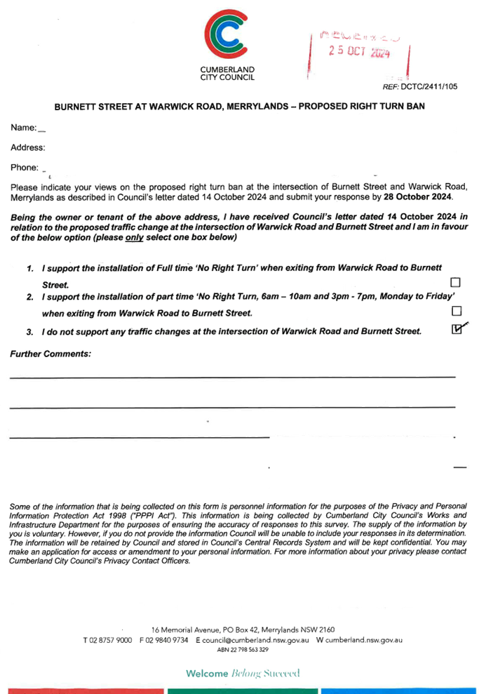
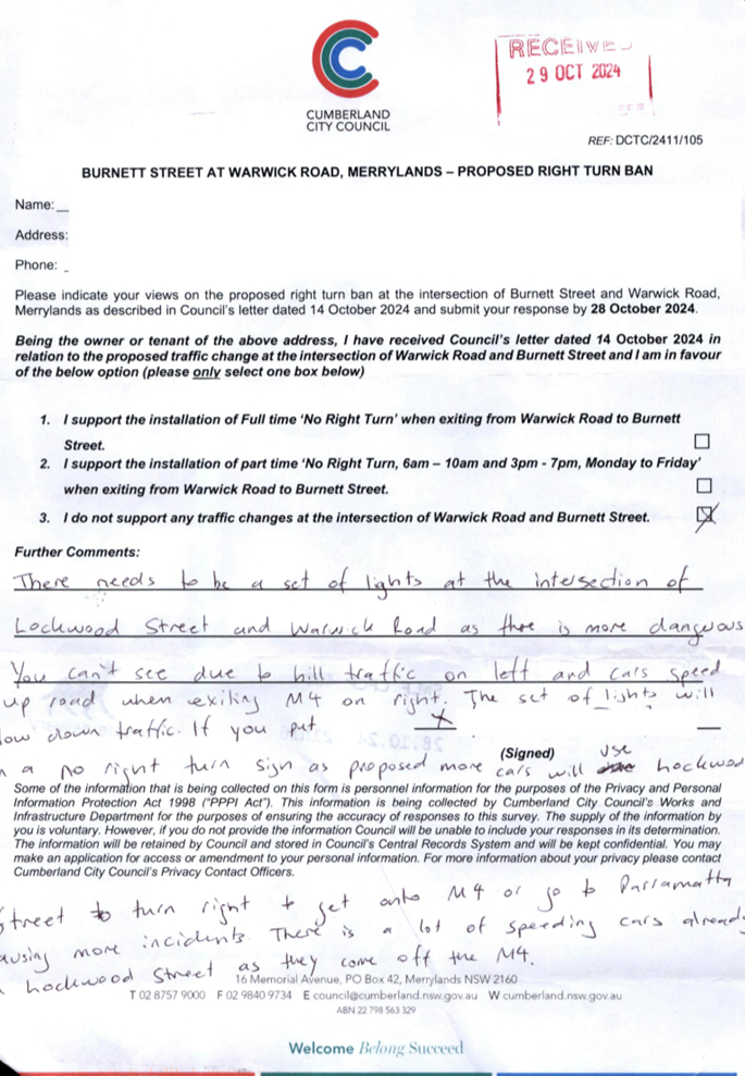
WARWICK ROAD & BURNETT STREET, MERRYLANDS – REQUEST FOR BANNING TURNING MOVEMENTS AT THE INTERSECTION |
|
´ |
|
|
´ |
|
|
CTC-25-123 |
OLD PROSPECT ROAD AND ETTALONG STREET, GREYSTANES – TEMPORARY ROAD CLOSURES ASSOCIATED WITH ‘OUR LADY QUEEN OF PEACE FESTA’ |
|
|
´ |
|
´ |
|
|
CTC-25-124 |
BRISTOL STREET, MERRYLANDS WEST – ROAD SAFETY CONCERNS |
|
´ |
|
|
´ |
|
|
CTC-25-125 |
HARGRAVE ROAD, AUBURN – PROVISION OF A PEDESTRIAN CROSSING OUTSIDE AUBURN HOSPITAL |
|
|
|
´ |
|
´ |
|
CTC-25-126 |
OCTAVIA STREET, TOONGABBIE – PROVISION OF A PEDESTRIAN CROSSING AT THE INTERSECTION WITH AURELIA STREET |
|
|
´ |
|
´ |
|
|
CTC-25-127 |
TALBOT ROAD, GUILDFORD - PROPOSED PEDESTRIAN FENCING |
|
´ |
|
|
´ |
|
|
CTC-25-128 |
OLYMPIC DRIVE, LIDCOMBE – PROPOSED SAFETY FENCE |
|
|
|
´ |
|
´ |
|
CTC-25-129 |
PRINCES STREET AND KING STREET, GUILDFORD WEST – PROPOSED ROUNDABOUT |
|
´ |
|
|
´ |
|
|
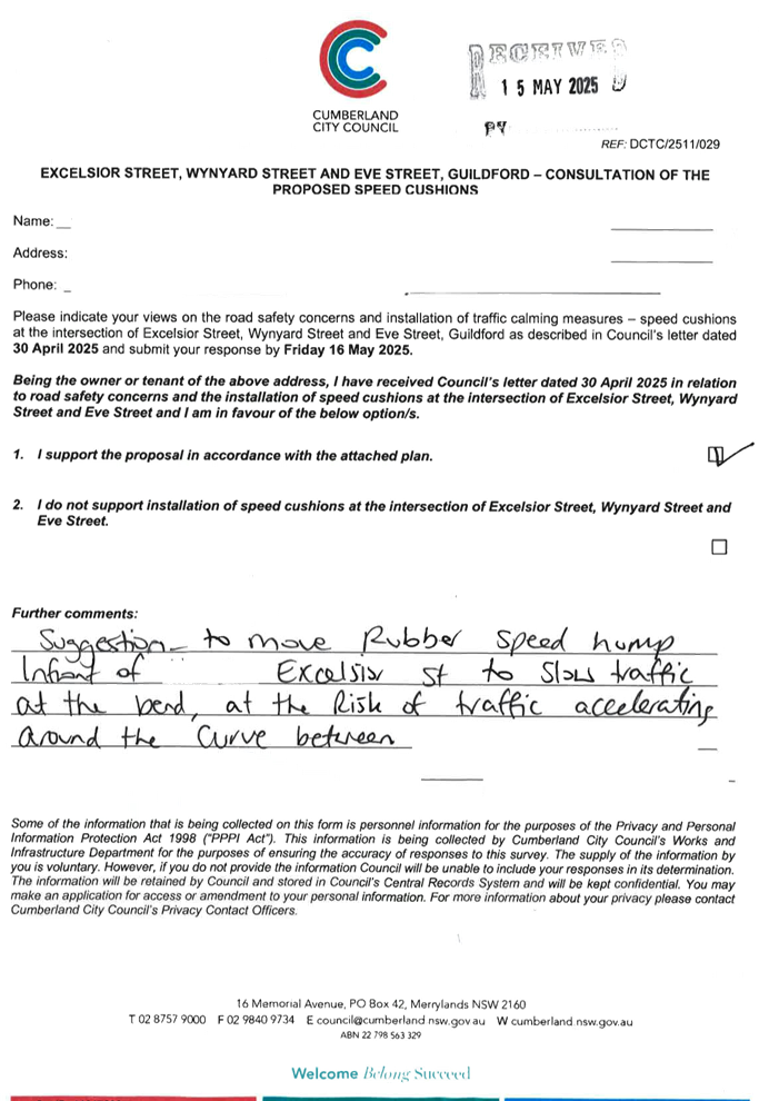
CTC-25-130 |
EXCELSIOR STREET, WYNYARD STREET AND EVE STREET, GUILDFORD - ROAD SAFETY CONCERNS - CONSULTATION RESULT |
|
´ |
|
|
´ |
|
|
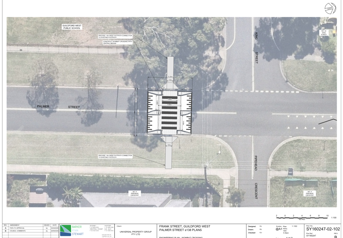
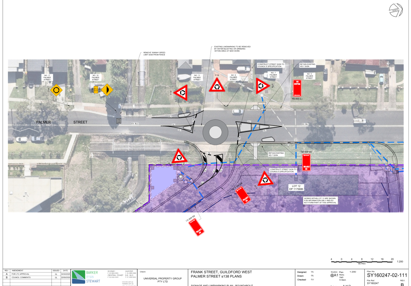
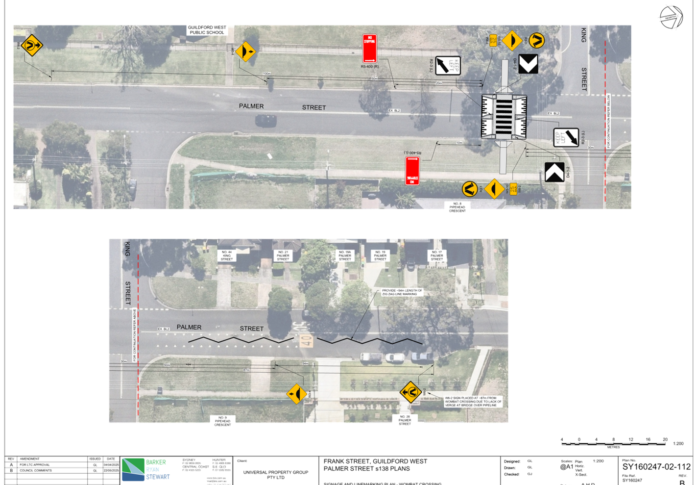
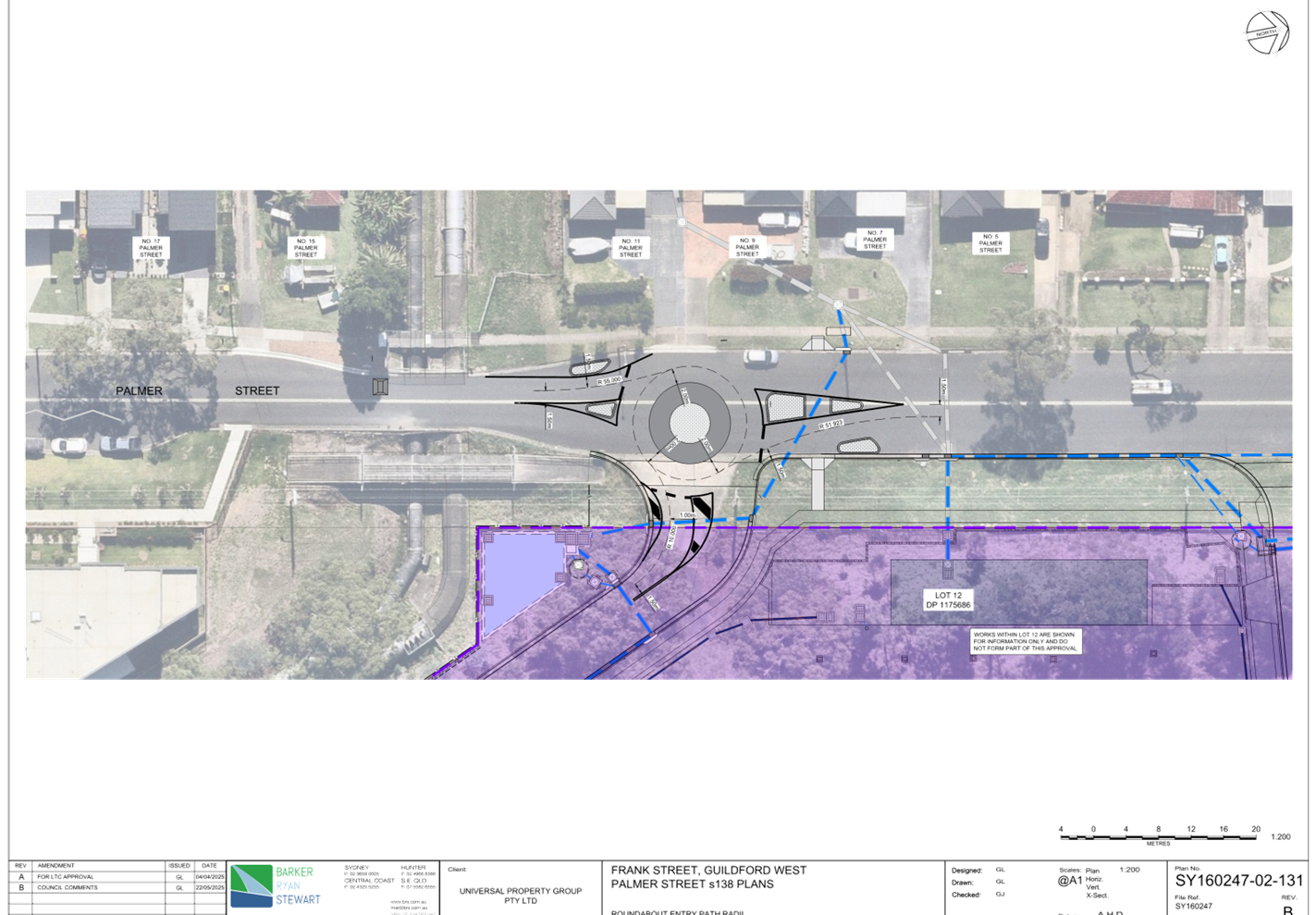
CTC-25-131 |
PALMER STREET, GUILDFORD WEST – PROPOSED ROUNDABOUT AND PEDESTRIAN CROSSING |
|
´ |
|
|
´ |
|
|
CTC-25-132 |
PARK ROAD AND ANGUS AVENUE, AUBURN – PROPOSED INTERSECTION TREATMENT |
|
|
|
´ |
|
´ |
|
CTC-25-133 |
PARK ROAD AT MOUNT AUBURN ROAD AND ANGUS AVENUE, AUBURN – PROPOSED ROUNDABOUT |
|
|
|
´ |
|
´ |
|
CTC-25-134 |
GUILDFORD ROAD, GUILDFORD – ROAD SAFETY CONCERNS |
|
´ |
|
|
|
|
4 June 2025
Minutes of the Traffic Committee meeting held at Merrylands Administration Building, 16 Memorial Avenue, Merrylands on Wednesday, 2 April 2025.
opening of meeting:
The meeting was opened by the Chairperson - Clr. Joseph Rahme at 9.33am.
Present:
|
MEMBERS |
|
|
Clr Joseph Rahme (Chairman) |
Cumberland City Council |
|
Matthew Tangonan |
Transport for NSW |
|
Mr George Campbell |
Local Member for Auburn |
|
Clr Glenn Elmore |
Local Member for Granville |
|
Leading Senior Constable William Graham |
Cumberland Police Area Command |
|
Leading Senior Constable Raymond Yeung |
Auburn Police Area Command |
|
COUNCIL OFFICERS |
|
|
Daniel Cavallo |
Director Environment & Planning |
|
Elias Elias |
Manager Engineering & Building |
|
Soma Somaskanthan |
Executive Engineer Traffic and Transport |
|
Siva Sivakumar |
Manager Special Projects |
|
Scott Kavanagh |
Coordinator Engineering Services |
|
Gabrielle Zerni |
Supervisor Administration |
|
Nancy Nguyen |
Engineering & Building Administration Officer |
|
Paulette Maroon |
Governance Officer (Minute Taker) |
Apologies:
|
Dr Diane Colman |
Local Member for Prospect Concurrence for all items received. |
|
Local Member for Fairfield – no representative nominated |
Local Member for Fairfield - No items in the electorate. |
|
James Duguid |
Transit Systems – Concurrence for all items received. |
Declarations Of Interest
Nil.
CONFIRMATION OF previous MINUTES
That the Cumberland Traffic Committee confirm the minutes of the Cumberland Traffic Committee held on 5 February 2025 be confirmed as per Council’s resolution 26 March 2025.
Note: Final Resolutions can be viewed on Council’s Website.
Moved Clr. Glenn Elmore, Seconded Mr George Campbell.
Summary of Reports
Part 1 - Recommended for Approval under Delegated Authority
|
Item # |
Title |
Electorate |
Police Area Command (PAC) |
||||
|
Fairfield |
Granville |
Prospect |
Auburn |
Cumberland |
Auburn |
||
|
CTC-25-057 |
ROBILLIARD STREET AND REES STREET, MAYS HILL – PROPOSED LINE MARKING ADJUSTMENT |
|
´ |
|
|
´ |
|
|
CTC-25-058 |
JOYCE STREET, PENDLE HILL - PROPOSED ACCESSIBLE PARKING SPACE |
|
|
´ |
|
´ |
|
|
CTC-25-059 |
TARGO ROAD AT ORAMZI ROAD AND BANDO ROAD, GIRRAWEEN – PROPOSED LINE MARKING |
|
|
´ |
|
´ |
|
|
CTC-25-060 |
GUILFOYLE STREET, BERALA - APPLICATION FOR 'WORKS ZONE' SIGNAGE |
|
|
|
´ |
|
´ |
|
CTC-25-061 |
MURPHY STREET AT BRISTOL STREET, MERRYLANDS WEST – INTERSECTION TREATMENT |
|
´ |
|
|
´ |
|
|
CTC-25-062 |
DAN STREET, MERRYLANDS – PROPOSED ‘NO PARKING’ SIGNS DURING WASTE NIGHT |
|
´ |
|
|
´ |
|
|
CTC-25-063 |
NEILSON STREET, GRANVILLE – PROPOSED ‘NO PARKING’ SIGNS DURING WASTE NIGHT |
|
´ |
|
|
´ |
|
|
CTC-25-064 |
ROSE CRESCENT, REGENTS PARK – PROPOSED PARKING RESTRICTIONS |
|
|
|
´ |
|
´ |
|
CTC-25-065 |
REGENT STREET AND CAMPBELL STREET AT LEONIE CRESCENT, BERALA – PROPOSED INTERSECTION TREATMENT |
|
|
|
´ |
|
´ |
|
CTC-25-066 |
HARROW ROAD, AUBURN – PROPOSED 1/4 P PARKING RESTRICTIONS |
|
|
|
´ |
|
´ |
|
CTC-25-067 |
HILLTOP ROAD, MERRYLANDS-PROPOSED TIMED PARKING RESTRICTION |
|
´ |
|
|
´ |
|
|
CTC-25-068 |
FREITAS LANE, LIDCOMBE – PROPOSED PARKING RESTRICTIONS |
|
|
|
´ |
|
´ |
|
CTC-25-069 |
CUMBERLAND ROAD CORNER OF CHISWICK ROAD, AUBURN - PROPOSED TIMED PARKING |
|
|
|
´ |
|
´ |
|
CTC-25-070 |
CUMBERLAND ROAD CORNER OF MARY STREET, AUBURN - PROPOSED TIMED PARKING |
|
|
|
´ |
|
´ |
|
CTC-25-071 |
DUFFY STREET, MERRYLANDS – PROPOSED ‘NO PARKING’ RESTRICTIONS |
|
´ |
|
|
´ |
|
|
CTC-25-072 |
HAWKSVIEW STREET, GUILDFORD – RELOCATION OF THE EXISTING PARKING RESTRICITON |
|
´ |
|
|
´ |
|
|
CTC-25-073 |
LANEWAY BETWEEN FIRST STREET AND SECOND STREET, GRANVILLE – PROPOSED PARKING RESTRICTIONS |
|
´ |
|
|
´ |
|
|
CTC-25-074 |
LANEWAY BETWEEN SECOND STREET AND THIRD STREET, GRANVILLE – PROPOSED PARKING RESTRICTIONS |
|
´ |
|
|
´ |
|
|
CTC-25-075 |
LANEWAY BETWEEN THIRD STREET AND FOURTH STREET, GRANVILLE – PROPOSED PARKING RESTRICTIONS |
|
´ |
|
|
´ |
|
|
CTC-25-076 |
LANEWAY BETWEEN FOURTH STREET AND FIFTH STREET, GRANVILLE – PROPOSED PARKING RESTRICTIONS |
|
´ |
|
|
´ |
|
|
CTC-25-077 |
LANEWAY BETWEEN WILLIAM STREET AND FIRST STREET, GRANVILLE – PROPOSED PARKING RESTRICTIONS |
|
´ |
|
|
´ |
|
|
CTC-25-078 |
CLYDE STREET, GRANVILLE AT SIXTH STREET – PROPOSED ‘NO STOPPING’ RESTRICTIONS |
|
´ |
|
|
´ |
|
|
CTC-25-079 |
LANEWAY BETWEEN FIFTH STREET AND SIXTH STREET, GRANVILLE – PROPOSED PARKING RESTRICTIONS |
|
´ |
|
|
´ |
|
|
CTC-25-080 |
HAMPSTEAD ROAD, AUBURN – APPLICATION FOR ‘WORKS ZONE’ SIGNAGE |
|
|
|
´ |
|
´ |
|
CTC-25-081 |
WARREN ROAD AND WOODPARK ROAD, WOODPARK – REQUEST FOR A ROUNDABOUT |
|
´ |
|
|
´ |
|
|
CTC-25-082 |
MARTIN STREET, LIDCOMBE – APPLICATION FOR ‘WORKS ZONE’ SIGNAGE |
|
|
|
´ |
|
´ |
|
CTC-25-083 |
GIBBONS ST, AUBURN – APPLICATION FOR ‘WORKS ZONE’ SIGNAGE |
|
|
|
´ |
|
´ |
|
CTC-25-084 |
PEGLER AVENUE, SOUTH GRANVILLE – APPLICATION FOR ‘WORKS ZONE’ SIGNAGE |
|
´ |
|
|
´ |
|
Part 2 - Recommendation to Council
Note: Part 2 recommendations of the Traffic Committee are subject to Council’s endorsement. For final decisions regarding these matters, please refer to the Council Meeting Minutes where these matters were reported to Council for determination.
|
Item # |
Title |
Electorate |
Police Area Command (PAC) |
||||
|
Fairfield |
Granville |
Prospect |
Auburn |
Cumberland |
Auburn |
||
|
CTC-25-085 |
DAMIEN AVENUE, GREYSTANES - ROAD SAFETY CONCERNS |
|
|
´ |
|
´ |
|
|
CTC-25-086 |
GORDON AVENUE, SOUTH GRANVILLE – ROAD SAFETY CONCERNS |
|
´ |
|
|
´ |
|
|
CTC-25-087 |
KENYONS ROAD, MERRYLANDS WEST – ROAD SAFETY CONCERNS |
|
´ |
|
|
´ |
|
|
CTC-25-088 |
DRIFTWAY DRIVE, PEMULWUY - REQUEST FOR PEDESTRIAN CROSSING |
|
|
´ |
|
´ |
|
|
CTC-25-089 |
BRIGHTON STREET, GREYSTANES – ROAD SAFETY CONCERNS - CONSULTATION |
|
|
´ |
|
´ |
|
|
CTC-25-090 |
TOONGABBIE ROAD, TOONGABBIE –SAFETY CONCERNS AT THE BEND |
|
|
´ |
|
´ |
|
|
CTC-25-091 |
DAHLIA STREET, GREYSTANES – ALPHA ROAD PARK PARKING REVIEW |
|
|
´ |
|
´ |
|
|
CTC-25-092 |
GILBA ROAD GIRRAWEEN – PROPOSED MODIFICATIONS TO PREVIOUSLY APPROVED RAISED PEDESTRIAN CROSSING |
|
´ |
|
|
´ |
|
|
CTC-25-093 |
PENDLE HILL PUBLIC DOMAIN PLAN - JOYCE STREET PARK UPGRADE, PENDLE HILL – PROPOSED REALIGNMENT OF PEDESTRIAN CROSSING & ROUNDABOUT AT PURDIE LANE |
|
|
´ |
|
´ |
|
|
CTC-25-094 |
CHARLES STREET, GRANVILLE - CONCERNS AT THE INTERSECTION WITH BLAXCELL STREET |
|
´ |
|
|
´ |
|
|
CTC-25-095 |
LAVINIA STREET, SOUTH GRANVILLE - SAFETY CONCERNS |
|
´ |
|
|
´ |
|
|
CTC-25-096 |
MAIN AVENUE, LIDCOMBE – ROAD SAFETY CONCERNS |
|
|
|
´ |
|
´ |
|
CTC-25-097 |
REDFERN STREET, GRANVILLE - SAFETY CONCERNS |
|
´ |
|
|
´ |
|
|
CTC-25-098 |
MONA STREET, AUBURN & SOUTH GRANVILLE – PARKING RESTRICTION MODIFICATION |
|
|
|
´ |
|
´ |
Part 1 - Recommended for Approval under Delegated Authority in accordance with Part 1 of the Terms of Reference for the Cumberland Local Traffic Committee.
|
Items Resolved by Exception |
|
The Committee resolved by exception the below items on the Traffic Committee Agenda as per the recommendations in the reports:
CTC-25-057, CTC-25-058, CTC-25-059, CTC-25-060, CTC-25-061, CTC-25-062, CTC-25-063, CTC-25-064, CTC-25-065, CTC-25-066, CTC-25-067, CTC-25-068, CTC-25-069, CTC-25-070, CTC-25-071, CTC-25-072, CTC-25-073, CTC-25-074, CTC-25-075, CTC-25-076, CTC-25-077, CTC-25-078, CTC-25-079, CTC-25-080, CTC-25-081, CTC-25-082, CTC-25-083, CTC-25-084.
Moved Mr George Campbell, Seconded Clr Glenn Elmore |
|
ITEM CTC-25-057 - ROBILLIARD STREET AND REES STREET, MAYS HILL – PROPOSED LINE MARKING ADJUSTMENT |
|
Resolved by Exception
The Traffic Committee recommends that the adjustment of ‘BL2’, ‘TB’ and ‘TB1’ line marking at the intersection of Robilliard Street and Rees Street, Mays Hill in accordance with the attached plan be approved. |
|
ITEM CTC-25-058 - JOYCE STREET, PENDLE HILL - PROPOSED ACCESSIBLE PARKING SPACE |
|
Resolved by Exception
The Traffic Committee recommends that:
1. The proposed accessible parking spaces on Joyce Street, Pendle Hill in accordance with the attached plan be approved.
2. The resident with the request and affected residents / businesses be advised of the outcome. |
|
ITEM CTC-25-059 - TARGO ROAD AT ORAMZI ROAD AND BANDO ROAD, GIRRAWEEN – PROPOSED LINE MARKING |
|
Resolved by Exception
The Traffic Committee recommends that the installation of ‘BL2’ line marking on Targo Road, Girraween and its intersections of Oramzi Road and Bando Road, Girraween in accordance with the attached plans be approved. |
|
ITEM CTC-25-060 - GUILFOYLE STREET, BERALA - APPLICATION FOR 'WORKS ZONE' SIGNAGE |
|
Resolved by Exception
The Traffic Committee recommends that:
1. The 12m long ‘Works Zone, 7:00am-6:00pm, Monday-Friday, 8:00am-4:00pm, Saturday’ signs be approved on the frontage of the redevelopment site on Guilfoyle Street, Berala in accordance with the attached plan subject to Council’s standard conditions for the period of 6 months and subsequent extension if required.
2. The applicant be advised to pay the ‘Works Zone’ fees to Council as per the adopted Fees and Charges. |
|
ITEM CTC-25-061 - MURPHY STREET AT BRISTOL STREET, MERRYLANDS WEST – INTERSECTION TREATMENT |
|
Resolved by Exception
The Traffic Committee recommends that:
1. The installation of ‘No Stopping’ signage, ‘BL2’ and chevron line marking at the intersection of Murphy Street and Bristol Street, Merrylands West in accordance with the attached plan be approved in-principle.
2. Council undertake consultation with the affected residents and report back to Traffic Committee if objections are received.
3. The residents with the request and affected residents be advised of the outcome. |
|
ITEM CTC-25-062 - DAN STREET, MERRYLANDS – PROPOSED ‘NO PARKING’ SIGNS DURING WASTE NIGHT |
|
Resolved by Exception The Traffic Committee recommends that: 1. The proposed ‘No Parking 5am-12pm Thursday’ restrictions in the cul-de-sac of Dan Street, Merrylands in accordance with the attached plan be approved. 2. The resident with the request and affected residents be advised of the outcome. |
|
ITEM CTC-25-063 - NEILSON STREET, GRANVILLE – PROPOSED ‘NO PARKING’ SIGNS DURING WASTE NIGHT |
|
Resolved by Exception The Traffic Committee recommends that: 1. The proposed ‘No Parking 5am-12pm Thursday’ restrictions in the cul-de-sac of Neilson Street, Granville in accordance with the attached plan be approved. 2. The resident with the request and affected residents be advised of the outcome. |
|
ITEM CTC-25-064 - ROSE CRESCENT, REGENTS PARK – PROPOSED PARKING RESTRICTIONS |
|
Resolved by Exception The Traffic Committee recommends: 1. The installation of “No Parking, Motor Vehicles Under 4.5 t GVM Excepted” signs on the northern side of Rose Crescent, Regents Park in accordance with the attached plan be approved.
2. The persons with the request and affected properties be advised of the outcome. |
|
ITEM CTC-25-065 - REGENT STREET AND CAMPBELL STREET AT LEONIE CRESCENT, BERALA – PROPOSED INTERSECTION TREATMENT |
|
Resolved by Exception
The Traffic Committee recommends that:
1. The installation of ‘Give Way’ signs, line marking, and ‘No Stopping’ restrictions in Regent Street and Campbell Street at the intersection of Leonie Crescent, Berala in accordance with attached plan be approved.
2. The resident with the request and affected residents be advised of the outcome. |
|
ITEM CTC-25-066 - HARROW ROAD, AUBURN – PROPOSED 1/4 P PARKING RESTRICTIONS |
|
Resolved by Exception
The Traffic Committee recommends that:
1. The installation of ‘1/4 P 9am to 7pm’ signage on the eastern side of Harrow Road, Auburn as per the attached plan be approved.
2. The business with the request and affected residents be advised of the outcome. |
|
ITEM CTC-25-067 - HILLTOP ROAD, MERRYLANDS-PROPOSED TIMED PARKING RESTRICTION |
|
Resolved by Exception
The Traffic Committee recommends that:
1. The installation of ‘1/2 P 8:30 am to 6pm Mon- Fri, 8:30 am to 12 noon Sat’ as per the attached plan be approved.
2. The property owner with the request and affected residents be advised of the outcome. |
|
ITEM CTC-25-068 - FREITAS LANE, LIDCOMBE – PROPOSED PARKING RESTRICTIONS |
|
Resolved by Exception That the Traffic Committee recommends that: 1. The proposed ‘No Parking’ and ‘No Stopping’ restrictions in Freitas Lane, Lidcombe in accordance with the attached plan be approved 2. The resident that made the request and affected residents be notified of the outcome. |
|
ITEM CTC-25-069 - CUMBERLAND ROAD CORNER OF CHISWICK ROAD, AUBURN - PROPOSED TIMED PARKING |
|
Resolved by Exception The Traffic Committee recommends that: 1. The installation of ‘1/2P 9 AM – 6 PM, Monday to Sunday’ signage in Chiswick Road outside the shop at the corner of Cumberland Road in accordance with the attached plan be approved. 2. The business owner and adjacent residents be notified of the outcome. |
|
ITEM CTC-25-070 - CUMBERLAND ROAD CORNER OF MARY STREET, AUBURN - PROPOSED TIMED PARKING |
|
Resolved by Exception
The Traffic Committee recommends that:
1. The installation of ‘1/2P 9 AM – 6 PM, Monday to Sunday’ signage in Mary Street outside the shop at the corner of Cumberland Road in accordance with the attached plan be approved. 2. The business owner and adjacent residents be notified of the outcome. |
|
ITEM CTC-25-071 - DUFFY STREET, MERRYLANDS – PROPOSED ‘NO PARKING’ RESTRICTIONS |
|
Resolved by Exception
The Traffic Committee recommends that:
1. The extension of ‘No Stopping’ zone on the southern side of Duffy Street, Merrylands in front of No. 2, by an additional 12m to the west, in accordance with the attached plan be approved in-principle.
2. Council undertake consultation with the affected residents and report back to Traffic Committee if objections are received.
3. The resident with the request and affected residents be advised of the outcome. |
|
ITEM CTC-25-072 - HAWKSVIEW STREET, GUILDFORD – RELOCATION OF THE EXISTING PARKING RESTRICITON |
|
Resolved by Exception
The Traffic Committee recommends that:
1. The extension of the existing ‘No Stopping’ signage on the northern side of Hawksview Street, Merrylands in front of No. 7 in accordance with the attached plan be approved.
2. Council undertake consultation with affected residents and report back to Traffic Committee if objections are received.
3. The resident that made the request and affected residents be notified of the outcome. |
|
ITEM CTC-25-073 - LANEWAY BETWEEN FIRST STREET AND SECOND STREET, GRANVILLE – PROPOSED PARKING RESTRICTIONS |
|
Resolved by Exception That the Traffic Committee recommends that: 1. The proposed ‘No Parking’ and ‘No Stopping’ restrictions in the laneway between First Street and Second Street, Granville in accordance with the attached plan be approved.
2. The resident that made the request and affected residents be notified of the outcome. |
|
ITEM CTC-25-074 - LANEWAY BETWEEN SECOND STREET AND THIRD STREET, GRANVILLE – PROPOSED PARKING RESTRICTIONS |
|
Resolved by Exception That the Traffic Committee recommends that: 1. The proposed ‘No Parking’ and ‘No Stopping’ restrictions in the laneway between Second Street and Third Street, Granville in accordance with the attached plan be approved. 2. The resident that made the request and affected residents be notified of the outcome. |
|
ITEM CTC-25-075 - LANEWAY BETWEEN THIRD STREET AND FOURTH STREET, GRANVILLE – PROPOSED PARKING RESTRICTIONS |
|
Resolved by Exception That the Traffic Committee recommends that: 1. The proposed ‘No Parking’ and ‘No Stopping’ restrictions in the laneway between Third Street and Fourth Street, Granville in accordance with the attached plan be approved. 2. The resident that made the request and affected residents be notified of the outcome. |
|
ITEM CTC-25-076 - LANEWAY BETWEEN FOURTH STREET AND FIFTH STREET, GRANVILLE – PROPOSED PARKING RESTRICTIONS |
|
Resolved by Exception That the Traffic Committee recommends that: 1. The proposed ‘No Parking’ and ‘No Stopping’ restrictions in the laneway between Fourth Street and Fifth Street, Granville in accordance with the attached plan be approved. 2. The resident that made the request and affected residents be notified of the outcome. |
|
ITEM CTC-25-077 - LANEWAY BETWEEN WILLIAM STREET AND FIRST STREET, GRANVILLE – PROPOSED PARKING RESTRICTIONS |
|
Resolved by Exception That the Traffic Committee recommends that: 1. The proposed ‘No Parking’ and ‘No Stopping’ restrictions in the laneway between William Street and First Street, Granville in accordance with the attached plan be approved. 2. The resident that made the request and affected residents be notified of the outcome. |
|
ITEM CTC-25-078 - CLYDE STREET, GRANVILLE AT SIXTH STREET – PROPOSED ‘NO STOPPING’ RESTRICTIONS |
|
Resolved by Exception That the Traffic Committee recommends that: 1. The proposed ‘No Stopping’ restrictions and ‘Bus Zone’ signage on the eastern side of Clyde Street, Granville between Fifth Street and Sixth Street, and BL2 line marking on Sixth Street, in accordance with the attached plan, be approved in-principle. 2. Consultation be undertaken with directly affected residents and a report be provided back to the Traffic Committee meeting if objections are received. 3. The resident that made the request and affected residents be notified of the outcome. |
|
ITEM CTC-25-079 - LANEWAY BETWEEN FIFTH STREET AND SIXTH STREET, GRANVILLE – PROPOSED PARKING RESTRICTIONS |
|
Resolved by Exception That the Traffic Committee recommends that: 1. The proposed ‘No Parking’ restrictions in the laneway between Fifth Street and Sixth Street, Granville in accordance with the attached plan be approved. 2. The resident that made the request and affected residents be notified of the outcome. |
|
ITEM CTC-25-080 - HAMPSTEAD ROAD, AUBURN – APPLICATION FOR ‘WORKS ZONE’ SIGNAGE |
|
Resolved by Exception
The Traffic Committee recommends that:
1. The 12m long ‘Works Zone, 7:00am-6:00pm, Monday-Friday, 8:00am-4:00pm, Saturday’ signs be approved on the frontage of the redevelopment site on Hampstead Road, Auburn in accordance with the attached plan subject to Council’s standard conditions for the period of 6 months and subsequent extension if required.
2. The applicant be advised to pay the ‘Works Zone’ fees to Council as per the adopted Fees and Charges. |
|
ITEM CTC-25-081 - WARREN ROAD AND WOODPARK ROAD, WOODPARK – REQUEST FOR A ROUNDABOUT |
|
Resolved by Exception
The Traffic Committee recommended that:
1. The installation of ‘No stopping’ signs and line marking on the Warren Road approaches at the intersection with Woodpark Road, Woodpark, in accordance with the attached plan be approved in-principle.
2. Council undertake consultation with affected residents and report back to the Traffic Committee if objections are received.
3. The resident that made the request and affected residents be advised of the outcome. |
|
ITEM CTC-25-082 - MARTIN STREET, LIDCOMBE – APPLICATION FOR ‘WORKS ZONE’ SIGNAGE |
|
Resolved by Exception
The Traffic Committee recommends that:
1. The 12m long ‘Works Zone, 7:00am-6:00pm, Monday-Friday, 8:00am-4:00pm, Saturday’ signs be approved in principle on the frontage of the redevelopment site on Martin Street, Lidcombe in accordance with the attached plan subject to Council’s standard conditions for a period of 6 months and subsequent extension if required.
2. Council provide ‘No Parking’ signs on the western side of Martin Street and undertake consultation with directly affected residents.
3. The applicant be advised to pay the ‘Works Zone’ fees to Council as per the adopted Fees and Charges once the consultation is completed. |
|
ITEM CTC-25-083 - GIBBONS ST, AUBURN – APPLICATION FOR ‘WORKS ZONE’ SIGNAGE |
|
Resolved by Exception
The Traffic Committee recommends that:
1. The 18m long ‘Works Zone, 7:00am-6:00pm, Monday-Friday, 8:00am-4:00pm, Saturday’ signs be approved in principle on the frontage of the redevelopment site on Gibbons Street, Auburn in accordance with the attached plan subject to Council’s standard conditions for the period of 6 months and subsequent extension if required.
2. The applicant be advised to pay the ‘Works Zone’ fees to Council as per the adopted Fees and Charges. |
|
ITEM CTC-25-084 - PEGLER AVENUE, SOUTH GRANVILLE – APPLICATION FOR ‘WORKS ZONE’ SIGNAGE |
|
Resolved by Exception
The Traffic Committee recommends that:
1. The 12m long ‘Works Zone, 7:00am-6:00pm, Monday-Friday, 8:00am-4:00pm, Saturday’ signs be approved in principle on the frontage of the redevelopment site on Pegler Avenue, South Granville in accordance with the attached plan subject to Council’s standard conditions for the period of 3 months and subsequent extension if required. 2. The applicant be advised to pay the ‘Works Zone’ fees to Council as per the adopted Fees and Charges. |
Part 2 - Recommendation to Council in accordance with Part 2 of the Terms of Reference for the Cumberland Local Traffic Committee.
Note: Part 2 recommendations of the Traffic Committee are subject to Council’s endorsement. For final decisions regarding these matters, please refer to the Council Meeting Minutes where these matters were reported to Council for determination.
|
Items Resolved by Exception |
|
The Committee resolved by exception the below items on the Traffic Committee Agenda as per the recommendations in the reports:
CTC-25-085, CTC-25-086, CTC-25-087. CTC-25-088, CTC-25-089, CTC-25-090, CTC-25-091, CTC-25-093, CTC-25-096.
Moved Mr George Campbell, Seconded Clr Glenn Elmore |
|
ITEM CTC-25-085 - DAMIEN AVENUE, GREYSTANES - ROAD SAFETY CONCERNS |
|
Resolved by Exception
The Traffic Committee recommends that Council investigate alternate measures for speed calming including a combination of speed humps and local traffic management devices and undertake further consultation with the affected residents. |
|
ITEM CTC-25-086 - GORDON AVENUE, SOUTH GRANVILLE – ROAD SAFETY CONCERNS |
|
Resolved by Exception
The Traffic Committee recommends that:
1. Council consults with the resident of Gordon Avenue, South Granville to assess support for the installation of speed humps, and report back to the Traffic Committee.
2. Council request Cumberland Police Area Command to undertake speed surveillance in Gordon Avenue, South Granville.
3. The resident with the request and affected residents be advised on the outcome. |
|
ITEM CTC-25-087 - KENYONS ROAD, MERRYLANDS WEST – ROAD SAFETY CONCERNS |
|
Resolved by Exception
The Traffic Committee recommends that Council consults with the resident of Kenyons Street, Merrylands West to assess support or otherwise for the installation of traffic calming devices, and provide a further report to the Traffic Committee. |
|
ITEM CTC-25-088 - DRIFTWAY DRIVE, PEMULWUY - REQUEST FOR PEDESTRIAN CROSSING |
|
Resolved by Exception
The Traffic Committee recommends that:
1. The proposed marked pedestrian crossing on Driftway Drive, Pemulwuy be approved in principle.
2. Council forward final design plans to Transport for NSW for concurrence.
3. Council undertake consultation with directly impacted residents regarding the proposed marked pedestrian crossing in Driftway Drive, Pemulwuy, and report back to the Traffic Committee if objections are received. |
|
ITEM CTC-25-089 - BRIGHTON STREET, GREYSTANES – ROAD SAFETY CONCERNS - CONSULTATION |
|
Resolved by Exception
The Traffic Committee recommends that:
1. The installation of speed humps near No.29 in Brighton Street and kerb blister island near No.17 be supported.
2. Concerned and affected residents are notified of the outcome. |
|
ITEM CTC-25-090 - TOONGABBIE ROAD, TOONGABBIE –SAFETY CONCERNS AT THE BEND |
|
Resolved by Exception
The Traffic Committee recommends that the proposed installation of advisory bend ahead warning signs in Toongabbie Road on the approaches to the bend in accordance with the attached plan be approved. |
|
ITEM CTC-25-091 - DAHLIA STREET, GREYSTANES – ALPHA ROAD PARK PARKING REVIEW |
|
Resolved by Exception
The Traffic Committee recommends that the consultation be undertaken with affected residents, businesses and sporting groups for the provision of indented parking spaces at Alpha Road Park along Dahlia Street, Greystanes, and a further report be provided to the Traffic Committee.
|
|
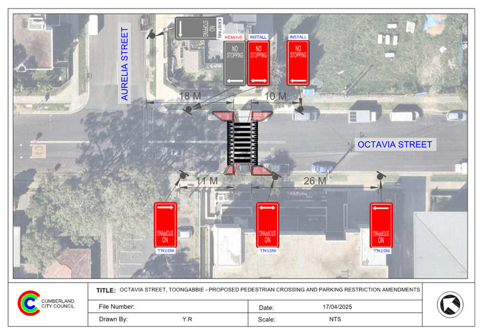
ITEM CTC-25-093 - PENDLE HILL PUBLIC DOMAIN PLAN - JOYCE STREET PARK UPGRADE, PENDLE HILL – PROPOSED REALIGNMENT OF PEDESTRIAN CROSSING & ROUNDABOUT AT PURDIE LANE |
|
Resolved by Exception
The Traffic Committee recommends that:
1. The proposed pedestrian crossing realignment and associated traffic works for the Joyce Street Park Upgrade at Pendle Hill Town Centre in accordance with the attached plan be approved.
2. The proposed roundabout at the intersection of Joyce Street and Purdie Lane in accordance with the attached plan be approved, subject to approval by Transport for NSW of a Traffic Management Plan for the banning of trucks turning left in to Purdie Lane. |
|
ITEM CTC-25-096 - MAIN AVENUE, LIDCOMBE – ROAD SAFETY CONCERNS |
|
Resolved by Exception The Traffic Committee recommends that Council undertake consultation with the residents and properties along Main Avenue, Lidcombe, to assess support or otherwise for the installation of traffic calming devices in the street. |
|
ITEM CTC-25-092 - GILBA ROAD GIRRAWEEN – PROPOSED MODIFICATIONS TO PREVIOUSLY APPROVED RAISED PEDESTRIAN CROSSING |
|
The Traffic Committee recommends that:
1. The modifications to the proposed raised pedestrian crossing on Gilba Road, Girraween (outside Girraween Public School) in accordance with the attached plan be supported.
3. Council notify adjacent residents and school of the outcome.
Moved Mr Matthew Tangonan, Seconded Mr George Campbell. |
|
ITEM CTC-25-094 - CHARLES STREET, GRANVILLE - CONCERNS AT THE INTERSECTION WITH BLAXCELL STREET |
|
The Cumberland Traffic Committee recommends that Council prepare a Traffic Management Plan for the precinct bound by Adam Street, Excelsior Street, Louis Street, Fifth Street and Clyde Street to identify desired traffic flow options.
Moved Clr Glenn Elmore, Seconded Mr George Campbell. |
|
ITEM CTC-25-095 - LAVINIA STREET, SOUTH GRANVILLE - SAFETY CONCERNS |
|
The Traffic Committee recommends that Council prepare a Traffic Management Plan for the precinct bound by Adam Street, Excelsior Street, Louis Street & Fifth Street and Clyde Street to identify desired traffic flow options.
Moved Clr Glenn Elmore, Seconded Mr George Campbell. |
|
ITEM CTC-25-097 - REDFERN STREET, GRANVILLE - SAFETY CONCERNS |
|
Recommendation
The Traffic Committee recommends that Council prepare a Traffic Management Plan for the precinct bound by Adam Street, Excelsior Street, Louis Street, Fifth Street & Clyde Street to identify desired traffic flow options.
Moved Clr Glenn Elmore, Seconded Mr Matthew Tangonan |
|
ITEM CTC-25-098 - MONA STREET, AUBURN & SOUTH GRANVILLE – PARKING RESTRICTION MODIFICATION |
|
The Traffic Committee recommends that Council undertake consultation with the residents and broader community on proposed changes to parking restrictions along Mona Street between Clyde Street and Chisholm Road, and provide a further report on the consultation results to the Traffic Committee.
Moved Clr Glenn Elmore, Seconded Mr George Campbell.
|
General Business
The following general business was raised by Council officers:
Olympic Drive and Joseph St Lidcombe
Council has received representations from the State MP to investigate a reduction of the current 70km per hour speed limit on Olympic Drive and Joseph St Lidcombe between Church St and Georges Ave. Council officers will liaise with TfNSW to investigate the request.
Cumberland Local Government Area Traffic Study - Progress Update
Following Council’s resolution, Officers have progressed the Bold Street Bridge study, with a consultant engaged with a working group to progress later this month. Other studies will progress shortly.
Albert Street & Frank Street, Guildford West
Concerns from residents regarding the intersection of Albert Street & Frank Street, Guildford West. Residents have requested a roundabout, where Council officers will investigate this intersection as per Council’s Traffic and Transport Policy and Guideline.
Dunmore St and Garfield St, Wentworthville - No Left Turn Vehicles under 9m Excepted
Concerns from residents regarding the intersection of Dunmore Street and Garfield Street, Wentworthville. They have reported No Left Turn Vehicles under 9m Excepted is confusing and not clear where Council officers will investigate how to improve this matter.
Roads Act Review
NSW Government is undertaking a review of the Roads Act to ensure that it continue to meet the need of the community. An issues paper was released early this year, and it is anticipated that an option paper will be provided for consultation in the second half of 2025.
Next Meeting
Next Meeting 4 June 2025 at 9:30 AM
Meeting Close
The meeting terminated at 10.09am.
Signed:
Chairperson
Traffic Committee
4 June 2025
Part 1
Recommended for Approval under Delegated Authority
4 June 2025
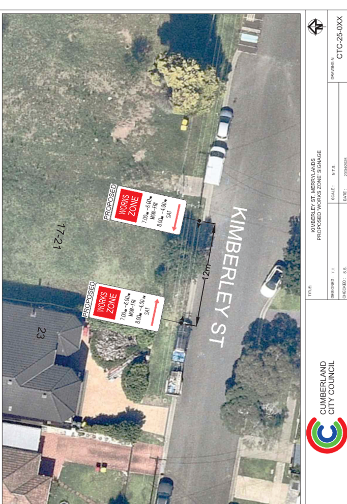
Item No: CTC-25-099
KIMBERLEY STREET, MERRYLANDS – APPLICATION FOR ‘WORKS ZONE’ SIGNAGE
Directorate: Environment and Planning
Responsible Officer: Manager Engineering and Building
Electorate: Granville
Police Area Command (PAC): Cumberland
Agenda Part Part 1
Note: Recommended for Approval under Delegated Authority
Summary
Council has received an application for a ‘Works Zone’ on Kimberley Street, Merrylands associated with the development at 17-21 Kimberley Street, Merrylands.
This report outlines the outcome of the investigation into this matter.
The Traffic Committee recommends that:
1. The 12m long ‘Works Zone, 7:00am-6:00pm, Monday-Friday, 8:00am-4:00pm, Saturday’ signs be approved in principle on the frontage of the redevelopment site on Kimberley Street, Merrylands in accordance with the attached plan subject to Council’s standard conditions for the period of 6 months and subsequent extension if required.
2. The applicant be advised to pay the ‘Works Zone’ fees to Council as per the adopted Fees and Charges
Report
Council has received an application for a ‘Works Zone’ on Kimberley Street, Merrylands associated with the development at 17-21 Kimberley Street, Merrylands. The proposed development involves construction of a residential flat building containing sixteen dwellings, comprising 8 x 1-bedroom and 8 x 2-bedroom units, parking for eight vehicles, associated site works and landscaping, and consolidation of three lots into a single lot - 17-21 Kimberley St Merrylands NSW 2160.
The temporary “Works Zone” is approximately 12m in length and proposed to commence in May 2025 for 6 months. The proposed times are between 7:00am to 6:00pm Monday to Friday and 8:00am to 4:00pm on Saturdays.
There will be a loss of two (2) unrestricted parking spaces on the northern side of Kimberley Street, Merrylands during the operation of the “Works Zone”.
COnsultation
The proposal is outside the property being developed and no consultation is considered necessary as the request was made by the builder.
Attachments
1. Plan - Kimberley Street, Merrylands - Proposed Temporary ' Work Zone' Signage
DOCUMENTS
ASSOCIATED WITH
REPORT CTC-25-099
Attachment 1
Plan - Kimberley Street, Merrylands - Proposed Temporary ' Work Zone' Signage
4 June 2025
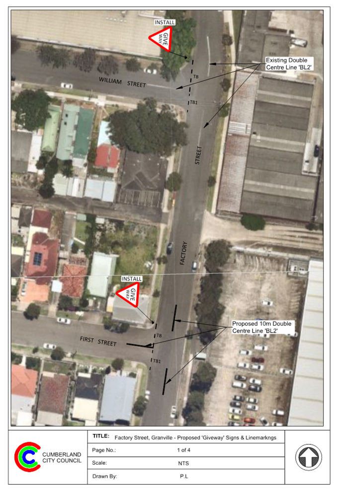
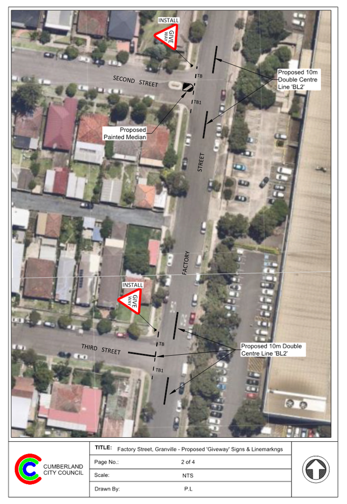
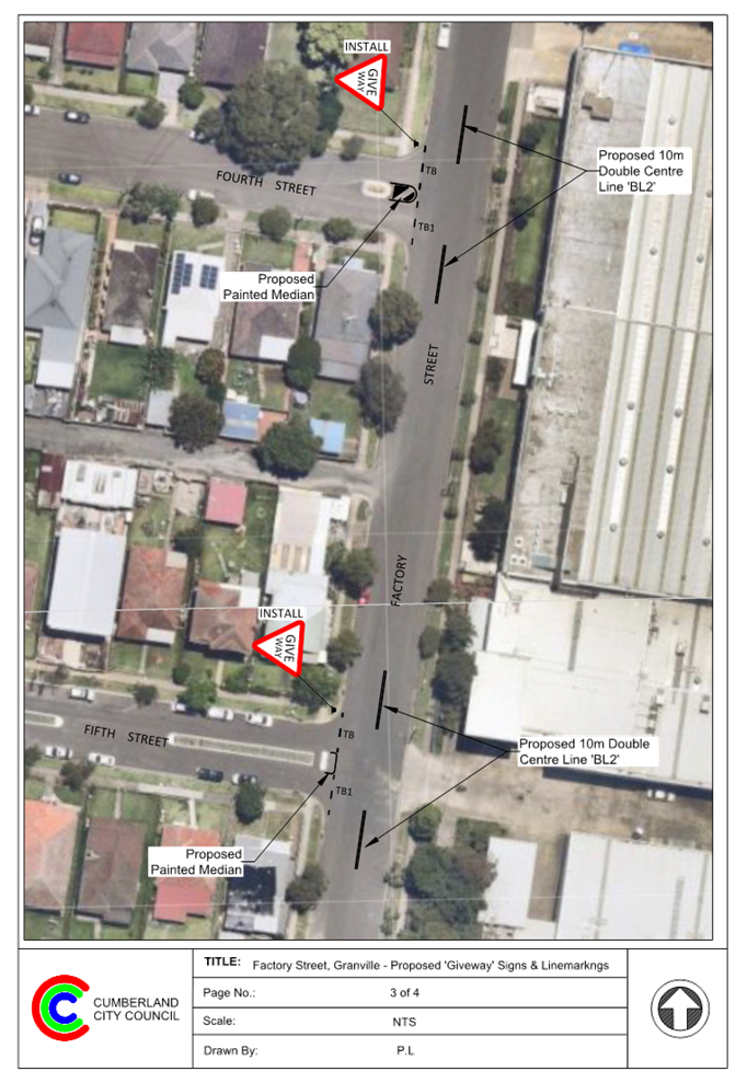
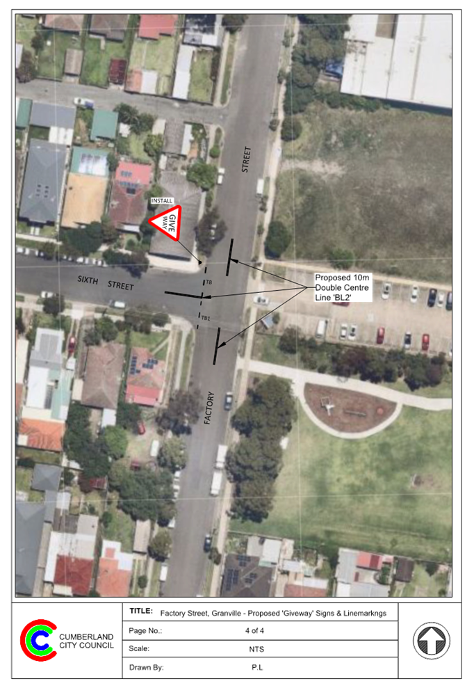
Item No: CTC-25-100
FACTORY STREET AND ITS INTERSECTIONS WITH SIDE STREETS, GRANVILLE – PROPOSED INTERSECTION TREATMENTS
Directorate: Environment and Planning
Responsible Officer: Manager Engineering and Building
Electorate: Granville
Police Area Command (PAC): Cumberland
Agenda Part Part 1
Note: Recommended for Approval under Delegated Authority
Summary
Council has received requests from residents and motorists to install ‘Give Way’ or ‘Stop’ signage together with line marking at the intersections of Factory Street and side streets in Granville.
This report outlines the outcome of the investigation into this matter.
The Traffic Committee recommends that:
1. The installation of ‘Give Way’ control signs and associated line marking at the intersections of Factory Street, Granville with side streets in accordance with the attached plans be approved.
2. The affected / concerned residents be notified of the outcome.
Report
Factory Street, Granville is functioning as a Collector Road that runs in a north – south direction between Clyde Station and Seventh Street with a speed limit of 50 km/h. It has a width of approximately 12.5 m and parking is permitted on both sides of the road unless signposted otherwise.
There are seven side streets namely, William Street, First Street, Second Street, Third Street, Fourth Street, Fifth Street and Sixth Street running in east-west directions between Factory Street and Clyde Street. The speed limit in all these streets is 50 km/h.
The map below shows Factory Street and the intersections:
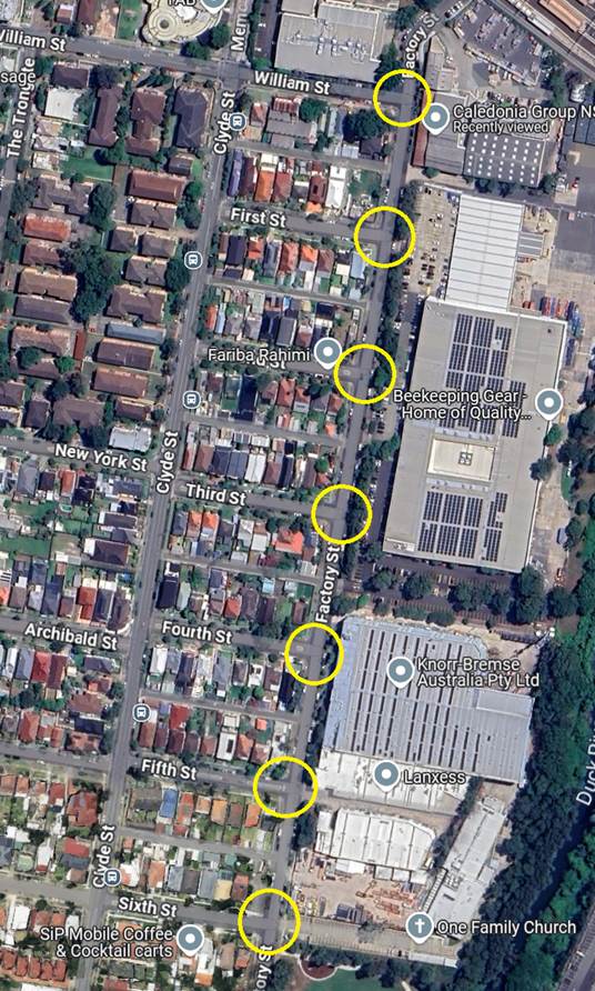
Locality Plan
Council has received requests from residents and motorists regarding the provision of ‘Give-Way’ or ‘Stop’ control at the intersections of Factory Street and side streets.
Council officers have investigated the request and have noted that the traffic and its composition in Factory Street raises safety concerns. It is also noted that there is significant number of trucks using Factory Street to access the industries on the eastern side.
Crash Data
The latest Crash data indicated that there was one reported crash at the intersection of Factory Street and William Street, Granville in the 5 years ending June 2024.
The crash details are shown in the table below:
|
Date |
Location |
Description |
|
16/07/2020 |
Factory Street, 20 m south of William Street |
Left-through |
Australian Standard Requirements
Based on Australian Standard AS 1742.2-2022 – Part 2: Traffic Control Devices for General Use, controls are required at all non-signalised intersections in the following manner:
a) GIVE WAY signs shall be provided at all intersections with four or more legs.
b) GIVE WAY signs shall be provided at any three-way intersections where the layout is such that it is not clear how or whether the T-intersection rule would operate, for example, at a Y-intersection.
c) GIVE WAY signs should be used for road safety reasons at unsignalized T-intersections in both rural and urban areas where the major road is an arterial or collector type road.
d) STOP signs shall be provided instead of GIVE WAY signs at items (a), (b) and (c) on any controlled approach where intersection sight distance is limited by a permanent obstruction as determined in accordance with Clause 2.5.3. Stop signs shall not be used where intersection sight distance is adequate for GIVE WAY signs.
Based on these requirements, ‘Stop’ signs are not warranted at these intersections, as the sight distance for vehicles turning from the side streets onto Factory Street is not limited. However, in accordance with warrant (c) of AS1742.2 – Part 2, the provision of ‘Give Way’ signage and associated line marking can be considered at this intersection.
To improve the safety of the intersection, it is proposed that a ‘Give Way’ signs with associated line marking be installed in side streets between William Street and Sixth Street at their intersections of Factory Street.
COnsultation
Consultation has not been undertaken as the signage or centre line marking at these intersections do not directly impact on properties at these locations.
Attachments
1. Plan – Factory Street and side street intersections, Granville – Proposed ‘Give Way’ signage and line marking
DOCUMENTS
ASSOCIATED WITH
REPORT CTC-25-100
Attachment 1
Plan – Factory Street and side street intersections, Granville – Proposed ‘Give Way’ signage and line marking
4 June 2025
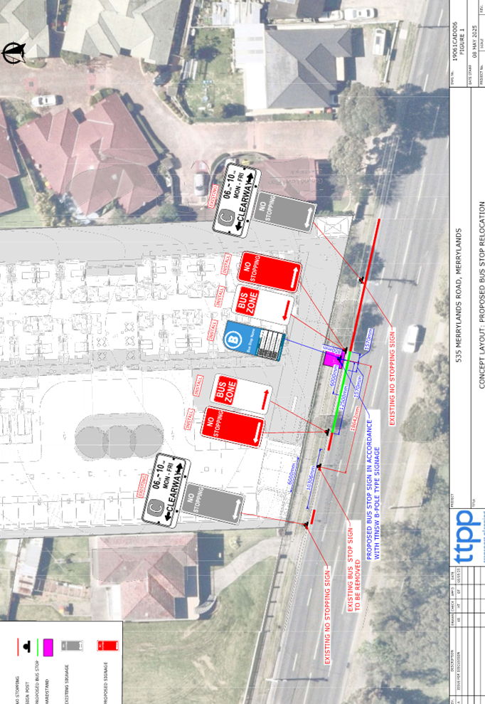
Item No: CTC-25-101
MERRYLANDS ROAD, MERRYLANDS – PROPOSED RELOCATION OF EXISTING BUS STOP
Directorate: Environment and Planning
Responsible Officer: Manager Engineering and Building
Electorate: Granville
Police Area Command (PAC): Cumberland
Agenda Part Part 1
Note: Recommended for Approval under Delegated Authority
Summary
Council has received a request from the applicant of 535 Merrylands Road, Merrylands, regarding the proposed relocation of the existing bus stop at this location.
This report outlines the outcome of the investigation into this matter.
The Traffic Committee recommends that:
1. The relocation of existing Bus Stop and associated signage in front of No.535 Merrylands Road, Merrylands in accordance with the attached plan be approved.
2. The cost of the works shall be borne by the applicant.
3. The applicant is to be notified of the outcome.
Report
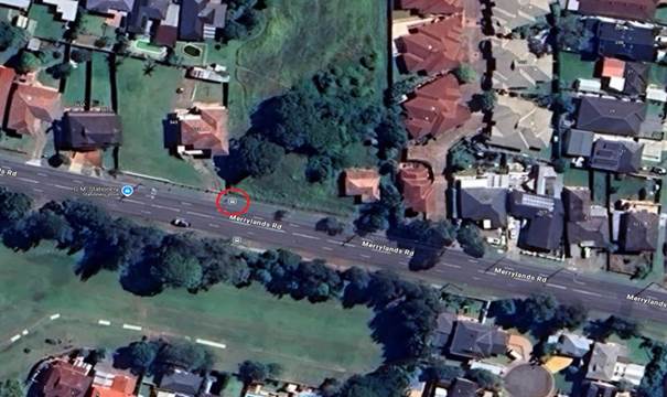
Merrylands Road is an arterial road that runs in an east–west direction between Merrylands and Greystanes. The location under consideration has a sign posted speed limit of 50 km/h and a width of approximately 12.9 metres. Parking is restricted on both sides of the road, with full-time ‘No Stopping’ zones associated with ‘Clearway’ restrictions that operate from Monday to Friday, 6 am to 10 am.
A bus stop is currently located in front of 535 Merrylands Road, approximately 10 metres from its boundary with 541 Merrylands Road. This bus stop is registered with Transport for NSW as ‘Merrylands Road before Mark Street, Merrylands’ with Stop ID 2160189.
The map below shows the location of the bus stop (marked in red circle):
Consent was granted for a proposed 90 bed aged care facility with on-site car parking at 535 Merrylands Road, Merrylands (REV2021/0003) by Council on 13/10/2021. Condition No. 77 of the consent requires that the Bus Stop relocation be submitted to the Local Traffic Committee, as outlined below:
77 DACCZ06 – Street Sign (Bus Zone) Relocation
The ‘Bus Zone’ shall be clear of the proposed driveway. In this regard, a detailed plan showing the proposed relocation of the existing ‘Bus Zone’ sign on Merrylands Road, Merrylands shall be prepared in consultation with Council and submitted to the Cumberland Local Traffic Committee for consideration and approval
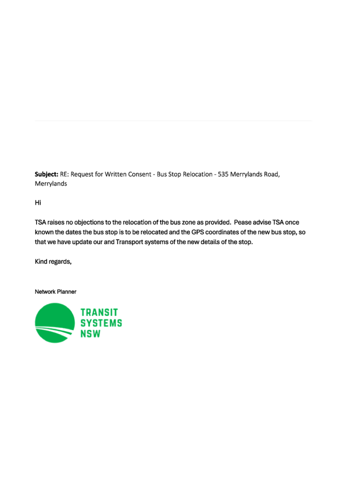
In accordance with the above condition, Zaki Property Group has provided a traffic report prepared by TTPP, along with written consent from Transit Systems, to relocate the existing Bus Zone.
It is proposed to relocate the existing bus stop and its associated signage in accordance with the attached plan.
COnsultation
Consultation was not undertaken as the proposed relocation affects only 535 Merrylands Road and does not impact any other residents.
Attachments
1. Plan – Merrylands Road, Merrylands - Proposed Relocation of the Existing Bus Stop
DOCUMENTS
ASSOCIATED WITH
REPORT CTC-25-101
Attachment 1
Plan – Merrylands Road, Merrylands - Proposed Relocation of the Existing Bus Stop
DOCUMENTS
ASSOCIATED WITH
REPORT CTC-25-101
Attachment 2
Consent from Transit Systems
4 June 2025
Item No: CTC-25-102
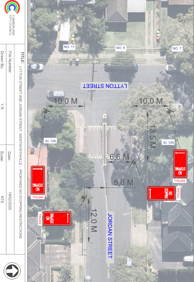
LYTTON STREET AND JORDAN STREET, WENTWORTHVILLE – PROPOSED ‘NO STOPPING’ RESTRICTIONS
Directorate: Environment and Planning
Responsible Officer: Manager Engineering and Building
Electorate: Granville
Police Area Command (PAC): Cumberland
Agenda Part Part 1
Note: Recommended for Approval under Delegated Authority
Summary
Council has received safety concerns from residents at the intersection of Lytton Street and Jordan Street, Wentworthville.
This report outlines the outcome of the investigation into this matter.
The Traffic Committee recommends that:
1. The installation of ‘No Stopping’ signs at the intersection of Lytton Street and Jordan Street, Wentworthville in accordance with the attached plan be approved.
2. The affected and concerned residents be notified of the outcome.
Report
Lytton Street is a local road that runs in a north-south direction with a default speed limit of 50 km/h. It has a width of approximately 12.6 m and parking is permitted on both sides of the road unless otherwise signposted.
Jordan Street is a local road that runs in an east-west direction between Lytton Street and Bridge Road with a speed limit of 50 km/h as well. It has a width of approximately 12.6 m and parking is permitted on both sides of the road unless otherwise signposted.
Lytton Street and Jordan Street form a T-intersection with priority to Lytton Street.
The map below shows the intersection.
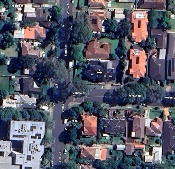
Locality Plan
The latest Centre for Road Safety accident data indicated that there were no reported accidents related to parked vehicles or sight distance at this intersection in the last 5 years.
A site inspection indicated that vehicles are parking too close to the intersection. It is proposed to install ‘No Stopping’ restrictions at the intersection. The signage and line marking would strengthen the Road Rules requirement and stop vehicles from parking too close to the intersection.
COnsultation
The proposal was notified to the impacted and adjacent residents for a period of 14 days starting from 3 March 2025 to 17 March 2025.
There were no responses received.
Attachments
1. Plan – Lytton Street and Jordan Street, Wentworthville – Proposed ‘No Stopping’ restrictions
DOCUMENTS
ASSOCIATED WITH
REPORT CTC-25-102
Attachment 1
Plan – Lytton Street and Jordan Street, Wentworthville – Proposed ‘No Stopping’ restrictions
4 June 2025
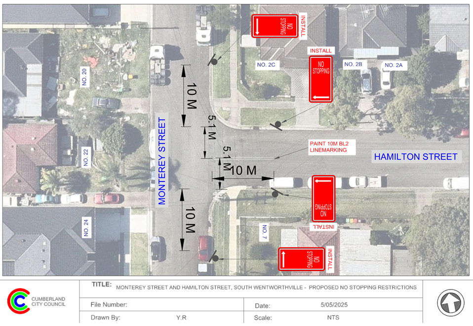
Item No: CTC-25-103
MONTEREY STREET AND HAMILTON STREET, SOUTH WENTWORTHVILLE – PROPOSED ‘NO STOPPING’ RESTRICTIONS AND LINE MARKING
Directorate: Environment and Planning
Responsible Officer: Manager Engineering and Building
Electorate: Granville
Police Area Command (PAC): Cumberland
Agenda Part Part 1
Note: Recommended for Approval under Delegated Authority
Summary
Council has received safety concerns from residents at the intersection of Monterey Street and Hamilton Street, South Wentworthville.
This report outlines the outcome of the investigation into this matter.
The Traffic Committee recommends that:
1. The installation of ‘No Stopping’ signs and ‘BL2’ line marking at the intersection of Monterey Street and Hamilton Street, South Wentworthville in accordance with the attached plan be approved in principle.
2. Council consult with affected residents and report back to the Traffic Committee if objections are received.
Report
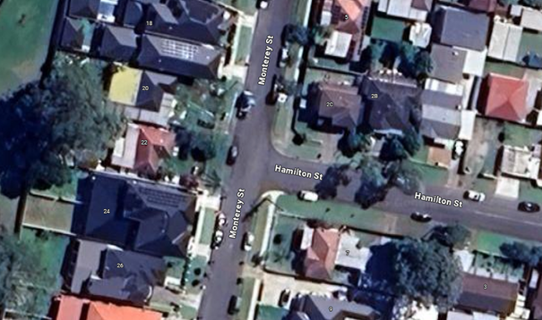
Monterey Street is a local road that runs in a north-south direction between Hollywood Street and Richmond Street with a sign-posted speed limit of 50 km/h. It has a width of approximately 10m and parking is permitted on both sides of the road unless otherwise signposted.
Hamilton Street is a local road that runs in an east-west direction between Monterey Street and Frances Street with a speed limit of 50 km/h. It has a width of approximately 10.4m and parking is permitted on both sides of the road unless otherwise signposted.
Monterey Street and Hamilton Street form a T-intersection with priority to Monterey Street.
The map below shows the intersection.
Locality Plan
The latest Centre for Road Safety accident data indicated that there were no reported accidents related to parked vehicles or sight distance at this intersection in the last 5 years.
A site inspection indicated that vehicles are parking within 10 metres at the intersection. It is proposed to install ‘No Stopping’ restrictions and ‘BL2’ line marking at the intersection. The signage and line marking would strengthen the Road Rules requirement and stop vehicles from parking too close to the intersection.
COnsultation
Subject to endorsement, consultation will be undertaken with affected residents on the proposal.
Attachments
1. Plan – Monterey Street and Hamilton Street, South Wentworthville – Proposed ‘No Stopping’ restrictions and BL2 line markings
DOCUMENTS
ASSOCIATED WITH
REPORT CTC-25-103
Attachment 1
Plan – Monterey Street and Hamilton Street, South Wentworthville – Proposed ‘No Stopping’ restrictions and BL2 line markings
4 June 2025
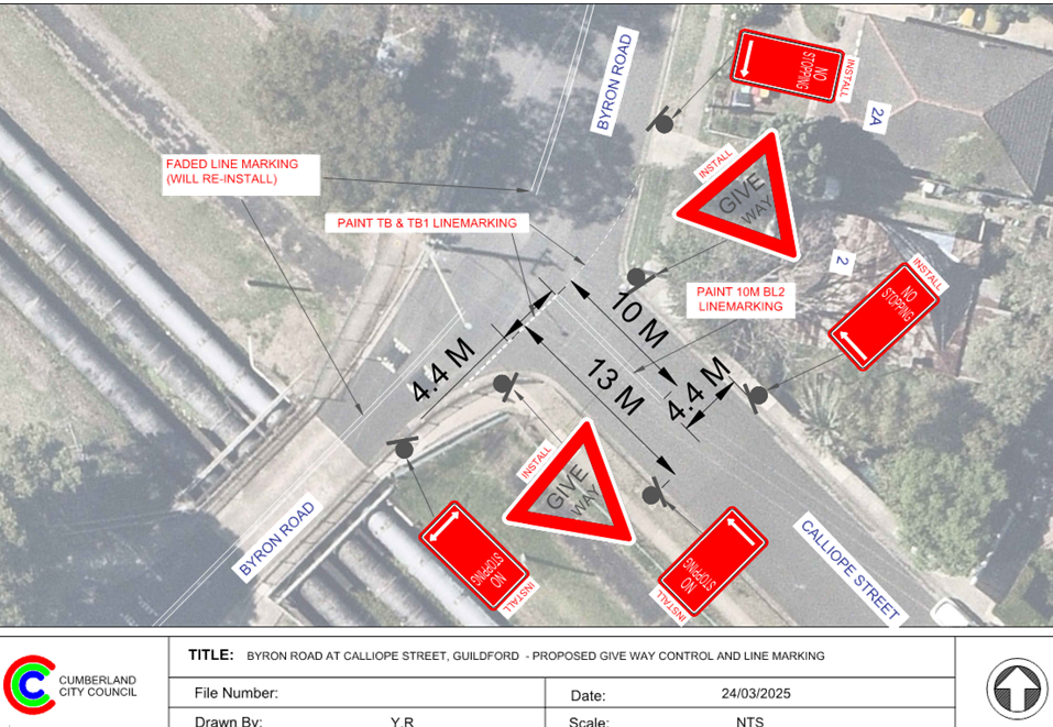
Item No: CTC-25-104
CALLIOPE STREET AND BYRON ROAD, GUILDFORD – PROPOSED INTERSECTION TREATMENT
Directorate: Environment and Planning
Responsible Officer: Manager Engineering and Building
Electorate: Granville
Police Area Command (PAC): Cumberland
Agenda Part Part 1
Note: Recommended for Approval under Delegated Authority
Summary
Council has received safety concerns from residents at the intersections of Calliope Street and Byron Road, Guildford.
This report outlines the outcome of the investigation into this matter.
The Traffic Committee recommends that:
1. The installation of ‘Give Way’ and ‘No Stopping’ signs with associated line marking at the intersection of Calliope Street and Byron Road, Guildford in accordance with attached plan be approved.
2. The affected / concerned residents be notified of the outcome.
Report
Calliope Street is a local road that runs in an east-west direction between Military Road and Byron Road with a speed limit of 50 km/h. It has a width of approximately 9m near Byron Road and parking is permitted on both sides of the road unless otherwise signposted.
Byron Road is a local road generally running north–south, connecting Guildford Road and Military Road, with a posted speed limit of 50 km/h. North of the Calliope Street intersection, the road is approximately 12.5 metres wide and allows parking on both sides. However, south of the intersection, the road narrows significantly as it transitions into a bridge over the Sydney Water pipeline corridor. ‘No Stopping’ signs are installed on the west side of the bridge, and due to the limited road width, parking is impractical on either side of the bridge.
Calliope Street intersects with Byron Road and forms a Y-shaped junction, where priority is given to Byron Road traffic. Currently, there is no Give Way signage or line marking in place at this location.
The map below shows the intersection.
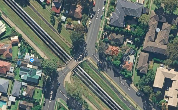
Locality Plan
The latest Centre for Road Safety accident data indicated that there were no reported accidents related to vehicles that failed to give way at this intersection in the last 5 years.
Residents have expressed concerns regarding the give way control at this intersection, alleging that vehicles on Calliope Street frequently fail to give way to traffic on Byron Road.
Based on Australian Standard AS 1742.2-2009 – Part 2: Traffic Control Devices for General Use, controls are required at all non-signalised intersections in the following manner:
a) GIVE WAY signs shall be provided at all intersections with four or more legs.
b) GIVE WAY signs shall be provided at any three-way intersections where the layout is such that it is not clear how or whether the T-intersection rule would operate, for example, at a Y-intersection.
c) GIVE WAY signs should be used for road safety reasons at unsignalised T-intersections in both rural and urban areas where the major road is an arterial or collect type road.
Based on point (b) above, 'Give Way' signage is warranted at this intersection. Therefore, it is recommended that ‘Give Way’ controls be provided at this location to prevent vehicles from failure to give way to traffic on Byron Road.
Site inspections also confirmed that some vehicles were parked too close to the intersection, posing potential safety risks. To address this issue, it is proposed to install ‘No Stopping’ restrictions and apply ‘BL2’ line marking at the location.
The proposed signage and line marking will reinforce Road Rules, ensuring vehicles do not park too close to the intersection. ‘No Stopping’ signs are proposed on both sides of Calliope Street at 13 metres, allowing vehicles to safely pass parked cars without encroaching on the proposed ‘BL2’ line marking.
COnsultation
The proposal was notified to the impacted and adjacent residents for a period of 14 days starting from 16 April 2025 to 30 April 2025.
No objections were received.
Attachments
DOCUMENTS
ASSOCIATED WITH
REPORT CTC-25-104
Attachment 1
Plan - Calliope Street and Byron Road, Guildford
4 June 2025
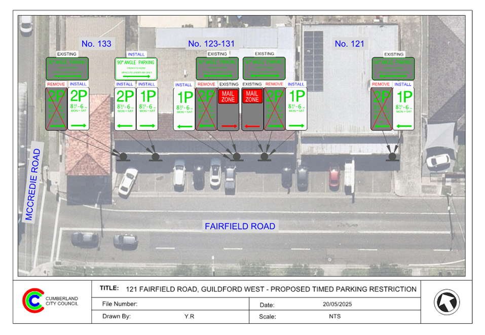
Item No: CTC-25-105
FAIRFIELD ROAD, GUILDFORD WEST – PROPOSED PARKING RESTRICTIONS
Directorate: Environment and Planning
Responsible Officer: Manager Engineering and Building
Electorate: Granville
Police Area Command (PAC): Cumberland
Agenda Part Part 1
Note: Recommended for Approval under Delegated Authority
Summary
Council has received a request from a shop owner in Fairfield Road, Guildford West to convert sections of the existing 2P parking restrictions on the western side of Fairfield Road, Guildford West outside No.121 and No. 123-131 into 1P to facilitate parking turnover at this location.
This report outlines the outcome of the investigation into this matter.
The Traffic Committee recommends that:
1. The installation of ‘1P 8:30 am to 6pm Mon- Sat’ on the western side of Fairfield Road, Guildford West outside No.121 and part of No. 123-131, as provided in the attached plan, be approved.
2. Council notifies the business owners of the outcome.
Report
Council has received a request from a shop owner on Fairfield Road, Guildford West, seeking consideration to amend the existing timed parking restrictions in front of Nos. 121–123. This location functions as a local centre, featuring a variety of shops facing Fairfield Road with 90-degree angle parking. At present, the parking spaces in front of these properties are subject to a 2P timed restriction.
It is alleged that some vehicles parked at this location for extended periods of time, making it difficult for the customers to find available parking.
To improve parking turnover at this location, it is proposed to replace two sections of the existing 2P restrictions with 1P restrictions operating from 8:30 AM to 6:00 PM, Monday to Saturday, as shown in the attached plan.
COnsultation
The proposal was initially consulted with the business owners for a period of 14 days from 17 April 2025 to 30 April 2025 proposing 1P in front of No. 121.
Following verbal feedback from the business owners, Council officers conducted follow-up in-person consultations and proposed a 1P parking restriction in front of Nos. 121 and 123-131. One property owner expressed support for the 1P proposal as a suitable response to their concerns. The remaining spaces will retain the existing 2P restrictions to accommodate the needs of other businesses.
Attachments
1. Plan – Fairfield Road, Guildford West – Proposed ‘1P’ Parking Restriction
DOCUMENTS
ASSOCIATED WITH
REPORT CTC-25-105
Attachment 1
Plan – Fairfield Road, Guildford West – Proposed ‘1P’ Parking Restriction
4 June 2025
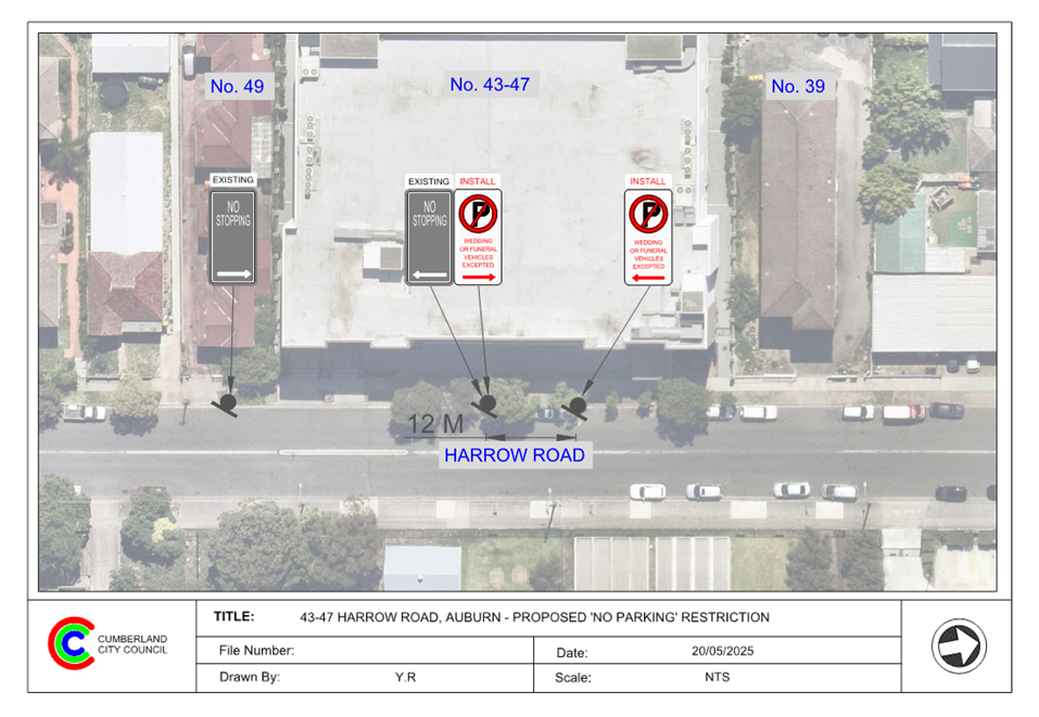
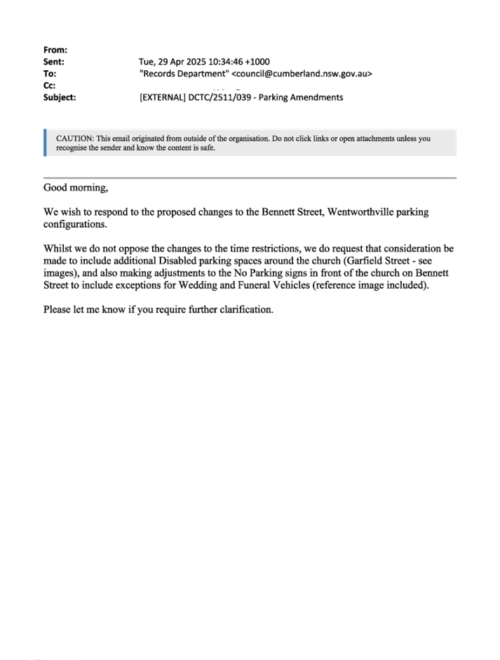
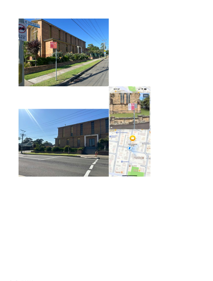
Item No: CTC-25-106
HARROW ROAD, AUBURN - PROPOSED ‘NO PARKING WEDDING OR FUNERAL VEHICLES EXCEPTED’ SIGNAGE
Directorate: Environment and Planning
Responsible Officer: Manager Engineering and Building
Electorate: Auburn
Police Area Command (PAC): Auburn
Agenda Part Part 1
Note: Recommended for Approval under Delegated Authority
Summary
Council has received a request from the Mosque located at No.43-47 Harrow Road, Auburn for the installation of ‘No Parking, Wedding or Funeral Vehicles Excepted’ signs at the frontage of the Mosque.
This report outlines the outcome of the investigation into this matter.
The Traffic Committee recommends that:
1. The proposed ‘No Parking, Wedding or Funeral Vehicles Excepted’ signs outside No.43-47 Harrow Road, Auburn in accordance with the attached plan be approved.
2. Council notify the property owner of the outcome.
Report
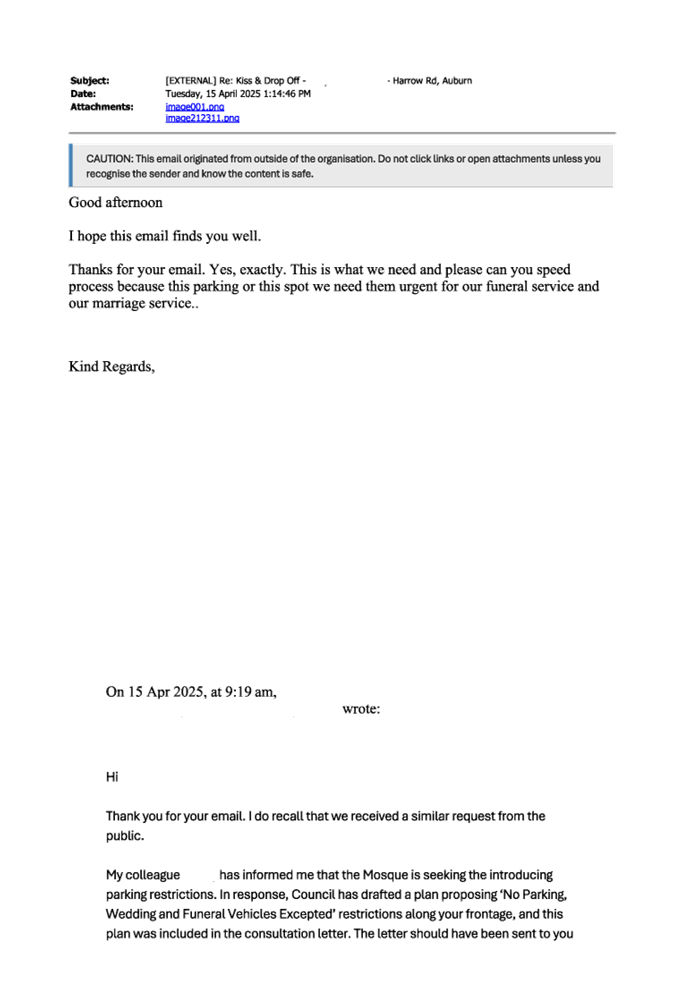
Council has received a request from the Mosque located at No.43-47 Harrow Road, Auburn for the installation of ‘No Parking, Wedding or Funeral Vehicles Excepted’ signs at the frontage of the Mosque.
Council officers have investigated the matter and observed that the existing unrestricted parking spaces outside the Mosque are frequently occupied due to high parking demand in the area. As a result, it is difficult for wedding or funeral service vehicles to find a parking space outside the Mosque.
To improve parking availability for wedding and funeral service vehicles, it is proposed to convert part of the existing unrestricted parking space on Harrow Road outside the Mosque to a ‘No Parking – Wedding or Funeral Vehicles Excepted’ zone in accordance with the attached plan.
COnsultation
The proposal was notified to impacted and adjacent residents and business owners for a period of 14 days starting from 16 April 2025 to 30 April 2025. Two submissions were received. Following the consultation period, Council officers further engaged with stakeholders on the proposal.
Attachments
1. Plan – Harrow Road, Auburn – Proposed ‘No Parking Wedding or Funeral Vehicles Excepted’
DOCUMENTS
ASSOCIATED WITH
REPORT CTC-25-106
Attachment 1
Plan – Harrow Road, Auburn – Proposed ‘No Parking Wedding or Funeral Vehicles Excepted’
DOCUMENTS
ASSOCIATED WITH
REPORT CTC-25-106
Attachment 2
Submissions
4 June 2025
Item No: CTC-25-107
OXFORD STREET, GUILDFORD – PROPOSED EXTENSION OF EXISTING 'NO STOPPING' RESTRICTION
Directorate: Environment and Planning
Responsible Officer: Manager Engineering and Building
Electorate: Granville
Police Area Command (PAC): Cumberland
Agenda Part Part 1
Note: Recommended for Approval under Delegated Authority
Summary
Council has received safety concerns from Granville South Public School on Oxford Street, Guildford.
This report outlines the outcome of the investigation into this matter.
The Traffic Committee recommends that:
1. The extension of the existing ‘No Stopping’ restrictions on Oxford Street, Guildford outside Granville South Public School in accordance with attached plan be approved.
2. Granville South Public School be notified of the outcome.
Report
Oxford Street is a regional road that runs in an east-west direction between Railway Terrace and Woodville Road with a sign posted speed limit of 50 km/h. It has a width of approximately 13m near Woodville Road that accommodates four trafficable lanes.
No Stopping’ restrictions are currently in place on both sides of Oxford Street at its intersection with Woodville Road to support traffic flow and enhance safety at this busy junction.
The map below shows the intersection.
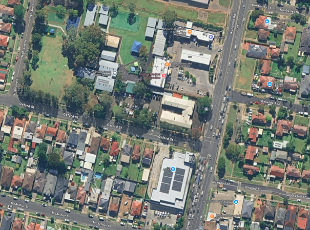
Locality Plan
Granville South Public School has contacted Council to raise safety concerns following recent near-miss incidents experienced by school staff when exiting the driveway onto Oxford Street.
The latest Centre for Road Safety accident data indicates that no accidents related to vehicles failing to give way at the school car park on Oxford Street have been reported in the past five years.
To address the concerns raised by the school, it is proposed to extend the existing ‘No Stopping’ restrictions on the northern side of Oxford Street from the current endpoint to the school driveway to prevent vehicles from stopping near the driveway and to ensure adequate sight distance is maintained.
COnsultation
Consultation was not required as this issue was raised by Granville South Public School, and the proposed change only affect the school.
Attachments
1. Plan - Oxford Street, Guildford – Extension of the Existing ‘No Stopping’ signage
DOCUMENTS
ASSOCIATED WITH
REPORT CTC-25-107
Attachment 1
Plan - Oxford Street, Guildford – Extension of the Existing ‘No Stopping’ signage
4 June 2025
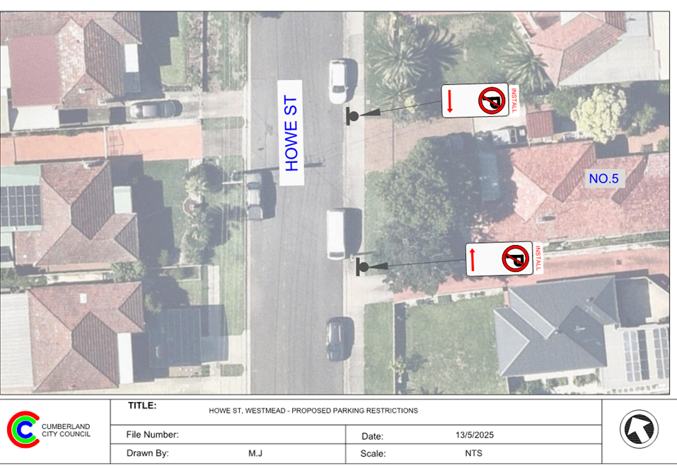
Item No: CTC-25-108
HOWE STREET, WESTMEAD – PROPOSED PARKING RESTRICTIONS
Directorate: Environment and Planning
Responsible Officer: Manager Engineering and Building
Electorate: Granville
Police Area Command (PAC): Cumberland
Agenda Part Part 1
Note: Recommended for Approval under Delegated Authority
Summary
Council has received a request from the applicant of 5 Howe Street, Westmead, regarding the proposed ‘No Parking’ restrictions.
This report outlines the outcome of the investigation into this matter.
The Traffic Committee recommends that:
1. The proposed ‘No Parking’ signage outside No. 5 Howe Street, Westmead in accordance with the attached plan be approved.
2. The cost of the works shall be borne by the applicant.
3. The applicant is to be notified of the outcome.
Report
Howe Street is a local road that runs in a north – south direction between Cotswold Street and Amos Street, Westmead. The street has a sign posted speed limit of 50 km/h and a width of approximately 9 metres. Parking is unrestricted on both sides of the road unless otherwise signposted.
The map below shows the location of the site:
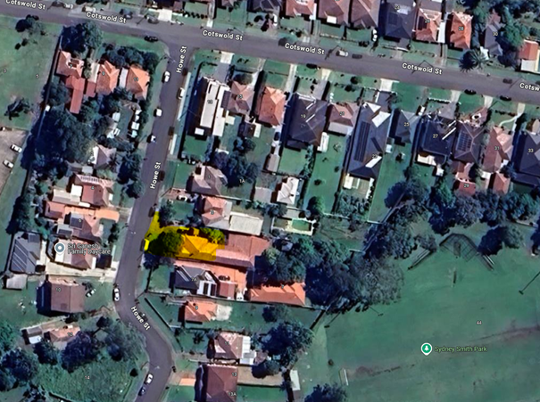
Council granted development consent for a proposed 68-place Child Care Centre at 5 Howe Street, Westmead (DA2018/444/1). A condition of consent requires the installation of ‘No Parking’ signage outside the property, with the signage plan to be submitted to the Local Traffic Committee.
In compliance with this condition, the applicant has submitted a signage plan proposing the installation of ‘No Parking’ restrictions. It is suggested that the proposed parking restrictions outside No.5 Howe Street, as shown in the attached plan be endorsed.
COnsultation
Consultation was not undertaken as the proposal only affects No.5 Howe Street and does not impact any other residents.
Attachments
1. Plan – Howe Street, Westmead - Proposed ‘No Parking’ signage
DOCUMENTS
ASSOCIATED WITH
REPORT CTC-25-108
Attachment 1
Plan – Howe Street, Westmead - Proposed ‘No Parking’ signage
4 June 2025
Item No: CTC-25-109
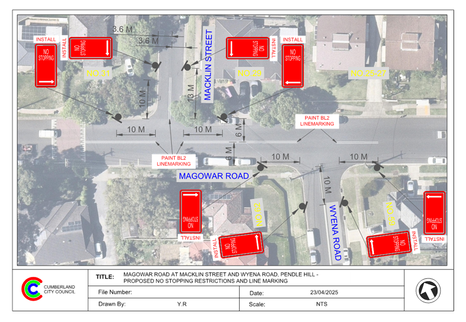
MAGOWAR ROAD, GIRRAWEEN – PROPOSED ‘NO STOPPING’ PARKING RESTRICTIONS
Directorate: Environment and Planning
Responsible Officer: Manager Engineering and Building
Electorate: Prospect
Police Area Command (PAC): Cumberland
Agenda Part Part 1
Note: Recommended for Approval under Delegated Authority
Summary
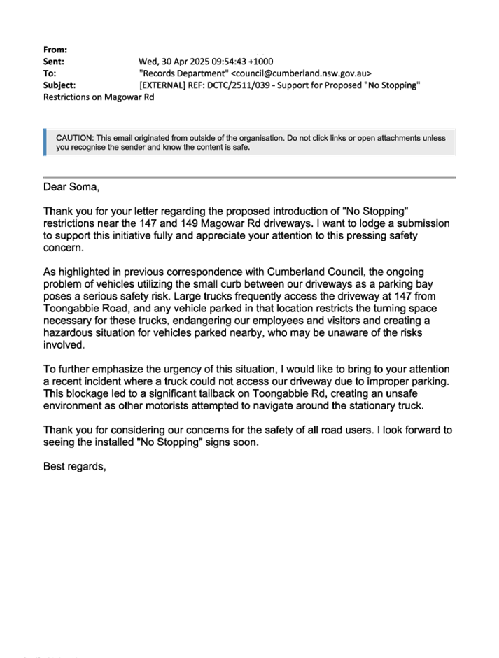
Council has received safety concerns from the businesses owner at 147 and 149 Magowar Road, Girraween.
This report outlines the outcome of the investigation into this matter.
The Traffic Committee recommends that:
1. The installation of ‘No Stopping’ signs between No. 147 and No. 149 Magowar Road, Girraween in accordance with the attached plan be approved.
2. The affected / concerned businesses be notified of the outcome.
Report
Magowar Road is a local road that runs in an east-west direction between Toongabbie Road and Pendle Way with a speed limit of 50 km/h. It has a width of approximately 12m and parking is permitted on both sides of the road unless otherwise signposted.
Magowar Road west of Girraween Road is primarily an industrial area. Two businesses located at 147 and 149 Magowar Road are situated on the northern side of the road. Their driveways are positioned near the shared boundary with a 4.5 metre gap between them.
The map below shows the location.
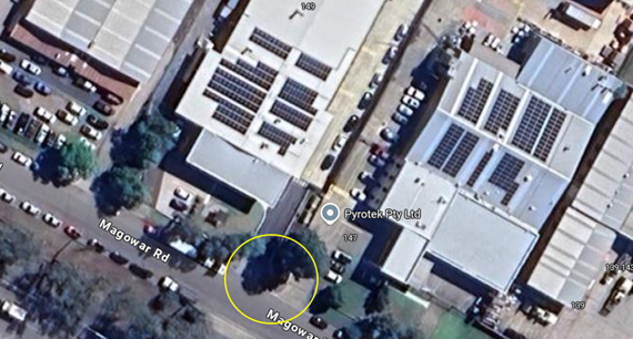
Locality Plan
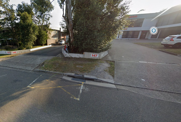
Street View
The business owners have reported that the 4.5-metre gap between the driveways of No. 147 and No. 149 is too narrow to accommodate a parked car. As a result, vehicles often encroach upon both driveways and obstructing access for large trucks entering both properties.
Driveway line markings have been painted at this location by Council previously to deter private vehicles from parking between the two driveways; however, these markings are often ignored by drivers.
Given the need for clear and safe truck access to the driveways, it is proposed to install ‘No Stopping’ restrictions between No.147 and No.149 Magowar Road, Girraween as per the plan attached.
COnsultation
The proposal was notified to the impacted and adjacent residents for a period of 14 days starting from 6 May 2025 to 23 May 2025.
One response was received, with some clarifications on the proposal. Council officers have contacted the submitter and advised that access to the driveway would not be impacted by the proposal.
Attachments
1. Plan – Magowar Road, Girraween – Proposed Parking Restrictions
DOCUMENTS
ASSOCIATED WITH
REPORT CTC-25-109
Attachment 1
Plan – Magowar Road, Girraween – Proposed Parking Restrictions
DOCUMENTS
ASSOCIATED WITH
REPORT CTC-25-109
Attachment 2
Submission
4 June 2025
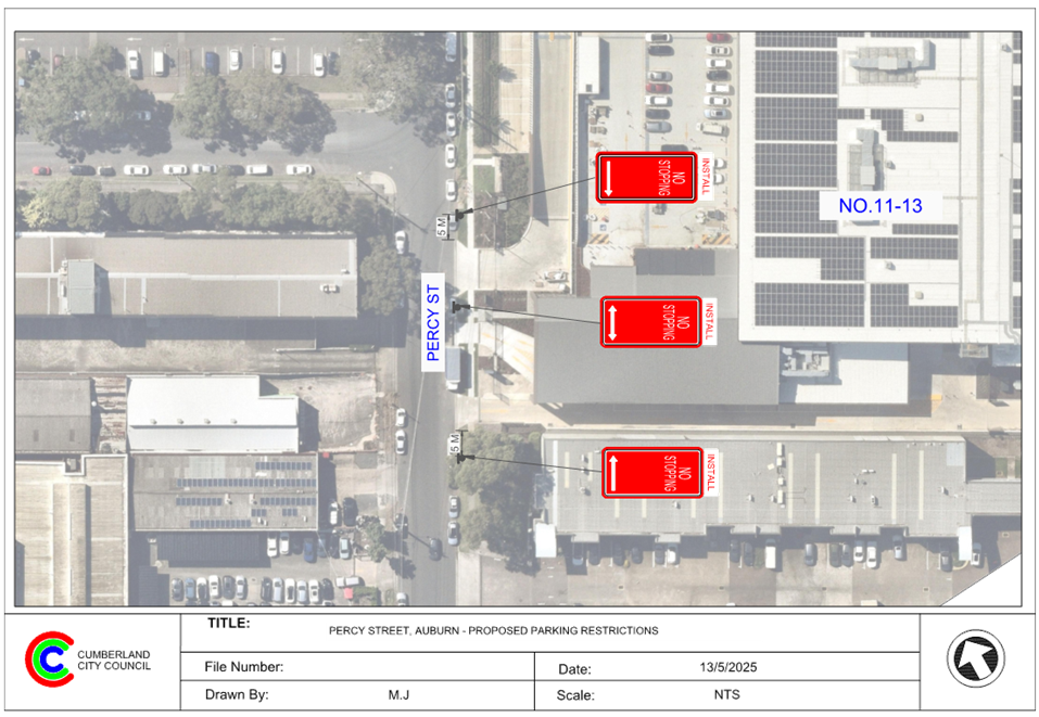
Item No: CTC-25-110
PERCY STREET, AUBURN - PROPOSED ‘NO STOPPING’ SIGNAGE
Directorate: Environment and Planning
Responsible Officer: Manager Engineering and Building
Electorate: Auburn
Police Area Command (PAC): Auburn
Agenda Part Part 1
Note: Recommended for Approval under Delegated Authority
Summary
Council has received a request from the Woolworths located at 11–13 Percy Street, Auburn for the installation of ‘No Stopping’ signs at their driveway.
This report outlines the outcome of the investigation into this matter.
The Traffic Committee recommends:
1. The proposed ‘No Stopping’ signs outside No. 11-13 Percy Street, Auburn in accordance with the attached plan be approved.
2. Council notify the affected businesses of the outcome.
Report
Council has received a request from Woolworths located at 11–13 Percy Street, Auburn for the installation of ‘No Stopping’ signage at their driveway due to safety concerns. The request cites limited sight distance for drivers exiting the site and the significant challenges faced by heavy vehicles when attempting to enter the property safely.
Council officers held a site meeting with Woolworths representative. During the meeting, it was observed that the existing unrestricted parking spaces outside the property are frequently occupied due to high parking demand in the area. As a result, vehicles exiting the site face restricted visibility due to parked vehicles and heavy vehicles are often unable to enter the site safely.
To improve safety and accessibility for vehicles at this location, it is proposed to install ‘No Stopping’ signage outside 11–13 Percy Street Auburn in accordance with the attached plan.
COnsultation
The proposal is proposed and supported by Woolworths staff. Council’s Place and Economy Team has advised that no objections were received from the strata management of the neighbouring property.
Attachments
1. Plan – Percy Street, Auburn – Proposed ‘No Stopping’ signage.
DOCUMENTS
ASSOCIATED WITH
REPORT CTC-25-110
Attachment 1
Plan – Percy Street, Auburn – Proposed ‘No Stopping’ signage.
4 June 2025
Item No: CTC-25-111
MAGOWAR ROAD AT MACKLIN STREET AND WYENA ROAD, PENDLE HILL – PROPOSED ‘NO STOPPING’ RESTRICTIONS AND LINE MARKING
Directorate: Environment and Planning
Responsible Officer: Manager Engineering and Building
Electorate: Prospect
Police Area Command (PAC): Cumberland
Agenda Part Part 1
Note: Recommended for Approval under Delegated Authority
Summary
Council has received safety concerns from the residents in Magowar Road near Macklin Street and Wyena Road, Pendle Hill.
This report outlines the outcome of the investigation into this matter.
The Traffic Committee recommends that:
1. The installation of ‘No Stopping’ signs, ‘BL2’ line markings in Magowar Road and at the intersection of Macklin Street and Wyena Road, Pendle Hill in accordance with the attached plan be approved.
2. The affected / concerned residents be notified of the outcome.
Report
Magowar Road is a local road that runs in an east-west direction between Toongabbie Road and Pendle Way with a speed limit of 50 km/h. It has a width of approximately 12m and parking is permitted on both sides of the road unless otherwise signposted.
Macklin Street is a local road running in a north–south direction that connects with Magowar Road. It has a speed limit of 50 km/h and a width of approximately 7 metres. Parking is permitted on both sides of the road unless otherwise signposted.
Wyena Road is a local road running in a north–south direction that also connects with Magowar Road. It is located approximately 30 metres from Macklin Street and has the same speed limit as Macklin Street. Wyena Road is approximately 10.5 metre wide marked with ‘BL2’ barrier line marking.
Magowar Road form two T- intersections with Wynena Road and Macklin Street, with priority given to traffic on Magowar Road.
The map below shows the intersection.
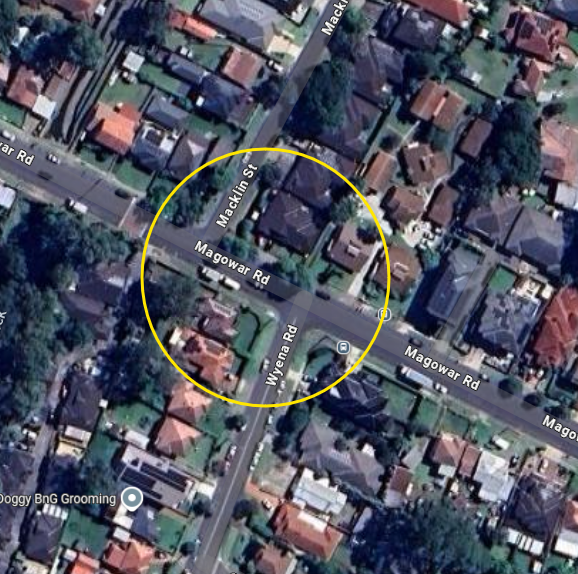
Locality Plan
The latest Centre for Road Safety accident data indicated that there were no reported accidents at both intersections in the last 5 years.
A site inspection indicated that vehicles are parking within 10 metres from both intersections. The installation of 10m to 13m ‘No Stopping’ signs at these intersections would strengthen the Road Rules requirements and stop vehicles from parking too close to the intersection.
It is also proposed to paint ‘BL2’ line markings on Magowar Road between, and at, the two intersections with Macklin Street and Wyena Road to reinforce the travel lane widths in each direction.
The proposed 13-metre ‘No Stopping’ restriction in Macklin Street is to allow vehicles to safely pass parked cars without encroaching on the proposed ‘BL2’ line marking.
COnsultation
The proposal was notified to the impacted and adjacent residents for a period of 14 days starting from 6 May 2025 to 23 May 2025.
One response was received, with some clarifications on the proposal. Council officers have contacted the submitter and advised that access to the driveway would not be impacted by the proposal.
Attachments
1. Plan – Magowar Road, Pendle Hill – Proposed parking restrictions and BL2 line markings
DOCUMENTS
ASSOCIATED WITH
REPORT CTC-25-111
Attachment 1
Plan – Magowar Road, Pendle Hill – Proposed parking restrictions and BL2 line markings
DOCUMENTS
ASSOCIATED WITH
REPORT CTC-25-111
Attachment 2
Submission
4 June 2025
Item No: CTC-25-112
ELVINA STREET AND GOZO ROAD, GREYSTANES – PROPOSED ‘NO STOPPING’ RESTRICTIONS AND LINE MARKING
Directorate: Environment and Planning
Responsible Officer: Manager Engineering and Building
Electorate: Prospect
Police Area Command (PAC): Cumberland
Agenda Part Part 1
Note: Recommended for Approval under Delegated Authority
Summary
Council has received safety concerns from the residents in Gozo Road near Elvina Street, Greystanes.
This report outlines the outcome of the investigation into this matter.
The Traffic Committee recommends that:
1. The installation of ‘No Stopping’ signs, ‘BL2’ line markings, and the modification of ‘EL1’ line markings at the intersection of Elvina Street and Gozo Road, Greystanes, in accordance with the attached plan, be approved in principle.
2. Council consults with affected residents and report back to the Traffic Committee if objections are received.
3. The concerned and affected residents be notified of the outcome.
Report
Elvina Street is a local road that runs in an east-west direction between Gozo Road and Roberta Street with a speed limit of 50 km/h. It has a width of approximately 7.5m and parking is permitted on both sides of the road unless otherwise signposted.
On the southern side of Elvina Street, there is a local centre comprising three retail shops, with unrestricted 90-degree angle parking spaces provided in front of the shops.
Gozo Road is a local road run in a north-south direction between Old Prospect Road and Whalans Road. It has a speed limit of 50 km/h and width of approximately 10m. Parking is permitted on both sides of the road unless otherwise signposted. Currently, ‘BL2’ and ‘EL1’ line markings exist on Gozo Road.
Elvina Street forms a T- intersection with Gozo Road, with priority given to traffic on Gozo Road.
The map below shows the intersection.
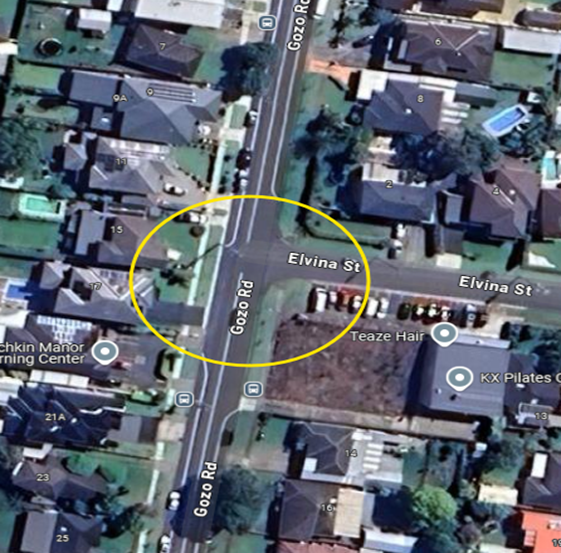
Locality Plan
The latest Centre for Road Safety accident data indicated that there were no reported accidents at this intersection in the last 5 years.
A site inspection revealed that vehicles are parking within 10 metres of the intersection. To address this issue, it is proposed to install 10 to 13-metre ‘No Stopping’ signs at the intersection. This measure would reinforce Road Rules requirements and prevent vehicles from parking too close to the intersection.
Additionally, it is recommended to paint BL2 line markings on Elvina Street to clearly define travel lanes in each direction and discourage vehicles from travelling on the wrong side of the street. A section of the existing edge line marking on the eastern side of Gozo Road will also be removed and extended closer to the intersection to align with the proposed ‘No Stopping’ sign.
The proposed 13-metre ‘No Stopping’ restriction on the northern side of Elvina Street is intended to allow vehicles to safely pass a parked car without encroaching on the proposed BL2 line marking.
COnsultation
Consultation has not yet been undertaken. Council will consult with residents if endorsed by the Traffic Committee.
Attachments
1. Plan – Elvina Street and Gozo Road, Greystanes – Proposed parking restrictions and line markings
DOCUMENTS
ASSOCIATED WITH
REPORT CTC-25-112
Attachment 1
Plan – Elvina Street and Gozo Road, Greystanes – Proposed parking restrictions and line markings
4 June 2025
Item No: CTC-25-113
STURT STREET, SMITHFIELD – PROPOSED 1/2 P TIMED PARKING AND 'NO STOPPING' RESTRICTIONS
Directorate: Environment and Planning
Responsible Officer: Manager Engineering and Building
Electorate: Granville
Police Area Command (PAC): Cumberland
Agenda Part Part 1
Note: Recommended for Approval under Delegated Authority
Summary
Council has received a request from the business owner at 149 Sturt Street, Smithfield, regarding limited visibility for vehicles exiting their driveway due to parked vehicles.
This report outlines the outcome of the investigation into this matter.
The Traffic Committee recommends that:
1. The installation of ‘1/2 P 8:30 am to 6pm’ and ‘No Stopping’ restrictions on the eastern side of Sturt Street, Smithfield as per the attached plan be approved.
2. Council notify business owners of the outcome.
Report
Sturt Street is a Collector Road that runs in a north – south direction with a speed limit of 50km/h and a width of approximately 12.5 metres. The street is located within an industrial area.
Council has received a request from the business owner at 149 McCredie Road, Smithfield seeking consideration to address the issue of heavy vehicle parking along Sturt Street. Currently, parking is unrestricted outside 149 McCredie Road. It has been reported that heavy vehicles, particularly prime movers and semi-trailers, are parking along the street for extended periods, obstructing sight lines for vehicles exiting driveways.
The map below shows the location.
Locality Plan
Street View
In accordance with NSW Road Rules, heavy vehicles are only permitted to park on the street for less than one hour. To reinforce these rules and improve visibility for vehicles exiting the driveway, it is proposed to install ‘No Stopping’ signs at the driveways of No. 149.
Additionally, to improve parking turnover for café customers next door, a 1/2P (8:30 AM – 6:00 PM) restriction is proposed at this location as shown in the attached drawing.
COnsultation
Council’s engagement team conducted in-person consultations with affected business owners, and all four responses received were in favour of the proposal.
Attachments
1. Plan – Sturt Street, Smithfield – Proposed ‘1/2P’ Parking Restriction and No Stopping Signs
DOCUMENTS
ASSOCIATED WITH
REPORT CTC-25-113
Attachment 1
Plan – Sturt Street, Smithfield – Proposed ‘1/2P’ Parking Restriction and No Stopping Signs
DOCUMENTS
ASSOCIATED WITH
REPORT CTC-25-113
Attachment 2
Business Engagement Report
4 June 2025
Item No: CTC-25-114
BENNETT STREET, WENTWORTHVILLE – PROPOSED AMENDMENTS TO EXISTING PARKING RESTRICTIONS
Directorate: Environment and Planning
Responsible Officer: Manager Engineering and Building
Electorate: Prospect
Police Area Command (PAC): Cumberland
Agenda Part Part 1
Note: Recommended for Approval under Delegated Authority
Summary
Council has received safety concerns from Our Lady of Mount Carmel Primary School in relation to the parking issues in Bennett Street, Wentworthville.
This report outlines the outcome of the investigation into this matter.
The Traffic Committee recommends that:
1. The installation of ‘No Parking, 8:30 am to 9:30 am Mon- Fri, 2:30 pm to 4:00 pm, school days and amendment to existing P 15 minutes as per the attached plan be approved.
2. Council notifies Our Lady of Mount Carmel Primary School of the outcome.
Report
Council has received safety concerns from Our Lady of Mount Carmel Primary School on Bennett Street, Wentworthville, seeking suitable measure to alleviate parking issues on Bennett Street at the school frontage.
Bennett Street is a local road that runs in an east – west direction between Garfield Street and Station Street. It has a sign posted speed limit of 50 km/h and an approximate width of 12.9 metres. Parking on the northern side of the road is generally unrestricted unless otherwise signposted. On the southern side, in front of the school, a combination of part-time 'No Parking' restrictions in the afternoon, part-time 'P15 minute parking' zones, and designated disabled parking spaces have been installed.
Locality Plan
It is alleged that, during the afternoon school peak hours, some vehicles are parking for extended periods in unrestricted areas along the school frontage. This limits available space for other vehicles to safely pull into the kerbside for student pick-up and drop-off. As a result, some drivers have been observed engaging in unsafe behaviours, such as double-parking.
To improve safety for school students at this location, it is proposed to amend the existing part-time ‘No Parking’ restrictions with extended duration that operates from 8:00 AM to 9:30 AM, 2:30 PM to 4:00 PM, school days, as shown in the attached plan. While the disabled parking is proposed to be retained, the existing ‘P 15 minute’ restriction will be amended to align with the proposed duration for ‘No Parking’.
COnsultation
The proposal was initially consulted with the school and affected property owners for a period of 21 days from 9 April 2025 to 30 April 2025.
One submission was received proposing additional parking on the eastern side of Garfield Street, between the Bennett Street intersection and the existing children’s crossing. Council officers will assess the feasibility of this proposal and report back to the Traffic Committee if required.
Attachments
1. Plan – Bennett Street, Wentworthville – Proposed Amendment for Parking Restrictions
DOCUMENTS
ASSOCIATED WITH
REPORT CTC-25-114
Attachment 1
Plan – Bennett Street, Wentworthville – Proposed Amendment for Parking Restrictions
DOCUMENTS
ASSOCIATED WITH
REPORT CTC-25-114
Attachment 2
Submission
4 June 2025
Item No: CTC-25-115
IRIS STREET, GUILDFORD – PROPOSED PARKING RESTRICTIONS
Directorate: Environment and Planning
Responsible Officer: Manager Engineering and Building
Electorate: Granville
Police Area Command (PAC): Cumberland
Agenda Part Part 1
Note: Recommended for Approval under Delegated Authority
Summary
Council has received a request from a resident regarding road safety on the eastern side of Iris Street, Guildford, adjacent to Tom Uren Park.
This report outlines the outcome of the investigation into this matter.
The Traffic Committee recommends that:
1. The installation of ‘No Parking’ and ‘No Stopping’ signage on the eastern side of Iris Street, Guildford, outside Tom Uren Park, in accordance with the attached plan, be approved in principle.
2. Council consult affected residents and report back to the Traffic Committee if objections are received.
Report
Iris Street is a local road that runs mainly in a north-south direction with a speed limit of 50 km/h. It is approximately 430 metres long and 7 metres wide. Parking is permitted on both sides of the road unless otherwise signposted.
The section of interest is located on the eastern side of Iris Street, adjacent to Tom Uren Park and is approximately 200 metres in length.
The map below shows the area:
Locality Plan
The resident has raised concerns about safety issues for vehicles exiting the park car park, due to cars parked near the entry/exit driveway. These parked vehicles obstruct visibility, making it difficult for drivers to see oncoming traffic when leaving the carpark.
To improve safety and reinforce NSW Road Rules, the following parking restrictions are proposed on the eastern side of Iris Street:
· ‘No Stopping’ and ‘No Parking’ restrictions at the intersection with Karani Avenue to improve sight distance and support existing road rules.
· A 12-metre ‘No Parking’ zone further south, opposite house numbers 40 and 42, to allow vehicles to safely pass each other and reduce the risk of head-on collisions.
· ‘No Parking’ restrictions near the entrance to the Council car park to improve visibility for vehicles exiting the car park.
Although the proposed changes do not directly impact the local residents, consultation will be undertaken with the residents on the opposite side of this section of Iris Street.
COnsultation
Subject to endorsement, consultation will be undertaken with the residents on the opposite side of this section of Iris Street on the proposal.
Attachments
1. Plan – Iris Street, Guildford – Proposed Parking Restrictions
DOCUMENTS
ASSOCIATED WITH
REPORT CTC-25-115
Attachment 1
Plan – Iris Street, Guildford – Proposed Parking Restrictions
4 June 2025
Item No: CTC-25-116
PERCY STREET, AUBURN – PROPOSED PARKING RESTRICTIONS ASSOCIATED WITH A DEVELOPMENT APPLICATION
Directorate: Environment and Planning
Responsible Officer: Manager Engineering and Building
Electorate: Auburn
Police Area Command (PAC): Auburn
Agenda Part Part 1
Note: Recommended for Approval under Delegated Authority
Summary
Council has received concept plan for the proposed installation of pedestrian crossing associated with an approved development application at The International Maarif Schools of Australia (IMSA) Gallipoli Campus Auburn located on Percy Street, Auburn.
This report outlines the outcome of a review into this matter.
The Traffic Committee recommends that:
1. The request for a pedestrian crossing on Percy Street, Auburn outside the International Maarif Schools of Australia (IMSA) Gallipoli Campus, Auburn and associated signage be approved in principle.
2. The costs associated with the installation of the signage shall be borne by the applicant at no cost to Council.
3. The applicant provides final design plans for Council approval prior to construction.
4. The applicant be notified of Council’s resolution.
Report
The International Maarif Schools of Australia (IMSA) Gallipoli Campus, Auburn was approved in March 2020 involving the staged construction of a new K-12 school, with capacity for 728 primary and secondary students and 58 full-time equivalent staff. The school currently has from Kindergarten to Year 5.
The approved plans for the project include a bus zone and pick-up and drop-off zone along the Percy Street frontage of the site, along with a new pedestrian crossing across Percy Street near the intersection with Gelibolu Parade.
Cumberland Traffic Committee at its meeting held on 2 March 2022 considered a report on the request from the Project Manager for the provision of the pedestrian crossing on Percy Road outside the school and recommended that:
1. The request for a pedestrian crossing on Percy Street, Auburn outside the school not be approved.
The proposed ‘No Parking; 8:00AM-9:30AM; 2:30PM-4:00PM; School Days’ and ‘Bus Zone; 8:00AM-9:30AM; 2:30PM-4:00PM; School Days’ signs in accordance with the attached plan be approved.
2. The costs associated with the installation of the signage shall be borne by the applicant at no cost to Council.
3. The applicant be notified of Council’s resolution.
The signs were installed subsequently.
According to the Annual Report of International Maarif Schools of Australia in 2023, the Gallipoli Campus had classes from Kindergarten to Year 9 with a total of 433 students enrolled. It is anticipated that the construction works will be completed by 2025 and the full complement of expected student numbers will be reached in 2026.
Based on the status of the school development, Council has received plan for the proposed pedestrian crossing.
The map below shows the location of Percy Street, Auburn.
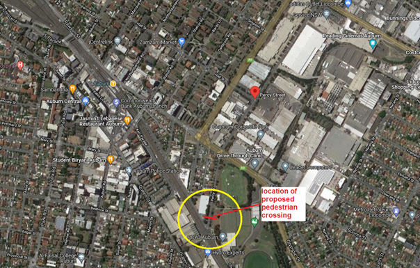
Transport for NSW has provided guideline to Local Governments to utilise reduced warrants on local roads, subject to satisfying safety requirements outlined in the Australian Standards and Austroads Guidelines.
Council has developed its own guidelines for the provision of pedestrian crossings on local roads especially at high demand locations including schools, community facilities, parks, hospitals, medical facilities, town centres, neighbourhood shops and public transport facilities.
A pedestrian (zebra) crossing is deemed to meet the numerical warrant for a pedestrian (zebra) crossing if the crossing point meets the following criteria:
· In each of two separate one-hour periods in a typical day, the pedestrian flow per hour crossing the road is or is expected to be equal to or greater than 20, and vehicle volumes be equal to or greater than 200. Where each unaccompanied child, elderly person or mobility impaired pedestrian is counted as two pedestrians.
In addition to the above, all requirements set down in Australian Standards are to be met.
Since the school has reached 60% of its potential number of students (with 433 students enrolled up to Year 9 in 2023) prior to final completion, Council officer observations have indicated that the pedestrian numbers are high in the morning and evening school hours; however, the vehicle numbers were not meeting the minimum threshold. While the numerical threshold for vehicles has not been met, the location of the pedestrian crossing supports safe access for students, parents and community members along a strategic link between Auburn Town Centre and Wyatt Park.
A concept plan showing the proposed crossing is attached.
There were further concerns raised by school administration requesting Council officers to review parking arrangement including the bus zones in Percy Street and Gelibolu Parade around the school. This matter is being investigated and a further report will be provided to the Traffic Committee, if required.
COnsultation
The location of the pedestrian crossing is between the school site at Percy Street and Wyatt Park, which is owned by Council. As the matter has been raised by the school and is related to their development application on the site, no further consultation is proposed.
Attachments
1. Plans – Percy Street, Auburn – Proposed pedestrian crossing and signage outside the International Maarif Schools of Australia at No 2 Percy Street Auburn.
DOCUMENTS
ASSOCIATED WITH
REPORT CTC-25-116
Attachment 1
Plans – Percy Street, Auburn – Proposed pedestrian crossing and signage outside the International Maarif Schools of Australia at No 2 Percy Street Auburn.
4 June 2025
Item No: CTC-25-117
ALBERT STREET AND FRANK STREET, GUILDFORD – ROAD SAFETY CONCERNS
Directorate: Environment and Planning
Responsible Officer: Manager Engineering and Building
Electorate: Granville
Police Area Command (PAC): Cumberland
Agenda Part Part 1
Note: Recommended for Approval under Delegated Authority
Summary
This report outlines the outcome of the investigation into this matter.
The Traffic Committee recommends that:
1. The installation of ‘Give Way’ signage and associated linemarking on Frank Street at Albert Street, Guildford West, be approved according to the attached plan.
2. The installation of ‘No Stopping’ signage and ‘BL2’ linemarking on Frank Street at Albert Street, Guildford West, be approved according to the attached plan.
3. The concerned and affected residents be consulted and report back to Traffic Committee if objections are received.
Report
Council has received a request from a local resident for the construction of a roundabout at the intersection of Albert Street and Frank Street, Guildford due to safety concerns.
Albert Street is a collector road connecting Harris Street and Fairfield Road, with a posted speed limit of 50 km/h. It has a width of approximately 10.5m and parking is permitted on both sides of the road unless otherwise signposted.
Frank Street is a local road running in a north–south direction, also with a speed limit of 50 km/h. It has a width of approximately 10.5m and parking is permitted on both sides of the road unless otherwise signposted.
At the intersection of Albert Street and Frank Street, priority is currently given to Albert Street. However, there are no existing 'Give Way' signs or linemarking at this location.
Albert Street also has a roundabout at its intersections with Palmer Street and Bowden Street, both situated within 200 metres of the Frank Street intersection.
![]()
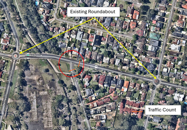
Locality Plan
Council has received concerns from a local resident regarding road safety at the intersection of Albert Street and Frank Street.
The latest crash data indicates that there were no recorded crashes at this intersection in the five years ending December 2024.
Traffic counts were undertaken in Frank Street and Albert Street, Guildford in April 2025. The traffic count locations are marked on the map above, with results below.
|
|
Location |
Average daily traffic (Veh/day) |
Average Peak Hour (Veh/hr) |
85th %tile speed (Km/hr) |
|
|
AM |
PM |
|
|||
|
Frank Street |
South of Albert Street |
753 |
75 |
77 |
42.3 |
|
Albert Street |
South of Guildford Rd |
7,205 |
533 |
637 |
54 |
The daily and peak hour traffic volumes in Albert Street are over 10 times greater in comparison to Frank Street. It is also noted that the traffic volumes show the importance of Albert Street being a collector road in the hierarchy of the network.
Considering the uneven traffic flow from the two streets, it indicates that there may be undue delays at the intersection especially for Frank Street traffic if a roundabout is implemented.
According to Austroads Guide to Traffic Management Part 6 – Intersections, Interchanges and Crossings, Table 2.10: Key traffic management considerations in the selection of roundabouts.
“Dominant flows on one approach may lead to excessive delay on the subsequent approach…”
Based on the above, a roundabout at the intersection of Frank Street and Albert Street is not warranted and should not be supported.
In accordance with Australian Standard AS 1742.2-2009 – Part 2: Traffic Control Devices for General Use, controls are required at all non-signalised intersections in the following manner:
a) GIVE WAY signs shall be provided at all intersections with four or more legs.
b) GIVE WAY signs shall be provided at any three-way intersections where the layout is such that it is not clear how or whether the T-intersection rule would operate, for example, at a Y-intersection.
c) GIVE WAY signs should be used for road safety reasons at unsignalised T-intersections in both rural and urban areas where the major road is an arterial or collect type road.
Based on point (b) above, 'Give Way' signage is warranted at this intersection. Therefore, it is recommended that ‘Give Way’ controls be provided at this location to prevent vehicles from failure to give way to traffic on Albert Street.
Site inspections also confirmed that some vehicles were parked too close to the intersection, posing potential safety risks. To address this issue, it is proposed to install ‘No Stopping’ restrictions and apply ‘BL2’ line marking at the location.
COnsultation
Subject to endorsement, consultation will be undertaken with affected residents on the proposal.
Attachments
1. Plan - Albert Street at Frank Street, Guildford West - Proposed 'Give Way' signage and linemarking
DOCUMENTS
ASSOCIATED WITH
REPORT CTC-25-117
Attachment 1
Plan - Albert Street at Frank Street, Guildford West - Proposed 'Give Way' signage and linemarking
4 June 2025
Item No: CTC-25-118
JOHN ST, LIDCOMBE – APPLICATION FOR ‘WORKS ZONE’ SIGNAGE
Directorate: Environment and Planning
Responsible Officer: Manager Engineering and Building
Electorate: Auburn
Police Area Command (PAC): Auburn
Agenda Part Part 1
Note: Recommended for Approval under Delegated Authority
Summary
Council has received an application for a ‘Works Zone’ on John Street, Lidcombe associated with the development at 164 John Street, Lidcombe.
This report outlines the outcome of the investigation into this matter.
The Traffic Committee recommends that:
1. The 12m long ‘Works Zone, 7:00am-6:00pm, Monday-Friday, 8:00am-4:00pm, Saturday’ signs be approved in principle on the frontage of the redevelopment site on John Street, Lidcombe in accordance with the attached plan subject to Council’s standard conditions for the period of 6 months and subsequent extension if required.
2. The applicant be advised to pay the ‘Works Zone’ fees to Council as per the adopted Fees and Charges.
Report
Council has received an application for a ‘Works Zone’ on John Street, Lidcombe associated with the development at 164 John Street, Lidcombe. The proposed development involves demolition of existing structures and construction of a single dwelling.
The temporary “Works Zone” is approximately 12m in length and proposed to commence in June 2025 for 6 months. The proposed times are between 7:00am to 6:00pm Monday to Friday and 8:00am to 4:00pm on Saturdays.
There will be a loss of two (2) unrestricted parking spaces on the western side of John Street, Lidcombe during the operation of the “Works Zone”.
COnsultation
Consultation will be undertaken if supported by the traffic committee.
Attachments
1. Plan – John Street, Lidcombe – Proposed Temporary ‘Works Zone’ signage.
DOCUMENTS
ASSOCIATED WITH
REPORT CTC-25-118
Attachment 1
Plan – John Street, Lidcombe – Proposed Temporary ‘Works Zone’ signage.
4 June 2025
Item No: CTC-25-119
RANDLE STREET AND BENNALONG STREET, GRANVILLE – ROAD SAFETY CONCERNS
Directorate: Environment and Planning
Responsible Officer: Manager Engineering and Building
Electorate: Granville
Police Area Command (PAC): Cumberland
Agenda Part Part 1
Note: Recommended for Approval under Delegated Authority
Summary
Council has received a request from a local resident regarding road safety concerns at the intersection of Randle Street and Bennalong Street, Granville due to safety concerns.
This report outlines the outcome of the investigation into this matter.
The Traffic Committee recommends that:
1. The proposed ‘BL2’ centre lines on the Bennelong Street approaches to its intersection with Randle Street, in accordance with the attached plan, be approved.
2. The concerned resident be notified of the outcome.
Report
Council has received a request from a local resident regarding road safety concerns at the intersection of Randle Street and Bennalong Street, Granville.
Randle Street is a local road running in an east – west direction with a posted speed limit of 50 km/h. It has a width of approximately 11m and parking is permitted on both sides of the road unless otherwise signposted.
Bennalong Street is a local road running in a north–south direction, also with a speed limit of 50 km/h. It has a width of approximately 9m and parking is permitted on both sides of the road unless otherwise signposted.
Randle Street and Bennalong Street form a four-way intersection with priority given to Randle Street. The intersection is controlled by 'Stop' signs and associated linemarking.
![]()
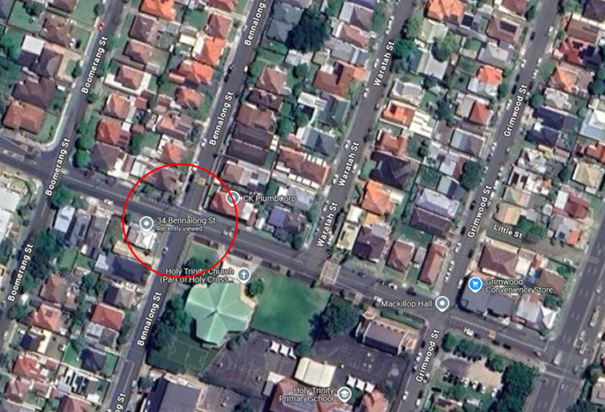
Locality Plan
Council has received concerns from a local resident regarding road safety at the intersection of Randle Street and Bennalong Street, with a suggestion that a roundabout be constructed at this location.
The latest crash data indicates that there were two recorded vehicle accidents at this intersection in the five years. The accident details are listed in the table below.
|
Date |
Location |
Description |
|
04/08/2022 |
Bennalong St at Randle Street |
Other manoeuvring |
|
25/04/2023 |
Bennalong St at Randle Street |
Cross Traffic |
Traffic counts were undertaken in Bennalong Street and Randle Street, Granville in April 2025. The traffic count locations are marked on the map above.
Traffic Count Data in Bennalong Street and Randle Street:
|
|
Location |
Average daily traffic (Veh/day) |
Average Peak Hour (Veh/hr) |
85th %tile speed (Km/hr) |
|
|
AM |
PM |
|
|||
|
Bennalong Street |
South of Randle Street |
876 |
115 |
80 |
23.2 |
|
Randle Street |
South of Granville Rd |
3,509 |
366 |
265 |
43.7 |
The daily and peak hour traffic volumes in Randle Street are significantly greater in comparison to Bennalong Street.
Considering the uneven traffic flow from the two streets, it indicates that there may be undue delays at the intersection, especially for Bennalong Street traffic, if a roundabout is implemented.
According to Austroads Guide to Traffic Management Part 6 – Intersections, Interchanges and Crossings, Table 2.10: Key traffic management considerations in the selection of roundabouts.
“Dominant flows on one approach may lead to excessive delay on the subsequent approach…”
In addition, Bennalong Street is approximately 9.5 metres wide, and has an insufficient area to accommodate a roundabout at the intersection.
It is proposed to paint ‘BL2’ centre lines on the Bennelong Street approaches to the intersection. Council officers will also review the existing signage and linemarking at the intersection and install warning signs if necessary.
COnsultation
Consultation is not required as no properties are directly affected by the proposal.
Attachments
1. Plan - Randle Street & Bennelong Street, Granville - Proposed centre line marking
DOCUMENTS
ASSOCIATED WITH
REPORT CTC-25-119
Attachment 1
Plan - Randle Street & Bennelong Street, Granville - Proposed centre line marking
Traffic Committee
4 June 2025
Part 2
Recommendation to Council
4 June 2025
Item No: CTC-25-120
THE ESPLANADE, ELIZABETH STREET AND AMHERST STREET, GUILDFORD - ROAD SAFETY CONCERNS
Directorate: Environment and Planning
Responsible Officer: Manager Engineering and Building
Electorate: Granville
Police Area Command (PAC): Cumberland
Agenda Part Part 2
Note: Recommendation to Council
Summary
Council has received concerns from a local resident regarding intersection safety at the intersection of The Esplanade, Amherst Street and Elizabeth Street, Guildford.
This report outlines the outcome of the investigation into this matter.
The Traffic Committee recommends that:
1. The installation of ‘No Stopping’ signs and centre line marking at the intersection of The Esplanade, Amherst Street and Elizabeth Street, and the proposed speed cushions on the Elizabeth Street approach to its intersection with The Esplanade, Guildford, in accordance with the attached plan, be approved in principle.
2. Council undertake consultation with affected residents and report back to the Traffic Committee if objections are received.
3. Concerned and affected residents be notified of the outcome.
Report
The Esplanade is a local road that runs in a north-south direction between Guildford Road and Hawksview Street with a default speed limit of 50km/h. The street is approximately 750m long and has a width of approximately 12.7m. Parking is permitted on both sides of the road unless signposted otherwise.
Amherst Street is a local road that runs in a westerly direction from The Esplanade and has a speed limit of 50 km/hr. It has a width of approximately 8.8 m. Council has previously installed speed humps in Amherst Street as traffic calming treatment.
Elizabeth Street runs in an easterly direction from The Esplanade and has a width of approximately 11.8 m.
Both Amherst Street and Elizabeth Street form T-intersections with The Esplanade separated by approximately 20m.
There is a bus route through Elizabeth Street, The Esplanade and Amherst Street and in the reverse direction.
Traffic counts were undertaken in Elizabeth Street and Amherst Street late in 2024.
The traffic count location is shown in red on the map below.
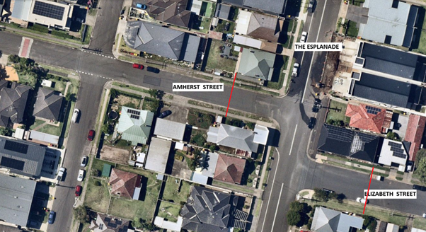
The traffic count data is shown below:
|
|
Elizabeth Street |
Amherst Street |
|
Average Daily Traffic (Both directions) – Veh/hr |
1,833 |
1,319 |
|
Eastbound |
1070 |
519 |
|
Westbound |
763 |
800 |
|
85th percentile speed (Both directions) – Km/hr |
43.4 |
27.0 |
|
Eastbound |
42.3 |
24.3 (towards intersection) |
|
Westbound |
44.6 (towards intersection) |
28.3 |
The latest crash data indicated that there was one reported crash at the intersection of Elizabeth Street and The Esplanade in the 5 years ending June 2024.
|
Date |
Location |
Description |
|
19/05/2021 |
Elizabeth Street & The Esplanade |
Right-through |
There were no reported crashes at the intersection of Amherst Street and The Esplanade.
The resident has requested to consider a roundabout at the staggered intersection. Council has investigated the request and found that due to the bus route, narrow road width of Amherst Street and the distance separating both T-intersections, it is not feasible for the provision of a roundabout in accordance with Austroads guidelines.
It is noted from the traffic count data, that the vehicle speeds on Elizabeth Street towards The Esplanade is high (85th percentile speed 44.6 km/hr), which is unsafe if the need arises for vehicles to give way at the intersection. It is proposed to install speed cushions on the Elizabeth Street approach, as well as ‘No Stopping’ signage at the intersection with The Esplanade to improve road safety and reinforce the Road Rules.
The approach speeds on Amherst Street are acceptable (85th %tile speed 24.3 km/hr), noting that vehicles travelling along Amherst Street are passing through speed humps in the street. However, there is an opportunity to install ‘No Stopping’ signage at the intersection with The Esplanade to improve road safety and reinforce the Road Rules.
COnsultation
Subject to endorsement, consultation will be undertaken with affected residents on the proposal.
Attachments
1. Plan - The Esplanade, Amherst Street and Elizabeth Street, Guildford – Proposed intersection treatment.
DOCUMENTS
ASSOCIATED WITH
REPORT CTC-25-120
Attachment 1
Plan - The Esplanade, Amherst Street and Elizabeth Street, Guildford – Proposed intersection treatment.
4 June 2025
Item No: CTC-25-121
VAUGHAN STREET, LIDCOMBE – REQUEST FOR MEDIAN ISLAND OUTSIDE MCDONALD’S DRIVEWAY
Directorate: Environment and Planning
Responsible Officer: Manager Engineering and Building
Electorate: Auburn
Police Area Command (PAC): Auburn
Agenda Part Part 2
Note: Recommendation to Council
Summary
Council has received safety concerns from motorists regarding the carpark driveway of McDonald’s on the northeastern corner of Olympic Drive and Vaughan Street, Lidcombe.
This report outlines the outcome of the investigation into this matter.
The Traffic Committee recommends that:
1. A 600 mm wide, 25m long median island on Vaughan Street, Lidcombe, outside the McDonalds carpark driveway, be approved in principle.
2. Council undertake consultation with affected stakeholders and a further report be provided to the Traffic Committee if objections are received.
Report
Council has received safety concerns from motorists regarding the carpark driveway of McDonald’s on the northeastern corner of Olympic Drive and Vaughan Street, Lidcombe.
The image below shows the location:
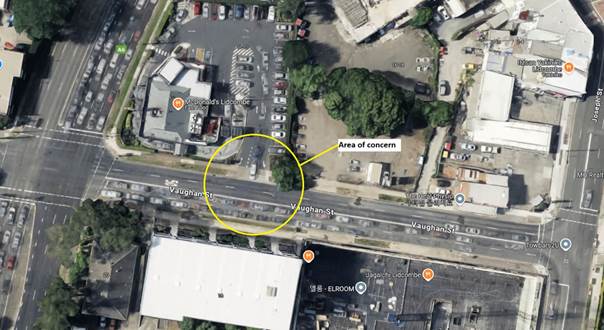
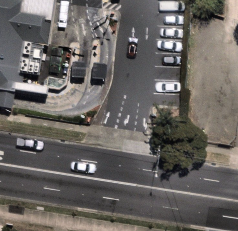
Locality Plan
Olympic Drive is a state road managed by Transport for NSW and forms an intersection with Vaughan Street which is controlled by traffic signals.
The section of Vaughan Street east of Olympic Drive is a local road that runs in a westerly direction from Joseph Street and has a speed limit of 50 km/hr. Vaughan Street west of Olympic Drive is a regional road.
The McDonald’s carpark driveway is located approximately 35 m east from the Olympic Drive traffic signals.
The driveway is marked one lane entry and two lanes for exit, one for right turn and the other for left turn at Vaughan Street. It is alleged that cars travelling westbound on Vaughan Street from Joseph Street tend to travel in the wrong lane to enter the carpark driveway due to long queues in Vaughan Street extending beyond the carpark driveway. Also, cars exiting from the carpark in the right turn lane try to force into the queued traffic and sometimes blocking oncoming traffic. This behaviour causes road safety issues.
The latest crash data indicated that there were two reported crashes on Vaughan Street in the vicinity of McDonalds driveway in the last 5 years ending June 2024. The details of these crashes are tabulated below:
|
Date |
Location |
Description |
|
16/10/2021 |
Vaughan Street & McDonalds |
Emerging from driveway |
|
04/10/2023 |
Vaughan Street 40 m east of Olympic Drive (opposite carpark driveway) |
Rear right |
Two options are available for Council to remedy this situation. One option is by contacting McDonald’s to convert the right turn lane from the carpark into left turn lane thus arranging a dual left turn lanes; however, this is in contradiction to the approved development consent. The other option is to build a physical barrier by providing a median island to avoid the traffic conflict at this location. It is proposed that a physical barrier be progressed to address the issue raised.
COnsultation
Subject to endorsement, consultation will be undertaken with affected stakeholders on the proposal.
Attachments
DOCUMENTS
ASSOCIATED WITH
REPORT CTC-25-121
Attachment 1
Plan – Vaughan Street, Lidcombe – Proposed median island
4 June 2025
Item No: CTC-25-122
WARWICK ROAD & BURNETT STREET, MERRYLANDS – REQUEST FOR BANNING TURNING MOVEMENTS AT THE INTERSECTION
Directorate: Environment and Planning
Responsible Officer: Manager Engineering and Building
Electorate: Granville
Police Area Command (PAC): Cumberland
Agenda Part Part 2
Note: Recommendation to Council
Summary
The Cumberland Traffic Committee considered a report on the request for the right turn ban for vehicles exiting Warwick Road at its meeting held on 5 June 2024.
This report outlines the outcome of the follow up actions into this matter.
The Traffic Committee recommends that:
1. Council installs “No Right Turn, 6 AM – 10AM, 3PM – 7PM, Monday to Friday” signage on Warwick Road, Merrylands at its intersection with Burnett Street as per the attached plan.
2. Council installs advisory sign indicating “No Right Turn at Burnett St, 6 AM-10 AM, 3 PM-7 PM, MON-FRI” on Warwick Road at its intersection with Walpole Street as per the attached plan.
3. Council notify the residents who sent submissions during the consultation of the outcome.
4. Council provide information to road users and local residents of the traffic movement changes prior to commencement.
Report
Council received a request from a resident for banning turning movements at the intersection of Burnett Street and Warwick Road, Merrylands.
Burnett Street is a regional road carrying over 19,000 vehicles/day and links Burnett Street to another regional road Merrylands Road. Warwick Road is a local road that runs in a northerly direction from Merrylands Road to Burnett Street.
Burnett Street and Warwick Road form a T-intersection with ‘Give Way’ sign and line marking on Warwick Road.
The map below shows the locality of Burnett Street and Warwick Road, Merrylands.
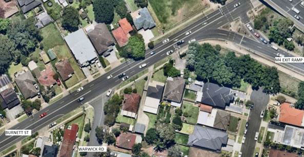
Cumberland Traffic Committee considered a report on the request for the right turn ban for vehicles exiting Warwick Road at its meeting held on 5 June 2024.
Traffic Committee recommended that:
1. Council undertakes community consultation for implementing part time or full-time right turn ban from Warwick Road into Burnett Street and prepare a Traffic Management Plan in consultation with Transport for NSW for submission and approval.
2. Council prepares a signage plan and report back to the Traffic Committee following the approval of the Traffic Management Plan by Transport for NSW.
Council approved the above recommendations at its meeting held on 7 August 2024.
Following Council resolution, consultation was undertaken with the residents of Warwick Road and surrounding streets. The consultation area is marked on the map below.
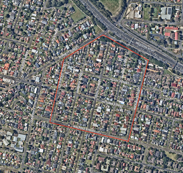
Consultation Area
Council included two options for residents to consider, namely, a full-time right turn ban and a part time right turn ban. A total of 402 letters were sent to owners and tenants of properties. Council received 49 submissions, and the result is summarised below:
Support for full-time ban = 6
Support for part-time ban = 14
Objection for any ban = 29
Based on the above, it is noted that there were 20 submissions supporting a part time or full-time right turn ban. Submissions varied depending on the locations of residents, with those living closest to the intersection supporting the request for a full or part time ban. These residents also indicated that several minor crashes and near misses have occurred in addition to the two formally reported crashes at the intersection over the last five years. This information was used to inform a Traffic Management Plan (TMP) focusing on improving intersection safety.
Following consultation, Council officers submitted a TMP to Transport for NSW for implementing a part time right turn ban (‘No Right Turn, 6 AM – 10AM, 3PM – 7PM, Monday to Friday’).
Council has received Transport for NSW approval of the TMP, with concurrence that implementing a ban of right turning movements will reduce accidents during peak hours and improve overall safety for road users during peak traffic periods.
Council proposes to install the signage for the part time right turn ban in accordance with the TMP. Prior to commencement, Council officers will advise local residents and road users of the changes to traffic movements at this location.
COnsultation
Consultation was undertaken for 14 days from 14 October 2024 to 28 October 2024. Details of the consultation are outlined in the report.
Attachments
1. Plan – Signage plan for the part time right turn ban at the intersection of Warwick Road & Burnett Street.
3. Approval of Traffic Management Plan by TfNSW
4. Previous Report - CTC-24-142- Warwick Road & Burnett Street, Merrylands - Part Time Right Turn Ban
DOCUMENTS
ASSOCIATED WITH
REPORT CTC-25-122
Attachment 1
Plan – Signage plan for the part time right turn ban at the intersection of Warwick Road & Burnett Street.
DOCUMENTS
ASSOCIATED WITH
REPORT CTC-25-122
Attachment 2
Traffic Management Plan
DOCUMENTS
ASSOCIATED WITH
REPORT CTC-25-122
Attachment 3
Approval of Traffic Management Plan by TfNSW
DOCUMENTS
ASSOCIATED WITH
REPORT CTC-25-122
Attachment 4
Previous Report - CTC-24-142- Warwick Road & Burnett Street, Merrylands - Part Time Right Turn Ban
4 June 2025
Item No: CTC-25-123
OLD PROSPECT ROAD AND ETTALONG STREET, GREYSTANES – TEMPORARY ROAD CLOSURES ASSOCIATED WITH ‘OUR LADY QUEEN OF PEACE FESTA’
Directorate: Environment and Planning
Responsible Officer: Manager Engineering and Building
Electorate: Prospect
Police Area Command (PAC): Cumberland
Agenda Part Part 2
Note: Recommendation to Council
Summary
Council has received a request regarding the temporary closure of Old Prospect Road and Ettalong Road, Greystanes for the procession associated with ‘Our Lady Queen of Peace Festa’ 2025.
The Traffic Committee recommends that the temporary closures of Old Prospect Road and Ettalong Road, Greystanes between the hours of 2:00pm and 5:00pm Sunday 28 September 2025 be approved subject to the following conditions:
1. All affected businesses, residents and emergency stakeholders being notified/consulted of the closure.
2. Complying with the notification requirements of the Roads Act 1993, i.e. placing public notices in a newspaper and erecting notices on the road.
3. Bus operators be consulted of the closure.
4. Approval of a Traffic Management Plan by Transport for NSW and the Transport Management Centre and amending the Plan appropriately as recommended by the above authorities.
Report
Council has received an application for the temporary closure of Old Prospect Road and Ettalong Road, Greystanes between the hours of 2:00 pm and 5:00 pm on Sunday 28 September 2025 during the Our Lady Queen of Peace (OLQP) Festa.
Over the years, the Our Lady Queen of Peace (OLQP) Festa commemorates the parish patron of "Our Lady, Queen of Peace". The OLQP Festa has been a calendar highlight of the Greystanes Community since 1965 with many nationalities. Festa has now become a multicultural event in the Greystanes community with many people attending from all walks of life. Over the past 4 years (post COVID), thousands of people enjoy the tradition of Festa, families making an annual pilgrimage to attend.
One part of the Festa includes a procession of the statue of ‘Our Lady’ through the Parish Grounds. This year, the Festa celebrates 60 years, and the Festa Committee would like the procession to proceed in the streets of Greystanes.
The Festa Committee has requested road closures of part of Ettalong Road and Old Prospect Road Greystanes on Sunday 28 September 2025 for the procession.
Upon advice from the police who attended the Festa last year, the FESTA committee has also requested a kerbside lane closure in Old Prospect Road at the frontage of the property of Our Lady Queen of Peace for the duration of the Festa to enhance safety.
The FESTA committee has requested for the temporary closure of section of Old Prospect Road around its intersection with Ettalong Road and a section of Ettalong Road between Old Prospect Road and Kookaburra Street for the duration of the procession.
The road closures will be between 2:00 pm and 5:00 pm Sunday 28 September 2025.
It should be noted that the road closure involves a traffic signal site at the intersection of Old Prospect Road and Ettalong Street.
The applicant will submit a traffic management plan for approval by the Transport Management Centre and Transport for NSW for the road closure and make changes appropriately as recommended by these bodies.
COnsultation
The event organisers will carry out consultation with all affected businesses and residents and any objection received will be forwarded to Council for consideration.
Attachments
Nil
4 June 2025
Item No: CTC-25-124
BRISTOL STREET, MERRYLANDS WEST – ROAD SAFETY CONCERNS
Directorate: Environment and Planning
Responsible Officer: Manager Engineering and Building
Electorate: Granville
Police Area Command (PAC): Cumberland
Agenda Part Part 2
Note: Recommendation to Council
Summary
Council has received a request from a local resident for the installation of traffic calming devices on Bristol Street, Merrylands West due to speeding concerns.
This report outlines the outcome of the investigation into this matter.
The Traffic Committee recommends that Council undertake consultation with the residents of Bristol Street, Merrylands West, between Cusack Street and Fowler Road, to assess support or otherwise for the provision of speed humps in the street.
Report
Council has received a request from a local resident for the installation of traffic calming devices on Bristol Street, Merrylands West due to speeding concerns. Bristol Street is a local road that runs in an east – west direction between Sherwood Road and Fowler Road.
The speed limit in the street is 50 km/h, and during school operating hours the 40 km/h
school zone speed limit applies for a section of the road. Parking is permitted on both
sides of the road unless otherwise signposted.
Merrylands West High School has access in Bristol Street west of Cusack Street. The school has two raised pedestrian crossings in Bristol Street outside the school between Sherwood Road and the bend near Cusack Street. There is also a concrete median island built in the bend west of Cusack Street. The school ground is located along Bristol Street between Bettina Street and Cusack Street and is continuously fenced up to the driveway west of Cusack Street.
The map below shows the location of Bristol Street.
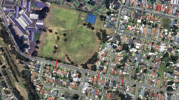
Council has received a request from a local resident for the installation of traffic calming devices on Bristol Street, Merrylands West due to speeding concerns. Council has previously reported traffic conditions in Bristol Street and the Traffic Committee recommended that traffic calming devices on Bristol Street, Merrylands West not be supported. The section of Bristol Street between Sherwood Road and Cusack Street has several traffic calming devices installed at the school frontage.
Traffic counts were undertaken on Bristol Street at 3 locations in 2024. The traffic count locations are shown in red on the map above. One location is within the School Zone, the second location at the start/end of the School Zone and the third location outside the School Zone. The three counts will assist in determining driver behaviour inside and outside the School Zone.
The results of the traffic counts on Bristol Street, Merrylands West are detailed in the table below:
|
|
At #16 Outside School Zone |
At #33 At the start of School Zone |
At #44 In School Zone |
|
Average Daily Traffic (Veh/hr) |
6,555 |
6,647 |
6,167 |
|
Median Speed (Km/hr) |
47.5 |
46.8 |
48.6 |
|
85th %tile speed (Km/hr) |
54.5 |
54 |
55.6 |
|
85th %tile speed School Times: 8AM-9AM, 2PM-3PM
|
|
49.5 |
49.9 |
The latest crash data indicated that there were no reported mid-block crashes in Bristol Street in the 5 years ending June 2024. There were two intersection crashes, one at the intersection with Sherwood Road and other at the intersection with Fowler Road.
The crash details are shown in the table below:
|
Date |
Location |
Description |
|
04/12/2020 |
Sherwood Road & Bristol Street |
Rear end |
|
10/06/2024 |
Sherwood Road & Fowler Road |
Off left/rt bnd=>obj |
The results of the traffic count and recorded crash history have been used to determine the need for the installation of traffic calming devices in accordance with the criteria set out in Council’s Local Traffic and Transport Policy and Guidelines for Local Area Traffic Management (LATM).
The LATM assessment is summarised in the tables below:
Table 1 – Bristol Street - LATM Assessment Points
|
Criteria |
Maximum Score |
Score Achieved |
|
Traffic Study Data |
60 |
25 |
|
Local Characteristics |
35 |
22 |
|
Total |
100 |
47 |
Table 2 – Bristol Street – Recommended Actions
|
Points (out of 100) |
Recommended Action(s) |
|
61-100 |
· Report to Cumberland Traffic Committee with a recommendation of providing traffic calming. · Report to Cumberland Traffic Committee on line marking and associated improvements to support traffic calming and road safety as an initial response, subject to technical guidelines. · Consider community and stakeholder consultation on potential improvements. |
|
41-60 |
· Monitor and review traffic data after 6 months. · Report to Cumberland Traffic Committee on line marking and associated improvements to support traffic calming and road safety as an initial response, subject to technical guidelines. · Consider community and stakeholder consultation on potential improvements. |
|
25-40 |
· Monitor and review traffic data after 12 months. · Report to Cumberland Traffic Committee online marking and associated improvements to support traffic calming and road safety as an initial response, subject to technical guidelines. · Consider community and stakeholder consultation on potential improvements. |
|
<25 |
· Do nothing. |
|
Speed |
· Regardless of the total points scored, should the 85th percentile speed exceeds the posted speed limit by 5km/h, the street is to be referred to the Local Area Command of the NSW Police for monitoring and/or enforcement. · Opportunities for line marking and associated improvements to support traffic calming and road safety to be considered, subject to technical guidelines. |
The traffic counts indicated that the recorded 85th percentile speeds were between 54 and 55.6 km/hr. It is also noted that the recorded speeds during School Zone times were high for the counts within the school zone.
Based on the assessment undertaken, it is proposed that Council undertake consultation with the residents of Bristol Street to assess support or otherwise for the installation of speed humps in the street.
COnsultation
Subject to endorsement, consultation will be undertaken with affected residents on the proposal.
Attachments
4 June 2025
Item No: CTC-25-125
HARGRAVE ROAD, AUBURN – PROVISION OF A PEDESTRIAN CROSSING OUTSIDE AUBURN HOSPITAL
Directorate: Environment and Planning
Responsible Officer: Manager Engineering and Building
Electorate: Auburn
Police Area Command (PAC): Auburn
Agenda Part Part 2
Note: Recommendation to Council
Summary
Council has received a request from the Auburn Hospital Management for a pedestrian crossing on Hargrave Road, Auburn outside the hospital staff car park. Council has also resolved at its meeting on 26 March 2025 to investigate the installation of a pedestrian crossing near Auburn Hospital.
This report outlines the outcome of the investigation into this matter.
The Traffic Committee recommends that:
1. A raised pedestrian crossing on Hargrave Road, Auburn, outside Auburn Hospital be approved in principle.
2. Council investigate the two locations as indicated in the report and prepare concept plans for consultation with affected residents and Auburn Hospital Administration.
3. A further report on the consultation results and preferred location with concept plan be provided for consideration by the Traffic Committee.
Report
Council has received a request from the Auburn Hospital Management for a pedestrian crossing on Hargrave Road, Auburn outside the hospital staff car park.
Council also resolved on a Notice of Motion (C03/25-89 Notice of Motion - Traffic Safety Measures) at its meeting on 26 March 2025 to investigate the installation of a pedestrian crossing near Auburn Hospital amongst other items.
Min.912 - C03/25-89 Notice of Motion - Traffic Safety Measures
That Council:
1. Investigate the installation of a pedestrian crossing and associated safety measures on both Lidbury Street and York Street, Berala, near York Park;
2. Investigate the installation of a pedestrian crossing and associated safety measures on Hargrave Road, near the Auburn Hospital entry and bus stop; and
3. Provide a report to the Traffic Committee, detailing the process undertaken including technical studies and implementation costs.
This report details the investigation undertaken in this regard.
Hargrave Road is a local road that runs in a north-south direction between Water Street and Helena Street and has a speed limit of 50 km/hr. Auburn Hospital and associated buildings are located in the section of Hargrave Road between Water Street and Norval Street. There are “No Stopping”, “Bus Zone” and “Taxi Zone” signage in the street.
The latest crash data indicated that there was one reported crash at the intersection of Hargrave Road and Water Street in the last 5 years which was a pedestrian related crash.
The location requested by the Hospital Staff is outside the staff carpark. However, this is 50-70 m away from the hospital entry for visitors and patients.
Pedestrian crossing warrants
Council officers have investigated the request to provide a pedestrian crossing outside the Auburn Hospital Staff Carpark on Hargrave Road.
Transport for NSW has recently provided guideline to Local Governments to utilise reduced warrants on local roads, subject to satisfying safety requirements outlined in the Australian Standards and Austroads Guidelines.
Council has developed its own guidelines for the provision of pedestrian crossings on local roads especially at high demand locations including schools, community facilities, parks, hospitals, medical facilities, town centres, neighbourhood shops and public transport facilities.
A pedestrian (zebra) crossing is deemed to meet the numerical warrant for a pedestrian (zebra) crossing if the crossing point meets the following criteria:
· In each of two separate one-hour periods in a typical day, the pedestrian flow per hour crossing the road is or is expected to be equal to or greater than 20, and vehicle volumes be equal to or greater than 200. Where each unaccompanied child, elderly person or mobility impaired pedestrian is counted as two pedestrians.
In addition to the above, all requirements set down in Australian Standards are to be met.
Pedestrian and Vehicle counts:
Pedestrian and vehicle counts were taken on Thursday 6 March 2025 in the area between the Auburn Hospital Entry and Water Street. The hourly count data is given below:
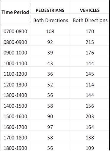
Based on the above, it is noted that the numerical warrants for a pedestrian crossing are satisfied in accordance with Council’s Local Traffic and Transport Policy and Guidelines, considering this location is outside the Auburn Hospital. The location also meets the safety requirements as outlined in the Australian Standards.
Council has identified two specific locations for further investigation. These two locations are shown in the map below:
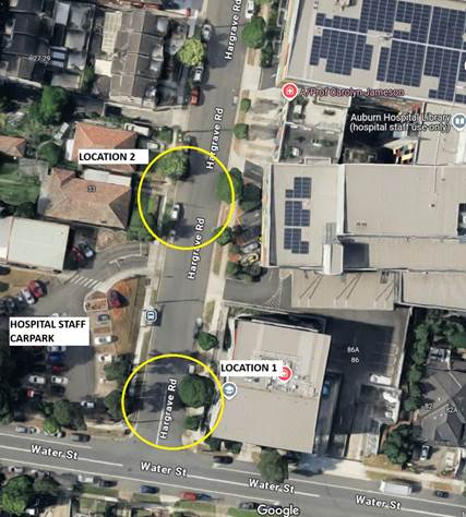
It is proposed to further investigate the two locations identified in the map. Council officers will prepare concept plans for the two locations identified and undertake consultation with affected residents and Auburn Hospital Administration.
A further report identifying the exact location suitable for pedestrian crossing will be provided to the Traffic Committee for consideration.
COnsultation
Subject to endorsement, Council officers will prepare concept plans and undertake consultation with affected residents, bus operator and hospital management on the proposal.
Attachments
4 June 2025
Item No: CTC-25-126
OCTAVIA STREET, TOONGABBIE – PROVISION OF A PEDESTRIAN CROSSING AT THE INTERSECTION WITH AURELIA STREET
Directorate: Environment and Planning
Responsible Officer: Manager Engineering and Building
Electorate: Prospect
Police Area Command (PAC): Cumberland
Agenda Part Part 2
Note: Recommendation to Council
Summary
Council has received a request from residents for a pedestrian facility on Octavia Street, Toongabbie outside the car park of Girraween Park. This facility is also identified by Council in the adopted the Toongabbie Town Centre Public Domain Plan.
This report outlines the outcome of the investigation into this matter.
The Traffic Committee recommends that:
1. A raised pedestrian crossing on Octavia Street, Toongabbie, outside the car park of Girraween Park, as provided in the attached plan, be approved in principle.
2. Council forward final design plans to Transport for NSW for concurrence.
3. Council undertake consultation with affected residents and other stakeholders and report back to the Traffic Committee if objections are received.
Report
Council has received a request from the residents for a pedestrian facility on Octavia Street, Toongabbie outside the car park of Girraween Park.
Council, at its meeting held on 21 August 2024, adopted the Toongabbie Town Centre Public Domain Plan. As part of the plan, a pedestrian facility was identified on Octavia Street at its intersection with Aurelia Street, as shown in the image below.
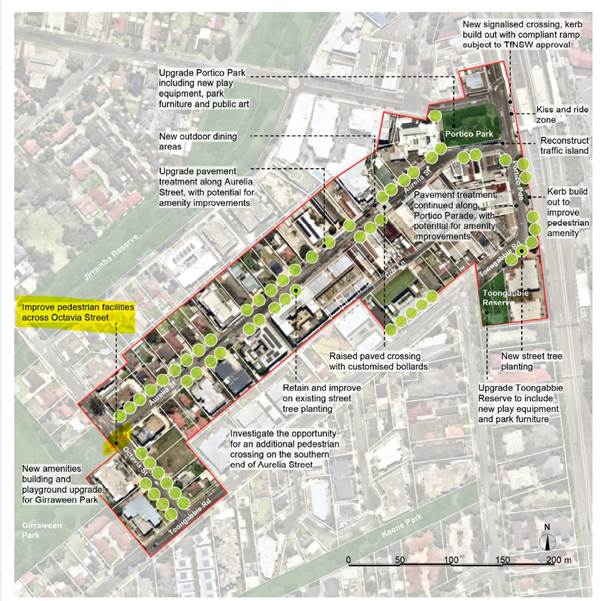
Toongabbie Town Centre Public Domain Plan
Octavia Street is a local road that runs in a westerly direction from Toongabbie Road and has a speed limit of 50 km/hr. Girraween Park car park is in Octavia Street opposite the intersection with Aurelia Street.
The map below shows the location of Octavia Street and the car park.
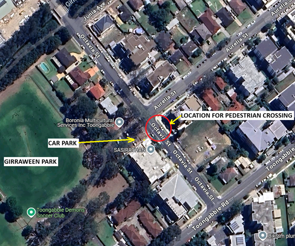
Locality Plan
Council officers have investigated the request to provide a pedestrian facility on Octavia Street, Toongabbie, outside the car park at Girraween Park.
The latest crash data indicated that there were two reported crashes at the intersection of Octavia Street and Aurelia Street in the last 5 years ending June 2024. These crashes are vehicle related.
|
Date |
Location |
Description |
|
09/01/2021 |
Aurelia Street & Octavia Street |
Rear right |
|
03/09/2022 |
Aurelia Street & Octavia Street |
Left off carriageway into object |
Pedestrian crossing warrants:
Transport for NSW has recently provided guideline to Local Governments to utilise reduced warrants on local roads, subject to satisfying safety requirements outlined in the Australian Standards and Austroads Guidelines.
Council has developed its own guidelines for the provision of pedestrian crossings on local roads especially at high demand locations including schools, community facilities, parks, hospitals, medical facilities, town centres, neighbourhood shops and public transport facilities.
A pedestrian (zebra) crossing is deemed to meet the numerical warrant for a pedestrian (zebra) crossing if the crossing point meets the following criteria:
· In each of two separate one-hour periods in a typical day, the pedestrian flow per hour crossing the road is or is expected to be equal to or greater than 20, and vehicle volumes be equal to or greater than 200. Where each unaccompanied child, elderly person or mobility impaired pedestrian is counted as two pedestrians.
In addition to the above, all requirements set down in Australian Standards are to be met.
Pedestrian and vehicle counts were taken on Friday 7 March 2025. The hourly count data is given below:
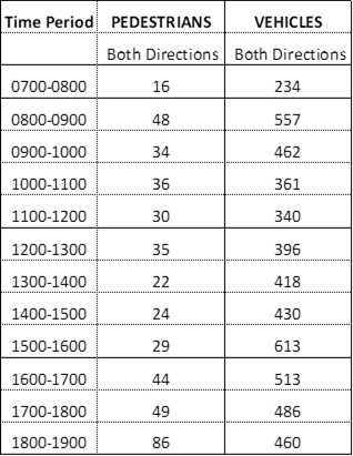
Based on the above, it is noted that the numerical warrants for a pedestrian crossing are satisfied in accordance with Council’s Local Traffic and Transport Policy, and is a strategic link as outlined in the Toongabbie Town Centre Public Domain Plan. The location also meets the safety requirements as outlined in the relevant Australian Standards.
It is proposed to provide a raised pedestrian crossing on Octavia Street near Aurelia Street. The raised pedestrian crossing will improve safety for pedestrians particularly residents using Girraween Park at this location.
COnsultation
Subject to endorsement, Council officers will undertake consultation on the proposal with affected residents and relevant stakeholders.
Attachments
1. Octavia Street, Toongabbie – Proposed raised pedestrian crossing – Concept plan
DOCUMENTS
ASSOCIATED WITH
REPORT CTC-25-126
Attachment 1
Octavia Street, Toongabbie – Proposed raised pedestrian crossing – Concept plan
4 June 2025
Item No: CTC-25-127
TALBOT ROAD, GUILDFORD - PROPOSED PEDESTRIAN FENCING
Directorate: Environment and Planning
Responsible Officer: Manager Engineering and Building
Electorate: Granville
Police Area Command (PAC): Cumberland
Agenda Part Part 2
Note: Recommendation to Council
Summary
Council has received safety concerns from a business owner in Talbot Road, Guildford.
This report outlines the outcome of the investigation into this matter.
The Traffic Committee recommends that:
1. The installation of a pedestrian fence on the eastern side of Talbot Road along the side boundary of No. 265 Guildford Road, Guildford, in accordance with the attached plan, be approved.
2. The concerned business owner be notified of the outcome.
Report
Talbot Road Street is a regional road that runs in a north-south direction. It has a width of approximately 9.5m with a speed limit of 50 km/h. In the business section of the street, parking is not permitted on either side.
The map below shows the intersection.
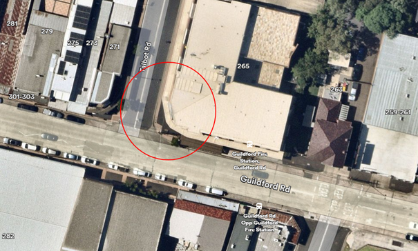 Locality
Plan
Locality
Plan
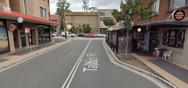 Street
View
Street
View
Council has received a request from the business owner of No. 265 Guildford Road regarding the installation of a pedestrian fence on the eastern side of Talbot Road along the side boundary of No.265 Guildford Road.
The business owner has raised concerns about safety near an outdoor dining area located at the southeast corner of Guildford Road and Talbot Road. While there is already a safety fence on the western side of Talbot Road next to No. 271 Guildford Road, there is no such fence on the eastern side. The business owner is concerned that vehicles entering the intersection from Guildford Road are traveling at high speeds, creating a potential risk of crashing into the outdoor dining area.
To improve pedestrian safety, it is proposed to install a pedestrian safety fence on the eastern side of Talbot Road, as shown in the attached plan.
COnsultation
No consultation has been undertaken as the installation of the pedestrian safety fence does not adversely impact on any parking or properties.
Attachments
1. Plan – Talbot Road, Guildford – Proposed pedestrian fencing
DOCUMENTS
ASSOCIATED WITH
REPORT CTC-25-127
Attachment 1
Plan – Talbot Road, Guildford – Proposed pedestrian fencing
4 June 2025
Item No: CTC-25-128
OLYMPIC DRIVE, LIDCOMBE – PROPOSED SAFETY FENCE
Directorate: Environment and Planning
Responsible Officer: Manager Engineering and Building
Electorate: Auburn
Police Area Command (PAC): Auburn
Agenda Part Part 2
Note: Recommendation to Council
Summary
Council has received a request from a resident concerning safety issues at the bend in Olympic Drive, Lidcombe outside No.13.
This report outlines the outcome of the investigation into this matter.
The Traffic Committee recommends that:
1. The installation of safety fence at the bend in Olympic Drive, Lidcombe outside No.13 in accordance with the attached plan be approved.
2. The concerned resident be notified of the outcome.
Report
Olympic Drive is a state road under the jurisdiction of Transport for NSW (TfNSW). It has 3 lanes in each direction with a wide median at the centre which has a wire fencing in the middle. The speed limit in the street at this location is 70km/hr.
The map below shows the location under consideration in Olympic Drive.
Locality Plan
Street View
It is alleged that vehicles travelling southbound on Olympic Drive lose control, mount the nature strip, and crash into the boundary walls of nearby properties.
According to the Centre for Road Safety accident database, there have been two reported incidents where southbound vehicles lost control and struck objects near the bend, in the vicinity of properties numbered 5 to 13. It should be noted that only officially reported accidents are recorded in the database.
Council has considered other options to provide guard rails and concrete barriers. However, the presence of driveways prevents sufficient length of such structures. Therefore, it is proposed to provide safety fence at this location to respond to the issue raised at this location.
COnsultation
Consultation has been carried out with Transport for NSW (TfNSW) and no objections were received.
Community consultation has not been undertaken as the proposal does not directly impact any residents.
Attachments
DOCUMENTS
ASSOCIATED WITH
REPORT CTC-25-128
Attachment 1
Plan – Olympic Drive, Lidcombe – Proposed Safety Fence
4 June 2025
Item No: CTC-25-129
PRINCES STREET AND KING STREET, GUILDFORD WEST – PROPOSED ROUNDABOUT
Directorate: Environment and Planning
Responsible Officer: Manager Engineering and Building
Electorate: Granville
Police Area Command (PAC): Cumberland
Agenda Part Part 2
Note: Recommendation to Council
Summary
Council has received a request from a local resident for the installation of a roundabout at the intersection of Princes Street and King Street, Guildford West due to safety concerns.
This report outlines the outcome of the investigation into this matter.
The Traffic Committee recommends that:
1. That the installation of a roundabout at the intersection of King Street and Princes Street, Guildford West, be supported in principle.
2. Council prepare a concept plan for the proposed roundabout and undertake consultation with affected residents, with a further report provided to the Traffic Committee if objections are received.
Report
Princes Street is a local road that runs in a north-south direction with a posted speed limit of 50 km/h. It has a width of approximately 10.5m and parking is permitted on both sides of the road unless otherwise signposted.
King Street is a local road that runs in an east-west direction with a posted speed limit of 50 km/h. It has a width of approximately 13m and parking is permitted on both sides of the road unless signposted.
Princes Street and King Street form a four-way intersection, with priority given to King Street. Currently, there are ‘Give Way’ signs and associated line marking on Princes Street and ‘BL2’ line marking along King Street.
![]()
Locality Plan
In February 2025, the Cumberland Traffic Committee recommended the installation of a raised pedestrian crossing on King Street, near Princes Street. The final location of the proposed crossing is subject to consultation with Guildford West Public School.
Council has recently received concerns from a local resident regarding road safety at the intersection of Princes Street and King Street.
The latest Centre for Road Safety crash data indicates that there were three reported accidents at the intersection of Princes Street and King Street in the five years. The accident details are listed in the table below.
|
Date |
Location |
Description |
|
27/3/2020 |
Princes Street and King Street |
Vehicle failed to give way |
|
23/7/2020 |
Princes Street and King Street |
Vehicle failed to give way |
|
26/8/2023 |
Princes Street and King Street |
Vehicle failed to give way |
Traffic counts were undertaken in Princes Street and King Street, Guildford West in April 2025. The traffic count locations are marked on the same map above.
Traffic Count Data in Princes Street and King Street:
|
|
Average daily traffic (Veh/day) |
Average Peak Hour (Veh/hr) |
85th %tile speed (Km/hr) |
|
|
AM |
PM |
|
||
|
King Street |
1,827 |
129 |
163 |
58 |
|
Princes Street |
444 |
56 |
49 |
40.7 |
Given the number of accidents at this intersection and the high vehicle speeds on King Street, it is proposed to install a roundabout to help reduce speed and improve safety for vehicles turning from Princes Street into King Street. The design of the roundabout will also be informed with the location of the proposed pedestrian crossing to ensure that both projects can be delivered to meet community and technical requirements.
COnsultation
Subject to endorsement, consultation will be undertaken on the proposal.
Attachments
Nil
4 June 2025
Item No: CTC-25-130
EXCELSIOR STREET, WYNYARD STREET AND EVE STREET, GUILDFORD - ROAD SAFETY CONCERNS - CONSULTATION RESULT
Directorate: Environment and Planning
Responsible Officer: Manager Engineering and Building
Electorate: Granville
Police Area Command (PAC): Cumberland
Agenda Part Part 2
Note: Recommendation to Council
Summary
Council has received safety concerns from a local resident in Excelsior Street at the intersections of Wynyard Street and Eve Street, Guildford.
This report outlines the consultation outcomes on the proposal.
The Traffic Committee recommends that:
1. The proposed intersection treatment at the intersection of Excelsior Street, Wynyard Street and Eve Street, Guildford in accordance with the attached plan be approved.
2. Council notify affected and concerned residents of the outcome.
Report
Cumberland Traffic Committee (CTC) at its meeting in February 2025 considered a report (Item No. CTC-25-041) regarding road safety concerns on Excelsior Street, Wynyard Street and Eve Street, Guildford. Council resolved to undertake consultation with the affected residents to determine support for the intersection treatment and report back to Cumberland Traffic Committee.
Consultation was carried out with the residents of Excelsior Street, Wynyard Street and Eve Street accordingly in April 2025. A total of 31 letters including a survey form and a plan were distributed to residents and property owners. Council received four responses (13% of the total letters sent) by the closing date, including two responses from the same address. Of the remaining three responses, all (100%) expressed support for the proposed intersection treatment. One respondent did not select a specific option but indicated support in the comments section.
Based on the above results, as no objections were received from residents, it is recommended that the installation of the proposed intersection treatment be supported in accordance with the attached plan.
COnsultation
The proposal was notified to the impacted and adjacent residents for a period of 14 days from 30 April 2025 to 14 May 2025. Four responses were received in support of the proposal.
Attachments
1. Plan – Excelsior Street, Wynyard Street and Eve Street, Guildford – Proposed intersection treatment
DOCUMENTS
ASSOCIATED WITH
REPORT CTC-25-130
Attachment 1
Plan – Excelsior Street, Wynyard Street and Eve Street, Guildford – Proposed intersection treatment
DOCUMENTS
ASSOCIATED WITH
REPORT CTC-25-130
Attachment 2
Submissions
4 June 2025
Item No: CTC-25-131
PALMER STREET, GUILDFORD WEST – PROPOSED ROUNDABOUT AND PEDESTRIAN CROSSING
Directorate: Environment and Planning
Responsible Officer: Manager Engineering and Building
Electorate: Granville
Police Area Command (PAC): Cumberland
Agenda Part Part 2
Note: Recommendation to Council
Summary
Council has received a request from the applicant for the development on Palmer Street, Guildford West, regarding the proposed roundabout and pedestrian crossing associated with the new development at the corner of Albert Street and Palmer Street.
This report outlines the outcome of the investigation into this matter.
The Traffic Committee recommends that:
1. The proposed roundabout and pedestrian crossing on Palmer Street, Guildford be approved in principle, subject to final plans being reviewed and accepted by Council.
2. The applicant is to consult with local residents on the proposal prior to the receipt of final plans with Council for review, with the outcomes of consultation provided to Council.
3. The cost of the works shall be borne by the applicant.
4. The applicant is to be notified of the outcome.
Report
Palmer Street is a local road that runs in a north – south direction between Albert Street and McCredie Road, Guildford West. It has a sign posted speed limit of 50 km/h and a width of approximately 11 metres. Parking is unrestricted on both sides of the road unless otherwise signposted.
The map below shows the location of the site:
Locality Plan – Proposed development site highlighted in yellow
In 2017, Council granted development consent (DA2017/52/1) for a residential project comprising four apartment buildings with 192 units and 23 townhouses. As part of the consent conditions, a roundabout is required at the intersection of the service road and Palmer Street, along with a raised pedestrian crossing to connect the development to Guildford West Public School, with concept plans for these works be submitted to the Local Traffic Committee for review.
In compliance with this condition, the applicant has submitted concept plans proposing the construction of pedestrian crossing and roundabout. Following review by Council officers, it is recommended that the proposed roundabout and pedestrian crossing on Palmer Street, Guildford be approved in principle, subject to final plans being reviewed and accepted by Council.
COnsultation
Subject to endorsement, the applicant is required to carry out consultation with affected local residents on the proposal, with the outcomes of the consultation provided to Council prior to the review of final plans by Council officers.
Attachments
1. Plan – Palmer Street, Guildford West – Proposed Roundabout and Pedestrian Crossing
DOCUMENTS
ASSOCIATED WITH
REPORT CTC-25-131
Attachment 1
Plan – Palmer Street, Guildford West – Proposed Roundabout and Pedestrian Crossing
4 June 2025
Item No: CTC-25-132
PARK ROAD AND ANGUS AVENUE, AUBURN – PROPOSED INTERSECTION TREATMENT
Directorate: Environment and Planning
Responsible Officer: Manager Engineering and Building
Electorate: Auburn
Police Area Command (PAC): Auburn
Agenda Part Part 2
Note: Recommendation to Council
Summary
Council has received a request from a local resident regarding the safety at the intersection of Park Road and Angus Avenue, Auburn.
This report outlines the outcome of the investigation into this matter.
The Traffic Committee recommends that:
1. The provision of a marked merge bay and associated parking restrictions on Park Road at the intersection with Angus Avenue, Auburn, be supported in principle.
2. Council undertake consultation with affected residents and report back to the Traffic Committee if objections are received.
Report
Park Road is a regional road that runs in a north-south direction with a posted speed limit of 60 km/h. It has a width of approximately 12.5m and parking is permitted on both sides of the road unless otherwise signposted.
Angus Avenue is a local road that runs in an east-west direction with a posted speed limit of 50 km/h. It is a U-shape road with both ends connects to Park Road. It has a width of approximately 9m and parking is permitted on both sides of the road unless signposted.
Park Road and Angus Avenue form a T-intersection, with priority given to traffic on Park Road. Currently, ‘Give Way’ signs and associated line marking are in place on Angus Avenue, while ‘BL2’ line marking is present along Park Road.
![]()
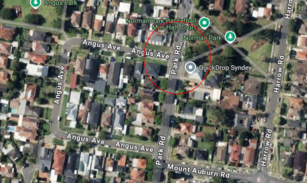
Locality Plan
Council has received concerns from a local resident regarding road safety on Park Road, at the northern end of the Angus Avenue intersection. It is alleged that vehicles are having difficulties to turn right from Angus Avenue onto Park Road.
Investigations found that as Park Road is a regional road carrying a high volume of traffic in both directions, and it is difficult for vehicles on Angus Avenue to turn right onto Park Road.
To improve traffic flow and safety at this intersection, particularly for right-turning vehicles from Angus Avenue, it is proposed to install a merge bay on Park Road. As part of this treatment, a marked island will be provided on Park Road, north of Angus Avenue, to better delineate traffic movements. Parking restrictions will also be required on the eastern side of Park Road at this location to accommodate the changes.
COnsultation
Subject to endorsement, consultation will be undertaken on the proposal.
Attachments
1. Plan – Park Road at Angus Avenue, Auburn – Proposed Intersection Treatment.
DOCUMENTS
ASSOCIATED WITH
REPORT CTC-25-132
Attachment 1
Plan – Park Road at Angus Avenue, Auburn – Proposed Intersection Treatment.
4 June 2025
Item No: CTC-25-133
PARK ROAD AT MOUNT AUBURN ROAD AND ANGUS AVENUE, AUBURN – PROPOSED ROUNDABOUT
Directorate: Environment and Planning
Responsible Officer: Manager Engineering and Building
Electorate: Auburn
Police Area Command (PAC): Auburn
Agenda Part Part 2
Note: Recommendation to Council
Summary
Council has received a request from a local resident for the installation of a roundabout in Park Road at the intersection of Mount Auburn Road and Angus Avenue, Auburn due to safety concerns.
This report outlines the outcome of the investigation into this matter.
The Traffic Committee recommends that:
1. The installation of a roundabout at the intersection of Park Road and Mount Auburn Road, Auburn, in accordance with the attached plan, be supported in principle.
2. Council undertake consultation with adjacent residents and provide a further report to the Traffic Committee.
Report
Park Road is a regional road that runs in a north-south direction with a posted speed limit of 60 km/h. It has a width of approximately 12.5m and parking is permitted on both sides of the road unless otherwise signposted.
Mount Auburn Road is a local road that runs in an east-west direction with a posted speed limit of 50 km/h. It has a width of approximately 12.5m and parking is permitted on both sides of the road unless signposted.
Angus Avenue is a local road that runs in an east-west direction with a posted speed limit of 50 km/h. It has a width of approximately 9m and parking is permitted on both sides of the road unless signposted.
Park Road, Mount Auburn Road, and Angus Avenue form a staggered four-way intersection, with priority given to traffic on Park Road. Currently, ‘Give Way’ signs and associated line marking are in place on Mount Auburn Road and Angus Avenue, while ‘BL2’ line marking is present along Park Road.
![]()
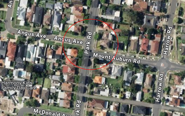
Locality Plan
Council has received concerns from a local resident regarding road safety at the intersection of Mount Auburn Road and Park Road.
The latest Centre for Road Safety crash data indicates that there was one reported accident at the intersection of Park Road and Mount Auburn Road in the five years. The accident details are listed in the table below.
|
Date |
Location |
Description |
|
16/10/2020 |
Park Road at Mount Auburn Road |
Vehicle failed to give way |
Investigations have found that the staggered layout of the intersection can create confusion for drivers, particularly when vehicles from Mount Auburn Road and Angus Avenue arrive at the same time, leading to potential right-of-way conflicts. The offset configuration also increases the risk of side-impact collisions and near-misses, especially where sight distance is limited.
To improve safety, it is proposed to install a roundabout at the intersection of Park Road and Mount Auburn Road. A roundabout can reduce both the number and severity of conflict points compared to the existing give-way controls. The lower travel speeds and one-way traffic flow through a roundabout significantly decrease the risk of serious crashes. Additionally, by reducing approach speeds on all legs of the intersection, a roundabout enhances safety for both drivers and pedestrians.
The traffic movement at the intersection of Park Road and Angus Avenue would be restricted to left in and left out only due to the refuge islands associated with the proposed roundabout.
COnsultation
Subject to endorsement, consultation will be undertaken on the proposal.
Attachments
1. Plan – Park Road at Mount Auburn Road, Auburn – Proposed roundabout
DOCUMENTS
ASSOCIATED WITH
REPORT CTC-25-133
Attachment 1
Plan – Park Road at Mount Auburn Road, Auburn – Proposed roundabout
4 June 2025
Item No: CTC-25-134
GUILDFORD ROAD, GUILDFORD – ROAD SAFETY CONCERNS
Directorate: Environment and Planning
Responsible Officer: Manager Engineering and Building
Electorate: Granville
Police Area Command (PAC): Cumberland
Agenda Part Part 2
Note: Recommendation to Council
Summary
Council has received a request from local businesses for the installation of a traffic calming device on Guildford Road, Guildford between Talbot Road and Bolton Street due to safety concerns.
This report outlines the outcome of the investigation into this matter.
The Traffic Committee recommends that:
1. The installation of a speed hump in Guildford Road, Guildford, outside No.270, as provided in the attached plan, be supported in principle.
2. Council undertake consultation on the proposal and provide a further report to the Traffic Committee if objections are received.
3. Concerned and affected businesses be notified of the outcome.
Report
Council has received requests from local businesses for the installation of a traffic calming device on Guildford Road, Guildford between Talbot Road and Bolton Street due to safety concerns.
Guildford Road is a local road runs in an east-west direction between Palmer Street and Clyde Street. The section of interest is between Talbot Road and Bolton Street.
There are three existing pedestrian crossings including two raised and one at-level crossing situated in Guildford Road east of Railway Terrace up to Station Street which is approximately a 180 m section. There is also an existing raised threshold located near Roseberry Road 220 m away from the last raised pedestrian crossing near Station Street.
The section of Guildford Road west of Marian Street is signposted as ‘High Pedestrian area’ with a speed limit of 40 km/h.
The map below shows the location of Guildford Road section being considered:
The latest Centre for Road Safety Crash data indicated that there were two reported crashes in the section of Guildford Road under consideration in the 5 years ending June 2024.
|
Date |
Location |
DCA Code description |
|
26/09/2019 |
265 Guildford Road |
303 – Same- rear right |
|
12/03/2020 |
100m east of Talbot Road |
301 – Same- rear end |
A traffic count was undertaken on Guildford Road between Bolton Street and Rosebery Road in February 2025.
The results of the traffic count on Guildford Road, between Station Street and Roseberry Street, indicated the following:
· Average Daily Traffic (ADT) (vehicles/day): 11,661
· 85th percentile speed (km/h): 37.7 km/h
· Mean (average) speed (km/h): 30.5 km/h
The distance between the last raised pedestrian crossing in Guildford Road near Station Street and the raised threshold (speed hump) near Roseberry Road is approximately 220 m. Based on the high volume of traffic and high pedestrian activity in the area, the installation of an additional speed hump could be considered in this section. Therefore, it is proposed to install a raised threshold (speed hump) in Guildford Road outside property No.270 near the Fire Station opposite Bolton Street.
COnsultation
Subject to endorsement, consultation will be undertaken on the proposal.
Attachments
DOCUMENTS
ASSOCIATED WITH
REPORT CTC-25-134
Attachment 1
Plan - Guildford Road, Guildford - Proposed Speed Hump