2 April 2025
A meeting of the Traffic Committee will be held at
9:30 AM in Merrylands Administration Building, 16 Memorial Avenue, Merrylands
on Wednesday, 2 April 2025.
Business as below:
Yours faithfully
Peter J. Fitzgerald
General Manager
ORDER OF BUSINESS
1.
Apologies
2.
Declarations of Interest
3.
Confirmation of Previous Minutes endorsed by Council
4.
Summary of Reports.......................................................................................................... 5
5.
Reports
-
Part 1 - Recommended for Approval under Delegated Authority
-
Part 2 - Recommendation to Council
CONTENTS
Report No. Name
of Report Page
No.
Part 1 - Recommended for Approval under Delegated
Authority
CTC-25-057 ROBILLIARD
STREET AND REES STREET, MAYS HILL – PROPOSED LINE MARKING ADJUSTMENT............................................................ 33
CTC-25-058 JOYCE
STREET, PENDLE HILL - PROPOSED ACCESSIBLE PARKING SPACE........................................................................................................ 51
CTC-25-059 TARGO
ROAD AT ORAMZI ROAD AND BANDO ROAD, GIRRAWEEN – PROPOSED LINE MARKING................................................................. 61
CTC-25-060 GUILFOYLE
STREET, BERALA - APPLICATION FOR 'WORKS ZONE' SIGNAGE................................................................................................... 75
CTC-25-061 MURPHY
STREET AT BRISTOL STREET, MERRYLANDS WEST – INTERSECTION TREATMENT.............................................................. 81
CTC-25-062 DAN
STREET, MERRYLANDS – PROPOSED ‘NO PARKING’ SIGNS DURING WASTE
NIGHT........................................................................ 87
CTC-25-063 NEILSON
STREET, GRANVILLE – PROPOSED ‘NO PARKING’ SIGNS DURING WASTE
NIGHT........................................................................ 97
CTC-25-064 ROSE
CRESCENT, REGENTS PARK – PROPOSED PARKING RESTRICTIONS..................................................................................... 103
CTC-25-065 REGENT
STREET AND CAMPBELL STREET AT LEONIE CRESCENT, BERALA – PROPOSED
INTERSECTION TREATMENT.............. 115
CTC-25-066 HARROW
ROAD, AUBURN – PROPOSED 1/4 P PARKING RESTRICTIONS..................................................................................... 123
CTC-25-067 HILLTOP
ROAD, MERRYLANDS-PROPOSED TIMED PARKING RESTRICTION........................................................................................ 133
CTC-25-068 FREITAS
LANE, LIDCOMBE – PROPOSED PARKING RESTRICTIONS 143
CTC-25-069 CUMBERLAND
ROAD CORNER OF CHISWICK ROAD, AUBURN - PROPOSED TIMED PARKING............................................................ 149
CTC-25-070 CUMBERLAND
ROAD CORNER OF MARY STREET, AUBURN - PROPOSED TIMED PARKING............................................................ 155
CTC-25-071 DUFFY
STREET, MERRYLANDS – PROPOSED ‘NO PARKING’ RESTRICTIONS..................................................................................... 165
CTC-25-072 HAWKSVIEW
STREET, GUILDFORD – RELOCATION OF THE EXISTING PARKING RESTRICITON..................................................................... 171
CTC-25-073 LANEWAY
BETWEEN FIRST STREET AND SECOND STREET, GRANVILLE – PROPOSED PARKING
RESTRICTIONS............... 177
CTC-25-074 LANEWAY
BETWEEN SECOND STREET AND THIRD STREET, GRANVILLE – PROPOSED PARKING
RESTRICTIONS............... 189
CTC-25-075 LANEWAY
BETWEEN THIRD STREET AND FOURTH STREET, GRANVILLE – PROPOSED PARKING
RESTRICTIONS............... 201
CTC-25-076 LANEWAY
BETWEEN FOURTH STREET AND FIFTH STREET, GRANVILLE – PROPOSED PARKING
RESTRICTIONS............... 209
CTC-25-077 LANEWAY
BETWEEN WILLIAM STREET AND FIRST STREET, GRANVILLE – PROPOSED PARKING
RESTRICTIONS............... 225
CTC-25-078 CLYDE
STREET, GRANVILLE AT SIXTH STREET – PROPOSED ‘NO STOPPING’
RESTRICTIONS.............................................................. 231
CTC-25-079 LANEWAY
BETWEEN FIFTH STREET AND SIXTH STREET, GRANVILLE – PROPOSED PARKING
RESTRICTIONS....................................... 239
CTC-25-080 HAMPSTEAD
ROAD, AUBURN – APPLICATION FOR ‘WORKS ZONE’ SIGNAGE................................................................................................. 251
CTC-25-081 WARREN
ROAD AND WOODPARK ROAD, WOODPARK – REQUEST FOR A ROUNDABOUT......................................................................... 257
CTC-25-082 MARTIN
STREET, LIDCOMBE – APPLICATION FOR ‘WORKS ZONE’ SIGNAGE................................................................................................. 265
CTC-25-083 GIBBONS
ST, AUBURN – APPLICATION FOR ‘WORKS ZONE’ SIGNAGE 271
CTC-25-084 PEGLER
AVENUE, SOUTH GRANVILLE – APPLICATION FOR ‘WORKS ZONE’
SIGNAGE.................................................................................... 277
Part 2 - Recommendation to Council
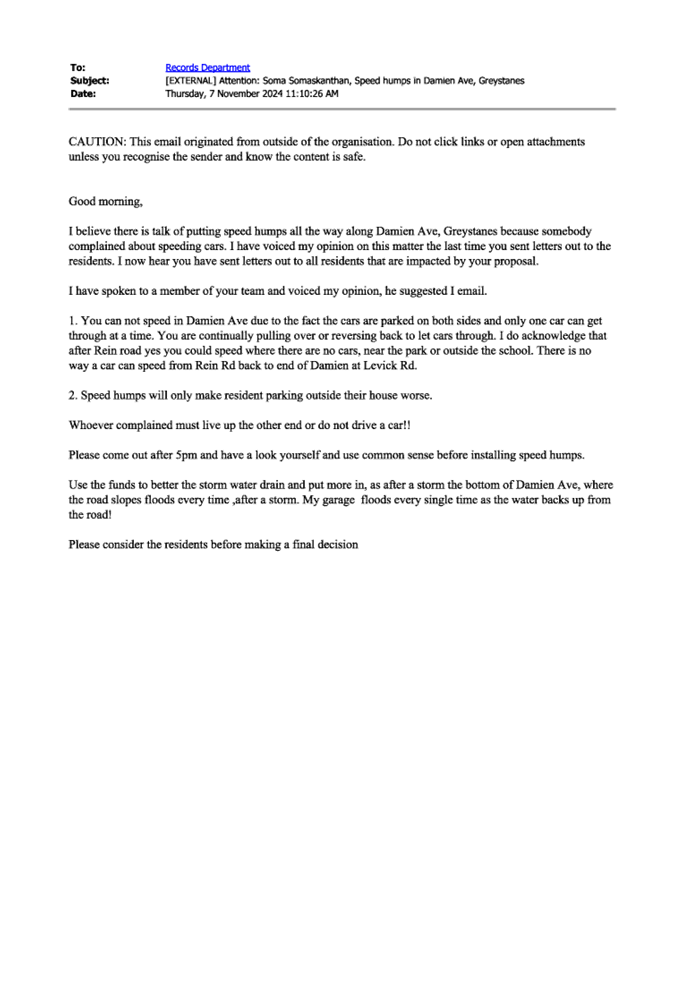
CTC-25-085 DAMIEN
AVENUE, GREYSTANES - ROAD SAFETY CONCERNS 285
CTC-25-086 GORDON
AVENUE, SOUTH GRANVILLE – ROAD SAFETY CONCERNS 313
CTC-25-087 KENYONS
ROAD, MERRYLANDS WEST – ROAD SAFETY CONCERNS 317
CTC-25-088 DRIFTWAY
DRIVE, PEMULWUY - REQUEST FOR PEDESTRIAN CROSSING.............................................................................................. 321
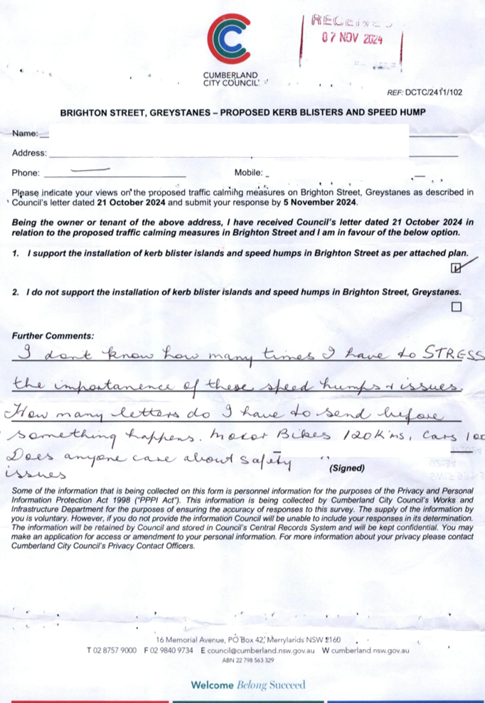
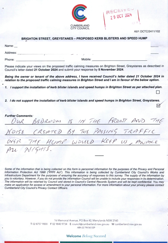
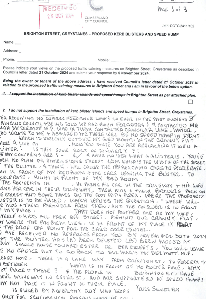
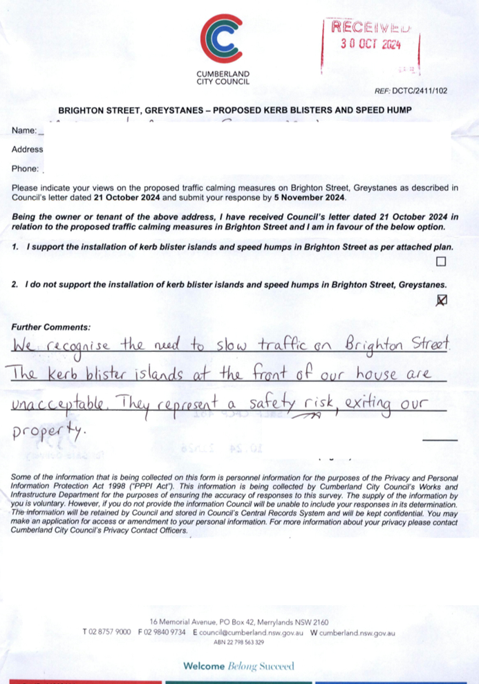
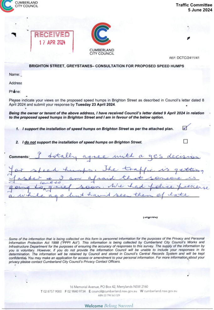
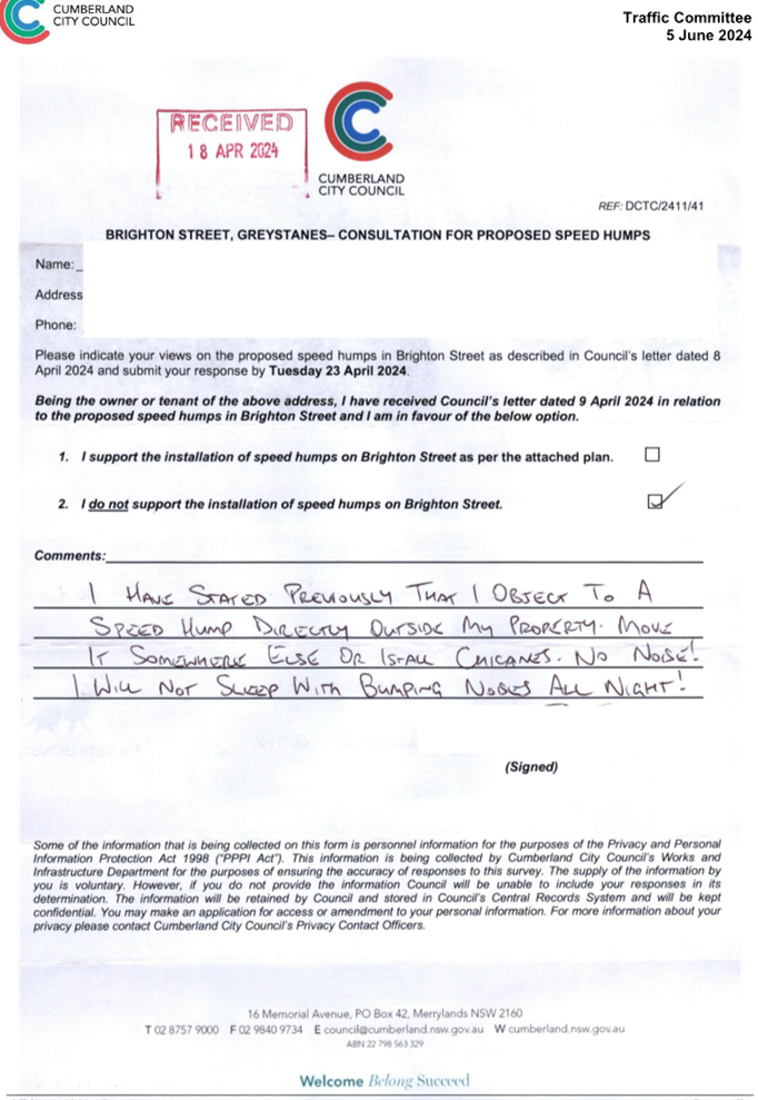
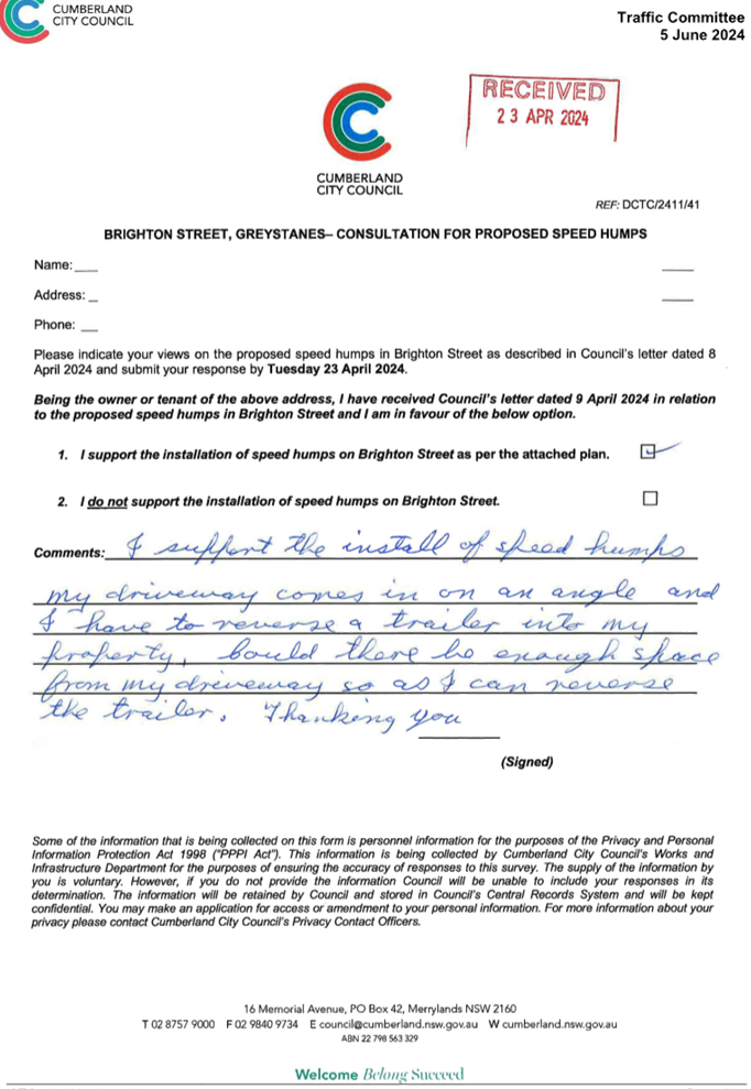
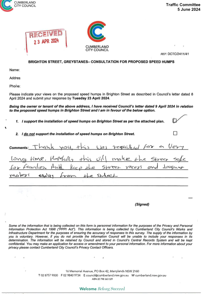
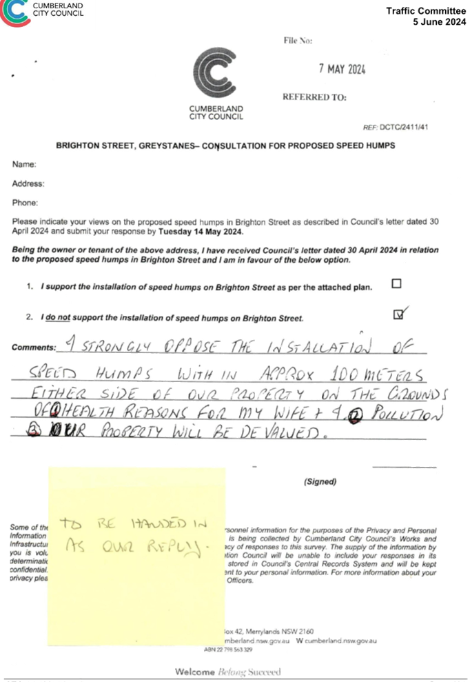
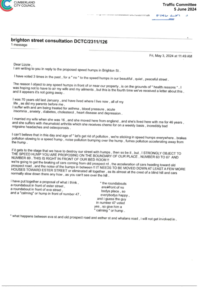
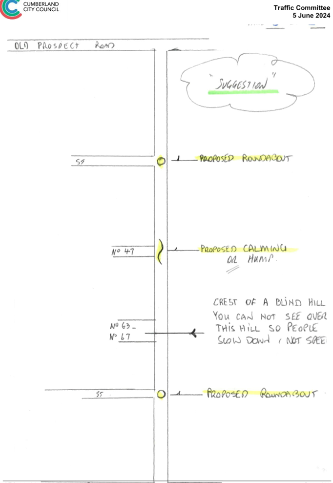
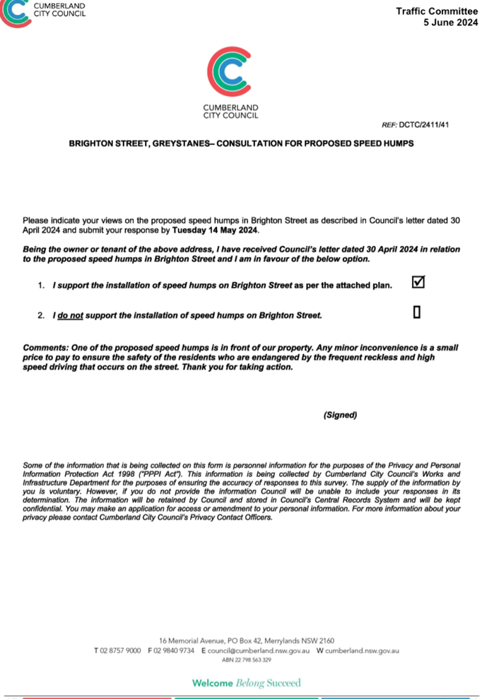
CTC-25-089 BRIGHTON
STREET, GREYSTANES – ROAD SAFETY CONCERNS - CONSULTATION.................................................................................... 325
CTC-25-090 TOONGABBIE
ROAD, TOONGABBIE –SAFETY CONCERNS AT THE BEND........................................................................................................ 365
CTC-25-091 DAHLIA
STREET, GREYSTANES – ALPHA ROAD PARK PARKING REVIEW................................................................................................... 371
CTC-25-092 GILBA
ROAD GIRRAWEEN – PROPOSED MODIFICATIONS TO PREVIOUSLY APPROVED RAISED
PEDESTRIAN CROSSING. 377
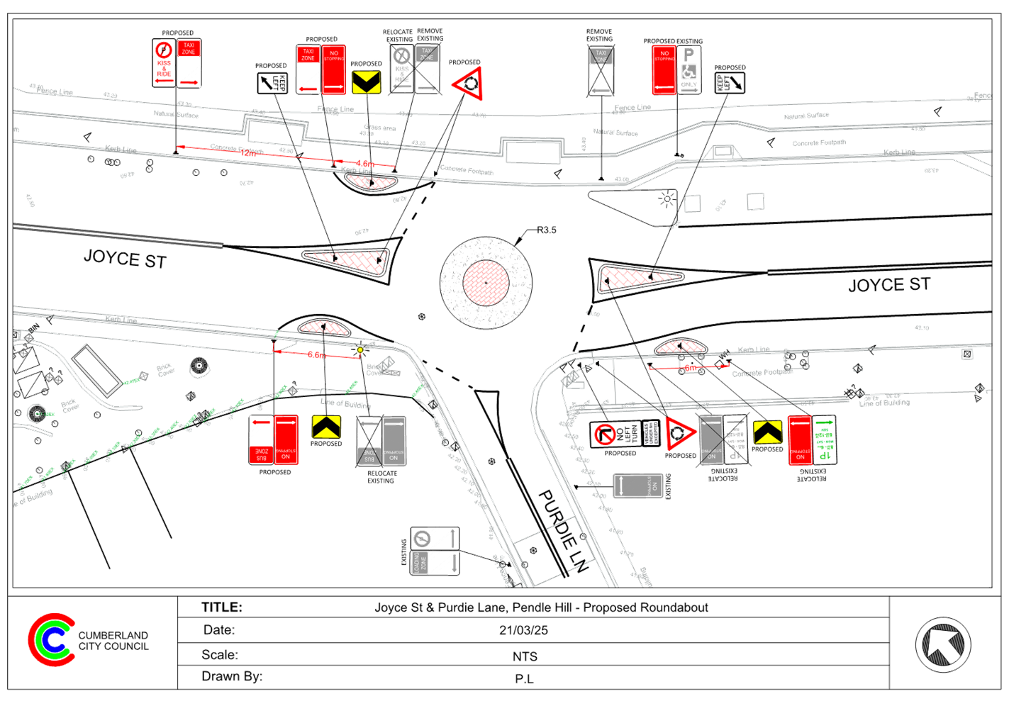
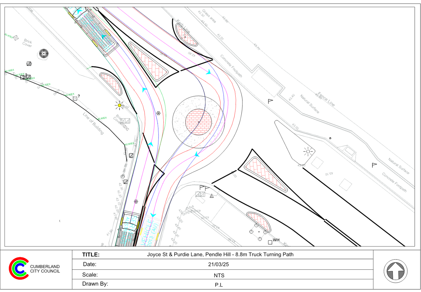
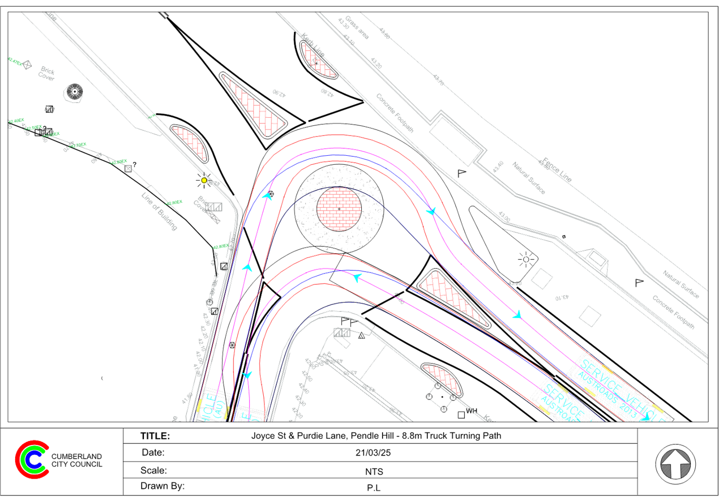
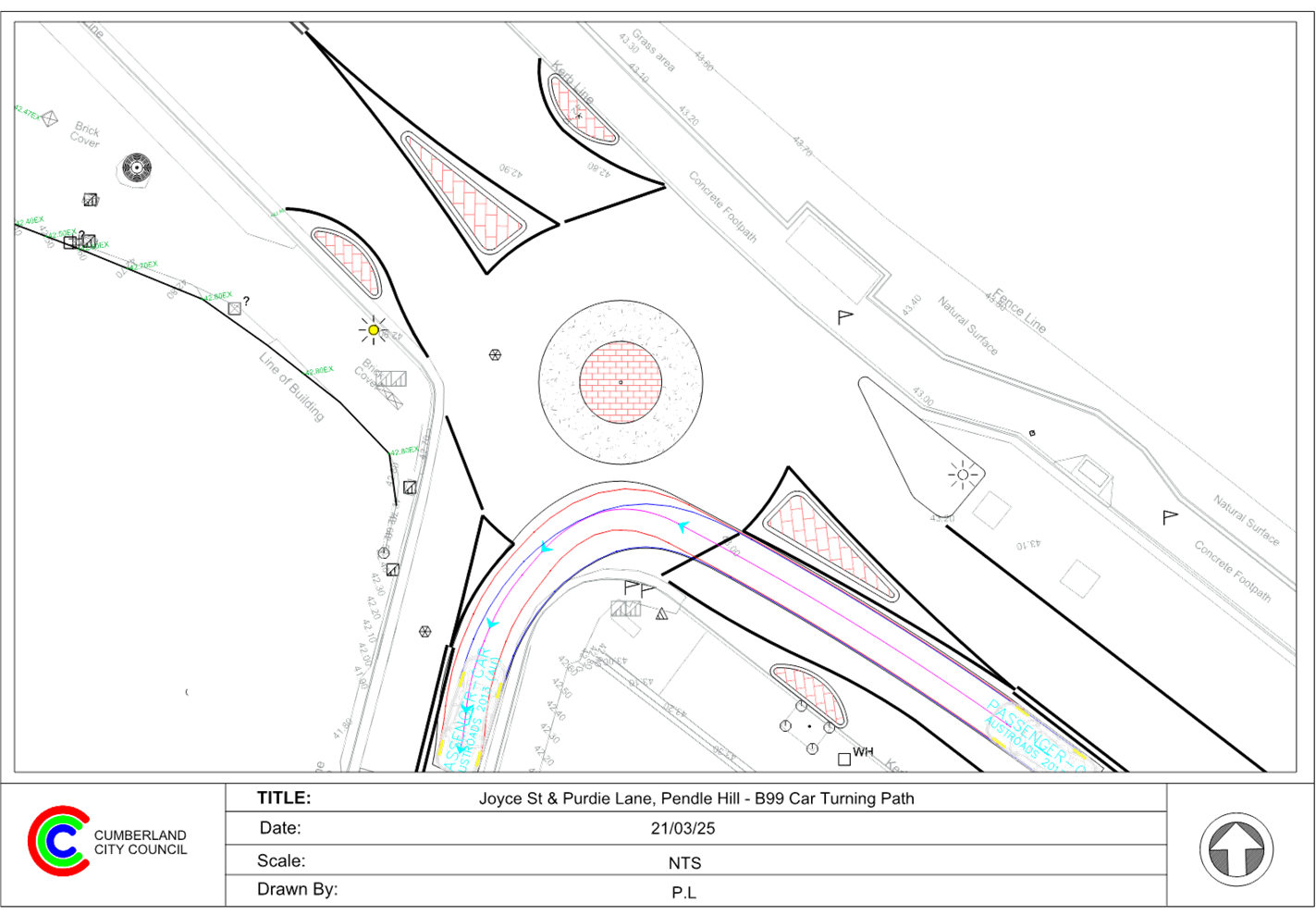
CTC-25-093 PENDLE
HILL PUBLIC DOMAIN PLAN - JOYCE STREET PARK UPGRADE, PENDLE HILL –
PROPOSED REALIGNMENT OF PEDESTRIAN CROSSING & ROUNDABOUT AT PURDIE LANE 383
CTC-25-094 CHARLES
STREET, GRANVILLE - CONCERNS AT THE INTERSECTION WITH BLAXCELL STREET.................................................................. 397
CTC-25-095 LAVINIA
STREET, SOUTH GRANVILLE - SAFETY CONCERNS 401
CTC-25-096 MAIN
AVENUE, LIDCOMBE – ROAD SAFETY CONCERNS........ 407
CTC-25-097 REDFERN
STREET, GRANVILLE - SAFETY CONCERNS........... 409
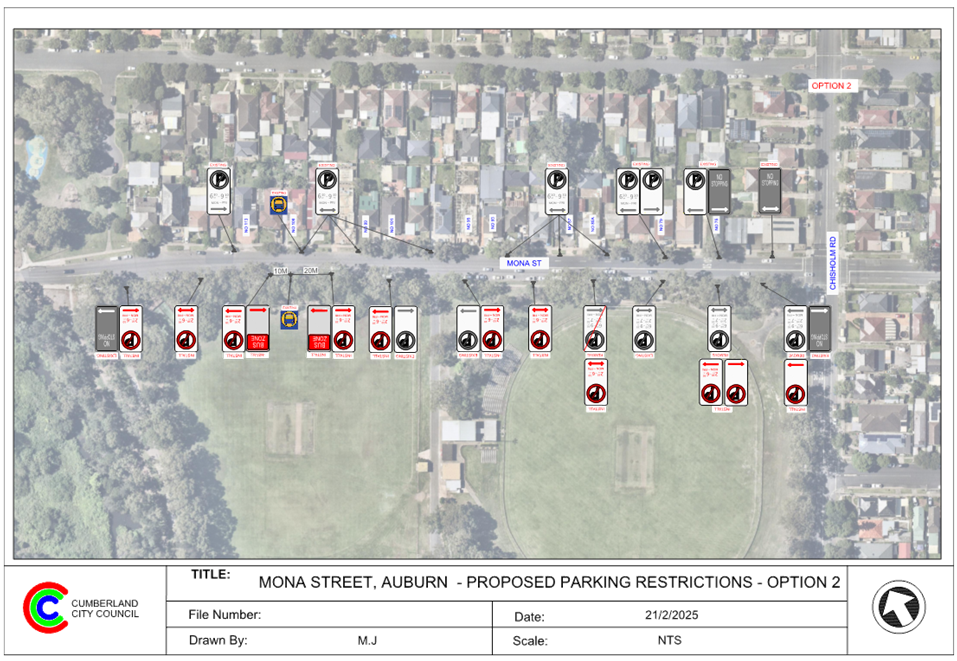
CTC-25-098 MONA
STREET, AUBURN & SOUTH GRANVILLE – PARKING RESTRICTION MODIFICATION.......................................................... 413
2 April 2025
Summary of Reports
Part 1 - Recommended for Approval under Delegated
Authority
|
Item #
|
Title
|
Electorate
|
Police Area Command (PAC)
|
|
Fairfield
|
Granville
|
Prospect
|
Auburn
|
Cumberland
|
Auburn
|
|
CTC-25-057
|
ROBILLIARD STREET AND REES
STREET, MAYS HILL – PROPOSED LINE MARKING ADJUSTMENT
|
|
´
|
|
|
´
|
|
|
CTC-25-058
|
JOYCE STREET, PENDLE HILL -
PROPOSED ACCESSIBLE PARKING SPACE
|
|
|
´
|
|
´
|
|
|
CTC-25-059
|
TARGO ROAD AT ORAMZI ROAD
AND BANDO ROAD, GIRRAWEEN – PROPOSED LINE MARKING
|
|
|
´
|
|
´
|
|
|
CTC-25-060
|
GUILFOYLE STREET, BERALA -
APPLICATION FOR 'WORKS ZONE' SIGNAGE
|
|
|
|
´
|
|
´
|
|
CTC-25-061
|
MURPHY STREET AT BRISTOL
STREET, MERRYLANDS WEST – INTERSECTION TREATMENT
|
|
´
|
|
|
´
|
|
|
CTC-25-062
|
DAN STREET, MERRYLANDS
– PROPOSED ‘NO PARKING’ SIGNS DURING WASTE NIGHT
|
|
´
|
|
|
´
|
|
|
CTC-25-063
|
NEILSON STREET, GRANVILLE
– PROPOSED ‘NO PARKING’ SIGNS DURING WASTE NIGHT
|
|
´
|
|
|
´
|
|
|
CTC-25-064
|
ROSE CRESCENT, REGENTS PARK
– PROPOSED PARKING RESTRICTIONS
|
|
|
|
´
|
|
´
|
|
CTC-25-065
|
REGENT STREET AND CAMPBELL
STREET AT LEONIE CRESCENT, BERALA – PROPOSED INTERSECTION
TREATMENT
|
|
|
|
´
|
|
´
|
|
CTC-25-066
|
HARROW ROAD, AUBURN –
PROPOSED 1/4 P PARKING RESTRICTIONS
|
|
|
|
´
|
|
´
|
|
CTC-25-067
|
HILLTOP ROAD,
MERRYLANDS-PROPOSED TIMED PARKING RESTRICTION
|
|
´
|
|
|
´
|
|
|
CTC-25-068
|
FREITAS LANE, LIDCOMBE
– PROPOSED PARKING RESTRICTIONS
|
|
|
|
´
|
|
´
|
|
CTC-25-069
|
CUMBERLAND ROAD CORNER OF
CHISWICK ROAD, AUBURN - PROPOSED TIMED PARKING
|
|
|
|
´
|
|
´
|
|
CTC-25-070
|
CUMBERLAND ROAD CORNER OF
MARY STREET, AUBURN - PROPOSED TIMED PARKING
|
|
|
|
´
|
|
´
|
|
CTC-25-071
|
DUFFY STREET, MERRYLANDS
– PROPOSED ‘NO PARKING’ RESTRICTIONS
|
|
´
|
|
|
´
|
|
|
CTC-25-072
|
HAWKSVIEW STREET, GUILDFORD
– RELOCATION OF THE EXISTING PARKING RESTRICITON
|
|
´
|
|
|
´
|
|
|
CTC-25-073
|
LANEWAY BETWEEN FIRST
STREET AND SECOND STREET, GRANVILLE – PROPOSED PARKING RESTRICTIONS
|
|
´
|
|
|
´
|
|
|
CTC-25-074
|
LANEWAY BETWEEN SECOND
STREET AND THIRD STREET, GRANVILLE – PROPOSED PARKING RESTRICTIONS
|
|
´
|
|
|
´
|
|
|
CTC-25-075
|
LANEWAY BETWEEN THIRD
STREET AND FOURTH STREET, GRANVILLE – PROPOSED PARKING RESTRICTIONS
|
|
´
|
|
|
´
|
|
|
CTC-25-076
|
LANEWAY BETWEEN FOURTH
STREET AND FIFTH STREET, GRANVILLE – PROPOSED PARKING RESTRICTIONS
|
|
´
|
|
|
´
|
|
|
CTC-25-077
|
LANEWAY BETWEEN WILLIAM
STREET AND FIRST STREET, GRANVILLE – PROPOSED PARKING RESTRICTIONS
|
|
´
|
|
|
´
|
|
|
CTC-25-078
|
CLYDE STREET, GRANVILLE AT
SIXTH STREET – PROPOSED ‘NO STOPPING’ RESTRICTIONS
|
|
´
|
|
|
´
|
|
|
CTC-25-079
|
LANEWAY BETWEEN FIFTH
STREET AND SIXTH STREET, GRANVILLE – PROPOSED PARKING RESTRICTIONS
|
|
´
|
|
|
´
|
|
|
CTC-25-080
|
HAMPSTEAD ROAD, AUBURN
– APPLICATION FOR ‘WORKS ZONE’ SIGNAGE
|
|
|
|
´
|
|
´
|
|
CTC-25-081
|
WARREN ROAD AND WOODPARK
ROAD, WOODPARK – REQUEST FOR A ROUNDABOUT
|
|
´
|
|
|
´
|
|
|
CTC-25-082
|
MARTIN STREET, LIDCOMBE
– APPLICATION FOR ‘WORKS ZONE’ SIGNAGE
|
|
|
|
´
|
|
´
|
|
CTC-25-083
|
GIBBONS ST, AUBURN –
APPLICATION FOR ‘WORKS ZONE’ SIGNAGE
|
|
|
|
´
|
|
´
|
|
CTC-25-084
|
PEGLER AVENUE, SOUTH
GRANVILLE – APPLICATION FOR ‘WORKS ZONE’ SIGNAGE
|
|
´
|
|
|
´
|
|
Part 2 - Recommendation to Council
|
Item #
|
Title
|
Electorate
|
Police Area Command (PAC)
|
|
Fairfield
|
Granville
|
Prospect
|
Auburn
|
Cumberland
|
Auburn
|
|
CTC-25-085
|
DAMIEN AVENUE, GREYSTANES -
ROAD SAFETY CONCERNS
|
|
|
´
|
|
´
|
|
|
CTC-25-086
|
GORDON AVENUE, SOUTH
GRANVILLE – ROAD SAFETY CONCERNS
|
|
´
|
|
|
´
|
|
|
CTC-25-087
|
KENYONS ROAD, MERRYLANDS
WEST – ROAD SAFETY CONCERNS
|
|
´
|
|
|
´
|
|
|
CTC-25-088
|
DRIFTWAY DRIVE, PEMULWUY -
REQUEST FOR PEDESTRIAN CROSSING
|
|
|
´
|
|
´
|
|
|
CTC-25-089
|
BRIGHTON STREET,
GREYSTANES – ROAD SAFETY CONCERNS - CONSULTATION
|
|
|
´
|
|
´
|
|
|
CTC-25-090
|
TOONGABBIE ROAD, TOONGABBIE
–SAFETY CONCERNS AT THE BEND
|
|
|
´
|
|
´
|
|
|
CTC-25-091
|
DAHLIA STREET, GREYSTANES
– ALPHA ROAD PARK PARKING REVIEW
|
|
|
´
|
|
´
|
|
|
CTC-25-092
|
GILBA ROAD GIRRAWEEN
– PROPOSED MODIFICATIONS TO PREVIOUSLY APPROVED RAISED PEDESTRIAN
CROSSING
|
|
´
|
|
|
´
|
|
|
CTC-25-093
|
PENDLE HILL PUBLIC DOMAIN
PLAN - JOYCE STREET PARK UPGRADE, PENDLE HILL – PROPOSED REALIGNMENT OF
PEDESTRIAN CROSSING & ROUNDABOUT AT PURDIE LANE
|
|
|
´
|
|
´
|
|
|
CTC-25-094
|
CHARLES STREET, GRANVILLE -
CONCERNS AT THE INTERSECTION WITH BLAXCELL STREET
|
|
´
|
|
|
´
|
|
|
CTC-25-095
|
LAVINIA STREET, SOUTH
GRANVILLE - SAFETY CONCERNS
|
|
´
|
|
|
´
|
|
|
CTC-25-096
|
MAIN AVENUE, LIDCOMBE
– ROAD SAFETY CONCERNS
|
|
|
|
´
|
|
´
|
|
CTC-25-097
|
REDFERN STREET, GRANVILLE -
SAFETY CONCERNS
|
|
´
|
|
|
´
|
|
|
CTC-25-098
|
MONA STREET, AUBURN &
SOUTH GRANVILLE – PARKING RESTRICTION MODIFICATION
|
|
|
|
´
|
|
´
|
2 April 2025
Minutes of the Traffic Committee meeting held at Merrylands
Administration Building, 16 Memorial Avenue, Merrylands on Wednesday 05
February 2025.
opening of
meeting:
The meeting was opened by the Chairperson - Clr. Joseph
Rahme at 9:32am.
Present:
|
MEMBERS
|
|
|
Clr Joseph Rahme (Chairman)
|
Cumberland City Council
|
|
Mr Matthew Tangonan
|
Transport for NSW
|
|
Mr George Campbell
|
Local Member for Auburn
|
|
Clr Glenn Elmore
|
Local Member for Granville
|
|
Dr Diane Colman
|
Local Member for Prospect
|
|
Leading Senior Constable William Graham
|
Cumberland Police Area Command
|
|
Leading Senior Constable Raymond
Yeung
|
Auburn Police Area Command
|
|
COUNCIL OFFICERS
|
|
|
Daniel Cavallo
|
Director Environment & Planning
|
|
Elias Elias
|
Manager Engineering & Building
|
|
Soma Somaskanthan
|
Executive Engineer Traffic and Transport
|
|
Siva Sivakumar
|
Manager Special Projects
|
|
Scott Kavanagh
|
Coordinator Engineering Services
|
|
Pamela MacIntyre
|
Governance Officer (Minute Taker)
|
Apologies:
|
Mr James Duguid
|
Transit Systems - No objections received.
|
|
Local Member for Fairfield – no representative
nominated
|
Local Member for Fairfield - No items in the State
Electorate.
|
|
CDCBus
|
No objections received.
|
|
Transdev
|
No objections received.
|
Declarations Of Interest
Nil.
CONFIRMATION OF previous
MINUTES
That the Cumberland Traffic Committee confirm the minutes of
the Cumberland Traffic Committee held on 6 November 2024 be confirmed.
Moved Clr Glenn Elmore, Seconded Leading
Senior Constable William Graham.
Summary of reports
Part 1 - Recommended for Approval under Delegated
Authority
|
Item #
|
Title
|
Electorate
|
Police Area Command (PAC)
|
|
Fairfield
|
Granville
|
Prospect
|
Auburn
|
Cumberland
|
Auburn
|
|
CTC-25-001
|
HERDSMANS AVENUE AND
COLLEGE STREET, LIDCOMBE – PROPOSED INTERSECTION TREATMENT
|
|
|
|
´
|
|
´
|
|
CTC-25-002
|
GILBA ROAD AND PENDLE WAY,
PENDLE HILL – PROPOSED RELOCATION OF THE EXISTING FENCE
|
|
|
´
|
|
´
|
|
|
CTC-25-003
|
KIBO ROAD AND THIRD AVENUE,
REGENTS PARK - PROPOSED ‘NO STOPPING’ RESTRICTIONS AND CENTRE
LINE MARKING
|
|
|
|
´
|
|
´
|
|
CTC-25-004
|
KIMBERLEY STREET AT
WOODVILLE ROAD, MERRYLANDS – PROPOSED 'NO STOPPING' RESTRICTIONS AND
LINE MARKING
|
|
´
|
|
|
´
|
|
|
CTC-25-005
|
RAWSON ROAD AND GREAT
WESTERN HIGHWAY, SOUTH WENTWORTHVILLE – PROPOSED 'NO STOPPING'
RESTRICTIONS AND LINE MARKING
|
|
|
´
|
|
´
|
|
|
CTC-25-006
|
FREDERICK STREET AT JONES
STREET, PENDLE HILL– PROPOSED 'NO STOPPING' RESTRICTIONS AND LINE
MARKING
|
|
|
´
|
|
´
|
|
|
CTC-25-007
|
BLAXCELL STREET AND WELLS
STREET, SOUTH GRANVILLE – PROPOSED ‘NO STOPPING’
RESTRICTIONS AND LINE MARKING
|
|
´
|
|
|
´
|
|
|
CTC-25-008
|
FOWLER ROAD AND
O’CONNOR STREET, GUILDFORD – PROPOSED ‘NO STOPPING’
RESTRICTIONS AND LINE MARKING
|
|
´
|
|
|
´
|
|
|
CTC-25-009
|
CLUNIES ROSS STREET,
PEMULWUY – PROPOSED 'NO STOPPING' RESTRICITONS
|
|
|
´
|
|
´
|
|
|
CTC-25-010
|
RAILWAY STREET, LIDCOMBE
– PROPOSED ‘NO STOPPING’ RESTRICTIONS NEAR EAST STREET
INTERSECTION
|
|
|
|
´
|
|
´
|
|
CTC-25-011
|
CONDOIN LANE, PEMULWUY
– REQUEST FOR REMOVAL OF 'NO STOPPING' SIGNAGE
|
|
|
´
|
|
´
|
|
|
CTC-25-012
|
MONA STREET, SOUTH
GRANVILLE – PARKING RESTRICTION MODIFICATION
|
|
´
|
|
|
´
|
|
|
CTC-25-013
|
OLD PROSPECT ROAD AND
GRAFTON STEET, GREYSTANES – PROPOSED GIVEWAY SIGNAGE AND LINE MARKING
|
|
|
´
|
|
´
|
|
|
CTC-25-014
|
RAWSON STREET, AUBURN AT
DARTBROOK ROAD – REQUEST FOR ‘KEEP CLEAR’ LINE MARKING
|
|
|
|
´
|
|
´
|
|
CTC-25-015
|
WALLACE STREET AND WARATAH
STREET AT UNION STREET, GRANVILLE – PROPOSED PARKING SIGNAGE AND LINE
MARKING
|
|
´
|
|
|
´
|
|
|
CTC-25-016
|
MCLEOD ROAD / DRESSLER
COURT, HOLROYD / MERRYLANDS – REQUEST FOR TIMED PARKING IN THE INDENTED
PARKING AREA
|
|
´
|
|
|
´
|
|
|
CTC-25-017
|
MAGOWAR ROAD, GIRRAWEEN -
TIMED PARKING CONSULTATION
|
|
|
´
|
|
´
|
|
|
CTC-25-018
|
JONES STREET,
WENTWORTHVILLE – ROAD SAFETY CONCERNS – CONSULTATION RESULT
|
|
|
´
|
|
´
|
|
|
CTC-25-019
|
MCCREDIE ROAD, GUILDFORD
WEST - ROAD SAFETY CONCERNS – CONSULTATION RESULT
|
|
´
|
|
|
´
|
|
|
CTC-25-020
|
THE BOULEVARDE, LIDCOMBE -
ROAD SAFETY CONCERNS – CONSULTATION RESULT
|
|
|
|
´
|
|
´
|
|
CTC-25-021
|
STATION ROAD, AUBURN
– APPLICATION FOR ‘WORKS ZONE’ SIGNAGE
|
|
|
|
´
|
|
´
|
|
CTC-25-022
|
JOHN STREET, LIDCOMBE
– APPLICATION FOR ‘WORKS ZONE’ SIGNAGE
|
|
|
|
´
|
|
´
|
|
CTC-25-023
|
NORTHUMBERLAND ROAD, AUBURN
– APPLICATION FOR ‘WORKS ZONE’ SIGNAGE
|
|
|
|
´
|
|
´
|
Part 2 - Recommendation to Council
Note: Part 2 recommendations of the Traffic Committee are
subject to Council’s endorsement. For final decisions regarding these
matters, please refer to the Council Meeting Minutes where these matters were
reported to Council for determination.
|
Item #
|
Title
|
Electorate
|
Police Area Command (PAC)
|
|
Fairfield
|
Granville
|
Prospect
|
Auburn
|
Cumberland
|
Auburn
|
|
CTC-25-024
|
OXFORD STREET AND HIGHLAND
STREET, GUILDFORD - AUSTRALIAN GOVERNMENT BLACK SPOT PROGRAM
|
|
´
|
|
|
´
|
|
|
CTC-25-025
|
AMY STREET AT KINGSLAND
ROAD, REGENTS PARK - AUSTRALIAN GOVERNMENT BLACK SPOT PROGRAM
|
|
|
|
´
|
|
´
|
|
CTC-25-026
|
RAILWAY PARADE, HELENA
STREET AND COCKTHORPE ROAD, AUBURN - AUSTRALIAN GOVERNMENT BLACK SPOT PROGRAM
|
|
|
|
´
|
|
´
|
|
CTC-25-027
|
LIDCOMBE TOWN CENTRE PUBLIC
DOMAIN PLAN - JOSEPH STREET PRECINCT – PROPOSED PEDESTRIAN CROSSING ON
BRIDGE STREET
|
|
|
|
´
|
|
´
|
|
CTC-25-028
|
LIDCOMBE TOWN CENTRE PUBLIC
DOMAIN PLAN - JOSEPH STREET PRECINCT – PROPOSED PEDESTRIAN CROSSING ON
TAYLOR STREET
|
|
|
|
´
|
|
´
|
|
CTC-25-029
|
GUILDFORD ROAD, GUILDFORD -
PROPOSED TEMPORARY ROAD CLOSURE FOR GUILDFORD FESTIVAL
|
|
´
|
|
|
´
|
|
|
CTC-25-030
|
MIMOSA STREET, GRANVILLE -
PARTIAL ROAD CLOSURE AT DUCK RIVER
|
|
´
|
|
|
´
|
|
|
CTC-25-031
|
SEVENTH STREET, GRANVILLE -
PARTIAL ROAD CLOSURE AT DUCK RIVER
|
|
´
|
|
|
´
|
|
|
CTC-25-032
|
WINGELLO STREET AND SWIFT
STREET, GUILDFORD – PROPOSED 'ONE WAY' - CONSULTATION RESULT
|
|
´
|
|
|
´
|
|
|
CTC-25-033
|
ROSEBERRY STREET AND MARY
STREET, MERRYLANDS – PROPOSED ROUNDABOUT
|
|
´
|
|
|
´
|
|
|
CTC-25-034
|
PHILLIPS AVENUE, GREATREX
AVENUE AND COLEMAN AVENUE, REGENTS PARK – PROPOSED TRAFFIC CALMING
MEASURES
|
|
|
|
´
|
|
´
|
|
CTC-25-035
|
HAWKSVIEW STREET, GUILDFORD
– PROPOSED PEDESTRIAN FENCING
|
|
´
|
|
|
´
|
|
|
CTC-25-036
|
TILBA STREET, BERALA -
RESPONSE TO NOTICE OF MOTION - REQUEST FOR A PEDESTRIAN CROSSING
|
|
|
|
´
|
|
´
|
|
CTC-25-037
|
DANIEL STREET, GRANVILLE -
REQUEST FOR PEDESTRIAN CROSSING
|
|
´
|
|
|
´
|
|
|
CTC-25-038
|
KING STREET, GUILDFORD WEST
- REQUEST FOR PEDESTRIAN CROSSING
|
|
´
|
|
|
´
|
|
|
CTC-25-039
|
CHURCH STREET & SWETE
STREET, LIDCOMBE - PROPOSED RAISED INTERSECTION AND MARKED PEDESTRIAN
CROSSINGS
|
|
|
|
´
|
|
´
|
|
CTC-25-040
|
MILITARY ROAD, GUILDFORD -
PARKING ARRANGEMENT REIVEW
|
|
´
|
|
|
´
|
|
|
CTC-25-041
|
EXCELSIOR STREET, WYNYARD
STREET AND EVE STREET, GUILDFORD – PROPOSED INTERSECTION TREATMENT
|
|
´
|
|
|
´
|
|
|
CTC-25-042
|
BRIDGE ROAD, WESTMEAD
– INTERSECTION TREATMENT
|
|
´
|
|
|
´
|
|
|
CTC-25-043
|
WHALANS ROAD, GREYSTANES
– ROAD SAFETY CONCERNS
|
|
|
´
|
|
´
|
|
|
CTC-25-044
|
WOMBAT STREET, PEMULWUY -
ROAD SAFETY CONCERNS
|
|
|
´
|
|
´
|
|
|
CTC-25-045
|
LANCE CRESCENT, GREYSTANES
- ROAD SAFETY CONCERNS
|
|
|
´
|
|
´
|
|
|
CTC-25-046
|
LACKEY STREET, MERRYLANDS
– ROAD SAFETY CONCERNS
|
|
´
|
|
|
´
|
|
|
CTC-25-047
|
TENNYSON PARADE, GUILDFORD
WEST - ROAD SAFETY CONCERNS
|
|
´
|
|
|
´
|
|
|
CTC-25-048
|
HUNT STREET, GUILDFORD WEST
- ROAD SAFETY CONCERNS
|
|
´
|
|
|
´
|
|
|
CTC-25-049
|
ROSEBERRY STREET BETWEEN
HAWKSVIEW STREET AND MYALL STREET, MERRYLANDS – ROAD SAFETY CONCERNS
|
|
´
|
|
|
´
|
|
|
CTC-25-050
|
GRASSMERE STREET, GUILDFORD
- ROAD SAFETY CONCERNS – CONSULTATION RESULT
|
|
´
|
|
|
´
|
|
|
CTC-25-051
|
MCARTHUR STREET, GUILDFORD
– ROAD SAFETY CONCERNS – CONSULTATION RESULT
|
|
´
|
|
|
´
|
|
|
CTC-25-052
|
LOCKWOOD STREET, MERRYLANDS
- ROAD SAFETY CONCERNS – CONSULTATION RESULT
|
|
´
|
|
|
´
|
|
|
CTC-25-053
|
RUNYON AVENUE, GREYSTANES -
ROAD SAFETY CONCERNS – CONSULTATION RESULT
|
|
|
´
|
|
´
|
|
|
CTC-25-054
|
BOOMERANG STREET AND RANDLE
STREET, GRANVILLE - ROAD SAFETY CONCERNS – CONSULTATION RESULT
|
|
´
|
|
|
´
|
|
|
CTC-25-055
|
WALPOLE STREET, MERRYLANDS
- ROAD SAFETY CONCERNS – CONSULTATION RESULT
|
|
´
|
|
|
´
|
|
|
CTC-25-056
|
OLD PROSPECT ROAD BETWEEN
GOZO ROAD AND BRIGHTON STREET, GREYSTANES - ROAD SAFETY CONCERNS –
CONSULTATION RESULT
|
|
|
´
|
|
´
|
|
REPORTS
Part 1 - Recommended for
Approval under Delegated Authority in accordance with Part 1 of the Terms of
Reference for the Cumberland Local Traffic Committee.
|
Items Resolved by Exception
|
|
The Committee resolved by exception the below items on the
Traffic Committee Agenda as per the recommendations in the reports:
CTC-25-001, CTC-25-002, CTC-25-003, CTC-25-004, CTC-25-005,
CTC-25-006, CTC-25-007, CTC-25-008, CTC-25-009, CTC-25-010, CTC-25-011, CTC-25-012,
CTC-25-013, CTC-25-014, CTC-25-015, CTC-25-016, CTC-25-017, CTC-25-018, CTC-25-019,
CTC-25-021, CTC-25-022 and CTC-25-023.
Moved Clr Glenn Elmore, Seconded Mr Matthew
Tangonan.
|
|
ITEM CTC-25-001 - HERDSMANS AVENUE AND COLLEGE STREET,
LIDCOMBE – PROPOSED INTERSECTION TREATMENT
|
|
Resolved by Exception
The Traffic Committee recommends that:
1. The
installation of ‘Give Way’ signs, line marking, and ‘No
Stopping’ restrictions at the intersection of Herdsmans Avenue and
College Street, Lidcombe, in accordance with attached plan be approved.
2. The
affected / concerned residents be notified of the outcome.
|
|
ITEM CTC-25-002 - GILBA ROAD AND PENDLE WAY, PENDLE
HILL – PROPOSED RELOCATION OF THE EXISTING FENCE
|
|
Resolved by Exception
The Traffic Committee recommends that the existing fence
at the south-west corner at the intersection of Gilba Road and Pendle Way,
Pendle Hill be relocated approximately 500mm away from the intersection in
accordance with the attached plan be approved.
|
|
ITEM CTC-25-003 - KIBO ROAD AND THIRD AVENUE, REGENTS
PARK - PROPOSED ‘NO STOPPING’ RESTRICTIONS AND CENTRE LINE
MARKING
|
|
Resolved by Exception
The Traffic Committee recommends that:
1. The
installation of ‘No Stopping’ signs and line marking at the intersection
of Kibo Road and Third Avenue, Regents Park in accordance with attached plan
be approved.
2. The
affected / concerned residents be notified of the outcome.
|
|
ITEM CTC-25-004 - KIMBERLEY STREET AT WOODVILLE ROAD,
MERRYLANDS – PROPOSED 'NO STOPPING' RESTRICTIONS AND LINE MARKING
|
|
Resolved by Exception
The Traffic Committee recommends
that:
1. The
installation of ‘No Stopping’ signs and BL2 line marking at the
intersection of Kimberley Street and Woodville Road, Merrylands in accordance
with the attached plan be approved.
2. The
affected / concerned residents be notified of the outcome.
|
|
ITEM CTC-25-005 - RAWSON ROAD AND GREAT WESTERN
HIGHWAY, SOUTH WENTWORTHVILLE – PROPOSED 'NO STOPPING' RESTRICTIONS AND
LINE MARKING
|
|
Resolved by Exception
The Traffic Committee recommends that:
1. The
installation of ‘No Stopping’ sign and ‘BL2’ line
marking at the intersection of Rawson Road and Great Western Highway, South
Wentworthville in accordance with the attached plan be approved.
2. The
affected / concerned residents be notified of the outcome.
|
|
ITEM CTC-25-006 - FREDERICK STREET AT JONES STREET,
PENDLE HILL– PROPOSED 'NO STOPPING' RESTRICTIONS AND LINE MARKING
|
|
Resolved by Exception
The Traffic Committee recommends that:
1. The
installation of ‘No Stopping’ signs and ‘BL2’ line
marking on Frederick Street at Jones Street, Pendle Hill in accordance with
the attached plan be approved.
2. The
affected / concerned residents be notified of the outcome.
|
|
ITEM CTC-25-007 - BLAXCELL STREET AND WELLS STREET,
SOUTH GRANVILLE – PROPOSED ‘NO STOPPING’ RESTRICTIONS AND
LINE MARKING
|
|
Resolved by Exception
The Traffic Committee recommends that:
1. The
installation of ‘No Stopping’ signs and ‘BL2’ line
marking at the intersection of Blaxcell Street and Wells Street, South
Granville in accordance with the attached plan be approved.
2. The
affected / concerned residents be notified of the outcome.
|
|
ITEM CTC-25-008 - FOWLER ROAD AND O’CONNOR
STREET, GUILDFORD – PROPOSED ‘NO STOPPING’ RESTRICTIONS AND
LINE MARKING
|
|
Resolved by Exception
The Traffic Committee recommends that:
1. The
installation of ‘No Stopping’ signs and ‘BL2’ line
marking at the intersection of Fowler Road and O’Connor Street,
Guildford in accordance with the attached plan be approved.
2. The
affected / concerned residents be notified of the outcome.
|
|
ITEM CTC-25-009 - CLUNIES ROSS STREET, PEMULWUY
– PROPOSED 'NO STOPPING' RESTRICITONS
|
|
Resolved by Exception
The Traffic Committee recommends that:
1. The
existing ‘No Stopping’ restrictions on the eastern side of
Clunies Ross Street, Pemulwuy outside No. 6-20 be extended 30m north in
accordance with the attached plan be approved.
2. The
affected/concerned residents/businesses be notified of the outcome.
|
|
ITEM CTC-25-010 - RAILWAY STREET, LIDCOMBE –
PROPOSED ‘NO STOPPING’ RESTRICTIONS NEAR EAST STREET INTERSECTION
|
|
Resolved by Exception
The Traffic Committee recommends that:
1. The
installation of ‘No Stopping’ signs on the north side of the
intersection of Railway Street and East Street, Lidcombe in accordance with
the attached plan be approved.
2. The
affected / concerned properties be notified of the outcome.
|
|
ITEM CTC-25-011 - CONDOIN LANE, PEMULWUY –
REQUEST FOR REMOVAL OF 'NO STOPPING' SIGNAGE
|
|
Resolved by Exception
The Traffic Committee recommends that:
1. The
existing 'No Stopping’ and ‘No Parking’ signage on the
eastern side of Condoin Lane, Pemulwuy be modified in accordance with the
attached plan.
2. The
affected /concerned residents be notified of the outcome.
|
|
ITEM CTC-25-012 - MONA STREET, SOUTH GRANVILLE –
PARKING RESTRICTION MODIFICATION
|
|
Resolved by Exception
The Traffic Committee recommends
that:
1. Replace
the existing ‘No Parking, 2:30pm - 6:30pm, Mon – Fri’ on
the southern side of Mona Street between No. 150 to No.172 to ‘No
Parking, 7am – 9:30am, 2:30pm – 6:30pm, Mon – Fri’ as
per attached plan.
2. Install
a 27m Bus Zone at the existing bus stop on the southern side of Mona Street
near No. 172 as per attached plan.
3. The
affected/concerned residents be notified of the outcome.
|
|
ITEM CTC-25-013 - OLD PROSPECT ROAD AND GRAFTON STEET,
GREYSTANES – PROPOSED GIVEWAY SIGNAGE AND LINE MARKING
|
|
Resolved by Exception
The Traffic Committee recommends
that:
1. The
installation of ‘Give Way’ signage and line marking at the
intersection of Old Prospect Road and Grafton Street, Greystanes in
accordance with the attached plan be approved.
2. The
affected / concerned residents be notified of the outcome.
|
|
ITEM CTC-25-014 - RAWSON STREET, AUBURN AT DARTBROOK
ROAD – REQUEST FOR ‘KEEP CLEAR’ LINE MARKING
|
|
Resolved by Exception
That the Traffic Committee
recommends that the installation of ‘Keep Clear’ pavement marking
at the intersection of Rawson Road and Dartbrook Road, Auburn in accordance
with the attached plan be approved.
|
|
ITEM CTC-25-015 - WALLACE STREET AND WARATAH STREET AT
UNION STREET, GRANVILLE – PROPOSED PARKING SIGNAGE AND LINE MARKING
|
|
Resolved by Exception
The Traffic Committee recommends that:
1. The
installation of ‘No Stopping’ signage and BL2 linemarking on
Wallace Street and Waratah Street at their intersection with Union Street in
accordance with attached plan be approved.
2. The
affected / concerned residents be notified of the outcome.
|
|
ITEM CTC-25-016 - MCLEOD ROAD / DRESSLER COURT,
HOLROYD / MERRYLANDS – REQUEST FOR TIMED PARKING IN THE INDENTED
PARKING AREA
|
|
Resolved by Exception
The Traffic Committee recommends that:
1. The
installation of ‘1P, 8:30am-6pm, Mon - Fri and 8:30am – 12.30pm,
Sat’ on the western end of McLeod Road, Holroyd/Merrylands be supported
as per the plan attached.
2. The
affected /concerned residents be notified of the outcome.
|
|
ITEM CTC-25-017 - MAGOWAR ROAD, GIRRAWEEN - TIMED
PARKING CONSULTATION
|
|
Resolved by Exception
The Traffic Committee recommends
that:
1. Two
Hour (2P) time limited parking signs be installed in Magowar Road, west of
Girraween Road, Girraween in accordance with the attached plan be approved.
2. Council
notify affected/ concerned residents of the outcome.
|
|
ITEM CTC-25-018 - JONES STREET, WENTWORTHVILLE –
ROAD SAFETY CONCERNS – CONSULTATION RESULT
|
|
Resolved by Exception
The Cumberland Traffic Committee recommends that:
1. Council
install ‘BL2’ centre line marking and ‘EL1’ Edge Line
marking in Jones Street, Wentworthville in accordance with the attached
plans.
2. Council
notify the concerned residents of the outcome.
|
|
ITEM CTC-25-019 - MCCREDIE ROAD, GUILDFORD WEST - ROAD
SAFETY CONCERNS – CONSULTATION RESULT
|
|
Resolved by Exception
The Traffic Committee recommends that:
1. Council
undertake speed monitoring with the assistance of Variable Message Signs
(VMS) in McCredie Road, Guildford West.
2. Council
notify affected/ concerned residents of the outcome.
|
|
ITEM CTC-25-021 - STATION ROAD, AUBURN –
APPLICATION FOR ‘WORKS ZONE’ SIGNAGE
|
|
Resolved by Exception
The Traffic Committee recommends that:
1. The
12m long ‘Works Zone, 7:00am-6:00pm, Monday-Friday, 8:00am-4:00pm,
Saturday’ signs be installed on the frontage of the redevelopment site
on Station Road in accordance with the attached plan subject to
Council’s standard conditions for the period of 12 months and
subsequent extension if required.
2. The
applicant be advised to pay the ‘Works Zone’ fees to Council as
per the adopted Fees and Charges.
|
|
ITEM CTC-25-022 - JOHN STREET, LIDCOMBE –
APPLICATION FOR ‘WORKS ZONE’ SIGNAGE
|
|
Resolved by Exception
The Traffic Committee recommends that:
1. The
30m long ‘Works Zone, 7:00am-6:00pm, Monday-Friday, 8:00am-4:00pm,
Saturday’ signs be installed on the frontage of the development site on
John Street, Lidcombe in accordance with the attached plan subject to
Council’s standard conditions for the period of 6 months and subsequent
extension if required.
2. The
applicant be advised to pay the ‘Works Zone’ fees to Council as
per the adopted Fees and Charges.
|
|
ITEM CTC-25-023 - NORTHUMBERLAND ROAD, AUBURN –
APPLICATION FOR ‘WORKS ZONE’ SIGNAGE
|
|
Resolved by Exception
The Traffic Committee recommends that:
1. The
48m long ‘Works Zone, 7:00am-6:00pm, Monday-Friday, 8:00am-4:00pm,
Saturday’ signs be approved on the frontage of the redevelopment site
on Northumberland Road in accordance with the attached plan subject to
Council’s standard conditions for the period of 12 months and
subsequent extension if required.
2. The
applicant be advised to pay the ‘Works Zone’ fees to Council as
per the adopted Fees and Charges.
|
|
ITEM CTC-25-020 - THE BOULEVARDE, LIDCOMBE - ROAD
SAFETY CONCERNS – CONSULTATION RESULT
|
|
The Traffic Committee recommends that:
1. The
installation of edge lines on both sides in The Boulevarde, Lidcombe in
accordance with the attached plan be approved.
2. Council
notify concerned residents of the outcome.
3. A review of
Traffic volumes and speed along the Boulevarde, Lidcombe be undertaken six
months after the installation of edge lines and a report be provided to the
Traffic Committee if required.
Discussion:
Committee members discussed the results of the
consultation and various technical options for consideration along the
Boulevarde, Lidcombe.
Moved Clr Glenn Elmore, Seconded Mr George
Campbell
|
Part 2 - Recommendation to
Council in accordance with Part 2 of the Terms of Reference for the Cumberland
Local Traffic Committee.
Note: Part 2 recommendations of the Traffic Committee are
subject to Council’s endorsement. For final decisions regarding these
matters, please refer to the Council Meeting Minutes where these matters were
reported to Council for determination.
|
ITEMS RESOLVED BY EXCEPTION
|
|
The Committee resolved by exception the below items on the
Traffic Committee Agenda as per the recommendations in the reports:
CTC-25-024, CTC-25-025, CTC-25-026, CTC-25-027, CTC-25-028,
CTC-25-029, CTC-25-30, CTC-25-031, CTC-25-032, CTC-25-033, CTC-25-034, CTC-25-035,
CTC-25-036, CTC-25-037, CTC-25-038, CTC-25-041, CTC-25-042, CTC-25-043, CTC-25-044,
CTC-25-045, CTC-25-046, CTC-25-047, CTC-25-048, CTC-25-049, CTC-25-050, CTC-25-051,
CTC-25-052, CTC-25-053, CTC-25-054, CTC-25-055 and CTC-25-056.
Moved Clr Glenn Elmore, Seconded Mr Matthew
Tangonan.
|
|
ITEM CTC-25-024 - OXFORD STREET AND HIGHLAND STREET,
GUILDFORD - AUSTRALIAN GOVERNMENT BLACK SPOT PROGRAM
|
|
Resolved by Exception
The Traffic Committee
recommends:
1. Council
officers consult with the community on the amended plan of the proposed
roundabout at the intersection of Oxford Street and Highland Street,
Guildford.
2. Affected
residents and residents who signed the petition be notified.
3. Report
the results of the consultation to a future Traffic Committee meeting.
|
|
ITEM CTC-25-025 - AMY STREET AT KINGSLAND ROAD,
REGENTS PARK - AUSTRALIAN GOVERNMENT BLACK SPOT PROGRAM
|
|
Resolved by Exception
The Traffic Committee recommends
that:
1. The
proposed concrete raised thresholds (speed humps) and associated signs on the
approaches to the roundabout at the intersection of Amy Street and Kingsland
Road, Regents Park, in accordance with the attached plan be approved.
2. Council
progress the project for construction in accordance with grant requirements.
3. Directly
affected residents be notified of Council’s resolution.
|
|
ITEM CTC-25-026 - RAILWAY PARADE, HELENA STREET AND
COCKTHORPE ROAD, AUBURN - AUSTRALIAN GOVERNMENT BLACK SPOT PROGRAM
|
|
Resolved by Exception
The Traffic Committee recommends
that:
1. The
proposed concrete raised thresholds (speed humps) and associated signs on the
approaches to the roundabout at the intersection of Railway Parade, Helena
Street and Cockthorpe Road, Auburn, in accordance with the attached plan be
approved.
2. Council
progress the project for construction in accordance with grant requirements.
3. Directly
affected residents be notified of Council’s resolution.
|
|
ITEM CTC-25-027 - LIDCOMBE TOWN CENTRE PUBLIC DOMAIN
PLAN - JOSEPH STREET PRECINCT – PROPOSED PEDESTRIAN CROSSING ON BRIDGE
STREET
|
|
Resolved by Exception
The Traffic Committee recommends that the proposed raised
pedestrian crossing on Bridge Street, Lidcombe, as part of the Joseph Street
Precinct Upgrade to implement the Lidcombe Town Centre Public Domain Plan, be
approved.
|
|
ITEM CTC-25-028 - LIDCOMBE TOWN CENTRE PUBLIC DOMAIN
PLAN - JOSEPH STREET PRECINCT – PROPOSED PEDESTRIAN CROSSING ON TAYLOR
STREET
|
|
Resolved by Exception
The Traffic Committee recommends that the proposed raised
pedestrian crossing on Taylor Street, Lidcombe, as part of the Joseph Street
Precinct Upgrade to implement the Lidcombe Town Centre Public Domain Plan, be
approved.
|
|
ITEM CTC-25-029 - GUILDFORD ROAD, GUILDFORD - PROPOSED
TEMPORARY ROAD CLOSURE FOR GUILDFORD FESTIVAL
|
|
Resolved by Exception
The Traffic Committee recommends
that the temporary full road closure of Guildford
Road between Railway Terrace, and Talbot Road and short sections of Cross
Street and Station Street, Guildford from 6:00 AM on Saturday 24 May
2025 to 2:00AM on Sunday 25 May 2025 be approved, subject to:
1. Approval
from Transport for NSW for the Traffic Management Plan and Traffic Guidance
Scheme.
2. All
affected businesses and emergency stakeholders being notified of the closure.
3. Complying
with the notification requirements of the Roads Act 1993, i.e., placing
public notices in a newspaper and erecting notices on the road.
4. Temporary
bus routes and bus zones replacing the existing bus zones in the closed area
be provided in consultation with the bus operator.
|
|
ITEM CTC-25-030 - MIMOSA STREET, GRANVILLE - PARTIAL
ROAD CLOSURE AT DUCK RIVER
|
|
Resolved by Exception
The Traffic Committee recommends that Council approve the
partial road closure of Mimosa Street, Granville, in accordance with the
attached plan.
|
|
ITEM CTC-25-031 - SEVENTH STREET, GRANVILLE - PARTIAL
ROAD CLOSURE AT DUCK RIVER
|
|
Resolved by Exception
The Traffic Committee recommends that Council approve the
partial road closure of Seventh Street, Granville, in accordance with the attached
plan.
|
|
ITEM CTC-25-032 - WINGELLO STREET AND SWIFT STREET,
GUILDFORD – PROPOSED 'ONE WAY' - CONSULTATION RESULT
|
|
Resolved by Exception
The Traffic Committee recommends that:
1. Option
1 ‘one-way’ traffic arrangement in Wingello Street and Swift
Street, Guildford be supported in principle.
2. Council
prepare a Traffic Management Plan (TMP) and forward to Transport for NSW for
approval.
3. The
affected/ concerned residents be notified of the outcome.
|
|
ITEM CTC-25-033 - ROSEBERRY STREET AND MARY STREET,
MERRYLANDS – PROPOSED ROUNDABOUT
|
|
Resolved by Exception
The Traffic Committee recommended that:
1. The
installation of speed cushions on Mary Street approaches at its intersection
with Roseberry Street, Merrylands be supported.
2. Council
undertake consultation with adjacent residents.
|
|
ITEM CTC-25-034 - PHILLIPS AVENUE, GREATREX AVENUE AND
COLEMAN AVENUE, REGENTS PARK – PROPOSED TRAFFIC CALMING MEASURES
|
|
Resolved by Exception
The Traffic Committee recommends that Council to undertake
consultation with the residents in Greatrex Avenue and Phillips Avenue,
Regents Park to assess support or otherwise for the installation of traffic
calming devices in these streets.
|
|
ITEM CTC-25-035 - HAWKSVIEW STREET, GUILDFORD –
PROPOSED PEDESTRIAN FENCING
|
|
Resolved by Exception
The Traffic Committee recommends that:
1. The
installation of a 10m pedestrian safety fencing along the frontage of No.48
Hawksview Street, Guildford in accordance with the attached plan be approved.
2. The
affected / concerned residents be notified of the outcome.
|
|
ITEM CTC-25-036 - TILBA STREET, BERALA - RESPONSE TO
NOTICE OF MOTION - REQUEST FOR A PEDESTRIAN CROSSING
|
|
Resolved by Exception
The Traffic Committee recommends that:
1. A
marked pedestrian crossing in Tilba Street, Berala, be approved in principle.
2. Council
design the proposed pedestrian crossing at the existing pedestrian refuge
location and undertake consultation with adjacent and affected properties and
report back to the Traffic Committee.
|
|
ITEM CTC-25-037 - DANIEL STREET, GRANVILLE - REQUEST
FOR PEDESTRIAN CROSSING
|
|
Resolved by Exception
The Traffic Committee recommends that:
1. The
proposed marked pedestrian crossing on Daniel Street, Granville be approved
in principle.
2. Council
forward final design plans to Transport for NSW for concurrence.
3. Council
undertake consultation with the residents and Granville Public School regarding
the proposed marked pedestrian crossing in Daniel Street, Granville and
report back to the Traffic Committee if objections are received.
|
|
ITEM CTC-25-038 - KING STREET, GUILDFORD WEST -
REQUEST FOR PEDESTRIAN CROSSING
|
|
Resolved by Exception
The Traffic Committee recommends
that:
1. The
proposed marked pedestrian crossing on King Street, Guildford West be
approved in principle subject to consultation.
2. Council
forward final design plans to Transport for NSW for concurrence.
3. Council
undertake consultation with the residents and Guildford West Public School
regarding the proposed marked pedestrian crossing in King Street, Guildford
West and report back to the Traffic Committee if objections are received.
|
|
ITEM CTC-25-041 - EXCELSIOR STREET, WYNYARD STREET AND
EVE STREET, GUILDFORD – PROPOSED INTERSECTION TREATMENT
|
|
Resolved by Exception
The Traffic Committee recommends that:
1. The
proposed intersection treatment at the intersection of Excelsior Street,
Wynyard Street and Eve Street, Guildford in accordance with the attached plan
be approved in principle.
2. The
affected residents be consulted and Council report back the consultation
results to the Traffic Committee if objections are received.
|
|
ITEM CTC-25-042 - BRIDGE ROAD, WESTMEAD –
INTERSECTION TREATMENT
|
|
Resolved by Exception
The Traffic Committee recommends that:
1. The
intersection treatment at the intersection of Haigh Street and Bridge Road,
Westmead as per the attached plan be approved.
2. The
installation of ‘EL1’ edge line marking on both sides of Bridge
Road between Haig Street and Killeen Street as per the attached plan be
approved.
3. The
affected / concerned residents be notified of the outcome.
|
|
ITEM CTC-25-043 - WHALANS ROAD, GREYSTANES –
ROAD SAFETY CONCERNS
|
|
Resolved by Exception
The Traffic Committee recommends:
1. Council
consult on the installation of traffic calming devices on Whalans Road,
Greystanes and report the results to a future Traffic Committee meeting
2. Council
refers the matter to NSW Police for speed monitoring and/or enforcement.
|
|
ITEM CTC-25-044 - WOMBAT STREET, PEMULWUY - ROAD
SAFETY CONCERNS
|
|
Resolved by Exception
The Traffic Committee recommends that:
1. The
existing rubber speed cushions in Wombat Street be converted to full-width
concrete speed humps.
2. The
affected/concerned residents be notified.
|
|
ITEM CTC-25-045 - LANCE CRESCENT, GREYSTANES - ROAD
SAFETY CONCERNS
|
|
Resolved by Exception
The Traffic Committee recommends that:
1. Council
consults with residents of Lance Crescent, Greystanes to gauge their interest
for the installation of speed humps in the street.
2. The
concerned resident be notified of the outcome.
|
|
ITEM CTC-25-046 - LACKEY STREET, MERRYLANDS –
ROAD SAFETY CONCERNS
|
|
Resolved by Exception
The Cumberland Traffic Committee recommends that Council
undertake consultation with the residents of Lackey Street, Merrylands
between Excelsior Street and Robertson Street to assess support or otherwise
for the installation of traffic calming devices in the street and report back
to the Traffic Committee.
|
|
ITEM CTC-25-047 - TENNYSON PARADE, GUILDFORD WEST -
ROAD SAFETY CONCERNS
|
|
Resolved by Exception
The Traffic Committee recommends that:
1. The
installation of traffic calming devices on Tennyson Parade, Guildford West be
supported as per the attached plan.
2. Council
notify concerned resident of the outcome.
|
|
ITEM CTC-25-048 - HUNT STREET, GUILDFORD WEST - ROAD
SAFETY CONCERNS
|
|
Resolved by Exception
The Traffic Committee recommends that:
1. Council
prepare design of speed humps, undertake consultation with the directly
affected and adjacent residents and report back to Traffic Committee.
2. Council
notify the concerned residents of the outcome.
|
|
ITEM CTC-25-049 - ROSEBERRY STREET BETWEEN HAWKSVIEW
STREET AND MYALL STREET, MERRYLANDS – ROAD SAFETY CONCERNS
|
|
Resolved by Exception
The Cumberland Traffic Committee recommends that Council
undertake consultation with the residents of Roseberry Street between
Hawksview Street and Myall Street, Merrylands to assess support or otherwise
for the installation of traffic calming devices in the street and report back
to the Traffic Committee.
|
|
ITEM CTC-25-050 - GRASSMERE STREET, GUILDFORD - ROAD
SAFETY CONCERNS – CONSULTATION RESULT
|
|
Resolved by Exception
The Traffic Committee recommends that:
1. The
installation of speed hump in Grassmere Street, Guildford be supported.
2. Council
include the project in a future Capital Works Program.
3. Council
notify affected/ concerned residents of the outcome.
|
|
ITEM CTC-25-051 - MCARTHUR STREET, GUILDFORD –
ROAD SAFETY CONCERNS – CONSULTATION RESULT
|
|
Resolved by Exception
The Traffic Committee recommends
that:
1. Council
install the speed humps in front of No. 12 and No. 34 as per attached plan.
2. Council
investigate alternative traffic calming options at other two locations.
3. Council
notify concerned resident of the outcome.
|
|
ITEM CTC-25-052 - LOCKWOOD STREET, MERRYLANDS - ROAD
SAFETY CONCERNS – CONSULTATION RESULT
|
|
Resolved by Exception
The Traffic Committee recommends that the Council consult
with residents of Lockwood Street, Merrylands between Walpole Street and
Burnett Street, to gauge their support or opposition to the installation of
speed humps at this section of Lockwood Street.
|
|
ITEM CTC-25-053 - RUNYON AVENUE, GREYSTANES - ROAD
SAFETY CONCERNS – CONSULTATION RESULT
|
|
Resolved by Exception
The Traffic Committee recommends that:
1. The
installation of traffic calming devices on Runyon Avenue, Greystanes be
supported as per the attached plan.
2. Council
notify affected / concerned residents of the outcome.
|
|
ITEM CTC-25-054 - BOOMERANG STREET AND RANDLE STREET,
GRANVILLE - ROAD SAFETY CONCERNS – CONSULTATION RESULT
|
|
Resolved by Exception
The Traffic Committee recommends that:
1. The
installation of speed cushions in Boomerang Street at Randle Street,
Granville be supported, as provided in the attached plan.
2. Council
include the project in a future Capital Works Program.
3. Council
notify affected/ concerned residents of the outcome.
|
|
ITEM CTC-25-055 - WALPOLE STREET, MERRYLANDS - ROAD
SAFETY CONCERNS – CONSULTATION RESULT
|
|
Resolved by Exception
The Traffic Committee recommends that:
1. Council
prepare design of speed humps, undertake consultation with the directly
affected and adjacent residents and report back to Traffic Committee.
2. Council
notify the concerned residents of the outcome.
|
|
ITEM CTC-25-056 - OLD PROSPECT ROAD BETWEEN GOZO ROAD
AND BRIGHTON STREET, GREYSTANES - ROAD SAFETY CONCERNS – CONSULTATION
RESULT
|
|
Resolved by Exception
The Traffic Committee recommends that:
1. Council
prepares a speed hump design, undertake consultation with the directly
affected and adjacent residents and report back to Traffic Committee.
2. Council
notify affected/ concerned residents of the outcome.
|
|
ITEM CTC-25-039 - CHURCH STREET & SWETE STREET,
LIDCOMBE - PROPOSED RAISED INTERSECTION AND MARKED PEDESTRIAN CROSSINGS
|
|
The Traffic Committee recommends that:
1. The
proposed marked pedestrian crossings on Church Street and Swete Street,
Lidcombe, including the raised intersection of Church Street and Swete Street
and signage in accordance with the attached plan be approved in-principle.
2. Council
undertake consultation with the affected residents regarding the proposal and
report back to the Traffic Committee if objections are received.
Discussion:
Council officers advised that a letter and petition from
the residents in support of the proposal has been received by Council.
Moved Mr George Campbell, Seconded Leading
Senior Constable William Graham.
|
|
ITEM CTC-25-040 - MILITARY ROAD, GUILDFORD - PARKING
ARRANGEMENT REIVEW
|
|
The Traffic Committee recommends that:
1. The
existing 68-metre unrestricted parking area along the western side of
Military Road outside Guildford Public School be converted to ‘No
Parking 8:00am-9:30am, 2:30pm-3:30pm, School Days’ in accordance with
the attached plan.
2. The school and
affected residents be notified of the outcome.
3. That the
matter be referred to Council Officers as a Part 1 item in accordance with
the Traffic Committee Terms of Reference.
Moved Clr Glenn Elmore, Seconded Leading
Senior Constable William Graham.
|
General Business
The following general business was
raised:
Fowler Road and
McCredie Road, Guildford
Council officers advised that a serious traffic incident
occurred at the intersection of Fowler and McCredie Roads, Guildford on 17
December 2024. This matter is currently being investigated.
Baoma Avenue and
Driftway Drive Pemulwuy
Council officers informed the Traffic Committee that
representation has been received by Council Officers regarding the ‘No Stopping’
signs at this intersection. Council Officers to investigate and liaise with the
resident and will report back to the Traffic Committee, if required.
Targo Road, Girraween
and Surrounding Streets
Council officers advised the Traffic Committee that concerns
from residents has been raised regarding dangerous driving and parking in
unsafe locations. Council will investigate the allegations and review options
to improve between Targo Road from Oramzi Street, Bando Road and Girraween
Road.
Warrick Road and
Burnett Street, Merrylands
Council officers advised that an accident occurred on Tuesday,
4 February 2025, at the intersection of Warrick Road and Burnett Street,
Merrylands. It is noted that the Traffic Committee and Council have previously
resolved to investigate potential right-turn restrictions off Warrick Road.
Hawksview Street and Harris Street, Merrylands
Clr Elmore informed the Committee that the pedestrian fence
at the roundabout has been damaged. Council Officers will investigate the fence
location in repairing the fence.
Stuart Street and Lisgar Street, Granville
Clr Rahme has requested Council officers to investigate the
effectiveness of the existing roundabout and determine if any additional
treatment is required.
Queen Street, Auburn
Leading Senior Constable Raymond Yeung requested Council
officers review the existing ‘No Parking’ signs along Queen Street,
Auburn.
Next Meeting
Next Meeting Wednesday, 2 April
2025 at 9:30 AM
Meeting Close
The meeting terminated at 10:16am.
Signed:
Chairperson
2 April 2025
Part 1
Recommended for Approval under Delegated Authority
2 April 2025
Item No: CTC-25-057
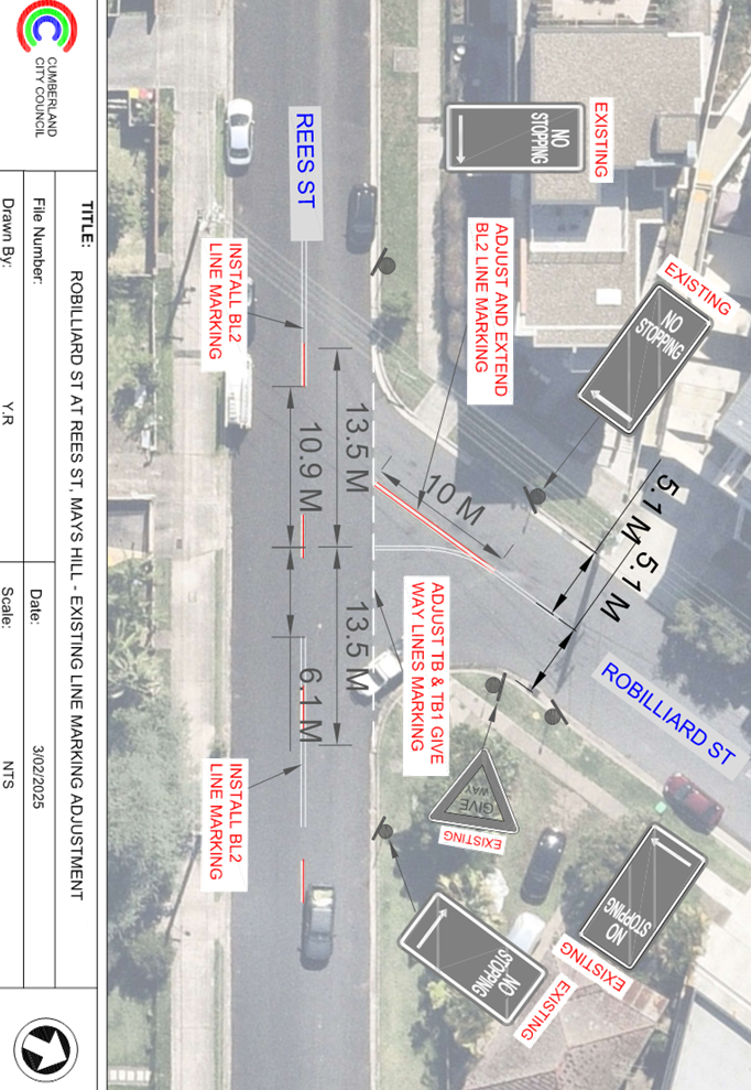
ROBILLIARD
STREET AND REES STREET, MAYS HILL – PROPOSED LINE MARKING ADJUSTMENT
Directorate: Environment
and Planning
Responsible
Officer: Manager
Engineering and Building
Electorate: Granville
Police Area
Command (PAC): Cumberland
Agenda Part Part
1
Note: Recommended
for Approval under Delegated Authority
Council has received safety concerns from residents at the
intersection of Robilliard Street and Rees Street, Mays Hill.
This report outlines the outcome of the investigation into
this matter.
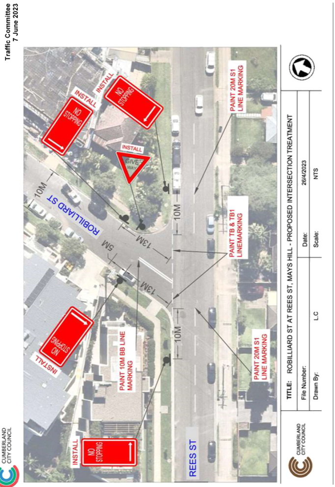
The Traffic Committee recommends that the adjustment of
‘BL2’, ‘TB’ and ‘TB1’ line marking at the
intersection of Robilliard Street and Rees Street, Mays Hill in accordance with
the attached plan be approved.
Robilliard Street is a collector road that runs in a
north-south direction between Great Western Highway and Rees Street with a
sign-posted speed limit of 50 km/h. It has a width of approximately 10 m and
parking is permitted on both sides of the road unless otherwise signposted.
Rees Street is a local road that runs in an east-west
direction between Peggy Street and Burnett Street with a speed limit of 50
km/h. It has a width of approximately 10.5 m and parking is permitted on both
sides of the road unless otherwise signposted.
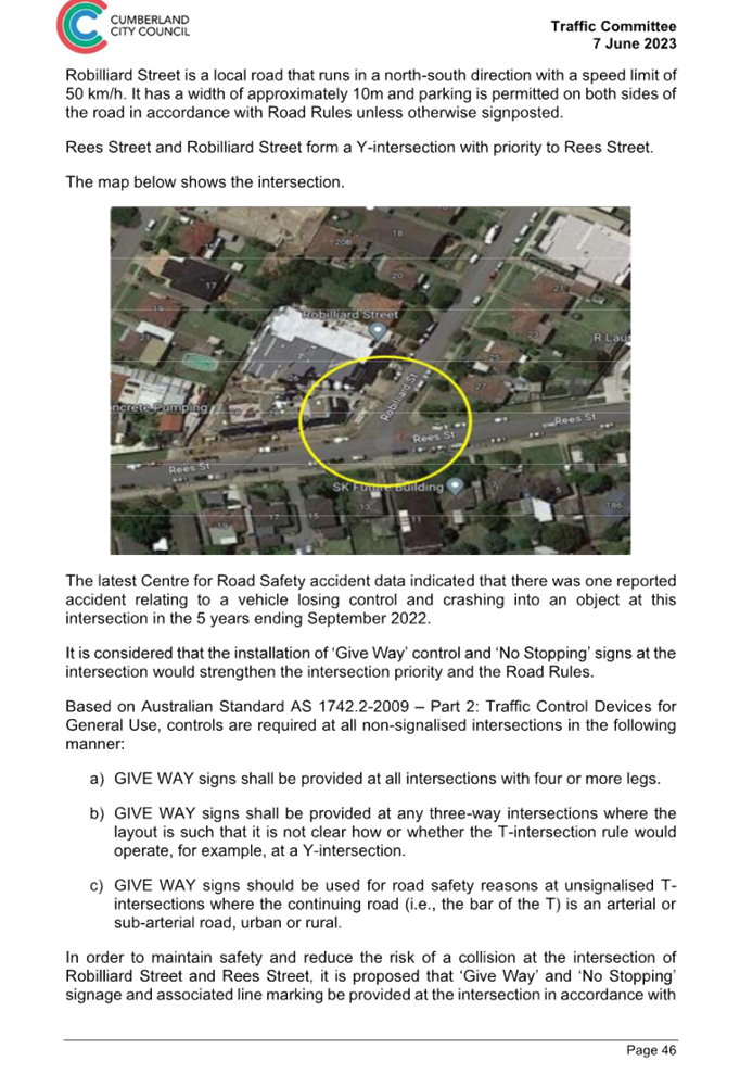
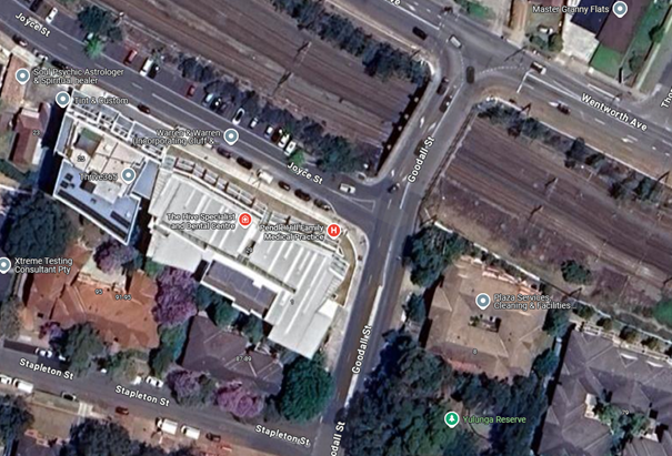
Robilliard Street and Rees Street form a Y-intersection with
priority to Rees Street.
The map below shows the intersection.
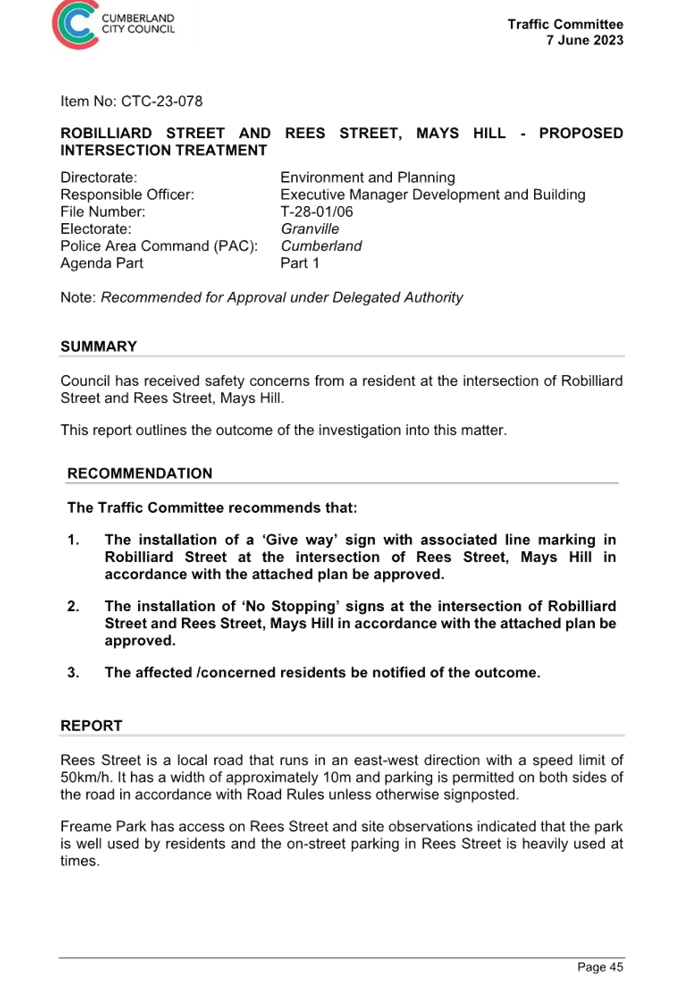
Cumberland Traffic Committee
(CTC) at its meeting in June 2023 considered a report (CTC-23-078) regarding
this intersection. Council resolved that:
1. The installation of a ‘Give way’ sign with
associated line marking in Robilliard Street at the intersection of Rees
Street, Mays Hill in accordance with the attached plan be approved.
2. The installation of ‘No Stopping’ signs at the
intersection of Robilliard Street and Rees Street, Mays Hill in accordance with
the attached plan be approved.
3. The affected /concerned residents be notified of the
outcome.
Since the installation of
‘BL2’ line marking at the intersection, Council has received
multiple inquiries from road users regarding the difficulty of turning from
Rees Street (westbound) into Robilliard Street. Drivers have reported challenges
in avoiding the road centrelines while manoeuvring through the intersection.
Council officers have
investigated these concerns and propose adjusting the line markings at the
intersection to create more space for vehicles to turn safely.
Consultation is not required as
the proposed line marking has no impact to the local residents.
1. Plan
– Robilliard Street and Rees Street, Mays Hill – Proposed line
marking adjustments
2. Previous
Report – CTC-23-078
DOCUMENTS
ASSOCIATED WITH
REPORT CTC-25-057
Attachment 1
Plan – Robilliard Street and Rees Street, Mays
Hill – Proposed line marking adjustments
2 April 2025
DOCUMENTS
ASSOCIATED WITH
REPORT CTC-25-057
Attachment 2
Previous Report – CTC-23-078
2 April 2025
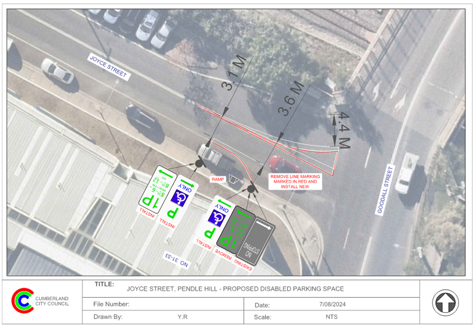
Item No: CTC-25-058
JOYCE STREET,
PENDLE HILL - PROPOSED ACCESSIBLE PARKING SPACE
Directorate: Environment
and Planning
Responsible
Officer: Manager
Engineering and Building
Electorate: Prospect
Police Area
Command (PAC): Cumberland
Agenda Part Part
1
Note: Recommended
for Approval under Delegated Authority
Council has received a request
from a local resident for the installation of an accessible parking space on Joyce
Street, Pendle Hill.
This report outlines the outcome
of the investigation into this matter.
The Traffic Committee recommends that:
1. The
proposed accessible parking spaces on Joyce Street, Pendle Hill in accordance
with the attached plan be approved.
2. The
resident with the request and affected residents / businesses be advised of the
outcome.
Council has received a request
from a local resident for the installation of an accessible parking space outside
Pendle Hill Family Medical Practice at No. 29-33 Joyce Street, Pendle Hill due
to the inconvenience of parking for visitors with mobility challenges.
Council officers have investigated the matter and observed
that the existing time-restricted parking spaces are frequently occupied due to
high demand. As a result, it is difficult for visitors with disabilities to
find a parking space at this section of Joyce Street.
In order to improve the parking availability for visitors
with disabilities, it is proposed to convert a section of the existing
time-restricted parking spaces on Joyce Street to one accessible parking spaces
in accordance with the attached plan. Existing pavement markings will be
adjusted accordingly.
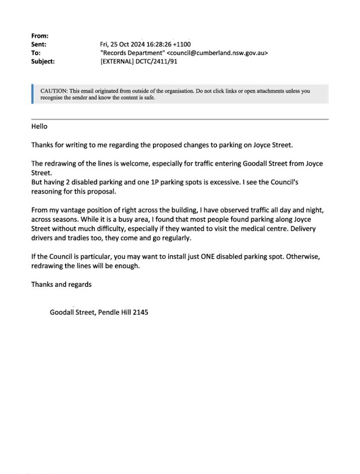
The proposal was notified to the
impacted and adjacent residents and business owners for a period of 14 days
starting from 21 October 2024 to 5 November 2024. One response was received
supporting the installation of one accessible parking space at this location.
1. Plan- Joyce
Street, Pendle Hill - Proposed Accessible Parking
2. Submission
DOCUMENTS
ASSOCIATED WITH
REPORT CTC-25-058
Attachment 1
Plan- Joyce Street, Pendle Hill - Proposed Accessible
Parking
2 April 2025
DOCUMENTS
ASSOCIATED WITH
REPORT CTC-25-058
Attachment 2
Submission
2 April 2025
2 April 2025
Item No: CTC-25-059
TARGO ROAD AT
ORAMZI ROAD AND BANDO ROAD, GIRRAWEEN – PROPOSED LINE MARKING
Directorate: Environment
and Planning
Responsible
Officer: Manager
Engineering and Building
Electorate: Prospect
Police Area
Command (PAC): Cumberland
Agenda Part Part
1
Note: Recommended
for Approval under Delegated Authority
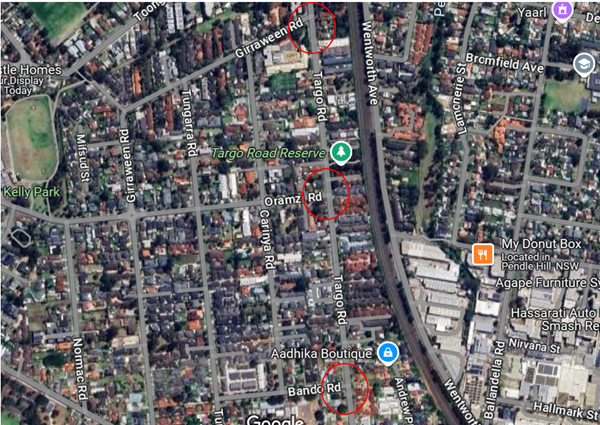
Council has received safety concerns from residents
regarding Targo Road at its intersections with Girraween Road, Oramzi Road and
Bando Road, Girraween.
This report outlines the outcome of the investigation into
this matter.
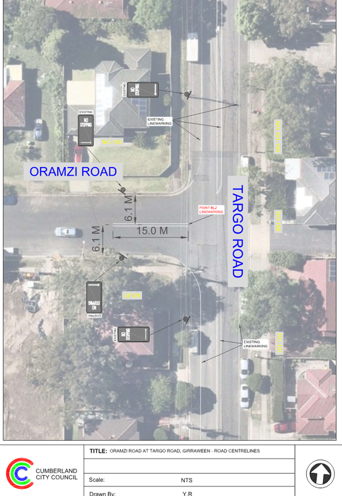
The Traffic Committee recommends that the installation of
‘BL2’ line marking on Targo Road, Girraween and its intersections
of Oramzi Road and Bando Road, Girraween in accordance with the attached plans
be approved.
Targo Road is a collector road that runs in a north-south
direction between Toongabbie Road and Great Western Highway with a sign-posted
speed limit of 50 km/h. It has a width of approximately 12.5 m and parking is
permitted on both sides of the road unless otherwise signposted.
Girraween Road is a collector road that runs in a
north-south direction between Targo Road and Great Western Highway with a
sign-posted speed limit of 50 km/h. Near Targo Road intersection, it has a
width of approximately 10m and parking is permitted on both sides of the road
unless otherwise signposted.
Oramzi Road is a local road that runs mainly in an east-west
direction between Targo Road and Great Western Highway with a sign-posted speed
limit of 50 km/h. Near Targo Road intersection, it has a width of approximately
12.5 m and parking is permitted on both sides of the road unless otherwise
signposted.
Bando Road is a local road that
runs in an east-west direction between Targo Road and Tungarra Road with a
sign-posted speed limit of 50 km/h. It has a width of
approximately 10m and parking is permitted on both sides of
the road unless otherwise signposted.
Targo Road intersects Girraween Road, Oramzi Road and Bando
Road and forming three T-intersections with priority to Targo Road.
The map below shows the intersection:
The latest Centre for Road
Safety accident data indicated that there was one recorded cross traffic
accident at the intersection of Targo Road and Oramzi Road in the last 5 years.
Council has received enquiries
from residents concerning the safety for the three intersections discussed
above. Council officers have investigated the concern and propose to provide
BL2 line marking to assist in retaining traffic on the correct side of the
roads.
Consultation is not required as
the proposed line marking has no impact to the local residents.
1. Plan - Targo
Road at Oramzi Road, Girraween - Proposed linemarking
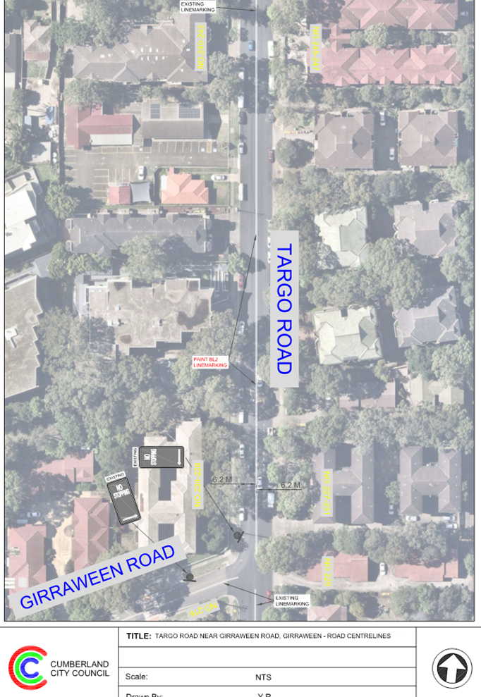
2. Plan
- Targo Road at Girraween Road- Proposed linemarking
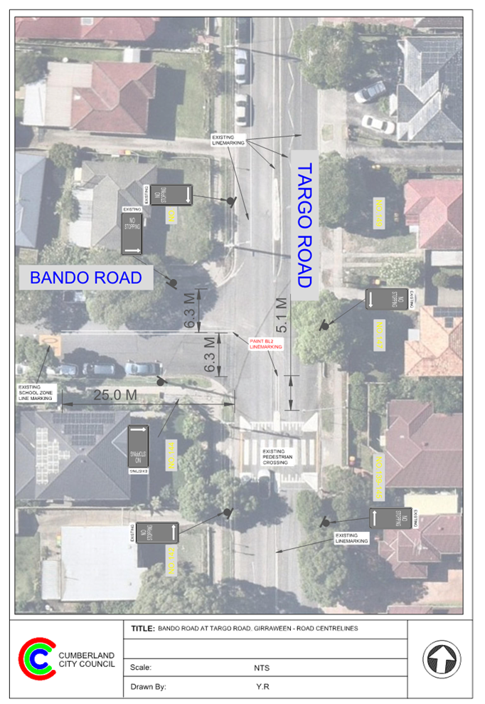
3. Plan
- Targo Road at Bando Road- Proposed linemarking
DOCUMENTS
ASSOCIATED WITH
REPORT CTC-25-059
Attachment 1
Plan - Targo Road at Oramzi Road, Girraween - Proposed
linemarking
2 April 2025
DOCUMENTS
ASSOCIATED WITH
REPORT CTC-25-059
Attachment 2
Plan - Targo Road at Girraween Road- Proposed
linemarking
2 April 2025
DOCUMENTS
ASSOCIATED WITH
REPORT CTC-25-059
Attachment 3
Plan - Targo Road at Bando Road- Proposed linemarking
2 April 2025
2 April 2025
Item No: CTC-25-060
GUILFOYLE
STREET, BERALA - APPLICATION FOR 'WORKS ZONE' SIGNAGE
Directorate: Environment
and Planning
Responsible
Officer: Manager
Engineering and Building
Electorate: Auburn
Police Area
Command (PAC): Auburn
Agenda Part Part
1
Note: Recommended
for Approval under Delegated Authority
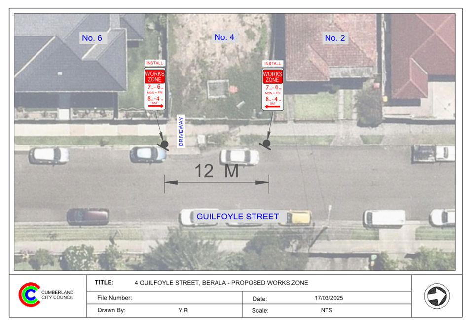
Council has received an
application for a ‘Works Zone’ on Guilfoyle Street, Berala
associated with the development at 4 Guilfoyle Street, Berala.
This report outlines the outcome
of the investigation into this matter.
The Traffic Committee recommends that:
1. The
12m long ‘Works Zone, 7:00am-6:00pm, Monday-Friday, 8:00am-4:00pm,
Saturday’ signs be approved on the frontage of the redevelopment site on
Guilfoyle Street, Berala in accordance with the attached plan subject to
Council’s standard conditions for the period of 6 months and subsequent
extension if required.
2. The
applicant be advised to pay the ‘Works Zone’ fees to Council as per
the adopted Fees and Charges.
Council has received an
application for a ‘Works Zone’ on Guilfoyle Street, Berala
associated with the development at 4 Guilfoyle Street, Berala. The proposed
development involves demolition of existing structures and construction of a
single dwelling.
The temporary “Works
Zone” is approximately 12m in length and proposed to commence in April
2025 for 6 months. The proposed times are between 7:00am to 6:00pm Monday to
Friday and 8:00am to 4:00pm on Saturdays.
There will be a loss of two (2) unrestricted
parking spaces on Guilfoyle Street, Berala during the operation of the
“Works Zone”.
The proposal is outside the
property being developed and no consultation is considered necessary as the
request was made by the builder.
1. Plan –
Guilfoyle Street, Berala – Proposed Temporary ‘Works Zone’
signage.
DOCUMENTS
ASSOCIATED WITH
REPORT CTC-25-060
Attachment 1
Plan – Guilfoyle Street, Berala – Proposed
Temporary ‘Works Zone’ signage.
2 April 2025
2 April 2025
Item No: CTC-25-061
MURPHY STREET
AT BRISTOL STREET, MERRYLANDS WEST – INTERSECTION TREATMENT
Directorate: Environment
and Planning
Responsible
Officer: Manager
Engineering and Building
Electorate: Granville
Police Area
Command (PAC): Cumberland
Agenda Part Part
1
Note: Recommended
for Approval under Delegated Authority
Council has received safety
concerns from residents at the intersection of Murphy Street and Bristol
Street, Merrylands West.
This report outlines the outcome
of the investigation into this matter.
The Traffic Committee recommends that:
1. The
installation of ‘No Stopping’ signage, ‘BL2’ and
chevron line marking at the intersection of Murphy Street and Bristol Street,
Merrylands West in accordance with the attached plan be approved in-principle.
2. Council
undertake consultation with the affected residents and report back to Traffic
Committee if objections are received.
3. The
residents with the request and affected residents be advised of the outcome.
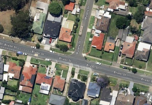
Bristol Street is a local road
that runs in an east-west direction between Sherwood Road and Fowler Road with
a speed limit of 50 km/h. It has a width of approximately 10m and parking is
permitted on both sides of the road in accordance with Road Rules unless
otherwise signposted.
Murphy Street is a no through
local road that runs in a north-south direction from Bristol Street with a
speed limit of 50 km/h. It has a width of approximately 7m and parking is
permitted on both sides of the road in accordance with Road Rules unless otherwise
signposted.
Murphy Street and Bristol Street
forms a T-intersection with priority to Bristol Street.
The map below shows the
intersection:
The latest Centre for Road Safety
accident data indicated that there were no reported accidents related to parked
vehicles or sight distance at this intersection in the last 5
years.
The resident reported that
vehicles are parking too close to the intersection, restricting sight distance
when turning from Murphy Street onto Bristol Street. To address this issue, it
is proposed to install ‘No Stopping’ signage, 'BL2' and chevron
line markings at the intersection to reinforce road rules and prevent vehicles
from parking too close to the intersection.
Subject to endorsement,
consultation will be undertaken with residents prior to the commencement of
works.
1. Plan –
Murphy Street at Bristol Street, Merrylands West – Intersection Treatment
DOCUMENTS
ASSOCIATED WITH
REPORT CTC-25-061
Attachment 1
Plan – Murphy Street at Bristol Street,
Merrylands West – Intersection Treatment
2 April 2025
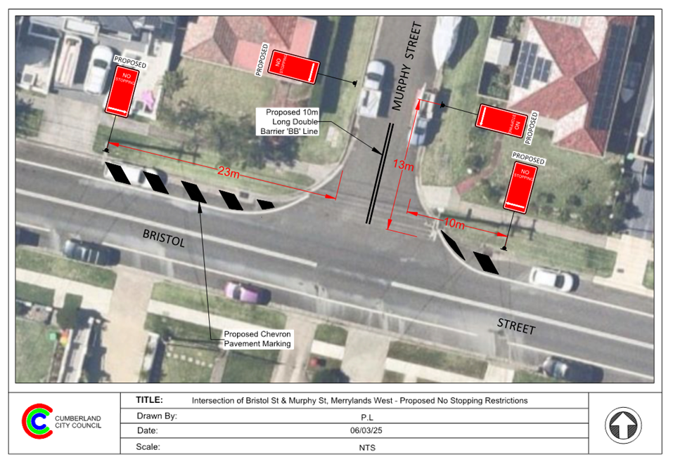
2 April 2025
Item No: CTC-25-062
DAN STREET,
MERRYLANDS – PROPOSED ‘NO PARKING’ SIGNS DURING WASTE NIGHT
Directorate: Environment
and Planning
Responsible
Officer: Manager
Engineering and Building
Electorate: Granville
Police Area
Command (PAC): Cumberland
Agenda Part Part
1
Note: Recommended
for Approval under Delegated Authority
Council has received a request
from a resident for the installation of parking restrictions in the cul-de-sac
end of Dan Street, Merrylands.
This report outlines the outcome
of the investigation into this matter.
The Traffic Committee recommends that:
1. The
proposed ‘No Parking 5am-12pm Thursday’ restrictions in the
cul-de-sac of Dan Street, Merrylands in accordance with the attached plan be
approved
2. The
resident with the request and affected residents be advised of the outcome.
Dan Street is a no-through local
road that runs in an east – west direction with a posted speed limit of
50 km/h. It has a width of approximately 7.5 m and parking is permitted on both
sides of the road. It has a cul-de-sac on the western end of the street.
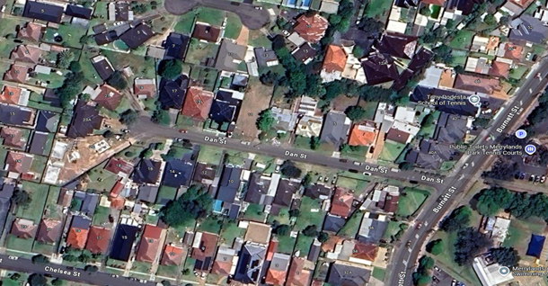
Council has received a request for the installation of
parking restrictions in the cul-de-sac end of Dan Street.
Council’s Waste Collection Team have advised that
parked vehicles in the cul-de-sac are causing difficulties for waste trucks to
turn around. With a cul-de-sac radius of approximately 8.4 metres, manoeuvring
large vehicles becomes challenging when cars are parked in the area.
It is proposed to install part-time ‘No Parking
5am-12pm Thursday’ signage at the cul-de-sac of Dan Street to allow waste
collection vehicles to manoeuvre during waste collection days.
The proposal was notified to the
impacted and adjacent residents for a period of 14 days from 18 February 2025
and 7 March 2025.
Council received two submission
supporting the proposal and requested Council to consider full-time
restrictions in the cul-de-sac.
1. Plan –
Dan Street, Merrylands – Proposed part-time ‘No Parking’
signs.
2. Submissions
e
DOCUMENTS
ASSOCIATED WITH
REPORT CTC-25-062
Attachment 1
Plan – Dan Street, Merrylands – Proposed
part-time ‘No Parking’ signs.
2 April 2025
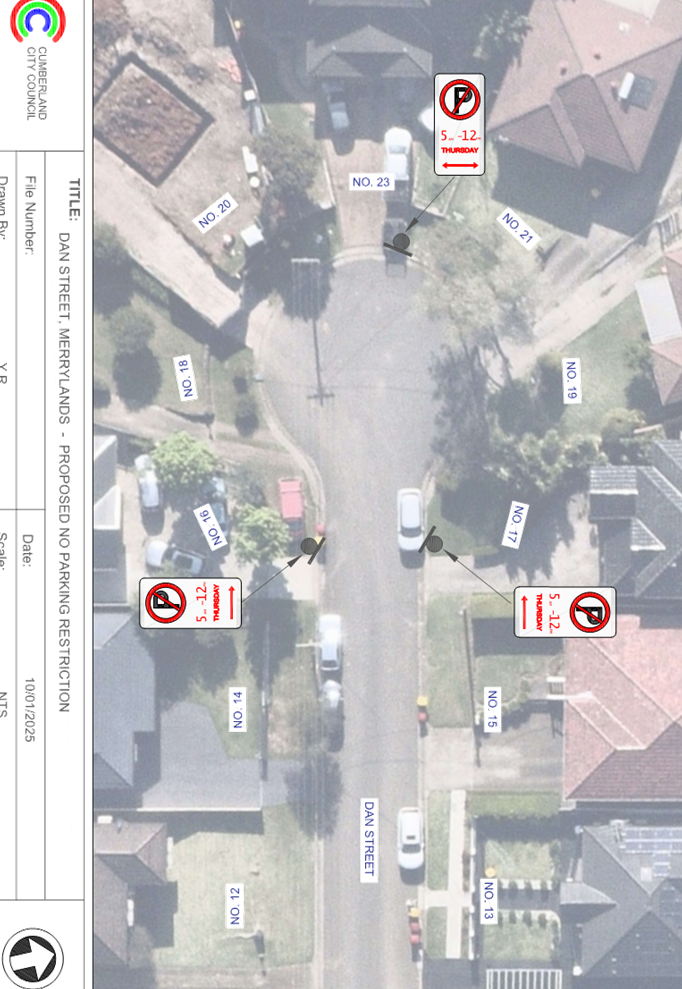
DOCUMENTS
ASSOCIATED WITH
REPORT CTC-25-062
Attachment 2
Submissions
2 April 2025
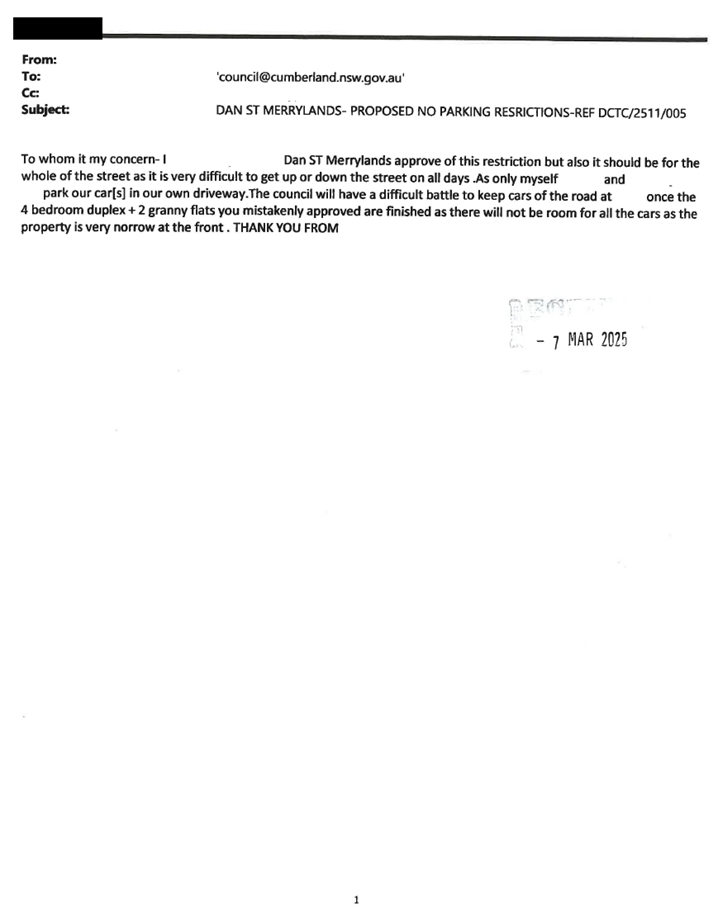
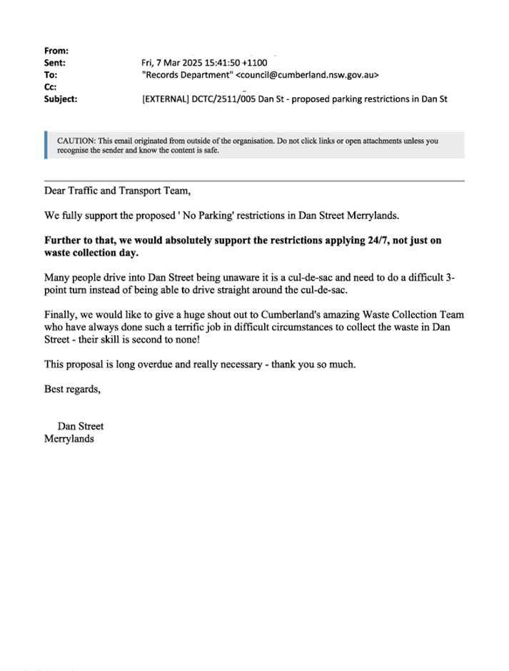
2 April 2025
Item No: CTC-25-063
NEILSON
STREET, GRANVILLE – PROPOSED ‘NO PARKING’ SIGNS DURING WASTE
NIGHT
Directorate: Environment
and Planning
Responsible
Officer: Manager
Engineering and Building
Electorate: Granville
Police Area
Command (PAC): Cumberland
Agenda Part Part
1
Note: Recommended
for Approval under Delegated Authority
Council has received a request
from a resident for the installation of parking restrictions in the cul-de-sac
end of Neilson Street, Granville.
This report outlines the outcome
of the investigation into this matter.
The Traffic Committee recommends that:
1. The
proposed ‘No Parking 5am-12pm Thursday’ restrictions in the
cul-de-sac of Neilson Street, Granville in accordance with the attached plan be
approved.
2. The
resident with the request and affected residents be advised of the outcome.
Neilson Street is a no-through
local road that runs in an east – west direction with a posted speed
limit of 50 km/h. It has a width of approximately 11 m and parking is permitted
on both sides of the road. It has a square cul-de-sac on the eastern end of the
street.
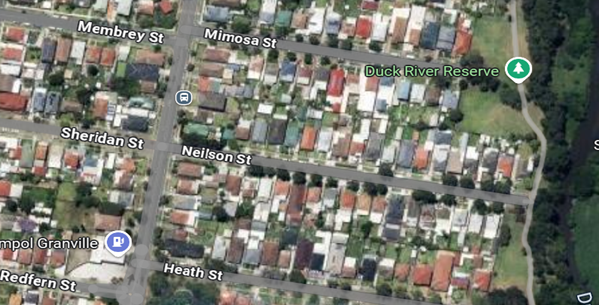
Council has received a request for the installation of
parking restrictions in the cul-de-sac end of Neilson Street.
Council’s Waste Collection
Team have advised that parked vehicles in the cul-de-sac are causing
difficulties for waste trucks to turn around.
It is proposed to install part-time ‘No Parking
5am-12pm Thursday’ signage at the cul-de-sac of Neilson Street to allow
waste collection vehicles to manoeuvre during waste collection days.
The proposal was notified to the
impacted and adjacent residents for a period of 14 days from 17 February 2025
and 7 March 2025. No submissions were received.
1. Plan –
Neilson Street, Granville – Proposed part-time ‘No Parking’
signs.
DOCUMENTS
ASSOCIATED WITH
REPORT CTC-25-063
Attachment 1
Plan – Neilson Street, Granville –
Proposed part-time ‘No Parking’ signs.
2 April 2025
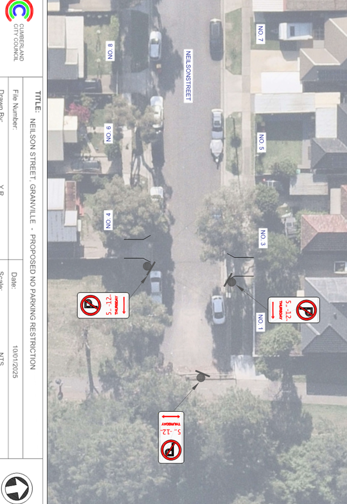
2 April 2025
Item No: CTC-25-064
ROSE CRESCENT,
REGENTS PARK – PROPOSED PARKING RESTRICTIONS
Directorate: Environment
and Planning
Responsible
Officer: Manager
Engineering and Building
Electorate: Auburn
Police Area
Command (PAC): Auburn
Agenda Part Part
1
Note: Recommended
for Approval under Delegated Authority
Council has received a request
from the management of a Place of Worship in Rose Crescent, Regents Park for
the installation of appropriate restrictions to prevent large trucks parking in
the street and causing safety concerns and access issues for worshippers
and road users.
This report outlines the outcome
of the investigation into this matter.
The Traffic Committee recommends:
1. The
installation of “No Parking, Motor Vehicles Under 4.5 t GVM
Excepted” signs on the northern side of Rose Crescent, Regents Park in
accordance with the attached plan be approved.
2. The
persons with the request and affected properties be advised of the outcome.
Council has received a request
from the management of a Place of Worship in Rose Crescent, Regents Park for
the installation appropriate restrictions to prevent large trucks parking in
the street and causing safety concerns and access issues for worshippers
and road users.
Rose Crescent is a local road that
runs in an eastern direction from Park Road upto the bend at Chisholm Road. It
is approximately 10.6m wide and has a speed limit of 50km/hr. Sydney Water
pipelines run on the southern side of the street and industrial properties
located on the northern side. There are three Places of Worship located on the
northern side which attract high volume of worshippers attending on special
days and weekends and large number of people on normal days.
The map below shows the location
of Rose Crescent and details of the signage:
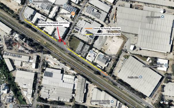
The street view below shows the
area and truck parking.
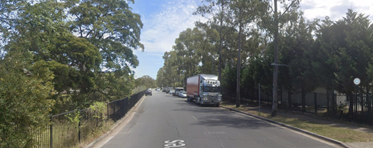
Large trucks park in this area during day, night and
continuously during weekends. Council rangers have been called in the past to
enforce the one hour parking requirement for trucks under the Road Rules.
Council has received concerns from one of the places of
worship that large trucks and trailers park at the frontage on both sides of
the driveway obstructing visibility for vehicles driving out of the properties
causing near misses and crashes. It is also indicated that trucks park in the
evenings and overnight when the places of worship are attended by large number
of people causing serious safety concerns.
It is alleged that the waste collection at the places of
worship occurring three times a week are obstructed by parked trucks blocking
access which result in the facilities being charged for missed collection. It
is also alleged that the delays in collecting the large bins result in
environmental concerns. The parked trucks also reduce turning path clearance to
allow service vehicles to provide delivery and waste collection activities
off-street.
Council officers have investigated the concerns. It was
observed during inspections in the area at different times that large trucks
and trailers are parked on Rose Crescent.
In view of the above, it is considered necessary to signpost
as proposed due to the following considerations:
· The area is an industrial
area where a large number of trucks accessing the sites.
· The large number
of people gathering at places of worship.
· Council rangers
cannot be present all the time particularly in the evenings and nights when the
places of worship are holding events.
· All loading and
unloading for the premises occur off-street.
It is proposed to install “No Parking, Motor Vehicles
Under 4.5 t GVM Excepted” signs on the northern side of Rose Crescent,
Regents Park in accordance with the attached plan.
The proposal was notified to the
impacted and adjacent properties for a period of 14 days starting from 7 March
2025 to 21 March 2025.
There was one submission received
supporting the proposal.
1. Plan –
Rose Crescent, Regents Park – Proposed no parking signage
2. Submission
DOCUMENTS
ASSOCIATED WITH
REPORT CTC-25-064
Attachment 1
Plan – Rose Crescent, Regents Park – Proposed
no parking signage
2 April 2025
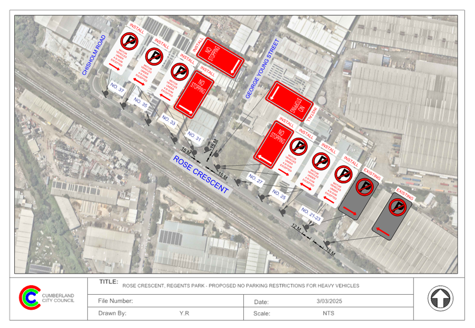
DOCUMENTS
ASSOCIATED WITH
REPORT CTC-25-064
Attachment 2
Submission
2 April 2025
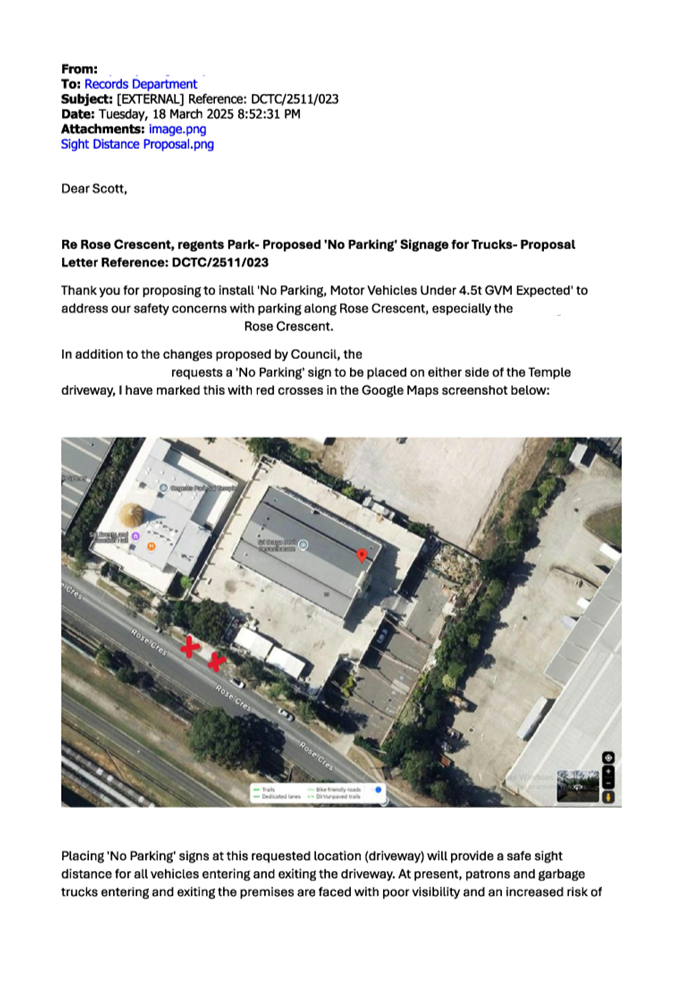
2 April 2025
Item No: CTC-25-065
REGENT STREET
AND CAMPBELL STREET AT LEONIE CRESCENT, BERALA – PROPOSED
INTERSECTION TREATMENT
Directorate: Environment
and Planning
Responsible
Officer: Manager
Engineering and Building
Electorate: Auburn
Police Area
Command (PAC): Auburn
Agenda Part Part
1
Note: Recommended
for Approval under Delegated Authority
Council has received safety concerns from residents in
Regent Street and Campbell Street at the intersection of Leonie Crescent,
Berala.
This report outlines the outcome of the investigation into
this matter.
The Traffic Committee recommends that:
1. The
installation of ‘Give Way’ signs, line marking, and ‘No
Stopping’ restrictions in Regent Street and Campbell Street at the
intersection of Leonie Crescent, Berala in accordance with attached plan be
approved.
2. The
resident with the request and affected residents be advised of the outcome.
Regent Street is local road that runs in a north-south
direction with a speed limit of 50 km/h. It has a width of approximately 12.5 m
and parking is permitted on both sides of the road unless otherwise signposted.
Campbell Street is local road that runs in a north-south
direction with a speed limit of 50 km/h. It has a width of approximately 12.5 m
and parking is permitted on both sides of the road unless otherwise signposted.
Leonie Crescent is a local road that mainly runs an
east-west direction with a cul-de-sac at its southern end. The road
is approximately 7.5 m wide, with parking allowed on both sides of the road
unless otherwise signposted.
Regent Street connects to Campbell Street, and both
intersect at Leonie Crescent forming a Y- intersection with priority to Regent
Street and Campbell Street.
The map below shows the intersection.
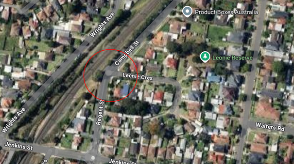
Locality
Plan
The latest Centre for Road Safety accident data indicated
that there were no reported accidents at this intersection in the last 5 years.
Residents have raised concerns about vehicles parking within
10 metres of the intersection. Inspections confirmed that vehicles are parking
too close to the intersection, creating potential safety risks. To address
this, it is proposed to install ‘No Stopping’ restrictions and
‘BL2’ line marking at the intersection.
Inspections also revealed that no line marking, or signage
is provided at this intersection and the Y-shaped intersection could confuse
drivers, as the road geometry makes the 'Give Way' priorities unclear.
In accordance with Australian Standard AS 1742.2-2009
– Part 2: Traffic Control Devices for General Use, controls are required
at all non-signalised intersections in the following manner:
a) GIVE
WAY signs shall be provided at all intersections with four or more legs.
b) GIVE
WAY signs shall be provided at any three-way intersections where the layout is
such that it is not clear how or whether the T-intersection rule would operate,
for example, at a Y-intersection.
c) GIVE
WAY signs should be used for road safety reasons at unsignalised
T-intersections in both rural and urban areas where the major road is an
arterial or collect type road.
Based on point (b) above, 'Give Way' signage is warranted at
this location. Therefore, it is recommended that ‘Give Way’
controls be provided at this intersection to prevent vehicles from failure to
give way to traffic on Regent Street and Campbell Street.
The proposal was notified to the
impacted and adjacent residents for a period of 14 days starting from 1 March
2025 to 14 March 2025.
No submissions were received.
1. Plan –
Regent Street and Campbell Street at Leonie Crescent, Berala – Proposed
Intersection Treatments
DOCUMENTS
ASSOCIATED WITH
REPORT CTC-25-065
Attachment 1
Plan – Regent Street and Campbell Street at
Leonie Crescent, Berala – Proposed Intersection Treatments
2 April 2025
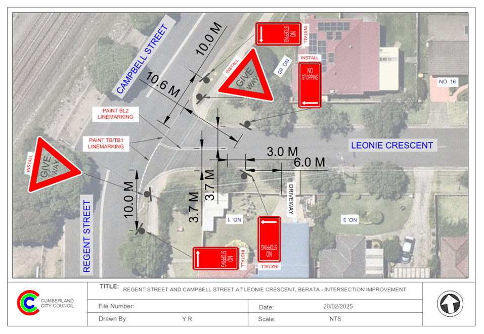
2 April 2025
Item No: CTC-25-066
HARROW ROAD,
AUBURN – PROPOSED 1/4 P PARKING RESTRICTIONS
Directorate: Environment
and Planning
Responsible
Officer: Manager
Engineering and Building
Electorate: Auburn
Police Area
Command (PAC): Auburn
Agenda Part Part
1
Note: Recommended
for Approval under Delegated Authority
Council has received a request from
a grocery shop at 110 Harrow Road, Auburn for the installation of 15-minute
parking restriction on the eastern side of Harrow Road, Auburn outside No. 110
to improve parking turnover at this location.
This report outlines the outcome
of the investigation into this matter.
The Traffic Committee recommends that:
1. The
installation of ‘1/4 P 9am to 7pm’ signage on the eastern side of
Harrow Road, Auburn as per the attached plan be approved.
2. The
business with the request and affected residents be advised of the outcome.
Council has received a request
from a grocery shop at 110 Harrow Road, Auburn to install a 15-minute parking
restriction on the eastern side of Harrow Road, outside No.110 to improve
parking turnover in the area. The shop is located in a low-density residential
zone, where parking is generally unrestricted unless signposted.
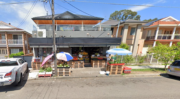
It is alleged that vehicles parked at this area for
extensive period of time, making shop customers and delivery services difficult
in finding parking in the area.
A Council officer contacted the shop owner, who advised that
they would like ‘1/4 P 9 AM – 7 PM’ parking restrictions
installed outside the shop frontage. To improve parking turnover at this
location, it is proposed to implement these restrictions as outlined in the
attached plan.
The
proposal was notified to the impacted and adjacent residents/owners for a
period of 14 days from 24 February 2025 to 7 March 2025.
One objection was received,
stating that the proposed restriction is unnecessary and raising concerns about
the limited on-street parking availability in this section of Harrow Road.
1. Plan –
Harrow Road, Auburn – Proposed Parking Restrictions
2. Submission
DOCUMENTS
ASSOCIATED WITH
REPORT CTC-25-066
Attachment 1
Plan – Harrow Road, Auburn – Proposed
Parking Restrictions
2 April 2025
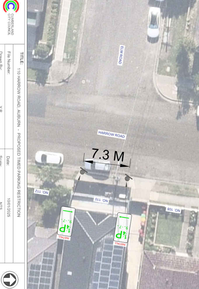
DOCUMENTS
ASSOCIATED WITH
REPORT CTC-25-066
Attachment 2
Submission
2 April 2025
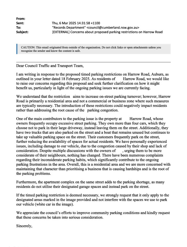
2 April 2025
Item No: CTC-25-067
HILLTOP ROAD, MERRYLANDS-PROPOSED
TIMED PARKING RESTRICTION
Directorate: Environment
and Planning
Responsible
Officer: Manager
Engineering and Building
Electorate: Granville
Police Area
Command (PAC): Cumberland
Agenda Part Part
1
Note: Recommended
for Approval under Delegated Authority
Council has received a request from
a property owner of No.14 Hilltop Road, Merrylands for the installation of
15-minute parking restriction on the southern side of Hilltop Road, Merrylands
outside No. 14 to facilitate parking turnover at this location.
This report outlines the outcome
of the investigation into this matter.
The Traffic Committee recommends that:
1. The
installation of ‘1/2 P 8:30 am to 6pm Mon- Fri, 8:30 am to 12 noon
Sat’ as per the attached plan be approved.
2. The
property owner with the request and affected residents be advised of the
outcome.
Council has received a request
from a property owner of No.14 Hilltop Road, Merrylands for the consideration
of time parking in front of this property. No.14 Hilltop Road is a newly
constructed mixed used development with shops on the ground floor and a Child
Care Centre. Currently, parking is unrestricted at its frontage of the
property.
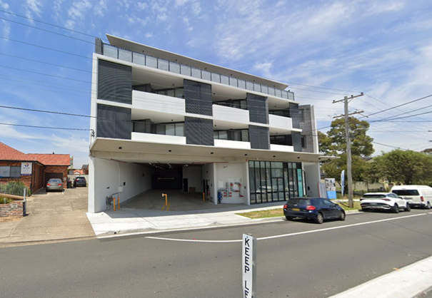
It is alleged that some vehicles parked at this location for
extended periods of time, making shop customers and childcare centre parents
difficult in finding parking in the area.
To improve parking turnover at this location, it is proposed
to introduce a 1/2 P restriction (8:30 AM – 6:00 PM, Monday to Friday,
and 8:30 AM – 12:00 PM, Saturday) and modify the existing parking edge
line as outlined in the attached plan.
The proposal was notified to the
impacted and adjacent residents/ owners for a period of 14 days from 24
February 2025 to 7 March 2025. One response was received in favour of this
proposal.
1. Plan –
Hilltop Road, Merrylands – Proposed ‘1/2 P’ Parking
Restriction
2. Submission
DOCUMENTS
ASSOCIATED WITH
REPORT CTC-25-067
Attachment 1
Plan – Hilltop Road, Merrylands – Proposed
‘1/2 P’ Parking Restriction
2 April 2025
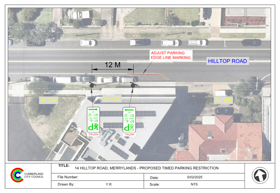
DOCUMENTS
ASSOCIATED WITH
REPORT CTC-25-067
Attachment 2
Submission
2 April 2025
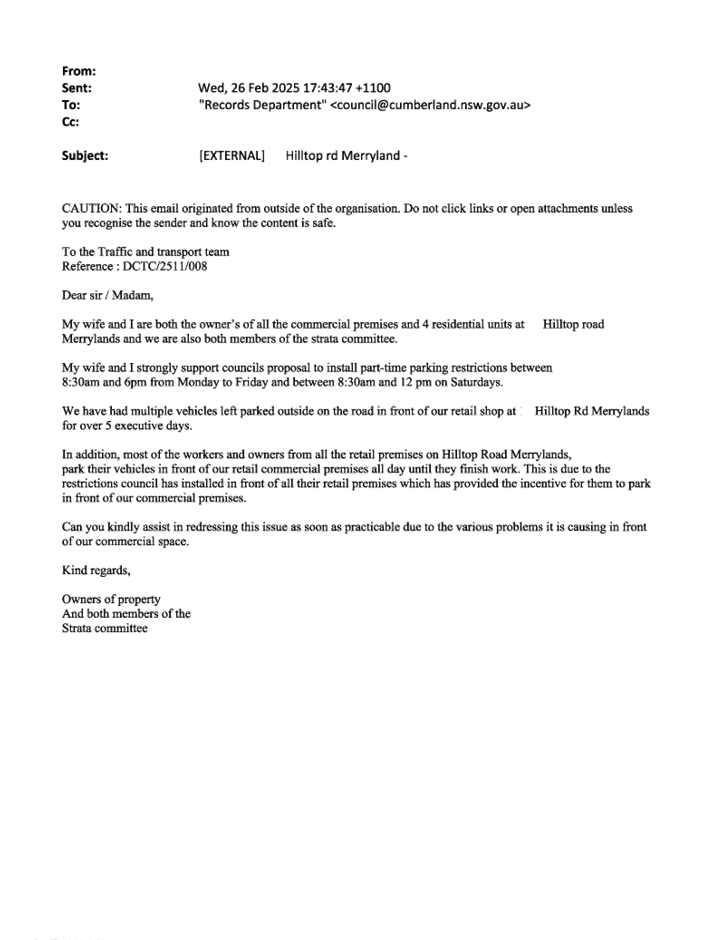
2 April 2025
Item No: CTC-25-068
FREITAS LANE,
LIDCOMBE – PROPOSED PARKING RESTRICTIONS
Directorate: Environment
and Planning
Responsible
Officer: Manager
Engineering and Building
Electorate: Auburn
Police Area
Command (PAC): Auburn
Agenda Part Part
1
Note: Recommended
for Approval under Delegated Authority
Council has received a request for
the installation of parking restrictions in Freitas Lane, Lidcombe.
This report outlines the outcome
of the investigation into this matter.
That the Traffic Committee recommends that:
1. The
proposed ‘No Parking’ and ‘No Stopping’ restrictions in
Freitas Lane, Lidcombe in accordance with the attached plan be approved
2. The
resident that made the request and affected residents be notified of the
outcome.
Freitas Lane provides access to
properties along the laneway. Recently, a new section was constructed,
extending the laneway to connect Vaughan Street and Kerrs Road. The laneway is
approximately 5.3 m wide and has ‘No Parking’ restrictions in
certain sections, while parking is permitted in other unrestricted areas.
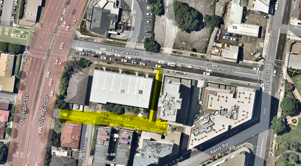
Council has received a request to
install parking restrictions on both sides of the laneway due to parked
vehicles obstructing property access.
To address this issue, it is
possible to install “No Parking” signs on both sides of the newly
constructed laneway and on the southern side of the existing laneway to ensure
clear access for residents. Additonally, “No Stopping” restrictions
are recommneded at the Vaughan Street intersection to reinforce statutory
requirements under NSW Road Rules.
The proposal was notified to the
impacted and adjacent residents for a period of 14 days from 28 February 2025
to 14 March 2025. No submissions were received.
1. Plan –
Freitas Lane, Lidcombe – Proposed ‘No Parking’ signs.
DOCUMENTS
ASSOCIATED WITH
REPORT CTC-25-068
Attachment 1
Plan – Freitas Lane, Lidcombe – Proposed
‘No Parking’ signs.
2 April 2025
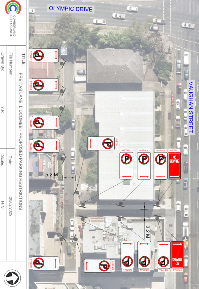
2 April 2025
Item No: CTC-25-069
CUMBERLAND
ROAD CORNER OF CHISWICK ROAD, AUBURN - PROPOSED TIMED PARKING
Directorate: Environment
and Planning
Responsible
Officer: Manager
Engineering and Building
Electorate: Auburn
Police Area
Command (PAC): Auburn
Agenda Part Part
1
Note: Recommended
for Approval under Delegated Authority
Council has
received a request from the business owner at the corner of Cumberland Road and
Chiswick Road for timed parking at their boundary to assist shoppers.
This report outlines the outcome of the investigation into
this matter.
The Traffic Committee
recommends that:
1. The
installation of ‘1/2P 9 AM – 6 PM, Monday to Sunday’ signage
in Chiswick Road outside the shop at the corner of Cumberland Road in
accordance with the attached plan be approved.
2. The
business owner and adjacent residents be notified of the outcome.
Council has received a request from
the business owner at the corner of Cumberland Road and Chiswick Road for timed
parking at their boundary to assist shoppers.
Cumberland Road, Auburn is a collector road that runs in a
north south direction and has a speed limit of 50km/hr. Chiswick Road is a
local road that runs in an east west direction and has a speed limit of
50km/hr. The intersection of Cumberland Road and Chiswick Road is controlled by
a roundabout.
The corner shop’s entire frontage on Cumberland Road
is signposted as ‘No Stopping’. The side boundary of the shop on
Chiswick Road is signposted as ‘No Stopping’ for a short distance;
however, the property has a long boundary along Chiswick Road which is
unrestricted for parking after the ‘No Stopping’ zone.
The map below shows the intersection.
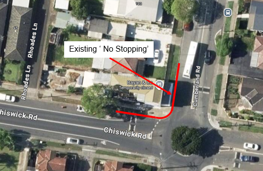

It is alleged that some vehicles parked at this location for
extended periods of time, making shop customers difficult in finding parking in
the area.
To improve parking turnover at this location, it is proposed
to introduce a 1/2 P restriction (9AM – 6PM, Monday to Sunday) at
Chiswick Road along the side of the shop as outlined in the attached plan.
Council undertook consultation with
the business owner. The owner supported the proposal.
1. Plan –
Cumberland Road, corner Chiswick Rd, Auburn
DOCUMENTS
ASSOCIATED WITH
REPORT CTC-25-069
Attachment 1
Plan – Cumberland Road, corner Chiswick Rd,
Auburn
2 April 2025
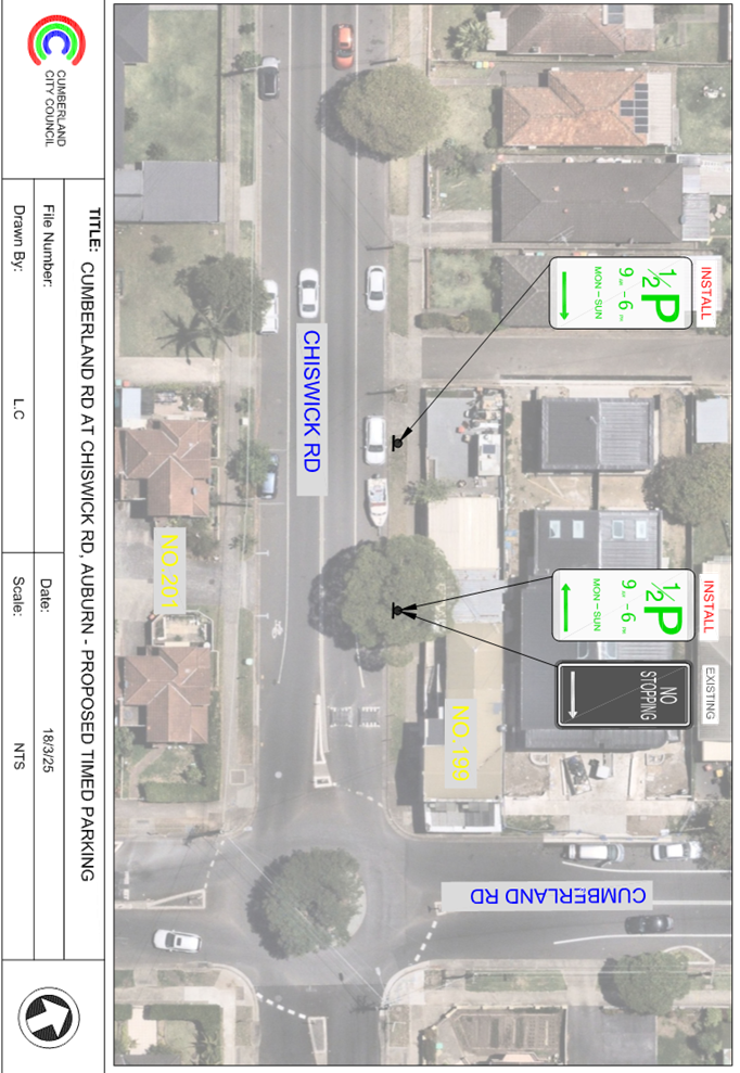
2 April 2025
Item No: CTC-25-070
CUMBERLAND
ROAD CORNER OF MARY STREET, AUBURN - PROPOSED TIMED PARKING
Directorate: Environment
and Planning
Responsible
Officer: Manager
Engineering and Building
Electorate: Auburn
Police Area
Command (PAC): Auburn
Agenda Part Part
1
Note: Recommended
for Approval under Delegated Authority
Council has received a request from the business owner at
the corner of Cumberland Road and Mary Street for timed parking at their
boundary to assist shoppers.
This report outlines the outcome of the investigation into
this matter.
The Traffic Committee recommends that:
1. The
installation of ‘1/2P 9 AM – 6 PM, Monday to Sunday’ signage
in Mary Street outside the shop at the corner of Cumberland Road in accordance
with the attached plan be approved.
2. The
business owner and adjacent residents be notified of the outcome.
Council has received a request from the business owner at
the corner of Cumberland Road and Mary Street for timed parking at their
boundary to assist shoppers.
Cumberland Road, Auburn is a collector road that runs in a
north south direction and has a speed limit of 50km/hr. Mary Street is a local
road that runs in an east west direction and has a speed limit of 50km/hr. The
intersection of Cumberland Road and Mary Street is controlled by a roundabout.
The corner shop’s entire frontage on Cumberland Road
is signposted as ‘No Stopping’. The side boundary of the shop on
Mary Street is signposted as ‘No Stopping’ for a short distance;
however, the property has a long boundary along Mary Street which is
unrestricted for parking after the ‘No Stopping’ zone.
The map below shows the intersection.
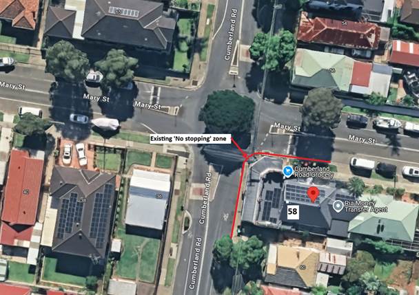
It is alleged that some vehicles parked at this location for
extended periods of time, making shop customers difficult in finding parking in
the area.
To improve parking turnover at this location, it is proposed
to introduce a 1/2 P restriction (9 AM – 6 PM, Monday to Sunday) at Mary
Street along the side of the shop as outlined in the attached plan.
Council undertook consultation with the business owner. The
business owner supported the proposal. However, one objection was received from
a property, which is not directly impacted as the installation does not affect
its frontage.
1. Plan –
Cumberland Road corner Mary Street, Auburn
2. Submission
DOCUMENTS
ASSOCIATED WITH
REPORT CTC-25-070
Attachment 1
Plan – Cumberland Road corner Mary Street,
Auburn
2 April 2025
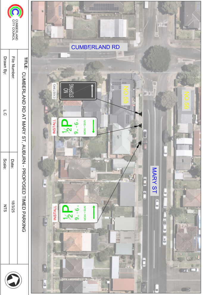
DOCUMENTS
ASSOCIATED WITH
REPORT CTC-25-070
Attachment 2
Submission
2 April 2025
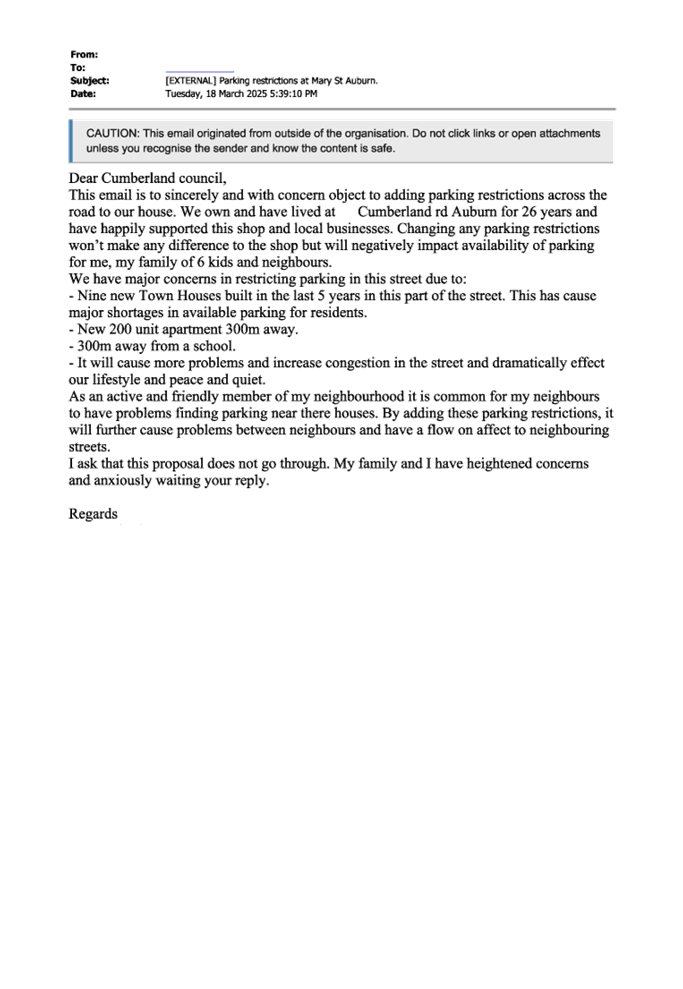
2 April 2025
Item No: CTC-25-071
DUFFY STREET,
MERRYLANDS – PROPOSED ‘NO PARKING’ RESTRICTIONS
Directorate: Environment
and Planning
Responsible
Officer: Manager
Engineering and Building
Electorate: Granville
Police Area
Command (PAC): Cumberland
Agenda Part Part
1
Note: Recommended
for Approval under Delegated Authority
Council has received safety concerns from a resident of Duffy
Street, Merrylands near the bend outside No.7.
This report outlines the outcome of the investigation into
this matter.
The Traffic Committee recommends that:
1. The
extension of ‘No Stopping’ zone on the southern side of Duffy
Street, Merrylands in front of No. 2, by an additional 12m to the west, in
accordance with the attached plan be approved in-principle.
2. Council
undertake consultation with the affected residents and report back to Traffic
Committee if objections are received.
3. The
resident with the request and affected residents be advised of the outcome.
Duffy Street is a local cul-de-sac road that runs mainly in
an east - west direction, it connects with Sherwood Road on the eastern side,
it has a speed limit of 50 km/h. It has a width of approximately 10m and
parking is permitted on both sides of the road unless otherwise signposted.
Duffy Street currently has a 30m 'No Stopping' zone
installed on the southern side of the road. A resident has alleged that, due to
the short distance between two driveways, vehicles frequently park in this
location, encroaching on the driveways and impacting access.
The map below shows the area:
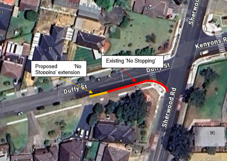
Figure 1 –
Locality Plan
It is alleged by the resident who raised concerns that when
vehicles park in the parking space between the driveways, the vehicles
sometimes overhang the driveway. Also, cars parking in this spot obstructs view
of oncoming traffic while exiting from the driveway. It should be noted that
signalising works are being undertaken at the intersection of Sherwood Road,
Duffy Street and Kenyons Road.
It is proposed to extend the existing ‘No
Stopping’ on the southern side of Duffy Street by 12 m to the west, in
order to prohibit parking on the short section between the two driveways.
Subject to endorsement, consultation
will be undertaken with directly affected residents on the proposal.
1. Plan –
Duffy Street, Merrylands – Proposed ‘No Parking’ restriction
extension
DOCUMENTS
ASSOCIATED WITH
REPORT CTC-25-071
Attachment 1
Plan – Duffy Street, Merrylands – Proposed
‘No Parking’ restriction extension
2 April 2025
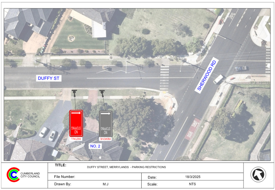
2 April 2025
Item No: CTC-25-072
HAWKSVIEW
STREET, GUILDFORD – RELOCATION OF THE EXISTING PARKING RESTRICITON
Directorate: Environment
and Planning
Responsible
Officer: Manager
Engineering and Building
Electorate: Granville
Police Area
Command (PAC): Cumberland
Agenda Part Part
1
Note: Recommended
for Approval under Delegated Authority
Council has received safety concerns from a resident in
Hawksview Street, Merrylands near No.7.
This report outlines the outcome of the investigation into
this matter.
The Traffic Committee recommends that:
1. The
extension of the existing ‘No Stopping’ signage on the northern
side of Hawksview Street, Merrylands in front of No. 7 in accordance with the
attached plan be approved.
2. Council
undertake consultation with affected residents and report back to Traffic
Committee if objections are received.
3. The
resident that made the request and affected residents be notified of the
outcome.
Hawksview Street is a regional road that runs in an east -
west direction between Fowler Road and Oxford Street with a speed limit of 50
km/h. It is approximately 12.5 meters wide, and parking is allowed on both
sides unless otherwise signposted.
Currently, a 30m ‘No Stopping’ zone exists on
the northern side of Hawksview Street between Military Road and Cecil Street.
On-street parking is available from No.7 to No.13 Hawksview Street.
The map below shows the area:
It is alleged that vehicles parked in the area between the
driveways of No.7 and No.9 Hawksview Street often block the sight distance for drivers
exiting No. 7.
Considering the heavy traffic on Hawksview Street, it is
proposed to extend the existing ‘No Stopping’ on the northern side
of Hawksview Street near No. 7 by 10m to the west, to prevent vehicles parked
in this area and improve sight distance for safer vehicle movements.
Subject to endorsement, consultation
will be undertaken with directly affected residents on the proposal.
1. Plan –
Hawksview Street, Merrylands – Extension of the existing parking
restrictions
DOCUMENTS
ASSOCIATED WITH
REPORT CTC-25-072
Attachment 1
Plan – Hawksview Street, Merrylands –
Extension of the existing parking restrictions
2 April 2025
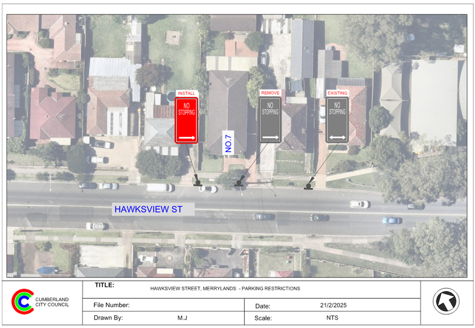
2 April 2025
Item No: CTC-25-073
LANEWAY
BETWEEN FIRST STREET AND SECOND STREET, GRANVILLE – PROPOSED PARKING
RESTRICTIONS
Directorate: Environment
and Planning
Responsible
Officer: Manager
Engineering and Building
Electorate: Granville
Police Area
Command (PAC): Cumberland
Agenda Part Part
1
Note: Recommended
for Approval under Delegated Authority
Council has received a request
from a resident for the installation of parking restrictions in the laneway
between First Street and Second Street, Granville.
This report outlines the outcome
of the investigation into this matter.
That the Traffic Committee recommends that:
1. The
proposed ‘No Parking’ and ‘No Stopping’ restrictions in
the laneway between First Street and Second Street, Granville in accordance
with the attached plan be approved.
2. The
resident that made the request and affected residents be notified of the
outcome.
First Street is a local road that runs in an east –
west direction with a posted speed limit of 50 km/h. It has a width of
approximately 12.4 m and parking is permitted on both sides of the road.
Second Street is a local road that runs in an east –
west direction with a posted speed limit of 50 km/h. It has a width of
approximately 12.5 m and parking is permitted on both sides of the road.
A laneway runs parallel to First Street and Second Street
providing vehicular access to most properties in First Street and Second Street
between Clyde Street and Factory Street. It has a width of approximately 3.8 m (gutter
to gutter).
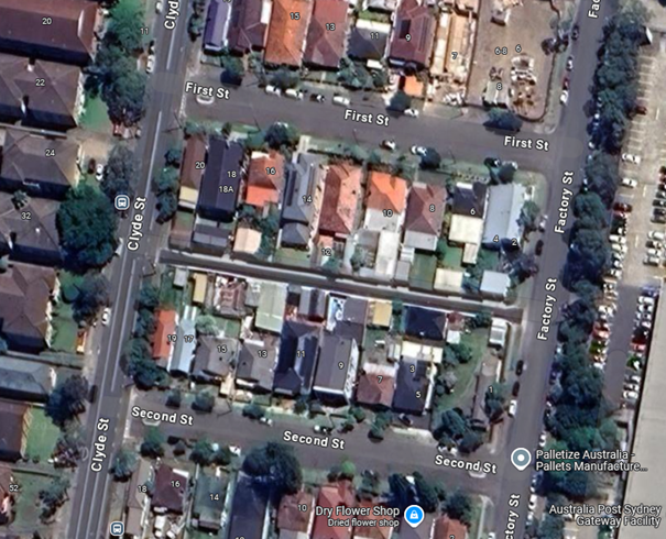
There are existing ‘No Parking’ restrictions in
the laneway. Council has received a request to install additional ‘No Parking’
signs in the laneway due to parked vehicles obstructing access to properties
along the laneway between First Street and Second Street.
It is proposed to install additional 'No Parking' signs on
both sides of the laneway to ensure adequate access for residents.
Additionally, 'No Stopping' restrictions are proposed at the intersections to
reinforce statutory ‘No Stopping’ requirements under NSW Road
Rules. These 'No Stopping' signs will be installed at appropriate locations as
shown in the attached drawing.
The proposal was notified to the
impacted and adjacent residents for a period of 14 days from 11 March 2025 to
25 March 2025.
Council received one submission
objecting to the proposal. However, this proposal aims to provide adequate
access for residents in the back lane, and it is proposed to implement the
parking restrictions as per the attached plan.
1. Plan –
Laneway Between First Street and Second Street, Granville – Proposed
‘No Parking’ signs.
2. Submission
DOCUMENTS
ASSOCIATED WITH
REPORT CTC-25-073
Attachment 1
Plan – Laneway Between First Street and Second
Street, Granville – Proposed ‘No Parking’ signs.
2 April 2025
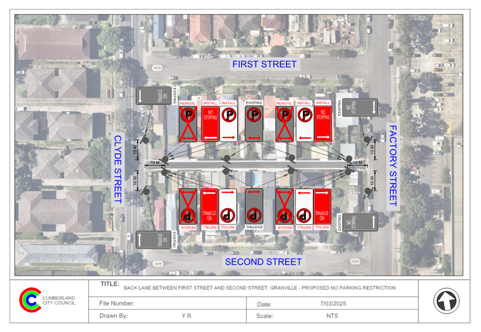
DOCUMENTS
ASSOCIATED WITH
REPORT CTC-25-073
Attachment 2
Submission
2 April 2025
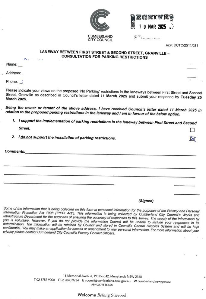
2 April 2025
Item No: CTC-25-074
LANEWAY
BETWEEN SECOND STREET AND THIRD STREET, GRANVILLE – PROPOSED PARKING
RESTRICTIONS
Directorate: Environment
and Planning
Responsible
Officer: Manager
Engineering and Building
Electorate: Granville
Police Area
Command (PAC): Cumberland
Agenda Part Part
1
Note: Recommended
for Approval under Delegated Authority
Council has received a request
from a resident for the installation of parking restrictions in the laneway
between Second Street and Third Street, Granville.
This report outlines the outcome
of the investigation into this matter.
That the Traffic Committee recommends that:
1. The proposed
‘No Parking’ and ‘No Stopping’ restrictions in the
laneway between Second Street and Third Street, Granville in accordance with
the attached plan be approved.
2. The resident
that made the request and affected residents be notified of the outcome.
Second Street is a local road that runs in an east –
west direction with a posted speed limit of 50 km/h. It has a width of
approximately 12.5 m and parking is permitted on both sides of the road.
Third Street is a local road that runs in an east –
west direction with a posted speed limit of 50 km/h. It has a width of
approximately 12.6 m and parking is permitted on both sides of the road.
A laneway runs parallel to Second
Street and Third Street providing vehicular access to most properties in Second
Street and Third Street between Clyde Street and Factory
Street. It has a width of approximately 5.8 m.
. \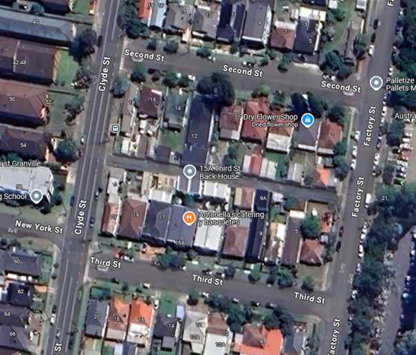
There are existing ‘No Parking’ restrictions in
the laneway. Council has received a request to install additional ‘No
Parking’ signs in the laneway due to parked vehicles obstructing access
to properties along the laneway between Second Street and Third Street.
It is proposed to install additional 'No Parking' signs on
both sides of the laneway to ensure adequate access for residents.
Additionally, 'No Stopping' restrictions are proposed at the intersections to
reinforce statutory ‘No Stopping’ requirements under NSW Road
Rules. These 'No Stopping' signs will be installed at appropriate locations as
shown in the attached drawing.
The proposal was notified to the impacted and adjacent
residents for a period of 14 days from 11 March 2025 to 25 March 2025.
Council received one submission supporting the proposal.
1. Plan –
Laneway Between Second Street and Third Street, Granville – Proposed
‘No Parking’ signs.
2. Submission
DOCUMENTS
ASSOCIATED WITH
REPORT CTC-25-074
Attachment 1
Plan – Laneway Between Second Street and Third
Street, Granville – Proposed ‘No Parking’ signs.
2 April 2025
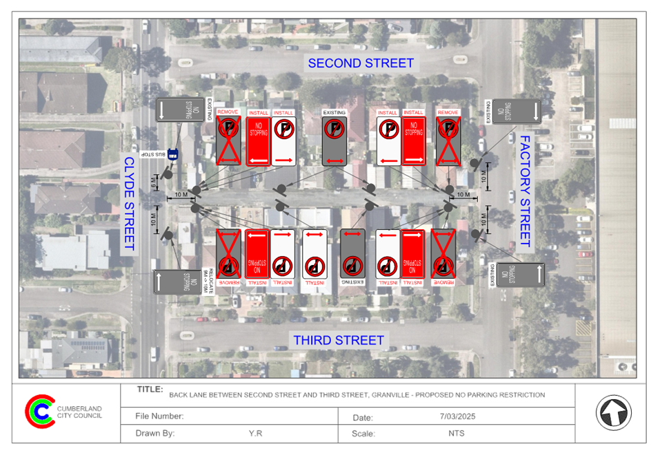
DOCUMENTS
ASSOCIATED WITH
REPORT CTC-25-074
Attachment 2
Submission
2 April 2025
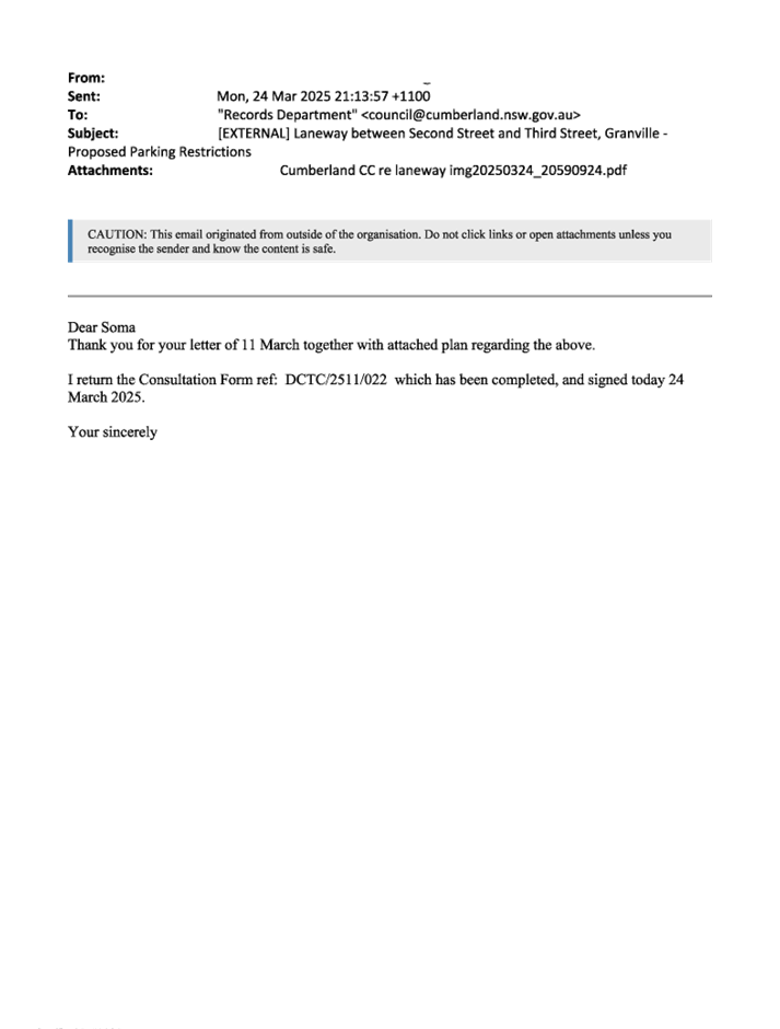
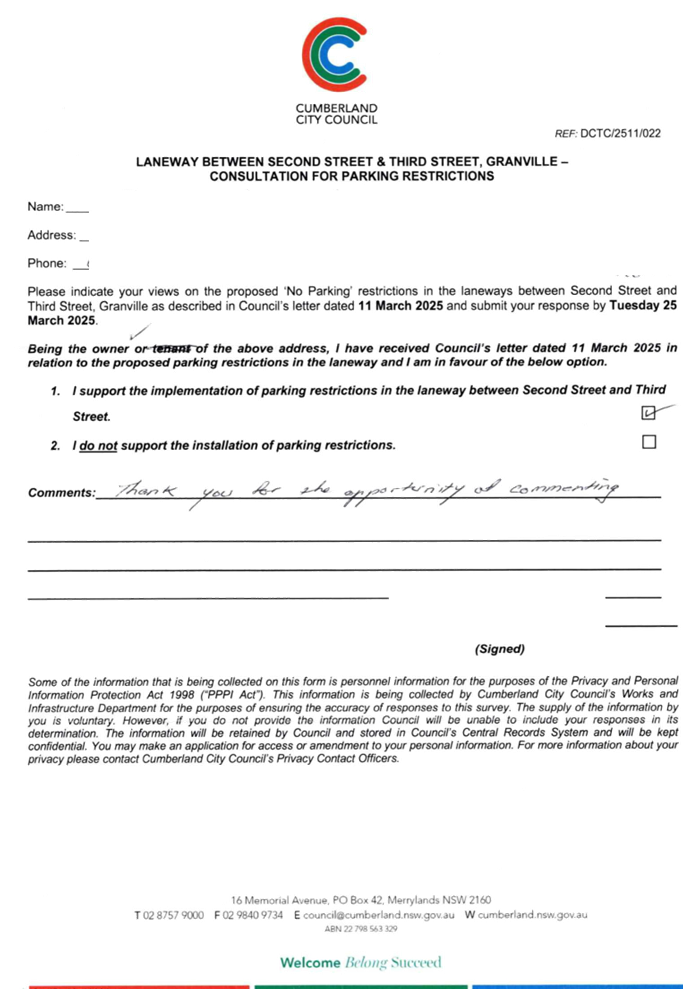
2 April 2025
Item No: CTC-25-075
LANEWAY
BETWEEN THIRD STREET AND FOURTH STREET, GRANVILLE – PROPOSED PARKING
RESTRICTIONS
Directorate: Environment
and Planning
Responsible
Officer: Manager
Engineering and Building
Electorate: Granville
Police Area
Command (PAC): Cumberland
Agenda Part Part
1
Note: Recommended
for Approval under Delegated Authority
Council has received a request
from a resident for the installation of parking restrictions in the laneway
between Third Street and Fourth Street, Granville.
This report outlines the outcome
of the investigation into this matter.
That the Traffic Committee recommends that:
1. The
proposed ‘No Parking’ and ‘No Stopping’ restrictions in
the laneway between Third Street and Fourth Street, Granville in accordance
with the attached plan be approved.
2. The resident
that made the request and affected residents be notified of the outcome.
Third Street is a local road that runs in an east –
west direction with a posted speed limit of 50 km/h. It has a width of
approximately 12.6 m and parking is permitted on both sides of the road.
Fourth Street is a local road that runs in an east –
west direction with a posted speed limit of 50 km/h. It has a width of
approximately 12.2 m and parking is permitted on both sides of the road.
A laneway runs parallel to Third
Street and Fourth Street providing vehicular access to most properties in Third
Street and Fourth Street between Clyde Street and Factory
Street. It has a width of approximately 4.2 m (gutter to
gutter).
. \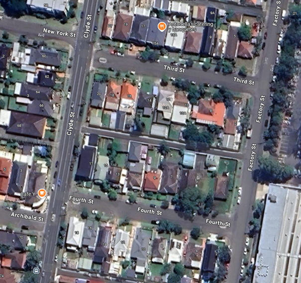
There are existing ‘No Parking’ restrictions in
the laneway. Council has received a request to install additional ‘No
Parking’ signs in the laneway due to parked vehicles obstructing access
to properties along the laneway between Third Street and Fourth Street.
It is proposed to install additional 'No Parking' signs on
both sides of the laneway to ensure adequate access for residents.
Additionally, 'No Stopping' restrictions are proposed at the intersections to
reinforce statutory No Stopping requirements under NSW Road Rules. These 'No
Stopping' signs will be installed at appropriate locations as shown in the
attached drawing.
The proposal was notified to the
impacted and adjacent residents for a period of 14 days from 11 March 2025 to
25 March 2025. No submissions were received.
1. Plan –
Laneway Between Third Street and Fourth Street, Granville – Proposed
‘No Parking’ signs.
DOCUMENTS
ASSOCIATED WITH
REPORT CTC-25-075
Attachment 1
Plan – Laneway Between Third Street and Fourth
Street, Granville – Proposed ‘No Parking’ signs.
2 April 2025
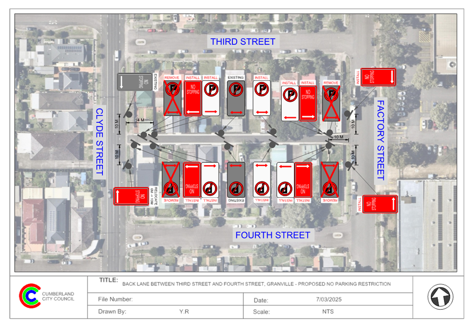
2 April 2025
Item No: CTC-25-076
LANEWAY
BETWEEN FOURTH STREET AND FIFTH STREET, GRANVILLE – PROPOSED PARKING
RESTRICTIONS
Directorate: Environment
and Planning
Responsible
Officer: Manager
Engineering and Building
Electorate: Granville
Police Area
Command (PAC): Cumberland
Agenda Part Part
1
Note: Recommended
for Approval under Delegated Authority
Council has received a request
from a resident for the installation of parking restrictions in the laneway
between Fourth Street and Fifth Street, Granville.
This report outlines the outcome
of the investigation into this matter.
That the Traffic Committee recommends that:
1. The proposed ‘No
Parking’ and ‘No Stopping’ restrictions in the laneway
between Fourth Street and Fifth Street, Granville in accordance with the
attached plan be approved.
2. The resident that made the
request and affected residents be notified of the outcome.
Fourth Street is a local road that runs in an east –
west direction with a posted speed limit of 50 km/h. It has a width of
approximately 12.2 m and parking is permitted on both sides of the road.
Fifth Street is a local road that runs in an east –
west direction with a posted speed limit of 50 km/h. It has a width of
approximately 12.7 m and parking is permitted on both sides of the road.
A laneway runs parallel to Fourth Street and Fifth Street
providing vehicular access to most properties in Fourth Street and Fifth Street
between Clyde Street and Factory Street. It has a width of approximately 4.2 m
(gutter to gutter).
. \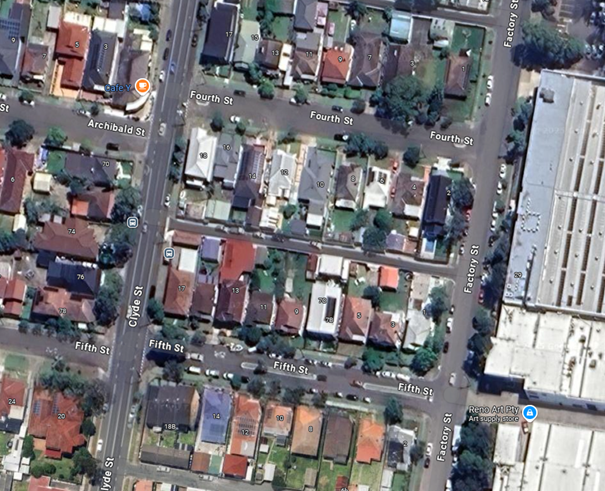
Council has received a request to install parking
restrictions in the laneway due to parked vehicles obstructing access to
properties along the laneway between Fourth Street and Fifth Street.
It is proposed to install 'No Parking' signs on both sides
of the laneway to ensure adequate access for residents. Additionally, 'No
Stopping' restrictions are proposed at the intersections to reinforce statutory
No Stopping requirements under NSW Road Rules. These 'No Stopping' signs will
be installed at appropriate locations as shown in the attached drawing.
The proposal was notified to the
impacted and adjacent residents for a period of 14 days from 11 March 2025 to
25 March 2025.
Council received four submissions,
with one submission in support and three objections, with concerns for the
shortage of on-street parking. However, this proposal aims to provide adequate
access for residents in the back lane, and it is proposed to implement the
parking restrictions as per the attached plan.
1. Plan –
Laneway Between Fourth Street and Fifth Street, Granville – Proposed
‘No Parking’ signs.
2. Submissions
DOCUMENTS
ASSOCIATED WITH
REPORT CTC-25-076
Attachment 1
Plan – Laneway Between Fourth Street and Fifth
Street, Granville – Proposed ‘No Parking’ signs.
2 April 2025
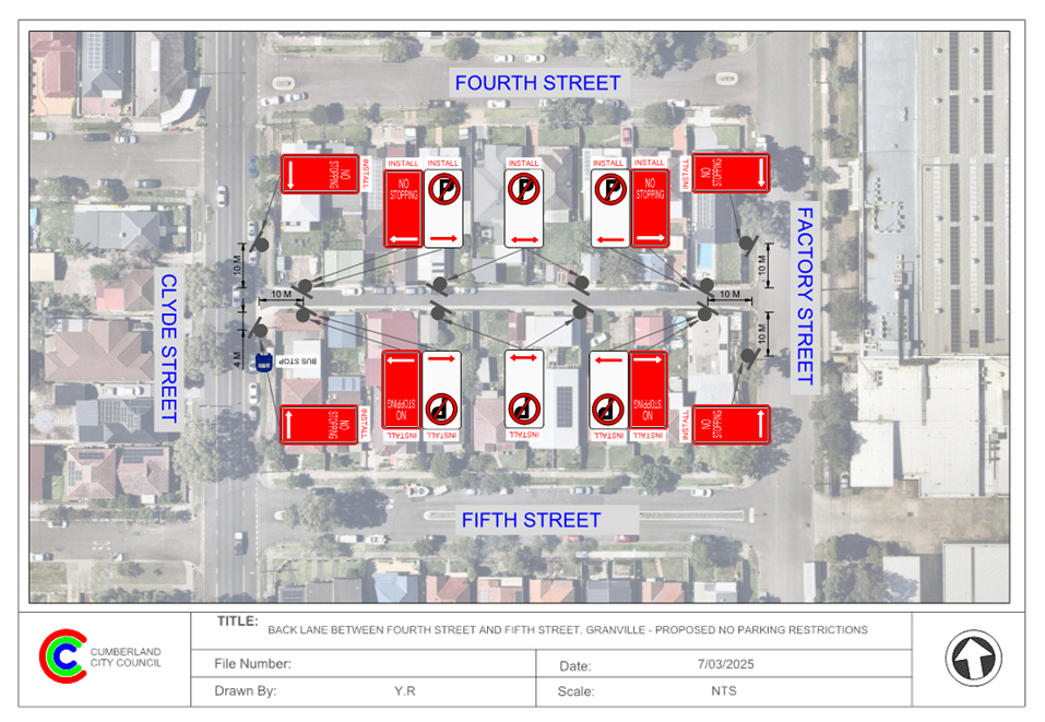
DOCUMENTS
ASSOCIATED WITH
REPORT CTC-25-076
Attachment 2
Submissions
2 April 2025
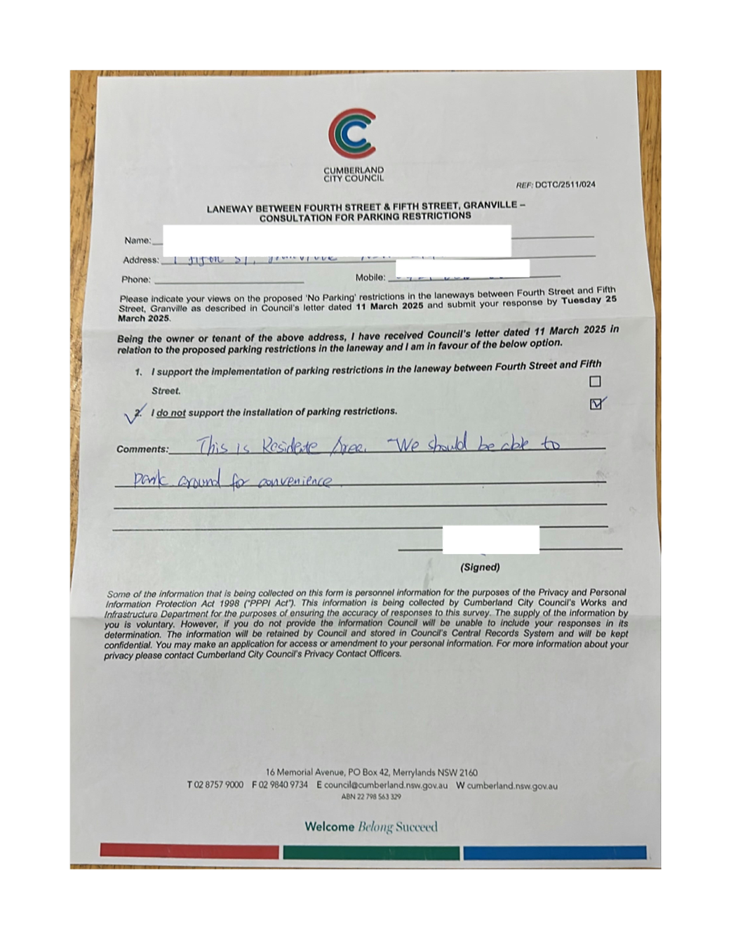
2 April 2025
Item No: CTC-25-077
LANEWAY
BETWEEN WILLIAM STREET AND FIRST STREET, GRANVILLE – PROPOSED PARKING
RESTRICTIONS
Directorate: Environment
and Planning
Responsible
Officer: Manager
Engineering and Building
Electorate: Granville
Police Area
Command (PAC): Cumberland
Agenda Part Part
1
Note: Recommended
for Approval under Delegated Authority
Council has received a request
from a resident for the installation of parking restrictions in the laneway
between William Street and First Street, Granville.
This report outlines the outcome
of the investigation into this matter.
That the Traffic Committee recommends that:
1. The
proposed ‘No Parking’ and ‘No Stopping’ restrictions in
the laneway between William Street and First Street, Granville in accordance
with the attached plan be approved.
2. The
resident that made the request and affected residents be notified of the
outcome.
William Street (between Clyde Street and Factory Street) is
a local road that runs in an east – west direction with a posted speed
limit of 50 km/h. It has a width of approximately 12.5 m and parking is
permitted on both sides of the road.
First Street is a local road that runs in an east –
west direction with a posted speed limit of 50 km/h. It has a width of
approximately 12.4 m and parking is permitted on both sides of the road.
A laneway runs parallel to William Street and First Street
providing vehicular access to most properties in William Street and First
Street between Clyde Street and Factory Street. It has a width of approximately
5.7 m.
. 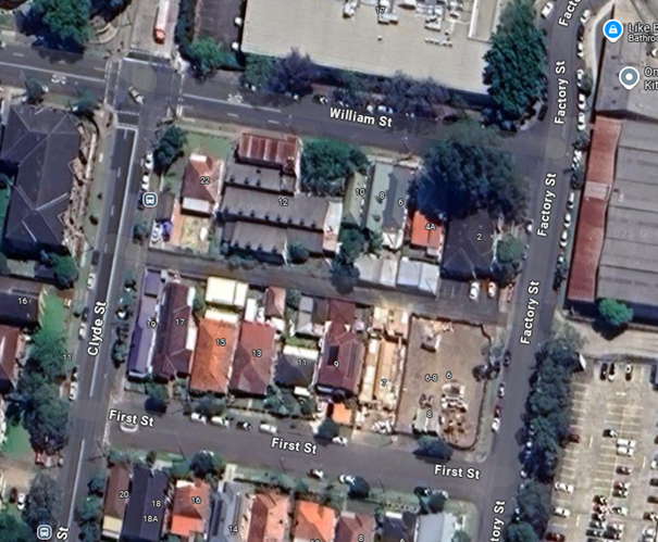
There are existing ‘No Parking’ restrictions in
the laneway. Council has received a request to install additional ‘No
Parking’ signs in the laneway due to parked vehicles obstructing access
to properties along the laneway between William Street and First Street.
It is proposed to install additional 'No Parking' signs on
both sides of the laneway to ensure adequate access for residents.
Additionally, 'No Stopping' restrictions are proposed at the intersections to
reinforce statutory No Stopping requirements under NSW Road Rules. These 'No
Stopping' signs will be installed at appropriate locations as shown in the
attached drawing.
The proposal was notified to the impacted and adjacent
residents for a period of 14 days from 11 March 2025 to 25 March 2025. No
submissions were received.
1. Plan –
Laneway Between William Street and First Street, Granville – Proposed
‘No Parking’ signs.
DOCUMENTS
ASSOCIATED WITH
REPORT CTC-25-077
Attachment 1
Plan – Laneway Between William Street and First
Street, Granville – Proposed ‘No Parking’ signs.
2 April 2025
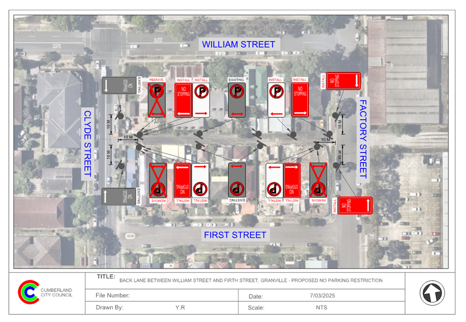
2 April 2025
Item No: CTC-25-078
CLYDE STREET,
GRANVILLE AT SIXTH STREET – PROPOSED ‘NO STOPPING’
RESTRICTIONS
Directorate: Environment
and Planning
Responsible
Officer: Manager
Engineering and Building
Electorate: Granville
Police Area
Command (PAC): Cumberland
Agenda Part Part
1
Note: Recommended
for Approval under Delegated Authority
Council has received a request
from a resident for the installation of ‘No Stopping’ restrictions
on the east side of Clyde Street, Granville between Fifth Street and Sixth Street.
This report outlines the outcome
of the investigation into this matter.
That the Traffic Committee recommends that:
1. The proposed ‘No
Stopping’ restrictions and ‘Bus Zone’ signage on the eastern
side of Clyde Street, Granville between Fifth Street and Sixth Street, and BL2
line marking on Sixth Street, in accordance with the attached plan, be approved
in-principle.
2. Consultation be undertaken with
directly affected residents and a report be provided back to the Traffic
Committee meeting if objections are received.
3. The resident that made the
request and affected residents be notified of the outcome.
Clyde Street is a collector road that runs in a north–
south direction with a posted speed limit of 60 km/h. It has a width of
approximately 12.2 m and parking is permitted on both sides of the road unless
sign posted.
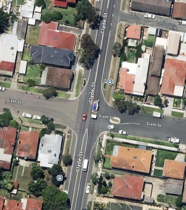
Council has received a concern regarding the eastern side of
Clyde Street, between Sixth Street and the laneway south of Fifth Street due to
parked vehicles obstructing sight distance for motorists.
A review of the existing signage revealed that a bus stop
for Route S2 and school buses is located on the eastern side of Clyde Street,
just north of Sixth Street. However, there is currently no ‘Bus
Zone’ signage at this location, which may lead to unauthorised parking
and hinder bus operations.
To address these issues, it is
proposed to install both ‘No Stopping’ and ‘Bus Zone’
signage on the eastern side of Clyde Street. This will reinforce road rules,
improve sight distance and ensure clear access for buses. It is also proposed
to install ‘BL2’ centre line on Sixth Street.
A plan has been attached showing
the details of the proposal.
Subject to endorsement,
consultation will be undertaken with directly affected residents on the
proposal.
1. Plan –
Clyde Street, Granville – Proposed ‘No Stopping’ Restriction.
DOCUMENTS
ASSOCIATED WITH
REPORT CTC-25-078
Attachment 1
Plan – Clyde Street, Granville – Proposed
‘No Stopping’ Restriction.
2 April 2025
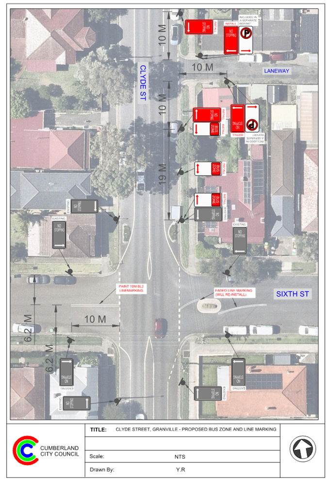
2 April 2025
Item No: CTC-25-079
LANEWAY
BETWEEN FIFTH STREET AND SIXTH STREET, GRANVILLE – PROPOSED PARKING
RESTRICTIONS
Directorate: Environment
and Planning
Responsible
Officer: Manager
Engineering and Building
Electorate: Granville
Police Area
Command (PAC): Cumberland
Agenda Part Part
1
Note: Recommended
for Approval under Delegated Authority
Council has received a request
from a resident for the installation of parking restrictions in the laneway
between Fifth Street and Sixth Street, Granville.
This report outlines the outcome
of the investigation into this matter.
That the Traffic Committee recommends that:
1. The proposed ‘No
Parking’ restrictions in the laneway between Fifth Street and Sixth
Street, Granville in accordance with the attached plan be approved.
2. The resident that made the
request and affected residents be notified of the outcome.
Fifth Street is a local road that runs in an east –
west direction with a posted speed limit of 50 km/h. It has a width of
approximately 12.7 m and parking is permitted on both sides of the road.
Sixth Street is a local road that runs in an east –
west direction with a posted speed limit of 50 km/h. It has a width of
approximately 12.7 m and parking is permitted on both sides of the road in
accordance with the Road Rules.
A laneway runs parallel to Fifth Street and Sixth Street
providing vehicular access to most properties in Fifth Street and Sixth Street
between Clyde Street and Factory Street. It has a width of approximately 6.2 m.
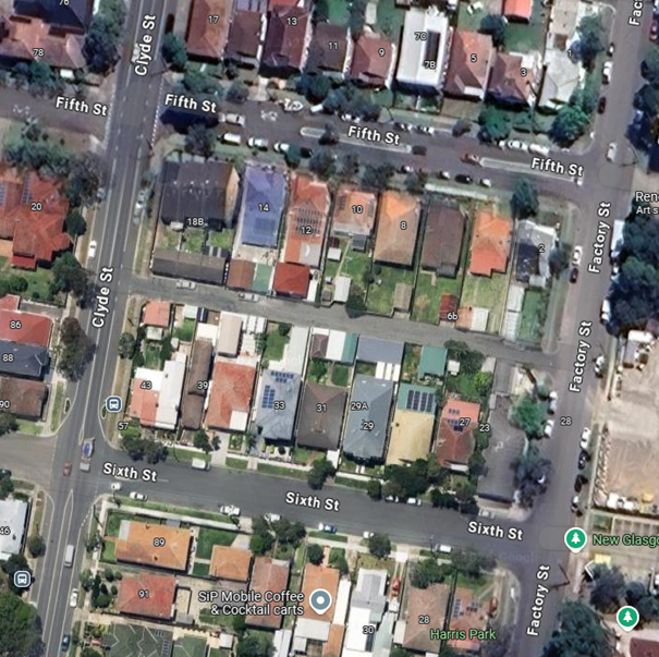
Council has received a request to install parking
restrictions in the laneway due to parked vehicles obstructing access to
properties along the laneway between Fifth Street and Sixth Street. Due to the
narrow laneway width, there will not be sufficient width available in the
laneway for vehicles to drive past when cars are parked on both sides.
It is proposed to install 'No Parking' signs on both sides
of the laneway to ensure adequate access for residents.
The proposal was notified to the impacted and adjacent
residents for a period of 14 days from 17 February 2025 to 4 March 2025.
Council received one submission objecting with concerns for
the shortage of on-street parking after hours. However, this proposal aims to
provide adequate access for residents in the back lane, and it is proposed to
implement the parking restrictions as per the attached plan.
1. Plan –
Laneway Between Fifth Street and Sixth Street, Granville – Proposed
‘No Parking’ signs.
2. Submission
DOCUMENTS
ASSOCIATED WITH
REPORT CTC-25-079
Attachment 1
Plan – Laneway Between Fifth Street and Sixth
Street, Granville – Proposed ‘No Parking’ signs.
2 April 2025
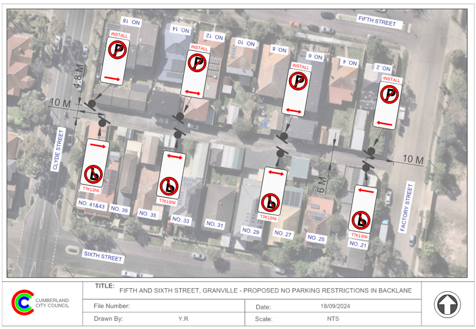
DOCUMENTS
ASSOCIATED WITH
REPORT CTC-25-079
Attachment 2
Submission
2 April 2025
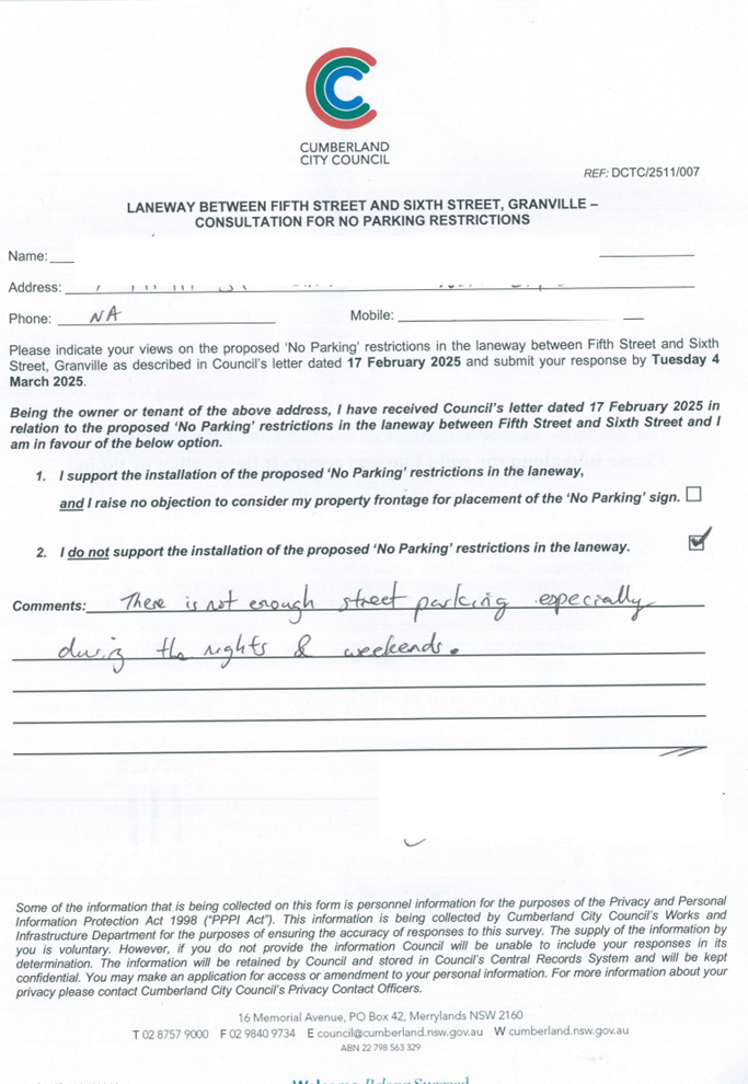
2 April 2025
Item No: CTC-25-080
HAMPSTEAD
ROAD, AUBURN – APPLICATION FOR ‘WORKS ZONE’ SIGNAGE
Directorate: Environment
and Planning
Responsible
Officer: Manager
Engineering and Building
Electorate: Auburn
Police Area
Command (PAC): Auburn
Agenda Part Part
1
Note: Recommended
for Approval under Delegated Authority
Council has received an
application for a ‘Works Zone’ on Hampstead Road, Auburn associated
with the development at 31 Hampstead Road, Auburn.
This report outlines the outcome
of the investigation into this matter.
The Traffic Committee recommends that:
1. The
12m long ‘Works Zone, 7:00am-6:00pm, Monday-Friday, 8:00am-4:00pm,
Saturday’ signs be approved on the frontage of the redevelopment site on
Hampstead Road, Auburn in accordance with the attached plan subject to
Council’s standard conditions for the period of 6 months and subsequent
extension if required.
2. The
applicant be advised to pay the ‘Works Zone’ fees to Council as per
the adopted Fees and Charges.
Council has received an
application for a ‘Works Zone’ on Hampstead Road, Auburn associated
with the development at 31 Hampstead Road, Auburn. The proposed development
involves demolition of existing structures and construction of a single dwelling.
The temporary “Works
Zone” is approximately 6m in length and proposed to commence in April
2025 for 37 weeks. The proposed times are between 7:00am to 6:00pm Monday to
Friday and 8:00am to 4:00pm on Saturdays.
There will be a loss of two (2)
unrestricted parking space on Hampstead Road, Auburn during the operation of
the “Works Zone”.
The proposal is outside the
property being developed and no consultation is considered necessary as the
request was made by the builder.
1. Plan –
Hampstead Road, Auburn – Proposed Temporary ‘Works Zone’
signage.
DOCUMENTS
ASSOCIATED WITH
REPORT CTC-25-080
Attachment 1
Plan – Hampstead Road, Auburn – Proposed
Temporary ‘Works Zone’ signage.
2 April 2025

2 April 2025
Item No: CTC-25-081
WARREN ROAD
AND WOODPARK ROAD, WOODPARK – REQUEST FOR A ROUNDABOUT
Directorate: Environment
and Planning
Responsible
Officer: Manager
Engineering and Building
Electorate: Granville
Police Area
Command (PAC): Cumberland
Agenda Part Part
1
Note: Recommended
for Approval under Delegated Authority
Council
has received a request from a local resident for the construction of a
roundabout at the intersection of Warren Road and Woodpark Road, Woodpark due
to safety concerns.
This report outlines the outcome
of the investigation into this matter.
The Traffic Committee recommended that:
1. The
installation of ‘No stopping’ signs and line marking on the Warren
Road approaches at the intersection with Woodpark Road, Woodpark, in accordance
with the attached plan be approved in-principle.
2. Council
undertake consultation with affected residents and report back to the Traffic
Committee if objections are received.
3. The
resident that made the request and affected residents be advised of the
outcome.
Council has received a request from a local resident for the
construction of a roundabout at the intersection of Warren Road and Woodpark
Road, Woodpark due to safety concerns.
Woodpark Road is a regional road connecting Cumberland
Highway and Great Western Highway via Sherwood Road and Centenary Road. It has
a speed limit of 60 km/hr and trafficable 4-lanes at this intersection.
Warren Road is a local road that is in an north south
direction and has a speed limit of 50 km/hr.
Warren Road and Woodpark Road form an intersection with
priority to Woodpark Road with ‘STOP’ signs on the Warren Road
approaches.
Woodpark Road has lane lines marked leading to its
signalised intersection with Cumberland Highway and peak period ‘No
Stopping signs in mid-block to assist traffic flow.

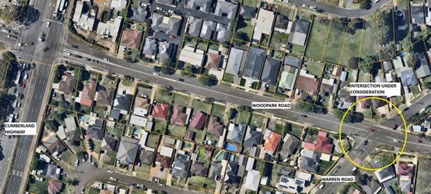
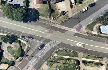
Council has received concerns from a local resident
regarding road safety at the intersection of Warren Road and Woodpark Road.
The latest crash data indicates that there were three
reported crashes at the intersection of Warren Road and Woodpark Road in the
five years ending June 2024. The crash details are listed in the table below.
|
Date
|
Location
|
Description
|
|
12/01/2022
|
Woodpark
Rd & Warren Rd
|
Cross
Traffic
|
|
11/03/2023
|
Woodpark
Rd & Warren Rd
|
Cross
Traffic
|
|
26/03/2023
|
Woodpark
Rd & Warren Rd
|
Cross
Traffic
|
Traffic counts were undertaken in Woodpark Road and Warren
Road, Woodpark in March 2025. The traffic count locations are marked on the map
above.
Traffic Count Data in Woodpark Road and Warren
Road:
|
|
Location
|
Average daily traffic (Veh/day)
|
Average Peak Hour (Veh/hr)
|
85th %tile speed (Km/hr)
|
|
AM
|
PM
|
|
|
Woodpark Road
|
West of Warren Rd
|
15,098
|
1,057
|
1,186
|
64.2
|
|
Warren Road
|
South of Woodpark Rd
|
1,471
|
98
|
116
|
35.6
|
The daily and peak hour traffic volumes in Woodpark Road are
over 10 times greater in comparison to Warren Road. It is also noted that the
traffic volumes show the importance of Woodpark Road being a regional road in
the hierarchy of the network.
Considering the uneven traffic flow from the two streets, it
indicates that there may be undue delays at the intersection especially for
Woodpark Road traffic if a roundabout is implemented.
According to Austroads Guide to Traffic Management Part 6
– Intersections, Interchanges and Crossings, Table 2.10: Key
traffic management considerations in the selection of roundabouts.
“Dominant flows on one
approach may lead to excessive delay on the subsequent approach…”
In addition, Council has also checked the geometry of a
roundabout if provided at this location. The roundabout is required to be
allowing for two lanes in each direction on Woodpark Road to facilitate smooth
and efficient operation of the regional road approach to the traffic signals at
Cumberland Highway. The roundabout design has to allow for large trucks and
buses travelling in Woodpark Road at a reasonable speed and is likely to
require large land acquisition of the corner properties.
Based on the above considerations, a roundabout at the
intersection of Woodpark Road and Warren Road is not proposed at this time.
However, in response to the issue provided, it is proposed to install ‘No
Stopping’ signs and line marking at the intersection to enhance safety at
this location, as outlined in the attached plan.
Subject to endorsement,
consultation will be undertaken on the signage and line marking proposal.
1. Plan –
Warren Road & Woodpark Road, Woodpark – Proposed ‘No
Stopping’ signs and line marking
DOCUMENTS
ASSOCIATED WITH
REPORT CTC-25-081
Attachment 1
Plan – Warren Road & Woodpark Road, Woodpark
– Proposed ‘No Stopping’ signs and line marking
2 April 2025
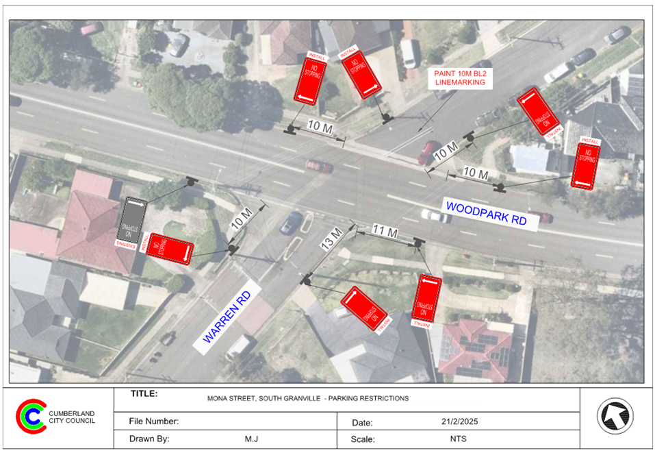
2 April 2025
Item No: CTC-25-082
MARTIN STREET,
LIDCOMBE – APPLICATION FOR ‘WORKS ZONE’ SIGNAGE
Directorate: Environment
and Planning
Responsible
Officer: Manager
Engineering and Building
Electorate: Auburn
Police Area
Command (PAC): Auburn
Agenda Part Part
1
Note: Recommended
for Approval under Delegated Authority
Council has received an
application for a ‘Works Zone’ on Martin Street, Lidcombe
associated with the development at 34 Martin Street, Lidcombe.
This report outlines the outcome
of the investigation into this matter.
The Traffic Committee recommends that:
1. The
12m long ‘Works Zone, 7:00am-6:00pm, Monday-Friday, 8:00am-4:00pm,
Saturday’ signs be approved in principle on the frontage of the
redevelopment site on Martin Street, Lidcombe in accordance with the attached
plan subject to Council’s standard conditions for a period of 6 months
and subsequent extension if required.
2. Council
provide ‘No Parking’ signs on the western side of Martin Street and
undertake consultation with directly affected residents.
3. The
applicant be advised to pay the ‘Works Zone’ fees to Council as per
the adopted Fees and Charges once the consultation is completed.
Council has received an
application for a ‘Works Zone’ on Martin Street, Lidcombe
associated with the development at 34 Martin Street, Lidcombe. The proposed
development involves demolition of existing structures and construction of a
single dwelling.
Martin Street is a local road that
runs in a north south direction and approximately 6.5m wide. There are
‘No Parking’ restrictions on the eastern side of the street and
parking is allowed on the western side.
The temporary ‘Works
Zone’ is approximately 12m in length and proposed to commence in April
2025 for 12 months. The proposed times are between 7:00am to 6:00pm Monday to
Friday and 8:00am to 4:00pm on Saturdays. The temporary ‘Works Zone’
will be in the existing “No Parking” signposted side of the street.
It is proposed to provide a
‘No Parking’ zone on the western side of Martin Street to allow for
vehicles to travel along the street during the operation of the ‘Works
Zone’.
There will be a loss of two (2)
unrestricted parking spaces on the western side of Martin Street, Lidcombe
during the operation of the ‘Works Zone’.
The ‘Works Zone’ is
outside the property being developed and no consultation is considered
necessary as the request was made by the builder.
Subject to endorsement,
consultation will be undertaken with directly affected residents on the
temporary ‘No Parking’ signage at this location.
1. Plan –
Martin Street, Lidcombe – Proposed Temporary 'Works Zone" and
"No Parking" signage
DOCUMENTS
ASSOCIATED WITH
REPORT CTC-25-082
Attachment 1
Plan – Martin Street, Lidcombe – Proposed
Temporary 'Works Zone" and "No Parking" signage
2 April 2025
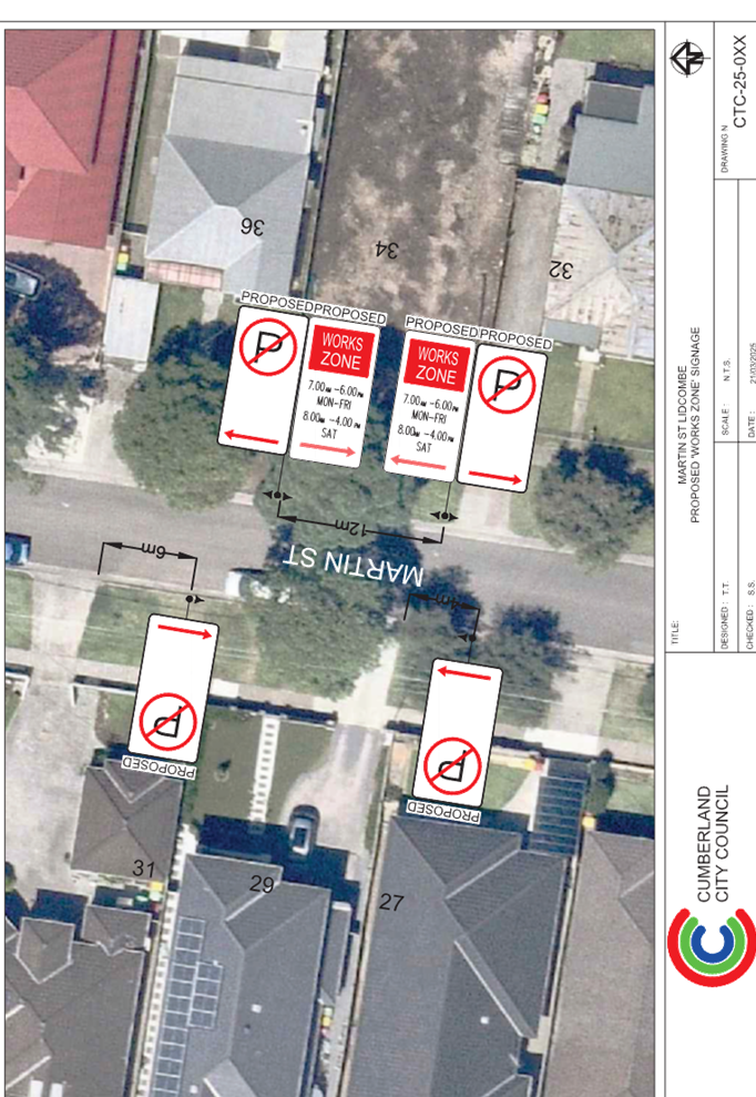
2 April 2025
Item No: CTC-25-083
GIBBONS ST,
AUBURN – APPLICATION FOR ‘WORKS ZONE’ SIGNAGE
Directorate: Environment
and Planning
Responsible
Officer: Manager
Engineering and Building
Electorate: Auburn
Police Area
Command (PAC): Auburn
Agenda Part Part
1
Note: Recommended
for Approval under Delegated Authority
Council has received an
application for a ‘Works Zone’ on Gibbons Street, Auburn associated
with the development at 155-157 Rawson Street, Auburn.
This report outlines the outcome
of the investigation into this matter.
The Traffic Committee recommends that:
1. The
18m long ‘Works Zone, 7:00am-6:00pm, Monday-Friday, 8:00am-4:00pm,
Saturday’ signs be approved in principle on the frontage of the
redevelopment site on Gibbons Street, Auburn in accordance with the attached
plan subject to Council’s standard conditions for the period of 6 months
and subsequent extension if required.
2. The
applicant be advised to pay the ‘Works Zone’ fees to Council as per
the adopted Fees and Charges.
Council has received an
application for a ‘Works Zone’ on Gibbons Street, Auburn associated
with the development at 155-157 Rawson Street, Auburn. The proposed development
involves demolition of existing structures and construction of 2 single
dwellings.
The temporary ‘Works
Zone’ is approximately 18m in length and proposed to commence in April
2025 for 6 months. The proposed times are between 7:00am to 6:00pm Monday to
Friday and 8:00am to 4:00pm on Saturdays.
There will be a loss of three (3)
unrestricted parking spaces on the northern side of Gibbons Street, Auburn
during the operation of the ‘Works Zone’.
The proposal is outside the
property being developed and no consultation is considered necessary as the
request was made by the builder.
1. Plan –
Gibbons Street, Lidcombe – Proposed Temporary ‘Works Zone’
signage.
DOCUMENTS
ASSOCIATED WITH
REPORT CTC-25-083
Attachment 1
Plan – Gibbons Street, Lidcombe – Proposed
Temporary ‘Works Zone’ signage.
2 April 2025
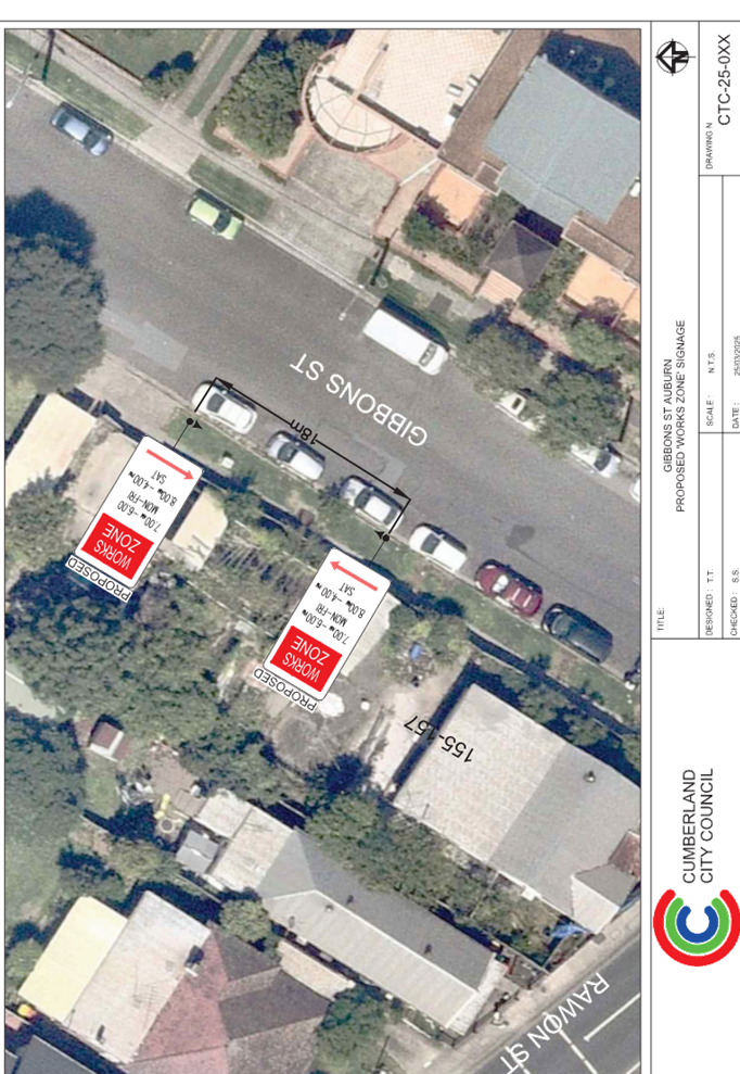
2 April 2025
Item No: CTC-25-084
PEGLER AVENUE,
SOUTH GRANVILLE – APPLICATION FOR ‘WORKS ZONE’ SIGNAGE
Directorate: Environment
and Planning
Responsible
Officer: Manager
Engineering and Building
Electorate: Granville
Police Area
Command (PAC): Cumberland
Agenda Part Part
1
Note: Recommended
for Approval under Delegated Authority
Council has received an
application for a ‘Works Zone’ on Pegler Avenue, South Granville
associated with the development at 67 Pegler Avenue, South Granville.
This report outlines the outcome
of the investigation into this matter.
The Traffic Committee recommends that:
1. The
12m long ‘Works Zone, 7:00am-6:00pm, Monday-Friday, 8:00am-4:00pm,
Saturday’ signs be approved in principle on the frontage of the
redevelopment site on Pegler Avenue, South Granville in accordance with the
attached plan subject to Council’s standard conditions for the period of
3 months and subsequent extension if required.
2. The
applicant be advised to pay the ‘Works Zone’ fees to Council as per
the adopted Fees and Charges.
Council has received an
application for a ‘Works Zone’ on 67 Pegler Avenue, South Granville
associated with the development at 67 Pegler Avenue, South Granville. The
proposed development involves demolition of existing structures and construction
of a three-storey boarding house comprising 24 boarding rooms and a manager's
room over basement car parking.
The temporary ‘Works
Zone’ is approximately 12m in length and proposed to commence in April
2025 for 3 months. The proposed times are between 7:00am to 6:00pm Monday to
Friday and 8:00am to 4:00pm on Saturdays.
There will be a loss of two (2)
unrestricted parking spaces on the eastern side of Pegler Avenue, South
Granville during the operation of the ‘Works Zone’.
The proposal is outside the
property being developed and no consultation is considered necessary as the
request was made by the builder.
1. Plan –
Pegler Avenue, South Granville – Proposed Temporary ‘Works
Zone’ signage.
DOCUMENTS
ASSOCIATED WITH
REPORT CTC-25-084
Attachment 1
Plan – Pegler Avenue, South Granville –
Proposed Temporary ‘Works Zone’ signage.
2 April 2025

2 April 2025
Part 2
Recommendation to Council
2 April 2025
Item No: CTC-25-085
DAMIEN AVENUE,
GREYSTANES - ROAD SAFETY CONCERNS
Directorate: Environment
and Planning
Responsible
Officer: Manager
Engineering and Building
Electorate: Prospect
Police Area
Command (PAC): Cumberland
Agenda Part Part
2
Note: Recommendation
to Council
Council has undertaken consultation with resident for the
proposed speed humps in Damien Avenue, Greystanes.
This report outlines the outcome of the review.
The Traffic Committee recommends that Council investigate
alternate measures for speed calming including a combination of speed humps and
local traffic management devices and undertake further consultation with the
affected residents.
Cumberland Traffic Committee
(CTC) at its meeting in June 2024 considered a report (CTC-24-135) regarding
road safety concerns on Damien Avenue, Greystanes. Council resolved to
undertake designs on the location of speed humps, consult with affected and
adjacent residents on the proposed design and report back to the Traffic
Committee.
Following the resolution, a
design was prepared as attached to this report and consultation was carried out
with the residents of Damien Avenue accordingly in October 2024. Council
received 15 responses (29% of the total letters sent) by the closing date, 6
responses (40%) were in support and 9 responses (60%) opposed to the proposal. Based
on the results, the majority of residents opposed the installation of the
proposed speed humps.
As an alternative, consideration
was given to the implementation of BL2 line marking as a road safety response;
however, Damien Avenue is approximately 7 metres wide and the implementation of
these line markings would reduce the availability of on-street parking at this
location.
Given the consultation results
and the ongoing community interest in the matter, it is recommended that
Council officers explore alternate measures for traffic calming, such as
alternate speed hump locations, vehicle activated signs and other potential
traffic management devices, and for further consultation to be undertaken with
directly affected residents.
The proposal was notified to the
impacted resident for a period of 14 days from 23 October 2024 to 6 November
2024.
A total of 51 letters were
distributed with an attached survey form to the residents / owners. There were
15 responses (29% of the total letters sent) received by the closing date, 6
responses (40%) were in support and 9 responses (60%) opposed to the proposal.
1. Plan -
Damien Avenue, Greystanes - Proposed speed hump locations considered during
consultation (1 of 2)
2. Plan
- Damien Avenue, Greystanes - Proposed speed hump locations considered during
consultation (2 of 2)
3. Submissions
DOCUMENTS
ASSOCIATED WITH
REPORT CTC-25-085
Attachment 1
Plan - Damien Avenue, Greystanes - Proposed speed hump
locations considered during consultation (1 of 2)
2 April 2025
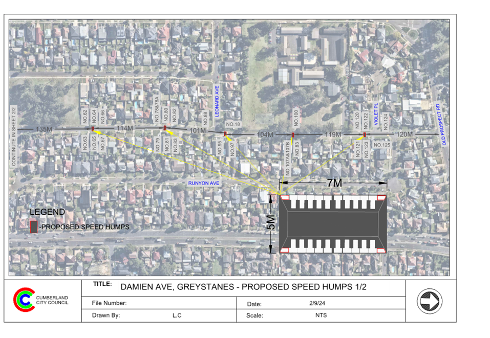
DOCUMENTS
ASSOCIATED WITH
REPORT CTC-25-085
Attachment 2
Plan - Damien Avenue, Greystanes - Proposed speed hump
locations considered during consultation (2 of 2)
2 April 2025
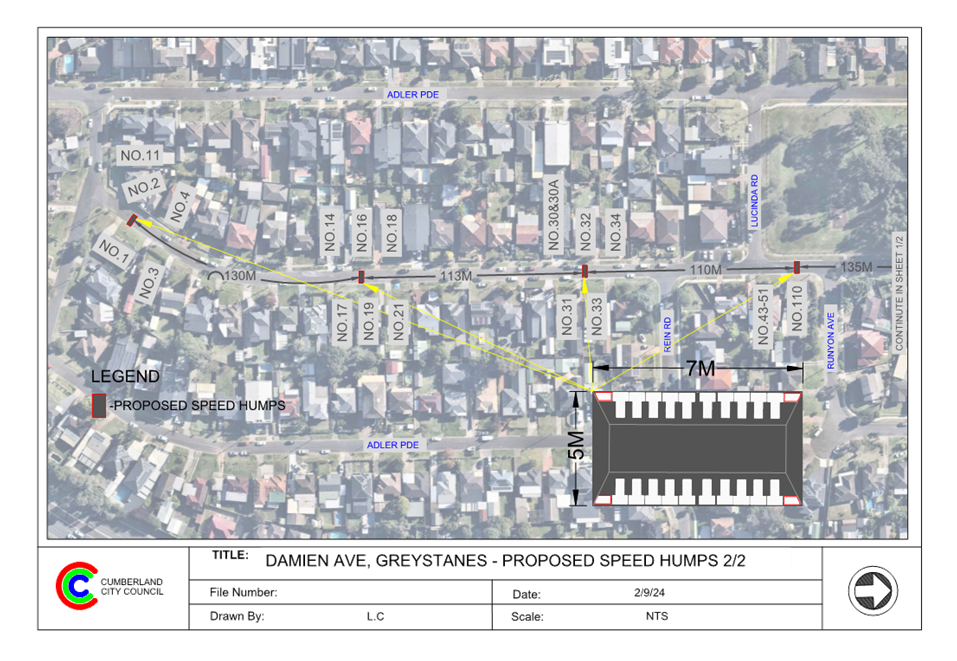
DOCUMENTS
ASSOCIATED WITH
REPORT CTC-25-085
Attachment 3
Submissions

2 April 2025
Item No: CTC-25-086
GORDON AVENUE,
SOUTH GRANVILLE – ROAD SAFETY CONCERNS
Directorate: Environment
and Planning
Responsible
Officer: Manager
Engineering and Building
Electorate: Granville
Police Area
Command (PAC): Cumberland
Agenda Part Part
2
Note: Recommendation
to Council
Council has received a request
from a local resident for the installation of traffic calming devices on Gordon
Avenue, South Granville due to speeding concerns.
This report outlines the outcome
of the investigation into this matter.
The Traffic Committee recommends that:
1. Council
consults with the resident of Gordon Avenue, South Granville to assess support
for the installation of speed humps, and report back to the Traffic Committee.
2. Council
request Cumberland Police Area Command to undertake speed surveillance in
Gordon Avenue, South Granville.
3. The resident with the request and
affected residents be advised on the outcome.
Council has received a request
from a local resident for the installation of traffic calming devices on Gordon
Avenue, South Granville due to speeding concerns.
Gordon Avenue is a local road runs
in a north – south direction from Aubrey Street to Oakleigh Avenue. The
road is approximately 680m long, it intersects with Dellwood Street at its
midway. The speed limit is 50km/h and parking is permitted on both sides of the
road in accordance with the Road Rules unless otherwise signposted.
Council officers have investigated
the request for the installation of traffic calming devices on Gordon Avenue in
accordance with Council’s Local Area Traffic Management (LATM) Policy.
The latest Centre for Road Safety
accident data indicated that there were no reported accidents in Gordon Avenue
in the previous 5 years ending June 2024.
The map below shows the location
of Gordon Avenue:
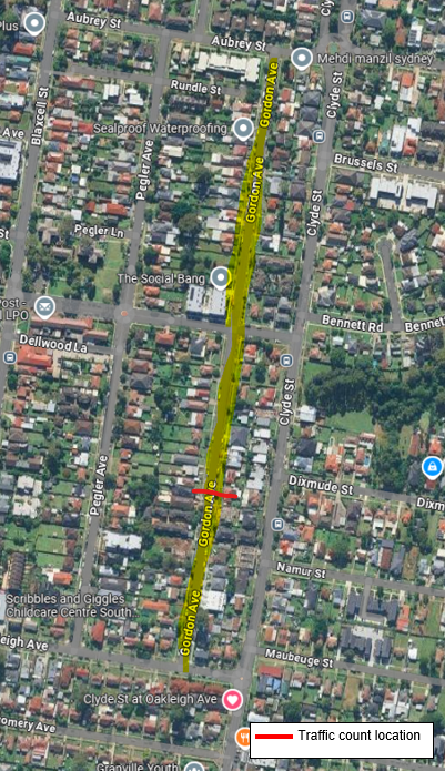
A traffic count was undertaken on Gordon Avenue in February
2025. The traffic count location is shown in red on the map above. The results
of the traffic count indicated the following:
· Average Daily
Traffic (ADT) = 639 veh/day,
· 85th
percentile speed recorded = 55.4 km/h
· Mean Speed =
43.9km/h
Council officers have investigated the request for the
installation of traffic calming devices on Gordon Avenue in accordance with
Council’s Local Traffic and Transport Policy and Guideline.
The results of the traffic count and recorded crashes were
used in the Local Area Traffic Management (LATM) assessment to determine the
need for the installation of traffic calming devices on Gordon Avenue in
accordance with the criteria set out in Council’s Local Traffic and
Transport Policy and Guideline.
The LATM assessments are summarised in the tables below:
Table 1 – Gordon Avenue - LATM Assessment Points
|
Criteria
|
Maximum Score
|
Scores Achieved
|
|
Traffic Study Data
|
60
|
23
|
|
Local Characteristics
|
40
|
5
|
|
Total
|
100
|
28
|
Table 2 – Gordon Avenue – Action
|
Points (out of 100)
|
Recommended Action(s)
|
|
61-100
|
• Report to Cumberland Traffic
Committee with a recommendation of providing traffic calming
• Report to Cumberland Traffic
Committee on line marking and associated improvements to
support traffic calming and road safety as an initial response, subject to
technical guidelines
• Consider community and
stakeholder consultation on potential improvements
|
|
41-60
|
• Monitor and review traffic data
after 6 months
• Report to Cumberland Traffic
Committee on line marking and associated improvements to support traffic
calming and road safety as an initial response, subject to technical
guidelines
• Consider community and
stakeholder consultation on potential improvements
|
|
25-40
|
• Monitor and review traffic data
after 12 months
• Report to Cumberland Traffic
Committee online marking and associated improvements to support traffic
calming and road safety as an initial response, subject to technical
guidelines
• Consider community and
stakeholder consultation on potential improvements
|
|
<25
|
• Do nothing
|
|
Speed
|
• Regardless of the total points
scored, should the 85th percentile speed exceeds the posted
speed limit by 5km/h, the street is to be referred to the Local Area Command
of the NSW Police for monitoring and/or enforcement
• Opportunities for line marking
and associated improvements to support traffic calming and road safety to be
considered, subject to technical guidelines.
|
Based on the above, Council will
consult with the residents of Gordon Avenue, South Granville to assess support
for the installation of the traffic calming devices and report back to the
Traffic Committee.
Subject to endorsement, consultation will be undertaken on
the proposal.
Nil
2 April 2025
Item No: CTC-25-087
KENYONS ROAD,
MERRYLANDS WEST – ROAD SAFETY CONCERNS
Directorate: Environment
and Planning
Responsible
Officer: Manager
Engineering and Building
Electorate: Granville
Police Area
Command (PAC): Cumberland
Agenda Part Part
2
Note: Recommendation
to Council
Council has received a request
from a local resident for the installation of traffic calming devices on
Kenyons Road, Merrylands West due to speeding concerns.
This report outlines the outcome
of the investigation into this matter.
The Traffic Committee recommends that Council consults
with the resident of Kenyons Street, Merrylands West to assess support or
otherwise for the installation of traffic calming devices, and provide a
further report to the Traffic Committee.
Council has received a request
from a local resident for the installation of traffic calming devices on
Kenyons Road, Merrylands West due to speeding concerns.
Kenyons Road is a local road runs
in an east-west direction from Fowler Road to Sherwood Road. The road is
approximately 800m long with an existing roundabout at the intersection of
Arcadia Street. The speed limit is 50km/h and parking is permitted on both sides
of the road in accordance with the Road Rules unless otherwise signposted.
The map below shows the location of Kenyons Road:


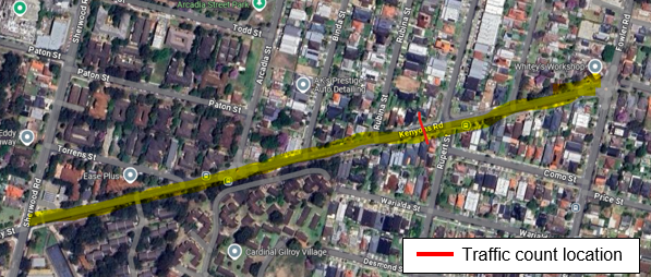
Council officers have investigated
the request for the installation of traffic calming devices on Kenyons Road in
accordance with Council’s Local Traffic and Transport Policy and
Guideline.
The latest Centre for Road Safety
accident data indicated that there were no reported accidents in Kenyons Road
in the last 5 years ending June 2024.
A traffic count was undertaken on Kenyons Road in December
2024. The traffic count location is shown in red on the map above. The results
of the traffic count indicated the following:
· Average Daily
Traffic (ADT) = 9,026 veh/day
· 85th percentile
speed = 54.4 km/h
· Mean (average)
vehicle speed = 47.1 km/h
The results of the traffic count and recorded crashes were
used in the assessment to determine the need for the installation of traffic
calming devices on Kenyons Road in accordance with the Local Area Traffic
Management (LATM) criteria set out in Council’s Local Traffic and
Transport Policy and Guideline.
The LATM assessment is summarised in the tables below:
Table 1 – Kenyons Road - LATM Assessment Points
|
Criteria
|
Maximum Score
|
Score Achieved
|
|
Traffic Study Data
|
60
|
15
|
|
Local Characteristics
|
35
|
20
|
|
Total
|
100
|
35
|
Table 2 – Kenyons Road – Action
|
Points (out of 100)
|
Recommended Action(s)
|
|
61-100
|
• Report to Cumberland Traffic Committee with a
recommendation of providing traffic calming
• Report to Cumberland Traffic Committee on line
marking and associated improvements to support traffic
calming and road safety as an initial response, subject to technical
guidelines
• Consider community and stakeholder consultation
on potential improvements
|
|
41-60
|
• Monitor and review traffic data after 6 months
• Report to Cumberland Traffic Committee on line
marking and associated improvements to support traffic calming and road
safety as an initial response, subject to technical guidelines
• Consider community and stakeholder consultation
on potential improvements
|
|
25-40
|
• Monitor and review traffic data after 12 months
• Report to Cumberland Traffic Committee on line
marking and associated improvements to support traffic calming and road
safety as an initial response, subject to technical guidelines
• Consider community and stakeholder consultation
on potential improvements
|
|
<25
|
• Do nothing
|
|
Speed
|
• Regardless of the total points scored, should the
85th percentile speed exceeds the posted speed limit by 5km/h, the street is
to be referred to the Local Area Command of the NSW Police for monitoring
and/or enforcement
• Opportunities for line marking and associated
improvements to support traffic calming and road safety to be considered,
subject to technical guidelines.
|
The traffic count indicated that the recorded 85th
percentile speed was 54.4 km/h which is above the speed limit of the street.
Based on the above assessment,
Council will consult with the residents of Kenyons Road, Merrylands West to
assess support for the installation of the traffic calming devices.
Subject to endorsement, consultation on the proposal will be
undertaken.
Nil
2 April 2025
Item No: CTC-25-088
DRIFTWAY
DRIVE, PEMULWUY - REQUEST FOR PEDESTRIAN CROSSING
Directorate: Environment
and Planning
Responsible
Officer: Manager
Engineering and Building
Electorate: Prospect
Police Area
Command (PAC): Cumberland
Agenda Part Part
2
Note: Recommendation
to Council
Council has received a request from a resident for a
pedestrian crossing on Driftway Drive, Pemulwuy south of Butu Wargun Drive due
to safety concerns.
This report outlines the outcome of the investigation into
this matter.
The Traffic Committee recommends that:
1. The
proposed marked pedestrian crossing on Driftway Drive, Pemulwuy be approved in
principle.
2. Council
forward final design plans to Transport for NSW for concurrence.
3. Council
undertake consultation with directly impacted residents regarding the proposed
marked pedestrian crossing in Driftway Drive, Pemulwuy, and report back to the
Traffic Committee if objections are received.
Council has received a request
from residents for the provision of a pedestrian crossing on Driftway Drive,
Pemulwuy south of Butu Wargun Drive.
Driftway Drive is a local road
that runs in a north-south direction. The section of interest is between Butu
Wargun Drive and Newport Street. This section of Driftway Drive is
approximately 160m long and 6.5m wide while indented parking is provided on both
sides of the street. The street has a default speed limit of 50 km/h.
A speed cushion is located on
Driftway Drive between Butu Wargun Drive and Newport Street, with bus stops on
both sides of the street nearby.
The map below shows the location
of Driftway Drive, Pemulwuy and the school.
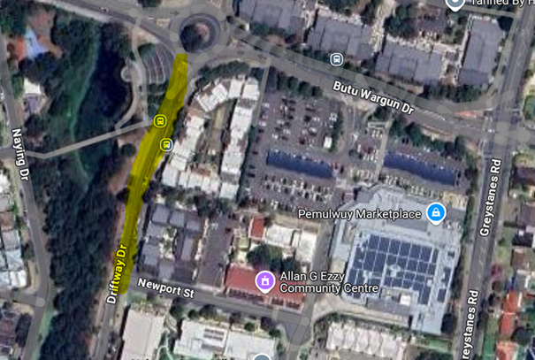
The latest Centre for Road Safety accident data indicated
that there were no reported accidents at this section of Driftway Drive in the
last 5 years that involves pedestrians.
Council officers have investigated the request for a
pedestrian crossing at this section of Driftway Drive, Pemulwuy.
Pedestrian Crossing Warrants
Council has developed its own guidelines for the provision
of pedestrian crossings on local roads especially at high demand locations
including schools, community facilities, parks, hospitals, medical facilities,
town centres, neighbourhood shops and public transport facilities.
A pedestrian (zebra) crossing is deemed to meet the
numerical warrant for a pedestrian (zebra) crossing if the crossing point meets
the following criteria:
· In each of two
separate one-hour periods in a typical day, the pedestrian flow per hour
crossing the road is or is expected to be equal to or greater than 20, and
vehicle volumes be equal to or greater than 200. Where each unaccompanied
child, elderly person or mobility impaired pedestrian is counted as two
pedestrians.
In addition to the above, all requirements set down in
Australian Standards are to be met.
Council undertook pedestrian and vehicle counts at this
section of Driftway Drive in June 2024. The hourly count data is given below:
|
Time Period
|
Vehicle Numbers
per hour
|
Pedestrian
Numbers per hour
|
|
6:00-7:00
|
122
|
0
|
|
7:00-8:00
|
270
|
9
|
|
8:00-9:00
|
405
|
39
|
|
9:00-10:00
|
222
|
29
|
|
15:00-16:00
|
324
|
78
|
|
16:00-17:00
|
387
|
26
|
|
17:00-18:00
|
380
|
25
|
The vehicle and pedestrian counts undertaken in Driftway
Drive satisfies the requirements for a marked pedestrian crossing. It is
proposed to remove the existing speed cushion and provide a raised marked
pedestrian crossing to enhance safety for pedestrians crossing Driftway Drive.
Subject to endorsement, Council
officers will carry out consultation with surrounding residents on the
proposal.
Nil
2 April 2025
Item No: CTC-25-089
BRIGHTON
STREET, GREYSTANES – ROAD SAFETY CONCERNS - CONSULTATION
Directorate: Environment
and Planning
Responsible
Officer: Manager
Engineering and Building
Electorate: Prospect
Police Area
Command (PAC): Cumberland
Agenda Part Part
2
Note: Recommendation
to Council
Council has received a request
from a local resident for the installation of traffic calming devices on
Brighton Street, Greystanes due to speeding concerns.
This report outlines the outcome
of the investigation into this matter.
The Traffic Committee recommends that:
1. The
installation of speed humps near No.29 in Brighton Street and kerb blister
island near No.17 be supported.
2. Concerned
and affected residents are notified of the outcome.
Cumberland Traffic Committee
(CTC) at its meeting in June 2024 considered a report (CTC-24-133) regarding
road safety concerns on Brighton Street, Greystanes. Council resolved to
support the location of two speed humps on the street, and to consider an alternate
speed hump and traffic calming measures at some locations.
In accordance with the recommendation, a consultation
regarding the relocation of one speed hump and the addition of two proposed new
kerb blister islands was conducted with the residents of Brighton Street in
October 2024.
Council received 4 responses (44.4% of the total letters
sent) by the closing date. 1 response (25%) supported the proposed speed hump
relocation, and 3 responses (75%) objected to the proposed kerb blister islands
at one of the locations.
Based on the results, three objections were received from
directly affected residents at one of the locations. Considering the proposed
blister island in front of No. 69 is near a crest, which may impact safety and
visibility, it is recommended that this blister island not be installed and
that traffic conditions are monitored following the installation of the blister
islands and speed humps and report back to the Traffic Committee if necessary.
It is also recommended that the installation of speed humps
near No.29 in Brighton Street and kerb blister island near No.17 be
supported.
The proposal was notified to the
residents in Brighton Street for a period of 14 days from 22 October 2024 to 5
November 2024.
A total of 9 letters were
distributed with an attached survey from and a plan to the residents/ owners.
Council received 4 responses (44.4% of the total letters sent) by the closing
date. 1 response (25%) supported the proposed speed hump relocation, and 3
responses (75%) opposed the proposed kerb blister islands.
1. Plan -
Brighton Street, Greystanes - Approved and proposed traffic calming devices
2. Submissions
3. Previous
Report - CTC-24-133
4. Previous
Minutes - CTC-24-133
DOCUMENTS
ASSOCIATED WITH
REPORT CTC-25-089
Attachment 1
Plan - Brighton Street, Greystanes - Approved and
proposed traffic calming devices
2 April 2025
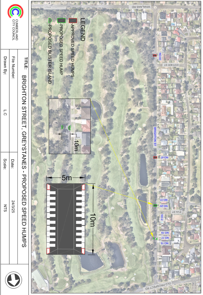
DOCUMENTS
ASSOCIATED WITH
REPORT CTC-25-089
Attachment 2
Submissions
DOCUMENTS
ASSOCIATED WITH
REPORT CTC-25-089
Attachment 3
Previous Report - CTC-24-133
DOCUMENTS
ASSOCIATED WITH
REPORT CTC-25-089
Attachment 4
Previous Minutes - CTC-24-133
2 April 2025
Item No: CTC-25-090
TOONGABBIE
ROAD, TOONGABBIE –SAFETY CONCERNS AT THE BEND
Directorate: Environment
and Planning
Responsible
Officer: Manager
Engineering and Building
Electorate: Prospect
Police Area
Command (PAC): Cumberland
Agenda Part Part
2
Note: Recommendation
to Council
Council has received safety
concerns from a local resident at the bend in Toongabbie Road, Toongabbie.
This report outlines the outcome
of the investigation into this matter.
The Traffic Committee recommends that the proposed
installation of advisory bend ahead warning signs in Toongabbie Road on the
approaches to the bend in accordance with the attached plan be approved.
Council has received safety
concerns from a local resident regarding the bend in Toongabbie Road,
Toongabbie. The bend is located approximately 150m east of the intersection of
Toongabbie Road and Portia Road.
Toongabbie Road is a local road
that runs in a north-south and east-west directions between Great western
Highway and Portico Parade. It is a regional road from Great Western Highway to
Portia Road. It is approximately 12.5m wide. It has a speed limit of 60km/hr
between Great Western Highway and Portia Road and 50km/hr beyond Portia Road.
It is on a B-Double approved route between Great Western Highway and Portia
Road.
Council has received safety
concerns regarding vehicles losing control while negotiating the curve in
Toongabbie Road approximately 150m east of Portia Road intersection.
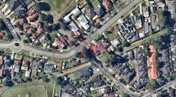
Council undertook a traffic count
on the approach to the bend (marked in red above) in February 2025 and count
data is given below:
· Average Daily
Traffic (ADT) = 6,040 veh/day,
· 85th percentile
speed = 49.5 km/h,
· Mean (average)
vehicle speed = 44 km/h.
Council undertook an assessment of
the bend using a ‘safe curve speed indicator’ and found that the
curve is suitable for a speed of 25km/hr. It is proposed to install advisory bend-ahead
warning signs together with 25km/hr supplementary signs on both approaches to
enhance safety.
Consultation is not required as
the proposed warning signs has no impact to the local residents.
1. Plan –
Toongabbie Road, Toongabbie
DOCUMENTS
ASSOCIATED WITH
REPORT CTC-25-090
Attachment 1
Plan – Toongabbie Road, Toongabbie
2 April 2025
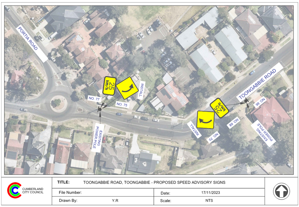
2 April 2025
Item No: CTC-25-091
DAHLIA STREET,
GREYSTANES – ALPHA ROAD PARK PARKING REVIEW
Directorate: Environment
and Planning
Responsible
Officer: Manager
Engineering and Building
Electorate: Prospect
Police Area
Command (PAC): Cumberland
Agenda Part Part
2
Note: Recommendation
to Council
Council officers has reviewed the existing parking condition
in Alpha Road Park located in Dahlia Street, Greystanes in accordance with
‘Holroyd Sports Ground Plan of Management’ and proposes to
construct additional indented parking spaces to improve the parking situation
in the area.
The Traffic Committee recommends that the consultation be
undertaken with affected residents, businesses and sporting groups for the
provision of indented parking spaces at Alpha Road Park along Dahlia Street,
Greystanes, and a further report be provided to the Traffic Committee.
Alpha Road Park is located between
Dahlia Street and Alpha Road, Greystanes which primarily used for sporting
purposes by various user groups. Parking is available along Alpha Road and
Dahlia Street outside the park.
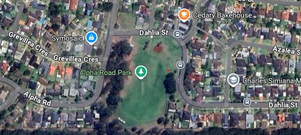
Council officers recently reviewed the existing parking
conditions at Alpha Road Park located on Dahlia Street, Greystanes in
accordance with the Holroyd Sports Ground Plan of Management. The review
identified an opportunity to provide additional indented parking spaces along
Dahlia Street to help improve the parking situation in the area.
Considering the ongoing parking challenges in the area, the
proposed additional indented parking spaces will not only provide more parking
for park visitors but also help alleviate overall parking demand in the area.
Therefore, it is proposed to construct intended parking bays in Dahlia Street,
Greystanes along the Alpha Road Park frontage as per the attached plan.
It is recommended that consultation be undertaken with
affected residents, businesses and sporting groups for the provision of
indented parking spaces at Alpha Road Park along Dahlia Street, Greystanes, and
a further report be provided to the Traffic Committee.
Subject to endorsement,
consultation will be undertaken on the proposal.
1. Plan –
Dahlia Street, Greystanes – Proposed indented parking bays
DOCUMENTS
ASSOCIATED WITH
REPORT CTC-25-091
Attachment 1
Plan – Dahlia Street, Greystanes –
Proposed indented parking bays
2 April 2025
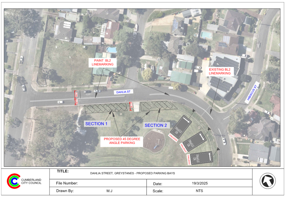
2 April 2025
Item No: CTC-25-092
GILBA ROAD
GIRRAWEEN – PROPOSED MODIFICATIONS TO PREVIOUSLY APPROVED RAISED
PEDESTRIAN CROSSING
Directorate: Environment
and Planning
Responsible
Officer: Manager
Engineering and Building
Electorate: Granville
Police Area
Command (PAC): Cumberland
Agenda Part Part
2
Note: Recommendation
to Council
Council has received funding under
the ‘Active Transport to School’ stream of the FY2024/25 Get NSW
Active program for the construction of a raised pedestrian crossing on Gilba
Road, Girraween at Girraween Public School.
This report provides an update on
the progress of the project.
The Traffic Committee recommends that:
1. The
modifications to the proposed raised pedestrian crossing on Gilba Road,
Girraween (outside Girraween Public School) in accordance with the attached
plan be supported.
2. Council
notify adjacent residents and school of the outcome.
Cumberland Traffic Committee at its meeting held on 3 August
2022 considered a report (CTC-22-151) on the safety concerns at the existing
at-level pedestrian crossing on Gilba Road, Girraween outside Girraween Public
School.
The Traffic Committee recommended that:
1. Proposed
raised pedestrian crossing on Gilba Road, Girraween outside Girraween Public
School be supported in principle.
2. Council
includes construction of the raised pedestrian crossing in a future Capital
Works Program.
3. Council
notifies the adjacent residents and Girraween Public School prior to
construction.
Subsequently, Council approved the traffic committee
recommendations.
Following the above, Council applied for funding and was
successful under the ‘Active Transport to School stream of the
FY2024/25 Get NSW Active program’.
The approved concept had kerb blister islands and existing
median islands at the location.
Following further discussions with Transport for NSW and
Council, both parties agreed to redesign the facility with road narrowing
instead of kerb blisters. With this design, the existing ‘No
Stopping’ zones on both sides can be reduced in accordance with
Australian Standards and Transport for NSW guidelines.
This reduction enables Council to provide 35 m long
‘No Parking’ School Days zone on the northern side of Gilba Road
outside the school to assist drop off/pick up activities for school. Residents
will be able to park in these areas outside of hours.
Council has modified the design and the revised plan is
attached. It is recommended that the revised project design be supported.
Consultation was undertaken with
the school principal who welcomed the provision of drop off/pick up area for
school.
1. Plan –
Proposed Raised Pedestrian Crossing in Gilba Road outside Girraween Public
School.
DOCUMENTS
ASSOCIATED WITH
REPORT CTC-25-092
Attachment 1
Plan – Proposed Raised Pedestrian Crossing in
Gilba Road outside Girraween Public School.
2 April 2025
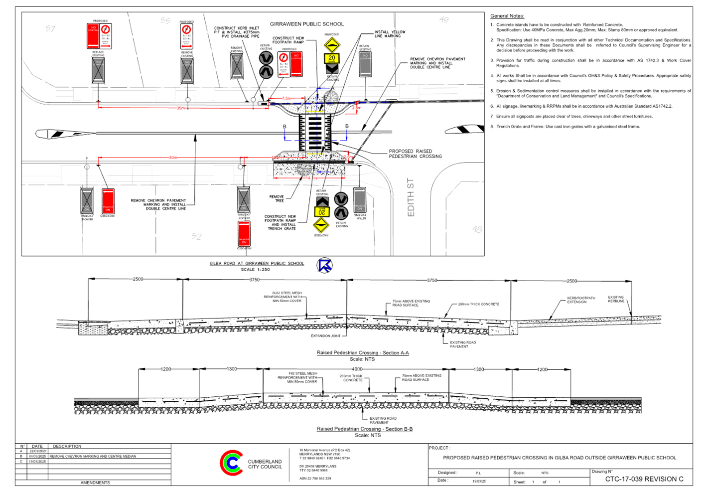
2 April 2025
Item No: CTC-25-093
PENDLE HILL
PUBLIC DOMAIN PLAN - JOYCE STREET PARK UPGRADE, PENDLE HILL – PROPOSED
REALIGNMENT OF PEDESTRIAN CROSSING & ROUNDABOUT AT PURDIE LANE
Directorate: Environment
and Planning
Responsible
Officer: Manager
Engineering and Building
Electorate: Prospect
Police Area
Command (PAC): Cumberland
Agenda Part Part
2
Note: Recommendation
to Council
Council at its meeting on 7
February 2024 adopted Pendle Hill Public Domain Plan following public
exhibition. As part of the works, several traffic facilities are proposed.
This report outlines the proposed
works included in the Public Domain Plan.
The Traffic Committee recommends that:
1. The
proposed pedestrian crossing realignment and associated traffic works for the
Joyce Street Park Upgrade at Pendle Hill Town Centre in accordance with the
attached plan be approved.
2. The
proposed roundabout at the intersection of Joyce Street and Purdie Lane in
accordance with the attached plan be approved, subject to approval by Transport
for NSW of a Traffic Management Plan for the banning of trucks turning left in
to Purdie Lane.
Council at its meeting on 7
February 2024 adopted Pendle Hill Public Domain Plan following public
exhibition. As part of the works, following traffic facilities are proposed:
· Re-alignment of the existing raised pedestrian crossing
outside the Pendle Hill Station.
· A new roundabout at the intersection of Joyce Street and
Purdie Lane.
· A pedestrian refuge on Joyce Street near the intersection
of Goodall Street.
· A pedestrian crossing on Civic Avenue at Pendle Way
intersection.
· Upgrade of existing pedestrian crossing on Stapleton Street
at Pendle Way.
The image below details the
proposed works in the Pendle Hill Public Domain Plan.
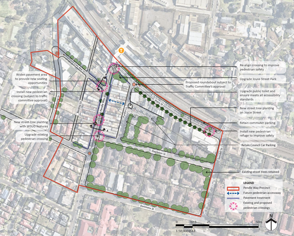
Following the adoption of the
Pendle Hill Town Centre Public Domain Plan, the plans for the following works
have been progressed and are included in this report for consideration by the
Traffic Committee:
· Re-alignment of the existing raised pedestrian crossing
outside the Pendle Hill Station.
· A new roundabout at the intersection of Joyce Street and
Purdie Lane.
The image below shows the location
of these proposals, with the attached plans providing further details on these
works.
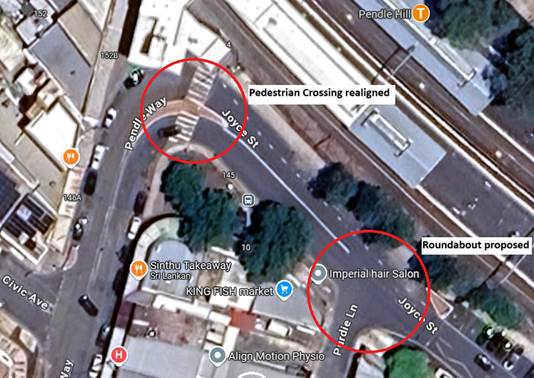
It is recommended that the Traffic
Committee endorse the identified traffic related works at these locations.
The Pendle Hill Public Domain Plan was on public exhibition
for a period of 28 days from 22 May 2023 to 21 June 2023. There were 24
submissions received. The submissions were generally in support of the
proposal.
Further consultation was undertaken on the Joyce Street Park
Upgrade from 24 June 2024 to 22 July 2024. There was one submission received.
The submission was positive.
1. Plan –
Joyce Street Park Upgrade -Realigned pedestrian crossing.
2. Plan
- Proposed roundabout at Purdie Lane
DOCUMENTS
ASSOCIATED WITH
REPORT CTC-25-093
Attachment 1
Plan – Joyce Street Park Upgrade
-Realigned pedestrian crossing.
2 April 2025
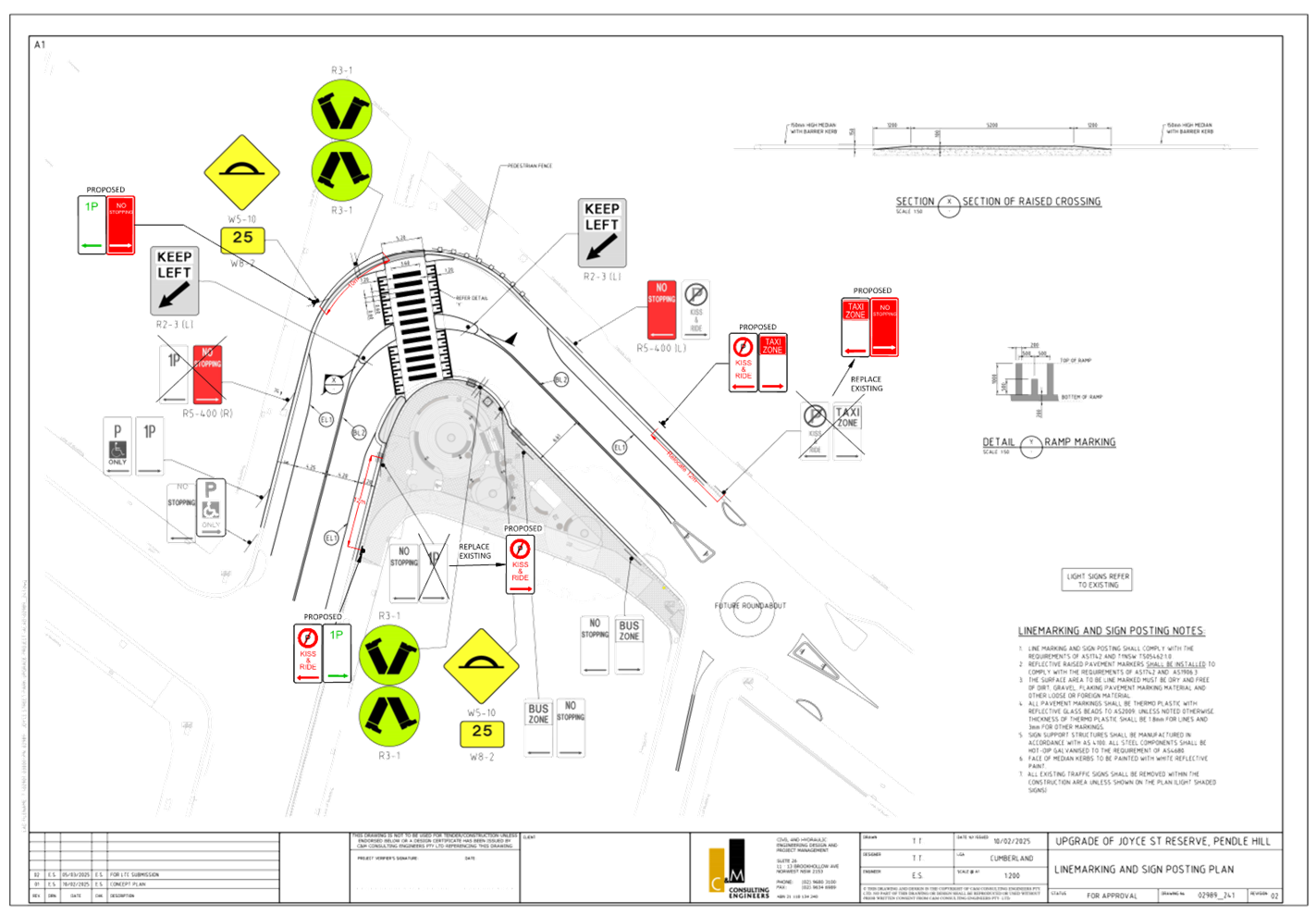
DOCUMENTS
ASSOCIATED WITH
REPORT CTC-25-093
Attachment 2
Plan - Proposed roundabout at Purdie Lane
2 April 2025
Item No: CTC-25-094
CHARLES
STREET, GRANVILLE - CONCERNS AT THE INTERSECTION WITH BLAXCELL STREET
Directorate: Environment
and Planning
Responsible
Officer: Manager
Engineering and Building
Electorate: Granville
Police Area
Command (PAC): Cumberland
Agenda Part Part
2
Note: Recommendation
to Council
Council has received safety
concerns at the intersection of Blaxcell Street and Charles Street, Granville
with respect to queuing vehicles on Blaxcell Street blocking Charles Street and
safety of vehicles exiting from Charles Street.
This report outlines the issues
and proposes future action.
The Cumberland Traffic Committee recommends that Council
prepare a Traffic Management Plan for the precinct bound by Adam Street,
Excelsior Street, Louis Street, Fifth Street and Clyde Street to identify
desired traffic flow options.
Council has received safety
concerns at the intersection of Blaxcell Street and Charles Street, Granville
with respect to the ongoing issue of queuing vehicles on Blaxcell Street
blocking Charles Street and safety of vehicles entering and exiting from Charles
Street.
Charles Street is a local road
that runs in an east-west direction between Blaxcell Street and The Trongate
and is approximately 140 m long. It has a varying width between approximately
6.8 to 9.2 m. There are also indented parallel parking bays in the street. The
posted speed limit is 50 km/h.
Blaxcell Street is a local
collector road that runs in a north-south direction, it has a width of
approximately 12m with a 50 km/h speed limit.
The map below shows the location
of Charles Street, Granville.
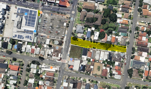
Traffic conditions at the intersection
Council has received several community concerns at the
intersection of Blaxcell Street and Charles Street.
The issues raised are:
· Southbound
vehicles queuing in the kerbside lane to obtain access to the service station
at the corner of Blaxcell Street and Celia Street. The queuing sometimes
extends into the roundabout at Louis Street which is over 100 m
· The queued
vehicles block buses accessing the bus stop south of Charles Street, forcing
buses to stop in the middle lane. This creates safety concerns for bus
passengers.
· Council
investigated possible options including ‘Keep Clear’ pavement
marking at Charles Street; however, the location does not warrant the pavement
marking in accordance with Transport for NSW guidelines.
· Council previously
considered the option of relocating the pedestrian crossing on Blaxcell Street
at the frontage of the service station and the bus stop south of Celia Street.
This proposal was not progressed due to objections from residents.
· There were
requests for the closure of Charles Street to avoid conflict points.
Crash data
The latest crash data indicates that there were no reported
crashes at the intersection of Blaxcell Street and Charles Street in the five
years, ending June 2024. However, Council has received numerous complaints of
unreported crashes and near misses.
Council has also been requested to investigate the concerns
to resolve the concerns, including any traffic movement changes to improve road
safety.
Process for road
closures or banning movement of traffic
In accordance with the Transport for NSW (TfNSW) guidelines,
Council does not have delegation to close a road or ban any traffic movement
without preparing and receiving approval from TfNSW of a Traffic Management
Plan (TMP).
The TMP deals with various impacts of the road closure
including
· Justification for
the decision to permanently close the road or ban movements. The impacts of the
proposal have to be modelled using appropriate software and justification for
the proposed closure analysed.
· Measures to
ameliorate re-assigned traffic.
· Any impact of
public transport services (if any).
· Impact on
emergency vehicle and heavy vehicle access and alternate routes.
· Impact on other
streets in the area.
In addition, one of the requirements of the TMP is that the
proposal to be advertised and public comments summarised and addressed.
Next steps
There are three reports provided in
this agenda dealing with traffic flow changes which will have a cumulative
impact in the precinct bound by Adam Street, Excelsior Street, Louis Street
& Fifth Street and Clyde Street. The other two roads of primary concern
within the precinct are Lavinia Street and Redfern Street.
Council proposes to undertake a combined traffic modelling
and subsequent area wide traffic study which will evaluate options and provide
recommendations for future traffic controls within the precinct (Granville
South - Traffic Management Plan). Once the Traffic Management Plan
is developed, it is proposed to undertake consultation with the community on
the proposed measures recommended.
A further report will be brought back to the Traffic
Committee once the study and traffic management plan is complete, prior to
undertaking community consultation.
The study area is shown in the map below with the three
streets under consideration, namely, Lavinia Street, Redfern Street and Charles
Street:
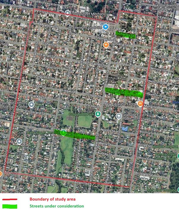
Subject to endorsement, consultation will be undertaken
following the preparation of a traffic study if supported by the Traffic
Committee.
Nil
2 April 2025
Item No: CTC-25-095
LAVINIA
STREET, SOUTH GRANVILLE - SAFETY CONCERNS
Directorate: Environment
and Planning
Responsible
Officer: Manager
Engineering and Building
Electorate: Granville
Police Area
Command (PAC): Cumberland
Agenda Part Part
2
Note: Recommendation
to Council
Council has received safety concerns on Lavinia Street,
South Granville with respect to speeding vehicles and safety of pedestrians,
park visitors and school students. This request is to close the road for
through traffic at the shared pathway crossing location between Frederick
Avenue and Robertson Street.
This report outlines the preliminary investigation into
this matter and viability of the closure.
The Traffic Committee recommends that Council prepare a
Traffic Management Plan for the precinct bound by Adam Street, Excelsior
Street, Louis Street & Fifth Street and Clyde Street to identify desired
traffic flow options.
Council has received safety concerns on Lavinia Street with
respect to speeding vehicles and safety of pedestrians, park visitors and
school students. The request suggests closing the road for through
traffic at the shared pathway crossing location between Frederick Avenue and
Robertson Street.
Lavinia Street is a local road that runs in an east-west
direction between Blaxcell Street and Excelsior Street and is approximately 660
m long. It has a width of approximately 9.5 m. The posted speed limit is 50 km/h
and parking is permitted on both sides of the road unless signposted. There are
90-degree indented parking spaces provided on the southern side of Lavinia
Street between Robertson Street and Frederick Avenue just west of the shared
pathway crossing.
There are Park reserves on either side of Lavinia Street
between Robertson Street and Blaxcell Street. Colquhoun Park is located on the
northern side of Lavinia Street while Harry Gapes Reserve is located on the
southern side.
It is alleged that the through traffic was allowed in the
past without any consultation with the community.
The map below shows the location
of Lavinia Street, South Granville.
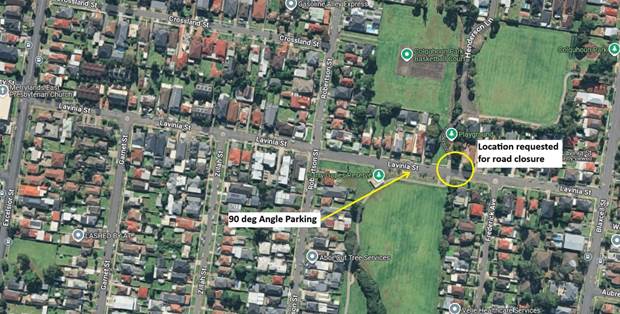
Council officers have investigated the impacts of the road
closure.
Crash data in the section under consideration
In the last five years ending June 2024, the latest crash
data indicates that there was one reported crash at the intersection of Lavinia
Street and Robertson Street in the section of Lavinia Street being considered
for closure. This crash detail is listed in the table below.
|
Date
|
Location
|
Description
|
|
15/05/2022
|
At
Robertson St intersection
|
Left
off carriageway into object
|
Traffic data
A traffic count was undertaken at this location in August
2024 and the results are shown in the table below. It is noted that the
eastbound and westbound peak hour volumes do not match to the total value in
both directions as the peak hour time periods may vary.
|
Description
|
Both directions
|
Eastbound
|
Westbound
|
|
Average Daily Traffic
(Veh./day)
|
3,045
|
1,254
|
1,791
|
|
Average Peak Hour
traffic (Veh/hr) – AM Peak
|
209
|
62
|
156
|
|
Average Peak Hour
traffic (Veh/hr) – PM Peak
|
272
|
136
|
136
|
Request for permanent
closure of Lavinia Street at this section
There are several
considerations of closing Lavinia Street, including:
· Access to the
parks via Lavinia Street is affected to the users who live on the eastern side
must take detours to access the park via vehicle.
· Available
90-degree indented parking on Lavinia Street will be reduced for the provision
of a cul-de-sac or turning bay at the closure.
· Impact on adjacent
streets with additional traffic.
· Opportunity to
integrate the open space areas in this location to provide continuous access
without crossing the road.
Process for road
closures
In accordance with the Transport for NSW (TfNSW) guidelines,
Council does not have delegation to close a road without preparing and
receiving approval from TfNSW of a Traffic Management Plan (TMP).
The TMP deals with various impacts of the road closure
including
· Justification for
the decision to permanently close the road or ban movements.
The impacts of the proposal have to be modelled using
appropriate software and justification for the proposed closure analysed.
· Measures to
ameliorate re-assigned traffic.
· Any impact of
public transport services (if any).
· Impact on
emergency vehicle and heavy vehicle access and alternate routes.
· Impact on other
streets in the area.
In addition, one of the requirements of the TMP is that the
proposal to be advertised and public comments summarised and addressed.
Next steps
There are three reports provided in this agenda dealing with
traffic flow changes which will have a cumulative impact in the precinct bound
by Adam Street, Excelsior Street, Louis Street & Fifth Street and Clyde
Street. The other two roads of primary concern within the precinct are Charles
Street at the Blaxcell Street intersection and Redfern Street.
Council proposes to undertake a combined traffic modelling
and subsequent area wide traffic study which will evaluate options and provide
recommendations for future traffic controls within the precinct (Granville
South - Traffic Management Plan). Once the Traffic Management Plan
is developed, it is proposed to undertake consultation with the community on
the proposed measures recommended.
A further report will be brought back to the Traffic
Committee once the study and traffic management plan is complete, prior to
undertaking community consultation.
The study area is shown in the map below with the three
streets under consideration, namely, Lavinia Street, Redfern Street and Charles
Street:
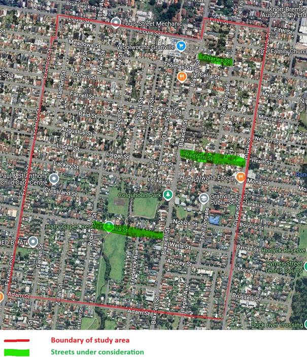
Subject to endorsement,
consultation will be undertaken following the preparation of a traffic study if
supported by the Traffic Committee.
Nil
2 April 2025
Item No: CTC-25-096
MAIN AVENUE,
LIDCOMBE – ROAD SAFETY CONCERNS
Directorate: Environment
and Planning
Responsible
Officer: Manager
Engineering and Building
Electorate: Auburn
Police Area
Command (PAC): Auburn
Agenda Part Part
2
Note: Recommendation
to Council
Council has received a request from Sydney Onnuri Church for
the installation of traffic calming devices on Main Avenue, Lidcombe due to
speeding concerns.
This report outlines the outcome of the investigation into
this matter.
The Traffic Committee recommends that Council
undertake consultation with the residents and properties along Main Avenue,
Lidcombe, to assess support or otherwise for the installation of traffic
calming devices in the street.
Council has received a request from Sydney Onnuri Church
located at No.18 Main Avenue, Lidcombe to investigate the installation of
traffic calming devices outside the church due to speeding concerns.
Main Avenue is a local road that runs
in an east-west and north-south directions from Joseph Street to Weeroona Road.
The road is approximately 800m long and 18m wide with indented (90 degree and
parallel) parking spaces on both sides of the street. Main Avenue has a speed
limit of 50km/h.
The map below shows the location
of Main Avenue, Lidcombe:

The latest Centre for Road Safety accident data indicated
that there was no reported accident in Main Avenue in the last 5 years ending
June 2024.
Based on the ongoing feedback received by residents and the
congregation that attends the church, Council proposes to undertake traffic
counts in all these streets and anayse the data, and to carry out consultation
to assess support or otherwise for traffic calming measures in the street.
Subject to endorsement,
consultation will be undertaken on the proposal.
Nil
2 April 2025
Item No: CTC-25-097
REDFERN
STREET, GRANVILLE - SAFETY CONCERNS
Directorate: Environment
and Planning
Responsible
Officer: Manager
Engineering and Building
Electorate: Granville
Police Area
Command (PAC): Cumberland
Agenda Part Part
2
Note: Recommendation
to Council
Council has received safety concerns in Redfern Street,
South Granville with respect to road safety especially about frequent
unreported crashes and speeding in the street.
This report outlines the issues and proposes future action.
The Traffic Committee recommends that Council prepare a
Traffic Management Plan for the precinct bound by Adam Street, Excelsior
Street, Louis Street, Fifth Street & Clyde Street to identify desired
traffic flow options.
Council has received safety concerns in Redfern Street,
South Granville with respect to narrow road and traffic volumes in the street.
Redfern Street, South Granville is a local road that runs
in an east-west direction between Blaxcell Street and Clyde Street. It is
approximately 9.4 m wide, and parking is permitted on both sides of the road in
accordance with Road Rules.
Redfern Street forms T-intersections at both ends with
Blaxcell Street and Clyde Street which are controlled by roundabouts. Clyde
Street is a regional road and carries over 20,000 veh/day and Redfern Street
carries over 9,000 veh/day. Redfern Street also forms a four-legged
intersection with The Trongate which is also controlled by a roundabout. This
is the main route between Auburn and Granville.
There is a pedestrian crossing provided on Redfern Street
east of the Trongate.
The road width of 9.4 m leaves 5 to 5.2 m effective travel
lanes for two-way traffic within a short length of the road in both sections of
Redfern Street.
The map below shows the location of Redfern Street,
Granville.
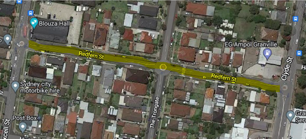
Traffic conditions in Redfern Street
Council has received several community concerns in Redfern
Street.
The issues raised are:
· Redfern Street has
high volumes of traffic for a local road as it is on the route between Auburn
and Granville.
· The narrow road
width with parking allowed on both sides resulting in safety concerns for
two-way traffic with high traffic volumes.
· Request to
consider left in and left out arrangement into and out of Redfern Street at the
Clyde Street and Redfern Street intersection.
Crash data
The latest crash data in the five years ending June 2024
indicates that there were:
· Two reported midblock crashes in Redfern Street.
· Three reported crashes
at the intersections of Redfern Street with Clyde Street.
· One reported crash
at the intersection of Redfern Street with Blaxcell Street.
· One reported crash
at the intersection of Redfern Street with The Trongate.
Further details of the reported crashes is listed in the
table below.
|
Date
|
Location
|
Description
|
|
26/06/2020
|
At
the intersection with Clyde Street
|
Right-through
from left
|
|
21/10/2020
|
At
the intersection with Clyde Street
|
Right-through
from left
|
|
20/01/2021
|
At
the intersection with Blaxcell Street
|
Out
of control on carriageway
|
|
24/08/2022
|
At
the intersection with Clyde Street
|
Right-through
from right
|
|
08/06/2023
|
50 m west of Clyde St
|
Left off carriageway into object
|
|
18/11/2023
|
30 m west of The Trongate
|
Emerging from driveway
|
|
04/05/2024
|
At
the intersection with The Trongate
|
Rear
left
|
Council has been requested to investigate the concerns to
resolve them including any traffic movement changes to improve road safety. A
range of options may be considered, including:
· Parking restrictions
on one side or both sides to increase the travel lane widths to facilitate
two-way traffic with desired traffic lane width.
· Turning bans for
selected traffic movements.
· One-way
arrangement in Redfern Street.
It is noted that some of these options may require
supporting additional infrastructure to be successfully delivered.
Process for conversion
to one-way or banning movement of traffic
In accordance with the Transport for NSW (TfNSW) guidelines,
Council does not have delegation to close a road or ban any traffic movement
without preparing and receiving approval from TfNSW of a Traffic Management
Plan (TMP).
The TMP deals with various impacts of the road closure
including
· Justification for
the decision to permanently close the road or ban movements.
The impacts of the proposal have to be modelled using
appropriate software and justification for the proposed closure analysed.
· Measures to
ameliorate re-assigned traffic.
· Any impact of
public transport services (if any).
· Impact on
emergency vehicle and heavy vehicle access and alternate routes.
· Impact on other
streets in the area.
In addition, one of the requirements of the TMP is that the
proposal to be advertised and public comments summarised and addressed.
Next steps
There are three reports provided in this agenda dealing with
traffic flow changes which will have a cumulative impact in the precinct bound
by Adam Street, Excelsior Street, Louis Street & Fifth Street and Clyde
Street. The other two roads of primary concern within the precinct are Lavinia
Street and Charles Street.
Council proposes to undertake a combined traffic modelling
and subsequent area wide traffic study which will evaluate options and provide
recommendations for future traffic controls within the precinct (Granville
South - Traffic Management Plan). Once the Traffic Management Plan
is developed, it is proposed to undertake consultation with the community on
the proposed measures recommended.
A further report will be brought back to the Traffic
Committee once the study and traffic management plan is complete, prior to
undertaking community consultation.
The study area is shown in the map below with the three
streets under consideration, namely, Lavinia Street, Redfern Street and Charles
Street:
Subject to endorsement,
consultation will be undertaken following the preparation of a traffic study if
supported by the Traffic Committee.
Nil
2 April 2025
Item No: CTC-25-098
MONA STREET,
AUBURN & SOUTH GRANVILLE – PARKING RESTRICTION MODIFICATION
Directorate: Environment
and Planning
Responsible
Officer: Manager
Engineering and Building
Electorate: Auburn
Police Area
Command (PAC): Auburn
Agenda Part Part
2
Note: Recommendation
to Council
Council has received requests from residents and motorists
regarding traffic congestions in Mona Street, Auburn and South Granville during
peak hours.
This report outlines the outcome
of the investigation into this matter.
The Traffic Committee recommends that Council undertake
consultation with the residents and broader community on proposed changes to
parking restrictions along Mona Street between Clyde Street and Chisholm Road,
and provide a further report on the consultation results to the Traffic
Committee.
Mona Street is a local road that runs in an east-west direction
with a speed limit of 50 km/h. It has approximately 1.3km in length and
approximately 12.6m in width. Parking is permitted on both sides of the road
unless otherwise signposted.
Cumberland Traffic Committee (CTC) at its meeting on 5
February 2025 considered a report (CTC-25-012) regarding the extension of the
existing part-time 'No Parking' restrictions on the southern side of Mona
Street, Granville, near Clyde Street, and the Traffic Committee recommended
that:
1. Replace
the existing ‘No Parking, 2:30pm - 6:30pm, Mon – Fri’ on the
southern side of Mona Street between No. 150 to No.172 to ‘No Parking,
7am – 9:30am, 2:30pm – 6:30pm, Mon – Fri’ as per
attached plan.
2. Install
a 27m Bus Zone at the existing bus stop on the southern side of Mona Street
near No. 172 as per attached plan.
Following the Traffic Committee meeting, additional concerns
were raised by residents regarding the extension of the parking restrictions
further east to Chisholm Road, improve the traffic flow during peak hours along
Mona Street and Chisholm Road.
The map below shows the area:
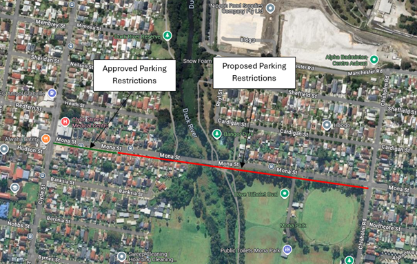
The following changes to line marking and signposting are
proposed:
· For Mona Street
(east of Duck River) with travel in the western direction, ‘No
Parking’ restrictions are proposed through two options: PM peak only, and
AM / PM peak.
· For Mona Street
(west of Duck River) with travel in the western direction, ‘No
Parking’ restrictions are proposed through two options: PM peak only, and
AM / PM peak.
By extending the parking restrictions during busy periods,
it will allow for additional vehicles to be accommodated over two lanes where
this is provided for along Mona Street. It is anticipated that this would
also assist in queue lengths along Chisholm Street for vehicles travelling
towards Mona Street.
Given the community interest in traffic movements at this
location, it is recommended that the Traffic Committee and Council endorse that
the proposal be progressed to consultation. If supported, consultation
will be undertaken by Council officers with residents and the broader community
and a further report provided to the Traffic Committee.
Subject to endorsement,
consultation will be undertaken on the proposals.
1. Plan - Mona
Street, South Granville - Proposed options for time limited parking
restrictions
2. Plan
- Mona Street, Auburn – Proposed Option 1 for time limited parking
restrictions
3. Plan
- Mona Street, Auburn - Proposed Option 2 for time limited parking restrictions
DOCUMENTS
ASSOCIATED WITH
REPORT CTC-25-098
Attachment 1
Plan - Mona Street, South Granville - Proposed options
for time limited parking restrictions
2 April 2025
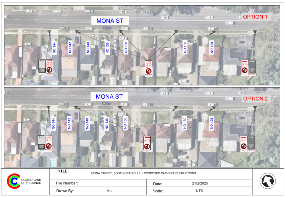
DOCUMENTS
ASSOCIATED WITH
REPORT CTC-25-098
Attachment 2
Plan - Mona Street, Auburn – Proposed Option 1
for time limited parking restrictions
2 April 2025

DOCUMENTS
ASSOCIATED WITH
REPORT CTC-25-098
Attachment 3
Plan - Mona Street, Auburn - Proposed Option 2 for
time limited parking restrictions
2 April 2025