5 June 2024
5 June 2024
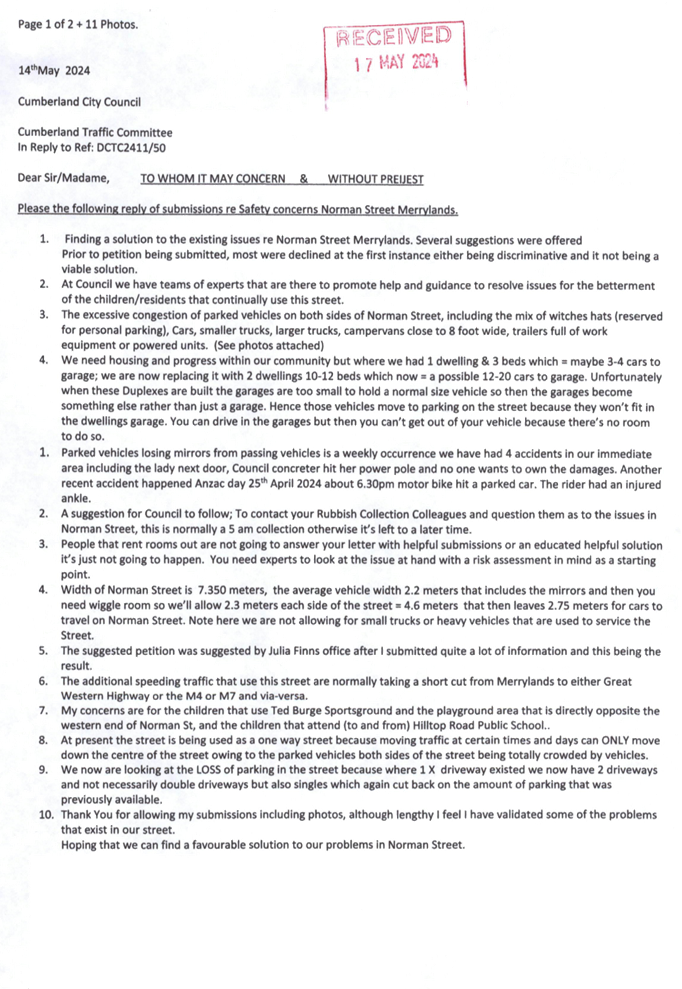
A meeting of the Traffic Committee will be held at 9.30am in Merrylands Administration Building, 16 Memorial Avenue, Merrylands on Wednesday, 5 June 2024.
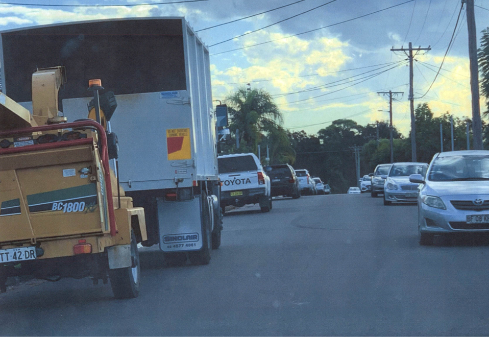
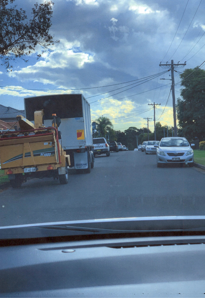
Business as below:
Yours faithfully
Melissa Attia
Acting General Manager
ORDER OF BUSINESS
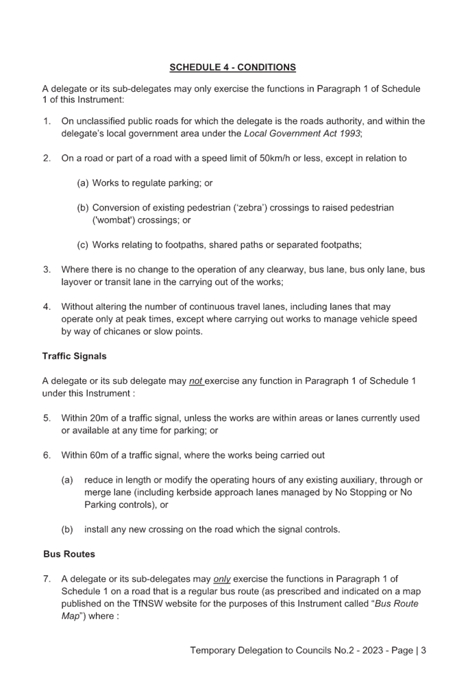
1. Apologies
2. Declarations of Interest
3. Confirmation of Previous Minutes endorsed by Council
4. Summary of Reports.......................................................................................................... 6
5. Reports
- Part 1 - Recommended for Approval under Delegated Authority
- Part 2 - Recommendation to Council
CONTENTS
Report No. Name of Report Page No.
Part 1 - Recommended for Approval under Delegated Authority
CTC-24-096 OXFORD STREET, BERALA - ROAD SAFETY CONCERNS......... 27
CTC-24-097 ELM ROAD, AUBURN - ROAD SAFETY CONCERNS..................... 39
CTC-24-098 THE AVENUE, GRANVILLE - ROAD SAFETY CONCERNS........... 53
CTC-24-099 VILLIERS STREET, MERRYLANDS - ROAD SAFETY CONCERNS 61
CTC-24-100 HILLTOP ROAD, MERRYLANDS - ROAD SAFETY CONCERNS.. 73
CTC-24-101 CLARENCE STREET, MERRYLANDS – ROAD SAFETY CONCERNS – CONSULTATION RESULT..................................................................... 81
CTC-24-102 DESMOND STREET, MERRYLANDS WEST - ROAD SAFETY CONCERNS 109
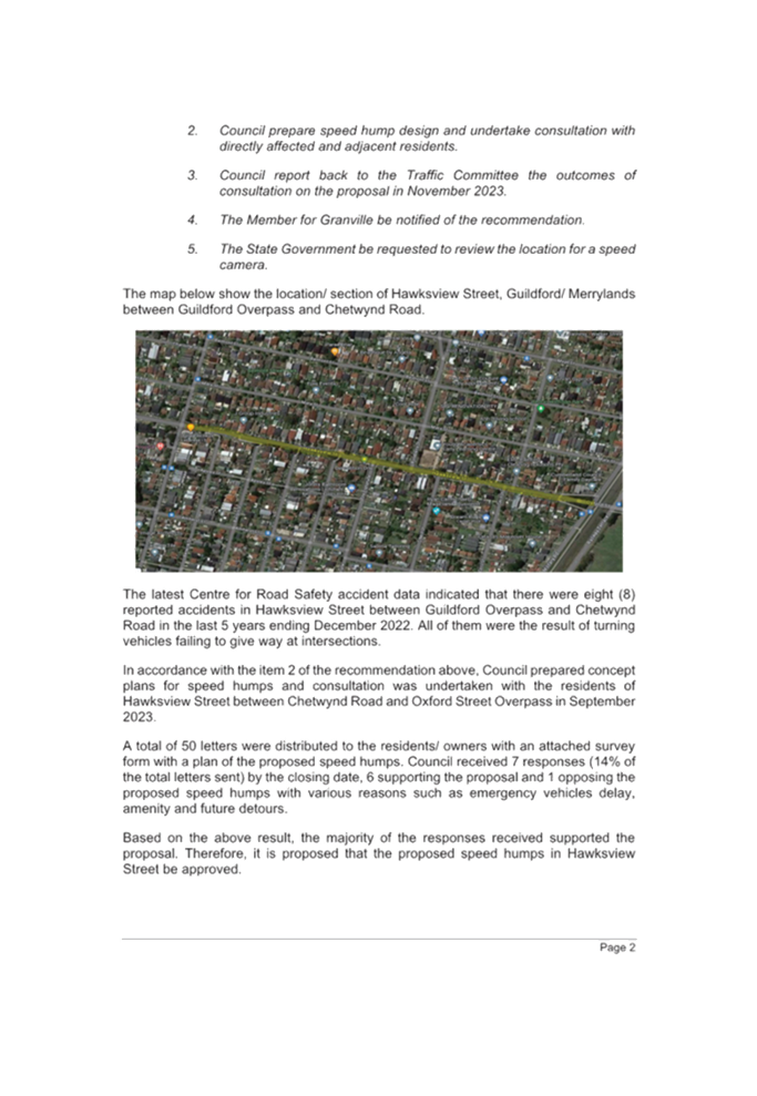
CTC-24-103 HAWKSVIEW STREET, GUILDFORD AND MERRYLANDS – ROAD SAFETY CONCERN.............................................................................. 117
CTC-24-104 THE ESPLANADE, GUILDFORD - ROAD SAFETY CONCERNS 135
CTC-24-105 LANCE CRESCENT, GREYSTANES - ROAD SAFETY CONCERNS 147
CTC-24-106 ELDRIDGE ROAD, GREYSTANES - ROAD SAFETY CONCERNS 159
CTC-24-107 OATLANDS STREET, WENTWORTHVILLE - ROAD SAFETY CONCERNS 167
CTC-24-108 PASTORAL CIRCUIT, PEMULWUY – EXTENSION OF THE EXISTING ‘NO STOPPING’ RESTRICTIONS.............................................................. 179
CTC-24-109 BRAESIDE ROAD, GREYSTANES - MODIFICATIONS TO THE EXISTING 'NO STOPPING' RESTRICTIONS....................................................... 191
CTC-24-110 SANDRA STREET AND FIONA STREET, WOODPARK – PROPOSED ‘NO STOPPING’ RESTRICTIONS AND LINEMARKING........................ 199
CTC-24-111 LOMOND STREET, GUILDFORD WEST – EXTENSION OF THE EXISTING ‘NO STOPPING’ RESTRICTIONS...................................................... 205
CTC-24-112 BURSILL STREET AND TALBOT ROAD, GUILDFORD – PROPOSED ‘NO STOPPING’ RESTRICTIONS AND LINEMARKING........................ 217
CTC-24-113 MILITARY ROAD AND BYRON ROAD, GUILDFORD – PROPOSED ‘NO STOPPING’ RESTRICTIONS AND LINEMARKING........................ 223
CTC-24-114 KERRS ROAD AND BERNARD STREET, LIDCOMBE – PROPOSED ‘NO STOPPING’ RESTRICTIONS AND LINEMARKING........................ 231
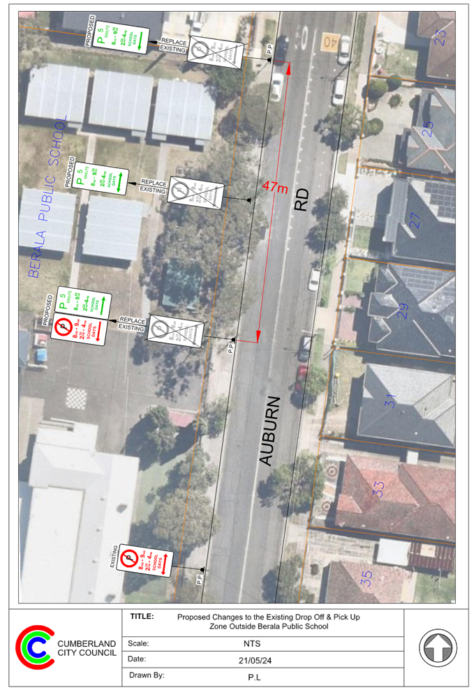
CTC-24-115 AUBURN ROAD, BERALA - PARKING ARRANGEMENT REIVEW 237
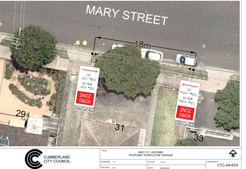
CTC-24-116 MARY STREET, LIDCOMBE – APPLICATION FOR ‘WORKS ZONE’ SIGNAGE................................................................................................. 243
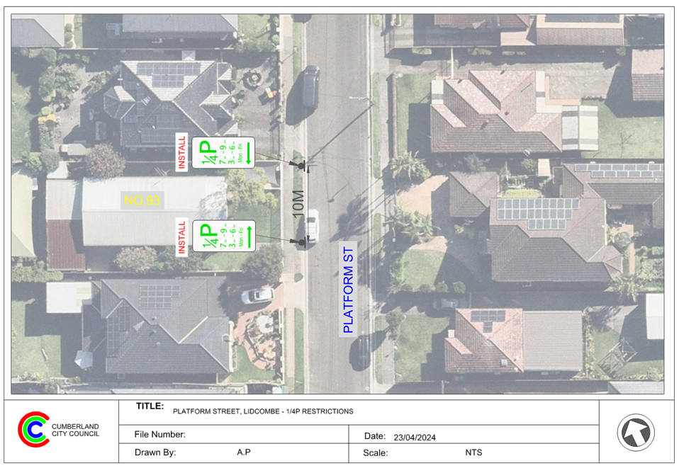
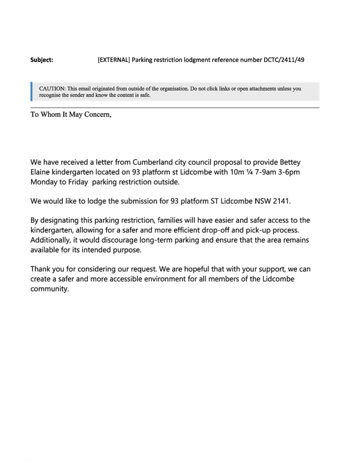
CTC-24-117 PLATFORM STREET, LIDCOMBE – PROPOSED PARKING RESTRICTIONS..................................................................................... 249
CTC-24-118 MAGOWAR ROAD, GIRRAWEEN - PROPOSED PARKING RESTRICTIONS – CONSULTATION RESULTS.............................. 259
CTC-24-119 HIBISCUS STREET, GREYSTANES – PROPOSED ‘NO PARKING’ PARKING RESTRICITONS.................................................................. 279
CTC-24-120 NAYING DRIVE, PEMULWUY – PROPOSED ‘NO PARKING’ PARKING RESTRICITONS..................................................................................... 307
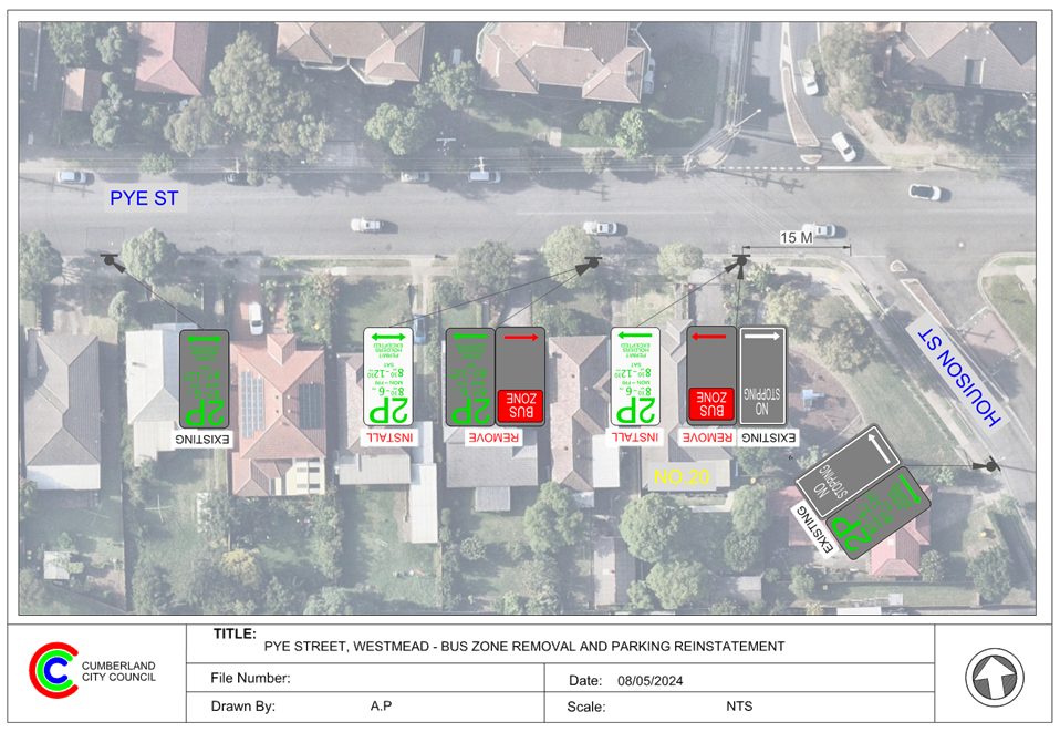
CTC-24-121 PYE STREET, WESTMEAD – REMOVAL OF REDUNDANT ‘BUS ZONE’ SIGNAGE................................................................................................. 327
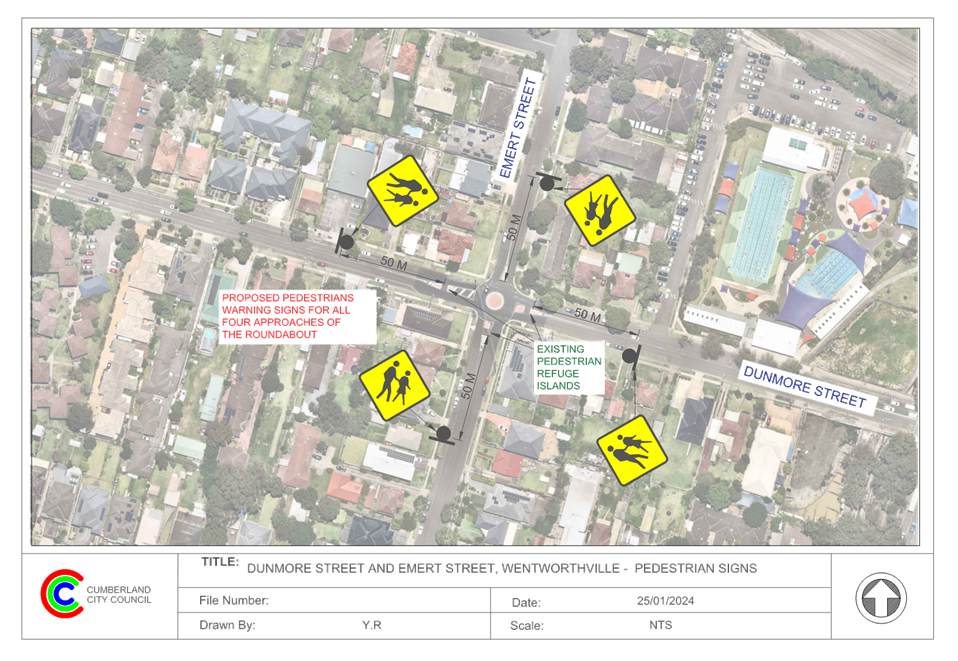
CTC-24-122 DUNMORE STREET, WENTWORTHVILLE – REQUEST FOR A MARKED PEDESTRIAN CROSSING................................................................... 333
CTC-24-123 ENID AVENUE, GRANILLE – APPLICATION FOR ‘WORKS ZONE’ SIGNAGE................................................................................................. 351
CTC-24-124 PATRICIA STREET, MAYS HILL – APPLICATION FOR ‘WORKS ZONE’ SIGNAGE................................................................................................. 357
CTC-24-125 BOOMERANG STREET AND RANDLE STREET, GRANVILLE - ROAD SAFETY CONCERNS........................................................................... 363
Part 2 - Recommendation to Council
CTC-24-126 THE BOULEVARDE, LIDCOMBE - ROAD SAFETY CONCERNS 369
CTC-24-127 WALPOLE STREET, MERRYLANDS - ROAD SAFETY CONCERNS 387
CTC-24-128 GLOUCESTER AVENUE, MERRYLANDS - ROAD SAFETY CONCERNS 391
CTC-24-129 GRASSMERE STREET, GUILDFORD - ROAD SAFETY CONCERNS – CONSULTATION RESULT................................................................... 399
CTC-24-130 HUNT STREET, GUILDFORD WEST - ROAD SAFETY CONCERNS 427
CTC-24-131 MCCREDIE ROAD, GUIDLFORD WEST - ROAD SAFETY CONCERNS 435
CTC-24-132 FOWLER ROAD, GUILDFORD WEST - ROAD SAFETY CONCERNS 451
CTC-24-133 BRIGHTON STREET, GREYSTANES – ROAD SAFETY CONCERNS - CONSULTATION.................................................................................... 467
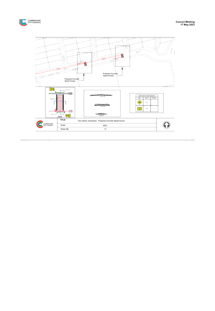
CTC-24-134 TERRY STREET, GREYSTANES - ROAD SAFETY CONCERNS 487
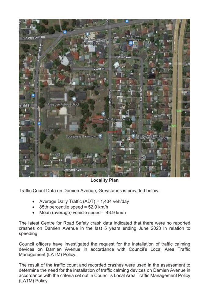
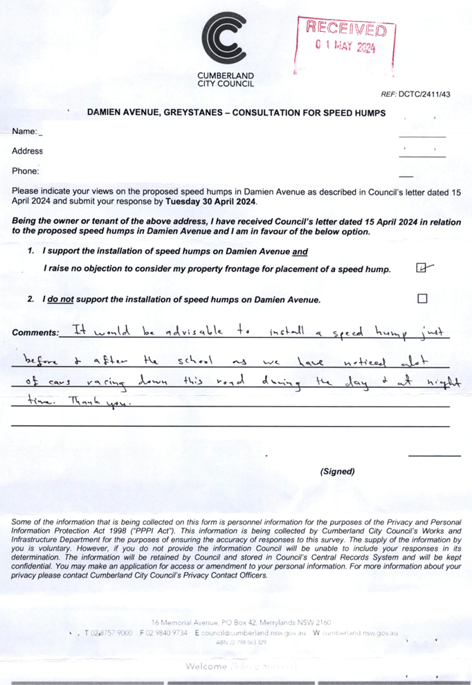
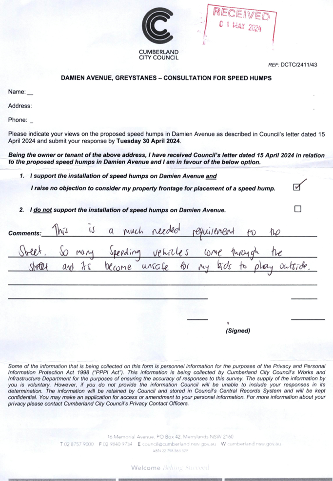
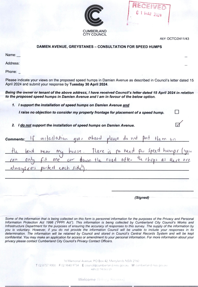
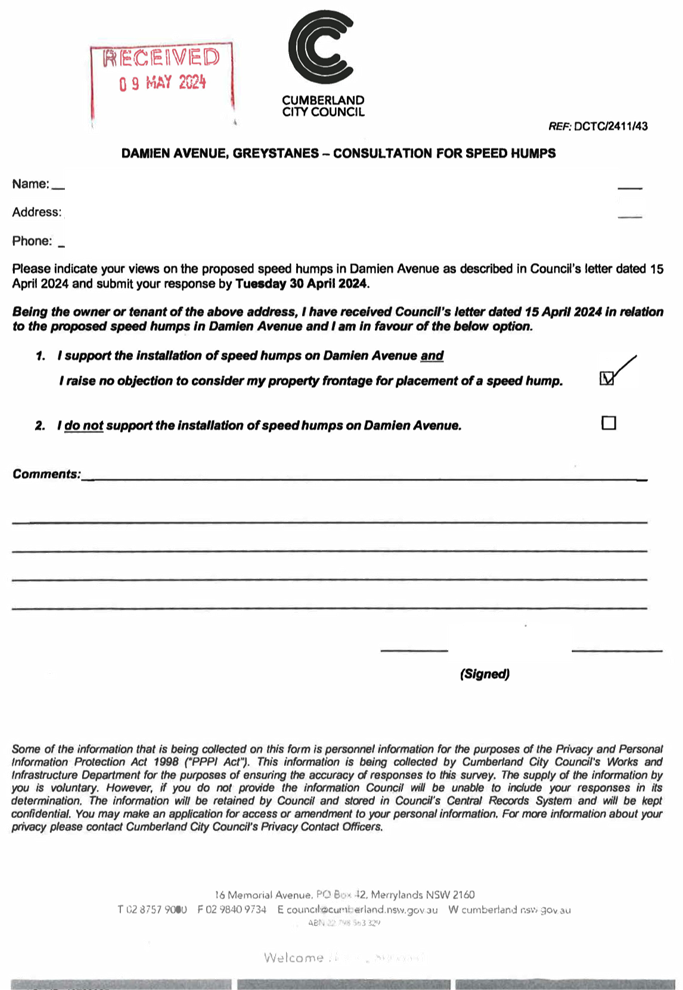
CTC-24-135 DAMIEN AVENUE, GREYSTANES - ROAD SAFETY CONCERNS 507
CTC-24-136 OLD PROSPECT ROAD, GREYSTANES - ROAD SAFETY CONCERNS 551
CTC-24-137 WOMBAT STREET, PEMULWUY - ROAD SAFETY CONCERNS 555
CTC-24-138 PENDLE WAY, PENDLE HILL - PROPOSED TEMPORARY ROAD CLOSURE FOR 'THAI PONGAL FESTIVAL 2025'.......................... 563
CTC-24-139 LIDCOMBE TOWN CENTRE PUBLIC DOMAIN PLAN - PROPOSED ON-STREET PARKING ARRANGEMENTS FOR JOSEPH STREET PRECINCT 587
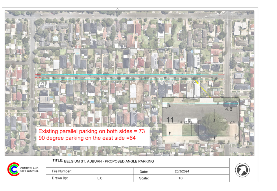
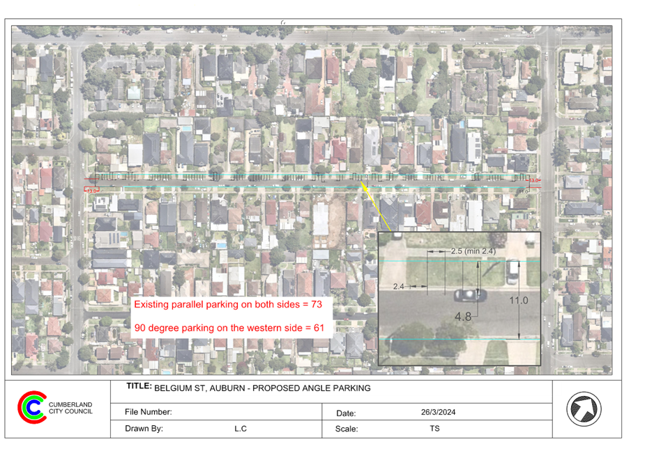
CTC-24-140 BELGIUM STREET, AUBURN - REQUEST FOR ROAD WIDENING 607
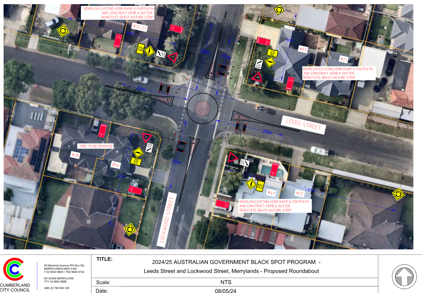
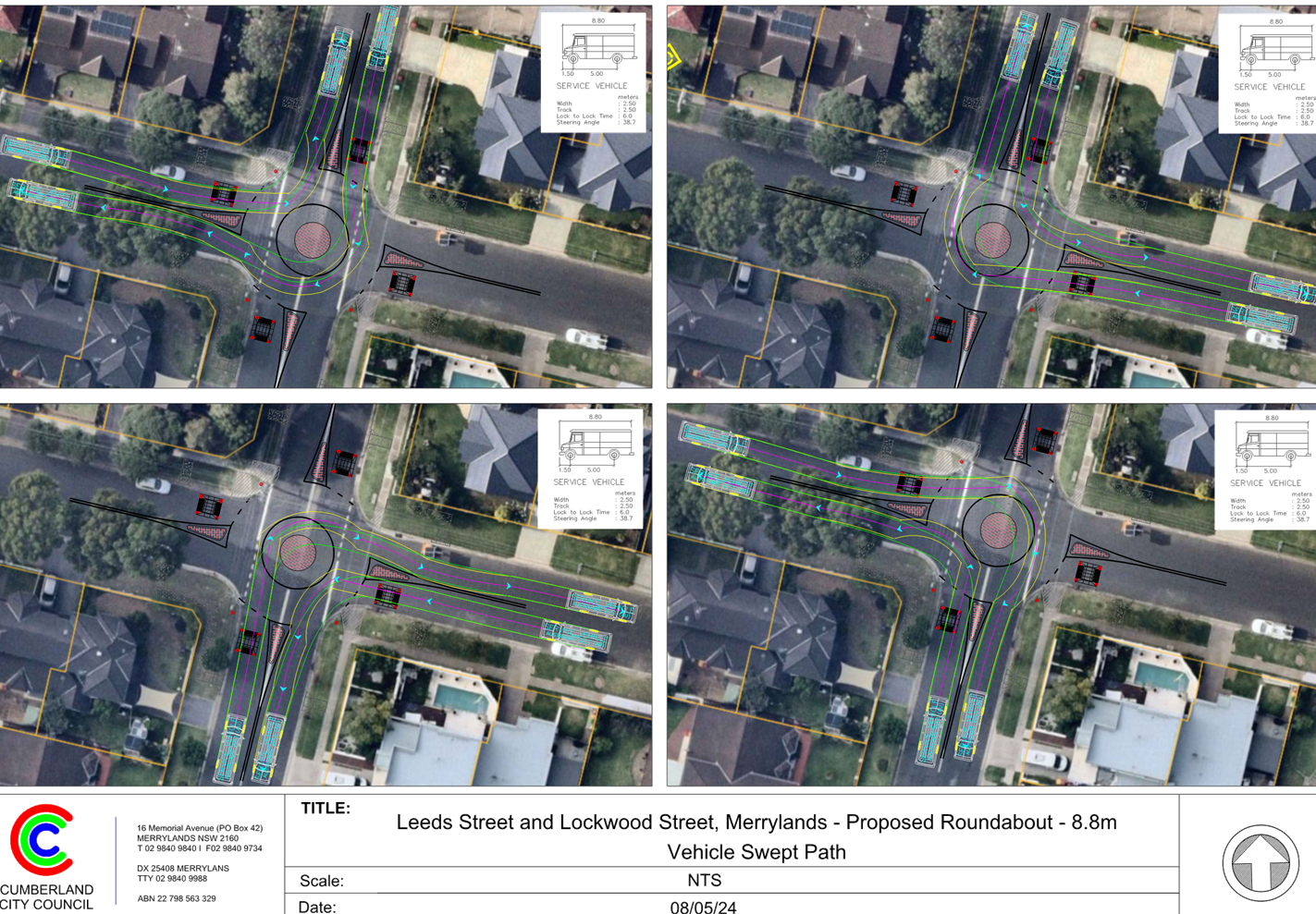
CTC-24-141 LOCKWOOD STREET AND LEEDS STREET, MERRYLANDS - PROPOSED ROUNDABOUT............................................................... 617
CTC-24-142 WARWICK ROAD & BURNETT STREET, MERRYLANDS – REQUEST FOR BANNING TURNING MOVEMENTS INTO WARWICK ROAD...... 627
CTC-24-143 NORMAN STREET, MERRYLANDS – ROAD SAFETY CONCERNS – CONSULTATION RESULT................................................................... 631
CTC-24-144 BERESFORD ROAD, GREYSTANES - NOTICE OF MOTION - TRAFFIC IMPROVEMENT IN GREYSTANES.................................................... 675
CTC-24-145 HAMILTON STREET AND BERKELEY STREET, SOUTH WENTWORTHVILLE - PROPOSED TREATMENT AT THE ROUNDABOUT 679
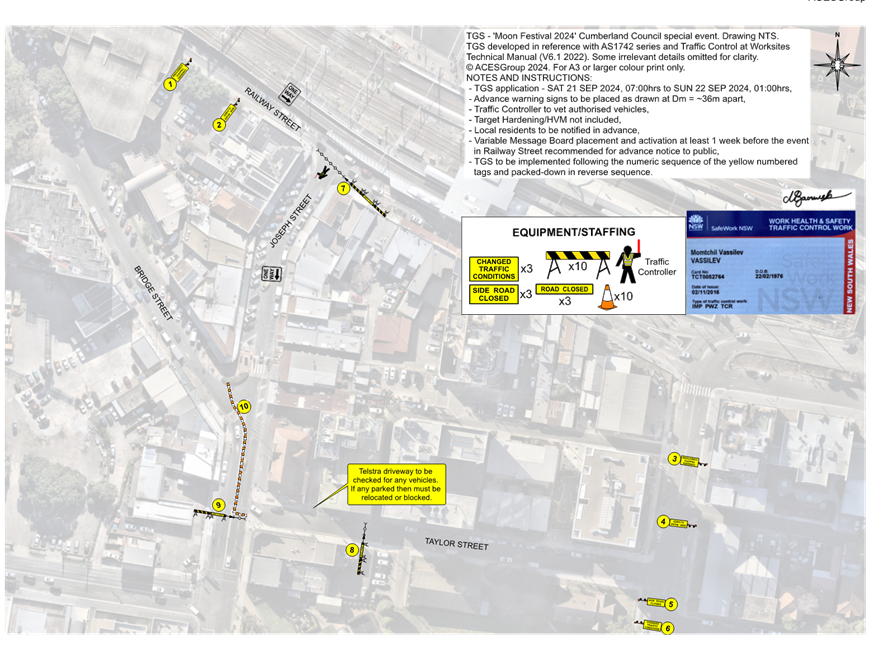
CTC-24-146 JOSEPH STREET, LIDCOMBE - TEMPORARY ROAD CLOSURE FOR MOON FESTIVAL CELEBRATIONS.................................................. 693
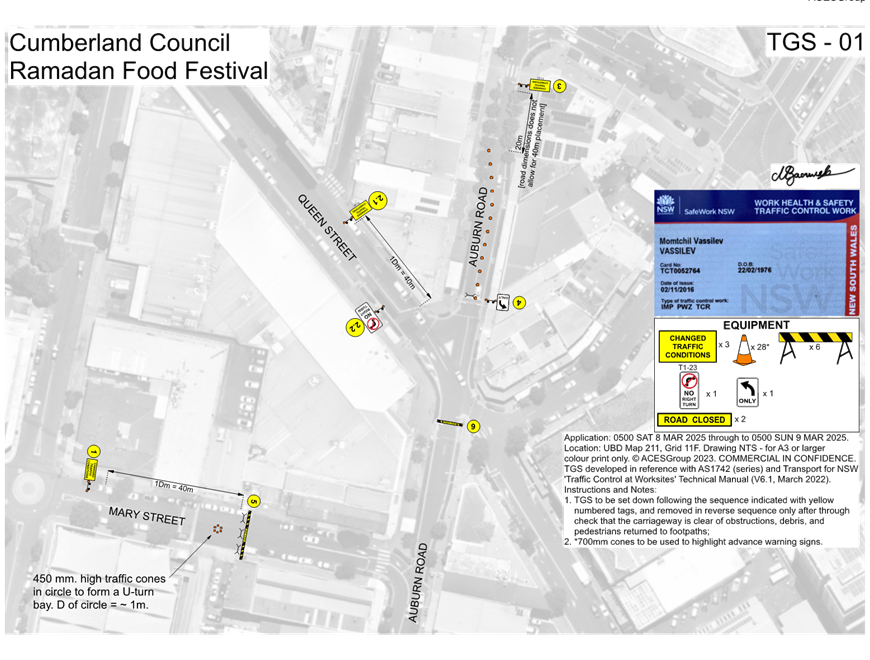
CTC-24-147 TEMPORARY ROAD CLOSURES IN THE AUBURN CBD FOR RAMADAN FOOD FESTIVAL 2025......................................................................... 707
CTC-24-148 NEW STREET, AUBURN - PROPOSED TEMPORARY ROAD CLOSURE FOR ST RAYMOND MARONITE CHURCH ANNUAL COMMUNITY EVENT 727
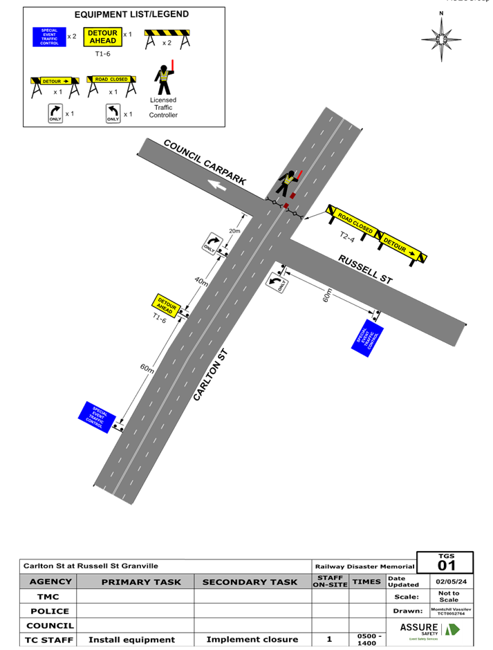
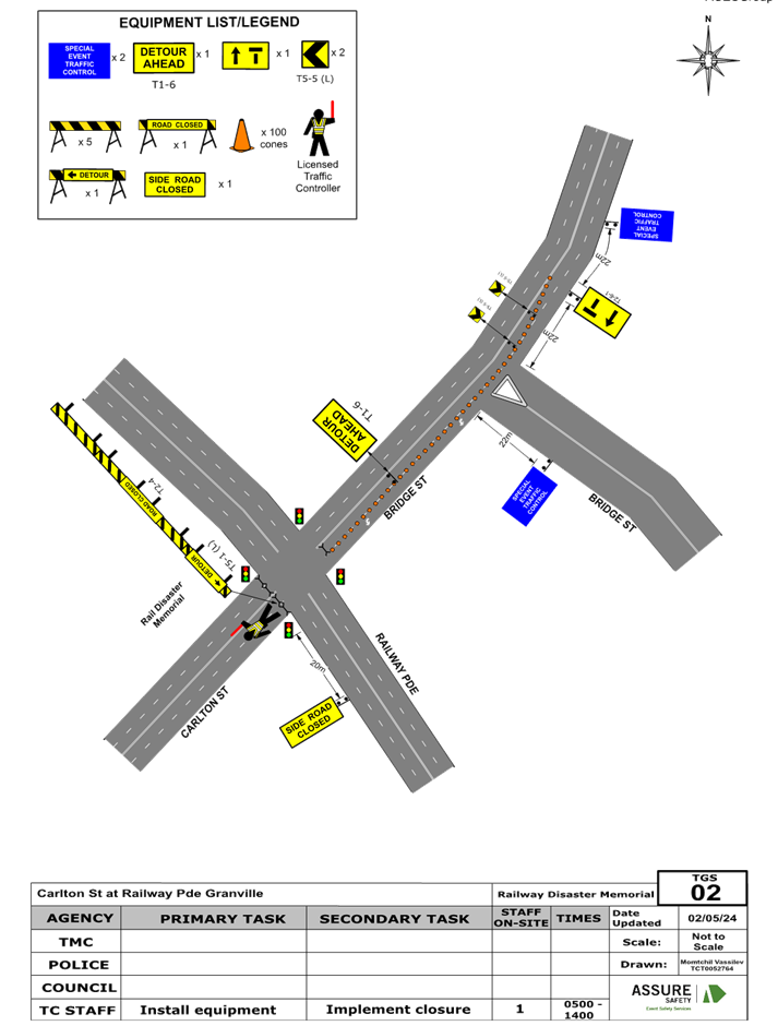
CTC-24-149 CARLTON STREET, GRANVILLE - PROPOSED TEMPORARY ROAD CLOSURE FOR GRANVILLE RAILWAY DISASTER MEMORIAL 733
CTC-24-150 MERRYLANDS ROAD, MERRYLANDS - TEMPORARY ROAD CLOSURE FOR ‘NOWRUZ’ PERSIAN NEW YEAR CELEBRATIONS............ 751
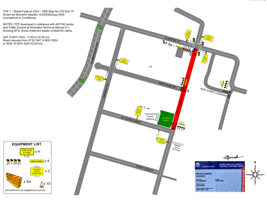
CTC-24-151 STATION STREET, WENTWORTHVILLE – PROPOSED ROAD CLOSURES FOR DIWALI FESTIVAL EVENT.................................. 765
CTC-24-152 TEMPORARY ROAD CLOSURE FOR ‘AUSTRALIA DAY’ CELEBRATIONS 781
CTC-24-153 DRAFT ‘LOCAL TRAFFIC AND TRANSPORT POLICY AND GUIDELINE’ 799
CTC-24-154 TEMPORARY OPTIONAL DELEGATIONS ON TRAFFIC MANAGEMENT AND PEDESTRIAN WORKS TO COUNCILS FROM TRANSPORT FOR NSW.......................................................................................................... 821
5 June 2024
Summary of Reports
Part 1 - Recommended for Approval under Delegated Authority
|
Item # |
Title |
Electorate |
Police Area Command (PAC) |
||||
|
Fairfield |
Granville |
Prospect |
Auburn |
Cumberland |
Auburn |
||
|
CTC-24-096 |
OXFORD STREET, BERALA - ROAD SAFETY CONCERNS |
|
|
|
´ |
|
´ |
|
CTC-24-097 |
ELM ROAD, AUBURN - ROAD SAFETY CONCERNS |
|
|
|
´ |
|
´ |
|
CTC-24-098 |
THE AVENUE, GRANVILLE - ROAD SAFETY CONCERNS |
|
´ |
|
|
´ |
|
|
CTC-24-099 |
VILLIERS STREET, MERRYLANDS - ROAD SAFETY CONCERNS |
|
´ |
|
|
´ |
|
|
CTC-24-100 |
HILLTOP ROAD, MERRYLANDS - ROAD SAFETY CONCERNS |
|
´ |
|
|
´ |
|
|
CTC-24-101 |
CLARENCE STREET, MERRYLANDS – ROAD SAFETY CONCERNS – CONSULTATION RESULT |
|
´ |
|
|
´ |
|
|
CTC-24-102 |
DESMOND STREET, MERRYLANDS WEST - ROAD SAFETY CONCERNS |
|
´ |
|
|
´ |
|
|
CTC-24-103 |
HAWKSVIEW STREET, GUILDFORD AND MERRYLANDS – ROAD SAFETY CONCERN |
|
´ |
|
|
´ |
|
|
CTC-24-104 |
THE ESPLANADE, GUILDFORD - ROAD SAFETY CONCERNS |
|
´ |
|
|
´ |
|
|
CTC-24-105 |
LANCE CRESCENT, GREYSTANES - ROAD SAFETY CONCERNS |
|
|
´ |
|
´ |
|
|
CTC-24-106 |
ELDRIDGE ROAD, GREYSTANES - ROAD SAFETY CONCERNS |
|
|
´ |
|
´ |
|
|
CTC-24-107 |
OATLANDS STREET, WENTWORTHVILLE - ROAD SAFETY CONCERNS |
|
|
´ |
|
´ |
|
|
CTC-24-108 |
PASTORAL CIRCUIT, PEMULWUY – EXTENSION OF THE EXISTING ‘NO STOPPING’ RESTRICTIONS |
|
|
´ |
|
´ |
|
|
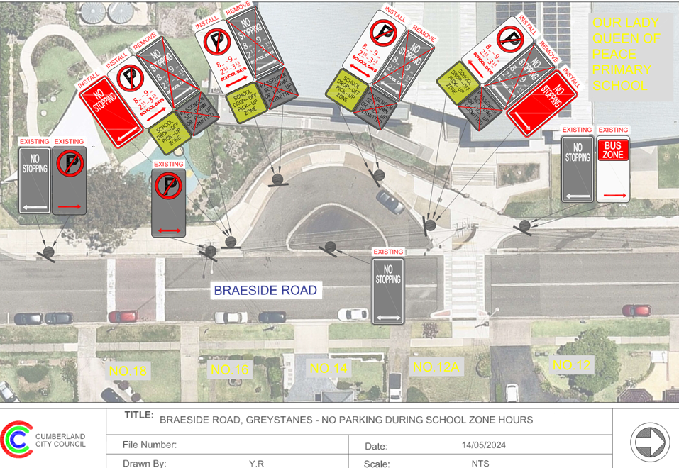
CTC-24-109 |
BRAESIDE ROAD, GREYSTANES - MODIFICATIONS TO THE EXISTING 'NO STOPPING' RESTRICTIONS |
|
|
´ |
|
´ |
|
|
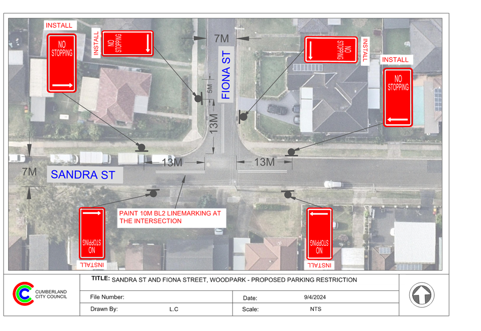
CTC-24-110 |
SANDRA STREET AND FIONA STREET, WOODPARK – PROPOSED ‘NO STOPPING’ RESTRICTIONS AND LINEMARKING |
|
´ |
|
|
´ |
|
|
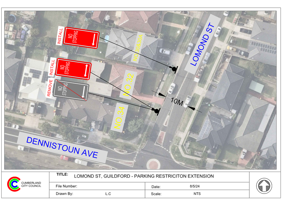
CTC-24-111 |
LOMOND STREET, GUILDFORD WEST – EXTENSION OF THE EXISTING ‘NO STOPPING’ RESTRICTIONS |
|
´ |
|
|
´ |
|
|
CTC-24-112 |
BURSILL STREET AND TALBOT ROAD, GUILDFORD – PROPOSED ‘NO STOPPING’ RESTRICTIONS AND LINEMARKING |
|
´ |
|
|
´ |
|
|
CTC-24-113 |
MILITARY ROAD AND BYRON ROAD, GUILDFORD – PROPOSED ‘NO STOPPING’ RESTRICTIONS AND LINEMARKING |
|
´ |
|
|
´ |
|
|
CTC-24-114 |
KERRS ROAD AND BERNARD STREET, LIDCOMBE – PROPOSED ‘NO STOPPING’ RESTRICTIONS AND LINEMARKING |
|
|
|
´ |
|
´ |
|
CTC-24-115 |
AUBURN ROAD, BERALA - PARKING ARRANGEMENT REIVEW |
|
|
|
´ |
|
´ |
|
CTC-24-116 |
MARY STREET, LIDCOMBE – APPLICATION FOR ‘WORKS ZONE’ SIGNAGE |
|
|
|
´ |
|
´ |
|
CTC-24-117 |
PLATFORM STREET, LIDCOMBE – PROPOSED PARKING RESTRICTIONS |
|
|
|
´ |
|
´ |
|
CTC-24-118 |
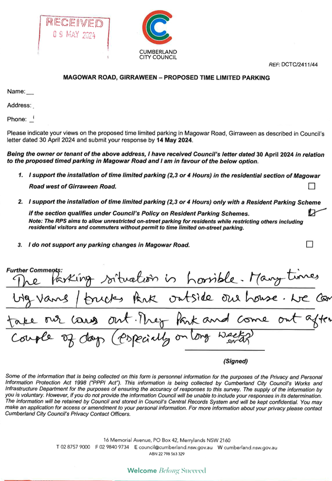
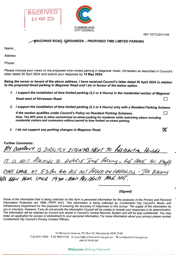
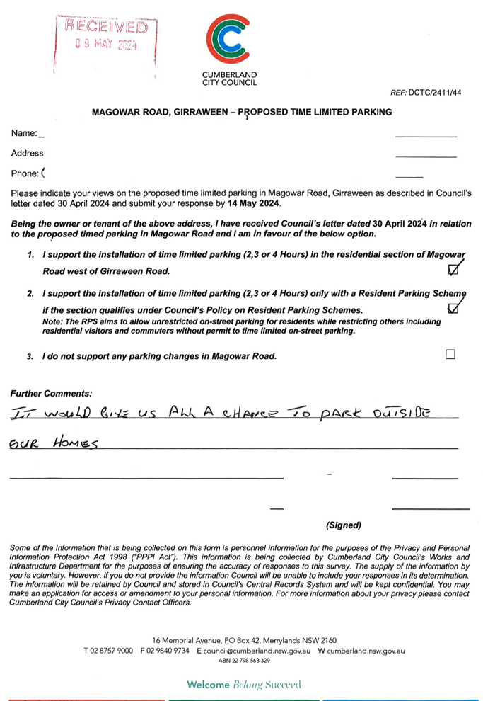
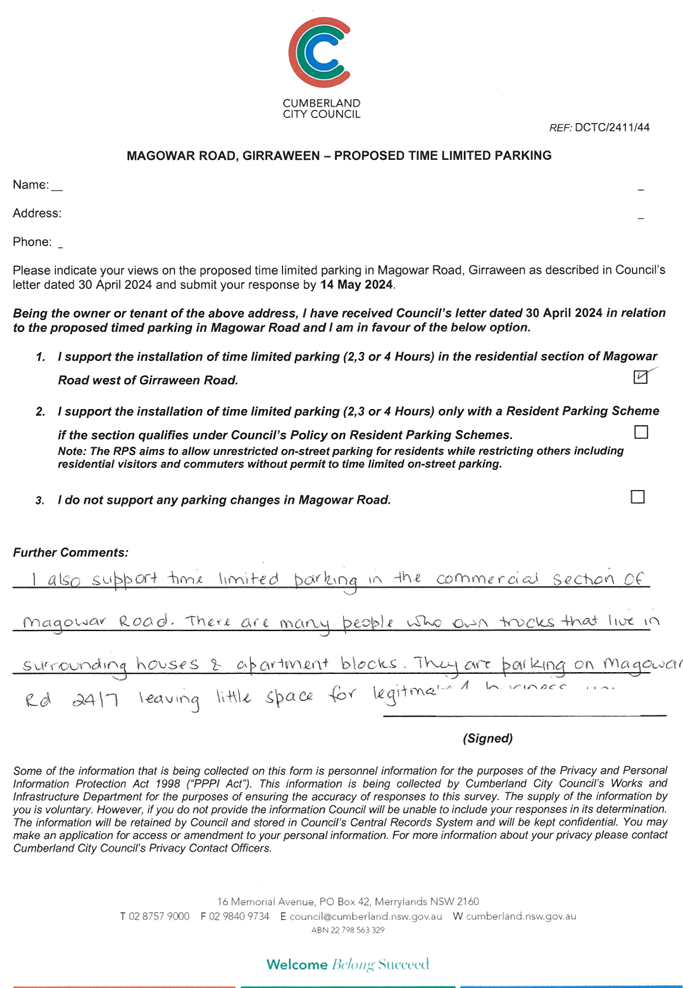
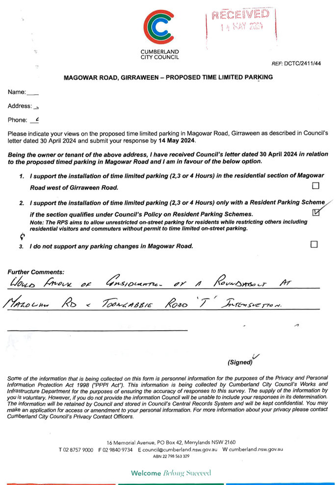
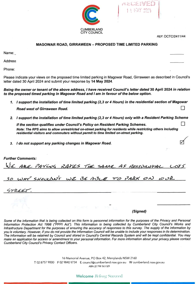
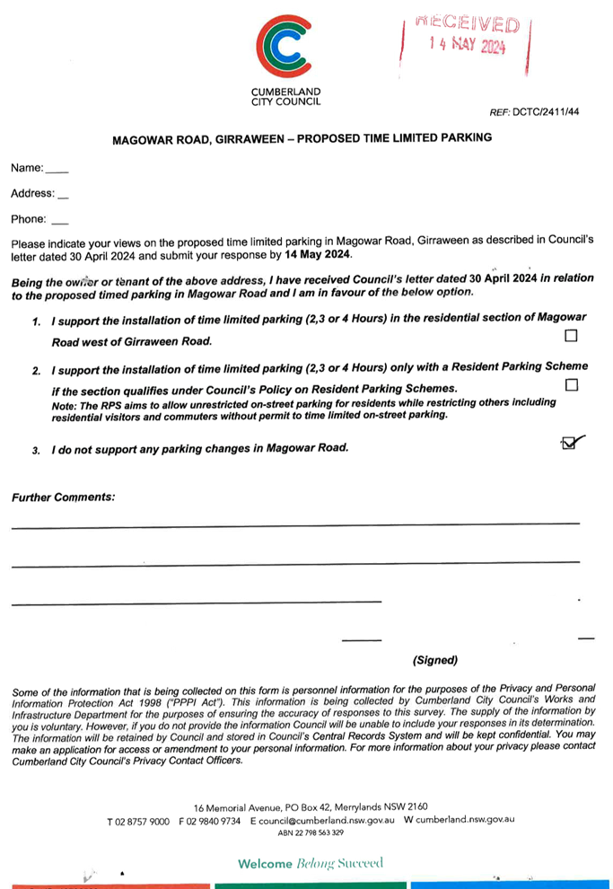
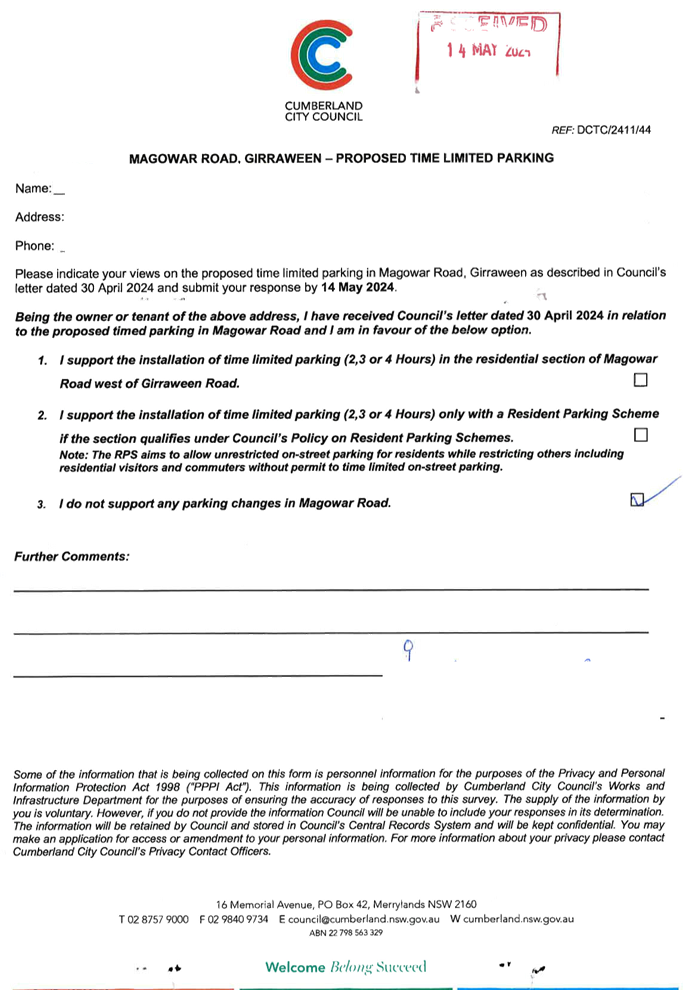
MAGOWAR ROAD, GIRRAWEEN - PROPOSED PARKING RESTRICTIONS – CONSULTATION RESULTS |
|
|
´ |
|
´ |
|
|
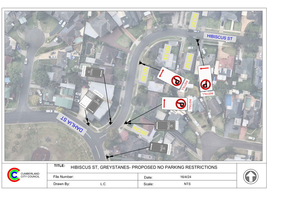
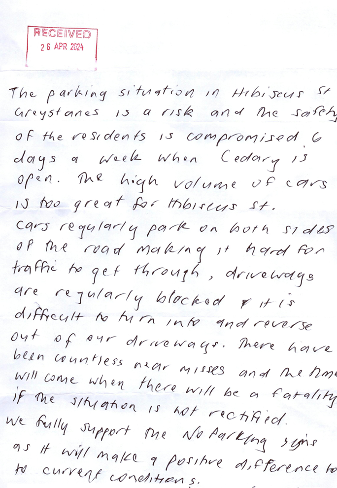
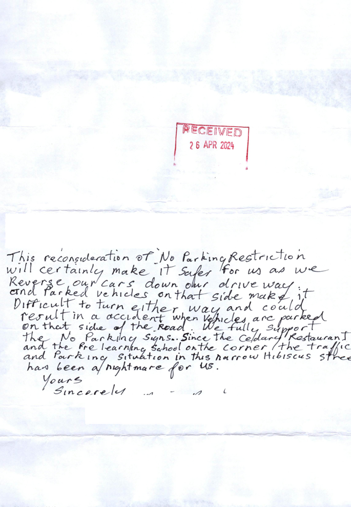
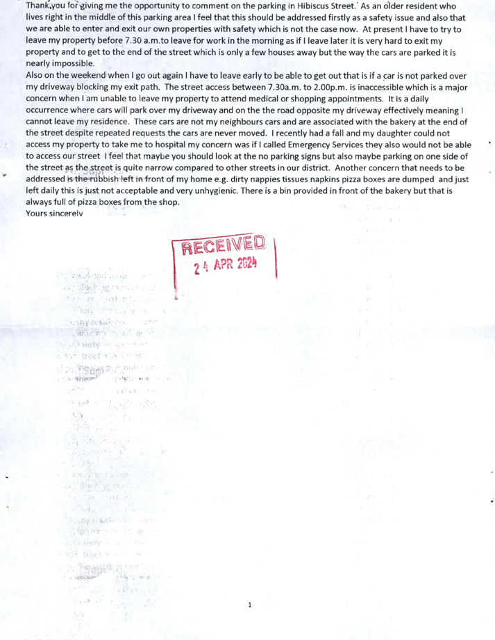
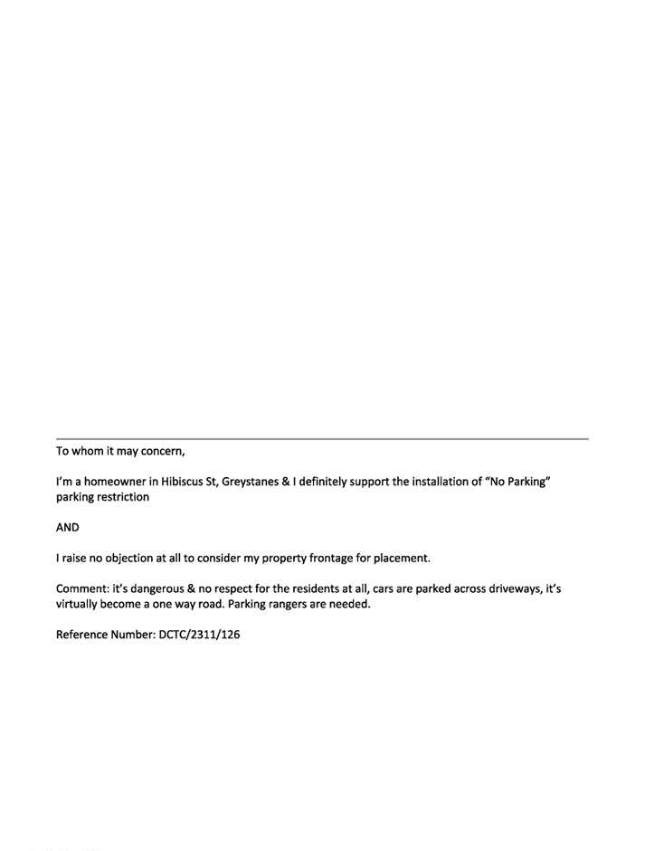
CTC-24-119 |
HIBISCUS STREET, GREYSTANES – PROPOSED ‘NO PARKING’ PARKING RESTRICITONS |
|
|
´ |
|
´ |
|
|
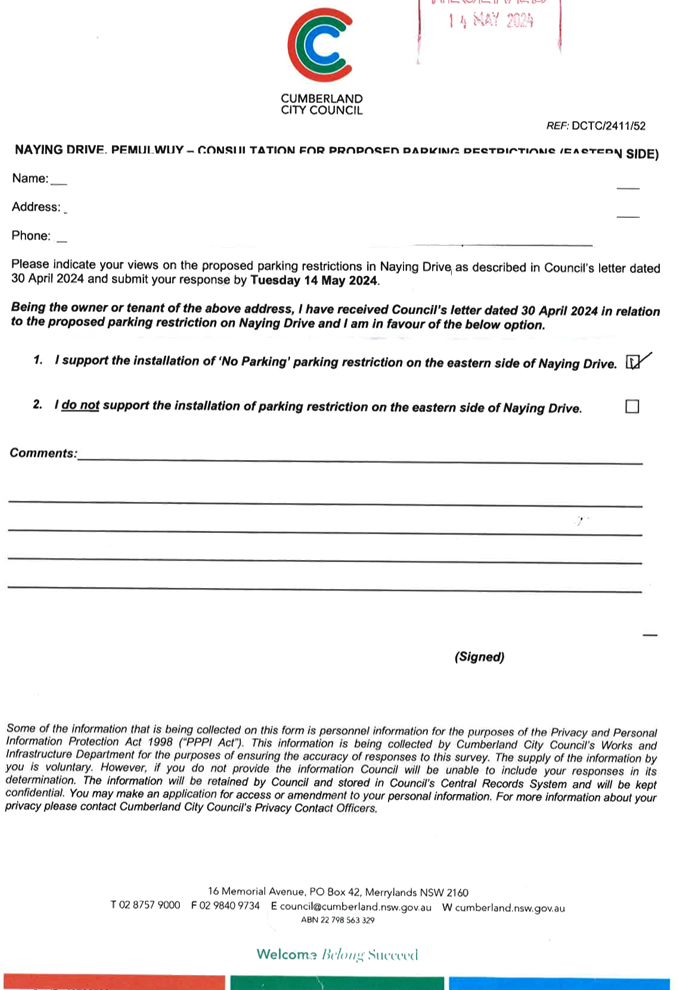
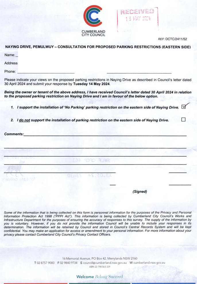
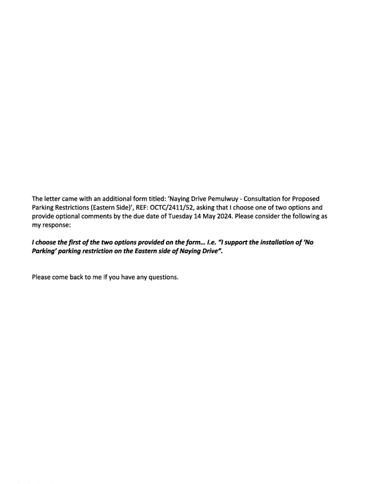
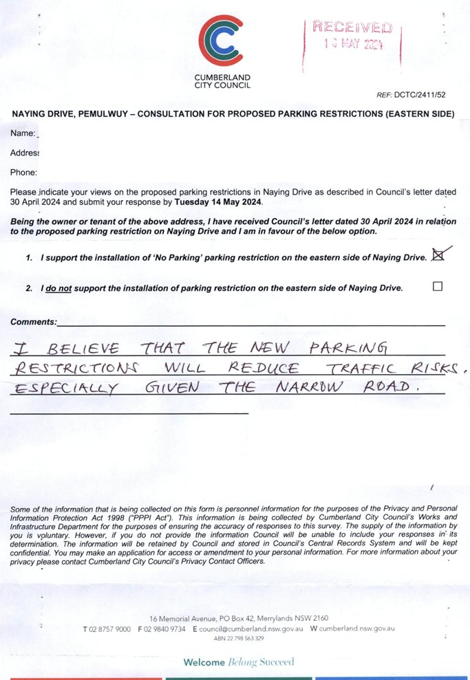
CTC-24-120 |
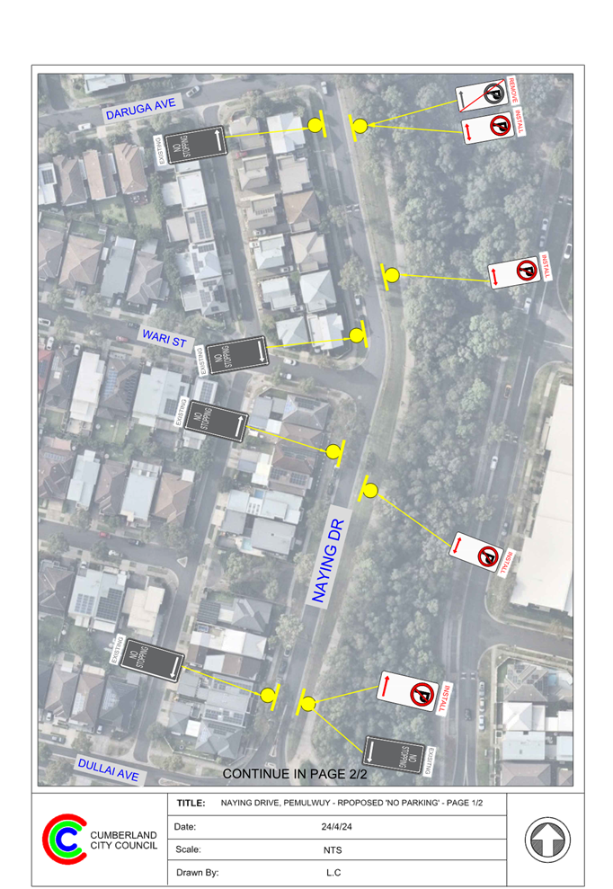
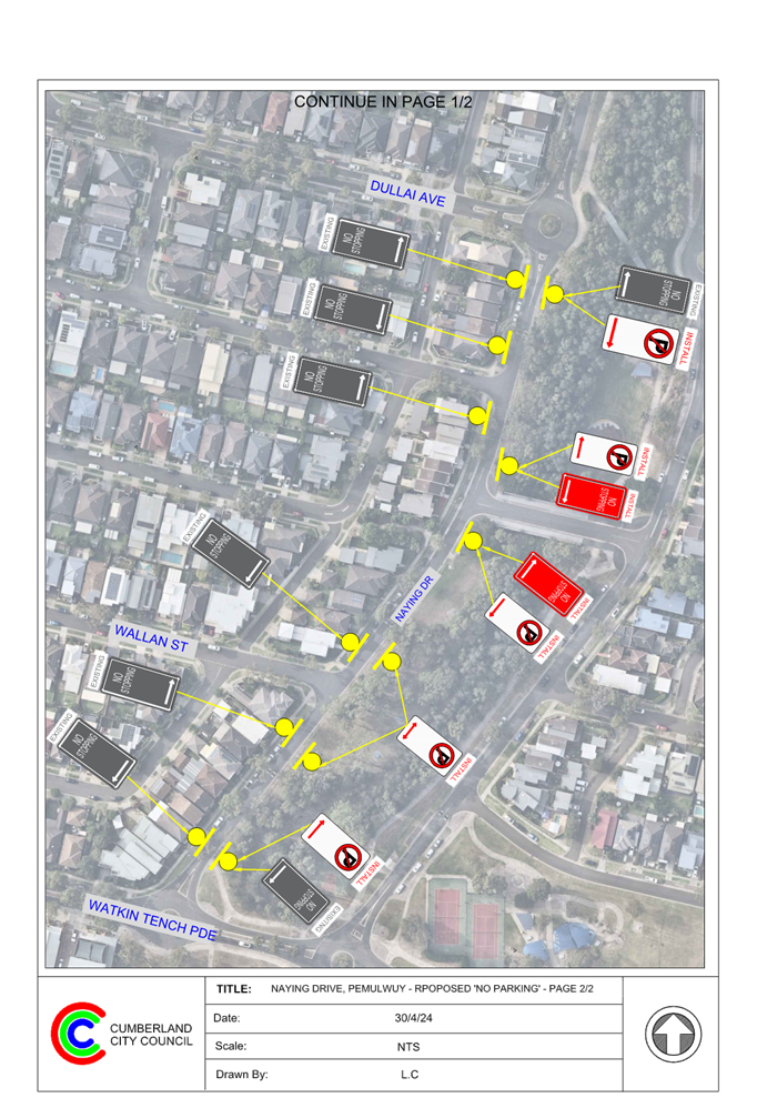
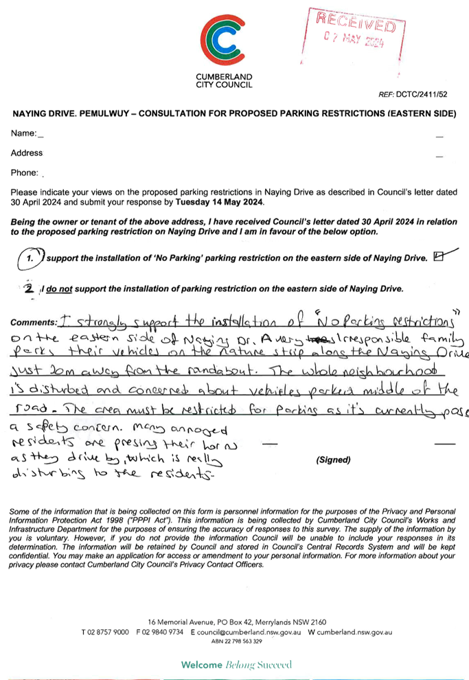
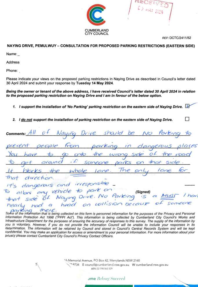
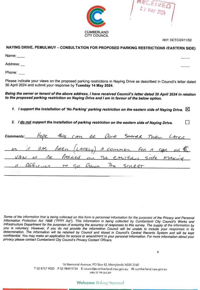
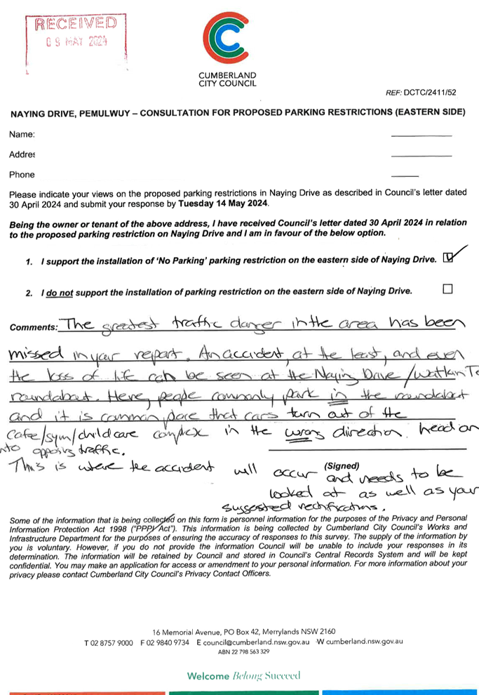
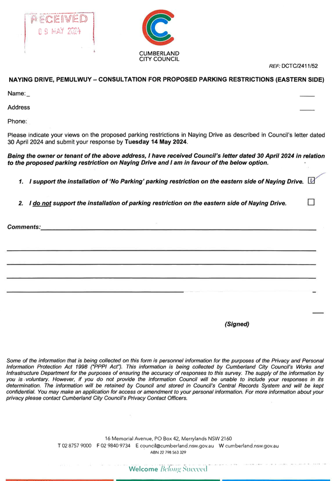
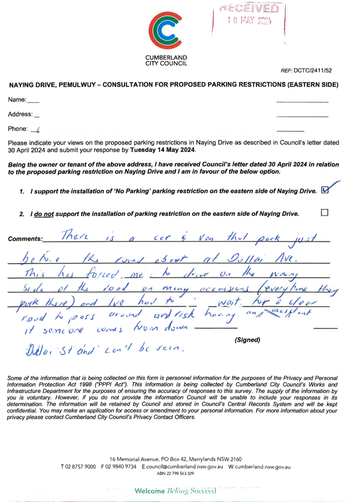
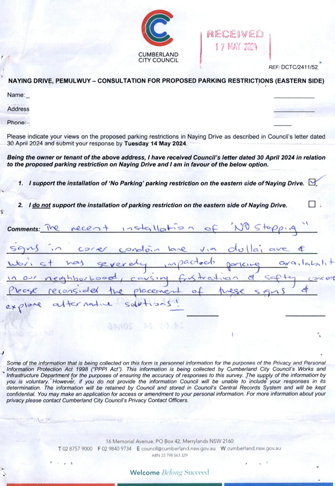
NAYING DRIVE, PEMULWUY – PROPOSED ‘NO PARKING’ PARKING RESTRICITONS |
|
|
´ |
|
´ |
|
|
CTC-24-121 |
PYE STREET, WESTMEAD – REMOVAL OF REDUNDANT ‘BUS ZONE’ SIGNAGE |
|
´ |
|
|
´ |
|
|
CTC-24-122 |
DUNMORE STREET, WENTWORTHVILLE – REQUEST FOR A MARKED PEDESTRIAN CROSSING |
|
|
´ |
|
´ |
|
|
CTC-24-123 |
ENID AVENUE, GRANILLE – APPLICATION FOR ‘WORKS ZONE’ SIGNAGE |
|
´ |
|
|
´ |
|
|
CTC-24-124 |
PATRICIA STREET, MAYS HILL – APPLICATION FOR ‘WORKS ZONE’ SIGNAGE |
|
|
´ |
|
´ |
|
|
CTC-24-125 |
BOOMERANG STREET AND RANDLE STREET, GRANVILLE - ROAD SAFETY CONCERNS |
|
´ |
|
|
|
|
Part 2 - Recommendation to Council
|
Item # |
Title |
Electorate |
Police Area Command (PAC) |
||||
|
Fairfield |
Granville |
Prospect |
Auburn |
Cumberland |
Auburn |
||
|
CTC-24-126 |
THE BOULEVARDE, LIDCOMBE - ROAD SAFETY CONCERNS |
|
|
|
´ |
|
´ |
|
CTC-24-127 |
WALPOLE STREET, MERRYLANDS - ROAD SAFETY CONCERNS |
|
´ |
|
|
´ |
|
|
CTC-24-128 |
GLOUCESTER AVENUE, MERRYLANDS - ROAD SAFETY CONCERNS |
|
´ |
|
|
´ |
|
|
CTC-24-129 |
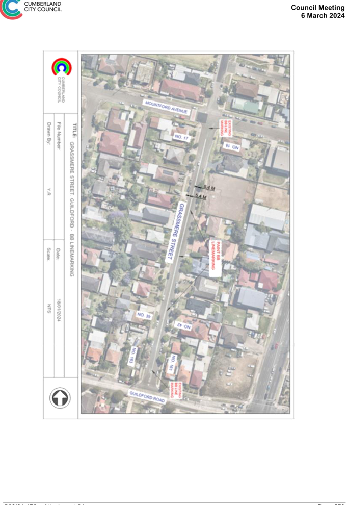
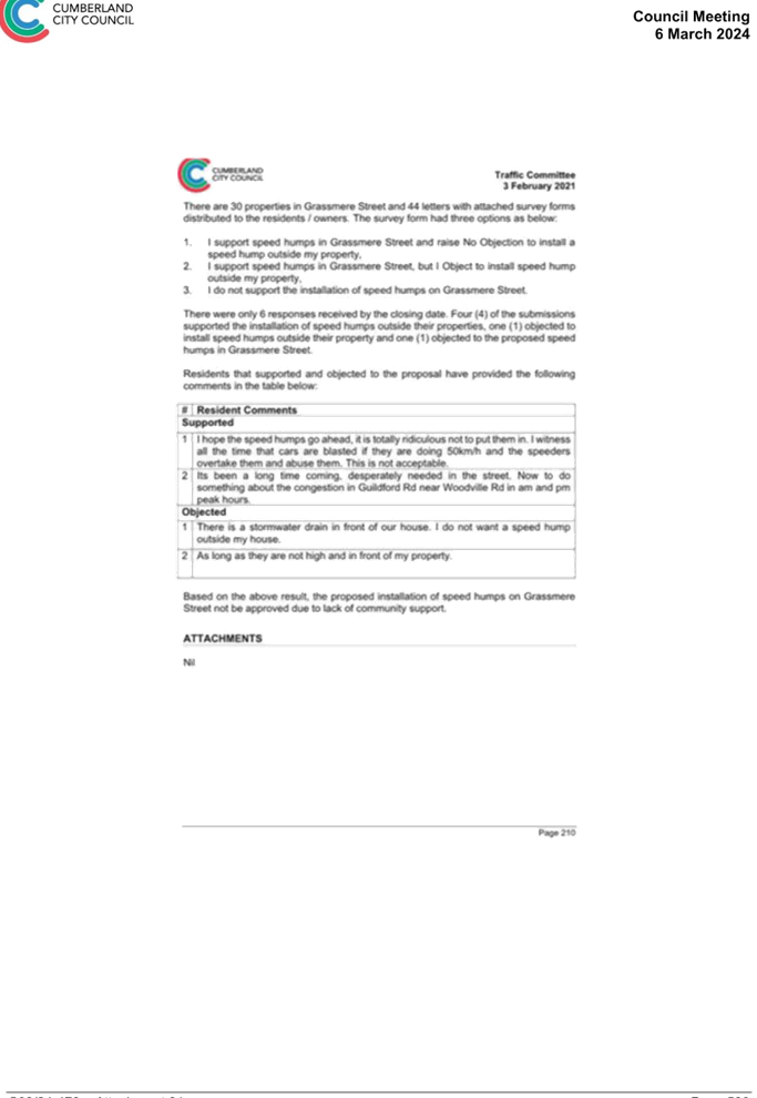
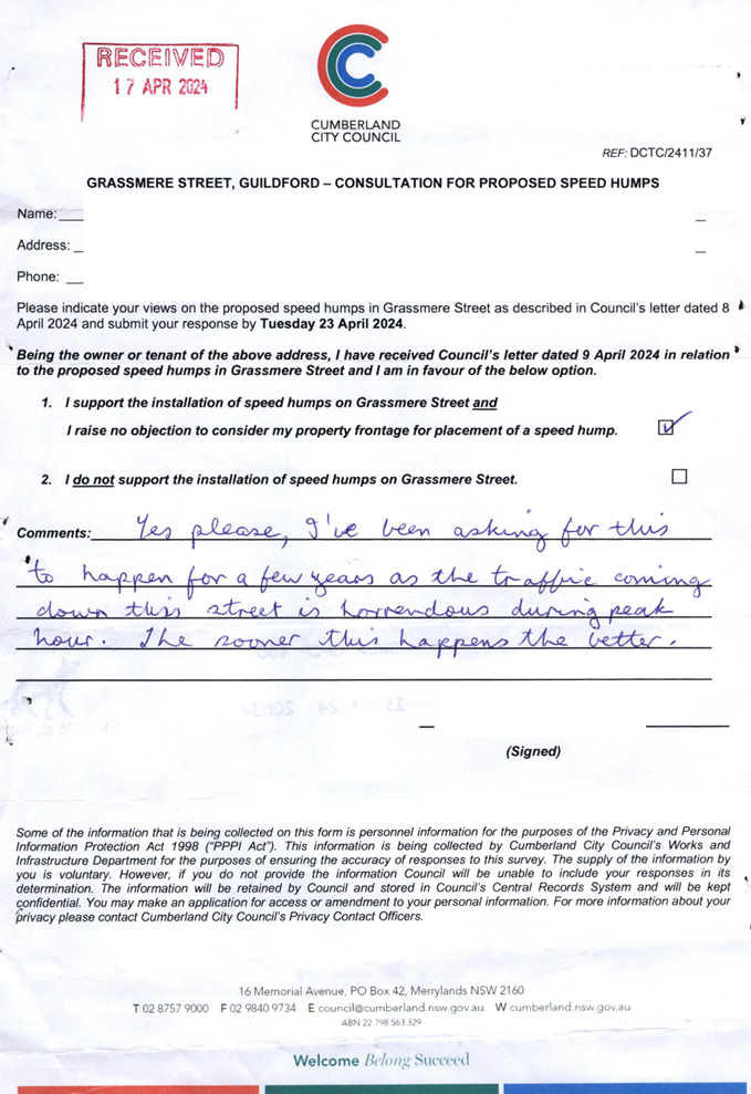
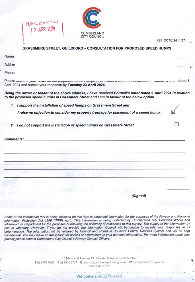
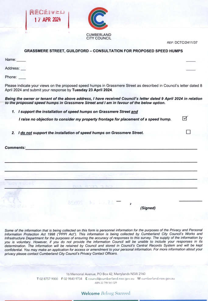
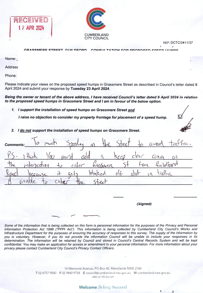
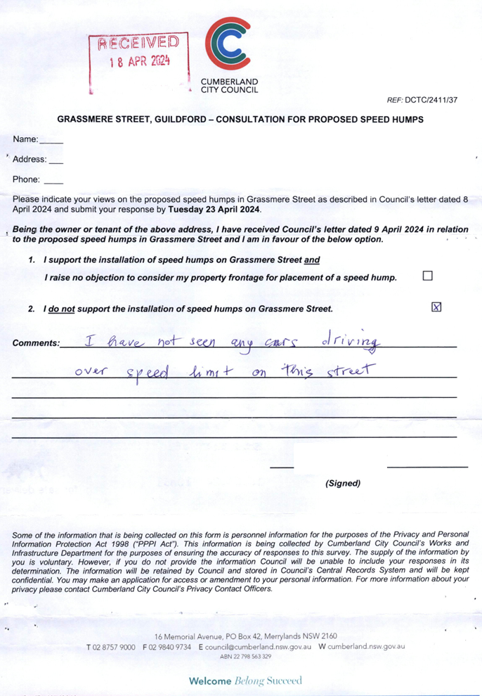
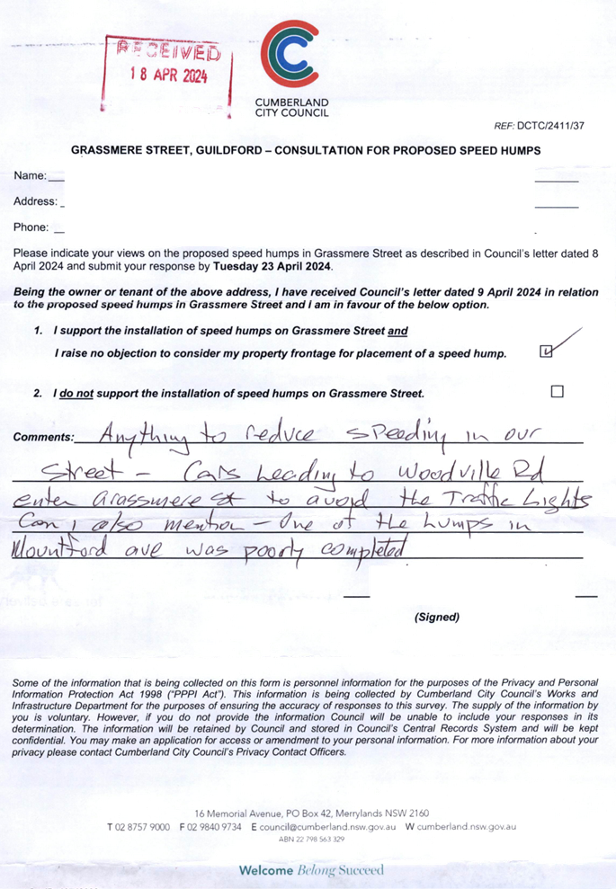
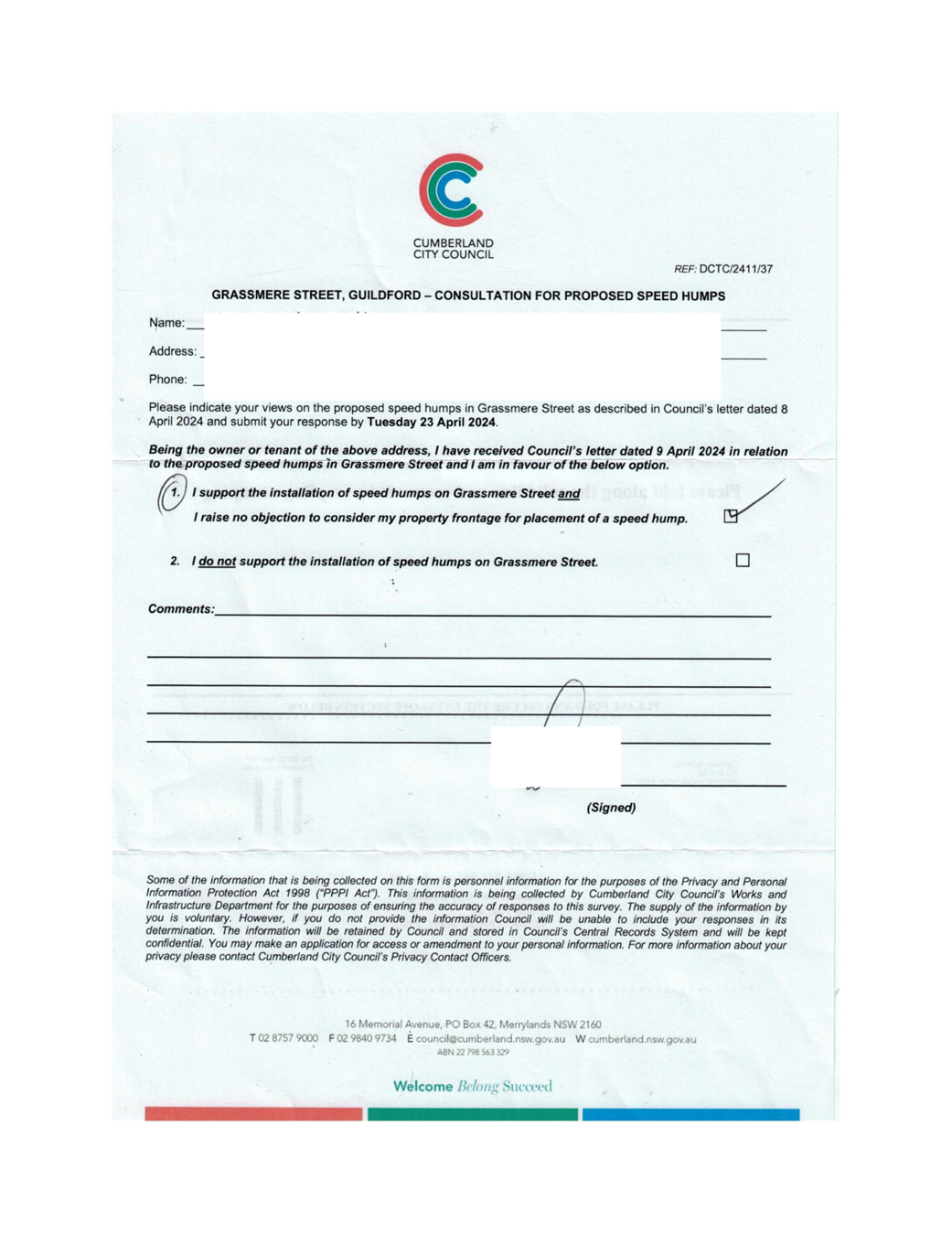
GRASSMERE STREET, GUILDFORD - ROAD SAFETY CONCERNS – CONSULTATION RESULT |
|
´ |
|
|
´ |
|
|
CTC-24-130 |
HUNT STREET, GUILDFORD WEST - ROAD SAFETY CONCERNS |
|
´ |
|
|
´ |
|
|
CTC-24-131 |
MCCREDIE ROAD, GUIDLFORD WEST - ROAD SAFETY CONCERNS |
|
´ |
|
|
´ |
|
|
CTC-24-132 |
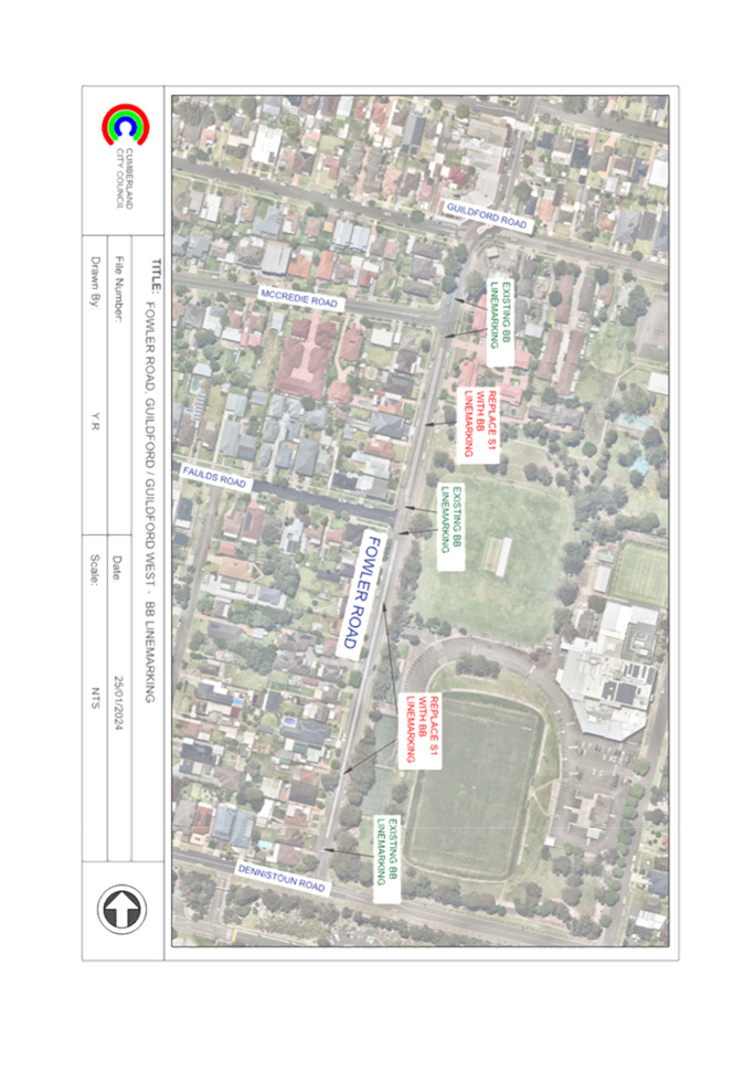
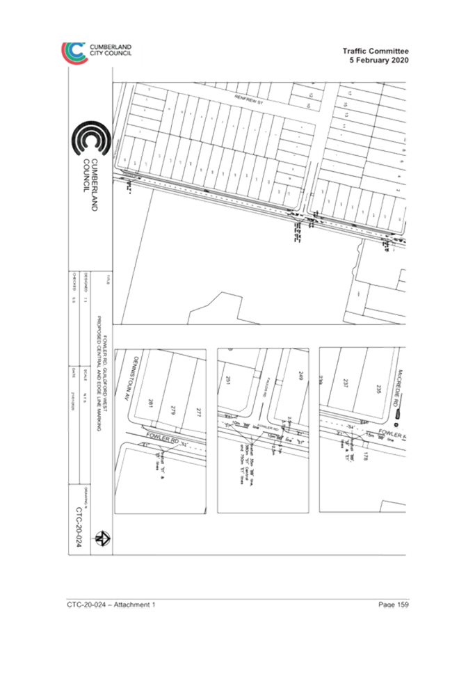
FOWLER ROAD, GUILDFORD WEST - ROAD SAFETY CONCERNS |
|
´ |
|
|
´ |
|
|
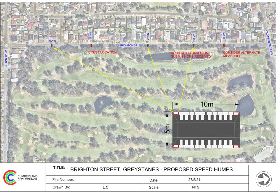
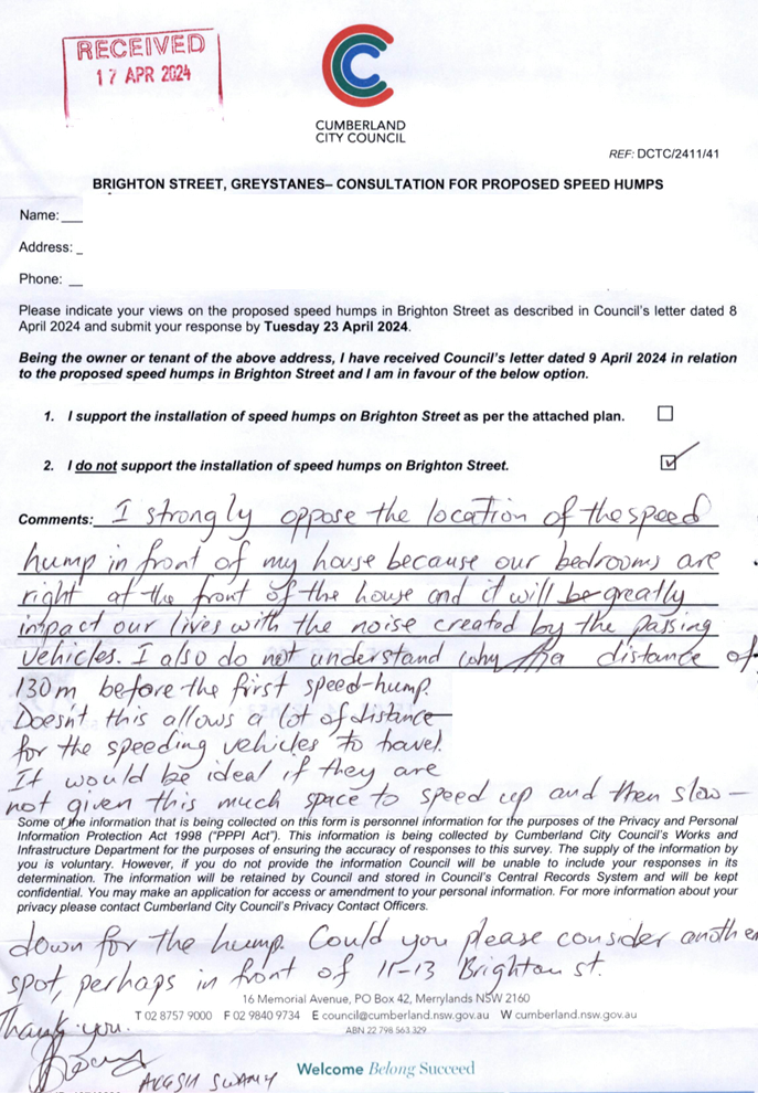
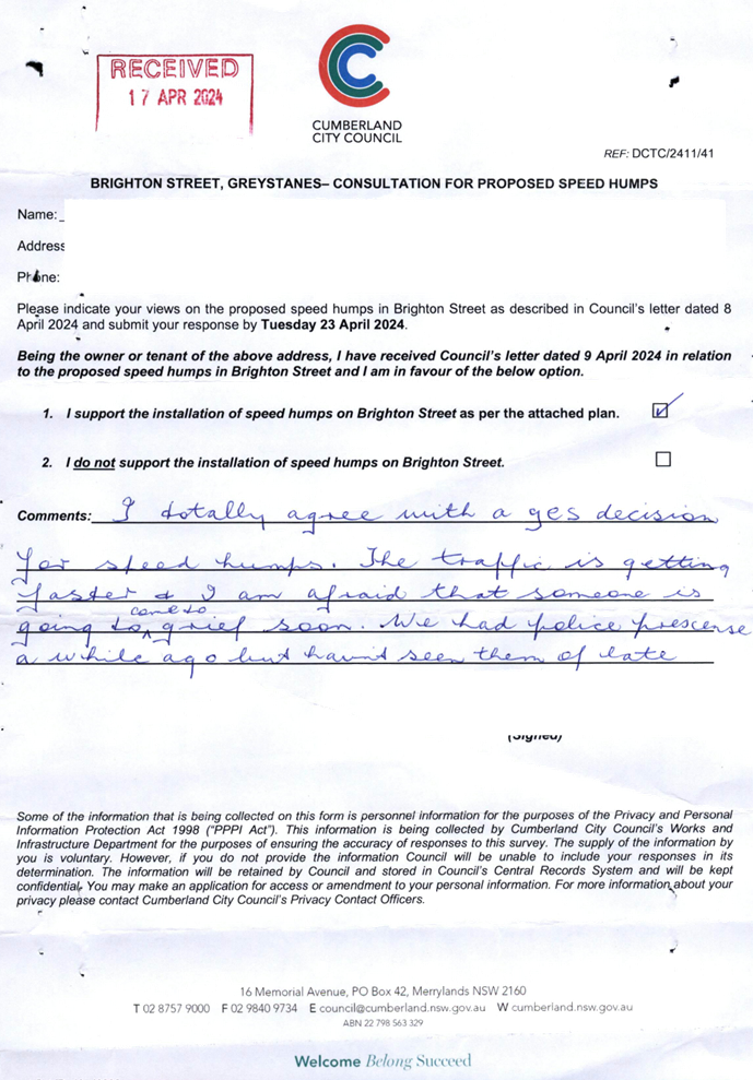
CTC-24-133 |
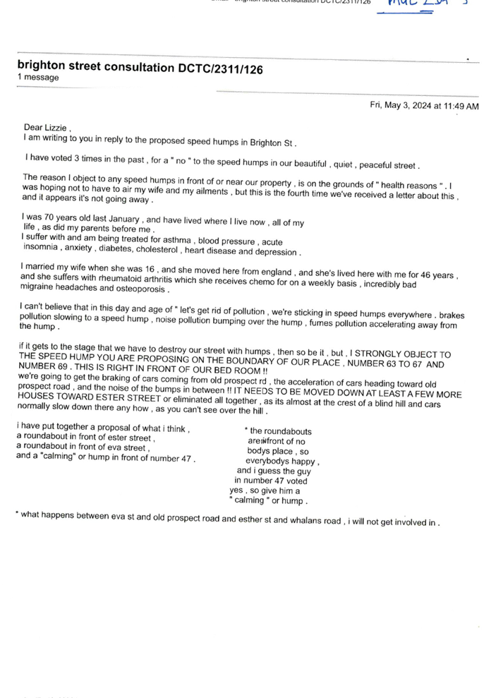
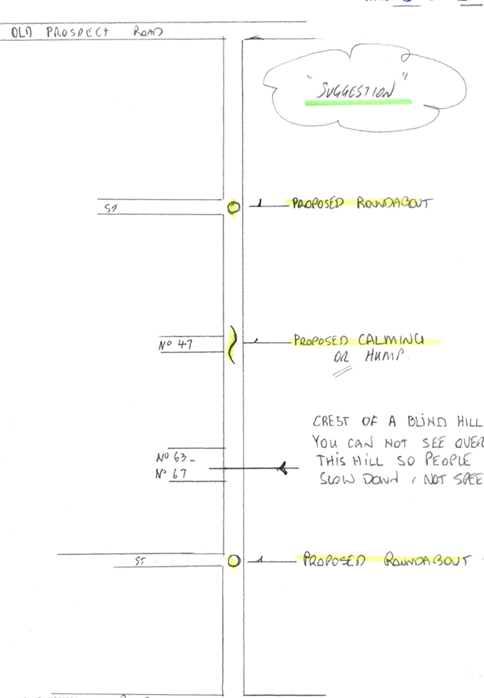
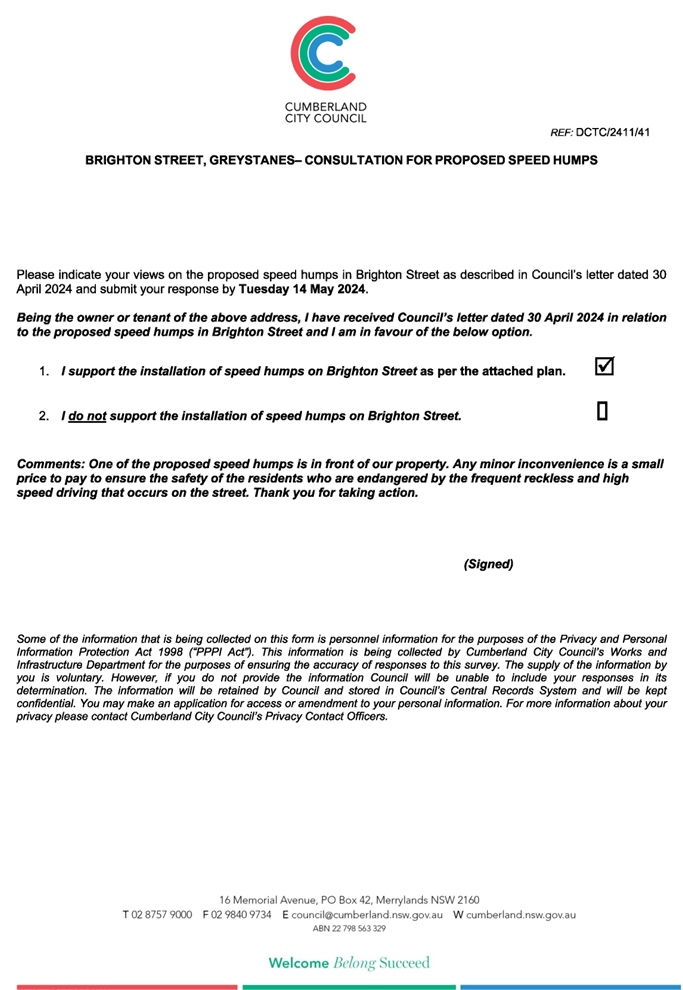
BRIGHTON STREET, GREYSTANES – ROAD SAFETY CONCERNS - CONSULTATION |
|
|
´ |
|
´ |
|
|
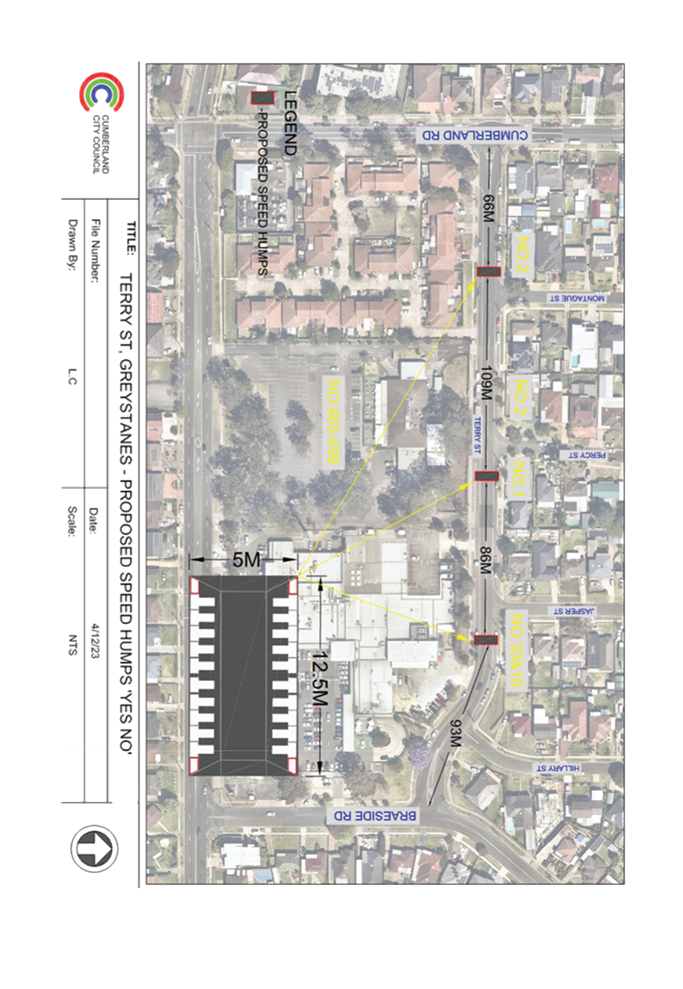
CTC-24-134 |
TERRY STREET, GREYSTANES - ROAD SAFETY CONCERNS |
|
|
´ |
|
´ |
|
|
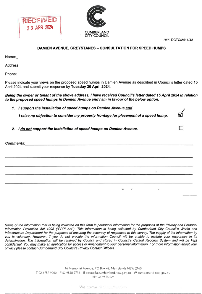
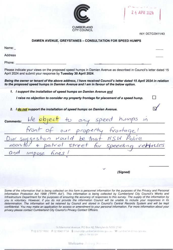
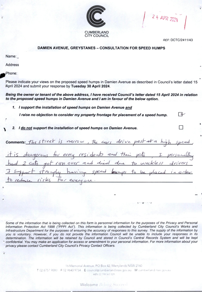
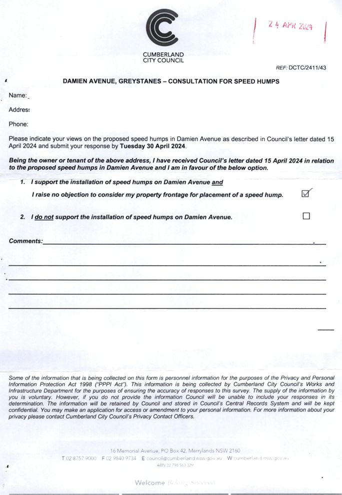
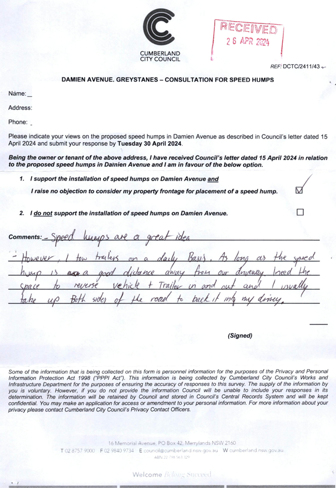
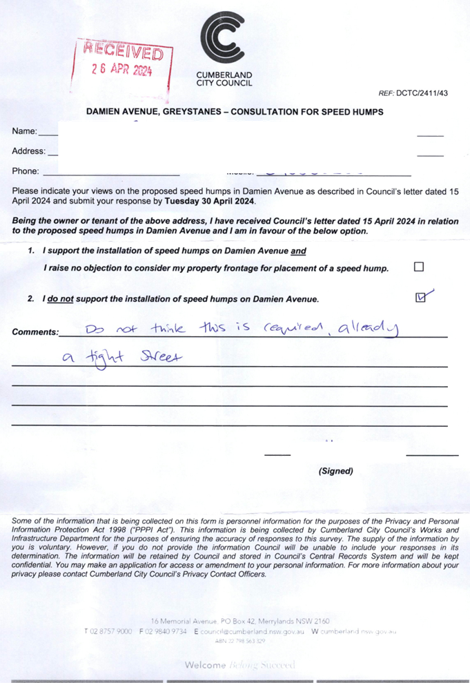
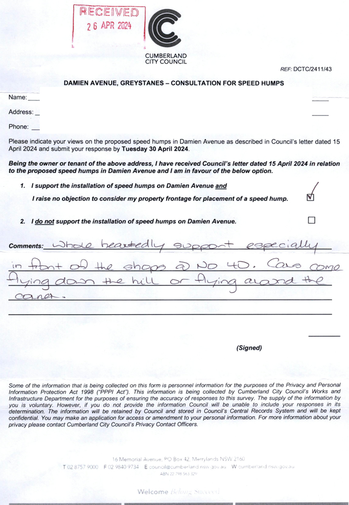
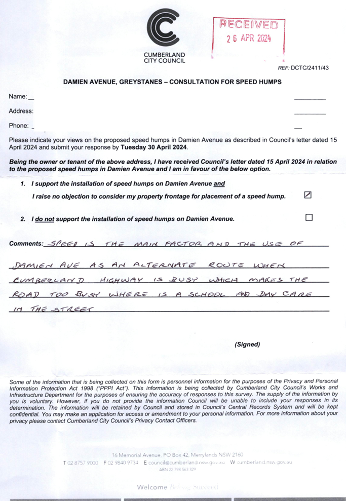
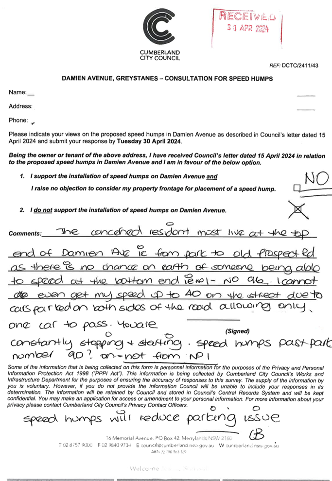
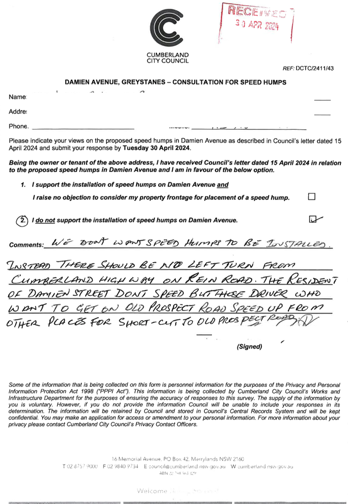
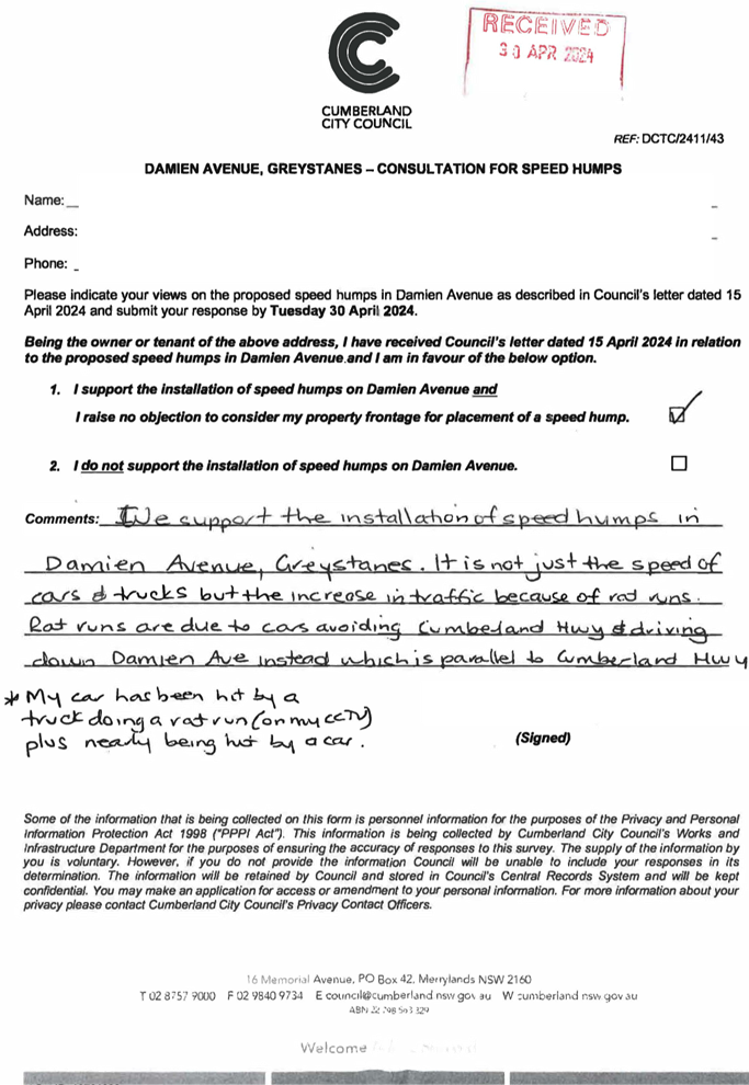
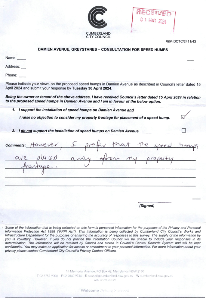
CTC-24-135 |
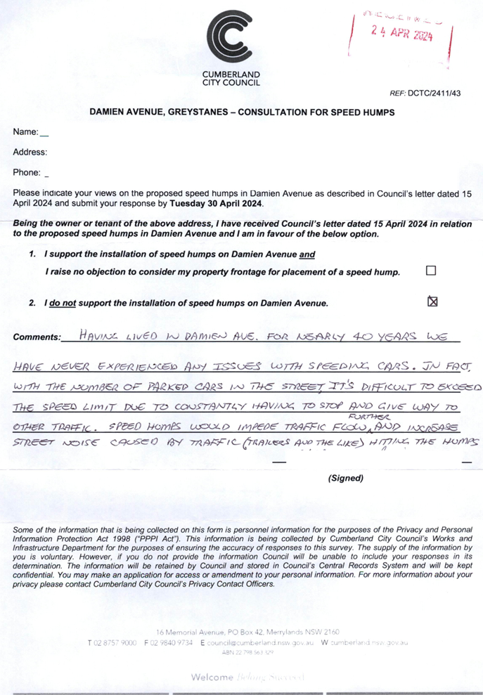
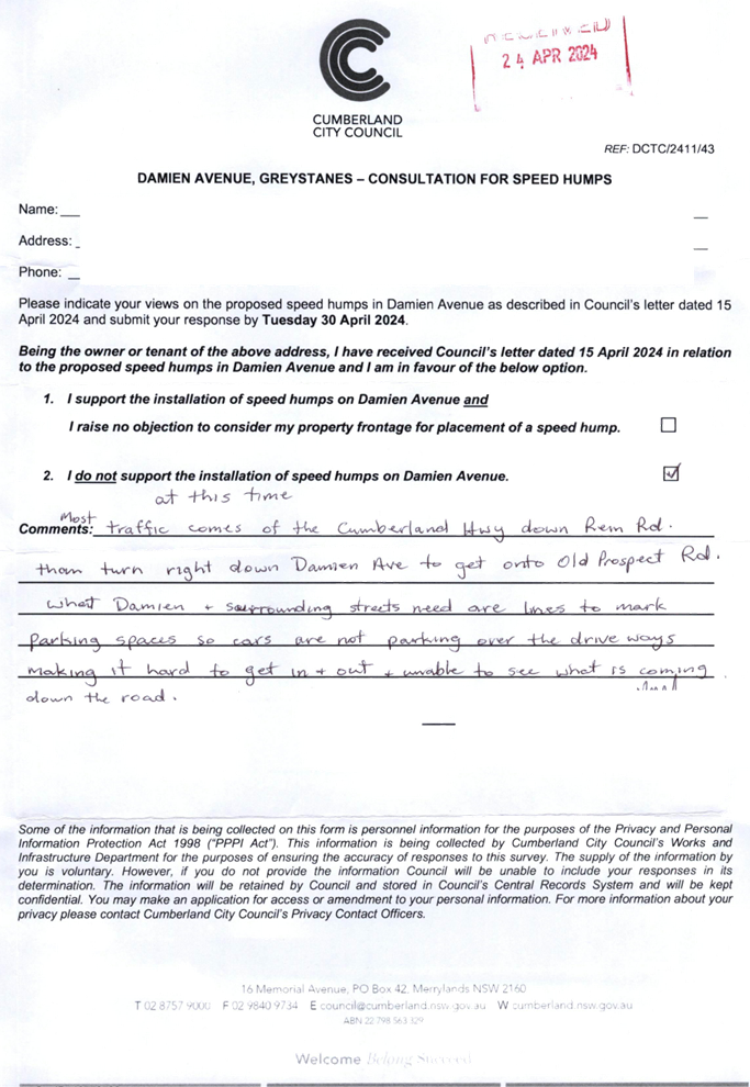
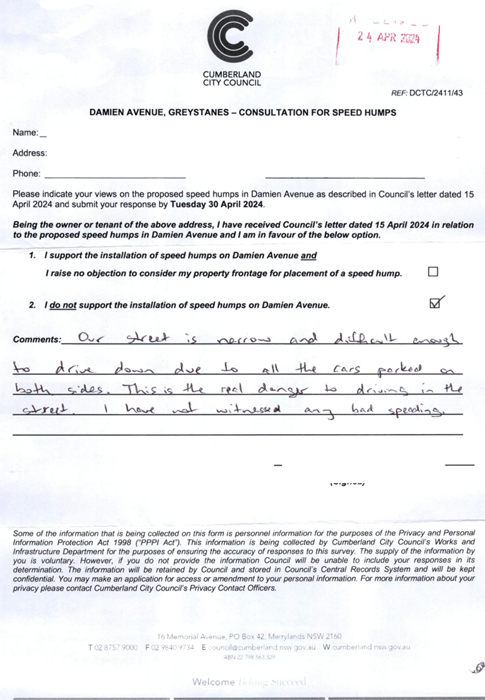
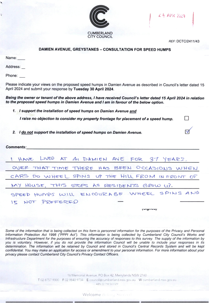
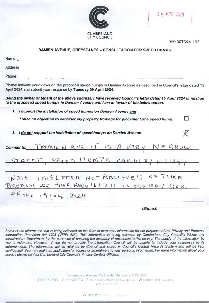
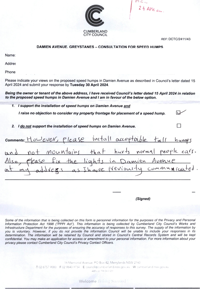
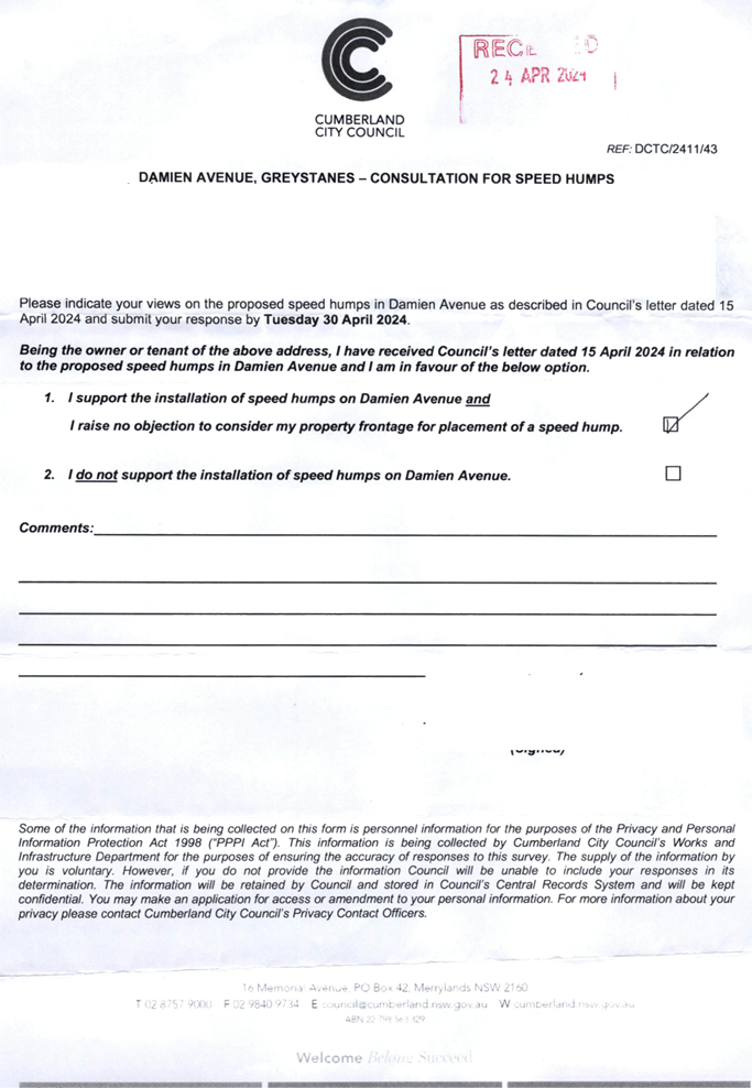
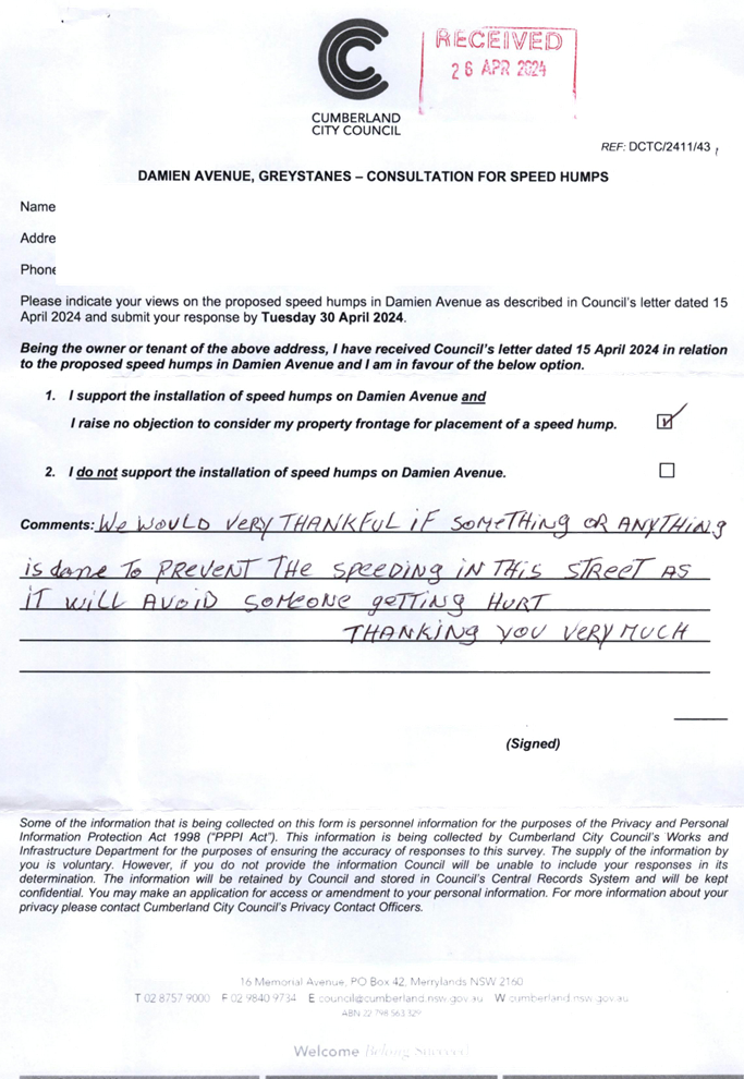
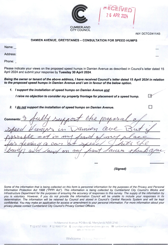
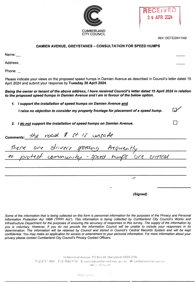
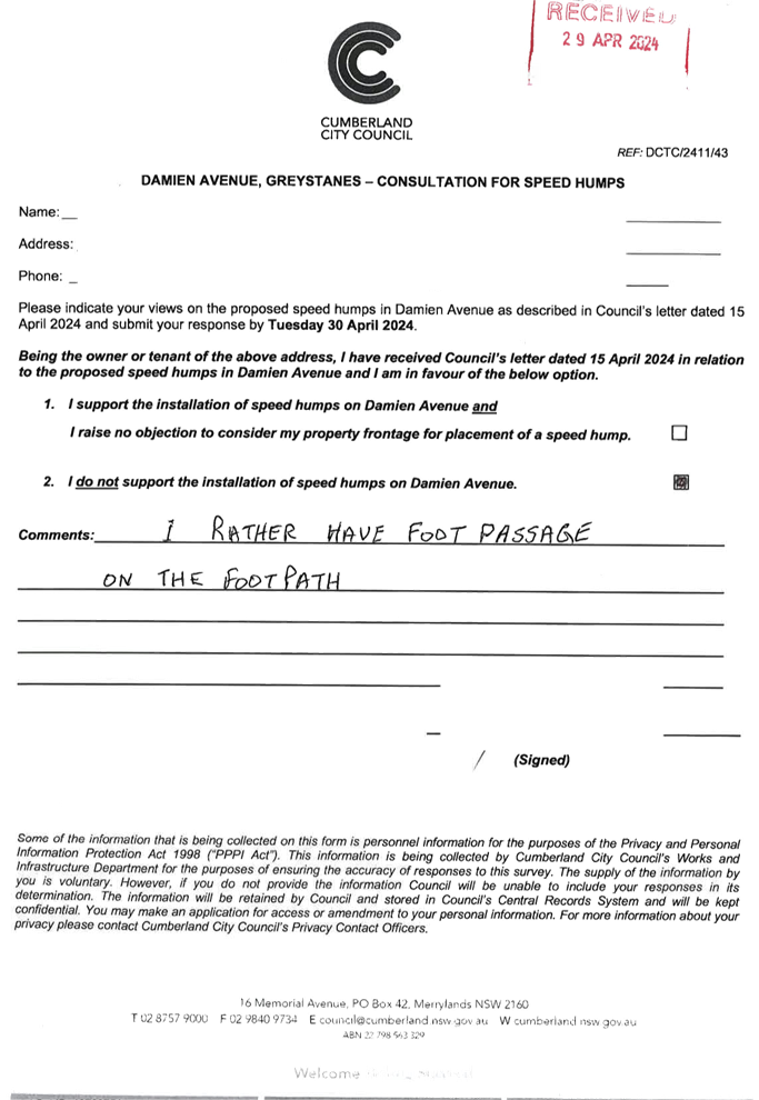
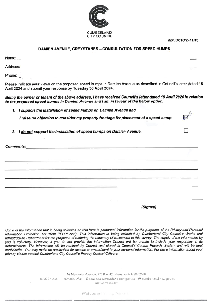
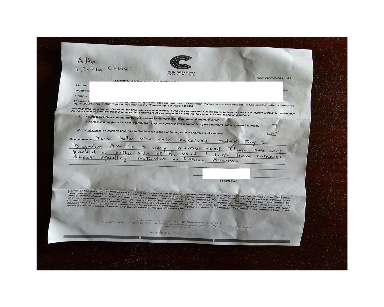
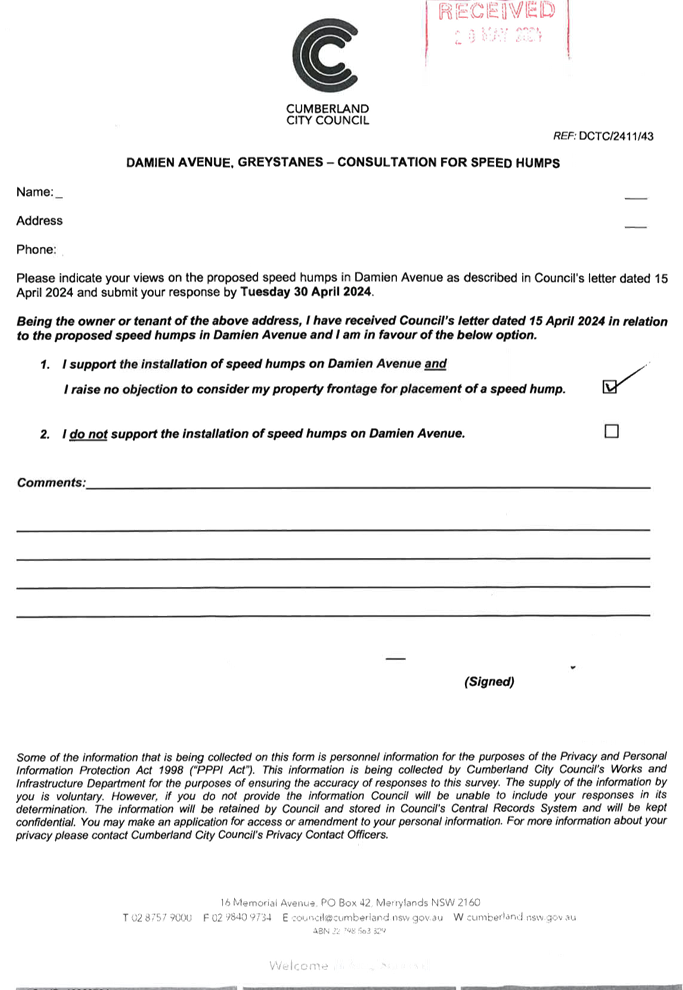
DAMIEN AVENUE, GREYSTANES - ROAD SAFETY CONCERNS |
|
|
´ |
|
´ |
|
|
CTC-24-136 |
OLD PROSPECT ROAD, GREYSTANES - ROAD SAFETY CONCERNS |
|
|
´ |
|
´ |
|
|
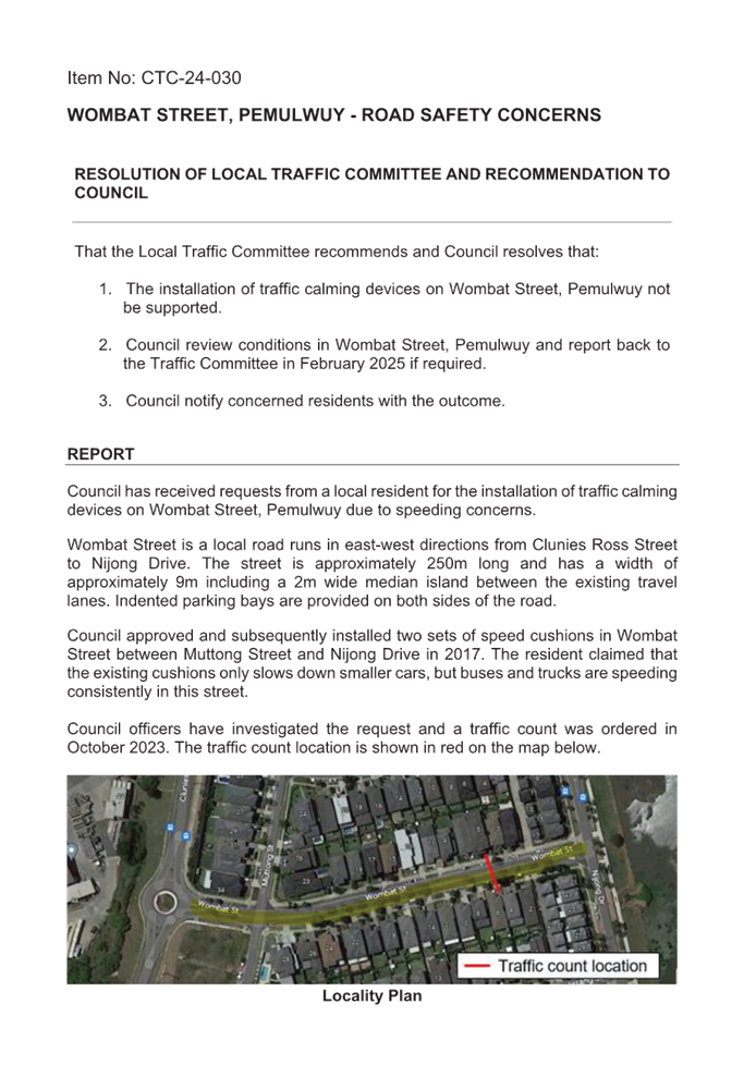
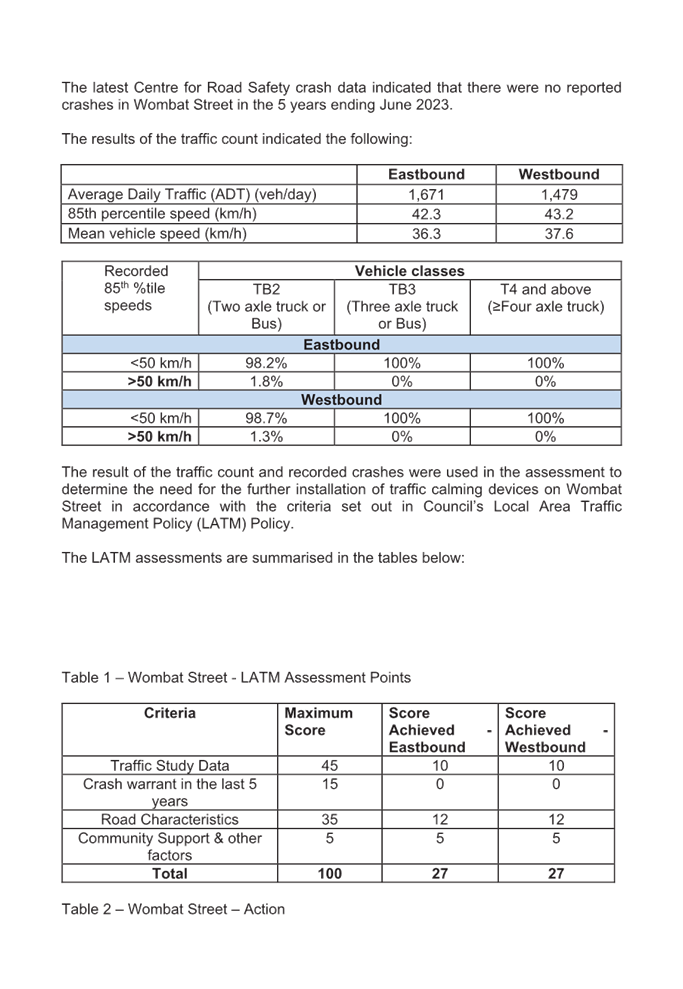
CTC-24-137 |
WOMBAT STREET, PEMULWUY - ROAD SAFETY CONCERNS |
|
|
´ |
|
´ |
|
|
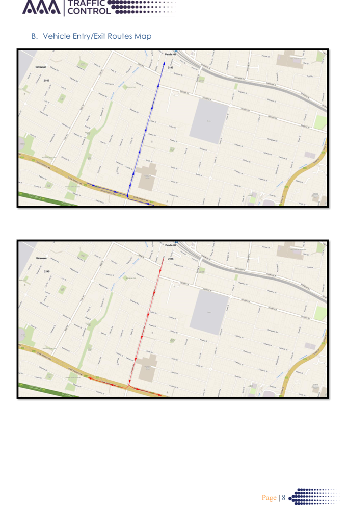
CTC-24-138 |
PENDLE WAY, PENDLE HILL - PROPOSED TEMPORARY ROAD CLOSURE FOR 'THAI PONGAL FESTIVAL 2025' |
|
|
´ |
|
´ |
|
|
CTC-24-139 |
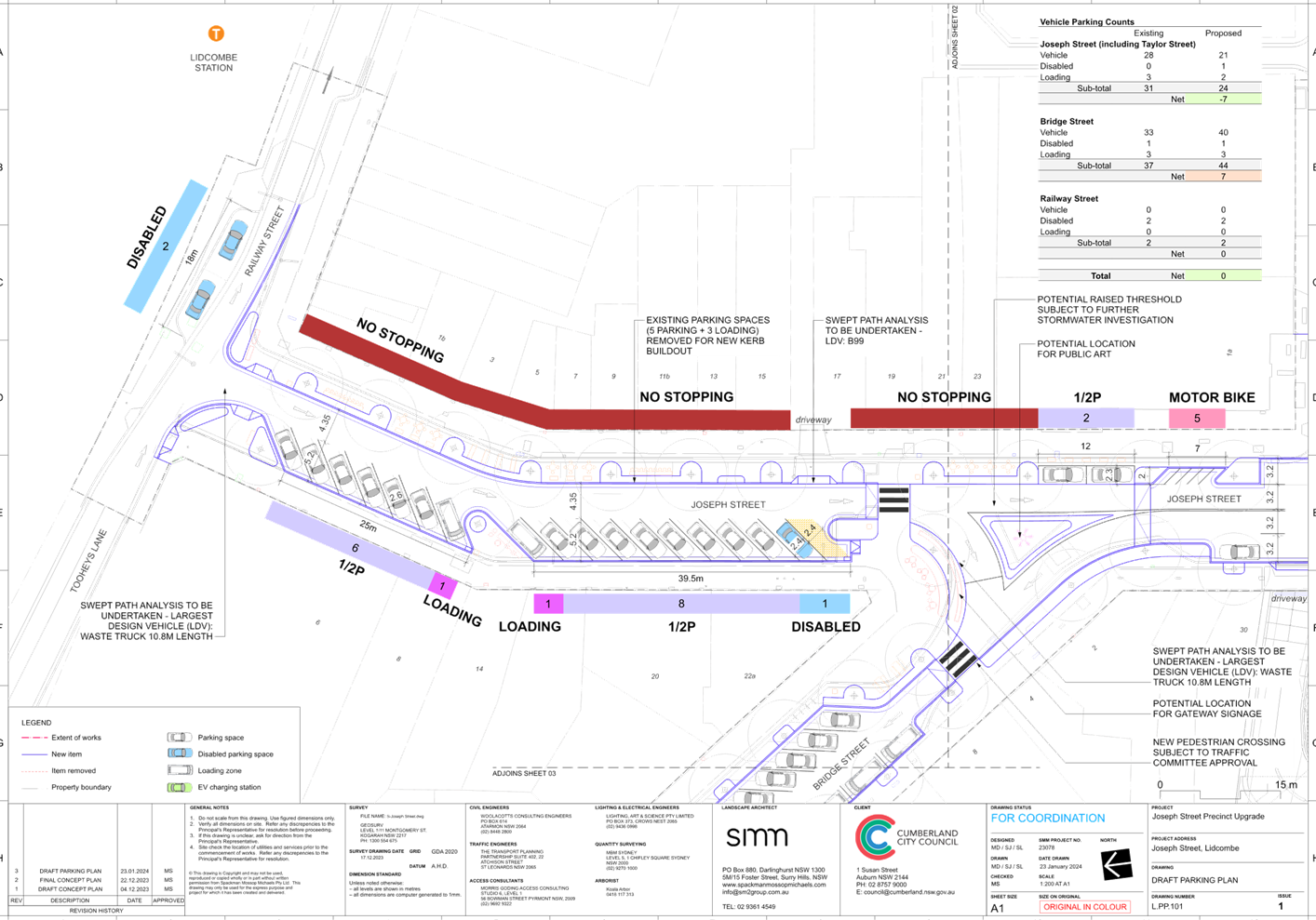
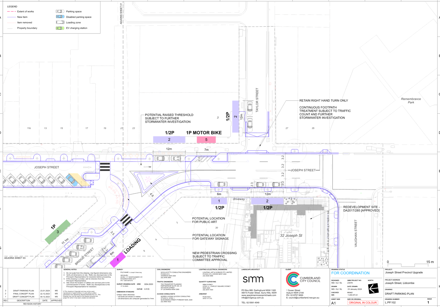
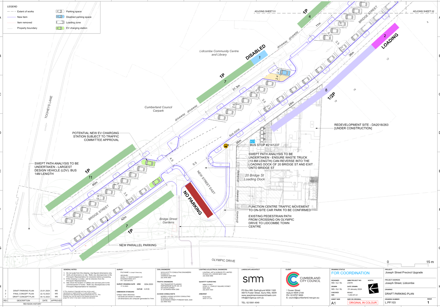
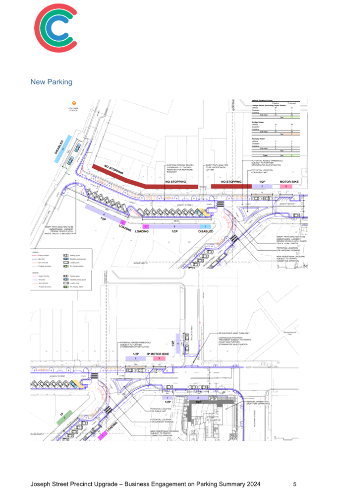
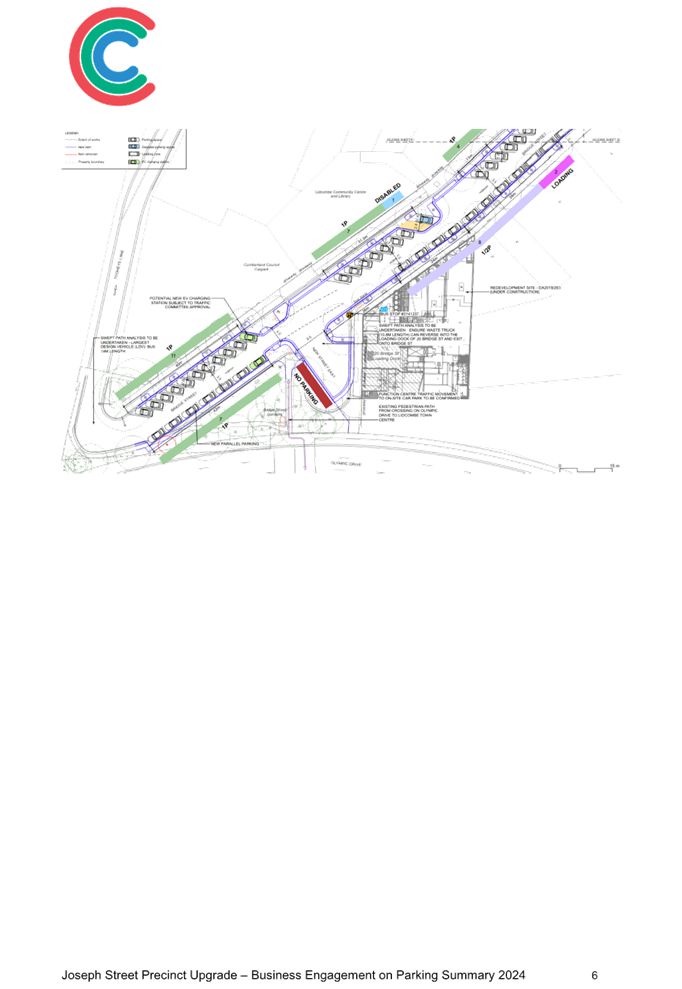
LIDCOMBE TOWN CENTRE PUBLIC DOMAIN PLAN - PROPOSED ON-STREET PARKING ARRANGEMENTS FOR JOSEPH STREET PRECINCT |
|
|
|
´ |
|
´ |
|
CTC-24-140 |
BELGIUM STREET, AUBURN - REQUEST FOR ROAD WIDENING |
|
|
|
´ |
|
´ |
|
CTC-24-141 |
LOCKWOOD STREET AND LEEDS STREET, MERRYLANDS - PROPOSED ROUNDABOUT |
|
´ |
|
|
´ |
|
|
CTC-24-142 |
WARWICK ROAD & BURNETT STREET, MERRYLANDS – REQUEST FOR BANNING TURNING MOVEMENTS INTO WARWICK ROAD |
|
´ |
|
|
´ |
|
|
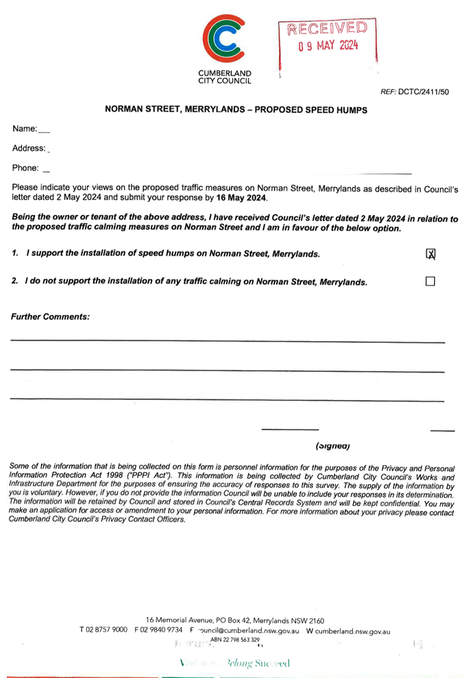
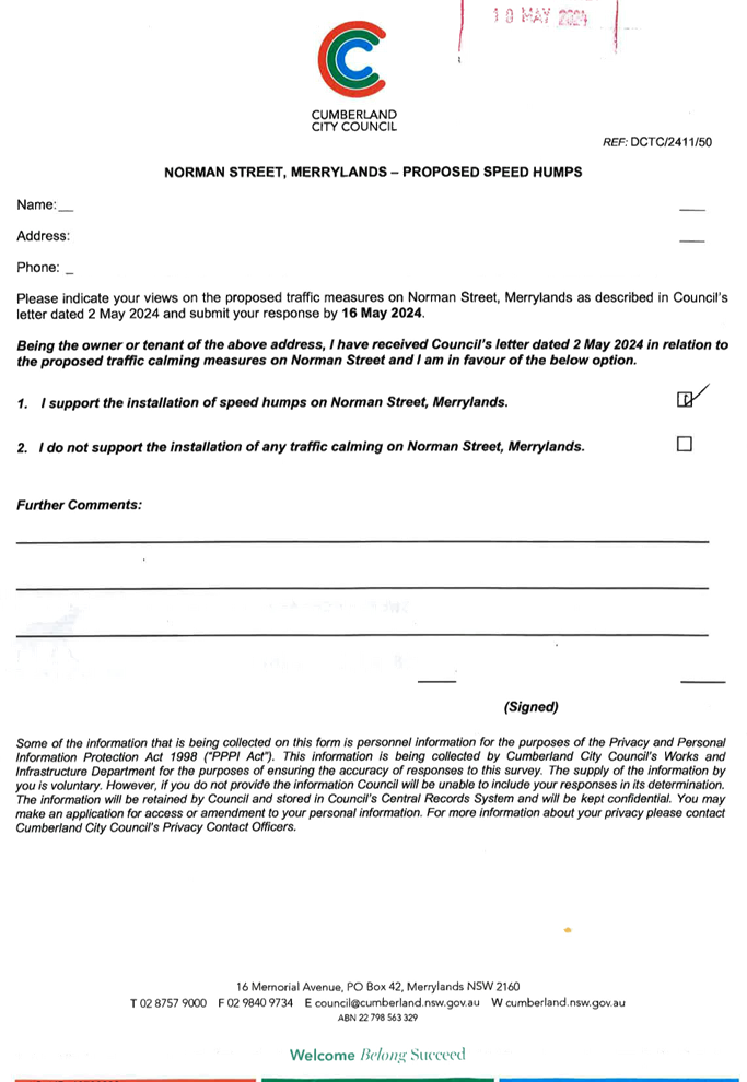
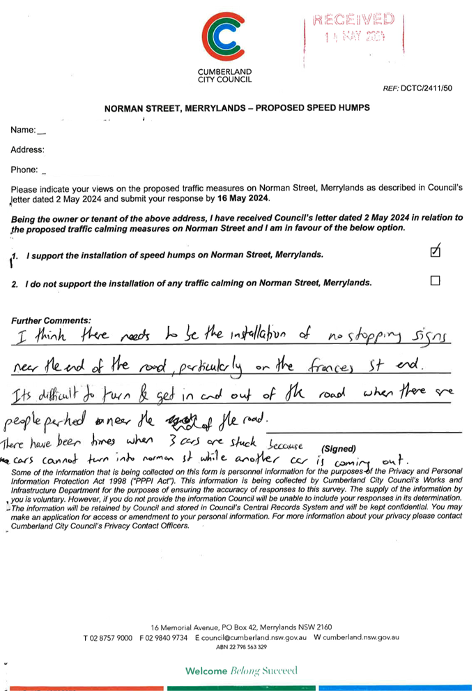
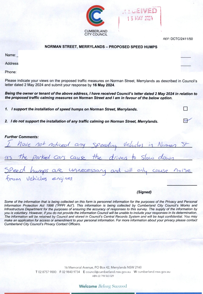
CTC-24-143 |
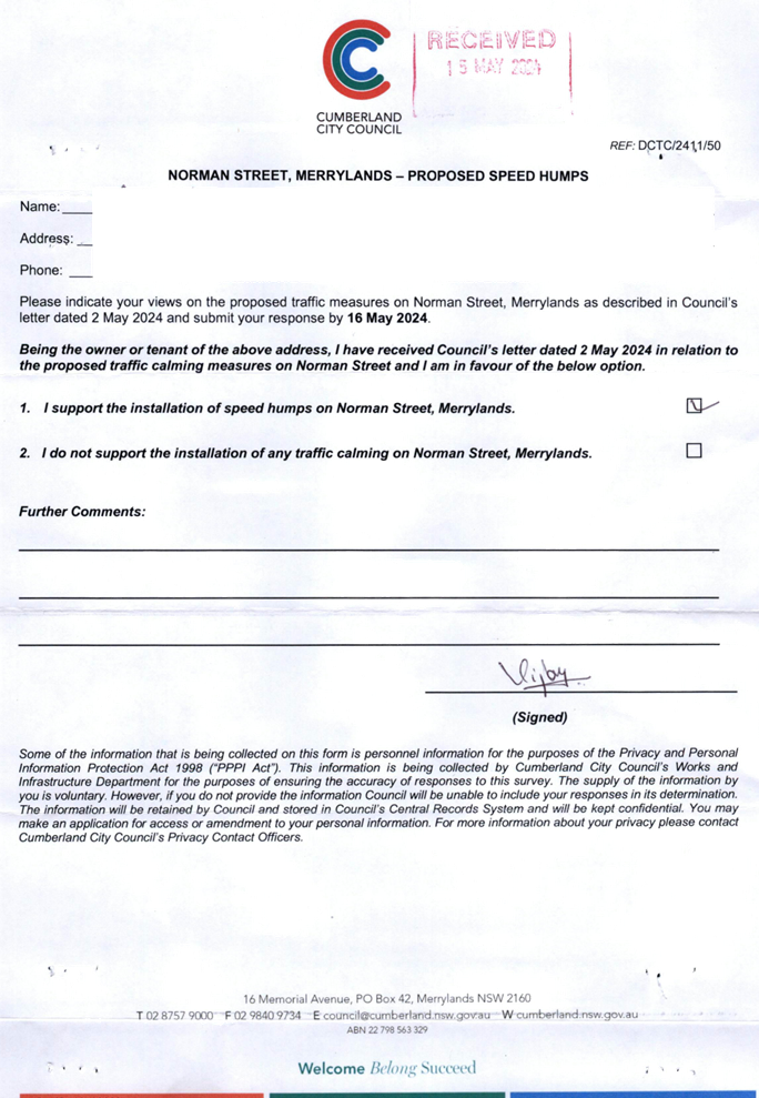
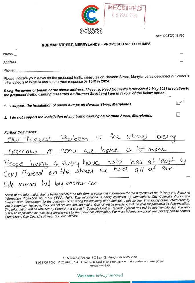
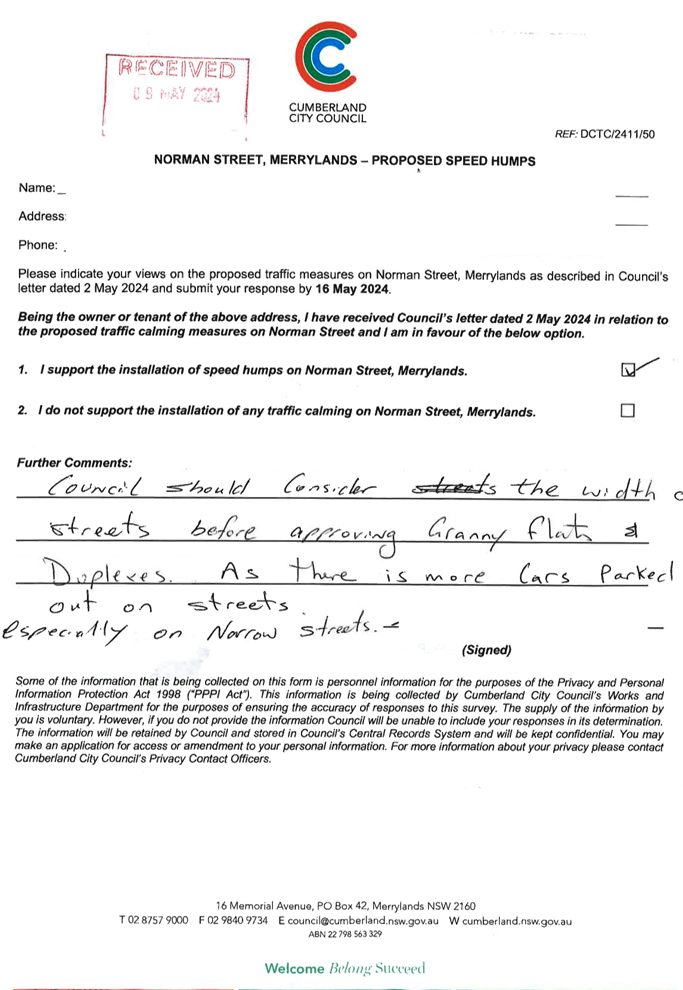
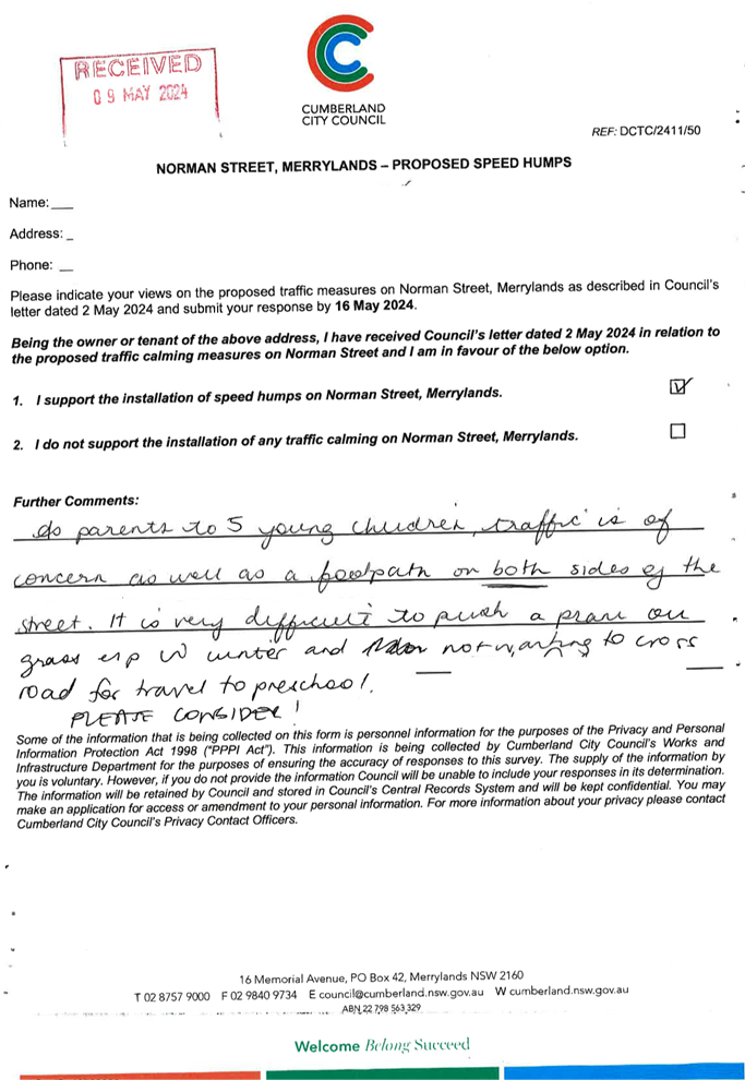
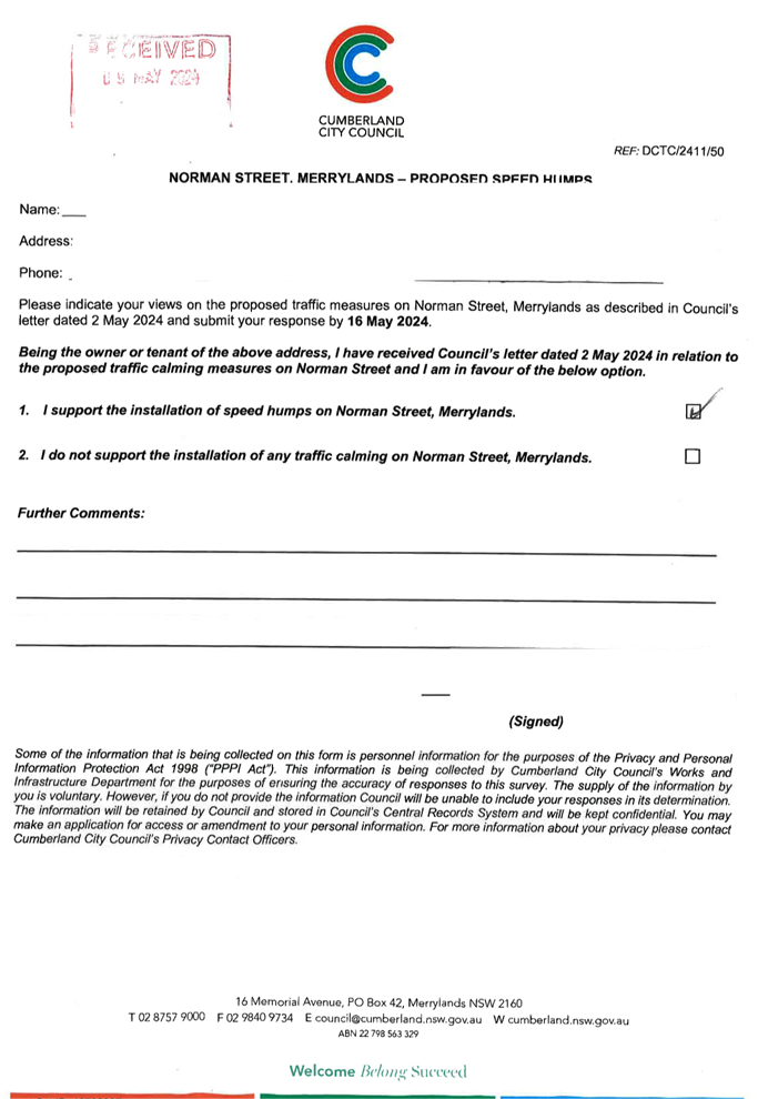
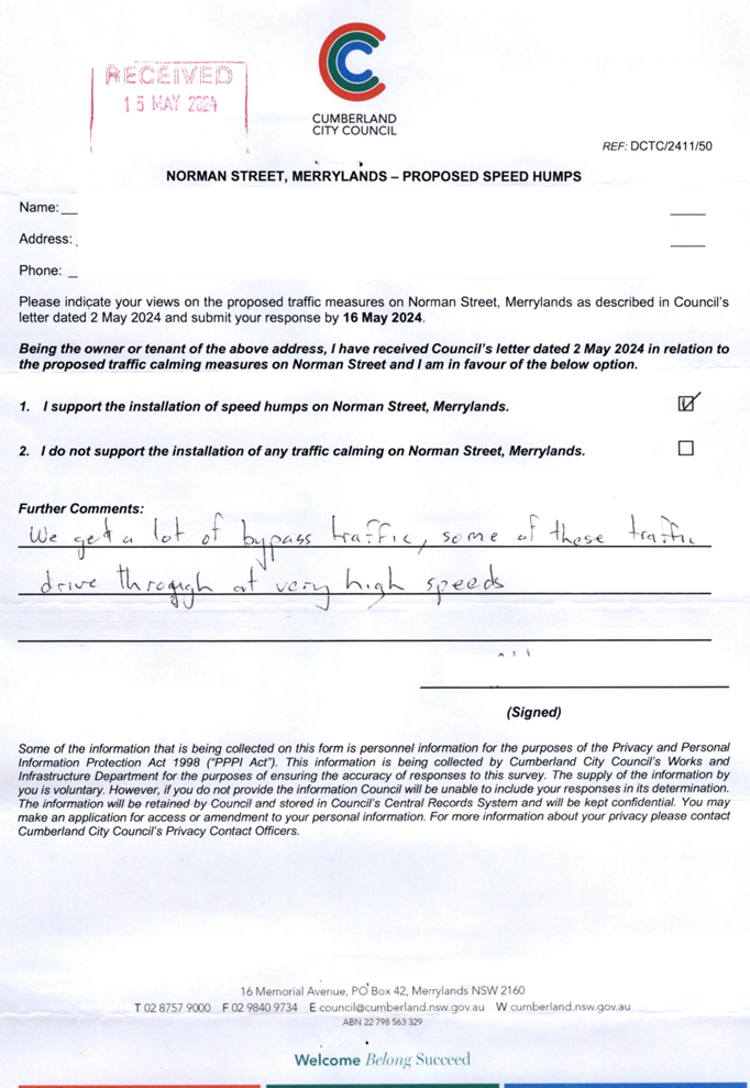
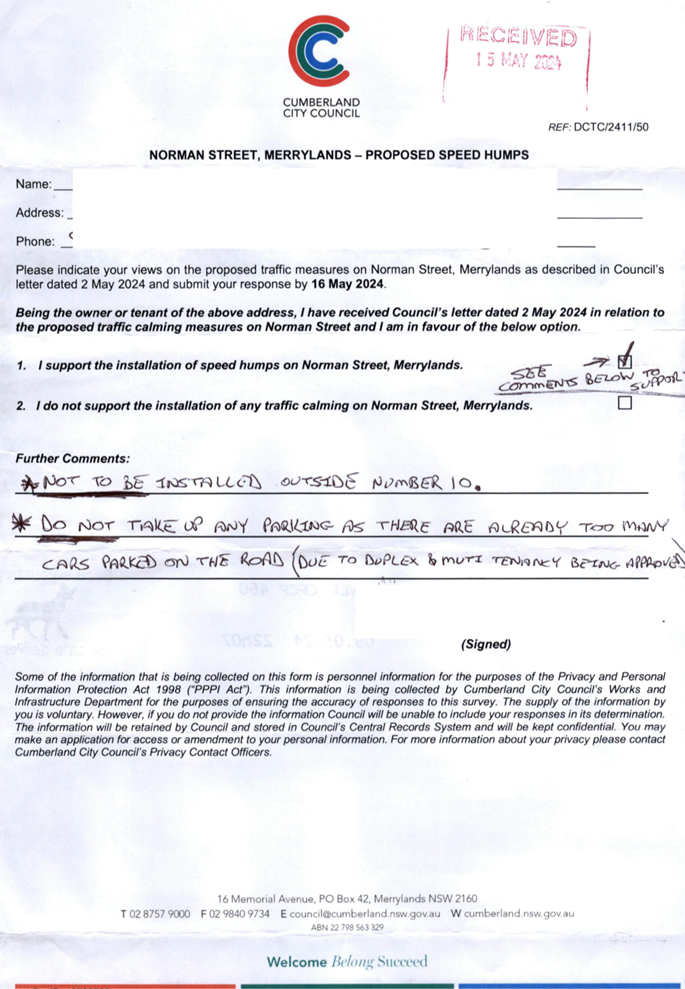
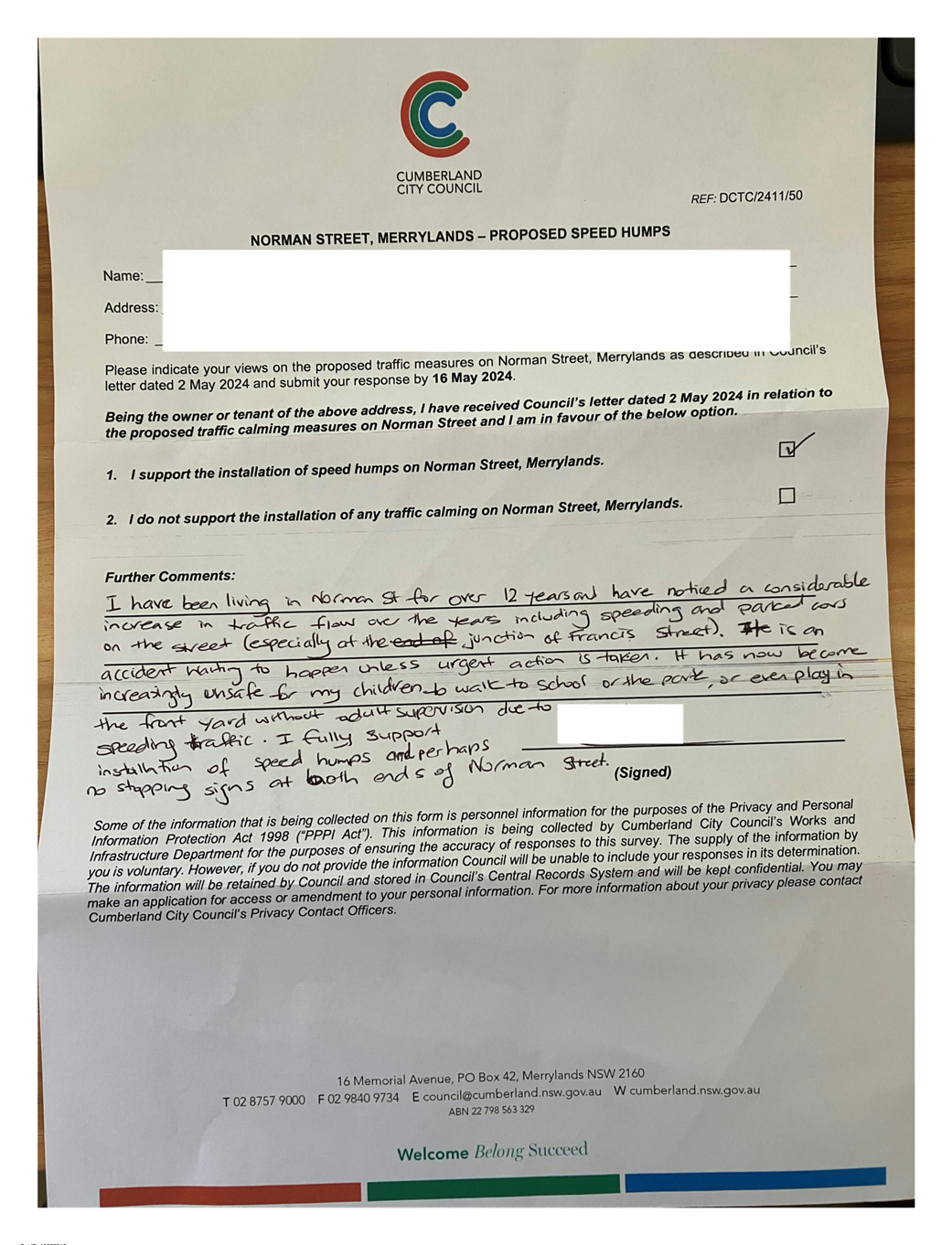
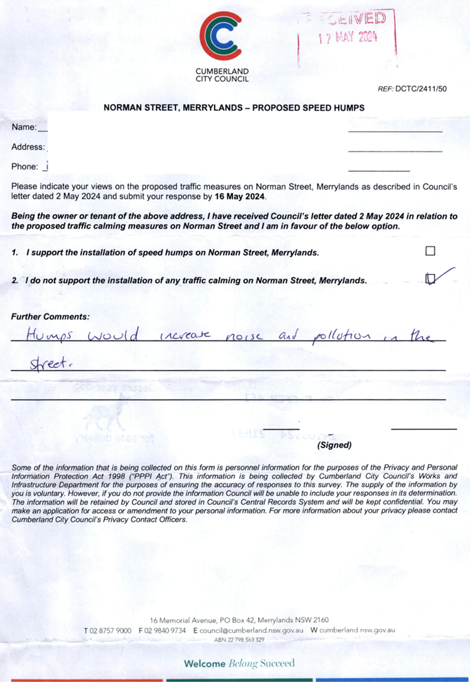
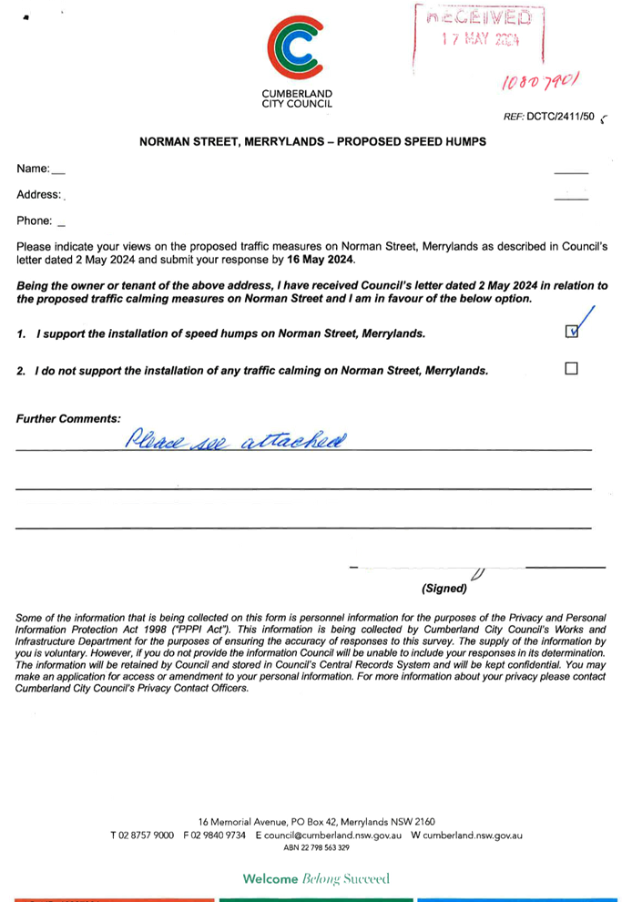
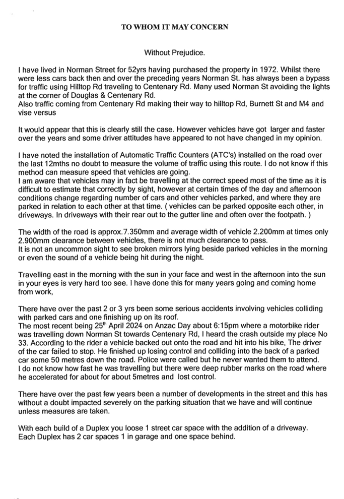
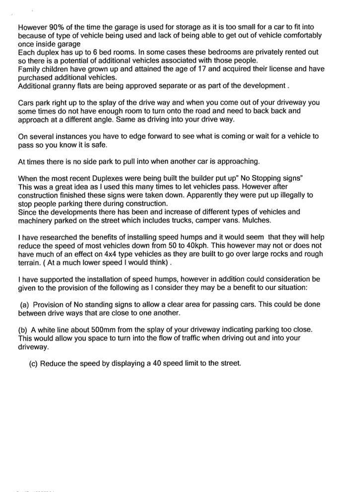
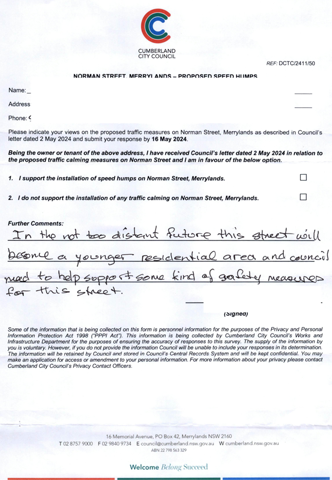
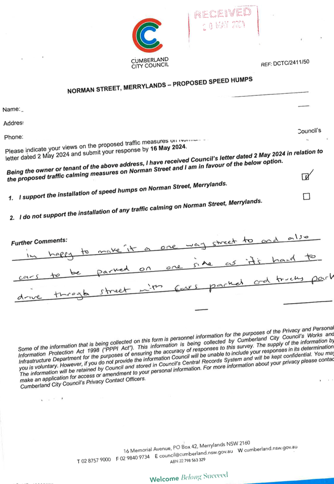
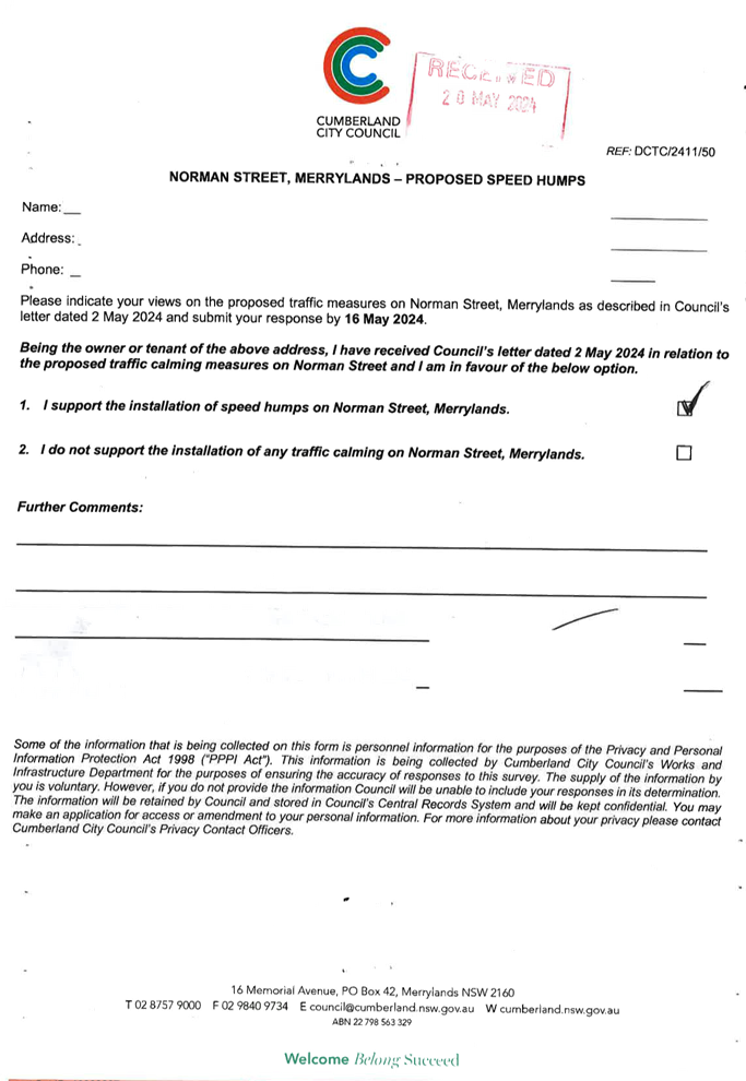
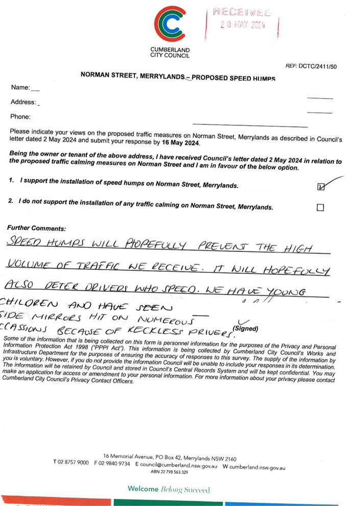
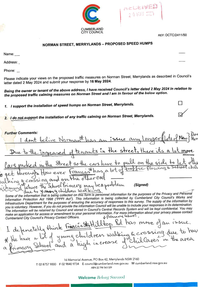
NORMAN STREET, MERRYLANDS – ROAD SAFETY CONCERNS – CONSULTATION RESULT |
|
´ |
|
|
´ |
|
|
CTC-24-144 |
BERESFORD ROAD, GREYSTANES - NOTICE OF MOTION - TRAFFIC IMPROVEMENT IN GREYSTANES |
|
|
´ |
|
´ |
|
|
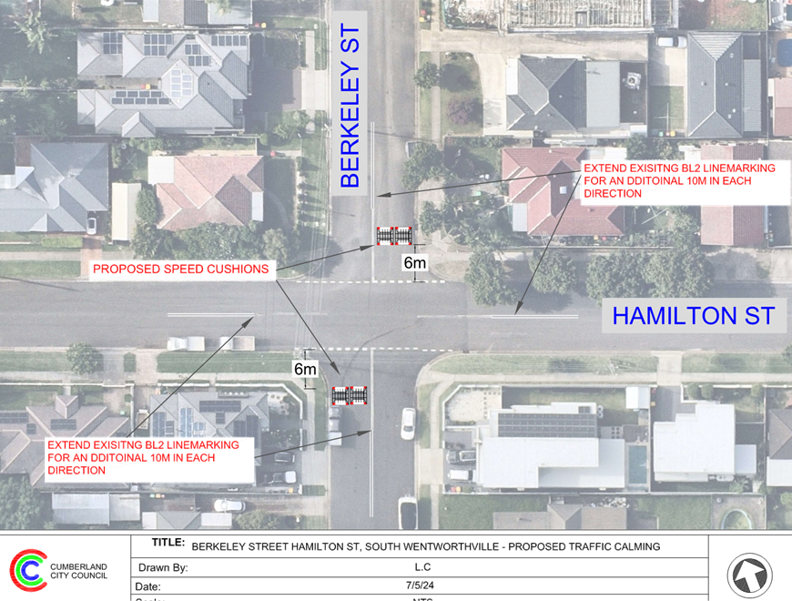
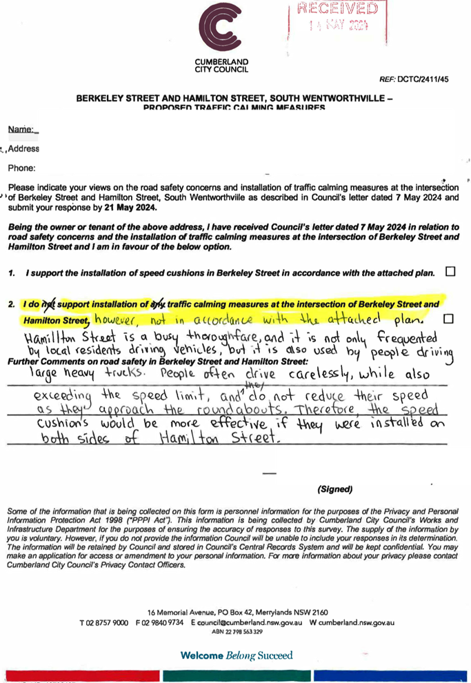
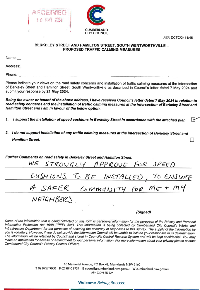
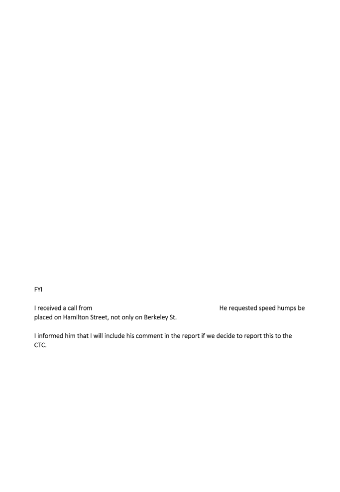
CTC-24-145 |
HAMILTON STREET AND BERKELEY STREET, SOUTH WENTWORTHVILLE - PROPOSED TREATMENT AT THE ROUNDABOUT |
|
´ |
|
|
´ |
|
|
CTC-24-146 |
JOSEPH STREET, LIDCOMBE - TEMPORARY ROAD CLOSURE FOR MOON FESTIVAL CELEBRATIONS |
|
|
|
´ |
|
´ |
|
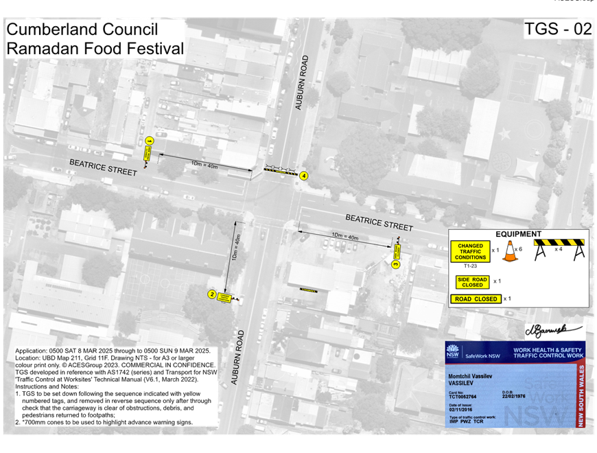
CTC-24-147 |
TEMPORARY ROAD CLOSURES IN THE AUBURN CBD FOR RAMADAN FOOD FESTIVAL 2025 |
|
|
|
´ |
|
´ |
|
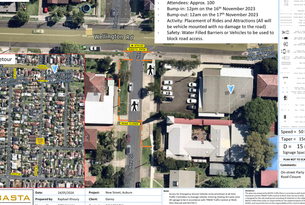
CTC-24-148 |
NEW STREET, AUBURN - PROPOSED TEMPORARY ROAD CLOSURE FOR ST RAYMOND MARONITE CHURCH ANNUAL COMMUNITY EVENT |
|
|
|
´ |
|
´ |
|
CTC-24-149 |
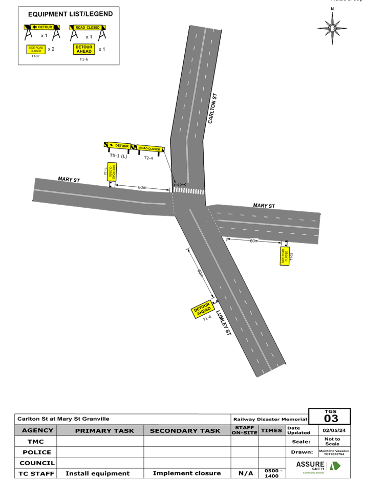
CARLTON STREET, GRANVILLE - PROPOSED TEMPORARY ROAD CLOSURE FOR GRANVILLE RAILWAY DISASTER MEMORIAL |
|
´ |
|
|
´ |
|
|
CTC-24-150 |
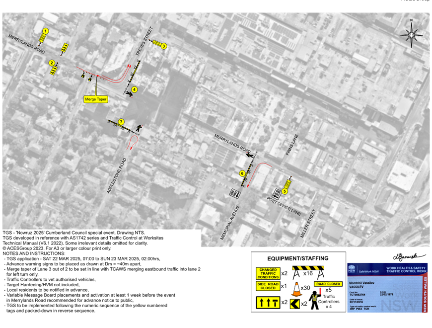
MERRYLANDS ROAD, MERRYLANDS - TEMPORARY ROAD CLOSURE FOR ‘NOWRUZ’ PERSIAN NEW YEAR CELEBRATIONS |
|
´ |
|
|
´ |
|
|
CTC-24-151 |
STATION STREET, WENTWORTHVILLE – PROPOSED ROAD CLOSURES FOR DIWALI FESTIVAL EVENT |
|
|
´ |
|
´ |
|
|
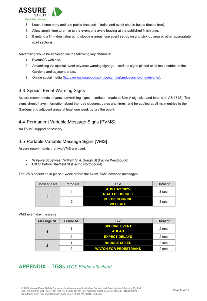
CTC-24-152 |
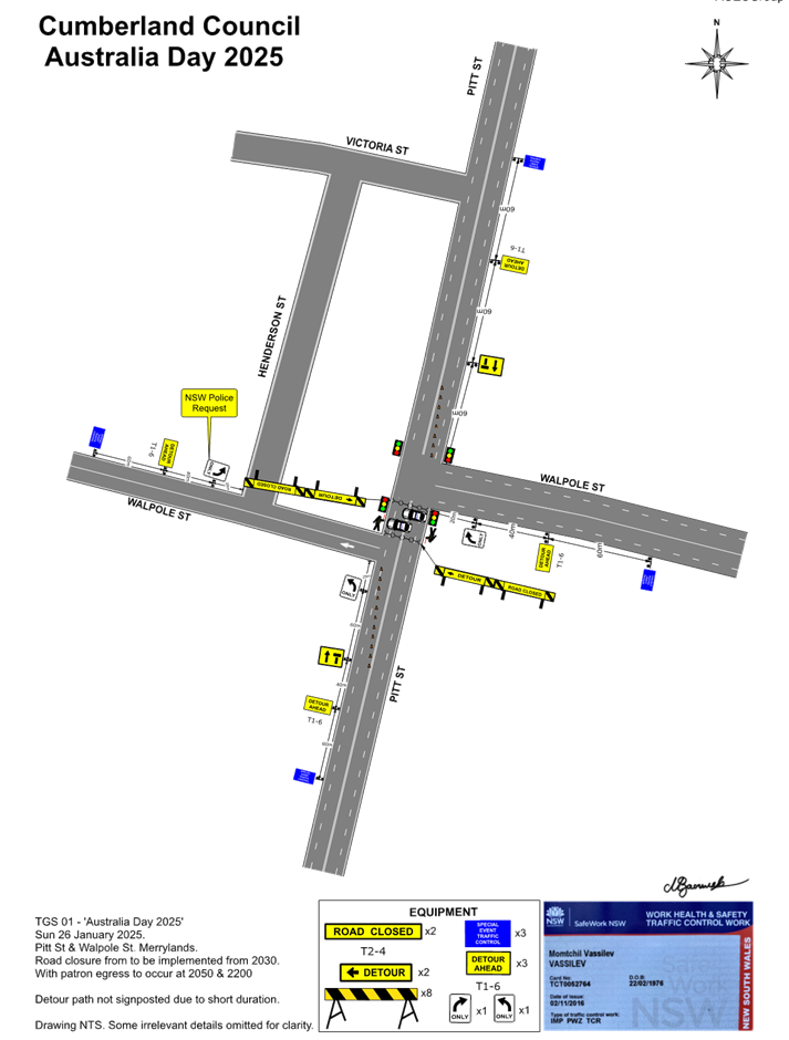
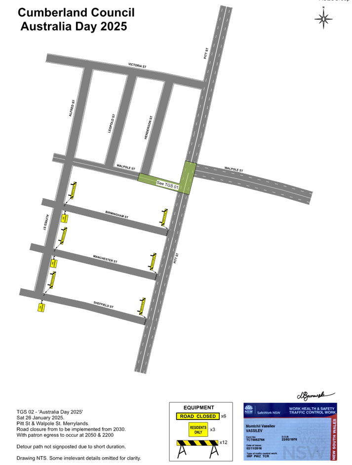
TEMPORARY ROAD CLOSURE FOR ‘AUSTRALIA DAY’ CELEBRATIONS |
|
´ |
|
|
´ |
|
|
CTC-24-153 |
DRAFT ‘LOCAL TRAFFIC AND TRANSPORT POLICY AND GUIDELINE’ |
|
´ |
|
|
´ |
|
|
CTC-24-154 |
TEMPORARY OPTIONAL DELEGATIONS ON TRAFFIC MANAGEMENT AND PEDESTRIAN WORKS TO COUNCILS FROM TRANSPORT FOR NSW |
|
´ |
|
|
|
|
5 June 2024
Minutes of the Traffic Committee meeting held at Merrylands Administration Building, 16 Memorial Avenue, Merrylands on Wednesday, 3 April 2024.
opening of meeting:
The meeting was opened by the Chairperson - Clr Suman Saha at 9:33am.
ACKNOWLEDGEMENT OF COUNTRY
The Chairperson provided an Acknowledgement of Country.
Present:
|
MEMBERS |
|
|
Clr Suman Saha (Chairman) |
Cumberland City Council |
|
Ms Irene Xu |
Transport for NSW |
|
Mr George Campbell |
Local Member for Auburn |
|
Clr Glenn Elmore |
Local Member for Granville |
|
Clr Diane Colman |
Local Member for Prospect |
|
Leading Senior Constable William Graham |
Cumberland Police Area Command |
|
Leading Senior Constable Raymond Yeung |
Auburn Police Area Command |
|
COUNCIL OFFICERS |
|
|
Daniel Cavallo |
Director Environment and Planning |
|
Elias Elias |
Acting Manager Engineering & Building |
|
Soma Somaskanthan |
Executive Engineer Traffic and Transport |
|
Siva Sivakumar |
Manager Special Projects |
|
Gabrielle Zerni |
Engineering Administration Officer |
|
Lyndall Thompson |
Senior Governance & Civic Events Officer (Observer) |
|
Pamela MacIntyre |
Governance Officer (Minute Taker) |
Apologies:
|
Local Member for Fairfield – no representative nominated |
Local Member for Fairfield - No items in the State electorate. |
|
Ms Hannah Shilling |
Transit Systems - No objections received. |
|
CDCBus |
No objections received. |
|
Transdev |
No objections received. |
Declarations Of Interest
Nil.
CONFIRMATION OF previous MINUTES
That the Cumberland Traffic Committee confirm the minutes of the Cumberland Traffic Committee held on 7 February 2024 be confirmed with the exception of the following items that have been returned to the Committee for further consideration as per Council’s resolution 20 March 2024, CTC-24-027, CTC-24-028, CTC-24-029, CTC-24-030, CTC-24-031, CTC24-032, CTC-24-033, CTC-24-034, CTC-24-035, CTC-24-037, CTC-24-038, CTC-24-042, CTC-24-043, CTC-24-044, CTC-24-045, CTC-24-046, CTC-24-047, CTC-24-048, CTC-24-049, CTC-24-051 and CTC-24-057.
Note: Final resolutions can be viewed on Council’s website.
Summary of reports
Part 1 - Recommended for Approval under Delegated Authority
|
Item # |
Title |
Electorate |
Police Area Command (PAC) |
||||
|
Fairfield |
Granville |
Prospect |
Auburn |
Cumberland |
Auburn |
||
|
CTC-24-059 |
JOHN STREET, LIDCOMBE – PROPOSED PARKING RESTRICTIONS |
|
|
|
´ |
|
´ |
|
CTC-24-060 |
BOMBAY STREET AND MAUD STREET, LIDCOMBE – PROPOSED ‘NO STOPPING’ RESTRICTIONS AND LINEMARKING |
|
|
|
´ |
|
´ |
|
CTC-24-061 |
DELHI STREET AND MAUD STREET, LIDCOMBE – PROPOSED ‘NO STOPPING’ RESTRICTIONS AND LINEMARKING |
|
|
|
´ |
|
´ |
|
CTC-24-062 |
ALICE STREET, AUBURN - ROAD SAFETY CONCERNS |
|
|
|
´ |
|
´ |
|
CTC-24-063 |
CHISHOLM ROAD AT CARDIGAN STREET, AUBURN – REQUEST FOR ‘KEEP CLEAR’ LINEMARKING |
|
|
|
´ |
|
´ |
|
CTC-24-064 |
RAILWAY PARADE, GRANVILLE - ROAD SAFETY CONCERNS |
|
´ |
|
|
´ |
|
|
CTC-24-065 |
NEW YORK STREET, GRANVILLE – PROPOSED RELOCATION OF THE EXISTING ‘NO PARKING’ SIGNAGE |
|
´ |
|
|
´ |
|
|
CTC-24-066 |
GOUGH STREET AND WALPOLE STREET, HOLROYD – PROPOSED ‘NO STOPPING’ RESTRICTIONS AND LINEMARKING |
|
´ |
|
|
´ |
|
|
CTC-24-067 |
BRADMAN STREET AT EXCELSIOR STREET AND WOODVILLE ROAD, MERRYLANDS – PROPOSED ‘NO STOPPING’ RESTRICTIONS AND LINEMARKING |
|
´ |
|
|
´ |
|
|
CTC-24-068 |
GLADSTONE STREET, MERRYLANDS - PROPOSED SIGNAGE AND LINEMARKING |
|
´ |
|
|
´ |
|
|
CTC-24-069 |
JOSEPHINE STREET, MERRYLANDS WEST – PROPOSED ‘NO STOPPING’ RESTRICTIONS |
|
´ |
|
|
´ |
|
|
CTC-24-070 |
YENNORA AVENUE AND WYANNA GROVE, YENNORA – PROPOSED PARKING RESTRICTIONS |
|
´ |
|
|
´ |
|
|
CTC-24-071 |
LANCE CRESCENT, GREYSTANES – PROPOSED RELOCATION OF THE EXISTING ‘NO STOPPING’ AND ‘NO PARKING’ SIGNAGE |
|
|
´ |
|
´ |
|
|
CTC-24-072 |
HACKNEY STREET, GREYSTANES - ROAD SAFETY CONCERNS |
|
|
´ |
|
´ |
|
|
CTC-24-073 |
ALLEN STREET AND FINLAYSON STREET, SOUTH WENTWORTHVILLE – PROPOSED ‘NO STOPPING’ RESTRICTIONS |
|
´ |
|
|
´ |
|
|
CTC-24-074 |
SMITH STREET, PENDLE HILL - ROAD SAFETY CONCERNS |
|
|
´ |
|
´ |
|
|
CTC-24-075 |
SMITH STREET AND PENDLE WAY, PENDLE HILL – PARKING RESTRICTIONS AND LINEMARKING AT THE INTERSECTION |
|
|
´ |
|
´ |
|
|
CTC-24-076 |
BULGA LANE, PEMULWUY – PROPOSED ‘NO STOPPING’ RESTRICTIONS |
|
|
´ |
|
´ |
|
|
CTC-24-077 |
NIJONG DRIVE, PEMULWUY – REMOVAL OF REDUNDANT ‘BUS ZONE’ SIGNAGE |
|
|
´ |
|
´ |
|
Part 2 - Recommendation to Council
Note: Part 2 recommendations of the Traffic Committee are subject to Council’s endorsement. For final decisions regarding these matters, please refer to the Council Meeting Minutes where these matters were reported to Council for determination.
|
Item # |
Title |
Electorate |
Police Area Command (PAC) |
||||
|
Fairfield |
Granville |
Prospect |
Auburn |
Cumberland |
Auburn |
||
|
CTC-24-078 |
Review of Traffic Related Policies and Guidelines |
|
|
´ |
|
´ |
|
|
CTC-24-079 |
LANEWAY BETWEEN LINDEN STREET AND HARVEY PLACE, TOONGABBIE – PROPOSED TO CONVERT THE LANEWAY TO ONE-WAY TRAFFIC FLOW |
|
|
´ |
|
´ |
|
|
CTC-24-080 |
BURRAGA WAY AND MUTTONG STREET, PEMULWUY – PROPOSED ONE-WAY TRAFFIC FLOW AND REMOVAL OF PARKING RESTRICITONS. |
|
|
´ |
|
´ |
|
|
CTC-24-081 |
JONES STREET, WENTWORTHVILLE – ROAD SAFETY CONCERNS – CONSULTATION RESULT |
|
|
´ |
|
´ |
|
|
CTC-24-082 |
HAMPDEN ROAD, SOUTH WENTWORTHVILLE – ROAD SAFETY CONCERNS |
|
´ |
|
|
´ |
|
|
CTC-24-083 |
RUNYON AVENUE, GREYSTANES – ROAD SAFETY CONCERNS - CONSULTATION RESULT |
|
|
´ |
|
´ |
|
|
CTC-24-084 |
WHALANS ROAD AND BRIGHTON STREET, GREYSTANES - PROPOSED MODIFICATION TO THE EXISTING ROUNDABOUT |
|
|
´ |
|
´ |
|
|
CTC-24-085 |
DENNISTOUN AVENUE, GUILDFORD WEST – CONSULTATION RESULTS |
|
´ |
|
|
´ |
|
|
CTC-24-086 |
TENNYSON PARADE, GUILDFORD WEST – ROAD SAFETY CONCERNS - CONSULTATION RESULT |
|
´ |
|
|
´ |
|
|
CTC-24-087 |
CHETWYND ROAD AND GUILDFORD ROAD, GUILDFORD - ROAD SAFETY CONCERNS |
|
´ |
|
|
´ |
|
|
CTC-24-088 |
WILLOUGHBY STREET, GUILDFORD - ROAD SAFETY CONCERNS – CONSULTATION RESULT |
|
´ |
|
|
´ |
|
|
CTC-24-089 |
MCARTHUR STREET, GUILDFORD – ROAD SAFETY CONCERNS – CONSULTATION RESULT |
|
´ |
|
|
´ |
|
|
CTC-24-090 |
O'NEILL STREET, GUILDFORD - PROPOSED INTERSECTION TREATMENT AT ELIZABETH STREET |
|
´ |
|
|
´ |
|
|
CTC-24-091 |
DENMARK STREET, MERRYLANDS – ROAD SAFETY CONCERNS – CONSULTATION RESULT |
|
´ |
|
|
´ |
|
|
CTC-24-092 |
PITT STREET, MERRYLANDS - PROPOSED PEDESTRIAN FENCING |
|
´ |
|
|
´ |
|
|
CTC-24-093 |
BLAXCELL STREET AND LISGAR STREET, SOUTH GRANVILLE - INTERSECTION SAFETY CONCERNS |
|
´ |
|
|
´ |
|
|
CTC-24-094 |
WALTERS ROAD AND SECOND AVENUE, BERALA - ROAD SAFETY CONCERNS |
|
|
|
´ |
|
´ |
|
CTC-24-095 |
REGENT STREET, REGENTS PARK - REQUEST FOR BANNING RIGHT TURNS INTO AMY STREET |
|
|
|
´ |
|
´ |
REPORTS
Part 1 - Recommended for Approval under Delegated Authority in accordance with Part 1 of the Terms of Reference for the Cumberland Local Traffic Committee.
|
ITEMS RESOLVED BY EXCEPTION |
|
The Committee resolved by exception the below items on the Traffic Committee agenda as per the recommendations in the reports:
Part 1: CTC-24-059, CTC-24-060, CTC-24-061, CTC-24-062, CTC-24-064, CTC-24-065, CTC-24-066, CTC-24-067, CTC-24-068, CTC-24-069, CTC-24-070, CTC-24-071, CTC-24-072, CTC-24-073, CTC-24-074, CTC-24-075, CTC-24-076 and CTC-24-077.
Moved Ms Irene Xu, Seconded Leading Senior Constable Raymond Yeung |
|
ITEM CTC-24-059 - JOHN STREET, LIDCOMBE – PROPOSED PARKING RESTRICTIONS |
|
Resolved by Exception
The Traffic Committee recommends that:
1. The proposed installation of ‘1/4P 8AM – 9:30AM, 3PM-5PM, Mon-Fri’ outside No. 151 John Street, Lidcombe in accordance with the attached plan be approved.
2. The affected / concerned business owners be notified of the outcome. |
|
ITEM CTC-24-060 - BOMBAY STREET AND MAUD STREET, LIDCOMBE – PROPOSED ‘NO STOPPING’ RESTRICTIONS AND LINEMARKING |
|
Resolved by Exception
The Traffic Committee recommends that:
1. The installation of ‘No Stopping’ signs and line marking at the intersection of Bombay Street and Maud Street, Lidcombe in accordance with the attached plan be approved.
2. The affected residents be notified of the outcome. |
|
ITEM CTC-24-061 - DELHI STREET AND MAUD STREET, LIDCOMBE – PROPOSED ‘NO STOPPING’ RESTRICTIONS AND LINEMARKING |
|
Resolved by Exception
The Traffic Committee recommends that:
1. The installation of ‘No Stopping’ signs and line marking on Delhi Street and Maud Street, Lidcombe in accordance with the attached plan be approved.
2. The affected residents be notified of the outcome. |
|
ITEM CTC-24-062 - ALICE STREET, AUBURN - ROAD SAFETY CONCERNS |
|
Resolved by Exception
The Traffic Committee recommends that:
1. The provision of DL1 and BL2 linemarking along Alice Street, Auburn in accordance with the attached plan be approved.
2. The concerned resident be notified of the outcome. |
ITEM CTC-24-064 - RAILWAY PARADE, GRANVILLE - ROAD SAFETY CONCERNS |
|
Resolved by Exception
The Traffic Committee recommends that:
1. The provision of edge line marking on the southern side of Railway Parade between Jamieson Street and Milton Street, Granville in accordance with the attached plan be approved.
2. The concerned resident be notified of the outcome. |
|
ITEM CTC-24-065 - NEW YORK STREET, GRANVILLE – PROPOSED RELOCATION OF THE EXISTING ‘NO PARKING’ SIGNAGE |
|
Resolved by Exception
The Traffic Committee recommends that:
1. The relocation of the existing ‘No Parking’ signage on New York Street, Granville in accordance with the attached plan be approved.
2. The affected/concerned residents be notified of the outcome. |
|
ITEM CTC-24-066 - GOUGH STREET AND WALPOLE STREET, HOLROYD – PROPOSED ‘NO STOPPING’ RESTRICTIONS AND LINEMARKING |
|
Resolved by Exception
The Traffic Committee recommends that:
1. The installation of ‘No Stopping’ signs and ‘BL2’ (Former BB) line marking at the intersection of Gough Street and Walpole Street, Holroyd in accordance with the attached plan be approved.
2. The affected / concerned residents be notified of the outcome. |
|
ITEM CTC-24-067 - BRADMAN STREET AT EXCELSIOR STREET AND WOODVILLE ROAD, MERRYLANDS – PROPOSED ‘NO STOPPING’ RESTRICTIONS AND LINEMARKING |
|
Resolved by Exception
The Traffic Committee recommends that:
1. The installation of ‘No Stopping’ signage and ‘BL2’ line marking in Bradman Street, Merrylands and the intersection of Excelsior Street and Woodville Road in accordance with the attached plan be approved.
2. The affected / concerned residents be notified of the outcome. |
|
ITEM CTC-24-068 - GLADSTONE STREET, MERRYLANDS - PROPOSED SIGNAGE AND LINEMARKING |
|
Resolved by Exception
The Traffic Committee recommends that:
1. The installation of signage and linemarking in accordance with the attached plan be supported.
2. The cost associated with the work shall be borne by the applicant at no cost to Council.
3. The applicant be notified of the outcome. |
|
ITEM CTC-24-069 - JOSEPHINE STREET, MERRYLANDS WEST – PROPOSED ‘NO STOPPING’ RESTRICTIONS |
|
Resolved by Exception
The Traffic Committee recommends that:
1. The installation of ‘No Stopping’ signs on the northern side of Josephine Street at the bend in accordance with the attached plan be approved.
2. The adjacent residents be notified of the outcome. |
|
ITEM CTC-24-070 - YENNORA AVENUE AND WYANNA GROVE, YENNORA – PROPOSED PARKING RESTRICTIONS |
|
Resolved by Exception
The Traffic Committee recommends that:
1. The proposed installation of ‘1/4P 6:00AM – 3:00PM Mon-Fri and 6:00AM – 12:30PM Sat’ outside No. 29 Yennora Avenue, Yennora in accordance with the attached plan be approved.
2. The proposed installation of ‘No Stopping’ signage at the intersection of Yennora Avenue and Wyanna Grove, Yennora in accordance with the attached plan be approved.
3. The affected / concerned business owners be notified of the outcome. |
|
ITEM CTC-24-071 - LANCE CRESCENT, GREYSTANES – PROPOSED RELOCATION OF THE EXISTING ‘NO STOPPING’ AND ‘NO PARKING’ SIGNAGE |
|
Resolved by Exception
The Traffic Committee recommends that:
1. The existing ‘No Stopping’ and ‘No Parking’ signs on Lance Crescent west of Adrian place, Greystanes be relocated 4m west in accordance with the attached plan be approved.
2. The affected/concerned residents be notified of the outcome. |
|
ITEM CTC-24-072 - HACKNEY STREET, GREYSTANES - ROAD SAFETY CONCERNS |
|
Resolved by Exception
The Traffic Committee recommends that:
1. The installation of ‘BL2’ line marking along Hackney Street, Greystanes in accordance with the attached plan be approved.
2. The concerned resident be notified of the outcome. |
|
ITEM CTC-24-073 - ALLEN STREET AND FINLAYSON STREET, SOUTH WENTWORTHVILLE – PROPOSED ‘NO STOPPING’ RESTRICTIONS |
|
Resolved by Exception
The Traffic Committee recommends that:
1. The installation of ‘No Stopping’ signs on Allen Street and Finlayson Street, South Wentworthville in accordance with the attached plan be approved.
2. The affected residents be notified of the outcome. |
|
ITEM CTC-24-074 - SMITH STREET, PENDLE HILL - ROAD SAFETY CONCERNS |
|
Resolved by Exception
The Traffic Committee recommends that:
1. The installation of ‘BL2’ line marking along Smith Street, Pendle Hill in accordance with the attached plan be approved.
2. The concerned resident be notified of the outcome. |
|
ITEM CTC-24-075 - SMITH STREET AND PENDLE WAY, PENDLE HILL – PARKING RESTRICTIONS AND LINEMARKING AT THE INTERSECTION |
|
Resolved by Exception
The Traffic Committee recommends that:
1. The installation of ‘No Stopping’ signs and ‘BL2 (Former BB)’ line markings at the intersection of Smith Street and Pendle Way, Pendle Hill in accordance with the attached plan be approved.
2. The affected / concerned residents be notified of the outcome. |
|
ITEM CTC-24-076 - BULGA LANE, PEMULWUY – PROPOSED ‘NO STOPPING’ RESTRICTIONS |
|
Resolved by Exception
The Traffic Committee recommends that:
1. The installation of 12.5m ‘No Stopping’ signs on the eastern side of Bulga Lane, Pemulwuy in accordance with the attached plan be approved.
2. The affected / concerned residents be notified of the outcome. |
|
ITEM CTC-24-077 - NIJONG DRIVE, PEMULWUY – REMOVAL OF REDUNDANT ‘BUS ZONE’ SIGNAGE |
|
Resolved by Exception
The Traffic Committee recommends that:
1. The removal of the redundant ‘Bus Zone’ signage on both sides of Nijong Drive, Pemulwuy as per attached plan be approved.
2. The affected / concerned residents be notified of the outcome. |
|
ITEM CTC-24-063 - CHISHOLM ROAD AT CARDIGAN STREET, AUBURN – REQUEST FOR ‘KEEP CLEAR’ LINEMARKING |
|
The Traffic Committee recommends that the installation of ‘Do Not Queue Across Intersection’ signage on Chisholm Road at its intersection with Cardigan Street, Auburn be approved.
Discussion:
Transport for NSW identified concerns regarding the suitability of the proposed line marking provided in the attached plan. Following discussion, the line marking was removed from the recommendation. Council will monitor the effectiveness of the signage once installed and consider alternate treatments should these be required.
Moved Ms Irene Xu, Seconded Mr George Campbell |
Part 2 - Recommendation to Council in accordance with Part 2 of the Terms of Reference for the Cumberland Local Traffic Committee.
Note: Part 2 recommendations of the Traffic Committee are subject to Council’s endorsement. For final decisions regarding these matters, please refer to the Council Meeting Minutes where these matters were reported to Council for determination.
|
ITEMS RESOLVED BY EXCEPTION |
|
The Committee resolved by exception the below items on the Traffic Committee agenda as per the recommendations in the reports:
Part 2: CTC-24-078, CTC-24-079, CTC-24-080, CTC-24-081, CTC-24-082, CTC-24-083, CTC-24-084, CTC-24-085, CTC-24-086, CTC-24-087, CTC-24-088, CTC-24-089, CTC-24-090, CTC-24-091, CTC-24-093, CTC-24-094 and CTC-24-095.
Moved Ms Irene Xu, Seconded Leading Senior Constable Raymond Yeung |
|
ITEM CTC-24-078 - Review of Traffic Related Policies and Guidelines |
|
Resolved by Exception
That the Traffic Committee note the information contained within this report. |
|
ITEM CTC-24-079 - LANEWAY BETWEEN LINDEN STREET AND HARVEY PLACE, TOONGABBIE – PROPOSED TO CONVERT THE LANEWAY TO ONE-WAY TRAFFIC FLOW |
|
Resolved by Exception
The Traffic Committee recommends that:
1. The conversion of the laneway between Linden Street and Harvey Place, Toongabbie to westbound one-way traffic flow in accordance with the attached plan be approved.
2. Council submit a Traffic Management Plan to Transport for NSW for endorsement.
3. The affected / concerned residents be notified of the outcome. |
|
ITEM CTC-24-080 - BURRAGA WAY AND MUTTONG STREET, PEMULWUY – PROPOSED ONE-WAY TRAFFIC FLOW AND REMOVAL OF PARKING RESTRICITONS. |
|
Resolved by Exception
The Traffic Committee recommends that:
1. The proposed one-way traffic flow arrangement of Burraga Way and Muttong Street, Pemulwuy in accordance with the attached plan be approved in principle.
2. Council prepare a Traffic Management Plan of the arrangement to inform further consultation with the residents and Transport for NSW.
3. The affected / concerned residents be notified of the outcome. |
|
ITEM CTC-24-081 - JONES STREET, WENTWORTHVILLE – ROAD SAFETY CONCERNS – CONSULTATION RESULT |
|
Resolved by Exception
The Traffic Committee recommends that:
1. Council prepare design of speed humps, undertake consultation with the directly affected and adjacent residents and report back to Traffic Committee.
2. Council notify the concerned residents of the outcome. |
|
ITEM CTC-24-082 - HAMPDEN ROAD, SOUTH WENTWORTHVILLE – ROAD SAFETY CONCERNS |
|
Resolved by Exception
The Traffic Committee recommends that: 1. BL2 and El1 line marking be provided in accordance with the attached plan be approved.
2. The proposed kerb blister islands in accordance with the attached plan be approved, subject to consultation with directly affected residents and their support for the proposed kerb blister islands.
3. Council notify affected/ concerned residents of the outcome. |
|
ITEM CTC-24-083 - RUNYON AVENUE, GREYSTANES – ROAD SAFETY CONCERNS - CONSULTATION RESULT |
|
Resolved by Exception
The Traffic Committee recommends that:
1. Council prepare a concept design of the speed humps in Runyon Avenue, Greystanes, undertake consultation with the adjacent/affected residents and report back to Traffic Committee.
2. Council notify concerned resident of the outcome. |
|
ITEM CTC-24-084 - WHALANS ROAD AND BRIGHTON STREET, GREYSTANES - PROPOSED MODIFICATION TO THE EXISTING ROUNDABOUT |
|
Resolved by Exception
The Traffic Committee recommends that:
1. The centre island of the roundabout at the intersection of Whalans Road and Brighton Street, Greystanes be removed in accordance with the drawing.
2. The surrounding resident be notified prior to the modification works. |
|
ITEM CTC-24-085 - DENNISTOUN AVENUE, GUILDFORD WEST – CONSULTATION RESULTS |
|
Resolved by Exception
The Traffic Committee recommends that:
1. Council undertake further consultation with the Yennora Intermodal Terminal Community Consultative Group regarding the closure of Dennistoun Avenue at Fairfield Road.
2. Council prepare a Traffic Management Plan in consultation with for submission to Transport for NSW for approval.
3. The concerned residents be notified of the outcome. |
|
ITEM CTC-24-086 - TENNYSON PARADE, GUILDFORD WEST – ROAD SAFETY CONCERNS - CONSULTATION RESULT |
|
Resolved by Exception
The Traffic Committee recommends that:
1. The installation of traffic calming devices on Tennyson Parade, Guildford West be supported in principle.
2. Council prepare a concept plan for speed humps in Tennyson Parade, Guildford West, and undertake consultation with the affected and adjacent residents and report back to the traffic committee.
3. Council notify concerned resident of the outcome. |
|
ITEM CTC-24-087 - CHETWYND ROAD AND GUILDFORD ROAD, GUILDFORD - ROAD SAFETY CONCERNS |
|
Resolved by Exception
The Traffic Committee recommends that:
1. The installation of speed cushions on the approaches at the roundabout of Chetwynd Road and Guildford Road, Guildford in accordance with the attached plan be supported.
2. Consultation be undertaken with directly affected residents prior to progressing with the proposal. |
|
ITEM CTC-24-088 - WILLOUGHBY STREET, GUILDFORD - ROAD SAFETY CONCERNS – CONSULTATION RESULT |
|
Resolved by Exception
The Traffic Committee recommends that:
1. The installation of speed humps on Willoughby Street, Guildford in accordance with the attached plan be supported.
2. Council notify affected/ concerned residents of the outcome. |
|
ITEM CTC-24-089 - MCARTHUR STREET, GUILDFORD – ROAD SAFETY CONCERNS – CONSULTATION RESULT |
|
Resolved by Exception
The Traffic Committee recommends that:
1. Council undertake design of speed humps along McArthur Street, Guildford, consult with the directly affected residents and report back to the Traffic Committee.
2. Council notify concerned resident of the outcome. |
|
ITEM CTC-24-090 - O'NEILL STREET, GUILDFORD - PROPOSED INTERSECTION TREATMENT AT ELIZABETH STREET |
|
Resolved by Exception
That the Traffic Committee recommends:
1. That the provision of the intersection treatment at O’Neill Street and Elizabeth Street, Guildford, in accordance with the attached plan be supported.
2. Council undertake consultation with the adjacent properties and report back to Traffic Committee if objections are received. |
|
ITEM CTC-24-091 - DENMARK STREET, MERRYLANDS – ROAD SAFETY CONCERNS – CONSULTATION RESULT |
|
Resolved by Exception
The Traffic Committee recommends that:
1. The proposed speed humps in Denmark Street, Merrylands in accordance with the attached plan be constructed, subject to funding availability.
2. The affected and concerned residents be notified of the outcome. |
|
ITEM CTC-24-093 - BLAXCELL STREET AND LISGAR STREET, SOUTH GRANVILLE - INTERSECTION SAFETY CONCERNS |
|
Resolved by Exception
The Traffic Committee recommends that:
1. The installation of speed cushions, median islands and associated works on Lisgar Street at the intersection of Blaxcell Street in accordance with the attached plan be supported.
2. The concerned resident be notified of the outcome. |
|
ITEM CTC-24-094 - WALTERS ROAD AND SECOND AVENUE, BERALA - ROAD SAFETY CONCERNS |
|
Resolved by Exception
The Traffic Committee recommends that:
1. The installation of speed cushions, median islands and associated works on Second Avenue at the intersection of Walters Road, Berala in accordance with the attached plan be supported.
2. The concerned resident be notified of the outcome. |
|
ITEM CTC-24-095 - REGENT STREET, REGENTS PARK - REQUEST FOR BANNING RIGHT TURNS INTO AMY STREET |
|
Resolved by Exception
The Traffic Committee recommends that:
1. Council undertake community consultation for implementing part time or full-time right turn ban from Regent Street into Amy Street, Regents Park.
2. Prepare a Traffic Management Plan in consultation with for submission to Transport for NSW for approval. |
|
ITEM CTC-24-092 - PITT STREET, MERRYLANDS - PROPOSED PEDESTRIAN FENCING |
|
The Traffic Committee recommends that:
1. The installation of a pedestrian fence in Pitt Street, Merrylands at the front of No.171 in accordance with the attached plan be approved.
2. The adjacent owners/residents be notified of the outcome.
Moved Ms Irene Xu, Seconded Leading Senior Constable Raymond Yeung |
General Business
The following general business was raised:
The Portico and Portico Parade, Toongabbie
Leading Senior Constable William Graham advised concerns regarding members of the public making U-turns at The Portico and Portico Parade intersection in Toongabbie. Council was requested to repaint the existing line marking in this location.
Rosewall Street and Hopman Street, Greystanes
Mr Elias Elias raised the concerns of a resident in relation to the recently installed ‘no stopping’ signs at the intersection of Rosewall Street and Hopman Street, Greystanes. Resident raised concerns as to why it was installed when the Committee did not support the installation of ‘no stopping’ signs in the cul-de-sac of Hopman Street. It is noted that the treatment at the intersection of Rosewall and Hopman Streets is to reinforce the road rules and is a statutory requirement. It is not mandatory in a cul-de-sac and Council received objections from affected residents to the proposal.
Butu Wargun Drive, Pemulwuy
Mr Elias Elias raised concerns of the two roundabouts connected by a bus way previously closed on Butu Wargun Drive. This was opened to assist with construction taking place nearby. At the request of the Police, it has been requested that this road be closed due to delinquent behaviour. Council has received a request from residents to keep this road open for their utilisation. It is suggested that this remains closed to ensure heavy vehicles do not access the residential zone.
Beresford Road, Greystanes
Mr Daniel Cavallo provided the committee with an update on a matter of urgency raised at the 6 March 2024 Council Meeting regarding the investigation of road safety improvements outside Beresford Road Public School. Council officers met with the Deputy Principal of the school and provided road safety information to share with the school community. Council officers are reviewing the effectiveness of existing road safety measures at this location, including practices relating to permits with respect to development and construction. A detailed report will be provided to the Traffic Committee for consideration at the next meeting in June 2024.
Former Local Member of Granville Representation
The Chairperson referred to the resolution of the previous Traffic Committee meeting regarding the departure of former member Mr Chris Worthington, confirming that a letter had been drafted to thank him for his service to the Traffic Committee.
Next Meeting
Next Meeting 5 June 2024 at 9.30am
Meeting Close
The meeting terminated at 10:27am.
Signed:
Chairperson
Traffic Committee
5 June 2024
Part 1
Recommended for Approval under Delegated Authority
5 June 2024
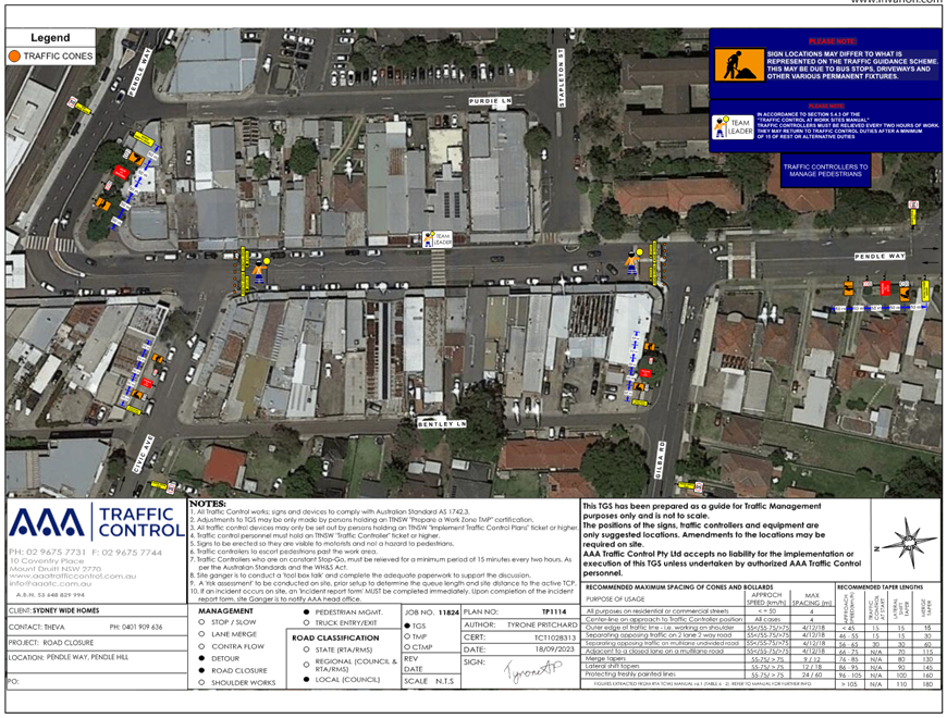
Item No: CTC-24-096
OXFORD STREET, BERALA - ROAD SAFETY CONCERNS
Directorate: Environment and Planning
Responsible Officer: Manager Engineering and Building
Electorate: Auburn
Police Area Command (PAC): Auburn
Agenda Part Part 1
Note: Recommended for Approval under Delegated Authority
Summary
Council
presented a report at the traffic committee on 7 February 2024 on the road
safety concerns on Oxford Street, Berala due to speeding concerns.
Council at its meeting held on 20 March 2024, resolved that this item considered by the Cumberland Local Traffic Committee at the 7 February 2024 meeting as provided in this report, be returned to the Committee for further consideration.
This report outlines the outcome of further review into this matter.
The Traffic Committee recommends that:
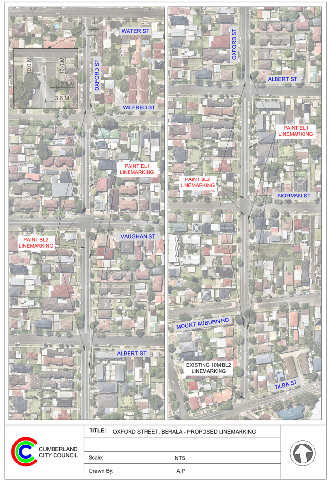
1. The installation of ‘BL2’ centre and ‘EL1’ edge lines on Oxford Street, Berala be approved.
2. Council request Auburn Police Area Command to undertake speed surveillance in Oxford Street, Berala.
3. The concerned resident be notified of the outcome.
Report
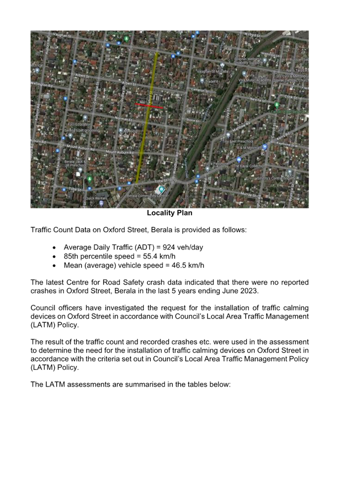
Oxford Street is a local road that runs in a north-south direction with a posted speed limit of 50km/h. The street is approximately 700m long and has a width of approximately 12.5m. Parking is permitted on both sides of the road unless signposted.
A report (CTC-24-028) on the road safety concerns in Oxford Street was presented to the Cumberland Traffic Committee on 7 February 2024, and the traffic committee recommended that:
1. The installation of traffic calming devices on Oxford Street, Berala not be supported.
2. Council request Auburn Police Area Command to undertake speed surveillance in Oxford Street, Berala.
3. Investigate the potential for line marking and signage to address concerns and provide a report to the Committee for consideration in April 2024.
4. The concerned resident be notified of the outcome.
Council at its meeting held on 20 March 2024, resolved that this item considered by the Cumberland Local Traffic Committee at the 7 February 2024 meeting as provided in this report, be returned to the Committee for further consideration.
Council officers have now undertaken further investigation as per Council resolution and the recommendation (item 3) by traffic committee for line marking in Oxford Street, Berala.
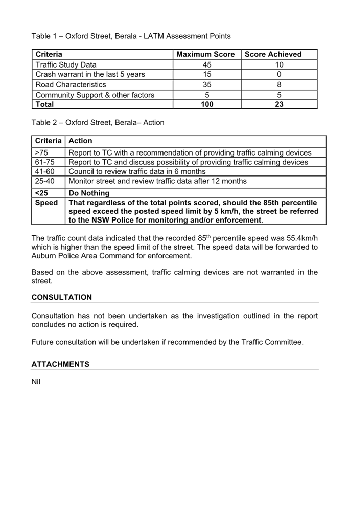
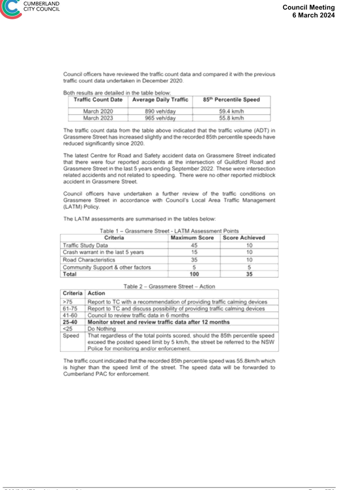
Based on the previous traffic count data, the average daily traffic was 924 vehicles/day and the recorded 85th percentile speed was 55.4 km/hr.
Considering the high recorded 85th percentile speed in Oxford Street, Berala, Council proposes to install ‘BL2 (former ‘BB’)’ centre line and ‘E1’ edge lines to streamline traffic flow at this location.
COnsultation
Attachments
1. Plan – Oxford Street, Berala – Proposed Line Marking
2. Previous Report – CTC-24-028 – Oxford Street, Berala – Road Safety Concerns
DOCUMENTS
ASSOCIATED WITH
REPORT CTC-24-096
Attachment 1
Plan – Oxford Street, Berala – Proposed Line Marking
DOCUMENTS
ASSOCIATED WITH
REPORT CTC-24-096
Attachment 2
Previous Report – CTC-24-028 – Oxford Street, Berala – Road Safety Concerns
5 June 2024
Item No: CTC-24-097
ELM ROAD, AUBURN - ROAD SAFETY CONCERNS
Directorate: Environment and Planning
Responsible Officer: Manager Engineering and Building
Electorate: Auburn
Police Area Command (PAC): Auburn
Agenda Part Part 1
Note: Recommended for Approval under Delegated Authority
Summary
Council officers presented a report at the traffic committee on 7 February 2024 on the road safety concerns on Elm Road, Auburn due to speeding concerns.
Council at its meeting held on 20 March 2024, resolved that this item considered by the Cumberland Local Traffic Committee at the 7 February 2024 meeting as provided in this report, be returned to the Committee for further consideration.
This report outlines the outcome of further review into this matter.
The Traffic Committee recommends that:
1. The installation of ‘BL2’ centre and edge lines on Elm Road, Auburn be approved.
2. The concerned residents be notified of the outcome.
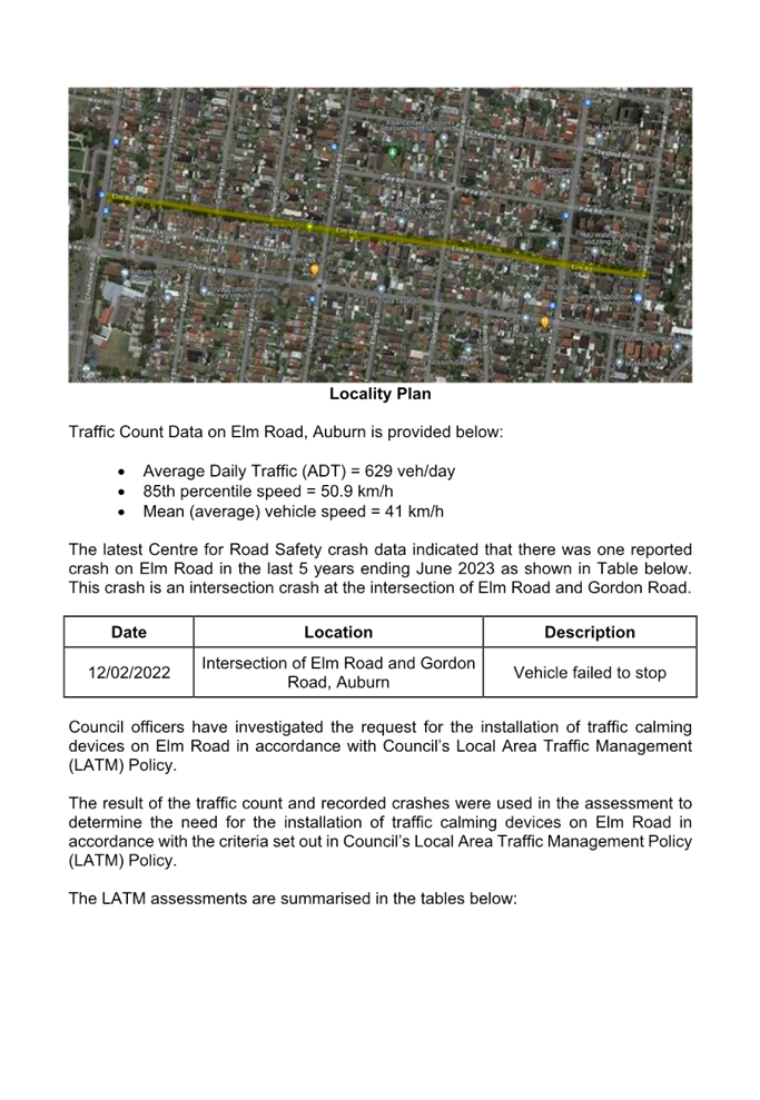
Report
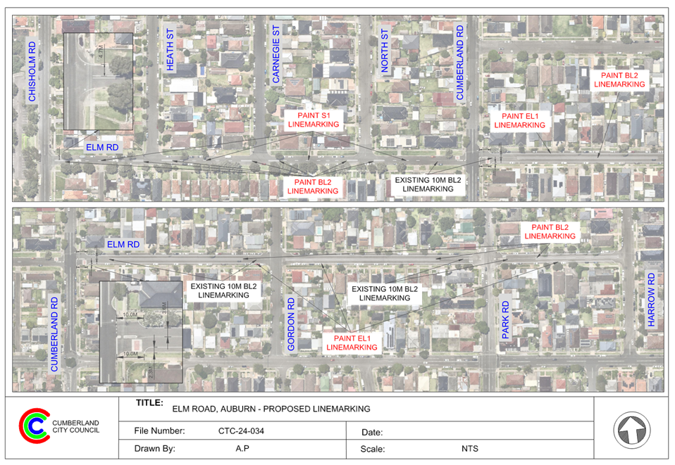
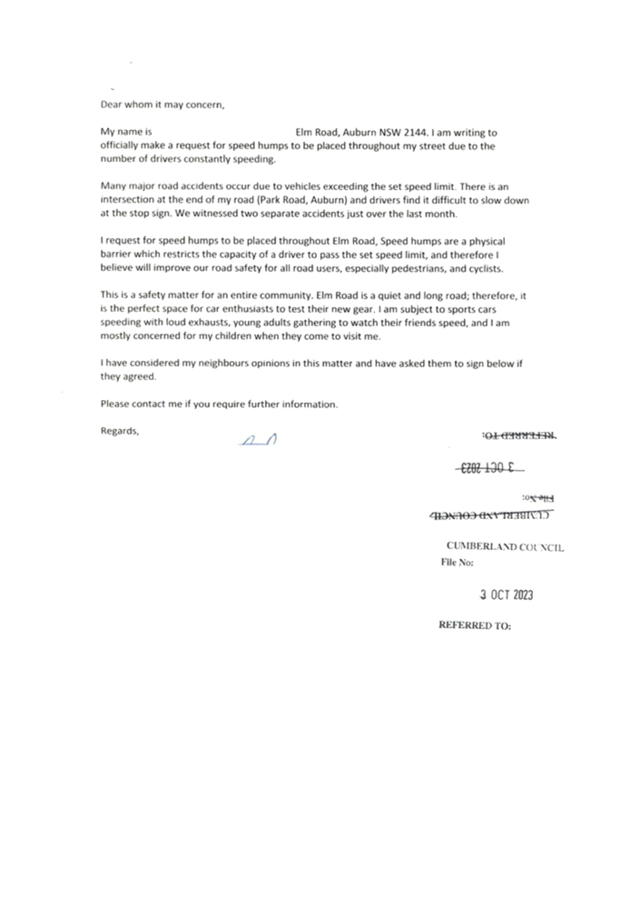
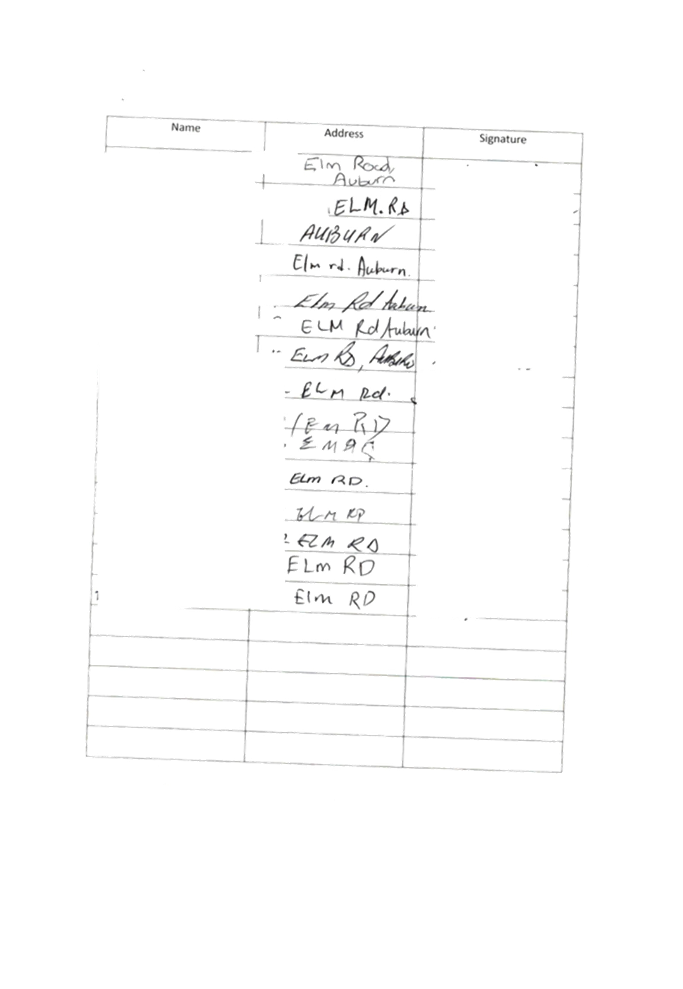
Elm Road is a local road that runs in an east- west direction with a posted speed limit. of 50km/h. The street is approximately 950m long and has a width of approximately 12.5m. The section of interest is between Gordon Road and Park Road, as the residents raised concerns regarding this section of Elm Road. This section of Elm Road approximately 200m long and parking is permitted on both sides of the road, unless signposted otherwise.
A report (CTC-24-034) on the road safety concerns in Elm Road was presented to the Cumberland Traffic Committee on 7 February 2024, and the traffic committee recommended that:
1. The installation of traffic calming devices on Elm Road, Auburn not be supported.
2. Investigate the potential for line marking and signage to address speeding concerns and provide a report to the Committee for consideration in April 2024.
3. The concerned residents be notified of the outcome.
Council at its meeting held on 20 March 2024, resolved that this item considered by the Cumberland Local Traffic Committee at the 7 February 2024 meeting as provided in this report, be returned to the Committee for further consideration.
Council officers have now undertaken further investigation as per Council resolution and recommendation (item 2) by the traffic committee for line marking in Elm Road, Auburn.
Elm Road has ‘BL2’ centre lines marked at its intersections with Cumberland Road, Gordon Road and Park Road which are also controlled by ‘Stop’ signs and line marking. Also, there are median islands provided on Elm Road at the Park Road and Cumberland Road intersections. There are concrete speed humps provided on Elm Road at its intersection with Cumberland Road.
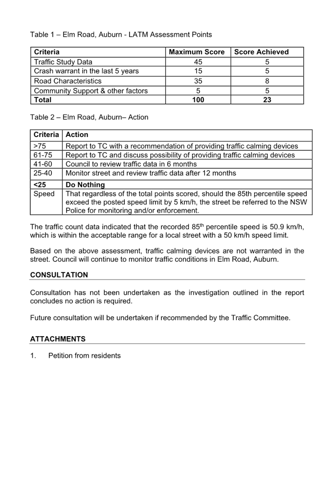
Based on the previous traffic count data, the average daily traffic was 629 vehicles/day and the recorded 85th percentile speed was 50.9 km/hr. It was also noted that there was one reported crash at the intersection of Elm Road and Gordon Road.
Following review by Council officers and community interest in the matter, Council proposes to install ‘BL2 (former ‘BB’)’ centre line and ‘E1’ edge lines to streamline traffic flow.
COnsultation
Consultation has not been undertaken as the line marking does not impact on available on-street parking.
Attachments
1. Plan – Elm Road, Auburn - Proposed Line Marking
2. Previous Report – CTC-24-034 – Elm Road, Auburn – Road Safety Concerns
DOCUMENTS
ASSOCIATED WITH
REPORT CTC-24-097
Attachment 1
Plan – Elm Road, Auburn - Proposed Line Marking
DOCUMENTS
ASSOCIATED WITH
REPORT CTC-24-097
Attachment 2
Previous Report – CTC-24-034 – Elm Road, Auburn – Road Safety Concerns
5 June 2024
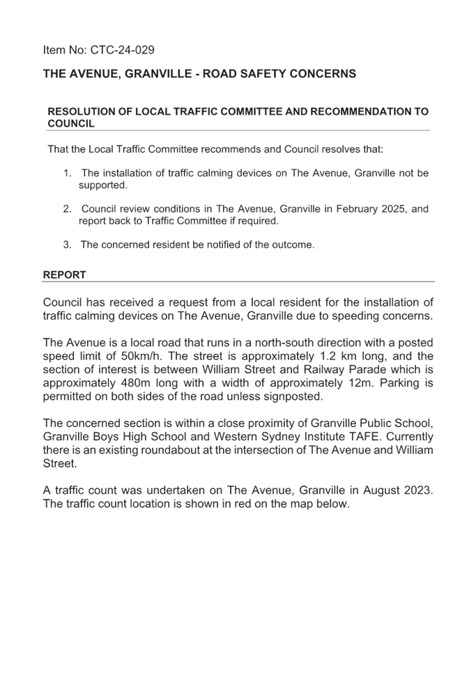
Item No: CTC-24-098
THE AVENUE, GRANVILLE - ROAD SAFETY CONCERNS
Directorate: Environment and Planning
Responsible Officer: Manager Engineering and Building
Electorate: Granville
Police Area Command (PAC): Cumberland
Agenda Part Part 1
Note: Recommended for Approval under Delegated Authority
Summary
Council officers presented a report at the Traffic Committee on 7 February 2024 regarding road safety concerns on The Avenue, Granville.
Council, at its meeting held on 20 March 2024, resolved that this item considered by the Cumberland Local Traffic Committee at the 7 February 2024 meeting as provided in this report, be returned to the Committee for further consideration.
This report outlines the outcome of the investigation into this matter.
The Traffic Committee recommends that:
1. Council undertake further speed monitoring with the assistance of Variable Message Signs (VMS) in The Avenue, Granville.
2. The concerned resident be notified of the outcome.
Report
Council officers presented a report at the traffic committee on 7 February 2024 on the road safety concerns on The Avenue, Granville.
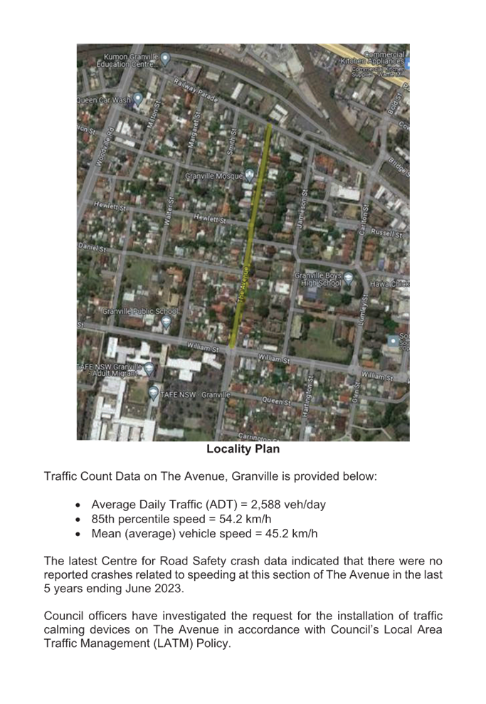
The Avenue is a local road that runs in a north-south direction with a posted speed limit of 50km/h. The street is approximately 1.2 km long, and the section of interest between William Street and Railway Parade is approximately 480m long with a width of approximately 12m. Parking is permitted on both sides of the road unless signposted otherwise.
A report (CTC-24-029) was presented to Cumberland Traffic Committee on 7 February 2024 reviewing the previous traffic count and additional crash data and the Local Area Traffic Management analysis undertaken.
The Traffic Committee recommended that:
1. The installation of traffic calming devices on The Avenue, Granville not be supported.
2. Council review conditions in The Avenue, Granville in February 2025, and report back to Traffic Committee if required.
3. The concerned resident be notified of the outcome.
Council at its meeting held on 20 March 2024, resolved that this item considered by the Cumberland Local Traffic Committee at the 7 February 2024 meeting as provided in this report, be returned to the Committee for further consideration.
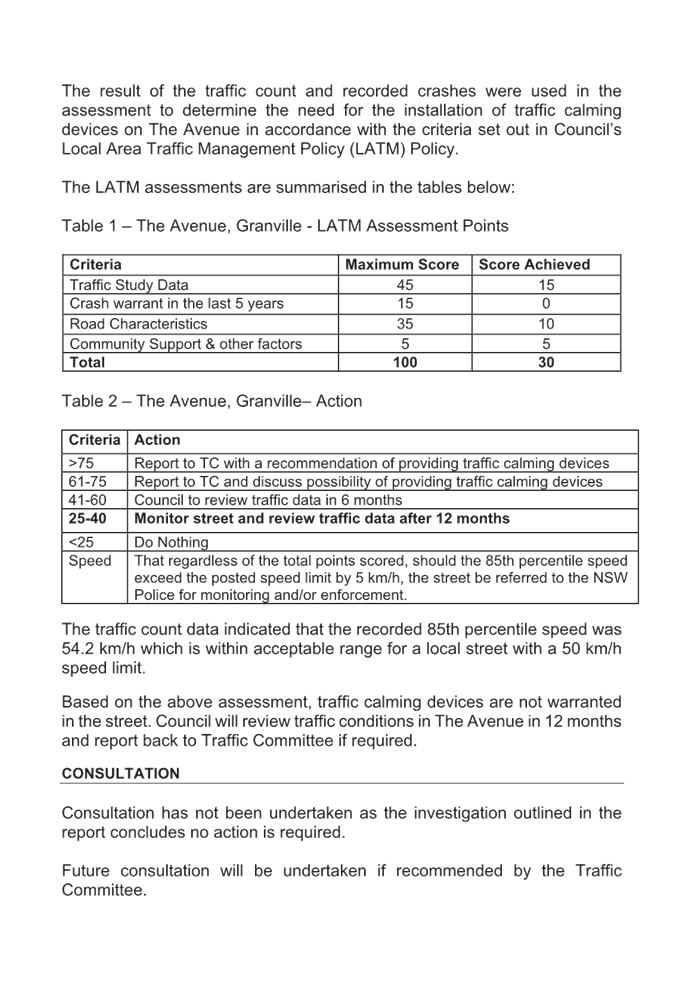
Council officers have undertaken a review of the conditions in The Avenue, Granville. The traffic count data indicated that the recorded 85th percentile speed was 54.2 km/hr.
Following review by Council officers and community interest in the matter, Council will undertake further speed monitoring with the assistance of Variable Message Signs (VMS) in The Avenue, Granville to improve safety.
COnsultation
No consultation has been undertaken as the matter relates to the temporary provision of variable messaging signs.
Attachments
1. Previous Report – CTC-24-029 – The Avenue, Granville – Road Safety Concerns
DOCUMENTS
ASSOCIATED WITH
REPORT CTC-24-098
Attachment 1
Previous Report – CTC-24-029 – The Avenue, Granville – Road Safety Concerns
5 June 2024
Item No: CTC-24-099
VILLIERS STREET, MERRYLANDS - ROAD SAFETY CONCERNS
Directorate: Environment and Planning
Responsible Officer: Manager Engineering and Building
Electorate: Granville
Police Area Command (PAC): Cumberland
Agenda Part Part 1
Note: Recommended for Approval under Delegated Authority
Summary
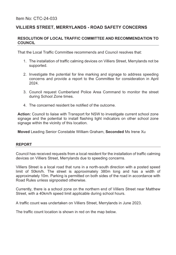
Council officers presented a report at the traffic committee on 7 February 2024 on the road safety concerns on Villiers Street, Merrylands due to speeding concerns.
Council at its meeting held on 20 March 2024, resolved that this item considered by the Cumberland Local Traffic Committee at the 7 February 2024 meeting as provided in this report, be returned to the Committee for further consideration.
This report outlines the outcome of further review into this matter.
The Traffic Committee recommends that:
1. The proposed line marking on Villiers Street, Merrylands in accordance with the attached plan be approved.
2. Council request Cumberland Police Area Command to monitor the street during School Zone times.
3. The concerned residents be notified of the outcome.
Report
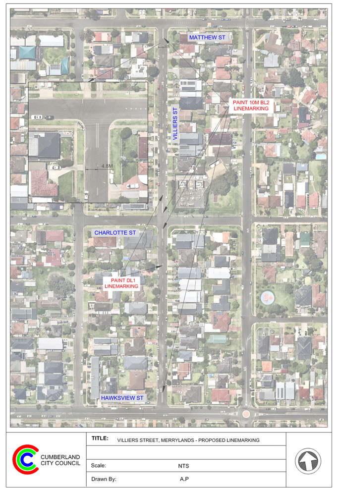
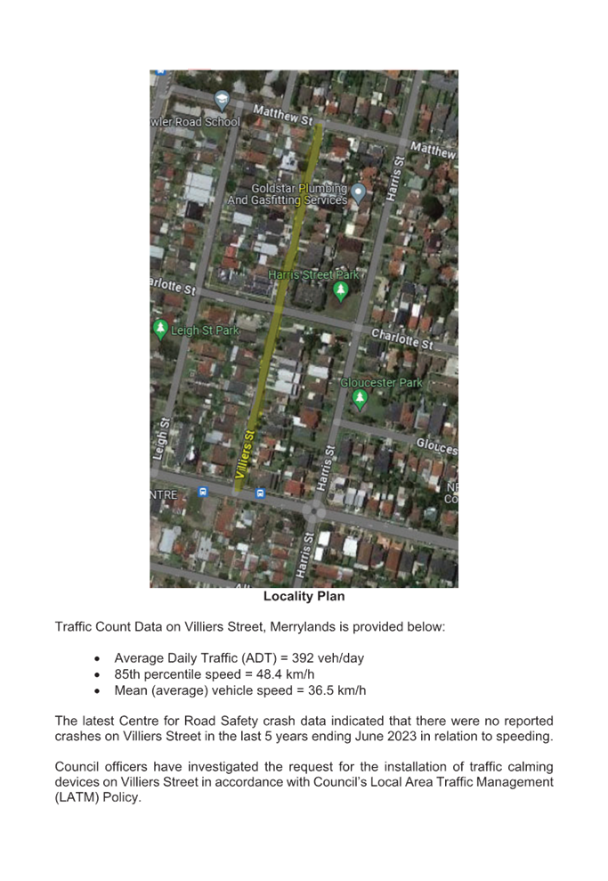
Villiers Street is a local road that runs in a north-south direction with a posted speed
limit of 50km/h. The street is approximately 380m long and has a width of
approximately 10m.
A report (CTC-24-033) on the road safety concerns in Villiers Street was presented to the Cumberland Traffic Committee on 7 February 2024, and the traffic committee recommended that:
1. The installation of traffic calming devices on Villiers Street, Merrylands not be supported.
2. Investigate the potential for line marking and signage to address speeding concerns and provide a report to the Committee for consideration in April 2024.
3. Council request Cumberland Police Area Command to monitor the street during School Zone times.
4. The concerned resident be notified of the outcome.
Council at its meeting held on 20 March 2024, resolved that this item considered by the Cumberland Local Traffic Committee at the 7 February 2024 meeting as provided in this report, be returned to the Committee for further consideration.
Council officers have now undertaken further investigation as per Council resolution and recommendation (item 2) by the traffic committee for line marking in Villiers Street, Merrylands.
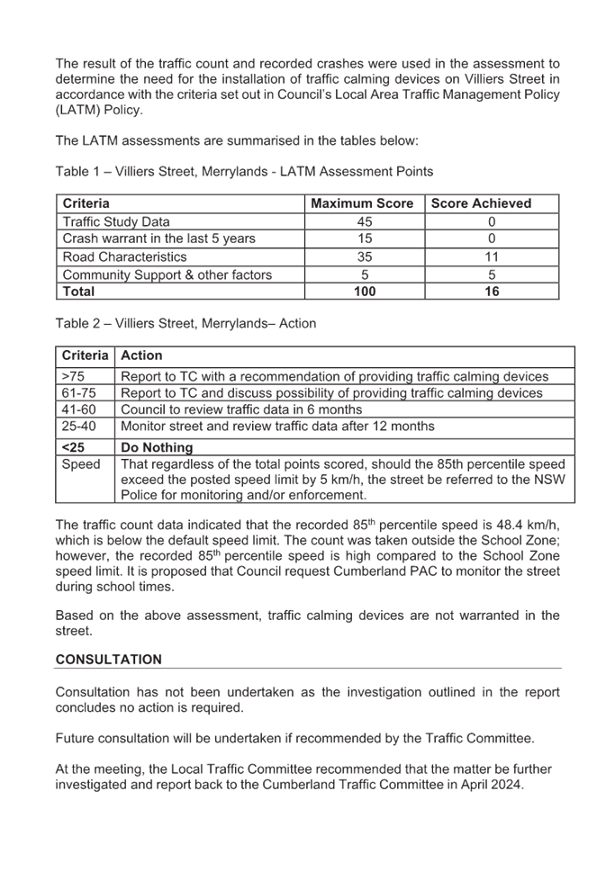
Based on the previous traffic count data, the average daily traffic was 392 vehicles/day and the recorded 85th percentile speed was 48.4 km/hr. It was also noted that there were no reported crashes in Villiers Street.
Considering the above and community interest in the matter, Council proposes to install ‘BL2’ (former ‘BB’) centre lines at the intersections and ‘DL1’ (former S1) dividing (centre) lines in midblock sections of Villiers Street to streamline traffic flow.
COnsultation
Consultation has not been undertaken as the line marking does not impact on available on-street parking.
Attachments
1. Plan – Villiers Street, Merrylands - Proposed Line Marking
2. Previous Report – CTC-24-033 – Villiers Street, Merrylands – Road Safety Concerns
DOCUMENTS
ASSOCIATED WITH
REPORT CTC-24-099
Attachment 1
Plan – Villiers Street, Merrylands - Proposed Line Marking
DOCUMENTS
ASSOCIATED WITH
REPORT CTC-24-099
Attachment 2
Previous Report – CTC-24-033 – Villiers Street, Merrylands – Road Safety Concerns
5 June 2024
Item No: CTC-24-100
HILLTOP ROAD, MERRYLANDS - ROAD SAFETY CONCERNS
Directorate: Environment and Planning
Responsible Officer: Manager Engineering and Building
Electorate: Granville
Police Area Command (PAC): Cumberland
Agenda Part Part 1
Note: Recommended for Approval under Delegated Authority
Summary
Council officers presented a report at the traffic committee on 7 February 2024 on the road safety concerns on Hilltop Road, Merrylands.
Council, at its meeting held on 20 March 2024, resolved that this item considered by the Cumberland Local Traffic Committee at the 7 February 2024 meeting as provided in this report, be returned to the Committee for further consideration.
This report outlines the outcome of the investigation into this matter.
The Traffic Committee recommends that:
1. Council undertake further speed monitoring with the assistance of Variable Message Signs (VMS) in Hilltop Road, Merrylands between Coleman Street and Burnett Street.
2. The concerned resident be notified of the outcome.
Report
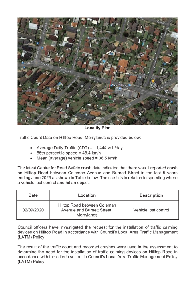
Hilltop Road, Merrylands between Coleman Street and Burnett Street is classified as a collector road that runs in an east-west direction with a default speed limit of 50km/h. The section between Coleman Street and Burnett Street is approximately 300m long and has a width of approximately 12.8m. Parking is permitted on both sides of the road unless signposted.
A report (CTC-24-035) was presented to Cumberland Traffic Committee on 7 February 2024 reviewing the previous traffic count and additional crash data and the Local Area Traffic Management analysis undertaken.
The Traffic Committee recommended that:
1. The installation of traffic calming devices on Hilltop Road, Merrylands between Coleman Street and Burnett Street not be supported.
2. Council review conditions in Hilltop Road, Merrylands in August 2024, and report back to Traffic Committee if required.
3. The concerned resident be notified of the outcome.
Council at its meeting held on 20 March 2024, resolved that this item considered by the Cumberland Local Traffic Committee at the 7 February 2024 meeting as provided in this report, be returned to the Committee for further consideration.
Following review by Council officers and given the continued community concerns in the street, Council will organise Variable Message Signs (VMS) at this section of Hilltop Road, Merrylands, to increase awareness to motorists.
COnsultation
No consultation has been undertaken as the matter relates to the temporary provision of variable messaging signs.
Attachments
1. Previous Report – CTC-24-035 – Hilltop Road, Merrylands – Road Safety Concerns
DOCUMENTS
ASSOCIATED WITH
REPORT CTC-24-100
Attachment 1
Previous Report – CTC-24-035 – Hilltop Road, Merrylands – Road Safety Concerns
5 June 2024
Item No: CTC-24-101
CLARENCE STREET, MERRYLANDS – ROAD SAFETY CONCERNS – CONSULTATION RESULT
Directorate: Environment and Planning
Responsible Officer: Manager Engineering and Building
Electorate: Granville
Police Area Command (PAC): Cumberland
Agenda Part Part 1
Note: Recommended for Approval under Delegated Authority
Summary
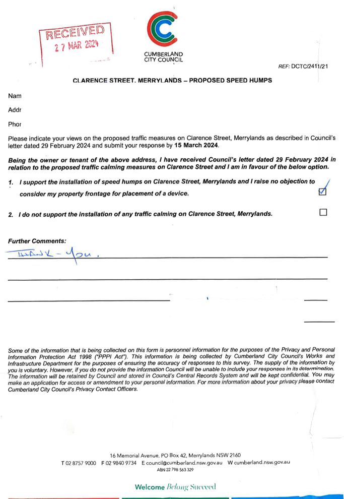
Council has received a request from a local resident for the installation of speed humps on Clarence Street, Merrylands due to speeding concerns.
This report outlines the outcome of the investigation into this matter.
The Traffic Committee recommends that:
1. Council provide ‘BL2’ centre line marking in Clarence Street, Merrylands in accordance with the attached plan.
2. Council request Cumberland Police Area Command to undertake random speed surveillance in Clarence Street, Merrylands.
3. Council notify the concerned residents of the outcome.
Report
Cumberland Traffic Committee (CTC) at its meeting in November 2023 considered a report (CTC-23-190) regarding road safety concerns in Clarence Street, Merrylands. CTC recommended and Council subsequently resolved to undertake consultation with the residents of Clarence Street, Merrylands to assess support or otherwise of resident for installation of traffic calming devices in the street and report back to the Traffic Committee.
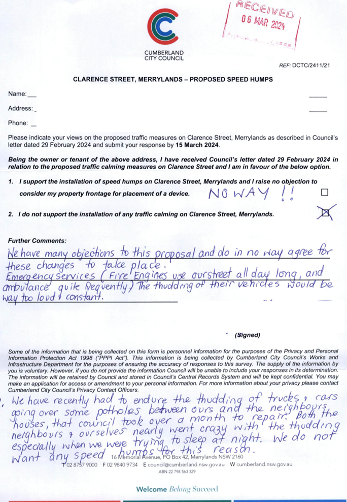
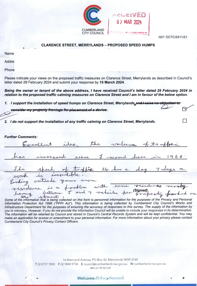
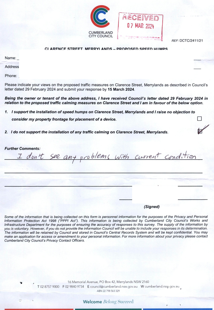
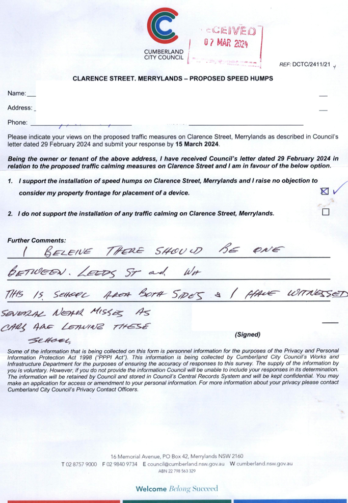
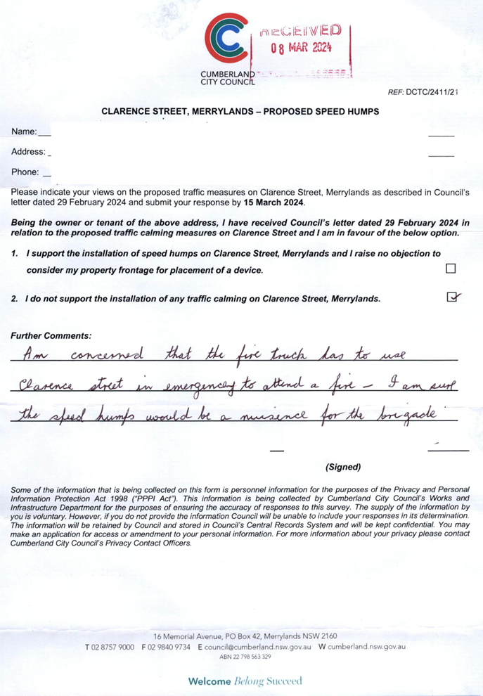
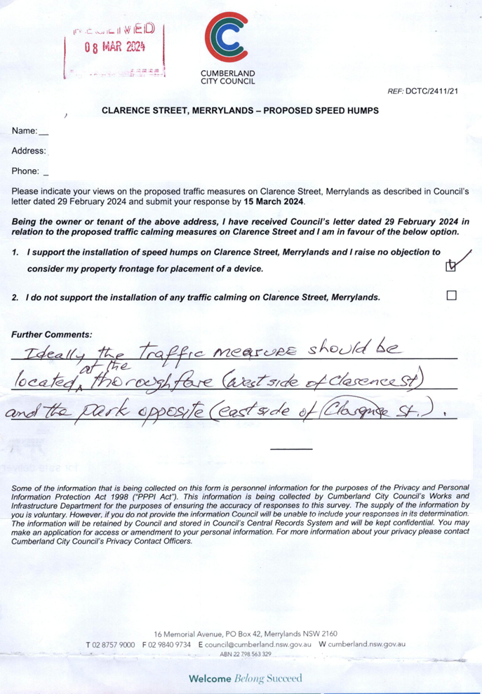
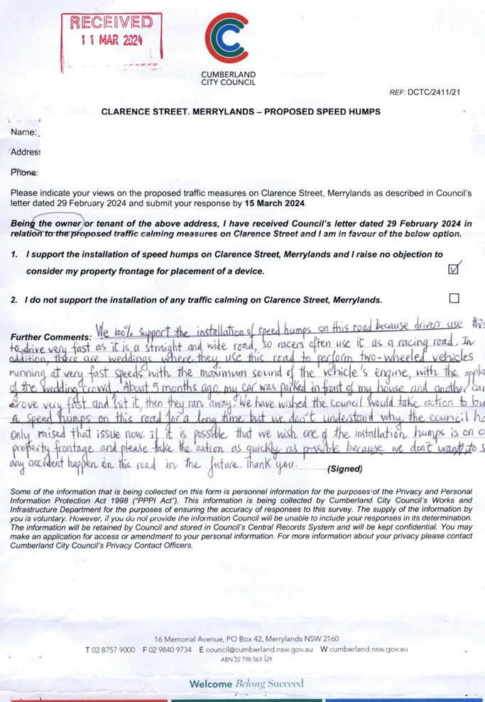
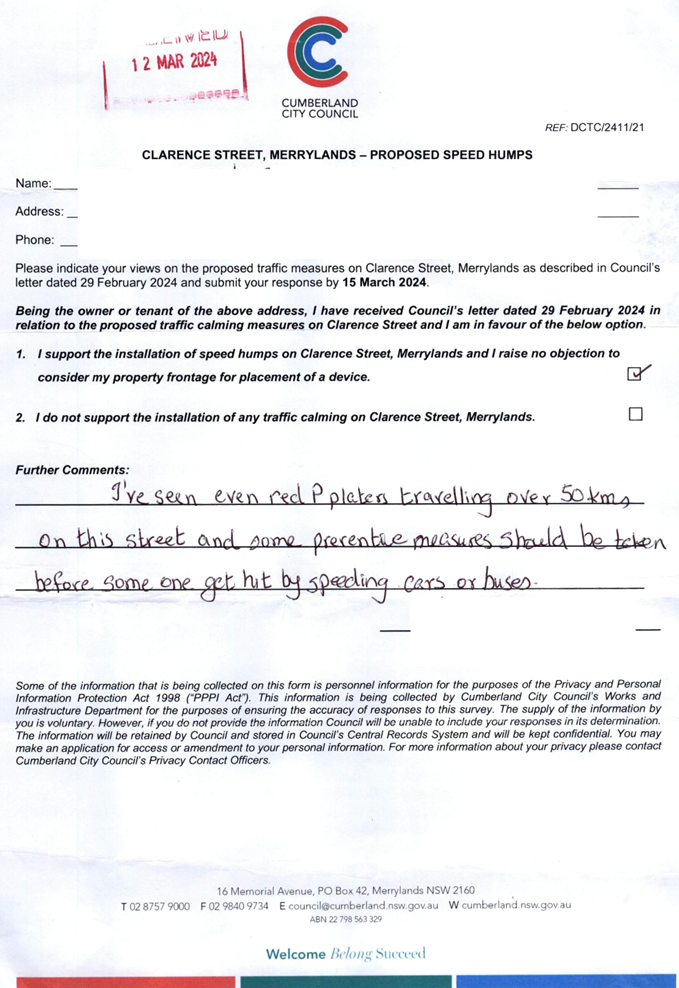
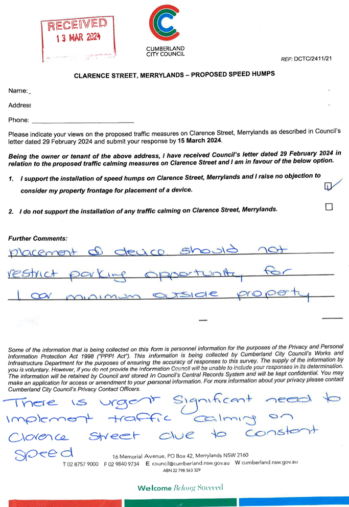
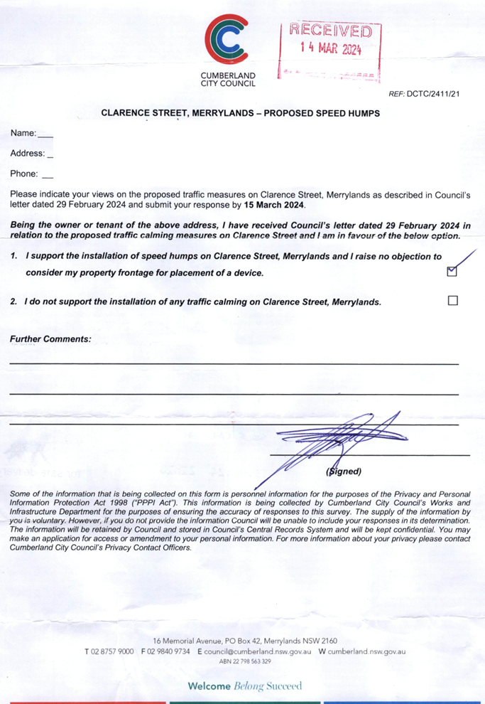
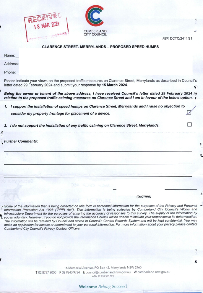
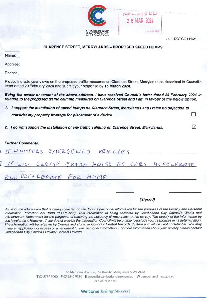
In accordance with Council’s resolution, a consultation was carried out with the residents in Clarence Street in February 2024. A total of 68 letters were distributed to the residents / owners with an attached survey form.
Council received nine responses (13.2% of the total letters sent) by the closing date, six (66.7%) supported the proposed speed humps and three (33.3%) opposed to the proposal.
Based on the survey results, although majority of the residents who responded to the survey supported the proposed speed humps in the street, speed humps could not be installed in the street with an appropriate interval of 100-120m as per the relevant guidelines due to the location of objections received from some residents.
In accordance with previous traffic count, the average daily traffic in Clarence Street is 2,503 vehicles/day, which meets the volume warrants for centre line marking in accordance with the relevant guidelines.
In response to the community interest on the matter, it is proposed that ‘BL2’ centre line marking be provided in Clarence Street, Merrylands. In addition, it is proposed that Cumberland Police Area Command be requested to undertake random speed surveillance in the street.
COnsultation
The proposal was notified to the impacted residents for a period of 14 days from 29 February 2024 to 15 March 2024. A total of 68 letters were distributed to the residents / owners with an attached survey form.
Council received nine (9) responses (13.2% of the total letters sent) by the closing date, six (66.7%) supported the proposed speed humps and three (33.3%) opposed to the proposal.
The line marking proposal in this report does not impact on any properties and further consultation has not been undertaken on this proposal.
Attachments
1. Plan – Clarence Street, Merrylands – Proposed ‘BL2’ Centre Line Marking
DOCUMENTS
ASSOCIATED WITH
REPORT CTC-24-101
Attachment 1
Plan – Clarence Street, Merrylands – Proposed ‘BL2’ Centre Line Marking
DOCUMENTS
ASSOCIATED WITH
REPORT CTC-24-101
Attachment 2
Previous report CTC-23-190
5 June 2024
Item No: CTC-24-102
DESMOND STREET, MERRYLANDS WEST - ROAD SAFETY CONCERNS
Directorate: Environment and Planning
Responsible Officer: Manager Engineering and Building
Electorate: Granville
Police Area Command (PAC): Cumberland
Agenda Part Part 1
Note: Recommended for Approval under Delegated Authority
Summary
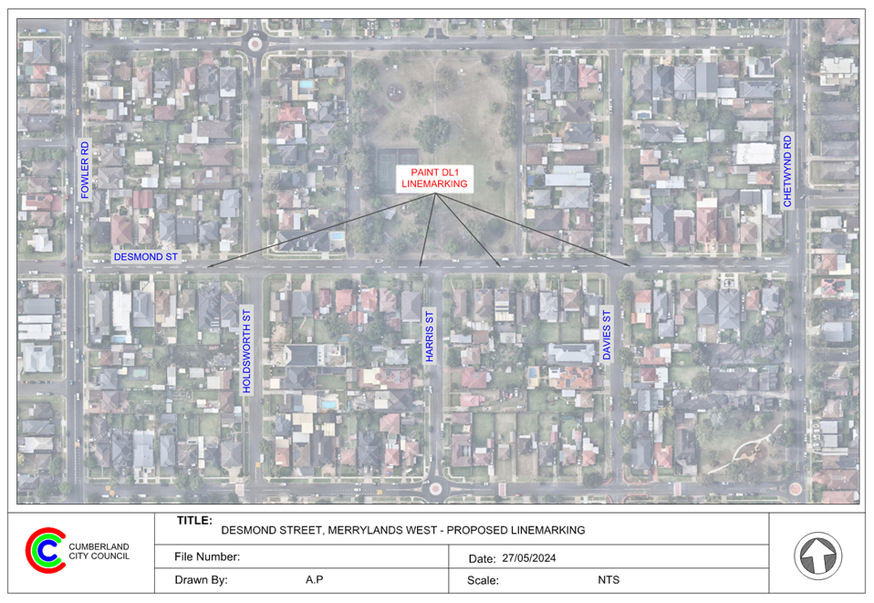
Council has received requests from a local resident for the installation of traffic calming devices on Desmond Street, Merrylands West due to speeding concerns.
This report outlines the outcome of the investigation into this matter.
The Traffic Committee recommends that:
1. Council provide ‘DL1’ dividing lines in Desmond Street, Greystanes as per the attached plan.
2. Council request Cumberland Police Area Command to undertake random speed surveillance in Desmond Street, Merrylands West.
3. The concerned resident be notified of the outcome.
Report
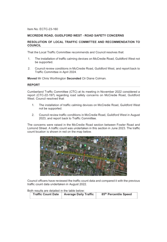
Council has received requests from a local resident for the installation of traffic calming devices on Desmond Street, Merrylands West between Chetwynd Road and Fowler Road due to speeding concerns.
Desmond Street is a local road that runs in an east-west direction with a posted speed limit of 50km/h. This section of the street is approximately 500m long and has a width of approximately 10m. Parking is permitted on both sides of the street unless signposted.
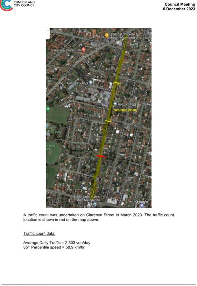
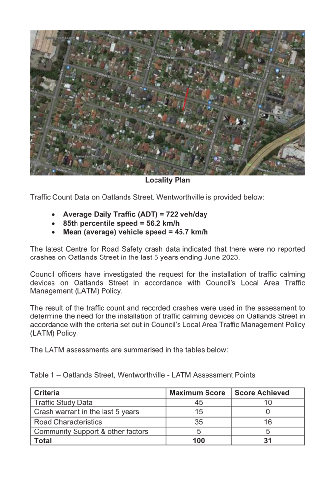
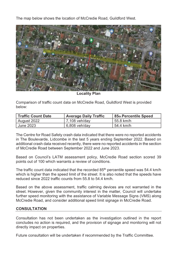
A traffic count was undertaken on Desmond Street, Merrylands West in October 2023. The traffic count location is shown in red on the map below.
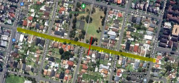
Locality Plan
Traffic Count Data on Desmond Street, Merrylands West:
· Average Daily Traffic (ADT) = 1,865 vehicles/day
· 85th percentile speed = 56.5 km/h
· Mean (average) vehicle speed = 50.2 km/h
The latest Centre for Road Safety accident data indicated that there were no accidents on Desmond Street in the last 5 years ending September 2023 in relation to speeding.
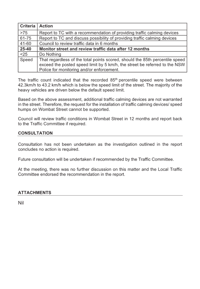
Council officers have investigated the request for the installation of traffic calming devices on Desmond Street in accordance with Council’s Local Area Traffic Management (LATM) Policy. The result of the traffic count and recorded crashes were used in the assessment to determine the need for the installation of traffic calming devices on Desmond Street in accordance with the criteria set out in Council’s Local Area Traffic Management Policy (LATM) Policy.
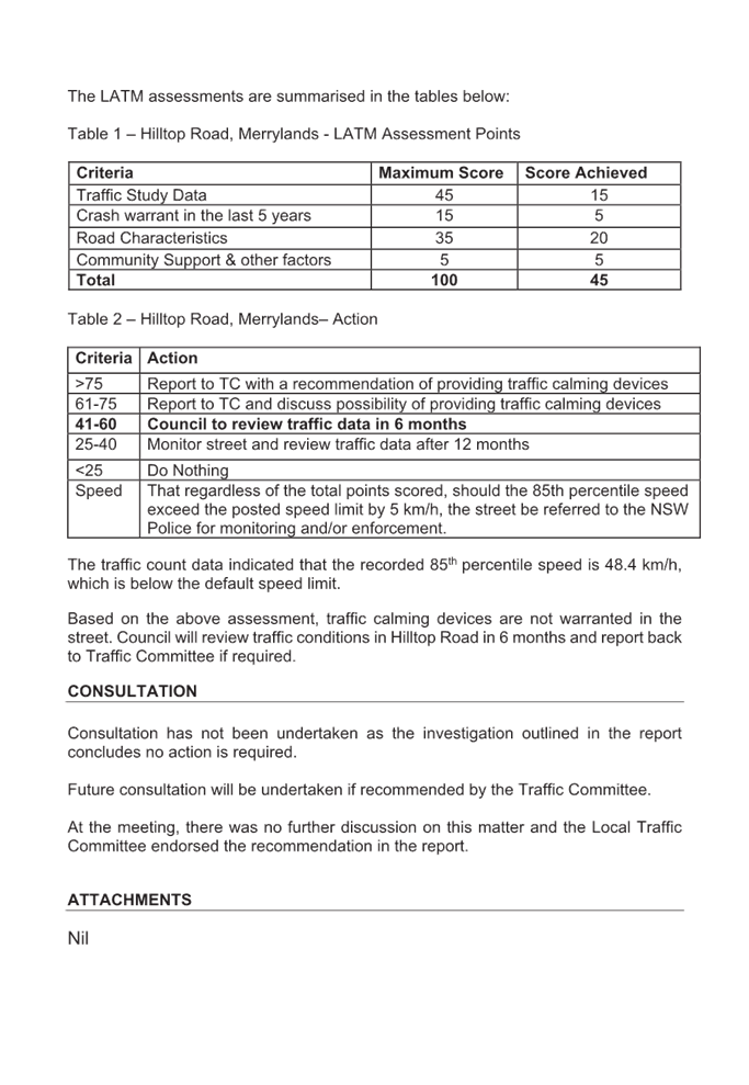
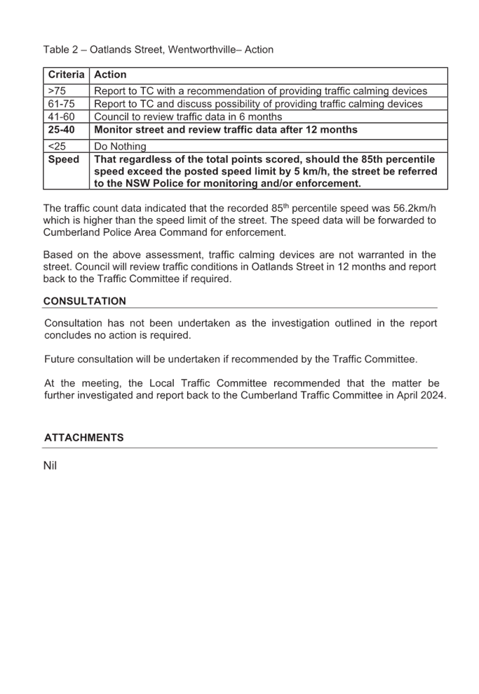
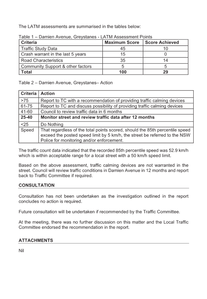
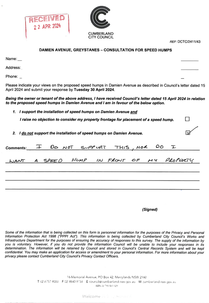
The LATM assessments are summarised in the tables below:
Table 1 – Desmond Street, Merrylands West - LATM Assessment Points
|
Criteria |
Maximum Score |
Score Achieved |
|
Traffic Study Data |
45 |
20 |
|
Crash warrant in the last 5 years |
15 |
0 |
|
Road Characteristics |
35 |
10 |
|
Community Support & other factors |
5 |
5 |
|
Total |
100 |
35 |
Table 2 – Desmond Street, Merrylands West– Action
|
Criteria |
Action |
|
>75 |
Report to TC with a recommendation of providing traffic calming devices |
|
61-75 |
Report to TC and discuss possibility of providing traffic calming devices |
|
41-60 |
Council to review traffic data in 6 months |
|
25-40 |
Monitor street and review traffic data after 12 months |
|
<25 |
Do Nothing |
|
Speed |
That regardless of the total points scored, should the 85th percentile speed exceed the posted speed limit by 5 km/h, the street be referred to the NSW Police for monitoring and/or enforcement. |
The traffic count data indicated that the recorded 85th percentile speed is 56.5 km/h, which is above the speed limit for a local street with a 50 km/h speed limit. Based on the above assessment, traffic calming devices are not warranted in the street. However, based on the high recorded 85th percentile speed, it is proposed to provide ‘DL1’ dividing lines in the centre of Desmond Street, Merrylands West, to assist with road safety.
It is also proposed that Cumberland Police Area Command undertake random speed surveillance in Desmond Street, Merrylands West.
COnsultation
Consultation has not been undertaken as the line marking does not impact on available on-street parking.
Attachments
1. Plan - Desmond Street Merrylands West - Proposed Centre Line Marking
DOCUMENTS
ASSOCIATED WITH
REPORT CTC-24-102
Attachment 1
Plan - Desmond Street Merrylands West - Proposed Centre Line Marking
5 June 2024
Item No: CTC-24-103
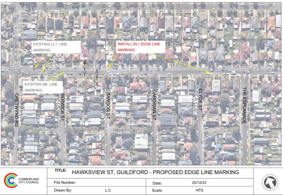
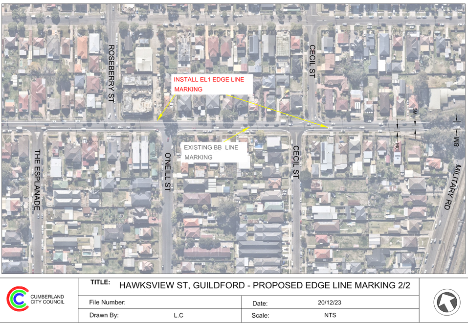
HAWKSVIEW STREET, GUILDFORD AND MERRYLANDS – ROAD SAFETY CONCERN
Directorate: Environment and Planning
Responsible Officer: Manager Engineering and Building
Electorate: Granville
Police Area Command (PAC): Cumberland
Agenda Part Part 1
Note: Recommended for Approval under Delegated Authority
Summary
Cumberland Traffic Committee considered a report on the installation of traffic calming devices on Hawksview Street, Guildford on 7 February 2024.
Council at its meeting held on 20 March 2024, resolved that this item considered by the Cumberland Local Traffic Committee at the 7 February 2024 meeting as provided in this report, be returned to the Committee for further consideration.
This report outlines further review into this matter.
The Traffic Committee recommends that:
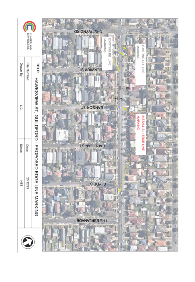
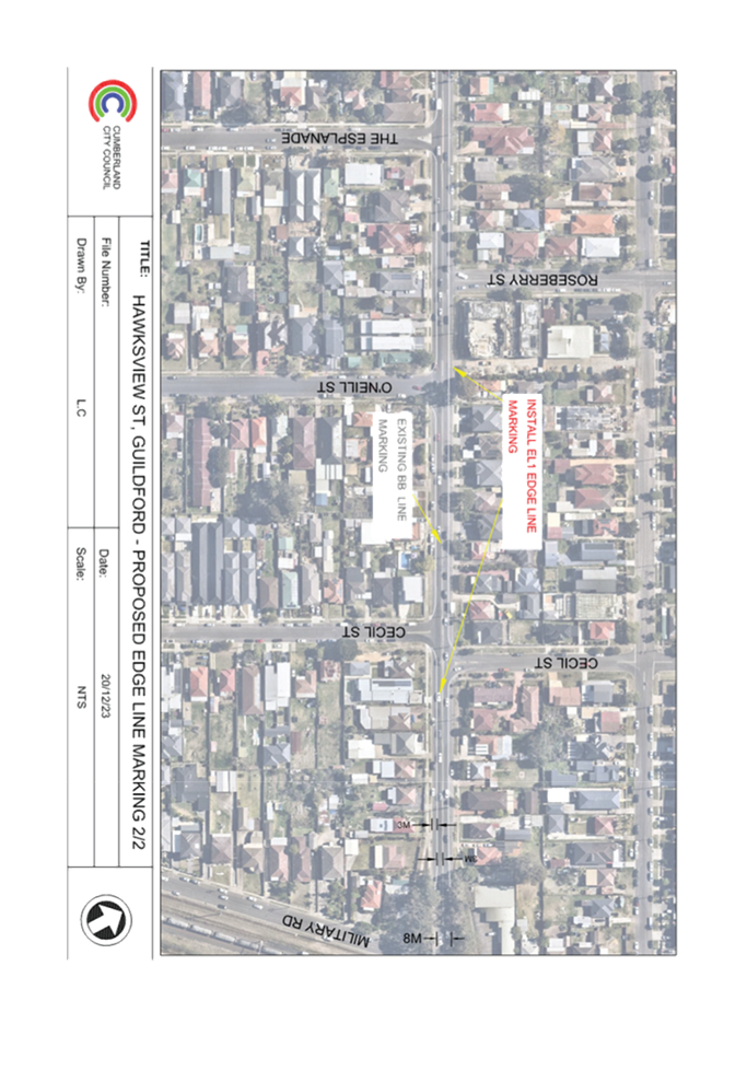
1. Installation of edge line marking in Hawksview Street between Chetwynd Road and Oxford Street overpass be approved in accordance with the plan attached in the report.
2. Council continues to advocate for a speed camera on Hawksview Street and continue to liaise with the State Member for Granville and other relevant agencies on the matter.
3. Council notify the concerned residents of the outcome.
Report
Hawksview Street is a regional road that runs in an east-west direction with a posted speed limit of 50km/h. The street has a width of approximately 12.5m. Parking is permitted on both sides of the road unless signposted.
Due to concerns from the residents, safety in Hawksview Street was investigated and reported to traffic committee in the past. Previous history of reports is detailed in the attachment, ‘Previous Report - CTC-24-051 – Hawksview Street, Guildford and Merrylands – Road Safety Concern’.
Cumberland Traffic Committee considered a report (CTC-24-051) on the installation of traffic calming devices on Hawksview Street, Guildford on 7 February 2024.The traffic committee recommended that:
1. Installation of edge line marking in Hawksview Street between Chetwynd Road and Oxford Street overpass be approved in accordance with the plan attached in the report.
2. Council continues to advocate for a speed camera on Hawksview Street and continue to liaise with the State Member for Granville and other relevant agencies on the matter.
3. Council notify the concerned residents of the outcome.
Council at its meeting held on 20 March 2024, resolved that this item considered by the Cumberland Local Traffic Committee at the 7 February 2024 meeting as provided in this report, be returned to the Committee for further consideration.
In accordance with previous considerations, the Cumberland Traffic Committee (CTC) at its meeting held in November 2023 noted that the installation of speed humps along Hawksview Street will most likely encourage road users to divert onto surrounding local streets.
As recommended by the CTC in February 2024, installation of a speed camera at a suitable location along Hawksview Street will encourage traffic to slow down in the street. Council officers have lodged an online request on the NSW Government’s Safer Roads website for a speed camera installation. Council will also continue to advocate for a speed camera on Hawksview Street and continue to liaise with the State Member for Granville and other relevant agencies on the matter.
In addition, as recommended by CTC, it is also proposed that edge lines be installed in Hawksview Street to supplement the existing ‘BL2’ (double continuous centre lines) line marking, as provided on the plan associated with this report.
COnsultation
Consultation has not been undertaken as the line marking does not impact on available on-street parking.
Attachments
1. Plan - Proposed Edge Line Marking
2. Previous Report - CTC-24-051 – Hawksview Street, Guildford and Merrylands – Road Safety Concern
DOCUMENTS
ASSOCIATED WITH
REPORT CTC-24-103
Attachment 1
Plan - Proposed Edge Line Marking
DOCUMENTS
ASSOCIATED WITH
REPORT CTC-24-103
Attachment 2
Previous Report - CTC-24-051 – Hawksview Street, Guildford and Merrylands – Road Safety Concern
5 June 2024
Item No: CTC-24-104
THE ESPLANADE, GUILDFORD - ROAD SAFETY CONCERNS
Directorate: Environment and Planning
Responsible Officer: Manager Engineering and Building
Electorate: Granville
Police Area Command (PAC): Cumberland
Agenda Part Part 1
Note: Recommended for Approval under Delegated Authority
Summary
Council presented a report at the traffic committee on 7 February 2024 on the road safety concerns on The Esplanade, Guildford.
Council at its meeting held on 20 March 2024, resolved that this item considered by the Cumberland Local Traffic Committee at the 7 February 2024 meeting as provided in this report, be returned to the Committee for further consideration.
This report outlines the outcome of further review into this matter.
The Traffic Committee recommends that:
1. The installation of ‘BL2’ centre and edge lines on The Esplanade, Guildford in accordance with the attached plan be approved.
2. Council request Cumberland Police Area Command to undertake speed surveillance in The Esplanade, Guildford.
3. The concerned resident be notified of the outcome.
Report
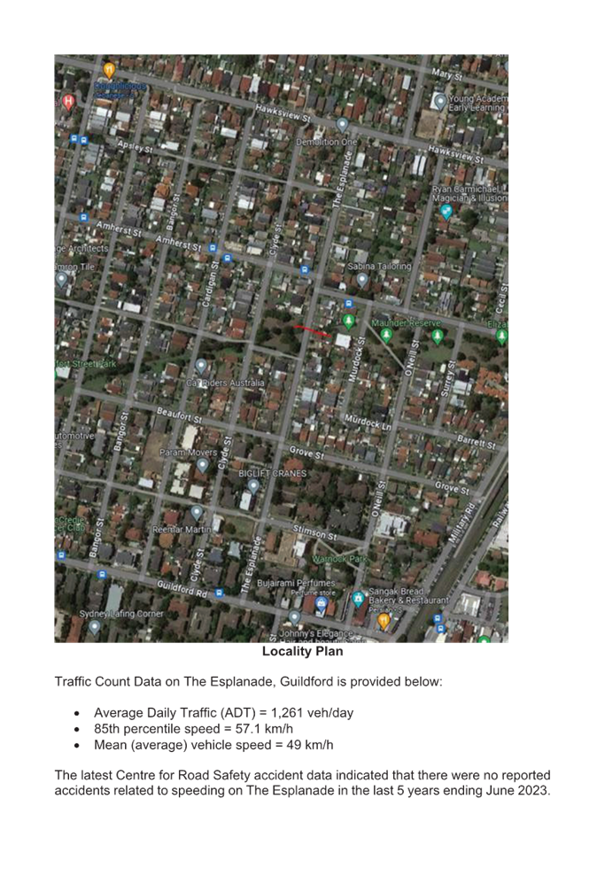
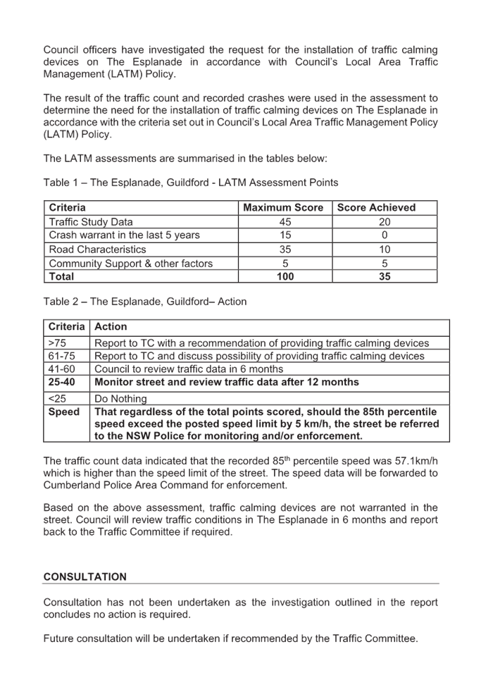
The Esplanade is a local road that runs in a north-south direction between Guildford Road and Hawksview Street with a default speed limit of 50km/h. The street is approximately 750m long and has a width of approximately 12.7m. there is no line marking in the street.
A report (CTC-24-032) on the road safety concerns in The Esplanade was presented to the Cumberland Traffic Committee on 7 February 2024, and the traffic committee recommended that:
1. The installation of traffic calming devices on The Esplanade, Guildford not be supported.
2. Investigate the potential for line marking and signage to address concerns and provide a report to the Committee for consideration in April 2024.
3. Council request Cumberland Police Area Command to undertake speed surveillance in The Esplanade, Guildford.
4. The concerned resident be notified of the outcome.
Council at its meeting held on 20 March 2024, resolved that this item considered by the Cumberland Local Traffic Committee at the 7 February 2024 meeting as provided in this report, be returned to the Committee for further consideration.
Council officers have now undertaken further investigation as per Council resolution and recommendation (item 2) by the traffic committee for line marking in The Esplanade.
Based on the traffic count data, the average daily traffic in The Esplanade is 1,261 vehicles/day and the recorded 85th percentile speed was 57.1 km/hr.
Considering the high recorded 85th percentile speed in The Esplanade and community interest in the matter, Council proposes to install ‘BL2’ centre line (double lines) and ‘E1’ edge lines to streamline traffic flow.
COnsultation
Consultation has not been undertaken as the line marking does not impact on available on-street parking.
Attachments
1. Plan - The Esplanade, Guildford – Proposed Line Marking
2. Previous Report - CTC-24-032 - The Esplanade, Guildford – Road Safety Concerns
DOCUMENTS
ASSOCIATED WITH
REPORT CTC-24-104
Attachment 1
Plan - The Esplanade, Guildford – Proposed Line Marking
DOCUMENTS
ASSOCIATED WITH
REPORT CTC-24-104
Attachment 2
Previous Report - CTC-24-032 - The Esplanade, Guildford – Road Safety Concerns
5 June 2024
Item No: CTC-24-105
LANCE CRESCENT, GREYSTANES - ROAD SAFETY CONCERNS
Directorate: Environment and Planning
Responsible Officer: Manager Engineering and Building
Electorate: Prospect
Police Area Command (PAC): Cumberland
Agenda Part Part 1
Note: Recommended for Approval under Delegated Authority
Summary
Cumberland Traffic Committee considered a report on the road safety concerns on Lance Crescent, Greystanes on 7 February 2024.
This report outlines further investigation into this matter.
The Traffic Committee recommends that:
1. Council undertake further speed monitoring with the assistance of Variable Message Signs (VMS) in Lance Crescent, Greystanes.
2. The concerned resident be notified of the outcome.
Report
Cumberland Traffic Committee considered a report on the road safety concerns on Lance Crescent, Greystanes on 7 February 2024.
The traffic committee recommended that:
1. The installation of traffic calming devices on Lance Crescent, Greystanes not be supported.
2. Council undertake further speed monitoring with the assistance of Variable Message Signs (VMS) in Lance Crescent.
3. The concerned resident be notified of the outcome.
Council at its meeting held on 20 March 2024, resolved that this item considered by the Cumberland Local Traffic Committee at the 7 February 2024 meeting as provided in this report, be returned to the Committee for further consideration.
Council officers have undertaken a review of the conditions in Lance Crescent, and are provided as follows:
· Average Daily Traffic (ADT) = 582 vehicles/day
· 85th percentile speed (recorded) = 46.4 km/hr
· Mean Speed (recorded) = 39.2 km/hr
· Speed limit of the street = 50 km/hr
The recent Centre for Road Safety Crash data received indicated that there was one non-injury reported crash in Lance Crescent in 5 year period ending September 2023. The crash happened at the intersection of Old Prospect Road and Lance Crescent. There were no other speed related crashes in Lance Crescent during the same period.
The traffic count data indicated that the recorded 85th percentile speed was 46.4 km/h, which is below the speed limit of the street.
Following review by Council officers and community interest on the matter, Council will continue to monitor traffic conditions on Lance Crescent by undertaking further speed monitoring with the assistance of Variable Message Signs (VMS).
COnsultation
No consultation has been undertaken as the matter relates to the temporary provision of variable messaging signs.
Attachments
1. Previous Report - CTC-20-047 – Lance Crescent, Greystanes – Road safety Concerns
DOCUMENTS
ASSOCIATED WITH
REPORT CTC-24-105
Attachment 1
Previous Report - CTC-20-047 – Lance Crescent, Greystanes – Road safety Concerns
5 June 2024
Item No: CTC-24-106
ELDRIDGE ROAD, GREYSTANES - ROAD SAFETY CONCERNS
Directorate: Environment and Planning
Responsible Officer: Manager Engineering and Building
Electorate: Prospect
Police Area Command (PAC): Cumberland
Agenda Part Part 1
Note: Recommended for Approval under Delegated Authority
Summary
Cumberland Traffic Committee considered a report on the road safety concerns on Eldridge Road, Greystanes on 7 February 2024.
This report outlines further investigation into this matter.
The Traffic Committee recommends that:
1. Council request Cumberland Police Area Command to undertake random speed surveillance during school hours.
2. The concerned resident be notified of the outcome.
Report
Background
Eldridge Road is a local road that runs in an east-west direction with a default speed limit of 50km/h and 40km/h speed limit applies during school hours in part of the street.
The street is approximately 440m long and has a width of approximately 10.5m.
Parking is permitted on both sides of the road unless signposted. Holroyd High School is located close by, and a School Zone is provided for majority of the Eldredge Street. There is ‘BL2’ (double continuous centre lines) marked along Eldridge Street.
Cumberland Traffic Committee considered a report (CTC-24-043) on the road safety concerns on Eldridge Road, Greystanes on 7 February 2024.
The traffic committee recommended that;
1. The installation of traffic calming devices on Eldridge Road, Greystanes not be supported.
2. Council request Cumberland Police Area Command to undertake speed surveillance during school hours.
3. The concerned resident be notified of the outcome.
Council at its meeting held on 20 March 2024, resolved that this item considered by the Cumberland Local Traffic Committee at the 7 February 2024 meeting as provided in this report, be returned to the Committee for further consideration.
Council officers have undertaken a review of the conditions in Eldridge Road, Greystanes.
Based on the traffic counts undertaken in Eldridge Road, the average daily traffic in the street is 988 vehicles/day and the recorded 85th percentile speed was 52.9 km/hr.
The recorded 85th percentile speed value is within acceptable limits, however, further analysis of the speed profile in the street indicated that there was speeding during 40km/hr School Zone times.
Given the community interest on the matter, Council will continue to monitor traffic conditions on Eldridge Road. It is also proposed that the Cumberland Police area Command monitor the street during the school times.
COnsultation
Consultation has not been undertaken as the investigation outlined in the report concludes no action is required.
Future consultation will be undertaken if recommended by the Traffic Committee.
Attachments
1. Previous Report - CTC-20-043 – Eldridge Road, Greystanes – Road Safety Concerns
DOCUMENTS
ASSOCIATED WITH
REPORT CTC-24-106
Attachment 1
Previous Report - CTC-20-043 – Eldridge Road, Greystanes – Road Safety Concerns
5 June 2024
Item No: CTC-24-107
OATLANDS STREET, WENTWORTHVILLE - ROAD SAFETY CONCERNS
Directorate: Environment and Planning
Responsible Officer: Manager Engineering and Building
Electorate: Prospect
Police Area Command (PAC): Cumberland
Agenda Part Part 1
Note: Recommended for Approval under Delegated Authority
Summary
Council officers presented a report at the traffic committee on 7 February 2024 on the road safety concerns on Oatlands Street, Wentworthville due to speeding concerns.
Council at its meeting held on 20 March 2024, resolved that this item considered by the Cumberland Local Traffic Committee at the 7 February 2024 meeting as provided in this report, be returned to the Committee for further consideration.
This report outlines the outcome of further review into this matter.
The Traffic Committee recommends that:
1. The installation of ‘BL2’ centre and ‘E1’ edge lines on Oatlands Street, Wentworthville be approved.
2. The concerned residents be notified of the outcome.
Report
Oatlands Street is a local road that runs in an east-west direction between Jones Street
and Emert Street with a default speed limit of 50km/h. The street is approximately 560m long and has a width of approximately 12.6m. A report (CTC-24-045) on the road safety concerns in Oatlands Street was presented to the Cumberland Traffic Committee on 7 February 2024, and the Traffic Committee recommended that:
1. The installation of traffic calming devices on Oatlands Street, Wentworthville
not be supported.
2. Investigate the potential for line marking and signage to address speeding concerns and provide a report to the Committee for consideration in April 2024.
3. Council request Cumberland Police Area Command to undertake speed surveillance in Oatlands Street, Wentworthville.
4. The concerned resident be notified of the outcome.
Council at its meeting held on 20 March 2024, resolved that this item considered by the Cumberland Local Traffic Committee at the 7 February 2024 meeting as provided in this report, be returned to the Committee for further consideration.
Council officers have now undertaken further investigation as per Council resolution and recommendation (item 2) by the traffic committee for line marking in Oatlands Street, Wentworthville.
Based on the previous traffic count data, the average daily traffic was 722 vehicles/day and the recorded 85th percentile speed was 56.2 km/hr.
The latest Centre for Road Safety crash data indicated that there were no reported crashes on Oatlands Street in the last 5 years ending June 2023.
Following review by Council officers and community interest in the matter, Council proposes to install ‘BL2’ (former ‘BB’) centre line and ‘E1’ edge lines to streamline traffic flow.
COnsultation
Consultation has not been undertaken as the line marking does not impact on available on-street parking.
Attachments
1. Plan – Oatlands Street, Wentworthville - Proposed Line Marking
2. Previous Report – CTC-24-045 – Oatlands Street, Wentworthville – Road Safety Concerns
DOCUMENTS
ASSOCIATED WITH
REPORT CTC-24-107
Attachment 1
Plan – Oatlands Street, Wentworthville - Proposed Line Marking
DOCUMENTS
ASSOCIATED WITH
REPORT CTC-24-107
Attachment 2
Previous Report – CTC-24-045 – Oatlands Street, Wentworthville – Road Safety Concerns
5 June 2024
Item No: CTC-24-108
PASTORAL CIRCUIT, PEMULWUY – EXTENSION OF THE EXISTING ‘NO STOPPING’ RESTRICTIONS
Directorate: Environment and Planning
Responsible Officer: Manager Engineering and Building
Electorate: Prospect
Police Area Command (PAC): Cumberland
Agenda Part Part 1
Note: Recommended for Approval under Delegated Authority
Summary
Council has received safety concerns from a resident requesting that consideration be given to the extension of the existing ‘No Stopping’ restrictions on the northern side of Pastoral Circuit, Pemulwuy along the side boundary of No.112 Driftway Drive.
This report outlines the outcome of the investigation into this matter.
The Traffic Committee recommends that:
1. The relocation of the existing ‘No Stopping’ sign outside No.112 Pastoral Circuit, Pemulwuy in accordance with the attached plan be approved.
2. The affected / concerned residents be notified of the outcome.
Report
Pastoral Circuit is a local road that forms a loop by connecting with Driftway Drive with a speed limit of 50 km/h. It has a width of approximately 6m and parking is permitted on both sides of the road unless otherwise signposted.
Recently, council received a request from a resident for the extension of the existing ‘No Stopping’ sign in Pastoral Circuit, Pemulwuy along the side boundary of No.112 Driftway Drive.
The map below shows the location.
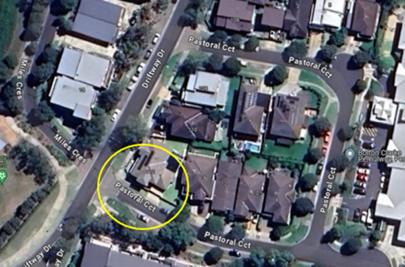
Locality Plan
Currently, the existing 'No Stopping' sign is located approximately 3 metres west of the driveway of No. 112 Driftway Drive. The resident alleges that cars often park in this space and partially block the driveway.
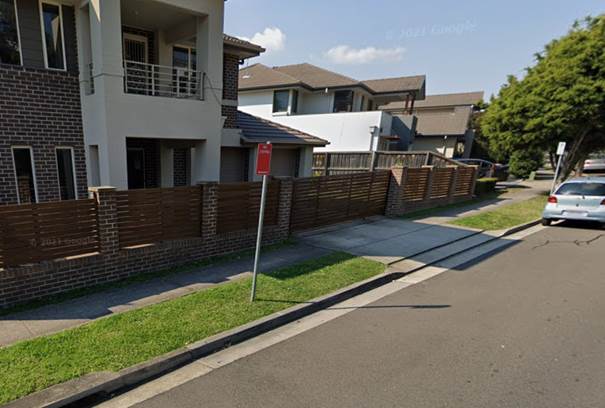
In order to reinforce the road rules at this location, it is proposed to extend the existing ‘No Stopping’ restrictions as per attached drawing.
COnsultation
The proposal was notified to the impacted and adjacent residents for a period of 14 days starting from 17 April 2024 to 1 May 2024.
There was one response received in support of the proposal.
Attachments
1. Plan – Pastoral Circuit, Pemulwuy – Proposed Parking Restrictions
DOCUMENTS
ASSOCIATED WITH
REPORT CTC-24-108
Attachment 1
Plan – Pastoral Circuit, Pemulwuy – Proposed Parking Restrictions
DOCUMENTS
ASSOCIATED WITH
REPORT CTC-24-108
Attachment 2
Submission
5 June 2024
Item No: CTC-24-109
BRAESIDE ROAD, GREYSTANES - MODIFICATIONS TO THE EXISTING 'NO STOPPING' RESTRICTIONS
Directorate: Environment and Planning
Responsible Officer: Manager Engineering and Building
Electorate: Prospect
Police Area Command (PAC): Cumberland
Agenda Part Part 1
Note: Recommended for Approval under Delegated Authority
Summary
Council has received an enquiry from Our Lady Queen of Peace Catholic Primary School regarding the existing ‘No Stopping’ restrictions on Braeside Road, Greystanes outside the school.
This report outlines the outcome of the investigation into this matter.
The Traffic Committee recommends that:
1. The replacement of the existing part-time ‘No Stopping’ signs on Braeside Road, Greystanes at the pick-up/drop-off bay area with part-time ‘No Parking’ signs in accordance with the attached plan be approved.
2. Our Lady Queen of Peace Catholic Primary School be notified of the outcome.
Report
Council has received a request from Our Lady Queen of Peace Catholic Primary School to replace the existing ‘No Stopping’ restrictions on Braeside Road, Greystanes, outside the school with ‘No Parking’ restrictions.
Braeside Road is a local collector road that runs north-south, connecting Merrylands Road and Old Prospect Road, with a posted speed limit of 50 km/h. A designated pick-up and drop-off zone during school hours was provided in the bay area outside Our Lady Queen of Peace Catholic Primary School. However, ‘No Stopping’ restrictions during school hours were recently installed in the bay area as part of the raised pedestrian crossing work outside the school.
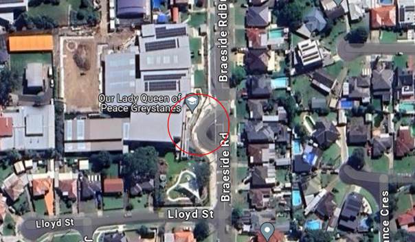
Locality Plan
The implementation of the ‘No Stopping’ restrictions at this location removed opportunities for parents to pick up and drop off their children and contradicts the supplementary sign ‘Passenger set Down or Pick Up permitted’. As a result, the school requested that part-time ‘No Parking’ restrictions be reinstated in the bay area.
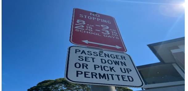
Council officers inspected the site and observed that the existing parking restriction was signposted as ‘No Stopping, 8am – 9am, 2:15pm – 3:15pm, School Days,’ with an additional supplementary sign underneath advising ‘Passenger set down or pick up permitted.’
To assist with the operation of this bay, Council proposes to replace the existing part-time ‘No Stopping’ signs with ‘No Parking’ signs and to replace the existing supplementary signs with TfNSW approved signs to deliver a clearer message.
COnsultation
Consultation has not been undertaken as the proposed change was initiated by Our Lady Queen of Peace Catholic Primary School and no residents will be impacted by the changes.
Attachments
DOCUMENTS
ASSOCIATED WITH
REPORT CTC-24-109
Attachment 1
Braeside Road, Greystanes - Plan
5 June 2024
Item No: CTC-24-110
SANDRA STREET AND FIONA STREET, WOODPARK – PROPOSED ‘NO STOPPING’ RESTRICTIONS AND LINEMARKING
Directorate: Environment and Planning
Responsible Officer: Manager Engineering and Building
Electorate: Granville
Police Area Command (PAC): Cumberland
Agenda Part Part 1
Note: Recommended for Approval under Delegated Authority
Summary
Council has received safety concerns from residents at the intersection of Sandra Street and Fiona Street, Woodpark.
This report outlines the outcome of the investigation into this matter.
The Traffic Committee recommends that:
1. The installation of ‘No Stopping’ signs and ‘BB’ line marking at the intersection of Sandra Street and Fiona Street, Woodpark in accordance with the attached plan be approved.
2. The affected / concerned residents be notified of the outcome.
Report
The concerned section of Sandra Street is a local road that runs in an east-west direction between Dell Street and Fiona Street with a speed limit of 50 km/h. It has a width of approximately 7m and parking is permitted on both sides of the road unless otherwise signposted.
Fiona Street is a local road that runs in a north-south direction between Sandra Street and Woodpark Road with a speed limit of 50 km/h. It has a width of approximately 7m and parking is permitted on both sides of the road unless otherwise signposted.
Sandra Street and Fiona Street forms a T- intersection with priority to Sandra Street.
The map below shows the intersection.
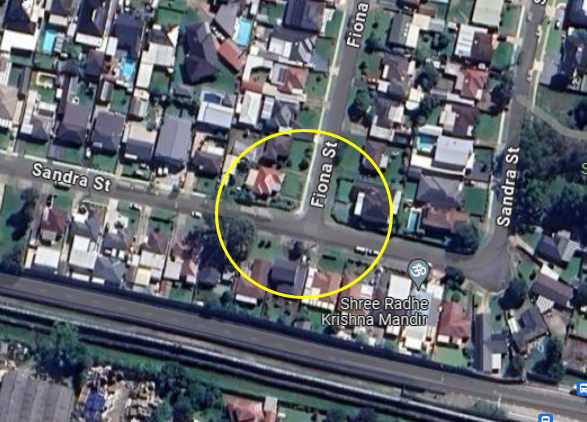
Locality Plan
The latest Centre for Road Safety accident data indicated that there were no reported accidents at this intersection in the last 5 years ending June 2023.
A site inspection indicated that vehicles are parking within 10 metres at the intersection. It is proposed to install 13m ‘No Stopping’ restrictions and 10m ‘BB’ line marking at the intersection. The signage and line marking would strengthen the Road Rules requirement and stop vehicles from parking too close to the intersection.
The ‘No Stopping’ signs are proposed to be installed on both sides of Fiona Street and Sandra Street at 13m to allow vehicles to safely pass a parked car without encroaching the proposed ‘BB’ line marking.
COnsultation
The proposal was notified to the impacted and adjacent residents for a period of 14 days starting from 15 April 2024 to 30 April 2024. There were no responses received.
Attachments
1. Plan – Sandra Street and Fiona Street, Woodpark – Proposed ‘No Stopping’ restrictions and BB Line Markings
DOCUMENTS
ASSOCIATED WITH
REPORT CTC-24-110
Attachment 1
Plan – Sandra Street and Fiona Street, Woodpark – Proposed ‘No Stopping’ restrictions and BB Line Markings
5 June 2024
Item No: CTC-24-111
LOMOND STREET, GUILDFORD WEST – EXTENSION OF THE EXISTING ‘NO STOPPING’ RESTRICTIONS
Directorate: Environment and Planning
Responsible Officer: Acting Manager Engineering and Building
Electorate: Granville
Police Area Command (PAC): Cumberland
Agenda Part Part 1
Note: Recommended for Approval under Delegated Authority
Summary
Council has received a request from a resident regarding parked vehicles on the western side of Lomond Street near the intersection of Dennistoun Avenue, Guildford.
This report outlines the outcome of the investigation into this matter.
The Traffic Committee recommends that:
1. The extension of the existing ‘No Stopping’ signage on the western side of Lomond Street near No. 34 in accordance with the attached plan be approved.
2. The affected/concerned residents be notified of the outcome.
Report
Lomond Street is a local road that runs in a north - south directions. Lomond Street has a speed limit of 50 km/h. It has a width of approximately 10m. Parking is permitted on both sides of the road unless otherwise signposted.
The section being investigated is between Dennistoun Avenue and Leach Road near the existing roundabout located on the southern end of Lomond Street. This section of Lomond Street has approximately 50m existing BL2 linemarking associated with the roundabout at the intersection of Lomond Street and Dennistoun Avenue. The current travel lane width for the BL2 marked area is approximately 4.2m for the northbound direction and 5.8m for the southbound direction.
The map below shows the area:
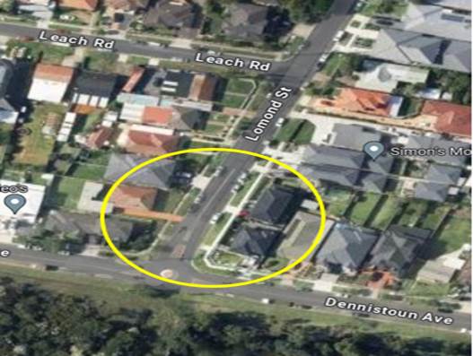
Figure 1 – Locality Plan
The latest Centre for Road Safety accident data indicated that there were no reported accidents at this intersection in the last 5 years ending September 2023.
In accordance with NSW Road Rule, Rule 208:
(6) if the road has a continuous dividing line or a dividing strip, the driver must position the vehicle at least 3 metres form the continuous dividing line or dividing strip …
An investigation revealed that vehicles parked on the western side of Lomond Street next to the existing BL2 linemarking are unable to maintain the 3-metre clearance in accordance with the above road rule.
The council also received complaints from residents alleging that when vehicles park at this location, the sight distance for motorists leaving the site is severely restricted.
To improve safety and reinforce the road rules, it is proposed to extend the existing 'No Stopping' sign on the western side of Lomond Street near No. 34 by 19 metres north as per the attached plan.
COnsultation
The proposal was notified to the impacted/ concerned residents for a period of 14 days starting from 8 May 2024 to 22 May 2024.
There was one objection received. The reason of the objection was due to the loss of on street parking space.
Attachments
1. Plan – Lomond Street, Guildford West – Proposed ‘No Stopping’ Sign Extension.
DOCUMENTS
ASSOCIATED WITH
REPORT CTC-24-111
Attachment 1
Plan – Lomond Street, Guildford West – Proposed ‘No Stopping’ Sign Extension.
DOCUMENTS
ASSOCIATED WITH
REPORT CTC-24-111
Attachment 2
Submission
5 June 2024
Item No: CTC-24-112
BURSILL STREET AND TALBOT ROAD, GUILDFORD – PROPOSED ‘NO STOPPING’ RESTRICTIONS AND LINEMARKING
Directorate: Environment and Planning
Responsible Officer: Manager Engineering and Building
Electorate: Granville
Police Area Command (PAC): Cumberland
Agenda Part Part 1
Note: Recommended for Approval under Delegated Authority
Summary
Council has received safety concerns from residents at the intersection of Bursill Street and Talbot Road, Guildford.
This report outlines the outcome of the investigation into this matter.
The Traffic Committee recommends that:
1. The installation of a ‘No Stopping’ sign at the intersection of Bursill Street and Talbot Road, Guildford in accordance with the attached plan be approved.
2. The affected / concerned residents be notified of the outcome.
Report
Bursill Street is a local road that runs in an east-west direction between Railway Terrace and Woodville Road with a speed limit of 50 km/h. It has a width of approximately 12.5m and parking is permitted on both sides of the road unless otherwise signposted.
Talbot Road is a local road that runs in a north-south direction between Bursill Street and Guildford Road with a speed limit of 50 km/h. It has a width of approximately 9.5m and parking is permitted on both sides of the road unless otherwise signposted.
Bursill Street and Talbot Road forms a T- intersection with priority to Bursill Street.
The map below shows the intersection.
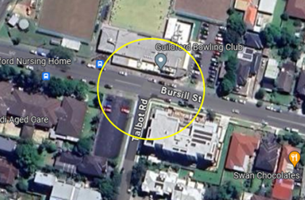
Locality Plan
The latest Centre for Road Safety accident data indicated that there were 2 reported accidents at this intersection in the last 5 years ending September 2023. The accidents details are list in the table below:
|
Date |
Location |
Description |
|
01/09/2019 |
Bursill Street at Talbot Road |
Vehicles failed to give way |
|
04/10/2022 |
Talbot Road, 20m from Bursill Street |
Vehicle lost control |
A site inspection indicated that vehicles are parking within 10 metres at the intersection. It is proposed to install 10m ‘No Stopping’ restrictions at the intersection. The signage and line marking would strengthen the Road Rules requirement and stop vehicles from parking too close to the intersection.
COnsultation
The proposal was notified to the impacted and adjacent residents for a period of 14 days starting from 17 April 2024 to 1 May 2024.
There were no responses received.
Attachments
1. Plan – Bursill Street and Talbot Road, Guildford – Proposed ‘No Stopping’ Restrictions
DOCUMENTS
ASSOCIATED WITH
REPORT CTC-24-112
Attachment 1
Plan – Bursill Street and Talbot Road, Guildford – Proposed ‘No Stopping’ Restrictions
5 June 2024
Item No: CTC-24-113
MILITARY ROAD AND BYRON ROAD, GUILDFORD – PROPOSED ‘NO STOPPING’ RESTRICTIONS AND LINEMARKING
Directorate: Environment and Planning
Responsible Officer: Manager Engineering and Building
Electorate: Granville
Police Area Command (PAC): Cumberland
Agenda Part Part 1
Note: Recommended for Approval under Delegated Authority
Summary
Council has received safety concerns from residents at the intersection of Military Road and Byron Road, Guildford.
This report outlines the outcome of the investigation into this matter.
The Traffic Committee recommends that:
1. The installation of ‘No Stopping’ signs and ‘BL2’ line marking at the intersection of Military Road and Byron Road, Guildford in accordance with the attached plan be approved.
2. The affected / concerned residents be notified of the outcome.
Report
Military Road is a Collector Road that runs in an east-west direction between Merrylands Road and Loftus Road with a speed limit of 50 km/h. It has a width of approximately 12.5m and parking is permitted on both sides of the road unless otherwise signposted.
Byron Road is a Collector Road that runs in a north-south direction between Military Road and Guildford Road with a speed limit of 50 km/h. It has a width of approximately 12.5m and parking is permitted on both sides of the road unless otherwise signposted.
Military Road and Byron Road forms a T- intersection with priority to Military Road.
The map below shows the intersection.
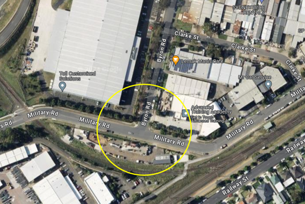
Locality Plan
The latest Centre for Road Safety crash data indicated that there was 1 reported crash at this intersection in the last 5 years ending September 2023. The crash details are list in the table below:
|
Date |
Location |
Description |
|
19/08/2022 |
Military Rd at Byron Rd |
Type of the accident is unknown |
Recent Crash
Council was notified of a crash that occurred at this intersection on Saturday 27 April 2024.
Based on Police records, a vehicle failed to giveway to an e-bicycle at the intersection. Vehicle was turning right from Byron onto Military Rd. and the E-bike was on Military Road.
In accordance with the provisions of the Austroads Guide to Road Design Part 3, the absolute minimum stopping sight distance (SSD) for a vehicle travelling at 50 kph is 49 metres and the desirable minimum SSD is 55 metres.
An inspection confirmed that when vehicles, especially heavy vehicles, are parked on the northern side of Military Road at Byron Road, the SSD is significantly reduced compared to the standard requirement.
Therefore, it is proposed that full-time ‘No Stopping’ restrictions and line marking be provided at the intersection of Military Road at Byron Road to improve the sight distance and safety for vehicles exiting Byron Road.
COnsultation
The proposal was notified to the impacted and adjacent residents for a period of 14 days from 3 May 2024 to 17 May 2024. No response was received.
Attachments
1. Plan – Military Road and Byron Road, Guildford – Proposed ‘No Stopping’ Restrictions and BL2 Line Markings
DOCUMENTS
ASSOCIATED WITH
REPORT CTC-24-113
Attachment 1
Plan – Military Road and Byron Road, Guildford – Proposed ‘No Stopping’ Restrictions and BL2 Line Markings
5 June 2024
Item No: CTC-24-114
KERRS ROAD AND BERNARD STREET, LIDCOMBE – PROPOSED ‘NO STOPPING’ RESTRICTIONS AND LINEMARKING
Directorate: Environment and Planning
Responsible Officer: Manager Engineering and Building
Electorate: Auburn
Police Area Command (PAC): Auburn
Agenda Part Part 1
Note: Recommended for Approval under Delegated Authority
Summary
Council has received safety concerns from residents at the intersection of Kerrs Road and Bernard Street, Lidcombe.
This report outlines the outcome of the investigation into this matter.
The Traffic Committee recommends that:
1. The installation of ‘No Stopping’ signs and ‘BL2’ line marking at the intersection of Kerrs Road and Bernard Street, Lidcombe in accordance with the attached plan be approved.
2. The affected / concerned residents be notified of the outcome.
Report
Kerrs Road is a local road that runs in an east-west direction between Olympic Drive and Joseph Street with a speed limit of 50 km/h. It has a width of approximately 12.5m and parking is permitted on both sides of the road unless otherwise signposted.
Bernard Street is a local road that runs in a north-south direction between Kerrs Road and Raymond Street with a speed limit of 50 km/h. It has a width of approximately 12.5m and parking is permitted on both sides of the road unless otherwise signposted.
Kerrs Road and Bernard Street forms a T- intersection with priority to Kerrs Road.
The map below shows the intersection.
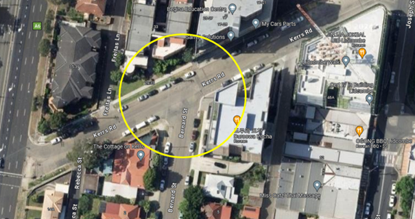
Locality Plan
The latest Centre for Road Safety accident data indicated that there was no reported accident at this intersection in the last 5 years ending 2023.
A site inspection indicated that vehicles are parking within 10 metres at the intersection. It is proposed to install 10m ‘No Stopping’ restrictions and ‘BL2’ line marking at the intersection. The signage and line marking would strengthen the Road Rules requirement and stop vehicles from parking too close to the intersection.
COnsultation
The proposal was notified to the impacted and adjacent residents for a period of 14 days starting from 2 May 2024 to 16 May 2024.
There were no responses received.
Attachments
1. Plan – Kerrs Road and Bernard Street, Lidcombe – Proposed ‘No Stopping’ restrictions and BL2 Line Markings
DOCUMENTS
ASSOCIATED WITH
REPORT CTC-24-114
Attachment 1
Plan – Kerrs Road and Bernard Street, Lidcombe – Proposed ‘No Stopping’ restrictions and BL2 Line Markings
5 June 2024
Item No: CTC-24-115
AUBURN ROAD, BERALA - PARKING ARRANGEMENT REIVEW
Directorate: Environment and Planning
Responsible Officer: Manager Engineering and Building
Electorate: Auburn
Police Area Command (PAC): Auburn
Agenda Part Part 1
Note: Recommended for Approval under Delegated Authority
Summary
Council received a request from Berala Public School to convert a section of the existing pick-up and drop-off area into a 5-minute parking zone outside the school.
This report outlines the outcome of the investigation into this matter.
The Traffic Committee recommends that:
1. The existing part-time ‘No Parking’ restrictions on the western side of Auburn Road outside Berala Public School be converted to ‘5 Minute 8am-9:30am, 2:30pm-4pm School Days’ in accordance with the attached plan.
2. The school be notified of the outcome.
Report
Council received a request from Berala Public School to convert a section of the existing pick-up and drop-off area into a 5-minute parking zone outside the school.
Auburn Road, Berala is a local road that runs in a north-south direction with a speed limit of 50km/h. It has a school zone at the southern end from Clarke Street, with a 40 km/h speed limit during school hours. The street is approximately 12.5 metres wide and currently has 'No Parking' restrictions on the western side outside Berala Public School, providing a pick-up and drop-off area for school.
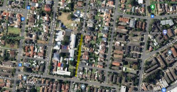 Locality Plan
A site meeting was conducted with the school administration and Council officers. The school has indicated a need for parents to park their vehicles and escort their children to and from school. Currently, parents are parking in the 'No Parking' area, creating safety and enforcement issues.
To improve safety and provide convenience for parents, it is proposed to convert 47m of the existing part-time 'No Parking' restrictions to a 5-minute parking zone during school hours to facilitate pick-up and drop-off activities.
COnsultation
Consultation is not required as the proposed changes only impact the school, and the school initiated the proposal.
Attachments
DOCUMENTS
ASSOCIATED WITH
REPORT CTC-24-115
Attachment 1
Plan – Auburn Road, Berala – Parking Arrangement Review
5 June 2024
Item No: CTC-24-116
MARY STREET, LIDCOMBE – APPLICATION FOR ‘WORKS ZONE’ SIGNAGE
Directorate: Environment and Planning
Responsible Officer: Manager Engineering and Building
Electorate: Auburn
Police Area Command (PAC): Auburn
Agenda Part Part 1
Note: Recommended for Approval under Delegated Authority
Summary
Council has received an application for a ‘Works Zone’ on Mary Street, Lidcombe associated with the development at 31 Mary Street, Lidcombe.
This report outlines the outcome of the investigation into this matter.
The Traffic Committee recommends that:
1. The 18m long ‘Works Zone, 7:00am-6:00pm, Monday-Friday, 8:00am-4:00pm, Saturday’ signs be installed on the frontage of the development site on Mary Street, Lidcombe in accordance with the attached plan, subject to Council’s standard conditions for the period of 9 months and subsequent extension if required.
i)
2. The applicant be advised to pay the ‘Works Zone’ fees to Council as per the adopted Fees and Charges.
Report
Council has received an application for a ‘Works Zone’ on Mary Street, Lidcombe associated with the development at 31 Mary Street, Lidcombe. The proposed development involves construction of a six (6) storey mixed use development comprising of an eighty (80) place childcare centre, four (4) residential apartments for National Disability Insurance Scheme rental with a rooftop communal terrace, an indoor recreation facility and basement car parking for twenty-five (25) vehicles of a childcare centre and swim centre.
The temporary “Works Zone” is approximately 18m in length and proposed to commence in May 2024 for 9 months. The proposed time is between 7:00am to 6:00pm Monday to Friday and 8:00am to 4:00pm on Saturdays.
There will be a loss of three (3) on-street unrestricted parking spaces on the southern side of Mary Street, Lidcombe during the operation of the “Works Zone”.
COnsultation
The proposal is outside the property being developed and no consultation is considered necessary as the request was made by the builder.
Attachments
1. Plan – Mary Street, Lidcombe – Proposed Temporary ‘Works Zone’ Signage
DOCUMENTS
ASSOCIATED WITH
REPORT CTC-24-116
Attachment 1
Plan – Mary Street, Lidcombe – Proposed Temporary ‘Works Zone’ Signage
5 June 2024
Item No: CTC-24-117
PLATFORM STREET, LIDCOMBE – PROPOSED PARKING RESTRICTIONS
Directorate: Environment and Planning
Responsible Officer: Manager Engineering and Building
Electorate: Auburn
Police Area Command (PAC): Auburn
Agenda Part Part 1
Note: Recommended for Approval under Delegated Authority
Summary
Council has received a request from a Child Care Centre located at No.93 Platform Street, Lidcombe for the provision of timed parking outside the property.
This report outlines the outcome of the investigation into this matter.
The Traffic Committee recommends that:
1. The proposed installation of ‘1/4P 7AM-9AM, 3PM-6PM, Mon-Fri’ outside No. 93 Platform Street, Lidcombe in accordance with the attached plan be approved.
2. The affected / concerned business owners be notified of the outcome.
Report
Platform Street is a local road that runs in a north-south direction with a speed limit of 50km/h. It has a width of 8.5m with unrestricted parking on both sides of the street unless otherwise signposted.
Council has received a request from a Child Care Centre located at No.93 Platform Street, Lidcombe, for the installation of timed parking restrictions outside the property.
The business owner has advised that due to the high parking demand in the area, the existing unrestricted on-street parking spaces are occupied for most of the day, thereby limiting parking opportunities for parents accessing the centre.
The map below shows the location.
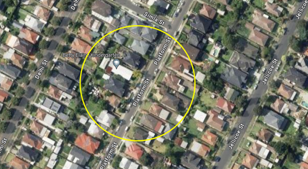
Locality Plan
Council officers have investigated the matter which revealed that due to the high demand of parking in the area, vehicles often park for long periods of time in the street preventing parents from the Child Care Centre using the spaces outside the centre.
To assist the business in the area, it is proposed to install 1/4 hour parking restrictions between the hours of 7am to 9am and 3pm to 6pm from Monday to Friday which would increase parking turnover at this location.
COnsultation
The proposal was notified to the impacted and adjacent residents for a period of 14 days starting from 24 April 2024 to 8 May 2024.
There was one response received which supported the proposal.
Attachments
1. Plan – Platform Street, Lidcombe – Proposed Parking Restrictions
DOCUMENTS
ASSOCIATED WITH
REPORT CTC-24-117
Attachment 1
Plan – Platform Street, Lidcombe – Proposed Parking Restrictions
DOCUMENTS
ASSOCIATED WITH
REPORT CTC-24-117
Attachment 2
Submission
5 June 2024
Item No: CTC-24-118
MAGOWAR ROAD, GIRRAWEEN - PROPOSED PARKING RESTRICTIONS – CONSULTATION RESULTS
Directorate: Environment and Planning
Responsible Officer: Manager Engineering and Building
Electorate: Prospect
Police Area Command (PAC): Cumberland
Agenda Part Part 1
Note: Recommended for Approval under Delegated Authority
Summary
Council has received concerns from local residents and businesses for the installation of time limited parking restrictions on Magowar Road, Girraween.
This report outlines the outcome of the investigation into this matter.
The Local Traffic Committee recommended that:
1. Council undertake further consultation with the residents directly impacted by the proposed parking restrictions and report back to traffic committee if objections are received.
2. Council notify concerned resident of the outcome.
Report
Magowar Road is a local road that runs in an east – west direction between Pendle Way and Toongabbie Road with 50 km/hr speed limit. The section of interest is approximately 260m west from Girraween Road. This section has a width of approximately 12.2m and parking is permitted on both sides of the road in accordance with the Road Rules unless signposted.
Magowar Road between Girraween Road and Toongabbie Road has a combination of low-residential properties and industrial/ commercial sites. There are 10 single dwellings located within this section of the Road and the rest of the street are commercial sites.
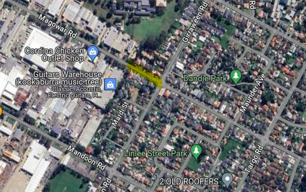
In response to resident concerns about parking difficulties in this section of the street, Council conducted a consultation regarding parking options in May 2024. A total of 50 letters with attached survey forms were distributed. The survey offered three options for selection:
1. Support the installation of time limited parking (2,3 or 4 Hours) in the residential section of Magowar Road west of Girraween Road.
2. Support the installation of time limited parking (2,3 or 4 Hours) only with a Resident Parking Scheme if the section qualifies under Council’s Policy on Resident Parking Schemes.
3. I do not support any parking changes in Magowar Road.
Council received 13 responses (80% of the total letters sent) by the closing date including one response received from the same address but with different option selected. Out of the 13 responses there were 14 selections made, as one of the responses selected more than one preferred option.
The survey result is summarised in the table below.
|
|
Option 1 Timed parking |
Option 2 Residential parking scheme |
Option 3 Object to the proposal |
Total |
|
No of selections |
2 |
6 |
6 |
14 |
|
Percentage |
14.3% |
42.9% |
42.9% |
100% |
An analysis of the survey data indicated that the majority of objections were from business owners in the western section of the street. However, the proposed parking restrictions mainly affect the residential part, which is in the eastern section of the street. Therefore, the responses from residential properties have been summarised below:
|
|
Option 1 Timed parking |
Option 2 Residential parking scheme |
Option 3 Object to the proposal |
Total |
|
No of residential response |
2 |
2 |
2 |
6 |
|
Percentage |
33% |
33% |
33% |
100% |
Among the responses from residents (excluding business owners), the three options were evenly distributed. Based on the overall survey results, 42.9% of the responses objected to any parking restrictions on the street, 42.9% supported the provision of a residential parking scheme, and only 14.3% supported timed parking restrictions.
With the majority of responses indicating support for timed parking and/or a residential parking scheme, it is recommended that further consultation with residents be undertaken on a proposed parking arrangement for the residential section on Magowar Road between Girraween Road and the industrial area.
COnsultation
The proposal was consulted with residents of Magowar Road for a period of 14 days from 30 April 2024 to 14 May 2024. A total of 50 letters with an attached survey form were distributed to the residents / business owners. Details of the consultation outcomes are provided in the report.
Attachments
DOCUMENTS
ASSOCIATED WITH
REPORT CTC-24-118
Attachment 1
Submissions
5 June 2024
Item No: CTC-24-119
HIBISCUS STREET, GREYSTANES – PROPOSED ‘NO PARKING’ PARKING RESTRICITONS
Directorate: Environment and Planning
Responsible Officer: Manager Engineering and Building
Electorate: Prospect
Police Area Command (PAC): Cumberland
Agenda Part Part 1
Note: Recommended for Approval under Delegated Authority
Summary
Council has received concerns from residents regarding parked vehicles in Hibiscus Street near the intersection with Dahlia Street, Guildford.
This report outlines the outcome of the investigation into this matter.
The Traffic Committee recommends that:
1. The installation of the ‘No Parking’ signs on the eastern side of Hibiscus Street as per attached plan be approved.
2. The affected/concerned residents be notified of the outcome.
Report
Hibiscus Street is a local road running east-west, with a speed limit of 50 km/h and a width of approximately 7 meters. Parking is permitted on both sides of the road according to Road Rules unless otherwise signposted.
Currently, there are a few businesses and shops located at the corner of Hibiscus Street and Dahlia Street. Council has received complaints from local residents about vehicles visiting these shops parking in this section of Hibiscus Street causing safety concerns.
The matter was investigated and reported to Cumberland Traffic Committee (CTC) in the past, a summary of the report and recommendations are listed below:
6 April 2022
CTC considered a report (CTC-22-066) regarding the proposed parking restrictions and line marking on Hibiscus Street and recommended that:
The installation of ‘No Stopping’ signs and ‘BB’ line marking at the intersection of Dahlia Street and Hibiscus Street, Greystanes in accordance with the attached plan be approved.
19 October 2022
Due to further complaints received from the residents, CTC considered a report (CTC- 22-160) regarding the relocation of ‘No Stopping’ sign at the intersection on Hibiscus Street and recommended that:
1. The relocation of the existing ‘No Stopping’ sign on the eastern side of Hibiscus Street, Greystanes at its intersection with Dahlia Street in accordance with the attached plan be approved.
2. The affected residents be notified of the outcome.
Map below shows the location of Hibiscus Street, Greystanes:
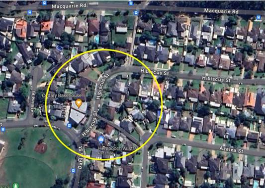
Figure 1 – Locality Plan
The latest Centre for Road Safety accident data indicated that there were no reported accidents in Hibiscus Street in the last 5 years ending September 2023.
Following the relocation of the existing 'No Stopping' sign, Council has received complaints from the residents of Hibiscus Street about the parking conditions. The residents allege that the business on the corner generates significant traffic and vehicles visiting the business often park on both sides of the street restricting two-way traffic movement.
In response to these concerns, a consultation was carried out with the residents and businesses at the corner. A total of 22 letters with attached survey forms were distributed to the residents and business owners, proposing 'No Parking' restrictions on the eastern side of Hibiscus Street, including the bend outside No.54. Council received 13 responses (59% of the total letters sent). Of these, 10 responses (76.9%) supported the proposal, and 3 (23.1%) opposed it. It should be noted that all 3 opposing responses were not from the directly affected residents, and all the affected residents who responded to the survey supported the proposed parking restrictions.
Based on the survey results, considering that the majority supported the proposal, it is proposed to install the 'No Parking' signs on the eastern side of Hibiscus Street as per the attached plan to improve safety in this section of Hibiscus Street.
COnsultation
The proposal was notified to the impacted/ concerned residents for a period of 14 days starting from 8 May 2024 to 22 May 2024. Council received 13 responses (59% of the total letters sent). Of these, 10 responses (76.9%) supported the proposal, and 3 (23.1%) opposed the proposal.
Attachments
1. Plan – Hibiscus Street, Greystanes – Proposed ‘No Parking’ Signs
DOCUMENTS
ASSOCIATED WITH
REPORT CTC-24-119
Attachment 1
Plan – Hibiscus Street, Greystanes – Proposed ‘No Parking’ Signs
DOCUMENTS
ASSOCIATED WITH
REPORT CTC-24-119
Attachment 2
Submissions
5 June 2024
Item No: CTC-24-120
NAYING DRIVE, PEMULWUY – PROPOSED ‘NO PARKING’ PARKING RESTRICITONS
Directorate: Environment and Planning
Responsible Officer: Manager Engineering and Building
Electorate: Prospect
Police Area Command (PAC): Cumberland
Agenda Part Part 1
Note: Recommended for Approval under Delegated Authority
Summary
Council has received safety concerns from a resident regarding parked vehicles parking on the eastern side of Naying Drive, Pemulwuy.
This report outlines the outcome of the investigation into this matter.
That the Traffic Committee recommends that:
1. The installation of the ‘No Parking’ sign on the eastern side of Naying Drive, Pemulwuy between Daruga Avenue and Watkin Tench Parade as per the attached plan be approved.
2. The affected/concerned residents be notified of the outcome.
Report
Naying Drive is a local road running in a north-south direction with a speed limit of 50 km/h. The road is approximately 6 metres wide, with indented parking bays on the western side. "No Stopping" restrictions are applied to other sections on the western side, while parking on the eastern side is currently unrestricted.
Council has received concerns from local residents about road safety and parking on Naying Drive. Residents allege that the width of the street prevents two-way traffic when vehicles are parked on the eastern side.
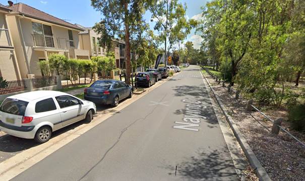
Locality Plan
The latest Centre for Road Safety accident data shows no reported accidents at this section of Naying Drive in the last five years ending September 2023.
Council officers investigated and found that when cars are parked on the eastern side of Naying Drive, two-way traffic cannot be maintained and vehicles cannot give way to oncoming traffic because the indented parking bays are often occupied and there are no driveways in Naying Drive for vehicles to pull over.
Council distributed 50 letters to the residents in Naying Drive between Daruga Avenue and Watkin Tench Parade and received 12 responses (24% of the total letters sent) by the closing date. All submissions supported the proposed parking restrictions.
In order to improve safety in Naying Drive, it is proposed to install ‘No Parking’ signs on the eastern side of Naying Drive as per attached plan.
COnsultation
The proposal was notified to the impacted and adjacent residents for a period of 14 days starting from 1 May 2024 to 14 May 2024. Council distributed 50 letters and received 12 responses. All submissions supported the proposed parking restrictions.
Attachments
1. Plan – Naying Drive, Pemulwuy – Proposed ‘No Parking’ Signs
DOCUMENTS
ASSOCIATED WITH
REPORT CTC-24-120
Attachment 1
Plan – Naying Drive, Pemulwuy – Proposed ‘No Parking’ Signs
5 June 2024
Item No: CTC-24-121
PYE STREET, WESTMEAD – REMOVAL OF REDUNDANT ‘BUS ZONE’ SIGNAGE
Directorate: Environment and Planning
Responsible Officer: Manager Engineering and Building
Electorate: Granville
Police Area Command (PAC): Cumberland
Agenda Part Part 1
Note: Recommended for Approval under Delegated Authority
Summary
Council has received a request from CDC Bus to remove the redundant ‘Bus Zone’ outside No. 20 Pye Street, Westmead.
This report outlines the outcome of the investigation into this matter.
The Traffic Committee recommends that:
1. The removal of the redundant ‘Bus Zone’ signage outside No. 20 Pye Street, Westmead as per the attached plan be approved.
2. The installation of ‘2P 8:30am – 6pm Monday to Friday, 8:30am – 12:30pm Saturday, Permit Holder Excepted’ signage as per the attached plan be approved.
3. The affected / concerned residents be notified of the outcome.
Report
Pye Street is a local road that runs in an east-west direction with a speed limit of 50 km/h. It has a width of approximately 14m and parking is permitted on both sides of the road in accordance with Road Rules unless signposted.
Council has received a request from CDC Bus to remove the redundant Bus Zone signage outside No. 20 Pye Street, Westmead, as it is no longer in use.
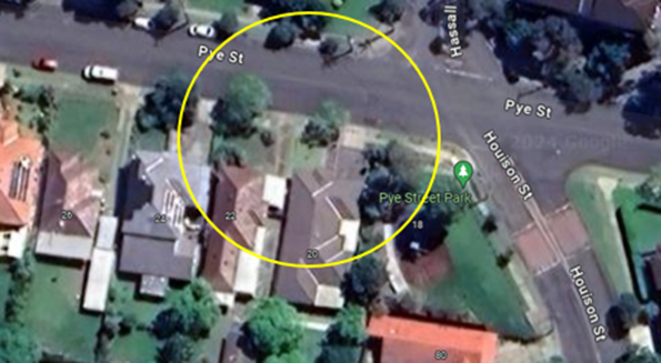
Considering that the existing ‘Bus Zone’ signage outside No. 20 Pye Street is no longer required, it is proposed to remove the ‘Bus Zone’ signage at this section of Pye Street, Westmead, and reinstate the part-time 2P restrictions to align with the surrounding area.
COnsultation
The proposal was notified to the impacted and adjacent residents for a period of 14 days starting from 9 May 2024 to 23 May 2024.
There were no responses received.
Attachments
1. Plan – Pye Street, Westmead – Removal of a Redundant ‘Bus Zone’ and Signposting ‘2P’ Signage
DOCUMENTS
ASSOCIATED WITH
REPORT CTC-24-121
Attachment 1
Plan – Pye Street, Westmead – Removal of a Redundant ‘Bus Zone’ and Signposting ‘2P’ Signage
5 June 2024
Item No: CTC-24-122
DUNMORE STREET, WENTWORTHVILLE – REQUEST FOR A MARKED PEDESTRIAN CROSSING
Directorate: Environment and Planning
Responsible Officer: Manager Engineering and Building
Electorate: Prospect
Police Area Command (PAC): Cumberland
Agenda Part Part 1
Note: Recommended for Approval under Delegated Authority
Summary
Council officers presented a report at the traffic committee on 7 February 2024 on the request from a resident for the provision of a marked pedestrian crossing on Dunmore Street, Wentworthville west of Emert Street.
Council at its meeting held on 20 March 2024, resolved that this item considered by the Cumberland Local Traffic Committee at the 7 February 2024 meeting as provided in this report, be returned to the Committee for further consideration.
This report outlines the outcome of further review into this matter.
The Traffic Committee recommends that:
1. The installation of pedestrian warning signs on all approaches to the roundabout at the intersection of Dunmore Street and Emert Street, Wentworthville, as per the attached plan be approved.
2. The concerned resident be notified of the outcome.
Report
Dunmore Street is a regional road that runs in an east–west direction connecting Pendle Way and Cumberland Highway. The section of interest is between Layton Street and Emert Street. This section of Dunmore Street is approximately 325m long
and 12.4m wide, with a default speed limit of 50 km/h. A report (CTC-24-037) on the pedestrian crossing request on Dunmore Street was presented to the Cumberland Traffic Committee on 7 February 2024, and the traffic committee recommended that:
1. The provision of a marked pedestrian crossing on Dunmore Street, Wentworthville not be supported at this time.
2. The installation of pedestrian warning signs on all approaches to the roundabout as per the attached plan be approved.
3. The concerned resident be notified of the outcome.
Council at its meeting held on 20 March 2024, resolved that this item considered by the Cumberland Local Traffic Committee at the 7 February 2024 meeting as provided in this report, be returned to the Committee for further consideration.
Council officers have undertaken further analysis of the pedestrian counts which is listed below:
|
Period |
Vehicles |
Pedestrians |
|||
|
Adults |
Elderly & students |
Total |
Total with factoring 2 for elderly & children |
||
|
|
|
|
|
|
|
|
6:00 – 7:00 |
288 |
2 |
0 |
2 |
2 |
|
7:00 – 8:00 |
490 |
6 |
1 |
7 |
8 |
|
8:00 – 9:00 |
729 |
7 |
4 |
11 |
15 |
|
9:00 – 10:00 |
509 |
5 |
1 |
6 |
7 |
|
10:00 – 11:00 |
443 |
6 |
0 |
6 |
6 |
|
11:00 – 12:00 |
432 |
0 |
0 |
0 |
0 |
|
12:00 – 13:00 |
446 |
1 |
0 |
1 |
1 |
|
13:00 – 14:00 |
415 |
1 |
0 |
1 |
1 |
|
14:00 – 15:00 |
527 |
3 |
0 |
3 |
3 |
|
15:00 – 16:00 |
698 |
5 |
3 |
8 |
11 |
|
16:00 – 17:00 |
653 |
2 |
0 |
2 |
2 |
|
17:00 – 18:00 |
776 |
10 |
3 |
13 |
16 |
|
18:00 – 19:00 |
650 |
10 |
0 |
10 |
10 |
A review of the pedestrian counts with consideration of the TfNSW guidelines indicates that the location does not meet the warrants for a pedestrian crossing. It is noted that Council is currently preparing further guidance on pedestrian crossings that may be used in the future to assess the matter. In the meantime, following review by Council officers and community interest in the matter, it is proposed that pedestrian warning signs be installed at the Dunmore Street / Emert Street roundabout. The attached plan shows details of the signs and locations for the proposal.
COnsultation
Consultation has not been undertaken as the signage does not impact on any property or on-street parking.
Attachments
1. Plan – Dunmore Street & Emert Street, Wentworthville – Pedestrian Warning Signs
2. Previous Report – CTC-24-037 – Dunmore Street, Wentworthville – Request for a Marked Pedestrian Crossing
DOCUMENTS
ASSOCIATED WITH
REPORT CTC-24-122
Attachment 1
Plan – Dunmore Street & Emert Street, Wentworthville – Pedestrian Warning Signs
DOCUMENTS
ASSOCIATED WITH
REPORT CTC-24-122
Attachment 2
Previous Report – CTC-24-037 – Dunmore Street, Wentworthville – Request for a Marked Pedestrian Crossing
5 June 2024
Item No: CTC-24-123
ENID AVENUE, GRANILLE – APPLICATION FOR ‘WORKS ZONE’ SIGNAGE
Directorate: Environment and Planning
Responsible Officer: Manager Engineering and Building
Electorate: Granville
Police Area Command (PAC): Cumberland
Agenda Part Part 1
Note: Recommended for Approval under Delegated Authority
Summary
Council has received an application for a ‘Works Zone’ on Enid Avenue, Granville associated with the development at 31-33 Enid Avenue, Granville.
This report outlines the outcome of the investigation into this matter.
The Cumberland Traffic Committee recommends that:
1. The 12m long ‘Works Zone, 7:00am-6:00pm, Monday-Friday, 8:00am-4:00pm, Saturday’ signs be installed on the frontage of the development site on Enid Avenue, Granville in accordance with the attached plan subject to Council’s standard conditions for the period of 5 months and subsequent extension if required.
2. The applicant be advised to pay the ‘Works Zone’ fees to Council as per the adopted Fees and Charges.
Report
Council has received an application for a ‘Works Zone’ on Enid Avenue, Granville associated with the development at 31-33 Enid Avenue, Granville. The proposed development involves construction of a six (6) storey residential building comprising of 49 double co-living rooms over basement car parking.
The temporary “Works Zone” is approximately 12m in length and proposed to commence in July 2024 for 5 months. The proposed time is between 7:00am to 6:00pm Monday to Friday and 8:00am to 4:00pm on Saturdays.
There will be a loss of two (2) on-street unrestricted parking spaces on the western side of Enid Avenue, Granville during the operation of the “Works Zone”.
COnsultation
The proposal is outside the property being developed and no consultation is considered necessary as the request was made by the builder.
Attachments
1. Plan – Enid Avenue, Granville – Proposed Temporary ‘Works Zone’ Signage
DOCUMENTS
ASSOCIATED WITH
REPORT CTC-24-123
Attachment 1
Plan – Enid Avenue, Granville – Proposed Temporary ‘Works Zone’ Signage
5 June 2024
Item No: CTC-24-124
PATRICIA STREET, MAYS HILL – APPLICATION FOR ‘WORKS ZONE’ SIGNAGE
Directorate: Environment and Planning
Responsible Officer: Manager Engineering and Building
Electorate: Prospect
Police Area Command (PAC): Cumberland
Agenda Part Part 1
Note: Recommended for Approval under Delegated Authority
Summary
Council has received an application for a ‘Works Zone’ on Patricia Street, Mays Hill associated with the development at 14-16 Patricia Street, Mays Hill.
This report outlines the outcome of the investigation into this matter.
The Cumberland Traffic Committee recommends that:
1. The 30m long ‘Works Zone, 7:00am-6:00pm, Monday-Friday, 8:00am-4:00pm, Saturday’ signs be installed on the frontage of the development site on Patricia Street, Mays Hill in accordance with the attached plan subject to Council’s standard conditions for the period of 10 months and subsequent extension if required.
2. The applicant be advised to pay the ‘Works Zone’ fees to Council as per the adopted Fees and Charges.
Report
Council has received an application for a ‘Works Zone’ on Patricia Street, Mays Hill associated with the development at 14-16 Patricia Street, Mays Hill. The proposed development involves construction of a four (4) storey residential flat building containing 29 affordable housing units over one level of basement car parking.
The temporary “Works Zone” is approximately 30m in length and proposed to commence in June 2024 for 10 months. The proposed time is between 7:00am to 6:00pm Monday to Friday and 8:00am to 4:00pm on Saturdays.
There will be a loss of five (5) on-street unrestricted parking spaces on the western side of Patricia Street, Mays Hill during the operation of the “Works Zone”.
COnsultation
The proposal is outside the property being developed and no consultation is considered necessary as the request was made by the builder.
Attachments
1. Plan – Patricia Street, Mays Hill – Proposed Temporary ‘Works Zone’ Signage
DOCUMENTS
ASSOCIATED WITH
REPORT CTC-24-124
Attachment 1
Plan – Patricia Street, Mays Hill – Proposed Temporary ‘Works Zone’ Signage
5 June 2024
Item No: CTC-24-125
BOOMERANG STREET AND RANDLE STREET, GRANVILLE - ROAD SAFETY CONCERNS
Directorate: Environment and Planning
Responsible Officer: Manager Engineering and Building
Electorate: Granville
Police Area Command (PAC): Cumberland
Agenda Part Part 1
Note: Recommended for Approval under Delegated Authority
Summary
Council has received safety concerns from a local resident at the intersection of Boomerang Street and Randle Street, Granville.
This report outlines the outcome of the investigation into this matter.
The Traffic Committee recommends that:
1. Council install pedestrian refuge warning signs in Randle Street, Granville.
2. The concerned resident be notified of the outcome.
Report
Council has received safety concerns from a local resident at the intersection of Boomerang Street and Randle Street, Granville.
Randle Street is a local road that runs in an east – west direction with a default speed limit of 50km/h. The street is approximately 340m long and has a width of approximately 11.5m. Parking is permitted on both sides of the road unless signposted.
Boomerang Street is a local road that runs in a north-south direction with a default speed limit of 50km/h. The street is approximately 400m long and has a width of approximately 7.8m. Parking is permitted on both sides of the road unless signposted.
Boomerang Street and Randle Street form a four-way intersection where priority is given to Boomerang Street. Give-way signage and BL2 line marking have been provided at this intersection.
The resident alleged that vehicles are turning from Randle Street onto Boomerang Street at an excessive speed.
In response to this request, a traffic count was undertaken on Boomerang Street and Randle Street, Granville in 2024. The traffic count locations are shown in red on the map below.
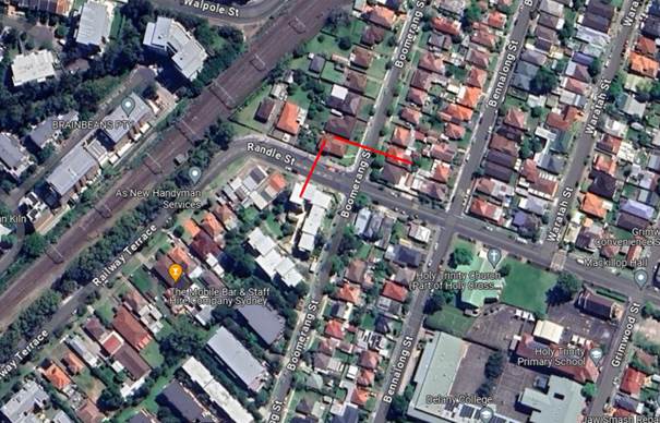
Locality Plan
Traffic count data on Boomerang Street, Granville (northbound):
· Average Daily Traffic (ADT) = 788 veh/day
· 85th percentile speed = 45 km/h
· Mean (average) vehicle speed = 38.7 km/h
Traffic count data on Randle Street, Granville (eastbound):
· Average Daily Traffic (ADT) = 2,741 veh/day
· 85th percentile speed = 44.1 km/h
· Mean (average) vehicle speed = 37.3 km/h
The above data indicated that vehicles on Randle Street (eastbound) and Boomerang Street (northbound) were travelling at an acceptable speed.
The latest Centre for Road Safety accident data indicated that there was 1 reported accident on Boomerang Street in the last 5 years ending September 2023 in relation to speeding. The accident details are list in the table below:
|
Date |
Location |
Description |
|
26/2/2021 |
Intersection of Boomerang Street and William Street |
Vehicle lost control and hit an object |
Council officers have investigated the request for the installation of traffic calming devices on Boomerang Street in accordance with Council’s Local Area Traffic Management (LATM) Policy. The result of the traffic count and recorded crashes were used in the assessment to determine the need for the installation of traffic calming devices on Boomerang Street in accordance with the criteria set out in Council’s Local Area Traffic Management Policy (LATM) Policy.
The LATM assessments are summarised in the tables below:
Table 1 – Boomerang Street, Granville - LATM Assessment Points
|
Criteria |
Maximum Score |
Score Achieved |
|
Traffic Study Data |
45 |
10 |
|
Crash warrant in the last 5 years |
15 |
5 |
|
Road Characteristics |
35 |
12 |
|
Community Support & other factors |
5 |
5 |
|
Total |
100 |
32 |
Table 2 – Boomerang Street, Granville– Action
|
Criteria |
Action |
|
>75 |
Report to TC with a recommendation of providing traffic calming devices |
|
61-75 |
Report to TC and discuss possibility of providing traffic calming devices |
|
41-60 |
Council to review traffic data in 6 months |
|
25-40 |
Monitor street and review traffic data after 12 months |
|
<25 |
Do Nothing |
|
Speed |
That regardless of the total points scored, should the 85th percentile speed exceed the posted speed limit by 5 km/h, the street be referred to the NSW Police for monitoring and/or enforcement. |
Council officers also investigated the possibility of providing a concrete median island on Boomerang Street north of Randle Street. However, investigation revealed that it would restrict turning movements for an 8.8m truck due to the narrowness of the road.
Based on the above assessment, traffic calming devices are not warranted in Boomerang Street. Council will review traffic conditions at this intersection in 12 months and report back to Traffic Committee if required.
With consideration of the review by Council officers and community interest in the matter, it is proposed to install pedestrian refuge warning signs in Randle Street to bring awareness to motorists and enhance safety at the pedestrian refuge located west of Boomerang Street.
COnsultation
Consultation has not been undertaken as the warning signs do not impact on-street parking or property frontages.
Attachments
Nil
5 June 2024
Item No: CTC-24-126
THE BOULEVARDE, LIDCOMBE - ROAD SAFETY CONCERNS
Directorate: Environment and Planning
Responsible Officer: Manager Engineering and Building
Electorate: Auburn
Police Area Command (PAC): Auburn
Agenda Part Part 2
Note: Recommendation to Council
Summary
Council officers presented a report at the Traffic Committee on 7 February 2024 on the road safety concerns on The Boulevarde, Lidcombe.
Council at its meeting held on 20 March 2024, resolved that this item considered by the Cumberland Local Traffic Committee at the 7 February 2024 meeting as provided in this report, be returned to the Committee for further consideration.
This report outlines the proposal for further consideration.
The Traffic Committee recommends that Council undertake consultation with the residents along The Boulevarde to assess community support or otherwise for the installation of traffic calming devices in the street and report their findings back to the Traffic Committee.
Report
The Boulevarde, Lidcombe is a local road that runs in an east-west direction between the State Road, Olympic drive and Nottinghill Road. It is approximately 330 m long and 12.5m wide with a speed limit of 50km/hr.
A report (CTC-24-048) was presented to Cumberland Traffic Committee on 7 February 2024 reviewing the previous traffic count and additional crash data and the Local Area Traffic Management analysis undertaken.
The Traffic Committee recommended that:
1. Council undertake consultation with the residents along The Boulevarde to assess community support or otherwise for the installation of traffic calming devices in the street and report their findings back to the Traffic Committee.
2. The concerned resident be notified of the outcome.
Council at its meeting held on 20 March 2024, resolved that this item considered by the Cumberland Local Traffic Committee at the 7 February 2024 meeting as provided in this report, be returned to the Committee for further consideration.
Given the community interest on the matter, it is proposed that Council undertake consultation with the residents along The Boulevarde regarding traffic calming devices as previously recommended and report the findings back to the Traffic Committee.
COnsultation
Consultation has not been undertaken. Future consultation will be undertaken if recommended by the Traffic Committee.
Attachments
1. Previous Report – CTC-24-048 – The Boulevarde, Lidcombe – Road Safety Concerns
DOCUMENTS
ASSOCIATED WITH
REPORT CTC-24-126
Attachment 1
Previous Report – CTC-24-048 – The Boulevarde, Lidcombe – Road Safety Concerns
5 June 2024
Item No: CTC-24-127
WALPOLE STREET, MERRYLANDS - ROAD SAFETY CONCERNS
Directorate: Environment and Planning
Responsible Officer: Manager Engineering and Building
Electorate: Granville
Police Area Command (PAC): Cumberland
Agenda Part Part 2
Note: Recommendation to Council
Summary
Council has received a request from a local resident for the installation of traffic calming devices on Walpole Street, Merrylands due to speeding concerns.
This report outlines the outcome of the investigation into this matter.
The Traffic Committee recommends that Council undertake consultation with the residents along Walpole Street, Holroyd to assess community support or otherwise for the installation of traffic calming devices in the street and report their findings back to the Traffic Committee.
Report
Walpole Street section under consideration is a local road that runs between Pitt Street and Clarence Street, Merrylands. This section of Walpole Street is approximately 900m long and approximately 12.7m wide.
There are roundabouts constructed at the intersections of Walpole Street with Warwick Road and Windsor Road. In this analysis, Council has analysed the Walpole Road section between Pitt Street and Windsor Road which is approximately 530m long.
Council has received a request from a local resident for the installation of traffic calming devices on Walpole Street, Merrylands due to speeding concerns.
A traffic count was undertaken in March 2024. The traffic count location is shown in red on the map below.
The map below shows the location of Walpole Street.
Locality Plan
Traffic Count Data on Walpole Street, Holroyd:
· Average Daily Traffic (ADT) = 4,611 veh/day,
· 85th percentile speed = 58 km/h,
· Mean (average) vehicle speed = 50.1km/h.
The latest Centre for Road Safety crash data indicated that there was one reported crash at this section of Walpole Street in the last 5 years ending September 2023 in relation to speeding. The accident details are list in the table below:
|
Date |
Location |
Description |
|
16/08/2020 |
Walpole Street at Windsor Road |
Vehicle lost control and hit an object |
It should be noted that at the time of the accident in 2020, there was already a roundabout at the intersection of Walpole Street and Windsor Road.
Council officers have investigated the request for the installation of traffic calming devices on Walpole Street in accordance with Council’s Local Area Traffic Management (LATM) Policy. The result of the traffic count and recorded crashes were used in the assessment to determine the need for the installation of traffic calming devices on Walpole Street in accordance with the criteria set out in Council’s Local Area Traffic Management Policy (LATM) Policy.
The LATM assessments are summarised in the tables below:
Table 1 – Walpole Street, Holroyd - LATM Assessment Points
|
Criteria |
Maximum Score |
Score Achieved |
|
Traffic Study Data |
45 |
25 |
|
Crash warrant in the last 5 years |
15 |
5 |
|
Road Characteristics |
35 |
16 |
|
Community Support & other factors |
5 |
5 |
|
Total |
100 |
51 |
Table 2 – Walpole Street, Holroyd – Action
|
Criteria |
Action |
|
>75 |
Report to TC with a recommendation of providing traffic calming devices |
|
61-75 |
Report to TC and discuss possibility of providing traffic calming devices |
|
41-60 |
Council to review traffic data in 6 months |
|
25-40 |
Monitor street and review traffic data after 12 months |
|
<25 |
Do Nothing |
|
Speed |
That regardless of the total points scored, should the 85th percentile speed exceed the posted speed limit by 5 km/h, the street be referred to the NSW Police for monitoring and/or enforcement. |
The traffic count data indicated that the recorded 85th percentile speed was 58 km/h which is above the speed limit for a local street with a 50 km/h speed limit. Therefore, it is proposed that Council undertake consultation with the residents in the section of Walpole Street to assess support or otherwise for speed humps in the street.
COnsultation
Consultation has not been undertaken. Future consultation will be undertaken if recommended by the Traffic Committee and approved by Council.
Attachments
5 June 2024
Item No: CTC-24-128
GLOUCESTER AVENUE, MERRYLANDS - ROAD SAFETY CONCERNS
Directorate: Environment and Planning
Responsible Officer: Manager Engineering and Building
Electorate: Granville
Police Area Command (PAC): Cumberland
Agenda Part Part 2
Note: Recommendation to Council
Summary
Council officers presented a report at the Traffic Committee on 7 February 2024 on the road safety concerns on Gloucester Avenue, Merrylands.
Council at its meeting held on 20 March 2024, resolved that this item considered by the Cumberland Local Traffic Committee at the 7 February 2024 meeting as provided in this report, be returned to the Committee for further consideration.
This report outlines the proposal for further consideration.
The Traffic Committee recommends that Council undertake consultation with the residents along Gloucester Avenue, Merrylands to assess community support or otherwise for the installation of traffic calming devices in the street and report their findings back to the Traffic Committee.
Report
Gloucester Avenue is a local road that runs in an east-west direction with a speed limit of 50km/h. The street is approximately 250m long and has a width of approximately 7m. Parking is permitted on both sides of the road in accordance with Road Rules unless otherwise signposted.
A report (CTC-24-044) was presented to Cumberland Traffic Committee on 7 February 2024 reviewing the previous traffic counts and additional crash data.
The Traffic Committee recommended that:
1. The installation of traffic calming devices on Gloucester Avenue, Merrylands not be supported.
2. Council review conditions in Gloucester Avenue, Merrylands in February 2025, and report back to Traffic Committee if required.
3. The concerned resident be notified of the outcome.
Council at its meeting held on 20 March 2024, resolved that this item considered by the Cumberland Local Traffic Committee at the 7 February 2024 meeting as provided in this report, be returned to the Committee for further consideration.
Council officers have further reviewed the available data. Based on September 2023 traffic count data, the recorded 85th percentile speed was 50.4km/hr. While the recorded 85th percentile speed was 50.4km/hr which is within the acceptable range for the street with a speed limit of 50km/hr, the narrow road width (approximately 7m) and short length of the street raises safety concerns for residents. It is also noted that the provision of linemarking in accordance with the technical guidelines to address safety concerns would impact on the provision of on-street parking given the width of the road at this location.
Following the review by Council officers and community interest on the matter, it is proposed that Council undertake consultation with the residents along Gloucester Avenue, Merrylands regarding traffic calming devices.
COnsultation
Attachments
1. Previous Report – CTC-24-044 – Gloucester Avenue, Merrylands – Road Safety Concerns
DOCUMENTS
ASSOCIATED WITH
REPORT CTC-24-128
Attachment 1
Previous Report – CTC-24-044 – Gloucester Avenue, Merrylands – Road Safety Concerns
5 June 2024
Item No: CTC-24-129
GRASSMERE STREET, GUILDFORD - ROAD SAFETY CONCERNS – CONSULTATION RESULT
Directorate: Environment and Planning
Responsible Officer: Manager Engineering and Building
Electorate: Granville
Police Area Command (PAC): Cumberland
Agenda Part Part 2
Note: Recommendation to Council
Summary
Council has undertaken consultation with residents for the proposed speed humps/ cushions in Grassmere Street, Guildford.
This report outlines the outcome of the review.
The Traffic Committee recommends that:
1. The installation of speed humps on Grassmere Street, Guildford be supported in principle.
2. Council prepare speed hump design, undertake consultation with directly affected and adjacent residents and report back to the Traffic Committee.
Report
Grassmere Street is a local street that runs in a north – south direction with a posted speed limit of 50 km/h. It has a width of approximately 10.5m and parking is permitted on both side of the road unless signposted.
Council has received concern from local residents regarding road safety on Grassmere Street, Guildford. The matter was investigated and reported to Cumberland Traffic Committee (CTC) in the past, a summary of the reports and recommendations are listed below:
1 April 2020
Council Traffic Committee (CTC) at its meeting in April 2020 considered a report (CTC-20-063) regarding road safety concerns and related speed humps request on Grassmere Street, and CTC recommended that:
The Cumberland Traffic Committee recommends that Council undertake consultation with the residents of Grassmere Street, Guildford to determine support or otherwise for speed humps and report back to Cumberland Traffic Committee.
25 February 2021
Council Traffic Committee (CTC) at its meeting in February 2021 considered a report (CTC-21-026) regarding road safety concerns on Grassmere Street, and CTC recommended that:
1. The proposed installation of speed humps on Grassmere Street, Guildford not be approved.
2. Council review conditions in Grassmere Street, Guildford in February 2022.
4 August 2021
Council undertook consultation with residents of Grassmere Street and reported to the August CTC (CTC-21-200), and CTC recommended that:
1. The proposed installation of speed humps on Grassmere Street, Guildford not be approved.
2. Council approve ‘S1’ centre line marking on Grassmere Street between Guildford Road and Mountford Avenue in accordance with attached plan.
3. Council request assistance from Cumberland Police Area Command for speed surveillance in Grassmere Street, Guildford.
18 October 2023
Council received further complaints regarding the matter, and it was reported to CTC (ECTC-23-158) in October 2023. CTC recommended that:
1. The installation of traffic calming devices on Grassmere Street, Guildford not be supported.
2. Council review conditions in Grassmere Street, Guildford, and investigate the safety hazard at the intersection of Grassmere Street and Guildford Road in November 2024 and report back to Traffic Committee.
3. Council request Cumberland Police Area Command to undertake random speed surveillance in Grassmere Street, Guildford
1 November 2023
Following the CTC meeting, the report was reported to Council in November 2023 (EECTC-23-158), Council resolved:
That the matter be referred back to the Traffic Committee.
7 February 2024
Following the Council resolution, the deferred report was then reported back to CTC in February 2024 (CTC-24-053), and CTC recommended that:
1. The ‘BB’ Centre line marking on Grassmere Street, Guildford in accordance with the attached plan be approved.
2. Council undertake consultation with the residents along Grassmere Street to assess community support or otherwise for the installation of traffic calming devices in the street and report the findings back to the Traffic Committee in June 2024.
3. Council investigate the safety hazard at the intersection of Grassmere Street and Guildford Road and report back to Traffic Committee in June 2024.
4. Council request Cumberland Police Area Command to undertake random speed surveillance in Grassmere Street, Guildford.
Council at its meeting held on 6 March 2024, approved the above CTC recommendation.
Traffic calming devices along Grassmere Street
In accordance with the above resolution, consultation was carried out with the residents of Grassmere Street in April 2024.
Council distributed 43 letters to the residents in Grassmere Street and received 7 responses (16% of the total letters sent) by the closing date. 6 responses (85.7%) supported the proposed speed humps and 1 response (14.3%) opposed to the proposal.
Based on the above result, as majority of the responses supported the proposal, it is recommended that the installation of speed humps be supported, and Council prepare the design of the speed humps and report back to the CTC.
Intersection of Grassmere Street and Guildford Road
There were concerns raised at the above intersection. Traffic calming measures in Grassmere Street as proposed in this report will improve safety at this intersection.
Also, Transport for NSW has commenced works on the proposed improvements at the intersection of Woodville Road and Guildford Road. These improvements involve traffic signal infrastructure improvements (completed now) and associated road surface works in the vicinity. Grassmere Street and Guildford Road intersection is approximately 75m from the Woodville Road intersection and will be impacted by any changes to line marking at this intersection.
Council is liaising with Transport for NSW to ascertain suitable traffic measures at the intersection of Guildford Road and Grassmere Street and a report will be presented to the Traffic Committee in August 2024.
COnsultation
The proposal was notified to the impacted resident for a period of 14 days from 9 April 2024 to 23 April 2024.
A total of 43 letters were distributed with an attached survey form and a plan to the residents / owners. Council received 7 responses (16% of the total letters sent) by the closing date. 6 responses (85.7%) supported the proposed speed humps and 1 response (14.3%) opposed to the proposal.
Attachments
DOCUMENTS
ASSOCIATED WITH
REPORT CTC-24-129
Attachment 1
Previous Report – CTC-24-053
5 June 2024
Item No: CTC-24-130
HUNT STREET, GUILDFORD WEST - ROAD SAFETY CONCERNS
Directorate: Environment and Planning
Responsible Officer: Manager Engineering and Building
Electorate: Granville
Police Area Command (PAC): Cumberland
Agenda Part Part 2
Note: Recommendation to Council
Summary
Council presented a report at the traffic committee on 7 February 2024 on the road safety concerns on Hunt Street, Guildford West.
Council at its meeting held on 20 March 2024, resolved that this item considered by the Cumberland Local Traffic Committee at the 7 February 2024 meeting as provided in this report, be returned to the Committee for further consideration.
This report outlines the outcome of further review into this matter.
The Cumberland Local Traffic Committee recommends that Council undertake consultation with the residents along Hunt Street, Guildford West to assess community support or otherwise for the installation of traffic calming devices in the street and report their findings back to the Traffic Committee.
Report
Hunt Street is a local road that runs in an east-west direction between Lomond Street and Fairfield Road with a default speed limit of 50km/h. The street is approximately 580m long and has a width of approximately 10.4m. Parking is permitted on both sides of the road unless signposted.
A report (CTC-24-031) on the road safety concerns in Hunt Street was presented to the Cumberland Traffic Committee on 7 February 2024, and the traffic committee recommended that:
1. The installation of traffic calming devices on Hunt Street, Guildford West not be supported.
2. Investigate the potential for line marking and signage to address concerns and provide a report to the Committee for consideration in April 2024.
3. Council request Cumberland Police Area Command to undertake speed surveillance in Hunt Street, Guildford West.
4. The concerned resident be notified of the outcome.
Council at its meeting held on 20 March 2024, resolved that this item considered by the Cumberland Local Traffic Committee at the 7 February 2024 meeting as provided in this report, be returned to the Committee for further consideration.
Council officers have now undertaken further review into the conditions in Hunt Street as per the Council resolution.
Based on the previous traffic count data, the average daily traffic was 762 vehicles/day and the recorded 85th percentile speed was 57 km/hr.
Considering high recorded 85th percentile speed in Hunt Street and continued community interest on the matter, Council proposes to undertake consultation with the residents in Hunt Street, Guildford West to assess community support or otherwise for the installation of traffic calming devices in the street.
COnsultation
Consultation has not been undertaken. Future consultation will be undertaken if recommended by the Traffic Committee.
Attachments
1. Previous Report – CTC-24-031 – Hunt Street, Guildford West – Road Safety Concerns
DOCUMENTS
ASSOCIATED WITH
REPORT CTC-24-130
Attachment 1
Previous Report – CTC-24-031 – Hunt Street, Guildford West – Road Safety Concerns
5 June 2024
Item No: CTC-24-131
MCCREDIE ROAD, GUIDLFORD WEST - ROAD SAFETY CONCERNS
Directorate: Environment and Planning
Responsible Officer: Manager Engineering and Building
Electorate: Granville
Police Area Command (PAC): Cumberland
Agenda Part Part 2
Note: Recommendation to Council
Summary
Council presented a report at the Traffic Committee on 7 February 2024 on the road safety concerns on McCredie Road, Guildford West.
Council at its meeting held on 20 March 2024, resolved that this item considered by the Cumberland Local Traffic Committee at the 7 February 2024 meeting as provided in this report, be returned to the Committee for further consideration.
This report outlines the outcome of further review into this matter.
The Cumberland Local Traffic Committee recommends that that Council undertake consultation with the residents along McCredie Road between Fowler Road and Lomond Road to assess community support or otherwise for the installation of traffic calming devices in the street and report their findings back to the Traffic Committee.
Report
McCredie Road is a local road that runs in an east-west direction with a speed limit of 50km/h. This section of street is approximately 390m long and has a width of approximately 11m. There are ‘BL2’ centre and edge lines marked in McCredie Road. There are also a median island and kerb blisters built on McCredie Road at approximately 160m from the roundabout at Lomond Street.
A report (CTC-24-046) on the road safety concerns in McCredie Road section was presented to the Cumberland Traffic Committee on 7 February 2024, and the traffic committee recommended that:
1. The installation of traffic calming devices on McCredie Road, Guildford West not be supported.
2. Council review conditions in McCredie Road, Guildford West in February 2025, and report back to Traffic Committee if required.
3. Council to review existing line marking and signage on McCredie Road and renew if required.
4. Council undertake further speed monitoring with the assistance of Variable Message Signs (VMS) in McCredie Road.
5. The concerned resident be notified of the outcome.
Council at its meeting held on 20 March 2024, resolved that this item considered by the Cumberland Local Traffic Committee at the 7 February 2024 meeting as provided in this report, be returned to the Committee for further consideration.
Council officers have now undertaken further investigation on the matter. Based on the previous traffic count data, the average daily traffic was 6,808 vehicles/day and the recorded 85th percentile speed was 54.4 km/hr. Considering the high recorded 85th percentile speed in McCredie Road, between Fowler Road and Lomond Street, and community interest on the matter, Council proposes to undertake consultation with the residents in the section of McCredie Road to assess community support or otherwise for the installation of traffic calming devices in the street.
COnsultation
Consultation has not been undertaken. Future consultation will be undertaken if recommended by the Traffic Committee.
Attachments
1. Previous Report – CTC-24-046 – McCredie Road, Guildford – Road Safety Concerns
DOCUMENTS
ASSOCIATED WITH
REPORT CTC-24-131
Attachment 1
Previous Report – CTC-24-046 – McCredie Road, Guildford – Road Safety Concerns
5 June 2024
Item No: CTC-24-132
FOWLER ROAD, GUILDFORD WEST - ROAD SAFETY CONCERNS
Directorate: Environment and Planning
Responsible Officer: Manager Engineering and Building
Electorate: Granville
Police Area Command (PAC): Cumberland
Agenda Part Part 2
Note: Recommendation to Council
Summary
Cumberland Traffic Committee considered a report on the speeding concerns on Fowler Road, Guildford West between McCredie Road, and Dennistoun Avenue on 7 February 2024.
This report outlines further investigation into this matter.
The Traffic Committee recommends that:
1. The installation of a ‘Vehicle Activated Sign (VAS) indicating “Speed Limit” & “Slow Down” messages for southbound traffic in Fowler Road between McCredie Road and Dennistoun Avenue be approved in-principle.
2. Council consult with adjoining residents and prepare a plan for the installation of the VAS at suitable location and forward to Transport for NSW for concurrence.
3. Council request Cumberland Police Area Command to undertake speed surveillance in Fowler Road, Guildford West.
4. The concerned resident be notified of the outcome.
Report
Cumberland Traffic Committee considered a report on the speeding concerns on Fowler Road, Guildford West between McCredie Road, and Dennistoun Avenue on 7 February 2024.
The traffic committee recommended that:
1. The installation of traffic calming devices on Fowler Road, Guildford not be supported.
2. Installation of ‘BB’ Centre line marking replacing the existing ‘S1’ Separator (dashed) Centre line in Fowler Road between McCredie Road and Dennistoun Avenue be approved.
3. Council review conditions in Fowler Road, Guildford in August 2024, and report back to Traffic Committee if required.
4. Council request Cumberland Police Area Command to undertake speed surveillance in Fowler Road, Guildford West.
5. The concerned resident be notified of the outcome.
Council considered the Traffic Committee recommendations at its meeting on 6 March 2024 and resolved that ‘the matter be returned to the Traffic committee for further consideration’.
It is noted that concerns were raised by a resident at the Council meeting regarding the proposed line marking. In addition, it was indicated that speed humps in the Fowler Road section currently has ‘S1’ separator dividing lines (dashed line) and edge lines marked. It has also ‘BL2’ (former ‘BB’) centre lines marked at the intersections.
Based on recent traffic count in November 2023, the following data is provided:
|
Average Daily Traffic (ADT) veh/day |
|
2,569 |
|
85th %tile speed (recorded) km/hr |
Both directions |
60.3 |
|
|
Northbound |
57.8 |
|
|
Southbound |
61.2 |
The traffic count data indicated that the average daily traffic was 2,569 vehicles/day and the recorded 85th percentile speed (both directions) was 60.3km/h which is significantly higher (20%) than the speed limit of the street. The recorded 85th percentile speed of southbound traffic was 61.2km/hr, which was 3.4km/hr greater than the value recorded for northbound traffic.
In response to road conditions at this location, it is proposed to install a ‘Vehicle Activated Sign (VAS)’ indicating the words; ‘Speed Limit’ & ‘Slow Down’ messages at a suitable location for the southbound traffic. Vehicle activated signs activate if an approaching vehicle is detected to be exceeding a preset speed value in accordance with the speed limit of the street. A suitable location to be determined based on visibility for road users and the need to avoid underground utilities. An example of a VAS is shown below:
It is also proposed that Council review conditions in the street 6 months after the installation of the ‘Vehicle Activated Sign (VAS)’.
COnsultation
Consultation has not been undertaken. Future consultation will be undertaken if recommended by the Traffic Committee.
Attachments
1. Previous Report - CTC-20-024 - Fowler Road, Guildford West - Proposed Line Marking
DOCUMENTS
ASSOCIATED WITH
REPORT CTC-24-132
Attachment 1
Previous Report - CTC-20-024 - Fowler Road, Guildford West - Proposed Line Marking
5 June 2024
Item No: CTC-24-133
BRIGHTON STREET, GREYSTANES – ROAD SAFETY CONCERNS - CONSULTATION
Directorate: Environment and Planning
Responsible Officer: Manager Engineering and Building
Electorate: Prospect
Police Area Command (PAC): Cumberland
Agenda Part Part 2
Note: Recommendation to Council
Summary
Council has received a request from a local resident for the installation of traffic calming devices on Brighton Street, Greystanes due to speeding concerns.
This report outlines the outcome of the investigation into this matter.
The Traffic Committee recommends that:
1. The updated plan for speed humps along Brighton Street, Greystanes, in accordance with the attached plan be approved.
2. Council consult affected residents at the new location of the relocated speed hump.
3. Council consider alternate road safety measures at locations where the provision of speed humps has not been supported by residents.
Report
Brighton Street is a local road that runs in a north-south direction between Old Prospect Road and Whalans Road with a posted speed limit of 50 km/h. It has a width of approximately 10.2m and parking is permitted on both sides of the road unless signposted.
Cumberland Country Golf Club and its golf course are situated on the eastern
side of Brighton Street, with residential properties on the western side.
Currently, 'BL2' line marking is in place on Brighton Street.
Council has received a concern from a local resident regarding road safety on Brighton Street, Greystanes. The matter was investigated and reported to Cumberland Traffic Committee (CTC) in the past. A summary of the reports and recommendations are listed below:
5 August 2020
CTC considered a report (ECTC-20-166) on the speeding concerns in Brighton Street and recommended that:
The Cumberland Traffic Committee recommended that Council undertake consultation with the residents of Brighton Street, Greystanes to determine support or otherwise for speed humps and report back to Cumberland Traffic Committee.
4 August 2021
Following the CTC recommendation in August 2020, Council undertook consultation with the residents of Brighton Street and reported to CTC in August 2021 (CTC-21-203).
The Cumberland Traffic Committee recommended that;
The Cumberland Traffic Committee recommended that Council undertake further consultation with residents of Brighton Street, Greystanes and report back to traffic Committee.
1 November 2023
Following the CTC recommendation in August 2021, Council undertook a further consultation with the residents of Brighton Street in January 2023, due to the lack of responses received from the residents, Council undertook the consultation again in October 2023. The matter was then reported to CTC in November 2023 (CTC-23-186).
The Cumberland Traffic Committee recommended that;
The matter be deferred and report back to the Cumberland Traffic Committee in February 2024.
4 February 2024
Following the CTC recommendation in November 2023, the report was submitted back to the CTC in February 2023 (CTC-24-050).
The Cumberland Traffic Committee recommended that;
1. The installation of speed humps on Brighton Street, Greystanes in accordance with the attached plan be supported.
2. Council undertake consultation with the adjacent and directly affected residents for the installation of speed humps and report back to Traffic committee.
In accordance with the above, Council undertook consultation with directly affected residents on Brighton Street in April 2024, providing a detailed speed hump design. This report summarises the results of the consultation.
In April 2024, consultation was carried out with the residents of Brighton Street. A total of 11 letters, each with an attached survey form and plan, were distributed to the residents/owners.
Council received 7 responses (64% of the total letters sent) by the closing date. 4 responses (57%) supported the proposed speed humps, and 3 responses (43%) opposed the proposal. Within the 4 responses who supported, there was one response indicated that due to neighbour’s health condition, he is supportive to the relocation of the speed hump location further up or down the street.
Council officers have reviewed the plan following the consideration of submissions and have removed two speed humps while slightly relocating another speed hump. Council officers will consider alternate road safety measures at locations where the speed humps have been removed from the plan.
An amended plan is attached for consideration by the Traffic Committee. Subject to endorsement, further consultation will be undertaken with the affected residents where the speed hump is proposed to be relocated.
COnsultation
The proposal was notified to the residents in Brighton Street for a period of 14 days from 9 April 2024 to 23 April 2024.
Council received 7 responses (64% of the total letters sent) by the closing date. 4 responses (57%) supported the proposed speed humps, and three responses (43%) opposed them.
Attachments
DOCUMENTS
ASSOCIATED WITH
REPORT CTC-24-133
Attachment 1
Brighton Street, Greystanes - Amended Speed Hump Plan
DOCUMENTS
ASSOCIATED WITH
REPORT CTC-24-133
Attachment 2
Submissions
5 June 2024
Item No: CTC-24-134
TERRY STREET, GREYSTANES - ROAD SAFETY CONCERNS
Directorate: Environment and Planning
Responsible Officer: Manager Engineering and Building
Electorate: Prospect
Police Area Command (PAC): Cumberland
Agenda Part Part 2
Note: Recommendation to Council
Summary
Council officers presented a
report at the traffic committee on 7 February 2024 on the road safety concerns
on Terry Street, Greystanes and proposed concept for speed humps.
Council at its meeting held on 20 March 2024, resolved that this item considered by the Cumberland Local Traffic Committee at the 7 February 2024 meeting as provided in this report, be returned to the Committee for further consideration.
This report reviews the proposal.
The Traffic Committee recommends that:
1. The amended design of speed humps on Terry Street, Greystanes in accordance with the attached plan be approved in principle.
2. Council undertake consultation with the adjacent residents of the new speed hump locations and report back to the Traffic Committee if objections are received.
Report
Terry Street is a local road that runs in an east-west direction with a posted speed limit of 50 km/h. It has a width of approximately 12.5m and parking is permitted on both sides of the road unless signposted. Terry Street has centre line and edge lines marked previously following resident concerns.
Council has received concerns from a local resident regarding road safety on Terry Street, Greystanes. The matter was investigated and reported to Cumberland Traffic Committee (CTC) in the past. A summary of the reports and recommendations are in the attached previous report to Cumberland Traffic Committee (CTC-24-049) in February 2024.
Following further concerns, Council officers prepared an amended concept plan for consultation with the residents which was reported at the CTC meeting in February 2024. The Traffic Committee recommended that:
1. The amended design of speed humps on Terry Street, Greystanes in accordance with the attached plan be approved in principle.
2. Council undertake consultation with the adjacent residents of the new speed hump locations and report back to the Traffic Committee.
Council at its meeting held on 20 March 2024, resolved that this item considered by the Cumberland Local Traffic Committee at the 7 February 2024 meeting as provided in this report, be returned to the Committee for further consideration.
It is proposed that the amended concept plan be approved in principle and considered for consultation with directly affected and adjacent residents.
COnsultation
Consultation has not been undertaken with the updated plan. Future consultation will
be undertaken if recommended by the Traffic Committee and approved by Council.
Attachments
1. Plan – Terry Street - Proposed Line Marking
2. Previous Report – CTC-24-049 – Terry Street Greystanes – Road Safety Concerns
DOCUMENTS
ASSOCIATED WITH
REPORT CTC-24-134
Attachment 1
Plan – Terry Street - Proposed Line Marking
DOCUMENTS
ASSOCIATED WITH
REPORT CTC-24-134
Attachment 2
Previous Report – CTC-24-049 – Terry Street Greystanes – Road Safety Concerns
5 June 2024
Item No: CTC-24-135
DAMIEN AVENUE, GREYSTANES - ROAD SAFETY CONCERNS
Directorate: Environment and Planning
Responsible Officer: Manager Engineering and Building
Electorate: Prospect
Police Area Command (PAC): Cumberland
Agenda Part Part 2
Note: Recommendation to Council
Summary
Cumberland Traffic Committee considered a report on the installation of traffic calming devices on Damien Avenue, Greystanes on 7 February 2024.
Council at its meeting held on 20 March 2024, resolved that this item considered by the Cumberland Local Traffic Committee at the 7 February 2024 meeting as provided in this report, be returned to the Committee for further consideration.
This report outlines further review into this matter.
The Cumberland Traffic Committee recommends that Council:
1. Undertake design and location of speed humps in Damien Avenue, Greystanes,
2. Consult with affected and adjacent residents on the proposed design and report the outcomes to Traffic Committee.
Report
Damien Avenue is a local street that runs in a north – south direction with a speed limit of 50 km/h. It has a width of approximately 7.4m and parking is permitted on both side of the road unless otherwise signposted.
A report (CTC-24-038) on the road safety concerns in Damien Avenue was presented to the Cumberland Traffic Committee on 7 February 2024, and the Traffic Committee recommended that:
1. The installation of traffic calming devices on Damien Avenue, Greystanes not be supported.
2. Council review conditions in Damien Avenue, Greystanes in February 2025, and report back to Traffic Committee if required.
3. The concerned resident be notified of the outcome.
Council at its meeting held on 20 March 2024, resolved that this item considered by the Cumberland Local Traffic Committee at the 7 February 2024 meeting as provided in this report, be returned to the Committee for further consideration.
Council officers have undertaken a further review on this matter and undertook consultation with residents of Damien Avenue to assess support from the residents for the installation of speed humps in the street.
A total of 118 letters, accompanied by survey forms, were distributed to residents/owners. By the closing date, Council received 33 responses, representing 14% of the total letters sent. Among these, 20 responses (60.6%) supported the proposal, while 13 (39.4%) objected to the proposed speed humps.
It should be noted that within the 20 supportive responses, two indicated opposition to placing the speed humps in front of their properties. Additionally, four submissions highlighted that vehicles are using Damien Avenue as an alternative to avoid traffic on the Cumberland Highway as Damien Avenue runs parallel to it.
With the majority of respondents supporting the provision of speed humps on the street, it is proposed to prepare concept plans for speed humps in Damien Avenue and undertake consultation with affected and adjacent residents on the street.
COnsultation
The proposal was notified to the impacted resident for a period of 14 days from 16 April 2024 to 30 April 2024.
A total of 118 letters were distributed with an attached survey form to the residents / owners. There were 33 responses (14% of the total letters sent) received by the closing date, 20 responses (60.6%) were in support and 13 (39.4%) objected to the proposal.
Attachments
1. Previous report – CTC-24-038 – Damien Avenue, Greystanes – Road Safety Concerns
DOCUMENTS
ASSOCIATED WITH
REPORT CTC-24-135
Attachment 1
Previous report – CTC-24-038 – Damien Avenue, Greystanes – Road Safety Concerns
5 June 2024
Item No: CTC-24-136
OLD PROSPECT ROAD, GREYSTANES - ROAD SAFETY CONCERNS
Directorate: Environment and Planning
Responsible Officer: Manager Engineering and Building
Electorate: Prospect
Police Area Command (PAC): Cumberland
Agenda Part Part 2
Note: Recommendation to Council
Summary
Council has received requests from a local resident for the installation of traffic calming devices on Old Prospect Road, Greystanes due to speeding concerns.
This report outlines the outcome of the investigation into this matter.
The Traffic Committee recommends that:
1. Council undertake consultation with the residents in the section of Old Prospect Road between Gozo Road and Brighton Street to assess their support or otherwise for the installation of speed humps in the section of the street.
2. The concerned resident be notified of the outcome.
Report
Council has received requests from a local resident for the installation of traffic calming devices on Old Prospect Road, Greystanes particularly between Gozo Road and Brighton Street due to speeding concerns.
Old Prospect Road is a Collector road that runs in an east-west direction with a posted speed limit of 50km/h. The section between Gozo Road and Brighton Street is approximately 380m long and has a width of approximately 12.5m. Parking is permitted on both sides of the street unless signposted.
A traffic count was undertaken on Old Prospect Road, Greystanes in May 2024. The traffic count location is shown in red on the map below.
Locality Plan
Traffic Count Data on Old Prospect Road, Greystanes:
· Average Daily Traffic (ADT) = 8,639 veh/day,
· 85th percentile speed = 54.1 km/h,
· Mean (average) vehicle speed = 49.4 km/h.
The latest Centre for Road Safety accident data indicated that there were no recorded accidents at this section of Old Prospect Road in the last 5 years ending September 2023 in relation to speeding.
Council officers have investigated the request for the installation of traffic calming devices on Old Prospect Road in accordance with Council’s Local Area Traffic Management (LATM) Policy. The result of the traffic count and recorded crashes were used in the assessment to determine the need for the installation of traffic calming devices on Old Prospect Road in accordance with the criteria set out in Council’s Local Area Traffic Management Policy (LATM) Policy.
The LATM assessments are summarised in the tables below:
Table 1 – Old Prospect Road, Greystanes - LATM Assessment Points
|
Criteria |
Maximum Score |
Score Achieved |
|
Traffic Study Data |
45 |
15 |
|
Crash warrant in the last 5 years |
15 |
0 |
|
Road Characteristics |
35 |
14 |
|
Community Support & other factors |
5 |
5 |
|
Total |
100 |
34 |
Table 2 – Old Prospect Road, Greystanes– Action
|
Criteria |
Action |
|
>75 |
Report to TC with a recommendation of providing traffic calming devices |
|
61-75 |
Report to TC and discuss possibility of providing traffic calming devices |
|
41-60 |
Council to review traffic data in 6 months |
|
25-40 |
Monitor street and review traffic data after 12 months |
|
<25 |
Do Nothing |
|
Speed |
That regardless of the total points scored, should the 85th percentile speed exceed the posted speed limit by 5 km/h, the street be referred to the NSW Police for monitoring and/or enforcement. |
Based on the above assessment, traffic calming devices are not warranted in the street.
However, due to the recorded 85 %tile speed being high compared to the speed limit in the street, and continued community concerns, Council will undertake consultation of the residents in this section of Old Prospect Road, Greystanes.
COnsultation
Consultation will be undertaken if recommended by Council.
Attachments
Nil
5 June 2024
Item No: CTC-24-137
WOMBAT STREET, PEMULWUY - ROAD SAFETY CONCERNS
Directorate: Environment and Planning
Responsible Officer: Manager Engineering and Building
Electorate: Prospect
Police Area Command (PAC): Cumberland
Agenda Part Part 2
Note: Recommendation to Council
Summary
Council officers presented a report at the traffic committee on 7 February 2024 on the road safety concerns on Wombat Street, Pemulwuy.
Council at its meeting held on 20 March 2024, resolved that this item considered by the Cumberland Local Traffic Committee at the 7 February 2024 meeting as provided in this report, be returned to the Committee for further consideration.
This report outlines the outcome of the investigation into this matter.
The Traffic Committee recommends that:
1. The existing rubber speed cushions in Wombat Street be converted to full-width concrete speed humps.
2. Council notify concerned resident of the outcome.
Report
Wombat Street is a local road runs in east-west directions from Clunies Ross Street to Nijong Drive. The street is approximately 250m long and has a width of approximately 9m including a 2m wide median island between the existing travel lanes. Indented parking bays are provided on both sides of the road.
A report (CTC-24-030) was presented to Cumberland Traffic Committee on 7 February 2024 reviewing the traffic condition in Wombat Street, Pemulwuy.
The Traffic Committee recommended that:
1. The installation of traffic calming devices on Wombat Street, Pemulwuy not be supported.
2. Council review conditions in Wombat Street, Pemulwuy and report back to the Traffic Committee in February 2025 if required.
3. Council notify concerned residents with the outcome.
Council at its meeting held on 20 March 2024, resolved that this item considered by the Cumberland Local Traffic Committee at the 7 February 2024 meeting as provided in this report, be returned to the Committee for further consideration.
Council officers have further reviewed the conditions in Wombat Street and considered the community interest on the matter. With consideration of these factors, it is proposed to replace the existing rubber speed cushions in Wombat Street with full-width concrete speed humps.
COnsultation
Consultation has not been undertaken. Future consultation will be undertaken if recommended by the Traffic Committee.
Attachments
1. Previous Report – CTC-24-030 – Wombat Street, Pemulwuy – Road Safety Concerns
DOCUMENTS
ASSOCIATED WITH
REPORT CTC-24-137
Attachment 1
Previous Report – CTC-24-030 – Wombat Street, Pemulwuy – Road Safety Concerns
5 June 2024
Item No: CTC-24-138
PENDLE WAY, PENDLE HILL - PROPOSED TEMPORARY ROAD CLOSURE FOR 'THAI PONGAL FESTIVAL 2025'
Directorate: Environment and Planning
Responsible Officer: Manager Engineering and Building
Electorate: Prospect
Police Area Command (PAC): Cumberland
Agenda Part Part 2
Note: Recommendation to Council
Summary
For the committee to consider 11-hour closure of Pendle Way, Pendle Hill for ‘Thai Pongal Festival 2025’.
This report outlines the outcome of the investigation into this matter.
The Traffic Committee recommends that the temporary closure of Pendle Way, Pendle Hill (from Gilba Road to Civic Avenue) between the hours of 2:00am and 8:00pm Sunday 19 January 2025 be approved subject to the following conditions:
1. All affected businesses, residents and emergency stakeholders being notified/consulted of the closure.
2. Complying with the notification requirements of the Roads Act 1993, i.e. placing public notices in a newspaper and erecting notices on the road.
3. Bus operators be consulted of the closure.
4. Approval of a Traffic Management Plan by Transport for NSW and the Transport Management Centre.
Report
Council has received an application for the temporary closure of Pendle Way, Pendle Hill between Gilba Road and Civic Avenue from 3:00am to 2:00pm Sunday 19 January 2025 for the Thai Pongal Festival.
Pendle Way, Pendle Hill is a local collector road that runs in a north-south direction linking Pendle Hill Station to the north and Great Western Highway to the south. Shops and small businesses are occupying along this section of street with time restricted and parking permitted on both side of the road.
Transit Systems bus service operates 705 Blacktown to Parramatta via Pendle Hill Station daily. The event organiser has consulted with the bus operator and received no objection. It is also noted that CDC Bus operates school afternoon drop off on Monday to Friday from Girraween High School to Pendle Hill Station via Joyce Street and this service will not be affected by the Sunday Road closure.
The road closure will be between 3:00 am and 2:00pm Sunday 19 January 2025.
The draft Traffic Management Plan with Traffic Control Plans for the community event is attached.
The Traffic Management Plan will be forwarded to Transport for NSW for approval.
COnsultation
The event organisers will carry out consultation with all affected businesses and residents and any objection received will be forwarded to Council for consideration.
Attachments
1. Plan – Traffic Management & Traffic Control Plan– Thai Pongal Festival 2025
DOCUMENTS
ASSOCIATED WITH
REPORT CTC-24-138
Attachment 1
Plan – Traffic Management & Traffic Control Plan– Thai Pongal Festival 2025
5 June 2024
Item No: CTC-24-139
LIDCOMBE TOWN CENTRE PUBLIC DOMAIN PLAN - PROPOSED ON-STREET PARKING ARRANGEMENTS FOR JOSEPH STREET PRECINCT
Directorate: Environment and Planning
Responsible Officer: Manager Engineering and Building
Electorate: Auburn
Police Area Command (PAC): Auburn
Agenda Part Part 2
Note: Recommendation to Council
Summary
Council is currently working on the implementation of the Lidcombe Town Centre Public Domain Plan which has been adopted by Council at its meeting on 2 August 2023. The first stage of works under the Plan is identified as Joseph Street Precinct, which has received funding under the WestInvest program.
This report outlines the community consultation undertaken for the proposed changes in the Joseph Street Precinct.
The Traffic Committee recommends that the proposed changes to on-street parking arrangements for the Joseph Street Precinct in the Lidcombe Town Centre be approved.
Report
A report (CTC-24-055) on the Lidcombe Town Centre Public Domain was presented to the Cumberland Traffic Committee on 7 February 2024, and the Traffic Committee recommended and Council subsequently approved that:
1. The proposed changes to on-street parking arrangements for the Joseph Street Precinct in the Lidcombe Town Centre be supported in-principle.
2. Consultation is undertaken with the community and businesses on the proposed on-street parking arrangements.
Council undertook consultation on the finalised concept plan for the Joseph Street Precinct Upgrade from 26 March 2024 to 30 April 2024. As part of this consultation, Council officers visited businesses in the precinct to seek their feedback on the concept plan. There was strong support for the concept plan, with general feedback on parking issues in the area provided.
As no specific concerns on the proposed parking arrangements as part of the Joseph Street Precinct Upgrade were raised by affected businesses, it is recommended that the proposed changes to on-street parking arrangements be approved.
COnsultation
Information on consultation for the proposal is outlined in the main body of the report.
Attachments
1. Joseph Street Precinct - Proposed On-Street Car Parking Arrangements
2. Business Engagement Report - Joseph Street Precinct Upgrade Concept Plan
DOCUMENTS
ASSOCIATED WITH
REPORT CTC-24-139
Attachment 1
Joseph Street Precinct - Proposed On-Street Car Parking Arrangements
DOCUMENTS
ASSOCIATED WITH
REPORT CTC-24-139
Attachment 2
Business Engagement Report - Joseph Street Precinct Upgrade Concept Plan
5 June 2024
Item No: CTC-24-140
BELGIUM STREET, AUBURN - REQUEST FOR ROAD WIDENING
Directorate: Environment and Planning
Responsible Officer: Manager Engineering and Building
Electorate: Auburn
Police Area Command (PAC): Auburn
Agenda Part Part 2
Note: Recommendation to Council
Summary
Council has received requests from residents in Belgium Street, Auburn concerning various issues including the narrow width of the street.
This report outlines the outcome of the investigation into this matter.
The Traffic Committee recommends that consultation be undertaken with residents on the options for indented parking bays on Belgium Street, Auburn, and a further report be provided to the Traffic Committee.
Report
Belgium Street is a local road that runs in a north-south direction between Wellington Road and Albert Road, with a speed limit of 50 km/h. The street is approximately 400m in length and has a width of approximately 7.1m. Parking is permitted on both sides of the road in accordance with Road Rules unless otherwise signposted. Belgium Street consists mainly of low-density houses, with some duplexes and granny flats.
Council has received requests from residents on Belgium Street to widen the road due to its narrowness. Residents allege that two-way traffic cannot be maintained when vehicles are parked on both sides of the street, and they experience difficulties entering or exiting their properties due to parked vehicles. Residents are also concerned about constant speeding issues on Belgium Street and damage to vehicles' side mirrors caused by speeding motorists.
The matter was investigated and reported to Cumberland Traffic Committee (CTC) in November 2023 (CTC-23-189) and Traffic Committee recommended that:
1. The installation of parking restrictions in Belgium Street, Auburn not be supported due to community objections.
2. Council note the alternate options provided to respond to issues identified in the report.
3. Council investigate the option of indented parking in Belgium Street, Auburn, and provide a further report to the Cumberland Traffic Committee.
4. Council notify concerned residents of the outcome.
In accordance with the recommendation, Council officers have explored all available angle parking options, such as 30-degree, 45-degree, and 90-degree. Based on the calculations, 90-degree parking generates more parking spaces than the other options. Therefore, the 90-degree on-street parking option was selected as the most appropriate design for Belgium Street.
Following this analysis, two options for 90-degree indented parking bays were developed. The details of these options are listed in the table below, with an initial concept plan of the options attached to the report. Based on the options provided, the proposed 90-degree indented parking bay on the eastern side of Belgium Street will result in the loss of fewer parking spaces.
|
|
Treatment |
Number of parking provided |
Travel lane width |
|
Base Option |
Maintain the existing parking arrangement |
73 |
3m |
|
Option 1 |
90-degree indented parking bay on the eastern side of Belgium Street |
64 |
4.2m |
|
Option 2 |
90-degree indented parking bay on the western side of Belgium Street |
61 |
4.2m |
Given the community interest in the matter, it is proposed that further consultation is undertaken with residents to seek their feedback on the options provided for indented parking, and a further report provided to the Traffic Committee.
COnsultation
Consultation has not been undertaken. Future consultation will be undertaken if recommended by the Traffic Committee.
Attachments
1. Belgium Street - Indented Parking Bays - Option 1
DOCUMENTS
ASSOCIATED WITH
REPORT CTC-24-140
Attachment 1
Belgium Street - Indented Parking Bays - Option 1
DOCUMENTS
ASSOCIATED WITH
REPORT CTC-24-140
Attachment 2
Belgium Street - Indented Parking Bays - Option 2
5 June 2024
Item No: CTC-24-141
LOCKWOOD STREET AND LEEDS STREET, MERRYLANDS - PROPOSED ROUNDABOUT
Directorate: Environment and Planning
Responsible Officer: Manager Engineering and Building
Electorate: Granville
Police Area Command (PAC): Cumberland
Agenda Part Part 2
Note: Recommendation to Council
Summary
Council has received requests from a local resident for the installation of a roundabout at the intersection of Lockwood Street and Leeds Street, Merrylands due to safety concerns.
This report outlines the outcome of the investigation into this matter.
The Traffic Committee recommended that:
1. The installation of a roundabout at the intersection of Lockwood Street and Leeds Street, Merrylands be approved in principle.
2. Council undertake consultation with directly affected and adjacent residents and report back to Traffic Committee with the consultation result and final design plans for approval.
3. Council apply for funding under a future suitable program for the construction of the roundabout.
Report
Lockwood Street is a local road that runs in a north-south direction with a posted speed limit of 50 km/h. It has a width of approximately 12.8m near Merrylands Road and 10.2m near Walpole Street and parking is permitted on both sides of the road unless otherwise signposted.
Leeds Street is a local road that runs in an east-west direction with a posted speed limit of 50 km/h. It has a width of approximately 10m and parking is permitted on both sides of the road unless signposted.
Lockwood Street and Leeds Street form an intersection, with priority given to Lockwood Street. Currently, there are ‘Stop’ signs and line marking on the Leeds Street approaches at this intersection with ‘BL2’ line marking provided on Lockwood Street.
Locality Plan
Council has received concerns from a local resident regarding road safety at the intersection of Lockwood Street and Leeds Street. The resident alleged that there have been many reported and unreported crashes at this intersection.
The latest Centre for Road Safety crash data indicates that there were four reported crashes at the intersection of Lockwood Street and Leeds Street in the five years, ending in September 2023. The accident details are listed in the table below.
|
Date |
Location |
Description |
|
01/07/2019 |
Lockwood Street and Leeds Street |
Vehicle failed to give way |
|
24/12/2021 |
Lockwood Street and Leeds Street |
Vehicle failed to give way |
|
10/01/2022 |
Lockwood Street and Leeds Street |
Vehicle failed to give way |
|
25/05/2023 |
Lockwood Street and Leeds Street |
Vehicle failed to give way |
Considering the number of reported crashes at this intersection, it is proposed that a roundabout be installed at this location to improve safety.
COnsultation
Consultation has not been undertaken with the plan. Future consultation will be undertaken if recommended by the Traffic Committee and approved by Council.
Attachments
1. Concept Plan – Lockwood street and Leeds Street, Merrylands - Proposed Roundabout
DOCUMENTS
ASSOCIATED WITH
REPORT CTC-24-141
Attachment 1
Concept Plan – Lockwood street and Leeds Street, Merrylands - Proposed Roundabout
DOCUMENTS
ASSOCIATED WITH
REPORT CTC-24-141
Attachment 2
Plan - Swept Path Analysis
5 June 2024
Item No: CTC-24-142
WARWICK ROAD & BURNETT STREET, MERRYLANDS – REQUEST FOR BANNING TURNING MOVEMENTS INTO WARWICK ROAD
Directorate: Environment and Planning
Responsible Officer: Manager Engineering and Building
Electorate: Granville
Police Area Command (PAC): Cumberland
Agenda Part Part 2
Note: Recommendation to Council
Summary
Cumberland City Council received a request from a resident for banning turning movements at the intersection of Burnett Street and Warwick Road, Merrylands.
This report outlines the outcome of the investigation into this matter.
The Traffic Committee recommends:
1. Council undertake community consultation for implementing part time or full-time right turn ban from Warwick Road into Burnett Street and prepare a Traffic Management Plan in consultation with Transport for NSW for submission and approval.
2. Council prepare a signage plan and report back to the Traffic Committee following the approval of the Traffic Management Plan by Transport for NSW.
Report
Council received a request from a resident for banning turning movements at the intersection of Burnett Street and Warwick Road, Merrylands.
Burnett Street is a regional road carrying over 19,000 vehicles/day and links Burnett Street to another regional road Merrylands Road.
Warwick Road is a local road that runs in a northerly direction from Merrylands Road to Burnett Street.
Burnett Street and Warwick Road form a T-intersection with ‘Give Way’ sign and line marking on Warwick Road.
Site observations
Council officers have inspected the site and the following observations are made:
· “Give way” sign and line marking in Warwick Road.
· Existing right turn ban from Burnett Street into Warwick Road.
· The lane line marking with ‘No Stopping” restriction on the eastern side of Burnet Street between the M4 Exit ramp and Warwick Road (approximately 75m).
· “BL2” centre lines marked in Burnett Street in the vicinity of Warwick Road intersection.
· Edge line marking on Burnett Street west of Warwick Road allowing parking along the kerbside. Parking is allowed in Burnett Street for over 300m (except at the side road intersections) between Warwick Road and Hilltop Road.
The map below show the locality of Burnett Street and Warwick Road, Merrylands.
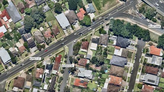
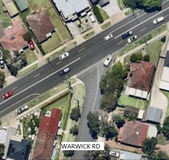
This report assesses the feasibility of the turn bans and the impacts on surrounding streets. Site observations have indicated that:
· Vehicles exiting from the M4 ramp speed through in a westbound direction towards the intersection with Warwick Road.
· Vehicles turning left into Warwick Road travel along kerb side lane.
· Traffic exiting Warwick Road into Burnett Street, particularly the right turns, have difficulty in judging the available gap to complete the manoeuvre.
· Traffic coming out of the M4 Exit ramp may be speeding down Burnett Street. The section of Burnett Street southwest of the ramp has two lanes in each direction.
Crash data
Based on Centre for Road Safety crash data, there were 2 reported crashes at the intersection of Burnett Street and Warwick Road intersection in the last five years ending September 2023. It should be noted that the available crash data does not show minor crashes or near misses.
|
Date |
Location |
Degree |
Description |
|
15/12/2019 |
Intersection of Burnett St & Warwick Rd |
Injury |
Right through from right |
|
13/08/2020 |
Intersection of Burnett St & Warwick Rd |
Injury |
Other same direction |
Turning movement data
Council undertook intersection turning movement volumes on Wednesday 1 May 2024 and the data is shown below:
|
HOURLY
FLOW |
Warwick Rd approach |
Burnett St - Eastern approach |
Burnett St - Western approach |
||
|
|
left turn |
Right turn |
Left Turn |
Straight through |
Straight through |
|
7:00 - 8:00 |
15 |
104 |
112 |
546 |
1,136 |
|
8:00 - 9:00 |
12 |
122 |
220 |
638 |
1,145 |
|
9:00 - 10:00 |
12 |
84 |
159 |
439 |
838 |
|
10:00 - 11:00 |
14 |
88 |
138 |
406 |
623 |
|
11:00 - 12:00 |
8 |
85 |
124 |
667 |
662 |
|
12:00 - 13:00 |
13 |
73 |
223 |
917 |
733 |
|
13:00 - 14:00 |
14 |
79 |
181 |
598 |
681 |
|
14:00 - 15:00 |
11 |
83 |
201 |
799 |
699 |
|
15:00 - 16:00 |
15 |
95 |
345 |
916 |
696 |
|
16:00 - 17:00 |
9 |
101 |
307 |
913 |
794 |
|
17:00 - 18:00 |
22 |
86 |
243 |
842 |
806 |
|
18:00 - 19:00 |
13 |
84 |
206 |
732 |
750 |
Turning movement options
Following review by Council officers, the following options are available for consideration singly or in combination:
1. Banning left turn movements from Burnett Street into Warwick Road.
Warwick Road is conveniently located to allow left turn movements into the street as Burnett Street east of the street has two lanes and kerbside parking is banned. Also, banning the left turn into Warwick Road will direct traffic into the other side roads. Due to the kerbside parking availability on Burnett Street west of Warwick Road, this is likely to force turning vehicles along the centre lane and may cause ‘rear end’ crashes or delays to the large volume of traffic in the regional road, Burnett Street.
Based on the above, this option is not considered suitable.
2. Banning right turn movements out of Warwick Road into Burnett Street.
Banning right turns out of Warwick Road may divert some traffic into the other streets; however, it is considered to be a safer option in preventing the right turns into Burnett Street against four lanes of traffic.
The right turn ban may be implemented during the peak periods only or full time.
It is proposed that Council undertake consultation with the residents, and motorists to assess support or otherwise to consider appropriate times to ban the right turn movements from Warwick Road.
Process for banning movements
In accordance with the Transport for NSW guidelines (TfNSW), Council does not have delegation to ban movements of any vehicular traffic without preparing and receiving approval from TfNSW of a Traffic Management Plan (TMP).
The TMP deals with various impacts of banning any movement, including impact on emergency vehicle access, other streets in the vicinity and justification for the decision to ban. In preparing the TMP, the proposal is required to be advertised and public comments summarised and addressed.
The impacts of the proposal may have to be modelled using appropriate software and justification for the request analysed.
COnsultation
Consultation has not been undertaken. Future consultation will be undertaken if recommended by the Traffic Committee.
Attachments
Nil
5 June 2024
Item No: CTC-24-143
NORMAN STREET, MERRYLANDS – ROAD SAFETY CONCERNS – CONSULTATION RESULT
Directorate: Environment and Planning
Responsible Officer: Manager Engineering and Building
Electorate: Granville
Police Area Command (PAC): Cumberland
Agenda Part Part 2
Note: Recommendation to Council
Summary
Council has received a request from a local resident for the installation of speed humps on Norman Street, Merrylands due to speeding concerns.
This report outlines the outcome of the investigation into this matter.
The Traffic Committee recommends that:
1. Council prepare design of speed humps in Norman Street, Merrylands, undertake consultation with the directly affected and adjacent residents and report back to Traffic Committee.
2. Council notify the concerned residents of the outcome.
Report
Cumberland Traffic Committee (CTC) at its meeting in March 2023 considered a report (ECTC-23-046) regarding road safety concerns in Norman Street, Merrylands. CTC recommended and Council subsequently resolved (on 5 April 2023) as follows:
1. The Cumberland Traffic Committee resolved and recommends to Council that the installation of traffic calming devices on Norman Street, Merrylands not be supported.
2. That Council review conditions in Norman Street, Merrylands and report back to the Traffic Committee in April 2024.
3. That the resident be notified of Council’s decision.
Council has received continued concerns from the residents of Norman Street and undertook consultation with the residents to assess support or otherwise of residents for installation of traffic calming devices in the street.
The consultation was carried out with the residents of Norman Street in May 2024. A total of 53 letters were distributed to the residents / owners with an attached survey form.
Council received 20 responses (75% of the total letters sent) by the closing date. 15 (75%) supported the proposed speed humps, 4 (20%) opposed to the proposal and 1 (5%) had no preference marked. With the 14 supporting responses received, there was one response that indicated their objection to the speed hump being placed in front of their property frontage.
There were also some comments received from the residents. 5 submissions raised concerns about the narrow road width of Norman Street and the existing on-street parking conditions, 3 submissions raised concerns about the bypass traffic that Norman Street is experiencing. Council also received verbal communication from a concerned resident who does not live on the street, who suggested that the safety issue is not caused by speeding motorists but by the narrowness of the street.
Based on the survey results, the majority of the residents who responded to the survey supported the proposed speed humps in the street. Therefore, it is recommended that Council prepare a design and consult with the resident who will be directly impacted by the proposed speed humps.
COnsultation
The proposal was notified to the impacted residents for a period of 14 days from 2 May 2024 to 16 May 2024. A total of 53 letters were distributed to the residents / owners with an attached survey form.
Council received 20 responses (75% of the total letters sent) by the closing date. 15 (75%) supported the proposed speed humps, 4 (20%) opposed the proposal and 1 (5%) response had no preference marked.
Attachments
DOCUMENTS
ASSOCIATED WITH
REPORT CTC-24-143
Attachment 1
Previous Report CTC-23-046
5 June 2024
Item No: CTC-24-144
BERESFORD ROAD, GREYSTANES - NOTICE OF MOTION - TRAFFIC IMPROVEMENT IN GREYSTANES
Directorate: Environment and Planning
Responsible Officer: Manager Engineering and Building
Electorate: Prospect
Police Area Command (PAC): Cumberland
Agenda Part Part 2
Note: Recommendation to Council
Summary
Council has resolved following a Notice of Motion to investigate traffic improvement to Beresford Road, Greystanes outside Beresford Public school between Namoi Street and MacLeay Street to improve safety outcomes and reduce congestion and liaise with school principal.
This report outlines the outcome of the investigation into this matter.
The Traffic Committee recommends that the information contained in this report be noted.
Report
Council at a meeting held on 6 March 2024 resolved on a Notice of Motion – ‘Matter of Urgency – Traffic Improvement in Greystanes’ resolved:
‘That Council immediately investigate traffic improvement to Beresford Rd, Greystanes
outside of Beresford Road Public school between (Namoi Street and MacLeay Street)
to improve safety outcomes and reduce congestion and liaise with the school principal’.
This report details actions taken at this location in the past and actions taken subsequent to the above resolution.
Background Information
Beresford Road is a local road that runs in a North-South direction between Old Prospect Road and Great Western Highway.
The section under consideration is between Namoi Street and Macleay Street which is approximately 325m long. There are roundabouts provided on Beresford Road at its intersections with Namoi Street and Macleay Street.
Beresford Road Public School is located on the east of this section. Greystanes High School is located on the western side of Beresford Road north of Bathurst Street. The map below shows the location of Beresford Road Public School and the section of Beresford Road under consideration.
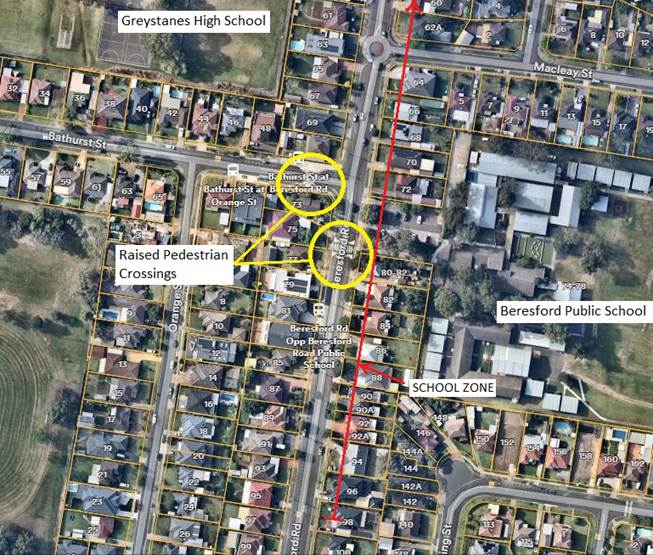
Based on Centre for Road Safety crash data, there were no reported crashes in Beresford Road between Namoi Street and Macleay Street. It should be noted that the crash data does not include any minor crashes.
The following site observations have been made in this section of Beresford Road:
1. Beresford Road has an approximately 485m long School Zone just north of Namoi Street extending up to the boundary of Greystanes High School. The School Zone also has flashing lights on both ends and appropriately signposted.
2. Raised pedestrian crossing combined with children crossing flags on Beresford Road south of Bathurst Street. This crossing also has a crossing supervisor during school times.
3. The existing at level pedestrian crossing on Bathurst Street near Beresford Road was raised under the Federal Stimulus Program in 2022.
4. Roundabouts on Beresford Road at its intersections with Namoi Street and Macleay Street.
Recent Crash on 27 February 2024
There was a crash that occurred on Beresford Road outside the school approximately 20m south of the existing raised pedestrian crossing where a student was injured.
Following the crash, Council officers were contacted by the Beresford Road Public school and Leading Senior Constable William Graham of Cumberland Police Area Command who confirmed the crash. Council officers inspected the street and undertook an audit of existing signage in the area.
It was alleged that there was a construction happening at a residence nearby and insufficient traffic control measures were implemented by the builder. Council rangers also visited the site.
Subsequent to the crash, the following activities have been undertaken:
· Council has repainted all the faded lines and replaced all faded signs.
· Council officers have been in contact with the school administration to provide road safety information to be provided to the parents and students.
· Council officers have reviewed the approval associated with the nearby residential construction site to ensure that all appropriate measures are being undertaken.
Council will continue to monitor the location outside the school for further traffic improvements required and report any further proposals to the Traffic Committee.
COnsultation
Consultation has not been undertaken. Future consultation will be undertaken if recommended by the Traffic Committee.
Attachments
Nil
5 June 2024
Item No: CTC-24-145
HAMILTON STREET AND BERKELEY STREET, SOUTH WENTWORTHVILLE - PROPOSED TREATMENT AT THE ROUNDABOUT
Directorate: Environment and Planning
Responsible Officer: Manager Engineering and Building
Electorate: Granville
Police Area Command (PAC): Cumberland
Agenda Part Part 2
Note: Recommendation to Council
Summary
Council has received safety concerns from a resident at the intersection of Hamilton Street and Berkeley Street, South Wentworthville.
This report outlines the outcome of the investigation into this matter.
The Traffic Committee recommends that:
1. The proposed speed cushions in Berkeley Street, South Wentworthville as per attached plan be approved.
2. The concerned resident be notified of the outcome.
Report
Berkeley Street a local that runs in a north-south direction from Bartlett Street to a cul-de-sac road at its northern end. It has a speed limit of 50 km/h. The width of the street is approximately 12.5m and parking is permitted on both sides of the road unless otherwise signposted.
Hamilton Street is a local road that runs in an east-west direction between Monterey Street and Frances Street with a speed limit of 50 km/h. It has a width of approximately 9.8m and parking is permitted on both sides of the road unless otherwise signposted.
Hamilton Street and Berkeley Street form a four-way intersection controlled by 'Give Way' signage and line marking, with priority given to Hamilton Street. Currently, a roundabout exists on Hamilton Street at the intersections of Alto Street and Richmond Street. The distance between the above two roundabouts is approximately 200m.
The map below shows the intersection.
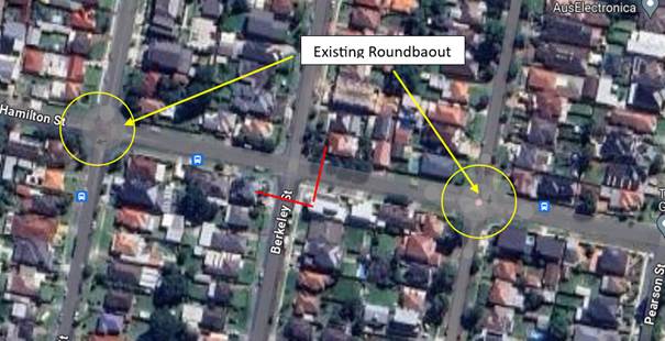
A resident alleges that an accident occurred recently. A car traveling northbound on Berkeley Street lost control and crashed into the property at No. 42, located at the northeast corner at the intersection of Hamilton Street and Berkeley Street.
The latest Centre for Road Safety accident data indicated that there was no accident at this intersection in the last 5 years ending September 2023 in relation to speeding.
In response to the concerns, traffic counts were undertaken at this intersection in May 2024. The traffic count locations are shown in red in the map above.
Traffic count data on Hamilton Street, South Wentworthville:
· Average Daily Traffic (ADT) = 3,542 veh/day
· 85th percentile speed = 51.2 km/h
· Mean (average) vehicle speed = 43.9 km/h
Traffic count data on Berkeley Street, South Wentworthville:
· Average Daily Traffic (ADT) = 232 veh/day
· 85th percentile speed = 43.9 km/h
· Mean (average) vehicle speed = 36.7 km/h
Council consulted with residents about a proposal to install speed cushions on Berkeley Street at both approaches to Hamilton Street. A total of nine letters with attached survey forms were distributed to residents.
Council received two responses, one in support and one objecting to the proposal as shown on the plan. However, both responses indicated that additional traffic calming devices are needed on Hamilton Street, particularly at the approaches to the existing roundabouts due to vehicles entering and leaving the roundabout at excessive speeds.
Based on the above, Council proposed to install a speed cushion in Berkeley Street on both approaches to Hamilton Street to improve safety at the intersection.
COnsultation
The proposal was notified to the impacted and adjacent residents for a period of 14 days from 6 May 2024 to 25 May 2024.
Two submissions were received, with one in support and one objecting to the proposal.
Attachments
1. Plan – Berkeley Street & Hamilton Street, South Wentworthville - Proposed Speed Cushions
DOCUMENTS
ASSOCIATED WITH
REPORT CTC-24-145
Attachment 1
Plan – Berkeley Street & Hamilton Street, South Wentworthville - Proposed Speed Cushions
DOCUMENTS
ASSOCIATED WITH
REPORT CTC-24-145
Attachment 2
Submissions
5 June 2024
Item No: CTC-24-146
JOSEPH STREET, LIDCOMBE - TEMPORARY ROAD CLOSURE FOR MOON FESTIVAL CELEBRATIONS
Directorate: Environment and Planning
Responsible Officer: Manager Engineering and Building
Electorate: Auburn
Police Area Command (PAC): Auburn
Agenda Part Part 2
Note: Recommendation to Council
Summary
Council has received an application from Council’s Events Section requesting the closure of Joseph Street, Lidcombe between Railway Street and Bridge Street to facilitate 2024 Moon Festival Celebrations.
This report outlines the outcome of the investigation into this matter.
The Traffic Committee recommends that the temporary road closure of Joseph Street between Railway Street and Bridge Street be approved in accordance with the attached traffic guidance scheme between the hours of 7:00AM, Saturday 21 September 2024 and 1:00AM, Sunday 22 September 2024 subject to:
1. All affected businesses and emergency stakeholders being notified of the closure.
2. Complying with the notification requirements of the Roads Act 1993, i.e., placing public notices in a newspaper and erecting notices on the road.
3. Approval of a Traffic Management Plan by Transport Management Centre.
Report
Council proposes to hold the 2024 Moon Festival Celebrations in three areas include Auburn, Barela and Lidcombe. Road closure is required for the street festival event on Joseph Street, Lidcombe.
The event will commence from 6:00PM and finishing at 10:00PM on Saturday 21 September 2024. The road closure is required on Joseph Street between Railway Street and Bridge Street, from 7:00AM, Saturday 21 September 2024 to 1:00AM, Sunday 22 September 2024 to facilitate event patrons to assemble and evacuate the area safely.
The event is classified as a Class 3 event in accordance with the Special Event Guidelines.
The map below shows the street network around Joseph Street in this area.
![]()
The attached Traffic Guidance Scheme (TGS) shows the signage and the road section to be closed.
The TGS and Traffic Management Plan (TMP) will be submitted to Transport for NSW for approval.
COnsultation
Council’s Events team will carry out the following notification activities, subject to Traffic Committee endorsement of the temporary road closure:
· Council media release.
· Letter box notifications are sent to local residents and businesses in the area.
· Council’s traffic contractor will have VMS boards present.
Attachments
DOCUMENTS
ASSOCIATED WITH
REPORT CTC-24-146
Attachment 1
Traffic Guidance Scheme
5 June 2024
Item No: CTC-24-147
TEMPORARY ROAD CLOSURES IN THE AUBURN CBD FOR RAMADAN FOOD FESTIVAL 2025
Directorate: Environment and Planning
Responsible Officer: Manager Engineering and Building
Electorate: Auburn
Police Area Command (PAC): Auburn
Agenda Part Part 2
Note: Recommendation to Council
Summary
Council has received an application from Council’s Events Section requesting the closure of selected roads in the Auburn CBD to facilitate ‘Ramadan Street Festival 2025’.
This report outlines the outcome of the investigation into this matter.
The Traffic Committee recommends that the temporary closure of Auburn Road between Queen Street and Beatrice Street and the eastern section of Mary Street, between Harrow Road and Auburn Road, Auburn between 7:00 AM on Saturday 8 March 2025 and 5:00 AM on Sunday 9 March 2025 be approved subject to:
1. All affected businesses and emergency stakeholders being notified of the closure.
2. Complying with the notification requirements of the Roads Act 1993, i.e., placing public notices in a newspaper and erecting notices on the road.
3. Approval of a Traffic Management Plan by the Transport Management Centre.
4. Temporary bus routes and bus zones replacing the existing bus zones in the closed area be provided in consultation with the bus operator.
Report
Council proposes to hold the annual ‘Ramadan Street Festival’ in the Auburn CBD in March 2025.
‘Ramadan Street Festival 2025’ provides free access to cultural event celebrating the local community. Council is committed to delivering the event to focus interest on the local area, while keeping a community spirit and attracting visitors from the Sydney metropolitan area.
The event will involve street stalls with food and merchandise.
Council is planning to deliver a one-night street food festival in Auburn, consistent with recent Ramadan festival operations in 2024. This event being an annual event, no issues were encountered during the event held in previous years.
The Traffic Guidance Scheme (TGS) are attached. Transport for NSW will be forwarded the Traffic Management Plan with the updated details for approval.
Road Closures
The road closure from morning will prevent any parking within the event area and also provide time for event officers to set up stalls and other furniture required for the event. The closure is as follows.
· Auburn Road between Queen Street and Beatrice Street
· Eastern section of Mary Street, between Harrow Road and Auburn Road
The map below shows the road closures in yellow.
COnsultation
Council’s Event team will carry out the following notification activities, subject to Traffic Committee endorsement of the temporary road closure:
· Council media release.
· Letter box notifications are sent to local residents and businesses in the area.
· Council’s traffic contractor will have VMS boards present.
Attachments
1. Traffic Guidance Scheme (TGS) – Ramadan Food Festival 2025
DOCUMENTS
ASSOCIATED WITH
REPORT CTC-24-147
Attachment 1
Traffic Guidance Scheme (TGS) – Ramadan Food Festival 2025
5 June 2024
Item No: CTC-24-148
NEW STREET, AUBURN - PROPOSED TEMPORARY ROAD CLOSURE FOR ST RAYMOND MARONITE CHURCH ANNUAL COMMUNITY EVENT
Directorate: Environment and Planning
Responsible Officer: Manager Engineering and Building
Electorate: Auburn
Police Area Command (PAC): Auburn
Agenda Part Part 2
Note: Recommendation to Council
Summary
Council received a request from St. Raymond Maronite Church to temporarily close New Street, Auburn, between Wellington Road and Hillview Street, from 12:00 PM Saturday 16 November 2024 to 12:00 AM Sunday 17 November 2024 (12 hours) for their annual community event.
This report gives details of the closure.
That the Traffic Committee recommends that Council approve the temporary full road closure of New Street, Auburn between Wellington Road and Hillview Street from Saturday 16 November 2024 12:00 PM to Sunday 17 November 2024 12:00 AM, subject to approval from Transport for NSW for the Traffic Management Plan and Traffic Guidance Scheme.
Report
Council received a request from St. Raymond Maronite Church to temporarily close New Street, Auburn, between Wellington Road and Hillview Street, from 12:00 PM Saturday 16 November 2024 to 12:00 AM Sunday 17 November 2024 (12 hours) for their annual community event.
This is an annual community gathering to celebrate the cultural and spiritual heritage of the St. Raymond Maronite Church. Families of the parish, community members, and guests numbering of approximately 100 persons are expected to attend the event.
The event is located in New Street, which will be adorned with decorations and setups for various activities. Residents will have access to their properties at all times.
The plan shows the location of closure:
A copy of Traffic Guidance Scheme (TGS) is attached.
COnsultation
The event organiser will carry out consultations with the residents in New Street, Auburn.
Attachments
1. St Raymond Maronite Church Annual Community Event - Traffic Guidance Scheme
DOCUMENTS
ASSOCIATED WITH
REPORT CTC-24-148
Attachment 1
St Raymond Maronite Church Annual Community Event - Traffic Guidance Scheme
5 June 2024
Item No: CTC-24-149
CARLTON STREET, GRANVILLE - PROPOSED TEMPORARY ROAD CLOSURE FOR GRANVILLE RAILWAY DISASTER MEMORIAL
Directorate: Environment and Planning
Responsible Officer: Manager Engineering and Building
Electorate: Granville
Police Area Command (PAC): Cumberland
Agenda Part Part 2
Note: Recommendation to Council
Summary
Cumberland City Council organising the “Granville Railway Disaster Memorial” event has proposed the temporary closure of Carlton Street, Granville between Railway Parade and Council car park entry adjacent to Russell Street. The memorial event is scheduled on Saturday 18 January 2025 from 7:00 AM to 1:00 PM.
This report gives details of the closure.
The Traffic Committee recommends that:
1. Council approve the temporary full road closure of Carlton Street, Granville between Railway Parade and Council car park entry adjacent to Russell Street from 5:00 AM to 2:00PM on Saturday 18 January 2025 subject to approval from Transport for NSW for the Traffic Management Plan and Traffic Guidance Scheme.
2. The Traffic Management Plan and Traffic Guidance Scheme be forwarded to City of Parramatta for concurrence.
Report
Cumberland Council organising the “Granville Railway Disaster Memorial” event has proposed the temporary closure of Carlton Street, Granville between Railway Parade and Council car park entry adjacent to Russell Street. The memorial event is scheduled on Saturday 18 January 2025 from 7:00 AM to 1:00 PM. The traffic guidance scheme will be implemented from 5:00AM to 2:00PM.
This is an annual memorial service to commemorate the lives lost due to the 1977 Granville Rail Disaster. Families of the victims, survivors and rescue personnel numbering 100 to 150 persons are expected to attend the event.
The Railway Disaster memorial is located on the south western corner of the Carlton Street & Railway Parade traffic lights. Please see a street view of the memorial below:
The event organisers have identified that as in previous years, the attendees will meet at the Granville Townhall and march along Carlton Street towards the memorial.
The plan overleaf shows the location of closure:
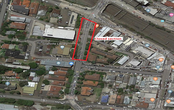
Following the event conducted previous years, event debriefings by Council staff observed that the events were successful without any issues.
Copies of the Traffic Management Plan (TMP) and Traffic Guidance Scheme (TGS) are attached.
COnsultation
Council’s Event team will carry out the following notification activities, subject to Traffic Committee endorsement of the temporary road closure:
· Council media release.
· Letter box notifications are sent to local residents and businesses in Granville and surrounding areas to advise them of changes to traffic.
· Council’s traffic contractor will have VMS boards present.
Attachments
1. Granville Railway Disaster Memorial 2025 – Traffic Management Plan
DOCUMENTS
ASSOCIATED WITH
REPORT CTC-24-149
Attachment 1
Granville Railway Disaster Memorial 2025 – Traffic Management Plan
5 June 2024
Item No: CTC-24-150
MERRYLANDS ROAD, MERRYLANDS - TEMPORARY ROAD CLOSURE FOR ‘NOWRUZ’ PERSIAN NEW YEAR CELEBRATIONS
Directorate: Environment and Planning
Responsible Officer: Manager Engineering and Building
Electorate: Granville
Police Area Command (PAC): Cumberland
Agenda Part Part 2
Note: Recommendation to Council
Summary
Council has received an application from Council’s Events Section requesting the closure of Merrylands Road, Merrylands between Treves Street and Miller Street to facilitate 2025 Nowruz Celebrations.
This report outlines the outcome of the investigation into this matter.
The Traffic Committee recommends that the temporary road closure of Merrylands Road between Treves Street and Miller Street be approved in accordance with the attached traffic guidance scheme between the hours of 7:00AM, Saturday, 22 March 2025 and 2:00AM, Sunday, 23 March 2025 subject to:
1. All affected businesses and emergency stakeholders being notified of the closure.
2. Complying with the notification requirements of the Roads Act 1993, i.e., placing public notices in a newspaper and erecting notices on the road.
3. Approval of a Traffic Management Plan by the Transport Management Centre.
Report
Following inaugural celebration by Cumberland City Council of ‘Nowruz’, the Persian New Year at The Granville Centre in 2024, the event will be held in the new public space Merrylands Civic Square.
The closure of Merrylands Road between Treves Street and Miller Street for this event aims to provide additional event celebration space and crucially to provide opportunities for local town centre businesses to achieve maximum benefit from the event by being located in or close to the event site. This local business engagement outcome is linked to funding being received by NSW Government so is crucial to the event delivery.
The road closure will be on Merrylands Road between Treves Street and Miller Street, from 7:00AM, Saturday, 22 March 2025 to 2:00AM, Sunday, 23 March 2025.
The event is classified as Class 3 in accordance with the Special Event Guidelines.
The map below shows the street network around Merrylands Road in this area.
![]()
The attached Traffic Guidance Scheme (TGS) shows the signage and the road section to be closed.
The TGS and Traffic Management Plan (TMP) will be forwarded to Transport for NSW for approval.
COnsultation
Council’s Events team will carry out the following notification activities, subject to Traffic Committee endorsement of the temporary road closure:
· Council media release.
· Letter box notifications are sent to local residents and businesses in the area.
· Council’s traffic contractor will have VMS boards present.
Attachments
DOCUMENTS
ASSOCIATED WITH
REPORT CTC-24-150
Attachment 1
Nowruz Event - Traffic Guidance Scheme
5 June 2024
Item No: CTC-24-151
STATION STREET, WENTWORTHVILLE – PROPOSED ROAD CLOSURES FOR DIWALI FESTIVAL EVENT
Directorate: Environment and Planning
Responsible Officer: Manager Engineering and Building
Electorate: Prospect
Police Area Command (PAC): Cumberland
Agenda Part Part 2
Note: Recommendation to Council
Summary
For the committee to consider the 14-hour closure of Station Street, Wentworthville for the Diwali Festival Event.
This report outlines the outcome of the investigation into this matter.
The Traffic Committee recommends that the temporary road closure of Station Street, Wentworthville between Dunmore Street and McKern Street between the hours of 7:00am Saturday 9 November 2024 to 1:00am Sunday 10 November 2024 be approved subject to the following conditions:
1. All affected businesses, residents and emergency stakeholders being notified of the closure.
2. Complying with the notification requirements of the Roads Act 1993, i.e. placing public notices in a newspaper and erecting notices on the road.
3. Bus operators shall be consulted of the closure.
4. Approval of a Traffic Management Plan by Transport for NSW and the Transport Management Centre be obtained.
Report
Council has received an application for the temporary closure of Station Street, Wentworthville between Dunmore Street and Perry Street from 7:00am Saturday 9 November 2024 to 1:00am Sunday 10 November 2024 for the Diwali Festival event.
Station Street, Wentworthville is a local road that runs in a north-south direction linking Wentworthville Station to the north and Great Western Highway to the south. Shops and small businesses are occupying along the street with time restricted parking is permitted on both side of the road. Transit Systems bus 818 and ComfortDelGro Australia bus S8 are operating on Station Street from Monday to Friday. No bus services operate on Saturdays.
The Station Street closure for the Diwali Festival event has occurred in the past (pre Covid) and Council has not received any complaints from the public. It is an annual event, which will be held and managed by Cumberland City Council. It is noted that the event is scheduled to be carried out on Saturday 9 November 2024 between the hours of 6:00pm and 9:00pm.
The Traffic Control Plan for the Diwali Festival event is attached.
A Traffic Management Plan will be forwarded to Transport for NSW for approval.
COnsultation
Council’s Events team will carry out the following notification activities:
· The event will be advertised via Council’s website and social media page, local papers and through any other community/business networks.
· Business Consultation will occur in the area (in particular with any businesses directly affected by the closure
· Resident Notification Letters will be sent at least 8 weeks prior to the event being held.
· Messaging around ‘Changes to Traffic’ will also be available on Council’s website – The Diwali Event Web Page
Attachments
DOCUMENTS
ASSOCIATED WITH
REPORT CTC-24-151
Attachment 1
Traffic Control Plan – Diwali Festival
5 June 2024
Item No: CTC-24-152
TEMPORARY ROAD CLOSURE FOR ‘AUSTRALIA DAY’ CELEBRATIONS
Directorate: Environment and Planning
Responsible Officer: Manager Engineering and Building
Electorate: Granville
Police Area Command (PAC): Cumberland
Agenda Part Part 2
Note: Recommendation to Council
Summary
For the Committee to consider the two (2) hour closure of a short section of Pitt Street, Merrylands to facilitate 2025 Australia Day Celebrations in Holroyd Gardens at the corner of Pitt Street & Walpole Street.
The event will be managed by Council.
The Traffic Committee recommends that the temporary two-hour closure of Pitt Street in accordance with the attached traffic control plan between 8:30PM and 10:30PM on Sunday January 26, 2025 be approved, subject to concurrence and approval of a Traffic Management Plan (TMP) by Transport for NSW.
Report
Australia Day is celebrated annually in Holroyd Gardens at the corner of Pitt Street & Walpole Street. The event will be managed by Council.
Australia Day will be celebrated on Sunday January 26, 2025 commencing from 6:00PM and finishing at 9:00PM. Approximately 1,000 people are expected to attend the event throughout the duration. There will be fireworks at the end of the event.
The road closure will be on Pitt Street between the two eastern and western approaches of the staggered intersection of Walpole Street. The road closures will be between 8:30PM and 10:30PM to facilitate event patrons to evacuate the area safely and cross Pitt Street to access their parked cars or walk to Merrylands station which is less than 900m from Holroyd Gardens.
The event is classified as Class 3 in accordance with the Special Event Guidelines.
The map below shows the street network and Holroyd Gardens.
The Traffic Management Plan and Traffic Guidance are attached.
The Traffic Management Plan (TMP) will be submitted to Transport for NSW for approval.
Attachments
DOCUMENTS
ASSOCIATED WITH
REPORT CTC-24-152
Attachment 1
Traffic Management Plan - Australia Day 2025
5 June 2024
Item No: CTC-24-153
DRAFT ‘LOCAL TRAFFIC AND TRANSPORT POLICY AND GUIDELINE’
Directorate: Environment and Planning
Responsible Officer: Manager Engineering and Building
Electorate:
Police Area Command (PAC):
Agenda Part Part 2
Note: Recommendation to Council
Summary
Council has undertaken a review of traffic related policies and guidelines to ensure that best practice can be achieved in relation to road safety and relevant Australian Standards and Austroads Guides. Following this review, Council officers have prepared a draft Local Traffic and Transport Policy and Guideline for consideration.
The Traffic Committee recommends that the draft Local Traffic and Transport Policy and Guideline be provided for consideration by Council.
Report
Council has undertaken a review of traffic related policies and guidelines to ensure that best practice can be achieved in relation to road safety and relevant Australian Standards and Austroads Guides. Following this review, Council officers have prepared a draft Local Traffic and Transport Policy and Guideline for consideration.
The purpose of the Policy and Guideline is to inform stakeholders on Council’s requirements to deliver best practice traffic and transport solutions and safety for the benefit of the Cumberland community. The documents cover three areas: Local Area Traffic Management; pedestrian crossings; and Permit Parking Schemes.
It is noted that stakeholder consultation is in progress on the draft documents, and further refinements may be undertaken on the Policy and Guideline following consideration by the Traffic Committee but prior to consideration by Council.
COnsultation
Subject to endorsement by Council, consultation on the draft Policy and Guideline would be undertaken in accordance with policy requirements.
Attachments
1. Draft Local Traffic and Transport Policy
DOCUMENTS
ASSOCIATED WITH
REPORT CTC-24-153
Attachment 1
Draft Local Traffic and Transport Policy
DOCUMENTS
ASSOCIATED WITH
REPORT CTC-24-153
Attachment 2
Draft Local Traffic and Transport Guideline
5 June 2024
Item No: CTC-24-154
TEMPORARY OPTIONAL DELEGATIONS ON TRAFFIC MANAGEMENT AND PEDESTRIAN WORKS TO COUNCILS FROM TRANSPORT FOR NSW
Directorate: Environment and Planning
Responsible Officer: Manager Engineering and Building
Electorate:
Police Area Command (PAC):
Agenda Part Part 2
Note: Recommendation to Council
Summary
Council officers at the traffic committee meeting held on 7 February 2024 presented a report informing the committee of the new temporary delegation to Councils by Transport for NSW (TfNSW).
Council at its meeting held on 20 March 2024, resolved that this item considered by the Cumberland Local Traffic Committee at the 7 February 2024 meeting as provided in this report, be returned to the Committee for further consideration.
This report explains the temporary delegation.
The Local Traffic Committee recommends that the information contained in this report be noted.
Report
Transport for NSW issued a ‘Instrument of Delegation and Authorisation – Traffic Management and Pedestrian Works, Temporary Delegation to Councils’ under Roads Act 1993 and Road Transport Act 2013 on 12 December 2023. This temporary delegation is valid until 30 June 2026 unless revoked earlier.
The delegation provides the policy and framework for Councils to exercise the traffic functions delegated to them. Councils may only exercise their delegated functions in accordance with the delegation within the specified conditions. Under these delegations, Transport for NSW continues to manage the State Road network.
This temporary delegation delegates certain functions, subject to conditions in addition to previous delegation for controlling traffic on Council roads. This includes:
· Delegating power to Councils to install some traffic devices without approval from Transport for NSW under a streamlined process.
· Delegating power to Councils to create pedestrian crossings, bike lanes, street trees and parking changes without going to the Traffic Committee or Transport for NSW.
Further information regarding this can be found within Attachment 2.
It is noted that the temporary delegations are optional and do not need to be enacted by the Traffic Committee or Council.
At this time, Council officers are not recommending the enacting of these temporary optional delegations. The current arrangements provide an appropriate process that enables consultation with key stakeholders and the community, and the ability for the Traffic Committee or elected Council to be part of decision making on key traffic related matters.
Should Council wish to proceed with these delegations, an amendment of the Cumberland Traffic Committee Terms of Reference would be required and need to be resolved by Council.
COnsultation
Consultation is not required as it relates to delegations from Transport for NSW regarding traffic matters.
Attachments
1. Instrument of Delegation and Authorisation – Traffic Management and Pedestrian Works, Temporary Delegation to Councils
2. Temporary Delegation to Councils – Transport for NSW Information
DOCUMENTS
ASSOCIATED WITH
REPORT CTC-24-154
Attachment 1
Instrument of Delegation and Authorisation – Traffic Management and Pedestrian Works, Temporary Delegation to Councils
DOCUMENTS
ASSOCIATED WITH
REPORT CTC-24-154
Attachment 2
Temporary Delegation to Councils – Transport for NSW Information
DOCUMENTS
ASSOCIATED WITH
REPORT CTC-24-154
Attachment 3
Current Regulation of Traffic Delegation to Councils