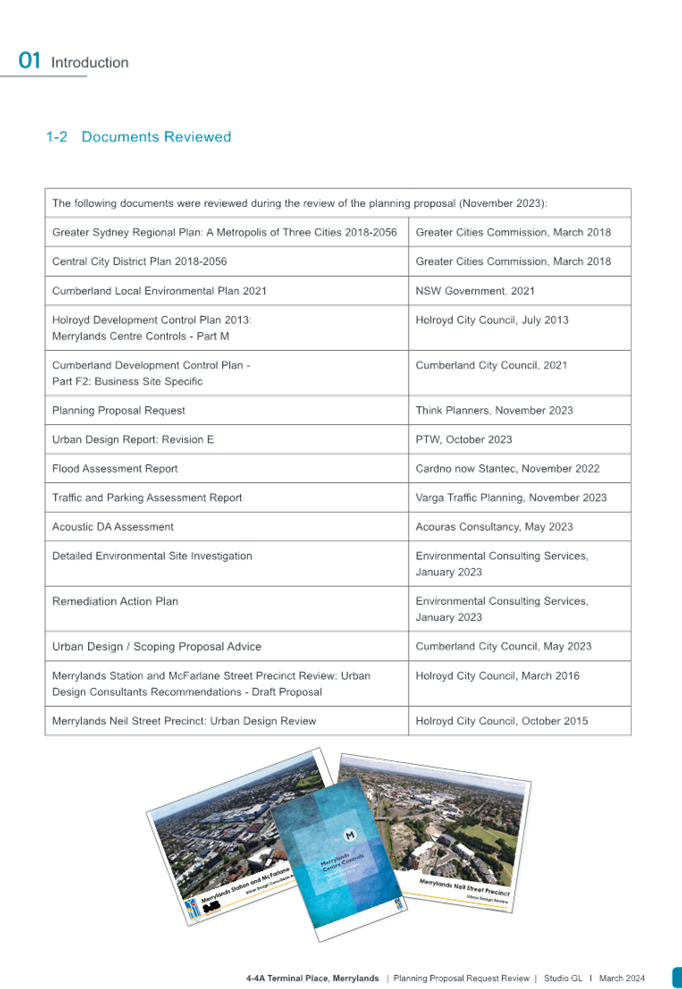
Council Meeting
Wednesday, 1 May 2024 at 6:30 PM
Cumberland City Council Chambers
Merrylands Service Centre, 16 Memorial Avenue, Merrylands
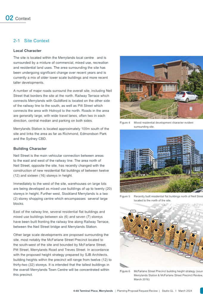
Council Meeting
Wednesday, 1 May 2024 at 6:30 PM
Cumberland City Council Chambers
Merrylands Service Centre, 16 Memorial Avenue, Merrylands
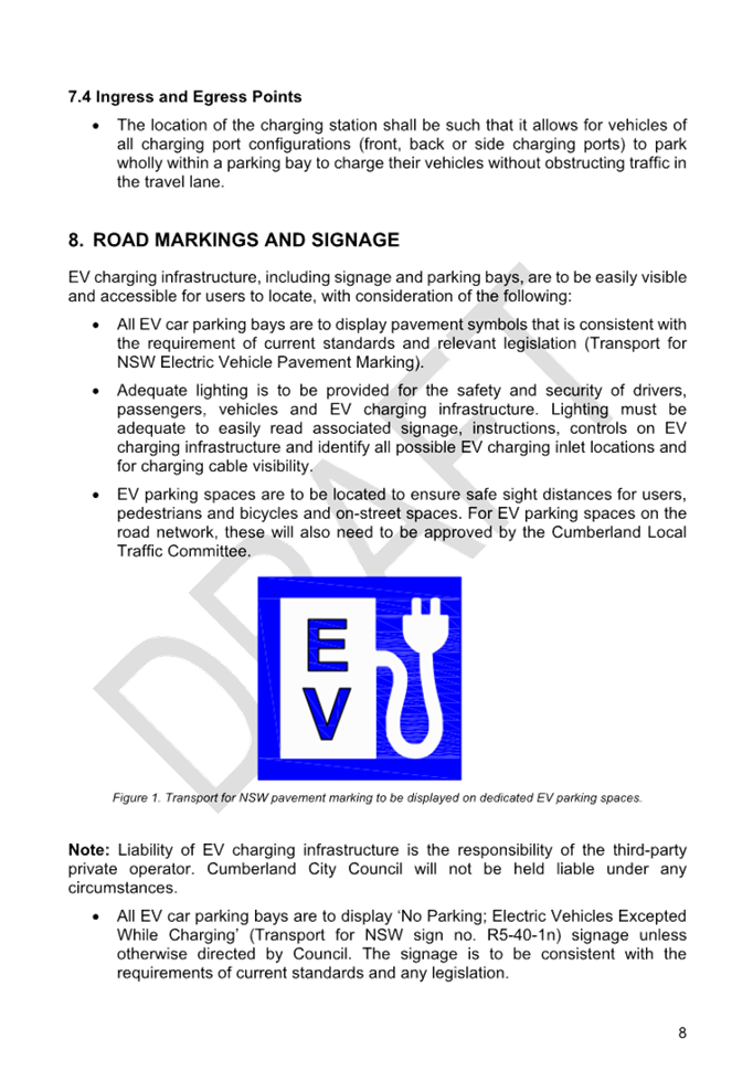
Councillor Contact Details
|
Granville Ward |
||
|
Clr Steve Christou |
0419 651 187 |
|
|
Clr Ola Hamed (Deputy Mayor) |
0405 070 007 |
|
|
Clr Joseph Rahme |
0418 995 471 |
|
|
Greystanes Ward |
||
|
Clr Diane Colman |
0400 279 200 |
Diane.Colman@cumberland.nsw.gov.au |
|
Clr Greg Cummings |
0417 612 717 |
|
|
Clr Eddy Sarkis |
0425 348 000 |
|
|
Regents Park Ward |
||
|
Clr Kun Huang |
0418 911 774 |
|
|
Clr Sabrin Farooqui |
0400 322 999 |
Sabrin.Farooqui@cumberland.nsw.gov.au |
|
Clr Helen Hughes |
0400 264 534 |
Helen.Hughes@cumberland.nsw.gov.au |
|
South Granville Ward |
||
|
Clr Glenn Elmore |
0418 459 527 |
|
|
Clr Paul Garrard |
0414 504 504 |
|
|
Clr Mohamad Hussein |
0400 281 726 |
Mohamad.Hussein@cumberland.nsw.gov.au |
|
Wentworthville Ward |
||
|
Clr Suman Saha |
0419 546 950 |
|
|
Clr Lisa Lake (Mayor) |
0418 669 681 |
|
|
Clr Michael Zaiter |
0418 432 797 |
|
Statement of Ethical Obligations
Oath or Affirmation of Office
In taking the Oath or Affirmation of Office, each Councillor has made a commitment to undertake the duties of the office of councillor in the best interests of the people of Cumberland and Cumberland City Council and that they will faithfully and impartially carry out the functions, powers, authorities and discretions vested in them under the Local Government Act 1993 or any other Act to the best of their ability and judgment.
Conflicts of Interest
A councillor who has a conflict of interest in any matter with which the council is concerned, and who is present at a meeting of the council when the matter is being considered, must disclose the interest and the nature of the interest to the meeting as soon as practicable. Both the disclosure and the nature of the interest must be recorded in the minutes of the Council meeting where the conflict of interest arises. Councillors should ensure that they are familiar with Parts 4 and 5 of the Code of Conduct in relation to their obligations to declare and manage conflicts of interests.
For information on Council services and facilities please visit www.cumberland.nsw.gov.au
Council Meeting
1 May 2024
All Council Meetings are livestreamed via Council’s website. An audio/visual recording of the meeting is published following the meeting. Recordings remain on Council's website for a period of 12 months and are archived following this.
1 Opening of Meeting
2 Opening Prayer / Acknowledgement of Country / National Anthem
3 Apologies / Requests for Leave of Absence/ Requests for Attendance by Audio-Visual Link
4 Confirmation of Previous Minutes
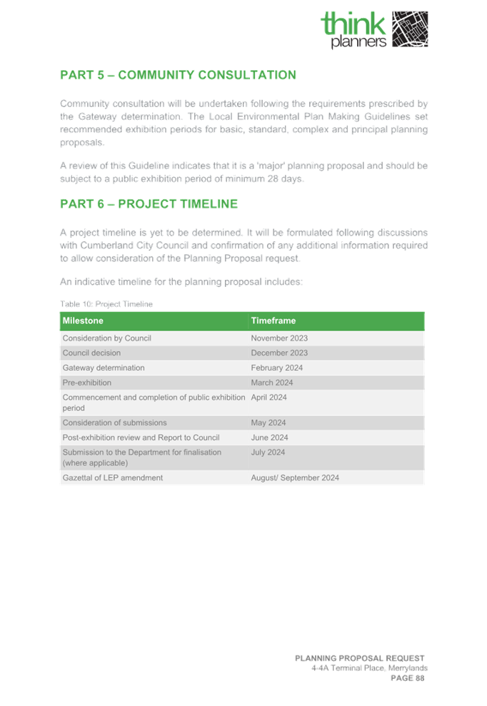
C05/24-505 Minutes of the Ordinary Meeting of Council - 17 April 2024........... 5
5 Disclosures of Interest
Nil
7 Public Forum / Presentation of Petitions
8 Items Resolved by Exception
C05/24-506 Adoption of Library Strategy 2024 - 2027 - Post Exhibition.......... 23
C05/24-507 Planning Proposal for 4-4A Terminal Place, Merrylands............... 71
C05/24-508 Response to Notice of Motion - Electric Vehicle (EV) Charging Stations (C07/23-346)...................................................................................................... 329
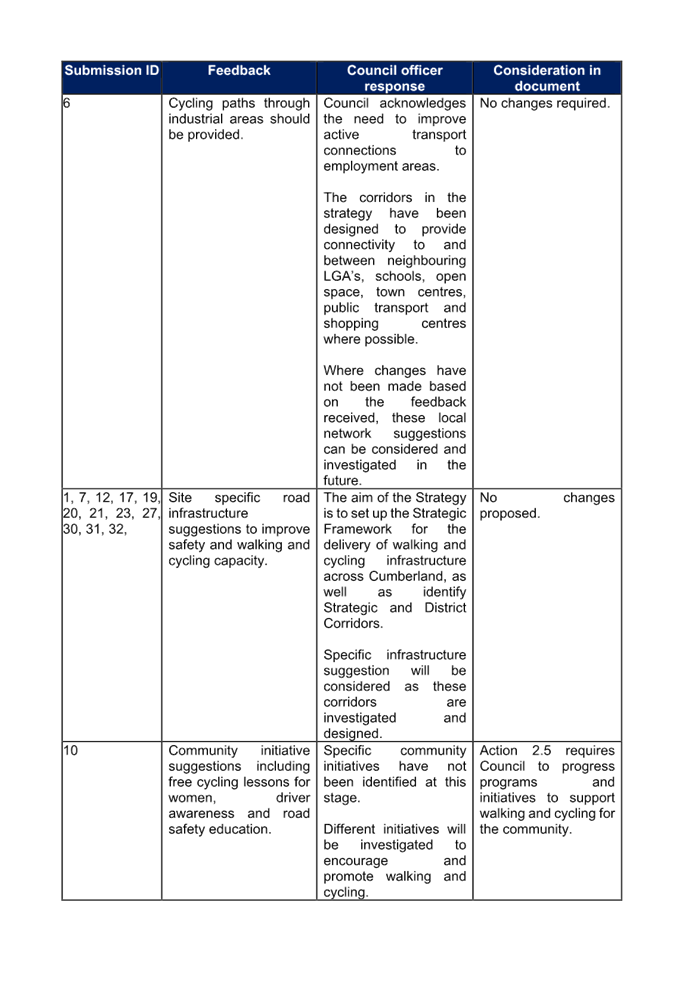
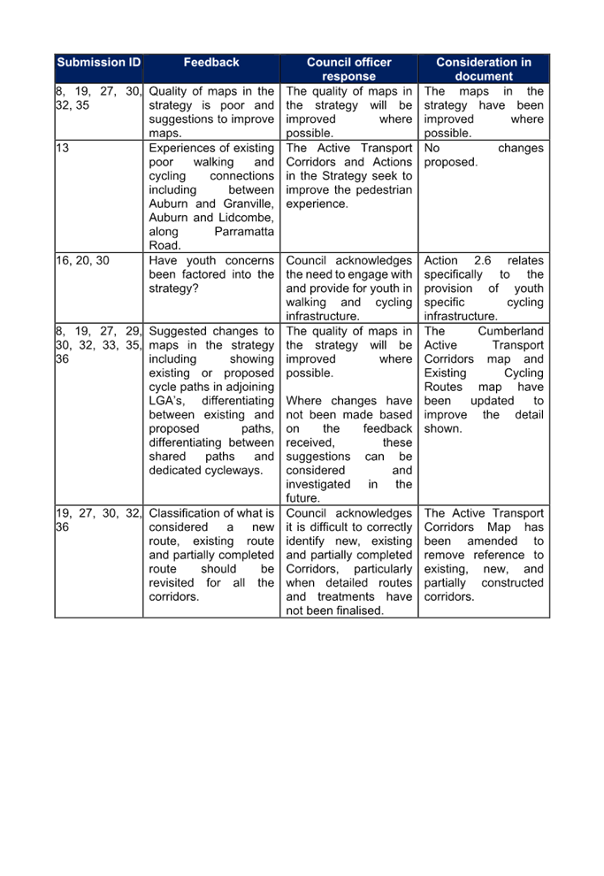
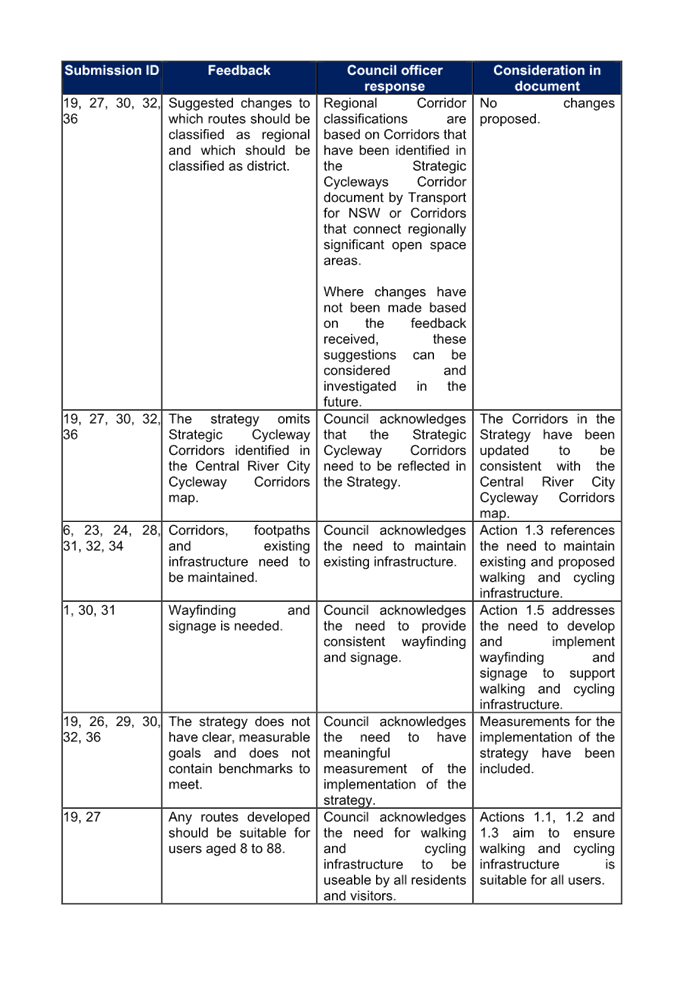
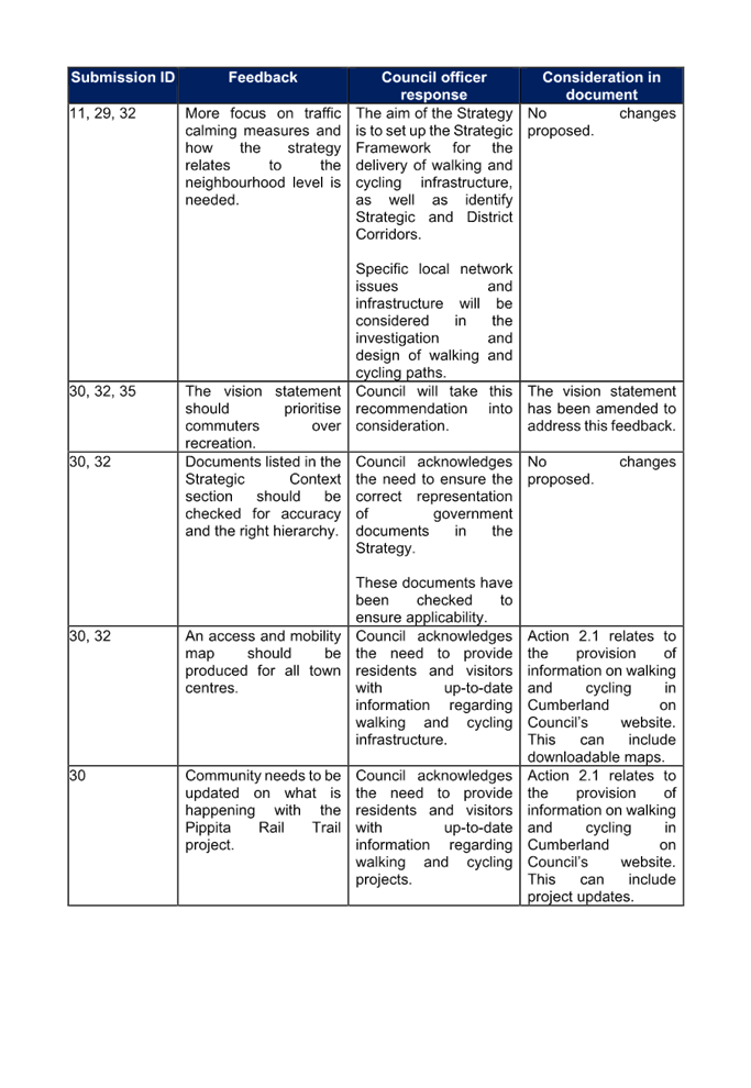
C05/24-509 Draft Cumberland Walking and Cycling Strategy - Post Exhibition Report 357
C05/24-510 Draft Cumberland Local Shops Study - Post Exhibition.............. 427
C05/24-511 Response to Notice of Motion - Promotion of Opportunities in Development Industry (C04/24-502)....................................................................... 617
10 Reports of Council Committees
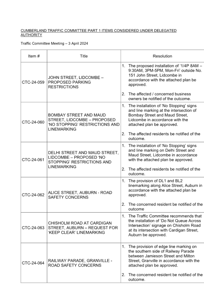
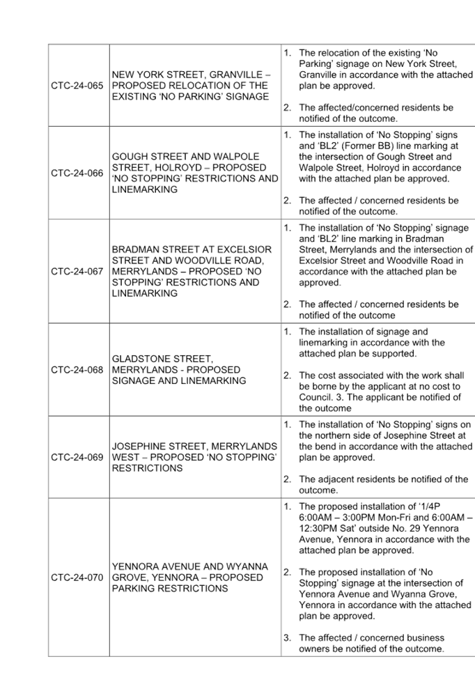
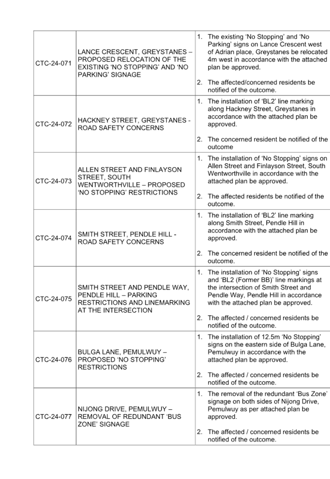
C05/24-512 Property Committee - Minutes of Meeting held 22 April 2024.......... 621
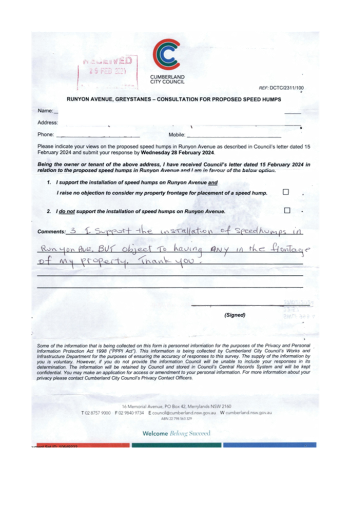
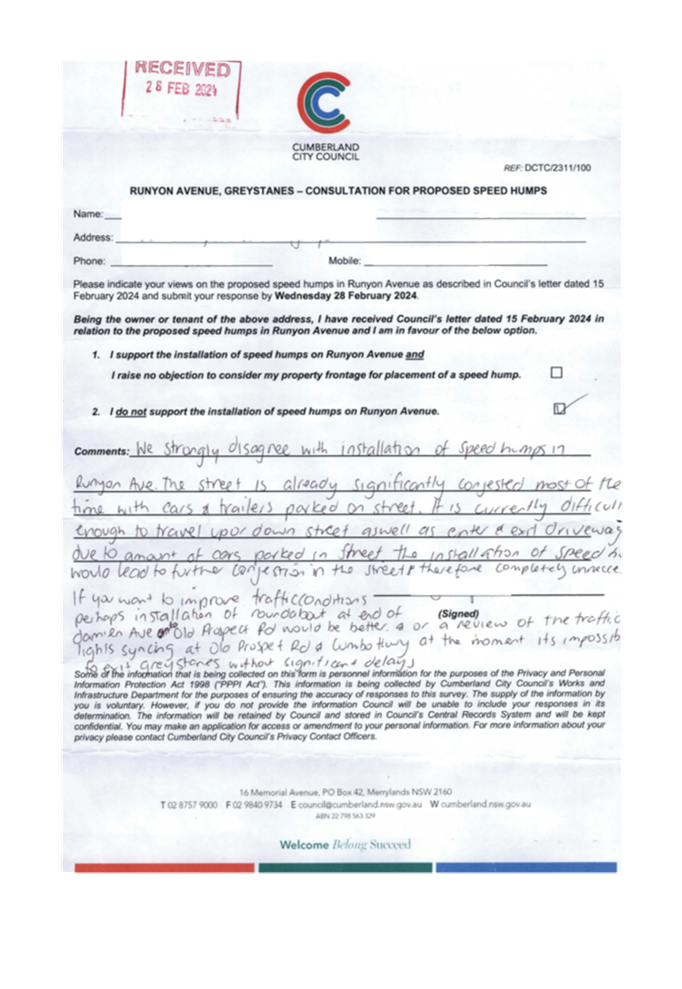
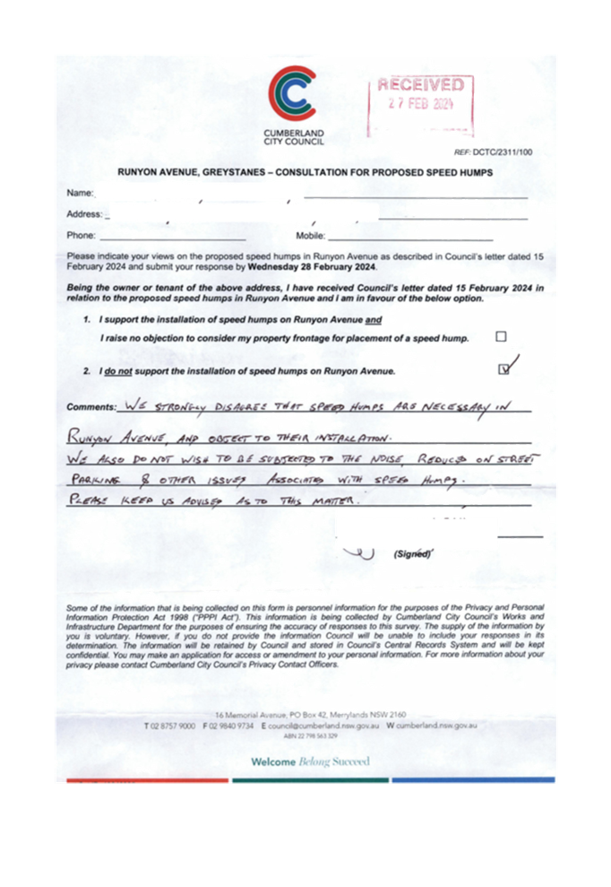
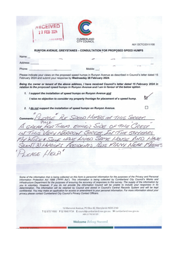
C05/24-513 Cumberland Local Traffic Committee - Minutes of 3 April 2024 Meeting and Items Considered under Delegated Authority.......................................... 633
C05/24-514 Cumberland Local Traffic Committee - 3 April 2024 - Recommendations to Council................................................................................................. 659
Nil
12 Motions to Alter or Rescind Council Resolution
Nil
Nil
C05/24-515 Tender Evaluation Report - Auburn Depot Amenities Upgrade
Note: Included in Closed Council in accordance with Section 10A(2)(d)(i) and (d)(ii) of the Local Government Act as the information involves commercial information of a confidential nature that would, if disclosed prejudice the commercial position of the person who supplied it and information that would, if disclosed, confer a commercial advantage on a competitor of the council.
15 Confidential Attachments from Open Reports
C05/24-512 Property Committee - Minutes of Meeting held 22 April 2024
2... Property Committee Meeting Agenda - 22 April 2024
Note: Included in Closed Business Paper in accordance with Section 10A(2)(d)(i) of the Local Government Act as the information involves commercial information of a confidential nature that would, if disclosed prejudice the commercial position of the person who supplied it.
16 Resolutions passed in Closed Session
17 Other / General Matters
18 Close
1 May 2024
Item No: C05/24-505
Minutes of the Ordinary Meeting of Council - 17 April 2024
Directorate: Governance and Risk
Responsible Officer: Director Governance and Risk
That Council confirm the minutes of the Ordinary Meeting of Council held on 17 April 2024.
Attachments
DOCUMENTS
ASSOCIATED WITH
REPORT C05/24-505
Attachment 1
Draft Council Minutes - 17 April 2024
1 May 2024
Item No: C05/24-506
Adoption of Library Strategy 2024 - 2027 - Post Exhibition
Directorate: Community and Culture
Responsible Officer: Director Community and Culture
Community Strategic Plan Goal: Supporting Community Health, Safety and Wellbeing
Summary
This report recommends the adoption of the Library Strategy 2024 – 2027 following a period of public exhibition.
|
Recommendation That Council adopt the Library Strategy 2024 - 2027 as outlined in Attachment 1 of this report. |
Report
At the Ordinary Council meeting on 15 November 2023, Council resolved to place the Draft Library Strategy 2024 - 2027 on public exhibition for community feedback (Min. 11/23-436).
Subsequently, Council received five submissions during the 28-day exhibition period. In addition, two emails were received with questions and comments on the Draft Strategy. A summary of all submissions received, and Council’s response is outlined in Attachment 2.
Minor amendments have been made to the Draft Strategy based on the public submissions. Key changes include:
· Amendment of images to include a variety of libraries and activities.
· Amendment of statistics from the Australian Bureau of Statistics (ABS) in the ‘About Cumberland’ paragraph and ‘snapshot of Cumberland.’
· Amendment of the wording of Priority 1 relating to design and delivery of library programs.
· Amendment and additional wording of Priority 2 relating to planning of libraries and locations as well as implementation of a library vending machine.
· Additional wording to Priority 3 relating to Library Advisory Committee.
· Update of library usage statistics to reflect more recent figures.
Much of these submissions relate to initiatives that are already incorporated into actions in the Draft Strategy.
In accordance with the above, Council has now addressed all public feedback and recommends the Draft Library Strategy 2024 - 2027 be adopted by Council as outlined in Attachment 2 of this report.
Community Engagement
Council publicly exhibited the Draft Library Strategy 2024 - 2027, for a period of 28 days from 22 January 2024 to 16 February 2024.
During the public exhibition period, the following community engagement activities were undertaken:
· The Draft Strategy was distributed to Council’s Library Advisory Committee.
· The Draft Strategy was made available on Council’s ‘Have Your Say’ website.
· The Draft Strategy was made available at Council Libraries.
· Public notice of the exhibition period of the Draft Strategy was advertised in the Auburn Review and Parramatta News on 6 February 2024.
· Public notice of the exhibition period of the Draft Strategy was advertised on Social Media platforms on 28 January, 8 and 11 February 2024.
Council received 634 visits to the ‘Have Your Say’ community engagement website during the public exhibition period, with 60 people downloading the Draft Strategy provided.
Submissions were received from 7 respondents. Council has formally responded to all respondents who made a submission and notified them of the consideration of this item at this Council meeting.
Policy Implications
The adoption of this Strategy will rescind the previously adopted version of this Strategy.
Risk Implications
There are no risk implications for Council associated with this report.
Financial Implications
The projects outlined within the Library Strategy will be delivered within the Library Services operational budget, utilising existing resources and funding sources.
Council will also proactively seek external grants and explore various funding and delivery opportunities where appropriate to support the delivery of actions outlined in the Draft Strategy.
CONCLUSION
Council has publicly exhibited the Draft Library Strategy 2024 – 2027, and formally responded to all who made a submission. The Strategy is now recommended for adoption.
Attachments
1. Draft Library Strategy 2024 -2027
2. Summary of Submissions Draft Library Strategy 2024-2027
DOCUMENTS
ASSOCIATED WITH
REPORT C05/24-506
Attachment 1
Draft Library Strategy 2024 -2027
DOCUMENTS
ASSOCIATED WITH
REPORT C05/24-506
Attachment 2
Summary of Submissions Draft Library Strategy 2024-2027
DOCUMENTS
ASSOCIATED WITH
REPORT C05/24-506
Attachment 3
Engagement Report Draft Library Strategy 2024 - 2027
1 May 2024
Item No: C05/24-507
Planning Proposal for 4-4A Terminal Place, Merrylands
Directorate: Environment and Planning
Responsible Officer: Director Environment & Planning
Community Strategic Plan Goal: Enhancing the Natural and Built Environment
Summary
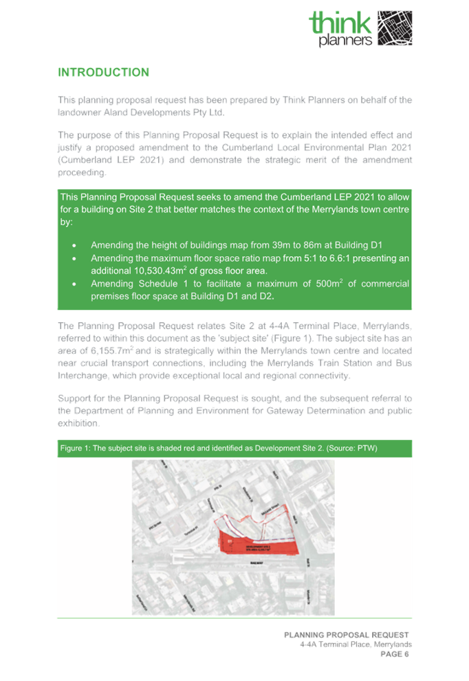
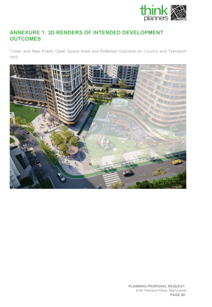
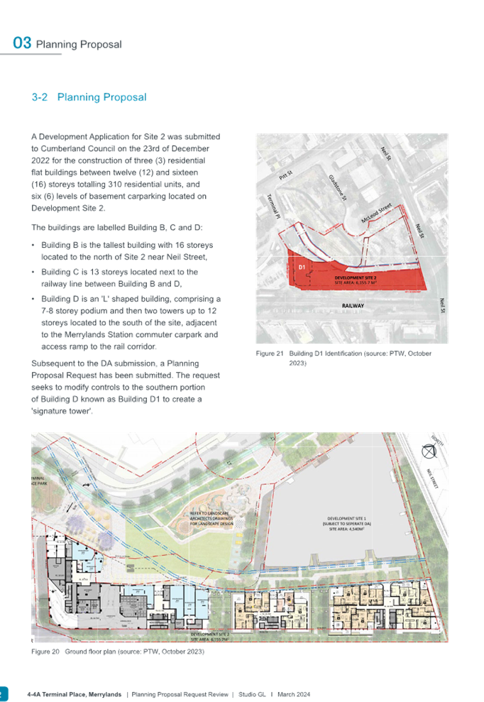
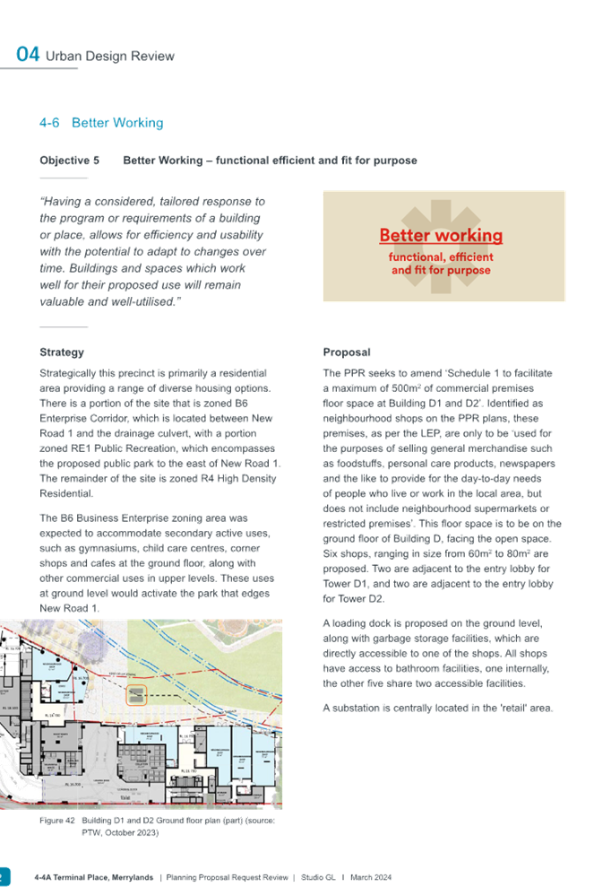
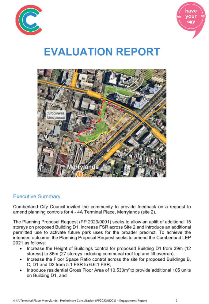
Council has received a Planning Proposal that relates to 4-4A Terminal Place, Merrylands, which is located adjacent to the Merrylands Transport Interchange (bus, railway station and commuter carpark) within the Merrylands Town Centre. Development Application (DA2022/0776) is currently being assessed and subject to the determination by the Sydney Central City Planning Panel, which facilitates the development of four residential towers ranging from 12-17 storeys (Buildings B, C, D1 and D2) consisting of 303 residential apartments, 6 neighbourhood shop tenancies with basement car parking on-site.
The primary purpose of the Planning Proposal is to facilitate the delivery of additional residential apartments across Site 2 at this location for Buildings B, C, D1 and D2, and to introduce an additional permitted use for commercial premises to activate future park uses for the broader precinct.
The Planning Proposal Request was placed on early consultation from 30 January 2024 to 28 February 2024 and reported to the Cumberland Local Planning Panel in April 2024. In response to preliminary public feedback and review by Council officers, it is recommended that Council progress with an amended Planning Proposal for the site, which results in reduction of building height for proposed Building D1 and Floor Space Ratio controls to minimise potential built form impacts with regard to bulk and scale, building height and residential amenity, as well as ensuring that the provision of commercial premises as part of the additional permitted use does not create an adverse impact.
It is recommended that the amended Planning Proposal once be prepared and be forwarded to the Department of Planning, Industry and Environment for a Gateway Determination. Should a Gateway Determination be received, Council officers will enter into discussions with the Proponent to negotiate and to prepare a Voluntary Planning Agreement, which is consistent with legislative and policy requirements.
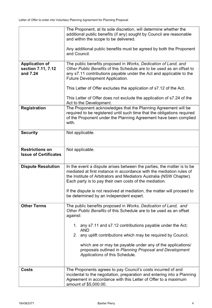
|
Recommendation That Council: 1. Endorse an amended Planning Proposal to be prepared for 4-4A Terminal Place, Merrylands (Site 2) applying to Lot 1 DP 1173048, Part of Lot 1 DP 229589, and Part of Lot 1 DP 1302939 (R4 zoned land), that seeks to amend the Cumberland Local Environmental Plan (LEP) 2021, to: a. Increase Height of Buildings (HoB) controls for proposed Building D1 from 39 metres to 65 metres b. Increase proposed Floor Space Ratio controls for: I. Buildings D1 and D2 from 5:1 FSR to 5.5:1 FSR, and II. Buildings B and C from 5:1 FSR to 6:1 FSR c. Apply a gross floor area of not exceeding 500m2 of ‘commercial premises’ as an additional permitted use for proposed Buildings D1 and D2 (Block D) only. 2. Endorse that the planning proposal for 4-4A Terminal Place, Merrylands be forwarded to the Department of Planning, Housing and Infrastructure for a Gateway Determination. 3. Prepare a Voluntary Planning Agreement to derive public benefit, should a Gateway Determination be received. |
Report
Background
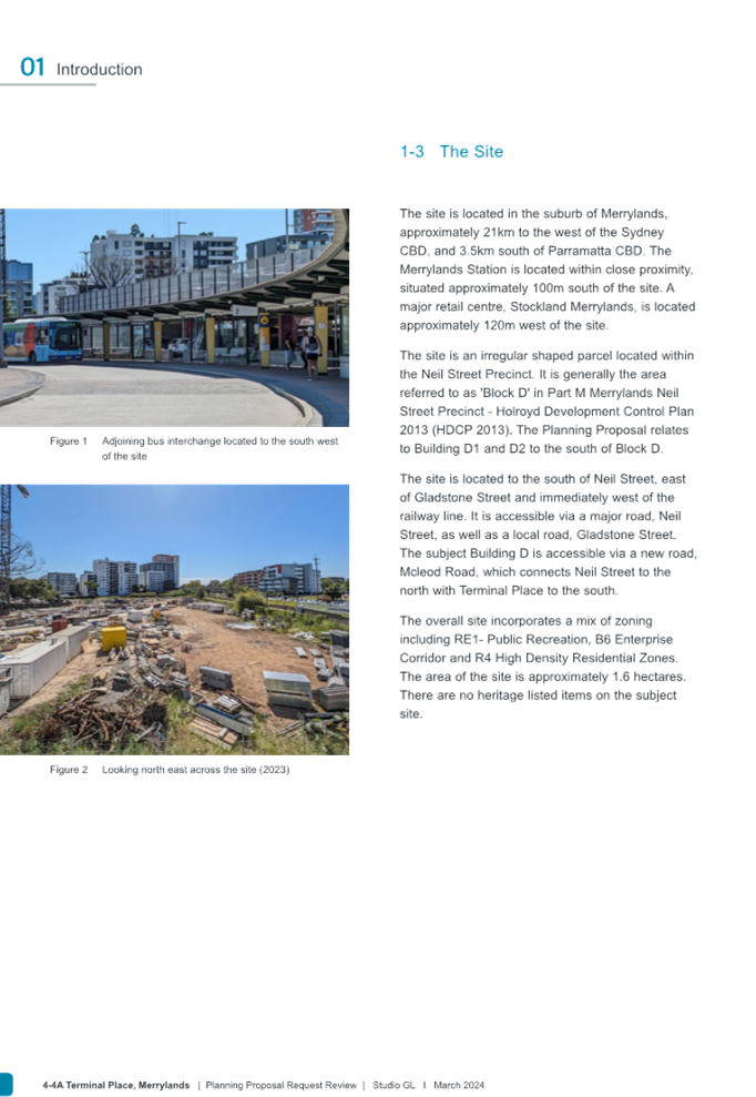
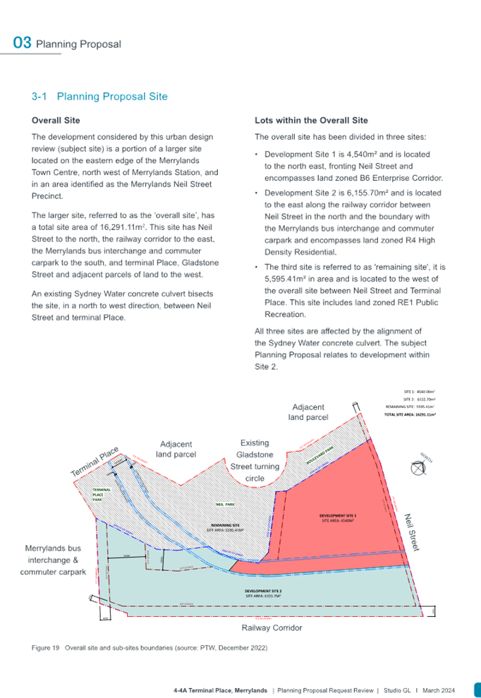
The Planning Proposal Request (PP2023/0001) relates to Site 2 at 4-4A Terminal Place, Merrylands that is located adjacent to the Merrylands Transport Interchange (bus, railway station and commuter carpark) within the Merrylands Town Centre.
On 18 October 2023, Aland Pty Ltd (the Proponent/developer) and Think Planners (Proponent’s Planning Consultant) lodged a Planning Proposal Request with Council for land at 4 – 4A Merrylands Terminal Place, Merrylands (Site 2), which is legally described as Lot 1 DP 1173048, Part of Lot 1 DP 229589, and Part of Lot 1 DP 1302939 on behalf of the landowner Merrylands 88 Development Pty Ltd.
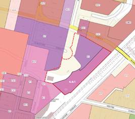
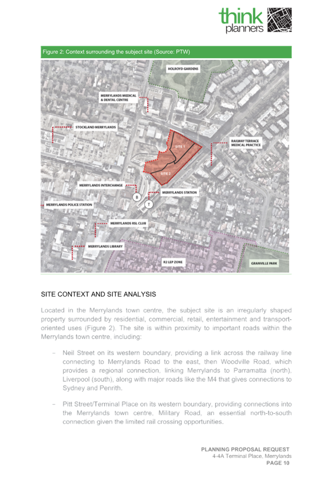
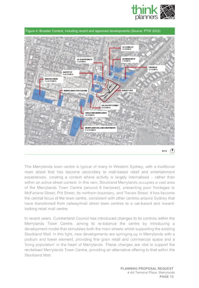
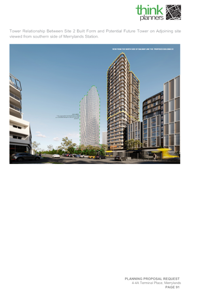
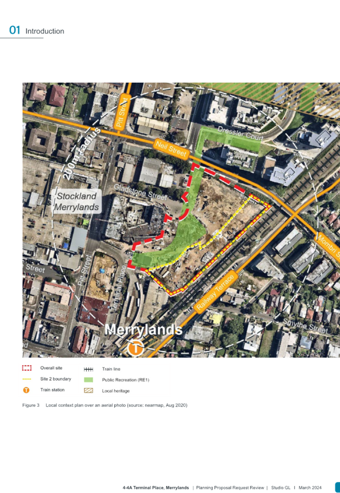
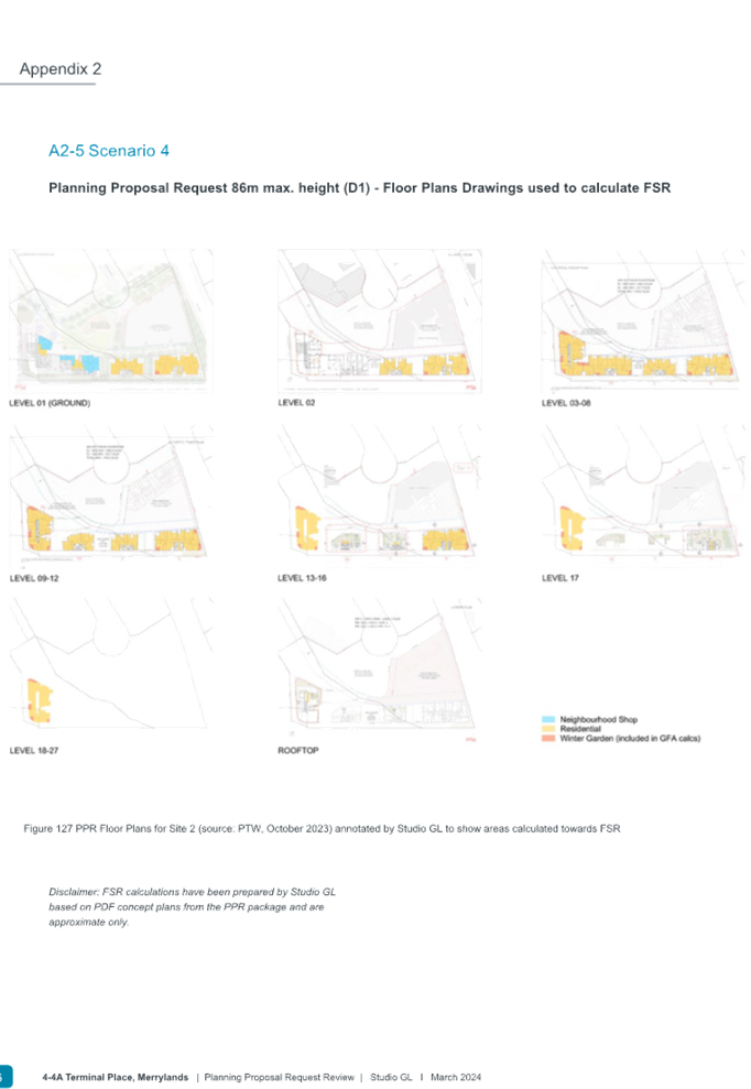
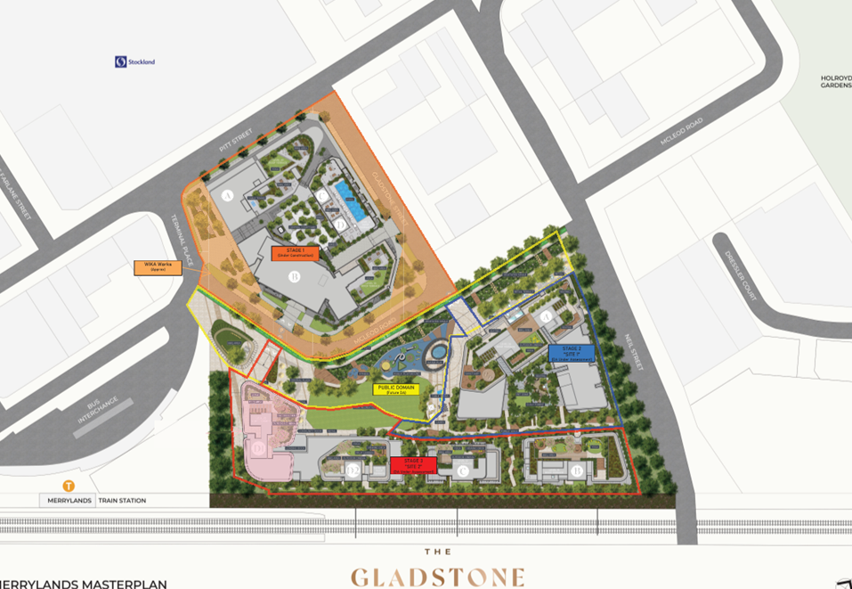
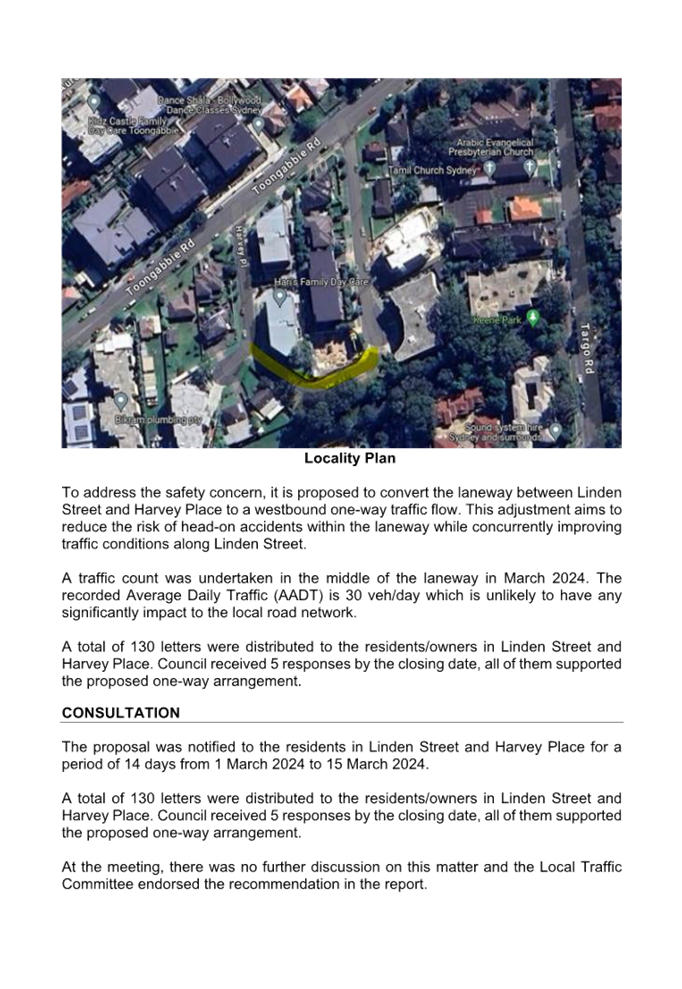
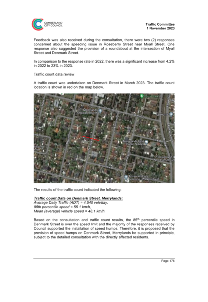
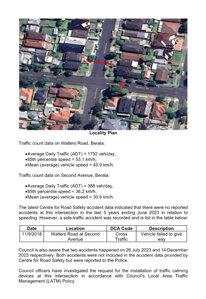
Site 2 situated within Block D in Neil Street Precinct (strategic precinct) is outlined in yellow in Figure 1 below and forms part of the Gladstone Village, a staged masterplan development site, as outlined in red with approximately 16,289m2 in area. The overall site (Sites 1 and 2) will facilitate the development of 3 residential towers (Buildings B, C, D1 and D2) subject to this Planning Proposal Request and a single mixed-use tower building (Building A), which was approved under DA2022/0722 the Sydney Central City Planning Panel (PP SSCC-414) on 26th March 2024, comprising 236 apartments, basement car parking and 4 commercial tenancies. The developer will also be involved within the precinct in the delivery of public parks and local road, and the upgrade to the existing public domain.
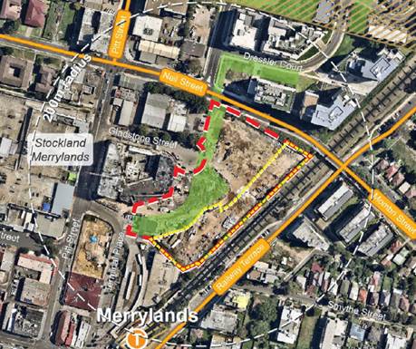
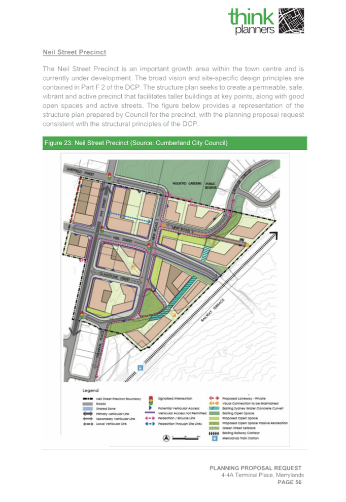
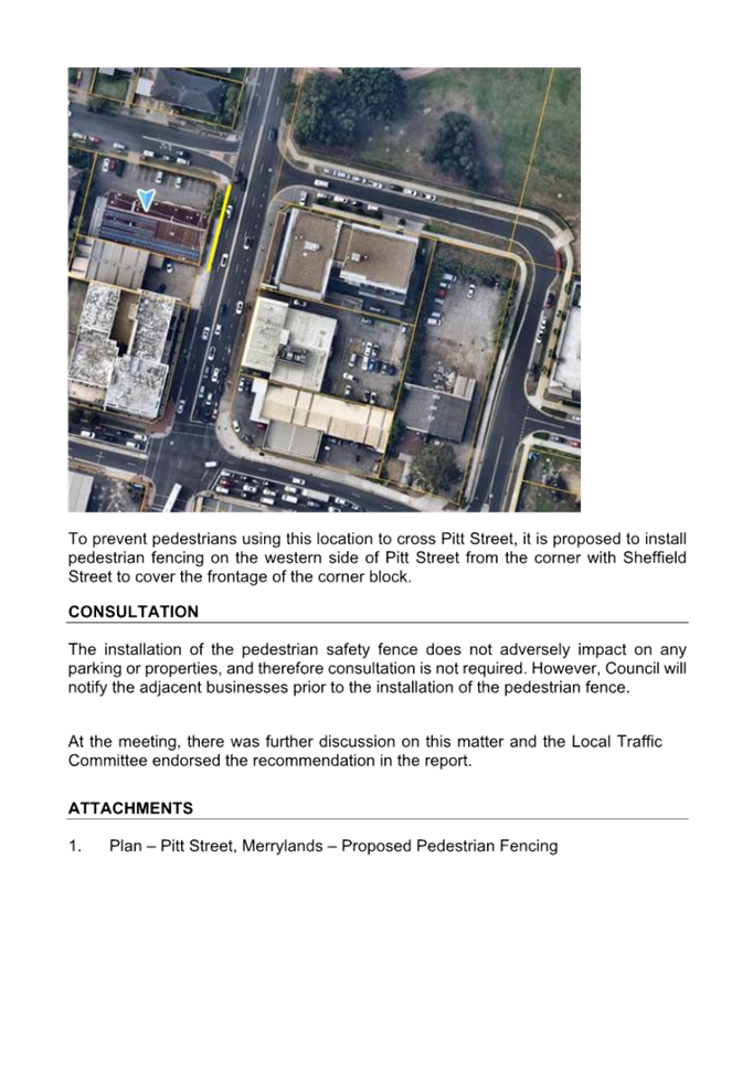
Figure 1: Proposed Site 2 and surrounds (Source: Studio GL, March 2024)
Development Application (DA2022/0776) lodged for the development of four residential towers (Buildings B, C, D1 and D2) comprising 303 residential apartments, 6 neighbourhood shops with basement car parking on Site 2, is currently still under assessment and will be subject to the determination by the Sydney Central City Planning Panel (PP SSCC-424). Should the approval be granted for these residential towers, Building D1 will become the tower base of the proposed development envisaged by this Planning Proposal Request.
The Planning Proposal Request seeks to amend the Cumberland Local Environmental Plan (LEP) 2021 as follows:
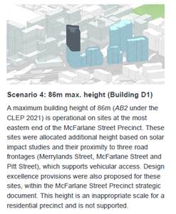
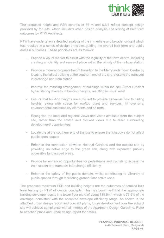
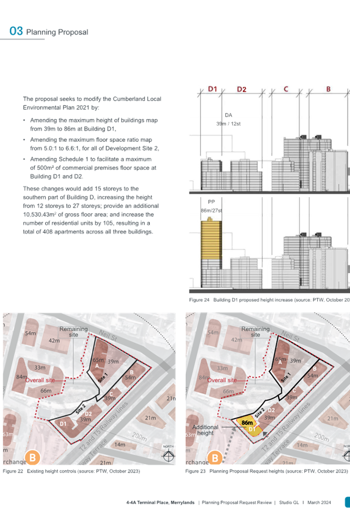
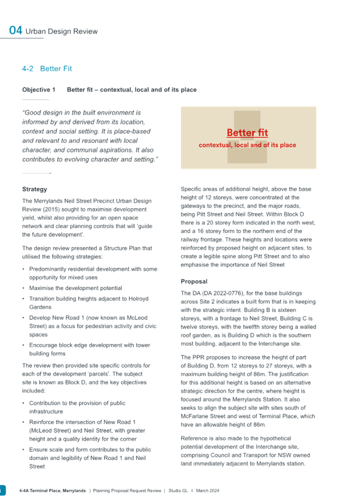
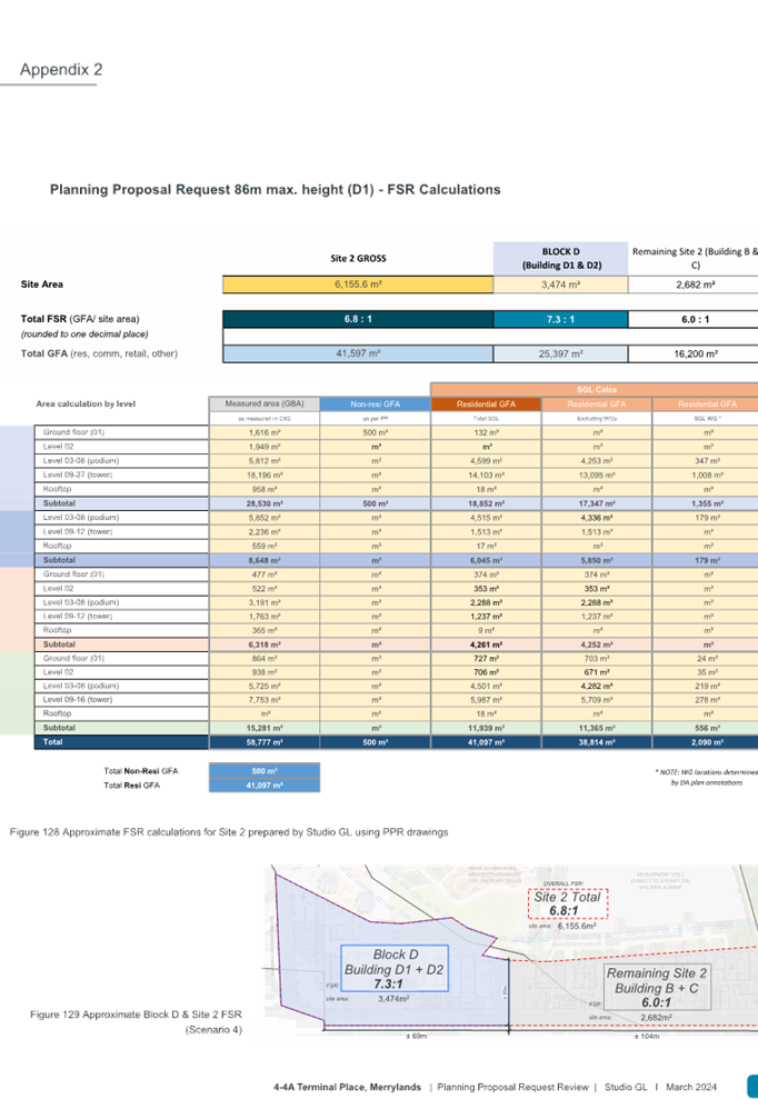
· To increase the Height of Buildings control for proposed Building D1, including communal roof top and lift overrun, from 39m (12 storeys) to 86m (27 storeys),
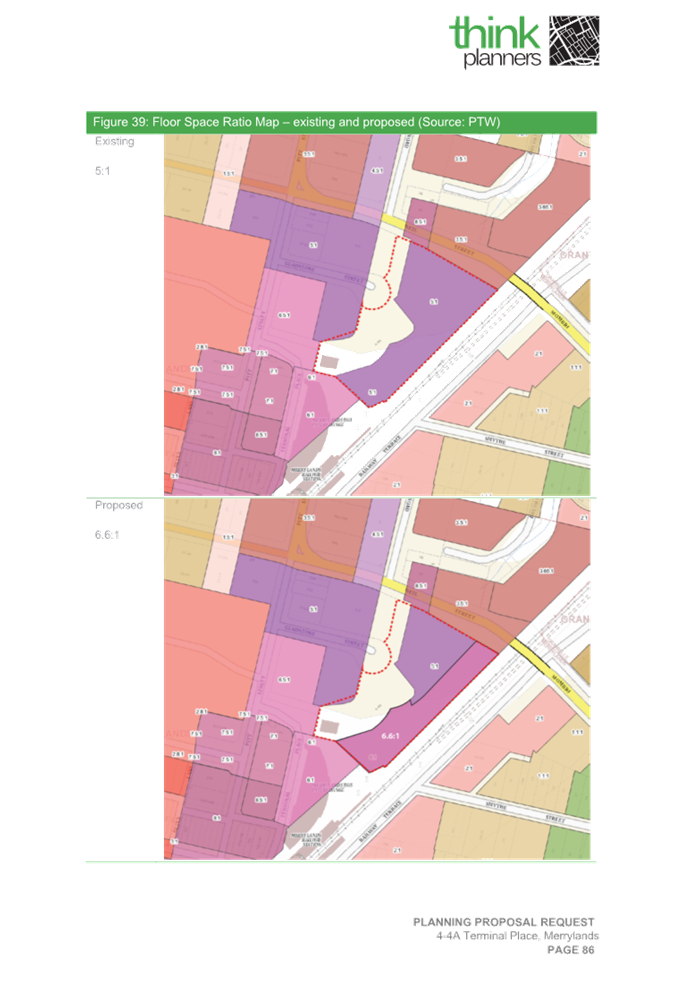
· To increase the Floor Space Ratio control across the site for proposed Buildings B, C, D1 and D2 from 5:1 FSR to 6.6:1 FSR,
· To introduce residential Gross Floor Area of 10,530m2 to provide additional 105 units on Building D1, and
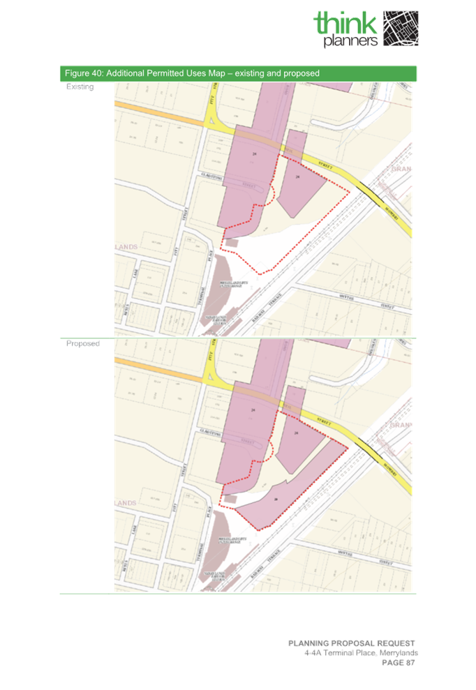
· To introduce 500m2 of commercial Gross Floor Area as part of an Additional Permitted Use to amend Schedule 1 where proposed Buildings D1 and D2 are located at ground floor.
It should be noted that if Council was to proceed with the Planning Proposal Request, an amended Planning Proposal will be required as recommended by Council officers that would accommodate approximately 43 dwellings. This is to further reduce impacts relating to proposed built form and building transition, view lines and residential amenity within Site 2, the broader Gladstone Village precinct, the Neil Street precinct, and the Merrylands transport interchange and town centre.
The proposal request is supported with a public benefit offer which is discussed in the main body of the report.
The status of the proposal is provided in Figure 2 below:
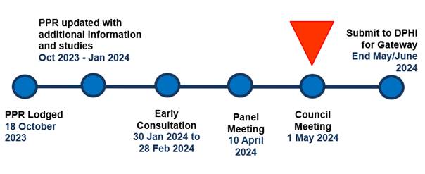
Figure 2: Status of Planning Proposal
Subject Site and Context
Subject site
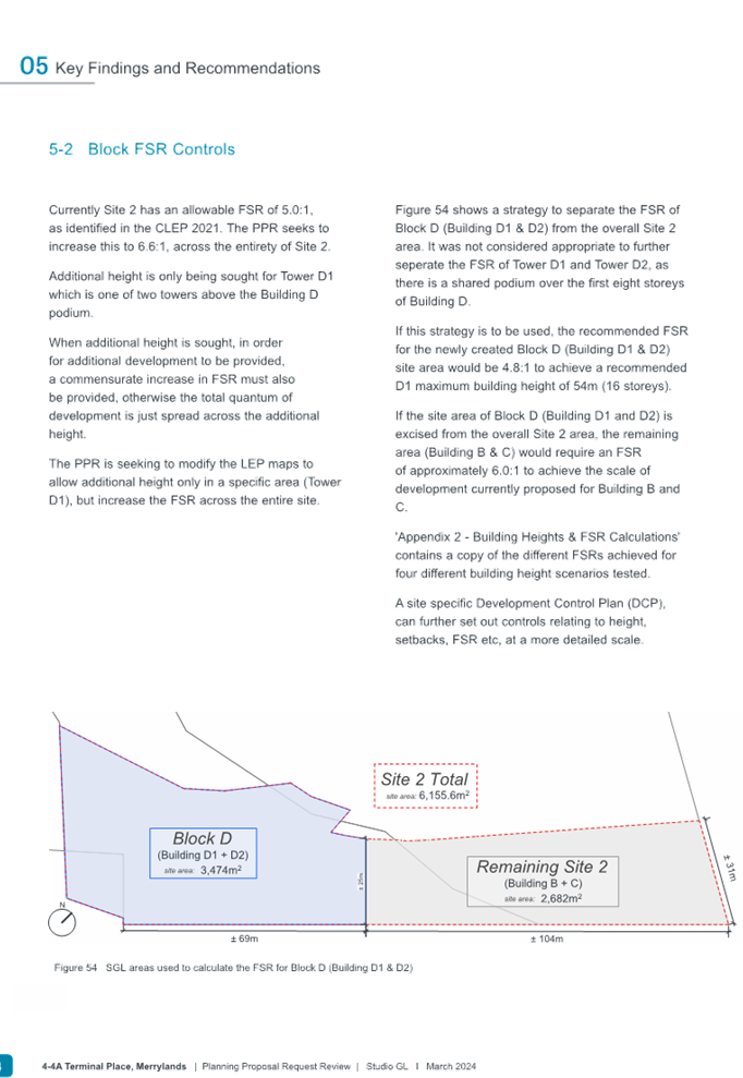
The proposed Site 2 is a large irregular shaped site with site area of 6155.6m2, comprising 3 lots which sits within Stage 3 of the overall masterplan. The site is currently void of existing buildings, structures, or vegetation. Figure 3 shows the location of the intended buildings to be situated within Site 2 and the overall Gladstone Village site. It is noted that proposed buildings and works annotated as Stage 1, Stage 2 (Site 1) and Public Domain as shown in Figure 3 below do not form part of this Planning Proposal Request site.
The Planning Proposal Request relates primarily to proposed Building D1, application of FSR for entire Site 2 and introduces additional permitted use to proposed Buildings D1 and D2 location. The location of the proposed buildings within Site 2 is outlined in red and as shown in Figure 3 below.
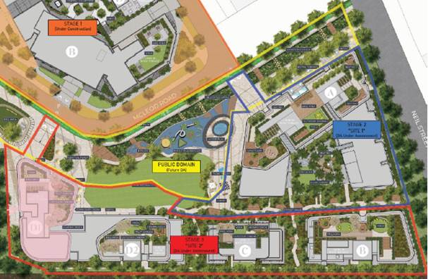
Figure 3: Masterplan overview and proposed Site 2
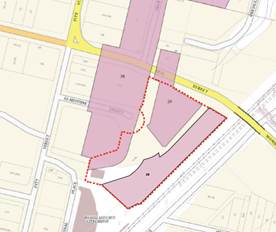
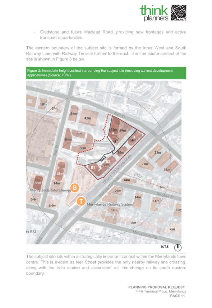
An approval for draft subdivision plan for the precinct has been issued under DA2023/0108 as shown in Figure 4 below, which shows consolidated Site 2 (marked with black arrow) that adjoins the main southern railway line from the immediate east and adjoins Site 1 to the immediate west.
|
|
Figure 4: Proposed draft subdivision plan
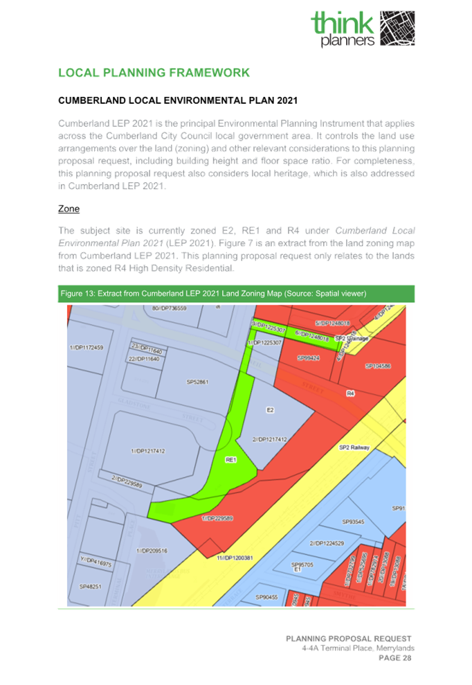
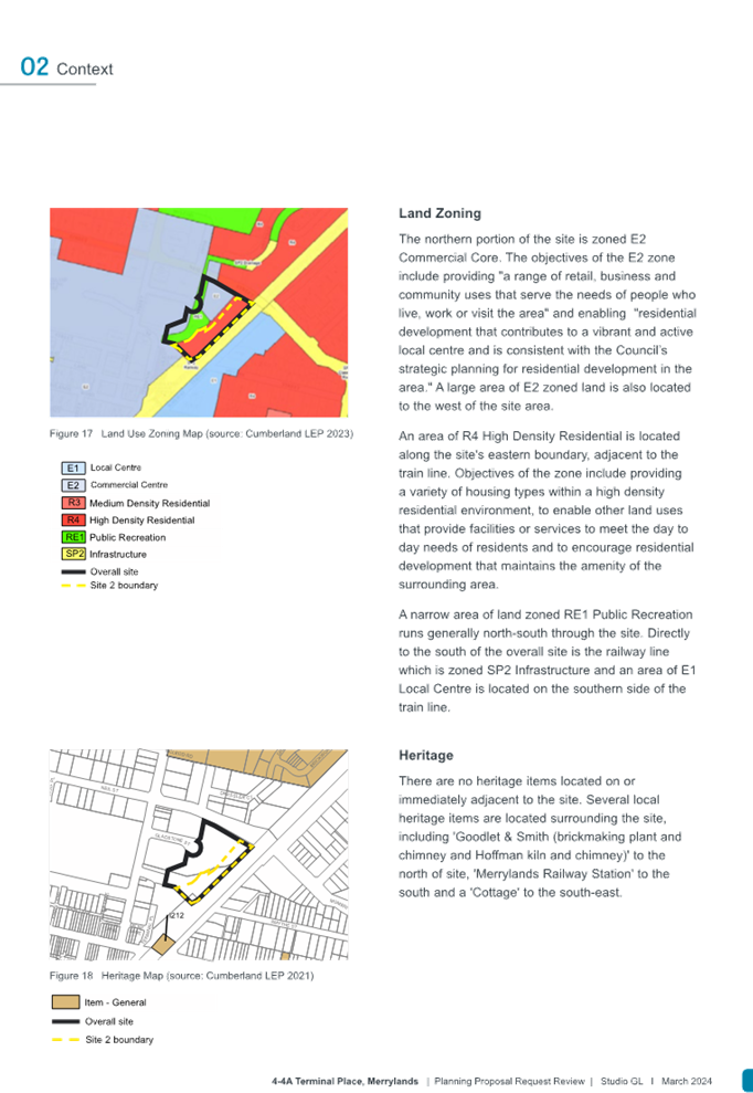
Site 2 is located within the land portion zoned as R4 High Density Residential only and excludes the application of E2 Commercial Centre and RE1 Public Recreation zonings. The existing planning controls and legal descriptions of the site are further tabled within the next section.
Regional context
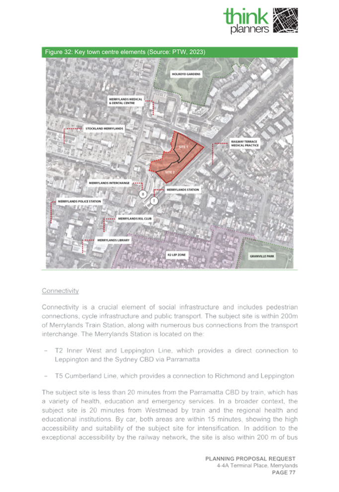
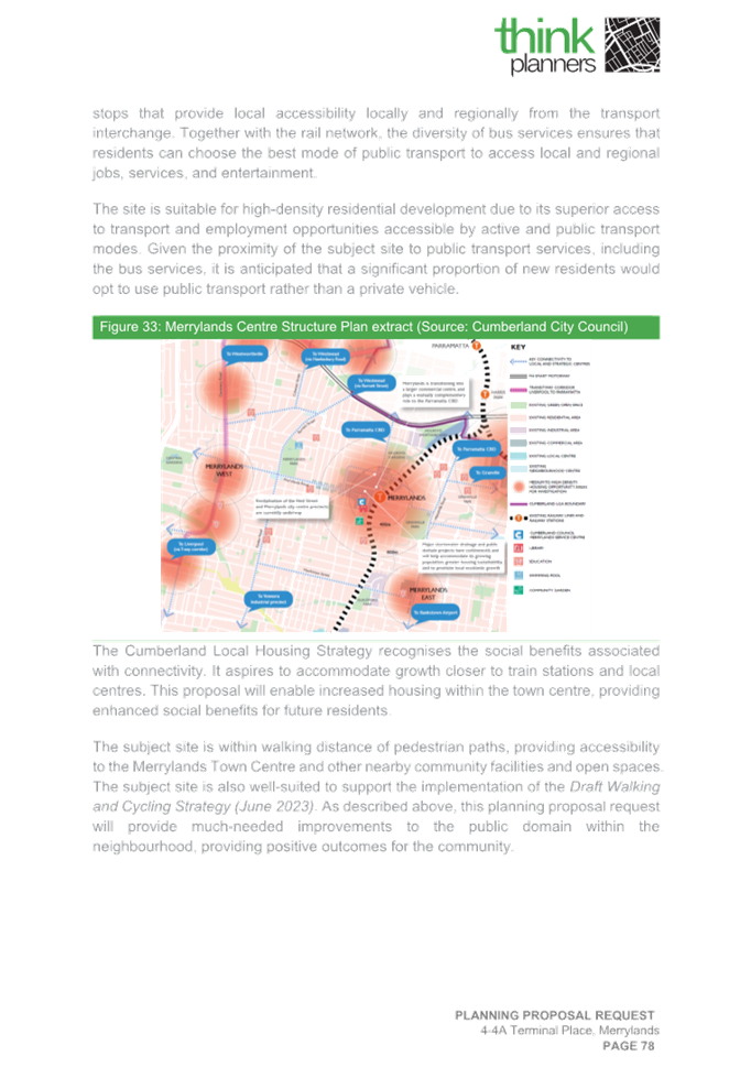
The proposed site is located within the Merrylands Town Centre, approximately 3.5 kilometres south of Parramatta Central Business District (CBD) and 25 kilometres west of the Sydney CBD. Merrylands Town Centre is Cumberland City’s proposed strategic centre, with good access to a diverse range of higher order services and facilities, retail/commercial and residential opportunities.
The proposed site is well-served by public transportation and local infrastructure, with Merrylands Railway Station and Transport Interchange located within 100-200 metres of the site to the south and west and bus transport services along both Merrylands Road, McFarlane Street, Pitt Street and Neil Street. Major arterial roads servicing the region are located within close proximity to the site, which include Woodville Road, M4 Motorway and Cumberland Highway.
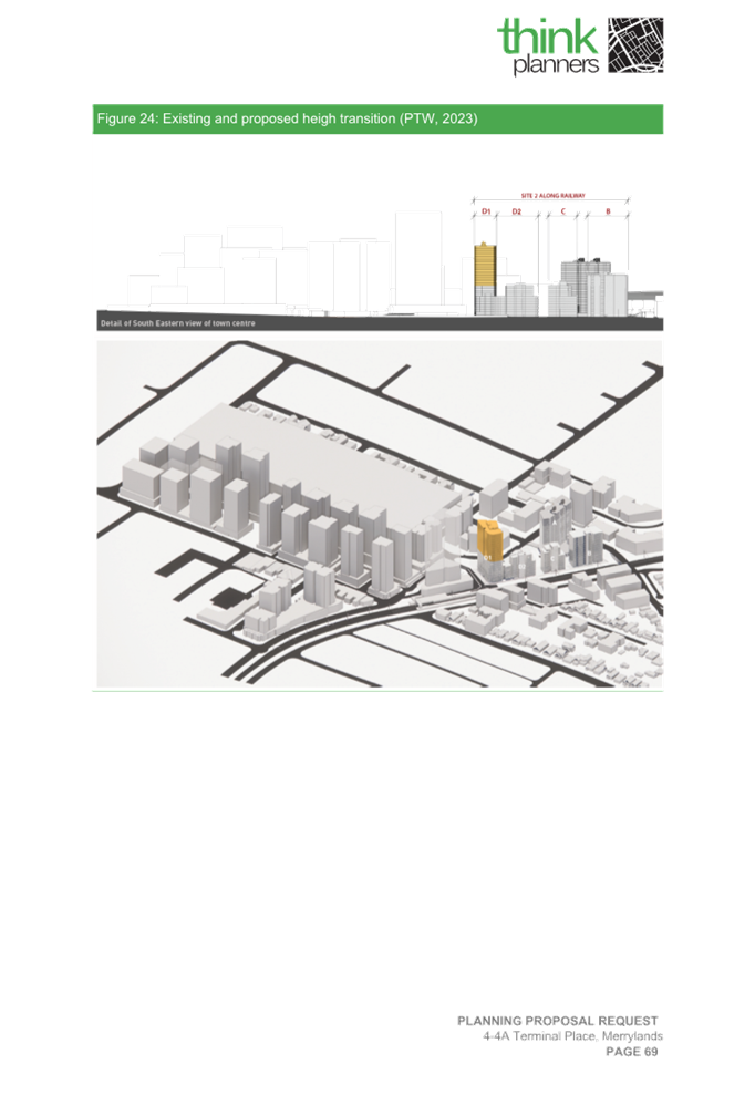
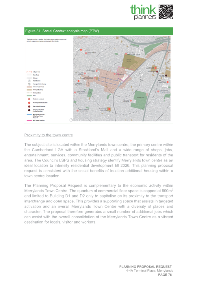
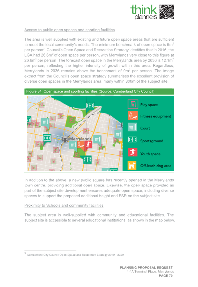
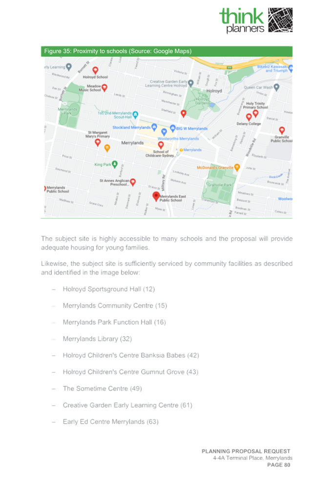
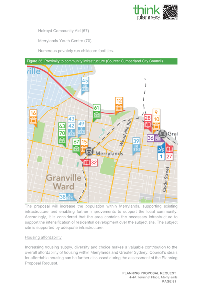
The site is further located approximately 360m from existing Granville Park, approximately 250m from Holroyd Gardens Park and approximately 170m from the Merrylands Civic Town Square, the Merrylands Stockland Mall and the McFarlane Street Precinct, which is considered as a prime commercial/retail precinct with schools, community facilities and services.
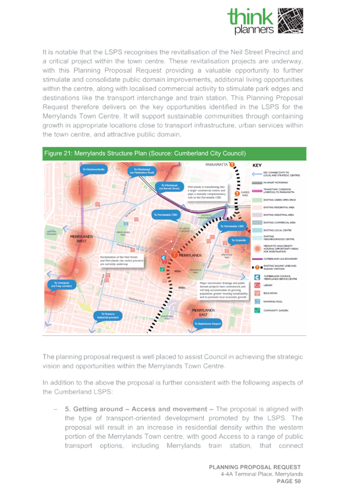
Council’s Cumberland 2030: Our Local Strategic Planning Statement shows that the Neil Street Precinct revitalisation is currently underway.
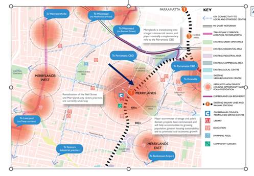
Figure 5: Proposed site’s location within the Merrylands Town Centre
Local context
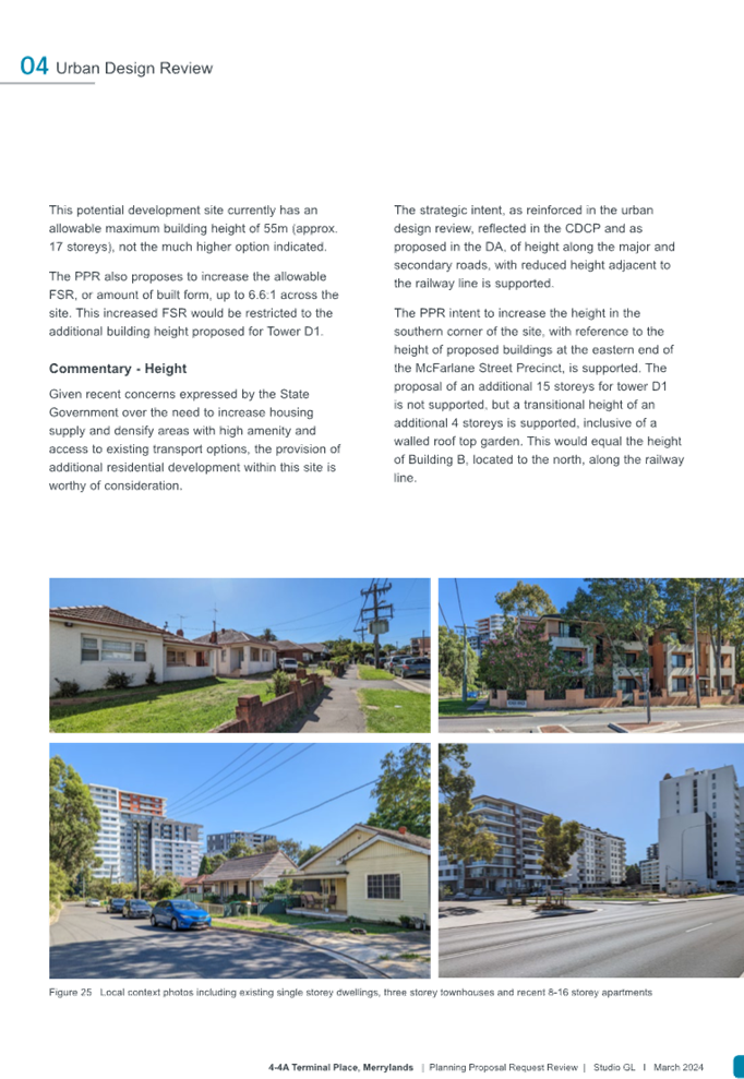
The proposed site is located within the 200m radius of the Merrylands Town Centre and forms part of the Gladstone Village development site. The site is also located within Block D of the existing Neil Street Precinct, which is currently undergoing development transition.
The site further adjoins the Merrylands Transport Interchange that is characterised with development up to 3 storeys in height approximately from south and borders the T2 and T5 southern railway lines from east. The northern part of the site is bounded by Neil Street and residential flat buildings development to the height of 6-9 storeys, while the eastern part of the site adjoins land earmarked for future park and Site 1.
Currently, the precinct surrounds are characterised by a mix of different building typologies, which includes high density residential developments, low scale developments with some commercial uses with new development occurring. The surrounding areas are characterised by new mixed use and high-density residential developments with some older style buildings (circa 1970s) along Merrylands Road.
Part of the Merrylands Transport Interchange site is owned by Council and part of the Merrylands Station land is owned by Rail Corporation NSW. Council currently has not indicated any future plans to increase the existing density or building height for this site by amending the Cumberland LEP 2021. The planning controls for the transport interchange site will remain for 55m in building height and 6:1 in FSR.
Pre-lodgement Meeting with Proponent
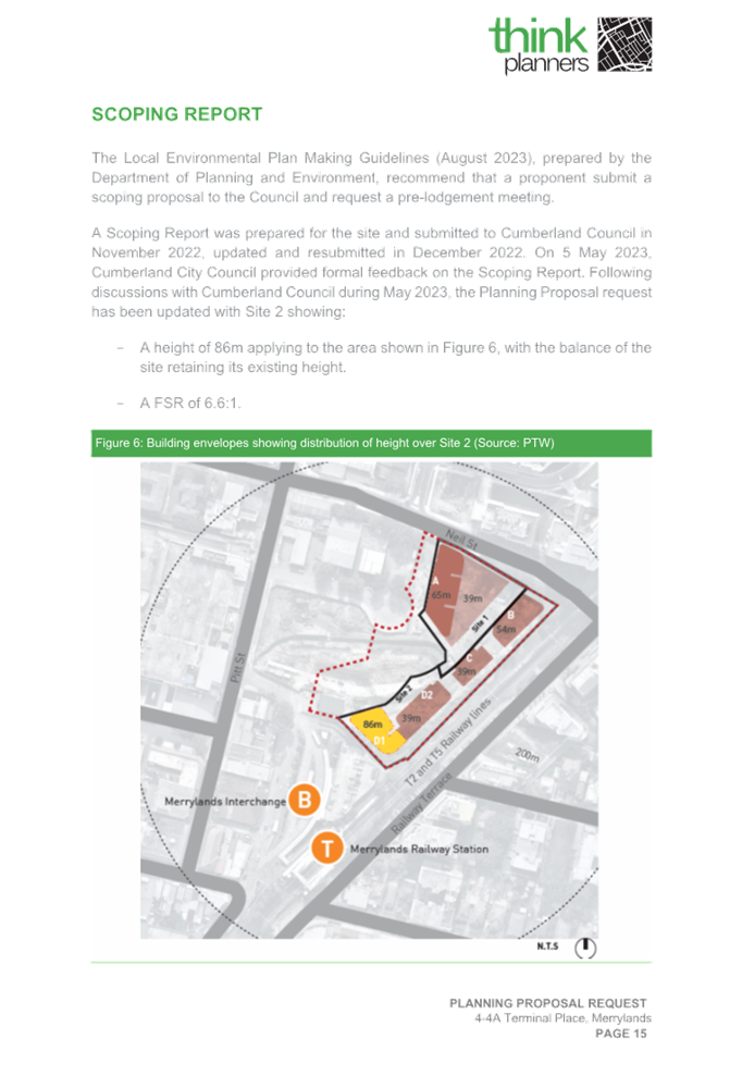
In November/December 2022, the Proponent lodged a scoping proposal for the site with a proposal to achieve a 115m maximum building height for Building D1 and applied a proposed 6.4:1 FSR across the proposed Site 2, which was later corrected as 6.6:1 FSR after some discrepancies were found.
In May 2023, a meeting was held between Council officers and the Proponent regarding the Scoping Proposal lodged for 4-4A Terminal Place Merrylands, and the following matters were discussed and raised prior to the lodgement of any Planning Proposal Request:
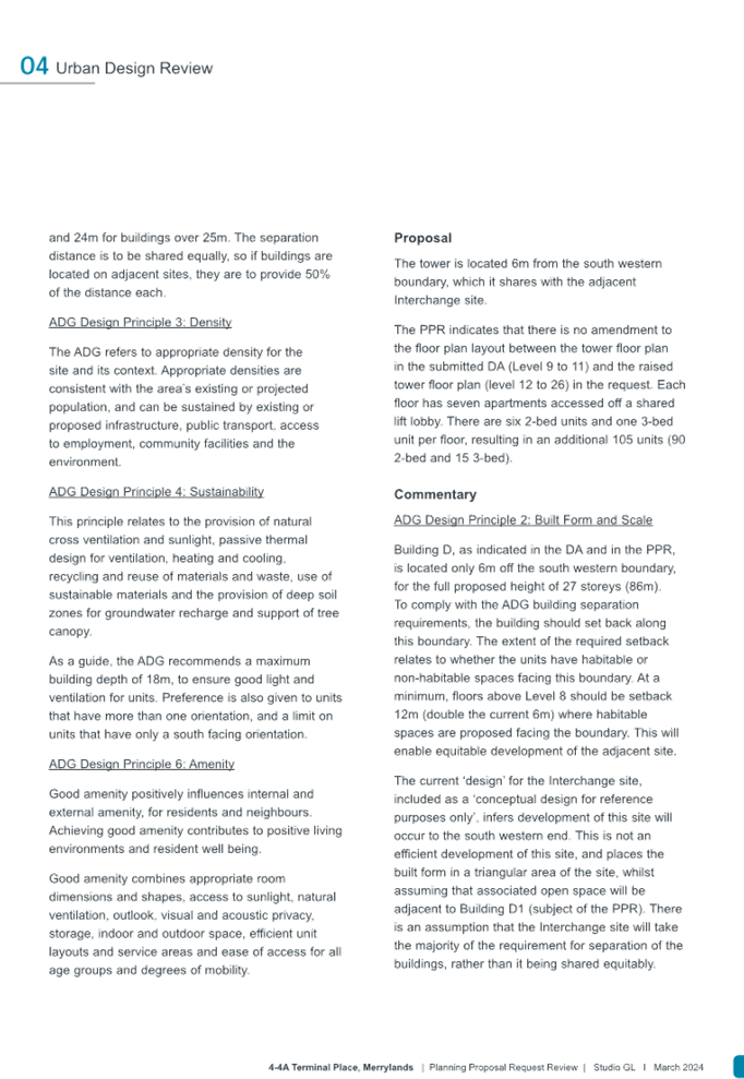
1. Built form modulation and ADG compliance,
2. Overshadowing impact from the additional proposed building height,
3. Interchange site re-development,
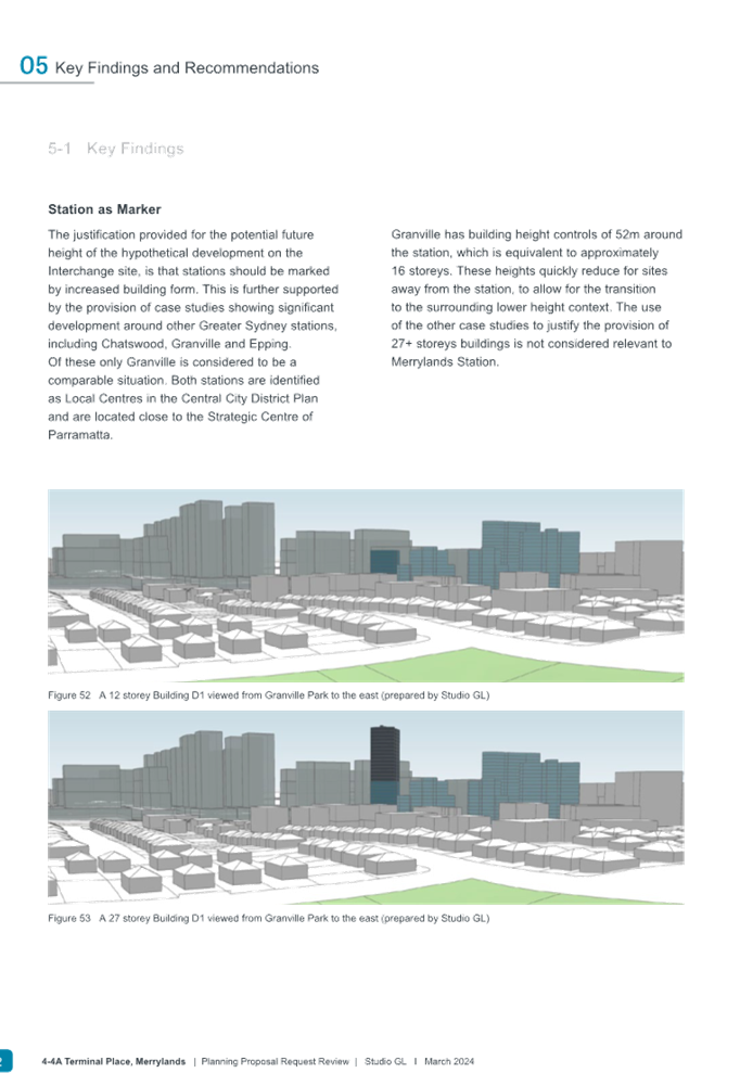
4. Station as marker in Local Centres,
5. Inappropriate location of driveway access,
6. Justification for the proposed additional FSR,
7. Traffic, access, and parking,
8. Planning agreement requirements, and
9. External agencies feedback.
Council requested the proponent to further revise the proposal and to reduce the impacts resulting from the proposed building height, bulk and scale, overshadowing and residential amenity in consideration with the vision and objectives of the Neil Street Precinct.
Council officers also raised concerns regarding the proposed increase to the existing building height and density of Merrylands Transport Interchange as part of the justification submitted to support the proposal to increase principal development controls at Site 2.
Following this, a Planning Proposal was lodged with Council in October 2023 and updated with additional information in January 2024.
Development Application (DA)
On 23rd December 2022, Council accepted a Development Application (DA2022/0776) for Site 2 and this DA is currently being assessed and will be referred to the Sydney Central City Planning Panel for a determination.
The above application proposes the construction of 4 residential towers (Buildings B, C, D1 and D2) ranging from height of 12 to 17 storeys and comprising 6 neighbourhood shop tenancies, and a total of 303 apartments including six levels of basement car parking with associated works. Table 1 provides a summary of the DA scheme that is being assessed.
|
Building |
No of storeys |
No of apartments |
Description |
|
Building B |
17 storeys (54m) |
126 |
· The DA lodged, includes a total of 303 residential apartments, 6 neighbourhood shop tenancies occupying a total area of approximately 426m2 and 6 basement levels with 439 car spaces.
The apartments include the following mix: · 28 x 1-bedroom apartments · 228 x 2-bedroom apartments · 47 x 3-bedroom apartments
|
|
Building C |
12 storeys (39m) |
43 |
|
|
Buildings D1 & D2 (linked with common podium) |
12 storeys (39m) |
134 |
Table 1: Overview of existing DA2022/0776
Existing Planning Controls
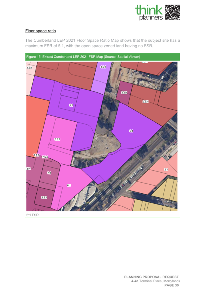
The site is subject to planning controls contained in Cumberland LEP 2021. The following key controls apply to the site:
· Land Zone: R4 High Density Residential,
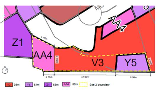
· Height of Buildings: 39m (V3) and 54m (Y5),
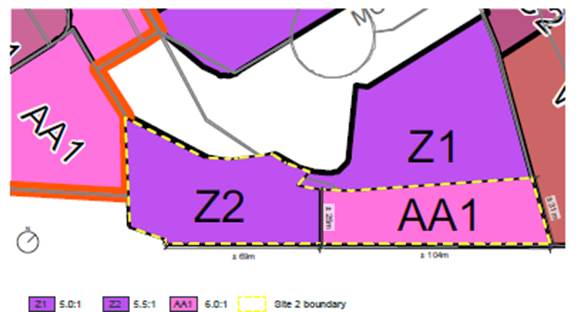
· Floor Space Ratio: 5:1 (Z1), and
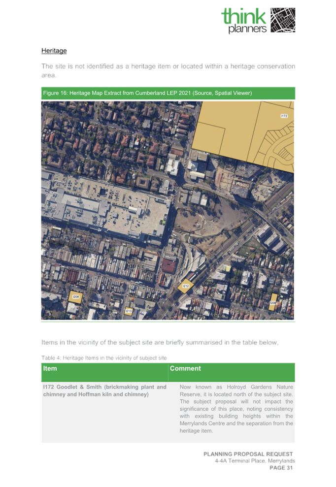
· Heritage: Item I212 (Merrylands Railway Station).
Table 2 outlines the existing planning controls under the Cumberland Local Environmental Plan (LEP) 2021 apply to the proposed site.
|
Property Address |
Lot & DP |
Land affectation (full/part) |
Existing Land Zoning (LZN) |
Existing Maximum Height of Buildings (HoB) |
Existing Floor Space Ratio (FSR) |
|
4-4A Terminal Place, Merrylands (Site 2) |
Lot 1 DP 1173048 |
Applies to entire lot |
R4 High Density Residential |
V3 (39m) |
Z1 (5:1 FSR (applying to R4 zone only) |
|
Part of Lot 1 DP 229589 |
Affected by multiple zones but the proposal applies only to R4 High Density Residential portion |
Part R4 High Density Residential, Part E2 Commercial Centre and Part RE1 Public Recreation |
V3 (39m)
|
Z1 (5:1 FSR) (applying to R4 zone only) |
|
|
Part of Lot 1 DP 1302939 |
Affected by multiple zonings but the proposal applies only to R4 High Density Residential portion |
Part R4 High Density Residential, Part E2 Commercial Centre and Part RE1 Public Recreation |
V3 (39m) Y5 (54m)
|
Z1 (5:1 FSR applying to R4 zone only) |
Table 2: Legal description and existing Cumberland LEP 2021 planning controls for Sites 1 and 2
Figures 6, 7, 8 and 9 below contain LEP mapping extracts for the above existing planning controls.
|
Figure 6: Land Zoning (R4) |
|
|
Figure 7: Height of Buildings (V3 - 39m & Y5 - 54m) |
|
|
Figure 8: Floor Space Ratio (Z1- 5.0:1) |
|
|
Figure 9: Heritage (Item I212) Merrylands Station |
|
Planning Proposal Request
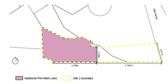
Figures 10, 11 and 12 below contain extracts from the PTW Urban Design Report (Rev E, October 2023) submitted to support the Planning Proposal Request to amend the Cumberland LEP 2021, which indicate the proposed Height of Buildings and Floor Space Ratio controls, and the Additional Permitted Use sought.
|
|
Figure 11: Proposed Floor Space Ratio (6.6:1 FSR) |
|
Figure 12: Proposed Additional Permitted Use application (500m2 of Commercial Premises) |
|
The Planning Proposal Request states that the proposed development scheme is intended to:
· Provide a height and FSR that is more consistent with the location of the site within the existing Merrylands Town Centre, railway station and transport interchange.
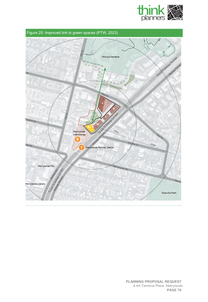
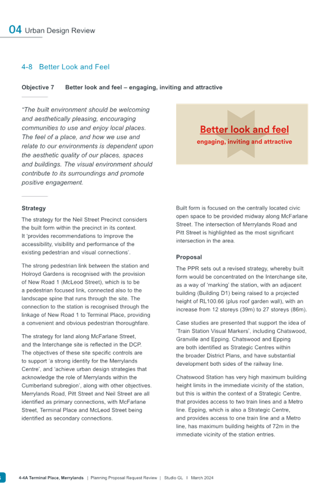
· Provide a good urban design outcome for the site and broader Neil Street Precinct, serve as a marker building to the existing Merrylands Transport interchange to assist the legibility and improve the relationship to the existing Merrylands Town Centre.
· Complement the economy with the Merrylands Town Centre by additional opportunities for employment, adjacent to transport interchange and fronting parks.
· Create an identity and a sense of place within the vicinity of the existing Merrylands Railway Station because the existing Merrylands Transport Interchange lacks an identity currently.
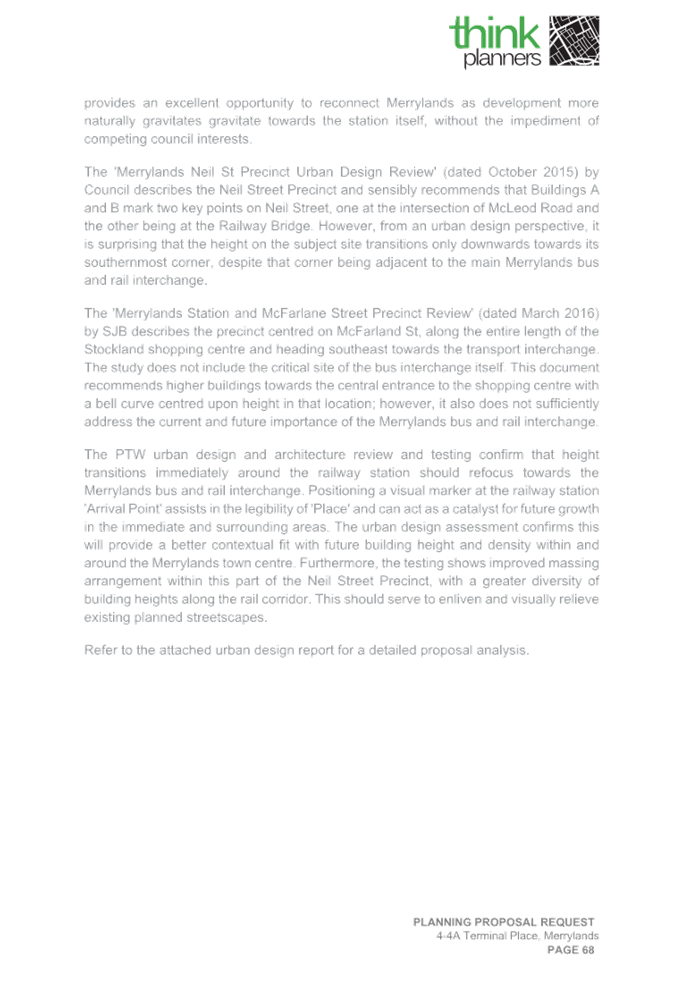
· Provide a more suitable building height transition to Merrylands Town Centre by locating the tallest building at the southern end of the site close to the transport interchange and improve the massing arrangements of buildings within the Neil Street Precinct by facilitating varying building heights.
· Contribute to a mode shift from private vehicles towards public and active transport modes by linking higher densities with public transport.
· Support the NSW government’s vision for a more diverse housing mix leading to greater choice and ideally housing affordability and deliver additional housing.
· Contribute to local economic growth without threatening the commercial viability of the existing Merrylands Town Centre, McFarlane Street Precinct and Stockland Mall commercial/retail precinct.
· Deliver increased housing within proximity to public transport, contributing to the NSW Government’s 30-minute city policy objective.
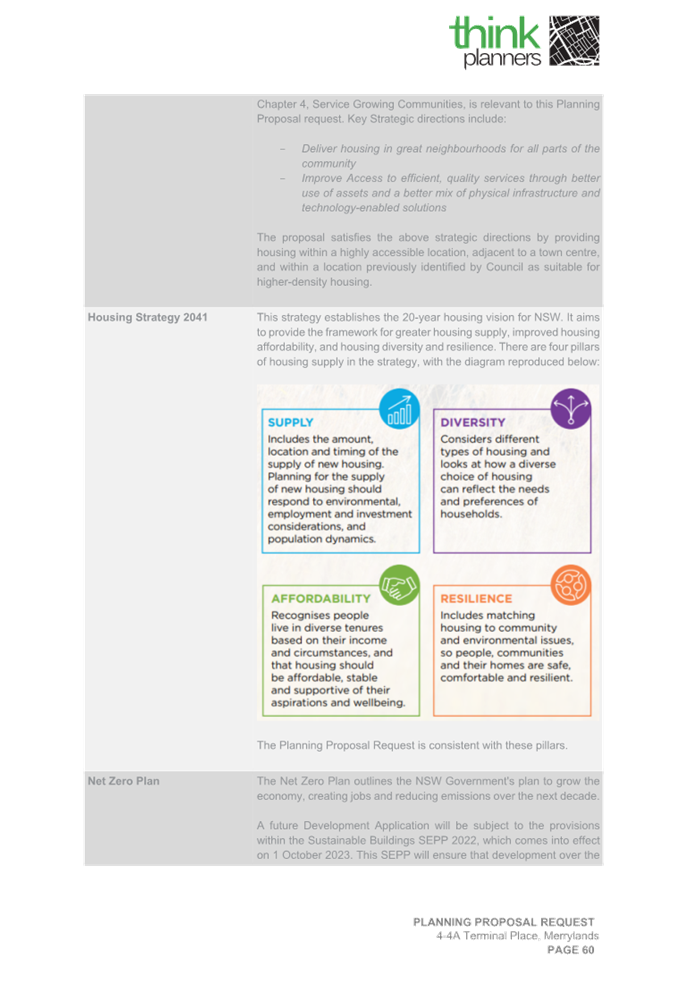
Strategic Considerations
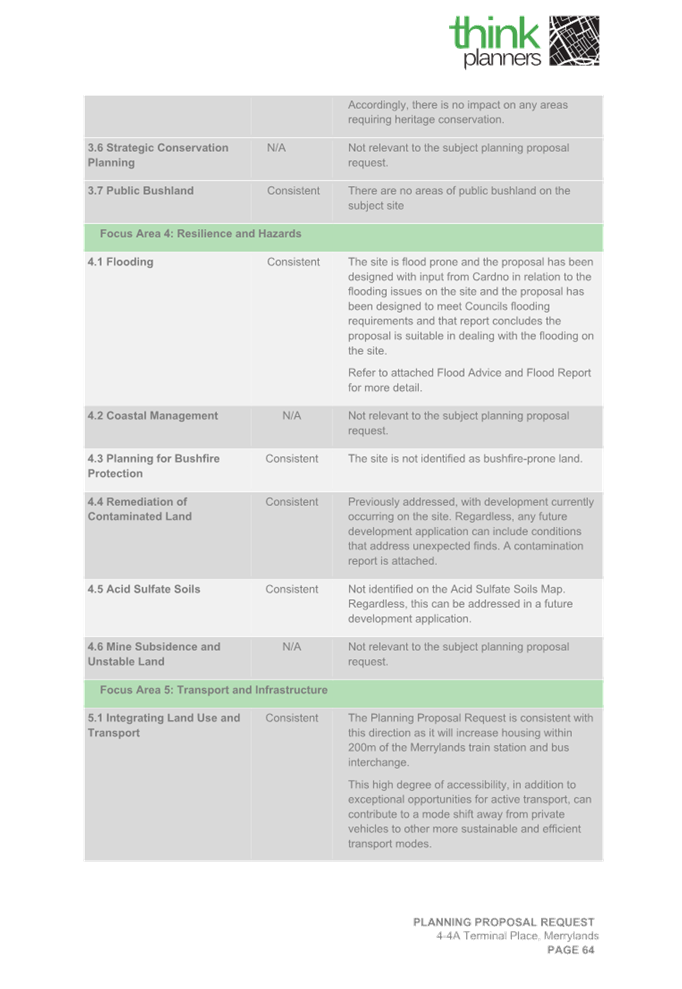
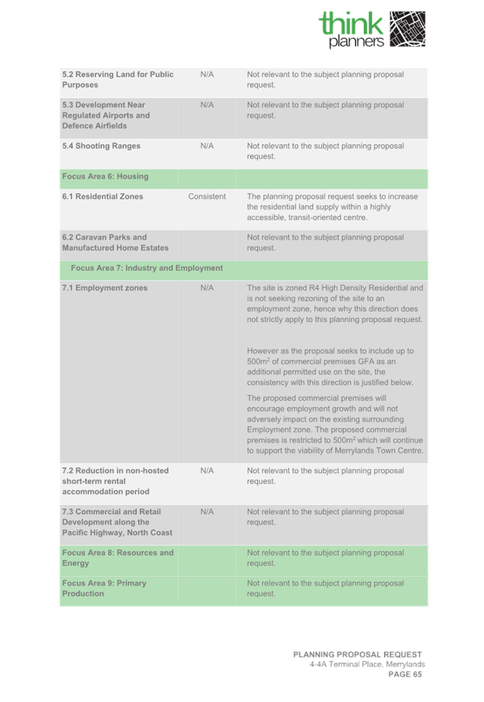
The Planning Proposal Request is broadly consistent from a strategic perspective when considered in relation to Region, District and Local Plans. These are further outlined below.
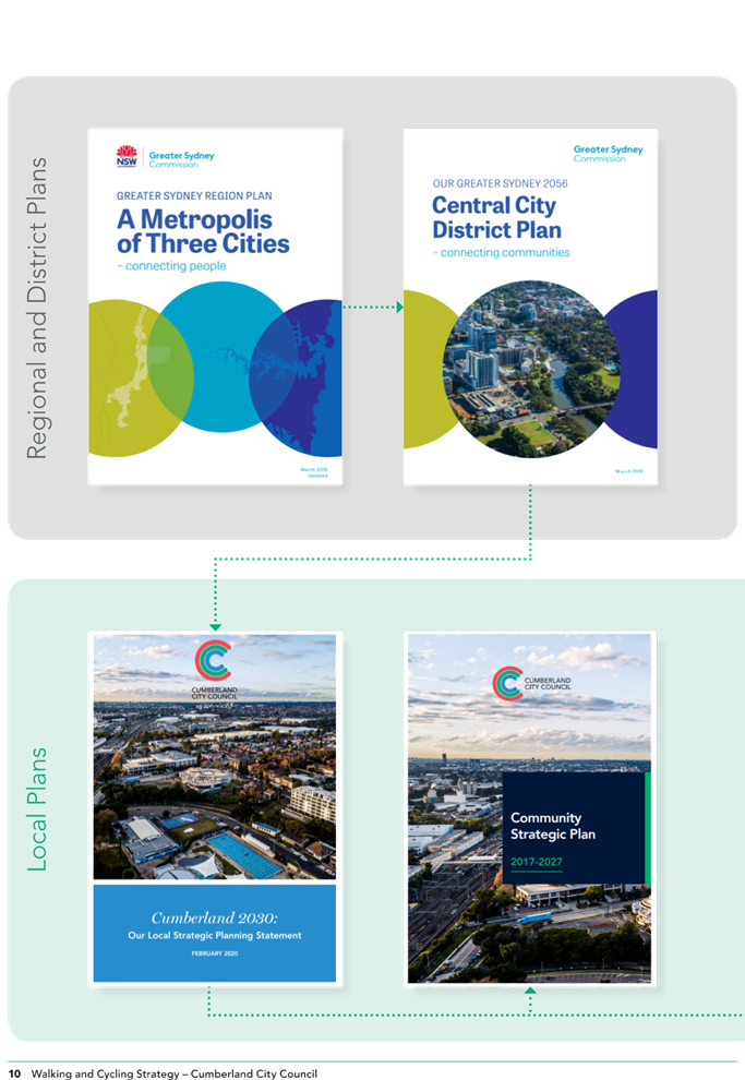
Consistency with A Metropolis of Three Cities - Greater Sydney Region Plan
The proposal is broadly consistent with Greater Sydney Region Plan, particularly the following Planning Directions:
· Planning Priority N1- City supported by infrastructure – the site is well connected to public transport infrastructure. The site and surrounds have been identified for increased residential development along with some commercial uses within the Merrylands Station and Neil Street Precinct Planning Proposal, as notified.
· City for its people – the future development will facilitate active uses and opportunities for social interaction. The proposed tower building will assist people to navigate through the town centre and proposed strategic centre.
· Housing in the City – the proposal will provide new housing adjacent to Merrylands Railway Station and the Merrylands Transport Interchange and set within a network of new roads, parks, and pathways.
· An efficient City – the proposal has potential to reduce transport costs and emissions by increasing the resident population with access to public transport and given the proposed site is within walking distance of an established town centre and proposed strategic centre.
Consistency with the Central City District Plan
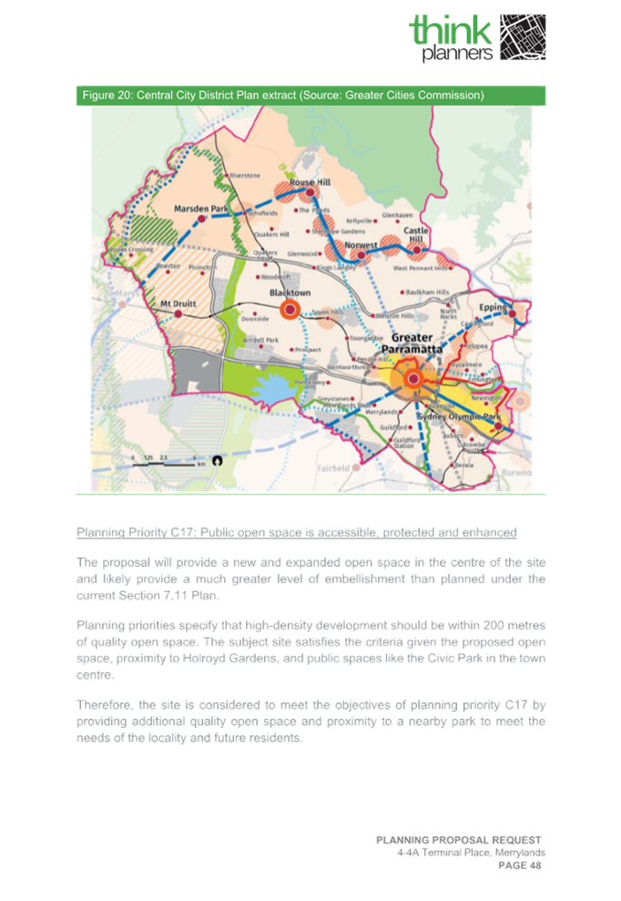
The proposal is broadly consistent with Central City District Plan, particularly the following Planning Priorities:
· Planning Priority C2 - Planning for a city supported by infrastructure – the proposal seeks to increase principal development controls close to key public open space, existing infrastructure such as near to the Merrylands Transport Interchange and within the Neil Street Precinct.
· Planning Priority C4- Fostering healthy, creative, culturally rich, and socially connected communities – the Planning Proposal Request forms part of the broader Gladstone Village masterplan providing housing for a culturally diverse community with greater access to public open space, local roads and promoting walking and cycling, healthy lifestyles with close access to public transport, schools, services and community facilities within the Merrylands Town Centre.
· Planning Priority C5 - Providing housing supply, choice, and affordability with access to jobs, services, and public transport – the Planning Proposal Request seeks to deliver additional jobs and housing in Merrylands Town Centre, Cumberland’s key Commercial Centre near to existing Merrylands Transport interchange. The site is accessible to all the jobs, services, and public transport of the Parramatta CBD.
· Planning Priority C9- Delivering integrated land use and transport planning and a 30-minute City – the proposed Planning Proposal Request forms part of a large residential development site within the Neil Street Precinct and is located within 200m or less walking distance with access to existing public bus and rail transport and the Merrylands Town Centre (proposed strategic centre) and is 30 minutes to Parramatta CBD.
Consistency with Cumberland 2030: Our Local Strategic Planning Statement
The proposal is broadly consistent with the Cumberland 2030: Our Local Strategic Planning Statement, particularly the following Local Planning Priorities:
· Local Planning Priority 3 – Align local infrastructure delivery with planned growth.
· Local Planning Priority 5 – Delivering housing diversity to suit changing needs, as the proposal will supply increase housing options for an ageing population.
· Local Planning Priority 6 – Deliver affordable housing suitable for the needs of all people at various stages of their lives, as the future redevelopment will incorporate several accommodation options to enable people form a variety of backgrounds and socio-economic status to age in place.
· Local Planning Priority 10 – Support a strong and diverse local economy across town centres and employment hubs.
Consistency with Cumberland Local Housing Strategy
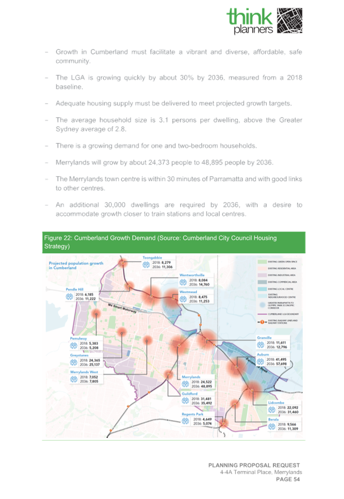
The Planning Proposal Request is generally consistent with the Cumberland Local Housing Strategy adopted by Council. The Merrylands Town Centre is Cumberland City’s ‘proposed strategic centre’. The area is identified as a prime location for housing in the Strategy, which will contribute to Cumberland’s housing target of 28,000 to 28,500 additional dwellings between 2016-2036. Should Council progress with an amended Planning Proposal as recommended the proposal is likely to provide approximately 43 additional residential apartments in addition to the DA being assessed. The proposed development site located within Neil Street Precinct is likely to contribute towards 2100 dwellings as envisaged in total.
Consistency with the Neil Street Precinct Masterplan
The Neil Street Precinct Masterplan Planning provisions was notified in late 2017. The envisaged vision, objectives and site-specific development controls are addressed in Part F2 of the Cumberland Development Control Plan (DCP) 2021. The Planning Proposal, as amended, is broadly consistent with the envisaged vision and objectives with the overall masterplan and specifically Block D of the Neil Street Precinct.
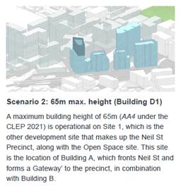
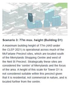
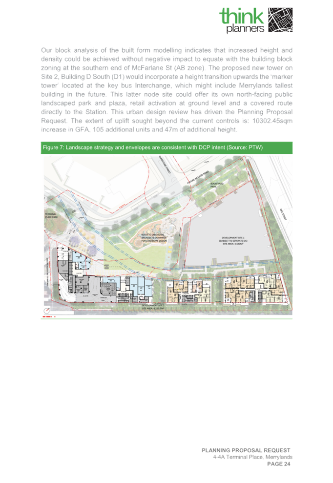
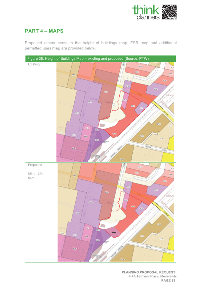
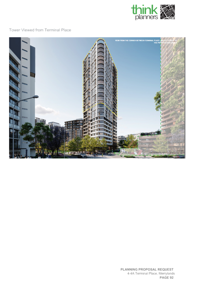
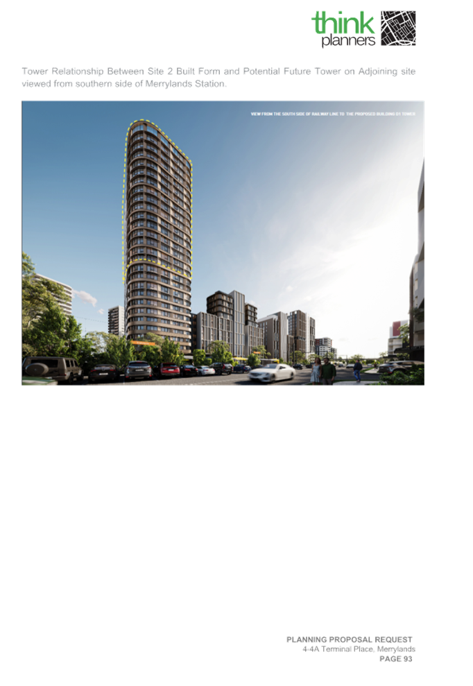
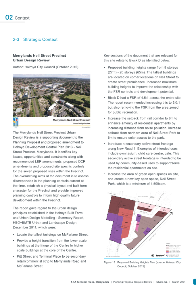
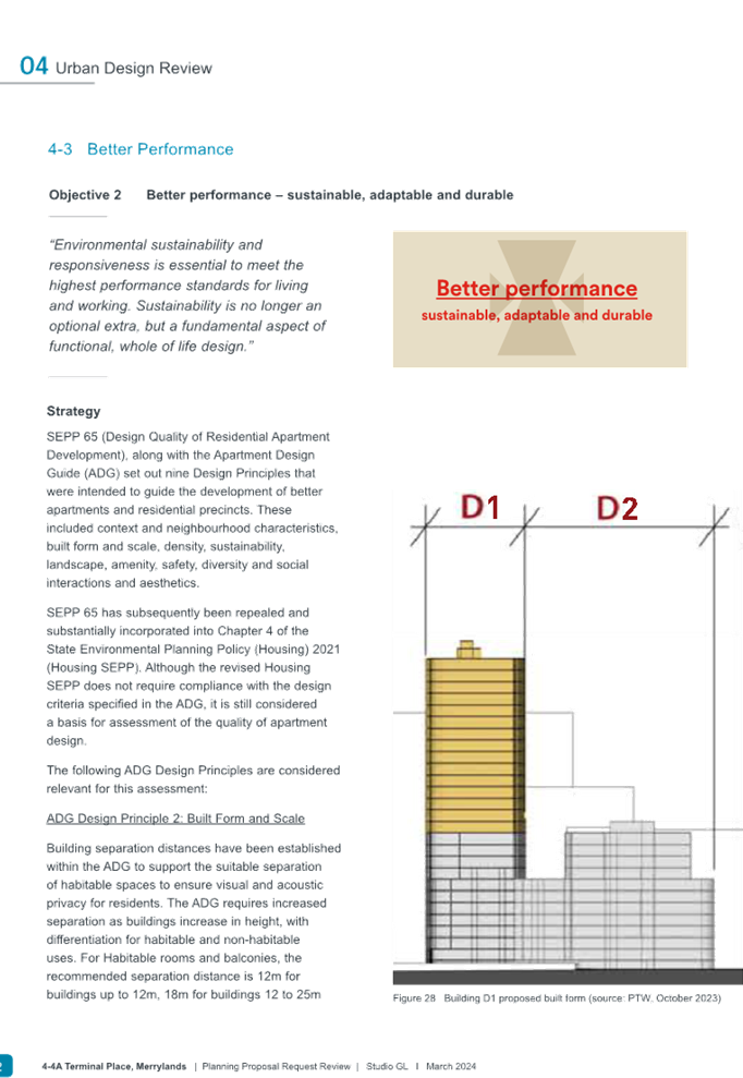
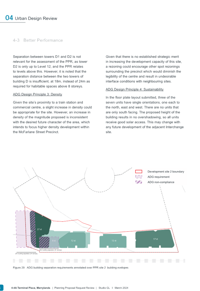
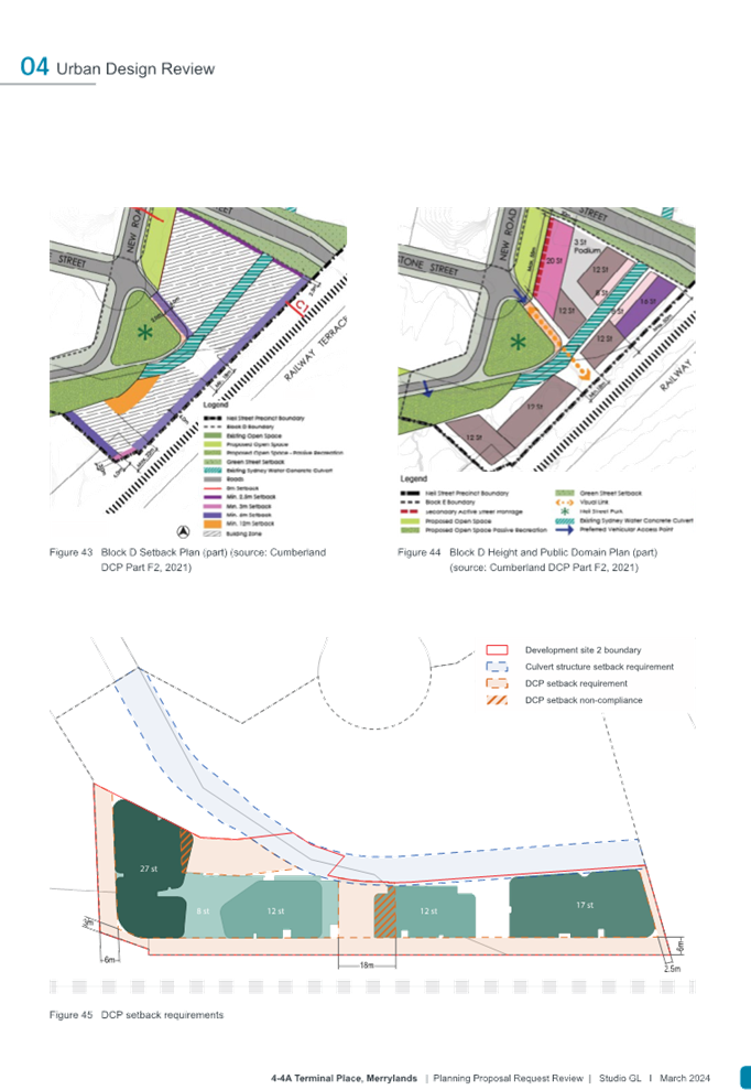
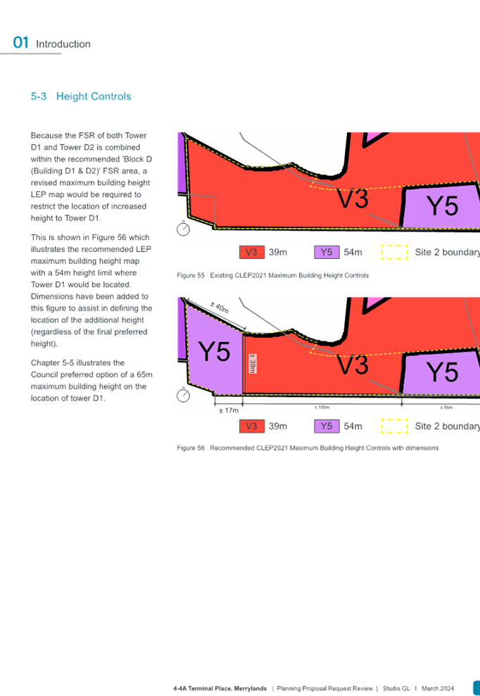
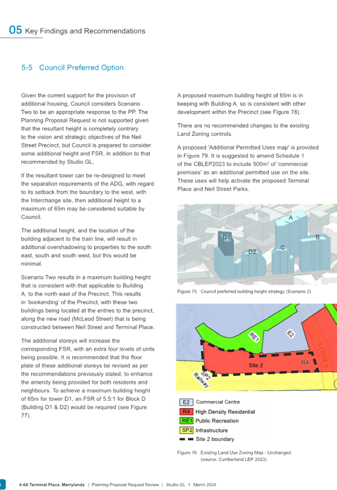
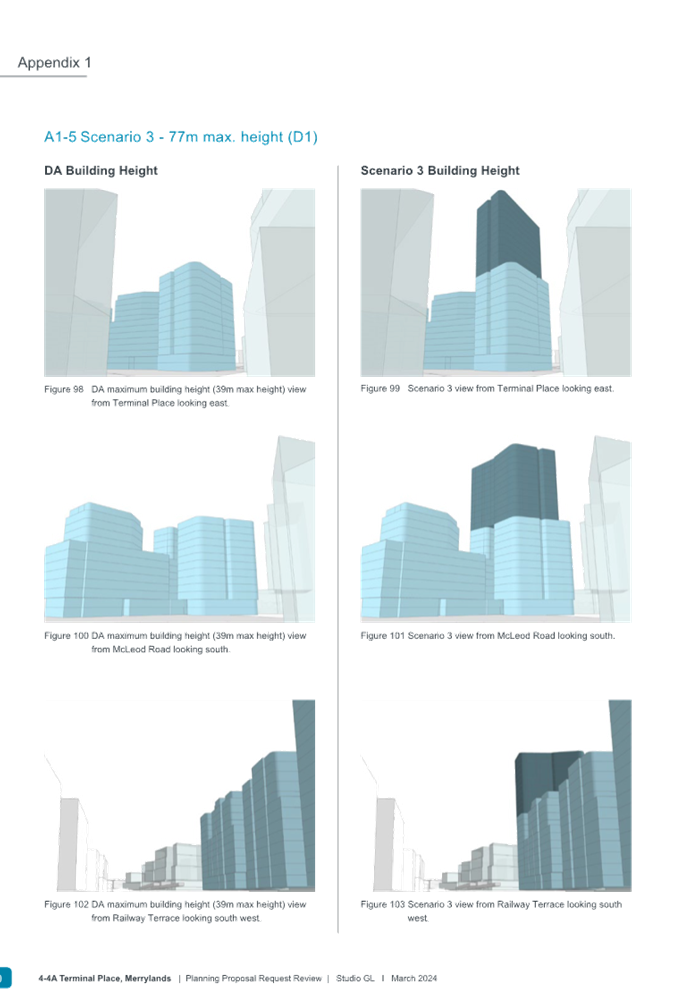
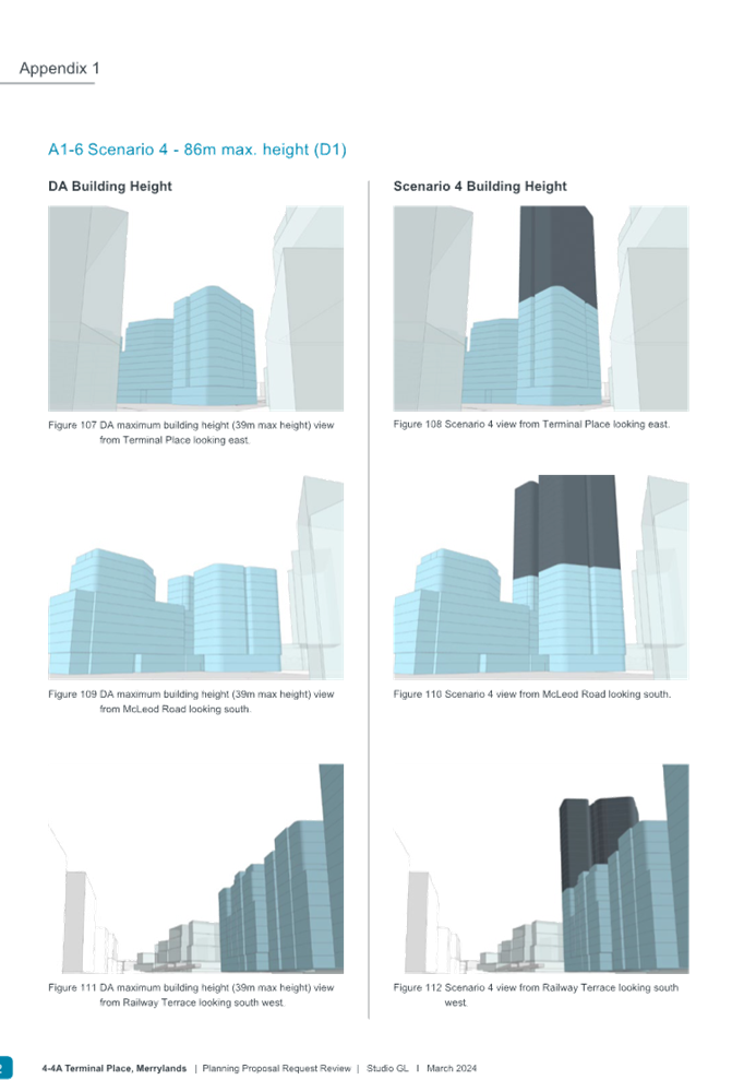
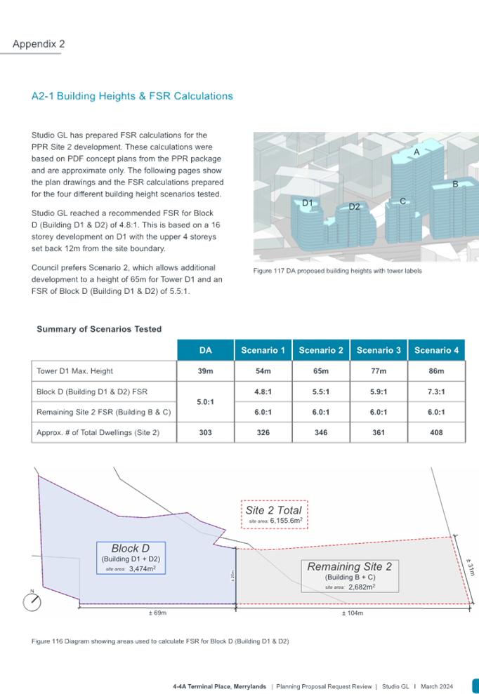
The Precinct’s structure plan shows that the proposed Site 2 located in Block D has been allowed for a maximum 12 storeys in building height (shaded light blue) as shown in Figure 13 below with the preferred scenario of 65 metres (shown dark blue), which aligns to Block A (Site 1) existing permitted building height. This is contrary to the original Planning Proposal Requests beyond what has been envisaged by Block D to a building height of 86m (27 storeys in building height).
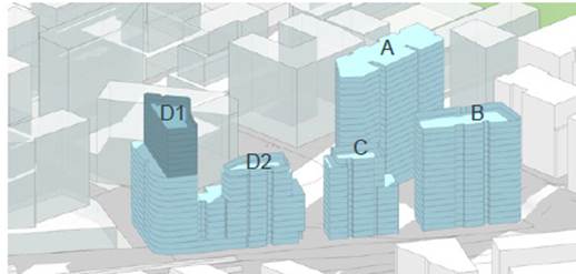
Figure 13: Council’s preferred scenario of 65m building height in relation to other proposed buildings on Site 2 including Site 1, Building A (Source: Studio GL, Mar 2024)
Key Considerations
Following the Panel meeting advice, Council officers are satisfied that the proposal has strategic and site-based merit to proceed to Gateway, subject to certain planning control amendments as recommended in this report. If endorsed, the recommended planning controls will facilitate the delivery of additional housing supply on one of the larger residential sites within Block D of the Neil Street Precinct, Merrylands Town Centre and near to Merrylands transport interchange; an area that is highly accessible to public transport and a wide range of existing services and facilities and is identified in Cumberland City’s Local Strategic Planning Statement as a key location for future growth or an area of revitalisation.
There is merit in progressing the Planning Proposal to the next phase of assessment, subject to the proposed Height of Buildings and Floor Space Ratio controls being adjusted to minimise the significant impact of the proposed development on the site, broader precinct and surrounding sites that is further elaborated below.
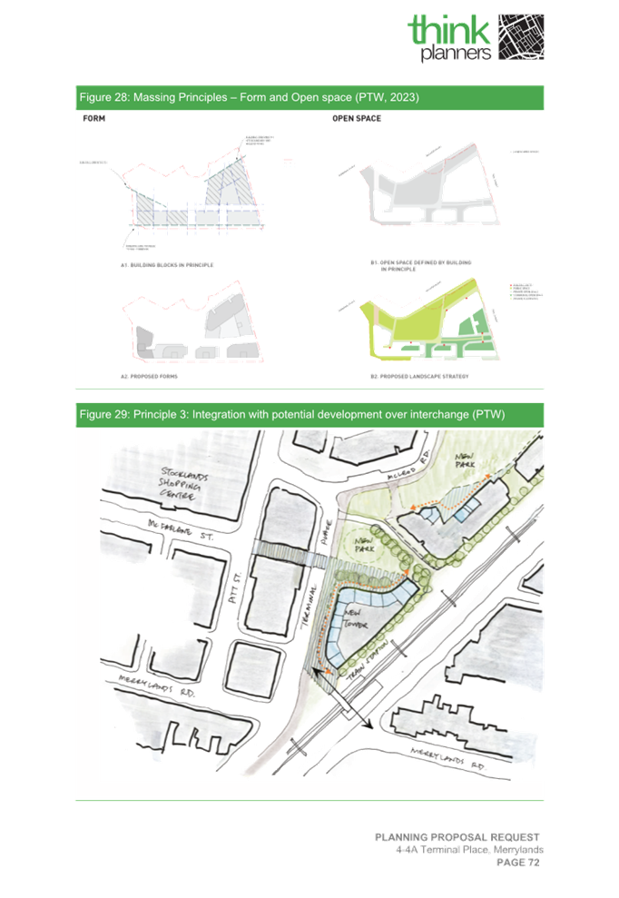
Built form
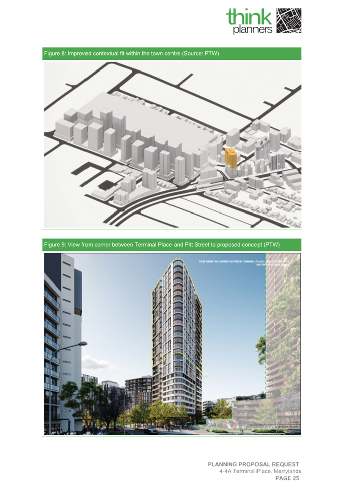
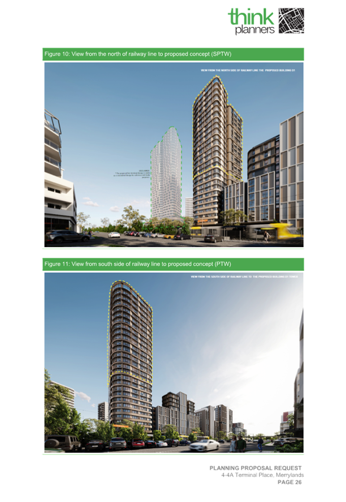
The Planning Proposal Request is supported with an urban design report prepared by PTW (Rev E, October 2023) to determine strategic and urban design outcomes and development impacts from the proposal regarding building height, built form and transition, solar access, overshadowing and residential amenity. The urban design report explains how the subject site can serve to assist in the rebalancing of key station marker buildings around Merrylands railway station and through the transitioning of height with the Building D1 addition, which are envisaged in an improved context of the likely future development forms of Merrylands Town Centre.
Council officers have undertaken further analysis of the requested built form controls to better determine the potential impacts of the proposal, including the potential additional FSR and maximum height limit achievable. Studio GL Urban Design consultant was engaged in the undertaking of the additional built form testing and modelling that are supported with solar access and shadow analysis to determine suitability of the Height of Buildings and FSR controls proposed for the subject site. An urban design report has been prepared by Studio GL (v4, March 2024) to support Council’s assessment.
The proposed changes sought to the principal development controls do not align with the strategic focus and compete with the existing Cumberland LEP 2021 planning controls applying to the site and its surrounds. The proposal references a hypothetical concept for the existing Merrylands Transport Interchange site to further increase existing building height and FSR controls for a site owned by Council and Transport for NSW, which has not been earmarked for any further increase in the principal development controls in the near future.
Council officers consider the proposed Height of Buildings and FSR controls in the Planning Proposal Request are not appropriate and may result in development outcomes that are out of scale in comparison with all surrounding current and future built form. Table 3 below identifies the proposed significant uplift and impact of the planning controls proposed.
|
LEP Planning Controls |
Existing |
Proposed |
Expected change or increase |
|
Height of Buildings |
39m (12 storeys) |
Building D1 86m (27 storeys plus roof top) |
221% (15 storeys) |
|
FSR |
5:1 |
6.6:1 (across entire site for all Buildings B, C, D1 and D2) |
132% (1.6:1 additional FSR) |
Table 3: Proposed uplift and impact of the proposed planning controls
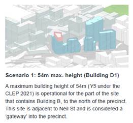
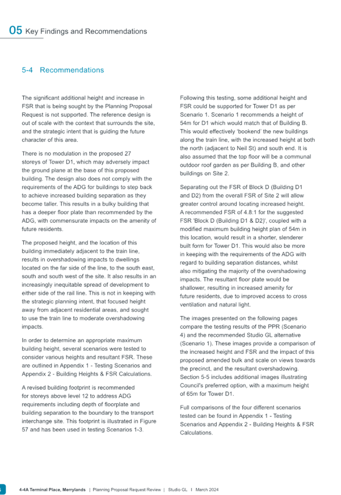
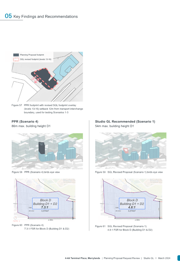
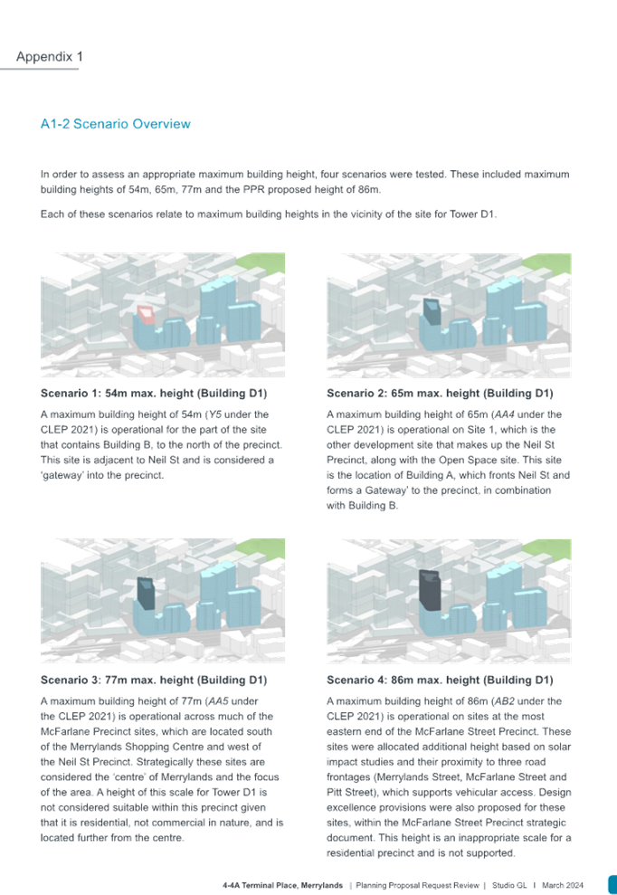
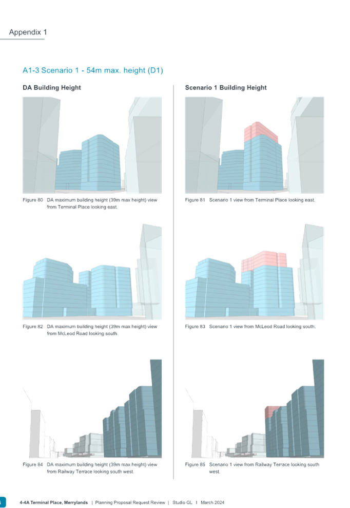
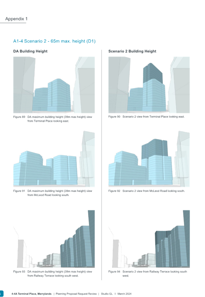
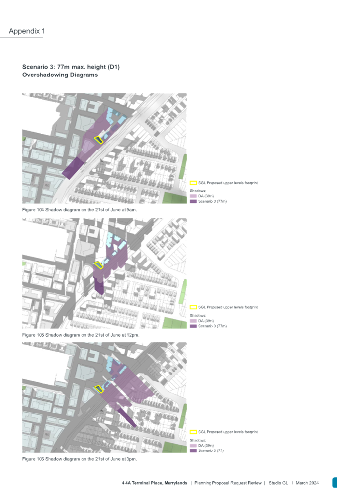
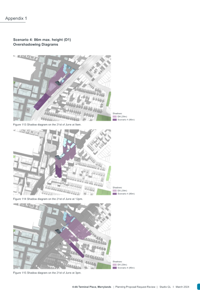
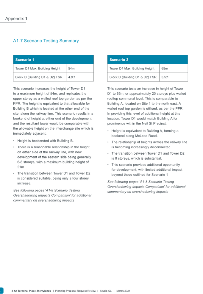
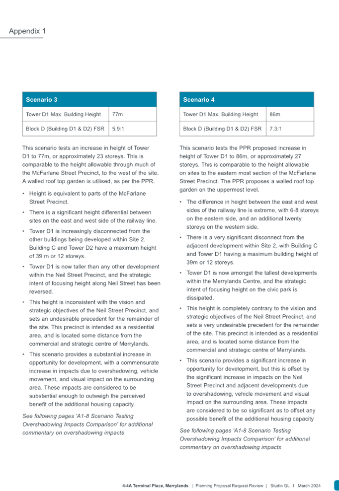
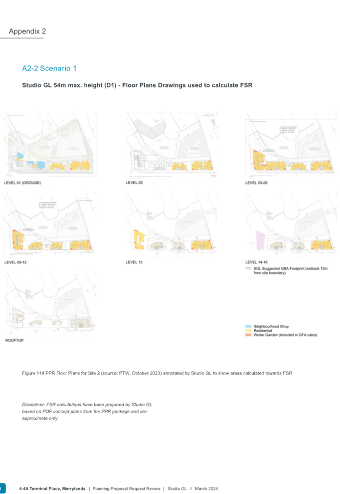
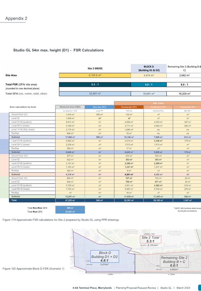
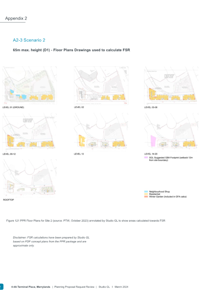
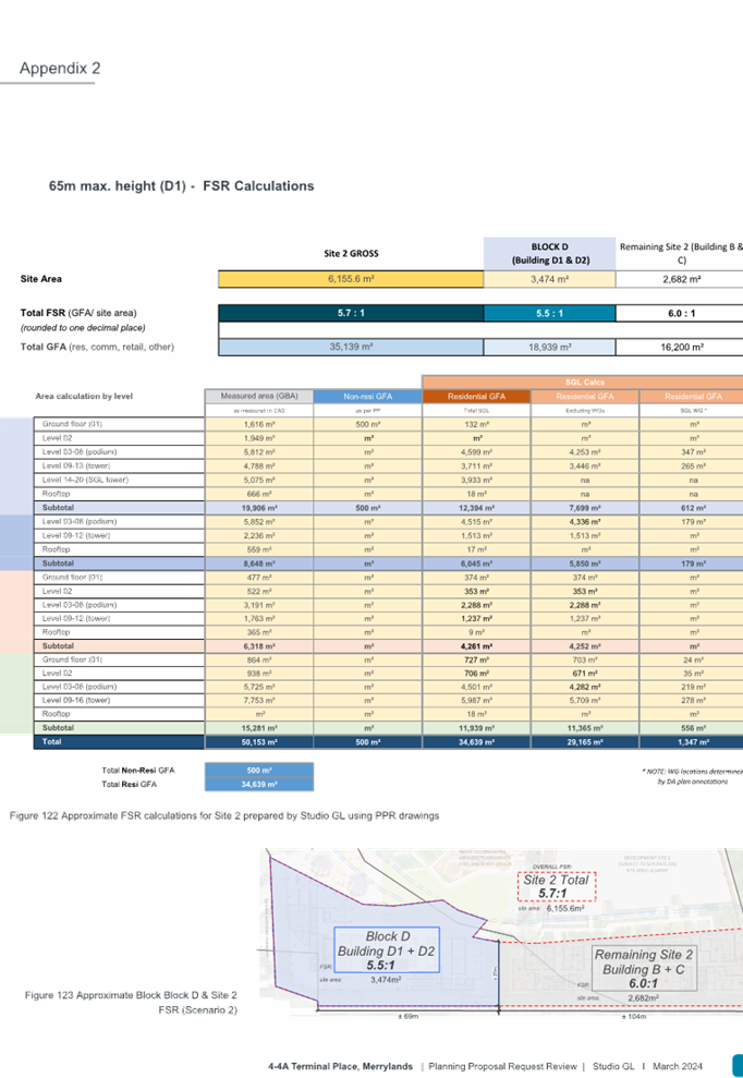
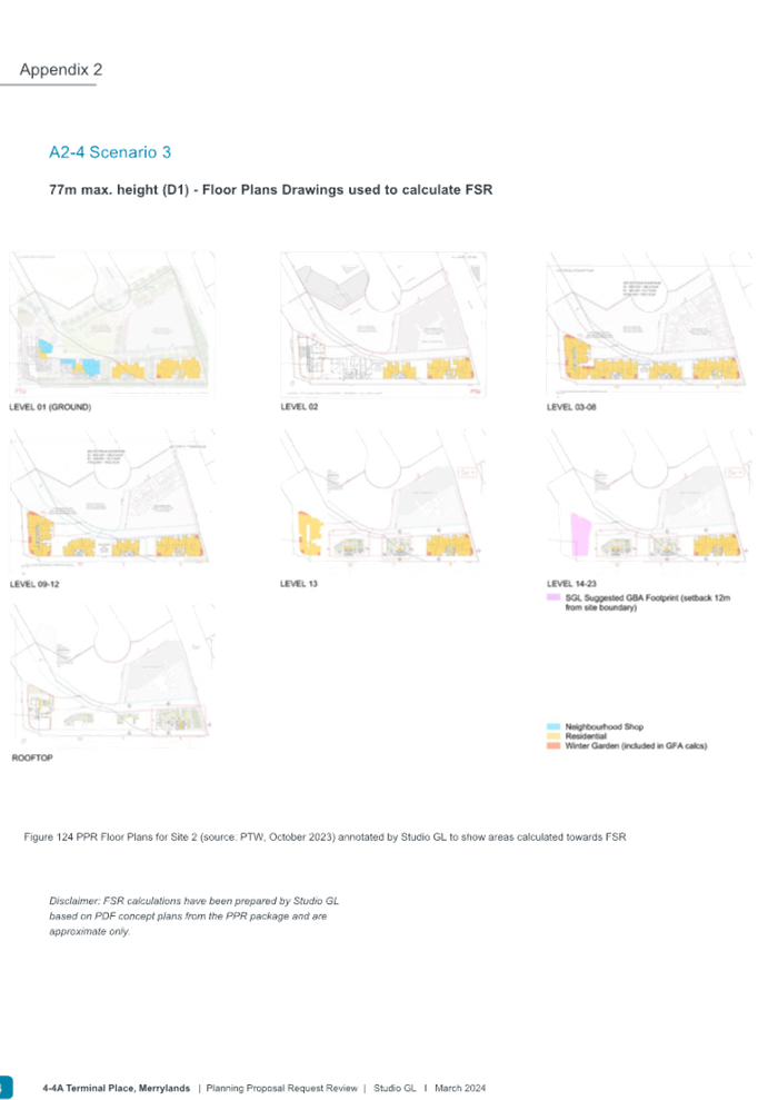
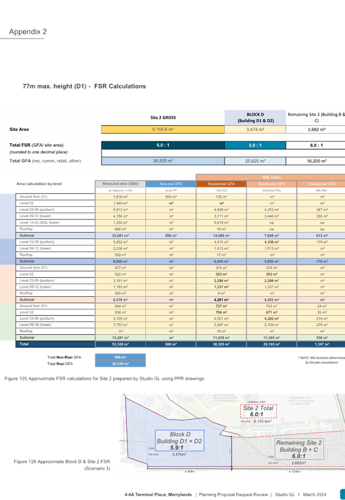
To establish what would be more suitable and achievable height for Building D1, four building height scenarios were modelled and tested ranging at 54m, 65m, 77m and 86m. The Studio GL report provides the following modelled individual scenario overview.
The building heights are modelled by testing the FSR that is to be applied on Building D1 and rest of the Site 2 along with solar and residential amenity impact analysis. The scenarios have considered the proposed controls under the Planning Proposal Request and the tower base DA lodged (DA2022/0776), assuming that this DA be approved by the Sydney Central City Planning Panel in its current form, which is relying on the existing LEP controls.
The urban design and planning review of these scenarios was undertaken utilising the Better Placed and Apartment Design Guide (ADG) principles to demonstrate the strategic context that relates to the proposed site location and relationship within the Neil Street Precinct and adjoining to the Merrylands Town Centre and Transport Interchange as the broader strategic context, rather than focusing on the hypothetical argument of any future uplift of the Merrylands Transport Interchange.
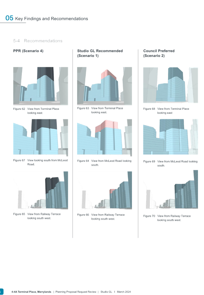
The key findings of the review conclude that the proposed additional 15 storeys or additional 43m in building height with 6.6:1 FSR across the site (Scenario 4) would have detrimental outcomes to both future residents within the Neil Street precinct and wider community due to impact on view lines, extent of overshadowing, potential pedestrian/vehicle conflicts as well the as impact on proposed buildings bulk and scale that is considered to be out of scale with regard to the strategic context of Merrylands public transport interchange and town centre. In comparison, the built form of Scenarios 1 and 2 are better aligned with the broader strategic context and with lower built form impacts.
Further information on the scenarios and built form metrics are provided in Figure 14 and Table 4.
|
|
|
|
|
|
Figure 14: Overview of modelled scenarios (Source: Studio GL, March 2024)
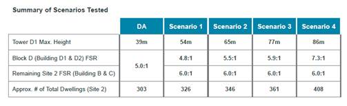
Table 4: Comparison of the development outcomes for each scenario (Source: Studio GL, March 2024)
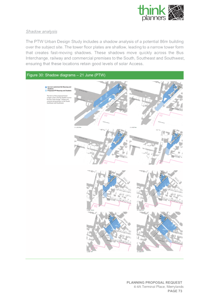
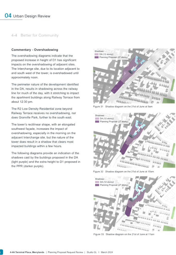
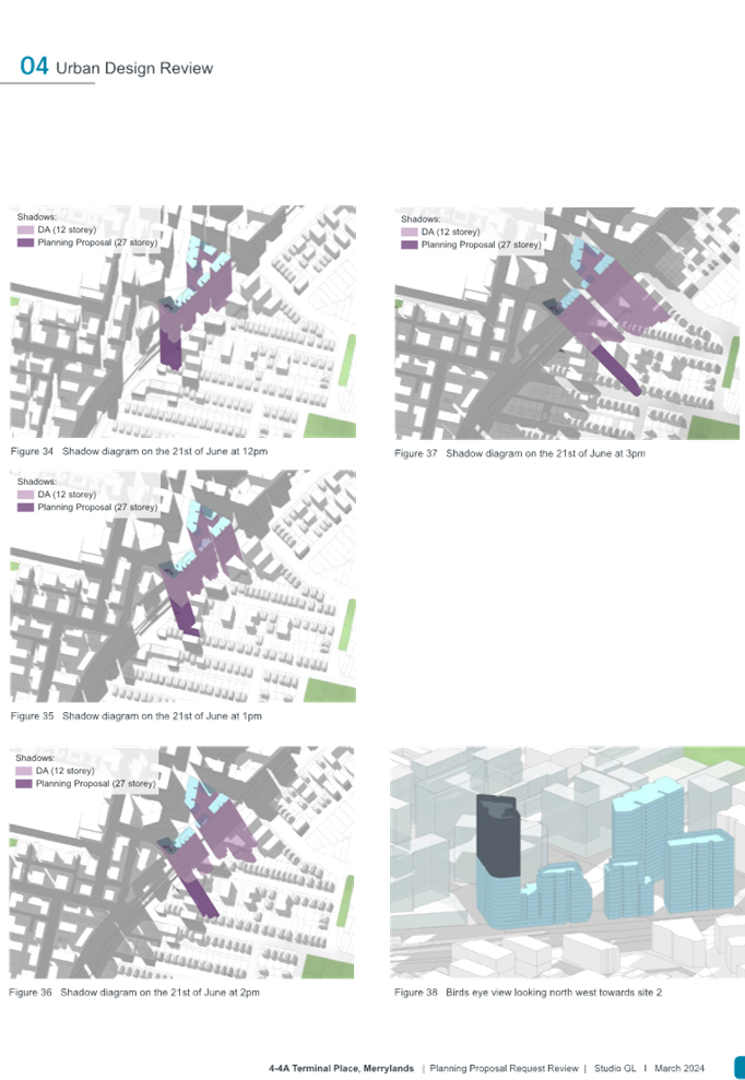
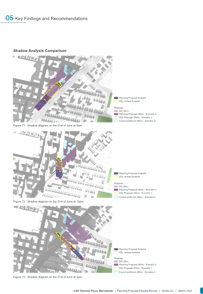
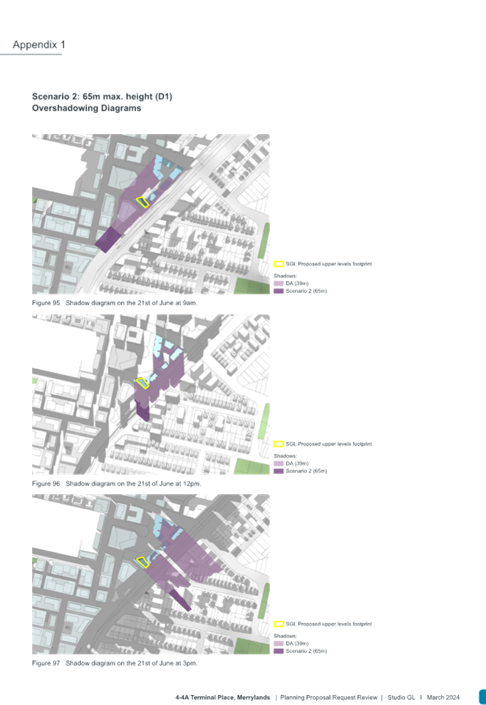
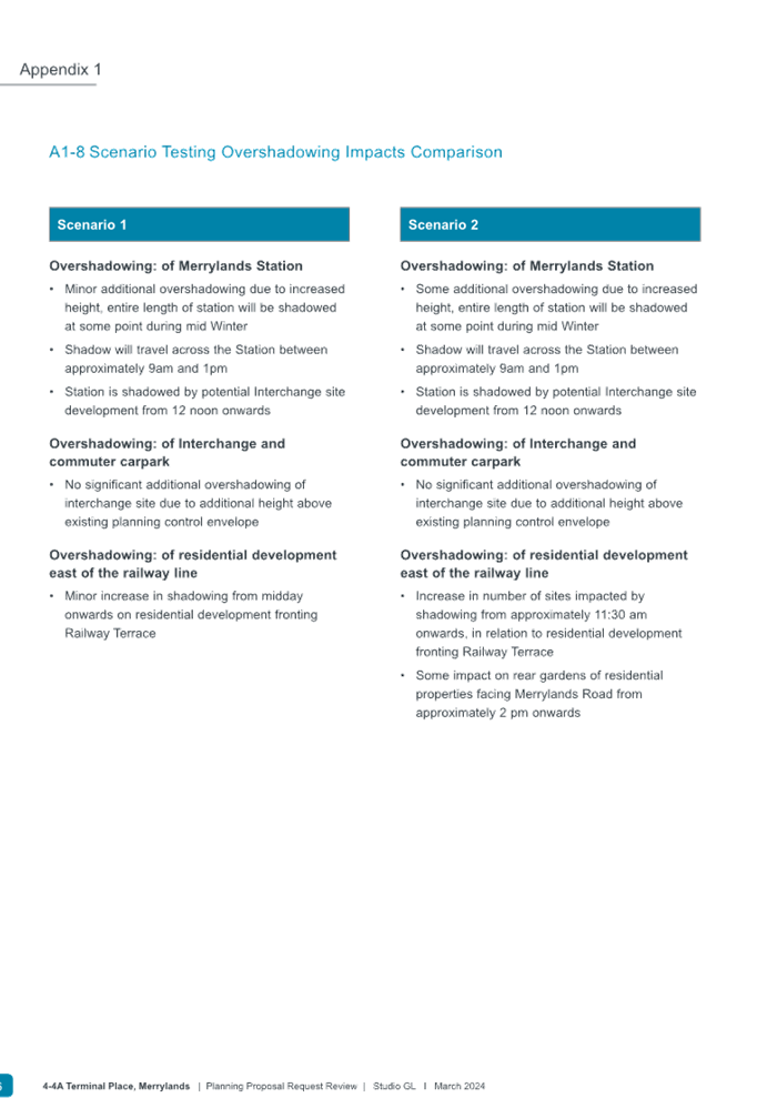
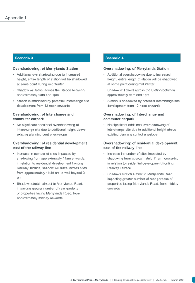
The modelled built form is also tested against the outcomes of the solar access and shadow analysis. These outcomes demonstrate that Scenarios 1 and 2 are likely to result in lesser overshadowing impacts from proposed building heights for the residential properties located southwest, southeast and at Merrylands Railway Station, in comparison with Scenarios 3 and 4 that are considered likely to create worst case impact (refer to Appendix 1 of Council’s urban design advice by Studio GL for information).
Should Council proceed with an amended Planning Proposal as recommended in this report to Gateway, the above built form, building height and floor space ratio, solar access and residential amenity and shadow impacts are further likely to be reduced.
Economic and social benefits
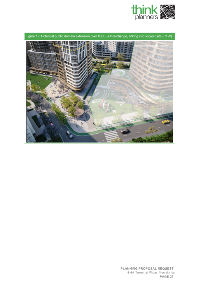
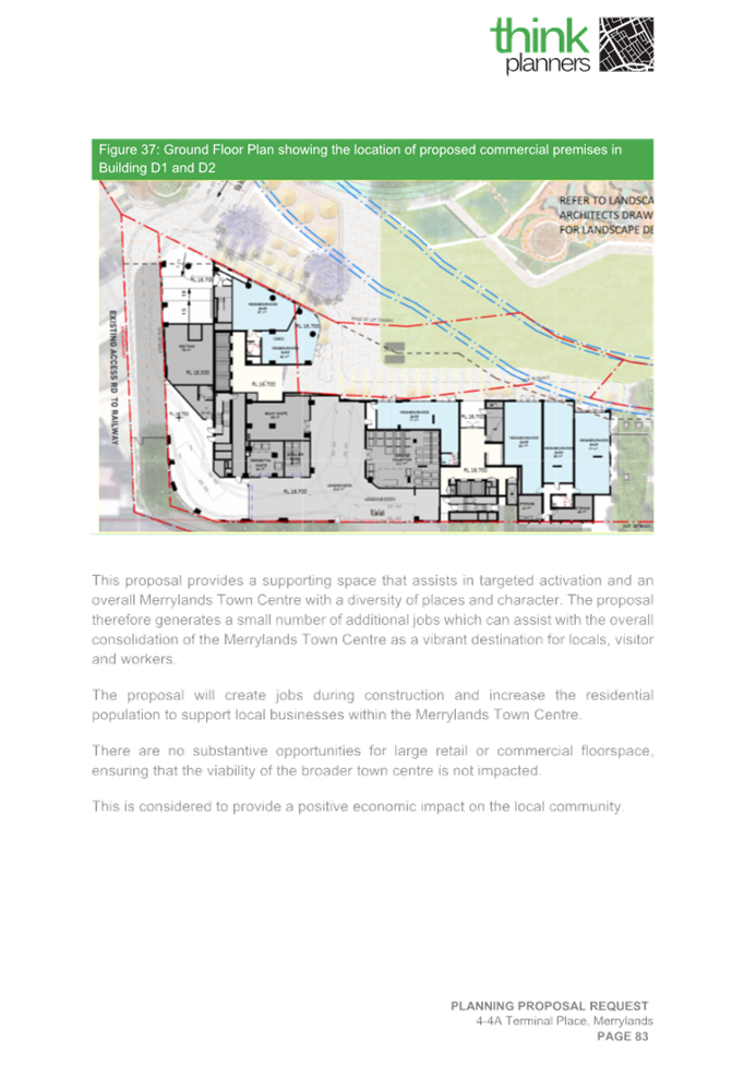
The proposal request proposes to deliver a small quantum of 500m2 in ‘commercial premises’ as an additional permitted use to be introduced for Buildings D1 and D2. These buildings are likely to have more direct interphase with the proposed future parks for Terminal Place and Neil Street which are planned to be delivered within the Gladstone Village precinct to further activate the proposed public parks.
The proposal request is unlikely to result in creating significant economic impact by introducing 500m2 of commercial premises use for the proposed site nor its immediate surrounds especially the Merrylands Town Centre’s commercial/retail core, McFarlane Street and Stockland Mall shopping area where significant amount of retail and commercial offerings are being made at a greater scale. The proposal request is also anticipated to deliver approximately 60 additional local jobs during pre and post construction stages of the proposed development.
Studio GL report (refer to the Attachments section of this report) has also tested this within the proposed building height scenarios with the proposed 500m2 of non-residential provision and have not raised any concerns.
Should the proposal request proceeds with an amended Planning Proposal as recommended by Council to Gateway, the proposed quantum of 500m2 of commercial premises use is unlikely to be further increased resulting in significant economic impact and these relevant impacts will be further assessed via a future modified development application.
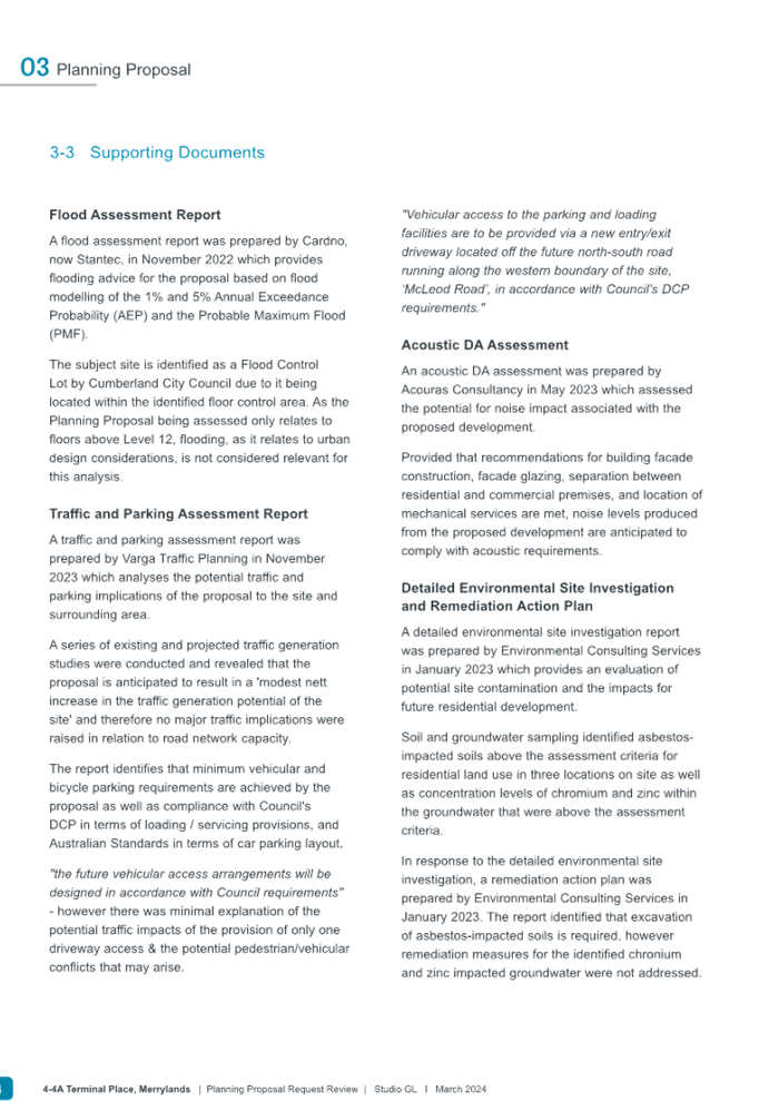
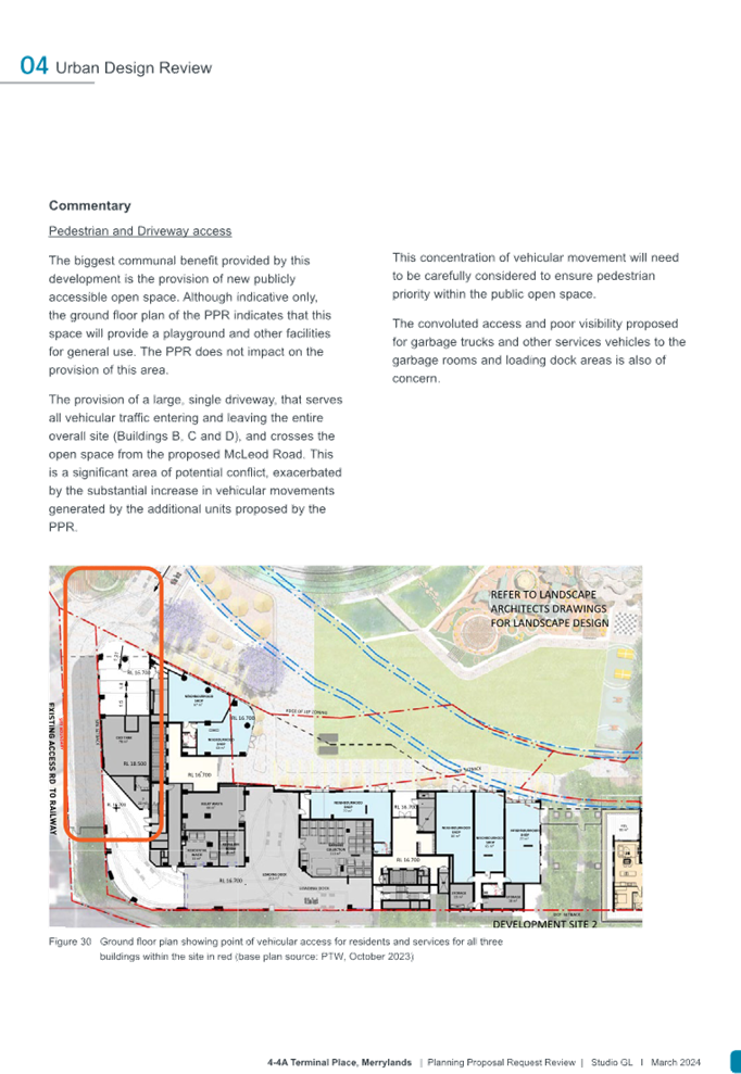
Traffic, transport and parking
The Planning Proposal Request is supported by a traffic and transport assessment report prepared by Varga Traffic Planning (November 2023), which states that the proposal request is unlikely to create any significant traffic impacts to its surrounds and concludes that traffic and parking impacts associated with the additional dwellings are likely to be minor in nature.
It is noted that the broader traffic and transport impacts and mitigation measures for the base tower are addressed as part of DA2022/0776 assessment.
Transport for NSW have also provided comments on the proponent’s traffic report and these can be considered and addressed as part of the next stages of the proposal prior to submission of an amended Planning Proposal for a Gateway Determination.
Should Council proceeds with an amended Planning Proposal as recommended, to Gateway, it is anticipated that the proposed traffic, transport and parking impacts will be further reduced considering the reduction to proposed 86m building height for proposed Building D1 which would reduce the proposed apartments from approximately 105 to 43 dwellings considering significant built form, building height, floor space ratio, views, solar access and residential amenity and building transition impacts.
The proponent would also need to address Transport for NSW submission dated 14 March 2024 by updating the existing traffic, transport and assessment report prior to lodgement of the amended proposal for a Gateway determination.
Environmental
The Planning Proposal Request is supported by a range of technical studies that address the following matters:
· Flooding and stormwater
Flooding and stormwater issues were also identified and addressed as part of Council’s Neil Street Precinct Planning Proposal and are being implemented through subsequent DAs for the site.
The proposal request is also supported with a flood impact statement report prepared by Cardno, now Stantec (November 2022), which concludes that flood protection can be afforded to proposed Site 2 located within Block D of the Neil Street Precinct.
Council’s Stormwater Engineer has further confirmed that the proposed site’s northwestern corner is impacted by flooding during 1% AEP storm event and some easements located outside that may be beneficial to Council. Council’s Stormwater Engineer has further reviewed the proponent’s flood assessment report exhibited and has confirmed that the Planning Proposal Request is supportable to progress subject to compliance with flood and easement related development controls at the DA stage. DA2022/0776 for the base tower is currently being assessed for this site and the above matters are anticipated to be dealt as part of the DA assessment process.
Council’s existing flood map (refer to council’s assessment report to panel attached) indicates that the dominant flood risk affection is considered as low risk (PMF) at the proposed site. On the northwestern corner, the flood risk is considered as a medium risk (1%).
Should the proposal request proceeds with an amended Planning Proposal with alternative planning controls as recommended to Gateway, these impacts are likely to be further considered in detail via the current or a future modified development application. Given the site’s dominant flood risk affectation is low risk it is highly unlikely that significant impacts would be anticipated.
· Noise and vibration impacts
The proposal request is supported with an acoustic assessment report by Acouras Consultancy (May 2023). The report assesses the existing road and railway vibration impact on the proposed development site at proposed Site 2 and concludes that the vibration levels are of ‘low probability’ impact and further detailed consideration may be required at the DA stage. The current DA lodged is also being assessed regarding this.
Council’s Environmental Health Officer has confirmed that further detailed assessment will be required at the DA stage requiring operational noise management for any proposed retail/commercial uses, compliance with relevant Australian Standards requirements for fit out and commercial kitchen, and waste management plan to be submitted by the proponent.
It is concluded that the Planning Proposal Request is unlikely to result in any negative environmental impacts provided that the recommendations made by the acoustic report are complied with. Should the proposal request proceeds as an amended Planning Proposal to Gateway, these additional impacts are likely to be further considered in detail via the current DA or a future modified development application.
· Site contamination/remediation
The proposal request is supported with Detailed Site Investigation (DSI) and Remediation Action Plan (RAP) reports prepared by Environmental Consulting Services (issued in January 2023). These documents are concurrently being assessed as part of the DA2022/0776. The DSI report concludes that the site would be suitable for the proposed residential development use provided that a detailed remediation action plan be prepared and along with some additional investigation for asbestos.
Council’s Environmental Health Officer has confirmed that further detailed assessment will be undertaken at the DA stage and the Planning Proposal Request is unlikely to have any negative environmental impacts, provided that the recommendations made by the Remediation Action Plan are complied with.
Should the proposal request proceeds as an amended Planning Proposal as recommended in this report to Gateway, detailed impacts are likely to be further assessed via the current or a future modified development application.
Heritage
The Planning Proposal Request is not supported with a heritage impact assessment given that the subject site is not identified or listed as a local or state significant heritage item, nor it is located within an existing heritage conservation area, nor it is identified as a draft heritage item under the Cumberland LEP 2021. The proposed site is located within a close vicinity of the Merrylands Railway Station towards the southern side, which is a listed local heritage item under the Cumberland LEP 2021.
The shadow analysis conducted by Studio GL confirms that the proposed built form scenarios modelled for the preferred option of 65 metre building height (Scenario 2) as recommended for the amended Planning Proposal is unlikely to result in additional overshadowing and adverse amenity impacts on the existing Merrylands Railway Station.
Should the proposal request proceeds with an amended Planning Proposal as recommended by Council to Gateway, these considerations are likely to be further considered via the current or a future modified development application.
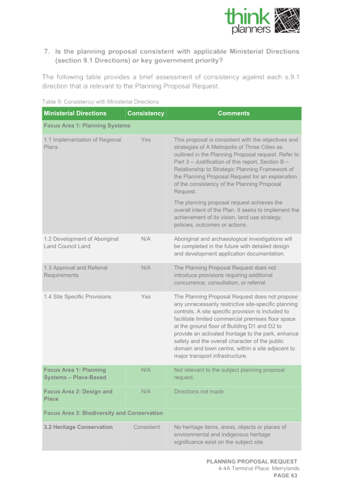
Council officers also recommends that the proponent provides a written response to the NSW Heritage submission to be attached to the amended Planning Proposal Request provisions recommended in this report to demonstrate consistency with ministerial direction 3.2 - Heritage Conservation or address this via the proponent’s updated Planning Proposal Request.
Additional Permitted Uses
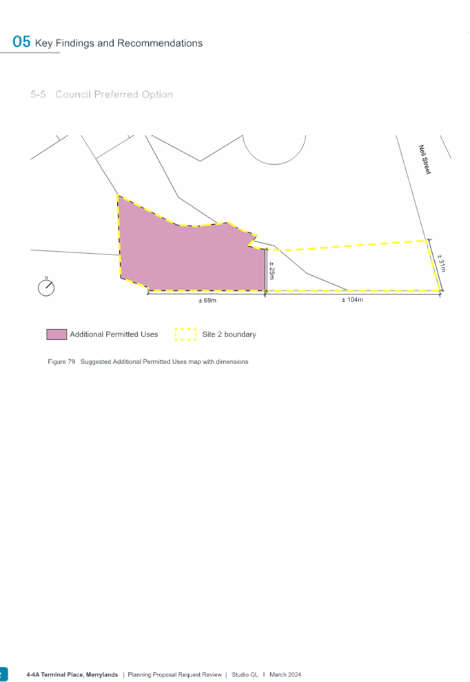
The Proposal Request seeks to introduce 500m2 of commercial premises as an additional permitted use to Buildings D1 and D2 by amending Schedule 1 of the Cumberland LEP 2021.
Commercial premises is a LEP group term and by permitting this term it is intended that retail premises, business premises and office premises will also be permitted as a result.
The proposal has further stated that the proposed 500m2 in area for commercial premises use would be utilised for a range of uses such as some retail, hospitality, food, and beverage offerings such as restaurants or cafes, which could further activate the proposed future park uses along with some convenience store and business premises like beauty salons or similar. The proposed additional permitted use is likely to be visited by residents who live within the proposed Gladstone Village precinct and the surrounding neighbourhood and further continue to support and enhance the economic viability of the Merrylands Town Centre, which is also being consistent with the existing R4 zone objectives.
The proposed quantum of 500m2 commercial premises as an additional permitted use is unlikely to create an undesirable impact provided that onsite retail/commercial parking is provided. Should the proposal request proceeds with an amended Planning Proposal as recommended by Council to Gateway, these impacts are likely to be further assessed via a future modified development application.
Recommended Planning Controls
Following an assessment of strategic and site-specific considerations for the site, an amended Planning Proposal is proposed by Council officers in response to the built form and residential amenity issues identified as part of the assessment.
It is recommended that Council proceeds to Gateway with an amended Planning Proposal containing alternate planning controls, as outlined in Table 3. Compared with the requested planning controls, the recommended planning controls would deliver approximately an additional 43 residential apartments for proposed Building D1 (down from proposed 105 apartments), increasing the total number of apartments for the proposed Site 2 development to approximately 346 residential apartments (down from 408 as originally requested by the Proponent).
Specifically, it is recommended that the height control for Building D1 is to be reduced from the proposed 86m to 65m and that the FSR controls are to be amended from 6.6:1 (across Site 2) to 5.5:1 for Buildings D1 and D2, and 6:1 for Buildings B and C. It is noted that these proposed controls are aligned with Scenario 2 as identified in Council’s urban design report (prepared by Studio GL) and will result in a maximum building height that is consistent with that applicable to proposed Building A (Site 1), to the northeast of the Neil Street Precinct. The recommendation from Council officers also aligns with strategic directions in supporting additional housing in areas close to public transport (bus and rail) and local services.
Table 5 provides a comparison table between the existing proponent request and Council’s recommended planning controls for the site under the amended Planning Proposal.
|
Planning Control |
PPR Requested Planning Controls |
Recommended Planning Controls to Cumberland Local Planning Panel |
Recommended Planning Controls to Council |
Difference between original and recommended planning controls |
|
Building Height (including base tower of Building D1) |
86m (27 storeys with roof top and lift overrun) |
65m (20 storeys with communal roof top and lift overrun) |
65m (20 storeys with communal roof top and lift overrun) |
21m (7 storeys) |
|
Floor Space Ratio |
6.6:1 (across Site 2) |
5.5:1 for Buildings D1 and D2, and 6:1 for Buildings B and C |
5.5:1 for Buildings D1 and D2, and 6:1 for Buildings B and C |
See GFA section below |
|
Residential Gross Floor Area (GFA) |
10,530m2 |
4,072m2 |
4,072m2 |
6,458m2 |
|
Additional Permitted Use (500m2 commercial premises) |
Buildings D1 and D2 (as per PP Request) |
Buildings D1 & D2 only |
Buildings D1 & D2 only |
Supported |
|
Number of Units (estimated) |
105 |
43 |
43 |
62 |
Table 5: Comparison table of Planning Proposal Request and recommended planning controls by Council officers
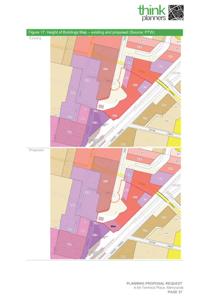
The proposed amendments to the mapping associated with the Cumberland LEP 2021 under the amended Planning Proposal is provided in Figures 15, 16 and 17.
|
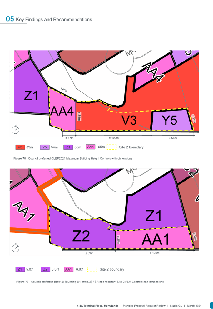
Figure 15: Proposed Building Heights as amended. Buildings D1 and D2 - AA4: 65m, V3: 39m and Y5: 54m (Source: Studio GL, March 2024)
|
|
Figure 16: Proposed FSR as amended, Buildings D1 and D2 - Z2: 5.5:1 and Buildings B and C - AA1: 6:1 (Source: Studio GL, March 2024)
|
|
Figure 17: Additional Permitted Use as amended, to be applied to proposed Buildings D1 and D2 only (Source: Studio GL, March 2024) |
Public Benefit Offer
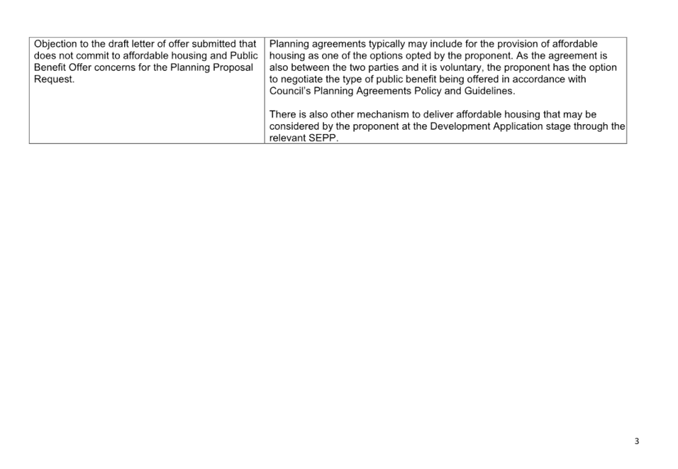
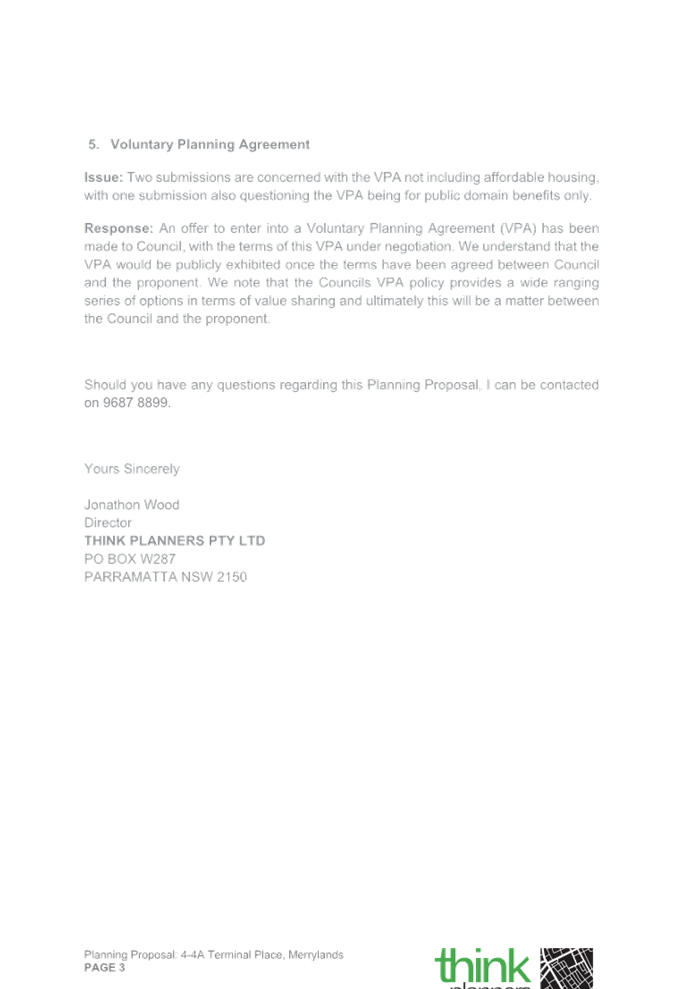
As part of the Planning Proposal Request, the Proponent submitted a Letter of Offer demonstrating Public Benefit Offer in March 2024 and indicating that they may enter into a Voluntary Planning Agreement with Council to construct facilities (as agreed between Council and the Proponent) on the land for the purposes of civic, community and maintenance use. The offer also considers the potential for the inclusion of affordable housing on the site.
Should Council endorse an amended Planning Proposal be forwarded and a Gateway Determination received, Council will negotiate a Voluntary Planning Agreement with the Proponent to ensure that any public benefit offer for the Planning Proposal maximises the outcomes for the wider community and is consistent with the Cumberland Planning Agreements Policy.
Early Consultation
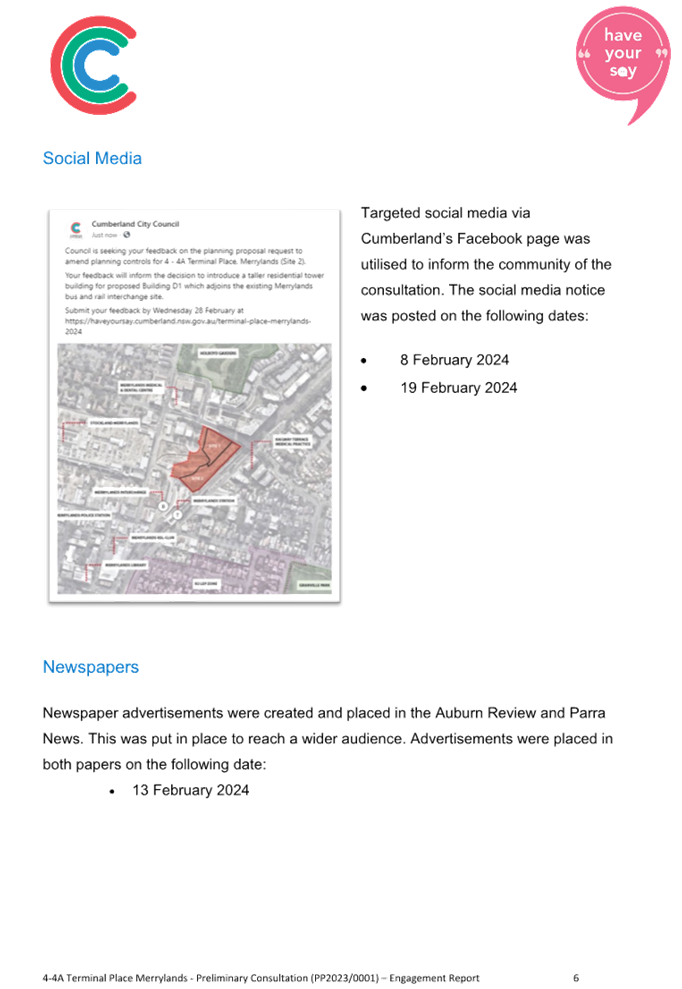
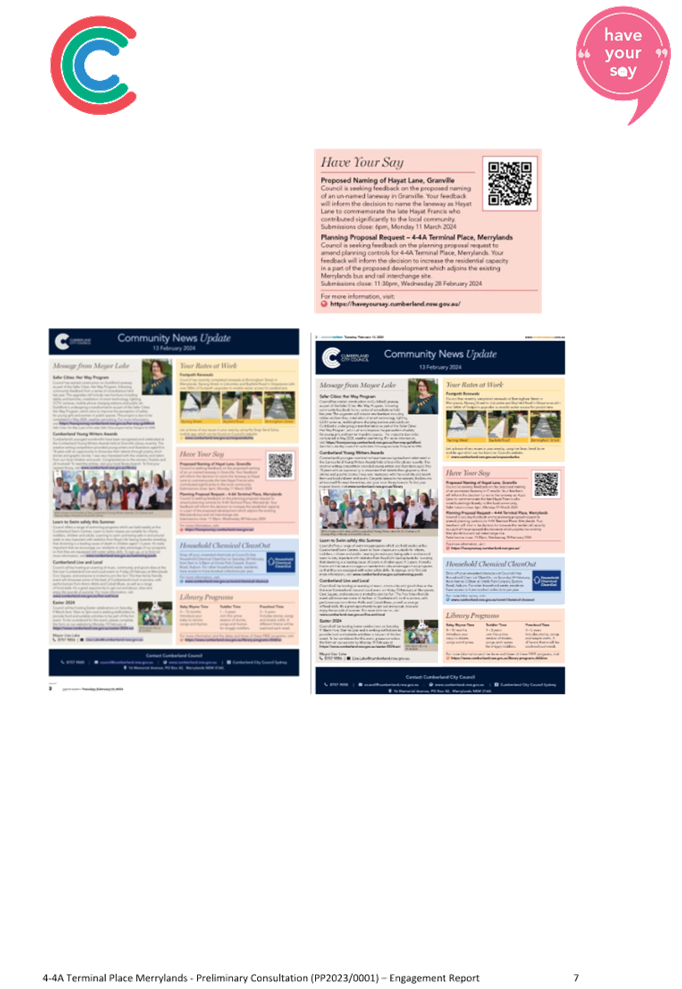
Council Officers placed the Planning Proposal Request on early public consultation from 30 January 2024 to 28 February 2024, as required by Cumberland Planning Proposal Notification Policy requirements and was exhibited for 30 days.
All owners and occupiers were also notified within 200 metres distance radius of the site. The exhibition material was made available online on Council’s website on Have your say page and in hardcopy form in Council’s administration buildings (Merrylands and Auburn) and Merrylands library. The proposal was also promoted through Council’s social media platforms, e-newsletter, and local newspapers (community engagement report is attached).
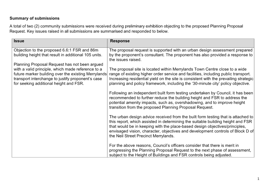
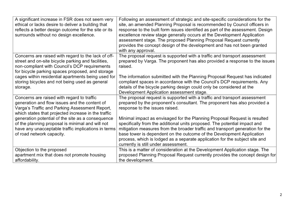
Community Submissions
Council received 2 written submissions during the community consultation period. Key concern raised in submissions are summarised below.
· Objections received for proposed 86m building height and proposed 6.6:1 FSR for the site given its significant impact,
· Concerns raised about traffic generation flow, on-site parking (car and bicycle), and congestion,
· Provision of affordable housing,
· Apartment mix, and
· Concerns relating to the draft letter of offer as public benefit.
Council’s and proponent’s response to the community submissions are attached to this report.
Should Council proceed with an amended Planning Proposal with alternative planning controls as recommended in this report, the impacts or concerns raised are likely to be further reduced and/or minimised.
State Agencies
Relevant State agencies were also consulted to provide referral comments on the proposal request. Items covered in the submissions are briefly outlined below.
|
Agency |
Comments |
|
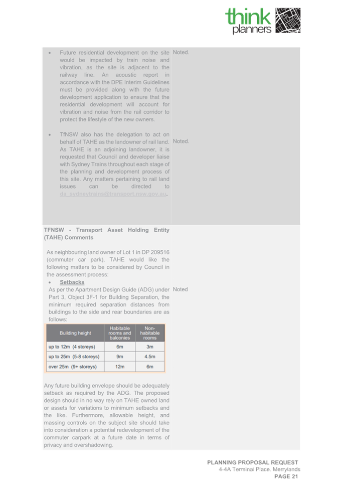
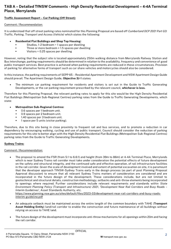
Transport for NSW |
· A detailed traffic and transport study needs to be prepared prior to submission of the proposal for Gateway (as confirmed with Transport for NSW under Tab A of the letter). · Consultation with Sydney Trains early in the design process (as part of pre-DA discussion) is required considering the site shares a common boundary with Sydney Railway line. · Recommendation is provided to reduce the number of on-site and off-street parking provisions as per parking criteria given to promote walking, cycling, public bus and railway transport given the site’s centrality to these locations. · Requirements for adequate site setbacks are to be maintained across the entire length of the site from Sydney train powerlines. · Inclusion of anti-throw mechanisms for all openings within 20m facing the existing rail corridor is required. · Mitigation of train noise and vibration on future proposed residents is required. |
|
Heritage NSW |
· It is recommended that a comprehensive Aboriginal cultural heritage assessment will be required as per the Ministerial Direction 3.2 for Heritage Conservation. Council officers consider this may not be required given the site is not identified as an existing local or state item and is not located within heritage conservation area, nor it is considered as a draft heritage item under the Cumberland LEP 2021. |
|
Environmental Protection Agency (EPA) |
· No submission was received. |
|
NSW Sydney Water |
· No submission was received. |
Table 6: State Agency comments
Should Council progress with an amended Planning Proposal as per Council’s preferred Scenario 2, the proponent would need to update the traffic and transport assessment to reflect the amended planning controls and amend the traffic, transport and parking impacts and address Transport for NSW’s comments in (Tab A) prior to lodgement of the proposal for a Gateway Determination. It is anticipated that the proposed traffic, transport, and parking impacts will further reduce if the amended Planning Proposal is recommended and proceeds.
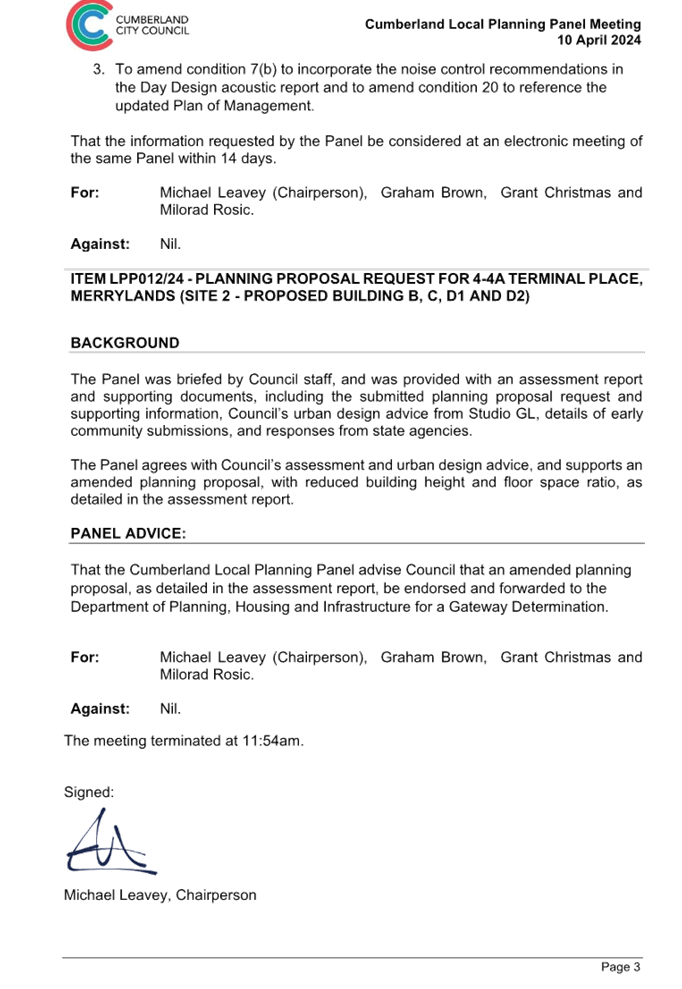
Advice from the Cumberland Local Planning Panel
The Cumberland Local Planning Panel considered a report on the Planning Proposal Request assessment and the outcomes of the preliminary community consultation on 10 April 2024. The Panel agreed with Council officer’s assessment and urban design advice, and supported an amended Planning Proposal, with reduced building height and floor space ratio. The Panel recommended to advise Council that an amended planning proposal, as detailed in the assessment, be endorsed and forwarded to the Department of Planning, Housing and Infrastructure for a Gateway Determination.
Next Steps
Following receipt of early consultation feedback, review of the Planning Proposal by Council officers and advice provided by the Cumberland Local Planning Panel, an amended Planning Proposal is provided for consideration by Council. It is recommended that Council endorse the Planning Proposal and that this be forwarded to the Department of Planning, Housing and Infrastructure for a Gateway Determination. It is also recommended that a Voluntary Planning Agreement be prepared to derive public benefit, should a Gateway Determination be received.
Community Engagement
The proposal has been subject to early public consultation as outlined in this report. Further statutory public consultation will occur should the recommended amended Planning Proposal proceed past Gateway.
Key issues raised in objections were taken into consideration by Council officers as part of the assessment and resulted in the formulation of alternate controls, which address many of the concerns raised and minimise the impact of the proposal on the Neil Street precinct and surrounding sites.
Policy Implications
Policy implications for Council are outlined in this report.
Risk Implications
There are minimal risk implications for Council on the proposal outlined in this report.
Financial Implications
Should the amended proposal proceed to Gateway Determination, Council officers will further negotiate with the Proponent to ensure the public benefit offer is consistent with Council’s Planning Agreements Policy and Guideline.
CONCLUSION
This report recommends that Council endorse an amended Planning Proposal for 4-4A Terminal Place, Merrylands and for the proposal to be forwarded to the Department of Planning, Housing and Infrastructure for a Gateway Determination, Subject to a positive Gateway Determination, a Voluntary Planning Agreement will be prepared to derive public benefit. The proposal will provide additional housing in the Merrylands Town Centre with the built form designed to minimise adverse impacts on residential amenity.
Attachments
2. Urban Design Assessment (Additional Attachment)
3. Traffic and Transport Assessment (Additional Attachment)
4. Detailed Site Investigation Report (Additional Attachment)
5. Remediation Action Plan (Additional Attachment)
6. Acoustic Report (Additional Attachment)
7. Flooding Advice (Additional Attachment)
8. Council's Urban Design Advice (Studio GL)
9. Summary of Community Submissions with Council's Response
10. Proponent Response to Community Submissions
11. Community Engagement Report
12. Transport for NSW Submission
DOCUMENTS
ASSOCIATED WITH
REPORT C05/24-507
Attachment 1
Planning Proposal Request
DOCUMENTS
ASSOCIATED WITH
REPORT C05/24-507
Attachment 9
Summary of Community Submissions with Council's Response
DOCUMENTS
ASSOCIATED WITH
REPORT C05/24-507
Attachment 10
Proponent Response to Community Submissions
DOCUMENTS
ASSOCIATED WITH
REPORT C05/24-507
Attachment 15
Cumberland Local Planning Panel Advice
1 May 2024
Item No: C05/24-508
Response to Notice of Motion - Electric Vehicle (EV) Charging Stations (C07/23-346)
Directorate: Environment and Planning
Responsible Officer: Director Environment & Planning
Community Strategic Plan Goal: Delivering Sustainable Infrastructure and Services
Summary
This report provides a response to the Notice of Motion – Electric Vehicle (EV) Charging Stations resolved at the Ordinary Meeting of Council on 5 July 2023. It recommends that Council place the Draft Public Electric Vehicle Charging Infrastructure Policy and supporting Guideline on public exhibition for a period of 28 days.
|
Recommendation That Council: 1. Receive and note the report. 2. Place the Draft Public Electric Vehicle Charging Infrastructure Policy and supporting Guideline on public exhibition for a period of 28 days, and subsequently adopt the document if no adverse submissions are received. |
Report
At the Ordinary Meeting of Council on 5 July 2023, the following Notice of Motion (C07/23-346) was resolved regarding Electric Vehicle (EV) Charging Stations:
“With the progression of the draft Smart Places Strategy and Action Plan, a key action is to progress investigations on electric vehicle charging in Cumberland. Given the significant interest in the matter and opportunities to work with other levels of Government, that Council:
1. Immediately commence investigative work to develop a policy for the roll out of Electric Vehicle Charging points in Cumberland, with a focus on Council facilities and landholdings.
2. As part of this work, consider proposed arrangements for the ongoing management of these facilities, including financial and operational benefits and impacts to Council.
3. Identify and progress applications through available funding sources outside of Council, such as current State and Federal grant opportunities, including the Australian Renewable Energy Agency (ARENA) Innovation in Charging Grant Program.”
This report provides a response to this Notice of Motion.
Background
Transport emissions contribute up to one third (~5.8 million tonnes) of Western Sydney’s total Greenhouse gas emissions, with light vehicles constituting half of the transport emissions (Western Sydney Electric Vehicle Roadmap 2022-2030). The introduction of Electric Vehicles (EVs) is an approach that can contribute to a reduction of emissions that support Federal and State policies in this area.
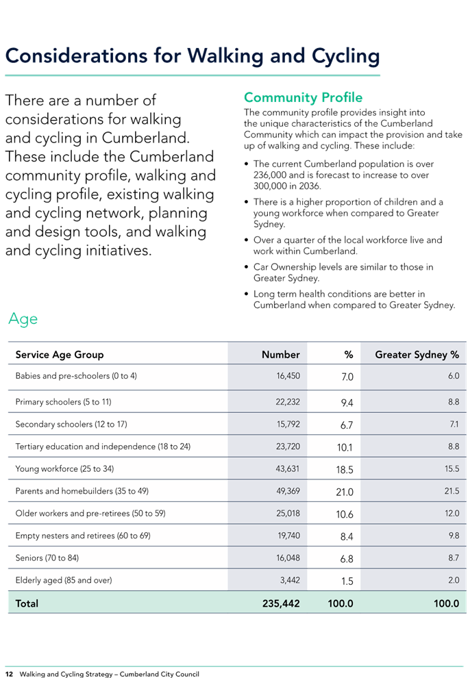
Based on the 2021 Census, a total of over 60,000 vehicles are registered at private occupied dwellings in the Cumberland LGA. While only a small proportion of these vehicles are battery operated EVs (around 900 vehicles in March 2024), this figure is projected to increase over time. The growing proportion of EVs will require the provision of appropriate charging infrastructure. Currently, publicly accessible charging stations are available in selected shopping centres and petrol stations, as shown in Figure 1. However, there are opportunities to increase the provision of publicly accessible charging stations on Council owned land by a third party provider or by Council itself.
Draft Public Electric Vehicle Charging Infrastructure Policy
The Draft Public Electric Vehicle Charging Infrastructure Policy and supporting Guideline have been developed by Council officers to provide a framework in response to the provision of EV charging infrastructure on Council land. The documents cover a range of areas, including approval processes, design considerations, charging specifications, site selection, advertising, financial commitments and leasing arrangements of public EV charging infrastructure on Council owned and managed land. The documents enable Council to facilitate and prepare for the growing demand to rollout publicly accessible electric vehicle charging infrastructure for our community.
It is now recommended that Council place the Draft Public Electric Vehicle Charging Infrastructure Policy and supporting Guideline on public exhibition for a period of 28 days, and subsequently adopt the document if no adverse submissions are received. Should the Policy be adopted, the Guideline identified in this report will support the implementation of the Policy.
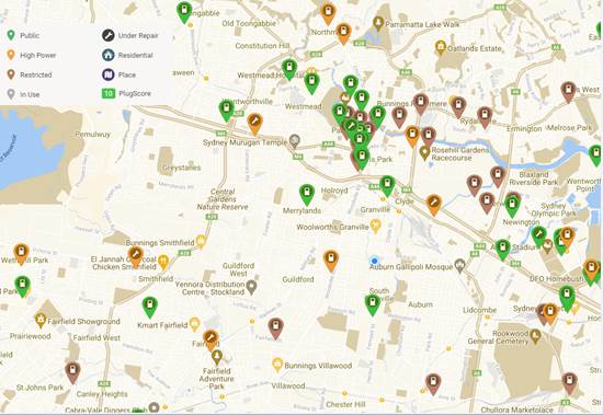
Figure 1. Map of EV Charging Infrastructure in Cumberland (Source: https://www.plugshare.com/)
Electric Vehicle Charging Infrastructure Grant Opportunities
Council officers have identified a range of grant opportunities for the provision of electric vehicle (EV) charging infrastructure, as outlined in Table 1. While there are currently no open rounds, it is anticipated that future round will be opened for Council to consider an application as appropriate.
|
Grant |
Status |
Information |
|
Driving the Nation Program – Innovation in Charging (Federal) |
Open |
Council is eligible for this initiative; however, the criteria include the requirement to commit to a minimum $0.5M co-contribution funding. Council must also acquire access to supply chains in the form of established infrastructure and demonstrate a pathway from council use to commercial deployment in an ongoing commitment. Where chargers are to be deployed, these should be available to the public |
|
Electric Vehicle Destination Charging (State) |
Open, but not eligible |
Cumberland City Council is not currently eligible for this grant. We may be named as an eligible LGA in future rounds. If so, this grant can be revisited at that time |
|
Electric Vehicle Kerbside Charging (State) |
Closed, awaiting future round |
Cumberland City Council may be eligible for this funding initiative. The grant requires a minimum of 4 EV charging sites with a total combined minimum of 8 EV charge ports (e.g. 4 dual port EV chargers, 8 single port EV chargers or a combination thereof). The NSW Government will contribute 80% of the total installation cost and equipment costs capped at $10,000 and 80% of EV charger software subscription for 3 years, with a total maximum government contribution of $800,000 |
Community Engagement
Subject to endorsement by Council, the Draft Policy and supporting Guideline will be placed on public exhibition for a period of 28 days.
Policy Implications
The Draft Policy and supporting Guideline on EV charging infrastructure aligns with Council’s Community Strategic Plan, Smart Places Strategy and Action Plan, as well as the NSW Government’s Electric Vehicle Strategy.
Risk Implications
The Policy and supporting guideline on EV charging infrastructure provides a framework to minimise risks to Council and the community in this area.
Financial Implications
While there are no current financial implications, there may be a funding commitment required should a grant opportunity on EV charging infrastructure be open where Council is eligible and interested to apply.
CONCLUSION
This report provides a response to the Notice of Motion – Electric Vehicle (EV) Charging Stations resolved at the Ordinary Meeting of Council on 5 July 2023. It recommends that Council endorse the Draft Public Electric Vehicle Charging Infrastructure Policy and supporting Guideline being placed on public exhibition for a period of 28 days. Information on grant opportunities is also provided for consideration.
Attachments
1. Draft Public Electric Vehicle Charging Infrastructure Policy
2. Draft Public Electric Vehicle Charging Infrastructure Guideline
DOCUMENTS
ASSOCIATED WITH
REPORT C05/24-508
Attachment 1
Draft Public Electric Vehicle Charging Infrastructure Policy
DOCUMENTS
ASSOCIATED WITH
REPORT C05/24-508
Attachment 2
Draft Public Electric Vehicle Charging Infrastructure Guideline
1 May 2024
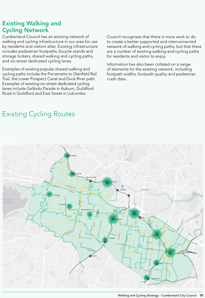
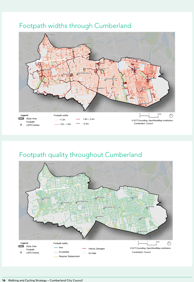
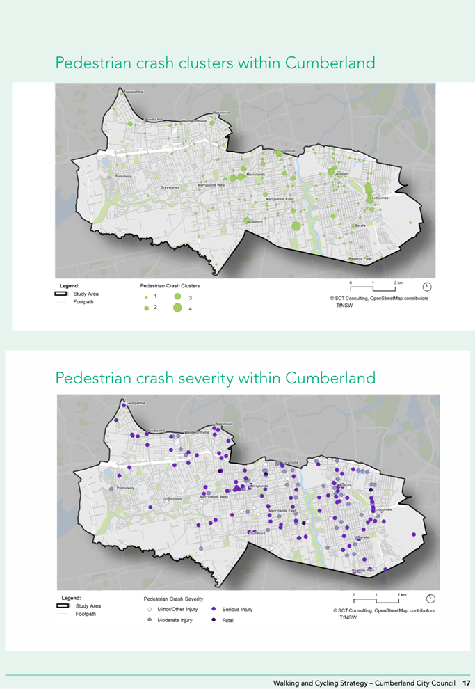
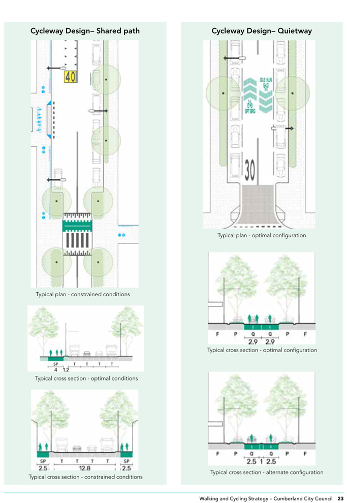
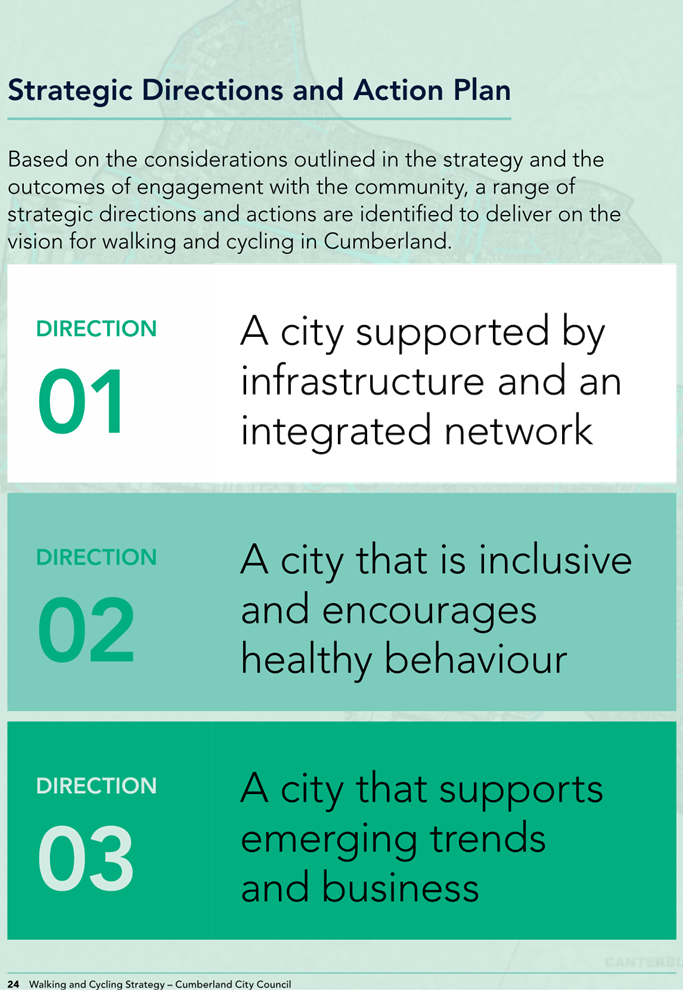
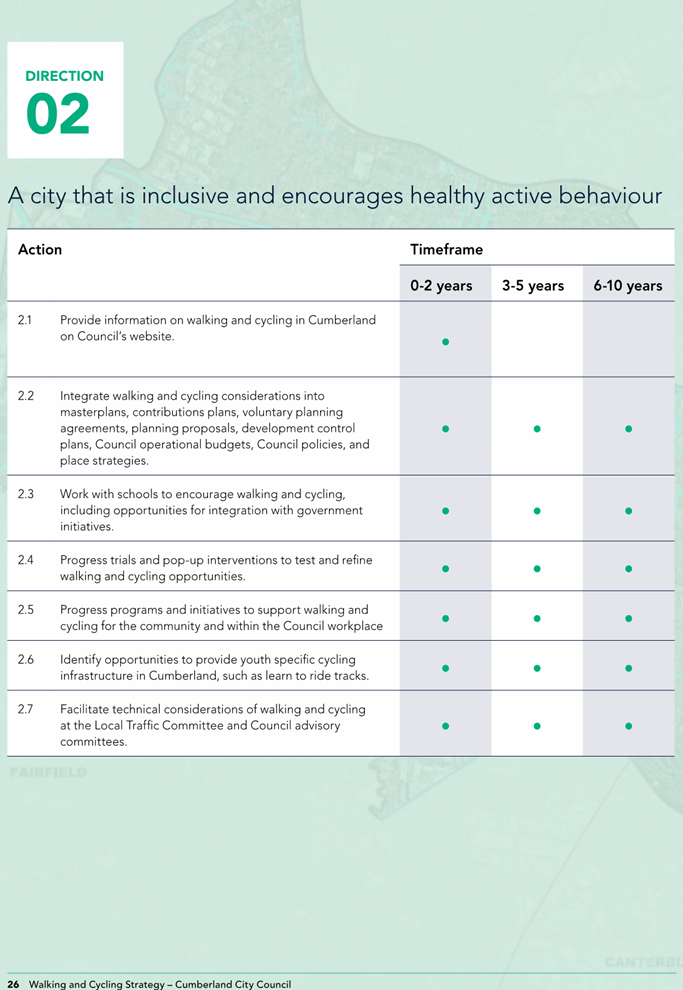
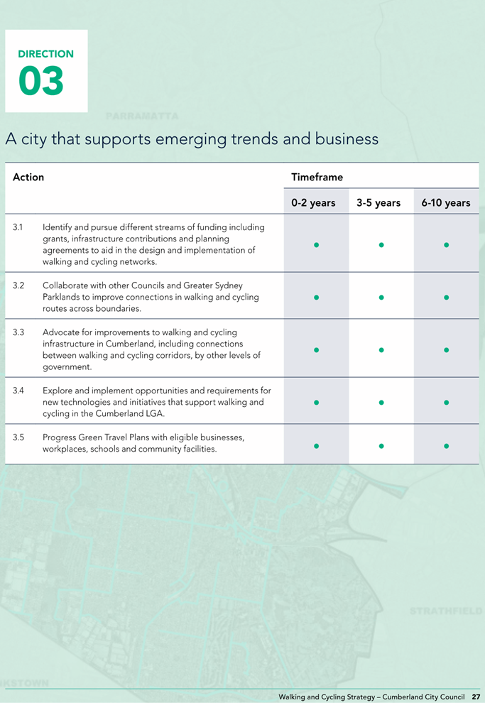
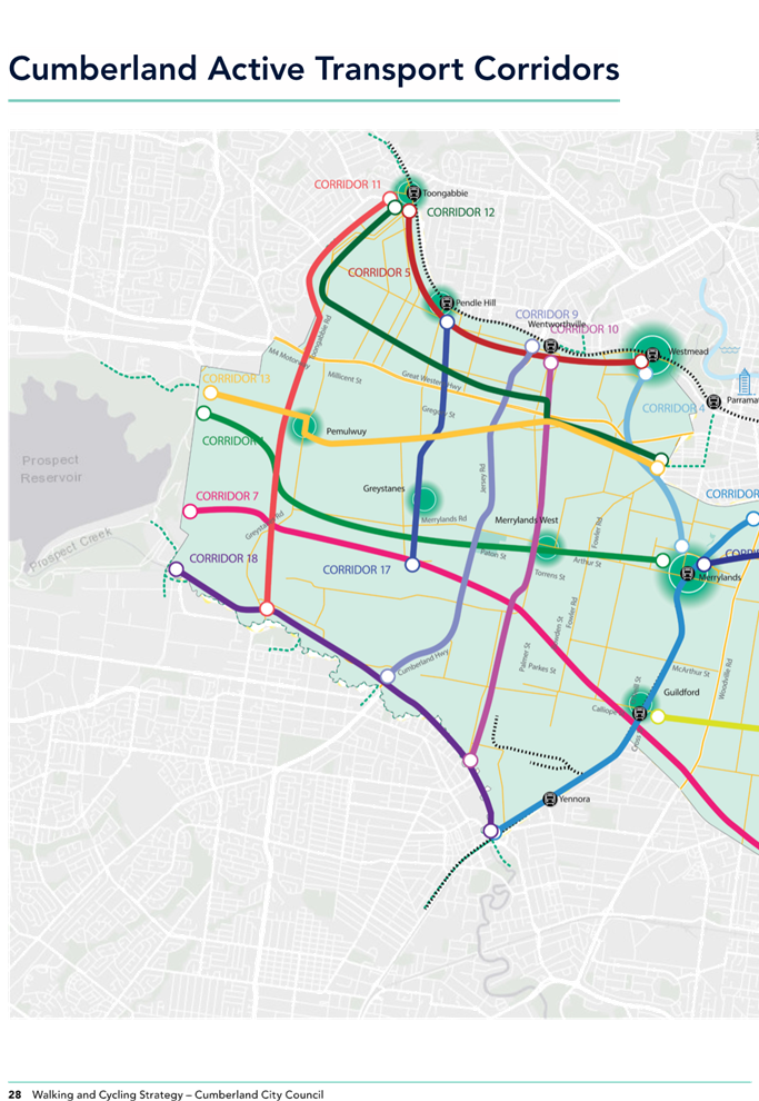
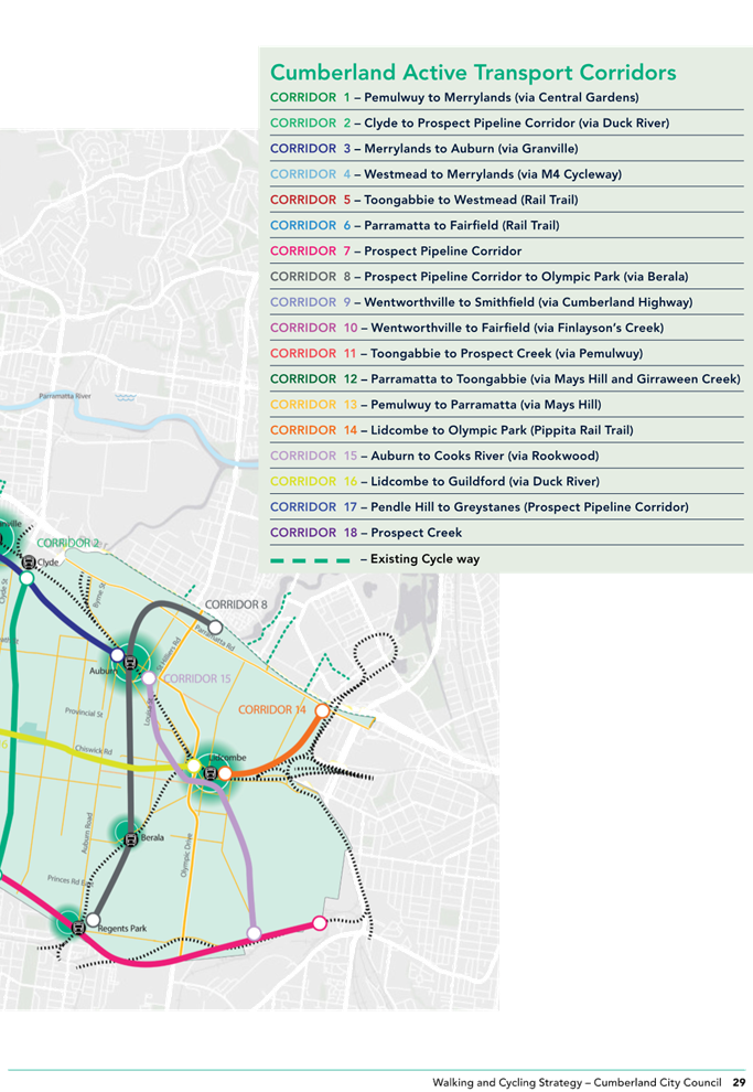
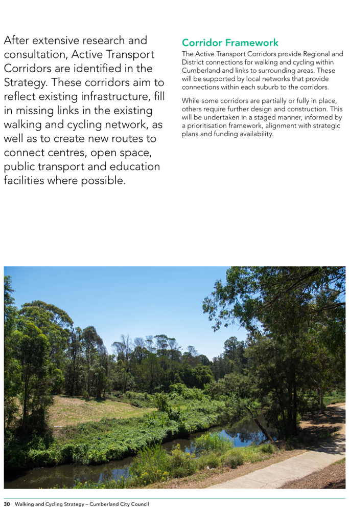
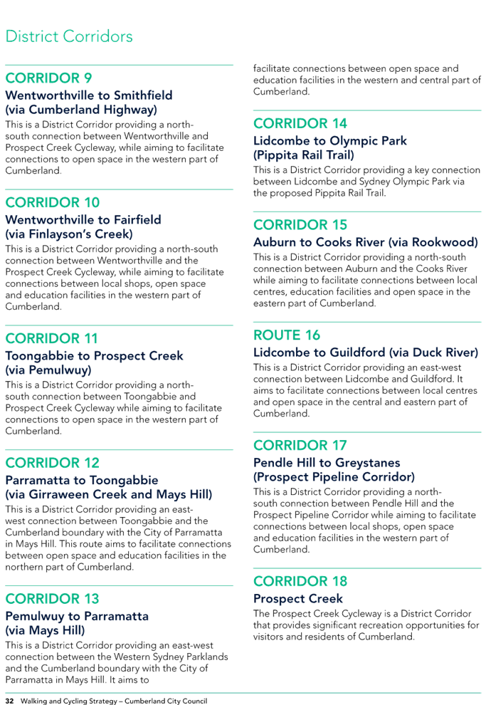
Item No: C05/24-509
Draft Cumberland Walking and Cycling Strategy - Post Exhibition Report
Directorate: Environment and Planning
Responsible Officer: Director Environment & Planning
Community Strategic Plan Goal: Enhancing the Natural and Built Environment
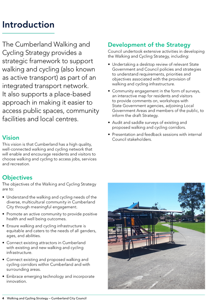
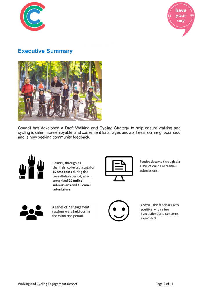
Summary
This report recommends the adoption of the Draft Cumberland Walking and Cycling Strategy following a period of public exhibition.
|
Recommendation That Council adopt the Draft Cumberland Walking and Cycling Strategy as provided in Attachment 1 of this report. |
Report
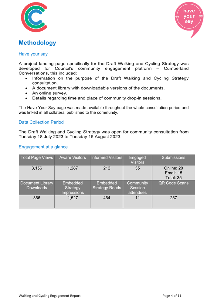
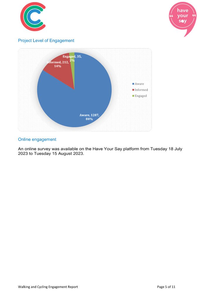
At the 5 July 2023 Ordinary Council meeting, Council resolved to place the Draft Cumberland Walking and Cycling Strategy on public exhibition for community feedback (Min. 474).
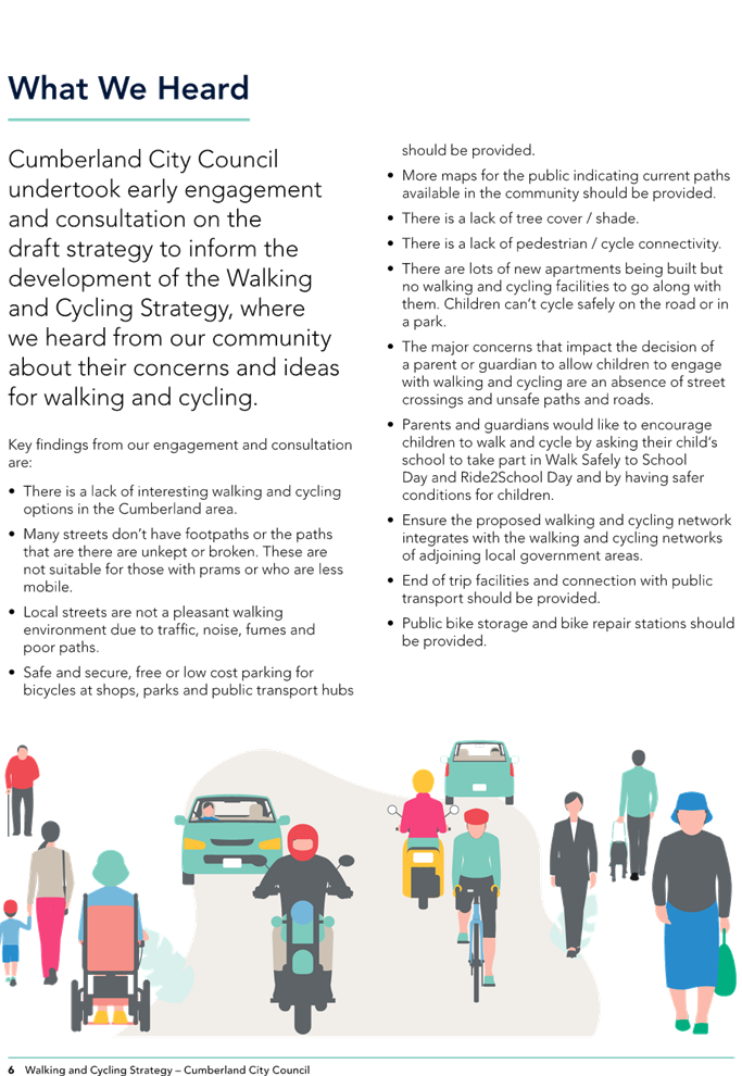
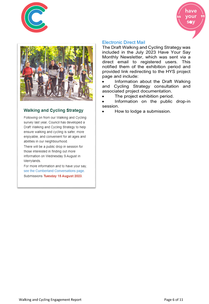
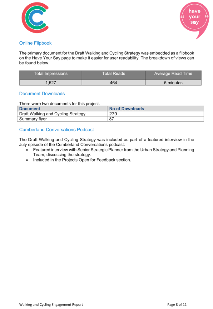
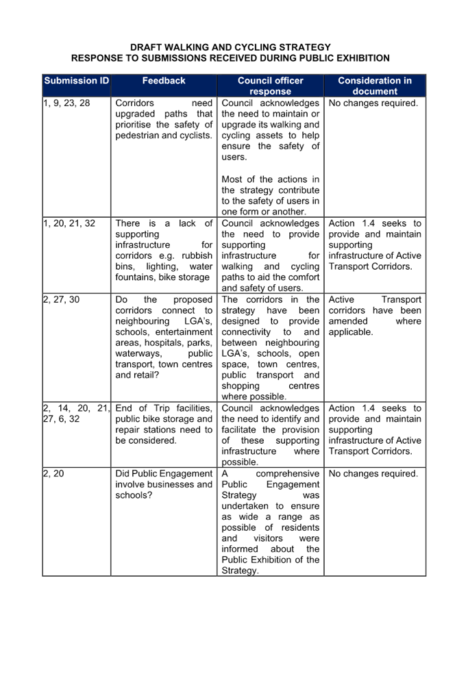
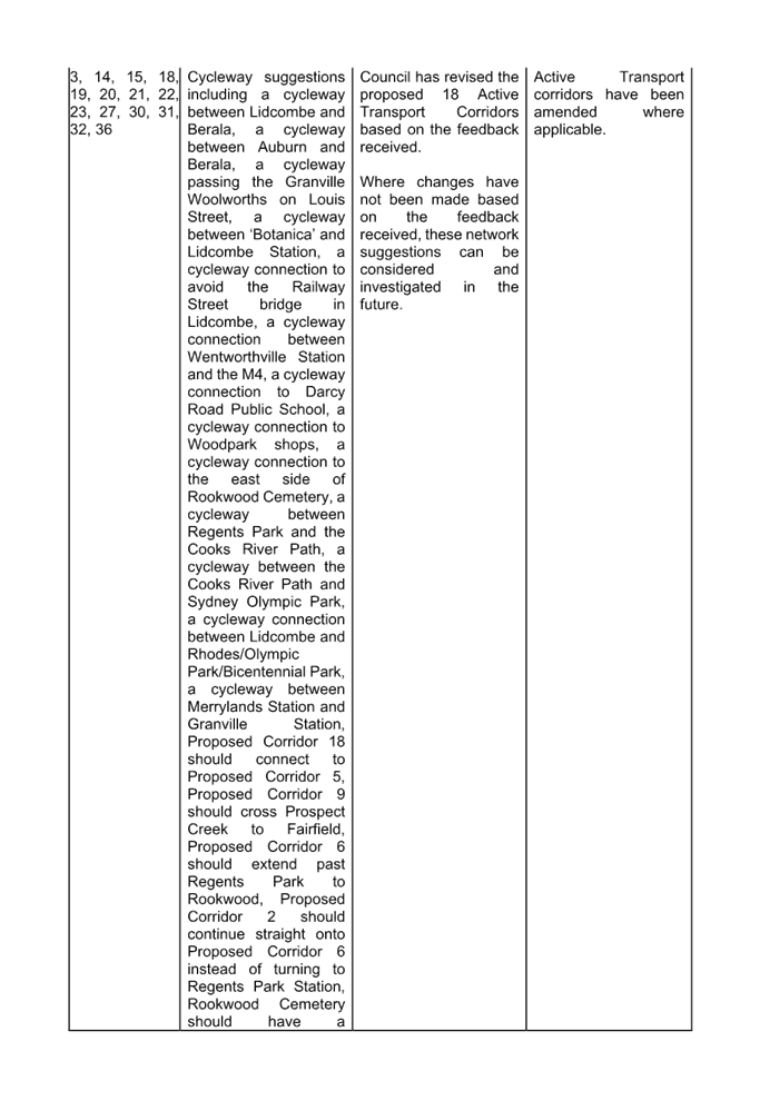
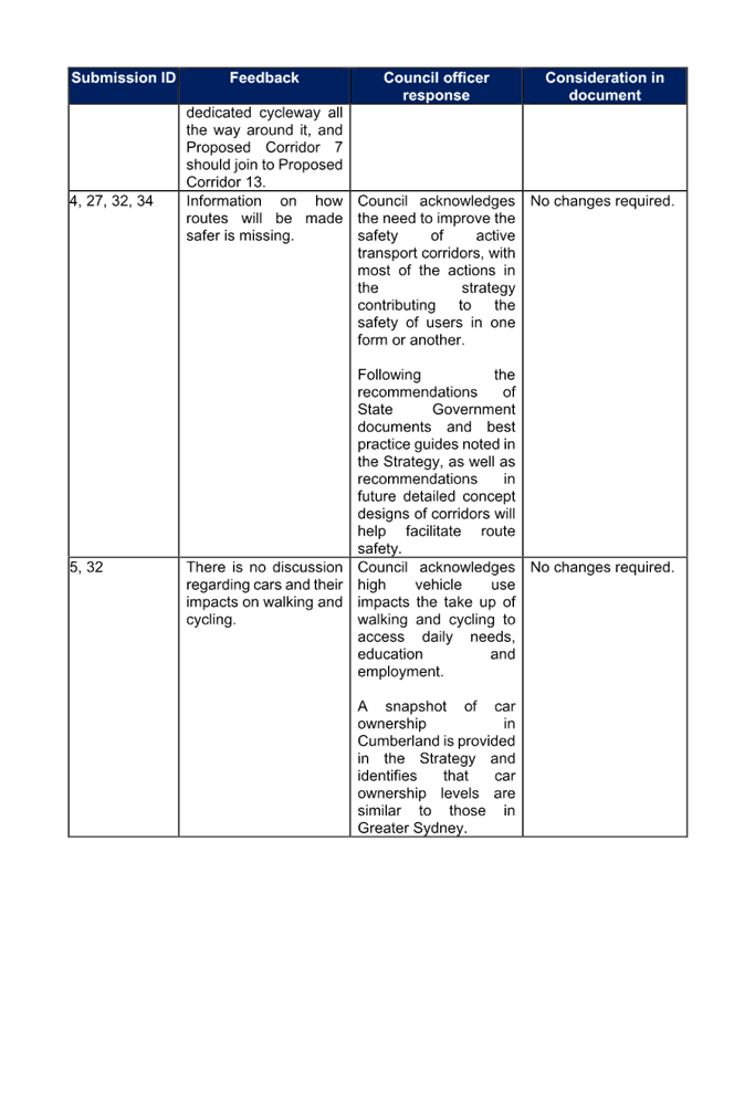
During the 28-day public exhibition period from 18 July 2023 to 15 August 2023, Council received 35 submissions, conducted one (1) drop-in session and conducted 1 targeted stakeholder workshop. A summary of all submissions received and Council’s response is provided with the report. Feedback received included:
· Suggestions to amend the Active Transport Corridors.
· Site specific infrastructure suggestions.
· Suggestions to improve the quality of the Strategy itself.
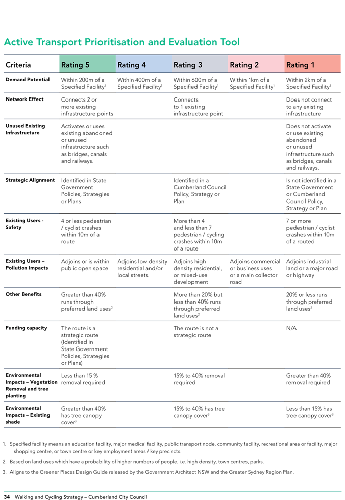
· Suggestions to amend the criteria and ratings in the Prioritisation and Evaluation Tool.
· Suggestions to amend the Strategic Directions and Action Plan.
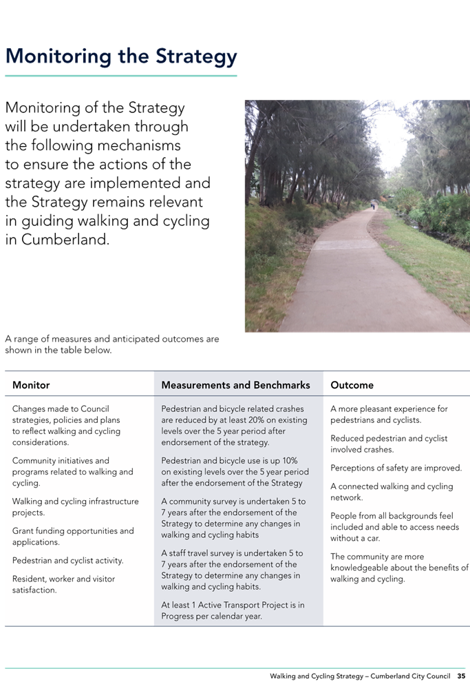
· Identifying clear measurements for monitoring the implementation of the strategy.
· Suggestions for the provision of supporting infrastructure.
· Suggestions for community initiatives to promote walking and cycling.
· Identifying the need to maintain existing and proposed walking and cycling infrastructure.
Changes proposed to the Draft Strategy as a result of feedback received during public exhibition include:
· Minor amendment to Action 3.2.
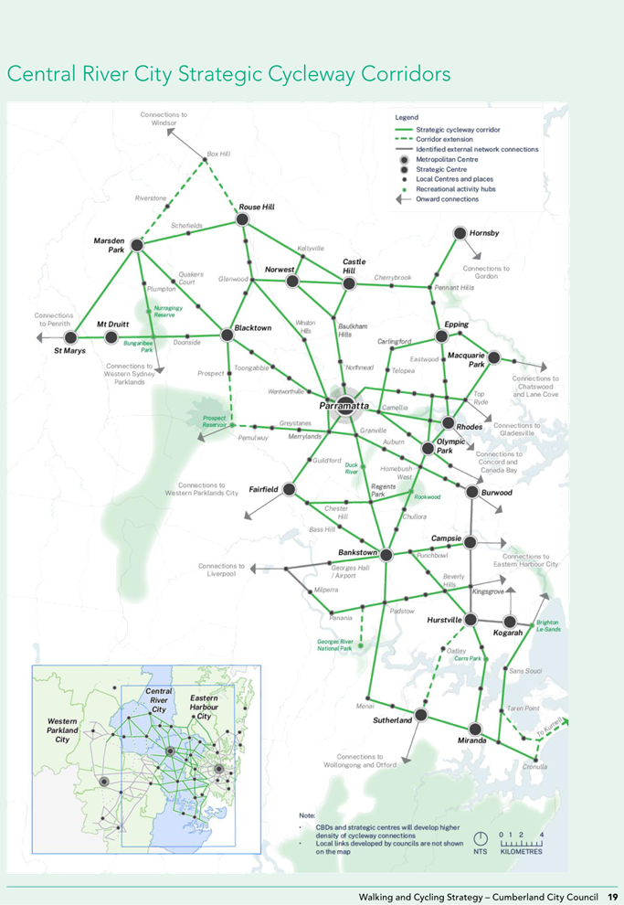
· Changes to the Active Transport Corridors with a new Corridor 5, changes to Corridor numbers, amendments to Corridors 2, 3, 7 and 18, and combining of Corridors 15 and 16 into a new Corridor 16.
· Amendment to the Prioritisation and Evaluation Tool criteria.
· Enhanced measurements for monitoring the strategy.
In accordance with the above, Council has now addressed all public feedback and recommends the Draft Cumberland Walking and Cycling Strategy be adopted by Council as outlined in Attachment 1 of this report.
Community Engagement
Council publicly exhibited the Draft Cumberland Walking and Cycling Strategy for a period of 28 days from 18 July 2023 to 15 August 2023 both on Council’s website and in local newspaper publications. Corflute signs were also placed at train stations and open space locations throughout Cumberland, and postcards and flyers were available to the community at Council offices, Council libraries and the Merrylands Civic Square opening.
Council had 3,156 visits to the ‘Have Your Say’ website during the public exhibition period, with 366 downloads of the Draft Strategy.
A stakeholder workshop was conducted with 5 attendees, as well as a public drop-in session with 6 attendees.
Submissions were received from 35 respondents, 20 through the ‘Have Your Say website’ and 15 directly to Council officers.
Council has formally responded to all respondents who made a submission and notified them of the consideration of this item at this Council meeting.
Policy Implications
The Draft Strategy aligns with Council’s Community Strategic Plan 2017-2027 and Cumberland 2030: Our Local Strategic Planning Statement. Should Council endorse the Draft Strategy, the Cumberland Walking and Cycling Strategy would become a new policy of Council.
Risk Implications
There are no risk implications for Council associated with this report.
Financial Implications
Funding is provided in Council’s Capital Works Program for some walking related works such as footpaths. Opportunities for further funding of walking and cycling initiatives will be considered as part of the forward program, including use of capital funding, local infrastructure contributions and grants.
The ability to seek additional funding for sources outside of Council will be enhanced with an endorsed Walking and Cycling Strategy in place.
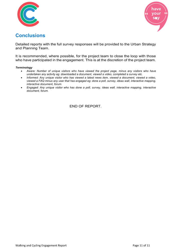
CONCLUSION
Council has publicly exhibited the Draft Cumberland Walking and Cycling Strategy, and formally responded to all who made a submission. The Strategy is now recommended for adoption.
Attachments
1. Cumberland Walking and Cycling Strategy
2. Draft Walking and Cycling Strategy - Engagement Report
3. Draft Walking and Cycling Strategy - Response to Submissions
DOCUMENTS
ASSOCIATED WITH
REPORT C05/24-509
Attachment 1
Cumberland Walking and Cycling Strategy
DOCUMENTS
ASSOCIATED WITH
REPORT C05/24-509
Attachment 2
Draft Walking and Cycling Strategy - Engagement Report
DOCUMENTS
ASSOCIATED WITH
REPORT C05/24-509
Attachment 3
Draft Walking and Cycling Strategy - Response to Submissions
1 May 2024
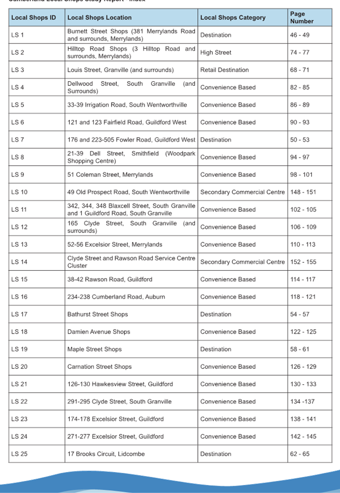
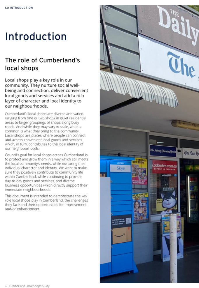
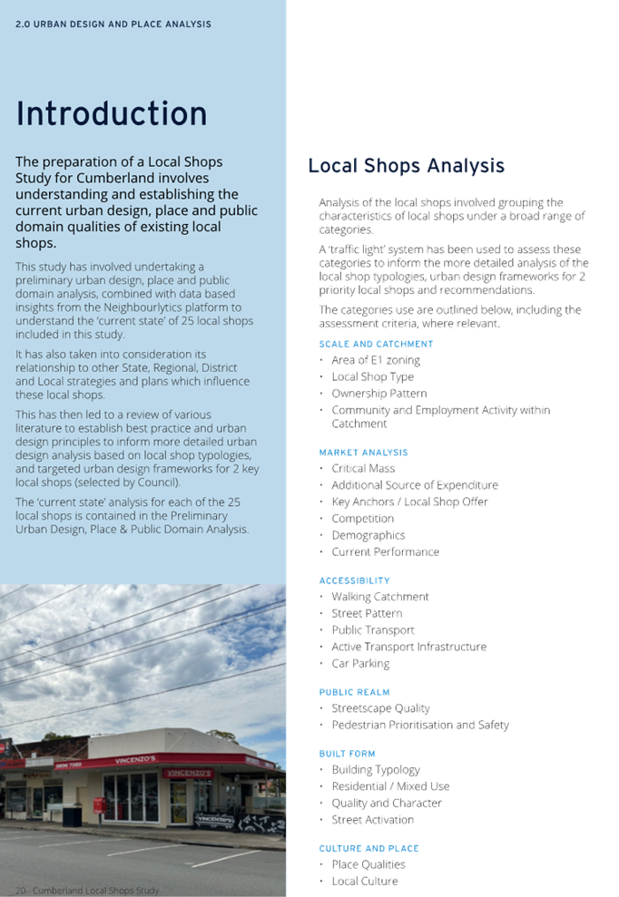
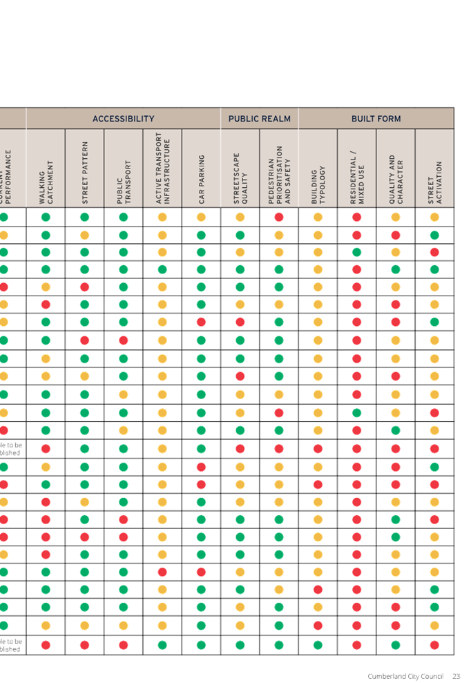
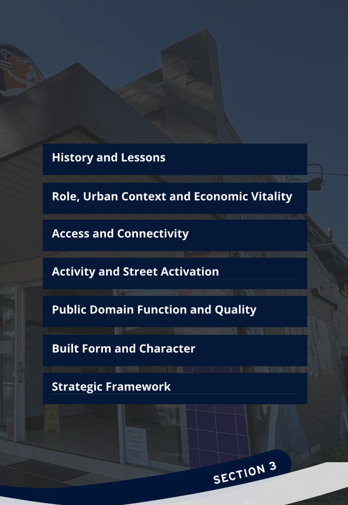
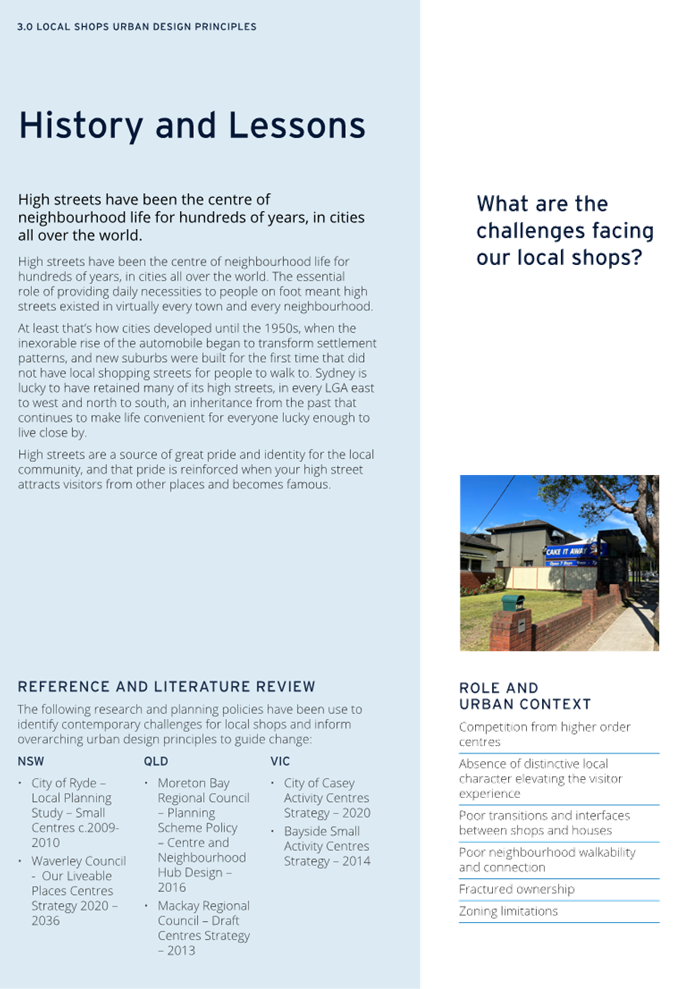
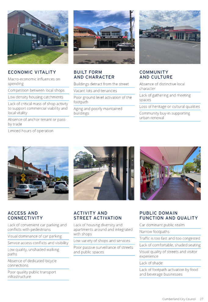
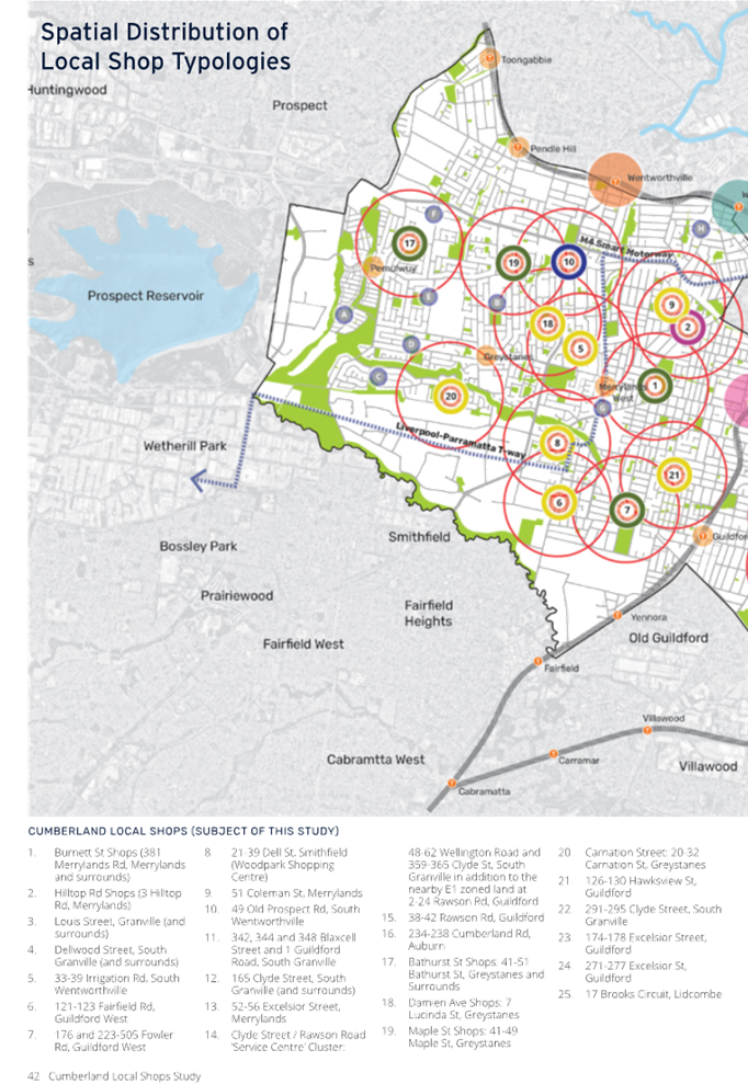
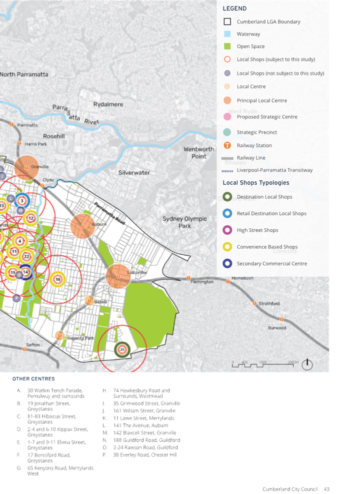
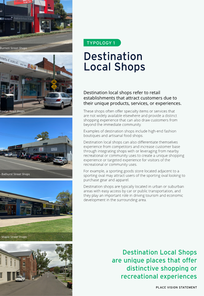
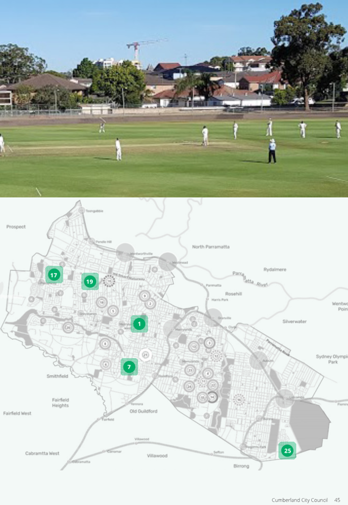
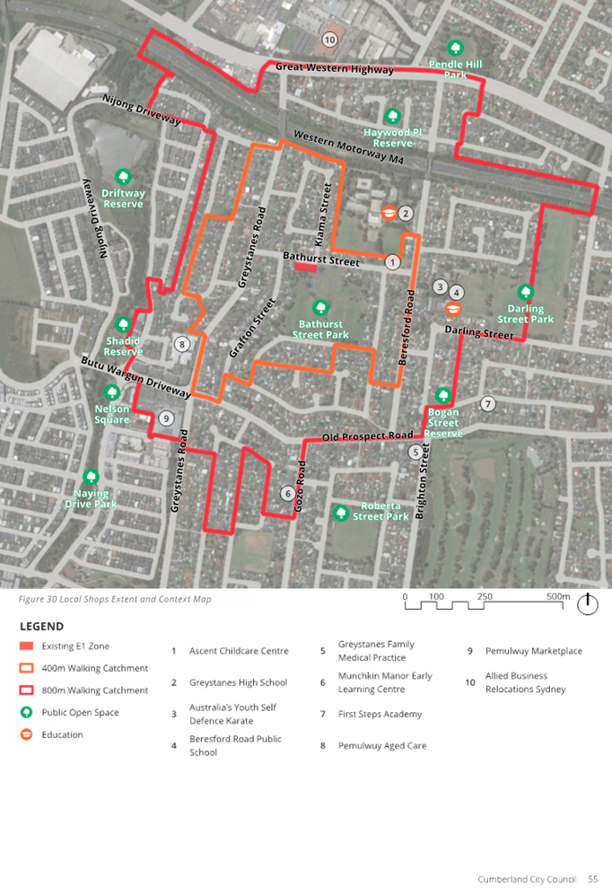
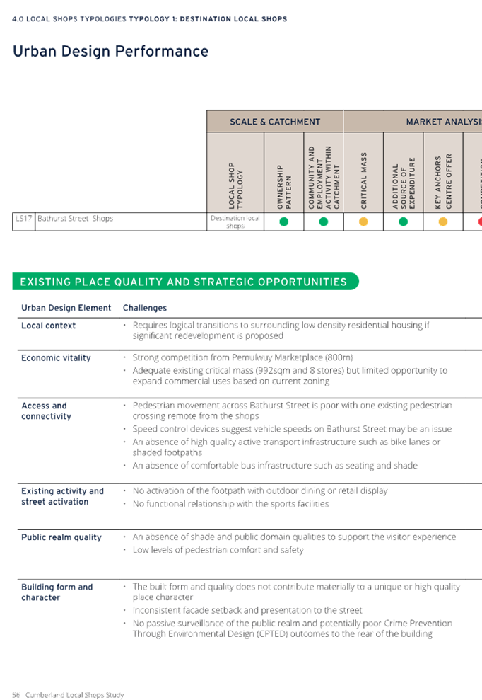
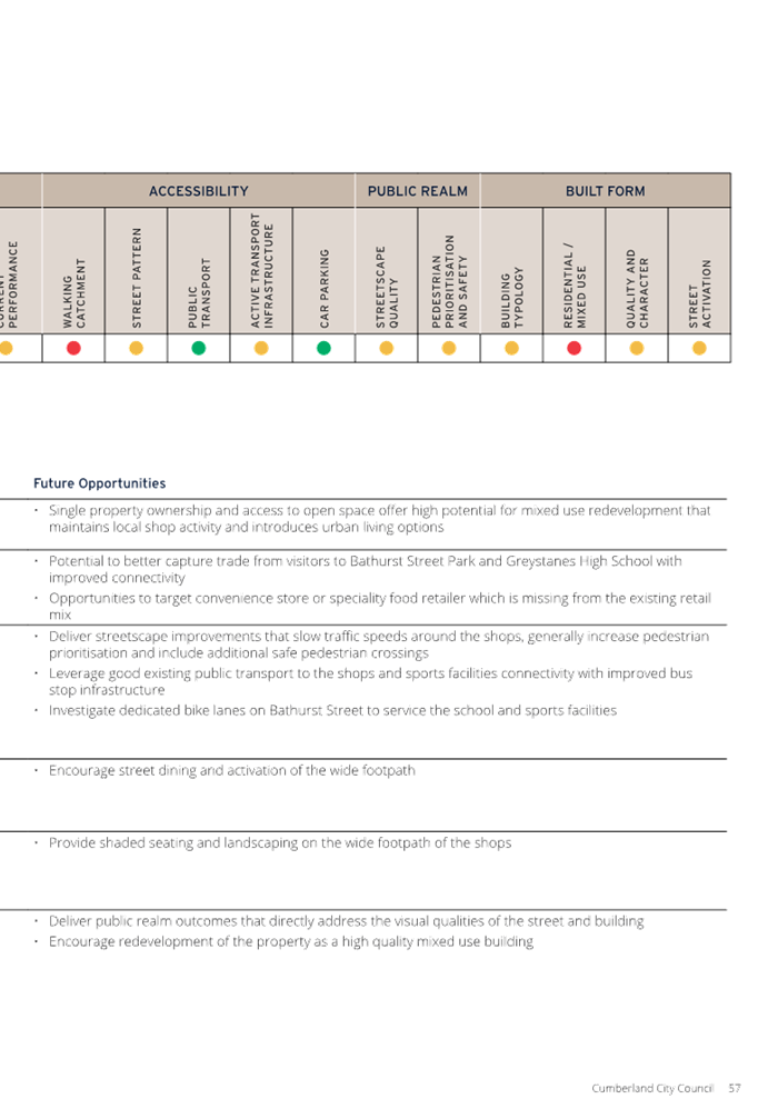
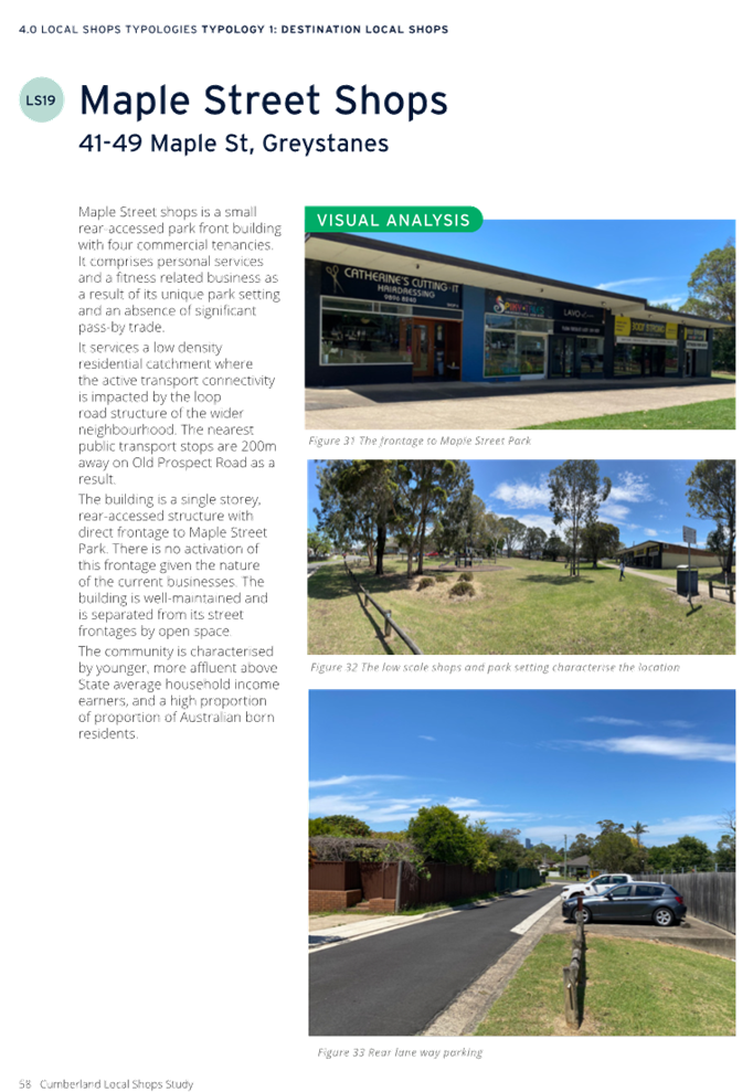
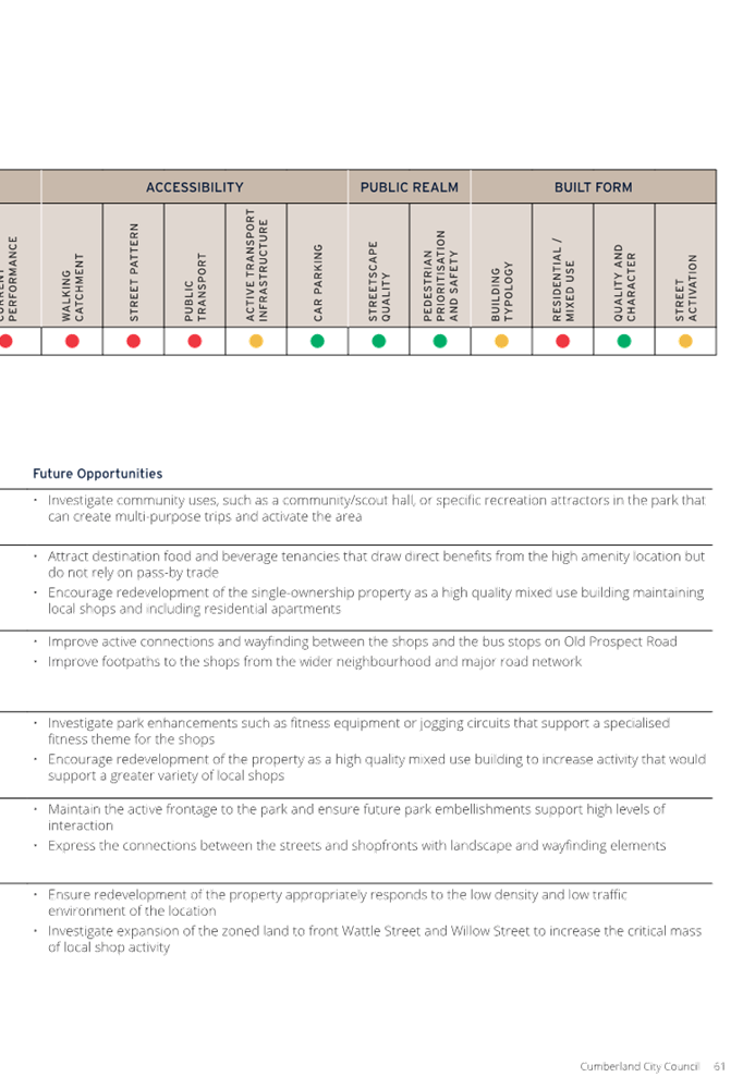
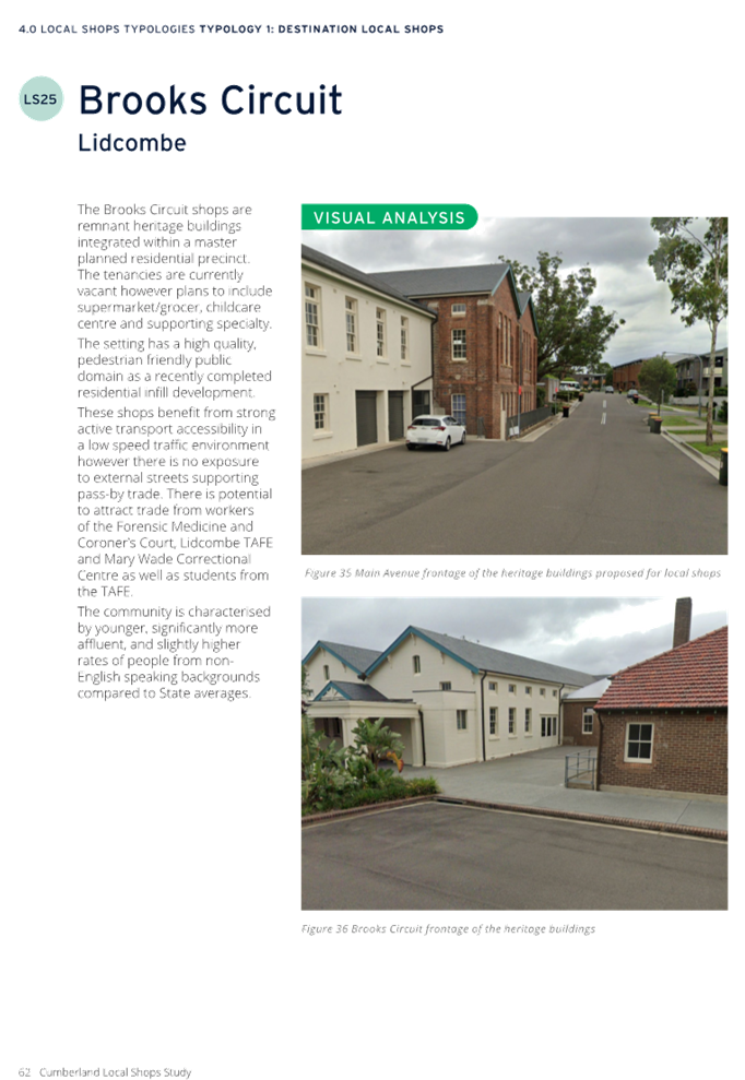
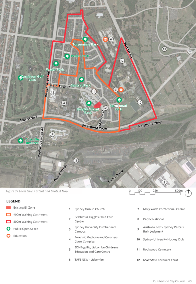
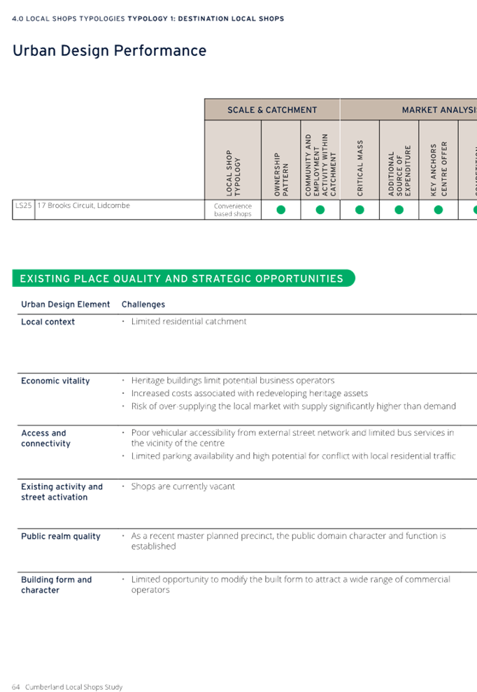
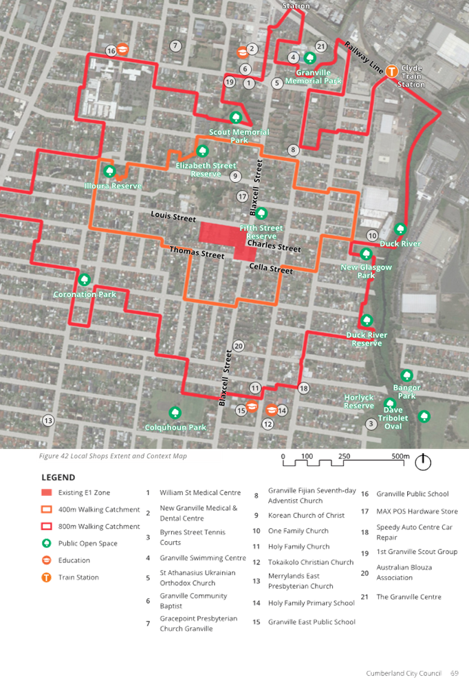
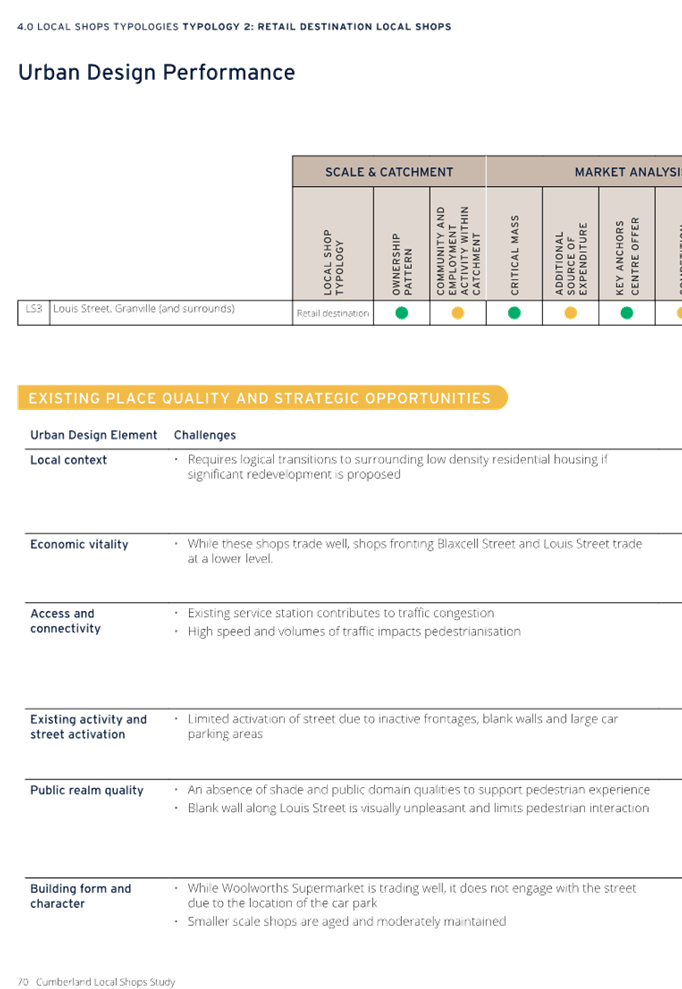
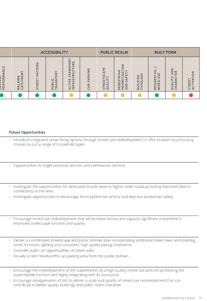
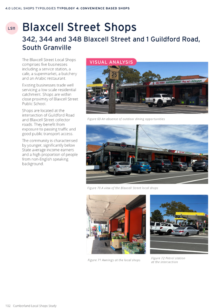
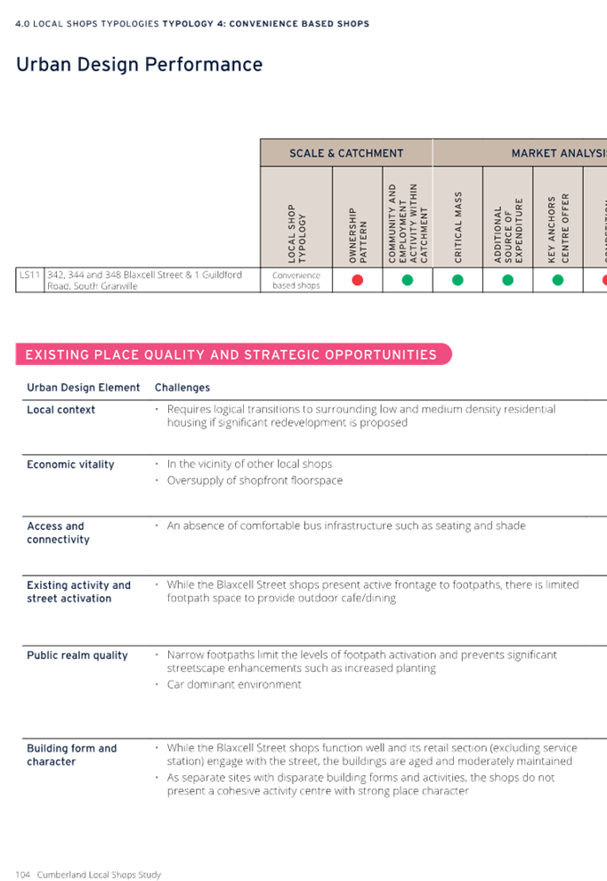
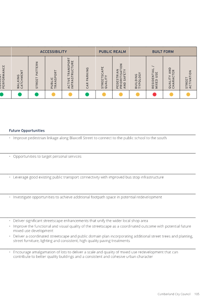
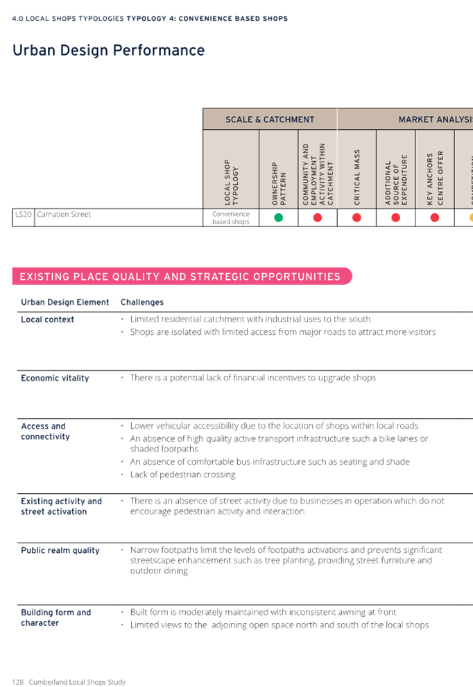
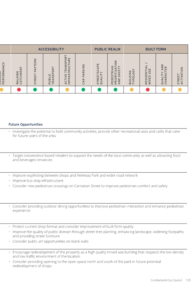
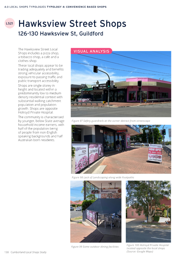
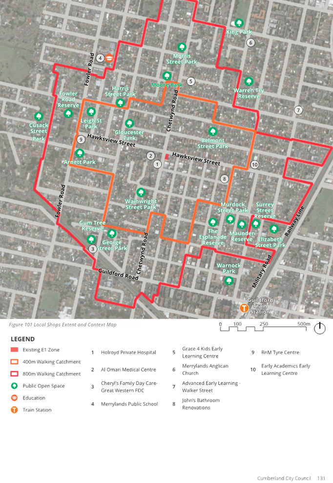
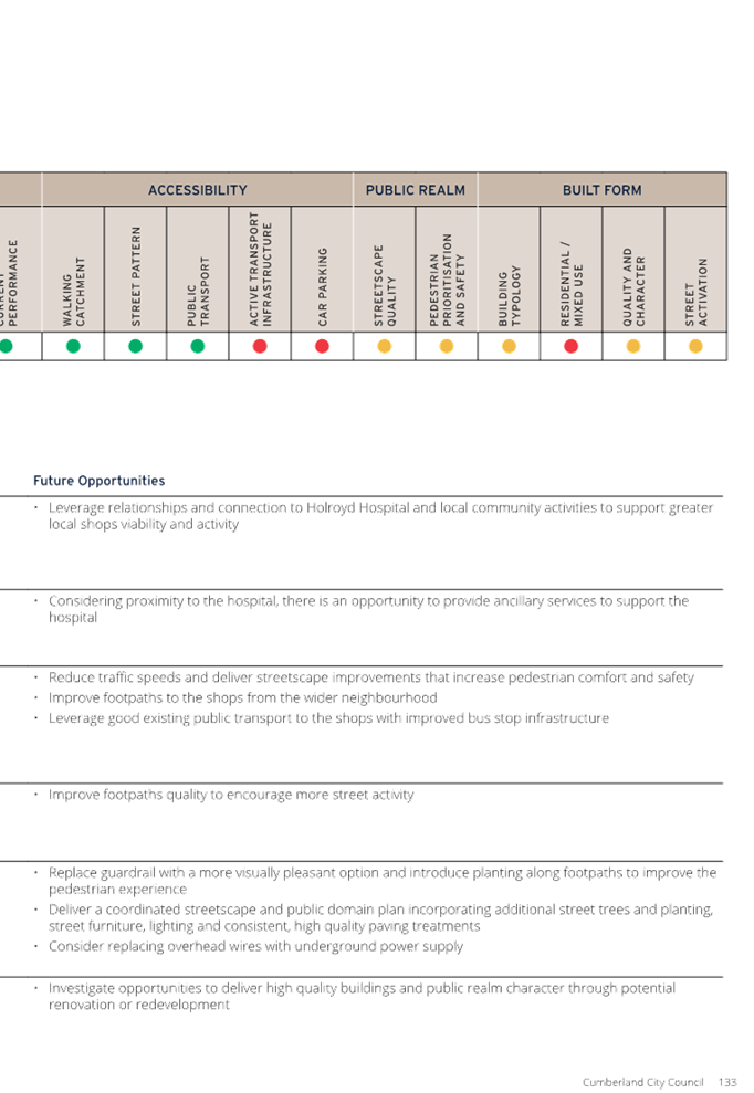
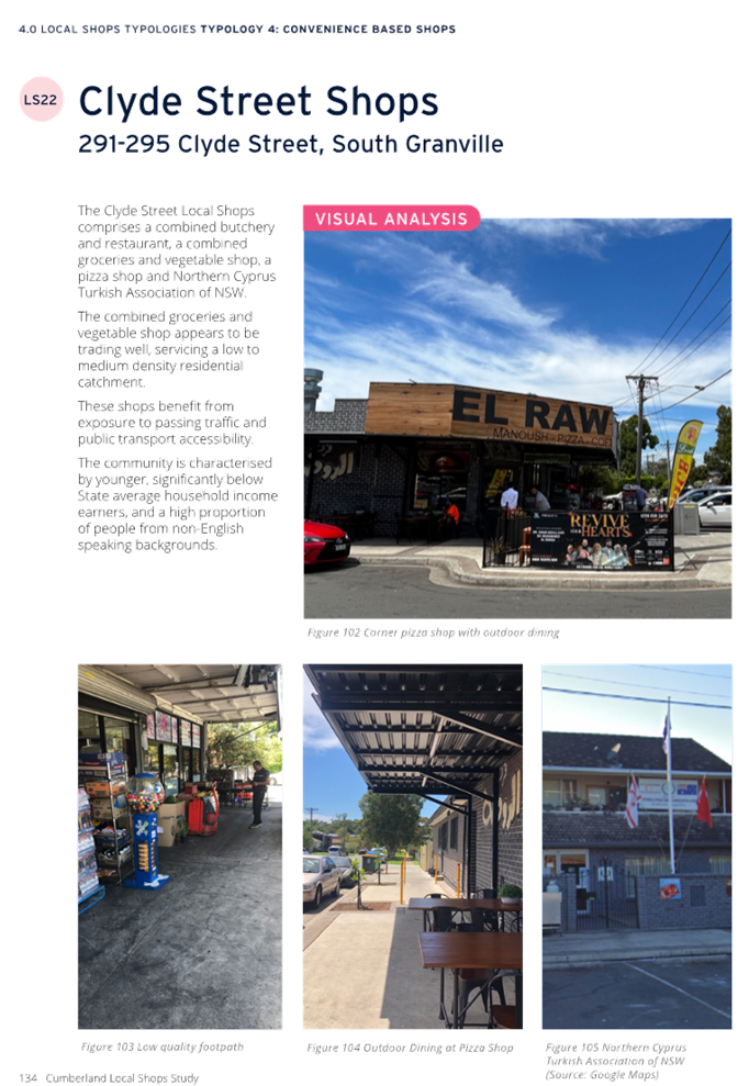
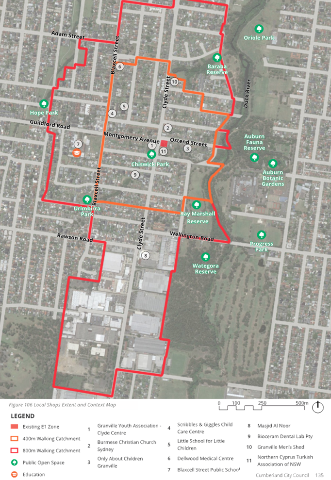
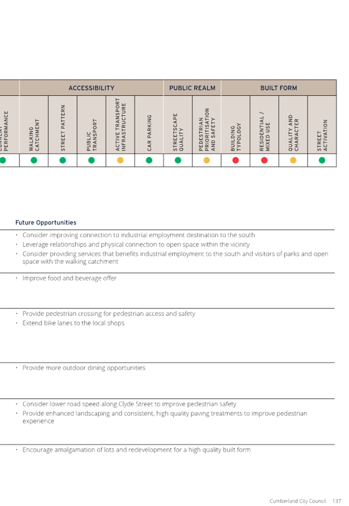
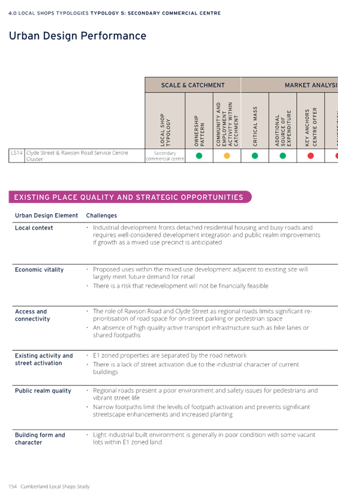
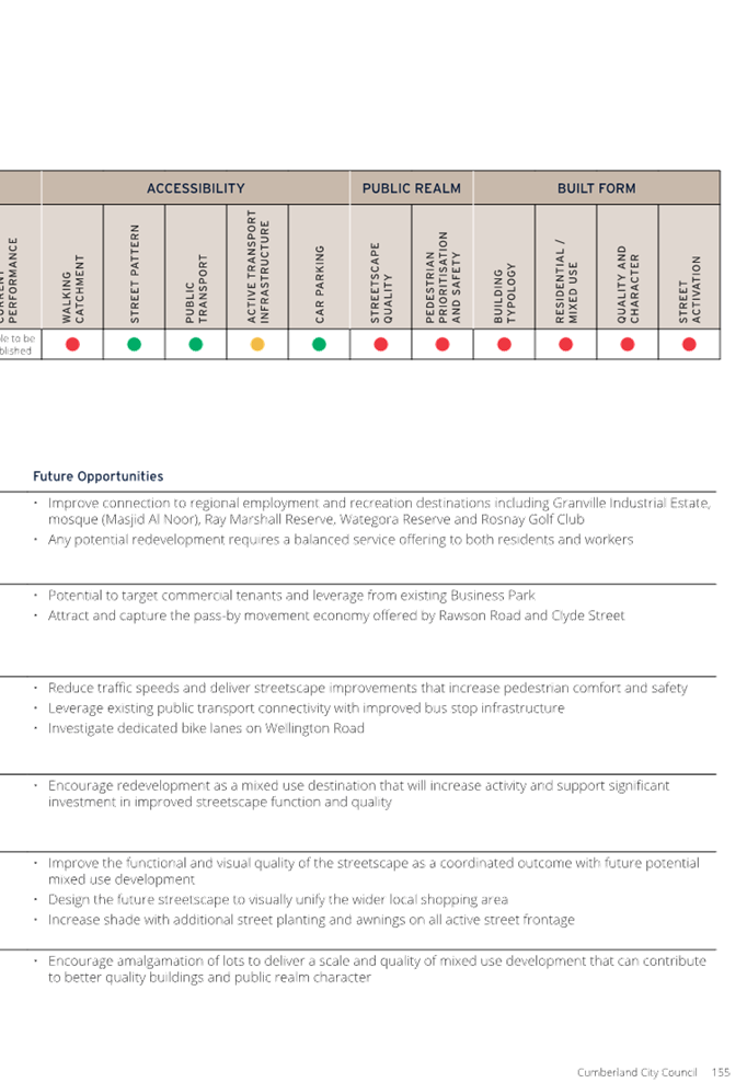
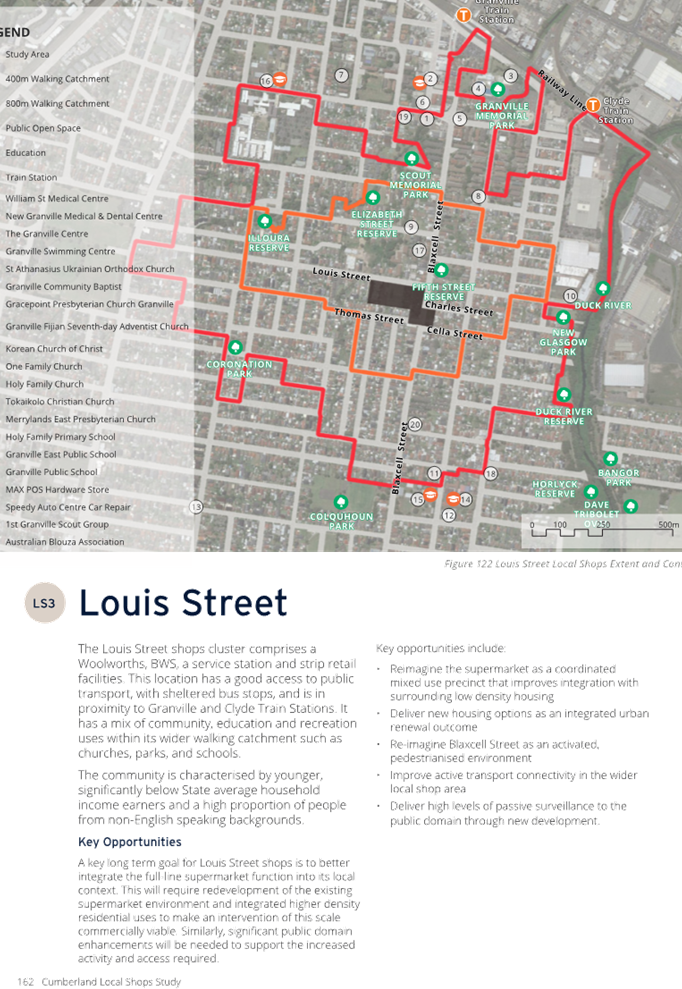
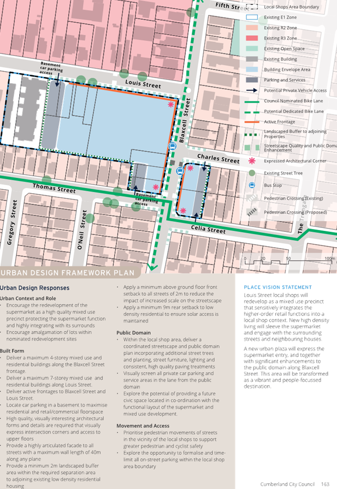
Item No: C05/24-510
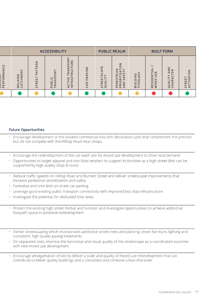
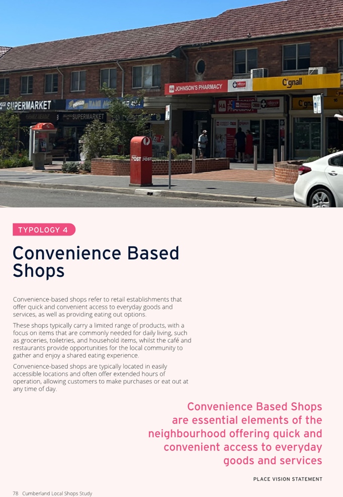
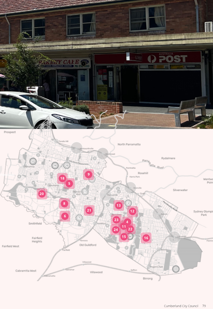
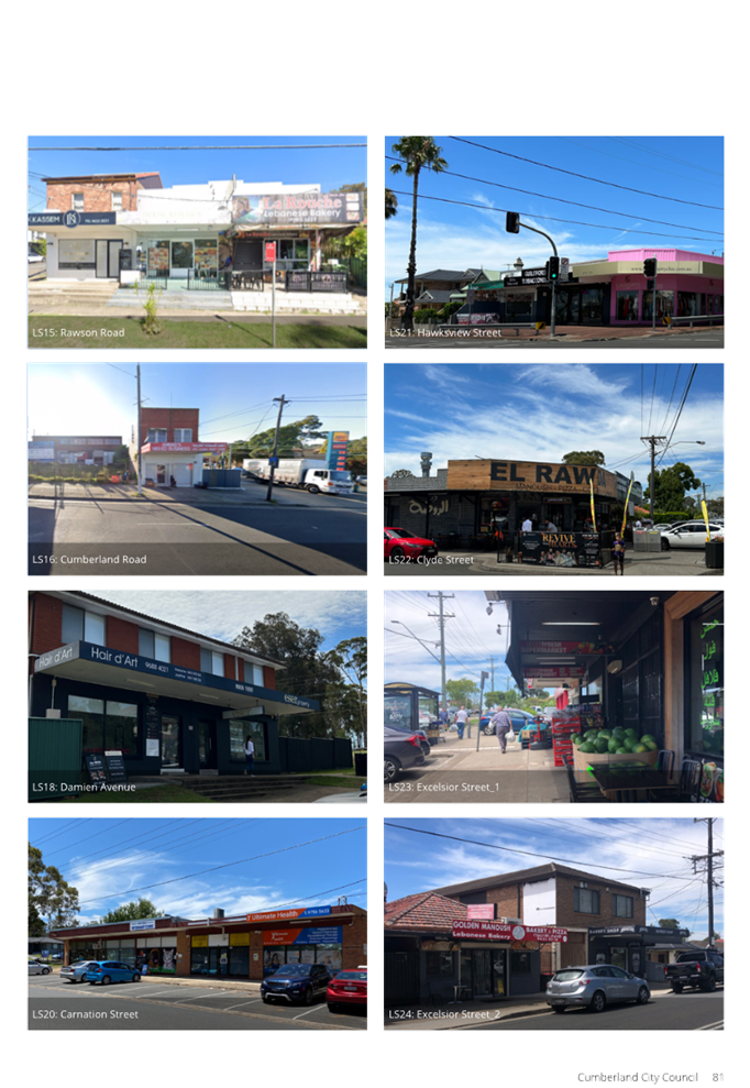
Draft Cumberland Local Shops Study - Post Exhibition
Directorate: Environment and Planning
Responsible Officer: Director Environment & Planning
Community Strategic Plan Goal: Enhancing the Natural and Built Environment
Summary
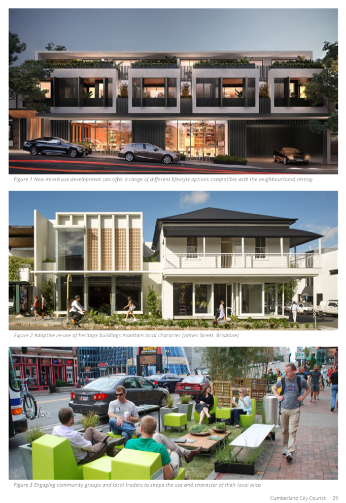
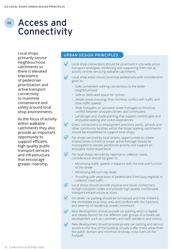
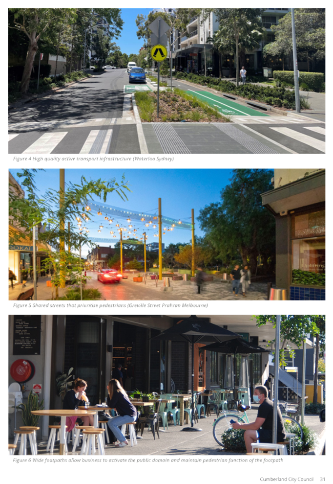
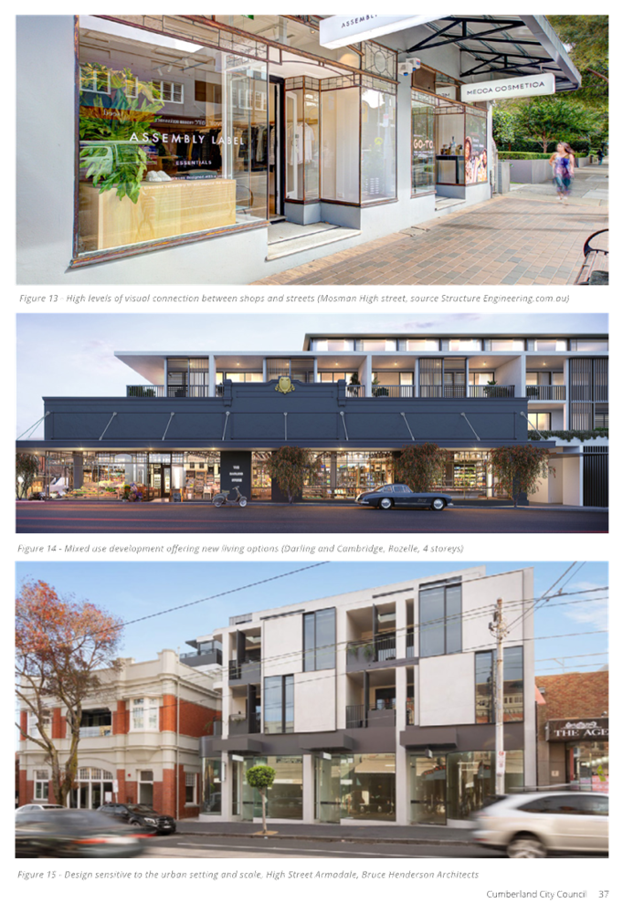
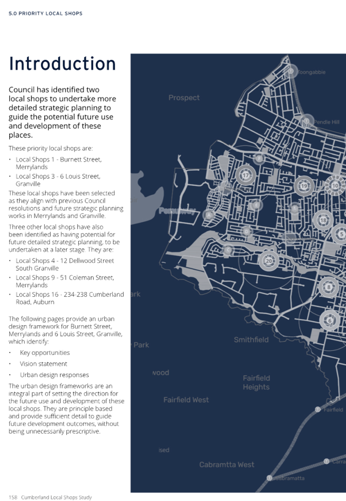
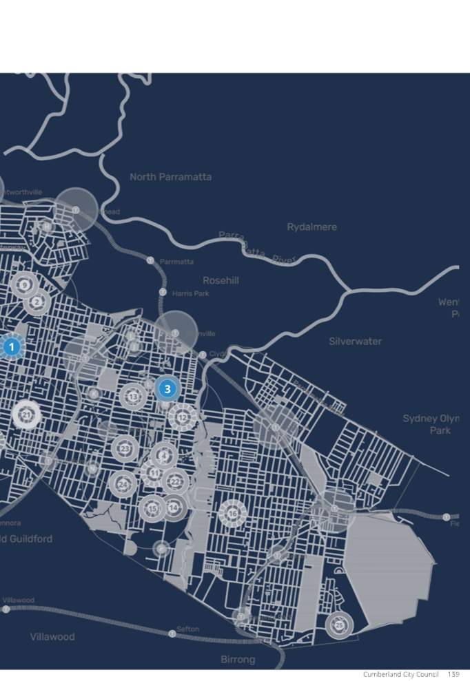
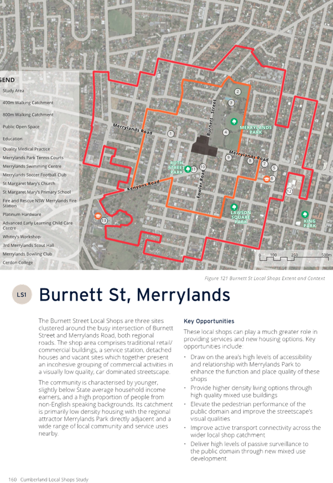
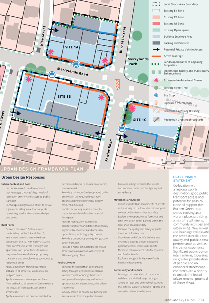
The draft Cumberland Local Shops Study has been developed to explore how Council can understand, protect and enhance our local shops to meet the needs of the community now and in the future.
The Study was placed on public exhibition seeking feedback from the community and businesses. This report details the outcomes from submissions received during the public exhibition period and recommends the adoption of the Cumberland Local Shops Study.
|
Recommendation That Council adopt the Cumberland Local Shops Study as provided in this report. |
Report
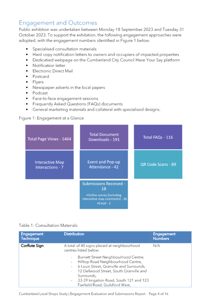
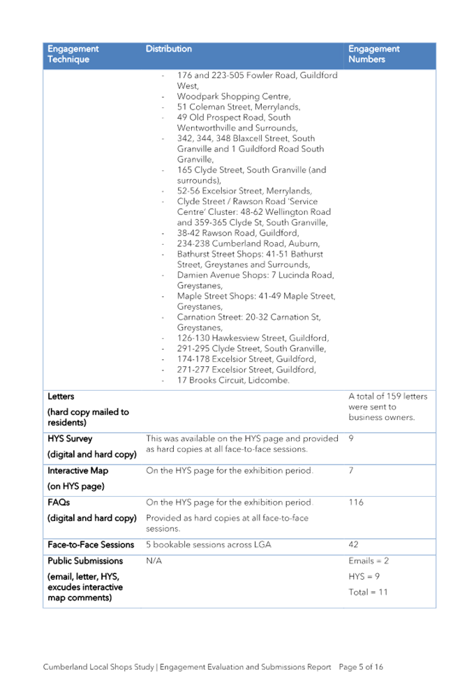
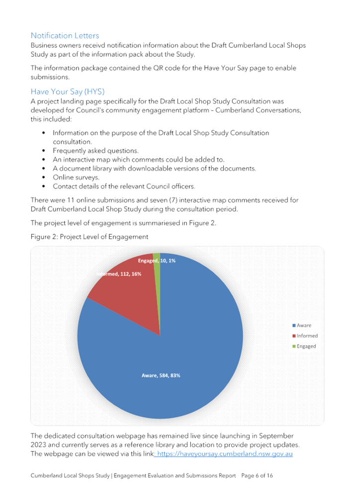
Council at its meeting of 16 August 2023 (Item No: C08/23-368) resolved that the Draft Cumberland Local Shops Study be placed on public exhibition, with a report to be provided back to Council (Min. 505).
The Draft Cumberland Local Shops Study was exhibited for more than 28 days between Monday 18 September to Tuesday 31 October 2023 and made available on Council’s ‘Have Your Say’ page.
Subsequently, a total of 18 submissions were received. A summary of the submissions received and Council’s responses are outlined in Attachment 4 to this report.
The final draft revision of the documents following the public exhibition period have been prepared to take account of minor errors and text clarifications.
In accordance with the above, Council has now addressed all public feedback and recommends the Cumberland Local Shops Study be adopted by Council as provided in this report.
Community Engagement
Council publicly exhibited the Draft Cumberland Local Shops Study for more than 28 days from Monday 18 September to Tuesday 31 October 2023 both on Council’s website and in local newspaper publications.
Council had 1,464 visits to the ‘Have Your Say’ community engagement website during the public exhibition period, with 191 downloads of the documents provided. 42 people participated in the drop in sessions provided.
Submissions were received from 18 respondents. Council has formally responded to all respondents who made a submission and notified them of the consideration of this item at this Council meeting.
Methods of engagement included:
· Notices published in local newspapers.
· Notices sent to Have Your Say Newsletter participants.
· Letters were distributed to local businesses.
· Posters were installed at select locations within the local shops identified.
· Five drop in sessions held across Cumberland.
Policy Implications
The Cumberland Local Shops Study is consistent with current State and local strategies and plans.
Risk Implications
There are no risk implications for Council associated with this report.
Financial Implications
There are no financial implications for Council associated with this report.
CONCLUSION
The draft Cumberland Local Shops Study has been developed to explore how Council can understand, protect and enhance our local shops to meet the needs of the community now and in the future. It is recommended that Council adopt the Cumberland Local Shops Study as provided in this report.
Attachments
1. Cumberland Local Shops Study
2. Cumberland Local Shops Study - Economic and Retail Analysis (Additional Attachment)
3. Cumberland Local Shops Study - Preliminary Urban Design, Place and Public Domain Analysis (Additional Attachment)
DOCUMENTS
ASSOCIATED WITH
REPORT C05/24-510
Attachment 1
Cumberland Local Shops Study
DOCUMENTS
ASSOCIATED WITH
REPORT C05/24-510
Attachment 4
Engagement Evaluation and Submissions Report
1 May 2024
Item No: C05/24-511
Response to Notice of Motion - Promotion of Opportunities in Development Industry (C04/24-502)
Directorate: Environment and Planning
Responsible Officer: Director Environment & Planning
Community Strategic Plan Goal: Delivering Sustainable Infrastructure and Services
Summary
This report provides a response to the Notice of Motion – Promotion of Opportunities in Development Industry resolved at the Ordinary Meeting of Council on 17 April 2024. It recommends that Council select an option in relation to the arrangements on the payment of developer contributions upon development.
Recommendation
That Council receive the report and determine to proceed with either Option 1 or Option 2 as outlined in the report.
Report
At the Ordinary Meeting of Council on 17 April 2024, the following Notice of Motion (C04/24-502) was resolved regarding Promotion of Opportunities in Development Industry:
“In support of effects to promote enhanced economic opportunities from within the development industry towards addressing the existing housing backlog, the General Manager urgently report on the following:
1. As to how developer contributions upon development could be deferred for a specific period; and
2. How the community’s interest, represented by Council can be protected.”
This report provides a response to this Notice of Motion.
Background
The payment of developer contributions is a condition of consent for development applications, and to provide a monetary contribution towards growth infrastructure that is required to support an increase in population. The payment of developer contributions generally is required prior to a Construction Certificate being issued.
The framework and administrative arrangements for the collection of developer contributions are outlined in the Cumberland Local Infrastructure Contributions Plan and its predecessor documents. The deferral of contributions is typically not provided, although specific circumstances are identified in the Contributions Plan where these arrangements may be considered.
During the COVID pandemic, temporary arrangements were put in place for the deferral of developer contributions. The intent of these arrangements was to stimulate development activity during uncertain economic times, by reducing upfront costs for development applications to progress to construction. These temporary arrangements included:
· Council: deferral of the payment of developer contributions from prior to Construction Certificate to prior to Occupation Certificate for all types of developments. These arrangements were in place between April 2020 and January 2021.
· NSW Government: deferral of the payment of developer contributions from prior to Construction Certificate to prior to Occupation Certificate for development with a capital value greater than $10 million, subject to a Construction Certificate being issued prior to September 2022. These arrangements were in place between September 2020 and September 2022.
For Council’s temporary deferral arrangements, a total of 44 applications were deemed to be eligible for the scheme, with 22 applications progressing within the timeframe to enable the deferral of contributions. From the applications that are progressing, 17 applications have made the contributions payment and 5 applications remain outstanding. The deferred amount of contributions for applications that progressed was $2,086,163.26, with $1,071,827.96 still to be paid on the issue of an Occupation Certificate.
For the NSW Government’s temporary deferral arrangements, a total of 58 applications were deemed to be eligible for the scheme, with 12 applications progressing within the timeframe of obtaining a Construction Certificate by 25 September 2022 to enable the deferral of contributions. From the applications that are progressing, 8 applications have made the contributions payment and 4 applications remain outstanding. The deferred amount of contributions for applications that progressed was $16,673,826.82, with $8,360,610.80 still to be paid on the issue of an Occupation Certificate.
Considerations for the Deferral on the Payment of Developer Contributions
Since the return of usual arrangements for the payment of developer contributions following COVID, there are a number of recent considerations on the matter. These include the following:
· All States and Territories have signed the National Housing Accord, along with The Australian Local Government Association. The Housing Accord was an initiative to address housing supply and affordability nationally. In line with its relative population share of the National Accord target, NSW has committed to deliver at least 314,000 new homes by 2029, with a stretch goal of 377,000 homes.
· Previous attempts to defer the payment of developer contributions from prior to Construction Certificate to prior to Occupation Certificate stage on an ongoing basis were not able to be delivered through legislative or policy change by the NSW Government. This was informed by local Council concerns on the approach at the time.
· In 2023, the NSW Government introduced a State based developer contribution in the form of a Housing and Productivity Contribution. This applies to all development within the Greater Sydney area, with the rate varying depending on the location and type of development undertaken, and also needs to be paid prior to the issue of a Construction Certificate. This State based developer contribution is in addition to local developer contributions upon development.
With these considerations in mind, two options are presented for consideration by Council in relation to the payment of developer contributions:
· Option 1: No changes undertaken to arrangements on the payment of developer contributions upon development.
· Option 2: Introduce a temporary deferral on the payment of developer contributions from prior to Construction Certificate to prior to Occupation Certificate development. This would apply to development with a capital value greater than $10 million, subject to a Construction Certificate being issued within two years of the commencement date of the temporary deferral arrangement.
Further information of the options is provided in Table 1.
|
Option |
Considerations |
|
Option 1: No changes undertaken to arrangements on the payment of developer contributions upon development |
· Current arrangements in the Cumberland Local Infrastructure Contributions Plan would continue to apply. · Collection of funds from developer contributions under current arrangements supports the timely delivery of growth infrastructure, aligned with current budget and infrastructure planning. |
|
Option 2: Introduce a temporary deferral on the payment of developer contributions upon development |
· Temporary deferral on the payment of developer contributions from prior to Construction Certificate to prior to Occupation Certificate development. This would apply to development with a capital value greater than $10 million, subject to a Construction Certificate being issued within two years of the commencement date of the temporary deferral arrangement. · Current arrangements in the Cumberland Local Infrastructure Contributions Plan would continue to apply for developments not eligible for the temporary deferral on the payment of contributions. · The greater than $10 million capital value would place a focus on larger scale development, which could facilitate higher volumes of new housing as sought under the National Housing Accord. · Deferral of the payment of funds from developer contributions would still enable the collection of funds; however, the timing may be delayed. This may impact on the timing of growth infrastructure projects that rely on this funding to be delivered. |
Table 1: Options for Consideration on the Payment of Developer Contributions
It is recommended that Council choose one of the identified options in relation to the payment of developer contributions upon development, in order to provide certainty to the community and industry on the matter.
Community Engagement
There are no consultation processes for Council associated with this report.
Policy Implications
Policy implications for Council are outlined in the main body of the report.
Risk Implications
Risk implications for Council are outlined in the main body of the report.
Financial Implications
Financial implications for Council are outlined in the main body of the report.
CONCLUSION
This report provides a response to the Notice of Motion – Promotion of Opportunities in Development Industry resolved at the Ordinary Meeting of Council on 17 April 2024, seeking that Council select an option in relation to the arrangements on the payment of developer contributions upon development.
Attachments
Nil
1 May 2024
Item No: C05/24-512
Property Committee - Minutes of Meeting held 22 April 2024
Directorate: Governance and Risk
Responsible Officer: Director Governance and Risk
Community Strategic Plan Goal: Providing Local Leadership
Summary
This report presents the Draft Minutes of the Cumberland Property Committee meeting held on 22 April 2024 for Council’s information.
|
Recommendation That Council: 1. Receive the Minutes of the Cumberland Property Committee meeting held on 22 April 2024, and adopt the recommendations contained therein. 2. Include a copy of the resolutions of Council in the Minutes. |
Report
Council’s Property Committee recently held a meeting on Monday, 22 April 2024.
Minutes of this meeting are attached for Council’s information.
Community Engagement
There are no consultation processes for Council associated with this report.
Policy Implications
There are no policy implications for Council associated with this report.
Risk Implications
There are no direct risks associated with this report. However, the presentation of the meeting minutes to Council provides transparent oversight of Council strategic property related decisions, in accordance with the adopted Terms of Reference.
Financial Implications
The operations of the Property Committee are coordinated by the Governance and Risk Directorate within Council utilising existing allocated resources.
CONCLUSION
The minutes of the Cumberland Property Committee meeting are provided to Council for information purposes and to ensure that the review mechanisms of Council operate in an open and transparent manner. It is recommended that Council receive this information.
Attachments
1. Draft Property Committee Meeting Minutes - 22 April 2024
2. Property Committee Meeting Agenda - 22 April 2024 (confidential)
Note: Included in Closed Business Paper in accordance with Section 10A(2)(d)(i) of the Local Government Act as the information involves commercial information of a confidential nature that would, if disclosed prejudice the commercial position of the person who supplied it.
DOCUMENTS
ASSOCIATED WITH
REPORT C05/24-512
Attachment 1
Draft Property Committee Meeting Minutes - 22 April 2024
1 May 2024
Item No: C05/24-513
Cumberland Local Traffic Committee - Minutes of 3 April 2024 Meeting and Items Considered under Delegated Authority
Directorate: Environment and Planning
Responsible Officer: Director Environment & Planning
Community Strategic Plan Goal: Enhancing the Natural and Built Environment
Summary
This report presents the minutes of the Cumberland Local Traffic Committee meeting and items considered under delegated authority.
Recommendation
That Council:
1. Note the items considered under delegated authority by the Cumberland Local Traffic Committee at the 3 April 2024 meeting, as provided in Attachment 1.
2. Receive and note the minutes of the Cumberland Local Traffic Committee meeting held on 3 April 2024, as provided in Attachment 2.
Report
A meeting of the Cumberland Local Traffic Committee was held, and the minutes of the meeting are provided in Attachment 2. The items considered under delegated authority under Part 1 of the Terms of Reference for the Cumberland Local Traffic Committee are provided in Attachment 1.
Community Engagement
Community consultation has been undertaken and has been addressed under each report that was presented to the Local Traffic Committee.
Policy Implications
There are no policy implications for Council associated with this report.
Risk Implications
There are no risk implications for Council associated with this report.
Financial Implications
There are no financial implications for Council associated with this report.
Attachments
1. Items Considered under Delegated Authority at the Cumberland Local Traffic Committee on 3 April 2024
2. Minutes of the Meeting of the Cumberland Local Traffic Committee on 3 April 2024
DOCUMENTS
ASSOCIATED WITH
REPORT C05/24-513
Attachment 1
Items Considered under Delegated Authority at the Cumberland Local Traffic Commitee on 3 April 2024
DOCUMENTS
ASSOCIATED WITH
REPORT C05/24-513
Attachment 2
Minutes of the Meeting of the Cumberland Local Traffic Committee on 3 April 2024
1 May 2024
Item No: C05/24-514
Cumberland Local Traffic Committee - 3 April 2024 - Recommendations to Council
Directorate: Environment and Planning
Responsible Officer: Director Environment & Planning
Community Strategic Plan Goal: Enhancing the Natural and Built Environment
Summary
This report presents the recommendations to Council on items considered by the Cumberland Local Traffic Committee.
Recommendation
That Council endorse the recommendations for items considered by the Cumberland Local Traffic Committee at the 3 April 2024 meeting, as provided in this report.
Report
A meeting of the Cumberland Local Traffic Committee was held. The items recommended for endorsement by Council under Part 2 of the Terms of Reference for the Cumberland Local Traffic Committee is provided in this report and attachments.
Community Engagement
Community consultation has been addressed under each item that was presented to the Cumberland Local Traffic Committee.
Policy Implications
There are no policy implications for Council associated with this report.
Risk Implications
There are no risk implications for Council associated with this report.
Financial Implications
The expenditure of funds associated with implementing the recommendations will be included in the Council’s traffic facility construction program.
Attachments
1. CTC-24-078 - Review of Traffic Related Policies and Guidelines
2. CTC-24-079 - Laneway between Linden Street and Harvey Place, Toongabbie – Proposed to convert the laneway to one-way traffic flow
3. CTC-24-080 - Burraga Way and Muttong Street, Pemulwuy – Proposed one-way traffic flow and removal of parking restrictions
4. CTC-24-081 - Jones Street, Wentworthville – Road Safety Concerns – Consultation Result
5. CTC-24-082 - Hampden Road, South Wentworthville – Road Safety Concerns
6. CTC-24-083 - Runyon Avenue, Greystanes – Road Safety Concerns - Consultation Result
7. CTC-24-084 - Whalans Road and Brighton Street, Greystanes - Proposed modification to the existing roundabout
8. CTC-24-085 - Dennistoun Avenue, Guildford West – Consultation Results
9. CTC-24-086 - Tennyson Parade, Guildford West – Road Safety Concerns - Consultation Result
10. CTC-24-087 - Chetwynd Road and Guildford Road, Guildford - Road Safety Concerns
11. CTC-24-088 - Willoughby Street, Guildford - Road Safety Concerns – Consultation Result
12. CTC-24-089 - McArthur Street, Guildford – Road Safety Concerns – Consultation Result
13. CTC-24-090 - O'Neill Street, Guildford - Proposed Intersection Treatment at Elizabeth Street
14. CTC-24-091 - Denmark Street, Merrylands – Road Safety Concerns – Consultation Result
15. CTC-24-092 - Pitt Street, Merrylands - Proposed Pedestrian Fencing
16. CTC-24-093 - Blaxcell Street and Lisgar Street, South Granville - Intersection Safety Concerns
17. CTC-24-094 - Walters Road and Second Avenue, Berala - Road Safety Concerns
18. CTC-24-095 - Regent Street, Regents Park - Request for Banning Right Turns into Amy Street
DOCUMENTS
ASSOCIATED WITH
REPORT C05/24-514
Attachment 1
CTC-24-078 - Review of Traffic Related Policies and Guidelines
DOCUMENTS
ASSOCIATED WITH
REPORT C05/24-514
Attachment 2
CTC-24-079 - Laneway between Linden Street and Harvey Place, Toongabbie – Proposed to convert the laneway to one-way traffic flow
DOCUMENTS
ASSOCIATED WITH
REPORT C05/24-514
Attachment 3
CTC-24-080 - Burraga Way and Muttong Street, Pemulwuy – Proposed one-way traffic flow and removal of parking restrictions
DOCUMENTS
ASSOCIATED WITH
REPORT C05/24-514
Attachment 4
CTC-24-081 - Jones Street, Wentworthville – Road Safety Concerns – Consultation Result
DOCUMENTS
ASSOCIATED WITH
REPORT C05/24-514
Attachment 5
CTC-24-082 - Hampden Road, South Wentworthville – Road Safety Concerns
DOCUMENTS
ASSOCIATED WITH
REPORT C05/24-514
Attachment 6
CTC-24-083 - Runyon Avenue, Greystanes – Road Safety Concerns - Consultation Result
DOCUMENTS
ASSOCIATED WITH
REPORT C05/24-514
Attachment 7
CTC-24-084 - Whalans Road and Brighton Street, Greystanes - Proposed modification to the existing roundabout
DOCUMENTS
ASSOCIATED WITH
REPORT C05/24-514
Attachment 8
CTC-24-085 - Dennistoun Avenue, Guildford West – Consultation Results
DOCUMENTS
ASSOCIATED WITH
REPORT C05/24-514
Attachment 9
CTC-24-086 - Tennyson Parade, Guildford West – Road Safety Concerns - Consultation Result
DOCUMENTS
ASSOCIATED WITH
REPORT C05/24-514
Attachment 10
CTC-24-087 - Chetwynd Road and Guildford Road, Guildford - Road Safety Concerns
DOCUMENTS
ASSOCIATED WITH
REPORT C05/24-514
Attachment 11
CTC-24-088 - Willoughby Street, Guildford - Road Safety Concerns – Consultation Result
DOCUMENTS
ASSOCIATED WITH
REPORT C05/24-514
Attachment 12
CTC-24-089 - McArthur Street, Guildford – Road Safety Concerns – Consultation Result
DOCUMENTS
ASSOCIATED WITH
REPORT C05/24-514
Attachment 13
CTC-24-090 - O'Neill Street, Guildford - Proposed Intersection Treatment at Elizabeth Street
DOCUMENTS
ASSOCIATED WITH
REPORT C05/24-514
Attachment 14
CTC-24-091 - Denmark Street, Merrylands – Road Safety Concerns – Consultation Result
DOCUMENTS
ASSOCIATED WITH
REPORT C05/24-514
Attachment 15
CTC-24-092 - Pitt Street, Merrylands - Proposed Pedestrian Fencing
DOCUMENTS
ASSOCIATED WITH
REPORT C05/24-514
Attachment 16
CTC-24-093 - Blaxcell Street and Lisgar Street, South Granville - Intersection Safety Concerns
DOCUMENTS
ASSOCIATED WITH
REPORT C05/24-514
Attachment 17
CTC-24-094 - Walters Road and Second Avenue, Berala - Road Safety Concerns
DOCUMENTS
ASSOCIATED WITH
REPORT C05/24-514
Attachment 18
CTC-24-095 - Regent Street, Regents Park - Request for Banning Right Turns into Amy Street


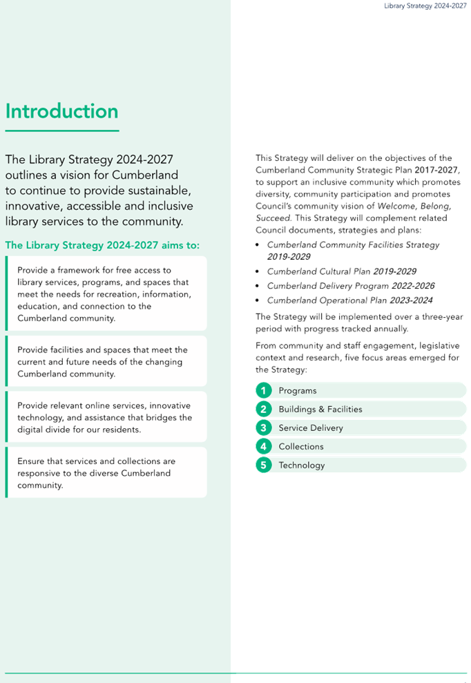
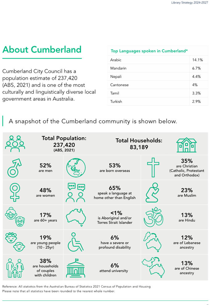
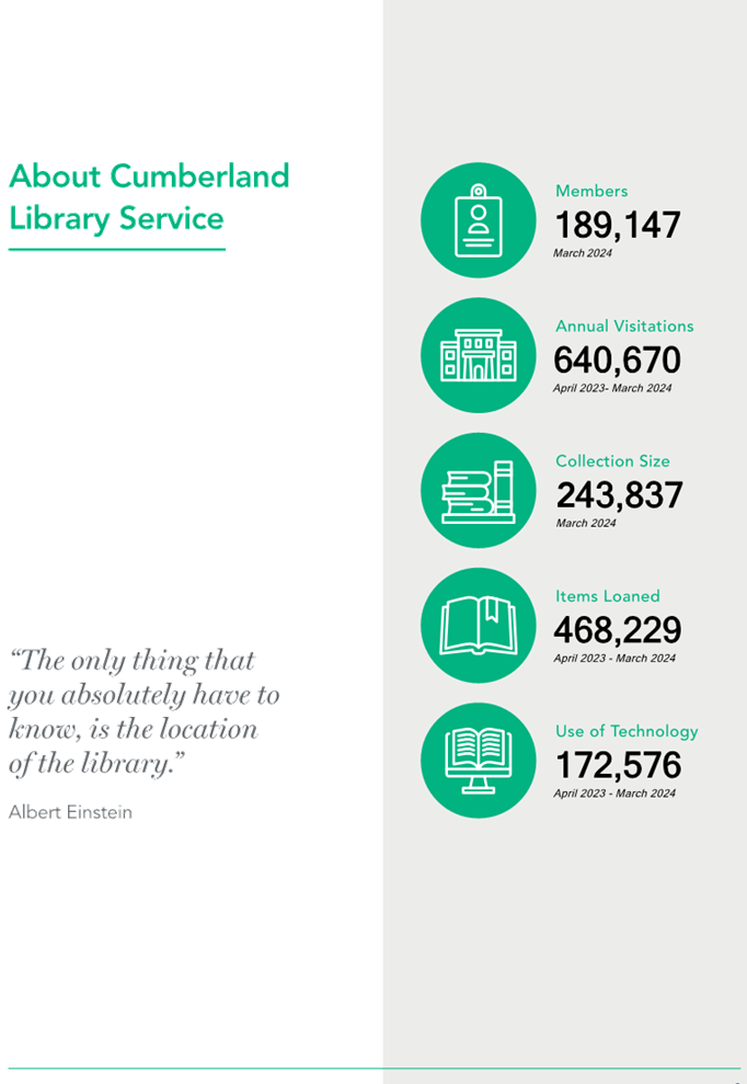
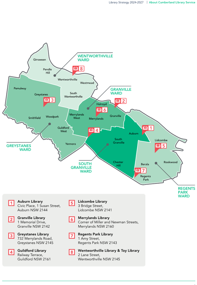
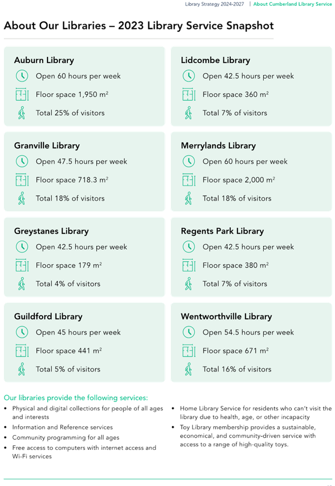

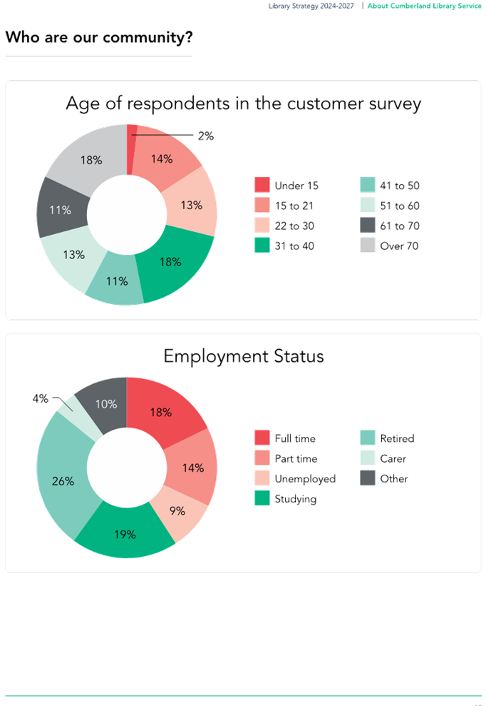
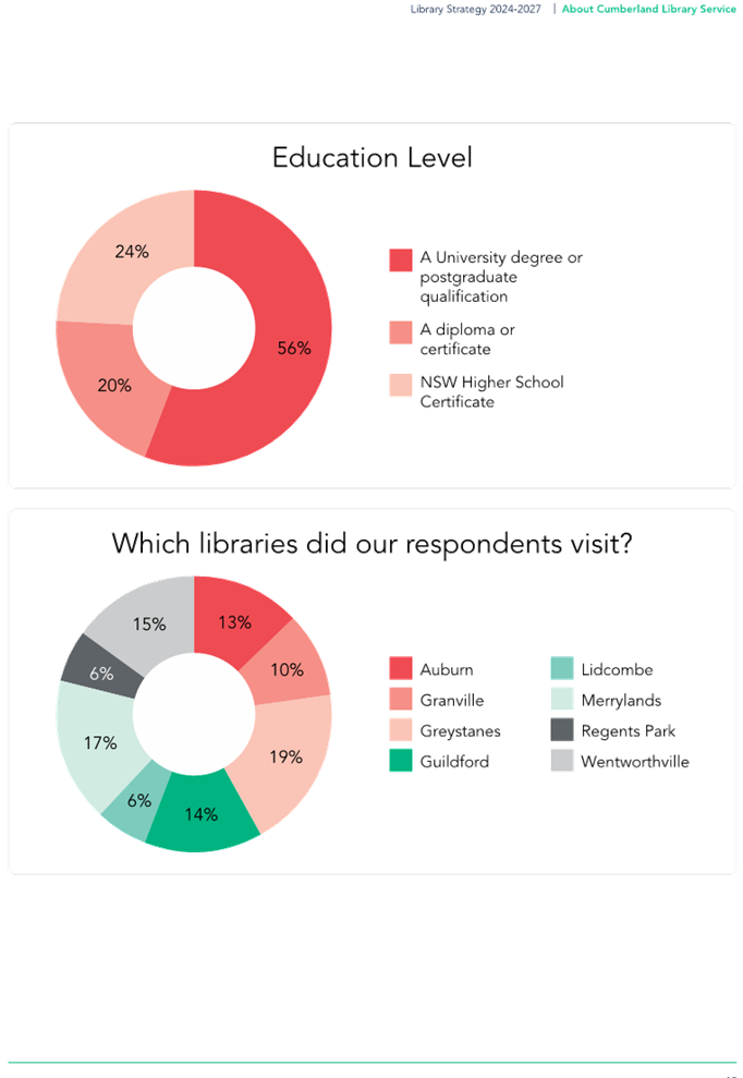

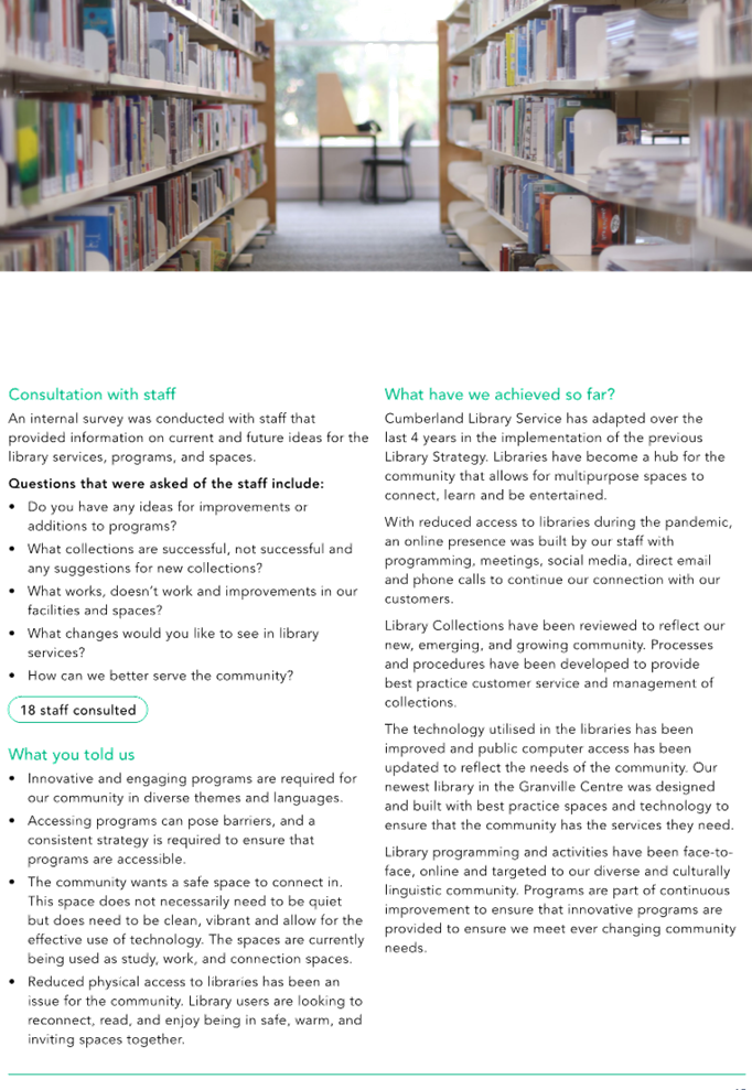
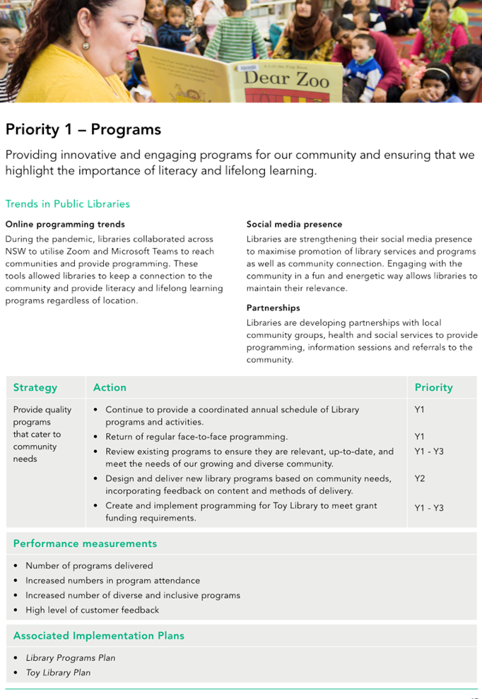
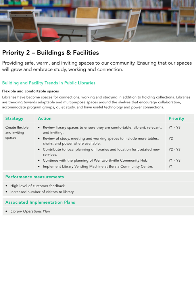


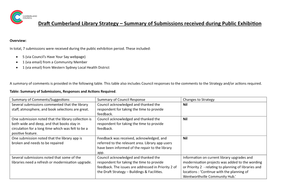

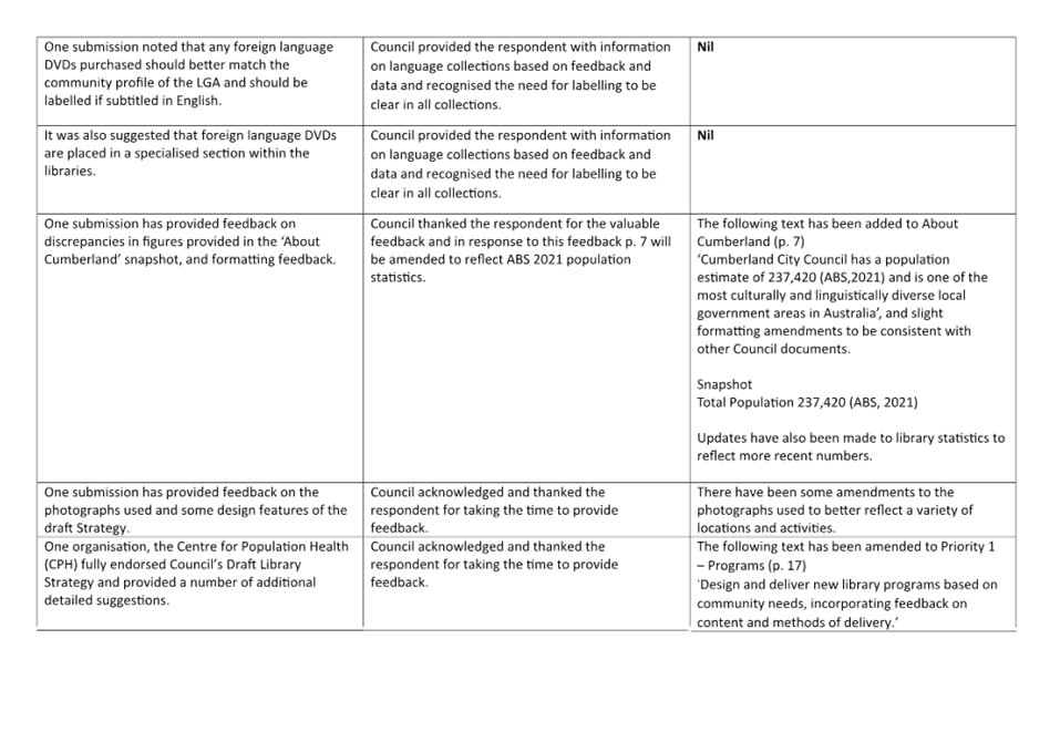

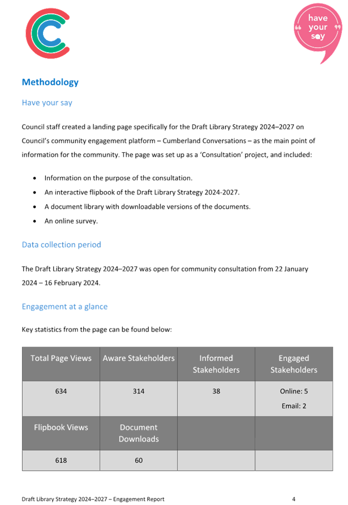
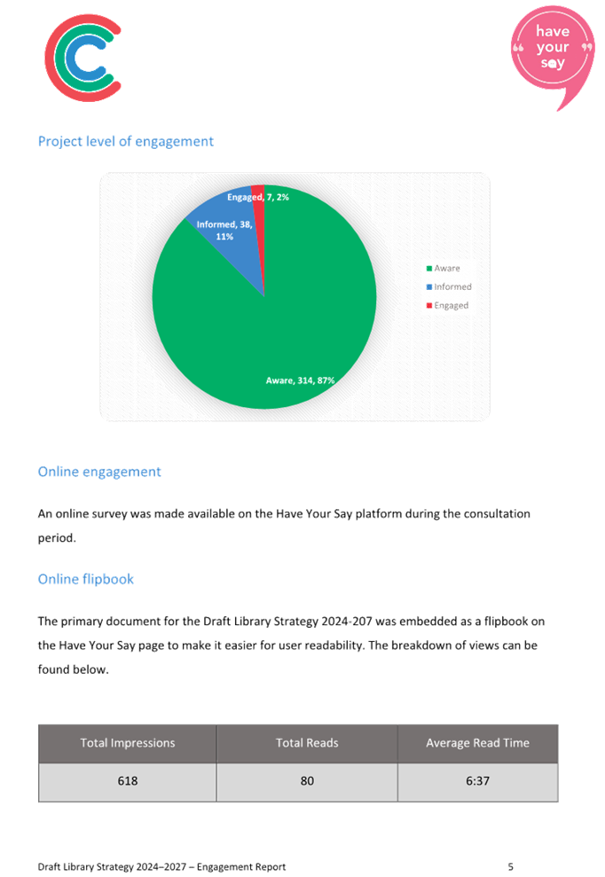
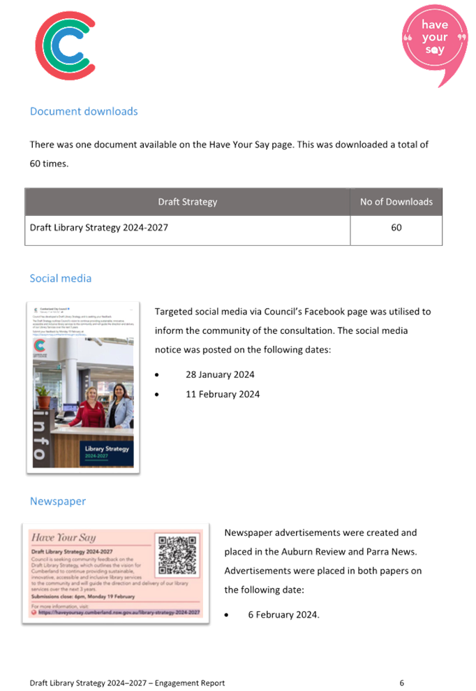
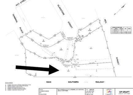
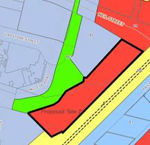
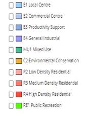
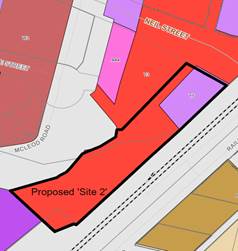
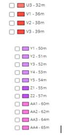
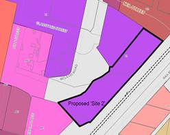
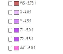
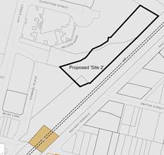
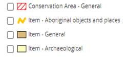
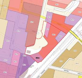 Figure 10: Proposed Building
Height for (Building D1 – 86m)
Figure 10: Proposed Building
Height for (Building D1 – 86m)