3 April 2024
A meeting of the Traffic Committee will be held at
9.30am in Merrylands Administration Building, 16 Memorial Avenue, Merrylands on
Wednesday, 3 April 2024.
Business as below:
Yours faithfully
Peter J. Fitzgerald
General Manager
ORDER OF BUSINESS
1.
Apologies
2.
Declarations of Interest
3.
Confirmation of Previous Minutes endorsed by Council
4.
Summary of Reports.......................................................................................................... 5
5.
Reports
-
Part 1 - Recommended for Approval under Delegated Authority
-
Part 2 - Recommendation to Council
CONTENTS
Report No. Name
of Report Page
No.
Part 1 - Recommended for Approval under Delegated
Authority
CTC-24-059 JOHN
STREET, LIDCOMBE – PROPOSED PARKING RESTRICTIONS 37
CTC-24-060 BOMBAY
STREET AND MAUD STREET, LIDCOMBE – PROPOSED ‘NO STOPPING’
RESTRICTIONS AND LINEMARKING.......................... 43
CTC-24-061 DELHI
STREET AND MAUD STREET, LIDCOMBE – PROPOSED ‘NO STOPPING’
RESTRICTIONS AND LINEMARKING.......................... 51
CTC-24-062 ALICE
STREET, AUBURN - ROAD SAFETY CONCERNS.............. 63
CTC-24-063 CHISHOLM
ROAD AT CARDIGAN STREET, AUBURN – REQUEST FOR ‘KEEP CLEAR’
LINEMARKING.............................................................. 71
CTC-24-064 RAILWAY
PARADE, GRANVILLE - ROAD SAFETY CONCERNS. 77
CTC-24-065 NEW
YORK STREET, GRANVILLE – PROPOSED RELOCATION OF THE EXISTING ‘NO
PARKING’ SIGNAGE................................................... 85
CTC-24-066 GOUGH
STREET AND WALPOLE STREET, HOLROYD – PROPOSED ‘NO STOPPING’
RESTRICTIONS AND LINEMARKING.......................... 91
CTC-24-067 BRADMAN
STREET AT EXCELSIOR STREET AND WOODVILLE ROAD, MERRYLANDS – PROPOSED
‘NO STOPPING’ RESTRICTIONS AND LINEMARKING.......................................................................................... 99
CTC-24-068 GLADSTONE
STREET, MERRYLANDS - PROPOSED SIGNAGE AND LINEMARKING....................................................................................... 105
CTC-24-069 JOSEPHINE
STREET, MERRYLANDS WEST – PROPOSED ‘NO STOPPING’ RESTRICTIONS.............................................................. 111
CTC-24-070 YENNORA
AVENUE AND WYANNA GROVE, YENNORA – PROPOSED PARKING RESTRICTIONS.................................................................. 117
CTC-24-071 LANCE
CRESCENT, GREYSTANES – PROPOSED RELOCATION OF THE EXISTING ‘NO
STOPPING’ AND ‘NO PARKING’ SIGNAGE......... 125
CTC-24-072 HACKNEY
STREET, GREYSTANES - ROAD SAFETY CONCERNS 131
CTC-24-073 ALLEN
STREET AND FINLAYSON STREET, SOUTH WENTWORTHVILLE – PROPOSED ‘NO
STOPPING’ RESTRICTIONS........................... 139
CTC-24-074 SMITH
STREET, PENDLE HILL - ROAD SAFETY CONCERNS.. 145
CTC-24-075 SMITH
STREET AND PENDLE WAY, PENDLE HILL – PARKING RESTRICTIONS AND LINEMARKING
AT THE INTERSECTION. 153
CTC-24-076 BULGA
LANE, PEMULWUY – PROPOSED ‘NO STOPPING’ RESTRICTIONS..................................................................................... 159
CTC-24-077 NIJONG
DRIVE, PEMULWUY – REMOVAL OF REDUNDANT ‘BUS ZONE’ SIGNAGE................................................................................................. 181
Part 2 - Recommendation to Council
CTC-24-078 Review
of Traffic Related Policies and Guidelines 191
CTC-24-079 LANEWAY
BETWEEN LINDEN STREET AND HARVEY PLACE, TOONGABBIE – PROPOSED TO CONVERT
THE LANEWAY TO ONE-WAY TRAFFIC FLOW........................................................................... 193
CTC-24-080 BURRAGA
WAY AND MUTTONG STREET, PEMULWUY – PROPOSED ONE-WAY TRAFFIC FLOW AND
REMOVAL OF PARKING RESTRICITONS..................................................................................... 201
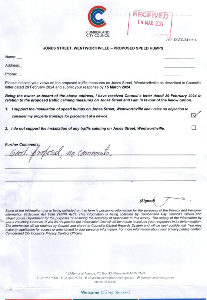
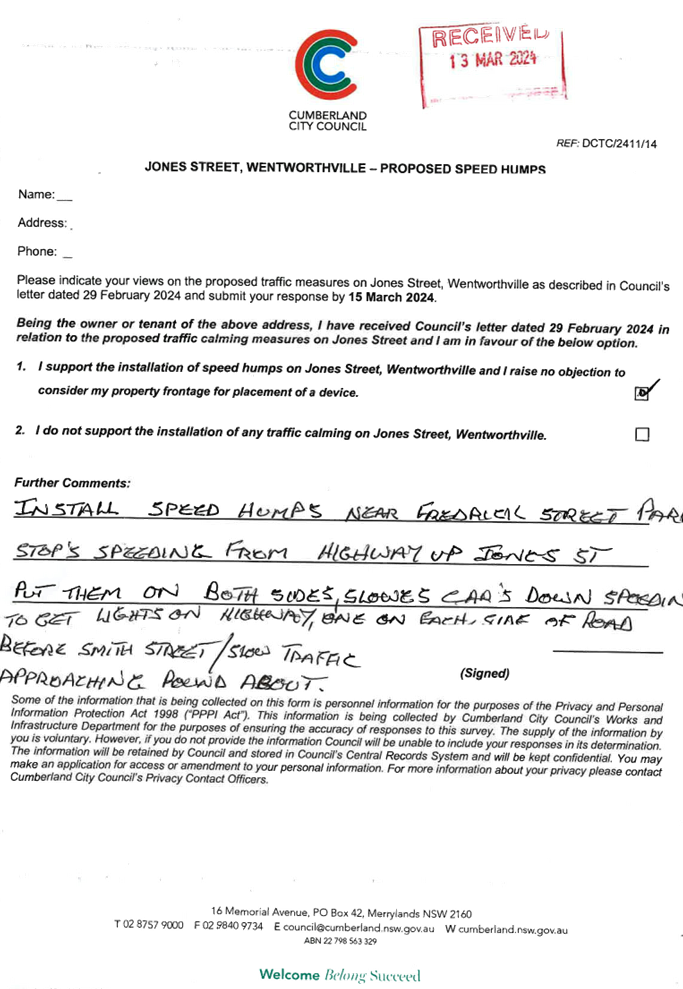
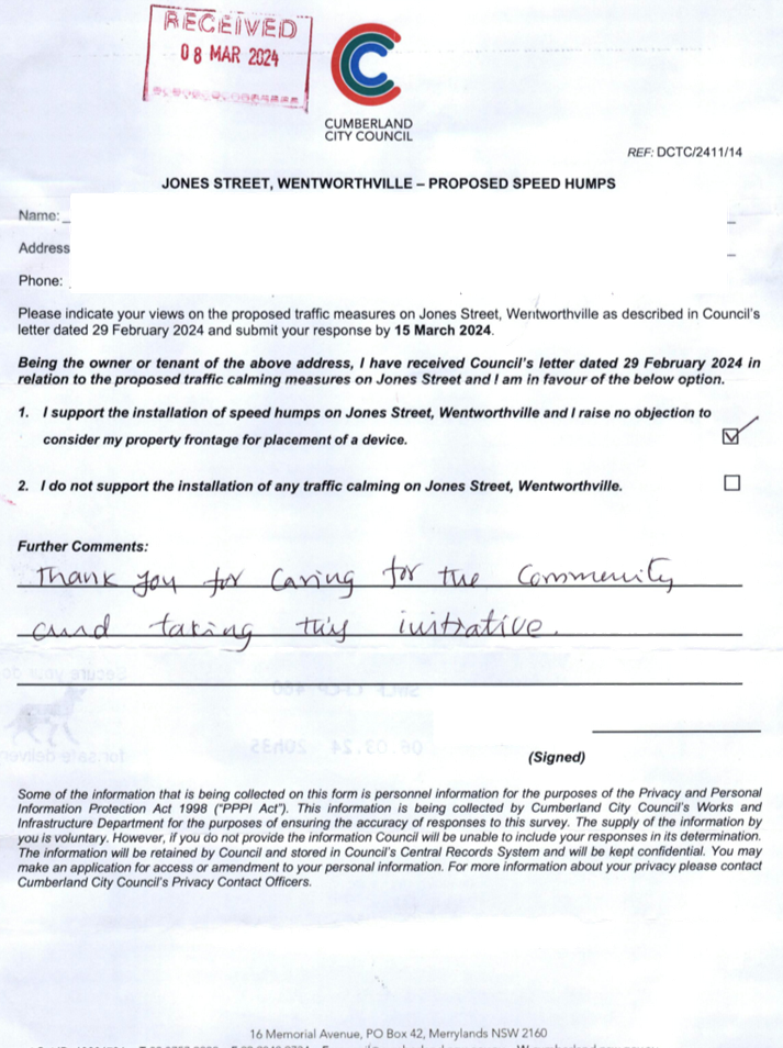
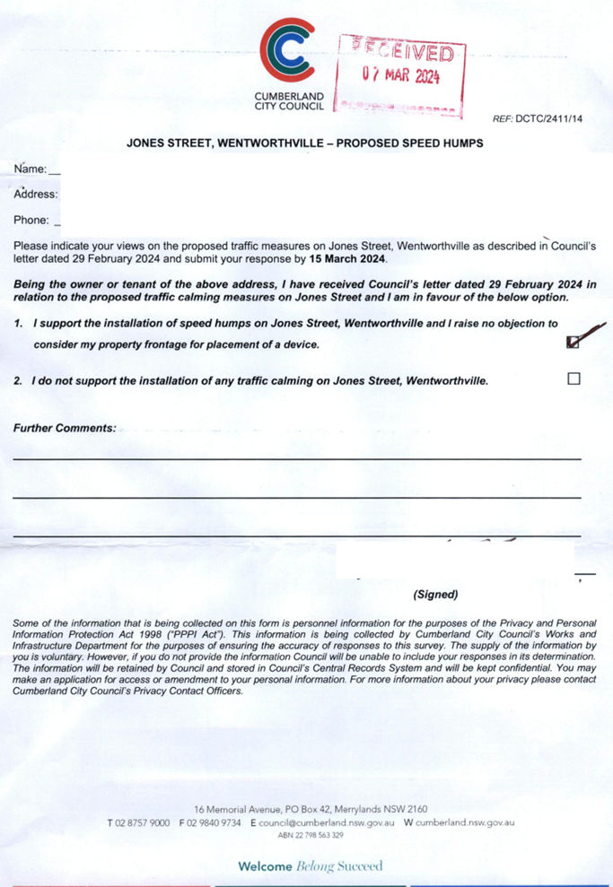
CTC-24-081 JONES
STREET, WENTWORTHVILLE – ROAD SAFETY CONCERNS – CONSULTATION RESULT................................................................... 217
CTC-24-082 HAMPDEN
ROAD, SOUTH WENTWORTHVILLE – ROAD SAFETY CONCERNS............................................................................................ 237
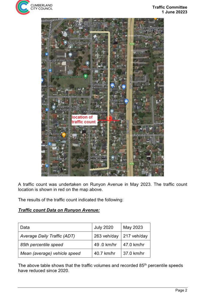
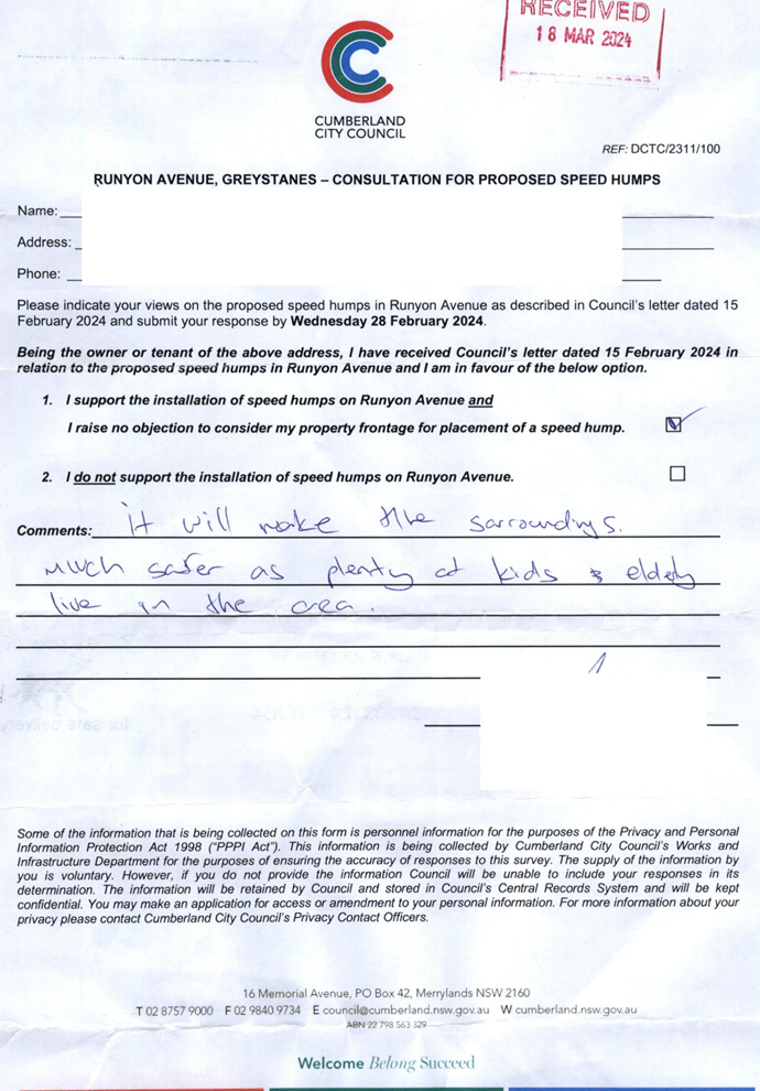
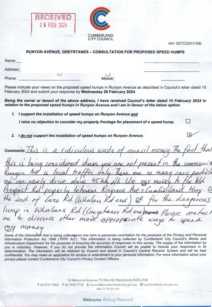
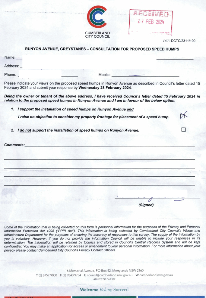
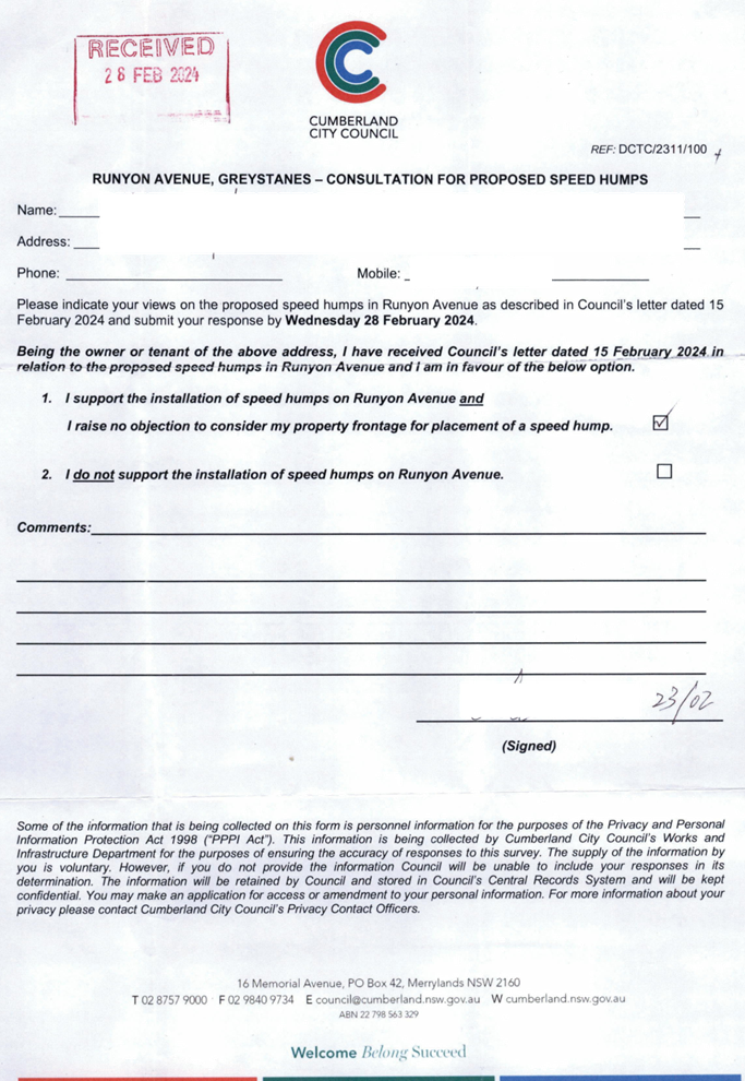
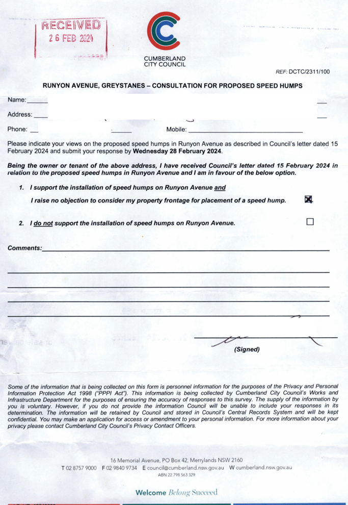
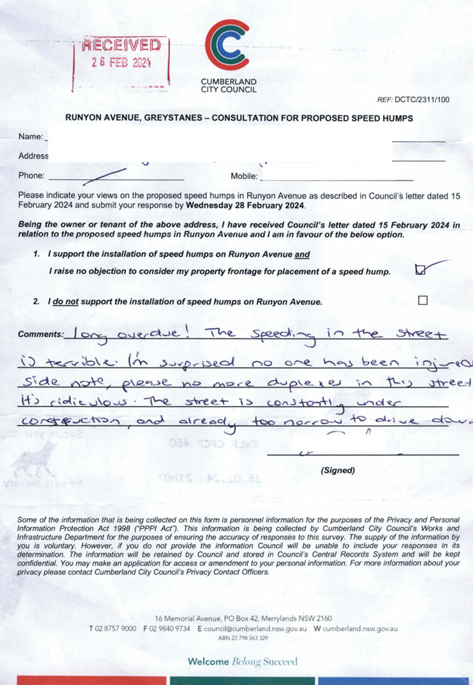
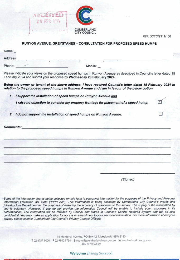
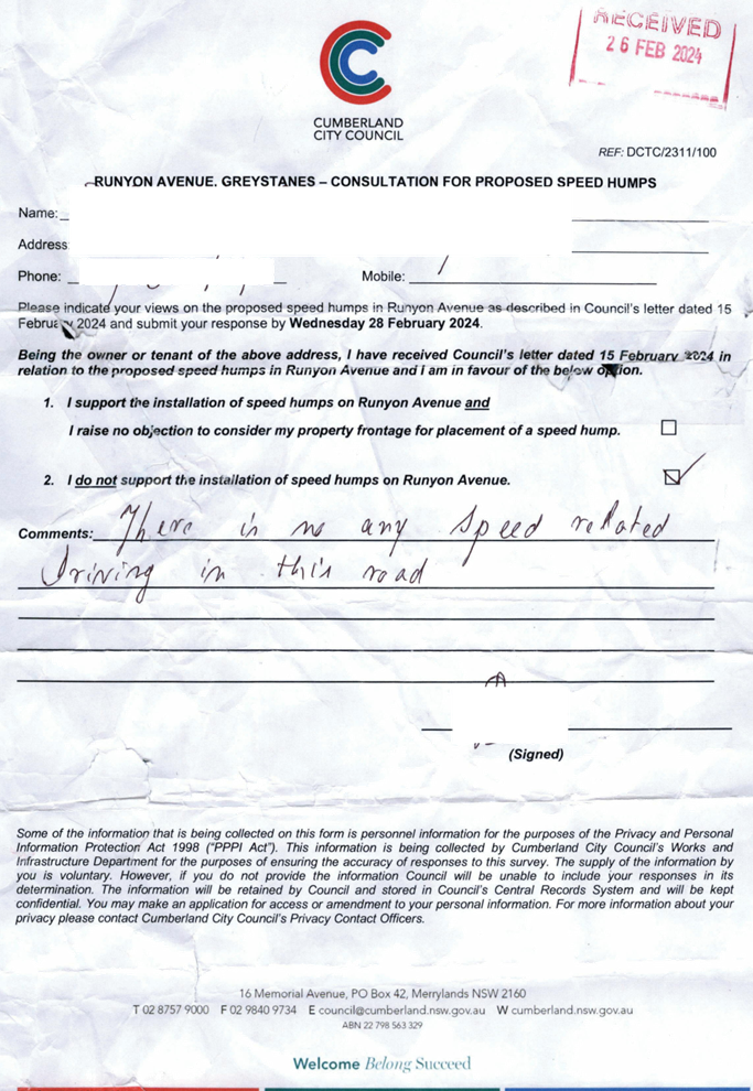
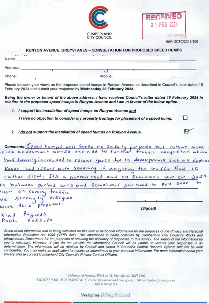
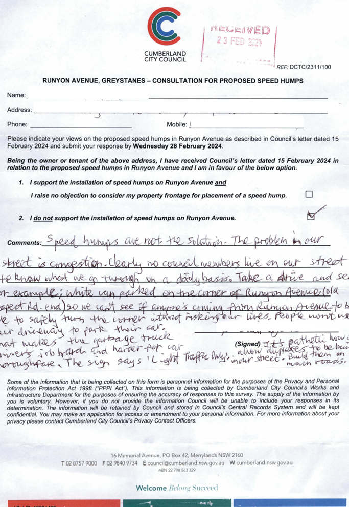
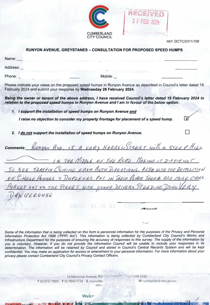
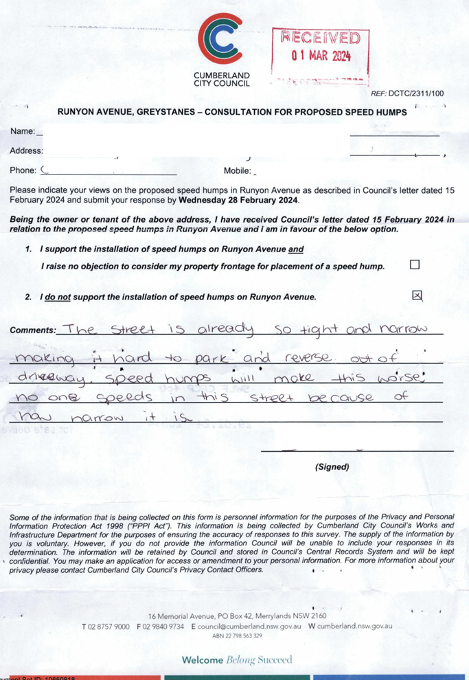
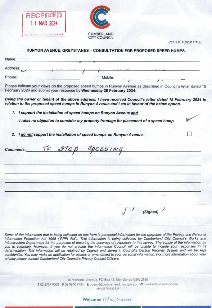
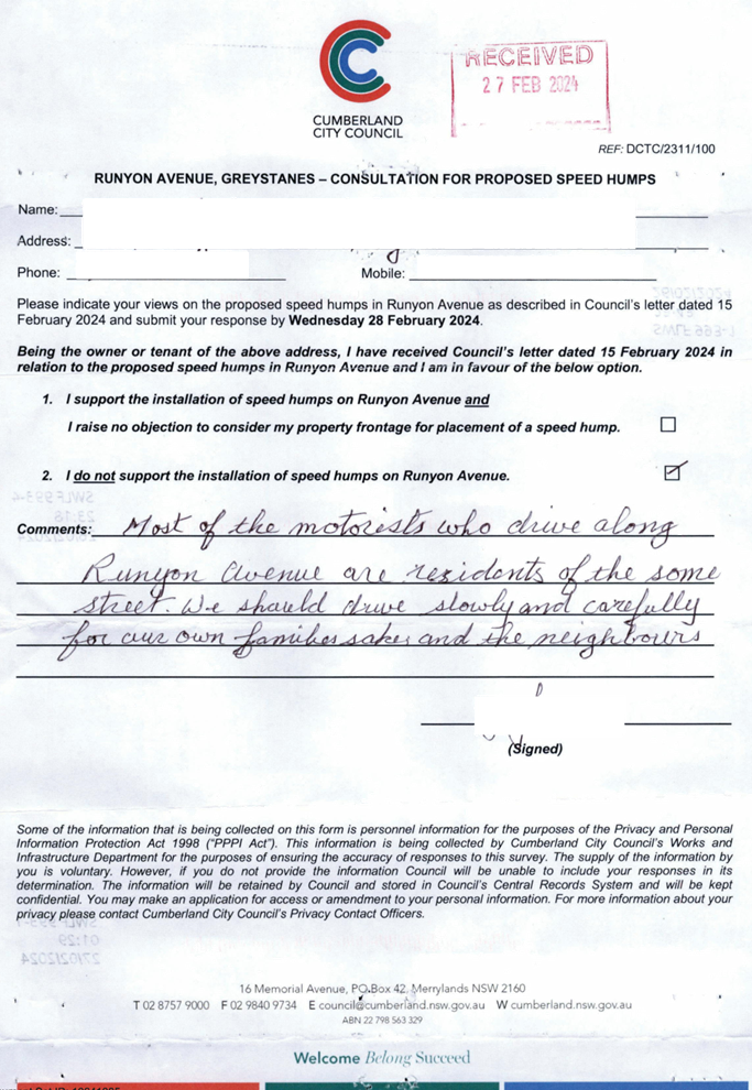
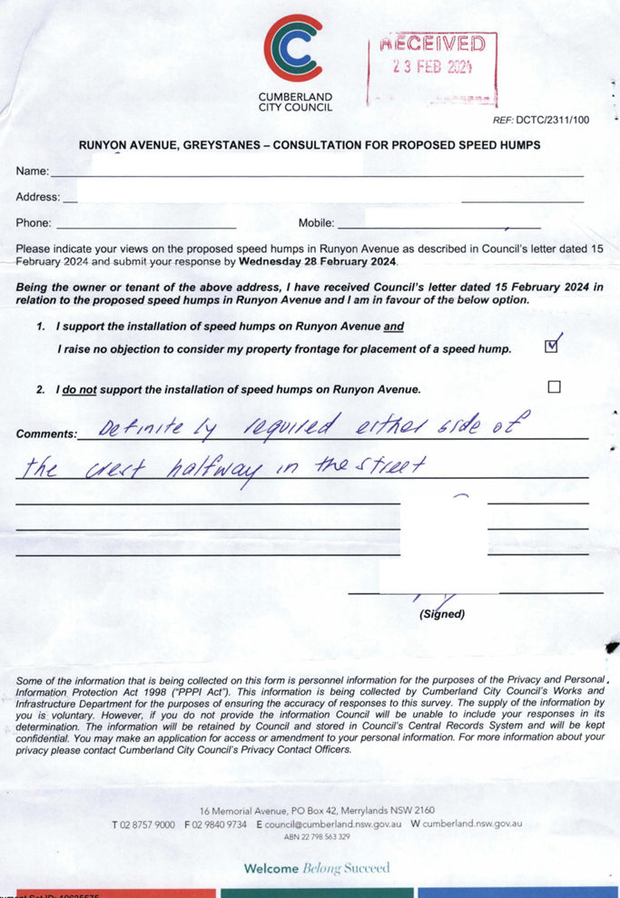
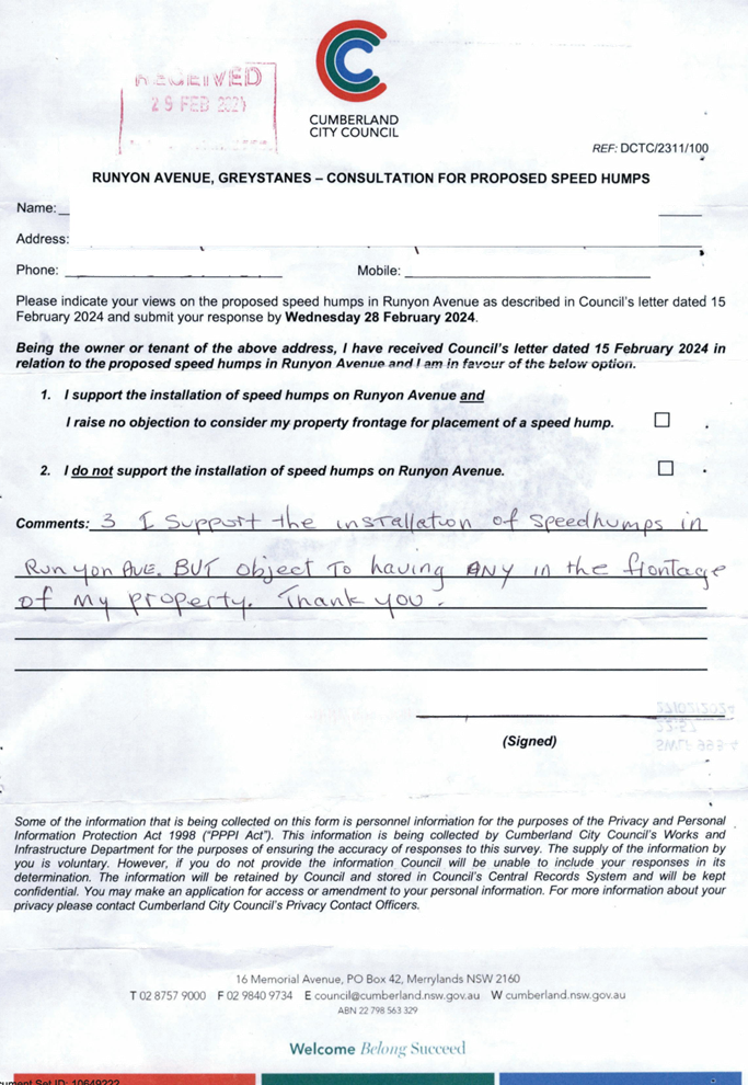
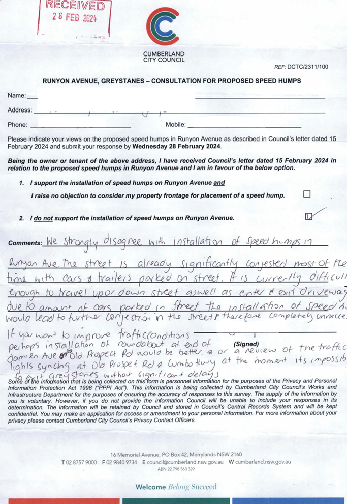
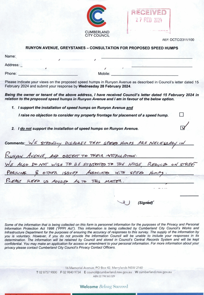
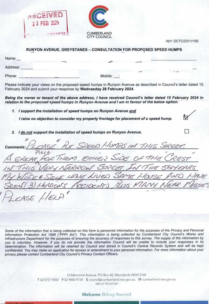
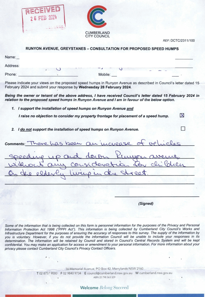
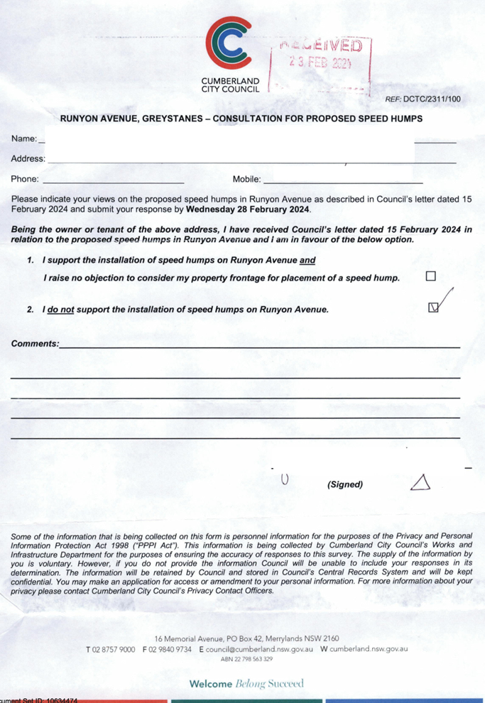
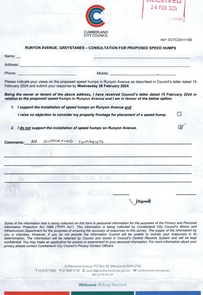
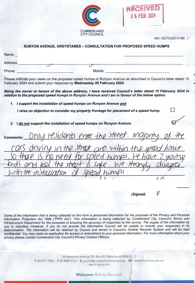
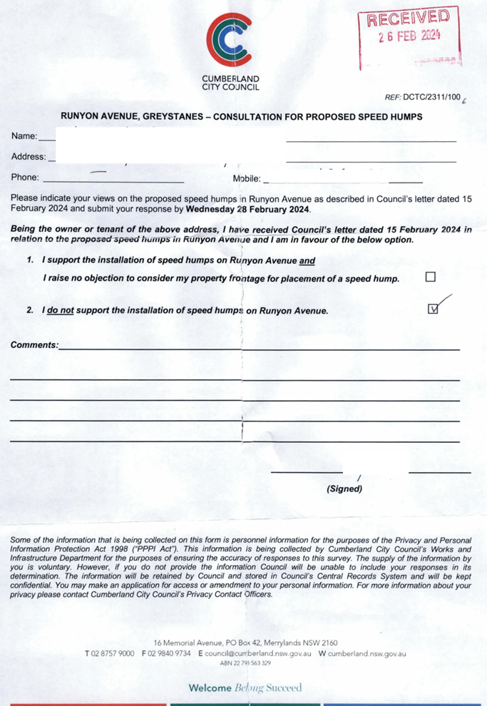
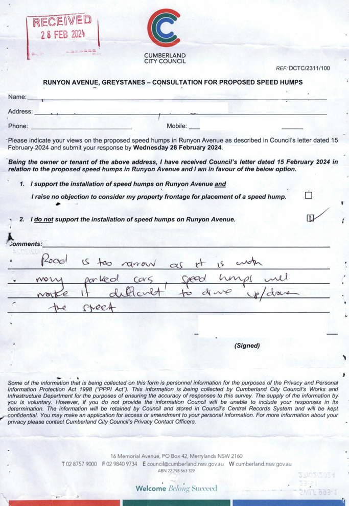
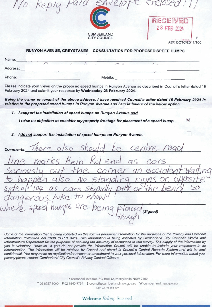
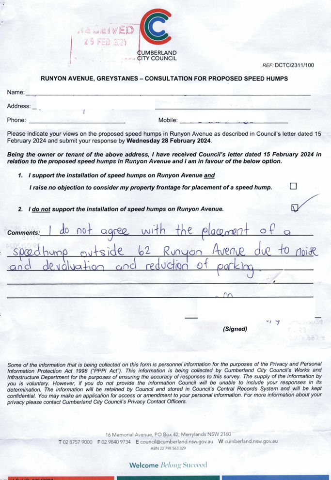
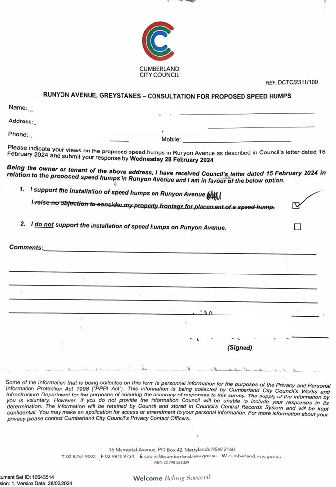
CTC-24-083 RUNYON
AVENUE, GREYSTANES – ROAD SAFETY CONCERNS - CONSULTATION RESULT................................................................... 255
CTC-24-084 WHALANS
ROAD AND BRIGHTON STREET, GREYSTANES - PROPOSED MODIFICATION TO THE EXISTING
ROUNDABOUT 305
CTC-24-085 DENNISTOUN
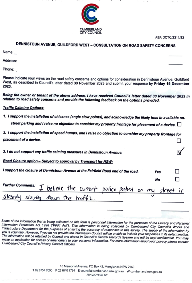
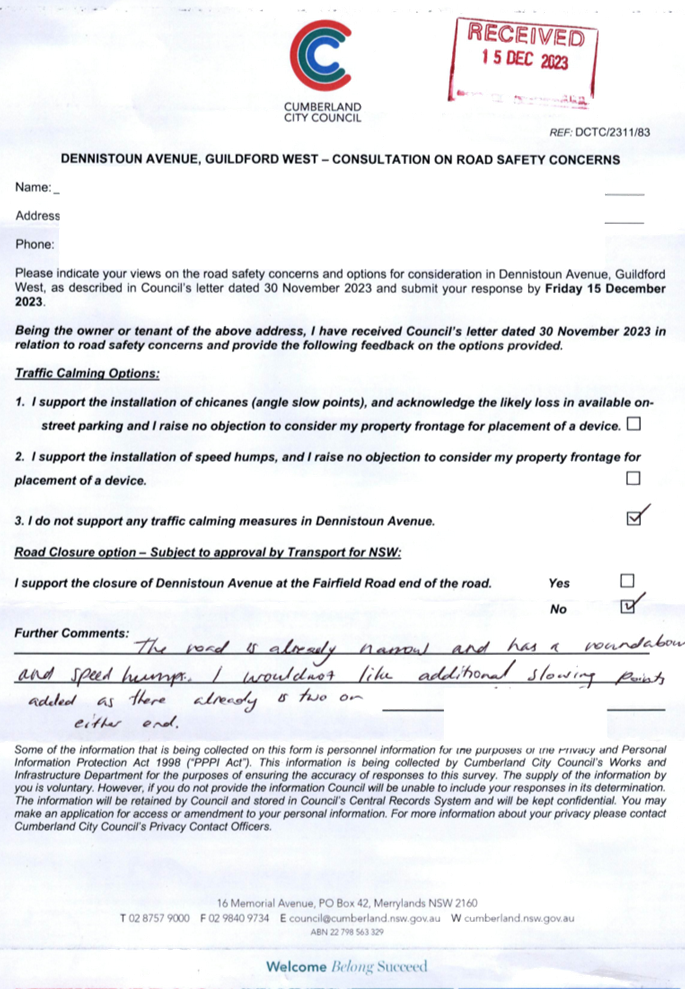
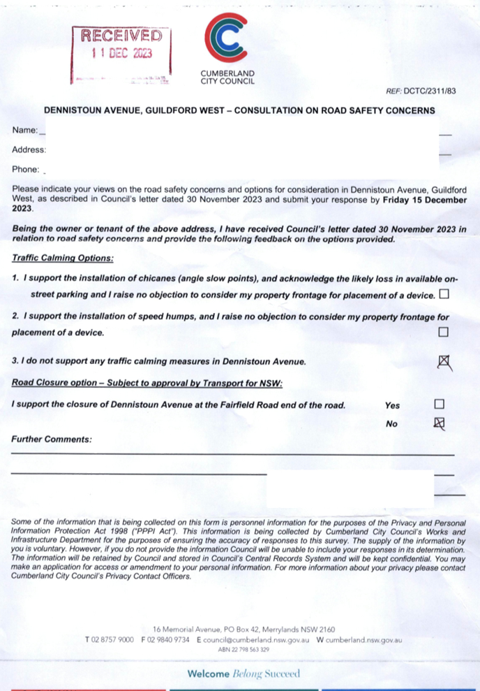
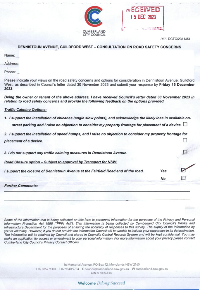
AVENUE, GUILDFORD WEST – CONSULTATION RESULTS................................................................................................ 309
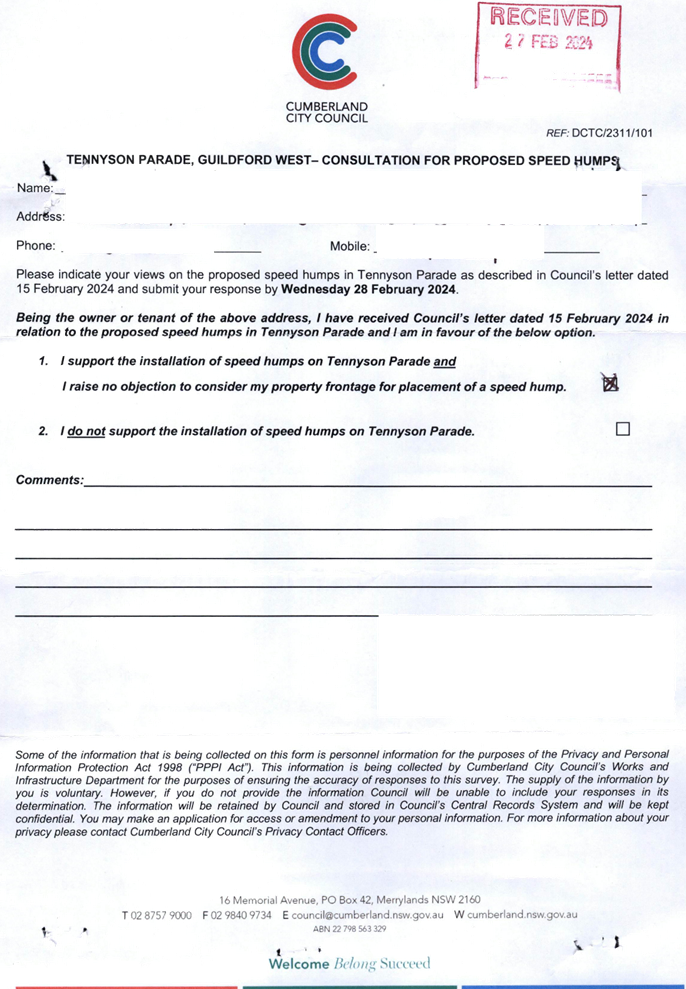
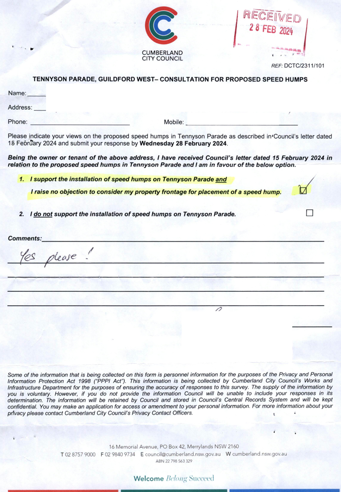
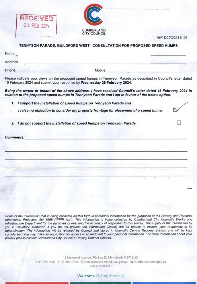
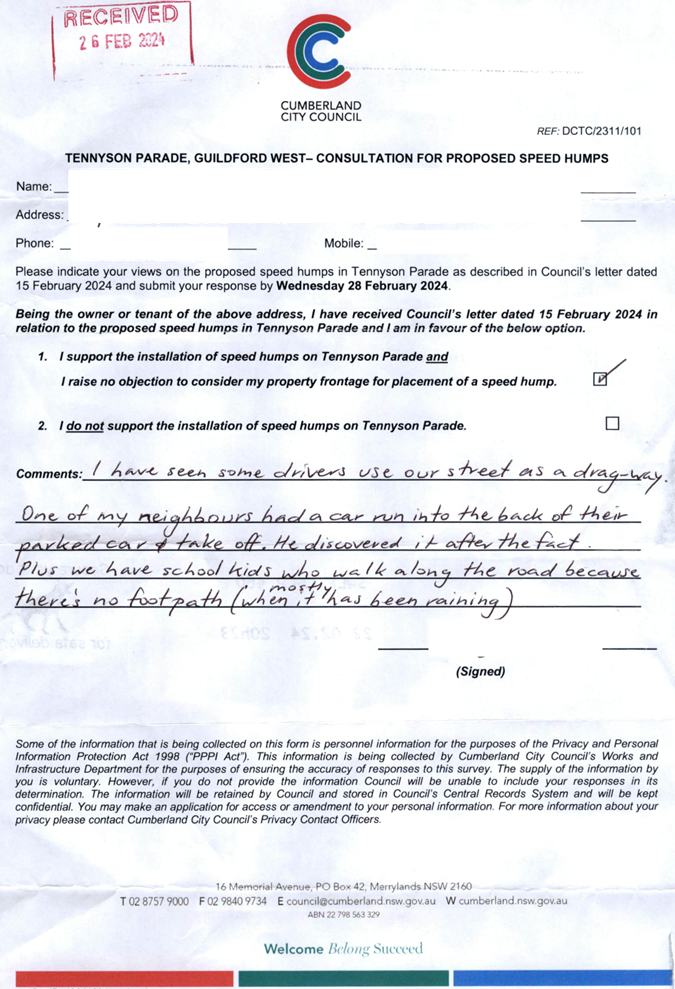
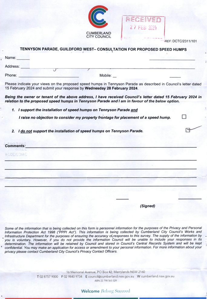
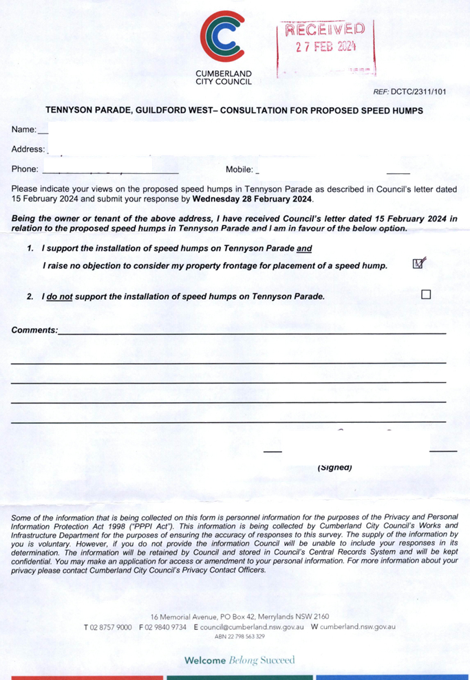
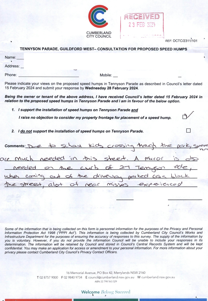
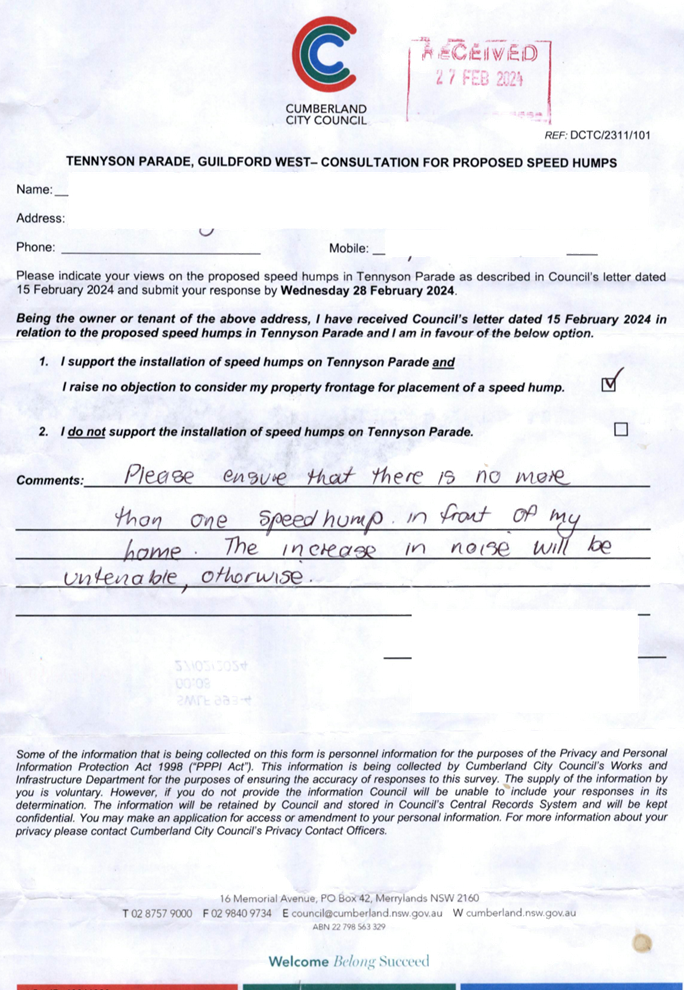
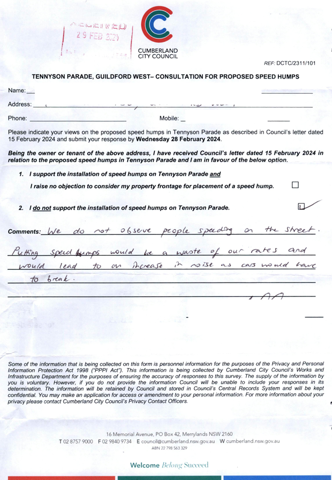
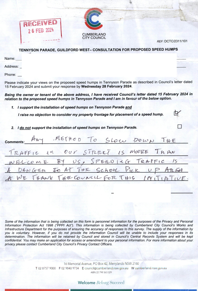
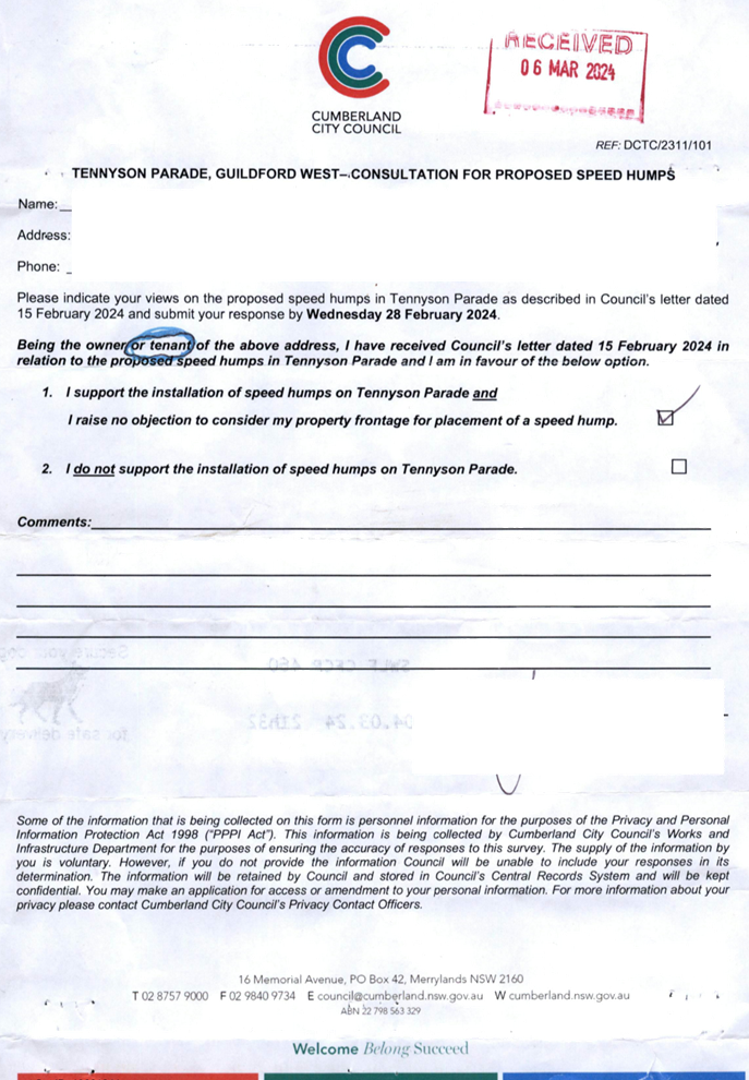
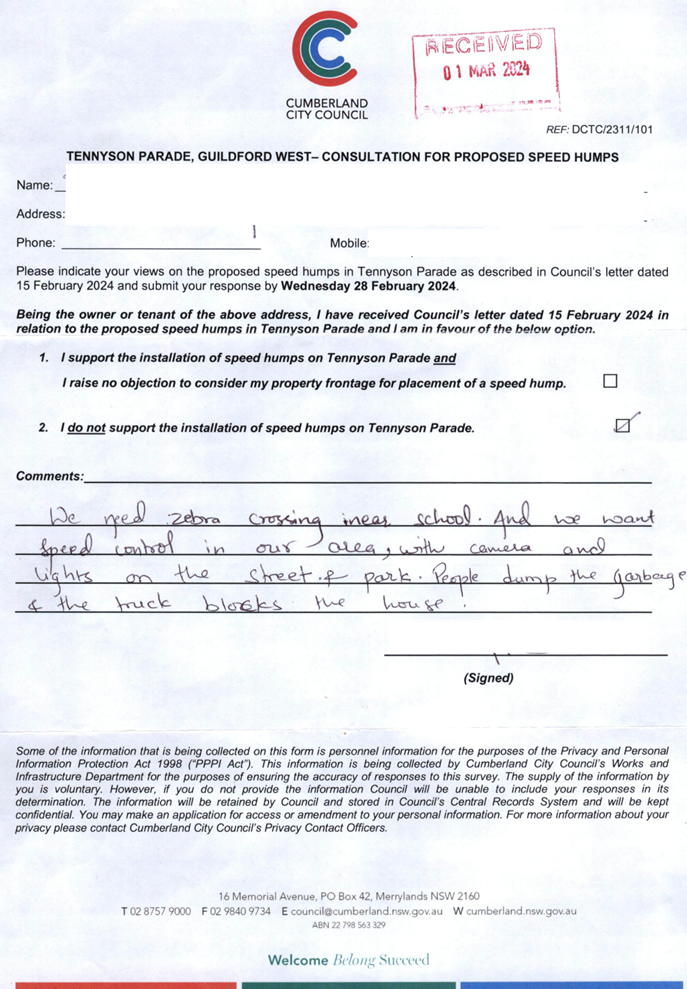
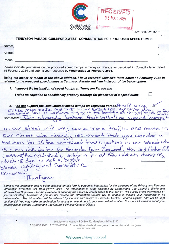
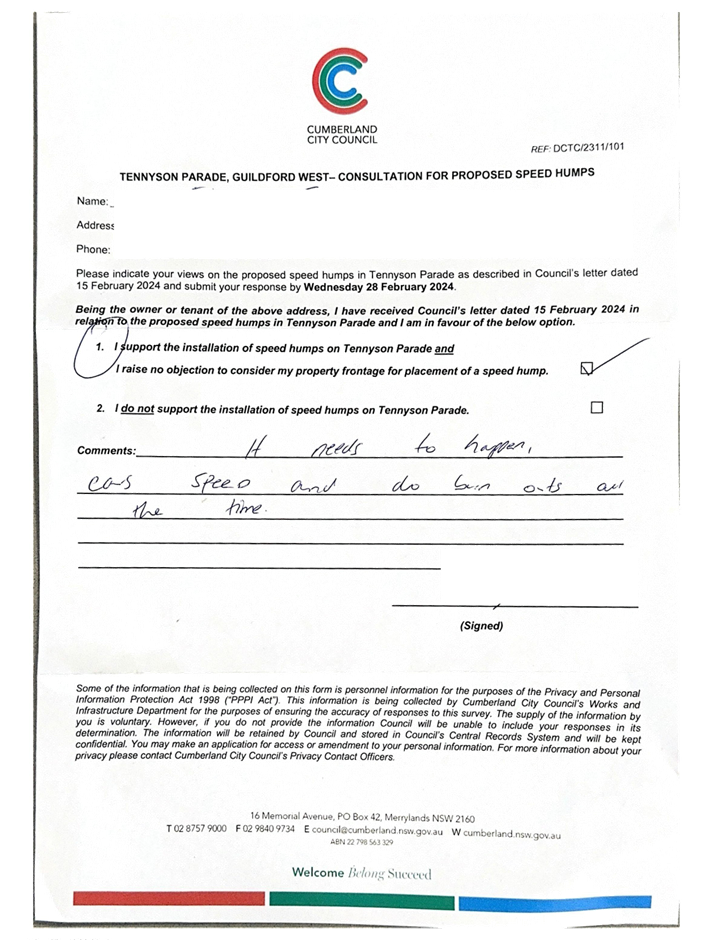
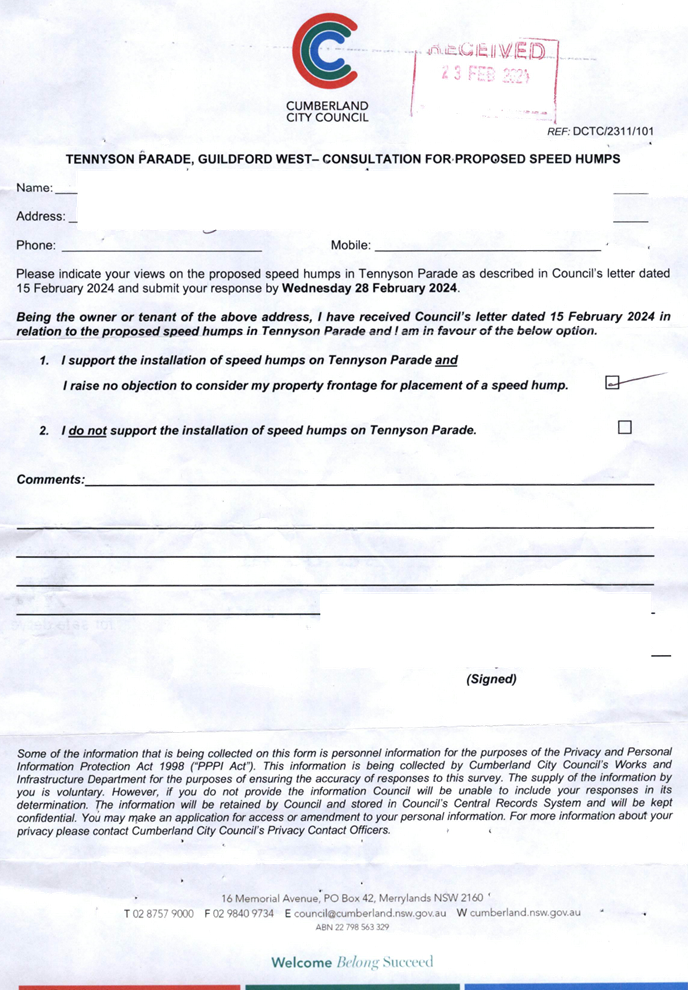
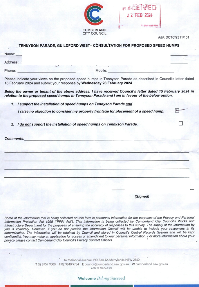
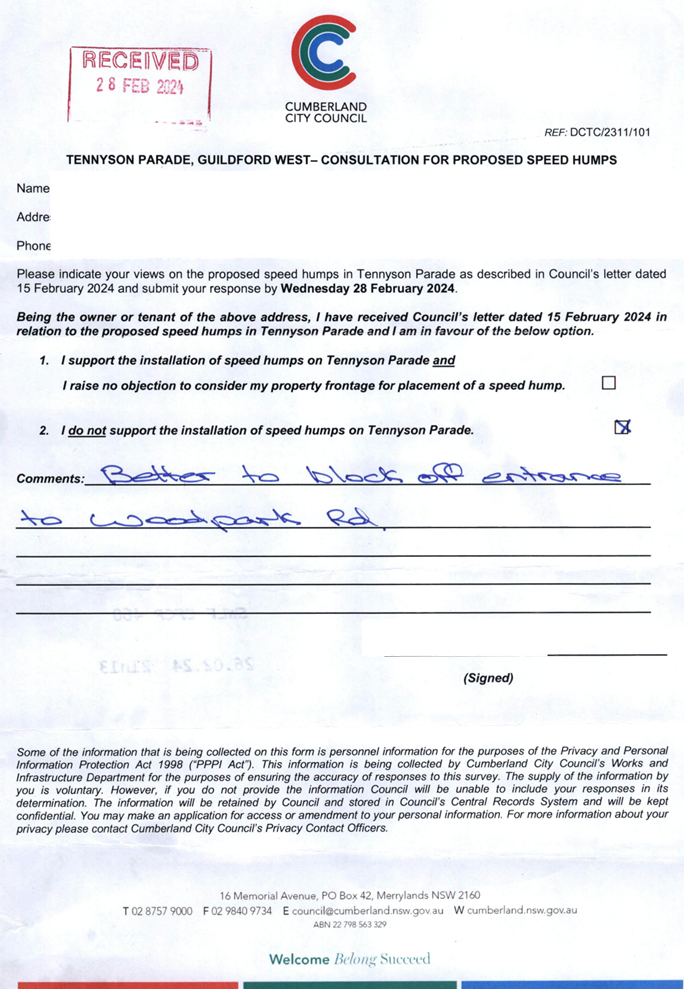
CTC-24-086 TENNYSON
PARADE, GUILDFORD WEST – ROAD SAFETY CONCERNS - CONSULTATION RESULT................................................................ 339
CTC-24-087 CHETWYND
ROAD AND GUILDFORD ROAD, GUILDFORD - ROAD SAFETY CONCERNS........................................................................... 371
CTC-24-088 WILLOUGHBY
STREET, GUILDFORD - ROAD SAFETY CONCERNS – CONSULTATION RESULT................................................................... 379
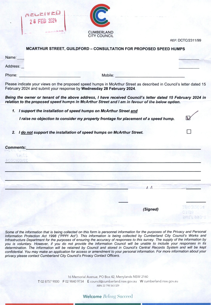
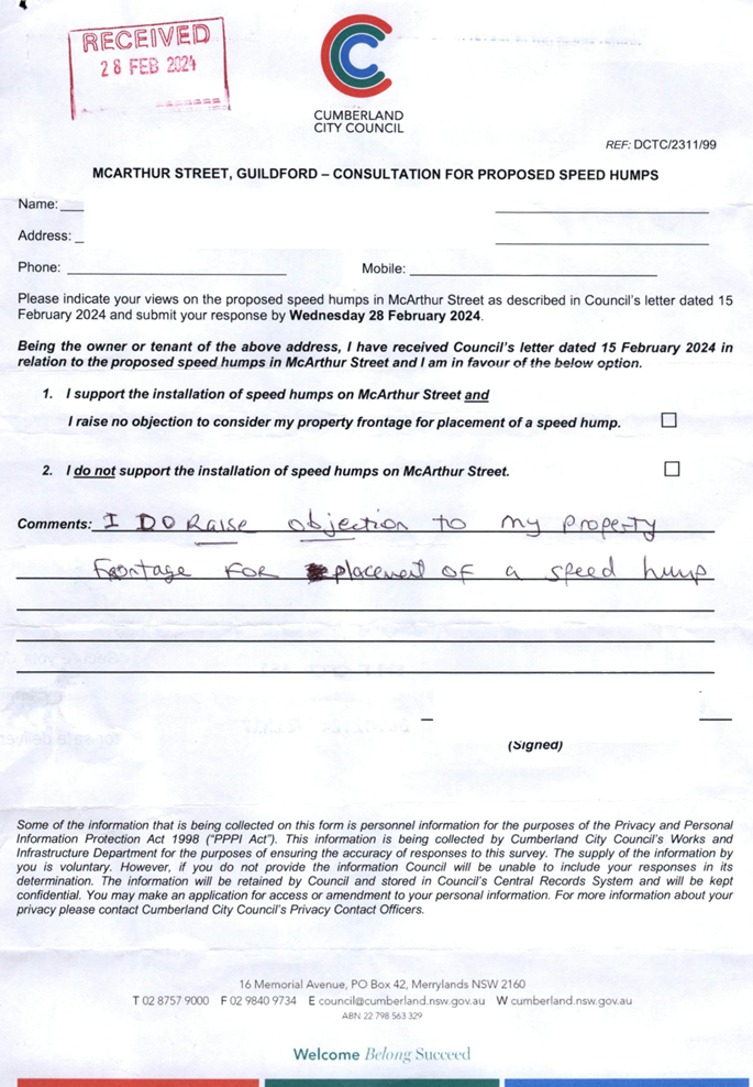
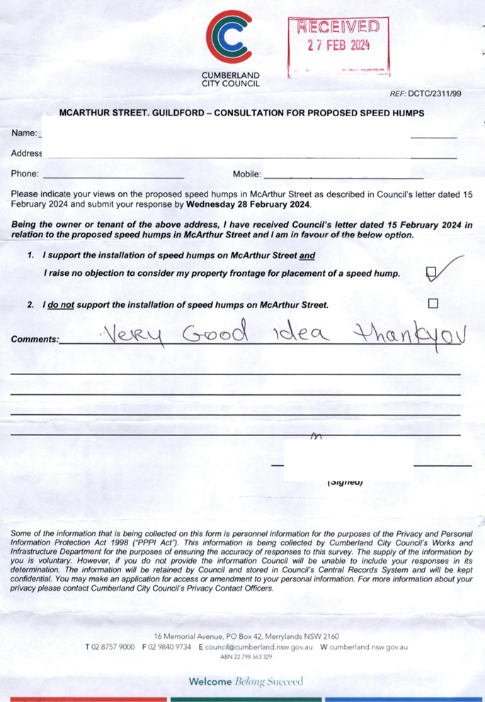
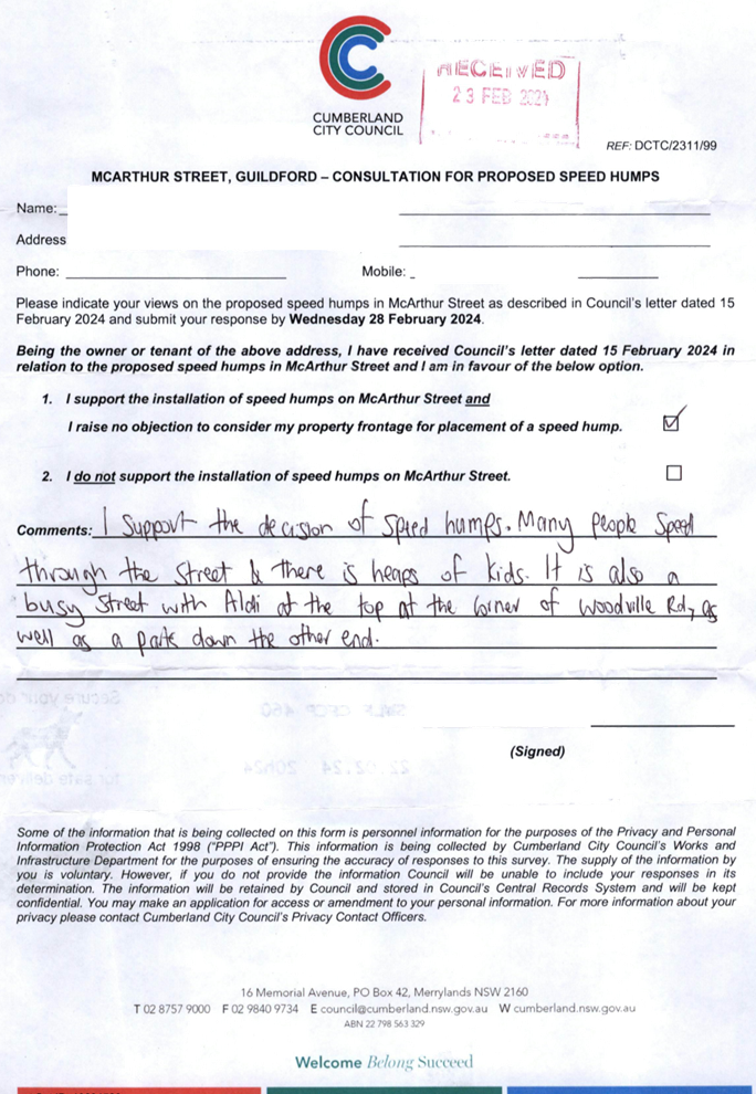
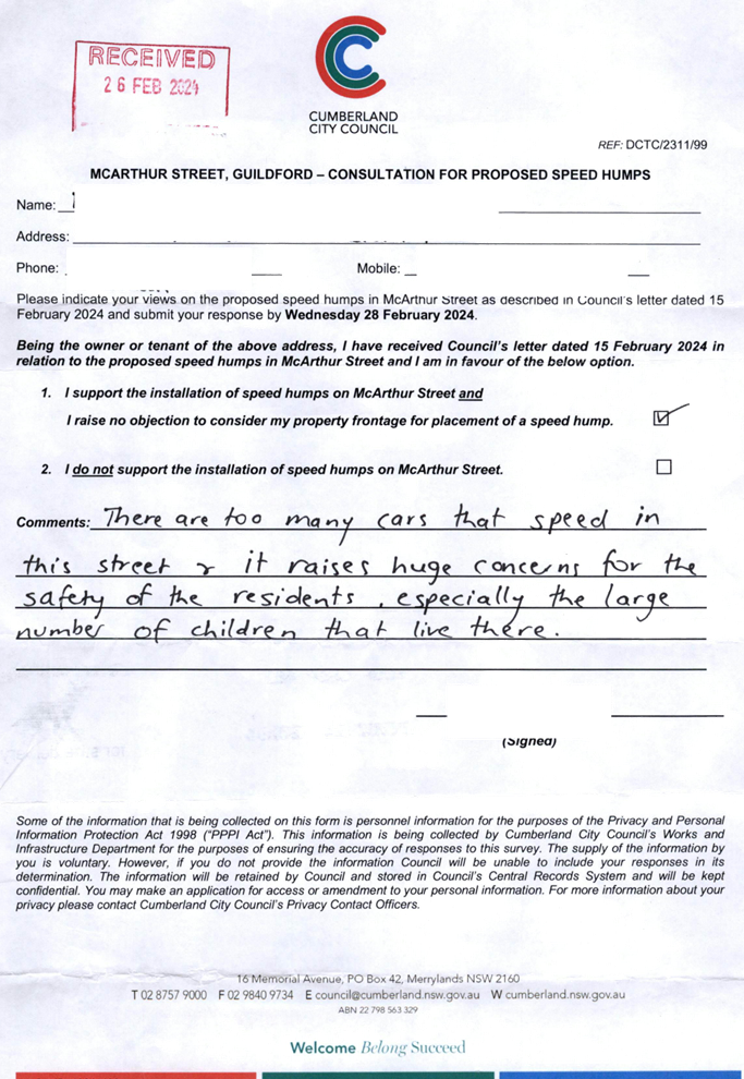
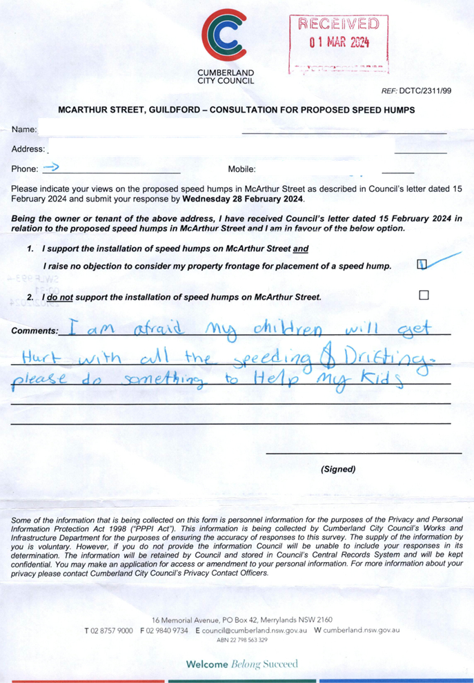
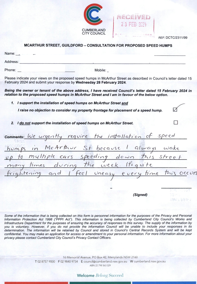
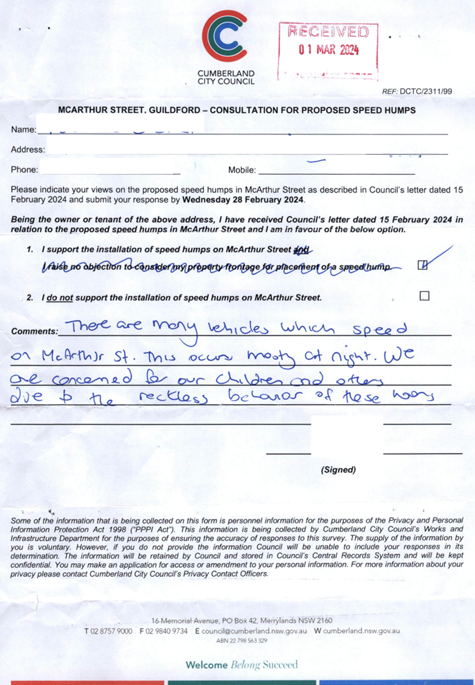
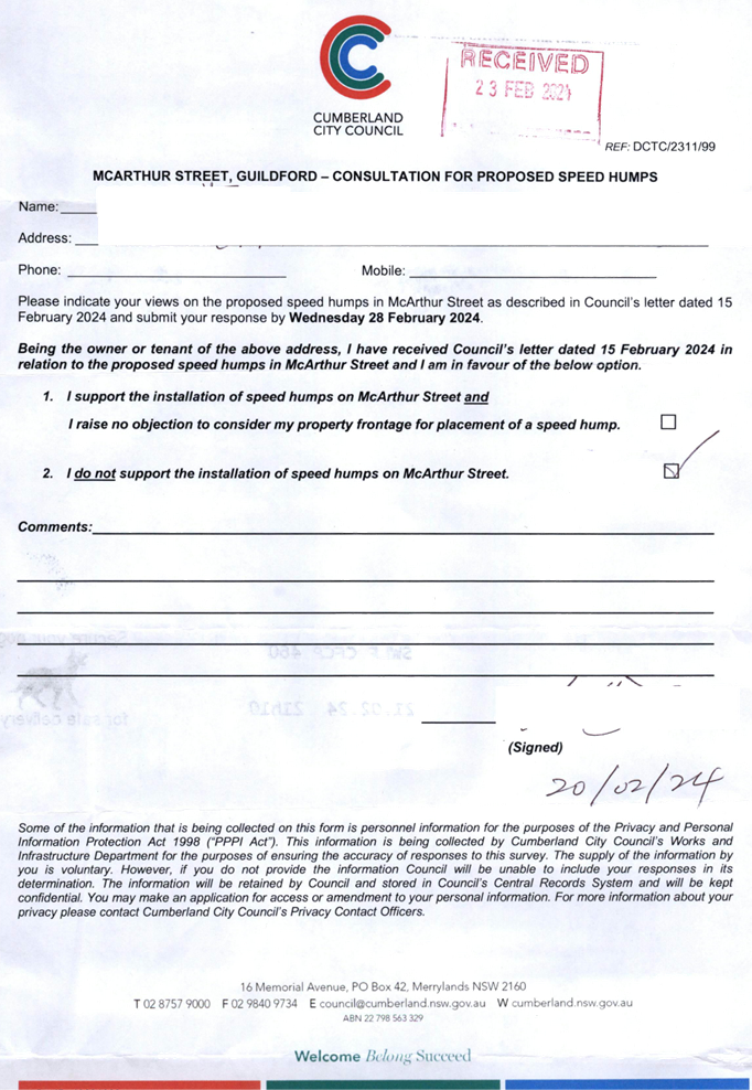
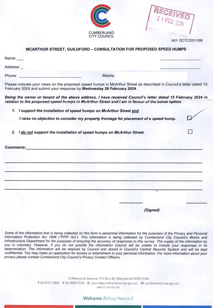
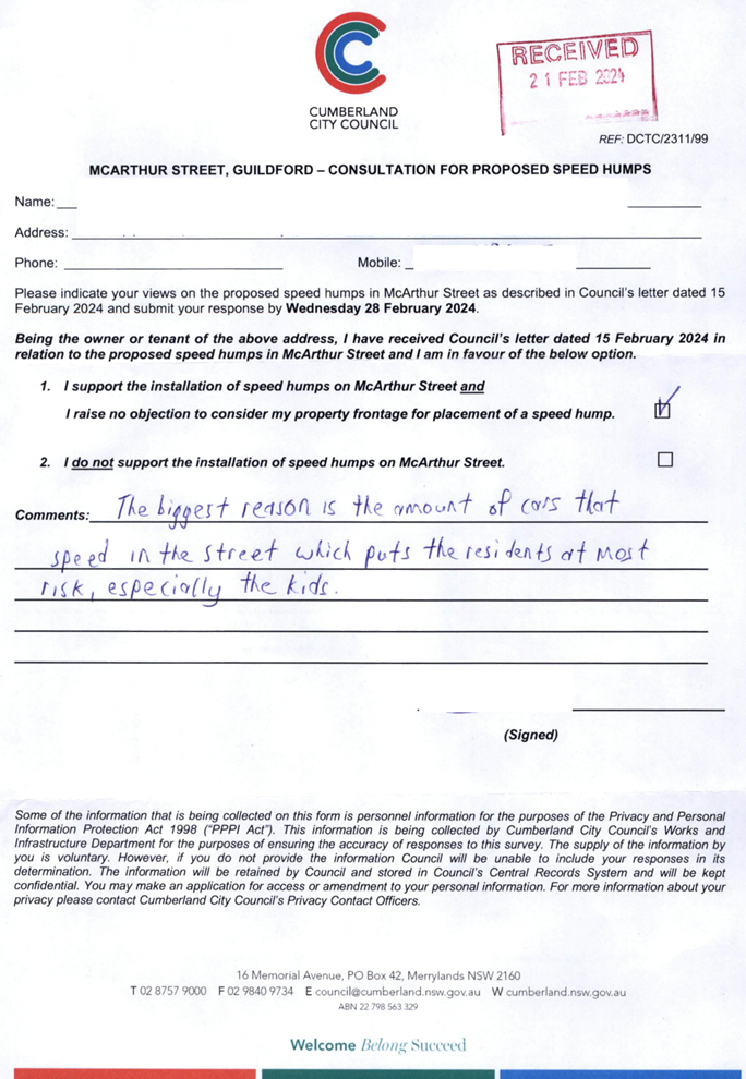
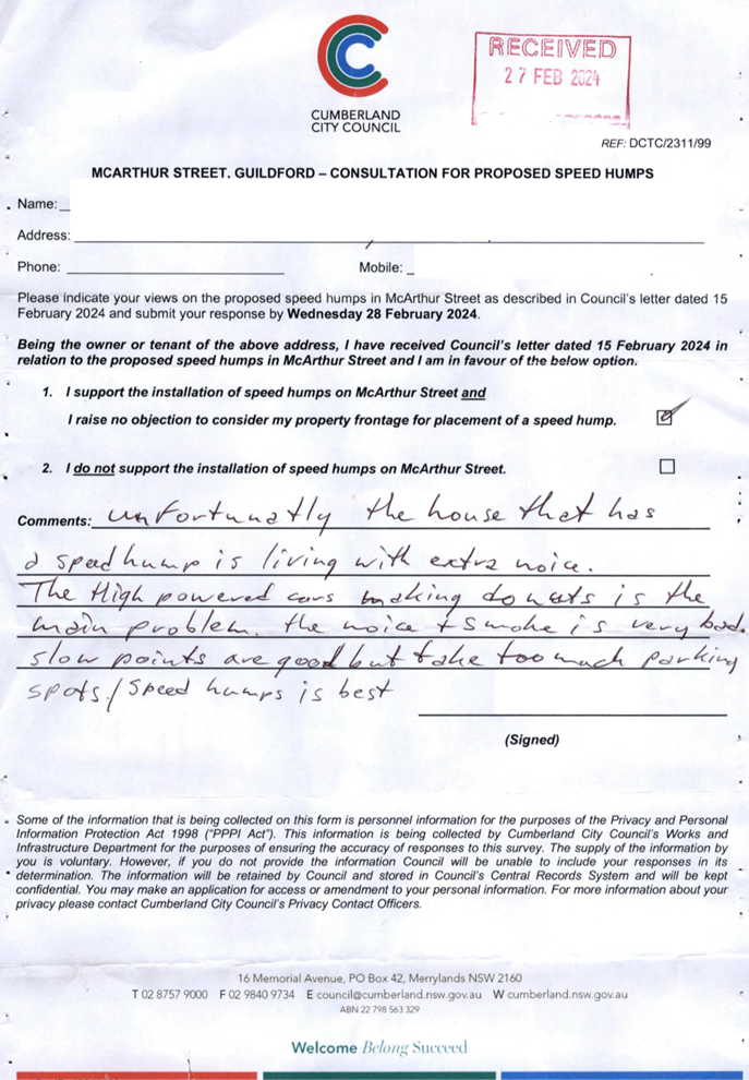
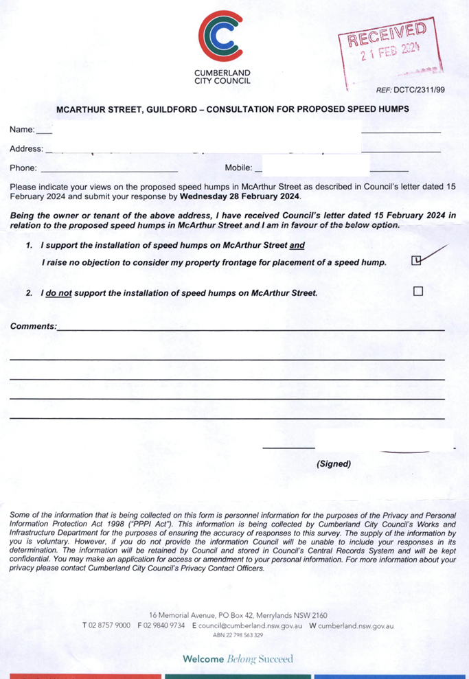
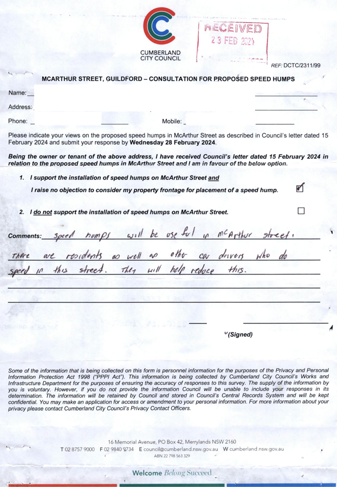
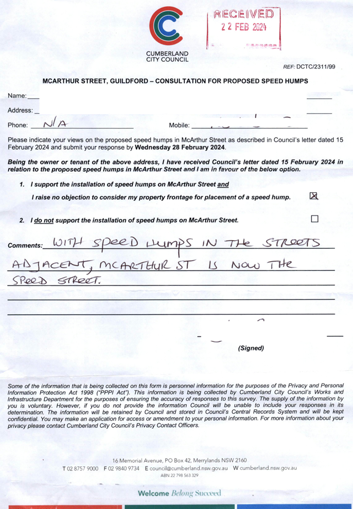
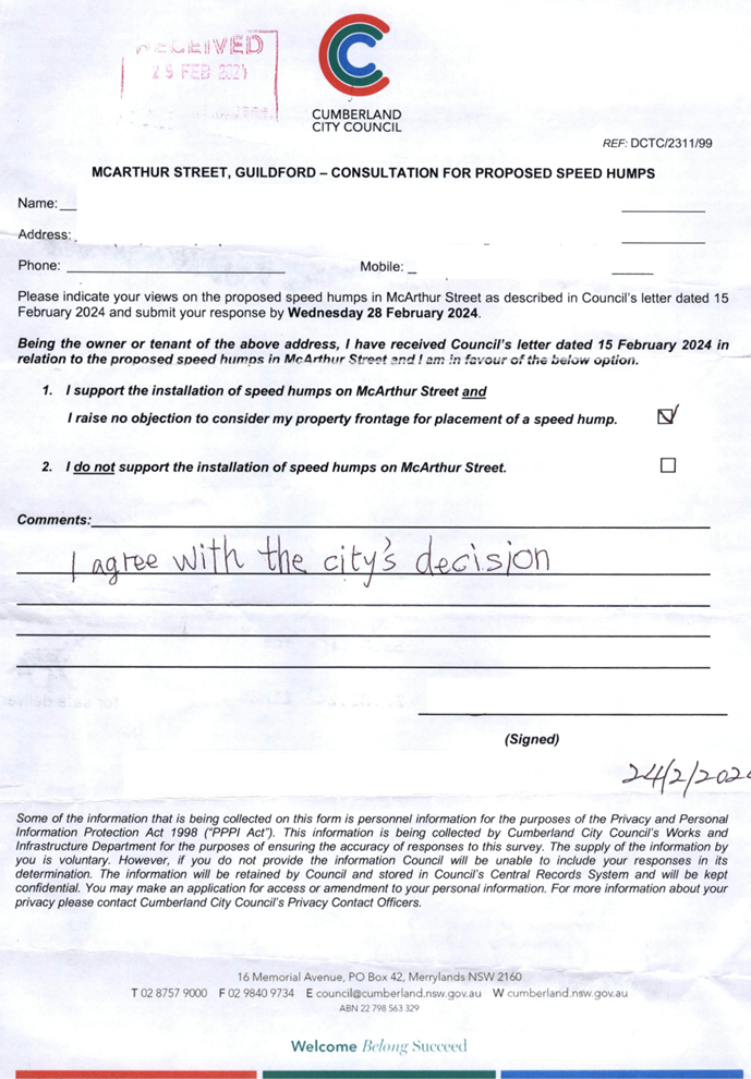
CTC-24-089 MCARTHUR
STREET, GUILDFORD – ROAD SAFETY CONCERNS – CONSULTATION RESULT................................................................... 391
CTC-24-090 O'NEILL
STREET, GUILDFORD - PROPOSED INTERSECTION TREATMENT AT ELIZABETH STREET............................................ 421
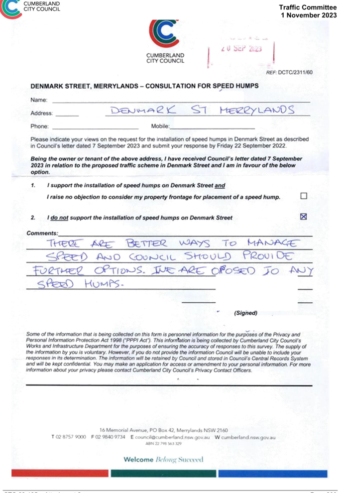
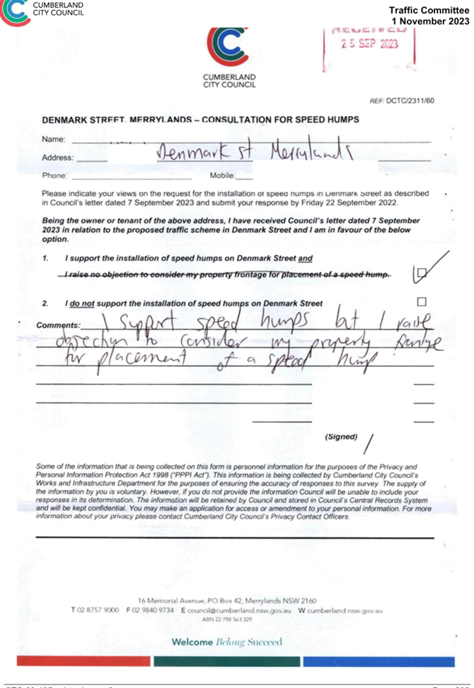
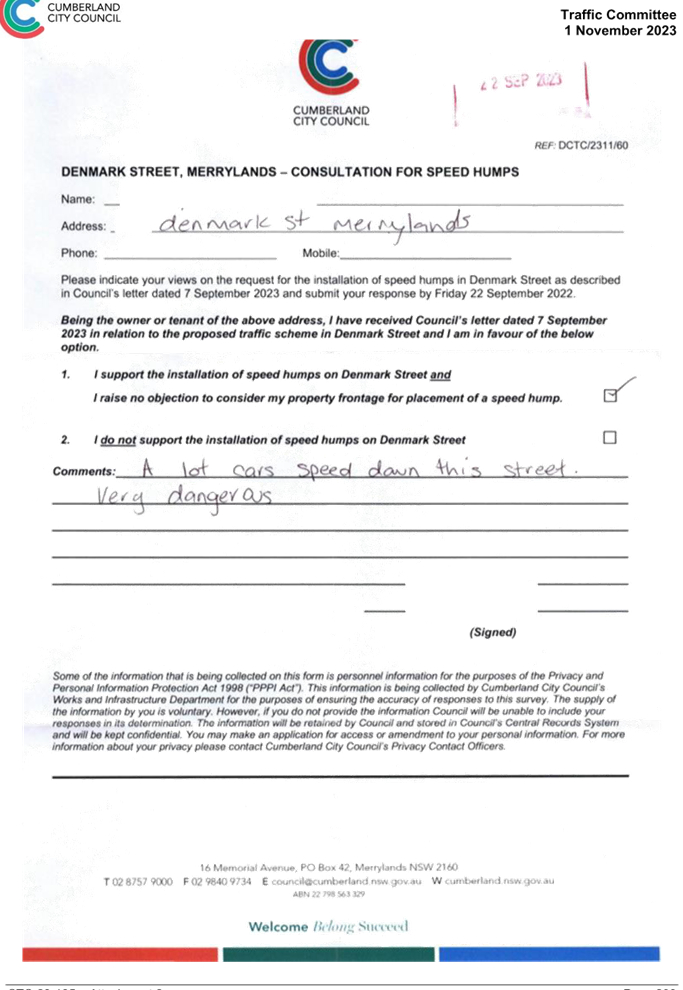
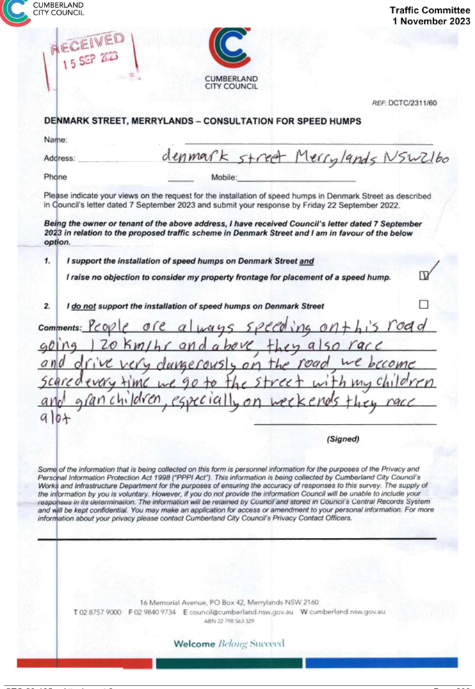
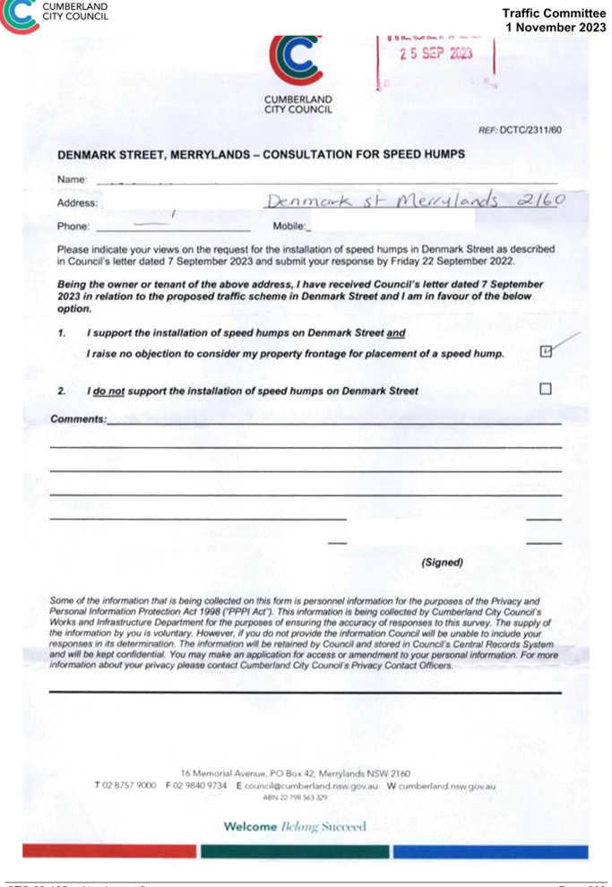
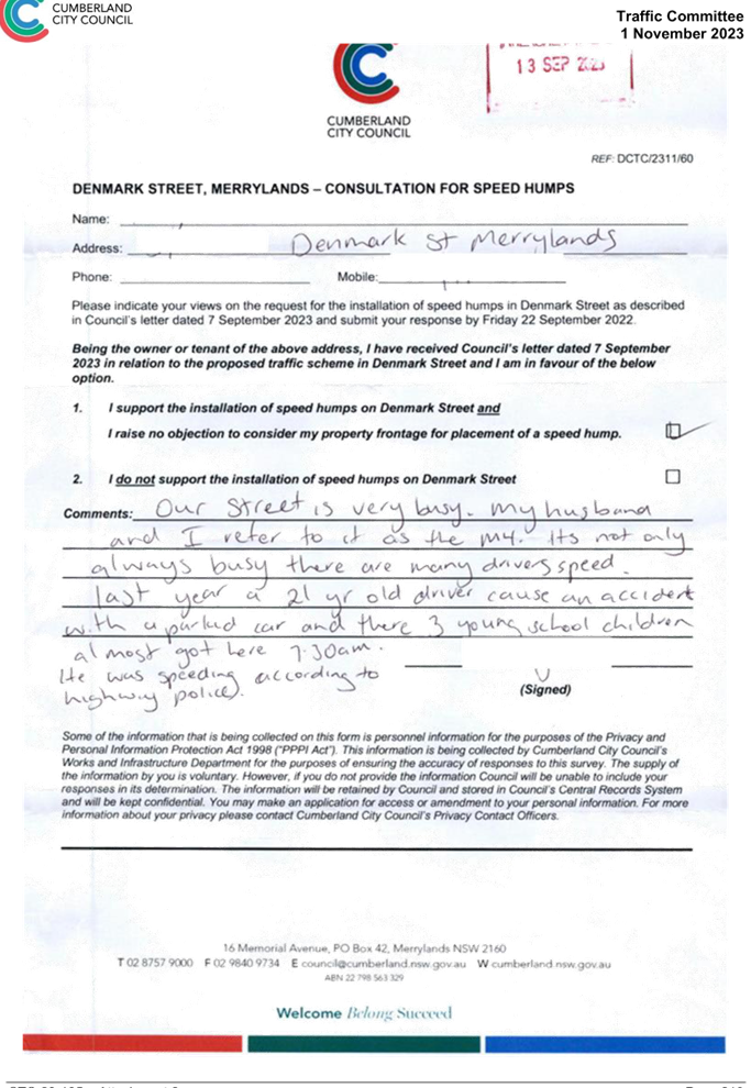
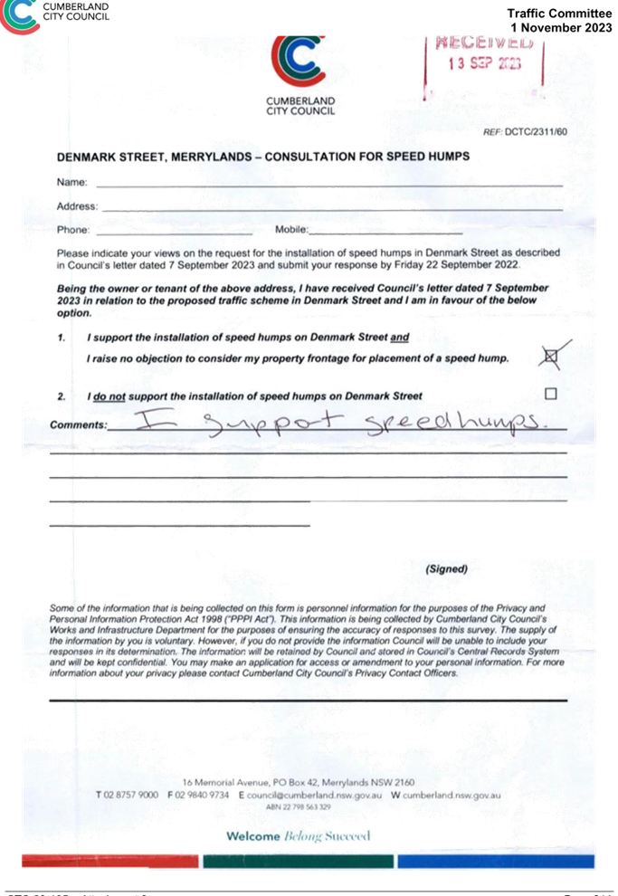
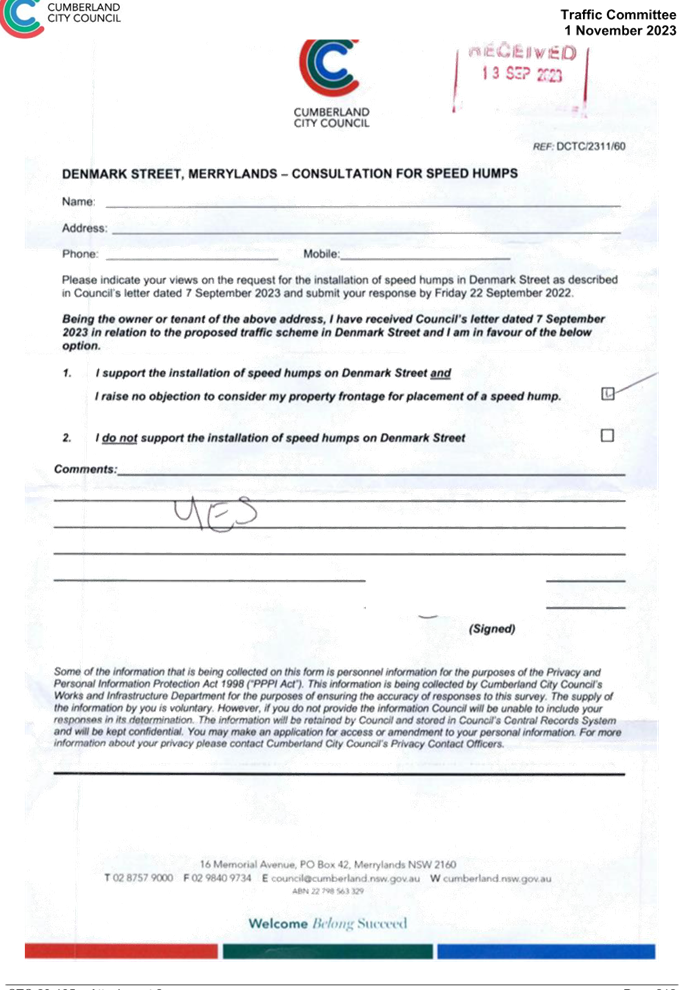
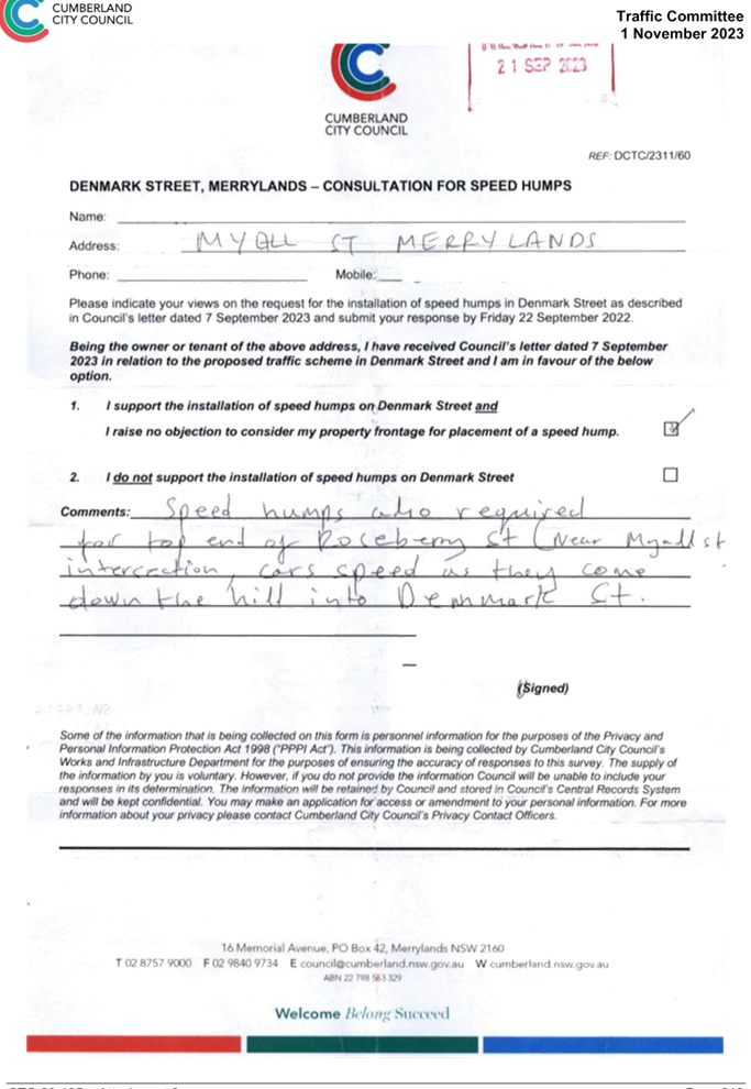
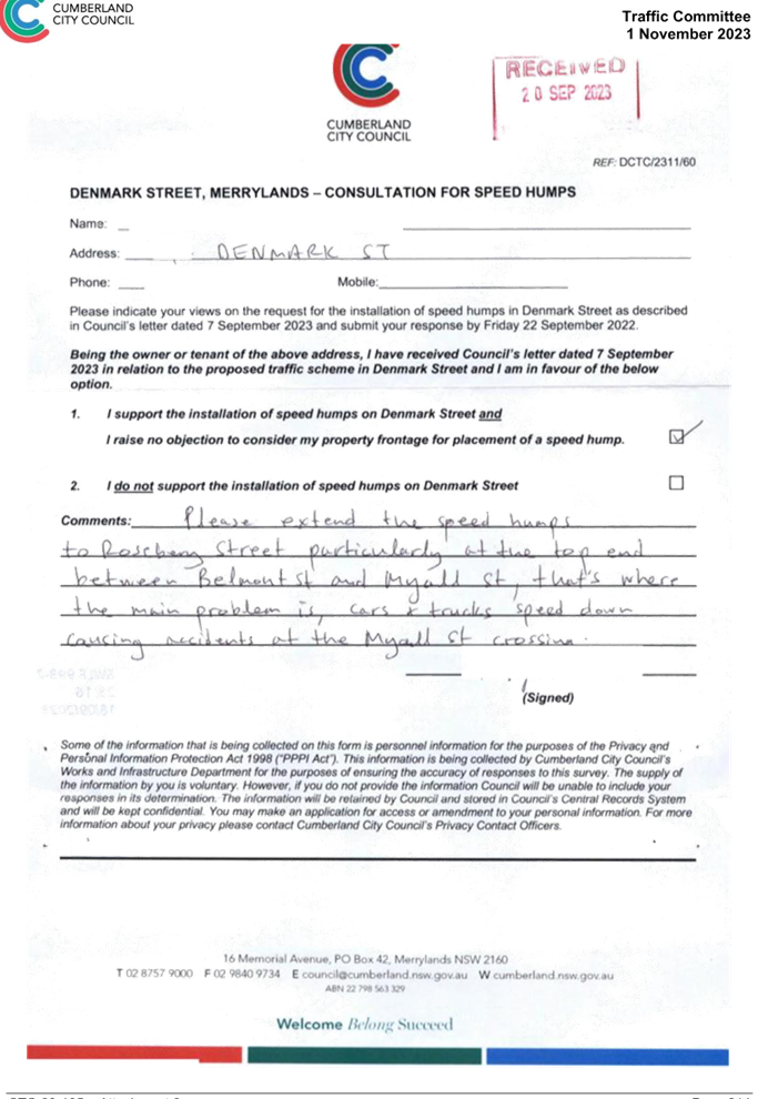
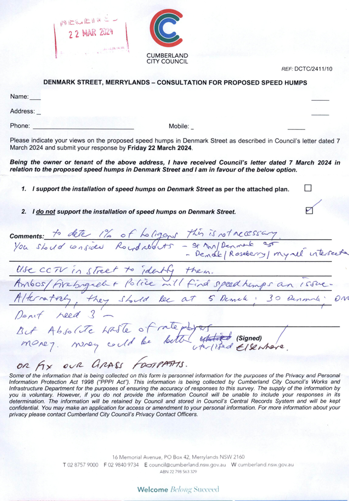
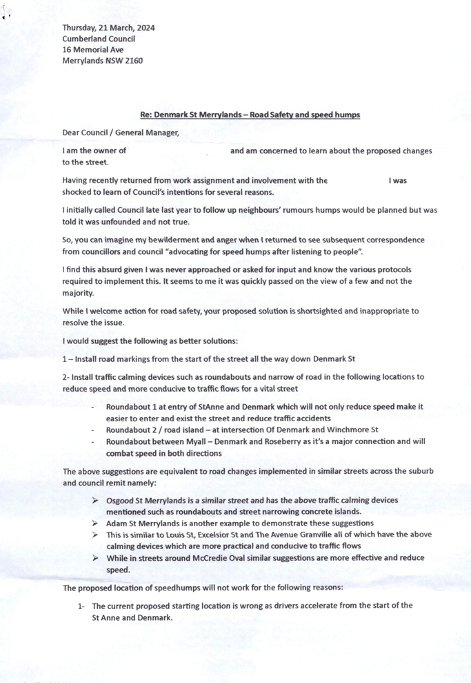
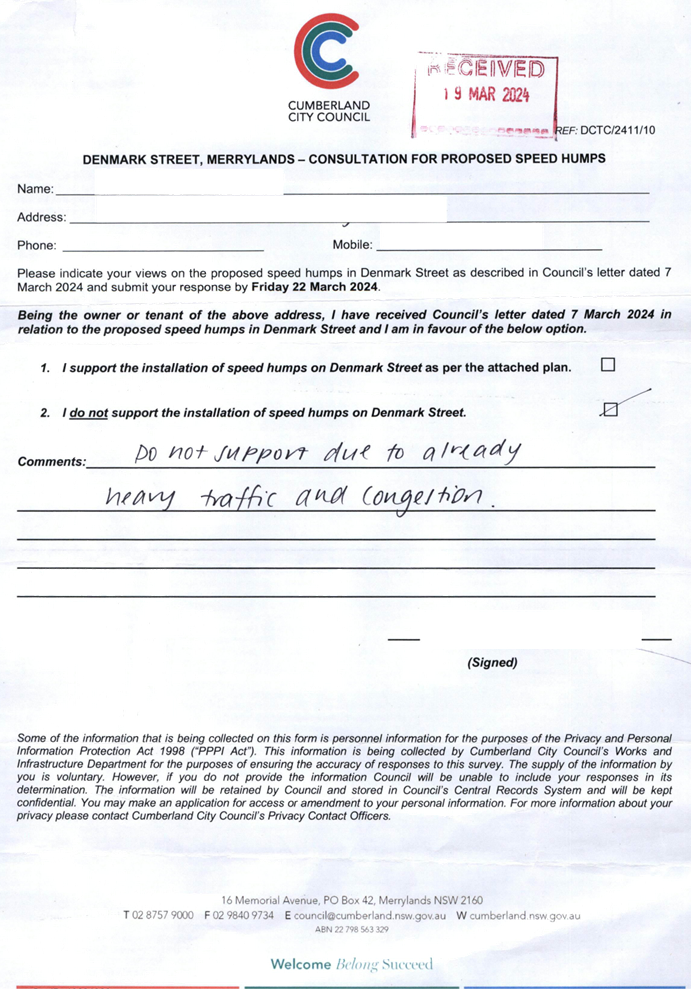
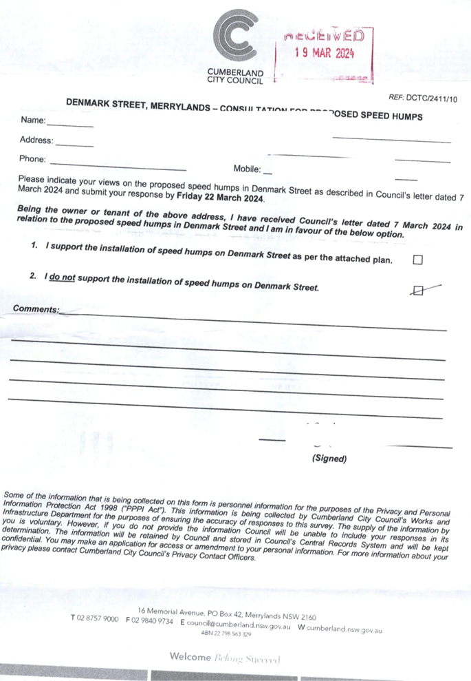
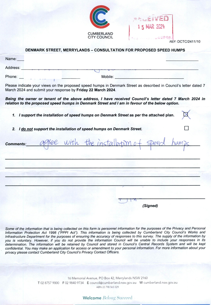
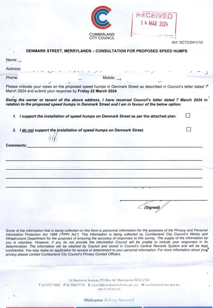
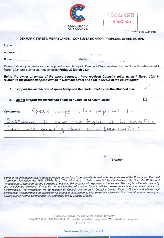
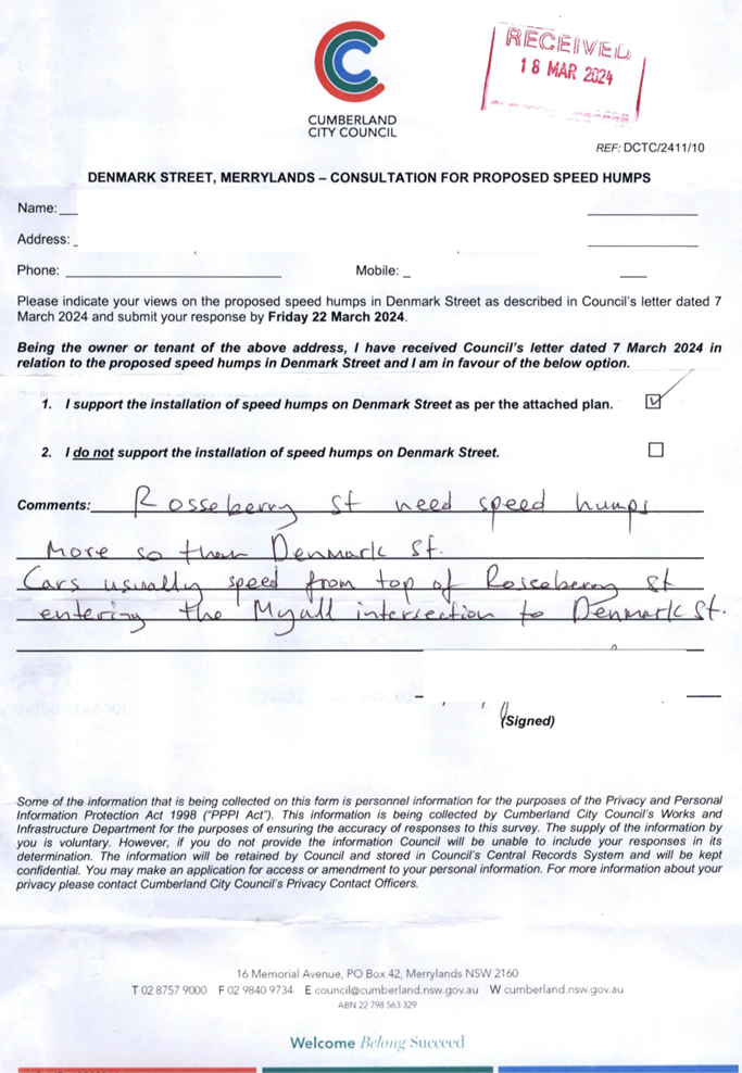
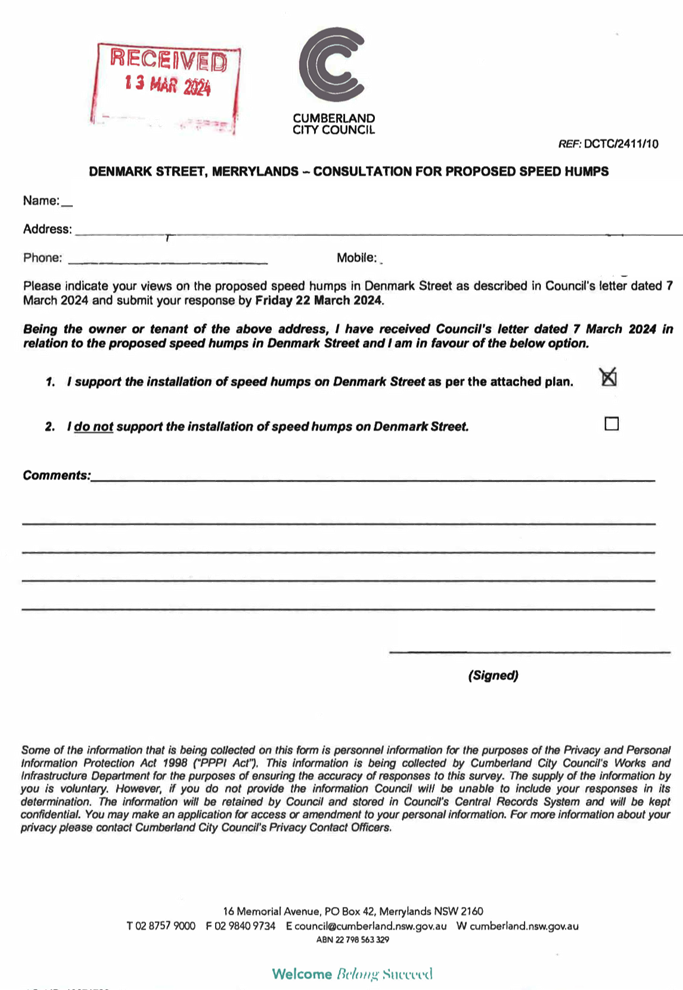
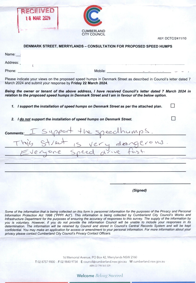
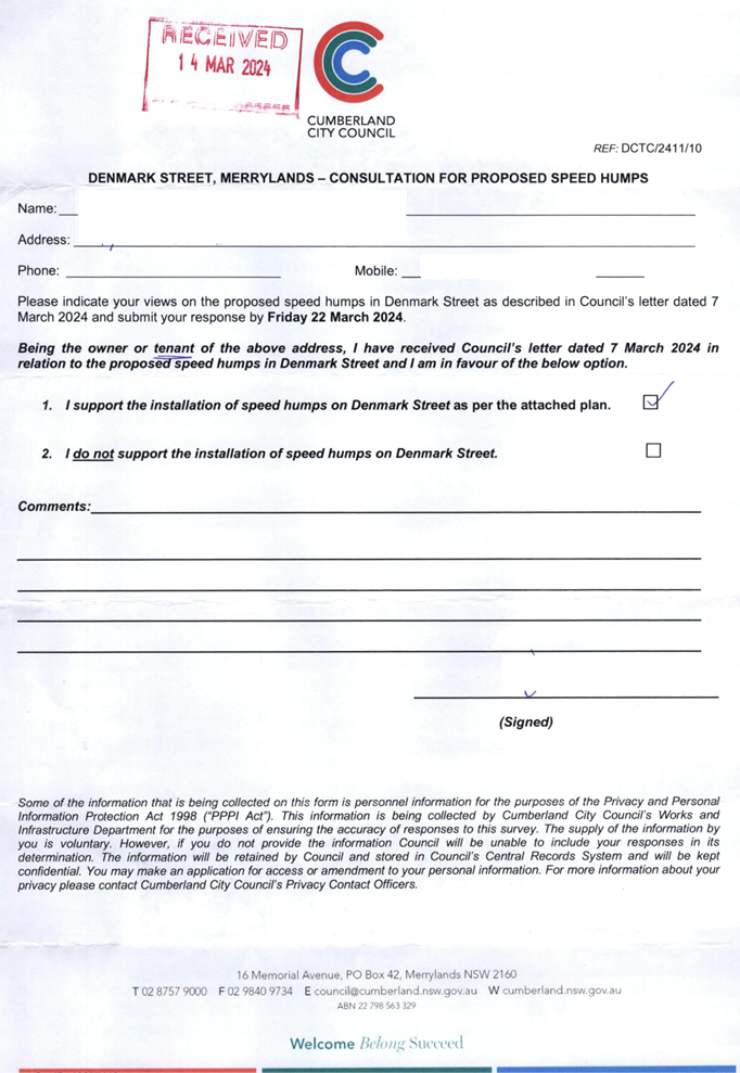
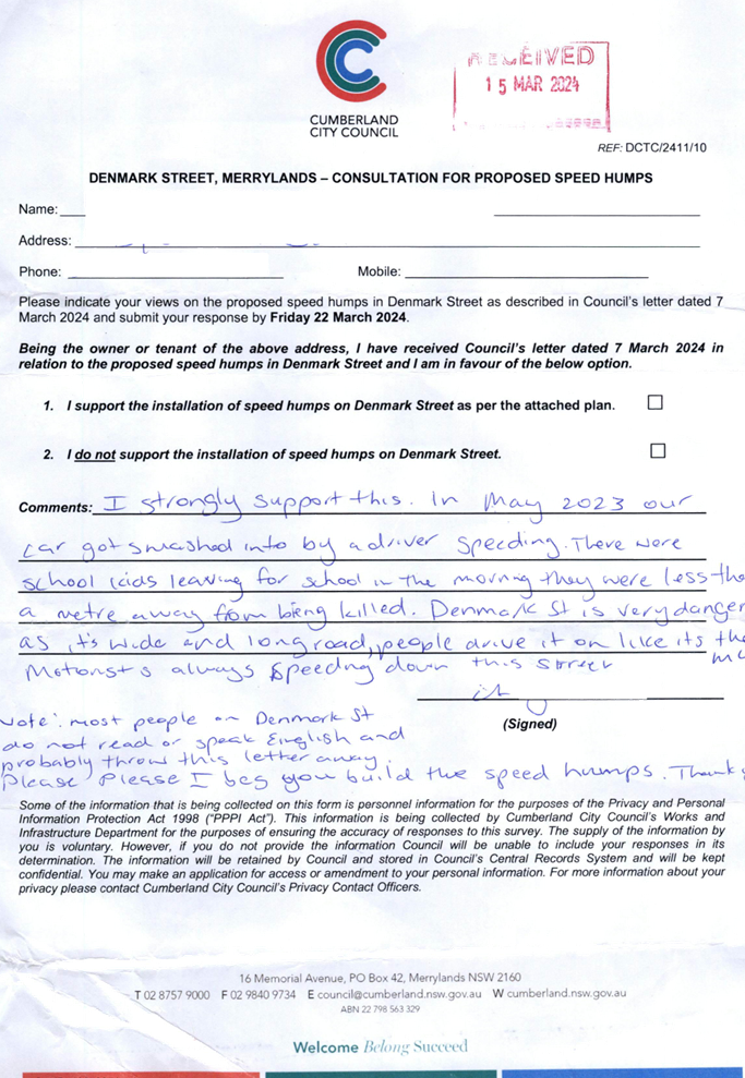
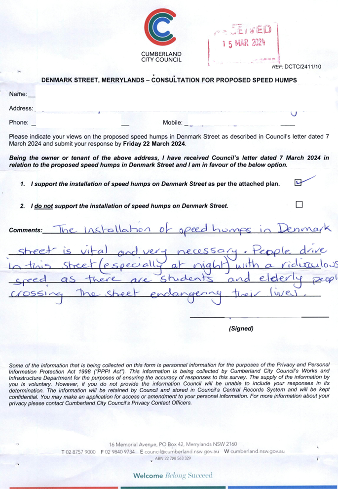
CTC-24-091 DENMARK
STREET, MERRYLANDS – ROAD SAFETY CONCERNS – CONSULTATION RESULT................................................................... 429
CTC-24-092 PITT
STREET, MERRYLANDS - PROPOSED PEDESTRIAN FENCING 499
CTC-24-093 BLAXCELL
STREET AND LISGAR STREET, SOUTH GRANVILLE - INTERSECTION SAFETY CONCERNS............................................ 505
CTC-24-094 WALTERS
ROAD AND SECOND AVENUE, BERALA - ROAD SAFETY CONCERNS............................................................................................ 513
CTC-24-095 REGENT
STREET, REGENTS PARK - REQUEST FOR BANNING RIGHT TURNS INTO AMY STREET................................................................ 525
3 April 2024
Summary of Reports
Part 1 - Recommended for Approval under Delegated Authority
|
Item #
|
Title
|
Electorate
|
Police Area Command (PAC)
|
|
Fairfield
|
Granville
|
Prospect
|
Auburn
|
Cumberland
|
Auburn
|
|
CTC-24-059
|
JOHN STREET, LIDCOMBE
– PROPOSED PARKING RESTRICTIONS
|
|
|
|
´
|
|
´
|
|
CTC-24-060
|
BOMBAY STREET AND MAUD
STREET, LIDCOMBE – PROPOSED ‘NO STOPPING’ RESTRICTIONS AND
LINEMARKING
|
|
|
|
´
|
|
´
|
|
CTC-24-061
|
DELHI STREET AND MAUD
STREET, LIDCOMBE – PROPOSED ‘NO STOPPING’ RESTRICTIONS AND
LINEMARKING
|
|
|
|
´
|
|
´
|
|
CTC-24-062
|
ALICE STREET, AUBURN - ROAD
SAFETY CONCERNS
|
|
|
|
´
|
|
´
|
|
CTC-24-063
|
CHISHOLM ROAD AT CARDIGAN
STREET, AUBURN – REQUEST FOR ‘KEEP CLEAR’ LINEMARKING
|
|
|
|
´
|
|
´
|
|
CTC-24-064
|
RAILWAY PARADE, GRANVILLE -
ROAD SAFETY CONCERNS
|
|
´
|
|
|
´
|
|
|
CTC-24-065
|
NEW YORK STREET, GRANVILLE
– PROPOSED RELOCATION OF THE EXISTING ‘NO PARKING’ SIGNAGE
|
|
´
|
|
|
´
|
|
|
CTC-24-066
|
GOUGH STREET AND WALPOLE
STREET, HOLROYD – PROPOSED ‘NO STOPPING’ RESTRICTIONS AND
LINEMARKING
|
|
´
|
|
|
´
|
|
|
CTC-24-067
|
BRADMAN STREET AT EXCELSIOR
STREET AND WOODVILLE ROAD, MERRYLANDS – PROPOSED ‘NO
STOPPING’ RESTRICTIONS AND LINEMARKING
|
|
´
|
|
|
´
|
|
|
CTC-24-068
|
GLADSTONE STREET,
MERRYLANDS - PROPOSED SIGNAGE AND LINEMARKING
|
|
´
|
|
|
´
|
|
|
CTC-24-069
|
JOSEPHINE STREET,
MERRYLANDS WEST – PROPOSED ‘NO STOPPING’ RESTRICTIONS
|
|
´
|
|
|
´
|
|
|
CTC-24-070
|
YENNORA AVENUE AND WYANNA GROVE,
YENNORA – PROPOSED PARKING RESTRICTIONS
|
|
´
|
|
|
´
|
|
|
CTC-24-071
|
LANCE CRESCENT, GREYSTANES
– PROPOSED RELOCATION OF THE EXISTING ‘NO STOPPING’ AND
‘NO PARKING’ SIGNAGE
|
|
|
´
|
|
´
|
|
|
CTC-24-072
|
HACKNEY STREET, GREYSTANES
- ROAD SAFETY CONCERNS
|
|
|
´
|
|
´
|
|
|
CTC-24-073
|
ALLEN STREET AND FINLAYSON
STREET, SOUTH WENTWORTHVILLE – PROPOSED ‘NO STOPPING’
RESTRICTIONS
|
|
´
|
|
|
´
|
|
|
CTC-24-074
|
SMITH STREET, PENDLE HILL -
ROAD SAFETY CONCERNS
|
|
|
´
|
|
´
|
|
|
CTC-24-075
|
SMITH STREET AND PENDLE
WAY, PENDLE HILL – PARKING RESTRICTIONS AND LINEMARKING AT THE
INTERSECTION
|
|
|
´
|
|
´
|
|
|
CTC-24-076
|
BULGA LANE, PEMULWUY
– PROPOSED ‘NO STOPPING’ RESTRICTIONS
|
|
|
´
|
|
´
|
|
|
CTC-24-077
|
NIJONG DRIVE, PEMULWUY
– REMOVAL OF REDUNDANT ‘BUS ZONE’ SIGNAGE
|
|
|
´
|
|
´
|
|
Part 2 - Recommendation to Council
|
Item #
|
Title
|
Electorate
|
Police Area Command (PAC)
|
|
Fairfield
|
Granville
|
Prospect
|
Auburn
|
Cumberland
|
Auburn
|
|
CTC-24-078
|
Review of Traffic Related
Policies and Guidelines
|
|
|
´
|
|
´
|
|
|
CTC-24-079
|
LANEWAY BETWEEN LINDEN
STREET AND HARVEY PLACE, TOONGABBIE – PROPOSED TO CONVERT THE LANEWAY
TO ONE-WAY TRAFFIC FLOW
|
|
|
´
|
|
´
|
|
|
CTC-24-080
|
BURRAGA WAY AND MUTTONG
STREET, PEMULWUY – PROPOSED ONE-WAY TRAFFIC FLOW AND REMOVAL OF PARKING
RESTRICITONS.
|
|
|
´
|
|
´
|
|
|
CTC-24-081
|
JONES STREET, WENTWORTHVILLE
– ROAD SAFETY CONCERNS – CONSULTATION RESULT
|
|
|
´
|
|
´
|
|
|
CTC-24-082
|
HAMPDEN ROAD, SOUTH
WENTWORTHVILLE – ROAD SAFETY CONCERNS
|
|
´
|
|
|
´
|
|
|
CTC-24-083
|
RUNYON AVENUE, GREYSTANES
– ROAD SAFETY CONCERNS - CONSULTATION RESULT
|
|
|
´
|
|
´
|
|
|
CTC-24-084
|
WHALANS ROAD AND BRIGHTON
STREET, GREYSTANES - PROPOSED MODIFICATION TO THE EXISTING ROUNDABOUT
|
|
|
´
|
|
´
|
|
|
CTC-24-085
|
DENNISTOUN AVENUE,
GUILDFORD WEST – CONSULTATION RESULTS
|
|
´
|
|
|
´
|
|
|
CTC-24-086
|
TENNYSON PARADE, GUILDFORD
WEST – ROAD SAFETY CONCERNS - CONSULTATION RESULT
|
|
´
|
|
|
´
|
|
|
CTC-24-087
|
CHETWYND ROAD AND GUILDFORD
ROAD, GUILDFORD - ROAD SAFETY CONCERNS
|
|
´
|
|
|
´
|
|
|
CTC-24-088
|
WILLOUGHBY STREET,
GUILDFORD - ROAD SAFETY CONCERNS – CONSULTATION RESULT
|
|
´
|
|
|
´
|
|
|
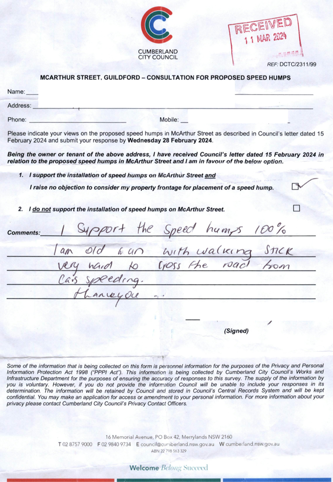
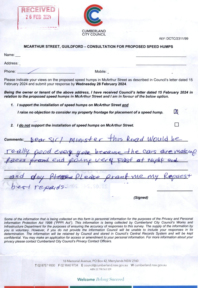
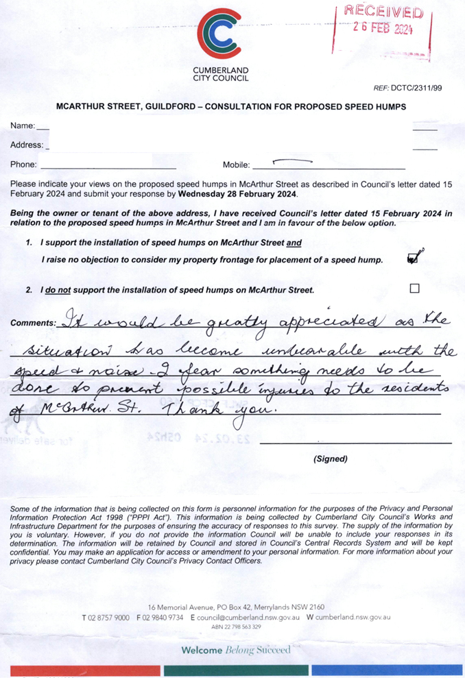
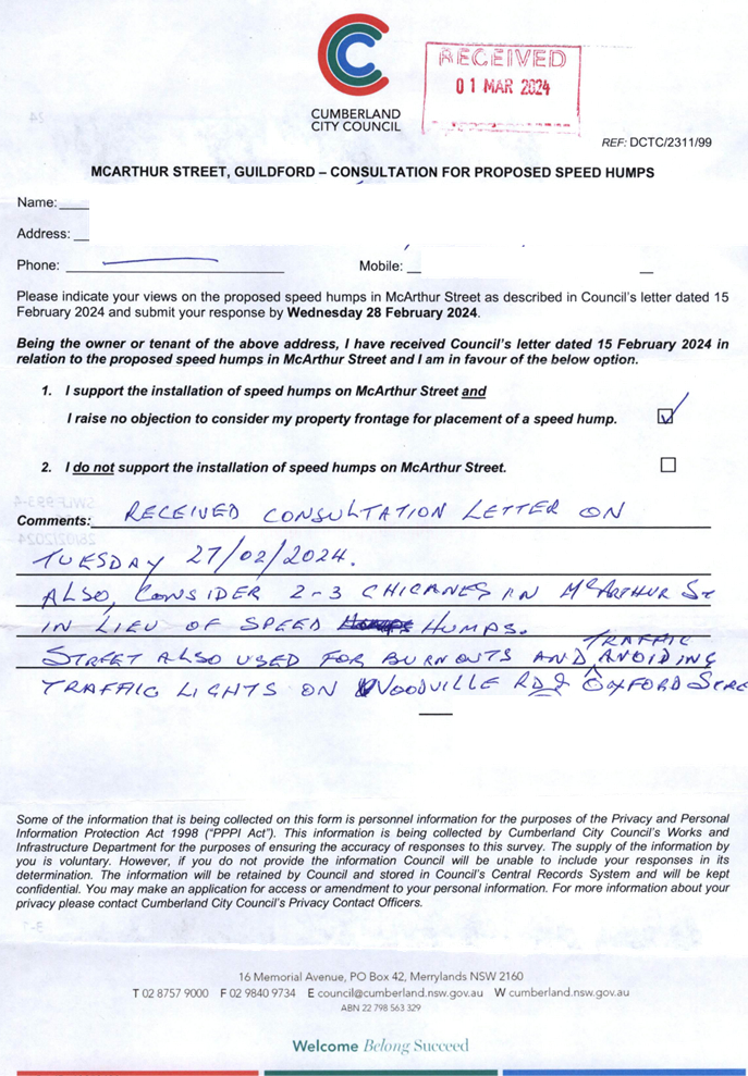
CTC-24-089
|
MCARTHUR STREET, GUILDFORD
– ROAD SAFETY CONCERNS – CONSULTATION RESULT
|
|
´
|
|
|
´
|
|
|
CTC-24-090
|
O'NEILL STREET, GUILDFORD -
PROPOSED INTERSECTION TREATMENT AT ELIZABETH STREET
|
|
´
|
|
|
´
|
|
|
CTC-24-091
|
DENMARK STREET, MERRYLANDS
– ROAD SAFETY CONCERNS – CONSULTATION RESULT
|
|
´
|
|
|
´
|
|
|
CTC-24-092
|
PITT STREET, MERRYLANDS -
PROPOSED PEDESTRIAN FENCING
|
|
´
|
|
|
´
|
|
|
CTC-24-093
|
BLAXCELL STREET AND LISGAR
STREET, SOUTH GRANVILLE - INTERSECTION SAFETY CONCERNS
|
|
´
|
|
|
´
|
|
|
CTC-24-094
|
WALTERS ROAD AND SECOND
AVENUE, BERALA - ROAD SAFETY CONCERNS
|
|
|
|
´
|
|
´
|
|
CTC-24-095
|
REGENT STREET, REGENTS PARK
- REQUEST FOR BANNING RIGHT TURNS INTO AMY STREET
|
|
|
|
´
|
|
´
|
3 April 2024
Minutes of the Traffic Committee meeting held at Merrylands
Administration Building, 16 Memorial Avenue, Merrylands on Wednesday 07
February 2024.
opening of
meeting:
The meeting was opened by the Chairperson – Clr Suman
Saha at 9.36am.
Present:
|
MEMBERS
|
|
|
Clr Suman Saha (Chairman)
|
Cumberland City Council
|
|
Ms Irene Xu
|
Transport for NSW
|
|
Mr George Campbell
|
Local Member for Auburn
|
|
Clr Glenn Elmore
|
Local Member for Granville
|
|
Clr Diane Colman
|
Local Member for Prospect
|
|
Leading Senior Constable William
Graham
|
Cumberland Police Area Command
|
|
Leading Senior Constable Raymond Yeung
|
Auburn Police Area Command
|
|
Ms Hannah Shilling
|
Transit Systems
|
|
|
|
|
COUNCIL OFFICERS
|
|
|
Daniel Cavallo
|
Director Environment and Planning
|
|
Elias Elias
|
Acting Manager Engineering & Building
|
|
Soma Somaskanthan
|
Executive Engineer Traffic and Transport
|
|
Siva Sivakumar
|
Manager Special Projects
|
|
Gabrielle Zerni
|
Engineering Administration Officer
|
|
Lyndall Thompson
|
Senior Governance & Civic Events Officer (Minute
Taker)
|
|
Pamela MacIntyre
|
Governance Officer (Observer)
|
Apologies:
|
Local Member for Fairfield – no representative
nominated
|
Local Member for Fairfield - No items in the State
electorate.
|
|
CDCBus
|
No objections received.
|
|
Transdev
|
No objections received.
|
The Chairperson advised the Traffic Committee of a change in
representation for the Local Member of Granville, noting Mr Chris Worthington
would be replaced by Clr Glenn Elmore. The Chairperson acknowledged and thanked
the contribution and service provided by Mr Worthington to the Traffic
Committee.
Declarations Of Interest
Nil.
CONFIRMATION OF previous MINUTES
That the Committee confirm the minutes of the Extraordinary
Cumberland Traffic Committee Meeting held on 18 October 2023 which were
endorsed at the Ordinary Council Meeting held on 1 November 2023 with the
exception of items ECTC-23-158, ECTC-23-159, ECTC-23-160, ECTC-23-162 and
ECTC-23-164 which were dealt with separately.
That the Committee confirm the minutes of the Ordinary
Cumberland Traffic Committee Meeting held on 1 November 2023 were endorsed at
the Ordinary Council Meeting held on 6 December 2023 with the exception of
items CTC-23-187, CTC-23-191 and CTC-23-192 which were dealt with separately.
Note: Final resolutions can be viewed on Council’s
website.
Moved Leading Senior Constable William Graham, Seconded
Ms Irene Xu
Summary of reports
Part 1 - Recommended for Approval under Delegated
Authority
|
Item #
|
Title
|
Electorate
|
Police Area Command (PAC)
|
|
Fairfield
|
Granville
|
Prospect
|
Auburn
|
Cumberland
|
Auburn
|
|
CTC-24-001
|
BERTHA STREET AND WOODVILLE
ROAD, MERRYLANDS – PROPOSED ‘NO STOPPING’ RESTRICTIONS AND
LINE MARKING
|
|
´
|
|
|
´
|
|
|
CTC-24-002
|
FULLAGAR ROAD,
WENTWORTHVILLE – RELOCATION OF EXISTING ‘NO STOPPING’
SIGNAGE
|
|
|
´
|
|
´
|
|
|
CTC-24-003
|
GOOREEN STREET AND NYRANG
STREET, LIDCOMBE – PROPOSED ‘NO STOPPING’ RESTRICTIONS AND
LINEMARKING
|
|
|
|
´
|
|
´
|
|
CTC-24-004
|
MEMORIAL AVENUE, MERRYLANDS
– MODIFICATIONS TO THE EXISTING MAIL ZONE
|
|
´
|
|
|
´
|
|
|
CTC-24-005
|
NYRANG STREET,
LIDCOMBE– PROPOSED BB LINEMAKRING
|
|
|
|
´
|
|
´
|
|
CTC-24-006
|
WAYLAND AVENUE AND GEORGES
AVENUE, LIDCOMBE – PROPOSED ‘NO STOPPING’ RESTRICTIONS AND
LINEMARKING
|
|
|
|
´
|
|
´
|
|
CTC-24-007
|
BERITH ROAD AND CAROLYN
STREET, GREYSTANES – PROPOSED ‘NO STOPPING’ RESTRICTIONS
AND LINEMARKING
|
|
|
´
|
|
´
|
|
|
CTC-24-008
|
DUFFY STREET AND CAMERON
COURT, MERRYLAND WEST – PROPOSED ‘NO STOPPING’ RESTRICTIONS
AND LINE MARKING
|
|
´
|
|
|
´
|
|
|
CTC-24-009
|
THE TRONGATE AT CELIA
STREET AND ROSSITER STREET, GRANVILLE – PROPOSED ‘NO
STOPPING’ RESTRICTIONS AND LINEMARKING
|
|
´
|
|
|
´
|
|
|
CTC-24-010
|
THE TRONGATE AND CHARLES
STREET, GRANVILLE – PROPOSED ‘NO STOPPING’
RESTRICTIONS AND LINE MARKING
|
|
´
|
|
|
´
|
|
|
CTC-24-011
|
DAVIES STREET AND DESMOND
STREET, MERRYLANDS – PROPOSED ‘NO STOPPING’ RESTRICTIONS
AND LINEMARKING
|
|
´
|
|
|
´
|
|
|
CTC-24-012
|
MERRYLANDS ROAD, MERRYLANDS
– REQUEST FOR ACCESSABLE PARKING
|
|
´
|
|
|
´
|
|
|
CTC-24-013
|
BLAXCELL STREET, SOUTH
GRANVILLE – REVIEW OF THE EXISTING PARKING RESTRICTIONS
|
|
´
|
|
|
´
|
|
|
CTC-24-014
|
LUCAS STREET, GUILDFORD
– CHANGES TO THE EXISTING PARKING RESTRICTIONS
|
|
´
|
|
|
´
|
|
|
CTC-24-015
|
STAFFORD STREET, SOUTH
GRANVILLE – EXTENSION OF THE EXISTING ‘NO PARKING’
RESTRICTIONS
|
|
´
|
|
|
´
|
|
|
CTC-24-016
|
WILLIAM STREET, GRANVILLE -
PROPOSED ACCESSIBLE PARKING SPACES
|
|
´
|
|
|
´
|
|
|
CTC-24-017
|
PARK STREET AND WOODVILLE
ROAD, MERRYLANDS – PROPOSED ‘NO STOPPING’ RESTRICTIONS AND
LINE MARKING
|
|
´
|
|
|
´
|
|
|
CTC-24-018
|
BOOMERANG STREET, GRANVILLE
– PROPOSED INSTALLATION OF RUMBLE STRIPS
|
|
´
|
|
|
´
|
|
|
CTC-24-019
|
PRITCHARD STREET EAST AND
GARFIELD STREET, WENTWORTHVILLE – PROPOSED CHANGES TO THE EXISTING
PARKING RESTRICTION
|
|
|
´
|
|
´
|
|
|
CTC-24-020
|
CONDOIN LANE, PEMULWUY
– REQUEST FOR REMOVAL OF 'NO STOPPING' SIGNAGE
|
|
|
´
|
|
´
|
|
|
CTC-24-021
|
NYRANG STREET, LIDCOMBE
– REVIEW OF SLOW POINT TREATMENTS AT INTERSECTIONS
|
|
|
|
´
|
|
´
|
|
CTC-24-022
|
MERRYLANDS ROAD AND
CAMBRIDGE STREET, MERRYLANDS - SIGNAGE REVIEW
|
|
´
|
|
|
´
|
|
Part 2 - Recommendation to Council
Note: Part 2 recommendations of the Traffic
Committee are subject to Council’s endorsement. For final decisions
regarding these matters, please refer to the Council Meeting Minutes where
these matters were reported to Council for determination.
|
Item #
|
Title
|
Electorate
|
Police Area Command (PAC)
|
|
Fairfield
|
Granville
|
Prospect
|
Auburn
|
Cumberland
|
Auburn
|
|
CTC-24-058
|
GUILDFORD ROAD,
GUILDFORD - PROPOSED TEMPORARY ROAD CLOSURE FOR GUILDFORD FESTIVAL
|
|
´
|
|
|
´
|
|
|
CTC-24-023
|
WINGELLO STREET AND SWIFT
STREET, GUILDFORD – PROPOSED 'ONE WAY' ARRANGEMENT
|
|
´
|
|
|
´
|
|
|
CTC-24-024
|
BURNETT STREET, MAYS HILL -
ROAD SAFETY CONCERNS
|
|
´
|
|
|
´
|
|
|
CTC-24-025
|
FIFTH STREET AND THE
TRONGATE, GRANVILLE – ROAD SAFETY CONCERNS – CONSULTATION RESULT
|
|
´
|
|
|
´
|
|
|
CTC-24-026
|
LOCKWOOD STREET,
MERRYLANDS – ROAD SAFETY CONCERNS - CONSULTATION
|
|
´
|
|
|
´
|
|
|
CTC-24-027
|
FOWLER ROAD, GUILDFORD WEST
- ROAD SAFETY CONCERNS
|
|
´
|
|
|
´
|
|
|
CTC-24-028
|
OXFORD STREET, BERALA -
ROAD SAFETY CONCERNS
|
|
|
|
´
|
|
´
|
|
CTC-24-029
|
THE AVENUE, GRANVILLE -
ROAD SAFETY CONCERNS
|
|
´
|
|
|
´
|
|
|
CTC-24-030
|
WOMBAT STREET, PEMULWUY -
ROAD SAFETY CONCERNS
|
|
|
´
|
|
´
|
|
|
CTC-24-031
|
HUNT STREET , GUILDFORD
WEST - ROAD SAFETY CONCERNS
|
|
´
|
|
|
´
|
|
|
CTC-24-032
|
THE ESPLANADE, GUILDFORD -
ROAD SAFETY CONCERNS
|
|
´
|
|
|
´
|
|
|
CTC-24-033
|
VILLIERS STREET, MERRYLANDS
- ROAD SAFETY CONCERNS
|
|
´
|
|
|
´
|
|
|
CTC-24-034
|
ELM ROAD, AUBURN - ROAD
SAFETY CONCERNS
|
|
|
|
´
|
|
´
|
|
CTC-24-035
|
HILLTOP ROAD, MERRYLANDS -
ROAD SAFETY CONCERNS
|
|
´
|
|
|
´
|
|
|
CTC-24-036
|
LANEWAY BETWEEN VAUGHAN
STREET AND FREITAS LANE, LIDCOMBE – PROPOSED TO CONVERT THE LANEWAY TO
ONE-WAY TRAFFIC FLOW
|
|
|
|
´
|
|
´
|
|
CTC-24-037
|
DUNMORE STREET,
WENTWORTHVILLE – REQUEST FOR A MARKED PEDESTRIAN CROSSING
|
|
|
´
|
|
´
|
|
|
CTC-24-038
|
DAMIEN AVENUE, GREYSTANES -
ROAD SAFETY CONCERNS
|
|
|
´
|
|
´
|
|
|
CTC-24-039
|
DUNMORE STREET,
WENTWORTHVILLE - ROAD SAFETY CONCERNS
|
|
´
|
|
|
´
|
|
|
CTC-24-040
|
HAWKSVIEW STREET,
MERRYLANDS - REQUEST TO REMOVE THE EXISTING PEDESTRIAN REFUGE ISLAND
|
|
´
|
|
|
´
|
|
|
CTC-24-041
|
CLYDE STREET AND ARCHIBALD
STREET, GRANVILLE - PROPOSED PEDESTRIAN FENCING
|
|
´
|
|
|
´
|
|
|
CTC-24-042
|
BAKER STREET, MERRYLANDS -
ROAD SAFETY CONCERNS
|
|
´
|
|
|
´
|
|
|
CTC-24-043
|
ELDRIDGE ROAD, GREYSTANES -
ROAD SAFETY CONCERNS
|
|
|
´
|
|
´
|
|
|
CTC-24-044
|
GLOUCESTER AVENUE,
MERRYLANDS - ROAD SAFETY CONCERNS
|
|
´
|
|
|
´
|
|
|
CTC-24-045
|
OATLANDS STREET, WENTWORTHVILLE
- ROAD SAFETY CONCERNS
|
|
|
´
|
|
´
|
|
|
CTC-24-046
|
MCCREDIE ROAD, GUIDLFORD
WEST - ROAD SAFETY CONCERNS
|
|
´
|
|
|
´
|
|
|
CTC-24-047
|
LANCE CRESCENT, GREYSTANES
- ROAD SAFETY CONCERNS
|
|
|
´
|
|
´
|
|
|
CTC-24-048
|
THE BOULEVARDE, LIDCOMBE -
ROAD SAFETY CONCERNS
|
|
|
|
´
|
|
´
|
|
CTC-24-049
|
TERRY STREET,
GREYSTANES – ROAD SAFETY CONCERNS
|
|
|
´
|
|
´
|
|
|
CTC-24-050
|
BRIGHTON STREET,
GREYSTANES – ROAD SAFETY CONCERNS - CONSULTATION
|
|
|
´
|
|
´
|
|
|
CTC-24-051
|
HAWKSVIEW STREET, GUILDFORD
AND MERRYLANDS – ROAD SAFETY CONCERN
|
|
´
|
|
|
´
|
|
|
CTC-24-052
|
ADDLESTONE ROAD, MERRYLANDS
- RELOCATION OF THE EXISTING PEDESTRIAN CROSSING
|
|
´
|
|
|
´
|
|
|
CTC-24-053
|
GRASSMERE STREET, GUILDFORD
- ROAD SAFETY CONCERNS
|
|
´
|
|
|
´
|
|
|
CTC-24-054
|
BRIDGE ROAD, WESTMEAD
– SYDNEY TRAINS ROAD-OVER-RAIL BRIDGE UPGRADE
|
|
´
|
|
|
´
|
|
|
CTC-24-055
|
LIDCOMBE TOWN CENTRE PUBLIC
DOMAIN PLAN - PROPOSED ON-STREET PARKING ARRANGEMENTS FOR JOSEPH STREET
PRECINCT
|
|
|
|
´
|
|
´
|
|
CTC-24-056
|
HAMPDEN ROAD, SOUTH
WENTWORTHVILLE – ROAD SAFETY CONCERNS
|
|
´
|
|
|
´
|
|
|
CTC-24-057
|
TEMPORARY OPTIONAL DELEGATIONS
ON TRAFFIC MANAGEMENT AND PEDESTRIAN WORKS TO COUNCILS FROM TRANSPORT FOR NSW
|
|
´
|
|
|
´
|
|
REPORTS
Part 1 - Recommended
for Approval under Delegated Authority in accordance with Part 1 of the Terms
of Reference for the Cumberland Local Traffic Committee.
|
ITEMS RESOLVED BY EXCEPTION
|
|
The Committee resolved by
exception the below items on the Traffic Committee agenda as per the
recommendations in the reports:
Part 1: CTC-24-003, CTC-24-004, CTC-24-005, CTC-24-007, CTC-24-008, CTC-24-011, CTC-24-013, CTC-24-014 CTC-24-015, CTC-24-016 CTC-24-018, CTC-24-019 CTC-24-020, CTC-24-021 and CTC-24-022.
Moved Ms Irene Xu, Seconded Mr George
Campbell.
|
|
ITEM CTC-24-003 - GOOREEN STREET AND NYRANG STREET,
LIDCOMBE – PROPOSED ‘NO STOPPING’ RESTRICTIONS AND LINE MARKING
|
|
Resolved by Exception
The Traffic Committee recommends that:
1. The
installation of ‘No Stopping’ signs at the intersection of
Gooreen Street and Nyrang Street, Lidcombe in accordance with the attached
plan be approved.
2. The
affected / concerned residents be notified of the outcome.
|
|
ITEM CTC-24-004 - MEMORIAL AVENUE, MERRYLANDS –
MODIFICATIONS TO THE EXISTING MAIL ZONE
|
|
Resolved by Exception
The Traffic Committee recommends that:
1. The existing
‘Mail Zone 6pm – 8pm, Sun – Fri’ in front of No. 12
Memorial Avenue, Merrylands be replaced with ‘Mail Zone 1pm –
5pm, Mon – Fri in accordance with the attached plan.
2. The existing
‘1/4P 8:30am – 6pm, Mon – Fri, 8:30am – 12:30pm
Sat’ be replaced with ‘1/4P 8:30am – 1pm, Mon – Fri,
8:30am – 12:30pm Sat’ in accordance with the attached plan.
3. The
adjacent businesses be notified of the outcome.
|
|
ITEM CTC-24-005 - NYRANG STREET, LIDCOMBE –
PROPOSED BB LINE MARKING
|
|
Resolved by Exception
The Traffic Committee recommends that:
1. The
installation ‘BB’ line marking at the bend in Nyrang Street,
Lidcombe in accordance with the attached plan be approved.
2. The
affected/concerned residents be notified of the outcome.
|
|
ITEM CTC-24-007 - BERITH ROAD AND CAROLYN STREET,
GREYSTANES – PROPOSED ‘NO STOPPING’ RESTRICTIONS AND LINE MARKING
|
|
Resolved by Exception
The Traffic Committee recommends that:
1. The
installation of ‘No Stopping’ signs and ‘BB’ line
marking at the intersection of Carolyn Street and Berith Road, Greystanes in
accordance with the attached plan be approved.
2. The
affected / concerned residents be notified of the outcome.
|
|
ITEM CTC-24-008 - DUFFY STREET AND CAMERON COURT,
MERRYLAND WEST – PROPOSED ‘NO STOPPING’ RESTRICTIONS AND
LINE MARKING
|
|
Resolved by Exception
The Traffic Committee recommends that:
1. The
installation of ‘No Stopping’ signs, ‘S1’ and
‘BB’ line marking at the intersection of Duffy Street and Cameron
Court, Merrylands West in accordance with the attached plan be approved.
2. The
affected / concerned residents be notified of the outcome.
|
|
ITEM CTC-24-011 - DAVIES STREET AND DESMOND STREET,
MERRYLANDS – PROPOSED ‘NO STOPPING’ RESTRICTIONS AND LINE MARKING
|
|
Resolved by Exception
The Traffic Committee recommends that:
1. The
installation of ‘No Stopping’ signs and ‘BB’ line
marking at the intersection of Davies Street and Desmond Street, Merrylands
in accordance with the attached plan be approved.
2. The
affected / concerned residents be notified of the outcome.
|
|
ITEM CTC-24-013 - BLAXCELL STREET, SOUTH GRANVILLE
– REVIEW OF THE EXISTING PARKING RESTRICTIONS
|
|
Resolved by Exception
The Traffic Committee recommends that:
1. The
existing ‘No Parking 6am – 9am, 3pm-6pm Monday to Friday’
on the eastern side of Blaxcell Street, South Granville outside No.419 be
replaced with 'No Stopping' restrictions in accordance with the attached
plan.
2. The
affected/concerned residents be notified of the outcome.
|
|
ITEM CTC-24-014 - LUCAS STREET, GUILDFORD –
CHANGES TO THE EXISTING PARKING RESTRICTIONS
|
|
Resolved by Exception
The Traffic Committee recommends that:
1. The
relocation of the existing ‘1/2P 8am-6pm Monday to Friday,
8:30am-12:30pm Saturday’ parking restrictions on the southern side of
Lucas Street in accordance with the attached plan be approved.
2. The
affected/concerned residents be notified of the outcome.
|
|
ITEM CTC-24-015 - STAFFORD STREET, SOUTH GRANVILLE
– EXTENSION OF THE EXISTING ‘NO PARKING’ RESTRICTIONS
|
|
Resolved by Exception
The Traffic Committee recommends that:
1. The
relocation of the existing ‘No Parking’ sign on the southern side
of Stafford Street, South Granville at the cul-de-sac in accordance with the
attached plan be approved.
2. The
affected/concerned residents be notified of the outcome.
|
|
ITEM CTC-24-016 - WILLIAM STREET, GRANVILLE - PROPOSED
ACCESSIBLE PARKING SPACES
|
|
Resolved by Exception
The Traffic Committee recommends that:
1. The
proposed accessible parking spaces on William Street, Granville in accordance
with the attached plan be approved.
2. The
affected residents / businesses be notified of the outcome.
|
|
ITEM CTC-24-018 - BOOMERANG STREET, GRANVILLE –
PROPOSED INSTALLATION OF RUMBLE STRIPS
|
|
Resolved by Exception
The Traffic Committee recommends that:
1. The
installation of rumble strips in Boomerang Street, Granville at the
intersection of Randle Street in accordance with the attached plan be
supported.
2. The
adjacent residents be notified of the outcome.
|
|
ITEM CTC-24-019 - PRITCHARD STREET EAST AND GARFIELD
STREET, WENTWORTHVILLE – PROPOSED CHANGES TO THE EXISTING PARKING
RESTRICTION
|
|
Resolved by Exception
The Traffic Committee recommends that:
1. The
installation of ‘No Stopping’ signs and ‘BB’ line
marking at the intersection of Pritchard Street East and Garfield Street,
Wentworthville in accordance with the attached plan be approved.
2. The
existing ‘No Parking’ restrictions on the northern side of
Pritchard Street East outside No. 42-44 be replaced with ‘2P, 8:30am
– 6pm Mon – Fri, 8:30am – 4.30pm Sat’ in accordance
with the attached plan be approved.
3. The
affected / concerned residents be notified of the outcome.
|
|
ITEM CTC-24-020 - CONDOIN LANE, PEMULWUY –
REQUEST FOR REMOVAL OF 'NO STOPPING' SIGNAGE
|
|
Resolved by Exception
The Traffic Committee recommends that:
1. The
existing 'No Stopping’ signage on the eastern side of Condoin Lane be
partially removed in accordance with the attached plan subject to the
consultation with the residents of No.27-31.
2. The
existing 'No Stopping’ signage on the western side of Condoin Lane be
replaced with ‘No Parking’ signage in accordance with the
attached plan.
3. The
affected /concerned residents be notified of the outcome.
|
|
ITEM CTC-24-021 - NYRANG STREET, LIDCOMBE –
REVIEW OF SLOW POINT TREATMENTS AT INTERSECTIONS
|
|
Resolved by Exception
The Traffic Committee recommends that:
1. The
installation of ‘Slow Point’ and ‘Ahead’ warning
signs on Calool Street, Dewrang Street, Elimatta Street, Frampton Street,
Gooreen Street and Hastings Street, Lidcombe in accordance with the attached
plan be approved.
2. The
affected / concerned residents be notified of the outcome.
|
|
ITEM CTC-24-022 - MERRYLANDS ROAD AND CAMBRIDGE
STREET, MERRYLANDS - SIGNAGE REVIEW
|
|
Resolved by Exception
The Traffic Committee recommends that the removal of the
existing ‘No Right Turn’ signage at the intersection of
Merrylands Road and Cambridge Street not be supported.
|
|
ITEM CTC-24-001 - BERTHA STREET AND WOODVILLE ROAD,
MERRYLANDS – PROPOSED ‘NO STOPPING’ RESTRICTIONS AND LINE
MARKING
|
|
The Traffic Committee recommends that:
1. The
installation of ‘No Stopping’ signs and ‘BB’ line
marking at the intersection of Bertha Street and Woodville Road, Merrylands
in accordance with the attached plan be approved.
2. The
affected / concerned residents be notified of the outcome.
Action:
Missing ‘Give Way’
signage to be installed and not to obstruct existing left turn only signage.
Moved Ms Irene Xu, Seconded Leading Senior
Constable Raymond Yeung
|
|
ITEM CTC-24-002 - FULLAGAR ROAD, WENTWORTHVILLE
– RELOCATION OF EXISTING ‘NO STOPPING’ SIGNAGE
|
|
The Traffic Committee recommends that:
1. The proposed
relocation of the existing ‘No Stopping’ sign located in front of
No. 73 Fullagar Road, Lidcombe in accordance with the attached plan be
approved.
2. The
affected residents be notified of the outcome.
Action:
Investigate ‘No
Stopping’ compliance signage being present near pedestrian refuge and
reinstate if missing.
Moved Ms Irene Xu, Seconded Leading Senior
Constable Raymond Yeung
|
|
ITEM CTC-24-006 - WAYLAND AVENUE AND GEORGES AVENUE,
LIDCOMBE – PROPOSED ‘NO STOPPING’ RESTRICTIONS AND LINE MARKING
|
|
The Traffic Committee recommends that:
1. The
installation of ‘No Stopping’ signs and ‘BB’ line
marking at the intersection of Wayland Avenue and Georges Avenue, Lidcombe in
accordance with the attached plan be approved.
2. The
affected / concerned residents be notified of the outcome.
Action:
Further investigation on bus
zone signage at the bus stop near 28 Georges Avenue, with a report back to
the Committee in April 2024 (if required).
Moved Ms Irene Xu, Seconded Clr Glenn Elmore
|
|
ITEM CTC-24-009 - THE TRONGATE AT CELIA STREET AND
ROSSITER STREET, GRANVILLE – PROPOSED ‘NO STOPPING’
RESTRICTIONS AND LINE MARKING
|
|
The Traffic Committee recommends that:
1. The
installation of ‘No Stopping’ signs and ‘BB’ line
marking at the intersection of Celia Street, Rossiter Street and The
Trongate, Granville in accordance with the attached plan be approved.
2. The
affected / concerned residents be notified of the outcome.
Moved Ms Irene Xu, Seconded Clr Glenn Elmore
|
|
ITEM CTC-24-010 - THE TRONGATE AND CHARLES STREET,
GRANVILLE – PROPOSED ‘NO STOPPING’ RESTRICTIONS AND
LINE MARKING
|
|
The Traffic Committee recommends that:
1. The
installation of ‘No Stopping’ signs and ‘BB’ line
marking at the intersection of The Trongate and Charles Street, Granville in
accordance with the attached plan be approved.
2. The
affected / concerned residents be notified of the outcome.
Action:
Investigate missing ‘Give
Way’ signage being present at the intersection and reinstate if required.
Moved Ms Irene Xu, Seconded Leading Senior
Constable William Graham.
|
|
ITEM CTC-24-012 - MERRYLANDS ROAD, MERRYLANDS –
REQUEST FOR ACCESSIBLE PARKING
|
|
The Traffic Committee recommends that:
1. The
conversion of the existing ‘P30 minutes 8:30am-6pm Monday to Friday
8:30am to 12:30pm Saturday’ on the southern side of Merrylands Road,
Merrylands Road outside No. 112 to an accessible parking space with a time
limit 6am-6pm seven days in accordance with the attached plan be supported.
2. The
affected/concerned residents/businesses be notified of the outcome.
Moved Ms Irene Xu, Seconded Leading Senior
Constable William Graham
|
|
ITEM CTC-24-017 - PARK STREET AND WOODVILLE ROAD,
MERRYLANDS – PROPOSED ‘NO STOPPING’ RESTRICTIONS AND LINE
MARKING
|
|
The Traffic Committee recommends that:
1. The
installation of ‘No Stopping’ signs and ‘BB’ line
marking at the intersection of Park Street and Woodville Road, Merrylands in
accordance with the attached plan be approved subject to consultation.
2. The
affected / concerned residents be notified of the outcome.
Action:
Investigate missing ‘Give
Way’ signage being present at the intersection and reinstate if required.
Moved Ms Irene Xu, Seconded Clr Glenn Elmore
|
Part 2 - Recommendation to
Council in accordance with Part 2 of the Terms of Reference for the Cumberland
Local Traffic Committee.
Note: Part 2 recommendations of the Traffic Committee are
subject to Council’s endorsement. For final decisions regarding these
matters, please refer to the Council Meeting Minutes where these matters were
reported to Council for determination.
|
ITEMS RESOLVED BY EXCEPTION
|
|
The Committee resolved by
exception the below items on the Traffic Committee agenda as per the
recommendations in the reports:
Part 2: CTC-24-023, CTC-24-024, CTC-24-025, CTC-24-026, CTC-24-029, CTC-24-030, CTC-24-035, CTC-24-036 CTC-24-038, CTC-24-039, CTC-24-040, CTC-24-041, CTC-24-042, CTC-24-044, CTC-24-047, CTC-24-049, CTC-24-050, CTC-24-054 and CTC-24-057.
Moved Ms Irene Xu, Seconded Mr George
Campbell.
|
|
ITEM CTC-24-023 - WINGELLO STREET AND SWIFT STREET,
GUILDFORD – PROPOSED 'ONE WAY' ARRANGEMENT
|
|
Resolved by Exception
The Traffic Committee recommends that:
1. Council
develop concept plans regarding options on how the one-way arrangement could
operate.
2. Council
to undertake further consultation with the residents and report their
findings back to the Traffic Committee.
3. The
concerned resident be notified of the outcome.
|
|
ITEM CTC-24-024 - BURNETT STREET, MAYS HILL - ROAD
SAFETY CONCERNS
|
|
Resolved by Exception
The Traffic Committee recommends that the provision of a
roundabout / traffic signals at the intersection of Burnett Street and Rees
Street, Mays Hill is not warranted with the current traffic volumes and low
reported accident data.
|
|
ITEM CTC-24-025 - FIFTH STREET AND THE TRONGATE,
GRANVILLE – ROAD SAFETY CONCERNS – CONSULTATION RESULT
|
|
Resolved by Exception
The Traffic Committee recommends that:
1. The
installation of a roundabout at the intersection of Fifth Street and The
Trongate, Granville be supported.
2. Council
apply for funding for the construction of the roundabout under a suitable
program.
|
|
ITEM CTC-24-026 - LOCKWOOD STREET, MERRYLANDS
– ROAD SAFETY CONCERNS - CONSULTATION
|
|
Resolved by Exception
The Traffic Committee recommended that:
1. The
installation of speed humps on Lockwood Street, Merrylands as per the
attached plan be supported.
2. Council
notify affected/ concerned residents of the outcome.
|
|
ITEM CTC-24-029 - THE AVENUE, GRANVILLE - ROAD SAFETY
CONCERNS
|
|
Resolved by Exception
The Traffic Committee recommends that:
1. The
installation of traffic calming devices on The Avenue, Granville not be
supported.
2. Council
review conditions in The Avenue, Granville in February 2025, and report back
to Traffic Committee if required.
3. The
concerned resident be notified of the outcome.
|
|
ITEM CTC-24-030 - WOMBAT STREET, PEMULWUY - ROAD
SAFETY CONCERNS
|
|
Resolved by Exception
The Traffic Committee recommends that:
1. The
installation of traffic calming devices on Wombat Street, Pemulwuy not be
supported.
2. Council
review conditions in Wombat Street, Pemulwuy and report back to the Traffic
Committee in February 2025 if required.
3. Council
notify concerned residents with the outcome.
|
|
ITEM CTC-24-035 - HILLTOP ROAD, MERRYLANDS - ROAD
SAFETY CONCERNS
|
|
Resolved by Exception
The Traffic Committee recommends that:
1. The
installation of traffic calming devices on Hilltop Road, Merrylands between
Coleman Street and Burnett Street not be supported.
2. Council
review conditions in Hilltop Road, Merrylands in August 2024, and report back
to Traffic Committee if required.
3. The
concerned residents be notified of the outcome.
|
|
ITEM CTC-24-036 - LANEWAY BETWEEN VAUGHAN STREET AND
FREITAS LANE, LIDCOMBE – PROPOSED TO CONVERT THE LANEWAY TO ONE-WAY
TRAFFIC FLOW
|
|
Resolved by Exception
The Traffic Committee recommends that the laneway between
Vaughan Street and Freitas Lane, Lidcombe be signposted as one-way in
northbound direction in accordance with the attached plan.
|
|
ITEM CTC-24-038 - DAMIEN AVENUE, GREYSTANES - ROAD
SAFETY CONCERNS
|
|
Resolved by Exception
The Traffic Committee recommends that:
1. The
installation of traffic calming devices on Damien Avenue, Greystanes not be
supported.
2. Council
review conditions in Damien Avenue, Greystanes in February 2025, and report
back to Traffic Committee if required.
3. The
concerned resident be notified of the outcome.
|
|
ITEM CTC-24-039 - DUNMORE STREET, WENTWORTHVILLE -
ROAD SAFETY CONCERNS
|
|
Resolved by Exception
The Traffic Committee recommends that:
1. The
installation of traffic calming devices on Dunmore Street, Wentworthville not
be supported.
2. Council
review conditions in Dunmore Street, Wentworthville in February 2025, and
report back to Traffic Committee if required.
|
|
ITEM CTC-24-040 - HAWKSVIEW STREET, MERRYLANDS -
REQUEST TO REMOVE THE EXISTING PEDESTRIAN REFUGE ISLAND
|
|
Resolved by Exception
The Traffic Committee recommends that:
1. The removal of
existing pedestrian refuge on Hawksview Street, Merrylands not be supported.
2. The concerned
resident be notified of the outcome.
|
|
ITEM CTC-24-041 - CLYDE STREET AND ARCHIBALD STREET,
GRANVILLE - PROPOSED PEDESTRIAN FENCING
|
|
Resolved by Exception
The Traffic Committee recommends that:
1. The
installation of pedestrian fence at the intersection of Archibald Street and
Clyde Street, Granville in accordance with the attached plan be approved.
2. The
concerned business owners/residents be notified of the outcome.
|
|
ITEM CTC-24-042 - BAKER STREET, MERRYLANDS - ROAD
SAFETY CONCERNS
|
|
Resolved by Exception
The Traffic Committee recommends that:
1. The
installation of traffic calming devices on Baker Street, Merrylands not be
supported.
2. Council
review conditions in Baker Street, Merrylands in February 2025, and report
back to Traffic Committee if required.
3. The
concerned resident be notified of the outcome.
|
|
ITEM CTC-24-044 - GLOUCESTER AVENUE, MERRYLANDS - ROAD
SAFETY CONCERNS
|
|
Resolved by Exception
The Traffic Committee recommends that:
1. The
installation of traffic calming devices on Gloucester Avenue, Merrylands not
be supported.
2. Council
review conditions in Gloucester Avenue, Merrylands in February 2025, and
report back to Traffic Committee if required.
3. The
concerned resident be notified of the outcome.
|
|
ITEM CTC-24-047 - LANCE CRESCENT, GREYSTANES - ROAD
SAFETY CONCERNS
|
|
Resolved by Exception
The Traffic Committee recommends that:
1. The installation of traffic calming
devices on Lance Crescent, Greystanes not be supported.
2. Council
undertake further speed monitoring with the assistance of Variable Message
Signs (VMS) in Lance Crescent.
3. The
concerned resident be notified of the outcome.
|
|
ITEM CTC-24-049 - TERRY STREET, GREYSTANES
– ROAD SAFETY CONCERNS
|
|
Resolved by Exception
The Traffic Committee recommends that:
1. The
amended design of speed humps on Terry Street, Greystanes in accordance with
the attached plan be approved in principle.
2. Council
undertake consultation with the adjacent residents of the new speed hump
locations and report back to the Traffic Committee.
|
|
ITEM CTC-24-050 - BRIGHTON STREET, GREYSTANES
– ROAD SAFETY CONCERNS - CONSULTATION
|
|
Resolved by Exception
The Traffic Committee recommends that:
1. The
installation of speed humps on Brighton Street, Greystanes in accordance with
the attached plan be supported.
2. Council
undertake consultation with the adjacent and directly affected residents for
the installation of speed humps and report back to Traffic Committee.
|
|
ITEM CTC-24-054 - BRIDGE ROAD, WESTMEAD – SYDNEY
TRAINS ROAD-OVER-RAIL BRIDGE UPGRADE
|
|
Resolved by Exception
The Traffic Committee recommends that the information in
this report be noted.
|
|
ITEM CTC-24-057 - TEMPORARY OPTIONAL DELEGATIONS ON
TRAFFIC MANAGEMENT AND PEDESTRIAN WORKS TO COUNCILS FROM TRANSPORT FOR NSW
|
|
Resolved by Exception
The Traffic Committee recommends that the information
contained in this report be noted.
|
|
ITEM CTC-24-027 - FOWLER ROAD, GUILDFORD WEST - ROAD
SAFETY CONCERNS
|
|
The Traffic Committee recommends that:
1. The
installation of speed humps on Fowler Road, Guildford not be supported.
2. Installation
of ‘BB’ Centre line marking replacing the existing
‘S1’ Separator (dashed) Centre line in Fowler Road between
McCredie Road and Dennistoun Avenue be approved.
3. Council
review conditions in Fowler Road, Guildford after completing work identified
in Item 2, and report back to Traffic Committee in August 2024.
4. Council
request Cumberland Police Area Command to undertake speed surveillance in
Fowler Road, Guildford West.
5. Council
undertake further speed monitoring with the assistance of Variable Message
Signs in Fowler Road.
6. The
concerned resident be notified of the outcome.
Moved Leading Senior Constable William Graham, Seconded
Clr Glenn Elmore
|
|
ITEM CTC-24-028 - OXFORD STREET, BERALA - ROAD SAFETY
CONCERNS
|
|
The Traffic Committee recommends that:
1. The
installation of traffic calming devices on Oxford Street, Berala not be
supported.
2. Council
request Auburn Police Area Command to undertake speed surveillance in Oxford
Street, Berala.
3.
Investigate the potential for line marking and signage to address concerns
and provide a report to the Committee for consideration in April 2024.
4. The
concerned resident be notified of the outcome.
Moved Leading Senior Constable Raymond Leung, Seconded
Ms Irene Xu
|
|
ITEM CTC-24-031 - HUNT STREET , GUILDFORD WEST - ROAD
SAFETY CONCERNS
|
|
The Traffic Committee recommends that:
1. The
installation of traffic calming devices on Hunt Street, Guildford West not be
supported.
2. Investigate
the potential for line marking and signage to address concerns and provide a
report to the Committee for consideration in April 2024.
3. Council
request Cumberland Police Area Command to undertake speed surveillance in
Hunt Street, Guildford West.
4. The
concerned resident be notified of the outcome.
Moved Leading Senior Constable William Graham, Seconded
Ms Irene Xu
|
|
ITEM CTC-24-032 - THE ESPLANADE, GUILDFORD - ROAD
SAFETY CONCERNS
|
|
The Traffic Committee recommends that:
1. The
installation of traffic calming devices on The Esplanade, Guildford not be
supported.
2. Investigate
the potential for line marking and signage to address concerns and provide a
report to the Committee for consideration in April 2024.
3. Council
request Cumberland Police Area Command to undertake speed surveillance in The
Esplanade, Guildford.
4. The
concerned resident be notified of the outcome.
Moved Leading Senior Constable William Graham, Seconded
Clr Glenn Elmore
|
|
ITEM CTC-24-033 - VILLIERS STREET, MERRYLANDS - ROAD
SAFETY CONCERNS
|
|
The Traffic Committee recommends that:
1. The
installation of traffic calming devices on Villiers Street, Merrylands not be
supported.
2. Investigate
the potential for line marking and signage to address speeding concerns and
provide a report to the Committee for consideration in April 2024.
3. Council
request Cumberland Police Area Command to monitor the street during School
Zone times.
4. The concerned
resident be notified of the outcome.
Action:
Council to liaise with
Transport for NSW to investigate current school zone signage and the
potential to install flashing light indicators on other school zone signage within
the vicinity of this location.
Moved Leading Senior Constable William Graham, Seconded
Ms Irene Xu
|
|
ITEM CTC-24-034 - ELM ROAD, AUBURN - ROAD SAFETY
CONCERNS
|
|
The Traffic Committee recommends that:
1. The
installation of traffic calming devices on Elm Road, Auburn not be supported.
2. Investigate
the potential for line marking and signage to address speeding concerns and
provide a report to the Committee for consideration in April 2024.
3. The
concerned residents be notified of the outcome.
Moved Leading Senior Constable Raymond Leung, Seconded
Ms Irene Xu
|
|
ITEM CTC-24-037 - DUNMORE STREET, WENTWORTHVILLE
– REQUEST FOR A MARKED PEDESTRIAN CROSSING
|
|
The Traffic Committee recommends that:
1. The provision of a marked pedestrian
crossing on Dunmore Street, Wentworthville not be supported at this time.|
2. The
installation of pedestrian warning signs on all approaches to the roundabout
as per the attached plan be approved.
3. The
concerned resident be notified of the outcome.
Moved Ms Irene Xu, Seconded Clr Glenn Elmore
|
|
ITEM CTC-24-043 - ELDRIDGE ROAD, GREYSTANES - ROAD
SAFETY CONCERNS
|
|
The Traffic Committee recommends that:
1. The
installation of traffic calming devices on Eldridge Road, Greystanes not be
supported.
2. Council
request Cumberland Police Area Command to undertake speed surveillance during
school hours.
3. The
concerned resident be notified of the outcome.
Moved Leading Senior Constable William Graham, Seconded
Ms Irene Xu.
|
|
ITEM CTC-24-045 - OATLANDS STREET, WENTWORTHVILLE -
ROAD SAFETY CONCERNS
|
|
The Traffic Committee recommends that:
1. The
installation of traffic calming devices on Oatlands Street, Wentworthville
not be supported.
2. Investigate
the potential for line marking and signage to address speeding concerns and
provide a report to the Committee for consideration in April 2024.
3. Council
request Cumberland Police Area Command to undertake speed surveillance in
Oatlands Street, Wentworthville.
4. The
concerned resident be notified of the outcome.
Moved Leading Senior Constable William Graham, Seconded
Clr Glenn Elmore
|
|
ITEM CTC-24-046 - MCCREDIE ROAD, GUILDFORD WEST - ROAD
SAFETY CONCERNS
|
|
The Traffic Committee recommends that:
1. The
installation of traffic calming devices on McCredie Road, Guildford West not
be supported.
2. Council
review conditions in McCredie Road, Guildford West in February 2025, and
report back to Traffic Committee if required.
3. Council
to review existing line marking and signage on McCredie Road and renew if
required.
4. Council
undertake further speed monitoring with the assistance of Variable Message
Signs (VMS) in McCredie Road.
5. The
concerned resident be notified of the outcome.
Moved Ms Irene Xu, Seconded Clr Glenn Elmore.
|
|
ITEM CTC-24-048 - THE BOULEVARDE, LIDCOMBE - ROAD
SAFETY CONCERNS
|
|
The Traffic Committee recommends that:
1. Council
undertake consultation with the residents along The Boulevarde to assess
community support or otherwise for the installation of traffic calming
devices in the street and report their findings back to the Traffic
Committee.
2. The
concerned resident be notified of the outcome.
Moved Mr George Campbell, Seconded Leading
Senior Constable William Graham.
|
|
ITEM CTC-24-051 - HAWKSVIEW STREET, GUILDFORD AND
MERRYLANDS – ROAD SAFETY CONCERN
|
|
The Traffic Committee recommends
that:
1. Installation
of edge line marking in Hawksview Street between Chetwynd Road and Oxford
Street overpass be approved in accordance with the plan attached in the report.
2. Council
continues to advocate for a speed camera on Hawksview Street and continue to
liaise with the State Member for Granville and other relevant agencies on the
matter.
3. Council
notify the concerned residents of the outcome.
Action:
Council officers to provide
further information on steps already undertaken on this matter.
Moved Clr Glenn Elmore, Seconded Clr Diane Colman
|
|
ITEM CTC-24-052 - ADDLESTONE ROAD, MERRYLANDS -
RELOCATION OF THE EXISTING PEDESTRIAN CROSSING
|
|
The Traffic Committee recommends that:
1. The relocation
of the existing raised pedestrian crossing on Addlestone Road, Merrylands and
associated signage in accordance with the attached plan be approved.
2. Suitable
fencing or alternate measures to direct pedestrians towards the pedestrian
crossing without impacting driver sight lines be investigated.
3. Amended plans
shall be forwarded to Transport for NSW for approval.
Moved Ms Irene Xu, Seconded Leading Senior
Constable William Graham
|
|
ITEM CTC-24-053 - GRASSMERE STREET, GUILDFORD - ROAD
SAFETY CONCERNS
|
|
The Traffic Committee recommends that:
1. The
‘BB’ Centre line marking on Grassmere Street, Guildford in
accordance with the attached plan be approved.
2. Council undertake consultation with
the residents along Grassmere Street to assess community support or otherwise
for the installation of traffic calming devices in the street and report the
findings back to the Traffic Committee in June 2024.
3. Council investigate the safety
hazard at the intersection of Grassmere Street and Guildford Road and report
back to Traffic Committee in June 2024.
4. Council request Cumberland Police
Area Command to undertake random speed surveillance in Grassmere Street,
Guildford.
Moved Clr Glenn Elmore, Seconded Clr Diane Colman
|
|
ITEM CTC-24-055 - LIDCOMBE TOWN CENTRE PUBLIC DOMAIN
PLAN - PROPOSED ON-STREET PARKING ARRANGEMENTS FOR JOSEPH STREET PRECINCT
|
|
The Traffic Committee recommends that:
1. The
proposed changes to on-street parking arrangements for the Joseph Street
Precinct in the Lidcombe Town Centre be supported in-principle.
2. Consultation
is undertaken with the community and businesses on the proposed on-street
parking arrangements.
Moved Ms Irene Xu, Seconded Leading Senior
Constable William Graham
|
|
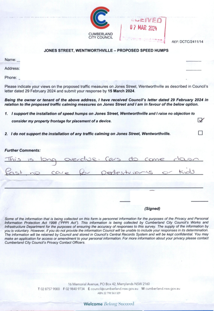
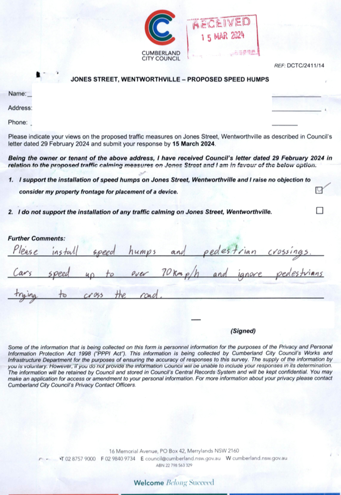
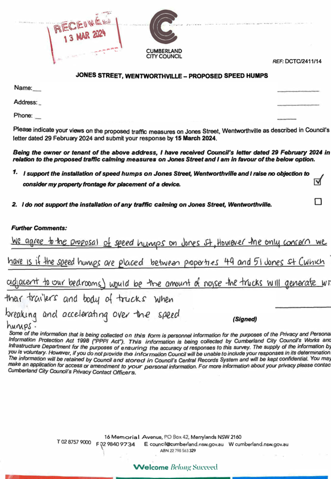
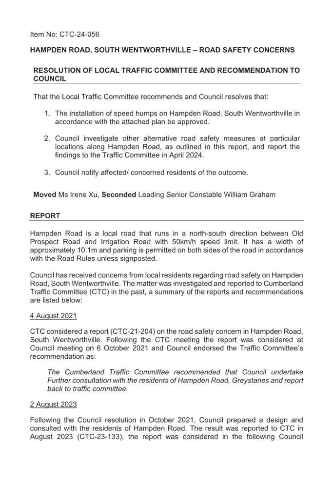
ITEM CTC-24-056 - HAMPDEN ROAD, SOUTH
WENTWORTHVILLE – ROAD SAFETY CONCERNS
|
|
The Traffic Committee recommends that:
1. The installation of speed humps on
Hampden Road, South Wentworthville in accordance with the attached plan be
approved.
2. Council investigate other alternative
road safety measures at particular locations along Hampden Road, as outlined
in this report, and report the findings to the Traffic Committee in April
2024.
3. Council
notify affected/ concerned residents of the outcome.
Moved Ms Irene Xu, Seconded Leading Senior
Constable William Graham
|
|
ITEM CTC-24-058 - GUILDFORD ROAD, GUILDFORD -
PROPOSED TEMPORARY ROAD CLOSURE FOR GUILDFORD FESTIVAL
|
|
The Traffic Committee recommends that the temporary
full road closure of Guildford Road, Guildford
between Railway Terrace and Talbot Road from 7:00 AM to 11:59PM on
Saturday 25 May 2024 be approved, subject to:
1. Approval from
Transport for NSW for the Traffic Management Plan and Traffic Guidance
Scheme.
2. All affected
businesses and emergency stakeholders being notified of the closure.
3. Complying with
the notification requirements of the Roads Act 1993, i.e., placing public
notices in a newspaper and erecting notices on the road.
4. Temporary bus
routes and bus zones replacing the existing bus zones in the closed area be
provided in consultation with the bus operator.
Moved Leading Senior Constable William Graham, Seconded
Clr Diane Colman.
|
General Business
The following general business was
raised:
CTC24-002
Ms Irene Xu requested that a review
be undertaken of the existing signage at the pedestrian refuge on Fullagar Road,
with a report to be brought back to the Traffic Committee if required.
Walters Road and Second Avenue,
Berala
Clr Diane Colman advised of
residents’ safety concerns at this intersection after a recent incident
involving a flipped car and another driving into a house. It was requested that
the intersection be investigated for safety measures with a report back to the
Traffic Committee.
Mr George Campbell raised concern
of the traffic crash statistics received and requested that Centre for Road
Safety be queried regarding any details of this incident. Mr Campbell further
added that the incident occurred on 14th December 2023 and that a
previous Council resolution noted a review of Council’s previous
decision.
Fowler Road and Dennistoun
Avenue, Guildford West
Clr Diane Colman advised of
residents’ concern of this intersection regarding:
1. insufficient
lighting as the intersection is too dim.
2. installed
bollards are not effective for trucks that frequently turn at this
intersection. It was requested that consideration be made to utilising the same
approach at Nyrang Street, Lidcombe near the Toohey’s site.
Clr Colman requested traffic count
data to include the vehicle class as previously done with other reports and for
this report to be brought back to the Traffic Committee.
Mr Cavallo advised that this has
been raised by the Intermodal Terminal Community Consultative Group who will be
discussing this further at their next meeting, adding that any discussion will
be provided in the report back to the Traffic Committee.
Merrylands Road, Merrylands
Clr Diane Colman advised that
driving eastbound on Merrylands Road into the Town Centre there are no right
hand turns into side streets and directs traffic flow into Merrylands Town
Centre as a result. Council to investigate and report to the Traffic Committee
with recommendations if required.
Intersection of Warwick Road
and Burnett Street, Merrylands
Clr Diane Colman advised of
residents’ safety concerns regarding car accidents given the close
proximity to the M4 turn off. It was requested that investigations be
undertaken into a ‘No Right Turn’ from Warwick Road and a ‘No
Left Turn’ from Burnett Street to Warwick Road and reported back to the
Traffic Committee.
Sydney Metro West Project
Mr Elias Elias advised that night works
are being undertaken on the 19th, 20th, 22nd,
26th, 27th and 29th February. Notification
will be provided to residents and traffic control measures will also be in
place. Clr Saha requested that all Ward Councillors be provided with this
information.
Great Western Highway and
Bridge Road, South Wentworthville
Mr Elias Elias advised of concerns
raised by motorists regarding the right turn signal changes at this
intersection. As this is a State Road, it was advised that Council will write
to Transport for NSW to request that the right turn signal timing from Bridge
Road be reviewed.
Kerrie Street and Fairfield
Road, Guildford West
Ms Hannah Shilling advised of
Transit Systems wishing to further discuss the relocation of the bus stop on
Fairfield Road. It was advised that further discussions will be held and
reported back to the Traffic Committee if required.
21 Frances Street, Merrylands
Ms Hannah Shilling advised that
Transit Systems had received an email from a resident at 21 Frances St
Merrylands. The resident has built a duplex at this location and their driveway
is now in the middle of the bus stop and have requested that the bus stop be
relocated. It was noted that Council process is that the bus stop is relocated
within the frontage of the developing property owner. Council will work with
Transit Systems to resolve the issue.
Next Meeting
Next Meeting 3 April 2024 at
9.30am
Meeting Close
The meeting terminated at 12.23pm.
Signed:
Chairperson
3 April 2024
Part 1
Recommended for Approval under Delegated Authority
3 April 2024
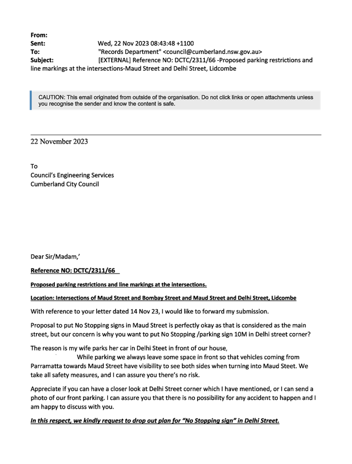
Item No: CTC-24-059
JOHN STREET,
LIDCOMBE – PROPOSED PARKING RESTRICTIONS
Directorate: Environment
and Planning
Responsible
Officer: Acting
Manager Engineering and Building
Electorate: Auburn
Police Area
Command (PAC): Auburn
Agenda Part Part
1
Note: Recommended
for Approval under Delegated Authority
Council has received a request from a pre-school owner
located at No.151 John Street, Lidcombe for the installation of timed parking
outside the property.
This report outlines the outcome of the investigation into
this matter.
|
The Traffic Committee recommends that:
1. The proposed
installation of ‘1/4P 8AM – 9:30AM, 3PM-5PM, Mon-Fri’
outside No. 151 John Street, Lidcombe in accordance with the attached plan be
approved.
2. The affected
/ concerned business owners be notified of the outcome.
|
Council has received a request
from the pre-school located at No.151 John Street Lidcombe for the installation
of timed parking restrictions outside the property.
The business owner has advised
that due to the high parking demand in the area, the existing unrestricted
on-street parking spaces are occupied for most of the day, thereby limiting
opportunities for parents accessing the pre-school.
John Street is a local collector
road that runs in a north-south direction with a speed limit of 60km/h. It has
a width of 11.5m with unrestricted parking on both sides of the street unless
otherwise signposted.
The map below shows the location.
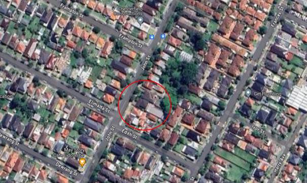
Locality Plan
The latest Centre for Road Safety accident data indicated
that there were no reported accidents at this location in the last 5 years
ending June 2023.
Council officers have investigated the matter which revealed
that due to the high demand of parking in the area, vehicles often park for
long periods of time in the street preventing the parents from the preschool
using the spaces.
To assist the business in the area, it is proposed to
install 1/4 hour parking restrictions which would increase parking turnover for
the business between the hours of 8am to 9:30am and 3pm to 5pm on weekdays.
The proposal was notified to the
impacted and adjacent residents for a period of 14 days starting from 1 March
2024 to 15 March 2024.
Council received a response from
the preschool that supported the proposal.
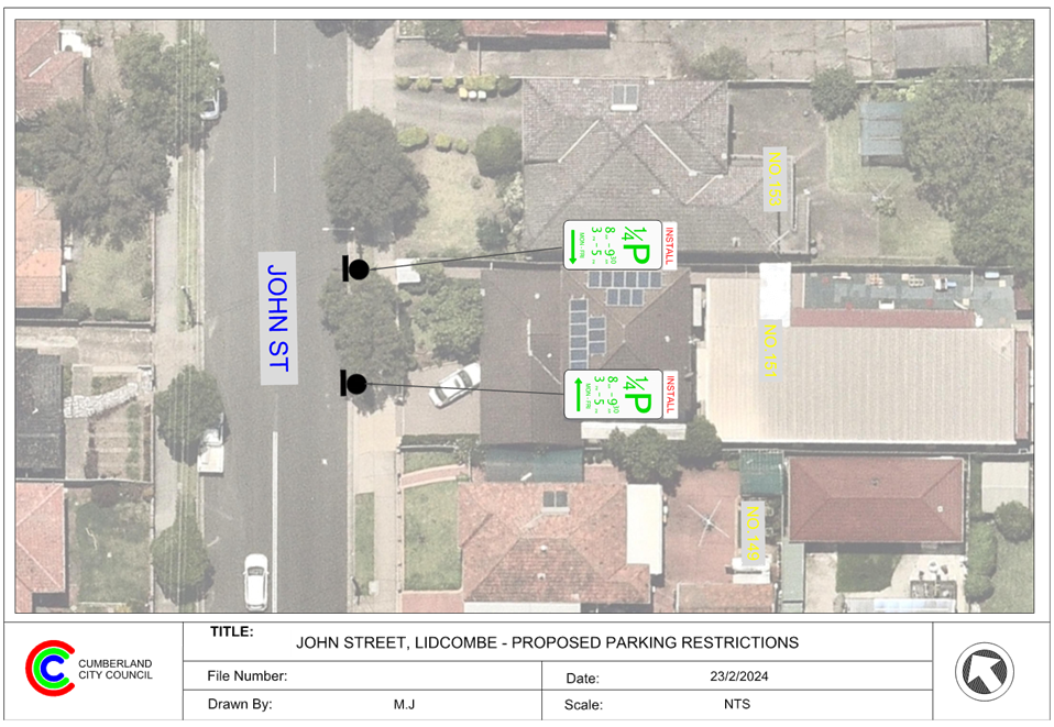
1. Plan
- John Street, Lidcombe - Proposed 15min parking
DOCUMENTS
ASSOCIATED WITH
REPORT CTC-24-059
Attachment 1
Plan - John Street, Lidcombe - Proposed 15min parking
3 April 2024
3 April 2024
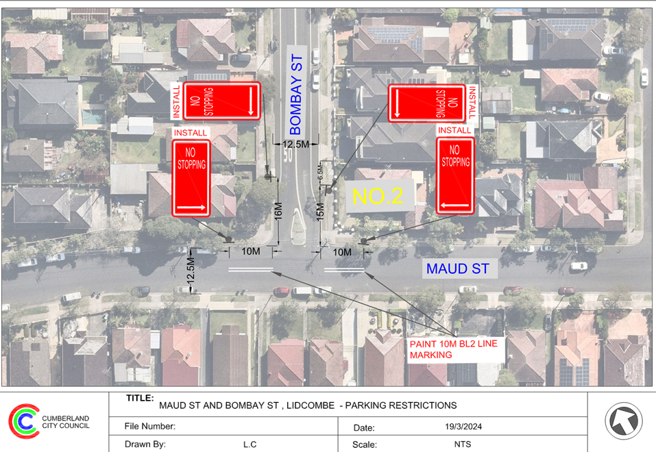
Item No: CTC-24-060
BOMBAY STREET
AND MAUD STREET, LIDCOMBE – PROPOSED ‘NO STOPPING’
RESTRICTIONS AND LINEMARKING
Directorate: Environment
and Planning
Responsible
Officer: Acting
Manager Engineering and Building
Electorate: Auburn
Police Area
Command (PAC): Auburn
Agenda Part Part
1
Note: Recommended
for Approval under Delegated Authority
Council has received safety concerns from a resident at the
intersection of Bombay Street and Maud Street, Lidcombe.
This report outlines the outcome of the investigation into
this matter.
|
The Traffic Committee recommends that:
1. The
installation of ‘No Stopping’ signs and line marking at the
intersection of Bombay Street and Maud Street, Lidcombe in accordance with
the attached plan be approved.
2. The
affected residents be notified of the outcome.
|
Maud Street, Lidcombe is a local road that runs in an east-west
direction between John Street and Swete Steet with a speed limit of 50 km/h. It
has a width of approximately 12.5m and parking is permitted on both sides of
the road unless otherwise signposted.
Bombay Street is a local road that runs in a north-south
direction with speed limit of 50 km/h. It has a width of approximately 12.5m
and parking is permitted on both sides of the road unless otherwise signposted.
Bombay Street and Maud Street form a T-intersection with
‘Give Way’ sign and line marking in Bombay Street giving priority
to Maud Street.
The map below shows the intersection.
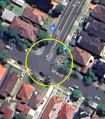
Figure 1 –
Locality Plan
The latest Centre for Road Safety accident data indicated
that there were two reported accidents at this intersection in the 5 years
ending June 2023.
|
Date
|
Location
|
Description
|
|
03/10/2018
|
Bombay St at Maud St
|
Left Near
|
|
13/11/2021
|
Bombay St at Maud St
|
Off rt/lft bnd=>obj
|
A site inspection indicated that vehicles are parking within
10 metres at the intersection. It is proposed to install 10m ‘No
Stopping’ signs and 10m BL2 line marking on the east and west side of the
intersection on Maud Street. For the eastern and southern side of Bombay Street
it is proposed to install 15-16m ‘No Stopping’ signs to support the
existing EL1 line marking.
Therefore, it is proposed to install the ‘No
Stopping’ signs and BL2 line marking at the intersection of Bombay Street
and Maud Street, Lidcombe as per the attached plan.
The proposal was notified to the
impacted and adjacent residents for a period of 14 days starting from 15
November 2023 to 29 November 2023.
There were no responses received.
1. Plan - Maud
Street and Bombay Street, Lidcombe - Proposed 'No Stopping' restrictions and
linemarking
DOCUMENTS
ASSOCIATED WITH
REPORT CTC-24-060
Attachment 1
Plan - Maud Street and Bombay Street, Lidcombe -
Proposed 'No Stopping' restrictions and linemarking
3 April 2024
3 April 2024
Item No: CTC-24-061
DELHI STREET
AND MAUD STREET, LIDCOMBE – PROPOSED ‘NO STOPPING’
RESTRICTIONS AND LINEMARKING
Directorate: Environment
and Planning
Responsible
Officer: Acting
Manager Engineering and Building
Electorate: Auburn
Police Area
Command (PAC): Auburn
Agenda Part Part
1
Note: Recommended
for Approval under Delegated Authority
Council has received safety concerns from a resident at the
intersection of Delhi Street and Maud Street, Lidcombe.
This report outlines the outcome of the investigation into
this matter.
|
The Traffic Committee recommends that:
1. The
installation of ‘No Stopping’ signs and line marking on Delhi
Street and Maud Street, Lidcombe in accordance with the attached plan be
approved.
2. The
affected residents be notified of the outcome.
|
Maud Street is a local road that runs in an east-west
direction between John Street and Swete Steet with a speed limit of 50 km/h. It
has a width of approximately 12.5m and parking is permitted on both sides of
the road unless otherwise signposted.
Delhi Street is a local road that runs in a north-south
direction with speed limit of 50 km/h. It has a width of approximately 12.5m
and parking is permitted on both sides of the road unless otherwise signposted.
Delhi Street and Maud Street form a T-intersection with
priority to Maud Street.
The map below shows the intersection.
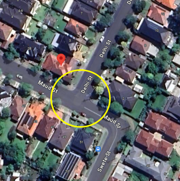
Figure 1 –
Locality Plan
The latest Centre for Road Safety accident data indicated
that there were no reported accidents at this intersection in the 5 years
ending June 2023.
A site inspection indicated that vehicles are parking within
10 metres at the intersection. It is proposed to install BL2 line marking on
the north and west of the intersection. It is also proposed to install 10m
‘No Stopping’ signs on the northern side of Maud Street, 10m
‘No Stopping’ sign on the eastern side of Delhi Street and 12m
‘No Stopping’ sign on the western side in Delhi Street. The 12m
will discourage people from parking adjacent to the short available distance
between the intersection and the existing driveway of No.1.
The proposal was notified to the
impacted and adjacent residents for a period of 14 days starting from 15
November 2023 to 29 November 2023.
There were 2 submissions in
support and 1 submission objecting to the proposal. The resident who objected
to the proposal expressed concern over losing on-street parking space adjacent
to the property. As this proposal is only to enforce the 10m road rule
requirement at the intersections, the space is not considered as an available
on-street parking space and there will be no loss of on-street parking spaces.
1. Plan - Delhi
Street and Maud Street, Lidcombe - Proposed 'No Stopping' restrictions and
linemarking
2. Submissions
DOCUMENTS
ASSOCIATED WITH
REPORT CTC-24-061
Attachment 1
Plan - Delhi Street and Maud Street, Lidcombe -
Proposed 'No Stopping' restrictions and linemarking
3 April 2024
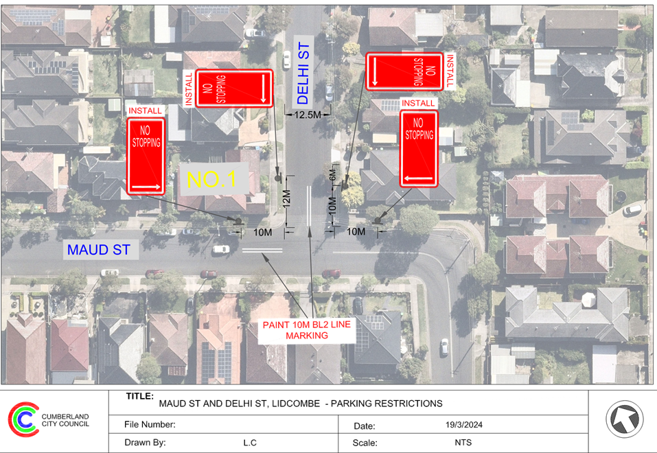
DOCUMENTS
ASSOCIATED WITH
REPORT CTC-24-061
Attachment 2
Submissions
3 April 2024
Item No: CTC-24-062
ALICE STREET,
AUBURN - ROAD SAFETY CONCERNS
Directorate: Environment
and Planning
Responsible
Officer: Acting
Manager Engineering and Building
Electorate: Auburn
Police Area
Command (PAC): Auburn
Agenda Part Part
1
Note: Recommended
for Approval under Delegated Authority
Council has received requests from
a local resident for the installation of traffic calming devices on Alice
Street, Auburn due to speeding concerns.
This report outlines the outcome
of the investigation into this matter.
|
The Traffic Committee recommends that:
1. The
provision of DL1 and BL2 linemarking along Alice Street, Auburn in accordance
with the attached plan be approved.
2. The
concerned resident be notified of the outcome.
|
Council has received requests
from a local resident for the installation of traffic calming devices on Alice
Street, Auburn due to speeding concerns. The resident also requested additional
‘One-way’ signage in Alice Street between Queen Street Northcote
Street.
Alice Street is a local road that runs in a north-south
direction with a posted speed limit of 50km/h. The street is approximately 870m
long and has a width of approximately 10m. Timed parking restrictions applied
on some sections of the street. Alice Street between Queen Street and Northcote
Street is restricted to one-way(southbound) traffic flow.
Currently a roundabout exists in Alice Street at the
intersection of Mary Street to control traffic speed and a raised pedestrian
crossing near Northcote Street. The street also has a school zone between South
Parade and Pritchard Street.
A traffic count was undertaken
on Alice Street, Auburn in March 2024. The traffic count location is shown in
red on the map below.
Locality
Plan
Traffic count data on Alice Street, Auburn:
· Average Daily
Traffic (ADT) = 2,657 veh/day,
· 85th percentile
speed = 47.2 km/h,
· Mean (average)
vehicle speed = 39.1 km/h.
The latest Centre for Road Safety accident data indicated
that there was one reported accident on Alice Street in the last 5 years ending
June 2023 in relation to speeding. The accident details are list in the table
below:
|
Date
|
Accident ID
|
Location
|
DCA Code
|
Description
|
|
08/11/2022
|
1306642
|
Alice Street at Beatrice Street
|
Right Turn
|
Vehicle hit a parked car when turning right
|
Council officers have investigated the request for the
installation of traffic calming devices on Alice Street in accordance with
Council’s Local Area Traffic Management (LATM) Policy.
The result of the traffic count
and recorded crashes were used in the assessment to determine the need for the
installation of traffic calming devices on Alice Street in accordance with the
criteria set out in Council’s Local Area Traffic Management Policy (LATM)
Policy.
The LATM assessments are
summarised in the tables below:
Table 1 – Alice Street, Auburn - LATM Assessment
Points
|
Criteria
|
Maximum Score
|
Score Achieved
|
|
Traffic Study Data
|
45
|
15
|
|
Crash warrant in the
last 5 years
|
15
|
5
|
|
Road Characteristics
|
35
|
18
|
|
Community Support &
other factors
|
5
|
5
|
|
Total
|
100
|
43
|
Table 2 – Alice
Street, Auburn– Action
|
Criteria
|
Action
|
|
>75
|
Report to TC with a
recommendation of providing traffic calming devices
|
|
61-75
|
Report to TC and
discuss possibility of providing traffic calming devices
|
|
41-60
|
Council to review
traffic data in 6 months
|
|
25-40
|
Monitor street and
review traffic data after 12 months
|
|
<25
|
Do Nothing
|
|
Speed
|
That regardless of the
total points scored, should the 85th percentile speed exceed the posted speed
limit by 5 km/h, the street be referred to the NSW Police for monitoring
and/or enforcement.
|
The traffic count data indicated
that the recorded 85th percentile speed is 47.2 km/h, which is below
the default speed limit. Based on the above assessment, traffic calming devices
are not warranted in the street.
However, as per Transport for NSW
Delineation Guidelines, the installation of DL1 line marking (former
‘S1’ centre lines) is warranted when:
· AADT is greater
than 2,500 vehicles on urban roads.
· Pavement width is
greater than 5.5m.
Based on the traffic count data,
Alice Street has a AADT of 2,657 vehicles per day which meets the warrants for
DL1 line marking. Therefore, it is proposed to provide DL1 linemarking along
Alice Street between Happ Street and Edgar Street with BL2 linemarking at the
intersection of Edgar Street and Happ Street.
Consultation has not been undertaken as no residents will be
impacted by the proposed linemarking.
1. Plan - Alice
Street, Auburn - Proposed Linemarking
DOCUMENTS
ASSOCIATED WITH
REPORT CTC-24-062
Attachment 1
Plan - Alice Street, Auburn - Proposed Linemarking
3 April 2024
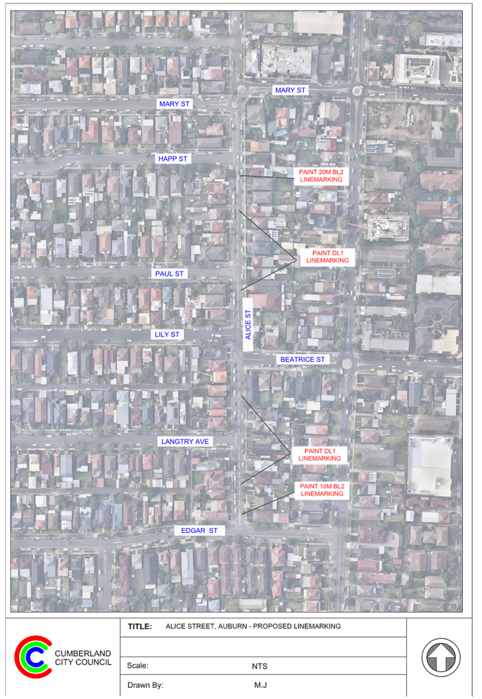
3 April 2024
Item No: CTC-24-063
CHISHOLM ROAD
AT CARDIGAN STREET, AUBURN – REQUEST FOR ‘KEEP CLEAR’
LINEMARKING
Directorate: Environment
and Planning
Responsible
Officer: Acting
Manager Engineering and Building
Electorate: Auburn
Police Area
Command (PAC): Auburn
Agenda Part Part
1
Note: Recommended
for Approval under Delegated Authority
Council has received a request
from motorists and residents about the safety of the intersection of Chisholm
Road and Cardigan Street, Auburn due to vehicle queuing at the
intersection.
This report outlines the outcome
of the investigation into this matter.
|
The Traffic Committee recommends that the installation
of ‘Do Not Queue Across Intersection’ signage and associated line
marking on Chisholm Road at its intersection with Cardigan Street, Auburn in
accordance with the attached plan be approved.
|
Chisholm Road is a reginal road
that runs in a north-south direction with a speed limit of 50km/h. This section
of Chisholm Road has a width of approximately 12.5m with parking permitted on
both sides of the road unless signposted.
Cardigan Street is a local road
that runs in an east-west direction with a speed limit of 50km/h. This section
of Cardigan Street has a width of approximately 12.5m with parking permitted on
both sides of the road unless signposted.
Chisholm Road and Cardigan Street form a four-way
intersection with priority to Chisholm Road.
Cardigan Road has median islands with openings on both
approaches. Cardigan Road has ‘Stop’ control on its eastern
approach and ‘Give Way’ control on its western approach.
It is alleged by the resdients that
they experience difficulties when turning from Cardigan Street into Chisholm
Road due to vehicles queuing across the intersection. It is requested that
‘Keep Clear’ line marking be provided at the intersection to
reinforce the NSW Road Rules.
It should be noted that St
Joseph’s Hospital is located at the end of Cardigan Street. Cars and
ambulances are using Cardigan Street to access the hospital.
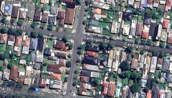
Figure
1 – Locality Plan
‘Keep Clear’
Pavement markings are generally used outside Ambulance and Fire Brigade
driveways and critical intersections close to a signalised intersection where
vehicles queuing to turn right into side roads might result in interfering with
the performance of the signalised intersection.
Although this intersection does
not meet the warrant for a ‘Keep Clear’ line marking, to assist
ambulance and other vehicles move into the traffic without delay, it is
proposed to provide ‘Do Not Queue Across Intersection’ signage with
associated line marking at this intersection.
Consultation has not been undertaken as no residents will be
impacted by the proposed signage and linemarking.
1. Plan -
Chisholm Road and Cardigan Street, Auburn - Proposed 'Do Not Queue Across
Intersection' signage and linemarking
DOCUMENTS
ASSOCIATED WITH
REPORT CTC-24-063
Attachment 1
Plan - Chisholm Road and Cardigan Street, Auburn -
Proposed 'Do Not Queue Across Intersection' signage and linemarking
3 April 2024
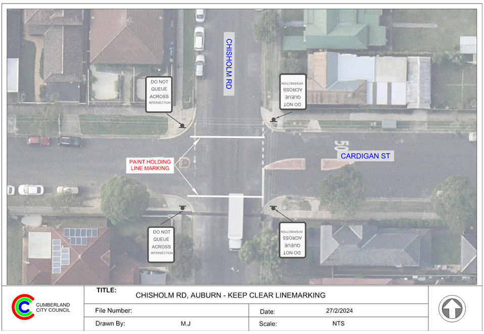
3 April 2024
Item No: CTC-24-064
RAILWAY
PARADE, GRANVILLE - ROAD SAFETY CONCERNS
Directorate: Environment
and Planning
Responsible
Officer: Acting
Manager Engineering and Building
Electorate: Granville
Police Area
Command (PAC): Cumberland
Agenda Part Part
1
Note: Recommended
for Approval under Delegated Authority
Council has received requests from
a local resident for the installation of traffic calming devices on Railway
Parade, Granville due to speeding concerns.
This report outlines the outcome
of the investigation into this matter.
|
The Traffic Committee recommends that:
1. The
provision of edge line marking on the southern side of Railway Parade between
Jamieson Street and Milton Street, Granville in accordance with the attached
plan be approved.
2. The
concerned resident be notified of the outcome.
|
Council has received requests
from a local resident for the installation of traffic calming devices on Railway
Parade, Granville due to speeding concerns.
Railway Parade is a local road that runs in an east-west
direction with a posted speed limit of 50km/h. The street is approximately 550m
long and has a width of approximately 9.8m. Parking is permitted on both sides
of the road unless signposted.
A traffic count was undertaken
on Railway Parade, Granville in March 2024 near No. 21. The traffic count
location is shown in red on the map below.

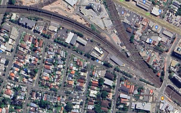
Locality
Plan
Traffic count data on Railway Parade, Granville:
· Average Daily
Traffic (ADT) = 2,194 veh/day,
· 85th percentile
speed = 54.2 km/h,
· Mean (average)
vehicle speed = 45.4 km/h.
The latest Centre for Road Safety accident data indicated
that there was no reported accident on Railway Parade in the last 5 years
ending June 2023 in relation to speeding.
Council officers have investigated the request for the
installation of traffic calming devices on Railway Parade in accordance with
Council’s Local Area Traffic Management (LATM) Policy.
The result of the traffic count
and recorded crashes were used in the assessment to determine the need for the
installation of traffic calming devices on Railway Parade in accordance with
the criteria set out in Council’s Local Area Traffic Management Policy
(LATM) Policy.
The LATM assessments are
summarised in the tables below:
Table 1 – Railway Parade, Granville - LATM Assessment
Points
|
Criteria
|
Maximum Score
|
Score Achieved
|
|
Traffic Study Data
|
45
|
15
|
|
Crash warrant in the
last 5 years
|
15
|
0
|
|
Road Characteristics
|
35
|
18
|
|
Community Support &
other factors
|
5
|
5
|
|
Total
|
100
|
38
|
Table 2 – Railway
Parade, Granville– Action
|
Criteria
|
Action
|
|
>75
|
Report to TC with a
recommendation of providing traffic calming devices
|
|
61-75
|
Report to TC and
discuss possibility of providing traffic calming devices
|
|
41-60
|
Council to review
traffic data in 6 months
|
|
25-40
|
Monitor street and
review traffic data after 12 months
|
|
<25
|
Do Nothing
|
|
Speed
|
That regardless of the
total points scored, should the 85th percentile speed exceed the posted speed
limit by 5 km/h, the street be referred to the NSW Police for monitoring
and/or enforcement.
|
The traffic count data indicated
that the recorded 85th percentile speed is 54.18 km/h, which is
within acceptable range for a local street with a 50 km/h speed limit.
Based on the above assessment,
traffic calming devices are not warranted on the street. However, site
observations indicated that the existing BL2 line markings between Smith Street
and Milton Street are faded. Council will repaint the line marking to better
delineate traffic in this section of Railway Parade. It is also proposed to
provide EL1 edge line markings on the southern side of the road to narrow the
travel lane and hence improve safety for motorists.
Consultation has not been undertaken as no residents will be
impacted by the proposed linemarking.
1. Plan -
Railway Parade, Granville - Proposed edge line marking
DOCUMENTS
ASSOCIATED WITH
REPORT CTC-24-064
Attachment 1
Plan - Railway Parade, Granville - Proposed edge line
marking
3 April 2024
3 April 2024
Item No: CTC-24-065
NEW YORK
STREET, GRANVILLE – PROPOSED RELOCATION OF THE EXISTING ‘NO PARKING’
SIGNAGE
Directorate: Environment
and Planning
Responsible
Officer: Acting
Manager Engineering and Building
Electorate: Granville
Police Area
Command (PAC): Cumberland
Agenda Part Part
1
Note: Recommended
for Approval under Delegated Authority
Council has received a request from a resident regarding the
relocation of the existing ‘No Parking’ signage in New York Street.
This report outlines the outcome of the investigation into
this matter.
|
The Traffic Committee recommends that:
1. The
relocation of the existing ‘No Parking’ signage on New York
Street, Granville in accordance with the attached plan be approved.
2. The
affected/concerned residents be notified of the outcome.
|
New York Street is a local road that runs in an east-west
direction between The Trongate and Blaxcell Street with a speed limit of 50
km/h. The street has varying width with parking bays and road narrowing.
Cumberland Traffic Committee (CTC) at its meeting in August
2023 considered a report (CTC-23-109) regarding the provision of parking
restrictions in New York Street, Granville.
After the installation of the parking restrictions, Council
received further complaint from a resident requesting the relocation of the
recently installed parking restrictions on New York Street to allow more
parking spaces for his vehicle outside his property.
The map below shows the area.
Figure 1 –
Locality Plan
In order to provide additional parking spaces for the local
residents, it is proposed to relocate the existing ‘No Parking’
signage in New York Street as per attached plan.
The proposal was notified to the
impacted/ concerned residents for a period of 14 days starting from 12 February
2024 to 26 February 2024.
There were no responses received.
1. New York
Street, Granville - Proposed 'No Parking' restrictions
DOCUMENTS
ASSOCIATED WITH
REPORT CTC-24-065
Attachment 1
New York Street, Granville - Proposed 'No Parking'
restrictions
3 April 2024
3 April 2024
Item No: CTC-24-066
GOUGH STREET
AND WALPOLE STREET, HOLROYD – PROPOSED ‘NO STOPPING’
RESTRICTIONS AND LINEMARKING
Directorate: Environment
and Planning
Responsible
Officer: Acting
Manager Engineering and Building
Electorate: Granville
Police Area
Command (PAC): Cumberland
Agenda Part Part
1
Note: Recommended
for Approval under Delegated Authority
Council has received safety concerns from residents at the
intersection of Gough Street and Walpole Street, Holroyd.
This report outlines the outcome of the investigation into
this matter.
|
The Traffic Committee recommends that:
1. The
installation of ‘No Stopping’ signs and ‘BL2’ (Former
BB) line marking at the intersection of Gough Street and Walpole Street,
Holroyd in accordance with the attached plan be approved.
2. The
affected / concerned residents be notified of the outcome.
|
Walpole Street is a local road that runs in an east-west
direction between Crescent Street and Pitt Street with a speed limit of 50
km/h. It has a width of approximately 12.5m and parking is permitted on both
sides of the road unless otherwise signposted.
Gough Street is a local road that runs in a north-south
direction between Walpole Street and Robert Street with a speed limit of 50
km/h. It has a width of approximately 7.8m and parking is permitted on both
sides of the road unless otherwise signposted.
Gough Street and Walpole Street forms a T- intersection with
priority to Walpole Street.
The map below shows the intersection.

Locality Plan
The latest Centre for Road Safety accident data indicated
that there were no reported accidents at this intersection in the last 5 years
ending December 2022.
A site inspection indicated that vehicles are parking within
10 metres at the intersection. It is proposed to install 10m ‘No
Stopping’ restrictions and ‘BL2’ line marking at the
intersection. The signage and line marking would strengthen the Road Rules
requirement and stop vehicles from parking too close to the intersection.
The ‘No Stopping’ signs are proposed to be
installed on both sides of Gough Street at 10 - 13m to allow vehicles to safely
pass a parked car without encroaching the proposed ‘BL2’ line
marking.
The proposal was notified to the
impacted and adjacent residents for a period of 14 days starting from 15
November 2023 to 29 November 2023. There were no responses received.
1. Plan –
Gough Street and Walpole Street, Holroyd – Proposed ‘No
Stopping’ restrictions and BL2 line markings
DOCUMENTS
ASSOCIATED WITH
REPORT CTC-24-066
Attachment 1
Plan – Gough Street and Walpole Street, Holroyd
– Proposed ‘No Stopping’ restrictions and BL2 line markings
3 April 2024
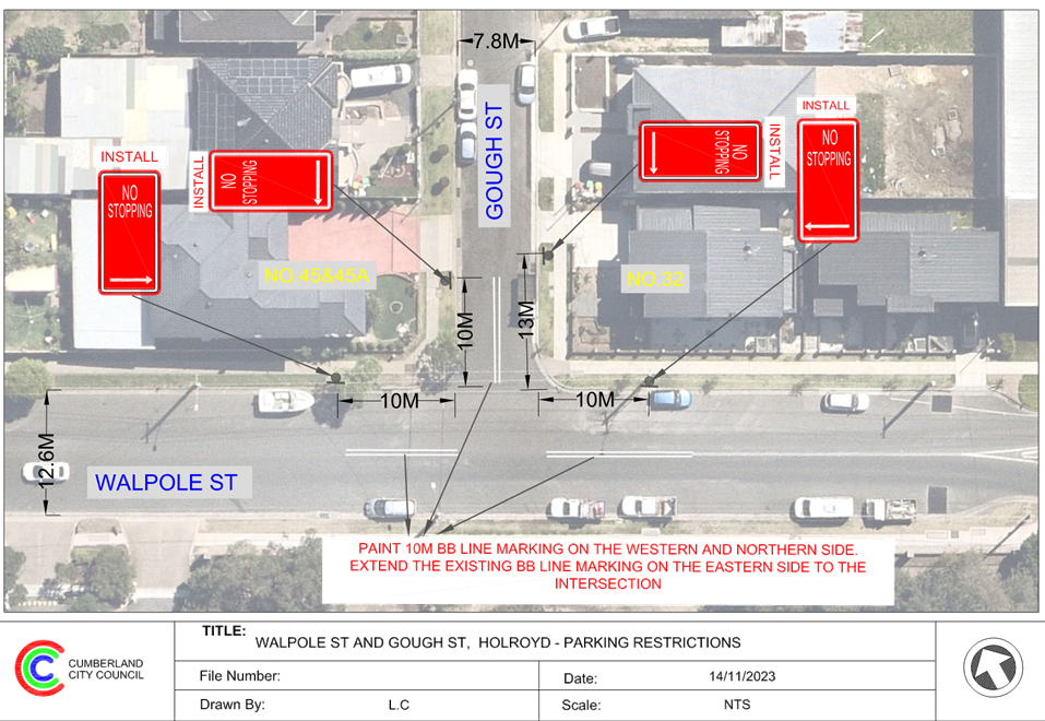
3 April 2024
Item No: CTC-24-067
BRADMAN STREET
AT EXCELSIOR STREET AND WOODVILLE ROAD, MERRYLANDS – PROPOSED ‘NO
STOPPING’ RESTRICTIONS AND LINEMARKING
Directorate: Environment
and Planning
Responsible
Officer: Acting
Manager Engineering and Building
Electorate: Granville
Police Area
Command (PAC): Cumberland
Agenda Part Part
1
Note: Recommended
for Approval under Delegated Authority
Council has received safety concerns from residents in
Bradman Street, Merrylands at the intersections of Bradman Street with Excelsior
Street and Woodville Road.
This report outlines the outcome of the investigation into
this matter.
|
The Traffic Committee recommends that:
1. The
installation of ‘No Stopping’ signage and ‘BL2’ line
marking in Bradman Street, Merrylands and the intersection of Excelsior
Street and Woodville Road in accordance with the attached plan be approved.
2. The
affected / concerned residents be notified of the outcome.
|
Bradman Street is a local road that runs in an east-west
direction between Excelsior Street and Woodville Road with a speed limit of 50
km/h. It has a width of approximately 12.5m and parking is permitted on both
sides of the road unless otherwise signposted.
Woodville Road is a State Road and Excelsior Street is a
collector road. Both streets run in a north-south direction. Bradman Street
forms T-intersections with Woodville Road and Excelsior Street at its western
and eastern ends respectively. Priority is given to Woodville Road and
Excelsior Street.
The map below shows the intersections.
Locality Plan
The latest Centre for Road Safety accident data indicated
that there were no reported accidents at both intersections in the last 5 years
ending June 2023.
A site inspection indicated that vehicles are parking within
10 metres at both intersections. It is proposed to install 10m ‘No
Stopping’ restrictions and ‘BL2’ (former ‘BB’
lines) line marking at the two intersections. The signage and line marking would
strengthen the Road Rules requirements and stop vehicles from parking too close
to the intersection.
The ‘No Stopping’ sign is proposed to be
installed on the south-eastern side of Bradman Street at 12 metres to prevent
vehicle parking too close to the driveway of No.50.
The proposal was notified to the
impacted and adjacent residents for a period of 14 days starting from 15
November 2023 to 29 November 2023.
There were no responses
received.
1. Plan -
Bradman Street, Merrylands - Proposed 'No Stopping' signage and linemarking at
intersections
DOCUMENTS
ASSOCIATED WITH
REPORT CTC-24-067
Attachment 1
Plan - Bradman Street, Merrylands - Proposed 'No
Stopping' signage and linemarking at intersections
3 April 2024
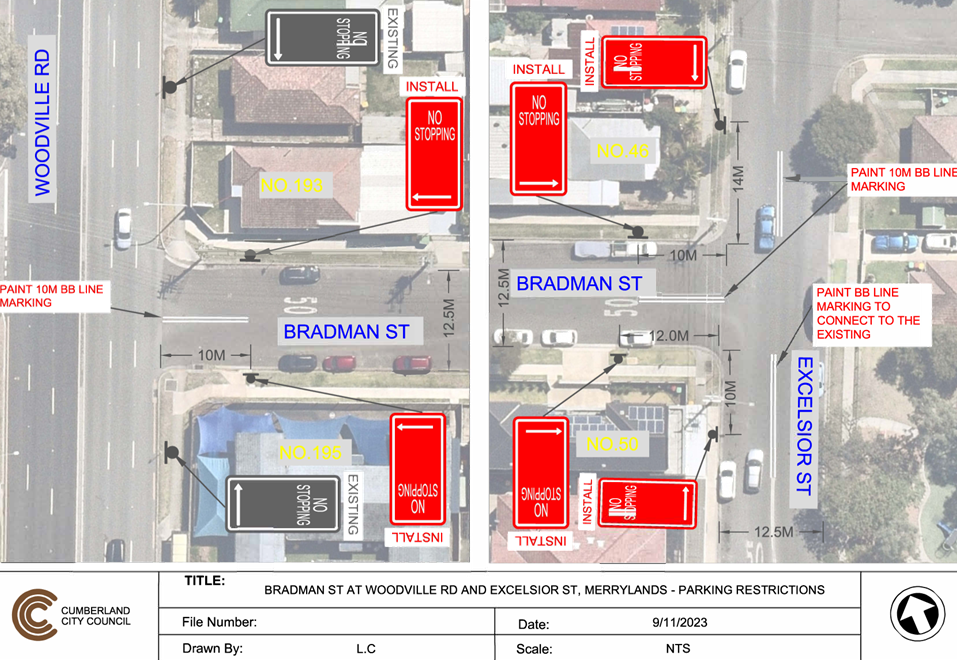
3 April 2024
Item No: CTC-24-068
GLADSTONE
STREET, MERRYLANDS - PROPOSED SIGNAGE AND LINEMARKING
Directorate: Environment
and Planning
Responsible
Officer: Acting
Manager Engineering and Building
Electorate: Granville
Police Area
Command (PAC): Cumberland
Agenda Part Part
1
Note: Recommended
for Approval under Delegated Authority
Council has received the detailed
design of the proposed signage and linemarking in Gladstone Street and a newly
constructed road in Merrylands associated with the approved development
application at 224-240 Pitt Street, Merrylands.
This report outlines the outcome
of the investigation into this matter.
|
The Traffic Committee recommends that:
1. The
installation of signage and linemarking in accordance with the attached plan
be supported.
2. The
cost associated with the work shall be borne by the applicant at no cost to
Council.
3. The applicant be
notified of the outcome.
|
Council has granted approval for the development application
at 224-240 Pitt Street, Merrylands. As part of this development, a median
island in Gladstone Street and a new road is to be constructed with associated
signage and line marking.
Locality
Plan
Council has received the
detailed design of the proposed works for Traffic Committee consideration.
Consultation is not required as no
residents will be impacted by the proposed work.
1. Plan –
Gladstone Street, Merrylands – Proposed signage and linemarking
DOCUMENTS
ASSOCIATED WITH
REPORT CTC-24-068
Attachment 1
Plan – Gladstone Street, Merrylands –
Proposed signage and linemarking
3 April 2024
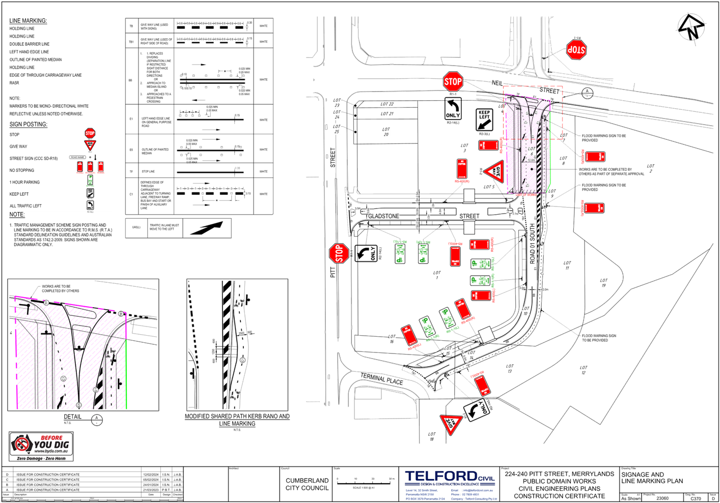
3 April 2024
Item No: CTC-24-069
JOSEPHINE
STREET, MERRYLANDS WEST – PROPOSED ‘NO STOPPING’ RESTRICTIONS
Directorate: Environment
and Planning
Responsible
Officer: Acting
Manager Engineering and Building
Electorate: Granville
Police Area
Command (PAC): Cumberland
Agenda Part Part
1
Note: Recommended
for Approval under Delegated Authority
Council has received safety
concerns from a resident of Josephine Street, Merrylands West near the bend at
No.13.
This report outlines the outcome
of the investigation into this matter.
|
The Traffic Committee recommends that:
1. The
installation of ‘No Stopping’ signs on the northern side of
Josephine Street at the bend in accordance with the attached plan be
approved.
2. The
adjacent residents be notified of the outcome.
|
Josephine Street is a local road
that runs in east-west directions with a speed limit of 50 km/h. It connects
with Bruce Street at its eastern end and has a cul-de-sac at its western end.
The Street has a width of approximately 7m and parking is permitted on both
sides of the road in accordance with Road Rules unless otherwise signposted.
Josephine Street has a sharp bend
near No.13 with unrestricted parking on both sides of the road. Currently,
there is no line marking exists at the bend. The resident alleged that
motorists experience limited sight distance due to parked vehicles at this
location and motorists often drive on the wrong side of the road when
negotiating the bend.
The map below shows the area:

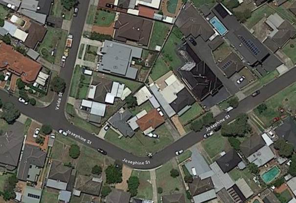
Locality
Plan
The latest Centre for Road Safety
accident data indicated that there were no reported accident in the 5 years
ending June 2023. A site inspection indicated that vehicles are parking on the
northern side of the bend.
In order to improve safety and
reduce the risk of a head on-collision, it is proposed to install ‘No
Stopping’ signs on the northern side of the bend as per attached plan.
The proposal was notified to the
impacted and adjacent residents for a period of 14 days starting from 31
October 2023 to 14 November 2023. No response was received.
1. Plan –
Josephine Street, Merrylands West – Proposed ‘No Stopping’
Restrictions
DOCUMENTS
ASSOCIATED WITH
REPORT CTC-24-069
Attachment 1
Plan – Josephine Street, Merrylands West –
Proposed ‘No Stopping’ Restrictions
3 April 2024
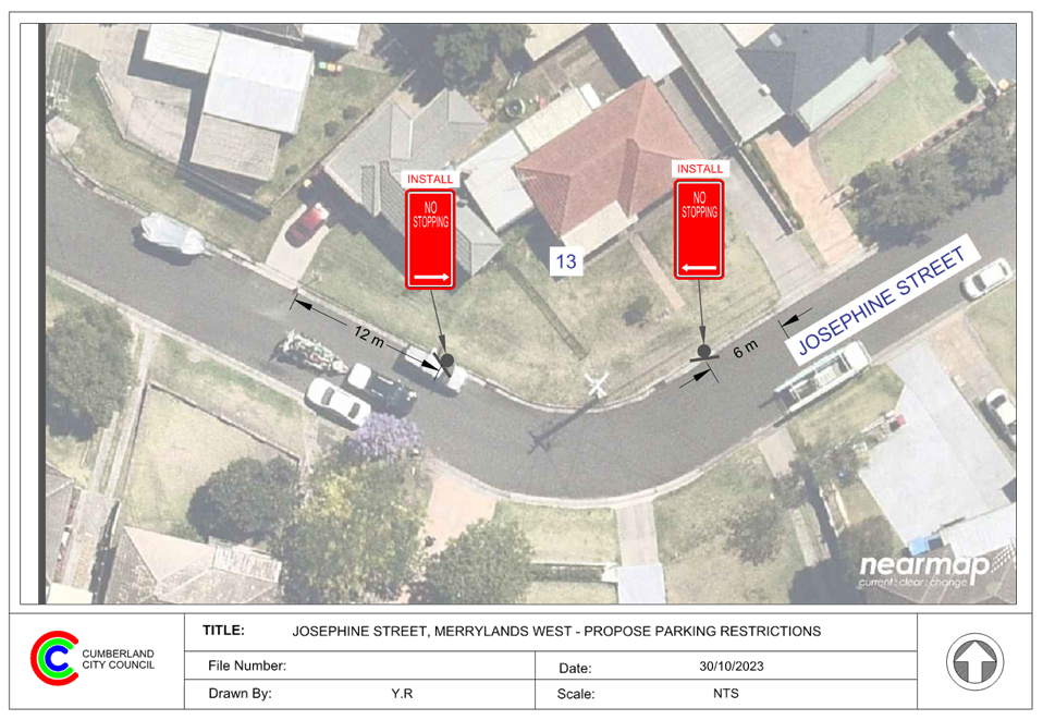
3 April 2024
Item No: CTC-24-070
YENNORA AVENUE
AND WYANNA GROVE, YENNORA – PROPOSED PARKING RESTRICTIONS
Directorate: Environment
and Planning
Responsible
Officer: Acting
Manager Engineering and Building
Electorate: Granville
Police Area
Command (PAC): Cumberland
Agenda Part Part
1
Note: Recommended
for Approval under Delegated Authority
Council has received a request from a local business
(Café) owner for the installation of timed parking on Yennora Avenue,
Yennora.
This report outlines the outcome of the investigation into
this matter.
|
The Traffic Committee recommends that:
1. The proposed
installation of ‘1/4P 6:00AM – 3:00PM Mon-Fri and 6:00AM –
12:30PM Sat’ outside No. 29 Yennora Avenue, Yennora in accordance with
the attached plan be approved.
2. The proposed
installation of ‘No Stopping’ signage at the intersection of Yennora
Avenue and Wyanna Grove, Yennora in accordance with the attached plan be
approved.
3. The affected
/ concerned business owners be notified of the outcome.
|
Council has received a request
from a local café located at No. 29 Yennora Avenue Yennora for the
installation of timed parking restrictions outside the café.
The business owner has advised
that due to high parking demand in the area, the existing unrestricted
on-street parking spaces are occupied most of the day and remove parking
opportunity for customers.
Yennora Avenue is a local road
that runs in a north-south direction between Loftus Road and Nelson Road with a
speed limit of 50km/h. It has a width of 12.5m with unrestricted parking on
both sides of the street unless otherwise signposted.
Wyanna Grove is a local road that runs in an east-west
direction between Norrie Street and Yennora Avenue with a speed limit of
50km/h. It has a width of 10.5m with unrestricted parking on both sides of the
street unless otherwise signposted.
Yennora Avenue and Wyanna Grove form a T- intersection with
priority to Yennora Avenue.
The map below shows the intersection.
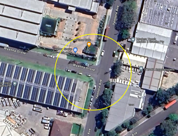
Locality Plan
The latest Centre for Road Safety accident data indicated
that there were no reported accidents at this intersection in the last 5 years
ending June 2023.
Council officers have investigated the matter which revealed
that due to the high demand of parking in this industrial area, vehicles often
park for long periods of time in the street preventing the café’s
customers from using the spaces.
To assist the businesses in the area, it is proposed to
install 1/4 hour parking restrictions which would increase parking turnover for
the business.
A site inspection also indicated that vehicles are parking
within 10 metres at the intersection. It is proposed to install 10m ‘No
Stopping’ restrictions at the intersection. The signage would strengthen
the Road Rules requirement and stop vehicles from parking too close to the
intersection.
The proposal was notified to the
impacted and adjacent residents for a period of 14 days starting from 12
February 2024 to 26 February 2024. There were no responses received.
1. Plan –
Yennora Avenue and Wyanna Grove, Yennora – Proposed parking restrictions
DOCUMENTS
ASSOCIATED WITH
REPORT CTC-24-070
Attachment 1
Plan – Yennora Avenue and Wyanna Grove, Yennora
– Proposed parking restrictions
3 April 2024
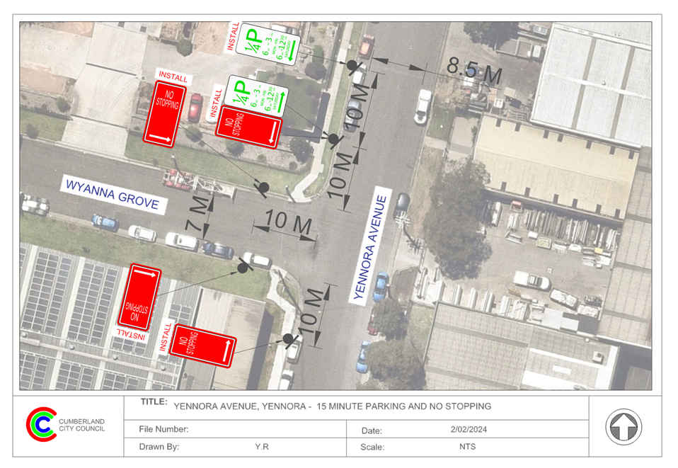
3 April 2024
Item No: CTC-24-071
LANCE
CRESCENT, GREYSTANES – PROPOSED RELOCATION OF THE EXISTING ‘NO
STOPPING’ AND ‘NO PARKING’ SIGNAGE
Directorate: Environment
and Planning
Responsible
Officer: Acting
Manager Engineering and Building
Electorate: Prospect
Police Area
Command (PAC): Cumberland
Agenda Part Part
1
Note: Recommended
for Approval under Delegated Authority
Council has received a request from a resident regarding the
relocation of the existing ‘No Parking’ and ‘No
Stopping’ in Lance Crescent near the intersection of Adrian Place,
Woodpark.
This report outlines the outcome of the investigation into
this matter.
|
The Traffic Committee recommends that:
1. The
existing ‘No Stopping’ and ‘No Parking’ signs on
Lance Crescent west of Adrian place, Greystanes be relocated 4m west in
accordance with the attached plan be approved.
2. The
affected/concerned residents be notified of the outcome.
|
Lance Crescent is a local road that runs in a north - south
directions. Lance Crescent has a speed limit of 50 km/h. It has a width of
approximately 7m. Parking is permitted on both sides of the road in accordance
with Road Rules unless otherwise signposted.
Where Lance Crescent and Adrian Place forms a T-
intersection with priority given to Lance Crescent.
Cumberland Traffic Committee (CTC) at its meeting in August
2023 considered a report (CTC-23-119) regarding the provision of parking
restrictions and linemarking at the intersection of Lance Crescent and Adrian
Place.
After the installation of the parking restrictions, Council
received further complaint from the resident requesting the extension of the
recently installed parking restrictions further west on Lance Crescent to
improve safety at the bend.
The map below shows the area.
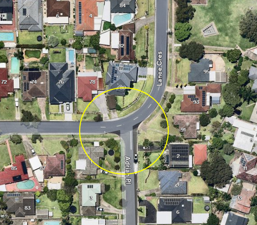
Figure 1 –
Locality Plan
The latest Centre for Road Safety accident data indicated
that there were no reported accidents at this intersection in the 5 years
ending June 2023.
In order to improve safety and reduce the risk of collisions
at the bend, it is proposed to relocate and extend the existing ‘No
Stopping’ and ‘No Parking’ signs near No. 78 further west for
4m on Lance Crescent as per attached plan.
The proposal was notified to the
impacted/ concerned residents for a period of 14 days starting from 14 February
2024 to 28 February 2024. There were no responses received.
1. Plan –
Lance Crescent, Greystanes – Proposed ‘No Stopping’ and
‘No Parking’ relocation
DOCUMENTS
ASSOCIATED WITH
REPORT CTC-24-071
Attachment 1
Plan – Lance Crescent, Greystanes –
Proposed ‘No Stopping’ and ‘No Parking’ relocation
3 April 2024
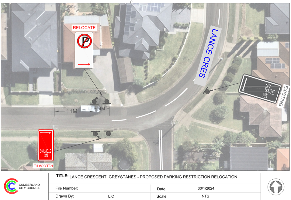
3 April 2024
Item No: CTC-24-072
HACKNEY
STREET, GREYSTANES - ROAD SAFETY CONCERNS
Directorate: Environment
and Planning
Responsible
Officer: Acting
Manager Engineering and Building
Electorate: Prospect
Police Area
Command (PAC): Cumberland
Agenda Part Part
1
Note: Recommended
for Approval under Delegated Authority
Council has received requests from
a local resident for the installation of traffic calming devices on Hackney
Street, Greystanes due to speeding concerns.
This report outlines the outcome
of the investigation into this matter.
|
The Traffic Committee recommends that:
1. The
installation of ‘BL2’ line marking along Hackney Street,
Greystanes in accordance with the attached plan be approved.
2. The
concerned resident be notified of the outcome.
|
Council has received requests
from a local resident for the installation of traffic calming devices on Hackney
Street, Greystanes due to speeding concerns.
Hackney Street is a local road that runs in a north-south
direction with a posted speed limit of 50km/h. The street is approximately 400m
long and has a width of approximately 10.5m. Parking is permitted on both sides
of the road unless signposted.
Currently, there is a speed hump in Hackney Street near
Darling Street outside No.44.
A traffic count was undertaken
on Hackney Street, Greystanes in March 2024. The traffic count location is
shown in red on the map below.


Locality
Plan
Traffic Count Data on Hackney Street, Greystanes:
· Average Daily
Traffic (ADT) = 1,477 veh/day,
· 85th percentile
speed = 52.6 km/h,
· Mean (average)
vehicle speed = 45.2 km/h.
The latest Centre for Road Safety accident data indicated
that there were no reported accidents on Hackney Street in the last 5 years
ending June 2023 in relation to speeding.
Council’s Officers have investigated the request for
the installation of traffic calming devices on Hackney Street in accordance
with Council’s Local Area Traffic Management (LATM) Policy.
The result of the traffic count
and recorded crashes were used in the assessment to determine the need for the
installation of traffic calming devices on Hackney Street in accordance with
the criteria set out in Council’s Local Area Traffic Management Policy
(LATM) Policy.
The LATM assessments are
summarised in the tables below:
Table 1 – Hackney Street, Greystanes - LATM Assessment
Points
|
Criteria
|
Maximum Score
|
Score Achieved
|
|
Traffic Study Data
|
45
|
10
|
|
Crash warrant in the
last 5 years
|
15
|
0
|
|
Road Characteristics
|
35
|
10
|
|
Community Support &
other factors
|
5
|
5
|
|
Total
|
100
|
25
|
Table 2 – Hackney
Street, Greystanes– Action
|
Criteria
|
Action
|
|
>75
|
Report to TC with a
recommendation of providing traffic calming devices
|
|
61-75
|
Report to TC and
discuss possibility of providing traffic calming devices
|
|
41-60
|
Council to review
traffic data in 6 months
|
|
25-40
|
Monitor street and
review traffic data after 12 months
|
|
<25
|
Do Nothing
|
|
Speed
|
That regardless of the
total points scored, should the 85th percentile speed exceed the posted speed
limit by 5 km/h, the street be referred to the NSW Police for monitoring
and/or enforcement.
|
The traffic count data indicated
that the recorded 85th percentile speed was 52.6 km/h which is within
acceptable range for a local street with a 50 km/h speed limit. Based on the
above assessment, traffic calming devices are not warranted in the street.
However, as per Transport for NSW
Delineation Guidelines, the installation of BL2 line marking (former
‘BB’ centre lines) is warranted when:
· AADT is greater
than 2,500 vehicles on urban roads.
· Pavement width is
greater than 5.5m.
· To prohibit overtaking
and U turn movements
Based on the traffic count data,
Hackney Street has a AADT of 1,477 vehicles per day which does not meet the
warrants for BL2 line marking, However, considering the 85th
percentile speed is over 50km/h, it is recommended to provide line marking in
Hackney Street to better delineate traffic and improve safety.
Consultation has not been undertaken as no residents will be
impacted by the proposed linemarking.
1. Plan –
Hackney Street, Greystanes - Proposed BL2 Linemarking
DOCUMENTS
ASSOCIATED WITH
REPORT CTC-24-072
Attachment 1
Plan – Hackney Street, Greystanes - Proposed BL2
Linemarking
3 April 2024
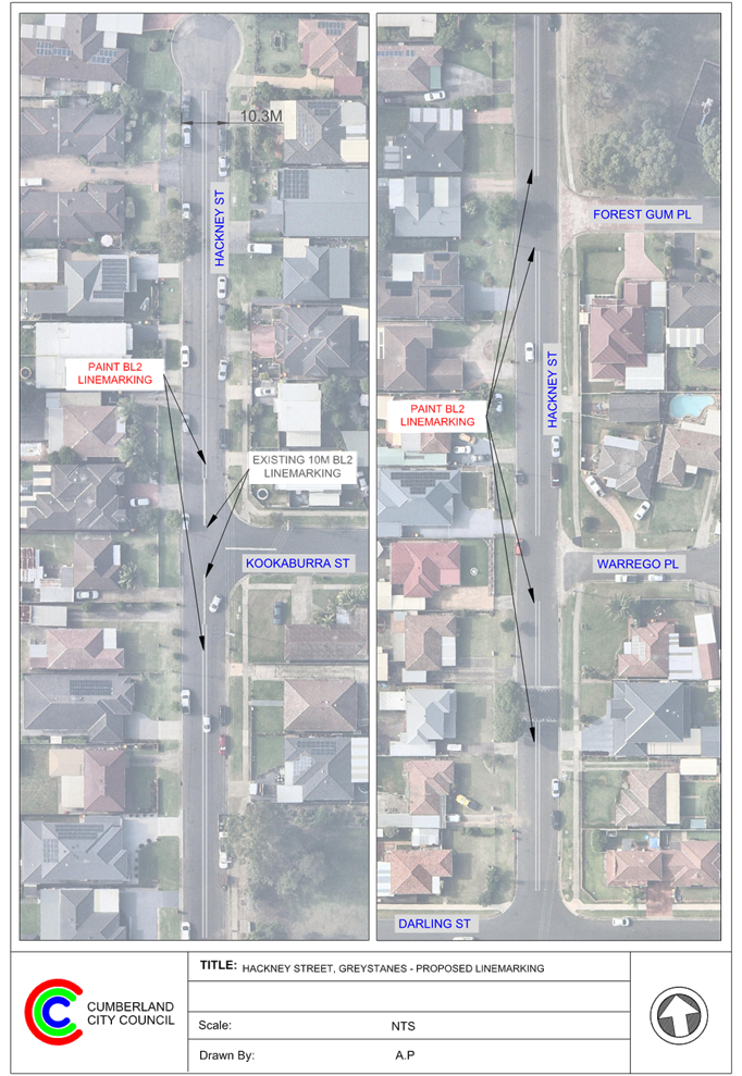
3 April 2024
Item No: CTC-24-073
ALLEN STREET
AND FINLAYSON STREET, SOUTH WENTWORTHVILLE – PROPOSED ‘NO STOPPING’
RESTRICTIONS
Directorate: Environment
and Planning
Responsible
Officer: Acting
Manager Engineering and Building
Electorate: Granville
Police Area
Command (PAC): Cumberland
Agenda Part Part
1
Note: Recommended
for Approval under Delegated Authority
Council has received safety concerns regarding access to
buses in Allen Street near its intersection with Finlayson Street, South
Wentworthville.
This report outlines the outcome of the investigation into
this matter.
|
The Traffic Committee recommends that:
1. The
installation of ‘No Stopping’ signs on Allen Street and Finlayson
Street, South Wentworthville in accordance with the attached plan be
approved.
2. The
affected residents be notified of the outcome.
|
Allen Street is a local road that runs in an east-west
direction between Old Prospect Road and Richmond Steet with a speed limit of 50
km/h. It has a varying width and approximately 10.2m wide at the bus stop
location under consideration and parking is permitted on both sides of the road
unless otherwise signposted.
There is a refuge island positioned 20m west of the
intersection of Allen Street and Finlayson Street and there are two existing
bus zones situated on the northern and southern side of Allen Street
approximately 40m west of the intersection.
Finlayson Street is a local road that runs in a north-south
direction with speed limit of 50 km/h. It has a width of approximately 10.2m
and parking is permitted on both sides of the road unless otherwise signposted.
Allen Street and Finlayson Street form a T-intersection with
priority to Allen Street.
The map below shows the intersection.
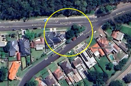
Figure 1 –
Locality Plan
The latest Centre for Road Safety accident data indicated
that there was no reported accidents at this intersection in the 5 years ending
June 2023.
It was observed that when cars are parked adjacent to the
refuge island, the westbound vehicles especially buses cannot pass this area
safely. It should be noted that the southern side of Allen Street west of
Finlayson Street up to the bus zone signage is within the statutory ‘No
Stopping’ zones related to the intersection and the pedestrian refuge.
It is proposed to install ‘No Stopping’ signs on
the southern side of Allen Street from the existing ‘Bus Zone’ sign
to Finlayson Street as per Transport for NSW Technical Direction and Road Rules
requirement for pedestrian refuges and the intersection. As the proposed
‘No Stopping’ immediately joins the existing ‘Bus Zone’
on the southern side of Allen Street, it will assist in resolving the problem
for buses when buses negotiate the refuge island. Additionally, it is proposed
to install 10m ‘No Stopping’ on the northern / western side of
Finlayson Street to enforce the road rule.
The attached plan shows the proposed ‘No
Stopping’ signs at the intersection of Allen Street and Finlayson Street,
South Wentworthville.
The proposal was notified to the
impacted and adjacent residents for a period of 14 days starting from 29
February 2024 to 14 March 2024.
There were no responses received.
1. Plan - Allen
Street, South Wentworthville - Proposed 'No Stopping' restrictions
DOCUMENTS
ASSOCIATED WITH
REPORT CTC-24-073
Attachment 1
Plan - Allen Street, South Wentworthville - Proposed
'No Stopping' restrictions
3 April 2024
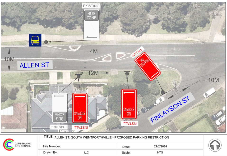
3 April 2024
Item No: CTC-24-074
SMITH STREET,
PENDLE HILL - ROAD SAFETY CONCERNS
Directorate: Environment
and Planning
Responsible
Officer: Acting
Manager Engineering and Building
Electorate: Prospect
Police Area
Command (PAC): Cumberland
Agenda Part Part
1
Note: Recommended
for Approval under Delegated Authority
Council has received a request
from a local resident for the installation of traffic calming devices on Smith
Street, Pendle Hill due to speeding concerns.
This report outlines the outcome
of the investigation into this matter.
|
The Traffic Committee recommends that:
1. The
installation of ‘BL2’ line marking along Smith Street, Pendle
Hill in accordance with the attached plan be approved.
2. The
concerned resident be notified of the outcome.
|
Council has received requests
from a local resident for the installation of traffic calming devices on Smith
Street, Pendle Hill due to speeding concerns.
Smith Street is a local road that runs in a north-south
direction with a posted speed limit of 50km/h. The street is approximately 570m
long and has a width of approximately 12m. Parking is permitted on both sides
of the road unless signposted. Currently, there is a school zone on the eastern
end of Smith Street near Pendle way, with a 40km/h speed limit applicable
during school hours.
A traffic count was undertaken
on Smith Street, Pendle Hill in March 2023. The traffic count location is shown
in red on the map below.
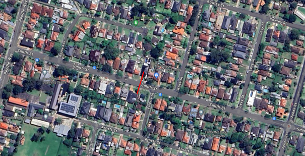
Locality
Plan
Traffic Count Data on Smith Street, Pendle Hill:
· Average Daily
Traffic (ADT) = 3,296 veh/day,
· 85th percentile
speed = 51.1 km/h,
· Mean (average)
vehicle speed = 43.7 km/h.
The latest Centre for Road Safety accident data indicated
that there was one reported accident on Smith Street in the last 5 years ending
June 2023 in relation to speeding. The accident details are list in the table
below:
|
Date
|
Location
|
DCA Code
|
Description
|
|
20/03/2022
|
50m from Pendle Way, Pendle Hill.
|
Right off carriageway into object
|
Vehicle lost control
|
Council officers have investigated the request for the
installation of traffic calming devices on Smith Street in accordance with
Council’s Local Area Traffic Management (LATM) Policy.
The result of the traffic count
and recorded crashes were used in the assessment to determine the need for the
installation of traffic calming devices on Smith Street in accordance with the
criteria set out in Council’s Local Area Traffic Management Policy (LATM)
Policy.
The LATM assessments are
summarised in the tables below:
Table 1 – Smith Street, Pendle Hill - LATM Assessment
Points
|
Criteria
|
Maximum Score
|
Score Achieved
|
|
Traffic Study Data
|
45
|
15
|
|
Crash warrant in the
last 5 years
|
15
|
5
|
|
Road Characteristics
|
35
|
18
|
|
Community Support &
other factors
|
5
|
5
|
|
Total
|
100
|
43
|
Table 2 – Smith
Street, Pendle Hill– Action
|
Criteria
|
Action
|
|
>75
|
Report to TC with a
recommendation of providing traffic calming devices
|
|
61-75
|
Report to TC and
discuss possibility of providing traffic calming devices
|
|
41-60
|
Council to review
traffic data in 6 months
|
|
25-40
|
Monitor street and
review traffic data after 12 months
|
|
<25
|
Do Nothing
|
|
Speed
|
That regardless of the
total points scored, should the 85th percentile speed exceed the posted speed
limit by 5 km/h, the street be referred to the NSW Police for monitoring
and/or enforcement.
|
The traffic count data indicated
that the recorded 85th percentile speed was 51.1 km/h which is within
acceptable range for a local street with a 50 km/h speed limit.
Based on the above assessment,
traffic calming devices are not warranted in the street. However, considering
the traffic volume in the street, it is recommended to provide line marking in
Smith Street to streamline traffic and improve safety.
As per Transport for NSW
Delineation Guidelines, the installation of BL2 line marking (former
‘BB’ centre lines) is warranted when:
· AADT is greater
than 2,500 vehicles on urban roads.
· Pavement width is
greater than 5.5m.
· To prohibit
overtaking and U turn movements
Smith Street has a AADT of 3,296
vehicles per day and a pavement width of 12m which meets the warrants for BL2
line marking. ‘BL2’ line marking controls speed of vehicles by
prohibiting overtaking and U turn movements.
Consultation has not been undertaken as no residents will be
impacted by the proposed line marking.
1. Plan - Smith
Street, Pendle Hill - Proposed Linemarking
DOCUMENTS
ASSOCIATED WITH
REPORT CTC-24-074
Attachment 1
Plan - Smith Street, Pendle Hill - Proposed
Linemarking
3 April 2024
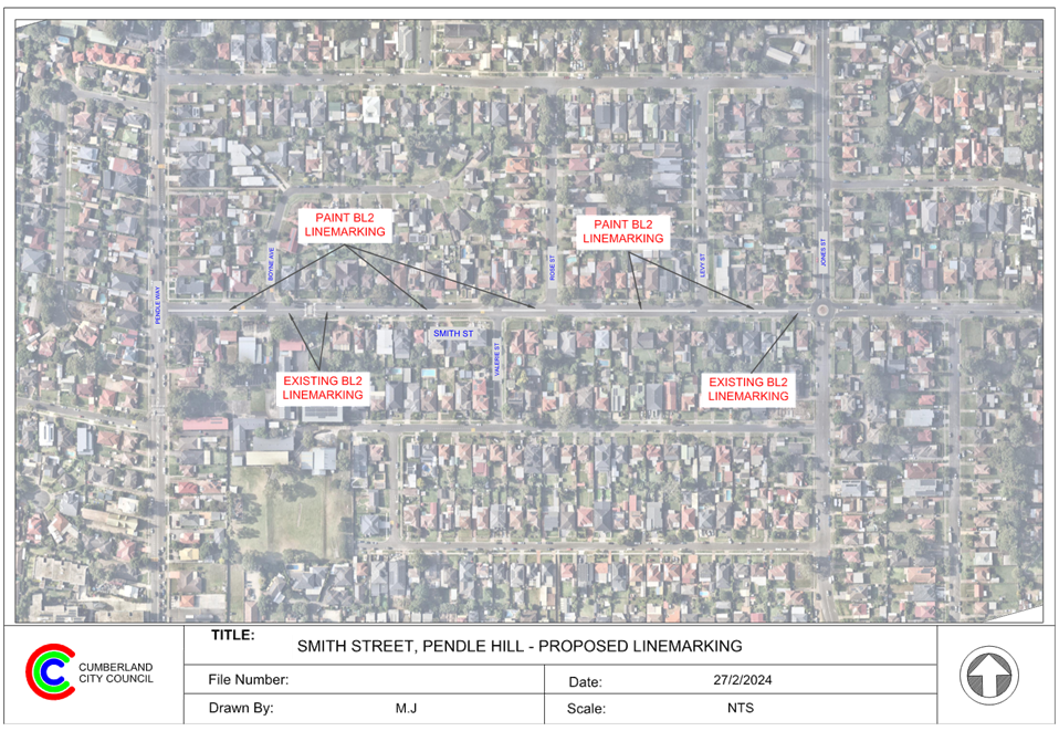
3 April 2024
Item No: CTC-24-075
SMITH STREET
AND PENDLE WAY, PENDLE HILL – PARKING RESTRICTIONS AND LINEMARKING AT THE
INTERSECTION
Directorate: Environment
and Planning
Responsible
Officer: Acting
Manager Engineering and Building
Electorate: Prospect
Police Area
Command (PAC): Cumberland
Agenda Part Part
1
Note: Recommended
for Approval under Delegated Authority
Council has received safety concerns from residents at the
intersection of Smith Street and Pendle Way, Pendle Hill.
This report outlines the outcome of the investigation into
this matter.
|
The Traffic Committee recommends that:
1. The
installation of ‘No Stopping’ signs and ‘BL2 (Former
BB)’ line markings at the intersection of Smith Street and Pendle Way,
Pendle Hill in accordance with the attached plan be approved.
2. The
affected / concerned residents be notified of the outcome.
|
Smith Street is a local road that runs in an east-west
direction between Pendle Way and Jones Street with a speed limit of 50 km/h. It
has a width of approximately 12.5m and parking is permitted on both sides of
the road unless otherwise signposted. Currently, there is a school zone on the
eastern end of Smith Street near Pendle way, with a 40km/h speed limit
applicable during school hours.
Pendle Way is a collector road that runs in a north-south
direction between Joyce Street and Great Western Highway with a speed limit of
50 km/h. This section of Pendle Way has a width of approximately 12.5m and
parking is permitted on both sides of the road unless otherwise signposted.
Smith Street and Pendle Way form a T- intersection with
priority to Pendle Way.
The map below shows the intersection.
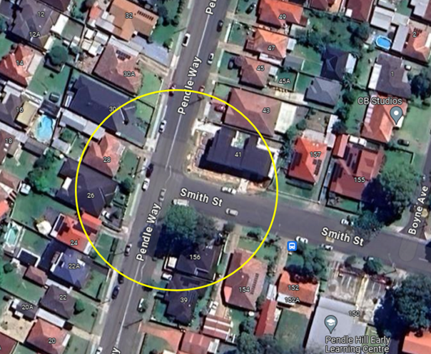
Locality Plan
The latest Centre for Road Safety accident data indicated
that there were no reported accidents at this intersection in the last 5 years
ending June 2023.
A site inspection indicated that vehicles are parking within
10 metres at the intersection. It is proposed to install 10m ‘No
Stopping’ restrictions and ‘BL2’ line markings at the
intersection. The signage and line marking would strengthen the Road Rules requirement
and stop vehicles from parking too close to the intersection.
The proposal was notified to the
impacted and adjacent residents for a period of 14 days starting from 29
February 2024 to 15 March 2024. There were no responses received.
1. Plan - Smith
Street and Pendle Way, Pendle Hill - Proposed parking restrictions and
linemarking
DOCUMENTS
ASSOCIATED WITH
REPORT CTC-24-075
Attachment 1
Plan - Smith Street and Pendle Way, Pendle Hill -
Proposed parking restrictions and linemarking
3 April 2024
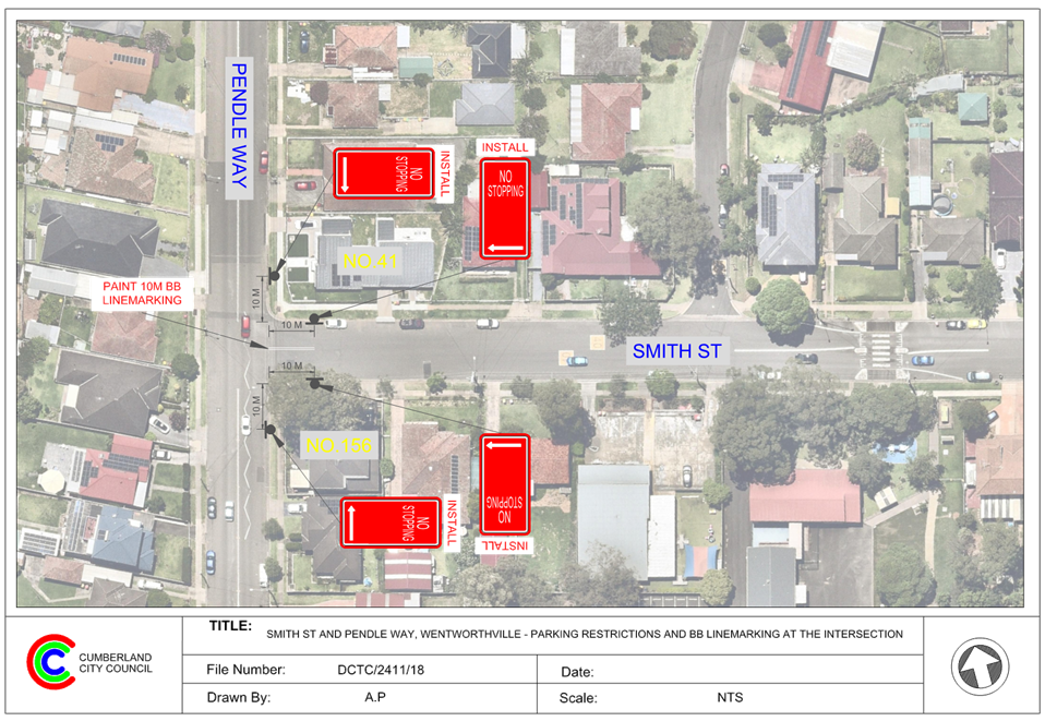
3 April 2024
Item No: CTC-24-076
BULGA LANE,
PEMULWUY – PROPOSED ‘NO STOPPING’ RESTRICTIONS
Directorate: Environment
and Planning
Responsible
Officer: Acting
Manager Engineering and Building
Electorate: Prospect
Police Area
Command (PAC): Cumberland
Agenda Part Part
1
Note: Recommended
for Approval under Delegated Authority
Council has received concerns from residents in Bulga Lane,
Pemulwuy regarding difficulties in accessing their garages due to parked cars
in the laneway.
This report outlines the outcome of the investigation into
this matter.
|
The Traffic Committee recommends that:
1. The
installation of 12.5m ‘No Stopping’ signs on the eastern side of
Bulga Lane, Pemulwuy in accordance with the attached plan be approved.
2. The
affected / concerned residents be notified of the outcome.
|
Bulga Lane is a local road that runs in a one-way direction
(northbound) between Wallan Street and Dullai Avenue with a speed limit of 50
km/h, parking is currently permitted on some sections of Bulga Lane, however
most sections have ‘No Parking’ signs installed on one-side of the
street.
The section of interest is between Dungara Drive and Wallan
Street, it has a width of approximately 5m and parking signage exists on
neither side of the laneway which is different to rest of the Bulga Lane.
The properties between Wallan Street and Dungara Drive have
their main frontage on Daruga Avenue and garage access on Bulga Lane.
Recently, Council received a complaint from a resident
claiming that accessing the garage is difficult due to parked vehicles at this section
of Bulga Lane. The resident alleged that in order to avoid the parked cars,
vehicles were damaged while attempting to access the garage due to the kerb and
gutter.
The map below shows Bulga Lane between Dungara Drive and
Wallan Street.
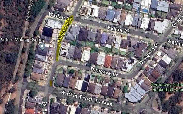
Locality Plan
The latest Centre for Road Safety accident data indicated
that there was no reported accident at this section of Bulga Lane in the last 5
years ending June 2023.
A swept path assessment indicates that when vehicles are
parking on the eastern side of Bulga Lane, the residents cannot access single
garages and will have difficulties to access double garages.
Council undertook a consultation with the residents in Bulga
Lane and received 5 responses (33.3% of the total letter sent) by the closing
date, with 1 response (20%) supporting and 4 responses (80%) opposing the
proposed parking restrictions in the laneway. The resident who supported the
proposal has indicated support of partial parking restriction in Bulga Lane at
the affected area outside his garage.
Considering the feedback from the
residents and the high parking demand at this location, it is recommended that
12.5m parking restriction be installed on the eastern side of Bulga Lane
outside the garage of the resident who supported the proposed parking
restrictions.
The proposal was notified to the
impacted and adjacent residents for a period of 14 days starting from 24
November 2023 to 8 December 2023.
There were 5 responses received. 1
response supported the proposal and 4 responses objected to the proposal with
the reason of loss of on-street parking space.
1. Plan - Bulga
Lane, Pemulwuy - Proposed 'No Stopping' Restrictions
2. Submissions
DOCUMENTS
ASSOCIATED WITH
REPORT CTC-24-076
Attachment 1
Plan - Bulga Lane, Pemulwuy - Proposed 'No Stopping'
Restrictions
3 April 2024
DOCUMENTS
ASSOCIATED WITH
REPORT CTC-24-076
Attachment 2
Submissions

3 April 2024
Item No: CTC-24-077
NIJONG DRIVE,
PEMULWUY – REMOVAL OF REDUNDANT ‘BUS ZONE’ SIGNAGE
Directorate: Environment
and Planning
Responsible
Officer: Acting
Manager Engineering and Building
Electorate: Prospect
Police Area
Command (PAC): Cumberland
Agenda Part Part
1
Note: Recommended
for Approval under Delegated Authority
Council has received a request
from the residents in Nijong Drive to remove the redundant bus stops in Nijong
Drive, Pemulwuy due to limited parking spaces for local residents.
This report outlines the outcome of the investigation into
this matter.
|
The Traffic Committee recommends that:
1. The
removal of the redundant ‘Bus Zone’ signage on both sides of
Nijong Drive, Pemulwuy as per attached plan be approved.
2. The
affected / concerned residents be notified of the outcome.
|
Nijong Drive is classified as a local road that runs in a north-south
direction with a speed limit of 50 km/h. It has a width of approximately 6.5m
and parking is permitted on both sides of the road in accordance with Road
Rules unless signposted.
Council has received a request
from local residents to remove the redundant Bus Zones in Nijong Drive,
Pemulwuy due to limited parking spaces in the area. It is alleged by the
resident that the existing bus stop on both sides of Nijong Drive outside No.77
are not in use. Consequently, residents have requested the removal of these
‘Bus Zones’ and the reinstatement of unrestricted parking at this
location.
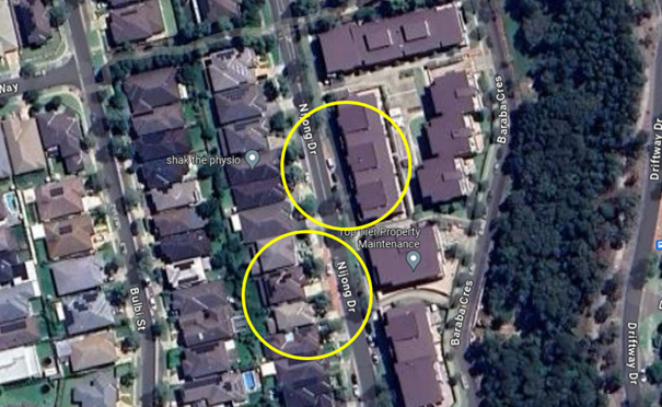
Council consulted with the bus
operator (Transit Systems) and was advised that both ‘Bus Zones’
are redundant as there is no bus route serving these stops.
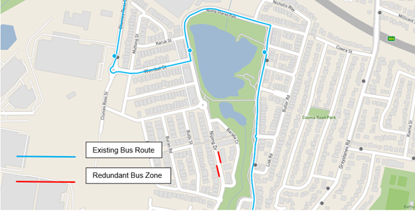
Considering the existing ‘Bus Zone’ on both
sides of Nijong Drive outside No.77 are no longer required. It is
proposed to remove both ‘Bus Zone’ at this section of Nijong Drive,
Pemulwuy as per attached drawing. Unrestricted indented parking will be resumed
to provide additional parking spaces to the residents.
The proposal was notified to the
impacted and adjacent residents for a period of 14 days starting from 16
February 2024 to 29 February 2024. There were no responses received.
1. Plan -
Nijong Drive, Pemulwuy - Removal of 'Bus Zone' Signage
DOCUMENTS
ASSOCIATED WITH
REPORT CTC-24-077
Attachment 1
Plan - Nijong Drive, Pemulwuy - Removal of 'Bus Zone'
Signage
3 April 2024
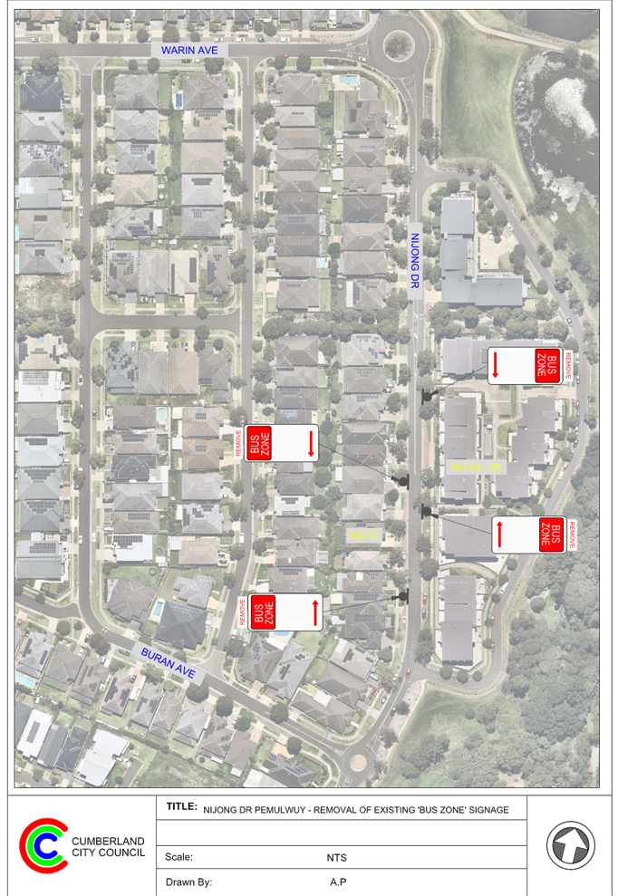
3 April 2024
Part 2
Recommendation to Council
3 April 2024
Item No: CTC-24-078
Review of
Traffic Related Policies and Guidelines
Directorate: Environment
and Planning
Responsible
Officer: Acting
Manager Engineering and Building
Electorate:
Police Area
Command (PAC):
Agenda Part Part
2
Note: Recommendation
to Council
This report is to inform the
Committee of a review on Council’s traffic related policies and
guidelines.
|
That the Traffic Committee note the information
contained within this report.
|
There are opportunities to review
and refine traffic related policies and guidelines to ensure that best practice
can be achieved in relation to road safety and relevant Australian Standards
and Austroads Guides.
Council officers will bring back a
report for further consideration by the Traffic Committee and Council.
The report to be provided to the Traffic
Committee and Council will identify any consultation requirements.
Nil
3 April 2024
Item No: CTC-24-079
LANEWAY
BETWEEN LINDEN STREET AND HARVEY PLACE, TOONGABBIE – PROPOSED TO CONVERT
THE LANEWAY TO ONE-WAY TRAFFIC FLOW
Directorate: Environment
and Planning
Responsible
Officer: Acting
Manager Engineering and Building
Electorate: Prospect
Police Area
Command (PAC): Cumberland
Agenda Part Part
2
Note: Recommendation
to Council
Council has received requests from residents to convert the
laneway between Linden Street and Harvey Place, Toongabbie, to one-way traffic
flow due to the narrow width of the laneway.
This report outlines the outcome of the investigation into
this matter.
|
The Traffic Committee recommends that:
1. The
conversion of the laneway between Linden Street and Harvey Place, Toongabbie
to westbound one-way traffic flow in accordance with the attached plan be
approved.
2. Council
submit a Traffic Management Plan to Transport for NSW for endorsement.
3. The
affected / concerned residents be notified of the outcome.
|
The laneway situated at No 7 Linden Street serves as a
connection between Linden Street and Harvey Place. It runs in an east-west
direction with an approximate width of 5.5m.
Currently, this laneway has been used for two-way traffic
flow with parking permitted on both sides, creating a potential safety issue
due to its narrow width.
The map below shows the location of the laneway.
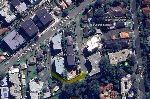 Locality
Plan
Locality
Plan
To address the safety concern, it is proposed to convert the
laneway between Linden Street and Harvey Place to a westbound one-way traffic
flow. This adjustment aims to reduce the risk of head-on accidents within the
laneway while concurrently improving traffic conditions along Linden Street.
A traffic count was undertaken in the middle of the laneway
in March 2024. The recorded Average Daily Traffic (AADT) is 30 veh/day which is
unlikely to have any significantly impact to the local road network.
A total of 130 letters were distributed to the
residents/owners in Linden Street and Harvey Place. Council received 5
responses by the closing date, all of them supported the proposed one-way
arrangement.
The proposal was notified to the
residents in Linden Street and Harvey Place for a period of 14 days from 1
March 2024 to 15 March 2024.
A total of 130 letters were distributed to the
residents/owners in Linden Street and Harvey Place. Council received 5
responses by the closing date, all of them supported the proposed one-way
arrangement.
1. Plan -
Linden Street and Harvey Place, Toongabbie - Proposed one-way arrangement
DOCUMENTS
ASSOCIATED WITH
REPORT CTC-24-079
Attachment 1
Plan - Linden Street and Harvey Place, Toongabbie -
Proposed one-way arrangement
3 April 2024
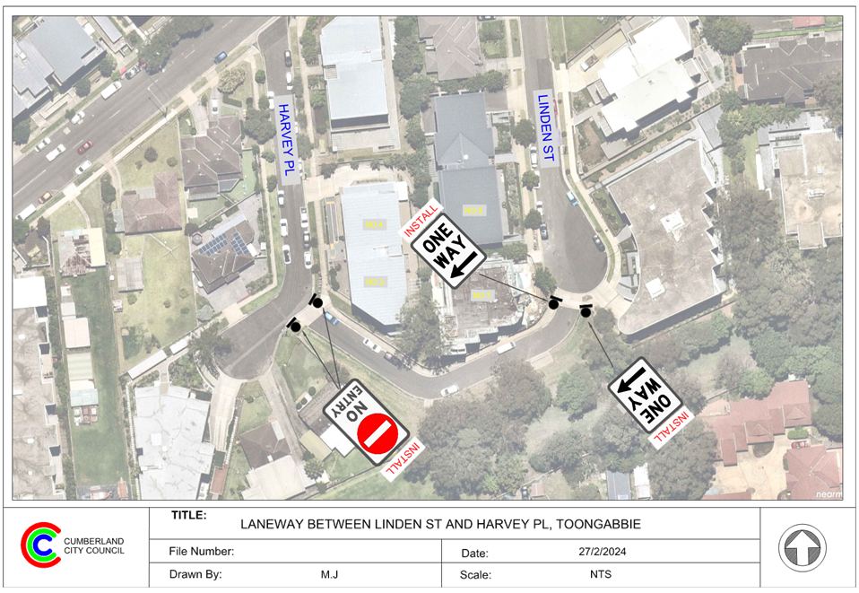
3 April 2024
Item No: CTC-24-080
BURRAGA WAY
AND MUTTONG STREET, PEMULWUY – PROPOSED ONE-WAY TRAFFIC FLOW AND REMOVAL
OF PARKING RESTRICITONS.
Directorate: Environment
and Planning
Responsible
Officer: Acting
Manager Engineering and Building
Electorate: Prospect
Police Area
Command (PAC): Cumberland
Agenda Part Part
2
Note: Recommendation
to Council
Council has received requests from residents to convert
Burraga Way and Muttong Street, Pemulwuy to one-way traffic flow to allow
additional on-street parking spaces in the street.
This report outlines the outcome of the investigation into
this matter.
|
The Traffic Committee recommends that:
1. The
proposed one-way traffic flow arrangement of Burraga Way and Muttong
Street, Pemulwuy in accordance with the attached plan be approved in
principle.
2. Council
prepare a Traffic Management Plan of the arrangement to inform further
consultation with the residents and Transport for NSW.
3. The
affected / concerned residents be notified of the outcome.
|
Muttong Street is a local road that runs in a north-south
direction with a speed limit of 50 km/h. It has a width of approximately 5.5m
and indented bay is provided on the western side of the street. Parking at
other sections of the street is not permitted.
Burraga Way is a local road that runs in an east-west
direction with a speed limit of 50 km/h. It has a width of approximately 5.5m
and indented bay is provided on the northern side of the street. Parking at
other sections of the street is not permitted.
Currently, both streets are used for two-way traffic flow
and parking is not permitted due to the narrowness of the road.
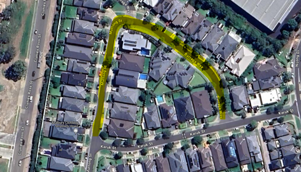
Locality Plan
Council has received requests from residents to convert
Burraga Way and Muttong Street, Pemulwuy to one-way traffic
flow.
To address the resident’s concern and considering the
existing indented parking bays, it is proposed to convert Burraga Way (westbound)
and Muttong Street (southbound) to a one-way traffic flow. This adjustment
would reduce the risk of head-on accidents.
As Burraga Street and Muttong Street are only used by the
local residents, therefore, the proposed one-way arrangement will not have any
major impact to the local road network.
A total of 48 letters were distributed to the
residents/owners in Burraga Way and Muttong Street. Council received 6
responses. Two responses supported the proposal and four responses objected to
the proposal. The objections identified concerns with specific design elements
of the arrangement including access to and from driveways, available on-street
parking, and concerns regarding travel times with the one-way arrangement.
The proposal was notified to the
residents in Burraga way and Muttong Street for a period of 14 days from 12
March 2024 to 26 March 2024.
A total of 48 letters were
distributed to the resident/owners in Burraga Way and Muttong Street.
Council received 6 responses. Two
responses supported the proposal and four responses objected to the proposal.
1. Plan –
Proposed one-way arrangement.
2. Burraga
Way Submissions
DOCUMENTS
ASSOCIATED WITH
REPORT CTC-24-080
Attachment 1
Plan – Proposed one-way arrangement.
3 April 2024
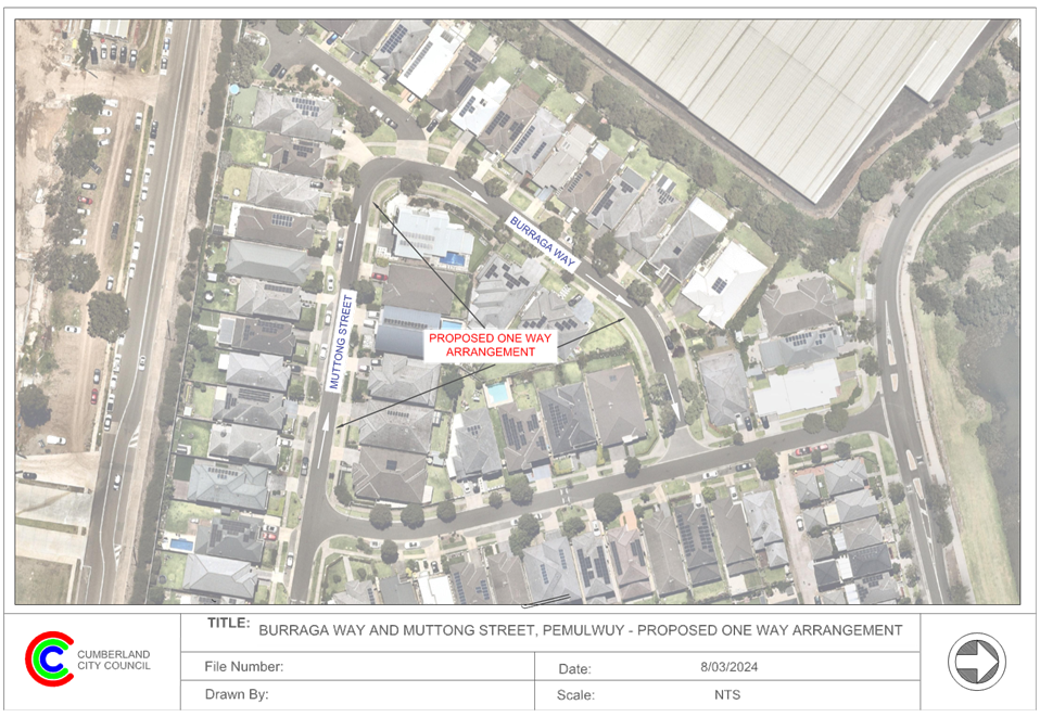
DOCUMENTS
ASSOCIATED WITH
REPORT CTC-24-080
Attachment 2
Burraga Way Submissions
3 April 2024
Item No: CTC-24-081
JONES STREET,
WENTWORTHVILLE – ROAD SAFETY CONCERNS – CONSULTATION RESULT
Directorate: Environment
and Planning
Responsible
Officer: Acting
Manager Engineering and Building
Electorate: Prospect
Police Area
Command (PAC): Cumberland
Agenda Part Part
2
Note: Recommendation
to Council
Council has received a request
from a local resident for the installation of speed humps on Jones Street,
Wentworthville due to speeding concerns.
This report outlines the outcome
of the investigation into this matter.
|
The Traffic Committee recommends that:
1. Council
prepare design of speed humps, undertake consultation with the directly
affected and adjacent residents and report back to Traffic Committee.
2. Council
notify the concerned residents of the outcome.
|
Cumberland
Traffic Committee (CTC) at its meeting in August 2023 considered a report (CTC-23-127) regarding road safety
concerns in Jones Street, Wentworthville. CTC recommended and Council
subsequently resolved to undertake consultation with the residents of Jones
Street, Wentworthville to assess support or otherwise of resident for
installation of traffic calming devices in the street and report back to the
Traffic Committee.
In accordance with
Council’s resolution, a consultation was carried out with the residents
in Jones Street in February 2024. A total of 43 letters were distributed to the
residents / owners with an attached survey form.
Council received nine responses
(20.9% of the total letters sent) by the closing date, eight (88.9%) supported
the proposed speed humps and one (11.1%) opposed to the proposal. The resident
did not provide specific reasons for objecting to the proposed speed humps.
Based on the survey results,
majority of the residents who responded to the survey supported the proposed
speed humps in the street. Therefore, it is recommended that council prepare a
detailed design and consult with the resident who will be directly impacted by
the proposed speed humps.
The proposal was notified to the
impacted residents for a period of 14 days from 29 February 2024 to 15 March
2024. A total of 43 letters were distributed to the residents / owners with an
attached survey form.
Council received nine responses
(20.9% of the total letters sent) by the closing date, eight (88.9%) supporting
the proposed speed humps and one (11.1%) opposing the proposal.
1. Previous
Report - CTC-23-127
2. Submissions
DOCUMENTS
ASSOCIATED WITH
REPORT CTC-24-081
Attachment 1
Previous Report - CTC-23-127
DOCUMENTS
ASSOCIATED WITH
REPORT CTC-24-081
Attachment 2
Submissions
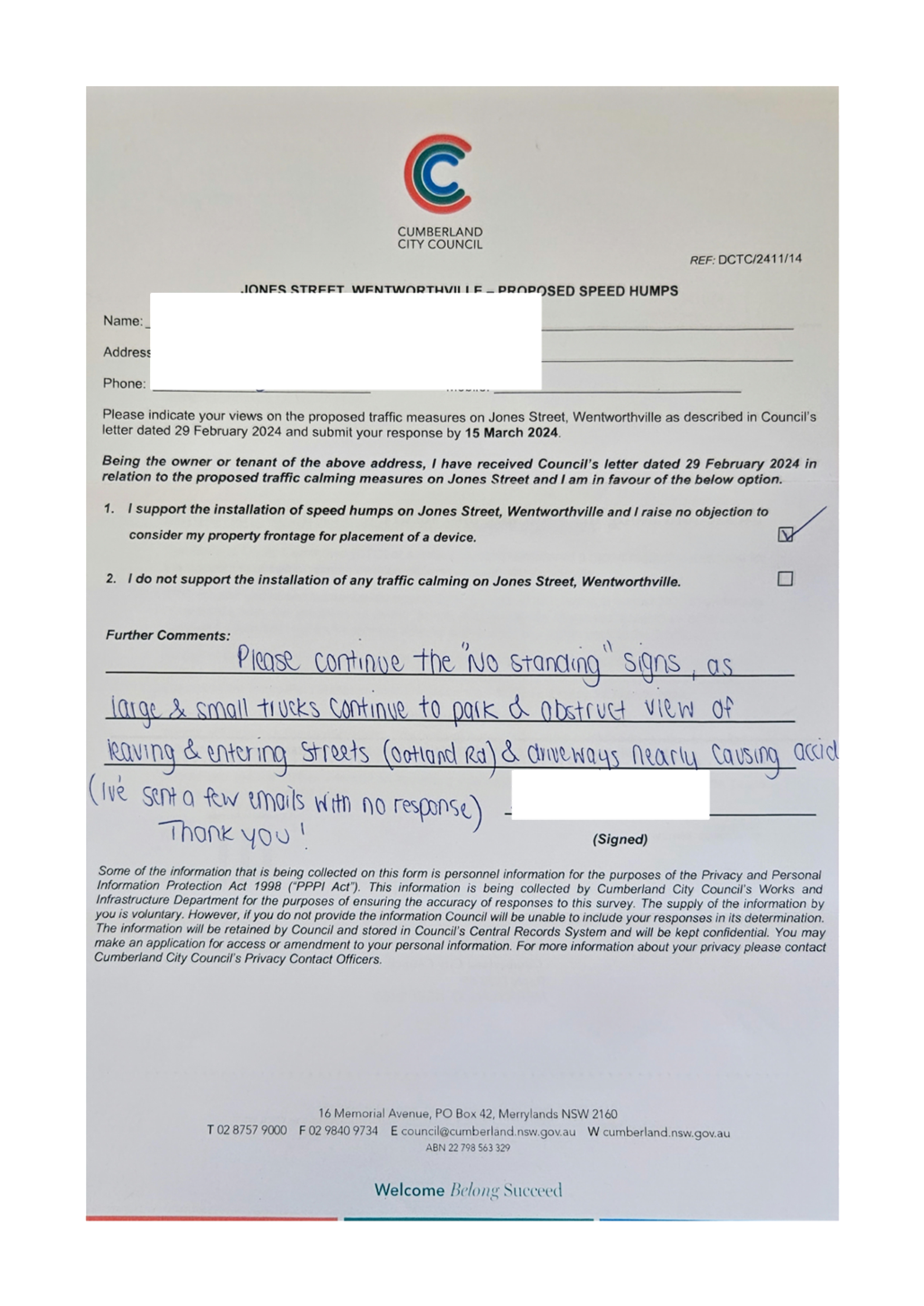
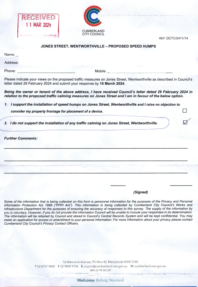
3 April 2024
Item No: CTC-24-082
HAMPDEN ROAD,
SOUTH WENTWORTHVILLE – ROAD SAFETY CONCERNS
Directorate: Environment
and Planning
Responsible
Officer: Acting
Manager Engineering and Building
Electorate: Granville
Police Area
Command (PAC): Cumberland
Agenda Part Part
2
Note: Recommendation
to Council
Council has received concerns from
a local resident for the installation of traffic calming devices on Hampden
Road, South Wentworthville due to speeding concerns.
This report outlines the outcome
of the investigation into this matter.
|
The Traffic Committee recommends that:
1. BL2
and El1 line marking be provided in accordance with the attached plan be
approved.
2. The
proposed kerb blister islands in accordance with the attached plan be
approved, subject to consultation with directly affected residents and their
support for the proposed kerb blister islands.
3. Council
notify affected/ concerned residents of the outcome.
|
Council has received concerns from local residents regarding
road safety on Hampden Road, South Wentworthville. Cumberland Traffic Committee
(CTC) considered a report in February 2024 (CTC-24-056) regarding road safety
on Hampden Road, South Wentworthville. Traffic Committee recommended that:
1. The
installation of speed humps on Hampden Road, South Wentworthville in accordance
with the attached plan be approved.
2. Council
investigate other alternative road safety measures at particular locations
along Hampden Road, as outlined in this report, and report the findings to the
Traffic Committee in April 2024.
3. Council
notify affected / concerned residents of the outcome.
Following the recommendation,
Council investigated alternative road safety measures on Hampden Road, South
Wentworthville accordingly. There are three road safety measures been prepared
and included in this report:
· ‘BL2
– Double Centre Line Marking’
· ‘EL1
– Edge Line Marking’
· Blister
Islands
As per Transport for NSW
Delineation and Pavement Marking Standard, the installation of Edge Line
Marking (EL1) and Barrier Line Marking (BL2) are warranted when:
|
Line
marking type
|
Warrant
|
|
BL2
|
· Road
width greater than 5.5m
· AADT
is greater than 2,500 vehicles
|
|
EL1
|
· Pavement
width is greater than 6.8m
· Where
dividing lines or lane lines are present.
|
The traffic count data from 2020
indicated that the Average Annual Daily Traffic (AADT) of Hampden Road was
2,147 per day. Therefore, it is reasonable to assume that the current AADT of
Hampden Road meets the warrant for BL2 line marking. The provision of BL2 and
EL1 line marking would better delineate traffic flow and improve safety on the
street.
Blister islands of various
dimensions have been proposed outside No. 13, 32, and 92, respectively, aiming
to enhance safety by reducing the road width. However, the implementation of
these blister islands will also lead to the loss of on-street parking spaces. Plans
with proposed three road safety measures are attached with this report.
Subject to endorsement,
consultation will be undertaken with directly affected residents.
1. Plans
– Hampden Road, South Wentworthville – Proposed road safety
measures
2. Previous
report CTC-24-056
3. Minutes
CTC-24-056
DOCUMENTS
ASSOCIATED WITH
REPORT CTC-24-082
Attachment 1
Plans – Hampden Road, South Wentworthville
– Proposed road safety measures
3 April 2024
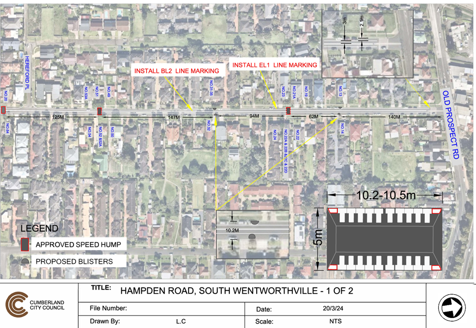
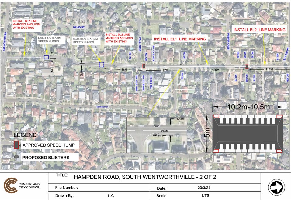
DOCUMENTS
ASSOCIATED WITH
REPORT CTC-24-082
Attachment 2
Previous report CTC-24-056
DOCUMENTS
ASSOCIATED WITH
REPORT CTC-24-082
Attachment 3
Minutes CTC-24-056
3 April 2024
3 April 2024
Item No: CTC-24-083
RUNYON AVENUE,
GREYSTANES – ROAD SAFETY CONCERNS - CONSULTATION RESULT
Directorate: Environment
and Planning
Responsible
Officer: Acting
Manager Engineering and Building
Electorate: Prospect
Police Area
Command (PAC): Cumberland
Agenda Part Part
2
Note: Recommendation
to Council
Council has received a request
from a local resident for the installation of traffic calming devices on Runyon
Avenue, Greystanes due to speeding concerns.
This report outlines the outcome
of the investigation into this matter.
|
The Traffic Committee recommends that;
1. Council
prepare a concept design of the speed humps in Runyon Avenue, Greystanes,
undertake consultation with the adjacent/affected residents and report back
to Traffic Committee.
2. Council
notify concerned resident of the outcome.
|
Runyon Avenue is a local road that
runs in a north-south direction with a posted speed limit of 50 km/h. It has a
width of approximately 7m and parking is permitted on both side of the road
unless signposted.
Council has received concerns from
local residents regarding road safety on Runyon Avenue, Greystanes. The matter
was investigated and reported to Cumberland Traffic Committee (CTC) in the
past, a summary of the reports and recommendations are listed below.
Background
CTC 5 August 2020
Cumberland Traffic Committee
(CTC) at its meeting in August 2020 considered a report (CTC-20-145) regarding
road safety concerns on Willoughby Street, Guildford and Council resolved that:
The Cumberland Traffic
Committee recommends that the report be received, and no further action be
taken on Runyon Avenue, Greystanes at this stage.
CTC 2 August 2023
Due to further complaint
received from the residents of Runyon Avenue, Cumberland Traffic Committee
(CTC) at its meeting in August 2023 considered a report (CTC-23-130) regarding
road safety concerns on Runyon Avenue, Greystanes. Subsequently, Council at its
meeting on 6 September 2023 resolved:
That
Council consult with the affected residents in the street and seek their
feedback on the traffic calming devices and return the matter to the Committee.
In accordance with the above
Council resolution, a consultation was carried out with the residents of Runyon
Avenue in February 2024, a total of 127 letters with an attached survey form
were distributed to the residents / owners.
Council received 36 responses (28%
of the total letters sent) by the closing date, where 20 (55.6%) responses
supported the proposed speed humps and 16 (44.4%) responses opposed the
proposed speed humps.
Based on the above result, the majority
of the residents responded to the survey supported the provision of speed humps
in Runyon Avenue. Therefore, it is recommended that Council prepare a concept
drawing and consult with the directly impacted residents.
The proposal was notified to the
residents in Runyon Avenue for a period of 14 days from 14 February 2024 to 28
February 2024.
A total of 127 letters were
distributed with an attached survey form to the residents / owners. Council
received 36 responses (28% of the total letters sent) by the closing date.
1. Previous
Report – CTC-23-130
2. Previous
Council Minutes – CTC-23-130
3. Submissions
DOCUMENTS
ASSOCIATED WITH
REPORT CTC-24-083
Attachment 1
Previous Report – CTC-23-130
DOCUMENTS
ASSOCIATED WITH
REPORT CTC-24-083
Attachment 2
Previous Council Minutes – CTC-23-130
3 April 2024

DOCUMENTS
ASSOCIATED WITH
REPORT CTC-24-083
Attachment 3
Submissions
3 April 2024
Item No: CTC-24-084
WHALANS ROAD
AND BRIGHTON STREET, GREYSTANES - PROPOSED MODIFICATION TO THE EXISTING
ROUNDABOUT
Directorate: Environment
and Planning
Responsible
Officer: Acting
Manager Engineering and Building
Electorate: Prospect
Police Area
Command (PAC): Cumberland
Agenda Part Part
2
Note: Recommendation
to Council
Council has received requests from
a local resident to review the roundabout at the intersection of Whalans Road
and Brighton Street, Greystanes due to heavy vehicles having difficulties to
turn at the roundabout.
This report outlines the outcome
of the investigation into this matter.
|
The Traffic Committee recommends that:
1. The
centre island of the roundabout at the intersection of Whalans Road and
Brighton Street, Greystanes be removed in accordance with the drawing.
2. The
surrounding resident be notified prior to the modification works.
|
Council has received requests from
a local resident to review the roundabout at the intersection of Whalans Road
and Brighton Street, Greystanes due to heavy vehicles having difficulties to
turn at the roundabout.
Whalans Road is a local road that runs in an east-west
direction with a sign-posted speed limit of 50km/h. The street is approximately
1,530m long and has a width of approximately 10.3m. Parking is permitted on
both sides of the road unless signposted.
Brighton Street is a local road that runs in a north-south
direction with a sign-posted speed limit of 50km/h. The street is approximately
795m long and has a width of approximately 10.3m. Parking is permitted on both
sides of the road unless signposted.
Whalans Road and Brighton Street forms a T-intersection
controlled by a roundabout associated with a concrete island on all three
approaches. The roundabout is mountable with a raised centre island at its
centre.
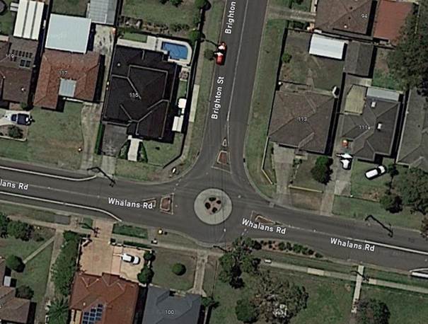
Locality
Plan
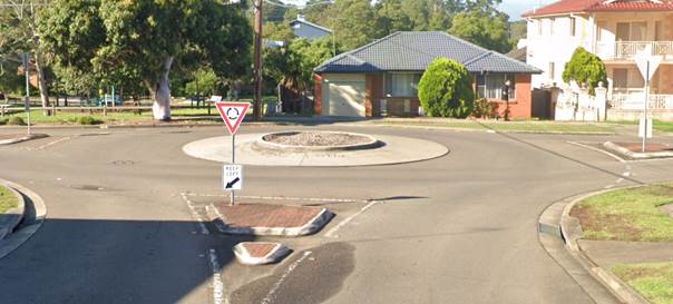
Roundabout,
viewed from Brighton Street
A resident has claimed that
heavy vehicles face challenges in making safe turns at the roundabout due to
the raised centre island. Council has conducted a review of the turning path
for a 12.5m heavy vehicle, and the turning path diagram is provided below.

12.5m
Heavy Vehicle Turning Path Diagram
Based on the analysis, it is
recommended to remove the existing raised centre island at the roundabout to
enhance the manoeuvrability of heavy vehicles.
Consultation has not been
undertaken as no residents will be impacted by the proposed modifications.
Council will notify the surrounding residents before work commences.
Nil
3 April 2024
Item No: CTC-24-085
DENNISTOUN
AVENUE, GUILDFORD WEST – CONSULTATION RESULTS
Directorate: Environment
and Planning
Responsible
Officer: Acting
Manager Engineering and Building
Electorate: Granville
Police Area
Command (PAC): Cumberland
Agenda Part Part
2
Note: Recommendation
to Council
Council has undertaken a
consultation with residents of Dennistoun Avenue, Guildford West for the installation
of traffic calming devices in the street.
This report outlines the outcome
of the investigation into this matter.
|
The Traffic Committee recommends that:
1. Council
undertake further consultation with the Yennora Intermodal Terminal Community
Consultative Group regarding the closure of Dennistoun Avenue at Fairfield
Road.
2. Council
prepare a Traffic Management Plan in consultation with for submission to
Transport for NSW for approval.
3. The
concerned residents be notified of the outcome.
|
Dennistoun Avenue is a collector
road that runs in an east-west direction between Fairfield Road and Byron Road
with a posted speed limit of 50 km/h. It has a width of approximately 10m and
parking is permitted on both sides of the road unless signposted.
Currently, the northern side of
Dennistoun Avenue is a residential area, and the southern side of the street is
an industrial area.
Council has received concerns
from a local resident regarding road safety on Dennistoun Avenue, Greystanes.
The map below shows the location
of Dennistoun Avenue, Guildford West.
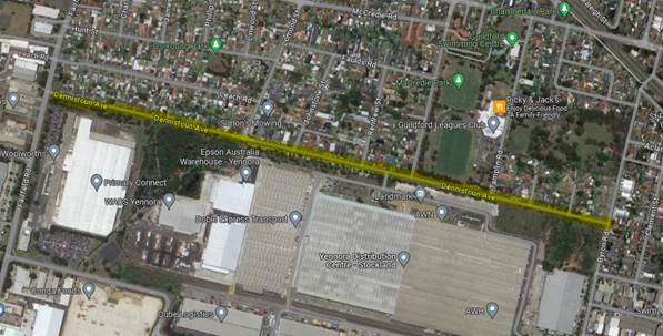
The matter was investigated and
reported to Cumberland traffic Committee (CTC) in the past, a summary of the
reports and recommendations are listed below.
5 February 2020:
CTC considered a report
(CTC-20-015) regarding the road safety concerns on Dennistoun Avenue and
recommended that:
1. Council
design speed humps in Dennistoun Avenue, Guildford West in accordance with
relevant standards and undertake consultation with properties adjacent to the
proposed speed humps; and
2. Council
report back to Cumberland Traffic Committee for final approval following
consultation.
2 August 2023:
Following the CTC recommendation
in February 2020, Council undertook consultation with the residents of
Dennistoun Avenue and reported to CTC in August 2023 (CTC-23-132).
The Cumberland Traffic Committee
recommended that:
1. The
installation of speed humps on Dennistoun Avenue, Guildford West not be
supported.
3. Council
investigate alternate traffic calming options and report back to CTC in
November 2023.
4. Edge
line marking be provided on both sides of Dennistoun Avenue in accordance with
the attached plan.
5. The
concerned residents be notified of the recommendation.
Following the CTC recommendation
in August 2023, Council at its meeting held on 6 September 2023 resolved that:
Council
consult with the residents in the street and seek their feedback on the
following:
1. Traffic calming
devices and return the matter to the Committee.
2. Closure of Dennistoun
Avenue to vehicle access onto Fairfield Road.
18 October 2023:
Cumberland Traffic Committee
considered a further report on Dennistoun Avenue at its October meeting and
recommended that:
1. The
installation of ‘No Left Turn’ and ‘For Trucks’ signage
on Fairfield Road at the intersection of Dennistoun Avenue, Guildford West in
accordance with the attached plan be approved.
2. The
installation of ‘For Trucks at All Times’ signage below the
existing ‘No Right Turn’ signage on Fairfield Road at the
intersection of Dennistoun Avenue, Guildford West in accordance with the
attached plan be approved.
3. The
installation of ‘No Truck Access to Fairfield Road’ signage in Dennistoun
Avenue near Byron Road, Guildford in accordance with the attached plan be
approved.
4. Council
remove the existing no truck signs at this intersection.
Council approved the above
recommendations at its meeting held on 1 November 2024.
The signs have now been
installed.
In accordance with the Council
resolution of 6 September 2023, consultation was carried out with the residents
in Dennistoun Avenue in December 2023. A total of 39 letters with an attached
survey form were distributed to the residents/ owners. The following options
were listed in the survey form:
Option 1:
I support the installation of
chicanes (angle slow points) and acknowledge the likely loss in available
on-street parking and I raise no objection to consider my property frontage for
placement of a device.
Option 2:
I support the installation of
speed humps, and I raise no objection to consider my property frontage for
placement of a device.
Option 3:
I do not support any traffic
calming measures in Dennistoun Avenue.
Road Closure option –
Subject to approval by Transport for NSW:
I support the closure of
Dennistoun Avenue at the Fairfield Road end of the road.
Council received 18 responses
(46% of the total letters sent) by the closing date. Out of these responses, 6
(33%) respondents selected one option, 9 (50%) respondents selected two options
and 3 respondents (17%) selected three options.
A summary of the survey result
is provided in table below
Table 1 – Survey Results
|
|
Option
1
Speed
hump
|
Option
2
Chicanes
|
Option
3
Do
not support
|
Road
Closure
|
|
Yes
|
No
|
|
Resident’s
selection
|
3
|
6
|
3
|
9
|
2
|
It should be noted that the
above numbers include selection of multiple options also and do not add up to
total number of submissions.
Based on the above table,
majority of the responses supported road closure and chicanes in Dennistoun
Avenue. However, residents supporting road closure is 23% of the total
letters sent.
In accordance with the Transport for NSW guidelines (TfNSW)
and Delegation to Councils, Council does not have the delegation to close roads
to traffic without preparing and receiving approval from TfNSW of a Traffic
Management Plan (TMP).
The TMP deals with various impacts of the road closure
including impacts on emergency vehicle access, other streets in the vicinity,
public transport access, justification for the decision to ban, and any other
considerations. As part of the TMP, the proposal is also to be advertised and
public comments summarised and issues addressed.
It is understood that this
matter has been raised by the Yennora Intermodal Terminal Community
Consultative Group. Council officers will discuss the proposed options
with the Group and seek their feedback as part of the process.
The proposal was notified to the
residents in Dennistoun Avenue for a period of 14 days from 1 December 2023 to
15 December 2023.
A total of 39 letters were
distributed with an attached survey form to the residents / owners. Council
received 18 responses (46% of the total letters sent) by the closing date.
1. Submissions
DOCUMENTS
ASSOCIATED WITH
REPORT CTC-24-085
Attachment 1
Submissions
3 April 2024
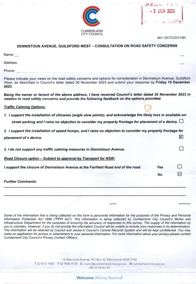
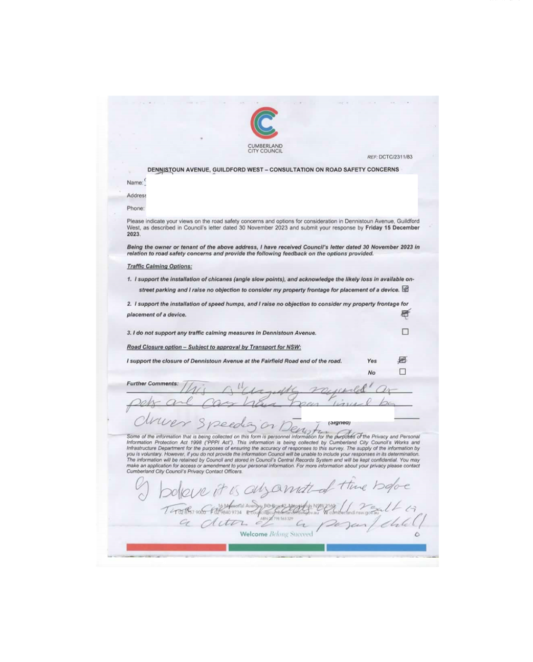
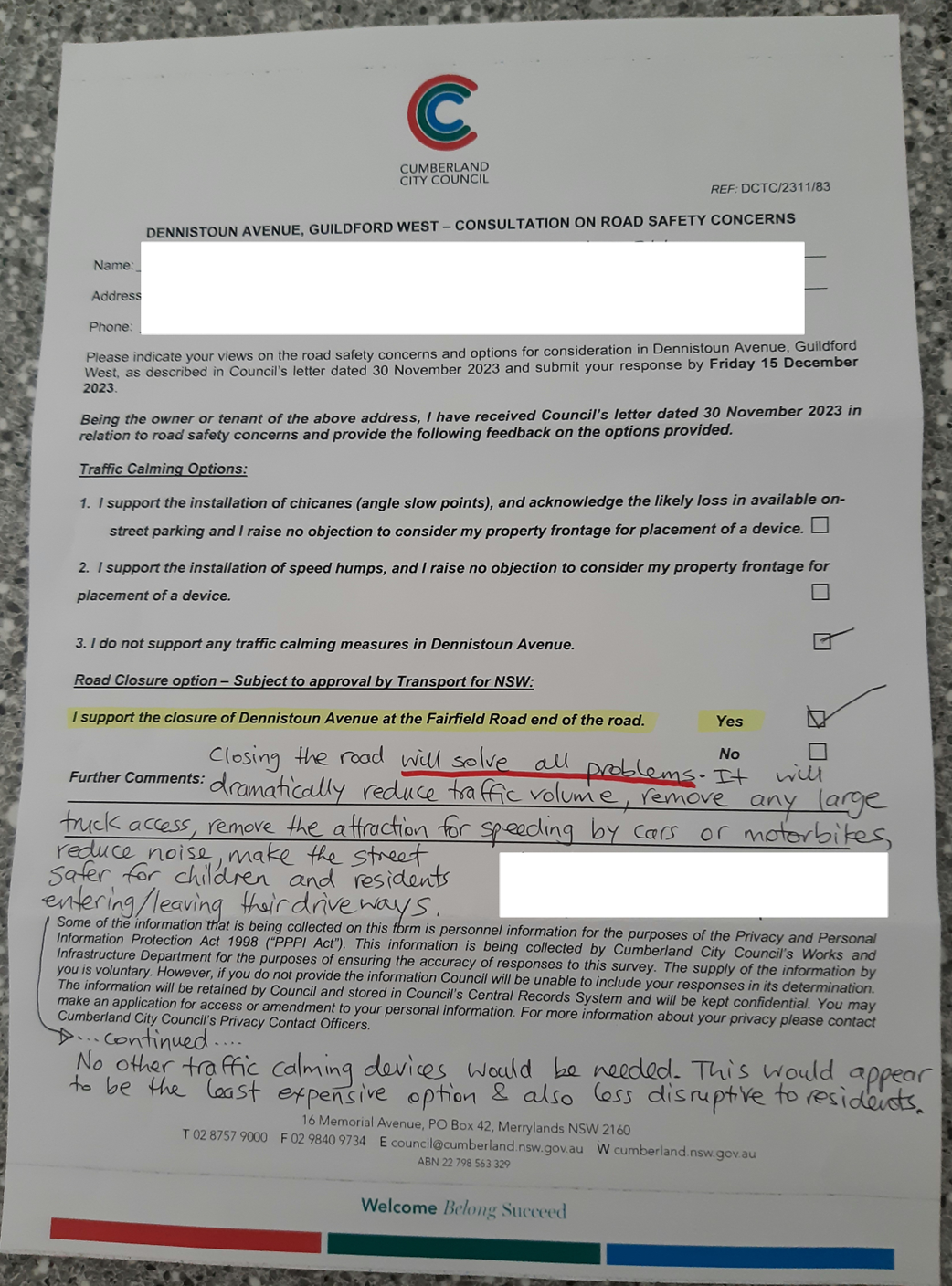
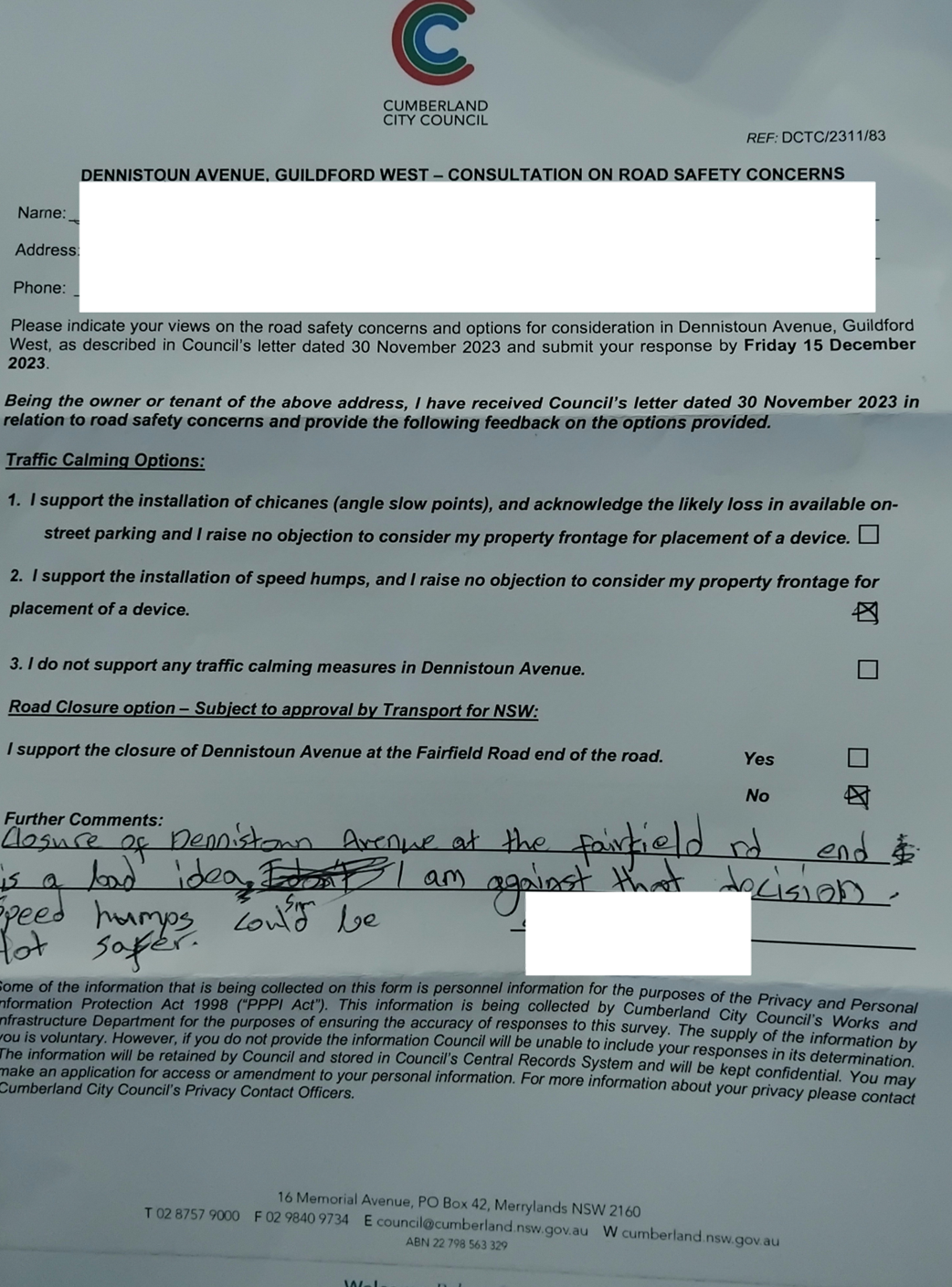
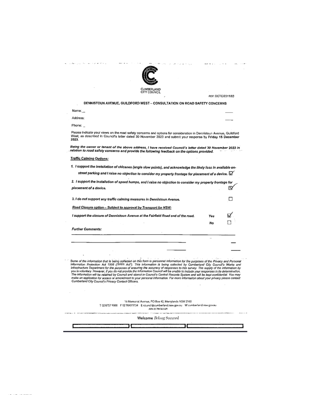
3 April 2024
Item No: CTC-24-086
TENNYSON
PARADE, GUILDFORD WEST – ROAD SAFETY CONCERNS - CONSULTATION RESULT
Directorate: Environment
and Planning
Responsible
Officer: Acting
Manager Engineering and Building
Electorate: Granville
Police Area
Command (PAC): Cumberland
Agenda Part Part
2
Note: Recommendation
to Council
Council has received a request
from a local resident for the installation of traffic calming devices on
Tennyson Parade, Guildford West due to speeding concerns.
This report outlines the outcome
of the investigation into this matter.
|
The Traffic Committee recommends that:
1. The
installation of traffic calming devices on Tennyson Parade, Guildford West be
supported in principle.
2. Council
prepare a concept plan for speed humps in Tennyson Parade, Guildford West,
and undertake consultation with the affected and adjacent residents and
report back to the traffic committee.
3. Council
notify concerned resident of the outcome.
|
Tennyson Parade is a local road
that runs in a north-south direction with a posted speed limit of 50 km/h. It
has a width of approximately 10m and parking is permitted on both side of the
road unless signposted.
Council has received concerns from
local residents regarding road safety on Tennyson Parade, Guildford West. The
matter (CTC-23-131) was reported to Cumberland Traffic Committee (CTC) on 2
August 2023, and Council subsequently resolved the following at its meeting on
6 September 2023:
That
Council consult with the affected residents in the street and seek their
feedback on the traffic calming devices and return the matter to the Committee.
In accordance with the above Council resolution, a
consultation was carried out with the residents of Tennyson Parade in February
2024, a total of 46 letters with an attached survey form were distributed to
the residents / owners.
Council received 16 responses (35% of the total letter sent)
by the closing date (plus an additional response from the same property), where
11 (68.8%) responses supported the proposed speed humps and 5 (31.3%) responses
opposed the proposed speed humps.
Based on the above result, majority of the residents in
Tennyson Parade supported the speed humps. Therefore, it is proposed that
Council prepare a concept plan for speed humps in Tennyson Parade and undertake
consultation with the affected and adjacent residents.
The proposal was notified to the
residents in Tennyson Parade for a period of 14 days from 14 February 2024 to
28 February 2024.
A total of 46 letters were distributed with an attached
survey form to the residents /owners. Council received 16 responses (35% of the
total letters sent) by the closing date.
1. Previous
Report – CTC-23-131
2. Previous
Council Minutes – CTC-23-131
3. Tennyson
Parade Submission
DOCUMENTS
ASSOCIATED WITH
REPORT CTC-24-086
Attachment 1
Previous Report – CTC-23-131
DOCUMENTS
ASSOCIATED WITH
REPORT CTC-24-086
Attachment 2
Previous Council Minutes – CTC-23-131
3 April 2024

DOCUMENTS
ASSOCIATED WITH
REPORT CTC-24-086
Attachment 3
Tennyson Parade Submission
3 April 2024
Item No: CTC-24-087
CHETWYND ROAD
AND GUILDFORD ROAD, GUILDFORD - ROAD SAFETY CONCERNS
Directorate: Environment
and Planning
Responsible
Officer: Acting
Manager Engineering and Building
Electorate: Granville
Police Area
Command (PAC): Cumberland
Agenda Part Part
2
Note: Recommendation
to Council
Council has received safety
concerns from a local resident for the installation of traffic calming devices
at the intersection of Chetwynd Road and Guildford Road, Guildford.
This report outlines the outcome
of the investigation into this matter.
|
The Traffic Committee recommends that:
1. The
installation of speed cushions on the approaches at the roundabout of
Chetwynd Road and Guildford Road, Guildford in accordance with the attached
plan be supported.
2. Consultation
be undertaken with directly affected residents prior to progressing with the
proposal.
|
Council has received safety
concerns from a local resident for the installation of traffic calming devices
at the intersection of Chetwynd Road and Guildford Road, Guildford.
Chetwynd Road is a collector road that runs in a north-south
direction with a sign-posted speed limit of 50km/h. The street is approximately
1.9km long and has a width of approximately 12.8m near Guildford Road. Parking
is permitted on both sides of the road unless signposted.
Guildford Road is also a collector road but runs in an
east-west direction with a sign-posted speed limit of 50km/h. The street is
approximately 1.6km long and has a width of approximately 12.8m. Parking is
permitted on both sides of the road as well unless signposted.
Chetwynd Road and Guildford Road
form a T intersection, featuring a roundabout with associated refuge islands
and kerb blisters. A marked pedestrian crossing also exists approximately 40
metres east of the intersection.
A traffic count was undertaken
on Chetwynd Road and Guildford Road at the intersection in November 2023 and
January 2024 respectively. The traffic count location is shown in red on the
map below.
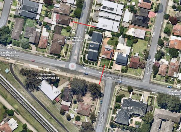
Locality
Plan
Traffic count data on Chetwynd Road:
· Average Daily
Traffic (ADT) = 4,325 veh/day,
· 85th percentile
speed = 51.8 km/h,
· Mean (average)
vehicle speed = 45.7 km/h.
Traffic count data on Guildford Road:
· Average Daily
Traffic (ADT) = 5,912 veh/day,
· 85th percentile
speed = 45.6 km/h,
· Mean (average)
vehicle speed = 39 km/h.
The latest Centre for Road Safety (CRS) crash data indicated
that there were no reported accidents at this intersection in the last 5 years
ending June 2023. Based on Police records, there were two crashes at this
intersection not included in the CRS data in 2024.
The traffic count data indicated that the recorded 85th
percentile speed on the approaches to the roundabout at the intersection of
Chetwynd Road and Guildford Road were:
· 51.8 km/h on the
Chetwynd Road approach, and
· 45.6km/h on the
eastern approach of Guildford Road.
These approach speeds are
considered high on the approaches to a roundabout, and it is proposed that
speed cushions are installed on the approaches to the roundabout. It is also
proposed that consultation on the proposal be undertaken with directly affected
residents.
Subject to endorsement, consultation will be undertaken on
the proposal with directly affected residents.
1. Plan -
Proposed speed cushions at the intersection of Chetwynd Road & Guildford
Road
DOCUMENTS
ASSOCIATED WITH
REPORT CTC-24-087
Attachment 1
Plan - Proposed speed cushions at the intersection of
Chetwynd Road & Guildford Road
3 April 2024
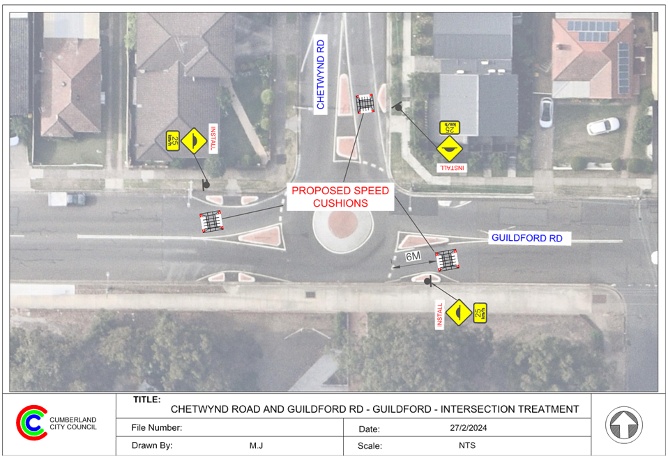
3 April 2024
Item No: CTC-24-088
WILLOUGHBY
STREET, GUILDFORD - ROAD SAFETY CONCERNS – CONSULTATION RESULT
Directorate: Environment
and Planning
Responsible
Officer: Acting
Manager Engineering and Building
Electorate: Granville
Police Area
Command (PAC): Cumberland
Agenda Part Part
2
Note: Recommendation
to Council
Council has conducted
consultations with residents regarding the installation of traffic calming
devices on Willoughby Street in Guildford due to concerns about speeding.
This report outlines the outcome
of the review.
|
The Traffic Committee recommends that:
1. The
installation of speed humps on Willoughby Street, Guildford in accordance
with the attached plan be supported.
2. Council
notify affected/ concerned residents of the outcome.
|
Willoughby Street is a local
road that runs in an east- west direction with a posted speed limit of 50 km/h.
it has a width of approximately 10.2m and parking is permitted on both sides of
the road unless signposted.
Council has received concerns
from local residents regarding road safety on Willoughby Street, Guildford. The
matter was investigated and reported to Cumberland Traffic Committee (CTC) in
the past, a summary of the reports and recommendations are listed below.
5 February 2020
Cumberland Traffic Committee
(CTC) at its meeting in February 2020 considered a report (Vide Item No.
CTC-20-006) regarding road safety concerns on Willoughby Street, Guildford and
CTC recommended that:
1. The
report be received and no further action be taken at this stage in regards to
speed humps.
2. Council request
Cumberland Police Area Command to undertake speed surveillance in Willoughby
Street, Guildford.
2 March 2022
CTC considered a report
(CTC-22-047) on the road safety concerns in Willoughby Street, Guilford. The
CTC recommended:
The Traffic Committee
recommended that Council undertake consultation with residents of Willoughby
Street, Guildford to assess support or otherwise for the installation of
traffic calming devices in the street.
18 October 2023
Following the recommendation, a
consultation was carried out in May 2023 and the result was reported (vide Item
No. ECTC-23-164) to October CTC and followed by Council Meeting in November
2023, Council resolved:
That the matter
be referred back to the Traffic Committee for consideration of the installation
of multiple speedhumps as indicated by the consultation.
In accordance with the Council
resolution, a detailed design of speed humps was prepared, and consultation was
carried out with the residents in Willoughby Street in February 2024.
Council distributed 11 letters
to the affected residents and no response were received by the closing date.
As no objections were received
from the residents, it is proposed that the installation of speed humps be
proceed.
The proposal was notified to the
impacted resident for a period of 14 days from 14 February 2024 to 28 February
2024.
A total of 11 letters were
distributed with an attached survey form and a plan to the residents / owners.
There were no responses received.
1. Previous
Report – ECTC-23-164
2. Plan
– Willoughby Street, Guildford – Proposed speed humps
DOCUMENTS
ASSOCIATED WITH
REPORT CTC-24-088
Attachment 1
Previous Report – ECTC-23-164
DOCUMENTS
ASSOCIATED WITH
REPORT CTC-24-088
Attachment 2
Plan – Willoughby Street, Guildford –
Proposed speed humps
3 April 2024
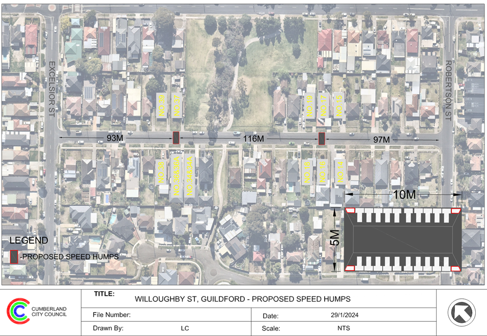
3 April 2024
Item No: CTC-24-089
MCARTHUR
STREET, GUILDFORD – ROAD SAFETY CONCERNS – CONSULTATION RESULT
Directorate: Environment
and Planning
Responsible
Officer: Acting
Manager Engineering and Building
Electorate: Granville
Police Area
Command (PAC): Cumberland
Agenda Part Part
2
Note: Recommendation
to Council
Council has received a request
from a local resident for the installation of traffic calming devices on
McArthur Street, Guildford due to speeding concerns.
This report outlines the outcome
of the investigation into this matter.
|
The Traffic Committee recommends that:
1. Council
undertake design of speed humps along McArthur Street, Guildford, consult
with the directly affected residents and report back to the Traffic
Committee.
2. Council
notify concerned resident of the outcome.
|
McArthur Street is a local road
that runs in an east-west direction with a posted speed limit of 50 km/h. It
has a width of approximately 12.5m and parking is permitted on both side of the
road unless signposted.
Council has received concerns from
local residents regarding road safety on McArthur Street, Guildford. The matter
was investigated and reported to Cumberland Traffic Committee (CTC) in the
past, a summary of the reports and recommendations are listed below:
6 April 2022
Cumberland Traffic Committee
(CTC) at its meeting in April 2022 considered a report (Vide Item No.
CTC-22-083) regarding road safety concerns on McArthur Street and Council
resolved that:
1. The
installation of traffic calming devices on McArthur Street, Guildford not be supported.
2.
Council review conditions in McArthur Street, Guildford in June 2023, and
report back to traffic committee.
6 September 2023
Cumberland Traffic Committee
(CTC) at its meeting in August 2023 considered a report (Vide Item No.
CTC-23-129) regarding road safety concerns on McArthur Street, Guildford, the
report also been considered in the following Council Meeting in September 2023,
subsequently Council resolved:
That
Council consult with the affected residents in the street and seek their feedback
on the traffic calming devices and return the matter to the Committee.
In accordance with the recommendation from Council, a
preliminary consultation was carried out with the residents of McArthur Street
in February 2024, a total of 76 letters with an attached survey form were
distributed to the residents/ owners.
Council received 21 responses (28%
of the total letters sent) by the closing date, 19 (90.5%) responses supported
the proposed speed humps, including 1 submission supported the proposal but
does not want the speed hump to be placed outside the property frontage, and 2
(9.5%) responses opposed the proposed speed humps.
Based on the above result,
majority of the responses received by Council supported the provision of speed
humps in McArthur Street, Guildford. It is recommended that Council prepare a
concept design of the speed humps, consult with the residents and report back
to Traffic Committee.
The proposal was notified to the
residents in McArthur Street for a period of 14 days from 14 February 2024 to
28 February 2024.
A total of 76 letters were
distributed with an attached survey form to the residents / owners. Council
received 21 responses (28% of the total letters sent) by the closing date.
1. Previous
Council Minutes – CTC-23-129
2. Submissions
DOCUMENTS
ASSOCIATED WITH
REPORT CTC-24-089
Attachment 1
Previous Council Minutes – CTC-23-129
3 April 2024
DOCUMENTS
ASSOCIATED WITH
REPORT CTC-24-089
Attachment 2
Submissions
3 April 2024
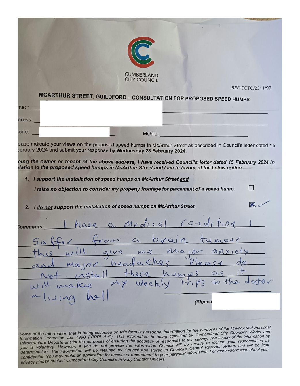
3 April 2024
Item No: CTC-24-090
O'NEILL
STREET, GUILDFORD - PROPOSED INTERSECTION TREATMENT AT ELIZABETH STREET
Directorate: Environment
and Planning
Responsible
Officer: Acting
Manager Engineering and Building
Electorate: Granville
Police Area
Command (PAC): Cumberland
Agenda Part Part
2
Note: Recommendation
to Council
Council has received safety
concerns at the intersection of O’Neill Street and Elizabeth Street,
Guildford.
This report outlines the
investigation into this matter.
|
That the Traffic Committee recommends:
1. That the
provision of the intersection treatment at O’Neill Street and Elizabeth
Street, Guildford, in accordance with the attached plan be supported.
2. Council
undertake consultation with the adjacent properties and report back to
Traffic Committee if objections are received.
|
Council has received safety
concerns at the intersection of O’Neill Street and Elizabeth Street,
Guildford.
Elizabeth Street is local road
that runs in an east-west direction between Military Road and The Explanade,
Guildford. It has a width of approximatelyt 11.5 m.
O’Neill Street is a local
road that runs in a north-south direction between Guildford Road and Hawksview
Street. O’Neill Street is approximately 12.3m wide at the intersection.
O’Neill Street forms a staggered intersection with Elizabeth Street.
Painted median islands with rumble strips have been provided at its
intersection with the southern approach of O’Neill Street. There is also
a painted kerb side island in line with the kerb line on the western side of
the southern approach of O’Neill Street. This painted island is provided
to provide access to the corner property via its driveway located near the
intersection.
Council has received concerns from
residents that vehicles from the northern leg of the intersection is speeding
through the kerb side painted island causing crashes on the eastern side of the
southern approach of O’Neill Street.
The image below shows the details
of the intersection:
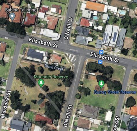
The latest Centre for Road Safety crash data indicated that
there was one reported crash at this location in the last 5 years ending June
2023. It should be noted that the crash database includes only reported crashes
and does not account for near misses or minor unreported crashes.
The crash details are list in the table below:
|
Date
|
Accident ID
|
Location
|
DCA Code
|
Description
|
|
08/07/2021
|
1274394
|
Elizabeth Street at O’Neil Street
|
Right -Left
|
Crash between right turning and left turning vehicles on
Elizabeth St
|
It is proposed to replace the
painted median islands with concrete medians to prevent vehicles speeding
across Elizabeth Street from the northern approach to southern approach of
O’Neill Street. The concrete median in O’Neill Street will have an
opening to allow turning of vehicles into the driveway of the corner property.
Subject to endorsement,
consultation will be undertaken with the directly affected residents.
1. Plan -
O'Neill Street and Elizabeth Street, Guildford - proposed intersection
treatment
DOCUMENTS
ASSOCIATED WITH
REPORT CTC-24-090
Attachment 1
Plan - O'Neill Street and Elizabeth Street, Guildford
- proposed intersection treatment
3 April 2024
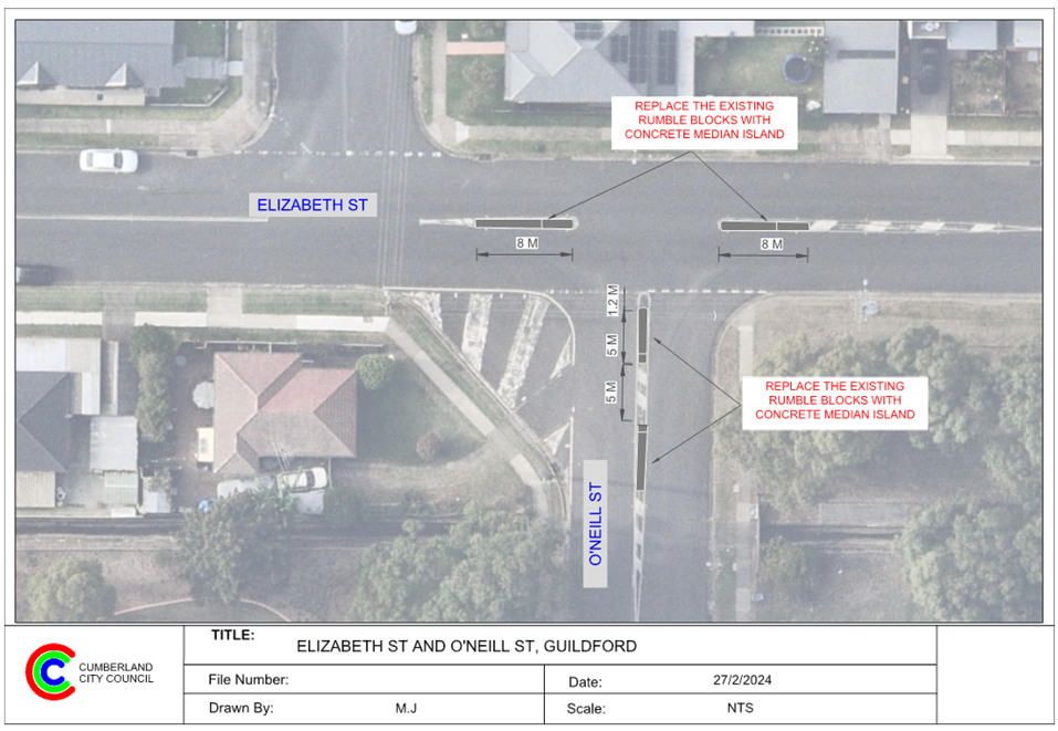
3 April 2024
Item No: CTC-24-091
DENMARK
STREET, MERRYLANDS – ROAD SAFETY CONCERNS – CONSULTATION RESULT
Directorate: Environment
and Planning
Responsible
Officer: Acting
Manager Engineering and Building
Electorate: Granville
Police Area
Command (PAC): Cumberland
Agenda Part Part
2
Note: Recommendation
to Council
Council has received requests from
local residents for the installation of traffic calming devices on Denmark
Street, Merrylands due to speeding concerns.
This report outlines the outcome
of the investigation into this matter.
|
The Traffic Committee recommends that:
1. The
proposed speed humps in Denmark Street, Merrylands in accordance with the
attached plan be constructed, subject to funding availability.
2. The
affected and concerned residents be notified of the outcome.
|
Denmark Street is a local road
that runs in a north-south direction with a posted speed limit of 50 km/h. It
has a width of approximately 12.5m and parking is permitted on both side of the
road unless signposted.
Council has received concerns from
local residents regarding road safety on Denmark Street, Merrylands. The matter
was investigated and reported to Cumberland Traffic Committee (CTC) in the
past, a summary of the reports and recommendations are listed below.
3 August 2022
Cumberland Traffic Committee
(CTC) at its meeting in August 2022 considered a report (CTC-22-138) regarding
road safety concerns on Denmark Street and CTC recommended that:
1. Support
in principle the installation of speed humps in Denmark Street, Merrylands.
2. Undertake
consultation on the proposal with the residents of Denmark Street, Merrylands.
3. Provide
a further report to the Traffic Committee. Report will include the consultation
results.
6 February 2023
In accordance with the CTC
recommendation, a consultation was carried out in November 2022 and the result
was reported (CTC-23-022) to February 2023 Cumberland Traffic Committee, CTC
recommended that:
1. The
installation of traffic calming devices on Denmark Street, Merrylands not be
supported.
2. Council
undertake traffic count data on Denmark Street along with community
consultation and report back to the Traffic Committee in June 2023.
1 November 2023
In accordance with the CTC recommendation, a consultation
was carried out in September 2023 and the result was reported (CTC-23-185)
along with a traffic condition review to November 2023 Cumberland Traffic
Committee, CTC recommended that:
1. The
installation of traffic calming devices on Denmark Street, Merrylands be
supported in principle.
2. Council
prepares design of speed humps and undertake consultation with directly
affected and adjacent properties and report back to the Traffic Committee in
April 2024.
In accordance with the recommendation, a consultation was
carried out with the residents of Denmark Street in March 2024, a total of 31
letters with an attached survey form were distributed to the residents /
owners.
Council received 12 responses (39%
of the total letters sent) by the closing date (plus an additional response
from the same property), where 8 (66.7%) responses supported the proposed speed
humps, 3 (25%) responses opposed to the proposed speed humps and 1 (8.3%)
submission had no preference marked.
Based on the above result,
majority of the responses received by Council supported the provision of speed
humps in Denmark Street. Therefore, it is suggested that the proposed speed
hump as per the attached plan be constructed, subject to funding availability.
The proposal was notified to the
impacted resident for a period of 14 days from 8 March 2024 to 22 March 2024.
A total of 31 letters were distributed to the residents /
owners with an attached survey form and 12 responses (39% of the total letter
sent) received.
1. Plan -
Denmark Street, Merrylands - Proposed Speed Humps
2. Previous
Report - CTC-23-185
3. Denmark
Street Submission
DOCUMENTS
ASSOCIATED WITH
REPORT CTC-24-091
Attachment 1
Plan - Denmark Street, Merrylands - Proposed Speed
Humps
3 April 2024
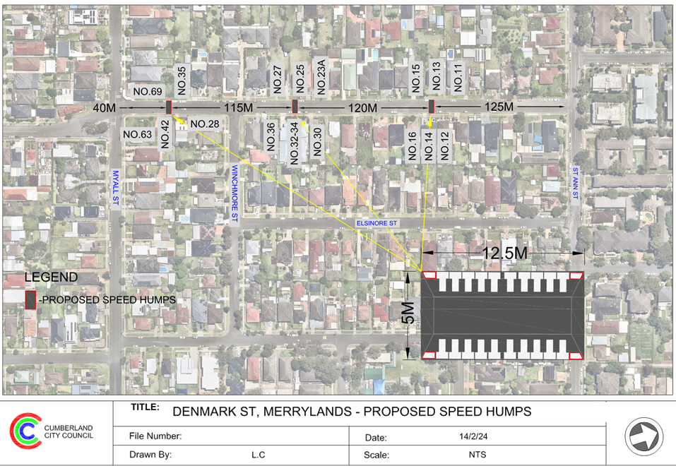
DOCUMENTS
ASSOCIATED WITH
REPORT CTC-24-091
Attachment 2
Previous Report - CTC-23-185
DOCUMENTS
ASSOCIATED WITH
REPORT CTC-24-091
Attachment 3
Denmark Street Submission
3 April 2024
Item No: CTC-24-092
PITT STREET,
MERRYLANDS - PROPOSED PEDESTRIAN FENCING
Directorate: Environment
and Planning
Responsible
Officer: Acting
Manager Engineering and Building
Electorate: Granville
Police Area
Command (PAC): Cumberland
Agenda Part Part
2
Note: Recommendation
to Council
Council has received safety
concerns from motorists and residents regarding pedestrians randomly crossing
Pitt Street south of Sheffield Street, Merrylands.
This report outlines the outcome
of the investigation into this matter.
|
The Traffic Committee recommends that:
1. The
installation of a pedestrian fence in Pitt Street, Merrylands at the front of
No.171 in accordance with the attached plan be approved.
2. The
adjacent owners/residents be notified of the outcome.
|
Pitt Street is a
‘classified’ regional road pursuant to Roads Act 1993 that runs in
a north-south direction. It is approximately 15m wide with a speed limit of 60
km/h. It accommodates two travel lanes for the northbound traffic and three travel
lanes for the southbound traffic. It also has a concrete median island in the
middle of the street to prevent right turns into and out of the adjacent local
road Sheffield Street. Parking is not permitted on both sides of the
road.
Property No 171 is at the corner
of Sheffield Street and has businesses which includes a café, a gym and
spa. Walpole Street Reserve is on the eastern side of Pitt Street. There is an
apartment block with ground floor businesses and apartments on higher floors on
the eastern side of Pitt Street.
This location is approximately 50m
from the signalised intersection of Neil Street and Pitt Street.
It is alleged that pedestrians are
crossing Pitt Street at this location and causing safety concerns to motorists.
The map below shows the location.
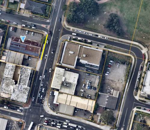
To prevent pedestrians using this
location to cross Pitt Street, it is proposed to install pedestrian fencing on
the western side of Pitt Street from the corner with Sheffield Street to cover
the frontage of the corner block.
The installation of the pedestrian
safety fence does not adversely impact on any parking or properties, and
therefore consultation is not required. However, Council will notify the
adjacent businesses prior to the installation of the pedestrian fence.
1. Plan –
Pitt Street, Merrylands – Proposed Pedestrian Fencing
DOCUMENTS
ASSOCIATED WITH
REPORT CTC-24-092
Attachment 1
Plan – Pitt Street, Merrylands – Proposed
Pedestrian Fencing
3 April 2024
3 April 2024
Item No: CTC-24-093
BLAXCELL
STREET AND LISGAR STREET, SOUTH GRANVILLE - INTERSECTION SAFETY CONCERNS
Directorate: Environment
and Planning
Responsible
Officer: Acting
Manager Engineering and Building
Electorate: Granville
Police Area
Command (PAC): Cumberland
Agenda Part Part
2
Note: Recommendation
to Council
Council has received concerns from
a local resident requesting installation of traffic calming devices at the
intersection of Blaxcell Street and Lisgar Street, South Granville due to
concerns regarding speeding through the intersection.
This report outlines the outcome
of the investigation into this matter.
|
The Traffic Committee recommends that:
1. The
installation of speed cushions, median islands and associated works on Lisgar
Street at the intersection of Blaxcell Street in accordance with the attached
plan be supported.
2. The
concerned resident be notified of the outcome.
|
Council has received concerns from
a local resident requesting installation of traffic calming devices at the
intersection of Blaxcell Street and Lisgar Street, South Granville due to
concerns regarding speeding through the intersection.
Blaxcell Street is a local collector road that runs in a
north-south direction with a posted speed limit of 50km/h. The street is
approximately 12.7m wide. Parking is permitted on both sides of the road unless
signposted.
Lisgar Street is a local road that runs in an east-west
direction with a speed limit of 50km/h. The street is approximately 650m long
and has a width of approximately 12.5m. Parking is permitted on both sides of
the road unless signposted.
Blaxcell Street and Lisgar Street form a T- intersection,
which is controlled by ‘Give Way’ sign while the priority is given
to Blaxcell Street.
Blaxcell Street has edge lines and a painted median at this
location. Lisgar Street has a 10m ‘BL2’ (former ‘BB’
line) line marking at the intersection.
It was alleged that vehicles are entering and exiting Lisgar
Street at high speeds
A traffic count was undertaken
on Lisgar Street in March 2024.
The traffic count locations are
shown in red on the map below.
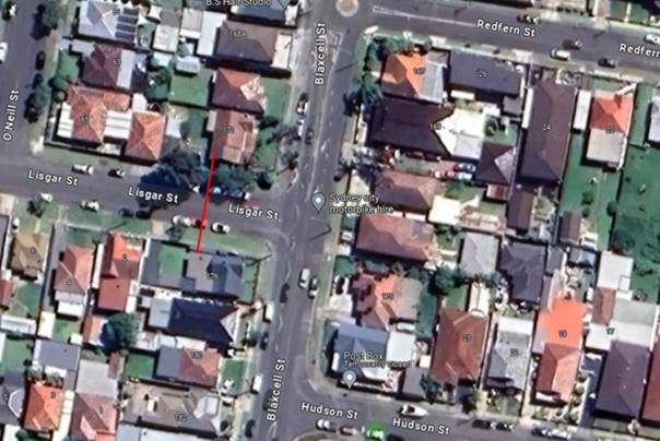
Locality
Plan
Traffic count data on Lisgar Street, South Granville:
· Average Daily
Traffic (ADT) = 3,939 veh/day;
· 85th percentile
speed:
o Eastbound = 41.4 km/h
o Westbound = 41.2 km/h
The latest Centre for Road Safety accident data indicated
that there were no reported accidents at this intersection in the last 5 years ending
June 2023.
Based on the above data, the 85th percentile
speeds for vehicle approaching and departing the intersection is 41.4 and 41.2
km/h which is considered high at 20m from the intersection.
Therefore, it is proposed to install speed cushions with
median island and associated line marking on Lisgar Street at its intersection
with Blaxcell Street to reduce the speed and improve safety.
The proposal was notified to the
residents in Blaxcell Street and Lisgar Street who will be directly impacted by
the proposed traffic devices for a period of 14 days from 12 March 2024 to 26
March 2024.
A total of 3 letters were
distributed with an attached survey form and a plan to the residents /owners.
No responses were received.
1. Plan -
Lisgar Street & Blaxcell Street, South Granville - Proposed Intersection
Treatment
DOCUMENTS
ASSOCIATED WITH
REPORT CTC-24-093
Attachment 1
Plan - Lisgar Street & Blaxcell Street, South
Granville - Proposed Intersection Treatment
3 April 2024
3 April 2024
Item No: CTC-24-094
WALTERS ROAD
AND SECOND AVENUE, BERALA - ROAD SAFETY CONCERNS
Directorate: Environment
and Planning
Responsible
Officer: Acting
Manager Engineering and Building
Electorate: Auburn
Police Area
Command (PAC): Auburn
Agenda Part Part
2
Note: Recommendation
to Council
Council has received concerns from
a local resident requesting the installation of traffic calming devices at the
intersection of Walters Road and Second Avenue, Berala due to speeding
concerns.
This report outlines the outcome
of the investigation into this matter.
|
The Traffic Committee recommends that:
1. The
installation of speed cushions, median islands and associated works on Second
Avenue at the intersection of Walters Road, Berala in accordance with the
attached plan be supported.
2. The
concerned resident be notified of the outcome.
|
Council has received concerns from
a local resident requested the installation of traffic calming devices at the
intersection of Walters Road and Second Avenue, Berala due to speeding
concerns.
Walters Road is a local road that runs in an east-west
direction with a posted speed limit of 50km/h. The street is approximately 700m
long and has a width of approximately 12.7m. Parking is permitted on both sides
of the road unless signposted.
Second Avenue is a local road that runs in a north-south
direction with a default speed limit of 50km/h. The street is approximately
730m long and has a width of approximately 12.5m. Parking is permitted on both
sides of the road unless signposted.
Walters Road and Second Avenue forms a four-way
intersection, and it is controlled by ‘Give Way’ signs while the
priority is given to Walters Road. Council recently painted BL2 line marking at
all approaches to the intersection to better delineate the traffic at this
location.
Traffic counts was undertaken on Seconds Avenue and Walters
Road, Berala in March 2024. The traffic count locations are shown in red on the
map below.
Locality
Plan
Traffic count data on Walters Road, Berala:
· Average Daily
Traffic (ADT) = 1752 veh/day,
· 85th percentile
speed = 53.1 km/h,
· Mean (average)
vehicle speed = 45.9 km/h.
Traffic count data on Second Avenue, Berala:
· Average Daily
Traffic (ADT) = 388 veh/day,
· 85th percentile
speed = 36.2 km/h,
· Mean (average)
vehicle speed = 30.6 km/h.
The latest Centre for Road Safety accident data indicated
that there were no reported accidents at this intersection in the last 5 years
ending June 2023 in relation to speeding. However, a side-traffic accident was
recorded and is list in the table below:
|
Date
|
Location
|
DCA Code
|
Description
|
|
11/9/2018
|
Walters Road at
Second Avenue
|
Cross Traffic
|
Vehicle failed to
give way
|
Council is also aware that two
accidents happened on 26 July 2023 and 14 December 2023 respectively. Both
accidents were not included in the accident data provided by Centre for Road
Safety but were reported to the Police.
Council officers have investigated the request for the
installation of traffic calming devices at this intersection in accordance with
Council’s Local Area Traffic Management (LATM) Policy.
The result of the traffic count
and recorded crashes were used in the assessment to determine the need for the
installation of traffic calming devices on Second Avenue in accordance with the
criteria set out in Council’s Local Area Traffic Management Policy (LATM)
Policy.
The LATM assessments are
summarised in the tables below:
Table 1 – Second Avenue, Berala - LATM Assessment
Points
|
Criteria
|
Maximum Score
|
Score Achieved
|
|
Traffic Study Data
|
45
|
0
|
|
Crash warrant in the
last 5 years
|
15
|
10
|
|
Road Characteristics
|
35
|
10
|
|
Community Support &
other factors
|
5
|
5
|
|
Total
|
100
|
25
|
Table 2 – Second
Avenue, Berala – Action
|
Criteria
|
Action
|
|
>75
|
Report to TC with a
recommendation of providing traffic calming devices
|
|
61-75
|
Report to TC and
discuss possibility of providing traffic calming devices
|
|
41-60
|
Council to review
traffic data in 6 months
|
|
25-40
|
Monitor street and
review traffic data after 12 months
|
|
<25
|
Do Nothing
|
|
Speed
|
That regardless of the
total points scored, should the 85th percentile speed exceed the posted speed
limit by 5 km/h, the street be referred to the NSW Police for monitoring
and/or enforcement.
|
The traffic count data indicated
that:
· The recorded 85th
percentile speed for Second Avenue is 36.2 km/h, which is below the default
speed limit.
· The recorded 85th
percentile speed for Walters Road is 53.1 km/h, which is within the acceptable
limits for a local road.
Based on the above assessment, traffic calming devices are
not warranted in the street. However, considering the recent accidents at the
intersection, it is proposed to implement speed cushions with median island and
associated linemarking on Second Avenue at the intersection of Walters Road.
The proposal
was notified to the residents in Walters Road and Second Avenue who will be
directly impacted by the proposed traffic devices for a period of 14 days from
12 March 2024 to 26 March 2024.
A total of 5 letters were
distributed with an attached survey form and a plan to the residents/ owner.
One response was received and supported the proposal.
1. Plan -
Walters Road and Second Avenue, Berala - Proposed Intersection Treatment
2. Walters
Road Submission
DOCUMENTS
ASSOCIATED WITH
REPORT CTC-24-094
Attachment 1
Plan - Walters Road and Second Avenue, Berala -
Proposed Intersection Treatment
3 April 2024
DOCUMENTS
ASSOCIATED WITH
REPORT CTC-24-094
Attachment 2
Walters Road Submission
3 April 2024
3 April 2024
Item No: CTC-24-095
REGENT STREET,
REGENTS PARK - REQUEST FOR BANNING RIGHT TURNS INTO AMY STREET
Directorate: Environment
and Planning
Responsible
Officer: Acting
Manager Engineering and Building
Electorate: Auburn
Police Area
Command (PAC): Auburn
Agenda Part Part
2
Note: Recommendation
to Council
Cumberland City Council received a request from a resident
for banning right turns from Regent Street into Amy Street.
This report outlines the outcome of the investigation into
this matter.
|
The Traffic Committee recommends that:
1. Council
undertake community consultation for implementing part time or full-time
right turn ban from Regent Street into Amy Street, Regents Park.
2. Prepare
a Traffic Management Plan in consultation with for submission to Transport
for NSW for approval.
|
Council has received a request from a resident for banning
right turns from Regent Street into Amy Street.
Amy Street is a regional road carrying over 17,000 veh/day
and links State Road, Joseph Street to regional roads Park Road and Carlingford
Road.
Regents Street is a local road that runs in a northerly
direction from Amy Street.
Amy Street and Regent Street form a T-intersection with
‘Give Way’ sign and line marking on Regent Street.
This report assesses the feasibility of the right turn bans
and the impacts on surrounding streets.
The map below show the locality of Amy Street and Regent
Street, Regents Park.
Site observations have indicated that Amy Street eastbound
queuing extends up to Kingsland Road roundabout during peak hours and Council
has received concerns from residents of side streets of ‘rat-runs’
undertaken by vehicles to avoid long queues in Amy Street at times.
Based on Centre for Road Safety crash data, there were no
reported crashes at this intersection in the last five years ending June 2023.
It should be noted that the available crash data does not show minor crashes or
near misses.
It was observed that the traffic exiting Regents Street into
Amy Street, particularly the right turns, have difficulty in judging the
available gap to complete the manoeuvre.
However, the traffic flow is slow moving during peak hours,
assisting the exiting traffic to ‘steal’ gaps while entering the
traffic stream in Amy Street. This creates unsafe situations which are avoided
due to slow movement of traffic.
Council undertook intersection turning movement volumes and
the data of right turning vehicles out of Regent Street is shown below:
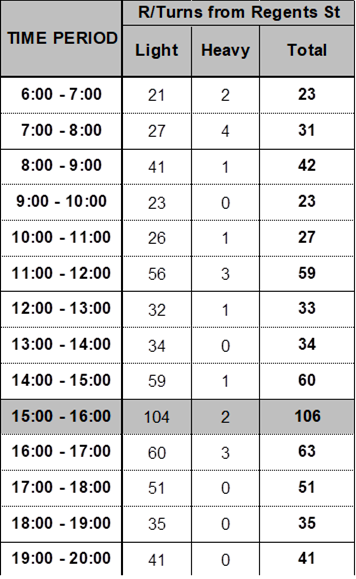
It should be noted that banning right turn movements from
Regent Street will direct traffic to other streets in the network. It will also
impact on the residents who have to take detours through other streets to
access Amy Street.
However, it is proposed that Council undertake consultation
with residents to consider appropriate times to ban the right turn movements
from Regent Street and liaise with Transport for NSW.
In accordance with the Transport for NSW guidelines (TfNSW),
Council does not have delegation to ban movements of any vehicular traffic
without preparing and receiving approval from TfNSW of a Traffic Management
Plan (TMP).
The TMP deals with various impacts of banning any movement,
including impact on emergency vehicle access, other streets in the vicinity,
and justification for the decision to ban. As part of this process, any proposal
is to be advertised and public comments summarised and addressed.
The impacts of the proposal may also need to be modelled
using appropriate software and justification for the request analysed.
Subject to endorsement, community
consultation will be undertaken as part of the preparation of a Traffic
Management Plan for consideration by Transport for NSW.
Nil