Traffic Committee
7 June 2023


7 June 2023
A meeting of the Traffic Committee will be held at 9.30am in Council Chambers, Merrylands Administration Building, 16 Memorial Avenue, Merrylands on Wednesday, 7 June 2023.
Business as below:
Yours faithfully
Peter J. Fitzgerald
General Manager
ORDER OF BUSINESS
1. Apologies
2. Declarations of Interest
3. Confirmation of Previous Minutes endorsed by Council
4. Summary of Reports.......................................................................................................... 5
5. Reports
- Part 1 - Recommended for Approval under Delegated Authority
- Part 2 - Recommendation to Council
CONTENTS
Report No. Name of Report Page No.
Part 1 - Recommended for Approval under Delegated Authority
CTC-23-074 Dursley Road, Yennora - Convert the existing 15 minute Parking to 10 Minute Parking and Installation / Extension of Restricted Parking Spaces................................................... 9
CTC-23-075 Bolaro Avenue, Greystanes - Proposed 'no stopping' Restrictions....................................................................................... 21
CTC-23-076 Carinya Road, Girraween - Provision of 'Stop' signage and Line marking........................................................................................ 31
CTC-23-077 Jones Street and Arnett Street, Pendle Hill - Proposed 'No stopping' Restrictions and Line Markings....................... 39
CTC-23-078 Robilliard Street and Rees Street, Mays Hill - Proposed Intersection Treatment.............................................................. 45
CTC-23-079 Lavinia Street and Blaxcell Street, South Granville - Proposed 'no stopping' signs and Linemarkings.......... 53
CTC-23-080 Biana Street at Waiana Street and Bobbina Avenue, Pemulwuy - Proposed 'No stopping' restrictions and Line Markings................................................................................................ 59
CTC-23-081 Percival Road, Smithfield - Proposed Extension of existing 'no stopping' Restrictions......................................................... 67
CTC-23-082 Murray Street at Nottinghill Road and Brixton Road, Lidcombe - Proposed 'No Stopping' Restrictions and Line Markings................................................................................................ 73
CTC-23-083 Kerr Parade, Auburn - Request for Accessible Parking 83
CTC-23-084 Harrow Road, Auburn - Application for 'Works Zone' signage................................................................................................... 89
Part 2 - Recommendation to Council
CTC-23-085 Response to Notice of Motion C08/22-121 - Residential Parking in Lidcombe........................................................................ 97
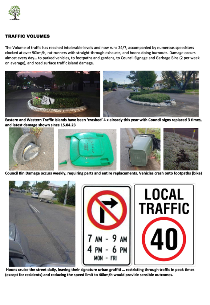
CTC-23-086 Response to Notice of Motion C03/23-262 - Traffic Calming Devices - Lansdowne Street, Merrylands..................... 157
CTC-23-087 Hawksview Street, Guildford and Merrylands - Road Safety Concerns........................................................................... 235
CTC-23-088 Dell Street, Woodpark - Review of Existing Timed Parking 243
CTC-23-089 Surrey Street, Guildford - Road Closure.................... 271
CTC-23-090 Rhodes Avenue, Guildford - Road Safety Concerns 279
CTC-23-091 Delhi Street, Lidcombe - Road Safety Concerns....... 283
CTC-23-092 Joseph Street and James Street, Lidcombe - Proposed Extension of Existing Pedestrian Fencing................... 287
CTC-23-093 Salisbury Road and Rhodes Avenue, Guildford - Proposed Intersection Treatment............................................................ 295
CTC-23-094 Swete Street and Mary Street, Lidcombe - Proposed Treatment at Roundabout....................................................... 303
CTC-23-095 Nottinghill Road and The Boulevard, Lidcombe - Proposed 'No Stopping' Restrictions and Linemarkings.............. 315
CTC-23-096 King Street, Guildford West - Road Safety Concerns 323
CTC-23-097 Leigh Street, Merrylands - Road Safety Concerns 331
CTC-23-098 Matthew Street, Merrylands - Road Safety Concerns 335
CTC-23-099 Hamilton Street, South Wentworthville - Road Safety Concerns............................................................................................ 339
CTC-23-100 Palmer Street, Guildford West - Road Safety Concerns 349
CTC-23-101 Harris Street, Merrylands - Road Safety Concerns 359
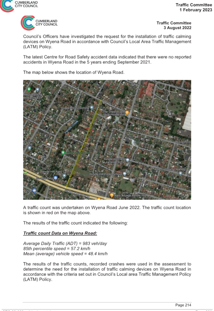
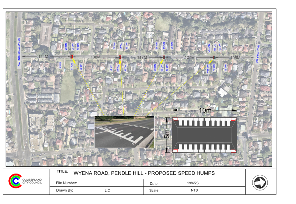
CTC-23-102 Wyena Road, Pendle Hill - Road Safety Concerns - Consultation.................................................................................... 363
CTC-23-103 Dorothy Street, Chester Hill - Road Safety Concerns 399
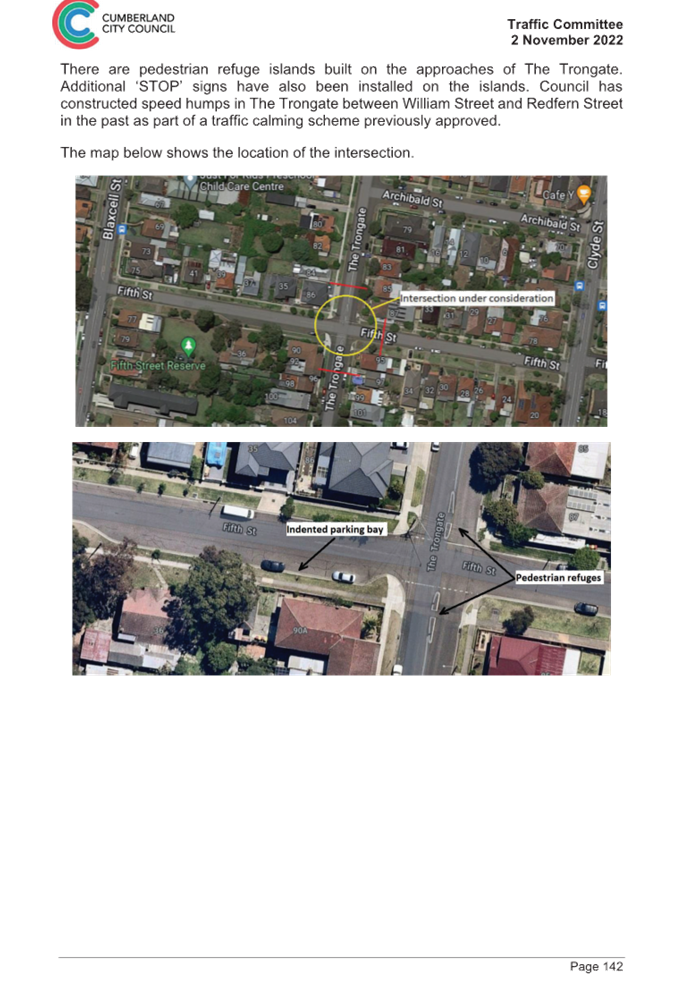
CTC-23-104 The Trongate and Fifth Street, Granville - Provision of a Roundabout...................................................................................... 403
Traffic Committee
7 June 2023
Part 1 - Recommended for Approval under Delegated Authority
|
Item # |
Title |
Electorate |
Police Area Command (PAC) |
||||
|
Fairfield |
Granville |
Prospect |
Auburn |
Cumberland |
Auburn |
||
|
CTC-23-074 |
Dursley Road, Yennora - Convert the existing 15 minute Parking to 10 Minute Parking and Installation / Extension of Restricted Parking Spaces |
|
´ |
|
|
´ |
|
|
CTC-23-075 |
Bolaro Avenue, Greystanes - Proposed 'no stopping' Restrictions |
|
|
´ |
|
´ |
|
|
CTC-23-076 |
Carinya Road, Girraween - Provision of 'Stop' signage and Line marking |
|
|
´ |
|
´ |
|
|
CTC-23-077 |
Jones Street and Arnett Street, Pendle Hill - Proposed 'No stopping' Restrictions and Line Markings |
|
|
´ |
|
´ |
|
|
CTC-23-078 |
Robilliard Street and Rees Street, Mays Hill - Proposed Intersection Treatment |
|
´ |
|
|
´ |
|
|
CTC-23-079 |
Lavinia Street and Blaxcell Street, South Granville - Proposed 'no stopping' signs and Linemarkings |
|
´ |
|
|
´ |
|
|
CTC-23-080 |
Biana Street at Waiana Street and Bobbina Avenue, Pemulwuy - Proposed 'No stopping' restrictions and Line Markings |
|
|
´ |
|
´ |
|
|
CTC-23-081 |
Percival Road, Smithfield - Proposed Extension of existing 'no stopping' Restrictions |
|
|
´ |
|
´ |
|
|
CTC-23-082 |
Murray Street at Nottinghill Road and Brixton Road, Lidcombe - Proposed 'No Stopping' Restrictions and Line Markings |
|
|
|
´ |
|
´ |
|
CTC-23-083 |
Kerr Parade, Auburn - Request for Accessible Parking |
|
|
|
´ |
|
´ |
|
CTC-23-084 |
Harrow Road, Auburn - Application for 'Works Zone' signage |
|
|
|
´ |
|
|
Part 2 - Recommendation to Council
|
Item # |
Title |
Electorate |
Police Area Command (PAC) |
||||
|
Fairfield |
Granville |
Prospect |
Auburn |
Cumberland |
Auburn |
||
|
CTC-23-085 |
Response to Notice of Motion C08/22-121 - Residential Parking in Lidcombe |
|
|
|
´ |
|
´ |
|
CTC-23-086 |
Response to Notice of Motion C03/23-262 - Traffic Calming Devices - Lansdowne Street, Merrylands |
|
´ |
|
|
´ |
|
|
CTC-23-087 |
Hawksview Street, Guildford and Merrylands - Road Safety Concerns |
|
´ |
|
|
´ |
|
|
CTC-23-088 |
Dell Street, Woodpark - Review of Existing Timed Parking |
|
´ |
|
|
´ |
|
|
CTC-23-089 |
Surrey Street, Guildford - Road Closure |
|
´ |
|
|
´ |
|
|
CTC-23-090 |
Rhodes Avenue, Guildford - Road Safety Concerns |
|
´ |
|
|
´ |
|
|
CTC-23-091 |
Delhi Street, Lidcombe - Road Safety Concerns |
|
|
|
´ |
|
´ |
|
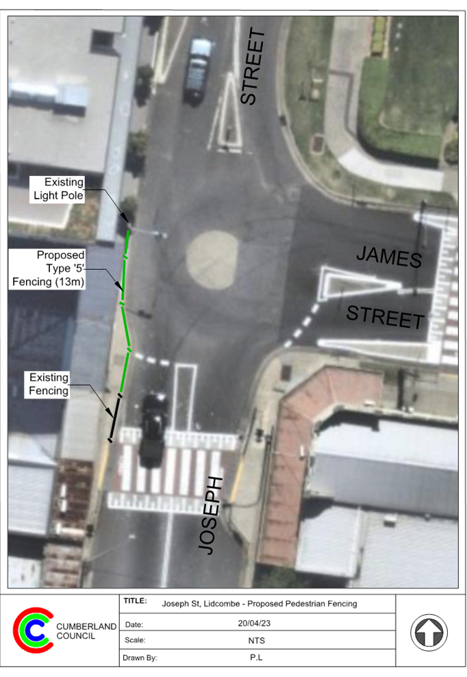
CTC-23-092 |
Joseph Street and James Street, Lidcombe - Proposed Extension of Existing Pedestrian Fencing |
|
|
|
´ |
|
´ |
|
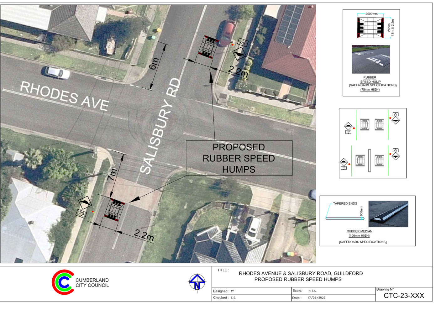
CTC-23-093 |
Salisbury Road and Rhodes Avenue, Guildford - Proposed Intersection Treatment |
|
´ |
|
|
´ |
|
|
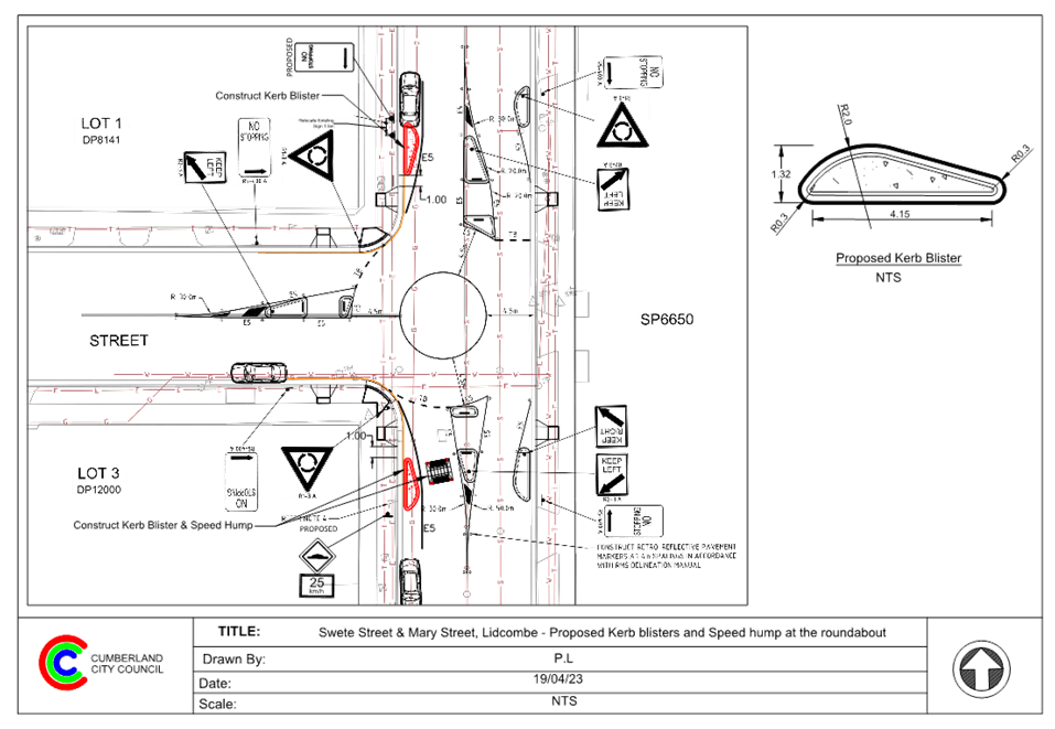
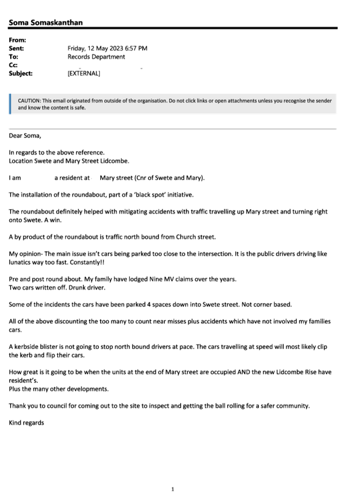
CTC-23-094 |
Swete Street and Mary Street, Lidcombe - Proposed Treatment at Roundabout |
|
|
|
´ |
|
´ |
|
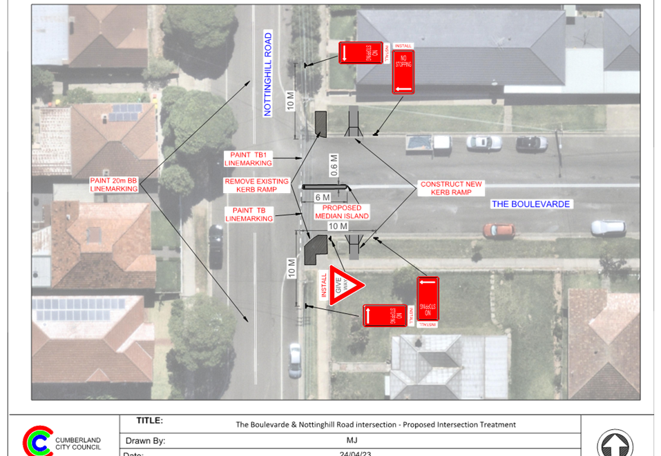
CTC-23-095 |
Nottinghill Road and The Boulevard, Lidcombe - Proposed 'No Stopping' Restrictions and Linemarkings |
|
|
|
´ |
|
´ |
|
CTC-23-096 |
King Street, Guildford West - Road Safety Concerns |
|
´ |
|
|
´ |
|
|
CTC-23-097 |
Leigh Street, Merrylands - Road Safety Concerns |
|
´ |
|
|
´ |
|
|
CTC-23-098 |
Matthew Street, Merrylands - Road Safety Concerns |
|
´ |
|
|
´ |
|
|
CTC-23-099 |
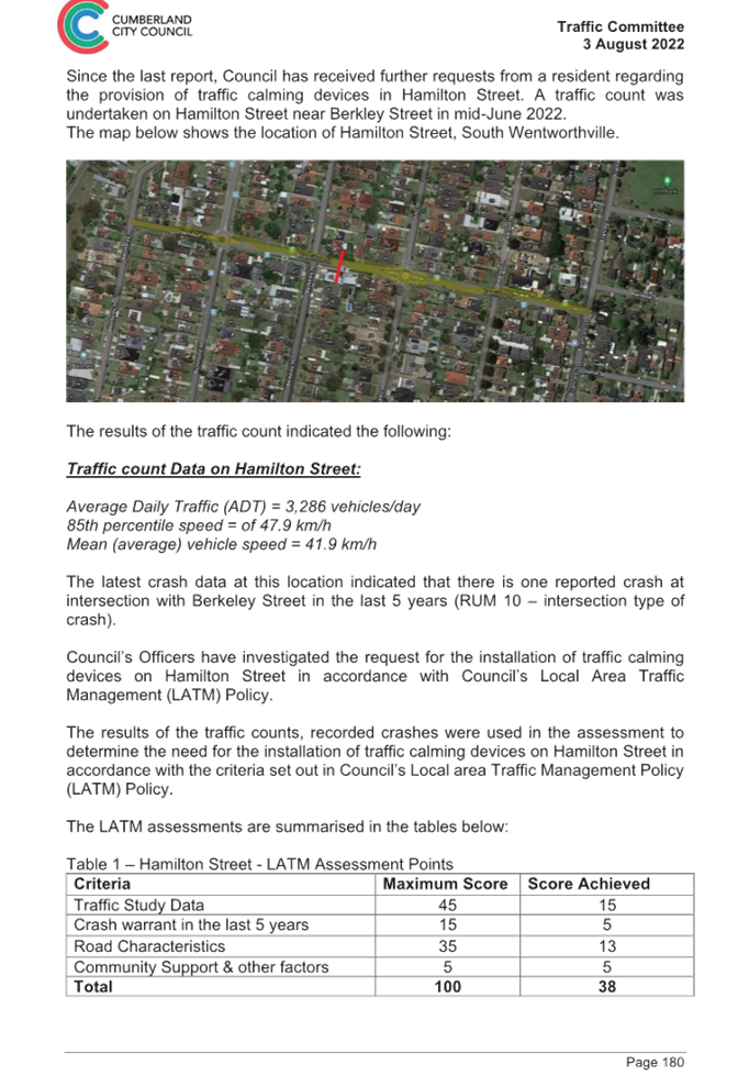
Hamilton Street, South Wentworthville - Road Safety Concerns |
|
´ |
|
|
´ |
|
|
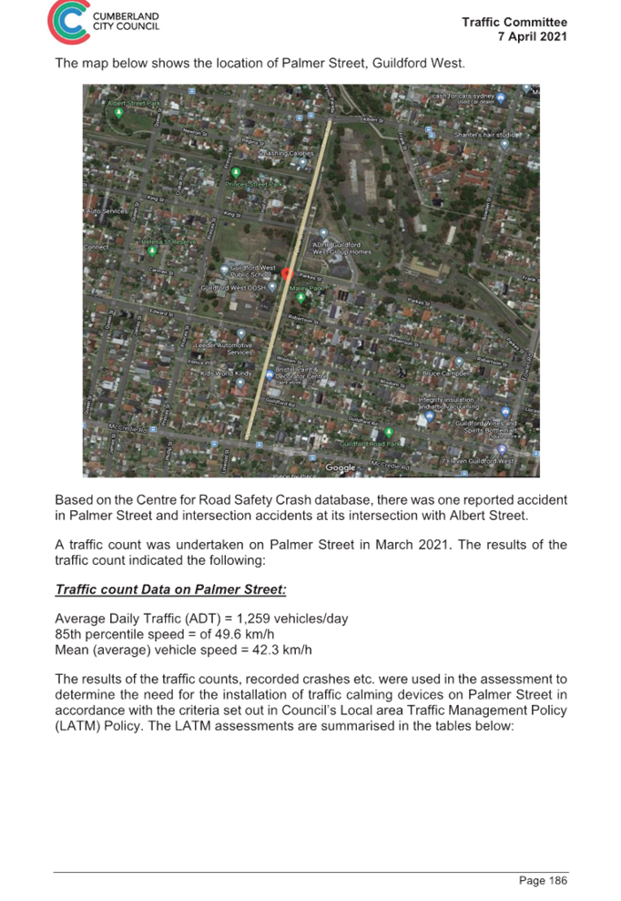
CTC-23-100 |
Palmer Street, Guildford West - Road Safety Concerns |
|
´ |
|
|
´ |
|
|
CTC-23-101 |
Harris Street, Merrylands - Road Safety Concerns |
|
´ |
|
|
´ |
|
|
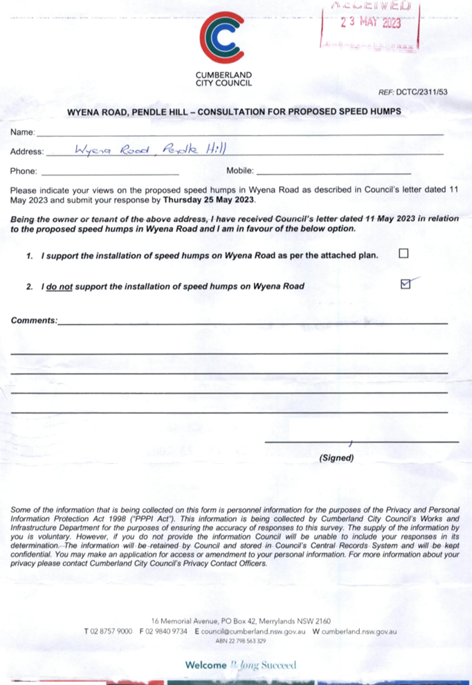
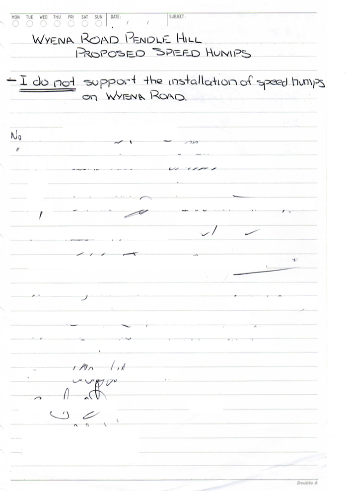
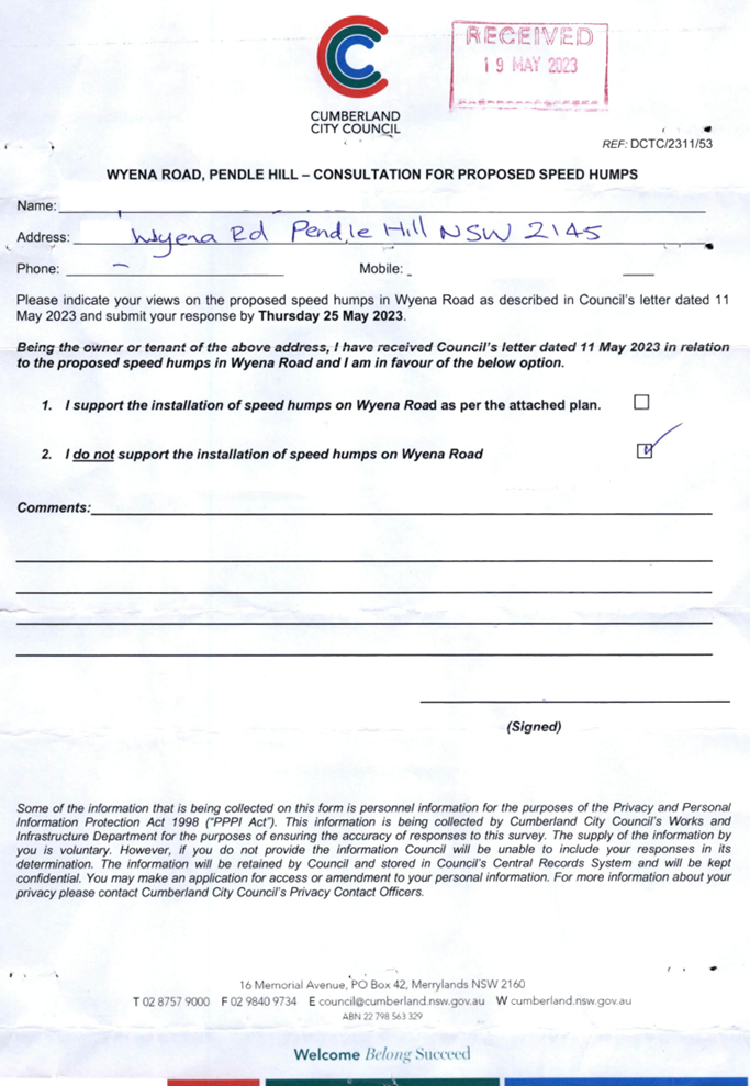
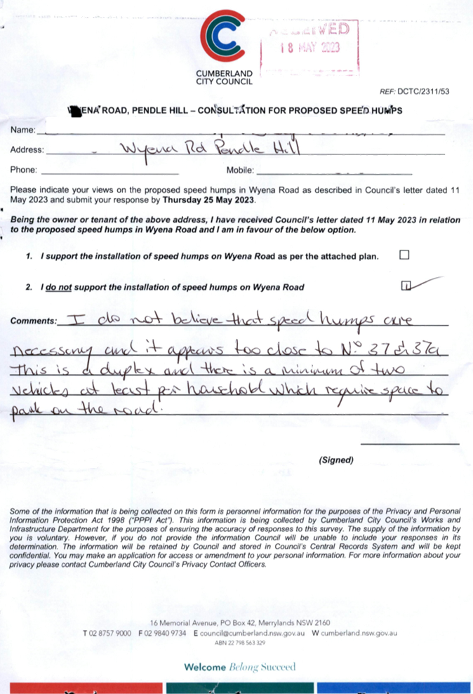
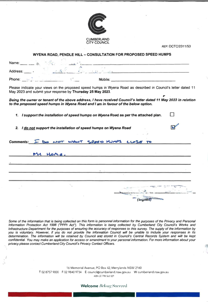
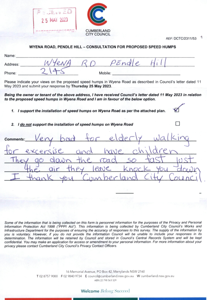
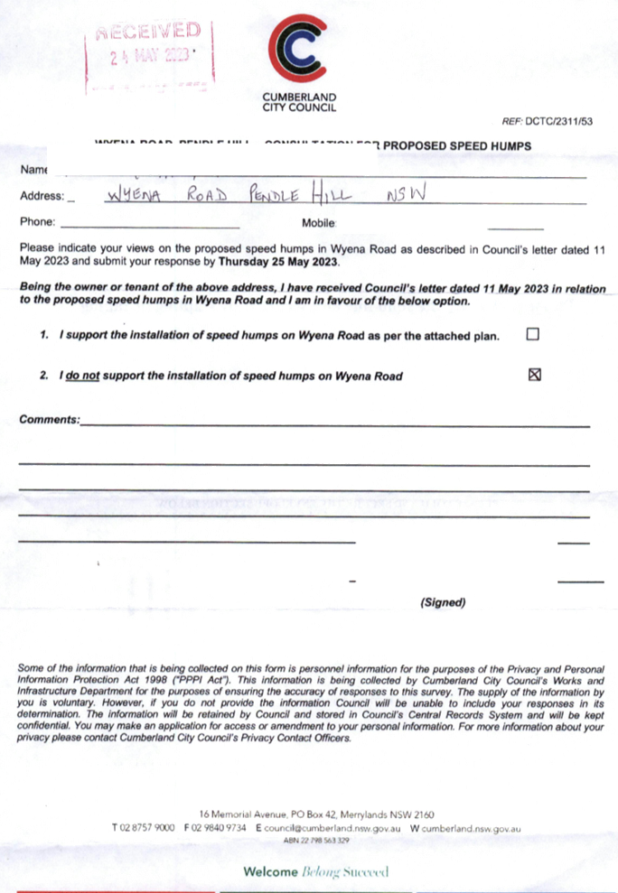
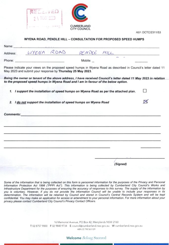
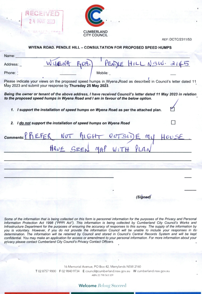
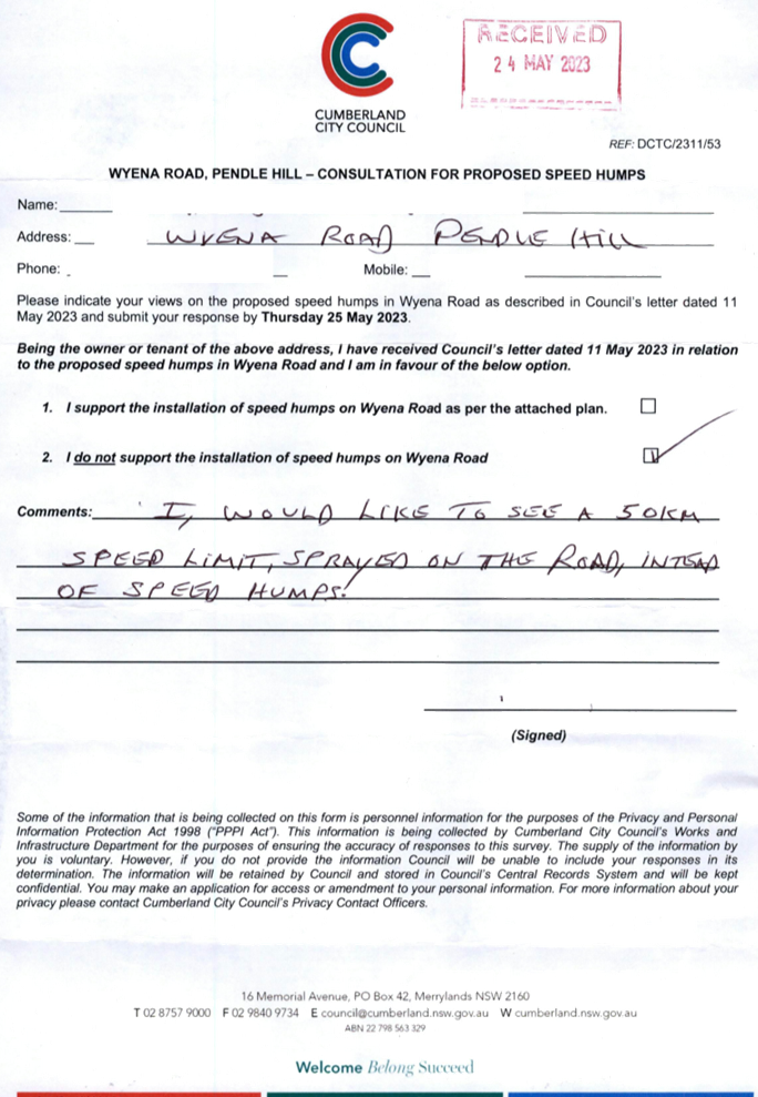
CTC-23-102 |
Wyena Road, Pendle Hill - Road Safety Concerns - Consultation |
|
|
´ |
|
´ |
|
|
CTC-23-103 |
Dorothy Street, Chester Hill - Road Safety Concerns |
|
´ |
|
|
´ |
|
|
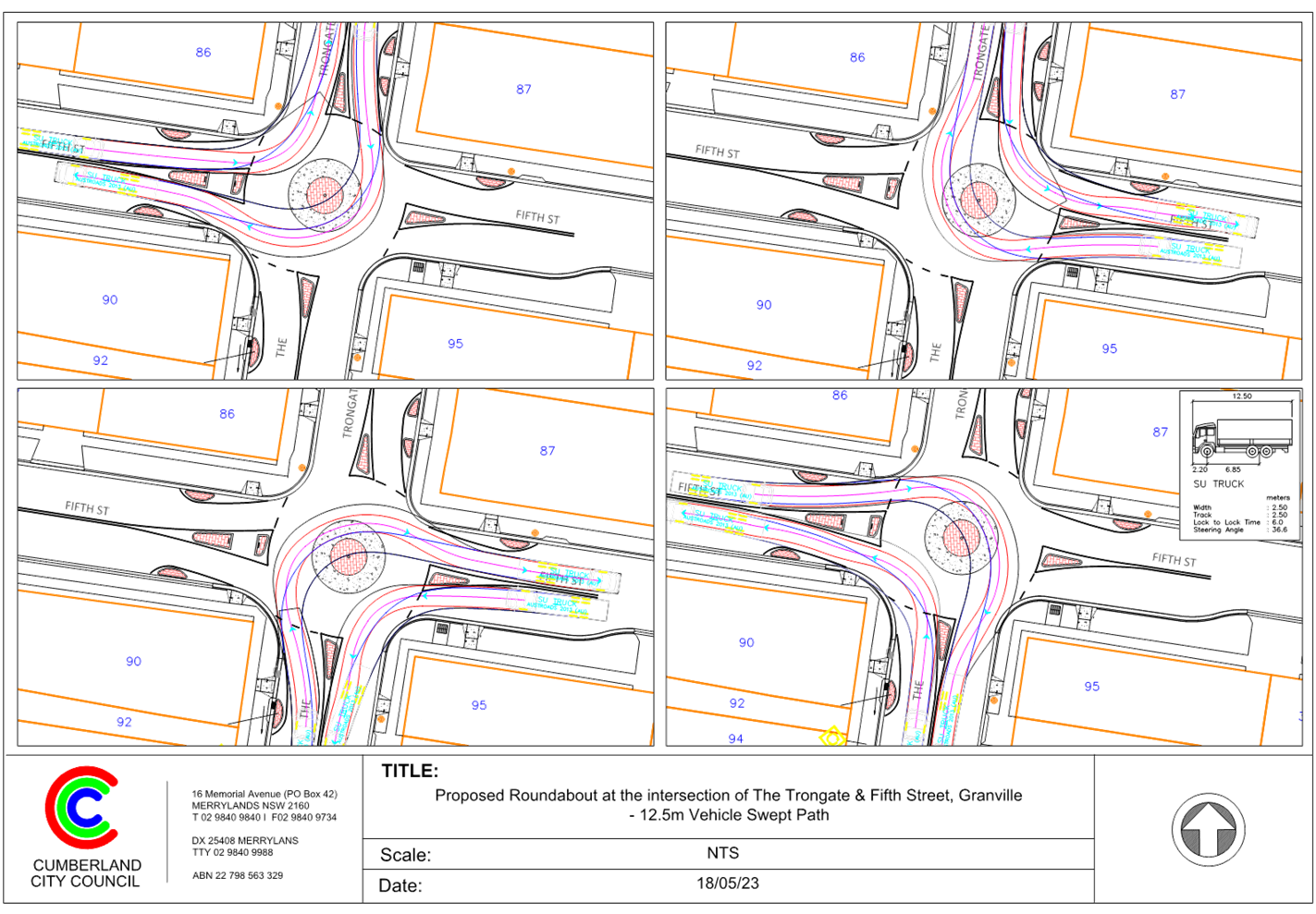
CTC-23-104 |
The Trongate and Fifth Street, Granville - Provision of a Roundabout |
|
´ |
|
|
|
|
Traffic Committee
7 June 2023
Part 1
Recommended for Approval under Delegated Authority
Traffic Committee
7 June 2023
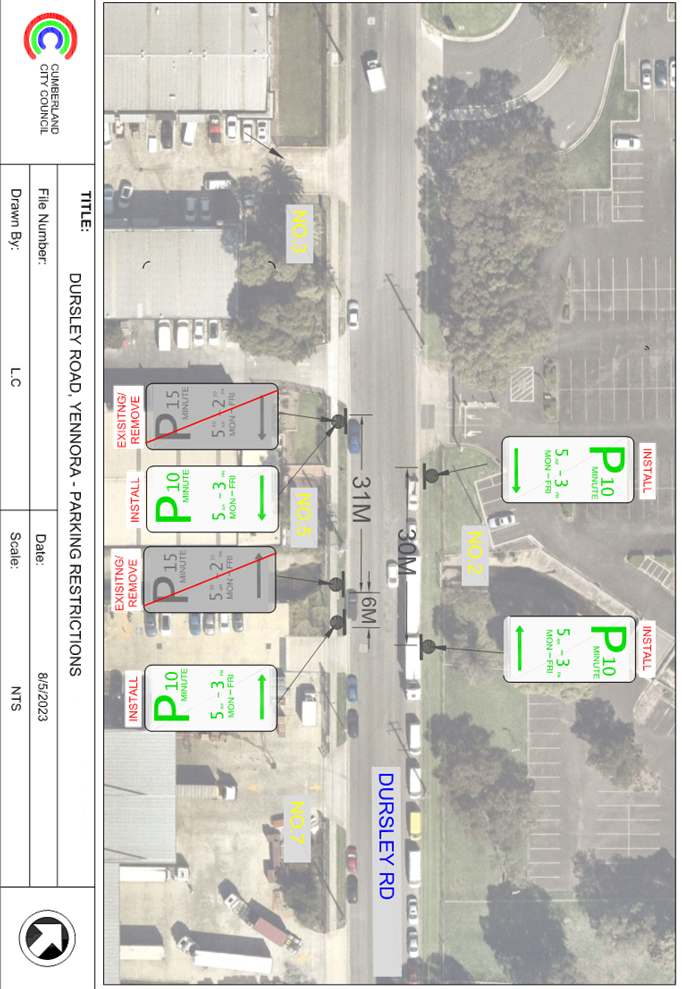
Item No: CTC-23-074
Dursley Road, Yennora - Convert the existing 15 minute Parking to 10 Minute Parking and Installation / Extension of Restricted Parking Spaces
Directorate: Environment and Planning
Responsible Officer: Planning Panels Support Officer
File Number: CTC-23
Electorate: Granville
Police Area Command (PAC): Cumberland
Agenda Part Part 1
Note: Recommended for Approval under Delegated Authority
Summary
Council has received a request from the café owner at 5 Dursley Road, Yennora to convert the existing 15 minute on-street parking spaces on the southern side of Dursley Road, Yennora to 10 minute spaces as well as to extend the timed parking spaces on the eastern and northern side of the business.
This report outlines the outcome of the investigation into this matter.
|
The Traffic Committee recommends that: 1. The conversion and extension of the existing 31m of ‘15-minute, 5am to 2:30pm Mon- Fri’ to 37m long ‘10-minute, 5am to 3pm; Mon – Fri’ on the southern side of Dursley Road as per the attached plan be approved. 2. The installation of 30m long ‘10-minute, 5am to 3pm; Mon – Fri’ on the northern side of Dursley Road, Yennora as per the attached plan be approved. 3. Notify affected/concerned businesses of the outcome. |
Report
Council has received a request from the café owner at 5 Dursley Road, Yennora for the consideration of converting the existing time restricted on-street parking area in front the café as well as further extending the restricted parking spaces to the eastern side. In addition, the business owner has requested the installation of the same timed parking spaces on the northern side of Dursley Road which is the frontage of Woolworths car park.
5 Dursley Road is situated in an industrial area, it is surrounded by warehouses. Currently, there are existing 31 metres long timed on-street parking spaces (15-minute, 5am to 2:30pm, Monday to Friday) located adjacent to No. 5 and No.7’s property frontage on the southern side of Dursley Road. The rest of the street is unrestricted unless otherwise signposted.
The cafe owner (Zesto Café) at 1/5 Dursley Road has requested to consider converting the existing 31 metres time restricted spaces to ‘10-minute, 5am to 3pm Monday to Friday’ and extend the length of the timed parking further east towards No.7’s property frontage to a total of 37 metres (1 net increase on the southern side of Dursley Road). He has also requested the installation of a new 30 metres timed parking spaces with the same restriction ‘10-minute, 5am to 3pm Monday to Friday’ on the northern side of Dursley Road located outside the property frontage of No.2.
Accompanied with this proposal the owner has submitted two letters from the managing agent of No. 5 and the owner of No.7. Both letters supported the proposed conversion of the existing ‘15 minute, 5am to 2:30pm, Monday to Friday’ on-street parking spaces to ‘10 minute, 5am to 3pm Monday to Friday’ and the further installation/extension of the parking spaces to the east of 5 Dursley Road. The café owner also forwarded an email from the managing company of the property / car park on the opposite side supporting the proposal.
Council has undertaken consultation with the adjacent and affected business owners. There were no responses received during the consultation period, therefore, to improve the parking turn over at this location, it is proposed to convert the existing timed parking to ’10-minute, 5am to 3pm Monday to Friday’ and install/extend the timed parking further east as per the attached plan. In addition, it is also proposed to install timed parking in a 30 metre section on the northern side of Dursley Road outside the Woolworths carpark.
COnsultation
The proposal was notified to the impacted and adjacent residents/ owners for a period of 14 days starting from 11 May 2023 to 25 May 2023.
No response was received for this proposal.
Attachments
2. Plan – Proposed Parking Restriction Changes and Extension.
DOCUMENTS
ASSOCIATED WITH
REPORT CTC-23-074
Attachment 1
Redacted Submissions
Attachment 2
Plan – Proposed Parking Restriction Changes and Extension.
Traffic Committee
7 June 2023
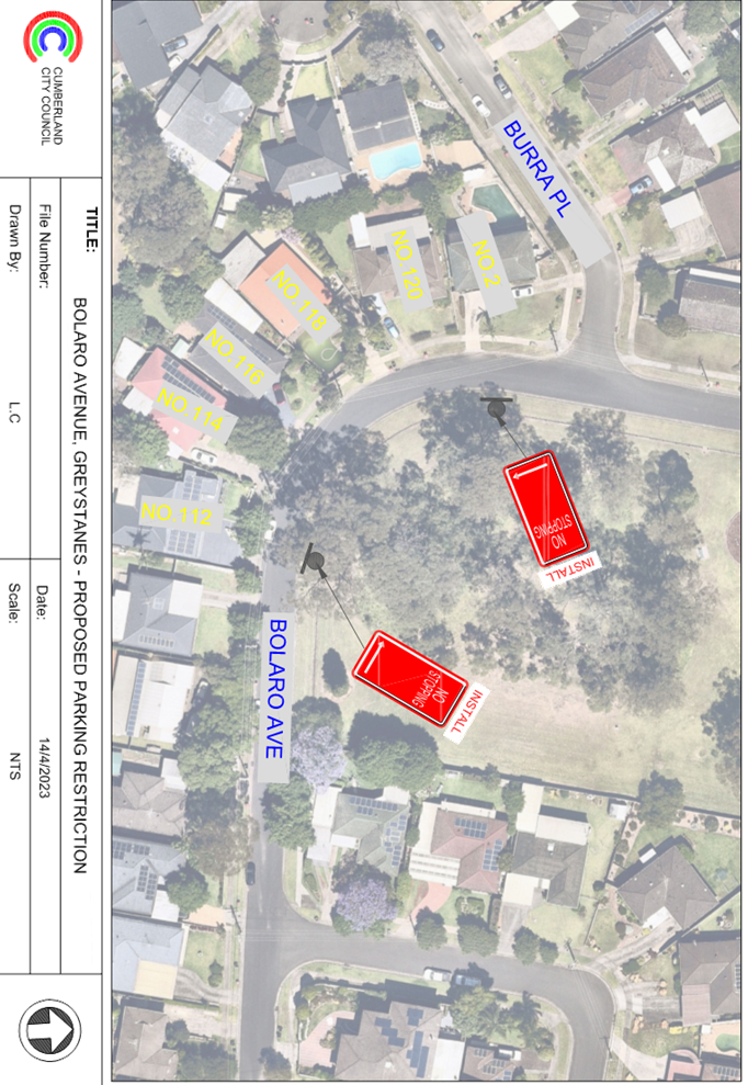
Item No: CTC-23-075
Bolaro Avenue, Greystanes - Proposed 'no stopping' Restrictions
Directorate: Environment and Planning
Responsible Officer: Executive Manager Development and Building
File Number: T-28-01/06
Electorate: Prospect
Police Area Command (PAC): Cumberland
Agenda Part Part 1
Note: Recommended for Approval under Delegated Authority
Summary
Council has received safety concerns from a resident of Bolaro Avenue, Greystanes near the bend opposite No.118.
This report outlines the outcome of the investigation into this matter.
|
The Traffic Committee recommends that: 1. The installation of ‘No Stopping’ signs on the eastern side of Bolaro Avenue, Greystanes at the bend in accordance with the attached plan be approved. 2. The adjacent residents be notified of the outcome. |
Report
Bolaro Avenue is a local road that runs in east-west and north-south directions between Birriwa Street and Taylor Street with a speed limit of 50 km/h. It has a width of approximately 7m and parking is permitted on both sides of the road in accordance with Road Rules unless otherwise signposted.
Bolaro Avenue has a 90-degree bend near No.118 with unrestricted parking on both sides of the road. Bolaro Avenue reserve is located on the eastern and northern side of Bolaro Avenue at the bend. Currently, there is no line marking existing at the bend. It is alleged by the resident that motorists often travel onto the wrong side of the road when negotiating the bend.
The map below shows the area:
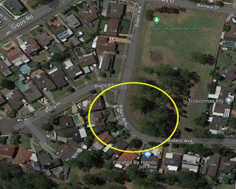
The latest Centre for Road Safety accident data indicated that there was one reported accident in the 5 years ending September 2022. The accident was in relation to the curved road alignment, it has the ‘road user movement’ (RUM) description of ‘Off carriageway into object/parked vehicles (RUM code 85).
A site inspection indicated that vehicles are parking on the eastern side of the bend. In order to improve safety and reduce the risk of a head on-collision, it is proposed to install ‘No Stopping’ signs on the eastern side of the bend as per attached plan.
COnsultation
The proposal was notified to the impacted and adjacent residents for a period of 14 days starting from 24 April 2023 to 8 May 2023.
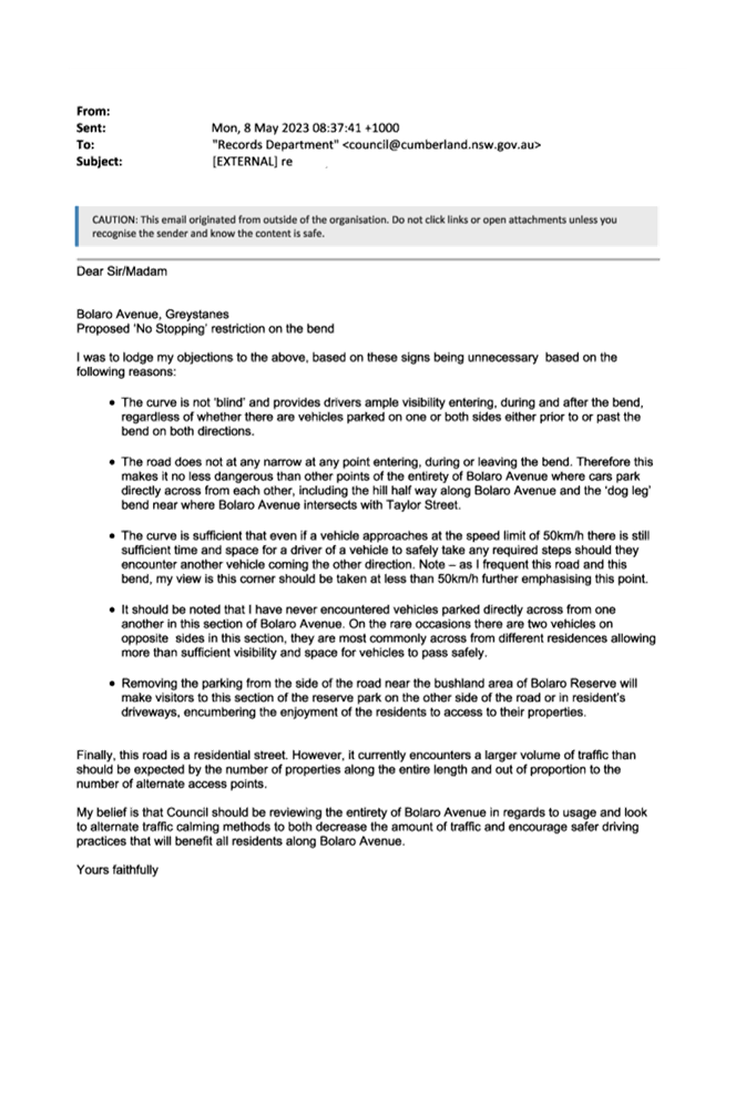
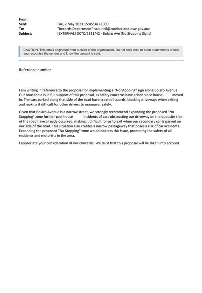
Council received two responses from the residents with one supported the proposal and one objected due to the loss of on-street parking space opposite to the property.
The street is situated in a low-density residential area. On-street parking is available in Bolaro Avenue. The installation of proposed ‘No Stopping’ on the eastern side of the 90-degree bend would improve the sight distance for the cars approaching the bend and avoid potential head-on collisions at this location.
Attachments
1. Plan - Bolaro Avenue, Greystanes - Proposed 'No stopping' restriction at the bend
DOCUMENTS
ASSOCIATED WITH
REPORT CTC-23-075
Attachment 1
Plan - Bolaro Avenue, Greystanes - Proposed 'No stopping' restriction at the bend
DOCUMENTS
ASSOCIATED WITH
REPORT CTC-23-075
Attachment 2
Redacted Submissions
7 June 2023
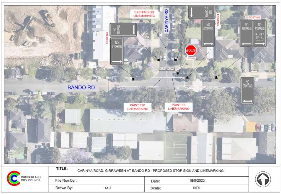
Item No: CTC-23-076
Carinya Road, Girraween - Provision of 'Stop' signage and Line marking
Directorate: Environment and Planning
Responsible Officer: Executive Manager Development and Building
File Number: T-28-01/06
Electorate: Prospect
Police Area Command (PAC): Cumberland
Agenda Part Part 1
Note: Recommended for Approval under Delegated Authority
Summary
Council has received safety concerns from the school community of Girraween Public School regarding the intersection of Carinya Road and Bando Road, Girraween.
This report outlines the outcome of the investigation into this matter.
|
The Traffic Committee recommends that: 1. The proposed ‘Stop’ sign and line marking on Carinya Road at Bando Road in accordance with the attached plan be approved. 2. Council notify Girraween Public School of the outcome. |
Report
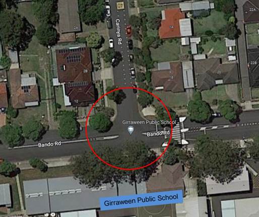
Cumberland Traffic Committee (CTC) at its meeting in April 2023 considered a report (vide Item No. CTC-23-072) regarding the provision of a pedestrian fence on the southern side of Bando Road opposite Carinya Road, Girraween. Council resolved to install the pedestrian fence and investigate the provision of a ‘Stop’ sign and line marking on Carinya Road at the intersection and report back to Traffic Committee in June 2023.
Carinya Road is a local road that runs in a north - south direction between Oramzi Road and Bando Road. It is approximately 390m long and 10.5m wide.
Bando Road is a local road that runs in an east – west direction between Tungarra Road and Targo Road. The road is approximately 270m long and 12.5m wide.
Both streets have a default speed of 50km/h, with the 40km/h school zone area during school operating hours. On-street parking is permitted on both sides of the roads unless otherwise signposted.
Carinya Road and Bando Road form a T- intersection with priority to Bando Road. The intersection has existing ‘No Stopping’ signs on all corners. There is also a raised pedestrian crossing on Bando Road east of Carinya Road.
Girraween Public School is located on Bando Road opposite Carinya Road.
The map below shows the intersection:
The latest Centre for Road Safety accident data indicated that there were no reported accidents at this intersection in the 5 years ending September 2022.
According to Australian Standards, the sight distance required for motorists turning left or right from Carinya Road into Bando Road is sufficient if they are stopped at the intersection. However, vehicles approaching the intersection without coming to a full halt may not have sufficient sight distance to react to approaching vehicles or pedestrians on the pedestrian crossing located approximately 10m east of the intersection.
Following a review of the intersection safety, considering the high pedestrian activities, particularly the use by school children during school hours at the pedestrian crossing and the presence of Girraween Public School, it is proposed to provide ‘Stop’ control including line marking in accordance with the attached plan.
The Stop control at this intersection will enhance safety for all road users at this location.
COnsultation
Consultation was not undertaken as no residents will be impacted by the proposed ‘Stop’ sign and linemarking.
Attachments
1. Plan - Carinya Road, Girraween - Proposed Stop Signage and landmarking
DOCUMENTS
ASSOCIATED WITH
REPORT CTC-23-076
Attachment 1
Plan - Carinya Road, Girraween - Proposed Stop Signage and landmarking
Traffic Committee
7 June 2023
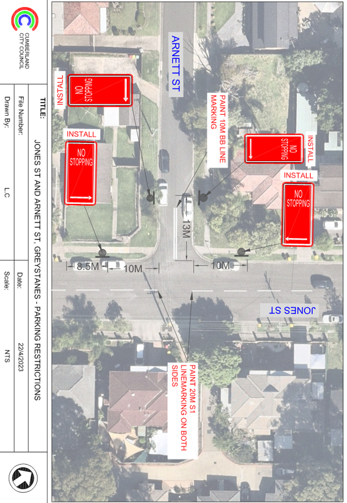
Item No: CTC-23-077
Jones Street and Arnett Street, Pendle Hill - Proposed 'No stopping' Restrictions and Line Markings
Directorate: Environment and Planning
Responsible Officer: Executive Manager Development and Building
File Number: T-28-01/06
Electorate: Prospect
Police Area Command (PAC): Cumberland
Agenda Part Part 1
Note: Recommended for Approval under Delegated Authority
Summary
Council has received safety concerns from a resident at the intersection of Jones Street and Arnett Street, Pendle Hill.
This report outlines the outcome of the investigation into this matter.
|
The Traffic Committee recommends that: 1. The installation of ‘No Stopping’ signs and line marking at the intersection of Jones Street and Arnett Street, Pendle Hill in accordance with the attached plan be approved. 2. The affected /concerned residents be notified of the outcome. |
Report
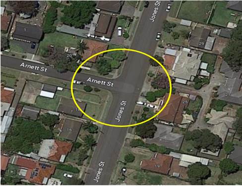
Arnett Street is a local road that runs in an east-west direction with a speed limit of 50 km/h. It has a width of approximately 7m and parking is permitted on both sides of the road in accordance with the Road Rules unless otherwise signposted.
Jones Street is a local road that runs in a north-south direction with a speed limit of 50 km/h. It has a width of approximately 12.5m and parking is permitted on both sides of the road unless otherwise signposted.
Arnett Street and Jones Street form a T-intersection with priority to Jones Street.
The map below shows the intersection.
The latest Centre for Road Safety accident data indicated that there were no reported accidents at this intersection in the 5 years ending September 2022.
A site inspection indicated that vehicles are parking within 10 metres at the intersection.
The installation of ‘No Stopping’ signs, ‘S1’ and ‘BB’ line marking at this location would strengthen the Road Rules requirements and improve safety at the intersection.
The ‘No Stopping’ signs are proposed to be installed on both sides of Arnett Street at 13m to allow vehicles to safely pass a parked car without encroaching the proposed ‘BB’ line marking.
Therefore, it is proposed to install ‘No Stopping’ signs and line marking at the intersection of Jones Street and Annett Street as per the attached plan.
COnsultation
The proposal was notified to the impacted and adjacent residents for a period of 14 days starting from 28 April 2023 to 12 May 2023.
No response was received for this proposal.
Attachments
1. Plan - Jones Street, Greystanes - Proposed 'No Stopping' Restrictions and line marking at the intersection
DOCUMENTS
ASSOCIATED WITH
REPORT CTC-23-077
Attachment 1
Plan - Jones Street, Greystanes - Proposed 'No Stopping' Restrictions and line marking at the intersection
Traffic Committee
7 June 2023
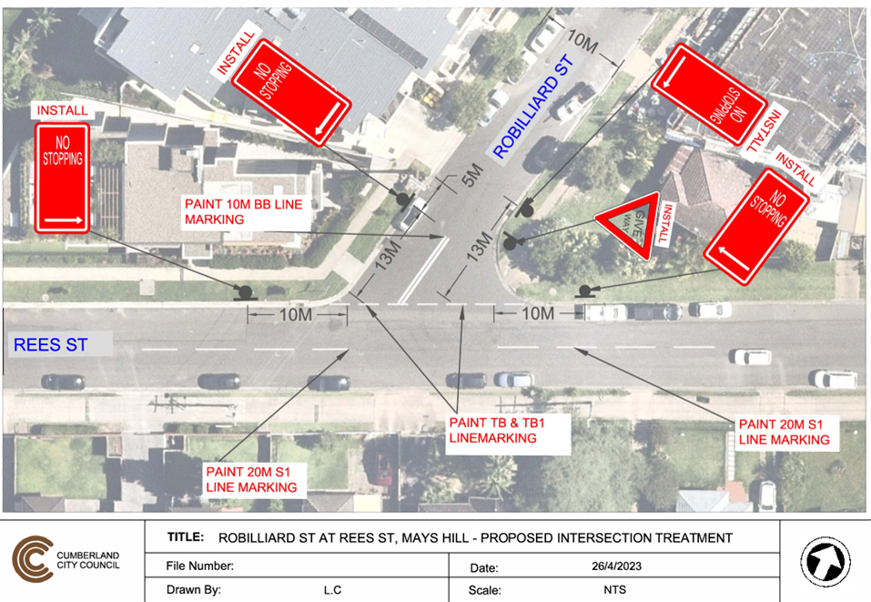
Item No: CTC-23-078
Robilliard Street and Rees Street, Mays Hill - Proposed Intersection Treatment
Directorate: Environment and Planning
Responsible Officer: Executive Manager Development and Building
File Number: T-28-01/06
Electorate: Granville
Police Area Command (PAC): Cumberland
Agenda Part Part 1
Note: Recommended for Approval under Delegated Authority
Summary
Council has received safety concerns from a resident at the intersection of Robilliard Street and Rees Street, Mays Hill.
This report outlines the outcome of the investigation into this matter.
|
The Traffic Committee recommends that: 1. The installation of a ‘Give way’ sign with associated line marking in Robilliard Street at the intersection of Rees Street, Mays Hill in accordance with the attached plan be approved. 2. The installation of ‘No Stopping’ signs at the intersection of Robilliard Street and Rees Street, Mays Hill in accordance with the attached plan be approved. 3. The affected /concerned residents be notified of the outcome. |
Report
Rees Street is a local road that runs in an east-west direction with a speed limit of 50km/h. It has a width of approximately 10m and parking is permitted on both sides of the road in accordance with Road Rules unless otherwise signposted.
Freame Park has access on Rees Street and site observations indicated that the park is well used by residents and the on-street parking in Rees Street is heavily used at times.
Robilliard Street is a local road that runs in a north-south direction with a speed limit of 50 km/h. It has a width of approximately 10m and parking is permitted on both sides of the road in accordance with Road Rules unless otherwise signposted.
Rees Street and Robilliard Street form a Y-intersection with priority to Rees Street.
The map below shows the intersection.
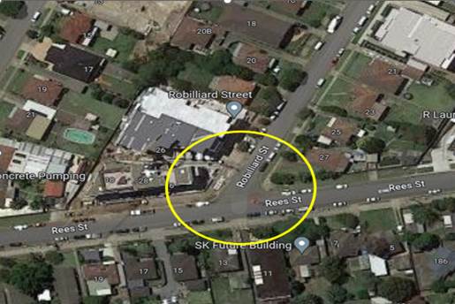
The latest Centre for Road Safety accident data indicated that there was one reported accident relating to a vehicle losing control and crashing into an object at this intersection in the 5 years ending September 2022.
It is considered that the installation of ‘Give Way’ control and ‘No Stopping’ signs at the intersection would strengthen the intersection priority and the Road Rules.
Based on Australian Standard AS 1742.2-2009 – Part 2: Traffic Control Devices for General Use, controls are required at all non-signalised intersections in the following manner:
a) GIVE WAY signs shall be provided at all intersections with four or more legs.
b) GIVE WAY signs shall be provided at any three-way intersections where the layout is such that it is not clear how or whether the T-intersection rule would operate, for example, at a Y-intersection.
c) GIVE WAY signs should be used for road safety reasons at unsignalised T-intersections where the continuing road (i.e., the bar of the T) is an arterial or sub-arterial road, urban or rural.
In order to maintain safety and reduce the risk of a collision at the intersection of Robilliard Street and Rees Street, it is proposed that ‘Give Way’ and ‘No Stopping’ signage and associated line marking be provided at the intersection in accordance with the attached plan. It is also proposed to install 10m ‘BB’ centre line marking in Robilliard Street and ‘S1’ centre line marking in Rees Street.
The ‘No Stopping’ signs in Robilliard Street are installed at 13m to allow for vehicles to pass a parked vehicle safely without crossing the ‘BB’ centre line.
COnsultation
The proposal was notified to the impacted and adjacent residents for a period of 14 days starting from 28 April 2023 to 12 May 2023.
No response was received for this proposal.
Attachments
1. Plan – Robilliard Street, Mays Hill – Proposed Intersection Treatment
DOCUMENTS
ASSOCIATED WITH
REPORT CTC-23-078
Attachment 1
Plan – Robilliard Street, Mays Hill – Proposed Intersection Treatment
Traffic Committee
7 June 2023
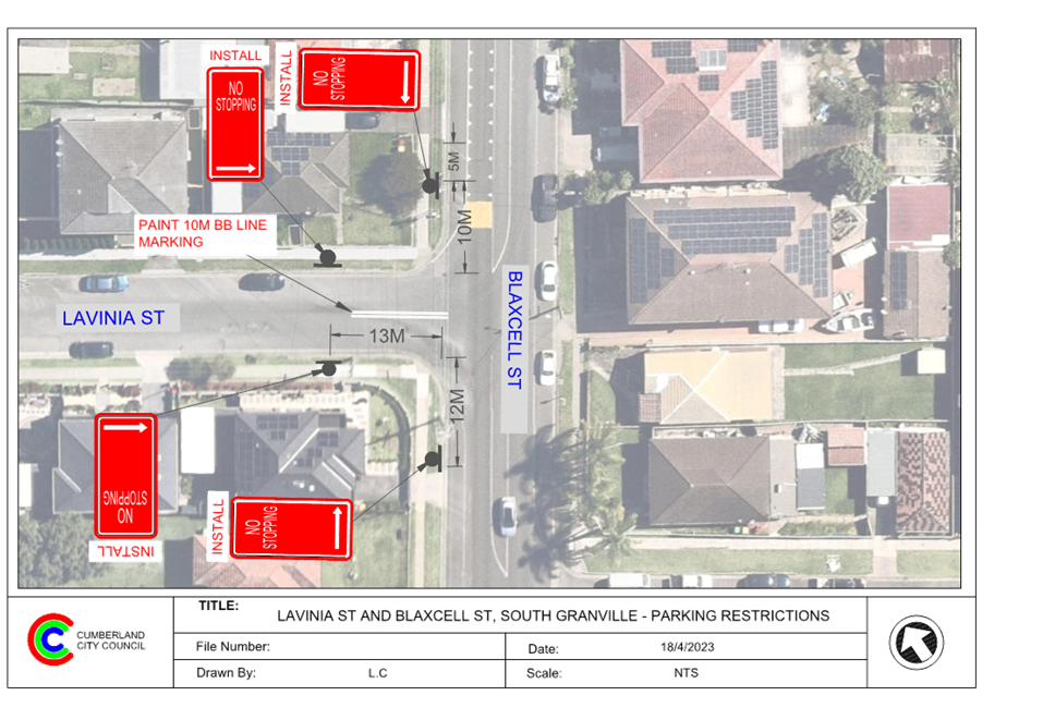
Item No: CTC-23-079
Lavinia Street and Blaxcell Street, South Granville - Proposed 'no stopping' signs and Linemarkings
Directorate: Environment and Planning
Responsible Officer: Executive Manager Development and Building
File Number: T-28-01/06
Electorate: Granville
Police Area Command (PAC): Cumberland
Agenda Part Part 1
Note: Recommended for Approval under Delegated Authority
Summary
Council has received safety concerns from a resident at the intersection of Lavinia Street and Blaxcell Street, South Granville.
This report outlines the outcome of the investigation into this matter.
|
The Traffic Committee recommends that: 1. The installation of ‘No Stopping’ signs and line marking at the intersection of Lavinia Street and Blaxcell Street, South Granville in accordance with the attached plan be approved. 2. The affected /concerned residents be notified of the outcome. |
Report
Lavinia Street is a local road that runs in an east-west direction with a speed limit of 50 km/h. It has a width of approximately 9m and parking is permitted on both sides of the road in accordance with Road Rules unless otherwise signposted.
Blaxcell Street is a local road that runs in a north-south direction with a speed limit of 50 km/h. It has a width of approximately 12.5m and parking is permitted on both sides of the road unless otherwise signposted. Blaxcell Street has a painted median island and edge lines marked.
Lavinia Street and Blaxcell Street form a T-intersection with priority to Blaxcell Street.
The map below shows the intersection.
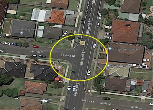
The latest Centre for Road Safety accident data indicated that there were no reported accidents at this intersection in the 5 years ending September 2022.
A site inspection indicated that vehicles are parking within 10 metres at the intersection.
The installation of ‘No Stopping’ signs and BB line marking on Lavinia Street would strengthen the Road Rules requirements and improve safety at the intersection.
The ‘No Stopping’ signs are proposed to be installed on both sides of Lavinia Street at 13m to allow vehicles to safely pass a parked car without encroaching the proposed ‘BB’ line marking.
It is proposed to install the ‘No Stopping’ signs and line marking at the intersection of Lavinia Street and Blaxcell Street, South Granville in accordance with the attached plan.
COnsultation
The proposal was notified to the impacted and adjacent residents for a period of 14 days starting from 27 April 2023 to 11 May 2023. No response was received for this proposal.
Attachments
1. Plan – Lavinia Street and Blaxcell Street, South Granville – Proposed 'No Stopping' signs and line marking
DOCUMENTS
ASSOCIATED WITH
REPORT CTC-23-079
Attachment 1
Plan – Lavinia Street and Blaxcell Street, South Granville – Proposed 'No Stopping' signs and line marking
Traffic Committee
7 June 2023
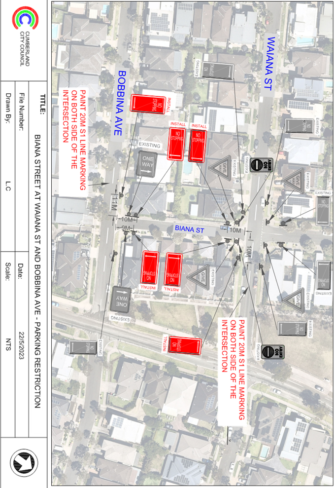
Item No: CTC-23-080
Biana Street at Waiana Street and Bobbina Avenue, Pemulwuy - Proposed 'No stopping' restrictions and Line Markings
Directorate: Environment and Planning
Responsible Officer: Executive Manager Development and Building
File Number: T-28-01/06
Electorate: Prospect
Police Area Command (PAC): Cumberland
Agenda Part Part 1
Note: Recommended for Approval under Delegated Authority
Summary
Council has received safety concerns from a resident on Biana Street at the intersection of Waiana Street and Bobbina Avenue, Pemulwuy.
This report outlines the outcome of the investigation into this matter.
|
The Traffic Committee recommends that: 1. The installation of ‘No Stopping’ signs at the intersections of Biana Street with Waiana Street and Bobbina Avenue, Pemulwuy in accordance with the attached plan be approved. 2. The installation of S1 centre line marking on Waiana Street and Bobbina Avenue in accordance with the attached plan be approved. 3. The affected/concerned residents be notified of the outcome.
|
Report
Biana Street, Pemulwuy is a local road that runs in a north - south direction. The section of interest is the one-way (northbound travel direction) section between Waiana Street and Bobbina Avenue. This section of Biana Street has a speed limit of 50 km/h and a width of approximately 5.5m. Parking is permitted in the street in accordance with the Road Rules unless otherwise signposted.
Waiana Street and Bobbina Avenue are two local roads parallel to each other and run in east – west directions. Both streets have a width of approximately 7.2m and a speed limit of 50 km/h. Parking is permitted on both sides of the road in accordance with the Road Rules unless otherwise signposted.
Waiana Street and Biana Street form a four-way intersection with existing ‘Give way’ controls in place. Bobbina Avenue and Biana Street form a T-intersection with priority to Bobbina Avenue.
The map below shows the two intersections:
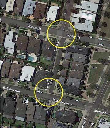
Figure 1 – Locality Plan
The latest Centre for Road Safety accident data indicated that there were no reported accidents at these two intersections in the 5 years ending September 2022.
It was alleged that vehicles are parking within 10 metres at the intersections. The installation of ‘No Stopping’ signs at the intersections would strengthen the Road Rules requirements and prevent vehicles parking too close to both intersections. Also, it is proposed to install and ‘S1’ centre line markings on Waiana Street and Bobbina Avenue to assist vehicles to travel on the left side of the centre line while at the intersection.
It is also proposed to install ‘No Stopping’ signs and ‘S1’ centre line markings at the intersections of Biana Street with Waiana Street and Bobbina Avenue as per the attached plan.
COnsultation
The proposal was notified to the impacted and adjacent residents for a period of 14 days starting from 15 February 2023 to 1 March 2023. No responses were received for this proposal.
Attachments
1. Plan – Biana Street, Waiana Street and Bobbina Avenue, Pemulwuy – Proposed ‘No Stopping’ restrictions and ‘S1’ line markings at the intersections
DOCUMENTS
ASSOCIATED WITH
REPORT CTC-23-080
Attachment 1
Plan – Biana Street, Waiana Street and Bobbina Avenue, Pemulwuy – Proposed ‘No Stopping’ restrictions and ‘S1’ line markings at the intersections
Traffic Committee
7 June 2023
Item No: CTC-23-081
Percival Road, Smithfield - Proposed Extension of existing 'no stopping' Restrictions
Directorate: Environment and Planning
Responsible Officer: Executive Manager Development and Building
File Number: T-28-01/06
Electorate: Prospect
Police Area Command (PAC): Cumberland
Agenda Part Part 1
Note: Recommended for Approval under Delegated Authority
Summary
Council has received a concern from the Transit Systems Transport Operator regarding bus access at their depot located at 49 - 57 Percival Road, Smithfield.
This report outlines the outcome of the investigation into this matter.
|
The Traffic Committee recommends that: 1. The relocation of the existing ‘No Stopping’ sign on the northern side of the driveway of 49-57 Percival Road, Smithfield by 13m in a northerly direction in accordance with the attached plan be approved. 2. The affected /concerned businesses be notified of the outcome. |
Report
Percival Road is a local road that runs in a north-south direction with a speed limit of 50 km/h. It has a width of approximately 12.5m and parking is permitted on both sides of the road unless otherwise signposted.
Transit Systems has a bus depot located at No. 49-57 Percival Road, it has its driveway positioned on Percival Road and is frequently used by buses entering and exiting the depot for daily operational purposes. Currently ‘No Stopping’ restrictions exist on both sides of the driveway; the sign north of the driveway is very close to the driveway.
The map below shows the driveway of No. 49-57.
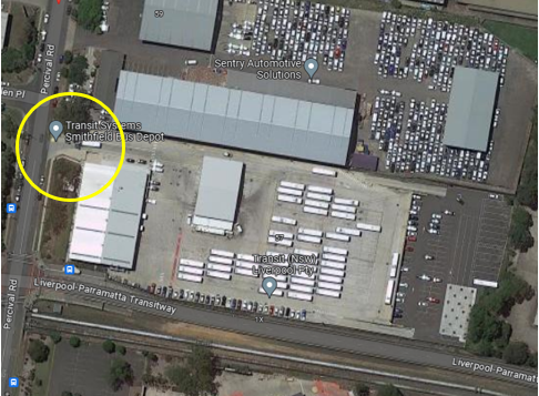
Figure 1 – Locality Plan
Transit Systems has alleged that due to vehicles particularly large trucks parking too close to their driveway on the northern side, buses are not able to safely enter or exit the above site. Therefore, Transit Systems has requested the relocation of the existing ‘No Stopping’ sign on the northern side of the driveway further north to improve safety at the driveway. The sign is proposed to be relocated by 13m.
COnsultation
The proposal was notified to the impacted and adjacent business owners for a period of 14 days starting from 5 May 2023 to 19 May 2023.
There was no response received from the business owners.
Attachments
1. Plan - Pervical Road, Smithfield - Proposed 'No Stopping' restriction near No.49-57
DOCUMENTS
ASSOCIATED WITH
REPORT CTC-23-081
Attachment 1
Plan - Pervical Road, Smithfield - Proposed 'No Stopping' restriction near No.49-57
Traffic Committee
7 June 2023
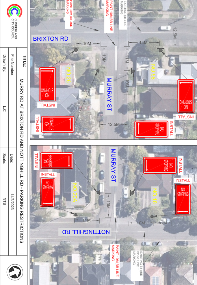
Item No: CTC-23-082
Murray Street at Nottinghill Road and Brixton Road, Lidcombe - Proposed 'No Stopping' Restrictions and Line Markings
Directorate: Environment and Planning
Responsible Officer: Executive Manager Development and Building
File Number: T-28-01/06
Electorate: Auburn
Police Area Command (PAC): Auburn
Agenda Part Part 1
Note: Recommended for Approval under Delegated Authority
Summary
Council has received safety concerns from a resident in Murray Street at its intersections with Nottinghill Road and Brixton Road, Lidcombe.
This report outlines the outcome of the investigation into this matter.
|
The Traffic Committee recommends that: 1. The installation of ‘No Stopping’ signs and line markings in Murray Street at its intersections with Nottinghill Road and Brixton Road, Lidcombe in accordance with the attached plan be approved. 2. The affected/concerned residents be notified of the outcome. |
Report
Murray Street is a local road that runs in an east-west direction between Brixton Road and Nottinghill Road. Murray Street has a speed limit of 50 km/h and a width of approximately 12.5m. Parking is permitted on both sides of the road unless otherwise signposted.
Brixton Road and Nottinghill Road are two local roads that run in the north-south direction, both streets intersect with Murray Street and has a speed limit of 50 km/h. Brixton Road and Nottinghill Road has a width of approximately 12m and parking is permitted on both sides of the road unless otherwise signposted.
Brixton Road forms a T-intersection with Murray Street on its western end with priority to Brixton Road. Nottinghill Road forms another T-intersection with Murray Street on its eastern end with priority to Nottinghill Road.
The map below shows the intersection.
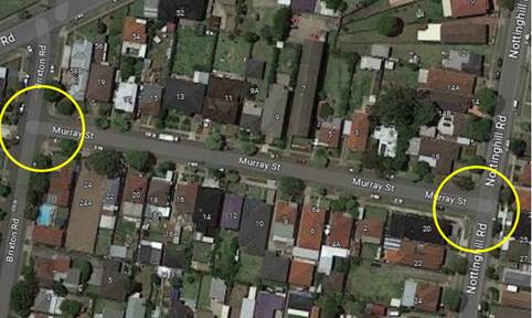
The latest Centre for Road Safety accident data indicated that there were no reported accidents at these intersections in the 5 years ending September 2022.
A site inspection indicated that vehicles are parking within 10 metres at the two intersections. The installation of 10m ‘No Stopping’ signs at both intersections would strengthen the Road Rules requirements, stop vehicles from parking too close to the intersection. The installation of ‘BB’ line markings on Murray Street at both intersections would allow vehicles to entre/exit Murray Street from Brixton Road and Nottinghill Road to stay on the right side of the road.
Therefore, it is proposed to install ‘No Stopping’ signs and line markings as per the attached plan.
COnsultation
The proposal was notified to the impacted and adjacent residents for a period of 14 days starting from 27 March 2023 to 9 April 2023.
Council received one response from a resident. The resident raised concerns of their visitors not able to park on the street and planning issues in the surrounding streets. No direct comments were provided by the resident on the proposed signage and line marking.
Attachments
1. Plan – Murray Street with Brixton Road and Nottinghill Road, Lidcombe – Proposed ‘No Stopping’ restrictions and line markings at the intersection
DOCUMENTS
ASSOCIATED WITH
REPORT CTC-23-082
Attachment 1
Plan – Murray Street with Brixton Road and Nottinghill Road, Lidcombe – Proposed ‘No Stopping’ restrictions and line markings at the intersection
DOCUMENTS
ASSOCIATED WITH
REPORT CTC-23-082
Attachment 2
Submission
Traffic Committee
7 June 2023
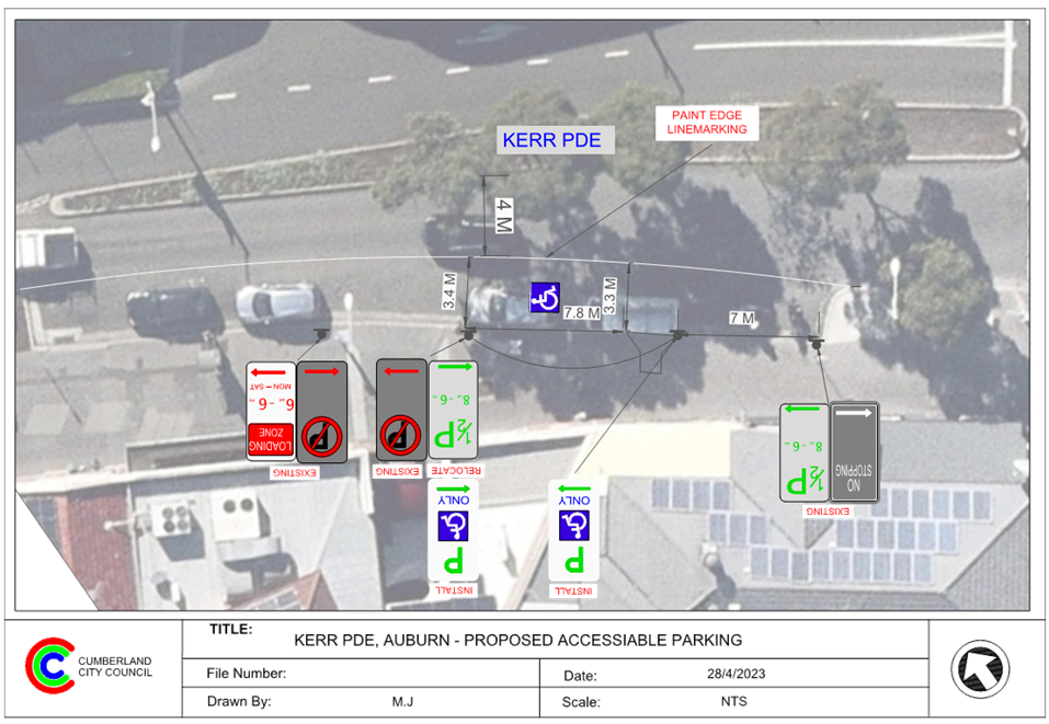
Item No: CTC-23-083
Kerr Parade, Auburn - Request for Accessible Parking
Directorate: Environment and Planning
Responsible Officer: Executive Manager Development and Building
File Number: T-28-01/06
Electorate: Auburn
Police Area Command (PAC): Auburn
Agenda Part Part 1
Note: Recommended for Approval under Delegated Authority
Summary
Council has received a request from a resident for the provision of an accessible parking space in Kerr Parade, Auburn, between Station Road and Auburn Road.
This report outlines the outcome of the investigation into this matter.
|
The Traffic Committee recommends that: 1. The conversion of the existing ‘1/2P 8am-6pm’ on the southern side of Kerr Parade between Station Road and Auburn Road to an accessible parking space in accordance with the attached plan be supported. 2. The affected/concerned residents/businesses be notified of the outcome. |
Report
Council received a request from a resident to convert a section of the existing ‘1/2P 8am-6pm’ on the southern side of Kerr Parade near a medical centre to an accessible parking space.
Kerr Parade between Station Road and Auburn Road is a local road that runs in an east-west direction with a default speed limit of 50km/h. This section of Kerr Parade is approximately 20m wide with a median island to separate the eastbound and westbound traffic. Two traffic lanes with indented parking bays exist on the northern side of the road and one traffic lane with indented parking bays exist on the southern side of the road. Currently 1/2-hour parking restrictions applied on both sides of the road at this section.
Council officers have investigated the matter. There is a Loading Zone provided on the western end of the indented bay ½ hour parking spaces on the eastern end near Station Road traffic signals. It was noted that the existing ½ hour parking spaces on both sides of the street are occupied most of the time. It is difficult for residents with disabilities to find a parking space near the medical centre at this section of Kerr Parade.
The map below shows the intersection.
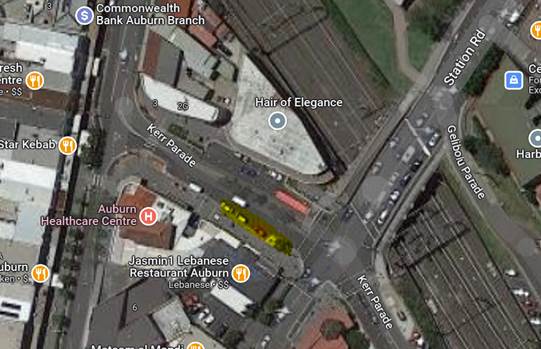
In order to improve the parking availability for residents with disabilities, it is proposed to convert a section of the existing 1/2-hour parking restrictions to an accessible parking space in accordance with the attached plan.
COnsultation
The proposal was notified to the impacted and adjacent business owners for a period of 14 days starting from 3 May 2023 to 17 May 2023.
No responses were received.
Attachments
1. Plan – Kerr Parade, Auburn – Convert the existing parking restrictions to an accessible parking space
DOCUMENTS
ASSOCIATED WITH
REPORT CTC-23-083
Attachment 1
Plan – Kerr Parade, Auburn – Convert the existing parking restrictions to an accessible parking space
Traffic Committee
7 June 2023
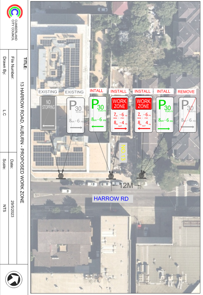
Item No: CTC-23-084
Harrow Road, Auburn - Application for 'Works Zone' signage
Directorate: Environment and Planning
Responsible Officer: Executive Manager Development and Building
File Number: T-28-01/06
Electorate: Auburn
Police Area Command (PAC): Auburn
Agenda Part Part 1
Note: Recommended for Approval under Delegated Authority
Summary
Council has received an application for a ‘Works Zone’ on Harrow Road, Auburn associated with the development at 13 Harrow Road, Auburn.
This report outlines the outcome of the investigation into this matter.
|
That the Cumberland Traffic Committee recommends that: 1. The existing ‘P30, 8am-6pm’ parking restrictions outside the development site of No. 13 Harrow Road, Auburn be replaced with ‘Works Zone, 7:00am-6:00pm, Monday-Friday, 8:00am-4:00pm, Saturday’ restrictions, subject to Council’s standard conditions for a period of 6 months and subsequent extension if required. 2. The applicant be advised to pay the ‘Works Zone’ fees to Council as per the adopted Fees and Charges. |
Report
Council has received an application for a ‘Works Zone’ on Harrow Road, Auburn associated with the development at No.13 Harrow Road, Auburn.
The proposed development involves construction of a commercial building.
The temporary “Works Zone” is approximately 12m in length and proposed to commence in May 2023 for 6 months. The proposed time is between 7:00am to 6:00pm Monday to Friday and 8:00am to 4:00pm on Saturdays.
There will be a loss of two (2) 30 minute parking spaces on the western side of Harrow Road, Auburn, outside the development site during the operation of the Works Zone.
COnsultation
The proposal is outside the property being developed and no consultation is required as the request was made by the builder.
Attachments
1. Plan - Harrow Road, Auburn - Proposed Temporary 'Works Zone' signage
DOCUMENTS
ASSOCIATED WITH
REPORT CTC-23-084
Attachment 1
Plan - Harrow Road, Auburn - Proposed Temporary 'Works Zone' signage
Traffic Committee
7 June 2023
Part 2
Recommendation to Council
Traffic Committee
7 June 2023
Item No: CTC-23-085
Response to Notice of Motion C08/22-121 - Residential Parking in Lidcombe
Directorate: Environment and Planning
Responsible Officer: Executive Manager Development and Building
File Number: T-28-01/06
Electorate: Auburn
Police Area Command (PAC): Auburn
Agenda Part Part 2
Note: Recommendation to Council
Summary
This report provides a response to Council’s Notice of Motion – Residential Parking in Lidcombe, resolved at the Ordinary Meeting of Council on 3 August 2022 (Min.183 C08/22-121).
|
The Traffic Committee recommends that Council: 1. Note the findings from the analysis and consultation on residential car parking in the Lidcombe Town Centre and surrounds. 2. Endorse that a Resident Parking Scheme not proceed in the Lidcombe Town Centre study area, due to non-compliance with criteria in Council’s Residential Parking Scheme Guideline. 3. Endorse that further analysis and consultation be undertaken on the introduction of timed parking in streets within the study area, where more than two thirds of available unrestricted parking is occupied during the daytime. |
Report
Background
Lidcombe is located in the eastern end of Cumberland LGA and is one of the Principal Local Centres as outlined in Cumberland 2030: Our Local Strategic Planning Statement. The area is connected to a number of train and bus services, and is also in close proximity to the regional road network.
Lidcombe is identified as a growing area for Cumberland, with changes to planning controls in the town centre as part of the new Cumberland Local Environmental Plan in 2021, as well as investment to upgrade the public domain to better meet the needs of the community now and in the future. A review of available Census data for 2016 and 2021 has been undertaken, and indicates the following trends:
· Local population has increased from 19,627 to 23,663 (approximately 21% increase)
· Number of dwellings has increased from 6,382 to 9,023 (approximately 41% increase)
· Average number of motor vehicles per dwelling has decreased from 1.6 to 1.5 (approximately 6% decrease)
· Average number of people per household has decreased from 3.2 to 2.9 (approximately 9% decrease)
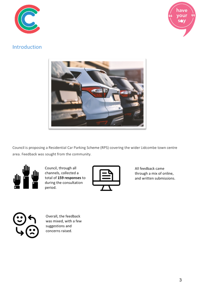
An ongoing issue raised by the community in the Lidcombe town centre and surrounds is the availability of car parking. This issue has been raised due to the use of parking to access train services, demand for parking to access services and facilities in the town centre, as well as the level of provision of car parking due to development occurring in the town centre.
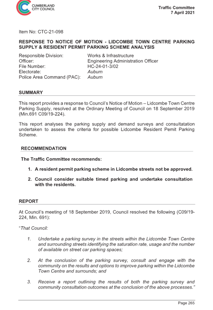
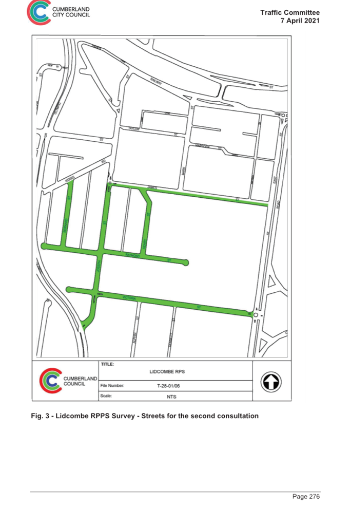
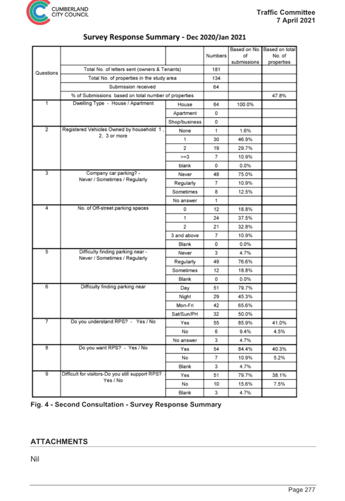
Following a Notice of Motion (C09/19-224, Min 691) at the Council meeting on 18 September 2019 to undertake a parking survey and community consultation, Council officers undertook a study of selected streets south of the railway line in Lidcombe. In addition, Council undertook a further consultation targeting residents in single dwelling streets impacted by train commuters to review the support and need for a Residential Parking Scheme. The results were reported to Cumberland Traffic Committee in April 2021 (CTC-21-098) and recommended that:
1. A resident permit parking scheme in Lidcombe streets not be approved.
2. Council consider suitable timed parking and undertake consultation with the residents.
Council approved the Traffic Committee recommendation at the Council meeting on 19 May 2021. The report for this process is provided in Attachment 1.
Separately, a Notice of Motion (C08/22-121, Min. 183) was considered at the Council meeting of 3 August 2022, and was resolved as follows:
That:
1. Consultation be undertaken for proposed residential car parking covering the
wider Lidcombe town centre area; and
2. The proposed boundary areas, inclusive of residential parking scheme, are as
follows:
· (South side of Lidcombe town centre) - Raymond Street East;
· (North side of Lidcombe town centre) – Rawson Street, Maud Street; and
· Yarram Street (both sides of the road that aligns with Maud Street)
3. Prior to progressing any consultation on the proposal, a report be provided to Council on the proposed approach for community engagement on this matter. This report is to be provided to Council in September 2022.
Following the above resolution, a report was presented to Council at its meeting held on 28 September 2022 outlining the proposed approach for consultation, aligned with the Cumberland Community Engagement Strategy. Council resolved that Council endorse the proposed approach for consultation regarding residential parking in Lidcombe.
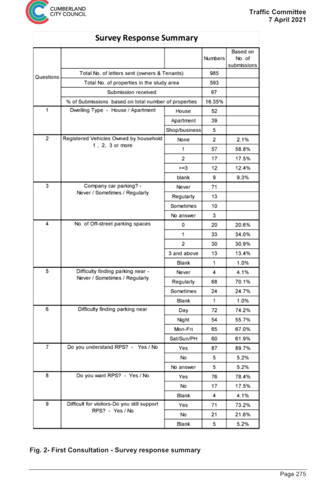
Residential Parking in Lidcombe Town Centre and Surrounds
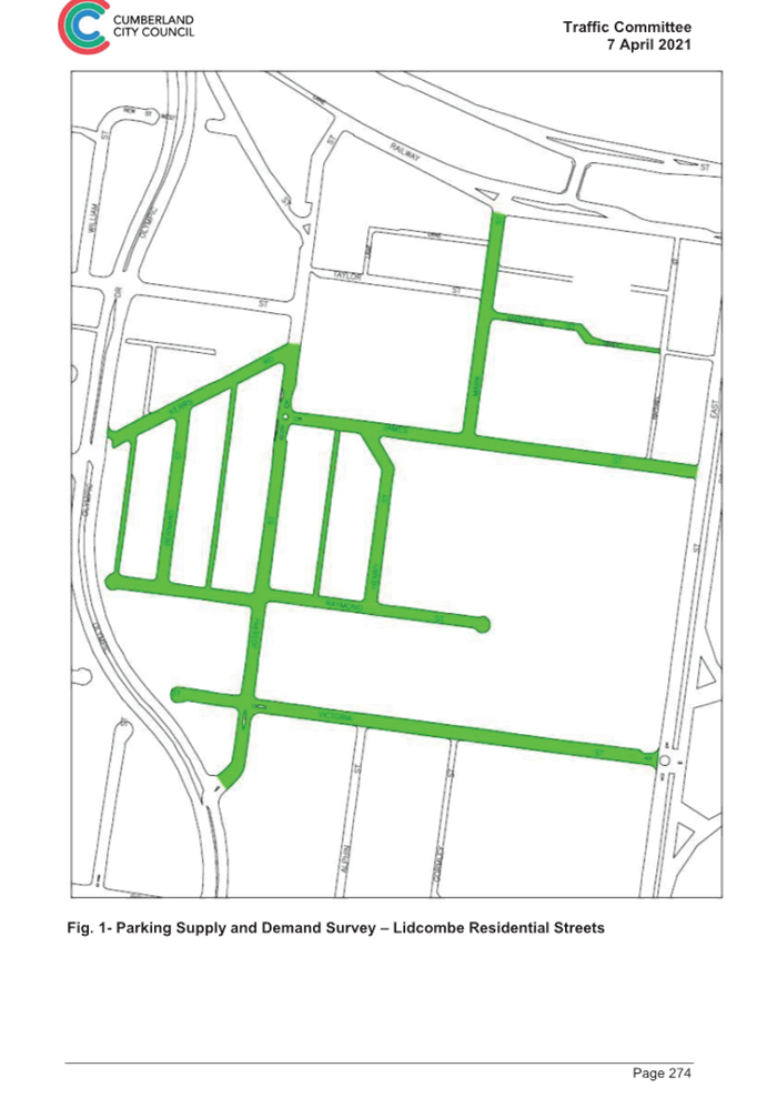
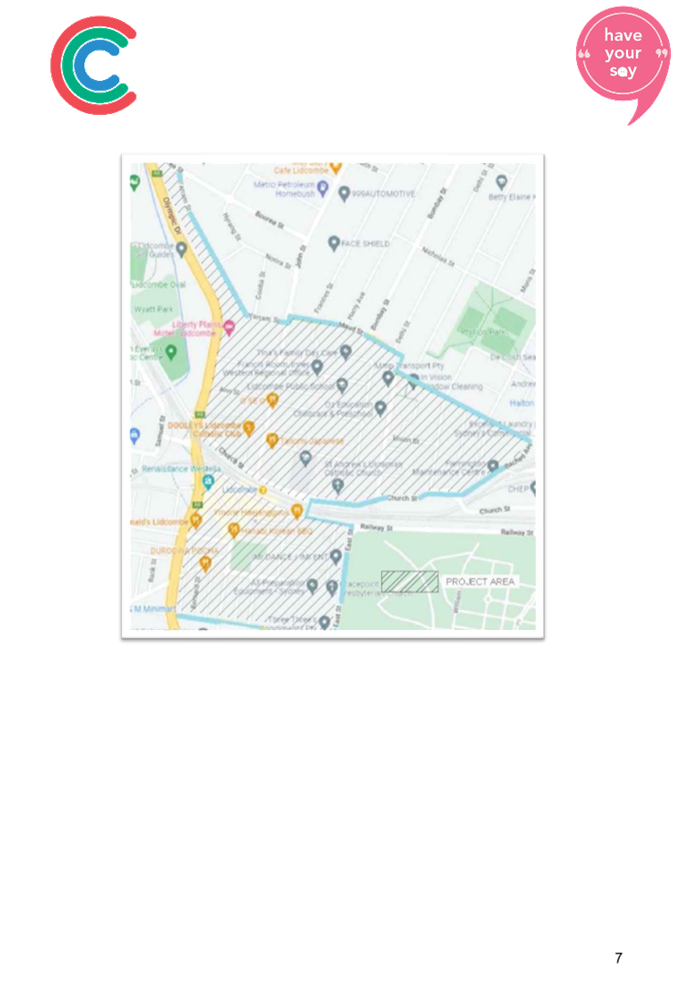
Based on the resolution, Council officers have progressed parking surveys and undertaken consultation on the proposal for residential car parking. The study area covers the residential properties within Rawson Street, Maud Street and Yarram Street on the north and Raymond Street East on the south and all streets within, as shown in Figure 1. It is noted that this area includes existing development and future development under construction.
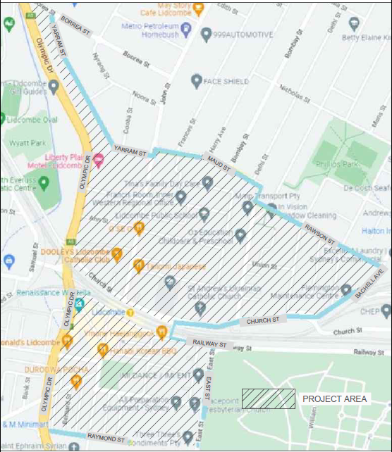
Figure 1: Study Area for Proposed Residential Car Parking
Based on Council’s resolution on the matter, the following approach was undertaken by Council officers on car parking in the Lidcombe town centre and surrounds:
· Data for on-street car parking supply and demand within the study area was captured to assist in the analysis of the proposal
· Consultation was undertaken with a focus on residential parking options in the Lidcombe area, as well as with local businesses on parking issues, given that the town centre is included in the project area
· The key option explored was the level of support for a residential parking scheme, assessed in accordance with Council’s Residential Parking Scheme Guideline. Opportunities to consider alternate parking options or maintain current on-street parking arrangements was also explored
· The main tool used to assess the residential parking scheme was the completion of a survey (either physical or electronic) by residents in the study area. The ability to collate other feedback on parking issues in the project area was undertaken through open-ended questions on the survey, correspondence directed to Council and through Council’s Have Your Say page
· Analysis was undertaken using the results of the car parking supply survey and consultation findings, using the criteria outlined in Council’s Residential Parking Scheme Guideline.
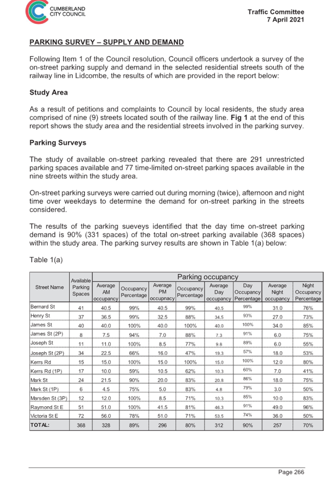
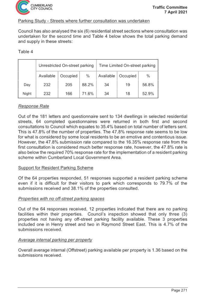
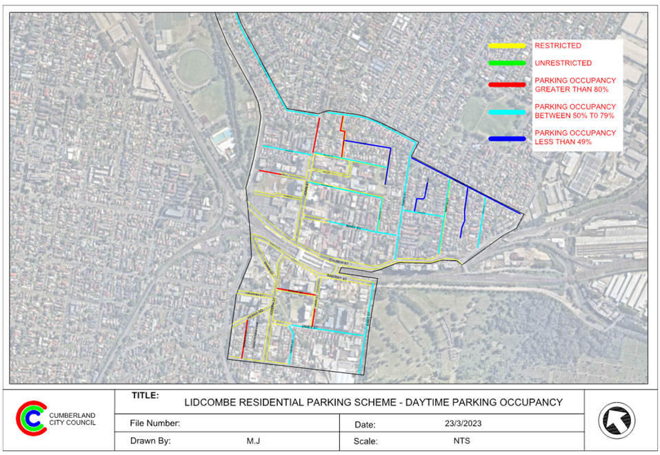
On-Street Car Parking Supply and Demand
Council officers engaged an independent consultant to undertake a survey of the on-street parking supply and demand in the streets within the study area. This information assisted in understanding actual utilisation during a period of typical activity, and contributed to the analysis undertaken as part of the proposal.
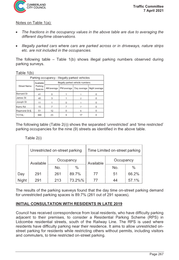
The on-street parking survey was undertaken on an hourly basis between 7:00AM and 9:00 PM on two Tuesdays and two Thursdays, which were used to average day time parking occupancy (between 7:00AM to 6:00PM) and average night time parking occupancy (between 6:00PM to 9:00PM).
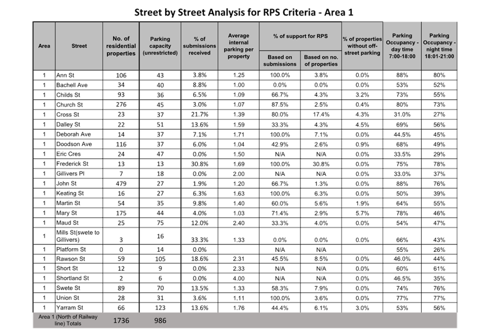
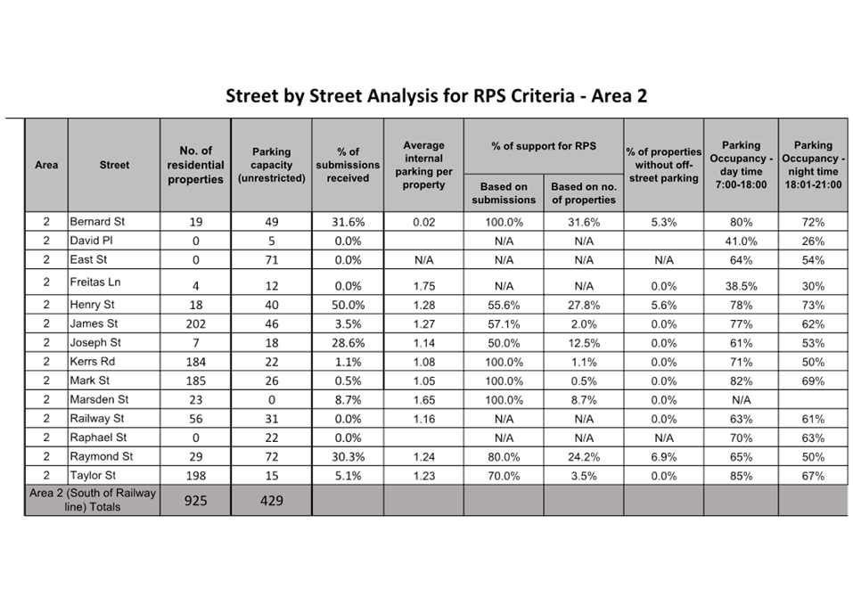
A summary of on-street car parking supply and demand is provided in Table 1. Further information on the survey by area and street is provided in Table 2. A map showing day time parking occupancy by street is also provided in Attachment 2.
|
Area |
Available unrestricted parking |
% of day time parking occupancy |
% of night time parking occupancy |
|
Total Study Area |
1415 |
59% |
55% |
|
Area 1 – North of Railway Line |
986 |
54% |
54% |
|
Area 2 – South of Railway Line |
429 |
70% |
59% |
Table 1: Summary of On-Street Car Parking Survey
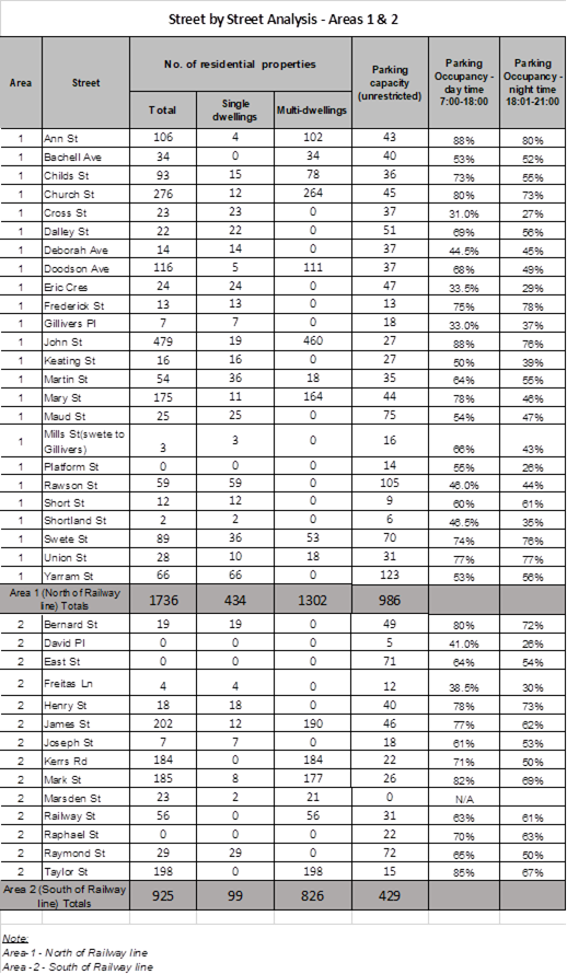
Table 2: On-Street Car Parking Survey by Area and Street
The results of the parking surveys identified that the daytime on-street parking demand is 59% (831 spaces) of the total on-street parking available (1,415 spaces) within the total study area. The daytime on-street parking demand for Ann Street and John Street were 88%, which could be explained by their close proximity to Lidcombe station and the John Street shopping strip. The daytime parking demand for the area south of the railway line is 70%, compared to 54% for the streets on the north of the railway line.
Consultation on Proposed Residential Parking Scheme
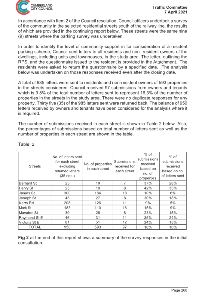
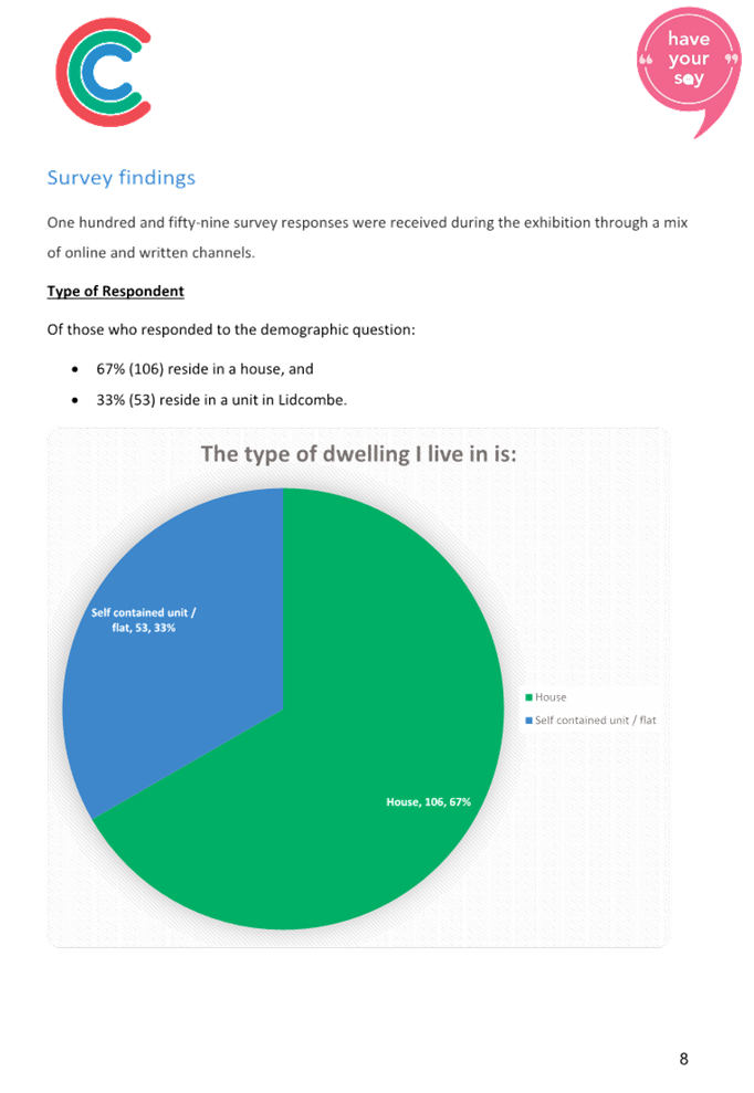
In accordance with Council’s resolution on the matter, consultation was undertaken on the proposal for a residential parking scheme between 7 November 2022 and 9 December 2022. Council received a total of 159 submissions, which included 104 online submissions and 55 completed survey forms by mail or email from owners and tenants. Out of the 159 submissions, 149 were within the study area which is 5.61% of the total of 2,661 properties. For reference, the 2,661 properties comprised of 533 single dwellings (20% of total properties) and 2,128 multi-dwellings (apartments and townhouses) (80% of total properties).
The key findings from the submissions included:
· 67% of respondents lived in a house, with the remainder living in an apartment
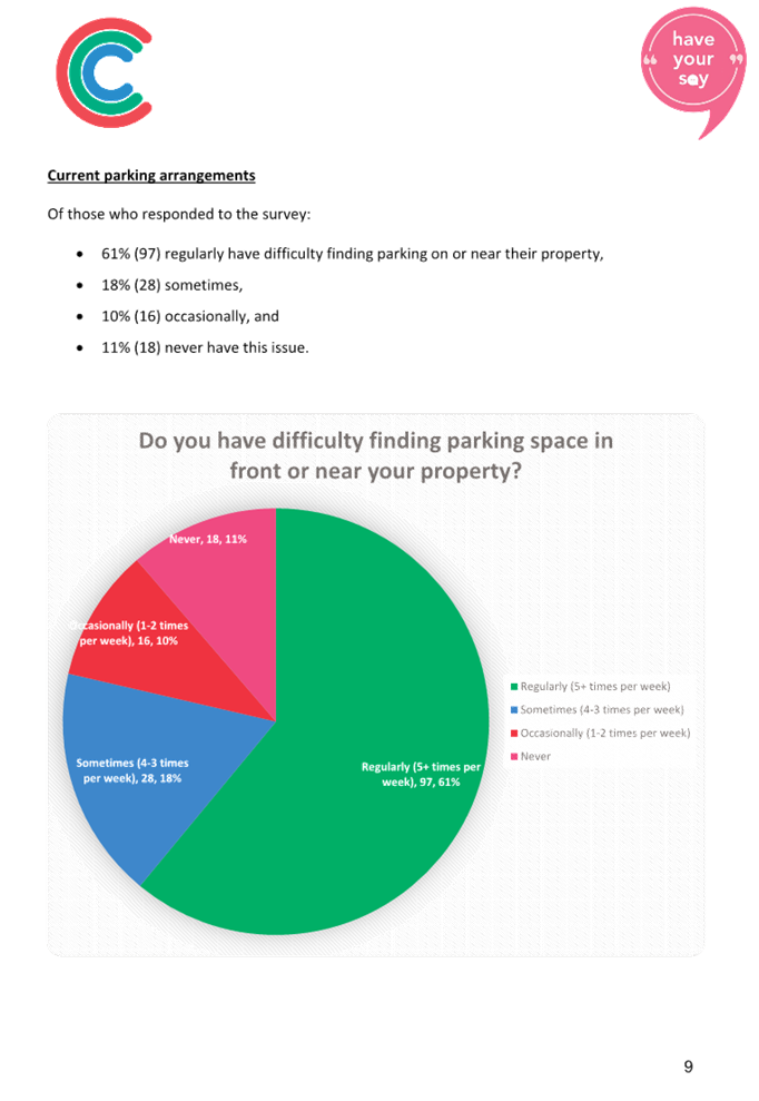
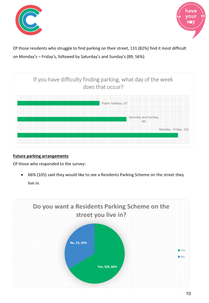
· 89% of respondents had difficulty in finding parking on or near their property, with this difficulty occurring more frequently during weekdays
· 66% of respondents expressed support for a Residential Parking Scheme in their area
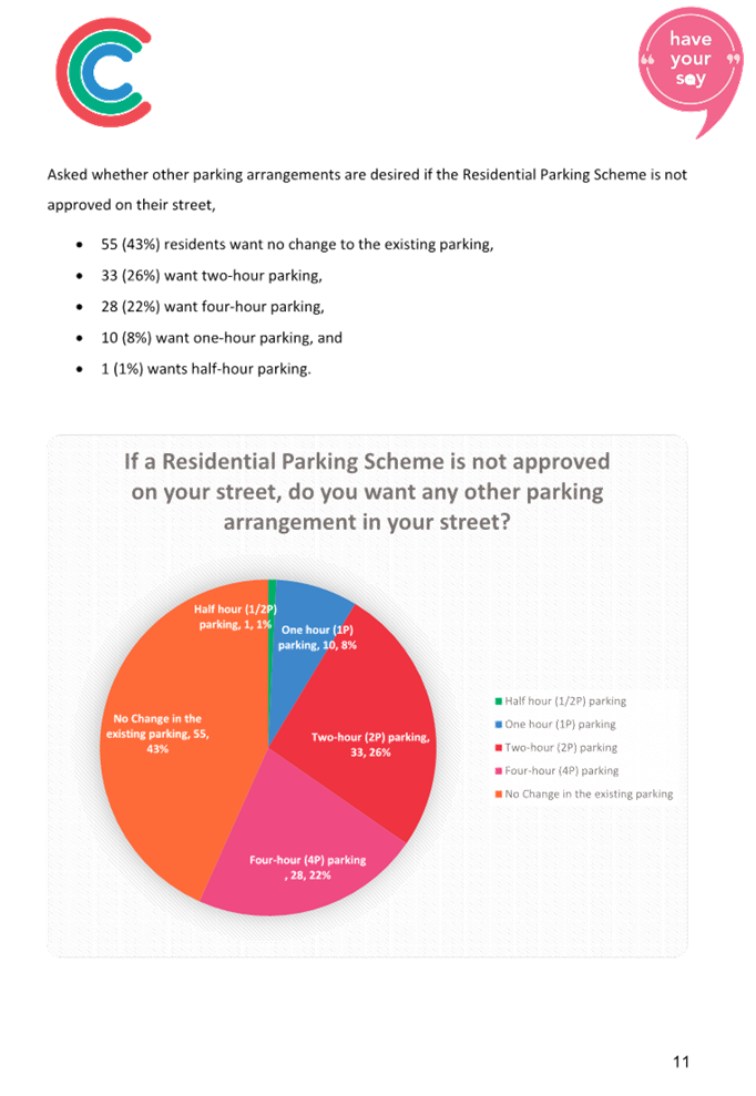
· 57% of respondents supported the introduction of timed parking on their street should a Residential Parking Scheme not be introduced
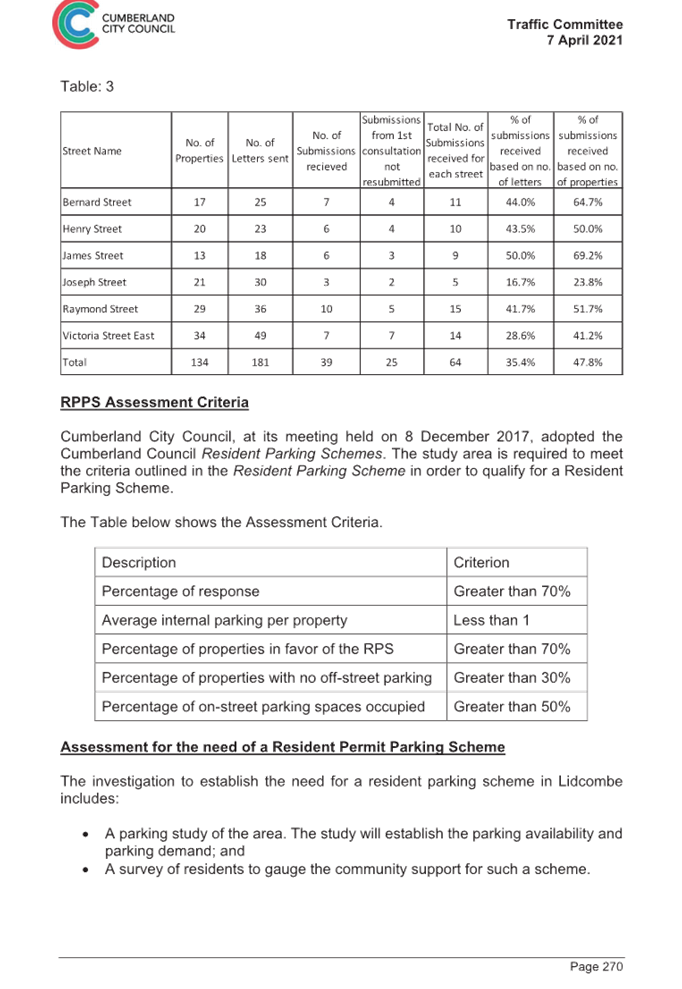
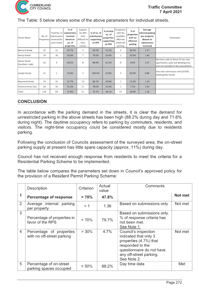
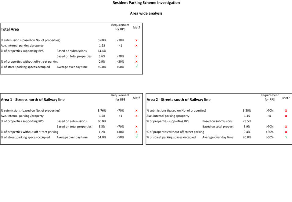
Analysis of Criteria in Council’s Residential Parking Scheme Guideline
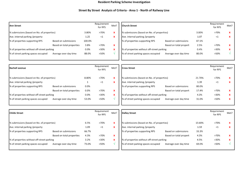
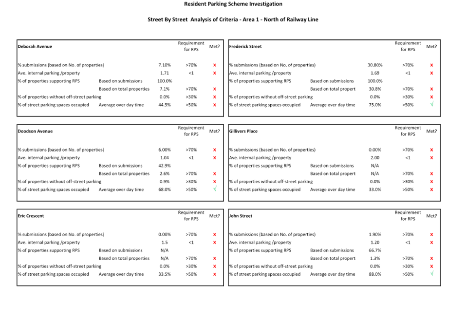
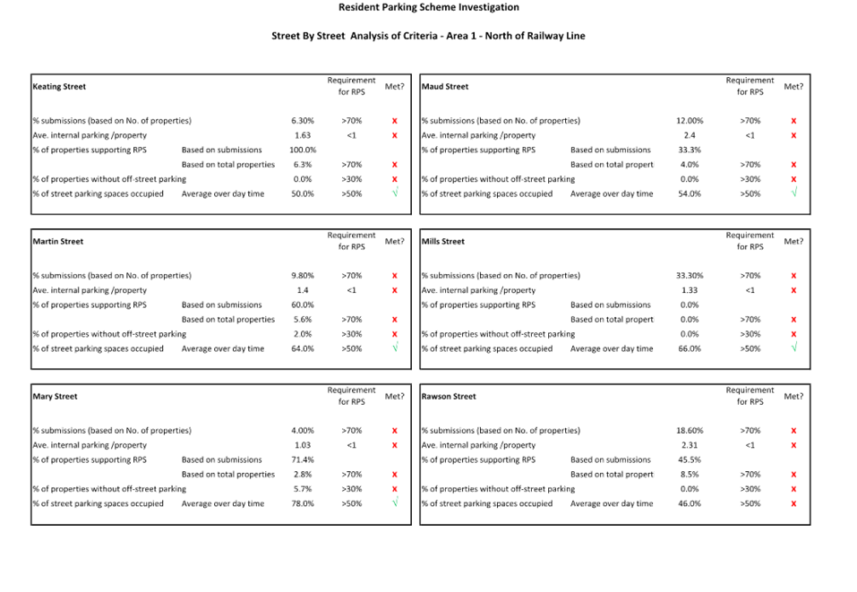
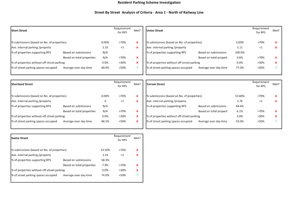
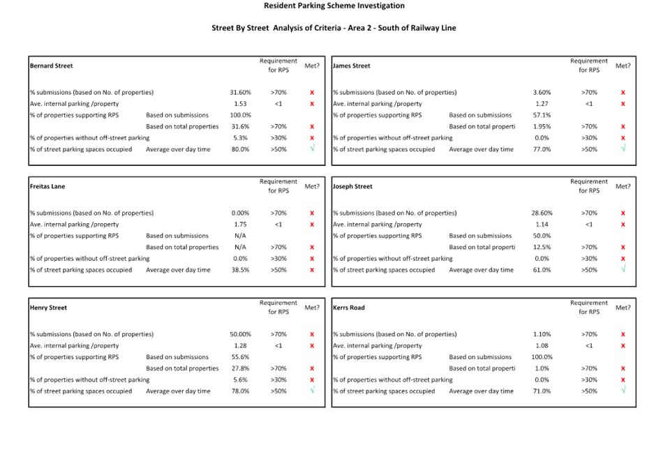
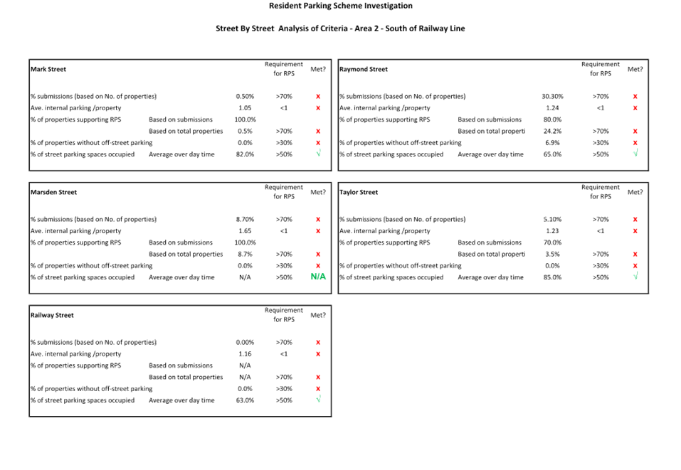
Based on the parking survey data and consultation findings, an analysis was undertaken using the criteria in Council’s Residential Parking Scheme Guideline. A summary of the analysis for the overall study area is provided in Table 3 and indicates that the only criterion met was for the percentage of on-street parking spaces occupied. Detailed analysis by area and street is provided in Attachment 3, and also indicates that no specific area or street met all the criteria as provided in the Guideline. It is noted that all criteria in Council’s Residential Parking Scheme Guideline need to be met to progress a proposal.
|
|
Description |
Criterion |
Actual value |
Comments |
|
|
1 |
Percentage of response |
> 70% |
5.61% |
|
Not met |
|
2 |
Average internal parking per property |
< 1 |
1.23 |
|
Not met |
|
3 |
Percentage of properties in favour of the RPS |
> 70% |
64.4% 3.7% |
Based on submissions. Based on number of properties |
Not met |
|
4 |
Percentage of properties with no off-street parking |
> 30% |
0.9% |
|
Not met |
|
5 |
Percentage of on-street parking spaces occupied |
> 50% |
59% |
Day time data |
Met |
Table 3: Summary of Analysis Using Residential Parking Scheme Guideline Criteria
Next Steps
Based on the analysis and consultation undertaken, the criteria outlined in Council’s Residential Parking Scheme Guideline has not been met. Using this information, it is recommended that a Resident Parking Scheme not proceed in the Lidcombe Town Centre study area.
It is noted that the parking surveys indicated a number of individual streets had day time occupancy where more than two thirds of on-street parking spaces were used (where unrestricted parking arrangements apply). These streets included Ann Street, Bernard Street, Childs Street, Church Street, Dalley Street, Doodson Avenue, Frederick Street, Henry Street, James Street, John Street, Kerrs Road, Mark Street, Mary Street, Raphael Street, Swete Street, Taylor Street and Union Street. Given community concerns on the issue of car parking in the Lidcombe area, it is also recommended that further analysis and consultation be undertaken on timed parking in these streets as an approach to address the issue. If supported, this work will look at a range of timed parking options, as well as opportunities for parts of the street to maintain untimed parking as an alternate for local residents.
COnsultation
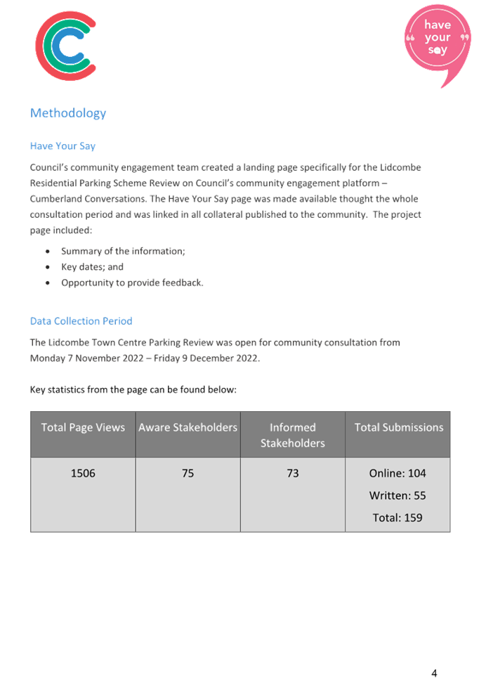
Consultation on the proposed Lidcombe Residential Parking Scheme was undertaken from 7 November 2022 to 9 December 2022.
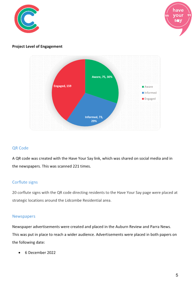
In accordance with Council’s resolution in September 2022 on consultation for the proposal, the following activities were undertaken to support the process:
· A landing page specifically for the Lidcombe Residential Parking Scheme Review on Council’s community engagement platform – Cumberland Conversations. The ‘Have Your Say page’ was made available throughout the whole consultation period and was linked in all collateral published to the community. The project page included a summary of the information, key dates and opportunity to provide feedback
· A summary of the consultation and how people can have their say was also translated in the top 5 languages of Arabic, Simplified Chinese, Korean, Nepalese and Vietnamese
· Corflute signs were displayed within the study area providing information and a QR Code link to Council’s ‘Have Your Say’ website inviting residents to scan the code to complete the online survey form
· Advertisement in local newspapers
· Letter and survey sent to letters to residents and non-resident owners of the dwellings in the study area
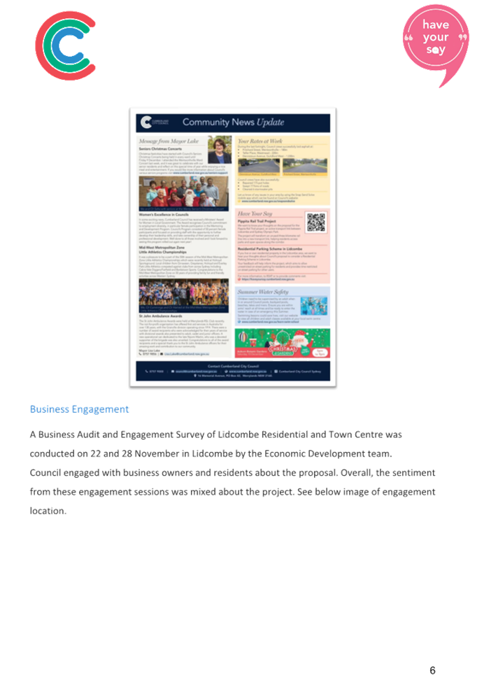
· Engagement with local business on parking issues in the area.
Council received a total of 159 submissions, which included 104 online submissions and 55 completed survey forms by mail or email from owners and tenants. Out of the 159 submissions, 149 were within the study area which is 5.61% of the total of 2,661 properties. The number of submissions received by street are also provided in Table 4.
Further information on the consultation, including the process and key findings, is provided in Attachment 4.
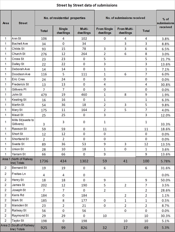
Table 4: Submissions Received by Street in Study Area
Note: within the ‘No. of submissions received’ column, the cells left empty (instead of a ‘zero’) indicates there are no single/multi-dwellings within that street, while the ones with ‘0’ indicates no submissions from that type of dwelling.
Attachments
2. On Street Car Parking Occupancy Map
3. Analysis of Criteria in Residential Parking Scheme Guideline by Area and Street
DOCUMENTS
ASSOCIATED WITH
REPORT CTC-23-085
Attachment 1
Previous Report-CTC-21-098
DOCUMENTS
ASSOCIATED WITH
REPORT CTC-23-085
Attachment 3
Analysis of Criteria in Residential Parking Scheme Guideline by Area and Street
Attachment 4
Lidcombe Residential Parking Engagement Report
7 June 2023
Item No: CTC-23-086
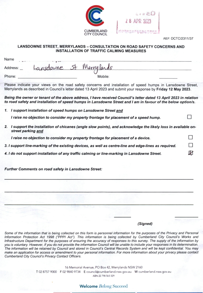
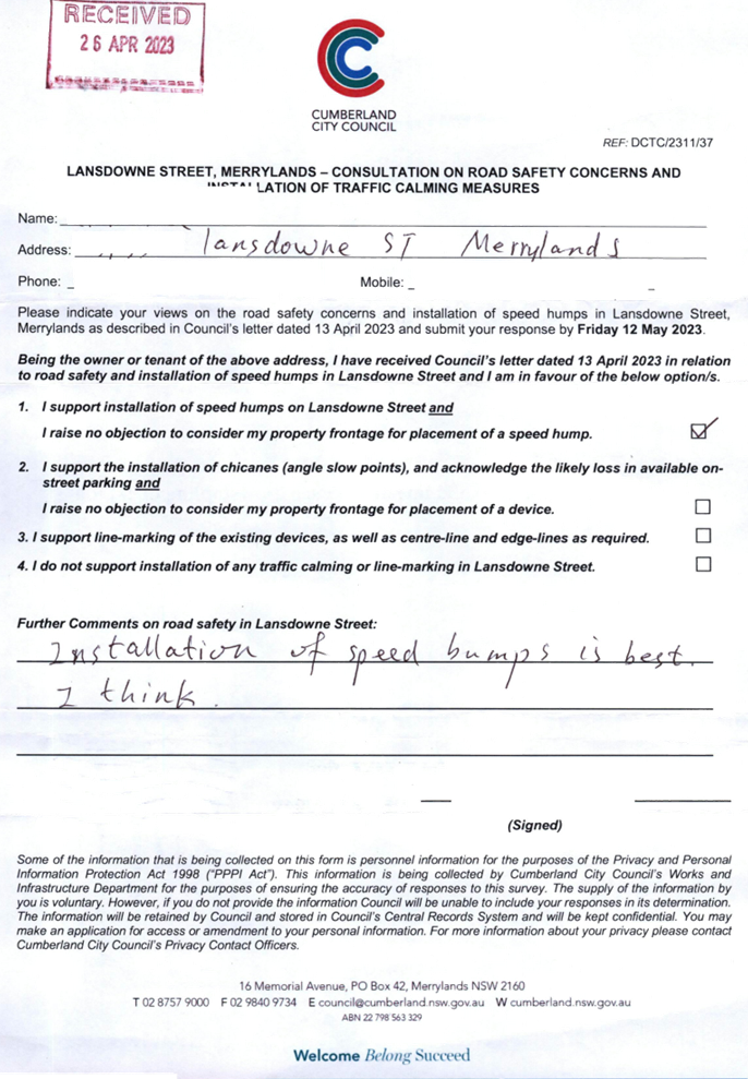
Response to Notice of Motion C03/23-262 - Traffic Calming Devices - Lansdowne Street, Merrylands
Directorate: Environment and Planning
Responsible Officer: Executive Manager Development and Building
File Number: T-28-01/06
Electorate: Granville
Police Area Command (PAC): Cumberland
Agenda Part Part 2
Note: Recommendation to Council
Summary
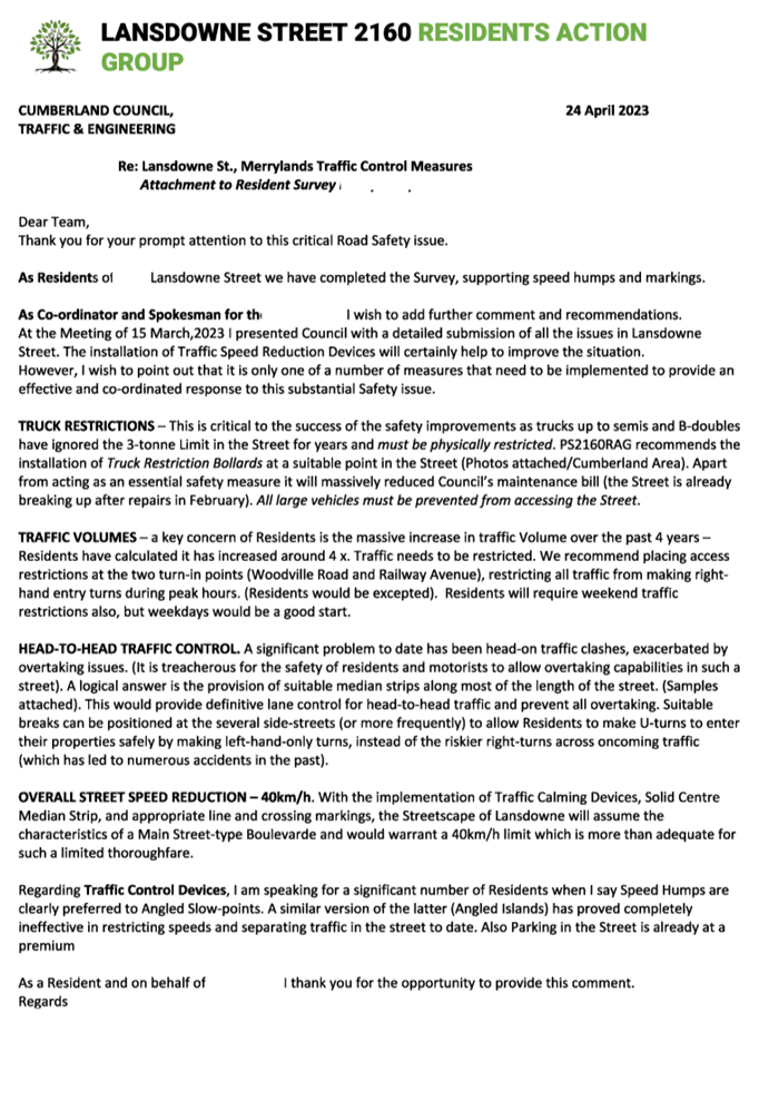
This report provides a response to Council’s Notice of Motion – Traffic Calming Devices in Lansdowne Street, Merrylands, resolved at the Ordinary Meeting of Council on 15 March 2023 (Min.373 C03/23-262).
|
The Traffic Committee recommends that Council: 1. Note the findings from the community consultation and review of technical information. 2. Endorse a staged approach to response to traffic issues in Lansdowne Street, Merrylands, which includes: a. Implementation of the line marking scheme in the street in accordance with the attached plan b. In-principle support of the installation of speed humps as a traffic calming device in the street, with the preparation of a design and consultation with adjacent residents to the proposed location of the speed humps. 3. Forward a detailed line marking plan to Transport for NSW for concurrence. 4. Provide a further report to the Traffic Committee in November 2023 on the status on the response of traffic issues in Lansdowne Street, Merrylands. 5. Notify residents of the outcome of the proposal. |
Report
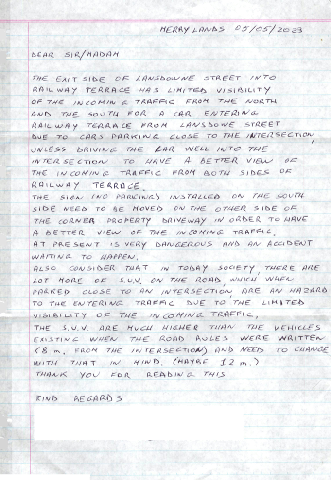
Background
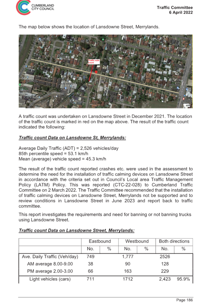
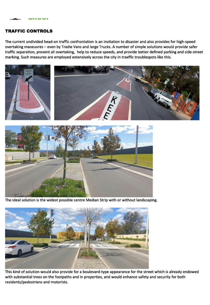
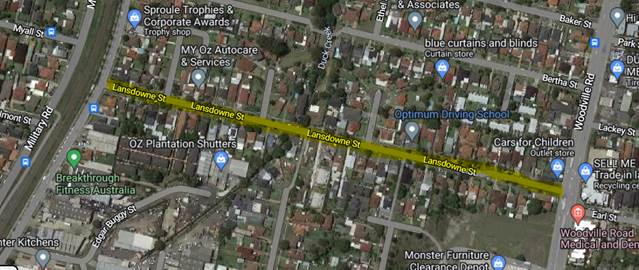
Lansdowne Street is a local road that runs in an east-west direction between Woodville Road and Railway Terrace. The speed limit is 50km/h and parking is permitted on both sides of the road unless signposted. Lansdowne Street is approximately 610m long and varying width. It has indented parking bays along the street which are not line marked. There are also islands constructed in the centre of the road. The travel lanes are effectively two lanes two way excluding the parking bays.
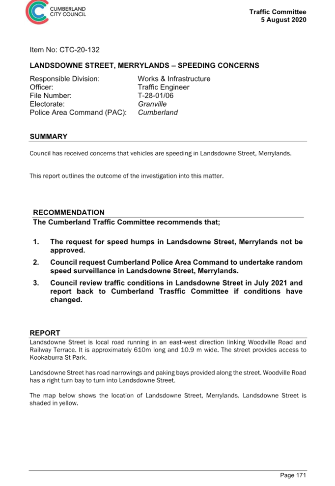
Cumberland Traffic Committee has previously considered conditions in Lansdowne Street, Merrylands, including the following:
1. CTC-20-132 - Cumberland Traffic Committee considered a report in August 2020 regarding speeding concerns in Lansdowne Street and recommended that speed humps not be approved.
2. CTC-22-028 - Cumberland Traffic Committee considered a report in March 2022 regarding road safety concerns in Lansdowne Street and recommended that traffic calming devices not be supported.
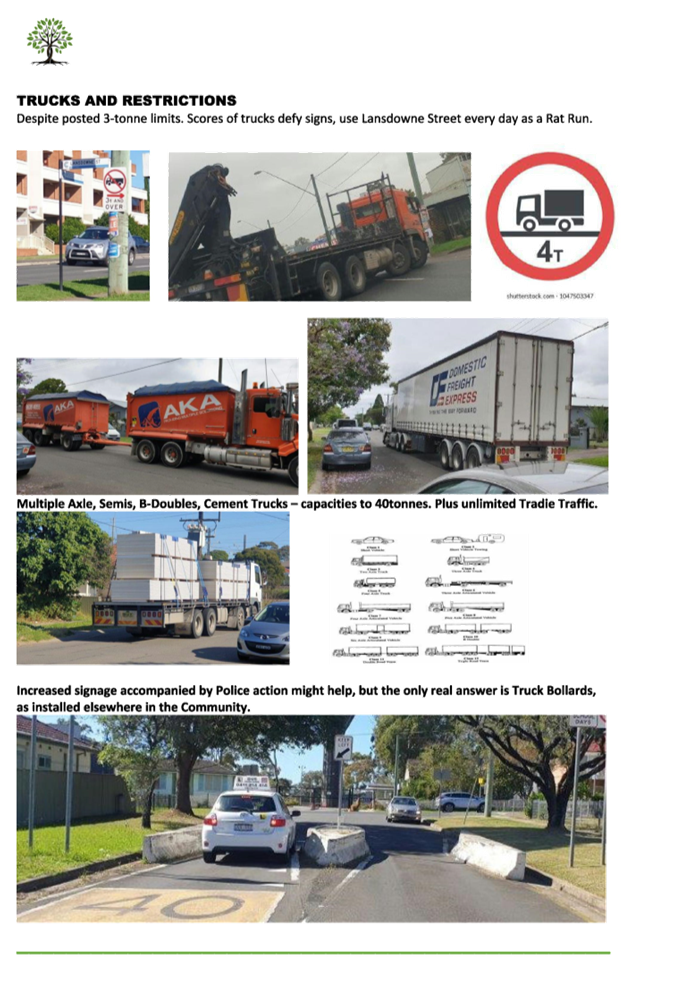
3. CTC-22-082 - Cumberland traffic Committee considered a report in April 2022 regarding a request for banning trucks in Lansdowne Street and recommended that the request to ban trucks in Lansdowne Street, Merrylands not be approved.
These reports are also attached to this paper.
A Notice of Motion (Min.373 C03/23-262) was considered at the Council meeting on 15 March 2023, and was resolved as follows:
That Council:
1. Refer resident feedback regarding safety issues in Lansdowne St Merrylands to the Traffic Committee.
2. Notes that the matter is set down for review by the Traffic Committee in June 2023.
3. Notify affected residents of any proposed action to seek their further feedback prior to implementation.
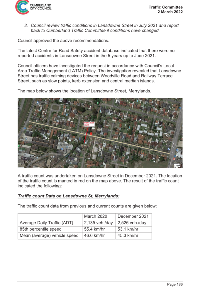
The map below shows the location of Lansdowne Street, Merrylands.
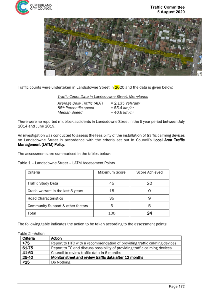
Traffic Count Data and Assessment
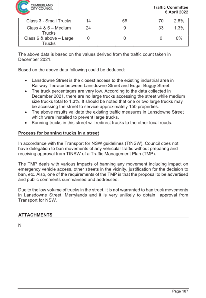
A traffic count was undertaken on Lansdowne Street in February 2023 at a midblock location, and was scheduled in preparation of the planned June 2023 report, prior to the resolution of Council in March 2023. The result of the recent traffic count and previous counts are shown in the table below:
|
|
Mar 2020 |
Dec 2021 |
Feb 2023 |
|
Average Daily Traffic (ADT) |
2,135 |
2,526 |
2,768 |
|
85th percentile speed |
55.4 |
53.1 |
52.4 |
|
Mean (average) vehicle speed |
-- |
45.4 |
44.8 |
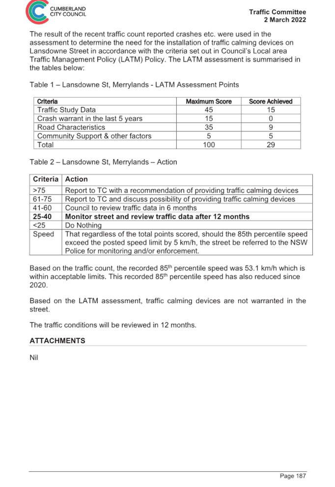
The result of the recent traffic count and reported crashes were used in the assessment to determine the need for the installation of traffic calming devices on Lansdowne Street in accordance with the criteria set out in Council’s Local Area Traffic Management Policy (LATM) Policy.
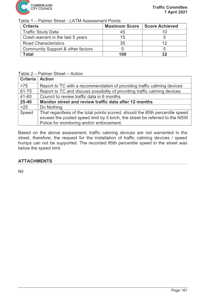
The LATM assessments are summarised in the tables below:
Table 1 – Lansdowne Street – LATM Assessment Points
|
Criteria |
Maximum Score |
Score Achieved |
|
Traffic study data |
45 |
15 |
|
Crash warrant in the last 5 years |
15 |
0 |
|
Road characteristics |
35 |
11 |
|
Community Support and other factors |
5 |
5 |
|
Total |
100 |
31 |
Table 2 – Lansdowne Street – Action
|
Criteria |
Action |
|
>75 |
Report to TC with a recommendation of providing traffic calming devices |
|
61-75 |
Report to TC and discuss possibility of providing traffic calming devices |
|
41-60 |
Council to review traffic data in 6 months |
|
25-40 |
Monitor street and review traffic data after 12 months |
|
<25 |
Do Nothing |
|
Speed |
That regardless of the total points scored, should the 85th percentile speed exceed the posted speed limit by 5 km/h, the street be referred to the NSW Police for monitoring and/or enforcement. |
Based on the above assessment, traffic calming devices are not warranted in Lansdowne Street, Merrylands.
Consultation
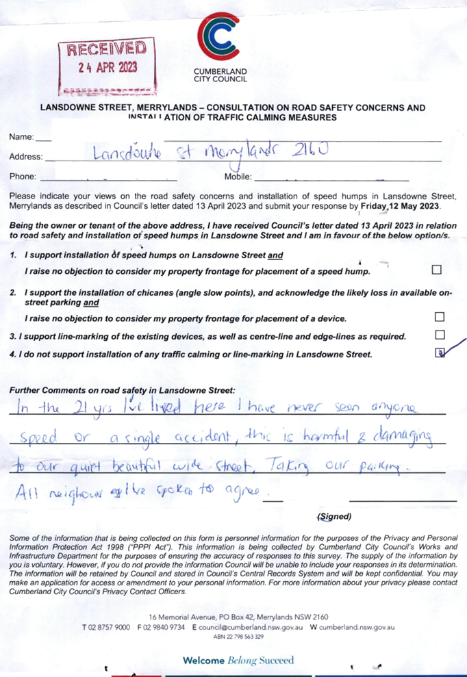
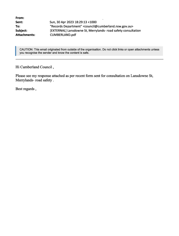
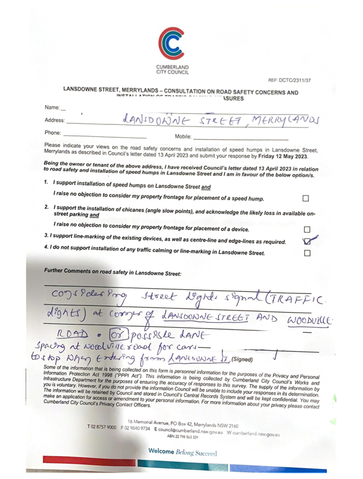
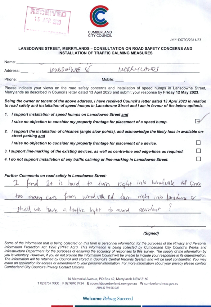
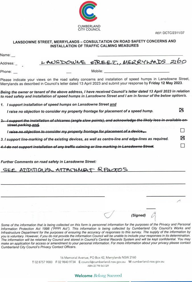
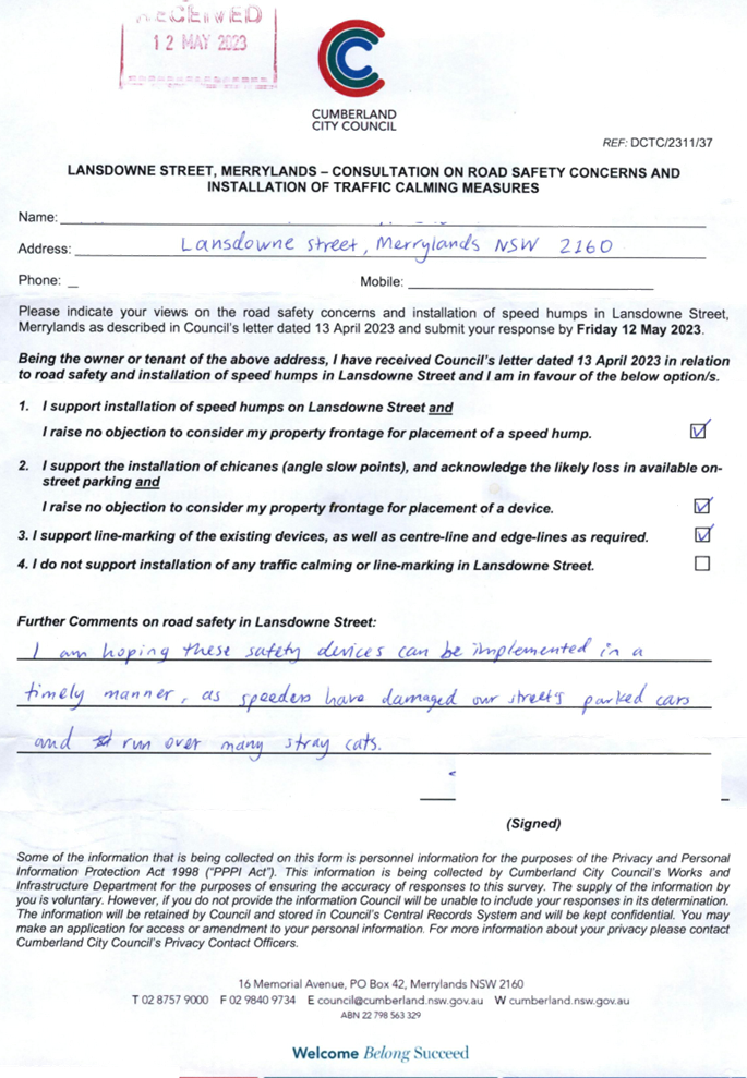
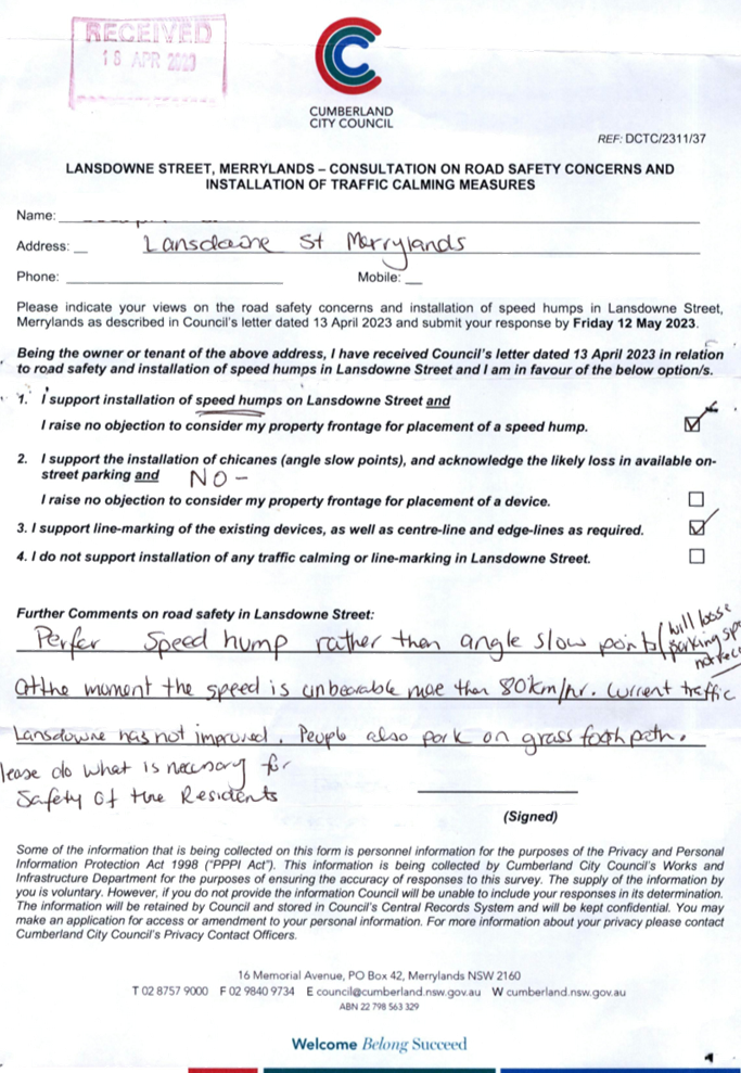
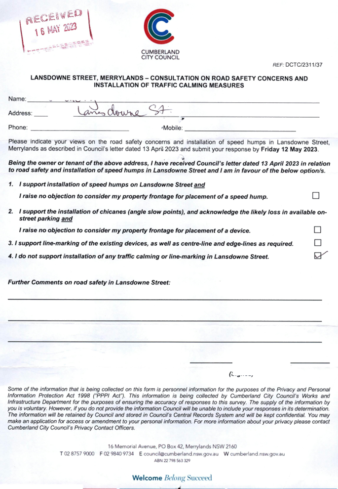
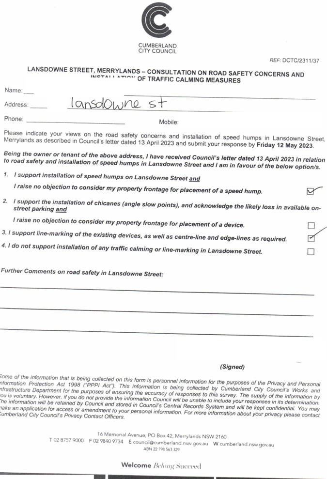
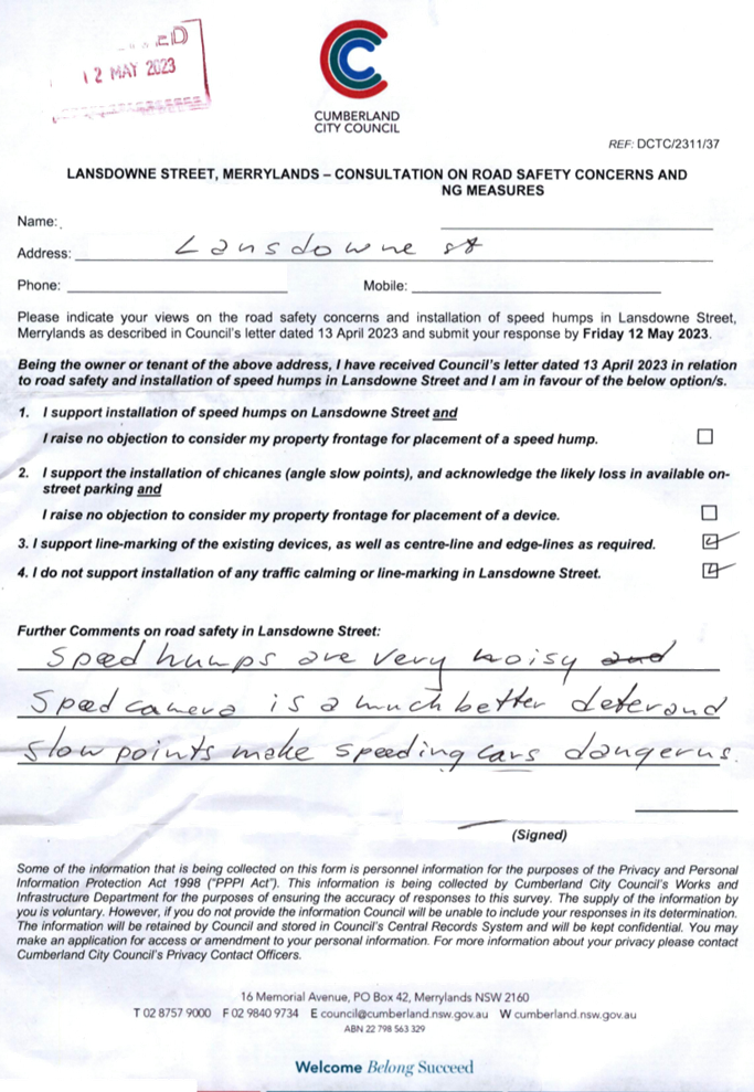
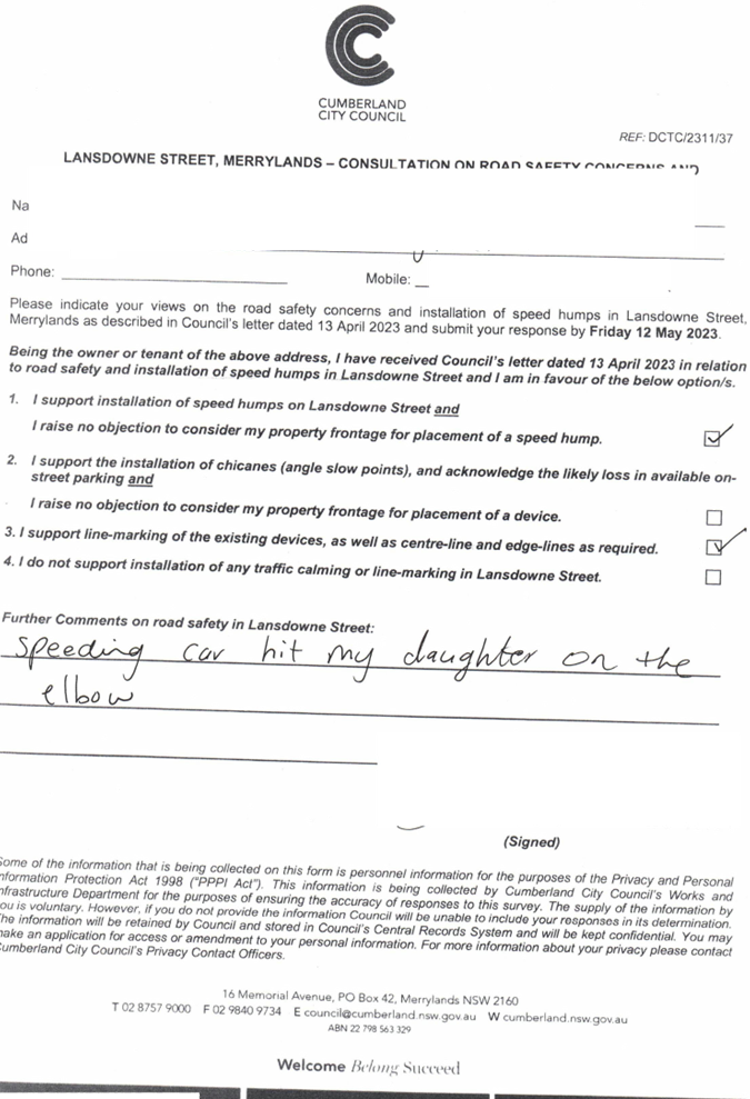
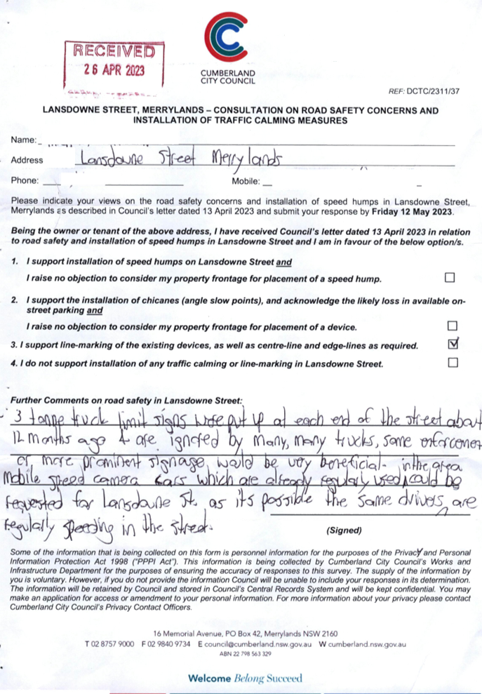
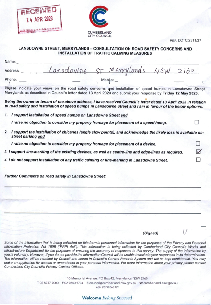
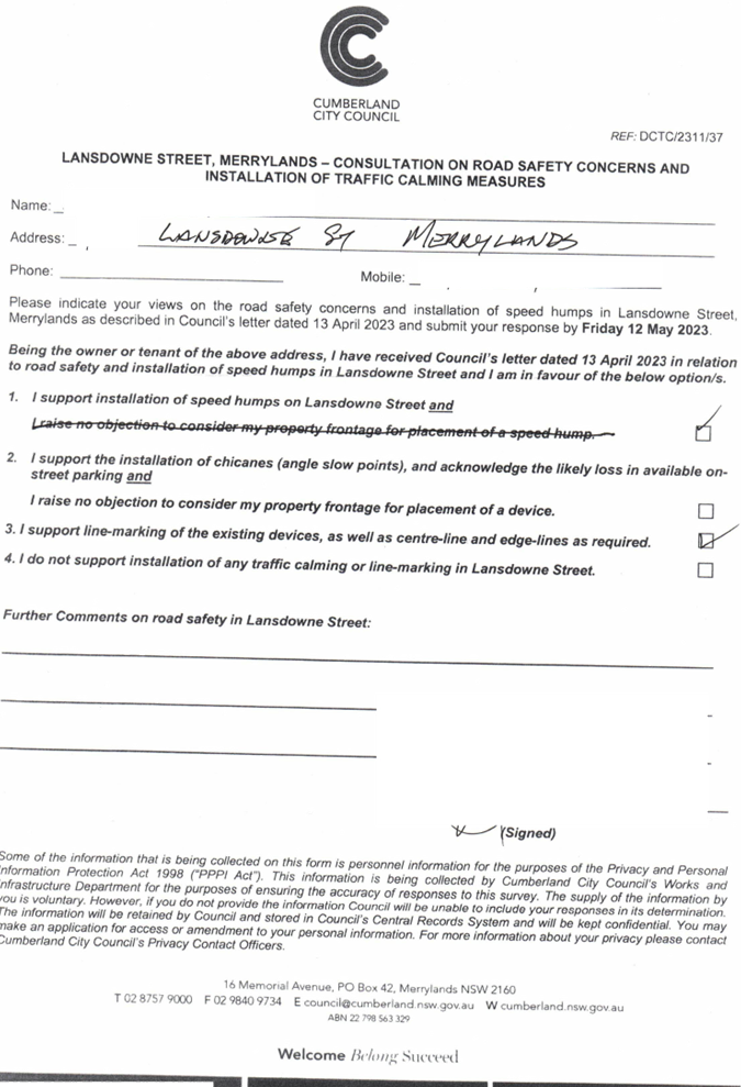
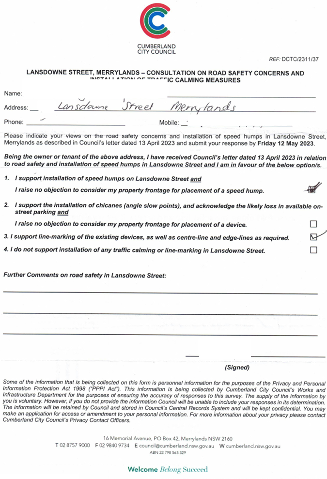
In accordance with the Notice of Motion, Council undertook consultation with the residents to get their feedback on road safety in Lansdowne Street and their level of support for traffic calming devices in the street. The consultation period was for a period of 30 days starting from 13 April 2023 to 12 May 2023.
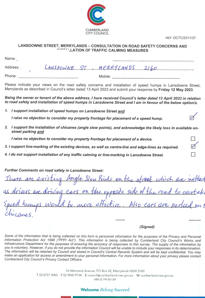
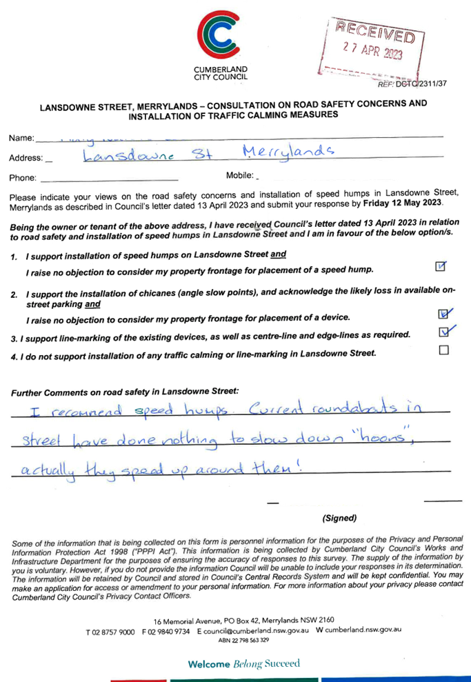
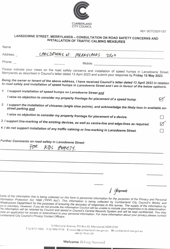
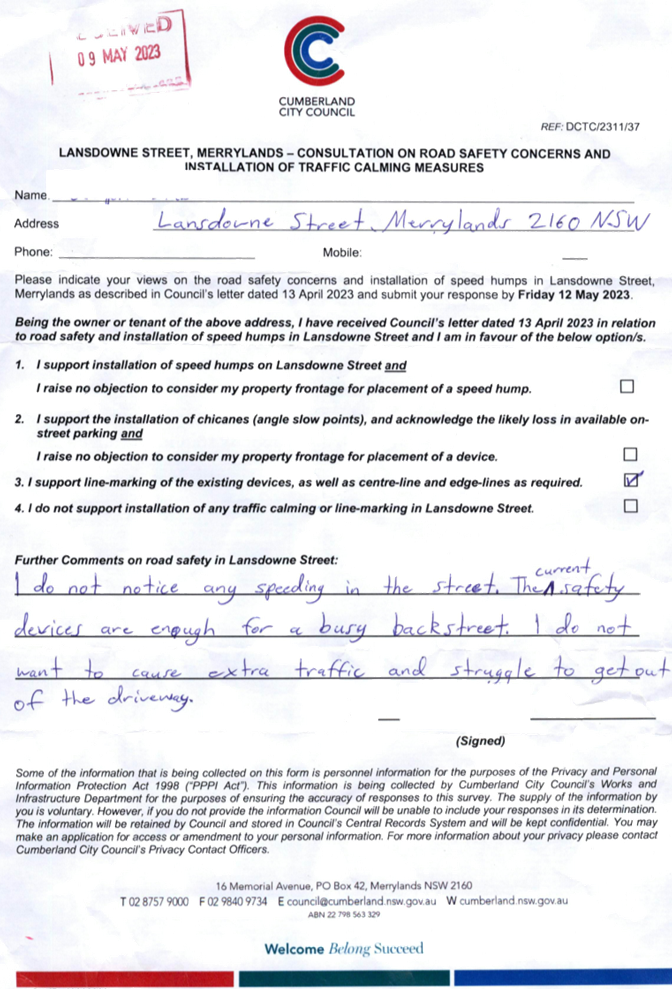
The survey form indicated the following options for consideration by the residents:
1. Speed humps
2. Chicanes
3. Line marking
4. None of the above
Council officers sent 130 consultation letters to owners and residents along Lansdowne Street, Merrylands. A total of 29 submissions were received, representing 26% of the total number of properties along the street. A range of options (including combination of options) were identified in the submissions, as outlined in the table below.
|
Options and Combinations |
Submissions in Support |
|
Speed humps only |
5 |
|
Chicanes only |
0 |
|
Line marking only |
6 |
|
Speed humps and line marking |
8 |
|
All three (speed humps, chicanes and line marking |
6 |
|
None |
4 |
|
Total number of submissions |
29 |
Next Steps
While the assessment of traffic and other road data does not warrant further action in accordance with Council’s Local Area Traffic Management (LATM) Policy, there has been significant Council and community interest in responding to traffic issues along Lansdowne Street, Merrylands. In response to this interest, it is recommended that a staged approach be progressed. This approach includes:
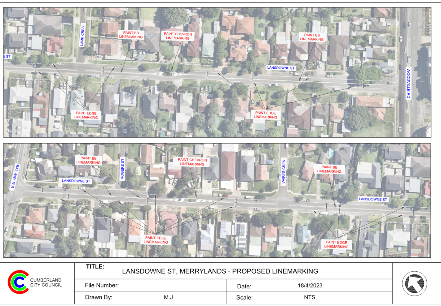
· Implementation of the line marking scheme in the street in accordance with the attached plan. This is a combination of enhancing existing line marking and new line marking to make it easier for vehicles to travel along the street in a safe manner. The plan will also be forwarded to Transport for NSW for their concurrence.
· In-principle support of the installation of speed humps as a traffic calming device in the street. If supported, the preparation of a design and consultation with adjacent residents to the proposed location of the speed humps will be undertaken.
It is also recommended that a further report is provided to the Traffic Committee in November 2023 on the status on the response of traffic issues in Lansdowne Street, Merrylands.
COnsultation
Information on the consultation in response to the Notice of Motion is included in the report.
Attachments
1. Plan – Proposed Line Marking Scheme
2. Previous Report - CTC-20-132
3. Previous Report - CTC-22-028
DOCUMENTS
ASSOCIATED WITH
REPORT CTC-23-086
Attachment 1
Plan – Proposed Line Marking Scheme
DOCUMENTS
ASSOCIATED WITH
REPORT CTC-23-086
Attachment 2
Previous Report - CTC-20-132
7 June 2023
Item No: CTC-23-087
Hawksview Street, Guildford and Merrylands - Road Safety Concerns
Directorate: Environment and Planning
Responsible Officer: Executive Manager Development and Building
File Number: HC-24-01-3/02
Electorate: Granville
Police Area Command (PAC): Cumberland
Agenda Part Part 2
Note: Recommendation to Council
Summary
There was a fatal accident in Hawksview Street, Guildford in April 2023.
This report outlines the investigation regarding the above.
|
The Cumberland Traffic Committee recommends that: 1. The existing ‘S1’ line marking in Hawksview Street be replaced with ‘BB’ line marking. 2. Council undertake a detailed review of conditions in Hawksview Street, Merrylands and report back to the Traffic Committee in August 2023. |
Report
There was a fatal accident in Hawksview Street, Merrylands in April 2023.
Following the fatal accident, Council resolved at its meeting held on 19 April 2023 “That Council immediately request that the relevant Council staff review the matter of traffic conditions and potential road safety improvements in Hawksview Street, Guildford”.
This report provides an interim update while Council officers further investigate the traffic conditions in Hawksview Street and provide a more detailed response for the Traffic Committee in August 2023.
Hawksview Street is a regional road running in an east-west direction between Fowler Road and Oxford Street. It is approximately 1.3km long and 12.5m wide. The speed limit is 50km/h and parking is permitted on both sides of the road unless otherwise signposted. Traffic signals and roundabouts exist along the street. There are ‘BB’ and ‘S1’ centre line markings at different sections of the street.
The map below shows the location of Hawksview Street:
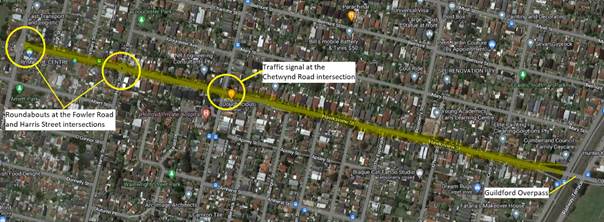
Currently, roundabouts exist at the intersections of Hawksview Street with Harris Street and Fowler Road. The intersection of Hawksview Street and Chetwynd Road is controlled by traffic signals.
Based on previous concerns from residents, Council officers undertook consultation with the residents for the installation of speed humps in Hawksview Street and reported to the Traffic Committee in 2019. The consultation results were inconclusive. Out of the 26% responses received, support and objection for the speed humps were evenly matched. At the time, the Traffic Committee discussed and considered that due to heavy traffic, noise levels would be high at speed humps and would not proceed.
In addition, Council officers have included different locations of Hawksview Street regularly from 2018 to 2023 in the ‘Safe Speed’ project which is undertaken with the help of the NSW Police Highway Patrol.
Fatal accident in April 2023
The recent fatal accident in Hawksview Street east of Cardigan Street occurred in April 2023. The accident was caused by an unsafe U-turn.
The section of Hawksview Street where the accident occurred is marked with ‘S1’ centre lines which is dashed line and is intended to allow for safe U-Turns.
According to the Road Rules, vehicles are allowed to perform a U-turn movement at ‘S1’ linemarking when it is safe. Considering the high volume of traffic in Hawksview Street, it is proposed to replace the existing S1 linemarking along the entire length of Hawksview Street with ‘BB’ line marking to ban the U-turn movement. The roundabouts located along Hawksview Street allow for safe U-turns by cars and other small vehicles. It is also noted that right turning into properties across ‘BB’ centre lines are permitted under the Road Rules.
The line marking is considered as an initial response to this matter. Further detailed work is being undertaken by Council officers, including traffic counts, review of data and further community consultation. The outcomes of this work and recommended actions to improve road safety and traffic management on Hawksview Street will be reported to the Traffic Committee at the next meeting in August 2023.
COnsultation
Consultation regarding the proposed line marking has not been undertaken as no residents are impacted by the proposal.
As outlined in the report, further community consultation will be undertaken on further potential improvements in response to road safety and traffic management concerns.
Attachments
DOCUMENTS
ASSOCIATED WITH
REPORT CTC-23-087
Attachment 1
Hawksview Street - Proposed BB Line Marking
Traffic Committee
7 June 2023
Item No: CTC-23-088
Dell Street, Woodpark - Review of Existing Timed Parking
Directorate: Environment and Planning
Responsible Officer: Executive Manager Development and Building
File Number: HC-24-01-3/02
Electorate: Granville
Police Area Command (PAC): Cumberland
Agenda Part Part 2
Note: Recommendation to Council
Summary
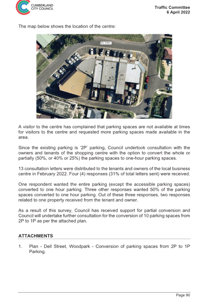
Council has received a request from a visitor to the shopping centre located at 21-39 Dell Street, Woodpark regarding shortage of parking in the area.
This report outlines the outcome of the investigation into this matter.
|
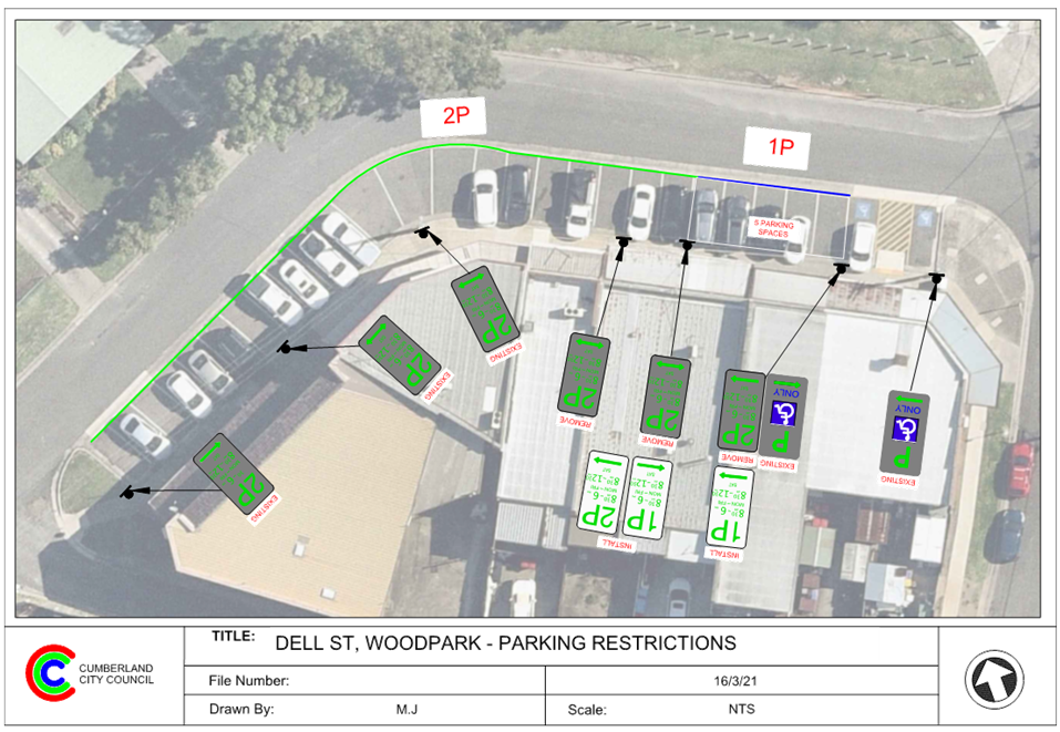
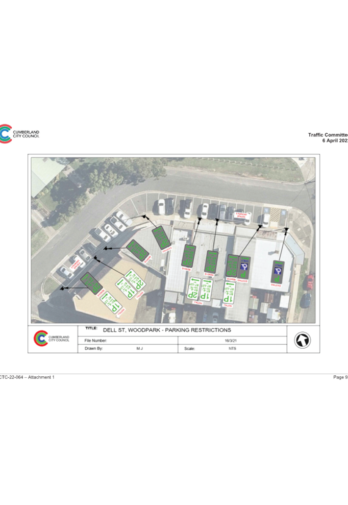
The Cumberland Traffic Committee recommends that: 1. The existing five 2-hours parking spaces on the northern side of Nos. 21-39 Dell Street, Woodpark outside the Dell Street Shopping Centre be converted to 1-hour parking spaces as per attached plan. 2. The affected businesses and concerned resident be notified of the outcome. |
Report
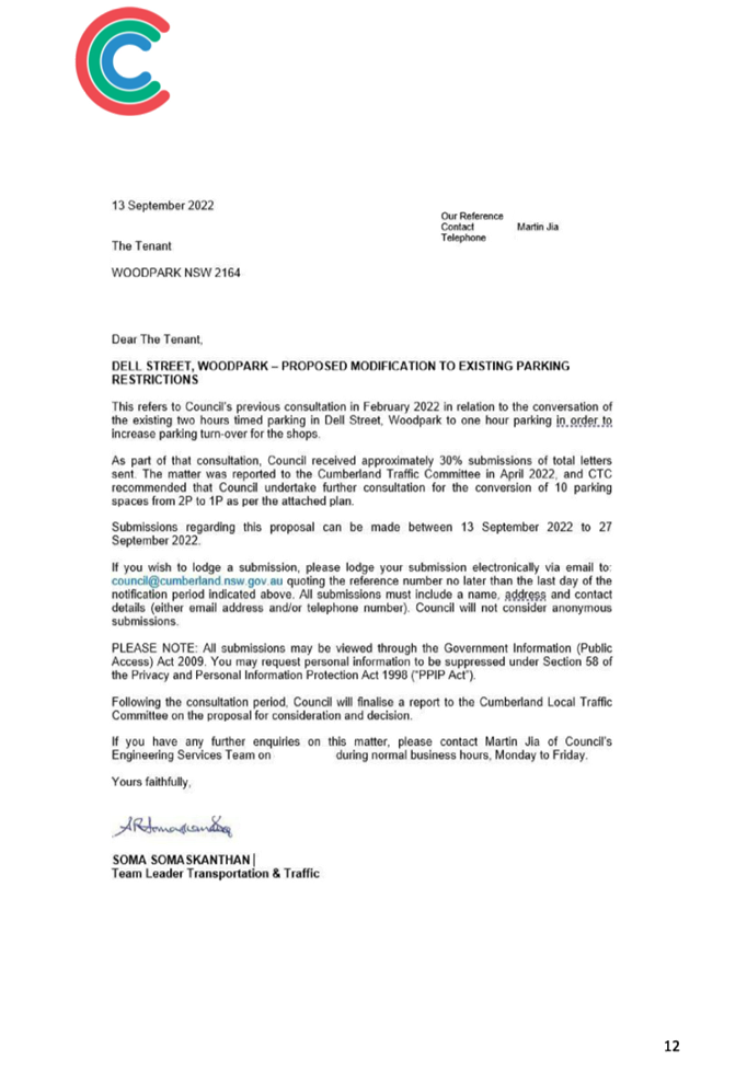
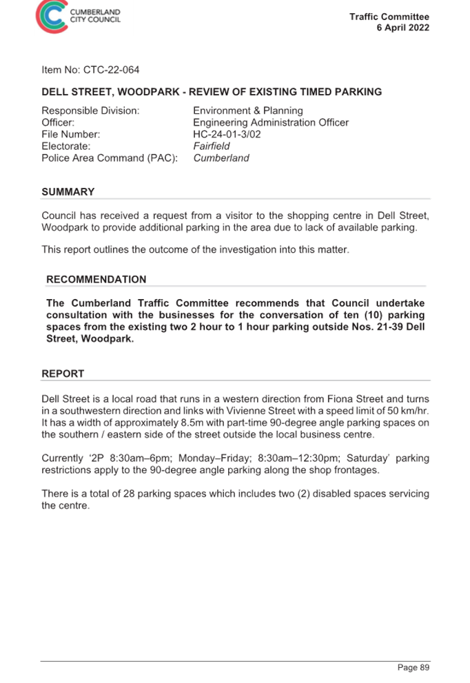
Cumberland Traffic Committee (CTC) at its meeting in April 2022 considered a report (CTC-22-064) regarding the conversion of the existing 2-hour parking spaces to 1-hour outside Nos. 21-39 Dell Street, Woodpark. The Cumberland Traffic Committee recommended that Council undertake consultation with the businesses for the conversation of ten (10) parking spaces from the existing two 2 hour to 1 hour parking outside Nos. 21-39 Dell Street, Woodpark.
Based on the above recommendation, consultation was undertaken with the tenants and owners of the businesses at the Dell Street Shopping Centre via post in September 2022. No responses were received.
Council received further concerns regarding the shortage of parking in the area.
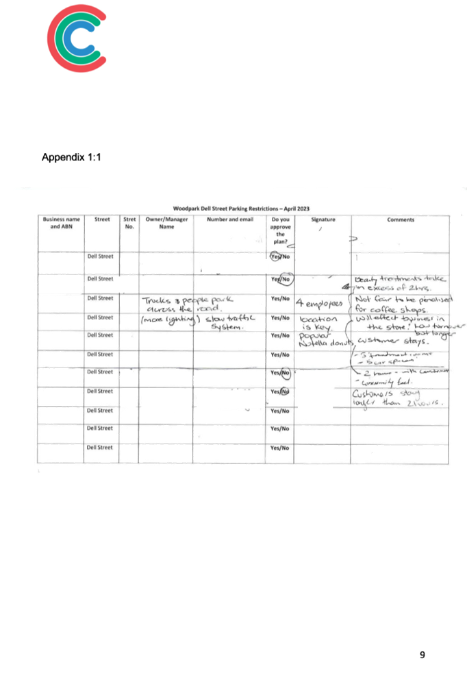
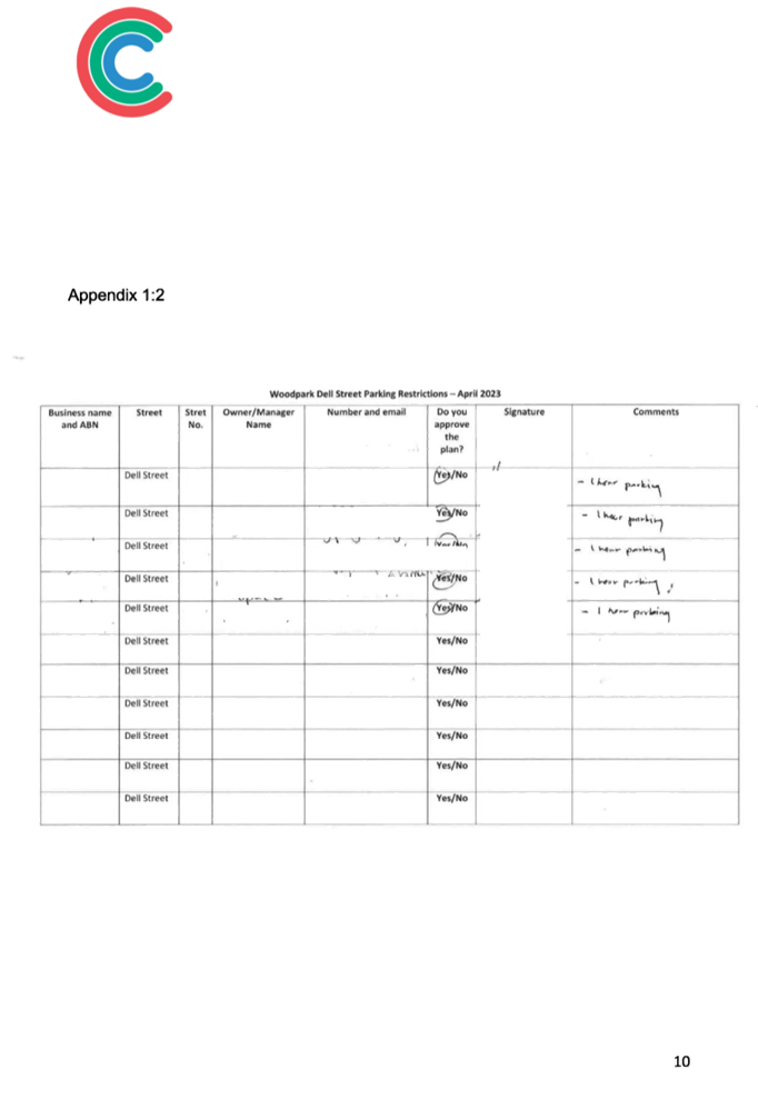
In April 2023, Council undertook further consultation with the shop owners at this location. Based on this engagement, nine businesses in the area have provided their comments on the proposal.
In summary, the businesses on the southern side of the Shopping Centre were strongly opposed to the changes due to the nature of their businesses and their customers’ needs. The food businesses located at the northern end of the complex were in favour of the changes as they believe it would benefit their businesses.
Based on the above result, it is proposed to convert five existing 2-hour parking spaces located on the northern end of the shopping complex to 1-hour parking as per the attached plan.
COnsultation
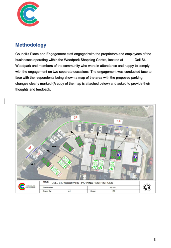
Consultation on the proposal was undertaken by Council in the first week of April 2023. The Team visited the Shopping Centre and conducted the engagement with the proprietors and employees of the businesses. A copy of the Engagement Report is attached to this report.
Attachments
1. Plan - Dell Street, Woodpark - Proposed 1 Hour Parking restrictions
DOCUMENTS
ASSOCIATED WITH
REPORT CTC-23-088
Attachment 1
Plan - Dell Street, Woodpark - Proposed 1 Hour Parking Restrictions
DOCUMENTS
ASSOCIATED WITH
REPORT CTC-23-088
Attachment 2
Engagement Report
7 June 2023
Item No: CTC-23-089
Surrey Street, Guildford - Road Closure
Directorate: Environment and Planning
Responsible Officer: Executive Manager Development and Building
File Number: HC-24-01-3/02
Electorate: Granville
Police Area Command (PAC): Cumberland
Agenda Part Part 2
Note: Recommendation to Council
Summary
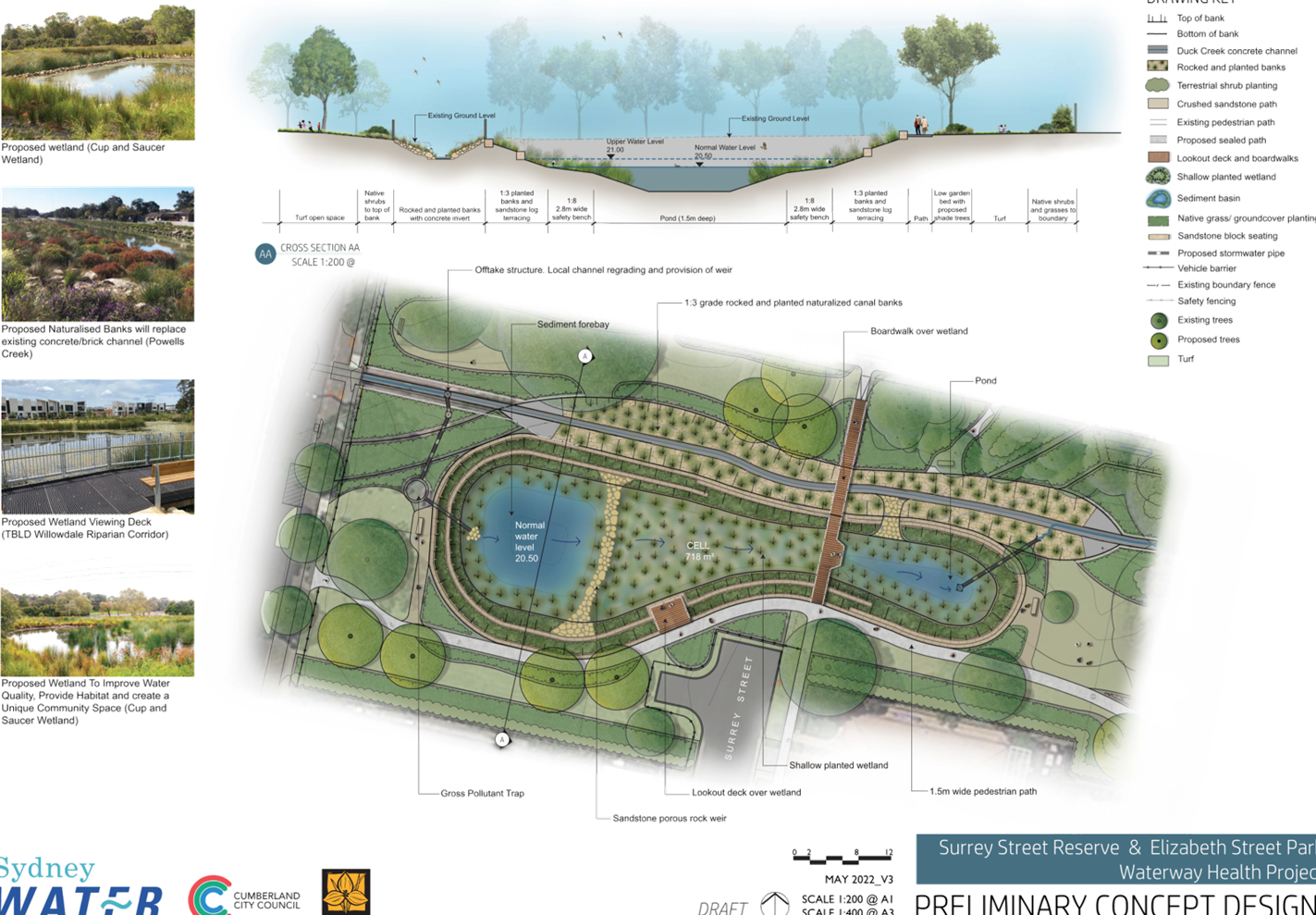
Council proposes to close a section of Surrey Street, Guildford and convert it into a reserve linking Surrey Street Reserve and Elizabeth Street Park as part of the Sydney Water Waterway Health Project.
This report outlines the outcome of the investigation into this matter.
|
The Cumberland Traffic Committee recommends that: 1. Council approve in-principle the closure of Surrey Street, Guildford, in accordance with the attached plan, subject to approval of a Traffic Management Plan by Transport for NSW. 2. Council forward final designs of the road closure proposal to Transport for NSW. 3. Council notify adjacent residents of the outcome. |
Report
In August 2021, Sydney Water commenced planning and design of the Surrey Street Chain of Parks Waterway Health Improvement Project in collaboration with Council. The project is located in Surrey Street Reserve & Elizabeth Street Park, Guildford. Proposed works include partial naturalisation of Duck Creek, construction of wetlands, walking paths, pedestrian bridge and other recreation and landscape improvements.
Closure of a section of Surrey Street for vehicular traffic and joining of Surrey Street Reserve and Elizabeth Street Park is an important element of the project. A turning bay is proposed at the closed section of Surrey Street for vehicles to turn back safely, with pedestrian access provided through the closed section. The project also proposes to incorporate 90-degree indented parking spaces, including accessible spaces, in Elizabeth Street at the frontage of the park.
Surrey Street is a local road with 5 residential properties excluding the corner properties with Barrett Street. It runs in a north-south direction between Barrett Street and Elizabeth Street and is approximately 165m long. The section of Surrey Street on the Elizabeth Street end has the Surrey Street Reserve on the west and Elizabeth Street Park on the east.
The map below shows the location of Surrey Street, Guildford:
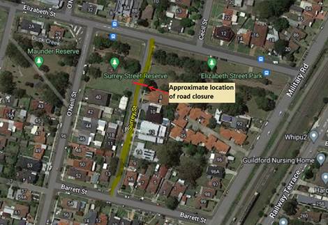
Council officers have investigated the impacts of the road closure. An assessment of traffic counts undertaken in August 2022, as provided in the table below, indicates the volume of detoured traffic from Surrey Street is very low, which is unlikely to have a significant impact on the local road network. Under the project, northbound traffic in Surrey Street will be detoured via Barrett Street and O’Neill Steet or Military Road, with southbound traffic in Surrey Street detoured via O’Neill Steet or Military Road and Barrett Street. There are no public transport routes through Surrey Street.
|
|
Average Daily Traffic (Veh./day) |
Average Peak Hour traffic |
|
|
|
|
AM peak |
PM Peak |
|
Surrey Street |
114 |
8 |
10 |
|
Barrett Street |
203 |
12 |
16 |
|
O’Neill Street |
1402 |
89 |
109 |
A further report will be presented to Traffic Committee when the road closure is finalised, and final designs are completed for the indented parking spaces.
Council officers have submitted a Traffic Management Plan (TMP) for the road closure to Transport for NSW, in accordance with the Traffic Committee delegation to Councils.
COnsultation
Consultation was undertaken by Sydney Water for a period of 28 days starting from 23 May 2022 to 20 June 2022.
No submissions were received.
Attachments
1. Plans - Surrey Street Reserve & Elizabeth Street Park Waterway Health Project Concept
DOCUMENTS
ASSOCIATED WITH
REPORT CTC-23-089
Attachment 1
Plans - Surrey Street Reserve & Elizabeth Street Park Waterway Health Project Concept
Traffic Committee
7 June 2023
Item No: CTC-23-090
Rhodes Avenue, Guildford - Road Safety Concerns
Directorate: Environment and Planning
Responsible Officer: Executive Manager Development and Building
File Number: HC-24-01-3/02
Electorate: Granville
Police Area Command (PAC): Cumberland
Agenda Part Part 2
Note: Recommendation to Council
Summary
Council has received speeding concerns from a local resident on Rhodes Avenue, Guildford.
This report outlines the outcome of the investigation into this matter.
|
The Cumberland Traffic Committee recommends that: 1. The installation of traffic calming devices on Rhodes Avenue, Guilford not be supported. 2. Council review conditions in Rhodes Avenue, Guildford and report back to the Traffic Committee in June 2024 if required. 3. Council notify concerned resident of the outcome. |
Report
Council has received speeding concerns from a local resident on Rhodes Avenue, Guildford
Rhodes Avenue is a local road that runs in an east-west direction between Woodville Road and Bolton Street with a speed limit of 50 km/h. It has a width of approximately 12.5m and parking is permitted on both sides of the road unless otherwise signposted.
Rhodes Avenue has ‘BB’ centre lines marked at the intersections. There are two roundabouts constructed at the intersections of Rhodes Avenue with Chamberlain Road and Rosebery Road.
This report analyses traffic conditions in Rhodes Avenue between the two roundabouts that is between Rosebery Road and Chamberlain Road.
The latest Centre for Road Safety accident data indicated that there were 5 reported accidents in Rhodes Avenue between Rosebery Road and Chamberlain Road in the 5 years ending September 2022. These 5 accidents are intersection crashes, 2 at Salisbury Road intersection and 3 at Milner Road intersection.
A separate report is included in this agenda for improving safety at the intersection of Rhodes Avenue and Salisbury Road.
The map below shows the location of Rhodes Avenue, Guildford:
Council officers have investigated the concerns and a traffic count was ordered in December 2022. The traffic count was undertaken at Rhodes Avenue, Guildford, mid-block between Milner Road and Rosebery Road. The results of the traffic count indicated the following:
|
Average Daily Traffic (ADT) – Veh/day |
865 |
|
85th percentile speed (km/hr) |
51.5 |
|
Mean (average) vehicle speed (km/hr)_ |
41.4 |
The results of the traffic counts and recorded crashes were used in the assessment to determine the need for the installation of traffic calming devices on Rhodes Avenue in accordance with the criteria set out in Council’s Local Area Traffic Management Policy (LATM) Policy.
The LATM assessments are summarised in the tables below:
Table 1 – Rhodes Avenue - LATM Assessment Points
|
Criteria |
Maximum Score |
Score Achieved |
|
Traffic Study Data |
45 |
5 |
|
Crash warrant in the last 5 years |
15 |
10 |
|
Road Characteristics |
35 |
13 |
|
Community Support & other factors |
5 |
5 |
|
Total |
100 |
33 |
Table 2 – Rhodes Avenue – Action
|
Criteria |
Action |
|
>75 |
Report to TC with a recommendation of providing traffic calming devices |
|
61-75 |
Report to TC and discuss possibility of providing traffic calming devices |
|
41-60 |
Council to review traffic data in 6 months |
|
25-40 |
Monitor street and review traffic data after 12 months |
|
<25 |
Do Nothing |
|
Speed |
That regardless of the total points scored, should the 85th percentile speed exceed the posted speed limit by 5 km/h, the street be referred to the NSW Police for monitoring and/or enforcement. |
The traffic count indicated that the recorded 85th percentile speed was 51.5 km/h, which is within acceptable limit compared to 50km/hr speed limit of the street.
Based on the above assessment, traffic calming devices are not warranted in the street at this time. Council will review traffic conditions in Rhodes Avenue in 12 months.
COnsultation
Consultation has not been undertaken as the investigation outlined in the report concludes no action is required.
Future consultation will be undertaken if recommended by the Traffic Committee.
Attachments
Nil
Traffic Committee
7 June 2023
Item No: CTC-23-091
Delhi Street, Lidcombe - Road Safety Concerns
Directorate: Environment and Planning
Responsible Officer: Executive Manager Development and Building
File Number: HC-24-01-3/02
Electorate: Auburn
Police Area Command (PAC): Auburn
Agenda Part Part 2
Note: Recommendation to Council
Summary
Council has reviewed traffic conditions in Delhi Street, Lidcombe.
This report outlines the outcome of the review.
|
The Cumberland Traffic Committee recommends that: 1. The installation of traffic calming devices on Delhi Street, Lidcombe not be supported. 2. Council request Cumberland Police Area Command to monitor speeding in Delhi Street. 3. Council review traffic conditions in Delhi Street, Lidcombe, in June 2024 and report back to Traffic Committee if required. 4. The concerned resident be notified of the outcome. |
Report
Cumberland Traffic Committee (CTC) at its meeting in August 2021 considered a report (Item No. CTC-21-197) regarding road safety concerns on Delhi Street, Lidcombe. Council resolved to review the traffic conditions in Delhi Street and report back to the Traffic Committee.
In accordance with Council’s resolution, a traffic count was undertaken in Delhi Street in February 2023. Council officers have reviewed the traffic count data and compared it with the previous traffic count data undertaken in June 2021 and October 2020. The traffic count locations are shown in red on the map below.
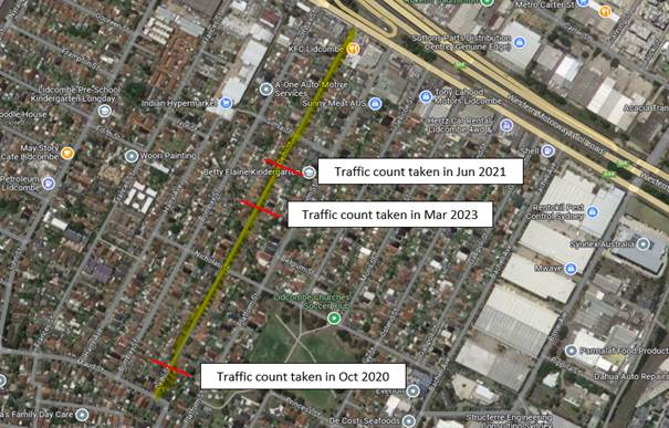
All results are detailed in the table below:
|
Traffic count date |
Av. daily traffic |
85th Percentile speed |
|
October 2020 |
1,728 |
54.5 km/h |
|
June 2021 |
2,156 |
47.2 km/h |
|
Mar 2023 |
1,777 |
56.5 km/h |
The traffic data from the table above indicated that the traffic volume (ADT) has decreased and recorded 85th percentile speeds have increased slightly since 2020.
According to the Centre for Road Safety Accident data, there were two reported accidents when a vehicle tried to perform a right/left turn and was hit another vehicle in Delhi Street in the 5 years ending September 2022. However, both accidents are at or close to the intersection of Maud Street, which is not related to speeding.
Based on the above, a further LATM assessment has been undertaken and the LATM assessment points are given below:
Table 1 – Delhi Street - LATM Assessment Points
|
Criteria |
Maximum Score |
Score Achieved |
|
Traffic Study Data |
45 |
15 |
|
Crash warrant in the last 5 years |
15 |
0 |
|
Road Characteristics |
35 |
10 |
|
Community Support & other factors |
5 |
5 |
|
Total |
100 |
30 |
Table 2 – Delhi Street – Action
|
Criteria |
Action |
|
>75 |
Report to TC with a recommendation of providing traffic calming devices |
|
61-75 |
Report to TC and discuss possibility of providing traffic calming devices |
|
41-60 |
Council to review traffic data in 6 months |
|
25-40 |
Monitor street and review traffic data after 12 months |
|
<25 |
Do Nothing |
|
Speed |
That regardless of the total points scored, should the 85th percentile speed exceed the posted speed limit by 5 km/h, the street be referred to the NSW Police for monitoring and/or enforcement. |
Based on the above assessment, traffic calming devices are not warranted in the street at this time. Therefore, the installation of traffic calming devices on Delhi Street, Lidcombe cannot be supported.
The recorded 85th percentile speed of 56.5km/hr is above the default speed limit. Therefore, Council will refer the street to Auburn Police Area Command for speed monitoring and/or enforcement.
Council will review conditions in Delhi Street in 12 months and report back to the Traffic Committee if traffic conditions have changed significantly.
COnsultation
Consultation has not been undertaken as the investigation outlined in the report concludes no action is required.
Future consultation will be undertaken if recommended by the Traffic Committee.
Attachments
Nil
Traffic Committee
7 June 2023
Item No: CTC-23-092
Joseph Street and James Street, Lidcombe - Proposed Extension of Existing Pedestrian Fencing
Directorate: Environment and Planning
Responsible Officer: Executive Manager Development and Building
File Number: T-28-01/06
Electorate: Auburn
Police Area Command (PAC): Auburn
Agenda Part Part 2
Note: Recommendation to Council
Summary
Council has received safety concerns from a business owner at the roundabout at the intersection of Joseph Street and James Street, Lidcombe.
This report outlines the outcome of the investigation into this matter.
|
The Traffic Committee recommends that: 1. The 13m extension of the existing pedestrian fence at the intersection of Joseph Street and James Street, Lidcombe in accordance with the attached plan be approved. 2. The concerned business owner be notified of the outcome. |
Report
James Street is a local road that runs in an east-west direction between East Street and Joseph Street with a speed limit of 50 km/h. It has a width of approximately 12.5m and parking is permitted on both sides of the road unless otherwise signposted.
James Street is on the local bypass route to Lidcombe Town Centre and carries large volume of traffic.
Joseph Street is a local road that runs in a north-south direction between Railway Street and State Road, Olympic Drive with a speed limit of 50 km/h. It has a width of approximately 12.5m and parking is permitted on both sides of the road unless otherwise signposted.
This intersection is controlled by a roundabout. There are raised pedestrian crossings at this roundabout on the James Street approach and Joseph Street southern approach. The crossings were raised in 2014 under the Federal Government Blackspot Program.
The raised pedestrian crossings have pedestrian fencing on either side of the marked crossing to prevent pedestrians crossing outside the crossing area.
The map below shows the intersection.
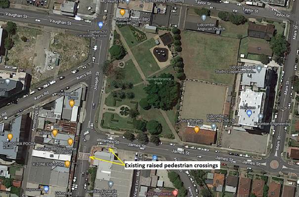
New apartment building has been built at the corner of Joseph Street and Kerrs Road which has increased pedestrian traffic along Joseph Street.
It is alleged that due to heavy traffic during peak periods, right turning vehicles from James Street attempting to enter the roundabout quickly when a gap is available cause near misses. It is proposed to extend the pedestrian fence at the crossing on the western side of Joseph Street in a northerly direction covering intersection.
The proposal as per the attached plan will enhance safety at this roundabout.
COnsultation
The extension of the pedestrian fence does not adversely impact on any parking or properties and no notification was undertaken.
Attachments
DOCUMENTS
ASSOCIATED WITH
REPORT CTC-23-092
Attachment 1
Joseph St, Lidcombe - Proposed Pedestrian Fencing
Traffic Committee
7 June 2023
Item No: CTC-23-093
Salisbury Road and Rhodes Avenue, Guildford - Proposed Intersection Treatment
Directorate: Environment and Planning
Responsible Officer: Executive Manager Development and Building
File Number: T-28-01/06
Electorate: Granville
Police Area Command (PAC): Cumberland
Agenda Part Part 2
Note: Recommendation to Council
Summary
Council has received safety concerns from a resident at the intersection of Salisbury Road and Rhodes Avenue, Guildford.
This report outlines the outcome of the investigation into this matter.
|
The Traffic Committee recommends that: 1. The installation of speed cushions on the Salisbury Road approaches at its intersection with Rhodes Avenue, Guildford in accordance with the attached plan be approved. 2. The concerned resident be notified of the outcome. |
Report
Council has received safety concerns from a resident at the intersection of Salisbury Road and Rhodes Avenue, Guildford.
Salisbury Road is a local road that runs in a north-south direction between Henry Street and Guildford Road with a speed limit of 50 km/h. It has a width of approximately 10.3m south of Rhodes Avenue and 12.5m north of Rhodes Avenue and parking is permitted on both sides of the road unless otherwise signposted.
Rhodes Avenue is a local road that runs in an east-west direction with a speed limit of 50 km/h. It has a width of approximately 12.5m and parking is permitted on both sides of the road unless otherwise signposted. Rhodes Avenue has ‘BB’ centre lines marked at the intersection.
Salisbury Road and Rhodes Avenue form an intersection with priority to Rhodes Avenue with ‘STOP’ signs and line marking on the Salisbury Road approaches.
The map below shows the intersection.
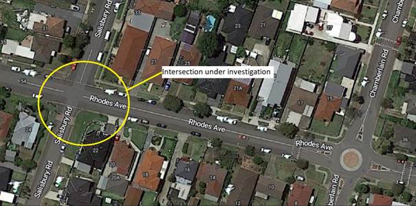
The latest Centre for Road Safety accident data indicated that there was one reported accident vehicle lost control and hit an object at this intersection in the 5 years ending September 2022.
There was also a recent accident at this intersection where a vehicle lost control and crashed into the fence of the corner property.
Site observations indicated that some vehicles approaching the intersection on the Salisbury Road approaches do not stop at the STOP control and drive through.
To assess approach speeds of traffic Council undertook traffic count on the Salisbury Road approach at 20m south of Rhodes Avenue.
Traffic count data:
Average Daily Traffic = 536 Veh/day
85th percentile speed (both directions) = 35 km/hr
85th percentile speed (northbound) = 33 km/hr
According to Austroads Guide, ‘Guide to Road Design - Part 3’, an approach speed of 33km/hr will require a desirable stopping distance of 30m for a vehicle to stop at the STOP signs/line marking. It is clear that the approach speed at 20m from the STOP control is high based on the Austroads guide.
It is proposed to install speed cushions on the Salisbury Road approaches to slow down traffic to stop at the STOP signs.
The proposed intersection treatment as per the attached plan will enhance safety at this intersection.
A separate report is presented in this agenda analysing traffic calming warrants in Rhodes Avenue in accordance with Council’s policy.
COnsultation
Consultation has not been undertaken as the investigation outlined in the report proposes capital works at the intersection which requires Council approval. In addition, the proposal has been discussed with the concerned resident after a site meeting.
Future consultation will be undertaken if recommended by the Traffic Committee and approved by Council.
Attachments
1. Plan - Rhodes Avenue and Salisbury Road, Guildford - Proposed Intersection Treatment
DOCUMENTS
ASSOCIATED WITH
REPORT CTC-23-093
Attachment 1
Plan - Rhodes Avenue and Salisbury Road, Guildford - Proposed Intersection Treatment
Traffic Committee
7 June 2023
Item No: CTC-23-094
Swete Street and Mary Street, Lidcombe - Proposed Treatment at Roundabout
Directorate: Environment and Planning
Responsible Officer: Executive Manager Development and Building
File Number: T-28-01/06
Electorate: Auburn
Police Area Command (PAC): Auburn
Agenda Part Part 2
Note: Recommendation to Council
Summary
Council has received safety concerns from a resident at the roundabout at the intersection of Swete Street and Mary Street, Lidcombe.
This report outlines the outcome of the investigation into this matter.
|
The Traffic Committee recommends that: 1. The construction of concrete kerb blisters at the intersection of Swete Street & Mary Street, Lidcombe in accordance with the attached plan be approved. 2. The installation of a speed cushion on the northbound approach of Swete Street at its intersection with Mary Street, Lidcombe in accordance with the attached plan be approved. 3. The concerned/affected residents be notified of the outcome. |
Report
Swete Street is a local road that runs in a north-south direction between Church Street and Maud Street with a speed limit of 50 km/h. It has a width of approximately 12.5m and parking is permitted on both sides of the road unless otherwise signposted.
Mary Street is a local road that runs in an east-west direction between Swete Street and John Street with a speed limit of 50 km/h. It has a width of approximately 12.5m and parking is permitted on both sides of the road unless otherwise signposted.
This intersection is controlled by a roundabout. The roundabout was constructed in 2019 under Federal Government Blackspot Program.
The map and street view below show the intersection.
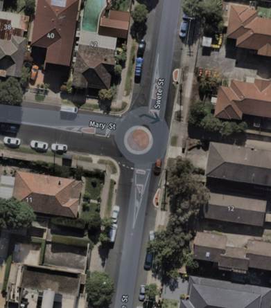
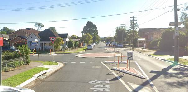
It is alleged that northbound vehicles on the Swete Street approach are speeding through the roundabout mounting the central island and losing control on the exit side. This has resulted in near misses and crashes with parked cars on the north-western side.
According to the Centre for Road Safety Accident Database, there was one accident in which a vehicle lost control and hit an object at this intersection since the construction of the roundabout in mid-2019.
Site observations have indicated that instead of slowing down on the approach to the roundabout and manoeuvre around the central island, northbound vehicles are mounting the central island while speeding through the roundabout.
To improve safety at this roundabout, it is proposed to construct kerb blisters on the western side of Swete Street to direct vehicles. Also, it is proposed to install a speed cushion on the northbound approach of Swete Street which will slow the approaching traffic.
The proposal as per the attached plan will enhance safety at this roundabout.
COnsultation
The proposal was notified to the impacted and adjacent residents for a period of 14 days from 11 May 2023 to 25 May 2023.
One submission was received indicating that speeding occurs due to some drivers driving ‘way too fast’. It is noted that Council officers had a site meeting with the same resident.
Attachments
1. Plan - Swete St & Mary St, Lidcombe - Proposed Kerb Blisters and Speed Hump at the Roundabout
DOCUMENTS
ASSOCIATED WITH
REPORT CTC-23-094
Attachment 1
Plan - Swete St & Mary St, Lidcombe - Proposed Kerb Blisters and Speed Hump at the Roundabout
DOCUMENTS
ASSOCIATED WITH
REPORT CTC-23-094
Attachment 2
Redacted Submission
Traffic Committee
7 June 2023
Item No: CTC-23-095
Nottinghill Road and The Boulevard, Lidcombe - Proposed 'No Stopping' Restrictions and Linemarkings
Directorate: Environment and Planning
Responsible Officer: Executive Manager Development and Building
File Number: T-28-01/06
Electorate: Auburn
Police Area Command (PAC): Auburn
Agenda Part Part 2
Note: Recommendation to Council
Summary
Council has received safety concerns from a resident at the intersection of Nottinghill Road and The Boulevarde, Lidcombe.
This report outlines the outcome of the investigation into this matter.
|
The Traffic Committee recommends that: 1. The installation of ‘No Stopping’ signs and line marking at the intersection of Nottinghill Road and The Boulevarde, Lidcombe in accordance with the attached plan be approved. 2. The affected residents be notified of the outcome. |
Report
The Boulevarde is a local road that runs in an east-west direction between Nottinghill Road and Joseph Street with a speed limit of 50 km/h. It has a width of approximately 13.7m and parking is permitted on both sides of the road unless otherwise signposted.
Nottinghill Road is a local road that runs in a north-south direction with a speed limit of 50 km/h. It has a width of approximately 12.5m and parking is permitted on both sides of the road unless otherwise signposted. Nottinghill Road has edge lines and centre lines marked.
The Boulevarde and Nottinghill Road form a T-intersection with priority to Nottinghill Road.
The map below shows the intersection.
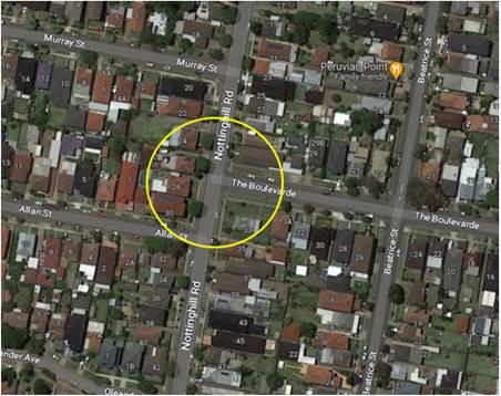
Figure 1 – Locality Plan
The latest Centre for Road Safety accident data indicated that there were no reported accidents at this intersection in the 5 years ending June 2022.
A site inspection indicated that vehicles are parking within 10 metres at the intersection.
Additionally, it was also alleged that vehicles northbound on Nottinghill Road are turning fast into The Boulevarde using the whole width of the side road creating near misses with vehicles waiting on The Boulevarde approach. It shall be noted that The Boulevarde is used as a rat-run to avoid the traffic signals at the intersection of Joseph Street and Georges Avenue.
The resident requested whether a ‘traffic dome’ could be installed at the intersection. It is noted that the use of traffic domes or silent cops have not been in practice now due to the danger posed to turning vehicles. Instead, Council proposes to construct a median island (600mm wide x 6m long) on the side road approach to provide turning vehicles to turn on the right side of road. It is also proposed to relocate the access ramps at the intersection to a location behind the median island as the 600mm wide median island will not provide protection to crossing pedestrians. Furthermore, Council also proposes to install ‘Give Way’ signs and line marking on The Boulevarde approach at this intersection to define the priority for Nottinghill Road.
The installation of ‘No Stopping’ signs would strengthen the Road Rules requirements, stop vehicles from parking too close to the intersection. It is also proposed to mark ‘BB’ centre lines on the Nottinghill Road and The Boulevarde approaches at the intersection.
The proposed intersection treatment as per the attached plan will enhance safety at this intersection.
COnsultation
The proposal was notified to the impacted and adjacent residents for a period of 14 days from 11 May 2023 to 25 May 2023. No submissions were received.
Attachments
1. Plan - Nottinghill Road & The Boulevarde, Lidcombe - Proposed Intersection Treatment
DOCUMENTS
ASSOCIATED WITH
REPORT CTC-23-095
Attachment 1
Plan - Nottinghill Road & The Boulevarde, Lidcombe - Proposed Intersection Treatment
Traffic Committee
7 June 2023
Item No: CTC-23-096
King Street, Guildford West - Road Safety Concerns
Directorate: Environment and Planning
Responsible Officer: Executive Manager Development and Building
File Number: HC-24-01-3/02
Electorate: Granville
Police Area Command (PAC): Cumberland
Agenda Part Part 2
Note: Recommendation to Council
Summary
Council has reviewed traffic conditions in King Street, Guildford West.
This report outlines the outcome of the review.
|
The Cumberland Traffic Committee recommends that: 1. The installation of traffic calming devices on King Street, Guildford West not be supported. 2. Council request Cumberland Police Area Command to monitor speeding in King Street, Guildford West. 3. Council review traffic conditions in King Street, Guildford West in June 2024 and report back to Traffic Committee if required. |
Report
Cumberland Traffic Committee (CTC) at its meeting in February 2020 considered a report (Item No.CTC-20-027) regarding road safety concerns in King Street, Guildford West. Council resolved to install line marking and review the conditions in King Street, Guildford West, and report back to Traffic Committee in April 2021.
Following the above, Council received further concerns from some residents and decided in March 2021 to undertake consultation with residents of King Street to determine support or otherwise for the installation of speed humps. Council did not receive sufficient submissions to proceed.
Following the consultation, a report with the consultation result was presented at Cumberland Traffic Committee (CTC) at its meeting in April 2021 (Item No. CTC-21-097). Council resolved that the installation of speed humps on King Street not be approved and Council review conditions in King Street, Guildford West, and report back to the Traffic Committee.
In accordance with Council’s resolution in April 2021 (CTC-21-097), a traffic count was undertaken in King Street in early 2023 and the location of the count marked in red on the map below.
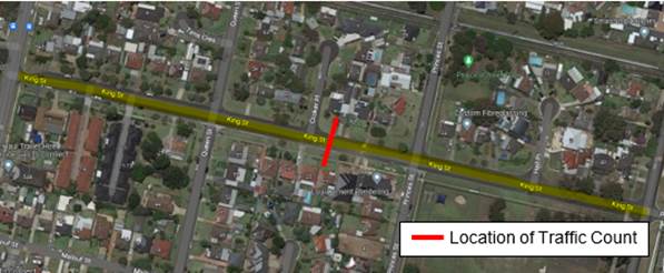
Council officers have reviewed the traffic count data and compared results with the previous traffic count data undertaken in 2019. Both results are detailed in the table below:
|
Traffic Count Date |
Average Daily Traffic |
85th Percentile Speed |
|
2019 |
1,279 |
60.7 km/h |
|
2023 |
1,361 |
58.7 km/h |
The traffic data from the table above indicated that the traffic volume (ADT) has increased slightly, and the recorded 85th percentile speed has reduced slightly since 2019.
According to the Centre for Road Safety Accident data, there were two reported accidents where a vehicle tried to perform a left/right turn and hit by another vehicle in King Street at the intersection of Princes Street in the 5 years ending September 2022.
Based on the above, a further LATM assessment was undertaken and the LATM assessment points are given below:
The LATM assessment points are given below:
Table 1 – King Street – LATM Assessment Points
|
Criteria |
Maximum Score |
Score Achieved |
|
Traffic Study Data |
45 |
20 |
|
Crash warrant in the last 5 years |
15 |
5 |
|
Road Characteristics |
35 |
10 |
|
Community Support & other factors |
5 |
5 |
|
Total |
100 |
40 |
Table 2 – King Street – Action
|
Criteria |
Action |
|
>75 |
Report to TC with a recommendation of providing traffic calming devices |
|
61-75 |
Report to TC and discuss possibility of providing traffic calming devices |
|
41-60 |
Council to review traffic data in 6 months |
|
25-40 |
Monitor street and review traffic data after 12 months |
|
<25 |
Do Nothing |
|
Speed |
That regardless of the total points scored, should the 85th percentile speed exceed the posted speed limit by 5 km/h, the street be referred to the NSW Police for monitoring and/or enforcement. |
The recorded 85th percentile speed of 58.7km/hr is above the default speed limit. Therefore, Council will refer the matter to Cumberland Police Area Command for speed monitoring and/or enforcement.
Council will review traffic conditions in King Street, Guildford West in 12 months and report back to the Traffic Committee if conditions change significantly.
COnsultation
Consultation has not been undertaken as the investigation outlined in the report concludes no action is required.
Future consultation will be undertaken if recommended by the Traffic Committee.
Attachments
DOCUMENTS
ASSOCIATED WITH
REPORT CTC-23-096
Attachment 1
Previous Report - CTC-21-097
7 June 2023
Item No: CTC-23-097
Leigh Street, Merrylands - Road Safety Concerns
Directorate: Environment and Planning
Responsible Officer: Executive Manager Development and Building
File Number: T-28-01/06
Electorate: Granville
Police Area Command (PAC): Cumberland
Agenda Part Part 2
Note: Recommendation to Council
Summary
Council has received a request from a local resident for the installation of traffic calming devices on Leigh Street, Merrylands due to speeding concerns.
This report outlines the outcome of the investigation into this matter.
|
The Cumberland Traffic Committee recommends that: 1. The installation of traffic calming devices on Leigh Street, Merrylands not be supported. 2. Council request Cumberland Police Area Command to undertake speed surveillance in Leigh Street, Merrylands, during School Zone times. 3. The concerned resident be notified of the outcome. |
Report
Council has received a request from a local resident for the installation of traffic calming devices on Leigh Street, Merrylands due to speeding concerns.
Leigh Street is a local road runs in a north-south direction between Matthew Street and Hawksview Street. The street is approximately 400m long and 9m wide.
The speed limit of the street is 50km/h with a section of ‘School Zone’ area at its northern end. Parking is permitted on both sides of the road in accordance with the Road Rules unless signposted.
Council’s Officers have investigated the request for the installation of traffic calming devices on Leigh Street in accordance with Council’s Local Area Traffic Management (LATM) Policy.
The latest Centre for Road Safety accident data indicated that there were no reported accidents in Leigh Street in the 5 years ending September 2022.
The map below shows the location of Leigh Street:
Two traffic counts were undertaken on Leigh Street in March 2023. The traffic count locations are shown in red on the map above.
The results of the traffic counts indicated the following:
Traffic count data on Leigh Street, Merrylands (Location 1):
Average Daily Traffic (ADT) = 577 veh/day,
85th percentile speed = 48.4 km/h,
Mean (average) vehicle speed = 39.2 km/h.
This section of Leigh Street has a school zone speed limit.
85th percentile speed (School times) = 45.4 km/hr
The school times selected in the analysis are 8:00 to 9:00AM and 2:00 to 3:00PM. The evening school time does not exactly coincide with the 2:30 to 4:00 PM School Zone times as the traffic count data allows only hourly periods.
Traffic count data on Leigh Street, Merrylands (Location 2):
Average Daily Traffic (ADT) = 462 veh/day,
85th percentile speed = 48.8 km/h,
Mean (average) vehicle speed = 39.4 km/h.
The results of the traffic counts and recorded crashes were used in the assessment to determine the need for the installation of traffic calming devices on Leigh Street in accordance with the criteria set out in Council’s Local area Traffic Management Policy (LATM) Policy.
The LATM assessments are summarised in the tables below:
Table 1 – Leigh Street (Location 1) - LATM Assessment Points
|
Criteria |
Maximum Score |
Score Achieved |
|
Traffic Study Data |
45 |
5 |
|
Crash warrant in the last 5 years |
15 |
0 |
|
Road Characteristics |
35 |
13 |
|
Community Support & other factors |
5 |
5 |
|
Total |
100 |
23 |
Table 2 – Leigh Street (Location 2) - LATM Assessment Points
|
Criteria |
Maximum Score |
Score Achieved |
|
Traffic Study Data |
45 |
0 |
|
Crash warrant in the last 5 years |
15 |
0 |
|
Road Characteristics |
35 |
12 |
|
Community Support & other factors |
5 |
5 |
|
Total |
100 |
17 |
Table 3 – Leigh Street – Action
|
Criteria |
Action |
|
>75 |
Report to TC with a recommendation of providing traffic calming devices |
|
61-75 |
Report to TC and discuss possibility of providing traffic calming devices |
|
41-60 |
Council to review traffic data in 6 months |
|
25-40 |
Monitor street and review traffic data after 12 months |
|
<25 |
Do Nothing |
|
Speed |
That regardless of the total points scored, should the 85th percentile speed exceed the posted speed limit by 5 km/h, the street be referred to the NSW Police for monitoring and/or enforcement. |
The traffic counts indicated that the recorded 85th percentile speed was 48.4 km/h and 48.8 km/h at locations 1 and 2 respectively, which are below the speed limit of the street. The School Zone time speeds are high in location 1 and it is proposed to request Cumberland Police to undertake speed surveillance in Leigh Street during School Zone times.
Based on the above assessment, traffic calming devices are not warranted in the street. Therefore, the request for the installation of traffic calming devices on Leigh Street cannot be supported.
COnsultation
Consultation has not been undertaken as the investigation outlined in the report concludes no action is required.
Future consultation will be undertaken if recommended by the Traffic Committee.
Attachments
Nil
Traffic Committee
7 June 2023
Item No: CTC-23-098
Matthew Street, Merrylands - Road Safety Concerns
Directorate: Environment and Planning
Responsible Officer: Executive Manager Development and Building
File Number: T-28-01/06
Electorate: Granville
Police Area Command (PAC): Cumberland
Agenda Part Part 2
Note: Recommendation to Council
Summary
Council has received a request from a local resident for the installation of traffic calming devices on Matthew Street, Merrylands due to speeding concerns.
This report outlines the outcome of the investigation into this matter.
|
The Cumberland Traffic Committee recommends that: 1. The installation of traffic calming devices on Matthew Street, Merrylands not be supported. 2. The concerned resident be notified of the outcome. |
Report
Council has received a request from a local resident for the installation of traffic calming devices on Matthew Street, Merrylands due to speeding concerns.
Matthew Street is a local road runs in an east-west direction between Fowler Road and Chetwynd Road. The street is approximately 500m long and 9.2m wide.
The speed limit of the street is 50km/h with a section of ‘School Zone’ area at its eastern end. Parking is permitted on both sides of the road in accordance with the Road Rules unless otherwise signposted.
Council’s Officers have investigated the request for the installation of traffic calming devices on Matthew Street in accordance with Council’s Local Area Traffic Management (LATM) Policy.
The latest Centre for Road Safety accident data indicated that there were no reported accidents in Matthew Street in the 5 years ending September 2022.
The map below shows the location of Matthew Street:
Figure 1 – Locality Plan
A traffic count was undertaken on Matthew Street in March 2023. The traffic count location is shown in red on the map above.
The results of the traffic count indicated the following:
Traffic count Data on Matthew Street, Merrylands:
Average Daily Traffic (ADT) = 762 veh/day,
85th percentile speed (full time) = 46.4 km/hr,
Mean (average) vehicle speed = 36.9 km/hr.
85th percentile speed (School times) = 41.7 km/hr
The school times selected in the analysis are 8:00 to 9:00AM and 2:00 to 3:00PM. The evening school time does not exactly coincide with the 2:30 to 4:00 PM School Zone times as the traffic count data allows only hourly periods.
The results of the traffic counts and recorded crashes were used in the assessment to determine the need for the installation of traffic calming devices on Matthew Street in accordance with the criteria set out in Council’s Local Area Traffic Management Policy (LATM) Policy.
The LATM assessments are summarised in the tables below:
Table 1 – Matthew Street - LATM Assessment Points
|
Criteria |
Maximum Score |
Score Achieved |
|
Traffic Study Data |
45 |
5 |
|
Crash warrant in the last 5 years |
15 |
0 |
|
Road Characteristics |
35 |
9 |
|
Community Support & other factors |
5 |
5 |
|
Total |
100 |
19 |
Table 2 – Matthew Street – Action
|
Criteria |
Action |
|
>75 |
Report to TC with a recommendation of providing traffic calming devices |
|
61-75 |
Report to TC and discuss possibility of providing traffic calming devices |
|
41-60 |
Council to review traffic data in 6 months |
|
25-40 |
Monitor street and review traffic data after 12 months |
|
<25 |
Do Nothing |
|
Speed |
That regardless of the total points scored, should the 85th percentile speed exceed the posted speed limit by 5 km/h, the street be referred to the NSW Police for monitoring and/or enforcement. |
The traffic count indicated that the recorded 85th percentile speed was 46.4 km/h which is below the speed limit of the street.
Based on the above assessment, traffic calming devices are not warranted in the street. Therefore, the request for the installation of traffic calming devices on Matthew Street cannot be supported.
COnsultation
Consultation has not been undertaken as the investigation outlined in the report concludes no action is required.
Future consultation will be undertaken if recommended by the Traffic Committee.
Attachments
Nil
Traffic Committee
7 June 2023
Item No: CTC-23-099
Hamilton Street, South Wentworthville - Road Safety Concerns
Directorate: Environment and Planning
Responsible Officer: Executive Manager Development and Building
File Number: HC-24-01-3/02
Electorate: Granville
Police Area Command (PAC): Cumberland
Agenda Part Part 2
Note: Recommendation to Council
Summary
Council has reviewed traffic conditions in Hamilton Street, South Wentworthville.
This report outlines the outcome of the review.
|
The Cumberland Traffic Committee recommends that: 1. The installation of traffic calming devices on Hamilton Street, South Wentworthville not be supported. 2. Council review conditions in Hamilton Street, South Wentworthville in June 2024 and report back to the Traffic Committee if required. 3. The concerned residents be notified of the outcome. |
Report
Cumberland Traffic Committee (CTC) at its meeting in August 2022 considered a report (Item No.CTC-22-141) regarding road safety concerns on Hamilton Street, South Wentworthville. Council resolved to review the conditions in Hamilton Street, South Wentworthville, and report back to Traffic Committee in November 2023. However, Council received further concerns from a resident and proposes to review conditions in June 2023.
A traffic count was undertaken in Hamilton Street in March 2023 as shown in the aerial photo below. Council officers have reviewed the traffic count data and compared it with the previous traffic count data undertaken in June 2022.
Both results are detailed in the table below:
|
Traffic count date |
Average Daily Traffic |
85th percentile speed |
|
June 2022 |
3,286 |
47.9 km/h |
|
March 2023 |
3,355 |
47 km/h |
The traffic data from the table above indicated that both traffic volume (ADT) and 85th percentile speed at Hamilton Street are similar to the data collected in 2022.
According to the Centre for Road Safety Accident data, there were no reported accidents in Hamilton Street in the 5 years ending September 2022.
Based on the above, a further LATM assessment was undertaken and the LATM assessment points are given below:
Table 1 – Hamilton Street - LATM Assessment Points
|
Criteria |
Maximum Score |
Score Achieved |
|
Traffic Study Data |
45 |
15 |
|
Crash warrant in the last 5 years |
15 |
0 |
|
Road Characteristics |
35 |
13 |
|
Community Support & other factors |
5 |
5 |
|
Total |
100 |
33 |
Table 2 – Hamilton Street – Action
|
Criteria |
Action |
|
>75 |
Report to TC with a recommendation of providing traffic calming devices |
|
61-75 |
Report to TC and discuss possibility of providing traffic calming devices |
|
41-60 |
Council to review traffic data in 6 months |
|
25-40 |
Monitor street and review traffic data after 12 months |
|
<25 |
Do Nothing |
|
Speed |
That regardless of the total points scored, should the 85th percentile speed exceed the posted speed limit by 5 km/h, the street be referred to the NSW Police for monitoring and/or enforcement. |
The recorded 85th percentile speed of 47 km/hr is below the default speed limit. Council will review traffic conditions in Hamilton Street in 12 months and report back to the Traffic Committee if there is a significant change in traffic conditions.
COnsultation
Consultation has not been undertaken as the investigation outlined in the report concludes no action is required.
Future consultation will be undertaken if recommended by the Traffic Committee.
Attachments
DOCUMENTS
ASSOCIATED WITH
REPORT CTC-23-099
Attachment 1
Previous Report - CTC-22-141
7 June 2023
Item No: CTC-23-100
Palmer Street, Guildford West - Road Safety Concerns
Directorate: Environment and Planning
Responsible Officer: Executive Manager Development and Building
File Number: HC-24-01-3/02
Electorate: Granville
Police Area Command (PAC): Cumberland
Agenda Part Part 2
Note: Recommendation to Council
Summary
Council has reviewed traffic conditions in Palmer Street, Guildford West.
This report outlines the outcome of the review.
|
The Cumberland Traffic Committee recommends that: 1. The installation of traffic calming devices on Palmer Street, Guildford West not be supported. 2. Council review conditions in Palmer Street, Guildford West in November 2023 and report back to traffic committee if required. |
Report
Cumberland Traffic Committee (CTC) at its meeting in April 2021 considered a report (Item No.CTC-21-079) regarding road safety concerns on Palmer Street, Guildford West. Council resolved to review the conditions in Palmer Street, Guildford West, and report back to the Traffic Committee.
In accordance with Council’s resolution, a traffic count was undertaken in Palmer Street in February 2023. Council officers have reviewed the traffic count data and compared it with the previous traffic count data undertaken in March 2021.
Both results are detailed in the table below:
|
Traffic count date |
Average Daily Traffic |
85th percentile speed |
|
March 2021 |
1,259 |
49.6 km/h |
|
February 2023 |
2,097 |
51.1 km/h |
The traffic data from the table above indicated that both traffic volume (ADT) and recorded 85th percentile speed at Palmer Street have slightly increased since 2021.
The map below shows the location of Palmer Street, Guildford West.
According to the Centre for Road Safety Accident data, there was one reported accident (left off into object) in Palmer Street in the five years ending September 2022.
Based on the above, a further LATM assessment was undertaken and the LATM assessment points are given below:
Table 1 – Palmer Street - LATM Assessment Points
|
Criteria |
Maximum Score |
Score Achieved |
|
Traffic Study Data |
45 |
15 |
|
Crash warrant in the last 5 years |
15 |
5 |
|
Road characteristics |
35 |
18 |
|
Community support & other factors |
5 |
5 |
|
Total |
100 |
43 |
Table 2 – Palmer Street – Action
|
Criteria |
Action |
|
>75 |
Report to TC with a recommendation of providing traffic calming devices |
|
61-75 |
Report to TC and discuss possibility of providing traffic calming devices |
|
41-60 |
Council to review traffic data in 6 months |
|
25-40 |
Monitor street and review traffic data after 12 months |
|
<25 |
Do Nothing |
|
Speed |
That regardless of the total points scored, should the 85th percentile speed exceed the posted speed limit by 5 km/h, the street be referred to the NSW Police for monitoring and/or enforcement. |
The recorded 85th percentile speed of 51.1 km/hr is slightly above the default speed limit and it is within acceptable limits.
Council will review conditions in Palmer Street, Guildford in 6 months and report back to Traffic Committee if there is a significant change in traffic conditions.
COnsultation
Consultation has not been undertaken as the investigation outlined in the report concludes no action is required.
Future consultation will be undertaken if recommended by the Traffic Committee.
Attachments
DOCUMENTS
ASSOCIATED WITH
REPORT CTC-23-100
Attachment 1
Previous Report - CTC-21-079
7 June 2023
Item No: CTC-23-101
Harris Street, Merrylands - Road Safety Concerns
Directorate: Environment and Planning
Responsible Officer: Executive Manager Development and Building
File Number: HC-24-01-3/02
Electorate: Granville
Police Area Command (PAC): Cumberland
Agenda Part Part 2
Note: Recommendation to Council
Summary
Council has received request from a local resident for the installation of traffic calming devices on Harris Street, Merrylands due to speeding concerns.
This report outlines the outcome of the investigation into this matter.
|
The Cumberland Traffic Committee recommends that: 1. The installation of traffic calming devices on Harris Street, Merrylands not be supported. 2. Council request Cumberland Police Area Command to monitor speeding in Harris Street. 3. Council review traffic conditions in Harris Street, Merrylands in June 2024, and report back to the Traffic Committee if required. 4. The concerned resident be notified of the outcome. |
Report
Council received requests from a local resident for the installation of traffic calming devices on Harris Street, Merrylands due to speeding concerns. The resident lives in the vicinity of the Harris Street section between Hawksview Street and Morris Street, Merrylands.
Harris Street runs in a north-south direction between Desmond Street and Guildford Road. The regional road Hawksview Street intersects Harris Street, and the intersection is controlled by a roundabout. Additionally, a roundabout was constructed in mid-2022 under Blackspot funding at the intersection of Harris Street and Morris Street.
This analysis considers the approximately 560m long section of Harris Street between the two roundabouts at its intersections with Hawksview Street and Morris Street.
Previously, Council approved a line marking scheme comprising of centre and edge lines in the section of Harris Street between Hawksview Street and Raleigh Street which is north of the bridge over Sydney Water Pipelines and approximately 100m north of Guildford Road. Furthermore, Cumberland Traffic Committee in April 2022 considered a report on Harris Street section south of Hawksview Street and recommended that traffic calming devices in Harris Street not be approved due to lack of community support.
In response to recent concerns, a traffic count was undertaken on Harris Street in March 2023. The traffic count location is shown in red in the map below.
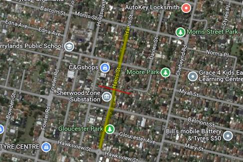
The results of the traffic count indicated the following on Harris Street, Merrylands:
Average Daily Traffic (ADT) = 1,017 veh/day,
85th percentile speed = 57.6 km/h,
Mean (average) vehicle speed = 48.6 km/h.
In accordance with the Centre for Road Safety Accident Database, there were no mid-block or speed related crashes in the Harris Street section under consideration. There were two intersection (cross-traffic) crashes at the intersection of Harris Street and Morris Street in the five years ending September 2022. These crashes resulted in the funding received for the roundabout at this intersection.
The result of the traffic count recorded and crashes were used in the assessment to determine the need for the installation of traffic calming devices on Harris Street in accordance with the criteria set out in Council’s Local Area Traffic Management Policy (LATM) Policy.
The LATM assessments are summarised in the tables below:
Table 1 – Harris Street - LATM Assessment Points
|
Criteria |
Maximum Score |
Score Achieved |
|
Traffic Study Data |
45 |
20 |
|
Crash warrant in the last 5 years |
15 |
0 |
|
Road Characteristics |
35 |
13 |
|
Community Support & other factors |
5 |
5 |
|
Total |
100 |
38 |
Table 2 – Harris Street – Action
|
Criteria |
Action |
|
>75 |
Report to TC with a recommendation of providing traffic calming devices |
|
61-75 |
Report to TC and discuss possibility of providing traffic calming devices |
|
41-60 |
Council to review traffic data in 6 months |
|
25-40 |
Monitor street and review traffic data after 12 months |
|
<25 |
Do Nothing |
|
Speed |
That regardless of the total points scored, should the 85th percentile speed exceed the posted speed limit by 5 km/h, the street be referred to the NSW Police for monitoring and/or enforcement. |
Based on the above assessment, traffic calming devices are not warranted in the street. Therefore, the request for the installation of traffic calming devices on Harris Street, Merrylands cannot be supported.
The traffic count indicated that the recorded 85th percentile speed was 57.6 km/h, which is higher than the speed limit. It is proposed to request Cumberland Police Area Command to undertake speed surveillance in Harris Street.
Council will review traffic conditions in Harris Street 12 months’ time and provide a further report to the Traffic Committee if there is a significant change in traffic conditions.
COnsultation
Consultation has not been undertaken as the investigation outlined in the report concludes no action is required.
Future consultation will be undertaken if recommended by the Traffic Committee.
Attachments
Nil
Traffic Committee
7 June 2023
Item No: CTC-23-102
Wyena Road, Pendle Hill - Road Safety Concerns - Consultation
Directorate: Environment and Planning
Responsible Officer: Executive Manager Development and Building
File Number: N/A
Electorate: Prospect
Police Area Command (PAC): Cumberland
Agenda Part Part 2
Note: Recommendation to Council
Summary
Cumberland Traffic Committee (CTC) at its meeting in February 2023 considered a report (CTC-23-023) regarding road safety concerns on Wyena Road, Pendle Hill and recommended to undertake a design for the speed humps and consult with the affected residents, and report back to the Traffic Committee in June 2023.
This report outlines the outcome of the consultation into this matter.
|
1. The Cumberland Traffic Committee recommends that the installation of traffic calming devices on Wyena Road, Pendle Hill not be supported. 2. Council review conditions in Wyena Road, Pendle Hill in June 2024 and report back to the Traffic Committee if required. 3. That Council notify all affected/concerned residents of the outcome. |
Report
Cumberland Traffic Committee (CTC) at its meeting in February 2023 considered a report (CTC-23-023) regarding road safety concerns on Wyena Road, Pendle Hill. Council resolved to undertake a design for the speed humps and consult with the affected residents, and report back to the Traffic Committee in June 2023.
In accordance with Council’s resolution, a design was prepared for the speed hump locations in Wyena Road and consultation was carried out with the affected residents in May 2023. A total of 33 letters with an attached speed hump design plan and a survey form were distributed to the affected residents/owners. There were 8 responses (24% of the total letters sent) received by the closing date. Out of these 8, two (2) submissions were supporting speed humps, however, one of these is an anonymous submission and the other submission did not want a speed humps outside their property. In total there were 6 responses (67%) opposing the proposed speed humps. One of the submissions objecting to the proposed speed humps was a petition signed by 21 residents (directly affected and other residents in the street).
Based on the above result, it is proposed that speed humps in Wyena Road, Pendle Hill not be supported.
Council will review traffic conditions in Wyena Road, Pendle Hill in June 2024, and report back to Traffic Committee if there is a significant change in conditions.
COnsultation
The proposal was notified to the impacted resident for a period of 14 days starting from 11 May 2023 to 25 May 2023.
A total of 33 letters were distributed to the affected residents/owners. There were 8 responses (24% of the total letters sent) received by the closing date. Details of responses are detailed in the report.
Attachments
1. Previous Report - CTC-23-023
2. Minutes of the Traffic Committee for Item CTC-23-023
DOCUMENTS
ASSOCIATED WITH
REPORT CTC-23-102
Attachment 1
Previous Report - CTC-23-023
Attachment 2
Minutes of the Traffic Committee for Item CTC-23-023
DOCUMENTS
ASSOCIATED WITH
REPORT CTC-23-102
Attachment 3
Concept Plan Used for Consultation
DOCUMENTS
ASSOCIATED WITH
REPORT CTC-23-102
Attachment 4
Redacted Submissions
7 June 2023
Item No: CTC-23-103
Dorothy Street, Chester Hill - Road Safety Concerns
Directorate: Environment and Planning
Responsible Officer: Executive Manager Development and Building
File Number: HC-24-01-3/02
Electorate: Granville
Police Area Command (PAC): Cumberland
Agenda Part Part 2
Note: Recommendation to Council
Summary
Council has received a request from a local resident for the installation of traffic calming devices on Dorothy Street, Chester Hill due to speeding concerns.
This report outlines the outcome of the review.
|
The Cumberland Traffic Committee recommends that: 1. The installation of traffic calming devices on Dorothy Street, Chester Hill not be supported. 2. The concerned resident be notified of the outcome. |
Report
Council has received a request from a local resident for the installation of traffic calming devices on Dorothy Street, Chester Hill due to speeding concerns.
Dorothy Street is a local road runs in a north – south direction between Everley Road and Boundary Road. It is approximately 460m long. The width of the street is approximately 7.5m.
The speed limit in the street is 50km/h. Parking is permitted on both sides of the road in accordance with the Road Rules unless signposted.
Council’s Officers have investigated the request for the installation of traffic calming devices on Dorothy Street in accordance with Council’s Local Area Traffic Management (LATM) Policy.
The latest Centre for Road Safety accident data indicated that there were no reported accidents in Dorothy Street in the five years ending September 2022.
The map below shows the location of Dorothy Street:
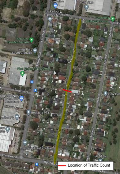
A traffic count was undertaken on Dorothy Street in March 2023. The traffic count location is shown in red on the map above.
The results of the traffic count indicated the following on Dorothy Street, Chester Hill:
Average Daily Traffic (ADT) = 395 veh/day,
85th percentile speed = 46.8 km/h,
Mean (average) vehicle speed = 36.2 km/h.
The result of the traffic count and recorded crashes were used in the assessment to determine the need for the installation of traffic calming devices on Dorothy Street in accordance with the criteria set out in Council’s Local Area Traffic Management Policy (LATM) Policy.
The LATM assessments are summarised in the tables below:
Table 1 – Dorothy Street - LATM Assessment Points
|
Criteria |
Maximum Score |
Score Achieved |
|
Traffic Study Data |
45 |
0 |
|
Crash warrant in the last 5 years |
15 |
0 |
|
Road Characteristics |
35 |
16 |
|
Community Support & other factors |
5 |
5 |
|
Total |
100 |
21 |
Table 2 – Dorothy Street – Action
|
Criteria |
Action |
|
>75 |
Report to TC with a recommendation of providing traffic calming devices |
|
61-75 |
Report to TC and discuss possibility of providing traffic calming devices |
|
41-60 |
Council to review traffic data in 6 months |
|
25-40 |
Monitor street and review traffic data after 12 months |
|
<25 |
Do Nothing |
|
Speed |
That regardless of the total points scored, should the 85th percentile speed exceed the posted speed limit by 5 km/h, the street be referred to the NSW Police for monitoring and/or enforcement. |
Based on the above assessment, traffic calming devices are not warranted in the street. Therefore, the request for the installation of traffic calming devices on Dorothy Street cannot be supported. The recorded 85th percentile speed of 46.8 km/hr is below the default speed limit.
COnsultation
Consultation has not been undertaken as the investigation outlined in the report concludes no action is required.
Future consultation will be undertaken if recommended by the Traffic Committee.
Attachments
Nil
Traffic Committee
7 June 2023
Item No: CTC-23-104
The Trongate and Fifth Street, Granville - Provision of a Roundabout
Directorate: Environment and Planning
Responsible Officer: Executive Manager Development and Building
File Number: HC-24-01-3/02
Electorate: Granville
Police Area Command (PAC): Cumberland
Agenda Part Part 2
Note: Recommendation to Council
Summary
This report provides a response to Council’s Notice of Motion – Safety Issues, The Trongate and Fifth Street, Granville, resolved at the Ordinary Meeting of Council on 5 April 2023 (Min.391 C04/23-281).
|
The Cumberland Traffic Committee recommends that: 1. The proposed roundabout at the intersection of The Trongate and Fifth Street, Granville be approved in principle. 2. Consultation be carried out with residents impacted by the proposed roundabout. 3. Council apply for funding for the construction of the roundabout under a suitable program. |
Report
This report provides a response to Council’s Notice of Motion – Safety Issues, Fifth Street and The Trongate, Granville, resolved at the Ordinary Meeting of Council on 5 April 2023 (Min.391 C04/23-281).
Cumberland Traffic Committee has previously investigated for the provision of a roundabout at the intersection of The Trongate and Fifth Street, Granville.
Cumberland Traffic Committee considered a report in November 2022 (CTC-22-193) regarding the provision of a roundabout at the intersection of The Trongate and Fifth Street, Granville and recommended that the provision of a roundabout at the intersection of The Trongate and Fifth Street, Granville is not warranted based on current traffic volumes. Council approved the recommendation at its meeting held on 1 March 2023.
A Notice of Motion (Min.391 C04/23-281) was considered at the Council meeting on 5 April 2023, and was resolved as follows:
That Council:
1. Refer resident feedback regarding significant accident and safety issues at the intersection of Fifth street and the Trongate, Granville and the proposal for a roundabout to the next Traffic Committee meeting.
2. Notify affected residents of any proposed actions or solutions proposed to seek their further input and feedback prior to implementation.
Following the Notice of Motion, Council officers undertook preparation of concept designs for a roundabout at the intersection of The Trongate and Fifth Street, Granville.
At the meeting, a resident addressed the Council requesting a roundabout at this intersection. The resident provided a document which illustrated that there were 2 minor crashes and 4 near miss crashes occurred at the intersection in the last 3 years. However, Council officers’ investigation into these alleged crashes indicated that these were not recorded in the database from the Centre for Road Safety. Based on the Centre for Road Safety accident records, there was one reported accident at this intersection in the five years ending September 2022. This accident which was a non-injury accident occurred in 2021.
Based on the information provided by the resident and Council’s resolution, Council officers have investigated the matter and prepared a concept design for a roundabout at the intersection of The Trongate and Fifth Street.
The proposal will have a loss of at least eight (8) existing on-street parking spaces and is estimated to cost in the range of $400,000.
COnsultation
Consultation has not been undertaken at this time as the proposal involves major capital expenditure and requires Council approval.
Future consultation will be undertaken if approved by Council.
Attachments
DOCUMENTS
ASSOCIATED WITH
REPORT CTC-23-104
Attachment 1
Plan - Proposed Roundabout