Traffic Committee
5 April 2023
5 April 2023
A meeting of the Traffic Committee will be held at 9.30am in Council Chambers, Merrylands Administration Building, 16 Memorial Avenue, Merrylands on Wednesday, 5 April 2023.
Business as below:
Yours faithfully
Peter J. Fitzgerald
General Manager
ORDER OF BUSINESS
1. Apologies
2. Declarations of Interest
3. Confirmation of Previous Minutes endorsed by Council
4. Summary of Reports.......................................................................................................... 4
5. Reports
- Part 1 - Recommended for Approval under Delegated Authority
- Part 2 - Recommendation to Council
CONTENTS
Report No. Name of Report Page No.
Part 1 - Recommended for Approval under Delegated Authority
CTC-23-047 Moree Avenue, Westmead - Application for 'Works Zone' Signage..................................................................................................... 9
CTC-23-048 Terminal Place, Merrylands - Application for 'Works Zone' Signage................................................................................................... 15
CTC-23-049 Northumberland Road, Auburn - Convert the Existing Part-Time Bus Zone to Fulltime Bus Zone..................................... 23
CTC-23-050 Nottinghill Road and The Boulevard, Lidcombe - Proposed 'No Stopping' Restrictions and Linemarkings................ 29
CTC-23-051 Sapphire Street, Greystanes - Proposed 'No Parking' Restrictions....................................................................................... 35
CTC-23-052 Graham Street, Greystanes - Proposed 'No Parking' Restrictions....................................................................................... 47
CTC-23-053 Kerr Parade, Auburn - Convert an Existing 2P Space to EV Parking................................................................................................... 53
CTC-23-054 Alexandra Avenue and Hassall Street, Westmead - Proposed Works for Sydney Metro in Westmead Area 59
CTC-23-055 Clunies Ross Street, Pemulwuy - Proposed 'No Parking' Restrictions and Line Markings............................................. 65
Part 2 - Recommendation to Council
CTC-23-056 Earl Street, Merrylands - Road Safety Concerns.... 77
CTC-23-057 Vaughan Street & Auburn Road, Auburn - Proposed Traffic Signal Consideration.................................................................... 91
CTC-23-058 Vaughan and Dudley Street, Lidcombe - Proposed Traffic Signal Consideration.................................................................... 95
CTC-23-059 Albert Street, Guildford - Road Safety Concerns... 99
CTC-23-060 Chelsea Street, Merrylands - Road Safety Concerns 103
CTC-23-061 Essington Street, Wentworthville - Road Safety Concerns............................................................................................ 113
CTC-23-062 Excelsior Street, Merrylands - Road Safety Concerns 117
CTC-23-063 Gordon Avenue, South Granville - Road Safety Concerns 127
CTC-23-064 Karrabah Road, Auburn - Road Safety Concerns..... 131
CTC-23-065 Mimosa Street, Granville - Construction of a Pedestrian Refuge.................................................................................................. 141
CTC-23-066 Hibiscus Street, Greystanes - Road Safety Concerns 209
CTC-23-067 Old Prospect Road between Gozo Road and Greystanes Road, Greystanes - Road Safety Concerns.................. 213
CTC-23-068 Roseberry Street, Merrylands - Road Safety Concerns 223
CTC-23-069 Ruth Street, Merrylands West - Proposed No Right Turn - Consultation.................................................................................... 235
CTC-23-070 Terry Street, Greystanes - Road Safety Concerns 255
CTC-23-071 Nottinghill Road, Berala - Road Safety Concerns.. 269
CTC-23-072 Bando Road, Girraween - Proposed Installation of Pedestrian Fencing...................................................................... 273
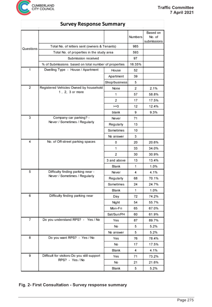
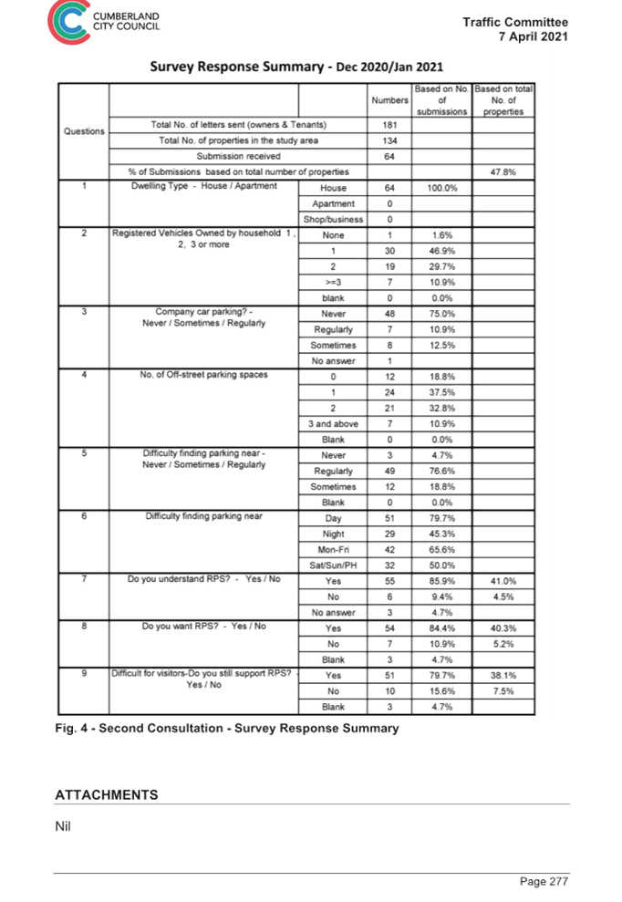
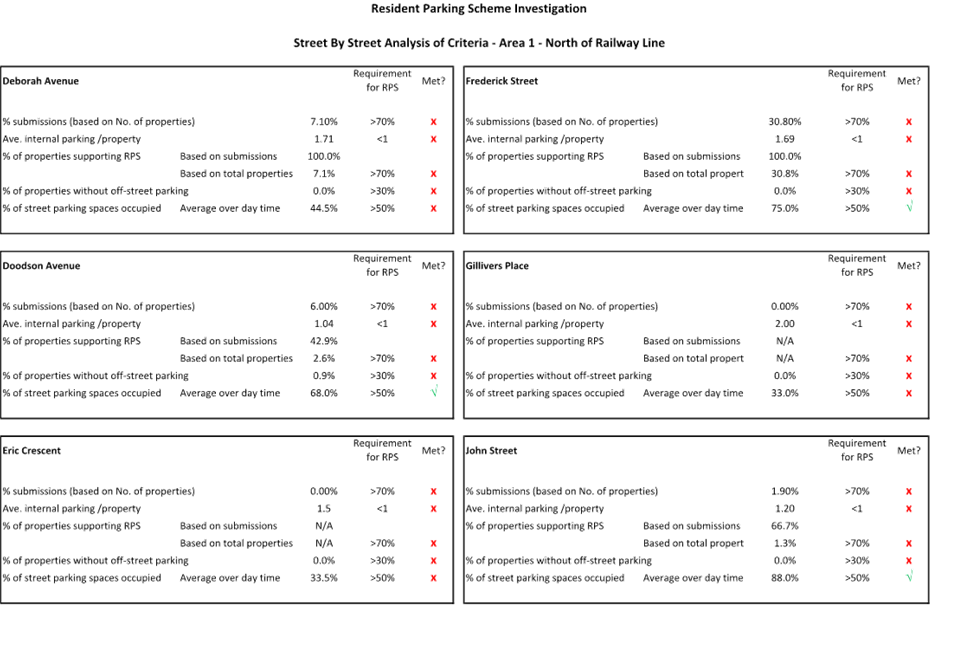
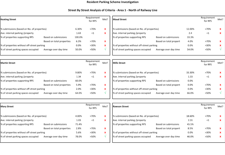
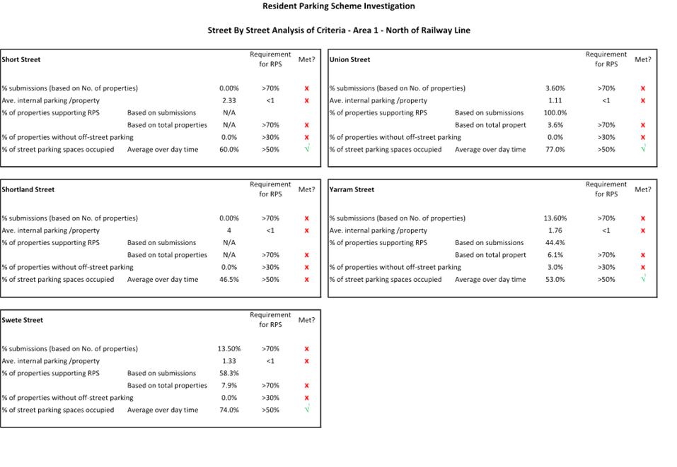
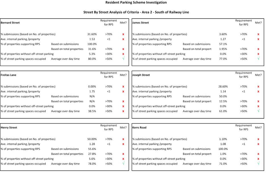
CTC-23-073 Response to Notice of Motion C08/22-121 - Residential Parking in Lidcombe...................................................................... 281
Traffic Committee
5 April 2023
Part 1 - Recommended for Approval under Delegated Authority
|
Item # |
Title |
Electorate |
Police Area Command (PAC) |
||||
|
Fairfield |
Granville |
Prospect |
Auburn |
Cumberland |
Auburn |
||
|
CTC-23-047 |
Moree Avenue, Westmead - Application for 'Works Zone' Signage |
|
´ |
|
|
´ |
|
|
CTC-23-048 |
Terminal Place, Merrylands - Application for 'Works Zone' Signage |
|
´ |
|
|
´ |
|
|
CTC-23-049 |
Northumberland Road, Auburn - Convert the Existing Part-Time Bus Zone to Fulltime Bus Zone |
|
|
|
´ |
|
´ |
|
CTC-23-050 |
Nottinghill Road and The Boulevard, Lidcombe - Proposed 'No Stopping' Restrictions and Linemarkings |
|
|
|
´ |
|
´ |
|
CTC-23-051 |
Sapphire Street, Greystanes - Proposed 'No Parking' Restrictions |
|
|
´ |
|
´ |
|
|
CTC-23-052 |
Graham Street, Greystanes - Proposed 'No Parking' Restrictions |
|
´ |
|
|
´ |
|
|
CTC-23-053 |
Kerr Parade, Auburn - Convert an Existing 2P Space to EV Parking |
|
|
|
´ |
|
´ |
|
CTC-23-054 |
Alexandra Avenue and Hassall Street, Westmead - Proposed Works for Sydney Metro in Westmead Area |
|
´ |
|
|
´ |
|
|
CTC-23-055 |
Clunies Ross Street, Pemulwuy - Proposed 'No Parking' Restrictions and Line Markings |
|
|
´ |
|
|
|
Part 2 - Recommendation to Council
|
Item # |
Title |
Electorate |
Police Area Command (PAC) |
||||
|
Fairfield |
Granville |
Prospect |
Auburn |
Cumberland |
Auburn |
||
|
CTC-23-056 |
Earl Street, Merrylands - Road Safety Concerns |
|
´ |
|
|
´ |
|
|
CTC-23-057 |
Vaughan Street & Auburn Road, Auburn - Proposed Traffic Signal Consideration |
|
|
|
´ |
|
´ |
|
CTC-23-058 |
Vaughan and Dudley Street, Lidcombe - Proposed Traffic Signal Consideration |
|
|
|
´ |
|
´ |
|
CTC-23-059 |
Albert Street, Guildford - Road Safety Concerns |
|
´ |
|
|
´ |
|
|
CTC-23-060 |
Chelsea Street, Merrylands - Road Safety Concerns |
|
´ |
|
|
´ |
|
|
CTC-23-061 |
Essington Street, Wentworthville - Road Safety Concerns |
|
´ |
|
|
´ |
|
|
CTC-23-062 |
Excelsior Street, Merrylands - Road Safety Concerns |
|
´ |
|
|
´ |
|
|
CTC-23-063 |
Gordon Avenue, South Granville - Road Safety Concerns |
|
|
|
´ |
´ |
|
|
CTC-23-064 |
Karrabah Road, Auburn - Road Safety Concerns |
|
|
|
´ |
|
´ |
|
CTC-23-065 |
Mimosa Street, Granville - Construction of a Pedestrian Refuge |
|
´ |
|
|
´ |
|
|
CTC-23-066 |
Hibiscus Street, Greystanes - Road Safety Concerns |
|
|
´ |
|
´ |
|
|
CTC-23-067 |
Old Prospect Road between Gozo Road and Greystanes Road, Greystanes - Road Safety Concerns |
|
|
´ |
|
´ |
|
|
CTC-23-068 |
Roseberry Street, Merrylands - Road Safety Concerns |
|
´ |
|
|
´ |
|
|
CTC-23-069 |
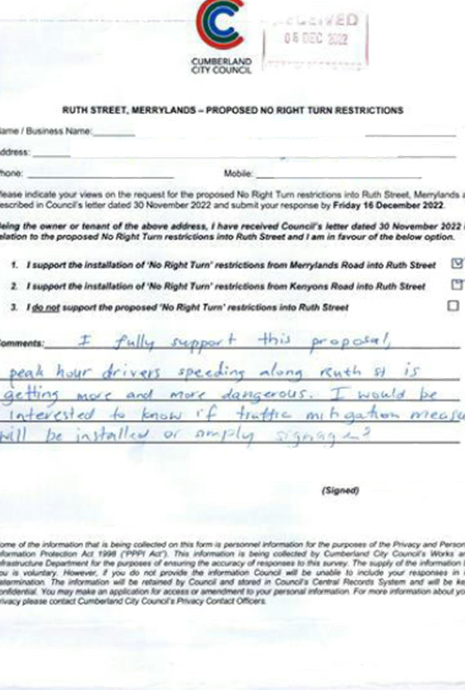
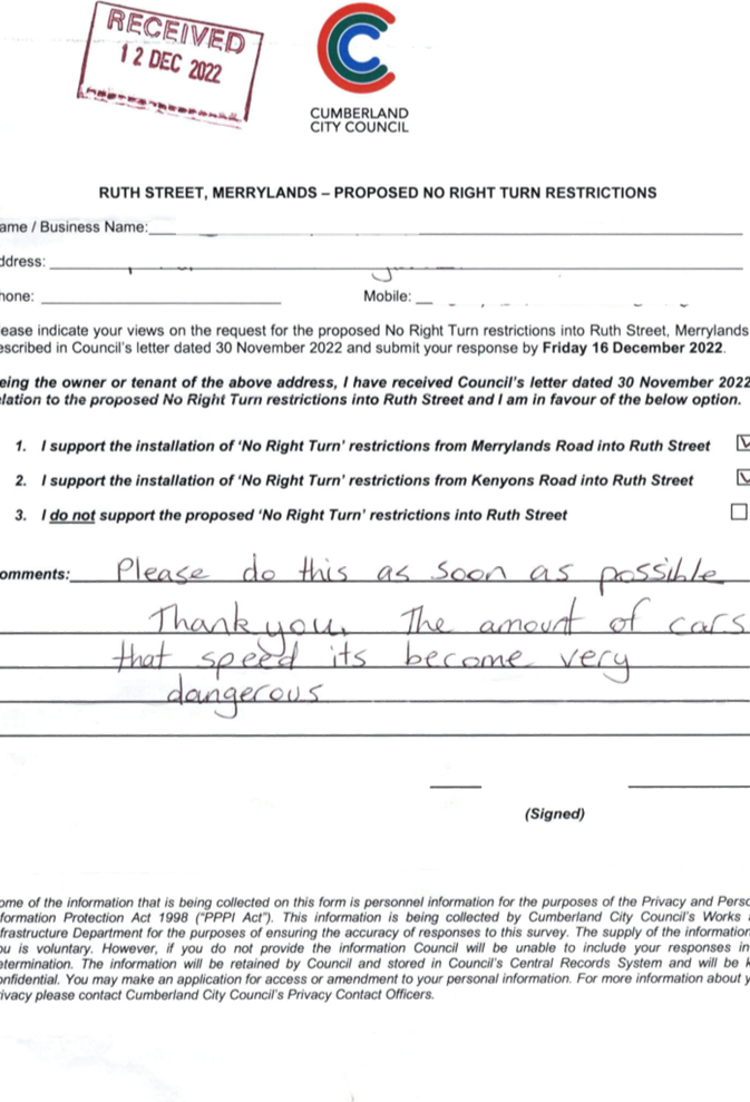
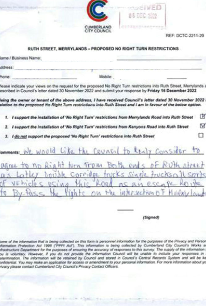
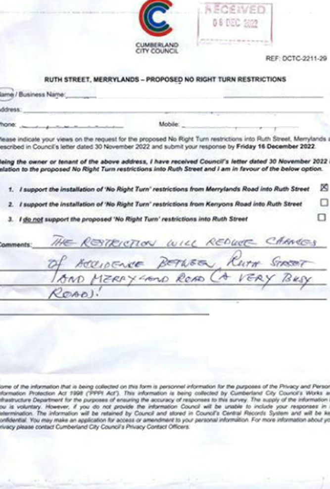
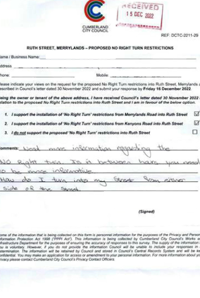
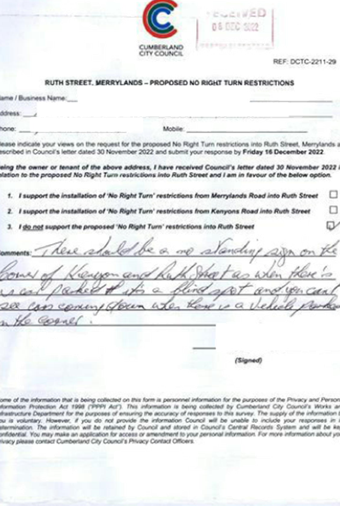
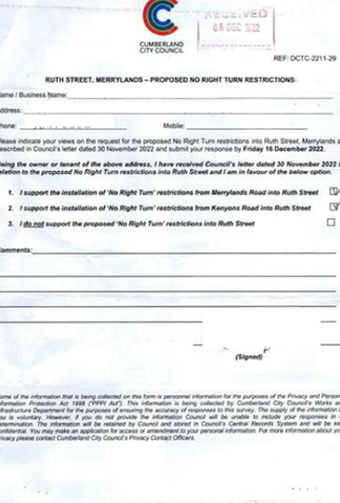
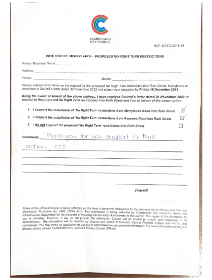
Ruth Street, Merrylands West - Proposed No Right Turn - Consultation |
|
´ |
|
|
´ |
|
|
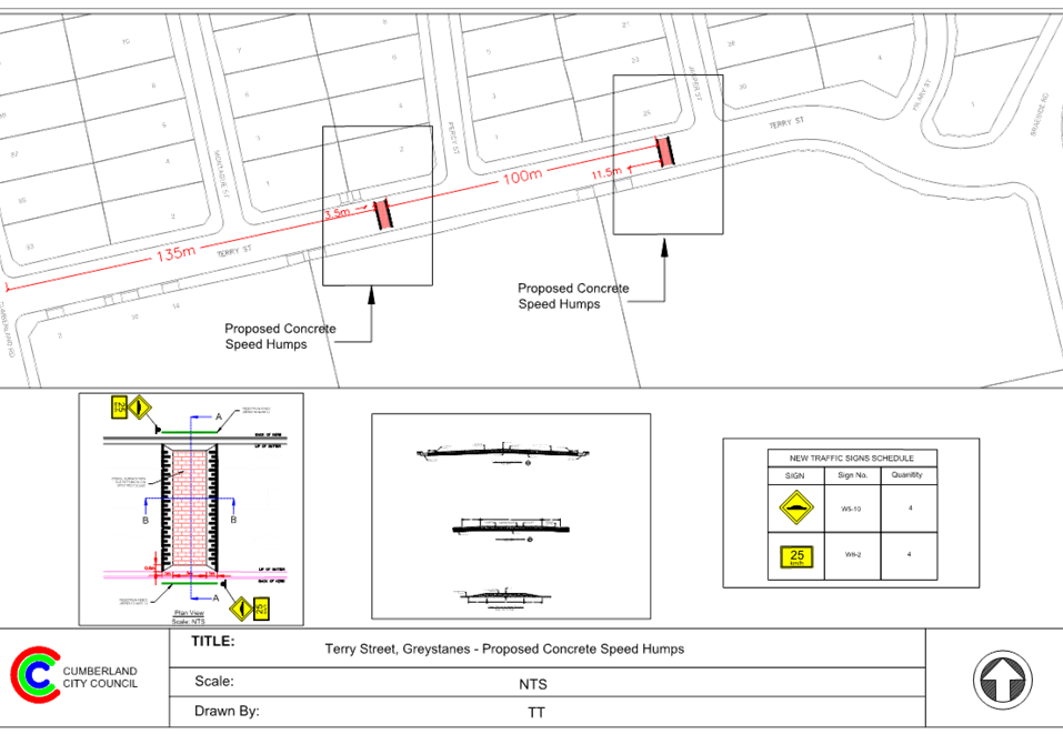
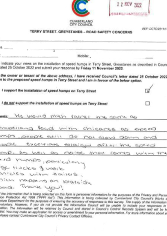
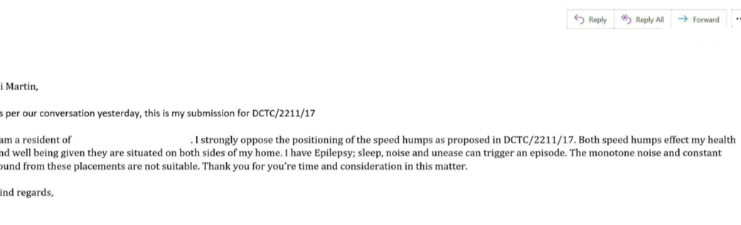
CTC-23-070 |
Terry Street, Greystanes - Road Safety Concerns |
|
´ |
|
|
´ |
|
|
CTC-23-071 |
Nottinghill Road, Berala - Road Safety Concerns |
|
|
|
´ |
|
´ |
|
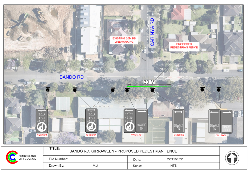
CTC-23-072 |
Bando Road, Girraween - Proposed Installation of Pedestrian Fencing |
|
|
´ |
|
´ |
|
|
CTC-23-073 |
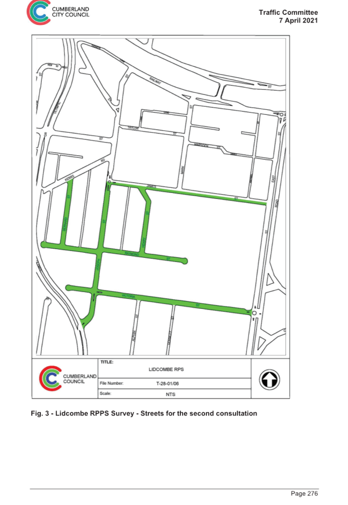
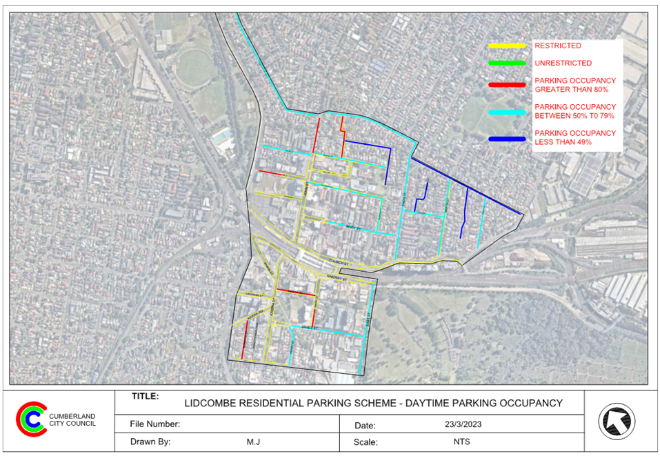
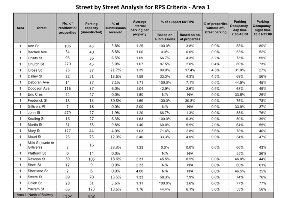
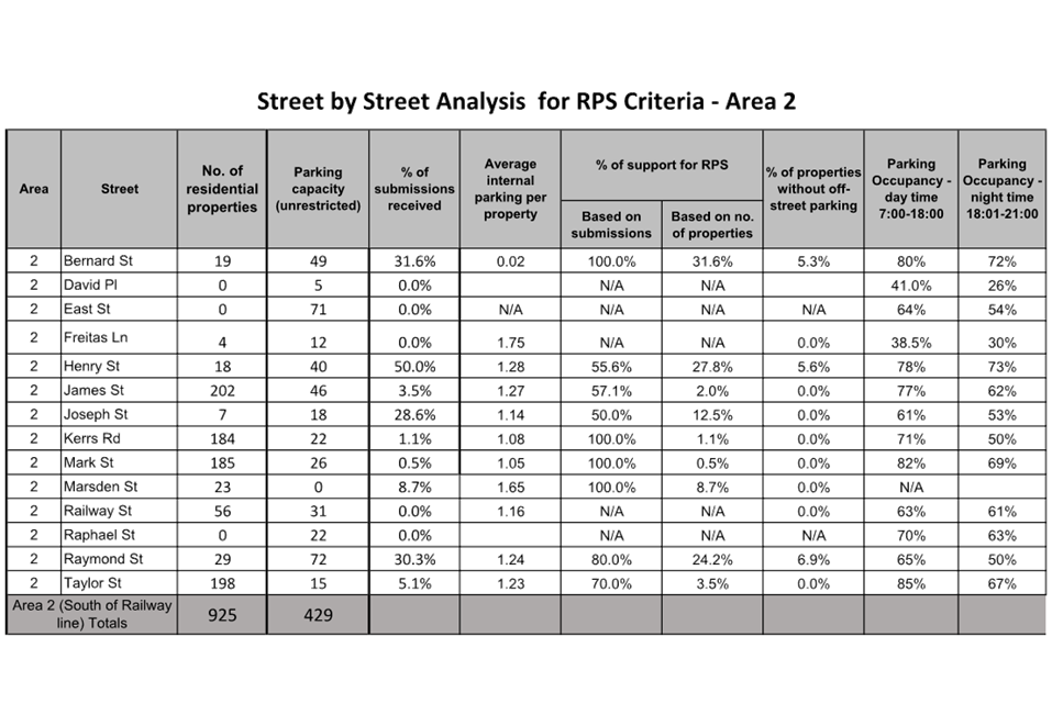
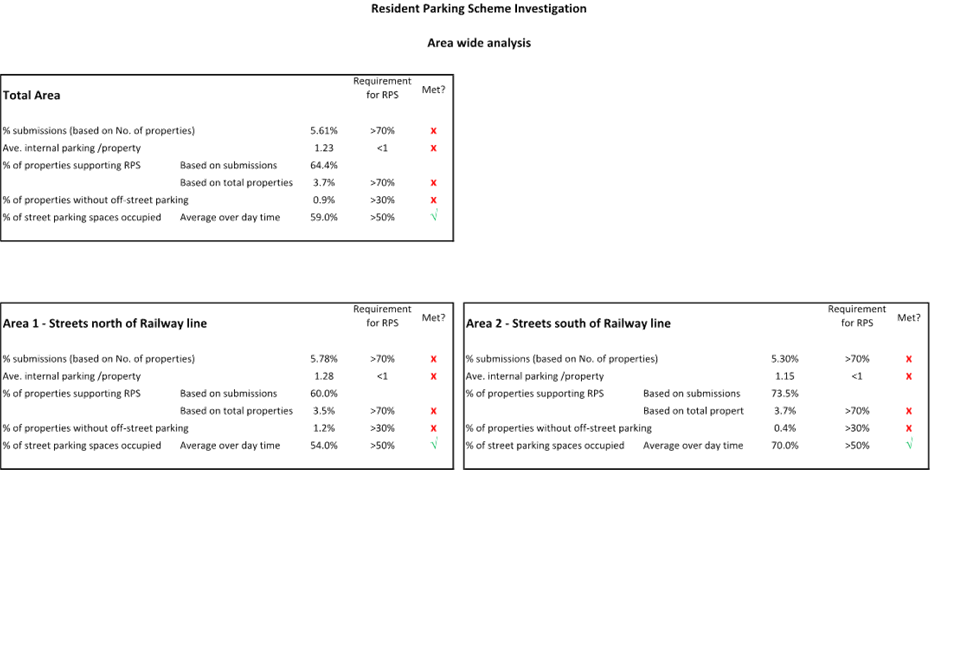
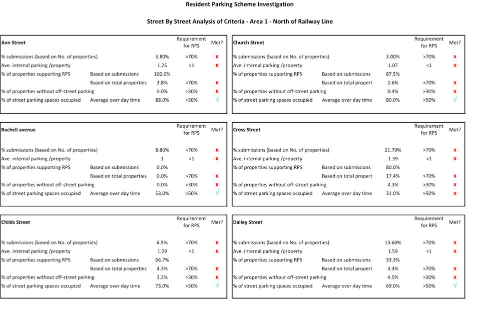
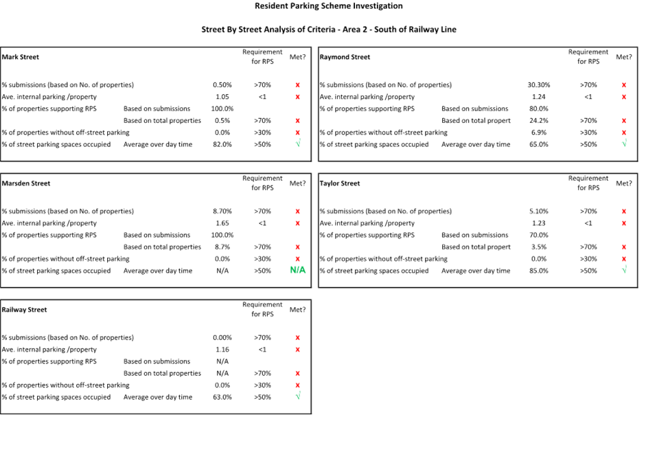
Response to Notice of Motion C08/22-121 - Residential Parking in Lidcombe |
|
|
|
´ |
|
|
Traffic Committee
5 April 2023
Part 1
Recommended for Approval under Delegated Authority
Traffic Committee
5 April 2023
Item No: CTC-23-047
Moree Avenue, Westmead - Application for 'Works Zone' Signage
Directorate: Environment and Planning
Responsible Officer: Executive Manager Development and Building
File Number: T-28-01/06
Electorate: Granville
Police Area Command (PAC): Cumberland
Agenda Part Part 1
Note: Recommended for Approval under Delegated Authority
Summary
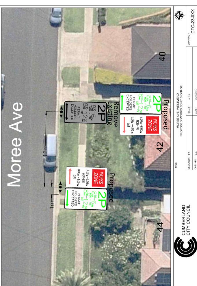
Council has received an application for a ‘Works Zone’ on Moree Avenue, Westmead associated with the development at 42 Moree Avenue, Westmead.
This report outlines the outcome of the investigation into this matter.
|
That the Cumberland Traffic Committee recommends that: 1. The 12m long ‘Works Zone, 7:00am-6:00pm, Monday-Friday, 8:00am-4:00pm, Saturday’ signs be installed on the frontage of the development site on Moree Avenue, Westmead subject to Council’s standard conditions for a period of 10 months and subsequent extension if required. 2. The applicant be advised to pay the ‘Works Zone’ fees to Council as per the adopted Fees and Charges. |
Report
Council has received an application for a ‘Works Zone’ on Moree Avenue, Westmead associated with the development at 42 Moree Avenue, Westmead.
The proposed development involves construction of a two-storey dwelling house.
The temporary “Works Zone” is approximately 12m in length and proposed to commence in April 2023 for 10 months. The proposed time is between 7:00am to 6:00pm Monday to Friday and 8:00am to 4:00pm on Saturdays.
There will be a loss of two (2) ‘2P’ parking spaces (under the Westmead resident parking scheme) on the southern side of Moree Avenue, Westmead during the operation of the Works Zone.
COnsultation
The proposal is outside the property being developed and no consultation is required as the request was made by the builder.
Attachments
1. Plan - Moree Avenue, Westmead - Proposed Temporary 'Works Zone' Signage
DOCUMENTS
ASSOCIATED WITH
REPORT CTC-23-047
Attachment 1
Plan - Moree Avenue, Westmead - Proposed Temporary 'Works Zone' Signage
Traffic Committee
5 April 2023
Item No: CTC-23-048
Terminal Place, Merrylands - Application for 'Works Zone' Signage
Directorate: Environment and Planning
Responsible Officer: Executive Manager Development and Building
File Number: T-28-01/06
Electorate: Granville
Police Area Command (PAC): Cumberland
Agenda Part Part 1
Note: Recommended for Approval under Delegated Authority
Summary
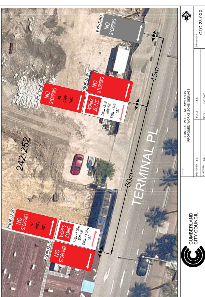
Council has received an application for a ‘Works Zone’ on Terminal Place, Merrylands associated with the development at 242-252 Pitt Street, Merrylands.
This report outlines the outcome of the investigation into this matter.
|
That the Cumberland Traffic Committee recommends that: 1. The 30m long ‘Works Zone, 7:00am-6:00pm, Monday-Friday, 8:00am-4:00pm, Saturday’ signs be installed on the frontage of the development site on Terminal Place, Merrylands subject to Council’s standard conditions for a period of 6 months and subsequent extension if required. 2. The applicant be advised to pay the ‘Works Zone’ fees to Council as per the adopted Fees and Charges. |
Report
Council has received an application for a ‘Works Zone’ on Terminal Place, Merrylands associated with the development at 242-252 Pitt Street, Merrylands. The proposed development involves construction of an 18-storey mixed use development over 5 levels of basement parking accommodating 3 levels of commercial floor, 161 residential units and 315 parking spaces.
The temporary “Works Zone” is approximately 30m in length and proposed to commence in April 2023 for 6 months. The proposed time is between 7:00am to 6:00pm Monday to Friday and 8:00am to 4:00pm on Saturdays.
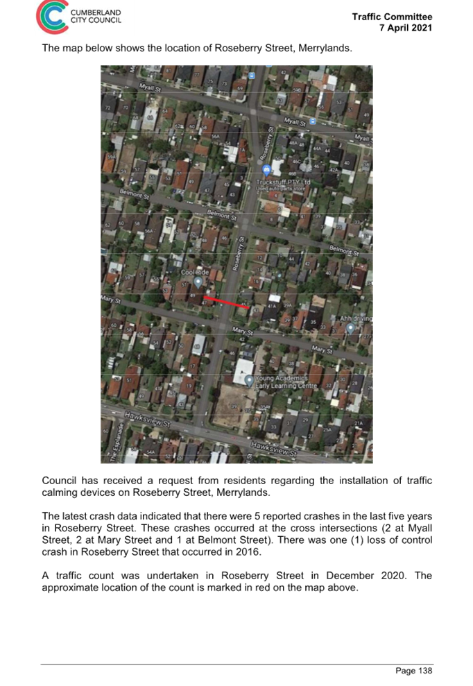
Terminal Place is a one-way southbound street with 2 lanes and indented bay accommodating multiple zones. It has ‘No Stopping’ restrictions on the western side and “No Parking’, a timed ‘Bus Zone’, a Taxi Zone and a ‘Mail Zone’ on the eastern side. Terminal Place provides access to Merrylands Station, commuter car park and Bus interchange.
The map below shows details of Terminal Place.
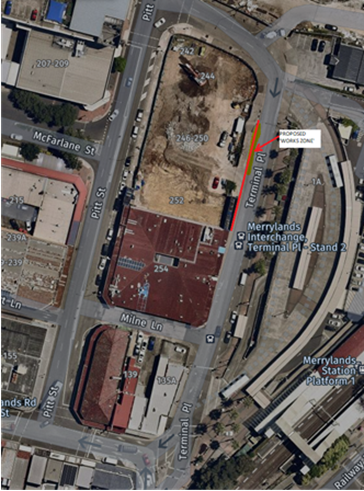
Southbound 2-lane traffic flow on Terminal Place, Merrylands will be merged into one lane during the operation of the Works Zone. The Works Zone section will be sign posted ‘No Stopping’ outside the works zone times.
Due to the location of the proposed ‘Works Zone’ in a turning lane with ‘No Stopping’ restrictions, Council has consulted with the representative of TfNSW who has concurred with the proposal away from the bend in Terminal Place.
It is considered approving the ‘Works Zone’ will not have adverse impact on the traffic flow in Terminal Place.
COnsultation
Due to the location of the proposed ‘Works Zone’, Council has consulted with the representative of TfNSW who has concurred with the proposal.
The proposal is outside the property being developed and no further consultation is required as the request was made by the builder.
Attachments
1. Plan - Terminal Place, Merrylands - Proposed Temporary 'Works Zone' Signage
DOCUMENTS
ASSOCIATED WITH
REPORT CTC-23-048
Attachment 1
Plan - Terminal Place, Merrylands - Proposed Temporary 'Works Zone' Signage
Traffic Committee
5 April 2023
Item No: CTC-23-049
Northumberland Road, Auburn - Convert the Existing Part-Time Bus Zone to Fulltime Bus Zone
Directorate: Environment and Planning
Responsible Officer: Executive Manager Development and Building
File Number: T-28-01/06
Electorate: Auburn
Police Area Command (PAC): Auburn
Agenda Part Part 1
Note: Recommended for Approval under Delegated Authority
Summary
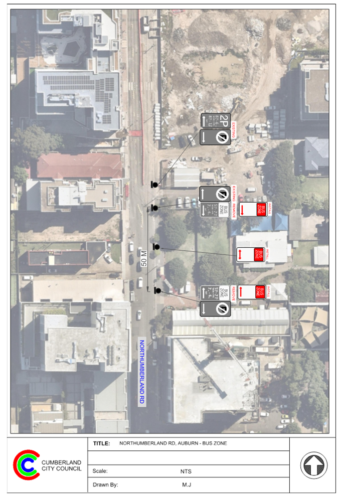
Council has received a request from the Bus Operator (Busways) to convert the existing part-time Bus Zone on the eastern side of Northumberland Road, Auburn outside Northumberland Reserve to a full-time Bus Zone.
This report outlines the outcome of the investigation into this matter.
|
The Cumberland Traffic Committee recommends that: 1. Replace the existing ‘Bus Zone 5:30am-7:30pm Mon-Fri, 7am-6pm Sat’ signs on the eastern side of Northumberland Road, Auburn outside Northumberland Reserve with full-time ‘Bus Zone’ signs in accordance with the attached plan be approved. 2. The adjacent properties be notified of the outcome. |
Report
Council has received a request from the Bus Operator Busways to convert the existing part-time ‘Bus Zone’ signs on the eastern side of Northumberland Road, Auburn outside Northumberland Reserve to full-time Bus Zone signage.
The above part-time bus zone services the bus route 540 and 544, which originally operates from Monday to Saturday. Following enhancements to the bus timetable, Busways has advised that the bus route 544 has been changed to full time from Monday to Sunday. As a result, buses are not able to access this bus stop and park safely during Sunday due to parked vehicles.
The map below shows the location of the bus stop:
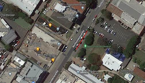
Figure 1 – Locality Plan
In order to facilitate the accessibility and safety of the bus services at this bus stop, it is proposed to replace the existing part-time “Bus Zone’ signage with full-time ‘Bus Zone’ signage as per attached plan.
COnsultation
Consultation was carried out with the impacted and adjacent residents for a period of 14 days from 6 to 20 March 2023. No submissions were received.
Attachments
1. Plan - Northumberland Road, Auburn - Proposed 'Bus Zones' Signage
DOCUMENTS
ASSOCIATED WITH
REPORT CTC-23-049
Attachment 1
Plan - Northumberland Road, Auburn - Proposed 'Bus Zones' Signage
Traffic Committee
5 April 2023
Item No: CTC-23-050
Nottinghill Road and The Boulevard, Lidcombe - Proposed 'No Stopping' Restrictions and Linemarkings
Directorate: Environment and Planning
Responsible Officer: Executive Manager Development and Building
File Number: T-28-01/06
Electorate: Auburn
Police Area Command (PAC): Auburn
Agenda Part Part 1
Note: Recommended for Approval under Delegated Authority
Summary
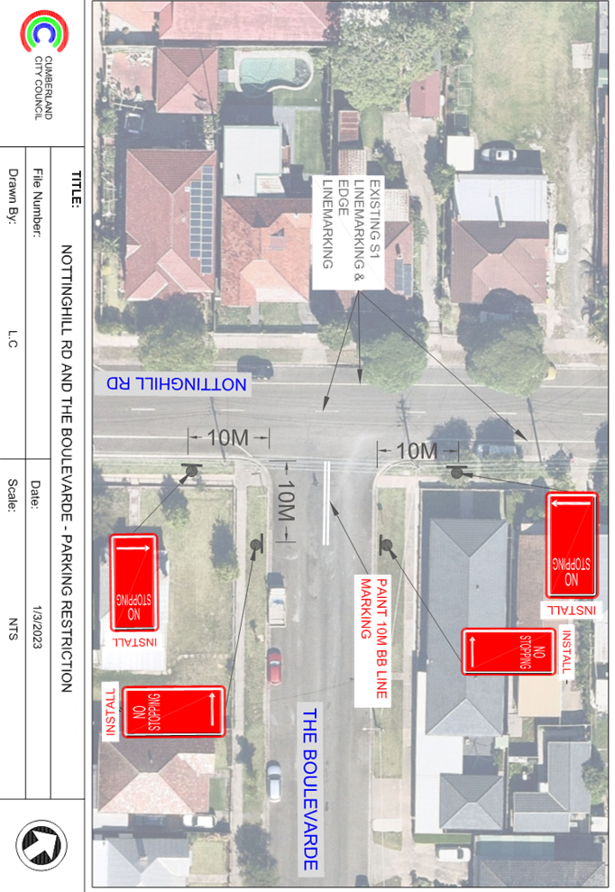
Council has received safety concerns from a resident at the intersection of Nottinghill Road and The Boulevarde, Greystanes.
This report outlines the outcome of the investigation into this matter.
|
The Traffic Committee recommends that: 1. The installation of ‘No Stopping’ signs and line marking at the intersection of Nottinghill Road and The Boulevarde, Lidcombe in accordance with the attached plan be approved. 2. The affected residents be notified of the outcome. |
Report
The Boulevarde is a local road that runs in an east-west direction between Nottinghill Road and Joseph Street with a speed limit of 50 km/h. It has a width of approximately 13.7m and parking is permitted on both sides of the road unless otherwise signposted.
Nottinghill Road is a local road that runs in a north-south direction with a speed limit of 50 km/h. It has a width of approximately 12.5m and parking is permitted on both sides of the road unless otherwise signposted. Nottinghill Road has edge lines and centre lines marked.
The Boulevarde and Nottinghill Road form a T-intersection with priority to Nottinghill Road.
The map below shows the intersection.
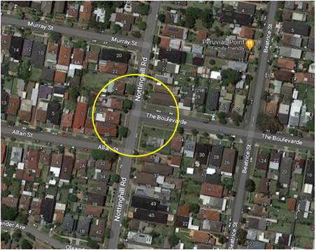
Figure 1 – Locality Plan
The latest Centre for Road Safety accident data indicated that there were no reported accidents at this intersection in the 5 years ending June 2022.
A site inspection indicated that vehicles are parking within 10 metres at the intersection. The installation of ‘No Stopping’ signs would strengthen the Road Rules requirements, stop vehicles from parking too close to the intersection. It is also proposed to mark 10m BB centre lines in The Boulevarde at the intersection.
Therefore, it is proposed to install ‘No Stopping’ signs and line marking at the intersection as per the attached plan.
COnsultation
The proposal was notified to the impacted and adjacent residents for a period of 14 days from 3 March to 17 March 2023. No responses were received.
Attachments
1. Plan - Nottinghill Road, Greystanes - Proposed 'No stopping' restrictions and line marking at the intersection
DOCUMENTS
ASSOCIATED WITH
REPORT CTC-23-050
Attachment 1
Plan - Nottinghill Road, Greystanes - Proposed 'No stopping' restrictions and line marking at the intersection
Traffic Committee
5 April 2023
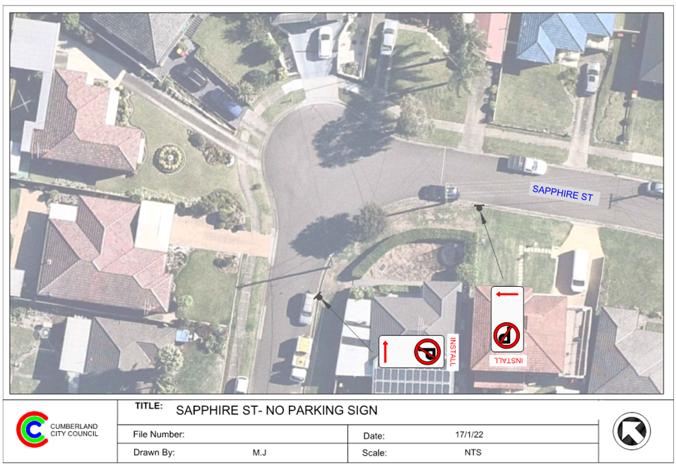
Item No: CTC-23-051
Sapphire Street, Greystanes - Proposed 'No Parking' Restrictions
Directorate: Environment and Planning
Responsible Officer: Executive Manager Development and Building
File Number: T-28-01/06
Electorate: Prospect
Police Area Command (PAC): Cumberland
Agenda Part Part 1
Note: Recommended for Approval under Delegated Authority
Summary
Council has received safety concerns from a resident of Sapphire Street, Greystanes near the bend outside No.7.
This report outlines the outcome of the investigation into this matter.
|
The Traffic Committee recommends that: 1. The installation of ‘No Parking’ signs on the southern side of Sapphire Street, Greystanes at the bend near No.7 in accordance with the attached plan be approved. 2. The affected residents be notified of the outcome. |
Report
Sapphire Street is a local road that runs mainly in an east - west direction between Crystal Street and Hackney Street with a speed limit of 50 km/h. It has a width of approximately 7m and parking is permitted on both sides of the road unless otherwise signposted.
Sapphire Street has a 90-degree bend near No.7 with unrestricted parking on both sides of the road. Currently, there is no line marking exists at the bend. It is alleged by the resident that due to the vertical alignment of this section of Sapphire Steet, motorists often travel onto the wrong side of the road when negotiating the bend.
The map below shows the area:
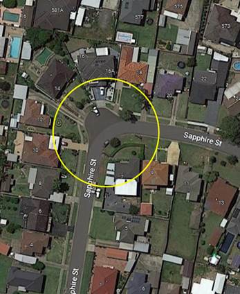
Figure 1 – Locality Plan
The latest Centre for Road Safety accident data indicated that there was no reported accident in the 5 years ending June 2022.
A site inspection indicated that vehicles are parking on the southern side of the bend. In order to maintain safety and reduce the risk of a head on-collision, it is suggested to install ‘No Parking’ signs on the southern side of the bend as per attached drawing
COnsultation
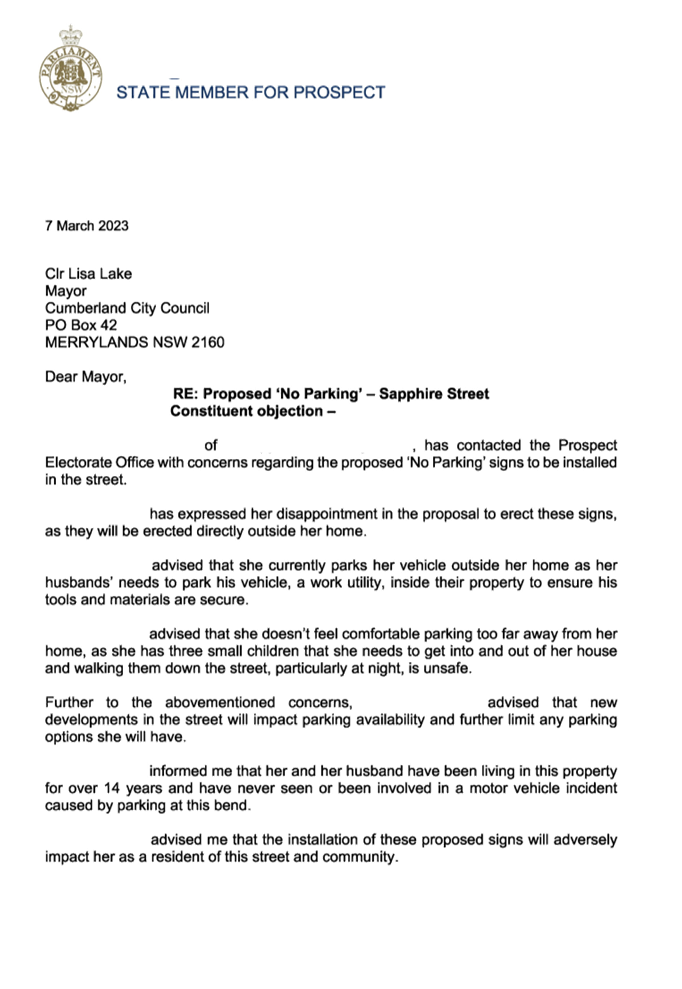
The proposal was notified to the impacted and adjacent residents for a period of 14 days starting from 15 February to 1 March 2023.
One representation was received from the local member on behalf of the resident. The resident objected to the proposal due to loss of on-street parking space adjacent to the property.
The street is situated in a low-density residential area. Alternate on-street parking will be available elsewhere in Sapphire Street outside the proposed parking restricted area.
The installation of proposed ‘No Parking’ on the eastern side of the 90-degree bend would improve the sight distance for the cars approaching the bend and avoid potential head-on collisions at this location.
Attachments
1. Plan - Sapphire Street, Greystanes - Proposed 'No Parking' restrictions at the bend
DOCUMENTS
ASSOCIATED WITH
REPORT CTC-23-051
Attachment 1
Plan - Sapphire Street, Greystanes - Proposed 'No Parking' restrictions at the bend
DOCUMENTS
ASSOCIATED WITH
REPORT CTC-23-051
Attachment 2
Submissions
5 April 2023
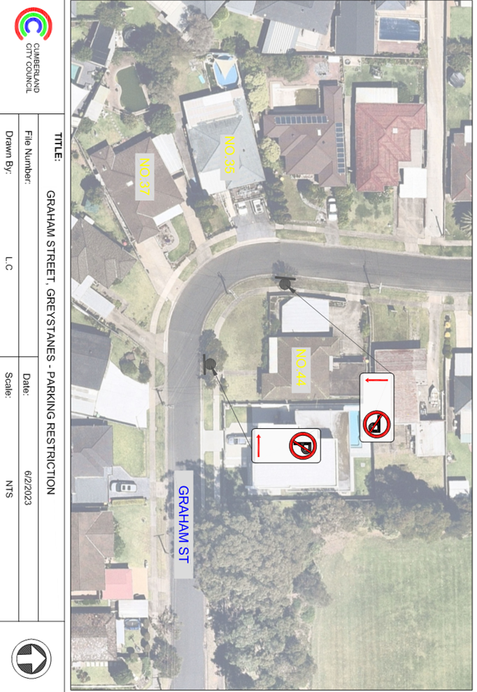
Item No: CTC-23-052
Graham Street, Greystanes - Proposed 'No Parking' Restrictions
Directorate: Environment and Planning
Responsible Officer: Executive Manager Development and Building
File Number: T-28-01/06
Electorate: Granville
Police Area Command (PAC): Cumberland
Agenda Part Part 1
Note: Recommended for Approval under Delegated Authority
Summary
Council has received safety concerns from a resident of Graham Street, Greystanes near the bend.
This report outlines the outcome of the investigation into this matter.
|
The Traffic Committee recommends that: 1. The installation of ‘No Parking’ signs at the bend near No.44 Graham Street, Greystanes in accordance with the attached plan be approved. 2. The affected residents be notified of the outcome. |
Report
Graham Street is a local road that runs in a north-south direction between Old Prospect Road and Laurence Street with a speed limit of 50 km/h. It has a width of approximately 6.5m and parking is permitted on both sides of the road in accordance with the Road Rules unless otherwise signposted.
Graham Street has a 90-degree bend near No.44 with unrestricted parking on both sides of the road. Currently, there is no line marking exists at the bend. It is alleged by the resident that due to the vertical alignment of this section of Graham Steet, motorists often travel onto the wrong side of the road when negotiating the bend.
The map below shows the area:
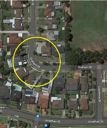
Figure 1 – Locality Plan
The latest Centre for Road Safety accident data indicated that there was one reported accident potentially related to sight distance (RUM code 85, ‘Off carriageway right on left bend into objects parked vehicle’) happened near the bend area in the 5 years ending June 2022.
A site inspection indicated that vehicles are parking on the eastern side of the bend. In order to maintain safety and reduce the risk of a head on-collision, it is proposed to install ‘No Parking’ signs on the eastern side of the bend as per attached drawing.
COnsultation
The proposal was notified to the impacted and adjacent residents for a period of 14 days starting from 15 February to 1 March 2023. No responses were received.
Attachments
1. Plan - Graham Street, Greystanes - Proposed 'No Parking" restrictions at the bend
DOCUMENTS
ASSOCIATED WITH
REPORT CTC-23-052
Attachment 1
Plan - Graham Street, Greystanes - Proposed 'No Parking" restrictions at the bend
Traffic Committee
5 April 2023
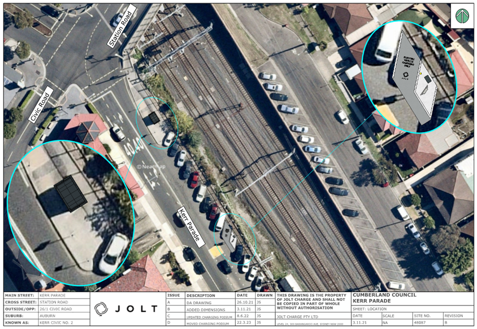
Item No: CTC-23-053
Kerr Parade, Auburn - Convert an Existing 2P Space to EV Parking
Directorate: Environment and Planning
Responsible Officer: Executive Manager Development and Building
File Number: T
Electorate: Auburn
Police Area Command (PAC): Auburn
Agenda Part Part 1
Note: Recommended for Approval under Delegated Authority
Summary
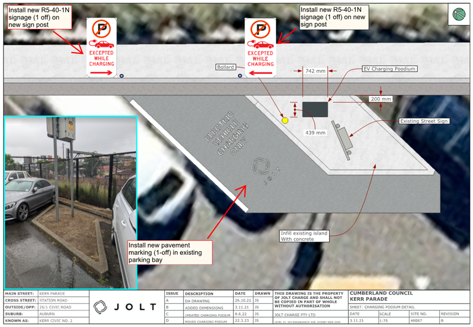
Council has received a request from JOLT Charge Pty Ltd (JOLT) to convert an existing part-time 2P space on the northern side of Kerr Parade, Auburn to Electric Vehicles (EV) parking only.
This report outlines the outcome of the investigation into this matter.
|
The Traffic Committee recommends that the conversion of a part-time 2P parking space on the northern side of Kerr Parade, Auburn to ‘EV parking only’ as per the attached plan be approved subject to the execution of a licence agreement with Council. |
Report
In order to assist the transition to electric vehicles in the Cumberland City Council Local Government Area, JOLT is deploying free public charging in selected locations within the local community. The area providing for 45-degree angle parking with ‘2P’ restriction on the northern side of Kerr Parade has been identified as a suitable location and has been agreed by Ausgrid. The charging station will be connected to the power substation at the corner of Station Road and Kerr Parade, Auburn.
Currently, 45 degree indented angular parking spaces are provided on the northern side of Kerr Parade, Auburn. 2P restrictions (8:30am-6pm Monday to Friday and 8:30am – 12:30pm Saturday) apply to these parking spaces.
JOLT proposes to convert an existing 2P indented angle parking space at this section of Kerr Parade to EV parking only. The original request from JOLT utilised the first parking bay near the substation.
However, due to the close proximity to the signalised intersection of Station Road, Kerr Parade & Civic Road, Auburn; Council initiated discussions with Transport for NSW representative and agreed that the location to be moved further away from the intersection to minimise impact on the performance of the signalised intersection.
Jolt has now provided a new plan showing the location of the charging station.
To facilitate the upgrade, it is proposed to convert an existing 2P space at this section of Kerr Parade to EV parking only as per attached drawing.
The parking bay to be used by the EV charging vehicles will have pavement marking and regulatory signs “No Parking” signs with the exception for Electric Vehicles Excepted while charging (R5-40-2N)“.
Council’s Property Section is assessing a licence agreement with Jolt for the use of the parking bay for EV charging.
COnsultation
Consultation is not required as no residents will be directly impacted by the proposed changes.
Notifications will be undertaken by JOLT after the proposal is approved by Council.
Attachments
1. Plans - Kerr Parade, Auburn - Proposed EV Charging Station
DOCUMENTS
ASSOCIATED WITH
REPORT CTC-23-053
Attachment 1
Plans - Kerr Parade, Auburn - Proposed EV Charging Station
5 April 2023
Item No: CTC-23-054
Alexandra Avenue and Hassall Street, Westmead - Proposed Works for Sydney Metro in Westmead Area
Directorate: Environment and Planning
Responsible Officer: Executive Manager Development and Building
File Number: HC-24-01-3/02
Electorate: Granville
Police Area Command (PAC): Cumberland
Agenda Part Part 1
Note: Recommended for Approval under Delegated Authority
Summary
Council has received a request from Sydney Metro West regarding the proposed changes to the existing signage & line marking associated with the construction of the new Metro Station in Westmead.
This report outlines the details into this matter.
|
That the Traffic Committee recommends that the following proposed changes to the existing signage & line marking in Alexandra Avenue and Hassall Street, Westmead in accordance with the attached plans be approved: 1. Changes to the existing parking signage and line marking on the southern side of Alexandra Avenue in accordance with the attached plan. 2. Changes to the existing line marking on both sides of Hassall Street accordance with the attached plans. |
Report
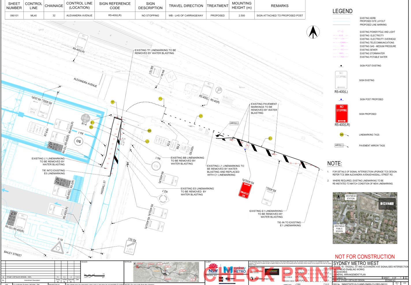
Gamuda Australian has proposed the following works in the Westmead area as a part of the proposed Sydney Metro station in Westmead:
1. Extension of the existing ‘No Stopping’ restrictions on the southern side of Alexandra Avenue.
2. Provision of chevron line marking on the southern side of Alexandra Avenue.
3. Provision of chevron line marking on Hassall Street.
4. Provision of E1 line marking on the western side of Hassall Street
Gamuda Australia has advised that the works are programmed to commence following approval by the traffic committee.
Council has received the concept plans for the proposed changes to the existing signage and line marking in the work area for Traffic Committee consideration.
COnsultation
Consultation is not required as the proposed signage and line marking have no impact on residents in the area.
Gamuda Australia will notify the surrounding residents once Council approved the proposed signage and line marking.
Attachments
1. Plan - Sydney Metro West - Changes to Traffic Facilities and Associated Signs
DOCUMENTS
ASSOCIATED WITH
REPORT CTC-23-054
Attachment 1
Plan - Sydney Metro West - Changes to Traffic Facilities and Associated Signs
Traffic Committee
5 April 2023
Item No: CTC-23-055
Clunies Ross Street, Pemulwuy - Proposed 'No Parking' Restrictions and Line Markings
Directorate: Environment and Planning
Responsible Officer: Executive Manager Development and Building
File Number: T-28-01/06
Electorate: Prospect
Police Area Command (PAC): Cumberland
Agenda Part Part 1
Note: Recommended for Approval under Delegated Authority
Summary
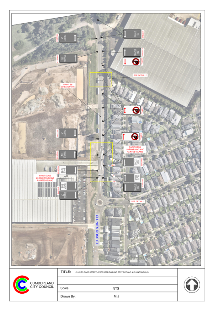
Council has received safety concerns from a resident requesting that consideration be given to the provision of line marking in Clunies Ross Street, Pemulwuy.
This report outlines the outcome of the investigation into this matter.
|
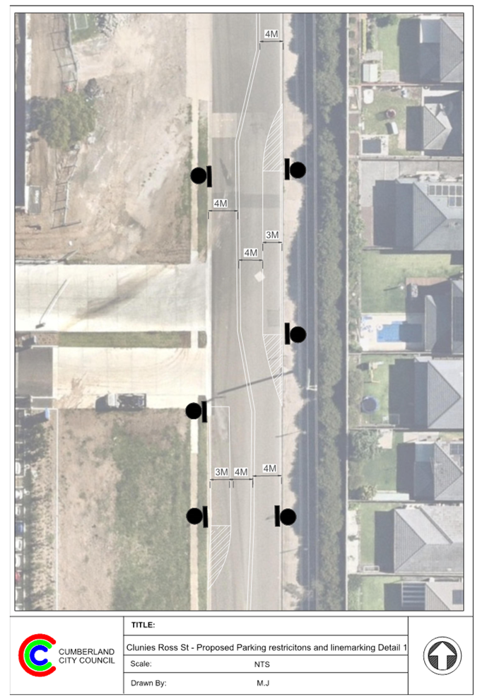
The Traffic Committee recommends that: 1. The installation of ‘No Parking’ signs on the eastern side of Clunies Ross Street, Pemulwuy in accordance with the attached plan be approved. 2. The relocation of the existing ‘Bus Zone’ signs on the eastern side of Clunies Ross Street, Pemulwuy in accordance with the attached plan be approved. 3. The provision of BB line marking along Clunies Ross Street, Pemulwuy and edge line marking in accordance with the attached plan be approved. |
Report
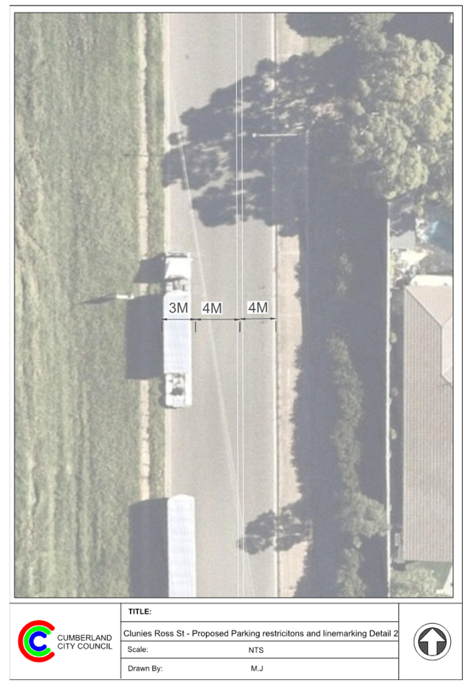
Clunies Ross Street is a local road that runs in a north – south direction with a speed limit of 50 km/h. The bend outside No.6 Clunies Ross Street is the boundary of Cumberland City Councill and Blacktown City Council. North of the bend belongs to Blacktown City Council and south of the bend belongs to Cumberland City Council. The road is approximately 340m long and 11m wide and parking is permitted on both sides of the road in accordance with the Road Rules unless otherwise signposted.
The eastern side of Clunies Ross Street is a residential area. No accesses are provided to the residential area via Clunies Ross Street. Industrial area is located on the western side of the road.
The map below shows the location.
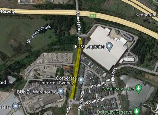
It is alleged that heavy vehicles park on both sides of the road and due to the lack of delineation at this section of Clunies Ross Street, motorists often cross over onto the wrong side of the road when heavy vehicles are parked on either side of the street. It shall be noted that heavy vehicles occupy wider kerb side lane compared to cars.
The latest Centre for Road Safety accident data indicated that there were no reported accidents in Clunies Ross Street in the 5 years ending June 2022.
In order to maintain safety and reduce the risk of a head on-collision at this section of Clunies Ross Street, it is proposed to provide ‘No Parking’ restrictions on the eastern side of the road and BB line marking along this section of Clunies Ross Street as per the attached plans.
It is also proposed to shift the BB centre line marking to the eastern side of the road and relocate the existing Bus Zone on the eastern side of Clunies Ross Street near Warin Avenue as per the attached drawing to minimise the impact on the on-street parking spaces on the western side. By shifting the BB line marking, two-way traffic can be maintained at all times while large vehicles are able to park on the western side of the road safely.
COnsultation
Consultation is not required as no residents or businesses will be directly impacted by the proposed parking restrictions and line marking. Parking arrangement on the western side of the road will not be changed, no vehicle/pedestrian accesses are provided to the residential area on the eastern side of the road via Clunies Ross Street.
Attachments
1. Plan - Clunies Ross Street, Pemulwuy - Proposed parking restrictions and line marking
DOCUMENTS
ASSOCIATED WITH
REPORT CTC-23-055
Attachment 1
Plan - Clunis Ross Street, Pemulwuy - Proposed parking restrictions and linemarking
Traffic Committee
5 April 2023
Item No: CTC-23-056
Earl Street, Merrylands - Road Safety Concerns
Directorate: Environment and Planning
Responsible Officer: Executive Manager Development and Building
File Number: HC-24-01-3/02
Electorate: Granville
Police Area Command (PAC): Cumberland
Agenda Part Part 2
Note: Recommendation to Council
Summary
Council has reviewed traffic conditions in Earl Street, Merrylands. This report outlines the outcome of the review.
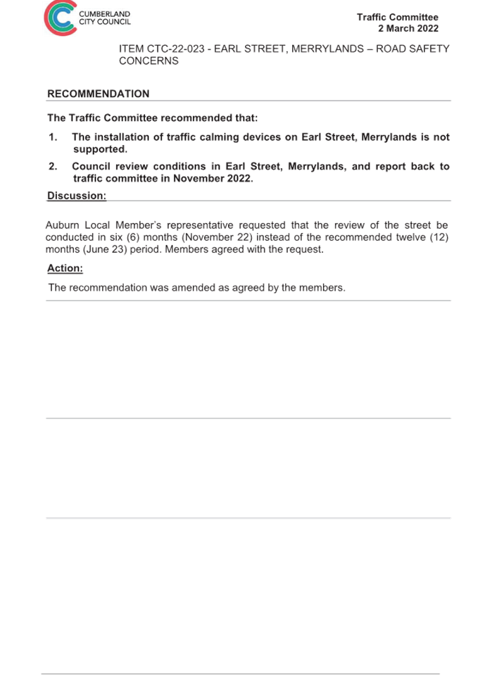
|
The Cumberland Traffic Committee recommends that; 1. The installation of traffic calming devices on Earl Street, Merrylands not be supported. 2. Council review conditions in Earl Street, Merrylands and report back to the Traffic Committee in April 2024. |
Report
Cumberland Traffic Committee (CTC) at its meeting in March 2022 considered a report (Item No.CTC-22-023) regarding road safety concerns on Earl Street, Merrylands.
Council resolved that traffic calming devices on Earl Street, Merrylands not to be supported and Council staff to review the traffic conditions in Earl Street in November 2022 and report back to the Traffic Committee.
A report was presented at the March 2023 Traffic Committee. At the meeting, it was recommended that the report be withdrawn, and a report be brought back to the Traffic Committee in April 2023, which includes the community consultation section in the report.
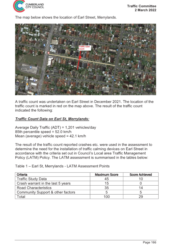
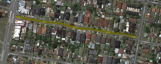
The map below shows the location of Earl Street, Merrylands.
In accordance with Council’s resolution, a traffic count was undertaken in Earl Street in February 2023. Council officers have reviewed the traffic count data and compared it with the previous traffic count data undertaken in December 2021.
Both results are detailed in the table below:
|
Traffic count date |
Ave. daily traffic |
85 Percentile speed |
|
December 2021 |
1,201 |
52 km/h |
|
February 2023 |
1,112 |
51 km/h |
The traffic data from the table above indicated that both traffic volume (AADT) and 85 percentile speed at this section of Earl Street have reduced since 2021.
According to the Centre for Road Safety Accident data, there were no reported accidents in Earl Street in the 5 years up to June 2022.
Based on the above, a further LATM assessment will result in similar points scored.
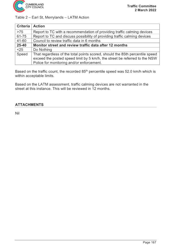
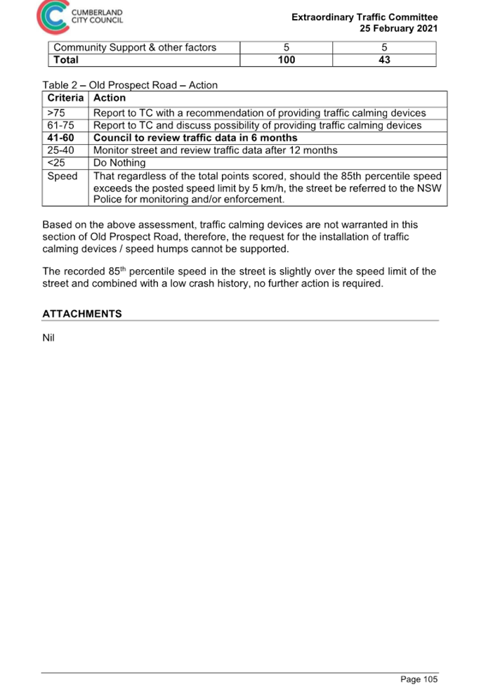
The LATM assessment points are given below:
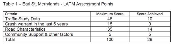
Therefore, the installation of traffic calming devices on Earl Street, Merrylands cannot be supported. The recorded 85th percentile speed of 51km/hr is within acceptable limits.
Council will review traffic conditions in Earl Street in 12 months.
COnsultation
Consultation has not been undertaken as the investigation outlined in the report recommends that the installation of traffic calming measures is not supported at this time. Future consultation will be undertaken if recommended by the Traffic Committee.
Attachments
DOCUMENTS
ASSOCIATED WITH
REPORT CTC-23-056
Attachment 1
Previous Report - CTC-22-023
Traffic Committee
5 April 2023
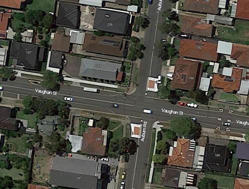
Item No: CTC-23-057
Vaughan Street & Auburn Road, Auburn - Proposed Traffic Signal Consideration
Directorate: Environment and Planning
Responsible Officer: Executive Manager Development and Building
File Number: T-28-01/06
Electorate: Auburn
Police Area Command (PAC): Auburn
Agenda Part Part 2
Note: Recommendation to Council
Summary
Council has received a request for consideration of traffic signal installation at the intersection of Vaughan Street and Auburn Road, Auburn.
This report outlines the outcome of the investigation into this matter.
|
The Traffic Committee recommends that the information contained in this report be noted. |
Report
Council has received a request for consideration of traffic signal installation at the intersection of Vaughan Street and Auburn Road, Auburn.
Vaughan Street is a classified regional road pursuant to Roads Act 1993 linking the state road, Olympic Drive through to Wellington Road, Clyde Street, Rawson Road to state road, Woodville Road. The section of Vaughan Street considered in this report is between Olympic Drive and Park Road. Vaughan Street has centre line marked together with edge lines to facilitate parking.
Auburn Road is a local road with ‘Stop’ control at the Vaughan Street intersection. There are also median islands and raised thresholds built on the approaches to the intersection.
Both roads have a 50km/hr speed limit.
The map below shows the intersection details:
Accident Data
Based on the Centre for Road Safety Accident Database, there were three reported accidents at this intersection in the 5 years ending June 2022. These accidents were vehicular accidents and did not involve pedestrians.
Warrants for Traffic Signal Installation
As a guide, a signalised intersection may be considered if one of the following warrants is met.
a. Traffic Demand:
For each of four one-hour periods of an average day:
· the major road flow exceeds 600 vehicles/hour in each direction; and
· the minor road flow exceeds 200 vehicles/hour in one direction
b. Continuous traffic:
For each of four one-hour periods of an average day:
· the major road flow exceeds 900 vehicles/hour in each direction; and
· the minor road flow exceeds 100 vehicles/hour in one direction; and
· the speed of traffic on the major road or limited sight distance from the minor road causes undue delay or hazard to the minor road vehicles; and
· there is no other traffic signal site easily accessible to the minor road vehicles
Another consideration is related to number of crashes at the intersection. This warrant requires 3 or more reported crashes per year over a 3 year period where the accidents could have been prevented by traffic signals.
Council undertook traffic counts in Vaughan Street and Auburn Road to assess the above criteria required for traffic signal consideration.
|
|
Vaughan Street – hourly traffic |
Auburn Road-hourly traffic |
||
|
Period |
East bound |
Westbound |
Northbound |
Southbound |
|
06:00-07:00 |
364 |
341 |
52 |
29 |
|
07:00-08:00 |
567 |
495 |
117 |
32 |
|
08:00-09:00 |
496 |
595 |
149 |
72 |
|
09:00-10:00 |
442 |
512 |
75 |
28 |
|
|
|
|
|
|
|
14:00-15:00 |
451 |
637 |
76 |
41 |
|
15:00-16:00 |
476 |
760 |
146 |
95 |
|
16:00-17:00 |
475 |
706 |
96 |
55 |
|
17:00-18:00 |
484 |
756 |
93 |
47 |
|
18:00-19:00 |
473 |
668 |
88 |
49 |
The data indicates that the hourly traffic does not meet the warrants for a traffic signal installation at the intersection of Vaughan Street and Auburn Road. It shall be also noted that the reported accident number of three in 5 years does not warrant traffic signal installation on safety grounds.
COnsultation
Consultation has not been undertaken as the investigation outlined in the report recommends that no action is required at this time.
Attachments
Nil
Traffic Committee
5 April 2023
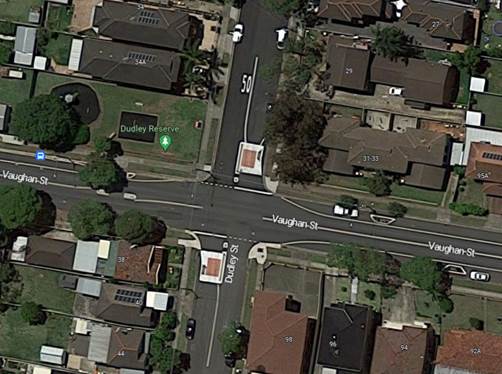
Item No: CTC-23-058
Vaughan and Dudley Street, Lidcombe - Proposed Traffic Signal Consideration
Directorate: Environment and Planning
Responsible Officer: Executive Manager Development and Building
File Number: T-28-01/06
Electorate: Auburn
Police Area Command (PAC): Auburn
Agenda Part Part 2
Note: Recommendation to Council
Summary
Council has received a request for consideration of traffic signal installation at the intersection of Vaughan Street and Dudley Street, Lidcombe.
This report outlines the outcome of the investigation into this matter.
|
The Traffic Committee recommends that the information contained in this report be noted. |
Report
Council has received a request for consideration of traffic signal installation at the intersection of Vaughan Street and Dudley Street, Lidcombe.
Vaughan Street is a classified regional road pursuant to Roads Act 1993 linking the state road, Olympic Drive through to Wellington Road, Clyde Street, Rawson Road to state road, Woodville Road. The section of Vaughan Street considered in this report is between Olympic Drive and Park Road. Vaughan Street has centre line marked together with edge lines to facilitate parking. It also has a median island and kerb blisters built on the west of Dudley Street.
Dudley Street is a local road with ‘Stop’ control at the Vaughan Street intersection. There are also median islands and raised thresholds built on the approaches to the intersection.
Both roads have a 50km/hr speed limit.
The map below shows the intersection details:
Accident Data
Based on the Centre for Road Safety Accident Database, there was one reported accident in 2020 at this intersection in the 5 years ending June 2022. This accident was a vehicular accident and does not involve pedestrians.
Warrants for Traffic Signal Installation
As a guide, a signalised intersection may be considered if one of the following warrants is met.
a. Traffic Demand:
For each of four one-hour periods of an average day:
· the major road flow exceeds 600 vehicles /hour in each direction; and
· the minor road flow exceeds 200 vehicles/hour in one direction
b. Continuous traffic:
For each of four one-hour periods of an average day:
· the major road flow exceeds 900 vehicles /hour in each direction; and
· the minor road flow exceeds 100 vehicles/hour in one direction; and
· the speed of traffic on the major road or limited sight distance from the minor road causes undue delay or hazard to the minor road vehicles; and
· there is no other traffic signal site easily accessible to the minor road vehicles
Another consideration is related to number of crashes at the intersection. This warrant requires 3 or more reported crashes per year over a 3 year period where the accidents could have been prevented by traffic signals.
Council undertook traffic counts in Vaughan Street and Dudley Street to assess the above criteria required for traffic signal consideration.
|
|
Vaughan Street – hourly traffic |
Dudley Street-hourly traffic |
||
|
Period |
East bound |
Westbound |
Northbound |
Southbound |
|
06:00-07:00 |
364 |
341 |
16 |
13 |
|
07:00-08:00 |
567 |
495 |
27 |
16 |
|
08:00-09:00 |
496 |
595 |
34 |
24 |
|
09:00-10:00 |
442 |
512 |
21 |
16 |
|
|
|
|
|
|
|
14:00-15:00 |
451 |
637 |
23 |
30 |
|
15:00-16:00 |
476 |
760 |
31 |
40 |
|
16:00-17:00 |
475 |
706 |
28 |
37 |
|
17:00-18:00 |
484 |
756 |
27 |
26 |
|
18:00-19:00 |
473 |
668 |
32 |
29 |
The data indicates that the hourly traffic does not meet the warrants for traffic signal installation at the intersection of Vaughan Street and Dudley Street. It shall be also noted that the reported accident number of one in 5 years does not warrant traffic signal installation on safety grounds.
COnsultation
Consultation has not been undertaken as the investigation outlined in the report recommends that no action is required at this time.
Attachments
Nil
Traffic Committee
5 April 2023
Item No: CTC-23-059
Albert Street, Guildford - Road Safety Concerns
Directorate: Environment and Planning
Responsible Officer: Executive Manager Development and Building
File Number: HC-24-01-3/02
Electorate: Granville
Police Area Command (PAC): Cumberland
Agenda Part Part 2
Note: Recommendation to Council
Summary
Council has received a request from a local resident for the installation of traffic calming devices on Albert Street, Guildford between Frank Street and Bowden Street due to speeding concerns.
This report outlines the outcome of the investigation into this matter.
|
The Cumberland Traffic Committee recommends that; 1. The installation of traffic calming devices on Albert Street between Frank Street and Bowden Street, Guildford not be supported. 2. Council review conditions in Albert Street between Frank Street and Bowden Street, Guildford, and report back to the Traffic Committee in April 2024. 3. Council request Cumberland Police Area Command to undertake speed surveillance in Albert Street, Guildford. |
Report
Council has received a request from a local resident for the installation of traffic calming devices on Albert Street, Guildford between Frank Street to Bowden Street due to speeding concerns.
Albert Street is a local road runs in east-west directions from Fairfield Road to Fowler Road. The section between Frank Street and Bowden Street is the section of concern, it is approximately 350m long and 11m wide. The speed limit is 50km/h and parking are permitted on both sides of the road in accordance with the Road Rules unless otherwise signposted.
Council’s Officers have investigated the request for the installation of traffic calming devices on this section of Albert Street in accordance with Council’s Local Area Traffic Management (LATM) Policy.
The latest Centre for Road Safety accident data indicated that there were no reported midblock accidents at this section of Albert Street in the five years ending June 2022. There were other accidents related to movements at the intersection of Albert Street and Bowden Street which currently has a roundabout.
The map below shows the location of Albert Street:
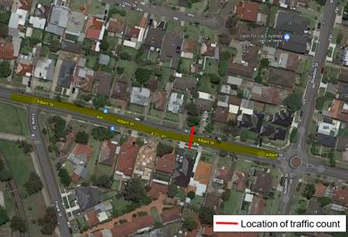
A traffic count was undertaken on Albert Street in March 2023. The traffic count location is shown in red on the map above.
The results of the traffic count indicated the following:
Average Daily Traffic (ADT) = 7237 veh/day,
85th percentile speed = 56.9 km/h,
Mean (average) vehicle speed = 49.5 km/h.
The results of the latest traffic count and recorded crashes were used in the assessment to determine the need for the installation of traffic calming devices on Albert Street between Frank Street to Bowden Street in accordance with the criteria set out in Council’s Local Area Traffic Management Policy (LATM) Policy.
The LATM assessments are summarised in the tables below:
Table 1 – Albert Street - LATM Assessment Points
|
Criteria |
Maximum Score |
Score Achieved |
|
Traffic Study Data |
45 |
20 |
|
Crash warrant in the last 5 years |
15 |
0 |
|
Road Characteristics |
35 |
14 |
|
Community Support & other factors |
5 |
5 |
|
Total |
100 |
39 |
Table 2 – Albert Street – Action
|
Criteria |
Action |
|
>75 |
Report to TC with a recommendation of providing traffic calming devices |
|
61-75 |
Report to TC and discuss possibility of providing traffic calming devices |
|
41-60 |
Council to review traffic data in 6 months |
|
25-40 |
Monitor street and review traffic data after 12 months |
|
<25 |
Do Nothing |
|
Speed |
That regardless of the total points scored, should the 85th percentile speed exceed the posted speed limit by 5 km/h, the street be referred to the NSW Police for monitoring and/or enforcement. |
Based on the above assessment, traffic calming devices are not warranted in the street. Therefore, the request for the installation of traffic calming devices / speed humps in Albert Street between Frank Street and Bowden Street cannot be supported.
The traffic count indicated that the recorded 85th percentile speed was 56.9 km/h which is above the default speed limit. The matter will be referred to the NSW Police for speed enforcement. Council will also review traffic conditions after 12 months in accordance with the results of the assessment.
COnsultation
Consultation has not been undertaken as the investigation outlined in the report concludes no action is required at this time.
Future consultation will be undertaken if recommended by the Traffic Committee.
Attachments
Nil
Traffic Committee
5 April 2023
Item No: CTC-23-060
Chelsea Street, Merrylands - Road Safety Concerns
Directorate: Environment and Planning
Responsible Officer: Executive Manager Development and Building
File Number: HC-24-01-3/02
Electorate: Granville
Police Area Command (PAC): Cumberland
Agenda Part Part 2
Note: Recommendation to Council
Summary
Council has reviewed traffic conditions in Chelsea Street, Merrylands. This report outlines the outcome of the review.
|
The Cumberland Traffic Committee recommends that; 1. The installation of traffic calming devices in Chelsea Street, Merrylands not be supported. 2. Council review conditions in Chelsea Street, Merrylands and report back to the Traffic Committee in November 2023. |
Report
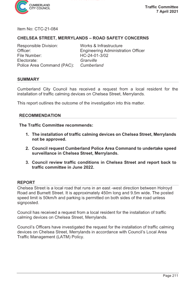
Cumberland Traffic Committee (CTC) at its meeting in April 2021 considered a report (Item No.CTC-21-084) regarding road safety concerns on Chelsea Street, Merrylands. Council resolved that Council review the conditions in Chelsea Street, Merrylands, and report back to traffic committee in April 2022.
The map below shows the location of Chelsea Street, Merrylands.
In accordance with Council’s resolution, a traffic count was undertaken in Chelsea Street in February 2023. Council officers have reviewed the traffic count data and compared it with the previous traffic count data undertaken in March 2021.
Both results are detailed in the table below:
|
Traffic count date |
Ave. daily traffic |
85th percentile speed |
|
March 2021 |
1,259 |
49.6 km/h |
|
February 2023 |
2,097 |
51.1 km/h |
The traffic data from the table above indicated that both traffic volume (AADT) and 85 percentile speed at Chelsea Street have increased slightly since 2021.
According to the Centre for Road Safety Accident data, there was one reported accident in Chelsea Street in the 5 years ending June 2022.
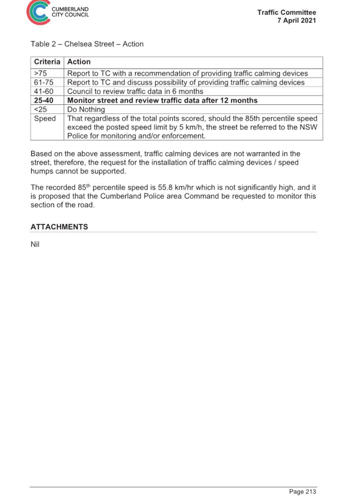
Based on the above, a further LATM assessment has been undertaken and the LATM assessment points are given below:
Table 1 – Chelsea Street - LATM Assessment Points
|
Criteria |
Maximum Score |
Score Achieved |
|
Traffic Study Data |
45 |
15 |
|
Crash warrant in the last 5 years |
15 |
5 |
|
Road Characteristics |
35 |
18 |
|
Community Support & other factors |
5 |
5 |
|
Total |
100 |
43 |
Table 2 – Chelsea Street – Action
|
Criteria |
Action |
|
>75 |
Report to TC with a recommendation of providing traffic calming devices |
|
61-75 |
Report to TC and discuss possibility of providing traffic calming devices |
|
41-60 |
Council to review traffic data in 6 months |
|
25-40 |
Monitor street and review traffic data after 12 months |
|
<25 |
Do Nothing |
|
Speed |
That regardless of the total points scored, should the 85th percentile speed exceed the posted speed limit by 5 km/h, the street be referred to the NSW Police for monitoring and/or enforcement. |
Based on the above assessment, traffic calming devices are not warranted in the street. The recorded 85th percentile speed of 51.1 km/h is slightly above the default speed limit but within acceptable limits.
Council will review traffic conditions in Chelsea Street in 6 months in accordance with the outcomes of the assessment.
COnsultation
Consultation has not been undertaken as the investigation outlined in the report concludes no action is required at this time.
Future consultation will be undertaken if recommended by the Traffic Committee.
Attachments
DOCUMENTS
ASSOCIATED WITH
REPORT CTC-23-060
Attachment 1
Previous report - CTC-21-084
5 April 2023
Item No: CTC-23-061
Essington Street, Wentworthville - Road Safety Concerns
Directorate: Environment and Planning
Responsible Officer: Executive Manager Development and Building
File Number: T-28-01/06
Electorate: Granville
Police Area Command (PAC): Cumberland
Agenda Part Part 2
Note: Recommendation to Council
Summary
Council has received a request from a local resident for the installation of traffic calming devices on Essington Street, Wentworthville due to speeding concerns. This report outlines the outcome of the investigation into this matter.
|
The Cumberland Traffic Committee recommends that; 1. The installation of traffic calming devices on Essington Street, Wentworthville not be supported. 2. Council review conditions in Essington Street, Wentworthville and report back to traffic committee in April 2024. |
Report
Council has received a request from a local resident for the installation of traffic calming devices on Essington Street, Wentworthville due to speeding concerns.
Essington Street is a local road runs in an east-west direction between Bransgrove Street and Bridge Road. It is approximately 640m long. The width of the street is approximately 10m.
The speed limit in the street is 50km/h with a 60m section of ‘School Zone’ area at its eastern end. Parking is permitted on both sides of the road in accordance with the Road Rules unless signposted.
Council’s Officers have investigated the request for the installation of traffic calming devices on Essington Street in accordance with Council’s Local Area Traffic Management (LATM) Policy.
The latest Centre for Road Safety accident data indicated that there were no reported accidents in Essington Street in the 5 years ending June 2022.
The map below shows the location of Essington Street:
Figure 1 – Locality Plan
A traffic count was undertaken on Essington Street in November 2022. The traffic count location is shown in red on the map above.
The results of the traffic count indicated the following:
Average Daily Traffic (ADT) = 1,030 veh/day,
85th percentile speed = 53.5 km/h,
Mean (average) vehicle speed = 44.2 km/h.
The results of the traffic counts and recorded crashes were used in the assessment to determine the need for the installation of traffic calming devices on Essington Street in accordance with the criteria set out in Council’s Local Area Traffic Management Policy (LATM) Policy.
The LATM assessments are summarised in the tables below:
Table 1 – Essington Street - LATM Assessment Points
|
Criteria |
Maximum Score |
Score Achieved |
|
Traffic Study Data |
45 |
10 |
|
Crash warrant in the last 5 years |
15 |
0 |
|
Road Characteristics |
35 |
18 |
|
Community Support & other factors |
5 |
5 |
|
Total |
100 |
33 |
Table 2 – Essington Street – Action
|
Criteria |
Action |
|
>75 |
Report to TC with a recommendation of providing traffic calming devices |
|
61-75 |
Report to TC and discuss possibility of providing traffic calming devices |
|
41-60 |
Council to review traffic data in 6 months |
|
25-40 |
Monitor street and review traffic data after 12 months |
|
<25 |
Do Nothing |
|
Speed |
That regardless of the total points scored, should the 85th percentile speed exceed the posted speed limit by 5 km/h, the street be referred to the NSW Police for monitoring and/or enforcement. |
The traffic count indicated that the recorded 85th percentile speed was 53.5 km/h which is over the 50km/h speed limit of the street, however it is within acceptable limits.
Based on the above assessment, traffic calming devices are not warranted in the street. Therefore, the request for the installation of traffic calming devices on Essington Street is not supported at this time.
Council will review traffic conditions in Essington Street in 12 months in accordance with the outcomes of the assessment.
COnsultation
Consultation has not been undertaken as the investigation outlined in the report concludes no action is required.
Future consultation will be undertaken if recommended by the Traffic Committee.
Attachments
Nil
Traffic Committee
5 April 2023
Item No: CTC-23-062
Excelsior Street, Merrylands - Road Safety Concerns
Directorate: Environment and Planning
Responsible Officer: Executive Manager Development and Building
File Number: HC-24-01-3/02
Electorate: Granville
Police Area Command (PAC): Cumberland
Agenda Part Part 2
Note: Recommendation to Council
Summary
Council has reviewed traffic conditions in Excelsior Street, Merrylands, in the vicinity of Excelsior Reserve. This report outlines the outcome of the review.
|
The Cumberland Traffic Committee recommends that; 1. The installation of traffic calming devices on Excelsior Street, Merrylands between Adam Street and Lavinia Street not be supported. 2. Council review conditions in Excelsior Street, Merrylands and report back to traffic committee in April 2024. |
Report
Cumberland Traffic Committee (CTC) at its meeting in April 2021 considered a report (Item No.CTC-21-059) regarding road safety concerns on Excelsior Street, Merrylands between Adam Street and Lavinia Street. Council resolved that traffic calming devices on Excelsior Street, Merrylands not to be supported and Council staff to review the traffic conditions in Excelsior Street in June 2022 and report back to the Traffic Committee.
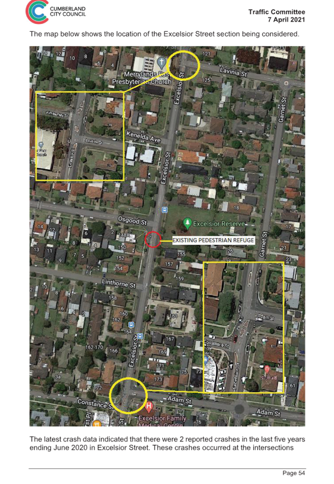
The map below shows the location of Excelsior Street, Merrylands between Adam Street and Lavinia Street encompassing Excelsior Reserve. The speed limit of the street is 50km/h.
In accordance with Council’s resolution, a traffic count was undertaken in Excelsior Street in February 2023. Council officers have reviewed the traffic count data and compared it with the previous traffic count data undertaken in February 2021.
Both results are detailed in the table below:
|
Traffic count date |
Ave. daily traffic |
85 Percentile speed |
|
February 2021 |
10,028 |
52 km/h |
|
February 2023 |
8,870 |
49.9 km/h |
The traffic data from the table above indicated that both traffic volume (AADT) and 85th percentile speed at this section of Excelsior Street have reduced since 2021.
According to the Centre for Road Safety Accident data, there were two reported accidents in Excelsior Street between Osgood Street and Linthorne Street in the 5 years ending June 2022.
Based on the above, a further LATM assessment has been undertaken and the LATM assessment points are given below:
Table 1 – Excelsior Street - LATM Assessment Points
|
Criteria |
Maximum Score |
Score Achieved |
|
Traffic Study Data |
45 |
15 |
|
Crash warrant in the last 5 years |
15 |
5 |
|
Road Characteristics |
35 |
13 |
|
Community Support & other factors |
5 |
5 |
|
Total |
100 |
38 |
Table 2 – Excelsior Street – Action
|
Criteria |
Action |
|
>75 |
Report to TC with a recommendation of providing traffic calming devices |
|
61-75 |
Report to TC and discuss possibility of providing traffic calming devices |
|
41-60 |
Council to review traffic data in 6 months |
|
25-40 |
Monitor street and review traffic data after 12 months |
|
<25 |
Do Nothing |
|
Speed |
That regardless of the total points scored, should the 85th percentile speed exceed the posted speed limit by 5 km/h, the street be referred to the NSW Police for monitoring and/or enforcement. |
Based on the above assessment, traffic calming devices are not warranted in the street. Therefore, the installation of traffic calming devices on Excelsior Street, Merrylands cannot be supported.
The recorded 85th percentile speed of 49.9km/hr is below the speed limit of the street.
Council will review traffic conditions in Excelsior Street in 12 months in accordance with the outcomes of the assessment.
COnsultation
Consultation has not been undertaken as the investigation outlined in the report concludes no action is required at this time.
Future consultation will be undertaken if recommended by the Traffic Committee.
Attachments
DOCUMENTS
ASSOCIATED WITH
REPORT CTC-23-062
Attachment 1
Previous report - CTC-21-059
5 April 2023
Item No: CTC-23-063
Gordon Avenue, South Granville - Road Safety Concerns
Directorate: Environment and Planning
Responsible Officer: Executive Manager Development and Building
File Number: HC-24-01-3/02
Electorate: Auburn
Police Area Command (PAC): Cumberland
Agenda Part Part 2
Note: Recommendation to Council
Summary
Council has received a request from a local resident for the installation of traffic calming devices on Gordon Avenue, South Granville, between Oakleigh Avenue and Dellwood Street due to speeding concerns. This report outlines the outcome of the review.
|
The Cumberland Traffic Committee recommends that: 1. The installation of traffic calming devices on Gordon Avenue, South Granville not be supported. 2. Council review conditions in Gordon Avenue, South Granville and report back to traffic committee in April 2024. 3. Council request Cumberland Police Area Command to undertake speed surveillance in Gordon Avenue, South Granville. |
Report
Council has received a request from a local resident for the installation of traffic calming devices on Gordon Avenue, South Granville between Oakleigh Avenue and Dellwood Street due to speeding concerns.
This section of Gordon Avenue is a local road runs in north – south direction. It is approximately 360m long and 8.8m wide. The speed limit is 50km/h and parking is permitted on both sides of the road in accordance with Road Rules unless otherwise signposted.
Council officers have investigated the request for the installation of traffic calming devices on Gordon Avenue in accordance with Council’s Local Area Traffic Management (LATM) Policy.
The latest Centre for Road Safety accident data indicated that there were no reported accidents in Gordon Avenue in the 5 years ending June 2022.
The map below shows the location of Gordon Avenue:
A traffic count was undertaken on Gordon Avenue in December 2022. The traffic count location is shown in red on the map above.
The results of the traffic count indicated the following:
Traffic count Data on Gordon Avenue, South Granville
Average Daily Traffic (ADT) = 601 veh/day,
85th percentile speed = 56.2 km/h,
Mean (average) vehicle speed = 44.2 km/h.
The results of the traffic count recorded crashes etc. were used in the assessment to determine the need for the installation of traffic calming devices on Gordon Avenue in accordance with the criteria set out in Council’s Local Area Traffic Management Policy (LATM) Policy.
The LATM assessment points are given below:
Table 1 – Gordon Avenue- LATM Assessment Points
|
Criteria |
Maximum Score |
Score Achieved |
|
Traffic Study Data |
45 |
10 |
|
Crash warrant in the last 5 years |
15 |
0 |
|
Road Characteristics |
35 |
11 |
|
Community Support & other factors |
5 |
5 |
|
Total |
100 |
26 |
Table 2 – Gordon Avenue– Action
|
Criteria |
Action |
|
>75 |
Report to TC with a recommendation of providing traffic calming devices |
|
61-75 |
Report to TC and discuss possibility of providing traffic calming devices |
|
41-60 |
Council to review traffic data in 6 months |
|
25-40 |
Monitor street and review traffic data after 12 months |
|
<25 |
Do Nothing |
|
Speed |
That regardless of the total points scored, should the 85th percentile speed exceed the posted speed limit by 5 km/h, the street be referred to the NSW Police for monitoring and/or enforcement. |
Based on the above assessment, traffic calming devices are not warranted in the street. Therefore, the installation of traffic calming devices in Gordon Avenue, South Granville cannot be supported at this time. The recorded 85th percentile speed of 56.2 km/h is above the default speed limit. As a result, the matter will be referred to the NSW Police Force for speed surveillance.
Council will review traffic conditions in Gordon Avenue in 12 months in accordance with the outcomes of the assessment.
COnsultation
Consultation has not been undertaken as the investigation outlined in the report concludes no action is required at this time.
Future consultation will be undertaken if recommended by the Traffic Committee.
Attachments
Nil
Traffic Committee
5 April 2023
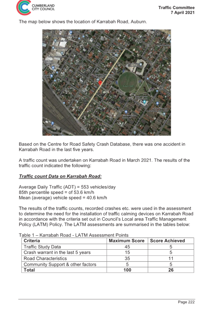
Item No: CTC-23-064
Karrabah Road, Auburn - Road Safety Concerns
Directorate: Environment and Planning
Responsible Officer: Executive Manager Development and Building
File Number: HC-24-01-3/02
Electorate: Auburn
Police Area Command (PAC): Auburn
Agenda Part Part 2
Note: Recommendation to Council
Summary
Council has undertaken a review of traffic conditions in Karrabah Road, Auburn. This report outlines the outcome of the review.
|
The Cumberland Traffic Committee recommends that the installation of traffic calming devices on Karrabah Road, Auburn, not be supported. |
Report
Cumberland Traffic Committee (CTC) at its meeting in April 2021 considered a report (Item No.CTC-21-086) regarding road safety concerns in Karrabah Road, Auburn. Council resolved that Council review the conditions in Karrabah Road, Auburn and report back to the Traffic Committee in June 2022.
The map below shows the location of Karrabah Road, Auburn.
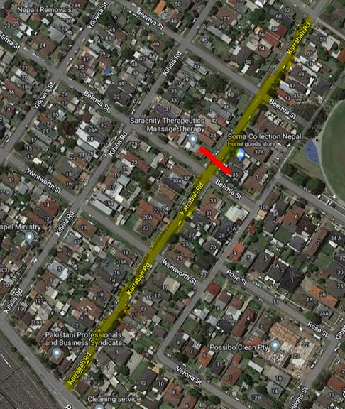
In accordance with Council’s resolution, a traffic count was undertaken in Karrabah Road in January 2023 to review traffic conditions in the street. The traffic count location is shown in red in the map above.
Council officers have reviewed the traffic count data and compared it with the previous data undertaken in March 2021.
Both results are detailed in the table below:
|
Traffic count date |
Ave. daily traffic |
85th percentile speed |
|
March 2021 |
553 |
53.6 km/h |
|
February 2023 |
473 |
50 km/h |
The traffic data from the table above indicated that both traffic volume (ADT) and 85th percentile speed at Karrabah Road have decreased since 2021.
According to the Centre for Road Safety Accident data, there were no reported accidents in Karrabah Road in the 5 years ending June 2022.
Based on the above, a further LATM assessment has been undertaken and the LATM assessment points are given below:
Table 1 – Karrabah Road - LATM Assessment Points
|
Criteria |
Maximum Score |
Score Achieved |
|
Traffic Study Data |
45 |
0 |
|
Crash warrant in the last 5 years |
15 |
0 |
|
Road Characteristics |
35 |
11 |
|
Community Support & other factors |
5 |
5 |
|
Total |
100 |
16 |
Table 2 – Karrabah Road – Action
|
Criteria |
Action |
|
>75 |
Report to TC with a recommendation of providing traffic calming devices |
|
61-75 |
Report to TC and discuss possibility of providing traffic calming devices |
|
41-60 |
Council to review traffic data in 6 months |
|
25-40 |
Monitor street and review traffic data after 12 months |
|
<25 |
Do Nothing |
|
Speed |
That regardless of the total points scored, should the 85th percentile speed exceed the posted speed limit by 5 km/h, the street be referred to the NSW Police for monitoring and/or enforcement. |
Based on the above assessment, traffic calming devices are not warranted in the street. Therefore, the installation of traffic calming devices on Karrabah Road, Auburn cannot be supported.
The recorded 85th percentile speed of 50 km/h is equal to the speed limit of the street.
COnsultation
Consultation has not been undertaken as the investigation outlined in the report concludes no action is required at this time.
Future consultation will be undertaken if recommended by the Traffic Committee.
Attachments
DOCUMENTS
ASSOCIATED WITH
REPORT CTC-23-064
Attachment 1
Previous report - CTC-21-086
5 April 2023
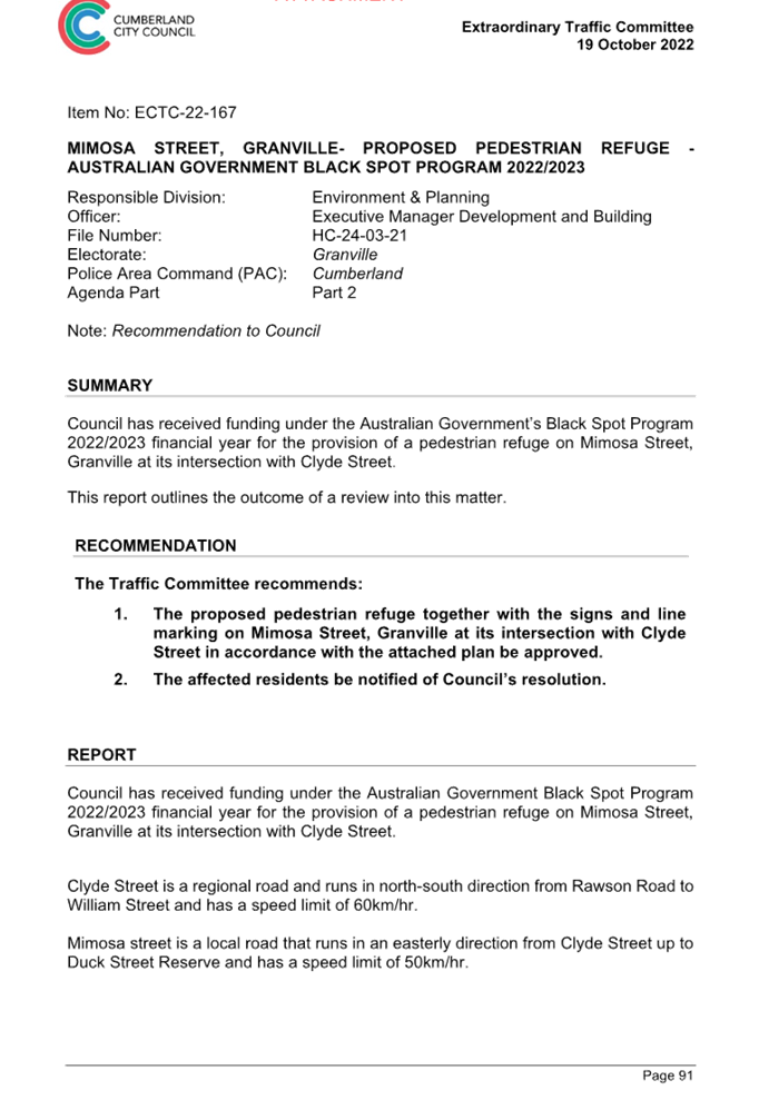
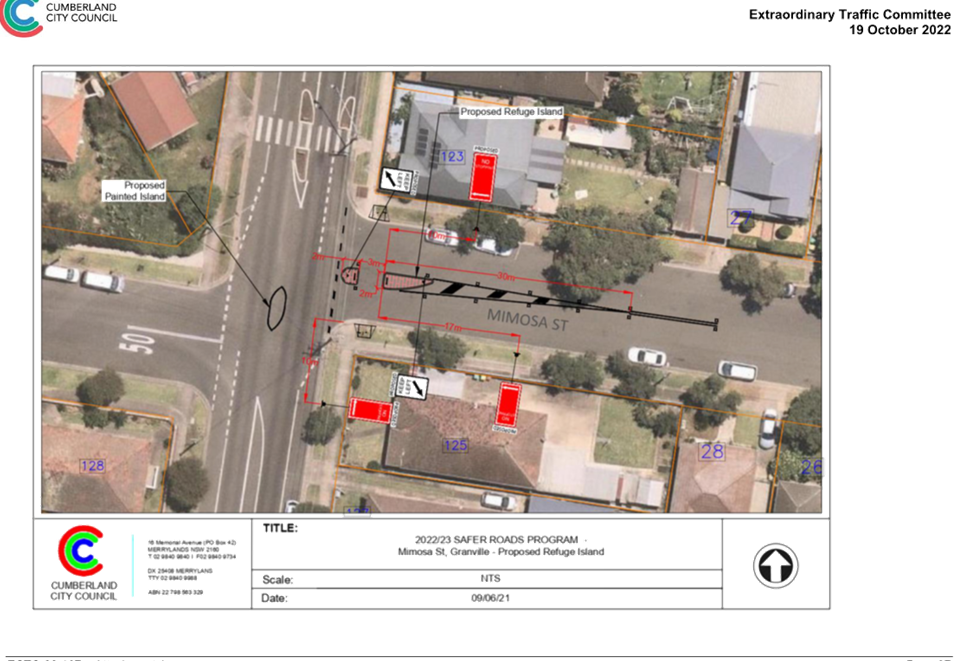
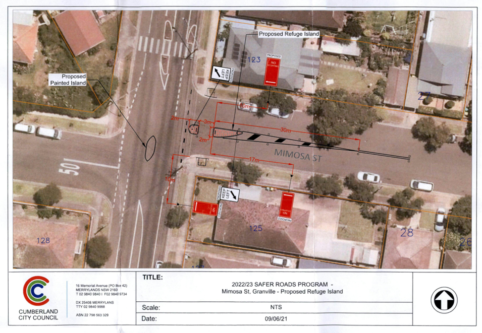
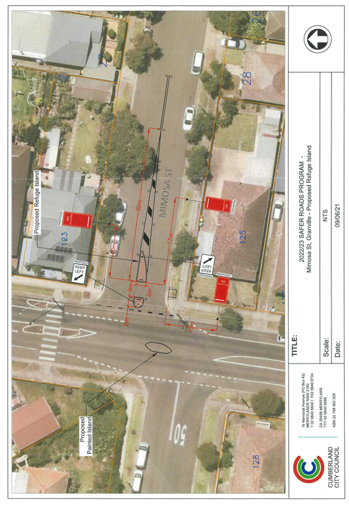
Item No: CTC-23-065
Mimosa Street, Granville - Construction of a Pedestrian Refuge
Directorate: Environment and Planning
Responsible Officer: Executive Manager Development and Building
File Number: HC-24-01-3/02
Electorate: Granville
Police Area Command (PAC): Cumberland
Agenda Part Part 2
Note: Recommendation to Council
Summary
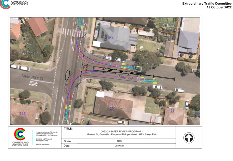
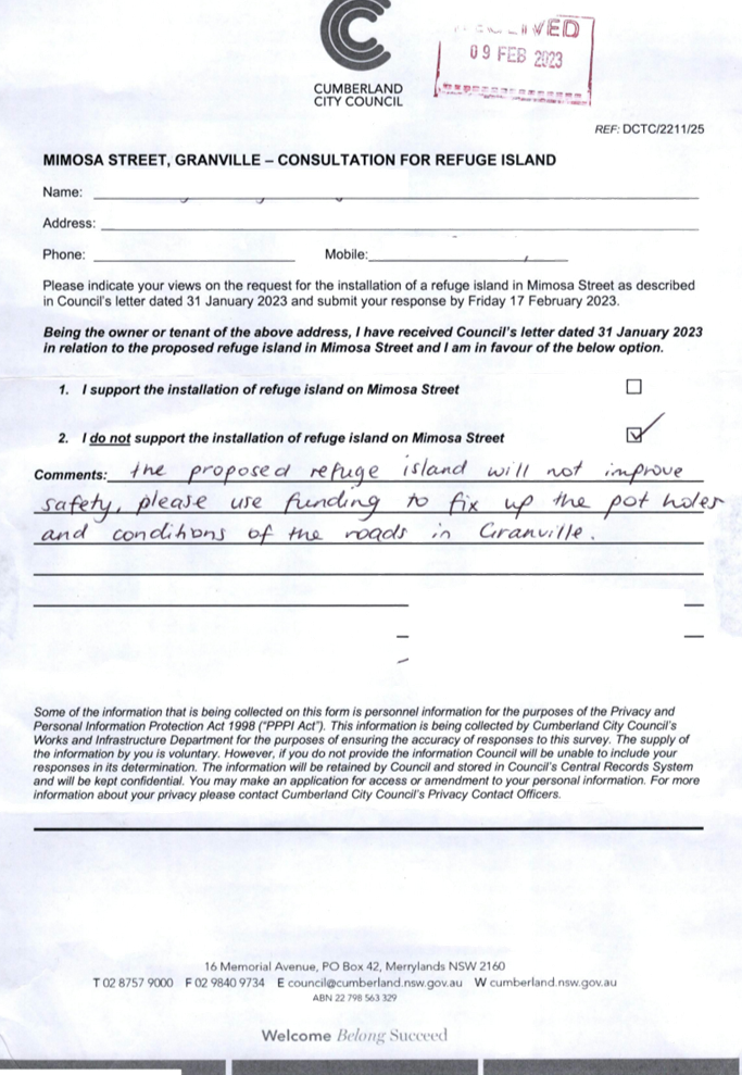
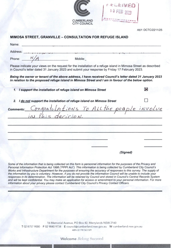
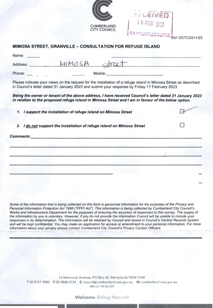
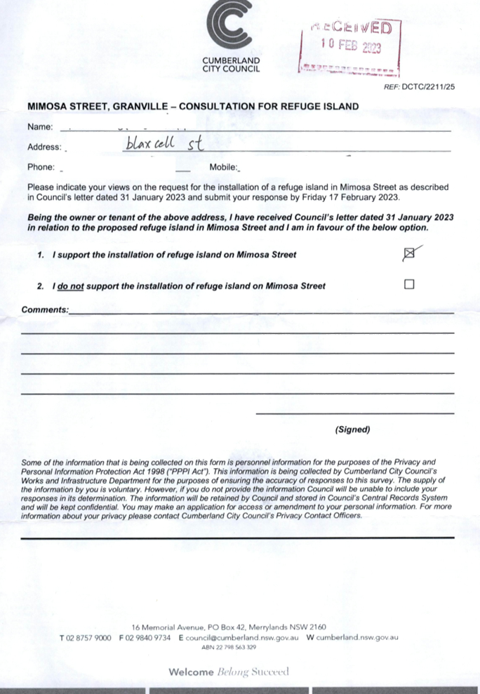
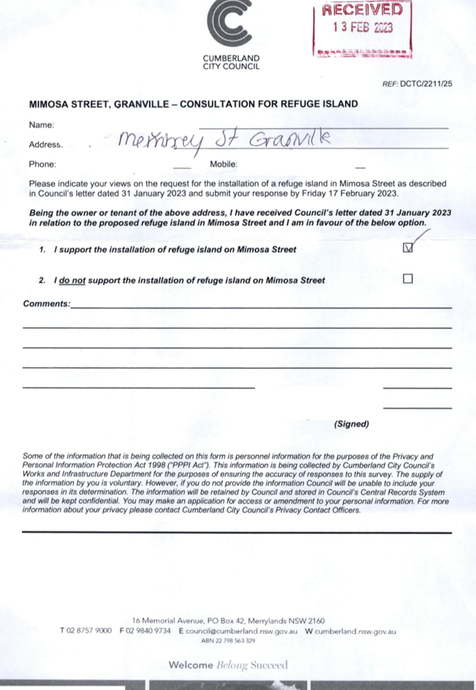
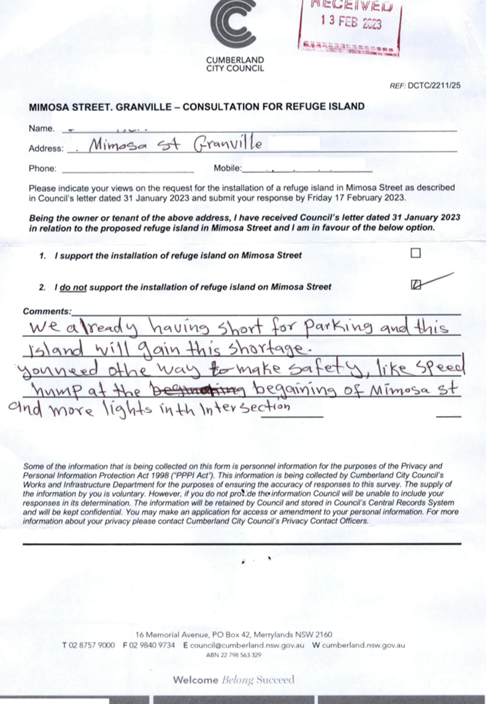
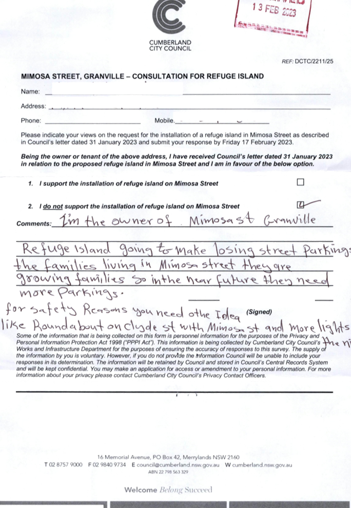
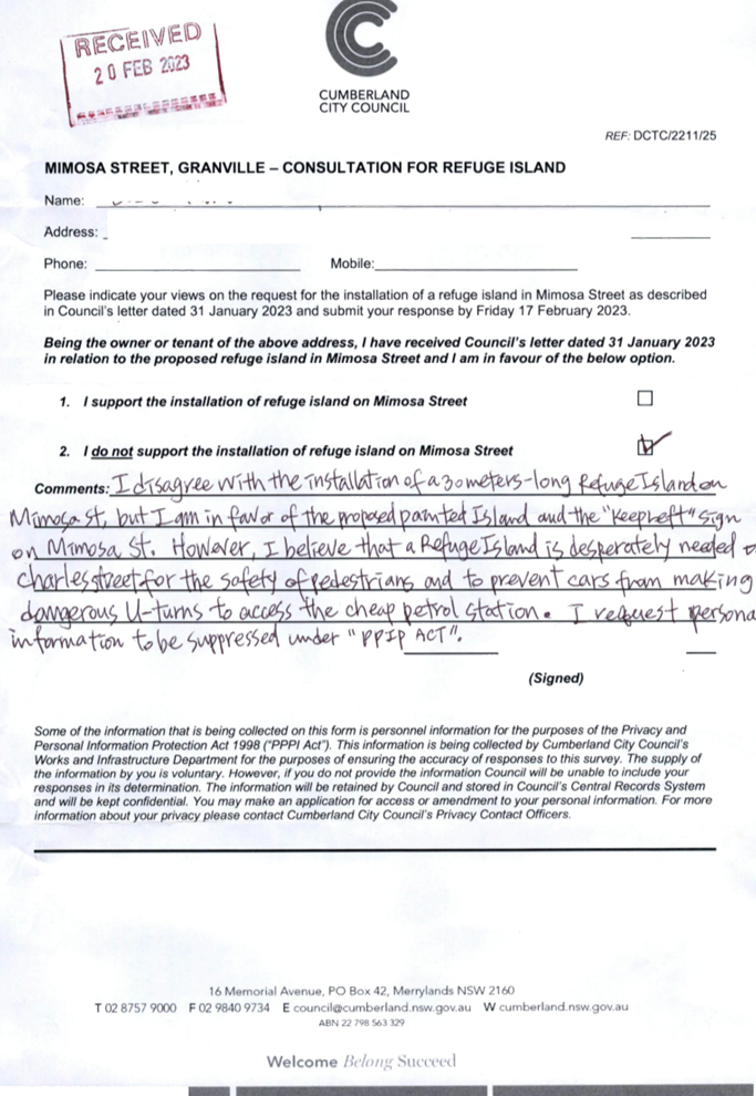
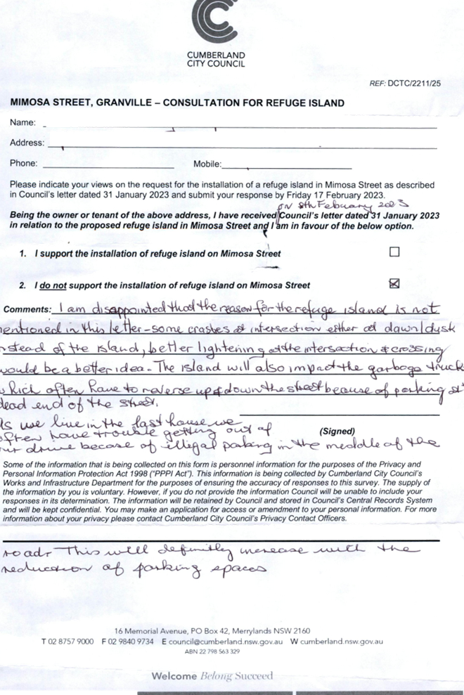
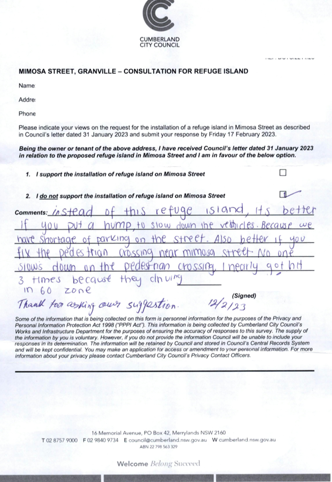
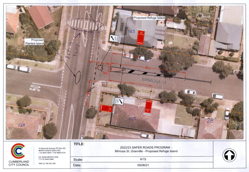
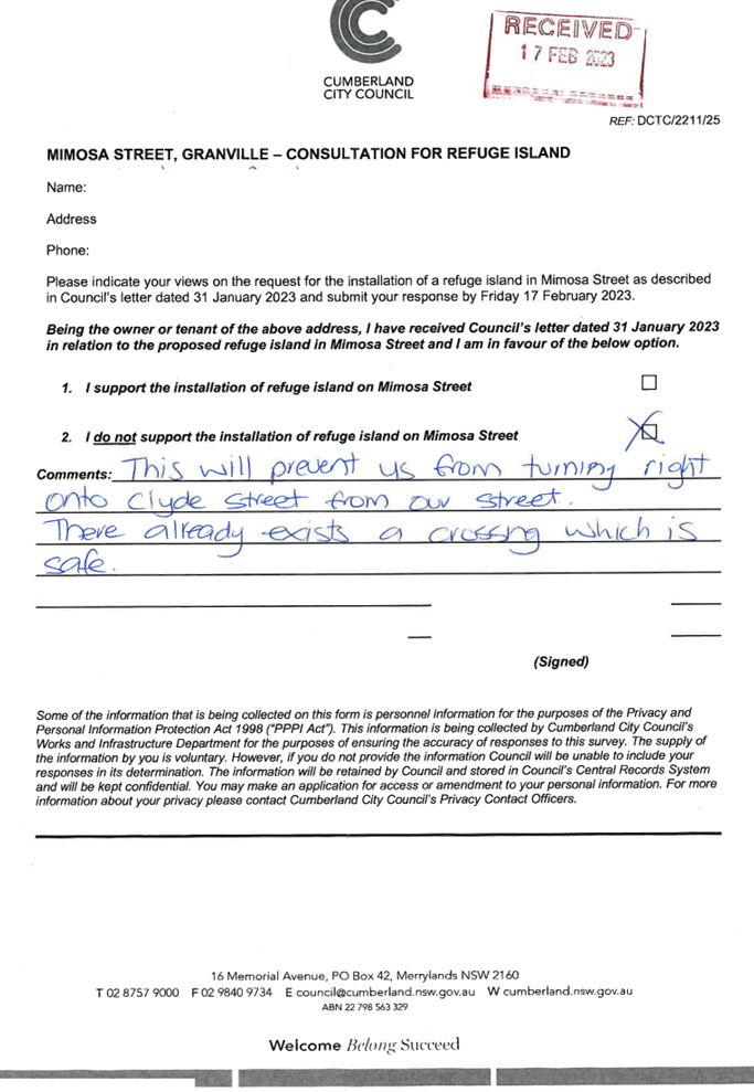
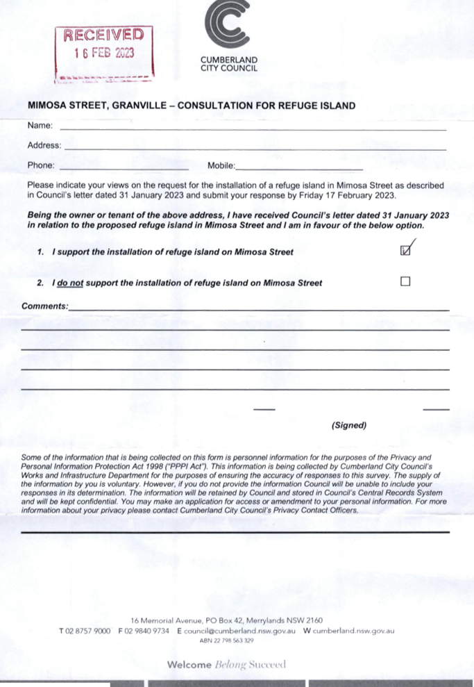
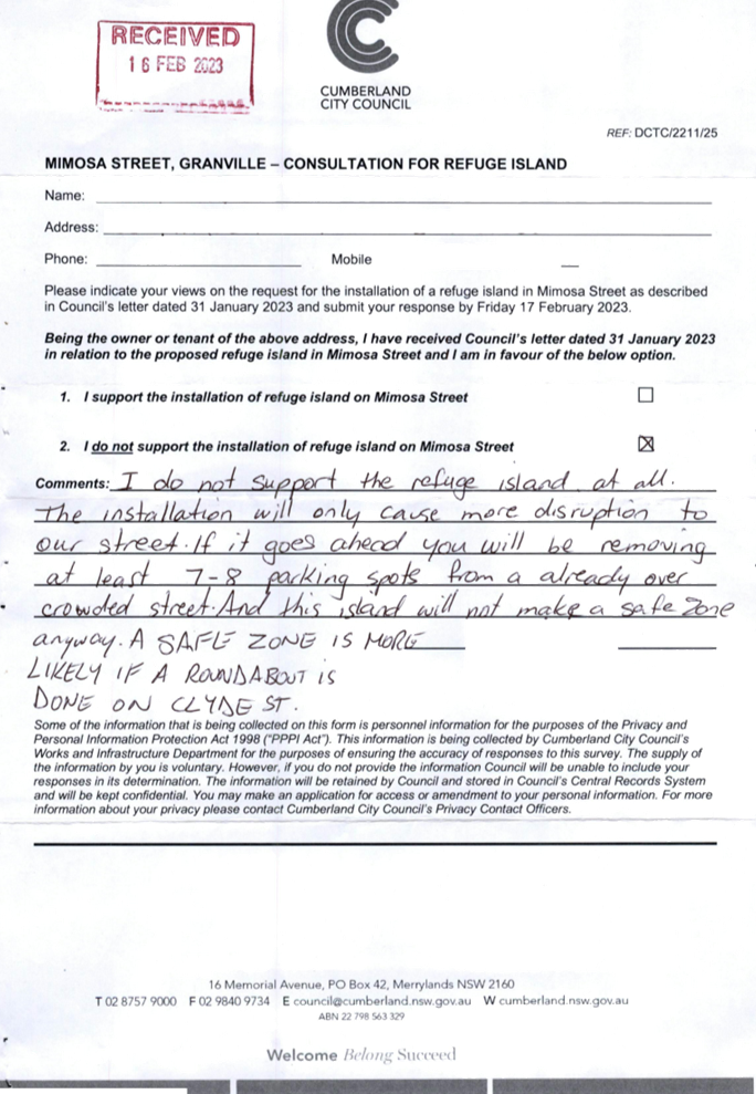
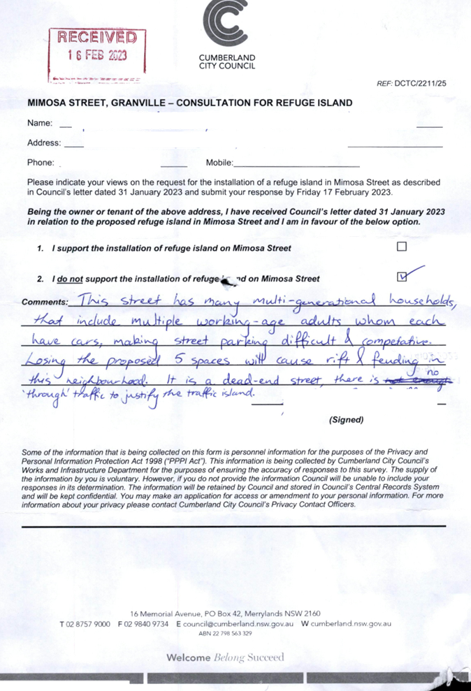
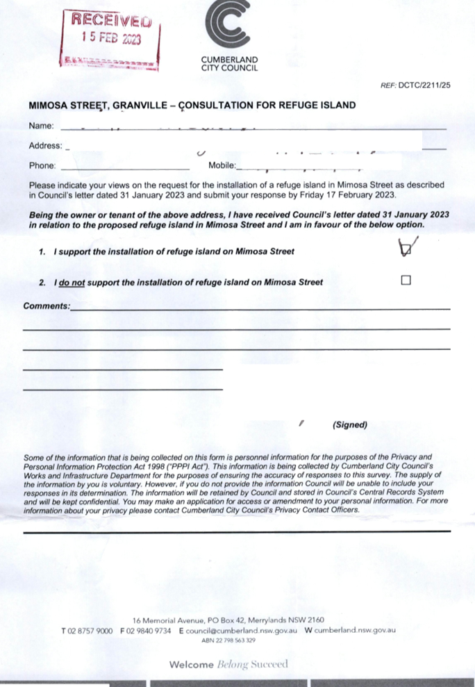
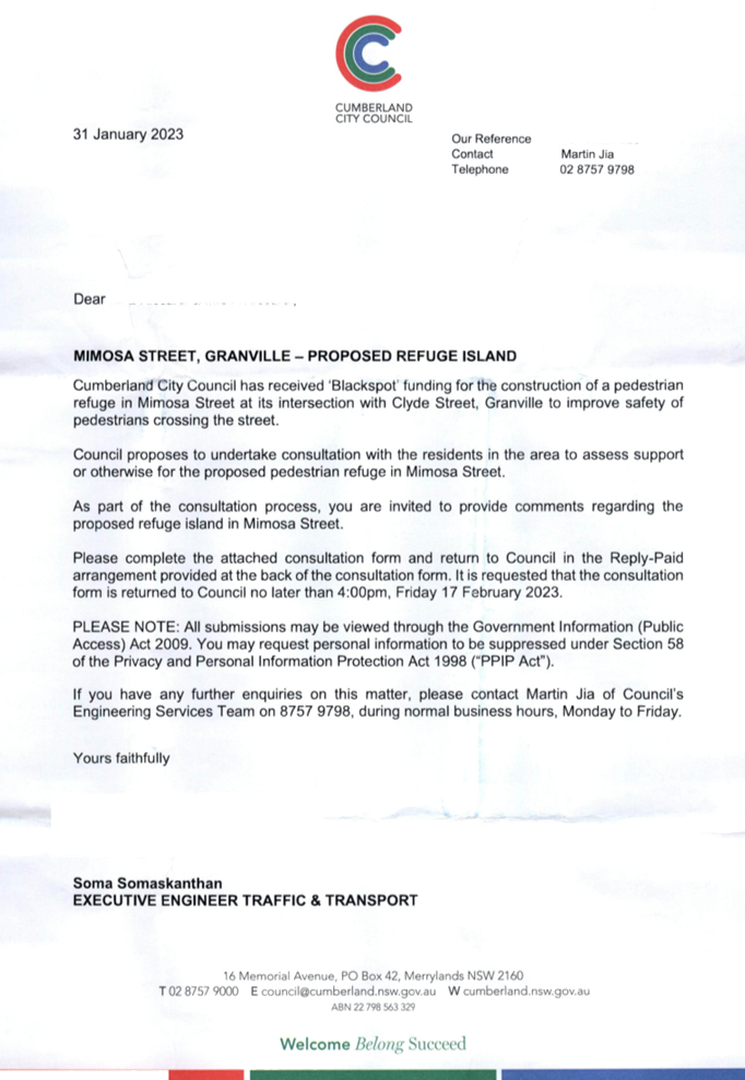
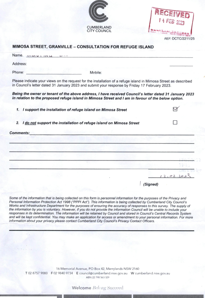
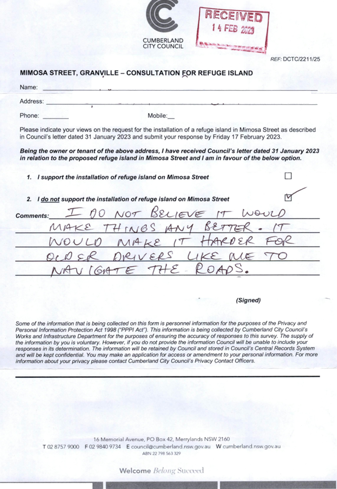
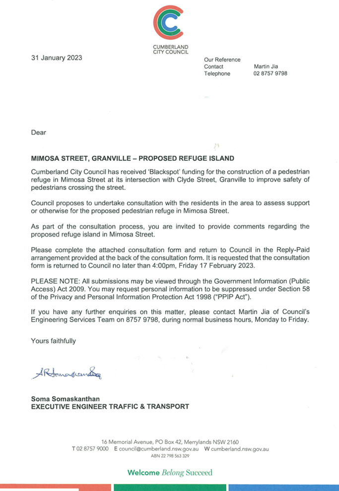
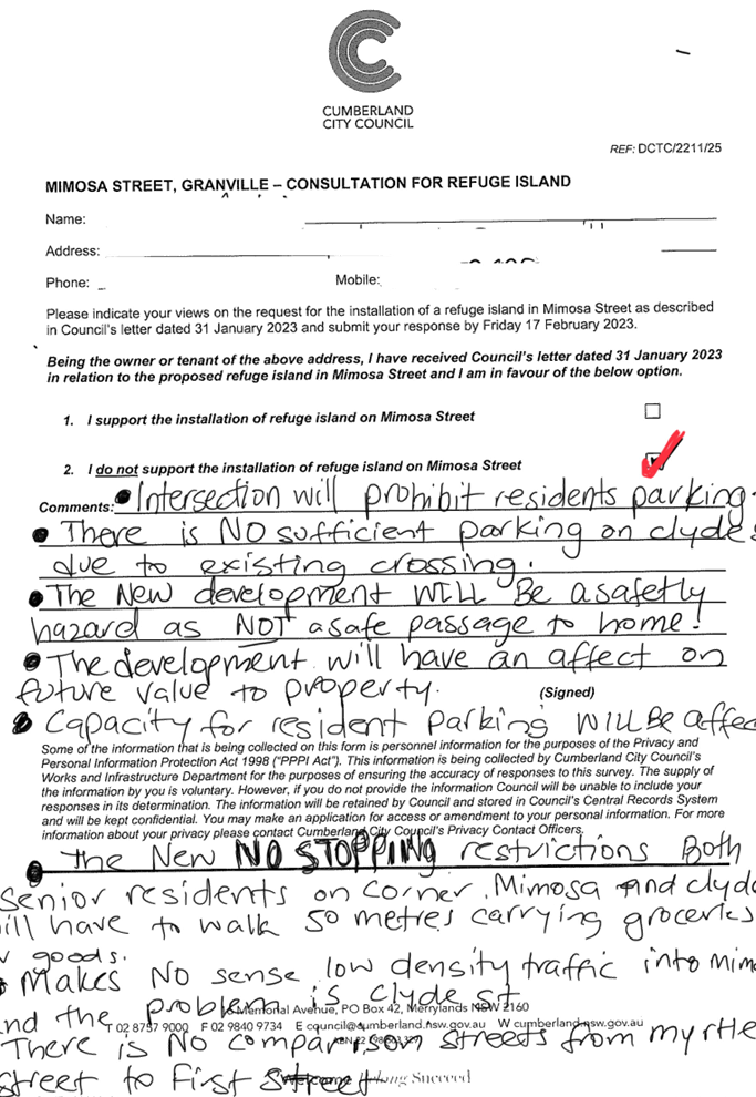
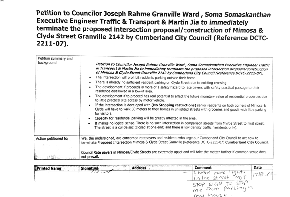
Council received funding under the Australian Government’s Black Spot Program 2022/2023 financial year for the provision of a pedestrian refuge on Mimosa Street, Granville at its intersection with Clyde Street. This report outlines the outcome of a review into this matter.
|
The Cumberland Traffic Committee recommends that: 1. The proposed pedestrian refuge together with the signs and line marking on Mimosa Street, Granville at its intersection with Clyde Street in accordance with the attached plan be approved. 2. The affected residents be notified of Council’s resolution. |
Report
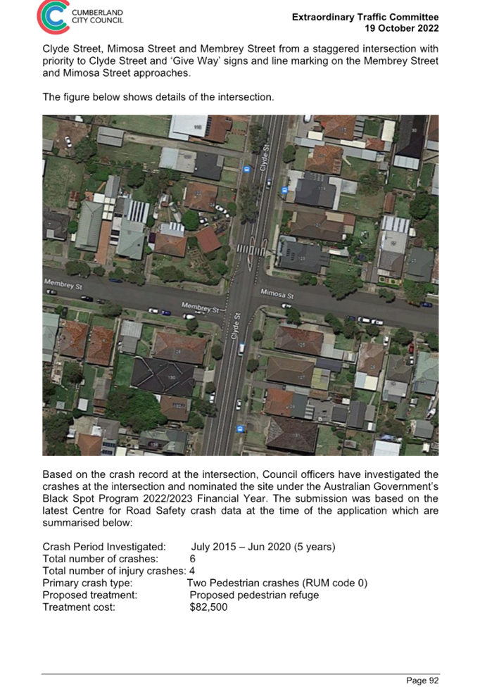
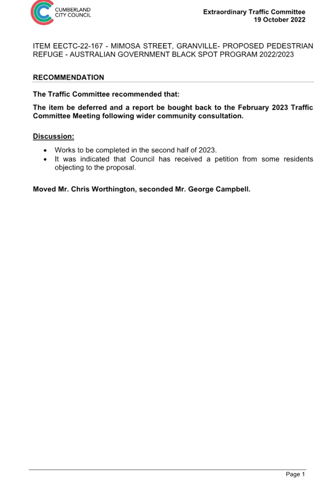
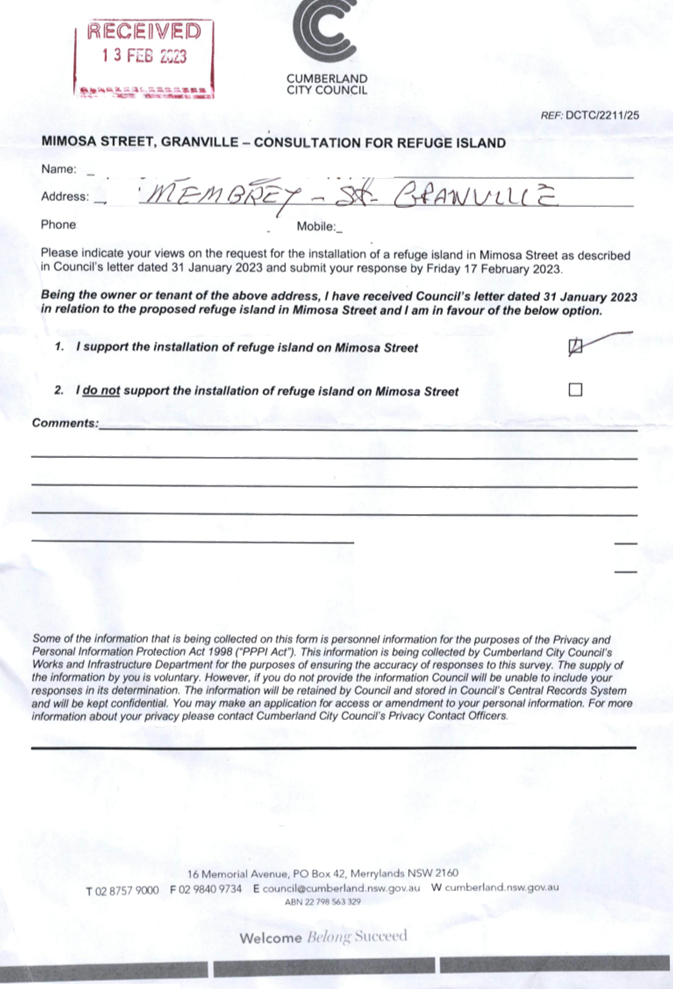
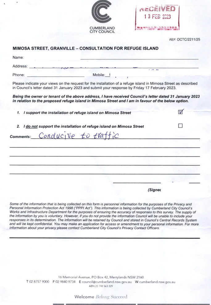
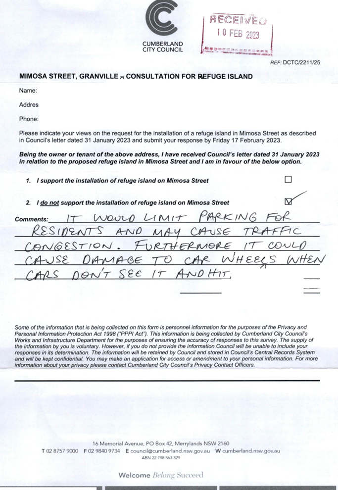
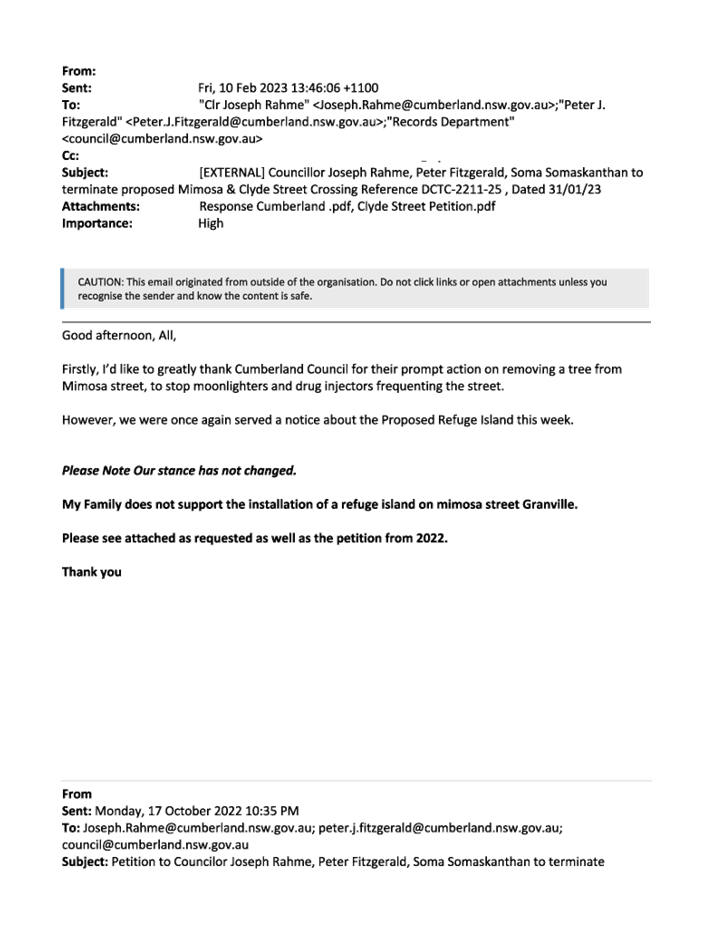
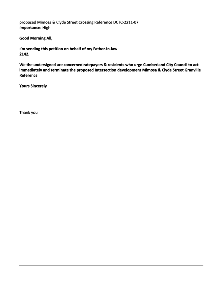
Cumberland Traffic Committee (CTC) at its meeting in October 2022 considered a report (Item No. ECTC-22-167) regarding the provision of a pedestrian refuge on Mimosa Street, Granville at its intersection with Clyde Street under the Australian Government Black Spot Program. Council resolved that the item be deferred, and a report be bought back to the Traffic Committee following wider community consultation.
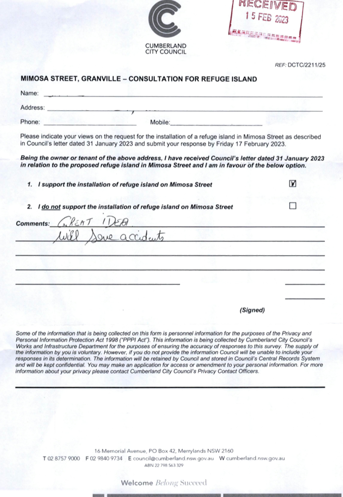
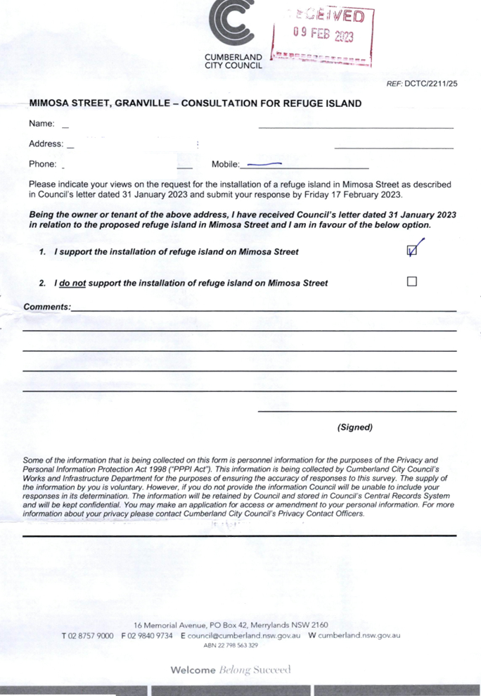
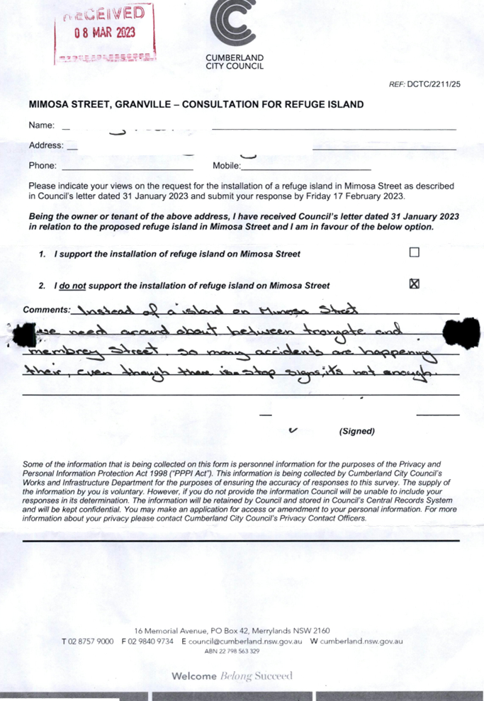
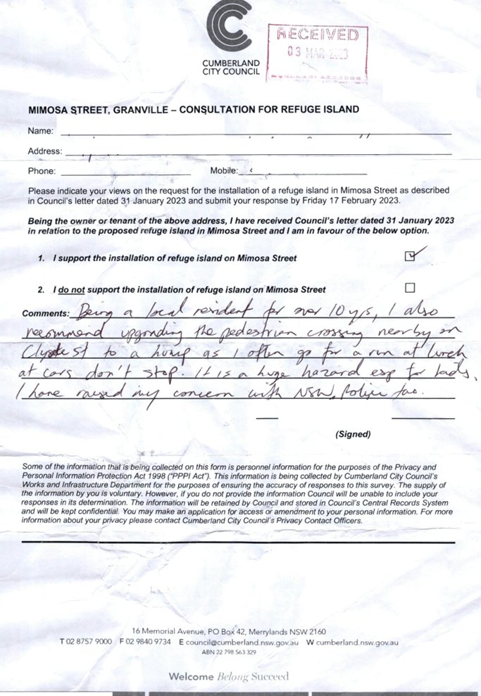
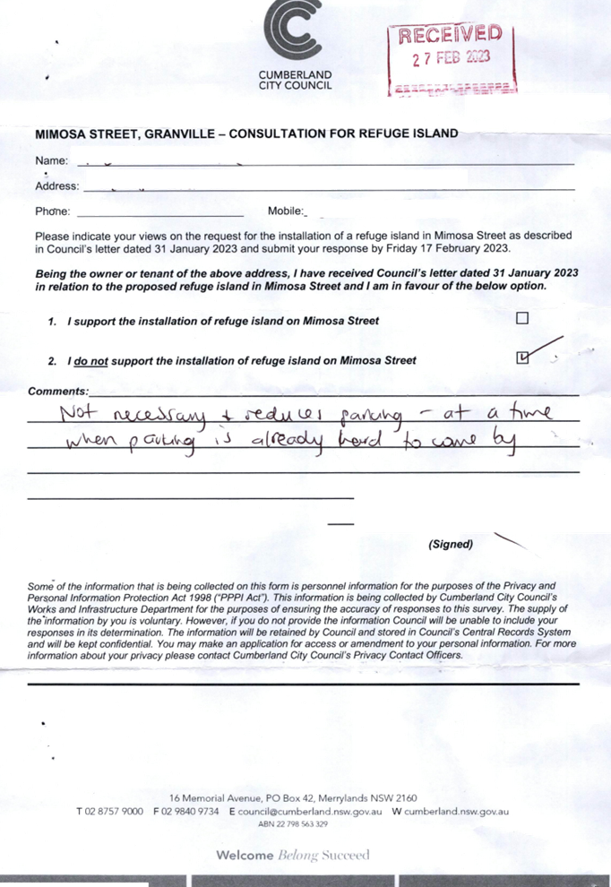
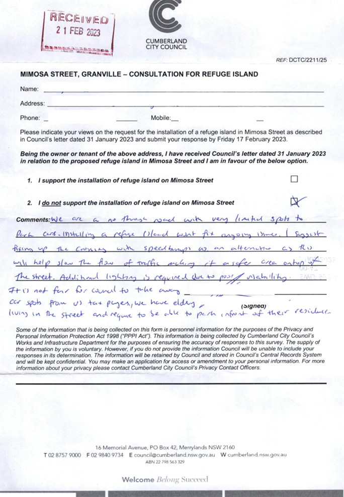
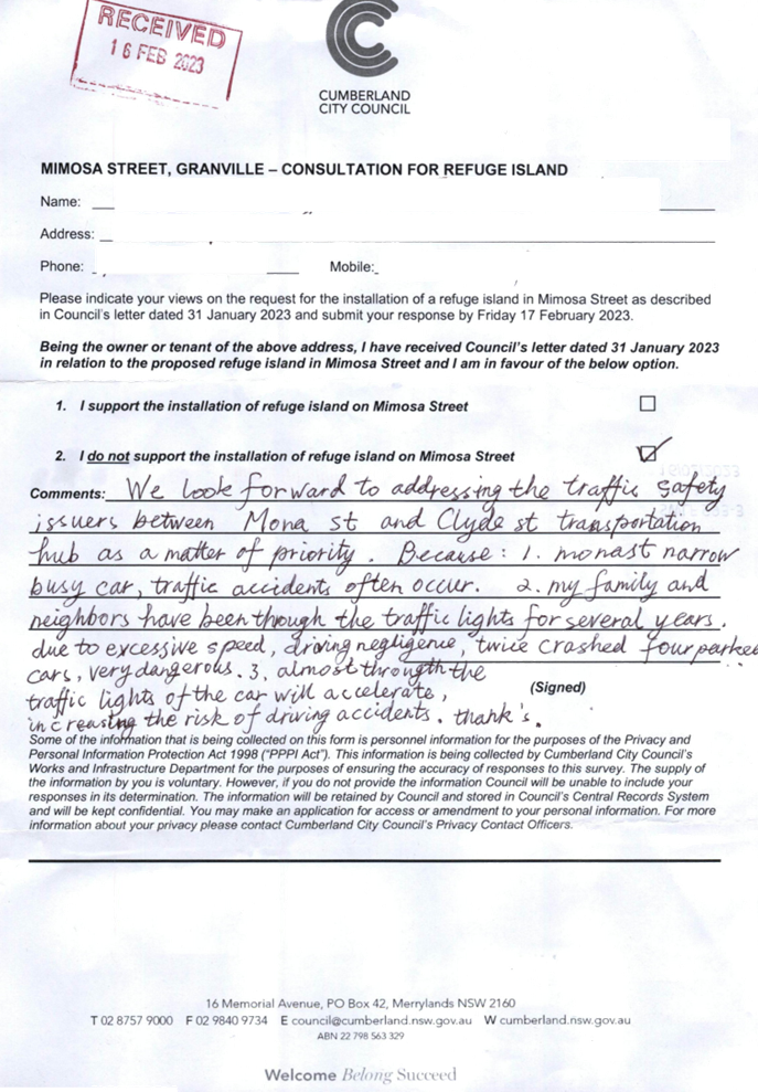
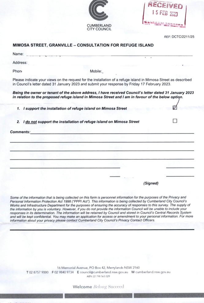
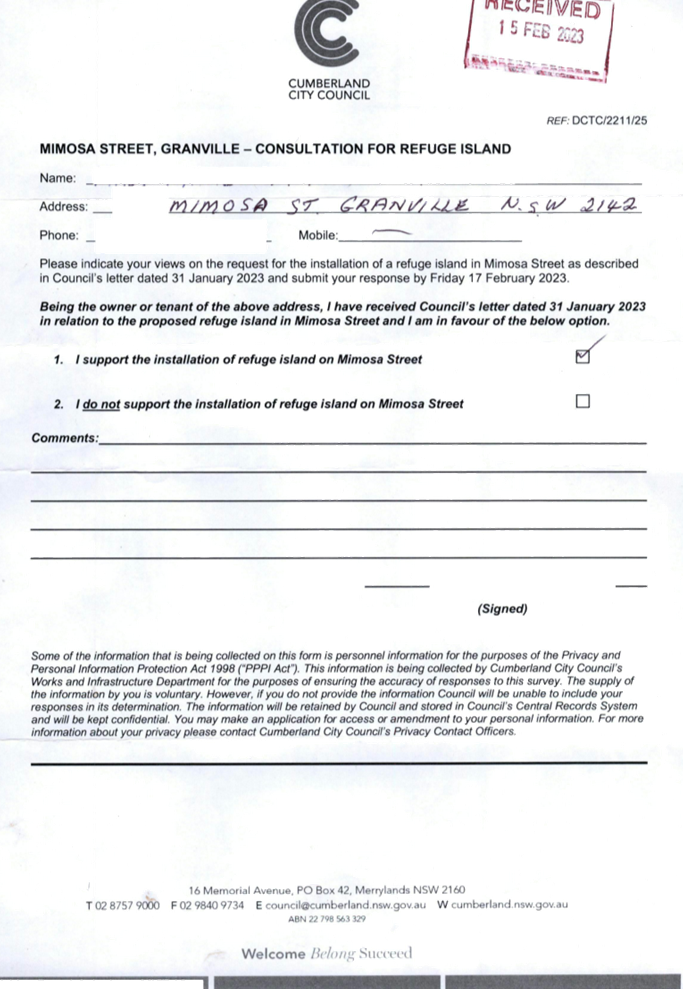
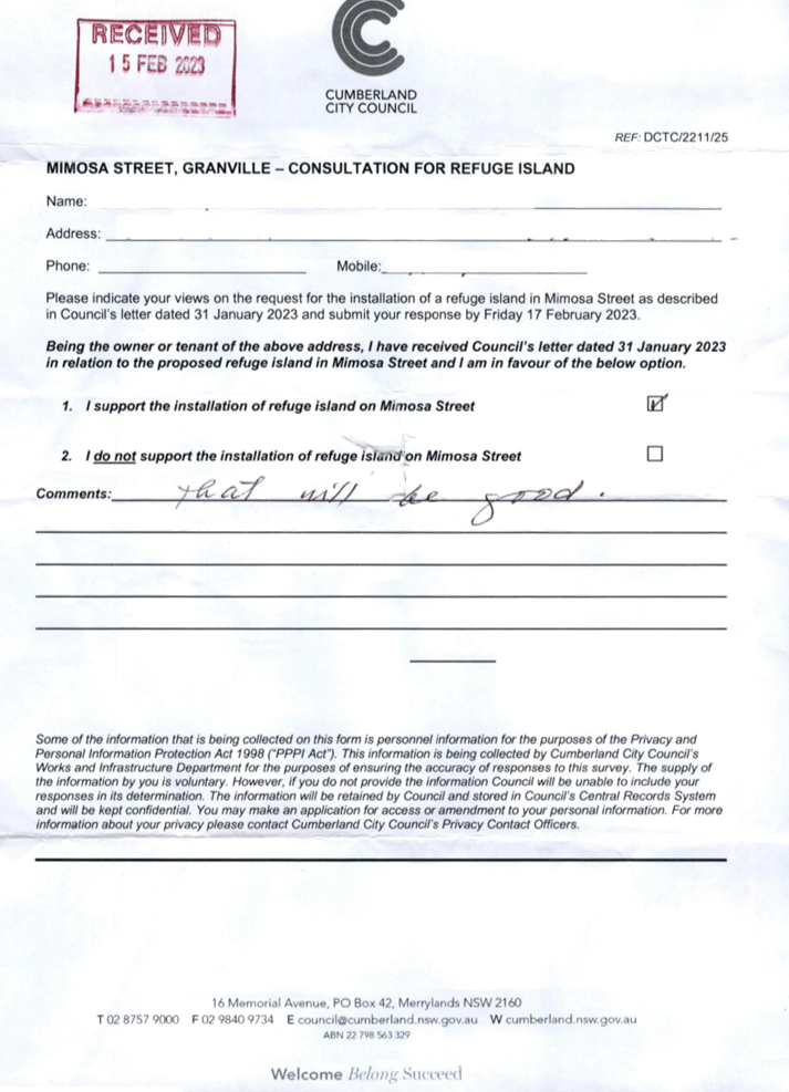
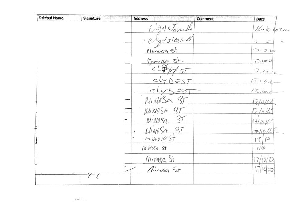
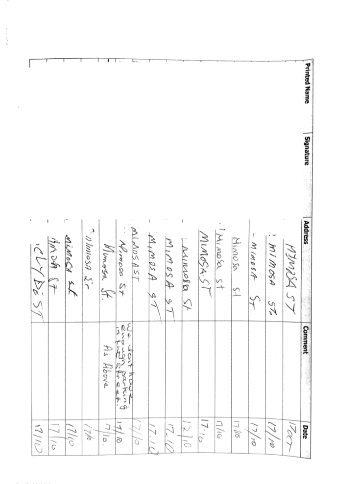
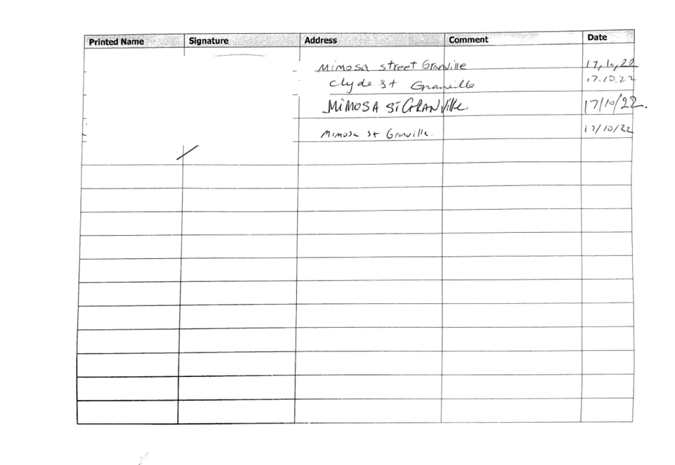
In accordance with Council’s resolution, 548 consultation letters were distributed to the residents within 400m radius from the proposed refuge island. Council received 30 responses, 14 (47%) supporting and 16 (53%) objecting to the proposed refuge island.
Out of the above responses, 3 submissions from Mimosa Street supported the proposal and 7 submissions from Mimosa Street objected to the proposal.
Although majority of the residents responding to the survey objected to the proposal, it should be noted that most of them will not be impacted by the proposed refuge island. Only one resident who objected to the proposal will be impacted by losing one parking space.
Mimosa Street is a local residential street with low parking demand. Large number of on-street parking spaces are available in the street outside the proposed parking restrictions associated with the refuge island. Therefore, the proposed pedestrian refuge will not have significant impact on the on-street parking spaces in Mimosa Street.
It shall also be noted that this project is under the Australian Government Black Spot Program due to pedestrian crashes that occurred at this location.
As such, it is recommended that the construction of the proposed refuge island be recommended.
COnsultation
Consultation was undertaken with the wider community in accordance with Council’s previous resolution between 31 January to 17 February 2023.
The consultation results are noted in the report above.
Attachments
1. Previous Report- ECTC-22-167
DOCUMENTS
ASSOCIATED WITH
REPORT CTC-23-065
Attachment 1
Previous Report- ECTC-22-167
DOCUMENTS
ASSOCIATED WITH
REPORT CTC-23-065
Attachment 2
Previous CTC Minutes - 19 October 2022
DOCUMENTS
ASSOCIATED WITH
REPORT CTC-23-065
Attachment 3
Submissions
Traffic Committee
5 April 2023
Item No: CTC-23-066
Hibiscus Street, Greystanes - Road Safety Concerns
Directorate: Environment and Planning
Responsible Officer: Executive Manager Development and Building
File Number: T-28-01/06
Electorate: Prospect
Police Area Command (PAC): Cumberland
Agenda Part Part 2
Note: Recommendation to Council
Summary
Council has received a request from a local resident for the installation of traffic calming devices on Hibiscus Street, Greystanes due to speeding concerns. This report outlines the outcome of the investigation into this matter.
|
The Cumberland Traffic Committee recommends that the installation of traffic calming devices on Hibiscus Street, Greystanes not be supported. |
Report
Council has received a request from a local resident for the installation of traffic calming devices on Hibiscus Street, Greystanes due to speeding concerns.
Hibiscus Street is a local road runs in an east-west direction. It connects with Dahlia Street at both ends. Hibiscus Street is approximately 640m long and the width of the street varies at different sections from 7m to 7.5m.
The speed limit in the street is 50km/h with a 35m section of ‘School Zone’ area at its eastern end. Parking is permitted on both sides of the road in accordance with the Road Rules unless signposted.
Council’s Officers have investigated the request for the installation of traffic calming devices on Hibiscus Street in accordance with Council’s Local Area Traffic Management (LATM) Policy.
The latest Centre for Road Safety accident data indicated that there were no reported accidents in Hibiscus Street in the 5 years ending June 2022.
The map below shows the location of Hibiscus Street:
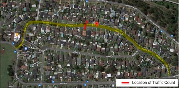
Figure 1 – Locality Plan
A traffic count was undertaken on Hibiscus Street in May 2022. The traffic count location is shown in red on the map above.
The results of the traffic count indicated the following:
Traffic count Data on Hibiscus Street, Greystanes:
Average Daily Traffic (ADT) = 314 veh/day,
85th percentile speed = 48.8 km/h,
Mean (average) vehicle speed = 39.7 km/h.
The results of the traffic counts and recorded crashes were used in the assessment to determine the need for the installation of traffic calming devices on Hibiscus Street in accordance with the criteria set out in Council’s Local Area Traffic Management Policy (LATM) Policy.
The LATM assessments are summarised in the tables below:
Table 1 – Hibiscus Street - LATM Assessment Points
|
Criteria |
Maximum Score |
Score Achieved |
|
Traffic Study Data |
45 |
0 |
|
Crash warrant in the last 5 years |
15 |
0 |
|
Road Characteristics |
35 |
12 |
|
Community Support & other factors |
5 |
5 |
|
Total |
100 |
17 |
Table 2 – Hibiscus Street – Action
|
Criteria |
Action |
|
>75 |
Report to TC with a recommendation of providing traffic calming devices |
|
61-75 |
Report to TC and discuss possibility of providing traffic calming devices |
|
41-60 |
Council to review traffic data in 6 months |
|
25-40 |
Monitor street and review traffic data after 12 months |
|
<25 |
Do Nothing |
|
Speed |
That regardless of the total points scored, should the 85th percentile speed exceed the posted speed limit by 5 km/h, the street be referred to the NSW Police for monitoring and/or enforcement. |
The traffic count indicated that the recorded 85th percentile speed was 48.8 km/h which is below the speed limit of the street.
Based on the above assessment, traffic calming devices are not warranted in the street. Therefore, the request for the installation of traffic calming devices / speed humps on Hibiscus Street cannot be supported at this time.
COnsultation
Consultation has not been undertaken as the investigation outlined in the report concludes no action is required.
Future consultation will be undertaken if recommended by the traffic committee.
Attachments
Nil
Traffic Committee
5 April 2023
Item No: CTC-23-067
Old Prospect Road between Gozo Road and Greystanes Road, Greystanes - Road Safety Concerns
Directorate: Environment and Planning
Responsible Officer: Executive Manager Development and Building
File Number: HC-24-01-3/02
Electorate: Prospect
Police Area Command (PAC): Cumberland
Agenda Part Part 2
Note: Recommendation to Council
Summary
Council has reviewed traffic conditions in Old Prospect Road between Gozo Road and Greystanes Road, Greystanes. This report outlines the outcome of the review.
|
That the Traffic Committee recommends that: 1. The installation of traffic calming devices on Old Prospect Road between Gozo Road and Greystanes Road, Greystanes not be approved. 2. Council review conditions in Old Prospect Road between Gozo Road and Greystanes Road, Greystanes and report back to the Traffic Committee in April 2024. |
Report
Cumberland Traffic Committee (CTC) at its meeting in February 2021 considered a report (Item No.CTC-21-049) regarding road safety concerns on Old Prospect Road between Gozo Road and Greystanes Road, Greystanes. Council resolved that Council review conditions in Old Prospect Road between Gozo Road and Greystanes Road, Greystanes and report back to the Traffic Committee in April 2022.
The map below shows the location of Old Prospect Road between Gozo Road and Greystanes Road, Greystanes.
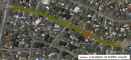
In accordance with Council’s resolution, a traffic count was undertaken in Old Prospect Road between Gozo Road and Greystanes Road in February 2023. Council officers have reviewed the traffic count data and compared it with the previous traffic count data undertaken November 2020.
Both results are detailed in the table below:
|
Traffic count date |
Ave. daily traffic |
85 Percentile speed |
|
November 2020 |
8,220 |
53.4 km/h |
|
February 2023 |
7,995 |
50 km/h |
The traffic data from the table above indicated that both traffic volume (ADT) and 85th percentile speed at this section of Old Prospect Road have decreased since 2020.
According to the Centre for Road Safety Accident data, there were two reported non-casualty accidents in Old Prospect Road between Gozo Road and Greystanes Road in the 5 years ending June 2022.
Based on the above, a further LATM assessment has been undertaken and the LATM assessment points are given below:
Table 1 – Old Prospect Road - LATM Assessment Points
|
Criteria |
Maximum Score |
Score Achieved |
|
Traffic Study Data |
45 |
15 |
|
Crash warrant in the last 5 years |
15 |
0 |
|
Road Characteristics |
35 |
12 |
|
Community Support & other factors |
5 |
5 |
|
Total |
100 |
32 |
Table 2 – Old Prospect Road – Action
|
Criteria |
Action |
|
>75 |
Report to TC with a recommendation of providing traffic calming devices |
|
61-75 |
Report to TC and discuss possibility of providing traffic calming devices |
|
41-60 |
Council to review traffic data in 6 months |
|
25-40 |
Monitor street and review traffic data after 12 months |
|
<25 |
Do Nothing |
|
Speed |
That regardless of the total points scored, should the 85th percentile speed exceed the posted speed limit by 5 km/h, the street be referred to the NSW Police for monitoring and/or enforcement. |
Based on the above assessment, traffic calming devices are not warranted in the street. Therefore, the installation of traffic calming devices at this section of Old Prospect Road, Greystanes cannot be supported.
The recorded 85th percentile speed of 50 km/h is at the speed limit of the street.
Council will review conditions in Old Prospect Road between Gozo Road and Greystanes Road, Greystanes, and report back to the Traffic Committee in 12 months in accordance with the outcomes of the assessment.
COnsultation
Consultation has not been undertaken as the investigation outlined in the report concludes no action is required.
Future consultation will be undertaken if recommended by the Traffic Committee.
Attachments
DOCUMENTS
ASSOCIATED WITH
REPORT CTC-23-067
Attachment 1
Previous Report - CTC-21-049
5 April 2023
Item No: CTC-23-068
Roseberry Street, Merrylands - Road Safety Concerns
Directorate: Environment and Planning
Responsible Officer: Executive Manager Development and Building
File Number: HC-24-01-3/02
Electorate: Granville
Police Area Command (PAC): Cumberland
Agenda Part Part 2
Note: Recommendation to Council
Summary
Council has reviewed traffic conditions in Roseberry Street, Merrylands. This report outlines the outcome of the review.
|
The Cumberland Traffic Committee recommends that; 1. The installation of traffic calming devices on Roseberry Street, Merrylands not be supported. 2. Council review conditions in Roseberry Street, Merrylands and report back to the Traffic Committee in April 2024. |
Report
Cumberland Traffic Committee (CTC) at its meeting in April 2021 considered a report (Item No.CTC-21-074) regarding road safety concerns on Roseberry Street, Merrylands. Council approved the installation of edge line marking in Roseberry Street, Merrylands. Council further resolved that the conditions in Roseberry Street, Merrylands be reviewed and reported back to the Traffic Committee.
The map below shows the location of Roseberry Street, Merrylands.
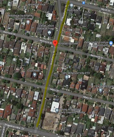
In accordance with Council’s resolution, a traffic count was undertaken in Roseberry Street in February 2023. Council officers have reviewed the traffic count data and compared it with the previous traffic count data undertaken in February 2021.
Both results are detailed in the table below:
|
Traffic count date |
Ave. daily traffic |
85 Percentile speed |
|
February 2021 |
5,060 |
56.9 km/h |
|
February 2023 |
4,340 |
53.6 km/h |
The traffic data from the table above indicated that both traffic volume (ADT) and 85th percentile speed at Roseberry Street have reduced since 2021.
According to the Centre for Road Safety Accident data, there were no reported accidents in Roseberry Street in the 5 years ending June 2022.
Based on the above, a further LATM assessment has been undertaken and the LATM assessment points are given below:
Table 1 – Roseberry Street - LATM Assessment Points
|
Criteria |
Maximum Score |
Score Achieved |
|
Traffic Study Data |
45 |
15 |
|
Crash warrant in the last 5 years |
15 |
0 |
|
Road Characteristics |
35 |
8 |
|
Community Support & other factors |
5 |
5 |
|
Total |
100 |
28 |
Table 2 – Roseberry Street – Action
|
Criteria |
Action |
|
>75 |
Report to TC with a recommendation of providing traffic calming devices |
|
61-75 |
Report to TC and discuss possibility of providing traffic calming devices |
|
41-60 |
Council to review traffic data in 6 months |
|
25-40 |
Monitor street and review traffic data after 12 months |
|
<25 |
Do Nothing |
|
Speed |
That regardless of the total points scored, should the 85th percentile speed exceed the posted speed limit by 5 km/h, the street be referred to the NSW Police for monitoring and/or enforcement. |
Based on the above assessment, traffic calming devices are not warranted in the street. Therefore, the installation of traffic calming devices on Roseberry Street, Merrylands cannot be supported at this time.
The recorded 85th percentile speed of 53.6 km/h is slightly above the default speed limit, and it is within acceptable limits in accordance with the outcomes of the assessment.
Council will review traffic conditions in Roseberry Street in 12 months in accordance with the outcomes of the assessment.
COnsultation
Consultation has not been undertaken as the investigation outlined in the report concludes no action is required.
Future consultation will be undertaken if recommended by the traffic committee.
Attachments
DOCUMENTS
ASSOCIATED WITH
REPORT CTC-23-068
Attachment 1
Previous Report - CTC-21-074
5 April 2023
Item No: CTC-23-069
Ruth Street, Merrylands West - Proposed No Right Turn - Consultation
Directorate: Environment and Planning
Responsible Officer: Executive Manager Development and Building
File Number: N/A
Electorate: Granville
Police Area Command (PAC): Cumberland
Agenda Part Part 2
Note: Recommendation to Council
Summary
Council has received requests from some residents in Ruth Street, Merrylands West for the installation of No Right Turn signage in Ruth Street at the intersections of Kenyons Road and Merrylands Road to prevent bypass traffic. This report outlines the outcome of the investigation into this matter.
|
The Cumberland Traffic Committee recommends that the ‘No Right Turn’ restrictions in Ruth Street at the intersection of Kenyons Road and Merrylands Road not be supported. |
Report
Council has received requests from local residents for the installation of No Right Turn signage in Ruth Street at the intersection of Kenyons Road and Merrylands Road to prevent bypass traffic.
Ruth Street is a local road runs in north – south directions from Merrylands Road to Kenyons Road. The street is approximately 220m long and 9m wide. The speed limit is 50km/h and parking are permitted on both sides of the road in accordance with the Road Rules unless otherwise signposted.
The resident alleged that traffic often uses Ruth Street to avoid the traffic signals at the intersection of Fowler Road and Merrylands Road. As a result, the street is taken additional traffic and the residents also raised the concerns of the safety for vehicles turning in and out of Ruth Street from Merrylands Road and Kenyons Road.
The latest Centre for Road Safety accident data indicated that there were no reported accidents in Ruth Street and its intersection with Merrylands Road and Kenyons Road in the 5 years ending June 2022.
The map below shows the location of Ruth Street:
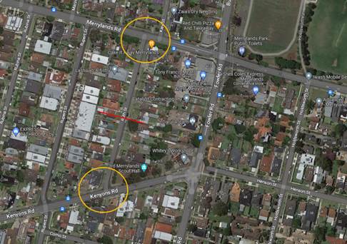
A traffic count was undertaken on Ruth Street in February 2023. The traffic count location is shown in red on the map above.
The results of the traffic count indicated the following:
Traffic count data on Ruth Street, Merrylands West:
Average Daily Traffic (ADT) = 1,223 veh/day,
85th percentile speed = 49.7 km/h,
Mean (average) vehicle speed = 41 km/h.
The result of the traffic count indicated that the ADT is within an acceptable limit for a local residential street.
Consultation was carried out with the residents in Ruth Street for a period of 14 days starting from 25 November to 12 December 2022. Twenty-nine (29) letters were distributed to the residents. Nine (9) responses were received, eight (8) of them supported the proposal and one (1) resident objected to the proposal.
Although majority of the residents responding to the survey supported the proposal, it is noted that only 31% of the residents in Ruth Street responded to the survey which showed a lack of interest of the proposed ‘No Right Turn’ restrictions.
It shall also be noted banning right turns into Ruth Street may push traffic to turn into adjacent parallel street thus shifting the issue to other streets.
In light of the above, the ‘No Right Turn’ restrictions in Ruth Street at its intersections of Merrylands Road and Kenyons Road are not supported due to the low traffic volume (ADT) and no recorded accident in the last 5 years.
COnsultation
Consultation was carried out with the residents in Ruth Street for a period of 14 days starting from 25 November to 12 December 2022. Twenty-nine letters were distributed to the residents. Nine (9) responses were received, eight (8) of them supported the proposal and one (1) resident objected to the proposal.
Attachments
DOCUMENTS
ASSOCIATED WITH
REPORT CTC-23-069
Attachment 1
Previous Report - CTC-21-241
5 April 2023
Item No: CTC-23-070
Terry Street, Greystanes - Road Safety Concerns
Directorate: Environment and Planning
Responsible Officer: Executive Manager Development and Building
File Number: HC-24-01-3/02
Electorate: Granville
Police Area Command (PAC): Cumberland
Agenda Part Part 2
Note: Recommendation to Council
Summary
Council has received a request from a local resident for the installation of traffic calming devices on Terry Street, Greystanes due to speeding concerns. This report outlines the outcome of the investigation into this matter.
|
The Cumberland Traffic Committee recommends that; 1. The installation of traffic calming devices on Terry Street, Greystanes not be supported. 2. Council review traffic conditions in Terry Street, Greystanes, and report back to the Traffic Committee in April 2024. |
Report
Cumberland Traffic Committee (CTC) at its meeting in November 2021 considered a report (Item No. CTC-21-241) regarding road safety concerns on Terry Street, Greystanes. Council resolved to undertake consultation with the residents/ owners of directly affected properties of Terry Street, Greystanes with the proposed speed humps to determine support and report back to Cumberland Traffic Committee.
Consultation was carried out with the residents of Terry Street. In October 2022, a total of 8 letters were distributed to the affected residents/ owners with an attached survey form and a detailed plan of the proposed speed hump locations. Council received 3 responses by the closing date, 2 in support and 1 objecting to the proposed speed humps.
Due to the above objection, Council proposes to not provide speed humps in Terry Street.
It is also proposed to review traffic conditions in Terry Street in 12 months.
COnsultation
The proposal was notified to the directly impacted resident for a period of 14 days from 25 October to 11 November 2022.
A total of 8 letters were distributed with an attached survey form and a detailed plan for the proposed speed hump locations to the residents/ owners. Council received 3 responses by the closing date, 2 in support and 1 objecting to the proposed speed humps.
The resident objecting to the proposal claimed that the proposed speed humps will have an impact on his/her existing health due to a medical condition.
Attachments
DOCUMENTS
ASSOCIATED WITH
REPORT CTC-23-070
Attachment 1
Previous Report - CTC-21-241
DOCUMENTS
ASSOCIATED WITH
REPORT CTC-23-070
Attachment 2
Submissions
Traffic Committee
5 April 2023
Item No: CTC-23-071
Nottinghill Road, Berala - Road Safety Concerns
Directorate: Environment and Planning
Responsible Officer: Executive Manager Development and Building
File Number: T-28-01/06
Electorate: Auburn
Police Area Command (PAC): Auburn
Agenda Part Part 2
Note: Recommendation to Council
Summary
Council has received a request from a local resident for the installation of traffic calming devices on Nottinghill Road, Berala due to speeding concerns. This report outlines the outcome of the investigation into this matter.
|
The Cumberland Traffic Committee recommends that; 1. The installation of traffic calming devices on Nottinghill Road, Berala not be supported. 2. Council request Auburn Police Area Command to monitor speeding in Nottinghill Road, Berala. 3. Council review traffic conditions in Nottinghill Road, Berala in November 2023 and report back to the Traffic Committee. |
Report
Council has received a request from a resident for the installation of traffic calming devices on Nottinghill Road, Berala due to speeding concerns.
Nottinghill Road is a local road that runs in a north - south direction from Kerrs Road to Amy Street. The road is approximately 2km long and 12.5m wide. The speed limit is 50km/h and parking is permitted on both sides of the road unless signposted.
Nottinghill Road provides access to Coleman Park between Georges Avenue and Leila Street, and Carnarvon Golf Course south of Leila Street to Amy Street. There are centre and edge lines provided in the street.
Council officers have investigated the request for the installation of traffic calming devices on Nottinghill Road in accordance with Council’s Local Area Traffic Management (LATM) Policy.
Due to the length of Nottinghill Road, the assessment has been undertaken by dividing the road into three sections. Each section has been assessed separately to determine if traffic calming devices are warranted or otherwise.
These three sections are listed below and shown on the map below:
Section 1: Nottinghill Road between Kerrs Road and Leila Street.
Section 2: Nottinghill Road between Leila Street and Kibo Road.
Section 3: Nottinghill Road between Kibo Road and Amy Street.
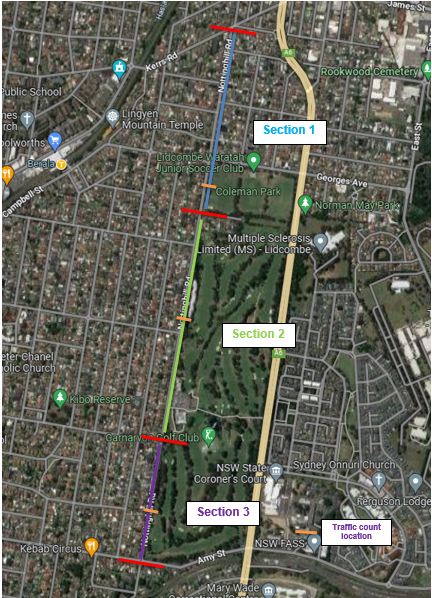
Sections 2 and 3 have the golf course on the eastern side while there are residential properties on the western side of the street. Section 1 has residential properties on both sides.
The latest Centre for Road Safety accident data indicated that there was one (1) reported midblock accidents in Nottinghill Road in the 5 years ending June 2022. There were other accidents related to movements at intersections.
Details of these accidents are listed in the table below:
|
Intersecting roads with Nottinghill Road |
No. of accidents |
Type of accident |
|
The Boulevarde |
1 |
Right/Left Far |
|
Walters Road |
1 |
Right Near |
|
Kibo Road |
1 |
Other Manoeuvring |
Traffic counts were undertaken at three locations in Nottinghill Road in late 2022. The traffic count locations for each separate section of Nottinghill Road are shown on the map above and the results of the traffic counts indicated the following table:
|
|
Section 1 (Outside No. 66) |
Section 2 (Outside No. 114) |
Section 3 (Outside No. 224) |
|
Average Daily Traffic (ADT) |
5,111 |
4,209 |
3,410 |
|
85th percentile speed (km/h) |
55.6 |
56 |
56 |
|
Mean vehicle speed (km/h) |
50 |
50.4 |
49.6 |
The results of the traffic counts and recorded crashes were used in the assessment to determine the need for the installation of traffic calming devices on Nottinghill Road in accordance with the criteria set out in Council’s Local Area Traffic Management Policy (LATM) Policy. The LATM assessments are summarised in the tables below:
Table1: LATM Assessment of the three sections
|
Criteria |
Maximum Score |
Score Achieved in different sections of Nottinghill Road |
||
|
|
|
Kerrs Road to Leila Street |
Leila Road to Kibo Road |
Kibo Road to Amy Street |
|
Traffic Study Data |
45 |
20 |
20 |
20 |
|
Crash warrant in the last 5 years |
15 |
15 |
5 |
0 |
|
Road Characteristics |
35 |
16 |
16 |
16 |
|
Community Support & other factors |
5 |
5 |
5 |
5 |
|
Total |
100 |
56 |
46 |
41 |
Table 2 - Nottinghill Road – Action
|
Criteria |
Action |
|
>75 |
Report to TC with a recommendation of providing traffic calming devices |
|
61-75 |
Report to TC and discuss possibility of providing traffic calming devices |
|
41-60 |
Council to review traffic data in 6 months |
|
25-40 |
Monitor street and review traffic data after 12 months |
|
<25 |
Do Nothing |
|
Speed |
That regardless of the total points scored, should the 85th percentile speed exceed the posted speed limit by 5 km/h, the street be referred to the NSW Police for monitoring and/or enforcement. |
Based on the above assessment, traffic calming devices are not warranted in the street. Therefore, the request for the installation of traffic calming devices / speed humps on Nottinghill Road cannot be supported at this time.
The traffic count indicated that the recorded 85th percentile speeds were between 55.6 - 56 km/h which are higher than the speed limit of the street.
It is proposed to request Auburn Police Area Command to undertake speed surveillance in Nottinghill Road and for Council to review conditions in six months in accordance with the outcome of the assessment.
COnsultation
Consultation has not been undertaken as the investigation outlined in the report concludes no action is required.
Future consultation will be undertaken if recommended by the traffic committee.
Attachments
Nil
Traffic Committee
5 April 2023
Item No: CTC-23-072
Bando Road, Girraween - Proposed Installation of Pedestrian Fencing
Directorate: Environment and Planning
Responsible Officer: Executive Manager Development and Building
File Number: T-28-01/06
Electorate: Prospect
Police Area Command (PAC): Cumberland
Agenda Part Part 2
Note: Recommendation to Council
Summary
Council has received safety concerns from Girraween Public School regarding pedestrian safety outside the school who have requested a pedestrian fence on the southern side of Bando Road at Carinya Road, Girraween.
In addition, the Cumberland Traffic Committee has recommended consideration of a pedestrian fence on Bando Road and STOP control on Carinya Road at its intersection with Bando Road.
This report outlines the outcome of the investigation into this matter.
|
The Traffic Committee recommends that the proposed installation of 30m pedestrian fence on the southern side of Bando Road at Carinya Road, in accordance with the attached plan, be approved. |
Report
The Cumberland Traffic Committee at its meeting held on 1 February 2023 considered a report on the intersection of Bando Road and Carinya Road and recommended that:
1. The proposed installation of 20m BB line marking on Carinya Road on the approach to Bando Road in accordance with the attached plan be approved.
2. Council investigate further safety improvements at the intersection, with the provision of a pedestrian fence on Bando Road and a stop sign on Carinya Road, with consultation with affected residents.
Council has also received safety concerns from Girraween Public School requesting pedestrian fencing on Bando Road in the ‘No Stopping’ area opposite Bando Road.
Bando Road is a local road that runs in an east – west direction between Tungarra Road and Targo Road. The road is approximately 270m long and 12.3m wide. Girraween Public School is located in Bando Road near Carinya Road, and it has a raised pedestrian crossing and associated line marking located 15m east of Carinya Road.
‘No Stopping’ restrictions exist on both sides of Bando Road near the pedestrian crossing outside Girraween Public School. A pickup/drop off zone is also provided on the southern side of Bando Road west of the ‘No Stopping’ area outside the school.
The figure below shows the location of the existing parking restrictions in Bando Road outside Girraween Public School.
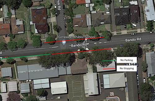
Figure 1 – Locality Plan
The latest Centre for Road Safety accident data indicated that there was no reported accident at this location in the 5 years ending March 2022.
A site meeting between the school and Council was organised to observe traffic behaviour at this location. It was alleged that majority of students exiting from the school on to the footpath on the southern side of Bando Road tend to walk close to the road edge and walk to the existing pedestrian crossing. It was alleged that the vehicles right turning out of Bando Road tend to speed and move closer to the edge of Bando Road section signposted with ‘No Stopping’. The school requested Council to consider installing a pedestrian fence on Bando Road opposite Carinya Road for the safety of students walking along the footpath.
It is proposed to install a pedestrian fence on the southern side of Bando Road as per the attached drawing to improve pedestrian safety.
In accordance with the Traffic Committee recommendation to consider ‘Stop’ control at the intersection of Carinya Road and Bando Road, Council has investigated the warrants of providing ‘Stop’ control in Carinya Road at Bando Road.
Based on Australian Standard AS 1742.2 – Part 2: Traffic Control Devices for General Use, controls are required at all non-signalised intersections in the following manner:
1. GIVE WAY signs shall be provided at all intersections with four or more legs.
2. GIVE WAY signs shall be provided at any three-way intersections where the layout is such that it is not clear how or whether the T-intersection rule would operate, for example, at a Y-intersection.
3. GIVE WAY signs should be used for road safety reasons at unsignalised T-intersections where the continuing road (i.e. the bar of the T) is an arterial or sub-arterial road, urban or rural.
4. STOP signs shall be provided instead of GIVE WAY signs on any controlled approach where intersection sight distance is substandard as determined in accordance with Clause 2.5.4. STOP signs shall not be used where intersection sight distance is adequate for GIVE WAY signs.
Council staff have investigated the request and found that the intersection does not meet the warrants for ‘Stop’ control or ‘Give Way’ signage. Therefore, the provision of a Give way or Stop control at this intersection cannot be supported.
COnsultation
Consultation was undertaken with representatives of Girraween Public School as outlined in this report.
Consultation on the pedestrian fence is not required as the location of the fence is outside the school property and no residents will be impacted by the proposed pedestrian fence.
Attachments
DOCUMENTS
ASSOCIATED WITH
REPORT CTC-23-072
Attachment 1
Plan - Bando Road, Girraween - Proposed Pedestrian Fence
Traffic Committee
5 April 2023
Item No: CTC-23-073
Response to Notice of Motion C08/22-121 - Residential Parking in Lidcombe
Directorate: Environment and Planning
Responsible Officer: Executive Manager Development and Building
File Number: T-28-01/06
Electorate: Auburn
Police Area Command (PAC): Auburn
Agenda Part Part 2
Note: Recommendation to Council
Summary
This report provides a response to Council’s Notice of Motion – Residential Parking in Lidcombe, resolved at the Ordinary Meeting of Council on 3 August 2022 (Min.183 C08/22-121).
|
The Traffic Committee recommends that Council: 1. Note the findings from the analysis and consultation on residential car parking in the Lidcombe Town Centre and surrounds. 2. Endorse that a Resident Parking Scheme not proceed in the Lidcombe Town Centre study area, due to non-compliance with criteria in Council’s Residential Parking Scheme Guideline. 3. Endorse that further analysis and consultation be undertaken on the introduction of timed parking in streets within the study area, where more than two thirds of available unrestricted parking is occupied during the daytime. |
Report
Background
Lidcombe is located in the eastern end of Cumberland LGA and is one of the Principal Local Centres as outlined in Cumberland 2030: Our Local Strategic Planning Statement. The area is connected to a number of train and bus services, and is also in close proximity to the regional road network.
Lidcombe is identified as a growing area for Cumberland, with changes to planning controls in the town centre as part of the new Cumberland Local Environmental Plan in 2021, as well as investment to upgrade the public domain to better meet the needs of the community now and in the future. A review of available Census data for 2016 and 2021 has been undertaken, and indicates the following trends:
· Local population has increased from 19,627 to 23,663 (approximately 21% increase)
· Number of dwellings has increased from 6,382 to 9,023 (approximately 41% increase)
· Average number of motor vehicles per dwelling has decreased from 1.6 to 1.5 (approximately 6% decrease)
· Average number of people per household has decreased from 3.2 to 2.9 (approximately 9% decrease)
An ongoing issue raised by the community in the Lidcombe town centre and surrounds is the availability of car parking. This issue has been raised due to the use of parking to access train services, demand for parking to access services and facilities in the town centre, as well as the level of provision of car parking due to development occurring in the town centre.
Following a Notice of Motion (C09/19-224, Min 691) at the Council meeting on 18 September 2019 to undertake a parking survey and community consultation, Council officers undertook a study of selected streets south of the railway line in Lidcombe. In addition, Council undertook a further consultation targeting residents in single dwelling streets impacted by train commuters to review the support and need for a Residential Parking Scheme. The results were reported to Cumberland Traffic Committee in April 2021 (CTC-21-098) and recommended that:
1. A resident permit parking scheme in Lidcombe streets not be approved.
2. Council consider suitable timed parking and undertake consultation with the residents.
Council approved the Traffic Committee recommendation at the Council meeting on 19 May 2021. The report for this process is provided in Attachment 1.
Separately, a Notice of Motion (C08/22-121, Min. 183) was considered at the Council meeting of 3 August 2022, and was resolved as follows:
That:
1. Consultation be undertaken for proposed residential car parking covering the
wider Lidcombe town centre area; and
2. The proposed boundary areas, inclusive of residential parking scheme, are as
follows:
· (South side of Lidcombe town centre) - Raymond Street East;
· (North side of Lidcombe town centre) – Rawson Street, Maud Street; and
· Yarram Street (both sides of the road that aligns with Maud Street)
3. Prior to progressing any consultation on the proposal, a report be provided to Council on the proposed approach for community engagement on this matter. This report is to be provided to Council in September 2022.
Following the above resolution, a report was presented to Council at its meeting held on 28 September 2022 outlining the proposed approach for consultation, aligned with the Cumberland Community Engagement Strategy. Council resolved that Council endorse the proposed approach for consultation regarding residential parking in Lidcombe.
Residential Parking in Lidcombe Town Centre and Surrounds
Based on the resolution, Council officers have progressed parking surveys and undertaken consultation on the proposal for residential car parking. The study area covers the residential properties within Rawson Street, Maud Street and Yarram Street on the north and Raymond Street East on the south and all streets within, as shown in Figure 1. It is noted that this area includes existing development and future development under construction.
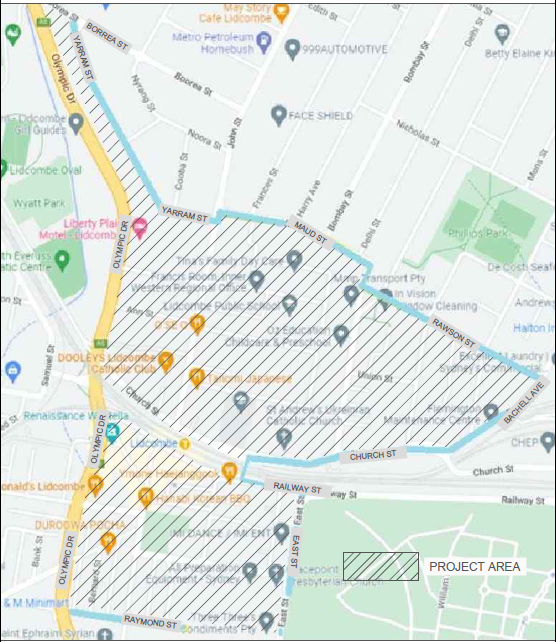
Figure 1: Study Area for Proposed Residential Car Parking
Based on Council’s resolution on the matter, the following approach was undertaken by Council officers on car parking in the Lidcombe town centre and surrounds:
· Data for on-street car parking supply and demand within the study area was captured to assist in the analysis of the proposal
· Consultation was undertaken with a focus on residential parking options in the Lidcombe area, as well as with local businesses on parking issues, given that the town centre is included in the project area
· The key option explored was the level of support for a residential parking scheme, assessed in accordance with Council’s Residential Parking Scheme Guideline. Opportunities to consider alternate parking options or maintain current on-street parking arrangements was also explored
· The main tool used to assess the residential parking scheme was the completion of a survey (either physical or electronic) by residents in the study area. The ability to collate other feedback on parking issues in the project area was undertaken through open-ended questions on the survey, correspondence directed to Council and through Council’s Have Your Say page
· Analysis was undertaken using the results of the car parking supply survey and consultation findings, using the criteria outlined in Council’s Residential Parking Scheme Guideline.
On-Street Car Parking Supply and Demand
Council officers engaged an independent consultant to undertake a survey of the on-street parking supply and demand in the streets within the study area. This information assisted in understanding actual utilisation during a period of typical activity, and contributed to the analysis undertaken as part of the proposal.
The on-street parking survey was undertaken on an hourly basis between 7:00AM and 9:00 PM on two Tuesdays and two Thursdays, which were used to average day time parking occupancy (between 7:00AM to 6:00PM) and average night time parking occupancy (between 6:00PM to 9:00PM).
A summary of on-street car parking supply and demand is provided in Table 1. Further information on the survey by area and street is provided in Table 2. A map showing day time parking occupancy by street is also provided in Attachment 2.
|
Area |
Available unrestricted parking |
% of day time parking occupancy |
% of night time parking occupancy |
|
Total Study Area |
1415 |
59% |
55% |
|
Area 1 – North of Railway Line |
986 |
54% |
54% |
|
Area 2 – South of Railway Line |
429 |
70% |
59% |
Table 1: Summary of On-Street Car Parking Survey
|
|
|
Table 2: On-Street Car Parking Survey by Area and Street
The results of the parking surveys identified that the day time on-street parking demand is 59% (831 spaces) of the total on-street parking available (1,415 spaces) within the total study area. The day time on-street parking demand for Ann Street and John Street were 88%, which could be explained by their close proximity to Lidcombe station and the John Street shopping strip. The day time parking demand for the area south of the railway line is 70%, compared to 54% for the streets on the north of the railway line.
Consultation on Proposed Residential Parking Scheme
In accordance with Council’s resolution on the matter, consultation was undertaken on the proposal for a residential parking scheme between 7 November 2022 and 9 December 2022. Council received a total of 159 submissions, which included 104 online submissions and 55 completed survey forms by mail or email from owners and tenants. Out of the 159 submissions, 149 were within the study area which is 5.61% of the total of 2,654 properties. The key findings from the submissions included:
· 67% of respondents lived in a house, with the remainder living in an apartment
· 89% of respondents had difficulty in finding parking on or near their property, with this difficulty occurring more frequently during weekdays
· 66% of respondents expressed support for a Residential Parking Scheme in their area
· 57% of respondents supported the introduction of timed parking on their street should a Residential Parking Scheme not be introduced
Analysis of Criteria in Council’s Residential Parking Scheme Guideline
Based on the parking survey data and consultation findings, an analysis was undertaken using the criteria in Council’s Residential Parking Scheme Guideline. A summary of the analysis for the overall study area is provided in Table 3, and indicates that the only criterion met was for the percentage of on-street parking spaces occupied. Detailed analysis by area and street is provided in Attachment 3, and also indicates that no specific area or street met all the criteria as provided in the Guideline. It is noted that all criteria in Council’s Residential Parking Scheme Guideline need to be met to progress a proposal.
|
|
Description |
Criterion |
Actual value |
Comments |
|
|
1 |
Percentage of response |
> 70% |
5.61% |
|
Not met |
|
2 |
Average internal parking per property |
< 1 |
1.23 |
|
Not met |
|
3 |
Percentage of properties in favour of the RPS |
> 70% |
64.4% 3.7% |
Based on submissions. Based on number of properties |
Not met |
|
4 |
Percentage of properties with no off-street parking |
> 30% |
0.9% |
|
Not met |
|
5 |
Percentage of on-street parking spaces occupied |
> 50% |
59% |
Day time data |
Met |
Table 3: Summary of Analysis Using Residential Parking Scheme Guideline Criteria
Next Steps
Based on the analysis and consultation undertaken, the criteria outlined in Council’s Residential Parking Scheme Guideline has not been met. Using this information, it is recommended that a Resident Parking Scheme not proceed in the Lidcombe Town Centre study area.
It is noted that the parking surveys indicated a number of individual streets had day time occupancy where more than two thirds of on-street parking spaces were used (where unrestricted parking arrangements apply). These streets included Ann Street, Bernard Street, Childs Street, Church Street, Dalley Street, Doodson Avenue, Frederick Street, Henry Street, James Street, John Street, Kerrs Road, Mark Street, Mary Street, Raphael Street, Swete Street, Taylor Street and Union Street. Given community concerns on the issue of car parking in the Lidcombe area, it is also recommended that further analysis and consultation be undertaken on timed parking in these streets as an approach to address the issue. If supported, this work will look at a range of timed parking options, as well as opportunities for parts of the street to maintain untimed parking as an alternate for local residents.
COnsultation
Consultation on the proposed Lidcombe Residential Parking Scheme was undertaken from 7 November 2022 to 9 December 2022.
In accordance with Council’s resolution in September 2022 on consultation for the proposal, the following activities were undertaken to support the process:
· A landing page specifically for the Lidcombe Residential Parking Scheme Review on Council’s community engagement platform – Cumberland Conversations. The ‘Have Your Say page’ was made available throughout the whole consultation period and was linked in all collateral published to the community. The project page included a summary of the information, key dates and opportunity to provide feedback
· A summary of the consultation and how people can have their say was also translated in the top 5 languages of Arabic, Simplified Chinese, Korean, Nepalese and Vietnamese
· Corflute signs were displayed within the study area providing information and a QR Code link to Council’s ‘Have Your Say’ website inviting residents to scan the code to complete the online survey form
· Advertisement in local newspapers
· Letter and survey sent to letters to residents and non-resident owners of the dwellings in the study area
· Engagement with local business on parking issues in the area.
Council received a total of 159 submissions, which included 104 online submissions and 55 completed survey forms by mail or email from owners and tenants. Out of the 159 submissions, 149 were within the study area which is 5.61% of the total of 2,654 properties. The number of submissions received by street are also provided in Table 4, with only the street where submissions were received included in the table.
Further information on the consultation, including the process and key findings, is provided in Attachment 4.
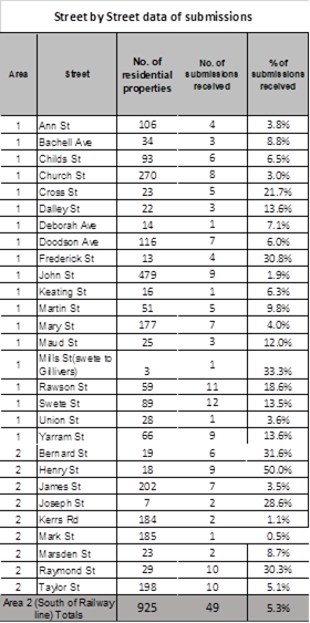
Table 4: Submissions Received by Street in Study Area
Attachments
2. On Street Car Parking Occupancy Map
3. Analysis of Criteria in Residential Parking Scheme Guideline by Area and Street
4. Engagement Report on Lidcombe Residential Parking Proposal
DOCUMENTS
ASSOCIATED WITH
REPORT CTC-23-073
Attachment 1
Previous Report-CTC-21-098
DOCUMENTS
ASSOCIATED WITH
REPORT CTC-23-073
Attachment 3
Analysis of Criteria in Residential Parking Scheme Guideline by Area and Street
Attachment 4
Engagement Report on Lidcombe Residential Parking Proposal