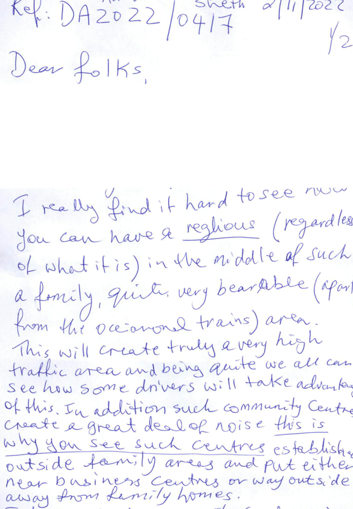
Cumberland Local Planning Panel Meeting
8 March 2023
A meeting of the Cumberland Local
Planning Panel will
be held at 11.30am via Zoom on Wednesday, 8 March 2023.
Business as below:
Yours faithfully
Peter J. Fitzgerald
General
Manager
ORDER OF BUSINESS
1. Receipt of Apologies
2. Confirmation of Minutes
3. Declarations of Interest
4. Address by invited
speakers
5. Reports:
- Development
Applications
- Planning
Proposals
6. Closed Session Reports
Cumberland Local Planning Panel Meeting
8 March 2023
CONTENTS
Report No. Name
of Report Page
No.
1 Development Applications
LPP005/23... Development
Application for 20 Myee Street, Merrylands............................ 5
LPP006/23... Development
Application for 191-201 Pitt Street, Merrylands.................. 253
LPP007/23... Development
Application for 73 Bangor Street, Guildford........................ 327
Cumberland Local Planning Panel Meeting
8 March 2023
Cumberland Local Planning Panel Meeting
8 March 2023
Item
No: LPP005/23
Development
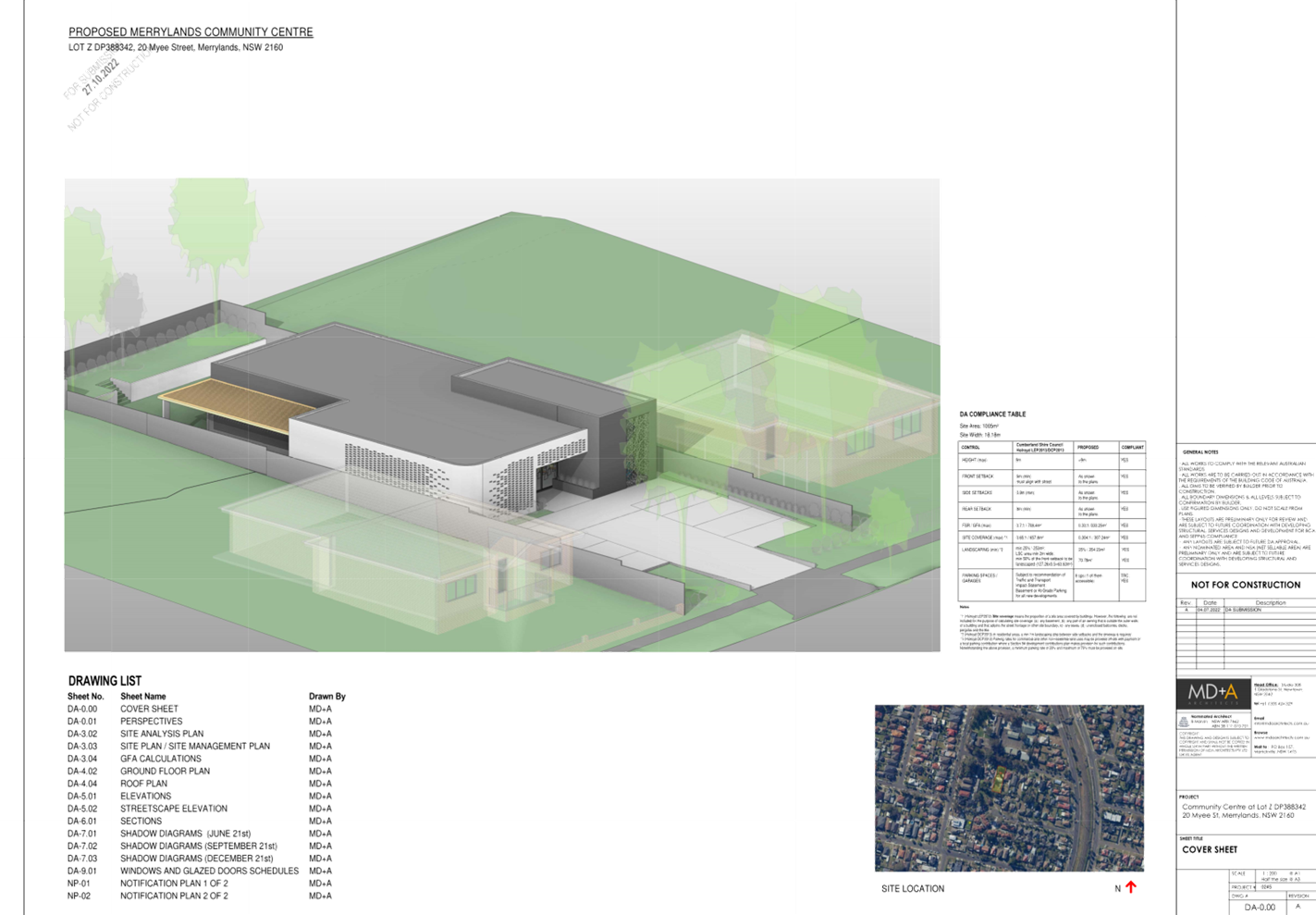
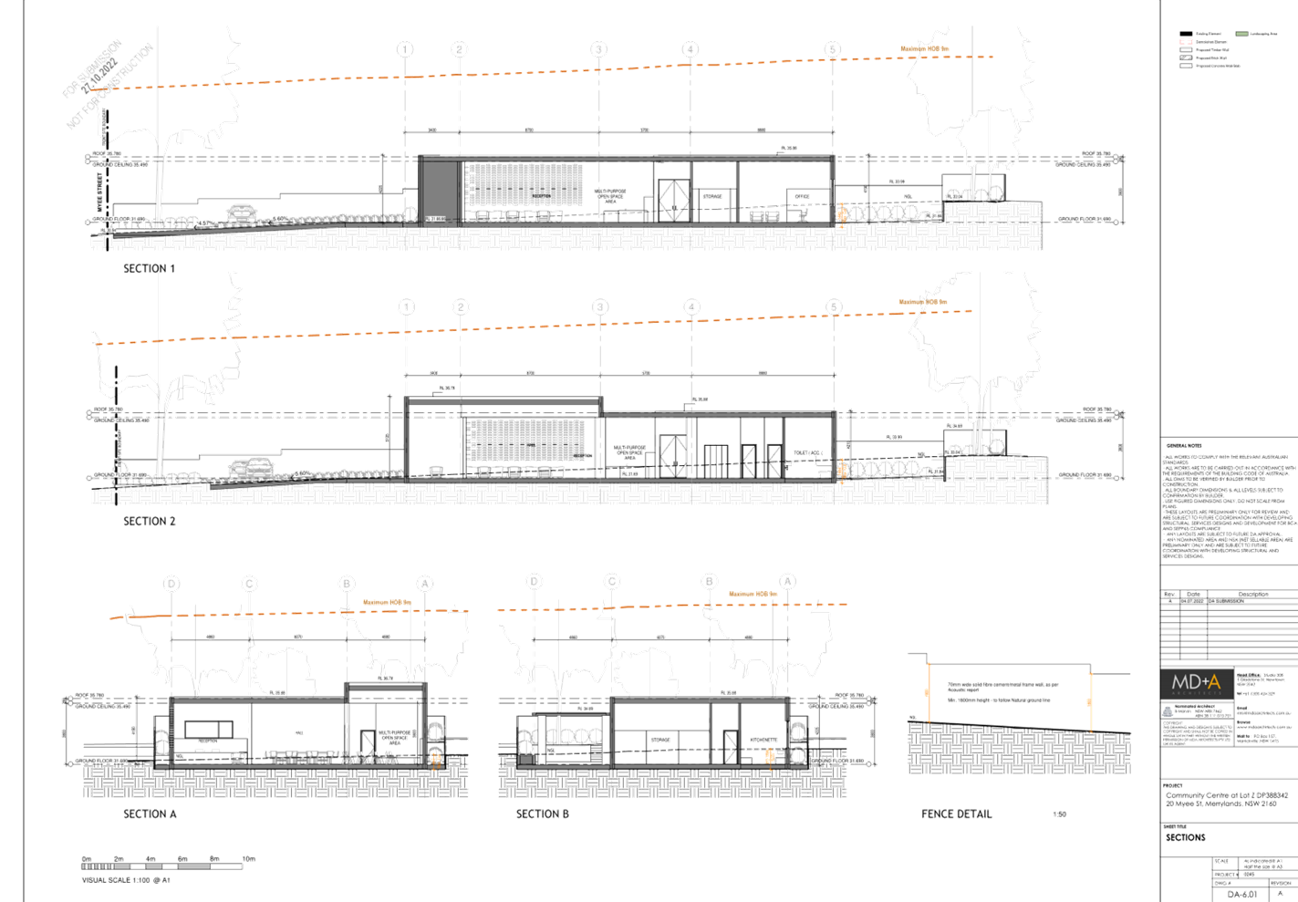
Application for 20 Myee Street, Merrylands
Directorate: Environment
and Planning
Responsible
Officer: Executive
Manager Development and Building
File
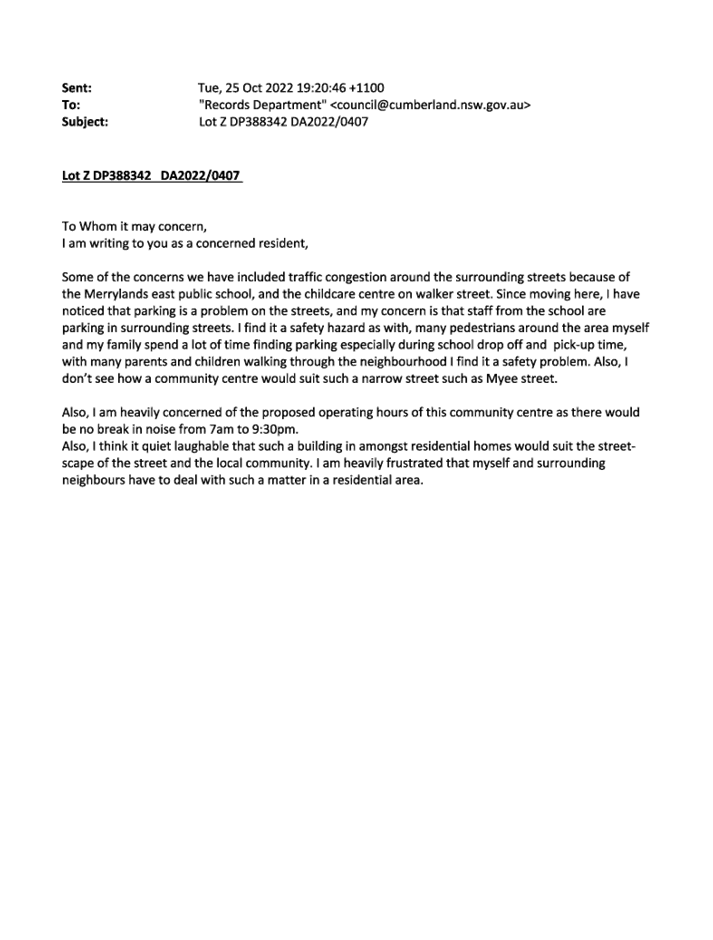
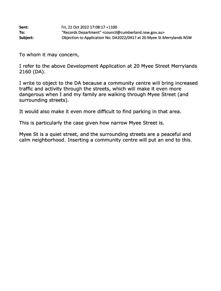
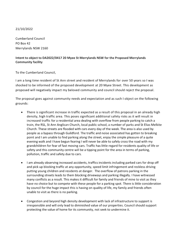
Number: DA2022/0417
|
Application
accepted
|
12 August 2022
|
|
Applicant
|
Local Approvals
|
|
Owner
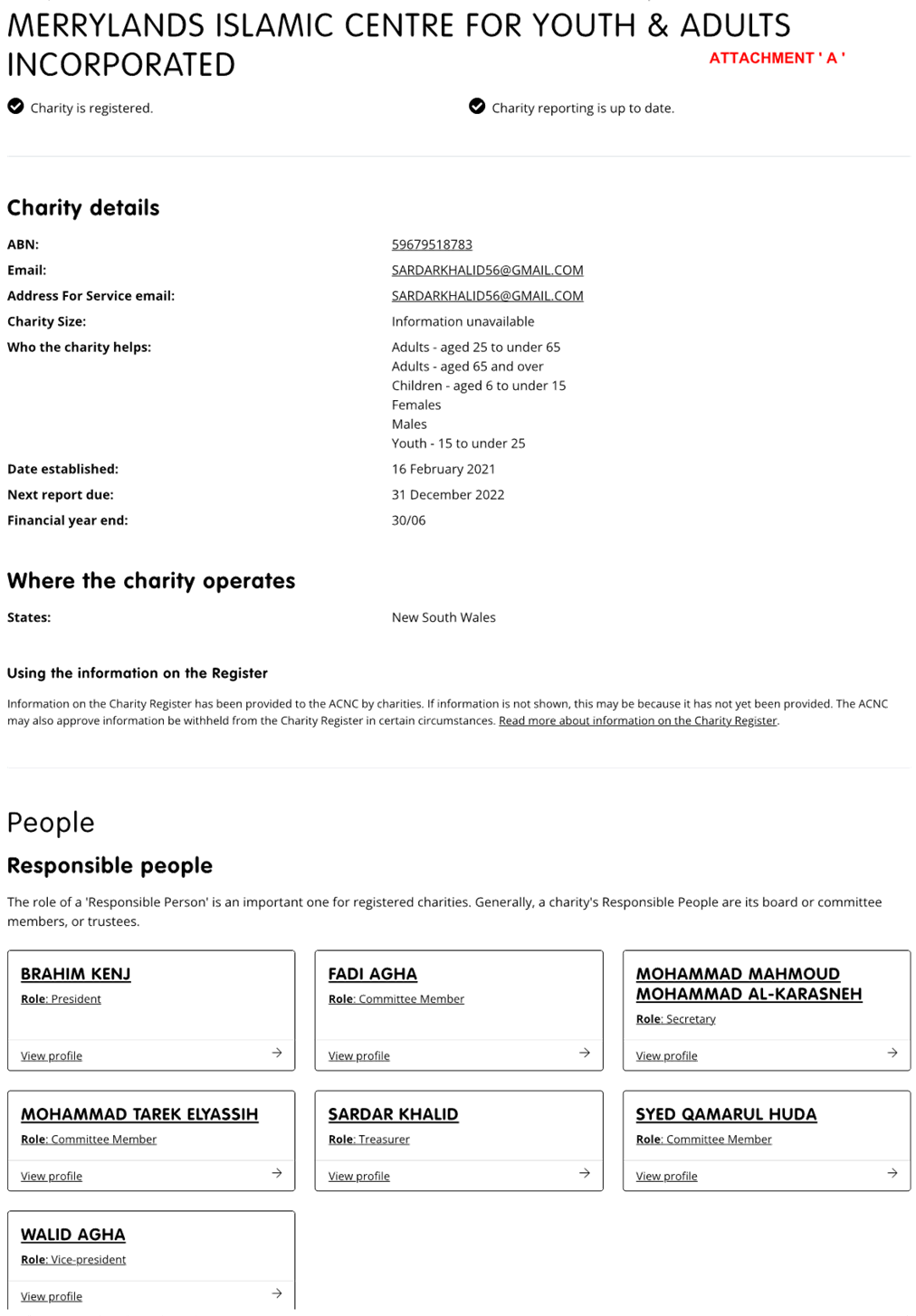
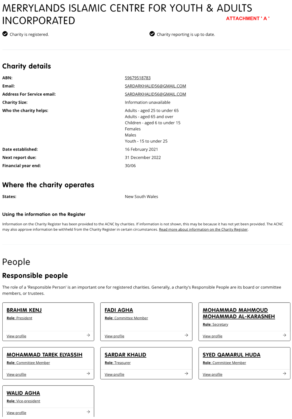
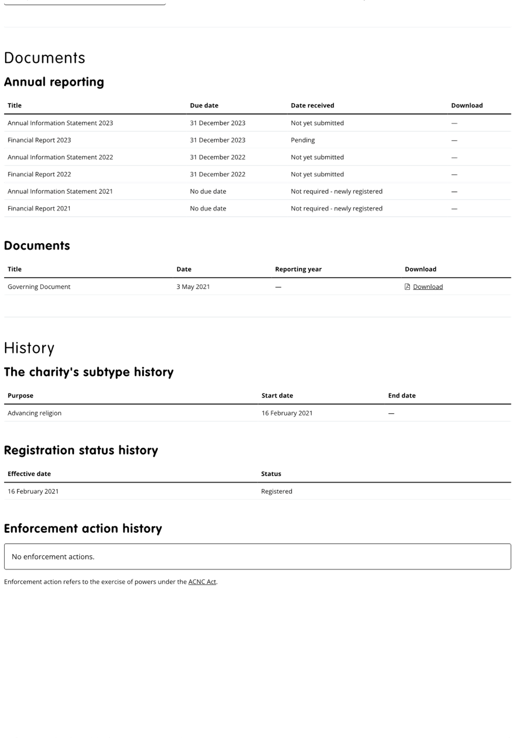
|
Merrylands Islamic Centre For
Youth & Adults Incorporated
|
|
Application
No.
|
DA2022/0417
|
|
Description
of Land
|
20 Myee Street
MERRYLANDS NSW 2160
Lot Z DP 388342
|
|
Proposed
Development
|
Demolition of existing
structures and construction of a one storey community facility including
at-grade parking and tree removal
|
|
Site
Area
|
1,005 square metres
|
|
Zoning
|
R3 Medium Density Residential
Zone
|
|
Disclosure
of political donations and gifts
|
Nil disclosure
|
|
Heritage
|
No – The site is located
within the immediate proximity of a heritage listed item with local
significance in accordance with the Cumberland Local Environmental Plan 2021,
which is an existing school building across the street, Merrylands East
Public School (I214).
|
|
Principal
Development Standards
|
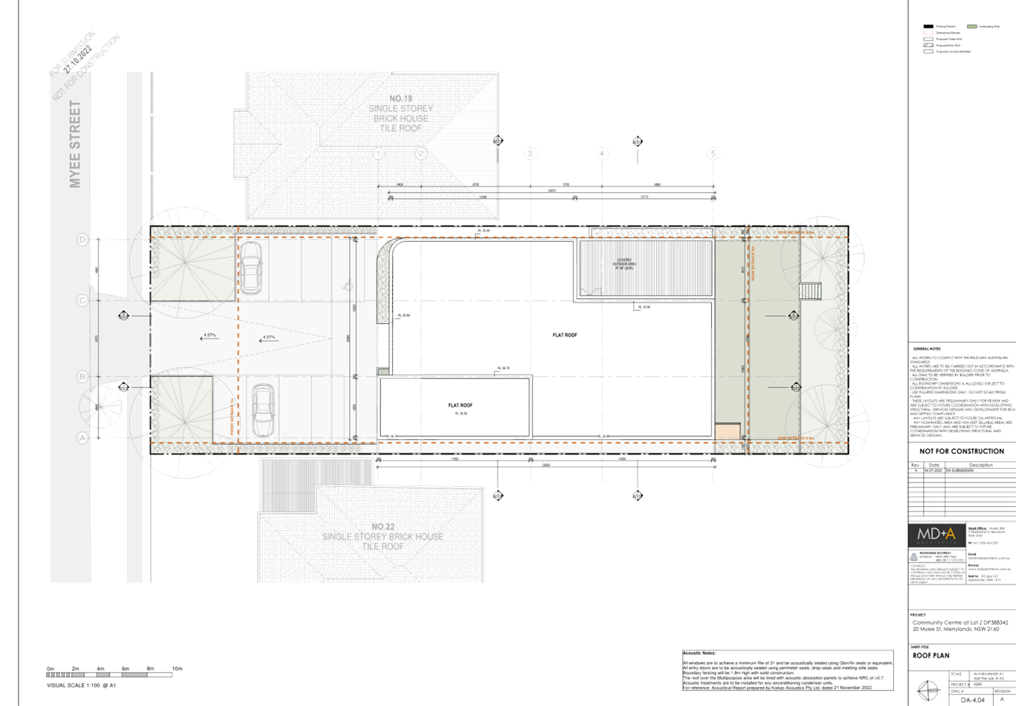
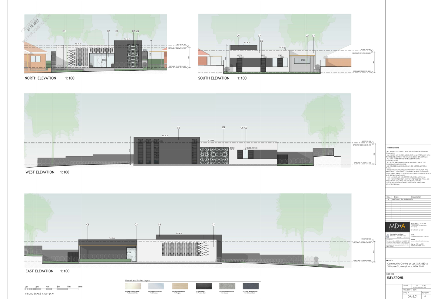
Height of Building
Permissible: 9m
Proposed: 5.198m
FSR
Permissible: 0.7:1
Proposed: 0.33:1
|
|
Issues
|
- Characterisation
of development
- Plan of
management
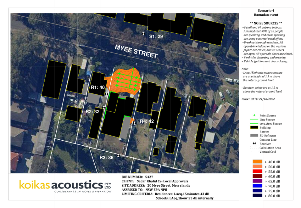
- Acoustic
impact
- Traffic
and parking
- Stormwater
management
- Submissions
|
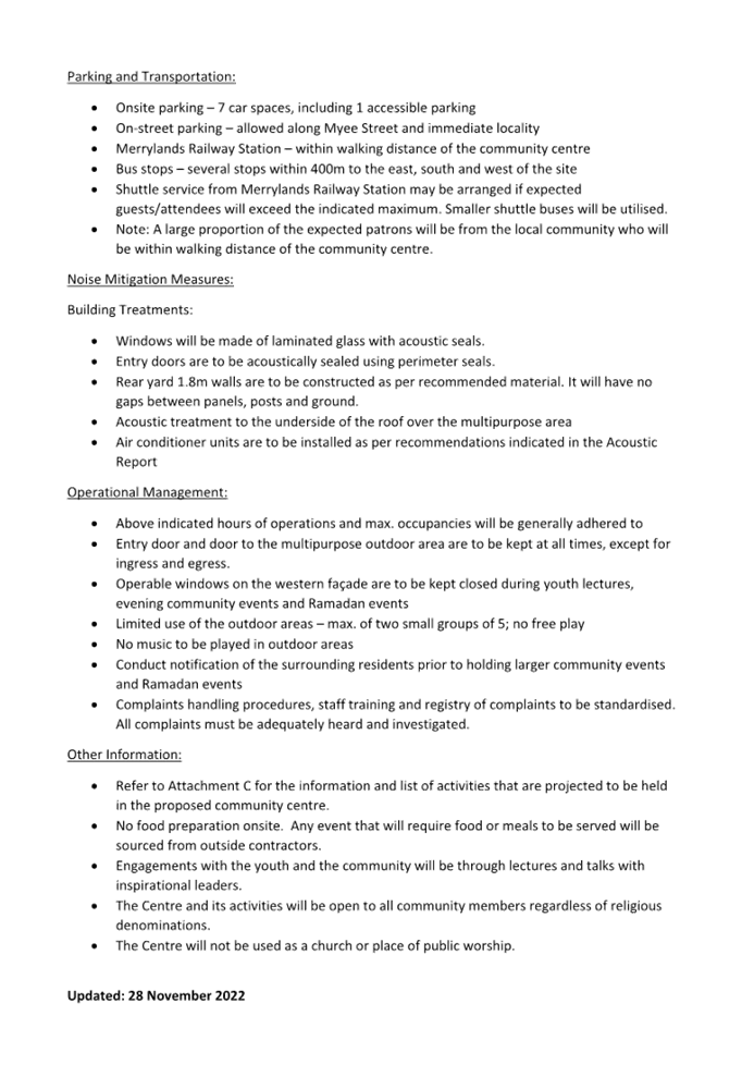
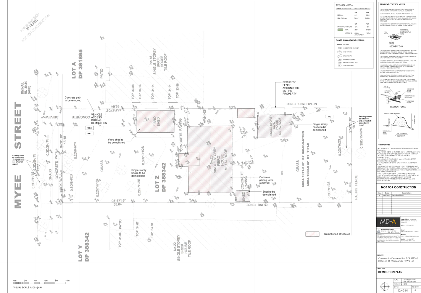
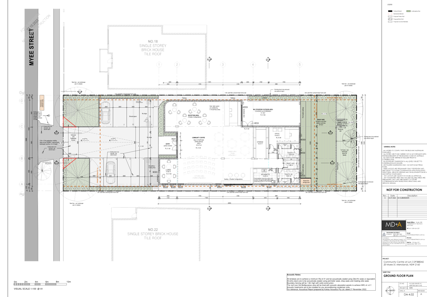
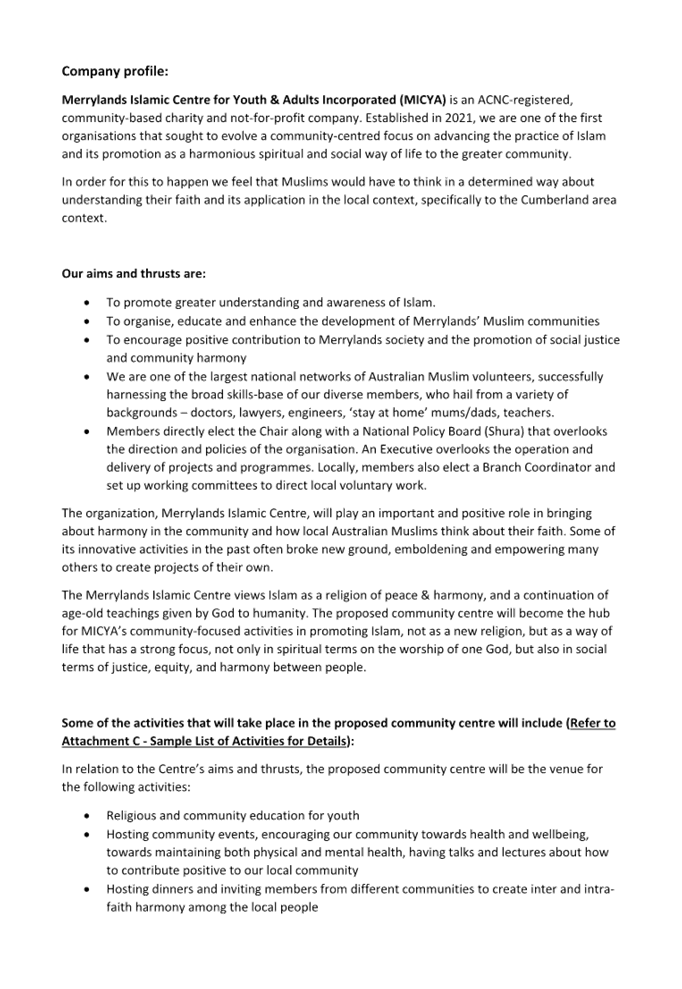
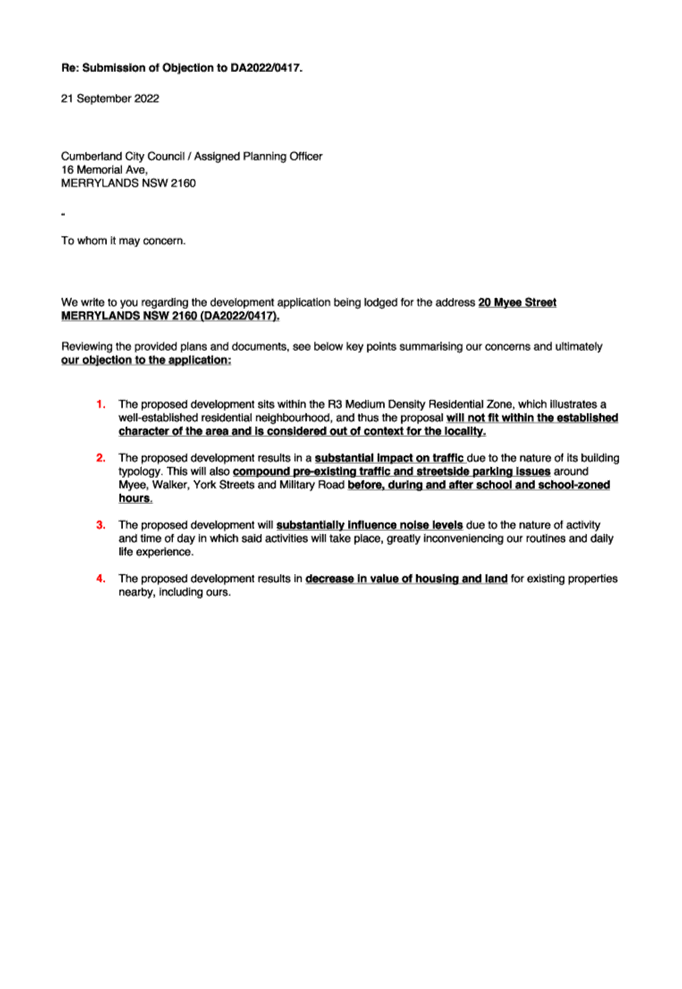
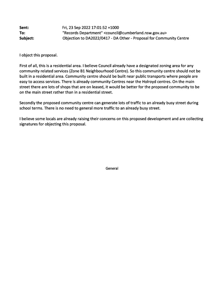
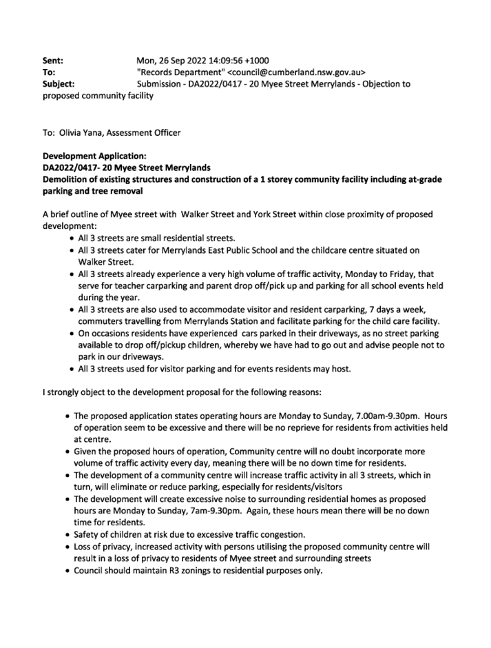
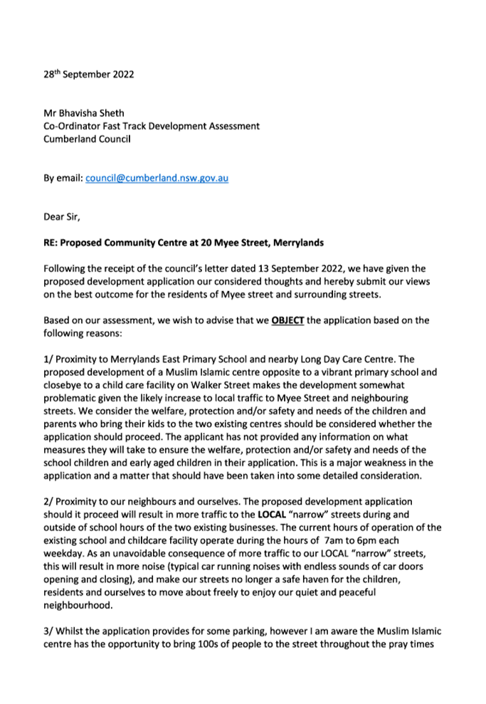
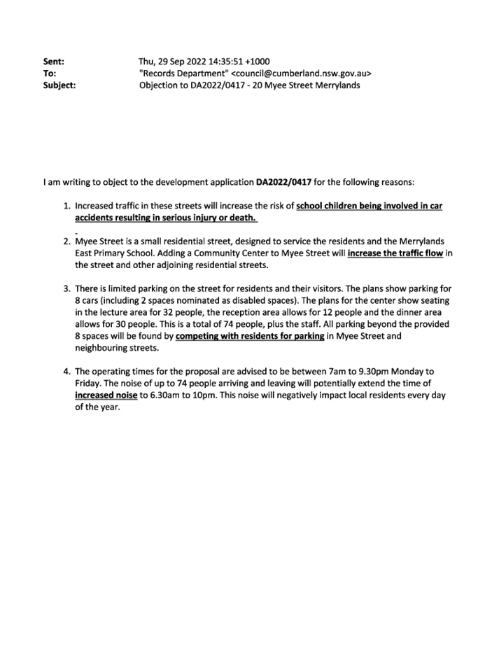
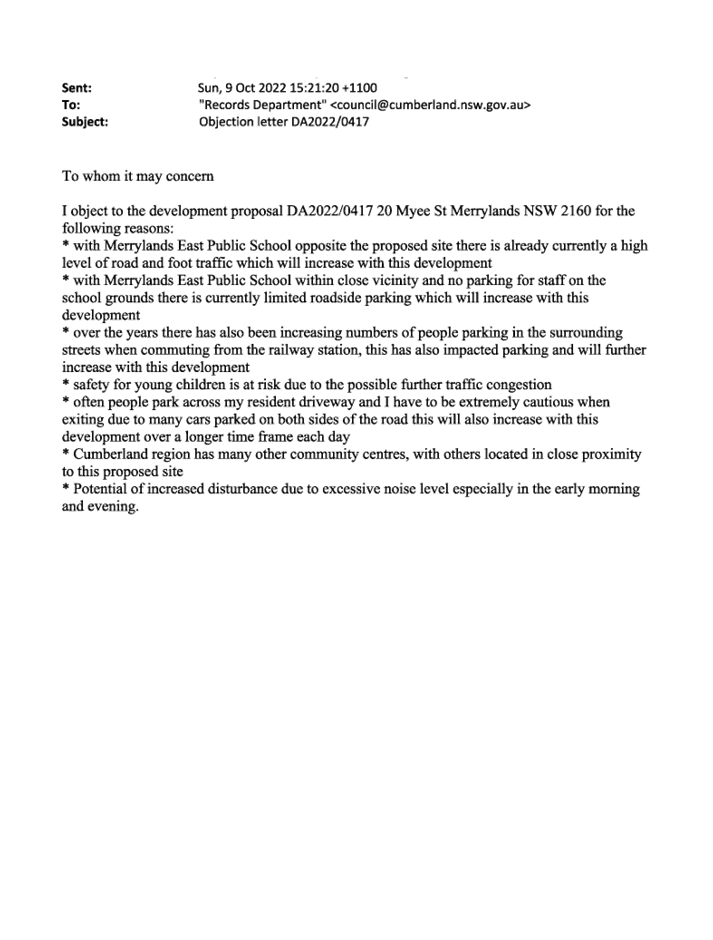
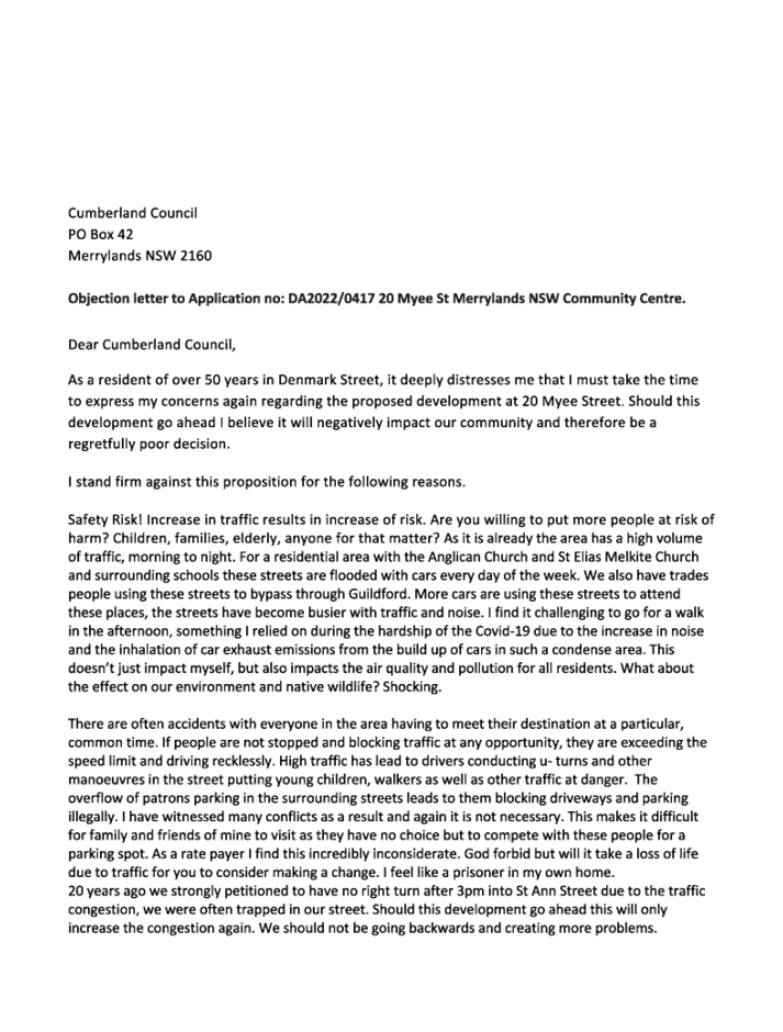
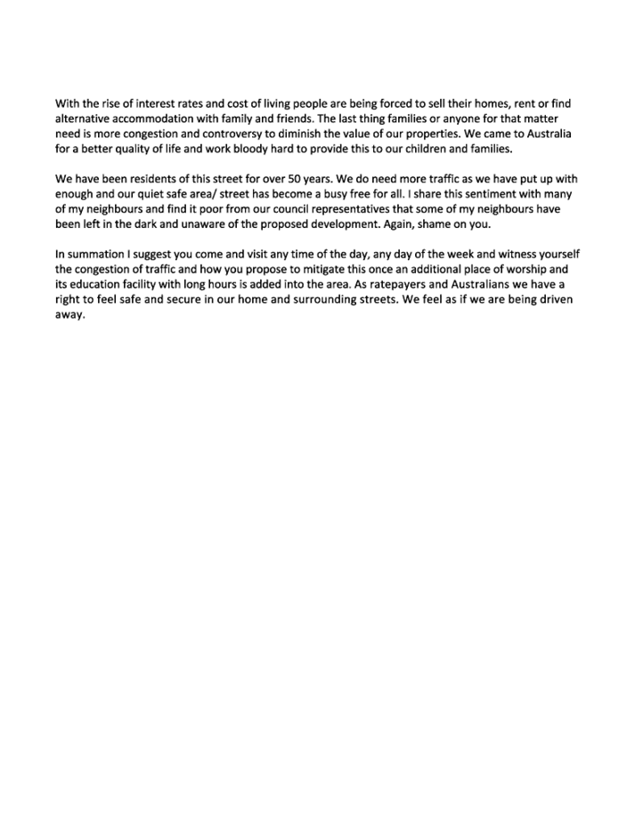
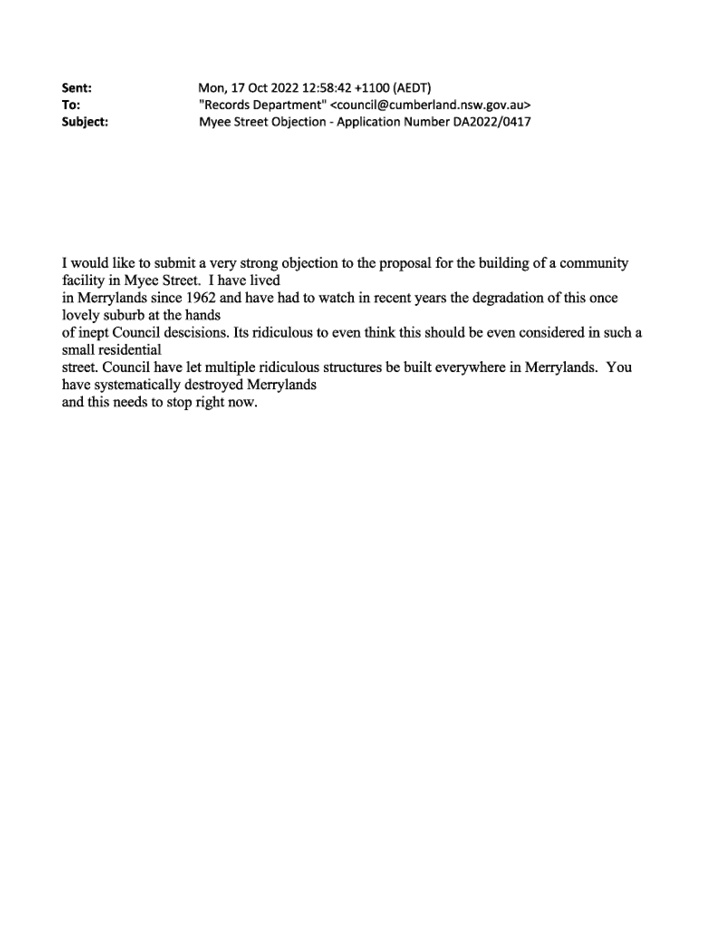
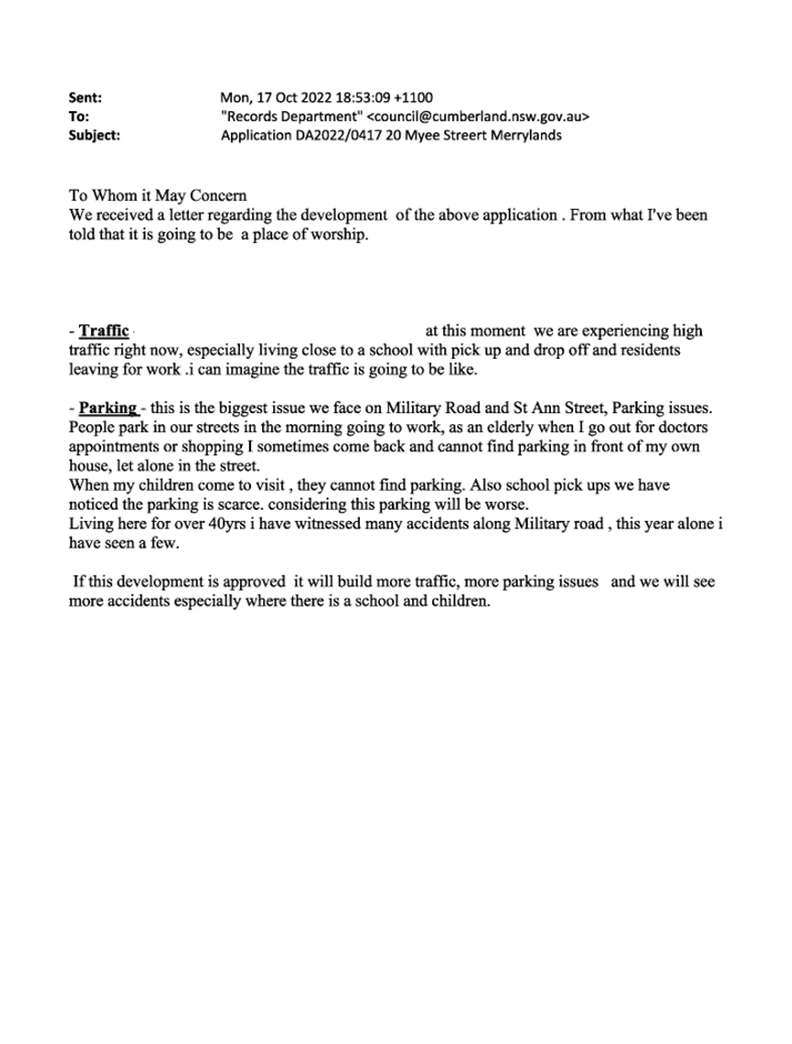
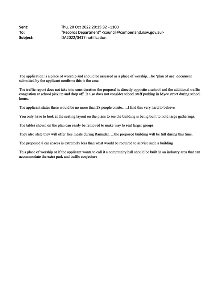
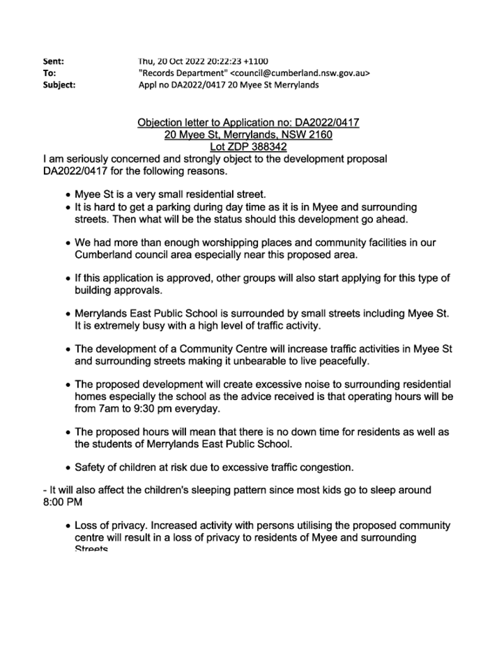
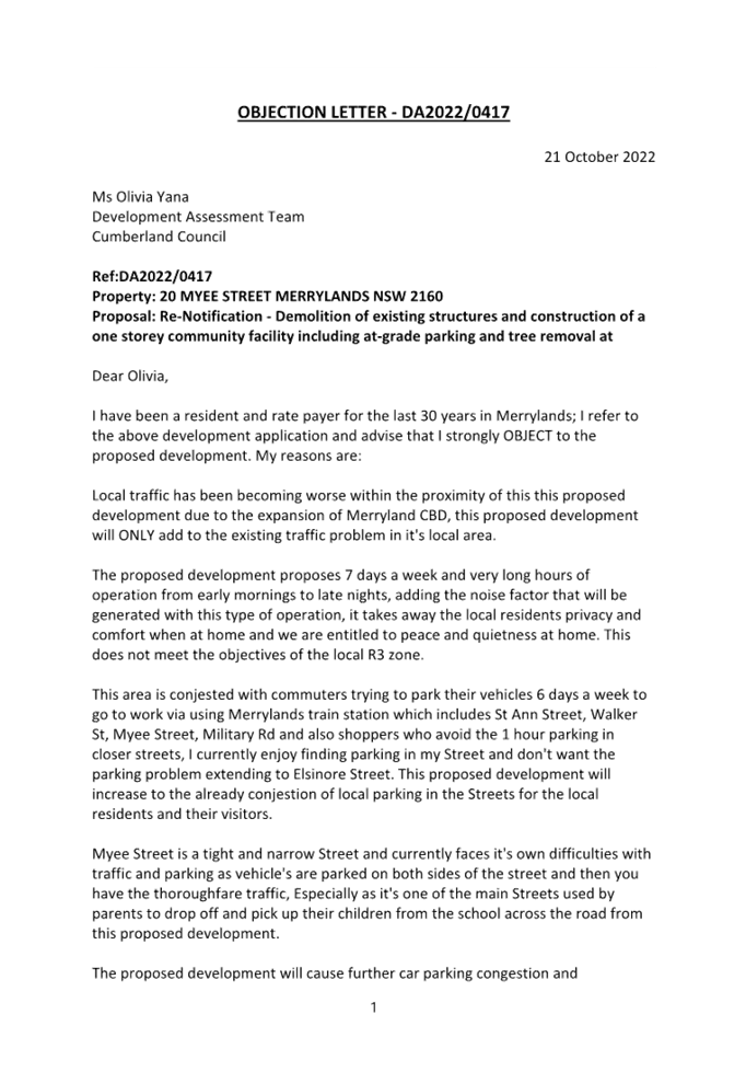
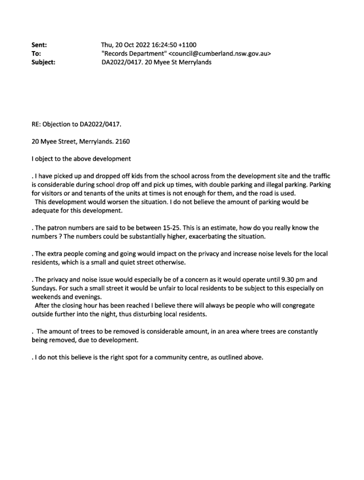
1. Development
Application No. DA2022/0417 was accepted on 12 August 2022 for the demolition
of existing structures and construction of a one storey community facility
including at-grade parking and tree removal.
2. The
application was publicly notified to occupants and owners of the adjoining
properties for a period of 14 days between 25 August 2022 to 8 September 2022,
and was further extended to 29 September 2022. The application was also
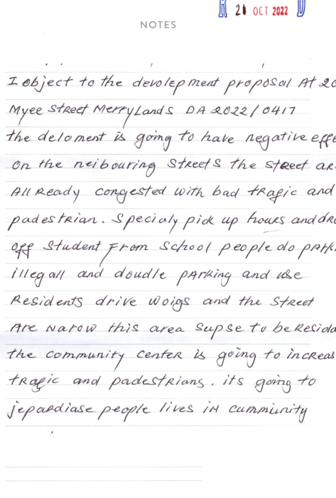
publicly re-notified for a period of 14 days between 7 October 2022 and 21
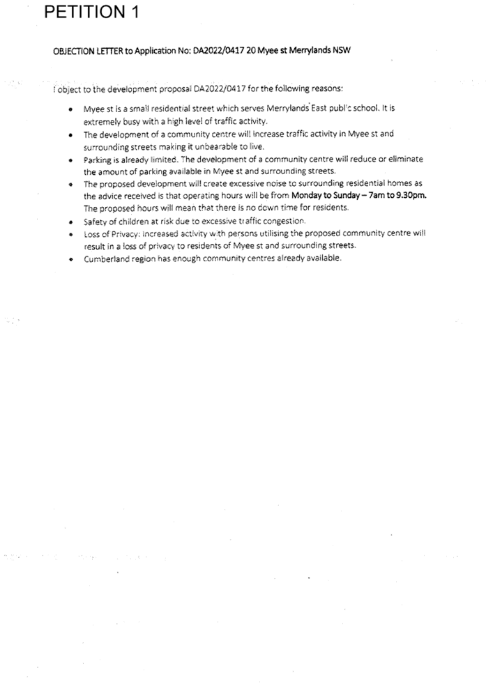
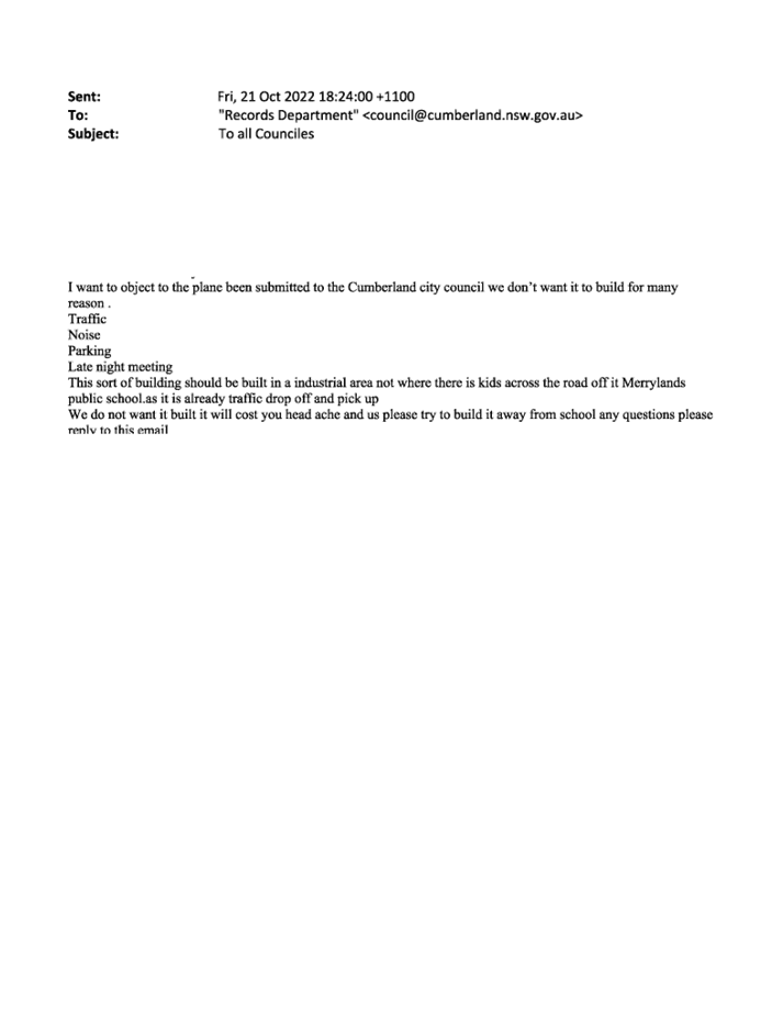
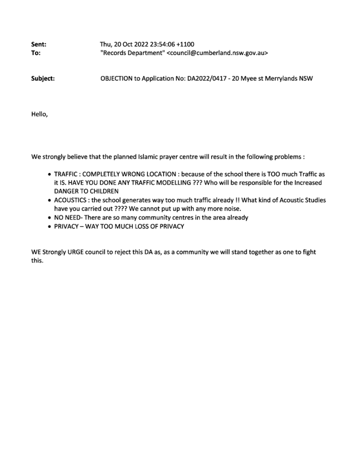
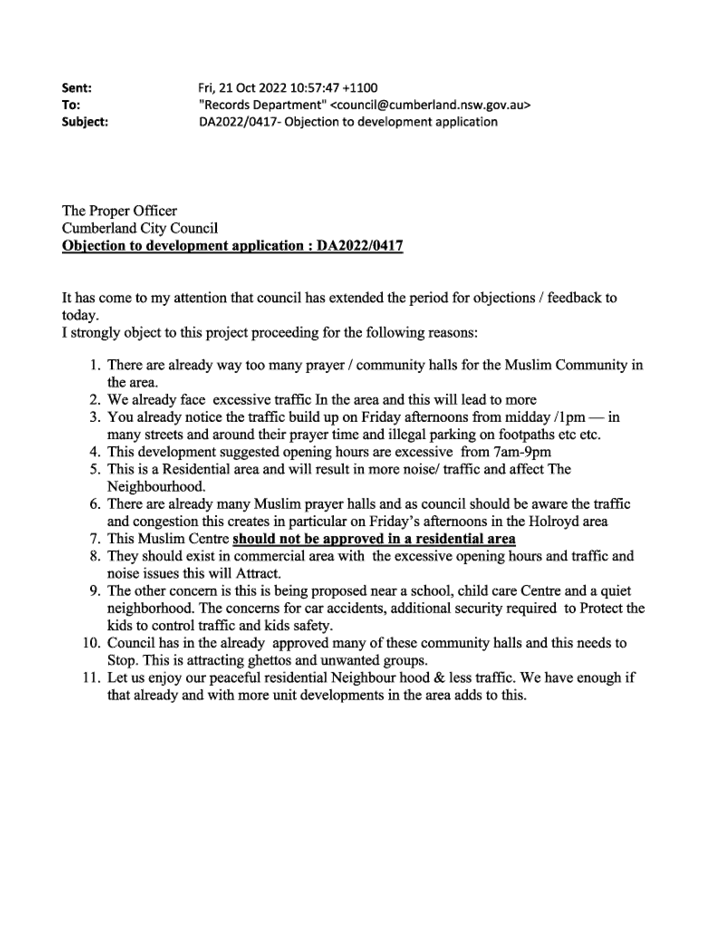
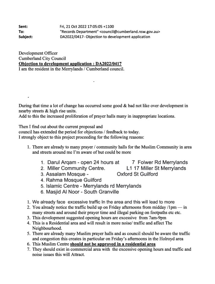
October 2022. In response, 111 submissions were received, in which 34
submissions are considered unique that include 1 petition from 77 submitters
and 1 pro-forma from 2 submitters. All of the submissions are objecting to the
proposed development.
3. The
subject site is not listed as a heritage item or located within the heritage
conservation area. The site however is located within immediate proximity of a
heritage listed item with local significance in accordance with the Cumberland
Local Environmental Plan 2021, which is an existing school building across the
street, Merrylands East Public School (I214).
4. The
application is referred to the Panel as the proposal is considered to be
contentious.
5. The
application is recommended for refusal subject to the reasons as discussed in
the Council’s assessment report.
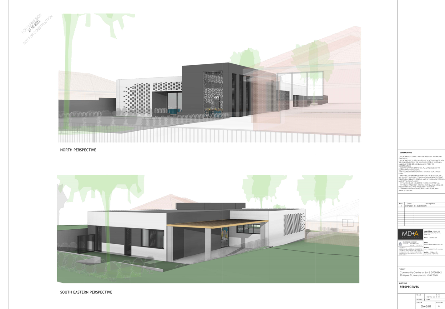
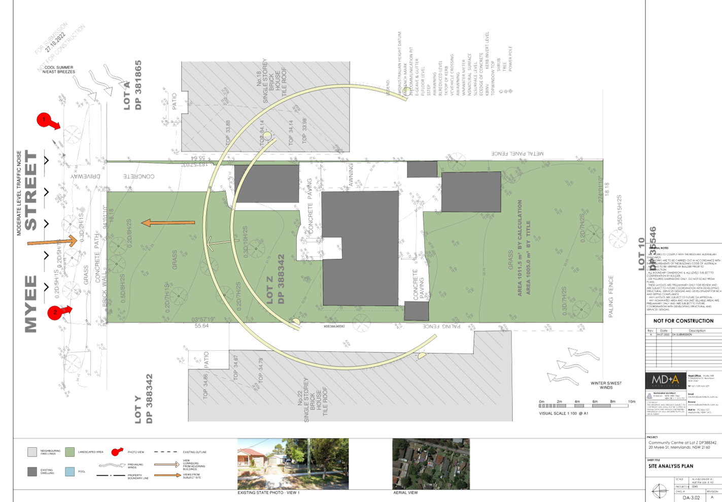
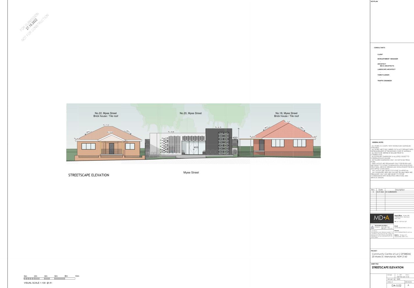
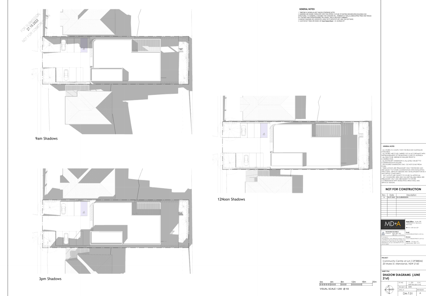
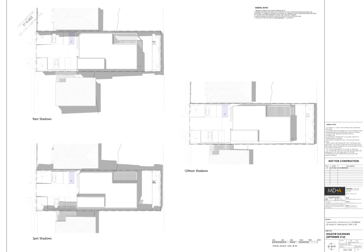
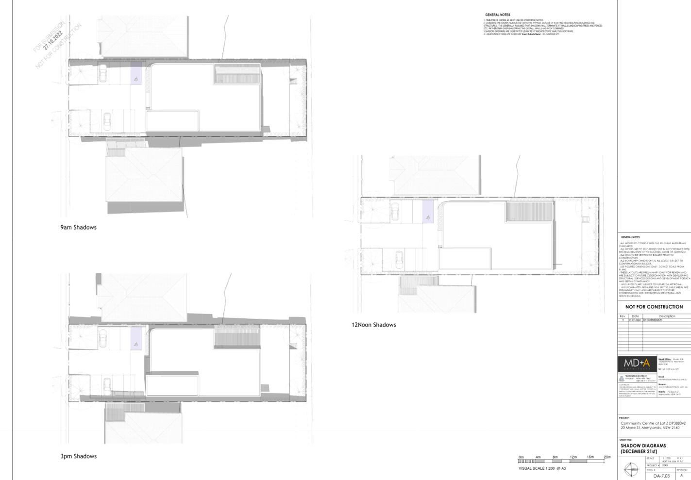
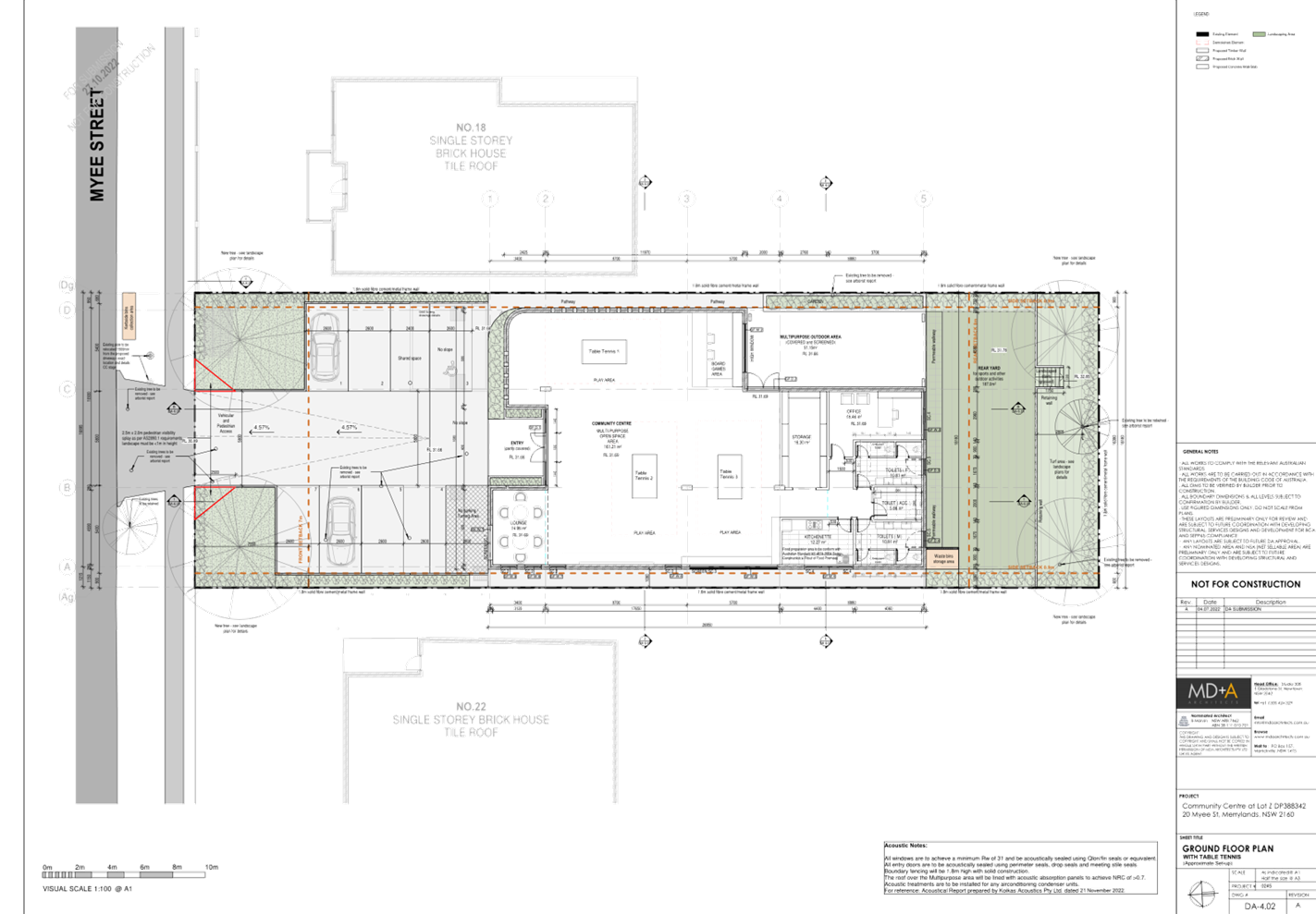
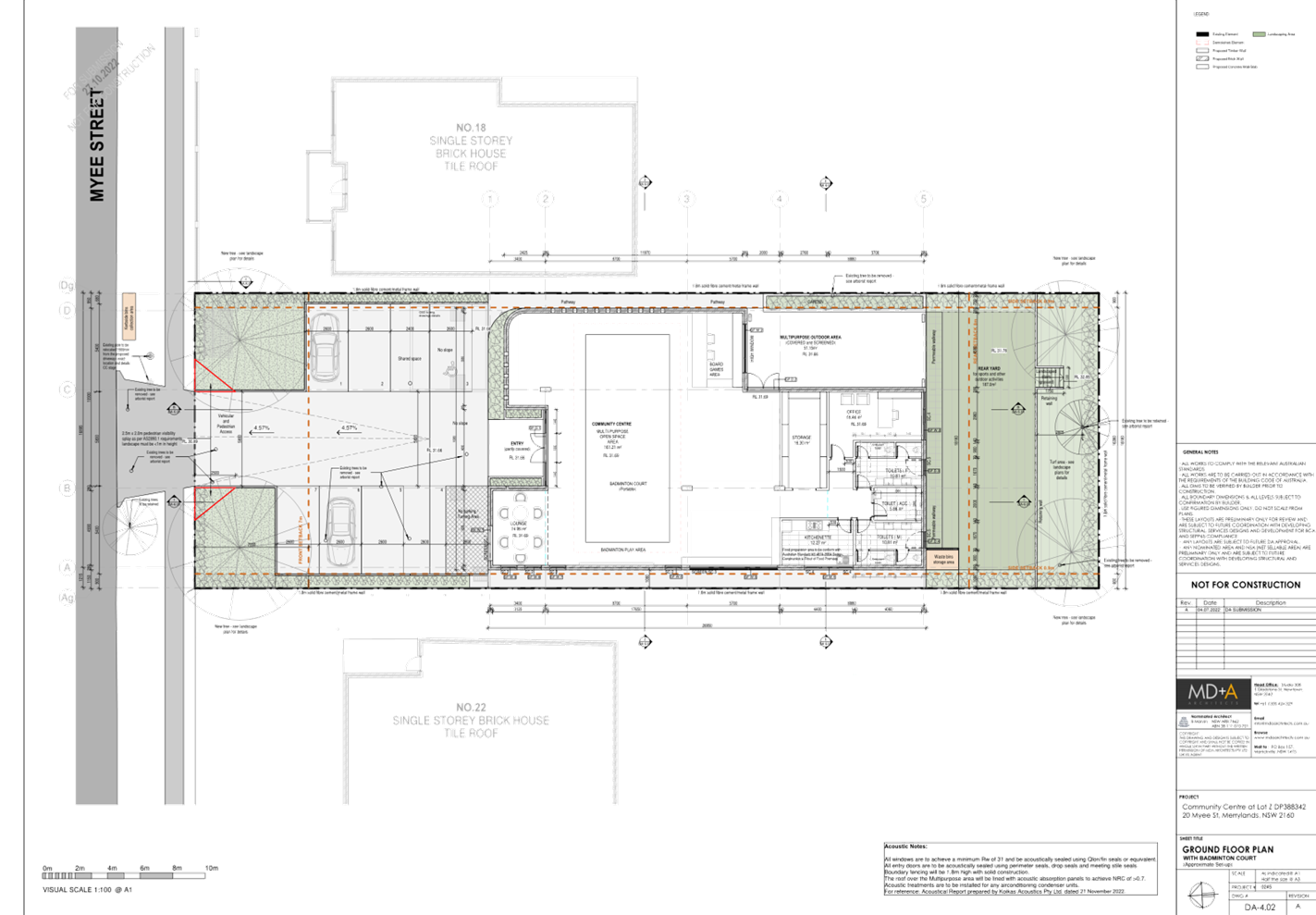
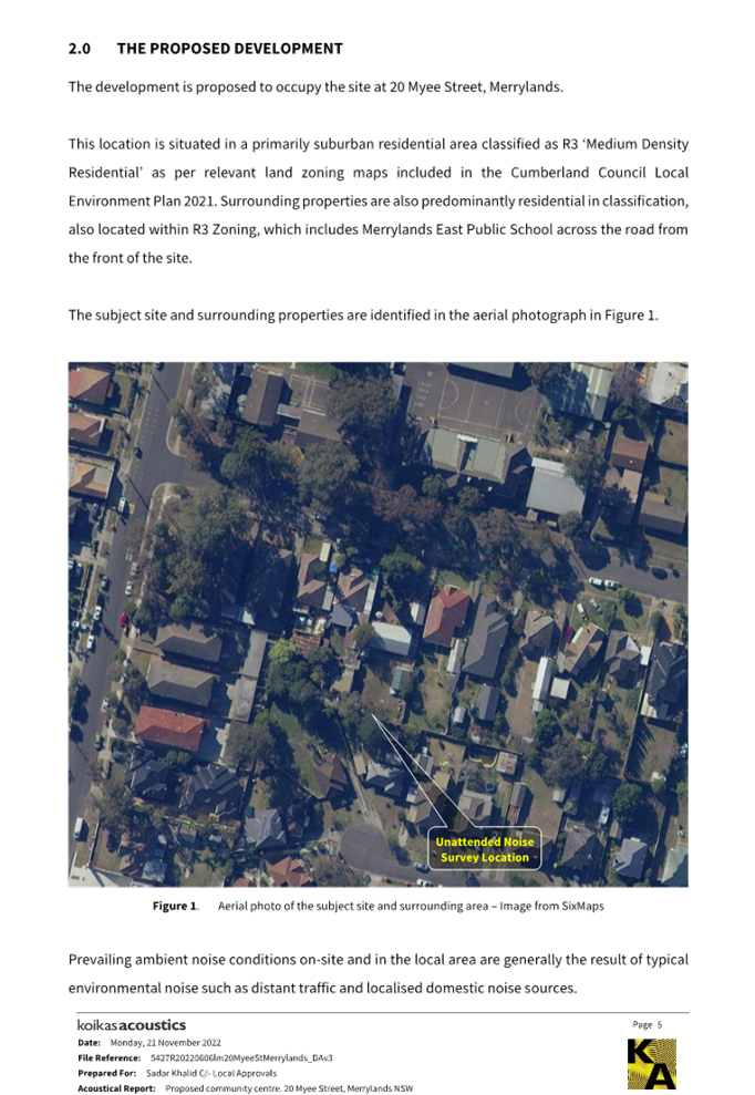
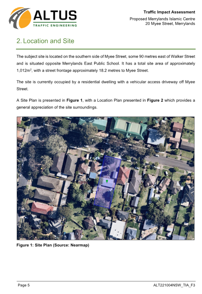
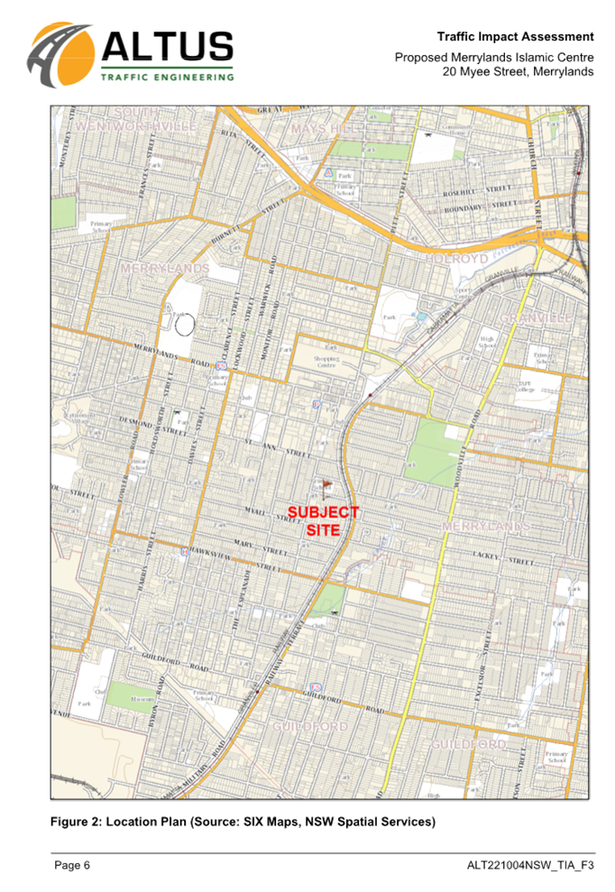
Subject Site and Surrounding
Area
The subject site is rectangular in
shape and legally described as Lot Z in DP 388342 with area of 1,005 square
metres (by title). The site has a street frontage to Myee Street with
lot’s width of 18.18m and depth of 55.64m. It has a 2m fall from the rear
to the front. Existing improvements on the site include a single storey
dwelling, a fibro shed within the front setbacks, a couple of metal sheds at
the rear and a variety of small to mature trees are scattered throughout the
site. The site is located across the road from the Merrylands East Primary
School that is identified as a heritage listed item with local significance in
accordance with the Cumberland Local Environmental Plan 2021 (I214).
Surrounding land uses are typically single and double storey dwelling houses
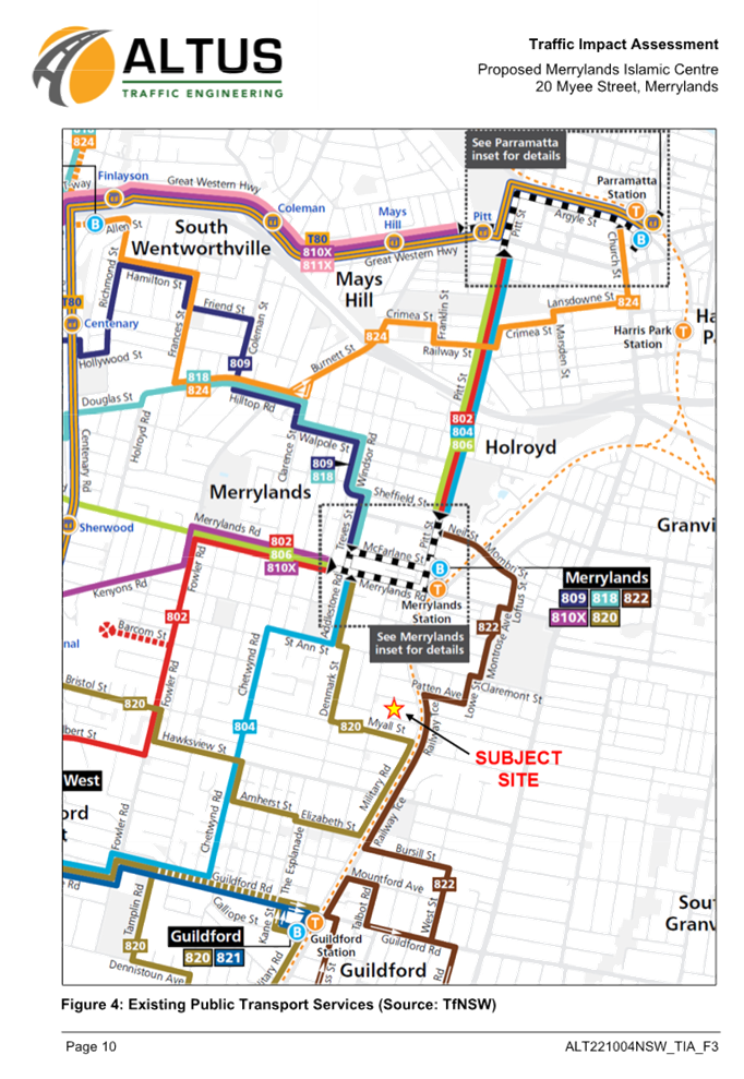
within the R3 Medium Density Residential zone. Merrylands Railway Station is
situated approximately 900m walking distance from the site.
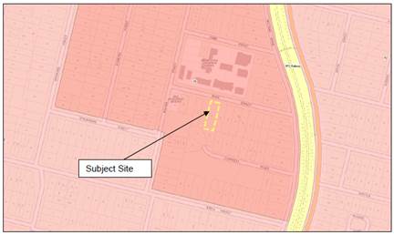
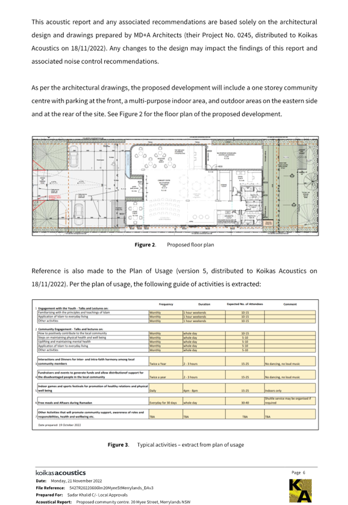
Figure
1 – Locality Plan of subject site
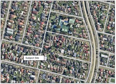
Figure
2 – Aerial view of subject site
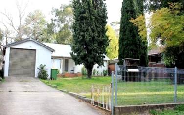
Figure
3 – Street view of subject site
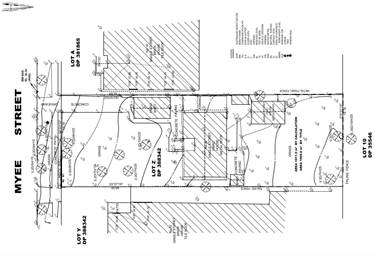
Figure
4 – Survey plan of the subject site
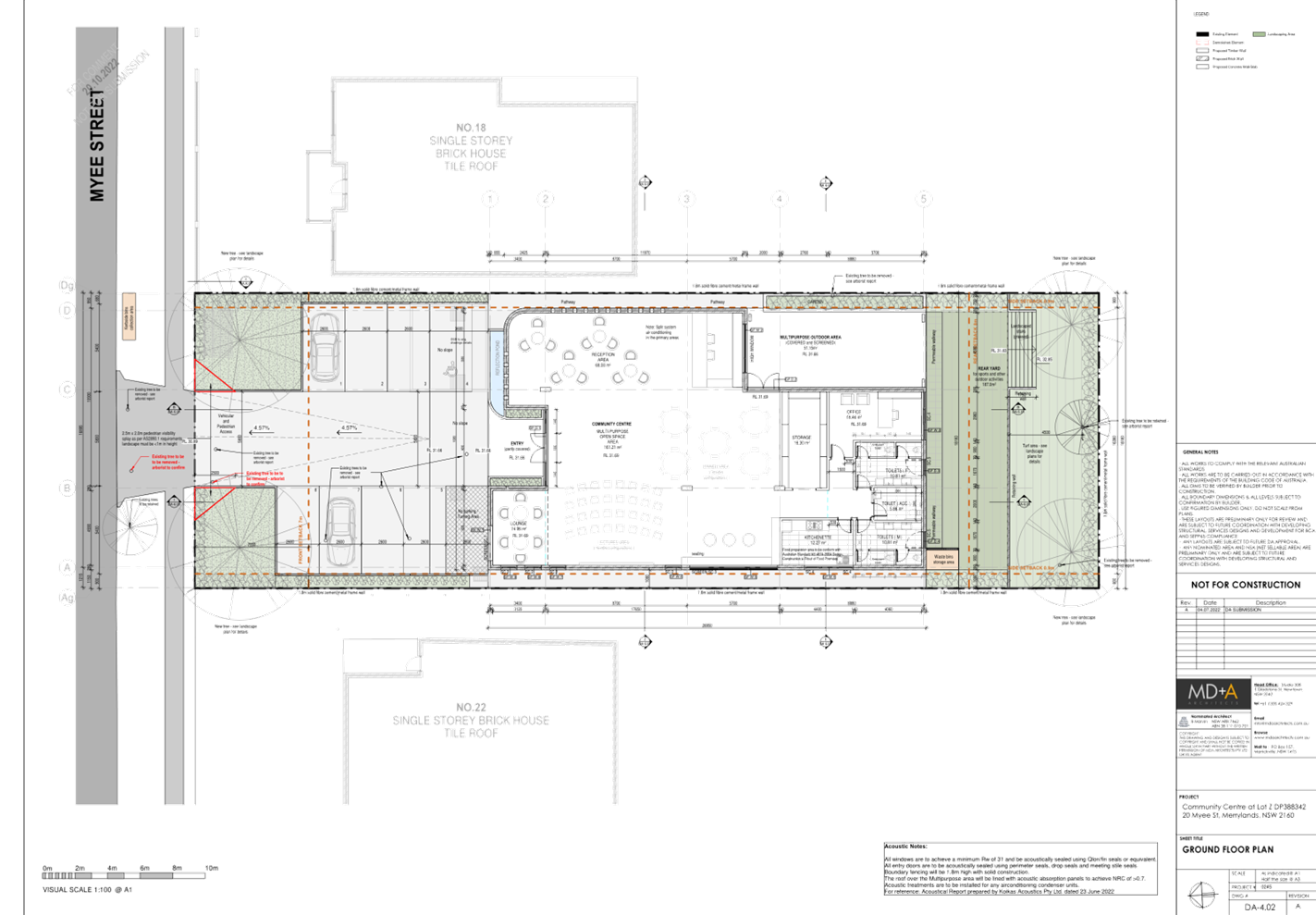
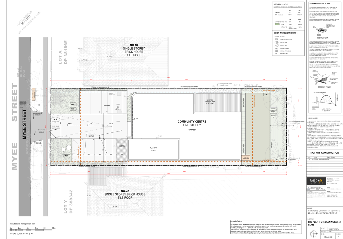
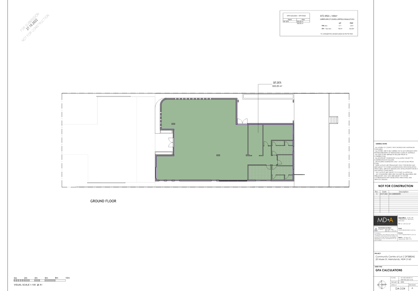
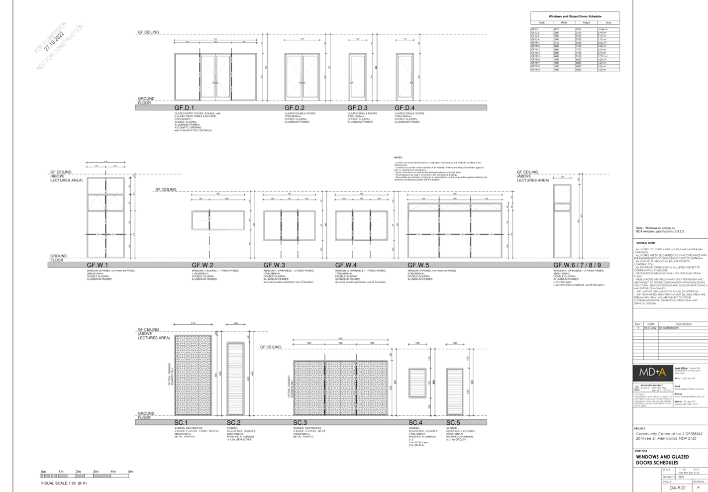
Description of the Development
Council has received a development
application for demolition of existing structures and construction of a one
storey community facility including at-grade parking and tree removal. A
detailed breakdown of the development is provided below.
Demolition
- Existing
structures on the site.
- Removal
of most trees on site to accommodate the new development.
Construction
- Two-way
driveway and 7 car parking spaces, including 1 disabled car space, within the
front setback.
- Relocation
of existing power pole within the nature strip to accommodate the proposed
driveway.
- Boundary
fencing at the rear to the height of 1.8m from finished floor levels.
- Partly
covered front porch.
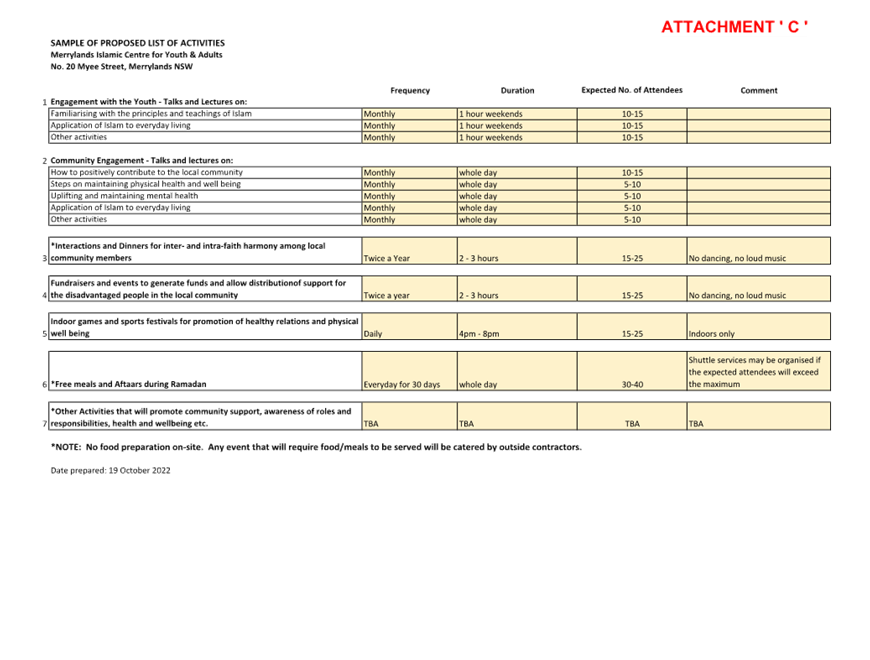
- Multipurpose
indoor and outdoor areas.
- Lounge,
store room, office, kitchenette, toilets and bin room.
Details of use
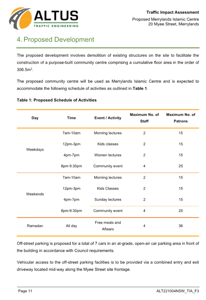
- No.
of staff on daily basis: 2 - 4 staff members.
- Up
to 30 - 40 people will visit the community facility during special events
(Aftaars during Ramadan). A small shuttle bus will be provided for pick up and
drop off to and from the railway station with capacity of up to 25 patrons.
The hours of operation are
7.00am to 9.30pm, 7 days a week.
- Associated
activities proposed are as follows.
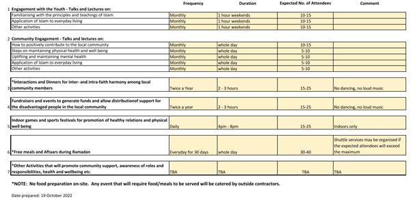
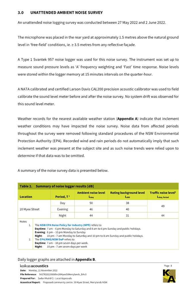
Figure
5 – Proposed activities listed in the Plan of Management
- Council
notes that there are inconsistencies in some of the proposed activities listed
between the plan of management and the traffic report, such as, during weekdays
between 4pm-7pm.

Figure
6 – Proposed daily activities listed in the Traffic Report
History
Pre-lodgement application advice
(PL-2021/0102) was issued on 30 November 2021 for demolition of existing
structures and construction of a place of public worship to house 40-50
worshippers. The pre-lodgement advice identified significant matters of concern
including insufficient parking and non-compliant to the required minimum lot
size. It was concluded that the site is unsuitable to be developed for the
purpose of a place of public worship.
Applicants Supporting
Statement
The applicant has provided a
Statement of Environmental Effects prepared by Local Approvals dated June 2022
and was received by Council on 12 August 2022 in support of the application.
Contact with Relevant
Parties
The assessing officer has
undertaken a site inspection of the subject site and surrounding properties and
has been in regular contact with the applicant throughout the assessment
process.
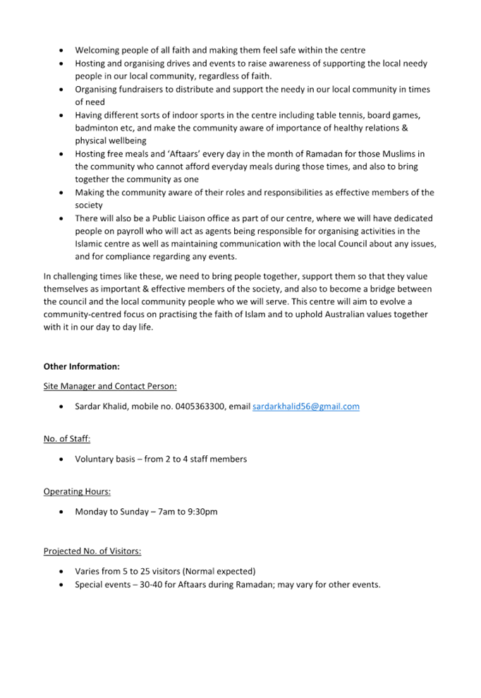
INTERNAL REFERRALS
Development Engineer
The development application was
referred to Council’s Development Engineer for comment who has advised
that the development proposal is not supported for reasons stated below.
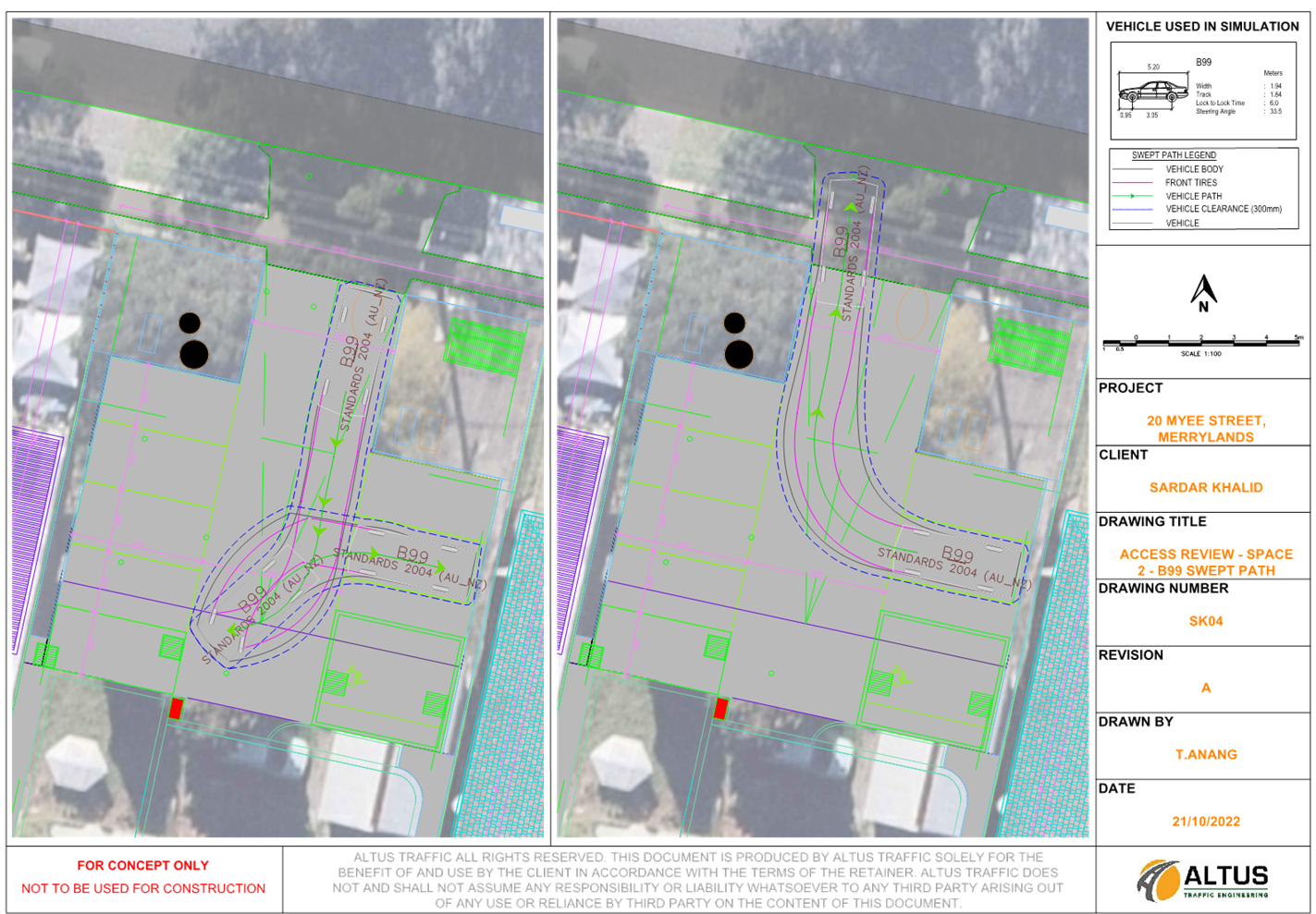
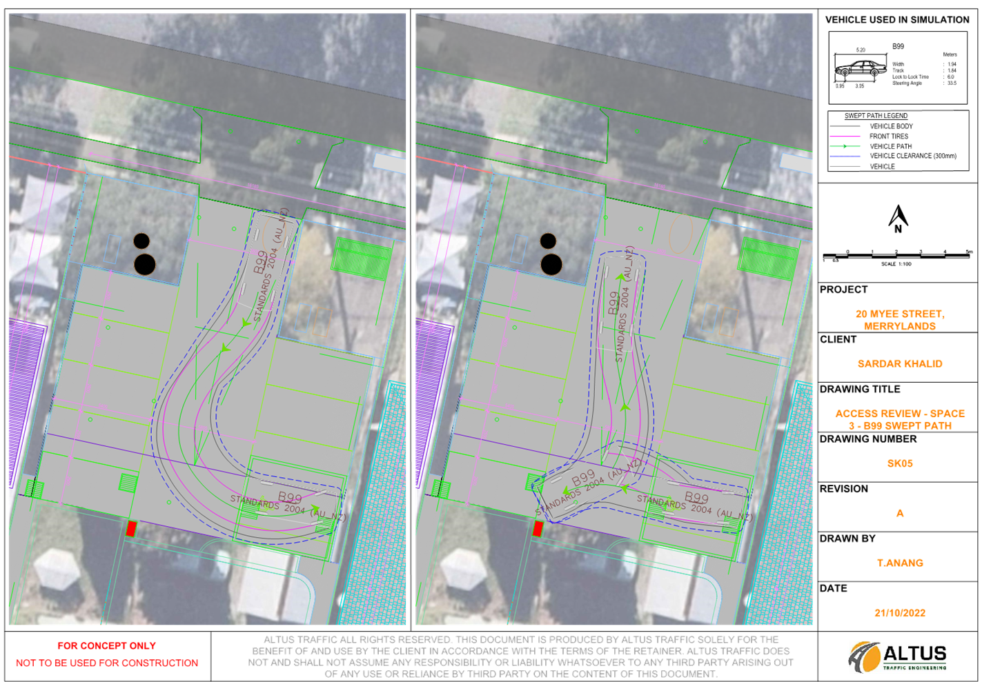
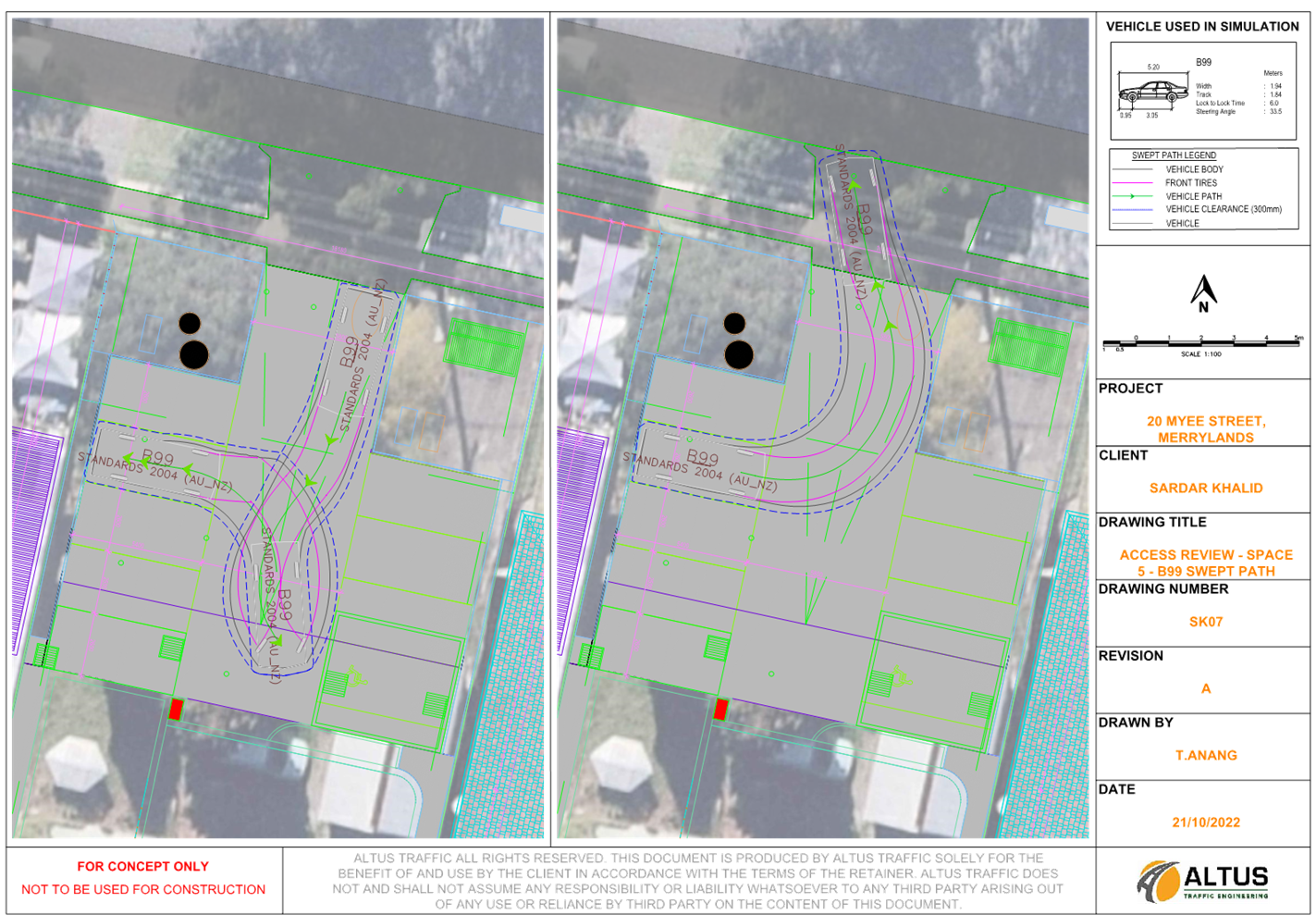
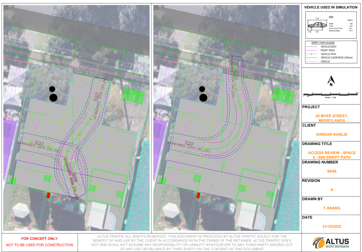
1. The
parking rate as estimated by the revised traffic report submitted for the
proposed community facility is not considered satisfactory. Sufficient on-site
parking spaces have not been provided for people attending the premises. The
development has the capacity to accommodate up to 70 people based on the
seating plan provided. Where 16 car parking spaces are required for the special
events as per the submitted traffic report, only 7 off-street parking space
proposed. Reliance on the on-street parking spaces to meet the additional
parking demand as per the traffic report and the proposed shortfall of 9 car
parking spaces could not be supported in this instance.
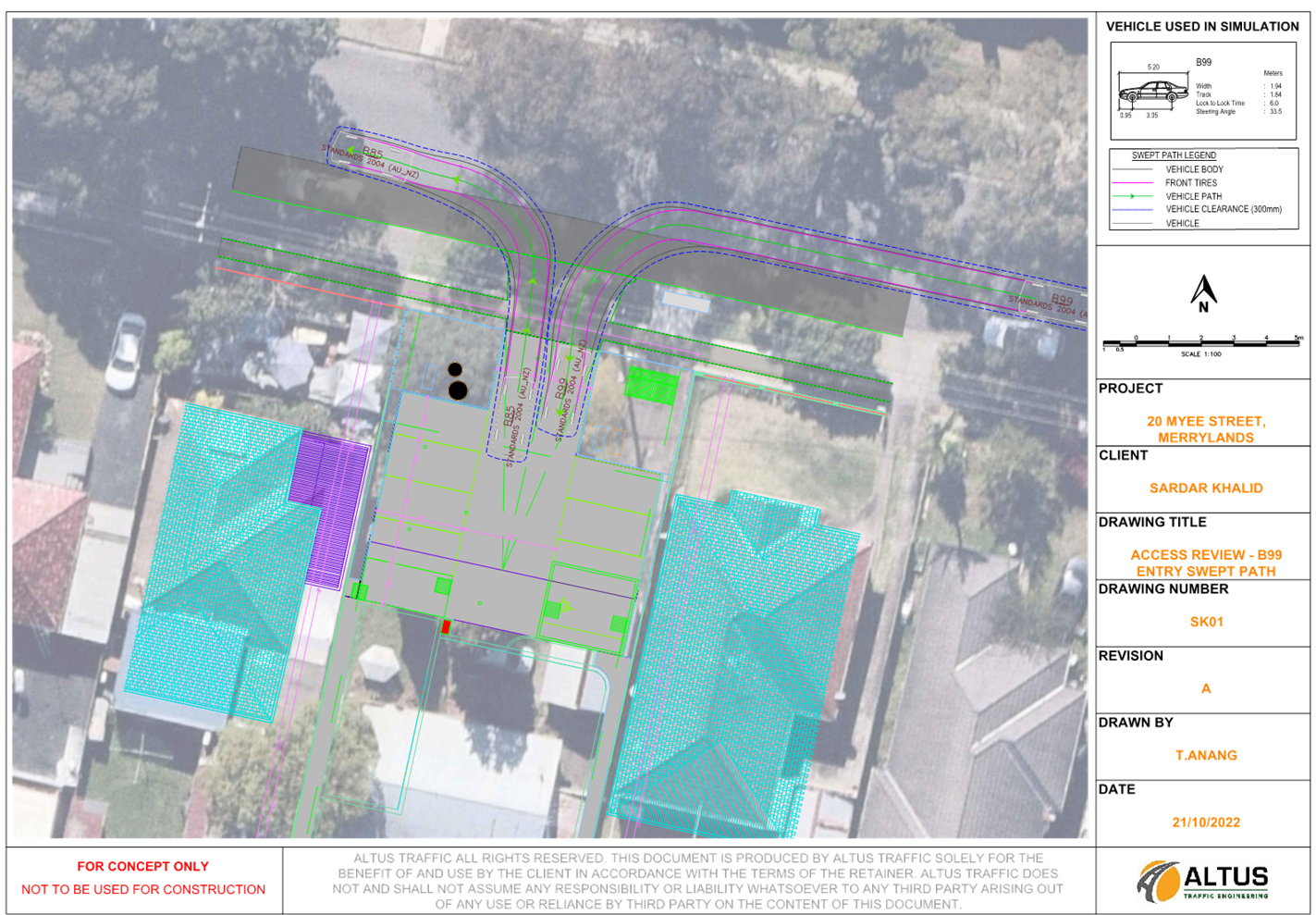
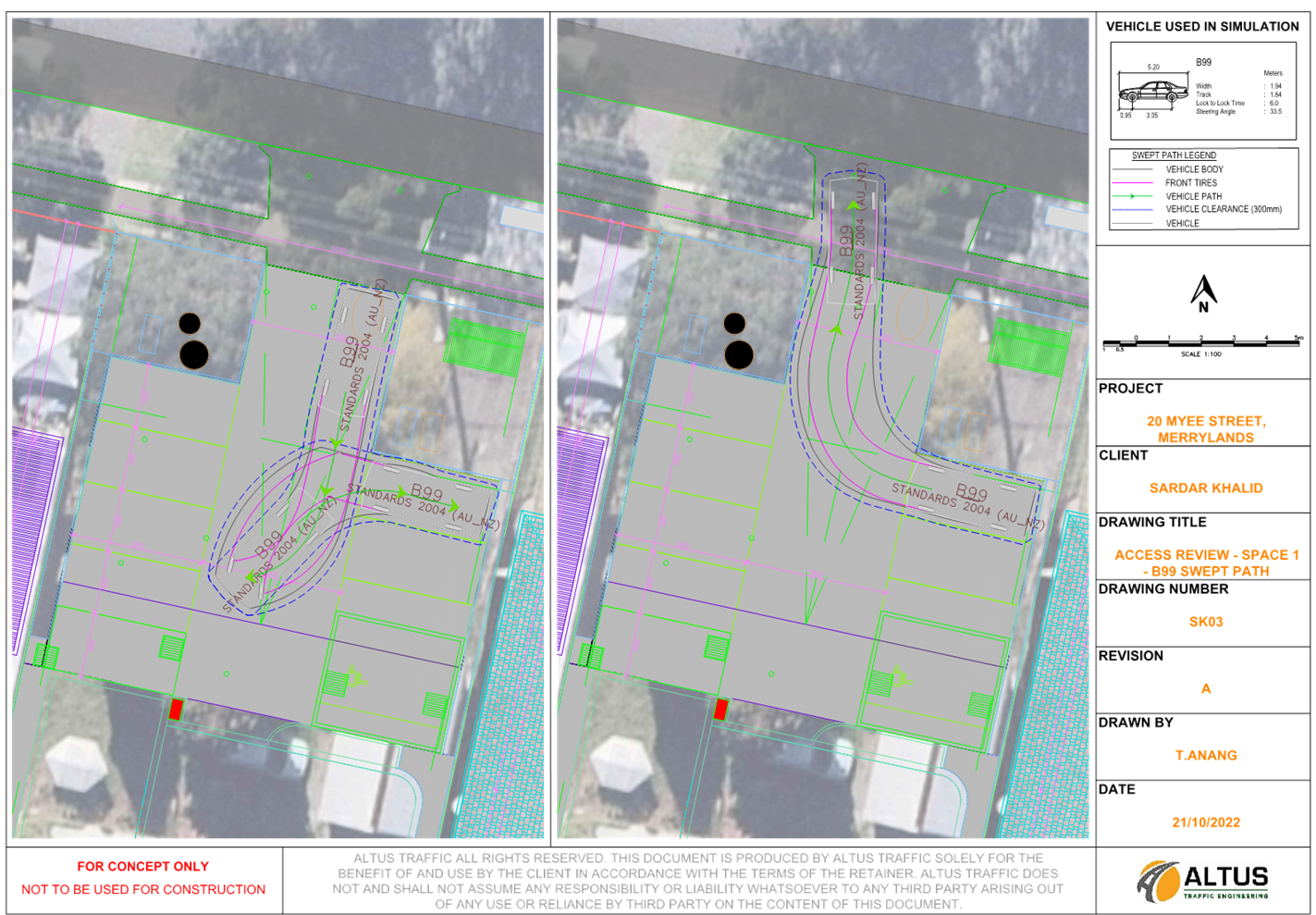
2. A
safe and appropriate service bay for a coach/bus within the site in accordance
with AS2890.2:2018 and appropriate turning area have not been provided on the
site to ensure the coach/bus can enter and leave the site in a forward
direction.
3. The
proposed stormwater management is not considered satisfactory for the following
reasons.
- Insufficient
information provided to assess On-Site Detention (OSD) system design.
- Overland
flows maybe obstructed and “intercepted and accepted within” the property
being developed due to unsatisfactory OSD and drainage design.
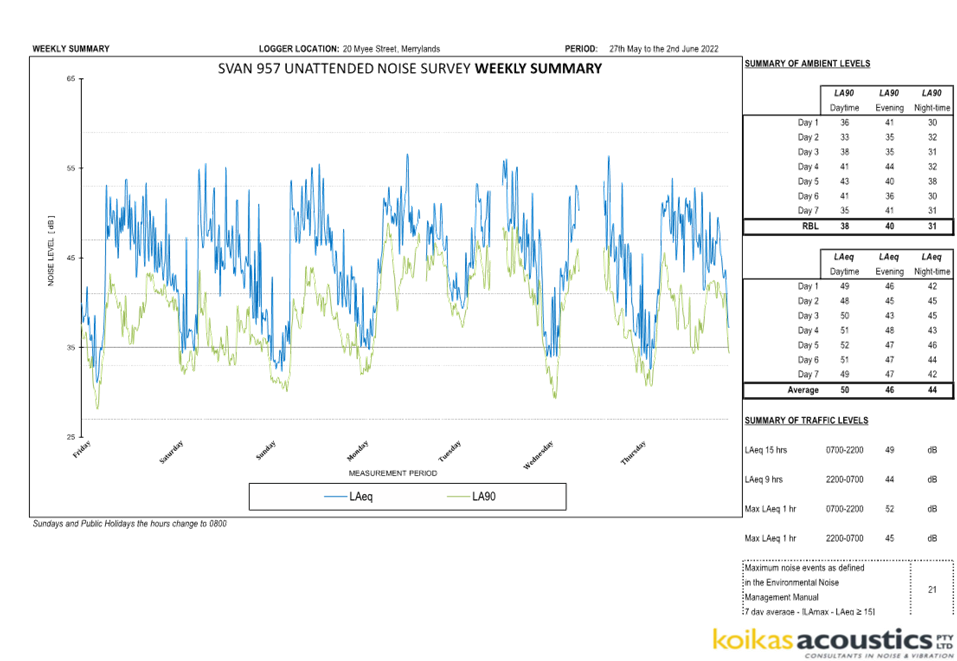
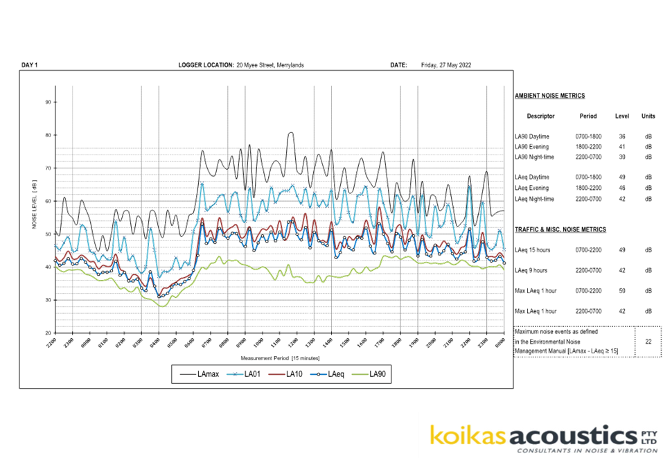
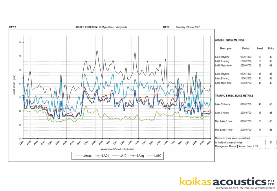
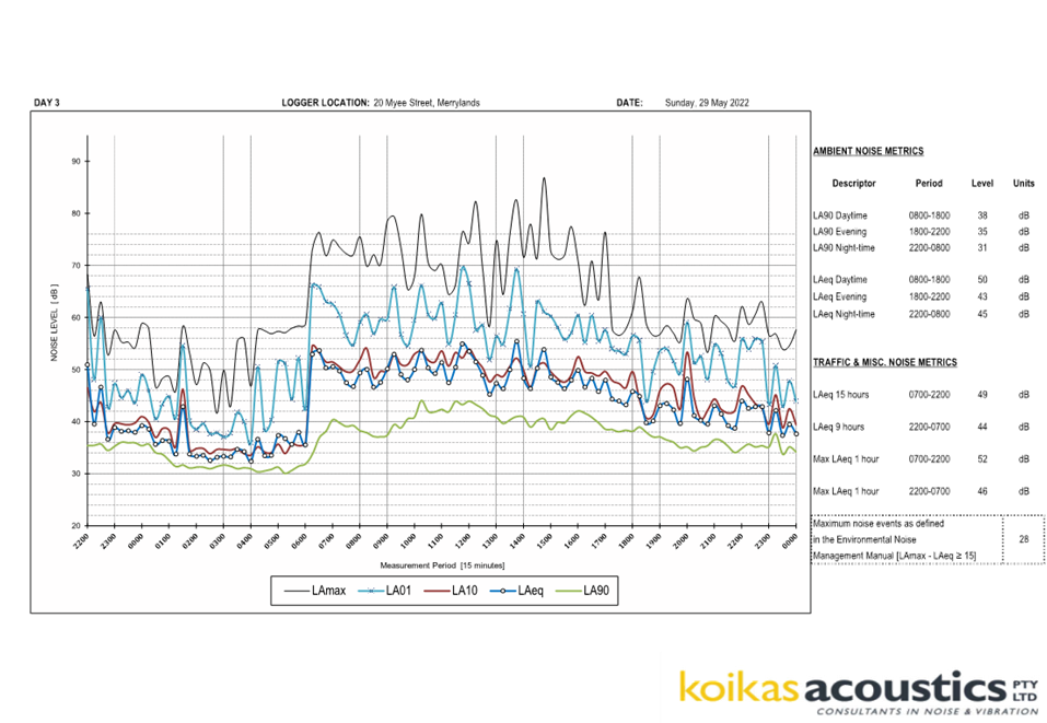
Environment and Health
The development application was
referred to Council’s Environment and Health Officer for comment who has
advised that the development proposal is not satisfactory, as insufficient
information provided in the plan of management and acoustic report. The
proposal cannot be supported in this instance.
Tree Management Officer
The development application was
referred to Council’s Tree Management Officer for comment who has advised
that the development proposal is satisfactory with regard to the tree removal
proposed and therefore can be supported subject to recommended conditions of
consent.
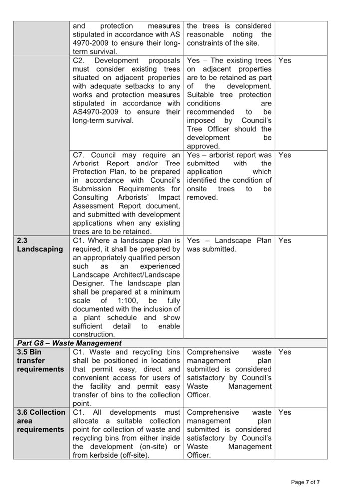
Waste Management
The development application was
referred to Council’s Waste Management Officer for comment who has
advised that the development proposal is satisfactory with regard to the waste
management proposed and therefore can be supported subject to recommended
conditions of consent.
External Referrals
Endeavour Energy
Endeavour Energy has raised no
concern with the proposal subject to the inclusion of conditions in any consent
for the development to ensure the existing power pole has sufficient clearance
to the proposed driveway and the available electricity services are adequate
for the development.
PLANNING COMMENTS
The provisions of any
Environmental Planning Instruments (EP&A Act s4.15 (1)(a)(i)
State Environmental Planning
Policies
The proposed development is
affected by the following State Environmental Planning Policies:
(a) State
Environmental Planning Policy (Transport and Infrastructure) 2021
The provisions of the Transport
and Infrastructure SEPP have been considered in the assessment of the
development application.
Chapter 2 – Infrastructure
Clause 2.48 –
Determination of development applications – other development
The proposed driveway is located
within 5m of an exposed overhead electricity power line. The proposal was
referred to Endeavour Energy, who raised no consent with the proposal subject
to the inclusion of conditions in any consent for the development to ensure the
existing power pole has sufficient clearance to the proposed driveway and the
available electricity services are adequate for the development.
(b) State
Environmental Planning Policy (Resilience and Hazards) 2021
Chapter 4 – Remediation
of Land
Clause 4.6 of Resilience and
Hazards SEPP requires Council to be satisfied that the site is suitable or can
be made suitable to accommodate the proposed development. The matters listed
within Clause 4.6 have been considered in the assessment of the development
application.
|
Matter for Consideration
|
Yes/No
|
|
Does the application involve re-development of the site or
a change of land use?
|
Yes
No
|
|
Does
the application involve re-development of the site or a change of land use?
|
Yes
No
|
|
Is the development going to be used for a sensitive land
use (e.g.: residential, educational, recreational, childcare or hospital)?
|
Yes
No
|
|
Does information available to you indicate that an
activity listed below has ever been approved, or occurred at the site?
acid/alkali plant and
formulation, agricultural/horticultural activities, airports, asbestos
production and disposal, chemicals manufacture and formulation, defence
works, drum re-conditioning works, dry cleaning establishments, electrical
manufacturing (transformers), electroplating and heat treatment premises,
engine works, explosive industry, gas works, iron and steel works, landfill
sites, metal treatment, mining and extractive industries, oil production and
storage, paint formulation and manufacture, pesticide manufacture and
formulation, power stations, railway yards, scrap yards, service stations,
sheep and cattle dips, smelting and refining, tanning and associated trades,
waste storage and treatment, wood preservation
|
Yes
No
|
|
Is the site listed on
Council’s Contaminated Land database?
|
Yes
No
|
|
Is the site subject to EPA
clean-up order or other EPA restrictions?
|
Yes
No
|
|
Has the site been the subject of
known pollution incidents or illegal dumping?
|
Yes
No
|
|
Does the site adjoin any
contaminated land/previously contaminated land?
|
Yes
No
|
|
Has the appropriate level of
investigation been carried out in respect of contamination matters for
Council to be satisfied that the site is suitable to accommodate the proposed
development or can be made suitable to accommodate the proposed development?
|
Yes
No
|
|
Details of contamination investigations carried out at the
site:
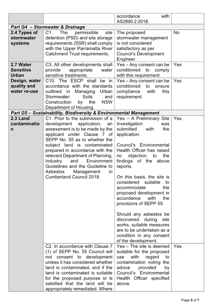
A Preliminary Site
Investigation (PSI) prepared by EIAustralia dated 5 August 2022 was submitted to support the current proposal. The PSI
states that the building facades appear aged. The report states that a
fragment of asbestos containing material (ACM) was noted along the fence of
the property and there could also be lead based paint in the façade.
Excavations and soil disturbance would be limited to works for footings and
services. The PSI concludes that the site can be made suitable for the
proposed use subject to implementations of the recommendations provided in
the PSI.
Council’s Environmental Health Officer has reviewed
the reports and considered the proposal to be satisfactory.
|
(c) Statement
Environmental Planning Policy (Biodiversity and Conservation) 2021
Chapter 2 –Vegetation in
non-rural Areas
The proposal does not exceed the
biodiversity offsets scheme threshold. Therefore, the proposed vegetation
removal is considered acceptable. Please refer to the DCP compliance table for
further discussion.
Chapter 10 – Sydney
Harbour Catchment
The subject site is identified as
being located within the area affected by the Sydney Regional Environmental
Plan (Sydney Harbour Catchment) 2005. The proposed development raises no issues
as no impact on the catchment is envisaged.
(Note: - the subject site is not
identified in the relevant map as ‘land within the ‘Foreshores and
Waterways Area’ or ‘Wetland Protection zone’, is not a
‘Strategic Foreshore Site’ and does not contain any heritage items.
Hence the majority of the SREP is not directly relevant to the proposed
development).
Local Environmental Plans
Cumberland Local Environmental
Plan 2021 (CLEP)
The provision of the CLEP is
applicable to the development proposal.
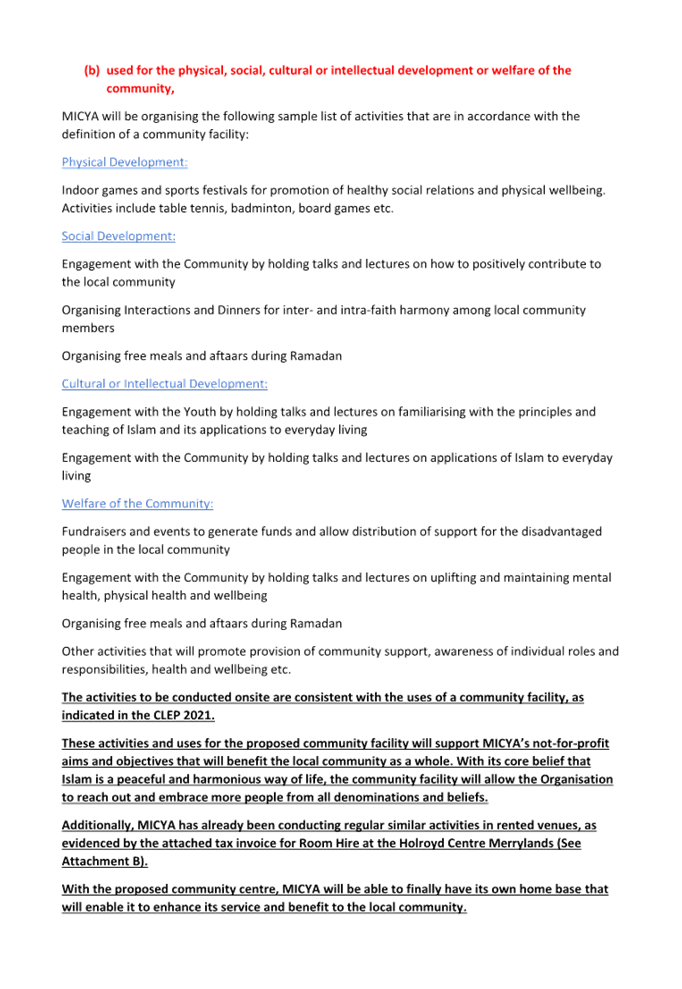
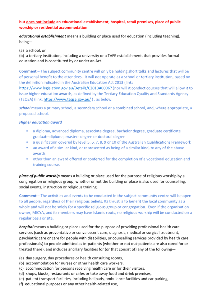
(a) Characterisation
of Development:
The primary use of the building is
identified as community facility, however the primary activities on the site as
per the Plan of Management include religious lectures and gatherings and celebration
of religious events, which are akin to a place of public worship rather than a
community facility.
The principles on how to
characterise a development can be found in Chamwell Pty Ltd v Strathfield
Council [2007] NSWLEC 114, in which Preston CJ states that the characterisation
of the purpose of a use of land should be undertaken ‘at a level of
generality which is necessary and sufficient to cover the individual
activities, transactions or processes carried on, not in terms of the detailed
activities, transactions or processes’. The task of characterisation of a
proposed development must also be done in a ‘common sense and practical
way’. To determine whether a development is (or will be) for a particular
purpose, an enquiry into how that purpose will be achieved by the development
is necessary.
While community facility and place
of public worship are both permissible land uses in the R3 Medium Density
Residential zone with consent, the development is seeking for approval of the
construction and use of the site as a community facility. The definition of
both community facility and place of public worship within the CLEP 2021 is
delineated as follows.
community facility means a
building or place—
(a) owned
or controlled by a public authority or non-profit community organisation, and
(b) used
for the physical, social, cultural or intellectual development or welfare of
the community,
but does not include an
educational establishment, hospital, retail premises, place of public worship
or residential accommodation.
place of public worship
means a building or place used for the purpose of religious worship by a
congregation or religious group, whether or not the building or place is also
used for counselling, social events, instruction or religious training.
In the Department of Planning and
Environment Circular PS 13-001, ‘How to characterise development’,
it also states that ‘development is considered to be for a particular
purpose if that purpose is the dominant purpose of the development. This
purpose is the reason for which the development is to be undertaken or the end
to which the development serves. A component of a development may have features
that are both ancillary and independent. If this is the case, consider the
following:
· Is
the component going to serve the dominant purpose of the development or is it
independent?’
Council is not satisfied that the
dominant purpose as a community facility is proposed in this instance. This
also becomes more evident with the content of the supporting documentation
submitted with the application in that the proposed activities will be similar
to activities generally carried out in a place of public worship. The proposed
development dominant activities include familiarising, teaching and application
of a religion to everyday living and celebrating Aftaars dinner. These features
of the proposed development are therefore independent and could not be
contemplated as serving the purpose built community facility.
Placing a condition to restrict
the use is also not considered as a practicable measure to manage ongoing
operation of the development.
Following from above, it is
considered that the proposed use and activities to be conducted within the
facility has not been satisfactorily characterised to be considered a community
facility, hence the application is recommended for refusal.
The relevant matters to be
considered under CLEP and the applicable clauses for the proposed development
are summarised below. A comprehensive LEP assessment is contained in Attachment
6.
Figure 7 – Cumberland LEP
2021 Compliance Table
|
OBJECTIVE/DEVELOPMENT
STANDARD
|
COMPLIANCE
|
DISCUSSION
|
|
Zone R3 Medium Density Residential
1. Objectives
of zone
• To ensure that
non-residential land uses are located in a setting that minimises impacts on
the amenity of a medium density residential environment.
|
No
|
The
development will not provide sufficient on-site parking to accommodate the
proposed use and is not accompanied with satisfactory documentation in terms
of OSD system design, acoustic assessment and plan of management. The physical limitation of the
subject site to accommodate the proposal consequently will result in
significant traffic, safety, parking, noise and amenity impacts to the
locality.
This
matter of non-compliance with the relevant provision of the Cumberland LEP
2021 has been included in draft notice of determination as a reason for
refusal.
|
|
4.3 Height of buildings
9m (max)
|
Yes
|
5.198m
|
|
4.4 Floor space ratio
0.7:1 (max)
|
Yes
|
0.33:1 (333.25 square metres)
|
|
5.10 Heritage conservation
|
Yes
|
The site is located within the immediate proximity of a
heritage listed item with local significance in accordance with the
Cumberland Local Environmental Plan 2021, which is an existing school
building across the street, Merrylands East Public School (I214). Given a
physical separation between the heritage listed item and the site, additional
heritage impact statement will not be required. The proposed building will
retain setbacks and built form that are consistent with the existing
dwelling. The proposed built form is considered to be compatible with the
existing local heritage listed item.
|
|
6.7
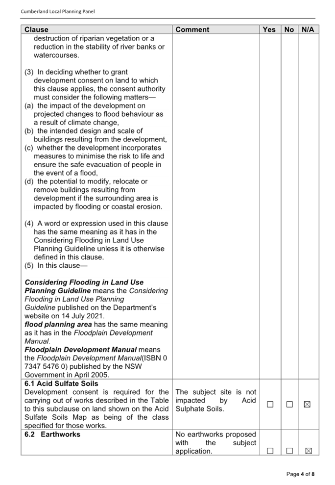
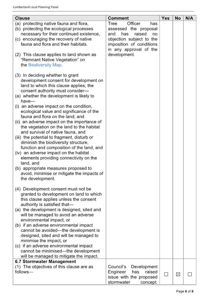
Stormwater management
(1)
The objectives of this clause are as follows—
(a) to
minimise the impacts of urban stormwater on properties, native vegetation and
receiving waters,
(b) to
avoid adverse impacts on soils and land stability,
(c) to
protect the environmental values of water identified for urban waterways in
the Sydney Harbour and Parramatta River and Georges River catchments.
(2)
Development consent must not be granted to development on land to which this
clause applies unless the consent authority is satisfied that the
development—
(a) is
designed to maximise the use of water permeable surfaces on the land having
regard to the soil characteristics affecting on-site infiltration of water,
and
(b) includes,
if practicable, on-site stormwater retention for use as an alternative supply
to mains water, groundwater or river water, and
(c) avoids
significant adverse impacts of stormwater runoff on adjoining properties,
native bushland and receiving waters, or if the impact cannot be reasonably
avoided, minimises and mitigates the impact.
|
No
|
Council’s
Development Engineer has raised issue with the proposed stormwater concept.
Specifically, the design of the OSD system is unsatisfactory and does not
consider Upper Parramatta River Catchment Trust (UPRCT) guidelines (Third Edition) and Council’s OSD
policy in its calculations.
This matter of non-compliance with the relevant provision
of the Cumberland LEP 2021 has been included in draft notice of determination
as a reason for refusal.
|
The provisions of any proposed
instrument that is or has been the subject (EP&A Act s4.15 (1)(a)(ii))
The proposed development is not
affected by any relevant Draft Environmental Planning Instruments.
The provisions of any
Development Control Plans (EP&A Act s4.15 (1)(a)(iii))
The CDCP provides guidance for the
design and operation of development to achieve the aims and objectives of the
CLEP.
A comprehensive assessment and
compliance table is contained in Attachment 7. The following table highlights
non-compliances with the CDCP, which relate primarily to setbacks, site
coverage and parking provision.
Figure 8 – Cumberland DCP
2021 Compliance Table
|
Clause
|
Control
|
Proposed
|
Complies
|
|
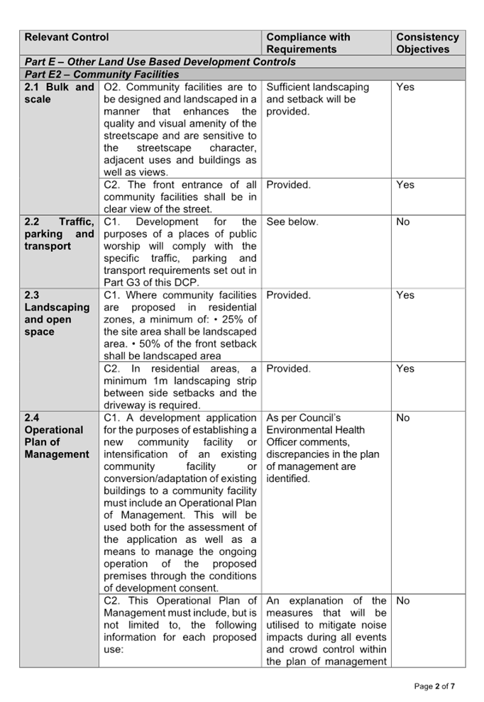
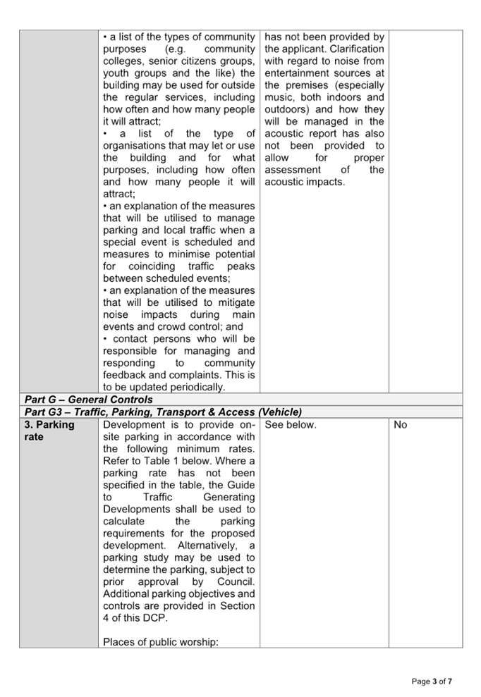
Part E2 Community Facilities
Section 2.2, C1
|
Development for the purposes of a community facility will
comply with the specific traffic, parking and transport requirements set out
in Part G3 of this DCP.
|
See below.
|
See below.
|
|
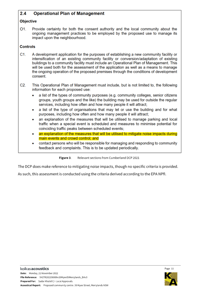
Section 2.4, C1 & C2
|
This Operational Plan of Management must include, but is
not limited to, the following information for each proposed use:
• a list of the types of community purposes (e.g.
community colleges, senior citizens groups, youth groups and the like) the
building may be used for outside the regular services, including how often
and how many people it will attract;
• a list of the type of organisations that may let
or use the building and for what purposes, including how often and how many
people it will attract;
• an explanation of the measures that will be
utilised to manage parking and local traffic when a special event is
scheduled and measures to minimise potential for coinciding traffic peaks
between scheduled events;
• an explanation of the measures that will be
utilised to mitigate noise impacts during main events and crowd control; and
• contact persons who will be responsible for
managing and responding to community feedback and complaints. This is to be
updated periodically.
|
As per Council’s
Environmental Health Officer comments, discrepancies in the plan of
management and acoustic report are identified. An explanation of the
measures that will be utilised to mitigate noise impacts during all events
and crowd control within the plan of management has not been provided by the
applicant. Clarification with regard to noise from entertainment sources at
the premises (especially music, both indoors and outdoors) and how they will
be managed in the acoustic report has also not been provided to allow for
proper assessment of the acoustic impacts.
|
No, this matter of non-compliance with the relevant
provision of the Cumberland DCP 2021 has been included in draft notice of
determination as a reason for refusal.
|
|
Part G3 Traffic, Parking, Transport & Access
(Vehicles)
Section 3
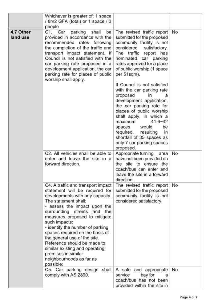
Section 4.7, C1 & C4
|
Parking rates shall comply with the minimum parking rates
in Section 3 of this Part of the DCP.
Car parking shall be provided in accordance with the
recommended rates following the completion of the traffic and transport
impact statement. If Council is not satisfied with the car parking rate
proposed in a development application, the car parking rate for places of
public worship shall apply.
A traffic and transport impact statement will be required
for developments with any capacity. The statement shall:
• assess the impact upon the surrounding streets and
the measures proposed to mitigate such impacts;
• identify the number of parking spaces required on
the basis of the general use of the site. Reference should be made to similar
existing and operating premises in similar neighbourhoods as far as possible;
|
The revised traffic
report submitted for the proposed community facility is not considered
satisfactory. Despite request to identify the number of parking spaces
required on the basis of the general use of the site and that reference
should be made to similar existing and operating premises (i.e., community
facility) in similar neighbourhoods as far as possible, the traffic report
has nominated mainly car parking rates approved for places of public worship.
This is not relevant to this application.
If Council is not satisfied with the car parking rate
proposed in a development application, the car parking rate for places of
public worship shall apply, in which a maximum 41.6~42 spaces would be
required, resulting in shortfall of 35 spaces.
Sufficient on-site
parking spaces based on any of these rates have not been provided.
It is also noted that
the proposed seating arrangements and total gross floor area of the
development indicate actual maximum number of patrons that could potentially
exceed the estimated maximum patron number at any one time.
The traffic
report also makes reference to the use of shuttle bus/coach for pick
up and drop off to and from the railway station with capacity of up to 25
patrons during special events that would last approximately 30 days. Further
review of the information submitted however indicates that service/parking
bay and appropriate turning area have not
been provided on the site to ensure the coach/bus can enter and leave the
site in a safe manner of a forward direction.
Reliance on the
on-street parking spaces to meet the additional parking demand as per the
proposal and shortfall of 9
car parking spaces during special events would result in safety concerns and
traffic and parking impacts on the existing locality and the local road
network, which therefore could not be supported in this instance.
|
No, this matter of non-compliance with the relevant
provision of the Cumberland DCP 2021 has been included in draft notice of
determination as a reason for refusal.
|
|
Section 4.7, C2 & C5
|
All vehicles shall be able to enter and leave the site in
a forward direction.
Car parking design shall comply with AS 2890.
|
A safe and appropriate
service bay for a coach/bus within the site in accordance with
AS2890.2:2018 and appropriate turning area have not been provided on the
site to ensure the coach/bus can enter and leave the site in a forward
direction. Non-compliance with these controls raise significant pedestrian safety concerns,
and traffic and parking impacts on the existing locality. The proposal
therefore could not be supported in this instance.
|
No, this matter of non-compliance with the relevant
provision of the Cumberland DCP 2021 has been included in draft notice of
determination as a reason for refusal.
|
|
Part G4 Stormwater and Drainage
Section, Section 2.4
|
The permissible site detention (PSD) and site storage
requirements (SSR) shall comply with the Upper Parramatta River Catchment
Trust requirements.
|
The proposed stormwater
management is not considered satisfactory as per Council’s Development
Engineer comments above.
|
No, this matter of non-compliance with the relevant
provision of the Cumberland DCP 2021 has been included in draft notice of
determination as a reason for refusal.
|
As indicated in the compliance
table above, the proposed development departs from controls in Parts E2, G3 and
G4 of CDCP. Having regard to these departures, it is considered that the
proposal performs unsatisfactorily from an environmental planning viewpoint as
detailed in the above table. The non-compliances form part of the reasons for
refusal.
The provisions of any planning
agreement that has been entered into under section 7.4, or any draft planning
agreement that a developer has offered to enter into under section 7.4
(EP&A Act s4.15(1)(a)(iiia))
There is no draft planning
agreement associated with the subject Development Application.
The provisions of the
Regulations (EP&A Act s4.15 (1)(a)(iv))
The proposed development raises no
concerns as to the relevant matters arising from the Environmental Planning and
Assessment Regulations 2021 (EP&A Reg).
The Likely Environmental,
Social or Economic Impacts (EP&A Act s4.15 (1)(b))
It is identified that the proposed
development if approved would create issues in relation to traffic and parking,
noise, intensity of use and stormwater drainage. For the reasons as presented
within the report, the proposed development is not supported.
The suitability of the site for
the development (EP&A Act s4.15 (1)(c))
The subject site and locality are
not known to be affected by any natural hazards or other site constraints
likely to have a significant adverse impact on the proposed development.
However, there are significant concerns as stated in the main body of the
report that will adversely impact the existing residential amenity in the
context of the site and surrounding locality. The proposal is therefore not
supported in this instance.
Submissions made in accordance
with the Act or Regulation (EP&A Act s4.15 (1)(d))
|
Advertised (Website)
|
Mail
|
Sign
|
Not Required
|
In accordance with Council’s
Notification requirements contained within the Cumberland Development Control
Plan 2021, the proposal was publicly notified for a period of 14 days between
25 August 2022 to 8 September 2022. The notification period was extended to 29
September 2022. The application was publicly re-notified for a period of 14
days between 7 October 2022 and 21 October 2022. In response, 111 submissions
were received, in which 34 submissions are considered unique that include 1
petition from 77 submitters and 1 pro-forma from 2 submitters. All of the
submissions are objecting to the proposed development with nil disclosing a
political donation or gift. The issues raised in the public submissions are
summarised and commented on as follows:
Figure
9 – Submissions Summary Table
|
Issue
|
Planner’s Comment
|
|
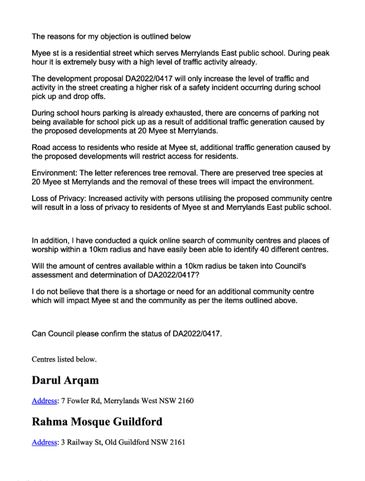
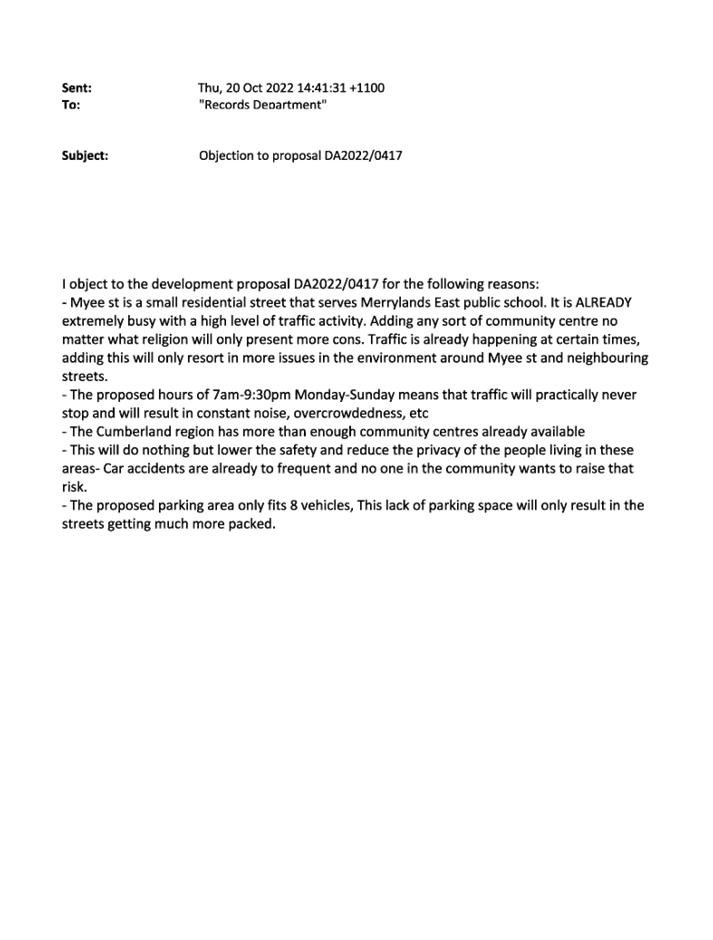
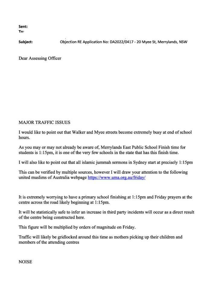
Parking and access issues.
Myee Street is a busy small, narrow and tight street with
parking on both sides with high level of traffic due to the location of
Merrylands East Public School and Long Day Care Centre.
|
As stated in the main body of the report, shortfall on the
car spaces proposed is not supported.
|
|
Traffic issues.
Significant increase in
traffic expected as a result of this proposal in an already high
density, high traffic area.
Existing residential area are already dealing with overflow from train
commuters, the RSL, St Ann Anglican Church, local public school, a number of
parks, St Elias Melkite Church and a bypass through Guildford by motorist.
Traffic modelling should be done for the proposal. There is an existing
petition for no right turn on St Ann St.
|
As stated in the main body of the report, traffic
assessment submitted for the proposed development is not considered
satisfactory and therefore it is not supported.
|
|
Safety issues.
The proposal will result in
increased traffic congestion, conflicts and accidents due to additional drop
off and pick up, illegal parking, speed limit infringement and reckless
driving putting pedestrians, young children and residents at danger.
|
As stated in the main body of the report, traffic
assessment submitted for the proposed development is not considered
satisfactory and therefore it is not supported.
|
|
Excessive noise issues due to
extended operating hours 7am to 9.30pm Monday to Sunday with functions
proposed.
|
As stated in the main body of the report, acoustic report
submitted with the proposal is not considered satisfactory and the
development is therefore not supported.
|
|
Loss and invasion to privacy.
|
Further privacy measures to address the concerns may be
imposed, should the proposal be supported. Nevertheless, the proposal is not
supported in this instance.
|
|
Wrong location.
The development should be
located in business or industrial area. R3 should be only for residential
purpose. The development does not fit into the established character and out
of context.
|
Community facility is a permitted land use in the R3 zone
under the Cumberland LEP 2021. Council notes in the main body of this report
regarding the significant impact that the proposal has on the locality and
the development is therefore not supported.
|
|
Decrease in property value.
|
The matter is not subject of assessment under s4.15 of the
EP&A Act.
|
|
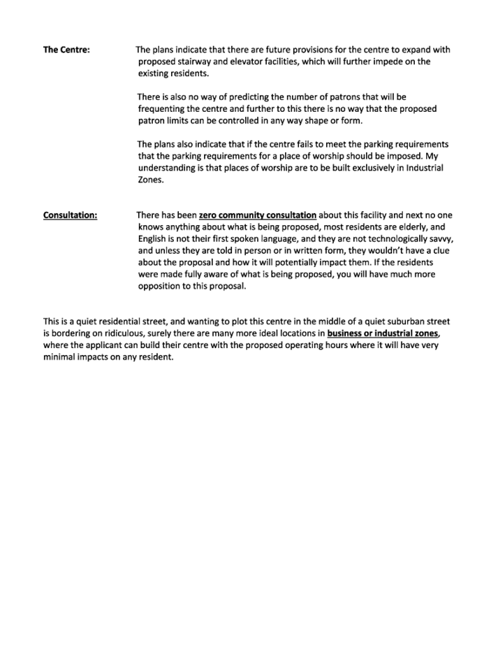
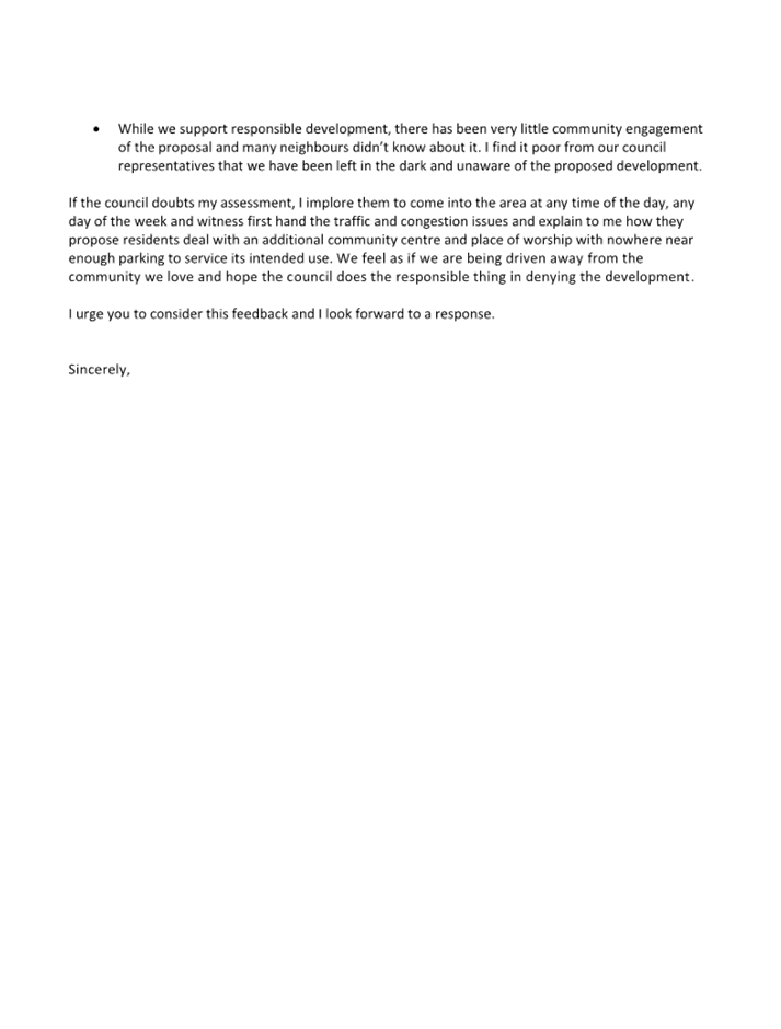
Zero community consultation.
Concern is raised for
difficulty for elderly, non-English speaking and not technology savvy
residents to participate.
|
Council provides
services for general public with no computer access at various location of
service centres. The application had also been publicly re-notified for the
broad community who expressed concerns regarding the proposal to Council for
a period of 14 days between 7 October 2022 and 21 October 2022.
|
|
Wrong plans attached to
notification letter.
|
Council notes the original
information that contains clerical error that was publicly notified
for a period of 14 days between 25 August
2022 to 8 September 2022. The notification period had therefore been extended
to 29 September 2022.
|
|
Tree removal.
|
Council’s Tree Management Officer has reviewed the
submitted arborist report for the proposed tree removal and considered it to
be satisfactory.
|
|
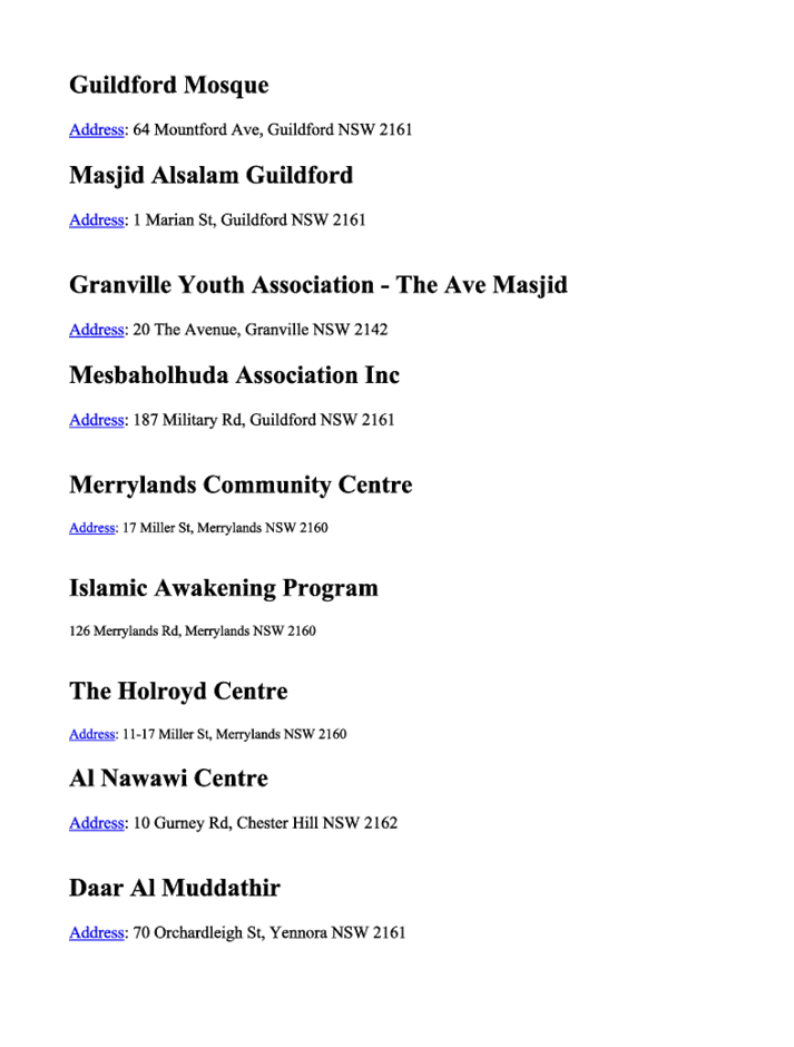
Too many community centres.
In 10km radius, there are
already 40 existing centres.
|
Community facility is a permitted land use in the R3 zone
under the Cumberland LEP 2021. Therefore, there is no radius limitation where
it may be built.
|
|
Discrepancies in proposed
development.
Plans submitted show that it
is capable to accommodate 74 people plus staff members, but only 8 car spaces
proposed.
The application is for a place
of public worship and should be assessed as a place of public worship. There
will be 100s of people praying 3-5 times a day.
Free meals are offered during
Ramadan, the place will accommodate more than what proposed.
|
Council notes these issues in the assessment of this
proposed development and the development is therefore not supported.
|
The public interest (EP&A
Act s4.15(1)(e))
In view of the foregoing analysis
it is considered that the development as proposed would not be consistent with
the public interest.
Cumberland Local
Infrastructure Contributions Plan 2020
The development would require the
payment of contributions in accordance with Cumberland Local Infrastructure
Contributions Plan 2020 and pursuant to Section 7.12 of the EP&A Act,
should the development be supported.
Disclosure of Political
Donations and Gifts
The applicant and notification
process did not result in any disclosure of Political Donations and Gifts.
Having regard to the relevant
matters of consideration under Section 4.15 of the Environmental Planning and
Assessment Act 1979, it is considered that the proposed development is
unacceptable for the reasons outlined in this report. It is recommended that
the development application be refused.
|
1. That
Development Application No. DA2022/0417 for demolition of existing structures
and construction of a one storey community facility including at-grade
parking and tree removal on land at 20 Myee Street MERRYLANDS NSW
2160 be refused for the reasons listed in the attached schedule.
2. Persons
whom have lodged a submission in respect to the application be notified of
the determination of the application.
|
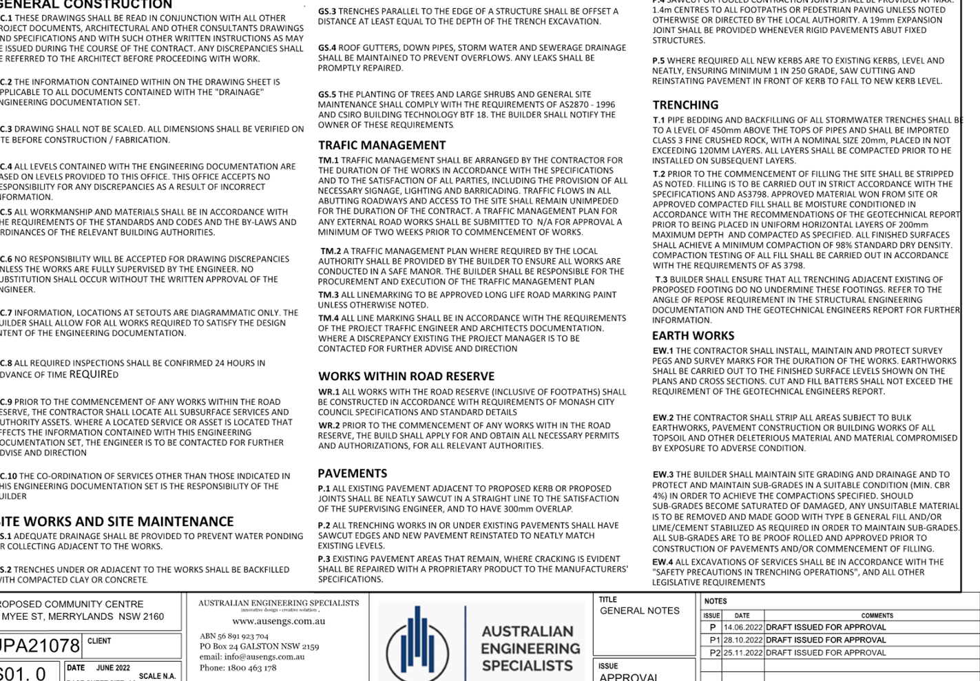
1. Draft
Notice of Determination
2. Architectural
Plans
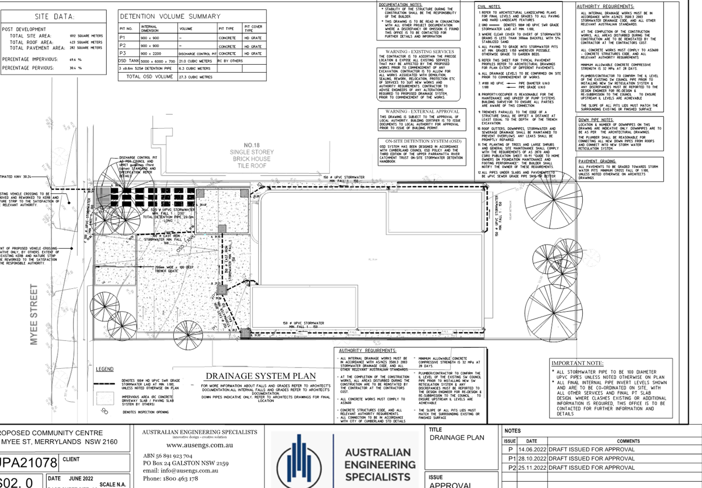
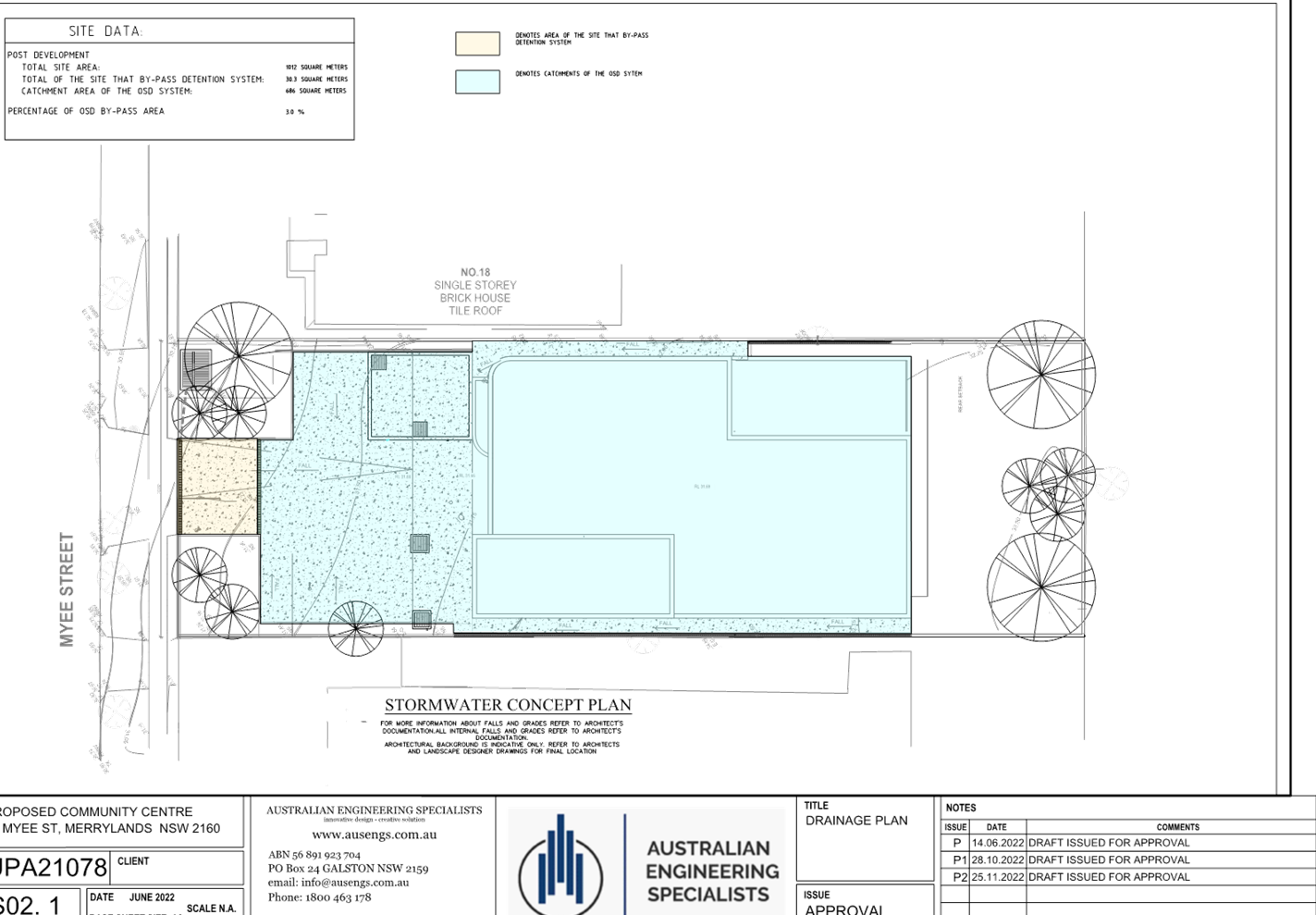
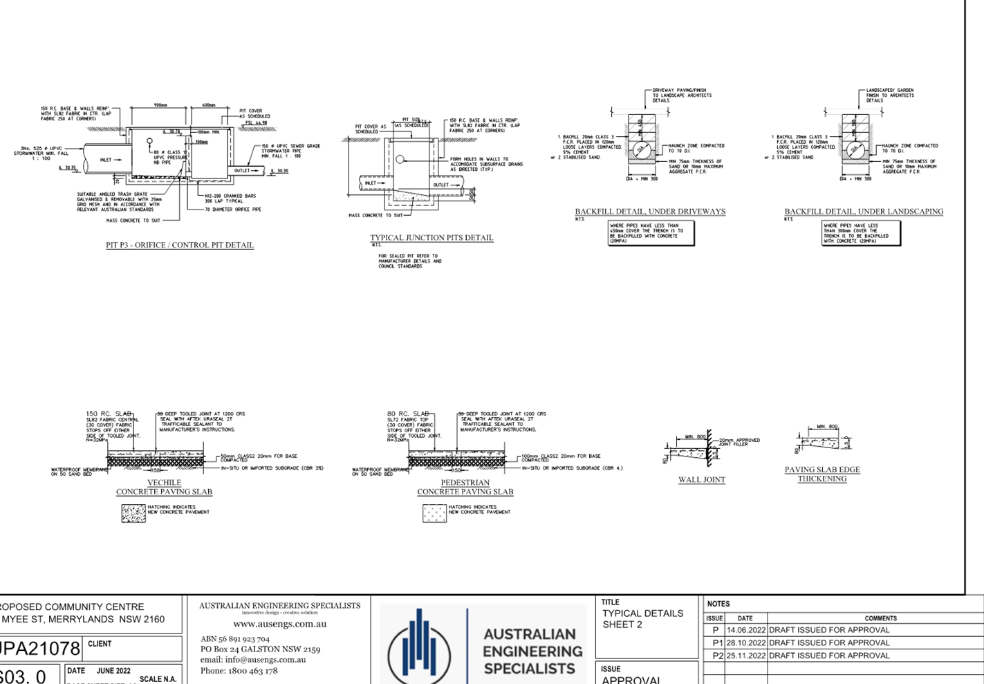
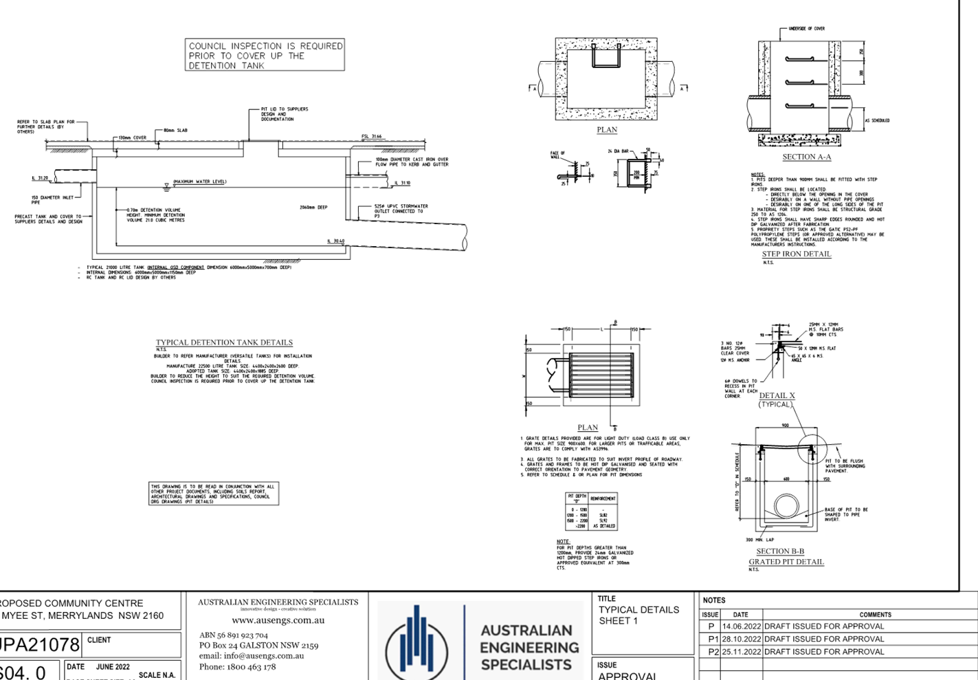
3. Stormwater
Plans
4. Plan
of Management
5. Noise
Assessment Report
6. Traffic
Assessment Report
7. Submissions
Received
8. Cumberland
Local Environmental Plan 2021
9. Cumberland
Development Control Plan 2021
10. Draft
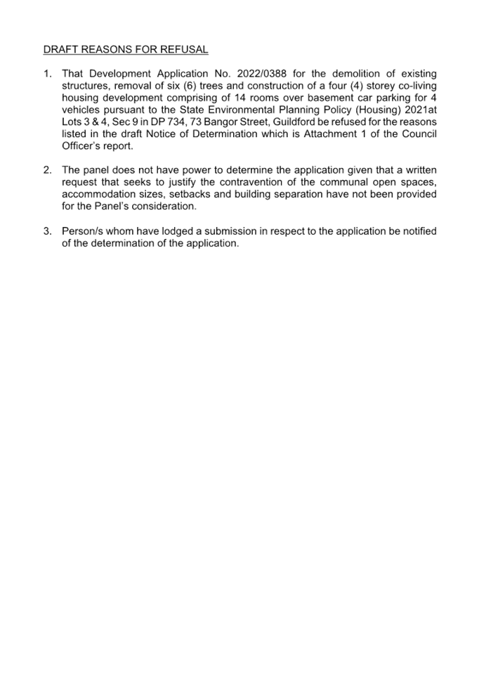
Reasons for Refusal
DOCUMENTS
ASSOCIATED WITH
REPORT LPP005/23
Attachment 1
Draft Notice of Determination
Cumberland Local Planning Panel Meeting
8 March 2023
DOCUMENTS
ASSOCIATED WITH
REPORT LPP005/23
Attachment 2
Architectural Plans
Cumberland Local Planning Panel Meeting
8 March 2023
DOCUMENTS
ASSOCIATED WITH
REPORT LPP005/23
Attachment 3
Stormwater Plans
Cumberland Local Planning Panel Meeting
8 March 2023
DOCUMENTS
ASSOCIATED WITH
REPORT LPP005/23
Attachment 4
Plan of Management
Cumberland Local Planning Panel Meeting
8 March 2023

DOCUMENTS
ASSOCIATED WITH
REPORT LPP005/23
Attachment 5
Noise Assessment Report
Cumberland Local Planning Panel Meeting
8 March 2023

DOCUMENTS
ASSOCIATED WITH
REPORT LPP005/23
Attachment 6
Traffic Assessment Report
Cumberland Local Planning Panel Meeting
8 March 2023


DOCUMENTS
ASSOCIATED WITH
REPORT LPP005/23
Attachment 7
Submissions Received
Cumberland Local Planning Panel Meeting
8 March 2023


DOCUMENTS
ASSOCIATED WITH
REPORT LPP005/23
Attachment 8
Cumberland Local Environmental Plan 2021
Cumberland Local Planning Panel Meeting
8 March 2023
DOCUMENTS
ASSOCIATED WITH
REPORT LPP005/23
Attachment 9
Cumberland Development Control Plan 2021
Cumberland Local Planning Panel Meeting
8 March 2023
DOCUMENTS
ASSOCIATED WITH
REPORT LPP005/23
Attachment 10
Draft Reasons for Refusal
Cumberland Local Planning Panel Meeting
8 March 2023
Cumberland Local Planning Panel Meeting
8 March 2023
Item
No: LPP006/23
Development
Application for 191-201 Pitt Street, Merrylands
Directorate: Environment
and Planning
Responsible
Officer: Executive
Manager Development and Building
File
Number: DA2022/0468
|
Application
accepted
|
11 October 2022
|
|
Applicant
|
DFP Planning Unit Trust
|
|
Owner
|
The Trust Company Limited
|
|
Application
No.
|
DA2022/0468
|
|
Description
of Land
|
191-201 Pitt Street
MERRYLANDS NSW 2160, Lot 11 DP 1178684
|
|
Proposed
Development
|
Alterations to parking arrangement
including new access stairs and provision of signage
|
|
Site
Area
|
6.609ha (66,090sqm)
|
|
Zoning
|
B4 Mixed Use Zone
|
|
Disclosure
of political donations and gifts
|
Nil disclosure
|
|
Heritage
|
No – Heritage Listed or
Heritage Conservation Area
|
|
Principal
Development Standards
|
FSR
Permissible: 2.8:1
Proposed: no change
Height of Building
Permissible: 14m & 53m
Proposed: 15.6m within the 14m
area
|
|
Issues
|
Height of Building
|
1. Development
Application No. DA2022/0468 was accepted on 11 October 2022 for the alteration
to parking arrangement including new access stairs and provision of signage.
2. The
application was publicly notified to occupants and owners of the adjoining
properties for a period of fourteen (14) days between 27 October 2022 and 10
November 2022. In response, no submissions were received.
3. The
subject site is the existing Stockland Merrylands Mall. The proposal involve
the following building works:
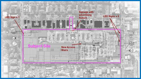
- Construction
of a new access stairs located in the middle of the site to provide access
between the split level rooftop car park area.
- Erection
of two (2) LED signages (1m x 2.96m each) to the eastern side of the shopping
mall along the Pitt Street frontage.
- Erection
of one (1) LED signage (1m x 2.96m) to the western side of the shopping mall
along the Treves Street frontage.
- Erection
of a new LED signage with advertising features (10.6m x 12.8m) is proposed
along the northern façade of the shopping mall above the recessed Neil
Street car park entry adjoins to the existing pedestrian / cycling path.
4. The
variation is as follow:
|
Control
|
Allowable
|
Proposed
|
% variation
|
|
Height of Building
|
Maximum 14m
|
Proposed 15.8m
|
12.86%
|
5. The
application is being reported to the Cumberland Local Planning Panel for
determination as the development application contravenes a development standard
in the Cumberland Local Environmental Plan 2021 by more than 10%.
6. The
application is recommended for approval subject to the conditions as provided
in the attached schedule.
Subject Site and Surrounding
Area
The site forms Lot 11 on DP
1178684 and is known as 191-201 Pitt Street, Merrylands NSW 2160. The site has
an area of 6.609 ha (66,090 sqm). The allotment is bounded by Treves Street to
the east, McFarlane Street to the south, Pitt Street to the east and Neil
Street to the north.
A site inspection of the premises
carried out on 4 November 2022 confirmed that the existing development on site
is the Stockland Merrylands Shopping Mall comprising a shopping centre with
various commercial tenancies, food and drink premises and child care
facilities. The existing development has approximately 25,799 sqm of leasable
floor area and 3,090 car parking spaces.
The existing developments
adjoining the site include commercial and residential developments of various
scales comprising service station and mechanical workshop at the corner of Neil
Street and Pitt Street, three to four storey walk-up flats along Neil Street
and Treves Street. The Merrylands Memorial Park is along located to the west of
the site on Treves Street. Opposite McFarlane Street to the south of the site
are single to three storey commercial developments near Pitt Street and the new
Civic Square for Merrylands and mixed used development comprising commercial
tenancies and shop-top housing are currently under construction near the Treves
Street.
Figure
1 – Locality Plan of subject site
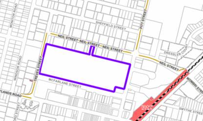
Figure
2 – Aerial view of subject site
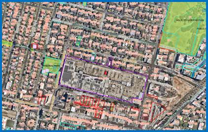
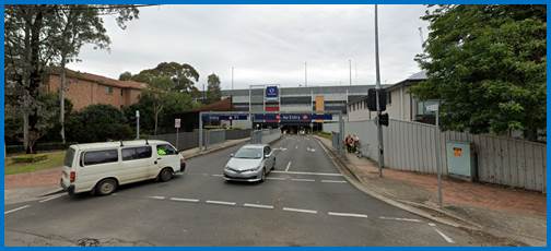
Figure
3 – Street view of subject site (Pitt Street frontage)
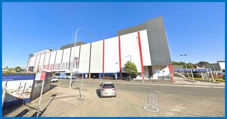
Figure
4 – Street view of subject site (Neil Street car park entry)
Figure
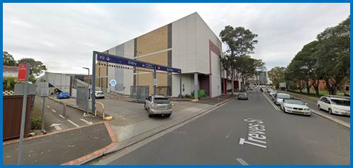
5 – Street view of subject site (Treves Street frontage)
Description of the
Development
Council is in receipt of a
development application that was accepted on 11 October 2022 seeking approval
for alterations to parking arrangement including new access stairs and
provision of signage. The detailed breakdown of the proposal is as below:
Construction:
· Modification
to the existing rooftop car park to provide an additional pedestrian stair;
· Installation
of two (2) new illuminated LED car park signages (1.00m x 2.96m) to Pitt Street
frontage;
· Installation
of one (1) new illuminated LED car park signage (1.00m x 2.96m) to Treves
Street frontage;
· Installation
of a new business identification sign with new illuminated LED car park signage
(10.60m x 12.80m) to the Neil Street car park entry facing along the existing
pedestrian / bicycle path along the northern elevation of the existing shopping
mall.
It is noted that the proposed new
business identification sign with new digital car park signage to Neil Street
will replace the existing business identification sign.
Moreover, the proposal will result
in the reduction of one (1) car parking space within the existing P6 level
rooftop car park to accommodate the proposed new access stairs. However, the
number of car parking spaces will remain compliant with the car parking
requirement to service the existing Stockland Shopping Mall.
Figure
5 – Locations of the proposed new structures
History
Stockland Shopping Mall currently
occupies the site, there are extensive CDCs, DAs, MODs and OCs for this site
“191-201 Pitt Street Merrylands” over a number of years which have
been reviewed to clarify the use and history of the site. No conflicting
applications were uncovered which impact the subject proposal.
Applicants Supporting
Statement
A Statement of Environmental
Effects dated 2 September 2022 (Project No.: 6126AH Final Version) and a Clause
4.6 Variation Request to the Height of Building dated 29 August 2022 (Project
No. 2126AH Rev_1, Draft Version) prepared by DIP Planning Consultants were
submitted with the application.
Contact with Relevant
Parties
The assessing officer has
undertaken a site inspection of the subject site and surrounding properties and
has been in regular contact with the applicant throughout the assessment
process.
INTERNAL REFERRALS
Development Engineer
The development application was
referred to Council’s Development Engineer for comment who has advised
that the development proposal is satisfactory given the proposed works is not
affecting the existing traffic and vehicular movement within and around the
property and therefore can be supported subject to recommended conditions of consent.
Building Surveyor
The development application was
referred to Council’s Building Surveyor for comment who has advised that
the development proposal is satisfactory and therefore can be supported subject
to recommended conditions of consent.
Contribution Officer
The development application was
referred to Council’s Contribution Officer for comment who has confirmed
the development would require the payment of contributions in accordance with
Cumberland Local Infrastructure Contributions Plan 2020.
In accordance with the
Contribution Plan a contribution is payable, pursuant to section 7.12 of the
Environmental Planning and Assessment Act 1979, calculated on the cost of
works. A total contribution of $679.00 would be payable prior to the issue of a
Construction Certificate.
EXTERNAL REFERRALS
The application was not required
to be referred to any external government authorities for comment.
PLANNING COMMENTS
The provisions of any
Environmental Planning Instruments (EP&A Act s4.15 (1)(a)(i))
State Environmental Planning
Policies
The proposed development is
affected by the following State Environmental Planning Policies:
(a) State
Environmental Planning Policy (Biodiversity and Conservation) 2021
Chapter 6 –Water
Catchments
Clause 10.18 – General
The subject site is identified as
being located within the area affected by State Environmental Planning Policy
(Biodiversity and Conservation) 2021. An assessment identifies that no issues
arise when considered under the relevant provisions of the State Policy.
However, the proposed additional
works to the existing Stockland Shopping Mall and raises no issues to the
Sydney Harbour Catchment as no impact on the Sydney Harbour Catchment is
envisaged.
(b) State
Environmental Planning Policy (Resilience and Hazards) 2021
Chapter 2 – Coastal
Management
Not applicable. The subject site
is not identified as a coastal wetland or ‘land identified as
“proximity area for coastal wetlands” or coastal management area.
Chapter 4 – Remediation
of Land
Clause 4.6 of Resilience and
Hazards SEPP 2021 requires Council to be satisfied that the site is suitable or
can be made suitable to accommodate the proposed development. The matters
listed within Clause 4.6 have been considered in the assessment of the
development application.
|
Matter for Consideration
|
Yes/No
|
|
Does the application involve re-development of the site or
a change of land use?
|
Yes
No
|
|
In the development going to be used for a sensitive land
use (e.g.: residential, educational, recreational, childcare or hospital)?
|
Yes
No
|
|
Does information available to you indicate that an
activity listed below has ever been approved, or occurred at the site?
acid/alkali plant and
formulation, agricultural/horticultural activities, airports, asbestos
production and disposal, chemicals manufacture and formulation, defence
works, drum re-conditioning works, dry cleaning establishments, electrical
manufacturing (transformers), electroplating and heat treatment premises,
engine works, explosive industry, gas works, iron and steel works, landfill
sites, metal treatment, mining and extractive industries, oil production and
storage, paint formulation and manufacture, pesticide manufacture and
formulation, power stations, railway yards, scrap yards, service stations,
sheep and cattle dips, smelting and refining, tanning and associated trades, waste
storage and treatment, wood preservation
|
Yes
No
|
|
Is the site listed on
Council’s Contaminated Land database?
|
Yes
No
|
|
Is the site subject to EPA
clean-up order or other EPA restrictions?
|
Yes
No
|
|
Has the site been the subject of
known pollution incidents or illegal dumping?
|
Yes
No
|
|
Does the site adjoin any
contaminated land/previously contaminated land?
|
Yes
No
|
|
Has the appropriate level of
investigation been carried out in respect of contamination matters for
Council to be satisfied that the site is suitable to accommodate the proposed
development or can be made suitable to accommodate the proposed development?
|
Yes
No
|
|
Details of contamination investigations carried out at the
site:
It is indicated in Council’s system that a Site
Audit Statement has been issued for this site as part of the original development
approval for the Stockland Shopping Centre. However, having considered the
scope of the proposed works relates to the access stairs and signage to the
existing Stockland Shopping Mall where no penetration of the slab will be
required, no further investigation
is considered necessary in the circumstances.
|
(c) Statement
Environmental Planning Policy (Industry and Employment) 2021
Chapter 3 Advertising and
Signage
The provisions of the Industry and
Employment SEPP 2021 apply to the proposed business identification signage.
Although Treves Street, Neil Street and Pitt Street area identified as
classified roads, a review of the proposal confirmed the proposal does not
require any concurrence approval from the Transport of NSW in accordance with
Part 3.2 of the Industry and Employment SEPP 2021 and the scale of the proposed
signages is considered suitable to the existing land use as the Stockland
Shopping Mall on site.
A comprehensive assessment and
compliance table is contained in Attachment 3, Appendix A.
Local Environmental Plans
Cumberland Local Environmental
Plan 2021
The provision of the Cumberland
Local Environmental Plan 2021 (CLEP) is applicable to the development proposal.
It is noted that the development generally complies with the key statutory
requirements of the CLEP 2021 and the objectives of the B4 Mixed Use zone.
(a) Permissibility:
The proposed development is
defined as a ‘business identification sign’ and ancillary works to
the shopping mall are permissible in the B4 Mixed Use zone with consent.
building identification sign means
a sign that identifies or names a building and that may include the name of a
building, the street name and number of a building, and a logo or other symbol
but does not include general advertising of products, goods or services.
Note—Building identification
signs are a type of signage—see the definition of that term in this
Dictionary.
signage means any sign, notice,
device, representation or advertisement that advertises or promotes any goods,
services or events and any structure or vessel that is principally designed
for, or that is used for, the display of signage, and includes any of the
following—
(a) an advertising
structure,
(b) a
building identification sign,
(c) a
business identification sign,
but does not include a traffic
sign or traffic control facilities.
The relevant matters to be
considered under CLEP 2021 and the applicable clauses for the proposed
development are summarised below. A comprehensive CLEP 2021 assessment is
contained in Attachment 4, Appendix B.
Figure
6 – Cumberland Local Environment Plan 2021 Compliance Table
|
DEVELOPMENT STANDARD
|
COMPLIANCE
|
DISCUSSION
|
|
4.3 Height of Buildings
The subject has a split height of building limit:
Maximum 14m
- Western
portion of the site
|
No – Refer to Clause 4.6 variation below
|
New business identification sign is 15.8m.
New access stairs are 15.2m.
This presents 12.86% of variation to this development
standard.
|
|
Maximum 53m
- Eastern
portion of the site
|
Yes
|
Two (2) illuminated LED signages installed along the
eastern elevation of the shopping mall are 8.46m.
|
|
4.4 Floor
Space Ratio
Maximum 2.8:1
|
Yes
|
The proposal relates to the installation of business
identification sign and access stairs to the existing shopping mall which
will not modify the gross floor area of the approved development on site.
It is therefore believing the proposal will remain
compliant with the floor space ratio as previously approved.
|
(b) Clause
4.6 – Variation to Building Height
Clause 4.6 allows the consent
authority to contravene development standards in certain circumstances and
provides an appropriate degree of flexibility to achieve better design
outcomes. The consent authority may grant the exception as the
Secretary’s concurrence can be assumed where clause 4.6 is adopted as per
the Department of Planning Circular PS 18-003, dated 21 February 2018.
The applicant has submitted a
written request to contravene the development standard for height of buildings.
Based on various case laws established by the Land and Environment Court of NSW
such as Initial Action Pty Ltd v Woollahra Municipal Council [2018] NSWLEC 118
(“Initial Action”) and Al Maha Pty Ltd v Huajun Investments Pty Ltd
[2018] NSWCA 245 and earlier cases Four2five P/L v Ashfield Council [2015]
NSWLEC 9, Randwick City Council v Micaul Holdings P/L [2016] NSW LEC7 and Zhang
v Council of the City of Ryde [2016] NSWLEC 1179, a 3 part assessment framework
for a variation request proposed and is discussed in detail below.
A copy of the Clause 4.6 Variation
Request to the Height of Building Development Standard under Clause 4.3 of CLEP
2021 prepared by DFP Planning Consultants is contained as Attachment 5.
The proposal seeks to contravene
the Height of Building Development Standard under Clause 4.3 of the CLEP 2021
that requires the height of building not to exceed 14m (majority western portion
of site) and 53m (minor eastern portion of site).
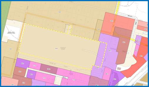
Figure
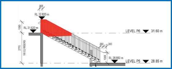
7 – Height of Building Map
(beige
coloured western portion as 14m and purple coloured eastern portion as 53m)
The maximum height of the proposed new business
identification sign located above the Neil Street car parking entrance will
reach the 15.8m and the access stairs between P5 and P6 car park level will
reach 15.2m (RL32.82m) when measured from the existing natural ground
level. This presents the maximum 1.8m above the maximum allowable height of
building to this part of the site and 12.86% of variation to this development
standard.
Figure
8 – The section of access stairs located in the middle of the rooftop car
park area that exceeds the maximum height of building allowance.
Figure
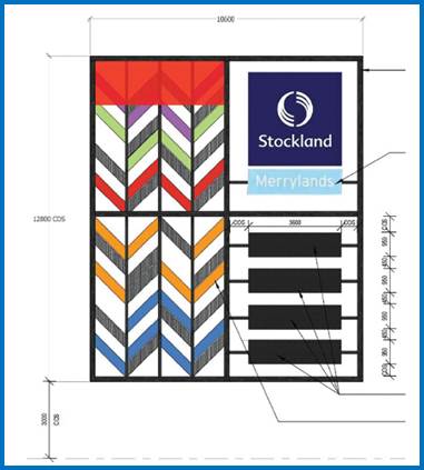
9 – The section of business identification sign facing Neil Street car
park entry exceed the maximum height of building allowance.
The 3 preconditions which must be
satisfied before the application can proceed are as follows:
1. Is
the proposed development consistent with the objectives of the zone?
Applicant’s justification:
Clause 4.6(1) of the LEP states the objectives of the clause as follows:
(a) to
provide an appropriate degree of flexibility in applying certain development
standards to particular development,
(b) to
achieve better outcomes for and from development by allowing flexibility in
particular circumstances.
In the Judgment of Initial Action
Pty Ltd v Woollahra Municipal Council [2018] NSWLEC 118 (“Initial
Action”), Preston CJ ruled that there is no provision that requires the
applicant to demonstrate compliance with these objectives or that the consent
authority be satisfied that the development achieves these objectives.
Furthermore, neither cl4.6(3) nor cl4.6(4) expressly or impliedly requires that
development that contravenes a development standard “achieve better
outcomes for and from development”.
Accordingly, the remaining
subclauses of cl4.6 provide the preconditions which must be satisfied before a
consent authority may grant development consent to a development that
contravenes a development standard imposed by an environmental planning
instrument. These preconditions are discussed hereunder.
Planner’s comment: It is
noted that the proposed business identification sign are ancillary to the
existing Stockland Shopping Mall. The proposal will not amend the principal use
of the site as the Stockland Shopping Mall, Therefore, it is agreed that the proposal
will remain compliant with the objectives of the B4 Mixed Use zone.
2. Is
the proposed development consistent with the objectives of the development
standard which is not met?
Applicant’s
justification: The proposed development exceeding the height of buildings
control does not result in any increase to the existing density of Stockland
Merrylands and are ‘attachments’ to the existing building to
improve safety and functionality (in the case of the pedestrian stair) and
building aesthetics (in the case of the proposed chevrons). The proposed
signage structure improvements will enhance the Neil Street façade and
contribute to a lessening of the visual impact of an unarticulated car park
façade.
In relation to the visual impact
on the adjoining residential properties the chevrons over the height limit are
set in front of the existing car park structure and within the existing signage
structure and therefore the additional visual impact is minimal.
The proposed rooftop pedestrian
stair will not be visible from the public domain and is not considered to alter
the existing shopping centre’s compatibility with the character of the
locality. The proposed improvements to the existing Neil Street signage
structure, including chevrons over the height limit, will enhance the
façade of the shopping centre and result in an improved contribution to
the mixed commercial/residential character of the area.
The proposed development will not
increase overshadowing or reduce privacy for adjoining properties. The pedestrian
stair is in the centre of the existing rooftop, well away from any adjoining
property. The proposed signage structure is on the northern façade of
the car park and any additional overshadowing would be over the shopping centre
itself, and there are no privacy impacts from the signage structure
improvements.
Planner’s comment:
The proposed development is consistent with the B4 zone objectives as it will
not amend the use of the existing premises as Stockland Shopping Mail. It is
very minor in nature which will not create additional shadow overcast on the
neighbouring properties nor visual impact to the streetscape. It is believed
that the proposal is consistent with the objectives of the height of buildings
development standard.
3. a.
Is compliance with the development standard unreasonable or unnecessary in the
circumstances of the case? And;
Applicant’s
justification: The proposed development is considered to be consistent with
the objectives of the height of buildings development standard as:
· The proposed
development exceeding the height of buildings control does not result in any
increase to the existing density of Stockland Merrylands and are
‘attachments’ to the existing building to improve safety and
functionality (in the case of the pedestrian stair) and building aesthetics (in
the case of the proposed chevrons).
· The proposed
rooftop pedestrian stair will not be visible from the public domain and is not
considered to alter the existing shopping centre’s compatibility with the
character of the locality. The proposed improvements to the existing Neil
Street signage structure, including chevrons over the height limit, will
enhance the façade of the shopping centre and result in an improved
contribution to the mixed commercial/residential character of the area.
· The proposed
signage structure improvements are considered an enhancement to the Neil Street
façade and in this sense will contribute to a lessening of the visual
impact of an unarticulated car park façade. In relation to the visual impact
on the adjoining residential properties the chevrons over the height limit are
set in front of the existing car park structure and within the existing signage
structure and therefore the additional visual impact is minimal.
· The proposed
development will not increase overshadowing or reduce privacy for adjoining
properties. The pedestrian stair is in the centre of the existing rooftop, well
away from any adjoining property. The proposed signage structure is on the
northern façade of the car park and any additional overshadowing would
be over the shopping centre itself, and there are no privacy impacts from the
signage structure improvements.
Planner’s comment:
The proposed height exceedance is considered very minor in nature and is
reasonable as the proposed development meets the underlying intent of the
control. It is considered that strict adherence to the height of building
development standard would result in a negligible improvement to the appearance
of the building and the amenity of the surrounding properties. Compliance with
the development standard is considered as being unnecessary in this instance.
It is further noted that the proposed stairs and signages are ancillary
structures of the building mass while the remainder of the building mass remains
as approved previously.
b. Are there sufficient
environmental planning grounds to justify contravening the development standard
and therefore is the applicant’s written justification well founded?
Applicant’s justification:
The site-specific environmental planning grounds that support the proposed
variation to the height of buildings development standard in this circumstance
are detailed in the SEE, supported by the accompanying architectural plans, and
are summarised below:
i) The
proposed non-compliances are within the existing building envelope.
The pedestrian stair serves the
upper car parking deck which is slightly above the 14m height control.
Therefore any additional building element (such as balustrading) will exceed
the height control. This is a site specific circumstance and the pedestrian
stair is wholly beneath the existing balustrade height at each level (P6 to P5)
and therefore no greater in height than other elements of the car parking
structure.
The proposed chevrons to the Neil
Street signage structure are within an existing steel frame and are replacing
existing louvres.
Given the proposed works are
within existing structures, the additional impact is considered negligible.
Containing the works within
existing structures is considered an environmental planning ground to support
he proposed variation.
ii) The
proposed pedestrian stair seeks to address and car park safety issue whereby
persons are utilising the car ramp to traverse between P6 and P5. The provision
of a pedestrian stair will separate vehicular and pedestrian movements in this
location. The improvement of safety is an environmental planning ground to
support the proposed variation.
iii) The
improvements to the Neil Street façade are part of a broader set of
façade improvements proposed by Stockland to improve wayfinding and
visually enhance the appearance of Stockland Merrylands. The chevrons are both
aesthetic and practical. To achieve consistency with the existing signage
framework the chevrons match the existing signage. If the chevrons were to
comply then the design outcome would not be aesthetically pleasing. The
proposed height variation achieves a better design outcome for wayfinding and
aesthetic improvements.
Planner’s comment:
The current proposal is supported from an environmental planning perspective
and demonstrates and there is merit in varying the height control to achieve a
better functionality of the site.
The above discussion demonstrates
that there are sufficient environmental planning grounds to justify the
departure from the control.
Conclusion:
Council is satisfied that the
applicant’s written request has adequately addressed the matters required
to be demonstrated by clause 4.6 subclause (3). Council is further satisfied
that the proposed development will be in the public interest because it is consistent
with the objectives of the particular standard and the objectives for
development within the zone in which the development is proposed to be carried
out.
It is the view of Council Officers
that justification provided is satisfactory and having considered the
application on its merit, the exception to the maximum 14m building height
development standard is considered acceptable in this instance.
The provisions of any proposed
instrument that is or has been the subject (EP&A Act s4.15 (1)(a)(ii))
(a) State
Environmental Planning Policy Amendment (Land Use Zones) (No 5) 2022 and
Standard Instrument (Local Environmental Plans) Order 2006
State Environmental Planning
Policy Amendment (Land Use Zones) (No 5) 2022 will commence on the 26 April
2023. However, the Policy is repealed at the beginning of the day following the
day on which the Policy commences.
On this day (26 April 2023),
significant changes to the Cumberland Local Environmental Plan 2021 will
commence. All matters relating to Business Zones and Industrial Zones are
repealed and instead replaced with new Employment zones as follows:
· E1 Local Centre.
· E2 Commercial
Centre.
· E3 Productivity
Support.
· E4 General
Industrial.
This will also impact upon several
other clauses of the Cumberland Local Environmental Plan 2021 and how
assessments are undertaken.
At the time the new provisions
commence, the site would be located within Zone “E2 Commercial
Centre”. Commercial premises would be permitted with consent within the
new zone.
In addition, the development would
be satisfactory in relation to the new objectives applied to the zone.
The provisions of any
Development Control Plans (EP&A Act s4.15 (1)(a)(iii))
The Cumberland Development Control
Plan 2021 (CDCP) provides guidance for the design and operation of development
to achieve the aims and objectives of the CLEP 2021. A review of the CDCP 2021
confirmed Part C, F2-6, G1, G3, G4 and G8 apply to development on this site.
However, the review against all relevant parts of the CDPC 2021 confirmed the
proposal will not result in any changes to the design of the original
development approval with the exception to the streetscape, façade and
signage control given that the proposal relates to access stairs and signage
ancillary to the existing Stockland Shopping Mall. Therefore, no further
assessment against Part C, F2-6, G3, G4 and G8 will be required.
However, an assessment against
Part G1 of the CDCP 2021 will be required as this relates to the subject of the
proposal. The information submitted with the application demonstrate a full
compliance with Part G1 of the CDCP 2021.
Part G1 – Advertising and
Signage
It is noted that the proposed
signage will be used in conjunction to the operation of the existing Stockland
Shopping Mall which will not contain any flashing lights. As advised by the
applicant, the signage facing Neil Street car park entrance will be subject to
light curfew from 9:00pm everyday to minimise the light spillage towards the
rear elevations of the residential flat buildings along Neil Street. In this
regard, the proposal remains fully compliant with all relevant parts including
Part G1 of the CDCP 2021 and an assessment table against the relevant parts of
the CDCP 2021 is not required in this instance.
The provisions of any planning
agreement that has been entered into under section 7.4, or any draft planning
agreement that a developer has offered to enter into under section 7.4
(EP&A Act s4.15(1)(a)(iiia))
There is no draft planning
agreement associated with the subject Development Application.
The provisions of the
Regulations (EP&A Act s4.15 (1)(a)(iv))
The proposed development raises no
concerns as to the relevant matters arising from the Environmental Planning and
Assessment Regulations 2021 (EP&A Reg).
The Likely Environmental,
Social or Economic Impacts (EP&A Act s4.15 (1)(b))
It is considered that the proposed
development will have no significant adverse environmental, social or economic
impacts in the locality.
The suitability of the site for
the development (EP&A Act s4.15 (1)(c))
The subject site and locality is
not known to be affected by any natural hazards or other site constraints
likely to have a significant adverse impact on the proposed development.
Accordingly, it is considered that the development is suitable in the context
of the site and surrounding locality.
Submissions made in accordance
with the Act or Regulation (EP&A Act s4.15 (1)(d))
|
Advertised (Website)
|
Mail
|
Sign
|
Not Required
|
In accordance with Council’s
Notification requirements contained within the CDCP 2021, the proposal was
publicly notified for a period of fourteen (14) days between 27 October 2022
and 10 November 2022. No submissions were received in respect of the proposed
development.
The public interest (EP&A
Act s4.15(1)(e))
In view of the foregoing analysis
it is considered that the development, if carried out subject to the conditions
set out in the recommendation below, will have no significant adverse impacts
on the public interest.
Cumberland Local
Infrastructure Contributions Plan 2020
The development would require the
payment of contributions in accordance with Cumberland Local Infrastructure
Contributions Plan 2020.
In accordance with the
Contribution Plan a contribution is payable, pursuant to Section 7.12 of the
EP&A Act, calculated on the cost of works. A total contribution of $679.00
would be payable prior to the issue of a Construction Certificate.
Disclosure of Political
Donations and Gifts
The applicant and notification
process did not result in any disclosure of Political Donations and Gifts.
The development application has
been assessed in accordance with the relevant requirements of the Environmental
Planning and Assessment Act 1979, Environmental Planning and Assessment
Regulation 2021, State Environmental Planning Policy (Biodiversity and
Conservation) 2021, State Environmental Planning Policy (Resilience and Hazards)
2021, Statement Environmental Planning Policy (Industry and Employment) 2021,
CLEP 2021 and CDCP 2021 and is considered to be satisfactory for approval
subject to conditions.
The proposed development is
appropriately located within the B4 Mixed Use zone under the relevant
provisions of the CLEP 2021, however variations in relation to the height of
building under the CLEP 2021 is sought.
Having regard to the assessment of
the proposal from a merit perspective, Council may be satisfied that the
development has been responsibly designed and provides for acceptable levels of
amenity for future residents. It is considered that the proposal successfully
minimises adverse impacts on the amenity of neighbouring properties. Hence the
development, irrespective of the departures noted above, is consistent with the
intentions of Council’s planning controls and represents a form of
development contemplated by the relevant statutory and non-statutory controls
applying to the land.
For these reasons, it is
considered that the proposal is satisfactory having regard to the matters of
consideration under Section 4.15 of the Environmental Planning and Assessment
Act 1979, and the development may be approved subject to conditions.
|
1. That
the Clause 4.6 variation request to contravene the height of building
development standard, pursuant to the Cumberland Local Environmental Plan
2021, be supported.
2. That
Development Application No. DA2022/0468 for alterations to parking
arrangement including new access stairs and provision of signage on land at
191-201 Pitt Street , Merrylands NSW 2160 be approved subject to conditions
listed in the attached schedule.
|
1. Draft Notice
of Determination
2. Architectural
Plans
3. Appendix
A – Statement Environmental Planning Policy (Industry and Employment)
2021
4. Appendix
B – Cumberland Local Environmental Plan 2021 (CLEP 2021)
5. Clause
4.6 Variation
6. Draft
Reasons of Approval
DOCUMENTS
ASSOCIATED WITH
REPORT LPP006/23
Attachment 1
Draft Notice of Determination
Cumberland Local Planning Panel Meeting
8 March 2023


DOCUMENTS
ASSOCIATED WITH
REPORT LPP006/23
Attachment 2
Architectural Plans
Cumberland Local Planning Panel Meeting
8 March 2023
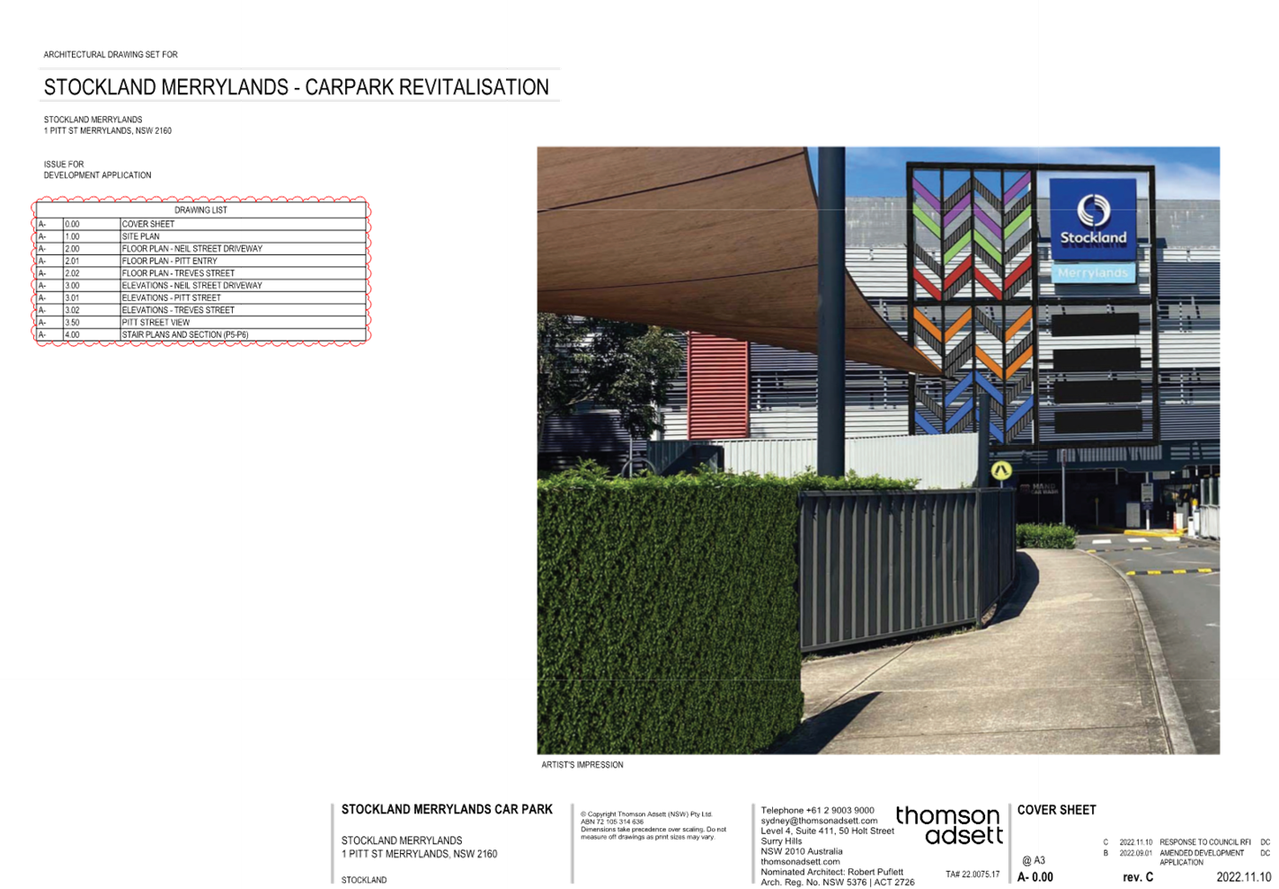
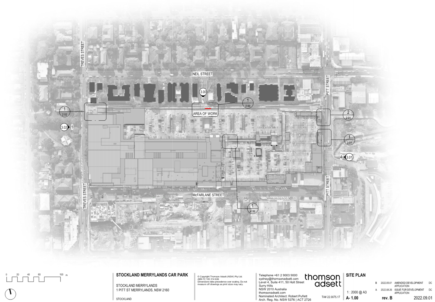
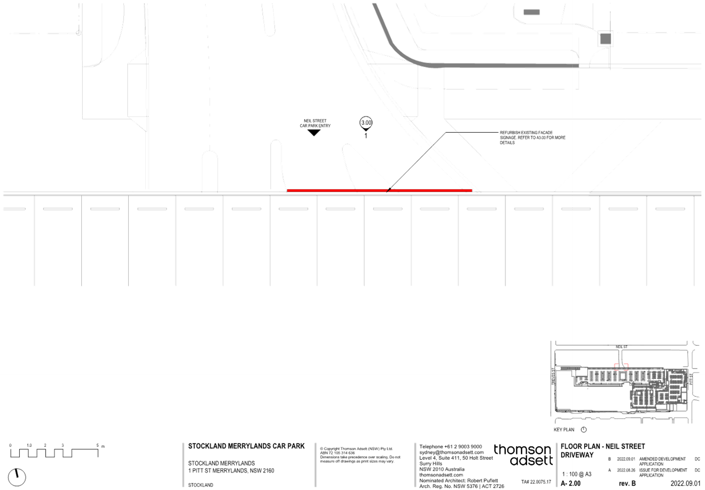
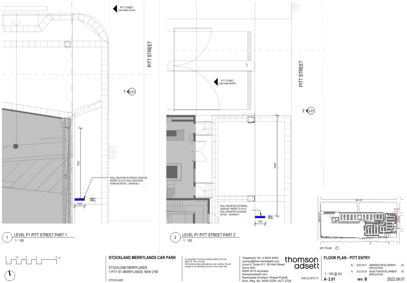
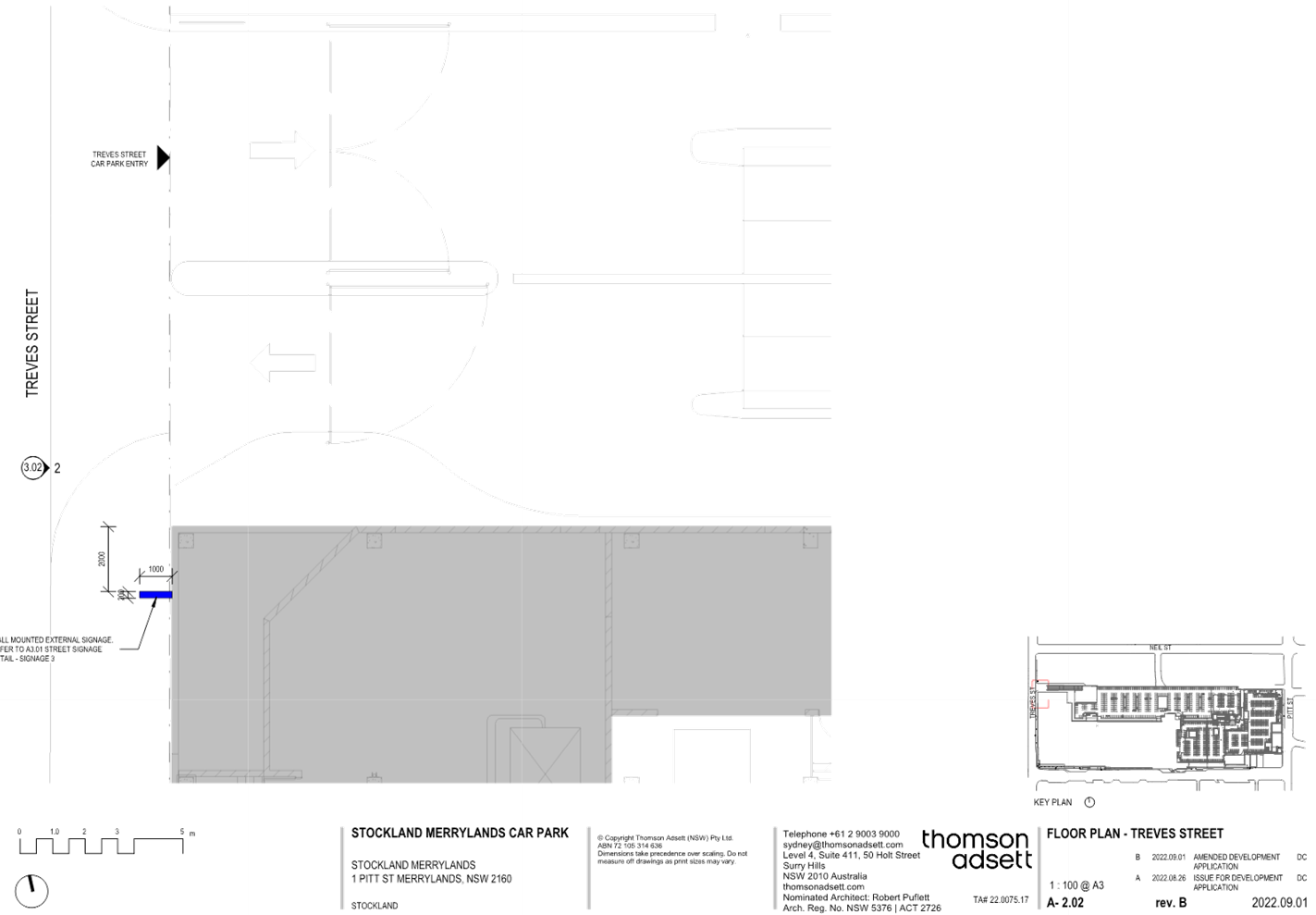
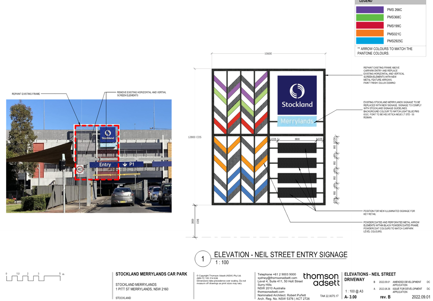
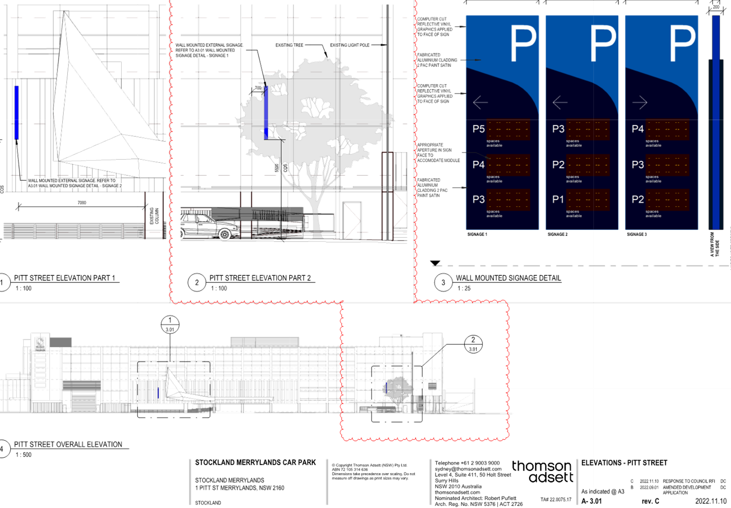
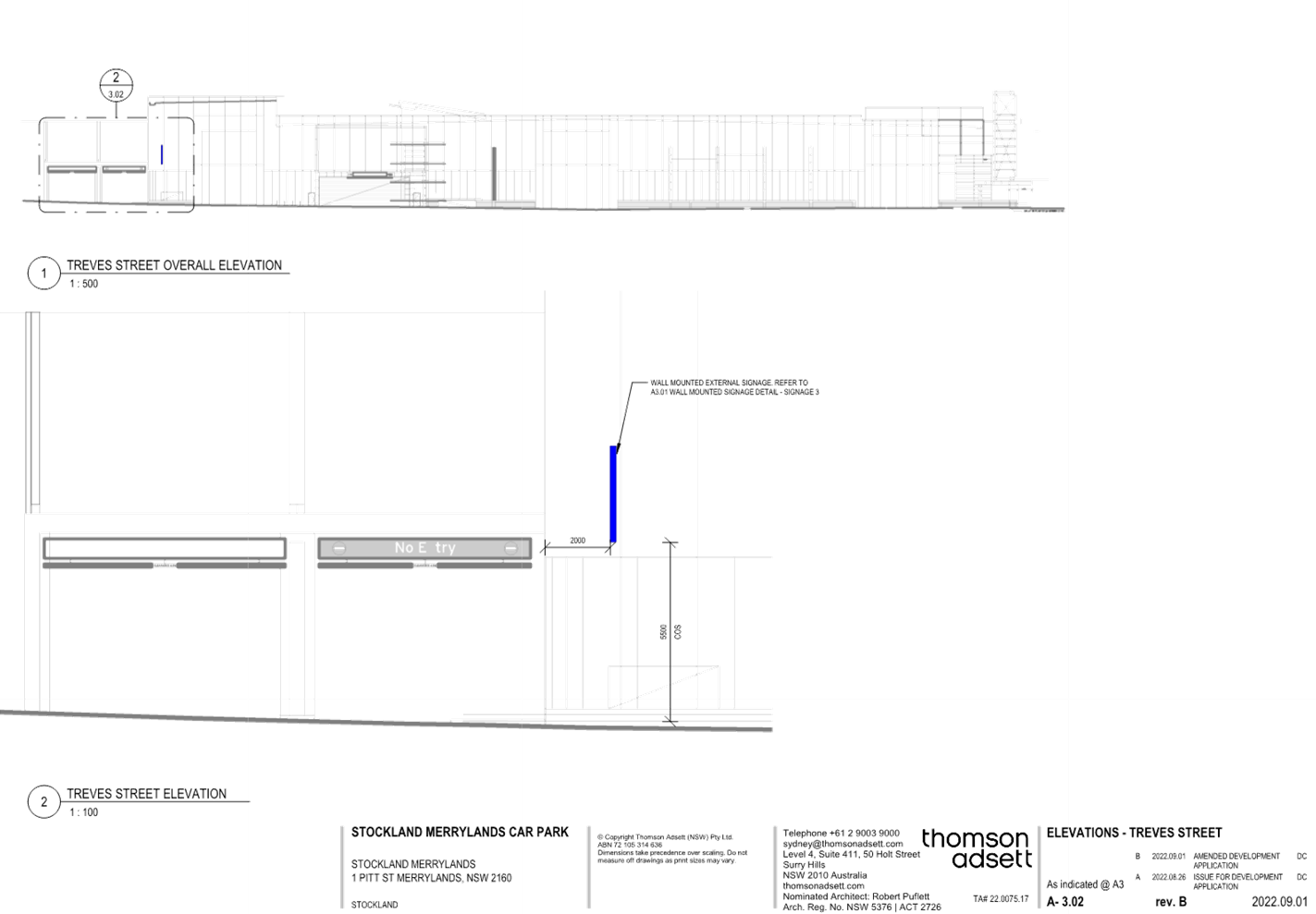
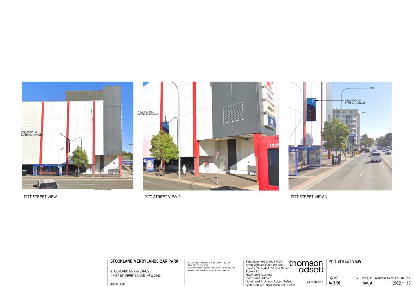
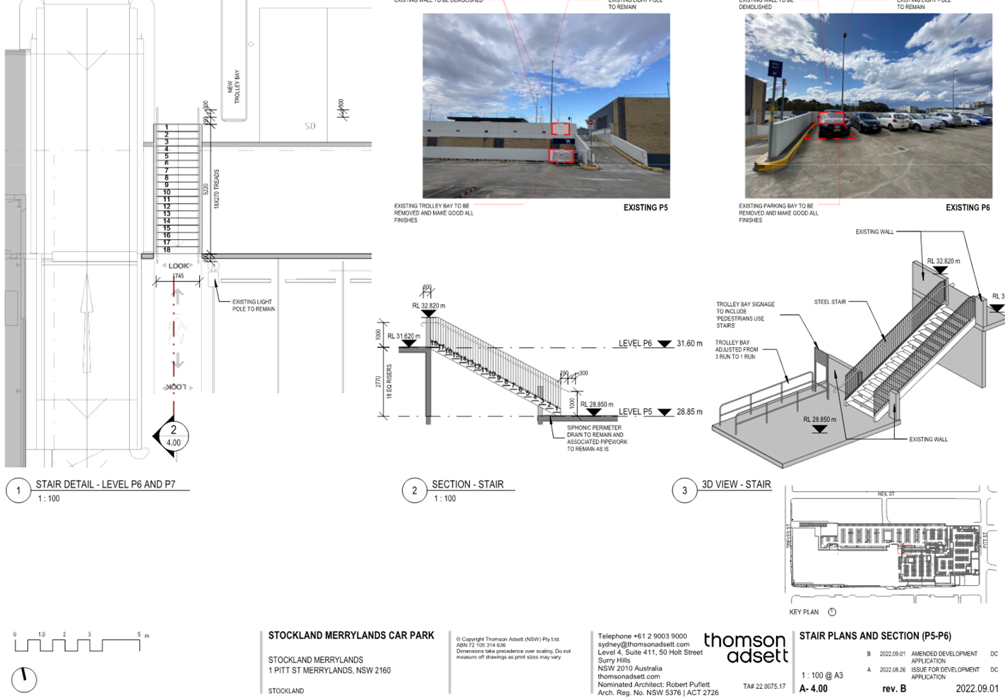
DOCUMENTS
ASSOCIATED WITH
REPORT LPP006/23
Attachment 3
Appendix A – Statement Environmental Planning
Policy (Industry and Employment) 2021
Cumberland Local Planning Panel Meeting
8 March 2023
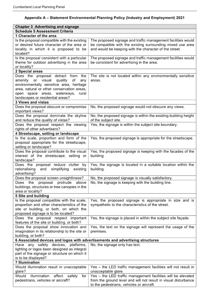
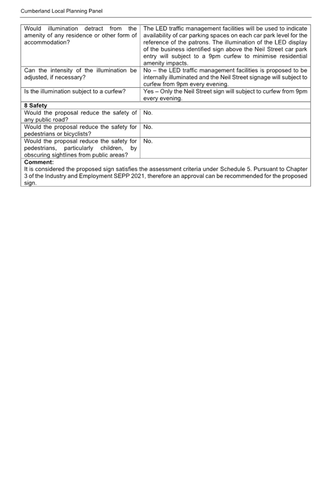
DOCUMENTS
ASSOCIATED WITH
REPORT LPP006/23
Attachment 4
Appendix B – Cumberland Local Environmental Plan
2021 (CLEP 2021)
Cumberland Local Planning Panel Meeting
8 March 2023
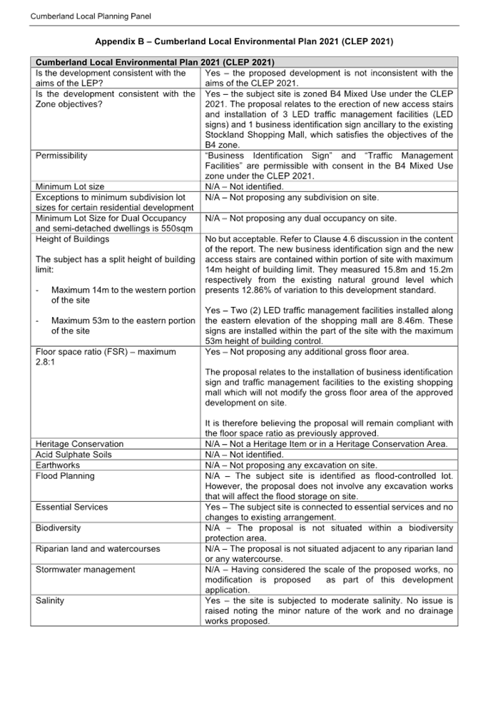
DOCUMENTS
ASSOCIATED WITH
REPORT LPP006/23
Attachment 5
Clause 4.6 Variation
Cumberland Local Planning Panel Meeting
8 March 2023
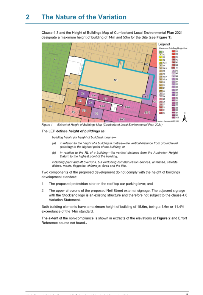
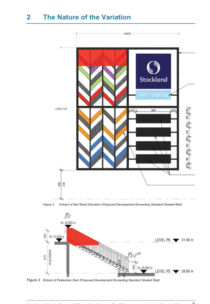
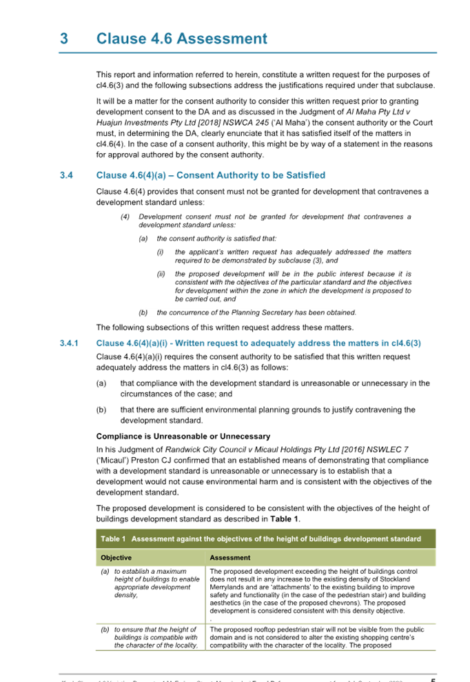
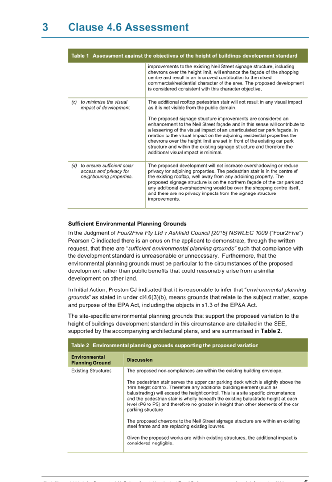
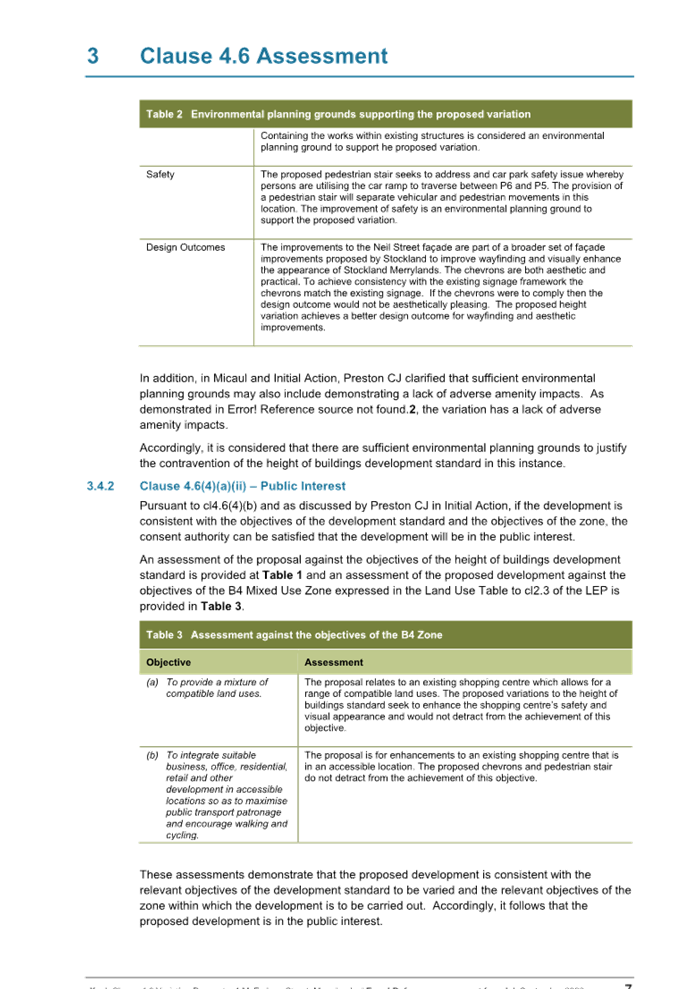
DOCUMENTS
ASSOCIATED WITH
REPORT LPP006/23
Attachment 6
Draft Reasons of Approval
Cumberland Local Planning Panel Meeting
8 March 2023

Cumberland
Local Planning Panel Meeting
8 March 2023
Item
No: LPP007/23
Development
Application for 73 Bangor Street, Guildford
Directorate: Environment
and Planning
Responsible
Officer: Executive
Manager Development and Building
File
Number: DA2022/0338
1. Development
Application No. DA2022/0388 was lodged on the 9 August 2022 for the demolition
of existing structures, removal of six (6) trees and construction of a four (4)
storey co-living housing development comprising of 14 rooms over basement car
parking for 4 vehicles pursuant to the State Environmental Planning Policy
(Housing) 2021.
2. The
application was publicly notified to occupants and owners of the adjoining
properties for a period of 14 days between 25 August 2022 and 8 September 2022.
In response, one (1) submission was received.
3. The
subject site is not listed as a heritage item or located within a heritage
conservation area in the Cumberland Local Environmental Plan 2021.
4. The
variations are as follows:
|
Control
|
Required
|
Provided
|
% variation
|
|
Communal Open Spaces -
Section 68(2)(d) State Environmental Planning Policy
(Housing) 2021
|
20% of site area (89.92 sqm)
|
17.6%
(79.1 sqm)
|
2.6%
|
|
Accommodation sizes - Section 69(1)(a)(i) State
Environmental Planning Policy (Housing) 2021
|
12sqm
for single occupancy
|
11.1sqm (room 14)
|
7.5%
|
|
Accommodation sizes - Section 69(1)(a)(ii) State
Environmental Planning Policy (Housing) 2021
|
16sqm
for double occupancy
|
14.5sqm (room 1)
|
3.1%
|
|
Minimum lot size - Section 69(1)(b)(ii) State
Environmental Planning Policy (Housing) 2021
|
800sqm
|
449.6sqm
|
43.8%
|
|
Setbacks - Section 69(2)(a)(ii) Environmental Planning
Policy (Housing) 2021
|
Minimum 3m (side boundary)
|
0.2m (basement) 0.9m to 3m (above ground levels)
|
0%-93.33%
|
|
Setbacks - Section 69(2)(a)(ii) State Environmental
Planning Policy (Housing) 2021
|
Minimum 6.7m (rear boundary)
|
3m-6m (all levels including basement)
|
10.44%-55.22%
|
|
Building separation - Section 69(2)(b) State Environmental
Planning Policy (Housing) 2021
|
6m separation (side boundary)
|
3m separation
|
50%
|
|
Building separation - Section 69(2)(b) State Environmental
Planning Policy (Housing) 2021
|
6.7m separation (rear boundary)
|
6m separation
|
10.44%
|
|
Solar access - Section 69(2)(c) State Environmental
Planning Policy (Housing) 2021
|
Non-numerical standard
|
Inadequate solar/sun view diagrams
|
-
|
5. The
application is referred to the Panel as the proposal contravenes the minimum
lot size, setbacks and building separation development standards, by more than
10%, under Sections 68 & 69 of the State Environmental Planning Policy
(Housing) 2021.
6. The
application is recommended for refusal as provided in the attached schedule.
Subject Site and Surrounding
Area
The subject site is legally
described as Lots 3 & 4, Section 9 in DP 734, and is commonly known as 73
Bangor Street, Guildford. The site is located on the western side of Bangor
Street between Stimson Street to the south and Beauford Street to the north.
The site area has the following
dimensions:
- Northern
(side) boundary 33.53
metres.
- Eastern
(Bangor Street) frontage 13.41
metres.
- Western
(rear) boundary 13.41
metres.
- Southern
(side) boundary 33.53
metres.
The site has an area of 449.6
square metres. The site has a fall of approximately 350mm or 2.6% to the north
along the rear boundary and has a slight fall from the rear to the front
boundary.
The property is currently occupied
by a single-storey fibro building with a detached car parking structure in the
rear yard and 6 trees located within the rear portion of the site. The subject
site is zoned R4 High Density Residential under the Cumberland Local
Environmental Plan 2021.
The surrounding locality is in its
early stages of transitioning from low to higher density development, which
currently comprises a mix of low density residential dwelling houses, and
higher density residential flat buildings such as the 3-storey residential flat
building to the north at 67-71 Bangor Street. The subject site is located
approximately 710 metres walking distance from the Guildford Railway Station.
The location of the site is shown below edged in purple.
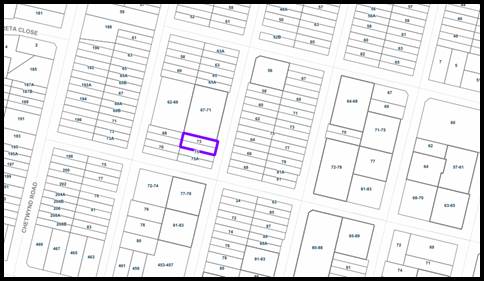
Figure
1 – Aerial base map of the site (highlighted in purple) and locale.
Source: Council’s IntraMaps
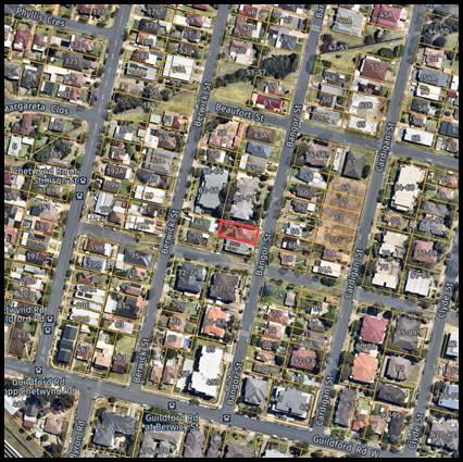
Figure
2 - Aerial view of the site (highlighted) and locale. Source: Nearmap dated 29
November 2022
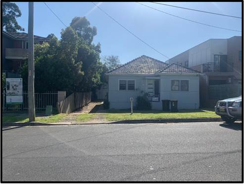
Figure
3 – View of the existing subject site from Bangor Street looking west.
Source: Photo taken 6 December 2022.
Description of the
Development
Development Application 2022/0388
is proposing the demolition of existing structures, removal of six (6) trees
and construction of a four (4) storey co-living housing development comprising
of 14 rooms over basement car parking for 4 vehicles pursuant to the State
Environmental Planning Policy (Housing) 2021.
A detailed summary of the proposal
is provided below:
Demolition works
- Demolition
of existing single-storey dwelling and rear structures.
Tree Removal
- Removal
of six (6) on-site trees.
Earthworks
- Associated
earthworks to allow construction of a level of basement car park for 4
vehicles.
Basement level 1 (RL 29.20)
· Vehicular
car parking for four (4) car parking spaces including one (1) accessible car
parking space, with vehicular access from Bangor Street;
· Twelve
(12) bicycle spaces;
· Three
(3) motorcycle spaces;
· On-site
detention (OSD) basin overhead the southern wall with a head height of 1.9m;
· Garbage
room with bin tug device; and
· One
(1) fire stair and one (1) lift core.
Construction of the 4-storey
co-living housing building
Ground level (RL 32.20)
· Two
(2) double occupancy co-living rooms (1 and 2) with ensuite bathroom and
kitchenette facilities and a street-facing courtyard to the co-living room 2 to
the front;
· Communal
room with manager’s workspace, kitchenette facilities, combined
dining/living room and adjoining courtyard;
· Two
(2) bicycle spaces within the communal courtyard along the southern side
boundary;
· Entry
lobby with a ramped pathway from Bangor Street and associated letterbox;
· Double
width vehicular crossover with access driveway with a waiting bay and traffic
signal/sign; and
· Two
(2) fire stairs and one (1) lift core.
Level 1 (RL 35.20)
· Three
(3) double occupancy co-living rooms (3, 4 and 5) including adaptable co-living
room 4 with ensuite bathroom and kitchenette facilities and a street-facing
balcony to the front co-living room 5;
· One
(1) single occupancy co-living room (6) with ensuite bathroom and kitchenette
facilities and a street-facing balcony; and
· One
(1) fire stair and one (1) lift core.
Level 2 plan (RL 38.20)
· Three
(3) double occupancy co-living rooms (7, 8 and 9) including adaptable co-living
room 8 with ensuite bathroom and kitchenette facilities and a street-facing
balcony to the front co-living room 9;
· One
(1) single occupancy co-living room (10) with ensuite bathroom and kitchenette
facilities and a street-facing balcony; and
· One
(1) fire stair and one (1) lift core.
Level 3 plan (RL 41.20)
· Three
(3) double occupancy co-living rooms (11, 12 and 13) with ensuite bathroom and
kitchenette facilities and a street-facing balcony to the front co-living room
13;
· One
(1) single occupancy co-living room (14) with ensuite bathroom and kitchenette
facilities and a street-facing balcony; and
· One
(1) fire stair and one (1) lift core.
History
Relevant Site History
On the 20th April 2021, the applicant
withdrew Development Application No. 2020/0740 for demolition of existing
structures and construction of a four (4) storey boarding house comprising of
20 rooms and a manager’s accommodation development over basement car
parking for pursuant to the State Environmental Planning Policy (Affordable
Rental Housing) 2007.
On the 9th August 2022,
Development Application No. 2022/0388 was lodged with Council which is the
subject of this report.
Applicants Supporting
Statement
The applicant has provided a Statement
of Environmental Effects prepared by BMA Urban Pty Ltd, dated 21st July 2022
and was received by Council on the 9th August 2022 in support of the
application.
Contact with Relevant
Parties
The assessing officer has
undertaken a site inspection of the subject site and surrounding properties and
has been in regular contact with the applicant throughout the assessment
process.
Internal Referrals
Development Engineer
The development application was
referred to Council’s Development Engineer for comment who has advised
that the development proposal is unsatisfactory with regard to stormwater
management, flooding and vehicular access and car parking and therefore cannot
be supported.
Waste Services
The development application was
referred to Council’s Resource Recovery Officer for comment who has
advised that the waste management plan is unsatisfactory and cannot be
supported.
Environmental Health Unit
The development application was
referred to Council’s Environment and Health Officer for comment who has
advised that the development proposal is satisfactory regarding to noise impact
and contamination and therefore can be supported subject to recommended
conditions of consent.
Tree Management Officer
The development application was
referred to Council’s Senior Tree Management Officer for comment who has
advised that the development proposal is satisfactory with regard to the trees
removal and therefore can be supported subject to recommended conditions of
consent.
External Referrals
Endeavour Energy
The development application was
referred to Endeavour Energy for comment. The development as proposed is
satisfactory in terms of electricity connection and therefore can be supported
subject to recommended conditions of consent.
Transgrid
The development application was
referred to Transgrid who rejected providing assessment given there is no
impact to Transgrid’s infrastructure/network.
NSW Police
The development application was
referred to the NSW Police – Cumberland Police Area Command for comment
who has advised that the development proposal is satisfactory in terms of crime
prevention and therefore can be supported subject to recommended conditions of
consent.
PLANNING COMMENTS
The provisions of any
Environmental Planning Instruments (EP&A Act s4.15 (1)(a)(i))
State Environmental Planning
Policies
The proposal is affected by the
following consolidated State Environmental Planning Policies that came into
effect on 1 March 2022.
|
State Environmental Planning
Polices (SEPPs)
|
Relevant Clauses(s)
|
Compliance with Requirements
|
|
State Environmental Planning Policy (Resilience and
Hazards) 2021.
|
Chapter 2 – Coastal Management
|
Not applicable. The subject site is not identified as a
coastal wetland or ‘land identified as “proximity area for coastal
wetlands” or coastal management area.
|
|
Chapter 4 – Remediation of Land
Clause 4.6
|
A targeted preliminary site investigation report (PSI) was
prepared by Geotechnical Consultants Australia Pty Ltd dated 9 Nov 2020
(reference E20163-1). The PSI has been reviewed and is suitable. Council’s Environmental Health
Officer is satisfied that the site is suitable for the development and
has recommended appropriate
conditions for any consent that may be issued.
|
|
State Environmental Planning Policy (Transport and
Infrastructure) 2021.
|
Chapter 2 –
Infrastructure
Division 5
Electricity transmission or distribution
|
Pursuant to Clause 2.48 the associated works are proposed
to be carried out within the vicinity of an easement for electricity that
benefits Endeavour Energy. In accordance with Clause 2.48 the application was
referred to Endeavour Energy who advised that the site is not burdened by an
easement benefitting Endeavour Energy. Endeavour Energy has reviewed the
proposed works and is raising no objection to the proposal subject to
conditions.
There are no additional provisions relevant to the development
application.
|
|
State Environmental
Planning Policy (Building Sustainability Index: BASIX) 2004.
|
-
|
BASIX Certificate No1150114M_03 dated 14 July 2022 and
prepared by EPS has been submitted with Council and assessed as being
satisfactory. A condition would be imposed prior to the issue of a
Construction Certificate for a Section J energy efficiency report to be
submitted if the application were recommended for approval.
|
|
State Environmental Planning Policy (Biodiversity and
Conservation) 2021.
|
Chapter 2 – Vegetation in non-Rural Areas.
|
The applicant is not seeking to remove any significant
trees, which hold any biodiversity or ecological values, on the site. The
proposal does not trigger the provisions of Chapter 2. Notwithstanding, the
application is recommended for refusal.
|
|
Chapter 6 – Bushland in Urban Areas.
|
The proposal does not involve the disturbance of any
bushland zoned or reserved for public open space.
|
|
Chapter 10 – Sydney Harbour Catchment.
|
The site is located with the Sydney Harbour Catchment area
and chapter 10 is applicable to the development application. The development
application raises no issues as to consistency with the requirements and
objectives of chapter 10 and the associated development control plan.
|
|
State Environmental Planning Policy (Housing) 2021
State Environmental Planning Policy (Housing) 2021 applies
to the development. A comprehensive assessment against the State
Environmental Planning Policy (Housing) 2021 controls is provided at
Appendix A. An assessment has been
undertaken using the relevant provisions and the following numerical
variations have been identified.
Chapter 3 Diverse
Housing
Part 3 Co-living
housing
· Communal
open spaces
Section 68(2)(d) - Developments shall provide at least 20%
of the site area as communal open spaces (COS) each with minimum dimensions
of 3 metres.
Planning comment: The proposal provides 79.1 square
metres of communal open spaces (excluding communal open spaces with less than
3m dimension from the planter garden/garden beds and areas). It is noted
there are discrepancies between areas shown as communal open spaces on the
architectural and landscape plans. The proposal does not comply with this non-discretionary development standard.
· Accommodation sizes
Section 69(1)(a) - Development consent must not be granted
for development for the purposes of co-living housing unless the consent
authority is satisfied that at least 12 square metres for a single occupant
and at least 16 square metres for a double occupant.
Planning comment: The proposal generally complies
with the accommodation sizes apart from single occupancy room 14 which is
11.1sqm and double occupancy room 1 which is 14.5sqm. The proposal does not
comply with this standard.
· Minimum lot size
Section 69(1)(b)(ii) - Development consent must not be
granted for development for the purposes of co-living housing unless the
consent authority is satisfied that the
minimum lot size for the co-living housing is not less than 800 square
metres.
Planning comment: The site has an area of 449.6
square metres, which is 350.4 square metres short of the minimum 800 square
metres for co-living housing in the R4 Zone. Council is not satisfied that
the minimum lot size for co-living housing variation of 43.8% can be
supported. A clause 4.6 variation was submitted and is discussed below.
· Setbacks
Section
69(2)(a)(ii) - Development consent must not be
granted for development for the purposes of co-living housing unless the
consent authority considers whether the front, side and rear setbacks
for the co-living housing are not less than the minimum setback requirements
for residential flat buildings under a relevant planning instrument.
Planning comment: The required setbacks under Part
B3 of the Cumberland DCP 2021 applicable to the site are:
- 6m
to the front boundary;
- 3m
to the side boundary; and
- 6.7m
to the rear boundary.
In addition, the basement walls shall have a minimum
setback of 1.2m from the side boundary to allow for planting. The proposed
front setbacks comply across all levels.
The proposed 0.9m to 3m side setbacks do not comply to all
levels. The proposed 6m rear setback does not comply across all levels. The
proposed basement setback to the side boundaries is approximately 200mm and
3m to the rear boundary which cannot be supported. The proposal does not
comply with this standard.
· Building separation
Section
69(2)(b) - Development consent must not be
granted for development for the purposes of co-living housing unless the consent
authority considers whether the building will comply with the minimum
building separation distances specified in the Apartment Design Guide.
Planning comment: A 3m setback is provided to the
non-habitable and habitable room windows to the northern and southern side
boundaries, which is deficient by 3m (50% variation) to the habitable room
windows to all levels. The proposal does not comply with this standard.
|
Local Environmental Plans
Cumberland Local Environmental
Plan 2021 (CLEP 2021)
The provisions of the Cumberland
Local Environmental Plan 2021 is applicable to the development proposal. The
subject site is zoned R4 High Density Residential under the Cumberland Local
Environmental Plan 2021.
It is identified that the
development is not consistent with the fifth objective of the R4 High Density
Residential zone which reads as:
· To
encourage residential development that maintains the amenity of the surrounding
area.
In this regard the built form and
suitability of the site does not maintain or enhance the residential amenity of
the surrounding area.
(a) Permissibility:
The proposed development is
defined as ‘co-living housing’ which is permissible in the R4 High
Density Residential land use zone with consent. The definition of the use is:
co-living housing means a building
or place that—
(a) has
at least 6 private rooms, some or all of which may have private kitchen and
bathroom facilities, and
(b) provides
occupants with a principal place of residence for at least 3 months, and
(c) has
shared facilities, such as a communal living room, bathroom, kitchen or
laundry, maintained by a managing agent, who provides management services 24
hours a day,
but does not include
backpackers’ accommodation, a boarding house, a group home, hotel or motel
accommodation, seniors housing or a serviced apartment.
Note—
Co-living housing is a type of
residential accommodation—see the definition of that term in this
Dictionary.
A comprehensive assessment of the
Cumberland Local Environmental Plan 2021 is contained in Appendix B.
The main provisions of the
Cumberland Local Environmental Plan 2021 relevant to the development are
prescribed in the table below.
|
Controls
|
Proposal
|
Compliance
|
|
Clause 4.3 of CLEP 2021
Height of Building – 15m
|
Permissible: 15 metres
(maximum).
Proposed: 14.2 square
metres.
|
Yes.
|
|
Clause 4.4 of CLEP 2021
Floor space ratio – 1.32:1
|
Permissible: 1.32:1 (includes
0.12:1 bonus FSR under the State Environmental Planning Policy (Housing)
2021).
Proposed: 1.01:1
|
Yes.
|
Development Standards that may
be varied under Clause 4.6
Other than the minimum lot size
for co-living housing which is discussed under a Clause 4.6, the relevant
matters to be considered under the State Environmental Planning Policy
(Housing) 2021 and the applicable clauses for the proposed development are
summarised below.
Communal open spaces
The matter concerning communal
open spaces and any Clause 4.6 variation to communal open spaces under Section
68(2)(d) of the State Environmental Planning Policy (Housing) 2021 has not been
considered by the applicant. As such, the application is unsatisfactory under
Clause 4.6.
Accommodation sizes
The matter concerning
accommodation sizes and any Clause 4.6 variation to accommodation sizes under
Section 69(1)(a) of the State Environmental Planning Policy (Housing) 2021 has
not been considered by the applicant. As such, the application is
unsatisfactory under Clause 4.6.
Setbacks
The matter concerning side and
rear setbacks and any Clause 4.6 variation to side and rear setbacks under
Section 69(2)(a)(ii) of the State Environmental Planning Policy (Housing) 2021
has not been considered by the applicant. As such, the application is
unsatisfactory under Clause 4.6.
Building separation
The matter concerning side and
rear building separation and any Clause 4.6 variation to side and rear building
separation under Section 69(2)(b) of the State Environmental Planning Policy
(Housing) 2021 has not been considered by the applicant. As such, the
application is unsatisfactory under Clause 4.6.
As identified above, significant
concerns are raised and are not addressed by the applicant in relation to the
development standards under the State Environmental Planning Policy (Housing)
2021.Furthermore, no written request that seeks to contravene these development
standards have been provided by the applicant for Council’s consideration,
hence the application is recommended for refusal.
(b) Clause
4.6 – Exceptions to Development Standards
Minimum lot size for co-living
housing
Clause 4.6 of the Cumberland Local
Environmental Plan 2021 allows the consent authority to vary development
standards in certain circumstances and provides an appropriate degree of
flexibility to achieve better design outcomes. The consent authority may grant
the exception as the Secretary’s concurrence can be assumed where clause
4.6 is adopted as per the Department of Planning Circular PS 18-003, dated 21
February 2018.
There are three (3) preconditions
which must be satisfied before the application can proceed which are:
1. Is
the proposed development consistent with the objectives of the zone?
2. Is
the proposed development consistent with the objectives of the development
standard which is not met?
3. Is
compliance with the development standard unreasonable or unnecessary in the
circumstances of the case?
These are answered below together
with the applicant’s justification.
Clause 4.6(2) of the Cumberland
Local Environmental Plan 2021 provides that:
(2) Development consent may,
subject to this clause, be granted for development even though the development
would contravene a development standard imposed by this or any other
environmental planning instrument. However, this clause does not apply to a
development standard that is expressly excluded from the operation of this
clause.
The minimum lot size for co-living
housing development standard is not expressly excluded from the operation of
clause 4.6 and accordingly, consent may be granted.
Clause 4.6(3) of the Cumberland
Local Environmental Plan 2021 provides that:
(3) Development consent must
not be granted for development that contravenes a development standard unless
the consent authority has considered a written request from the applicant that
seeks to justify the contravention of the development standard by
demonstrating:
a) that
compliance with the development standard is unreasonable or unnecessary in the
circumstances of the case, and
b) that
there are sufficient environmental planning grounds to justify contravening the
development standard.
The applicant has submitted a
written request to contravene the development standard for minimum lot size for
co-living housing under Section 69(1)(b)(ii) of the State Environmental
Planning Policy (Housing) 2021 and considers the judgements established by the
Land and Environment Court of NSW such as Initial Action Pty Ltd v Woollahra
Municipal Council [2018] NSWLEC 118 (“Initial Action”), Wehbe v
Pittwater Council [2007] NSW LEC 827 and Randwick City Council v Micaul
Holdings Pty Ltd [2016] NSWLEC 7 at [34].
The proposal seeks to contravene
the minimum lot size for co-living housing non-discretionary development
standards under Section 69(1)(b)(ii) of State Environmental Planning Policy
(Housing) 2021.
The proposed site area is 449.6
square metres which equates to a 43.8% variation.
Applicant response: To
answer the first two preconditions, the applicant has submitted a variation
request of 350.4 square metres to the minimum lot size for co-living housing of
800 square metres. The applicant’s written request states that “
…the SEPP does not include specific objectives for lot size.
Notwithstanding this, the underlying objective for the lot size control is to
ensure that co-living developments are compatible with the surrounding context
and enable greater density without adversely impacting on neighbour
amenity.”
The Principles of the State
Environmental Planning Policy (Housing) 2021 are as follows:
(a) enabling
the development of diverse housing types, including purpose-built rental
housing,
(b) encouraging
the development of housing that will meet the needs of more vulnerable members
of the community, including very low to moderate income households, seniors and
people with a disability,
(c) ensuring
new housing development provides residents with a reasonable level of amenity,
(d) promoting
the planning and delivery of housing in locations where it will make good use
of existing and planned infrastructure and services,
(e) minimising
adverse climate and environmental impacts of new housing development,
(f) reinforcing
the importance of designing housing in a way that reflects and enhances its locality,
(g) supporting
short-term rental accommodation as a home-sharing activity and contributor to
local economies, while managing the social and environmental impacts from this
use,
(h) mitigating
the loss of existing affordable rental housing.
The applicant’s written
request states that the Principles of the State Environmental Planning Policy
(Housing) 2021 will operate to support the underlying objectives relevant to
this form of development.
In addition, the applicant states
the proposal is consistent with the objectives of the R4 Zone, being:
· To
provide for the housing needs of the community within a high density
residential environment.
· To
provide a variety of housing types within a high density residential
environment.
· To
enable other land uses that provide facilities or services to meet the day to
day needs of residents.
· To
ensure that non-residential land uses are located in a setting that minimises
impacts on the amenity of a high density residential environment.
· To
encourage residential development that maintains the amenity of the surrounding
area.
Planning comment: As
prescribed by Sections 68 and 69 of the State Environmental Planning Policy
(Housing) 2021, the proposed development does not:
- adhere
to the minimum room sizes;
- minimum
communal open spaces each with at least 3m dimensions; and
- provide
minimum side and rear building separation or setback requirements for
residential flat buildings under the Cumberland Development Control Plan and
the Apartment Design Guide.
In addition, there is inadequate
sun solar diagrams demonstrating the proposal can achieve the requisite amount
of solar access to the communal living room at the ground level.
The proposed development is not
consistent with the objective (dot point number 5) of the R4 High Density
Residential Zone as the non-compliant built form including the size of the lot
cannot maintain a reasonable level of residential amenity with the locality.
The proposed development is not
consistent with principles (c), (d) and (e) of the State Environmental Planning
Policy (Housing) 2021.
a) Is
compliance with the development standard unreasonable or unnecessary in the
circumstances of the case?
Applicant response: The
applicant considers strict compliance with the minimum lot size standard as
being unreasonable and unnecessary under the principles of the State
Environmental Planning Policy (Housing) 2021 as follows:
· “The
underlying objective for the lot size control is to ensure that co-living
developments are compatible with the surrounding context and enable greater
density without adversely impacting on neighbour amenity. The specific
objectives of the development standard as specified in Part 3 (Principles of
Policy) of the Housing SEPP 2021 are detailed in the table below. An assessment
of the consistency of the proposed development against each of the objectives
is also provided.
· The
strict application of the lot size standard would not serve to enable but
rather, prevent the redevelopment of the site of this form of development and
therefore, limit the extent of purpose-built development provision across the
LGA.
· The
redevelopment of the subject site for the purpose of co-living housing will
have a positive influence on the community, inclusive of the vulnerable.
· In
order to address this Principle, reference is made to the high level of
compliance the proposal achieves with the remaining standards prescribed in
Clause 69 1 (a) through to 2 (f) of the Housing SEPP, where applicable.
· The
proposal also displays a high degree of compliance with the non-discretionary
standards prescribed in Clause 68, subsections (1) through to (2) (g), where
applicable.
· The
subject site is currently well serviced. These services can be readily updated
for the purpose of accommodating the proposed development.
· No
adverse climatic or environmental impacts are deemed to arise as a result of
the development, outside of what would be generally deemed as acceptable in an
R4-High Density Residential Zone.
· The
subject site is located within an R4-High Density Residential Zone. Despite the
R4 High Density Residential zoning under Cumberland Local Environmental Plan
2021, the immediately surrounding built form comprises of a diverse range of
development typologies ranging from the original detached single storey housing
stock to four (4) storey residential flat buildings, albeit of varying
architectural styles and ages. The established character of the locality is
both mixed and is in transition.”
Planning comment: In this
regard, the non-compliance with the minimum lot size is not supported as the
variation sought after is excessive and the justification to support
contravening the development standard is inadequate.
b) Are
there sufficient environmental planning grounds to justify contravening the
development standard and therefore is the applicant’s written
justification well founded?
Applicant response: The
applicant’s justification on environmental planning grounds is noted as
follows:
· “The
site is isolated by way of being located between a residential flat building
and recent dual occupancy development. It would not be expected that the dual
occupancy/residential flat building would be demolished to make way for
co-living development or any other form of housing.
· No
other feasible form of development apart from residential flat building is
permissible in the R4 Zone.
· Diverse
housing is in the form of co-living can be provided in an R4 High Density
Residential Zone.
· There
are no additional environmental/amenity impacts caused as a result of the
variation to the standard. The variation to the standard is not consequential
for any other planning matters;
· The
proposal complies with all other relevant development standards relevant to
this form of development notwithstanding the lot size shortfall.
· The
subject site is considered to be isolated noting that consolidation with the
neighbouring properties to the south was explored but resulted in failed
negotiations. The inability to consolidate should not preclude the subject site
from being redeveloped in a manner consistent with that anticipated in an R4
high density residential zone.
· Failing
to support the variation would unreasonably preclude the orderly redevelopment
of the site in a manner that responds to the zone objectives and land use
provision table as prescribed by the R4 High Density Residential Zone. The zone
prohibits residential accommodation in the form of dwelling houses and dual
occupancies while the Cumberland DCP requires the provision of a site area of
1000 square metres or greater for the purpose of residential flat buildings.
The provision of an affordable housing scheme in lieu of a residential flat
building on this isolated site is a better community outcome.
· The
strict imposition of the standard would essentially sterilise the land of being
redeveloped in a manner encouraged by the R4 land zoning.”
Planning comment: The
applicant’s justification is not considered to be well founded. The
proposal is not consistent with fifth objective of the R4 High Density
Residential land use zone of the Cumberland LEP 2021. The subject site is 449.6
square metres which equates to a variation of 43.8% to the minimum 800 square
metre requirement for co-living housing under the State Environmental Planning
Policy (Housing) 2021.
Council is not satisfied that the
proposed development will be in the public interest, given the extent of the
breaches under Sections 68 and 69 of the State Environmental Planning Policy
(Housing) 2021.
The provisions of any proposed
instrument that is or has been the subject (EP&A Act s4.15 (1)(a)(ii))
(a) State
Environmental Planning Policy (Sustainable Buildings) 2022
State Environmental Planning
Policy (Sustainable Buildings) 2022 sets sustainability standards of buildings
across NSW for residential and non-residential development. The Sustainable
Buildings SEPP was notified on 29 August 2022 and will come into effect on the
1 October 2023 to allow for the relevant industry to adjust to the new
standards. Savings and transitional provisions in accordance with Clause 4.2 of
the Sustainable Buildings SEPP will apply to the subject development
application or modification application that was made but not finally
determined before 1 October 2023.
The provisions of any
Development Control Plans (EP&A Act s4.15 (1)(a)(iii))
The relevant provisions of
Council’s Cumberland Development Control Plan (CDCP) 2021 that apply to
co-living housing, are residential flat buildings Part B3, which are discussed
below. The development is not considered acceptable from an environmental
planning view point. A comprehensive DCP assessment is contained in Appendix C.
The following is provided:
Part B3 Residential Flat
Buildings
Section 3.1 Building Envelope
The Cumberland DCP 2021 requires a
3 metre side setback from the side boundary and a 6.7 metre (20% of the
site’s length) from the rear boundary.
The proposed 0.9m to 3m side setbacks
and the proposed 6 metre rear setback does not comply across all levels. The
impacts of these non-compliances create adverse privacy impacts between the
subject site and the adjoining residential properties. It is also unclear in
the submitted information whether the proposal provides adequate solar access
to the occupants of the co-living housing building.
3.2 Basement design
The Cumberland DCP 2021 requires a
1.2 metre setback from the side boundary to allow for planting. The proposal
does not allow for opportunities for deep soil planting as the proposed
basement walls are located 200mm from the side boundaries which cannot be
supported.
The provisions of any planning
agreement that has been entered into under section 7.4, or any draft planning
agreement that a developer has offered to enter into under section 7.4
(EP&A Act s4.15(1)(a)(iiia))
There is no draft planning
agreement associated with the subject Development Application.
The provisions of the
Regulations (EP&A Act s4.15 (1)(a)(iv))
The proposed development fails to
address the relevant matters arising from the Environmental Planning and
Assessment Regulations 2021 in relation to documents required to be submitted
to accompany a development application with regards to stormwater drainage detail.
The Likely Environmental,
Social or Economic Impacts (EP&A Act s4.15 (1)(b))
All relevant issues have been
considered in the assessment of this proposal.
The suitability of the site for
the development (EP&A Act s4.15 (1)(c))
The subject site and locality are
known to be affected by flooding and overland flow. The design and site
constraints together with being an undersized lot for co-living housing are
likely to have a significant adverse impact on the surrounding residential
properties. Accordingly, it is considered that the development is not suitable
in the context of the site and surrounding locality.
Submissions made in accordance
with the Act or Regulation (EP&A Act s4.15 (1)(d))
|
Advertised (Website)
|
Mail
|
Sign
|
Not Required
|
In accordance with Council’s
Notification requirements contained within the Cumberland DCP 2021, the
proposal was publicly notified for a period of 14 days between 25 August 2022
and 1 September 2022. One (1) submission was received in respect of the
proposal.
The submission is described below.
|
Issue
|
Planner’s Comment
|
|
Building Height.
Four storeys is an overdevelopment.
|
The proposed 4-storey co-living housing development is
14.2 metres and does not exceed the maximum 15 metre building height control.
This issue does not warrant the refusal of the application.
|
|
Visual privacy from south-facing windows
|
Levels 1-3 south-facing windows are from 2 bathroom
windows (3m from boundary) and 1 window corridor (4.6m from the boundary).
The likelihood of adverse privacy impacts from the south-facing windows are
minimal given they are non-habitable and low traffic areas where the bathroom
windows will be frosted. This issue does not warrant the refusal of the
application.
The ground floor has a communal room window which is 3m
from the southern boundary and will be a high traffic area. There is a window
opposite the communal room window to the south at 75A Bangor Street, however,
the submitted survey plan shows this to be 4.45m above the floor level of the
communal room. The difference in height between these windows results in no
direct overlooking and implies these windows are at different levels. This
issue does not warrant the refusal of the application.
|
|
Insufficient car parking
|
The proposal complies with the car parking rate under
Section 68(2)(e)(i) of the Statement Environmental Planning Policy (Housing)
2021. If complied with, the
consent authority cannot require more onerous requirements for
non-discretionary development standards. This issue does not warrant
the refusal of the application.
|
|
Air pollution from vehicle exhaust
|
The driveway and therefore the opening to the basement is
along the site’s northern boundary. There is no proposed car/mechanical
exhaust extraction measures from the basement to the roof within the building
design. The objection is upheld and is included as a reason for refusal.
|
|
Neighbouring noise
impacts
|
Concerns were raised with regard to noise pollution.
Council’s Environmental Health Officer reviewed the proposal and raised
no objections. This issue does not warrant the refusal of the application.
|
|
Solar panels on the roof may not get enough sunlight
|
The property to the south 75A Bangor Street has 36 solar
panels on its roof while further south 75 Bangor Street there are 30 solar
panels. The submitted shadow diagrams does not depict the southern adjoining
properties nor show any solar panels. The development will reduce the solar
energy production efficiency of the southern adjoining properties. The
objection is upheld and is included as a reason for refusal.
|
|
Excessive shadows with
rear yard resulting in a reduction of clothes drying opportunities
|
The submitted shadow diagrams does not depict the southern
adjoining properties nor show any solar panels. Further to this, the rear
setback does not comply resulting in a building that is beyond the rear
building line to the south. The objection is upheld and is included as a
reason for refusal.
|
The provisions of the public
interest (Section 4.15(1)(e))
The proposal is contrary to the
public interest due to the likely environmental impacts of the development,
which are considered unacceptable. Matters that have arisen in this assessment
would justify the refusal of the application in the public interest.
Cumberland Local
Infrastructure Contributions Plan 2020
The development would not require
the payment of contributions in accordance with Cumberland Local Infrastructure
Contributions Plan 2020 given that it is recommended for refusal.
Disclosure of Political
Donations and Gifts
The applicant and notification
process did not result in any disclosure of Political Donations and Gifts.
The development application has
been assessed in accordance with the relevant requirements of the Environmental
Planning and Assessment Act 1979, State Environmental Planning Policy
(Resilience and Hazards) 2021, Statement Environmental Planning Policy (Housing)
2021, State Environmental Planning Policy (Transport and Infrastructure) 2021,
State Environmental Planning Policy (Biodiversity and Conservation) 2021, State
Environmental Planning Policy (Building Sustainability Index: BASIX) 2004,
Cumberland LEP 2021 and Cumberland DCP 2021 and is unsatisfactory for approval.
The proposal is generally not
consistent with the statutory and non-statutory controls applying to the
development. Having regard to the assessment of the proposal from a merit
perspective, Council is not satisfied that the development has been responsibly
designed and provides for acceptable levels of amenity for future residents.
The development is not considered to perform adequately in terms of its
relationship to its surrounding built and natural environment, particularly
having regard to impacts on adjoining properties.
For these reasons, having regard
to the relevant matters of consideration under Sections 4.15 of the
Environmental Planning and Assessment Act 1979, it is considered that the
development is not appropriate for the site and its surrounds. It is
recommended that the development be refused.
|
1. That
the Clause 4.6 variation request to contravene the minimum lot size standard
as contained within Section 69(1)(b)(ii) of the State Environmental Planning
Policy (Housing) 2021 is not supported.
2. That
Development Application No. 2022/0388 for the demolition of existing
structures and construction of a four (4) storey co-living housing
development comprising of 14 rooms over basement car parking for 4 vehicles
pursuant to State Environmental Planning Policy (Housing) 2021 on land at
Lots 3 & 4, Section 9 in DP 734, 73 Bangor Street, Guildford be refused
for the reasons listed in the attached schedule.
3. Person/s
whom have lodged a submission in respect to the application be notified of
the determination of the application.
|
1. Draft Notice
of Determination
2. Appendix
A - State Environmental Planning Policy (Housing) 2021 Assessment
3. Appendix
B -Cumberland LEP 2021 Assessment
4. Appendix
C - Cumberland DCP 2021 Assessment
5. Clause
4.6 Variation Request
6. Architectural,
Stormwater and Landscape Plans
7. Plan
of Management
8. Draft
Reasons for Refusal
DOCUMENTS
ASSOCIATED WITH
REPORT LPP007/23
Attachment 1
Draft Notice of Determination
Cumberland Local Planning Panel Meeting
8 March 2023
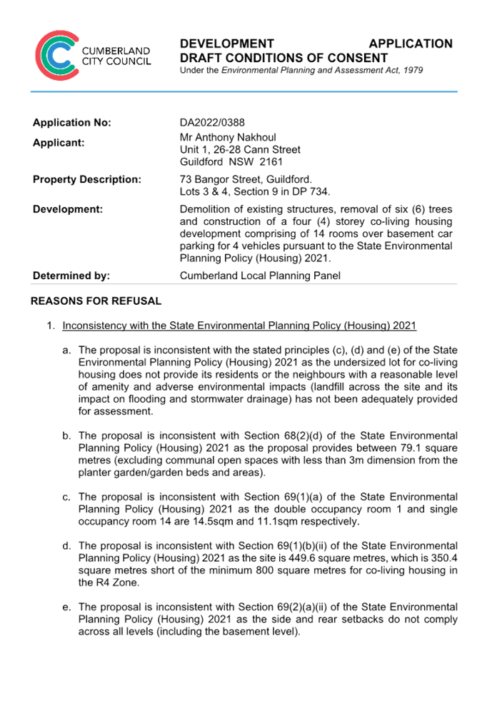
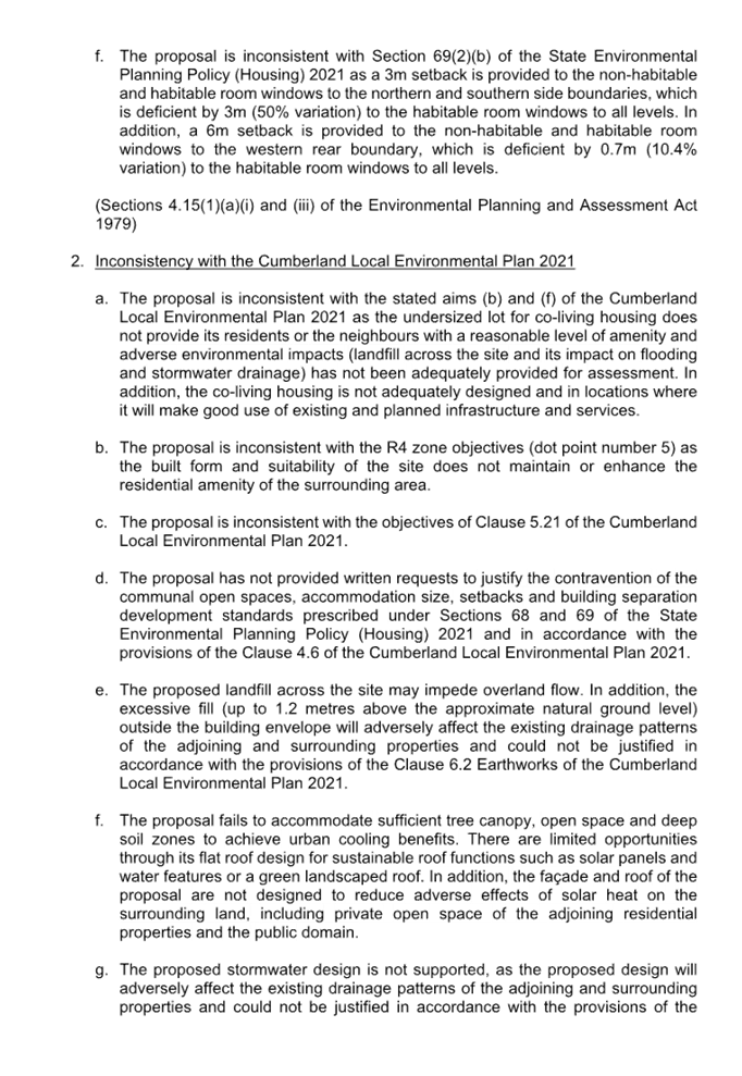
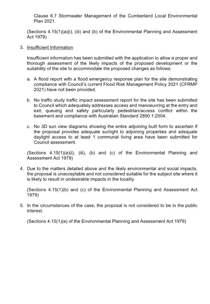
DOCUMENTS
ASSOCIATED WITH
REPORT LPP007/23
Attachment 2
Appendix A - State Environmental Planning Policy
(Housing) 2021 Assessment
Cumberland Local Planning Panel Meeting
8 March 2023
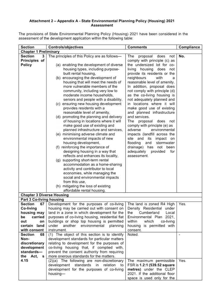
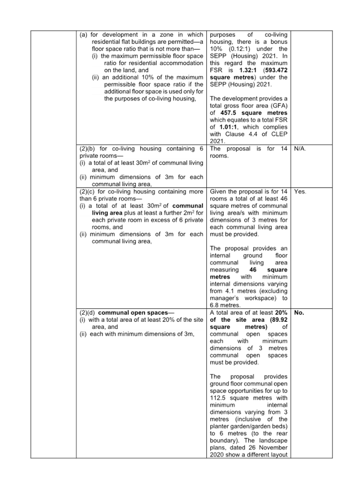
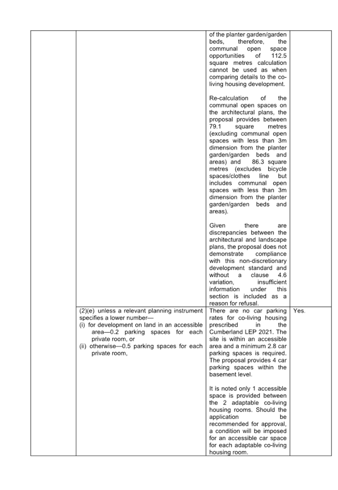

DOCUMENTS
ASSOCIATED WITH
REPORT LPP007/23
Attachment 3
Appendix B -Cumberland LEP 2021 Assessment
Cumberland Local Planning Panel Meeting
8 March 2023
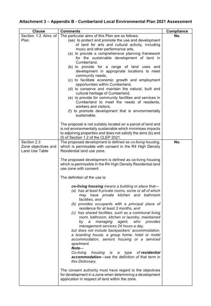
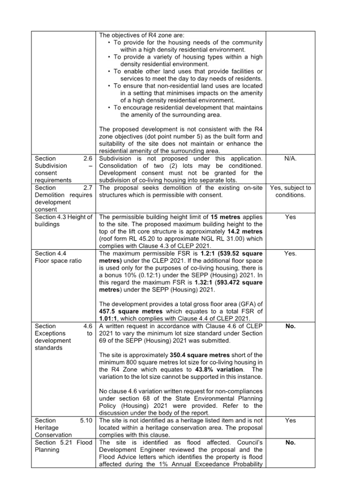
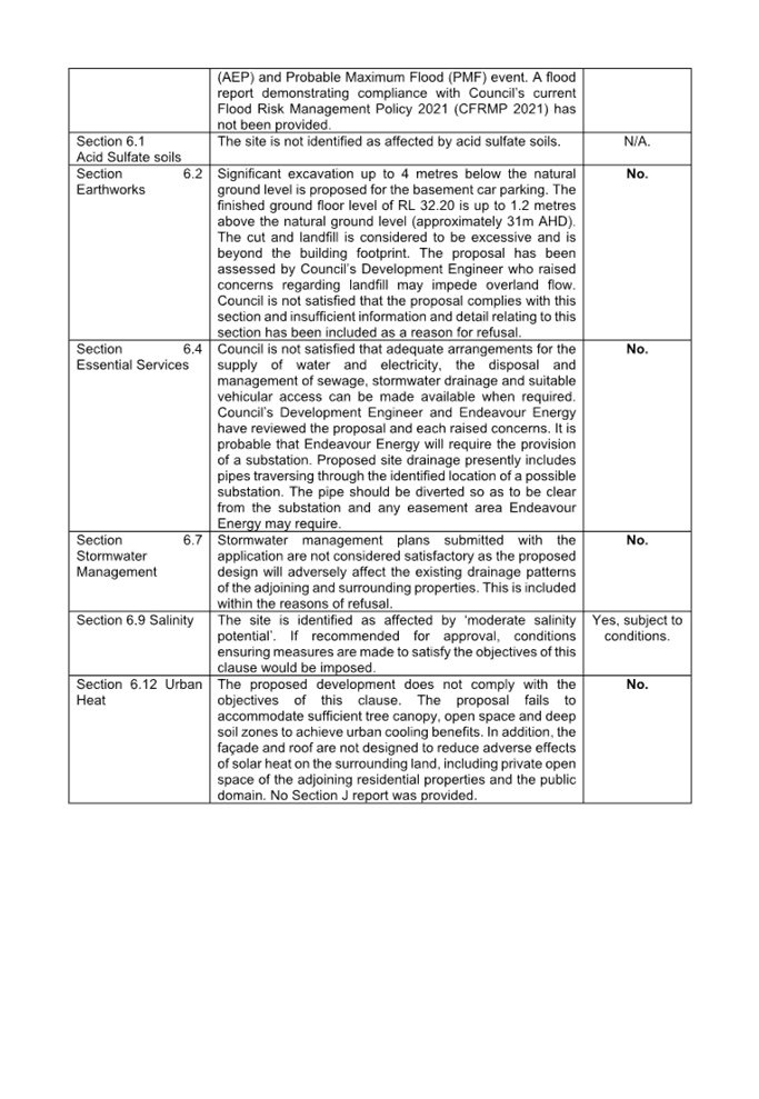
DOCUMENTS
ASSOCIATED WITH
REPORT LPP007/23
Attachment 4
Appendix C - Cumberland DCP 2021 Assessment
Cumberland Local Planning Panel Meeting
8 March 2023
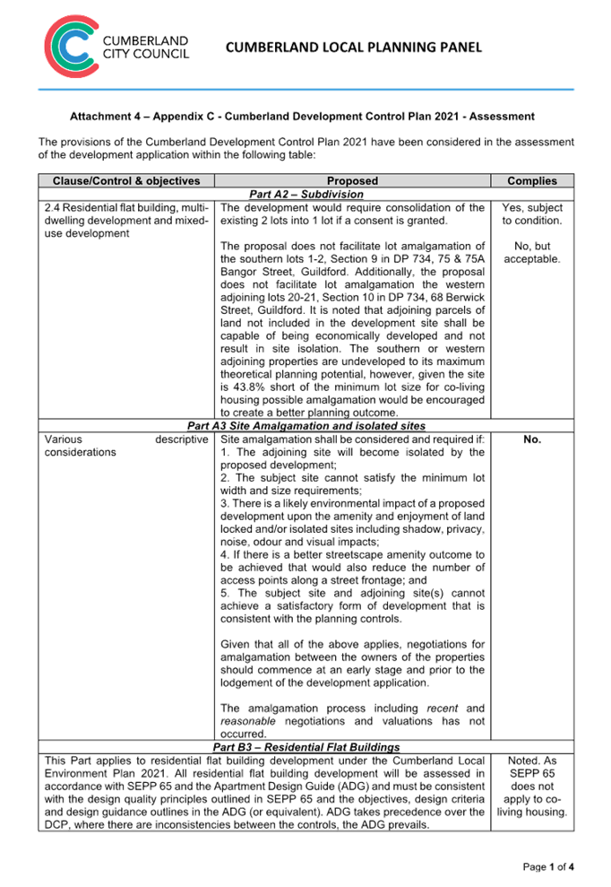
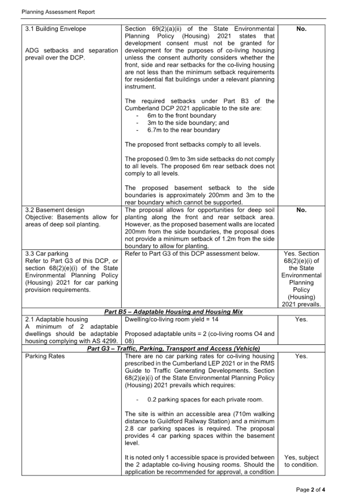
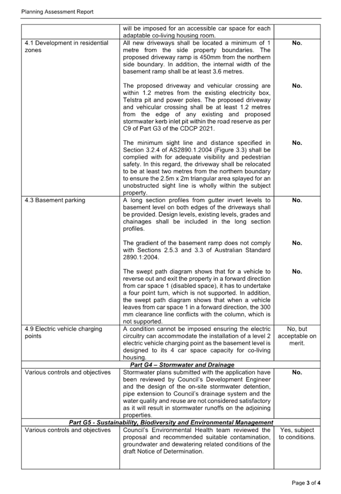
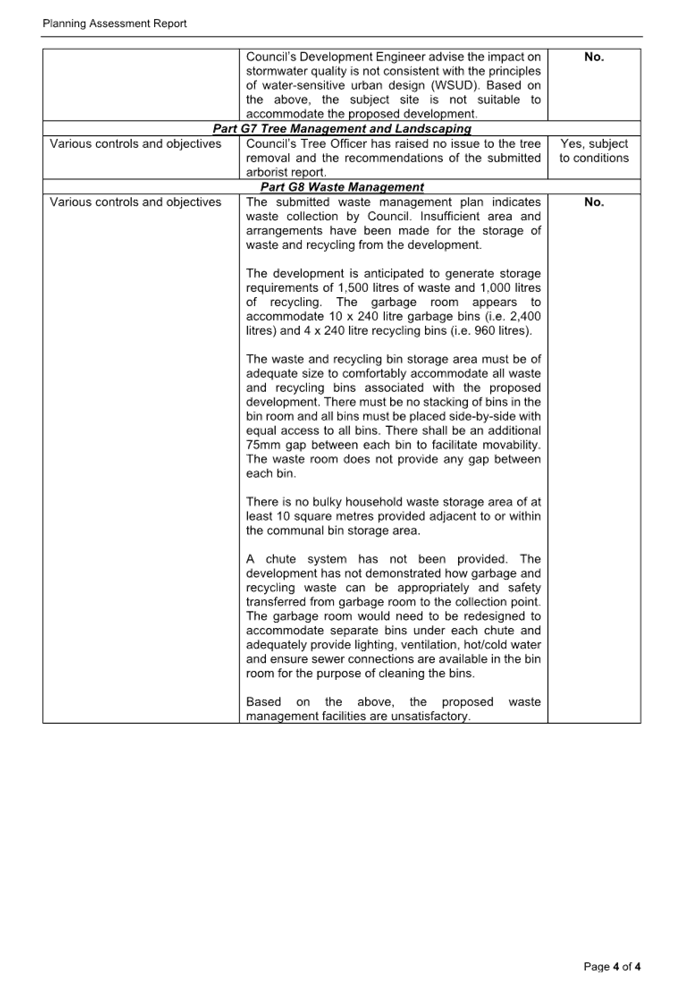
DOCUMENTS
ASSOCIATED WITH
REPORT LPP007/23
Attachment 5
Clause 4.6 Variation Request
Cumberland Local Planning Panel Meeting
8 March 2023

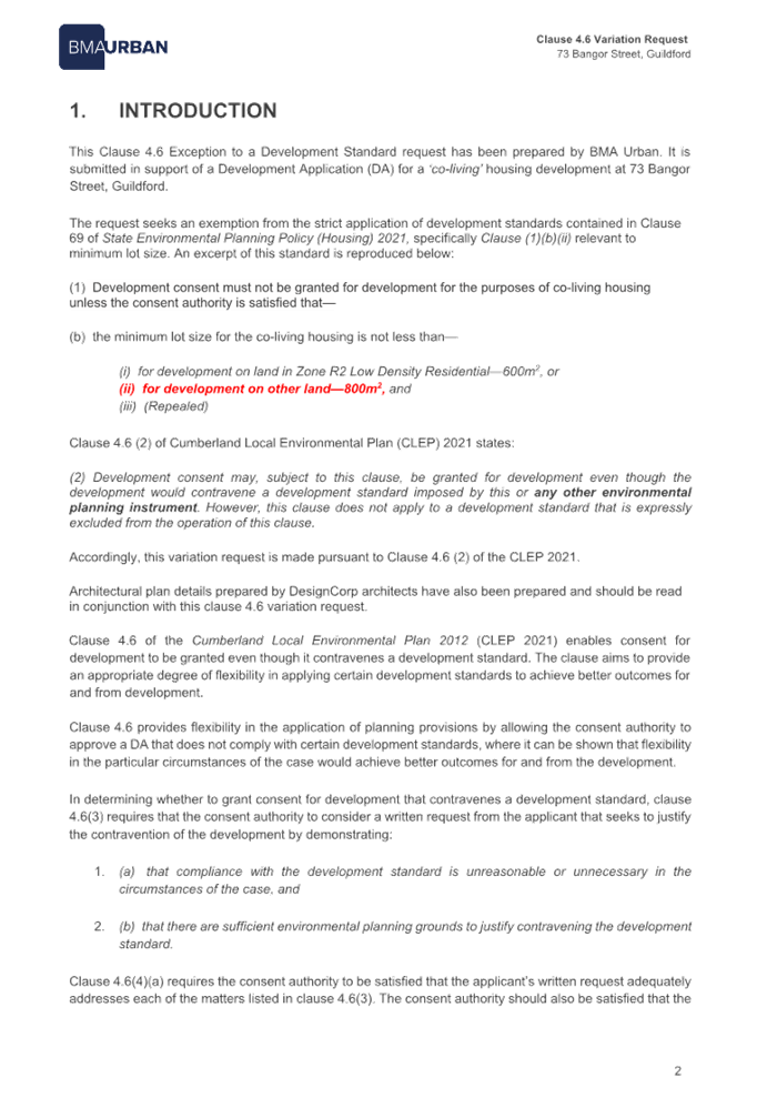
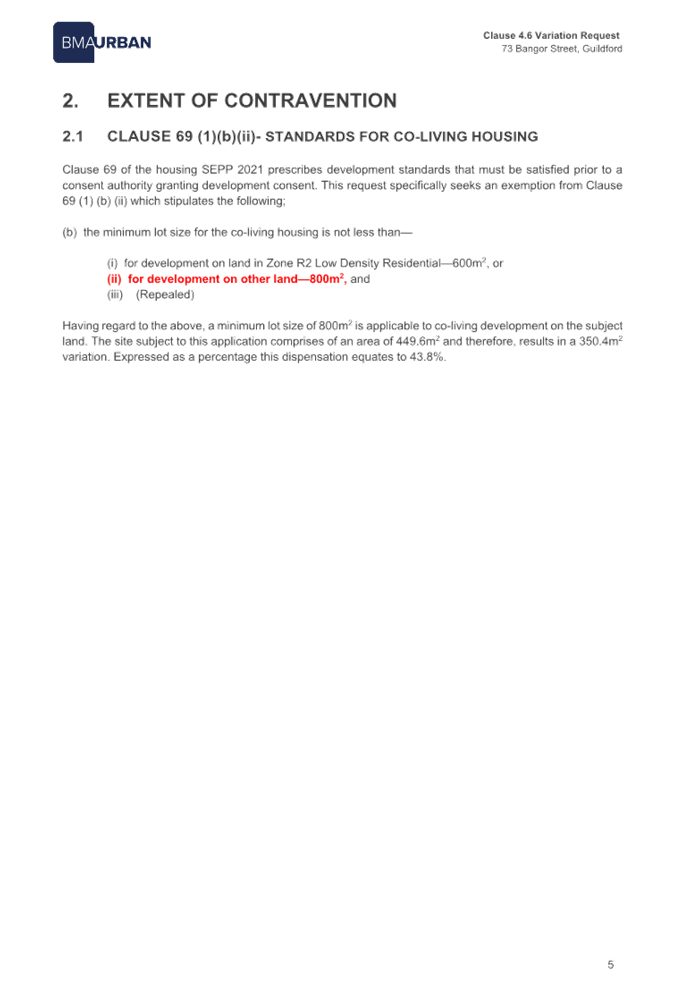
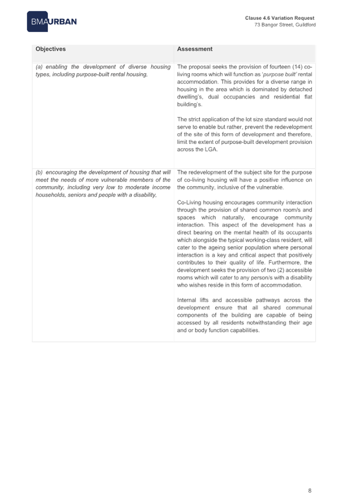
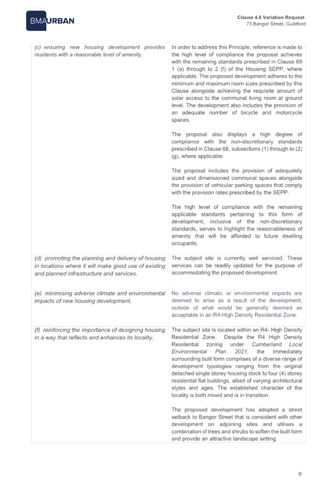
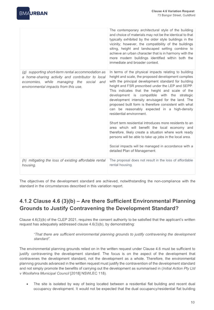

DOCUMENTS
ASSOCIATED WITH
REPORT LPP007/23
Attachment 6
Architectural, Stormwater and Landscape Plans
Cumberland Local Planning Panel Meeting
8 March 2023
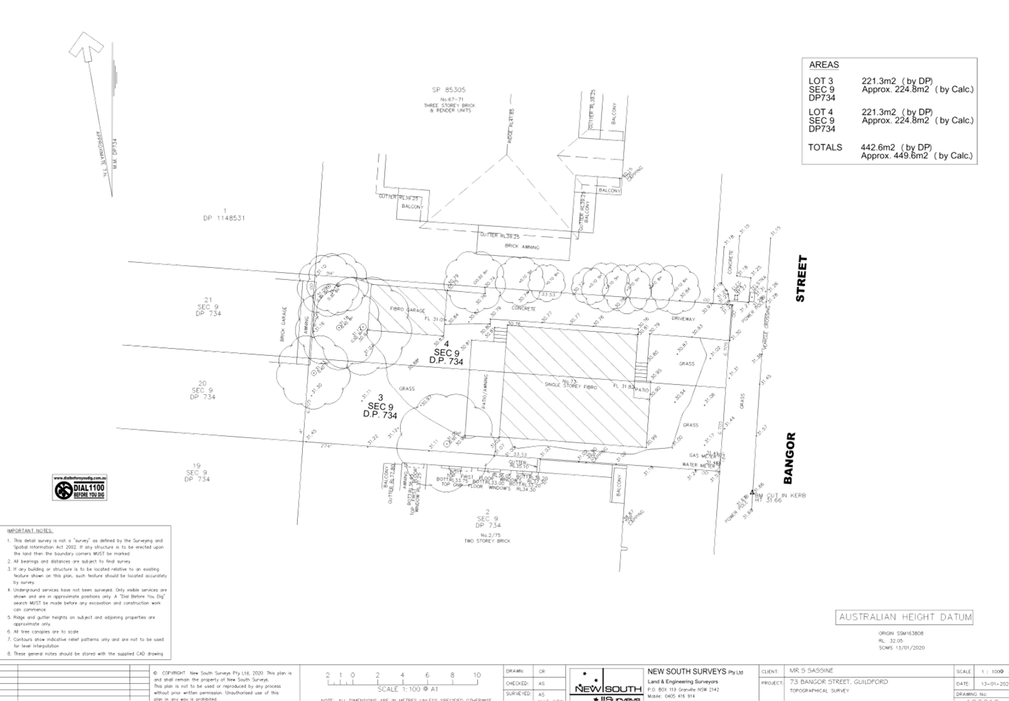
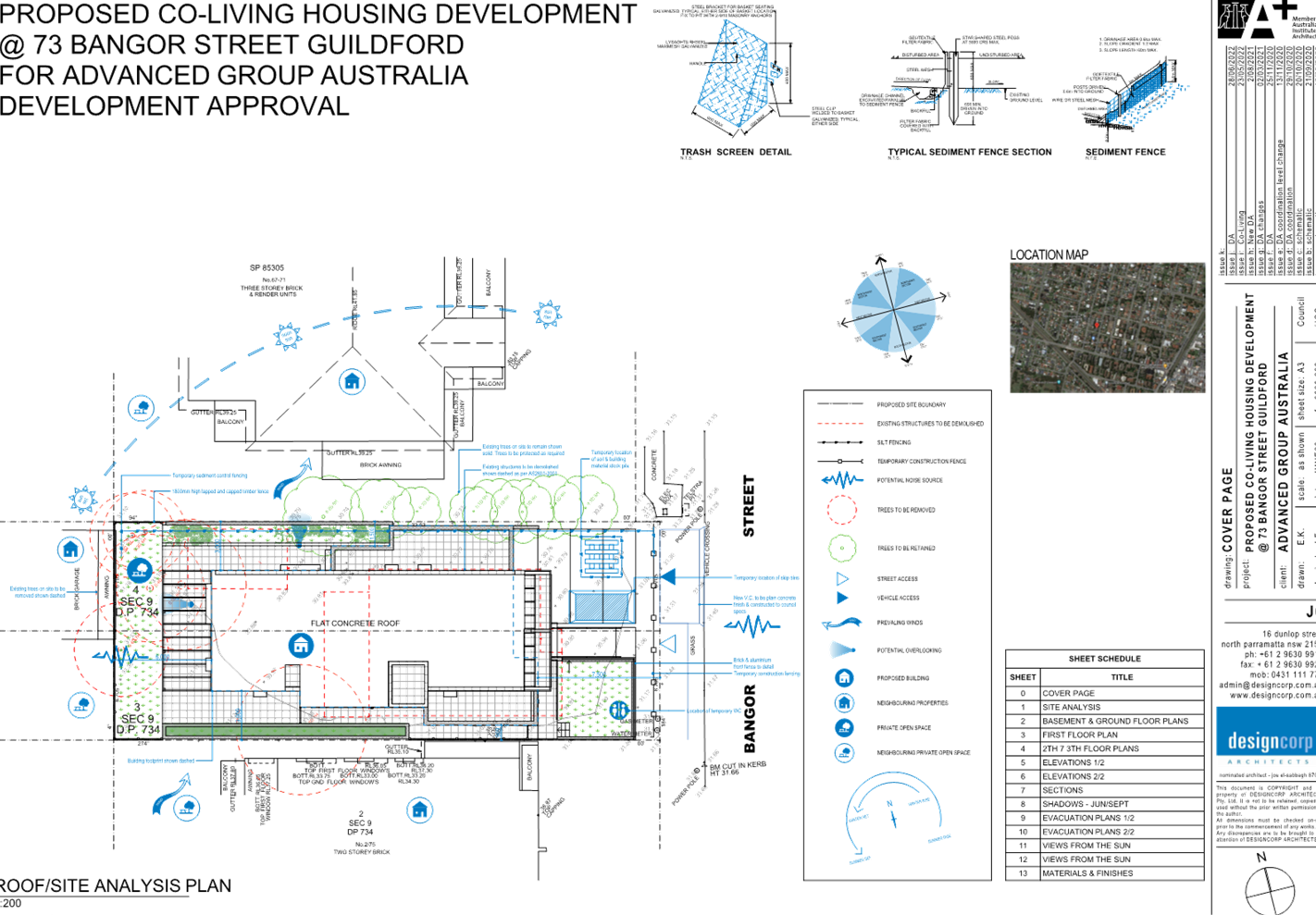
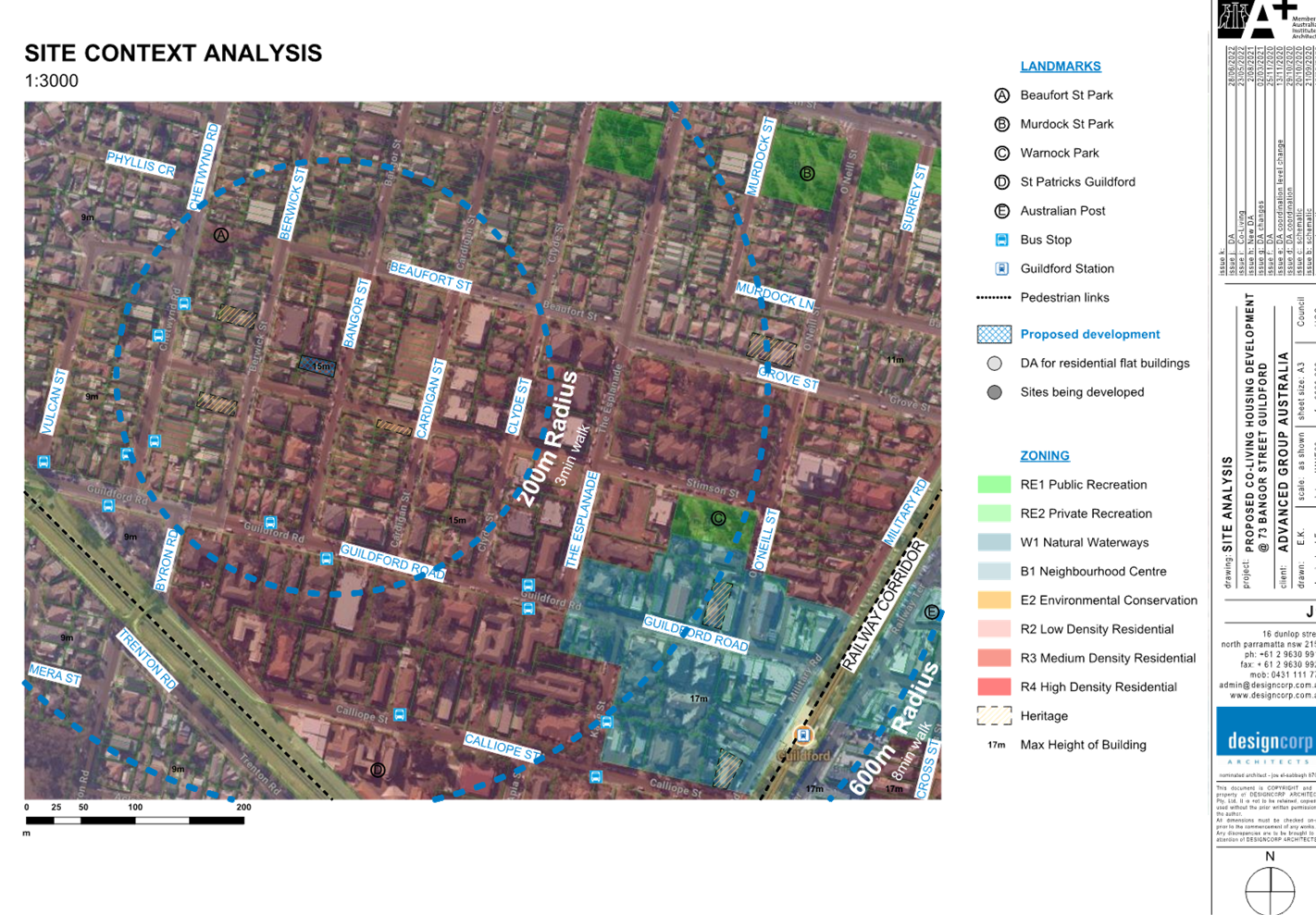
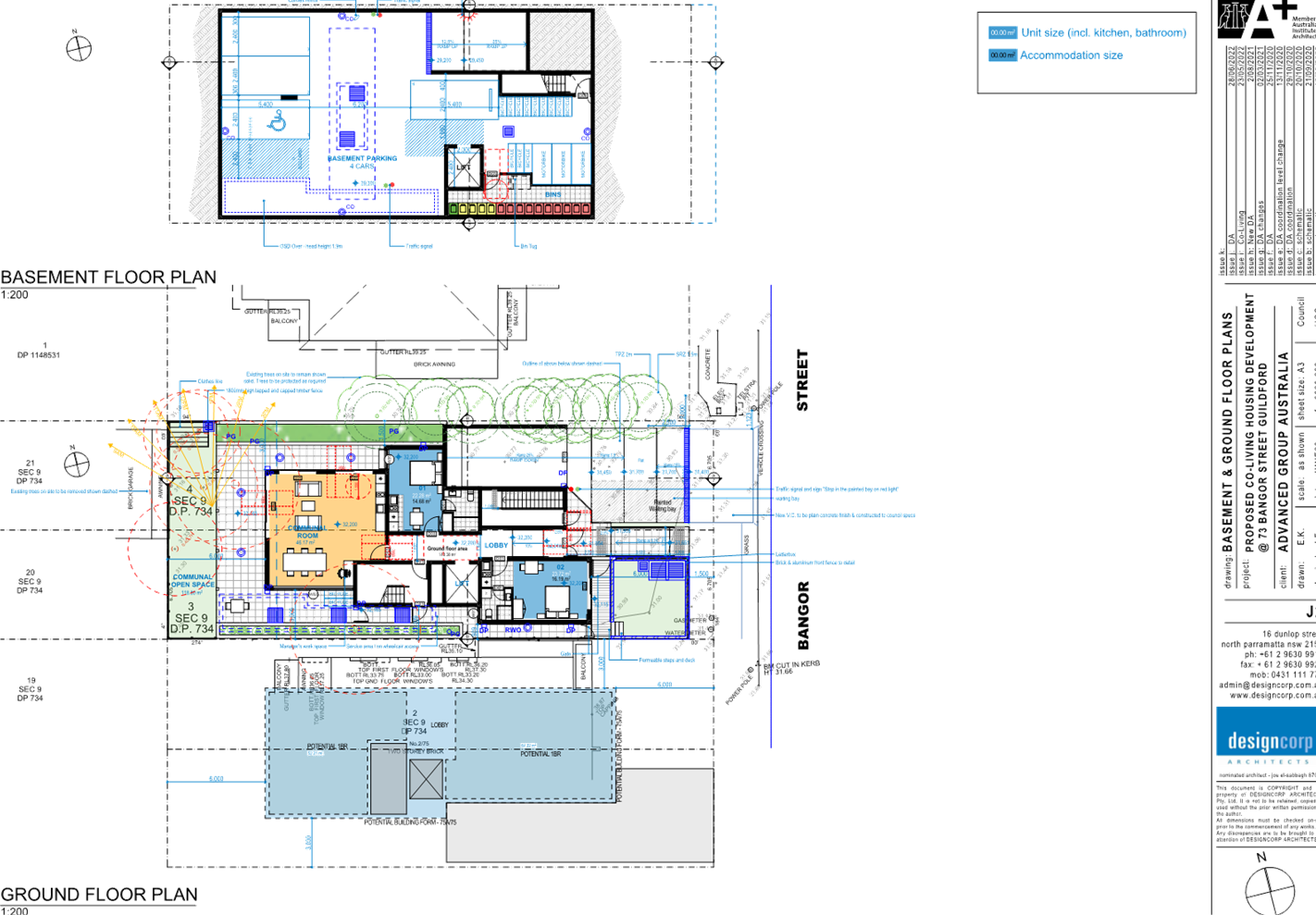
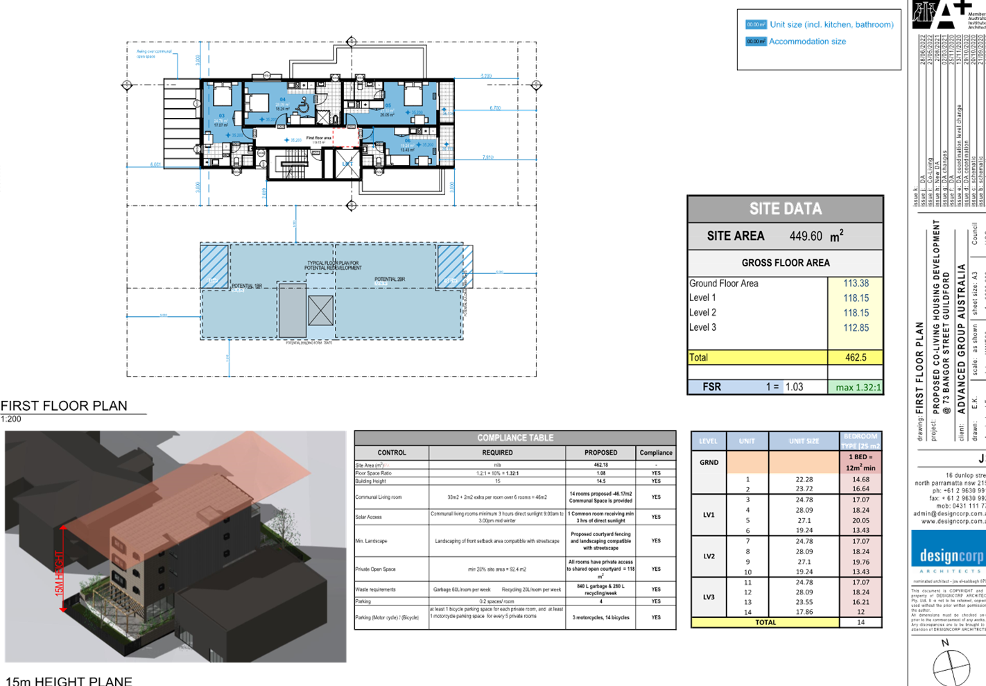
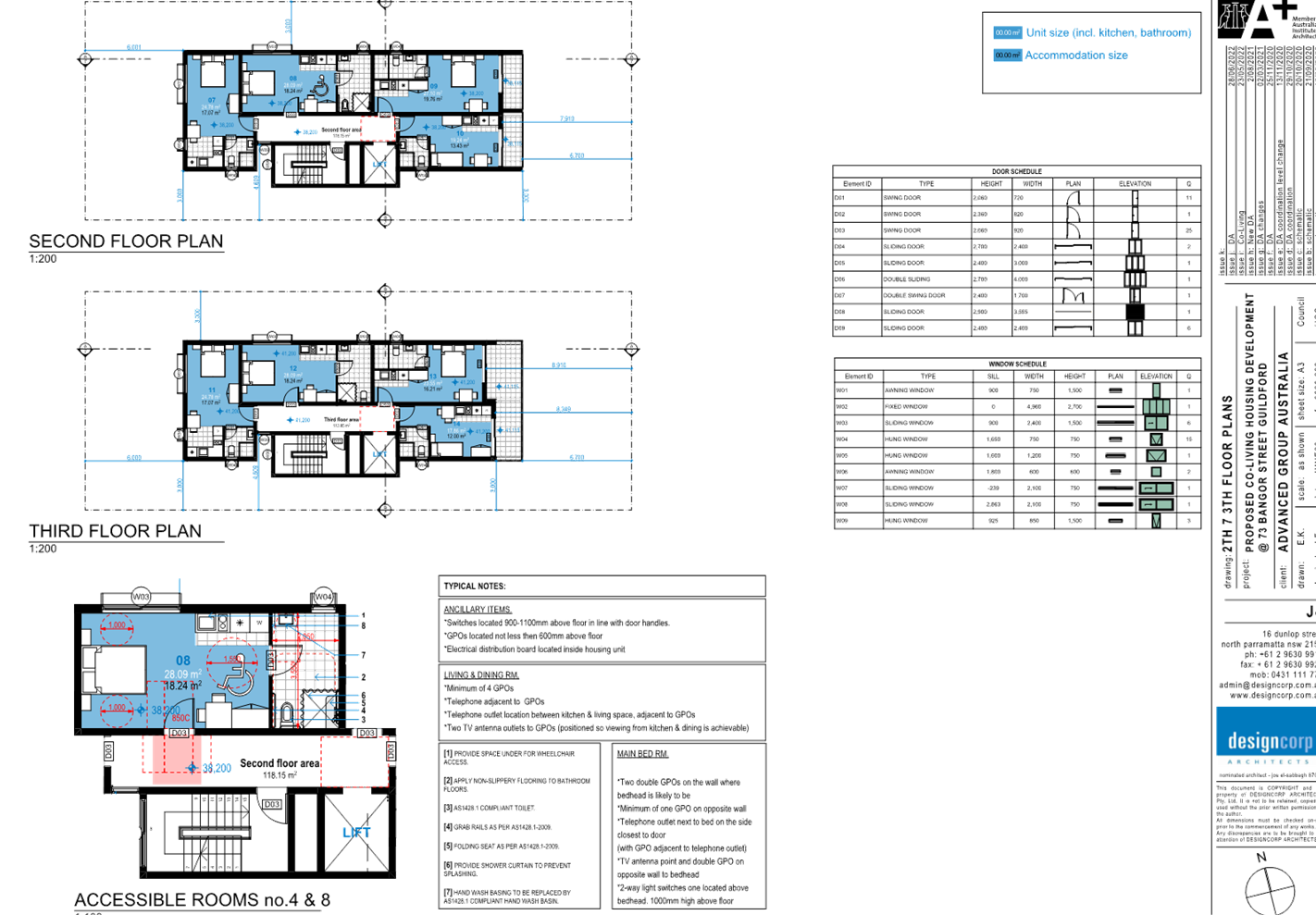
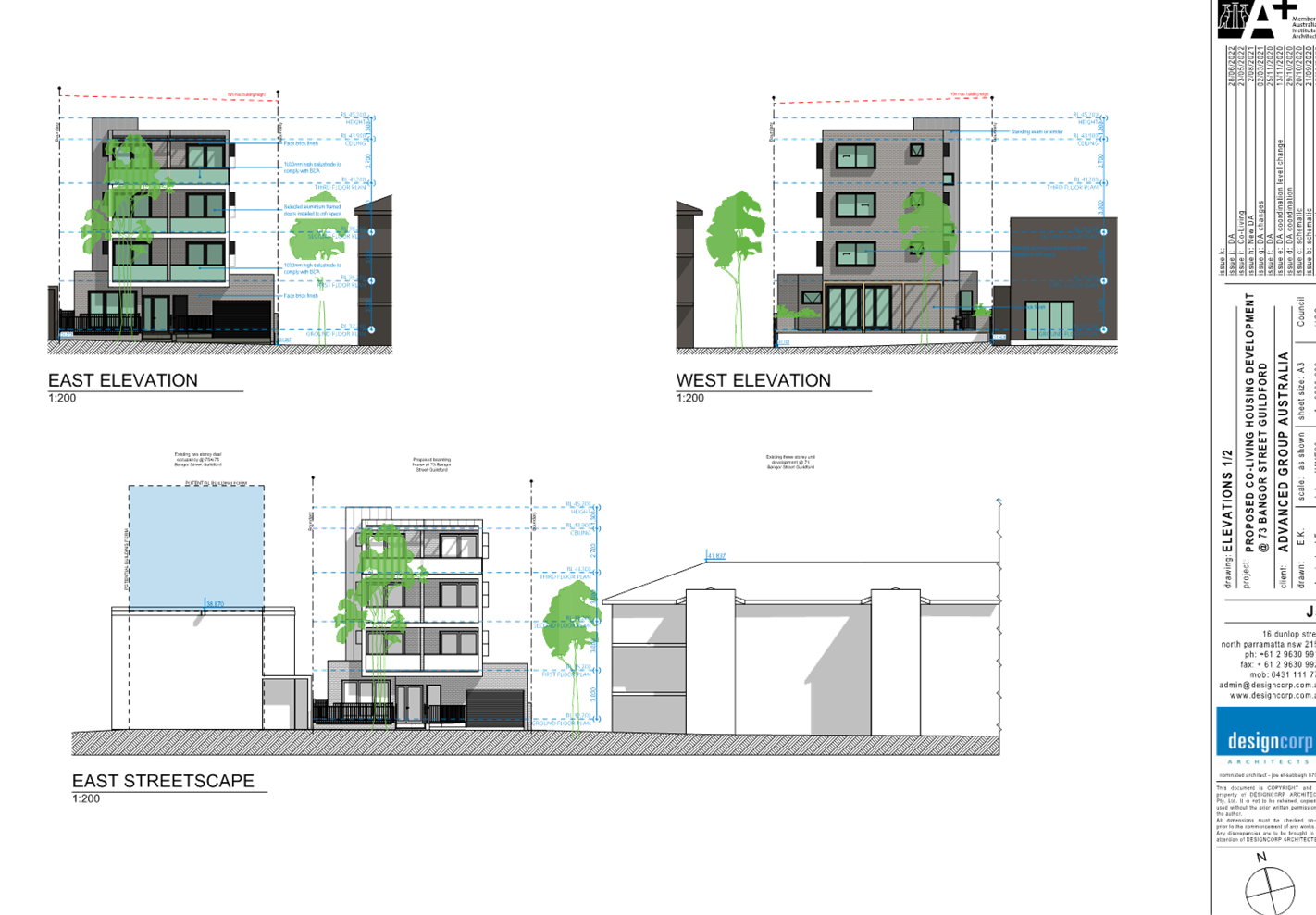
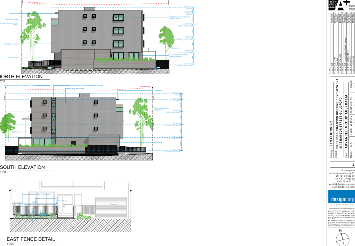
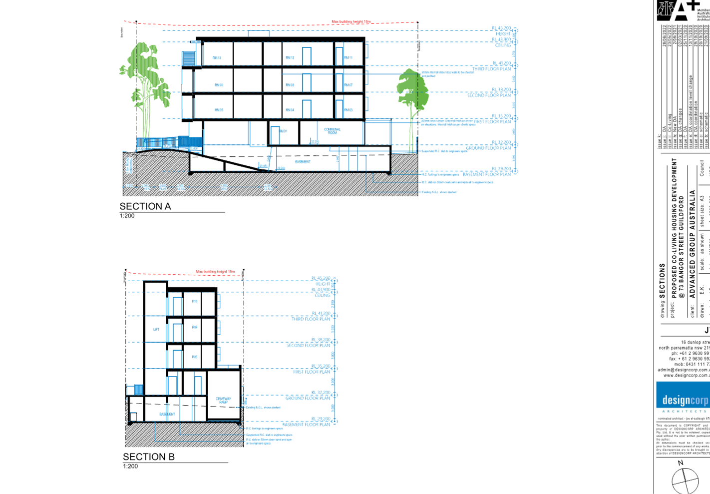
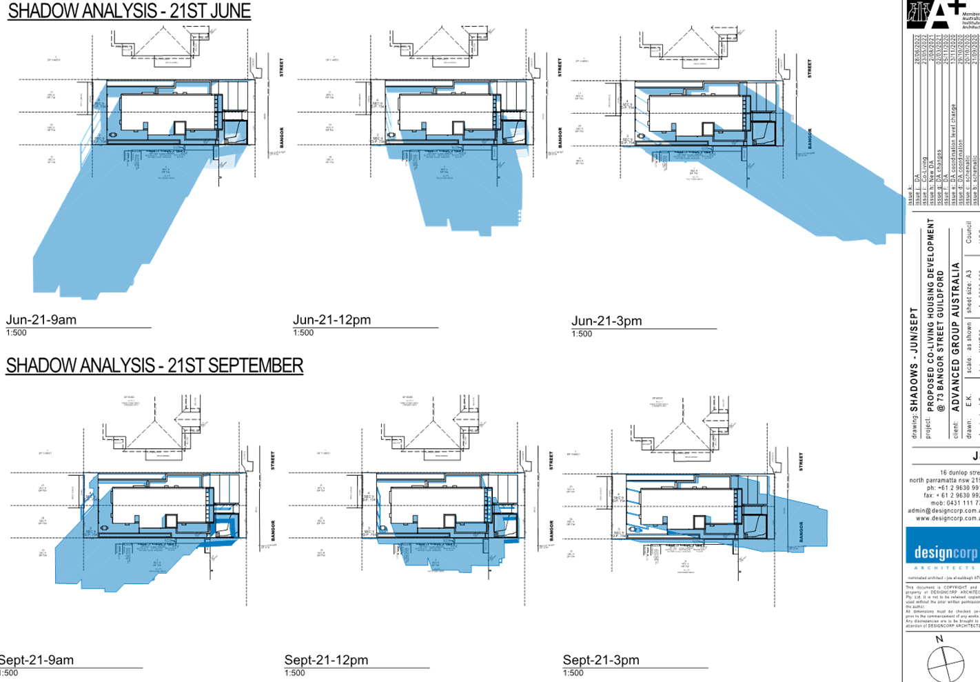
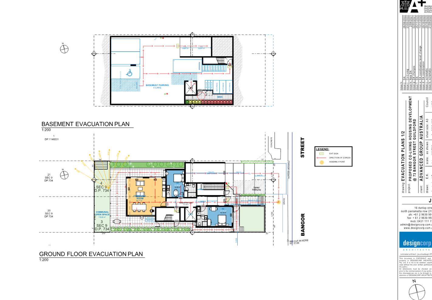
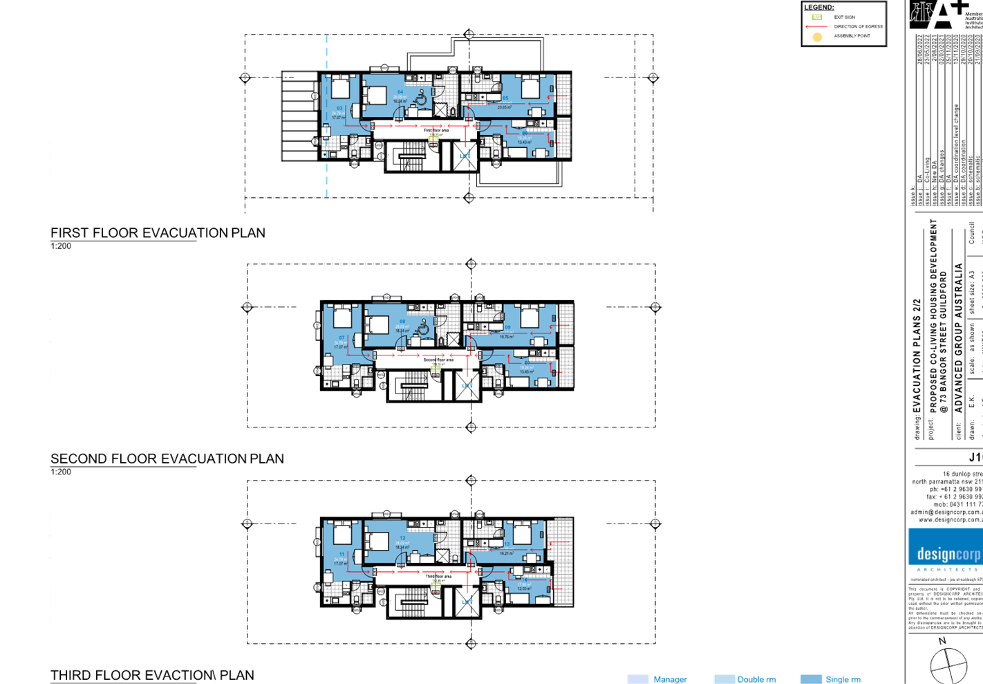
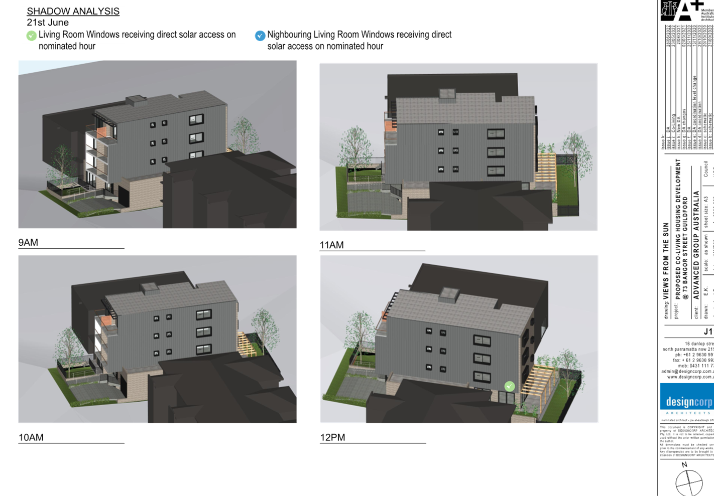
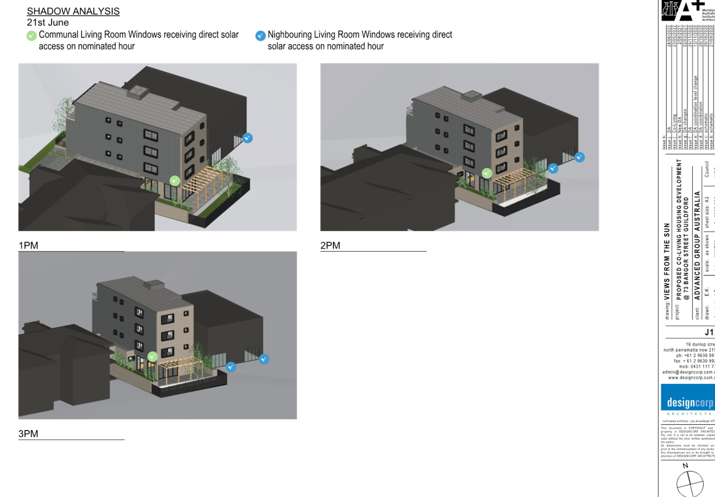
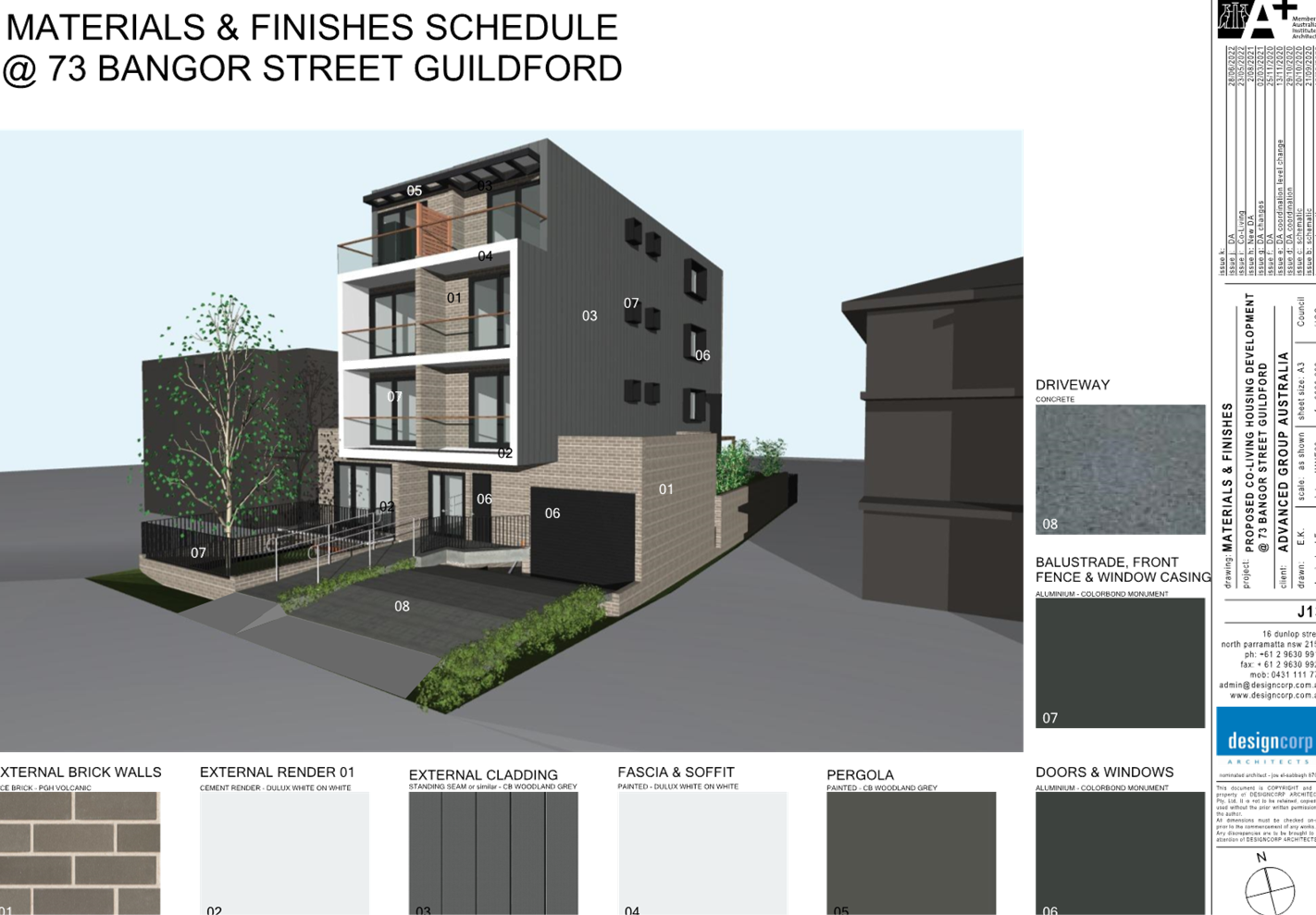
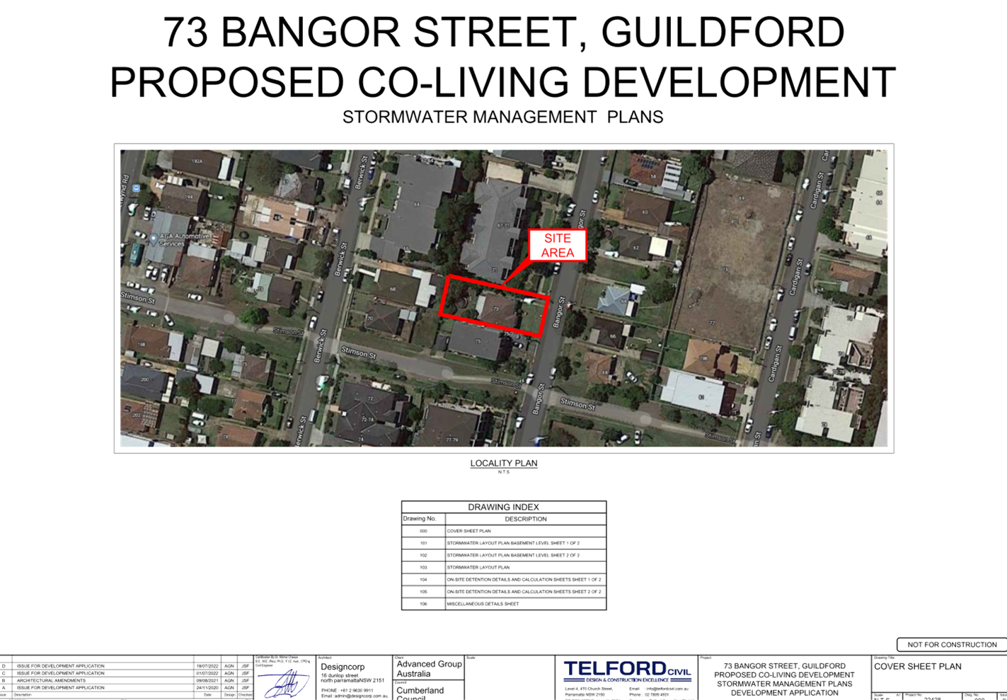
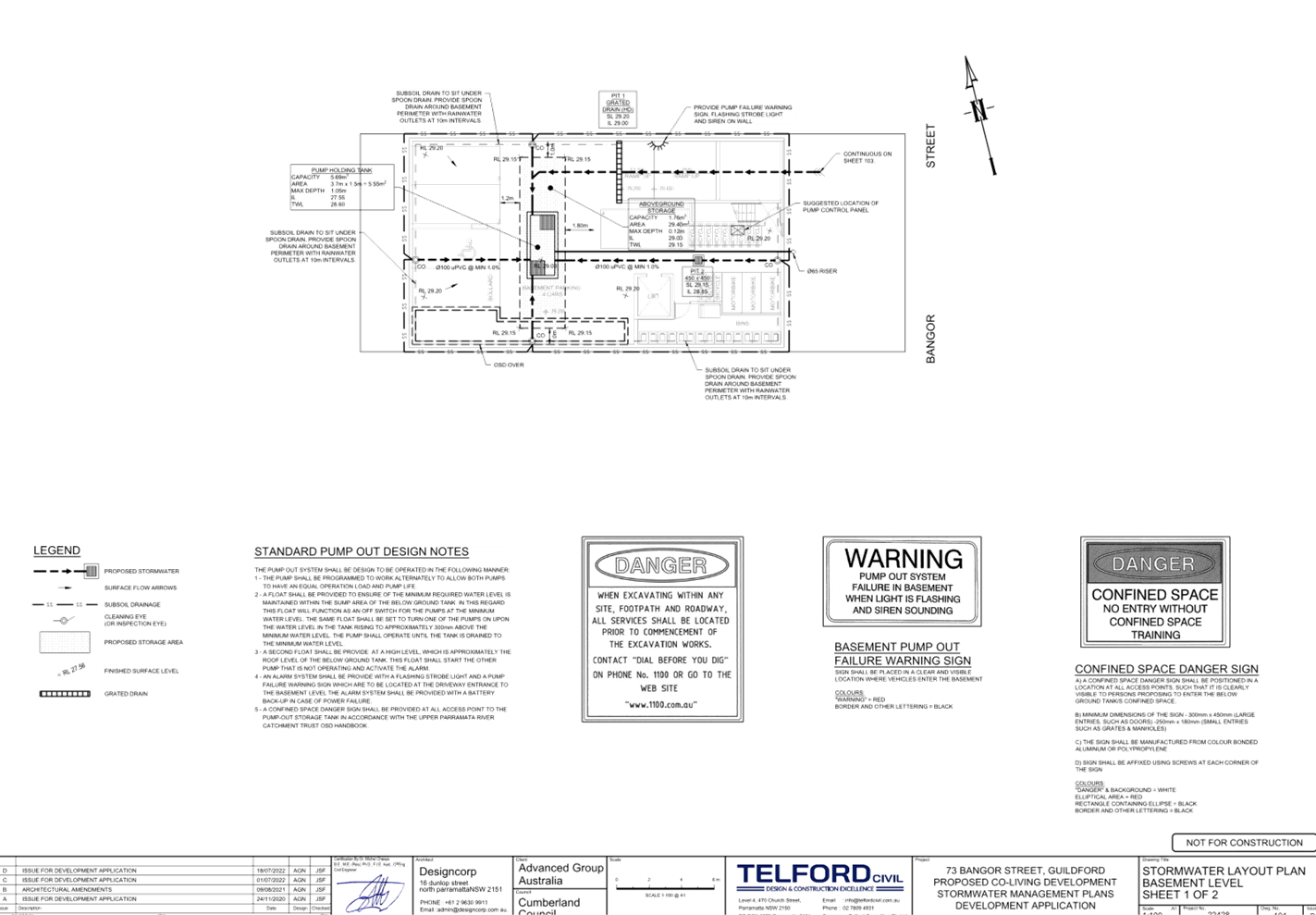
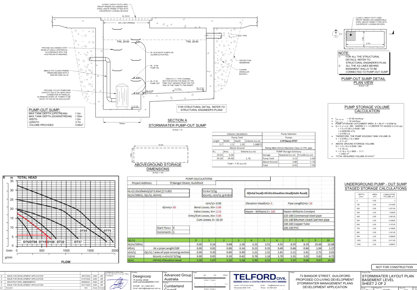
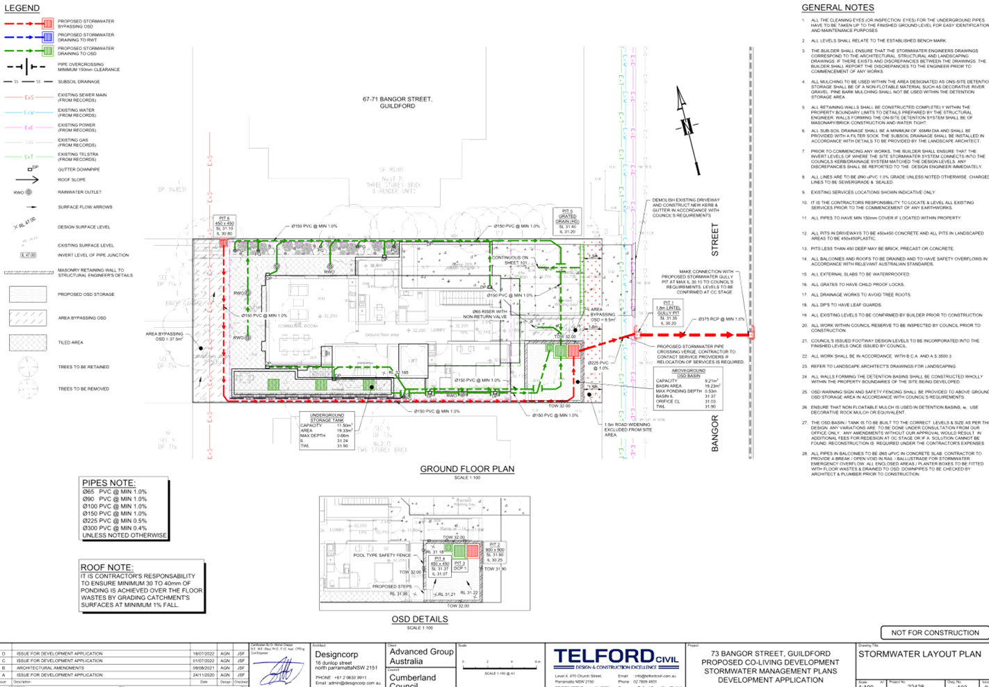
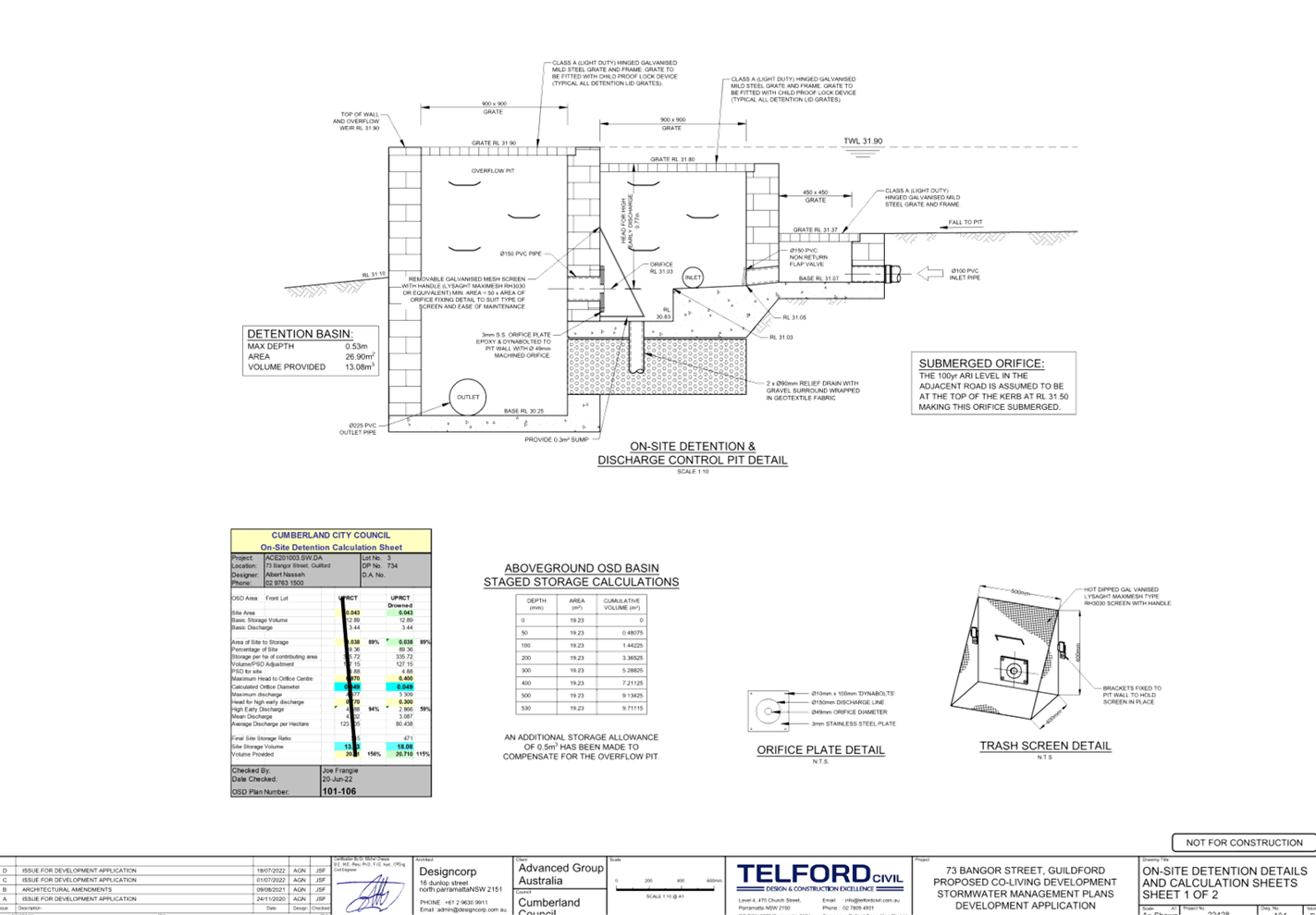
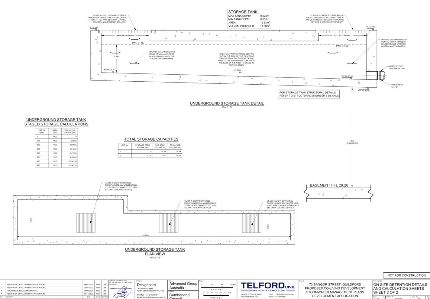
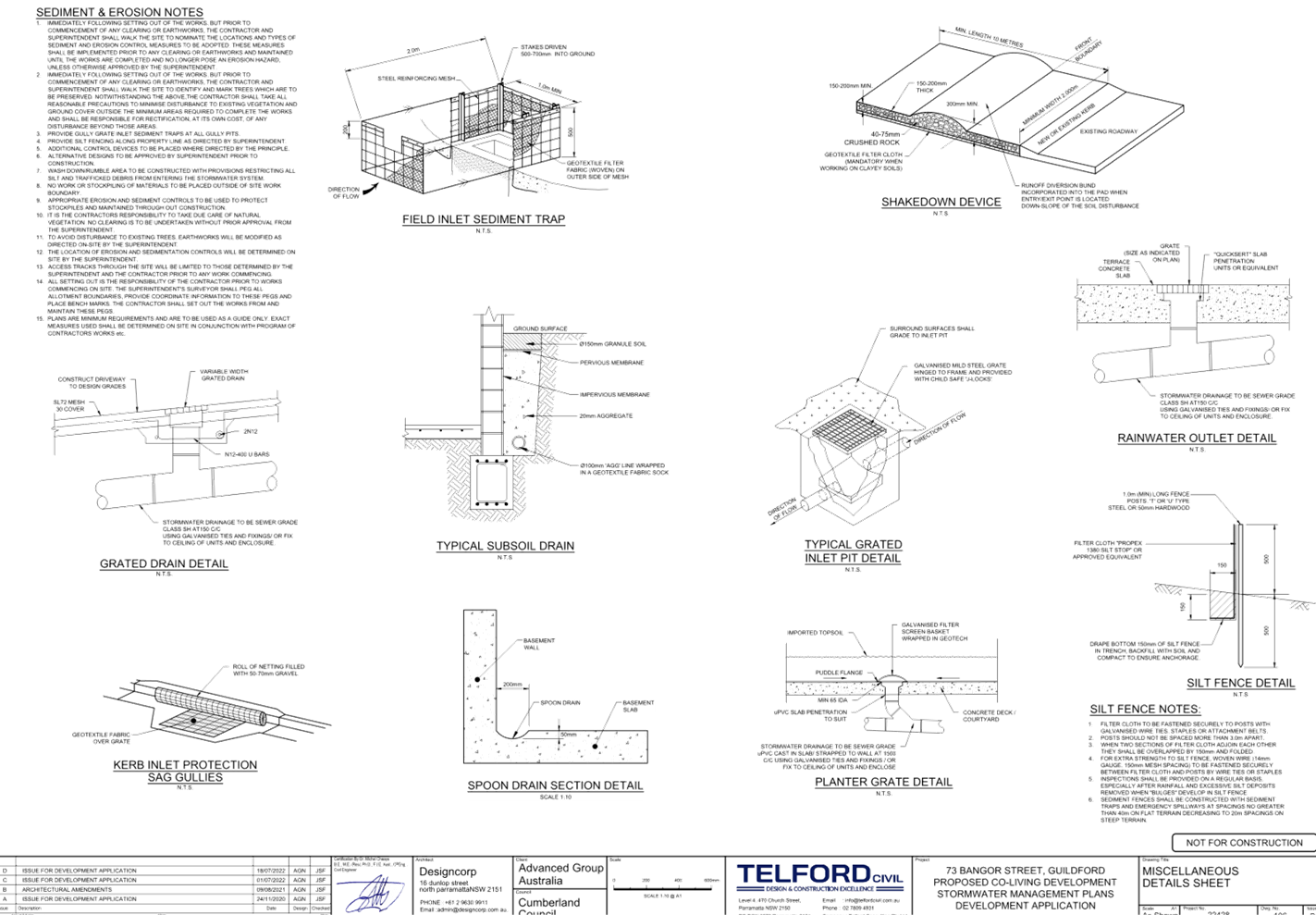
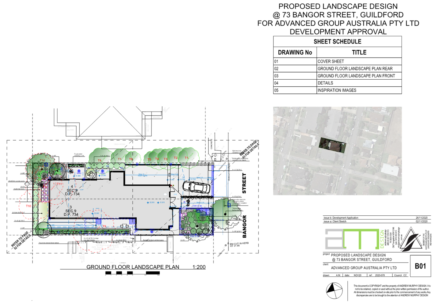
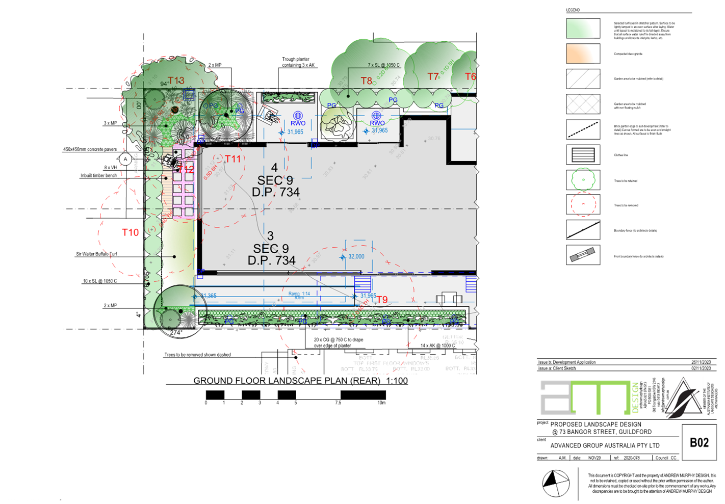
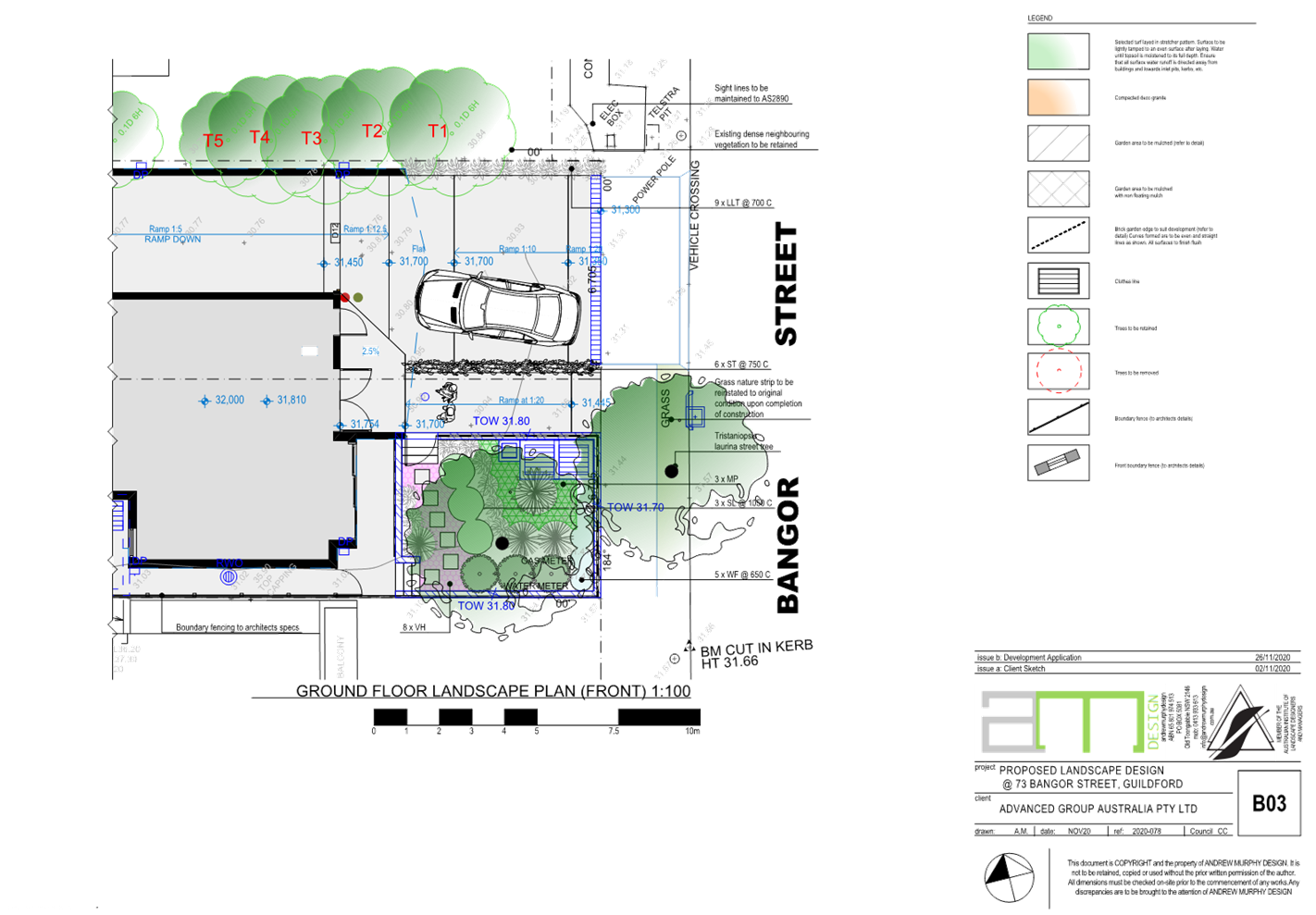
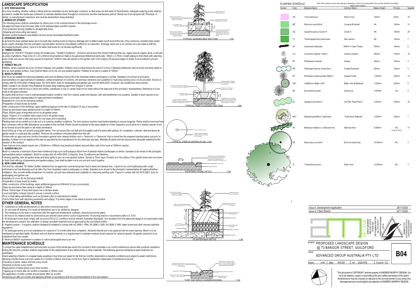
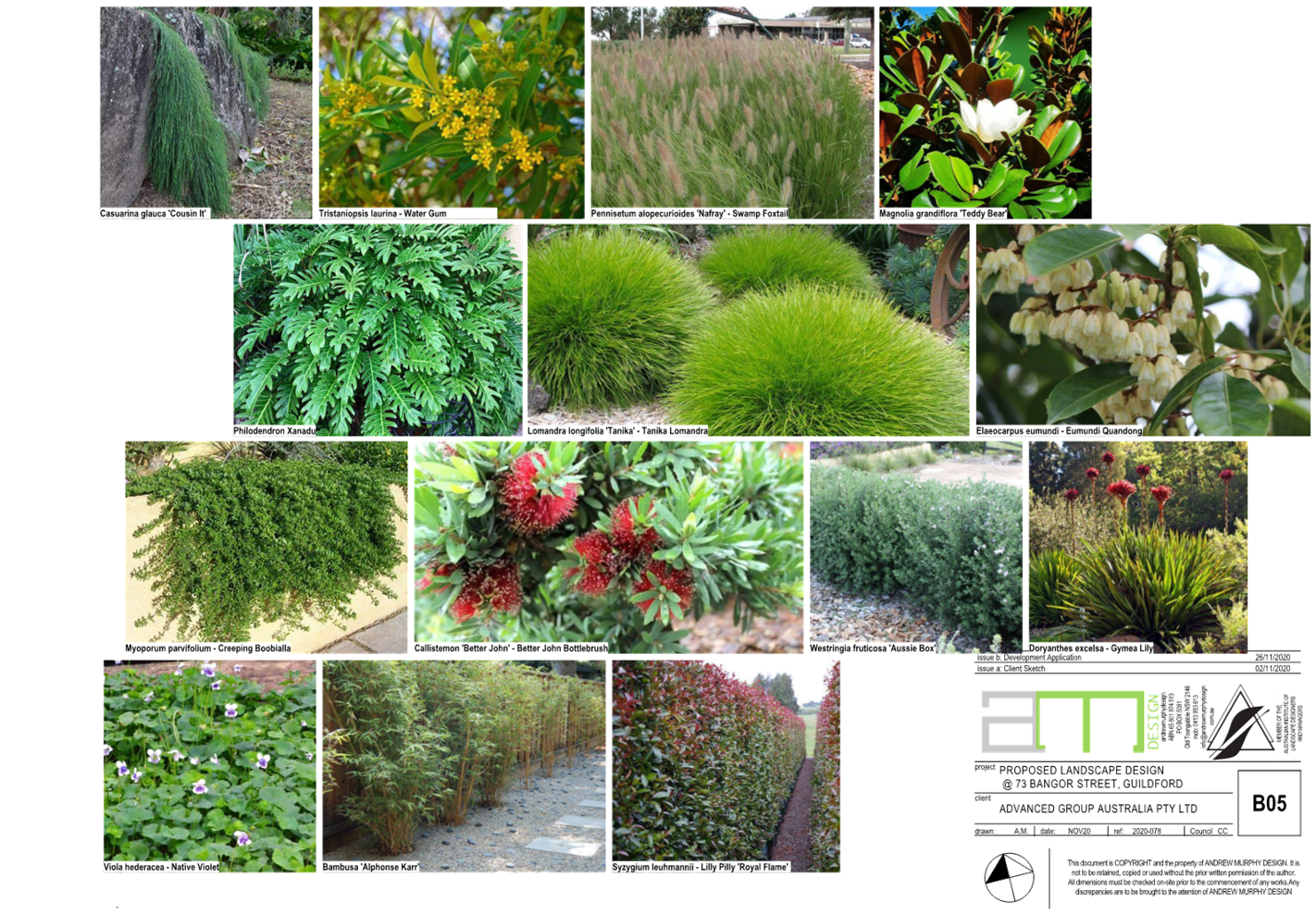
DOCUMENTS
ASSOCIATED WITH
REPORT LPP007/23
Attachment 7
Plan of Management
Cumberland Local Planning Panel Meeting
8 March 2023

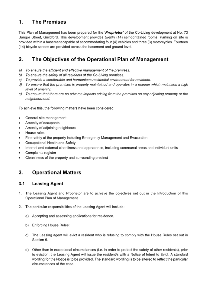
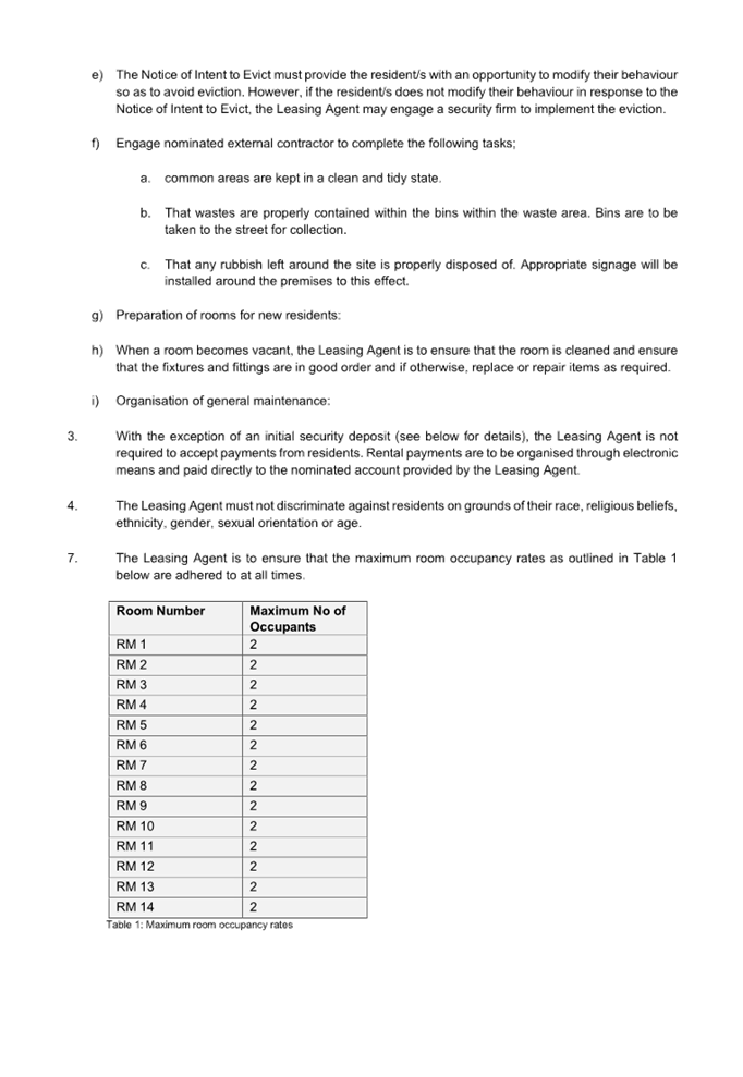
DOCUMENTS
ASSOCIATED WITH
REPORT LPP007/23
Attachment 8
Draft Reasons for Refusal
Cumberland Local Planning Panel Meeting
8 March 2023