Extraordinary Traffic Committee
1 March 2023
A
meeting of the Traffic Committee
will be held at 9:30am in Merrylands Administration Building, 16
Memorial Avenue, Merrylands on Wednesday, 1 March 2023.
Business as below:
Yours faithfully
Peter J. Fitzgerald
General Manager
ORDER OF BUSINESS
1.
Apologies
2.
Declarations of Interest
3.
Confirmation of Previous Minutes endorsed by Council (NIL)
4.
Summary of Reports.......................................................................................................... 4
5.
Reports
-
Part 1 - Recommended for Approval under Delegated Authority
-
Part 2 - Recommendation to Council
CONTENTS
Report No. Name
of Report Page
No.
Part 1 - Recommended for Approval under Delegated
Authority
ECTC-23-029 Coleman
Street, Merrylands - Proposed "Bus Zone" signs and 'no stopping'
restrictions.................................................. 9
ECTC-23-030 Frances
Street, South Wentworthville - Proposed 'Bus Zone' signage...................................................................................... 17
ECTC-23-031 Boundary
Road, Chester Hill - Removal of Redundant 'Bus Zone' Signage...................................................................................... 23
ECTC-23-032 Friend
Street, Merrylands - Removal of Redundant 'Bus Zone' Signage...................................................................................... 29
ECTC-23-033 Pritchard
Street West, Wentworthville - Modification to the existing accessible parking
space............................. 37
ECTC-23-034 Old
Prospect Road and Grafton Street, Greystanes - Proposed 'no stopping' Restrictions
and Line Marking 45
ECTC-23-035 Davidson
Road and Robertson Street, Guildford - Proposed 'No Stopping" Restrictions
and Line Marking 53
ECTC-23-036 Rawson
Street and Dalley Street, Lidcombe - Proposed 'No Stopping'Restrictions.................................................................. 59
ECTC-23-037 Bridge
Road and Killeen Street, Wentworthville - Proposed 'no stopping' Restrictions................................. 71
ECTC-23-038 Meakin
Street and Grace Crescent, Merrylands - Proposed 'no stopping' Restrictions and
Line Marking.................. 77
ECTC-23-039 Brunswick
Street, Granville - Proposed 'no stopping' restrictions....................................................................................... 93
ECTC-23-040 Toongabbie
Road, Toongabbie - Application for 'works zone' signage.................................................................................... 111
Part 2 - Recommendation to Council
ECTC-23-041 Temporary
Road Closure in the Auburn CBD for Ramadan Food Festival 2023......................................................................... 119
ECTC-23-042 Albert
Street, Palmer Street & Tennyson Parade - Australian Government Black Spot
Program 2022/2023 141
ECTC-23-043 Clyde
Street, South Granville - Road Safety Concerns 157
ECTC-23-044 Earl
Street, Merrylands - Road Safety Concerns.. 161
ECTC-23-045 Nicholas
Street, Lidcombe - Road Safety Concerns 175
ECTC-23-046 Norman
Street, Merrylands - Road Safety Concerns 179
Extraordinary Traffic Committee
1 March 2023
Summary of Reports
Part 1 - Recommended for Approval under Delegated
Authority
|
Item #
|
Title
|
Electorate
|
Police Area Command (PAC)
|
|
Fairfield
|
Granville
|
Prospect
|
Auburn
|
Cumberland
|
Auburn
|
|
ECTC-23-029
|
Coleman Street, Merrylands
- Proposed "Bus Zone" signs and 'no stopping' restrictions
|
|
´
|
|
|
´
|
|
|
ECTC-23-030
|
Frances Street, South
Wentworthville - Proposed 'Bus Zone' signage
|
|
´
|
|
|
´
|
|
|
ECTC-23-031
|
Boundary Road, Chester Hill
- Removal of Redundant 'Bus Zone' Signage
|
|
|
|
´
|
´
|
|
|
ECTC-23-032
|
Friend Street, Merrylands -
Removal of Redundant 'Bus Zone' Signage
|
|
´
|
|
|
´
|
|
|
ECTC-23-033
|
Pritchard Street West,
Wentworthville - Modification to the existing accessible parking space
|
|
|
´
|
|
´
|
|
|
ECTC-23-034
|
Old Prospect Road and
Grafton Street, Greystanes - Proposed 'no stopping' Restrictions and Line
Marking
|
|
|
´
|
|
´
|
|
|
ECTC-23-035
|
Davidson Road and Robertson
Street, Guildford - Proposed 'No Stopping" Restrictions and Line Marking
|
|
|
|
´
|
´
|
|
|
ECTC-23-036
|
Rawson Street and Dalley
Street, Lidcombe - Proposed 'No Stopping'Restrictions
|
|
|
|
´
|
|
´
|
|
ECTC-23-037
|
Bridge Road and Killeen
Street, Wentworthville - Proposed 'no stopping' Restrictions
|
|
´
|
|
|
´
|
|
|
ECTC-23-038
|
Meakin Street and Grace
Crescent, Merrylands - Proposed 'no stopping' Restrictions and Line Marking
|
|
´
|
|
|
´
|
|
|
ECTC-23-039
|
Brunswick Street, Granville
- Proposed 'no stopping' restrictions
|
|
´
|
|
|
´
|
|
|
ECTC-23-040
|
Toongabbie Road, Toongabbie
- Application for 'works zone' signage
|
|
|
´
|
|
´
|
|
Part 2 - Recommendation to Council
|
Item #
|
Title
|
Electorate
|
Police Area Command (PAC)
|
|
Fairfield
|
Granville
|
Prospect
|
Auburn
|
Cumberland
|
Auburn
|
|
ECTC-23-041
|
Temporary Road Closure in
the Auburn CBD for Ramadan Food Festival 2023
|
|
|
|
´
|
|
´
|
|
ECTC-23-042
|
Albert Street, Palmer
Street & Tennyson Parade - Australian Government Black Spot Program
2022/2023
|
´
|
|
|
|
´
|
|
|
ECTC-23-043
|
Clyde Street, South Granville
- Road Safety Concerns
|
|
|
|
´
|
´
|
|
|
ECTC-23-044
|
Earl Street, Merrylands -
Road Safety Concerns
|
|
´
|
|
|
´
|
|
|
ECTC-23-045
|
Nicholas Street, Lidcombe -
Road Safety Concerns
|
|
|
|
´
|
|
´
|
|
ECTC-23-046
|
Norman Street, Merrylands -
Road Safety Concerns
|
|
´
|
|
|
´
|
|
Extraordinary Traffic Committee
1 March 2023
Extraordinary Traffic Committee
1 March 2023
Part 1
Recommended for Approval under Delegated Authority
Extraordinary Traffic Committee
1 March 2023
Item
No: ECTC-23-029
Coleman
Street, Merrylands - Proposed "Bus Zone" signs and 'no stopping'
restrictions
Directorate: Environment
and Planning
Responsible
Officer: Executive
Manager Development and Building
File
Number: T-28-01/06
Electorate: Granville
Police Area
Command (PAC): Cumberland
Agenda Part Part
1
Note: Recommended
for Approval under Delegated Authority
Council has received a request
from Transit Systems Bus Operator for the installation of ‘Bus
Zone’ signs at the existing bus stop outside No. 59 Coleman Street,
Merrylands to facilitate buses accessing the bus stop.
This report outlines the outcome
of the investigation into this matter.
|
That the Cumberland Traffic Committee recommends
that:
1. The
installation of ‘Bus Zone’ signs on the western side of Coleman
Street, Merrylands outside No.59 in accordance with the attached plan be
approved.
2. The
installation of ‘No Stopping’ signs at the intersection of
Coleman Street and Dorothy Street, Merrylands in accordance with the attached
plan be approved.
3. The
adjacent residents be notified of the outcome.
|
Council has received a request
from Transit Systems for the installation of ‘Bus Zone’ signs at
the existing bus stop outside No.59 Coleman Street, Merrylands to facilitate
buses accessing the bus stop. It is alleged that cars are parking close to the
bus stop thus making it difficult for buses to access the bus stop.
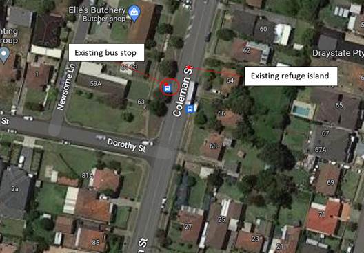
Coleman Street is a local road
runs in a north– south direction with a speed limit of 50 km/h. It has a
width of approximately 12.5m and parking is permitted on both sides of the road
unless signposted. There is an existing bus stop on the western side of Coleman
Street outside No.59. This bus stop is not sign posted with ‘Bus
Zone’ signs. A refuge island is also provided north of this location to
facilitate pedestrians crossing Coleman Street.
The map below shows the location
of the bus stop:
Figure
1 – Locality Plan
It is alleged by the
representative of Transit Systems that vehicles often park at the bus stop. As
a result, buses are not able to access this bus stop and park safely.
In accordance with the NSW Road
Rules 195:
‘A driver (except the driver
of a public bus) must not stop at a bus stop, or on the road, within 20 metres
before a sign on the road that indicates the bus stop, and 10 metres after the
sign, unless the driver stops at a place on a length of road, or in an area, to
which a parking control sign applies and the driver is permitted to stop at
that place under these Rules’
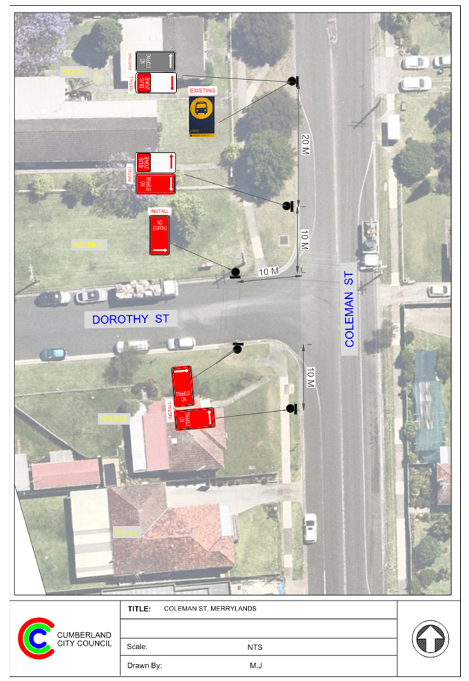
Therefore, it is proposed to
install ‘Bus Zone’ signs at the existing bus stop outside No.59
Coleman Street and ‘No Stopping’ at the intersection of Coleman
Street and Dorothy Street to strengthen the road rules as per attached plan.
Consultation was carried out with
the impacted and adjacent residents for a period of 14 days starting from 3 to
17 February 2023. No submissions were received.
1. Plan
- Coleman Street, Merrylands – Proposed ‘Bus Zone’ and
‘No Stopping’ signs
DOCUMENTS
ASSOCIATED WITH
REPORT ECTC-23-029
Attachment 1
Plan - Coleman Street, Merrylands –
Proposed ‘Bus Zone’ and ‘No Stopping’ signs
Extraordinary Traffic Committee
1 March 2023
Extraordinary Traffic Committee
1 March 2023
Item
No: ECTC-23-030
Frances Street,
South Wentworthville - Proposed 'Bus Zone' signage
Directorate: Environment
and Planning
Responsible
Officer: Executive
Manager Development and Building
File
Number: T-28-01/06
Electorate: Granville
Police Area
Command (PAC): Cumberland
Agenda Part Part
1
Note: Recommended
for Approval under Delegated Authority
Council has received a request
from Transit Systems Bus Operator for the installation of ‘Bus
Zone’ signs at the existing bus stop outside No. 76 Frances Street, South
Wentworthville to facilitate buses accessing the bus stop.
This report outlines the outcome
of the investigation into this matter.
|
That the Cumberland Traffic Committee recommends
that:
1. The
installation of ‘Bus Zone’ signs on the western side of Frances
Street, South Wentworthville outside No.76 in accordance with the attached
plan be approved.
2. The
adjacent residents be notified of the outcome.
|
Council has received a request
from Transit Systems Bus Operator for the installation of ‘Bus
Zone’ signs at the existing bus stop outside No. 76 Frances Street, South
Wentworthville to facilitate buses accessing the bus stop. It is alleged that
cars are parking close to the bus stop thus making it difficult for buses to
access the bus stop.
Frances Street is a local road
that runs in a north– south direction with a speed limit of 50 km/h. It
has a width of approximately 12.5m and parking is permitted on both sides of
the road unless signposted. There is an existing bus stop on the western side
of Frances Street outside No.76. This bus stop is not sign posted with
‘Bus Zone’ signs.
The map below shows the location
of the bus stop:
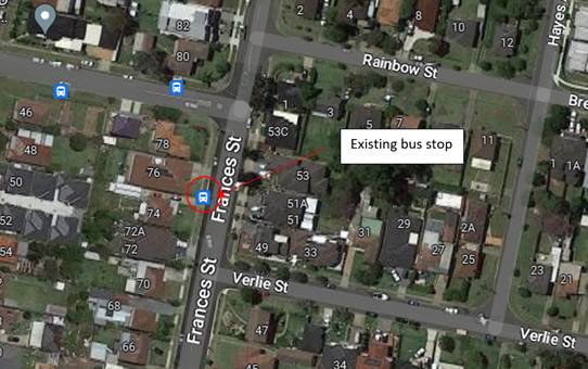
Figure
1 – Locality Plan
It is indicated by the
representative of Transit Systems that vehicles often park at the bus stop. As
a result, buses are not able to access this bus stop and park safely.
In accordance with the NSW Road
Rules 195:
‘A driver (except the driver
of a public bus) must not stop at a bus stop, or on the road, within 20 metres
before a sign on the road that indicates the bus stop, and 10 metres after the
sign, unless the driver stops at a place on a length of road, or in an area, to
which a parking control sign applies, and the driver is permitted to stop at
that place under these Rule.’
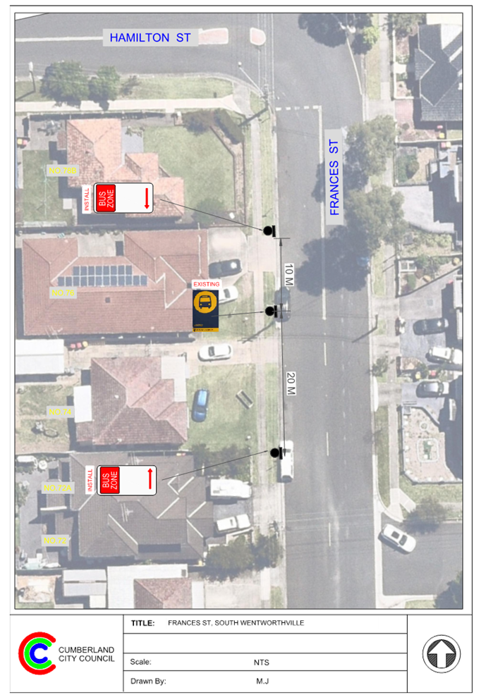
Therefore, it is proposed to
install ‘Bus Zone’ signs at the existing bus stop to strengthen the
Road Rules requirement as per attached plan.
Consultation was carried out with
the impacted and adjacent residents for a period of 14 days starting from 3 to
17 February 2023. No submissions were received.
1. Plan -
Frances Street, South Wentworthville – Proposed ‘Bus Zone’
signs
DOCUMENTS
ASSOCIATED WITH
REPORT ECTC-23-030
Attachment 1
Plan - Frances Street, South Wentworthville
– Proposed ‘Bus Zone’ signs
Extraordinary Traffic Committee
1 March 2023
Extraordinary Traffic Committee
1 March 2023
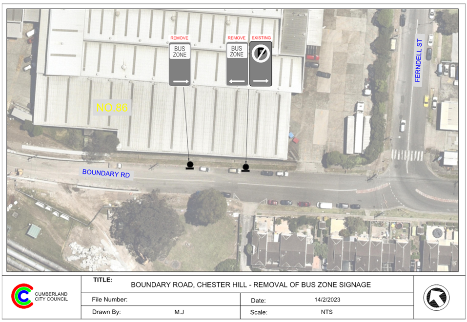
Item
No: ECTC-23-031
Boundary Road,
Chester Hill - Removal of Redundant 'Bus Zone' Signage
Directorate: Environment
and Planning
Responsible
Officer: Executive
Manager Development and Building
File
Number: T-28-01/06
Electorate: Auburn
Police Area
Command (PAC): Cumberland
Agenda Part Part
1
Note: Recommended
for Approval under Delegated Authority
Council has received a request
from a resident to remove a redundant ‘Bus Zone’ on Boundary Road,
Chester Hill along the side boundary of No. 86 Ferndell Street.
This report outlines the outcome
of the investigation into this matter.
|
That the Traffic Committee recommends that the
removal of the redundant ‘Bus Zone’ on the northern side of
Boundary Road, Chester Hill along the side boundary of No.86 Ferndell Street
as per attached plan be approved.
|
Boundary Road between Ferndell
Street and Priam Street is a local road that runs in an east-west direction
with a speed limit of 50 km/h. It has a width of approximately 12.5m and
parking is permitted on both sides of the road unless signposted.
There are ‘Bus Zone’
signs on the northern side of Boundary Road between Ferndell Street and Priam
Street.
It is alleged that the bus stop at
this location has not been in use and the bus zone signs are redundant.
Upon consultation, the bus
operator (Transdev) has advised as follows:
“This bus stop was in
use until the road was closed for a long period of time for the bridge works.
We have not restored the previous school trips which operated past here and can
keep operating on the amended route moving forward. Therefore, no objections to
the removal of the bus zone.”
Removing this redundant ‘Bus
zone’ signs will provide unrestricted parking for the residents and
industry visitors or employees.
It is proposed to remove the
‘Bus Zone’ signs on the northern side of Boundary Road, Chester
Hill along the side boundary of No.86 Ferndell Street.
Consultation is not required as
the existing bus stop is redundant and removal will provide additional
unrestricted parking for the residents and industry visitors or employees.
Transdev has been notified and
agreed for the removal of the redundant ‘Bus Zone’
signage.
1. Plan –
Boundary Road, Chester Hill – Removal of a redundant ‘Bus
Zone’
DOCUMENTS
ASSOCIATED WITH
REPORT ECTC-23-031
Attachment 1
Plan – Boundary Road, Chester Hill –
Removal of a redundant ‘Bus Zone’
Extraordinary Traffic Committee
1 March 2023
Extraordinary Traffic Committee
1 March 2023
Item
No: ECTC-23-032
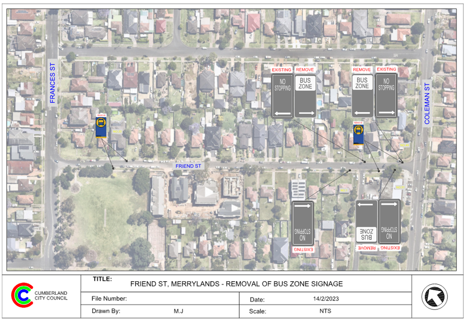
Friend Street,
Merrylands - Removal of Redundant 'Bus Zone' Signage
Directorate: Environment
and Planning
Responsible
Officer: Executive
Manager Development and Building
File
Number: T-28-01/06
Electorate: Granville
Police Area
Command (PAC): Cumberland
Agenda Part Part
1
Note: Recommended
for Approval under Delegated Authority
Council has received a request
from Transit Systems to remove four redundant bus stops in Friend Street,
Merrylands due to the change of the existing bus route.
This report outlines the outcome
of the investigation into this matter.
|
That the Traffic Committee recommends that the
removal of the redundant ‘Bus Zone’ signage on both sides of
Friend Street, Merrylands as per attached plan be approved.
|
Friend Street is classified as a
local road that runs in an east-west direction with a speed limit of 50 km/h.
It has a width of approximately 7.3m and parking is permitted on both sides of
the road in accordance with Road Rules unless signposted.
Transit Systems, the bus operator
has indicated that parked cars on both sides of Friend Street make it difficult
for buses to travel safely through the narrow street. They intend to move the
bus route to Verlie Street which is approximately 10.2m wide.
Transit Systems has advised that
Friend Street will be removed from the route from Monday, 27 March 2023 as per
the figure below.
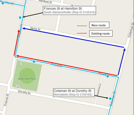
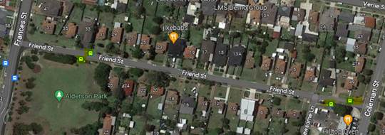
Currently, there are four existing
bus stops in Friend Street for bus route 809, two of them have ‘Bus
Zone’ signage. The map below shows the bus stops in Friend Street.
Since the bus route is to be moved
to Verlie Street, it is proposed that the existing four bus stops in Friend
Street are no longer required and are to be removed by Transit Systems.
It is proposed to remove the ‘Bus Zone’ signage on both side of
Friend Street, Merrylands as per attached drawing. Unrestricted on-street
parking will be resumed.
With regards to rerouting of the
bus route, any decisions in potential bus locations are separate to this report
and is a matter for the bus operator, Transit Systems and TfNSW.
Consultation is not required as
the existing bus stops will be redundant, and removal will provide additional
unrestricted parking for the residents.
Transit Systems has been notified
and agreed to remove the ‘Bus Zone’ signage.
1. Plan –
Friend Street, Merrylands – Removal of a redundant ‘Bus Zone’
DOCUMENTS
ASSOCIATED WITH
REPORT ECTC-23-032
Attachment 1
Plan – Friend Street, Merrylands – Removal
of a redundant ‘Bus Zone’
Extraordinary Traffic Committee
1 March 2023
Extraordinary Traffic Committee
1 March 2023
Item
No: ECTC-23-033
Pritchard
Street West, Wentworthville - Modification to the existing accessible parking
space
Directorate: Environment
and Planning
Responsible
Officer: Executive
Manager Development and Building
File
Number: T-28-01/06
Electorate: Prospect
Police Area
Command (PAC): Cumberland
Agenda Part Part
1
Note: Recommended
for Approval under Delegated Authority
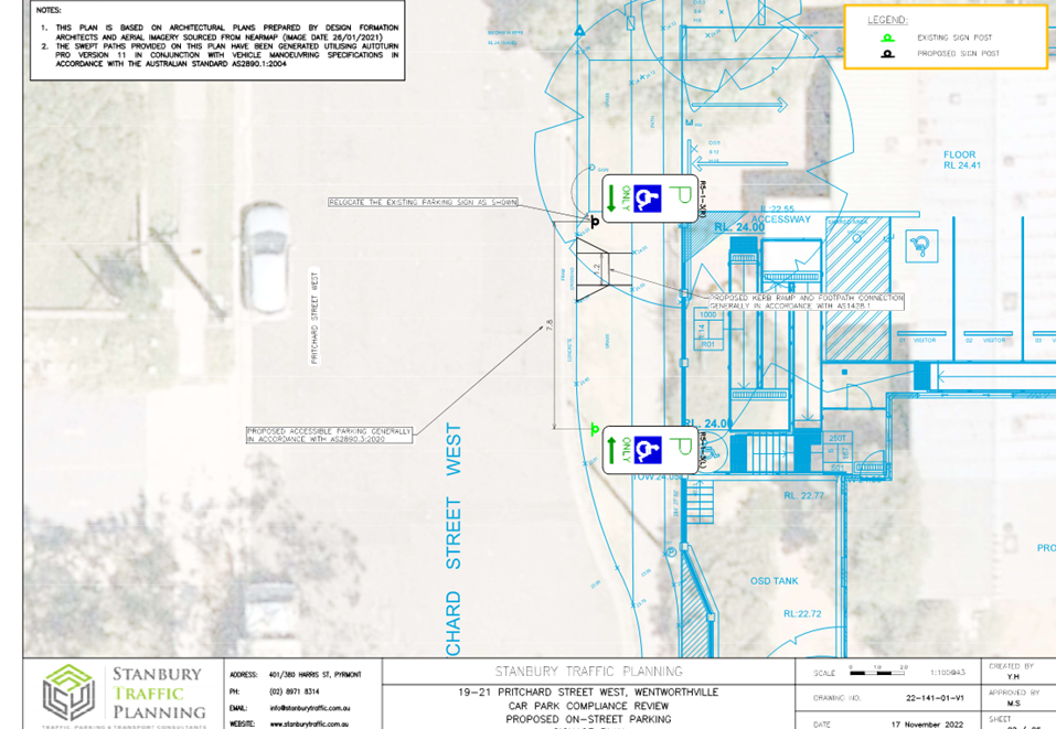
Council has received a request
from the developer (Landpro Development Management) of No.19-21 Pritchard
Street West, Wentworthville regarding the relocation of the existing accessible
parking space outside the existing Child Care Centre at No.19-21 Pritchard
Street West.
This report outlines the outcome
of the investigation into this matter.
|
That the Traffic Committee recommends that:
1. The
relocation of the existing accessible parking space on the northern side of
Pritchard Street West, Wentworthville outside No.19-21 be in accordance with
attached plan be approved.
2. The
above accessible parking space be removed after the completion of the Child
Care Centre development.
3. The
residents be notified of the outcome.
|
Council has granted approval for
the proposed development at 19-21 Pritchard Street West, Wentworthville to
construct a new Pre-School to cater for 30 to 40 children plus on-site car
park.
As per the approved condition No.
25:
‘The proposed relocation of
the existing accessible space shall be approved subject to Council’s
Traffic Committee approval.’
Pritchard Street West is a local
street that runs in an east – west direction with a speed limit of 50
km/h. Pritchard Street West connects with Emert Street at its western end and
has a cul-de-sac at its eastern end at Cumberland Highway. Parking is permitted
on both sides of the road unless signposted.
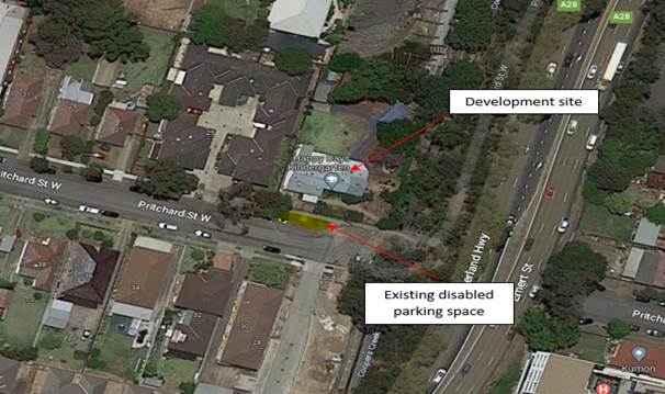
Figure
1 – Locality Plan
Currently, the site (No.19-21
Pritchard Street) operates as a Child Care Centre and there is an accessible
parking space outside the property provided for the existing centre. It is
proposed to relocate the accessible parking sign approximately 2 metres east
and provide pavement marking and an access ramp. The sign also needs to be
relocated to accommodate the new driveway of the proposed centre (Figure 2).
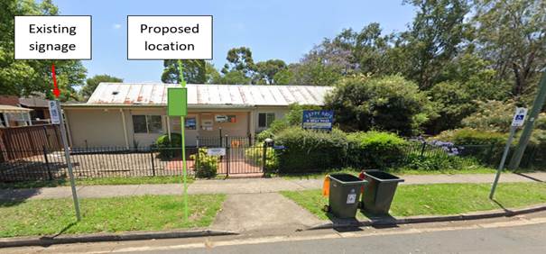
Figure
2 – Proposed location
The on-street accessible parking
space will be removed after the completion of the construction of the proposed
development, as an accessible parking space will be provided in the new car
park of the development.
Consultation is not required as no
residents will be impacted by the proposed modifications to the existing
accessible parking space.
1. Plan –
Pritchard Street West, Wentworthville – Relocation to the existing
accessible parking space
DOCUMENTS
ASSOCIATED WITH
REPORT ECTC-23-033
Attachment 1
Plan – Pritchard Street West, Wentworthville
– Relocation to the existing accessible parking space
Extraordinary Traffic Committee
1 March 2023
Extraordinary Traffic Committee
1 March 2023
Item
No: ECTC-23-034
Old Prospect
Road and Grafton Street, Greystanes - Proposed 'no stopping' Restrictions and
Line Marking
Directorate: Environment
and Planning
Responsible
Officer: Executive
Manager Development and Building
File
Number: HC-24-01-3/02
Electorate: Prospect
Police Area
Command (PAC): Cumberland
Agenda Part Part
1
Note: Recommended
for Approval under Delegated Authority
Council has received safety
concerns from a resident at the intersection of Old Prospect Road and Grafton
Street, Greystanes.
This report outlines the outcome
of the investigation into this matter.
|
That the Traffic Committee recommends that:
1. The
installation of ‘No Stopping’ signs and ‘BB’ centre
line at the intersection of Old Prospect Road and Grafton Street, Greystanes
in accordance with the attached plan be approved.
2. The
adjacent residents be notified of the outcome.
|
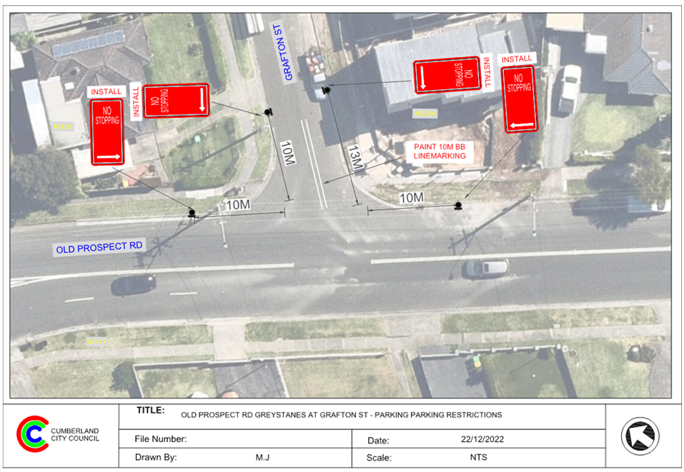
Old Prospect Road is a Collector
Road that runs in an east-west direction with a speed limit of 50 km/h. It has
a width of approximately 12m and parking is permitted on both sides of the road
unless signposted. ‘BB’ centre lines are marked in Old Prospect
Road.
Grafton Street runs in a north
– south direction with a speed limit of 50 km/h. It has a width of
approximately 7.5m and parking is permitted on both sides of the road in
accordance with Road Rules unless otherwise signposted.
Old Prospect Road and Grafton
Street form a T-intersection. The intersection does not have a ‘Give
Way’ sign; however, default priority applies with Old Prospect Road
having priority.
The map below shows the
intersection:
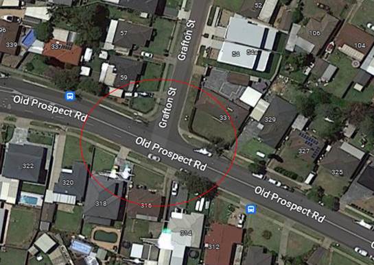
Figure
1 – Locality Plan
The latest Centre for Road Safety
accident data indicated that there were no reported accidents at this
intersection in the 5 years ending June 2022.
A site inspection indicated that
vehicles are parking within 10 metres from the intersection. The installation
of ‘No Stopping’ signs at the intersection would strengthen the
Road Rules requirements and stop vehicles from parking too close to the
intersection. It is also proposed to provide 10m ‘BB’ centre line
marking on the Grafton Street approach to keep turning vehicles on the left
side of the centre line.
The ‘No Stopping’ sign
on the eastern side of Grafton Street is proposed to be installed at 13m to allow
vehicles to safely pass a parked car without encroaching the proposed BB line
marking in the narrow road. The sign on the western side is at 10m at the edge
of the driveway of the corner property.
The proposal to provide ‘No
Stopping’ signs and ‘BB’ centre line marking at this
intersection as per the attached plan which will enhance safety at this
intersection.
Consultation was carried out with
the impacted and adjacent residents for a period of 14 days starting from 12 to
26 January 2023. No submissions were received.
1. Plan –
Old Prospect Road and Grafton Street, Greystanes – Proposed ‘No
Stopping’ restrictions and line marking
DOCUMENTS
ASSOCIATED WITH
REPORT ECTC-23-034
Attachment 1
Plan – Old Prospect Road and Grafton Street,
Greystanes – Proposed ‘No Stopping’
restrictions and line marking
Extraordinary Traffic Committee
1 March 2023
Extraordinary Traffic Committee
1 March 2023
Item
No: ECTC-23-035
Davidson Road
and Robertson Street, Guildford - Proposed 'No Stopping" Restrictions and
Line Marking
Directorate: Environment
and Planning
Responsible
Officer: Executive
Manager Development and Building
File
Number: HC-24-01-3/02
Electorate: Auburn
Police Area
Command (PAC): Cumberland
Agenda Part Part
1
Note: Recommended
for Approval under Delegated Authority
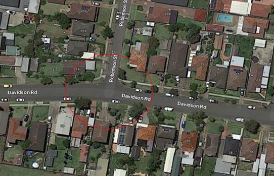
Council has received safety
concerns from a resident at the intersection of Davidson Road and Robertson Street,
Guildford.
This report outlines the outcome
of the investigation into this matter.
|
That the Traffic Committee recommends that:
1. The
installation of ‘No Stopping’ signs and ‘BB’ centre
line at the intersection of Davidson Road and Robertson Street, Guildford in
accordance with the attached plan be approved.
2. The
affected residents be notified of the outcome.
|
Davidson Road is a local road that
runs in an east-west direction with a speed limit of 50 km/h. It has a width of
approximately 12m and parking is permitted on both sides of the road unless
signposted.
Robertson Street is a local road
that runs in a north – south direction with a speed limit of 50 km/h. It
has a width of approximately 7.5m and parking is permitted on both sides of the
road in accordance with the Road Rules unless otherwise signposted. Robertson
Street has ‘BB’ centre lines painted at the intersection.
Davidson Road and Robertson Street
form a T-intersection. The intersection does not have a ‘Give Way’
sign; however, default priority applies with Davidson Road having priority.
The map below shows the
intersection:
The latest Centre for Road Safety
accident data indicated that there were no reported accidents at this
intersection in the 5 years ending June 2022.
A site inspection indicated that
vehicles are parking within 10 metres from the intersection. The installation
of ‘No Stopping’ signs at the intersection would strengthen the
Road Rules requirements and stop vehicles from parking too close to the
intersection.
The ‘No Stopping’
signs are proposed to be installed on both sides of Roberson Street beyond 10m
to allow vehicles to safely pass a parked car without encroaching the existing
‘BB’ centre line marking in the narrow road.
It is also proposed to provide 20m
‘BB’ centre line markings on Davidson Road on both approaches at
the intersection to help vehicles turning into and out of Robertson Street
position correctly.
The proposal to provide ‘No
Stopping’ signs and ‘BB’ centre line marking at the
intersection as per the attached plan which will enhance safety at this
intersection.
Consultation was carried out with
the impacted and adjacent residents for a period of 14 days starting from 12 to
26 January 2023. No submissions were received.
1. Plan –
Davidson Road and Robertson Street, Guildford – Proposed ‘No
Stopping’ restrictions and line marking.
DOCUMENTS
ASSOCIATED WITH
REPORT ECTC-23-035
Attachment 1
Plan – Davidson Road and Robertson Street,
Guildford – Proposed ‘No Stopping’ restrictions and line
marking.
Extraordinary Traffic Committee
1 March 2023
Extraordinary Traffic Committee
1 March 2023
Item
No: ECTC-23-036
Rawson Street
and Dalley Street, Lidcombe - Proposed 'No Stopping'Restrictions
Directorate: Environment
and Planning
Responsible
Officer: Executive
Manager Development and Building
File
Number: T-28-01/06
Electorate: Auburn
Police Area
Command (PAC): Auburn
Agenda Part Part
1
Note: Recommended
for Approval under Delegated Authority
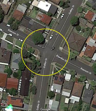
Council has received safety
concerns from a resident at the intersection of Rawson Street and Dalley
Street, Lidcombe.
This report outlines the outcome
of the investigation into this matter.
|
That the Traffic Committee recommends that:
1. The
installation of ‘No Stopping’ signs on Rawson Street and Dalley
Street, Lidcombe in accordance with the attached plan be approved.
2. The
affected residents be notified of the outcome.
|
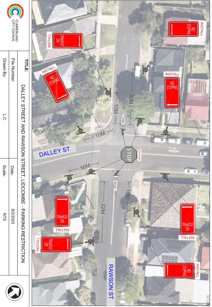
Rawson Street is a local road that
runs in an east-west direction between Swete Street and Bachell Avenue with a
speed limit of 50 km/h. It has a width of approximately 9.6m on western
approach and 12.5m on the eastern approach and parking is permitted on both
sides of the road in accordance with Road Rules unless otherwise signposted.
Dalley Street is a local road that
runs in a north-south direction with speed limit of 50 km/h. It has a width of
approximately 12.5m and parking is permitted on both sides of the road unless
otherwise signposted.
Rawson Street and Dalley Street
form a four-way intersection with existing ‘Stop’ controls on the
Rawson Street approaches. There are two existing refuge islands and 20m
‘BB’ centre line markings provided on both side of Rawson Street at
the intersection.
The map below shows the
intersection.
Figure
1 – Locality Plan
The latest Centre for Road Safety
accident data indicated that there were no reported accidents at this
intersection in the 5 years ending June 2022.
It is proposed to install 10m
‘No Stopping’ signs on the Dalley Street approaches of the
intersection. For the Rawson Road approaches of the intersection, it is
proposed to install ‘No Stopping’ signs at varying distances
greater than 10m to comply with the statutory ‘No Stopping’
distances for pedestrian refuge islands; namely; 20m on the approach to the
refuge island and 10m on the exit side of the refuge island for each travel
direction. The signs would strengthen the Road Rules requirements and stop vehicles
from parking too close to the existing intersection with refuge islands. This
will enhance safety of pedestrians using the existing pedestrian refuge
islands.
Therefore, it is proposed to
install the ‘No Stopping’ signs at the intersection of Rawson Road
and Dalley Road as per the attached plan.
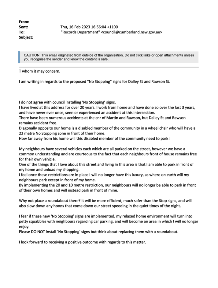
Consultation was carried out with
the impacted and adjacent residents for a period of 14 days starting from 9
February 2023 to 22 February 2023. One submission was received objecting to the
proposal. However, the resident is not directly impacted by the statutory
‘No Stopping’ restrictions proposed.
1. Plan –
Rawson Street and Dalley Street, Lidcombe – Proposed ‘No
Stopping’ Restrictions
2. Redacted
Submission
DOCUMENTS
ASSOCIATED WITH
REPORT ECTC-23-036
Attachment 1
Plan – Rawson Street and Dalley Street, Lidcombe
– Proposed ‘No Stopping’ Restrictions
Extraordinary Traffic Committee
1 March 2023
DOCUMENTS
ASSOCIATED WITH
REPORT ECTC-23-036
Attachment 2
Redacted Submission
Extraordinary Traffic Committee
1 March 2023

Extraordinary
Traffic Committee
1 March 2023
Item
No: ECTC-23-037
Bridge Road
and Killeen Street, Wentworthville - Proposed 'no stopping' Restrictions
Directorate: Environment
and Planning
Responsible
Officer: Executive
Manager Development and Building
File
Number: T-28-01/06
Electorate: Granville
Police Area
Command (PAC): Cumberland
Agenda Part Part
1
Note: Recommended
for Approval under Delegated Authority
Council has received safety
concerns from a resident at the intersection of Bridge Road and Killeen Street,
Wentworthville.
This report outlines the outcome
of the investigation into this matter.
|
That the Traffic Committee recommends that:
1. The
installation of ‘No Stopping’ signs at the intersection of Bridge
Road and Killeen Street, Wentworthville in accordance with the attached plan
be approved.
2. The
affected residents be notified of the outcome.
|
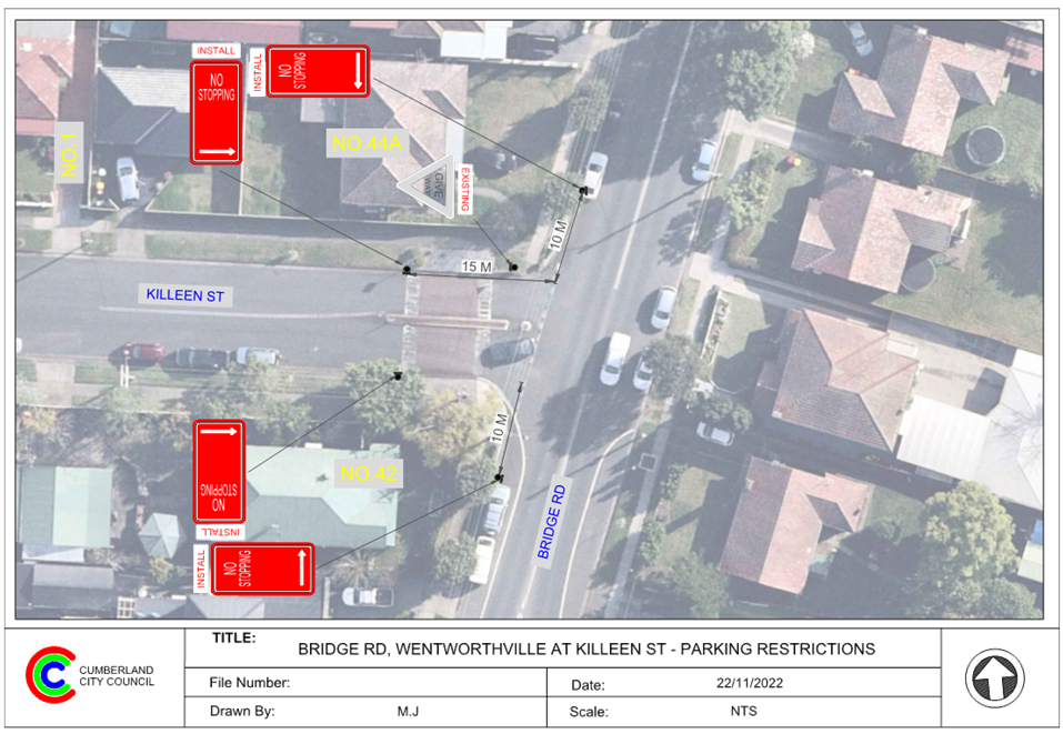
Killeen Street, Wentworthville is
a local road that runs in an east-west direction between Lytton Street and
Bridge Road with a speed limit of 50 km/h. It has a width of approximately
10.3m and parking is permitted on both sides of the road unless otherwise
signposted.
Bridge Road is a local collector
road that runs in a north-south direction with a speed limit of 50 km/h. It has
a width of approximately 13m and parking is permitted on both sides of the road
unless otherwise signposted.
Killeen Street and Bridge Road
form a T-intersection. There is an existing ‘Give way’ sign
installed in Killeen Street on the approach to Bridge Road. There is also a
raised threshold with a median island located on Killeen Street at the
intersection.
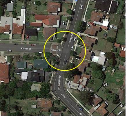
The map below shows the
intersection.
The latest Centre for Road Safety
accident data indicated that there were no reported accidents at this
intersection in the 5 years ending June 2022.
A site inspection indicated that
vehicles are parking on Bridge Road within 10 metres from the intersection. The
installation of ‘No Stopping’ signs at the intersection would
strengthen the Road Rules requirements and stop vehicles from parking too close
to the intersection.
The ‘No Stopping’
signs are proposed to be installed on both sides of Killeen Street at 15m to
allow vehicles to pass a parked car without mounting the existing median
island.
The proposed ‘No
Stopping’ signs at this intersection as per the attached plan will
enhance safety.
Consultation was carried out with
the impacted and adjacent residents for a period of 14 days starting from 24
November to 8 December 2022. No submissions were received.
1. Plan –
Bridge Road and Killeen Street, Wentworthville– Proposed ‘No
Stopping’ restrictions at the intersection
DOCUMENTS
ASSOCIATED WITH
REPORT ECTC-23-037
Attachment 1
Plan – Bridge Road and Killeen Street,
Wentworthville– Proposed ‘No Stopping’ restrictions at the
intersection
Extraordinary Traffic Committee
1 March 2023
Extraordinary Traffic Committee
1 March 2023
Item
No: ECTC-23-038
Meakin Street
and Grace Crescent, Merrylands - Proposed 'no stopping' Restrictions and Line
Marking
Directorate: Environment
and Planning
Responsible
Officer: Executive
Manager Development and Building
File
Number: T-28-01/06
Electorate: Granville
Police Area
Command (PAC): Cumberland
Agenda Part Part
1
Note: Recommended
for Approval under Delegated Authority
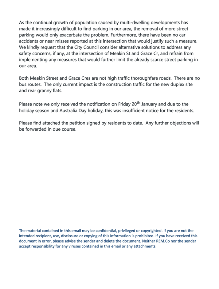
Council has received safety
concerns from a resident at the intersection of Meakin Street and Grace
Crescent, Merrylands.
This report outlines the outcome
of the investigation into this matter.
|
That the Traffic Committee recommends that:
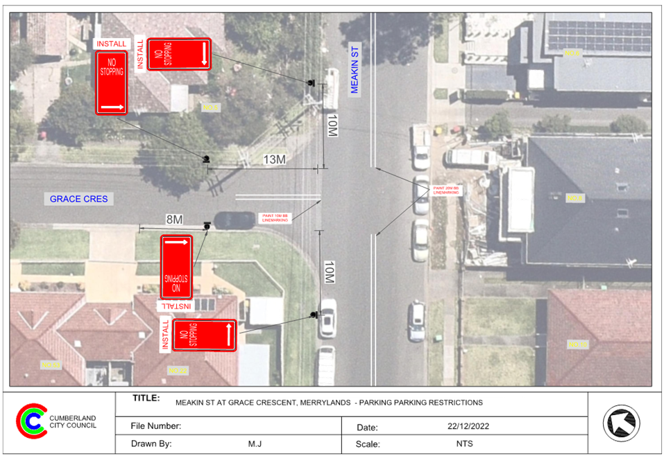
1. The
installation of ‘No Stopping’ signs and BB line marking at the
intersection of Meakin Street and Grace Crescent, Merrylands in accordance
with the attached plan be approved.
2. The
affected residents be notified of the outcome.
|
Meakin Street, Merrylands is a
local road that runs in a north- south direction between St Ann Street and
Myall Street with a speed limit of 50 km/h. It has a width of approximately
12.5m and parking is permitted on both sides of the road unless otherwise
signposted.
Grace Crescent is a local road
with a speed limit of 50 km/h. It connects with Meakin Street at its eastern
end and has a cul-de-sac at its southern end. Grace Crescent has a width of
approximately 7.1m and parking is permitted on both sides of the road in accordance
with Road Rules unless otherwise signposted.
Grace Crescent and Meakin Street
form a T-intersection with default priority to Meakin Street.
The map below shows the
intersection.
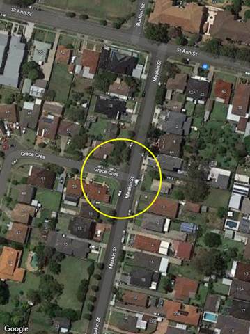
Figure
1 – Locality Plan
The latest Centre for Road Safety accident
data indicated that there were no reported accidents at this intersection in
the 5 years ending June 2022.
A site inspection indicated that
vehicles are parking within 10 metres from the intersection. The installation
of ‘No Stopping’ signs at the intersection would strengthen the
Road Rules requirements and stop vehicles from parking too close to the
intersection.
It is also proposed to provide 10m
‘BB’ centre line marking on Grace Crescent The ‘No
Stopping’ signs are proposed to be installed on both sides of Grace
Crescent at 13m to allow vehicles to safely pass a parked car without
encroaching the proposed BB line marking.
Therefore, it is proposed to
install the ‘No Stopping’ signs and BB line marking at the
intersection as per the attached plan.
Consultation was carried out with
the impacted and adjacent residents for a period of 14 days starting from 12 to
26 January 2023.
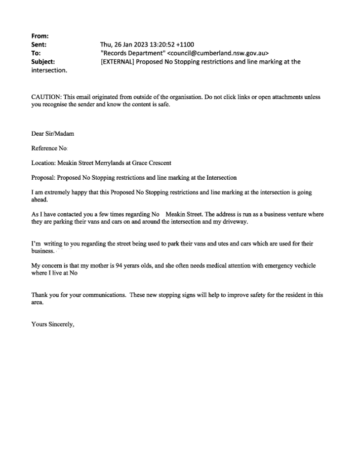
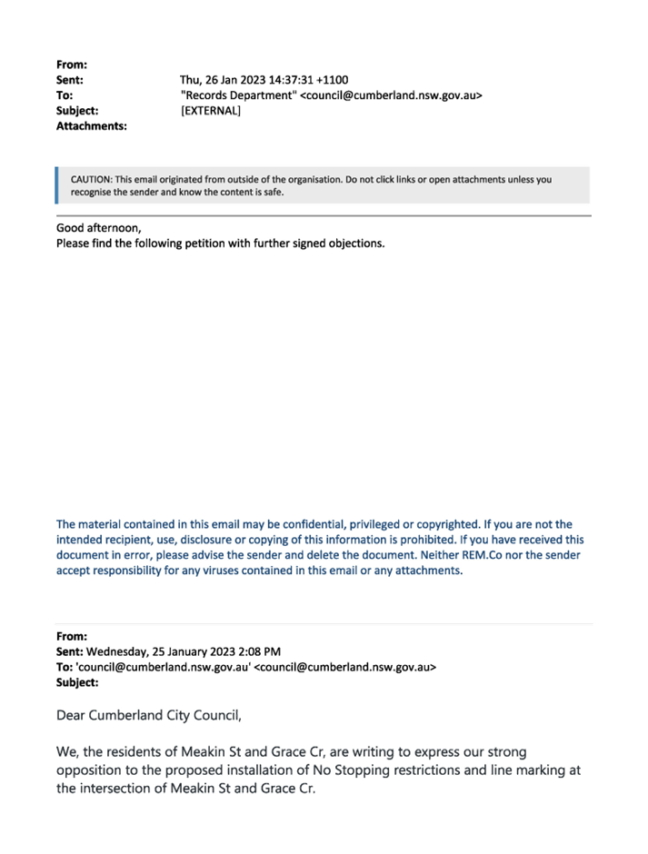
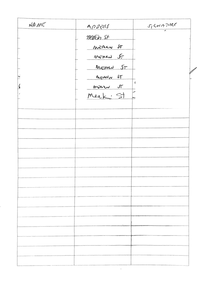
Council received one submission
supporting the proposal and a petition from the local residents objecting to
the proposal. The main concern raised by the residents is that the proposed
signage and line marking will reduce the number of on-street parking spaces at
this intersection. It should be noted that most of the residents who signed the
petition is not impacted by the proposal.
As per the NSW Road Rules,
vehicles are not allowed to stop within 10m from an intersection. Therefore,
the proposed ‘No Stopping’ restrictions will not result any loss of
legal parking spaces in Meakin Street.
The proposed 13m ‘No Stopping’
restrictions on both sides of Grace Crescent are to allow vehicles to safely
pass a parked car without encroaching the proposed BB line marking. The
proposed parking restrictions and line marking will not have a significant
impact on the local residents.
1. Plan –
Meakin Street and Grace Crescent, Merrylands – Proposed ‘No
Stopping’ restrictions and BB line marking at the intersection
2. Redacted
Submissions
DOCUMENTS
ASSOCIATED WITH
REPORT ECTC-23-038
Attachment 1
Plan – Meakin Street and Grace Crescent,
Merrylands – Proposed ‘No Stopping’ restrictions and BB line
marking at the intersection
Extraordinary Traffic Committee
1 March 2023
DOCUMENTS
ASSOCIATED WITH
REPORT ECTC-23-038
Attachment 2
Redacted Submissions
Extraordinary Traffic Committee
1 March 2023
Extraordinary
Traffic Committee
1 March 2023
Item
No: ECTC-23-039
Brunswick
Street, Granville - Proposed 'no stopping' restrictions
Directorate: Environment
and Planning
Responsible
Officer: Executive
Manager Development and Building
File
Number: T-28-01/06
Electorate: Granville
Police Area
Command (PAC): Cumberland
Agenda Part Part
1
Note: Recommended
for Approval under Delegated Authority
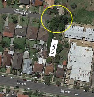
Council has received a request
from the consultants (Wongala Consulting Engineers) regarding the provision of
parking restrictions at the cul-de-sac of Brunswick Street, Granville
associated with the development of 39 Louis Street, Granville (DA2022/0497).
This report outlines the outcome
of the investigation into this matter.
|
That the Traffic Committee recommends that:
1. The
installation of ‘No Stopping’ signs at the cul-de-sac of
Brunswick Street, Granville in accordance with the attached plan be approved.
2. The
cost of installation of the signage to be borne by the applicant.
3. The
affected residents be notified of the outcome.
|
Council has granted deferred
commencement approval for the proposed two lot subdivision at 39 Louis Street,
Granville.
As per the approved condition No.
2:
‘A detailed plan showing the
proposed erection of the ‘NO STOPPING’ street signs on Brunswick
Street shall be prepared in consultation with Council’s Traffic Section.
The proposal shall be submitted to Cumberland Traffic Committee (CTC) for
review and approval. The CTC approval shall be submitted to Council.’
Louis Street, Granville is a local
road that runs in an east-west direction between Woodville Road and Blaxcell
Street with a speed limit of 50 km/h.
Brunswick Street, Granville is a
local road that runs parallel with Louis Street and has a speed limit of 50
km/h. It has a cul-de-sac at its eastern end and the width of the street
between The Avenue and the cul-de-sac is approximately 7m. Parking is permitted
on both sides of the road in accordance with Road Rules unless otherwise
signposted.
The map below shows the location.
The proposed subdivision is shown
below:
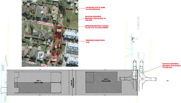
Lot 2 of the subdivision of No.39
Louis Street has driveway access via Brunswick Street at the cul-de-sac which
is currently unrestricted. The engineering consultants provided a turning path
diagram showing vehicles entering and leaving the site. The diagram indicated
that vehicles are not able to access the site when cars are parked in the
cul-de-sac.
Therefore, in accordance with the
development condition, it is proposed to install ‘No Stopping’
signs at the cul-de-sac in Brunswick Street as per the attached plan to improve
vehicle accessibility to Lot 2 of the subdivision at No.39 Louise Street and
manoeuvring of other vehicles in the cul-de-sac.
The proposal was notified to the
impacted and adjacent residents for a period of 14 days starting from 3
February 2023 to 17 February 2023.
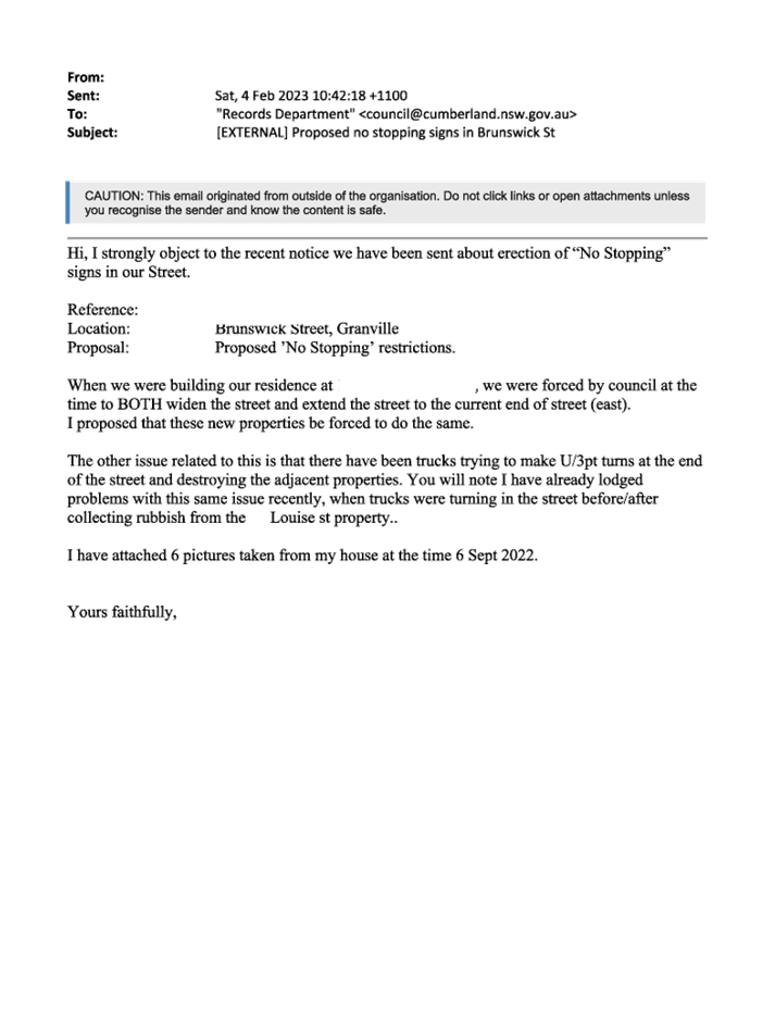
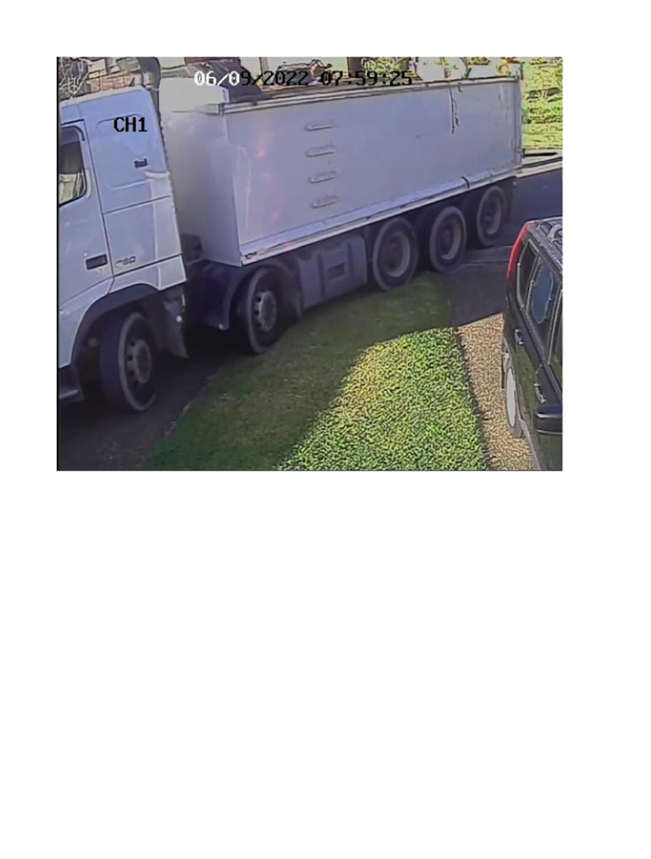
One submission was received.
However, the concerns raised by the resident are not related to the proposed
parking restrictions.
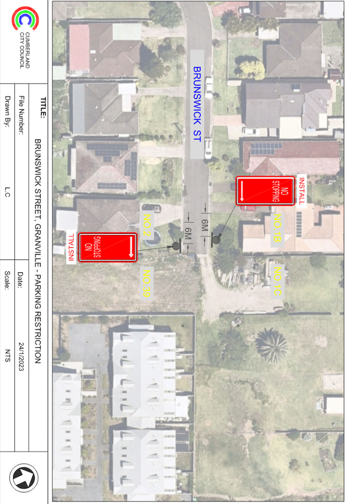
1. Plan –
Brunswick Street, Granville – Proposed ‘No Stopping’ restrictions
2. Redacted
Submissions
DOCUMENTS
ASSOCIATED WITH
REPORT ECTC-23-039
Attachment 1
Plan – Brunswick Street, Granville –
Proposed ‘No Stopping’ restrictions
Extraordinary Traffic Committee
1 March 2023
DOCUMENTS
ASSOCIATED WITH
REPORT ECTC-23-039
Attachment 2
Redacted Submissions
Extraordinary Traffic Committee
1 March 2023
Extraordinary
Traffic Committee
1 March 2023
Item
No: ECTC-23-040
Toongabbie
Road, Toongabbie - Application for 'works zone' signage
Directorate: Environment
and Planning
Responsible
Officer: Executive
Manager Development and Building
File
Number: T-28-01/06
Electorate: Prospect
Police Area
Command (PAC): Cumberland
Agenda Part Part
1
Note: Recommended
for Approval under Delegated Authority
Council has received an
application for a ‘Works Zone’ in Toongabbie Road, Toongabbie
associated with the development at 27-29 Toongabbie Road, Toongabbie.
This report outlines the outcome
of the investigation into this matter.
|
That the Cumberland Traffic Committee recommends
that:
1. The
24m long ‘Works Zone, 7:00am-6:00pm, Monday-Friday, 8:00am-4:00pm,
Saturday’ signs be installed on the frontage of the development site on
Toongabbie Road, Toongabbie subject to Council’s standard conditions
for the period of 6 months and subsequent extension if required.
2. The
applicant be advised to pay the ‘Works Zone’ fees to Council as
per the adopted Fees and Charges.
|
Council has received an
application for a ‘Works Zone’ on Toongabbie Road, Toongabbie
associated with the development at 27-29 Toongabbie Road, Toongabbie. The
proposed development involves construction of 5 storey residential flat
building over basement parking accommodating 20 residential units and 25
parking spaces.
The temporary “Works
Zone” is approximately 24m in length and proposed to commence in March
2023 for 6 months. The proposed time is between 7:00am to 6:00pm Monday to
Friday and 8:00am to 4:00pm on Saturdays.
There will be a loss of four (4)
on-street unrestricted parking spaces on the northern side of Toongabbie Road.
Toongabbie during the operation of the “Works Zone”.
The proposal is outside the property being developed and no
consultation is required
as the request was made by the builder.
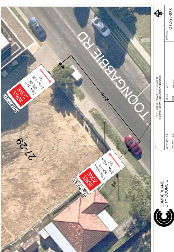
1. Plan –
Toongabbie Road, Toongabbie – Proposed Temporary ‘Works Zone’
signage
DOCUMENTS
ASSOCIATED WITH
REPORT ECTC-23-040
Attachment 1
Plan – Toongabbie Road, Toongabbie –
Proposed Temporary ‘Works Zone’ signage
Extraordinary Traffic Committee
1 March 2023
Extraordinary Traffic Committee
1 March 2023
Part 2
Recommendation to Council
Extraordinary Traffic Committee
1 March 2023
Item
No: ECTC-23-041
Temporary Road
Closure in the Auburn CBD for Ramadan Food Festival 2023
Directorate: Environment
and Planning
Responsible
Officer: Executive
Manager Development and Building
File
Number: T-28-01/06
Electorate: Auburn
Police Area
Command (PAC): Auburn
Agenda Part Part
2
Note: Recommendation
to Council
Council has received an
application from Council’s Events Section requesting the closure of
selected roads in the Auburn CBD to facilitate ‘Ramadan Street Food
Festival 2023’.
This report outlines the outcome
of the investigation into this matter.
|
That the Traffic Committee recommends the temporary
closure of Auburn Road between Queen Street and Beatrice Street and the
eastern section of Mary Street, between Harrow Road and Auburn Road, Auburn
be approved between the hours of 5AM Saturday, 15 April 2023 and 5AM Sunday,
16 April 2023 subject to;
1. All
affected businesses and emergency stakeholders being notified of the closure.
2. Complying
with the notification requirements of the Roads Act 1993, i.e., placing
public notices in a newspaper and erecting notices on the road.
3. Approval
of a Traffic Management Plan by Transport Management Centre.
4. Temporary
bus routes and bus zones replacing the existing bus zones in the closed area
be provided in consultation with the bus operator.
|
Council has received funding from
Multicultural NSW under the ‘Stronger Together Local Councils Major
Festival Grant’ program. This program aims to support multicultural
festival and events across NSW.
‘Ramadan Food Festival
2023’ is one such event Council has initiated under the funding. The
event provides free access to cultural event celebrating the local community.
Council is committed to delivering
the event to focus interest on the local area, while keeping a community spirit
and attracting visitors from the Sydney metropolitan area. The event will
involve street stalls with food and merchandise.
The event will commence at 6PM on
Saturday 15 April 2023 and end at Midnight 12:00AM.
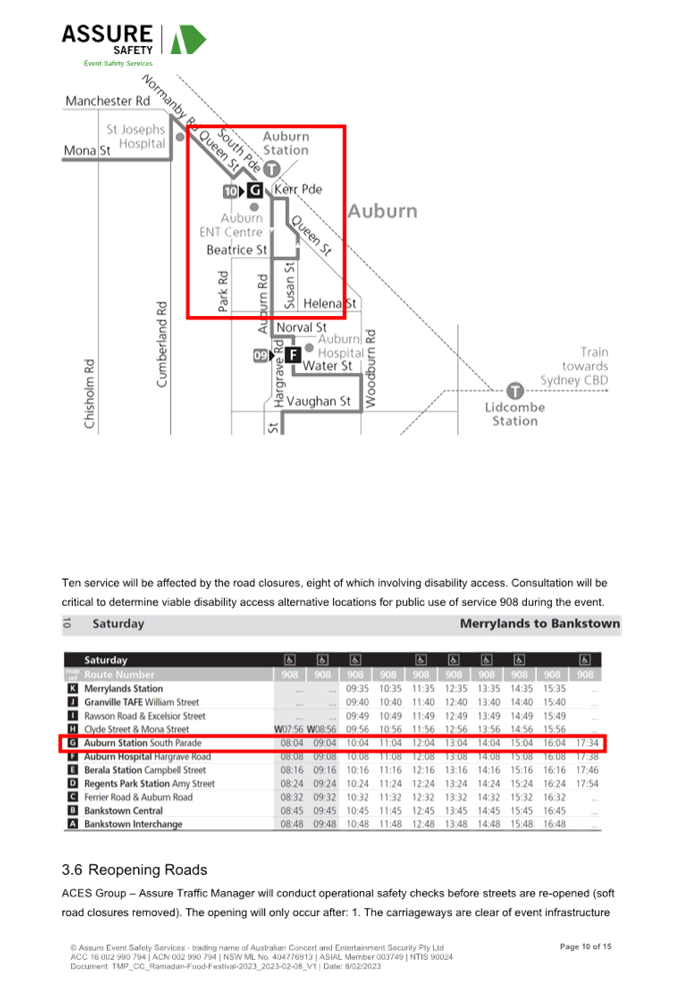
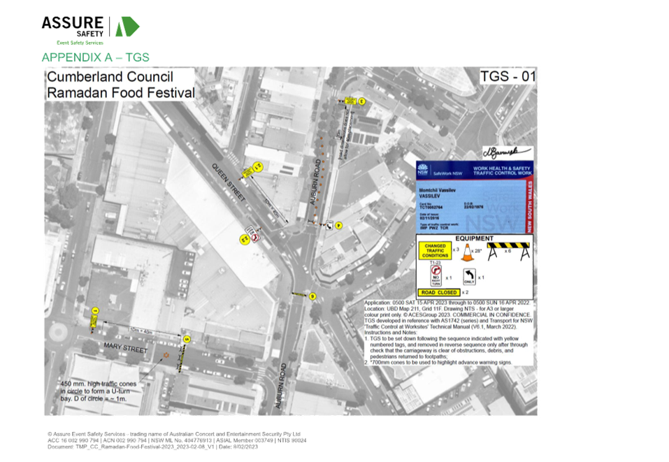
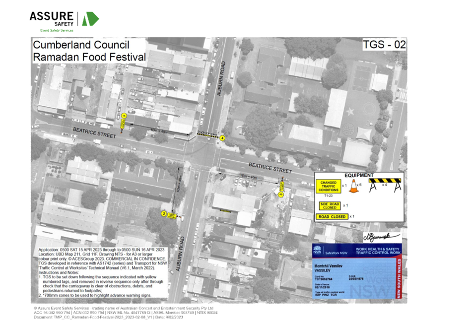
Road Closures:
Road closures will be from 5AM on
Saturday 15 April 2023 to 5AM Sunday 16 April 2023 allowing time for setting up
and dismantling.
The road closure from morning will
prevent any parking within the event area and also provide time for event
officers to set up stalls and other furniture required for the event. The
closure is as follows.
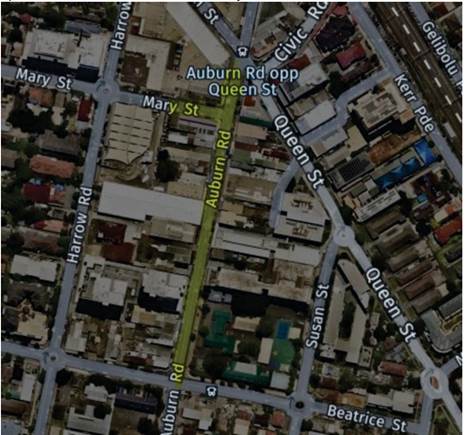
· Auburn
Road between Queen Street and Beatrice Street
· Eastern
section of Mary Street, between Harrow Road and Auburn Road
The map below shows the road
closures in yellow.
This event being an annual event,
no issues were encountered during the event held last year.
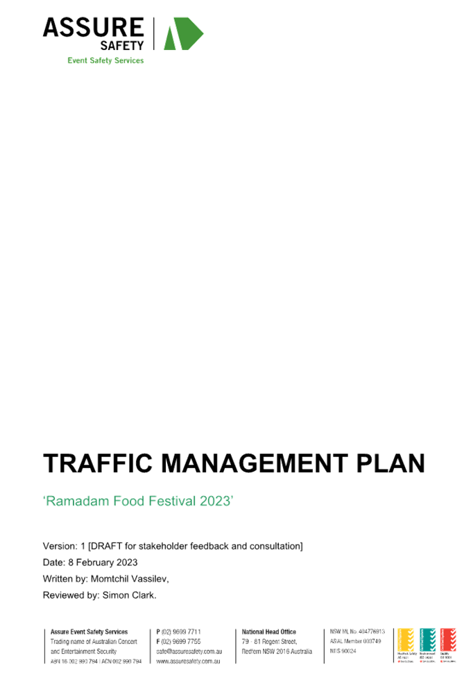
Traffic Management Plan (TMP)
including Traffic Control Plans is attached.
Council will carry out
notification of all affected businesses.
Council will also place
notification of the event on Council’s website.
1. TMP - Ramadan
Food Festival 2023
DOCUMENTS
ASSOCIATED WITH
REPORT ECTC-23-041
Attachment 1
TMP - Ramadan Food Festival 2023
Extraordinary Traffic Committee
1 March 2023
Extraordinary
Traffic Committee
1 March 2023
Item
No: ECTC-23-042
Albert Street,
Palmer Street & Tennyson Parade - Australian Government Black Spot Program
2022/2023
Directorate: Environment
and Planning
Responsible
Officer: Executive
Manager Development and Building
File
Number: HC-24-03-21
Electorate: Fairfield
Police Area
Command (PAC): Cumberland
Agenda Part Part
2
Note: Recommendation
to Council
Council has received funding under
the Australian Government Black Spot Program 2022/2023 financial year for the
construction of a roundabout at the intersection of Albert Street, Palmer
Street and Tennyson Parade, Guildford West.
This report outlines the outcome
of a review into this matter.
|
That the Traffic Committee recommends:
1. The
construction of the proposed roundabout together with the signs and line
marking plan at the intersection of Albert Street, Palmer Street and Tennyson
Parade, Guildford West be approved.
2. The
affected residents be notified prior to construction.
|
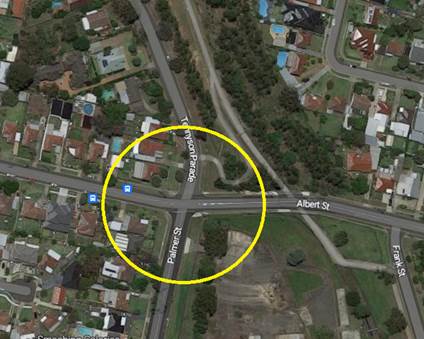
Albert Street is a local road that
runs in an east-west direction between Fairfield Road and Fowler Road. It is
approximately 1 kilometre long and with varying width at different sections.
Palmer Street is a local road that
runs in a northerly direction between McCredie Road and Albert Street and
approximately 770m long. Palmer Street provides one of the boundaries of
Guildford West Public School and has 40km/hr School zone and has a speed limit
of 50km/hr outside the school zone hours. There is also a raised pedestrian
crossing built on Palmer Street outside the school.
Tennyson Parade is a local road running
parallel to the can between Albert Road and Sherwood Road. Albert Street,
Palmer Street and Tennyson Parade form an intersection with priority to Albert
Road and ‘stop’ control on the Palmer Street and Tennyson Parade
approaches.
Figure below shows details of the
intersection.
Based on the crash record at the
intersection, Council officers have investigated the intersection performance
and nominated the site under Australian Government Black Spot Program 2022/2023
Financial Year. The submission was based on the latest Centre for Road Safety
crash data at the time of the application which are summarised below:
Crash Period Investigated: July 2015 – Jun 2020 (5
years)
Total number of crashes: 8
Total number of injury crashes: 4
Primary crash type: Cross traffic (RUM 10)
Proposed treatment: Proposed roundabout
Treatment cost: $353,000
Following the submission, Council
has received a formal notification from the Transport for NSW advising that the
submission for the proposed roundabout at the intersection of Albert Street,
Palmer Street and Tennyson Parade, Guildford West has received funding of
$353,000. This project will need to be completed in 2022/2023 Financial Year.
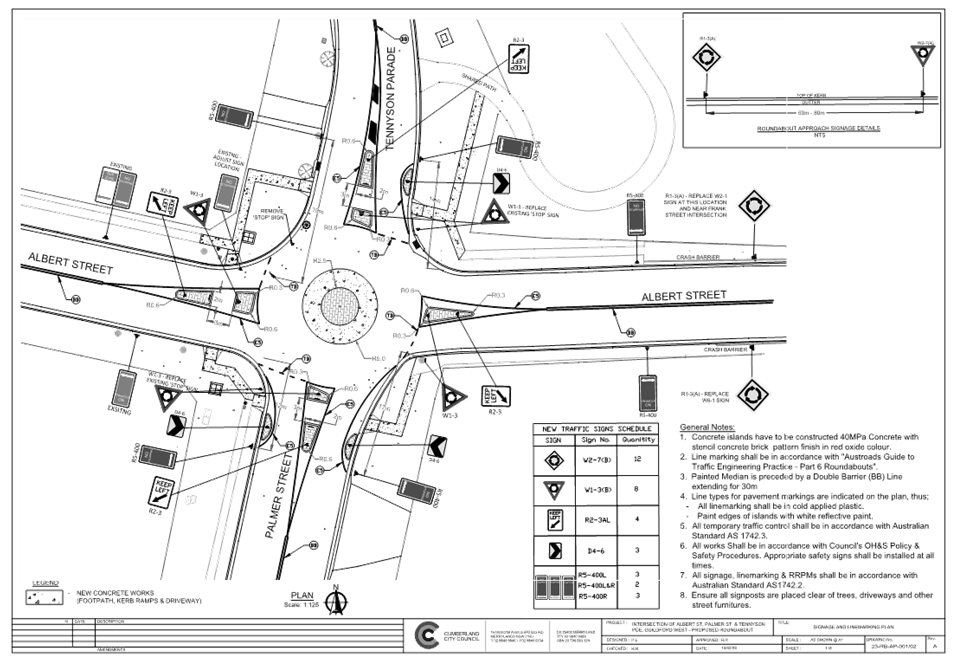
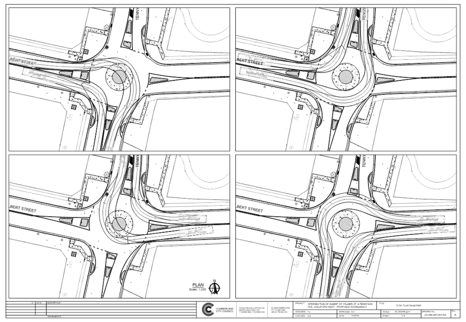
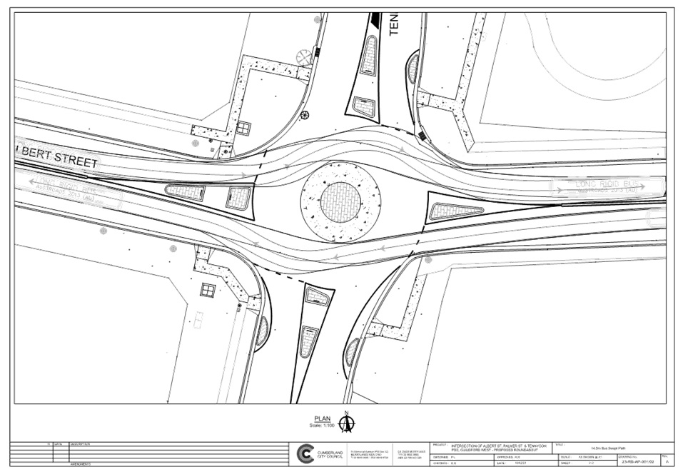
Design plans have been prepared to
accommodate the movement of Heavy Rigid Vehicle (12.5m long) on all approaches
and in accordance with current Roads and Maritime Services / Transport for NSW
Guidelines and considered satisfactory. The central island of the roundabout is
designed mountable to allow for manoeuvring of right turning trucks.
Swept paths have been provided in
the attachment. It is advised that the proposed treatment will slow down
traffic, define priority control and improve road safety for all road users.
The proposal was notified to the
impacted and adjacent residents on 27 September 2022. No submissions were
received.
1. Design Plan
– Albert Street, Palmer Street and Tennyson Parade, Guildford West
– Proposed roundabout
2. Swept
Path Analysis for 12.5m Truck
3. Swept
Path Analysis for Buses on Albert Street
DOCUMENTS
ASSOCIATED WITH
REPORT ECTC-23-042
Attachment 1
Design Plan – Albert Street, Palmer Street and
Tennyson Parade, Guildford West – Proposed roundabout
Extraordinary Traffic Committee
1 March 2023
DOCUMENTS
ASSOCIATED WITH
REPORT ECTC-23-042
Attachment 2
Swept Path Analysis for 12.5m Truck
Extraordinary Traffic Committee
1 March 2023
DOCUMENTS
ASSOCIATED WITH
REPORT ECTC-23-042
Attachment 3
Swept Path Analysis for Buses on Albert Street
Extraordinary Traffic Committee
1 March 2023
Extraordinary Traffic Committee
1 March 2023
Item
No: ECTC-23-043
Clyde Street,
South Granville - Road Safety Concerns
Directorate: Environment
and Planning
Responsible
Officer: Executive
Manager Development and Building
File
Number: T-28-01/06
Electorate: Auburn
Police Area
Command (PAC): Cumberland
Agenda Part Part
2
Note: Recommendation
to Council
Council has received a request
from a local resident for the installation of traffic calming devices on Clyde
Street, South Granville between Oakleigh Avenue and Randolph Street due to
speeding concerns.
This report outlines the outcome
of the investigation into this matter.
|
1. That
the Cumberland Traffic Committee recommends that the installation of traffic
calming devices on Clyde Street, South Granville not be supported.
2. That
Council review conditions in Clyde Street, South Granville and report back to
traffic committee in October 2023.
|
Council has received a request
from a local resident for the installation of traffic calming devices on Clyde
Street, South Granville between Oakleigh Avenue and Randolph Street due to
speeding concerns.
Clyde Street is a regional road
that runs in a north- south direction. The section between Oakleigh Avenue and
Randolph Street is approximately 400m long and 12.5m wide. The speed limit is
60km/h. Clyde Street has centre and edge line painted allowing parking on both
sides with the exception of parking restricted and sign posted areas.
A roundabout is provided at the
intersection of Clyde Street and Oakleigh Avenue. There is a local shopping
centre on Clyde Street just south of Ostend Street and Granville Youth
Association and Chiswick Park north of Chiswick Road. There is also a raised
pedestrian crossing on Clyde Street outside Chiswick Park.
Council’s Officers have
investigated the request for the installation of traffic calming devices on
Clyde Street in accordance with Council’s Local Area Traffic Management
(LATM) Policy.
The latest Centre for Road Safety
accident data indicated that there were seven reported accidents in this section
of Clyde Street in the last five years ending June 2022. Out of the seven
accidents, three of them occurred at the roundabout at the intersection of
Clyde Street with Oakleigh Avenue. Three other accidents occurred at the Clyde
Street intersections with Chiswick Road and Miller Street. One accident
occurred at midblock 20m north of Miller Street.
The map below shows the location
of Clyde Street:
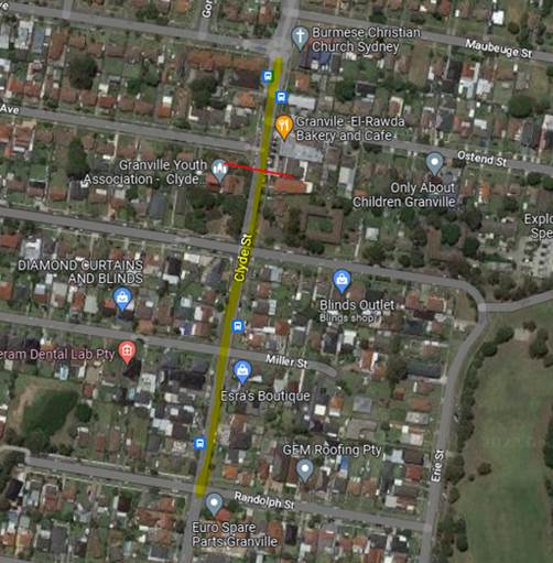
Figure
1 – Locality Plan
A traffic count was undertaken on
Clyde Street in October 2022. The traffic count location is shown in red on the
map above.
The results of the traffic count indicated the following:
Traffic count Data on Clyde Street, South Granville:
Average Daily Traffic (ADT) = 14,345 veh/day,
85th percentile speed = 44.6 km/h,
Mean (average) vehicle speed = 38.4km/h.
The results of the traffic count
and recorded crashes were used in the assessment to determine the need for the
installation of traffic calming devices on Clyde Street in accordance with the
criteria set out in Council’s Local area Traffic Management Policy (LATM)
Policy.
The LATM assessment is summarised
in the tables below:
Table 1 – Clyde Street -
LATM Assessment Points
|
Criteria
|
Maximum Score
|
Score Achieved
|
|
Traffic Study Data
|
45
|
15
|
|
Crash warrant in the
last 5 years
|
15
|
15
|
|
Road Characteristics
|
35
|
14
|
|
Community Support &
other factors
|
5
|
5
|
|
Total
|
100
|
49
|
Table 2 – Clyde Street
– Action
|
Criteria
|
Action
|
|
>75
|
Report to TC with a
recommendation of providing traffic calming devices
|
|
61-75
|
Report to TC and discuss
possibility of providing traffic calming devices
|
|
41-60
|
Council to review
traffic data in 6 months
|
|
25-40
|
Monitor street and
review traffic data after 12 months
|
|
<25
|
Do Nothing
|
|
Speed
|
That regardless of the
total points scored, should the 85th percentile speed exceeds the posted
speed limit by 5 km/h, the street be referred to the NSW Police for
monitoring and/or enforcement.
|
The traffic count indicated that
the recorded 85th percentile speed was 44.6km/h which is below the speed limit
of the street.
Based on the above assessment,
traffic calming devices are not warranted in the street, therefore, the request
for the installation of traffic calming devices / speed humps on Clyde Street
cannot be supported.
Council will review the conditions
in the street after 6 months.
Consultation has not been
undertaken as the investigation outlined in the report concludes no action is
required.
Future consultation will be
undertaken if recommended by the traffic committee.
Nil
Extraordinary Traffic Committee
1 March 2023
Item
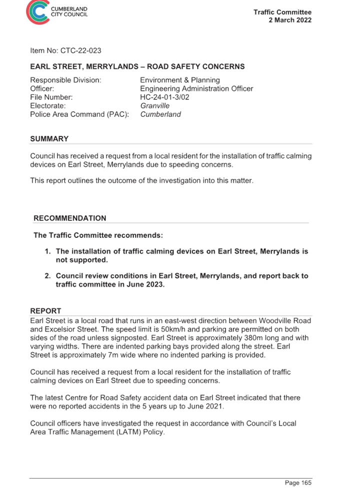
No: ECTC-23-044
Earl Street,
Merrylands - Road Safety Concerns
Directorate: Environment
and Planning
Responsible
Officer: Executive
Manager Development and Building
File
Number: HC-24-01-3/02
Electorate: Granville
Police Area
Command (PAC): Cumberland
Agenda Part Part
2
Note: Recommendation
to Council
Council has reviewed traffic conditions
in Earl Street, Merrylands. This report outlines the outcome of the review.
|
That the Cumberland Traffic Committee recommends
that;
1. The
installation of traffic calming devices on Earl Street, Merrylands is not
supported.
2. Council
review conditions in Earl Street, Merrylands and report back to traffic
committee in April 2024.
|
Cumberland Traffic Committee (CTC)
at its meeting in March 2022 considered a report (vide Item No.CTC-22-023)
regarding road safety concerns on Earl Street, Merrylands. Council resolved
that traffic calming devices on Earl Street, Merrylands not to be supported and
Council staff to review the traffic conditions in Earl Street in November 2022
and report back to traffic committee.
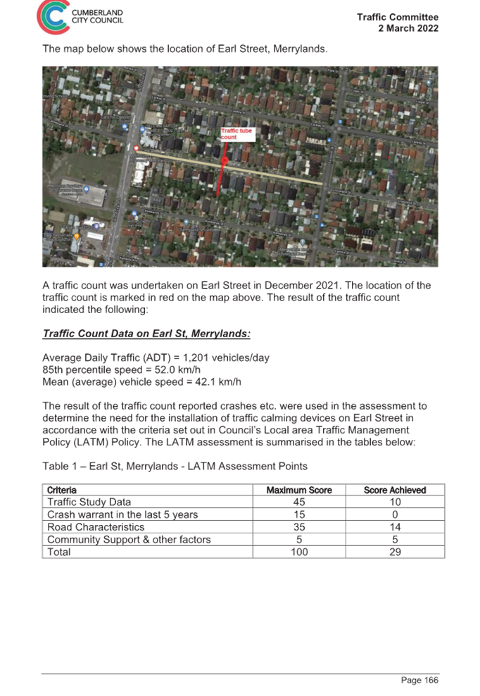
The map below shows the location
of Earl Street, Merrylands.
In accordance with Council’s
resolution, a traffic count was undertaken in Earl Street in February 2023.
Council officers have reviewed the traffic count data and compared it with the
previous traffic count data undertaken in December 2021.
Both results are detailed in the
table below:
|
Traffic
count date
|
Ave.
daily traffic
|
85
Percentile speed
|
|
December
2021
|
1,201
|
52
km/h
|
|
February
2023
|
1,112
|
51
km/h
|
The traffic data from the table
above indicated that both traffic volume (AADT) and 85 percentile speed at this
section of Earl Street have reduced since 2021.
According to the Centre for Road
Safety Accident data, there were no reported accidents in Earl Street in the 5
years up to June 2022.
Based on the above, a further LATM
assessment will result in similar points scored.
The LATM assessment points are
given below:
Therefore, the installation of
traffic calming devices on Earl Street, Merrylands cannot be supported. The
recorded 85th percentile speed of 51km/hr is within acceptable limits.
Council will review traffic
conditions in Earl Street in 12 months.
1. Previous
Report - CTC-22-023
2. Cumberland
Traffic Committee Minutes
DOCUMENTS
ASSOCIATED WITH
REPORT ECTC-23-044
Attachment 1
Previous Report - CTC-22-023
Extraordinary Traffic Committee
1 March 2023
DOCUMENTS
ASSOCIATED WITH
REPORT ECTC-23-044
Attachment 2
Cumberland Traffic Committee Minutes
Extraordinary Traffic Committee
1 March 2023
Extraordinary Traffic Committee
1 March 2023
Item
No: ECTC-23-045
Nicholas
Street, Lidcombe - Road Safety Concerns
Directorate: Environment
and Planning
Responsible
Officer: Executive
Manager Development and Building
File
Number: T-28-01/06
Electorate: Auburn
Police Area
Command (PAC): Auburn
Agenda Part Part
2
Note: Recommendation
to Council
Council has received a request
from a local resident for the installation of traffic calming devices on
Nicholas Street, Lidcombe due to speeding concerns.
This report outlines the outcome
of the investigation into this matter.
|
That the Cumberland Traffic Committee recommends
that;
1. The
installation of traffic calming devices on Nicholas Street, Lidcombe is not
supported.
2. Council
review conditions in Nicholas Street, Lidcombe and report back to traffic
committee in October 2023.
|
Council has received a request
from a local resident for the installation of traffic calming devices on
Nicholas Street, Lidcombe due to speeding concerns.
Nicholas Street is a local road
runs in an east-west direction between Bachell Avenue and Harry Avenue. It is
approximately 730m long and with varying width. The section of Nicholas Street
between Platform Street and Bachell Avenue is approximately 12.5m wide. The
other section between Harry Avenue and Platform Street is varying in width
between 8.9 to 9.1m. This section of Nicholas Street is 3T load limited.
The speed limit in the street is
50km/h and parking is permitted on both sides of the road in accordance with
the Road Rules unless signposted.
Concerns were raised regarding
speeding in Nicholas Street near the Bombay Street intersection.
Council’s Officers have
investigated the request for the installation of traffic calming devices on
Nicholas Street in accordance with Council’s Local Area Traffic
Management (LATM) Policy. For this analysis, the 275m long section of Nicholas
Street between Harry Avenue and Platform Street is considered.
The latest Centre for Road Safety
accident data indicated that there were five reported accidents in Nicholas
Street between Harry Avenue and Platform Street in the 5 years ending June
2022. Four of the accidents occurred at the intersection of Bombay Street.
Council has previously
investigated the safety concerns at the intersection of Bombay Street and
Nicholas Street (CTC-22-159) and the traffic committee recommended the
installation of ‘STOP’ control ahead warning signs on the Bombay
Street approaches to the intersection.
The map below shows the location
of Nicholas Street and the section under consideration:
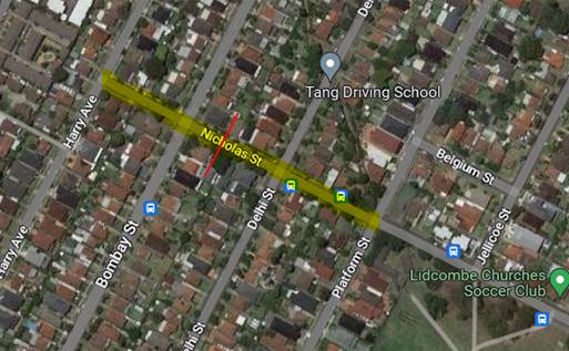
Figure
1 – Locality Plan
A traffic count was undertaken on
Nicholas Street in December 2022. The traffic count location is shown in red on
the map above.
The results of the traffic count
indicated the following:
Traffic count Data on Nicholas
Street, Lidcombe:
Average Daily Traffic (ADT) = 1,767 veh/day,
85th percentile speed = 45.4 km/h,
Mean (average) vehicle speed = 38.2 km/h.
The results of the traffic counts,
recorded crashes etc. were used in the assessment to determine the need for the
installation of traffic calming devices on Nicholas Street in accordance with
the criteria set out in Council’s Local area Traffic Management Policy
(LATM) Policy.
The LATM assessments are
summarised in the tables below:
Table
1 – Nicholas Street - LATM Assessment Points
|
Criteria
|
Maximum Score
|
Score Achieved
|
|
Traffic Study Data
|
45
|
10
|
|
Crash warrant in the
last 5 years
|
15
|
10
|
|
Road Characteristics
|
35
|
18
|
|
Community Support &
other factors
|
5
|
5
|
|
Total
|
100
|
43
|
Table
2 – Nicholas Street – Action
|
Criteria
|
Action
|
|
>75
|
Report to TC with a recommendation
of providing traffic calming devices
|
|
61-75
|
Report to TC and
discuss possibility of providing traffic calming devices
|
|
41-60
|
Council to review
traffic data in 6 months
|
|
25-40
|
Monitor street and
review traffic data after 12 months
|
|
<25
|
Do Nothing
|
|
Speed
|
That regardless of the
total points scored, should the 85th percentile speed exceed the posted speed
limit by 5 km/h, the street be referred to the NSW Police for monitoring
and/or enforcement.
|
The traffic count indicated that
the recorded 85th percentile speed was 45.4 km/h which is below the default
speed limit of the street.
Based on the above assessment,
traffic calming devices are not warranted in the street. Therefore, the request
for the installation of traffic calming devices / speed humps on Nicholas
Street cannot be supported.
Council will review the conditions
in the street after 6 months.
Consultation has not been
undertaken as the investigation outlined in the report concludes no action is
required.
Future consultation will be
undertaken if recommended by the traffic committee.
Nil
Extraordinary Traffic Committee
1 March 2023
Item
No: ECTC-23-046
Norman Street,
Merrylands - Road Safety Concerns
Directorate: Environment
and Planning
Responsible
Officer: Executive
Manager Development and Building
File
Number: T
Electorate: Granville
Police Area
Command (PAC): Cumberland
Agenda Part Part
2
Note: Recommendation
to Council
Council has received a request
from a local resident for the installation of traffic calming devices on Norman
Street, Merrylands due to speeding concerns.
This report outlines the outcome
of the investigation into this matter.
|
1. That
the Cumberland Traffic Committee recommends that the installation of traffic
calming devices on Norman Street, Merrylands not be supported.
2. That
Council review conditions in Norman Street, Merrylands and report back to
traffic committee in April 2024.
|
Council has received a request
from a local resident for the installation of traffic calming devices on Norman
Street, Merrylands due to speeding concerns.
Norman Street is a local road runs
in east-west directions from Frances Street to Richmond Street. Norman Street
is approximately 400m long and 7.5m wide. The speed limit is 50km/h and parking
are permitted on both sides of the road in accordance with the Road Rules
unless otherwise signposted.
Council’s Officers have
investigated the request for the installation of traffic calming devices on
Norman Street in accordance with Council’s Local Area Traffic Management
(LATM) Policy.
The latest Centre for Road Safety
accident data indicated that there were 1 reported accident (emerging from
driveway) in Norman Street in the 5 years ending March 2022.
The map below shows the location
of Norman Street:
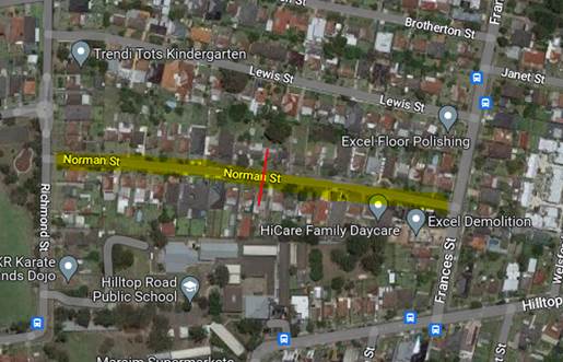
A traffic count was undertaken on
Norman Street in December 2022. The traffic count location is shown in red on
the map above.
The results of the traffic count
indicated the following:
Traffic count Data on Norman
Street, Merrylands:
Average Daily Traffic (ADT) = 828 veh/day,
85th percentile speed = 49.7 km/h,
Mean (average) vehicle speed = 41 km/h.
The result of the traffic count
recorded crashes etc. were used in the assessment to determine the need for the
installation of traffic calming devices on Norman Street in accordance with the
criteria set out in Council’s Local area Traffic Management Policy (LATM)
Policy.
The LATM assessments are
summarised in the tables below:
Table 1 – Norman Street -
LATM Assessment Points
|
Criteria
|
Maximum Score
|
Score Achieved
|
|
Traffic Study Data
|
45
|
5
|
|
Crash warrant in the
last 5 years
|
15
|
5
|
|
Road Characteristics
|
35
|
13
|
|
Community Support &
other factors
|
5
|
5
|
|
Total
|
100
|
28
|
Table 2 – Norman Street
– Action
|
Criteria
|
Action
|
|
>75
|
Report to TC with a
recommendation of providing traffic calming devices
|
|
61-75
|
Report to TC and
discuss possibility of providing traffic calming devices
|
|
41-60
|
Council to review
traffic data in 6 months
|
|
25-40
|
Monitor street and
review traffic data after 12 months
|
|
<25
|
Do Nothing
|
|
Speed
|
That regardless of the
total points scored, should the 85th percentile speed exceed the posted speed
limit by 5 km/h, the street be referred to the NSW Police for monitoring
and/or enforcement.
|
The traffic count indicated that
the recorded 85th percentile speed was 49.7 km/h which is below the speed limit
of the street.
Based on the above assessment,
traffic calming devices are not warranted in the street, therefore, the request
for the installation of traffic calming devices / speed humps on Norman Street
cannot be supported.
Council will review the conditions
in the street after 12 months.
Consultation has not been
undertaken as the investigation outlined in the report concludes no action is
required.
Future consultation will be
undertaken if recommended by the traffic committee.
Nil