1 June 2022
A
meeting of the Traffic Committee
will be held at 9.30am in Council Chambers, Merrylands Administration
Building, 16 Memorial Avenue, Merrylands on Wednesday, 1 June 2022.
ORDER OF BUSINESS
1.
Apologies
2.
Declarations of Interest
3.
Confirmation of Previous Minutes
4.
Summary of Reports........................................................................................................ 4
5.
Reports
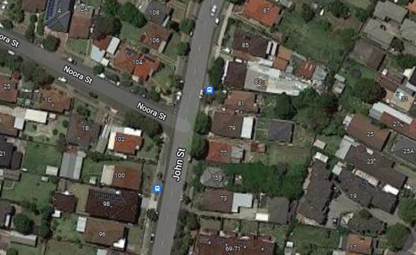
CTC-22-085. JOHN STREET, LIDCOMBE – PROPOSED
‘BUS ZONE’ SIGNAGE 19
CTC-22-086. RAWSON STREET, AUBURN AT DARTBROOK
ROAD – REQUEST FOR ‘KEEP CLEAR’ LINEMARKING.............................................................. 25
CTC-22-087. PAVESI STREET, GUILDFORD WEST -
PROPOSED ‘SLOW POINT’ WARNING SIGNS.................................................................................... 33
CTC-22-088. EDNA AVENUE, MERRYLANDS WEST AT FOWLER
ROAD– PROPOSED ‘NO STOPPING’ RESTRICTIONS AND LINE MARKING 39
CTC-22-089. ALEXANDRA AVENUE WESTMEAD -
APPLICATION FOR 'WORKS ZONE' SIGNAGE...................................................................................... 49
CTC-22-090. CUMBERLAND ROAD, AUBURN –
APPLICATION FOR ‘WORKS ZONE’ SIGNAGE................................................................................................... 55
CTC-22-091. ETTALONG ROAD, GREYSTANES –
APPLICATION FOR ‘WORKS ZONE’ SIGNAGE...................................................................................... 61
CTC-22-092. NORTHUMBERLAND ROAD, AUBURN –
APPLICATION FOR ‘WORKS ZONE’ SIGNAGE...................................................................................... 67
CTC-22-093. GELIBOLU PARADE, AUBURN –
PROPOSED PARKING RESTRICTIONS..................................................................................................................... 73
CTC-22-094. LONG STREET, SMITHFIELD –
PROPOSED PARKING RESTRICTIONS OUTSIDE NO.119.................................................................................... 81
CTC-22-095. LONG STREET, SMITHFIELD –
PROPOSED PARKING CHANGES OUTSIDE NO. 133................................................................................... 87
CTC-22-096. BROTHERTON STREET AND RICHMOND STREET,
SOUTH WENTWORTHVILLE – PROPOSED
‘NO STOPPING’
RESTRICTIONS AND LINE MARKING AT THE INTERSECTION.. 93
CTC-22-097. IVAN STREET, GREYSTANES AT THE
INTERSETION OF GRAHAM STREET– PROPOSED ‘NO STOPPING’
RESTRICTIONS AND LINE MARKING.................................................................................................. 99
CTC-22-098. KOOKABURRA STREET AND HACKNEY
STREET’ GREYSTANES – PROPOSED INTERSECTION TREATMENT.................................... 105
CTC-22-099. LAYTON STREET AND DUNMORE STREET,
WENTWORTHVILLE – PROPOSED PARKING RESTRICTIONS.......................................... 111
CTC-22-100. PARK ROAD AND CHESTNUT ROAD, AUBURN
– PROPOSED ‘NO STOPPING’ RESTRICTIONS.............................................................. 117
CTC-22-101. STAFFORD STREET, SOUTH GRANVILLE
– PROPOSED ‘NO PARKING’ SIGNS IN THE CUL-DE-SAC............................................................... 123
CTC-22-102. WEEROONA ROAD, LIDCOMBE –
REQUEST FOR ‘KEEP CLEAR’ LINEMARKING....................................................................................... 129
CTC-22-103. ALBERT STREET AND FOWLER STREET,
GUILDFORD – PROPOSED ‘NO STOPPING’ RESTRICTIONS...................................................... 135
CTC-22-104. FREDERICK AVENUE AND BLAXCELL STREET,
SOUTH GRANVILLE – PROPOSED
‘NO STOPPING’
RESTRICTIONS AND LINE MARKING AT THE INTERSECTION...................................................................... 141
CTC-22-105. PARK ROAD, AUBURN – APPLICATION
FOR ‘WORKS ZONE’ SIGNAGE................................................................................................................... 147
CTC-22-106. BROTHERTON STREET AND FRANCES STREET,
SOUTH WENTWORTHVILLE – PROPOSED ‘NO STOPPING’ RESTRICTIONS
& LINE MARKING AT THE INTERSECTION........................................ 153
CTC-22-107. SUSAN STREET, AUBURN –
MODIFICATION TO THE EXISTING PARKING RESTRICTIONS.................................................................. 159
CTC-22-108. AUBREY STREET AT THE TRONGATE AND
PEGLER AVENUE, SOUTH GRANVILLE – PROPOSED ‘NO STOPPING’ SIGNS
AND LINE MARKING AT THE INTERSECTIONS................................................................... 165
CTC-22-109. ELLIS STREET, MERRYLANDS AT HILLTOP
ROAD– PROPOSED PAINTED ISLAND AND LINEMARKING............................................ 171
CTC-22-110. SPENCER STREET, BERALA –
PROPOSED ‘NO PARKING’ SIGNS IN THE CUL-DE-SAC................................................................................. 177
CTC-22-111. HICKORY STREET, GREYSTANES AT ETTALONG
ROAD– PROPOSED BB LINEMARKING................................................................................. 183
CTC-22-112. DULLAI AVENUE, PEMULWUY – ROAD
SAFETY CONCERNS. 189
CTC-22-113. FOWLER ROAD AND FAULDS ROAD, GUILDFORD
WEST – PROVISION OF MEDIAN ISLAND............................................................................. 193
CTC-22-114. BLAXCELL STREET, GRANVILLE – PROPOSED
MEDIAN ISLAND NEAR THE EXISTING RAISED PEDESTRIAN CROSSING...................... 205
CTC-22-115. COLEMAN STREET, MERRYLANDS AT HILLTOP
ROAD – REQUEST FOR GUARD RAIL................................................................................. 211
CTC-22-116. REES STREET, MAYS HILL – ROAD
SAFETY CONCERNS....... 219
CTC-22-117. SUSAN STREET, AUBURN – ROAD
SAFETY CONCERNS........ 223
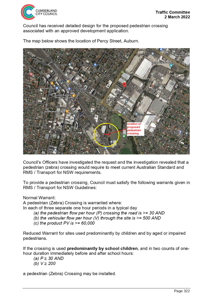
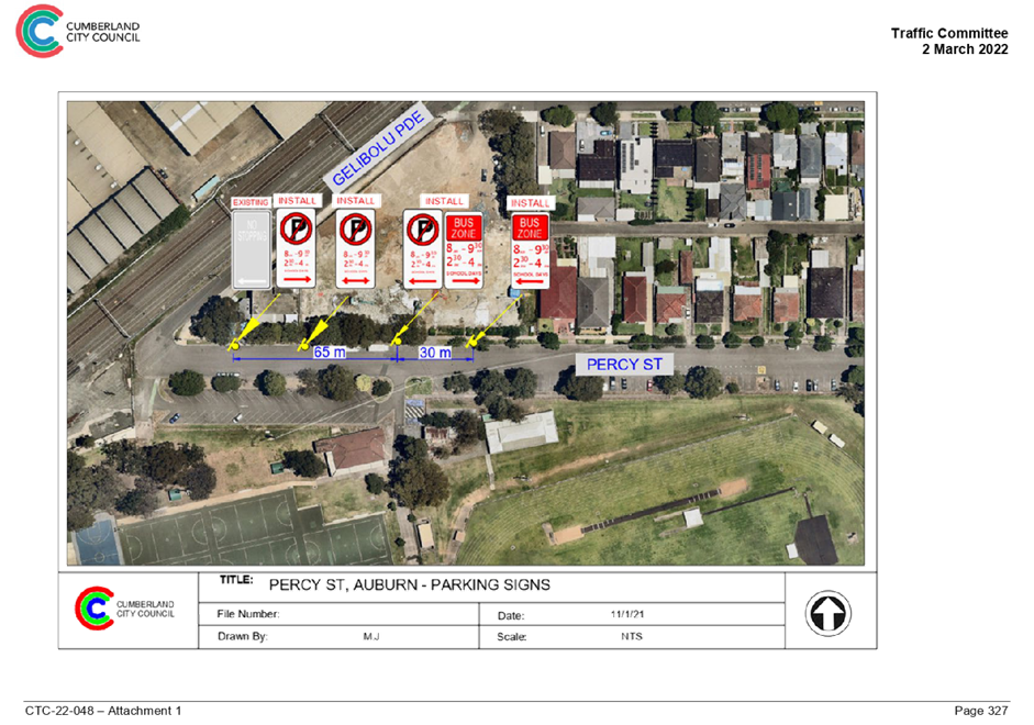
CTC-22-118. PERCY STREET, AUBURN – REQUEST
FOR CHILDREN CROSSING 227
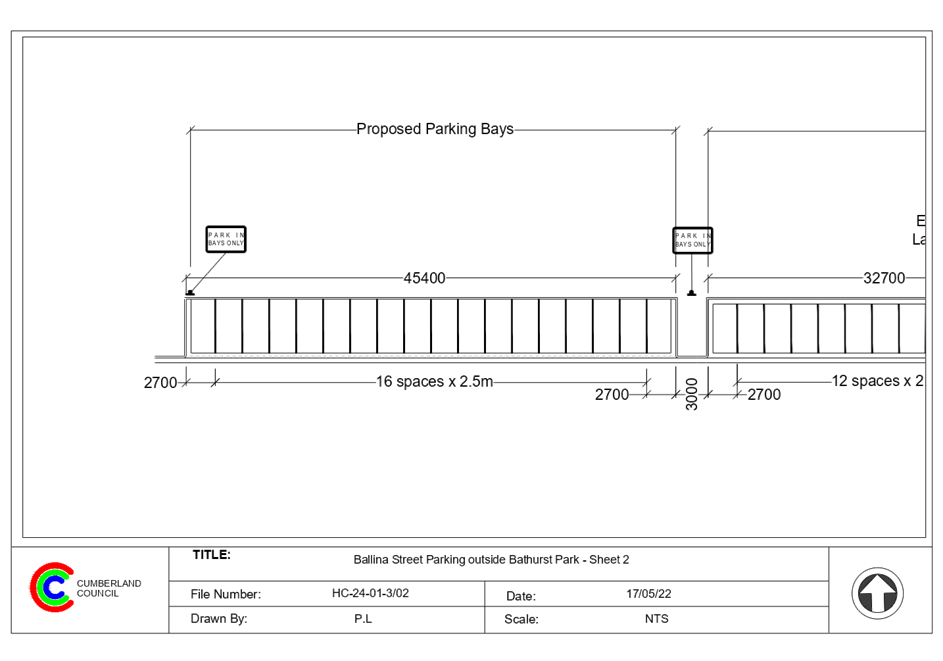
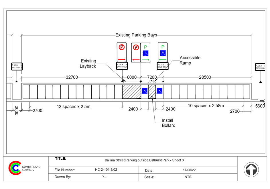
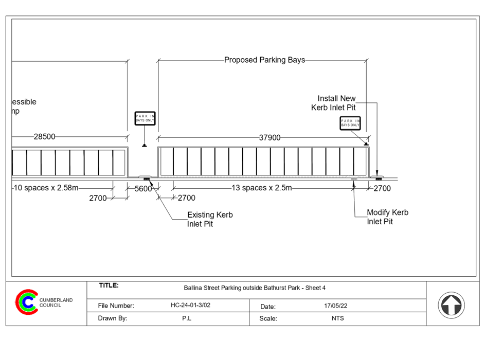
CTC-22-119. BALLINA STREET, GREYSTANES –
PROPOSED INDENTED ANGLE PARKING................................................................................................. 241
6.
Other Business
7.
Next Meeting
The next meeting of the Traffic
Committee is to be held on Wednesday, 3 August 2022.
1 June 2022
Summary of Reports
|
Item #
|
Title
|
Electorate
|
Police Area Command (PAC)
|
|
Fairfield
|
Granville
|
Prospect
|
Auburn
|
Cumberland
|
Auburn
|
|
CTC-22-085
|
JOHN STREET, LIDCOMBE
– PROPOSED ‘BUS ZONE’ SIGNAGE
|
|
|
|
´
|
|
´
|
|
CTC-22-086
|
RAWSON STREET, AUBURN AT
DARTBROOK ROAD – REQUEST FOR ‘KEEP CLEAR’ LINEMARKING
|
|
|
|
´
|
|
´
|
|
CTC-22-087
|
PAVESI STREET, GUILDFORD
WEST - PROPOSED ‘SLOW POINT’ WARNING SIGNS
|
´
|
|
|
|
´
|
|
|
CTC-22-088
|
EDNA AVENUE, MERRYLANDS
WEST AT FOWLER ROAD– PROPOSED ‘NO STOPPING’ RESTRICTIONS
AND LINE MARKING
|
|
´
|
|
|
´
|
|
|
CTC-22-089
|
ALEXANDRA AVENUE WESTMEAD -
APPLICATION FOR 'WORKS ZONE' SIGNAGE
|
|
´
|
|
|
´
|
|
|
CTC-22-090
|
CUMBERLAND ROAD, AUBURN
– APPLICATION FOR ‘WORKS ZONE’ SIGNAGE
|
|
|
|
´
|
|
´
|
|
CTC-22-091
|
ETTALONG ROAD, GREYSTANES
– APPLICATION FOR ‘WORKS ZONE’ SIGNAGE
|
|
|
´
|
|
´
|
|
|
CTC-22-092
|
NORTHUMBERLAND ROAD, AUBURN
– APPLICATION FOR ‘WORKS ZONE’ SIGNAGE
|
|
|
|
´
|
|
´
|
|
CTC-22-093
|
GELIBOLU PARADE, AUBURN
– PROPOSED PARKING RESTRICTIONS
|
|
|
|
´
|
|
´
|
|
CTC-22-094
|
LONG STREET,
SMITHFIELD – PROPOSED PARKING RESTRICTIONS OUTSIDE NO.119
|
|
|
´
|
|
´
|
|
|
CTC-22-095
|
LONG STREET,
SMITHFIELD – PROPOSED PARKING CHANGES OUTSIDE NO. 133
|
|
|
´
|
|
´
|
|
|
CTC-22-096
|
BROTHERTON STREET AND
RICHMOND STREET, SOUTH WENTWORTHVILLE – PROPOSED
‘NO STOPPING’
RESTRICTIONS AND LINE MARKING AT THE INTERSECTION
|
|
´
|
|
|
´
|
|
|
CTC-22-097
|
IVAN STREET, GREYSTANES AT
THE INTERSETION OF GRAHAM STREET– PROPOSED ‘NO STOPPING’
RESTRICTIONS AND LINE MARKING
|
|
´
|
|
|
´
|
|
|
CTC-22-098
|
KOOKABURRA STREET AND
HACKNEY STREET’ GREYSTANES – PROPOSED INTERSECTION TREATMENT
|
|
|
´
|
|
´
|
|
|
CTC-22-099
|
LAYTON STREET AND DUNMORE
STREET, WENTWORTHVILLE – PROPOSED PARKING RESTRICTIONS
|
|
|
´
|
|
´
|
|
|
CTC-22-100
|
PARK ROAD AND CHESTNUT
ROAD, AUBURN – PROPOSED ‘NO STOPPING’ RESTRICTIONS
|
|
|
|
´
|
|
´
|
|
CTC-22-101
|
STAFFORD STREET, SOUTH
GRANVILLE – PROPOSED ‘NO PARKING’ SIGNS IN THE CUL-DE-SAC
|
|
|
|
´
|
´
|
|
|
CTC-22-102
|
WEEROONA ROAD, LIDCOMBE
– REQUEST FOR ‘KEEP CLEAR’ LINEMARKING
|
|
|
|
´
|
|
´
|
|
CTC-22-103
|
ALBERT STREET AND FOWLER
STREET, GUILDFORD – PROPOSED ‘NO STOPPING’ RESTRICTIONS
|
|
´
|
|
|
´
|
|
|
CTC-22-104
|
FREDERICK AVENUE AND
BLAXCELL STREET, SOUTH GRANVILLE – PROPOSED
‘NO STOPPING’
RESTRICTIONS AND LINE MARKING AT THE INTERSECTION
|
|
|
|
´
|
´
|
|
|
CTC-22-105
|
PARK ROAD, AUBURN –
APPLICATION FOR ‘WORKS ZONE’ SIGNAGE
|
|
|
|
´
|
|
´
|
|
CTC-22-106
|
BROTHERTON STREET AND
FRANCES STREET, SOUTH WENTWORTHVILLE – PROPOSED ‘NO
STOPPING’ RESTRICTIONS & LINE MARKING AT THE INTERSECTION
|
|
´
|
|
|
´
|
|
|
CTC-22-107
|
SUSAN STREET, AUBURN
– MODIFICATION TO THE EXISTING PARKING RESTRICTIONS
|
|
|
|
´
|
|
´
|
|
CTC-22-108
|
AUBREY STREET AT THE
TRONGATE AND PEGLER AVENUE, SOUTH GRANVILLE – PROPOSED ‘NO
STOPPING’ SIGNS AND LINE MARKING AT THE INTERSECTIONS
|
|
|
|
´
|
´
|
|
|
CTC-22-109
|
ELLIS STREET, MERRYLANDS AT
HILLTOP ROAD– PROPOSED PAINTED ISLAND AND LINEMARKING
|
|
´
|
|
|
´
|
|
|
CTC-22-110
|
SPENCER STREET, BERALA
– PROPOSED ‘NO PARKING’ SIGNS IN THE CUL-DE-SAC
|
|
|
|
´
|
|
´
|
|
CTC-22-111
|
HICKORY STREET, GREYSTANES
AT ETTALONG ROAD– PROPOSED BB LINEMARKING
|
|
|
´
|
|
´
|
|
|
CTC-22-112
|
DULLAI AVENUE, PEMULWUY
– ROAD SAFETY CONCERNS
|
|
|
´
|
|
´
|
|
|
CTC-22-113
|
FOWLER ROAD AND FAULDS
ROAD, GUILDFORD WEST – PROVISION OF MEDIAN ISLAND
|
´
|
|
|
|
´
|
|
|
CTC-22-114
|
BLAXCELL STREET, GRANVILLE
– PROPOSED MEDIAN ISLAND NEAR THE EXISTING RAISED PEDESTRIAN CROSSING
|
|
´
|
|
|
´
|
|
|
CTC-22-115
|
COLEMAN STREET, MERRYLANDS
AT HILLTOP ROAD – REQUEST FOR GUARD RAIL
|
|
´
|
|
|
´
|
|
|
CTC-22-116
|
REES STREET, MAYS HILL
– ROAD SAFETY CONCERNS
|
|
´
|
|
|
´
|
|
|
CTC-22-117
|
SUSAN STREET, AUBURN
– ROAD SAFETY CONCERNS
|
|
|
|
´
|
|
´
|
|
CTC-22-118
|
PERCY STREET, AUBURN
– REQUEST FOR CHILDREN CROSSING
|
|
|
|
´
|
|
´
|
|
CTC-22-119
|
BALLINA STREET, GREYSTANES
– PROPOSED INDENTED ANGLE PARKING
|
|
|
´
|
|
´
|
|
1 June 2022
Minutes of the Traffic Committee
meeting held at Electronic Meeting on Wednesday, 6 April 2022.
Present:
Cumberland
Council -
Clr Suman Saha – Chairperson
Local
Member for Auburn -
Mr George Campbell
Local
Member for Fairfield -
Mr George Barcha.
Local
Member for Granville -
Mr Chris Worthington
Local Member for Prospect -
Clr Diane Colman
Cumberland
Police Area Command - Leading S/Const. Will Graham
Apologies:
Transport for NSW
(TfNSW)
- Ms Irene Xu - Concurrence received for all items except for one.
TfNSW comments have been incorporated in the item.
Auburn Police Area Command -
S/Const. Raymond Yeung - Concurrence received.
Transit
Systems -
No objections
received.
Transdev -
No objections
received.
CDCBus -
No objections received.
Declarations Of Interest
Nil
CONFIRMATION OF MINUTES
Mr Chris Worthington moved and seconded by Mr Campbell.
Summary of reports
Summary of Reports
|
Item #
|
Title
|
Electorate
|
Police Area Command (PAC)
|
|
Fairfield
|
Granville
|
Prospect
|
Auburn
|
Cumberland
|
Auburn
|
|
CTC-22-056
|
LIDBURY STREET AND
GUILFOYLE STREET, BERALA – PROPOSED ‘NO STOPPING’
RESTRICTIONS
|
|
|
|
´
|
|
´
|
|
CTC-22-057
|
OXFORD STREET, GUILDFORD
– PROPOSED PARKING RESTRICTIONS AND LINE MARKING
|
|
´
|
|
|
´
|
|
|
CTC-22-058
|
PARK ROAD AND CLARKE
STREET, BERALA – PROPOSED ‘NO STOPPING’ RESTRICTIONS
|
|
|
|
´
|
|
´
|
|
CTC-22-059
|
EXCELSIOR STREET NORTH OF
GUILDFORD ROAD, GUILDFORD – PROPOSED ‘BUS ZONE’
|
|
|
|
´
|
´
|
|
|
CTC-22-060
|
GOOD STREET, WESTMEAD
– REMOVAL OF A REDUNDANT ‘BUS ZONE’
|
|
´
|
|
|
´
|
|
|
CTC-22-061
|
LENA PLACE AND HILLIER
STREET, MERRYLANDS – PROPOSED PARKING RESTRICITONS DURING WASTE NIGHTS
|
|
´
|
|
|
´
|
|
|
CTC-22-062
|
MAGOWAR ROAD, GIRRAWEEN AT
GIRRAWEEN ROAD – PROPOSED PARKING RESTRICTIONS
|
|
|
´
|
|
´
|
|
|
CTC-22-063
|
TOONGABBIE ROAD, GIRRAWEEN
AT MAGOWAR ROAD – EXTENSION OF THE EXISTING ‘NO STOPPING’
ZONE
|
|
|
´
|
|
´
|
|
|
CTC-22-064
|
DELL STREET, WOODPARK -
REVIEW OF EXISTING TIMED PARKING
|
´
|
|
|
|
´
|
|
|
CTC-22-065
|
OLD PROSPECT ROAD, SOUTH
WENTWORTHVILLE – PROPOSED ‘NO STOPPING’ RESTRICTIONS
|
|
´
|
|
|
´
|
|
|
CTC-22-066
|
DAHLIA STREET AND HIBISCUS
STREET, GREYSTANES – PROPOSED PARKING RESTRICITONS & LINE MARKING
|
|
|
´
|
|
´
|
|
|
CTC-22-067
|
MACQUARIE ROAD, GREYSTANES
AT BAYFIELD ROAD– PROPOSED ‘NO STOPPING’ RESTRICTIONS
|
|
|
´
|
|
´
|
|
|
CTC-22-068
|
BOTANICA DRIVE, LIDCOMBE
– PROPOSED ‘NO PARKING’ RESTRICTIONS AND LINEMARKING
|
|
|
|
´
|
|
´
|
|
CTC-22-069
|
BRIDGE ROAD, WESTMEAD AT
HUDSON STREET– PROPOSED ‘NO STOPPING’ RESTRICTIONS
|
|
´
|
|
|
´
|
|
|
CTC-22-070
|
LOWANA AVENUE, MERRYLANDS -
PROPOSED PARKING RESTRICTIONS
|
|
´
|
|
|
´
|
|
|
CTC-22-071
|
CHURCH STREET, LIDCOMBE - APPLICATION
FOR 'WORKS ZONE' SIGNAGE
|
|
|
|
´
|
|
´
|
|
CTC-22-072
|
GEORGES AVENUE, LIDCOMBE AT
BEATRICE STREET – REQUEST FOR A PEDESTRIAN CROSSING
|
|
|
|
´
|
|
´
|
|
CTC-22-073
|
CLYDE STREET, SOUTH
GRANVILLE AT NOBBS STREET – ROAD SAFETY CONCERNS
|
|
|
|
´
|
´
|
|
|
CTC-22-074
|
ADDLESTONE ROAD, MERRYLANDS
– ROAD SAFETY CONCERNS
|
|
´
|
|
|
´
|
|
|
CTC-22-075
|
BADHAM STREET,
MERRYLANDS – ROAD SAFETY CONCERNS
|
|
´
|
|
|
´
|
|
|
CTC-22-076
|
JONES STREET,
WENTWORTHVILLE – ROAD SAFETY CONCERNS
|
|
|
´
|
|
´
|
|
|
CTC-22-077
|
HARRIS STREET, GUILDFORD
– ROAD SAFETY CONCERNS - CONSULTATION
|
|
´
|
|
|
´
|
|
|
CTC-22-078
|
KENNEDY STREET, GUILDFORD
– ROAD SAFETY CONCERNS
|
|
|
|
´
|
´
|
|
|
CTC-22-079
|
REID STREET,
MERRYLANDS – ROAD SAFETY CONCERNS
|
|
´
|
|
|
´
|
|
|
CTC-22-080
|
ACLAND STREET, GUILDFORD
– ROAD SAFETY CONCERNS
|
´
|
|
|
|
´
|
|
|
CTC-22-081
|
JOYCE STREET, PENDLE
HILL – ROAD SAFETY CONCERNS
|
|
|
´
|
|
´
|
|
|
CTC-22-082
|
LANSDOWNE STREET,
MERRYLANDS – REQUEST FOR BANNING TRUCKS IN THE STREET
|
|
´
|
|
|
´
|
|
|
CTC-22-083
|
MCARTHUR STREET,
GUILDFORD – ROAD SAFETY CONCERNS
|
|
´
|
|
|
´
|
|
|
CTC-22-084
|
OXFORD STREET, GUILDFORD -
PROPOSED EXTENSION OF EXISTING PEDESTRIAN FENCING
|
|
´
|
|
|
´
|
|
REPORTS
|
|
ITEM CTC-22-056 - LIDBURY STREET AND GUILFOYLE STREET,
BERALA – PROPOSED ‘NO STOPPING’ RESTRICTIONS
|
|
The Traffic Committee recommended that:
1. The
installation of ‘No Stopping’ signs and line marking at the
intersection of Lidbury Street and Guilfoyle Street, Berala in accordance
with the attached plan be approved.
2. The
adjacent residents be notified of the outcome.
|
|
|
ITEM CTC-22-057 - OXFORD STREET, GUILDFORD –
PROPOSED PARKING RESTRICTIONS AND LINE MARKING
|
|
The Traffic Committee recommended that:
1. The
installation of ‘No Stopping 8am-9:30am, 2:30-4pm Mon - Fri’
signs on southern side of Oxford Street, Guildford in accordance with the
attached plan be approved.
2. The
installation of lane line marking on the westbound section of Oxford Street
between Woodville Road and Highland Street in accordance with the attached
plan be approved.
3. The
affected residents and the school be consulted, and the consultation results
reported to traffic committee if objections are received.
Discussion:
Granville Local member’s
representative requested that the school be notified of the proposal. The
recommendation has been amended appropriately.
|
|
|
ITEM CTC-22-058 - PARK ROAD AND CLARKE STREET, BERALA
– PROPOSED ‘NO STOPPING’ RESTRICTIONS
|
|
The Traffic Committee
recommended that:
1. The
installation of ‘No Stopping’ signs and line marking at the intersection
of Park Road and Clarke Street, Berala in accordance with the attached plan
be approved.
2. The
adjacent residents be notified of the outcome.
|
|
|
ITEM CTC-22-059 - EXCELSIOR STREET NORTH OF GUILDFORD
ROAD, GUILDFORD – PROPOSED ‘BUS ZONE’
|
|
The Traffic Committee recommended that:
1. The
installation of a ‘Bus Zone’ signage on both sides of Excelsior
Street, Guildford at the existing bus stops near the intersection of
Guildford Road and Excelsior Street in accordance with the attached plan be
approved.
2. The
installation of ‘No Stopping’ signs at the intersection of
Guildford Road and Excelsior Street in accordance with the attached plan be
approved.
3. The
affected residents be notified of the outcome generally.
|
|
|
ITEM CTC-22-060 - GOOD STREET, WESTMEAD – REMOVAL
OF A REDUNDANT ‘BUS ZONE’
|
|
The Traffic Committee
recommended that:
1. The
removal of a redundant ‘Bus Zone’ on the western side of Good
Street, Westmead outside No.68 as per attached plan be approved.
2. The
‘Bus Zone’ area be converted to ‘2P; 8:30AM-6:00PM;
Mon-Fri; 8:30AM-12:00Noon; Sat; Permit Holders Excepted’ signage.
3. The
adjacent residents be notified of the outcome.
|
|
|
ITEM CTC-22-061 - LENA PLACE AND HILLIER STREET,
MERRYLANDS – PROPOSED PARKING RESTRICITONS DURING WASTE NIGHTS
|
|
The Traffic Committee recommended that Council
undertake consultation with the residents regarding the different options and
outcome of the consultation be reported back to traffic committee.
Discussion:
Three options were provided in the agenda for traffic
committee consideration.
Option 1
The Traffic Committee recommends that:
1. The
installation of ‘No Stopping’ and ‘No Parking; 6am–
2pm; Thursday’ signs on both sides of Lena Place and Hillier Street,
Merrylands as per Attachment 1 be approved in principle.
2. Council
undertake consultation with the residents and report back to traffic
committee if objections are received.
Option 2
The Traffic Committee recommends that:
1. The
installation of ‘No Stopping’ and ‘No Parking;
6am–12pm; Thursday’ signs on the northern side of Lena Place and
western side of Hillier Street, Merrylands as per Attachment 2 be approved in
principle.
2. Council
undertake consultation with the residents and report back to traffic
committee if objections are received.
Option 3
The Traffic Committee recommends that:
1. The
installation of ‘No Stopping’ and ‘No Parking;
6am–12pm; Thursday’ signs on the southern side of Lena Place and
eastern side of Hillier Street, Merrylands as per Attachment 3 be approved in
principle.
2. Council
undertake consultation with the residents and report back to traffic
committee if objections are received.
TfNSW representative recommended that Council undertake
consultation with the residents regarding the options and outcome of the consultation
be reported back to traffic committee.
After a brief discussion, members agreed with the TfNSW
recommendation.
The recommendation was amended
as agreed by the members.
|
|
|
ITEM CTC-22-062 - MAGOWAR ROAD, GIRRAWEEN AT GIRRAWEEN
ROAD – PROPOSED PARKING RESTRICTIONS
|
|
The Traffic Committee
recommended that:
1. The
installation of ‘No Stopping’ and ‘No Parking’ signs
in Magowar Road, Girraween at the intersection of Girraween Road in
accordance with the attached plan be approved.
2. The
affected residents be notified of the outcome.
|
|
|
ITEM CTC-22-063 - TOONGABBIE ROAD, GIRRAWEEN AT MAGOWAR
ROAD – EXTENSION OF THE EXISTING ‘NO STOPPING’ ZONE
|
|
The Traffic Committee
recommended that:
1. The
installation of ‘No Stopping’ signs in Toongabbie Road, Girraween
north of Magowar Road in accordance with the attached plan be approved.
2. The
adjacent property be notified of the outcome.
|
|
|
ITEM CTC-22-064 - DELL STREET, WOODPARK - REVIEW OF EXISTING
TIMED PARKING
|
|
The Cumberland Traffic
Committee recommended that Council undertake consultation with the businesses
for the conversion of ten (10) parking spaces from the existing two 2 hour to
1 hour parking outside Nos. 21-39 Dell Street, Woodpark.
|
|
|
ITEM CTC-22-065 - OLD PROSPECT ROAD, SOUTH WENTWORTHVILLE
– PROPOSED ‘NO STOPPING’ RESTRICTIONS
|
|
That the Traffic Committee
recommended that the installation of ‘No Stopping’ signs on the
northern side of Old Prospect Road, South Wentworthville west of Chelmsford
Road in accordance with the attached plan be approved.
|
|
|
ITEM CTC-22-066 - DAHLIA STREET AND HIBISCUS STREET,
GREYSTANES – PROPOSED PARKING RESTRICITONS & LINE MARKING
|
|
The Traffic Committee recommended that the installation
of ‘No Stopping’ signs and ‘BB’ line marking at the
intersection of Dahlia Street and Hibiscus Street, Greystanes in accordance
with the attached plan be approved.
Discussion:
Prospect Local member’s representative
indicated that additional parking is required in the area and Council to
investigate providing additional parking on Alpha Road at the corner with
Dahlia Street.
|
|
|
ITEM CTC-22-067 - MACQUARIE ROAD, GREYSTANES AT BAYFIELD
ROAD– PROPOSED ‘NO STOPPING’ RESTRICTIONS
|
|
The Traffic Committee
recommended that:
1. The
installation of ‘No Stopping’ signs in Macquarie Road at the
intersection of Bayfield Road, Greystanes in accordance with the attached
plan be approved.
2. The
adjacent residents be notified of the outcome.
|
|
|
ITEM CTC-22-068 - BOTANICA DRIVE, LIDCOMBE –
PROPOSED ‘NO PARKING’ RESTRICTIONS AND LINEMARKING
|
|
The Traffic Committee
recommended that:
1. The
installation of ‘No Parking’ signs and line marking in Botanica
Drive, Lidcombe at the bend in accordance with the attached plan be approved.
2. Council
undertake consultation with affected residents and report back to traffic
committee if objections are received.
|
|
|
ITEM CTC-22-069 - BRIDGE ROAD, WESTMEAD AT HUDSON
STREET– PROPOSED ‘NO STOPPING’ RESTRICTIONS
|
|
The Traffic Committee
recommended that:
1. The
installation of ‘No Stopping’ signs in Bridge Road and Hudson
Street, Westmead at its intersection in accordance with the attached plan be
approved.
2. The
affected residents be notified of the outcome.
|
|
|
ITEM CTC-22-070 - LOWANA AVENUE, MERRYLANDS - PROPOSED
PARKING RESTRICTIONS
|
|
The Traffic Committee recommended that:
1. The
installation of ‘1/4P; 8am-930am, 2:30pm-4pm’ School Days’
signs on the northern side of Lowana Avenue, Merrylands as per the attached
plan be approved in principle.
2. The
installation of ‘No Parking’ signs on the southern side of Lowana
Avenue, Merrylands as per the attached plan be approved in principle.
3. Council
undertake consultation with affected residents and report back to traffic
committee if objections are received.
|
|
|
ITEM CTC-22-071 - CHURCH STREET, LIDCOMBE - APPLICATION
FOR 'WORKS ZONE' SIGNAGE
|
|
The Traffic Committee recommended that:
1. The
‘Works Zone, 7:00am-6:00pm, Monday-Friday, 8:00am-4:00pm,
Saturday’ signs be installed on the frontage of the development site on
Church Street, Lidcombe in accordance with the different stages subject to
Council’s standard conditions and subsequent extension if required.
2. The applicant
be advised to pay the ‘Works Zone’ fees to Council as per the
adopted Fees and Charges.
|
|
|
ITEM CTC-22-072 - GEORGES AVENUE, LIDCOMBE AT BEATRICE
STREET – REQUEST FOR A PEDESTRIAN CROSSING
|
|
The Traffic Committee recommended that the installation
of a marked pedestrian crossing in Georges Avenue, Lidcombe at Beatrice
Street not be supported.
|
|
|
ITEM CTC-22-073 - CLYDE STREET, SOUTH GRANVILLE AT NOBBS
STREET – ROAD SAFETY CONCERNS
|
|
The Cumberland Traffic Committee recommended that;
1. The
installation of traffic calming devices on Clyde Street, South Granville not
be supported.
2. Council
review conditions in Clyde Street between Mona Street and Mons Street in
November 2022 and report back to traffic committee.
|
|
|
ITEM CTC-22-074 - ADDLESTONE ROAD, MERRYLANDS –
ROAD SAFETY CONCERNS
|
|
The Cumberland Traffic Committee recommended that:
1. The
installation of traffic calming devices on Addlestone Road, Merrylands not be
supported.
2. Council
review conditions in Addlestone Road, Merrylands in June 2023, and report
back to traffic committee.
|
|
|
ITEM CTC-22-075 - BADHAM STREET, MERRYLANDS –
ROAD SAFETY CONCERNS
|
|
The Cumberland Traffic Committee recommended that
the installation of traffic calming devices on Badham Street, Merrylands not
be supported.
|
|
|
ITEM CTC-22-076 - JONES STREET, WENTWORTHVILLE –
ROAD SAFETY CONCERNS
|
|
The Cumberland
Traffic Committee recommended that Council undertake consultation with the
residents of Jones Street, Wentworthville to assess support or otherwise for
installation of speed humps in the street.
|
|
|
ITEM CTC-22-077 - HARRIS STREET, GUILDFORD – ROAD
SAFETY CONCERNS - CONSULTATION
|
|
The Cumberland Traffic Committee recommended that:
1. The
installation of traffic calming devices on Harris Street, Guildford not be
supported.
2. Council
request Cumberland Police Area Command to monitor the road for speeding.
|
|
|
ITEM CTC-22-078 - KENNEDY STREET, GUILDFORD – ROAD
SAFETY CONCERNS
|
|
The Cumberland Traffic Committee recommended that
the installation of traffic calming devices on Kennedy Street, Guildford not
be supported.
|
|
|
ITEM CTC-22-079 - REID STREET, MERRYLANDS – ROAD
SAFETY CONCERNS
|
|
The Cumberland Traffic Committee recommended that
the installation of traffic calming devices on Reid Street, Merrylands
not be supported.
|
|
|
ITEM CTC-22-080 - ACLAND STREET, GUILDFORD – ROAD
SAFETY CONCERNS
|
|
The Cumberland Traffic Committee recommended that
the installation of traffic calming devices on Acland Street, Guildford not
be supported.
|
|
|
ITEM CTC-22-081 - JOYCE STREET, PENDLE HILL –
ROAD SAFETY CONCERNS
|
|
The Cumberland Traffic Committee recommended that;
1. The
installation of traffic calming devices on Joyce Street, Pendle Hill
not be supported.
2. Council
review conditions in Joyce Street, Pendle Hill in June 2023, and report back
to traffic committee.
|
|
|
ITEM CTC-22-082 - LANSDOWNE STREET, MERRYLANDS –
REQUEST FOR BANNING TRUCKS IN THE STREET
|
|
The Traffic Committee recommended the information
contained in this report be noted and request to ban trucks in Lansdowne
Street, Merrylands not be approved.
|
|
|
ITEM CTC-22-083 - MCARTHUR STREET, GUILDFORD
– ROAD SAFETY CONCERNS
|
|
The Cumberland Traffic Committee recommended that:
1. The
installation of traffic calming devices on McArthur Street, Guildford not be
supported.
2. Council
review conditions in McArthur Street, Guildford in June 2023, and report back
to traffic committee.
|
|
|
ITEM CTC-22-084 - OXFORD STREET, GUILDFORD - PROPOSED
EXTENSION OF EXISTING PEDESTRIAN FENCING
|
|
The Traffic Committee recommended that the
extension of the existing pedestrian safety fence on the northern side of
Oxford Street by 20m in a westerly direction be supported.
Discussion:
Granville Local member’s
representative raised whether 10m extension of the pedestrian fencing would
be satisfactory. Following discussions, members agreed that the pedestrian
fence be extended by 20m instead of the recommended 10m.
The recommendation has been
amended accordingly.
|
General Business
Nil.
Next Meeting
Next Meeting 1 June 2022 at 9:30AM
Meeting Close
The meeting terminated at 10:15AM
Signed:
Chairperson
1 June 2022
Item
No: CTC-22-085
JOHN STREET,
LIDCOMBE – PROPOSED ‘BUS ZONE’ SIGNAGE
Responsible
Division: Environment
& Planning
Officer: Engineering
Administration Officer
File
Number: T-28-01/06
Electorate: Auburn
Police Area
Command (PAC): Auburn
Council has received a request
from Transdev bus operator regarding vehicles parking regularly at the bus stop
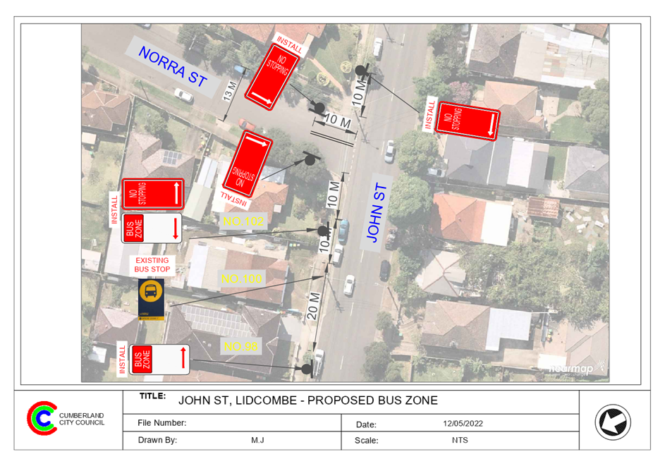
outside No.100 John Street, Lidcombe.
This report outlines the outcome
of the investigation into this matter.
|
The Traffic Committee recommends that:
1. The
installation of ‘Bus Zone’ signage in John Street, Lidcombe at
the existing bus stop outside No.100 in accordance with the attached plan be
approved.
2. The
installation of ‘No Stopping’ signs at the intersection of John
Street and Noora Street, Lidcombe in accordance with the attached plan be
approved.
3. The
adjacent properties be notified of the outcome.
|
John Street is a Collector Road that runs in a north
– south direction with a speed limit of 50 km/h. It has a width of
approximately 12.5m and parking is permitted on both sides of the road unless
signposted.
Council has received concerns from
Transdev bus operator that vehicles are parking regularly at the bus stop
outside No.100 John Street, Lidcombe. As a result, the buses experience
difficulties in dropping off / picking up passengers.
Map below shows locality
of John Street, Lidcombe.


In accordance with the Road Rules 2014, it is illegal to
stop a vehicle other than a public bus within 20m on the approach and 10m on
the departure side of a bus stop.
Therefore, to prevent illegal parking at the bus stop, strengthen
the Road Rules and assist busses to stop safely at the bus stop, it is proposed
to install ‘Bus Zone’ signs at the existing ‘Bus Stop’
outside No. 100 John Street.
Furthermore, it is proposed to provide a ‘No
Stopping’ signs and ‘BB’ centre line at the intersection of
John Street and Noora Street as per the attached plan.
1. Plan
- John Street & Noora Street, Lidcombe - Proposed Bus Zone signage and
intersection treatment
DOCUMENTS
ASSOCIATED WITH
REPORT CTC-22-085
Attachment 1
Plan - John Street & Noora Street, Lidcombe -
Proposed Bus Zone signage and intersection treatment
1 June 2022
1 June 2022
Item
No: CTC-22-086
RAWSON STREET,
AUBURN AT DARTBROOK ROAD – REQUEST FOR ‘KEEP CLEAR’
LINEMARKING
Responsible
Division: Environment
& Planning
Officer: Engineering
Administration Officer
File
Number: T-28-01/06
Electorate: Auburn
Police Area
Command (PAC): Auburn
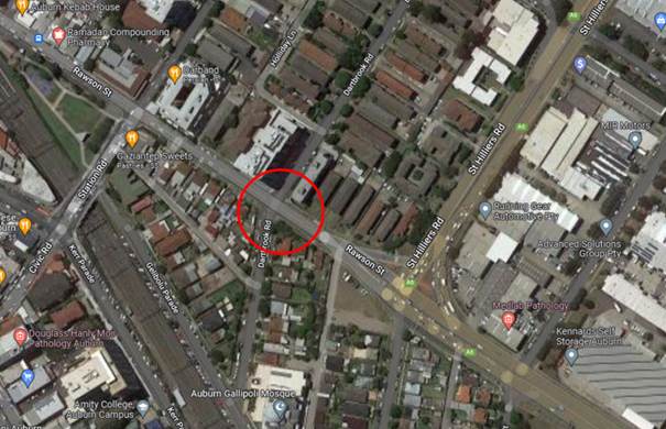
Council has received a request from
Auburn Gallipoli Mosque for the installation of ‘Keep Clear’
pavement markings on Rawson Street, Auburn at the intersection of Dartbrook
Road.
This report outlines the outcome
of the investigation into this matter.
|
The Traffic Committee recommends that the
installation of ‘Keep Clear’ pavement marking be approved at the
intersection of Rawson Road and Dartbrook Road, Auburn in accordance with the
attached plan.
|
Rawson Street is a regional road
that runs in an east-west direction between St Hilliers Road and Parramatta
Road. The speed limit in the Rawson Street section between Karrabah Road and St
Hilliers Road is 50km/h. This section of Rawson Street has a width of
approximately 12m with parking restrictions on both sides of the road.
There are also part time
‘No Stopping’ signs installed on the northern side of Rawson Street
between the full time ‘No Stopping’ zones at the traffic signals at
St Hilliers Road and Station Street.
Dartbrook Road is a local road
that runs in a north-south direction with a speed limit of 50km/h. It has a
width of approximately 12m and parking is permitted on both sides of the road
unless signposted.
Rawson Street and Dartbrook Road
form a four-way intersection with priority to Rawson Street. The intersection
is approximately 125-130m from the signalised intersections of Rawson Street /
Station Road and Rawson Street / St Hilliers Road.
Dartbrook Road north of Rawson
Street has left / left out control at Rawson Street. Rawson Street has
‘Do Not Queue Across Intersection’ signs installed on the southern
approach at the intersection with Dartbrook Road.
Council has received a request
from Auburn Gallipoli Mosque to install ‘Keep Clear’ on the
pavement at the intersection of Rawson Street and Dartbrook Road to prevent
vehicles queuing across the intersection.
Figure
1 – Locality Plan
This intersection is the only
available right turn movement into the precinct from Rawson Street, the other
option is to turn at the Station Road / Rawson Street traffic signals. This
signal does not provide enough time for right turning vehicles.
Council undertook a traffic
movement count at the intersection in the past, the result showed in the table
below indicated that there are significant numbers of vehicles turning right
from Rawson Road into Dartbrook Road especially outside the peak periods.
|
Right
turns from Rawson Eastbound (on a Friday)
|
Right
turns from Rawson Eastbound (on a Thursday)
|
|
7am-8am
|
11
|
12
|
|
8am-9am
|
17
|
18
|
|
9am-10am
|
21
|
24
|
|
10am-11am
|
36
|
22
|
|
11am-12pm
|
64
|
30
|
|
12pm-1pm
|
65
|
18
|
|
1pm-2pm
|
23
|
11
|
|
2pm-3pm
|
11
|
21
|
|
3pm-4pm
|
29
|
29
|
|
4pm-5pm
|
27
|
32
|
|
5pm-6pm
|
26
|
30
|
|
6pm-7pm
|
67
|
68
|
Table
1 – Survey Result
In accordance with the NSW Road
Rules, it is illegal to queue across an intersection. ‘Keep Clear’
Pavement markings are generally used outside Ambulance and Fire Brigade
driveways and critical intersections close to signalised intersection where
vehicles queuing to right turn into side roads might result in interfering with
the performance of the signalised intersection.
Due to the queue length at this
section of Rawson Street, there is minimum opportunity (gap) available to turn
right into Dartbrook Road from Rawson Street. This is likely to result an
impact on the performance of both signalised intersections near Dartbrook Road.
Therefore, it is proposed that
‘Keep Clear’ marking is provided at this intersection.
1. Plan -
Proposed 'Keep Clear' pavement marking on Rawson Street, Auburn
DOCUMENTS
ASSOCIATED WITH
REPORT CTC-22-086
Attachment 1
Plan - Proposed 'Keep Clear' pavement marking on
Rawson Street, Auburn
1 June 2022
1 June 2022
Item
No: CTC-22-087
PAVESI STREET,
GUILDFORD WEST - PROPOSED ‘SLOW POINT’ WARNING SIGNS
Responsible
Division: Environment
& Planning
Officer: Engineering
Administration Officer
File
Number: T-28-01/06
Electorate: Fairfield
Police Area
Command (PAC): Cumberland
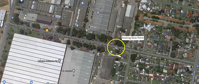
Council has received concerns regarding the ‘Slow
Point’ previously installed on Pavesi Street, Guildford West.
This report details the investigation into this matter.
|
The Traffic Committee recommends that the
installation ‘Slow Point’ warning signs on Pavesi Street,
Guildford West be approved.
|
Council has received concerns regarding the ‘Slow
Point’ previously installed on Pavesi Street, Guildford West.
Pavesi Street runs in an east-west direction between
Fairfield Road and Sturt Street, Guildford West. Pavesi Street has industrial
properties on the west and residential properties on the eastern side.
To prevent commercial vehicles from the industrial side of
Pavesi Street accessing the residential side, a ‘Slow Point’ was
built in the middle of Pavesi Street several years back.
Council has now received concerns that the ‘Slow
point’ has caused near misses and accidents.
An inspection of the location indicated that there is a
streetlight at the slow point. There are warning signs provided at both ends of
Pavesi Street that the road is a ‘No Through Road for Heavy vehicles or
vehicles in excess of 2.1m wide’. The sign also directs vehicles to an
alternate route via McCredie Road and Fairfield Road.
It was also observed that the slow point has pavement
marking directing traffic to the device. However, there are no warning signs
installed ahead of the slow point in Pavesi Street to warn motorists of the
slow point.
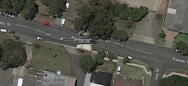
The map and street view
below show the location of the ‘chicane’.
According to the ‘Centre for Road Safety’
Accident Database, there were eight (8) reported accidents on Pavesi Street in
the vicinity of the slow point in the 5-year period ending June 2021. Out of
these 8 accidents, four (4) were recorded as ‘Road User Movement’
– RUM 64 - Permanent obstruction.
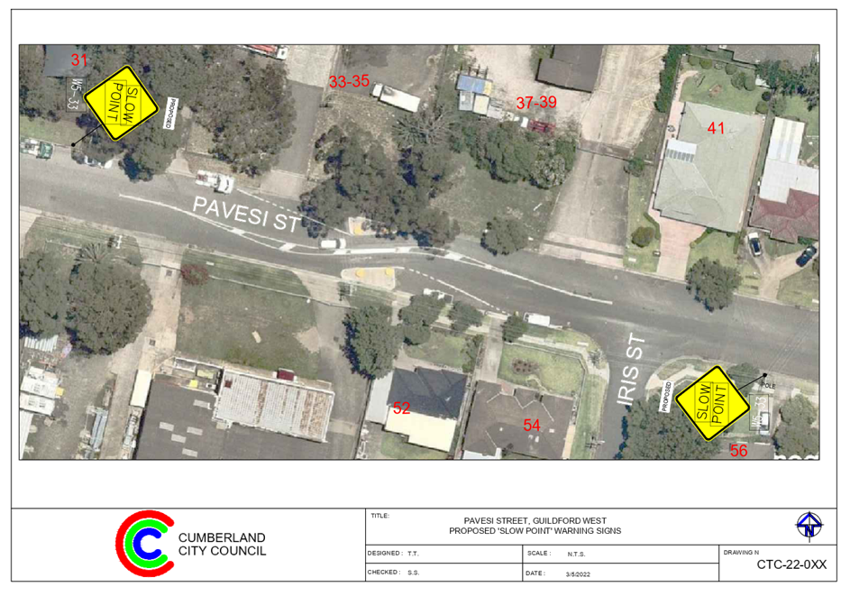
It is proposed to install
‘W5-33’ Slow Point warning signs on Pavesi Street on both sides of
the device as shown in the attached plan.
1. Plan Pavesi
Street, Guildford West- Proposed ‘Slow Point’ Warning Signs
DOCUMENTS
ASSOCIATED WITH
REPORT CTC-22-087
Attachment 1
Plan Pavesi Street, Guildford West- Proposed
‘Slow Point’ Warning Signs
1 June 2022
1 June 2022
Item
No: CTC-22-088
EDNA AVENUE,
MERRYLANDS WEST AT FOWLER ROAD– PROPOSED ‘NO STOPPING’
RESTRICTIONS AND LINE MARKING
Responsible
Division: Environment
& Planning
Officer: Engineering
Administration Officer
File
Number: HC-24-01-3/02
Electorate: Granville
Police Area
Command (PAC): Cumberland
Council has received concerns from a resident requesting
for the provision of parking restrictions at the intersections of Edna Avenue
with Fowler Road, Merrylands West.
This report outlines the outcome of the investigation into
this matter.
|
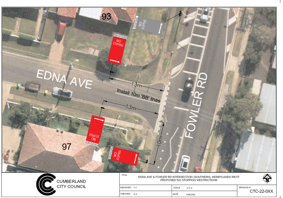
The Traffic Committee recommends that:
1. The
installation of ‘No Stopping’ signs and ‘BB’ centre
lines at the intersections of Edna Avenue with Fowler Road, Merrylands West
in accordance with the attached plans be approved.
2. The
adjacent properties be notified of the outcome.
|
Fowler Road is a regional road that runs in a
north-south direction with a speed limit of 50 km/h. it has a width of
approximately 12.5m and parking is permitted on both sides of the road unless
signposted.
Edna Avenue is a local road that runs in westerly direction
from Fowler Road with a speed limit of 50 km/h. It has a width of approximately
7.5m and parking is permitted on both sides of the road unless signposted. Edna
Avenue forms a loop and intersects Fowler Road at two locations forming
T-intersections with priority to Fowler Road. Both intersections have
‘Give Way’ signs and line marking.
A raised pedestrian crossing is in place on Fowler Road
between the two intersections of Edna Avenue towards the southern intersection
(just south of Matthew Street).
The map below shows the intersections:
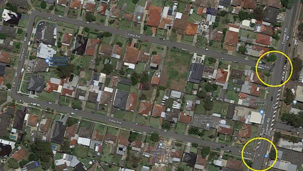
Figure 1 –
Locality Plan
A review of the available accident data indicated that there
was one recorded accident at the southern intersection in the five-year period
ending June 2021.
A site inspection indicated that vehicles are parking within
10 metres at these intersections. The installation of ‘No Stopping’
signs would strengthen the Road Rules requirements and stop vehicles from
parking too close to the intersection.
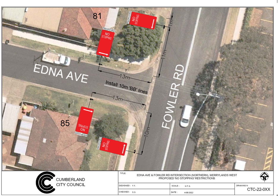
In order to maintain safety and reduce the risk of a
collision at both intersections, it is proposed that 10m double centreline
marking (BB) be provided in Edna Avenue to assist vehicles stay on the right
side of the road.
Fowler Road has ‘No Stopping’ signs near Edna
Avenue. It is proposed to install ‘No Stopping’ signs at 13m
in Edna Avenue at both intersections to allow vehicles to safely pass a parked
car without encroaching the proposed ‘BB’ centre lines.
1. Plan-1
– The northern intersection of Edna Avenue and Fowler Road
–Proposed ‘No Stopping’ restrictions and
‘BB’ centre line marking
2. Plan-2
– The southern intersection of Edna Avenue and Fowler Road
–Proposed ‘No Stopping’ restrictions and
‘BB’ centre line marking
DOCUMENTS
ASSOCIATED WITH
REPORT CTC-22-088
Attachment 1
Plan-1 – The northern intersection of Edna
Avenue and Fowler Road –Proposed ‘No Stopping’
restrictions and ‘BB’ centre line marking
1 June 2022
DOCUMENTS
ASSOCIATED WITH
REPORT CTC-22-088
Attachment 2
Plan-2 – The southern intersection of Edna
Avenue and Fowler Road –Proposed ‘No
Stopping’ restrictions and ‘BB’ centre line
marking
1 June 2022
1 June 2022
Item
No: CTC-22-089
ALEXANDRA
AVENUE WESTMEAD - APPLICATION FOR 'WORKS ZONE' SIGNAGE
Responsible
Division: Environment
& Planning
Officer: Engineering
Administration Officer
File
Number: T-28-01/06
Electorate: Granville
Police Area
Command (PAC): Cumberland
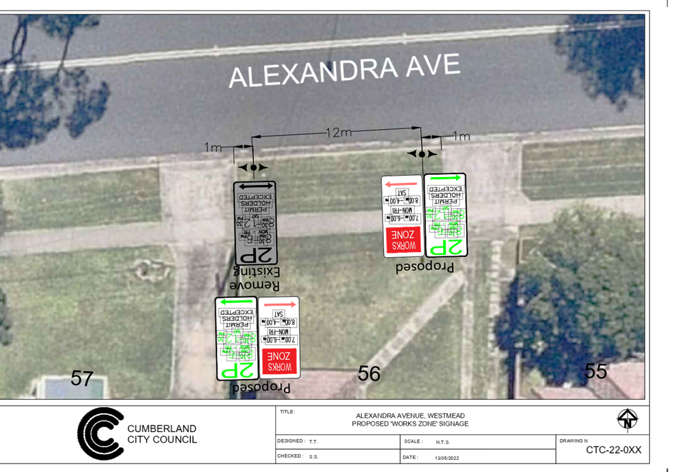
Council has received an
application for a ‘Works Zone’ on Alexandra Avenue, Westmead
associated with the development at 56 Alexandra Avenue, Westmead.
This report outlines the outcome
of the investigation into this matter.
|
The Cumberland Traffic Committee recommends that:
1. The 12m long
‘Works Zone, 7:00am-6:00pm, Monday-Friday, 8:00am-4:00pm,
Saturday’ signs be installed on the frontage of the development site on
Alexandra Avenue, Westmead subject to Council’s standard conditions for
the period of 10 months and subsequent extension if required.
2. The applicant
be advised to pay the ‘Works Zone’ fees to Council as per the
adopted Fees and Charges.
|
Council has received an
application for a ‘Works Zone’ on Alexandra Avenue, Westmead
associated with the development at 56 Alexandra Avenue, Westmead. The proposed
development involves construction of a single dwelling.
The temporary “Works
Zone” is approximately 12m in length and proposed to commence in July
2022 for 10 months. The proposed time is between 7:00am to 6:00pm Monday to
Friday and 8:00am to 4:00pm on Saturdays.
There will be a loss of
two (2P) on-street permit parking spaces on the southern side of Alexandra
Avenue, Westmead during the operation of the “Works Zone”. Attachments
1. Plan –
Alexandra Avenue, Westmead – Proposed Temporary ‘Works Zone’
signage
DOCUMENTS
ASSOCIATED WITH
REPORT CTC-22-089
Attachment 1
Plan – Alexandra Avenue, Westmead –
Proposed Temporary ‘Works Zone’ signage
1 June 2022
1 June 2022
Item
No: CTC-22-090
CUMBERLAND
ROAD, AUBURN – APPLICATION FOR ‘WORKS ZONE’ SIGNAGE
Responsible
Division: Environment
& Planning
Officer: Engineering
Administration Officer
File
Number: T-28-01/06
Electorate: Auburn
Police Area
Command (PAC): Auburn
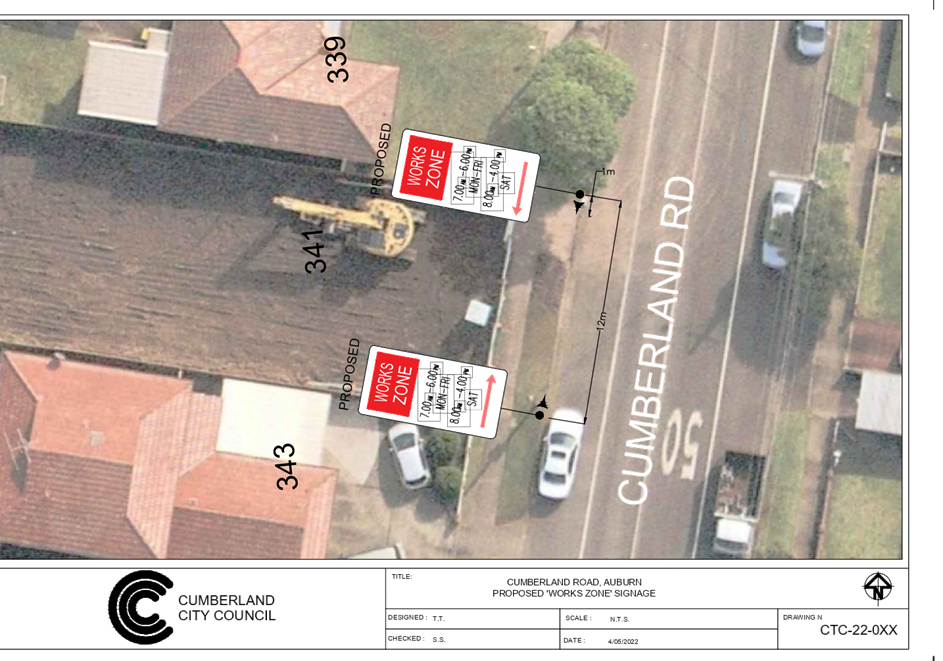
Council has received an
application for a ‘Works Zone’ on Cumberland Road, Auburn
associated with the development at 341 Cumberland Road, Auburn.
This report outlines the outcome
of the investigation into this matter.
|
The Cumberland Traffic Committee recommends that:
1. The 12m long
‘Works Zone, 7:00am-6:00pm, Monday-Friday, 8:00am-4:00pm,
Saturday’ signs be installed on the frontage of the development site on
Cumberland Road, Auburn subject to Council’s standard conditions for
the period of 6 months and subsequent extension if required.
2. The applicant
be advised to pay the ‘Works Zone’ fees to Council as per the
adopted Fees and Charges.
|
Council has received an
application for a ‘Works Zone’ on Cumberland Road, Auburn
associated with the development at 341 Cumberland Road, Auburn. The proposed
development involves construction of a single dwelling.
The temporary “Works
Zone” is approximately 12m in length and proposed to commence in July
2022 for 6 months. The proposed time is between 7:00am to 6:00pm Monday to
Friday and 8:00am to 4:00pm on Saturdays.
There will be a loss of two (2)
on-street unrestricted parking spaces on the western side of Cumberland Road,
Auburn during the operation of the “Works Zone”.
1. Plan –
Cumberland Road, Auburn – Proposed Temporary ‘Works Zone’
signage
DOCUMENTS
ASSOCIATED WITH
REPORT CTC-22-090
Attachment 1
Plan – Cumberland Road, Auburn – Proposed
Temporary ‘Works Zone’ signage
1 June 2022
1 June 2022
Item
No: CTC-22-091
ETTALONG ROAD,
GREYSTANES – APPLICATION FOR ‘WORKS ZONE’ SIGNAGE
Responsible
Division: Environment
& Planning
Officer: Engineering
Administration Officer
File
Number: T-28-01/06
Electorate: Prospect
Police Area
Command (PAC): Cumberland
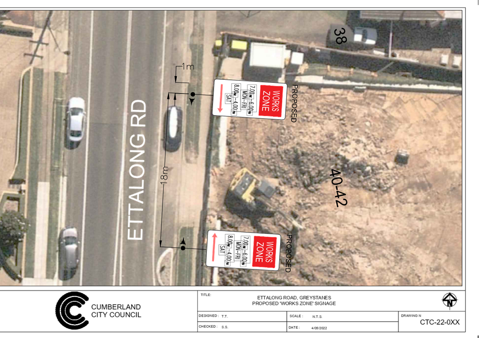
Council has received an
application for a ‘Works Zone’ on Ettalong Road, Greystanes
associated with the development at 40-42 Ettalong Road, Greystanes.
This report outlines the outcome
of the investigation into this matter.
|
The Cumberland Traffic Committee recommends that:
1. The 18m long
‘Works Zone, 7:00am-6:00pm, Monday-Friday, 8:00am-4:00pm,
Saturday’ signs be installed on the frontage of the development site on
Ettalong Road, Greystanes subject to Council’s standard conditions for
the period of 6 months and subsequent extension if required.
2. The applicant
be advised to pay the ‘Works Zone’ fees to Council as per the
adopted Fees and Charges.
|
Council has received an
application for a ‘Works Zone’ on Ettalong Road, Greystanes
associated with the development at 40-42 Ettalong Road, Greystanes. The
proposed development involves construction of a two-storey childcare centre.
The temporary “Works
Zone” is approximately 18m in length and proposed to commence in July
2022 for 6 months. The proposed time is between 7:00am to 6:00pm Monday to
Friday and 8:00am to 4:00pm on Saturdays.
There will be a loss of three
unrestricted on-street parking spaces on the eastern side on Ettalong Road,
Greystanes during the operation of the “Works Zone”.
1. Plan –
Ettalong Road, Greystanes – Proposed Temporary ‘Works Zone’
signage
DOCUMENTS
ASSOCIATED WITH
REPORT CTC-22-091
Attachment 1
Plan – Ettalong Road, Greystanes –
Proposed Temporary ‘Works Zone’ signage
1 June 2022
1 June 2022
Item
No: CTC-22-092
NORTHUMBERLAND
ROAD, AUBURN – APPLICATION FOR ‘WORKS ZONE’ SIGNAGE
Responsible
Division: Environment
& Planning
Officer: Engineering
Administration Officer
File
Number: T-28-01/06
Electorate: Auburn
Police Area
Command (PAC): Auburn
Council has received an
application for a ‘Works Zone’ on Northumberland Road, Auburn
associated with the development at 20 Northumberland Road, Auburn.
This report outlines the outcome
of the investigation into this matter.
|
The Cumberland Traffic Committee recommends that:
1. The 12m long ‘Works
Zone, 7:00am-6:00pm, Monday-Friday, 8:00am-4:00pm, Saturday’ signs be
installed on the frontage of the development site on Northumberland Road,
Auburn subject to Council’s standard conditions for the period of 12
months and subsequent extension if required.
2. The applicant
be advised to pay the ‘Works Zone’ fees to Council as per the
adopted Fees and Charges.
|
Council has received an
application for a ‘Works Zone’ on Northumberland Road, Auburn
associated with the development at 20 Northumberland Road, Auburn. The proposed
development involves construction of 12 storey mixed-use development with one
commercial and 36 units over 3 levels of basement parking for 41 cars.
The temporary “Works
Zone” is approximately 12m in length and proposed to commence in July
2022 for 12 months. The proposed time is between 7:00am to 6:00pm Monday to
Friday and 8:00am to 4:00pm on Saturdays.
There will be a loss of two 2 hour
on-street parking spaces on the western side of Northumberland Road, Auburn during
the operation of the “Works Zone”.
1. Plan –
Northumberland Road, Auburn – Proposed Temporary ‘Works Zone’
signage
DOCUMENTS
ASSOCIATED WITH
REPORT CTC-22-092
Attachment 1
Plan – Northumberland Road, Auburn –
Proposed Temporary ‘Works Zone’ signage
1 June 2022
1 June 2022
Item
No: CTC-22-093
GELIBOLU
PARADE, AUBURN – PROPOSED PARKING RESTRICTIONS
Responsible
Division: Environment
& Planning
Officer: Engineering
Administration Officer
File
Number: T-28-01/06
Electorate: Auburn
Police Area
Command (PAC): Auburn
Council has received requests from the mosque community to
provide timed parking in the angle parking area in Gelibolu Parade adjacent to
the railway line to assist worshippers.
This report details the investigation into this matter.
|
The Traffic Committee recommends:
1. The
installation of “2P; 6:00am-6:00pm; Mon-Fri” in the angle parking
area adjacent to the railway line in Gelibolu Parade, Auburn is supported
in-principle, in accordance with the attached plan.
2. Community
engagement be undertaken on the proposed changes prior to the final decision
on the proposal.
3. A
further report be provided following community engagement with a
recommendation on a final decision on the proposal.
|
Council has received requests from the community to
provide timed parking in the angle parking area in Gelibolu Parade adjacent to
the railway line to assist worshippers.
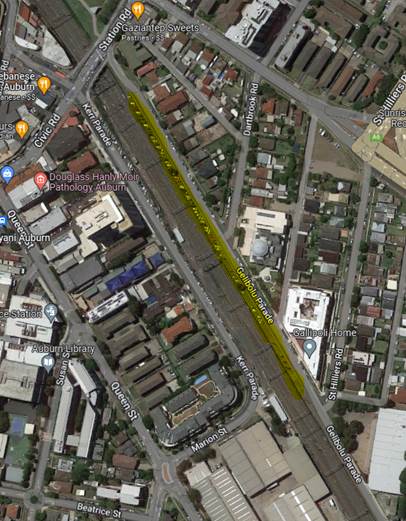
Gelibolu Parade, Auburn runs parallel to the railway line
linking Percy Street and Station Road. It also has a frontage of Gallipoli
Mosque. There is 45-degree angle parking on the railway line side of Gelibolu
Parade from approximately 45m from Station Road and St Hilliers Road. It is
also in close proximity to Auburn Town Centre and Wyatt Park.
Background:
The “Auburn Town Centre Parking Strategy” study undertaken
in 2011 identified the unrestricted angle parking in Gelibolu Parade, Auburn
which is outside the core Auburn Town Centre and used by railway commuters for
possible future full or partial time-restricted parking zone. This parking area
contains 94 numbers 45-degree angle parking spaces. This study was undertaken
prior to the construction of the multistorey carpark in Susan Street which
provides short term parking to residents and visitors.
Council installed ‘½ P’ parking in the
first six (6) angle parking spaces in Gelibolu Parade on the railway line side
in September 2011 to assist the businesses in Station Road that have lost the
parking spaces at their frontage after the widening of Station Road bridge.
The rest of the angle parking spaces totalling 88 are
unrestricted and a part of it is unoccupied most of the day. Part of this
unrestricted parking spaces are used by commuters and residents living outside
the town centre to drive to the area to park and use train transport to travel
to their work or other destinations.
Removal of these unrestricted parking spaces in full will
create problems to the commuters / residents who use rail transport to reach
their destinations after parking in Gelibolu Parade and discourage use of
public transport.
The map and street view below show the location of Gelibolu
Parade, Auburn.
Observations at different times by Council officers
indicated that 40 to 50 of the unrestricted parking spaces are free during the
day and it could be deduced that the majority of the occupied parking spaces
have been used by residents commuting to their workplaces by train.
It is proposed to convert 40 of the 88 unrestricted parking
spaces opposite the mosque to Two-hour (2P) parking from 6:00AM-6:00PM; Monday
to Friday.
The parking demand for the mosque is during prayer times,
therefore , the restrictions will underutilise the street parking. As the
average distance from these restricted parking spaces to Auburn Town Centre
is over 400m, it is unlikely that this parking will be used by the town
centre users due to the distance and the time limit.
Given the location of the car parking in the context of
significant land uses and its close proximity to the Auburn Town Centre and
Wyatt Park, it is recommended that community engagement be undertaken prior to
a final decision being made by the Traffic Committee.
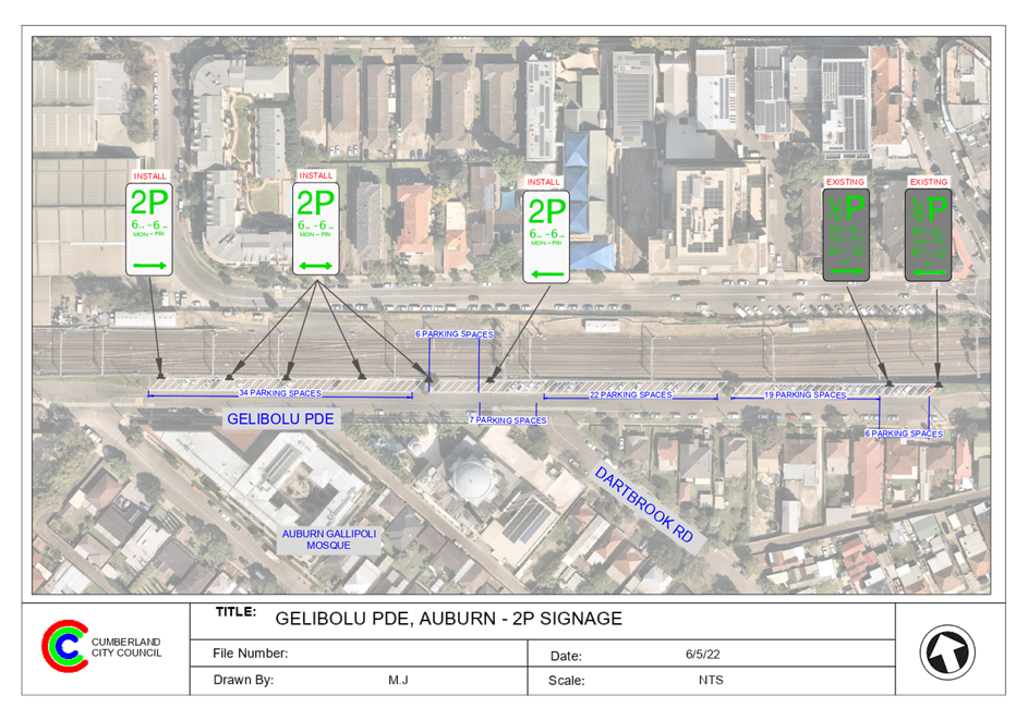
1. Plan –
Gelibolu Parade, Auburn – Proposed 2P parking restriction
DOCUMENTS
ASSOCIATED WITH
REPORT CTC-22-093
Attachment 1
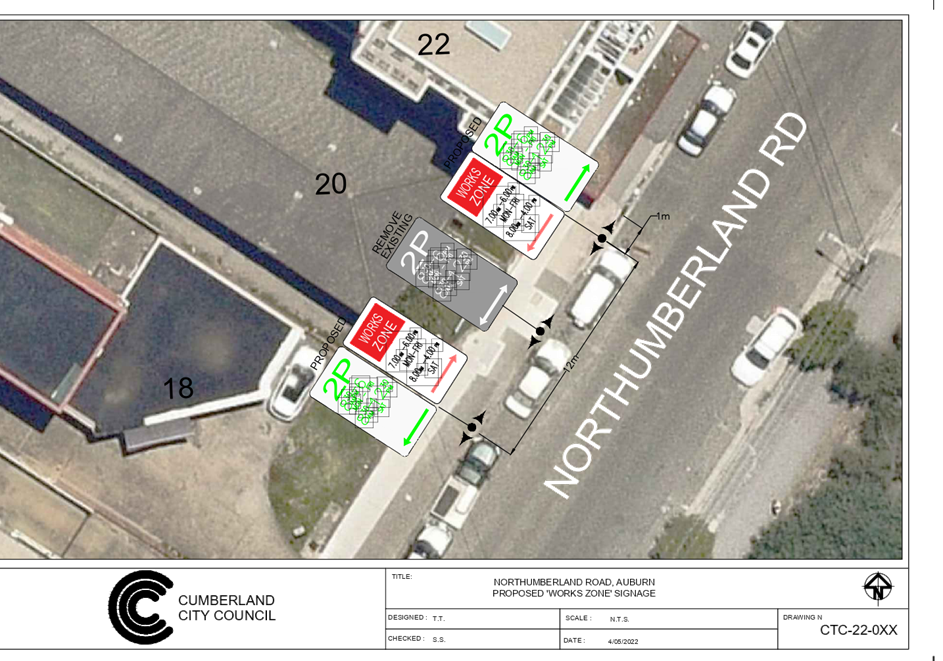
Plan – Gelibolu Parade, Auburn – Proposed
2P parking restriction
1 June 2022
1 June 2022
Item
No: CTC-22-094
LONG STREET,
SMITHFIELD – PROPOSED PARKING RESTRICTIONS OUTSIDE NO.119
Responsible
Division: Environment
& Planning
Officer: Engineering
Administration Officer
File
Number: HC-24-01-3/02
Electorate: Prospect
Police Area
Command (PAC): Cumberland
Council has received a request
from a local business owner for the installation of timed parking on Long
Street, Smithfield.
This report outlines the outcome
of the investigation into this matter.
|
The Traffic Committee recommends that:
1. The proposed
installation of ‘1/2P 6AM - 4PM, Mon – Fri, 6AM –
12:30PM Sat’, ‘No Stopping’ and ‘Bus Zone’
signs outside 119 Long Street, Smithfield in accordance with the attached
plan be approved.
2. Council notifies
the strata owner of 119 Long Street, Smithfield, and adjoining properties of
Council’s resolution.
|
Council has received a request
from a local business owner for the installation of timed parking on Long
Street, Smithfield. The business owner has advised that due to high parking
demand in the area, the existing unrestricted on-street parking spaces are occupied
most of the day and remove parking opportunity for customers.
Long Street is a collector road
that runs in an east-west direction. It has a width of 12.5m with unrestricted
parking on both sides of the street.
Council’s Officers have investigated the matter which
revealed that due to the high demand for parking in this industrial area,
vehicles often park for long periods of time in the street preventing the
take-away customers from using the spaces.
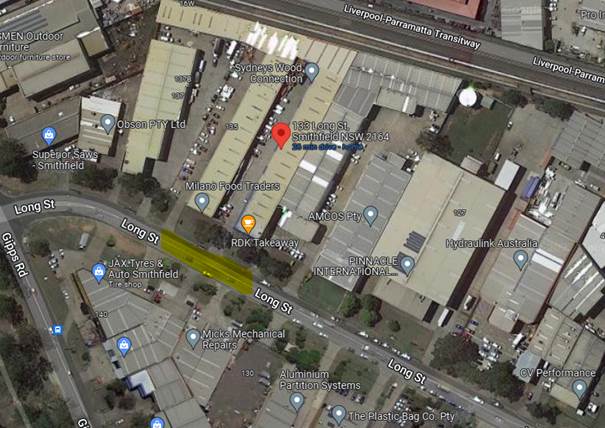
The map below shows the
location of Long Street, Smithfield.
To assist the business in the area, it is recommended to
install 1/2-hour parking restrictions which would increase parking turnover for
the take-away shop.
In addition, the installation of ‘No Stopping’
and ‘Bus Zone’ signs on Long Street would strengthen the road rules
in the area and improve road safety for all road users.
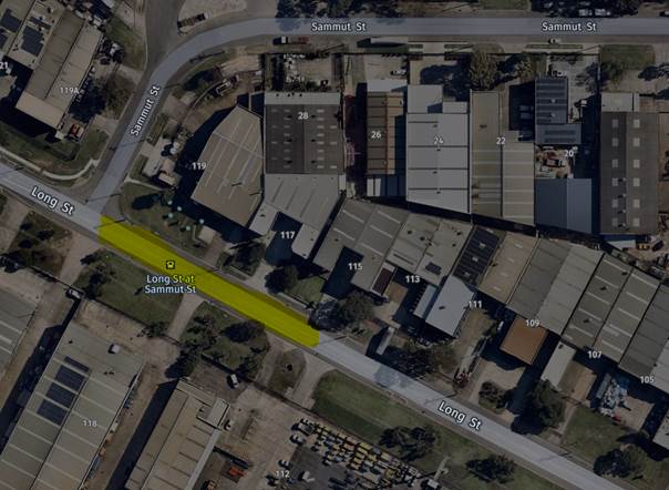
1. Plan –
Long Street, Smithfield - Proposed installation of parking restrictions
DOCUMENTS
ASSOCIATED WITH
REPORT CTC-22-094
Attachment 1
Plan – Long Street, Smithfield - Proposed
installation of parking restrictions
1 June 2022
1 June 2022
Item
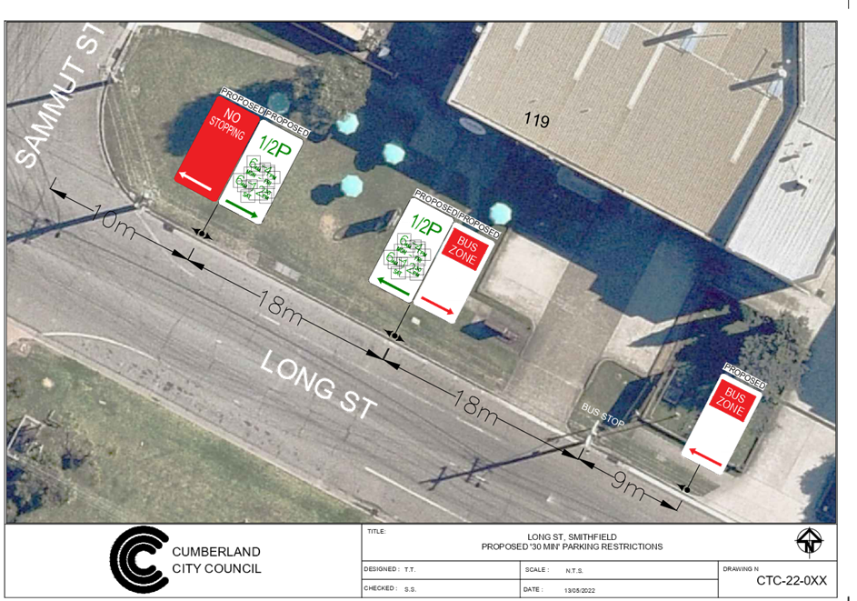
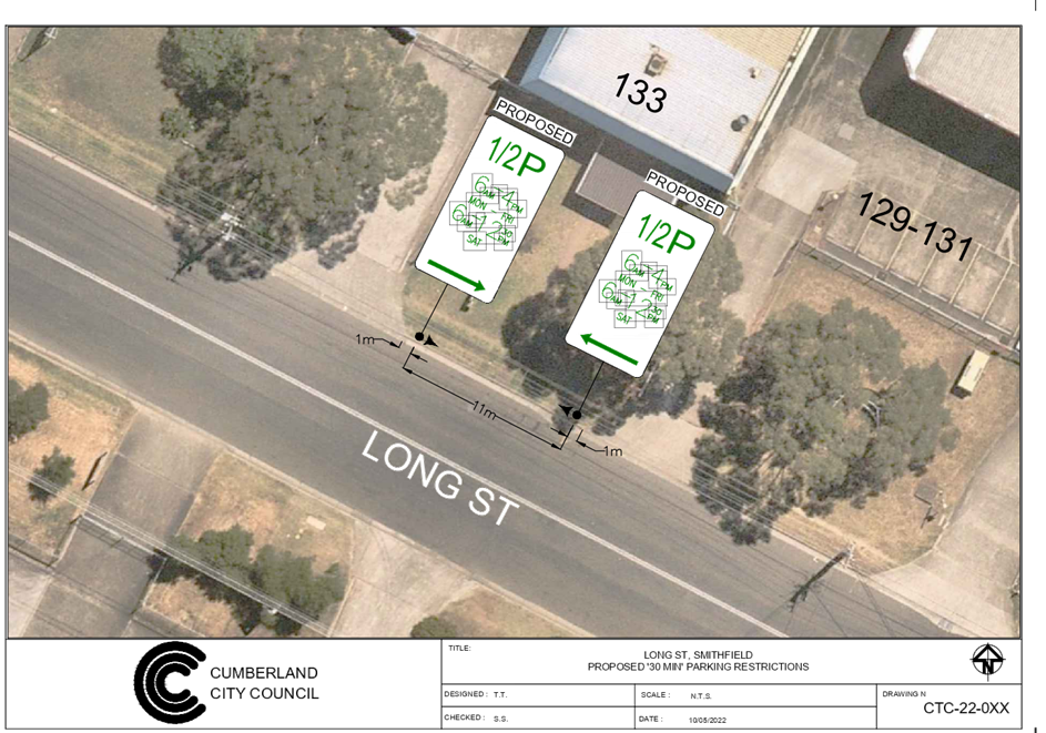
No: CTC-22-095
LONG STREET,
SMITHFIELD – PROPOSED PARKING CHANGES OUTSIDE NO. 133
Responsible
Division: Environment
& Planning
Officer: Engineering
Administration Officer
File
Number: HC-24-01-3/02
Electorate: Prospect
Police Area
Command (PAC): Cumberland
Council has received a request
from a local business (take-away) owner for the installation of timed parking
on Long Street, Smithfield.
This report outlines the outcome
of the investigation into this matter.
|
The Traffic Committee recommends that:
1. The proposed
installation of ‘1/2P; 6AM - 4PM, Mon-Fri, 6:00AM – 12:30PM,
Sat’ outside 133 Long Street, Smithfield in accordance with the
attached plan be approved.
2. Council
notifies the strata owner of 133 Long Street, Smithfield, and adjoining
properties of Council’s resolution.
|
Council has received a request
from the owner of a take-away cafe for the installation of timed parking on
Long Street, Smithfield. The business owner has advised that due to high
parking demand in the area, the existing unrestricted on-street parking spaces
are occupied most of the day and remove parking opportunity for customers.
Long Street is a collector road
that runs in an east-west direction. It has a width of 12.5m with unrestricted
parking on both sides of the street.
Council’s Officers have investigated the matter which
revealed that due to the high demand of parking in this industrial area,
vehicles often park for long periods of time in the street preventing the
take-away customers from using the spaces.
The map below shows the
location of Long Street, Smithfield’s.
To assist the businesses in the
area, it is proposed to install 1/2-hour parking which would increase parking
turnover for the business.
1. Plan –
Long Street, Smithfield - Proposed installation of parking restrictions
DOCUMENTS
ASSOCIATED WITH
REPORT CTC-22-095
Attachment 1
Plan – Long Street, Smithfield - Proposed
installation of parking restrictions
1 June 2022
1 June 2022
Item
No: CTC-22-096
BROTHERTON
STREET AND RICHMOND STREET, SOUTH WENTWORTHVILLE – PROPOSED ‘NO
STOPPING’ RESTRICTIONS AND LINE MARKING AT THE INTERSECTION
Responsible
Division: Environment
& Planning
Officer: Engineering
Administration Officer
File
Number: HC-24-01-3/02
Electorate: Granville
Police Area
Command (PAC): Cumberland
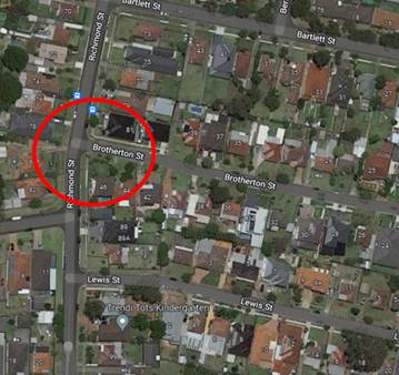
Council has received a request from a resident requesting
for parking restrictions at the intersection of Brotherton Street and Richmond
Street, South Wentworthville.
This report outlines the outcome of the investigation into
this matter.
|
The Traffic Committee recommends that:
1. The
installation of ‘No Stopping’ signs and line marking at the
intersection of Brotherton Street and Richmond Street, South Wentworthville
in accordance with the attached plan be approved.
2. The
adjacent properties be notified of the outcome.
|
Brotherton Street is a local road that runs in an east-west
direction with a speed limit of 50 km/h. It has a width of approximately 7.2m
and parking is permitted on both sides of the road in accordance with the Road
Rules unless signposted otherwise.
Richmond Street is a local road that runs in a north-south
direction with a speed limit of 50 km/h. It has a width of approximately 10.4m
and parking is permitted on both sides of the road unless signposted otherwise.
Brotherton Street forms a T – intersection with
Richmond Street with priority to Richmond Street.
The map below shows details at the intersection.
A review of the Centre for Road Safety accident data
indicated that there were no reported accidents at this intersection in the
five years ending June 2021.
A site inspection indicated that vehicles are parking within
the statutory 10 metres at both intersections. The installation of ‘No
Stopping’ signs would strengthen the Road Rules requirements and stop
vehicles from parking too close to the intersection. It would also improve
sight distance requirements.
Also, it is proposed to install
10m ‘BB’ centre lines at the intersection to assist vehicles stay
on the right side of the road. The ‘No Stopping’ signs on
Brotherton Street are installed at 13m to allow for vehicles to pass a parked
vehicle without encroaching into the ‘BB’ centre line.
1. Plan -
Brotherton Street & Richmond Street, South Wentworthville - Proposed 'No
Stopping' restrictions and 'BB' line marking
DOCUMENTS
ASSOCIATED WITH
REPORT CTC-22-096
Attachment 1
Plan - Brotherton Street & Richmond Street, South
Wentworthville - Proposed 'No Stopping' restrictions and 'BB' line marking
1 June 2022
1 June 2022
Item
No: CTC-22-097
IVAN STREET,
GREYSTANES AT THE INTERSETION OF GRAHAM STREET– PROPOSED ‘NO
STOPPING’ RESTRICTIONS AND LINE MARKING
Responsible
Division: Environment
& Planning
Officer: Engineering
Administration Officer
File
Number: HC-24-01-3/02
Electorate: Granville
Police Area
Command (PAC): Cumberland
Council has received concerns from a resident requesting for
intersection treatment at the intersection of Ivan Street and Graham Street,
Greystanes.
This report outlines the outcome of the investigation into
this matter.
|
The Traffic Committee recommends that:
1. The
installation of ‘No Stopping’ signs and ‘BB’ centre
line at the intersection of Ivan Street and Graham Street, Greystanes in
accordance with the attached plan be approved.
2. The
adjacent properties be notified of the outcome.
|
Graham Street is a local road that runs in a southerly
direction from Old Prospect Road with a speed limit of 50 km/h. It has a width
of approximately 7.5m and parking is permitted on both sides of the road in
accordance with the Road Rules unless signposted.
Ivan Street is a local road that runs in an east-west
direction with a speed limit of 50 km/h and ends in a cul-de-sac. It has a
width of approximately 7.5m and parking is permitted on both sides of the road
in accordance with the Road Rules unless signposted.
Ivan Street and Graham Street form a T-intersection with
priority to Graham Street.
There are ‘No Stopping’ signs provided on the
northwest corner of the intersection.
The map below shows the intersection:
A review of the available accident data indicated that there
were no recorded accidents at the intersection of Ivan Street and Graham Street
in the five years ending in June 2021.
A site inspection indicated that vehicles are parking within
10 metres from the intersection. The installation of ‘No Stopping’
signs would strengthen the Road Rules requirements and stop vehicles from
parking too close to the intersection.
It is also proposed to provide ‘BB’ centre line
marking at the intersection as per the attached plan. The ‘No
Stopping’ signs in Ivan Street is provided at 13m to prevent vehicles
crossing the 10m ‘BB’ centre line when passing a parked car.
1. Plan –
Ivan Street at the intersection of Graham Street Greystanes –Proposed
‘No Stopping’ parking restrictions and ‘BB’ centre line
marking.
DOCUMENTS
ASSOCIATED WITH
REPORT CTC-22-097
Attachment 1
Plan – Ivan Street at the intersection of Graham
Street Greystanes –Proposed ‘No Stopping’ parking
restrictions and ‘BB’ centre line marking.
1 June 2022
1 June 2022
Item
No: CTC-22-098
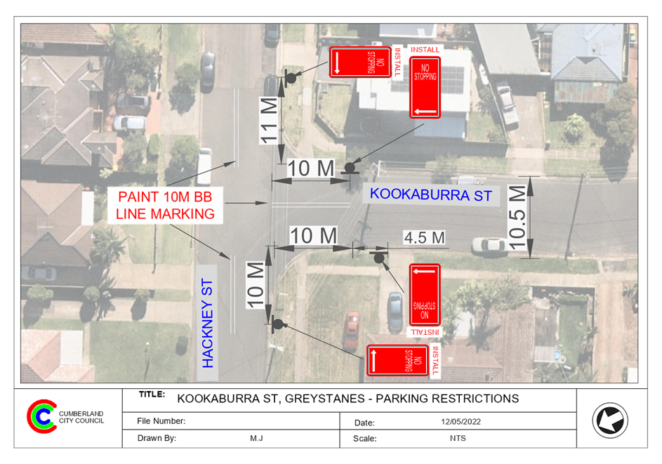
KOOKABURRA
STREET AND HACKNEY STREET’ GREYSTANES – PROPOSED INTERSECTION
TREATMENT
Responsible
Division: Environment
& Planning
Officer: Engineering
Administration Officer
File
Number: HC-24-01-3/02
Electorate: Prospect
Police Area
Command (PAC): Cumberland
Council has received requests from local residents to
improve safety at the intersection of Kookaburra Street and Hackney Street,
Greystanes.
This report outlines the outcome of the investigation into
this matter.
|
The Traffic Committee recommends that:
1. Proposed
‘No Stopping’ signs and BB line marking at the intersection of
Kookaburra Street and Hackney Street, Greystanes in accordance with the
attached plan be approved.
2. The
adjacent properties be notified of the outcome.
|
Kookaburra Street is a local road that runs in an east-west
direction with a posted speed limit of 50 km/h. It has a width of approximately
10.5m and parking is permitted on both sides of the road unless signposted.
Hackney Street is a local road that runs in a north-south
direction with a speed limit of 50 km/h. It has a width of approximately 10.3m
and parking is permitted on both sides of the road unless signposted.
Kookaburra Street and Hackney Street form a T –
junction with priority by default to Hackney Street.
The map below shows the location of the intersection:
Residents allege that the vehicles often turning right from
Hackney Street into Kookaburra Street at high speed. As a result, they always
turn into the wrong side of the road.
A review of the Centre for Road Safety accident data
indicates that there were no recorded accidents at the intersections of
Kookaburra Street and Hackney Street in the five years ending in June 2021.
In order to maintain safety and reduce the risk of a
collision at the intersection of Kookaburra Street and Hackney Street, it is
proposed that double centreline marking (BB) be provided in Kookaburra Street
and Hackney Street at the intersection.
It is also proposed that ‘No Stopping’ signs be
installed at the intersection as it would strengthen the Road Rules
requirements and stop vehicles from parking too close to the intersection.
1. Plan –
Kookaburra Street at Hackney Street, Greystanes – Proposed ‘No
Stopping’ signs and BB line marking.
DOCUMENTS
ASSOCIATED WITH
REPORT CTC-22-098
Attachment 1
Plan – Kookaburra Street at Hackney Street,
Greystanes – Proposed ‘No Stopping’ signs and BB line marking.
1 June 2022
1 June 2022
Item
No: CTC-22-099
LAYTON STREET
AND DUNMORE STREET, WENTWORTHVILLE – PROPOSED PARKING RESTRICTIONS
Responsible
Division: Environment
& Planning
Officer: Engineering
Administration Officer
File
Number: HC-24-01-3/02
Electorate: Prospect
Police Area
Command (PAC): Cumberland
A request has been received from Council’s compliance
team to install parking restrictions in Layton Street at the intersection of
Dunmore Street, Wentworthville to reinforce the Road Rules.
This report outlines the outcome of the investigation into
this matter.
|
The Traffic Committee recommends that:
1. ‘No
Stopping’ and ‘No Parking’ signs at the intersection of
Layton Street and Dunmore Street, Wentworthville in accordance with the
attached plan be approved.
2. The
adjacent properties be notified of the outcome.
|
Layton Street is a local road that runs in a north-south
direction with a speed limit of 50 km/h. It has a width of approximately 12.5m
and parking is permitted on both sides of the road unless signposted. There is
also a post box on the eastern side of Layton Street and a ‘No
Parking’ sign is provided after the post box, but the zone does not have
a closing sign.
Dunmore Street is a regional road that runs in an east-west
direction with a speed limit of 50 km/h. It has a width of approximately 12.5m
and parking is permitted on both sides of the road unless signposted. Dunmore
Street has centre line and edge lines marked.
Layton Street and Dunmore Street form a T –
intersection with priority by default to Dunmore Street.

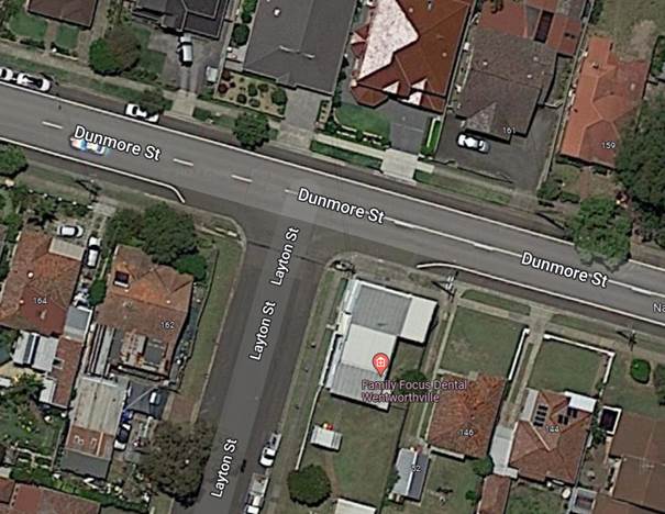
Figure 1 –
Locality Plan
A review of the Centre for Road Safety accident data
indicates that there were no reported accidents at the intersection of Layton
Street and Dunmore Street in the five years ending in June 2021.
Council’s compliance team indicated that vehicles are
parking within the statutory 10 metres at the intersection. Vehicles also park
outside the edge lines in Dunmore Street near the intersection. The
installation of ‘No Stopping’ signs would strengthen the Road Rules
requirements and stop vehicles from parking too close to the intersection. It
would also improve sight distance requirements. Also, provision of ‘No
Parking’ sign on the eastern side of Layton Street with the 10m ‘No
Stopping’ sign will close the existing no parking zone provided for the
post box.
Therefore, it is proposed to provide ‘No
Stopping’ and ‘No Parking’ signs in Layton Street at the
intersection as per attached plan.
1. Plan –
Layton Street at Dunmore Street, Wentworthville – Proposed Parking
Restrictions
DOCUMENTS
ASSOCIATED WITH
REPORT CTC-22-099
Attachment 1
Plan – Layton Street at Dunmore Street,
Wentworthville – Proposed Parking Restrictions
1 June 2022
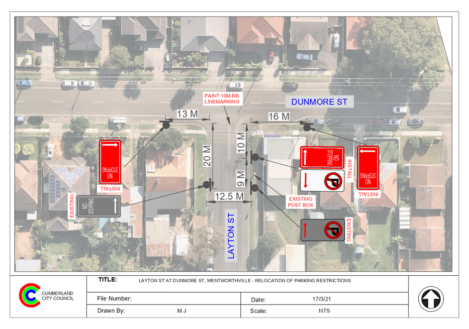
1 June 2022
Item
No: CTC-22-100
PARK ROAD AND
CHESTNUT ROAD, AUBURN – PROPOSED ‘NO STOPPING’ RESTRICTIONS
Responsible
Division: Environment
& Planning
Officer: Engineering
Administration Officer
File
Number: T-28-01/06
Electorate: Auburn
Police Area
Command (PAC): Auburn
Council has received a request from a resident requesting
for parking restrictions in Park Road, Auburn at its intersection with Chestnut
Road.
This report outlines the outcome of the investigation into
this matter.
|
The Traffic Committee recommends that:
1. The
installation of ‘No Stopping’ signs and ‘BB’ centre
line marking at the intersection of Park Road and Chestnut Road, Auburn in
accordance with the attached plan be approved.
2. The
adjacent properties be notified of the outcome.
|
Park Road is a collector road that runs in a north-south
direction with a speed limit of 60 km/h. It has a width of approximately 13m
and parking is permitted on both sides of the road unless signposted otherwise.
Park Road has separator centre line marked at the intersection.
Chestnut Road is a local road that runs in an east-west
direction with a posted speed limit of 50 km/h. It has a width of approximately
13m and parking is permitted on both sides of the road unless signposted
otherwise.
Park Road and Chestnut Road form a four-way intersection with
priority to Park Road. Median islands with Stop signs and line marking are
provided on the Chestnut Road approaches at the intersection.
The map below shows the intersection:
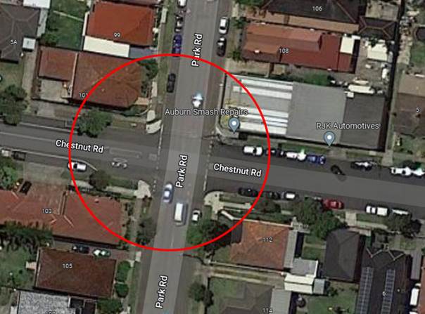
Figure 1 –
Locality Plan
A review of the Centre for Road Safety accident data
indicated that there were three reported accidents at the intersection of Park
Road and Chestnut Road in the five years ending in June 2021.
A site inspection indicated that vehicles are parking within
the statutory 10 metres on the Park Road approaches and outside the edge lines
on Chestnut Road at the intersection. The installation of ‘No
Stopping’ signs would strengthen the Road Rules requirements and stop
vehicles from parking too close to the intersection. It would also improve sight
distance requirements. The ‘No Stopping’ signs on the Chestnut Road
approaches are installed at distances greater than 10m to match the median
islands and edge line markings.
Also, it is proposed to install
‘BB’ centre lines on Park Road (20m long on both approaches) at the
intersection.
1. Plan –
Park Road at Chestnut Road, Auburn – Proposed ‘No Stopping’
parking restrictions and ‘BB’ centre line marking.
DOCUMENTS
ASSOCIATED WITH
REPORT CTC-22-100
Attachment 1
Plan – Park Road at Chestnut Road, Auburn
– Proposed ‘No Stopping’ parking restrictions and
‘BB’ centre line marking.
1 June 2022
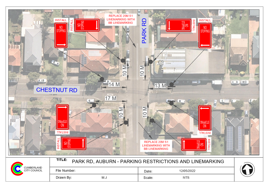
1 June 2022
Item
No: CTC-22-101
STAFFORD
STREET, SOUTH GRANVILLE – PROPOSED ‘NO PARKING’ SIGNS IN THE
CUL-DE-SAC
Responsible
Division: Environment
& Planning
Officer: Engineering
Administration Officer
File
Number: HC-24-01-3/02
Electorate: Auburn
Police Area
Command (PAC): Cumberland
Council has received a request
from a resident for the installation of parking restrictions in the cul-de-sac
end of Stafford Street, South Granville.
This report outlines the outcome
of the investigation into this matter.
|
The Traffic Committee recommends that:
1. The
proposed ‘No Parking’ restrictions in the cul-de-sac of Stafford
Street, South Granville in accordance with the attached plan be approved
2. The
adjacent properties be notified of the outcome.
|
Stafford Street is a local road that runs in an east –
west direction with a posted speed limit of 50 km/h. It has a width of
approximately 9m and parking is permitted on both sides of the road unless
signposted. It has a cul-de-sac on the western end of the street.
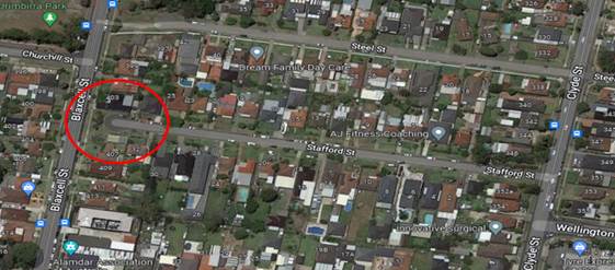
Council has received a
request for the installation of parking restrictions in the cul-de-sac end of
Stafford Street.
Council’s officers
have investigated the matter and it revealed that vehicles are parking in the
cul-de-sac end of the road causing problems to the vehicles and waste trucks to
turn around. The cul-de-sac bulb is approximately 7m radius and it is difficult
to manoeuvre cars and large vehicles around when cars are parked in the area.
Therefore, it is proposed
to install “No Parking” restrictions in the cul-de-sac end of the
street as per the attached plan.
1. Plan –
Stafford Street, South Granville – Proposed ‘No Parking’
signs.
DOCUMENTS
ASSOCIATED WITH
REPORT CTC-22-101
Attachment 1
Plan – Stafford Street, South Granville –
Proposed ‘No Parking’ signs.
1 June 2022
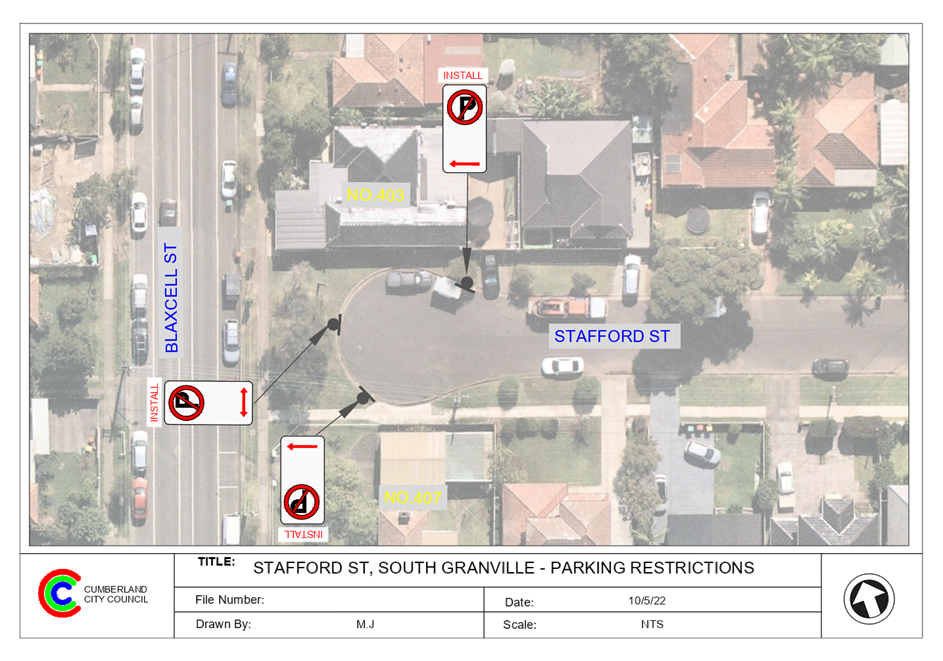
1 June 2022
Item
No: CTC-22-102
WEEROONA ROAD,
LIDCOMBE – REQUEST FOR ‘KEEP CLEAR’ LINEMARKING
Responsible
Division: Environment
& Planning
Officer: Engineering
Administration Officer
File Number: HC-24-01-3/02
Electorate: Auburn
Police Area
Command (PAC): Auburn
Council has received a request
from Forensic & Analytical Science Service located at 480 Weeroona Road,
Lidcombe for the installation of ‘Keep Clear’ pavement markings on
Weeroona Road, Lidcombe outside both of their driveways.
This report outlines the outcome
of the investigation into this matter.
|
The Traffic Committee recommends that the installation
of ‘Keep Clear’ pavement markings outside No.480 Weeroona Road,
Lidcombe in accordance with the attached plan be approved.
|
Weeroona Road between Joseph
Street and East Street is a regional road that runs in an east-west direction
with a speed limit of 60km/h. This section of Weeroona Road has a width of
approximately 12.5m with a bike lane on both sides of the street.
The request from Forensic &
Analytical Science Service stated that they need to receive urgent deliveries
to the facility 24/7 and traffic constantly blocking both driveways. As a
result, it impedes on the ability for pathologists, scientists, police and ambulance
to access or leave the site.
It is requested that ‘Keep Clear’ line marking be provided at both
driveways as one driveway is for the Forensic Medicine and Coroner’s
Court; and the other driveway is for Forensic and Analytical Science Service.
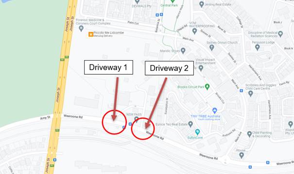
Figure
1 – Locality Plan
‘Keep Clear’
Pavement markings are generally used outside Ambulance and Fire Brigade
driveways and critical intersections close to signalised intersection where
vehicles queuing to right turn into side roads might result in interfering with
the performance of the signalised intersection.
Due to the queuing traffic at
this section of Weeroona Road, there is minimum opportunity (gap) available to
turn right into Weeroona Road from both driveways. It is proposed that
‘Keep Clear’ markings are provided in Weeroona Road as per the
attached drawing. This will assist ambulance and police vehicles
move into the traffic without delay.
1. Plan –
Weeroona Road, Lidcombe - Proposed ‘Keep Clear’ Line marking
DOCUMENTS
ASSOCIATED WITH
REPORT CTC-22-102
Attachment 1
Plan – Weeroona Road, Lidcombe - Proposed
‘Keep Clear’ Line marking
1 June 2022
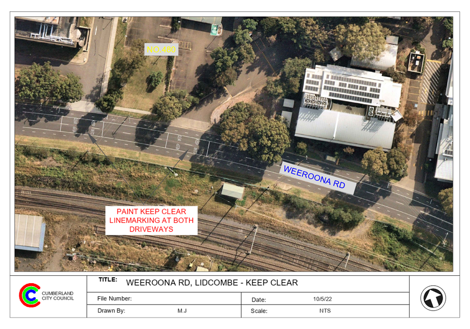
1 June 2022
Item
No: CTC-22-103
ALBERT STREET
AND FOWLER STREET, GUILDFORD – PROPOSED ‘NO STOPPING’
RESTRICTIONS
Responsible
Division: Environment
& Planning
Officer: Engineering
Administration Officer
File
Number: HC-24-01-3/02
Electorate: Granville
Police Area
Command (PAC): Cumberland
Council has received a request from a resident requesting
for parking restrictions in Albert Street, Guildford at its intersection with
Fowler Street.
This report outlines the outcome of the investigation into
this matter.
|
The Traffic Committee recommends that:
1. The
installation of ‘No Stopping’ signs and line marking at the
intersection of Albert Street and Fowler Street, Guildford in accordance with
the attached plan be approved.
2. The
adjacent properties be notified of the outcome.
|
Fowler Street is a regional road that runs in a north-south
direction with a speed limit of 50 km/h. It has a width of approximately 12.5m
and parking is permitted on both sides of the road in accordance with Road
Rules unless signposted.
Albert Street is a local road that runs in an east-west
direction with a posted speed limit of 50 km/h. It has a width of approximately
10.5m and parking is permitted on both sides of the road unless signposted.
Albert Street and Fowler Road form a four-way intersection
with priority to Fowler Road. Stop signs and line marking exist in Albert
Street on both approaches to the intersection.
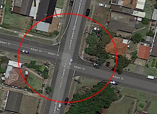
Figure 1 –
Locality Plan
A review of the Centre for Road Safety accident data
indicated that there were two reported accidents at the intersection of Albert
Street and Fowler Street in the five years ending in June 2021.
A site inspection indicated that vehicles are parking within
the statutory 10 metres at the intersection. The installation of ‘No
Stopping’ signs would strengthen the Road Rules requirements and stop
vehicles from parking too close to the intersection. It would also improve
sight distance requirements.
Also, it is proposed to
install ‘BB’ centre lines on Albert Street (10m long on the eastern
approaches) at the intersection to assist vehicles stay on the right side of
the road.
The ‘No Stopping’ signs are to be installed at
13m on the eastern approach of Albert Street to allow vehicles to safely pass a
parked car without encroaching the proposed ‘BB’ centre lines.
1. Plan –
Albert Street at Fowler Street, Guildford – Proposed ‘No
Stopping’ parking restrictions.
DOCUMENTS
ASSOCIATED WITH
REPORT CTC-22-103
Attachment 1
Plan – Albert Street at Fowler Street, Guildford
– Proposed ‘No Stopping’ parking restrictions.
1 June 2022
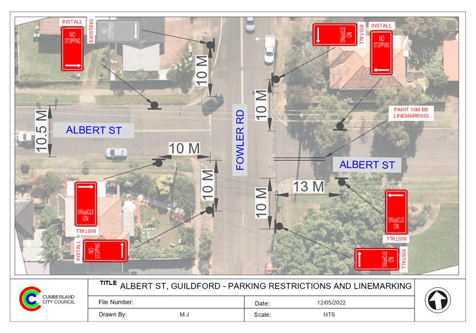
1 June 2022
Item
No: CTC-22-104
FREDERICK
AVENUE AND BLAXCELL STREET, SOUTH GRANVILLE – PROPOSED ‘NO
STOPPING’ RESTRICTIONS AND LINE MARKING AT THE INTERSECTION
Responsible
Division: Environment
& Planning
Officer: Engineering
Administration Officer
File
Number: HC-24-01-3/02
Electorate: Auburn
Police Area
Command (PAC): Cumberland
Council has received a request from a resident requesting
for parking restrictions at the intersection of Frederick Avenue and Blaxcell
Street, South Granville.
This report outlines the outcome of the investigation into
this matter.
|
The Traffic Committee recommends that:
1. The
installation of ‘No Stopping’ signs and line marking at the
intersection of Frederick Avenue and Blaxcell Street, South Granville in
accordance with the attached plan be approved.
2. The
adjacent properties be notified of the outcome.
|
Frederick Avenue is a local road that runs in an east-west
and north-south direction between Blaxcell Street and Lavinia Street with a
speed limit of 50 km/h. It has a width of approximately 7.3m and parking is
permitted on both sides of the road in accordance with the Road Rules unless
signposted otherwise.
Blaxcell Street is a collector road that runs in a
north-south direction with a speed limit of 50 km/h. It has a width of
approximately 12.5m and parking is permitted on both sides of the road unless
signposted otherwise. Blaxcell Street has a painted median island and edge
lines for parking.
Frederick Avenue forms a T – intersection with
Blaxcell Street with priority to Blaxcell Street.
The map below shows details at the intersection.
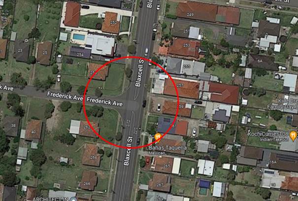
A review of the Centre for Road Safety accident data
indicated that there were no reported accidents related to sight distance at
this intersection in the five years ending June 2021.
A site inspection indicated that vehicles are parking within
the statutory 10 metres at the intersection. The installation of ‘No
Stopping’ signs would strengthen the Road Rules requirements and stop
vehicles from parking too close to the intersection. It would also improve
sight distance requirements.
Also, it is proposed to install
10m ‘BB’ centre line in Frederick Avenue to assist vehicles stay on
the right side of the road. The ‘No Stopping’ signs on Frederick
Avenue are installed at 13m to allow for vehicles to pass a parked vehicle
without encroaching into the ‘BB’ centre line.
1. Plan –
Frederick Avenue and Blaxcell Street, South Granville – Proposed
‘No Stopping’ restrictions and BB line marking.
DOCUMENTS
ASSOCIATED WITH
REPORT CTC-22-104
Attachment 1
Plan – Frederick Avenue and Blaxcell Street,
South Granville – Proposed ‘No Stopping’ restrictions and BB
line marking.
1 June 2022
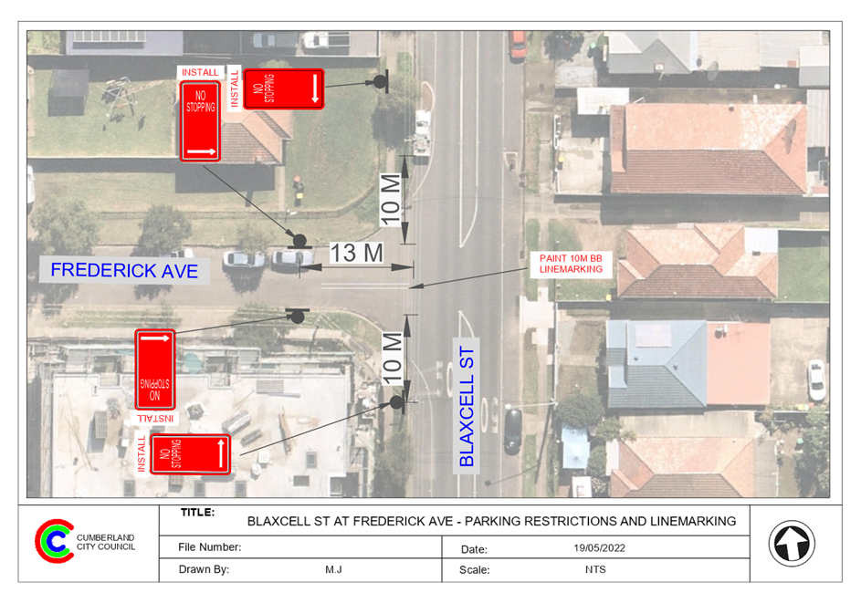
1 June 2022
Item
No: CTC-22-105
PARK ROAD,
AUBURN – APPLICATION FOR ‘WORKS ZONE’ SIGNAGE
Responsible
Division: Environment
& Planning
Officer: Engineering
Administration Officer
File
Number: T-28-01/06
Electorate: Auburn
Police Area
Command (PAC): Auburn
Council has received an
application for a ‘Works Zone’ on Park Road, Auburn associated with
the development at 40-42A Park Road, Auburn.
This report outlines the outcome
of the investigation into this matter.
|
The Cumberland Traffic Committee recommends that:
1. The 18m long
‘Works Zone, 7:00am-6:00pm, Monday-Friday, 8:00am-4:00pm,
Saturday’ signs be installed on the frontage of the development site on
Park Road, Auburn subject to Council’s standard conditions for the
period of 12 months and subsequent extension if required.
2. The applicant
be advised to pay the ‘Works Zone’ fees to Council as per the
adopted Fees and Charges.
|
Council has received an
application for a ‘Works Zone’ on Park Road, Auburn associated with
the development at 40-42A Park Road, Auburn. The proposed development involves
construction of 6 storey residential development with 34 units over 2 levels of
basement parking.
The temporary “Works
Zone” is approximately 18m in length and proposed to commence in July
2022 for 12 months. The proposed time is between 7:00am to 6:00pm Monday to
Friday and 8:00am to 4:00pm on Saturdays.
There will be a loss of three (3)
unrestricted on-street parking spaces on the eastern side of Park Road, Auburn
during the operation of the “Works Zone”.
1. Plan - Park
Road, Auburn - Proposed Temporary 'Works Zone' signage
DOCUMENTS
ASSOCIATED WITH
REPORT CTC-22-105
Attachment 1
Plan - Park Road, Auburn - Proposed Temporary 'Works
Zone' signage
1 June 2022
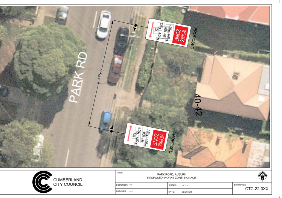
1 June 2022
Item
No: CTC-22-106
BROTHERTON
STREET AND FRANCES STREET, SOUTH WENTWORTHVILLE – PROPOSED ‘NO
STOPPING’ RESTRICTIONS & LINE MARKING AT THE INTERSECTION
Responsible
Division: Environment
& Planning
Officer: Engineering
Administration Officer
File
Number: HC-24-01-3/02
Electorate: Granville
Police Area
Command (PAC): Cumberland
Council has received a request from a resident requesting
for parking restrictions at the intersection of Brotherton Street and Frances
Street, South Wentworthville.
This report outlines the outcome of the investigation into
this matter.
|
The Traffic Committee recommends that:
1. The
installation of ‘No Stopping’ signs and line marking at the
intersection of Brotherton Street and Frances Street, South Wentworthville in
accordance with the attached plan be approved.
2. The
adjacent properties be notified of the outcome.
|
Brotherton Street is a local road that runs in an east-west
direction with a speed limit of 50 km/h. It has a width of approximately 7.2m
and parking is permitted on both sides of the road in accordance with the Road
Rules unless signposted otherwise.
Frances Street is a local road that runs in a north-south
direction with a speed limit of 50 km/h. It has a width of approximately 12.5m
and parking is permitted on both sides of the road unless signposted otherwise.
Brotherton Street forms a T – intersection with
Frances Street with priority to Frances Street.
The map below shows details at the intersection.
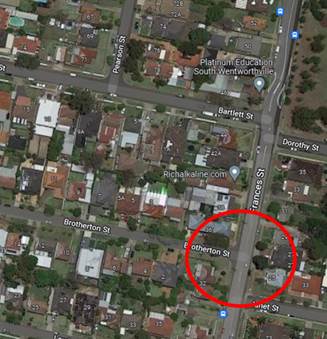
A review of the Centre for Road Safety accident data
indicated that there were no reported accidents at this intersection in the
five years ending June 2021.
A site inspection indicated that vehicles are parking within
the statutory 10 metres at both intersections. The installation of ‘No
Stopping’ signs would strengthen the Road Rules requirements and stop
vehicles from parking too close to the intersection. It would also improve
sight distance requirements.
Also, it is proposed to install
10m ‘BB’ centre lines at the intersection to assist vehicles stay
on the right side of the road. The ‘No Stopping’ signs on
Brotherton Street are installed at 13m to allow for vehicles to pass a parked
vehicle without encroaching into the ‘BB’ centre line.
1. Plan –
Brotherton Street and Frances Street, South Wentworthville – Proposed
‘No Stopping’ restrictions and BB line marking.
DOCUMENTS
ASSOCIATED WITH
REPORT CTC-22-106
Attachment 1
Plan – Brotherton Street and Frances Street,
South Wentworthville – Proposed ‘No Stopping’ restrictions
and BB line marking.
1 June 2022
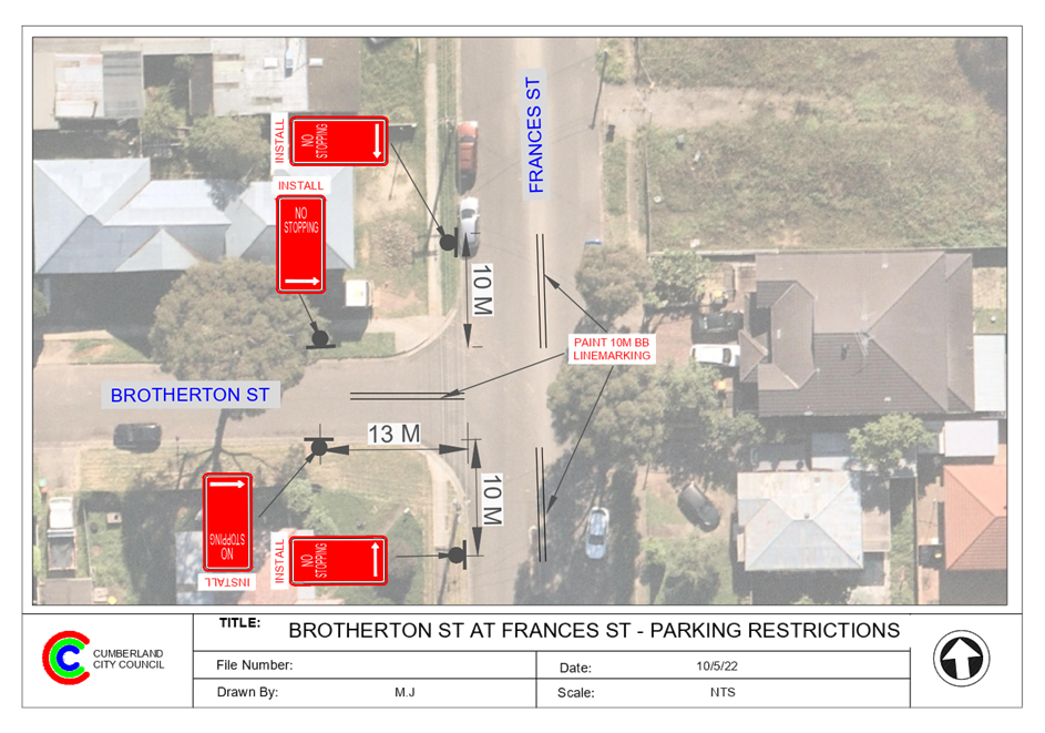
1 June 2022
Item
No: CTC-22-107
SUSAN STREET,
AUBURN – MODIFICATION TO THE EXISTING PARKING RESTRICTIONS
Responsible
Division: Environment
& Planning
Officer: Engineering
Administration Officer
File
Number: T-28-01/06
Electorate: Auburn
Police Area
Command (PAC): Auburn
Council has previously approved
installation of ‘No Parking’ signs covering the two driveways of
the Kindergarten development. This development has new parking arrangement
adjacent to the building and closed one driveway and provided a new driveway to
access the car park.
Council has now received a request
from the business to modify the existing parking restrictions in Susan Street,
Auburn outside No.50-52 as a part of the approved vehicle crossing application.
This report outlines the outcome
of the investigation into this matter.
|
The Traffic Committee recommends that:
1. The
modification of the parking restriction signage outside No. 50-52 Susan
Street, Auburn in accordance with the attached plan be approved.
2. The adjacent
properties be notified of the outcome.
|
Council has received a request
from the owner of the Kindergarten at 50-52 Susan Street for the adjustment of
the existing parking restrictions outside the property. It is in conjunction
with an approved vehicular crossing construction at this location.
The applicant has proposed the
following adjustment to the existing parking restrictions outside No.50-52
Susan Street:
1. Relocate
the existing No Parking zone
2. Relocate
the existing part-time 2-hour parking restrictions
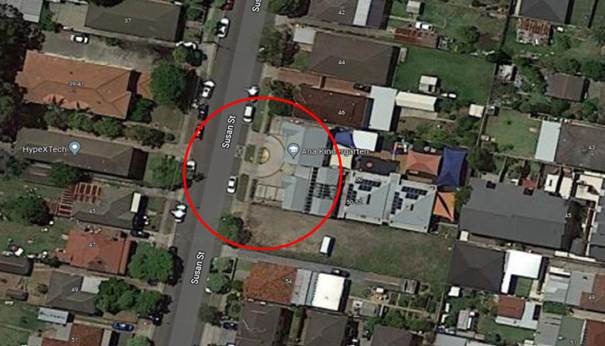
Plan
1 – Locality Plan
As a part of the approval, the
existing redundant vehicular access outside No.50-52 Susan Street has been
closed and kerb and gutter reconstructed as per the photo below. The proposed
adjustment of the existing parking restrictions will increase the number of 2P
street parking spaces at this section of Susan Street.
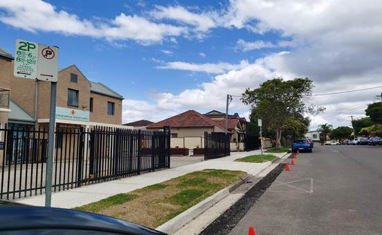
1. Plan –
Susan Street, Auburn – Modification to the existing parking restrictions
DOCUMENTS
ASSOCIATED WITH
REPORT CTC-22-107
Attachment 1
Plan – Susan Street, Auburn – Modification
to the existing parking restrictions
1 June 2022
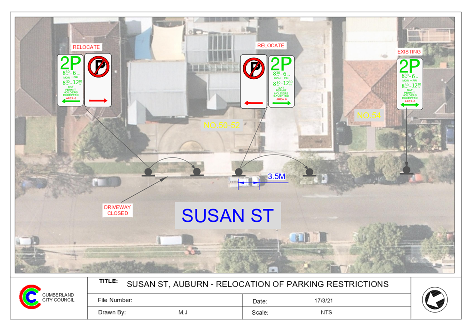
1 June 2022
Item
No: CTC-22-108
AUBREY STREET
AT THE TRONGATE AND PEGLER AVENUE, SOUTH GRANVILLE – PROPOSED ‘NO
STOPPING’ SIGNS AND LINE MARKING AT THE INTERSECTIONS
Responsible
Division: Environment
& Planning
Officer: Engineering
Administration Officer
File
Number: HC-24-01-3/02
Electorate: Auburn
Police Area
Command (PAC): Cumberland
Council has received a request from a resident requesting
for parking restrictions in Aubrey Street at the intersection of The Trongate
and Pegler Avenue, South Granville.
This report outlines the outcome of the investigation into
this matter.
|
The Traffic Committee recommends that:
1. The
installation of ‘No Stopping’ signs and ‘BB’ centre
line marking at the intersections of Aubrey Street with The Trongate
and Pegler Avenue, South Granville in accordance with the attached plan be
approved.
2. The
adjacent properties be notified of the outcome.
|
Aubrey Street is a local road that runs in an east-west
direction between Clyde Street and Blaxcell Street with a speed limit of 50
km/h. It has varying widths with road narrowing’s. Parking is permitted
on both sides of the road in accordance with the Road Rules unless signposted
otherwise.
The Trongate is a local collector road that runs in a
north-south direction with a speed limit of 50 km/h. It has a width of
approximately 12.5m and parking is permitted on both sides of the road unless
signposted otherwise.
Pegler Ave is a local road that runs in a north-south
direction with a speed limit of 50 km/h. It has a width of approximately 12.5m
and parking is permitted on both sides of the road unless signposted otherwise.
Aubrey Street forms a T – intersections with The
Trongate and Pegler Avenue with priority to Aubrey Street. ‘Stop’
signs are installed in The Trongate at its intersection with Aubrey Street.
There is also a median island with opening built in The Trongate at this
intersection.
The map below shows details at the intersections.

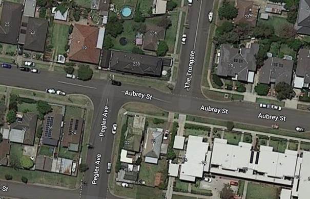
A review of the Centre for Road Safety accident data
indicated that there were no reported accidents at these intersections in the
five years ending June 2021.
A site inspection indicated that vehicles turning out of The
Trongate have sight distance issues on the right due the vertical crest. Also,
if a large vehicle is parked in Aubrey Street west of The Trongate, sight
distance to these turning vehicles is further restricted.
Also, it was observed that vehicles are parking within 3
metres of the ‘BB’ centre line provided in Aubrey Street near the intersections.
This will force vehicles to travel over the ‘BB’ centre lines on
part of the opposite travel lanes.
It is proposed to provide
‘No Stopping’ signs at these intersections to strengthen the Road
Rules requirements and improve safety.
1. Plan - Aubrey
Street at its intersections with The Trongate and Pegler Avenue - Proposed 'No
Stopping' restrictions and 'BB' centre line marking
DOCUMENTS
ASSOCIATED WITH
REPORT CTC-22-108
Attachment 1
Plan - Aubrey Street at its intersections with The
Trongate and Pegler Avenue - Proposed 'No Stopping' restrictions and 'BB'
centre line marking
1 June 2022
1 June 2022
Item
No: CTC-22-109
ELLIS STREET,
MERRYLANDS AT HILLTOP ROAD– PROPOSED PAINTED ISLAND AND LINEMARKING
Responsible
Division: Environment
& Planning
Officer: Engineering
Administration Officer
File
Number: HC-24-01-3/02
Electorate: Granville
Police Area
Command (PAC): Cumberland
Council has received requests from a local resident to
improve safety at the intersection of Ellis Street and Hilltop Road,
Merrylands.
This report outlines the outcome of the investigation into
this matter.
|
The Traffic Committee recommends that:
1. The
painted island and ‘BB’ line marking in Ellis Street Merrylands
at Hilltop Road in accordance with the attached plan be approved.
2. The
adjacent properties be notified of the outcome.
|
Ellis Street is a local road that runs in a north-south
direction with a speed limit of 50 km/h. It has a width of approximately 10.5m
and parking is permitted on both sides of the road unless signposted.
Hilltop Road is a collector road that runs in an east-west
direction with a speed limit of 50 km/h. It has a width of approximately 12m
and parking is permitted on both sides of the road unless signposted. There are
also ‘BB’ centre lines and edge lines provided on Hilltop Road.
Ellis Street and Hilltop Road form a Y – intersection.
A ‘Stop’ sign and associated line marking are provided in Ellis
Street at the intersection. ‘No Stopping’ signs are also
provided at the intersection.
Figure 1 –
Locality Plan
The resident alleged that due to the road geometry at the
intersection, vehicles often turn left or right from Hilltop Road into Ellis
Street with high speeds. It is unsafe to all road users.
A review of the Centre for Road Safety accident data
indicated that there were no reported accidents at the intersection of Ellis
Street and Hilltop Road in the five years ending in June 2021.
In order to maintain safety and
reduce the risk of a collision at the intersection of Ellis Street and Hilltop
Road, it is proposed to provide a kerbside painted island and double centreline
marking (BB) in Ellis Street at the intersection of Hilltop Road as per
attached plan.
1. Plan - Ellis
Street, Merrylands - Proposed painted island and line marking
DOCUMENTS
ASSOCIATED WITH
REPORT CTC-22-109
Attachment 1
Plan - Ellis Street, Merrylands - Proposed painted
island and line marking
1 June 2022
1 June 2022
Item
No: CTC-22-110
SPENCER
STREET, BERALA – PROPOSED ‘NO PARKING’ SIGNS IN THE
CUL-DE-SAC
Responsible
Division: Environment
& Planning
Officer: Engineering
Administration Officer
File
Number: T-28-01/06
Electorate: Auburn
Police Area
Command (PAC): Auburn
Council has received a request
from a resident for the installation of parking restrictions in the cul-de-sac
end of Spencer Street, Berala.
This report outlines the outcome
of the investigation into this matter.
|
The Traffic Committee recommends that:
1. The
proposed ‘No Parking’ restrictions in Spencer Street, Berala in
accordance with the attached plan be approved
2. The
adjacent properties be notified of the outcome.
|
Spencer Street is a local road that runs in a north – south
direction with a posted speed limit of 50 km/h. It has a width of approximately
7m and parking is permitted on both sides of the road in accordance with the
Road Rules unless signposted otherwise. It has a cul-de-sac on the northern end
of the street connecting to Spencer Park.
Council has received a request for the installation of
parking restrictions in the cul-de-sac end of Spencer Street. The resident
alleged that vehicles often park in the cul-de-sac blocking the driveway
access.
Council’s officers have investigated the matter and it
was revealed that the driveways of No.14 & 17 Spencer Street are located
adjacent to the park. Vehicles parking in the cul-de-sac end of the road will
block the access to these driveways as shown in photos below.
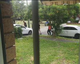
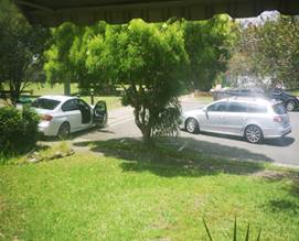
In order to maintain the access for the residents at the
corner of the park, it is proposed to install “No Parking”
restrictions in the cul-de-sac end of the street as per the attached plan.
1. Plan -
Spencer Street, Berala - Proposed 'No Parking' signage in the cul-de-sac
DOCUMENTS
ASSOCIATED WITH
REPORT CTC-22-110
Attachment 1
Plan - Spencer Street, Berala - Proposed 'No Parking'
signage in the cul-de-sac
1 June 2022
1 June 2022
Item
No: CTC-22-111
HICKORY
STREET, GREYSTANES AT ETTALONG ROAD– PROPOSED BB LINEMARKING
Responsible
Division: Environment
& Planning
Officer: Engineering
Administration Officer
File
Number: HC-24-01-3/02
Electorate: Prospect
Police Area
Command (PAC): Cumberland
Council has received requests from a local resident to
improve safety at the intersection of Hickory Street and Ettalong Road,
Greystanes.
This report outlines the outcome of the investigation into
this matter.
|
The Traffic Committee recommends that:
1. ‘BB’
line marking in Hickory Street, Greystanes at Ettalong Road in accordance
with the attached plan be approved.
2. The
relocation of the existing ‘No Stopping’ signs in Hickory Street
in accordance with the attached plan be approved.
3. The
adjacent properties be notified of the outcome.
|
Hickory Street is a local road that runs in an east-west
direction with a speed limit of 50 km/h. It has a width of approximately 7.1m
and parking is permitted on both sides of the road in accordance with the Road
Rules unless signposted.
Ettalong Road is a collector road that runs in a north-south
direction with a speed limit of 50 km/h. It has a width of approximately 12m
and parking is permitted on both sides of the road unless signposted. Ettalong
Road has a pedestrian refuge just south of Hickory Street and painted edge
lines and median.
Hickory Street and Ettalong Road form a T –
intersection with priority by default to Ettalong Road. ‘No
Stopping’ signs have been installed at the intersection.
Figure 1 –
Locality Plan
The resident alleged that the vehicles often turn right from
Ettalong Road into Hickory Street with speed. As a result, they always turn
into the wrong side of the road. It is unsafe for road users at the intersection.
A review of the Centre for Road Safety accident data
indicates that there were no reported accidents at the intersection of Hickory
Street and Ettalong Road in the five years ending in June 2021.
In order to maintain safety and reduce the risk of a
collision at the intersection of Hickory Street and Ettalong Road, it is
proposed that 10m long ‘BB’ centreline marking be provided in
Hickory Street at the intersection of Ettalong Road as per the attached
plan.
Also, it is proposed to relocate the existing ‘No
Stopping’ signs in Hickory Street to 13m to allow vehicles to pass a
parked car without encroaching the ‘BB’ centre line in the narrow
street.
1. Plan –
Hickory Street at Ettalong Road, Greystanes – Proposed BB line marking.
DOCUMENTS
ASSOCIATED WITH
REPORT CTC-22-111
Attachment 1
Plan – Hickory Street at Ettalong Road,
Greystanes – Proposed BB line marking.
1 June 2022
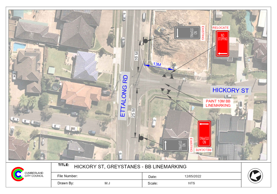
1 June 2022
Item
No: CTC-22-112
DULLAI AVENUE,
PEMULWUY – ROAD SAFETY CONCERNS
Responsible
Division: Environment
& Planning
Officer: Engineering
Administration Officer
File
Number: HC-24-01-3/02
Electorate: Prospect
Police Area
Command (PAC): Cumberland
Council has received a request
from a local resident for the installation of traffic calming devices on Dullai
Avenue, Pemulwuy due to speeding concerns.
This report outlines the outcome
of the investigation into this matter.
|
The Cumberland Traffic Committee recommends that
the installation of traffic calming devices on Dullai Avenue, Pemulwuy not be
supported.
|
Council has received a request
from a resident for the installation of traffic calming devices on Dullai
Avenue, Pemulwuy due to speeding concerns.
Dullai Avenue is a local road runs
in an east – west direction from Naying Drive to Daruga Avenue. The road
is approximately 310m long and 9.0m wide with an approximately 2m wide median
island in the middle separating the eastbound and westbound traffic. The centre
median provides a single lane of approximately 3.5m in both directions. The
speed limit is 50km/h and indented parking bays are provided on both sides of
the road.
Council’s Officers have investigated the request for
the installation of traffic calming devices on Dullai Avenue in accordance with
Council’s Local Area Traffic Management (LATM) Policy.
The latest Centre for Road Safety accident data indicated
that there were no reported accidents in Dullai Avenue in the 5 years ending
June 2021.
The map below shows the
location of Dullai Avenue:
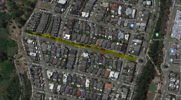
A traffic count was undertaken
on Dullai Avenue February 2022. The traffic count location is shown in red on
the map above.
The results of the
traffic count indicated the following:
Traffic count
Data on Dullai Avenue:
Average Daily Traffic (ADT) = 194 veh/day,
85th percentile speed = 48.6 km/h,
Mean (average) vehicle speed = 39 km/h.
The results of the traffic counts, recorded crashes etc.
were used in the assessment to determine the need for the installation of
traffic calming devices on Dullai Avenue in accordance with the criteria set
out in Council’s Local area Traffic Management Policy (LATM) Policy.
The LATM assessments are
summarised in the tables below:
Table 1 – Dullai
Avenue - LATM Assessment Points
|
Criteria
|
Maximum Score
|
Score Achieved
|
|
Traffic Study Data
|
45
|
0
|
|
Crash warrant in the
last 5 years
|
15
|
0
|
|
Road Characteristics
|
35
|
11
|
|
Community Support &
other factors
|
5
|
5
|
|
Total
|
100
|
16
|
Table 2 – Dullai
Avenue – Action
|
Criteria
|
Action
|
|
>75
|
Report to TC with a
recommendation of providing traffic calming devices
|
|
61-75
|
Report to TC and
discuss possibility of providing traffic calming devices
|
|
41-60
|
Council to review
traffic data in 6 months
|
|
25-40
|
Monitor street and
review traffic data after 12 months
|
|
<25
|
Do Nothing
|
|
Speed
|
That regardless of the
total points scored, should the 85th percentile speed exceed the posted speed
limit by 5 km/h, the street be referred to the NSW Police for monitoring
and/or enforcement.
|
The traffic count indicated that the recorded 85th
percentile speed was 48.6km/h which is below the speed limit of the street.
Based on the above assessment,
traffic calming devices are not warranted in the street, therefore, the request
for the installation of traffic calming devices / speed humps on Dullai Avenue
cannot be supported.
Nil
1 June 2022
Item
No: CTC-22-113
FOWLER ROAD
AND FAULDS ROAD, GUILDFORD WEST – PROVISION OF MEDIAN ISLAND
Responsible
Division: Environment
& Planning
Officer: Engineering
Administration Officer
File
Number: GS-284-TP
Electorate: Fairfield
Police Area
Command (PAC): Cumberland
The former Holroyd City Council
approved the installation of a pedestrian refuge on Faulds Road at its
intersection with Fowler Road as a stage 2 improvement, due to unsafe traffic
movements with vehicles crossing the centre line when turning right from Fowler
Road into Faulds Road. Rumble bars were installed on Faulds Road as Stage 1 in
2014.
This report outlines the outcome
of the investigation into this matter.
|
The Traffic Committee recommends that:
1. The
proposed median island in Faulds Road at Fowler Road, Guildford West in
accordance with the attached plan be approved.
2. The
adjacent properties be notified of the outcome.
|
The former Holroyd City Council
approved the installation of a pedestrian refuge on Faulds Road at its
intersection with Fowler Road as stage 2 due to unsafe traffic movements with
vehicles crossing the centre line when turning right from Fowler Road into Faulds
Road. Rumble bars were installed on Faulds Road as Stage 1 in 2014. Stage 2 was
never implemented.
A
report (ECTC-20-164) was also presented to the Cumberland Traffic Committee
(CTC) in September 2020 regarding the matter. CTC recommended and council
subsequently approved that the information contained in the report be noted.
Council has now received concerns from a local resident
regarding safety at this intersection.
The refuge island at this intersection approved previously
by Holroyd Traffic Committee and Council could not be built in accordance with
the current standards.
A review of the site indicated that a pedestrian refuge
island is not feasible at this location without affecting the kerb returns due
to existing road width / existing infrastructure (i.e. footpath / kerb and
gutter etc.).
The latest Centre for Road Safety crash data indicates that
there were no reported crashes at this intersection in the 5 years
ending June 2021.
BB centre line and edge line marking have been provided on
Fowler Road at the intersection. In addition, rumble bars were installed with
line marking few years ago on Faulds Road to keep the traffic flow on the
left-hand side of the road.
The map below shows the location of the intersection:
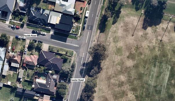
In order to keep the traffic flow on the correct side of the
road in Faulds Road at Fowler Road, it is proposed to replace the existing
rumble bars with a 900 mm wide median island with the relocation of the access
ramps in a westerly direction.
The swept path analysis indicated that there is sufficient
room for a 12.5m long vehicle to turn at the intersection.
1. Plan –
Fowler Road and Faulds Road, Guildford West – Proposed Median Island
2. Previous
Report – ECTC-20-164
DOCUMENTS
ASSOCIATED WITH
REPORT CTC-22-113
Attachment 1
Plan – Fowler Road and Faulds Road, Guildford
West – Proposed Median Island
1 June 2022
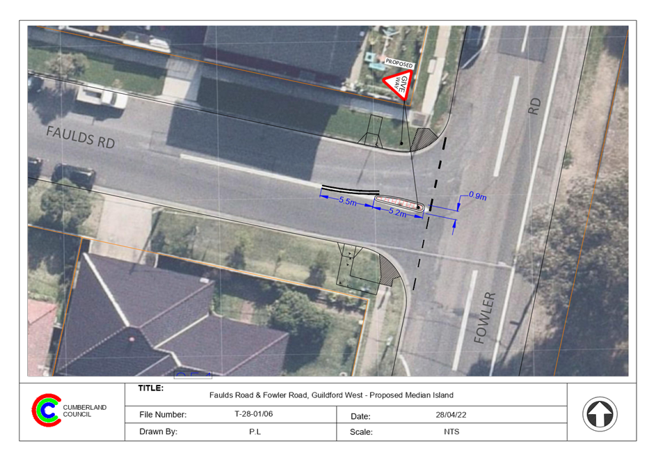
DOCUMENTS
ASSOCIATED WITH
REPORT CTC-22-113
Attachment 2
Previous Report – ECTC-20-164
1 June 2022
Item
No: CTC-22-114
BLAXCELL
STREET, GRANVILLE – PROPOSED MEDIAN ISLAND NEAR THE EXISTING RAISED
PEDESTRIAN CROSSING
Responsible
Division: Environment
& Planning
Officer: Engineering
Administration Officer
File
Number: T-28-01/06
Electorate: Granville
Police Area
Command (PAC): Cumberland
Council received strong objections
from the residents for the proposed relocation of the existing raised
pedestrian crossing on Blaxcell Street, Granville as recommended by the traffic
committee via CTC-22-055.
This report considers a review of
an alternate option to enhance safety at the existing raised pedestrian
crossing.
|
The Traffic Committee recommends that:
1. Council
approve the construction of the 600mm wide 12m long concrete median island
and associated line marking at the existing raised pedestrian crossing on
Blaxcell Street north of Thomas Street in accordance with the attached plan
be approved.
2. Council
requests the Bus Operator and Transport for NSW to consider alternate
location to relocate the bus stop on the eastern side of Blaxcell Street
south of Charles Street to a more suitable location to improve safety of
patrons and road users.
3. Council
notifies the service station at the corner of Blaxcell Street & Celia
Street and adjoining properties of the outcome.
|
Background:
Council has received complaints in
relation to queuing of vehicles on Blaxcell Street to access the service
station on Blaxcell Street. Long queues on southbound lane occupies the
kerbside lane and blocks access to existing bus stop which forces the buses to
stop in the middle traffic lane to drop off and pick up of patrons.
The queue on the northbound lane
to turn right to access the service station blocks the pedestrian crossing and
compromises pedestrian safety.
Therefore, Council commenced the
process to relocate both the pedestrian crossing and the bus stop to improve
safety of road users and constructing a median to prohibit right turns at this
location to improve northbound traffic flow.
Cumberland Traffic Committee at
its meeting in February 2020 considered two reports (vide Item No. CTC-20-034
& CTC-20-035) to relocate the existing raised pedestrian crossing on
Blaxcell Street at Thomas Street and the ‘Bus Zone’ on the eastern
side of Blaxcell Street.
The traffic committee recommended
to relocate the raised pedestrian crossing to a location south of Celia Street.
Also, similarly, recommended to move the bus stop (‘Bus Zone’) to a
new location together with the crossing south of Celia Street. These
recommendations were approved by Council subsequently.
Council received objections from a resident who will lose
the on-street parking within their frontage due to the parking restrictions
associated with the new relocated pedestrian crossing.
After a site meeting with the residents, a report
(CTC-21-208) was presented to Local Traffic Committee in August 2021 and the Traffic
Committee recommended to retain the previously approved option (via CTC-20-034
& 035).
In February 2022, Council received further objections from
residents and this matter was reported to Council via traffic committee on 6
April 2022. Council resolved that ‘this matter be deferred pending a
further report being prepared to next traffic committee meeting identifying
alternate measures similar to the attached to improve traffic safety at the
existing pedestrian crossing, whilst investigating suitable locations for the
relocation of the bus stop if required’.
Current Proposal:
As per Council resolution, Council officers have prepared a
proposal to provide a 600mm wide median island on Blaxcell Street on either
side of the existing raised pedestrian crossing opposite to the service
station. This will prohibit vehicles waiting /queuing on the crossing to turn
right into the service station driveway. These vehicles could drive further and
undertake U-turns to access the service station driveway.
This proposal will enhance pedestrian safety at the
pedestrian crossing and also help traffic flows in Blaxcell Street.
It is proposed to request the bus operator and Transport for
NSW to relocate the bus stop on the eastern side of Blaxcell Street south of
Charles Street to a more suitable location to improve safety of patrons and
road users.
1. Plan -
Blaxcell Street, Granville - Proposed median island
DOCUMENTS
ASSOCIATED WITH
REPORT CTC-22-114
Attachment 1
Plan - Blaxcell Street, Granville - Proposed median
island
1 June 2022

1 June 2022
Item
No: CTC-22-115
COLEMAN
STREET, MERRYLANDS AT HILLTOP ROAD – REQUEST FOR GUARD RAIL
Responsible
Division: Environment
& Planning
Officer: Engineering
Administration Officer
File
Number: HC-24-01-3/02
Electorate: Granville
Police Area
Command (PAC): Cumberland
Council has received concerns
from a resident that the intersection of Coleman Street and Hilltop Road,
Merrylands is unsafe and is requesting a guard rail be installed in front of
the property.
This report outlines the outcome
of the investigation into this matter.
|
The Traffic Committee recommends that:
1. The
installation of a guardrail at the intersection of Coleman Street and Hilltop
Road, Merrylands not be supported.
2. Provision of
a speed hump on the western approach of the roundabout at the intersection of
Coleman Street and Hilltop Road, Merrylands in accordance with the attached
plan be approved.
3. The concerned
resident and adjoining properties be notified of the outcome.
|
Council has received concerns
from a resident that the intersection of Coleman Street and Hilltop Road is
unsafe and is requesting a guardrail be installed in front of the property.
The residential property is
located at the corner of Coleman Street and Hilltop Road. There was an accident
recently where a vehicle lost control and crashed into the boundary wall of the
property. The owner of the property has requested that Council to provide a
guardrail at this intersection.
In accordance with the report
provided by the Police Force, the driver had a medical episode at the time. As
a result, the vehicle lost control at the roundabout and crashed into the fence
of No.84 Coleman Street.
Based on the accident Database
supplied by the Centre for Road Safety, there were 2 reported accidents (1
cross traffic and 1 left near accident in 2017) at this location in the five
years ending in June 2021.
The map below shows details of
the location.
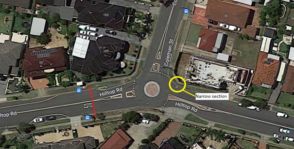
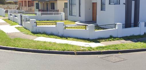
Council officers inspected the
site and noted that the narrowest section at this part of Coleman Street
between the back of the kerb to the footpath is 350mm. According to
Austroads Guideline, the minimum offset from the kerb is 200mm (Refer to Fig
6.4 and Table 6.3). The width of safety barrier and the post is 381mm (RMS
Standard Drawing R0710 – W Beam).
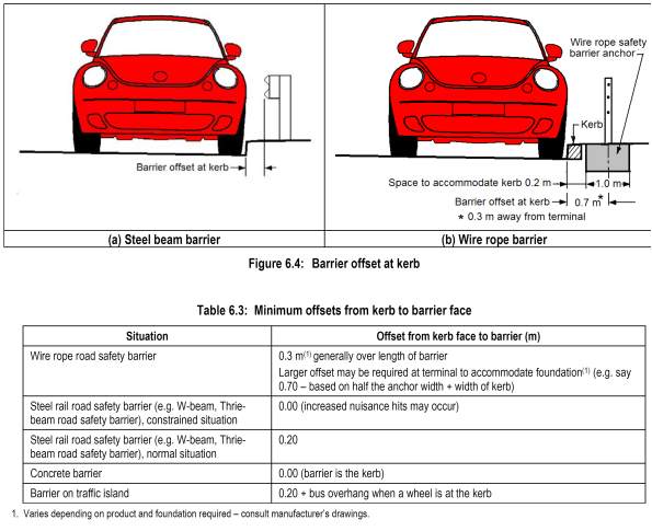
It is noted from the site inspection that the section
between the back of the kerb to the footpath is not wide enough to install a
guard rail.
A traffic count was
undertaken in April 2022.
The results of the
traffic count indicated the following:
Traffic count
Data on Hilltop Road, Eastbound traffic 20m from the Coleman Street roundabout:
Average Daily Traffic (ADT) =
8,927 vehicles/day
85th percentile speed =
40 km/hr
The approach speed to the roundabout is below the speed
limit, however, there may be a small percentage of vehicles travelling over the
speed limit. It is proposed to provide a speed hump on the western approach of
Hilltop Road.
1. Plan-Hilltop
Road & Coleman Street roundabout - Proposed Speed Cushion on the western
approach of Hilltop Road
DOCUMENTS
ASSOCIATED WITH
REPORT CTC-22-115
Attachment 1
Plan-Hilltop Road & Coleman Street roundabout -
Proposed Speed Cushion on the western approach of Hilltop Road
1 June 2022
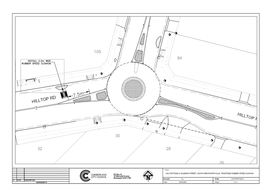
1 June 2022
Item
No: CTC-22-116
REES STREET,
MAYS HILL – ROAD SAFETY CONCERNS
Responsible
Division: Environment
& Planning
Officer: Engineering
Administration Officer
File
Number: HC-24-01-3/02
Electorate: Granville
Police Area
Command (PAC): Cumberland
Council has received a request
from a local resident for the installation of traffic calming devices on Rees
Street, Mays Hill due to speeding concerns.
This report outlines the outcome
of the investigation into this matter.
|
The Traffic Committee recommends that:
1. The
installation of traffic calming devices on Rees Street, Mays Hill not be
supported.
2. Council
review conditions in Rees Street in August 2023 and report back to traffic
committee.
|
Council has received a request
from a resident for the installation of traffic calming devices on Rees Street,
Mays Hill due to speeding concerns.
Rees Street is a local road runs
in an east – west direction from Burnett Street to Peggy Street. The road
is approximately 360m long and 10.2m wide with unrestricted parking on both
sides of the street. The street has a default speed limit of 50km/h.
Council’s Officers have investigated the request for
the installation of traffic calming devices on Rees Street in accordance with
Council’s Local Area Traffic Management (LATM) Policy.
The latest Centre for Road Safety accident data indicated
that there was one reported accident in Rees Street in the 5 years ending June
2021.
The map below shows the
location of Rees Street.
A traffic count was
undertaken on Rees Street December 2021. The traffic count location is shown in
red on the map above.
The results of the
traffic count indicated the following:
Traffic count
Data on Rees Street:
Average Daily Traffic (ADT) = 1,767 veh/day
85th percentile speed = 51.8 km/h
Mean (average) vehicle speed = 43.9 km/h
The results of the traffic counts, recorded crashes etc.
were used in the assessment to determine the need for the installation of
traffic calming devices on Rees Street in accordance with the criteria set out
in Council’s Local area Traffic Management Policy (LATM) Policy.
The LATM assessments are summarised in the tables below:
Table 1 – Rees
Street - LATM Assessment Points
|
Criteria
|
Maximum Score
|
Score Achieved
|
|
Traffic Study Data
|
45
|
10
|
|
Crash warrant in the
last 5 years
|
15
|
5
|
|
Road Characteristics
|
35
|
12
|
|
Community Support &
other factors
|
5
|
5
|
|
Total
|
100
|
32
|
Table 2 – Rees
Street – Action
|
Criteria
|
Action
|
|
>75
|
Report to TC with a
recommendation of providing traffic calming devices
|
|
61-75
|
Report to TC and
discuss possibility of providing traffic calming devices
|
|
41-60
|
Council to review
traffic data in 6 months
|
|
25-40
|
Monitor street and
review traffic data after 12 months
|
|
<25
|
Do Nothing
|
|
Speed
|
That regardless of the total
points scored, should the 85th percentile speed exceed the posted speed limit
by 5 km/h, the street be referred to the NSW Police for monitoring and/or
enforcement.
|
The traffic count indicated that the recorded 85th
percentile speed was 51.8 km/h which is within the acceptable limits.
Based on the above assessment, traffic calming devices are
not warranted in the street, therefore, the request for the installation of
traffic calming devices / speed humps on Rees Street cannot be supported.
Council will review the conditions in the street after 12
months.
Nil
1 June 2022
Item
No: CTC-22-117
SUSAN STREET,
AUBURN – ROAD SAFETY CONCERNS
Responsible
Division: Environment
& Planning
Officer: Engineering
Administration Officer
File Number: T-28-01/06
Electorate: Auburn
Police Area
Command (PAC): Auburn
Council has received a request
from a local resident for the installation of traffic calming devices on Susan
Street, Auburn due to speeding concerns.
This report outlines the outcome
of the investigation into this matter.
|
The Traffic Committee recommends that:
1. The
installation of traffic calming devices on Susan Street, Auburn not be
supported.
2. Council
review conditions in Susan Street, Auburn in August 2023 and report back to
traffic committee.
|
Council has received a request
from a resident for the installation of traffic calming devices on Susan
Street, Auburn due to speeding concerns.
Susan Street is a local road that
runs in a north-south direction from Queen Street to Helena Street. The road is
approximately 470m long and 12m wide. Council has installed ‘2P Resident
Permit Parking Scheme’ in Susan Street section between Beatrice Street
and Helena Street. The section between Queen Street and Beatrice Street
provides access to Council’s multi storey carpark, Auburn Public School
and Council office building.
There is also a raised pedestrian
crossing provided outside the school. A roundabout is provided at the
intersection of Susan Street and Beatrice Street.
The street has a default speed
limit of 50km/h outside the School Zone period.
Council’s Officers have investigated the request for
the installation of traffic calming devices on Susan Street in accordance with
Council’s Local Area Traffic Management (LATM) Policy. In this analysis,
Council has considered the Susan Street section between Beatrice Street and
Helena Street.
The latest Centre for Road Safety accident data indicated
that there were two reported accidents in Susan Street in the 5 years ending
June 2021.
The map below shows the location of Susan Street.
A traffic count was
undertaken on Susan Street in May 2022. The traffic count location is shown in
red on the map above.
The results of the
traffic count indicated the following:
Traffic count
Data on Susan Street:
Average Daily Traffic (ADT) = 1,888 veh/day
85th percentile speed = 54 km/h
Mean (average) vehicle speed = 46 km/h
The results of the traffic counts, recorded crashes etc.
were used in the assessment to determine the need for the installation of
traffic calming devices on Susan Street in accordance with the criteria set out
in Council’s Local area Traffic Management Policy (LATM) Policy.
The LATM assessments are
summarised in the tables below:
Table 1 – Susan
Street - LATM Assessment Points
|
Criteria
|
Maximum Score
|
Score Achieved
|
|
Traffic Study Data
|
45
|
10
|
|
Crash warrant in the
last 5 years
|
15
|
5
|
|
Road Characteristics
|
35
|
14
|
|
Community Support &
other factors
|
5
|
5
|
|
Total
|
100
|
34
|
Table 2 – Susan
Street – Action
|
Criteria
|
Action
|
|
>75
|
Report to TC with a
recommendation of providing traffic calming devices
|
|
61-75
|
Report to TC and
discuss possibility of providing traffic calming devices
|
|
41-60
|
Council to review
traffic data in 6 months
|
|
25-40
|
Monitor street and
review traffic data after 12 months
|
|
<25
|
Do Nothing
|
|
Speed
|
That regardless of the
total points scored, should the 85th percentile speed exceed the posted speed
limit by 5 km/h, the street be referred to the NSW Police for monitoring
and/or enforcement.
|
The traffic count indicated that the recorded 85th
percentile speed was 54 km/h which is within the acceptable limits.
Based on the above assessment, traffic calming devices are
not warranted in the street, therefore, the request for the installation of
traffic calming devices / speed humps on Susan Street cannot be supported.
Council will review the conditions in the street after 12
months.
Nil
1 June 2022
Item
No: CTC-22-118
PERCY STREET,
AUBURN – REQUEST FOR CHILDREN CROSSING
Responsible
Division: Environment
& Planning
Officer: Engineering
Administration Officer
File
Number: HC-24-03-21
Electorate: Auburn
Police Area
Command (PAC): Auburn
Council has received a request to
install ‘Children Crossing’ on Percy Street at The International
Maarif Schools of Australia (IMSA) Gallipoli Campus Auburn.
This report outlines the outcome
of a review into this matter.
|
The Traffic Committee recommends:
1. The
request for a Children crossing on Percy Street, Auburn outside the school
not be approved.
2. ‘No
Parking; 8:00AM-9:30AM; 2:30PM-4:00PM; School Days’ and ‘Bus
Zone; 8:00AM-9:30AM; 2:30PM-4:00PM; School Days’ signs in accordance
with the attached plan be approved.
3. The
costs associated with the installation of the signage shall be borne by the
applicant at no cost to Council.
4. Council
review provision of a pedestrian facility in Percy Street, Auburn, once
future stages of the development are progressed.
5. The
applicant be notified of the outcome.
|
Background:
The International Maarif Schools of Australia (IMSA)
Gallipoli Campus, Auburn was approved in March 2020 involving the staged
construction of a new K-12 school, with capacity for 750 primary and secondary
students. The school currently has from Kindergarten to Year 5.
The approved plans for the project by Department of Planning
include a bus zone and pick-up and drop-off zone on the western side of Percy
Street along the school frontage, along with a new pedestrian crossing across
Percy Street near the intersection with Gelibolu Parade. However,
1. There were no pedestrian warrants provided.
2. Currently the number of students in the
school is very much lower than the expected
final anticipated enrolment of 750 students.
The map below shows the location
of Percy Street, Auburn.
Initially, the school requested approval for a marked
pedestrian (zebra) crossing. Council’s Officers investigated the request
and the investigation revealed that a pedestrian (zebra) crossing did not meet
the current Australian Standard and RMS / Transport for NSW requirements.
Cumberland Traffic Committee at its meeting held on 2 March
2022 considered a report (CTC-22-048) on issues raised by the school and
recommended ‘inter alia’ that:
· The request for
a pedestrian crossing on Percy Street, Auburn outside the school not be
approved.
· The proposed
‘No Parking; 8:00AM-9:30AM; 2:30PM-4:00PM; School Days’ and
‘Bus Zone; 8:00AM-9:30AM; 2:30PM-4:00PM; School Days’ signs in
accordance with the attached plan be approved.
Council resolved at its meeting on 6 April 2022 in regard to
Item No. CTC-22-048
A report be prepared and
reported to the next Cumberland Traffic Committee meeting for Percy Street,
Auburn exploring the viability of a children’s crossing.
To provide a ‘Children’s crossing, Council must satisfy
the following warrants given in RMS / Transport for NSW Guidelines:
The numerical warrants as per the Transport for NSW
guidelines for locating Children’s Crossings on local lightly trafficked
roads are determined by:
· Traffic one hour
duration immediately before and after school hours the traffic flow exceeds 50
vehicles per hour in each direction
· One hour duration
immediately before and after school hours 20 or more children cross the
road within 20m of the proposed crossing location
Council officers undertook vehicle and pedestrian counts
outside the school, the result of the count is listed in Table below:
|
Time (duration one hour)
|
Vehicles
|
Crossing towards school
|
Crossing from school
|
Total
|
|
|
N’bound
|
S’bound
|
Adults
|
Children
|
Adults
|
Children
|
Adults
|
Children
|
|
8:00-9:00
|
43
|
32
|
17
|
33
|
11
|
0
|
28
|
33
|
|
8:30-9:30
|
34
|
24
|
16
|
51
|
12
|
22
|
28
|
73
|
|
2:30-3:30
|
22
|
11
|
28
|
5
|
18
|
29
|
46
|
34
|
|
3:00-4:00
|
34
|
16
|
37
|
6
|
46
|
73
|
83
|
79
|
Based on the survey result, the warrant for a
‘Children Crossing’ has not been met due to the low number of
vehicles. Therefore, a ‘Children Crossing’ is not warranted at this
stage. A pedestrian facility could be considered in the future once future
stages of the development are progressed and warrants are satisfied. In
addition to this, it should be noted that Council does not encourage school
pick up / drop off on the other side of the street as it endangers safety of
school children.
As an interim measure, it is recommended that the
recommendation of the previous report (CTC-22-048) that: The proposed
‘No Parking; 8:00AM-9:30AM; 2:30PM-4:00PM; School Days’ and
‘Bus Zone; 8:00AM-9:30AM; 2:30PM-4:00PM; School Days’ signs in
accordance with the attached plan be approved.
1. Previous
report – CTC-22-048
2. Plan
– Percy Street, Auburn – Proposed signage outside the International
Maarif Schools of Australia at No 2 Percy Street Auburn.
DOCUMENTS
ASSOCIATED WITH
REPORT CTC-22-118
Attachment 1
Previous report – CTC-22-048
DOCUMENTS
ASSOCIATED WITH
REPORT CTC-22-118
Attachment 2
Plan – Percy Street, Auburn – Proposed
signage outside the International Maarif Schools of Australia at No 2 Percy
Street Auburn.
1 June 2022
1 June 2022
Item
No: CTC-22-119
BALLINA
STREET, GREYSTANES – PROPOSED INDENTED ANGLE PARKING
Responsible
Division: Environment
& Planning
Officer: Engineering
Administration Officer
File
Number: T-28-01/06
Electorate: Prospect
Police Area
Command (PAC): Cumberland
Council has proposed provide
indented 90-degree angle parking spaces in Ballina Street at the frontage of
Bathurst Street Park.
This report outlines the proposal.
|
The Traffic Committee recommends that the
installation of 90-degree angle parking spaces in Ballina Street at the
frontage of Bathurst Street Park and associated ‘No Parking’ and
accessible parking signs in accordance with the attached plan be
approved.
|
Ballina Street is a local road
connecting to Orange Street at two locations. It is approximately 7.4m wide and
provides access to Bathurst Street together with Bathurst Street. It has
indented 90-degree parking spaces to provide parking for the park users
Due to the narrow road width,
Ballina Street experiences difficulty to access the properties and travel
through when park users and residents park in the street.
Bathurst Street Park is used by
‘Greystanes FC’ one of the largest football clubs in the LGA and
for other community activities.
The existing car park accessed
via Bathurst Street together with the on-street angle parking spaces are used
by the residents and patrons of the shopping centre on Bathurst Street. Council
has been receiving requests for an upgrade of parking spaces in the area. Also,
Council has received safety concerns from the residents of Ballina Street for
an upgrade of parking so that the Park users do not use on-street parking
spaces on Ballina Street as overflow parking in the narrow street.
The map below shows the location
of Ballina Street:
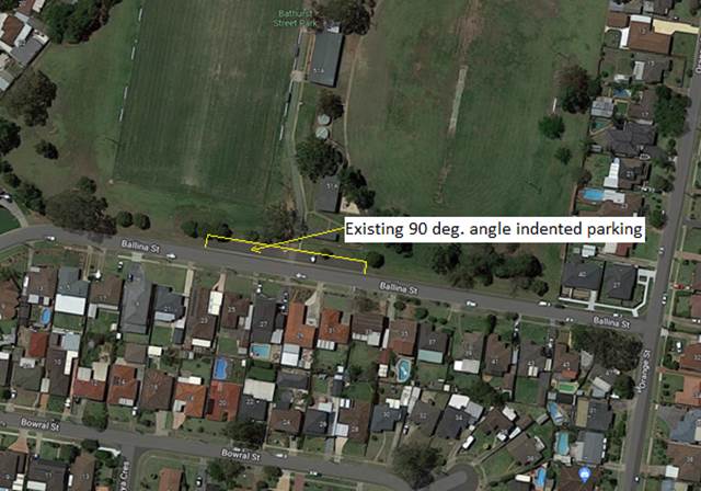
The upgrade of the angle parking
spaces will provide a total of 59 parking spaces which include two (2)
accessible parking spaces. It is proposed to provide accessible parking signs
for the accessible parking spaces and ‘No Parking’ signs to cover
the existing layback access into the park.
Council undertook community consultation between April 2022
to May 2022. In total, Council received 21 submissions, out of which 19
supported the proposal and 2 objected to the proposal.
1. Plan –
Ballina Street, Greystanes – proposed indented parking spaces
DOCUMENTS
ASSOCIATED WITH
REPORT CTC-22-119
Attachment 1
Plan – Ballina Street, Greystanes –
proposed indented parking spaces