6 April 2022
A
meeting of the Traffic Committee will be held at 9.30am in Council Chambers,
Merrylands Administration Building, 16 Memorial Avenue, Merrylands on
Wednesday, 6 April 2022.
ORDER OF BUSINESS
1.
Apologies
2.
Declarations of Interest
3.
Confirmation of Previous Minutes
4.
Summary of Reports....................................................................................................... 3
5.
Reports
CTC-22-056. LIDBURY STREET AND GUILFOYLE STREET,
BERALA – PROPOSED ‘NO STOPPING’ RESTRICTIONS......................................................... 29
CTC-22-057. OXFORD STREET, GUILDFORD –
PROPOSED PARKING RESTRICTIONS AND LINE MARKING................................................ 35
CTC-22-058. PARK ROAD AND CLARKE STREET, BERALA
– PROPOSED ‘NO STOPPING’ RESTRICTIONS................................................................. 43
CTC-22-059. EXCELSIOR STREET NORTH OF GUILDFORD ROAD,
GUILDFORD – PROPOSED ‘BUS ZONE’....................................................................... 49
CTC-22-060. GOOD STREET, WESTMEAD – REMOVAL
OF A REDUNDANT ‘BUS ZONE’......................................................................................................... 55
CTC-22-061. LENA PLACE AND HILLIER STREET,
MERRYLANDS – PROPOSED PARKING RESTRICITONS DURING WASTE NIGHTS.................... 61
CTC-22-062. MAGOWAR ROAD, GIRRAWEEN AT GIRRAWEEN
ROAD – PROPOSED PARKING RESTRICTIONS.................................................................... 77
CTC-22-063. TOONGABBIE ROAD, GIRRAWEEN AT MAGOWAR
ROAD – EXTENSION OF THE EXISTING ‘NO STOPPING’ ZONE............... 83
CTC-22-064. DELL STREET, WOODPARK - REVIEW OF
EXISTING TIMED PARKING..................................................................................................................... 89
CTC-22-065. OLD PROSPECT ROAD, SOUTH WENTWORTHVILLE
– PROPOSED ‘NO STOPPING’ RESTRICTIONS................................................................. 95
CTC-22-066. DAHLIA STREET AND HIBISCUS STREET,
GREYSTANES – PROPOSED PARKING RESTRICITONS & LINE MARKING......... 101
CTC-22-067. MACQUARIE ROAD, GREYSTANES AT BAYFIELD
ROAD– PROPOSED ‘NO STOPPING’ RESTRICTIONS...................................................... 109
CTC-22-068. BOTANICA DRIVE, LIDCOMBE –
PROPOSED ‘NO PARKING’ RESTRICTIONS AND LINEMARKING............................................... 115
CTC-22-069. BRIDGE ROAD, WESTMEAD AT HUDSON
STREET– PROPOSED ‘NO STOPPING’ RESTRICTIONS.............................................................. 121
CTC-22-070. LOWANA AVENUE, MERRYLANDS - PROPOSED
PARKING RESTRICTIONS..................................................................................... 127
CTC-22-071. CHURCH STREET, LIDCOMBE - APPLICATION
FOR 'WORKS ZONE' SIGNAGE................................................................................................. 133
CTC-22-072. GEORGES AVENUE, LIDCOMBE AT BEATRICE
STREET – REQUEST FOR A PEDESTRIAN CROSSING...................................................... 139
CTC-22-073. CLYDE STREET, SOUTH GRANVILLE AT NOBBS
STREET – ROAD SAFETY CONCERNS........................................................................... 143
CTC-22-074. ADDLESTONE ROAD, MERRYLANDS –
ROAD SAFETY CONCERNS 147
CTC-22-075. BADHAM STREET, MERRYLANDS
– ROAD SAFETY CONCERNS 151
CTC-22-076. JONES STREET, WENTWORTHVILLE –
ROAD SAFETY CONCERNS 155
CTC-22-077. HARRIS STREET, GUILDFORD – ROAD
SAFETY CONCERNS - CONSULTATION.................................................................................... 159
CTC-22-078. KENNEDY STREET, GUILDFORD – ROAD
SAFETY CONCERNS 169
CTC-22-079. REID STREET, MERRYLANDS –
ROAD SAFETY CONCERNS. 173
CTC-22-080. ACLAND STREET, GUILDFORD – ROAD
SAFETY CONCERNS 177
CTC-22-081. JOYCE STREET, PENDLE HILL
– ROAD SAFETY CONCERNS 181
CTC-22-082. LANSDOWNE STREET, MERRYLANDS –
REQUEST FOR BANNING TRUCKS IN THE STREET................................................................... 185
CTC-22-083. MCARTHUR STREET, GUILDFORD
– ROAD SAFETY CONCERNS 189
CTC-22-084. OXFORD STREET, GUILDFORD - PROPOSED
EXTENSION OF EXISTING PEDESTRIAN FENCING.................................................. 193
6.
Other Business
7.
Next Meeting
The next meeting of the Traffic
Committee is to be held on Wednesday, 1 June 2022.
6 April 2022
Summary of Reports
|
Item #
|
Title
|
Electorate
|
Police Area Command (PAC)
|
|
Fairfield
|
Granville
|
Prospect
|
Auburn
|
Cumberland
|
Auburn
|
|
CTC-22-056
|
LIDBURY STREET AND
GUILFOYLE STREET, BERALA – PROPOSED ‘NO STOPPING’
RESTRICTIONS
|
|
|
|
´
|
|
´
|
|
CTC-22-057
|
OXFORD STREET, GUILDFORD
– PROPOSED PARKING RESTRICTIONS AND LINE MARKING
|
|
´
|
|
|
´
|
|
|
CTC-22-058
|
PARK ROAD AND CLARKE STREET,
BERALA – PROPOSED ‘NO STOPPING’ RESTRICTIONS
|
|
|
|
´
|
|
´
|
|
CTC-22-059
|
EXCELSIOR STREET NORTH OF
GUILDFORD ROAD, GUILDFORD – PROPOSED ‘BUS ZONE’
|
|
|
|
´
|
´
|
|
|
CTC-22-060
|
GOOD STREET, WESTMEAD
– REMOVAL OF A REDUNDANT ‘BUS ZONE’
|
|
´
|
|
|
´
|
|
|
CTC-22-061
|
LENA PLACE AND HILLIER
STREET, MERRYLANDS – PROPOSED PARKING RESTRICITONS DURING WASTE NIGHTS
|
|
´
|
|
|
´
|
|
|
CTC-22-062
|
MAGOWAR ROAD, GIRRAWEEN AT
GIRRAWEEN ROAD – PROPOSED PARKING RESTRICTIONS
|
|
|
´
|
|
´
|
|
|
CTC-22-063
|
TOONGABBIE ROAD, GIRRAWEEN
AT MAGOWAR ROAD – EXTENSION OF THE EXISTING ‘NO STOPPING’
ZONE
|
|
|
´
|
|
´
|
|
|
CTC-22-064
|
DELL STREET, WOODPARK -
REVIEW OF EXISTING TIMED PARKING
|
´
|
|
|
|
´
|
|
|
CTC-22-065
|
OLD PROSPECT ROAD, SOUTH
WENTWORTHVILLE – PROPOSED ‘NO STOPPING’ RESTRICTIONS
|
|
´
|
|
|
´
|
|
|
CTC-22-066
|
DAHLIA STREET AND HIBISCUS
STREET, GREYSTANES – PROPOSED PARKING RESTRICITONS & LINE MARKING
|
|
|
´
|
|
´
|
|
|
CTC-22-067
|
MACQUARIE ROAD, GREYSTANES
AT BAYFIELD ROAD– PROPOSED ‘NO STOPPING’ RESTRICTIONS
|
|
|
´
|
|
´
|
|
|
CTC-22-068
|
BOTANICA DRIVE, LIDCOMBE
– PROPOSED ‘NO PARKING’ RESTRICTIONS AND LINEMARKING
|
|
|
|
´
|
|
´
|
|
CTC-22-069
|
BRIDGE ROAD, WESTMEAD AT
HUDSON STREET– PROPOSED ‘NO STOPPING’ RESTRICTIONS
|
|
´
|
|
|
´
|
|
|
CTC-22-070
|
LOWANA AVENUE, MERRYLANDS -
PROPOSED PARKING RESTRICTIONS
|
|
´
|
|
|
´
|
|
|
CTC-22-071
|
CHURCH STREET, LIDCOMBE -
APPLICATION FOR 'WORKS ZONE' SIGNAGE
|
|
|
|
´
|
|
´
|
|
CTC-22-072
|
GEORGES AVENUE, LIDCOMBE AT
BEATRICE STREET – REQUEST FOR A PEDESTRIAN CROSSING
|
|
|
|
´
|
|
´
|
|
CTC-22-073
|
CLYDE STREET, SOUTH
GRANVILLE AT NOBBS STREET – ROAD SAFETY CONCERNS
|
|
|
|
´
|
´
|
|
|
CTC-22-074
|
ADDLESTONE ROAD, MERRYLANDS
– ROAD SAFETY CONCERNS
|
|
´
|
|
|
´
|
|
|
CTC-22-075
|
BADHAM STREET,
MERRYLANDS – ROAD SAFETY CONCERNS
|
|
´
|
|
|
´
|
|
|
CTC-22-076
|
JONES STREET,
WENTWORTHVILLE – ROAD SAFETY CONCERNS
|
|
|
´
|
|
´
|
|
|
CTC-22-077
|
HARRIS STREET, GUILDFORD
– ROAD SAFETY CONCERNS - CONSULTATION
|
|
´
|
|
|
´
|
|
|
CTC-22-078
|
KENNEDY STREET, GUILDFORD
– ROAD SAFETY CONCERNS
|
|
|
|
´
|
´
|
|
|
CTC-22-079
|
REID STREET,
MERRYLANDS – ROAD SAFETY CONCERNS
|
|
´
|
|
|
´
|
|
|
CTC-22-080
|
ACLAND STREET, GUILDFORD
– ROAD SAFETY CONCERNS
|
´
|
|
|
|
´
|
|
|
CTC-22-081
|
JOYCE STREET, PENDLE
HILL – ROAD SAFETY CONCERNS
|
|
|
´
|
|
´
|
|
|
CTC-22-082
|
LANSDOWNE STREET,
MERRYLANDS – REQUEST FOR BANNING TRUCKS IN THE STREET
|
|
´
|
|
|
´
|
|
|
CTC-22-083
|
MCARTHUR STREET,
GUILDFORD – ROAD SAFETY CONCERNS
|
|
´
|
|
|
´
|
|
|
CTC-22-084
|
OXFORD STREET, GUILDFORD -
PROPOSED EXTENSION OF EXISTING PEDESTRIAN FENCING
|
|
´
|
|
|
´
|
|
6 April 2022
Minutes of the Traffic Committee
meeting held at Council Chambers, Merrylands Administration Building, 16
Memorial Avenue, Merrylands on Wednesday 2 March 2022.
Present:
Cumberland
Council -
Clr Suman Saha – Chairman
Transport
for NSW (TfNSW) -
Ms Irene Xu
Local
Member for Auburn -
Clr Ola Hamed and Mr George Campbell
Local
Member for Granville -
Mr Chris Worthington
Cumberland
Police Area Command - Leading S/Const. Will Graham
Apologies:
Local Member for Prospect
-
Clr Diane Colman –
Concurrence received from the representative.
Local
Member for Fairfield -
No items in the Fairfield State electorate.
Auburn Police Area
Command -
S/Const. Raymond Yeung –
Concurrence received.
Transit
Systems -
No objections
received.
Transdev -
No objections
received.
CDCBus -
No objections received.
Declarations Of Interest
Clr Ola Hamed – CTC-22-003
CONFIRMATION OF MINUTES
Chris Worthington moved and seconded by Clr Hamed.
Summary of reports
Summary of Reports
|
Item #
|
Title
|
Electorate
|
Police Area Command (PAC)
|
|
Fairfield
|
Granville
|
Prospect
|
Auburn
|
Cumberland
|
Auburn
|
|
CTC-22-001
|
CHISWICK ROAD, AUBURN AT
HARROW ROAD– PROPOSED ‘NO STOPPING’ RESTRICTIONS
|
|
|
|
´
|
|
´
|
|
CTC-22-002
|
CHURCH STREET,
LIDCOMBE– PROPOSED ‘LEFT TURN ONLY’ SIGN
|
|
|
|
´
|
|
´
|
|
CTC-22-003
|
EXCELSIOR STREET AND
BESZANT STREET, MERRYLANDS– PROPOSED EXTENSION OF THE EXISTING
‘NO STOPPING’ RESTRICTIONS
|
|
´
|
|
|
´
|
|
|
CTC-22-004
|
FOWLER ROAD, MERRYLANDS AT
THE INTERSETION OF WARIALDA STREET– PROPOSED ‘NO STOPPING’
RESTRICTIONS AND ‘BB’ LINEMARKING
|
|
´
|
|
|
´
|
|
|
CTC-22-005
|
TOONGABBIE ROAD, TOONGABBIE
– PROPOSED PART-TIME SCHOOL BUS ZONE SIGNS
|
|
|
´
|
|
´
|
|
|
CTC-22-006
|
WHALANS ROAD AND LAWRY
STREET, GREYSTANES – PROPOSED INTERSECTION TREATMENT
|
|
|
´
|
|
´
|
|
|
CTC-22-007
|
CLUCAS ROAD AND AMY STREET,
REGENTS PARK – PROPOSED ‘NO STOPPING’ SIGNS
|
|
|
|
´
|
|
´
|
|
CTC-22-008
|
FRANCES STREET AND BENSON
STREET, SOUTH WENTWORTHVILLE – PROPOSED ‘NO STOPPING’ SIGNS
AND ‘BB’ LINEMARKING
|
|
´
|
|
|
´
|
|
|
CTC-22-009
|
OCTAVIA STREET AND AURELIA
STREET, TOONGABBIE – PROPOSED ‘NO STOPPING’ SIGNS AND
‘BB’ LINE MARKING
|
|
|
´
|
|
´
|
|
|
CTC-22-010
|
OCTAVIA STREET AND
TOONGABBIE ROAD, TOONGABBIE – PROPOSED ‘NO STOPPING’ SIGNS
AND ‘BB’ LINEMARKING
|
|
|
´
|
|
´
|
|
|
CTC-22-011
|
WARWICK ROAD AND LEEDS
STREET, MERRYLANDS – PROPOSED ‘NO STOPPING’ SIGNS AND
‘BB’ LINEMARKING
|
|
´
|
|
|
´
|
|
|
CTC-22-012
|
ELIZABETH STREET, GUILDFORD
AT THE INTERSETION OF CECIL STREET– PROPOSED ‘NO STOPPING’ RESTRICTIONS
AND LINE MARKING
|
|
´
|
|
|
´
|
|
|
CTC-22-013
|
ELIZABETH STREET, GUILDFORD
AT THE INTERSETION OF O’NEILL STREET – PROPOSED INTERSECTION
TREATMENTS
|
|
´
|
|
|
´
|
|
|
CTC-22-014
|
PENDLE WAY, PENDLE HILL
– RELOCATE EXISTING PEAK PERIOD ‘NO STOPPING’ SIGN
|
|
|
´
|
|
´
|
|
|
CTC-22-015
|
VAUGHAN STREET AND AUBURN
ROAD, AUBURN – PROPOSED INTERSECTION TREATMENT
|
|
|
|
´
|
|
´
|
|
CTC-22-016
|
HOLDSWORTH STREET,
MERRYLANDS AT PRICE STREET– ROAD SAFETY CONCERNS
|
|
´
|
|
|
´
|
|
|
CTC-22-017
|
BERITH ROAD, GREYSTANES
– ROAD SAFETY CONCERNS
|
|
|
´
|
|
´
|
|
|
CTC-22-018
|
BRADMAN STREET, MERRYLANDS
– ROAD SAFETY CONCERNS
|
|
´
|
|
|
´
|
|
|
CTC-22-019
|
WARATAH STREET, GRANVILLE
– ROAD SAFETY CONCERNS
|
|
´
|
|
|
´
|
|
|
CTC-22-020
|
BERRY STREET, REGENTS PARK
– ROAD SAFETY CONCERNS
|
|
|
|
´
|
|
´
|
|
CTC-22-021
|
BURFORD STREET, MERRYLANDS
– ROAD SAFETY CONCERNS
|
|
´
|
|
|
´
|
|
|
CTC-22-022
|
DAVIDSON STREET, GUILDFORD
– ROAD SAFETY CONCERNS
|
|
|
|
´
|
´
|
|
|
CTC-22-023
|
EARL STREET, MERRYLANDS
– ROAD SAFETY CONCERNS
|
|
´
|
|
|
´
|
|
|
CTC-22-024
|
EDWIN STREET, REGENTS PARK
– ROAD SAFETY CONCERNS
|
|
|
|
´
|
|
´
|
|
CTC-22-025
|
HANBURY STREET, GREYSTANES
– ROAD SAFETY CONCERNS
|
|
´
|
|
|
´
|
|
|
CTC-22-026
|
HARRY AVENUE, LIDCOMBE
– ROAD SAFETY CONCERNS
|
|
|
|
´
|
|
´
|
|
CTC-22-027
|
LACKEY STREET, MERRYLANDS
– ROAD SAFETY CONCERNS
|
|
´
|
|
|
´
|
|
|
CTC-22-028
|
LANSDOWNE STREET,
MERRYLANDS – ROAD SAFETY CONCERNS
|
|
´
|
|
|
´
|
|
|
CTC-22-029
|
NICHOLAS STREET, LIDCOMBE
– ROAD SAFETY CONCERNS
|
|
|
|
´
|
|
´
|
|
CTC-22-030
|
ST ANN STREET, MERRYLANDS
– ROAD SAFETY CONCERNS
|
|
´
|
|
|
´
|
|
|
CTC-22-031
|
AUBURN ROAD, AUBURN –
PROPOSED CONSTRUCTION OF MEDIAN ISLAND
|
|
|
|
´
|
|
´
|
|
CTC-22-032
|
BLIGH STREET, GUILDFORD
– ROAD SAFETY CONCERNS
|
|
|
|
´
|
´
|
|
|
CTC-22-033
|
GILLIVERS PLACE AND MILLS
STREET, LIDCOMBE – ROAD SAFETY CONCERNS
|
|
|
|
´
|
|
´
|
|
CTC-22-034
|
ROAD CLOSURES IN THE AUBURN
CBD FOR RAMADAN FOOD FESTIVAL 2022
|
|
|
|
´
|
|
´
|
|
CTC-22-035
|
GILBA ROAD, GIRRAWEEN
– ROAD SAFETY CONCERNS
|
|
|
´
|
|
´
|
|
|
CTC-22-036
|
LUMLEY STREET, GRANVILLE
– ROAD SAFETY CONCERNS
|
|
´
|
|
|
´
|
|
|
CTC-22-037
|
EDGAR STREET AND GIBBS
STREET, AUBURN - SAFER ROADS PROGRAM 2021/2022
|
|
|
|
´
|
|
´
|
|
CTC-22-038
|
EXCELSIOR STREET AND BRIGHT
STREET, GUILDFORD - SAFER ROADS PROGRAM 2021/2022
|
|
|
|
´
|
´
|
|
|
CTC-22-039
|
HARRIS STREET AND MORRIS
STREET, MERRYLANDS - SAFER ROADS PROGRAM 2021/2022
|
|
´
|
|
|
´
|
|
|
CTC-22-040
|
ROSEBERY ROAD AND RHODES
AVENUE, GUILDFORD - SAFER ROADS PROGRAM 2021/2022
|
|
´
|
|
|
´
|
|
|
CTC-22-041
|
TEMPORARY ROAD CLOSURE FOR
‘GRANVILLE ACTIVATION 2022’ FUNDING AGREEMENT
|
|
´
|
|
|
´
|
|
|
CTC-22-042
|
BELMONT STREET, MERRYLANDS
– ROAD SAFETY CONCERNS
|
|
´
|
|
|
´
|
|
|
CTC-22-043
|
CUMBERLAND ROAD, AUBURN
– ROAD SAFETY CONCERNS
|
|
|
|
´
|
|
´
|
|
CTC-22-044
|
DRIFTWAY DRIVE, PEMULWUY
– REQUEST TO REMOVE PEDESTRIAN REFUGE
|
|
|
´
|
|
´
|
|
|
CTC-22-045
|
KIRKHAM ROAD, AUBURN
– ROAD SAFETY CONCERNS
|
|
|
|
´
|
|
´
|
|
CTC-22-046
|
PENDLE WAY, PENDLE HILL
– ROAD SAFETY CONCERNS
|
|
|
´
|
|
´
|
|
|
CTC-22-047
|
WILLOUGHBY STREET, GUILDFORD
– ROAD SAFETY CONCERNS
|
|
|
|
´
|
´
|
|
|
CTC-22-048
|
PERCY STREET, AUBURN
– PROPOSED PARKING RESTRICTIONS ASSOCIATED WITH A DEVELOPMENT
APPLICATION
|
|
|
|
´
|
|
´
|
|
CTC-22-049
|
WHALANS ROAD, GREYSTANES
– ROAD SAFETY CONCERNS
|
|
|
´
|
|
´
|
|
|
CTC-22-050
|
PARK ROAD, BERALA AT YORK
STREET - SAFER ROADS PROGRAM 2021/2022
|
|
|
|
´
|
|
´
|
|
CTC-22-051
|
JOHN STREET, LIDCOMBE AT
THE INTERSETION OF ELIMATTA STREET AND EDITH STREET– PROPOSED ‘NO
STOPPING’ RESTRICTIONS AND LINE MARKING
|
|
|
|
´
|
|
´
|
|
CTC-22-052
|
KERR PARADE, AUBURN– APPLICATION
FOR ‘WORKS ZONE’ SIGNAGE
|
|
|
|
´
|
|
´
|
|
CTC-22-053
|
LOCKWOOD STREET AND LEEDS
STREET, MERRYLANDS – PROPOSED ‘NO STOPPING’ SIGNS AND
‘BB’ LINEMARKING
|
|
´
|
|
|
´
|
|
|
CTC-22-054
|
NEIL STREET, MERRYLANDS
– PROPOSED LEFT IN / LEFT OUT ARRANGEMENT ASSOCIATED WITH A DEVELOPMENT
APPLICATION
|
|
´
|
|
|
´
|
|
|
CTC-22-055
|
BLAXCELL STREET, GRANVILLE
– REVIEW OF PROPOSED RELOCATION OF THE PEDESTRIAN CROSSING AND
ASSOCIATED SIGNAGE – FEDERAL STIMULUS PROGRAM
|
|
´
|
|
|
´
|
|
REPORTS
|
|
ITEM CTC-22-001 - CHISWICK ROAD, AUBURN AT HARROW
ROAD– PROPOSED ‘NO STOPPING’ RESTRICTIONS
|
|
The Traffic Committee recommended that:
1. The
installation of ‘No Stopping’ signs and line marking in Chiswick
Road and Harrow Road, Auburn at their intersections in accordance with the
attached plan be approved.
2. The
affected residents be notified of the outcome.
|
|
|
ITEM CTC-22-002 - CHURCH STREET, LIDCOMBE– PROPOSED
‘LEFT TURN ONLY’ SIGN
|
|
The Traffic Committee recommended that the installation
of a ‘Left Turn Only’ sign in Church Street, Lidcombe near the
overpass bridge in accordance with the attached plan be approved.
|
|
|
ITEM CTC-22-003 - EXCELSIOR STREET AND BESZANT STREET,
MERRYLANDS– PROPOSED EXTENSION OF THE EXISTING ‘NO
STOPPING’ RESTRICTIONS
|
|
The Traffic Committee recommended that the relocation
of the existing ‘No Stopping’ sign on the western side of
Excelsior Street at the north western corner of its intersection with Beszant
Street by approximatively 4m north in accordance with the attached plan be
approved.
|
|
|
|
|
ITEM CTC-22-004 - FOWLER ROAD, MERRYLANDS AT THE
INTERSETION OF WARIALDA STREET– PROPOSED ‘NO STOPPING’
RESTRICTIONS AND ‘BB’ LINEMARKING
|
|
The Traffic Committee recommended that:
1. The
installation of ‘No Stopping’ signs and ‘BB’ centre
line at the intersection of Fowler Road and Warialda Street, Merrylands in
accordance with the attached plan be approved.
2. The
affected residents be notified of the outcome.
|
|
|
ITEM CTC-22-005 - TOONGABBIE ROAD, TOONGABBIE –
PROPOSED PART-TIME SCHOOL BUS ZONE SIGNS
|
|
The Traffic Committee recommended that the installation
of ‘Bus Zone (7:30am-9:00am; 2:30pm-4:00pm; School Days)’ signs
outside No.125 Toongabbie Road, Toongabbie in accordance with the attached
plan be approved.
|
|
ITEM CTC-22-006 - WHALANS ROAD AND LAWRY STREET,
GREYSTANES – PROPOSED INTERSECTION TREATMENT
|
|
The Traffic Committee recommended that:
1. The
installation of ‘No Stopping’ signs and BB line marking at the
intersection of Whalans Road and Lawry Street, Greystanes in accordance with
the attached plan be approved.
2. The
affected residents be notified of the outcome generally.
|
|
|
ITEM CTC-22-007 - CLUCAS ROAD AND AMY STREET, REGENTS
PARK – PROPOSED ‘NO STOPPING’ SIGNS
|
|
The Traffic Committee
recommended that:
1. The
proposed installation of ‘No Stopping’ zones at the intersection
of Clucas Road and Amy Street, Regents Park in accordance with the attached
plan be approved.
2. The
adjacent residents be notified of the outcome generally.
|
|
ITEM CTC-22-008 - FRANCES STREET AND BENSON STREET, SOUTH
WENTWORTHVILLE – PROPOSED ‘NO STOPPING’ SIGNS AND
‘BB’ LINEMARKING
|
|
The Traffic Committee recommended that:
1. The
proposed installation of ‘No Stopping’ zones and ‘BB’
line marking at the intersection of Frances Street and Benson Street, South
Wentworthville in accordance with the attached plan be approved.
2. The
adjacent residents be notified of the outcome generally.
|
|
|
ITEM CTC-22-009 - OCTAVIA STREET AND AURELIA STREET,
TOONGABBIE – PROPOSED ‘NO STOPPING’ SIGNS AND
‘BB’ LINE MARKING
|
|
The Traffic Committee recommended that:
1. The
proposed installation of ‘No Stopping’ zones and ‘BB’
line marking at the intersection of Octavia Street and Aurelia Street,
Toongabbie in accordance with the attached plan be approved.
2. The
adjacent residents be notified of the outcome generally.
|
|
ITEM CTC-22-010 - OCTAVIA STREET AND TOONGABBIE ROAD,
TOONGABBIE – PROPOSED ‘NO STOPPING’ SIGNS AND
‘BB’ LINEMARKING
|
|
The Traffic Committee recommended that:
1. The
proposed installation of ‘No Stopping’ zones and ‘BB’
line marking at the intersection of Octavia Street and Toongabbie Road,
Toongabbie in accordance with the attached plan be approved.
2. The
adjacent residents be notified of the outcome generally.
|
|
|
ITEM CTC-22-011 - WARWICK ROAD AND LEEDS STREET,
MERRYLANDS – PROPOSED ‘NO STOPPING’ SIGNS AND
‘BB’ LINEMARKING
|
|
The Traffic Committee recommended that:
1. The
proposed installation of ‘No Stopping’ signs and ‘BB’
line marking at the intersection of Warwick Road and Leeds Street, Merrylands
in accordance with the attached plan be approved.
2. The
adjacent residents be notified of the outcome generally.
|
|
ITEM CTC-22-012 - ELIZABETH STREET, GUILDFORD AT THE
INTERSETION OF CECIL STREET– PROPOSED ‘NO STOPPING’
RESTRICTIONS AND LINE MARKING
|
|
The Traffic Committee recommended that:
1. The
installation of ‘No Stopping’ signs and ‘BB’ centre
line at the intersection of Elizabeth Street and Cecil Street, Guildford in
accordance with the attached plan be approved.
2. The
affected residents be notified of the outcome.
Discussion:
TfNSW representative recommended
that council investigate and consider installing ‘Give Way’ sign
and line marking at this location. Council requested to approve the
recommendation as it is and advised that it will further investigate and
bring another report to Traffic Committee if ‘Give Way’ sign is
warranted.
|
|
|
ITEM CTC-22-013 - ELIZABETH STREET, GUILDFORD AT THE
INTERSETION OF O’NEILL STREET – PROPOSED INTERSECTION TREATMENTS
|
|
The Traffic Committee recommended that:
1. The
installation of ‘No Stopping’ signs at the intersection of
Elizabeth Street and O’Neill Street in accordance with the attached
plan be approved.
2. The
affected residents be notified of the outcome.
|
|
ITEM CTC-22-014 - PENDLE WAY, PENDLE HILL –
RELOCATE EXISTING PEAK PERIOD ‘NO STOPPING’ SIGN
|
|
The Traffic Committee recommended that the proposed
relocation of existing ‘No Stopping, 6:30am – 9:30am and 3:30pm
– 6:30pm’ sign located in front of 11 Pendle Way, Pendle Hill in
accordance with the attached plan be approved.
|
|
|
ITEM CTC-22-015 - VAUGHAN STREET AND AUBURN ROAD, AUBURN
– PROPOSED INTERSECTION TREATMENT
|
|
The Traffic Committee recommended that:
1. The
installation of ‘No Stopping’ signs at the intersection of
Vaughan Street and Auburn Road, Auburn in accordance with the attached plan
be approved.
2. The
installation of ‘Stop Ahead’ warning signs in Auburn Road near
the intersection of Vaughan Street in accordance with the attached plan be
approved.
3. The
affected residents be notified of the outcome.
|
|
ITEM CTC-22-016 - HOLDSWORTH STREET, MERRYLANDS AT PRICE
STREET– ROAD SAFETY CONCERNS
|
|
The Traffic Committee recommended that:
1. The
installation of ‘No Stopping’ signs and ‘BB’ centre
line at the intersection of Holdsworth Street and Price Street, Merrylands in
accordance with the attached plan be approved.
2. The
affected residents be notified of the outcome.
|
|
|
ITEM CTC-22-017 - BERITH ROAD, GREYSTANES – ROAD
SAFETY CONCERNS
|
|
The Cumberland Traffic Committee recommended that
the installation of traffic calming devices on Berith Road, Greystanes not be
supported.
|
|
|
ITEM CTC-22-018 - BRADMAN STREET, MERRYLANDS – ROAD
SAFETY CONCERNS
|
|
The Cumberland Traffic Committee recommended that
the installation of traffic calming devices on Bradman Street, Merrylands not
be supported.
|
|
ITEM CTC-22-019 - WARATAH STREET, GRANVILLE – ROAD
SAFETY CONCERNS
|
|
The Cumberland Traffic Committee recommended that
the installation of traffic calming devices on Waratah Street, Granville not
be supported.
|
|
|
ITEM CTC-22-020 - BERRY STREET, REGENTS PARK – ROAD
SAFETY CONCERNS
|
|
The Traffic Committee recommended that the
installation of traffic calming devices on Berry Street, Regents Park not be
supported.
|
|
|
ITEM CTC-22-021 - BURFORD STREET, MERRYLANDS – ROAD
SAFETY CONCERNS
|
|
The Traffic Committee recommended that the
installation of traffic calming devices on Burford Street, Merrylands is not
supported.
|
|
ITEM CTC-22-022 - DAVIDSON STREET, GUILDFORD – ROAD
SAFETY CONCERNS
|
|
The Traffic Committee recommended that the
installation of traffic calming devices on Davidson Street, Guildford not be
supported.
|
|
|
ITEM CTC-22-023 - EARL STREET, MERRYLANDS – ROAD
SAFETY CONCERNS
|
|
The Traffic Committee recommended that:
1. The
installation of traffic calming devices on Earl Street, Merrylands is not
supported.
2. Council
review conditions in Earl Street, Merrylands, and report back to traffic
committee in November 2022.
Discussion:
Auburn Local Member’s
representative requested that the review of the street be conducted in six
(6) months (November 22) instead of the recommended twelve (12) months (June
23) period. Members agreed with the request.
Action:
The recommendation was amended
as agreed by the members.
|
|
|
ITEM CTC-22-024 - EDWIN STREET, REGENTS PARK – ROAD
SAFETY CONCERNS
|
|
The Traffic Committee recommended that the
installation of traffic calming devices on Edwin Street, Regents Park not be
supported.
|
|
ITEM CTC-22-025 - HANBURY STREET, GREYSTANES – ROAD
SAFETY CONCERNS
|
|
The Traffic Committee recommended that:
1. The
installation of traffic calming devices on Hanbury Street, Greystanes not be
supported.
2. Council
review conditions in Hanbury Street, Greystanes in June 2023 and report back
to traffic committee.
|
|
|
ITEM CTC-22-026 - HARRY AVENUE, LIDCOMBE – ROAD
SAFETY CONCERNS
|
|
The Traffic Committee recommended:
1. The
installation of traffic calming devices on Harry Avenue, Lidcombe not be
supported.
2. Council
review traffic conditions in Harry Avenue, Lidcombe in June 2023 and report
back to traffic committee.
|
|
ITEM CTC-22-027 - LACKEY STREET, MERRYLANDS – ROAD
SAFETY CONCERNS
|
|
The Traffic Committee recommended that;
1. The
installation of traffic calming devices on Lackey Street, Merrylands not be
supported.
2. Council
review conditions in Lackey Street, Merrylands and report back to traffic
committee in June 2023
|
|
|
ITEM CTC-22-028 - LANSDOWNE STREET, MERRYLANDS –
ROAD SAFETY CONCERNS
|
|
The Traffic Committee recommended that:
1. The
installation of traffic calming devices on Lansdowne Street, Merrylands not
be supported.
2. Council
review conditions in Lansdowne Street, Merrylands in June 2023 and report
back to traffic committee.
|
|
ITEM CTC-22-029 - NICHOLAS STREET, LIDCOMBE – ROAD
SAFETY CONCERNS
|
|
The Traffic Committee recommended:
1. The
installation of traffic calming devices on Nicholas Street, Lidcombe not be
supported.
2. Council
review conditions in Nicholas Street, Lidcombe in November 2022 and report
back to traffic committee.
|
|
|
ITEM CTC-22-030 - ST ANN STREET, MERRYLANDS – ROAD
SAFETY CONCERNS
|
|
The Traffic Committee recommended that the
conditions in St Ann Street be investigated again and reported back to
traffic committee.
|
|
ITEM CTC-22-031 - AUBURN ROAD, AUBURN – PROPOSED
CONSTRUCTION OF MEDIAN ISLAND
|
|
The Traffic Committee recommended that:
1. That
the installation of a 15m median islands on both sides of the existing
pedestrian crossing in Auburn Road, Auburn in accordance with the attached
plan be approved.
2. Council
to include the project in a future Capital Works Program.
|
|
|
ITEM CTC-22-032 - BLIGH STREET, GUILDFORD – ROAD
SAFETY CONCERNS
|
|
The Traffic Committee
recommended that:
1. The
installation of traffic calming devices on Bligh Street, Guildford in accordance
with the attached plan be supported in principle.
2. Council
consults directly affected residents and report back to Traffic Committee if
any objection is received.
3. The
proposed works be listed in Council’s future Capital Works Program for
construction.
|
|
ITEM CTC-22-033 - GILLIVERS PLACE AND MILLS STREET,
LIDCOMBE – ROAD SAFETY CONCERNS
|
|
The Traffic Committee recommended that;
1. The
installation of a marked pedestrian crossing at the corner of Gillivers Place
and Mills Street, Lidcombe not be supported.
2. Council
install ‘W6-3’ Children Crossing warning signs in Mills Street
and Gillivers Place, Lidcombe in accordance with the attached plan.
|
|
|
ITEM CTC-22-034 - ROAD CLOSURES IN THE AUBURN CBD FOR
RAMADAN FOOD FESTIVAL 2022
|
|
The Traffic Committee recommended that the
temporary closure of Auburn Road between Queen Street and Beatrice Street and
the eastern section of Mary Street, between Harrow Road and Auburn Road,
Auburn be approved between the hours of 5AM Saturday, 23rd April
2022 and 5AM Sunday, 24th April 2022 subject to;
1. All
affected businesses and emergency stakeholders being notified of the closure.
2. Complying
with the notification requirements of the Roads Act 1993, i.e., placing
public notices in a newspaper and erecting notices on the road.
3. Approval
of a Traffic Management Plan by Transport for NSW.
4. Temporary
bus routes and bus zones replacing the existing bus zones in the closed area
be provided in consultation with the bus operator.
Discussion:
TfNSW representative advised
that this event being a Class 2 event, Council to submit TMP, Public
Liability Insurance and risk assessment to TfNSW for review and concurrence
for the subject road closure. Council advised that the recommendation item 3
could be modified to reflect the request. Item 3 has been modified to read
as ‘Approval of a Traffic Management Plan by Transport for
NSW’.
|
|
|
ITEM CTC-22-035 - GILBA ROAD, GIRRAWEEN – ROAD
SAFETY CONCERNS
|
|
The Cumberland Traffic Committee recommended that
the installation of a raised pedestrian crossing on Gilba Road, Girraween
outside Girraween Public School not be supported.
|
|
ITEM CTC-22-036 - LUMLEY STREET, GRANVILLE – ROAD
SAFETY CONCERNS
|
|
The Cumberland Traffic Committee recommended that
the installation of traffic calming devices on Lumley Street, Granville not
be supported.
|
|
|
ITEM CTC-22-037 - EDGAR STREET AND GIBBS STREET, AUBURN -
SAFER ROADS PROGRAM 2021/2022
|
|
The Traffic Committee recommended that:
1. The
construction of the proposed roundabout together with the signs and line
marking plan at the intersection of Edgar Street and Gibbs Street, Auburn be
approved.
2. The
affected residents be notified of Council’s resolution.
|
|
ITEM CTC-22-038 - EXCELSIOR STREET AND BRIGHT STREET,
GUILDFORD - SAFER ROADS PROGRAM 2021/2022
|
|
The Traffic Committee recommended that:
1. The
construction of the proposed roundabout together with the signs and line
marking plan at the intersection of Excelsior Street and Bright Street,
Guildford be approved.
2. Council
forward final design plans to Transport for NSW.
3. The
affected residents be notified of Council’s resolution.
Discussion:
TfNSW representative requested
Council to check swept paths for buses as Excelsior Street is a bus route.
Council officer indicated that as part of item 2 above, the final design
plans will incorporate the swept paths.
|
|
|
ITEM CTC-22-039 - HARRIS STREET AND MORRIS STREET,
MERRYLANDS - SAFER ROADS PROGRAM 2021/2022
|
|
The Traffic Committee recommended that:
1. The
construction of the proposed roundabout together with the signs and line
marking plan at the intersection of Harris Street and Morris Street,
Merrylands be approved.
2. The
affected residents be notified of Council’s resolution.
|
|
|
ITEM CTC-22-040 - ROSEBERY ROAD AND RHODES AVENUE,
GUILDFORD - SAFER ROADS PROGRAM 2021/2022
|
|
The Traffic Committee recommended that:
1. The
construction of the proposed roundabout together with the signs and line
marking plan at the intersection of Rosebery Road and Rhodes Avenue,
Guildford be approved.
2. The
affected residents be notified of Council’s resolution.
|
|
|
ITEM CTC-22-041 - TEMPORARY ROAD CLOSURE FOR
‘GRANVILLE ACTIVATION 2022’ FUNDING AGREEMENT
|
|
The Traffic Committee recommended that the
temporary closure of South Street, Granville from 7:00 AM Sunday 15 May 2022
to 7:00PM Tuesday 24 May 2022 between Mary Street and Russell Street in
accordance with the Traffic Management Plan be supported, subject to below
conditions:
1. All
affected residents, businesses and emergency stakeholders being notified of
the closure.
2. Complying
with the notification requirements of the Roads Act 1993, i.e., placing public
notices in a newspaper and erecting notices on the road.
3. The
Traffic Management Plan and Special Event Application form be submitted to
Transport for NSW for approval.
|
|
ITEM CTC-22-042 - BELMONT STREET, MERRYLANDS – ROAD
SAFETY CONCERNS
|
|
The Traffic Committee recommended that the
installation of traffic calming devices on Belmont Street, Merrylands not be
supported.
|
|
|
ITEM CTC-22-043 - CUMBERLAND ROAD, AUBURN – ROAD
SAFETY CONCERNS
|
|
The Traffic Committee recommended:
1. The
installation of traffic calming devices on Cumberland Road, Auburn not be
supported.
2. Council
review conditions in Cumberland Road, Auburn in June 2023 and report back to
traffic committee.
|
|
|
ITEM CTC-22-044 - DRIFTWAY DRIVE, PEMULWUY –
REQUEST TO REMOVE PEDESTRIAN REFUGE
|
|
The Traffic Committee recommended the request for
the removal of pedestrian refuge in front of 92 Driftway Drive, Pemulwuy not
be approved.
|
|
ITEM CTC-22-045 - KIRKHAM ROAD, AUBURN – ROAD
SAFETY CONCERNS
|
|
The Traffic Committee recommended:
1. The
installation of traffic calming devices on Kirkham Road, Auburn not be
supported.
2. Council
review conditions in Kirkham Road, Auburn in June 2023 and report back to
traffic committee.
|
|
|
ITEM CTC-22-046 - PENDLE WAY, PENDLE HILL – ROAD
SAFETY CONCERNS
|
|
The Traffic Committee recommended that;
1. The
installation of traffic calming devices on Pendle Way, Pendle Hill not be supported.
2. Council
review conditions in Pendle Way, Pendle Hill in June 2023 and report back to
traffic committee.
Discussion:
TfNSW representative
recommended that Council review the traffic conditions on Pendle Way, Pendle
Hill in 12 months.
Action:
The recommendation has been
amended to reflect the above comments.
|
|
|
ITEM CTC-22-047 - WILLOUGHBY STREET, GUILDFORD –
ROAD SAFETY CONCERNS
|
|
The Traffic Committee recommended that Council
undertake consultation with residents of Willoughby Street, Guildford to
assess support or otherwise for the installation of traffic calming devices
in the street.
|
|
ITEM CTC-22-048 - PERCY STREET, AUBURN – PROPOSED
PARKING RESTRICTIONS ASSOCIATED WITH A DEVELOPMENT APPLICATION
|
|
The Traffic Committee recommended that:
1. The
request for a pedestrian crossing on Percy Street, Auburn outside the school
not be approved.
2. The
proposed ‘No Parking; 8:00AM-9:30AM; 2:30PM-4:00PM; School Days’
and ‘Bus Zone; 8:00AM-9:30AM; 2:30PM-4:00PM; School Days’ signs
in accordance with the attached plan be approved.
3. The
costs associated with the installation of the signage shall be borne by the
applicant at no cost to Council.
4. The
applicant be notified of Council’s resolution.
|
|
|
ITEM CTC-22-049 - WHALANS ROAD, GREYSTANES – ROAD
SAFETY CONCERNS
|
|
The Traffic Committee recommended that Council
undertake consultation with the residents of Whalans Road, Greystanes to
assess support or otherwise for the installation of traffic calming devices
in the street and report back to traffic committee.
|
|
ITEM CTC-22-050 - PARK ROAD, BERALA AT YORK STREET -
SAFER ROADS PROGRAM 2021/2022
|
|
The Traffic Committee recommended that:
1. The
construction of the proposed median island associated with signage and line
marking at the intersection of Park Road and York Street, Berala be approved.
2. The
affected residents be notified of Council’s resolution.
3.
Council forward swept path analysis to TfNSW.
Discussion:
TfNSW representative requested
Council to check swept paths for large vehicles. Council officer indicated
that it will be done and forwarded to TfNSW. The recommendation has been
incorporated with item 3 to reflect the above.
|
|
|
ITEM CTC-22-051 - JOHN STREET, LIDCOMBE AT THE
INTERSETION OF ELIMATTA STREET AND EDITH STREET– PROPOSED ‘NO
STOPPING’ RESTRICTIONS AND LINE MARKING
|
|
The Traffic Committee recommended that:
1. The
installation of ‘No Stopping’ signs and ‘BB’ centre
lines at the intersection of John Street, Elimatta Street and Edith Street in
accordance with the attached plan be approved.
2. The
adjacent residents be notified of the outcome.
|
|
ITEM CTC-22-052 - KERR PARADE, AUBURN– APPLICATION
FOR ‘WORKS ZONE’ SIGNAGE
|
|
The Traffic Committee
recommended that:
1. The
12m long ‘Works Zone, 7:00am-6:00pm, Monday-Friday, 8:00am-4:00pm,
Saturday’ signs be installed on the frontage of the development site on
Kerr Parade, Auburn subject to Council’s standard conditions for the
period of 12 months and subsequent extension if required.
2. Council
undertake consultation with Amity College concerning the loss of drop off /
pick up spaces for the school prior to commencement of the Works Zone.
3. The
applicant be advised to pay the ‘Works Zone’ fees to Council as
per the adopted Fees and Charges.
|
|
|
ITEM CTC-22-053 - LOCKWOOD STREET AND LEEDS STREET,
MERRYLANDS – PROPOSED ‘NO STOPPING’ SIGNS AND
‘BB’ LINEMARKING
|
|
The Traffic Committee recommended that:
1. The
proposed installation of ‘No Stopping’ signs at the intersection
of Lockwood Street and Leeds Street, Merrylands in accordance with the
attached plan be approved.
2. The
adjacent residents be notified of the outcome generally
|
|
|
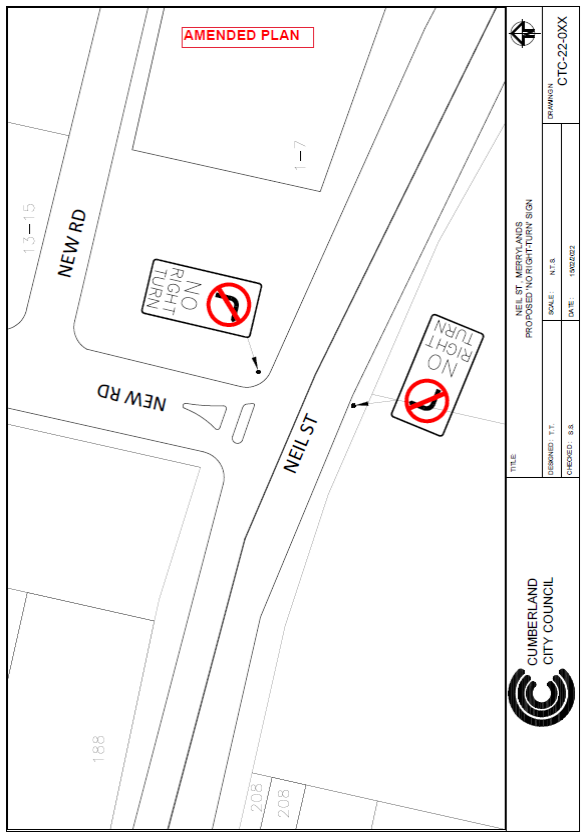
ITEM CTC-22-054 - NEIL STREET, MERRYLANDS –
PROPOSED LEFT IN / LEFT OUT ARRANGEMENT ASSOCIATED WITH A DEVELOPMENT
APPLICATION
|
|
The Traffic Committee recommended that the proposed
‘No Right Turn’ signage at the intersection of Neil Street and
the new road in accordance with the attached plan be approved.
Discussion:
TfNSW representative indicated
that the proposed no right turn signs be located on the left side of the
roads at the intersection. Council officer indicated that Council will amend
the plan and forward it to TfNSW. Council has amended the plan and forwarded
to TfNSW. TfNSW has given its concurrence to the amended plan. Council has
attached amended plan approved by TfNSW.
|
|
|
ITEM CTC-22-055 - BLAXCELL STREET, GRANVILLE –
REVIEW OF PROPOSED RELOCATION OF THE PEDESTRIAN CROSSING AND ASSOCIATED
SIGNAGE – FEDERAL STIMULUS PROGRAM
|
|
The Traffic Committee recommended that previously
approved option recommended by Cumberland Traffic Committee (CTC-20-034 &
035 and CTC -21-208) and approved by Council be approved for construction.
Discussion:
Two options were provided in the agenda for traffic
committee consideration.
Option 1:
The Traffic Committee recommends that previously
approved option recommended by Cumberland Traffic Committee (CTC-20-034 &
035 and CTC -21-208) and approved by Council be approved for construction.
Option 2:
The Traffic Committee recommends that no further action
taken in this regard to relocating the bus stop and the raised pedestrian
crossing.
After a brief discussion, members agreed that option 1 as
approved previously is the recommended option as it involves safety.
The recommendation was amended
as per the recommendation by the members.
|
General Business
Nil.
Next Meeting
Next Meeting 6 April 2022 at
9:30AM
Meeting Close
The meeting terminated at 10:27am.
Signed:
Chairperson
6 April 2022
Item
No: CTC-22-056
LIDBURY STREET
AND GUILFOYLE STREET, BERALA – PROPOSED ‘NO STOPPING’
RESTRICTIONS
Responsible
Division: Environment
& Planning
Officer: Engineering
Administration Officer
File
Number: HC-24-01-3/02
Electorate: Auburn
Police Area
Command (PAC): Auburn
Council has received a request from a resident requesting
for parking restrictions in Lidbury Street, Berala at its intersection with
Guilfoyle Street,
This report outlines the outcome of the investigation into
this matter.
|
The Traffic Committee recommends that:
1. The
installation of ‘No Stopping’ signs and line marking at the
intersection of Lidbury Street and Guilfoyle Street, Berala in accordance
with the attached plan be approved.
2. The
adjacent residents be notified of the outcome.
|
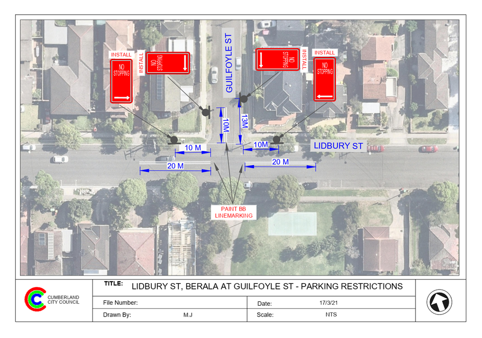
Lidbury Street is a local road that runs in an east-west
direction with a posted speed limit of 50 km/h. It has a width of approximately
12.5m and parking is permitted on both sides of the road unless signposted.
Guilfoyle Street is a local road that runs in a north-south
direction with a speed limit of 50 km/h. It has a width of approximately 9m and
parking is permitted on both sides of the road in accordance with Road Rules
unless signposted.
Lidbury Street and Guilfoyle Street form a T –
junction with priority by default to Lidbury Street.

Figure 1 –
Locality Plan
A review of the Centre for Road Safety accident data
indicated that there were no reported accidents at the intersection of Lidbury
Street and Guilfoyle Street in the five years ending in June 2021.
A site inspection indicated that vehicles are parking within
the statutory 10 metres at the intersection. The installation of ‘No
Stopping’ signs would strengthen the Road Rules requirements and stop
vehicles from parking too close to the intersection. It would also improve
sight distance requirements.
Also, it is proposed to
install ‘BB’ centre lines on Guilfoyle Street (10m long) and
Lidbury Street (20m long on both approaches) at the intersection to assist
vehicles stay on the right side of the road. The ‘No Stopping’ sign
on the eastern side of Guilfoyle Street is installed at 13m to allow vehicles
to safely pass a parked car without encroaching the proposed ‘BB’
centre lines in the narrow road.
The ‘No
Stopping’ sign on the western side of Guilfoyle Street is installed at
10m due to the presence of a driveway at the location.
1. Plan
– Lidbury Street at Guilfoyle Street, Berala – Proposed ‘No
Stopping’ parking restrictions.
DOCUMENTS
ASSOCIATED WITH
REPORT CTC-22-056
Attachment 1
Plan – Lidbury Street at Guilfoyle Street,
Berala – Proposed ‘No Stopping’ parking restrictions.
6 April 2022
6 April 2022
Item
No: CTC-22-057
OXFORD STREET,
GUILDFORD – PROPOSED PARKING RESTRICTIONS AND LINE MARKING
Responsible
Division: Environment
& Planning
Officer: Engineering
Administration Officer
File
Number: HC-24-01-3/02
Electorate: Granville
Police Area
Command (PAC): Cumberland
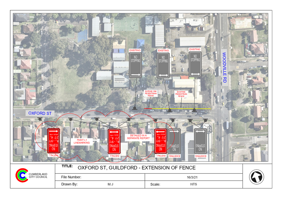
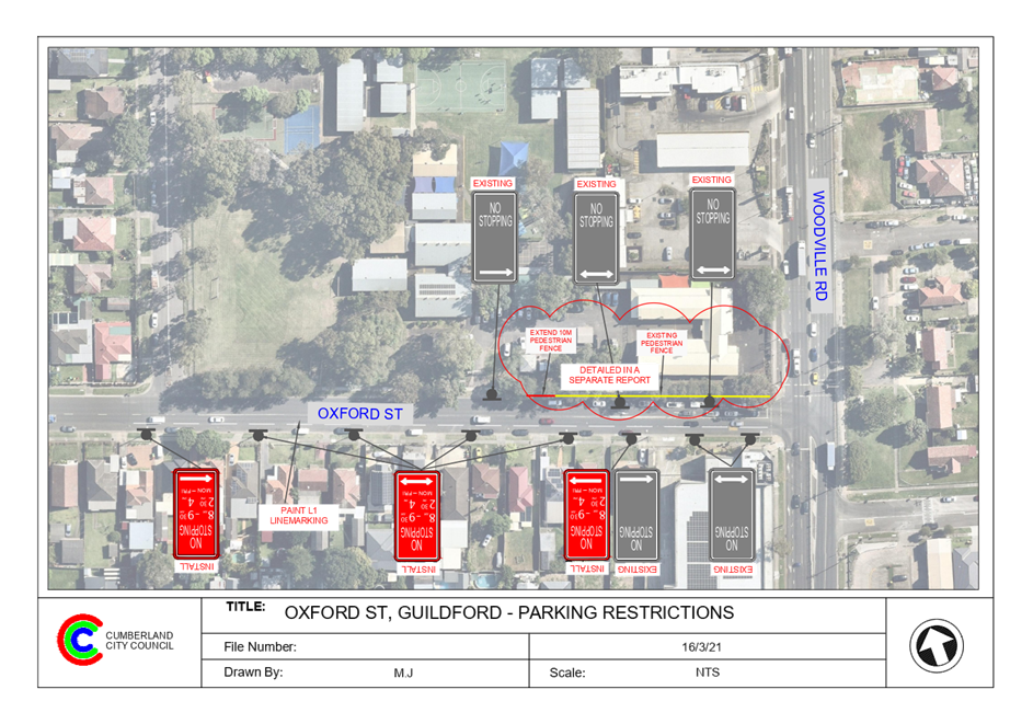
Council has received a request
from Granville south Public School to install parking restrictions in Oxford
Street, Guildford to improve the traffic flow during School hours.
This report outlines the outcome
of the investigation into this matter.
|
The Traffic Committee recommends that:
1. The
installation of ‘No Stopping 8am-9:30am, 2:30-4pm Mon - Fri’
signs on southern side of Oxford Street, Guildford in accordance with the
attached plan be approved.
2. The
installation of lane line marking on the westbound section of Oxford Street
between Woodville Road and Highland Street in accordance with the attached
plan be approved.
3. The
affected residents be consulted, and the consultation results reported to
traffic committee if objections are received.
|
Oxford Street is a regional road and passes over the railway
line. It carries large amount of traffic and is always busy particularly during
the peak hours. Oxford Street starts from Woodville Road which is a state road
and after passing over the railway line becomes Hawksview Street. Oxford Street
and Woodville Road form an intersection controlled by traffic signals.
Oxford Street between Woodville Road and Highland Street is
approximately 12.5m wide with unrestricted parking on the southern side of the
road except for the approximate 45m of ‘No Stopping’ zone from
Woodville Road. A pedestrian safety fence and ‘No Stopping’
restrictions exist on the northern side of Oxford Street along the side
boundary of Granville South Public School.
The driveway of the school car park is located on the
northern side of Oxford Street between Woodville Road and Highland Street.
School has drop off /pick up area in Highland Street.
The map below shows the location of Oxford Street.
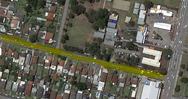
Figure 1 –
Locality Plan
The management of Granville South Public School has concerns
for teachers who wait on Oxford Street to turn right into the School car park
and parents who turn right into Highland Street to drop off /pick up school
kids during morning and afternoons. It is alleged that vehicles queuing along
Oxford Street prevent access into the car park or Highland Street during school
hours.
Council has previously installed ‘Do Not Queue Across
Intersection’ signs on Oxford Street at its intersection of Highland
Street, however, at school opening and closing times, the queues extend across
the intersection ignoring the ‘Blocked intersection rule’.
It is noted that the introduction of parking restrictions on
the southern side of Oxford Steet between Woodville Road and Highland Street
would improve the traffic flow at this section of Oxford Street as motorists
will be able to utilise the left lane at this section of the road while passing
waiting cars to turn right into the car park or Highland Street.
A site meeting between the school, Council and the local
member was organised to observe traffic behaviour at this location.
It was observed that the westbound traffic from Woodville
Road was experiencing difficulties using the kerb side lane of Oxford Street
between Woodville Road and Highland Street during School hours due to parked
vehicles.
It is proposed to install ‘No Stopping’
restrictions between 8am to 9:30am and 2:30pm to 4pm on weekdays to keep this
section of Oxford Street clear of parked vehicles.
In order to improve traffic flow and safety at this section
of Oxford Street, it is proposed that ‘No Stopping; 8am-9:30am; Mon
– Fri’ signs be installed on the southern side of Oxford Street,
between Woodville Road and Highland Street. It is also proposed to provide lane
line marking on the westbound section of Oxford Street between Woodville Road
and Highland Street.
A separate report is presented to traffic committee
proposing to extend the existing pedestrian safety fence on the northern side
of the street by 10m west.
Council officers will undertake
consultation with affected residents and report back to Traffic Committee if
objections are received.
1. Plan –
Oxford Street, Guildford – Proposed parking restrictions and line marking
DOCUMENTS
ASSOCIATED WITH
REPORT CTC-22-057
Attachment 1
Plan – Oxford Street, Guildford – Proposed
parking restrictions and line marking
6 April 2022
6 April 2022
Item
No: CTC-22-058
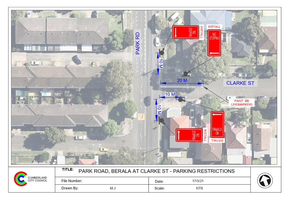
PARK ROAD AND
CLARKE STREET, BERALA – PROPOSED ‘NO STOPPING’ RESTRICTIONS
Responsible
Division: Environment
& Planning
Officer: Engineering
Administration Officer
File
Number: T-28-01/06
Electorate: Auburn
Police Area
Command (PAC): Auburn
Council has received a request from a resident requesting
for parking restrictions in Park Road, Berala at the intersection of Clarke
Street,
This report outlines the outcome of the investigation into
this matter.
|
The Traffic Committee recommends that:
1. The
installation of ‘No Stopping’ signs and line marking at the
intersection of Park Road and Clarke Street, Berala in accordance with the
attached plan be approved.
2. The
adjacent residents be notified of the outcome.
|
Park Road is a regional road that runs in a north-south
direction with a posted speed limit of 60 km/h. It has a width of approximately
12.5m and parking is permitted on both sides of the road unless signposted.
Clarke Street is a local road that runs in an east-west
direction with a posted speed limit of 50 km/h. It has a width of approximately
12m and parking is permitted on both sides of the road unless signposted.
Park Road and Clarke Street form a T – junction with
priority by default to Park Road.
The intersection is approximately 150m from Berala Public
School.
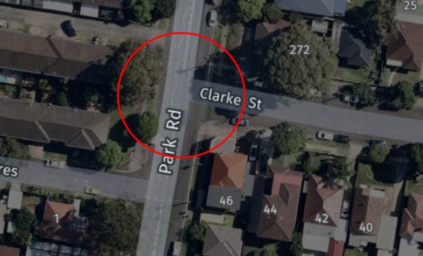
Figure 1 –
Locality Plan
A review of the Centre for Road Safety accident data
indicates that there were no reported accidents at the intersections of Park
Road and Clarke Street in the five years ending in June 2021.
A site inspection indicated that vehicles are parking within
10 metres at the intersection. The installation of ‘No Stopping’
signs would strengthen the Road Rules requirements and stop vehicles from
parking too close to the intersection. It would also improve sight distance
requirements.
Also, it is proposed to install 20m long ‘BB’
centre line on the Clarke Street to assist turning vehicles.
1. Plan –
Park Road at Clarke Street, Berala – Proposed ‘No Stopping’
parking restrictions.
DOCUMENTS
ASSOCIATED WITH
REPORT CTC-22-058
Attachment 1
Plan – Park Road at Clarke Street, Berala
– Proposed ‘No Stopping’ parking restrictions.
6 April 2022
6 April 2022
Item
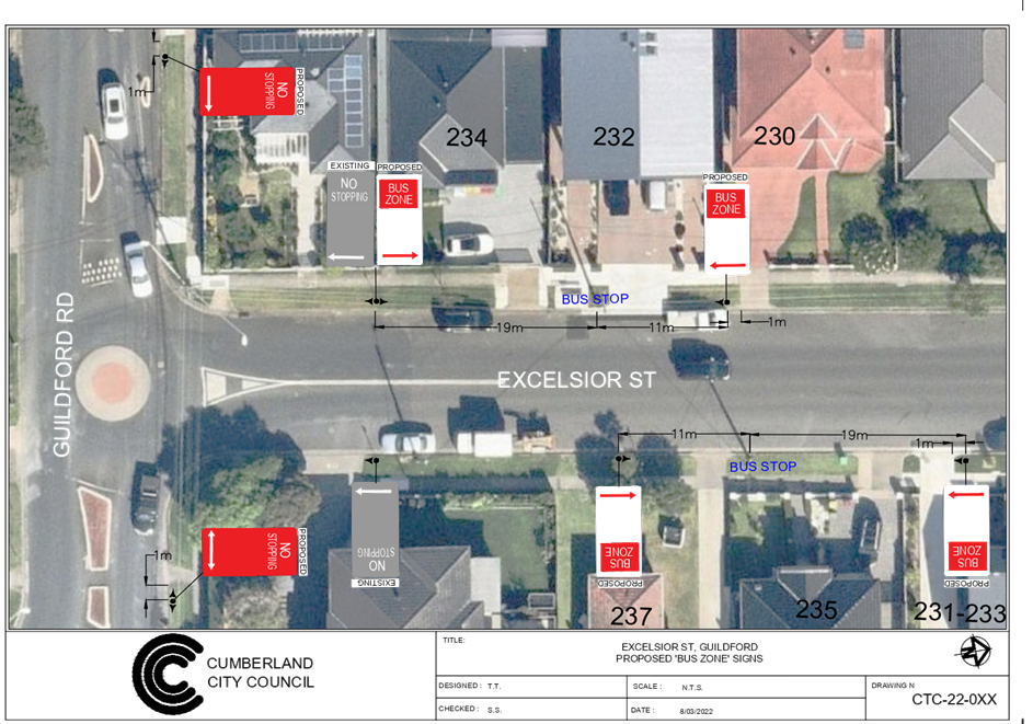
No: CTC-22-059
EXCELSIOR
STREET NORTH OF GUILDFORD ROAD, GUILDFORD – PROPOSED ‘BUS ZONE’
Responsible
Division: Environment
& Planning
Officer: Engineering
Administration Officer
File
Number: HC-24-01-3/02
Electorate: Auburn
Police Area
Command (PAC): Cumberland
Council has received concerns from
a resident that vehicles park regularly at the bus stop outside 232 Excelsior
Street, Guildford.
This report outlines the outcome
of the investigation into this matter.
|
The Traffic Committee recommends that:
1. The
installation of a ‘Bus Zone’ signage on both sides of Excelsior
Street, Guildford at the existing bus stops near the intersection of
Guildford Road and Excelsior Street in accordance with the attached plan be
approved.
2. The
installation of ‘No Stopping’ signs at the intersection of
Guildford Road and Excelsior Street in accordance with the attached plan be
approved.
3. The
affected residents be notified of the outcome generally.
|
Excelsior Street is a
local road that runs in a north – south direction with a speed limit of
50 km/h. It has a width of approximately 12.5m and parking is permitted on both
sides of the road unless signposted.
Council has received concerns from
a resident that vehicles park regularly at the bus stop outside 232 Excelsior
Street, Guildford.
The buses experience difficulty in
dropping off / picking up passengers due to vehicles parking illegally at the
bus stop.
In addition, it was observed
during site inspections that there are ‘No Stopping’ signs on both
sides of Excelsior Street at the roundabout, but there is no closing sign on
the northern side of Guildford Road west of Excelsior Street. There is a
‘No Stopping’ sign on the northern side of Guildford Road east of
Excelsior Street which is at a distance after the twin roundabouts.
Map below shows locality
of Excelsior Street, Guildford:


In accordance with the Road Rules 2014, it is illegal to
stop a vehicle other than a public bus within 20m on the approach and 10m on
the exist side of the bus stop.
Therefore, to prevent illegal parking at the bus stop,
strengthen the Road Rules and assist busses to stop safely at the bus stop, it
is recommended to install ‘Bus Zone’ signs at the existing
‘Bus Stop’ outside No. 232 Excelsior Street. The bus stop on the
eastern side of Excelsior Street also does not have ‘Bus Zone’
signage and it is proposed to install ‘Bus Zone’ signs at this bus
stop also.
Furthermore, it is proposed to provide ‘No
Stopping’ signs on Guildford Road as per the attached plan.
1. Plan –
Excelsior Street, Guildford – Proposed ‘Bus Zone’ signage and
‘No Stopping’ signs.
DOCUMENTS
ASSOCIATED WITH
REPORT CTC-22-059
Attachment 1
Plan – Excelsior Street, Guildford –
Proposed ‘Bus Zone’ signage and ‘No Stopping’ signs.
6 April 2022
6 April 2022
Item
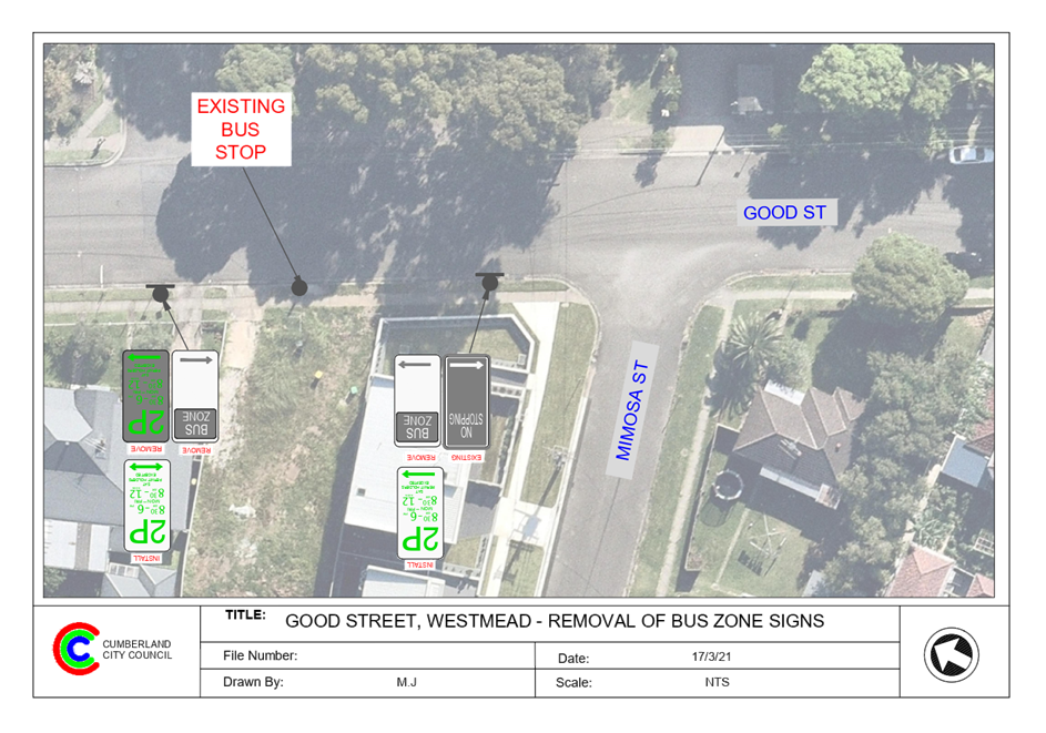
No: CTC-22-060
GOOD STREET,
WESTMEAD – REMOVAL OF A REDUNDANT ‘BUS ZONE’
Responsible
Division: Environment
& Planning
Officer: Engineering
Administration Officer
File
Number: HC-24-01-3/02
Electorate: Granville
Police Area
Command (PAC): Cumberland
Council has received a request
from a resident to remove a redundant ‘Bus Zone’ on Good Street,
Westmead outside property No.68.
This report outlines the outcome of the investigation into
this matter.
|
The Traffic Committee
recommends that:
1. The
removal of a redundant ‘Bus Zone’ on the western side of Good
Street, Westmead outside No.68 as per attached plan be approved.
2. The
‘Bus Zone’ area be converted to ‘2P; 8:30AM-6:00PM;
Mon-Fri; 8:30AM-12:00Noon; Sat; Permit Holders Excepted’ signage.
3. The
adjacent residents be notified of the outcome.
|
Good Street is a local road that runs in a north-south
direction with a posted speed limit of 50 km/h. It has a width of approximately
12.5m and 2 hours permit parking signs are installed except for the ‘No
Stopping’ and Bus Zone’ signage at this location.
There is an existing bus stop sign and a bus zone located on
the western side of Good Street outside house number 68, north of Mimosa
Street. CDC bus operator has advised that this bus stop is no longer required
and agreed to remove the redundant bus stop sign. The closest bus stop on
Good Street is opposite Oakes Street and approximately 125m from this location.
It is proposed to remove the ‘Bus Zone’ signs
outside 68 Good Street as the bus stop is no longer in use and would be removed
by the bus operator CDC Bus.
It is also proposed to signpost the bus zone area with two-hour
parking (2P; 8:30AM-6:00PM; Mon-Fri; 8:30AM-12:00 Noon; Sat; Permit Holders
Excepted) to match with the existing parking in the area.
1. Plan –
Good Street, Westmead – Removal of a redundant ‘Bus Zone’
DOCUMENTS
ASSOCIATED WITH
REPORT CTC-22-060
Attachment 1
Plan – Good Street, Westmead – Removal of
a redundant ‘Bus Zone’
6 April 2022
6 April 2022
Item
No: CTC-22-061
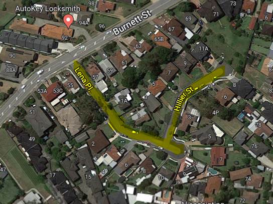
LENA PLACE AND
HILLIER STREET, MERRYLANDS – PROPOSED PARKING RESTRICITONS DURING WASTE
NIGHTS
Responsible
Division: Environment
& Planning
Officer: Engineering
Administration Officer
File
Number: HC-24-01-3/02
Electorate: Granville
Police Area
Command (PAC): Cumberland
Council has received a request
from a resident to install parking restrictions in Lena Place and Hillier
Street, Merrylands during waste collection time to improve the manoeuvrability
of large service vehicles.
This report outlines the outcome of the investigation into
this matter.
|
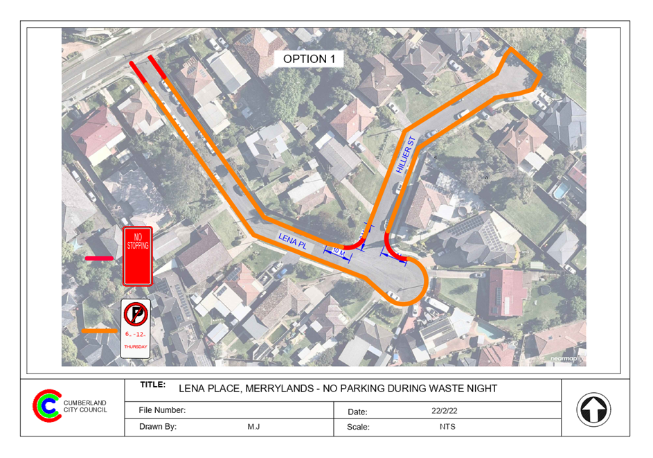
Option 1
The Traffic Committee recommends that:
1. The
installation of ‘No Stopping’ and ‘No Parking; 6am–
2pm; Thursday’ signs on both sides of Lena Place and Hillier Street,
Merrylands as per Attachment 1 be approved in principle.
2. Council
undertake consultation with the residents and report back to traffic
committee if objections are received.
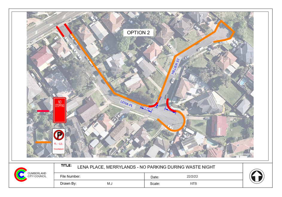
Option 2
The Traffic Committee recommends that:
1. The
installation of ‘No Stopping’ and ‘No Parking;
6am–12pm; Thursday’ signs on the northern side of Lena Place and
western side of Hillier Street, Merrylands as per Attachment 2 be approved in
principle.
2. Council
undertake consultation with the residents and report back to traffic
committee if objections are received.
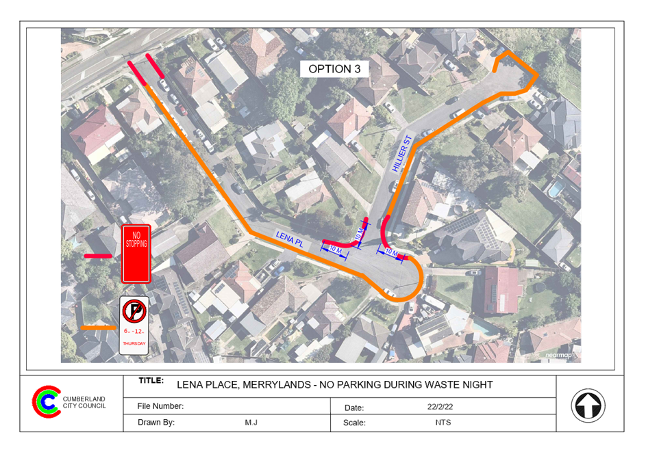
Option 3
The Traffic Committee recommends that:
1. The
installation of ‘No Stopping’ and ‘No Parking;
6am–12pm; Thursday’ signs on the southern side of Lena Place and
eastern side of Hillier Street, Merrylands as per Attachment 3 be approved in
principle.
2. Council
undertake consultation with the residents and report back to traffic
committee if objections are received.
|
Lena Place is a local road that
runs in an easterly direction from Burnett Street and ends in a cul-de-sac. The
speed limit of the street is 50 km/hr. It has a width of approximately 7m and
parking is permitted on both sides of the road in accordance with Road Rules
unless signposted.
Hillier Street is a local road
that runs in a northerly direction from Lena Place and ends in a
cul-de-sac. The speed limit of the street is 50 km/hr. It has a width of
approximately 7m and parking is permitted on both sides of the road in
accordance with Road Rules unless signposted.
Vehicles should be parked in a
staggered manner to provide 3m clearance for passing vehicles.
The map below shows location of
Lena Place and Hillier Street.
The resident alleged that the
waste collection trucks have difficulty to service Lena Place and Hillier
Street when vehicles are parked on both sides of the street.
Council’s Waste section confirmed
that vehicles parked on both sides of these streets will prevent large service
vehicles to access the street.
In order to improve the waste
collection vehicles accessibility to Lena Place and Hillier Street, three
options are proposed for consideration by the committee.
Option 1
The installation of ‘No
Stopping’ and ‘No Parking; 6am – 12 Noon; Thursday’
signs on both sides of Lena Place and Hillier Street, Merrylands as per
Attachment 1.
Option 2
The installation of ‘No
Stopping’ and ‘No Parking; 6am – 12 Noon; Thursday’
signs on the northern side of Lena Place and western side of Hillier Street,
Merrylands as per Attachment 2.
Option 3
The installation of ‘No
Stopping’ and ‘No Parking; 6am – 12 Noon; Thursday’
signs on the southern side of Lena Place and eastern side of Hillier Street,
Merrylands as per Attachment 3.
Due to the number of driveways,
option 2 would result a minimum loss of on-street parking spaces for local
residents. Each house in both streets has off street parking available.
It is also proposed to install
statutory ‘No Stopping’ signs at the intersections.
1. Plans –
Option 1 - Lena Place and Hillier Street, Merrylands – Proposed parking
restrictions during waste collection times
2. Plans
– Option 2 - Lena Place and Hillier Street, Merrylands – Proposed
parking restrictions during waste collection times.
3. Plans
– Option 3 - Lena Place and Hillier Street, Merrylands – Proposed
parking restrictions during waste collection times.
DOCUMENTS
ASSOCIATED WITH
REPORT CTC-22-061
Attachment 1
Plans – Option 1 - Lena Place and Hillier
Street, Merrylands – Proposed parking restrictions during waste
collection times
6 April 2022
DOCUMENTS
ASSOCIATED WITH
REPORT CTC-22-061
Attachment 2
Plans – Option 2 - Lena Place and Hillier
Street, Merrylands – Proposed parking restrictions during waste
collection times.
6 April 2022
DOCUMENTS
ASSOCIATED WITH
REPORT CTC-22-061
Attachment 3
Plans – Option 3 - Lena Place and Hillier
Street, Merrylands – Proposed parking restrictions during waste collection
times.
6 April 2022
6 April 2022
Item
No: CTC-22-062
MAGOWAR ROAD,
GIRRAWEEN AT GIRRAWEEN ROAD – PROPOSED PARKING RESTRICTIONS
Responsible
Division: Environment
& Planning
Officer: Engineering
Administration Officer
File
Number: HC-24-01-3/02
Electorate: Prospect
Police Area
Command (PAC): Cumberland
Council has received a request from a resident for parking
restrictions in Magowar Road, Girraween at the intersection of Girraween Road,
This report outlines the outcome of the investigation into
this matter.
|
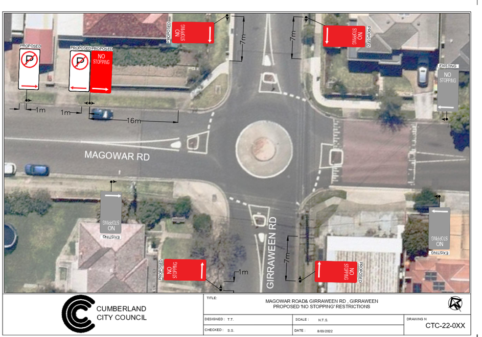
The Traffic Committee recommends that:
1. The
installation of ‘No Stopping’ and ‘No Parking’ signs
in Magowar Road, Girraween at the intersection of Girraween Road in
accordance with the attached plan be approved.
2. The
affected residents be notified of the outcome.
|
Girraween Road is a collector road that runs in a
north-south direction with a posted speed limit of 50 km/h. It has a width of
approximately 12.5m and parking is permitted on both sides of the road unless
signposted.
Magowar Road is a local road that runs in an east-west
direction with a speed limit of 50 km/h. It has a width of approximately 12.5m
and parking is permitted on both sides of the road unless signposted.
Girraween Road and Magowar Road forms a four-way intersection.
A roundabout has been constructed at the intersection with ‘No
Stopping’ signs in Magowar Road. No parking signage exist in Girraween
Road at the intersection.
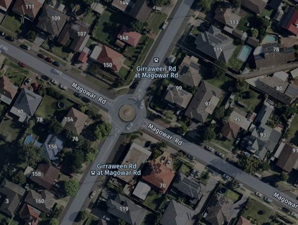
Figure 1 –
Locality Plan
It is alleged by the resident that vehicles constantly park
within 10m from the roundabout at the intersection of Girraween Road and
Magowar Road. The resident also stated that the distance between the driveway
of No. 150 Girraween Road and 107 Magowar Road is approximately 5m and vehicles
often park in this area overhanging the driveway. As a result, the sight
distance for the resident at his driveway is severely restricted by the parked
vehicles.
A review of the Centre for Road Safety accident data indicates
that there was one recorded accident at the intersections of Girraween Road and
Magowar Road in the five years ending June 2021.
To improve the sight distance for the resident when exiting
his driveway and improve safety at the intersection of Girraween Road and
Magowar Road, it is proposed to install ‘No Stopping’ signs at the
intersection and ‘No Parking’ signs outside No. 107 Magowar Road as
per the attached drawing.
1. Plan
–Magowar Road, Girraween at Girraween Road – Proposed parking
restrictions.
DOCUMENTS
ASSOCIATED WITH
REPORT CTC-22-062
Attachment 1
Plan –Magowar Road, Girraween at Girraween Road
– Proposed parking restrictions.
6 April 2022
6 April 2022
Item
No: CTC-22-063
TOONGABBIE
ROAD, GIRRAWEEN AT MAGOWAR ROAD – EXTENSION OF THE EXISTING ‘NO
STOPPING’ ZONE
Responsible
Division: Environment
& Planning
Officer: Engineering
Administration Officer
File
Number: HC-24-01-3/02
Electorate: Prospect
Police Area
Command (PAC): Cumberland
Council has received a request from a resident requesting
for parking restrictions in Toongabbie Road, Girraween at the intersection of
Magowar Road,
This report outlines the outcome of the investigation into
this matter.
|
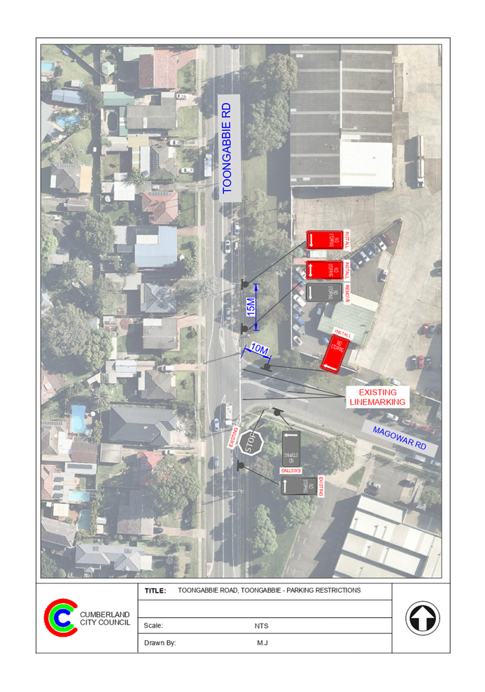
The Traffic Committee recommends that:
1. The
installation of ‘No Stopping’ signs in Toongabbie Road, Girraween
north of Magowar Road in accordance with the attached plan be approved.
2. The
adjacent property be notified of the outcome.
|
Toongabbie Road is a regional road that runs in a
north-south direction with a posted speed limit of 60 km/h. It has a width of
approximately 12.5m and parking is permitted on both sides of the road unless
signposted.
Magowar Road is a local road that runs in an east-west
direction with a speed limit of 50 km/h. It has a width of approximately 12.5m
and parking is permitted on both sides of the road unless signposted.
Toongabbie Road and Magowar Road form a T –
intersection with priority by default to Toongabbie Road. A ‘Stop’
sign and line marking is provided in Magowar Road at the intersections (Figure
1). There are existing ‘No Stopping’ signs located on the
south-eastern corner of the intersection. There is also a ‘No
Stopping’ sign on the eastern side of Toongabbie Road north of Magowar
Road.

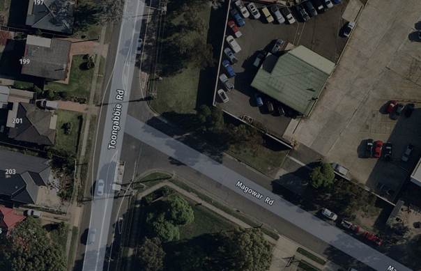
Figure 1 –
Locality Plan
A review of the Centre for Road Safety accident data indicates
that there was one reported accident at the intersections of Toongabbie Road
and Magowar Road in the five years ending June 2021.
Due to the industrial area in Toongabbie Road, there is a
high demand for on-street parking at this section of Toongabbie Road for both
visitors and staff from the business park. As a result, when vehicles
especially, heavy vehicles are parked on the eastern side of Toongabbie Road
near Magowar Road, sight distance for vehicles exiting from Magowar Road into
Toongabbie Road are limited.
An inspection confirmed that if vehicles are parked on the
eastern side of Toongabbie Road near Magowar Road, the sight distance is
reduced. The sight distance is further reduced when trucks are parked on
Toongabbie Road north of Magowar Road.
In order to improve the sight distance for the motorists at
the intersection of Toongabbie Road and Magowar Road, it is proposed to extend
the existing ‘No Stopping’ sign on the eastern side of Toongabbie
Road at Magowar Road further 10m north.
1. Plan –
Toongabbie Road at Magowar Road, Girraween – extension of the existing
‘No Stopping’ parking restrictions.
DOCUMENTS
ASSOCIATED WITH
REPORT CTC-22-063
Attachment 1
Plan – Toongabbie Road at Magowar Road,
Girraween – extension of the existing ‘No Stopping’ parking
restrictions.
6 April 2022
6 April 2022
Item
No: CTC-22-064
DELL STREET,
WOODPARK - REVIEW OF EXISTING TIMED PARKING
Responsible
Division: Environment
& Planning
Officer: Engineering
Administration Officer
File
Number: HC-24-01-3/02
Electorate: Fairfield
Police Area
Command (PAC): Cumberland
Council has received a request
from a visitor to the shopping centre in Dell Street, Woodpark to provide
additional parking in the area due to lack of available parking.
This report outlines the outcome
of the investigation into this matter.
|
The Cumberland Traffic Committee recommends that
Council undertake consultation with the businesses for the conversation of
ten (10) parking spaces from the existing two 2 hour to 1 hour parking
outside Nos. 21-39 Dell Street, Woodpark.
|
Dell Street is a local road that runs in a western direction
from Fiona Street and turns in a southwestern direction and links with Vivienne
Street with a speed limit of 50 km/hr. It has a width of approximately 8.5m
with part-time 90-degree angle parking spaces on the southern / eastern side of
the street outside the local business centre.
Currently ‘2P 8:30am–6pm; Monday–Friday;
8:30am–12:30pm; Saturday’ parking restrictions apply to the
90-degree angle parking along the shop frontages.
There is a total of 28 parking spaces which includes two (2)
disabled spaces servicing the centre.
The
map below shows the location of the centre:
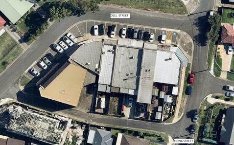
A visitor to the centre has
complained that parking spaces are not available at times for visitors to the
centre and requested more parking spaces made available in the area.
Since the existing parking is
‘2P’ parking, Council undertook consultation with the owners and
tenants of the shopping centre with the option to convert the whole or partially
(50%, or 40% or 25%) the parking spaces to one-hour parking spaces.
13 consultation letters were
distributed to the tenants and owners of the local business centre in February
2022. Four (4) responses (31% of total letters sent) were received.
One respondent wanted the entire
parking (except the accessible parking spaces) converted to one hour parking.
Three other responses wanted 50% of the parking spaces converted to one hour
parking. Out of these three responses, two responses related to one property
received from the tenant and owner.
As a result of this survey, Council has received support for
partial conversion and Council will undertake further consultation for the
conversion of 10 parking spaces from 2P to 1P as per the attached plan.
1. Plan - Dell
Street, Woodpark - Conversion of parking spaces from 2P to 1P Parking.
DOCUMENTS
ASSOCIATED WITH
REPORT CTC-22-064
Attachment 1
Plan - Dell Street, Woodpark - Conversion of parking
spaces from 2P to 1P Parking.
6 April 2022
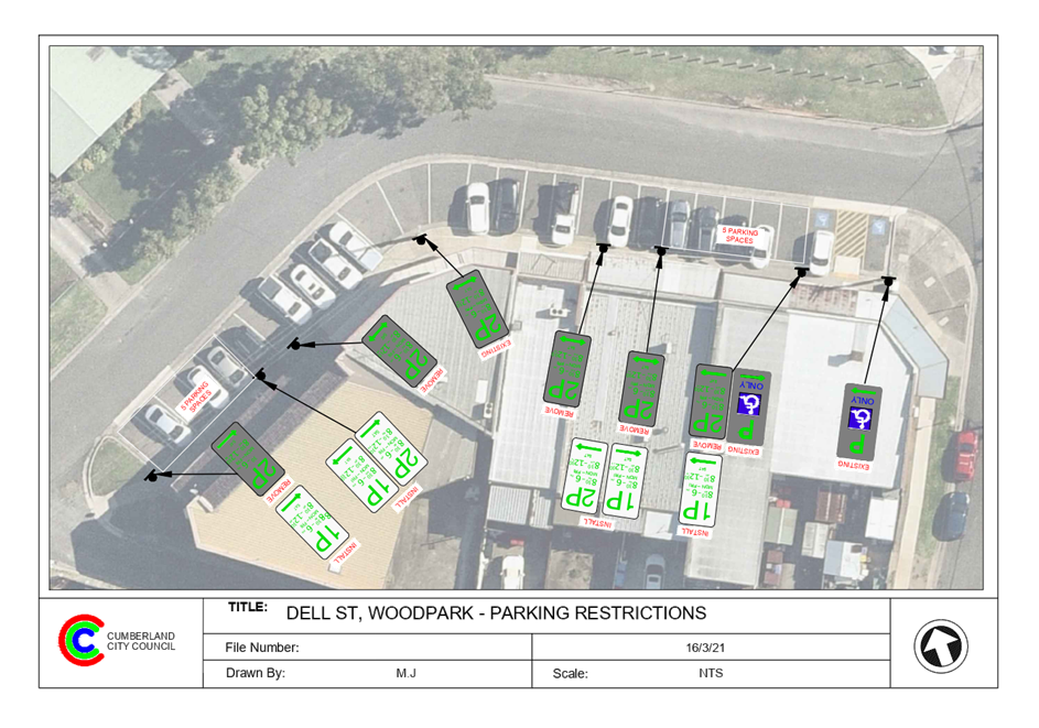
6 April 2022
Item
No: CTC-22-065
OLD PROSPECT
ROAD, SOUTH WENTWORTHVILLE – PROPOSED ‘NO STOPPING’
RESTRICTIONS
Responsible
Division: Environment
& Planning
Officer: Engineering
Administration Officer
File
Number: HC-24-01-3/02
Electorate: Granville
Police Area
Command (PAC): Cumberland
Council has received a request from Council’s Parking
Officers for parking restrictions in Old Prospect Road, South Wentworthville at
the curve west of Chelmsford Road, South Wentworthville.
This report outlines the outcome of the investigation into
this matter.
|
That the Traffic Committee recommends that the
installation of ‘No Stopping’ signs on the northern side of Old
Prospect Road, South Wentworthville west of Chelmsford Road in accordance
with the attached plan be approved.
|
Old Prospect Road is a Collector Road that runs in an east
– west direction with a speed limit of 50 km/h. It has a width of
approximately 12.5m and parking is permitted on both sides of the road unless
signposted. A bend also exists in Old Prospect Road west of Chelmsford
Road.
A pedestrian refuge exists on Old Prospect Road east of
Chelmsford Road. There are ‘No Stopping’ signs installed east of
the pedestrian crossing on the northern side of Old Prospect Road and no signs
have been installed to continue and close the ‘No Stopping’ zone on
the western side. Vehicles regularly park in this location. The road width on
the northern side of Old Prospect Road is approximately 6.3m. However, due to
the bend in the road and any vehicles turning right into Chelmsford Road which
provides access to South Wentworthville area, it is considered appropriate to
extend the ‘No Stopping’ zone west of the bend.
Council has received a request from Council’s Parking
Officers for parking restrictions in Old Prospect Road, South Wentworthville at
the curve west of Chelmsford Road, South Wentworthville.
The map below shows details of the location.
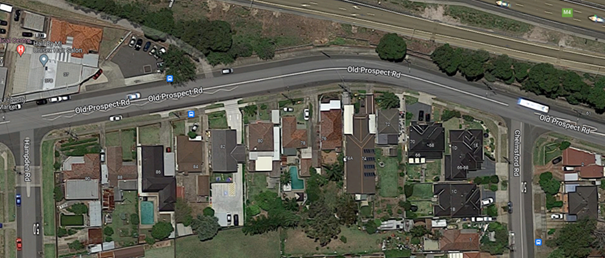
A review of the Centre for Road Safety accident data
indicates that there were no recorded accidents in Old Prospect Road between
Chelmsford Road and Hampden Road in the last five years ending in June 2021.
In order to improve safety, it is proposed that ‘No
Stopping’ signs be provided in Old Prospect Road at the bend west of
Chelmsford Road as per the attached plan. It is also proposed to install
‘No Stopping’ signs covering the frontage of the shared pathway.
The ‘No Stopping’ zone is adjacent to the
Motorway reserve and does not require consultation / notification.
1. Plan –
Old Prospect Road, South Wentworthville – Proposed ‘No
Stopping’ restrictions
DOCUMENTS
ASSOCIATED WITH
REPORT CTC-22-065
Attachment 1
Plan – Old Prospect Road, South Wentworthville
– Proposed ‘No Stopping’ restrictions
6 April 2022
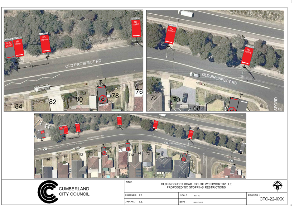
6 April 2022
Item
No: CTC-22-066
DAHLIA STREET
AND HIBISCUS STREET, GREYSTANES – PROPOSED PARKING RESTRICITONS &
LINE MARKING
Responsible
Division: Environment
& Planning
Officer: Engineering
Administration Officer
File
Number: HC-24-01-3/02
Electorate: Prospect
Police Area
Command (PAC): Cumberland
Council has received a request
from a local resident to improve road safety at the intersection of Dahlia
Street and Hibiscus Street, Greystanes.
This report outlines the outcome
of the investigation into this matter.
|
The Traffic Committee recommends that the
installation of ‘No Stopping’ signs and ‘BB’ line
marking at the intersection of Dahlia Street and Hibiscus Street, Greystanes
in accordance with the attached plan be approved.
|
Dahlia Street is a local road that runs in a
north–south / east-west direction and it has a width of approximately 10m
and parking is permitted on both sides of the road in accordance with Road
Rules unless signposted.
Hibiscus Street is a local road that runs in an east –
west direction and has a width of approximately 7m and parking is permitted on
both sides of the road in accordance with Road Rules unless signposted.
Dahlia Street and Hibiscus Street form a T – junction
with priority (by default) to Dahlia Street. The intersection is adjacent to
Alpha Road Park on Dahlia Street.
The intersection has ‘No Stopping’ signs
installed together with ‘Bus Zone’ signs near the bus stop on the
northern side.
The map below shows the
intersection of Dahlia Street and Hibiscus Street.
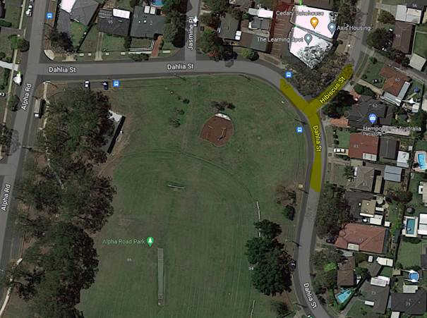
Figure 1 –
Locality Plan
It is alleged by the resident that vehicles often park on
the park side of Dahlia Street on the inside of the curve near the intersection
and force passing vehicles to travel on the wrong side of the street. The
resident has requested for Council to install indented parking bays in this
area to prevent parking at the kerbside. Installing indented bays at this
location is not feasible due to utilities and may require encroaching into the
Park area.
The street view below shows the cars parked on the curve at
the intersection.
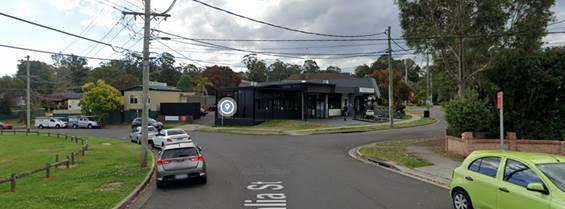
A review of the Centre for Road Safety accident data
indicates that there were no reported accidents at this section of Dahlia
Street in the five years ending in June 2021.
In order to maintain safety and reduce the risk of a head
on-collision, it is proposed that ‘No Stopping’ signs and
centreline marking (BB) be provided in Dahlia Street at the intersection
of Hibiscus Street as per the attached plan.
It is also proposed to install
‘Bus Zone’ signs on Dahlia Street on the Park side to strengthen
the Road Rules.
1. Plan –
Dahlia Street and Hibiscus Street, Greystanes – Proposed ‘No
Stopping’ and ‘Bus Zone’ signs and line marking.
DOCUMENTS
ASSOCIATED WITH
REPORT CTC-22-066
Attachment 1
Plan – Dahlia Street and Hibiscus Street,
Greystanes – Proposed ‘No Stopping’ and ‘Bus
Zone’ signs and line marking.
6 April 2022
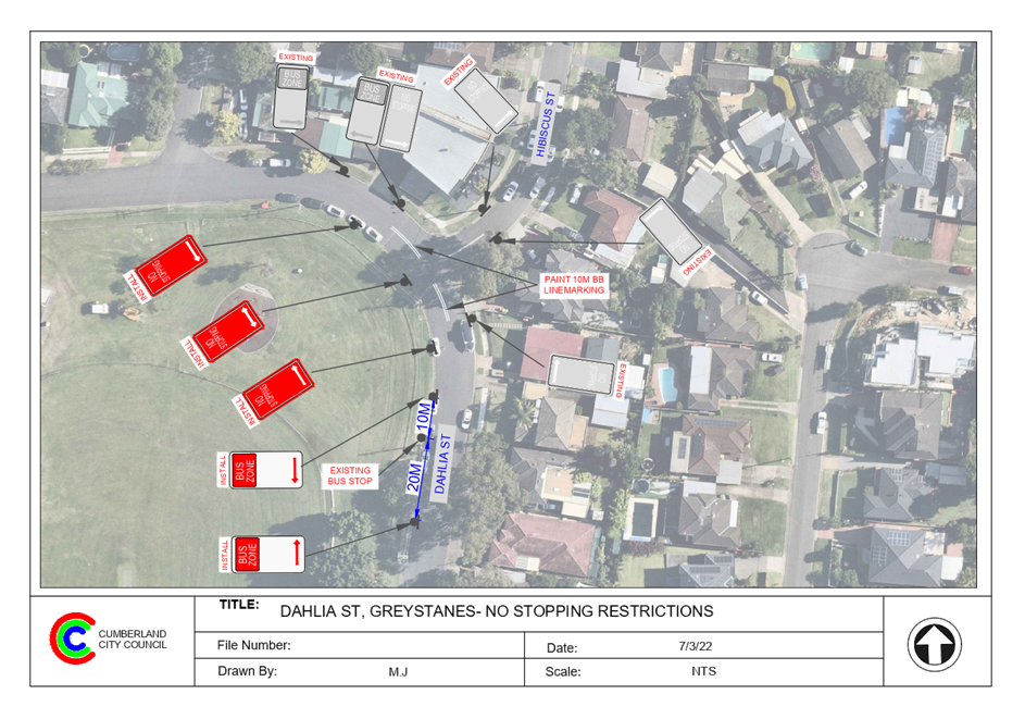
6 April 2022
Item
No: CTC-22-067
MACQUARIE
ROAD, GREYSTANES AT BAYFIELD ROAD– PROPOSED ‘NO STOPPING’
RESTRICTIONS
Responsible
Division: Environment
& Planning
Officer: Engineering
Administration Officer
File
Number: HC-24-01-3/02
Electorate: Prospect
Police Area
Command (PAC): Cumberland
Council has received a request from a resident requesting
for indented parking in Macquarie Road, Greystanes at the intersection of
Bayfield Road.
This report outlines the outcome of the investigation into
this matter.
|
The Traffic Committee recommends that:
1. The
installation of ‘No Stopping’ signs in Macquarie Road at the
intersection of Bayfield Road, Greystanes in accordance with the attached
plan be approved.
2. The
adjacent residents be notified of the outcome.
|
Macquarie Road is a local road that runs in an east –
west direction with a posted speed limit of 50 km/h. It has a width of
approximately 10.2 m and parking is permitted on both sides of the road unless
signposted.
Bayfield Road is a local road that runs in a north –
south direction with a speed limit of 50 km/h. It has a width of approximately
10.3m and parking is permitted on both sides of the road unless signposted.
Macquarie Road and Bayfield Road form a T – junction
with ‘reverse’ priority. There are ‘Give Way’ signs and
line marking on both approaches of Macquarie Road. This gives priority to
Bayfield Road traffic. There are median islands built on Macquarie Road
approaches to the intersection
The resident has requested for Council to install indented
parking bays in this area to prevent parking at the kerbside. Installing
indented bays at this location is not feasible due to utilities and also
requires encroaching into the reserve area.
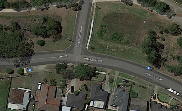
Figure 1 –
Locality Plan
A review of the Centre for Road Safety accident data
indicates that there were no recorded accidents at the intersections of
Macquarie Road and Bayfield Road in the last five years ending in June 2021.
A site inspection indicated that
vehicles are parking on the nature strip close to the intersection. The
installation of ‘No Stopping’ signs would strengthen the Road Rules
requirements and stop vehicles from parking close to the intersection. It would
also improve sight distance requirements.
1. Plan –
Macquarie Road at Bayfield Road, Greystanes – Proposed ‘No
Stopping’ parking restrictions.
DOCUMENTS
ASSOCIATED WITH
REPORT CTC-22-067
Attachment 1
Plan – Macquarie Road at Bayfield Road,
Greystanes – Proposed ‘No Stopping’ parking restrictions.
6 April 2022
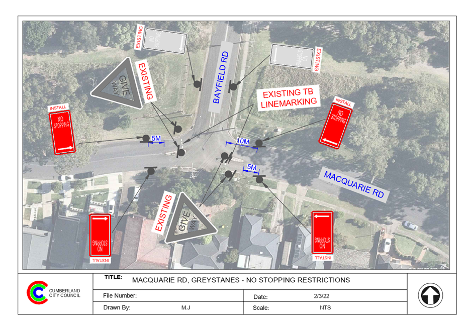
6 April 2022
Item
No: CTC-22-068
BOTANICA
DRIVE, LIDCOMBE – PROPOSED ‘NO PARKING’ RESTRICTIONS
AND LINEMARKING
Responsible
Division: Environment
& Planning
Officer: Engineering
Administration Officer
File
Number: T-28-01/06
Electorate: Auburn
Police Area
Command (PAC): Auburn
Council has received a request from a resident requesting
for parking restrictions in Botanica Drive, Lidcombe at the bend opposite the
park.
This report outlines the outcome of the investigation into
this matter.
|
The Traffic Committee recommends that:
1. The
installation of ‘No Parking’ signs and line marking in Botanica
Drive, Lidcombe at the bend in accordance with the attached plan be approved.
2. Council
undertake consultation with affected residents and report back to traffic
committee if objections are received.
|
Botanica Drive is a local road that runs in a north –
south direction with a posted speed limit of 50 km/h. It has a width of
approximately 9.4m and parking is permitted on both sides of the road unless
signposted. A sharp bend also exists in Botanica Drive outside No.61 (Figure
1).
It is alleged by the resident that due to the horizontal
alignment of this section of Botanica Drive, motorists often travel onto the
wrong side of the road when negotiating the bend especially when vehicles are
parked.
A review of the Centre for Road Safety accident data
indicates that there were no reported accidents at this section of Botanica
Drive in the last five years ending in June 2021.
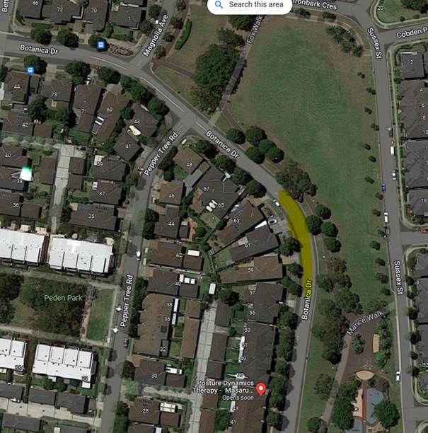 Figure
1 – Locality Plan
Figure
1 – Locality Plan
In order to maintain safety and reduce the risk of a head
on-collision, it is proposed that ‘No Parking’ signs and separation
centreline marking (S1) be provided in Botanica Drive at the bend as per the
attached plan. Parking restrictions are not installed on outside the bend
due to the parking demand for the park and sight lines are not compromised.
‘No Parking’ signs
will allow residents to drop off/pick up outside their properties.
1. Plan –
Botanica Drive, Lidcombe – Proposed ‘No Parking’ restrictions
and S1 line marking.
DOCUMENTS
ASSOCIATED WITH
REPORT CTC-22-068
Attachment 1
Plan – Botanica Drive, Lidcombe – Proposed
‘No Parking’ restrictions and S1 line marking.
6 April 2022
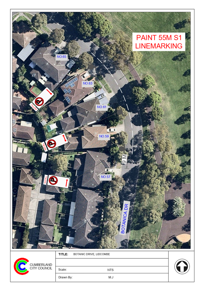
6 April 2022
Item
No: CTC-22-069
BRIDGE ROAD,
WESTMEAD AT HUDSON STREET– PROPOSED ‘NO STOPPING’
RESTRICTIONS
Responsible
Division: Environment
& Planning
Officer: Engineering
Administration Officer
File
Number: HC-24-01-3/02
Electorate: Granville
Police Area
Command (PAC): Cumberland
Council has received a request from a resident requesting
for parking restrictions at the intersection of Bridge Road and Hudson Street,
Westmead
This report outlines the outcome of the investigation into
this matter.
|
The Traffic Committee recommends that:
1. The
installation of ‘No Stopping’ signs in Bridge Road and Hudson
Street, Westmead at its intersection in accordance with the attached plan be
approved.
2. The
affected residents be notified of the outcome.
|
Bridge Road is a local road that runs in a north-south
direction with a posted speed limit of 50 km/h. It has a width of approximately
12.5m and parking is permitted on both sides of the road unless signposted.
Hudson Street is a local road that runs in an east-west
direction with a speed limit of 50 km/h. It has a width of approximately 10.4m
and parking is permitted on both sides of the road unless signposted. There is
a raised threshold with median island built on Hudson Street.
Bridge Road and Hudson Street form a T – junction with
priority by default to Bridge Road.
A bus stop sign also exists on the western side of Bridge
Road approximately 40m south of Hudson Street.
A childcare centre has been approved at the southwestern
corner property.
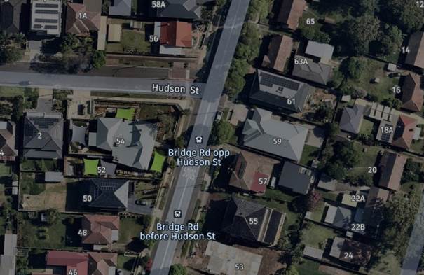
Figure 1 –
Locality Plan
A review of the Centre for Road Safety accident data
indicates that there were no recorded accidents at the intersections of Bridge
Road and Hudson Street in the five years ending in June 2021.
A site inspection indicated that vehicles are parking within
10 metres at the intersection. The installation of ‘No Stopping’
signs would strengthen the Road Rules requirements and stop vehicles from
parking too close to the intersection. It would also improve sight distance
requirements. The ‘No Stopping’ signs on Hudson Street are required
to be at greater distances due to road widths available to the existing
‘BB’ centre line marking on Hudson Street.
1. Plan –
Bridge Road at Hudson Street, Westmead – Proposed ‘No
Stopping’
restrictions
DOCUMENTS
ASSOCIATED WITH
REPORT CTC-22-069
Attachment 1
Plan – Bridge Road at Hudson Street, Westmead
– Proposed ‘No
Stopping’
restrictions
6 April 2022
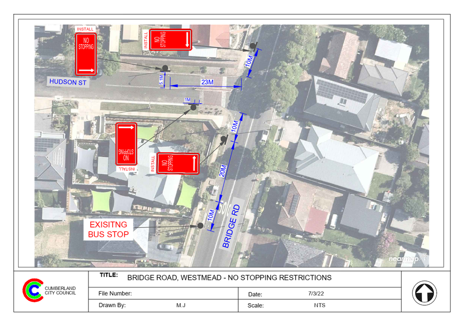
6 April 2022
Item
No: CTC-22-070
LOWANA AVENUE,
MERRYLANDS - PROPOSED PARKING RESTRICTIONS
Responsible
Division: Environment
& Planning
Officer: Team
Leader Transportation and Traffic
File
Number: HC-24-01-3/02
Electorate: Granville
Police Area
Command (PAC): Cumberland
Council has received a request
from Holroyd School located at the corner of Clarence Street and Lowana Avenue,
Merrylands for the provision of part-time parking restrictions in Lowana Avenue
outside the school.
This report outlines the outcome
of the investigation into this matter.
|
The Traffic Committee recommends that:
1. The
installation of ‘1/4P; 8am-930am, 2:30pm-4pm’ School Days’
signs on the northern side of Lowana Avenue, Merrylands as per the attached
plan be approved in principle.
2. The
installation of ‘No Parking’ signs on the southern side of Lowana
Avenue, Merrylands as per the attached plan be approved in principle.
3. Council
undertake consultation with affected residents and report back to traffic
committee if objections are received.
|
Lowana Avenue is a local road that
runs in an east – west direction. It has a width of approximately 7m. The
posted speed limit is 50km/h and 40km/h during school hours. Parking is
permitted on both sides of the road unless signposted.
Currently a length of
approximately 25m of 15-minute school-time parking restrictions exist on the
western side of Clarence Steet outside the school.
Map below shows locality of Lowana
Avenue:
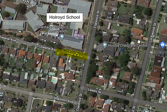
Council has received a request
from Holroyd School for the installation of additional 15-minute parking
restrictions on the northern side of Lowana Avenue outside the school to
facilitate drop off and pick up during school hours. Holroyd School
caters for special needs children and vehicle queuing to drop off children is a
road safety concern.
An on-site meeting was held with
the school and Council officers. It was agreed that the proposed additional
pick up and drop off area in Lowana Avenue would improve safety and efficient
traffic flow outside the school.
Due to the width of the street, it
is not sufficient to provide parking on both sides of the street and maintain
traffic flow. When there are no signage in a narrow street like Lowana Avenue,
drivers are expected to follow the Road Rules while parking the vehicles.
However, once signposted, Council is of the view that outside the signposted
times, it is implied that parking is allowed on both sides of the road. As
such, it is proposed to install fulltime ‘No Parking’ restrictions
on the southern side of Lowana Avenue to provide sufficient room for traffic
movements while vehicles are parking on the northern side of the street.
Council will consult with the
residents affected by the proposed parking restrictions and report back to
Traffic Committee if objections are received.
1. Plan –
Lowana Avenue, Merrylands – Proposed parking restrictions
DOCUMENTS
ASSOCIATED WITH
REPORT CTC-22-070
Attachment 1
Plan – Lowana Avenue, Merrylands –
Proposed parking restrictions
6 April 2022
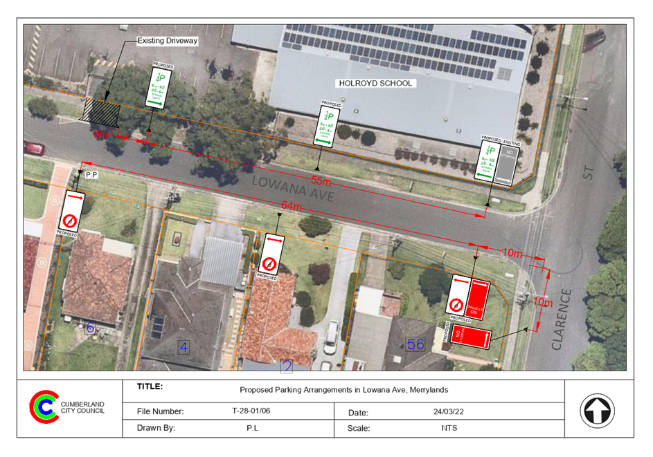
6 April 2022
Item
No: CTC-22-071
CHURCH STREET,
LIDCOMBE - APPLICATION FOR 'WORKS ZONE' SIGNAGE
Responsible
Division: Environment
& Planning
Officer: Team
Leader Transportation and Traffic
File
Number: T-28-01/06
Electorate: Auburn
Police Area
Command (PAC): Auburn
Council has received an
application for a ‘Works Zone’ on Church Street, Lidcombe
associated with the development at 2-36 Church Street, Lidcombe.
This report outlines the outcome
of the investigation into this matter.
|
The Traffic Committee recommends that:
1. The
‘Works Zone, 7:00am-6:00pm, Monday-Friday, 8:00am-4:00pm,
Saturday’ signs be installed on the frontage of the development site on
Church Street, Lidcombe in accordance with the different stages subject to
Council’s standard conditions and subsequent extension if required.
2. The applicant
be advised to pay the ‘Works Zone’ fees to Council as per the
adopted Fees and Charges.
|
Council has received an
application for a ‘Works Zone’ on Church Street, Lidcombe
associated with the development at 2-36 Church Street, Lidcombe. The proposed
development involves construction of 4 residential flat buildings of varying
heights from 4 to 10 storeys comprising 262 units over basement car parking for
264 vehicles and construction of a roundabout at the intersection of Martin
Street and Church Street.
The temporary “Works
Zone” will be reduced in length as shown in the attached plan from 190m
to 90m in three stages. The ‘Works Zone’ is proposed to commence in
April 2022 for a total of 39 weeks. The proposed time is between 7:00am to
6:00pm Monday to Friday and 8:00am to 4:00pm on Saturdays.
There will be a loss of several
unrestricted on-street parking spaces on the southern side of Church Street,
Lidcombe during the operation of different stages of the “Works
Zone”.
Different stages of the
‘Works Zone’ are as follows:
1. Full
length – 190m for 16 weeks
2. Reduced
to 145m (reduced from eastern end) for 10 weeks
3. Further
reduced to 90m (between Martin Street and Swete Street) – 13 weeks
The entire ‘Works
Zone’ will be on the development frontage.
The signs on the attached plan indicate
the extent of the different stages only. Council will provide additional signs
at appropriate intervals.
1. Plan –
Church Street, Lidcombe – Proposed Temporary ‘Works Zone’
signage
DOCUMENTS
ASSOCIATED WITH
REPORT CTC-22-071
Attachment 1
Plan – Church Street, Lidcombe – Proposed
Temporary ‘Works Zone’ signage
6 April 2022
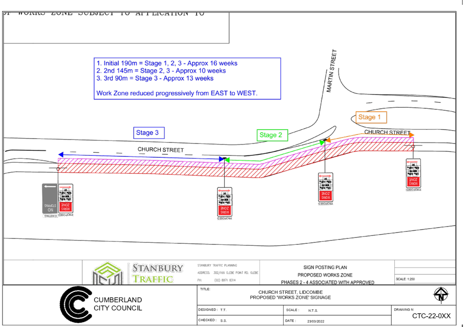
6 April 2022
Item
No: CTC-22-072
GEORGES
AVENUE, LIDCOMBE AT BEATRICE STREET – REQUEST FOR A PEDESTRIAN CROSSING
Responsible
Division: Environment
& Planning
Officer: Team
Leader Transportation and Traffic
File
Number: T-28-01/06
Electorate: Auburn
Police Area
Command (PAC): Auburn
Council has received a request
from a resident for the provision of a marked pedestrian crossing in Georges
Avenue, Lidcombe at Beatrice Street.
This report outlines the outcome
of the investigation into this matter.
|
The Traffic Committee recommends that the
installation of a marked pedestrian crossing in Georges Avenue, Lidcombe at
Beatrice Street not be supported.
|
The section of Georges Avenue
under consideration is a local road running in a westerly direction from the
state road, Joseph Street up to the local road Nottinghill Road with speed
limit of 50km/h. The street is approximately 12.5m wide with unrestricted parking
on both sides of the street unless signposted.
Beatrice Street is a local road
running in a northerly direction from Georges Avenue with speed limit of
50km/h. The street is approximately 12.5m wide with unrestricted parking on
both sides of the street unless signposted.
Georges Avenue also has Coleman
Park along its southern side.
Council has received a request
from a resident requesting a marked pedestrian crossing in Georges Avenue,
Lidcombe at Beatrice Street to facilitate crossing Georges Avenue from Beatrice
Street to Coleman Park.
The map below shows the location
of Georges Avenue:
To provide a pedestrian crossing,
Council must satisfy the following warrants given in RMS / Transport for NSW
Guidelines:
Normal Warrant:
A pedestrian (Zebra) Crossing is
warranted where:-
In each of three separate one hour
periods in a typical day
(a) the pedestrian flow per hour (P)
crossing the road is >= 30 AND
(b) the vehicular flow per hour (V) through
the site is >= 500 AND
(c) the product PV is >= 60,000
Reduced Warrant for sites used
predominantly by children and by aged or impaired pedestrians.
If the crossing is used
predominantly by school children, is not suitable site for a Children’s
Crossing and in two counts of one hour duration immediately before and after
school hours:-
(a) P ≥ 30 AND
(b) V ≥ 200
a pedestrian (Zebra) Crossing may
be installed.
Council officers in consultation
with Council’s Parks Section, decided to undertake pedestrian and vehicle
counts on a typical week day and a Saturday when the weekend park users would
be high.
Council undertook a pedestrian and
vehicle count at the intersection of Georges Avenue and Beatrice Street on
Thursday 17th and Saturday 19th March 2022.
The weather was clear on these
days. The result of the counts is shown in the table
below:
The survey result above indicates
that the number of pedestrians crossing Georges Avenue is very low both on a
typical week day and Saturday and do not meet the numerical warrants for a
marked pedestrian crossing. Therefore a marked pedestrian crossing cannot be
supported.
Nil
6 April 2022
Item
No: CTC-22-073
CLYDE STREET,
SOUTH GRANVILLE AT NOBBS STREET – ROAD SAFETY CONCERNS
Responsible
Division: Environment
& Planning
Officer: Team
Leader Transportation and Traffic
File
Number: HC-24-01-3/02
Electorate: Auburn
Police Area
Command (PAC): Cumberland
Council has received safety
concerns from a local resident at the intersection of Clyde Street and Nobbs
Street, South Granville. It is also alleged that vehicles are speeding on
Clyde Street between Mona Street and Mons Street. Also, a request has been made
to consider a roundabout at this intersection due to safety concerns.
This report outlines the outcome
of the investigation into this matter.
|
The Cumberland Traffic Committee recommends that;
1. The installation
of traffic calming devices on Clyde Street, South Granville not be supported.
2. Council
review conditions in Clyde Street between Mona Street and Mons Street in
November 2022 and report back to traffic committee.
|
Council has received safety
concerns from a local resident at the intersection of Clyde Street and Nobbs
Street, South Granville. It is also alleged that vehicles are speeding on
Clyde Street between Mons Street and Mona Street.
Clyde Street is a regional road
and runs in a north-south direction between William Street, Granville to Rawson
Road, Guildford. It has a speed limit of 60km/hr. The road is approximately
12.5m wide and parking is permitted on both sides of the road unless
signposted.
Nobbs Street is a local road
runs in an east – west direction. The road is approximately 12.5m wide
and parking is permitted on both sides of the road unless signposted. Nobbs
Street links Clyde Street with Blaxcell Street.
Clyde Street and Nobbs Street form
a T – junction with priority by Clyde Street. ‘Give Way’
signs and line marking are provided in Nobbs Street at its intersection with
Clyde Street. A pedestrian refuge exists on Clyde Street south of Nobbs Street.
There are existing ‘No Stopping’ signs installed at the intersection.
Granville East Public School has
frontages on The Trongate, Blaxcell Street and Nobbs Street. Also, Holy Family Primary
School has frontages on Clyde Street and The Trongate.
The map below shows the location
of the intersection of Clyde Street and Nobbs Street:
The latest Centre for Road Safety
accident data indicated that there was one reported accident at this section of
Clyde Street between Mona Street and Mons Street and one accident in Nobbs
Street near the intersection of Clyde Street related to speeding motorists in
the 5 years ending June 2021.
Traffic counts were undertaken on
Clyde Street and Nobbs Street in March 2022. The traffic count locations are
shown in red on the map above.
The results of the traffic count
indicated the following:
Traffic count Data on Clyde
Street :
Average Daily Traffic (ADT) = 14,582 vehicles/day,
Speed limit of the street
= 60km/hr
85th percentile speed =
of 52.6 km/h,
Mean (average) vehicle speed = 45.9 km/h.
Morning school hour (weekdays) 8am-9am = 821 veh/hr
Afternoon school hour (weekdays) 2pm-3pm = 1,070 veh/hr
Traffic count
Data on Nobbs Street :
Average Daily Traffic (ADT) = 2,335vehicles/day,
Speed limit of the street = 50 km/hr
85th percentile speed =
42.3 km/h,
Mean (average) vehicle speed = 36.9 km/h.
Morning school hour (weekdays) 8am-9am = 253 veh/hr
Afternoon school hour (weekdays) 2pm-3pm = 217 veh/hr
The traffic counts indicated that
the recorded 85th percentile speeds on the approaches to the intersection were 42.3km/hr
on a 50 km/hr speed limit road and 52.6 km/hr on 60km/hr speed limit road.
Particularly the approach speed on Nobbs Street approaching ‘Give
way’ control at Clyde Street was 42.3 km/hr which is significantly lower
than the speed limit of 50km/hr and within acceptable limits of the School Zone
speed limit. Speed values during school zone times (8:00-9:30 & 2:30-4:00)
could only be derived from the traffic count data partially.
In regard to the recorded 85th
percentile speed on Clyde Street, the speed of 52.6 km/hr is well below the
posted speed limit of 60 km/hr on Clyde Street.
The results of the traffic counts,
recorded crashes etc. were used in the assessment to determine the need for the
installation of traffic calming devices on Clyde Street in accordance with the
criteria set out in Council’s Local Area Traffic Management Policy (LATM)
Policy.
The LATM assessment are summarised
in the tables below:
Table 1 – Clyde
Street - LATM Assessment Points
|
Criteria
|
Maximum Score
|
Score Achieved
|
|
Traffic Study Data
|
45
|
15
|
|
Crash warrant in the
last 5 years
|
15
|
5
|
|
Road Characteristics
|
35
|
17
|
|
Community Support &
other factors
|
5
|
5
|
|
Total
|
100
|
42
|
Table 2 – Action
|
Criteria
|
Action
|
|
>75
|
Report to TC with a
recommendation of providing traffic calming devices
|
|
61-75
|
Report to TC and
discuss possibility of providing traffic calming devices
|
|
41-60
|
Council to review
traffic data in 6 months
|
|
25-40
|
Monitor street and
review traffic data after 12 months
|
|
<25
|
Do Nothing
|
|
Speed
|
That regardless of the
total points scored, should the 85th percentile speed exceed the posted speed
limit by 5 km/h, the street be referred to the NSW Police for monitoring
and/or enforcement.
|
The traffic count
indicated that the recorded 85th percentile speed on Clyde Street
between Mona Street and Mons Street was 52.6 km/h which is below the speed
limit of 60 km/hr.
The recorded 85th percentile speed on Nobbs
Street was 42.3 km/hr and within acceptable limits of the School Zone speed
limit.
Based on the above assessment, traffic calming devices are
not warranted in Clyde Street, therefore, the request for the installation of
traffic calming devices on Clyde Street cannot be supported. Council will
review conditions in 6 months.
In regard to the request for a roundabout at the
intersection of Clyde Street and Nobbs Street, a roundabout is not warranted
due to the low crash history at this intersection in the 5-year period and safe
approach speeds on the approaches to the intersection. Furthermore, the
intersection is treated with ‘No Stopping’ signs to improve sight
distance particularly for vehicles exiting Nobbs Street.
Nil
6 April 2022
Item
No: CTC-22-074
ADDLESTONE
ROAD, MERRYLANDS – ROAD SAFETY CONCERNS
Responsible
Division: Environment
& Planning
Officer: Engineering
Administration Officer
File
Number: HC-24-01-3/02
Electorate: Granville
Police Area
Command (PAC): Cumberland
Council has received a request
from a local resident for the installation of traffic calming devices on
Addlestone Road, Merrylands due to speeding concerns.
This report outlines the outcome
of the investigation into this matter.
|
The Cumberland Traffic Committee recommends that:
1. The
installation of traffic calming devices on Addlestone Road, Merrylands not be
supported.
2. Council
review conditions in Addlestone Road, Merrylands in June 2023, and report
back to traffic committee.
|
Council has received a request
from a local resident for the installation of traffic calming devices on
Addlestone Road, Merrylands due to speeding concerns.
Addlestone Road is a local road
runs in a north – south direction from Merrylands Road to Newman Street.
The road is approximately 420m long and 12.5m wide. The speed limit is 50km/h
and parking is permitted on both sides of the road unless signposted.
The intersection of Addlestone Road and Newman Street is
controlled by a roundabout. There is a raised threshold built at the entrance
to the Council car park on Addlestone Road between Newman Street and Merrylands
Road.
Council’s Officers have investigated the request for
the installation of traffic calming devices on Addlestone Road in accordance
with Council’s Local Area Traffic Management (LATM) Policy.
The latest Centre for Road Safety accident data indicated
that there were no reported accidents in Addlestone Road related to speeding
motorists in the last 5 years.
The map below shows the
location of Addlestone Road:
A traffic count was undertaken on Addlestone Road February
2022. The traffic count location is shown in red on the map above.
The results of the traffic count indicated the following:
Traffic count Data on Addlestone Road :
Average Daily Traffic (ADT) = 3,689 vehicles/day
85th percentile speed = of 51.8 km/h
Mean (average) vehicle speed = 43.9 km/h
The results of the traffic counts, recorded crashes etc.
were used in the assessment to determine the need for the installation of
traffic calming devices on Addlestone Road in accordance with the criteria set
out in Council’s Local area Traffic Management Policy (LATM) Policy.
The LATM assessments are
summarised in the tables below:
Table 1 –
Addlestone Road - LATM Assessment Points
|
Criteria
|
Maximum Score
|
Score Achieved
|
|
Traffic Study Data
|
45
|
15
|
|
Crash warrant in the
last 5 years
|
15
|
0
|
|
Road Characteristics
|
35
|
12
|
|
Community Support &
other factors
|
5
|
5
|
|
Total
|
100
|
32
|
Table 2 – Addlestone
Road – Action
|
Criteria
|
Action
|
|
>75
|
Report to TC with a
recommendation of providing traffic calming devices
|
|
61-75
|
Report to TC and
discuss possibility of providing traffic calming devices
|
|
41-60
|
Council to review
traffic data in 6 months
|
|
25-40
|
Monitor street and
review traffic data after 12 months
|
|
<25
|
Do Nothing
|
|
Speed
|
That regardless of the
total points scored, should the 85th percentile speed exceed the posted speed
limit by 5 km/h, the street be referred to the NSW Police for monitoring
and/or enforcement.
|
The traffic count indicated that the recorded 85th
percentile speed was 51.8km/h which is within acceptable limits.
Based on the above assessment, traffic calming devices are
not warranted in the street, therefore, the request for the installation of
traffic calming devices / speed humps on Addlestone Road cannot be supported.
Council will review the conditions in the street after 12
months.
Nil
6 April 2022
Item
No: CTC-22-075
BADHAM
STREET, MERRYLANDS – ROAD SAFETY CONCERNS
Responsible
Division: Environment
& Planning
Officer: Engineering
Administration Officer
File
Number: HC-24-01-3/02
Electorate: Granville
Police Area
Command (PAC): Cumberland
Council has received a request
from a local resident for the installation of traffic calming devices on Badham
Street, Merrylands due to speeding concerns.
This report outlines the outcome
of the investigation into this matter.
|
The Cumberland Traffic Committee recommends that
the installation of traffic calming devices on Badham Street, Merrylands not
be supported.
|
Council has received a request
from local residents for the installation of traffic calming devices on Badham
Street, Merrylands due to speeding concerns.
Badham Street is a local road runs
in a north-south direction between Meadows Street and Augustus Street. The road
is approximately 390m long and 12.5m wide. The speed limit is 50km/h and
parking is permitted on both sides of the road unless signposted.
Council’s Officers have investigated the request for
the installation of traffic calming devices on Badham Street in accordance with
Council’s Local Area Traffic Management (LATM) Policy.
The latest Centre for Road Safety accident data indicated
that there was one reported accident (cross traffic) in Badham Street at the
intersection of Cohen Street in the 5-year period ending June 2021.
The map below shows the
location of Badham Street:
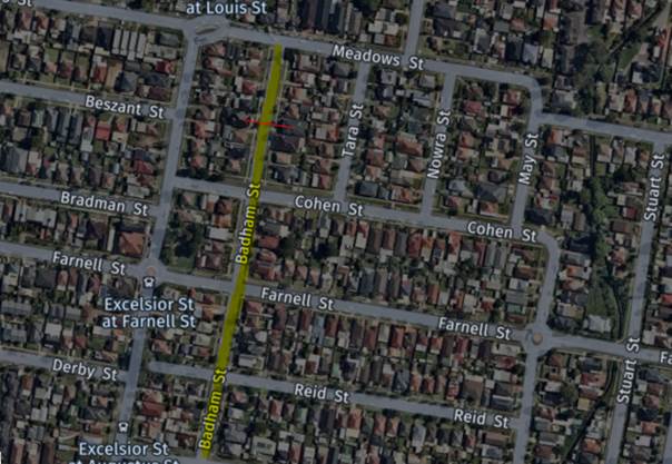
A traffic count was
undertaken on Badham Street outside No.9 in November 2021. The traffic count
location is shown in red on the map above.
The results of the
traffic count indicated the following:
Traffic count
Data on Badham Street:
Average Daily Traffic (ADT) = 345 vehicles/day
85th percentile speed = of 45 km/h
Mean (average) vehicle speed = 37 km/h
The results of the traffic counts, recorded crashes etc.
were used in the assessment to determine the need for the installation of
traffic calming devices on Badham Street in accordance with the criteria set
out in Council’s Local area Traffic Management Policy (LATM) Policy.
The LATM assessments are
summarised in the tables below:
Table 1 – Badham
Street - LATM Assessment Points
|
Criteria
|
Maximum Score
|
Score Achieved
|
|
Traffic Study Data
|
45
|
0
|
|
Crash warrant in the
last 5 years
|
15
|
5
|
|
Road Characteristics
|
35
|
8
|
|
Community Support &
other factors
|
5
|
5
|
|
Total
|
100
|
18
|
Table 2 – Badham
Street – Action
|
Criteria
|
Action
|
|
>75
|
Report to TC with a
recommendation of providing traffic calming devices
|
|
61-75
|
Report to TC and
discuss possibility of providing traffic calming devices
|
|
41-60
|
Council to review
traffic data in 6 months
|
|
25-40
|
Monitor street and
review traffic data after 12 months
|
|
<25
|
Do Nothing
|
|
Speed
|
That regardless of the
total points scored, should the 85th percentile speed exceeds the posted
speed limit by 5 km/h, the street be referred to the NSW Police for
monitoring and/or enforcement.
|
The traffic count indicated that the recorded 85th
percentile speed was 45km/h which is significantly below the default speed
limit.
Based on the above assessment, traffic calming devices are
not warranted in the street, therefore, the request for the installation of
traffic calming devices / speed humps on Badham Street cannot be supported.
Nil
6 April 2022
Item
No: CTC-22-076
JONES STREET,
WENTWORTHVILLE – ROAD SAFETY CONCERNS
Responsible
Division: Environment
& Planning
Officer: Engineering
Administration Officer
File
Number: HC-24-01-3/02
Electorate: Prospect
Police Area
Command (PAC): Cumberland
Council has received a request
from a local resident for the installation of traffic calming devices on Jones
Street, Wentworthville due to speeding concerns.
This report outlines the outcome
of the investigation into this matter.
|
The Cumberland
Traffic Committee recommends that Council undertake consultation with the
residents of Jones Street, Wentworthville to assess support or otherwise for
installation of speed humps in the street.
|
Council has received a request
from a local resident for the installation of traffic calming devices on Jones
Street, Wentworthville due to speeding concerns.
Jones Street is a local road runs
in a north-south direction between Great Western Highway and Stapleton Street.
It is approximately 990m long and 12.2m wide. The speed limit in the street is
50km/h and parking is permitted on both sides of the road unless signposted.
There are two roundabouts at the
intersections of Jones Street & Dunmore Road and Jones Street & Smith
Street. Council has considered the approximately 580m long straight section of
Jones Street for analysis.
Council’s Officers have investigated the request for
the installation of traffic calming devices on Jones Street in accordance with
Council’s Local Area Traffic Management (LATM) Policy.
The latest Centre for Road Safety accident data indicated
that there was one reported mid-block accident in this section of Jones Street
in the last 5 years.
The map below shows the
location of Jones Street:
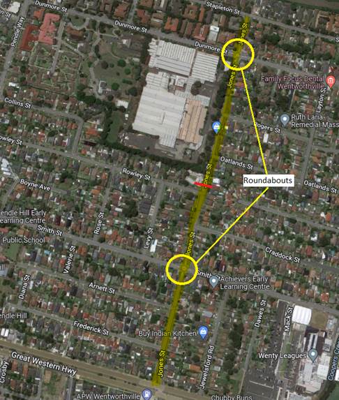
A traffic count was
undertaken on Jones Street December 2021. The traffic count location is shown
in red on the map above.
The results of the
traffic count indicated the following:
Traffic count
Data on Jones Street:
Average Daily Traffic (ADT) = 5,272 vehicles/day
85th percentile speed = of 64.4 km/h
Mean (average) vehicle speed = 56.7 km/h
The results of the traffic counts, recorded crashes etc.
were used in the assessment to determine the need for the installation of
traffic calming devices on Jones Street in accordance with the criteria
set out in Council’s Local area Traffic Management Policy (LATM) Policy.
The LATM assessments are
summarised in the tables below:
Table 1 – Jones
Street - LATM Assessment Points
|
Criteria
|
Maximum Score
|
Score Achieved
|
|
Traffic Study Data
|
45
|
35
|
|
Crash warrant in the
last 5 years
|
15
|
5
|
|
Road Characteristics
|
35
|
11
|
|
Community Support &
other factors
|
5
|
5
|
|
Total
|
100
|
56
|
Table 2 – Jones
Street – Action
|
Criteria
|
Action
|
|
>75
|
Report to TC with a
recommendation of providing traffic calming devices
|
|
61-75
|
Report to TC and
discuss possibility of providing traffic calming devices
|
|
41-60
|
Council to review
traffic data in 6 months
|
|
25-40
|
Monitor street and
review traffic data after 12 months
|
|
<25
|
Do Nothing
|
|
Speed
|
That regardless of the
total points scored, should the 85th percentile speed exceeds the posted
speed limit by 5 km/h, the street be referred to the NSW Police for monitoring
and/or enforcement.
|
The traffic count indicated that the recorded 85th
percentile speed was 64.4km/h which is significantly high compared to the speed
limit of the street.
Based on the above assessment, it is proposed to undertake
consultation with the residents of Jones Street, Wentworthville to assess
support or otherwise for installation of speed humps.
Also, the speed data was forwarded to Cumberland PAC for
speed surveillance.
Nil
6 April 2022
Item
No: CTC-22-077
HARRIS STREET,
GUILDFORD – ROAD SAFETY CONCERNS - CONSULTATION
Responsible
Division: Environment
& Planning
Officer: Engineering
Administration Officer
File
Number: HC-24-01-3/02
Electorate: Granville
Police Area
Command (PAC): Cumberland
Council received persistent
requests from local residents for the installation of traffic calming devices
on Harris Street, Guildford due to speeding concerns.
This report outlines the outcome
of the investigation into this matter.
|
The Cumberland Traffic Committee recommends that:
1. The
installation of traffic calming devices on Harris Street, Guildford not be
supported.
2. Council
request Cumberland Police Area Command to monitor the road for speeding.
|
Background:
Cumberland Traffic Committee
(CTC) at its meeting in April 2021 considered a report (vide Item No. CTC-21-093)
regarding road safety concerns on Harris Street, Guildford. Council resolved to
undertake consultation with the residents of Harris Street between Guildford
Road and Hawksview Street, Guildford to determine support or otherwise for
speed humps and report back to Cumberland Traffic Committee.
Consultation was carried out
with the residents at this section of Harris Street accordingly in May 2021.
Council only received approximately 27% submissions of total letters sent. The
consultation results were reported to Cumberland Traffic Committee in August
2021(CTC – 21 -201) with two options to consider. Attachment includes the
previous report CTC-21-201.
The Traffic Committee
recommended that the line marking treatment in Harris Street between Guildford
Road and Hawksview Street, Guildford in accordance with the attached plan be
approved. Council approved the recommendation on 06 October 2021.
Council has received further
concerns from residents insisting that speed humps are required to reduce speeding
in the street. Council has undertaken further consultation to assess support
from the residents in Harris Street.
Council distributed 95 letters with an attached survey form
to the residents / owners in February 2022. There were 20 responses (21% of
total letters sent) received by closing date, 18 (90%) in support and 1 (5%)
objected to the proposed speed humps.
Based on the above result, although the majority of the
responses received by Council supported the provision of speed humps in Harris
Street, it is noted that only 21% of the residents in Harris Street responded
to the survey.
The provision of speed humps in Harris Street, Guildford is
not supported by majority of the community which is shown by the lack of
responses received.
However, since the recorded 85th percentile speed
in the street was 57.4 km/hr, it is proposed to request Cumberland Police Area
Command to monitor the road for speeding.
1. Previous
report CTC–21–201
2. Extract
of Minutes of traffic committee for item CTC–21–201
DOCUMENTS
ASSOCIATED WITH
REPORT CTC-22-077
Attachment 1
Previous report CTC–21–201
6 April 2022
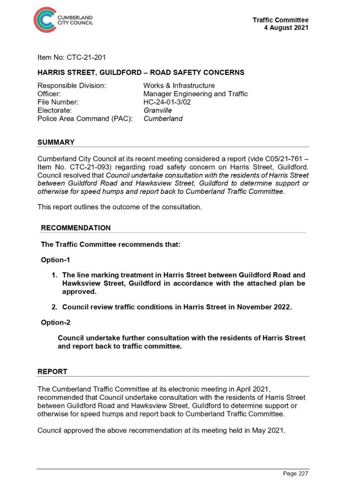
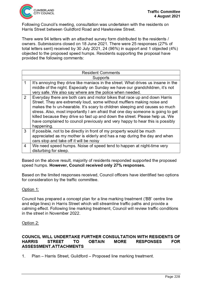
DOCUMENTS
ASSOCIATED WITH
REPORT CTC-22-077
Attachment 2
Extract of Minutes of traffic committee for item
CTC–21–201
6 April 2022
6 April 2022
Item
No: CTC-22-078
KENNEDY
STREET, GUILDFORD – ROAD SAFETY CONCERNS
Responsible
Division: Environment
& Planning
Officer: Engineering
Administration Officer
File
Number: HC-24-01-3/02
Electorate: Auburn
Police Area
Command (PAC): Cumberland
Council has received a request
from a local resident for the installation of traffic calming devices on
Kennedy Street, Guildford due to speeding concerns.
This report outlines the outcome
of the investigation into this matter.
|
The Cumberland Traffic Committee recommends that
the installation of traffic calming devices on Kennedy Street, Guildford not
be supported.
|
Council has received a request
from local residents for the installation of traffic calming devices on Kennedy
Street, Guildford due to speeding concerns.
Kennedy Street is a local road
that runs in an easterly direction from Robertson Street to a cul-de-sac at its
eastern end. The road is approximately 220m long and 7.3m wide. The speed limit
is 50km/h and parking is permitted on both sides of the road in accordance with
Road Rules unless signposted. During inspections, Council officers have
observed tyre marks in the street indicating dangerous driving.
Council’s Officers have investigated the request for
the installation of traffic calming devices on Kennedy Street in accordance
with Council’s Local Area Traffic Management (LATM) Policy.
The latest Centre for Road Safety accident data indicated
that there were no reported accidents in Kennedy Street in the 5-year period
ending June 2021.
The map below shows the
location of Kennedy Street:
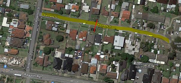
A traffic count was
undertaken on Kennedy Street December 2021. The traffic count location is shown
in red on the map above.
The results of the
traffic count indicated the following:
Traffic count
Data on Kennedy Street:
Average Daily Traffic (ADT) = 205 vehicles/day
85th percentile speed = of 44 km/h
Mean (average) vehicle speed = 35 km/h
The results of the traffic counts, recorded crashes etc.
were used in the assessment to determine the need for the installation of
traffic calming devices on Kennedy Street in accordance with the criteria
set out in Council’s Local area Traffic Management Policy (LATM) Policy.
The LATM assessments are
summarised in the tables below:
Table 1 – Kennedy
Street - LATM Assessment Points
|
Criteria
|
Maximum Score
|
Score Achieved
|
|
Traffic Study Data
|
45
|
0
|
|
Crash warrant in the
last 5 years
|
15
|
0
|
|
Road Characteristics
|
35
|
8
|
|
Community Support &
other factors
|
5
|
5
|
|
Total
|
100
|
13
|
Table 2 – Kennedy
Street – Action
|
Criteria
|
Action
|
|
>75
|
Report to TC with a
recommendation of providing traffic calming devices
|
|
61-75
|
Report to TC and
discuss possibility of providing traffic calming devices
|
|
41-60
|
Council to review
traffic data in 6 months
|
|
25-40
|
Monitor street and
review traffic data after 12 months
|
|
<25
|
Do Nothing
|
|
Speed
|
That regardless of the
total points scored, should the 85th percentile speed exceed the posted speed
limit by 5 km/h, the street be referred to the NSW Police for monitoring
and/or enforcement.
|
The traffic count indicated that the recorded 85th
percentile speed was 44km/h which is significantly below the default speed
limit.
Based on the above assessment, traffic calming devices are
not warranted in the street, therefore, the request for the installation of
traffic calming devices / speed humps on Kennedy Street cannot be supported.
Council has referred the illegal
and dangerous driving in the street to Highway Patrol for monitoring.
Nil
6 April 2022
Item
No: CTC-22-079
REID
STREET, MERRYLANDS – ROAD SAFETY CONCERNS
Responsible
Division: Environment
& Planning
Officer: Engineering
Administration Officer
File
Number: HC-24-01-3/02
Electorate: Granville
Police Area
Command (PAC): Cumberland
Council has received a request
from a local resident for the installation of traffic calming devices on Reid
Street, Merrylands due to speeding concerns.
This report outlines the outcome
of the investigation into this matter.
|
The Cumberland Traffic Committee recommends that
the installation of traffic calming devices on Reid Street, Merrylands
not be supported.
|
Council has received a request
from local residents for the installation of traffic calming devices on Reid
Street, Merrylands due to speeding concerns.
Reid Street is a local road runs
in an east-west direction from Abbott Street to a cul-de-sac at its western
end. The road is approximately 340m long and 10m wide with a default speed
limit of 50km/h. Parking is permitted on both sides of the road unless
signposted otherwise.
Council’s Officers have investigated the request for
the installation of traffic calming devices on Reid Street in accordance with
Council’s Local Area Traffic Management (LATM) Policy.
The latest Centre for Road Safety accident data indicated
that there were no reported accidents in Reid Street in the 5-year period
ending June 2021.
The map below shows the location of Reid Street:
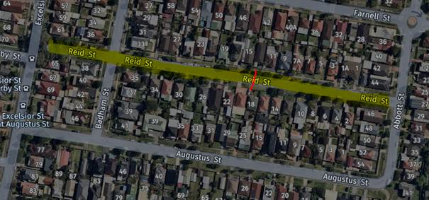
A traffic count was
undertaken on Reid Street December 2021. The traffic count location is
shown in red on the map above.
The results of the
traffic count indicated the following:
Traffic count
Data on Reid Street:
Average Daily Traffic (ADT) = 172 vehicles/day,
85th percentile speed = of 48.2 km/h,
Mean (average) vehicle speed = 35.4 km/h.
The result of the traffic count, recorded crashes etc. were
used in the assessment to determine the need for the installation of traffic
calming devices on Reid Street in accordance with the criteria set
out in Council’s Local area Traffic Management Policy (LATM) Policy.
The LATM assessments are
summarised in the tables below:
Table 1 – Reid
Street - LATM Assessment Points
|
Criteria
|
Maximum Score
|
Score Achieved
|
|
Traffic Study Data
|
45
|
0
|
|
Crash warrant in the
last 5 years
|
15
|
0
|
|
Road Characteristics
|
35
|
8
|
|
Community Support &
other factors
|
5
|
5
|
|
Total
|
100
|
13
|
Table 2 – Reid
Street – Action
|
Criteria
|
Action
|
|
>75
|
Report to TC with a
recommendation of providing traffic calming devices
|
|
61-75
|
Report to TC and
discuss possibility of providing traffic calming devices
|
|
41-60
|
Council to review
traffic data in 6 months
|
|
25-40
|
Monitor street and
review traffic data after 12 months
|
|
<25
|
Do Nothing
|
|
Speed
|
That regardless of the
total points scored, should the 85th percentile speed exceeds the posted
speed limit by 5 km/h, the street be referred to the NSW Police for
monitoring and/or enforcement.
|
The traffic count indicated that the recorded 85th
percentile speed was 48.2km/h which is below the default speed limit.
Based on the above assessment, traffic calming devices are
not warranted in the street, therefore, the request for the installation of
traffic calming devices / speed humps on Reid Street cannot be supported.
Nil
6 April 2022
Item
No: CTC-22-080
ACLAND STREET,
GUILDFORD – ROAD SAFETY CONCERNS
Responsible
Division: Environment
& Planning
Officer: Engineering
Administration Officer
File
Number: HC-24-01-3/02
Electorate: Fairfield
Police Area
Command (PAC): Cumberland
Council has received a request
from a local resident for the installation of traffic calming devices on Acland
Street, Guildford due to speeding concerns.
This report outlines the outcome
of the investigation into this matter.
|
The Cumberland Traffic Committee recommends that
the installation of traffic calming devices on Acland Street, Guildford not
be supported.
|
Council has received a request
from a resident for the installation of traffic calming devices on Acland
Street, Guildford due to speeding concerns.
Acland Street is a local road runs
in an east – west direction from Byron Road to Allison Road. The road is
approximately 210m long and 12.5m wide. The speed limit is 50km/h and parking
is permitted on both sides of the road unless signposted.
Council’s Officers have investigated the request for
the installation of traffic calming devices on Acland Street in accordance with
Council’s Local Area Traffic Management (LATM) Policy.
The latest Centre for Road Safety accident data indicated
that there were no reported accidents in Acland Street related to speeding
motorists in the 5 years ending June 2021.
The map below shows the
location of Acland Street:
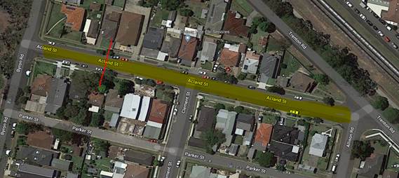
A traffic count was
undertaken on Acland Street February 2022. The traffic count location is shown
in red on the map above.
The results of the
traffic count indicated the following:
Traffic count
Data on Acland Street:
Average Daily Traffic (ADT) = 554vehicles/day
85th percentile speed = of 45.2 km/h
Mean (average) vehicle speed = 38.2 km/h
The results of the traffic counts, recorded crashes etc.
were used in the assessment to determine the need for the installation of
traffic calming devices on Acland Street in accordance with the criteria
set out in Council’s Local area Traffic Management Policy (LATM) Policy.
The LATM assessments are
summarised in the tables below:
Table 1 – Acland
Street - LATM Assessment Points
|
Criteria
|
Maximum Score
|
Score Achieved
|
|
Traffic Study Data
|
45
|
5
|
|
Crash warrant in the
last 5 years
|
15
|
5
|
|
Road Characteristics
|
35
|
7
|
|
Community Support &
other factors
|
5
|
5
|
|
Total
|
100
|
22
|
Table 2 – Acland
Street – Action
|
Criteria
|
Action
|
|
>75
|
Report to TC with a
recommendation of providing traffic calming devices
|
|
61-75
|
Report to TC and
discuss possibility of providing traffic calming devices
|
|
41-60
|
Council to review
traffic data in 6 months
|
|
25-40
|
Monitor street and
review traffic data after 12 months
|
|
<25
|
Do Nothing
|
|
Speed
|
That regardless of the
total points scored, should the 85th percentile speed exceeds the posted
speed limit by 5 km/h, the street be referred to the NSW Police for
monitoring and/or enforcement.
|
The traffic count indicated that the recorded 85th
percentile speed was 45.2km/h which is significantly below the speed limit.
Based on the above assessment,
traffic calming devices are not warranted in the street, therefore, the request
for the installation of traffic calming devices / speed humps on Acland Street
cannot be supported.
Nil
6 April 2022
Item
No: CTC-22-081
JOYCE
STREET, PENDLE HILL – ROAD SAFETY CONCERNS
Responsible
Division: Environment
& Planning
Officer: Engineering
Administration Officer
File
Number: HC-24-01-3/02
Electorate: Prospect
Police Area
Command (PAC): Cumberland
Council has received a request
from a local resident for the installation of traffic calming devices on Joyce
Street, Pendle Hill due to speeding concerns.
This report outlines the outcome
of the investigation into this matter.
|
The Cumberland Traffic Committee recommends that;
1. The
installation of traffic calming devices on Joyce Street, Pendle Hill
not be supported.
2. Council
review conditions in Joyce Street, Pendle Hill in June 2023, and report back
to traffic committee.
|
Council has received a request
from local residents for the installation of traffic calming devices on Joyce
Street, Pendle Hill due to speeding concerns.
Joyce Street is a local road runs
in an east-west direction between Pendle Way and Goodall Street. The road is
approximately 270m long with a default speed limit of 50km/h. 90-degree angle
parking is provided on the northern side of the street and 1P parallel parking
on the southern side.
Council’s Officers have investigated the request for
the installation of traffic calming devices on Joyce Street in accordance with
Council’s Local Area Traffic Management (LATM) Policy.
The latest Centre for Road Safety accident data indicated
that there were two reported accidents in Joyce Street in the 5-year period
ending June 2021.
The map below shows the
location of Joyce Street:
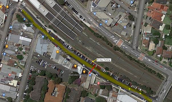
A traffic count was
undertaken on Joyce Street November 2021. The traffic count location is shown
in red on the map above.
The results of the
traffic count indicated the following:
Traffic count
Data on Joyce Street:
Average Daily Traffic (ADT) = 3,722 vehicles/day
85th percentile speed = of 45.2 km/h
Mean (average) vehicle speed = 37 km/h
The results of the traffic counts, recorded crashes etc.
were used in the assessment to determine the need for the installation of
traffic calming devices on Joyce Street in accordance with the criteria set out
in Council’s Local area Traffic Management Policy (LATM) Policy.
The LATM assessments are
summarised in the tables below:
Table 1 –
Joyce Street - LATM Assessment Points
|
Criteria
|
Maximum Score
|
Score Achieved
|
|
Traffic Study Data
|
45
|
15
|
|
Crash warrant in the
last 5 years
|
15
|
5
|
|
Road Characteristics
|
35
|
10
|
|
Community Support &
other factors
|
5
|
5
|
|
Total
|
100
|
35
|
Table 2 – Joyce
Street – Action
|
Criteria
|
Action
|
|
>75
|
Report to TC with a
recommendation of providing traffic calming devices
|
|
61-75
|
Report to TC and
discuss possibility of providing traffic calming devices
|
|
41-60
|
Council to review
traffic data in 6 months
|
|
25-40
|
Monitor street and
review traffic data after 12 months
|
|
<25
|
Do Nothing
|
|
Speed
|
That regardless of the
total points scored, should the 85th percentile speed exceeds the posted
speed limit by 5 km/h, the street be referred to the NSW Police for
monitoring and/or enforcement.
|
The traffic count indicated that the recorded 85th
percentile speed was 45km/h which is significantly below the default speed
limit.
Based on the above assessment, traffic calming devices are
not warranted in the street, therefore, the request for the installation of
traffic calming devices / speed humps on Joyce Street cannot be supported.
Council will review conditions in
the street in 12 months.
Nil
6 April 2022
Item
No: CTC-22-082
LANSDOWNE
STREET, MERRYLANDS – REQUEST FOR BANNING TRUCKS IN THE STREET
Responsible
Division: Environment
& Planning
Officer: Engineering
Administration Officer
File
Number: T-28-01/06
Electorate: Granville
Police Area
Command (PAC): Cumberland
Council received requests from a
resident in Lansdowne Street for banning trucks using the street.
This report outlines the outcome of the investigation into
this matter.
|
The Traffic Committee recommends the information
contained in this report be noted and request to ban trucks in Lansdowne
Street, Merrylands not be approved.
|
Lansdowne Street is a local road that runs in an
east-west direction between Woodville Road and Railway Terrace. The speed limit
is 50km/h and parking are permitted on both sides of the road unless
signposted. Lansdowne Street is approximately 610m long and 10.7m wide.
Council received requests from a resident in Lansdowne
Street for banning trucks using the street.
This report assesses the feasibility of banning trucks and
its impacts on surrounding streets.
The map below shows the location
of Lansdowne Street, Merrylands.
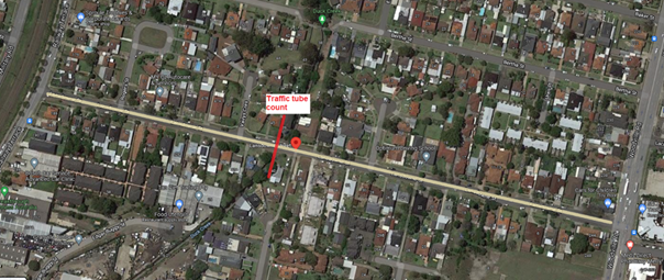
A traffic count was
undertaken on Lansdowne Street in December 2021. The location of the traffic
count is marked in red on the map above. The result of the traffic count
indicated the following:
Traffic count
Data on Lansdowne St, Merrylands:
Average Daily Traffic (ADT) = 2,526 vehicles/day
85th percentile speed = 53.1 km/h
Mean (average) vehicle speed = 45.3 km/h
The result of the traffic count reported crashes etc.
were used in the assessment to determine the need for the installation of
traffic calming devices on Lansdowne Street in accordance with the criteria set
out in Council’s Local area Traffic Management Policy (LATM) Policy. This
was reported (CTC-22-028) to Cumberland Traffic Committee on 2 March 2022. The Traffic
Committee recommended that the installation of traffic calming devices on
Lansdowne Street, Merrylands not be supported and to review conditions in
Lansdowne Street in June 2023 and report back to traffic committee.
This report investigates
the requirements and need for banning or not banning trucks using Lansdowne
Street.
Traffic count
Data on Lansdowne Street, Merrylands:
|
|
Eastbound
|
Westbound
|
Both directions
|
|
|
No.
|
%
|
No.
|
%
|
No.
|
%
|
|
Ave. Daily Traffic
(Veh/day)
|
749
|
|
1,777
|
|
2526
|
|
|
AM average
8.00-9.00
|
38
|
|
90
|
|
128
|
|
|
PM average
2.00-3.00
|
66
|
|
163
|
|
229
|
|
|
Light vehicles
(cars)
|
711
|
|
1712
|
|
2,423
|
95.9%
|
|
Class 3 - Small
Trucks
|
14
|
|
56
|
|
70
|
2.8%
|
|
Class 4 & 5
– Medium Trucks
|
24
|
|
9
|
|
33
|
1.3%
|
|
Class 6 & above
– Large Trucks
|
0
|
|
0
|
|
0
|
0%
|
The above data is based
on the values derived from the traffic count taken in December 2021.
Based on the above data
following could be deduced:
· Lansdowne
Street is the closest access to the existing industrial area in Railway Terrace
between Lansdowne Street and Edgar Buggy Street.
· The
truck percentages are very low. According to the data collected in December
2021, there are no large trucks accessing the street while medium size trucks
total to 1.3%. It should be noted that one or two large trucks may be accessing
the street to service approximately 150 properties.
· The
above results validate the existing traffic measures in Lansdowne Street which
were installed to prevent large trucks.
· Banning
trucks in this street will redirect trucks to the other local roads.
Process for banning
trucks in a street
In accordance with the
Transport for NSW guidelines (TfNSW), Council does not have delegation to ban
movements of any vehicular traffic without preparing and receiving approval
from TfNSW of a Traffic Management Plan (TMP).
The TMP deals with various impacts of banning any movement
including impact on emergency vehicle access, other streets in the vicinity,
justification for the decision to ban, etc. Also, one of the requirements of
the TMP is that the proposal to be advertised and public comments summarised
and addressed.
Due to the low volume of trucks in the street, it is not
warranted to ban truck movements in Lansdowne Street, Merrylands and it is very
unlikely to obtain approval from Transport for NSW.
Nil
6 April 2022
Item
No: CTC-22-083
MCARTHUR
STREET, GUILDFORD – ROAD SAFETY CONCERNS
Responsible
Division: Environment
& Planning
Officer: Engineering
Administration Officer
File
Number: HC-24-01-3/02
Electorate: Granville
Police Area
Command (PAC): Cumberland
Council has received a request
from a local resident for the installation of traffic calming devices on
McArthur Street, Guildford due to speeding concerns.
This report outlines the outcome
of the investigation into this matter.
|
The Cumberland Traffic Committee recommends that:
1. The
installation of traffic calming devices on McArthur Street, Guildford not be
supported.
2. Council
review conditions in McArthur Street, Guildford in June 2023, and report back
to traffic committee.
|
Council has received a request
from a local resident for the installation of traffic calming devices on
McArthur Street, Guildford due to speeding concerns.
McArthur Street is a local road
runs in an east - west direction between Woodville Road and Marian Street. The
road is approximately 550m long and 12.5m wide. The speed limit is 50km/h and
parking is permitted on both sides of the road unless signposted.
The latest Centre for Road Safety accident data indicated
that there was one reported accident (cross traffic) in McArthur Street at the
intersection of Cohen Street in the 5-year period ending June 2021.
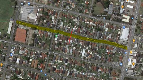
Council’s Officers have investigated the request for
the installation of traffic calming devices on McArthur Street in accordance
with Council’s Local Area Traffic Management (LATM) Policy.
A traffic count was undertaken on McArthur Street at middle
block in November 2021. The traffic count location is shown in red on the map
above.
The results of the
traffic count indicated the following:
Traffic count
Data on McArthur Street:
Average Daily Traffic (ADT) = 1,464 vehicles/day
85th percentile speed = of 54.2 km/h
Mean (average) vehicle speed = 45.4 km/h
The results of the traffic counts, recorded crashes etc.
were used in the assessment to determine the need for the installation of
traffic calming devices on McArthur Street in accordance with the criteria set
out in Council’s Local area Traffic Management Policy (LATM) Policy.
The LATM assessments are
summarised in the tables below:
Table 1 – McArthur
Street - LATM Assessment Points
|
Criteria
|
Maximum Score
|
Score Achieved
|
|
Traffic Study Data
|
45
|
10
|
|
Crash warrant in the
last 5 years
|
15
|
5
|
|
Road Characteristics
|
35
|
12
|
|
Community Support &
other factors
|
5
|
5
|
|
Total
|
100
|
32
|
Table 2 – McArthur
Street – Action
|
Criteria
|
Action
|
|
>75
|
Report to TC with a
recommendation of providing traffic calming devices
|
|
61-75
|
Report to TC and
discuss possibility of providing traffic calming devices
|
|
41-60
|
Council to review
traffic data in 6 months
|
|
25-40
|
Monitor street and
review traffic data after 12 months
|
|
<25
|
Do Nothing
|
|
Speed
|
That regardless of the
total points scored, should the 85th percentile speed exceeds the posted
speed limit by 5 km/h, the street be referred to the NSW Police for
monitoring and/or enforcement.
|
The traffic count indicated that the recorded 85th
percentile speed was 54.2 km/h which is within the acceptable limits.
Based on the above assessment, traffic calming devices are
not warranted in the street, therefore, the request for the installation of
traffic calming devices / speed humps on McArthur Street cannot be supported.
Council will review the conditions in the street after 12
months.
Nil
6 April 2022
Item
No: CTC-22-084
OXFORD STREET,
GUILDFORD - PROPOSED EXTENSION OF EXISTING PEDESTRIAN FENCING
Responsible
Division: Environment
& Planning
Officer: Team
Leader Transportation and Traffic
File
Number: HC-24-01-3/02
Electorate: Granville
Police Area
Command (PAC): Cumberland
Council has received a request
from Granville South Public School to install parking restrictions in Oxford
Street, Guildford to improve the traffic flow during School hours and extending
the existing pedestrian fence further.
This report outlines the outcome
of the investigation into this matter.
|
The Traffic Committee recommends that the extension
of the existing pedestrian safety fence on the northern side of Oxford Street
by 10m in a westerly direction be supported.
|
Oxford Street is a regional road
and passes over the railway line and carries large amount of traffic and is
always busy particularly during the peak hours. Oxford Street starts from
Woodville Road which is a state road and after passing over the railway line becomes
Hawksview Street. Oxford Street and Woodville Road form an intersection
controlled by traffic signals.
A pedestrian safety fence and ‘No Stopping’
restrictions exist on the northern side of Oxford Street along the side
boundary of Granville South Public School.
The driveway of the school car park is located on the
northern side of Oxford Street between Woodville Road and Highland Street.
School has drop off /pick up area in Highland Street.
The street view below shows the location of the pedestrian
fence on the northern side of Oxford Street.
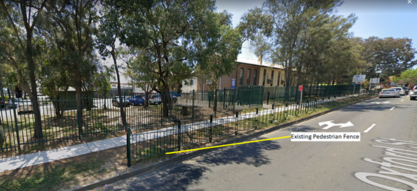
A site meeting between the school, Council and the local
member was organised to observe traffic behaviour at this location.
It was observed that some students exiting from the school
on to the footpath on the northern side of Oxford Street tend to go towards
west to where the pedestrian fence ends and cross the road instead of crossing
safely at the crossing at the signals.
It is proposed to extend the pedestrian fence further west
by 10m to discourage the above practice and improve pedestrian safety.
1. Plan –
Oxford Street, Guildford – Proposed extension of pedestrian fence.
DOCUMENTS
ASSOCIATED WITH
REPORT CTC-22-084
Attachment 1
Plan – Oxford Street, Guildford – Proposed
extension of pedestrian fence.
6 April 2022