2 March 2022
A
meeting of the Traffic Committee
will be held at 9.30am in Council Chambers, Merrylands Administration
Building, 16 Memorial Avenue, Merrylands on Wednesday, 2 March 2022.
ORDER OF BUSINESS
1.
Apologies
2.
Declarations of Interest
3.
Confirmation of Previous Minutes
4.
Summary of Reports........................................................................................................ 5
5.
Reports
CTC-22-001. CHISWICK ROAD, AUBURN AT HARROW
ROAD– PROPOSED ‘NO STOPPING’ RESTRICTIONS................................................................. 23
CTC-22-002. CHURCH STREET, LIDCOMBE–
PROPOSED ‘LEFT TURN ONLY’ SIGN..................................................................................................................... 25
CTC-22-003. EXCELSIOR STREET AND BESZANT STREET,
MERRYLANDS– PROPOSED EXTENSION OF THE EXISTING ‘NO STOPPING’
RESTRICTIONS....................................................................................... 29
CTC-22-004. FOWLER ROAD, MERRYLANDS AT THE
INTERSETION OF WARIALDA STREET– PROPOSED ‘NO STOPPING’
RESTRICTIONS AND ‘BB’ LINEMARKING.......................................................................................... 31
CTC-22-005. TOONGABBIE ROAD, TOONGABBIE – PROPOSED
PART-TIME SCHOOL BUS ZONE SIGNS................................................................. 33
CTC-22-006. WHALANS ROAD AND LAWRY STREET,
GREYSTANES – PROPOSED INTERSECTION TREATMENT.............................................................. 35
CTC-22-007. CLUCAS ROAD AND AMY STREET, REGENTS
PARK – PROPOSED ‘NO STOPPING’ SIGNS.................................................................................. 39
CTC-22-008. FRANCES STREET AND BENSON STREET,
SOUTH WENTWORTHVILLE – PROPOSED ‘NO STOPPING’ SIGNS AND
‘BB’ LINEMARKING.......................................................................................... 41
CTC-22-009. OCTAVIA STREET AND AURELIA STREET,
TOONGABBIE – PROPOSED ‘NO STOPPING’ SIGNS AND
‘BB’ LINE MARKING... 43
CTC-22-010. OCTAVIA STREET AND TOONGABBIE ROAD,
TOONGABBIE – PROPOSED ‘NO STOPPING’ SIGNS AND
‘BB’ LINEMARKING.... 45
CTC-22-011. WARWICK ROAD AND LEEDS STREET,
MERRYLANDS – PROPOSED ‘NO STOPPING’ SIGNS AND
‘BB’ LINEMARKING............................ 47
CTC-22-012. ELIZABETH STREET, GUILDFORD AT THE
INTERSETION OF CECIL STREET– PROPOSED ‘NO STOPPING’
RESTRICTIONS AND LINE MARKING.................................................................................................. 49
CTC-22-013. ELIZABETH STREET, GUILDFORD AT THE
INTERSETION OF O’NEILL STREET – PROPOSED INTERSECTION TREATMENTS............... 51
CTC-22-014. PENDLE WAY, PENDLE HILL –
RELOCATE EXISTING PEAK PERIOD ‘NO STOPPING’ SIGN............................................................................. 53
CTC-22-015. VAUGHAN STREET AND AUBURN ROAD, AUBURN
– PROPOSED INTERSECTION TREATMENT.............................................................. 55
CTC-22-016. HOLDSWORTH STREET, MERRYLANDS AT PRICE
STREET– ROAD SAFETY CONCERNS.............................................................................. 59
CTC-22-017. BERITH ROAD, GREYSTANES – ROAD
SAFETY CONCERNS.... 63
CTC-22-018. BRADMAN STREET, MERRYLANDS –
ROAD SAFETY CONCERNS 67
CTC-22-019. WARATAH STREET, GRANVILLE – ROAD
SAFETY CONCERNS 71
CTC-22-020. BERRY STREET, REGENTS PARK –
ROAD SAFETY CONCERNS 75
CTC-22-021. BURFORD STREET, MERRYLANDS –
ROAD SAFETY CONCERNS 79
CTC-22-022. DAVIDSON STREET, GUILDFORD –
ROAD SAFETY CONCERNS 83
CTC-22-023. EARL STREET, MERRYLANDS – ROAD
SAFETY CONCERNS... 87
CTC-22-024. EDWIN STREET, REGENTS PARK –
ROAD SAFETY CONCERNS 91
CTC-22-025. HANBURY STREET, GREYSTANES –
ROAD SAFETY CONCERNS 95
CTC-22-026. HARRY AVENUE, LIDCOMBE – ROAD
SAFETY CONCERNS...... 99
CTC-22-027. LACKEY STREET, MERRYLANDS – ROAD
SAFETY CONCERNS 103
CTC-22-028. LANSDOWNE STREET, MERRYLANDS –
ROAD SAFETY CONCERNS................................................................................................................... 107
CTC-22-029. NICHOLAS STREET, LIDCOMBE – ROAD
SAFETY CONCERNS 111
CTC-22-030. ST ANN STREET, MERRYLANDS – ROAD
SAFETY CONCERNS 115
CTC-22-031. AUBURN ROAD, AUBURN – PROPOSED
CONSTRUCTION OF MEDIAN ISLAND.................................................................................................... 119
CTC-22-032. BLIGH STREET, GUILDFORD – ROAD
SAFETY CONCERNS... 121
CTC-22-033. GILLIVERS PLACE AND MILLS STREET,
LIDCOMBE – ROAD SAFETY CONCERNS............................................................................................ 125
CTC-22-034. ROAD CLOSURES IN THE AUBURN CBD FOR
RAMADAN FOOD FESTIVAL 2022...................................................................................... 129
CTC-22-035. GILBA ROAD, GIRRAWEEN – ROAD
SAFETY CONCERNS....... 131
CTC-22-036. LUMLEY STREET, GRANVILLE – ROAD
SAFETY CONCERNS. 135
CTC-22-037. EDGAR STREET AND GIBBS STREET, AUBURN
- SAFER ROADS PROGRAM 2021/2022.......................................................................... 139
CTC-22-038. EXCELSIOR STREET AND BRIGHT STREET,
GUILDFORD - SAFER ROADS PROGRAM 2021/2022........................................................... 143
CTC-22-039. HARRIS STREET AND MORRIS STREET, MERRYLANDS
- SAFER ROADS PROGRAM 2021/2022........................................................... 147
CTC-22-040. ROSEBERY ROAD AND RHODES AVENUE,
GUILDFORD - SAFER ROADS PROGRAM 2021/2022........................................................... 151
CTC-22-041. TEMPORARY ROAD CLOSURE FOR
‘GRANVILLE ACTIVATION 2022’ FUNDING AGREEMENT...................................................................... 155
CTC-22-042. BELMONT STREET, MERRYLANDS –
ROAD SAFETY CONCERNS 157
CTC-22-043. CUMBERLAND ROAD, AUBURN – ROAD
SAFETY CONCERNS 161
CTC-22-044. DRIFTWAY DRIVE, PEMULWUY –
REQUEST TO REMOVE PEDESTRIAN REFUGE........................................................................ 165
CTC-22-045. KIRKHAM ROAD, AUBURN – ROAD
SAFETY CONCERNS........ 169
CTC-22-046. PENDLE WAY, PENDLE HILL – ROAD
SAFETY CONCERNS.... 173
CTC-22-047. WILLOUGHBY STREET, GUILDFORD –
ROAD SAFETY CONCERNS 177
CTC-22-048. PERCY STREET, AUBURN – PROPOSED
PARKING RESTRICTIONS ASSOCIATED WITH A DEVELOPMENT APPLICATION............... 181
CTC-22-049. WHALANS ROAD, GREYSTANES – ROAD
SAFETY CONCERNS 185
CTC-22-050. PARK ROAD, BERALA AT YORK STREET -
SAFER ROADS PROGRAM 2021/2022................................................................................................ 189
CTC-22-051. JOHN STREET, LIDCOMBE AT THE
INTERSETION OF ELIMATTA STREET AND EDITH STREET– PROPOSED ‘NO
STOPPING’ RESTRICTIONS AND LINE MARKING.............................................. 191
CTC-22-052. KERR PARADE, AUBURN– APPLICATION
FOR ‘WORKS ZONE’ SIGNAGE................................................................................................. 193
CTC-22-053. LOCKWOOD STREET AND LEEDS STREET,
MERRYLANDS – PROPOSED ‘NO STOPPING’ SIGNS AND
‘BB’ LINEMARKING.. 195
CTC-22-054. NEIL STREET, MERRYLANDS –
PROPOSED LEFT IN / LEFT OUT ARRANGEMENT ASSOCIATED WITH A DEVELOPMENT
APPLICATION................................................................................................................... 197
CTC-22-055. BLAXCELL STREET, GRANVILLE –
REVIEW OF PROPOSED RELOCATION OF THE PEDESTRIAN CROSSING AND ASSOCIATED SIGNAGE
– FEDERAL STIMULUS PROGRAM............................... 199
6.
Other Business
7.
Next Meeting
The next meeting of the Traffic
Committee is to be held on Wednesday, 6 April 2022.
2 March 2022
Summary of Reports
|
Item #
|
Title
|
Electorate
|
Police Area Command (PAC)
|
|
Fairfield
|
Granville
|
Prospect
|
Auburn
|
Cumberland
|
Auburn
|
|
CTC-22-001
|
CHISWICK ROAD, AUBURN AT
HARROW ROAD– PROPOSED ‘NO STOPPING’ RESTRICTIONS
|
|
|
|
´
|
|
´
|
|
CTC-22-002
|
CHURCH STREET,
LIDCOMBE– PROPOSED ‘LEFT TURN ONLY’ SIGN
|
|
|
|
´
|
|
´
|
|
CTC-22-003
|
EXCELSIOR STREET AND
BESZANT STREET, MERRYLANDS– PROPOSED EXTENSION OF THE EXISTING
‘NO STOPPING’ RESTRICTIONS
|
|
´
|
|
|
´
|
|
|
CTC-22-004
|
FOWLER ROAD, MERRYLANDS AT
THE INTERSETION OF WARIALDA STREET– PROPOSED ‘NO STOPPING’
RESTRICTIONS AND ‘BB’ LINEMARKING
|
|
´
|
|
|
´
|
|
|
CTC-22-005
|
TOONGABBIE ROAD, TOONGABBIE
– PROPOSED PART-TIME SCHOOL BUS ZONE SIGNS
|
|
|
´
|
|
´
|
|
|
CTC-22-006
|
WHALANS ROAD AND LAWRY
STREET, GREYSTANES – PROPOSED INTERSECTION TREATMENT
|
|
|
´
|
|
´
|
|
|
CTC-22-007
|
CLUCAS ROAD AND AMY STREET,
REGENTS PARK – PROPOSED ‘NO STOPPING’ SIGNS
|
|
|
|
´
|
|
´
|
|
CTC-22-008
|
FRANCES STREET AND BENSON
STREET, SOUTH WENTWORTHVILLE – PROPOSED ‘NO STOPPING’ SIGNS
AND ‘BB’ LINEMARKING
|
|
´
|
|
|
´
|
|
|
CTC-22-009
|
OCTAVIA STREET AND AURELIA
STREET, TOONGABBIE – PROPOSED ‘NO STOPPING’ SIGNS AND
‘BB’ LINE MARKING
|
|
|
´
|
|
´
|
|
|
CTC-22-010
|
OCTAVIA STREET AND
TOONGABBIE ROAD, TOONGABBIE – PROPOSED ‘NO STOPPING’ SIGNS
AND ‘BB’ LINEMARKING
|
|
|
´
|
|
´
|
|
|
CTC-22-011
|
WARWICK ROAD AND LEEDS
STREET, MERRYLANDS – PROPOSED ‘NO STOPPING’ SIGNS AND
‘BB’ LINEMARKING
|
|
´
|
|
|
´
|
|
|
CTC-22-012
|
ELIZABETH STREET, GUILDFORD
AT THE INTERSETION OF CECIL STREET– PROPOSED ‘NO STOPPING’
RESTRICTIONS AND LINE MARKING
|
|
´
|
|
|
´
|
|
|
CTC-22-013
|
ELIZABETH STREET, GUILDFORD
AT THE INTERSETION OF O’NEILL STREET – PROPOSED INTERSECTION
TREATMENTS
|
|
´
|
|
|
´
|
|
|
CTC-22-014
|
PENDLE WAY, PENDLE HILL
– RELOCATE EXISTING PEAK PERIOD ‘NO STOPPING’ SIGN
|
|
|
´
|
|
´
|
|
|
CTC-22-015
|
VAUGHAN STREET AND AUBURN
ROAD, AUBURN – PROPOSED INTERSECTION TREATMENT
|
|
|
|
´
|
|
´
|
|
CTC-22-016
|
HOLDSWORTH STREET,
MERRYLANDS AT PRICE STREET– ROAD SAFETY CONCERNS
|
|
´
|
|
|
´
|
|
|
CTC-22-017
|
BERITH ROAD, GREYSTANES
– ROAD SAFETY CONCERNS
|
|
|
´
|
|
´
|
|
|
CTC-22-018
|
BRADMAN STREET, MERRYLANDS
– ROAD SAFETY CONCERNS
|
|
´
|
|
|
´
|
|
|
CTC-22-019
|
WARATAH STREET, GRANVILLE
– ROAD SAFETY CONCERNS
|
|
´
|
|
|
´
|
|
|
CTC-22-020
|
BERRY STREET, REGENTS PARK
– ROAD SAFETY CONCERNS
|
|
|
|
´
|
|
´
|
|
CTC-22-021
|
BURFORD STREET, MERRYLANDS
– ROAD SAFETY CONCERNS
|
|
´
|
|
|
´
|
|
|
CTC-22-022
|
DAVIDSON STREET, GUILDFORD
– ROAD SAFETY CONCERNS
|
|
|
|
´
|
´
|
|
|
CTC-22-023
|
EARL STREET, MERRYLANDS
– ROAD SAFETY CONCERNS
|
|
´
|
|
|
´
|
|
|
CTC-22-024
|
EDWIN STREET, REGENTS PARK
– ROAD SAFETY CONCERNS
|
|
|
|
´
|
|
´
|
|
CTC-22-025
|
HANBURY STREET, GREYSTANES
– ROAD SAFETY CONCERNS
|
|
´
|
|
|
´
|
|
|
CTC-22-026
|
HARRY AVENUE, LIDCOMBE
– ROAD SAFETY CONCERNS
|
|
|
|
´
|
|
´
|
|
CTC-22-027
|
LACKEY STREET, MERRYLANDS
– ROAD SAFETY CONCERNS
|
|
´
|
|
|
´
|
|
|
CTC-22-028
|
LANSDOWNE STREET,
MERRYLANDS – ROAD SAFETY CONCERNS
|
|
´
|
|
|
´
|
|
|
CTC-22-029
|
NICHOLAS STREET, LIDCOMBE
– ROAD SAFETY CONCERNS
|
|
|
|
´
|
|
´
|
|
CTC-22-030
|
ST ANN STREET, MERRYLANDS
– ROAD SAFETY CONCERNS
|
|
´
|
|
|
´
|
|
|
CTC-22-031
|
AUBURN ROAD, AUBURN –
PROPOSED CONSTRUCTION OF MEDIAN ISLAND
|
|
|
|
´
|
|
´
|
|
CTC-22-032
|
BLIGH STREET, GUILDFORD
– ROAD SAFETY CONCERNS
|
|
|
|
´
|
´
|
|
|
CTC-22-033
|
GILLIVERS PLACE AND MILLS
STREET, LIDCOMBE – ROAD SAFETY CONCERNS
|
|
|
|
´
|
|
´
|
|
CTC-22-034
|
ROAD CLOSURES IN THE AUBURN
CBD FOR RAMADAN FOOD FESTIVAL 2022
|
|
|
|
´
|
|
´
|
|
CTC-22-035
|
GILBA ROAD, GIRRAWEEN
– ROAD SAFETY CONCERNS
|
|
|
´
|
|
´
|
|
|
CTC-22-036
|
LUMLEY STREET, GRANVILLE
– ROAD SAFETY CONCERNS
|
|
´
|
|
|
´
|
|
|
CTC-22-037
|
EDGAR STREET AND GIBBS
STREET, AUBURN - SAFER ROADS PROGRAM 2021/2022
|
|
|
|
´
|
|
´
|
|
CTC-22-038
|
EXCELSIOR STREET AND BRIGHT
STREET, GUILDFORD - SAFER ROADS PROGRAM 2021/2022
|
|
|
|
´
|
´
|
|
|
CTC-22-039
|
HARRIS STREET AND MORRIS
STREET, MERRYLANDS - SAFER ROADS PROGRAM 2021/2022
|
|
´
|
|
|
´
|
|
|
CTC-22-040
|
ROSEBERY ROAD AND RHODES
AVENUE, GUILDFORD - SAFER ROADS PROGRAM 2021/2022
|
|
´
|
|
|
´
|
|
|
CTC-22-041
|
TEMPORARY ROAD CLOSURE FOR
‘GRANVILLE ACTIVATION 2022’ FUNDING AGREEMENT
|
|
´
|
|
|
´
|
|
|
CTC-22-042
|
BELMONT STREET, MERRYLANDS
– ROAD SAFETY CONCERNS
|
|
´
|
|
|
´
|
|
|
CTC-22-043
|
CUMBERLAND ROAD, AUBURN
– ROAD SAFETY CONCERNS
|
|
|
|
´
|
|
´
|
|
CTC-22-044
|
DRIFTWAY DRIVE, PEMULWUY
– REQUEST TO REMOVE PEDESTRIAN REFUGE
|
|
|
´
|
|
´
|
|
|
CTC-22-045
|
KIRKHAM ROAD, AUBURN
– ROAD SAFETY CONCERNS
|
|
|
|
´
|
|
´
|
|
CTC-22-046
|
PENDLE WAY, PENDLE HILL
– ROAD SAFETY CONCERNS
|
|
|
´
|
|
´
|
|
|
CTC-22-047
|
WILLOUGHBY STREET,
GUILDFORD – ROAD SAFETY CONCERNS
|
|
|
|
´
|
´
|
|
|
CTC-22-048
|
PERCY STREET, AUBURN
– PROPOSED PARKING RESTRICTIONS ASSOCIATED WITH A DEVELOPMENT APPLICATION
|
|
|
|
´
|
|
´
|
|
CTC-22-049
|
WHALANS ROAD, GREYSTANES
– ROAD SAFETY CONCERNS
|
|
|
´
|
|
´
|
|
|
CTC-22-050
|
PARK ROAD, BERALA AT YORK
STREET - SAFER ROADS PROGRAM 2021/2022
|
|
|
|
´
|
|
´
|
|
CTC-22-051
|
JOHN STREET, LIDCOMBE AT
THE INTERSETION OF ELIMATTA STREET AND EDITH STREET– PROPOSED ‘NO
STOPPING’ RESTRICTIONS AND LINE MARKING
|
|
|
|
´
|
|
´
|
|
CTC-22-052
|
KERR PARADE, AUBURN–
APPLICATION FOR ‘WORKS ZONE’ SIGNAGE
|
|
|
|
´
|
|
´
|
|
CTC-22-053
|
LOCKWOOD STREET AND LEEDS
STREET, MERRYLANDS – PROPOSED ‘NO STOPPING’ SIGNS AND
‘BB’ LINEMARKING
|
|
´
|
|
|
´
|
|
|
CTC-22-054
|
NEIL STREET, MERRYLANDS
– PROPOSED LEFT IN / LEFT OUT ARRANGEMENT ASSOCIATED WITH A DEVELOPMENT
APPLICATION
|
|
´
|
|
|
´
|
|
|
CTC-22-055
|
BLAXCELL STREET, GRANVILLE
– REVIEW OF PROPOSED RELOCATION OF THE PEDESTRIAN CROSSING AND ASSOCIATED
SIGNAGE – FEDERAL STIMULUS PROGRAM
|
|
´
|
|
|
´
|
|
2 March 2022
Minutes of the meeting Electronic
Meeting of the Traffic Committee on Wednesday 3 November 2021.
Present:
Cumberland
Council - Clr
Paul Garrard – Chairman
Clr
Eddy Sarkis – Deputy Chair
Transport for NSW (TfNSW) - Ms Irene Xu – Concurrence received for all items with amendment
to one item.
Local Member for Auburn - Clr
George Campbell – Concurrence
received for all relevant items.
Local Member for Fairfield - Mr George Barcha – No objections
received.
Local Member for
Granville - Mr
Chris Worthington – Concurrence received for all relevant items.
Local Member for Prospect - Clr
Suman Saha – Concurrence
received for relevant items.
Auburn Police Area Command - Leading
S/Const. Nevill – Concurrence received for all
relevant items.
Cumberland Police Area Command - Leading S/Const.
Graham - Concurrence
received for all relevant items.
State Transit
Authority-
No objections
received.
Transdev
-
No objections
received.
CDBus - Concurrence received.
Transit Systems - No objections received.
Apologies:
Declarations Of Interest
Nil
CONFIRMATION OF MINUTES
Summary of reports
Summary of Reports
|
Item #
|
Title
|
Electorate
|
Police Area Command (PAC)
|
|
Fairfield
|
Granville
|
Prospect
|
Auburn
|
Cumberland
|
Auburn
|
|
CTC-21-209
|
BOOREA STREET, LIDCOMBE
– PROPOSED RELOCATION OF ROUNDABOUT WARNING SIGN ASSOCIATED WITH A
DEVELOPMENT APPLICATION
|
|
|
|
´
|
|
´
|
|
CTC-21-210
|
MARY STREET AND THE AVENUE,
GRANVILLE – PROPOSED ‘NO STOPPING’ SIGNS
|
|
|
|
´
|
|
´
|
|
CTC-21-211
|
NEWPORT STREET AND DRIFTWAY
DRIVE, PEMULWUY – PROPOSED INTERSECTION TREATMENT.
|
|
|
´
|
|
´
|
|
|
CTC-21-212
|
FAIRFIELD ROAD AND FORAY
STREET, YENNORA – PROPOSED ‘NO STOPPING’ SIGNS
|
´
|
|
|
|
´
|
|
|
CTC-21-213
|
DELLWOOD STREET, SOUTH
GRANVILLE – CHANGES TO EXISTING PARKING RESTRICTIONS.
|
|
|
|
´
|
|
´
|
|
CTC-21-214
|
CAMERON STREET AND WOODBURN
ROAD, LIDCOMBE – PROPOSED ‘NO STOPPING’ SIGNS
|
|
|
|
´
|
|
´
|
|
CTC-21-215
|
CARNATION STREET,
GREYSTANES – PROPOSED ‘BUS ZONE SIGNS
|
|
|
´
|
|
´
|
|
|
CTC-21-216
|
GARDENIA PARADE, GREYSTANES
– PROPOSED ‘BUS ZONE SIGNS
|
|
|
´
|
|
´
|
|
|
CTC-21-217
|
PRITCHARD STREET EAST,
WENTWORTHVILLE – PROPOSED ‘NO PARKING’ SIGNS
|
|
´
|
|
|
´
|
|
|
CTC-21-218
|
LENA PLACE AND BURNETT
STREET, MERRYLANDS – PROPOSED ‘NO STOPPING’ SIGNS AND
‘BB’ LINEMARKING
|
|
´
|
|
|
´
|
|
|
CTC-21-219
|
WHALANS ROAD AND LAWRY STREET,
GREYSTANES – ROAD SAFETY CONCERNS
|
|
|
´
|
|
´
|
|
|
CTC-21-220
|
CAMPBELL HILL ROAD,
GUILDFORD – PROPOSED ‘BUS ZONE SIGNS
|
|
|
|
´
|
|
´
|
|
CTC-21-221
|
WENTWORTH STREET AND
KARRABAH ROAD, AUBURN – PROPOSED ‘NO STOPPING’ SIGNS AND
‘BB’ LINEMARKING
|
|
|
|
´
|
|
´
|
|
CTC-21-222
|
HYLAND ROAD, GREYSTANES
– PROPOSED CHANGES TO ‘NO PARKING’ RESTRICTIONS
|
|
|
´
|
|
´
|
|
|
CTC-21-223
|
AURELIA STREET, TOONGABBIE
– APPLICATION FOR ‘WORKS ZONE’ SIGNAGE
|
|
|
´
|
|
´
|
|
|
CTC-21-224
|
HYACINTH STREET, GREYSTANES
– PROPOSED ‘NO STOPPING’ SIGNS ASSOCIATED WITH A
DEVELOPMENT APPLICATION
|
|
|
´
|
|
´
|
|
|
CTC-21-225
|
CUTCLIFFE AVENUE AND JOSEPH
STREET, REGENTS PARK – PROPOSED ‘NO STOPPING’ SIGNS AND
CENTRE LINE MARKING
|
|
|
|
´
|
|
´
|
|
CTC-21-226
|
FREDERICK AVENUE AND
LAVINIA STREET, SOUTH GRANVILLE – PROPOSED ‘NO STOPPING’
SIGNS
|
|
|
|
´
|
´
|
|
|
CTC-21-227
|
WOODPARK ROAD, SMITHFIELD
– REQUEST FOR 1/2 HOUR PARKING RESTRICTIONS.
|
|
|
´
|
|
´
|
|
|
CTC-21-228
|
MCFARLANE STREET,
MERRYLANDS– CHANGES TO EXISTING PARKING RESTRICTIONS
|
|
´
|
|
|
´
|
|
|
CTC-21-229
|
NORTHCOTE STREET, AUBURN
– REQUEST FOR ACCESSIBLE PARKING
|
|
|
|
´
|
|
´
|
|
CTC-21-230
|
BANDO ROAD, GIRRAWEEN
–PROPOSED RECONSTRUCTION OF EXISTING RAISED PEDESTRIAN CROSSING –
FEDERAL GOVERNMENT STIMULUS PROGRAM - ROAD SAFETY PROGRAM
|
|
|
´
|
|
´
|
|
|
CTC-21-231
|
BATHURST STREET, GREYTANES
- PROPOSED RELOCATION AND RAISING OF EXISTING PEDESTRIAN CROSSING –
FEDERAL GOVERNMENT STIMULUS PROGRAM - ROAD SAFETY PROGRAM
|
|
|
´
|
|
´
|
|
|
CTC-21-232
|
BRAESIDE ROAD, GREYTANES -
PROPOSED RAISING OF EXISTING PEDESTRIAN CROSSING – FEDERAL GOVERNMENT
STIMULUS PROGRAM - ROAD SAFETY PROGRAM
|
|
´
|
|
|
´
|
|
|
CTC-21-233
|
FAIRFIELD ROAD, GUILDFORD
WEST–PROPOSED RAISED PEDESTRIAN CROSSING – FEDERAL GOVERNMENT
STIMULUS PROGRAM - ROAD SAFETY PROGRAM
|
´
|
|
|
|
´
|
|
|
CTC-21-234
|
HILLTOP ROAD,
MERRYLANDS – PROPOSED RAISED PEDESTRIAN CROSSING – FEDERAL
GOVERNMENT STIMULUS PROGRAM - ROAD SAFETY PROGRAM
|
|
´
|
|
|
´
|
|
|
CTC-21-235
|
RINGROSE AVENUE, GREYTANES
- PROPOSED RAISING OF EXISTING PEDESTRIAN CROSSING – FEDERAL GOVERNMENT
STIMULUS PROGRAM - ROAD SAFETY PROGRAM
|
|
´
|
|
|
´
|
|
|
CTC-21-236
|
TEMPORARY ROAD CLOSURE FOR
‘AUSTRALIA DAY’ CELEBRATIONS
|
|
´
|
|
|
´
|
|
|
CTC-21-237
|
CARDIGAN STREET, GUILDFORD
– ROAD SAFETY CONCERNS
|
|
´
|
|
|
´
|
|
|
CTC-21-238
|
GRANVILLE RAILWAY DISASTER
MEMORIAL – PROPOSED TEMPORARY ROAD CLOSURE OF CARLTON STREET, GRANVILLE
|
|
´
|
|
|
´
|
|
|
CTC-21-239
|
GUILDFORD ROAD AND
ROBERTSON STREET, GUILDFORD –INVESTIGATION FOR THE PROVISION OF A
ROUNDABOUT
|
|
|
|
´
|
´
|
|
|
CTC-21-240
|
RUTH STREET, MERRYLANDS
WEST– REQUEST FOR BANNING OF RIGHT TURNS INTO THE STREET
|
|
´
|
|
|
´
|
|
|
CTC-21-241
|
TERRY STREET, GREYSTANES
– PROPOSED SPEED HUMPS
|
|
´
|
|
|
´
|
|
REPORTS
|
|
ITEM CTC-21-209 - BOOREA STREET, LIDCOMBE –
PROPOSED RELOCATION OF ROUNDABOUT WARNING SIGN ASSOCIATED WITH A DEVELOPMENT
APPLICATION
|
|
The Traffic Committee recommended that:
1. The
proposed relocation of the ‘Roundabout Ahead’ warning sign in
front of 27 Boorea Street, Lidcombe in accordance with the attached plan be
approved.
2. The
cost associated with the relocation of the sign shall be borne by the
applicant at no cost to Council.
3. The
applicant be notified of Council’s resolution.
|
|
|
ITEM CTC-21-210 - MARY STREET AND THE AVENUE, GRANVILLE
– PROPOSED ‘NO STOPPING’ SIGNS
|
|
The Traffic Committee recommended:
1. The
proposed extension of ‘No Stopping’ zones at the intersection of
Mary Street and The Avenue, Granville in accordance with the attached plan be
approved.
2. The
adjacent residents be notified of the outcome generally.
|
|
|
ITEM CTC-21-211 - NEWPORT STREET AND DRIFTWAY DRIVE,
PEMULWUY – PROPOSED INTERSECTION TREATMENT.
|
|
The Traffic Committee recommended that the installation
of ‘BB’ centre line marking at the intersection of Newport Street
and Driftway Drive, Pemulwuy in accordance with the attached plan be
approved.
|
|
|
ITEM CTC-21-212 - FAIRFIELD ROAD AND FORAY STREET,
YENNORA – PROPOSED ‘NO STOPPING’ SIGNS
|
|
The Traffic Committee recommended:
1. The
proposed installation of ‘No Stopping’ signs and ‘BB’
centre line at the intersection of Foray Street with Fairfield Road, Yennora
in accordance with the attached plan be approved.
2. The
adjacent businesses be notified of the outcome generally.
|
|
|
ITEM CTC-21-213 - DELLWOOD STREET, SOUTH GRANVILLE
– CHANGES TO EXISTING PARKING RESTRICTIONS.
|
|
The Traffic Committee recommended that:
1. The
changes to the existing parking arrangement on Dellwood Street, South
Granville in accordance with the attached plan be approved subject to
Australia Post relocating the mailbox.
2. The
adjacent businesses be notified of the outcome generally.
|
|
|
ITEM CTC-21-214 - CAMERON STREET AND WOODBURN ROAD,
LIDCOMBE – PROPOSED ‘NO STOPPING’ SIGNS
|
|
The Traffic Committee recommended:
1. The
proposed installation of ‘No Stopping’ zones and ‘BB’
line marking at the intersection of Cameron Street with Woodburn Road, Lidcombe
in accordance with the attached plan be approved.
2. The
adjacent residents be notified of the outcome generally.
|
|
|
ITEM CTC-21-215 - CARNATION STREET, GREYSTANES –
PROPOSED ‘BUS ZONE SIGNS
|
|
The Traffic Committee recommended:
1. The
installation of ‘Bus Zone’ signs on Carnation Street, Greystanes
in accordance with the attached plan be approved.
2. The
adjacent residents be notified of the outcome generally.
|
|
|
ITEM CTC-21-216 - GARDENIA PARADE, GREYSTANES –
PROPOSED ‘BUS ZONE SIGNS
|
|
The Traffic Committee recommended:
1. The
installation of ‘Bus Zone’ signs on Gardenia Parade, Greystanes
in accordance with the attached plan be approved.
2. The
adjacent residents be notified of the outcome generally.
|
|
|
ITEM CTC-21-217 - PRITCHARD STREET EAST, WENTWORTHVILLE
– PROPOSED ‘NO PARKING’ SIGNS
|
|
The Traffic Committee recommended:
1. The
proposed installation of ‘No Parking’ signs on Pritchard Street
East, Wentworthville in accordance with the attached plan be approved.
2. The
adjacent properties be notified of the outcome generally.
|
|
|
ITEM CTC-21-218 - LENA PLACE AND BURNETT STREET,
MERRYLANDS – PROPOSED ‘NO STOPPING’ SIGNS AND
‘BB’ LINEMARKING
|
|
The Traffic Committee recommended:
1. The
proposed installation of ‘No Stopping’ zones and ‘BB’
line marking at the intersection of Lena Place and Burnett Street, Merrylands
in accordance with the attached plan be approved.
2. The
adjacent residents be notified of the outcome generally.
|
|
|
ITEM CTC-21-219 - WHALANS ROAD AND LAWRY STREET,
GREYSTANES – ROAD SAFETY CONCERNS
|
|
The Traffic Committee recommended:
1. The
proposed installation of ‘No Stopping’ zones and ‘BB’
line marking at the intersection of Whalans Road and Lawry Street, Greystanes
in accordance with the attached plan be approved.
2. The
adjacent residents be notified of the outcome generally.
|
|
|
ITEM CTC-21-220 - CAMPBELL HILL ROAD, GUILDFORD – PROPOSED
‘BUS ZONE SIGNS
|
|
The Traffic Committee recommended:
1. The
installation of ‘Bus Zone’ signs on Campbell Hill Road, Guildford
in accordance with the attached plan be approved.
2. The
adjacent residents be notified of the outcome generally.
|
|
|
ITEM CTC-21-221 - WENTWORTH STREET AND KARRABAH ROAD,
AUBURN – PROPOSED ‘NO STOPPING’ SIGNS AND ‘BB’
LINEMARKING
|
|
The Traffic Committee recommended:
1. The
proposed installation of ‘No Stopping’ zones and ‘BB’
line marking at the intersection of Wentworth Street and Karrabah Road,
Auburn in accordance with the attached plan be approved.
2. The
adjacent residents be notified of the outcome generally.
|
|
|
ITEM CTC-21-222 - HYLAND ROAD, GREYSTANES –
PROPOSED CHANGES TO ‘NO PARKING’ RESTRICTIONS
|
|
The Traffic Committee recommended
that the conversion of ‘No Parking’ restrictions on the southern
side of Hyland Road, Greystanes to ‘No Parking; 4:00PM – 7:00AM
MON-FRI 4:00PM- 12:00 MIDNIGHT SAT 24 HOURS SUNDAY’ in accordance with
the attached plan be approved.
|
|
|
ITEM CTC-21-223 - AURELIA STREET, TOONGABBIE –
APPLICATION FOR ‘WORKS ZONE’ SIGNAGE
|
|
The Cumberland Traffic Committee recommended that:
1. The
18m long ‘Works Zone, 7:00am-6:00pm, Monday-Friday, 8:00am-4:00pm,
Saturday’ signs be installed on the frontage of the development site on
Aurelia Street, Toongabbie subject to Council’s standard conditions for
the period of 10 months and subsequent extension if required.
2. The
applicant be advised to pay the ‘Works Zone’ fees to Council as
per the adopted Fees and Charges.
|
|
|
ITEM CTC-21-224 - HYACINTH STREET, GREYSTANES –
PROPOSED ‘NO STOPPING’ SIGNS ASSOCIATED WITH A DEVELOPMENT
APPLICATION
|
|
The Traffic Committee recommended:
1. The
proposed installation of ‘No Stopping’ signs at the front of 15
Hyacinth Street, Greystanes in accordance with the attached plan be approved.
2. The
costs associated with the installation and ongoing maintenance of the signs
shall be borne by the owner of of 15 Hyacinth Street, Greystanes at no cost
to Council.
3. The
applicant be notified of Council’s resolution.
|
|
|
ITEM CTC-21-225 - CUTCLIFFE AVENUE AND JOSEPH STREET,
REGENTS PARK – PROPOSED ‘NO STOPPING’ SIGNS AND CENTRE LINE
MARKING
|
|
The Traffic Committee recommended:
1. The
proposed installation of ‘No Stopping’ zones and centre line
marking on Cutcliffe Avenue at its intersection with Joseph Street, Regents
Park in accordance with the attached plan be approved.
2. The
adjacent residents be notified of the outcome generally.
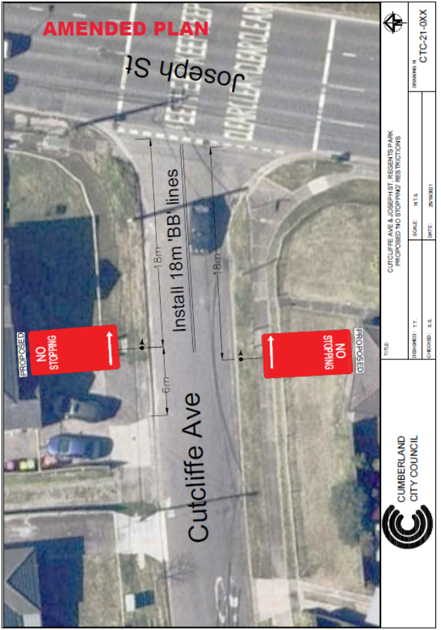
Discussion:
Transport for NSW
representative recommended to install ‘BB’ lines instead of
‘S1’ line at the intersection of Cutcliffe Avenue and Joseph
Street, Regents Park to enhance drivers’ consciousness of the traffic
directions and standardise their driving behaviours.
Action:
Amended plan attached.
|
Superseded
Plan
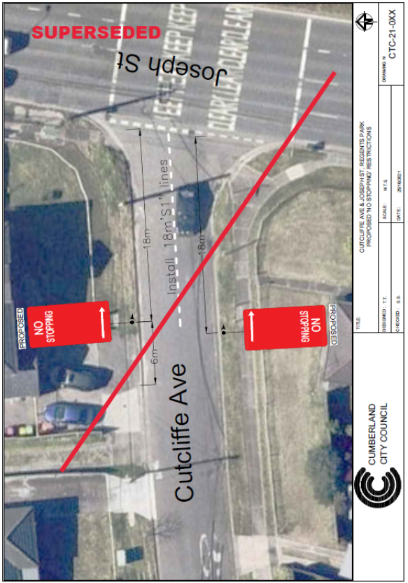
Amended
Plan
|
|
ITEM CTC-21-226 - FREDERICK AVENUE AND LAVINIA STREET,
SOUTH GRANVILLE – PROPOSED ‘NO STOPPING’ SIGNS
|
|
The Traffic Committee recommended:
1. The
proposed installation of ‘No Stopping’ signs at the intersection
of Frederick Avenue and Lavinia Street, South Granville in accordance with
the attached plan be approved.
2. The
adjacent residents be notified of the outcome generally.
|
|
|
ITEM CTC-21-227 - WOODPARK ROAD, SMITHFIELD –
REQUEST FOR 1/2 HOUR PARKING RESTRICTIONS.
|
|
The Traffic Committee recommended:
1. The
proposed installation of ‘1/2 hour, 5am – 4pm, Mon –
Fri’ in front of 115 Woodpark Road, Smithfield in accordance with the
attached plan be approved.
2. The
adjacent businesses be notified of the outcome generally.
|
|
|
ITEM CTC-21-228 - MCFARLANE STREET, MERRYLANDS–
CHANGES TO EXISTING PARKING RESTRICTIONS
|
|
The Traffic Committee recommended the changes to the
existing parking arrangement on McFarlane Street, Merrylands in accordance
with the attached plan be approved.
|
|
|
ITEM CTC-21-229 - NORTHCOTE STREET, AUBURN –
REQUEST FOR ACCESSIBLE PARKING
|
|
That the Traffic Committee recommended that the
request for accessible parking at the frontage of a property in Northcote
Street, Auburn not be approved.
|
|
|
ITEM CTC-21-230 - BANDO ROAD, GIRRAWEEN –PROPOSED
RECONSTRUCTION OF EXISTING RAISED PEDESTRIAN CROSSING – FEDERAL
GOVERNMENT STIMULUS PROGRAM - ROAD SAFETY PROGRAM
|
|
The Traffic Committee recommended that
1. The
proposed conversion of the existing raised asphalt crossing on Bando Road
east of Carinya Street, Girraween outside Girraween Public School to a raised
concrete pedestrian crossing in accordance with the attached plan be
approved.
2. The
final design plans be forwarded to Transport for NSW
3. The
adjacent residents be notified prior to construction.
|
|
|
ITEM CTC-21-231 - BATHURST STREET, GREYTANES - PROPOSED
RELOCATION AND RAISING OF EXISTING PEDESTRIAN CROSSING – FEDERAL
GOVERNMENT STIMULUS PROGRAM - ROAD SAFETY PROGRAM
|
|
The Traffic Committee recommended that
1. The
proposed relocation and conversion of the existing at-level pedestrian
crossing on Bathurst Street at Beresford Road, Greystanes to a raised
pedestrian crossing with road narrowing in accordance with the attached plan
be approved.
2. The
final design plans be forwarded to Transport for NSW.
3. The
adjacent residents be notified of the proposal.
|
|
|
ITEM CTC-21-232 - BRAESIDE ROAD, GREYTANES - PROPOSED
RAISING OF EXISTING PEDESTRIAN CROSSING – FEDERAL GOVERNMENT STIMULUS
PROGRAM - ROAD SAFETY PROGRAM
|
|
The Traffic Committee recommended:
1. The
proposed conversion of the existing at-level pedestrian crossing on Braeside
Road, Greystanes to a raised pedestrian crossing with road narrowing and kerb
blisters in accordance with the attached plan be approved.
2. The
final design plans be forwarded to Transport for NSW.
3. The
school be notified of the proposal.
|
|
|
ITEM CTC-21-233 - FAIRFIELD ROAD, GUILDFORD
WEST–PROPOSED RAISED PEDESTRIAN CROSSING – FEDERAL GOVERNMENT
STIMULUS PROGRAM - ROAD SAFETY PROGRAM
|
|
The Traffic Committee recommended that
1. The
proposed conversion of the existing at-level pedestrian crossing on Fairfield
Road north of Edward Street, Guildford West to a raised concrete pedestrian
crossing in accordance with the attached plan be approved.
2. The
final design plans be forwarded to Transport for NSW.
3. The
adjacent residents be notified of the proposal.
|
|
|
ITEM CTC-21-234 - HILLTOP ROAD, MERRYLANDS –
PROPOSED RAISED PEDESTRIAN CROSSING – FEDERAL GOVERNMENT STIMULUS
PROGRAM - ROAD SAFETY PROGRAM
|
|
The Traffic Committee recommended:
1. The
proposed conversion of the existing at-level pedestrian crossing on Hilltop
Road, Merrylands to a raised pedestrian crossing in accordance with the
attached plan be approved.
2. The
final design plans be forwarded to Transport for NSW
3. The
adjacent residents be notified of the proposal.
|
|
|
ITEM CTC-21-235 - RINGROSE AVENUE, GREYTANES - PROPOSED
RAISING OF EXISTING PEDESTRIAN CROSSING – FEDERAL GOVERNMENT STIMULUS
PROGRAM - ROAD SAFETY PROGRAM
|
|
The Traffic Committee recommended that
1. The
proposed relocation and conversion of the existing at-level pedestrian
crossing on Ringrose Avenue, Greystanes to a raised pedestrian crossing with
road narrowing in accordance with the attached plan be approved.
2. The
final design plans be forwarded to Transport for NSW.
3. The
adjacent residents be notified of the proposal.
|
|
|
ITEM CTC-21-236 - TEMPORARY ROAD CLOSURE FOR
‘AUSTRALIA DAY’ CELEBRATIONS
|
|
That the Traffic Committee recommended that the
temporary two hour closure of Pitt Street in accordance with the attached
traffic control plan between 8:30PM and 10:30PM on Wednesday January 26, 2022
be approved subject to concurrence and approval of a Traffic Management Plan
(TMP) by Transport for NSW.
|
|
|
ITEM CTC-21-237 - CARDIGAN STREET, GUILDFORD – ROAD
SAFETY CONCERNS
|
|
The Traffic Committee recommended the installation of
traffic calming devices on Cardigan Street, Guildford not be supported
|
|
|
ITEM CTC-21-238 - GRANVILLE RAILWAY DISASTER MEMORIAL
– PROPOSED TEMPORARY ROAD CLOSURE OF CARLTON STREET, GRANVILLE
|
|
The Traffic Committee recommended:
1. Council
approves the temporary full road closure of Carlton Street, Granville between
Railway Parade and Council car park entry adjacent to Russell Street from
5:00 AM to 1:00PM on Tuesday 18 January 2022 subject to approval from
Transport for NSW for the Traffic Management and Traffic Control Plans.
2. The
Traffic Management and Traffic Control Plans be forwarded to City of
Parramatta for concurrence.
|
|
|
ITEM CTC-21-239 - GUILDFORD ROAD AND ROBERTSON STREET,
GUILDFORD –INVESTIGATION FOR THE PROVISION OF A ROUNDABOUT
|
|
The Traffic Committee recommended:
1. The
request for the construction of a roundabout at the intersection of Guildford
Road and Robertson Street be supported in principle.
2. Council
prepare a Traffic Management Plan and submit to transport for NSW for
approval and report to traffic committee.
|
|
|
ITEM CTC-21-240 - RUTH STREET, MERRYLANDS WEST–
REQUEST FOR BANNING OF RIGHT TURNS INTO THE STREET
|
|
The Traffic Committee recommended:
1. The
information contained in this report be noted.
2. Council
undertake consultation with the residents of Ruth Street, Merrylands and
report back with consultation results.
|
|
|
ITEM CTC-21-241 - TERRY STREET, GREYSTANES –
PROPOSED SPEED HUMPS
|
|
The Traffic Committee recommended:
1. The
proposed installation of speed humps on Terry Street, Greystanes in
accordance with the attached plan be approved.
2. Council
undertake consultation with directly affected residents and report back to
traffic committee if objections are received.
|
General Business
The following general business was
raised:
Next Meeting
Next Meeting to be held Wednesday,
2 February 2022.
Meeting Close
The meeting terminated at: N/A
Signed:
Chairperson
2 March 2022
Item
No: CTC-22-001
CHISWICK ROAD,
AUBURN AT HARROW ROAD– PROPOSED ‘NO STOPPING’ RESTRICTIONS
Responsible
Division: Environment
& Planning
Officer: Engineering
Administration Officer
File
Number: HC-24-01-3/02
Electorate: Auburn
Police Area
Command (PAC): Auburn
Council has received a request from a resident requesting
for parking restrictions in Chiswick Road, Auburn at both intersections of
Harrow Road.
This report outlines the outcome
of the investigation into this matter
|
The Traffic Committee recommends:
1. The
installation of ‘No Stopping’ signs and line marking in Chiswick Road
and Harrow Road, Auburn at their intersections in accordance with the
attached plan be approved.
2. The
affected residents be notified of the outcome.
|
Chiswick Road is a local road that runs in an east-west
direction with a posted speed limit of 50 km/h. It has a width of approximately
12.5m and parking is permitted on both sides of the road unless signposted.
Harrow Road is a local road that runs in a north-south
direction with a speed limit of 50 km/h. it has a width of approximately 12.5m
and parking is permitted on both sides of the road unless signposted.
Chiswick Road and Harrow Road form T-junctions with priority
by default to Chiswick Road. No ‘Give Way’ signs provided in Harrow
Road at both intersections (Figure 1).
Council has received a request from a resident requesting
for parking restrictions in Chiswick Road, Auburn at both intersections of
Harrow Road.
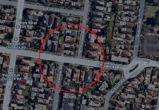
Figure 1 –
Locality Plan
A review of the Centre for Road Safety accident data
indicates that there was no recorded accident at the intersections of Chiswick
Road and Harrow Road in the last five years ending in March 2021.
A site inspection indicated that vehicles are parking within
10 metres at both intersections. The installation of ‘No Stopping’
signs would strengthen the Road Rules requirements and stop vehicles from
parking too close to the intersections. It would also improve sight distance
requirements.
Also, it is proposed to install ‘BB’ centre
lines on the Harrow Road approaches and Chiswick Road to assist turning
vehicles.
1. Plan
– Chiswick Road at Harrow Road, Auburn – Proposed ‘No
Stopping’ parking restrictions.
2 March 2022
Item
No: CTC-22-002
CHURCH STREET,
LIDCOMBE– PROPOSED ‘LEFT TURN ONLY’ SIGN
Responsible
Division: Environment
& Planning
Officer: Engineering
Administration Officer
File
Number: T-28-01/06
Electorate: Auburn
Police Area
Command (PAC): Auburn
Council has received a request
from a resident requesting for the installation of a ‘Left Turn
Only’ sign in Church Street, Lidcombe at the overpass bridge near
Lidcombe Railway Station.
This report outlines the outcome of the investigation into
this matter.
|
The Traffic Committee recommends the installation of a
‘Left Turn Only’ sign in Church Street, Lidcombe near the
overpass bridge in accordance with the attached plan be approved.
|
Church Street runs in an east-west direction between Olympic
Drive and Bachell Avenue and is a regional road with a posted speed limit of 50
km/h near the Lidcombe Town centre and 60km/hr after the town centre.
Railway Street between Mark Street and East Street is a
local road that runs in an east-west direction with a speed limit of 50 km/h.
Church Street and Railway Street connects via a bridge over
the railway line near Lidcombe Railway Station. Left and right turn
restrictions exist on both directions at this section of Church Street and
Railway Street as shown in figure 1 below.
Currently, pavement arrows are painted on Church Street and
Railway Street near the overpass bridge, ‘Left and Right Turn Only’
signs are also installed on both sides of Railway Street and a ‘Right
Turn Only’ sign is installed on the western side of Church Street near
the bridge. No signage was found on the eastern side of Church Street
approaching to the bridge (Figure 2).
Due to the high volume of traffic using this bridge
connecting sections of Lidcombe north and south of the railway line during peak
hours, it is alleged that the ‘Left Turn Only’ pavement arrows on
Church Street near the bridge are not visible as they are often covered by the
traffic. It is also alleged that vehicles sometimes attempt to go
straight from the eastern approach of Church Street causing near misses.
Figure 1 –
Locality Plan
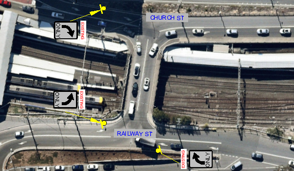
Figure 2 –
Existing signage and line marking
A review of the Centre for Road Safety accident database
indicates that there was one (1) recorded head on accident in Church Street at
the overpass bridge in the last five years ending in March 2021.
To improve the safety at this
intersection, it is proposed that a ‘Left Turn Only’ sign be
installed on the southern side of Church Street, Lidcombe east of the overpass
bridge as shown in attached plan.
1. Plan –
Church Street, Lidcombe – Proposed ‘Left Turn Only’ sign.
2 March 2022
Item
No: CTC-22-003
EXCELSIOR
STREET AND BESZANT STREET, MERRYLANDS– PROPOSED EXTENSION OF THE EXISTING
‘NO STOPPING’ RESTRICTIONS
Responsible
Division: Environment
& Planning
Officer: Engineering
Administration Officer
File
Number: HC-24-01-3/02
Electorate: Granville
Police Area
Command (PAC): Cumberland
Council has received a request from a resident requesting
for the extension of the existing ‘No Stopping’ restrictions
outside his property.
This report outlines the outcome of the investigation into
this matter.
|
The Traffic Committee recommends that the relocation of
the existing ‘No Stopping’ sign on the western side of Excelsior
Street at the north western corner of its intersection with Beszant Street by
approximatively 4m north in accordance with the attached plan be approved.
|
The Cumberland Traffic Committee, at its meeting of 25
February 2021, considered a report relating to the traffic conditions at the
intersection of Excelsior Street and Beszant Street, Merrylands. The Committee
recommended and Council subsequently resolved that “No Stopping”
signs be installed at 10 metres at the intersection as shown in the Figure 1
below.
After the installation of the “No Stopping”
signs, a representation was received from the resident of No.30 Excelsior
Street requesting the relocation of the ‘No Stopping’ sign outside
his property.
The resident clamied that the distance between the ‘No
Stopping’ sign and his driveway is approxiamtely 5m and vehicles often
park in this area. As a result, the sight distance for the resident at his drvieway
is serverly restricted by the pakred vehicles. The resident also stated that
vehicels regularly park partially across his driveway due to the short length
between the signage and his driveway.
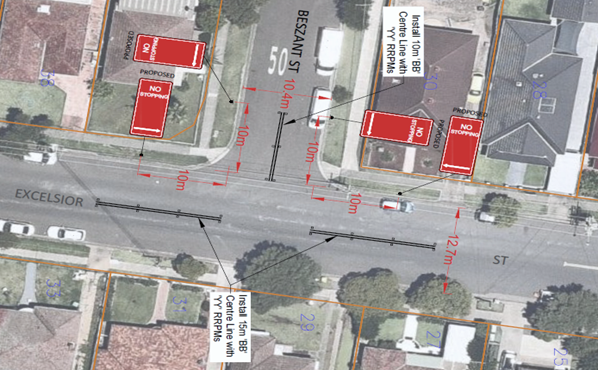
Figure 1 –
Approved No Stopping signs
Investigation found that the distance between the ‘No
Stopping’ sign and the driveway of No.30 Excelsior Street is not
sufficient to park a vehicle without overhanging the adjacent driveway.
To improve the safety at this location, it is proposed to
extend the existing ‘No Stopping’ sign outside No.30 Excelsior
Street approximately 4m north as per the attached plan.
No consultation is required as the request was made by the
resident of No.30 Excelsior Street and no other property frontage will be
impacted by the relocation of the ‘No Stopping’ sign.
1. Plan –
Excelsior Street and Beszant Street, Merrylands – Proposed relocation of
the existing ‘No Stopping’ sign.
2 March 2022
Item
No: CTC-22-004
FOWLER ROAD,
MERRYLANDS AT THE INTERSETION OF WARIALDA STREET– PROPOSED ‘NO
STOPPING’ RESTRICTIONS AND ‘BB’ LINEMARKING
Responsible
Division: Environment
& Planning
Officer: Engineering
Administration Officer
File
Number: HC-24-01-3/02
Electorate: Granville
Police Area
Command (PAC): Cumberland
Council has received a request from a resident requesting
installation of ‘No Stopping’ signs in Fowler Road at the
intersection of Warialda Street, Merrylands.
This report outlines the outcome of the investigation into
this matter.
|
The Traffic Committee recommends:
1. The
installation of ‘No Stopping’ signs and ‘BB’ centre
line at the intersection of Fowler Road and Warialda Street, Merrylands in
accordance with the attached plan be approved.
i)
2. The
affected residents be notified of the outcome.
|
Fowler Road is classified as a regional road that runs in a
north-south direction with a posted speed limit of 50 km/h. It has a width of
approximately 12.5m. A refuge island is provided in Fowler Road approximately
25m north from Warialda Street. ‘No Stopping’ restrictions
associated with the refuge island exist in Fowler Road. Parking is permitted on
other sections of Fowler Road at this intersection.
Warialda Street is a local road that runs in an east-west
direction with a posted speed limit of 50 km/h. it has a width of approximately
10.5 m and parking is permitted on both sides of the road unless signposted.
Fowler Road and Warialda Street form a T-junction with
priority to Fowler Road. ‘Give Way’ signs and line marking exist in
Warialda Street at the intersection of Fowler Road. A bus stop also exists
outside No.34 Fowler Street as shown in Figure 1 below.
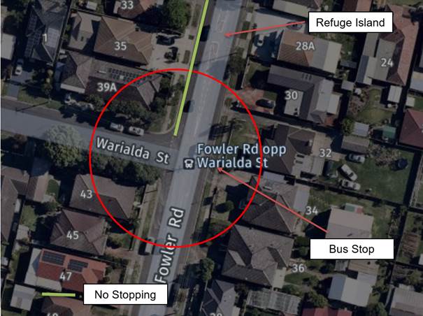
Figure 1 –
Locality Plan
A review of Centre for Road Safety accident data indicates
that there were no reported accidents at the intersection of Fowler Road and
Warialda Street in the last five years ending in March 2021.
A site inspection indicated that vehicles are parking within
10 metres from the intersection. The installation of ‘No Stopping’
signs would strengthen the Road Rules requirements and stop vehicles from
parking too close to the intersection. It would also improve sight distance
requirements.
To provide better delineation for the motorists in Fowler
Road at this intersection, it is suggested to remove the existing Separation
(S1) line marking in Fowler Road between Warialda Street and Desmond Street and
provide ‘BB’ centre line marking at this section of Fowler Road. As
the width of this section of Fowler Street is more than 12m, no on-street
parking spaces will be affected by the proposed ‘BB’ line
marking.
It is proposed to provide
‘No Stopping’ signs and ‘BB’ centre line marking at the
intersection as per the attached plan.
1. Plan - Fowler
Road at the intersection of Warialda Street, Merrylands – Proposed
‘No Stopping’ parking restrictions with ‘BB’ centre
line marking.
2 March 2022
Item
No: CTC-22-005
TOONGABBIE
ROAD, TOONGABBIE – PROPOSED PART-TIME SCHOOL BUS ZONE SIGNS
Responsible
Division: Environment
& Planning
Officer: Engineering
Administration Officer
File
Number: HC-24-01-3/02
Electorate: Prospect
Police Area
Command (PAC): Cumberland
Council has received a request
from CDC bus operator for the installation of part-time School Bus Zone signs
outside No.125 Toongabbie Road, Toongabbie.
This report outlines the outcome
of the investigation into this matter.
|
The Traffic Committee recommends the installation of
‘Bus Zone (7:30am-9:00am; 2:30pm-4:00pm; School Days)’ signs
outside No.125 Toongabbie Road, Toongabbie in accordance with the attached
plan be approved.
|
Toongabbie Road between the Great Western Highway and Portia
Road is a regional road that runs in a north-south direction. It has a width of
approximately 12.5m. The posted speed limit is 60km/h and parking are permitted
on both sides of the road unless signposted.
Council has received a request from CDC bus operator for the
installation of part-time ‘Bus Zone’ signs outside No.125
Toongabbie Road.
CDC bus provides a school bus service to pick up and drop
off school students in Toongabbie Road. However, no formal signage was
installed in the street.
Due to the increased requests from the parents, CDC bus
operator has requested that a formal bus zone at this location is needed to
ensure that buses are able to stop at the kerb safely to allow passengers to
board and alight. It is requested by the CDC bus operator that the bus zone at
this location could be part-time bus zone during school days outside No.125
Toongabbie Road.
The map below shows locality of Toongabbie Road, Toongabbie:
 Figure 1 – Locality
Plan
Figure 1 – Locality
Plan
It is recommended to install “Bus Zone; 7:30am-9:00am;
2:30pm-4:00pm; School Days” signs outside Nos. 125 Toongabbie Road. The
bus company will install a bus stop sign with school bus times at this
location. The property, 125 Toongabbie Road is owned by Cumberland City
Council.
No consultation is required as the
proposed bus zone location is at the frontage of a Council reserve.
1. Plan –
Toongabbie Road, Toongabbie – Proposed ‘Bus Zone’
2 March 2022
Item
No: CTC-22-006
WHALANS ROAD
AND LAWRY STREET, GREYSTANES – PROPOSED INTERSECTION TREATMENT
Responsible
Division: Environment
& Planning
Officer: Engineering
Administration Officer
File
Number: HC-24-01-3/02
Electorate: Prospect
Police Area
Command (PAC): Cumberland
Council has received a request
from a local resident to improve road safety at the intersection of Whalans
Road and Lawry Street, Greystanes.
This report outlines the outcome
of the investigation into this matter.
|
The Traffic Committee recommends:
1. The
installation of ‘No Stopping’ signs and BB line marking at the
intersection of Whalans Road and Lawry Street, Greystanes in accordance with
the attached plan be approved.
i)
2. The
affected residents be notified of the outcome generally.
|
Whalans Road is a local
road that runs in an east-west direction, it has a width of approximately 10.6m
and parking permitted on both sides of the road.
Whalans Road has centre
line and edge lines marked.
Lawry Street is a local
road that runs in a north-south direction and has a width of approximately 7.5m
at the intersection and parking is permitted on both sides of the road in
accordance with Road Rules.
Whalans Road and Lawry
Street form a T-junction with priority control (by default) to Whalans Road.
The intersection is near the reserve and Golf course on Whalans Road.
The map below shows the
intersection of Whalans Road and Lawry Street.
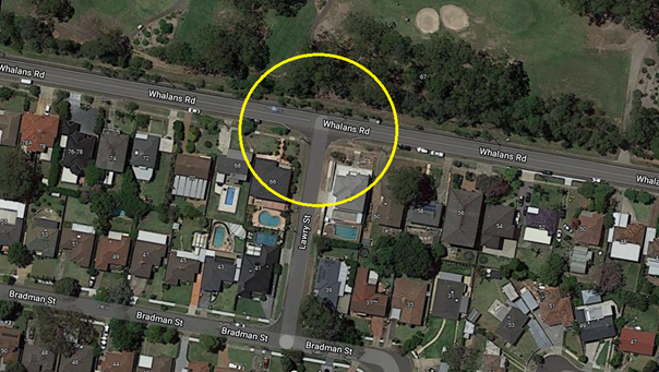
Council has received a
request from a local resident to improve road safety and install a roundabout
at the intersection of Whalans Road and Lawry Street.
The resident has alleged
that heavy traffic on Whalans Road makes it difficult to exit out of Lawry
Street. Also, it is alleged that vehicles park too close to the intersection.
Council’s Officers
have investigated the request and found that based on the latest crash data,
there were no reported crashes related to intersection crashes at this
intersection.
Council officers have
also investigated the request for a roundabout. Council’s investigation
revealed that a roundabout cannot be provided at this intersection in
accordance with the current standards and guidelines.
Further investigation
revealed that there are no ‘No Stopping’ signs at this intersection
and if vehicle/s park too close to the intersection then the sight distance
would be restricted.
The installation of
‘No Stopping’ signs would strengthen the Road Rules requirement and
stop vehicles from parking too close to the intersection and would improve
safety for all road users. In addition, the installation of ‘BB’ centre
line marking on Lawry Street will assist to keep traffic flow on the left-hand
side of the travelling lane.
The ‘No
Stopping’ signs on the Lawry Street approach are installed at 13m. This
will assist traffic to pass a parked vehicle without crossing the 10m
‘BB’ centre line in the narrow street. The ‘No
stopping’ signs on Whalans Road are installed to match the existing edge
line marking.
1. Plan –
Whalans Road and Lawry Street, Greystanes – Proposed ‘No
Stopping’ parking restriction and BB line marking.
2 March 2022
Item
No: CTC-22-007
CLUCAS ROAD
AND AMY STREET, REGENTS PARK – PROPOSED ‘NO STOPPING’ SIGNS
Responsible
Division: Environment
& Planning
Officer: Engineering
Administration Officer
File
Number: HC-24-01-3/02
Electorate: Auburn
Police Area
Command (PAC): Auburn
Council has received a complaint
from a local resident regarding road safety concerns at the intersection of
Clucas Road and Amy Street, Regents Park.
This report outlines the outcome
of the investigation into this matter.
|
The Traffic Committee recommends:
1. The
proposed installation of ‘No Stopping’ zones at the intersection
of Clucas Road and Amy Street, Regents Park in accordance with the attached
plan be approved.
i)
2. The
adjacent residents be notified of the outcome generally.
|
Amy Street is a regional
road that runs in an east-west direction with a speed limit of 50 km/hr. it has
a width of approximately 12.6m and parking is permitted on both sides of the
road unless signposted. Amy Street has ‘BB’ centre lines and edge
lines marked.
Clucas Road is a local
road that runs in a north-south direction with a posted speed limit of 50
km/hr. It has a width of approximately 7m and parking is permitted on both
sides of the road in accordance with Road Rules unless signposted.
Amy Street and Clucas
Road form a T-junction intersection with priority to Amy Street (by default).
The latest accident data
at this intersection indicated that there were no reported crashes at this
intersection in the last 5 years.
Council has received a complaint
from a local resident regarding road safety concerns at this intersection. The
resident has alleged that vehicles park very close to the intersection and
restrict traffic flow.
The map below shows the
intersection of Amy Street and Clucas Road, Regents Park.
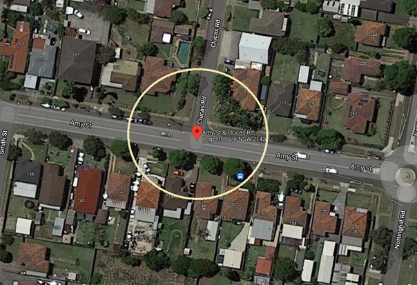
Council’s Officers
have investigated the request and found that there are no ‘No
Stopping’ signs at this intersection. The traffic flow would be
restricted if vehicles park too close to the intersection. Also, any parked
vehicle close to the intersection will cause safety issues for vehicles exiting
from Clucas Road into the regional road.
The installation of
‘No Stopping’ signs would strengthen the Road Rules requirement,
stop vehicles from parking too close to the intersection and would improve
safety for all road users. In addition, the installation of ‘BB’
centre line marking on Clucas Road will assist to keep traffic flow on the
left-hand side of the travelling lane.
The ‘No
Stopping’ signs on the Clucas Road approach are installed at 13m. This
will assist traffic to pass a parked vehicle without crossing the 10m
‘BB’ centre line in the narrow street.
1. Plan –
Amy Street and Clucas Road, Regents Park – Proposed ‘No
Stopping’ signs
2 March 2022
Item
No: CTC-22-008
FRANCES STREET
AND BENSON STREET, SOUTH WENTWORTHVILLE – PROPOSED ‘NO STOPPING’
SIGNS AND ‘BB’ LINEMARKING
Responsible
Division: Environment
& Planning
Officer: Engineering
Administration Officer
File
Number: HC-24-01-3/02
Electorate: Granville
Police Area
Command (PAC): Cumberland
Council has received a complaint
from a local resident regarding road safety concerns at the intersection of
Frances Street and Benson Street, South Wentworthville.
This report outlines the outcome
of the investigation into this matter.
|
The Traffic Committee recommends:
1. The
proposed installation of ‘No Stopping’ zones and ‘BB’
line marking at the intersection of Frances Street and Benson Street, South
Wentworthville in accordance with the attached plan be approved.
i)
2. The
adjacent residents be notified of the outcome generally.
|
Frances Street is a local
road that runs in a north-south direction with a speed limit of 50 km/hr. It
has a width of approximately 12m and parking permitted on both sides of the
road unless signposted.
Benson Street is a local
road that runs in an east-west direction with a speed limit of 50 km/hr. It has
a width of approximately 7.3m and parking is permitted on both sides of the
road in accordance with Road Rules unless signposted. Benson Street forms the
northern boundary of Pitt Park.
Frances Street and Benson
Street form a T-junction intersection with priority control Frances Street (by
default).
The latest accident data
at this intersection indicated that there were no reported accidents at this
intersection in the last 5 years.
Council has received a complaint
from a local resident regarding road safety concerns at this intersection. The
resident has alleged that vehicles park very close to the intersection and
restrict traffic flow and compromise safety of all road users including park
users.
The map below shows the
intersection of Frances Street and Benson Street.
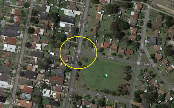
Council’s Officers
have investigated the request and found that there are no ‘No
Stopping’ signs installed at this intersection. The traffic flow would be
restricted if vehicles park too close to the intersection especially in the
narrow Benson Street.
Therefore, the
installation of ‘No Stopping’ signs and ‘BB’ centre
line marking at the intersection would improve road safety for all road users
at this intersection.
The ‘No Stopping’
signs on the Benson Street approach are installed at 13m. This will assist
traffic to pass a parked vehicle without crossing the 10m ‘BB’
centre line in the narrow street.
1. Plan –
Frances Street and Benson Street, South Wentworthville – Proposed
‘No Stopping’ signs and installation of BB line marking.
2 March 2022
Item
No: CTC-22-009
OCTAVIA STREET
AND AURELIA STREET, TOONGABBIE – PROPOSED ‘NO STOPPING’ SIGNS
AND ‘BB’ LINE MARKING
Responsible
Division: Environment
& Planning
Officer: Engineering
Administration Officer
File
Number: HC-24-01-3/02
Electorate: Prospect
Police Area
Command (PAC): Cumberland
Council has received a complaint
from a local resident regarding road safety concerns at the intersection of
Octavia Street and Aurelia Street, Toongabbie.
This report outlines the outcome
of the investigation into this matter.
|
The Traffic Committee recommends:
1. The
proposed installation of ‘No Stopping’ zones and ‘BB’
line marking at the intersection of Octavia Street and Aurelia Street,
Toongabbie in accordance with the attached plan be approved.
i)
2. The
adjacent residents be notified of the outcome generally.
|
Ocatvia Street is a local
road that runs in an east-west direction with a speed limit of 50 km/hr. It has
a width of approximately 12.8m and parking is permitted on both sides of the
road in accordance with Road Rules unless signposted.
Aurelia Street is a local
road that runs in a north-south direction with a posted speed limit of 50
km/hr. It has a width of approximately 12.6m and parking permitted on both
sides of the road in accordance with Road Rules unless signposted.
Octavia Street and
Aurelia Street form a T-junction intersection with priority to Octavia Street
(by default).
The latest accident data
at this intersection indicated that there was one reported accident at this
intersection in the last 5 years.
Council has received a complaint
from a local resident regarding road safety concerns at this intersection. The
resident has alleged that vehicles park very close to the intersection and
restrict traffic flow.
The map below shows the
intersection of Octavia Street and Aurelia Street.
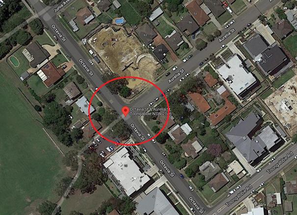
Council’s Officers
have investigated the request and found that there are ‘No
Stopping’ signs on Aurelia Street but there are no ‘No
Stopping’ signs on Octavia Street.
The traffic flow would be
restricted if vehicles park too close to the intersection particularly on
Ocatvia Street.
Therefore, the
installation of ‘No Stopping’ signs on Octavia Street at the
intersection with Aurelia Street would improve safety of all road users. In
addition, it is proposed to install ‘BB’ centre line marking in
Aurelia Street and Octavia Street to keep traffic flow on the left-hand side of
the centre lines.
The proposed intersection
treatment would improve road safety for all road users at this intersection
1. Plan –
Ocatvia Street and Aurelia Street, Toongabbie – Proposed ‘No
Stopping’ signs and installation of BB line marking.
2 March 2022
Item
No: CTC-22-010
OCTAVIA STREET
AND TOONGABBIE ROAD, TOONGABBIE – PROPOSED ‘NO STOPPING’
SIGNS AND ‘BB’ LINEMARKING
Responsible
Division: Environment
& Planning
Officer: Engineering
Administration Officer
File
Number: HC-24-01-3/02
Electorate: Prospect
Police Area
Command (PAC): Cumberland
Council has received a complaint
from a local resident regarding road safety concerns at the intersection of
Octavia Street and Toongabbie, Toongabbie.
This report outlines the outcome
of the investigation into this matter.
|
The Traffic Committee recommends:
1. The
proposed installation of ‘No Stopping’ zones and ‘BB’
line marking at the intersection of Octavia Street and Toongabbie Road,
Toongabbie in accordance with the attached plan be approved.
i)
2. The
adjacent residents be notified of the outcome generally.
|
Octavia Street is a local
road that runs in an east-west direction with a speed limit of 50 km/hr. It has
a width of approximately 12.8m and parking is permitted on both sides of the
road in accordance with Road Rules unless signposted.
Toongabbie Road section
at Octavia Street is a local road that runs in a north-south direction with a
posted speed limit of 50 km/hr at this section of road. It has a width of
approximately 12.2m and parking is permitted on both sides of the road unless
signposted.
Octavia Street and
Toongabbie Road form a T-junction intersection with priority to Toongabbie Road
(by default).
The latest accident data
at this intersection indicated that there were two reported accidents at this
intersection in the last 5 years.
Council has received a complaint
from a local resident regarding road safety concerns at this intersection. The
resident has alleged that vehicles park very close to the intersection and
restrict traffic flow.
The map below shows the
intersection of Octavia Street and Toongabbie Road.
Council’s Officers
have investigated the request and found that there were ‘No
Stopping’ signs on Toongabbie Road but the signs were missed during the
recent constructions nearby and there are no ‘No Stopping’ signs on
Octavia Street.
The traffic flow would be
restricted if vehicles park too close to the intersection.
There is a pedestrian
refuge on Toongabbie Road south of Octavia Street. The statutory ‘No
Stopping’ signs at the refuge have not been installed and or missing.
Therefore, the
installation of missing and new ‘No Stopping’ signs at the
intersection would improve safety of all road users. In addition, it is
recommended to install ‘BB’ centre line marking in Octavia Street
to keep traffic flow on the left-hand side of the travelling lane.
The proposed intersection
treatment would improve road safety for all road users at this intersection
1. Plan –
Ocatvia Street and Toongabbie Road, Toongabbie – Proposed ‘No
Stopping’ signs and installation of BB line marking.
2 March 2022
Item
No: CTC-22-011
WARWICK ROAD
AND LEEDS STREET, MERRYLANDS – PROPOSED ‘NO STOPPING’ SIGNS
AND ‘BB’ LINEMARKING
Responsible
Division: Environment
& Planning
Officer: Engineering
Administration Officer
File
Number: HC-24-01-3/02
Electorate: Granville
Police Area
Command (PAC): Cumberland
Council has received a complaint
from a local resident regarding road safety concerns at the intersection of
Warwick Road and Leeds Street, Merrylands.
This report outlines the outcome
of the investigation into this matter.
|
The Traffic Committee recommends:
1. The
proposed installation of ‘No Stopping’ signs and ‘BB’
line marking at the intersection of Warwick Road and Leeds Street, Merrylands
in accordance with the attached plan be approved.
i)
2. The
adjacent residents be notified of the outcome generally.
|
Warwick Road is a local
road that runs in a north-south direction with a speed limit of 50 km/hr. It
has a width of approximately 10.5m and parking permitted on both sides of the
road in accordance with Road Rules unless signposted.
Leeds Street is a local
road that runs in an east-west direction with a speed limit of 50 km/hr. It has
a width of approximately 10.5m and parking is permitted on both sides of the road
in accordance with Road Rules unless signposted.
Warwick Road and Leeds
Street form a cross junction intersection with priority control on Warwick Road
and ‘Give-Way’ signs on Leeds Street.
The latest accident data
at this intersection indicated that there were three reported accidents at this
intersection in the last 5 years.
Council has received a complaint
from a local resident regarding road safety concerns at this intersection. The
resident has alleged that vehicles speeding at the intersection and stopping at
existing ‘Give-Way’ signs.
The map below shows the
intersection of Warwick Road and Leeds Street.
Council’s Officers
have investigated the request and found that there are no ‘No
Stopping’ signs installed at this intersection.
Therefore, it is proposed
to the install statutory 10m ‘No Stopping’ zones at this
intersection to strengthen the Road Rules requirement and improve sight
distance.
It is also proposed
to install ‘BB’ centre lines at the intersection to keep traffic
flows on the left-hand side of the travelling lane.
The proposed intersection
treatment would improve road safety for all road users at this intersection.
1. Plan –
Warwick Road and Leeds Street, Merrylands – Proposed ‘No
Stopping’ signs and BB line marking.
2 March 2022
Item
No: CTC-22-012
ELIZABETH
STREET, GUILDFORD AT THE INTERSETION OF CECIL STREET– PROPOSED ‘NO
STOPPING’ RESTRICTIONS AND LINE MARKING
Responsible
Division: Environment
& Planning
Officer: Engineering
Administration Officer
File
Number: HC-24-01-3/02
Electorate: Granville
Police Area
Command (PAC): Cumberland
Council has received concerns from a resident requesting for
intersection treatment at the intersection of Elizabeth Street and Cecil
Street, Guildford. The resident has alleged that vehicles exiting from Cecil
Street fail to give way at this intersection.
This report outlines the outcome
of the investigation into this matter
|
The Traffic Committee recommends:
1. The
installation of ‘No Stopping’ signs and ‘BB’ centre
line at the intersection of Elizabeth Street and Cecil Street, Guildford in
accordance with the attached plan be approved.
i)
2. The
affected residents be notified of the outcome.
|
Elizabeth Street is a local road that runs in an east-west
direction with a speed limit of 50 km/h. It has a width of approximately 12m
and parking is permitted on both sides of the road unless signposted.
Cecil Street is a local road that runs in a north-south
direction with a speed limit of 50 km/h. it has a width of approximately 12m
and parking is permitted on both sides of the road unless signposted.
Elizabeth Street and Cecil Street form a T-junction with
priority to Elizabeth Street. The intersection does not have any ‘Give
Way’ signs installed; however, default priority applies here with
Elizabeth Street having priority.
The map below shows the intersection.
Figure 1 –
Locality Plan
A review of the available accident data indicated that there
was one (1) recorded accident at the intersection of Elizabeth Street and Cecil
Street in the last five years ending in March 2021.
The intersection satisfies the sight distance requirements
and due to low crash record, any intersection control sign such as ‘Give
Way’ or ‘Stop’ is not warranted. The T-intersection rule
applies. It is proposed to install ‘BB’ centre lines on Cecil
Street and Elizabeth Street which will assist to bring awareness of the
intersection.
A site inspection indicated that vehicles are parking within
10 metres from the intersection. The installation of 10m ‘No
Stopping’ signs would strengthen the Road Rules requirements and stop
vehicles from parking too close to the intersection.
Therefore, it is proposed to
provide ‘No Stopping’ signs and ‘BB’ centre line
marking at the intersection as per attached plan.
1. Plan –
Elizabeth Street at the intersection of Cecil Street Guildford –Proposed
‘No Stopping’ parking restrictions and ‘BB’ centre line
marking.
2 March 2022
Item
No: CTC-22-013
ELIZABETH
STREET, GUILDFORD AT THE INTERSETION OF O’NEILL STREET – PROPOSED
INTERSECTION TREATMENTS
Responsible
Division: Environment
& Planning
Officer: Engineering
Administration Officer
File
Number: HC-24-01-3/02
Electorate: Granville
Police Area
Command (PAC): Cumberland
Council has received concerns from a resident requesting for
intersection treatment at the intersection of Elizabeth Street and O’Neil
Street, Guildford. The resident has alleged that vehicles exiting from
O’Neil Street fail to give way at this intersection.
This report outlines the outcome of the investigation into
this matter.
|
The Traffic Committee recommends:
1. The
installation of ‘No Stopping’ signs at the intersection of
Elizabeth Street and O’Neill Street in accordance with the attached
plan be approved.
i)
2. The
affected residents be notified of the outcome.
|
Elizabeth Street is a local road that runs in an east-west
direction with a posted speed limit of 50 km/h. It has a width of approximately
12m and parking is permitted on both sides of the road unless signposted.
O’Neill Street is a local road that runs in a
north-south direction with a speed limit of 50 km/h and it has a width of
approximately 12m and parking is permitted on both sides of the road unless
signposted.
Elizabeth Street and O’Neill Street form staggered
intersection with priority to Elizabeth Street. ‘Give Way’ signs
and line marking are provided on O’Neill Street (Figure 1).
Figure 1 –
Locality Plan
A review of the Centre for Road Safety Accident database
indicated that there were no reported accidents at the intersection of
Elizabeth Street and O’Neill Street in the last five years ending March
2021.
Site observations indicated that vehicles occasionally park
close to the intersection. It is proposed to install “No Stopping’
signs at the intersection. The installation of ‘No Stopping’ signs
would strengthen the Road Rules requirements and stop vehicles from parking too
close to the intersection. It would also improve sight distance requirements.
The attached plan shows details of the proposal.
1. Plan –
Elizabeth Street, Guildford at the intersetion of O’Neill Street –
proposed intersection treatment.
2 March 2022
Item
No: CTC-22-014
PENDLE WAY,
PENDLE HILL – RELOCATE EXISTING PEAK PERIOD ‘NO STOPPING’
SIGN
Responsible
Division: Environment
& Planning
Officer: Engineering
Administration Officer
File
Number: HC-24-03-21
Electorate: Prospect
Police Area
Command (PAC): Cumberland
Council has received a request
from a local resident for the relocation of the existing peak period ‘No Stopping,
6:30am – 9:30am and 3:30pm – 6:30pm’ located in front of 11
Pendle Way, Pendle Hill.
This report outlines the outcome
of a review into this matter.
|
The Traffic Committee recommends the proposed
relocation of existing ‘No Stopping, 6:30am – 9:30am and 3:30pm
– 6:30pm’ sign located in front of 11 Pendle Way, Pendle Hill in
accordance with the attached plan be approved.
|
Council has received a
request from a local resident for the for the relocation of existing peak period
‘No Stopping, 6:30am – 9:30am & 3:30pm – 6:30pm’
located in front of 11 Pendle Way, Pendle Hill.
The resident has alleged
that vehicles park very close to the driveway (between driveway and ‘No
Stopping’ sign outside peak period) and restrict sight distance. This is
due to the unrestricted parking area is already parked up to the sign. The sign
is on the eastern side of Pendle Way on the approach to the signalised
intersection of Great Western Highway and Pendle Way.
Council’s Officers
have investigated the request and found that the existing peak period ‘No
Stopping’ sign is located 2.5m from the driveway. If a vehicle parked
within this gap between driveway and ‘No Stopping’ sign, then the
driveway will be blocked. There is also full time ‘No Stopping’
sign near the signalised intersection.
The increased peak period
‘No Stopping’ zone on the signalised approach would help the
operation of the traffic signals and will not have any adverse
impact.
Therefore, to resolve illegal
parking issue, it is proposed to relocate existing part time ‘No
Stopping, 6:30am – 9:30am & 3:30pm – 6:30pm’ sign by 9m
to the north from the current location (i.e., at the property boundary line
between number 11 and 13 Pendle Way, Pendle Hill).
No consultation is required since
the request was made by the adjacent property owner.
1. Plans –
Pendle Way, Pendle Hill – Proposed relocation of traffic sign.
2 March 2022
Item
No: CTC-22-015
VAUGHAN STREET
AND AUBURN ROAD, AUBURN – PROPOSED INTERSECTION TREATMENT
Responsible
Division: Environment
& Planning
Officer: Engineering
Administration Officer
File
Number: HC-24-01-3/02
Electorate: Auburn
Police Area
Command (PAC): Auburn
Council has received a request from a resident requesting
for improving safety at the intersection of Vaughan Street and Auburn Road,
Auburn.
This report outlines the outcome of the investigation into
this matter.
|
The Traffic Committee recommends:
1. The
installation of ‘No Stopping’ signs at the intersection of
Vaughan Street and Auburn Road, Auburn in accordance with the attached plan
be approved.
i)
2. The
installation of ‘Stop Ahead’ warning signs in Auburn Road near
the intersection of Vaughan Street in accordance with the attached plan be
approved.
ii)
3. The
affected residents be notified of the outcome.
|
Vaughan Street is a classified regional road that runs in an
east-west direction with a posted speed limit of 50 km/h. This section of Vaughan
Street has a width of approximately 12.5m with edge lines and centre line
marking. Parking is permitted on both sides of the road unless signposted.
Auburn Road is a local road that runs in a north-south
direction with a posted speed limit of 50 km/h. it has a width of approximately
12.5m and parking is permitted on both sides of the road unless signposted.
Vaughan Street and Auburn Road form an intersection with
priority to Vaughan Street. Stop signs and line marking with raised thresholds
and kerb blister islands exist in Auburn Road at the intersection of Vaughan
Street. A refuge island also exists in Vaughan Street east of Auburn Road
(Figure 1).
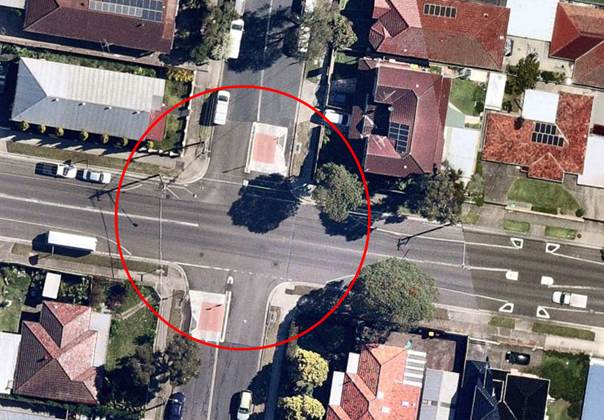
Figure 1 –
Locality Plan
A review of the recent accident data indicates that there
were six (6) recorded accidents (2 Non-Casualty and 4 Injured accidents) at the
intersection of Vaughan Street and Auburn Road in the last five years
(2016-2021) ending in March 2021.
A review of the sight distance at this intersection found
that when vehicles are parked within 10 metres from the intersection, the sight
distance for motorists turning from Auburn Road into Vaughan Street is
restricted.
There was a recent accident at this intersection which
necessitated an investigation into the safety of this intersection.
Site inspection indicated that there are no ‘No
Stopping’ signs at this intersection, however, the edge line marking
defined the extent of parking.
It is proposed to provide ‘No Stopping’ signs at
this intersection as per the attached plan. The installation of ‘No
Stopping’ signs would strengthen the Road Rules requirements and stop
vehicles from parking too close to the intersection. It would also improve
sight distance requirements. The ‘No Stopping’ signs on Vaughan
Street are proposed at 14m to match the existing edge line marking.
In order to improve safety, it is proposed to install a
‘Stop Ahead’ warning sign on both approaches of Auburn Road
approaching to the intersection as per the attached plan.
The resident also suggested that vehicles in Auburn Road
failed to stop and give way to the traffic in Aburn Road and requested No Right
Turn restrictions at this intersection.
The request of No Right Turn restrictions cannot be
supported as it will transfer the issue to the next intersection and will have
a significant impact on Council’s local road network and residents.
1. Plan –
Vaughan Street at Auburn Road, Auburn – Proposed ‘No
Stopping’ parking restrictions and ‘Stop Ahead’ warning sign.
2 March 2022
Item
No: CTC-22-016
HOLDSWORTH
STREET, MERRYLANDS AT PRICE STREET– ROAD SAFETY CONCERNS
Responsible
Division: Environment
& Planning
Officer: Engineering
Administration Officer
File
Number: HC-24-01-3/02
Electorate: Granville
Police Area
Command (PAC): Cumberland
Council has received safety
concerns from a local resident at the intersection of Holdsworth Street and
Price Street, Merrylands.
This report outlines the outcome
of the investigation into this matter.
|
The Traffic Committee recommends:
1. The
installation of ‘No Stopping’ signs and ‘BB’ centre
line at the intersection of Holdsworth Street and Price Street, Merrylands in
accordance with the attached plan be approved.
i)
2. The
affected residents be notified of the outcome.
|
Council has received safety
concerns from a local resident at the intersection of Holdsworth Street and
Price Street, Merrylands.
Holdsworth Street is a local road
runs in a north-south direction between Merrylands Road and Matthew Street. The
road is approximately 780m long and 10.2m wide. The street has a default speed
limit of 50km/h. Parking is permitted on both sides of the road unless
signposted.
Price Street is a local road runs
in an east-west direction between Fowler Road and Chetwynd Road. The road is
approximately 370m long and 10.3m wide. The speed limit is 50km/h and parking
are permitted on both sides of the road unless signposted.
Holdsworth Street and Price Street form an intersection with
priority to Price Street. ‘Give Way’ signs and line marking exist
in Holdsworth Street at the intersection.
The map below shows the
location of the intersection.

Traffic counts were undertaken on Holdsworth Street
approximately 20m south of Price Street and on Price Street approximately 35m
East of Holdsworth Street in November 2021.
The results of the traffic counts indicated the following:
Traffic count
Data on Holdsworth Street:
Average Daily Traffic (ADT) = 437 vehicles/day
85th percentile speed = of 43 km/h
Average Peak Hour Traffic =
AM – 49 Veh/hr & PM – 46 Veh/hr
Mean (average) vehicle speed = 37 km/h
Traffic count
Data on Price Street:
Average Daily Traffic (ADT) = 1,743 vehicles/day
85th percentile speed = of 53 km/h
Average Peak Hour Traffic =
AM – 157 Veh/hr & PM – 149 Veh/hr
Mean (average) vehicle speed = 46 km/h
The traffic count indicated that the recorded 85th
percentile speeds on the approaches to the intersection were 43km/h and 53
km/hr. Particularly the approach speed on Holdsworth Street approaching
‘Give way’ control at Price Street is 43 km/hr which is
significantly lower than the speed limit of 50km/hr.
The peak hour traffic volumes from the traffic count data
show that they are not significantly high and gaps will be available in Price
Street traffic to allow Holdsworth Street traffic to enter the intersection. A
peak hour traffic volume of 157 vehicles indicates that on average less than 3
vehicles pass the intersection (in both directions) every minute.
A review of the Centre for Road Safety Accident database
indicated that there were six (6) reported accidents at this intersection in
the last five years ending in June 2021.
Due to the large number of reported accidents, Council staff
have nominated this location for funding for improvements under the Safer Roads
Program.
In the interim, it is proposed to provide ‘No
Stopping’ signs and 20m ‘BB’ centre line marking at the
intersection to improve safety as per the attached plan.
1. 1. Plan
– Holdsworth Street, Merrylands at Price Street –Proposed ‘No
Stopping’ parking restrictions with ‘BB’ centre line marking.
2 March 2022
Item
No: CTC-22-017
BERITH ROAD,
GREYSTANES – ROAD SAFETY CONCERNS
Responsible
Division: Environment
& Planning
Officer: Engineering
Administration Officer
File
Number: HC-24-01-3/02
Electorate: Prospect
Police Area
Command (PAC): Cumberland
Council has received a request
from a local resident for the installation of traffic calming devices on Berith
Road, Greystanes due to speeding concerns.
This report outlines the outcome
of the investigation into this matter.
|
The Cumberland Traffic Committee recommends the
installation of traffic calming devices on Berith Road, Greystanes not be
supported.
|
Council has received a request
from residents for the installation of traffic calming devices on Berith Road,
Greystanes due to speeding concerns.
Berith Road is a local road runs
in a north-south direction between M4 and Old Prospect Road. The end near M4
Motorway is a cul-de-sac end. The road is approximately 310m long and 9.5m
wide. The speed limit is 50km/h and parking is permitted on both sides of the
road unless signposted.
The latest Centre for
Road Safety accident database indicated that there were no reported accidents
in the 5 years up to June 2021 in Berith Road.
Council’s Officers
have investigated the request for the installation of traffic calming devices
on Berith Road in accordance with Council’s Local Area Traffic Management
(LATM) Policy.
The map below shows the
location of Berith Road.
A traffic count was
undertaken on Berith Road in November 2021. The approximate location of the
traffic count is shown in red in the map above.
The results of the
traffic count indicated the following:
Traffic count
Data on Berith Road:
Average Daily Traffic (ADT) = 459 vehicles/day
85th percentile speed = of 53.8 km/h
Mean (average) vehicle speed = 44.5 km/h
The results of the
traffic counts, recorded crashes etc. were used in the assessment to determine
the need for the installation of traffic calming devices on Berith Road in
accordance with the criteria set out in Council’s Local area Traffic
Management Policy (LATM) Policy.
The LATM assessments are
summarised in the tables below:
Table 1 – Berith
Road - LATM Assessment Points
|
Criteria
|
Maximum Score
|
Score Achieved
|
|
Traffic Study Data
|
45
|
0
|
|
Crash warrant in the
last 5 years
|
15
|
0
|
|
Road Characteristics
|
35
|
10
|
|
Community Support &
other factors
|
5
|
5
|
|
Total
|
100
|
15
|
Table 2 – Berith
Road – Action
|
Criteria
|
Action
|
|
>75
|
Report to TC with a
recommendation of providing traffic calming devices
|
|
61-75
|
Report to TC and
discuss possibility of providing traffic calming devices
|
|
41-60
|
Council to review
traffic data in 6 months
|
|
25-40
|
Monitor street and
review traffic data after 12 months
|
|
<25
|
Do Nothing
|
|
Speed
|
That regardless of the
total points scored, should the 85th percentile speed exceed the posted speed
limit by 5 km/h, the street be referred to the NSW Police for monitoring
and/or enforcement.
|
The traffic count indicated
that the recorded 85th percentile speed was 53.8km/h which is within
acceptable limits.
Based on the above assessment,
traffic calming devices are not warranted in Berith Road, Greystanes.
Nil
2 March 2022
Item
No: CTC-22-018
BRADMAN
STREET, MERRYLANDS – ROAD SAFETY CONCERNS
Responsible
Division: Environment
& Planning
Officer: Engineering
Administration Officer
File
Number: HC-24-01-3/02
Electorate: Granville
Police Area
Command (PAC): Cumberland
Council has received a request
from a local resident for the installation of traffic calming devices on
Bradman Street, Merrylands due to speeding concerns.
This report outlines the outcome
of the investigation into this matter.
|
The Cumberland Traffic Committee recommends the
installation of traffic calming devices on Bradman Street, Merrylands not be
supported.
|
Council has received a request
from residents for the installation of traffic calming devices on Bradman
Street, Merrylands due to speeding concerns.
Bradman Street is a local road
runs in an east-west direction between Woodville Road and Excelsior Street. The
road is approximately 370m long and 12.5m wide. The speed limit is 50km/h and
parking is permitted on both sides of the road unless signposted.
Council’s Officers
have investigated the request for the installation of traffic calming devices
on Bradman Street in accordance with Council’s Local Area Traffic
Management (LATM) Policy.
The latest Centre for
Road Safety accident data indicated that there were no reported accidents in
Bradman Street in the 5 years up to June 2021.
The map below shows the
location of Bradman Street.
A traffic count was
undertaken on Bradman Street in November 2021. The traffic count location is
shown in red on the map above.
The results of the
traffic count indicated the following:
Traffic count
Data on Bradman Street:
Average Daily Traffic (ADT) = 571 vehicles/day
85th percentile speed = of 55 km/h
Mean (average) vehicle speed = 46 km/h
The results of the
traffic counts, recorded crashes etc. were used in the assessment to determine
the need for the installation of traffic calming devices on Bradman
Street in accordance with the criteria set out in Council’s Local
area Traffic Management Policy (LATM) Policy.
The LATM assessments are
summarised in the tables below:
Table 1 – Bradman
Street - LATM Assessment Points
|
Criteria
|
Maximum Score
|
Score Achieved
|
|
Traffic Study Data
|
45
|
10
|
|
Crash warrant in the last
5 years
|
15
|
0
|
|
Road Characteristics
|
35
|
8
|
|
Community Support &
other factors
|
5
|
5
|
|
Total
|
100
|
23
|
Table 2 – Bradman
Street – Action
|
Criteria
|
Action
|
|
>75
|
Report to TC with a
recommendation of providing traffic calming devices
|
|
61-75
|
Report to TC and discuss
possibility of providing traffic calming devices
|
|
41-60
|
Council to review
traffic data in 6 months
|
|
25-40
|
Monitor street and
review traffic data after 12 months
|
|
<25
|
Do Nothing
|
|
Speed
|
That regardless of the
total points scored, should the 85th percentile speed exceed the posted speed
limit by 5 km/h, the street be referred to the NSW Police for monitoring
and/or enforcement.
|
The traffic count
indicated that the recorded 85th percentile speed was 55km/h which
is within acceptable limits.
Based on the above
assessment, traffic calming devices are not warranted in Bradman Street,
Merrylands.
Nil
2 March 2022
Item
No: CTC-22-019
WARATAH
STREET, GRANVILLE – ROAD SAFETY CONCERNS
Responsible
Division: Environment
& Planning
Officer: Engineering
Administration Officer
File
Number: HC-24-01-3/02
Electorate: Granville
Police Area
Command (PAC): Cumberland
Council has received a request
from a local resident for the installation of traffic calming devices on
Waratah Street, Granville due to speeding concerns.
This report outlines the outcome
of the investigation into this matter.
|
The Cumberland Traffic Committee recommends the installation
of traffic calming devices on Waratah Street, Granville not be supported.
|
Council has received a request
from a local resident for the installation of traffic calming devices on
Waratah Street, Granville due to speeding concerns.
Waratah Street is a local road
running in a north-south direction between Union Street and Randle Street. The
road is approximately 190m long and 9.5m wide. The speed limit is 50km/h and
parking is permitted on both sides of the road in accordance with Road Rules.
The latest Centre for
Road Safety accident data indicated that there were no reported accidents on
Waratah Street in the 5 years up to June 2021.
Council’s Officers have investigated the request for
the installation of traffic calming devices on Waratah Street in accordance
with Council’s Local Area Traffic Management (LATM) Policy.
The map below shows the location of Waratah Street,
Granville.
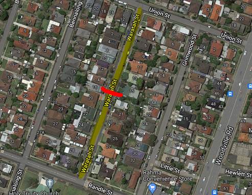
A traffic count was undertaken at the middle of Waratah
Street in December 2021. The traffic count location is marked in red in the map
above.
The results of the traffic count indicated the following:
Traffic count
Data on Waratah Street:
Average Daily Traffic (ADT) = 262 vehicles/day
85th percentile speed = of 47.7 km/h
Mean (average) vehicle speed = 37 km/h
The results of the traffic counts, recorded crashes etc.
were used in the assessment to determine the need for the installation of
traffic calming devices on Waratah Street in accordance with the criteria set
out in Council’s Local area Traffic Management Policy (LATM) Policy.
The LATM assessments are summarised in the tables below:
Table 1 – Waratah
Street - LATM Assessment Points
|
Criteria
|
Maximum Score
|
Score Achieved
|
|
Traffic Study Data
|
45
|
0
|
|
Crash warrant in the
last 5 years
|
15
|
0
|
|
Road Characteristics
|
35
|
9
|
|
Community Support &
other factors
|
5
|
5
|
|
Total
|
100
|
14
|
Table 2 – Waratah
Street – Action
|
Criteria
|
Action
|
|
>75
|
Report to TC with a
recommendation of providing traffic calming devices
|
|
61-75
|
Report to TC and
discuss possibility of providing traffic calming devices
|
|
41-60
|
Council to review
traffic data in 6 months
|
|
25-40
|
Monitor street and
review traffic data after 12 months
|
|
<25
|
Do Nothing
|
|
Speed
|
That regardless of the
total points scored, should the 85th percentile speed exceed the posted speed
limit by 5 km/h, the street be referred to the NSW Police for monitoring
and/or enforcement.
|
The traffic count indicated that the recorded 85th
percentile speed was 48km/h which is below the speed limit of the street.
Based on the above assessment, traffic calming devices are
not warranted in Waratah Street, Granville.
Nil
2 March 2022
Item
No: CTC-22-020
BERRY STREET,
REGENTS PARK – ROAD SAFETY CONCERNS
Responsible
Division: Environment
& Planning
Officer: Engineering
Administration Officer
File
Number: HC-24-01-3/02
Electorate: Auburn
Police Area
Command (PAC): Auburn
Council has
received a request from a local resident for the installation of traffic
calming devices on Berry Street, Regents Park due to speeding concerns.
This report outlines the outcome
of the investigation into this matter.
|
The Traffic Committee recommends the installation of traffic
calming devices on Berry Street, Regents Park not be supported.
|
Berry
Street is a local road that runs in an east-west direction between Kingsland
Road and Yukka Road. The speed limit is 50km/h and parking is permitted on both
sides of the road unless signposted. Berry Street is approximately 275m long
and 12.5m wide.
Council has received a
request from a local resident for the installation of traffic calming devices
on Berry Street due to speeding concerns.
The latest Centre for
Road Safety accident data on Berry Street indicated that there were no reported
accidents in the 5 years up to June 2021.
Council officers have
investigated the request in accordance with Council’s Local Area Traffic
Management (LATM) Policy.
The map below shows the
location of Berry Street, Regents Park.
A traffic count was
undertaken on Berry Street in November 2021. The location of the traffic count
is marked in red on the map above. The result of the traffic count indicated
the following:
Traffic count
Data on Berry St, Regents Park:
Average Daily Traffic (ADT) = 323 vehicles/day
Average Peak Hour traffic: AM 23 veh/hr & PM 36 veh/hr
85th percentile speed = 50.0 km/h
Mean (average) vehicle speed = 40.7 km/h
The result of the traffic
count, reported crashes etc. were used in the assessment to determine the need
for the installation of traffic calming devices on Berry Street in accordance
with the criteria set out in Council’s Local area Traffic Management
Policy (LATM) Policy. The LATM assessment is summarised in the tables below:
Table 1 – Berry St,
Regents Park - LATM Assessment Points
|
Criteria
|
Maximum
Score
|
Score
Achieved
|
|
Traffic Study Data
|
45
|
0
|
|
Crash warrant in the
last 5 years
|
15
|
0
|
|
Road Characteristics
|
35
|
12
|
|
Community Support &
other factors
|
5
|
5
|
|
Total
|
100
|
17
|
Table 2 – Berry St,
Regents Park - LATM – Action
|
Criteria
|
Action
|
|
>75
|
Report to TC with a
recommendation of providing traffic calming devices
|
|
61-75
|
Report to TC and
discuss possibility of providing traffic calming devices
|
|
41-60
|
Council to review
traffic data in 6 months
|
|
25-40
|
Monitor street and
review traffic data after 12 months
|
|
<25
|
Do Nothing
|
|
Speed
|
That regardless of the
total points scored, should the 85th percentile speed exceed the posted speed
limit by 5 km/h, the street be referred to the NSW Police for monitoring
and/or enforcement.
|
Based on the traffic
count, the recorded 85th percentile speed was 50.0 km/h which is
within acceptable limits.
Based on the LATM
assessment, traffic calming devices are not warranted in Berry Street.
It was also alleged by
the resident that vehicles are using Berry Street as part of a
‘rat-run’ using Yukka Street, Berry Street and Edwin Street to
avoid traffic queues in Amy Street. The average daily traffic in Berry Street
is 323 Veh/day which is considered low for a local road with over 40
properties. Also the average peak hour traffic in the street is 23 and 36
veh/hr during AM and PM peak hours respectively. It is believed that there is
no significant through traffic using Berry Street.
Nil
2 March 2022
Item
No: CTC-22-021
BURFORD
STREET, MERRYLANDS – ROAD SAFETY CONCERNS
Responsible
Division: Environment
& Planning
Officer: Engineering
Administration Officer
File
Number: HC-24-01-3/02
Electorate: Granville
Police Area
Command (PAC): Cumberland
The Cumberland Traffic Committee at its meeting held in
February 2021 considered a report on the traffic conditions in Burford Street
and recommended that the installation of additional traffic calming devices on
Burford Street, Merrylands not be approved, and that Council review conditions
in Burford Street and report back to traffic committee in November 2021.
Council approved the above recommendation subsequently.
This report outlines the outcome
of the investigation into this matter.
|
The Traffic Committee recommends that the
installation of traffic calming devices on Burford Street, Merrylands is not
supported.
|
Burford Street is a local
road that runs in a north-south direction between Merrylands Road and St Ann
Street. The speed limit is 50km/h and parking is permitted on both sides of the
road unless signposted. Burford Street is approximately 420m long and 9.5m wide
between Merrylands Road and St Ann Street.
There is one roundabout at the intersection of Burford Street and
Newman Street which is located approximately mid-block on Burford Street. There
is also King Park reserve west of Burford Street at the corner of St Ann
Street.
The Cumberland Traffic Committee at its meeting held in
February 2021 considered a report on the traffic conditions in Burford Street
and recommended:
1. The
installation of additional traffic calming devices on Burford Street,
Merrylands is not approved.
2. Council review conditions in Burford
Street and report back to traffic committee in November 2021.
The above recommendations
were approved by the Council subsequently.
Council has reviewed
conditions in Burford Street, Merrylands according to the Council resolution.
The Centre for Road
Safety accident data on Burford Street indicated that there was one reported
accident in the 5 years up to June 2021.
Council officers have
investigated the request in accordance with Council’s Local Area Traffic
Management (LATM) Policy. The investigation revealed that Burford Street has
traffic calming devices such as a roundabout and pedestrian refuge islands.
The map below shows the
location of Burford Street, Merrylands.
A traffic count was
undertaken on Burford Street in December 2021 between Merrylands Road and
Newman Street. The location of the traffic count is marked in red on the map
above. The result of the traffic count indicated the following:
Traffic count data on
Burford Street, Merrylands together with the data from the previous count is
tabulated below:
|
|
December 2020
|
December 2021
|
|
Average Daily Traffic
(ADT)
|
2,407
|
2,402
|
|
85th percentile speed
(km/h)
|
44.3
|
45.2
|
|
Mean (average) vehicle
speed (km/h)
|
34.4
|
36.4
|
The result of the recent
traffic count reported crashes etc. were used in the assessment to determine
the need for the installation of traffic calming devices on Burford Street in
accordance with the criteria set out in Council’s Local area Traffic
Management Policy (LATM) Policy. The LATM assessment is summarised in the
tables below:
Table 1 – Burford
St between Merrylands Rd & Newman St - LATM Assessment Points
|
Criteria
|
Maximum
Score
|
Score
Achieved
|
|
Traffic Study Data
|
45
|
15
|
|
Crash warrant in the
last 5 years
|
15
|
5
|
|
Road Characteristics
|
35
|
18
|
|
Community Support &
other factors
|
5
|
5
|
|
Total
|
100
|
43
|
Table 2 – Burford
St between Merrylands Rd & Newman St – LATM Action
|
Criteria
|
Action
|
|
>75
|
Report to TC with a
recommendation of providing traffic calming devices
|
|
61-75
|
Report to TC and
discuss possibility of providing traffic calming devices
|
|
41-60
|
Council to review
traffic data in 6 months
|
|
25-40
|
Monitor street and
review traffic data after 12 months
|
|
<25
|
Do Nothing
|
|
Speed
|
That regardless of the
total points scored, should the 85th percentile speed exceed the posted speed
limit by 5 km/h, the street be referred to the NSW Police for monitoring
and/or enforcement.
|
Based on the traffic
count, the recorded 85th percentile speed was 45.2 km/h which is
well below the speed limit.
Based on the LATM
assessment and the recorded speeds, no further action is required in Burford
Street. Attachments
Nil
2 March 2022
Item
No: CTC-22-022
DAVIDSON
STREET, GUILDFORD – ROAD SAFETY CONCERNS
Responsible
Division: Environment
& Planning
Officer: Engineering
Administration Officer
File
Number: HC-24-01-3/02
Electorate: Auburn
Police Area
Command (PAC): Cumberland
Council has
received a request from a local resident for the installation of traffic
calming devices on Davidson Street, Guildford due to speeding concerns.
This report outlines the outcome
of the investigation into this matter.
|
The Traffic Committee recommends the installation of
traffic calming devices on Davidson Street, Guildford not be supported.
|
Davidson Street is a
local road that runs in an east-west direction between Campbell Hill Road and
Dudley Road. The speed limit is 50km/h and parking is permitted on both sides
of the road unless signposted. Davidson Road is approximately 300m long and
11.5m wide.
Council has received a
request from a local resident for the installation of traffic calming devices
on Davidson Street, Guildford due to speeding concerns.
The latest Centre for
Road Safety Accident data on Davidson Road indicated that there were no
reported midblock accidents in the 5 years up to June 2021.
Council officers have
investigated the request in accordance with Council’s Local Area Traffic
Management (LATM) Policy.
The map below shows the
location of Davidson Street, Guildford.
A traffic count was
undertaken on Davidson Street in December 2021. The location of the traffic
count is marked in red on the map above. The result of the traffic count
indicated the following:
Traffic count
Data on Davidson Street, Guildford:
Average Daily Traffic (ADT) = 846 vehicles/day
85th percentile speed = 51.8 km/h
Mean (average) vehicle speed = 43.0 km/h
The result of the traffic
count reported crashes etc. were used in the assessment to determine the need
for the installation of traffic calming devices on Davidson Street in
accordance with the criteria set out in Council’s Local area Traffic
Management Policy (LATM) Policy. The LATM assessment is summarised in the
tables below:
Table 1 – Davidson
Street, Guildford - LATM Assessment Points
|
Criteria
|
Maximum
Score
|
Score
Achieved
|
|
Traffic Study Data
|
45
|
5
|
|
Crash warrant in the
last 5 years
|
15
|
0
|
|
Road Characteristics
|
35
|
9
|
|
Community Support &
other factors
|
5
|
5
|
|
Total
|
100
|
19
|
Table 2 – Davidson
Street, Guildford – Action
|
Criteria
|
Action
|
|
>75
|
Report to TC with a
recommendation of providing traffic calming devices
|
|
61-75
|
Report to TC and
discuss possibility of providing traffic calming devices
|
|
41-60
|
Council to review
traffic data in 6 months
|
|
25-40
|
Monitor street and
review traffic data after 12 months
|
|
<25
|
Do Nothing
|
|
Speed
|
That regardless of the
total points scored, should the 85th percentile speed exceed the posted speed
limit by 5 km/h, the street be referred to the NSW Police for monitoring
and/or enforcement.
|
Based on the traffic
count, the recorded 85th percentile speed was 51.8 km/h which within
acceptable limit.
Based on the LATM assessment,
traffic calming devices are not warranted in Davidson Street.
Nil
2 March 2022
Item
No: CTC-22-023
EARL STREET,
MERRYLANDS – ROAD SAFETY CONCERNS
Responsible
Division: Environment
& Planning
Officer: Engineering
Administration Officer
File
Number: HC-24-01-3/02
Electorate: Granville
Police Area
Command (PAC): Cumberland
Council has received a request
from a local resident for the installation of traffic calming devices on Earl
Street, Merrylands due to speeding concerns.
This report outlines the outcome
of the investigation into this matter.
|
The Traffic Committee recommends:
1. The
installation of traffic calming devices on Earl Street, Merrylands is not
supported.
i)
2. Council
review conditions in Earl Street, Merrylands, and report back to traffic
committee in June 2023.
|
Earl Street is a local
road that runs in an east-west direction between Woodville Road and Excelsior
Street. The speed limit is 50km/h and parking are permitted on both sides of
the road unless signposted. Earl Street is approximately 380m long and with
varying widths. There are indented parking bays provided along the street. Earl
Street is approximately 7m wide where no indented parking is provided.
Council has received a
request from a local resident for the installation of traffic calming devices
on Earl Street due to speeding concerns.
The latest Centre for
Road Safety accident data on Earl Street indicated that there were no reported
accidents in the 5 years up to June 2021.
Council officers have
investigated the request in accordance with Council’s Local Area Traffic
Management (LATM) Policy.
The map below shows the
location of Earl Street, Merrylands.
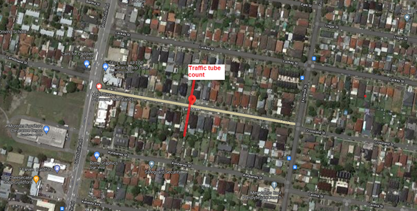
A traffic count was
undertaken on Earl Street in December 2021. The location of the traffic count
is marked in red on the map above. The result of the traffic count indicated
the following:
Traffic Count
Data on Earl St, Merrylands:
Average Daily Traffic (ADT) = 1,201 vehicles/day
85th percentile speed = 52.0 km/h
Mean (average) vehicle speed = 42.1 km/h
The result of the traffic
count reported crashes etc. were used in the assessment to determine the need
for the installation of traffic calming devices on Earl Street in accordance
with the criteria set out in Council’s Local area Traffic Management
Policy (LATM) Policy. The LATM assessment is summarised in the tables below:
Table 1 – Earl St,
Merrylands - LATM Assessment Points
|
Criteria
|
Maximum
Score
|
Score
Achieved
|
|
Traffic Study Data
|
45
|
10
|
|
Crash warrant in the
last 5 years
|
15
|
0
|
|
Road Characteristics
|
35
|
14
|
|
Community Support &
other factors
|
5
|
5
|
|
Total
|
100
|
29
|
Table 2 – Earl St,
Merrylands – LATM Action
|
Criteria
|
Action
|
|
>75
|
Report to TC with a
recommendation of providing traffic calming devices
|
|
61-75
|
Report to TC and
discuss possibility of providing traffic calming devices
|
|
41-60
|
Council to review
traffic data in 6 months
|
|
25-40
|
Monitor street and
review traffic data after 12 months
|
|
<25
|
Do Nothing
|
|
Speed
|
That regardless of the
total points scored, should the 85th percentile speed exceed the posted speed
limit by 5 km/h, the street be referred to the NSW Police for monitoring
and/or enforcement.
|
Based on the traffic
count, the recorded 85th percentile speed was 52.0 km/h which is
within acceptable limits.
Based on the LATM
assessment, traffic calming devices are not warranted in the street at this
instance. This will be reviewed in 12 months.
Nil
2 March 2022
Item
No: CTC-22-024
EDWIN STREET,
REGENTS PARK – ROAD SAFETY CONCERNS
Responsible
Division: Environment
& Planning
Officer: Engineering
Administration Officer
File
Number: HC-24-01-3/02
Electorate: Auburn
Police Area
Command (PAC): Auburn
Council has received a request
from a local resident for the installation of traffic calming devices on Edwin
Street, Regents Park due to speeding concerns.
This report outlines the outcome
of the investigation into this matter.
|
The Traffic Committee recommends the installation of
traffic calming devices on Edwin Street, Regents Park not be supported.
|
Edwin Street is a local
road that runs in an east-west and north-south direction between Kingsland Road
and Amy Street. The speed limit is 50km/h and parking is permitted on both
sides of the road unless signposted. Edwin Street is approximately 250m long
and 12.5m wide.
Council has received a
request from a local resident for the installation of traffic calming devices
on Edwin Street due to speeding concerns.
The Centre for Road
Safety accident data on Edwin Street indicated that there were no reported
accidents in the 5 years up to June 2021.
Council officers have
investigated the request in accordance with Council’s Local Area Traffic
Management (LATM) Policy.
The map below shows the
location of Edwin Street, Regents Park.
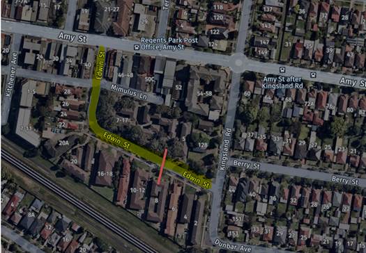
A traffic count was
undertaken on Edwin Street in December 2021. The location of the traffic count
is marked in red on the map above. The result of the traffic count indicated
the following:
Traffic count
Data on Edwin St, Regents Park:
Average Daily Traffic (ADT) = 548 vehicles/day
Average Peak hour traffic = AM 39 veh/hr
and PM 59 veh/hr
ADT for eastbound traffic = 289
veh/day
ADT for westbound traffic = 259 veh/day
85th percentile speed = 47.7 km/h
Mean (average) vehicle speed = 38 km/h
The result of the traffic
count reported crashes etc. were used in the assessment to determine the need
for the installation of traffic calming devices on Edwin Street in accordance
with the criteria set out in Council’s Local area Traffic Management
Policy (LATM) Policy. The LATM assessment is summarised in the tables below:
Table 1 – Edwin St,
Regents Park - LATM Assessment Points
|
Criteria
|
Maximum
Score
|
Score
Achieved
|
|
Traffic Study Data
|
45
|
5
|
|
Crash warrant in the
last 5 years
|
15
|
0
|
|
Road Characteristics
|
35
|
12
|
|
Community Support &
other factors
|
5
|
5
|
|
Total
|
100
|
22
|
Table 2 – Edwin St,
Regents Park - LATM – Action
|
Criteria
|
Action
|
|
>75
|
Report to TC with a
recommendation of providing traffic calming devices
|
|
61-75
|
Report to TC and
discuss possibility of providing traffic calming devices
|
|
41-60
|
Council to review
traffic data in 6 months
|
|
25-40
|
Monitor street and
review traffic data after 12 months
|
|
<25
|
Do Nothing
|
|
Speed
|
That regardless of the
total points scored, should the 85th percentile speed exceed the posted speed
limit by 5 km/h, the street be referred to the NSW Police for monitoring
and/or enforcement.
|
Based on the traffic count,
the recorded 85th percentile speed was 47.7 km/h which is below the
posted speed limits.
Based on the LATM
assessment, traffic calming devices are not warranted in the street.
It was also alleged by
the resident that vehicles are using Edwin Street as part of a
‘rat-run’ using Yukka Street, Berry Street and Kingsland Road to
avoid traffic queues in Amy Street. The average daily traffic in Edwin Street
is 548 Veh/day with peak hour traffic of 39 veh/hr and 59 veh/hr during AM and
PM peak hours respectively which is considered low for a medium density local
road with apartments and single dwellings.
It is believed that there
is no significant through traffic using Edwin Street.
The traffic count results also
indicated that the ADT for eastbound and westbound traffic in Edwin Street is
very close (289 and 259 vehicles/day). This suggested that there is no
significant ‘rat-run’ traffic in Edwin Street,
Nil
2 March 2022
Item
No: CTC-22-025
HANBURY
STREET, GREYSTANES – ROAD SAFETY CONCERNS
Responsible
Division: Environment
& Planning
Officer: Engineering
Administration Officer
File
Number: HC-24-01-3/02
Electorate: Granville
Police Area
Command (PAC): Cumberland
Council at its meeting on 17 March
2021 Considered a report (vide C03/21-706 – Item No. CTC-21-031)
regarding road safety concerns on Hanbury Street, Greystanes. Council approved
Cumberland Traffic Committee recommendation not to support traffic calming
devices in Hanbury Street and to review conditions in November 2021.
This report outlines the outcome
of the investigation into this matter.
|
The Traffic Committee recommends:
1. The
installation of traffic calming devices on Hanbury Street, Greystanes not be supported.
i)
2. Council
review conditions in Hanbury Street, Greystanes in June 2023 and report back
to traffic committee.
|
Cumberland Traffic
Committee at its meeting held in February 2021 recommended:
1. The request for traffic
calming devices in Hanbury Street, Greystanes not be approved,
2. Council review
conditions in Hanbury Street in November 2021 and report back to traffic
committee.
Council at its meeting on
17 March 2021 Considered approved the traffic committee’s recommendation.
Council’s Officers
have reviewed the conditions in Hanbury Street in accordance with
Council’s Local Area Traffic Management (LATM) Policy.
The Centre for Road
Safety accident data indicates that there were no reported crashes in Hanbury
Street in the 5 years up to June 2021.
The map below shows the
location of Hanbury Street, Greystanes.
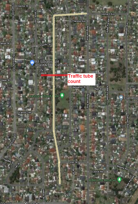
A traffic count was
undertaken on Hanbury Street in late December 2021. The location of the traffic
count is shown in red in the map above.
The results of the
traffic count indicated the following:
Traffic count
Data on Hanbury Street:
Average Daily Traffic (ADT) = 554 vehicles/day
85th percentile speed = of 55.6 km/h
Mean (average) vehicle speed = 45.5 km/h
The above data is
provided together with previous counts in tabulated form below:
|
|
August 2018
|
Nov. 2020
|
Nov. 2021
|
|
Average Daily
Traffic (Veh./day)
|
505
|
529
|
554
|
|
85th percentile
speed (km/hr)
|
58.7
|
57.8
|
55.6
|
|
Mean (average)
vehicle speed (km/hr)
|
48.6
|
47.9
|
45.5
|
The data above shows that
the recorded 85th percentile speed has reduced compared to previous
years.
The results of the latest
traffic counts, recorded crashes etc. were used in the assessment to determine
the need for the installation of traffic calming devices on Hanbury Street in
accordance with the criteria set out in Council’s Local area Traffic
Management Policy (LATM) Policy.
The LATM assessments are
summarised in the tables below:
Table 1 – Hanbury
Street - LATM Assessment Points
|
Criteria
|
Maximum Score
|
Score Achieved
|
|
Traffic Study Data
|
45
|
10
|
|
Crash warrant in the
last 5 years
|
15
|
0
|
|
Road Characteristics
|
35
|
16
|
|
Community Support &
other factors
|
5
|
5
|
|
Total
|
100
|
31
|
Table 2 – Hanbury
Street – Action
|
Criteria
|
Action
|
|
>75
|
Report to TC with a recommendation
of providing traffic calming devices
|
|
61-75
|
Report to TC and
discuss possibility of providing traffic calming devices
|
|
41-60
|
Council to review
traffic data in 6 months
|
|
25-40
|
Monitor street and
review traffic data after 12 months
|
|
<25
|
Do Nothing
|
|
Speed
|
That regardless of the
total points scored, should the 85th percentile speed exceed the posted speed
limit by 5 km/h, the street be referred to the NSW Police for monitoring
and/or enforcement.
|
The recorded 85th
percentile speed is 55.6 km/h which is within acceptable limit.
Based on the above assessment,
traffic calming devices are not warranted in the street.
This will be reviewed in
12 months.Attachments
Nil
2 March 2022
Item
No: CTC-22-026
HARRY AVENUE,
LIDCOMBE – ROAD SAFETY CONCERNS
Responsible
Division: Environment
& Planning
Officer: Engineering
Administration Officer
File
Number: HC-24-01-3/02
Electorate: Auburn
Police Area
Command (PAC): Auburn
Council has received a request
from a local resident for the installation of traffic calming devices on Harry
Avenue, Lidcombe due to speeding concerns.
This report outlines the outcome
of the investigation into this matter.
|
The Traffic Committee recommends:
1. The
installation of traffic calming devices on Harry Avenue, Lidcombe not be
supported.
i)
2. Council
review traffic conditions in Harry Avenue, Lidcombe in June 2023 and report
back to traffic committee.
|
Harry Avenue is a local
road that runs in a north-south direction. The speed limit is 50km/h and
parking are permitted on both sides of the road in accordance with the Road
Rules unless signposted. Harry Avenue is approximately 570m long and 8.0m wide.
Council has received a
request from a local resident for the installation of traffic calming devices
on Harry Avenue due to speeding concerns.
The latest Centre for
Road Safety accident data on Harry Avenue indicated that there was one reported
accident in the 5 years up to June 2021.
Council officers have
investigated the request in accordance with Council’s Local Area Traffic
Management (LATM) Policy.
The map below shows the
location of Harry Avenue, Lidcombe.
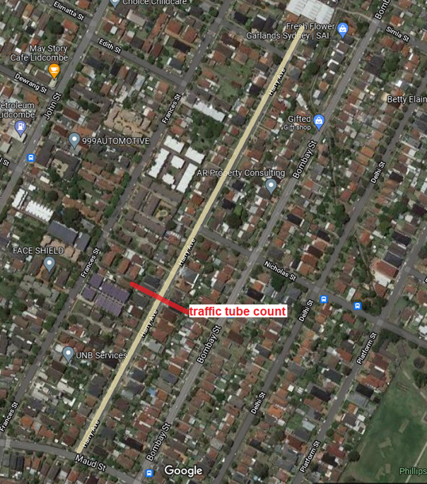
A traffic count was
undertaken on Harry Avenue in November 2021. The location of the traffic count
is marked in red on the map above. The result of the traffic count indicated
the following:
Traffic count
Data on Harry Avenue, Lidcombe:
Average Daily Traffic (ADT) = 599 vehicles/day
85th percentile speed = 52.2 km/h
Mean (average) vehicle speed = 43.0 km/h
The result of the traffic
count reported crashes etc. were used in the assessment to determine the need
for the installation of traffic calming devices on Harry Avenue in accordance
with the criteria set out in Council’s Local area Traffic Management
Policy (LATM) Policy. The LATM assessment is summarised in the tables below:
Table 1 – Harry
Avenue, Lidcombe - LATM Assessment Points
|
Criteria
|
Maximum
Score
|
Score
Achieved
|
|
Traffic Study Data
|
45
|
5
|
|
Crash warrant in the
last 5 years
|
15
|
5
|
|
Road Characteristics
|
35
|
15
|
|
Community Support &
other factors
|
5
|
5
|
|
Total
|
100
|
30
|
Table 2 – Harry
Avenue, Lidcombe – LATM Action
|
Criteria
|
Action
|
|
>75
|
Report to TC with a
recommendation of providing traffic calming devices
|
|
61-75
|
Report to TC and
discuss possibility of providing traffic calming devices
|
|
41-60
|
Council to review
traffic data in 6 months
|
|
25-40
|
Monitor street and
review traffic data after 12 months
|
|
<25
|
Do Nothing
|
|
Speed
|
That regardless of the total
points scored, should the 85th percentile speed exceed the posted speed limit
by 5 km/h, the street be referred to the NSW Police for monitoring and/or
enforcement.
|
Based on the traffic
count, the recorded 85th percentile speed was 52.2 km/h which is
within acceptable limits.
Based on the LATM
assessment, traffic calming devices are not warranted in the street. This will
be reviewed in 12 months.Attachments
Nil
2 March 2022
Item
No: CTC-22-027
LACKEY STREET,
MERRYLANDS – ROAD SAFETY CONCERNS
Responsible
Division: Environment
& Planning
Officer: Engineering
Administration Officer
File
Number: HC-24-01-3/02
Electorate: Granville
Police Area
Command (PAC): Cumberland
Council has received a request
from a local resident for the installation of traffic calming devices on Lackey
Street, Merrylands due to speeding concerns.
This report outlines the outcome
of the investigation into this matter.
|
The Traffic Committee recommends that;
1. The
installation of traffic calming devices on Lackey Street, Merrylands not be
supported.
2. Council
review conditions in Lackey Street, Merrylands and report back to traffic
committee in June 2023
|
Lackey Street is a local
road that runs in an east-west direction between Woodville Road and Blaxcell
Street. The speed limit is 50km/h and parking are permitted on both sides of
the road unless signposted. Lackey Street is approximately 1050m long and 12.3m
wide.
Council has received a
request from a local resident for the installation of traffic calming devices
on Lackey Street due to speeding concerns.
The latest Centre for
Road Safety accident data on Lackey Street indicated that there was one
reported accident in Lackey Street between Robertson Street and Excelsior
Street in the 5 years up to June 2021.
Council officers have
investigated the request in accordance with Council’s Local Area Traffic
Management (LATM) Policy. The investigation revealed that Lackey Street have
speed humps between Woodville Road and Excelsior Street, also Lackey Street is
closed at mid-block between Robertson Street and Blaxcell Street. A
roundabout was constructed at the intersection of Lackey Street and Excelsior
Street in 2019.
There are no traffic
calming devices on Lackey Street between Robertson Street and Excelsior Street.
And this investigation considers the section of Lackey Street between Robertson
Street and Excelsior Street.
The map below shows the
location of Lackey Street, Merrylands.
A traffic count was
undertaken on Lackey Street in November 2021. The location of the traffic count
is marked in red on the map above. The result of the traffic count indicated
the following:
Traffic count
Data on Lackey St between Robertson St & Excelsior St:
Average Daily Traffic (ADT) = 736 vehicles/day
85th percentile speed = 52.3 km/h
Mean (average) vehicle speed = 43 km/h
The result of the traffic
count reported crashes etc. were used in the assessment to determine the need
for the installation of traffic calming devices on Lackey Street in accordance
with the criteria set out in Council’s Local area Traffic Management
Policy (LATM) Policy. The LATM assessment is summarised in the tables below:
Table 1 – Lackey
St between Robertson St & Excelsior St - LATM Assessment Points
|
Criteria
|
Maximum
Score
|
Score
Achieved
|
|
Traffic Study Data
|
45
|
5
|
|
Crash warrant in the
last 5 years
|
15
|
5
|
|
Road Characteristics
|
35
|
10
|
|
Community Support &
other factors
|
5
|
5
|
|
Total
|
100
|
25
|
Table 2 – Lackey
St between Robertson St & Excelsior St – Action
|
Criteria
|
Action
|
|
>75
|
Report to TC with a
recommendation of providing traffic calming devices
|
|
61-75
|
Report to TC and
discuss possibility of providing traffic calming devices
|
|
41-60
|
Council to review
traffic data in 6 months
|
|
25-40
|
Monitor street and
review traffic data after 12 months
|
|
<25
|
Do Nothing
|
|
Speed
|
That regardless of the
total points scored, should the 85th percentile speed exceed the posted speed
limit by 5 km/h, the street be referred to the NSW Police for monitoring
and/or enforcement.
|
Based on the traffic
count, the recorded 85th percentile speed was 52.3 km/h which is
within acceptable limits.
Based on the LATM assessment,
traffic calming devices are not warranted in the street.
The conditions in Lackey
Street will be reviewed in 12 months.Attachments
Nil
2 March 2022
Item
No: CTC-22-028
LANSDOWNE
STREET, MERRYLANDS – ROAD SAFETY CONCERNS
Responsible
Division: Environment
& Planning
Officer: Engineering
Administration Officer
File
Number: HC-24-01-3/02
Electorate: Granville
Police Area
Command (PAC): Cumberland
Council has received a request
from a local resident for the installation of traffic calming devices on
Lansdowne Street, Merrylands due to speeding concerns.
This report outlines the outcome
of the investigation into this matter.
|
The Traffic Committee recommends:
1) The
installation of traffic calming devices on Lansdowne Street, Merrylands not
be supported.
i)
2) Council
review conditions in Lansdowne Street, Merrylands in June 2023 and report
back to traffic committee.
|
Lansdowne Street is a
local road that runs in an east-west direction between Woodville Road and
Railway Terrace. The speed limit is 50km/h and parking is permitted on both
sides of the road unless signposted. Lansdowne Street is approximately 610m
long and 10.7m wide.
Council has received a
request from a local resident for the installation of traffic calming devices
on Lansdowne Street due to speeding concerns.
Background:
Cumberland Traffic
Committee at its meeting held in August 2020 considered a report (CTC-20-132)
regarding speeding concerns in Lansdowne Street, Merrylands and recommended
that:
1. The request for speed humps in Lansdowne
Street, Merrylands not be approved.
2. Council request Cumberland Police Area
Command to undertake random speed surveillance in Lansdowne Street, Merrylands.
3. Council review traffic conditions in
Lansdowne Street in July 2021 and report back to Cumberland Traffic Committee
if conditions have changed.
Council approved the
above recommendations.
The
latest Centre for Road Safety accident database indicated that there were no
reported accidents in Lansdowne Street in the 5 years up to June 2021.
Council officers have
investigated the request in accordance with Council’s Local Area Traffic
Management (LATM) Policy. The investigation revealed that Lansdowne Street has
traffic calming devices between Woodville Road and Railway Terrace Street, such
as slow points, kerb extension and central median islands.
The map below shows the
location of Lansdowne Street, Merrylands.
A traffic count was
undertaken on Lansdowne Street in December 2021. The location of the traffic
count is marked in red on the map above. The result of the traffic count
indicated the following:
Traffic count
Data on Lansdowne St, Merrylands:
The traffic count data from previous and current counts are
given below:
|
|
March 2020
|
December 2021
|
|
Average Daily Traffic (ADT)
|
2,135 veh./day
|
2,526 veh./day
|
|
85th percentile speed
|
55.4 km/hr
|
53.1 km/hr
|
|
Mean (average) vehicle speed
|
46.6 km/hr
|
45.3 km/hr
|
The result of the recent
traffic count reported crashes etc. were used in the assessment to determine
the need for the installation of traffic calming devices on Lansdowne Street in
accordance with the criteria set out in Council’s Local area Traffic
Management Policy (LATM) Policy. The LATM assessment is summarised in the
tables below:
Table 1 – Lansdowne
St, Merrylands - LATM Assessment Points
|
Criteria
|
Maximum
Score
|
Score
Achieved
|
|
Traffic Study Data
|
45
|
15
|
|
Crash warrant in the
last 5 years
|
15
|
0
|
|
Road Characteristics
|
35
|
9
|
|
Community Support &
other factors
|
5
|
5
|
|
Total
|
100
|
29
|
Table 2 – Lansdowne
St, Merrylands – Action
|
Criteria
|
Action
|
|
>75
|
Report to TC with a
recommendation of providing traffic calming devices
|
|
61-75
|
Report to TC and
discuss possibility of providing traffic calming devices
|
|
41-60
|
Council to review
traffic data in 6 months
|
|
25-40
|
Monitor street and review
traffic data after 12 months
|
|
<25
|
Do Nothing
|
|
Speed
|
That regardless of the
total points scored, should the 85th percentile speed exceed the posted speed
limit by 5 km/h, the street be referred to the NSW Police for monitoring
and/or enforcement.
|
Based on the traffic
count, the recorded 85th percentile speed was 53.1 km/h which is
within acceptable limits. This recorded 85th percentile speed has
also reduced since 2020.
Based on the LATM assessment,
traffic calming devices are not warranted in the street.
The traffic conditions will be reviewed in 12 months.Attachments
Nil
2 March 2022
Item
No: CTC-22-029
NICHOLAS
STREET, LIDCOMBE – ROAD SAFETY CONCERNS
Responsible
Division: Environment
& Planning
Officer: Engineering
Administration Officer
File
Number: HC-24-01-3/02
Electorate: Auburn
Police Area
Command (PAC): Auburn
Council has received a request
from a local resident for the installation of traffic calming devices on
Nicholas Street, Lidcombe due to speeding concerns.
This report outlines the outcome
of the investigation into this matter.
|
The Traffic Committee recommends:
1. The
installation of traffic calming devices on Nicholas Street, Lidcombe not be
supported.
i)
2. Council
review conditions in Nicholas Street, Lidcombe in November 2022 and report
back to traffic committee.
|
Nicholas Street is a
local road that runs in an east-west direction between Harry Avenue and Bachell
Avenue. The speed limit is 50km/h and parking is permitted on both sides of the
road unless signposted. Nicholas Street has varying widths and the section
between Platform Street and Bachell Avenue is approximately 12.3m wide. This
section has edge lines and centre lines marked.
The section of Nicholas
Street between Harry Avenue and Platform Street is narrow and approximately 9m
wide.
Nicholas Street section
between Platform Street and Dalley Street provides frontage to Phillips Park.
Council has received a
request from a local resident for the installation of traffic calming devices
on Nicholas Street particularly the wider section between Platform Street and
Dalley Street fronting the park due to speeding concerns.
The latest Centre for
Road Safety accident data on Nicholas Street indicated that there were five
reported accidents on Nicholas Street in the 5 years up to June 2021. The
reported accidents are related to intersection type of crashes 3, pedestrian 1
and leaving parking 1. Three of the above accidents occurred at the
intersection of Nicholas Street and Ostend Street.
Council officers have
investigated the request in accordance with Council’s Local Area Traffic
Management (LATM) Policy.
The map below shows the
location of Nicholas Street, Lidcombe.
A traffic count was
undertaken on Nicholas Street in November 2021. The location of the traffic
count is marked in red on the map above. The result of the traffic count
indicated the following:
Traffic count
Data on Nicholas St between Platform Street & Dalley Street:
Average Daily Traffic (ADT) = 2,324 vehicles/day
85th percentile speed = 54.4 km/h
Mean (average) vehicle speed = 45.7 km/h
The result of the traffic
count reported crashes etc. were used in the assessment to determine the need
for the installation of traffic calming devices on Nicholas Street in
accordance with the criteria set out in Council’s Local area Traffic
Management Policy (LATM) Policy. The LATM assessment is summarised in the
tables below:
Table 1 – Nicholas
St between Platform Street & Dalley Street - LATM Assessment Points
|
Criteria
|
Maximum
Score
|
Score
Achieved
|
|
Traffic Study Data
|
45
|
15
|
|
Crash warrant in the
last 5 years
|
15
|
10
|
|
Road Characteristics
|
35
|
14
|
|
Community Support &
other factors
|
5
|
5
|
|
Total
|
100
|
44
|
Table 2 – Nicholas
St between Platform Street & Dalley Street – Action
|
Criteria
|
Action
|
|
>75
|
Report to TC with a
recommendation of providing traffic calming devices
|
|
61-75
|
Report to TC and
discuss possibility of providing traffic calming devices
|
|
41-60
|
Council to review
traffic data in 6 months
|
|
25-40
|
Monitor street and
review traffic data after 12 months
|
|
<25
|
Do Nothing
|
|
Speed
|
That regardless of the
total points scored, should the 85th percentile speed exceed the posted speed
limit by 5 km/h, the street be referred to the NSW Police for monitoring
and/or enforcement.
|
Based on the traffic
count, the recorded 85th percentile speed was 54.4 km/h which is
within acceptable limits.
Based on the LATM assessment,
traffic calming devices are not warranted in the street. The traffic conditions
in Nicholas Street will be reviewed in 6 months.
Council investigated
the accidents at Nicholas Street and Ostend Street intersection and has
applied for grant funding to treat the intersection.Attachments
Nil
2 March 2022
Item
No: CTC-22-030
ST ANN STREET,
MERRYLANDS – ROAD SAFETY CONCERNS
Responsible
Division: Environment
& Planning
Officer: Engineering
Administration Officer
File
Number: HC-24-01-3/02
Electorate: Granville
Police Area
Command (PAC): Cumberland
Council has received a request
from a local resident for the installation of traffic calming devices on St Ann
Street, Merrylands due to speeding concerns.
This report outlines the outcome
of the investigation into this matter.
|
The Traffic Committee recommends that the conditions
in St Ann Street be investigated again and reported back to traffic
committee.
|
St Ann Street is a local
road that runs in an east-west direction between Chetwynd Road and Military
Road. The speed limit is 50km/h and parking are permitted on both sides of the
road unless signposted. St Ann Street is approximately 812 long and 12.7m wide.
Council has received a
request from a local resident for the installation of traffic calming devices
on St Ann Street due to speeding concerns.
The latest Centre for
Road Safety accident data on St Ann Street indicated that there were no
reported accidents on St Ann Street in the 5 years up to June 2021.
Council officers have
investigated the request in accordance with Council’s Local Area Traffic
Management (LATM) Policy. The investigation revealed that St Ann Street has
traffic calming devices installed such as pedestrian refuges, central and edge
line marking between Chetwynd Road and Military Road.
The map below shows the
location of St Ann Street, Merrylands.
Two Traffic counts were
undertaken on St Ann Street in November 2021. The locations of the traffic
counts are marked in red on the map above. The results of the traffic counts
indicated the following:
Traffic count
Data on St Ann Street
|
|
between Chetwynd Rd
& Addlestone Rd
|
between Addlestone Rd
& Military Rd
|
|
Average Daily Traffic
(ADT) Veh/day
|
2,579
|
2,907
|
|
85th percentile speed
(km/hr)
|
56.9
|
50.6
|
|
Mean (aver) vehicle
speed (km/hr)
|
49.0
|
40.3
|
The results of the
traffic count reported crashes etc. were used in the assessment to determine
the need for the installation of traffic calming devices on St Ann Street in
accordance with the criteria set out in Council’s Local area Traffic
Management Policy (LATM) Policy. The LATM assessment is summarised in the
tables below:
Table 1 – St Ann
Street - LATM Assessment Points
|
Criteria
|
Maximum
Score
|
Scores
Achieved
|
|
Between
Chetwynd Rd & Addlestone Rd
|
Between
Chetwynd Rd & Addlestone Rd
|
|
Traffic Study Data
|
45
|
20
|
15
|
|
Crash warrant in the
last 5 years
|
15
|
0
|
0
|
|
Road Characteristics
|
35
|
16
|
14
|
|
Community Support &
other factors
|
5
|
5
|
5
|
|
Total
|
100
|
41
|
34
|
Table 2 – St Ann
Street – Action
|
Criteria
|
Action
|
|
>75
|
Report to TC with a
recommendation of providing traffic calming devices
|
|
61-75
|
Report to TC and
discuss possibility of providing traffic calming devices
|
|
41-60
|
Council to review
traffic data in 6 months
|
|
25-40
|
Monitor street and
review traffic data after 12 months
|
|
<25
|
Do Nothing
|
|
Speed
|
That regardless of the total
points scored, should the 85th percentile speed exceed the posted speed limit
by 5 km/h, the street be referred to the NSW Police for monitoring and/or
enforcement.
|
Based on the LATM
assessment, traffic calming devices are not warranted in the street.
Council officers
undertook further investigation including site inspections due to the
difference in recorded 85th percentile speeds in the two sections
and noticed that on-street parking spaces were occupied in similar nature.
Therefore, it is proposed to undertake further counts in the street to assess
traffic conditions.Attachments
Nil
2 March 2022
Item
No: CTC-22-031
AUBURN ROAD,
AUBURN – PROPOSED CONSTRUCTION OF MEDIAN ISLAND
Responsible
Division: Environment
& Planning
Officer: Engineering
Administration Officer
File
Number: T-28-01/06
Electorate: Auburn
Police Area
Command (PAC): Auburn
Council has received a request from a resident requesting
for the installation of median islands in Auburn Road, Auburn at the pedestrian
crossing outside Auburn Library due to dangerous vehicular movements at this
location.
This report outlines the outcome of the investigation into
this matter.
|
The Traffic Committee recommends:
1. That
the installation of a 15m median islands on both sides of the existing
pedestrian crossing in Auburn Road, Auburn in accordance with the attached
plan be approved.
i)
2. Council
to include the project in a future Capital Works Program.
|
Auburn Road is a local road that runs in a north-south
direction. The section of Auburn Road south of Mary Street up to South Parade
is part of Auburn Town Centre signposted ‘Local Traffic area’ with
40 km/h speed limit. it has a width of approximately 12m and parking is
provided on both sides of the road.
Currently BB centre line marking exists along Auburn Road
between Mary Street and Beatrice Street. In accordance with the Road Rules,
vehicles are not permitted overtaking on a road with BB centre line marking.
The resident alleged that when vehicles stopped at the pedestrian crossing
waiting for pedestrians to cross Auburn Road, vehicles behind constantly
overtake the existing BB line marking and drive on the other side of the road.
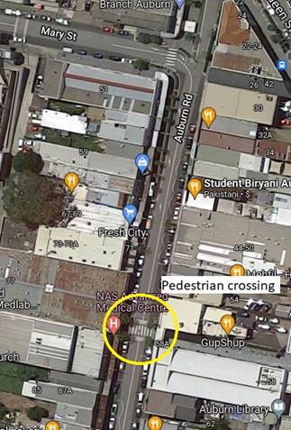
Locality Plan
The latest Centre for Road Safety accident database
indicated that there was one (1) reported accident (Pedestrian near side) at
the pedestrian crossing in the last five years (2016-2021).
In accordance with ‘AS2890-1-2004 Off-Street car
parking facilities’, the aisle width for parallel parked cars to
manoeuvre out of parking shall be 3.6m and as the width of Auburn Road at this
section is 12m, it is sufficient to provide a 300mm wide median island on both
sides of the pedestrian crossing and maintain parking on both sides.
In order to improve safety and
enforce the Road Rules, it is proposed to install a 15m concrete median islands
on both sides of the pedestrian crossing in Aburn Road between Mary Street and
Beatrice Street as per attached plan
1. Plan –
Auburn Road, Auburn – Proposed median islands
2 March 2022
Item
No: CTC-22-032
BLIGH STREET,
GUILDFORD – ROAD SAFETY CONCERNS
Responsible
Division: Environment
& Planning
Officer: Engineering
Administration Officer
File
Number: HC-24-01-3/02
Electorate: Auburn
Police Area
Command (PAC): Cumberland
Council has received a request
from a local resident for the installation of traffic calming devices on Bligh
Street, Guildford.
This report outlines the outcome
of the investigation into this matter.
|
The Traffic Committee
recommends:
1. The installation of traffic calming
devices on Bligh Street, Guildford in accordance with the attached plan be
supported in principle.
i)
2. Council consults directly affected
residents and report back to Traffic Committee if any objection is received.
3. The proposed works be listed in
Council’s future Capital Works Program for construction.
|
Bligh Street is a local road that runs in a north-south direction
between Rawson Road and Caroline Street. Bligh Street is approximately 380m
long and 10m wide. It has a speed limit of 50km/hr and parking is permitted on
both sides in accordance with the Road Rules unless signposted.
Council has received a request from a local resident for the
installation of traffic calming devices on Bligh Street, Guildford.
The intersection of Bligh Street, Campbell Hill Road is
controlled by traffic signals. The northern end of Bligh Street has a
priority-controlled intersection with Caroline Street.
Council’s officers have investigated the request for
the installation of traffic calming devices on Bligh Street, Guildford in
accordance with Council’s Local Area Traffic Management (LATM) Policy.
The map below shows the location
of Bligh Street, Guildford.
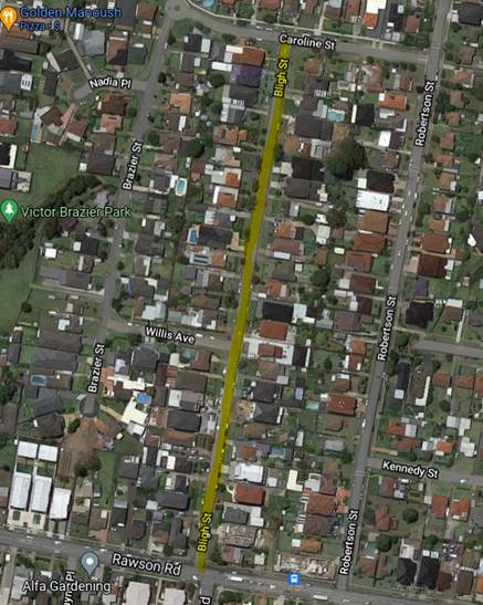
Based on the ‘Centre for Road Safety’ crash
data, there were no reported crashes in Bligh Street in the last 5-year period.
Council undertook traffic counts in Bligh Street, however,
the traffic counting tubes were vandalised twice and no valid data was
gathered. The street shows signs of speeding including ‘hooning’.
Council has undertaken consultation with the residents /
owners regarding installation of speed humps in the street. There were 59
letters with an attached survey form distributed to the residents / owners.
There were 21 responses received by closing date, 19 in support and 2 objecting
to the proposed speed humps.
Residents supported and objected to the proposal have
provided the following comments:
|
Resident Comments
|
|
Supporting
|
|
1
|
Support installation of
speed humps urgently required.
|
|
2
|
It’s about time
they use this street as a race strip, and they don’t live in this
street
|
|
3
|
People drive with
speeds of over 80km/hr almost daily. It is extremely risky for children and
families living along this street.
|
|
4
|
Please note this Is a
necessary action as the street has become almost like a speedway as cars use
it as a shortcut to Guildford road or Campbell hill road.
|
|
5
|
Support installation of
speed humps but due to health condition and safety reason, proposed speed
humps must not be installed Infront of the property.
|
|
Objecting
|
|
1
|
I do not support this
installation
|
|
2
|
If humps are the only
option for council, I support it (however see other considerations below) But
I object to place the hump in front of my property. Humps are one way of
reducing speed but come as an inconvenience to people residing in the street
and using it multiple times a day. Considered other strategies, more police
presence. Council led campaign to educate drivers on horns of speeding in
residential streets.
|
Based on the above results, majority of the residents are
supporting the installation of speed humps. Council prepared a design plan
placing speed humps at suitable intervals in the street.
Following traffic committee recommendation and Council
approval, Council officers will undertake consultation with the directly
affected residents.
1. Plan –
Bligh Street, Guildford - Proposed Speed Humps
2 March 2022
Item
No: CTC-22-033
GILLIVERS
PLACE AND MILLS STREET, LIDCOMBE – ROAD SAFETY CONCERNS
Responsible
Division: Environment
& Planning
Officer: Engineering
Administration Officer
File
Number: HC-24-01-3/02
Electorate: Auburn
Police Area
Command (PAC): Auburn
Council has received a request from Lidcombe Public School
requesting a marked pedestrian crossing outside the school back gate located at
the corner of Gillivers Place and Mills Street, Lidcombe.
This report outlines the outcome of the investigation into
this matter.
|
The Traffic Committee recommends that;
1. The
installation of a marked pedestrian crossing at the corner of Gillivers Place
and Mills Street, Lidcombe not be supported.
i)
2. Council
install ‘W6-3’ Children Crossing warning signs in Mills Street
and Gillivers Place, Lidcombe in accordance with the attached plan.
|
This report considers a request from Lidcombe Public School
for the installation of a marked pedestrian crossing outside the back gate of
the school located in Gillivers Place and Mills Street.
The school principal claimed that it is a potential risk for
their students crossing Gillivers Place and Mills Street during school hours
every day as no crossing facilities are provided at this location.
Gillivers Place is classified as a local street. The street
has a 40km/h school zone during school hours and a default speed limit of
50km/h outside school hours. The street is approximately 4.5m wide with
restricted parking on the western side (school side). It is also a one-way
street only allows northbound traffic.
Mills Street is classified as a local street. The street has
a 40km/h school zone during school hours and a default speed limit of 50km/h
outside school hours. The street is approximately 12.5m wide. Parking is
permitted on both sides of the road unless signposted.
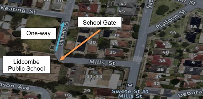
To provide a pedestrian crossing,
Council must satisfy the following warrants given in RMS / Transport for NSW
Guidelines:
Normal Warrant:
A pedestrian (Zebra) Crossing is warranted where:-
In each of three separate one hour periods in a typical day
(a) the pedestrian flow per hour (P)
crossing the road is >= 30 AND
(b) the vehicular flow per hour (V) through
the site is >= 500 AND
(c) the product PV is >= 60,000
Reduced Warrant
for sites used predominantly by children and by aged or impaired pedestrians.
If the crossing is used predominantly by school children,
is not suitable site for a Children’s Crossing and in two counts of one
hour duration immediately before and after school hours:-
(a) P ≥ 30 AND
(b) V ≥ 200
a pedestrian (Zebra) Crossing may be installed.
Council undertook a pedestrian
and vehicle count at the corner of Gillivers Place and Mills Street on Thursday
14 December 2021. The result of the count is shown in the table below:
Table – Traffic count
result
|
|
8am
– 9am
|
9am-10am
|
2pm-3pm
|
3pm-4pm
|
|
|
Veh
|
Ped
|
Veh
|
Ped
|
Veh
|
Ped
|
Veh
|
Ped
|
|
Gillivers
Pl
|
2
|
20
|
0
|
0
|
0
|
90
|
0
|
9
|
|
Mills
St
|
140
|
26
|
25
|
4
|
77
|
72
|
29
|
26
|
The survey result indicated that
Gillivers Place and Mills Street does not meet the numerical warrants for a
marked pedestrian crossing. Therefore a marked pedestrian crossing can not be
supported.
It is proposed to install
Children Crossing warning signs (W6-3) in Mills Street and Gillivers Place to
alert motorists of the presence of children in the area.
1. Plan -
Proposed Children Crossing warning signs
2 March 2022
Item
No: CTC-22-034
ROAD CLOSURES
IN THE AUBURN CBD FOR RAMADAN FOOD FESTIVAL 2022
Responsible
Division: Environment
& Planning
Officer: Engineering
Administration Officer
File
Number: T-28-01/06
Electorate: Auburn
Police Area
Command (PAC): Auburn
Council has received an application requesting the closure
of selected roads in the Auburn CBD to facilitate ‘Ramadan Street Food
Festival 2022’.
This report outlines the outcome of the investigation into
this matter.
|
The Traffic Committee recommends the temporary closure
of Auburn Road between Queen Street and Beatrice Street and the eastern
section of Mary Street, between Harrow Road and Auburn Road, Auburn be
approved between the hours of 5AM Saturday, 23rd April 2022 and
5AM Sunday, 24th April 2022 subject to;
1. All
affected businesses and emergency stakeholders being notified of the closure.
i)
2. Complying
with the notification requirements of the Roads Act 1993, i.e., placing
public notices in a newspaper and erecting notices on the road.
3. Approval
of a Traffic Management Plan by Transport Management Centre.
ii)
4. Temporary
bus routes and bus zones replacing the existing bus zones in the closed area
be provided in consultation with the bus operator.
|
Council has received funding from State Government under the
program ‘The Festival of Place – Open Streets’. This
program aims to support Councils to undertake short term projects involving
community events and activities on streets.
‘Ramadan Food Festival 2022’ is one such
event Council has initiated under the funding. The event provides free access
to cultural event celebrating the local community.
Council is committed to delivering the event to focus
interest on the
local area, while keeping a community spirit and attracting
visitors from the Sydney metropolitan area. The event will involve street
stalls with food and merchandise.
The event will commence at 6PM
on Saturday 23 April and end at Midnight 12:00AM.
Road Closures:
Road closures will be from 5AM
on Saturday 23 April to 5AM Sunday 24 April allowing time for
setting up and dismantling.
The road closure from morning
will prevent any parking within the event area and also procide time for event
officers to set up stalls and other furniture required for the event.
The closure is as follows;
· Auburn
Road between Queen Street and Beatrice Street
· Eastern
section of Mary Street, between Harrow Road and Auburn Road
The map below shows the road
closures in yellow.
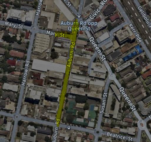
Traffic Management Plan (TMP)
including Traffic Control Plans is attached.Attachments
1. TMP –
Ramadan Food Festival 2022
2 March 2022
Item
No: CTC-22-035
GILBA ROAD,
GIRRAWEEN – ROAD SAFETY CONCERNS
Responsible
Division: Environment
& Planning
Officer: Engineering
Administration Officer
File Number: HC-24-01-3/02
Electorate: Prospect
Police Area
Command (PAC): Cumberland
Council has received a request
from a local resident for the conversion of the existing at-level pedestrian
crossing on Gilba Road, Girraween outside Girraween Public School to a raised
pedestrian crossing due to alleged speeding in Gilba Road approaches.
This report outlines the outcome
of the investigation into this matter.
|
The Cumberland Traffic Committee recommends the
installation of a raised pedestrian crossing on Gilba Road, Girraween outside
Girraween Public School not be supported.
|
Council has received a request
from a local resident for the conversion of the existing at-level pedestrian
crossing on Gilba Road, Girraween outside Girraween Public School to a raised
pedestrian crossing due to alleged speeding in Gilba Road approaches.
Gilba Road is a Collector Road
that runs in an east-west direction between Toongabbie Road and Pendle Way. The
street has a 40km/h school zone section during school hours and a default speed
limit of 50km/h outside school hours. Parking is permitted on both sides of the
road unless signposted.
A marked pedestrian crossing
exists outside Girraween Public School. There is also a pedestrian refuge built
just west of Tungarra Road which is west of the crossing. Gilba Road has
painted median island between the pedestrian refuge and east of the crossing to
enhance safety in this section of Gilba Road.
The map below shows the pedestrian
crossing and other devices in Gilba Road.
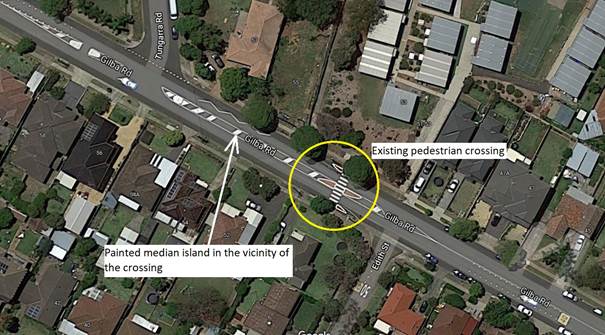
Council’s Officers
have investigated the request and a traffic count was undertaken on both sides
of the pedestrian crossing outside the school in November 2021.
The results of the
traffic counts indicated the following:
Traffic count
Data for the westbound traffic (towards the crossing) on Gilba Road 30m east of
the crossing:
Average Daily Traffic (ADT) = 2,367 vehicles/day
85th percentile speed = 48 km/h
85th percentile speed from 8am to 9am = 35.8 km/hr
85th percentile speed from 2pm to 3pm = 42.7 km/hr
85th percentile speed from 3pm to 4pm = 38.8 km/hr
Traffic count Data
for the eastbound traffic (towards the crossing) on Gilba Road 30m west of the
crossing
Average Daily Traffic (ADT) = 2,290 vehicles/day
85th percentile speed = 47 km/hr
85th percentile speed from 8am to 9am = 37.4 km/hr
85th percentile speed from 2pm to 3pm = 40.6 km/hr
85th percentile speed from 3pm to 4pm = 40.3 km/hr
The traffic counts
indicated that the recorded 85th percentile speeds for vehicles
approaching the existing pedestrian crossing were relatively low and within an
acceptable range. The data during school zone times are acceptable. The speed
data between 2:00 and 3:00pm only covers 30minutes (between 2:30 to 3:00pm) of
school zone.
The latest Centre for
Road Safety accident database indicated that there were no reported accidents
in the last 5 years at this location.
Considering the above,
conversion of the existing at-level pedestrian crossing to a raised pedestrian
crossing not be supported at this time.
Nil
2 March 2022
Item
No: CTC-22-036
LUMLEY STREET,
GRANVILLE – ROAD SAFETY CONCERNS
Responsible
Division: Environment
& Planning
Officer: Engineering
Administration Officer
File
Number: HC-24-01-3/02
Electorate: Granville
Police Area
Command (PAC): Cumberland
Council has received a request
from a local resident for the installation of traffic calming devices on Lumley
Street, Granville due to speeding concerns.
This report outlines the outcome
of the investigation into this matter.
|
The Cumberland Traffic Committee recommends the
installation of traffic calming devices on Lumley Street, Granville not be
supported.
|
Council has received a request
from residents for the installation of traffic calming devices on Lumley
Street, Granville due to speeding concerns.
Lumley Street is a local road runs
in a north-south direction between Mary Street and William Street. The road is
approximately 200m long and 12m wide. The street is a 40km/h school zone during
school hours and a default speed limit of 50km/h outside school hours. Parking
is permitted on both sides of the road unless signposted.
Council’s Officers
have investigated the request for the installation of traffic calming devices
on Lumley Street in accordance with Council’s Local Area Traffic
Management (LATM) Policy.
A review of Centre for
Road Safety Accident data indicated that there was one reported midblock
accident in Lumley Street in the 5 years up to June 2021. This accident
occurred during a U-turn by a vehicle. There was another accident occurred at
the roundabout at the intersection of William Street and Lumley Street.
The map below shows the
location of Lumley Street.
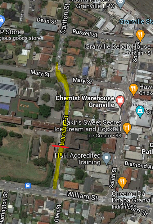
A traffic count was
undertaken on Lumley Street south of Maud Street in November 2021. The traffic
count location in shown in red in the map above.
The results of the
traffic count indicated the following:
Traffic count
Data on Lumley Street:
Average Daily Traffic (ADT) = 9,201 vehicles/day,
85th percentile speed = 45 km/h,
Mean (average) vehicle speed = 39.2 km/h.
The results of the
traffic counts, recorded crashes etc. were used in the assessment to determine
the need for the installation of traffic calming devices on Lumley Street in
accordance with the criteria set out in Council’s Local area Traffic Management
Policy (LATM) Policy.
The LATM assessments are
summarised in the tables below:
Table 1 – Lumley
Street - LATM Assessment Points
|
Criteria
|
Maximum Score
|
Score Achieved
|
|
Traffic Study Data
|
45
|
15
|
|
Crash warrant in the
last 5 years
|
15
|
5
|
|
Road Characteristics
|
35
|
10
|
|
Community Support &
other factors
|
5
|
5
|
|
Total
|
100
|
35
|
Table 2 – Lumley
Street – Action
|
Criteria
|
Action
|
|
>75
|
Report to TC with a
recommendation of providing traffic calming devices
|
|
61-75
|
Report to TC and
discuss possibility of providing traffic calming devices
|
|
41-60
|
Council to review
traffic data in 6 months
|
|
25-40
|
Monitor street and
review traffic data after 12 months
|
|
<25
|
Do Nothing
|
|
Speed
|
That regardless of the
total points scored, should the 85th percentile speed exceed the posted speed
limit by 5 km/h, the street be referred to the NSW Police for monitoring
and/or enforcement.
|
The traffic count
indicated that the recorded 85th percentile speed was 45km/h which
is well below the speed limit of the street.
Based on the above
assessment, traffic calming devices are not warranted in the street.
Nil
2 March 2022
Item
No: CTC-22-037
EDGAR STREET
AND GIBBS STREET, AUBURN - SAFER ROADS PROGRAM 2021/2022
Responsible
Division: Environment
& Planning
Officer: Engineering
Administration Officer
File
Number: HC-24-03-21
Electorate: Auburn
Police Area
Command (PAC): Auburn
Council has received funding under
the Federal Safer Roads Program 2021/2022 financial year for the construction
of a roundabout at the intersection of Edgar Street and Gibbs Street, Auburn.
This report outlines the outcome
of a review into this matter.
|
The Traffic Committee recommends:
1. The
construction of the proposed roundabout together with the signs and line
marking plan at the intersection of Edgar Street and Gibbs Street, Auburn be
approved.
i)
2. The
affected residents be notified of Council’s resolution.
|
Edgar Street, Auburn is a local road that runs in an
east-west direction, it has a width of approximately 12.5m with a signposted
50km/h speed limit. Parking is permitted on both sides.
Gibbs Street, Auburn is a local road that runs in a
north-south direction, it has a width of approximately 12.5m with a signposted
50km/h speed limit. Parking is permitted on both sides.
Edgar Street and Gibbs Street form a cross intersection with
priority to Edgar Street and ‘Give Way’ signs on Gibbs Street.
Figure 1 below shows details of the intersection and
surrounding streets.
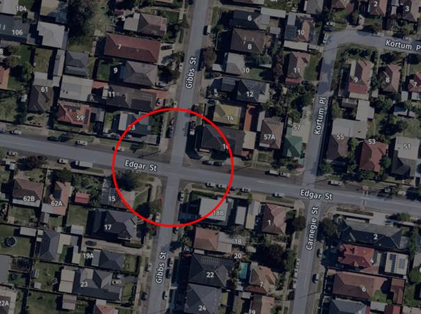
Figure 1 –
Locality Plan
Based on the crash record at the intersection,
Council’s Officers have investigated the intersection performance and
nominated the site for Black Spot Program 2021/2022 Financial Year. The
submission was based on the latest RMS crash data at the time of the
application which are summarised below:
Crash Period
Investigated: July 2014
– Jun 2019 (5 years)
Total number of crashes: 3
Total number of injury: 3
Primary crash type: Cross
traffic (RUM 10)
Proposed treatment: Proposed
roundabout
Treatment cost: $210,000
Following the submission, Council has received a formal
letter from the Transport for NSW advising that the submission for the proposed
roundabout at the intersection of Edgar Street and Gibbs Street has received
funding of $210,000. This project will need to be constructed/completed within
2021/2022 Financial Year.
The design has been prepared to accommodate the movement of
Heavy Rigid Vehicle (12.5m long) on all approaches and in accordance with
current Roads and Maritime Services / Transport for NSW Guidelines and
considered satisfactory. The central island of the roundabout is designed
mountable to allow for manoeuvring of right turning trucks.
Swept paths have been
provided in the attachment.
It is advised that the
proposed treatment will slow down traffic, define priority control and improve
road safety for all road users.
1. Plans –
Edgar Street and Gibbs Street, Auburn – Proposed roundabout
2. Turning
path disagram for a 12.5m truck
2 March 2022
Item
No: CTC-22-038
EXCELSIOR
STREET AND BRIGHT STREET, GUILDFORD - SAFER ROADS PROGRAM 2021/2022
Responsible
Division: Environment
& Planning
Officer: Engineering
Administration Officer
File
Number: HC-24-03-21
Electorate: Auburn
Police Area
Command (PAC): Cumberland
Council has received funding under
the Federal Safer Roads Program 2021/2022 financial year for the construction
of a roundabout at the intersection of Excelsior Street and Bright Street,
Guildford.
This report outlines the outcome
of a review into this matter.
|
The Traffic Committee recommends:
1. The
construction of the proposed roundabout together with the signs and line
marking plan at the intersection of Excelsior Street and Bright Street,
Guildford be approved
i)
2. Council
forward final design plans to Transport for NSW
ii)
3. The
affected residents be notified of Council’s resolution.
|
Excelsior Street, Guildford is a local road that runs in a
north-south direction, it has a width of approximately 12.4m with a signposted
50km/h speed limit. Parking is permitted on both sides.
Bright Street is a local road that runs in an east-west
direction between Woodville Road and a cul-de-sac at Hope Park and has a width
of approximately 11.7m with 50km/h speed limit. Parking is permitted on both
sides.
Excelsior Street and Bright Street form a cross intersection
with priority to Excelsior Street and ’Give Way’ signs on Bright
Street.
Figure 1 below shows details of the intersection and
surrounding streets.
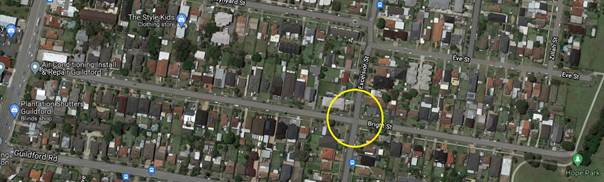
Figure 1 –
Locality Plan
Based on the crash record at the intersection,
Council’s Officers have investigated the intersection performance and
nominated the site for Black Spot Program 2021/2022 Financial Year. The
submission was based on the latest RMS crash data at the time of the
application which are summarised below:
Crash Period Investigated:
July 2014 – Jun 2019 (5
years)
Total number of crashes: 5
Total number of injury: 5
Primary crash type: Cross
traffic (RUM 10)
Proposed treatment: Proposed
roundabout
Treatment cost: $229,000
Following the submission, Council has received a formal
letter from the Transport for NSW advising that the submission for the proposed
roundabout at the intersection of Edgar Street and Gibbs Street has received
funding of $229,000. This project will need to be constructed/completed within
2021/2022 Financial Year.
The concept plans have been prepared to accommodate the
movement of Heavy Rigid Vehicle (12.5m long) on all approaches and in
accordance with current Roads and Maritime Services / Transport for NSW
Guidelines and considered satisfactory. The central island of the roundabout is
designed mountable to allow for manoeuvring of right turning trucks.
Swept paths have been
provided in the attachment.
It is advised that the
proposed treatment will slow down traffic, define priority control and improve
road safety for all road users.
Council is undertaking final
design plans for the roundabout and the plans will be forwarded to transport
for NSW
1. Concept Plan
– Excelsior Street and Bright Street, Guildford – Proposed
roundabout
2. Turning
path disagram for a 12.5m truck
2 March 2022
Item
No: CTC-22-039
HARRIS STREET
AND MORRIS STREET, MERRYLANDS - SAFER ROADS PROGRAM 2021/2022
Responsible
Division: Environment
& Planning
Officer: Engineering
Administration Officer
File
Number: HC-24-03-21
Electorate: Granville
Police Area
Command (PAC): Cumberland
Council has received funding under
the Safer Roads Program 2021/2022 financial year for the construction of a
roundabout at the intersection of Harris Street and Morris Street, Merrylands.
This report outlines the outcome
of a review into this matter.
|
The Traffic Committee recommends that:
1. The
construction of the proposed roundabout together with the signs and line
marking plan at the intersection of Harris Street and Morris Street,
Merrylands be approved
i)
2. The
affected residents be notified of Council’s resolution.
|
Harris Street, Merrylands is 10.5m with a signposted 50/km/h
speed limit. Parking is permitted on both sides.
Morris Street, Merrylands is a local road that runs in an
east-west direction, it has a width of approximately 10.5m with a signposted
50/km/h speed limit. Parking is permitted on both sides.
Harris Street and Morris Street form a cross intersection
with priority to Harris Street and ‘Give Way’ signs on Morris
Street.
Figure 1 below shows details of the intersection and
surrounding streets.
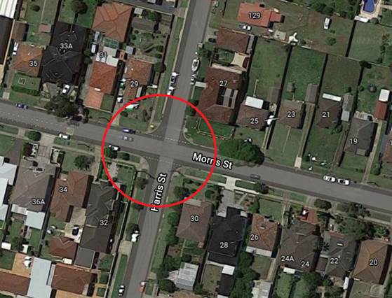
Figure 1 –
Locality Plan
Based on the crash record at the intersection,
Council’s Officers have investigated the intersection performance and
nominated the site for funding under the Federal Safer Roads Program 2021/2022
Financial Year. The submission was based on the latest RMS crash data at the
time of the application which are summarised below:
Crash Period
Investigated: July 2014
– Jun 2019 (5 years)
Total number of crashes: 4
Total number of injury: 4
Primary crash type: Cross
traffic (RUM 10)
Proposed treatment: Proposed
roundabout
Treatment cost: $255,000
Following the submission, Council has received a formal
letter from the Transport for NSW advising that the submission for the proposed
roundabout at the intersection of Edgar Street and Gibbs Street has received
funding of $255,000. This project will need to be constructed/completed within
2021/2022 Financial Year.
The design has been prepared to accommodate the movement of
Heavy Rigid Vehicle (12.5m long) on all approaches and in accordance with
current Roads and Maritime Services / Transport for NSW Guidelines and
considered satisfactory. The central island of the roundabout is designed mountable
to allow for manoeuvring of right turning trucks.
Swept paths have been
provided in the attachment.
It is advised that the proposed
treatment will slow down traffic, define priority control and improve road
safety for all road users.
1. Plan –
Turning path diagram
2. Plan
–Harris Street and Morris Street, Merrylands – Proposed roundabout
2 March 2022
Item
No: CTC-22-040
ROSEBERY ROAD
AND RHODES AVENUE, GUILDFORD - SAFER ROADS PROGRAM 2021/2022
Responsible
Division: Environment
& Planning
Officer: Engineering
Administration Officer
File
Number: HC-24-03-21
Electorate: Granville
Police Area
Command (PAC): Cumberland
Council has received funding under
the Federal Safer Roads Program 2021/2022 financial year for the construction
of a roundabout at the intersection of Rosebery Road and Rhodes Avenue,
Guildford.
This report outlines the outcome
of a review into this matter.
|
The Traffic Committee recommends:
1. The
construction of the proposed roundabout together with the signs and line
marking plan at the intersection of Rosebery Road and Rhodes Avenue,
Guildford be approved.
2. The
affected residents be notified of Council’s resolution.
|
Rosebery Road, Guildford is a local road that runs in an
east-west direction, it has a width of approximately 12.5m with a signposted
50/km/h speed limit. Parking is permitted on both sides.
Rhodes Avenue is a local road that runs in a north-south
direction, it has a width of approximately 12.5m with a signposted 50/km/h
speed limit. Parking is permitted on both sides.
Rosebery Road and Rhodes Avenue form a cross intersection
with priority to Rosebery Road and ‘STOP’ signs on Rhodes Avenue.
Figure 1 below shows details of the intersection and
surrounding streets.
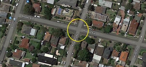
Figure 1 –
Locality Plan
Based on the crash record at the intersection,
Council’s Officers have investigated the intersection performance and
nominated the site for Black Spot Program 2021/2022 Financial Year. The
submission was based on the latest RMS crash data at the time of the
application which are summarised below:
Crash Period
Investigated: July 2014
– Jun 2019 (5 years)
Total number of crashes: 5
Total number of injury: 5
Primary crash type: Cross
traffic (RUM 10)
Proposed treatment: Proposed
roundabout
Treatment cost: $300,000
Following the submission, Council has received a formal
letter from the Transport for NSW advising that the submission for the proposed
roundabout at the intersection of Edgar Street and Gibbs Street has received
funding of $300,000. This project will need to be constructed/completed within
2021/2022 Financial Year.
The concept plans have been prepared to accommodate the
movement of Heavy Rigid Vehicle (12.5m long) on all approaches and in
accordance with current Roads and Maritime Services / Transport for NSW
Guidelines and considered satisfactory. The central island of the roundabout is
designed mountable to allow for manoeuvring of right turning trucks.
Swept paths have been
provided in the attachment.
It is advised that the
proposed treatment will slow down traffic, define priority control and improve
road safety for all road users.
Council is undertaking final
design plans for the roundabout and the plans will be forwarded to transport
for NSW
1. Concept Plan
– Rosebery Road & Rhodes Avenue, Guildford – Proposed
roundabout
2. Turning
path disagram for a 12.5m truck
2 March 2022
Item
No: CTC-22-041
TEMPORARY ROAD
CLOSURE FOR ‘GRANVILLE ACTIVATION 2022’ FUNDING AGREEMENT
Responsible
Division: Environment
& Planning
Officer: Engineering
Administration Officer
File
Number: HC-24-03-21
Electorate: Granville
Police Area
Command (PAC): Cumberland
Council has received funding from
the State Government to carry out short term demonstration projects involving
community events and activities on or in streets within Cumberland Local
Government Area (LGA). As part of this funding, ‘Granville Activation
2022’ is proposed to be held in South Street, Granville.
This report outlines the proposal
and the road closure involved in the project.
|
The Traffic Committee recommends that the temporary
closure of South Street, Granville from 7:00 AM Sunday 15 May 2022 to 7:00PM
Tuesday 24 May 2022 between Mary Street and Russell Street in accordance with
the Traffic Management Plan be supported, subject to below conditions:
1. All
affected residents, businesses and emergency stakeholders being notified of
the closure.
i)
2. Complying
with the notification requirements of the Roads Act 1993, i.e., placing
public notices in a newspaper and erecting notices on the road.
ii)
3. The
Traffic Management Plan and Special Event Application form be submitted to
Transport for NSW and Transport Management Centre for approval.
|
Council has received funding from
the State Government to carry out short term demonstration projects involving
community events and activities on or in streets within Cumberland Local
Government Area (LGA).
As part of this funding,
‘Granville Activation 2022’ is proposed to be held in South Street,
Granville.
The event will be between
Monday 16 May 2022 until Monday 23 May 2022. Council’s Events
Department will manage the activities and activations. To carry out the
event/activities safely, it is requested for a temporary full road closure
during the activities period.
Road Closure:
The road closure will be
affected from 7:00 AM Sunday 15 May 2022 to 7:00PM Tuesday 24 May 2022.
The road closure period before and after the event will provide sufficient time
for Event officers to erect and dismantle any temporary structures in the
closed area.
It should be noted that
there is no existing bus route through the closed section of South Street.
The map below shows
location of proposed temporary full road closure of South Street between
Russell Street and Mary Street, Granville.
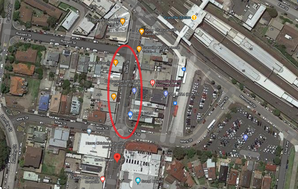
Plans showing he closure and
detours are attached.
The TMP together any other
required documents will be forwarded to Transport for NSW for final approval.
1. Traffic
Management Plan and Traffic Control Plan
2 March 2022
Item
No: CTC-22-042
BELMONT
STREET, MERRYLANDS – ROAD SAFETY CONCERNS
Responsible
Division: Environment
& Planning
Officer: Engineering
Administration Officer
File
Number: HC-24-01-3/02
Electorate: Granville
Police Area
Command (PAC): Cumberland
Council has received a request
from a local resident for the installation of traffic calming devices on
Belmont Street, Merrylands due to speeding concerns.
This report outlines the outcome
of the investigation into this matter.
|
The Traffic Committee recommends the installation of
traffic calming devices on Belmont Street, Merrylands not be supported.
|
Belmont Street is a local
road that runs in an east-west direction between Chetwynd Road and Military
Road. The speed limit is 50km/h and parking are permitted on both sides of the
road unless signposted. Belmont Street is approximately 933m long and 11.7m
wide.
Council has received a
request from a local resident for the installation of traffic calming devices
on Belmont Street due to speeding concerns.
The Centre for Road
Safety accident data on Belmont Street indicated that there were two reported
accidents on Belmont Street in the 5 years up to June 2021. There was one crash
in mid-block between Chetwynd Road and Roseberry Street and one intersection
crash at the intersection of Belmont Street and Roseberry Street during the 5
years period.
Council officers have
investigated the request in accordance with Council’s Local Area Traffic
Management (LATM) Policy.
The map below shows the
location of Belmont Street, Merrylands.
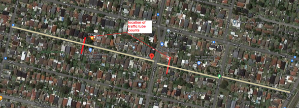
Two Traffic counts were
undertaken on Belmont Street in November 2021. The locations of the traffic
counts are marked in red on the map above. The results of the traffic counts
indicated the following:
|
|
From Chetwynd Rd to
Roseberry St
|
From Roseberry St to Military
Rd
|
|
Average Daily Traffic
(ADT) - vehicles/day
|
468
|
272
|
|
85th percentile speed -
km/h
|
54.7
|
49.8
|
|
Mean (average) vehicle
speed - km/h
|
45
|
39
|
The results of the
traffic count reported crashes etc. were used in the assessment to determine
the need for the installation of traffic calming devices on Belmont Street in
accordance with the criteria set out in Council’s Local area Traffic
Management Policy (LATM) Policy. The LATM assessment is summarised in the
tables below:
Table 1 – Belmont
Street - Two sections
|
Criteria
|
Maximum
Score
|
Score
Achieved
|
|
|
|
From
Chetwynd Rd to Roseberry St
|
From
Roseberry St to Military Rd
|
|
Traffic Study Data
|
45
|
0
|
0
|
|
Crash warrant in the
last 5 years
|
15
|
5
|
5
|
|
Road Characteristics
|
35
|
13
|
13
|
|
Community Support &
other factors
|
5
|
5
|
5
|
|
Total
|
100
|
23
|
23
|
Table 2 – Belmont
Street – Action
|
Criteria
|
Action
|
|
>75
|
Report to TC with a
recommendation of providing traffic calming devices
|
|
61-75
|
Report to TC and
discuss possibility of providing traffic calming devices
|
|
41-60
|
Council to review
traffic data in 6 months
|
|
25-40
|
Monitor street and
review traffic data after 12 months
|
|
<25
|
Do Nothing
|
|
Speed
|
That regardless of the
total points scored, should the 85th percentile speed exceed the posted speed
limit by 5 km/h, the street be referred to the NSW Police for monitoring
and/or enforcement.
|
Based on the traffic
counts, the recorded 85th percentile speeds in two sections of
Belmont Street were 54.7 and 49.8 km/h which are within acceptable limits.
Based on the LATM assessment,
traffic calming devices are not warranted in Belmont Street, Merrylands.
Nil
2 March 2022
Item
No: CTC-22-043
CUMBERLAND
ROAD, AUBURN – ROAD SAFETY CONCERNS
Responsible
Division: Environment
& Planning
Officer: Engineering
Administration Officer
File
Number: HC-24-01-3/02
Electorate: Auburn
Police Area
Command (PAC): Auburn
Council has received a request
from a local resident for the installation of traffic calming devices on
Cumberland Road, Auburn between Chiswick Road and Elm Road due to speeding
concerns.
This report outlines the outcome
of the investigation into this matter.
|
The Traffic Committee recommends:
1. The
installation of traffic calming devices on Cumberland Road, Auburn not be
supported.
i)
2. Council
review conditions in Cumberland Road, Auburn in June 2023 and report back to
traffic committee.
|
Cumberland Road, Auburn
is a local road that runs in a north-south direction between St Johns Road and
The Crescent. The speed limit is 50km/h and parking are permitted on both sides
of the road unless signposted. Cumberland Road is approximately 2.8 km long and
12.5m wide between St Johns Road and The Crescent.
Council has received a
request from a local resident for the installation of traffic calming devices
on Cumberland Road. The resident has raised speeding in the vicinity of their
property in the section between Chiswick Road and Elm Road.
For this investigation,
Council has considered the section of Cumberland Road between Chiswick Road and
Rickard Street which comprises the section where the resident has complained.
The latest Centre for Road
Safety accident data on Cumberland Road indicated that there were three
reported accidents in the section in the 5 years up to June 2021. All three
accidents were intersection accidents.
Council officers have
investigated the request in accordance with Council’s Local Area Traffic
Management (LATM) Policy. The investigation revealed that Cumberland Road have
traffic calming devices such as roundabout, blister islands, central and edge
line marking.
The map below shows the
location of Cumberland Road between Chiswick Road and Rickard Street.
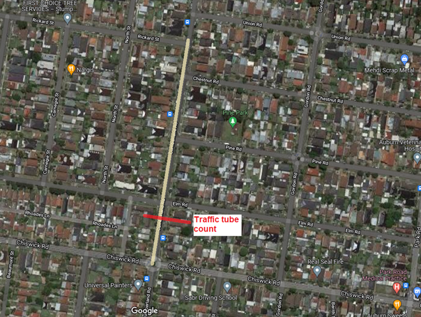
A traffic count was
undertaken on Cumberland Road in December 2021 between Chiswick Road and
Rickard Street. The location of the traffic count is marked in red on the map
above. The result of the traffic count indicated the following:
Traffic count
Data on Cumberland Rd between Chiswick Rd and Rickard St:
Average Daily Traffic (ADT) = 1,378 vehicles/day
85th percentile speed = 49.7 km/h
Mean (average) vehicle speed = 43.7 km/h
The result of the traffic
count reported crashes etc. were used in the assessment to determine the need
for the installation of traffic calming devices on Cumberland Road between
Chiswick Road and Rickard Street in accordance with the criteria set out in Council’s
Local area Traffic Management Policy (LATM) Policy. The LATM assessment is
summarised in the tables below:
Table 1 –
Cumberland Rd between Chiswick Rd & Rickard St - LATM Assessment Points
|
Criteria
|
Maximum
Score
|
Score
Achieved
|
|
Traffic Study Data
|
45
|
10
|
|
Crash warrant in the
last 5 years
|
15
|
10
|
|
Road Characteristics
|
35
|
12
|
|
Community Support &
other factors
|
5
|
5
|
|
Total
|
100
|
37
|
Table 2 –
Cumberland Rd between Chiswick Rd & Rickard St – Action
|
Criteria
|
Action
|
|
>75
|
Report to TC with a recommendation
of providing traffic calming devices
|
|
61-75
|
Report to TC and
discuss possibility of providing traffic calming devices
|
|
41-60
|
Council to review
traffic data in 6 months
|
|
25-40
|
Monitor street and
review traffic data after 12 months
|
|
<25
|
Do Nothing
|
|
Speed
|
That regardless of the
total points scored, should the 85th percentile speed exceed the posted speed
limit by 5 km/h, the street be referred to the NSW Police for monitoring
and/or enforcement.
|
Based on the traffic
count, the recorded 85th percentile speed was 49.7 km/h which is
below speed limit of the street.
Based on the LATM assessment,
traffic calming devices are not warranted in the street.
This will be reviewed in
12 months.Attachments
Nil
2 March 2022
Item
No: CTC-22-044
DRIFTWAY
DRIVE, PEMULWUY – REQUEST TO REMOVE PEDESTRIAN REFUGE
Responsible
Division: Environment
& Planning
Officer: Engineering
Administration Officer
File
Number: HC-24-01-3/02
Electorate: Prospect
Police Area
Command (PAC): Cumberland
Council has received a request
from a local resident for the removal of the existing refuge islands in front
of 92 Driftway Drive, Pemulwuy.
This report outlines the outcome
of the investigation into this matter.
|
The Traffic Committee recommends the request for the
removal of pedestrian refuge in front of 92 Driftway Drive, Pemulwuy not be
approved.
|
Driftway Drive is a local
road that runs in a north-south direction with a posted speed limit of 50
km/hr. It has a width of approximately 8.8m and parking restrictions apply on
both sides of the road unless signposted.
The latest accident data
indicated that there is no reported accident near property 92 Driftway Drive,
Pemulwuy in the last 5 years.
Council has received a request
from a local resident requesting to remove existing pedestrian refuge in front
of 92 Driftway Drive. The resident has alleged that the access driveway is
restricted (i.e., in and out of property).
The map below shows the
location of pedestrian refuge at 92 Driftway Drive, Pemulwuy.
Council’s
Officers have investigated the request and found that the refuge islands were
installed as part of the approved Pemulwuy Masterplan. The devices are in
accordance with Australian Standards and it were installed to provide a safer
crossing point for pedestrian and cyclists in the area.
There are 2 pedestrian
refuges on Driftway Drive on the northern and southern side of Miles Crescent.
The southern pedestrian refuge would likely assist pedestrians from crossing
Driftway Drive and the northern refuge islands would provide pedestrian and
cyclists from crossing Driftway Drive. The existing cycleway is located on the
western side of Driftway Drive and is a major connection to the existing
cycleway network within Pemulwuy area. The refuge islands outside 92 Driftway
Drive provide direct access to the off-street shared pathway on the western
side. In addition to this, the pedestrian refuges change the road widths
creating deflection on vehicle travel paths to reduce speeding in the precinct.
Miles crescent is a one-way street and the intersections have been treated for
safer exit from Miles Crescent. It shall be noted that Miles Crescent comprises
apartments.
The subject property has been designed as only left in movements as
part of the masterplan of this precinct. Similar arrangements are existing
within the precinct and other areas in the LGA.
Generally residential
driveways are designed for ‘B85’ (85th percentile)
vehicles, however, this driveway would cater for ‘B99’ (99th
percentile vehicle) also.
Council has provided
swept path analysis for ‘B85’ and ‘B99’ as part of the attachment.
It is noted that both templates show that vehicles can access the garage
without the removal of the islands. Therefore, the removal of the islands is
not recommended for the above safety reasons.
1. Swept path
analysis - B85 vehicle
2. Swept
path analysis - B99 vehicle
2 March 2022
Item
No: CTC-22-045
KIRKHAM ROAD,
AUBURN – ROAD SAFETY CONCERNS
Responsible
Division: Environment
& Planning
Officer: Engineering
Administration Officer
File
Number: HC-24-01-3/02
Electorate: Auburn
Police Area
Command (PAC): Auburn
Council has received a request
from a local resident for the installation of traffic calming devices on
Kirkham Road, Auburn due to speeding concerns.
This report outlines the outcome
of the investigation into this matter.
|
The Traffic Committee recommends:
1. The
installation of traffic calming devices on Kirkham Road, Auburn not be
supported.
i)
2. Council
review conditions in Kirkham Road, Auburn in June 2023 and report back to
traffic committee.
|
Kirkham Road is a local
road that runs mainly in an east-west direction between Chisholm Road and
Raglan Road. The speed limit is 50km/h and parking are permitted on both sides
of the road unless signposted. Kirkham Road is approximately 385m long
east-west and 110m long after the 90-degree bend towards Raglan Road. Kirkham
Road is approximately 11.5m wide.
Council has received a
request from a local resident for the installation of traffic calming devices
on Kirkham Road, Auburn due to speeding concerns.
The Centre for Road
Safety accident data on Kirkham Road indicated that there was one reported
accident in the 5 years up to June 2021. The accident occurred while emerging
from drive.
Council officers have
investigated the request in accordance with Council’s Local Area Traffic
Management (LATM) Policy.
The map below shows the
location of Kirkham Road, Auburn.
A traffic count was
undertaken on Kirkham Road in December 2021. The location of the traffic count
is marked in red on the map above. The result of the traffic count indicated
the following:
Traffic count
Data on Kirkham Road, Auburn:
Average Daily Traffic (ADT) = 561 vehicles/day
85th percentile speed = 51.1 km/h
Mean (average) vehicle speed = 41.6 km/h
The result of the traffic
count reported crashes etc. were used in the assessment to determine the need
for the installation of traffic calming devices on Kirkham Road in accordance
with the criteria set out in Council’s Local area Traffic Management
Policy (LATM) Policy. The LATM assessment is summarised in the tables below:
Table 1 – Kirkham
Road, Auburn - LATM Assessment Points
|
Criteria
|
Maximum
Score
|
Score
Achieved
|
|
Traffic Study Data
|
45
|
5
|
|
Crash warrant in the
last 5 years
|
15
|
5
|
|
Road Characteristics
|
35
|
10
|
|
Community Support &
other factors
|
5
|
5
|
|
Total
|
100
|
25
|
Table 2 – Kirkham
Road, Auburn – LATM Action
|
Criteria
|
Action
|
|
>75
|
Report to TC with a
recommendation of providing traffic calming devices
|
|
61-75
|
Report to TC and
discuss possibility of providing traffic calming devices
|
|
41-60
|
Council to review
traffic data in 6 months
|
|
25-40
|
Monitor street and
review traffic data after 12 months
|
|
<25
|
Do Nothing
|
|
Speed
|
That regardless of the
total points scored, should the 85th percentile speed exceed the posted speed
limit by 5 km/h, the street be referred to the NSW Police for monitoring
and/or enforcement.
|
Based on the traffic
count, the recorded 85th percentile speed was 51.1 km/h which is
within acceptable limits.
Based on the LATM assessment,
traffic calming devices are not warranted in the street.
This will be reviewed in
12 months.Attachments
Nil
2 March 2022
Item
No: CTC-22-046
PENDLE WAY,
PENDLE HILL – ROAD SAFETY CONCERNS
Responsible
Division: Environment
& Planning
Officer: Engineering
Administration Officer
File
Number: HC-24-01-3/02
Electorate: Prospect
Police Area
Command (PAC): Cumberland
Council has received a request
from a local resident for the installation of traffic calming devices on Pendle
Way, Pendle Hill between Dunmore Street and Magowar Road due to speeding
concerns.
This report outlines the outcome
of the investigation into this matter.
|
The Traffic Committee recommends the installation of
traffic calming devices on Pendle Way, Pendle Hill not be supported.
|
Pendle Way is a local
collector road that runs in a north-south direction between Great Western
Highway and Joyce Street. Pendle Way has a sharp bend at Pendle Hill station
and links with Joyce Street that runs parallel to railway line.
The speed limit in Pendle
Way is 50km/h and parking are permitted on both sides of the road unless
signposted. There is a School Zone in Pendle Way around Pendle Hill Public
School. Pendle Way has ‘BB’ centre lines marked.
Council has received a
request from a local resident raising concerns about speeding in the section of
Pendle Way between Dunmore Street and Magowar Road.
Pendle Way between
Dunmore Street and Magowar Road is approximately 265m long and 12.4m wide.
The intersection of
Pendle Way and Magowar Road is controlled by a roundabout. The intersection of
Pendle Way and Dunmore Street has traffic signal control.
The latest Centre for
Road Safety accident data indicated that there was one reported accident on
Pendle Way between Dunmore Street and Magowar Road in the 5 years up to June
2021. The reported accident can be considered an off path on straight crash
type (RUM code 71).
Council officers have
investigated the request in accordance with Council’s Local Area Traffic
Management (LATM) Policy.
The map below shows the
location of Pendle Way, Pendle Hill.
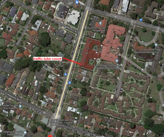
A traffic count was
undertaken on Pendle Way in November 2021. The location of the traffic count is
marked in red on the map above. The result of the traffic count indicated the
following:
Traffic count
Data on Pendle Way, Pendle Hill:
Average Daily Traffic (ADT) = 11,160 vehicles/day
85th percentile speed = 50.8 km/h
Mean (average) vehicle speed = 45.2 km/h
The result of the traffic
count reported crashes etc. were used in the assessment to determine the need
for the installation of traffic calming devices on Pendle Way in accordance
with the criteria set out in Council’s Local area Traffic Management
Policy (LATM) Policy. The LATM assessment is summarised in the tables below:
Table 1 – Pendle
Way, Pendle Hill - LATM Assessment Points
|
Criteria
|
Maximum
Score
|
Score
Achieved
|
|
Traffic Study Data
|
45
|
15
|
|
Crash warrant in the
last 5 years
|
15
|
5
|
|
Road Characteristics
|
35
|
13
|
|
Community Support &
other factors
|
5
|
5
|
|
Total
|
100
|
38
|
Table 2 – Pendle
Way, Pendle Hill – Action
|
Criteria
|
Action
|
|
>75
|
Report to TC with a
recommendation of providing traffic calming devices
|
|
61-75
|
Report to TC and
discuss possibility of providing traffic calming devices
|
|
41-60
|
Council to review
traffic data in 6 months
|
|
25-40
|
Monitor street and
review traffic data after 12 months
|
|
<25
|
Do Nothing
|
|
Speed
|
That regardless of the
total points scored, should the 85th percentile speed exceed the posted speed
limit by 5 km/h, the street be referred to the NSW Police for monitoring
and/or enforcement.
|
Based on the traffic
count, the recorded 85th percentile speed was 50.8 KM/H which are
within acceptable limits.
Based on the LATM
assessment, traffic calming devices are not warranted in the street.
This will be reviewed in
12 months.Attachments
Nil
2 March 2022
Item
No: CTC-22-047
WILLOUGHBY
STREET, GUILDFORD – ROAD SAFETY CONCERNS
Responsible
Division: Environment
& Planning
Officer: Engineering
Administration Officer
File
Number: HC-24-01-3/02
Electorate: Auburn
Police Area
Command (PAC): Cumberland
Council has received a request
from a local resident for the installation of traffic calming devices on
Willoughby Street, Guildford due to speeding concerns.
This report outlines the outcome
of the investigation into this matter.
|
The Traffic Committee recommends that Council undertake
consultation with residents of Willoughby Street, Guildford to assess support
or otherwise for the installation of traffic calming devices in the street.
|
Willoughby Street is a
local road that runs in an east-west direction between Excelsior Street and
Robertson Street. The speed limit is 50km/h and parking is permitted on both
sides of the road unless signposted. Willoughby Street is approximately 325m
long and 10.5m wide.
Council previously
undertook review of conditions in Willoughby Street, Guildford and reported to
Cumberland Traffic Committee in February 2020. The traffic committee
recommended that,
1. The report
be received, and no further action be taken at this stage in regard to speed
humps.
2. Council
request Cumberland Police Area Command to undertake speed surveillance in
Willoughby Street, Guildford.
Council approved the
recommendations subsequently.
Council has received
further concerns from a local resident in Willoughby Street concerning speeding
in the street.
The latest Centre for
Road Safety accident data indicated that there were no reported accidents on
Willoughby Street in the 5 years up to June 2021.
Council officers have
investigated the request in accordance with Council’s Local Area Traffic
Management (LATM) Policy.
The map below shows the
location of Willoughby Street, Guildford.
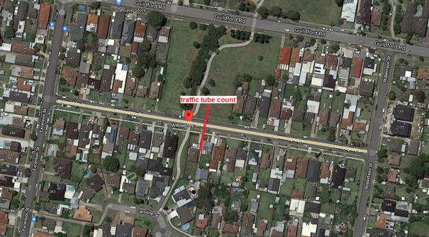
A traffic count was
undertaken on Willoughby Street in late November 2021. The location of the
traffic count is marked in red on the map above. The result of the traffic
count indicated the following:
Traffic count
Data on Willoughby St Guildford:
Average Daily Traffic (ADT) = 452 vehicles/day
85th percentile speed = 59.0 km/h
Mean (average) vehicle speed = 47.5 km/h
The recent traffic count data together with the previous
data is tabulated below:
|
|
March
2018
|
December
2019
|
November
2021
|
|
Average Daily Traffic (ADT)
|
464
|
439
|
452
|
|
85th %tile speed (km/hr)
|
60.5
|
57.2
|
59.0
|
|
Mean (average) vehicle speed (km/hr)
|
48.4
|
46.3
|
47.5
|
The result of the recent
traffic count, reported crashes etc. were used in the assessment to determine
the need for the installation of traffic calming devices on Willoughby Street
in accordance with the criteria set out in Council’s Local area Traffic
Management Policy (LATM) Policy. The LATM assessment is summarised in the
tables below:
Table 1 –
Willoughby St, Guildford - LATM Assessment Points
|
Criteria
|
Maximum
Score
|
Score
Achieved
|
|
Traffic Study Data
|
45
|
10
|
|
Crash warrant in the
last 5 years
|
15
|
0
|
|
Road Characteristics
|
35
|
13
|
|
Community Support &
other factors
|
5
|
5
|
|
Total
|
100
|
28
|
Table 2 – Willoughby
St, Guildford – Action
|
Criteria
|
Action
|
|
>75
|
Report to TC with a
recommendation of providing traffic calming devices
|
|
61-75
|
Report to TC and
discuss possibility of providing traffic calming devices
|
|
41-60
|
Council to review
traffic data in 6 months
|
|
25-40
|
Monitor street and
review traffic data after 12 months
|
|
<25
|
Do Nothing
|
|
Speed
|
That regardless of the
total points scored, should the 85th percentile speed exceed the posted speed
limit by 5 km/h, the street be referred to the NSW Police for monitoring
and/or enforcement.
|
Based on the traffic count, the
recorded 85th percentile speed was significantly higher than the
posted speed limit. It is proposed to undertake consultation with the residents
of Willoughby Street for the installation of traffic calming devices.
Nil
2 March 2022
Item
No: CTC-22-048
PERCY STREET,
AUBURN – PROPOSED PARKING RESTRICTIONS ASSOCIATED WITH A DEVELOPMENT
APPLICATION
Responsible
Division: Environment
& Planning
Officer: Engineering
Administration Officer
File
Number: HC-24-03-21
Electorate: Auburn
Police Area
Command (PAC): Auburn
Council has received detailed
design for the proposed installation of pedestrian crossing associated with an
approved development application at The International Maarif Schools of
Australia (IMSA) Gallipoli Campus Auburn located on Percy Street, Auburn.
This report outlines the outcome
of a review into this matter.
|
The Traffic Committee recommends:
1. The
request for a pedestrian crossing on Percy Street, Auburn outside the school
not be approved.
i)
2. The
proposed ‘No Parking; 8:00AM-9:30AM; 2:30PM-4:00PM; School Days’
and ‘Bus Zone; 8:00AM-9:30AM; 2:30PM-4:00PM; School Days’ signs
in accordance with the attached plan be approved.
ii)
3. The
costs associated with the installation of the signage shall be borne by the
applicant at no cost to Council.
iii)
4. The
applicant be notified of Council’s resolution.
|
The International Maarif
Schools of Australia (IMSA) Gallipoli Campus, Auburn was approved in March 2020
involving the staged construction of a new K-12 school, with capacity for 728
primary and secondary students and 58 full-time equivalent staff. The school
currently has from Kindergarten to Year 5.
The approved plans for
the project include a bus zone and pick-up and drop-off zone along the Percy
Street frontage of the site, along with a new pedestrian crossing across Percy
Street near the intersection with Gelibolu Parade. However, currently the
number of students in the school (in Kindergarten to Year 5) is very much lower
than the expected final enrolment of 728 students.
Council has received
detailed design for the proposed pedestrian crossing associated with an
approved development application.
The map below shows the
location of Percy Street, Auburn.
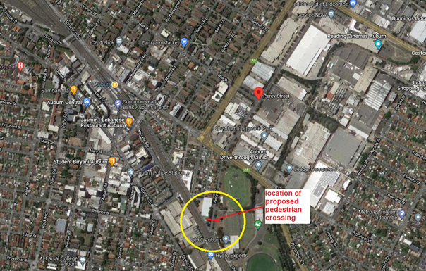
Council’s Officers
have investigated the request and the investigation revealed that a pedestrian
(zebra) crossing would require to meet current Australian Standard and RMS /
Transport for NSW requirements.
To provide a pedestrian crossing, Council must satisfy the
following warrants given in RMS / Transport for NSW Guidelines:
Normal Warrant:
A pedestrian (Zebra)
Crossing is warranted where:
In each of three separate
one hour periods in a typical day
(a)
the pedestrian flow per hour (P) crossing the road is >= 30 AND
(b)
the vehicular flow per hour (V) through the site is >= 500 AND
(c)
the product PV is >= 60,000
Reduced Warrant for sites
used predominantly by children and by aged or impaired pedestrians.
If the crossing is used predominantly
by school children, and in two counts of one-hour duration immediately
before and after school hours:
(a)
P ≥ 30 AND
(b)
V ≥ 200
a pedestrian (Zebra)
Crossing may be installed.
Since the school is with
limited number of students at this stage prior to final completion and no
pedestrian and vehicle counts have been provided to support the request.
Council officers believe that the numerical warrants required for a pedestrian
crossing will not be satisfied considering the low number of students currently
enrolled and there is no walking catchment for the school from the eastern side
of Percy Street.
However, Council proposes
to provide ‘No Parking; 8:00 AM-9:30AM; 2:30PM-4:00PM’ signage for
drop off / pick up and a school time Bus Zone as requested by the consultants
on behalf of the school.
A pedestrian crossing request
could be considered in the future subject to the satisfaction of the numerical
warrants once the construction of the development is fully completed.
1. Plans –
Percy Street, Auburn – Proposed signage outside the International Maarif
Schools of Australia at No 2 Percy Street Auburn.
2 March 2022
Item
No: CTC-22-049
WHALANS ROAD,
GREYSTANES – ROAD SAFETY CONCERNS
Responsible
Division: Environment
& Planning
Officer: Engineering
Administration Officer
File
Number: HC-24-01-3/02
Electorate: Prospect
Police Area
Command (PAC): Cumberland
Council has received a request
from a local resident for the installation of traffic calming devices on
Whalans Road, Greystanes due to speeding concerns.
This report outlines the outcome
of the investigation into this matter.
|
The Traffic Committee recommends Council undertake
consultation with the residents of Whalans Road, Greystanes to assess support
or otherwise for the installation of traffic calming devices in the street
and report back to traffic committee.
|
Whalans Road is a local road
that runs in an east-west direction between Greystanes Road and Cumberland
Road. The speed limit is 50km/h and parking are permitted on both sides of the
road unless signposted. Whalans Road is approximately 1530m long and 10.6m
wide.
Council has received a
request from a local resident for the installation of traffic calming devices
on Whalans Road between Cumberland Road and Gozo Road due to speeding concerns.
Background:
Cumberland Traffic
Committee at its meeting held on 1st November 2017 considered a report
regarding proposed speed humps on Whalans Road, Greystanes and recommended
that:
1. The provision of a traffic calming
device scheme incorporating speed humps on Whalans Road, Greystanes be approved
in principle.
2. The affected resident be consulted, and
the result reported back to the Traffic Committee with a detailed scheme.
Following consultation
with the residents, the speed humps were not approved as the majority of the
residents did not support the proposal.
Subsequently, Cumberland
Traffic Committee and Council approved the installation of pavement marking
(double barrier (BB) lines and ‘E1’ edge lines) as part of the
traffic calming measures in Whalans Road.
The pavement marking was
completed in late 2018.
Council has received
continued community concerns regarding speeding in the street.
The latest Centre for
Road Safety accident data indicated that there were seven reported accidents on
Whalans Road between Cumberland Road and Greystanes Road in the 5 years up to
June 2021.
Council officers have
investigated the request in accordance with Council’s Local Area Traffic
Management (LATM) Policy between Gozo Road and Cumberland Road. The
investigation revealed that Whalans Road has few traffic calming devices
such as roundabouts and edge and central line marking.
The map below shows the
location of Whalans Road, Greystanes.
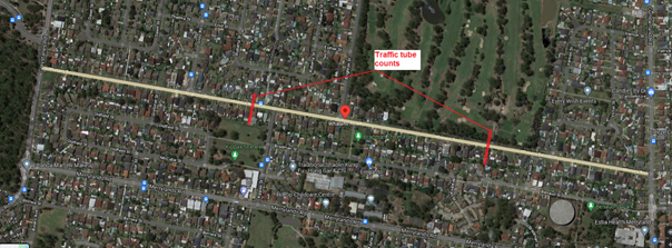
Two Traffic counts were
undertaken on Whalans Road in December 2021. The locations of the traffic
counts are marked in red on the map above. The results of the traffic counts
indicated the following:
Traffic count
Data on Whalans Rd between Gozo Rd & Kippax St:
Average Daily Traffic (ADT) = 2,572 vehicles/day
85th percentile speed = 56.9 km/h
Mean (average) vehicle speed = 48.2 km/h
The results of the
traffic count reported crashes etc. were used in the assessment to determine
the need for the installation of traffic calming devices on Whalans Road in
accordance with the criteria set out in Council’s Local area Traffic
Management Policy (LATM) Policy. The LATM assessment is summarised in the
tables below:
Table 1 –Whalans Rd
between Gozo Rd & Kippax St - LATM Assessment Points
|
Criteria
|
Maximum
Score
|
Score
Achieved
|
|
Traffic Study Data
|
45
|
20
|
|
Crash warrant in the
last 5 years
|
15
|
5
|
|
Road Characteristics
|
35
|
15
|
|
Community Support &
other factors
|
5
|
5
|
|
Total
|
100
|
45
|
Table 2 – Whalans
Rd between Gozo Rd & Kippax St – Action
|
Criteria
|
Action
|
|
>75
|
Report to TC with a
recommendation of providing traffic calming devices
|
|
61-75
|
Report to TC and
discuss possibility of providing traffic calming devices
|
|
41-60
|
Council to review
traffic data in 6 months
|
|
25-40
|
Monitor street and
review traffic data after 12 months
|
|
<25
|
Do Nothing
|
|
Speed
|
That regardless of the
total points scored, should the 85th percentile speed exceed the posted speed
limit by 5 km/h, the street be referred to the NSW Police for monitoring
and/or enforcement.
|
Traffic count
Data on Whalans Rd between Kippax St & Cumberland Rd:
Average Daily Traffic (ADT) = 2663 vehicles/day
85th percentile speed = 61. 6 km/h
Mean (average) vehicle speed = 54 km/h
The results of the
traffic count reported crashes etc. were used in the assessment to determine
the need for the installation of traffic calming devices on Whalans Road in
accordance with the criteria set out in Council’s Local area Traffic
Management Policy (LATM) Policy. The LATM assessment is summarised in the
tables below:
Table 3 – Whalans
Rd between Cumberland Rd & Kippax St - LATM Assessment Points
|
Criteria
|
Maximum
Score
|
Score
Achieved
|
|
Traffic Study Data
|
45
|
30
|
|
Crash warrant in the
last 5 years
|
15
|
10
|
|
Road Characteristics
|
35
|
13
|
|
Community Support &
other factors
|
5
|
5
|
|
Total
|
100
|
58
|
Table 4 – Whalans
Rd between Cumberland Rd & Kippax St – Action
|
Criteria
|
Action
|
|
>75
|
Report to TC with a
recommendation of providing traffic calming devices
|
|
61-75
|
Report to TC and
discuss possibility of providing traffic calming devices
|
|
41-60
|
Council to review
traffic data in 6 months
|
|
25-40
|
Monitor street and
review traffic data after 12 months
|
|
<25
|
Do Nothing
|
|
Speed
|
That regardless of the
total points scored, should the 85th percentile speed exceed the posted speed
limit by 5 km/h, the street be referred to the NSW Police for monitoring
and/or enforcement.
|
Based on the LATM
assessment, traffic calming devices are not warranted in the street. However,
the recorded 85th percentile speeds are high, particularly in the
section at the frontage of the Golf Course.
Comparison of 85th
percentile speeds:
|
|
September 2017
|
December 2021
|
|
Between Gozo Rd &
Kippax St
|
-
|
56.9 km/hr
|
|
Between Kippax St &
Cumberland Rd
|
65 km/hr
|
61.6 km/hr
|
It can be seen from the
recorded 85th percentile speeds above, the speeds have been high at
the frontage of the Golf course compared to the other section. However, the
recorded 85th percentile speed in December 2021 has reduced by
approximately 5% from 65 km/hr to 61.6 km/hr. The line marking in the street
may have assisted in reducing the speeds in this section.
It is proposed to
undertake further consultation with the residents to assess the support of
residents for speed humps in Whalans Road, Greystanes.
Nil
2 March 2022
Item
No: CTC-22-050
PARK ROAD, BERALA
AT YORK STREET - SAFER ROADS PROGRAM 2021/2022
Responsible
Division: Environment
& Planning
Officer: Engineering
Administration Officer
File
Number: T-28-01/06
Electorate: Auburn
Police Area
Command (PAC): Auburn
Council has received funding under
the Federal Safer Roads Program 2021/2022 financial year for the construction
of a Median Island with associated signage and line marking at the intersection
of Park Road and York Street, Berala.
This report outlines the outcome
of a review into this matter.
|
The Traffic Committee recommends:
1. The
construction of the proposed median island associated with signage and line
marking at the intersection of Park Road and York Street, Berala be approved.
i)
2. The
affected residents be notified of Council’s resolution.
|
Park Road is a Regional road that runs in a north-south
direction, it has a width of approximately 12m and parking permitted on both
sides of the road.
York Street is a local road that runs in an east-west
direction, it has a width of approximately 12m and parking permitted on both
sides of the road.
Park Road and York Street form a T-intersection at the
subject site with priority to Park Road.
Figure 1 below shows details of the intersection.
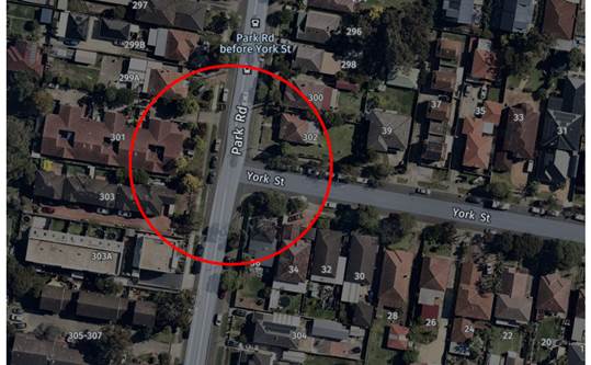
Figure 1 –
Locality Plan
Based on the crash record at the intersection,
Council’s Officers have investigated the intersection and nominated the
site for Safer Roads Program 2021/2022 Financial Year. The submission was based
on the latest RMS crash data at the time of the application which are
summarised below:
Crash Period
Investigated: July 2014
– Jun 2019 (5 years)
Total number of crashes: 5
Total number of injury: 5
Primary crash type: Right
Far/Right Near (RUM 11,15)
Proposed treatment: Median
Island
Treatment cost: $120,000
Following the submission, Council has received a formal
letter from the Transport for NSW advising that the submission for the proposed
Median Island at the intersection of Park Road and York Street has received
funding of $120,000. This project will need to be constructed/completed within
2021/2022 Financial Year.
The design has been prepared to accommodate the movement of
Heavy Rigid Vehicle (12.5m long) on all approaches and in accordance with
current Roads and Maritime Services / Transport for NSW Guidelines and
considered satisfactory.
Swept paths have been
checked for the left turning traffic from York Street.
It is advised that the
proposed treatment will slow down traffic, define priority control and improve
road safety for all road users.
1. Plans –
Park Road and York Street, Berala – Intersection Treatment
2 March 2022
Item
No: CTC-22-051
JOHN STREET,
LIDCOMBE AT THE INTERSETION OF ELIMATTA STREET AND EDITH STREET– PROPOSED
‘NO STOPPING’ RESTRICTIONS AND LINE MARKING
Responsible
Division: Environment
& Planning
Officer: Engineering
Administration Officer
File
Number: T-28-01/06
Electorate: Auburn
Police Area
Command (PAC): Auburn
Council has received concerns from a resident requesting
intersection treatment at the staggered intersection of John Street with
Elimatta Street and Edith Street.
This report outlines the outcome of the investigation into
this matter.
|
The Traffic Committee recommends:
1. The
installation of ‘No Stopping’ signs and ‘BB’ centre
lines at the intersection of John Street, Elimatta Street and Edith Street in
accordance with the attached plan be approved.
i)
2. The
adjacent residents be notified of the outcome.
|
John Street is a collector road that runs in a north-south
direction with a speed limit of 60 km/h. It has a width of approximately 12.5m
and parking is permitted on both sides of the road unless signposted.
Elimatta Street is a local road that runs in an east-west
direction with a speed limit of 50 km/h. It has a width of approximately 12m
and parking is permitted on both sides of the road unless signposted.
Edith Street is a local road that runs in an east-west
direction with a speed limit of 50 km/h. It has a width of approximately 12m
and parking is permitted on both sides of the road unless signposted.
John Street, Elimatta Street and Edith Street form a
staggered intersection with priority to John Street. No ‘Give Way’
signs or line marking are provided on Elimatta Street and Edith Street (Figure
1).
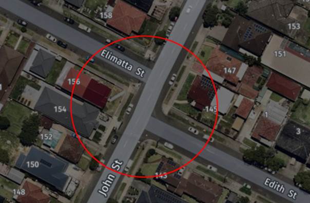
Figure 1 –
Locality Plan
A review of the Centre for Road Safety Accident database
indicated that there were no reported accidents at this staggered intersection
in the last five years ending March 2021.
During site inspections, it was observed that there are no
‘No Stopping’ signs at this staggered intersection. It will be
unsafe if vehicles park close to the intersection, particularly John Street
being a collector road carrying large volume of traffic.
The installation of statutory ‘No Stopping’
signs would strengthen the Road Rules requirement and stop vehicles from
parking too close to the intersection. It would also improve sight distance
requirements. It is also proposed to install “BB” centre lines on
the approaches to the intersection.
1. Plan –
John Street, at the intersection of Elimatta Street and Edith Street –
Proposed ‘No Stopping’ parking restrictions and ‘BB’
centre line marking
2 March 2022
Item
No: CTC-22-052
KERR PARADE,
AUBURN– APPLICATION FOR ‘WORKS ZONE’ SIGNAGE
Responsible
Division: Environment
& Planning
Officer: Engineering
Administration Officer
File
Number: T-28-01/06
Electorate: Auburn
Police Area
Command (PAC): Auburn
Council has received an
application for a ‘Works Zone’ on Kerr Parade, Auburn associated
with the development at 30 Kerr Parade, Auburn.
This report outlines the outcome
of the investigation into this matter.
|
The Traffic Committee
recommends:
1. The 12m long
‘Works Zone, 7:00am-6:00pm, Monday-Friday, 8:00am-4:00pm, Saturday’
signs be installed on the frontage of the development site on Kerr Parade,
Auburn subject to Council’s standard conditions for the period of 12
months and subsequent extension if required.
i)
2. Council
undertake consultation with Amity College concerning the loss of drop off /
pick up spaces for the school prior to commencement of the Works Zone.
ii)
3. The applicant
be advised to pay the ‘Works Zone’ fees to Council as per the
adopted Fees and Charges.
|
Council has received an
application for a ‘Works Zone’ on Kerr Parade, Auburn associated
with the development at 30 Kerr Parade, Auburn. The proposed development
involves construction of 12 storey boarding house with ground floor commercial
tenancy and 4 levels of basement parking.
The temporary “Works
Zone” is approximately 12m in length and proposed to commence in March
2022 for 12 months. The proposed time is between 7:00am to 6:00pm Monday to
Friday and 8:00am to 4:00pm on Saturdays.
There will be a loss of two (2)
one hour (1P) on-street parking spaces on the western side of Kerr Parade,
Auburn during the operation of the “Works Zone”. This area is
sign posted “No Parking, 8:00AM-9:30AM, 2:30PM-4:00PM, School Days”
for drop off / pick up of students of Amity College. However, the two spaces
are at the frontage of the property being developed and considered essential
for a works zone for the development.
Council generally provides School
drop off / pick up areas at the frontage of the school only. However, in this
instance the drop off/pick up area was extended with consent from the owner of
the property that is being developed.
Council will undertake
consultation with the school to address the shortfall.Attachments
1. Plan –
Kerr Parade, Auburn – Proposed Temporary ‘Works Zone’ signage
2 March 2022
Item
No: CTC-22-053
LOCKWOOD
STREET AND LEEDS STREET, MERRYLANDS – PROPOSED ‘NO STOPPING’
SIGNS AND ‘BB’ LINEMARKING
Responsible
Division: Environment
& Planning
Officer: Engineering
Administration Officer
File
Number: HC-24-01-3/02
Electorate: Granville
Police Area
Command (PAC): Cumberland
Council has received a complaint
from a local resident regarding road safety concerns at the intersection of
Lockwood Street and Leeds Street, Merrylands.
This report outlines the outcome
of the investigation into this matter.
|
The Traffic Committee recommends:
1. The
proposed installation of ‘No Stopping’ signs at the intersection
of Lockwood Street and Leeds Street, Merrylands in accordance with the
attached plan be approved.
i)
2. The
adjacent residents be notified of the outcome generally
|
Lockwood Street is a
local road that runs in a north-south direction with a speed limit of 50 km/hr.
It has a width of approximately 10.7m at its intersection and parking permitted
on both sides of the road unless signposted.
Leeds Street is a local
road that runs in an east-west direction with a speed limit of 50 km/hr. It has
a width of approximately 10.2m and parking is permitted on both sides of the
road in accordance with Road Rules unless signposted.
Lockwood Street and Leeds
Street form an intersection with priority to Lockwood Street and
‘Stop’ signs on Leeds Street.
Cumberland Traffic
Committee at its meeting in June 2021 considered a report (CTC-21-127) on road
safety concerns in Lockwood Street, Merrylands and recommended the installation
of line marking on Lockwood Street, Merrylands between Merrylands Road and
Walpole Street. As part of this line marking, ‘BB’ centre lines
were approved on all approaches to the intersection of Lockwood Street and
Leeds Street.
Council has received a
complaint from a local resident regarding road safety concerns following a
recent accident at this intersection.
The map below shows the
intersection of Lockwood Street and Leeds Street.
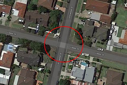
Council’s Officers
have investigated the request and found that there are no ‘No
Stopping’ signs installed at this intersection.
Therefore, it is proposed
to the install statutory 10m ‘No Stopping’ zones at this
intersection to strengthen the Road Rules requirement and improve sight
distance.
The previously approved
line marking and the ‘No Stopping’ signs at this intersection would
enhance road safety for all road users at this intersection.
1. Plan –
Lockwood Street and Leeds Street, Merrylands – Proposed ‘No
Stopping’ signs.
2 March 2022
Item
No: CTC-22-054
NEIL STREET,
MERRYLANDS – PROPOSED LEFT IN / LEFT OUT ARRANGEMENT ASSOCIATED WITH A
DEVELOPMENT APPLICATION
Responsible
Division: Environment
& Planning
Officer: Engineering
Administration Officer
File
Number: DA2012/493/1
Electorate: Granville
Police Area
Command (PAC): Cumberland
Council proposes to install
‘No Right Turn’ signage at the intersection of Neil Street and the
new road created as part of the Neil Street Masterplan to strengthen the left
in/Left out arrangement at this new intersection.
This report outlines the outcome
of a review into this matter.
|
The Traffic Committee recommends the proposed ‘No
Right Turn’ signage at the intersection of Neil Street and the new road
in accordance with the attached plan be approved.
|
Council proposes to
install ‘No Right Turn’ signage at the intersection of Neil Street
and the new road created as part of the Neil Street Masterplan to strengthen
the left in/Left out arrangement at this new intersection.
The new intersection is
approximately 130m from the signalised intersection of Neil Street and Pitt
Street and approximately 110m from the bridge over the railway lines.
It was originally
proposed to install traffic signal control at this intersection. However,
following discussions with the Roads and Maritime Services (now Transport for
NSW), the proposal to provide a Left in / Left out arrangement was decided as
appropriate.
The map below shows the
location of the intersection.
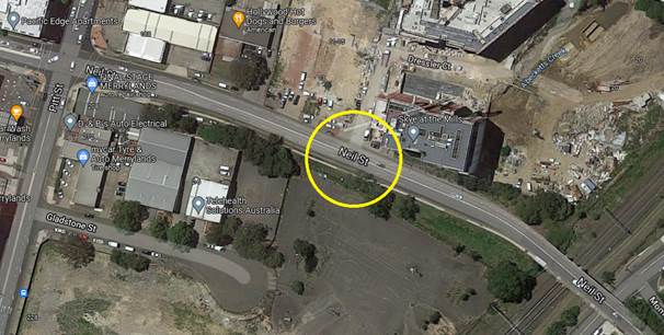
A street view of the
intersection is shown below.
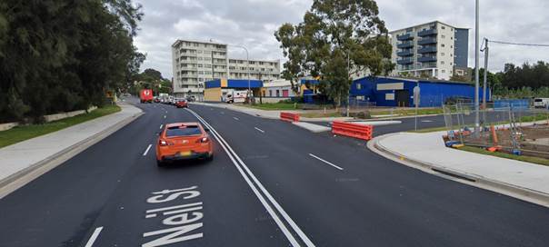
A triangular island has
been built in the new road at the intersection to physically ban right turning
movements into and out of the road. However, to strengthen the ban, it is
proposed to install no right turn signs on Neil Street and the New road.
1. Plan –
Neil Street, Merrylands – Proposed no right turn signage
2 March 2022
Item
No: CTC-22-055
BLAXCELL
STREET, GRANVILLE – REVIEW OF PROPOSED RELOCATION OF THE PEDESTRIAN
CROSSING AND ASSOCIATED SIGNAGE – FEDERAL STIMULUS PROGRAM
Responsible
Division: Environment
& Planning
Officer: Engineering
Administration Officer
File
Number: T-28-01/06
Electorate: Granville
Police Area
Command (PAC): Cumberland
Council received objections for
the proposed construction of the pedestrian crossing on Blaxcell Street,
Granville as per CTC-21-208.
This report considers a review
options for the proposal.
|
Two options are provided for traffic committee
consideration.
Option 1:
The Traffic Committee recommends that previously
approved option recommended by Cumberland Traffic Committee (CTC-20-034 &
035 and CTC -21-208) and approved by Council be approved for construction.
Option 2:
The Traffic Committee recommends that no further action
taken in this regard to relocating the bus stop and the raised pedestrian
crossing.
|
Background:
Council has received complaints in
relation to queuing of vehicles on Blaxcell Street to access the service
station on Blaxcell Street. Long queues on southbound lane occupies the
kerbside lane and blocks access to existing bus stop which forces the buses to
stop in the middle traffic lane to drop off and pick up of patrons.
The queue on the northbound lane
to turn right to access the service station blocks the pedestrian crossing and
compromises pedestrian safety.
Therefore, Council commenced the
process to relocate both the pedestrian crossing and the bus stop to improve
safety of road users and constructing a median to prohibit right turns at this
location to improve northbound traffic flow.
Cumberland Traffic Committee at
its meeting in February 2020 considered two reports (vide Item No. CTC-20-034
& CTC-20-035) to relocate the existing raised pedestrian crossing on
Blaxcell Street at Thomas Street and the ‘Bus Zone’ on the eastern
side of Blaxcell Street.
Council’s initial proposal
was to relocate the crossing to a location just south of the existing roundabout
of Blaxcell Street and Louis Street. Also, it was proposed to relocate the
existing ‘Bus Zone’ on the eastern side of Blaxcell Street south of
Charles Street to a location north of Charles Street.
The traffic committee recommended
to relocate the raised pedestrian crossing to a location south of Celia Street
instead of the initial proposal due to the proximity of the location to the
roundabout as it will compromise the performance of this busy roundabout .
Also, similarly, recommended to move the bus stop (‘Bus Zone’) to a
new location together with the crossing south of Celia Street.
Council approved the traffic
committee recommendations at its meeting held on 4 March 2020.
Council submitted the proposal for
construction under the Federal Government Stimulus Program in 2020/21
and received funding.
The works were scheduled to commence in June 2021. Council
received objections from a resident who will lose the on-street parking within
their frontage due to the parking restrictions associated with the new
relocated crossing.
At a site meeting with the residents, Council officers were
requested to consider alternate locations for the crossing and a location was
suggested. A report (CTC-21-208) was presented to Local Traffic Committee in
August 2021 with the following two options:
Option 1:
The Traffic Committee recommends:
1. The relocation of
the raised pedestrian crossing and ‘Bus Zone’ on Blaxcell Street be
approved as per the amended option 3 in the attached plan.
2. Council consult
affected businesses and properties.
Option 2:
The Traffic Committee recommends
that previously approved option recommended by Cumberland traffic committee
(CTC-20-034 & 035) and approved by Council be approved for construction.
Members of the traffic committee recommended and Council
subsequently approved option 2 as it has less impact on the local businesses,
residents and road networks. This means there is no change to the previously
approved location.
Changed proposal:
In February 2022, before the construction commenced, Council
received objections from the same resident who requested at a site meeting with
council officers that consideration be given to relocate the raised pedestrian
crossing to a location further south.
The map below shows the approved location and the new
location requested.
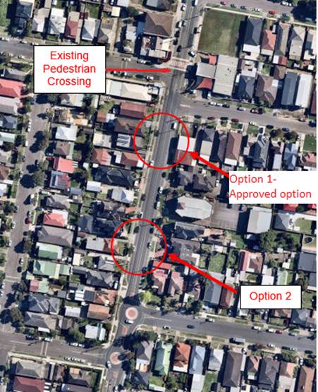
Map -1
Council officers have investigated new location and
summarise the outcome below:
The approved option is to relocate the pedestrian crossing
from one side of the intersection to the other side by maintaining the current
crossing warrants and also the location change will not have significant impact
on the current (existing) pedestrian movements and the necessity of the
existing crossing.
Relocation preferred by the traffic committee and
subsequently approved by Council fulfills the intentions of the relocation and
addresses concerns raised regarding the existing location.
Following objections from a resident to Option 1 as marked
in map 1 above (approved option), Council officers have investigated the
location suggested at the site meeting and found the following issues with the
location.
· The alternate
location is more than 60 metres from the proposed location which is more than
100 from the existing raised pedestrian crossing and far from any pedestrian
generators. Also, the relocation needs to be further south due to the presence
of existing driveways on both sides of the road.
i)
· Due to its
distance from the existing location, Council is required to check the
pedestrian and vehicle numerical warrants as a new crossing. As there are no
significant pedestrian generators at this location, the numerical warrants for
the pedestrians are unlikely to be satisfied. Also, a viable new location will
be in the proximity of the existing roundabout at Membrey Street. It shall be
noted that Council has not received any safety concerns of pedestrians who are
using the existing pedestrian facility on the northern side of the roundabout.
ii)
· The approved
location has residential driveways on one side only and clear kerbside on the
other side facilitating locating the relocated crossing. The new location
further south is outside other residences and Council may receive objections
from those residents in similar nature.
iii)
· As subject
construction is funded under ‘Federal Stimulus Program’, Council
will forfeit the funding if further delays are experienced for construction
iv)
· The existing
location of the crossing at the frontage of the service station results in
queuing across the crossing by waiting vehicles to turn into the service
station entrance. Also, exiting vehicles from the service station exit driveway
just south of the crossing create safety concerns for pedestrians using the
crossing. This necessitates the relocation of the crossing as approved to
improve pedestrian safety.
Based on the above, it is necessary that the originally
approved option be confirmed for the location for relocation. However, two
options are provided for traffic committee to consider.
1. CTC-21-208
– Blaxcell Street, Granville – Review of proposed relocation of the
pedestrian crossing and associated signage – Federal Stimulus Program
2. CTC-21-208
– Minutes of traffic committee item