9 February 2022
A meeting of the Cumberland Local
Planning Panel will
be held at 11:30am via Zoom on Wednesday, 9 February 2022.
Business as below:
Yours faithfully
Peter J. Fitzgerald
General
Manager
ORDER OF BUSINESS
1. Receipt of Apologies
2. Declarations of Interest
3. Address by invited
speakers
4. Reports:
- Development
Applications
- Planning
Proposals
5. Closed Session Reports
Cumberland Local Planning Panel Meeting
9 February 2022
CONTENTS
Report No. Name of Report Page
No.
Development Applications – Public Meeting
LPP001/22... Development Application
for 2-4 Cameron Street, Lidcombe....................... 5
LPP002/22... Development Application
for 2-8 Vaughan Street and 1 Kerrs Road, Lidcombe 217
Development
Applications – Electronic
Determination
LPP003/22... Development Application
for 7 Birmingham Street, Merrylands............... 341
Cumberland Local Planning Panel Meeting
9 February 2022
Item No:
LPP001/22
Development
Application for 2-4 Cameron Street, Lidcombe
Responsible
Division: Environment
& Planning
Officer: Executive
Manager Development and Building
File
Number: DA2021/0462
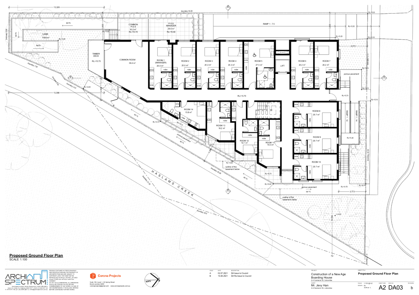
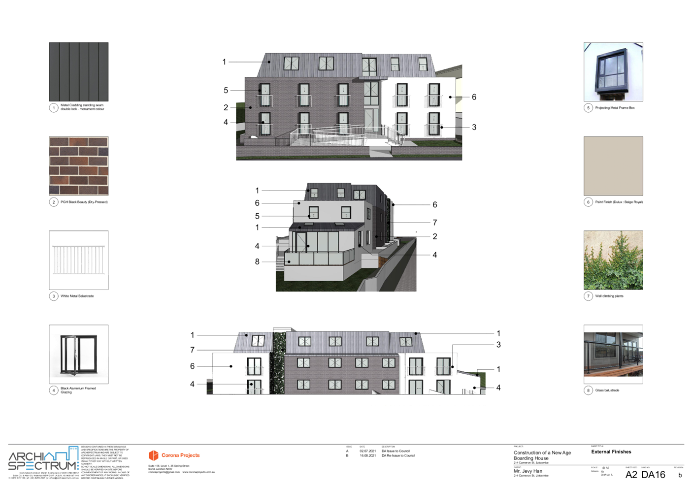
1. Development
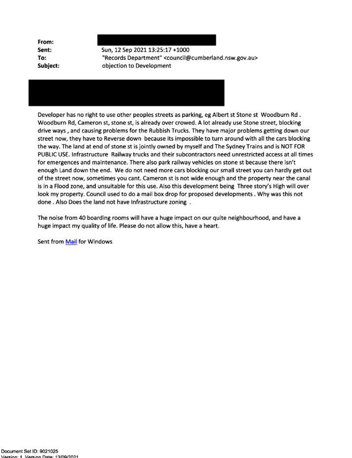
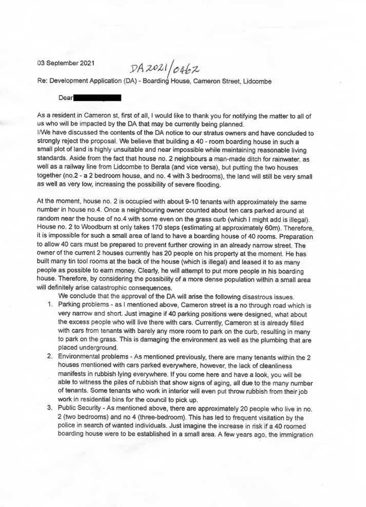
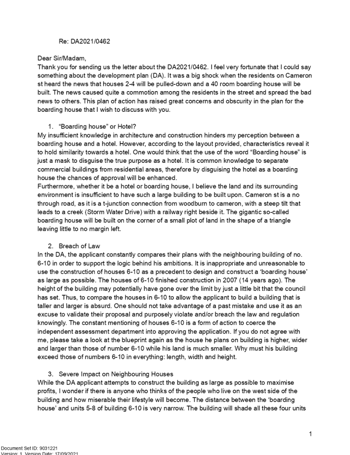
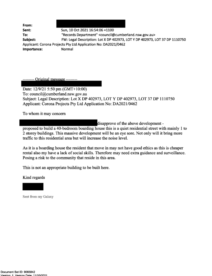
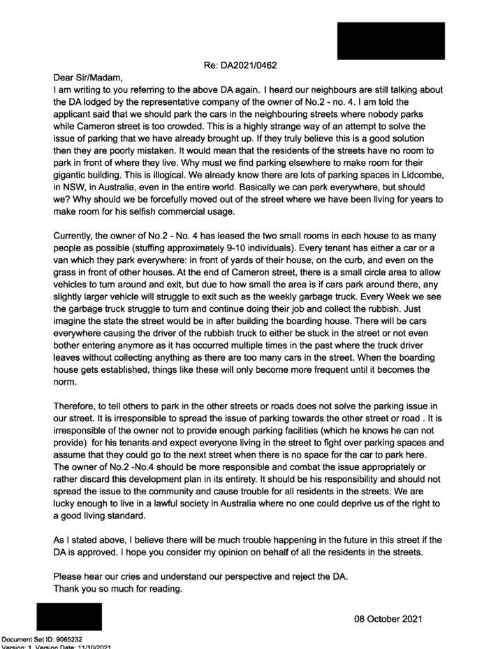
Application No. DA2021/0462 was accepted on 31 August 2021 for the demolition
of existing structures and construction of a three-storey boarding house,
comprising 40 boarding rooms (inclusive of a manager's room) over basement
parking.
2. The
application was publicly notified to occupants and owners of the adjoining
properties for a period of 14 days between 10 September 2021 and 24 September
2021.
3. Notification
was extended for an additional 14 days from 6 October 2021 and 20 October 2021
in order to capture a wider catchment area. In response to the notification, a
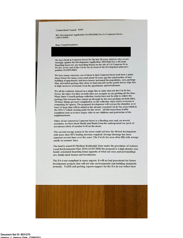
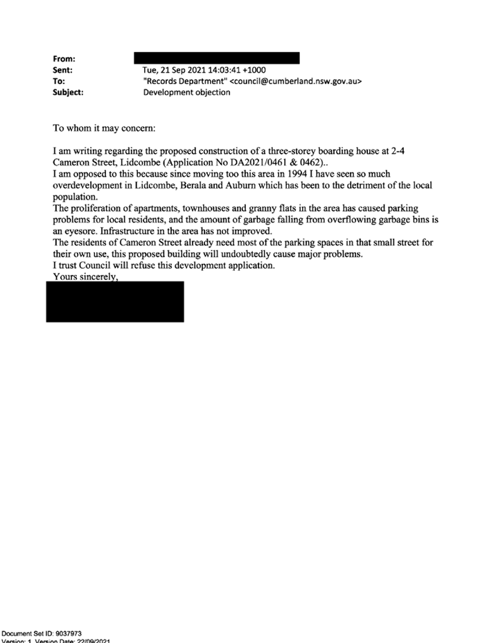
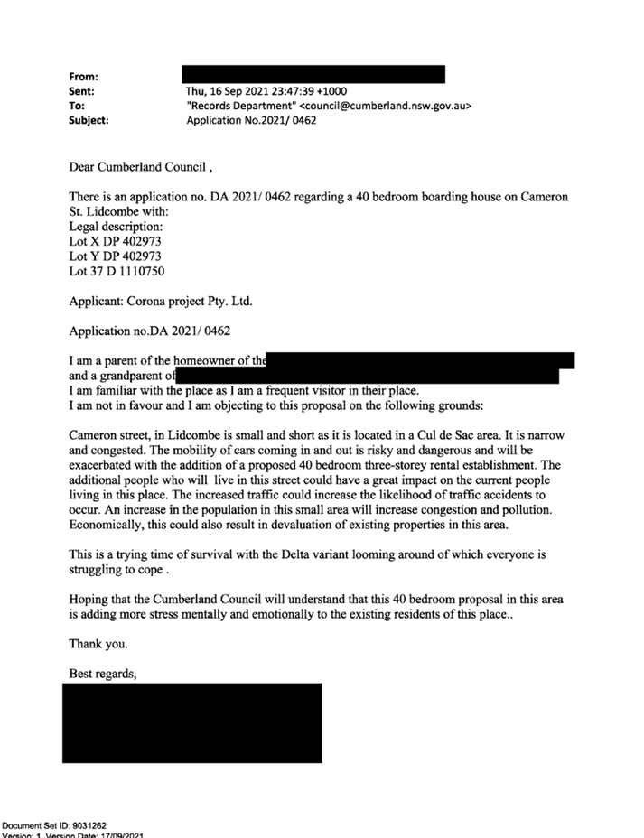
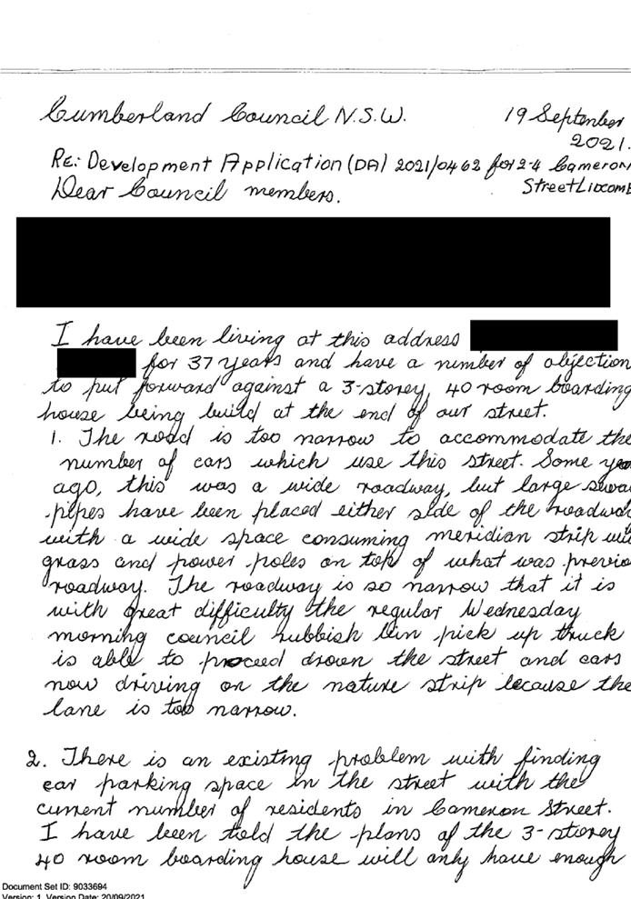
total of 44 unique submissions were received.
4. Significant
non-compliances and issues were identified and on this basis, a request to
withdraw the application incorporating the list of concerns was sent to the
applicant on 26 October 2021.
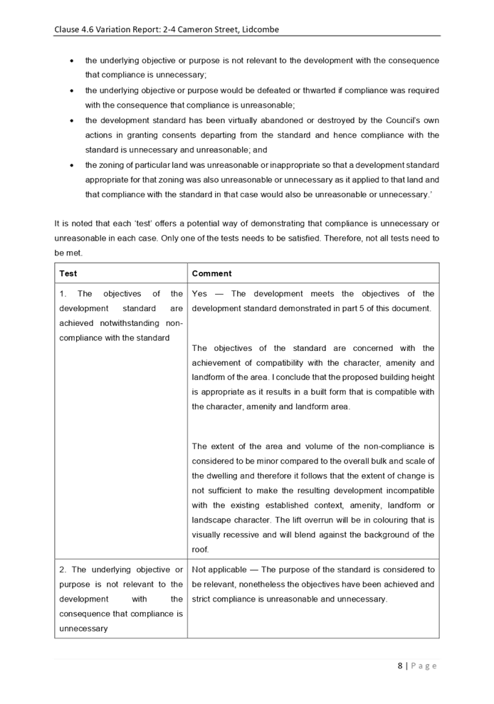
5. The
notable variations are listed as follows:
|
Control
|
Required
|
Provided
|
% variation
|
|
Building height
|
9m
|
9.5m
|
6%
|
|
Floor Space Ratio (FSR)
|
0.75:1
|
0.95:1
|
27%
|
|
Parking
|
Boarding room spaces = 20
(0.5 x 40)
|
15
|
25%
|
|
Room size
|
Single lodger boarding rooms must be a minimum of 12m2
|
Rooms 14, 29 and 40 are 10.5m2
|
12.5%
|
|
Setback from Haslam’s Creek
|
10m setback from the mean high water mark
|
Cannot be determined based on submitted information.
Due to the close proximity of the development to the edge
of the Haslam’s Creek channel, it is unlikely to comply.
|
Likely to be significant given the close proximity of the
development to the edge of the Haslam’s Creek channel.
|
|
Number of storeys
|
Maximum of two storeys
|
Three storeys
|
50%
|
|
Floor to ceiling heights
|
Minimum of 2.7m
|
Approximately 2.4m
|
11%
|
|
Landscape area
|
Minimum of 30%
(351.3)
|
17% (200m2)
|
43%
|
6. The application is
referred to the Panel as the proposal is considered to be contentious and
contravenes a development standard by more than 10%.
7. The
application is recommended for Refusal for the reasons provided in the attached
schedule.
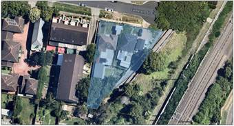
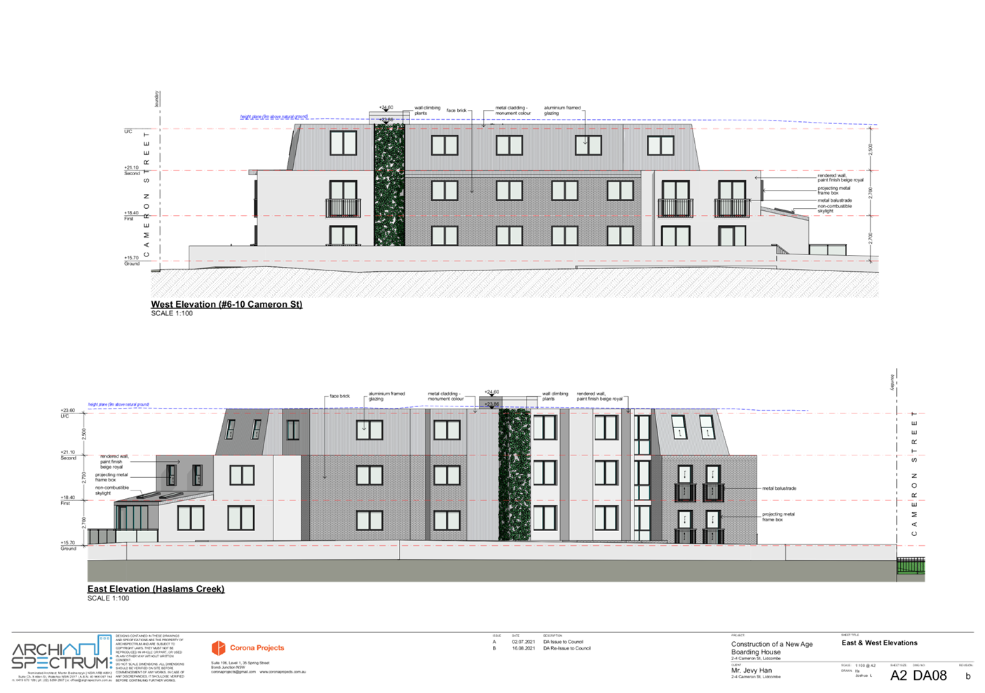
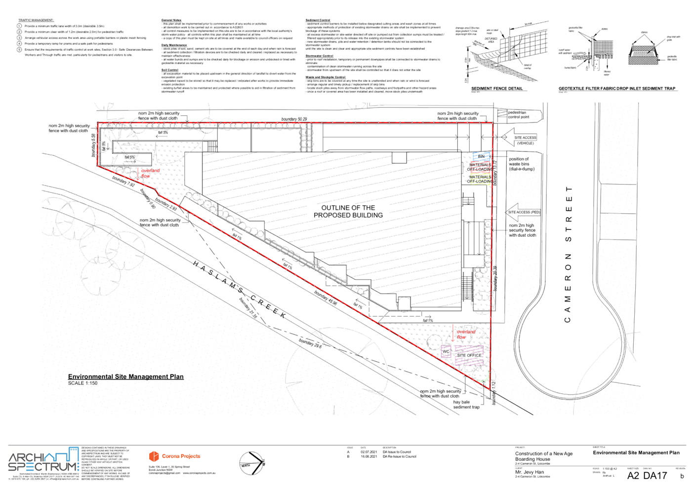
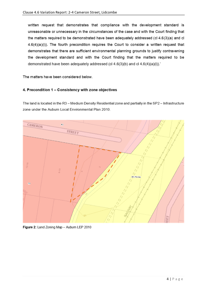
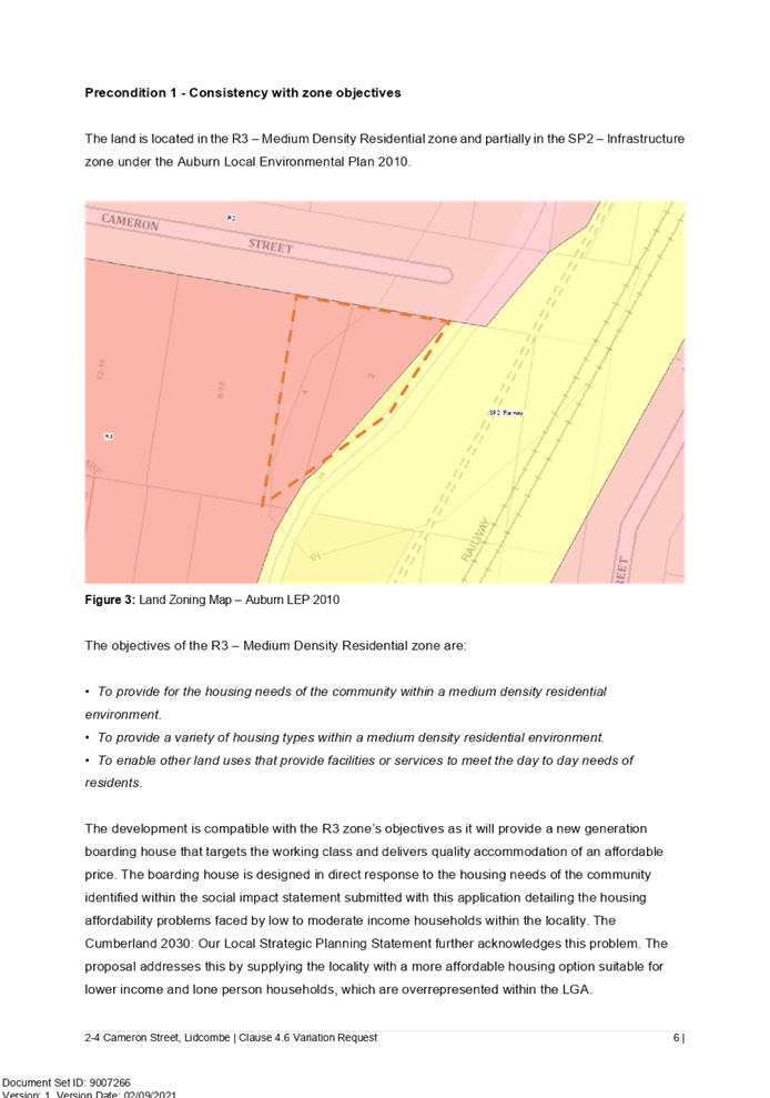
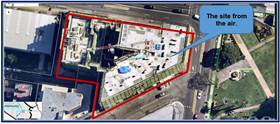
Subject Site and Surrounding
Area
The subject site comprises three
lots being Lot X DP 402973, Lot Y DP 402973 and Lot 37 DP 1110750 and is known
as 2-4 Cameron Street Lidcombe. The site is located at the end of a cul-de-sac
and is irregular in shape with a frontage to Cameron Street of 34.11m and a
total area of 1,171m2. The two larger sized lots are zoned R3 Medium Density
Residential and the smaller lot (Lot 37 DP 1110750) is zoned SP2
Infrastructure.
As shown in Figure 1, the site is
situated at the interface to a change in land use zone from R3 Medium Density
Residential to R2 Low Density Residential. Befitting the R2 land use zone,
dated single dwellings, dual occupancy and multi dwelling housing developments
are located to the north on the opposing side of Cameron Street. Haslam’s
Creek which is defined by a concrete channel traverses the eastern part of the
site. A rail corridor runs parallel to the eastern boundary of the site and is
setback approximately 22m. Immediately to the west lies a multi dwelling
housing development with basement level parking. The site is located within
walking distance to Lidcombe train station being approximately 1.2km away.
The site is a flood control lot
and is impacted by 1 in 100 year flooding.
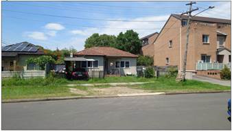
Currently, two dated single storey
dwellings are located on the site. A large tree is located at the rear of the
neighbouring property to the west with a canopy that extends over part of the
development site.
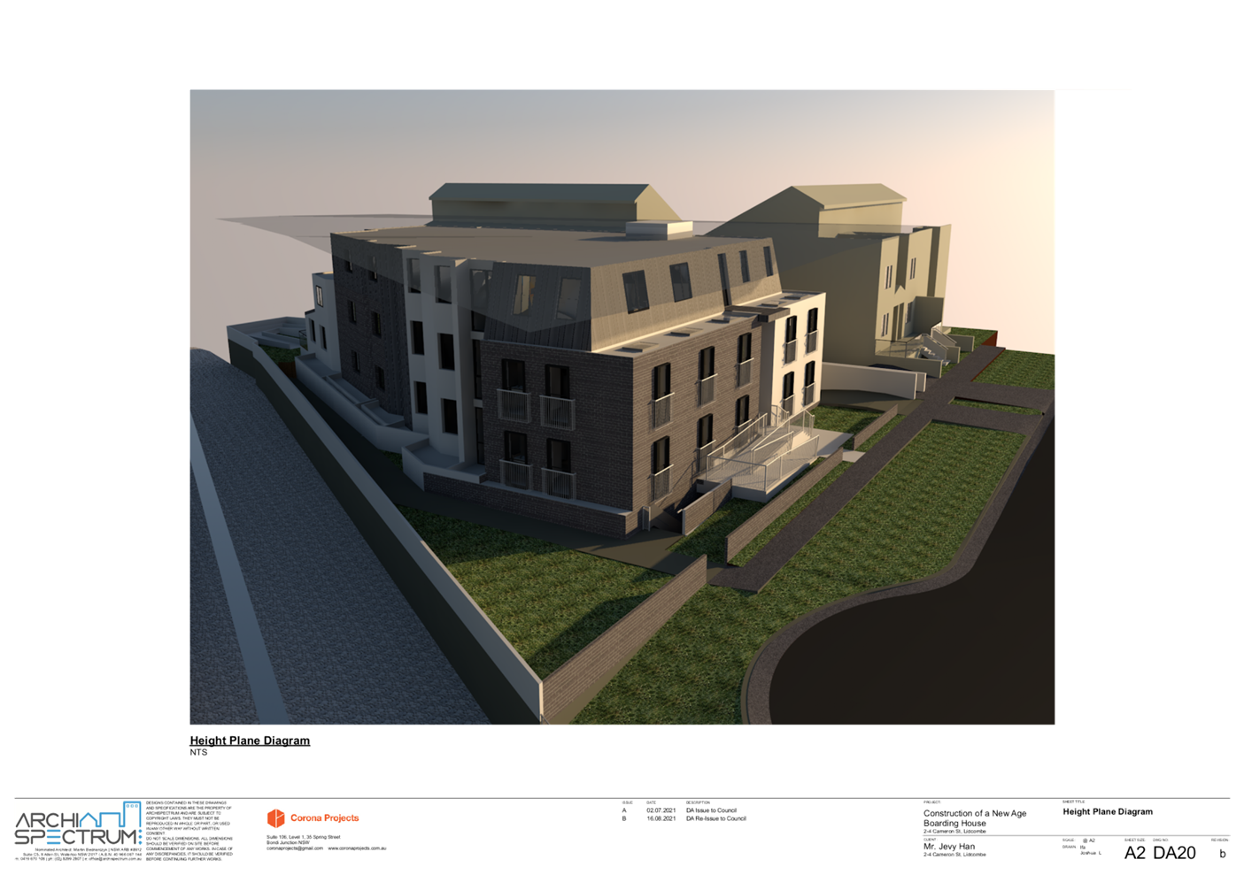
Figure
1 – Locality Plan of subject site highlighted in ‘blue’
Figure
2 – Aerial view of the subject site highlighted in ‘blue’
Figure
3 – Street view of no. 2 Cameron Street
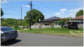
Figure
4 – Street view of no. 4 Cameron Street
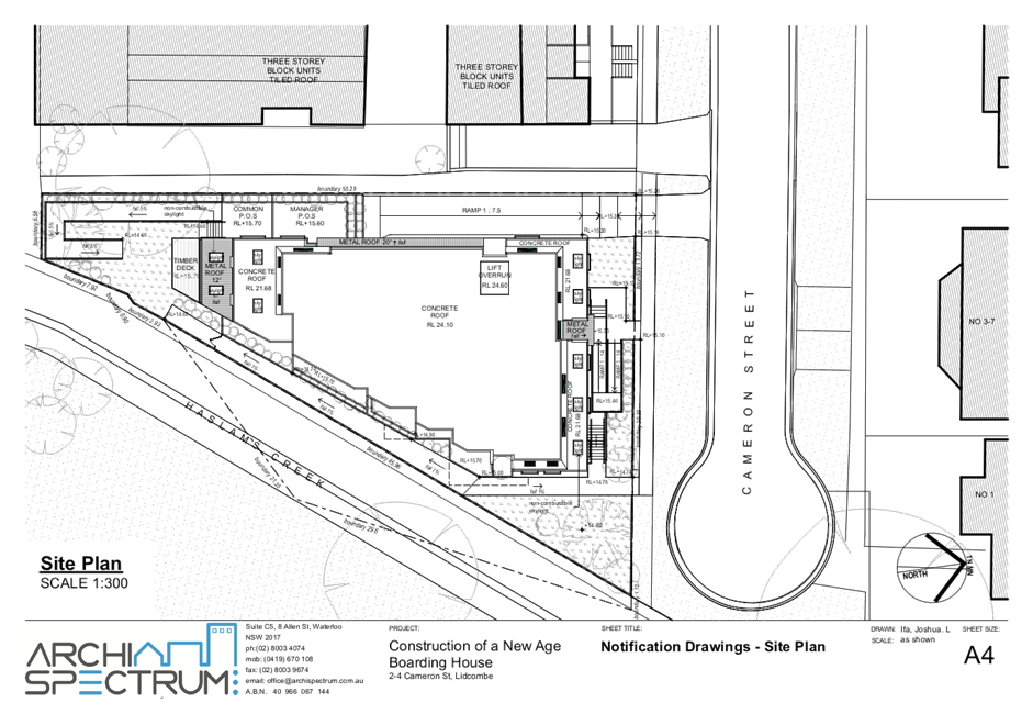
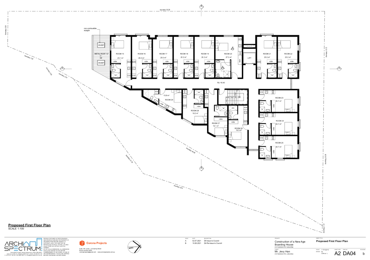
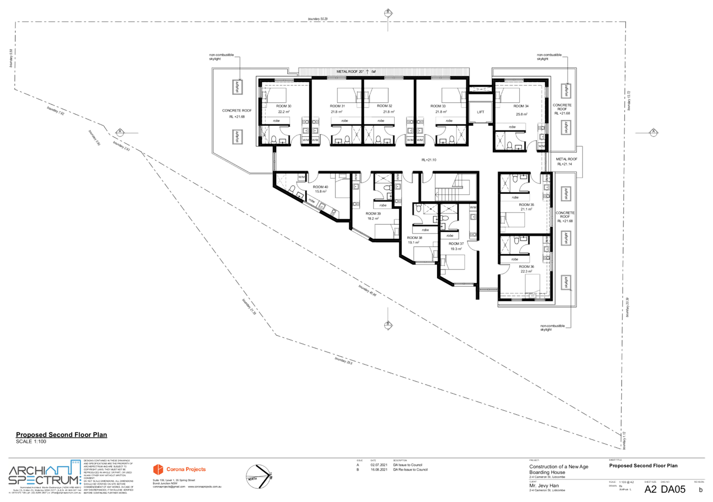
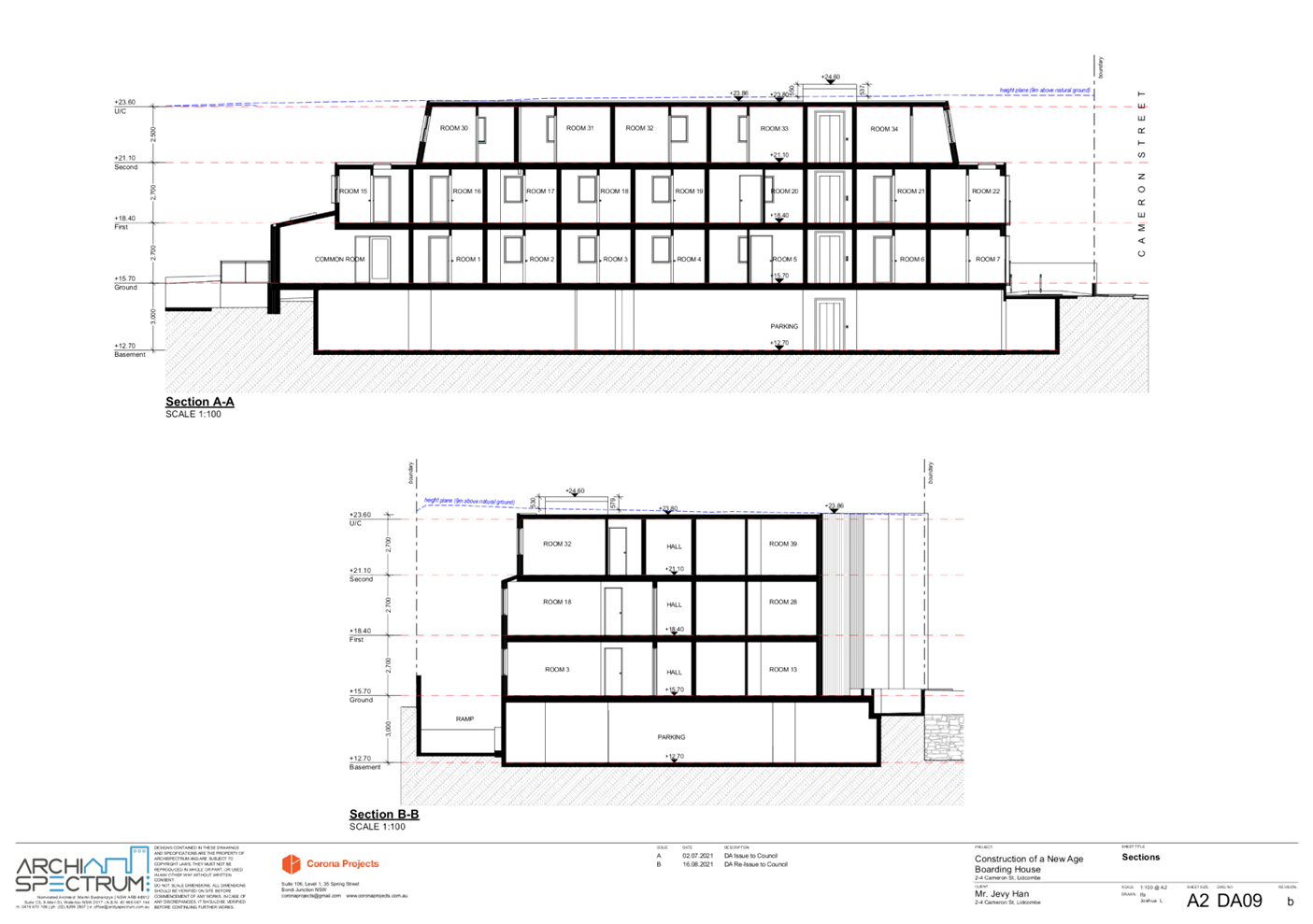
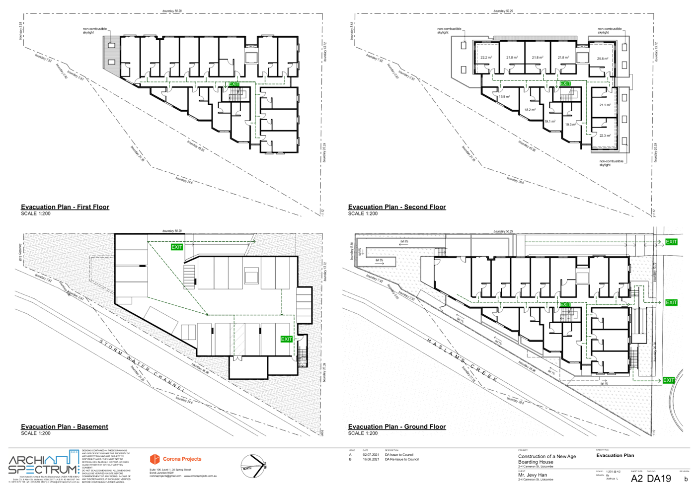
Description of the
Development
Council has received a development
application for the demolition of existing structures and the construction of a
‘new generation’ boarding house comprising three storeys and
basement level parking. The boarding house comprises 40 rooms inclusive of a
manager’s room. Two accessible rooms are provided. Approval is sought for
the use of car stackers in the basement level to provide 20 parking spaces, 8
motorcycle spaces and 8 bicycle spaces. A description of each level of the
development is provided below.
Basement level
- 10
spaces are provided on the ground and an additional 10 spaces are proposed on
car stackers.
- 2
disabled spaces and a shared zone.
- 8
motorcycle spaces.
- 8
bicycle spaces.
- A
services and bin room.
- A
pump room.
- An
elevator.
- Stairway
providing access to the ground level.
- Basement
ramp and driveway is located adjacent to the western side boundary.
Ground floor
- 13
boarding rooms, inclusive of one designed for disabled access.
- A
manager’s room and associated private open space.
- A
common room and a timber deck provide access to side and rear outdoor communal
areas.
- A
disabled access ramp is located within the front setback.
First floor
- 15
boarding rooms inclusive of one designed for disabled access.
Second floor
- 11
boarding rooms.
Applicants Supporting
Statement
The applicant has provided a
Statement of Environmental Effects prepared by Corona Projects dated August
2021 and was received by Council on 25 August 2021 in support of the
application.
Contact with Relevant
Parties
The assessing officer has
undertaken a site inspection of the subject site and surrounding properties and
has been in regular contact with the applicant throughout the assessment
process.
Internal Referrals
Development Engineer
The development application was
referred to Council’s Development Engineer for comment who has advised
that the development proposal is unsatisfactory as a 10m setback is not
provided to the foreshore building line.
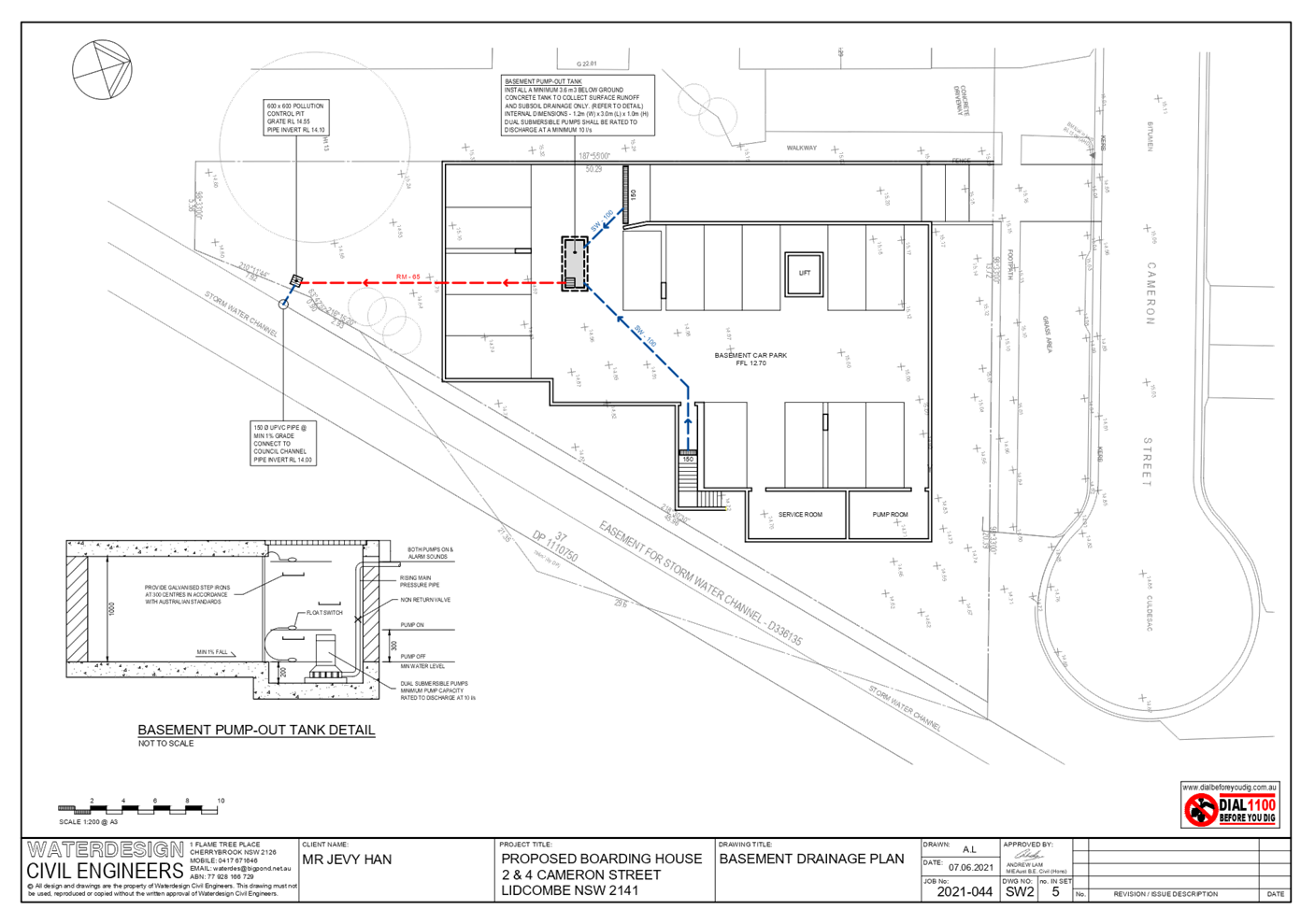
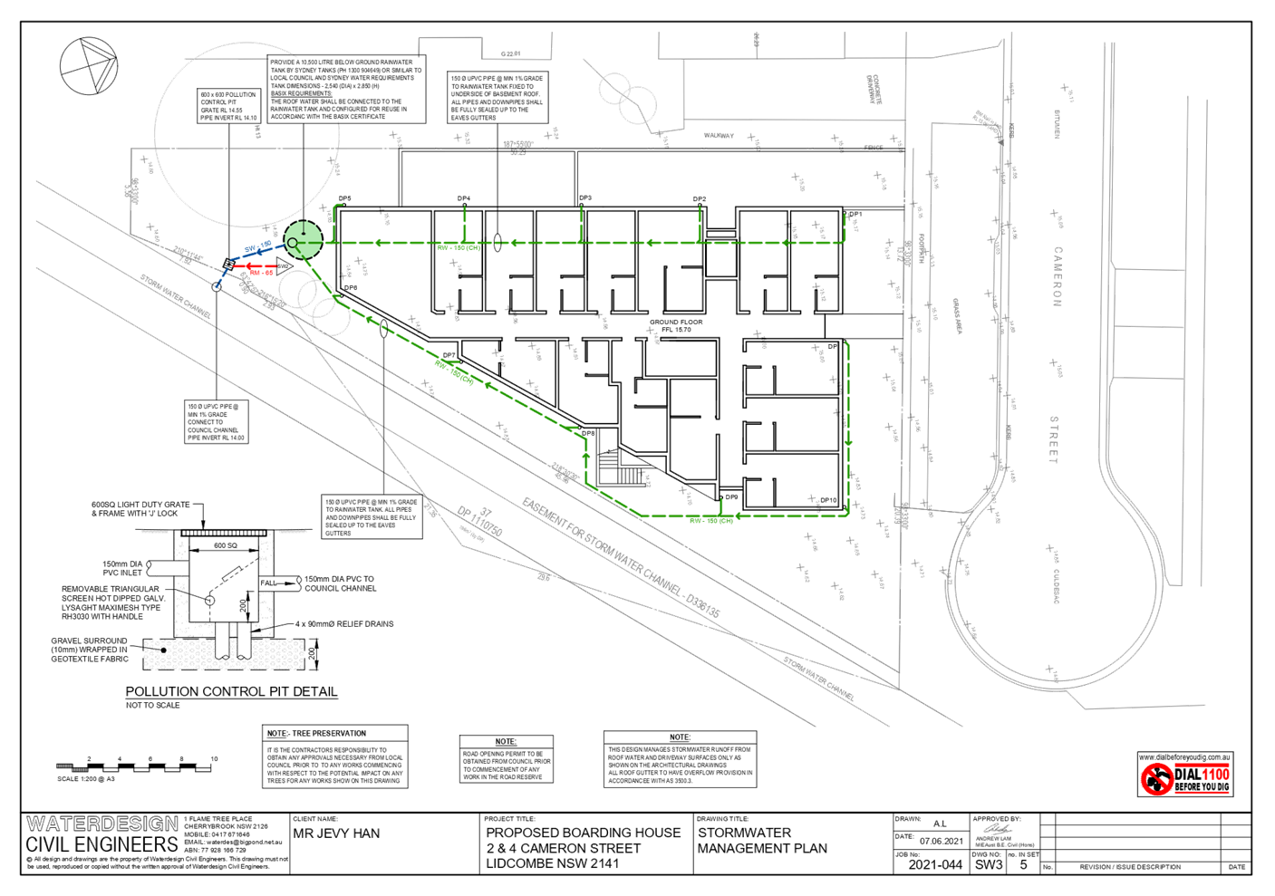
Furthermore, the submitted
stormwater drainage design does not comply with the relevant requirements of
Auburn Development Control Plan 2010 (ADCP). In this regard, an On-site
Detention (OSD) system is required to serve the development. It was further
noted that the basement drainage system does not comply with the relevant
stormwater requirements of ADCP and above ground storage volume has not been
provided.
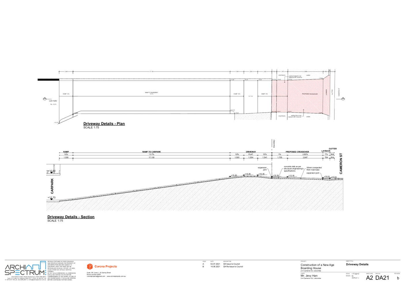
The proposed onsite parking design
is unsatisfactory as the use of car stackers is not supported. Moreover, the
design of the parking layout, the basement ramp and vehicle manoeuvrability
does not comply with the relevant Australian Standards.
Tree Management
Council’s Tree Management
Officer has advised that an arborist report should have been prepared and
provided to establish the impact of the proposed development on a mature tree
located at the rear of the neighbouring property to the west.
Waste Management
Council’s Waste Management
Officer has advised that the development is unsatisfactory as no waste
management plan was submitted and an appropriately designed bin transfer path
and temporary bin holding area has not been provided.
Environment and Health
Council’s Environment and
Health Officer has advised that the development proposal is satisfactory and
can be supported subject to conditions of consent.
External Referrals
Sydney Water
Insufficient information has been
provided to determine whether the development will impact Sydney Water’s
stormwater assets and its clearance requirements. In this regard, the applicant
has not identified the outside edge of Sydney Water’s stormwater channel
and a 1m clearance line from the outside face and the Sydney Water easement
line (if any) on the architectural and stormwater plans. No structures, access
paths, buildings, roof eve, stormwater pipes, stormwater pits or other
permanent structures are to be located within the 1m clearance zone.
Fencing is required along Sydney
Water’s stormwater assets. Any fence other than 1.2m high pool fencing,
1.8m high Colorbond fencing or equivalent should be located at least 1m away
from the outside face of the stormwater channel and be supported on piers. The
piers are to be extended at least 1m below the invert level of the stormwater
channel or 1m below the zone of influence of the stormwater channel. Fencing
along the stormwater channel is to be in such a way that the flood water and
stormwater overland flow are to be able to flow across the fence in both
directions.
Sydney Trains
Concurrence was granted by Sydney
Trains for the proposed development with regard to clause 86(4) of the State
Environmental Planning Policy (Infrastructure) 2007 (ISEPP).
Ausgrid
Ausgrid has raised no objection to
the development subject to compliance with the relevant Ausgrid Network
Standards and SafeWork NSW Codes of Practice for construction works near
existing electrical assets being demonstrated. Compliance with this requirement
can be addressed by imposing a condition of consent as part of any approval of
the development.
NSW Police
NSW Police have raised no
objection to the development but have identified several safety and security
measures that are likely to reduce the opportunity of crime at the development
site. These measures can be enforced by conditions of consent as part of any
approval of the development.
Planning Comments
The provisions of any
Environmental Planning Instruments (EP&A Act s4.15 (1)(a)(i))
State Environmental Planning
Policies
The proposed development is
affected by the following State Environmental Planning Policies:
(a) State
Environmental Planning Policy No. 55 – Remediation of Land (SEPP 55)
Clause 7 of SEPP 55 requires
Council to be satisfied that the site is suitable or can be made suitable to
accommodate the proposed development. The matters listed within Clause 7 have
been considered in the assessment of the development application.
|
Matter for Consideration
|
Yes/No
|
|
Does the application involve re-development of the site or
a change of land use?
|
Yes
No
|
|
Does
the application involve re-development of the site or a change of land use?
|
Yes
No
|
|
In the development going to be used for a sensitive land
use (e.g.: residential, educational, recreational, childcare or hospital)?
|
Yes
No
|
|
Does information available to you indicate that an
activity listed below has ever been approved, or occurred at the site?
acid/alkali plant and
formulation, agricultural/horticultural activities, airports, asbestos
production and disposal, chemicals manufacture and formulation, defence
works, drum re-conditioning works, dry cleaning establishments, electrical
manufacturing (transformers), electroplating and heat treatment premises,
engine works, explosive industry, gas works, iron and steel works, landfill
sites, metal treatment, mining and extractive industries, oil production and
storage, paint formulation and manufacture, pesticide manufacture and
formulation, power stations, railway yards, scrap yards, service stations,
sheep and cattle dips, smelting and refining, tanning and associated trades,
waste storage and treatment, wood preservation
|
Yes
No
|
|
Is the site listed on
Council’s Contaminated Land database?
|
Yes
No
|
|
Is the site subject to EPA
clean-up order or other EPA restrictions?
|
Yes
No
|
|
Has the site been the subject of
known pollution incidents or illegal dumping?
|
Yes
No
|
|
Does the site adjoin any
contaminated land/previously contaminated land?
|
Yes
No
|
|
Has the appropriate level of
investigation been carried out in respect of contamination matters for
Council to be satisfied that the site is suitable to accommodate the proposed
development or can be made suitable to accommodate the proposed development?
|
Yes
No
|
|
Details of contamination investigations carried out at the
site:
A Preliminary Site
Investigation report prepared by Environmental Earth Sciences, Version 2 and
dated 29 July 2021 was submitted with
the application. The report did not reveal any potential matters of concern
with regard to contamination and concludes that the site is suitable for its
intended use subject to conditions.
Council’s Environmental
Health Officer has reviewed the reports and determined that the site is
suitable to support such a development given that the report provides that
the site is suitable for the proposed use.
|
(b) State
Environmental Planning Policy (Infrastructure) 2007 (ISEPP)
The provisions of the ISEPP 2007
have been considered in the assessment of the development application.
Clause 86 – Excavation
in, above, below, or adjacent to rail corridors
The application is subject to
clause 86 of the ISEPP as the development involves the penetration of ground to
a depth of at least 2m below ground level (existing) on land that is within 25m
of a rail corridor. Sydney Trains has assessed the development in
accordance with the requirements of Clause 86(4) of the ISEPP and has advised that
concurrence is granted subject to the imposition of conditions of consent.
Clause 87 – Impact of
rail noise or vibration on non-rail development
The application is subject to
clause 87 of the ISEPP as the site is likely to be adversely affected by rail
noise or vibration. Council’s Environment and Health Officer has assessed
the submitted acoustic report noting that it has considered the NSW DP&I
Development Near Rail Corridors and Busy Roads – Interim Guidelines. No
objection to the development is raised by Council’s Environmental Health
Officer subject to conditions of consent to ensure the recommendations of the
report are undertaken.
(c) State
Environmental Planning Policy (Vegetation in Non-Rural Areas) 2017
The proposal does not exceed the
biodiversity offsets scheme threshold. Therefore, the proposed vegetation
removal is considered acceptable.
(d) State
Environmental Planning Policy (Building Sustainability Index: BASIX) 2004
BASIX Certificate 1217177M dated
Friday, 25 June 2021 prepared by Greenworld Architectural Drafting has been
submitted with Council and is considered to be satisfactory.
(e) State
Environmental Planning Policy (Housing) 2021 (SEPP Housing)
SEPP Housing 2021 came into force
on 26 November 2021. The SEPP includes schedule 7 (Savings and transitional
provisions) which states that if a DA was lodged with Council however not
determined, prior to 26 November 2021, the provisions of State Environmental
Planning Policy (Affordable Rental Housing) 2009 continue to apply to that DA.
The current DA was accepted by
Council on 31 August 2021 and as such the provisions of State Environmental
Planning Policy (Affordable Rental Housing) 2009 apply to the DA as follows.
(f) State
Environmental Planning Policy (Affordable Rental Housing) 2009 (ARH SEPP)
Division 3 of the ARH SEPP was
considered in the assessment of the development as it pertains to a boarding
house on land zoned R3 Medium Density Residential. In addition to
non-compliances with car parking, accommodation size, and the character of the
local area requirements of the ARH SEPP, compliance with the Floor Space Ratio
(FSR) has not been demonstrated.
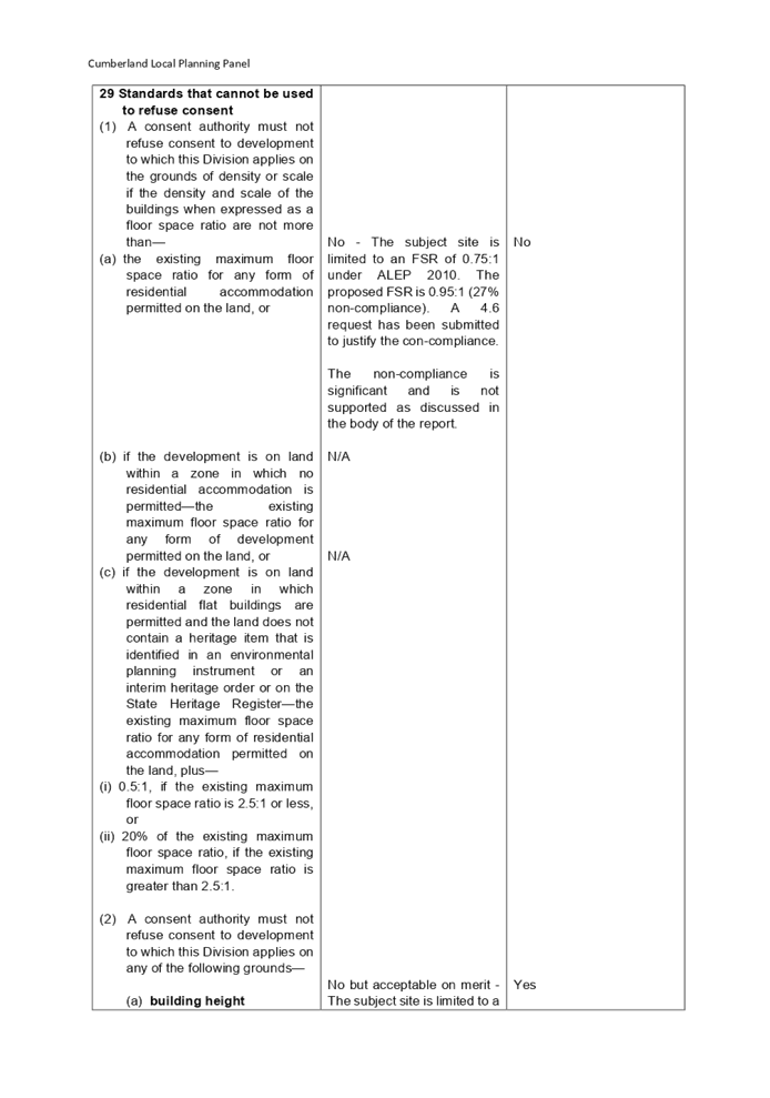
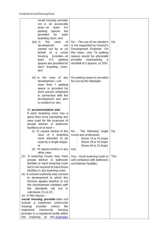
Clause 29(2) Standards that
cannot be used to refuse consent
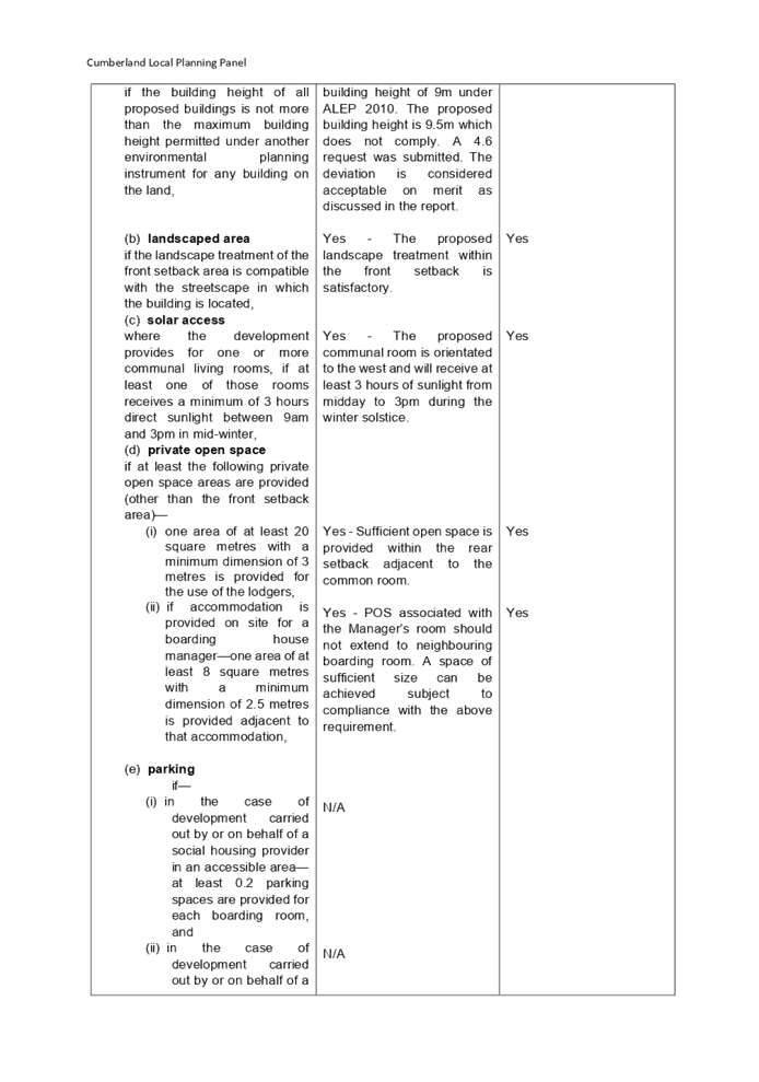
Parking
Council does not support the use
of car stackers in the basement level to meet with the car parking
requirements. Only 15 car parking spaces can be provided, where 20 spaces are
required for 40 rooms inclusive of a manager’s room. The non-compliance
is not supported, and this matter is included in the reason for refusal.
Accommodation size
Where a minimum of 12m2 is
required for single lodger accommodation size, rooms 14, 29 and 40 are provided
with accommodation size of 10.5m2. The non-compliance is not supported, and
this matter is included in the reason for refusal.
A full assessment against the ARH
SEPP is provided at Attachment 5. A detailed discussion of the development
against the character of the local area requirement is provided below.
Clause 30A Character of Local
Area
Division 3 of the SEPP contains
provisions and development standards that apply to the development for the
purpose of a boarding house. The development as proposed is considered to be
inconsistent with the relevant provisions and development standards of the
instrument at clause ‘30A Character of the local area’. This clause
specifies that ‘a consent authority must not consent to development to
which this Division applies unless it has taken into consideration whether the
design of the development is compatible with the character of the local
area’.
In order to determine the
compatibility of the proposal, an assessment of the character of the area and
application of the ‘character test’ for development derived from
the planning principle 11209 of 2005 Project Venture Development’s Pty
Ltd v Pittwater Council has been undertaken.
Step 1 – Identify the
local area:
The assessment identifies the
local area as primarily the visual catchment of the site (as viewed from within
the site and directly adjacent to the site on the street) which is shown in the
following aerial view.
Figure
5 Visual catchment highlighted in ‘red’
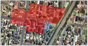
The site is zoned R3 medium
Density Residential and is located on the south side of Cameron Street. It is
situated at the interface of a change in land use zone with land on the
opposing side of Cameron Street being zoned R2 Low Density Residential. Development
on the opposing side of Cameron Street consists of dated single dwelling
houses, dual occupancy and multi dwellings developments that are one and two
storeys in height. Likewise, existing development along the southern side of
Cameron Street consists of older building stock including two single storey
dwellings, and two multi dwelling housing developments.
Step 2 – Determine the
character (future and present) of the local area
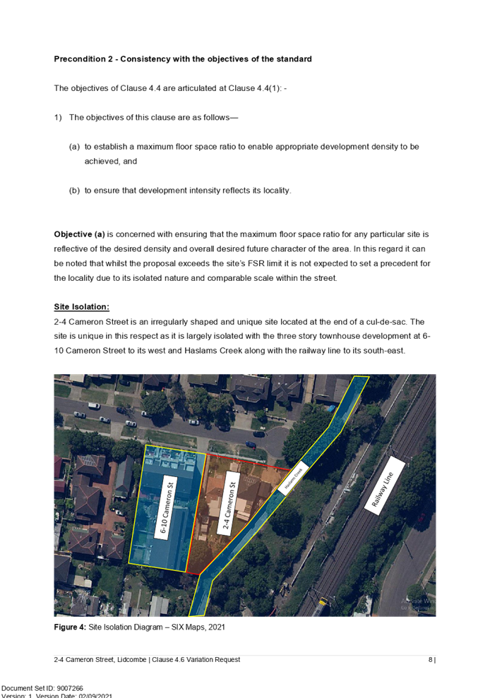
The subject site is zoned R3
Medium Density Residential and is located on the southern side of Cameron
Street between Vaughan Street to the north, a rail corridor to the east, Stone
Street to the south and Woodburn Road to the west. The locality is
characterised by predominantly dated low density residential dwellings and a number
of dated two storey multi dwelling developments. The site is located in close
proximity to public transport nodes being approximately 1.2km to both Lidcombe
and Berala train stations. Development in the immediate locality consists of
predominantly dated one and two storey dwelling houses.
Based on the proximity of the
local area to public transport and the prevalence of older building stock, the
area possesses great potential for redevelopment. Examples of this transition
include town house developments at 6-8 Albert Street and 71-75 Norman Street.
Step 3 – Determine if the
development is compatible with the character of the local area
In order to determine the
compatibility of the development with the established character of a local
area, the ‘character test’ derived from the Land and Environment
Court’s Planning Principle and case law – Project Venture
Development’s Pty Ltd v Pittwater Council can be applied. The character
test determines the compatibility of the development by asking whether the
physical impacts of the proposal on surrounding development is in harmony with
the buildings around it and the character of the area. These questions are
discussed in detail below.
Are the proposal’s
physical impacts on surrounding development acceptable?
The physical impacts include
constraints on the development potential of surrounding sites.
The physical impacts of the
proposal are assessed having regard to the impact of the development on the
amenity of surrounding properties. Amenity in this instance generally include
privacy, solar access, visual bulk and compatibility in the streetscape.
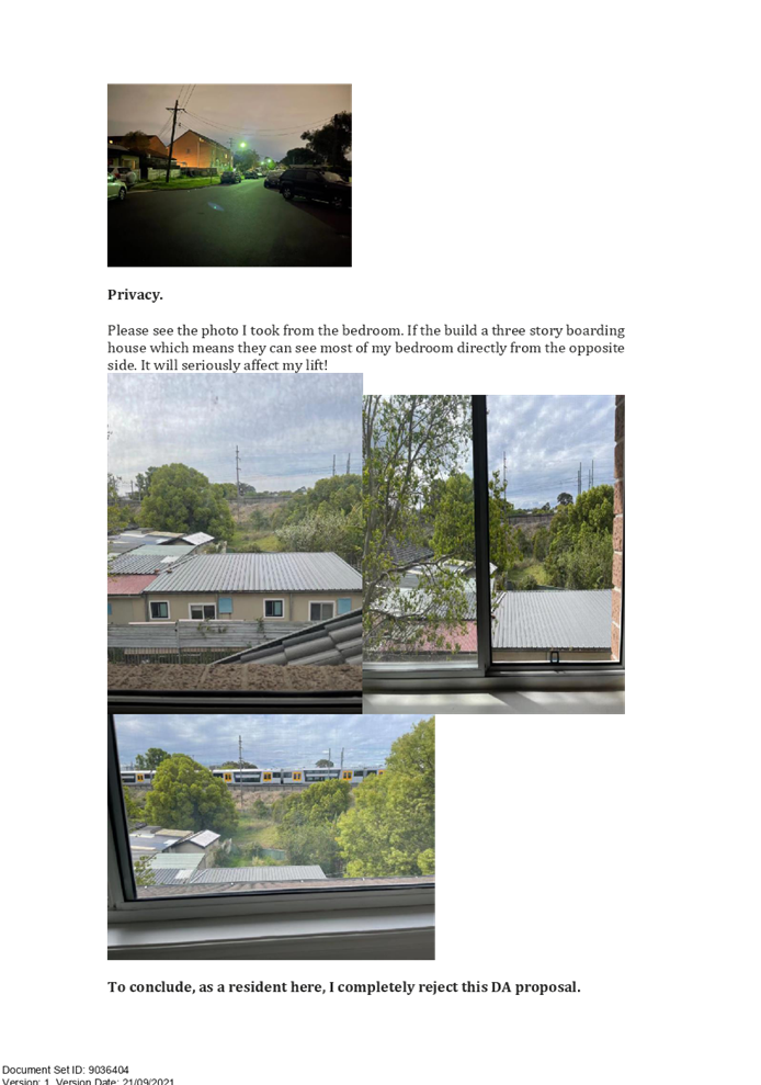
With regard to privacy, it is
noted that elevated private and communal open space areas are located within
the western side setback and may pose a privacy impact to dwellings on the
neighbouring property. Similarly, there are privacy concerns relating to the
potential of overlooking occurring from the large number of windows located on
the west elevation of the building. These matters have not been addressed by
the applicant.
It is claimed by the applicant
that the building mass (with the exception of the lift overrun) remains
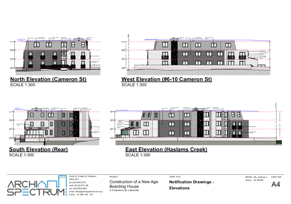
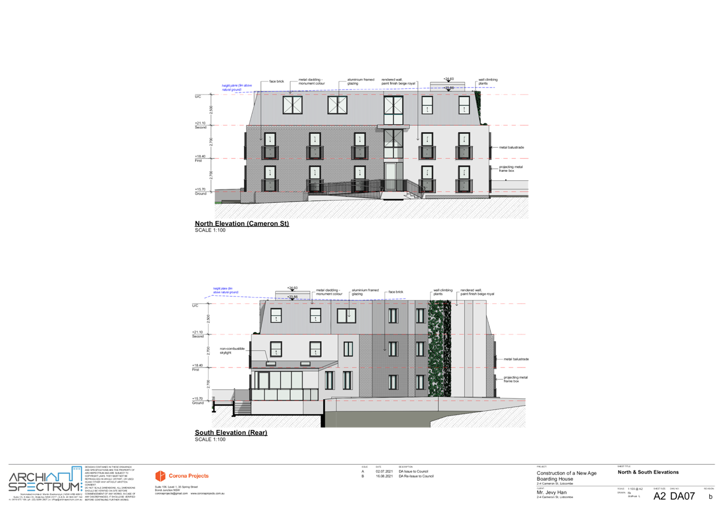
compliant with the 9m building height requirement however when viewing the
development from all sides it appears excessively bulky due to the third storey,
lack of articulation and the provision of a flat roof form. The design of the
development results in an unacceptable visual bulk that is inconsistent with
the desired aesthetic of medium density residential development in the area.
Based on the above discussion, the
physical impact of the proposal on surrounding developments is considered
unreasonable and incompatible with the character of the local area.
Step 4 - Is the
proposal’s appearance in harmony with the buildings around it and the
character of the street?
The building types established in
the local area are made of predominantly one and two storey residential
dwelling houses with a smaller number of dated multi dwelling developments
scattered throughout. The three-storey appearance and visual bulk of the
development is considered to be inconsistent with existing development in the
catchment area based on its sheer bulk and scale. While it is acknowledged that
the neighbouring development to the west contains a third level attic, it is
setback from the building line is integrated into an angular roof form. These
design measures minimize the visual bulk of the building mass considerably. The
proposed development does not impose such measures to any substantial degree.
It is also noted that insufficient articulation is provided to the street
facing and west elevations which exacerbates the visual bulk of the building as
described in Step 3.
Based on the above discussion, the
development is not considered to be in harmony with the existing and desired
residential character of the street and included as a reason for refusal.
Regional Environmental Plans
The proposed development is
affected by the following Regional Environmental Plans:
(a) Sydney
Regional Environmental Plan (Sydney Harbour Catchment) 2005
The subject site is identified as
being located within the area affected by the Sydney Regional Environmental
Plan (Sydney Harbour Catchment) 2005. In accordance with ALEP, a
significant part of the site is identified within the Foreshore Building Line
(FBL). Insufficient information has been provided to verify the extent of
conflict (if any) between the development and the foreshore building line.
Despite this, it is acknowledged
that the subject water body is a concrete channel that is not publicly
accessible and as such, does not conflict with the principles and requirements
pertaining to Foreshores and Waterways Area.
Local Environmental Plans
Cumberland Local Environmental
Plan 2021 (CLEP)
The Cumberland Local Environmental
Plan 2021 (CLEP) has been gazetted on the NSW Legislation website and commenced
on 5 November 2021. The CLEP 2021 is prepared to provide a single planning
framework for the future planning of Cumberland City. The CLEP 2021 harmonises
and repeals the three LEPs previously applicable to the Cumberland local
government area, those being:
· Holroyd
Local Environmental Plan 2013,
· Parramatta
Local Environmental Plan 2011, and
· Auburn
Local Environmental Plan 2010.
However, as the subject
application was lodged prior to the gazettal of the Cumberland LEP 2021, in
accordance with Clause 1.8A - Savings provision relating to development
applications, the application is assessed under the provisions of the Auburn
LEP 2010. As the Cumberland LEP was an exhibited draft at the lodgement of the
subject application, the provisions of the Cumberland LEP are also considered
in the assessment of the application and are considered to be unsatisfactory.
Auburn Local Environmental Plan
2010 (ALEP)
The provision of the ALEP is applicable
to the development proposal. It is noted that the development does not achieve
compliance with the key statutory requirements of the ALEP and the objectives
of the R3 Medium Density Residential land use zone.
(a) Permissibility:
The proposed development is
defined as a ‘boarding house’ and is permissible in the R3 Medium
Density Residential zone with consent.
boarding house means a building or
place—
(a) that
provides residents with a principal place of residence for at least 3 months,
and
(b) that
contains shared facilities, such as a communal living room, bathroom, kitchen
or laundry, and
(c) that
contains rooms, some or all of which may have private kitchen and bathroom
facilities, and
(d) used
to provide affordable housing, and
(e) if
not carried out by or on behalf of the Land and Housing
Corporation—managed by a registered community housing provider, but does
not include backpackers’ accommodation, co-living housing, a group home,
hotel or motel accommodation, seniors housing or a serviced apartment.
The relevant matters to be
considered under ALEP and the applicable clauses for the proposed development
are summarised below. A comprehensive LEP assessment is contained in Attachment
6.
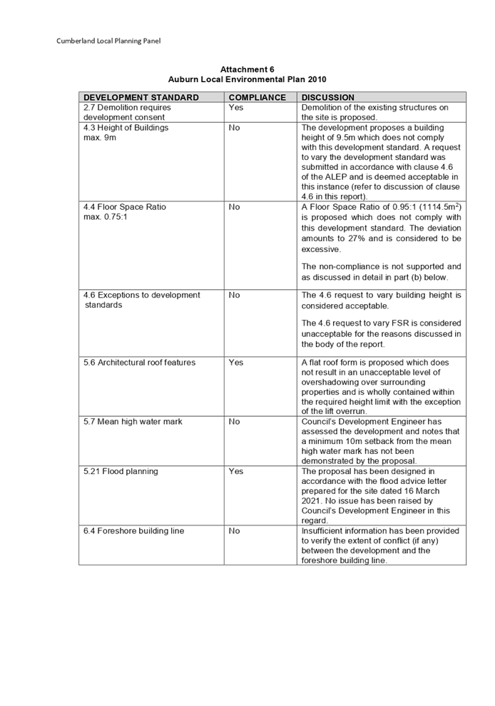
Figure
6 – Auburn LEP 2010 Compliance Table
|
DEVELOPMENT STANDARD
|
COMPLIANCE
|
DISCUSSION
|
|
4.3 Height of Buildings
max. 9m
|
No
|
The development proposes a building height of 9.5m which
does not comply with this development standard. A request to vary the
development standard was submitted in accordance with clause 4.6 of the ALEP
and is deemed acceptable in this instance (refer to discussion of clause 4.6
in this report).
|
|
4.4 Floor
Space Ratio
max. 0.75:1 (878.25m2)
|
No
|
A Floor Space Ratio of 0.95:1 (1114.5m2) is
proposed which does not comply with this development standard. The deviation
amounts to 27% and is considered to be excessive amounting to 236.25m2.
The non-compliance is not supported and as discussed in
detail in part (b) below. This matter is included in the reason for refusal.
|
|
4.6
Exceptions to development standards
|
No
|
The 4.6 request to vary building height is considered
acceptable.
The 4.6 request to vary FSR is considered unacceptable for
the reasons discussed in the body of the report. This matter is included in
the reason for refusal.
|
|
5.7 Mean
high water mark
|
No
|
Council’s Development
Engineer has assessed the development and notes that a minimum 10m setback
from the mean high-water mark has not been demonstrated by the proposal. This
matter is included in the reason for refusal.
|
|
5.21 Flood planning
|
Yes
|
The development has been designed in accordance with the
flood advice letter for the site dated 26 March 2021. No issue has been
raised by Council’s Development Engineer in this regard.
|
|
6.4 Foreshore building line
|
No
|
Insufficient information has
been provided to verify the extent of conflict (if any) between the
development and the foreshore building line.
|
(b) Clause 4.6 – Variation
to Floor Space Ratio (FSR) and Building Height
Clause 4.6 allows the consent
authority to vary development standards in certain circumstances and provides
an appropriate degree of flexibility to achieve better design outcomes. The
consent authority may grant the exception as the Secretary’s concurrence
can be assumed where clause 4.6 is adopted as per the Department of Planning
Circular PS 18-003, dated 21 February 2018.
The applicant has submitted a
written request to vary the development standards for FSR and Building Height.
Based on various case laws established by the Land and Environment Court of NSW
such as Four2five P/L v Ashfield Council [2015] NSWLEC 9, Randwick City Council
v Micaul Holdings P/L [2016] NSW LEC7 and Zhang and anor v Council of the City
of Ryde [2016] NSWLEC 1179, a 3 part assessment framework for a variation
request proposed under clause 4.6 has been considered and an assessment of the
proposed variance, following the 3 part test is discussed in detail below.
Floor Space Ration (FSR)
The 3 preconditions which must be
satisfied before the application can proceed are as follows:
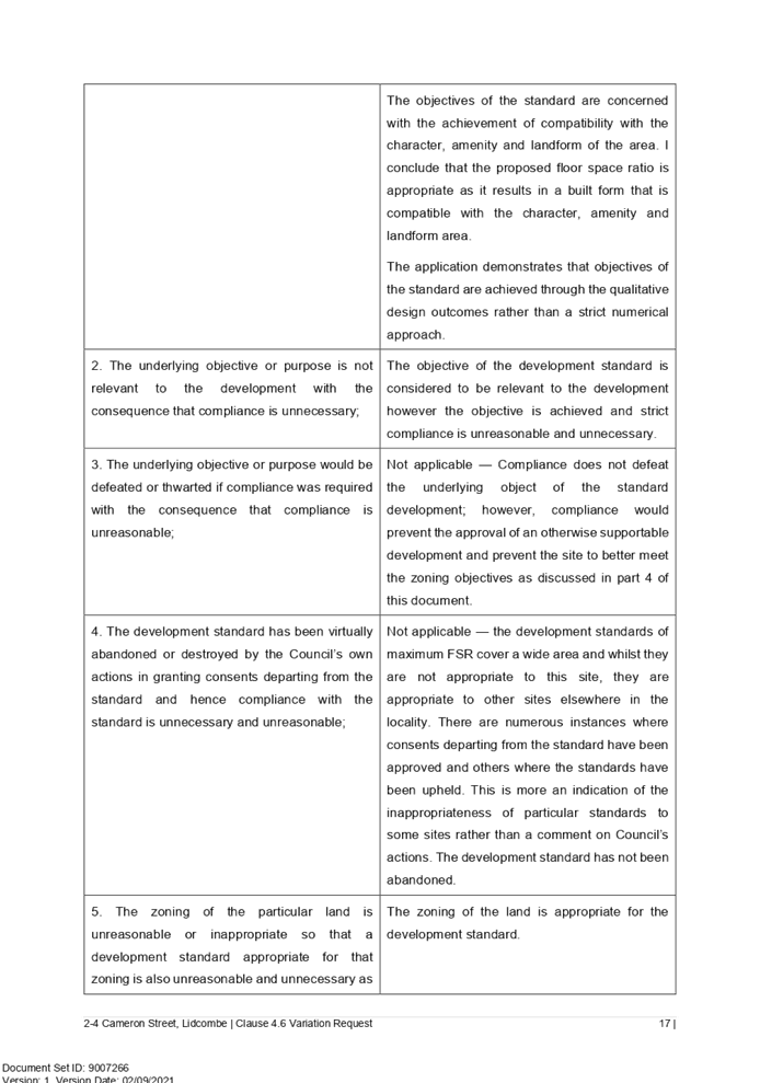
1. Is
the proposed development consistent with the objectives of the zone?
Applicant’s justification:
The boarding house is provided in response to the needs of the community
identified in the submitted social impact statement. It seeks to address the
issue of housing affordability faced by low to moderate income households in
the locality.
With regard to the SP2 land use
zone, no part of the development encroaches this part of this site.
Planner’s comment: The
development proposes a boarding house which satisfies the objectives of the R3
land use zone by catering to housing needs of the area and providing a variety
of housing types in the respective land use zone.
2. Is
the proposed development consistent with the objectives of the development
standard which is not met?
Applicant’s justification:
The objectives of the development standard are as follows:
(a) to
establish a maximum floor space ratio to enable appropriate development density
to be achieved, and
(b) to
ensure that development intensity reflects its locality.
With regard to objective (a), the
exceedance of the FSR development standard will not set an undesirable
precedent as it is isolated in nature and of comparable scale within the
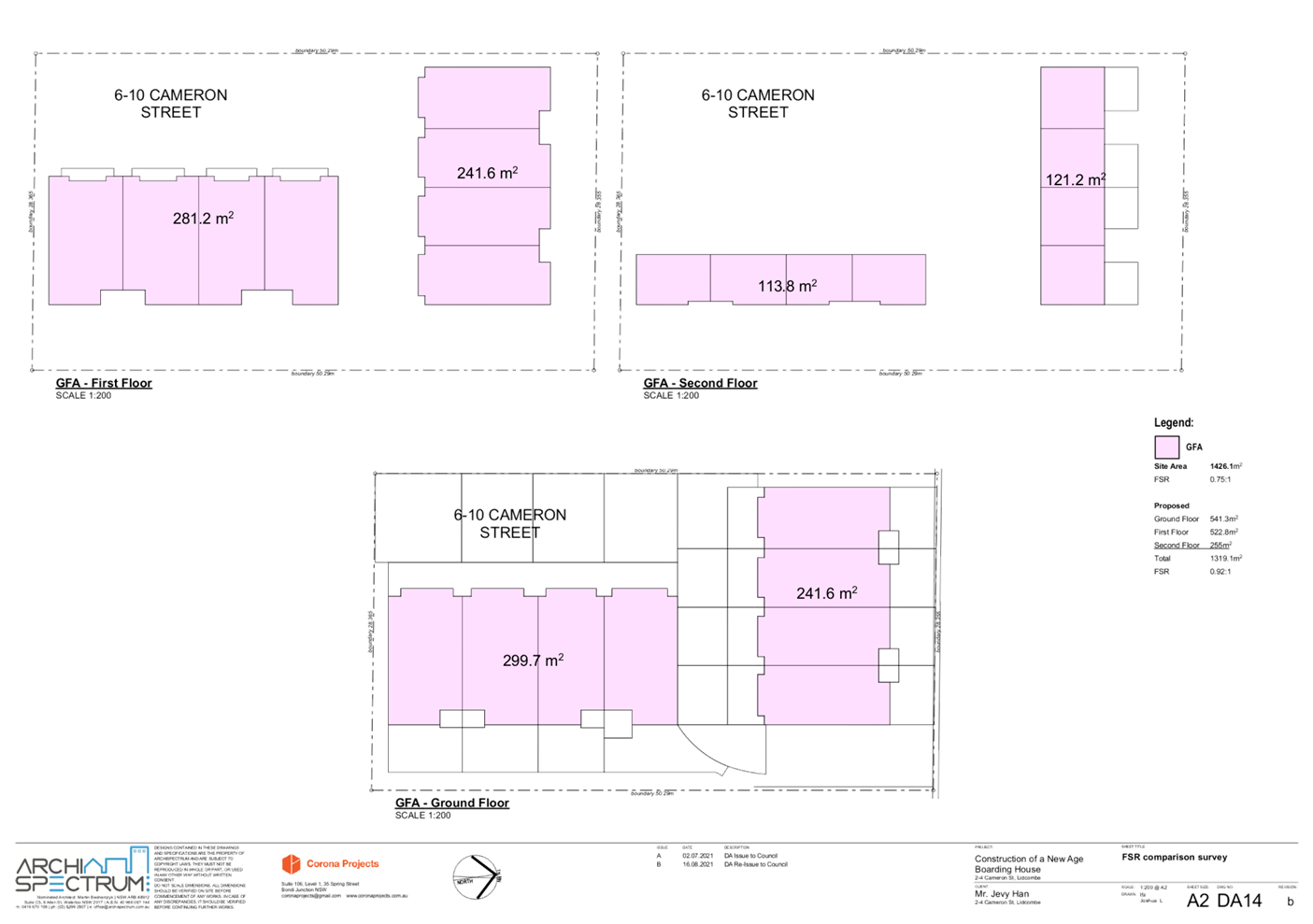
street. The FSR of the development is consistent with the neighbouring development
at 6-10 Cameron Street (DA/540/02) approved on 21 November 2003 with an
approved FSR of 0.92:1.
With regard to objective (b),
there is a high demand for affordable residential accommodation in Lidcombe and
the proposed boarding house is designed in response to the lack of housing
options available for low to medium income households.
Planner’s comment: The
development does not satisfy objective (a) of the development standard as it
establishes an inappropriate development density that would set an undesirable
precedent for future development to follow. In this regard, 27% of the GFA
equates to 236.25sqm which in this instance is comparable in size to the entire
area of the third level. The extent of the non-compliance in this regard is
considered excessive and unreasonable in this instance and is therefore not
supported.
The applicant makes reference to
the neighbouring development to the west which is a three-storey townhouse
development. It is noted that this development was approved in accordance with
superseded planning instruments and on this basis along, a comparison between
the two developments is considered unreasonable. Notwithstanding, it is noted
that the neighbouring development was approved with a fully compliant FSR of
“0.7:1 plus loft”.
It is considered that the
intensity of the proposed development is not reflective of the locality noting
the excessiveness of the non-compliance as noted above.
3.
a) Is
compliance with the development standard unreasonable or unnecessary in the
circumstances of the case? And;
Applicant’s justification:
It is the onus of the Council to form an opinion of satisfaction that the
written request demonstrates that compliance with the development standard is
unreasonable or unnecessary in the circumstances of the case.
Planner’s comment:
Compliance with the development standard is considered reasonable and necessary
in the circumstances of the case. As noted previously, the extent of the
deviation is excessive, resulting in an unacceptable bulk and scale that is inconsistent
with the existing and desired scale of development in the catchment area.
b) Are
there sufficient environmental planning grounds to justify contravening the
development standard and therefore is the applicant’s written
justification well founded?
Applicant’s justification:
The development is will integrate seamlessly with the streetscape which
contains an approved three storey townhouse development with a higher
non-compliant FSR. View loss, solar access and privacy is mitigated by unique shape
and isolated location of the site.
Planner’s comment:
Contravention of the development standard is not justified in this instance as
the FSR of the development is considered to be excessive and the resulting bulk
is inconsistent with existing and desired built form in the area. Moreover, the
neighbouring development was approved with a fully compliant FSR. It is
therefore considered that the applicant’s argument is not well founded
and there are insufficient planning grounds to contravene the development standard.
Conclusion:
The applicant’s written
request has not adequately addressed the matters required to be demonstrated by
clause 4.6 subclause (3). It is considered that the proposed development will
not be in the public interest because it is inconsistent with the objectives of
the particular standard that applies to the site.
It is the view of Council Officers
that justification provided is unsatisfactory and having considered the
application on its merit, the exception to the Floor Space Ratio development
standard is considered unacceptable in this instance.
Building height
The 3 preconditions which must be
satisfied before the application can proceed are as follows:
1. Is
the proposed development consistent with the objectives of the zone?
Applicant’s justification:
The boarding house is provided in response to the needs of the community
identified in the submitted social impact statement. It seeks to address the
issue of housing affordability faced by low to moderate income households in the
locality.
With regard to the SP2 land use
zone, no part of the development encroaches this part of this site.
Planner’s comment: The
development proposes a boarding house which satisfies the objectives of the R3
land use zone by catering to housing needs of the area and providing a variety
of housing types in the respective land use zone.
2. Is
the proposed development consistent with the objectives of the development
standard which is not met?
Applicant’s justification:
The objectives of the development standard are as follows:
(a) to
establish a maximum height of buildings to enable appropriate development
density to be achieved, and
(b) to
ensure that the height of buildings is compatible with the character of the
locality.
The proposed building height is of
a reasonable scale with articulation features mitigating any bulk impact.
Planner’s comment: It is
noted that the existing ground level is not shown on the elevations and
sectional drawings of the development. Notwithstanding, a line is shown indicating
the extent of the maximum building height on the elevation drawings which
suggests that the lift overrun is situated 500mm above the permitted building
height. This appears to be accurate based on a comparison with the reduced
levels shown in the submitted survey plan. It is considered that the
development as proposed is inconsistent with the objectives of the development
standard as the resulting bulk and scale of the development is found to be
incompatible with the character of the locality as discussed in detail under
the ‘Planning Comments’, section part ‘(f)’ of this
report.
3.
(a) Is
compliance with the development standard unreasonable or unnecessary in the
circumstances of the case? And;
Applicant’s justification:
Objectives of the development standard are achieved despite the non-compliance
and on this basis, the amendment of the development to comply is unreasonable
in this instance.
Planner’s comment: It is
considered reasonable to require the development to comply with the development
standard noting that a three storey building is proposed and the relevant
building height control in the Multi Dwelling Housing part of ADCP only permits
development to be a maximum of two storeys. In this regard, a reduction from
three to two storeys to address the non-compliance with the ADCP control would
is likely to result in full compliance with the development standard. On this
basis, it is considered fair and reasonable to require the full compliance with
the development standard to be achieved.
(b) Are
there sufficient environmental planning grounds to justify contravening the
development standard and therefore is the applicant’s written
justification well founded?
Applicant’s justification:
The development is designed to complement the existing scale and character of
the surrounding development, will integrate seamlessly with the existing
streetscape, does not result in adverse amenity impacts and the lift overrun
poses a minor visual impact. On this basis, there are sufficient planning
grounds to justify contravention of the development standard.
Planner’s comment: The
development as proposed poses a significant visual impact resulting from the
bulk and scale of the building envelope and the three storey appearance. The
result is a development that is inconsistent in scale and appearance with the
existing and desired character of the area as discussed under the
‘Planning Comments’ section part ‘(f)’ of this report.
It is therefore considered that the applicant’s written justification is
not well founded and shall form part of reasons for refusal.
Conclusion:
The applicant’s written
request has not adequately addressed the matters required to be demonstrated by
clause 4.6 subclause (3). It is considered that the proposed development will
not be in the public interest because it is inconsistent with the objectives of
the particular standard that applies to the site.
It is the view of Council Officers
that justification provided is unsatisfactory and having considered the
application on its merit, the exception to the Height of Buildings development
standard is considered unacceptable in this instance.
The provisions of any proposed
instrument that is or has been the subject (EP&A Act s4.15 (1)(a)(ii))
(a) Draft
State Environmental Planning Policy (Environment)
The draft SEPP relates to the
protection and management of our natural environment with the aim of
simplifying the planning rules for a number of water catchments, waterways,
urban bushland, and Willandra Lakes World Heritage Property. The changes
proposed include consolidating the following seven existing SEPPs:
· State
Environmental Planning Policy No. 19 – Bushland in Urban Areas
· State
Environmental Planning Policy (Sydney Drinking Water Catchment) 2011
· State
Environmental Planning Policy No. 50 – Canal Estate Development
· Greater
Metropolitan Regional Environmental Plan No. 2 – Georges River Catchment
· Sydney
Regional Environmental Plan No. 20 – Hawkesbury-Nepean River (No.2-1997)
· Sydney
Regional Environmental Plan (Sydney Harbour Catchment) 2005
· Willandra
Lakes Regional Environmental Plan No. 1 – World Heritage Property.
The draft policy will repeal the
above existing SEPPs and certain provisions will be transferred directly to the
new SEPP, amended and transferred, or repealed due to overlaps with other areas
of the NSW planning system.
Changes are also proposed to the
Standard Instrument – Principal Local Environmental Plan. Some provisions
of the existing policies will be transferred to new Section 117 Local Planning
Directions where appropriate.
The provisions of any
Development Control Plans (EP&A Act s4.15 (1)(a)(iii))
Cumberland Development Control
Plan (DCP) 2021
The Cumberland DCP 2021 is in
force as of 5 November 2021. However, as the subject application was lodged
prior to the Cumberland DCP coming into force, in accordance with Clause 1.1.4
- Savings provision of Part A - Introduction, the application is assessed under
the provisions of the Auburn DCP 2010 As the Cumberland DCP 2021 was adopted by
Council at the lodgement of the subject application, the provisions of the
Cumberland DCP are also considered in the assessment of the application and are
considered to be unsatisfactory.
Auburn Development Control Plan
(DCP) 2010
The Auburn Development Control
Plan 2010 provides guidance for the design and operation of development to
achieve the aims and objectives of the Auburn Local Environmental Plan 2010.
Auburn DCP section does not contain provisions regarding boarding houses and
assessment is carried out based on the typology of the development within the
subject land, which multi dwelling housing.
The following table highlights
non-compliances with the DCP, which relate to number of storeys, floor to
ceiling heights, building articulation and landscape area. The variations
sought are considered unsatisfactory:
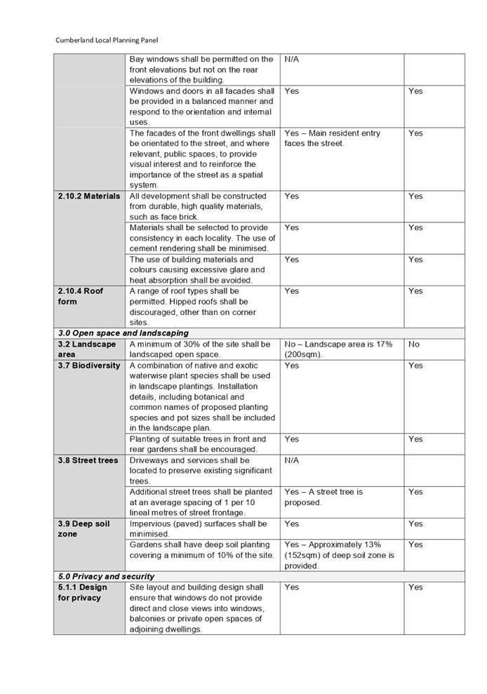
Figure 7 – Auburn
Development Control Plan 2010
Multi
Dwelling Housing Compliance Table
|
Clause
|
Control
|
Proposed
|
Complies
|
|
2.3.4 Haslam’s Creek
|
A minimum 10m setback from the top of the creek bank to
Haslam’s Creek and its tributaries shall be required.
|
No - A minimum setback of 10m
from the mean high-water mark to structures of the development has not been
demonstrated.
|
No
|
|
2.4 Number of storeys
|
Multi dwelling housing shall be a maximum two (2) storeys
above ground level (existing), except where basement car parking allows for
natural ventilation up to less than 1m above ground level.
|
The development is three storeys.
|
No
|
|
2.5 Floor to ceiling heights
|
The minimum floor to ceiling height shall be 2.7m.
|
Floor to ceiling heights of each level approximately 2.4m.
The removal of the third level as required by control 2.4
would enable the ground and first floor heights to be extended to comply with
this control and ensure an improved level of amenity is provided.
|
No
|
|
2.10.1 Building articulation
|
All elevations shall be well proportioned and articulated
by using balconies, terraces, verandahs, entrance porticos and blade walls.
|
Insufficient articulation is provided on the street facing
and west elevations.
|
No
|
|
Elevations shall provide for variation and depth rather
than relying on front façade treatment only. Varied massing
projections and recesses shall be used to create a sense of articulation and
depth.
|
Insufficient depth variation is provided on the street
facing and west elevations.
|
No
|
|
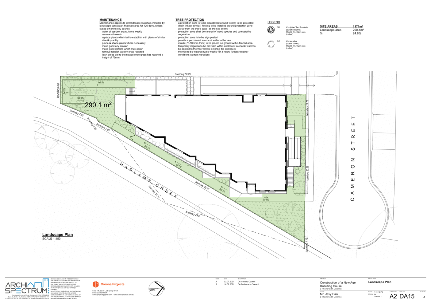
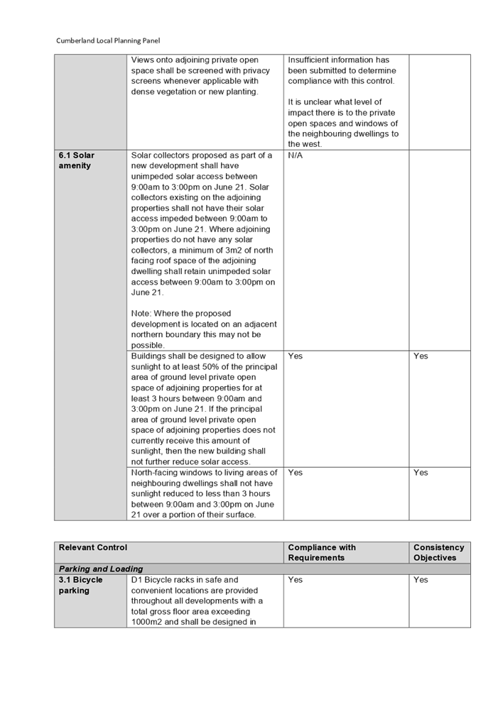
3.2 Landscape area
|
A minimum of 30% of the site shall be landscaped open
space.
|
Landscape area is 17% (200m2).
|
No
|
As
indicated in the compliance table above, the proposed development departs from
the Multi Dwelling Housing provisions of Council’s Auburn Development
Control Plan 2010. The siting, bulk and scale and streetscape provisions of the
Multi Dwelling Housing part of ADCP is relevant to the proposal as the
subject site is zoned R3 Medium Density Residential. Compliance with these
provisions will ensure the design of the development is sympathetic to the
design and scale of residential development in the prescribed land use zone. A
comprehensive assessment and compliance table is contained in Attachment 7.
The following table highlights
non-compliances with the DCP, which relate to vehicle access and internal
circulation. The non-compliances are considered unsatisfactory:
Parking
and Loading Compliance Table
|
Clause
|
Control
|
Proposed
|
Complies
|
|
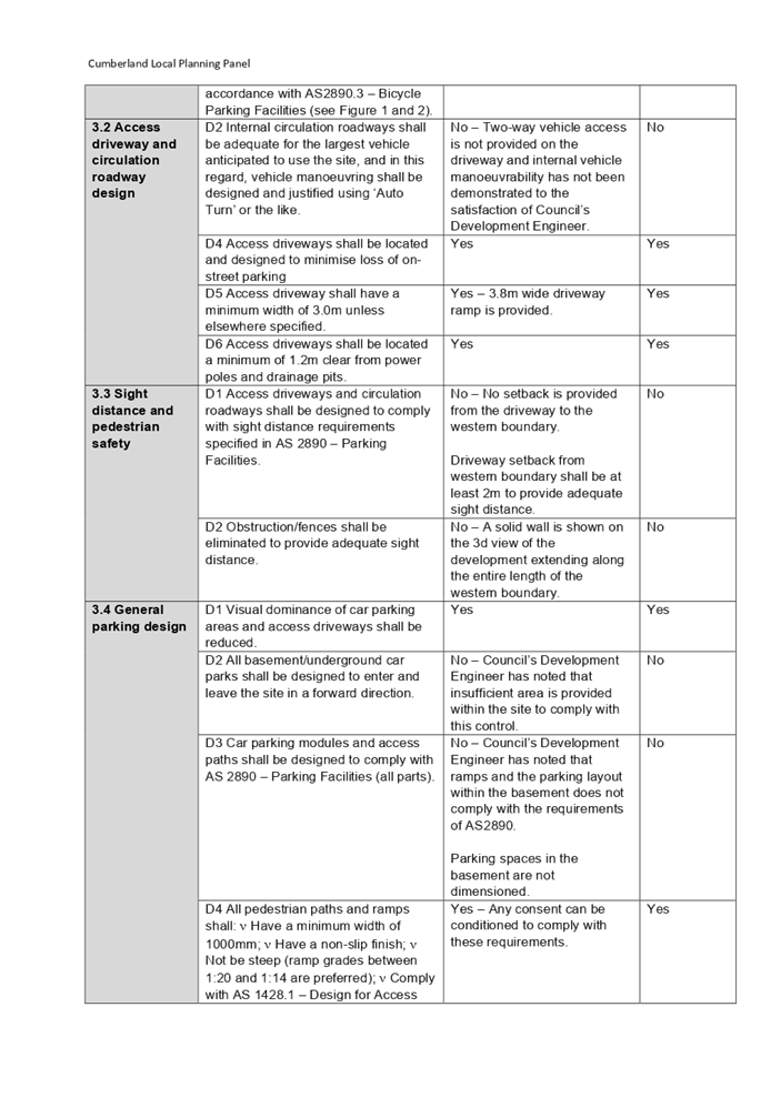
3.2 Access driveway and circulation roadway design
|
Internal circulation roadways shall be adequate for the
largest vehicle anticipated to use the site, and in this regard, vehicle
manoeuvring shall be designed and justified using ‘Auto Turn’ or
the like.
|
No – Two-way vehicle access is not provided on the
driveway and internal vehicle manoeuvrability has not been demonstrated to
the satisfaction of Council’s Development Engineer.
|
No
|
|
3.3 Sight distance and pedestrian safety
|
Access driveways and circulation roadways shall be
designed to comply with sight distance requirements specified in AS 2890
– Parking Facilities.
|
No – No setback is provided from the driveway to the
western boundary.
Driveway setback from western boundary shall be at least
2m to provide adequate sight distance.
|
No
|
|
Obstruction/fences shall be eliminated to provide adequate
sight distance.
|
No – A solid wall is shown on the 3d view of the
development extending along the entire length of the western boundary.
|
No
|
|
3.4 General parking design
|
All basement/underground car parks shall be designed to
enter and leave the site in a forward direction.
|
No – Council’s Development Engineer has noted
that insufficient area is provided within the site to comply with this
control.
|
No
|
|
Car parking modules and access paths shall be designed to
comply with AS 2890 – Parking Facilities (all parts).
|
No – Council’s Development Engineer has noted
that ramps and the parking layout within the basement does not comply with
the requirements of AS2890.
Parking spaces in the basement are not dimensioned.
|
No
|
The
following table highlights non-compliances with the DCP which relate to
stormwater drainage, design of the basement drainage system, On-Site Detention
(OSD) and the required setback of the development to Haslam’s Creek. The
non-compliances are considered unsatisfactory:
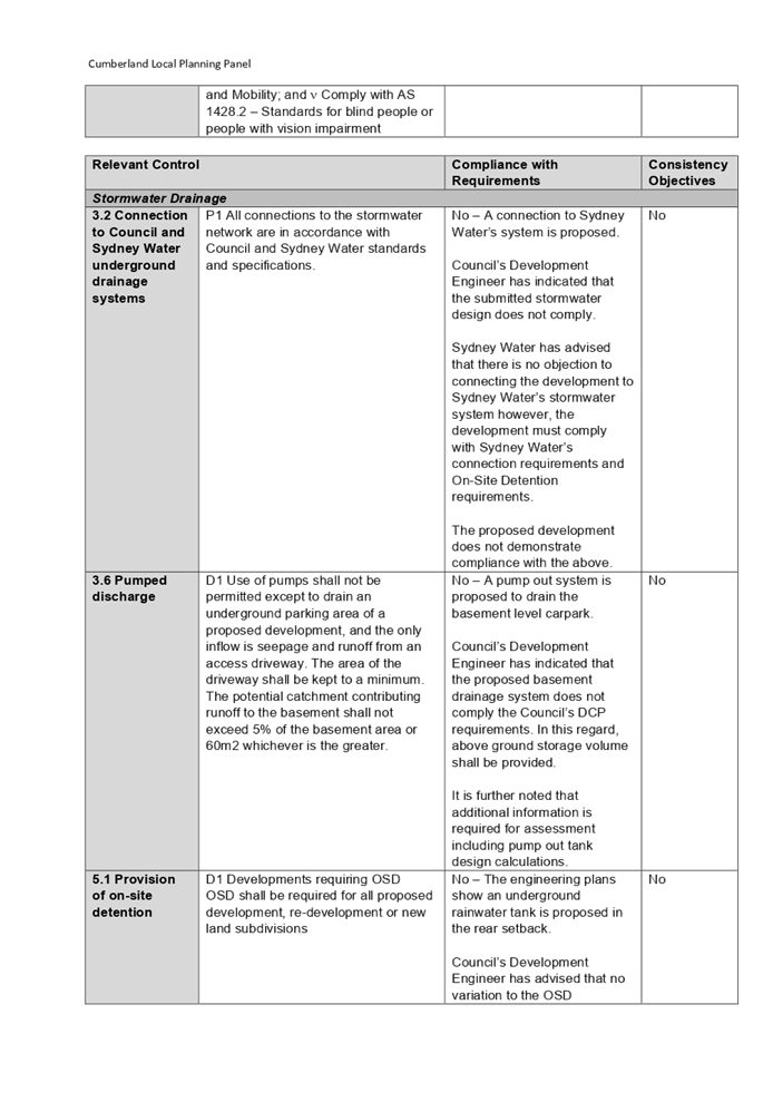
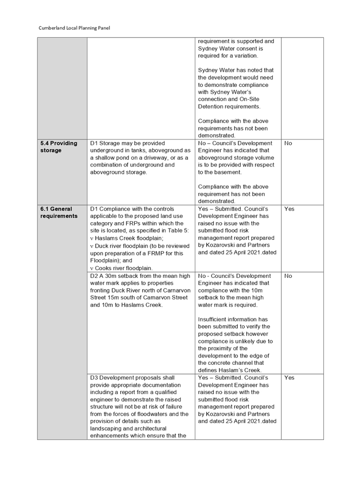
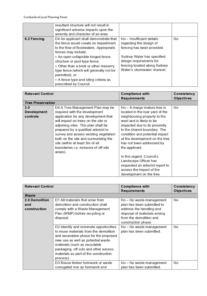
Stormwater
Drainage Compliance Table
The
following table highlights a non-compliance with the DCP, which relates to the
protection of trees on the surrounding properties. The non-compliance is
considered unsatisfactory:
Tree
Preservation Compliance Table
|
Clause
|
Control
|
Proposed
|
Complies
|
|
3.0 Development controls
|
A Tree Management Plan may be required with the
development application for any development that will impact on trees on the
site or adjoining sites. This plan shall be prepared by a qualified arborist
to survey and assess existing vegetation both on the site and surrounding the
site (within at least 5m of all boundaries i.e. inclusive of off-site areas).
|
No – A marge mature tree is located in the rear yard
of the neighbouring property to the west and is likely to be impacted due to
its proximity to the shared boundary. The condition and potential impact of
the development on the tree has not been addressed by the applicant.
In this regard, Council’s Landscape Officer has
requested an arborist report to assess the impact of the development on the
tree.
|
No
|
The
following table highlights non-compliances with the DCP, which relates
to the handling and disposal of waste associated with the demolition and
construction phases and the operation of the boarding house. The
non-compliances are considered unsatisfactory:
Waste
Compliance Table
|
Clause
|
Control
|
Proposed
|
Complies
|
|
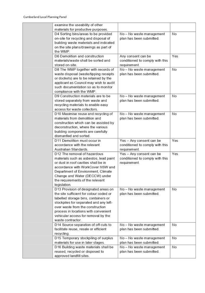
2.0 Demolition and construction
|
All materials that arise from demolition and construction
shall comply with a Waste Management Plan (WMP) before recycling or disposal.
|
No - A minimum setback of 10m
from the mean high-water mark to structures of the development has not been
demonstrated.
|
No
|
|
Identify and nominate opportunities to reuse materials
from the demolition and excavation phase for the proposed new use as well as
potential waste materials (such as recyclable packaging, off-cuts and other
excess materials as part of the construction process).
|
No – No waste management plan has been submitted.
|
No
|
|
Reuse timber formwork or waste corrugated iron as formwork
and examine the useability of other materials for productive purposes.
|
No – No waste management plan has been submitted.
|
No
|
|
Sorting bins/areas to be provided on-site for recycling
and disposal of building waste materials and indicated on the site
plans/drawings as part of the WMP.
|
No – No waste management plan has been submitted.
|
No
|
|
The WMP together with records of waste disposal
(waste/tipping receipts or dockets) are to be retained by the applicant as
Council may wish to audit such documentation so as to monitor compliance with
the WMP.
|
No – No waste management plan has been submitted.
|
No
|
|
Construction materials are to be stored separately from
waste and recycling materials to enable easy access for waste collectors.
|
No – No waste management plan has been submitted.
|
No
|
|
Maximise reuse and recycling of materials from demolition
and construction which can be assisted by deconstruction, where the various
building components are carefully dismantled and sorted.
|
No – No waste management plan has been submitted.
|
No
|
|
Provision of designated areas on the site sufficient for colour
coded or labelled storage bins, containers or stockpiles for separated and
any left-over waste from the construction process in locations with
convenient vehicular access for removal by the waste contractor.
|
No – No waste management plan has been submitted.
|
No
|
|
Source separation of off-cuts to facilitate reuse, resale
or efficient recycling.
|
No – No waste management plan has been submitted.
|
No
|
|
Temporary stockpiling of surplus materials for use in
later stages.
|
No – No waste management plan has been submitted.
|
No
|
|
Building waste materials shall be reused, recycled or
disposed to approved landfill sites.
|
No – No waste management plan has been submitted.
|
No
|
Having
regard to the above noted departures of ADCP, it is considered that the proposal
performs unsatisfactorily from an environmental planning viewpoint. These
matters are included in the reasons for refusal.
The provisions of any planning
agreement that has been entered into under section 7.4, or any draft planning
agreement that a developer has offered to enter into under section 7.4
(EP&A Act s4.15(1)(a)(iiia))
There is no draft planning
agreement associated with the subject Development Application.
The provisions of the
Regulations (EP&A Act s4.15 (1)(a)(iv))
The proposed development raises
concerns as to the relevant matters arising from the Environmental Planning and
Assessment Regulations 2000 (EP&A Reg). In this regard, insufficient
information was submitted to accurately determine building heights and the
setback from structures of the development to the mean high water mark and the
matter is included as a reason for refusal.
The Likely Environmental,
Social or Economic Impacts (EP&A Act s4.15 (1)(b))
It is considered that the proposed
development will have significant adverse environmental and social impacts in
the locality due to inappropriate scale of the development that is out of
character with the existing and desired character of the locality.
The suitability of the
site for the development (EP&A Act s4.15 (1)(c))
The subject site and locality are
known to be affected by natural hazards and site constraints that are likely to
have a significant adverse impact on the proposed development including its
proximity to Haslam’s Creek. This matter has not been addressed to the
satisfaction of Council’s Development Engineer.
Accordingly, it is considered that
the development is unsuitable in the context of the site and surrounding
locality.
Submissions made in accordance
with the Act or Regulation (EP&A Act s4.15 (1)(d))
|
Advertised (Council Website)
|
Mail
|
Sign
|
Not Required
|
In
accordance with Council’s Notification requirements contained within the
Auburn DCP 2010, the proposal was publicly notified for a period of 14 days
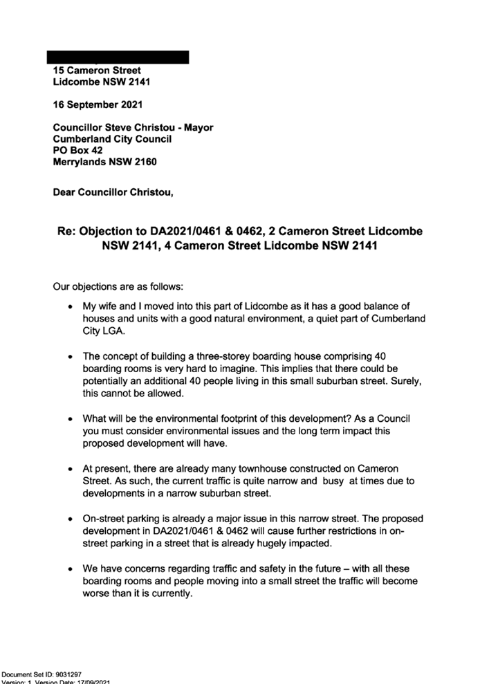
between 6 October 2021 and 20 October 2021. The notification generated
44 unique submissions in respect of the proposal. The issues raised in the
public submissions are summarised and commented on as follows:
Figure
8 – Submissions summary table
|
Issue
|
Planner’s Comment
|
|
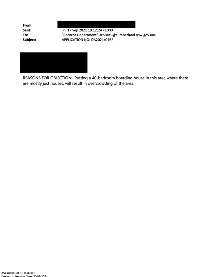
Development is out of character with the area, is an
overdevelopment of the site and is an eyesore
|
It is considered that the proposal is an overdevelopment
of the site and it is not supported. This matter is discussed in detail in
the body of the report.
|
|
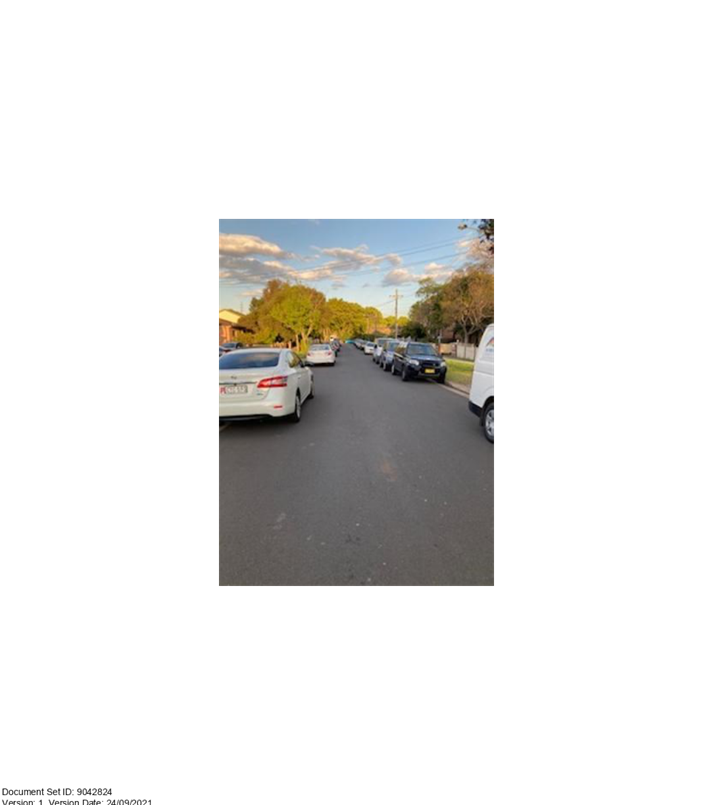
Increased traffic
|
Insufficient onsite parking is provided to accommodate the
parking demand of the development.
It is considered that the development in its current form
would pose an unacceptable impact on traffic within Cameron Street and in the
greater area of Lidcombe, and it is not supported.
|
|
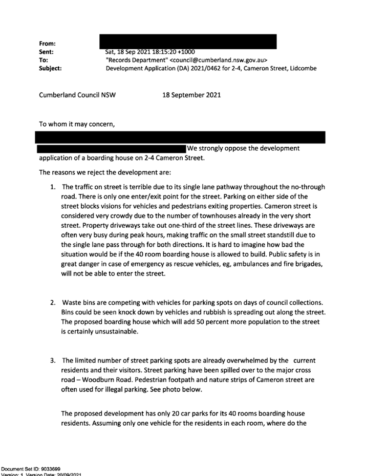
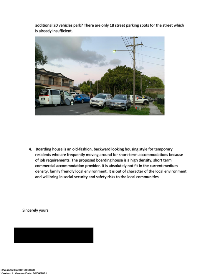
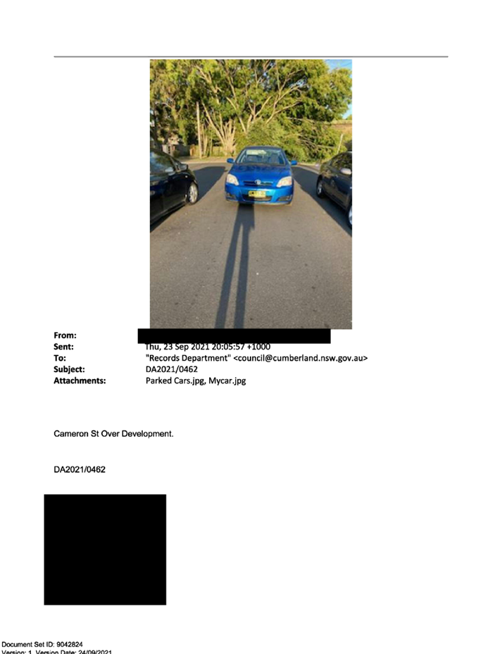
Inadequate on street parking
|
The onsite parking arrangement of the development is
unsatisfactory and would place an unacceptable level of demand on the
availability of on-street parking. The proposal is therefore not supported.
|
|
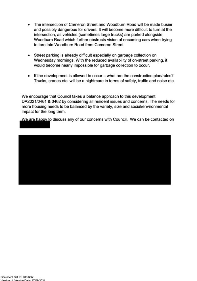
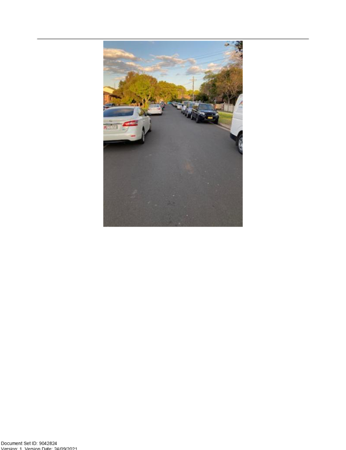
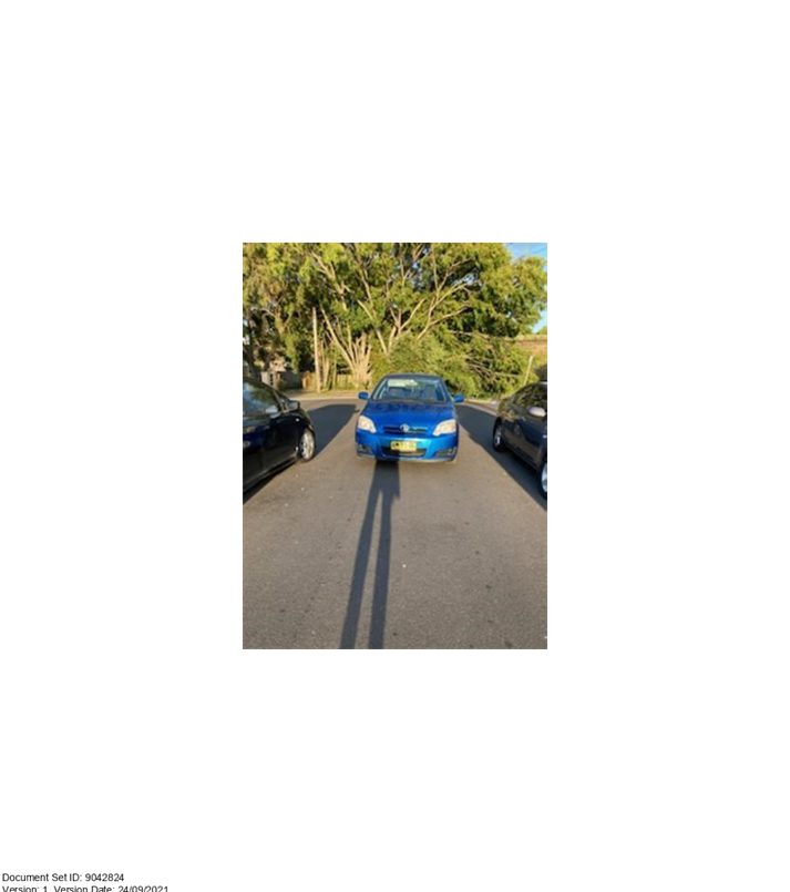
Vehicle manoeuvrability within the street is inadequate
|
It is acknowledged that vehicle manoeuvrability within
Cameron Street is difficult due to its narrow width and the parking of
vehicles along both sides throughout the day and night.
The development as proposed does not provide an acceptable
provision of onsite parking and as such would not be supported.
|
|
Waste collection in the street is problematic
|
Council’s Waste Officer has advised that the
submitted storage and disposal waste details are inadequate. The proposal is
therefore not supported.
|
|
Flood impacts
|
Flood impact assessment was reviewed by Council’s
Development Engineer and is considered satisfactory.
|
|
Non-compliant Floor Space Ratio (FSR)
|
The FSR of the proposed development is excessive and is
not supported. This matter forms the basis of the recommended refusal.
|
|
Non-compliant building height
|
Variation to building height relates to minor nature of
the deviation of 500m to a small proportion of the building mass (lift
overrun). Nonetheless, the proposal is not supported for issues raised in
main body of the report.
|
|
The development is to be setback at least 10m from the
mean high watermark
|
The proposal seeks to vary this requirement which is found
to be unacceptable by Council’s Development Engineer. This matter forms
the basis for the recommended refusal.
|
|
Driveway design does not comply
|
The siting of the driveway is identified by
Council’s Development Engineer as being unsatisfactory.
|
|
Landscaping shall be 20% of the site area
|
The required provision of landscape area on the site is
30% of the site area in accordance with ADCP, not 20%. It is acknowledged
that only 17% (200m2) is provided which does not comply.
|
|
What is ‘new age’ boarding house?
|
‘New age’ or ‘new generation’ is a
common terminology referring to boarding houses that offer self-contained
boarding rooms in residential, mixed use and some commercial land use zones.
|
|
Site is not accessible to public transportation
|
The subject site is considered to be within walking
distance to nearby train stations at Lidcombe and Berala.
|
|
Excavation will impact the concrete channel and rail
corridor
|
A determination on the impact to the concrete channel
cannot be made due to the submission of insufficient information.
Sydney Trains has provided comment on the development
raising no issue with regard to its proximity to the nearby rail corridor.
|
|
Consideration of development at 6-10 Cameron Street is
inappropriate
|
The development at 6-10 Cameron Street was approved under
superseded planning instruments. As such, it is considered inappropriate to
consider it a precedent for future development to follow.
|
|
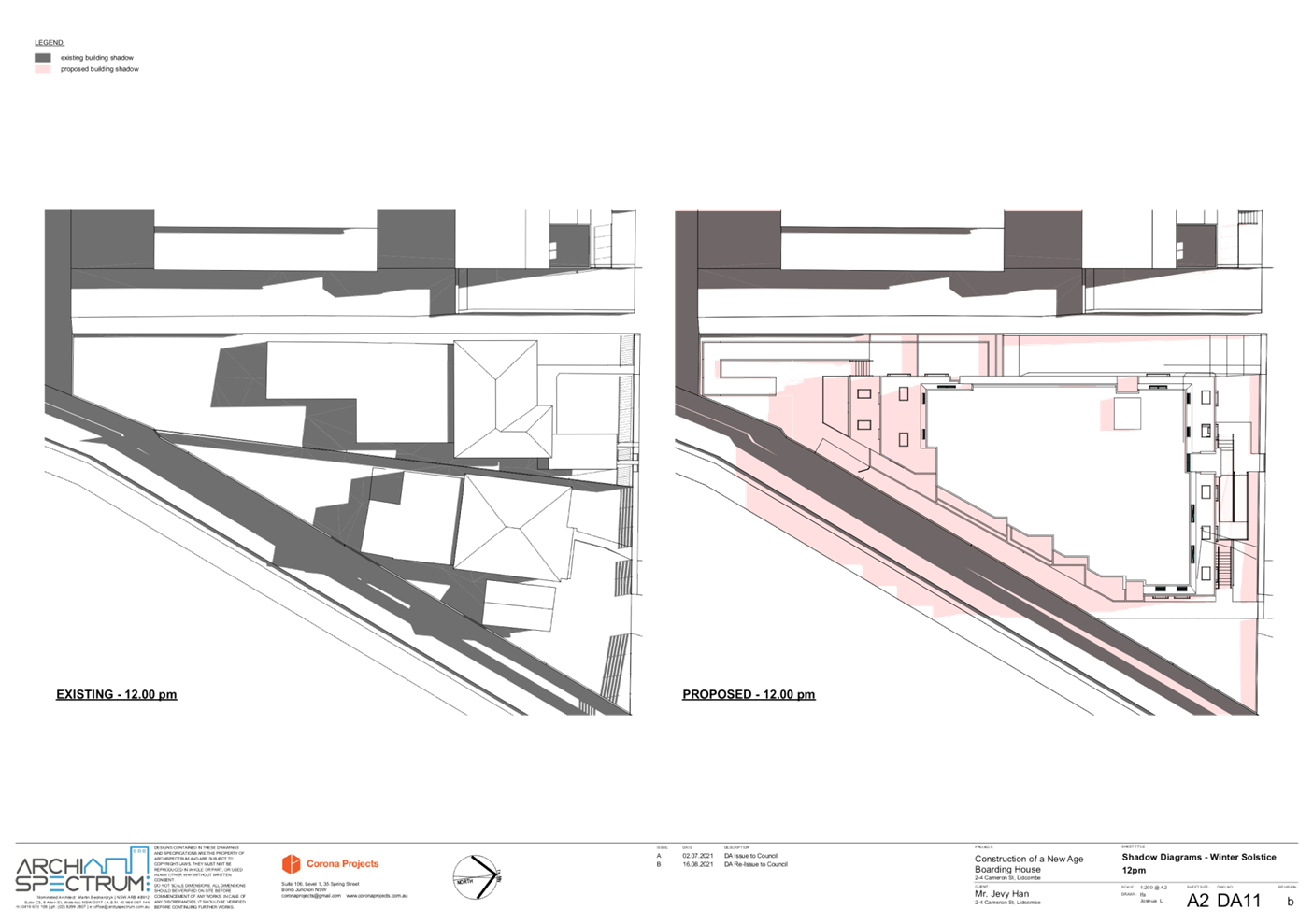
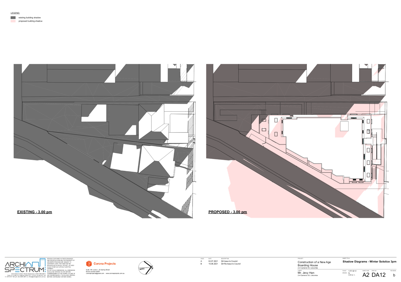
Overshadowing of neighbouring property to the west
|
The submitted sun shadow diagrams indicate the private
open spaces of rearward building at 6-10 Cameron Street will be under shadow
during the early morning and clear of shadow from midday onwards.
Council’s controls require at least 3 hours of solar access to
neighbouring private open spaces which is achieved by the development. As
such, no issue is raised with regard to overshadowing.
|
|
Public safety and security
|
NSW Police have raised no issue with the proposal with
regard to safety and security.
|
|
Mental health of boarders
|
This is not a matter to be considered by the assessment of
the DA under s4.15(1) of the EP&A Act 1979.
|
|
Devalue properties
|
This is not a matter to be considered by the assessment of
the DA under s4.15(1) of the EP&A Act 1979.
|
The public interest (EP&A
Act s4.15(1)(e))
In view of the foregoing analysis,
it is considered that the development as proposed would not be consistent with
the public interest.
CUMBERLAND LOCAL INFRASTRUCTURE
CONTRIBUTIONS PLAN 2020
The development would require the
payment of contributions in accordance with Cumberland Local Infrastructure
Contributions Plan 2020. Should the proposal be supported, contribution amount
would be conditioned as part of the consent.
DISCLOSURE OF POLITICAL
DONATIONS AND GIFTS
The applicant and notification
process did not result in any disclosure of Political Donations and Gifts.
The development application has
been assessed in accordance with the relevant requirements of the Environmental
Planning and Assessment Act 1979, State Environmental Planning Policy (Housing)
2021 (SEPP Housing), State Environmental Planning Policy (Affordable Rental
Housing) 2009 (ARH SEPP), State Environmental Planning Policy No. 55 –
Remediation of Land (SEPP 55), State Environmental Planning Policy
(Infrastructure) 2007 (ISEPP), State Environmental Planning Policy (Building
Sustainability Index: BASIX) 2004, Sydney Regional Environmental Plan (Sydney
Harbour Catchment) 2005, Auburn Local Environmental Plan 2010, Auburn
Development Control Plan 2010, Cumberland Local Environmental Plan 2021 and
Cumberland Development Control Plan 2021 and is considered to be unsatisfactory
for approval subject to reasons for refusal.
Having regard to the relevant
matters of consideration under Section 4.15 of the Environmental Planning and
Assessment Act 1979, it is considered that the proposed development is
unacceptable for the reasons outlined in this report. It is recommended that
the development application be refused.
|
1. That the Clause 4.6 variation
requests to vary the Floor Space Ratio and Height of Buildings development
standards, pursuant to the Auburn LEP 2010 is not supported.
2. That
Development Application No. DA2021/0462 for Demolition of existing structures
and construction of a three-storey boarding house, comprising 40 boarding
rooms (inclusive of a manager's room) over basement parking on land at 2
Cameron Street LIDCOMBE NSW 2141 be Refused subject to reasons
listed in the attached schedule.
3. Persons
whom have lodged a submission in respect to the application be notified of
the determination of the application.
|
1. Draft
Notice of Determination
2. Architectural
Plans
3. Stormwater/Engineering
Plans
4. Submissions
Received
5. SEPP
(Affordable Rental Housing) 2009 Assessment
6. Auburn
LEP Assessment
7. Auburn
DCP Assessment
8. 4.6
Request Building Height
9. 4.6
Request Floor Space Ratio
10. Draft
Reasons for Refusal
DOCUMENTS
ASSOCIATED WITH
REPORT LPP001/22
Attachment 1
Draft Notice of Determination
Cumberland Local Planning Panel Meeting
9 February 2022

DOCUMENTS
ASSOCIATED WITH
REPORT LPP001/22
Attachment 2
Architectural Plans
Cumberland Local Planning Panel Meeting
9 February 2022


DOCUMENTS
ASSOCIATED WITH
REPORT LPP001/22
Attachment 3
Stormwater/Engineering Plans
Cumberland Local Planning Panel Meeting
9 February 2022

DOCUMENTS
ASSOCIATED WITH
REPORT LPP001/22
Attachment 4
Submissions Received
Cumberland Local Planning Panel Meeting
9 February 2022


DOCUMENTS
ASSOCIATED WITH
REPORT LPP001/22
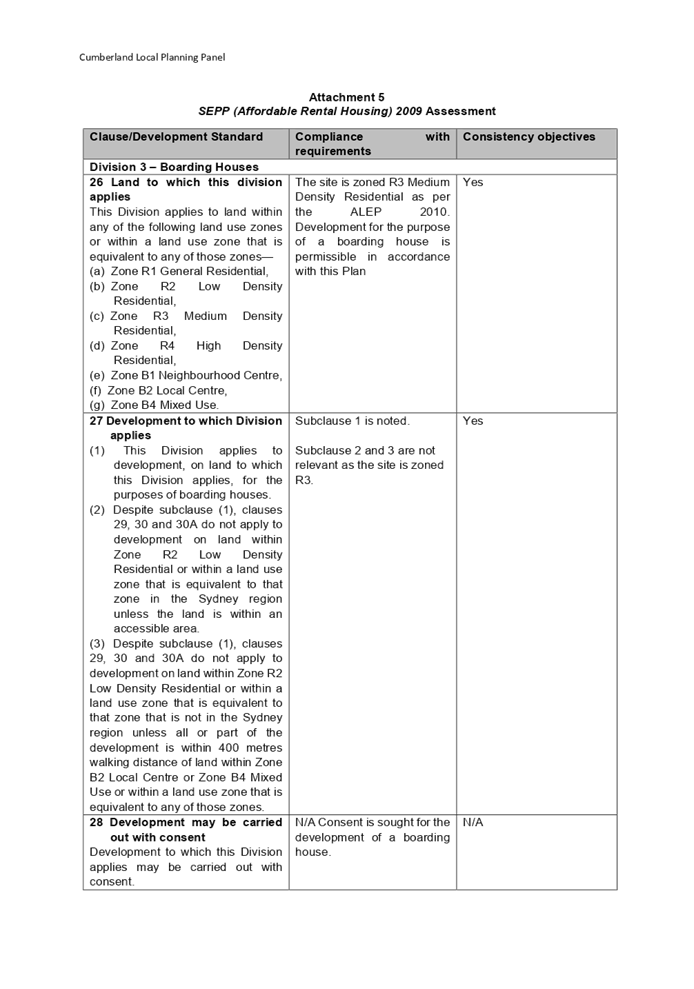
Attachment 5
SEPP (Affordable Rental Housing) 2009 Assessment
Cumberland Local Planning Panel Meeting
9 February 2022

DOCUMENTS
ASSOCIATED WITH
REPORT LPP001/22
Attachment 6
Auburn LEP Assessment
Cumberland Local Planning Panel Meeting
9 February 2022
DOCUMENTS
ASSOCIATED WITH
REPORT LPP001/22
Attachment 7
Auburn DCP Assessment
Cumberland Local Planning Panel Meeting
9 February 2022
DOCUMENTS
ASSOCIATED WITH
REPORT LPP001/22
Attachment 8
4.6 Request Building Height
Cumberland Local Planning Panel Meeting
9 February 2022
DOCUMENTS
ASSOCIATED WITH
REPORT LPP001/22
Attachment 9
4.6 Request Floor Space Ratio
Cumberland Local Planning Panel Meeting
9 February 2022


DOCUMENTS
ASSOCIATED WITH
REPORT LPP001/22
Attachment 10
Draft Reasons for Refusal
Cumberland Local Planning Panel Meeting
9 February 2022

Cumberland
Local Planning Panel Meeting
9 February 2022
Item No: LPP002/22
Development
Application for 2-8 Vaughan Street and 1 Kerrs Road, Lidcombe
Responsible
Division: Environment
& Planning
Officer: Executive
Manager Development and Building
File
Number: DA2021/0649
|
Application
accepted.
|
Friday 26 November 2021.
|
|
Applicant.
|
Eric Kim.
|
|
Owner.
|
Vaughan One Pty Ltd.
Vaughan Two Pty Ltd.
Vaughan Three Pty Ltd.
Vaughan Four Pty Ltd.
Vaughan Five Pty Ltd.
Vaughan Six Pty Ltd.
|
|
Application
No.
|
DA2021/0649.
|
|
Description
of Land.
|
Lot 1, 2, 5 and 6 Sec 8 in DP
3424.
Lot C, D in DP 416771.
Lot A and B in DP 432751.
2 - 8 Vaughan Street and 1
Kerrs Road, Lidcombe.
|
|
Proposed
Development.
|
Alterations and additions to
the approved 10 storey mixed use development (DA-347/2014) including two
additional storeys to Building B comprising of 19 residential apartments and
rooftop communal open space including associated amendments to the basement
level car parking.
|
|
Site
Area.
|
2,736 Square metres.
|
|
Zoning.
|
B4 Mixed Use zone.
|
|
Disclosure
of political donations and gifts.
|
Nil disclosure.
|
|
Heritage.
|
Site not listed as a heritage
item within the Cumberland Local Environmental Plan 2021. Memorial Park on
the opposite side of Joseph Street is listed as a heritage item within the
Cumberland Local Environmental Plan 2021.
|
|
Principal
Development Standards.
|
Floor space ratio
Permissible: 5.0:1.
Proposed: 4.993:1.
Height of Building
Permissible: 38 metres.
Proposed: 39.49 metres.
|
|
Issues
|
Height.
Side setbacks.
Submissions.
|
1. Development
Application 2021/0649 was accepted on Friday 26 November 2021 for alterations
and additions to the approved 10 storey mixed use development including two
additional storeys to Building B comprising of 19 apartments and rooftop
communal open space including associated amendments to the basement level car
parking.
2. The
application was publicly notified to occupants and owners of the adjoining
properties for a period of fourteen (14) days between Friday 3 December 2021
and Friday 17 December 2021. In response, thirteen (13) submissions were
received.
3. The
variations are as follows:
|
Control
|
Required
|
Provided
|
% variation
|
|
Part 3F - Apartment Design Guide.
Visual privacy and separation distances.
|
For over 25 metres or 9 storeys.
12 metres - habitable rooms to a boundary.
|
West facing balconies and windows of apartments B1009 and
B1109 setback 6 metres from western boundary.
|
50%.
|
|
4A-1 - Apartment Design Guide.
Solar and daylight access.
|
Maximum of 15% of apartments receive no sunlight
midwinter.
|
15.78%.
|
5.2%.
|
|
4E-1 - Apartment Design Guide.
Private Open space and balconies.
|
A balcony of 12 sq m in area to be provided for a 3
bedroom apartment.
|
2 apartments have balconies of 10 sq m in area.
|
16.6%.
|
|
Clause 4.3 Height of buildings -
CLEP 2021.
|
38 metres.
|
Maximum 39.49 metres.
|
3.92%.
|
4. The development
application is referred to the Panel as the proposal is an apartment building
for which State Environmental Planning Policy 65 “Design Quality of Residential
Apartment Development” applies and the number of unique submissions
exceed ten (10).
5. The
application is recommended for conditional approval subject to conditions as
provided in the attached schedule.
Subject Site and Surrounding
Area
The subject site is legally
described as Lot 1, 2, 5 and 6 Sec 8 in DP 3424, Lot C, D in DP 416771, Lot A
and B in DP 432751 and is known as 2 - 8 Vaughan Street & 1 Kerrs Road
Lidcombe. The site is located on the south west corner of Vaughan Street with
Joseph Street. The site comprises of 8 lots in total, forming an irregular
shaped configuration with a frontage width of 73.585 metres to Vaughan Street,
20.115 metres to Joseph Street and 60.35 metres to Kerr’s Road. The site
has an area of 2,736 square metres.
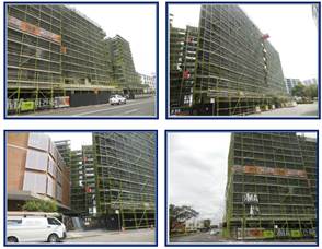
A ten storey mixed use development
with a three storey basement car park is presently being constructed on site.
Building A is the smaller tower at the western part of the site while building
B forms the larger building at the eastern part of the site.
The site is situated within the
Lidcombe Town Centre on the southern side of the Lidcombe Railway Station. The
immediate locality has been the subject of significant redevelopment and a
number of low to mid rise residential and mixed use developments exists within
close proximity of the site including:-
· 2
Kerrs Road to the south.
· 8
to 12 Kerrs Road to the south.
· 17
to 25 and 29 to 33 Kerrs Road to the south west.
· 10
to 16 Vaughan Street to the west.
A large expansive car park area is
situated to the north of the site along the northern side of Vaughan Street
that operates in conjunction with a function centre and retail/business uses.
Wellington Park is situated to the east of the site on the eastern side of
Joseph Street. The park incorporates a local heritage item being the Lidcombe
War Memorial Statute.
The
site is identified on the map below:
The
zoning of the land is provided below.
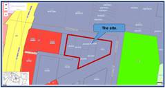
Photos
of the site are provided below.
Description of the
Development
Development application 2021/0649
is proposing alterations and additions to an approved mixed use commercial /
retail / apartment building across the site. The original development
comprising of two buildings known as Building A and Building B was approved
under development consent 2014/347. That approval comprised the following:-
· A
ten (10) storey mixed use development consisting of Buildings A and B
comprising of commercial and retail premises on the ground floor and apartments
above.
· A
total of 131 apartments consisting of 38 x 1 bedroom apartments, 51 x 2 bedroom
apartments and 42 x 3 bedroom apartments.
· A
three level basement car park for 255 vehicles.
The development application
proposes the following additional works to the approved development.
· Construct
an additional two storeys to (Building B) comprising of 19 apartments including
7 x 1 bedroom apartments, 6 x 2 bedroom apartments and 6 x 3 bedroom
apartments.
As a result of the above, the
development will now feature 150 apartments comprising of 43 x 1 bedroom apartments,
59 x 2 bedroom apartments and 48 x 3 bedroom apartments.
· Provide
914 square metres of common open space on the rooftop level of Building B
accessible via two lifts.
· Modify
basement car park Level 3 which includes a reshuffle of car parking spaces and
additional storage rooms to accommodate the additional apartments to be
constructed. The number of car parking spaces within the development remains
the same at 255 spaces to support the 150 apartments.
The development will have a
feature a gross floor area of 13,661 square metres resulting in a floor space
ratio of 4.993:1 and a maximum building height of 39.439 metres to the topmost
part of the fire stair / lift shaft for Building B.
There are no changes to the
commercial component of the development and no changes to the number of car
spaces required to support the commercial land uses on site.
A similar proposal was referred to
the Design Review Panel during 2020 and Council received appropriate advice.
Correspondence is available on Council records demonstrating that the current
design was not required to be referred a second time to the Design Review Panel
for assessment.
History
· Development
Application 287/2011
The Joint Regional Planning Panel,
at its meeting of Thursday 9 August 2012 resolved to approve Development
Application 287/2011 as a deferred commencement consent for the demolition of
existing structures and construction of an 8 storey mixed use development
comprising of 108 residential apartments and 16 ground floor commercial tenancies
over 2 levels of basement carparking with stormwater and landscaping works and
strata subdivision subject to conditions.
The deferred commencement consent
became operational on Wednesday 19 December 2012.
· Development
Application 287/2011/A
On Thursday 17 July 2014, the
Joint Regional Planning Panel resolved to approve a section 96 modification
application 287/2011/A to modify the layout of the ground floor & basement
car park levels and construct an additional basement car park level within the
development subject to conditions.
· Development
Application 2014/347
On Monday 8 June 2015, the Joint
Regional Planning Panel resolved to grant deferred commencement consent for
alterations and additions to the approved 8 storey mixed use development over 3
basement carpark levels subject to conditions.
The deferred commencement consent
issued required the top two floors of the development to be removed.
The operational consent was
granted on Wednesday 12 August 2015.
· Development
Application 2021/332
The development application was
lodged on Thursday 24 June 2021 for the construction of two additional
residential levels across Buildings A and B but was withdrawn on Thursday 5
August 2021 because it was relying on the draft Cumberland Local Environmental Plan
that had not been gazetted at that time.
Construction works
Construction works on both
buildings A and B has commenced and significant works have already been
completed to both to towers.
· Development
Application 2021/649
The latest development application
was accepted by Council on Friday 26 November 2021 following the gazettal of
the Cumberland Local Environmental Plan. The development application was
notified between Friday 3 December 2021 and Friday 17 December 2021 and
thirteen (13) submissions were received.
Applicants Supporting
Statement
The applicant has provided a
Statement of Environmental Effects prepared by Think Planners and dated
November 2021 which was accepted by Council on Friday 26 November 2021.
Contact with Relevant
Parties
The assessing officer has
undertaken a site inspection of the subject site and surrounding properties and
has been in regular contact with the applicant throughout the assessment
process.
Internal Referrals
Development Engineer
The development application was referred
to Council’s Development Engineer for comment who has advised that the
development proposal is satisfactory subject to conditions.
Environment and Health
The development application was
referred to Council’s Environment and Health Officer for comment who has
advised that the development proposal is satisfactory subject to a condition
requiring the acoustic report to be complied with.
External Referrals
The development application was
not required to be referred to any external government authority for comment or
assessment.
Planning Comments
The provisions of any
Environmental Planning Instruments (EP&A Act s4.15 (1)(a)(i))
State Environmental Planning
Policies
The proposed development is
affected by the following State Environmental Planning Policies:
(a) State
Environmental Planning Policy No. 55 - Remediation of Land (SEPP 55)
Clause 7 of SEPP 55 requires
Council to be satisfied that the site is suitable or can be made suitable to
accommodate the proposed development. The matters listed within Clause 7 have
been considered in the assessment of the development application.
|
Matter for Consideration
|
Yes/No
|
|
Does the application involve re-development of the site or
a change of land use?
|
Yes
No
|
|
Is the development going to be used for a sensitive land
use (e.g., residential, educational, recreational, childcare or hospital)?
|
Yes
No
|
|
Does information available to you indicate that an
activity listed below has ever been approved, or occurred at the site?
acid/alkali plant and
formulation, agricultural/horticultural activities, airports, asbestos
production and disposal, chemicals manufacture and formulation, defence
works, drum re-conditioning works, dry cleaning establishments, electrical
manufacturing (transformers), electroplating and heat treatment premises,
engine works, explosive industry, gas works, iron and steel works, landfill
sites, metal treatment, mining and extractive industries, oil production and
storage, paint formulation and manufacture, pesticide manufacture and
formulation, power stations, railway yards, scrap yards, service stations,
sheep and cattle dips, smelting and refining, tanning and associated trades,
waste storage and treatment, wood preservation
|
Yes
No
|
|
Is the site listed on
Council’s Contaminated Land database?
|
Yes
No
|
|
Is the site subject to EPA
clean-up order or other EPA restrictions?
|
Yes
No
|
|
Has the site been the subject of
known pollution incidents or illegal dumping?
|
Yes
No
|
|
Does the site adjoin any
contaminated land/previously contaminated land?
|
Yes
No
|
|
Has the appropriate level of
investigation been carried out in respect of contamination matters for
Council to be satisfied that the site is suitable to accommodate the proposed
development or can be made suitable to accommodate the proposed development?
|
Yes
No
|
|
Details of contamination investigations carried out at
the site:
The development application relates to the construction of
two additional storeys across the top of Building B which will increase the
number of apartments over an existing approved building footprint under the
previous consents issued.
It is considered satisfactory to rely on the contamination
reports provided under the original consent for which the SEPP 55
requirements have been appropriately addressed. In this regard, the Phase 2
Environmental Site Assessment report (ref ES4703) prepared by Aargus
Australia, dated December 2011 concluded that “the site is
suitable for the proposed use and recommended that any fibro identified as
asbestos containing material be removed and disposed of by a licensed
contractor and that a clearance certificate from a hygienist be obtained once
all asbestos has been cleared from site.”
Site validation has been addressed at Condition 67
attached to the first consent issued (287/2011). The site has since been
excavated and a basement car park constructed. As such, matters addressing
site contamination do not require further review as part of the latest
development application.
|
(b) State
Environmental Planning Policy No. 65 - Design Quality of Residential Apartment
Development (SEPP 65)
SEPP 65 applies to the development
as the building is 3 storeys or more and contains more than 4 dwellings. A
design statement addressing the design quality principles prescribed by SEPP 65
was prepared by the project architect. Integral to SEPP 65 is the Apartment
Design Guide (ADG) which sets benchmarks for the appearance, acceptable impacts
and residential amenity of the development.
The development is compliant with
most of the provisions except those specified below. A detailed assessment is
contained at Appendix C.
|
Control
|
Required
|
Provided
|
Yes / No
|
|
Part 3F - Visual privacy and separation distances.
|
For over 25 metres or 9 storeys.
12 metres - habitable rooms to a boundary.
6 metres for non habitable rooms to a boundary.
(Distances between buildings on the same site to be
combined depending on type of room.
|
The west facing balconies and windows of apartments
numbered B1009 and B1109 are setback 6 metres from the western property
boundary.
|
No.
(Satisfactory)
|
|
4A-1 - Solar and daylight access.
|
Maximum of 15% of apartments receive no sunlight
midwinter.
|
15.78%.
|
No.
|
|
4E-1 - Private Open space and balconies.
|
Three (3) bedroom apartments to have a balcony occupying
12 square metres.
|
2 apartments have balconies of 10 sq m in area.
|
No.
|
The variations
presented above are described below.
1 - Part 3F - Visual Privacy and
Separation Distances - The following setbacks are required:-
For buildings over 25 metres or 9
storeys.
· 12
metres - habitable rooms to a boundary.
· 6
metres for non habitable rooms to a boundary.
(Distances between buildings on
the same site to be combined depending on type of room).
The west facing balconies and
windows of apartments numbered B1009 and B1109 are setback 6 metres from the
western property boundary being 17 to 25 Kerrs Road which is a variation of 6
metres.
The building situated at 17 to 25
Kerrs Road to the west is eight (8) storeys in height and is a recent addition
to the Lidcombe Town Centre. The mixed use commercial / residential tower is
unlikely to be the subject of further development given its built form and
level of servicing provided.
The separation distance between
the buildings being 17 to 25 Kerrs Road and 2 to 8 Vaughan Street and 1 Kerrs
Road varies as follows:-
· 11.54
metres between buildings for the first four storeys.
· 17
to 17.94 metres between buildings for the upper four levels due to the building
at 17 to 25 Kerrs Road being stepped away from the side boundary.
The two new levels proposed for
Building B at 2 to 8 Vaughan Street and 1 Kerrs Road are situated three and
four storeys higher than the building situated at 17 to 25 Kerrs Road.
Apartments numbered B1009 and B1109 will be provided with view lines across the
roof of the building and not into specific apartments, common areas or private
spaces below.
As such, the location of the
balconies and the two western kitchen windows of apartments B1009 and B1109 are
satisfactory in this instance as a privacy concern does not arise.
The applicant will support the use
of additional privacy measures for the balconies such as privacy screens and
raised window sills for the affected windows which is addressed at condition
numbered 7 to reduce the likelihood of residents looking down onto the building
below.
2 - Part 4A-1 - Solar and daylight
access - A maximum of 15% of apartments may receive no sunlight at the winter
solstice.
Comment
The development application
proposes an additional nineteen (19) apartments to be constructed within the
approved development now under construction. Of this figure, at least sixteen
(16) apartments will receive adequate sunlight at the winter solstice due to
satisfactory orientation or provision of skylights. There is a minor variation
of 0.8% which is not significant.
Presently, at least 18.3% or 24 of
the total number of apartments do not receive adequate sunlight at the winter
solstice which is based on an approved development with 131 apartments.
As a result of the change sought,
the total number of apartments across the entire development that does not
receive sunlight is 27 or 18%. The variation in percentage terms is reduced
slightly by 0.3% and as such, the development may be accepted on the grounds
that the variation is marginally reduced.
3 - Part 4E-1 - Private open space
and balconies - A three bedroom apartment should be provided with a balcony
occupying an area of 12 square metres.
Comment
The balconies for apartments
numbered B1003 and B1103 have areas of 10 square metres instead of 12 square
metres. The applicant has provided the following response in relation to the
variation:-
· The
balconies of the apartments immediately below have similar sizes which have
been approved and now mostly constructed.
· The
layout and design of the apartment ensures that the principles implicit in the
ADG are met. In particular, the balconies are a generous extension to the
primary living area and the balcony is well proportioned and functional. The
proposal is entirely consistent with the principles of the Apartment Design
Guide. Any increase in the balcony size would not have any significant
improvement with respect to the inter-relationship between living room and
balcony.
Planning comments
A variation of 2 square metres or
16.6% exists for both balconies and it is identified that:-
· The
position of the balconies and their size replicates what has been approved and
constructed below.
· It
is feasible to alter the dividing wall between apartments B1002, B1003 and
B1102 and B1103 to create a larger balcony for the affected apartments but this
will result in a smaller balcony for Apartments B1002 and B1103 and impact the
windows and built form of the adjoining apartments. This will also have an
adverse impact on the finished appearance of the east facing façade of
the building facing Joseph Street.
It is considered appropriate to
support the variation in this instance given that a uniform building design
facing Joseph Street is retained for the upper two floors and consistent with
the built form provided below.
The development application is
compliant with the remaining provisions of the Apartment Design Guide.
(c) State
Environmental Planning Policy (Infrastructure) 2007 (ISEPP)
The provisions of State
Environmental Planning Policy (Infrastructure) 2007 have been considered in the
assessment of the development application. It is identified that Vaughan Street
is a Classified Regional Road (Number 2096) connecting Lidcombe with Guildford.
As such Clause 101, 102, 104 and Schedule 3 are required to be considered.
In this application, it is
identified that the basement car park is already constructed and there is no
increase in the number of car parking spaces provided within the development.
There are no changes as to how vehicle ingress and egress is achieved.
Olympic Drive is situated close to
the development site however, the site is situated more than 90 metres from the
road corridor. Olympic Drive carries more than 20,000 vehicles per day based on
average daily counts. It is considered that formal referral to Transport for
New South Wales is not required on the grounds that the thresholds under Clause
104 and Schedule 3 are not achieved.
The applicant has submitted an
acoustic report prepared by Acoustic Logic and dated Friday 26 March 2020. The
report addresses noise requirements under State Environmental Planning Policy
Infrastructure and road noise scenarios. The report is required to be
incorporated into any consent that may be issued.
(d) State
Environmental Planning Policy (Building Sustainability Index: BASIX) 2004
BASIX Certificate Number
384328M-09 and dated Monday 15 November 2021 prepared by EPS has been submitted
to the Council for assessment and determined as being satisfactory.
Regional Environmental Plans
The proposed development is
affected by the following Regional Environmental Plans:
Sydney Regional Environmental
Plan 2005 (Sydney Harbour Catchment)
The site is located within the
Sydney Harbour Catchment area and SREP (Sydney Harbour Catchment) 2005 is
applicable to the development application. The development application raises
no issues as to consistency with the requirements and objectives of the
planning instrument and associated development control plan.
Local Environmental Plans
The provision of the Cumberland
Local Environmental Plan 2021 is applicable to the development application. The
development application primarily seeks to increase the overall number of
apartments within the approved development. This will in turn increase the
floor space ratio and number of storeys of Building B by an additional two
storeys. This is discussed in further detail at Appendix A in relation to its
compliance with the Plan.
It is noted that the development
achieves compliance with the key statutory requirements of the Cumberland Local
Environmental Plan 2021 and the objectives of the B4 Mixed Use zone.
(a) Permissibility:
The proposed development is
defined as “Shop top housing” defined as:-
“One or more dwellings
located above ground floor retail premises or business premises”.
“Note:- Shop top housing is
a type of residential accommodation See the definition of that term in this
Dictionary”.
Permissibility must be established
via this approach given that “Residential flat buildings” are now a
prohibited form of development in the B4 Mixed Use zone. Given that there are
approved shops on the ground floor and all the apartments are situated above
the ground floor, Council officers may establish permissibility via this
approach.
The relevant matters to be
considered under the Cumberland Local Environmental Plan 2021 and the
applicable clauses for the proposed development are summarised below. A
comprehensive LEP assessment is contained in Appendix B.
|
DEVELOPMENT
STANDARD
|
COMPLIANCE
|
DISCUSSION
|
|
4.3 Height of Buildings
Maximum - 38 metres.
|
No.
|
The building has a maximum
height of 39.49 metres resulting in a variation of 1.49 metres. The variation
is generally limited to the lift over runs / stairs and supporting
infrastructure and not internal floor areas of the building.
|
|
4.4 Floor Space Ratio
Maximum - 5.0:1.
|
Yes.
|
The floor space ratio of the
development is 4.993:1.
|
|
5.10 Heritage
|
Yes
|
Memorial Park on the opposite
side of Joseph Street is listed as a heritage item in the Cumberland
LEP 2021. There are no adverse impacts to the park in terms of excess
overshadowing.
|
(b) Clause
4.6 - Variation to building height
Clause 4.6 allows the consent
authority to vary development standards in certain circumstances and provides
an appropriate degree of flexibility to achieve better design outcomes. The
consent authority may grant the exception as the Secretary’s concurrence
can be assumed where clause 4.6 is adopted as per the Department of Planning
Circular PS 18-003, dated 21 February 2018.
The applicant has submitted a
written request to vary the development standards for height. Based on various
case laws established by the Land and Environment Court of NSW such as
Four2five P/L v Ashfield Council [2015] NSWLEC 9, Randwick City Council v
Micaul Holdings P/L [2016] NSW LEC7 and Zhang and anor v Council of the City of
Ryde [2016] NSWLEC 1179, a 3 part assessment framework for a variation request
proposed under clause 4.6 has been considered and an assessment of the proposed
variance, following the 3 part test is discussed in detail below.
The 3 preconditions which must be
satisfied before the application can proceed are as follows:-
1. Is
the proposed development consistent with the objectives of the zone?
Applicant’s justification
In relation to the provisions of
Clause 4.5(4)(a)(ii) the consent authority can be satisfied that the
development including the numerical building height departure is in the public
interest.
The proposed development remains
consistent with the objectives of the building height control and the proposal
is consistent with the B4 zone objectives as follows:-
· To
provide a mixture of compatible land uses.
· To
integrate suitable business, office, residential, retail and other development
in accessible locations so as to maximise public transport patronage and
encourage walking and cycling.
The development:
· Provides
a mixture of compatible land uses being commercial and residential.
· Integrates
residential and commercial development in an accessible location within the
Lidcombe Town Centre to encourage public transport and encourage walking and
cycling.
· Provides
high density residential development.
· Provides
an active ground floor and quantum of commercial floor space.
The development is clearly in the
public interest because it is consistent with the objectives of the building
height standard, the objectives of the B4 zone and the numerical departure from
the building height control.
Planner’s comment:
It is identified that the
development:-
· Is
compatible with the land uses of a town centre location.
· Integrates
a mix of land uses ranging from commercial / retail to residential uses across
the same site.
· Encourages
high density residential development close to a rail station and services of
the Lidcombe Town Centre.
· Generally,
supports the objectives of the B4 Mixed Use zone.
2. Is
the proposed development consistent with the objectives of the development
standard which is not met?
Applicant’s justification
The objectives of the height
standard are:-
(a) to
establish a maximum height of buildings to enable appropriate development
density,
(b) to ensure
that the height of buildings is compatible with the character of the locality,
(c) to
minimise the visual impact of development,
(d) to ensure
sufficient solar access and privacy for neighbouring properties
The proposal despite the numerical
non compliance remains consistent with the objectives based on the following:
· The
building height, bulk and scale are compatible with the desired future
character of the locality and in particular, the height limit of 38 metres is
complied with except for the fire stair and lift overrun.
· The
additional height proposed enables the development to achieve the 5:1 FSR on
the site that is desirable given the Town Centre context and proximity to the
railway line.
· The
location and distribution of the additional height has no discernible
additional impact in terms of visual privacy and overshadowing when having
regard to the lot orientation.
· The
development provides for a high quality urban form for the development and the
fire stairs location is visually obscured and not discernible from public places.
· The
fire stair intrusion beyond the 38m height of building has no impact in terms
of shadowing or privacy to neighbouring properties.
As outlined above, the proposal
remains consistent with the underlying objectives of the control and compliance
is considered unnecessary or unreasonable again reiterating the variation to
the control is a technical departure and is a temporal issue.
Planner’s comment:
The following comments are made:-
· The
height of the development is generally consistent with the height provisions of
the Cumberland Local Environmental Plan at Clause 4.3.
· The
variations are limited to the lift overrun and fire stairs of building B that
provides access to the rooftop common open space and facilities required by the
residents.
· The
site benefits from being close to the Lidcombe Railway Station and associated
public transport services including access to the nearby Sydney Olympic Park.
· The
development provides for an adequate level of servicing to sustain the
increases that are sought.
3.
(a) Is
compliance with the development standard unreasonable or unnecessary in the
circumstances of the case?
In accordance with the provisions
of the clause, it is considered that compliance with the development standard
is unreasonable or unnecessary in the circumstances of the case as the
underlying objectives of the control are satisfied as discussed above in Part
2.
Planner’s comment:
It is identified that the
development largely achieves compliance with most remaining controls that apply
to the site and an adequate level of servicing is achieved. On the grounds
identified, compliance with the development standard is considered unreasonable
or unnecessary in the circumstances of the case.
(b) Are
there sufficient environmental planning grounds to justify contravening the
development standard and therefore is the applicant’s written
justification well founded?
Applicant’s justification
· The
proposal satisfies the objectives of the B4 zone and the objectives of the
building height standards.
· Non-compliance
with the standard does not contribute to adverse environmental impacts in terms
of overshadowing, visual impacts or view loss.
· The
development as proposed is consistent with the provisions of orderly and
economic development.
· The
departure permits the orderly and economic development of land and furthers the
objects of the Environmental Planning and Assessment Act 1979, notably (c),
(d), and (g); and
· The
departure enables the provision of the rooftop common open space area which is
a positive outcome to enhance amenity for residents with access to the rooftop
area. This is appropriate in a high density context in a Town Centre location.
Planner’s comment:
It is considered that there are
adequate environmental planning grounds to justify contravening the height of
the development standard for the following reasons.
· The
proposal satisfies the objectives of the B4 zone and the objectives of the
building height standards.
· The
shadowing created by Building A will not be changing from the approval given.
· The
shadowing created by Building B will increase further with the largest increase
occurring to the south and across the northern wall of the mixed use apartment
building situated at 2 to 4 Kerrs Road. At 12 noon on June 21, the approved
shadow extended to Level 5 of that building. As a result of the development,
the shadowing will now extend up to Level 7 of that development. The shadow
created by the development will extend across most if not the entire building
by 3 pm which is the same as the previous approval given.
The increase in shadowing is most
apparent across the 5th to the 7th level of that building situated at 2 to 4
Kerrs Road. The shadowing across the lower levels will not be changing from the
approval given.
All the apartments across Levels 5
to 7 will receive sunlight between 9 am and 10 am but sunlight declines
thereafter. The building at 2 to 4 Kerrs Road is separated from the development
by the Kerrs Road carriageway and the north facing apartments will continue to
receive adequate daylight and ventilation due to the 13 to 14 metre separation
between buildings created by the road carriageway. While there is an increase
in the level of shadowing created by the additional height, the increase is
considered as being acceptable given how the wide spaces between buildings
function.
· The
variation enables the provision of the rooftop common open space area for the
residents of both buildings which is appropriate for the location.
Conclusion
Council is satisfied that the applicant’s
written request has adequately addressed the matters required to be
demonstrated by clause 4.6 subclause (3). Council is further satisfied that the
proposed development will be in the public interest because it is consistent
with the objectives of the particular standard and the objectives for
development within the zone in which the development is proposed to be carried
out.
It is the view of Council Officers
that justification provided is satisfactory and having considered the
application on its merit, the exception to the maximum building height of
Clause 4.3 is considered acceptable in this instance.
The provisions of any proposed
instrument that is or has been the subject (EP&A Act s4.15 (1)(a)(ii))
The proposed development is not affected
by any relevant draft environmental planning instruments
The provisions of any
Development Control Plans (EP&A Act s4.15 (1)(a)(iii))
The Cumberland Development Control
Plan 2021 provides guidance for the design and operation of development to achieve
the aims and objectives of the Cumberland Local Environmental Plan 2021.
A comprehensive assessment and
compliance table is contained at Appendix B attached. It is identified that the
development achieves full compliance with the relevant provisions of the
Cumberland Development Control Plan and the development is considered
acceptable from an environmental planning viewpoint.
The provisions of any planning
agreement that has been entered into under section 7.4, or any draft planning
agreement that a developer has offered to enter into under section 7.4
(EP&A Act s4.15(1)(a)(iiia))
There is no draft planning
agreement associated with the subject development application.
The provisions of the
Regulations (EP&A Act s4.15 (1)(a)(iv))
The proposed development raises no
concerns as to the relevant matters arising from the Environmental Planning and
Assessment Regulations 2000 (EP&A Reg).
The Likely Environmental,
Social or Economic Impacts (EP&A Act s4.15 (1)(b))
It is considered that the proposed
development will have no significant adverse environmental, social or economic
impacts in the locality.
The suitability of the site for
the development (EP&A Act s4.15 (1)(c))
The subject site and locality is
not known to be affected by any natural hazards or other site constraints
likely to have a significant adverse impact on the proposed development.
Accordingly, it is considered that the development is suitable in the context
of the site and surrounding locality.
Submissions made in accordance
with the Act or Regulation (EP&A Act s4.15 (1)(d))
|
Advertised (Council Website)
|
Mail
|
Sign
|
Not Required
|
In
accordance with Council’s Notification requirements contained within the
Cumberland Development Control Plan, the development application was publicly
notified for a period of fourteen (14) days between Friday 3 December
2021 and Friday 17 December 2021. During the notification period, Council
received thirteen (13) submissions, of which eleven (11) are unique
submissions. The issues raised in the public submissions are summarised and
commented on as follows:
|
Issue
|
Planner’s Comment
|
|
The Lidcombe Town Centre is already over developed and
overpopulated.
|
The planning controls permit the form of development
proposed and the development is provided with an adequate level of servicing
to support the intensity of use proposed.
|
|
The existing development is poorly designed with no
redeeming features to make it sustainable. It is too dense, with little
landscaping to beak its box like features. The building is an example of a
developer squeezing every last cent from the site at the cost to future
residents.
|
The design and appearance of the two additional floors
follows the design and appearance of the floors below.
The building generally follows the planning controls
applicable to the site and consistent with the expectations for a town centre
site.
There is limited landscaping provided at ground level
because the ground level is earmarked for commercial outlets and shops.
The development application does not propose additional
works at ground level.
Common open space is provided across the roof of Building
B which is considered adequate for a town centre location.
|
|
Traffic and parking have become very difficult for
residents within the last few years as numerous commuters drive to work to
park their cars and use public transport to get to work.
|
The development application is supplied with an adequate
level of car parking to meet the expected intensity of use and no objections
are raised with respect to car parking requirements.
|
|
There is inadequate on street car parking for residents.
|
The development provides for adequate off street car
parking to support the expected intensity of use of the site and population
of the building. There are no car parking issues to address within the
development application as all controls are complied with.
|
|
The construction process has been very disruptive to the
local traffic and street parking with issues of noise disturbances common.
This is causing stress.
|
This is noted but it will cease once construction work is
complete. Issues concerning non - compliant construction process are handled
through Councils’ Compliance Unit.
This is not a reason to warrant refusal for a development
application.
|
|
The streets of Lidcombe are narrow and not designed to
have so many apartment buildings. This is unsafe for pedestrians and drivers.
|
The planning controls derived for the site and adjoining
sites have arisen from earlier planning studies undertaken. It is determined
that the locality does have carrying capacity to sustain the expected
intensity of use proposed.
|
|
Adding additional storeys to the current development
affects the neighbouring apartments by blocking natural sunlight to those
buildings.
My north facing apartment will be shaded by the
development.
The extra two storeys will exacerbate showing reducing
residential amenity.
The development will overshadow memorial park which will
affect the amenity of the park, its use and children playing in it.
|
There are no changes to Building A and as such, the
approved shadow lines for this building will not be changing. Thus, the
shadow impact onto 17 to 25 Kerrs Road will not be changing.
The shadows created by Building B will be changing and
will increase to the south, but given separation distance between buildings,
the increase is acceptable for a town centre location.
The winter shadows will cross over the far south west
portion of the park being that area closest to the intersection of Joseph
Street with James Street but only after 1 pm. The shadows will not have
adverse impact to the park.
|
|
It is unacceptable that the developer is seeking approval
for additional apartments so late in the construction.
|
The development application has been legally made and no
evidence exists to suggest anything to the contrary. The statement made is
not supported.
|
|
The structure of the building is unsafe. There are so many
issues with substandard construction and building defect issues in New South
Wales. The development will add to the current problem.
|
No evidence has been provided regarding any safety
concerns for the site. As such, the statement cannot be supported.
|
|
There will be a foreseeable increase in crime due to an
increase in population density. Criminal activity has already become prevalent
in the area.
|
The statement provided is not verified with a crime and
safety analysis. No evidence is provided that crime rates will increase as a
result of constructing two additional storeys to Building B.
|
|
The development is overbearing to heritage objects within
the vicinity of the site.
There will be adverse impact to the ANZAC Cenotaph in
Memorial Park.
|
The development has no impact to nearby heritage features
being Fenton House or the nearby parkland or its Cenotaph.
|
|
Property values will decrease.
|
Property value is not a matter of consideration under
s4.15(1) of the EP&A Act 1979.
|
|
Privacy is unsatisfactory.
|
There are no changes occurring to Building A.
The changes to Building B are acceptable in terms of
privacy and where concerns are raised, the concerns are capable of being
alleviated via conditions.
|
|
There will be excessive waste and noise levels.
|
Waste controls are satisfactory and not subject to change.
Noise and acoustics have been assessed and determined as
being satisfactory.
|
|
The wind tunnel effects will be worse.
|
A statement provided by Windtech which is dated Friday 12
November 2021 (Doc Ref WE883-03F01(Rev 0) identifies that the development
will be acceptable in relation to wind impacts.
|
|
The local schools are crowded and no new schools are being
built.
|
This is not relevant to the development application and
not a matter of consideration as part of the assessment process.
|
|
There is no public benefit arising from the development.
If approval is granted, the developer should be required
to contribute to active transport, bike facilities and parks.
|
The applicant is not required to provide a public benefit
arising from the development works sought.
A contribution is required to be paid for provision of
local infrastructure with the amount being calculated at $287,284. A
condition is provided to this effect within the recommendation made.
|
|
Further increase of housing density in this part of
Lidcombe is contrary to the stated position of the recently elected Councillors
who declared to be against development.
|
The development is assessed as being compliant with the
majority of the planning controls that apply to the site and is acceptable to
the location.
The determination authority is the Cumberland Local
Planning Panel and not the elected Councilors.
|
The public interest (EP&A
Act s4.15(1)(e))
In view of the foregoing analysis
it is considered that the development, if carried out subject to the conditions
set out in the recommendation below, will have no significant adverse impacts
on the public interest.
CUMBERLAND LOCAL INFRASTRUCTURE
CONTRIBUTIONS PLAN 2020
A contribution is required to be
paid in accordance with Cumberland Local Infrastructure Contributions Plan
2020. The amount of contribution payable is $287,284. Condition 11 attached to
the recommendation addresses the contributions that are payable.
DISCLOSURE OF POLITICAL
DONATIONS AND GIFTS
The applicant and notification
process did not result in any disclosure of Political Donations and Gifts.
The development application has
been assessed in accordance with the relevant requirements of the Environmental
Planning and Assessment Act 1979 and the following:-
· State
Environmental Planning Policy No. 55 - Remediation of Land.
· State
Environmental Planning Policy No. 65 - “Design Quality of Residential
Apartment Development” and the Apartment Design Guide.
· State
Environmental Planning Policy (Infrastructure) 2007.
· State
Environmental Planning Policy (Building Sustainability Index) BASIX 2004.
· Cumberland
Local Environmental Plan 2021.
· Cumberland
Development Control Plan 2021.
The development is considered to
be satisfactory for approval.
The proposed development is appropriately
located within the B4 Mixed Use zone under the provisions of the Cumberland
Local Environmental Plan 2021. However, a variation in relation to Clause 4.3
Building Height Limit of the Cumberland Local Environmental Plan 2021 is
sought.
Having regard to the assessment of
the proposal from a merit perspective, Council may be satisfied that the
development has been responsibly designed and provides for acceptable levels of
amenity for future residents. It is considered that the proposal successfully
minimises adverse impacts on the amenity of neighbouring properties. Hence the
development, irrespective of the departures noted above, is consistent with the
intentions of Council’s planning controls and represents a form of
development contemplated by the relevant statutory and non-statutory controls
applying to the land.
For these reasons, it is
considered that the proposal is satisfactory having regard to the matters of
consideration under Section 4.15 of the Environmental Planning and Assessment
Act 1979, and the development may be approved subject to conditions.
|
1. That
the Clause 4.6 variation request to vary the height standard of Clause 4.3
pursuant to the Cumberland LEP 2021 be supported.
2. That
Development Application 2021/0649 for alterations and additions to the
approved 10 storey mixed use development (DA-347/2014) including two
additional storeys to Building B comprising of 19 residential apartments and
rooftop communal open space including associated amendments to the basement
level car parking. on land at 2 to 8 Vaughan Street Lidcombe be approved
subject to conditions.
3. Persons
whom have lodged a submission in respect to the application be notified of
the determination of the application.
|
1. Draft Notice
of Determination
2. Appendix
A - Cumberland Local Environmental Plan 2021 Assessment
3. Appendix
B - Cumberland Development Control Plan Assessment and Appendix C - Apartment
Design Guide Assessment
4. Submissions
Received
5. Clause
4.6 Variation
6. Architectural
Plans, Shadow Diagrams and Landscape Plans
7. Draft
Reasons for Recommendation
DOCUMENTS
ASSOCIATED WITH
REPORT LPP002/22
Attachment 1
Draft Notice of Determination
Cumberland Local Planning Panel Meeting
9 February 2022
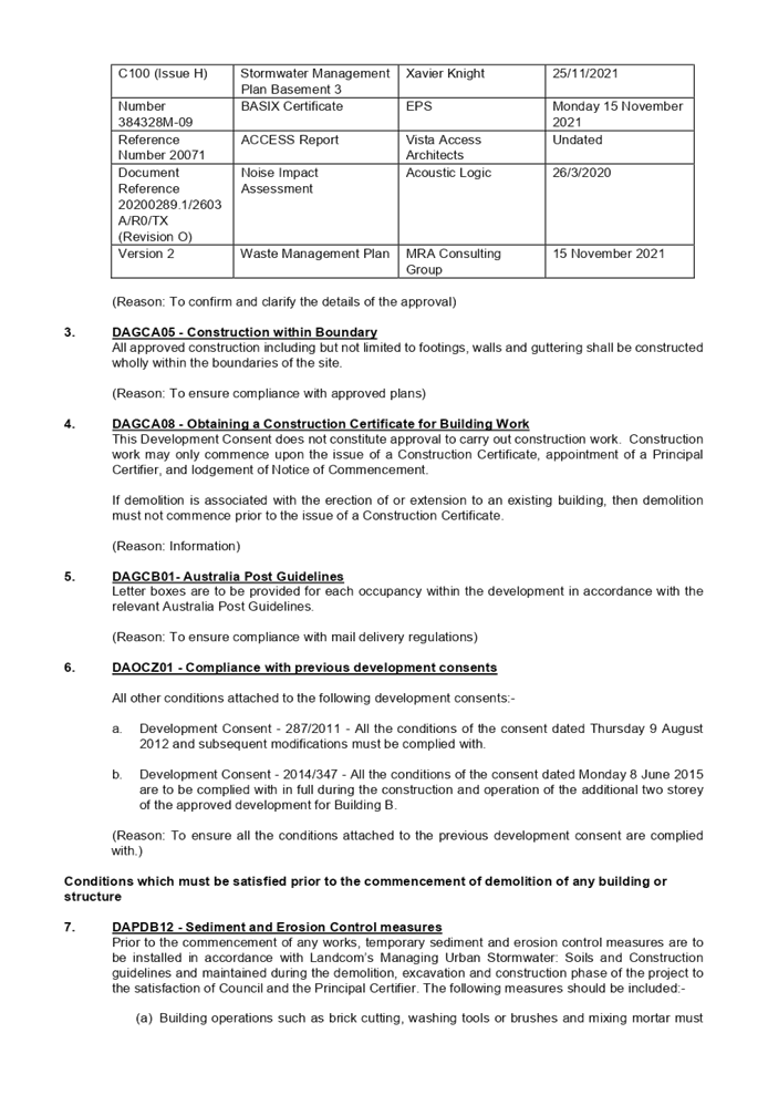

DOCUMENTS
ASSOCIATED WITH
REPORT LPP002/22
Attachment 2
Appendix A - Cumberland Local Environmental Plan 2021
Assessment
Cumberland Local Planning Panel Meeting
9 February 2022
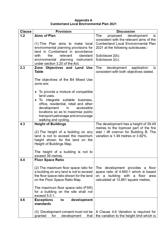
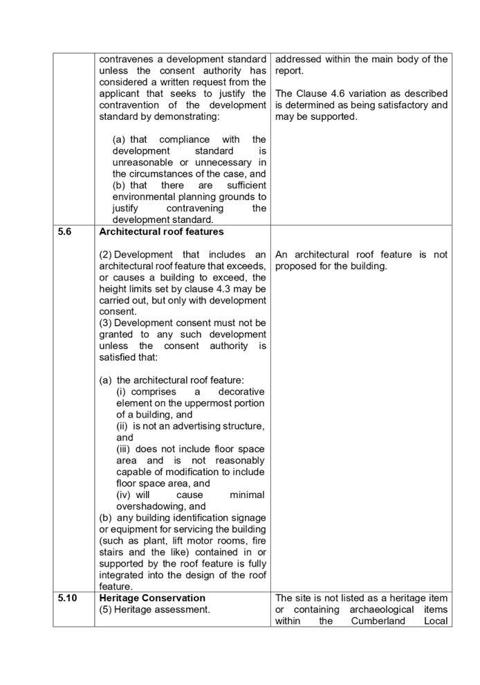

DOCUMENTS
ASSOCIATED WITH
REPORT LPP002/22
Attachment 3
Appendix B - Cumberland Development Control Plan
Assessment and Appendix C - Apartment Design Guide Assessment
Cumberland Local Planning Panel Meeting
9 February 2022
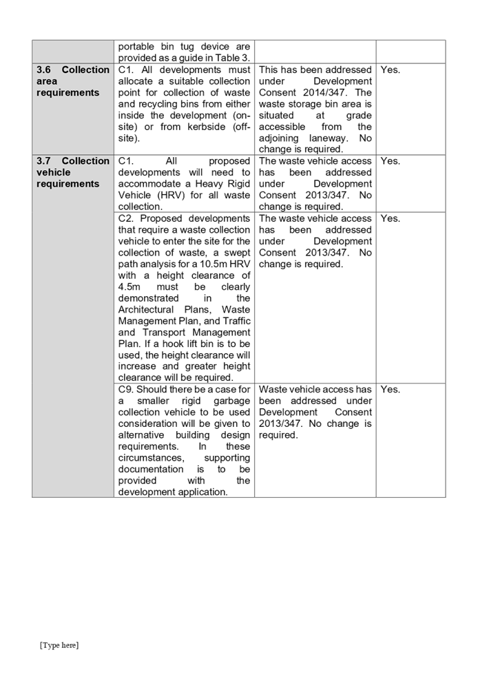
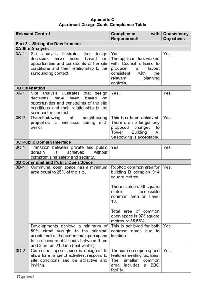
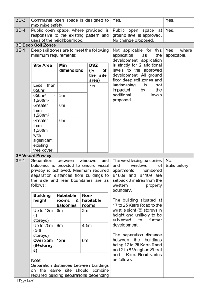
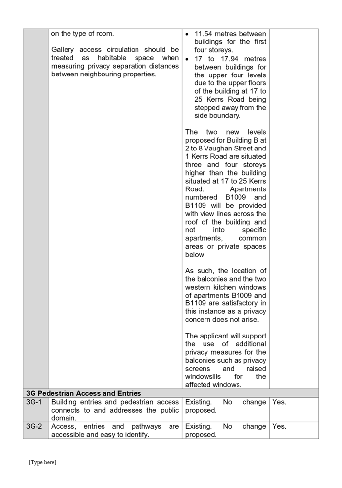
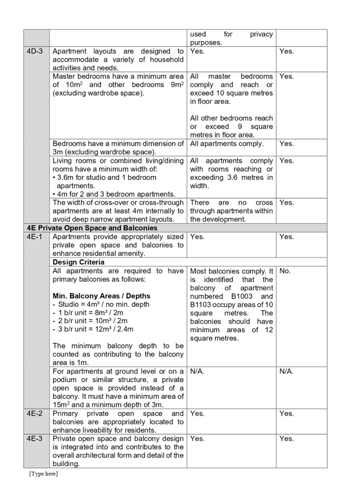
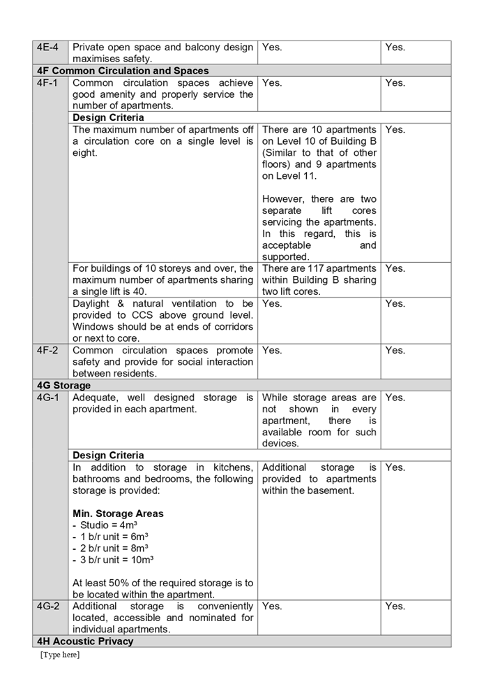
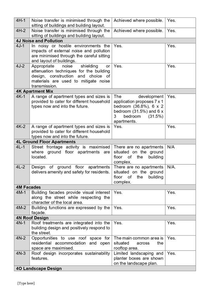
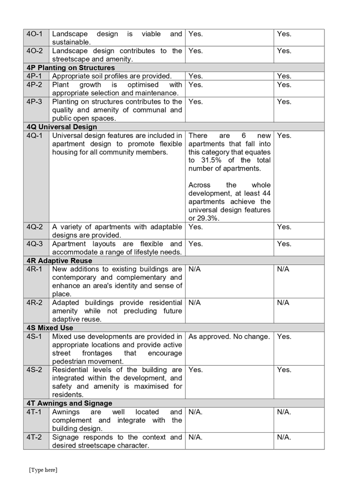
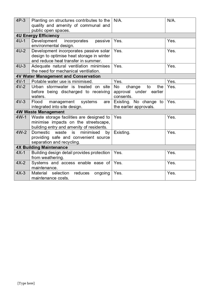
DOCUMENTS
ASSOCIATED WITH
REPORT LPP002/22
Attachment 4
Submissions Received
Cumberland Local Planning Panel Meeting
9 February 2022
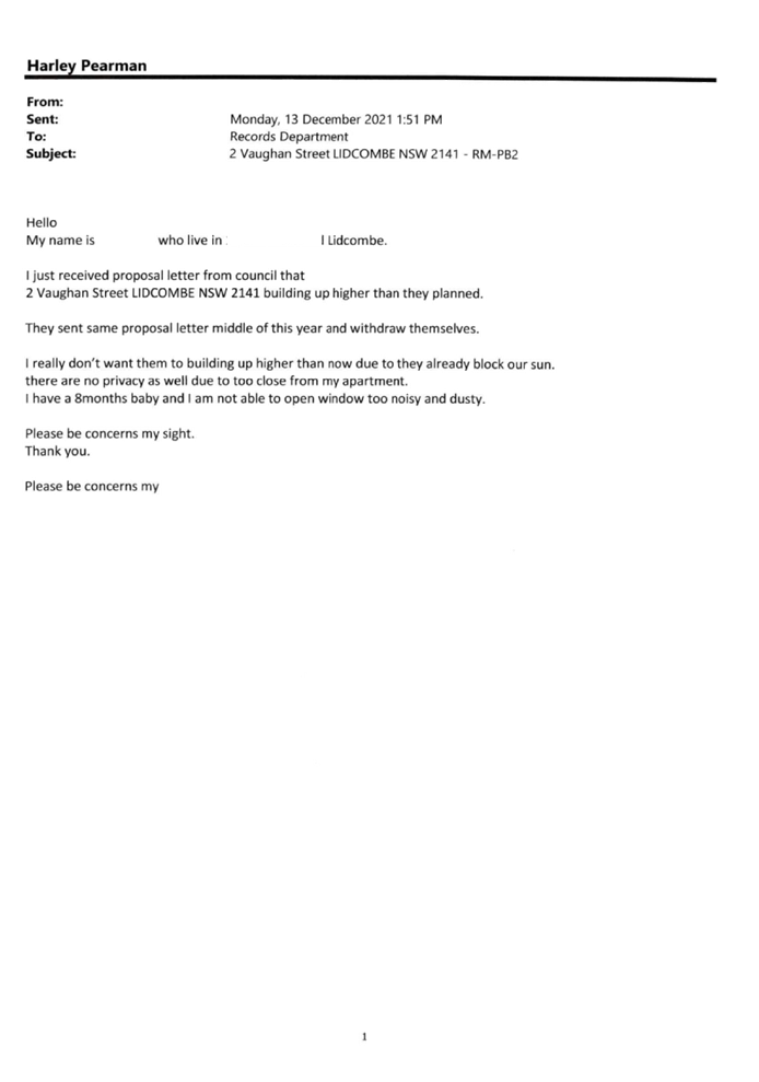
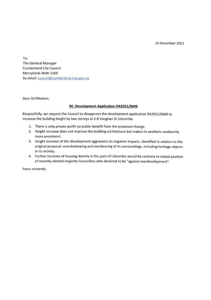
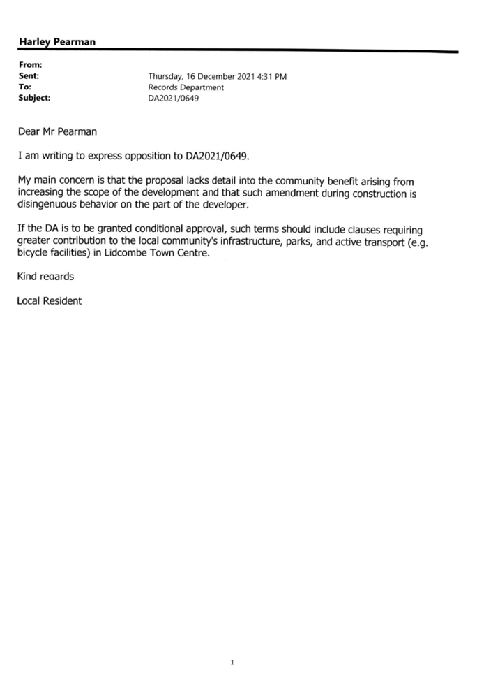


DOCUMENTS
ASSOCIATED WITH
REPORT LPP002/22
Attachment 5
Clause 4.6 Variation
Cumberland Local Planning Panel Meeting
9 February 2022
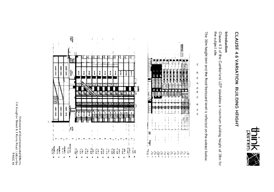
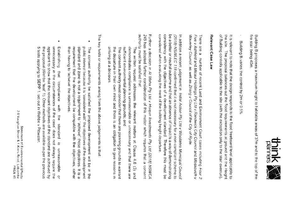

DOCUMENTS
ASSOCIATED WITH
REPORT LPP002/22
Attachment 6
Architectural Plans, Shadow Diagrams and Landscape
Plans
Cumberland Local Planning Panel Meeting
9 February 2022
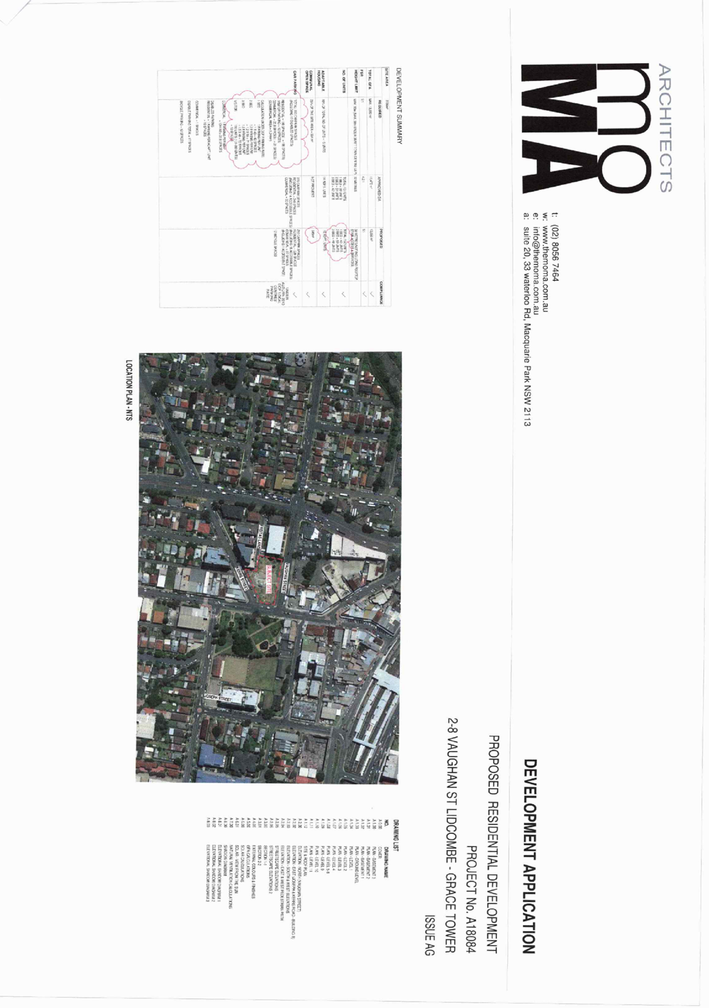
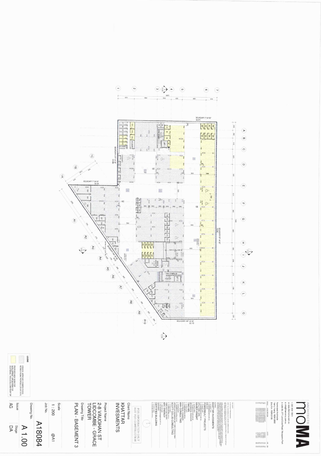
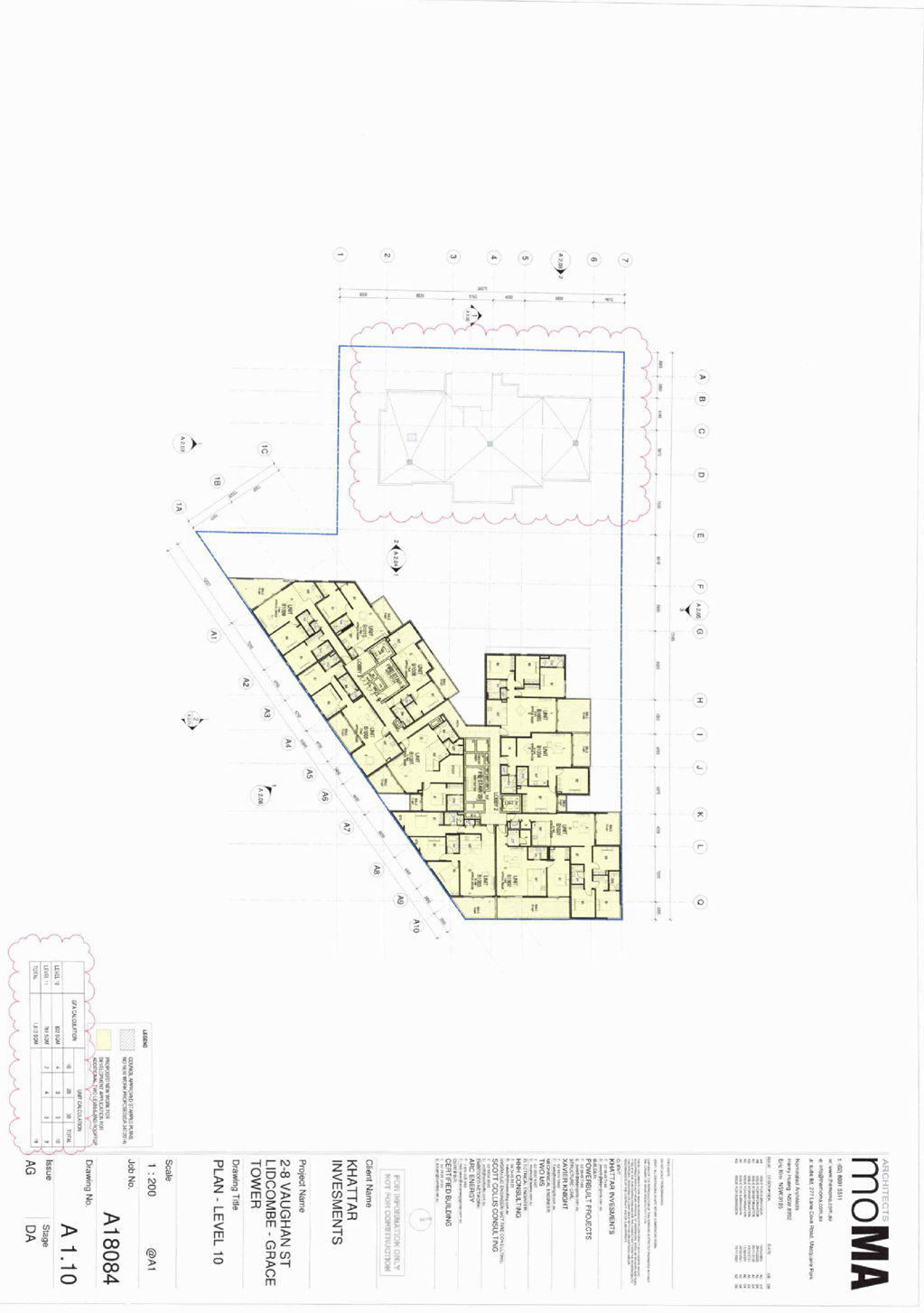
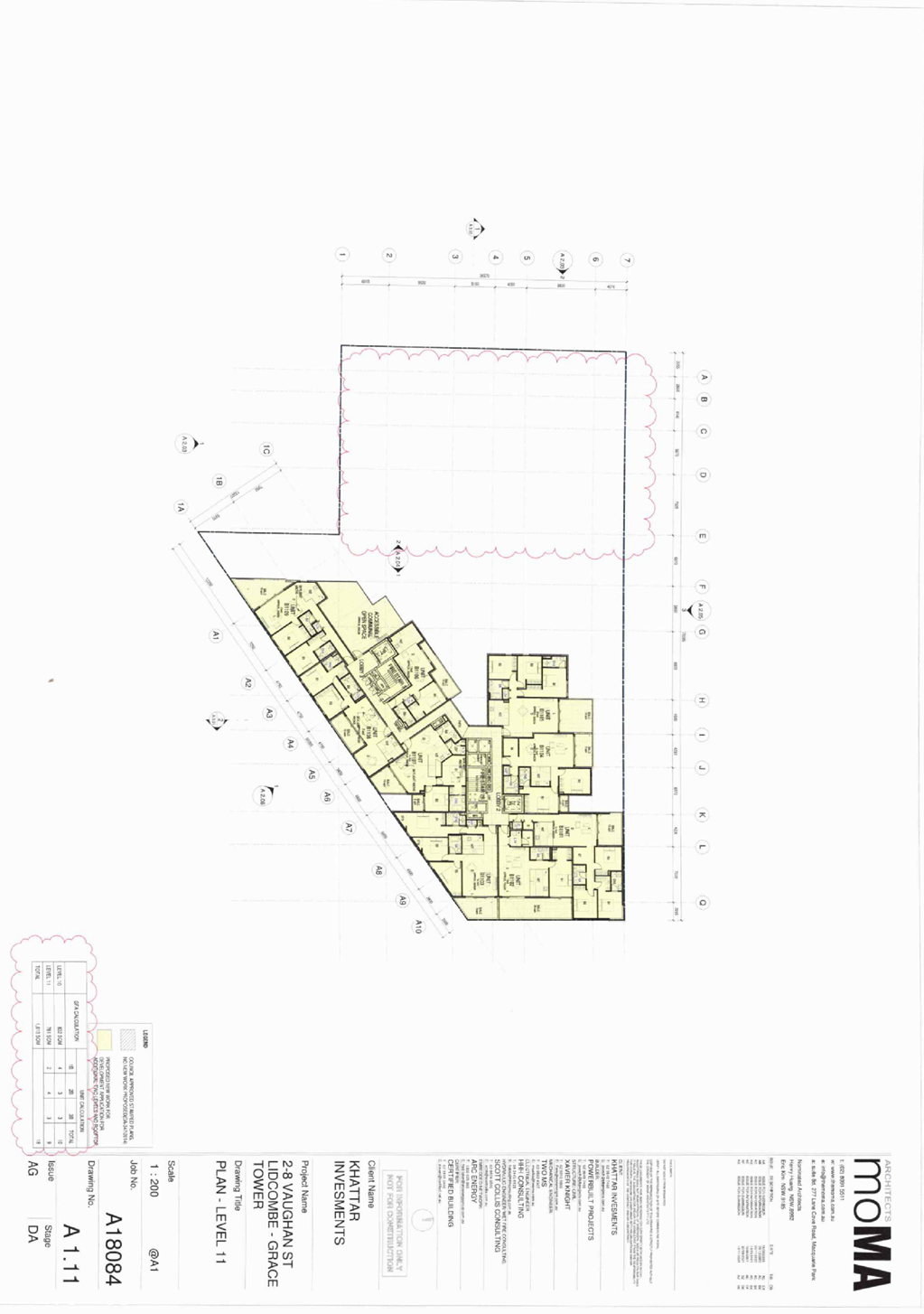
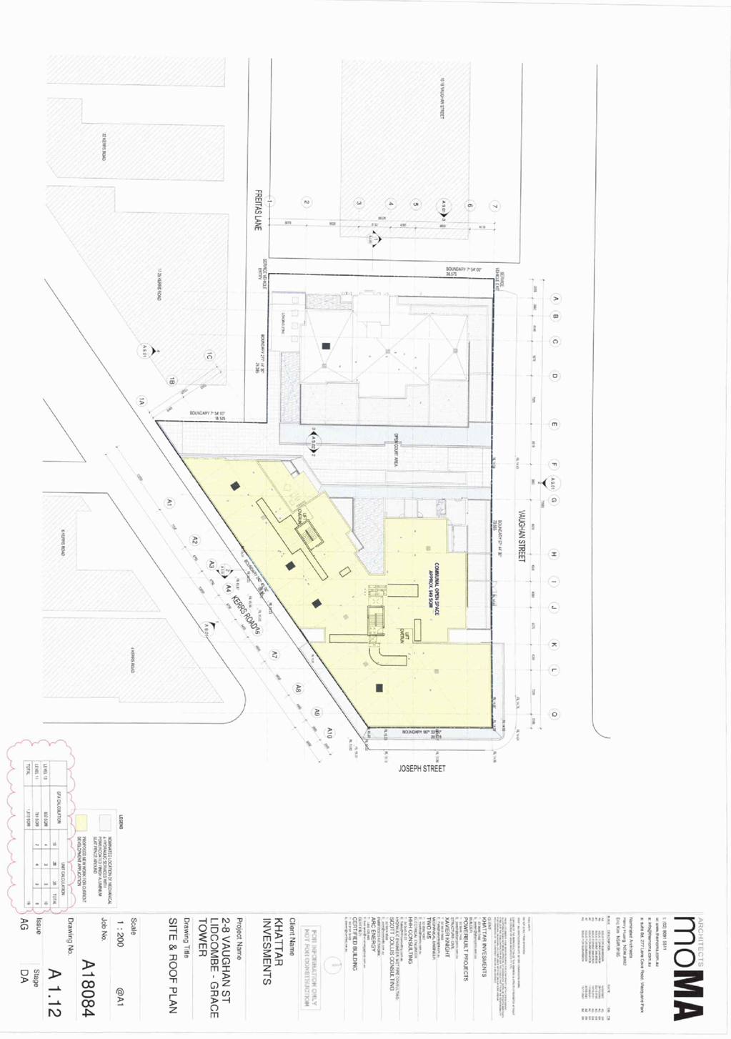
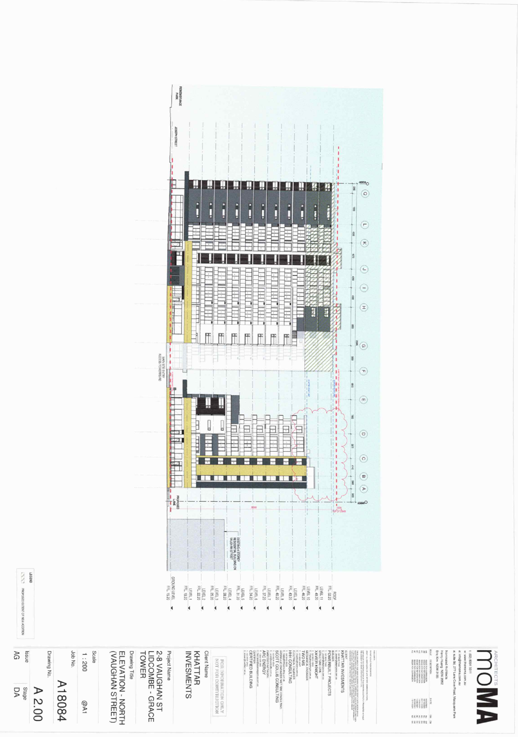
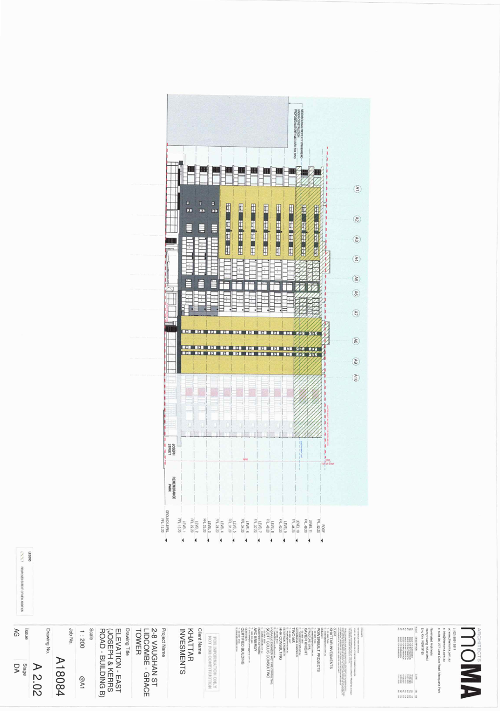
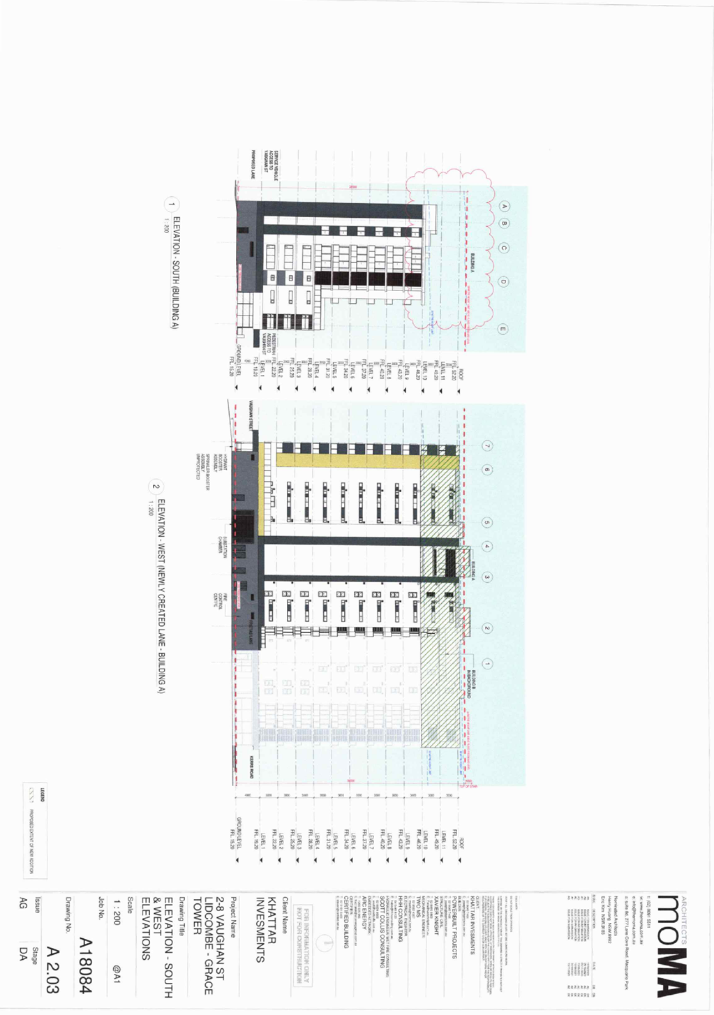
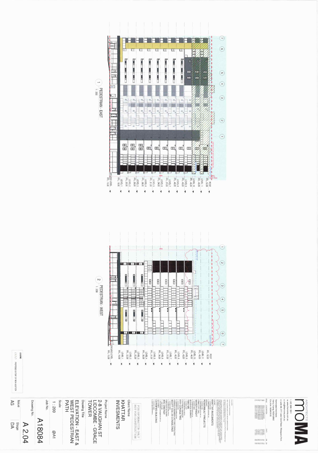
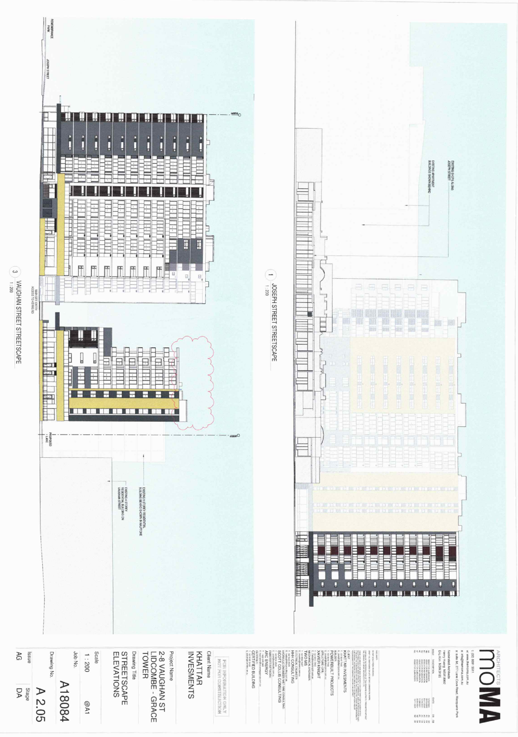
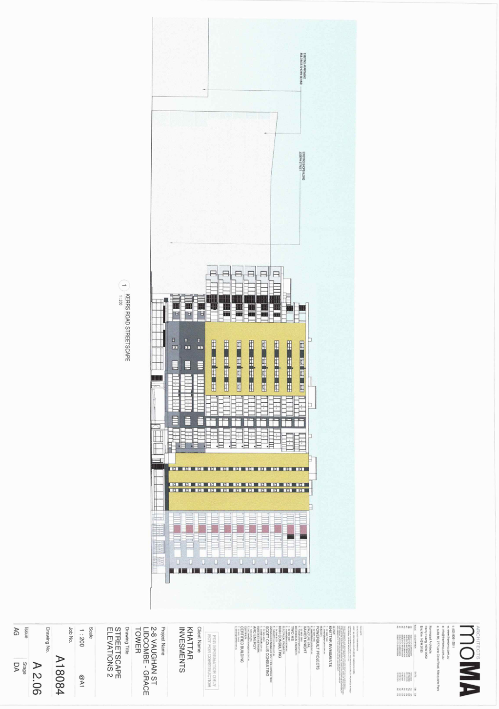
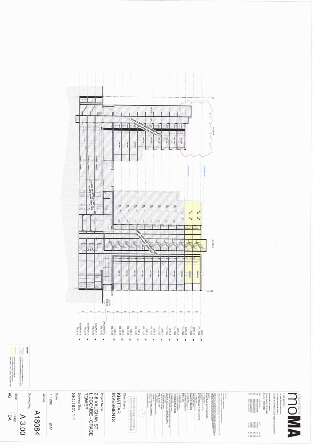
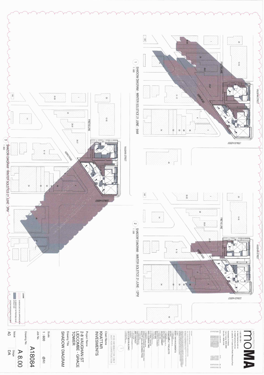
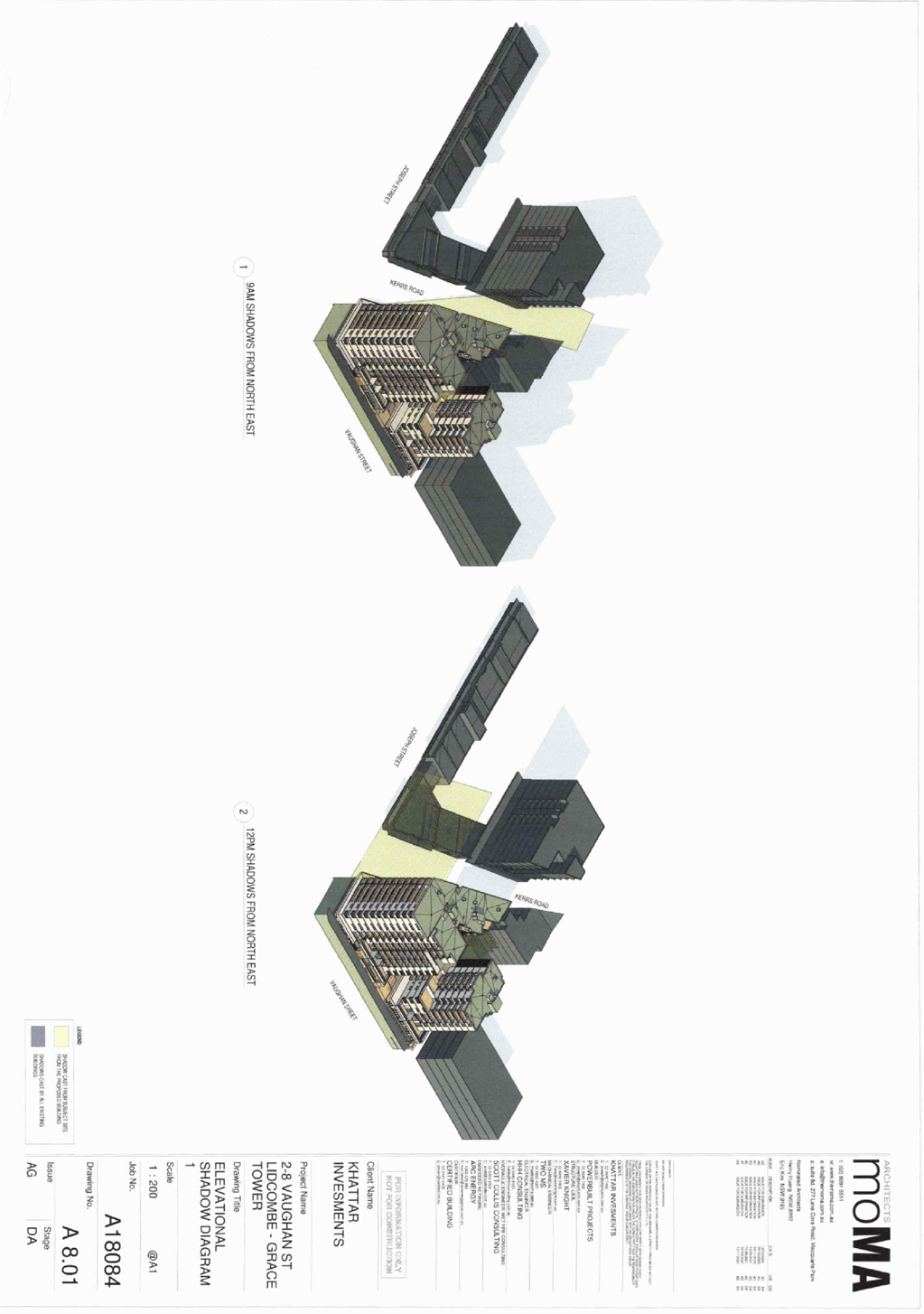
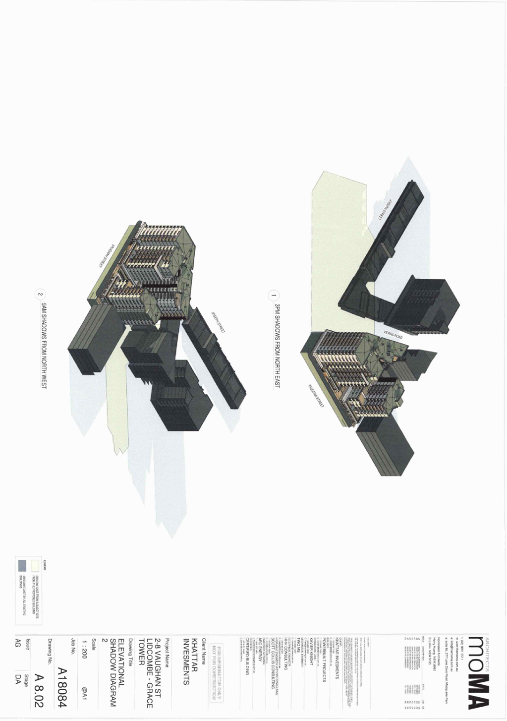
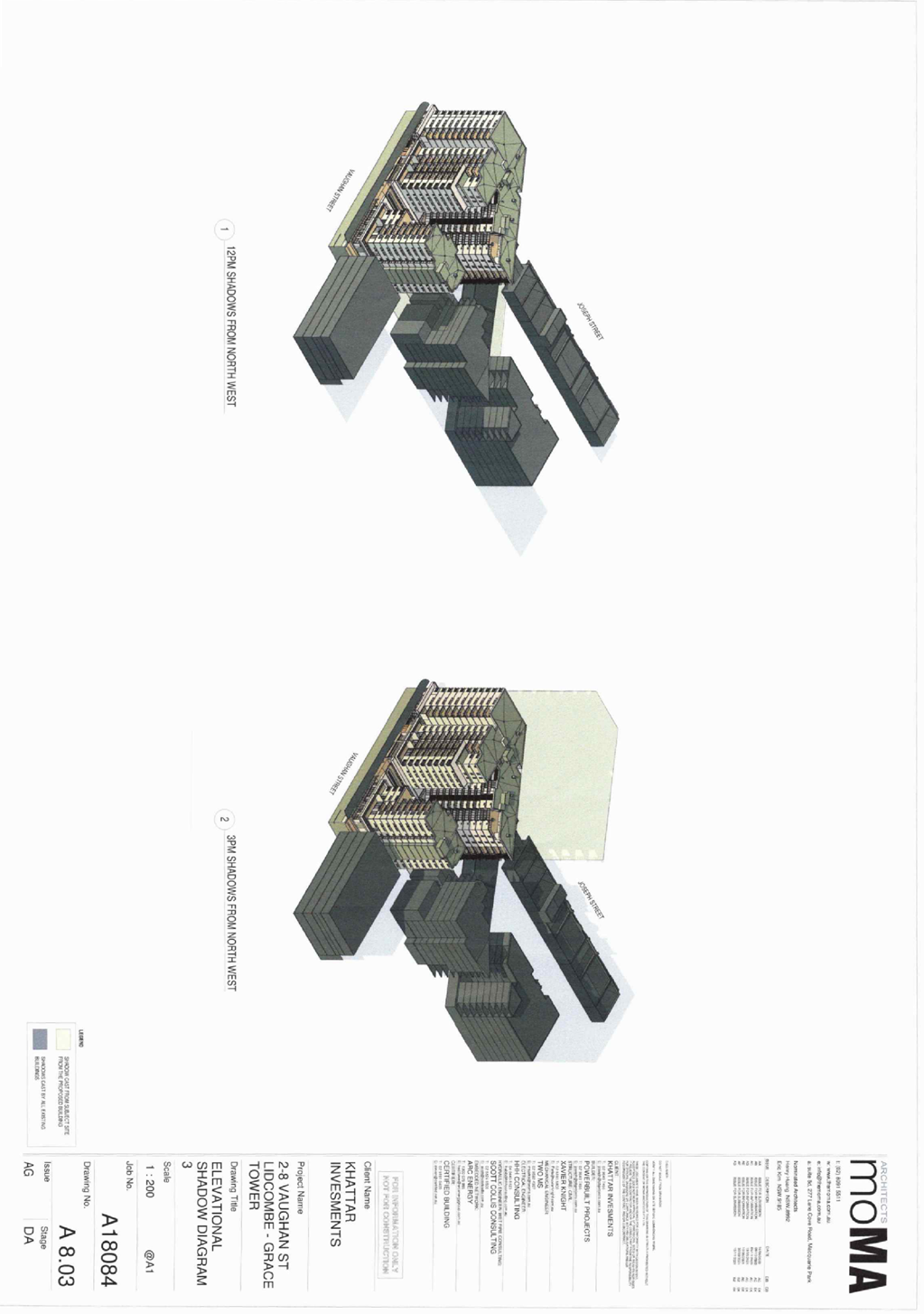
DOCUMENTS
ASSOCIATED WITH
REPORT LPP002/22
Attachment 7
Draft Reasons for Recommendation
Cumberland Local Planning Panel Meeting
9 February 2022
Cumberland Local Planning Panel Meeting
9 February 2022
Item No: LPP003/22
Development
Application for 7 Birmingham Street, Merrylands
Responsible
Division: Environment
& Planning
Officer: Executive
Manager Development and Building
File Number: DA2021/0298
|
Application
accepted
|
11 June 2021
|
|
Applicant
|
Designcorp Australia Pty Ltd
|
|
Owner
|
Mr J Saba
|
|
Application
No.
|
DA2021/0298
|
|
Description
of Land
|
7 Birmingham Street
MERRYLANDS NSW 2160, Lot 34 Sec 1 DP 5714
|
|
Proposed
Development
|
Demolition of existing
structures and the construction of a part four, part five storey residential
flat building for 8 units including undercroft at-grade parking pursuant to
the SEPP (Affordable Rental Housing) 2009
|
|
Site
Area
|
613.2m2
|
|
Zoning
|
R4 High Density Residential
Zone
|
|
Disclosure
of political donations and gifts
|
Nil disclosure
|
|
Heritage
|
The site is not listed as
heritage item and it is not located within Heritage Conservation Area.
|
|
Principal
Development Standards
|
FSR
Permissible: 1.2:1 (plus ARH
SEPP bonus 0.2:1) = 1.4:1
Proposed: 1.14:1
Height of Building
Permissible: 15m
Proposed: 16.76m
|
|
Issues
|
· Building
height
· Building
separation/visual privacy
· At
grade car parking
· Adaptable
unit and car parking
· Lot
frontage and landlocking
· Site
coverage
· Rear
setbacks
· Number
of storeys
· Submission
|
1. Development
Application No. DA2021/0298 was accepted on 11 June 2021 for the demolition of
existing structures and the construction of a part four, part five storey
residential flat building for 8 units including undercroft at-grade parking
(pursuant to the SEPP (Affordable Rental Housing) 2009.
2. The
application was publicly notified to occupants and owners of the adjoining
properties for a period of twenty one (21) days between 16 July 2021 and 6
August 2021. In response, one (1) submission was received.
3. The
subject site is not listed as a heritage item or located within the heritage
conservation area in the Holroyd Local Environmental Plan 2013.
4. The
subject application has been assessed against the relevant provisions of the
Environmental Planning and Assessment Act 1979, State Environmental Planning
Policy No 65 – Design Quality of Residential Apartment Development, State
Environmental Planning Policy (Affordable Rental Housing) 2009, Holroyd Local
Environmental Plan (HLEP) 2013 and Holroyd Development Control Plan (HDCP
2013).
5. The
notable variations are as follows:
|
Control
|
Required
|
Provided
|
% variation
|
|
Building Height (HLEP 2013)
|
15m
|
16.76m
|
11.73%
|
|
Building separation/ visual privacy (ADG)
|
6m (habitable) & 3m (non habitable) (4 storeys)
9m (5 storeys)
|
0.7m (GF east), 2m & 3m (Level 1-3 both sides)
3m (Level 4 both sides) & 6m (rear)
|
76.6%, 33.3% & 50%
66.6% & 33.3%
|
|
Adaptable unit and car parking (HDCP 2013)
|
15% of total units (8) = 1.2
(rounded up to 2)
|
1 adaptable unit and 1 disabled car space
|
50%
|
|
Lot frontage (HDCP 2013)
|
24m
|
15.24m
|
36.5%
|
|
Site coverage (HDCP 2013)
|
30%
|
52.1%
|
22.1%
|
|
Rear Setbacks (HDCP 2013)
|
8.04m (4 storeys)
12.06m (5 storeys)
|
6m
6m
|
25.37%
48%
|
|
Number of storey (HDCP 2013)
|
4
|
5
|
25%
|
6. The application is
referred to the Panel as it is a residential flat building development of 4 or
more storeys to which the State Environmental Planning Policy No 65 –
Design Quality of Residential Apartment Developments applies with contravention
of the building height development standard over 10%.
7. The
application is recommended deferred commencement approval subject to the
conditions as provided in the attached schedule.
Subject Site and Surrounding
Area
The subject site is known as 7 Birmingham
Street, Merrylands and is legally described as Lot 34, Section 1 in DP 5714.
The subject site is located on the northern side of Birmingham Street,
Merrylands. The site is rectangular in shape with a frontage of 15.24m to
Birmingham Street (replicated for the rear boundary) and side boundary
dimensions of 40.235m for a total site area of 613.2m². The land falls to
a low point within the easement on the western boundary, rising approximately
0.8 to the front south-western corner and 1.2m to the rear north-western corner
at a gentle grade.
The subject site has a
Council’s drainage easement which traverses in a south-eastern to north
western direction across the site as detailed in the below survey image.
Further to this the site is currently occupied by a single storey dwelling
house, detached carport and associated hard stand space. The site contains no
trees or significant landscape features. The site is subject to stormwater
overland flows and flooding, which includes land within each of the high flood,
medium flood and low flood risk precincts.
Surrounding the subject site is a
mixture of building types including residential flat buildings from 2 to 4
storeys in height and single storey dwellings.
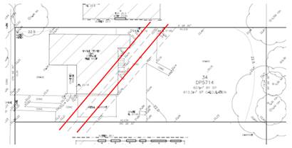
Figure
1 – Existing Council’s drainage easement location.
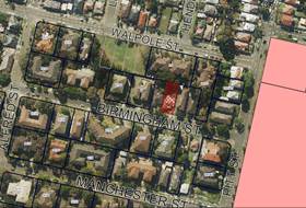
Figure
2 – Aerial view of subject site
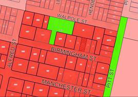
Figure
3 – Zoning map
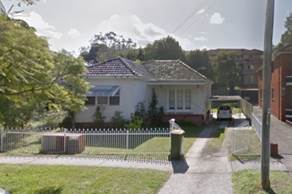
Figure
4 – Street view of subject site
Description of the
Development
Council has received a development
application for demolition of existing structures and the construction of a
part four, part five storey residential flat building for 8 units including
undercroft at-grade parking pursuant to the SEPP (Affordable Rental Housing)
2009.
Key features of the development
proposal are as follows:-
|
Level
|
Details
|
|
Ground floor level
|
Realignment of 600mm diameter Council’s drainage
easement along the western side boundary towards Birmingham Street;
Provision of entry foyer facing Birmingham Street with
lift and fire staircase;
Waste management room;
8 at grade car spaces (including 1 adaptable space)
elevated approximately 1.07m above natural ground level;
3 bicycle spaces;
Above ground OSD tank;
|
|
First Floor
|
1 x 3 bedroom unit (unit 1 split level);
2 x 2 bedroom units;
|
|
Second Floor
|
1 x 3 bedroom unit (unit 1 split level);
2 x 2 bedroom units;
|
|
Third Floor
|
1 x 1 bedroom unit;
2 x 2 bedroom units;
|
|
Rooftop
|
Storage;
Clothes drying area;
BBQ area; and
Communal open space (191m2).
|
The dwelling mix of the proposal
is as follows:
- 1
x 1 Bed Unit (12.5%);
- 6
x 2 Bed Unit (75%); and
- 1
x 3 Bed Unit (12.5%).
History
DA2017/226/1 was refused by the
Cumberland Local Planning Panel on 27 March 2019 for demolition of existing
structures; construction of a 4 storey residential flat building comprising 6
units under affordable rental housing SEPP 2009; at-grade parking accommodating
5 carparking spaces.
The applicant filed court
proceedings to the Land and Environment Court against the refusal of
DA2017/226/1 on 8 May 2019. Notice of discontinuance of the proceedings case
no. 2019/00143856 was requested by the applicant on 28 January 2020.
PL2020/0076 was held at Council on
25 September 2020 for demolition of existing structures and the construction of
a six (6) storey Residential Flat Building (including roof top communal open
space) pursuant to the SEPP (Affordable Rental Housing).
Applicants Supporting
Statement
The applicant has provided a Statement
of Environmental Effects prepared by Think Planners dated 27 May 2021 and was
received by Council on 11 June 2021 in support of the application.
Contact with Relevant
Parties
The assessing officer has
undertaken a site inspection of the subject site and surrounding properties and
has been in regular contact with the applicant throughout the assessment
process.
Internal Referrals
Development Engineer
The development application was
referred to Council’s Development Engineer for comment who has advised
that the development proposal is satisfactory with regard to Council’s
stormwater drainage pipeline relocation, stormwater management, flooding and
car parking and therefore can be supported subject to recommended conditions of
consent.
Environment and Health
The development application was
referred to Council’s Environment and Health Officer for comment who has
advised that the development proposal is satisfactory regarding to noise
impact, contamination and water protection and therefore can be supported
subject to recommended conditions of consent.
Tree Management Officer
The development application was
referred to Council’s Tree Management Officer for comment who has advised
that the development proposal is satisfactory with regard to the adjoining
trees protection and therefore can be supported subject to recommended
conditions of consent.
Waste Management
The development application was
referred to Council’s Waste Management Officer for comment who has
advised that the development proposal is satisfactory regarding the proposed
waste management and therefore can be supported subject to recommended
conditions of consent.
External Referral
The development application was
referred to Endeavour Energy for comment who has advised that the development
proposal is satisfactory in terms of electricity connection and therefore can
be supported subject to recommended conditions of consent.
Planning Comments
The provisions of any
Environmental Planning Instruments (EP&A Act s4.15 (1)(a)(i))
(a) State
Environmental Planning Policy (Housing) 2021 (SEPP Housing)
SEPP Housing 2021 came into force
on 26 November 2021. The SEPP includes schedule 7 (Savings and transitional
provisions) which states that if a Development Application (DA) was lodged with
Council however not determined, prior to 26 November 2021, the provisions of
State Environmental Planning Policy (Affordable Rental Housing) 2009 continue
to apply to that DA.
The current DA was accepted by
Council on 11 June 2021 and as such the provisions of State Environmental
Planning Policy (Affordable Rental Housing) 2009 apply to the application as
follows.
(a) State
Environmental Planning Policy (Affordable Rental Housing) 2009
The application has been submitted
under Part 2 New affordable rental housing – Division 1 In-fill
affordable housing of the ARH SEPP. It should be noted that the proposal fully
complies with the key planning controls contained within the ARH SEPP including
site area, deep soil zones, landscaped area, solar access, parking, dwelling
size and prescribed standards for in-fill affordable housing. A comprehensive
assessment against ARH SEPP is attached in Attachment 6 of this report.
10 Land to which Division
applies
This Division applies to a
development on the subject site, as it is located within R4 High Density
Residential zone and located within 800m walking distance to the Merrylands
Railway Station.
11 Development to which
Division applies
This Division of the ARH SEPP
applies as the development for the purposes of residential flat buildings will
be provided with at least 20% of the dwellings in the building will be used for
affordable housing. Calculations of the GFA allocation are listed below.
o 2 affordable rental
housing (ARH) - units 2 and 3 with GFA of 144.02m².
o Total GFA of 8 units
made of the following:
- Ground
floor = 34.84m².
- First
floor = 210.63m².
- Second
floor = 212.63m².
- Third
floor = 214.84m².
- Rooftop
= 25.9m².
- Total
= 698.84m².
o Percentage of ARH units
= 144.02m²/698.84m² x 100% = 20.7%.
Residential flat buildings are
also permissible on the land zoned R4 under Holroyd LEP 2013 and the land does
not contain a heritage item that is identified in an environmental planning
instrument or an interim heritage order or on the State Heritage Register. The
proposal will provide 20.7% of affordable housing dwellings, therefore Division
1 In-fill affordable housing of the ARH SEPP applies.
13 Residential flat buildings
where such buildings permissible
In accordance with clause
13(2)(a)(ii) of ARH SEPP, the maximum FSR that applies to the subject site is
1.2:1 + 0.2:1 = 1.4:1.
The proposal includes a GFA of
698.84m², or FSR of 1.14:1, which complies with the maximum permitted FSR
on the site.
An assessment of the development
against the provisions of Clause 16A (Character of the local area) is also
provided below.
16A Character of local area
A consent authority must not
consent to development to which this Division applies unless it has taken into
consideration whether the design of the development is compatible with the
character of the local area. The SEPP (ARH) does not contain any guidance for
assessing whether a proposal is compatible with the character of the local
area. However, a planning principle for assessing compatibility in the urban
environment was established by Senior Commissioner Roseth of the Land and
Environment Court in the judgement for Project Venture Developments Pty Ltd v
Pittwater Council [2005] NSWLEC 191. This involves asking the following two
questions:
· Are
the proposal’s physical impacts on surrounding development acceptable?
The physical impacts include constraints on the development potential of
surrounding sites.
· Is
the proposal’s appearance in harmony with the buildings around it and the
character of the street?
A merit assessment of the
character of the local area should consider the following 3 steps:
· Step
1 – Identify the ‘local area’.
· Step
2 – Determine the character of the ‘local area’.
· Step
3 – Determine whether the design of the proposed development is compatible
with the character of the ‘local area’.
An assessment against each step is
provided below:
Step 1 – Identify the
local area.
This assessment identifies the
local area as primarily the visual catchment of the site (outlined in black) as
viewed from within the site and directly adjacent to the site on the street
which is defined by the thick black line in the figure below:
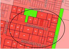
Figure
5 – Local Area catchment
Step 2 – Determine the
character (present and future) of the local area.
The zoning of the broader locality
and immediate area comprises R4 High Density Residential, R3 Medium Density
Residential and RE1 Public Recreation under the Holroyd Local Environmental
Plan (HLEP) 2013.
Present Character of the area
The character of the local area
comprises the visual catchment of regular shaped allotments viewed from and
surrounding the subject site, which includes:-
1. Holroyd
Gardens along the eastern side of Pitt Street;
2. Existing
2 – 3 storey walk up flats facing Pitt Street bounded by Walpole Street
to the north and Manchester Street to the south;
3. Surrounding
the subject site is a mixture of building types including residential flat
buildings from 2 to 4 storeys in height and single storey dwellings; and
4. A
vacant lot on the corner of Pitt Street and Manchester Street (153 Pitt Street)
has been approved for a 4 storey residential flat building with basement
parking and rooftop common terrace.
Figure
6: Existing Streetscapes
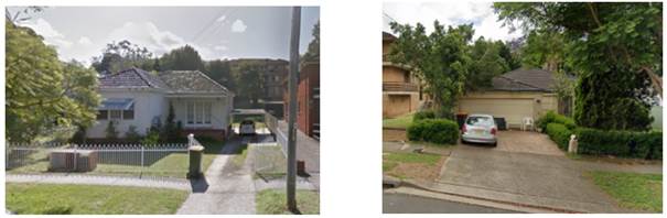
Subject site, 7 Birmingham
Street 9
Birmingham Street
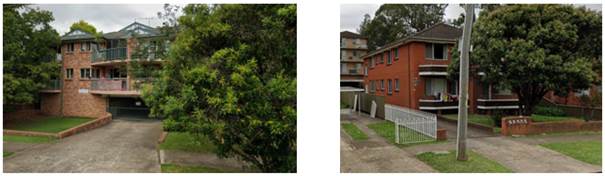
6-8 Birmingham
Street
5 Birmingham Street
Future Character of the area
The locality is in transition
particularly to support the increasing demand of affordable housing within the
close proximity of public transport hub and major commercial centre. The
transition issue is clear with regard to FSR, height and setbacks for the
proposed development. It is considered that the height, bulk and scale of the
proposed development is consistent with a single lot development, similar to
the newer approved residential flat buildings being constructed and would not
be inconsistent with the desired future character of the locality.
Step 3 - Determine if the
development is compatible with the character of the local area.
In accordance with the Land and
Environment Court’s ‘Planning Principle’ and case law
compatibility is best defined as ‘capable of existing together in
harmony’. In order to test compatibility two questions are to be considered.
These questions, as well as a response to each, are provided below:
· Are
the proposal’s physical impacts on surrounding development acceptable?
The physical impacts include constraints on the development potential of
surrounding sites.
The height, FSR and landscaping of
the proposed development are designed to maintain the harmony within the
streetscape, whilst contributing to the site context and constraint. The height
of building breaches the 15m height limit requirement for the lift core as
discussed later in the report. However, the development does not pose any
unreasonable overshadowing impacts on adjoining properties. The proposal
being a permissible land use, meets the FSR requirement (in accordance with ARH
SEPP, subject to the imposition of conditions) and contributes to the provision
of affordable housing within the close proximity of public transport hub and
major commercial centre. Appropriate setbacks for the rooftop communal open
spaces and privacy treatments are provided to minimise any adverse impacts to
the adjoining properties. The proposed development is similar to the newer
residential flat buildings being approved on 2-4 Manchester Street and 1
Sheffield Street, 6-10 Manchester Street, 153 Pitt Street, and other existing
developments in the vicinity, such as 3 and 5 Birmingham Street. The provision
of rooftop communal open space will allow better enjoyment of area with direct
solar access at the northerly orientation. Whilst the development will result
in some overshadowing to the adjoining properties on the side boundaries, the
impacts are not considered unreasonable given this is a function of the
allotment orientation and R4 context. The overall design represents the form of
development that is envisaged under the planning controls. Refer to further
discussion under DCP section of the report.
· Is
the proposal’s appearance in harmony with the buildings around it and the
character of the street?
To be compatible, a development
should contain, or at least respond to the key aesthetic elements that make up
the character of the surrounding area. The size of the basement with variation
to the side setbacks maximises landscaping and deep soil zones on site. The
front setbacks are generous and consistent with the existing streetscape. The
proposal is considered to maintain an appropriate residential character which
is consistent with the streetscape. As indicated, the local area has an
established high density residential built form, as such, the proposed
development is not considered to be inconsistent with the existing streetscape
character of the immediate area surrounding the subject site.
In conclusion, the proposal will
maintain the harmony within the general streetscape, and suitably fits in the
local character of the locality.
(b) State
Environmental Planning Policy No 65 – Design Quality of Residential
Apartment Development (SEPP 65)
SEPP 65 applies to the development
as the building is 3 storeys or more, and contains more than 4 dwellings. A
design statement addressing the design quality principles prescribed by SEPP 65
was prepared by the project architect, Joe El-Sabbagh, registration number
8707. Integral to SEPP 65 is the Apartment Design Guide (ADG), which sets
benchmarks for the appearance, acceptable impacts and residential amenity of
the development.
A comprehensive assessment against
the SEPP 65 and Apartment Design Guide (ADG) controls is provided at Attachment
7.
The proposal involves the
following non-compliance with the ADG controls.
• 3F
Visual Privacy
Objective 3F-1 of the ADG states
that minimum separation distances from buildings to side and rear boundaries
are as follows.
|
Building (height)
|
Habitable rooms and balconies
|
Non-habitable rooms
|
|
Up to 12m (4 storeys)
|
6m
|
3m
|
|
Up to 25m (5-8 storeys)
|
9m
|
4.5m
|
Due to the site frontage
limitation, full compliance with building separation is not feasible in this
instance. At ground floor level, building separation of 0.7m is proposed on the
eastern side boundary between elevated undercroft car parking area and units
windows of 5 Birmingham Street, where 3m building separation is required
between non-habitable and habitable areas. Condition is to be imposed to ensure
that privacy screening is to be installed full length along the fencing of the
undercroft car parking area on the eastern side to maintain visual privacy of 5
Birmingham Street habitable windows.
Building separation of 2m to 3m is
also to be provided to the eastern and western boundaries of the proposed flat
building from level 1 to level 3. Variation to the required building separation
of 6m is considered acceptable as privacy screens are to be provided to the
side facing balconies and highlight windows are also proposed for rooms with
openings facing the side elevation. Full openable windows are to be orientated
towards the northern (rear) and southern (front) elevations instead.
Further to that, building
separation of 3m to side boundaries and of 6m to rear boundary is provided for
building height of 5 storeys where the rooftop communal open space is located
on level 4. While there are no other 5 storeys buildings directly adjoining the
subject site, the rooftop communal open space will be provided with 1.6m high
privacy screening along all sides and rear boundaries to maintain privacy with
the adjoining properties.
Based on the provision of suitable
privacy measures as stated above, non-compliances with the building separation
controls are considered acceptable.
(c) State
Environmental Planning Policy No. 55 – Remediation of Land (SEPP 55)
Clause 7 of SEPP 55 requires
Council to be satisfied that the site is suitable or can be made suitable to
accommodate the proposed development. The matters listed within Clause 7 have
been considered in the assessment of the development application.
|
Matter for Consideration
|
Yes
|
No
|
|
Does the application involve re-development of the site or
a change of land use?
|
|
|
|
Does the application involve
re-development of the site or a change of land use?
|
|
|
|
In the development going to be used for a sensitive land
use (e.g.: residential, educational, recreational, childcare or hospital)?
|
|
|
|
Does information available to you indicate that an
activity listed below has ever been approved, or occurred at the site?
acid/alkali plant and
formulation, agricultural/horticultural activities, airports, asbestos
production and disposal, chemicals manufacture and formulation, defence
works, drum re-conditioning works, dry cleaning establishments, electrical
manufacturing (transformers), electroplating and heat treatment premises,
engine works, explosive industry, gas works, iron and steel works, landfill
sites, metal treatment, mining and extractive industries, oil production and
storage, paint formulation and manufacture, pesticide manufacture and
formulation, power stations, railway yards, scrap yards, service stations,
sheep and cattle dips, smelting and refining, tanning and associated trades,
waste storage and treatment, wood preservation
|
|
|
|
Is the site listed on
Council’s Contaminated Land database?
|
|
|
|
Is the site subject to EPA
clean-up order or other EPA restrictions?
|
|
|
|
Has the site been the subject of
known pollution incidents or illegal dumping?
|
|
|
|
Does the site adjoin any
contaminated land/previously contaminated land?
|
|
|
|
Has the appropriate level of
investigation been carried out in respect of contamination matters for
Council to be satisfied that the site is suitable to accommodate the proposed
development or can be made suitable to accommodate the proposed development?
|
|
|
|
Details of contamination investigations carried out at the
site:
A search of Council’s
records and a review of historical aerial imaging does not reveal any details
that the site is contaminated. A review of Preliminary Investigation Report
(PSI) prepared by GCA Geotechnical Consultants Australia, report number E20177-1, dated 10 December 2020 identifies that
the site can be made suitable for the proposed
development, subject to the following recommendations.
· All structures onsite should have a Hazardous Materials
Survey (HMS) conducted by a qualified occupational hygienist and/or
environmental consultant for the site prior to any demolition or renovation
works in accordance with relevant Australian Standards, SafeWork NSW codes of
practice and any other applicable requirements;
· Any soils requiring excavation, onsite reuse and/or
removal must be classified in accordance with “Waste Classification
Guidelines Part 1: Classifying Waste” NSW EPA (2014);
· The demolition of any structures and excavation activity
on site be undertaken in accordance with relevant Australian Standards,
SafeWork NSW codes of practice and any other applicable requirements; and
· A site specific ‘Unexpected Finds Protocol’
is to be made available for reference for all occupants and/or site workers
in the event unanticipated contamination is discovered, including asbestos.
Based on the comments provided by Council’s Environmental Health Unit and
appropriate conditions that have been included in the draft determination, Council is satisfied that the site is suitable for the
proposed used as proposed.
|
(d) State
Environmental Planning Policy (Infrastructure) 2007 (ISEPP)
The provisions of the ISEPP 2007
have been considered in the assessment of the development application.
Clause 45 – Development
likely to affect an electricity transmission or distribution network
The development application was
referred to Endeavour Energy for comment, who raised no objections, subject to
conditions, which have included within the draft notice of determination.
(e) Statement
Environmental Planning Policy No 19 - Bushland in Urban Areas
The proposal does not propose to
disturb bushland zoned or reserved for public open space.
(f) State
Environmental Planning Policy (Vegetation in Non-Rural Areas) 2017
N/A - the site contains no trees
or significant landscape features.
(g) State
Environmental Planning Policy (Coastal Management) 2018
The subject site is not identified
as a coastal wetland nor is it ‘land identified as “proximity area
for coastal wetlands” as per Part 2, Division 1 of the SEPP Coastal
Management 2018.
(h) State
Environmental Planning Policy (Building Sustainability Index: BASIX) 2004
BASIX certificate no. 1207322M
dated 31 May 2021 was submitted with the application. The certificate achieves
target scores and is consistent with the architectural plans.
Regional Environmental Plans
The proposed development is
affected by the following Regional Environmental Plans:
(a) Sydney
Regional Environmental Plan (Sydney Harbour Catchment) 2005
The subject site is identified as
being located within the area affected by the Sydney Regional Environmental
Plan (Sydney Harbour Catchment) 2005. The proposed development raises no issues
as no impact on the catchment is envisaged.
(Note: - the subject site is not
identified in the relevant map as ‘land within the ‘Foreshores and
Waterways Area’ or ‘Wetland Protection zone’, is not a
‘Strategic Foreshore Site’ and does not contain any heritage items.
Hence the majority of the SREP is not directly relevant to the proposed
development).
Local Environmental Plans
(i) Cumberland
Local Environmental Plan 2021 (CLEP)
The Cumberland Local Environmental
Plan 2021 (CLEP) has been gazetted on the NSW Legislation website and commenced
on 5 November 2021. The CLEP 2021 is prepared to provide a single planning
framework for the future planning of Cumberland City. The CLEP 2021 harmonises
and repeals the three LEPs previously applicable to the Cumberland local
government area, those being:
· Holroyd
Local Environmental Plan 2013,
· Parramatta
Local Environmental Plan 2011, and
· Auburn
Local Environmental Plan 2010.
However, as the subject
application was lodged prior to the gazettal of the Cumberland LEP 2021, in
accordance with Clause 1.8A - Savings provision relating to development
applications, the application is assessed under the provisions of the Holroyd
LEP 2013. As the Cumberland LEP was an exhibited draft at the lodgement of the
subject application, the provisions of the Cumberland LEP are also considered
in the assessment of the application and are considered to be satisfactory.
(j) Holroyd
Local Environmental Plan 2013 (HLEP 2013)
The proposed development is
defined as a ‘residential flat building’ under the provisions of
HLEP 2013. Residential flat buildings are permitted with consent in the R4
– High Density Residential zone which applies to the land as follows:
residential flat building means a
building containing 3 or more dwellings, but does not include an attached
dwelling or multi dwelling housing.
Note—
Residential flat buildings are a
type of residential accommodation—see the definition of that term in this
Dictionary.
The relevant matters to be
considered under Holroyd LEP 2013 and the applicable clauses for the proposed
development are summarised below. A comprehensive LEP assessment is contained
in Attachment 4.
Figure
7 –Holroyd LEP 2013 Compliance Table
|
DEVELOPMENT STANDARD
|
COMPLIANCE
|
DISCUSSION
|
|
4.3 Height of Buildings
Max 15m
|
N
|
16.76m - Clause 4.6
request to vary development standard was submitted with the application.
|
|
4.4 Floor Space Ratio
1.2:1 (plus ARH SEPP
bonus, refer to discussion above)
|
Y
|
1.14:1
|
|
4.6 Exceptions to
Development Standards
|
Y
|
Refer to detailed
discussions below.
|
|
5.10 Heritage Conservation
|
N/A
|
The site is not listed
as heritage item and it is not located within Heritage Conservation Area.
|
|
5.21 Flooding
|
Y
|
Flood study submitted
with the application is considered satisfactory, subject to conditions
imposed.
|
|
6.7 Stormwater Management
|
Y
|
The proposed stormwater
management submitted with the application is considered satisfactory, subject
to conditions imposed.
|
Clause 4.6 Exceptions to
Development Standards
Height of Buildings
The proposal seeks a variation to
Clause 4.3 – Height of Buildings that stipulates that the height of
building is not to exceed 15m on the subject site.
The proposed building has a maximum
building height of 16.76m to the roof of the lift core and fire stairs, and
15.54m to top of rooftop lobby, storage and pergola. This equates to a maximum
of 11.73% variation to the permitted height of buildings under the Holroyd LEP
2013.
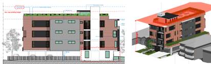
Figures
8 & 9 - Elevation and 3D height plane showing the extent of height
variation
Clause 4.6 allows the consent
authority to vary development standards in certain circumstances and provides
an appropriate degree of flexibility to achieve better design outcomes. The
consent authority may grant the exception as the Secretary’s concurrence
can be assumed where clause 4.6 is adopted as per the Department of Planning
Circular PS 18-003, dated 21 February 2018.
The applicant has submitted a
written request to vary the development standards for building height. Based on
various case laws established by the Land and Environment Court of NSW such as
Four2five P/L v Ashfield Council [2015] NSWLEC 9, Randwick City Council v
Micaul Holdings P/L [2016] NSW LEC7 and Zhang and anor v Council of the City of
Ryde [2016] NSWLEC 1179, a 3 part assessment framework for a variation request
proposed under clause 4.6 has been considered and an assessment of the proposed
variance, following the 3 part test is discussed in detail below.
The 3 preconditions which must be
satisfied before the application can proceed are as follows:
1. Is
the proposed development consistent with the objectives of the zone?
Applicant’s
justification:
The proposal ensures that the high
density nature of the zone is retained and there is not a significant change to
the character of the locality. In addition, the proposal complements and
enhances the local streetscape by virtue of the careful siting of the
development and the landscape embellishment works within the front setback.
Planner’s Comment:
The proposed development is
considered to be consistent with the objectives of the R4 High Density
Residential zone in that a variety of housing types within a high density
residential environment is provided, which is contributory to the existing
local character of the streetscapes.
2. Is
the proposed development consistent with the objectives of the development
standard which is not met?
Applicant’s
justification:
The current development proposal
is predominantly consistent with the building height with the exception of a
small portion of the building, roof form and lift over-run, the proposal
remains consistent with the objectives based on the following:
· In
relation to objective a) the visual impact of the development will present a 4
storey development consistent with the desired future character set by the 15m
height limit. Further the area of non-compliance is recessed from the street
frontage such that it is not easily ‘read’ in the streetscape which
minimises the visual impact of the element that exceeds the height limit;
· In
relation to objective (a) and the issue of solar access detailed shadow
analysis demonstrates that the adjoining properties maintain suitable solar
access with the shadow cast equitably given the orientation of the site;
· In
relation to objective (a) and the issue of visual privacy the proposal has been
designed to ensure that privacy impacts are mitigated noting that the area of
non-compliance is the lobby space leading to the COS and storage areas and the
perimeter of the of the COS area is treated with a raised planter and privacy
screens to mitigate privacy impacts- noting the COS area and planters and
privacy screens are below the height limit.
· In
relation to objective (b) the non-compliance with the height standard is a
result of the developments seeking compliance with flooding controls- and the
provision of suitable rooftop COS area and the proposal adequately responds to
the landform in the context of a flood affected site.
· In
relation to objective (c) the scale is appropriate noting the 4 storey form is
consistent with the HDCP 2013 provisions and there are only 3 levels of the
building with residential units and the proposal is also compliant with the
1.2:1 FSR meaning a suitable balance and intensity of development.
· The
minor non-compliance to the height control has no impact on the setting of any
items of environmental heritage or view corridors; and
· The
proposal is not located within a low-density area and the proposal represents
an appropriate built form on the site.
Planner’s comment:
The objectives of the building
height standard are to enable appropriate development density to be achieved
and to ensure that the height of the building is compatible with the character
of the locality as outlined above. The proposal is compliant with the maximum
FSR inclusive of the bonus provision under the ARH SEPP. The increased height
does not result in an additional level for residential use, as it comprises portion
of the roof structures, including storage area that could not be accommodated
on the car parking level due to flood affectation on the site and the top of
the lift core.
The departure sought is considered
to be modest and does not unreasonably impact on adjoining properties. The
additional height does not result in the appearance of bulk when viewed from
the existing streetscape and would not impinge on the changing streetscape that
is anticipated for the immediate area. Given that the proposed development
responds to the site and does so without compromising relationships with
adjoining development, the proposal is considered to be consistent with the
objectives of height requirements and development within the R4 zone.
3.
(a) Is
compliance with the development standard unreasonable or unnecessary in the
circumstances of the case?
Applicant’s
justification:
Strict compliance with the
prescriptive height requirement is unreasonable and unnecessary in the context
of the proposal and its particular circumstances. The proposed development
meets the underlying intent of the control and is a compatible form of
development that does not result in unreasonable environmental amenity impacts.
The proposal provides for a
rooftop COS in a location that will receive solar access and also be above the
flood level in a location delivery higher amenity than the ground floor which
is a poor location for the COS. The lift over-run and departure could be
removed however this would reduce the amenity for the development as it would
remove equitable and accessible access to the rooftop COS.
Planner’s comment:
Council Officers are satisfied
that the proposed variation has been appropriately justified and can be
supported in this instance. The height breach is limited to an overall building
height of 16.76m (RL 38.950) for the top of the lift core. The additional
height of the lift core will not be visible from the adjacent streets and
properties. The proposed variation to the development standard is necessary for
the structure containing the lift core and the site being subject to flooding
which requires an elevated ground floor plate. The departure sought is
considered to be modest and does not unreasonably impact on adjoining
properties. The additional height does not result in the appearance of bulk
when viewed from the existing streetscape, would not impinge on the changing
streetscape that is anticipated for the immediate area and does not result in
additional overshadowing to the adjoining properties. It is considered,
therefore, that the non-compliance with the Development Standard is not
unreasonable or unnecessary in the circumstances of the case.
(b) Are
there sufficient environmental planning grounds to justify contravening the
development standard and therefore is the applicant’s written
justification well founded?
The unique circumstances of the
case are considered to warrant support of the departure. Given that the
proposed development responds to the site and does so without unduly compromising
relationships with adjoining development, and does not unduly compromise other
relevant controls, the proposal is considered to be consistent with the
objectives of building height, and development within the R4 zone. In this
regard, the exception is well founded and can be supported.
Conclusion:
Council is satisfied that the
applicant’s written request has adequately addressed the matters required
to be demonstrated by clause 4.6 subclause (3). Council is further satisfied
that the proposed development will be in the public interest because it is
consistent with the objectives of the particular standard and the objectives
for development within the zone in which the development is proposed to be
carried out.
It is the view of Council Officers
that justification provided is satisfactory and having considered the
application on its merit, the contravention to the maximum building height
development standard is considered acceptable in this instance.
The provisions of any proposed
instrument that is or has been the subject (EP&A Act s4.15 (1)(a)(ii))
(a) Draft
State Environmental Planning Policy (Environment)
The draft SEPP relates to the
protection and management of our natural environment with the aim of
simplifying the planning rules for a number of water catchments, waterways,
urban bushland, and Willandra Lakes World Heritage Property. The changes
proposed include consolidating the following seven existing SEPPs:
· State
Environmental Planning Policy No. 19 – Bushland in Urban Areas
· State
Environmental Planning Policy (Sydney Drinking Water Catchment) 2011
· State
Environmental Planning Policy No. 50 – Canal Estate Development
· Greater
Metropolitan Regional Environmental Plan No. 2 – Georges River Catchment
· Sydney
Regional Environmental Plan No. 20 – Hawkesbury-Nepean River (No.2-1997)
· Sydney
Regional Environmental Plan (Sydney Harbour Catchment) 2005
· Willandra
Lakes Regional Environmental Plan No. 1 – World Heritage Property.
The draft policy will repeal the
above existing SEPPs and certain provisions will be transferred directly to the
new SEPP, amended and transferred, or repealed due to overlaps with other areas
of the NSW planning system.
Changes are also proposed to the
Standard Instrument – Principal Local Environmental Plan. Some provisions
of the existing policies will be transferred to new Section 117 Local Planning
Directions where appropriate.
(b) Draft
State Environmental Planning Policy (Design and Place)
The draft SEPP Design and Place as
exhibited aims to simplify and consolidate how to address the need for
sustainable and resilient places and deliver good design in NSW. The draft SEPP
has been not notified to any consent authorities and is therefore not a
mandatory matter for consideration under the Act.
The provisions of any
Development Control Plans (EP&A Act s4.15 (1)(a)(iii))
Cumberland Development Control
Plan (DCP) 2021
The Cumberland DCP 2021 is in
force as of 5 November 2021. However, as the subject application was lodged
prior to the Cumberland DCP coming into force, in accordance with Clause 1.1.4
- Savings provision of Part A - Introduction, the application is assessed under
the provisions of the Holroyd DCP 2013 As the Cumberland DCP 2021 was adopted
by Council at the lodgement of the subject application, the provisions of the
Cumberland DCP are also considered in the assessment of the application and are
considered to be satisfactory.
Holroyd Development Control
Plan (DCP) 2013
The Holroyd DCP 2013 provides
guidance for the design and operation of development to achieve the aims and
objectives of the DCP. A comprehensive assessment and compliance table is
contained in Attachment 9.
The proposed development generally
complies with the provisions of Holroyd DCP 2013 with the exception of the
following matters which are outlined in the table below.
· At
grade car parking
Part B, section 1 General
Residential Controls, clause 1.11 Car Parking & Roads, control C33 states
that basement parking is mandatory for all residential flat buildings
developments within the R4 zone. Due to the severe flood affectation on the
site that includes land within each of the high flood, medium flood and low
flood risk precincts, the proposed undercroft car parking area is considered
acceptable and is also supported by Council’s Development Engineer,
subject to conditions to be imposed. The proposal will continue to satisfy the
objective of the Holroyd DCP 2013 to ensure that car parking do not visually
dominate the streetscape by the reinforcement of building articulation proposed
along the street frontage.
· Adaptable
housing and car parking
Part A, section 3 Car Parking,
clause 3.6 Parking for the Disabled control C9 and Part B, section 1 General
Residential Controls, clause 6.9 Parking and Vehicular Access control C13 state
that car parking spaces allocated to dwellings that are built to the Adaptable
Housing Standard – AS 4299 must comply with the dimensions specified in
that standard. Further to that, clause 1.11 Adaptable Housing and
Accessibility, control C3 states that 15% of dwelling units shall comply with
AS4299- 1995- Adaptable Housing Class B, in which the number of adaptable units
will be calculated by rounding up to the nearest whole unit. The proposed
residential flat buildings comprising of 8 units will require 1.2 that is
rounded up to 2 units of adaptable housing with 2 associated car parking
spaces. The proposed development will provide for 1 unit of adaptable housing
with 1 associated car parking space. Non-compliance with the DCP requirements
is supported in this instance as the site’s constraint and flood
affectation will not allow for an additional/second disabled space to be
provided within the undercroft car parking area. Council’s Development
Engineer has reviewed the dimensions of the proposed disabled car space no.1
and found that the dimensions do not comply with Australian Standards
AS2890.6:2009. Changes to the layout of the ground floor level car parking area
are required to accommodate a compliant disabled car space, in which shall
include an extension of a portion of car space no.1 above the existing sewer
line. A separate approval from Sydney Water will be required. Deferred
commencement condition is to be imposed accordingly to reflect this
requirement. The extension of the hardstand area into the northern side will
not affect the area required as part of the deep soil zone having dimension
less than 3m in width.
· Lot
frontage and landlocking
Where a lot frontage of 24m is
required, the site has a lot frontage of only 15.24m. The proposal will result
in site isolation of 9 Birmingham Street, as 11-13 Birmingham Street is an
existing residential flat building development.
The site isolation principles
established by the Land and Environment Court have been considered in the
assessment of the development application. Development proposals that create
land locking or site isolation shall provide documentation that demonstrates a
reasonable attempt has been made by the applicants to purchase the land locked
site(s), including written valuation that represent the affected sites
potential value. Consistent with the Planning Principle of Karavellas v
Sutherland Shire Council [2004] NSWLEC 251 (Karavellas v Sutherland Shire
Council), the application is supported by an offer to the owner of the isolated
property at 9 Birmingham Street, with the offer being based on two recent
independent valuations. Two valuation reports prepared by two independent
registered valuers indicating the market values of the subject site were
issued, and the highest and best value was considered based on the likely
additional yield the site would be able to generate. On this basis, the offer
was made to purchase the property higher than the valuations tendered. The
owner of 9 Birmingham Street did not respond to any of offer made. The offer is
deemed a reasonable offer by the Planning Principle of Karavellas v Sutherland
Shire Council.
In the judgement of Cornerstone
Property Group Pty Ltd Vs Warringah Council [2004] NSWLEC 189, planning
principle to site isolation was further considered as follows:-
Can orderly and economic use and
development of the separate site be achieved if amalgamation is not feasible.
Future redevelopment sites
The sites at 7 and 9 Birmingham
Street are the last remaining dated single dwelling houses on the northern part
of Birmingham Street. Both of the sites have similar land sizes and capable to
be built as an individual lot. Mirrored or reversed design of 7 Birmingham
Street can be easily adopted on 9 Birmingham Street, as amalgamation of both
sites is not feasible in this instance. There is also an existing pattern on Birmingham
Street where individual lots have been built as residential flat buildings with
examples of developments at 3 and 5 Birmingham Street. Orderly and economic use
and development of 9 Birmingham Street as a separate site is considered
achievable without further amalgamation.
· Site
coverage
Where a maximum permitted site
coverage is 30%, the proposal will result in site coverage of 52.1%.
Non-compliance with the site coverage requirement however is considered
acceptable as the proposed development will maintain an adequate provision to
be made on site for deep soil planting, landscaping, driveways, communal open
space and On-Site Detention.
· Rear
setbacks
Where 20% of the length of the
site or 8.04m (4 storeys) and 30% of the length of the site or 12.06m (5
storeys) are required as rear setbacks, only 6m could be provided for level 1-4
and ground floor setback is proposed at approximately 1.3m from the at grade
car parking. This variation is considered as acceptable, as the proposed
development will still continue to satisfy the ADG requirements for building
separation and visual privacy, maintain residential amenity and will not result
in further overshadowing to the adjoining properties.
· Number
of storeys
The proposed development will
result in 5 storey development, where a maximum of 4 storey is permitted.
Variation to this control however is considered acceptable as the 5th storey is
proposed to accommodate a communal open space and is a result of the
developments seeking compliance with the flooding requirements. The proposal
adequately responds to the landform in the context of a flood affected site and
will still be perceived as a 4 storey development from the street, given the
5th storey element is appropriately setback.
Based on merit assessment above,
the variation proposed to the Holroyd DCP 2013 requirements will continue to
perform a satisfactory planning outcome in this instance.
The provisions of any planning
agreement that has been entered into under section 7.4, or any draft planning agreement
that a developer has offered to enter into under section 7.4 (EP&A Act
s4.15(1)(a)(iiia))
There is no draft planning
agreement associated with the subject Development Application.
The provisions of the
Regulation (EP&A Act s4.15 (1)(a)(iv))
The proposed development raises no
concerns as to the relevant matters arising from the Environmental Planning and
Assessment Regulation 2000 (EP&A Reg).
The Likely Environmental,
Social or Economic Impacts (EP&A Act s4.15 (1)(b))
It is considered that the proposed
development will have no significant adverse environmental, social or economic
impacts in the locality.
The suitability of the site for
the development (EP&A Act s4.15 (1)(c))
The subject site and locality are
not known to be affected by any natural hazards or other site constraints
likely to have a significant adverse impact on the proposed development.
Accordingly, it is considered that the development is suitable in the context
of the site and surrounding locality.
Submissions made in accordance
with the Act or Regulation (EP&A Act s4.15 (1)(d))
|
Advertised (Council Website)
|
Mail
|
Sign
|
Not Required
|
In
accordance with Council’s Notification requirements contained within the
Holroyd DCP 2013, the proposal was publicly notified for a period of 21 days
between 16 July 2021 and 6 August 2021. The notification generated one
(1) submission in respect of the proposal with nil disclosing a political
donation or gift. The issues raised in the public submissions are summarised
and commented on as follows:
Figure
10 – Submission summary table
|
The proposed DA building will sit
on
higher ground. Current
buildings are only 2-storey on that street, with an exception of only one
3-storey
building.
|
The locality is identified as in transition, particularly
to support the increasing demand of affordable housing. The height, bulk and
scale of the proposed development is consistent with the newer residential
flat buildings being constructed and would not be inconsistent with the
desired future character of the locality. Refer to detailed assessment under
“character of local area” above.
|
|
The proposed 25 boarding rooms
is not supported. Currently Birmingham Street anytime during the day is lined
with
cars on both sides of the road and will not cope with
another 25 or more cars.
|
The subject site is located within the close proximity of
public transport hub and major commercial centre. The proposed development is
for 8 units within a residential flat building subject to affordable rental
housing provision, which could accommodate the required car parking rate
within the site and is considered satisfactory.
|
|
The distance between the
building wall edge to the front boundary
needs to be pushed back as a
minimum to be in-line with other buildings in the same row and also provide
for open spaces / courtyard for residents to
‘hang-out’. Where is this space?
|
Where a minimum 6m front setback
is required, the proposal will result in front setback of 7.1m on the ground
floor level and 6m for the remaining floors above that is considered
satisfactory. Rooftop terrace with an area of 191m2 will be
provided as communal open space for the residents.
|
The public interest (EP&A
Act s4.15(1)(e))
In view of the foregoing analysis,
it is considered that the development, if carried out subject to the conditions
set out in the recommendation below, will have no significant adverse impacts
on the public interest.
CUMBERLAND LOCAL INFRASTRUCTURE
CONTRIBUTIONS PLAN 2020
The development would require the
payment of contributions in accordance with Cumberland Local Infrastructure
Contributions Plan 2020.
In accordance with the
Contribution Plan a contribution is payable, pursuant to Section 7.11of the
EP&A Act, calculated on the cost of works. A total contribution for 1 x 1
bedroom, 6 x 2 bedroom and 1 x 3 bedroom units of $107,093.00 (including credit
for 1 x 3 bedroom dwelling) would be payable prior to the issue of a
Construction Certificate
DISCLOSURE OF POLITICAL
DONATIONS AND GIFTS
The applicant and notification
process did not result in any disclosure of Political Donations and Gifts.
The Application has been assessed
in accordance with the relevant requirements of the Environmental Planning and Assessment
Act 1979, Environmental Planning and Assessment Regulation 2000, State
Environmental Planning Policy No. 55 – Remediation of Land, State
Environmental Planning Policy (Affordable Rental Housing) 2009, State
Environmental Planning Policy (Building Sustainability Index: BASIX) 2004,
State Environmental Planning Policy (Infrastructure) 2007, State Environmental
Planning Policy No. 65 (SEPP 65) – Design Quality of Residential
Apartment Development, Holroyd Local Environmental Plan 2013, Cumberland Local
Environmental Plan 2021, Cumberland Development Control Plan 2021, and Holroyd
Development Control Plan 2013 and is considered to be satisfactory. However,
variation in relation to the building height is sought.
Having regard to the assessment of
the proposal from a merit perspective, Council may be satisfied that the
development has been responsibly designed and provides for acceptable levels of
amenity for future residents. It is considered that the proposal successfully
minimises adverse impacts on the amenity of neighbouring properties. Hence the
development, irrespective of the departures noted above, is consistent with the
intentions of Council’s planning controls and represents a form of
development contemplated by the relevant statutory and non-statutory controls
applying to the land.
For these reasons, it is
considered that the proposal is satisfactory having regard to the matters of
consideration under Section 4.15 of the Environmental Planning and Assessment
Act 1979, and the proposed development is considered to be satisfactory subject
to deferred commencement conditions.
|
1. That
the Clause 4.6 variation request to vary the height of building development
standard, pursuant to the Cumberland LEP 2021, be supported.
2. That
Development Application No. DA2021/0298 for demolition of existing structures
and the construction of a part four, part five storey residential flat
building for 8 units including undercroft at-grade parking pursuant to the
SEPP (Affordable Rental Housing) 2009 on land at 7 Birmingham Street
MERRYLANDS NSW 2160 be granted a deferred commencement approval
subject to conditions listed in the attached schedule.
3. Persons
whom have lodged a submission in respect to the application be notified of
the determination of the application.
|
1. Draft Notice
of Determination
2. Clause
4.6 Variation Request
3. Architectural
Plans
4. Stormwater
Plans
5. Submission
Received
6. ARH
SEPP Assessment
7. SEPP
65 & ADG Assessment
8. Holroyd
LEP Assessment
9. Holroyd
DCP Assessment
10. Draft
Reasons for Approval
DOCUMENTS
ASSOCIATED WITH
REPORT LPP003/22
Attachment 1
Draft Notice of Determination
Cumberland Local Planning Panel Meeting
9 February 2022
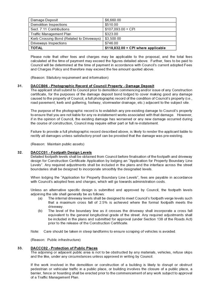


DOCUMENTS
ASSOCIATED WITH
REPORT LPP003/22
Attachment 2
Clause 4.6 Variation Request
Cumberland Local Planning Panel Meeting
9 February 2022
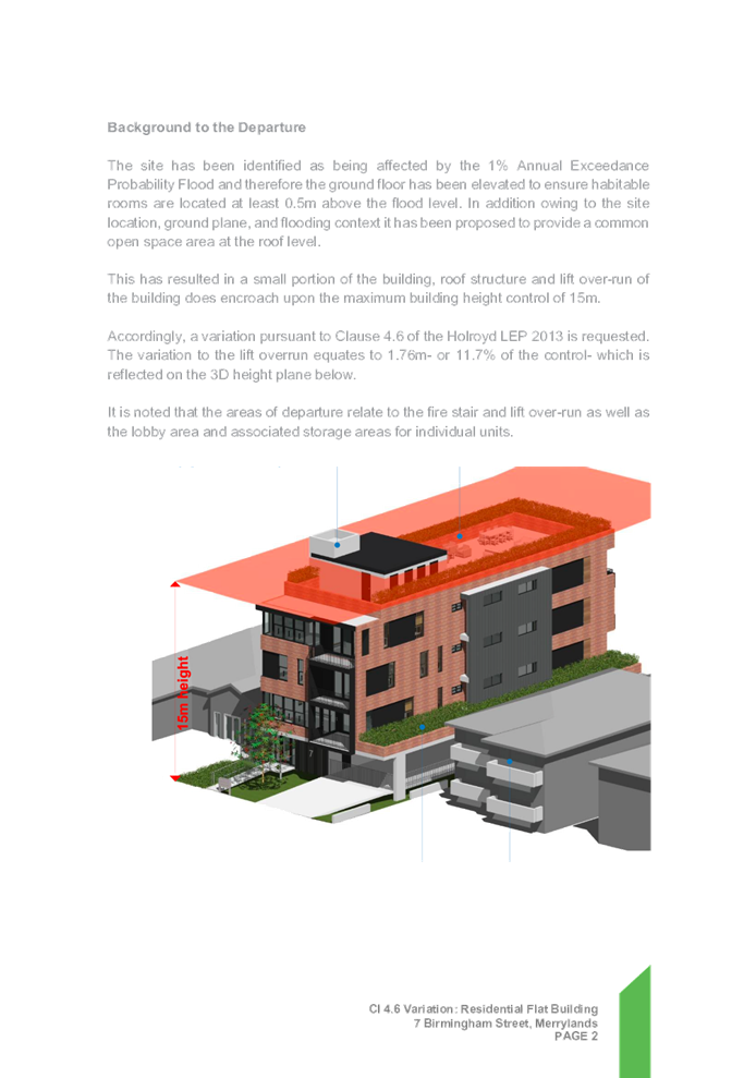


DOCUMENTS
ASSOCIATED WITH
REPORT LPP003/22
Attachment 3
Architectural Plans
Cumberland Local Planning Panel Meeting
9 February 2022
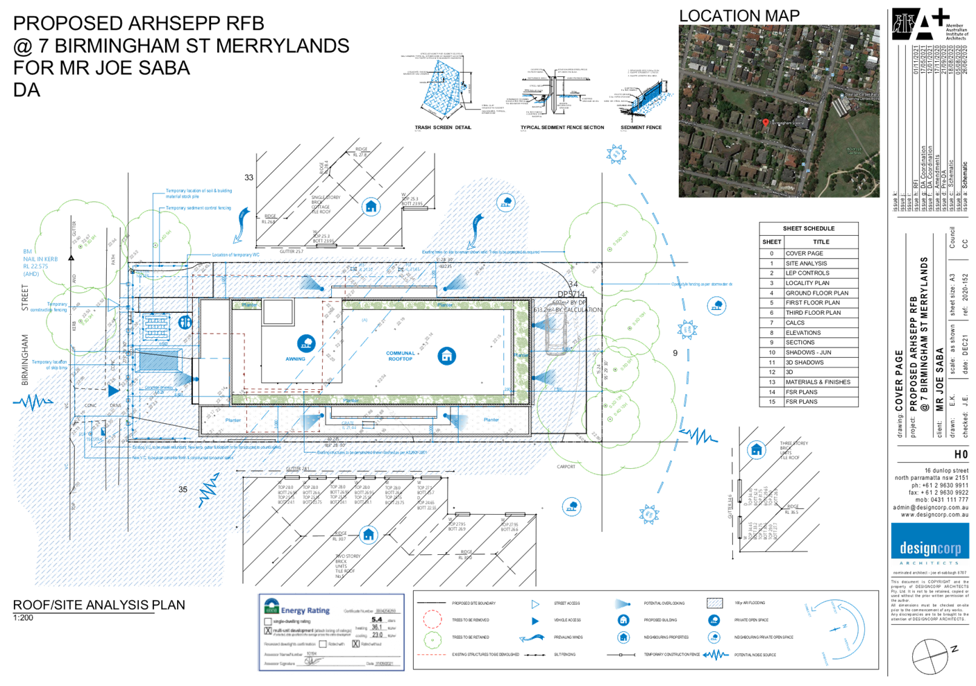
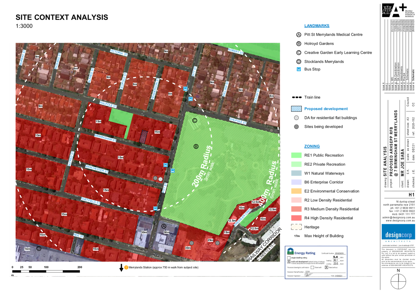
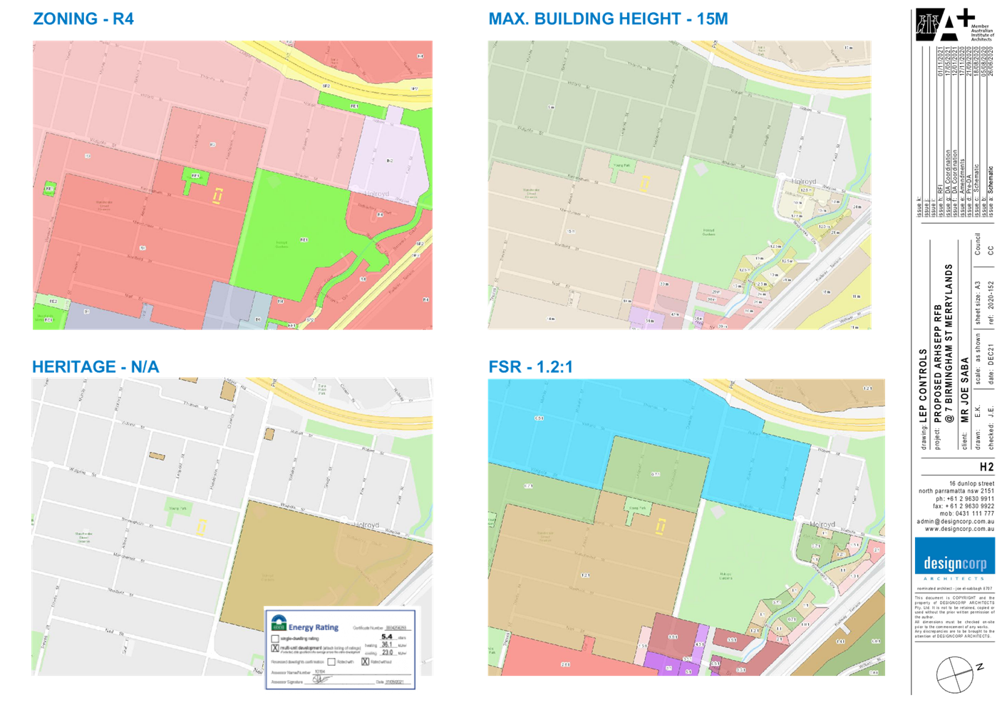

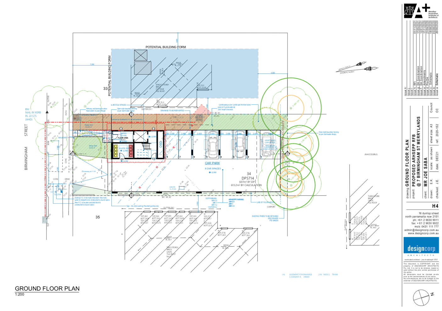
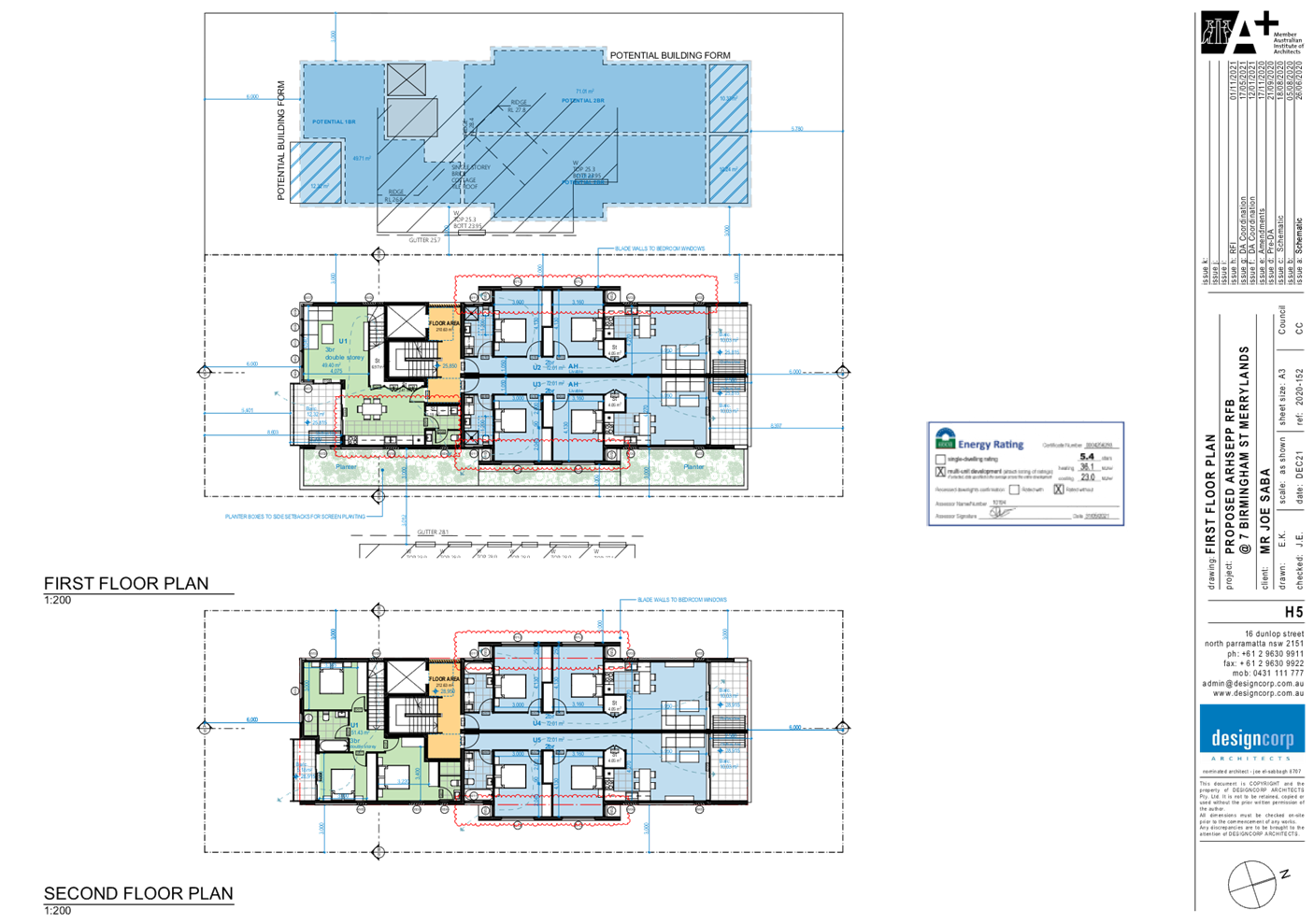
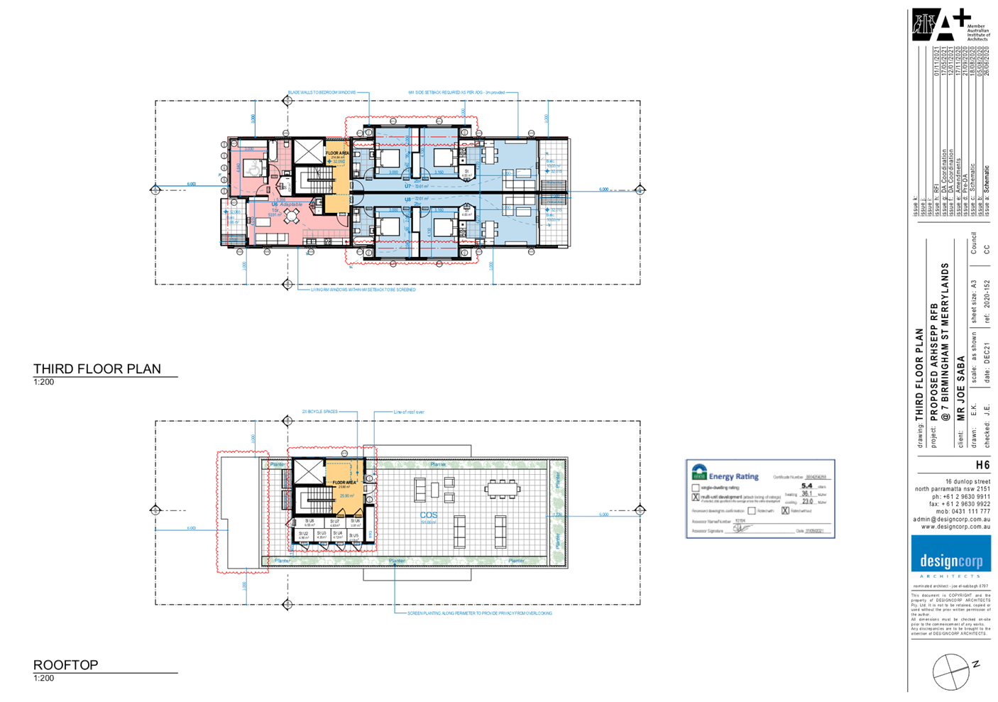
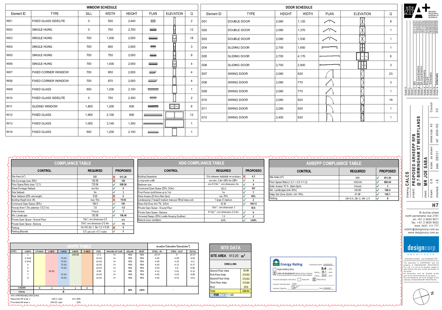
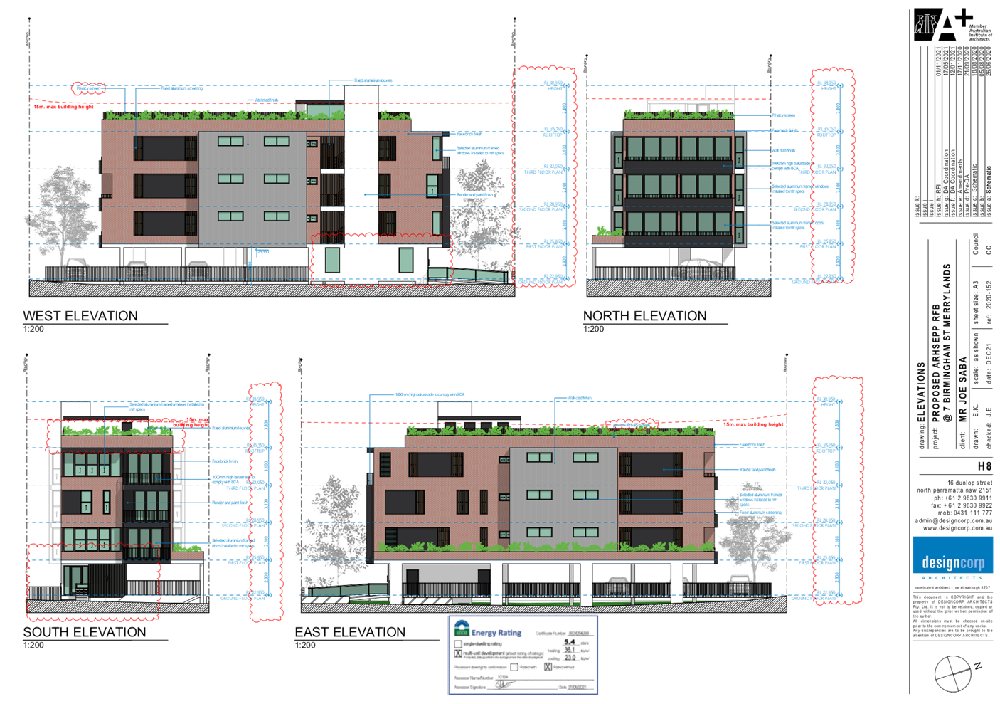
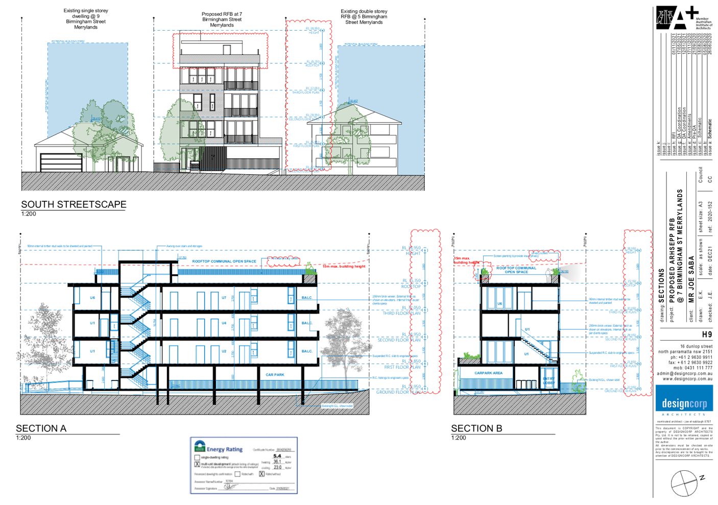
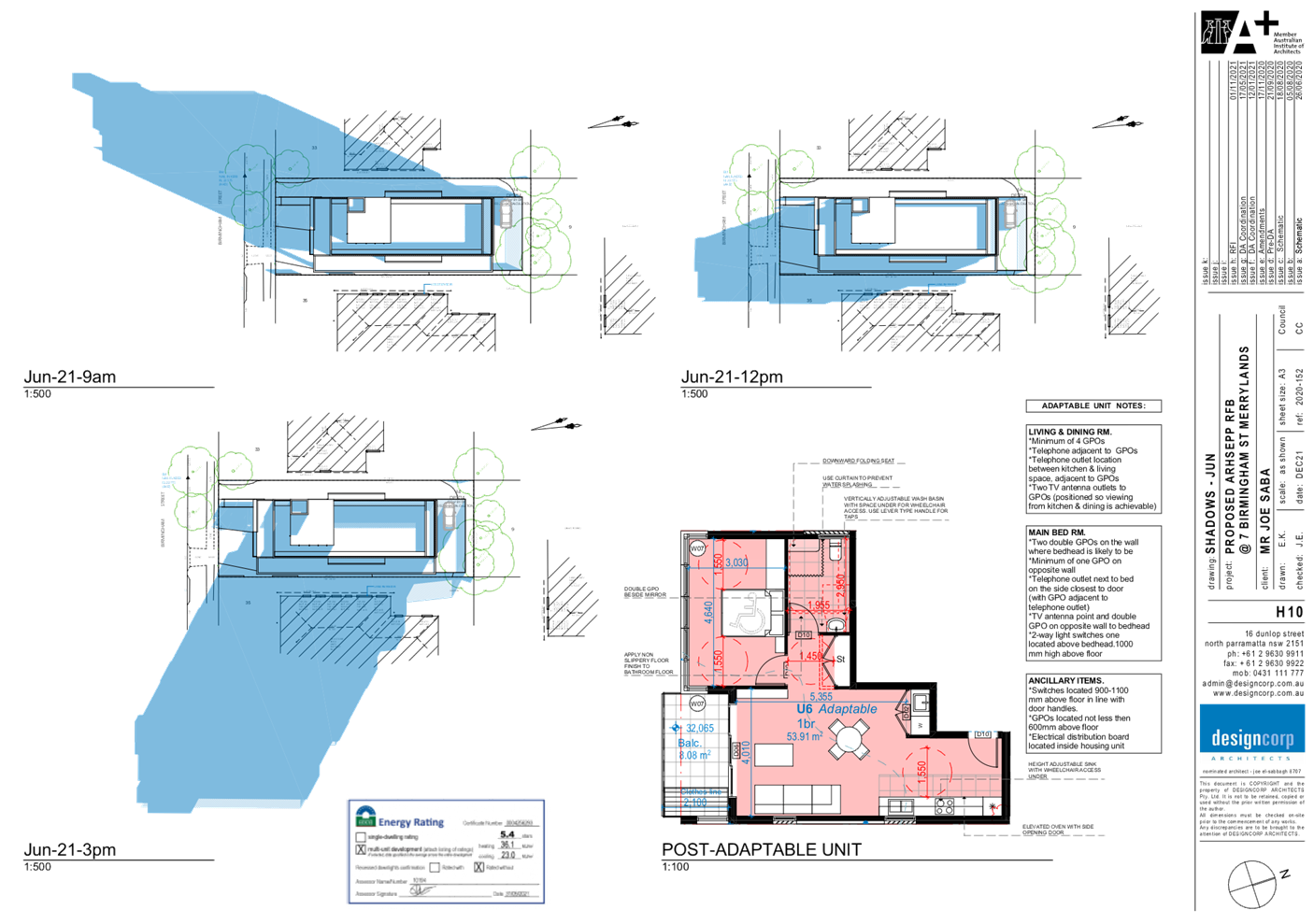
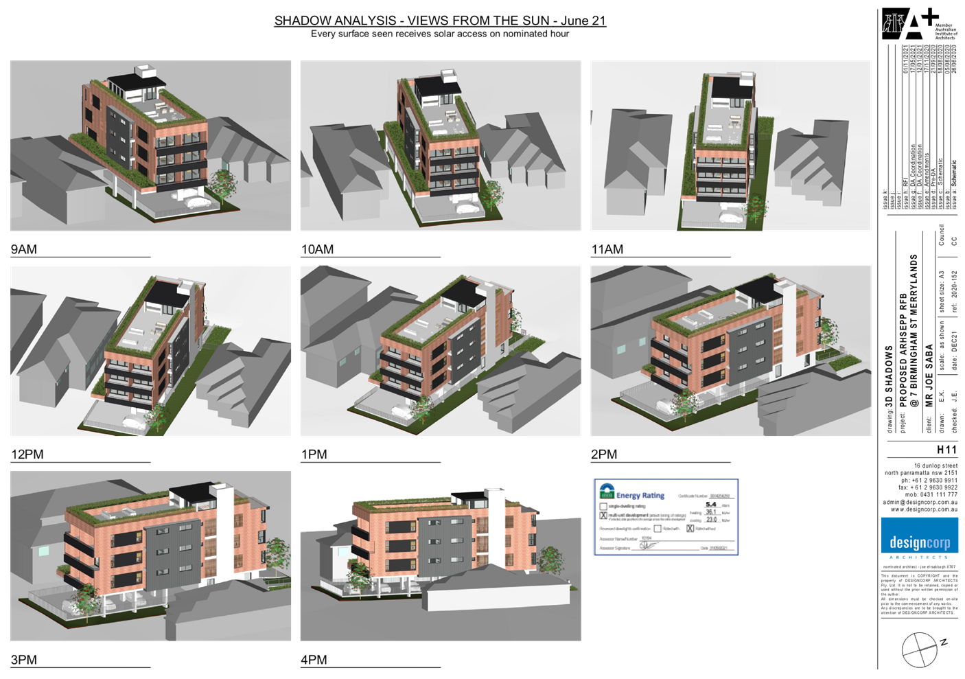
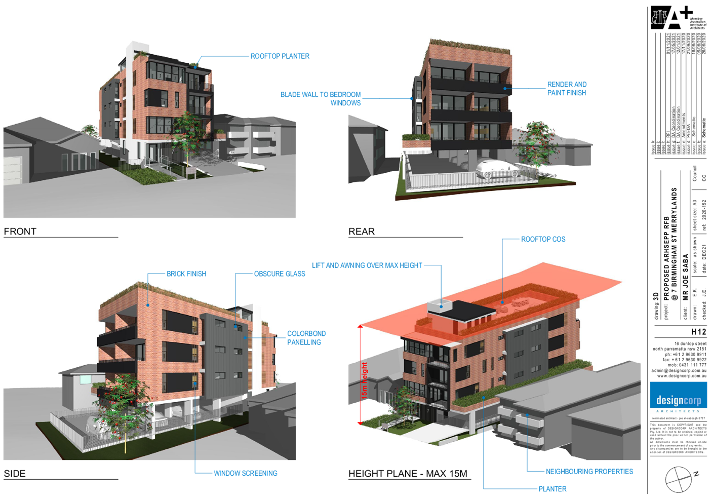
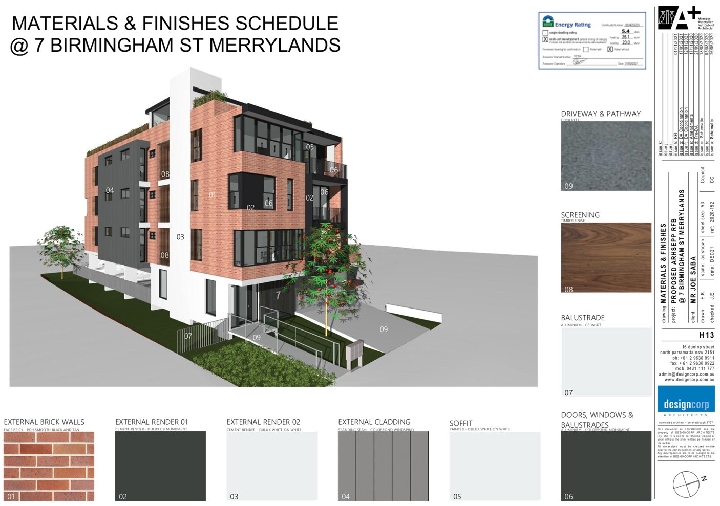
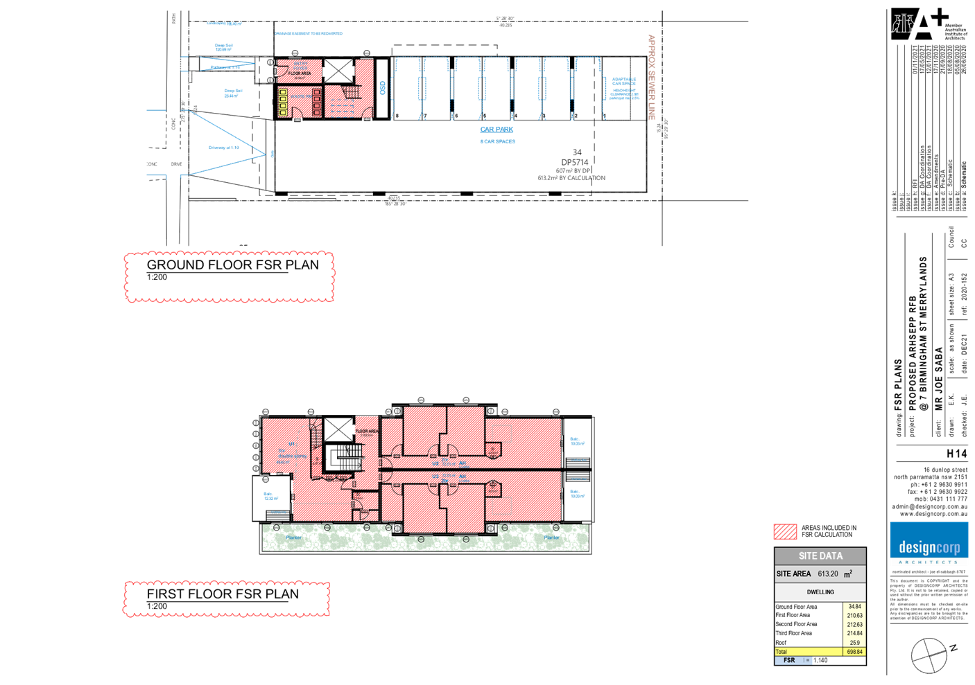
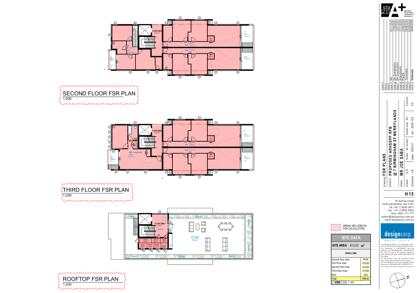
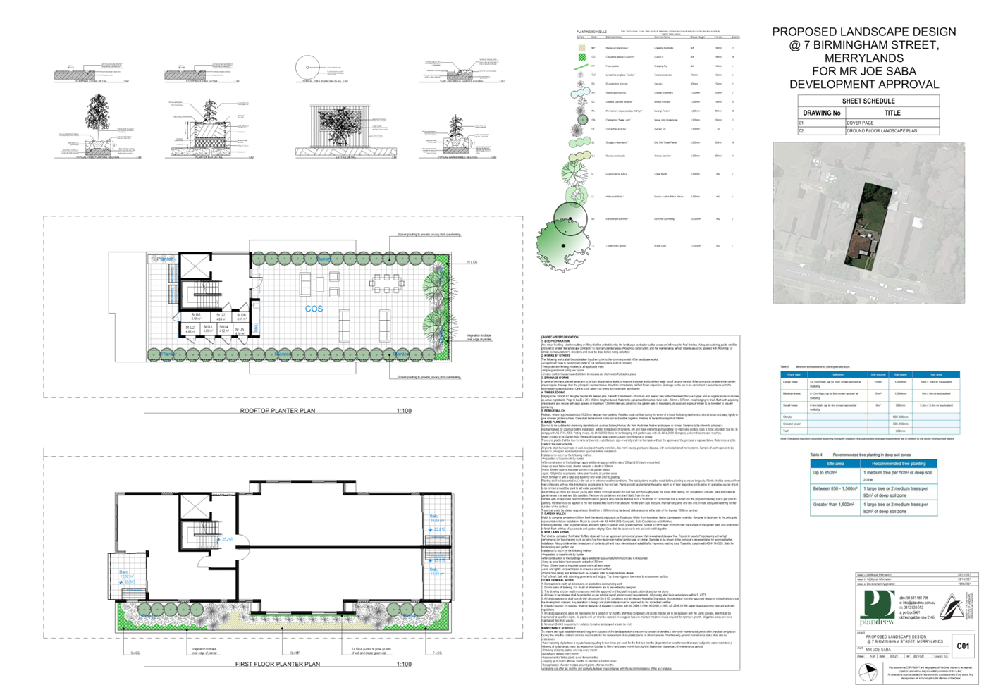
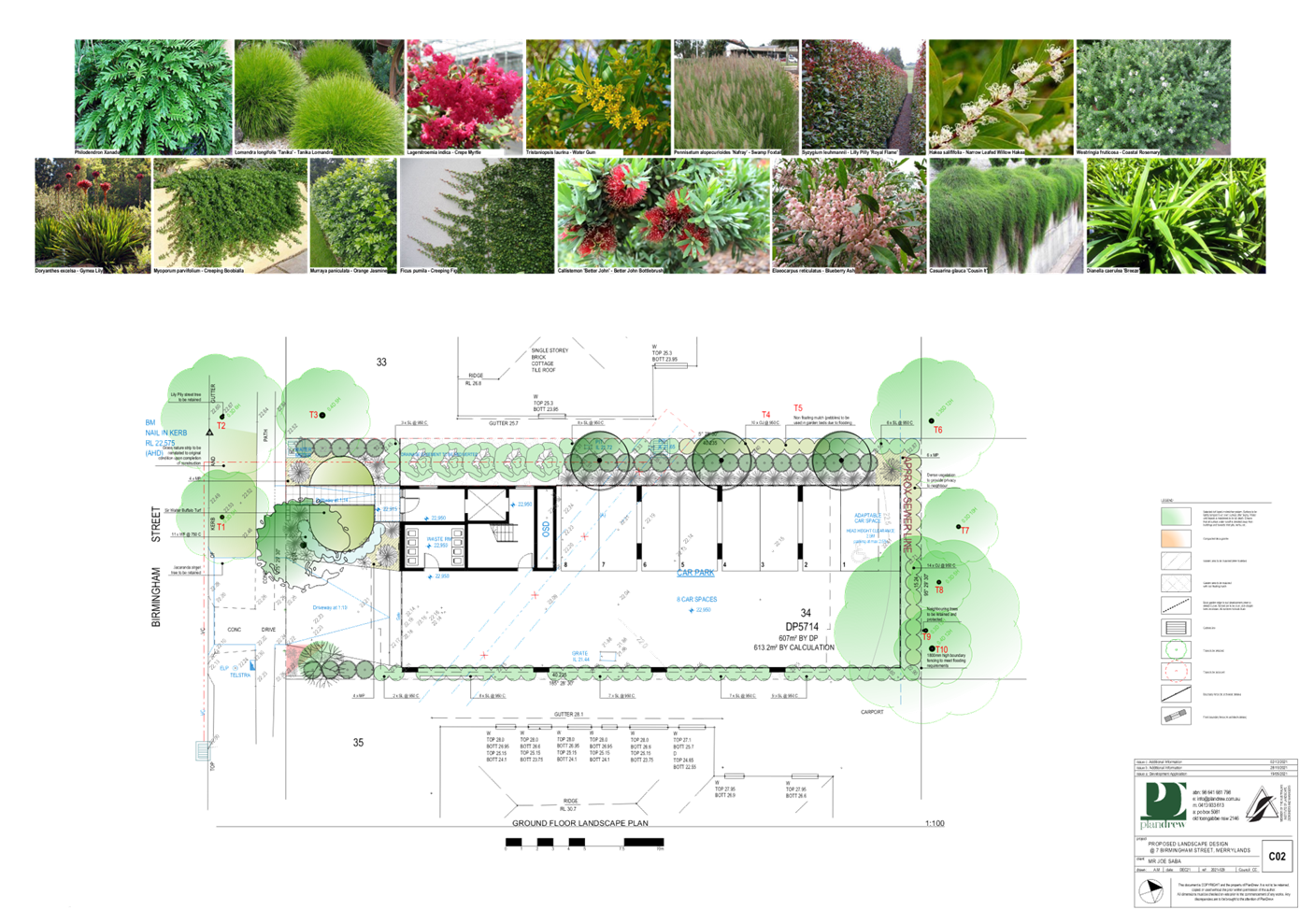
DOCUMENTS
ASSOCIATED WITH
REPORT LPP003/22
Attachment 4
Stormwater Plans
Cumberland Local Planning Panel Meeting
9 February 2022
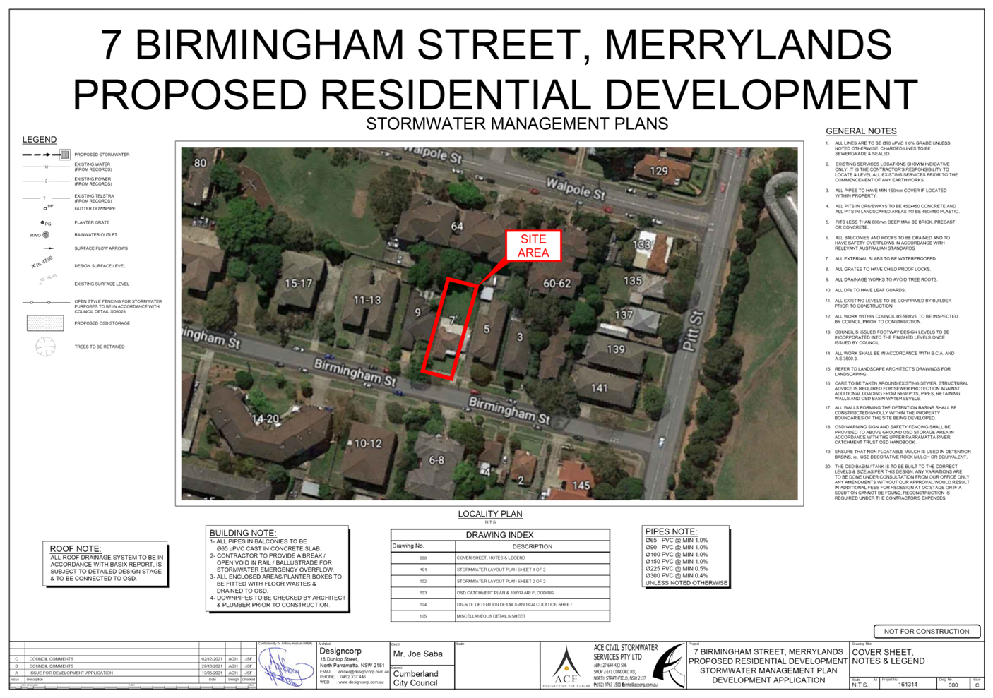
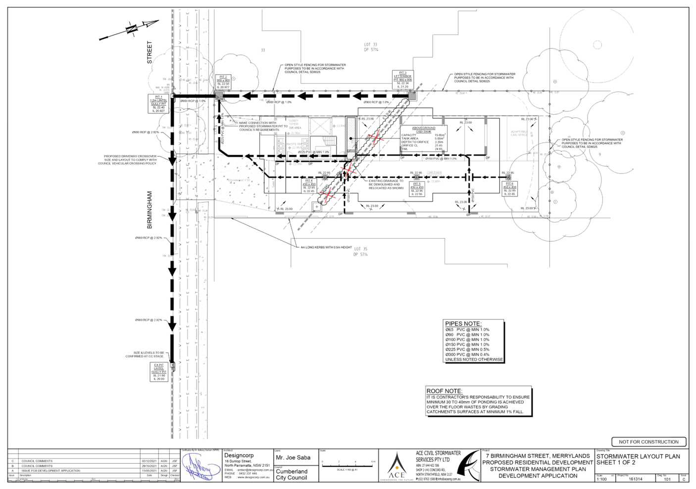
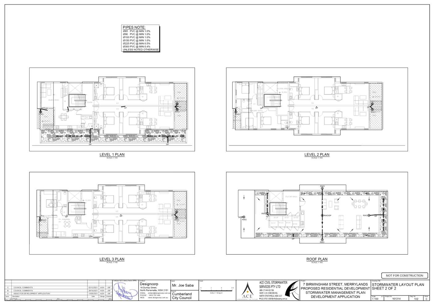
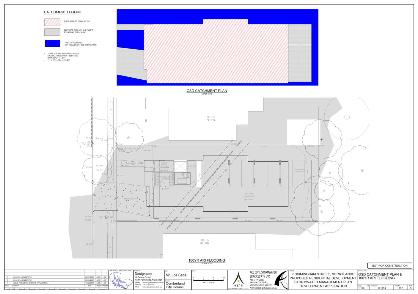
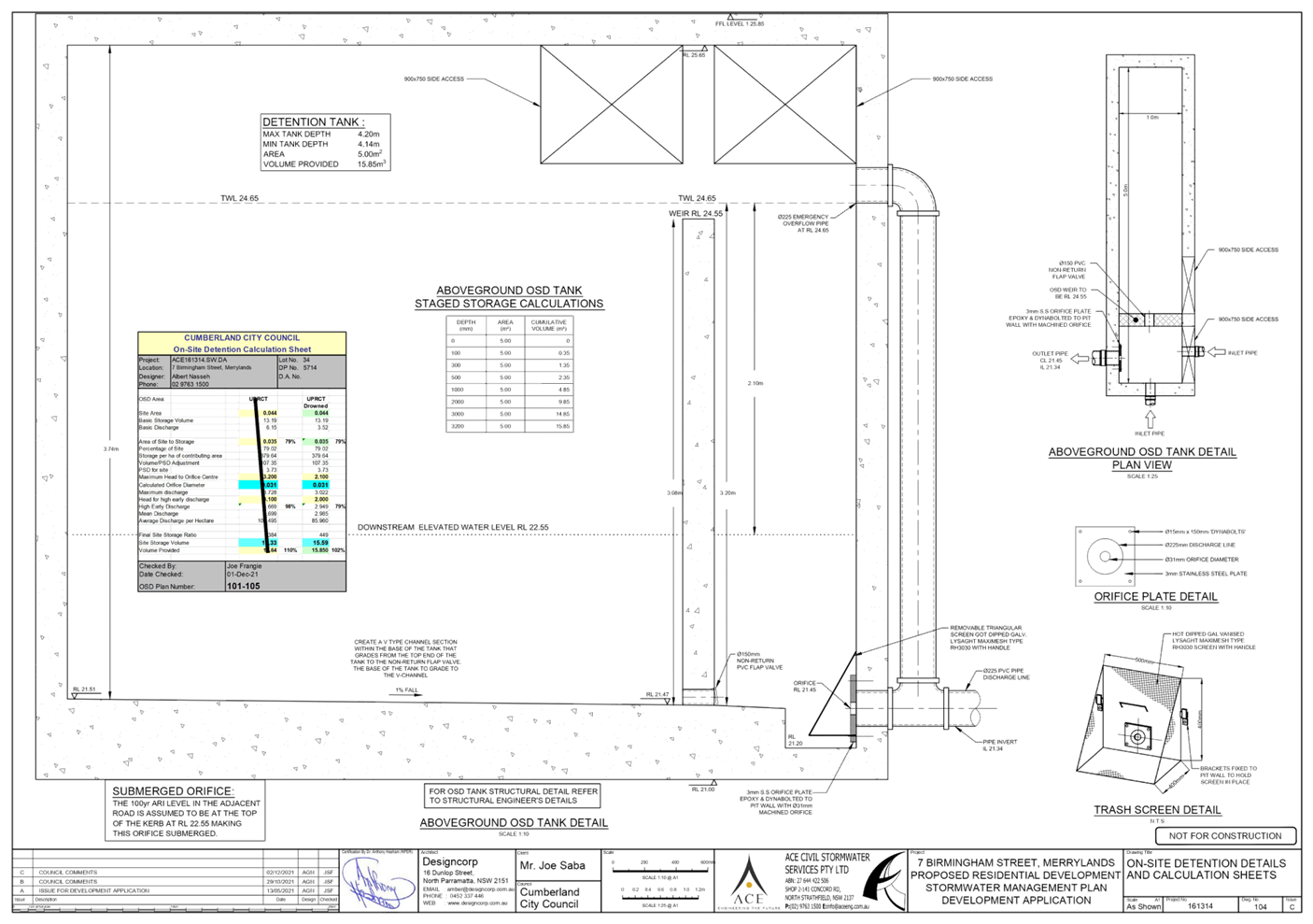
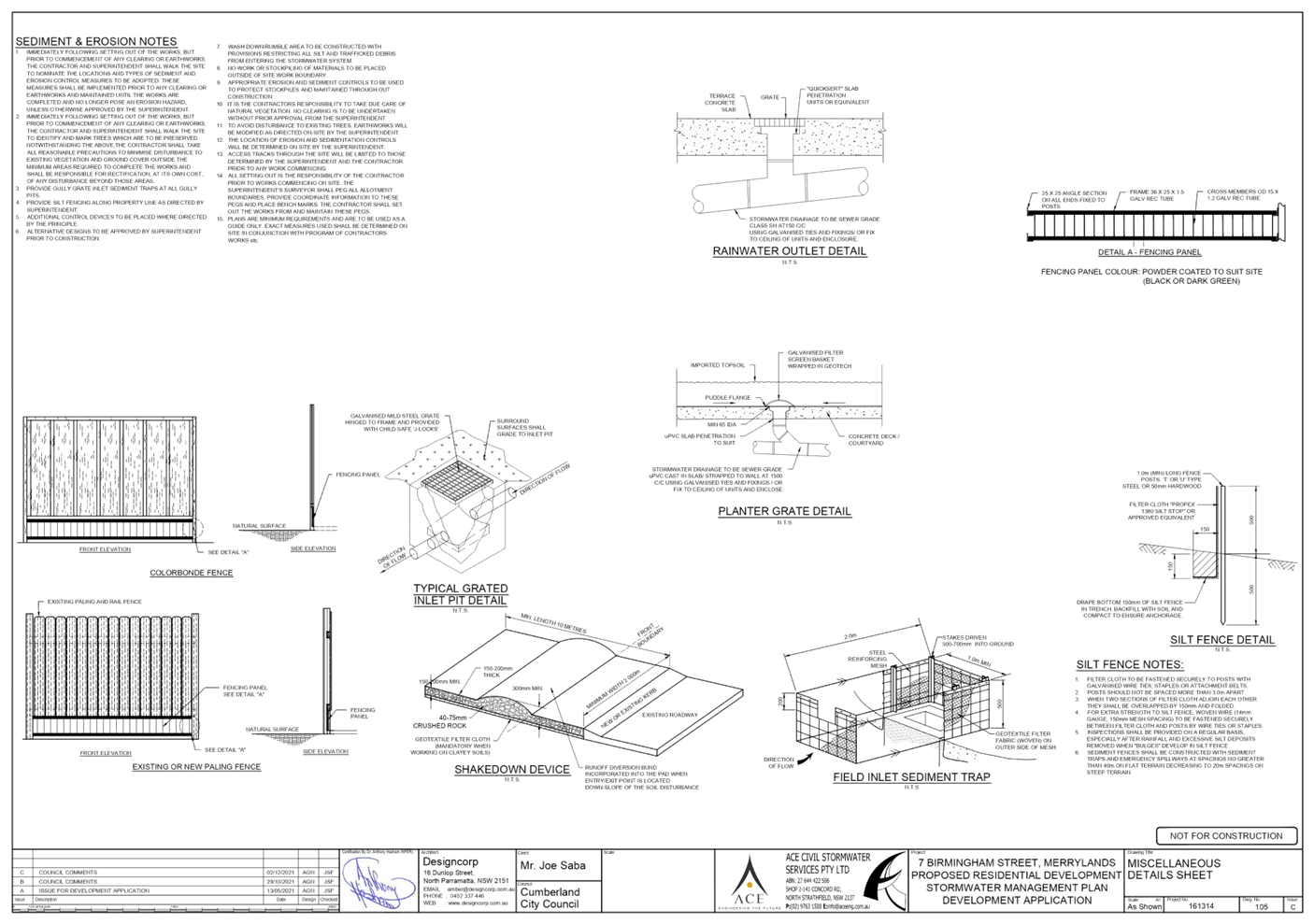
DOCUMENTS
ASSOCIATED WITH
REPORT LPP003/22
Attachment 5
Submission Received
Cumberland Local Planning Panel Meeting
9 February 2022
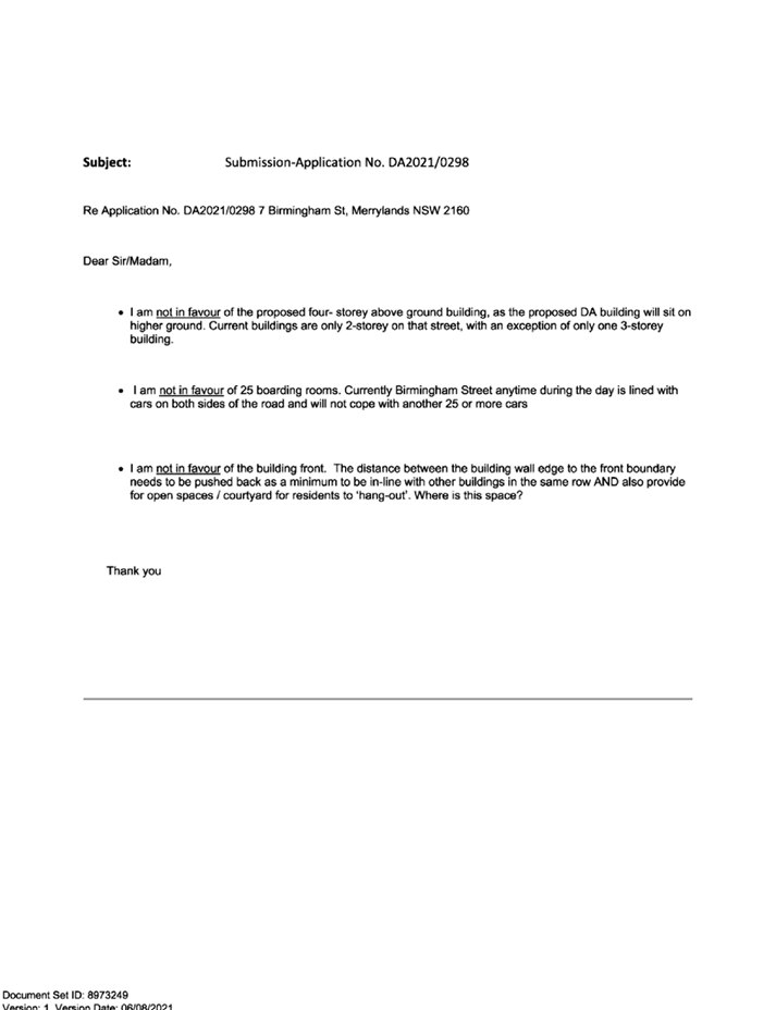
DOCUMENTS
ASSOCIATED WITH
REPORT LPP003/22
Attachment 6
ARH SEPP Assessment
Cumberland Local Planning Panel Meeting
9 February 2022
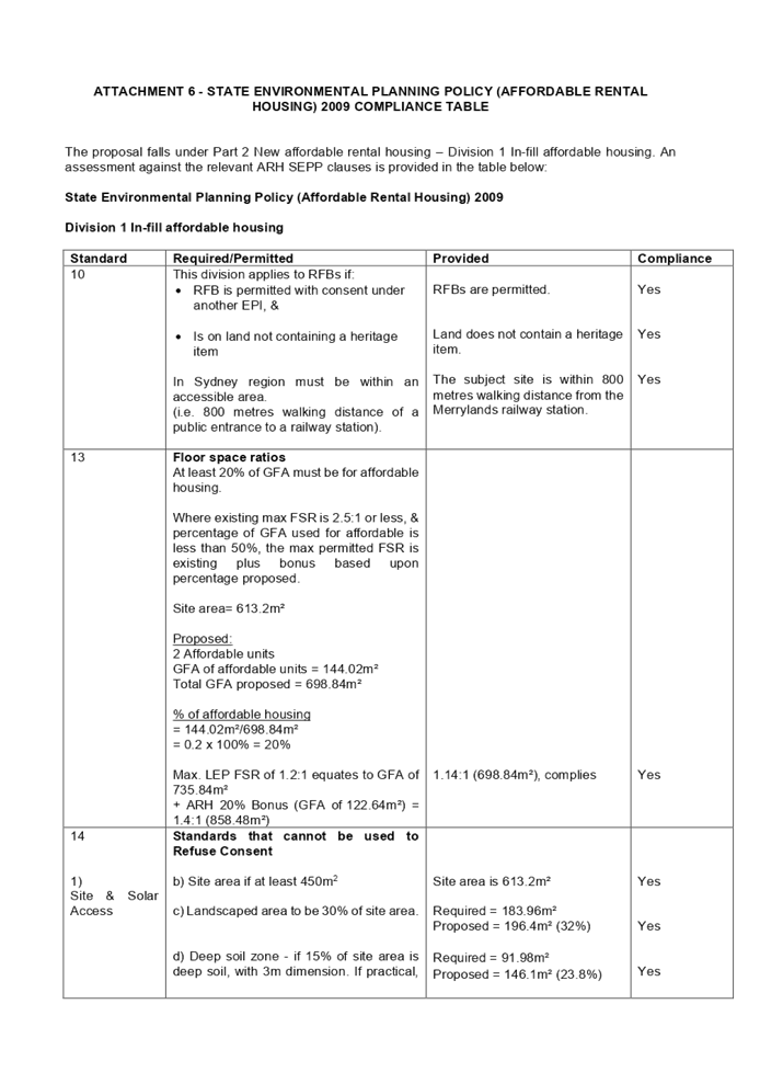
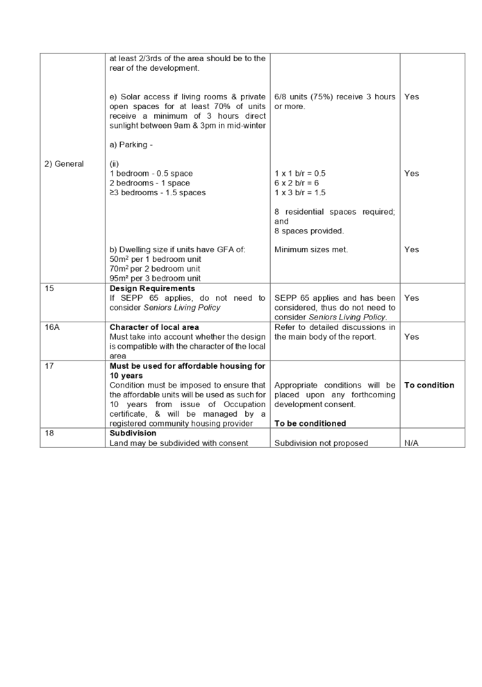
DOCUMENTS
ASSOCIATED WITH
REPORT LPP003/22
Attachment 7
SEPP 65 & ADG Assessment
Cumberland Local Planning Panel Meeting
9 February 2022
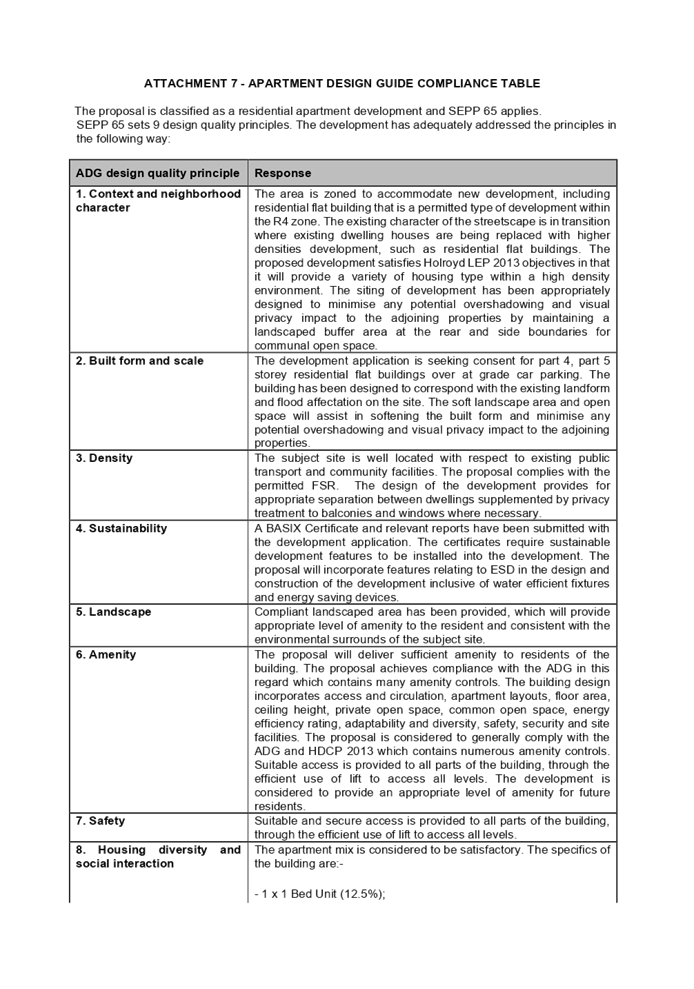

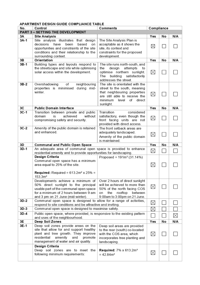
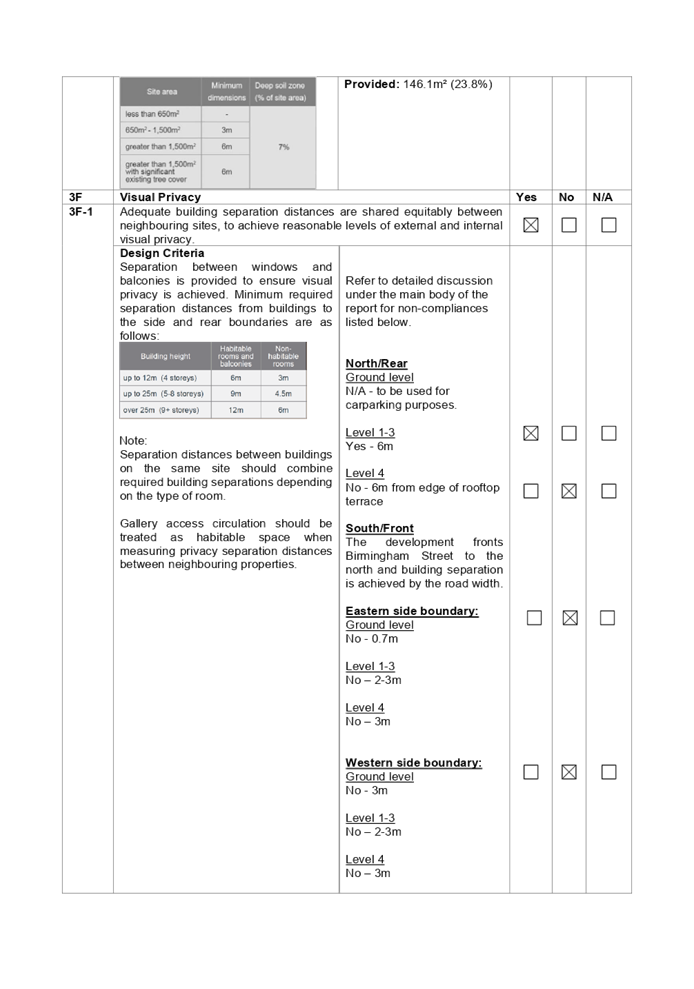
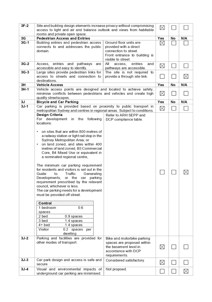
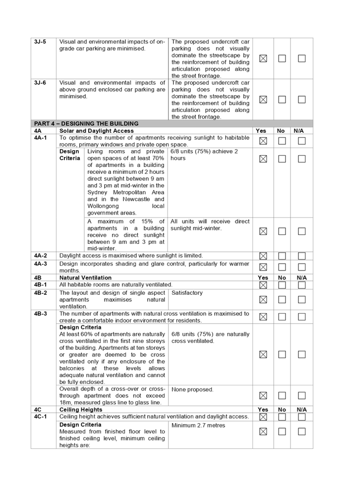
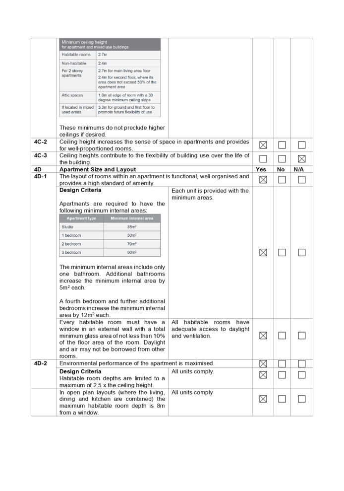
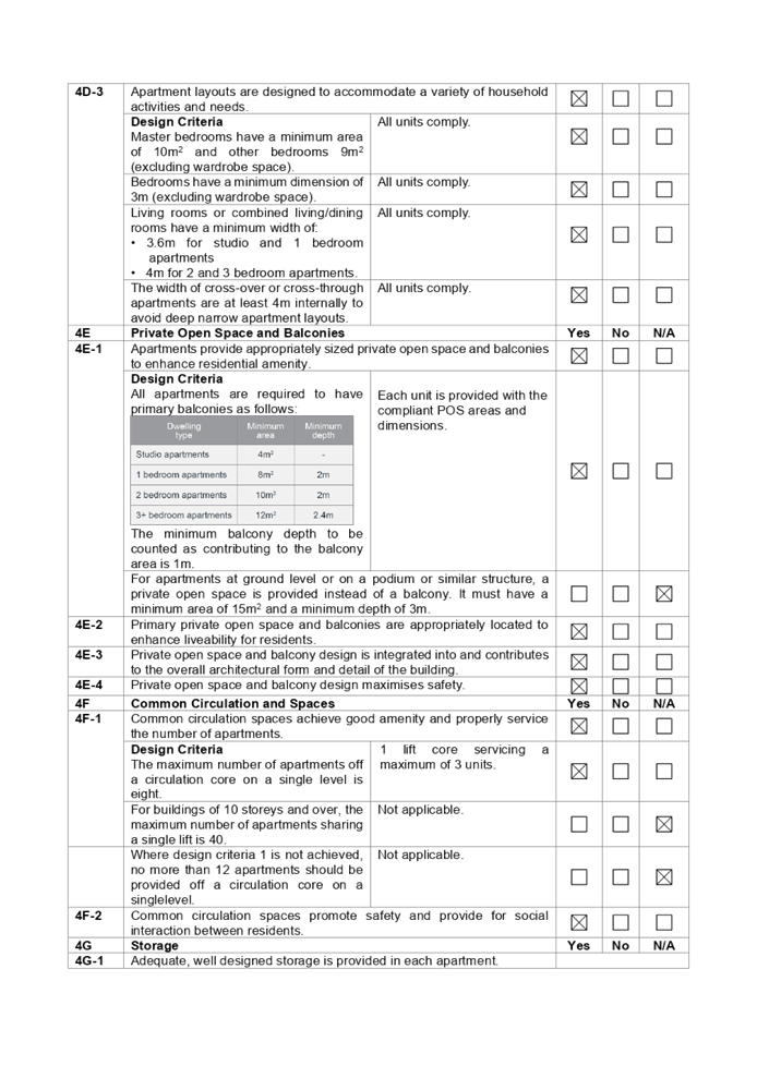
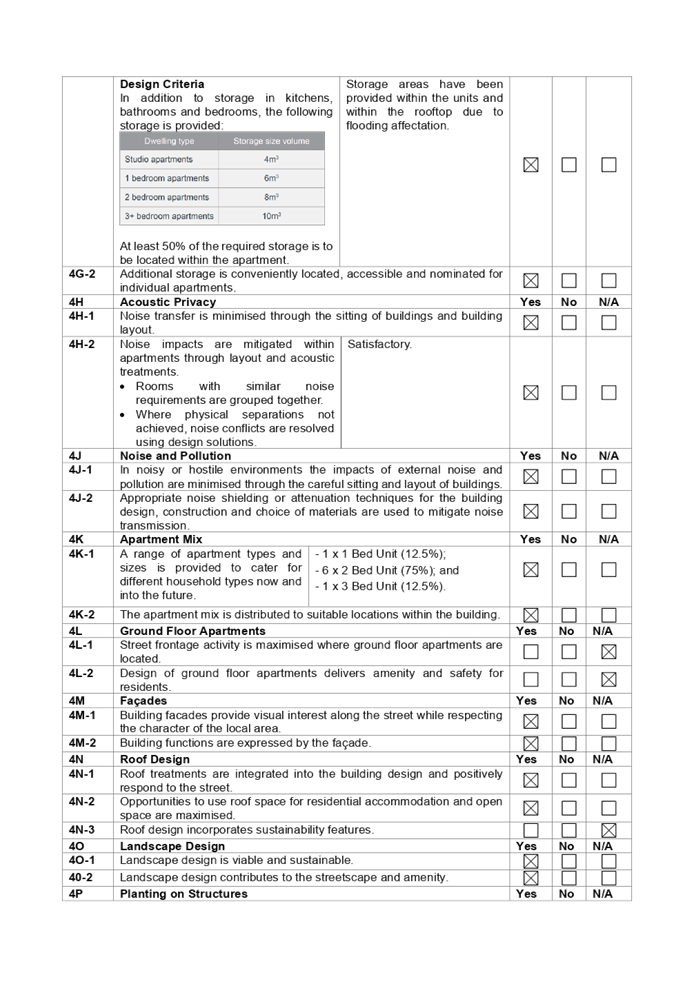
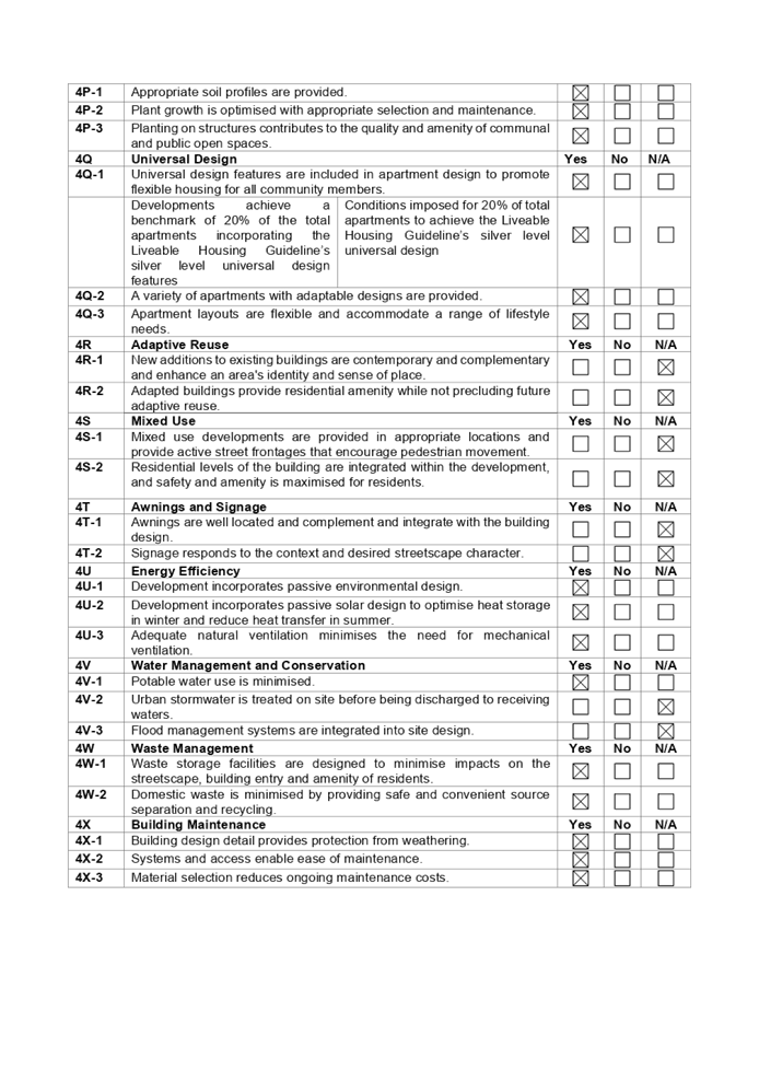
DOCUMENTS
ASSOCIATED WITH
REPORT LPP003/22
Attachment 8
Holroyd LEP Assessment
Cumberland Local Planning Panel Meeting
9 February 2022
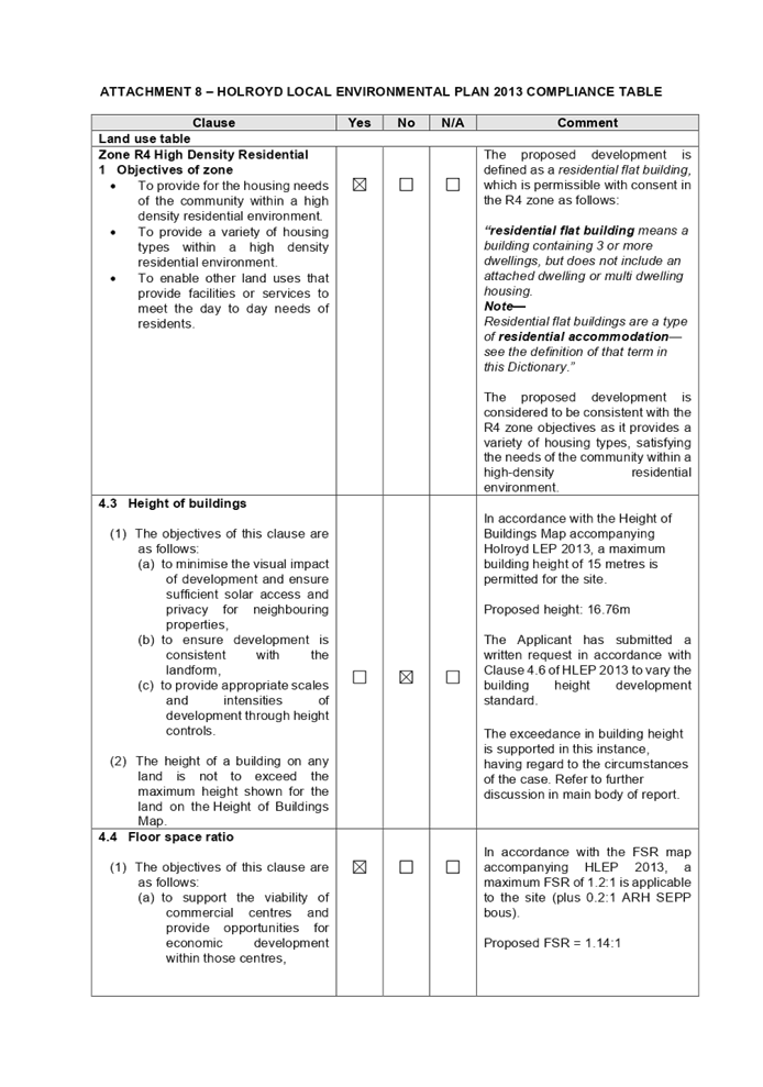
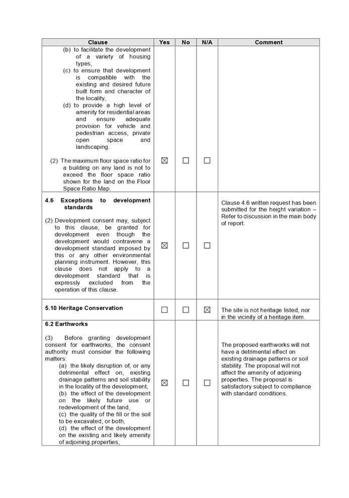
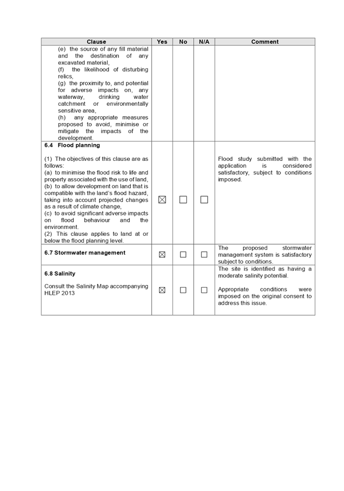
DOCUMENTS
ASSOCIATED WITH
REPORT LPP003/22
Attachment 9
Holroyd DCP Assessment
Cumberland Local Planning Panel Meeting
9 February 2022
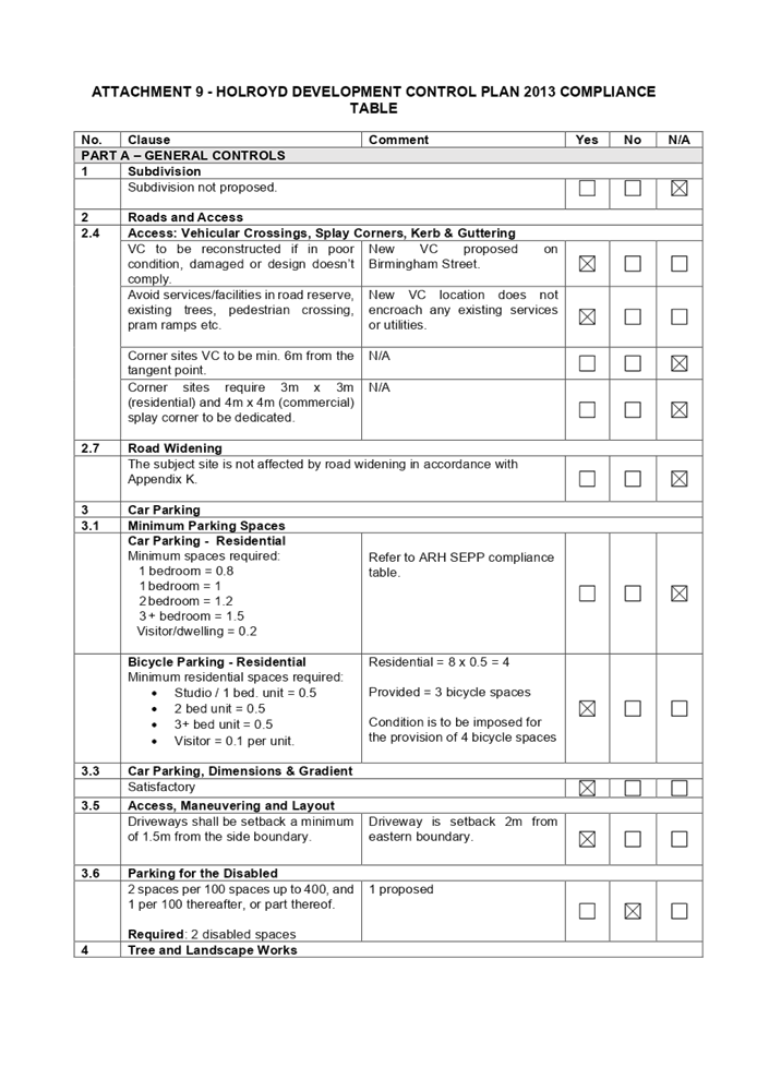
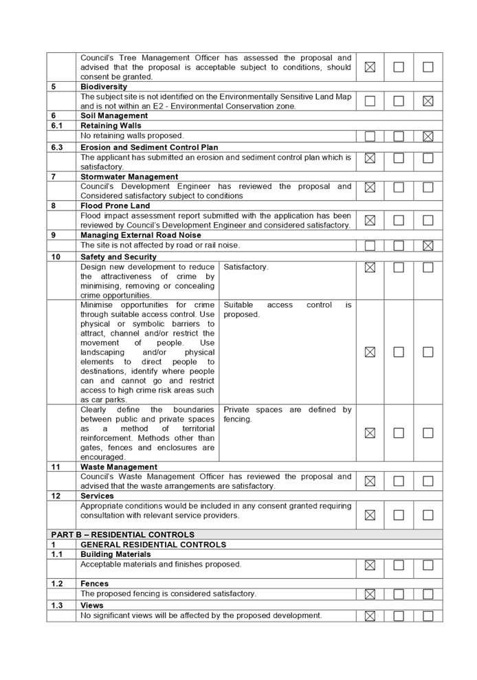
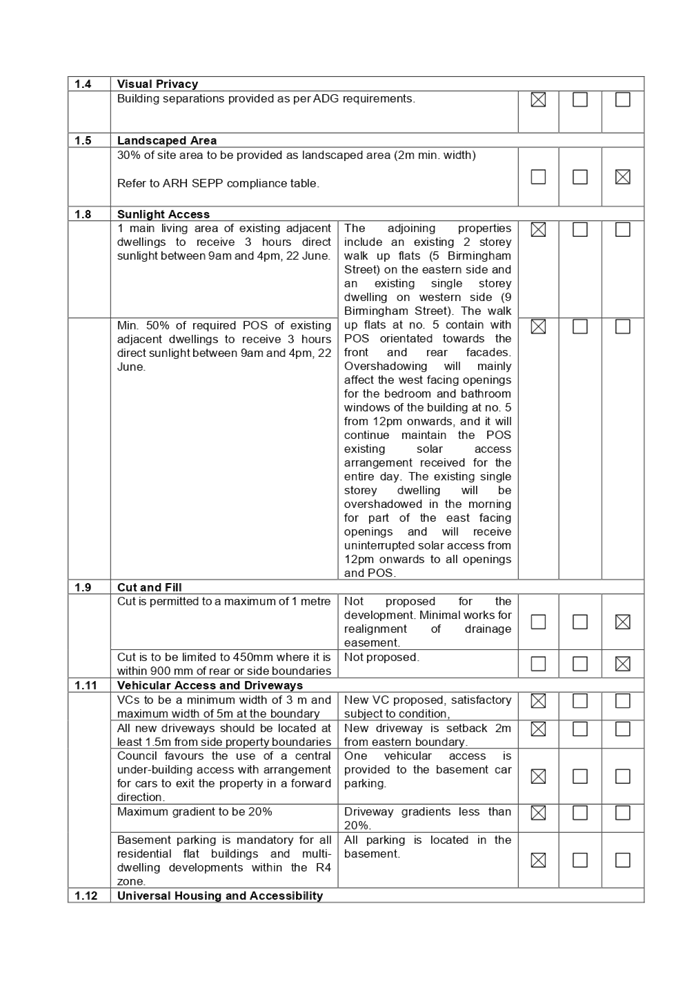
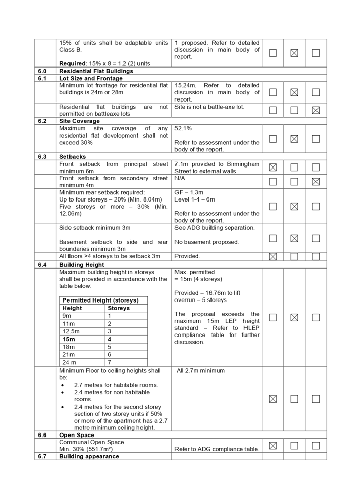
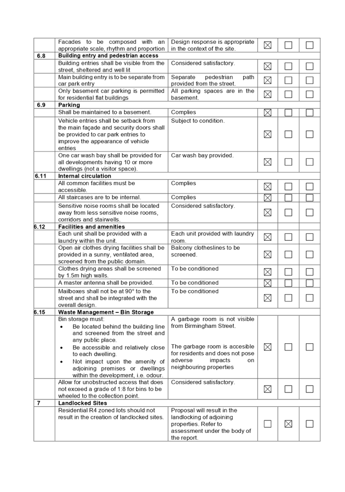
DOCUMENTS
ASSOCIATED WITH
REPORT LPP003/22
Attachment 10
Draft Reasons for Approval
Cumberland Local Planning Panel Meeting
9 February 2022