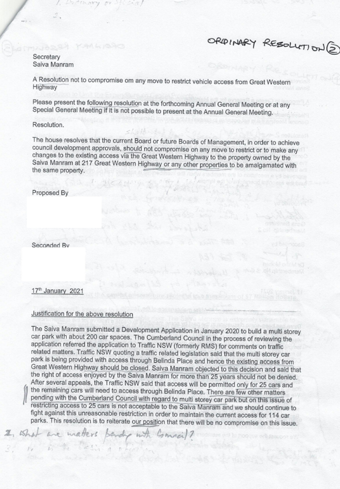
14 July 2021
A meeting of the Cumberland Local
Planning Panel will
be held at 11.30am via Zoom on Wednesday, 14 July 2021.
Business as below:
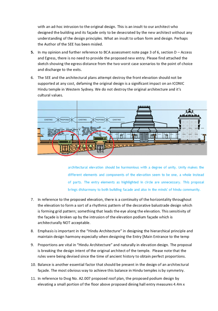
Yours faithfully
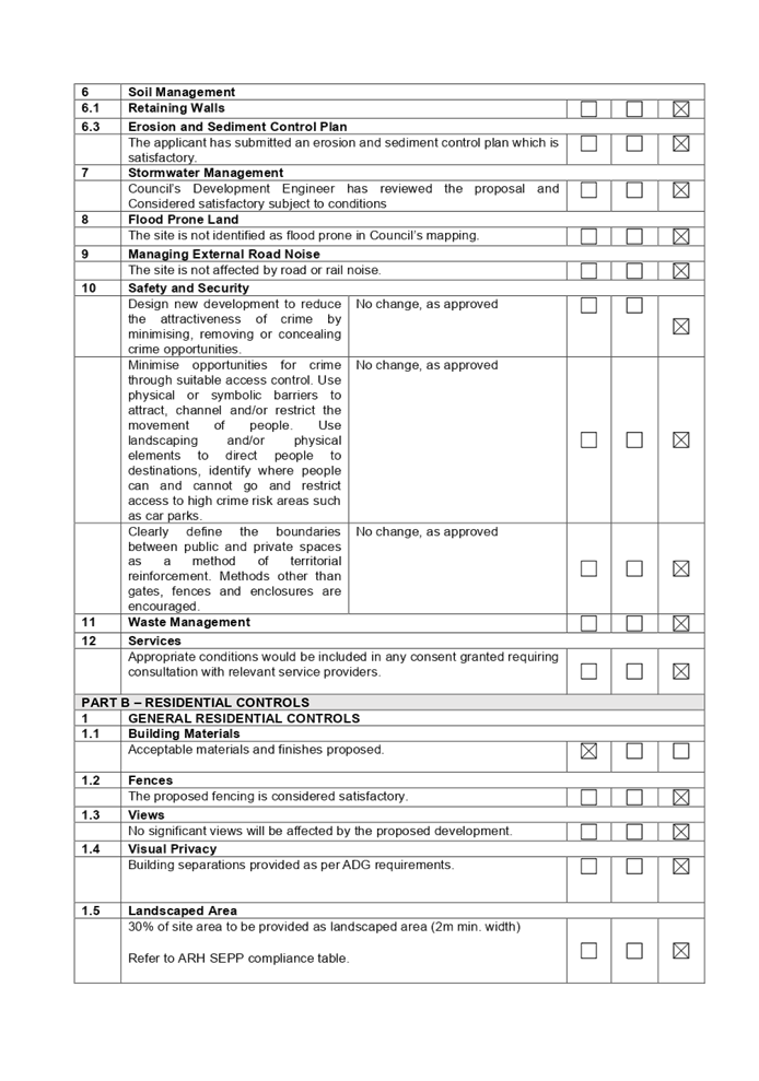
Peter J Fitzgerald
Acting
General Manager
ORDER OF BUSINESS
1. Receipt of Apologies
2. Confirmation of Minutes
3. Declarations of Interest
4. Address by invited
speakers
5. Reports:
- Development
Applications
- Planning
Proposals
6. Closed Session Reports
Cumberland Local Planning Panel Meeting
14 July 2021
CONTENTS
Report No. Name of Report Page
No.
Development Applications
LPP028/21... Development Application
for Church Street, Lidcombe................................. 5
LPP029/21... Modification Application
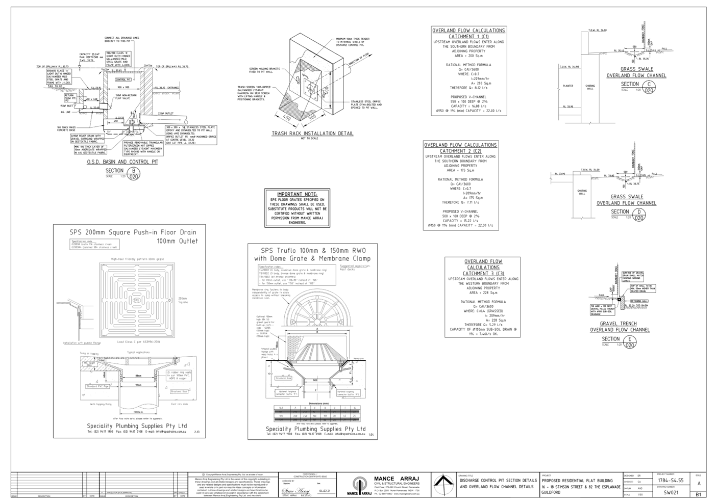
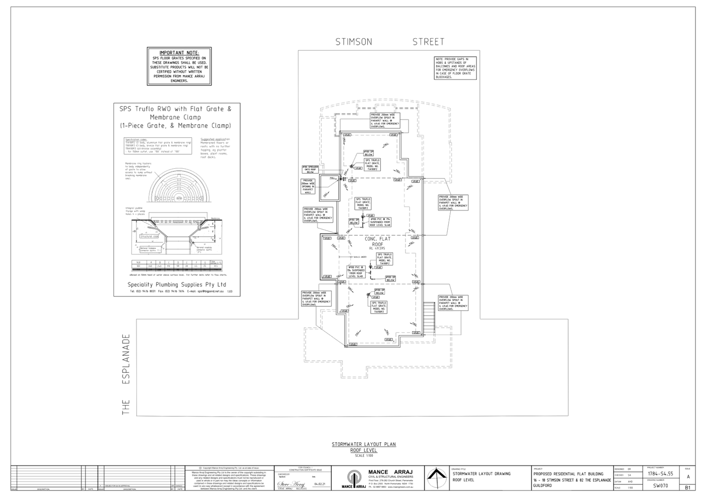
for 16-18 Stimson Street, Guildford..................... 55
LPP030/21... Development Application
for 217 Great Western Highway,
....................... Mays Hill............................................................................................................ 181
Cumberland Local Planning Panel Meeting
14 July 2021
Item No:
LPP028/21
Development
Application for Church Street, Lidcombe
Responsible
Division: Environment
& Planning
Officer: Executive
Manager Development and Building
File
Number: DA2021/0054
|
Application
lodged
|
3 February 2021
|
|
Applicant
|
Mr S P J Brennen
|
|
Owner
|
The Minister for Lands (under
the care and management by Council)
|
|
Application
No.
|
DA2021/0054
|
|
Description
of Land
|
Church Street LIDCOMBE
NSW 2141, Lot 7046 DP 1065005
|
|
Proposed
Development
|
Partial demolition of existing
toilet block, reinstatement of landscaping and installation of a lockable
power bollard
|
|
Site
Area
|
93sqm
|
|
Zoning
|
RE1 – Public Recreation
|
|
Disclosure
of political donations and gifts
|
Nil disclosure
|
|
Heritage
|
Yes – The subject
building is located on a site (Wyatt Park) that is a Local Heritage Item (I40)
|
|
Principal
Development Standards
|
N/A
|
|
Issues
|
Nil
|
1. Development
Application No. DA2021/0054 was received on 3 February 2021 for the partial
demolition of existing toilet block, reinstatement of landscaping and
installation of lockable power bollard.
2. The
application was publicly notified to occupants and owners of the adjoining
properties for a period of 14 days between 17 March 2021 and 31 March 2021. In
response, no submissions were received.
3. The
subject site is located on a site that is a heritage item in the Auburn Local
Environmental Plan 2010 as Heritage Item I40. The heritage item is Wyatt Park
and a Heritage Impact Statement has been submitted in support of the proposal.
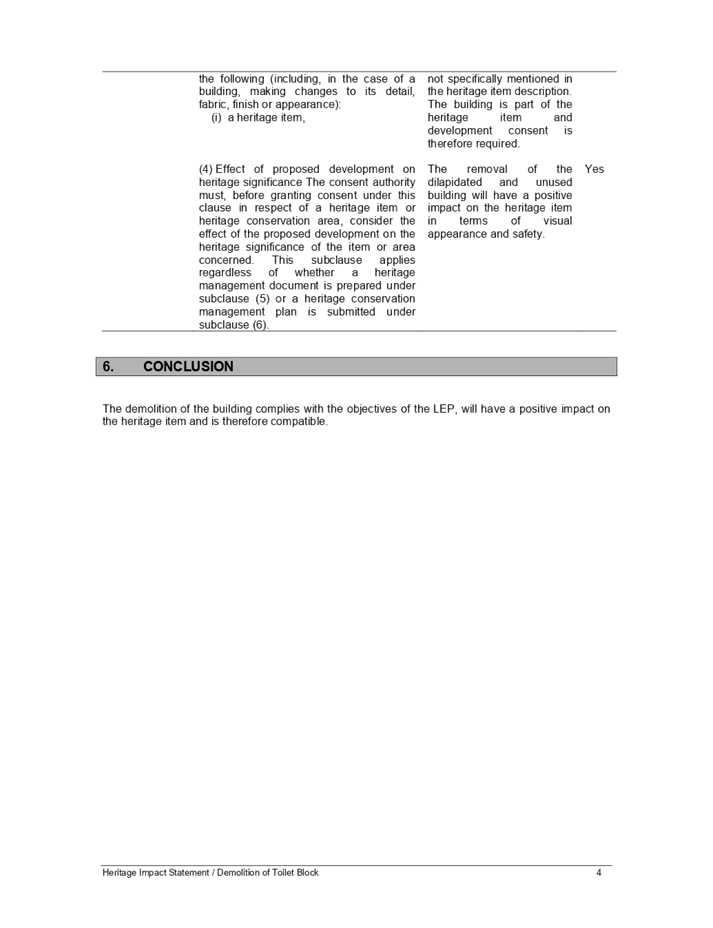
The proposed development will have minimal impact on the heritage item and is
considered satisfactory, having regard to the provisions of Clause 5.10(4) of
the Auburn Local Environmental Plan 2010.
4. The
development was referred to Council’s Heritage Committee for comment who
has raised no objections to the proposed development.
5. The
application is referred to the Cumberland Local Planning Panel for
determination as the development is proposed on land for which Council is the
land manager, resulting in a conflict of interest.
6. The
application is recommended for conditional approval subject to the conditions
as provided in the attached schedule.
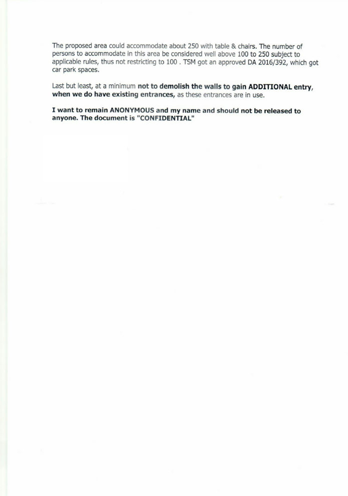
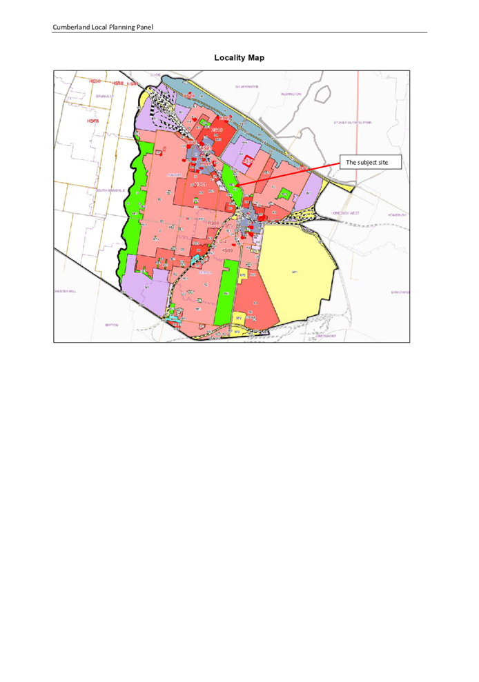
Subject Site and Surrounding
Area
The subject site is known as Wyatt
Park Lidcombe and is accessed via Church Street to the west and Olympic Drive
to the east. A rail corridor is located parallel to Church Street and the park
is located within walking distance (approximately 400m) to Lidcombe railway
station. The location of Wyatt Park is identified in Figure 1 below.
Wyatt Park contains numerous
sporting facilities that serve the wider residents of the Local Government Area
and Western Sydney. The Wyatt Park Management Plan recognises that the
‘majority of the park currently operates below capacity’ with a
number of dated and dilapidated facilities scattered throughout the park
including a defunct skate bowl, the Wyatt Park Youth Centre (WPYC) building,
the Cumberland Basketball Centre (CBC) building, netball courts and a
dilapidated toilet block.
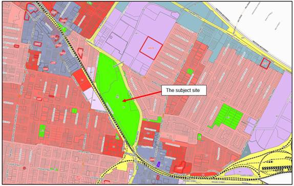
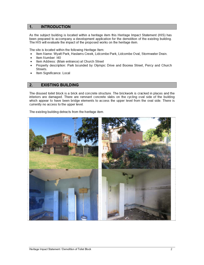
The subject of this DA is a toilet
block located on the southern side of Lidcombe Oval. The building is two
storeys in height, contains toilets and a change room and is in a poor
dilapidated state. The subject site is shown in context with the surrounding
land uses in Figure 1. The building proposed to be demolished is hi-lighted in
‘red’ in Figure 2 below.
Figure
1 – Land use map showing the location of the subject site

Figure 2 – Map
showing the location of the amenities block within Wyatt Park (source: Wyatt
Park Plan of Management, Revision 6, 13 April 2021)
Figure
3 – View of the amenities block building (south elevation) from within
Wyatt Park
Description of the Proposed
Development
Council has received a development
application for the demolition of a disused amenities block located within
Wyatt Park. The amenities block is located on the southern side of Lidcombe
Oval and as shown in Figure 3 is in a dilapidated state. Specifically, the
proposal will involve the removal of the following items:
- Amenities
block building.
- Two
concrete slabs to the north west of the building.
- Remnant
steps to the west of the building.
- Fencing
to the north east of the building.
- Reinstatement
of turf and landscaping to the area.
The slab and the electrical
infrastructure of the amenities block is proposed to be retained for future use
as defined in Council’s Wyatt Park Plan of Management (refer to
‘Referrals’ section of this report).
Figure
4 – Demolition plan
Applicants Supporting
Statement
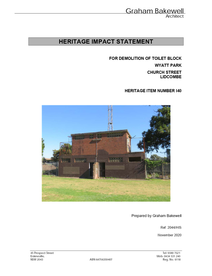
The applicant has provided a Statement of Environmental
Effects prepared by Graham Bakewell dated November 2020 and was received by
Council on 3 February 2021 in support of the application.
Contact with Relevant
Parties
The assessing officer has undertaken a site inspection of
the subject site and surrounding properties and has been in regular contact
with the applicant throughout the assessment process.
Internal Referrals
Landscape Officer
The development application was
referred to Council’s Landscape Officer for comment who has advised that
the development proposal is satisfactory and can be supported subject to
recommended conditions of consent.
The Wyatt Park Plan of Management
(the plan) dated 13 April 2021 was adopted by Council on 5 May 2021 and
provides a clear direction and framework for the future use and management of
the park. The plan identifies an intention to provide a kiosk or food truck on
the hard stand area where the amenities block currently stands (Refer to
Management Action B6 of the plan, page 73). Council’s Landscape Officer
has raised no issue to the demolition of the amenities block subject to the
retention of the ground slab and the associated electricity infrastructure. The
slab of the building and existing electricity infrastructure can be adapted
with little effort for use as a kiosk or a food truck in the future as
envisaged by the plan.
Tree Management Officer
It is noted that there are several
trees in close proximity to the amenities block. The development application
was referred to Council’s Tree Management Officer for comment who has
advised that the proposal is satisfactory subject to the imposition of standard
tree protection conditions in any consent.
Heritage Committee
The development application was
referred to Council’s Heritage Committee for comment who have raised no
objections to the proposal. It is noted that the amenities block building is
not identified as a local heritage item in Auburn Local Environmental Plan 2010
and is a small dilapidated structure that possesses no heritage value.
External Referrals
The application was not required
to be referred to any external agencies for comment.
PLANNING COMMENTS
The provisions of any
Environmental Planning Instruments (EP&A Act s4.15 (1)(a)(i))
State Environmental Planning
Policies
The proposed development is
affected by the following State Environmental Planning Policies:
(a) State
Environmental Planning Policy No. 55 – Remediation of Land (SEPP 55)
Clause 7 of SEPP 55 requires
Council to be satisfied that the site is suitable or can be made suitable to
accommodate the proposed development. The matters listed within Clause 7 have
been considered in the assessment of the development application.
|
Matter for
Consideration
|
Yes/No
|
|
Does the application
involve re-development of the site or a change of land use?
|
Yes No
|
|
In the development
going to be used for a sensitive land use (e.g.: residential, educational,
recreational, childcare or hospital)?
|
Yes N/A
|
|
Does information
available to you indicate that an activity listed below has ever been
approved, or occurred at the site?
acid/alkali plant and formulation, agricultural/horticultural
activities, airports, asbestos production and disposal, chemicals manufacture
and formulation, defence works, drum re-conditioning works, dry cleaning
establishments, electrical manufacturing (transformers), electroplating and
heat treatment premises, engine works, explosive industry, gas works, iron
and steel works, landfill sites, metal treatment, mining and extractive
industries, oil production and storage, paint formulation and manufacture,
pesticide manufacture and formulation, power stations, railway yards, scrap
yards, service stations, sheep and cattle dips, smelting and refining,
tanning and associated trades, waste storage and treatment, wood preservation
|
Yes No
|
|
Is
the site listed on Council’s Contaminated Land database?
|
Yes No
|
|
Is
the site subject to EPA clean-up order or other EPA restrictions?
|
Yes No
|
|
Has
the site been the subject of known pollution incidents or illegal dumping?
|
Yes No
|
|
Does
the site adjoin any contaminated land/previously contaminated land?
|
Yes No
|
|
Has
the appropriate level of investigation been carried out in respect of
contamination matters for Council to be satisfied that the site is suitable
to accommodate the proposed development or can be made suitable to
accommodate the proposed development?
|
Yes No
|
|
Details of
contamination investigations carried out at the site:
Council’s contamination mapping does not indicate
the subject site is contaminated in any way nor is it identified as being
potentially contaminated. A site inspection reveals the site does not have
any obvious history of a previous land use that may have the potential to
cause contamination and there is no specific evidence that indicates the site
is contaminated.
Notwithstanding, a standard condition of consent has been
recommended to manage any unexpected finds encountered during the proposed
works.
|
(b) State
Environmental Planning Policy (Infrastructure) 2007 (ISEPP)
The provisions of the ISEPP 2007
have been considered in the assessment of the development application.
Clause 85 – Development
adjacent to railway corridors
The site is adjacent to an
existing rail corridor and the development has been assessed against the
provisions of Clause 85(1). The development is not likely to have an adverse
effect on rail safety, given the distance of the works to the corridor and the
fact that the works are minor in nature. Further, the development does not
involve the placing of a metal finish, will not involve the use of a crane in
airspace above the rail corridor and is not located within 5 metres of an
exposed overhead electricity powerline that is used for the purpose of railways
or rail infrastructure facilities.
Clause 86 – Excavation
in, above, below or adjacent to rail corridors
The proposed development does not
involve any excavation works to a depth of 2 metres and the provisions of
Clause 86 are therefore not applicable.
Clause 87 – Impact of
rail noise or vibration on non-rail development
The proposed development is not
for the purpose of residential accommodation, a place of public worship, a
hospital or an educational establishment or centre-based child care facility
and the provisions of Clause 87 are therefore not applicable.
Clause 101 – Frontage to
classified road
The application is subject to
clause 101 of the ISEPP as Wyatt Park has frontage to Olympic Drive which is a
classified road. Council is satisfied that consent to the development can be
granted with respect to this clause noting that vehicles and machinery can gain
access to the site via an alternative roadway being Church Street to the west.
As such, the proposed demolition will not have a significantly adverse impact
on the ongoing operation of Olympic Drive.
Regional Environmental Plans
The proposed development is
affected by the following Regional Environmental Plans:
(a) Sydney
Regional Environmental Plan (Sydney Harbour Catchment) 2005
The subject site is identified as
being located within the area affected by the Sydney Regional Environmental
Plan (Sydney Harbour Catchment) 2005. The proposed development raises no issues
as no impact on the catchment is envisaged.
(Note: - the subject site is not
identified in the relevant map as ‘land within the ‘Foreshores and
Waterways Area’ or ‘Wetland Protection zone’, is not a
‘Strategic Foreshore Site’ and does not contain any heritage items.
Hence the majority of the SREP is not directly relevant to the proposed
development).
Local Environmental Plans
Auburn Local Environmental Plan
2010 (ALEP)
The provision of the ALEP is
applicable to the development proposal. It is noted that the development
achieves compliance with the key statutory requirements of the ALEP and the
objectives of the RE1 Public Recreation land use zone.
(a) Permissibility:-
The proposed development involves
demolition works which is permissible pursuant to Part 2, Clause 2.7 of the
ALEP.
The relevant matters to be
considered under ALEP and the applicable clauses for the proposed development
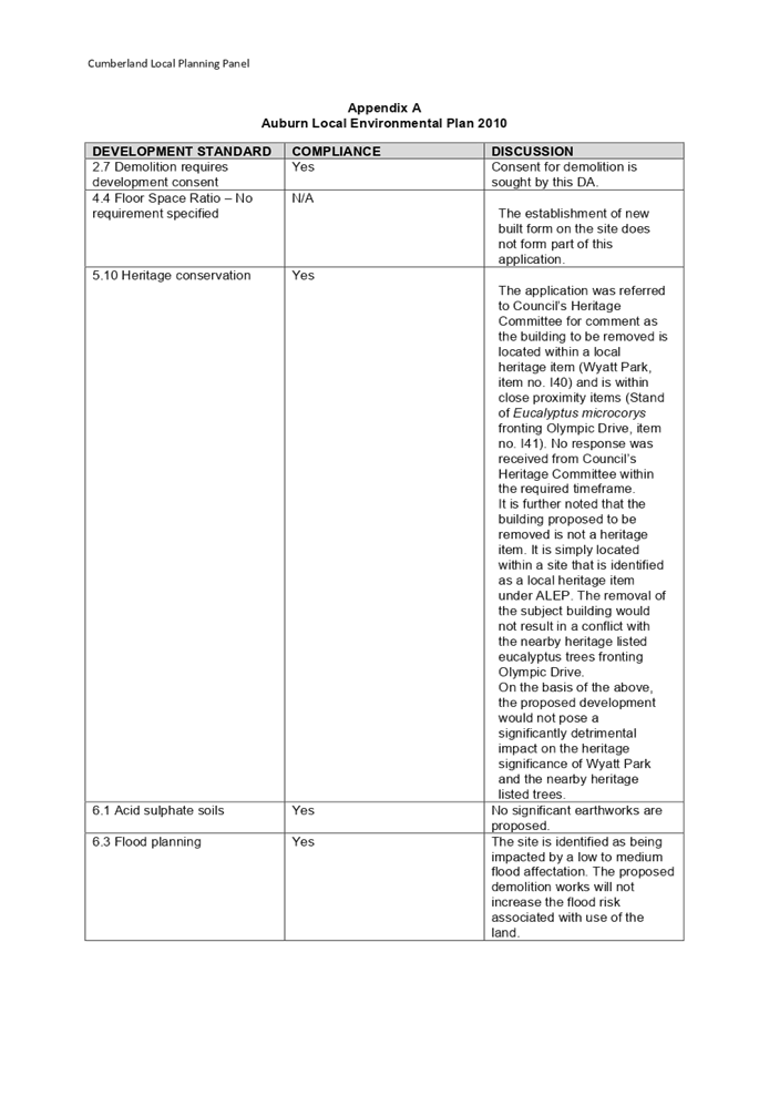
are summarised below. A comprehensive LEP assessment is contained in Appendix
A.
Figure
5 – Auburn LEP 2010 Compliance Table
|
DEVELOPMENT STANDARD
|
COMPLIANCE
|
DISCUSSION
|
|
2.7 Development
requires development consent
|
Yes
|
Development consent is
sought by this DA
|
|
5.10 Heritage
conservation
|
Yes
|
A Heritage Impact Statement
prepared by Graham Bakewell was submitted in support of the application
concluding that the proposed ‘demolition complies with the objectives
of the LEP, will have a positive impact on the heritage item and is therefore
compatible’
The application was referred to
Council’s Heritage Committee for comment as the building to be removed
is located within a local heritage item (Wyatt Park, item no. I40) and is
within close proximity to local heritage items (Stand of Eucalyptus
microcorys fronting Olympic Drive, item no. I41). No objections were
raised.
It is further noted that the
building proposed to be removed is not a heritage item. It is simply located
within a site that is identified as a local heritage item under the ALEP.
Given its proximity to the nearby heritage listed trees fronting Olympic
Drive, it is considered that the development would pose no significantly
detrimental heritage impact. This is supported by comment provided by
Council’s Tree Management Officer.
Based on the above assessment,
the proposed development is not considered to pose a significantly
detrimental impact on the heritage significance of Wyatt Park and the nearby
heritage listed trees and is therefore consistent with the provisions of this
clause.
|
The provisions of any proposed
instrument that is or has been the subject (EP&A Act s4.15 (1)(a)(ii))
(a) Draft
State Environmental Planning Policy (Environment)
The draft SEPP relates to the
protection and management of our natural environment with the aim of
simplifying the planning rules for a number of water catchments, waterways,
urban bushland, and Willandra Lakes World Heritage Property. The changes
proposed include consolidating the following seven existing SEPPs:
· State
Environmental Planning Policy No. 19 – Bushland in Urban Areas
· State
Environmental Planning Policy (Sydney Drinking Water Catchment) 2011
· State
Environmental Planning Policy No. 50 – Canal Estate Development
· Greater
Metropolitan Regional Environmental Plan No. 2 – Georges River Catchment
· Sydney
Regional Environmental Plan No. 20 – Hawkesbury-Nepean River (No.2-1997)
· Sydney
Regional Environmental Plan (Sydney Harbour Catchment) 2005
· Willandra
Lakes Regional Environmental Plan No. 1 – World Heritage Property.
The draft policy will repeal the
above existing SEPPs and certain provisions will be transferred directly to the
new SEPP, amended and transferred, or repealed due to overlaps with other areas
of the NSW planning system.
Changes are also proposed to the
Standard Instrument – Principal Local Environmental Plan. Some provisions
of the existing policies will be transferred to new Section 117 Local Planning
Directions where appropriate.
(b) Draft
Cumberland Local Environmental Plan (Draft CLEP)
The Draft Cumberland Local
Environmental Plan (Draft CLEP) has been prepared by Cumberland Council to
provide a single planning framework for the future planning of Cumberland City.
The changes proposed seek to harmonise and repeal the three existing LEPs
currently applicable to the Cumberland local government area, those being:
· Holroyd
Local Environmental Plan 2013,
· Parramatta
Local Environmental Plan 2011, and
· Auburn
Local Environmental Plan 2010.
The current planning controls for
the subject site, as contained within the Auburn Local Environmental Plan 2010
are not proposed to change under the Draft CLEP.
The provisions of any
Development Control Plans (EP&A Act s4.15 (1)(a)(iii))
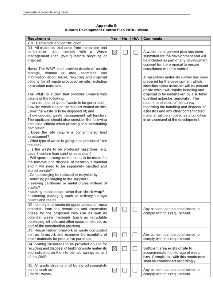
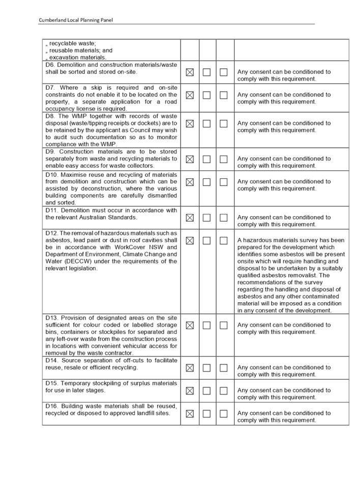
The Auburn Development Control
Plan 2010 (ADCP) provides guidance for the design and operation of development
to achieve the aims and objectives of the Auburn Local Environmental Plan 2010.
The proposed development complies with the relevant provisions and controls of
the ADCP and is considered acceptable from an environmental planning view
point.
A comprehensive assessment and
compliance table is contained in Appendix B.
The provisions of any planning
agreement that has been entered into under section 7.4, or any draft planning
agreement that a developer has offered to enter into under section 7.4
(EP&A Act s4.15(1)(a)(iiia))
There is no draft planning
agreement associated with the subject Development Application.
The provisions of the
Regulations (EP&A Act s4.15 (1)(a)(iv))
The proposed development raises no
concerns as to the relevant matters arising from the Environmental Planning and
Assessment Regulations 2000 (EP&A Reg).
The Likely Environmental,
Social or Economic Impacts (EP&A Act s4.15 (1)(b))
It is considered that the proposed
development will have no significant adverse environmental, social or economic
impacts in the locality. The Wyatt Park Plan of Management identifies the
amenities block as being in ‘poor’ condition. It was apparent
during an inspection of the site that the building is in a poor visual state
and may pose a danger to users of Wyatt Park if left in its current dilapidated
condition. The proposed demolition of the building would address this concern
and permit this part of the park to be upgraded for use (as envisioned by the
plan) which will have economic and social benefits for the local area and the
community.
The suitability of the site for
the development (EP&A Act s4.15 (1)(c))
The subject site and locality is
not known to be affected by any natural hazards or other site constraints
likely to have a significant adverse impact on the proposed development.
Accordingly, it is considered that the development is suitable in the context
of the site and surrounding locality.
Submissions made in accordance
with the Act or Regulation (EP&A Act s4.15 (1)(d))
|
Advertised (Council website)
|
Mail
|
Sign
|
Not Required
|
In accordance with Council’s
Notification requirements contained within the ADCP, the proposal was publicly
notified for a period of 14 days between 17 March 2021 and 31 March 2021. No
submissions were generated in respect of the proposal.
The public interest (EP&A
Act s4.15(1)(e))
In view of the foregoing analysis
it is considered that the development, if carried out subject to the conditions
set out in the recommendation below, will have no significant adverse impacts
on the public interest.
Cumberland Local
Infrastructure Contributions Plan 2020
The development does not require
the payment of contributions in accordance with Council’s Contributions
Plan.
Disclosure of Political
Donations and Gifts
The applicant and notification
process did not result in any disclosure of Political Donations and Gifts.
The development application has
been assessed in accordance with the relevant requirements of the Environmental
Planning and Assessment Act 1979, SEPP 55 – Remediation of Land, SEPP
(infrastructure) 2007, SREP (Sydney Harbour Catchment) 2005, Auburn Local
Environmental Plan 2010 and Auburn Development Control Plan 2010 and is
considered to be satisfactory for approval subject to conditions.
|
That
Development Application No. DA2021/0054 for partial demolition of existing
toilet block, reinstatement of landscaping and installation of a lockable
power bollard on land at Church Street LIDCOMBE NSW 2141 be approved subject
to attached conditions.
|
1. Draft
Notice of Determination
2. Architectural
Plans
3. Locality
Map
4. Heritage
Impact Statement
5. Appendix
A - Auburn Local Environmental Plan 2010
6. Appendix
B - Auburn Development Control Plan 2010
DOCUMENTS
ASSOCIATED WITH
REPORT LPP028/21
Attachment 1
Draft Notice of Determination
Cumberland Local Planning Panel Meeting
14 July 2021


DOCUMENTS
ASSOCIATED WITH
REPORT LPP028/21
Attachment 2
Architectural Plans
Cumberland Local Planning Panel Meeting
14 July 2021
DOCUMENTS
ASSOCIATED WITH
REPORT LPP028/21
Attachment 3
Locality Map
Cumberland Local Planning Panel Meeting
14 July 2021
DOCUMENTS
ASSOCIATED WITH
REPORT LPP028/21
Attachment 4
Heritage Impact Statement
Cumberland Local Planning Panel Meeting
14 July 2021
DOCUMENTS
ASSOCIATED WITH
REPORT LPP028/21
Attachment 5
Appendix A - Auburn Local Environmental Plan 2010
Cumberland Local Planning Panel Meeting
14 July 2021
DOCUMENTS
ASSOCIATED WITH
REPORT LPP028/21
Attachment 6
Appendix B - Auburn Development Control Plan 2010
Cumberland Local Planning Panel Meeting
14 July 2021
Cumberland
Local Planning Panel Meeting
14 July 2021
Item
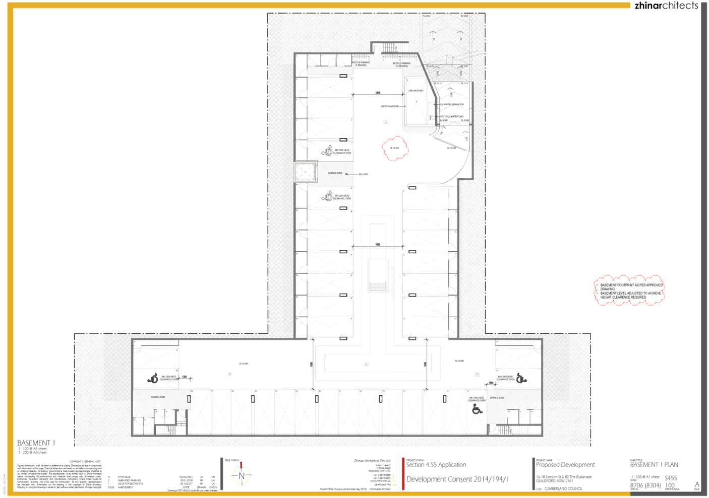
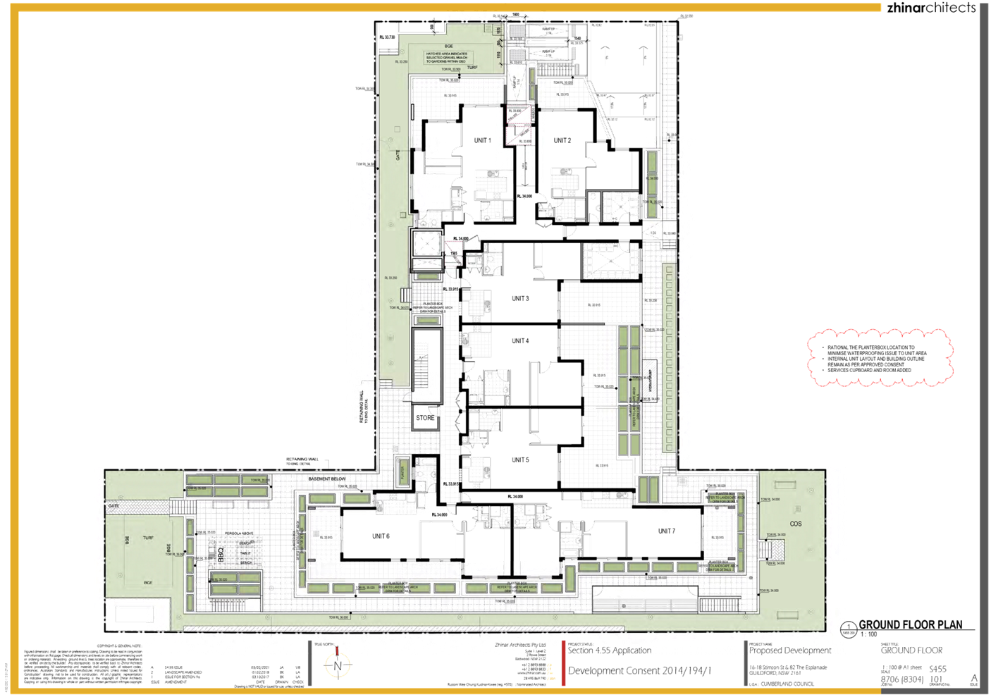
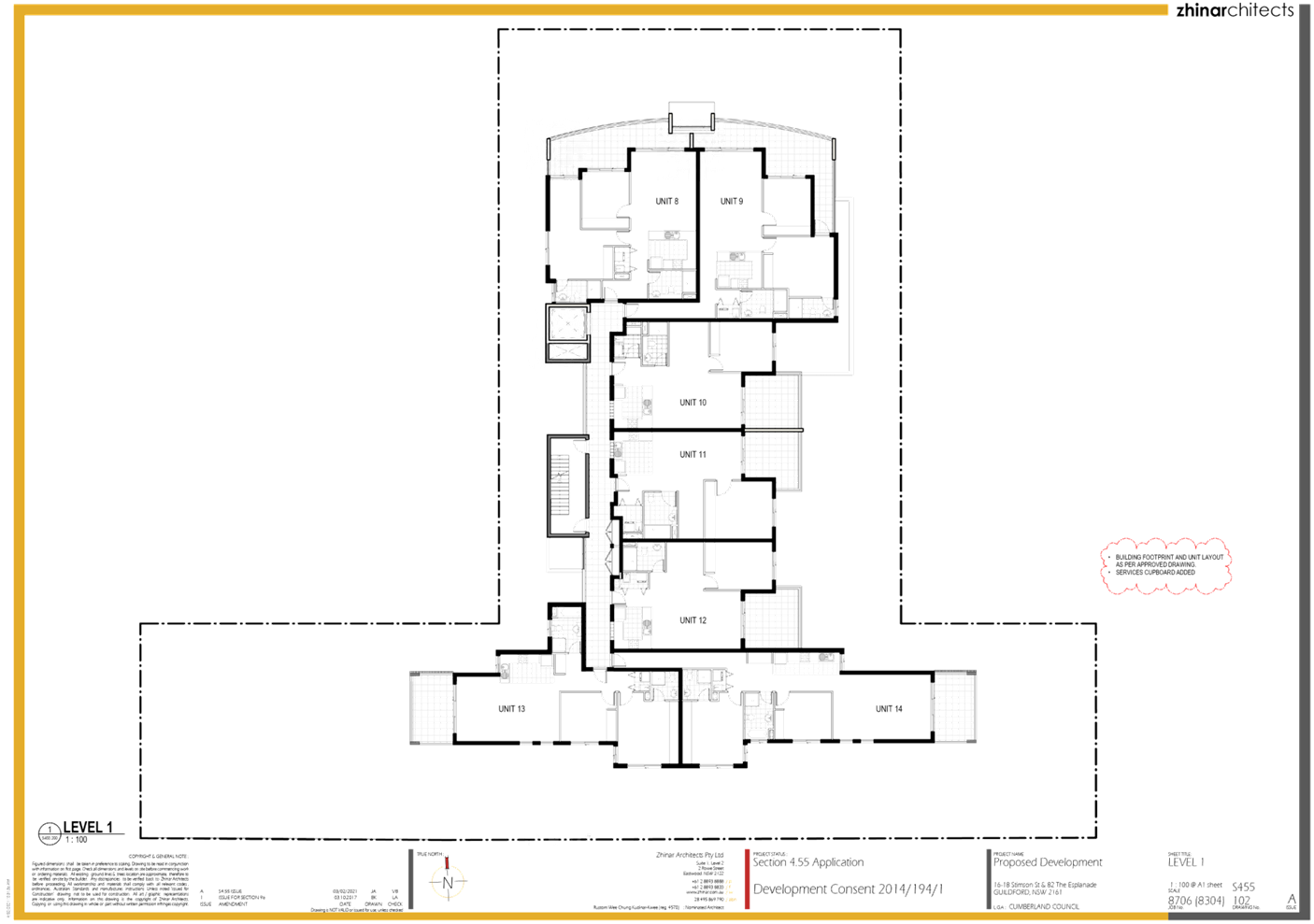
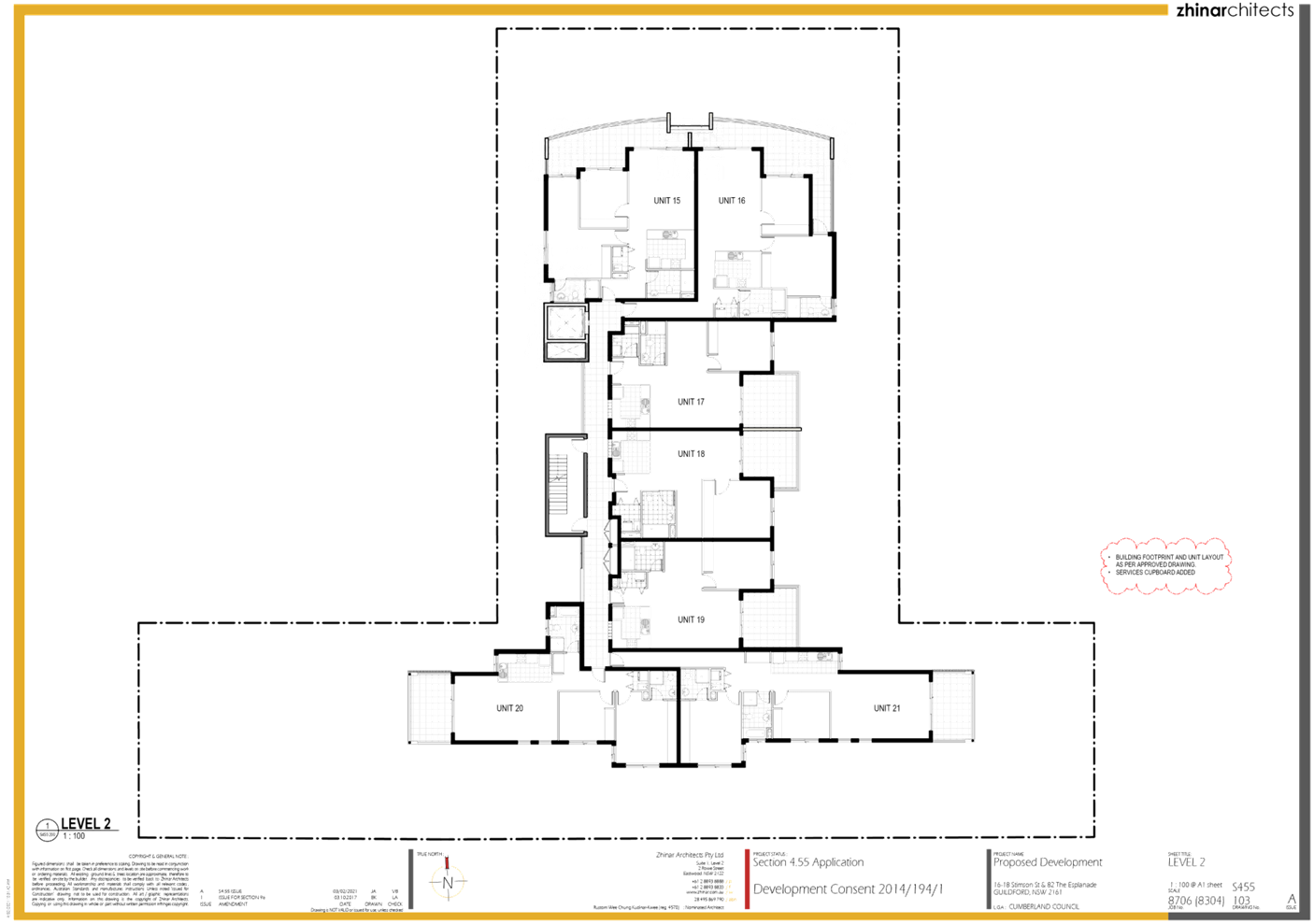
No: LPP029/21
Modification
Application for 16-18 Stimson Street, Guildford
Responsible
Division: Environment
& Planning
Officer: Executive
Manager Development and Building
File
Number: MOD2021/0076
|
Application
lodged
|
2 March 2021
|
|
Applicant
|
Zhinar Architects
|
|
Owner
|
Burnett St Pty Ltd
|
|
Application
No.
|
MOD2021/0076
|
|
Description
of Land
|
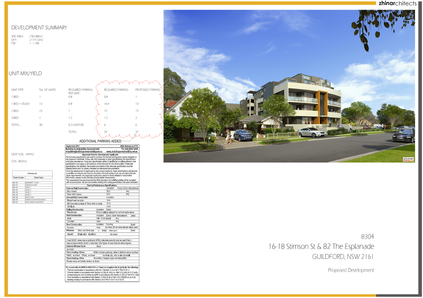
16 -18 Stimson Street
GUILDFORD NSW 2161, Lot 100 DP 1241157
|
|
Proposed
Development
|
Section 4.55(2) application
for various modifications to the approved residential flat building including
amendments to external finishes and floor levels and increase in building
height
|
|
Site
Area
|
1,782.82m2
|
|
Zoning
|
R4 - High Density Residential
Zone
|
|
Disclosure
of political donations and gifts
|
Nil disclosure
|
|
Heritage
|
No –The subject site is
not Heritage Listed or located within a Heritage Conservation Area
|
|
Principal
Development Standards
|
Floor Space ratio (FSR)
Permissible: 1.2 :1
Proposed: No Change, remains
as approved.
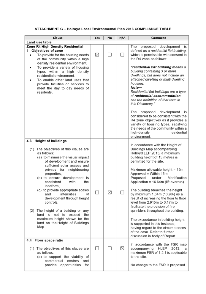
Height of Building (HOB)
Permissible:15m
Approved: 15m
Proposed:16.64m
|
|
Issues
|
Building Height
|
1. Modification
Application No. MOD2021/0076 was received on 4 March 2021 for the Section
4.55(2) application for various modifications to the approved residential flat
building including amendments to external finishes and floor levels and
increase in building height.
2. The
application was publicly notified to occupants and owners of the adjoining properties
for a period of 21 days between 31 March 2021 and 21 April 2021. In response,
two (2) submissions were received.
3. The
application has been assessed against the relevant provisions of the
Environmental Planning and Assessment Act 1979, State Environmental Planning
Policy No 65 – Design Quality of Residential Apartment Development (SEPP
65), Holroyd Local Environmental Plan 2013 (HLEP), Apartment Design Guide and
Holroyd Development Control Plan 2013 (HDCP).
4. The
application involves the following non-compliances which are considered
supportable as discussed in detail in the body of this report:
|
Control
|
Required
|
Approved DA
|
Proposed
|
% variation
|
|
Height of buildings (HLEP2013)
|
15m
|
15m
|
16.64m (lift overrun)
|
10.9%
|
5. The application is
being reported to the Cumberland Local Planning Panel (CLPP) for determination
as it is a development that contravenes a development standard by more than
10%.
6. The
application is recommended for approval subject to the conditions in the draft
notice of determination at Attachment 1.
Subject Site and Surrounding
Area
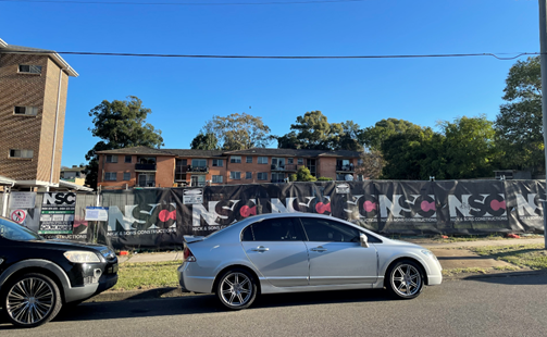
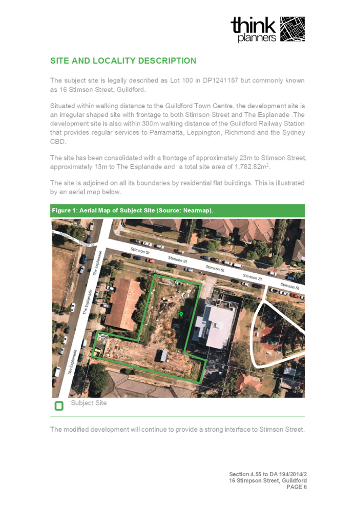
The subject site is legally
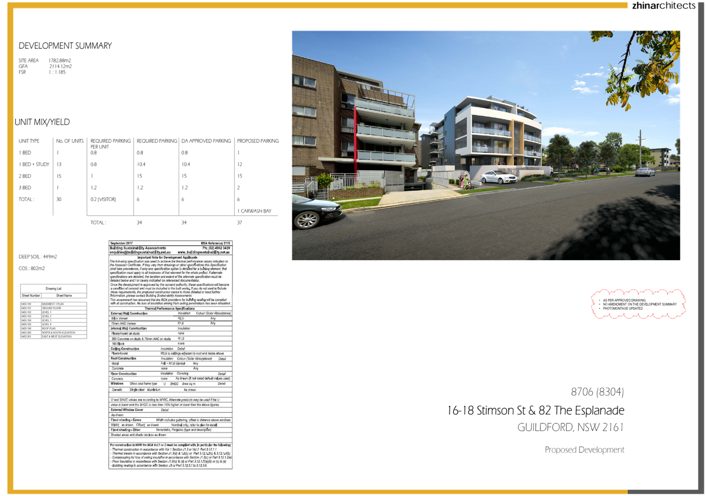
described as Lot 100 DP 1241157 and known as No. 16 to 18 Stimson Street,
GUILDFORD NSW 2161. The site has an area of 1,782.82m2 and a frontage
to Stimson Street of 23m and 13m to the Esplanade. The site is located within
walking distance to the Guildford Railway Station and the local commercial town
centre. The site is currently vacant and fenced off for upcoming works. The
subject site and neighbouring allotments are zoned R4 – High Density
Residential. The existing developments adjoining the site include 4 storey
residential flat building to the east and south and a single storey detached
dwelling house to the west.
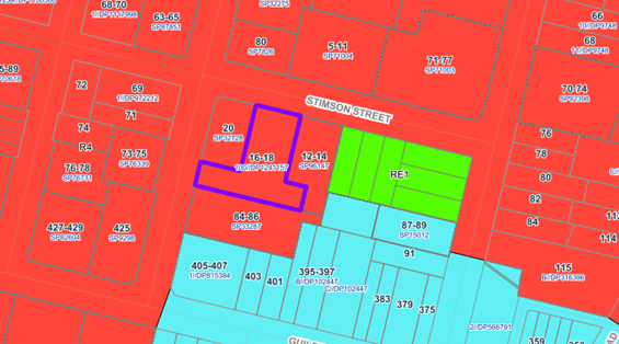
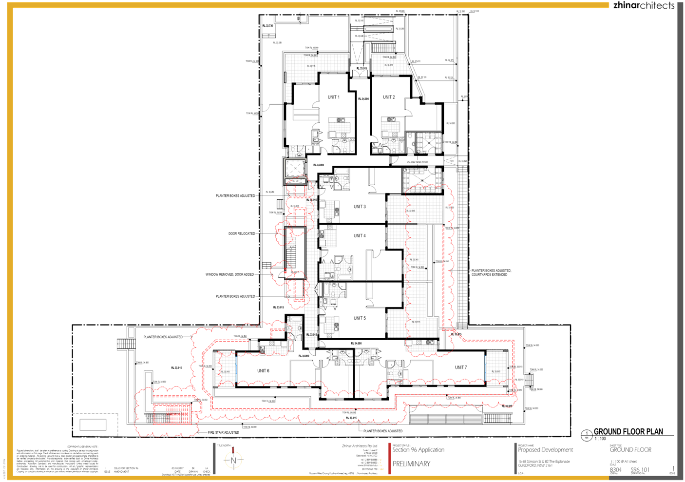
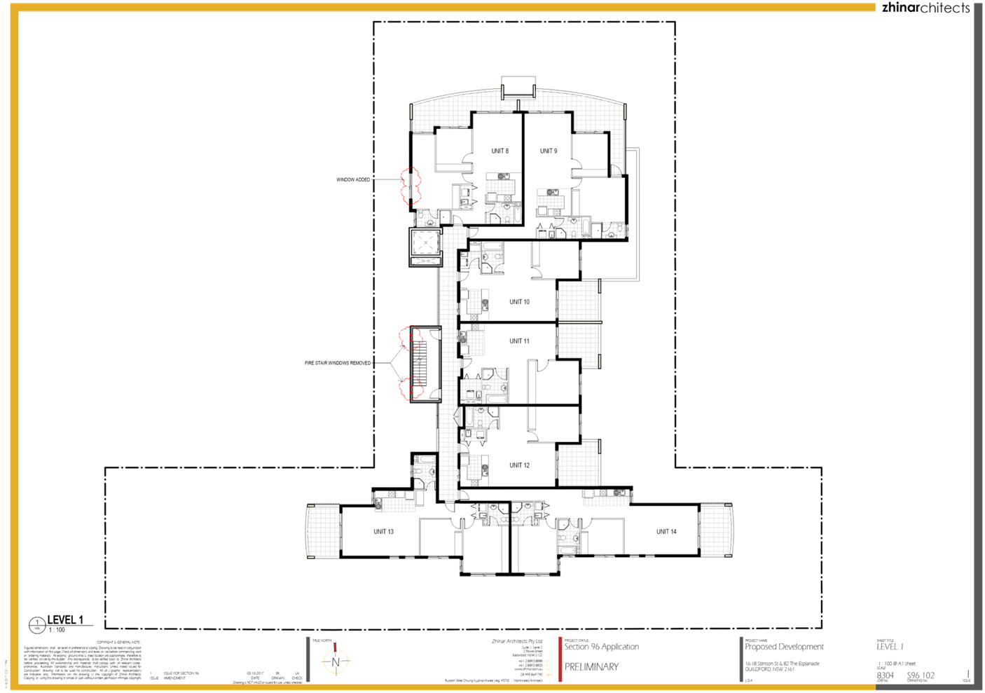
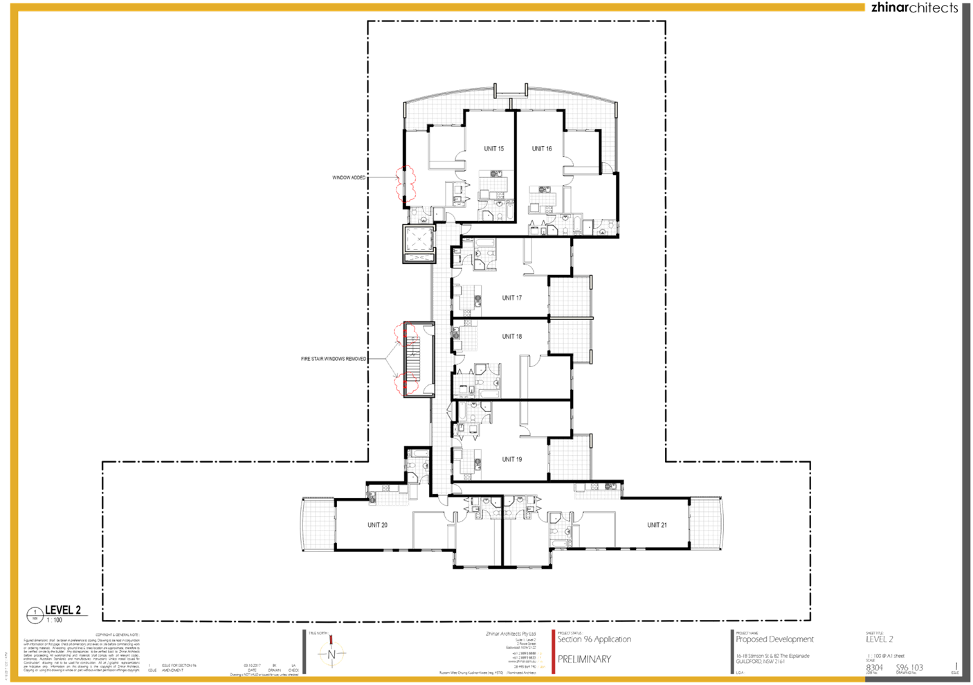
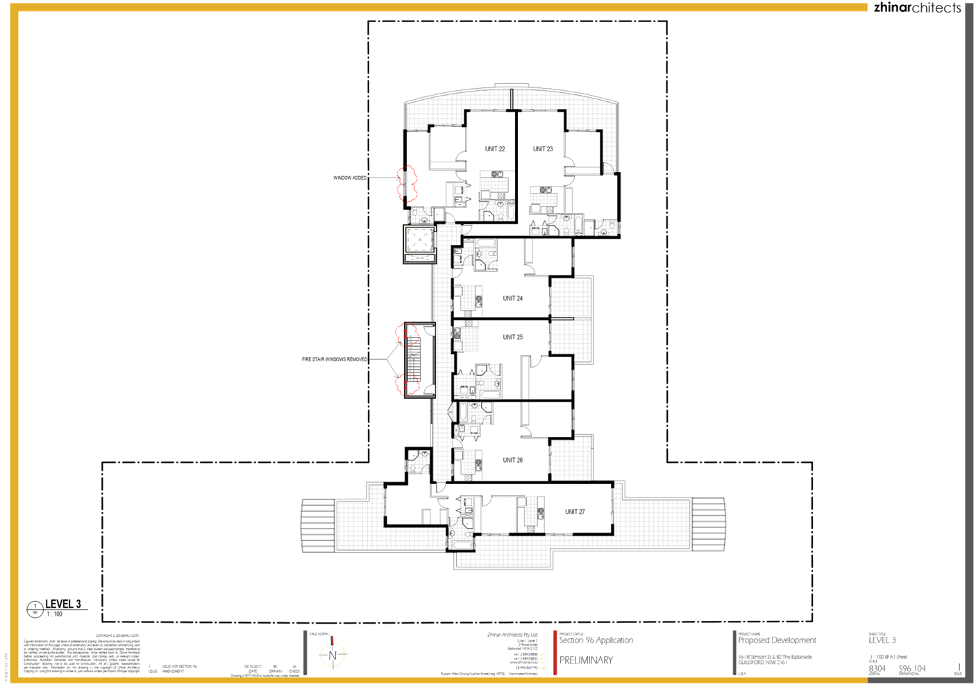
Figure
1 – Locality Plan of subject site
Figure
2 – Aerial view of subject site
Figure
3 – Street view of subject site
Description of the Proposed
Development
Council has received a
modification application for various modifications to the approved residential
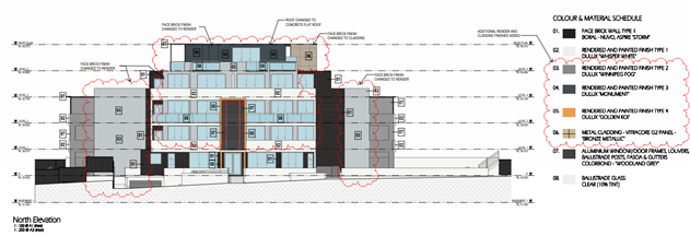
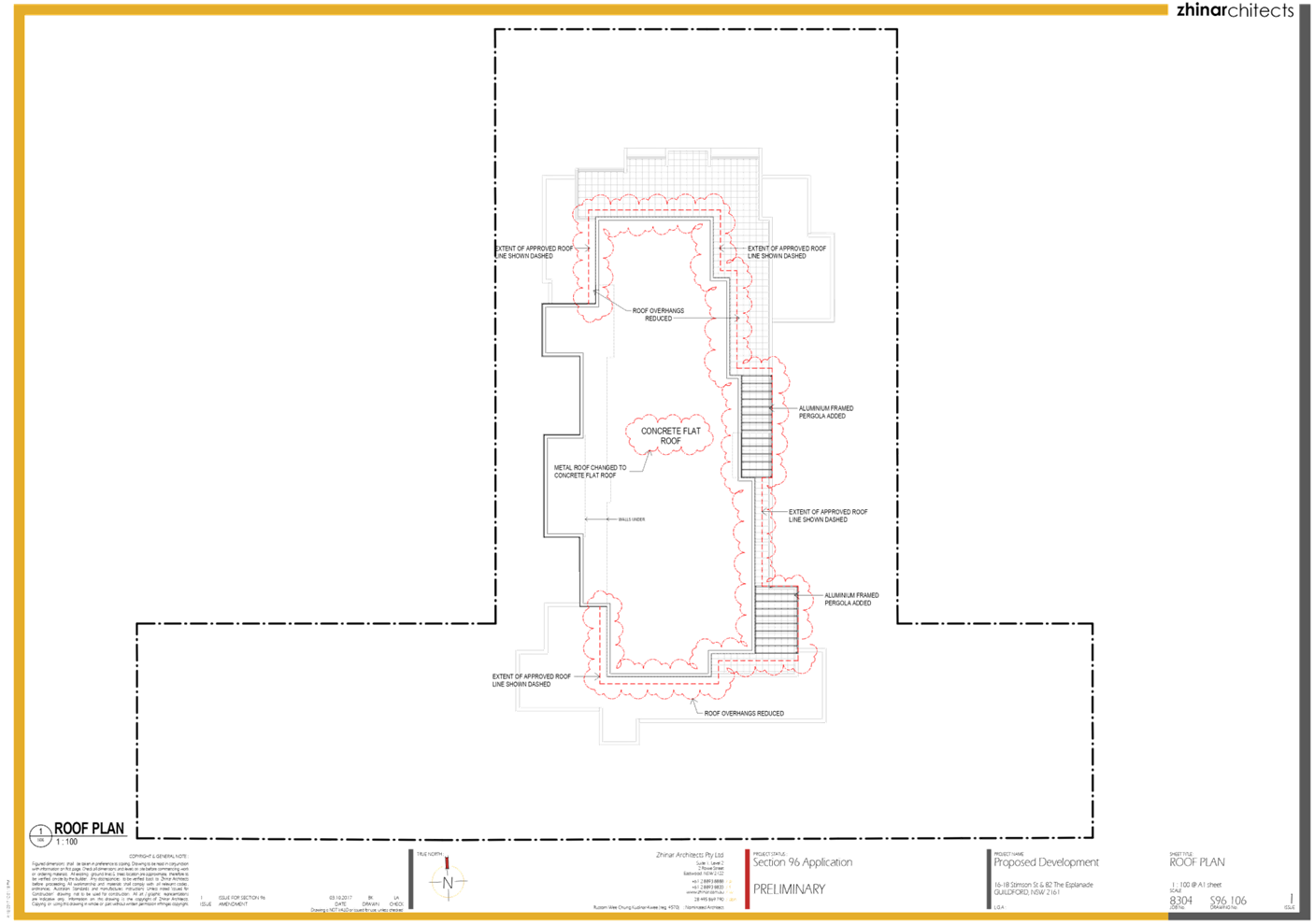
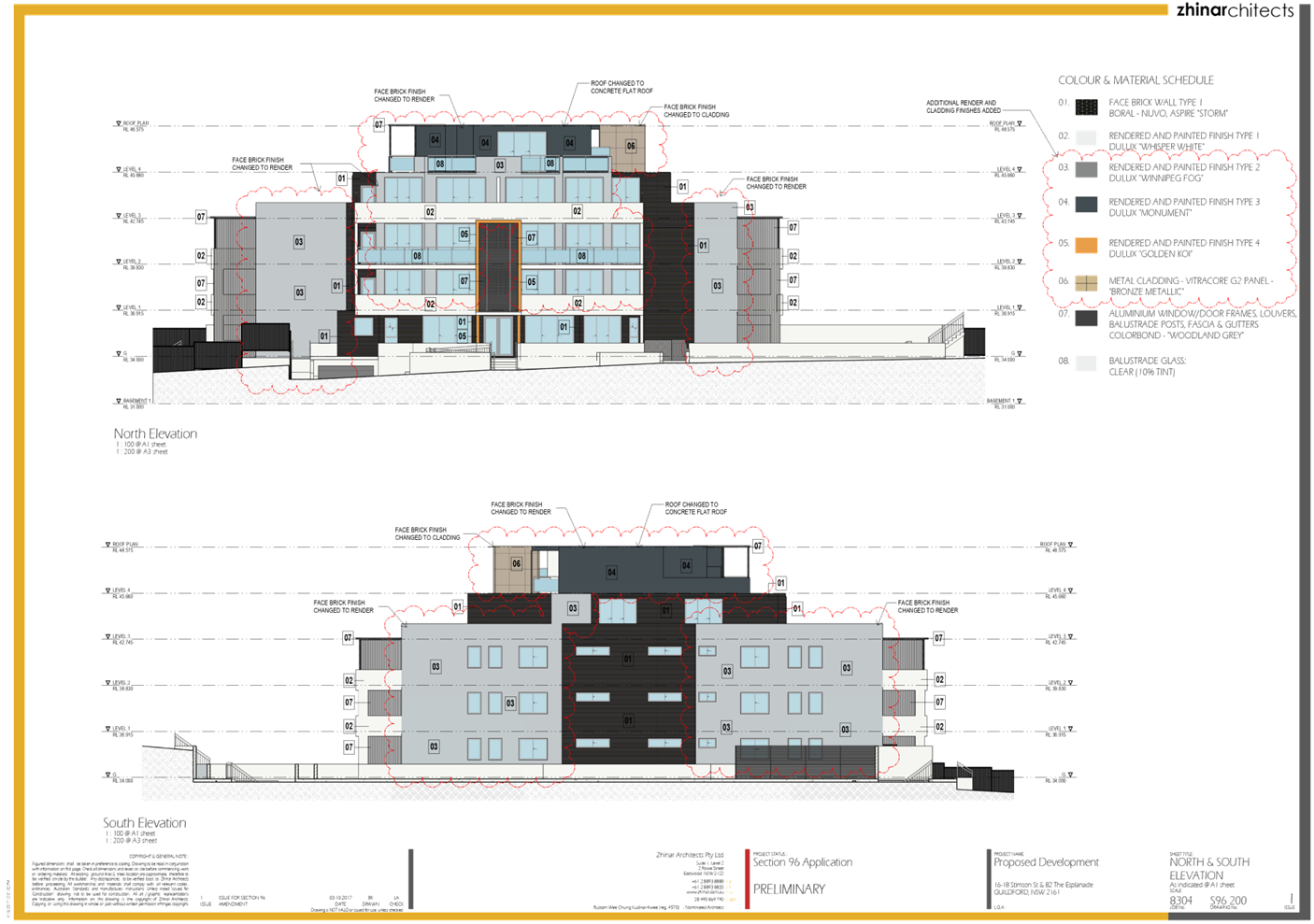
flat building including the following works:
· Refine
the external façade of the building by further increasing the use of
face brick and reducing render and removing metal cladding;
· Extend
the eastern portion of the roof level to increased weather protection to
balconies associated with units 28 and 29;
· Introduction
of service cupboards on each level of the building;
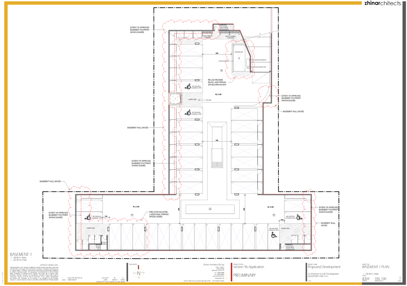
· Relocate
the planterbox location to minimize waterproofing issue to unit area;
· Lowering
of the basement level by 400mm from RL 31.085 to RL 30.685 as a result of
design refinement and to assist with providing sprinklers to the residential
levels;
· Increasing
the height of the building by 1.64m as a result of increasing the floor to
floor level from 2.915mm to 3.17mm to facilitate the provision of fire
sprinklers throughout the building and the lift overrun.
The following table provides a
comparison of approved development and proposed modification:
|
|
Approved
|
Modified
|
|
Storeys
|
5-storey Residential Flat Building
|
5-storey Residential Flat building
|
|
Maximum Building Height
|
48.575 RL
|
50.8RL
|
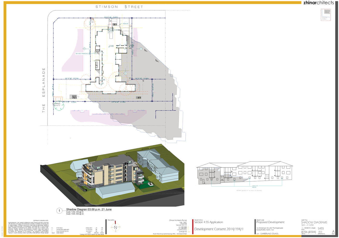
Figure
4: Approved on 16 October, 2017(Mod2014/194/2)
See
Attachment 5 to view in detail
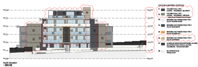
Figure
5: Proposed, Current Design (MOD2021/0076)
See
Attachment 2 to view in detail
Figure
6: Shadow Diagram, Current Application
See
Attachment 2 to view in detail
History
26 March 2014: A Pre-lodgement
Application was held to discuss construction of a 4 storey residential flat
building over one level of basement parking accommodating 30 residential units.
28 January 2015: Council approved
Development Application No. 2014/194/1 as a deferred commencement approval for
the demolition of the existing structures and construction of a five (5) storey
residential flat building accommodating thirty (30) units above a basement
parking.
26 February 2015: Council issued
an operative consent for the Development Application No. 2014/194/1 for the
demolition of the existing structures and construction of a five (5) storey
residential flat building accommodating thirty (30) units above a basement
parking.
16 October 2017: A Section 96
Modification of Development Consent No. 2014/194/2 was approved for minor
changes to the stamped approved architectural plans and Condition No. 2 of the
consent. This altered the RL to 48.575 but the overall building height
was with within the allowable 15m height restriction.
Applicants Supporting
Statement
The applicant has provided a
Statement of Environmental Effects prepared by Think Planners dated 1 March
2021 and was received by Council on 4 March 2021 in support of the application.
Contact with Relevant Parties
The assessing officer has
undertaken a site inspection of the subject site and surrounding properties and
has been in regular contact with the applicant throughout the assessment
process.
Internal Referrals
Development Engineer
The development application was
referred to Council’s Development Engineer for comment who has advised
that the development proposal is satisfactory and therefore can be supported
subject to recommended conditions of consent.
Building Surveyor
The development application was
referred to Council’s Building Surveyor for comment who has advised that
the development proposal is satisfactory and therefore can be supported subject
to recommended conditions of consent.
External Referrals
The application was not required
to be referred to any external government authorities for comment.
PLANNING COMMENTS
Section 4.55(2):
|
Requirement
|
Comments
|
|
Council is satisfied that the development to which the
consent as modified relates is substantially the same development as the
development for which the consent was originally granted and before that
consent as originally granted was modified (if at all), and
|
The development as proposed to be modified is
substantially the same as the original consent. That is, demolition and
consolidation of three (3) residential lots into one (1) lot for the
construction of a five (5) storey residential flat building accommodating
thirty (30) units over a basement car parking for thirty-four (34) vehicles
|
|
Council has consulted with the relevant Minister, public
authority or approval body (within the meaning of Division 5) in respect of a
condition imposed as a requirement of a concurrence to the consent or in
accordance with the general terms of an approval proposed to be granted by
the approval body and that Minister, authority or body has not, within 21
days after being consulted, objected to the modification of that consent, and
|
No Minister, public authority or other approval body was
required to be consulted regarding the proposed modification.
|
|
Council has notified the application in accordance with:
(i) the regulations, if the
regulations so require, or
(ii) a development control plan,
if the consent authority is a council that has made a development control
plan that requires the notification or advertising of applications for
modification of a development consent, and
|
See discussion on “Public Notification” in
this report.
|
|
Council has considered any submissions made concerning the
proposed modification within any period prescribed by the regulations or
provided by the development control plan, as the case may be.
|
See discussion on “Public Notification” in
this report.
|
|
Relevant matters referred to in Section 4.15(1) of the act
have been taken into consideration.
Council has considered the reasons given by the consent
authority for the grant of the consent that is sought to be modified.
|
Proposed modification is not contrary to the public
interest and the likely environmental impacts of the development as modified
are considered acceptable.
|
The provisions of any
Environmental Planning Instruments (EP&A Act s4.15 (1)(a)(I))
State Environmental Planning
Policies
The proposed development is
affected by the following State Environmental Planning Policies:
(a) State
Environmental Planning Policy No. 55 – Remediation of Land (SEPP 55)
The requirement at clause 7 of
SEPP 55 for Council to be satisfied that the site is suitable or can be made suitable
to accommodate the proposed development was considered under the original
application. The proposed modifications do not raise any new concerns about
potential contamination.
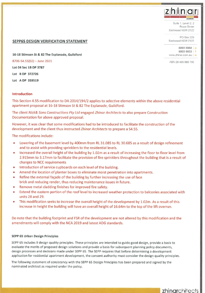
(b) Statement
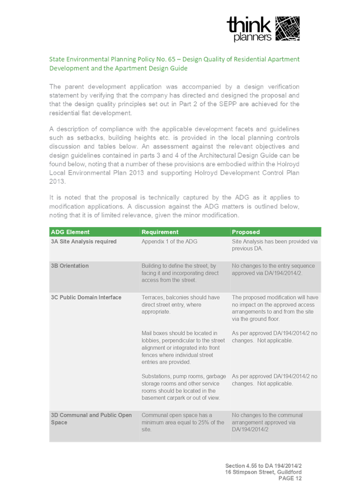
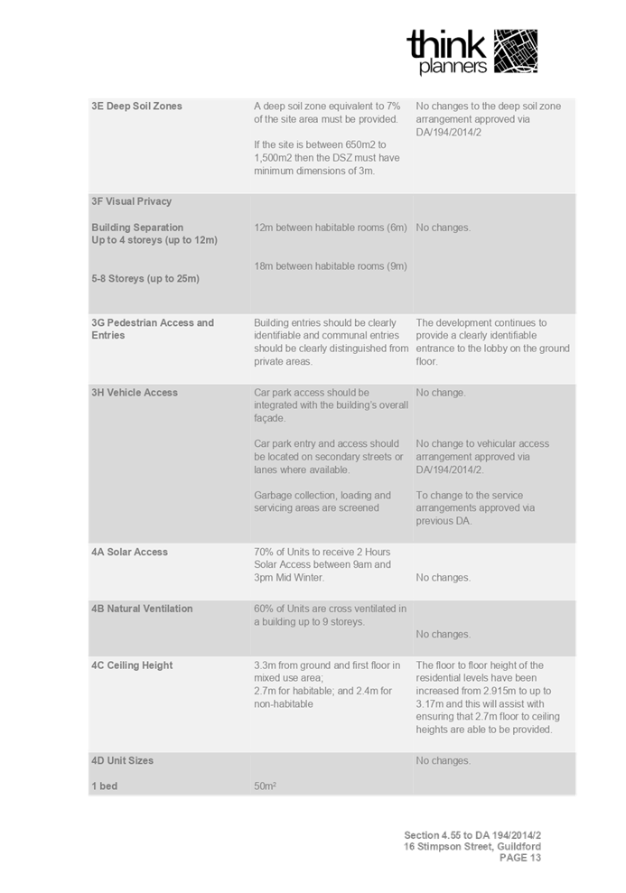
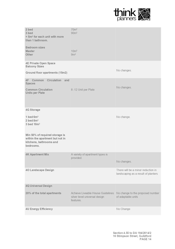
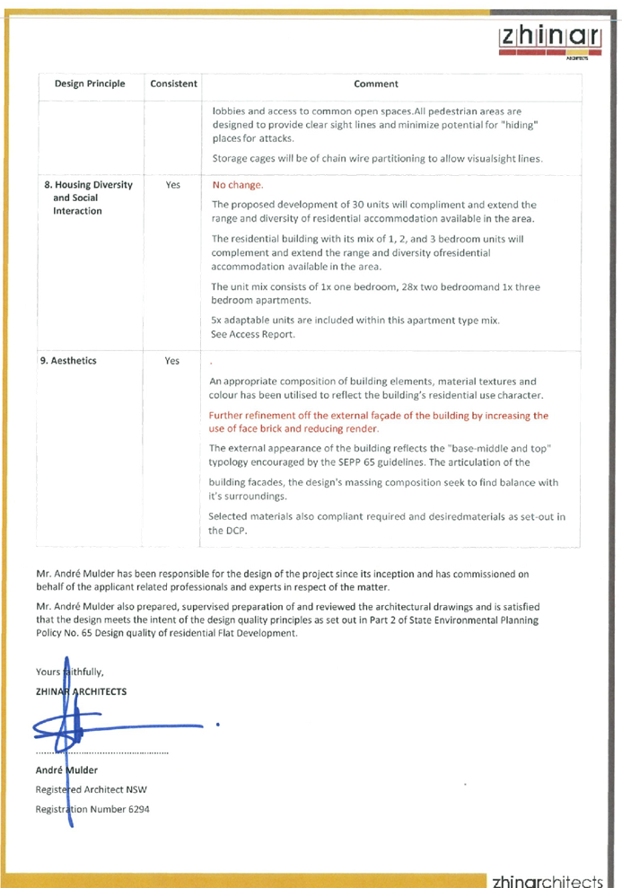
Environmental Planning Policy No. 65 - Design Quality of Residential Apartment
Development (SEPP 65)
SEPP 65 applies to the development
as the building is 3 storeys or more, and contains more than 4 dwellings. A
design statement addressing the design quality principles prescribed by SEPP 65
was prepared by the project architect. Integral to SEPP 65 is the Apartment
Design Guide (ADG), which sets benchmarks for the appearance, acceptable
impacts and residential amenity of the development. A revised design
verification statement signed by registered architect, Andre Mulder, Registered
Architect NSW, Registration No. 6294 was submitted with the s4.55(2)
application.
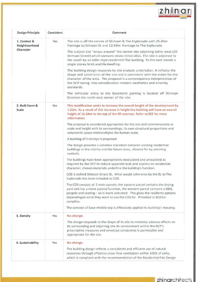
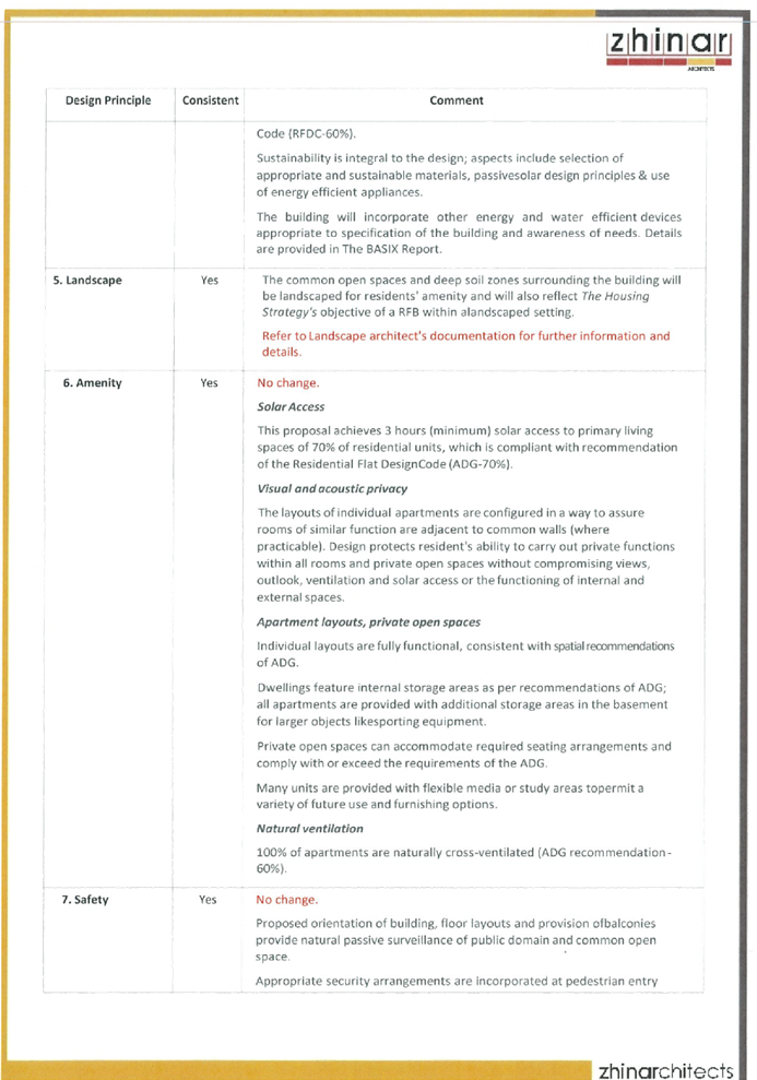
Following a detailed assessment of
the proposal against the provisions of SEPP 65 and the ADG, the proposal is
generally considered compliant and therefore performs satisfactorily. A
comprehensive assessment against SEPP 65 and the ADG is contained in Attachment
6.
(c) State
Environmental Planning Policy (Vegetation in Non-Rural Areas) 2017
The proposal does not exceed the
biodiversity offsets scheme threshold. Therefore, the proposed vegetation
removal is considered acceptable. Please refer to the DCP compliance table for
further discussion.
(d) State
Environmental Planning Policy (Infrastructure) 2007 (ISEPP)
The provisions of the ISEPP 2007
have been considered under the original assessment of the development
application.
(e) State
Environmental Planning Policy (Building Sustainability Index: BASIX) 2004
A revised BASIX certificate is not
warranted for the proposed modification.
Regional Environmental Plans
The proposed development is
affected by the following Regional Environmental Plans:
(a) Sydney
Regional Environmental Plan (Sydney Harbour Catchment) 2005
Note: Will be superseded once
Draft SEPP Environment comes into effect.
The subject site is identified as
being located within the area affected by the Sydney Regional Environmental
Plan (Sydney Harbour Catchment) 2005. The proposed development raises no issues
as no impact on the catchment is envisaged.
(Note: - the subject site is not
identified in the relevant map as ‘land within the ‘Foreshores and
Waterways Area’ or ‘Wetland Protection zone’, is not a
‘Strategic Foreshore Site’ and does not contain any heritage items.
Hence the majority of the SREP is not directly relevant to the proposed development).
Local Environmental Plans
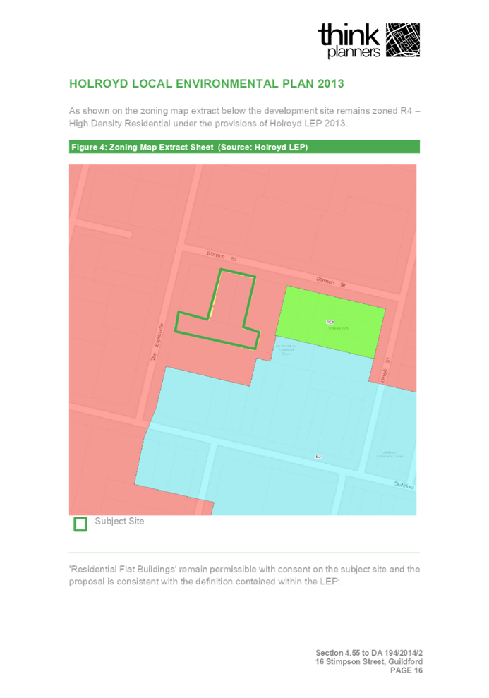
Holroyd Local Environmental
Plan 2013
The provision of the Holroyd Local
Environmental Plan 2013 is applicable to the development proposal. It is noted
that the development achieves compliance with the key statutory requirements of
the HLEP 2013 and the objectives of the High Residential Density Zoning.
(a) Permissibility:-
The proposed development is
defined as a ‘Residential Flat Building’ and is permissible in the
R4 Zone with consent.
residential flat building means a
building containing 3 or more dwellings, but does not include an attached
dwelling or multi dwelling housing.
The relevant matters to be
considered under HLEP2013 and the applicable clauses for the proposed
development are summarised below. A comprehensive LEP assessment is contained
in Attachment 7.
(b) Clause
4.3 Height of Buildings
The proposal seeks a variation to
Clause 4.3 – Height of Buildings that stipulates that the height of
buildings is not to exceed 15m on the subject site.
The modified proposal seeks the
following breaches to the maximum 12.5m building height standard:
|
Control
|
Development Standard
|
Approved DA
|
Proposed
|
% variation
|
|
Height of buildings (HLEP2013)
|
4.3 Height of Buildings
Maximum allowable
height = 15m
|
15m
|
16.64m (lift overrun)
|
10.9%
|
(c) Variation to
Building Height
It is noted that there is no
statutory requirement for a Clause 4.6 variation request to be submitted for
Section 4.55 modification applications. Nonetheless, the applicant has prepared
a Clause 4.6 variation request for the departure sought to the building height
standard (refer to Attachment 3).
Assessment of Building Height
variation
Applicant’s
justification:
The applicant requests that the
consent authority consider the request to vary the building height standard,
and grant development consent to the proposal, despite the departure from the
control, for the reasons stated below.
· The
overall height of the development presents as a compatible form of development
to the anticipated high density residential development that are emerging in
the locality, noting that the emerging character is for 5 plus storey
residential developments. The lift overrun is recessed behind the main building
alignment to downplay visual dominance as viewed from the public domain and
adjoining residential properties.
· The
proportion of the building that protrudes above the 15m height limit is largely
attributed to the lift overrun and presents with a dominant 5 storey building
design, reinforcing that the breach to the height standard does not result in
the development representing an overdevelopment of the site but rather a
suitable contextual response to the locational characteristics on the site in
order to achieve a suitable ground floor outcome with sufficient amenity for
the suites at this level.
· The
proposed development incorporates a complying floor space ratio as per the
provisions of the HLEP 2013, which will ensure that the scale of the proposed
development will be appropriate and will be visually consistent with the
permitted building height with the upper levels recessed and designed using a
lighter design style to ensure a positive streetscape presentation.
· The
additional height does not generate any additional amenity impacts given the
location of the site and the surrounding site context.
· The
proposal has been carefully designed to ensure that no adverse visual or
acoustic amenity impacts will be created by the proposed building height along
site boundaries as the upper levels are substantially recessed behind the
building perimeter.
· The
proposed articulation of the built form will ensure that the additional
building height will not be discernibly noticeable from street level.
· The
proposal provides for a better planning outcome as the same density of
apartments could be achieved in a building that is squashed into 5 levels of
development with a bigger floor plate that would be less articulated and would
be located closer to adjoining properties. Therefore, the response has been to
maximise the amenity of apartments.
· The
proposal has been designed to ensure that privacy impacts are mitigated against
and that the proposal will not obstruct existing view corridors
· The
proposal provides residential accommodation opportunities, the proposal will
strongly contribute towards revitalising the subject area, as it will increase
employment opportunities both during the construction phase and at the
completion of the proposal.
· The
proposal will provide for a number of distinct public benefits: Delivery
of additional housing within close proximity to the Employment Precinct of the
Guildford Town Centre.
- Creation of jobs during
the construction stage;
- Amenity impacts to
adjoining properties are mitigated and the distribution of additional floor
space across the site will not be discernibly different to a built form that is
compliant with the height control. The scale and intensity of the development
is appropriate noting that the proposal complies with the maximum FSR, which
demonstrate an appropriate development outcome.
As outlined above the proposal
remains consistent with the underlying objectives of the control and as such
compliance is considered unnecessary or unreasonable in the circumstances. The
above discussion demonstrates that there are sufficient environmental planning
grounds to justify the departure from the control.
Planners Comment:
The variation sought as part of
the subject application is minor. The additional height is the result of the
lift overrun and to provide a compliant floor to ceiling height which was
increased from 2.915m to 3.17m to facilitate the provision of fire sprinklers
throughout the building as per NCC requirements and the current Apartment
Design Guide (ADG) standards. As a result, the modification increases the
overall height of the building by 1.64m. This is due to the lift overrun and
the cumulative increase of floor to floor level from 2.915m to 3.17m.
The departures sought to the
building height standard are restricted to the lift overrun and roof slab and
do not include any additional habitable or additional gross floor area. The
variation is not considered to create unreasonable amenity impacts to the
adjoining properties via overshadowing or overlooking. The presentation of the
building is also not considered to be compromised by the variation to the
height control.
Council’s Building Surveyor
has confirmed that the building would require a sprinkler system and raise no
objection to the additional ceiling height. Therefore, the increase in building
height is considered acceptable in this instance.
Furthermore, the shadow diagrams
accompanying the application demonstrate that the proposal does not result in
any significant adverse impacts on surrounding properties and that the
development complies with the solar access requirements under the ADG.
It is the view of Council Officers
that justification provided is satisfactory and having considered the
application on its merit, the variation to the maximum building height
development standard is considered acceptable in this instance.
The provisions of any proposed
instrument that is or has been the subject (EP&A Act s4.15 (1)(a)(ii))
(a) Draft
State Environmental Planning Policy (Environment)
The draft SEPP relates to the
protection and management of our natural environment with the aim of
simplifying the planning rules for a number of water catchments, waterways,
urban bushland, and Willandra Lakes World Heritage Property. The changes
proposed include consolidating the following seven existing SEPPs:
· State
Environmental Planning Policy No. 19 – Bushland in Urban Areas
· State
Environmental Planning Policy (Sydney Drinking Water Catchment) 2011
· State
Environmental Planning Policy No. 50 – Canal Estate Development
· Greater
Metropolitan Regional Environmental Plan No. 2 – Georges River Catchment
· Sydney
Regional Environmental Plan No. 20 – Hawkesbury-Nepean River (No.2-1997)
· Sydney
Regional Environmental Plan (Sydney Harbour Catchment) 2005
· Willandra
Lakes Regional Environmental Plan No. 1 – World Heritage Property.
The draft policy will repeal the
above existing SEPPs and certain provisions will be transferred directly to the
new SEPP, amended and transferred, or repealed due to overlaps with other areas
of the NSW planning system.
Changes are also proposed to the
Standard Instrument – Principal Local Environmental Plan. Some provisions
of the existing policies will be transferred to new Section 117 Local Planning
Directions where appropriate.
(b) Draft
Cumberland Local Environmental Plan 2020 (Draft CLEP)
The Draft Cumberland Local Environmental
Plan 2020 (Draft CLEP) has been prepared by Cumberland Council to provide a
single planning framework for the future planning of Cumberland City. The
changes proposed seek to harmonise and repeal the three existing LEPs currently
applicable to the Cumberland local government area, those being:
· Holroyd
Local Environmental Plan 2013,
· Parramatta
Local Environmental Plan 2011, and
· Auburn
Local Environmental Plan 2010.
The current planning controls for
the subject site, as contained within the Holroyd LEP 2013, are not proposed to
change under the Draft CLEP.
The proposed development is not
affected by any relevant Draft Environmental Planning Instruments.
The provisions of any
Development Control Plans (EP&A Act s4.15 (1)(a)(iii))
The Holroyd DCP 2013 provides
guidance for the design and operation of development to achieve the aims and
objectives of the Holroyd Local Environmental Plan 2013.
A comprehensive assessment and
compliance table is contained in Attachment 8.
The proposed development complies
with the provisions of Council’s DCP and is considered acceptable from an
environmental planning view point.
The provisions of any planning
agreement that has been entered into under section 7.4, or any draft planning
agreement that a developer has offered to enter into under section 7.4
(EP&A Act s4.15(1)(a)(iiia))
There is no draft planning
agreement associated with the subject Development Application.
The provisions of the
Regulations (EP&A Act s4.15 (1)(a)(iv))
The proposed development raises no
concerns as to the relevant matters arising from the Environmental Planning and
Assessment Regulations 2000 (EP&A Reg).
The Likely Environmental,
Social or Economic Impacts (EP&A Act s4.15 (1)(b))
It is considered that the proposed
development will have no significant adverse environmental, social or economic
impacts in the locality.
The suitability of the site for
the development (EP&A Act s4.15 (1)(c))
The subject site and locality is
not known to be affected by any natural hazards or other site constraints
likely to have a significant adverse impact on the proposed development.
Accordingly, it is considered that the development is suitable in the context
of the site and surrounding locality.
Submissions made in accordance
with the Act or Regulation (EP&A Act s4.15 (1)(d))
|
Advertised (Council
website)
|
Mail
|
Sign
|
Not Required
|
In accordance with Council’s
Notification requirements contained within the Holroyd DCP 2013, the proposal
was publicly notified for a period of 21 days between 31 March 2021 and 21
April 2021. The notification generated two (2) submissions in respect of the
proposal with no submissions disclosing a political donation or gift. The
issues raised in the public submissions are summarised and commented on as
follows:
Figure
7 – Submissions summary table
|
Issue
|
Planners
Comment
|
|
1. The
submission raises concerns that the modification is seeking additional units
which would trigger on-street parking demand.
|
The modification is not seeking
to increase the number of units from what is already approved therefore the number
of units and the number of parking remain as approved.
|
|
2. The
submission raises concerns that a revised Clause 4.6 should be applicable for
the modification application because of the increase in height.
|
Planner’s comment: A
revised Clause 4.6 for a Development Standard is not required for a
modification application. However, justification is required and accordingly
the applicant has provided reasoning for the increase in height. Therefore,
this clause will not be applicable to this application. In accordance with
case law, as outlined in the Land Environment Court Case of Gann & Anor v
Sutherland Shire Council [2008] that there is power to modify a development
application where the modification would result in the breach of development
standards. The court took the view that development standards within an LEP
did not operate to prohibit the grant of consent if they were not complied
with (and no objection pursuant to SEPP No. 1 (now clause 4.6) had been
lodged). Notwithstanding, the court held that despite a SEPP No. 1 Objection
not being required, Section 96(2) (now known as cl 4.55(2)) of the
Environmental Planning and Assessment Act 1979 (The Act) still requires the
consent authority to take into consideration those matters referred to in
Section 79C (now Clause 4.15) of the Act. This case law has been applied to
Clause 4.6 of the Standard instrument (on which the HLEP 2013 is derived).
|
|
3. The
submission raises concerns that the height exceedance will have a direct
impact on the sunlight and privacy to the neighbouring property
|
The additional building height
will not be discernibly noticeable from street level, furthermore, no adverse
visual or acoustic amenity impacts will be created by the proposed building
height along site boundaries as the upper levels are substantially recessed
behind the building perimeter. Furthermore, the application has provided
revised Solar Access Plans that indicate the new shadows are not
significantly altered from what was previously approved. The proposed
development meets the underlying intent of the control and is a compatible
form of development that does not result in unreasonable environmental
amenity impacts. The proposal will not have any adverse effect on the
surrounding locality, and is consistent with the future character envisioned,
while supporting the role of Guildford as a strategic precinct.
|
The public interest (EP&A
Act s4.15(1)(e))
In view of the foregoing analysis
it is considered that the development, if carried out subject to the conditions
set out in the recommendation below, will have no significant adverse impacts
on the public interest.
Section 7.11 (Formerly S94)
Contribution Towards Provision or Improvement of Amenities or Services
This part of the Act relates to
the collection of monetary contributions from applicants for use in developing
key local infrastructure.
Cumberland Local
Infrastructure Contributions Plan 2020
The development would not require
the payment of any additional contributions in accordance with Cumberland Local
Infrastructure Contributions Plan 2020.
Disclosure of Political
Donations and Gifts
The applicant and notification
process did not result in any disclosure of Political Donations and Gifts.
The development as modified is
appropriately located within the R4 – High Density Residential zone under
the relevant provisions of the Holroyd Local Environmental Plan 2013, however
variation in relation to the additional building height sought. Having regard
to the assessment of the proposal from a merit perspective, Council may be
satisfied that the development has been responsibly designed and provides for
acceptable levels of amenity for future residents. It is considered that the
proposal successfully minimises adverse impacts on the amenity of neighbouring
properties. Hence the development, irrespective of the departures noted above,
is consistent with the intentions of Council’s planning controls and
represents a form of development contemplated by the relevant statutory and
non-statutory controls applying to the land.
For these reasons, it is
considered that the proposal is satisfactory having regard to the matters of
consideration under Section 4.15 and 4.55 of the Environmental Planning and
Assessment Act 1979, and the modified development may be approved subject to
conditions.
For these reasons, it is
considered that the proposal is satisfactory having regard to the matters of
consideration under Section 4.15 and 4.55 of the Environmental Planning and
Assessment Act 1979, and the modified development may be approved subject to
conditions.
|
1. That
Modification Application No. MOD2021/0076 for Section 4.55(2) application for
various modifications to the approved residential flat building including
amendments to external finishes and floor levels and increase in building
height on land at 16 -18 Stimson Street GUILDFORD NSW 2161 be
approved subject to attached.
2. Persons
whom have lodged a submission in respect to the application be notified of
the determination of the application.
|
1. Draft Notice
of Determination
2. Architectural
Plans
3. Statement
of Environmental Effects
4. Design
Verification Statement
5. Previous
Approved Plans
6. SEPP
65 Design Quality of Residential Apartment Development Assessment
7. Holroyd
LEP Compliance Table
8. Holroyd
DCP Compliance Table
9. Submissions
Recieved
DOCUMENTS
ASSOCIATED WITH
REPORT LPP029/21
Attachment 1
Draft Notice of Determination
Cumberland Local Planning Panel Meeting
14 July 2021
DOCUMENTS
ASSOCIATED WITH
REPORT LPP029/21
Attachment 2
Architectural Plans
Cumberland Local Planning Panel Meeting
14 July 2021
DOCUMENTS
ASSOCIATED WITH
REPORT LPP029/21
Attachment 3
Statement of Environmental Effects
Cumberland Local Planning Panel Meeting
14 July 2021


DOCUMENTS
ASSOCIATED WITH
REPORT LPP029/21
Attachment 4
Design Verification Statement
Cumberland Local Planning Panel Meeting
14 July 2021
DOCUMENTS
ASSOCIATED WITH
REPORT LPP029/21
Attachment 5
Previous Approved Plans
Cumberland Local Planning Panel Meeting
14 July 2021
DOCUMENTS
ASSOCIATED WITH
REPORT LPP029/21
Attachment 6
SEPP 65 Design Quality of Residential Apartment
Development Assessment
Cumberland Local Planning Panel Meeting
14 July 2021

DOCUMENTS
ASSOCIATED WITH
REPORT LPP029/21
Attachment 7
Holroyd LEP Compliance Table
Cumberland Local Planning Panel Meeting
14 July 2021
DOCUMENTS
ASSOCIATED WITH
REPORT LPP029/21
Attachment 8
Holroyd DCP Compliance Table
Cumberland Local Planning Panel Meeting
14 July 2021
DOCUMENTS
ASSOCIATED WITH
REPORT LPP029/21
Attachment 9
Submissions Recieved
Cumberland Local Planning Panel Meeting
14 July 2021
Cumberland
Local Planning Panel Meeting
14 July 2021
Item No: LPP030/21
Development
Application for 217 Great Western Highway, Mays Hill
Responsible
Division: Environment
& Planning
Officer: Executive
Manager Development and Building
File
Number: DA2021/0115
|
Application
lodged
|
1 April 2021
|
|
Applicant
|
Miletic-Mieler Development
Consultants Pty Ltd
|
|
Owner
|
The Saiva Manram
|
|
Application
No.
|
DA2021/0115
|
|
Description
of Land
|
217 Great Western Highway,
Mays Hill NSW 2145
Lot 1 DP 870186
|
|
Proposed
Development
|
Alterations and additions to
convert existing lower ground storage area into a dining hall associated with
the existing place of public worship, new entrance structures,
reconfiguration of parking spaces and associated site works
|
|
Site
Area
|
1.17 hectares (11,700m2)
|
|
Zoning
|
B6 – Enterprise Corridor
|
|
Disclosure
of political donations and gifts
|
Nil disclosure
|
|
Heritage
|
The subject site does not
contain a heritage item and is not located within the vicinity of the
heritage item or heritage conservation area.
|
|
Principal
Development Standards
|
Floor Space Ratio
Permissible: Maximum 1:1
Proposed: The proposal does
not result in any additional GFA.
Height of Building
Permissible: Maximum 15m
Proposed: Maximum 5.1m
|
|
Issues
|
Submissions received
|
1. Development
Application No. DA2021/0115 was received on 1 April 2021 for alterations and
additions to convert existing lower ground storage area into a dining hall
associated with the existing place of public worship, new entrance structures,
reconfiguration of parking spaces and associated site works.
2. The
application was publicly notified to occupants and owners of the adjoining
properties, published online on Council’s website and a site notice
placed at the property, for a period of 21 days between 9 April 2021 and 30
April 2021.
A further two-week extension of
time was granted until 14 May 2021 to lodge submissions with respect to the
proposal.
A total of sixteen (16) unique
submissions were received in response to the proposed development.
3. The
application is referred to the Cumberland Local Planning Panel (CLPP) for
determination as the matter is considered to be contentious.
4. It
is recommended that the application be approved subject to conditions provided
in the Draft Notice of Determination at Attachment 1.
Subject Site and Surrounding
Area
The subject site is legally
identified as Lot 1 in DP 870186 and is known as 217 Great Western Highway,
Mays Hill. The subject site has an approximate total site area of 1.17 hectares
(11,700m2).
The subject site is situated on
the southern side of Great Western Highway and western side of Belinda Place,
and directly adjoins the M4 Motorway on its southern boundary. The properties
to the north and east of the subject site predominantly consist of residential
dwellings that are transitioning into high density development noting the
zoning of the properties are B6 Enterprise Corridor along the Great Western
Highway, and R4 High Density Residential on the eastern side of Belinda Place.
The subject site is situated
within the Mays Hill Transitway Precinct, as identified in Holroyd Development
Control Plan 2013, and is zoned B6 Enterprise Corridor pursuant to Holroyd
Local Environmental Plan 2013.
The subject site is currently
occupied by the existing Murugan Temple on land known as 217 Great Western
Highway, Mays Hill.
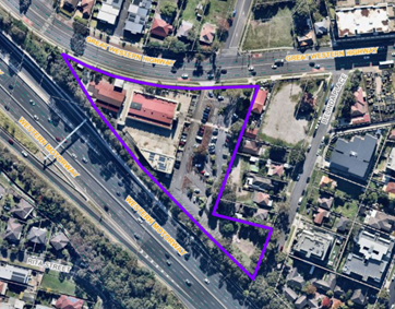
Figure
1 – Aerial image of subject site outlined in purple
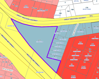
Figure
2 – Zoning Map. Subject site indicated in purple outline.
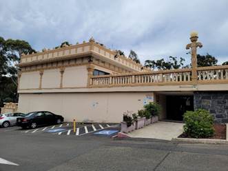
Figure
3 – Site Photo showing existing entry to lower ground level.
Figure
4 – Site Photo showing existing entry to lower ground level (left).
Proposed windows and new entry located to the right of the existing entry in
location of existing car parking spaces.
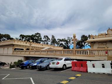
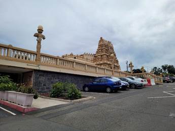
Figure
5 – Site Photo showing eastern elevation of subject proposal.
Description of the Proposed
Development
Council has received a development
application for the following:
· Alterations
and additions to convert an existing lower ground storage area (269m²)
into a dining hall associated with the existing place of public worship.
· New
entry and openings to the eastern elevation of the lower ground level and
replace existing internal door with fixed window adjacent to existing entry.
· Concrete
roof over both the existing and new entries to the lower ground level and decorative
1.2m balustrade to match existing podium level.
· Removal
of existing garden bed, reconfiguration of existing car spaces in western
parking bay adjacent to the proposed dining hall (net reduction of 1 car space)
and associated site works.
The existing lower ground storage
area is adjacent to an existing kitchen servery and amenities. The conversion
of the existing lower ground storage area does not result in additional gross
floor area.
The new dining hall is proposed to
be used by volunteers and devotees associated with the existing place of public
worship. The maximum capacity of the proposed dining hall is 100 people.
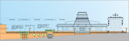
Figure
6 – Eastern elevation plan showing proposed development (Extract from
Drawing No. A2.005, Rev 4, prepared by JEYA Architects, dated 19/12/2020)
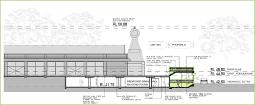
Figure
7 – Section plan showing proposed development (Extract from Drawing No.
A2.006, Rev 4, prepared by JEYA Architects, dated 04/01/2021)
Background
The following recent applications
at the subject site are of relevance to the proposed development:
DA2016/392/1 - 217 Great
Western Highway and 3-9 Belinda Place, Mays Hill
Development Consent No. 2016/392
was approved by Sydney West Central Planning Panel on 13 September 2017 for
consolidation of 5 lots into 1 lot, part demolition of existing structures, new
access driveway off Belinda Place, construction of a part 2, part 3 storey
community facility over 3 levels of basement car parking accommodating 197
parking spaces, a dining hall and an auditorium (meeting hall) accommodating a maximum
of 800 patrons, multi-purpose halls to be used in association with an existing
place of public worship at 217 Great Western Highway and 3-9 Belinda Place,
Mays Hill.
· DA2016/392/1 is a
valid development consent, however no works have commenced under the consent.
DA2019/371/1 – 217 Great
Western Highway, Mays Hill
Development Consent No. 2019/371/1
was issued by Council on 10 February 2020 for construction of a detached garage
to house a timber chariot associated with an existing place of worship and
associated site works, including alterations to the openings of the cultural
hall and construction of walls.
DA2020/0018 – 217 Great
Western Highway & 7-9 Belinda Place, Mays Hill
Deferred Commencement Development
Consent No. 2020/0018 was approved by the Sydney City Central Planning Panel on
22 December 2020 for demolition of existing structures, tree removal and
construction of a multi storey car park in association with the existing place
of public worship (Murugan Temple) including consolidation of 3 lots into 1
lot, and associated site works.
Application History
|
Date
|
Action
|
|
1 April 2021
|
Development Application 2021/0115 lodged with Council.
|
|
1 April 2021
|
The application was referred to Council’s internal
departments for review.
|
|
9 April to 30 April 2021
|
The application was
publicly notified to occupants and owners of the adjoining properties,
published online on Council’s website and a site notice placed at the
property, for a period of 21 days between 9
April 2021 and 30
April 2021.
A further two-week extension of
time was granted until 14 May 2021 to lodge submissions with respect to the
proposal.
A total of sixteen
(16) unique submissions were received in response to the proposed
development.
|
|
14 July 2021
|
Application referred to CLPP for determination.
|
Applicants Supporting
Statement
The applicant has provided a
Statement of Environmental Effects prepared by Miletic-Mieler Development
Consultants Pty Ltd dated February 2021 in support of the application.
Contact with Relevant
Parties
The assessing officer has
undertaken a site inspection of the subject site and surrounding properties and
has been in regular contact with the applicant throughout the assessment
process.
Internal Referrals
Development Engineer
The development application was
referred to Council’s Development Engineer for comment who has advised
that the development is satisfactory with respect to stormwater and parking,
and therefore can be supported subject to recommended conditions of consent.
Environmental Health Officer
The development application was
referred to Council’s Environmental Health Officer for comment who has
advised that the development proposal is satisfactory with respect to noise and
environmental impacts during construction works, and therefore can be supported
subject to recommended conditions of consent.
PLANNING COMMENTS
The provisions of any
Environmental Planning Instruments (EP&A Act s4.15 (1)(a)(i))
State Environmental Planning
Policies
The proposed development is
affected by the following State Environmental Planning Policies:
(a) State
Environmental Planning Policy No. 55 – Remediation of Land (SEPP 55)
Clause 7 of SEPP 55 requires
Council to be satisfied that the site is suitable or can be made suitable to
accommodate the proposed development. The matters listed within Clause 7 have
been considered in the assessment of the development application.
|
Matter for
Consideration
|
Yes/No
|
|
Does the application
involve re-development of the site or a change of land use?
|
Yes
No
|
|
In the development
going to be used for a sensitive land use?
|
Yes
No
|
|
Does information available to you indicate that an
activity listed below has ever been approved, or occurred at the site?
acid/alkali plant and
formulation, agricultural/horticultural activities, airports, asbestos
production and disposal, chemicals manufacture and formulation, defence
works, drum re-conditioning works, dry cleaning establishments, electrical
manufacturing (transformers), electroplating and heat treatment premises,
engine works, explosive industry, gas works, iron and steel works, landfill
sites, metal treatment, mining and extractive industries, oil production and
storage, paint formulation and manufacture, pesticide manufacture and
formulation, power stations, railway yards, scrap yards, service stations,
sheep and cattle dips, smelting and refining, tanning and associated trades,
waste storage and treatment, wood preservation
|
Yes
No
|
|
Is the site listed on
Council’s Contaminated Land database?
|
Yes
No
|
|
Is the site subject to EPA
clean-up order or other EPA restrictions?
|
Yes
No
|
|
Has the site been the subject of
known pollution incidents or illegal dumping?
|
Yes
No
|
|
Does the site adjoin any
contaminated land/previously contaminated land?
|
Yes
No
|
|
Has the appropriate level of
investigation been carried out in respect of contamination matters for
Council to be satisfied that the site is suitable to accommodate the proposed
development or can be made suitable to accommodate the proposed development?
|
Yes
No
|
|
Details of contamination investigations carried out at the
site:
The
site is not identified in Council’s records as being contaminated. A
site inspection reveals the site does not have any obvious history of a previous
land use that may have caused contamination and there is no specific evidence
that indicates the site is contaminated. The proposed development is for the
conversion of an existing storage area within the lower ground level to the
dining hall and contamination is not expected.
|
(b) State
Environmental Planning Policy (Infrastructure) 2007 (ISEPP)
The provisions of the ISEPP 2007
have been considered in the assessment of the development application.
Clause 101 – Frontage to
classified road
The application is subject to
Clause 101 of the ISEPP as the site has frontage to a classified road, being
the Great Western Highway. The proposed development is for the conversion of
the existing lower ground storage are to a dining hall and does not seek
changes to the existing vehicular access to the site from the Great Western
Highway. In this regard, the traffic impacts on the safety, efficiency and
ongoing operation of the Great Western Highway are not considered to be
adversely affected by the proposal.
Clause 104 –
Traffic-generating development
The proposal is not identified as
development specified in Column 1 of the Table to Schedule 3, and as such does
not require referral to Transport for NSW.
Regional Environmental Plans
The proposed development is
affected by the following Regional Environmental Plans:
(a) Sydney
Regional Environmental Plan (Sydney Harbour Catchment) 2005
The subject site is identified as
being located within the area affected by the Sydney Regional Environmental
Plan (Sydney Harbour Catchment) 2005. The proposed development raises no issues
as no impact on the catchment is envisaged.
(Note: - the subject site is not
identified in the relevant map as ‘land within the ‘Foreshores and
Waterways Area’ or ‘Wetland Protection zone’, is not a
‘Strategic Foreshore Site’ and does not contain any heritage items.
Hence the majority of the SREP is not directly relevant to the proposed
development).
Local Environmental Plans
Holroyd Local Environmental
Plan 2013
The provision of the Holroyd LEP
2013 is applicable to the development proposal. It is noted that the
development achieves compliance with the key statutory requirements of the
Holroyd LEP 2013 and the objectives of the B6 Enterprise Corridor zone.
(a) Permissibility:
-
The subject site operates as a
‘place of public worship’ and is a permissible land use in the B6
Enterprise Corridor zone.
The proposed dining hall is
ancillary to the approved place of public worship.
‘Place of public
worship’ is defined as:
place of public worship means a
building or place used for the purpose of religious worship by a congregation
or religious group, whether or not the building or place is also used for
counselling, social events, instruction or religious training.
A comprehensive assessment and
compliance table is attached to this report in Attachment 2 which demonstrates
the development’s compliance with the relevant planning controls that are
applicable to the site under Holroyd LEP 2013.
An assessment of the proposed
development against the principal development standards is summarised below.
|
Holroyd Local
Environmental Plan 2013
|
|
No.
|
Required/Permitted
|
Comment
|
Comply
|
|
Part 4 Principal
Development Standards
|
|
1.
|
Height of Buildings
Max. 15m
|
The proposed balustrade over the proposed entry has a
maximum building height of 5.1m.
|
Yes
|
|
2.
|
Floor Space Ratio
Max. 1:1
|
The proposal does not result in any additional GFA.
|
Yes
|
|
3.
|
Exceptions to Development Standards
|
Not Applicable.
|
N/A
|
The provisions of any proposed
instrument that is or has been the subject (EP&A Act s4.15 (1)(a)(ii))
(a) Draft
State Environmental Planning Policy (Environment)
The draft SEPP relates to the
protection and management of our natural environment with the aim of
simplifying the planning rules for a number of water catchments, waterways,
urban bushland, and Willandra Lakes World Heritage Property. The changes
proposed include consolidating the following seven existing SEPPs:
· State
Environmental Planning Policy No. 19 – Bushland in Urban Areas
· State
Environmental Planning Policy (Sydney Drinking Water Catchment) 2011
· State
Environmental Planning Policy No. 50 – Canal Estate Development
· Greater
Metropolitan Regional Environmental Plan No. 2 – Georges River Catchment
· Sydney
Regional Environmental Plan No. 20 – Hawkesbury-Nepean River (No.2-1997)
· Sydney
Regional Environmental Plan (Sydney Harbour Catchment) 2005
· Willandra
Lakes Regional Environmental Plan No. 1 – World Heritage Property.
The draft policy will repeal the
above existing SEPPs and certain provisions will be transferred directly to the
new SEPP, amended and transferred, or repealed due to overlaps with other areas
of the NSW planning system.
Changes are also proposed to the
Standard Instrument – Principal Local Environmental Plan. Some provisions
of the existing policies will be transferred to new Section 117 Local Planning
Directions where appropriate.
(b) Draft
Cumberland Local Environmental Plan (Draft CLEP)
The Draft Cumberland Local
Environmental Plan (Draft CLEP) has been prepared by Cumberland Council to
provide a single planning framework for the future planning of Cumberland City.
The changes proposed seek to harmonise and repeal the three existing LEPs
currently applicable to the Cumberland local government area, those being:
· Holroyd
Local Environmental Plan 2013,
· Parramatta
Local Environmental Plan 2011, and
· Auburn
Local Environmental Plan 2010.
The current planning controls for
the subject site, as contained within HLEP 2013 are not proposed to change
under the Draft CLEP. A B6 land use zone is maintained for the site under the
Draft CLEP as is a maximum building height of 15 metres and maximum floor space
ratio of 1.1.
The provisions of any
Development Control Plans (EP&A Act s4.15 (1)(a)(iii))
The Holroyd DCP 2013 (HDCP 2013)
provides guidance for the design and operation of development to achieve the
aims and objectives of the HLEP 2013.
The proposed development is
generally compliant with the relevant provisions. The net loss of one (1) car
parking space will be accounted for elsewhere within the site as demonstrated
in the table below.
|
PART A – GENERAL CONTROLS
|
|
3
|
Car Parking
|
|
3.1
|
Minimum Parking Spaces
|
|
Car
Parking – Place of Public Worship
Minimum spaces required:
· 1
per 8.5m2 of GFA
|
The existing
at-grade car park contains 114 car parking spaces.
The proposal does
not result in any additional GFA. In this regard no additional car parking is
required for the proposed dining hall.
It is noted that
the reconfiguration of the existing car parking spaces adjacent to the
existing and proposed building entries to the lower ground level will result
in the loss of 1 car parking space. Conditions are imposed requiring that the
1 car parking space be provided elsewhere within the subject site. The site
can accommodate the extra parking space.
|
A comprehensive assessment and
compliance table is contained in Attachment 3 which demonstrates the
proposal’s compliance with the relevant planning controls applicable to
the site.
The provisions of any planning
agreement that has been entered into under section 7.4, or any draft planning
agreement that a developer has offered to enter into under section 7.4
(EP&A Act s4.15(1)(a)(iiia))
There is no draft planning
agreement associated with the subject Development Application.
The Likely Environmental,
Social or Economic Impacts (EP&A Act s4.15 (1)(b))
It is considered that the proposed
development will have no significant adverse environmental, social or economic
impacts in the locality.
The suitability of the site for
the development (EP&A Act s4.15 (1)(c))
The subject site and locality is
not known to be affected by any natural hazards or other site constraints
likely to have a significant adverse impact on the proposed development.
Accordingly, it is considered that the development is suitable in the context
of the site and surrounding locality.
Submissions made in accordance
with the Act or Regulation (EP&A Act s4.15 (1)(d))
|
Advertised (Council website)
|
Mail
|
Sign
|
Not Required
|
In accordance with Council’s
Notification requirements contained within Holroyd DCP 2013, the proposal was
publicly notified for a period of 21 days between 9 April 2021 and 30 April
2021. The notification generated sixteen (16) unique submissions in respect of
the proposal with nil disclosing a political donation or gift. The issues
raised in the public submissions are summarised and commented on as follows:
Figure
8 – Submissions summary table
|
|
Concern
|
Comment
|
|
1
|
DA2016/392 approved a cultural hall, dining area and the
associated works that satisfy the needs of the community and is not an
overdevelopment of the site. The approved development under DA2016/392 is
less intrusive in its location that is both affordable and deliverable and
maintains the existing above ground OSD.
|
DA2016/392/1 approval was granted by the Sydney West
Central Planning Panel on 13 September 2017 for consolidation of 5 lots into
1 lot, part demolition of existing structures, new access driveway off
Belinda Place, construction of a part 2, part 3 storey community facility
over 3 levels of basement car parking accommodating 197 parking spaces, a
dining hall and an auditorium (meeting hall) accommodating a maximum of 800
patrons, multi-purpose halls to be used in association with an existing place
of public worship at 217 Great Western Highway and 3-9 Belinda Place, Mays
Hill.
DA2016/392/1 is an active consent and it is open to the
owners of the premises to activate the consent prior to its expiration.
|
|
2
|
It is unclear why the multi storey car park was approved
under DA2020/0018 when there is an existing approval (DA2016/392) for a
community hall and dining hall that formalises all future needs of the
existing place of public worship.
|
On 22 December 2020, DA2020/0018 deferred commencement
approval was granted by the Sydney City Central Planning Panel for demolition
of existing structures, tree removal and construction of a multi storey car
park in association with the existing place of public worship (Murugan
Temple) including consolidation of 3 lots into 1 lot, and associated site
works.
DA2020/0018 is yet to become an operative consent.
|
|
3
|
The existing lower ground storage area is non-habitable
and should not be converted to a dining hall.
Floor to ceiling height of the dining hall does not comply
with the BCA.
|
The existing lower ground storage has a 2.4m floor to
ceiling height measured to the bulkhead, and 2.315m floor to ceiling height
measured to the plasterboard ceiling.
Conditions are imposed requiring the dining hall room
height to comply with Part F3 of the NCC. This matter will be addressed as
part of the Construction Certificate application.
|
|
4
|
The design proposed is inconsistent/not in harmony with
the façade and design principles of the existing temple.
|
The built form of the proposal incorporates key
architectural design features of the temple and is considered to be in
keeping with the existing temple buildings. Windows are proposed along the
eastern elevation to provide natural light to the proposed dining hall.
|
|
5
|
The additional entry proposed is not required for access
and egress.
|
The proposed entry provides additional access to improve
access and egress to the lower ground level and dining hall.
|
|
6
|
A minimum 1:14 grade ramp is required with balustrade and
handrails for DDA compliance for the proposed entry ramp.
|
Stainless steel handrails are provided to the proposed
access ramp and will be fixed to the side wall. Conditions are imposed
requiring compliance with the BCA and Disability Discrimination Act 1992.
|
|
7
|
There is no DDA compliant access to the servery from the
proposed dining hall.
|
The access between the existing servery and proposed
dining hall is an operational matter. Conditions are imposed requiring DDA
compliance as part of the construction certificate for the dining hall.
|
|
8
|
Unauthorised demolition of the storage space hall wall
that separated the approved kitchen has not been addressed. Safety concerns
raised regarding structural adequacy and load.
|
There is evidence to suggest that the existing storage
room contained a southern wall along the corridor previously. The
unauthorised demolition of the referenced wall has been reported to
Council’s Compliance Section for investigation and action.
The proposal includes the removal of the southern wall
referred to above. A certificate of structural adequacy is required to be
prepared and signed by a qualified practising structural engineer in respect
to the load carrying capabilities of the existing structure to support the
proposed dining hall area as part of the construction certificate
application.
|
|
9
|
The maximum capacity of the dining hall and frequency of
use is not outlined.
The 100 person limit for the dining hall is inadequate for
functions and should accommodate 250 people.
How will catering and dining activity or special training
for staff be managed?
|
The proposed conversion of the existing storage room to a
dining hall is for volunteers and devotees associated with the existing place
of public worship.
The applicant has outlined that no change to or
intensification of the current temple uses on site are proposed.
In accordance with the submitted BCA Review prepared by
Philip Chun, dated 18 January 2021, the maximum number of people which can be
accommodated within the dining hall is 100 people. Conditions of consent are
imposed restricting the maximum number of people within the dining at any one
time as 100 people.
|
|
10
|
There is no car parking proposed for the new dining hall.
There is inadequate on-site car parking currently and The
Saiva Manram has requested an extension from Council to use the temporary
overflow car park at 1A Belinda Place & 197 Great Western Highway.
A traffic management plan has not been submitted.
|
The proposed dining hall is in the location of the
existing storage room. As there is no additional gross floor area proposed as
part of the subject application, this proposal does not require additional
car parking spaces to be provided on site.
The existing at-grade car park contains 114 car parking
spaces.
It is noted that the reconfiguration of the existing car
parking spaces adjacent to the existing and proposed building entries to the
lower ground level will result in the loss of 1 car parking space. Conditions
are imposed requiring that the 1 car parking space be provided elsewhere
within the subject site.
|
|
11
|
Where will the storage area be moved to with the proposed
conversion of the existing storage to dining hall?
|
Relocation of the existing storage area is not proposed as
part this application.
|
|
12
|
The application was not referred to TfNSW.
|
The proposed development does not require referral to
TfNSW in accordance with SEPP (Infrastructure) 2007 or the Roads Act 1993.
|
|
13
|
The directors listed on The Saiva Manram (TSM)
authorisation letter to lodged DA2021/0115 is incorrect.
|
Information submitted at the time of lodgement with
respect to owner’s consent for 217 Great Western Highway, Mays Hill is
consistent with information on Council’s records.
|
|
14
|
Documents for DA2021/0115 were not available on the
Council website during the notification period and only an extension of 2
weeks was provided to lodge a submission.
Exhibition dates were not changed on Council’s
website reflecting the extension of time.
|
The application was publicly notified to occupants and
owners of the adjoining properties, published online on Council’s
website and a site notice placed at the property, for a period of 21 days
between 9 April 2021 and 30 April 2021.
On 29 April 2021, Council was advised that documents and
plans submitted as part of DA2021/0115 were not available on Council’s
website for viewing. This matter was rectified, and Council’s website
was updated to show all documents and plans on 30 April 2021. Due to the technical
issues encountered, a two-week extension of time was granted until 14 May
2021 to lodge submissions with respect to the proposal.
|
The public interest (EP&A
Act s4.15(1)(e))
In view of the foregoing analysis
it is considered that the development, if carried out subject to the conditions
set out in the recommendation below, will have no significant adverse impacts
on the public interest.
Cumberland Local
Infrastructure Contributions Plan 2020
The development would not require
the payment of contributions in accordance with Cumberland Local Infrastructure
Contributions Plan 2020.
Disclosure of Political
Donations and Gifts
The applicant and notification
process did not result in any disclosure of Political Donations and Gifts.
The development application has
been assessed in accordance with the relevant requirements of the Environmental
Planning and Assessment Act 1979, SEPP55, ISEPP, SREP 2005, Draft Environment
SEPP, Draft CLEP, HLEP 2013 and the HDCP 2013 and is considered to be satisfactory
for approval, subject to the imposition of recommended draft conditions.
|
1. That
Development Application No. DA2021/0115 for alterations and additions to
convert existing lower ground storage area into a dining hall associated with
the existing place of public worship, new entrance structures,
reconfiguration of parking spaces and associated site works on land at 217
Great Western Highway, Mays Hill; be approved subject to attached conditions.
2. Persons
who have lodged a submission in respect to the application be notified of the
determination of the application.
|
1. Draft Notice
of Determination
2. Holroyd
Local Environmental Plan 2013 Compliance Table
3. Holroyd
Development Control Plan 2013 Compliance Table
4. Architectural
Plans
5. Stormwater
Plan
6. Submissions
Received
DOCUMENTS
ASSOCIATED WITH
REPORT LPP030/21
Attachment 1
Draft Notice of Determination
Cumberland Local Planning Panel Meeting
14 July 2021
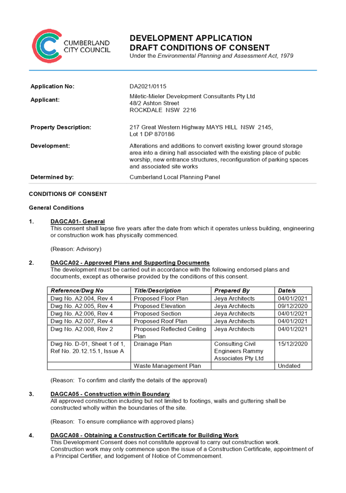

DOCUMENTS
ASSOCIATED WITH
REPORT LPP030/21
Attachment 2
Holroyd Local Environmental Plan 2013 Compliance Table
Cumberland Local Planning Panel Meeting
14 July 2021
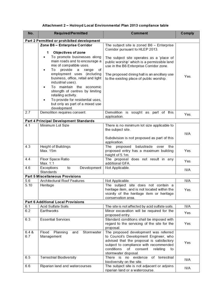

DOCUMENTS
ASSOCIATED WITH
REPORT LPP030/21
Attachment 3
Holroyd Development Control Plan 2013 Compliance Table
Cumberland Local Planning Panel Meeting
14 July 2021
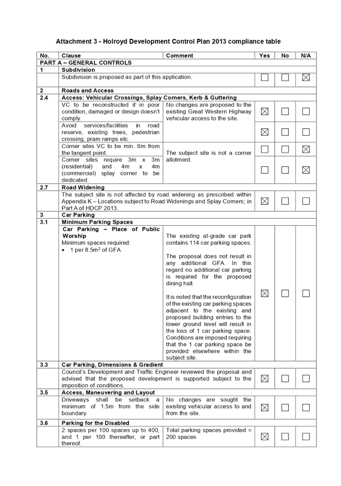
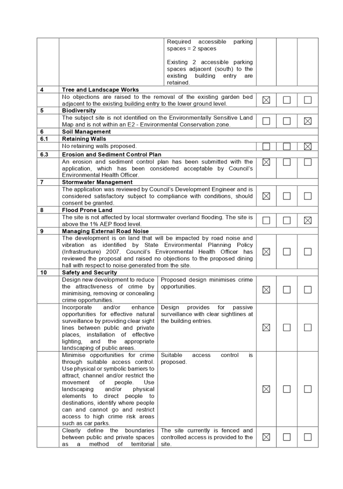
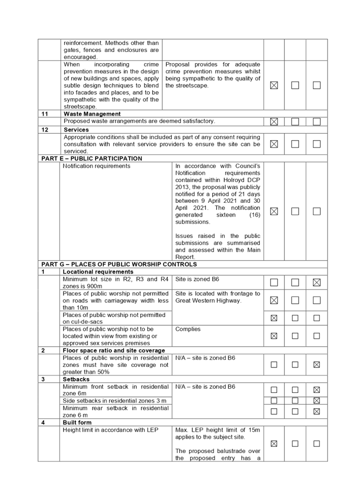
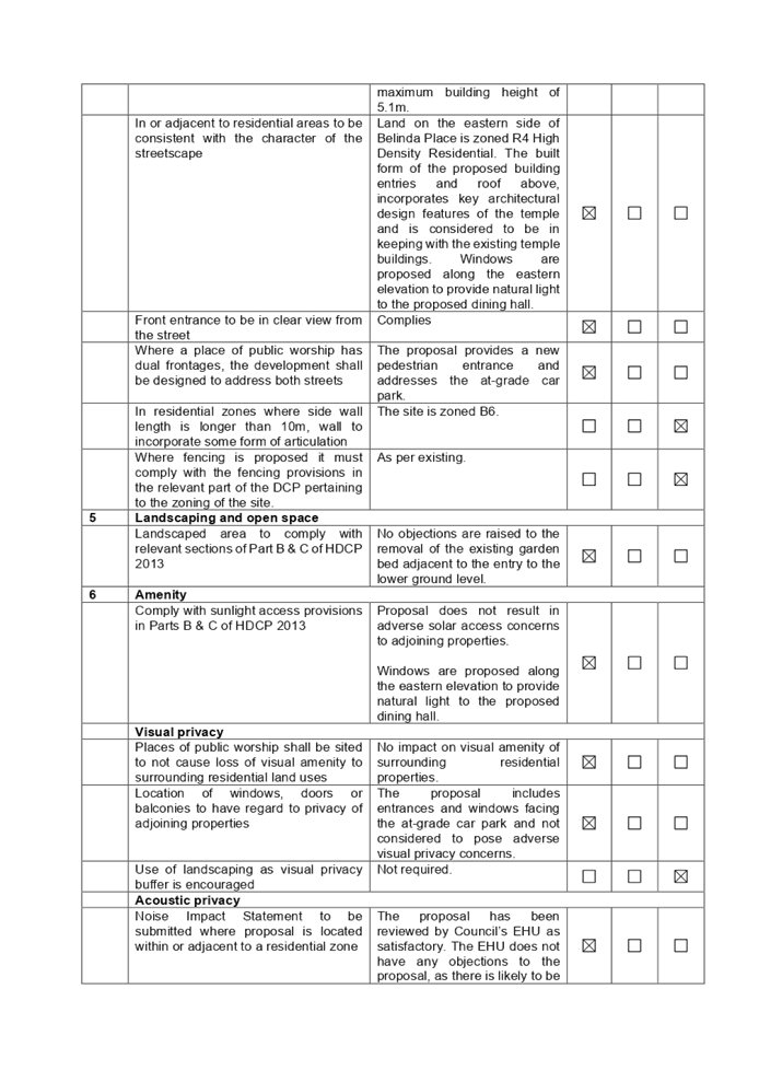
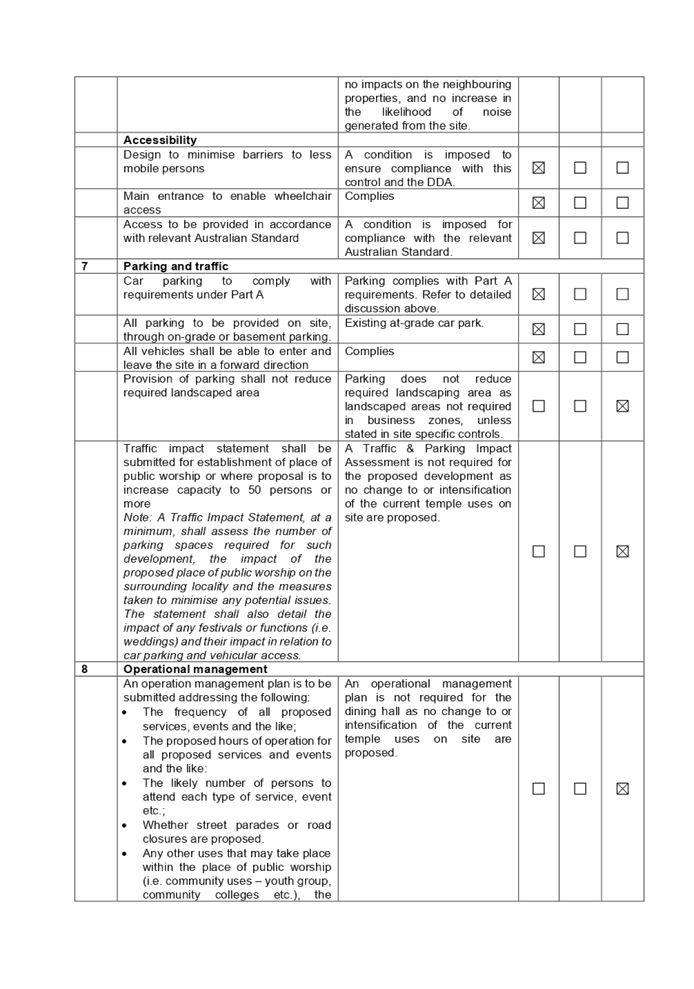

DOCUMENTS
ASSOCIATED WITH
REPORT LPP030/21
Attachment 4
Architectural Plans
Cumberland Local Planning Panel Meeting
14 July 2021
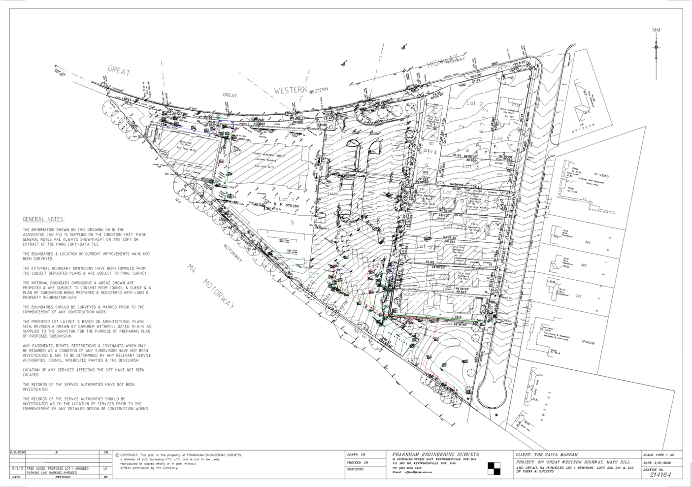
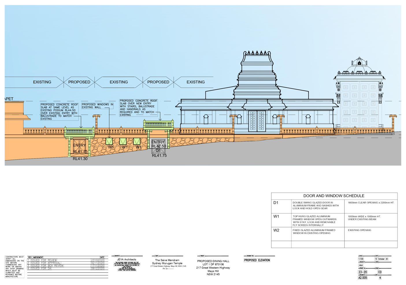
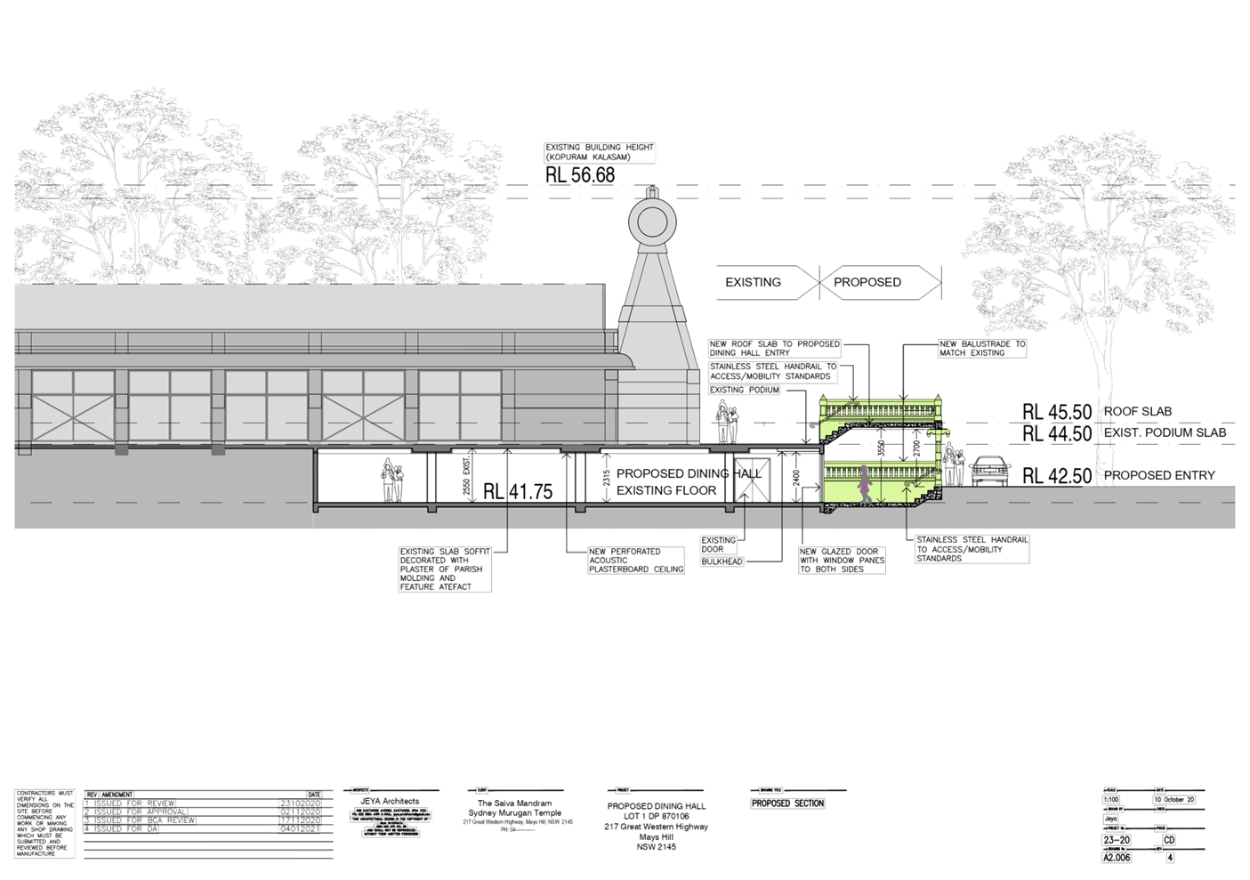
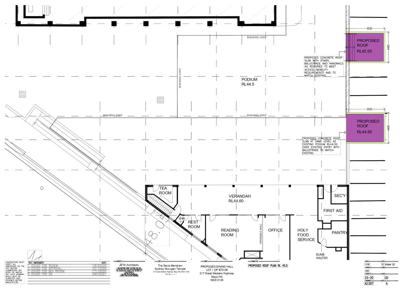
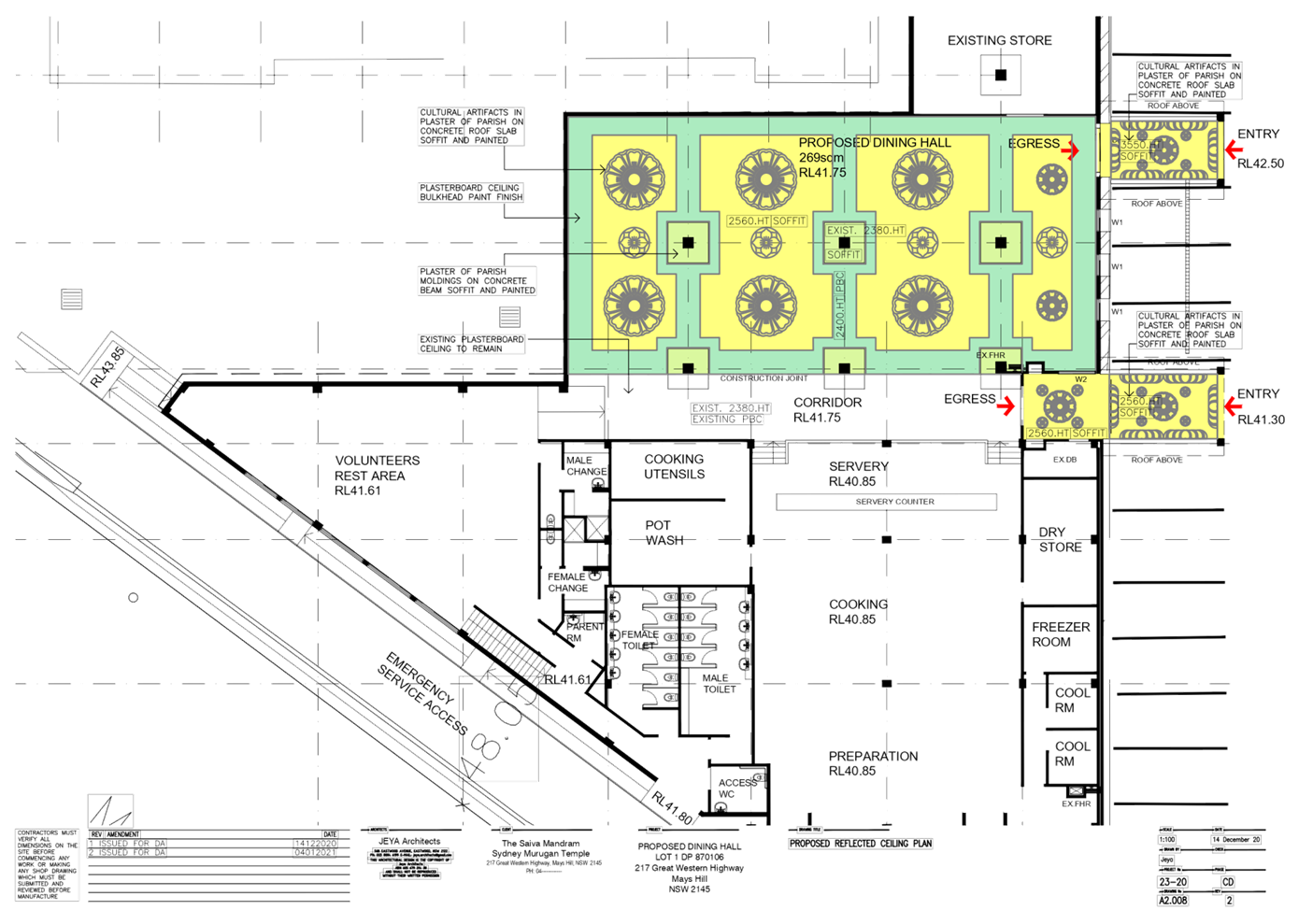
DOCUMENTS
ASSOCIATED WITH
REPORT LPP030/21
Attachment 5
Stormwater Plan
Cumberland Local Planning Panel Meeting
14 July 2021
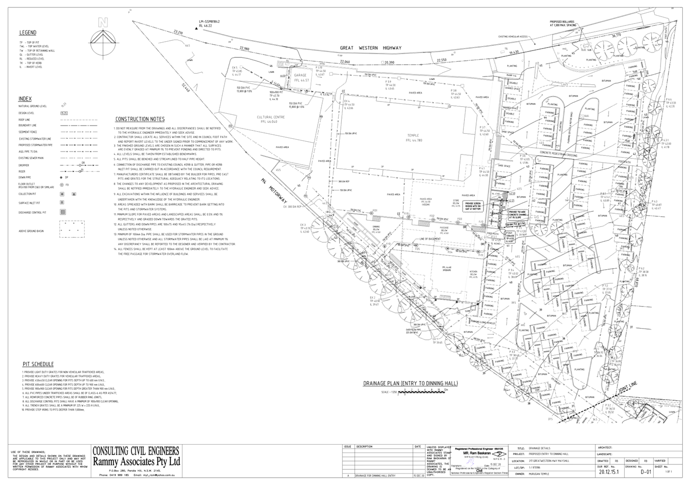
DOCUMENTS
ASSOCIATED WITH
REPORT LPP030/21
Attachment 6
Submissions Recieved
Cumberland Local Planning Panel Meeting
14 July 2021