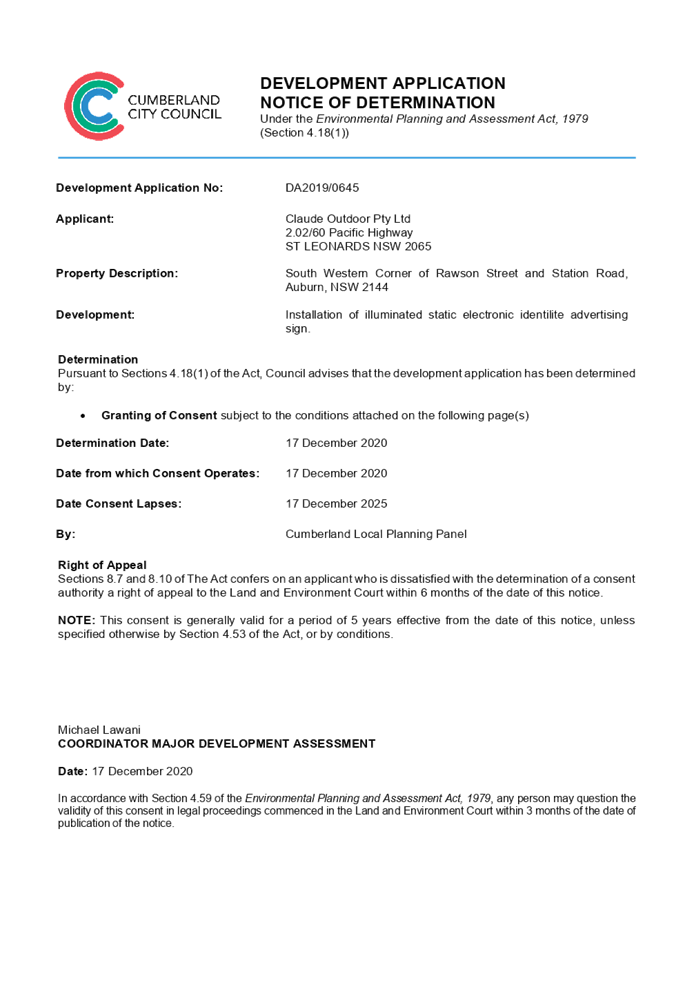
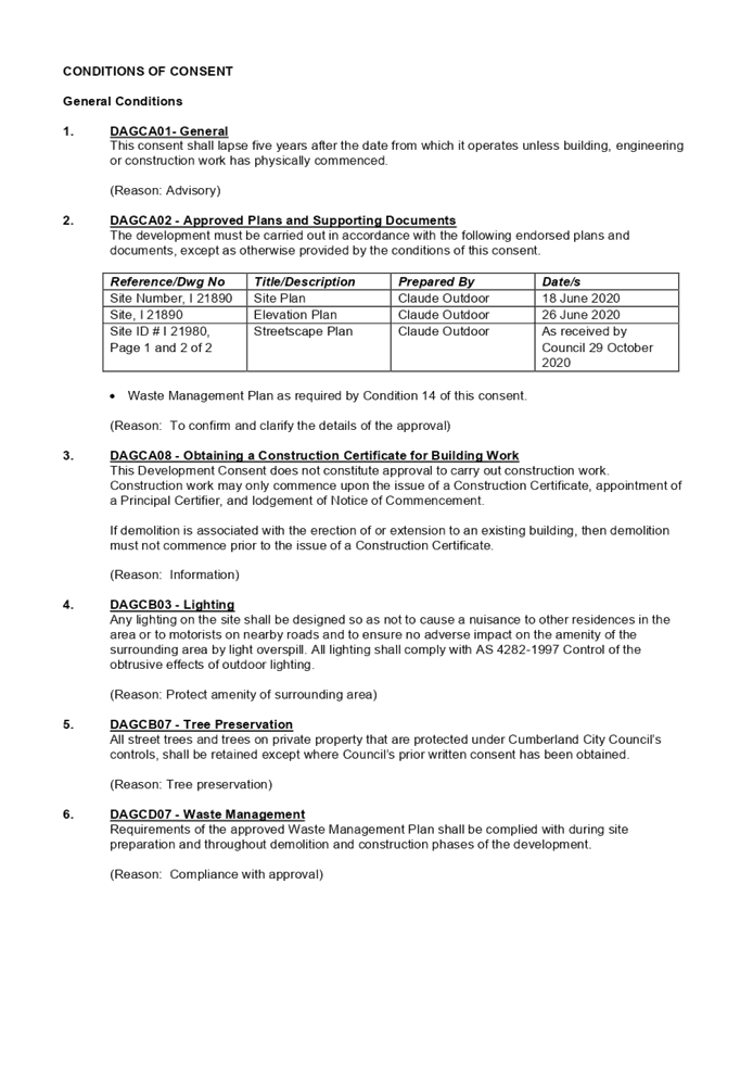
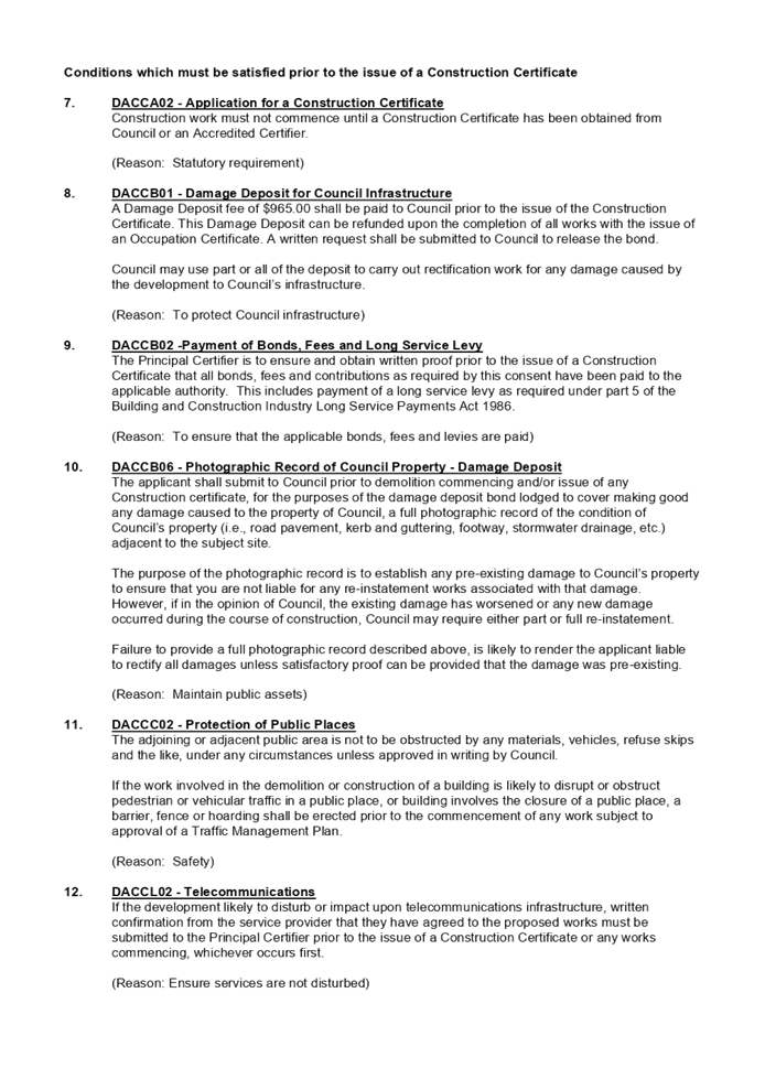
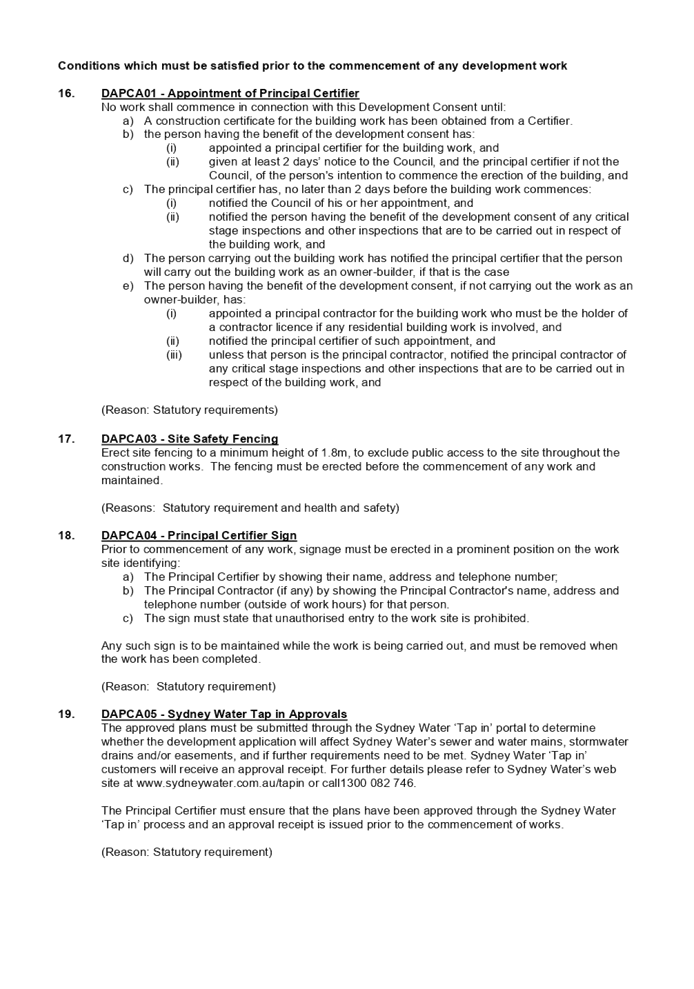
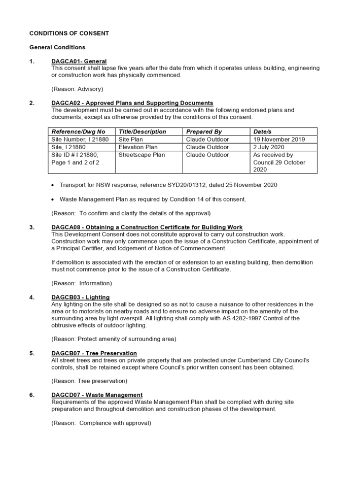
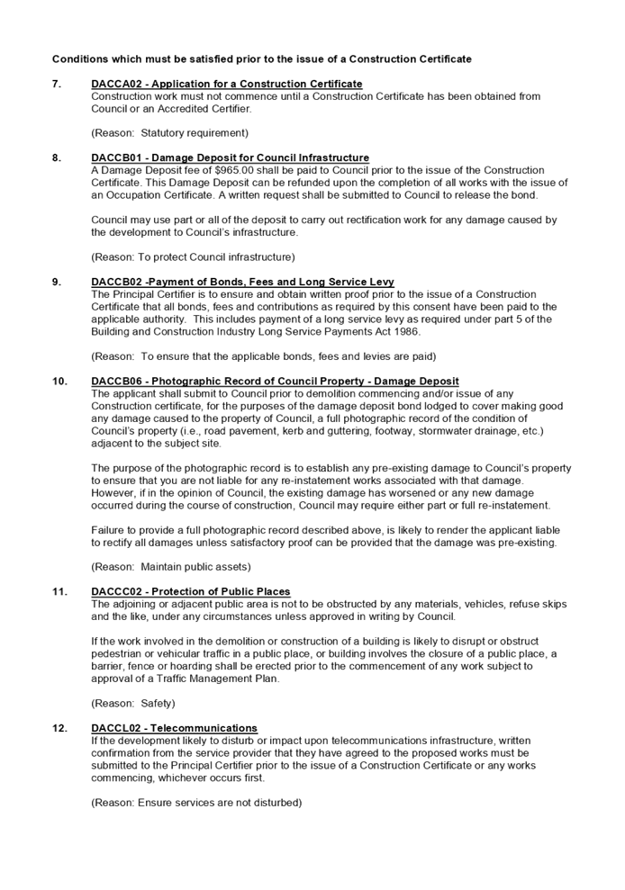
9 December 2020
LATE REPORTS
Cumberland Local Planning Panel Meeting – 9
December 2020
Report No. Name of Report Page
No.
Development Applications
LPP059/20... Development Application
for South Western Corner of Rawson Street and Station Road, Auburn........................................................................................................ 3
LPP060/20... Development Application
for North Eastern Corner of Great Western Highway and Station Street,
Wentworthville........................................................................ 111
Cumberland Local Planning Panel Meeting
9 December 2020
Item
No: LPP059/20
Development
Application for South Western Corner of Rawson Street and Station Road, Auburn
Responsible
Division: Environment
& Planning
Officer: Executive
Manager Development and Building
File
Number: DA2020/0645
|
Application
lodged
|
29 October 2020
|
|
Applicant
|
Claude Outdoor Pty Ltd
|
|
Owner
|
Cumberland City Council
|
|
Application
No.
|
DA2020/0645
|
|
Description
of Land
|
South Western Corner of Rawson
Street and Station Road, Auburn 2144
|
|
Proposed
Development
|
Installation of illuminated
static electronic identilite advertising sign
|
|
Zoning
|
B4 – Mixed Use
|
|
Disclosure
of political donations and gifts
|
Nil disclosure
|
|
Heritage
|
Subject site is within the
vicinity of two heritage items being a former Auburn RSL statue located in
Auburn Memorial Park and the Keighery Hotel located at 51 Rawson Street,
Auburn
|
|
Principal
Development Standards
|
N/A
|
|
Issues
|
The proposal does not seek any
non-compliances.
|
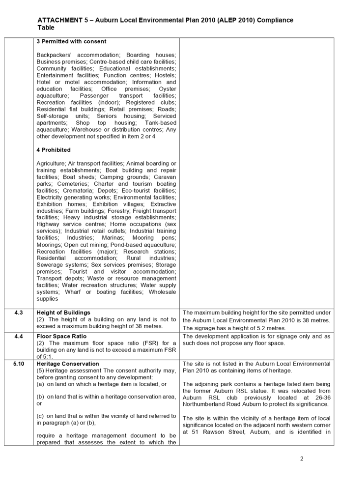
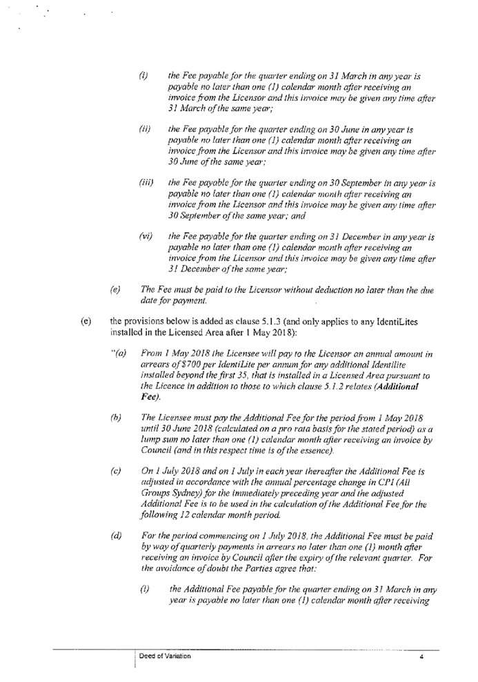
1. Development
Application No. DA2020/0645 was received on 29 October 2020 for the
Installation of illuminated static electronic identilite advertising sign.
2. The
application was publicly notified to occupants and owners of the adjoining
properties for a period of 14 days between 13 November 2020 and 27 November
2020. In response, no submissions were received.
3. The
development application does not seek any variations or non-compliances.
4. The
owner of the subject property is identified as Cumberland City Council. In this
regard, in accordance with Schedule 2 of the Local Planning Panel Direction
– Development Applications, the application is referred to the Cumberland
Local Planning Panel (CLPP) for determination.
5. The
application is recommended for conditional approval subject to the conditions
as provided in the attached schedule.
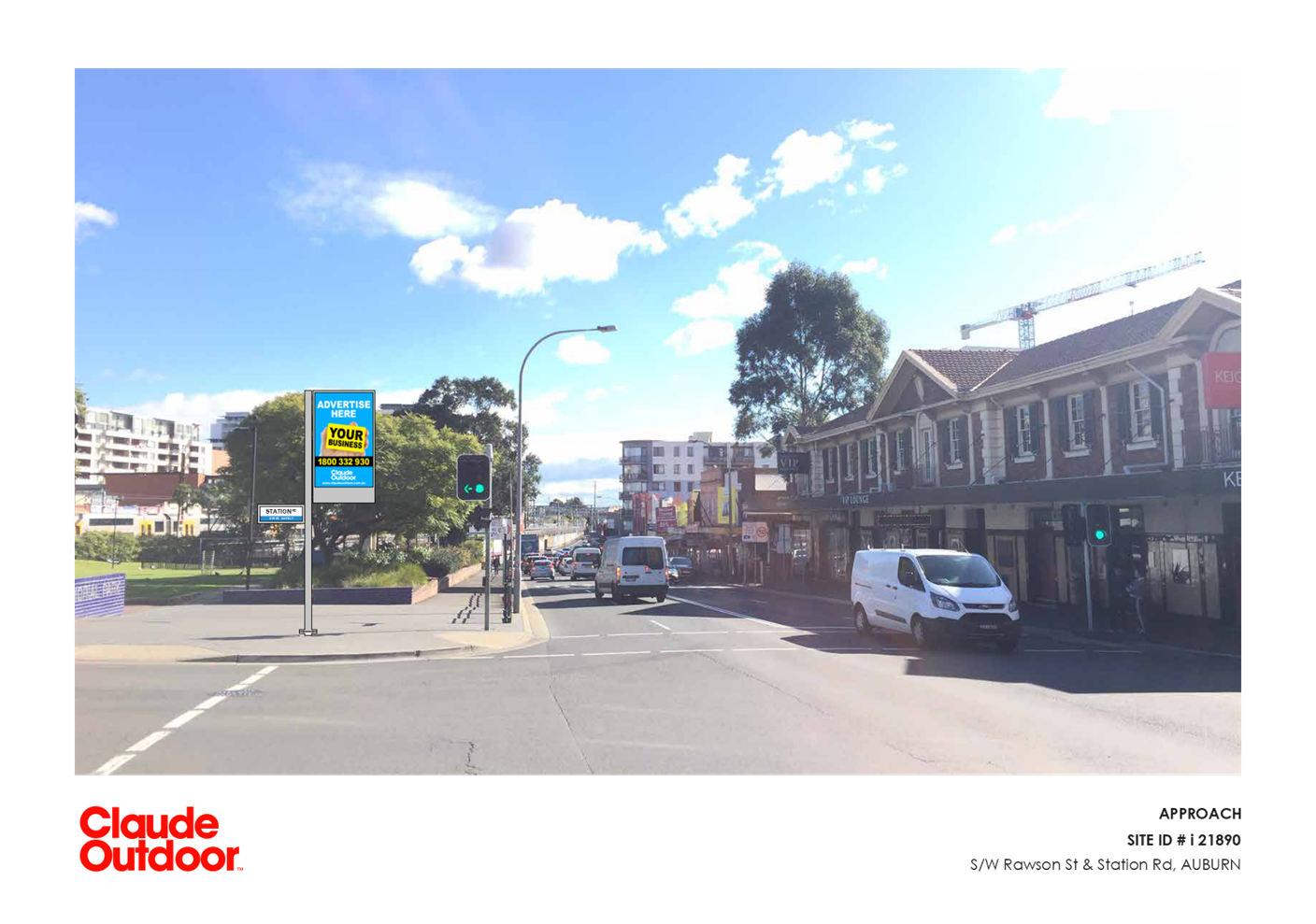
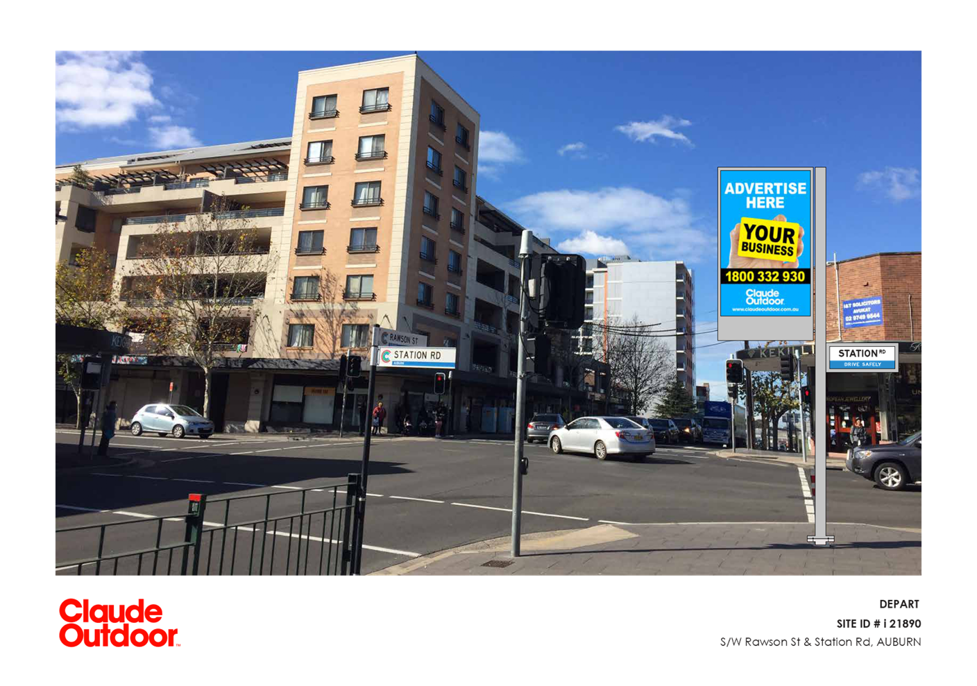
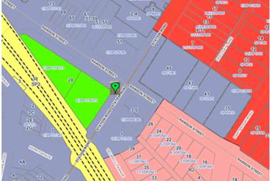
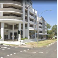
Subject Site and Surrounding
Area
The site is located at the south
western intersection of Station Road, Auburn and Rawson Street, Auburn.
The locality of the area is
dominated by a variety of uses including:
- An
open space park/reserve being Auburn Memorial Park to the immediate south west.
Auburn Memorial Park contains a heritage listed item being an RSL statue which
was relocated from the former Auburn RSL car park site at 26-26 Northumberland
Road Auburn. Further to the south west is a railway line and Auburn Station.
- Commercial
premises located on the adjacent south east corner of Station Road and Rawson
Street.
- A
pub/hotel premises located on the adjacent north west corner of Station Road
and Rawson Street known as Keighery Hotel. The Keighery Hotel is listed as
being of Local heritage significance under Auburn Local Environmental Plan 2010
(Item number I16).
- A
mixed use development comprising of commercial premises on the ground floor and
residential apartments above located on the adjacent north east corner of
Station Road and Rawson Street.
The subject location for the
proposed signage is not developed with any structures other than traffic
signals , pavement, fencing and two kerbs allowing for pedestrians to cross
Rawson Street in an east-west direction (and vice-versa) and in a north-south
direction (and vice-versa).
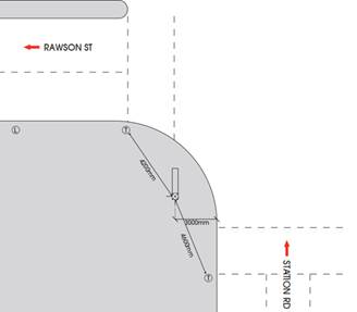
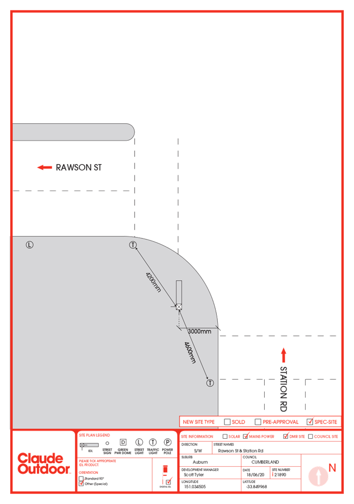
The signage is proposed to be
installed between the two pedestrian crossings as per figure 2 on the following
page.
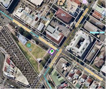
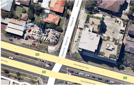
Figure
1 – Aerial view of subject site with the subject site indicated by green
marker and purple outline.
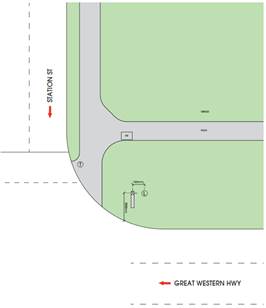
Figure
2 – Aerial view of subject site and location of proposed signage.
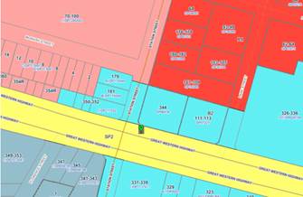
Figure
3 – Locality Plan of subject site indicated by green marker
Figure
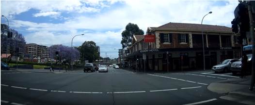
4- View of the subject location of the proposed signage (located on street
corner on left hand side of photo) looking west with Heritage Item being the
Keighery Hotel located on the right hand side of the photo.
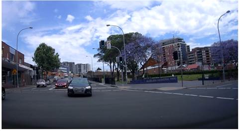
Figure 5- View of the
subject location of the proposed signage (located on corner on right hand side
of photo) looking south.
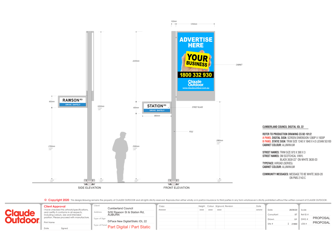
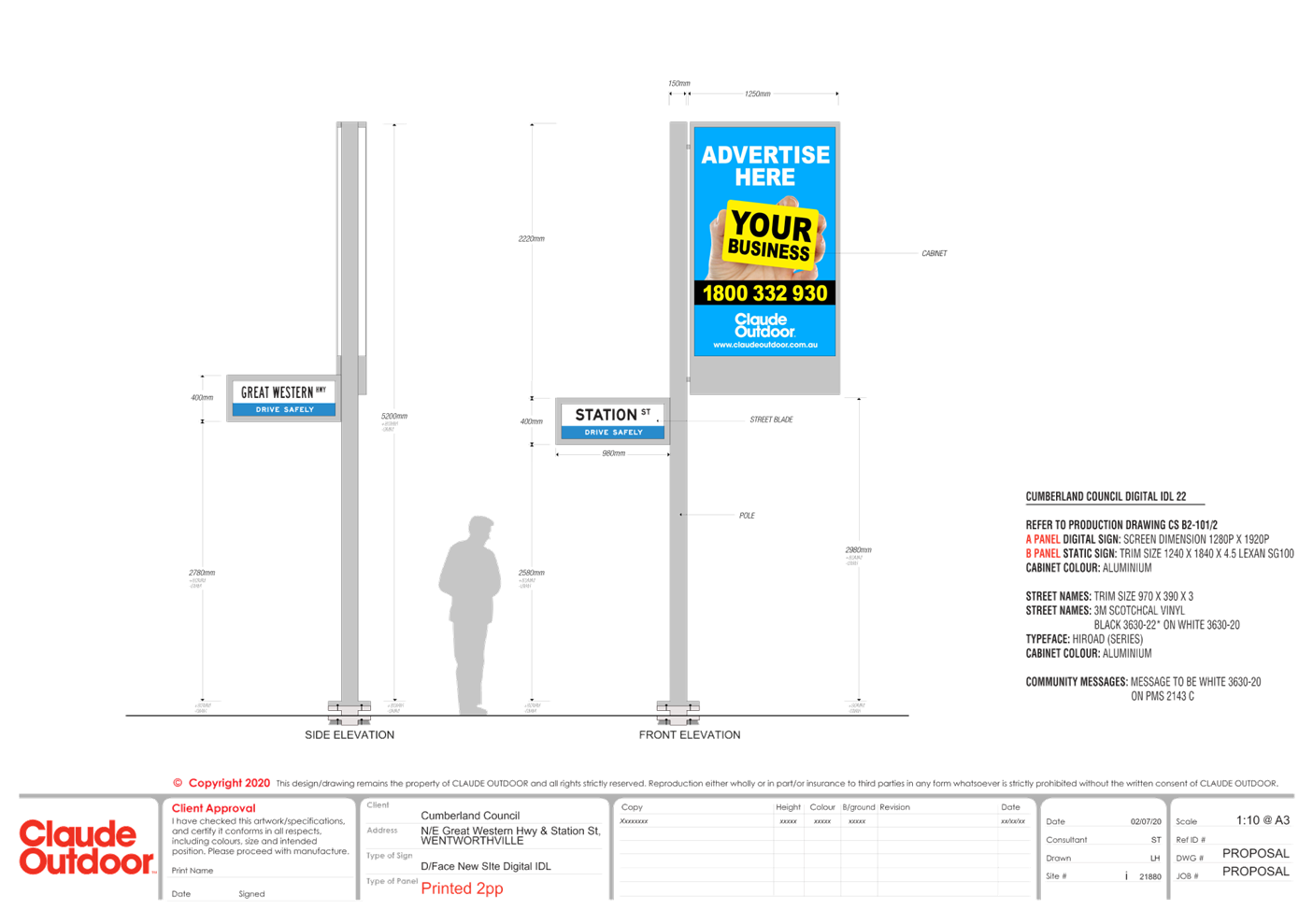
Description of the Proposed
Development
Council has received a development
application for the Installation of an illuminated static electronic identilite
advertising sign incorporating:
· Installation
of a pylon of approximately 5.2m in height and approximately 150mm in width.
The pylon shall consist of:
o Illuminated street
identification signage for Station Road connected to the pylon approximately
2.58m from the natural ground level facing south with dimensions of 390mm in
height by 970mm width and having an area of approximately 0.378 sq m
o Illuminated street
identification signage for Rawson Street connected to the pylon approximately
2.78m from the natural ground level with dimensions of 390mm in height by 970mm
width and having an area of approximately 0.378 sq m.
o A double sided static
electronic illuminated advertising sign connected to the pylon
approximately 2.98m from the natural ground level facing Rawson Street
with dimensions of 1.8m in height by 1.2m width and having an area of
approximately 2.16 sq m. The advertisement is static however the advertisement
can rotate between advertisements and as such conditions of consent are imposed
regarding dwell times.
The advertising panel is proposed
to display the name, logo and other information of a local business which
sponsors the sign. The advertising panel and the street name signs are proposed
to be internally illuminated.
It is noted that there is an
existing Licence Agreement between Council and Claude Outdoor (The applicant)
to provide IdentiLite advertising and directional street sign units at selected
locations throughout the Cumberland LGA. This development application is for
additional signage but within the agreed conditions of the standing agreement.
As such a condition is imposed for the consent to be valid until 12 August 2027
in accordance with the existing agreement.
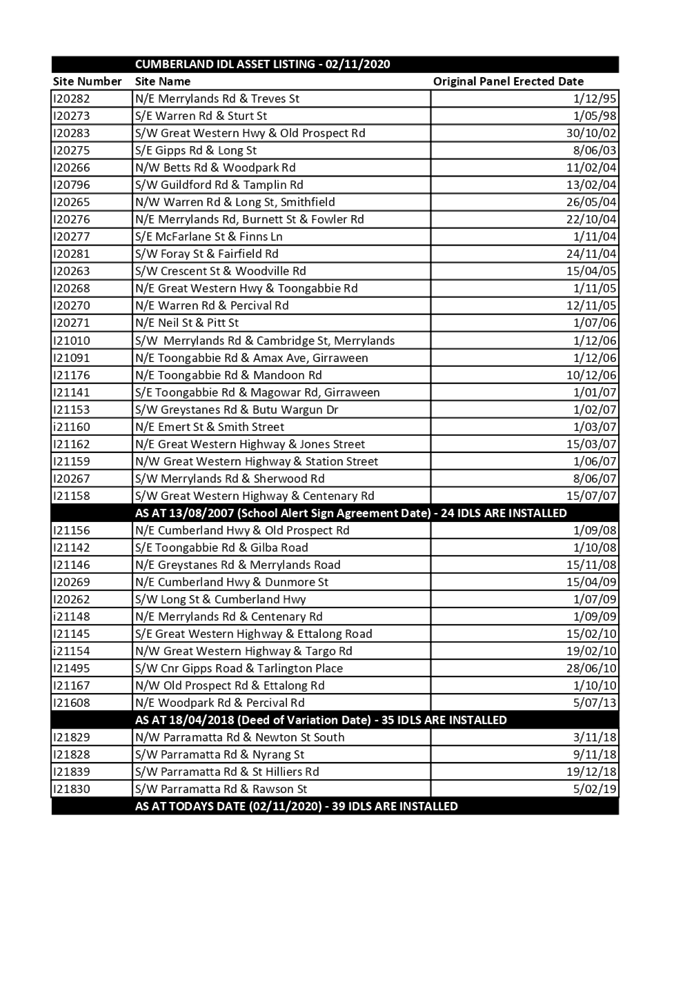
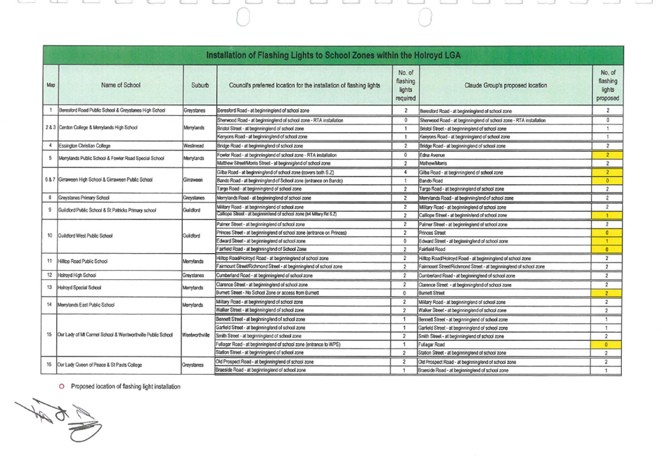
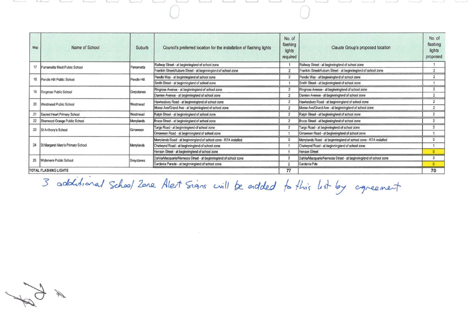
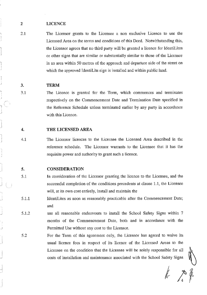
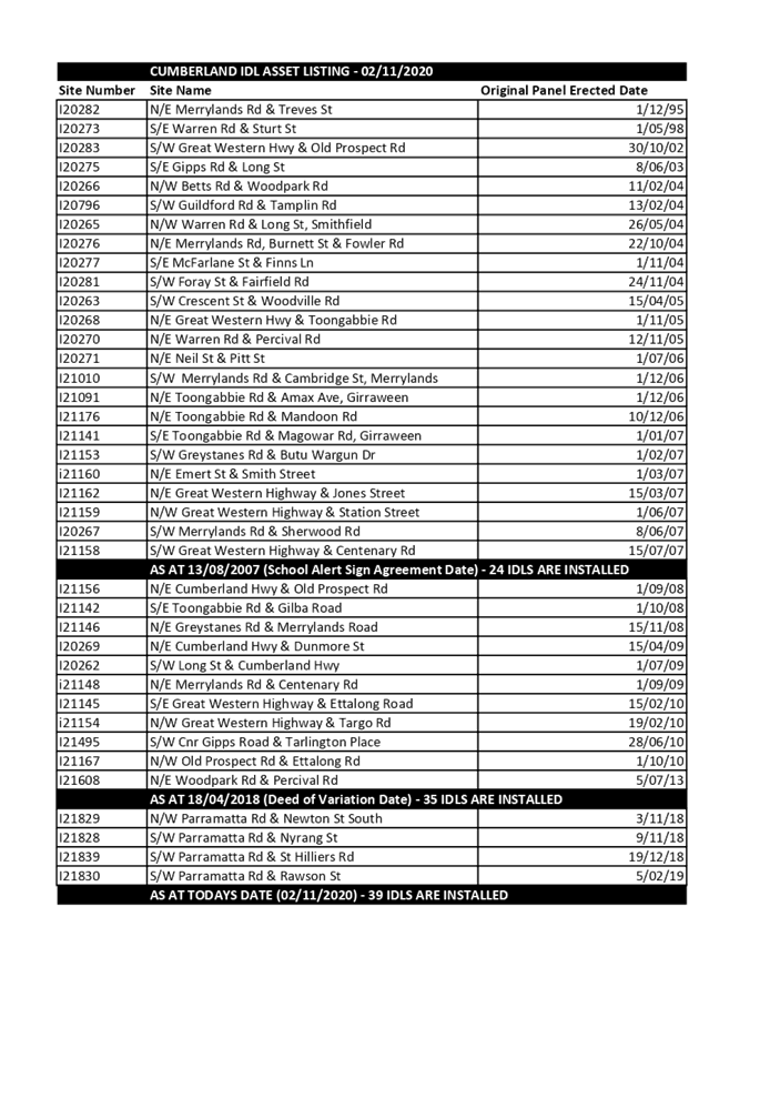
The agreement allows for 55
IdentiLite signages to be installed and 39 have already been installed by the 2
November 2020 with another 5 under review (Including the signage proposed as
per this development application). The license agreement is attached at
attachment 7 and attachment 8 and a list of the currently installed IdentiLite
signage is at attachment 9.
History
|
Date
|
Action
|
|
29 October 2020
|
DA2020/0645
was lodged with Council
|
|
13
November 2020 to 27 November 2020
|
Application
notified to surrounding properties, a sign was erected on the site, and an
advertisement was placed on Council’s website. No public
submissions were received as a result of the notification.
|
|
9
December 2020
|
Application
referred to the Cumberland Local Planning Panel for determination
|
Applicants Supporting
Statement
The applicant has provided a Statement of Environmental
Effects prepared by Claude Outdoor and was received by Council on 29 October
2020 in support of the application.
Contact with Relevant
Parties
Council has undertaken a site
inspection of the subject site and surrounding properties and has been in
contact with the applicant throughout the assessment process.
Internal Referrals
Development Engineer (Traffic)
The development application was
referred to Council’s Development Engineer for comment who has advised
that the development proposal is satisfactory subject to conditions.
Properties
The development application was
referred to Council’s properties section for comment who has advised that
the development proposal is satisfactory and can be supported subject to
conditions of consent including that the development be carried out in
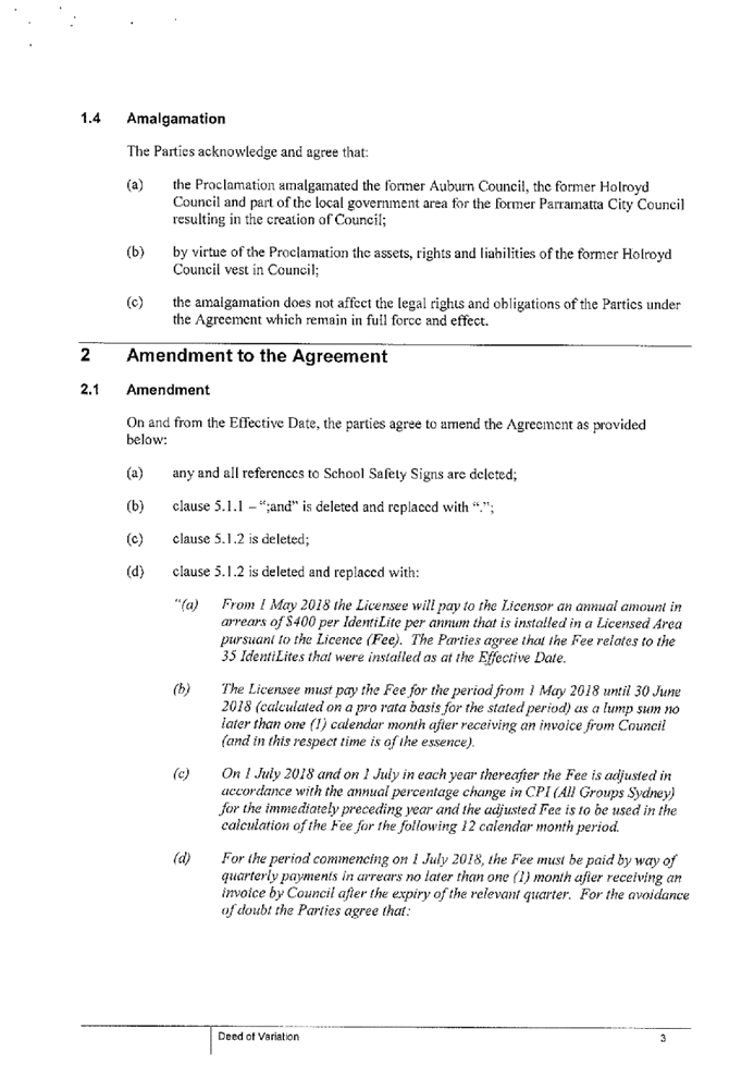
accordance with the agreement with Council outlined in the Schools Alert Sign
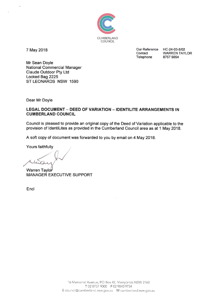
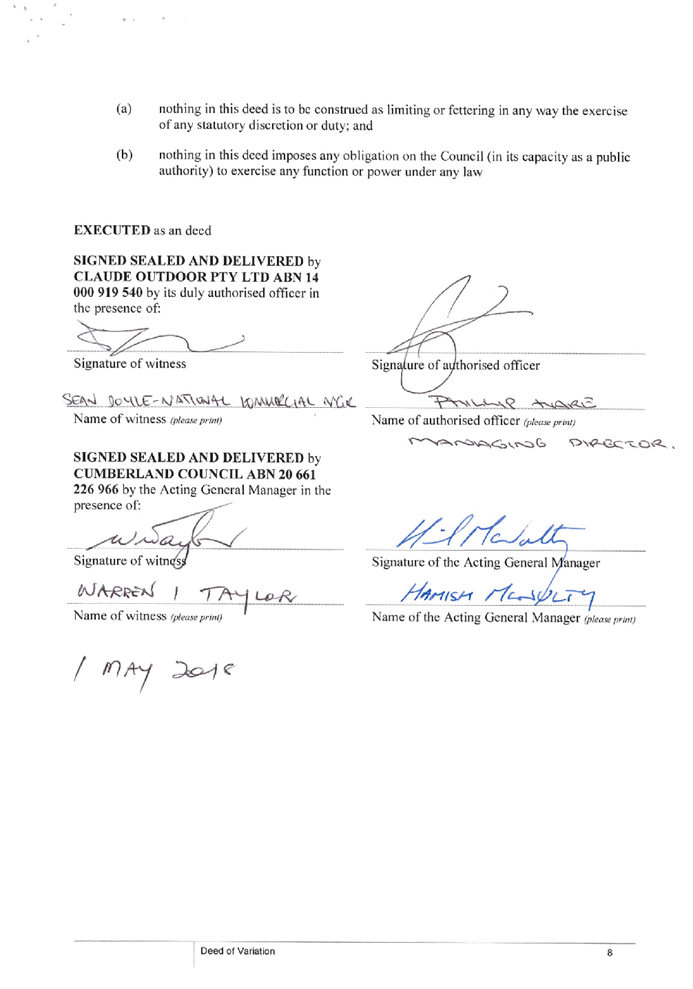
Deed made on 13 August 2007 (attachment 7) And Deed of Variation dated 1 May
2018 (Attachment 8).
External Referrals
Transport for NSW
The location of the signage is
located on a classified road. In this regard, the application was referred to
Transport for NSW (TfNSW) for concurrence, pursuant to clause 138(2) of the
Roads Act and for Council to be satisfied regarding clause 101 of State
Environmental Planning Policy (Infrastructure) 2007. The response received 25 November
2020 indicates that the proposal is satisfactory without any recommended
conditions.
PLANNING COMMENTS
The provisions of any
Environmental Planning Instruments (EP&A Act s4.15 (1)(a)(i))
State Environmental Planning
Policies
The proposed development is
affected by the following State Environmental Planning Policies:
(a) State
Environmental Planning Policy No. 55 – Remediation of Land (SEPP 55)
Clause 7 of SEPP 55 requires
Council to be satisfied that the site is suitable or can be made suitable to accommodate
the proposed development. The matters listed within Clause 7 have been
considered in the assessment of the development application.
|
Matter for
Consideration
|
Yes/No
|
|
Does the application
involve re-development of the site or a change of land use?
|
Yes
No
|
|
i)
Does the application involve
re-development of the site or a change of land use?
|
Yes
No
|
|
In the development
going to be used for a sensitive land use (e.g.: residential, educational,
recreational, childcare or hospital)?
|
Yes
No
|
|
Does information available to you indicate that an
activity listed below has ever been approved, or occurred at the site?
acid/alkali plant and
formulation, agricultural/horticultural activities, airports, asbestos
production and disposal, chemicals manufacture and formulation, defence
works, drum re-conditioning works, dry cleaning establishments, electrical
manufacturing (transformers), electroplating and heat treatment premises,
engine works, explosive industry, gas works, iron and steel works, landfill
sites, metal treatment, mining and extractive industries, oil production and
storage, paint formulation and manufacture, pesticide manufacture and
formulation, power stations, railway yards, scrap yards, service stations,
sheep and cattle dips, smelting and refining, tanning and associated trades,
waste storage and treatment, wood preservation
|
Yes
No
|
|
Is the site listed on
Council’s Contaminated Land database?
|
Yes
No
|
|
Is the site subject to EPA
clean-up order or other EPA restrictions?
|
Yes
No
|
|
Has the site been the subject of
known pollution incidents or illegal dumping?
|
Yes
No
|
|
Does the site adjoin any
contaminated land/previously contaminated land?
|
Yes
No
|
|
Has the appropriate level of
investigation been carried out in respect of contamination matters for
Council to be satisfied that the site is suitable to accommodate the proposed
development or can be made suitable to accommodate the proposed development?
|
Yes
No
|
|
Details of contamination investigations carried out at the
site:
The
site is identified as a public footpath area and no excavation work is
required. A base is to be installed with the signage pylon attached to the base
and proposed signage and street identification signage attached to the pylon.
Given the nature of the development application, it is considered that the
development sought is acceptable for the purpose of the state policy.
|
(b) State
Environmental Planning Policy (Infrastructure) 2007 (ISEPP)
The provisions of the ISEPP 2007
have been considered in the assessment of the development application.
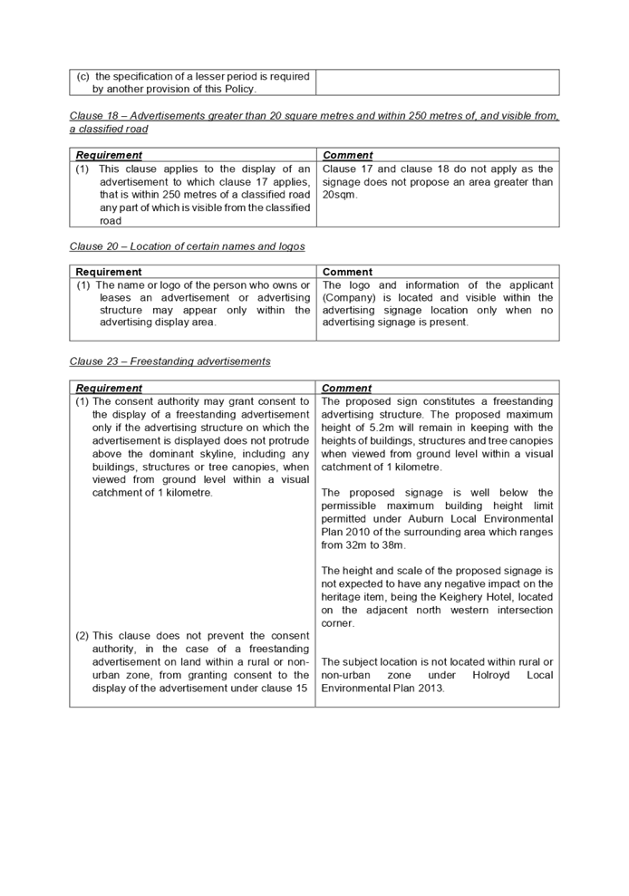
Clause 101 – Frontage to
classified road
The application is subject to
clause 101 of the ISEPP as the site has frontage to a classified road. The
application was referred to Transport for NSW (TfNSW) for comment. A response
was received from Transport for NSW (TfNSW) dated 25 November 2020 indicated
that the proposal is satisfactory without any recommended conditions.
It is noted that there is a
red-light speed camera located on the adjacent south eastern intersection
corner facing west however the proposed signage will have no impact upon the
camera.
(c) State
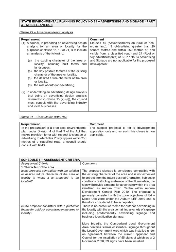
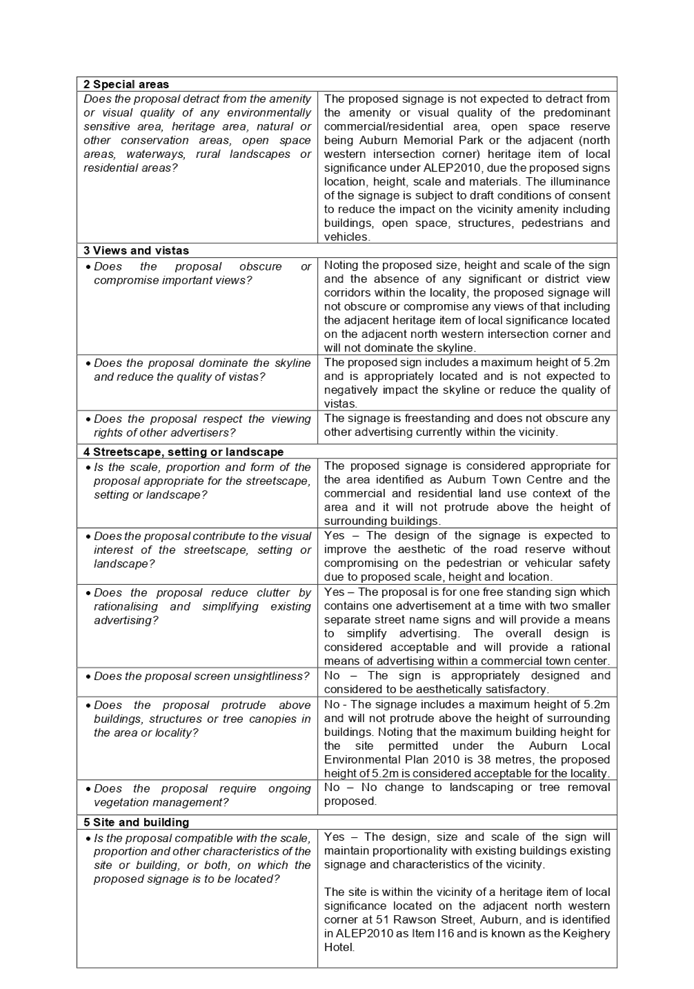
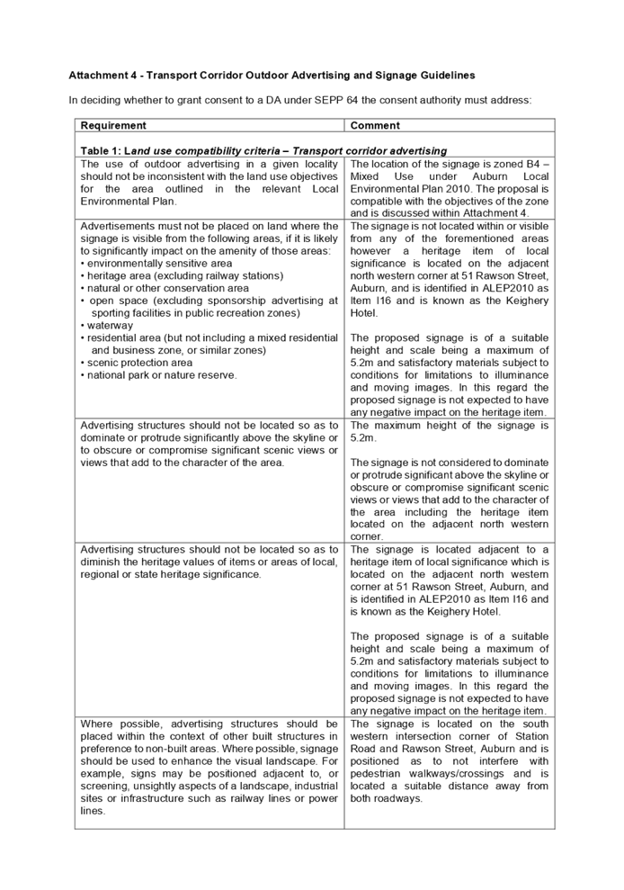
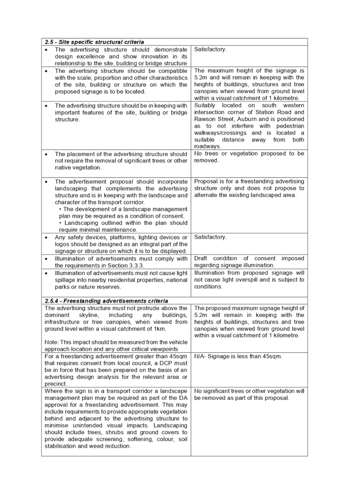
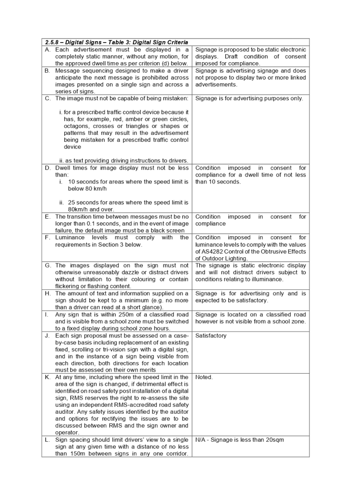
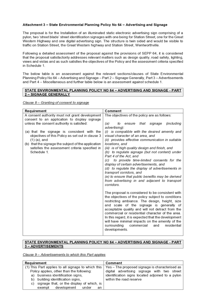
Environmental Planning Policy No 64 – Advertising and Signage
A detailed assessment of the
proposal against the provisions of State Environmental Planning Policy No 64
– Advertising and Signage including assessment against part 3 –
Advertisements and part 4 – Miscellaneous of the SEPP and schedule 1
– Assessment criteria was undertaken and the development proposal is
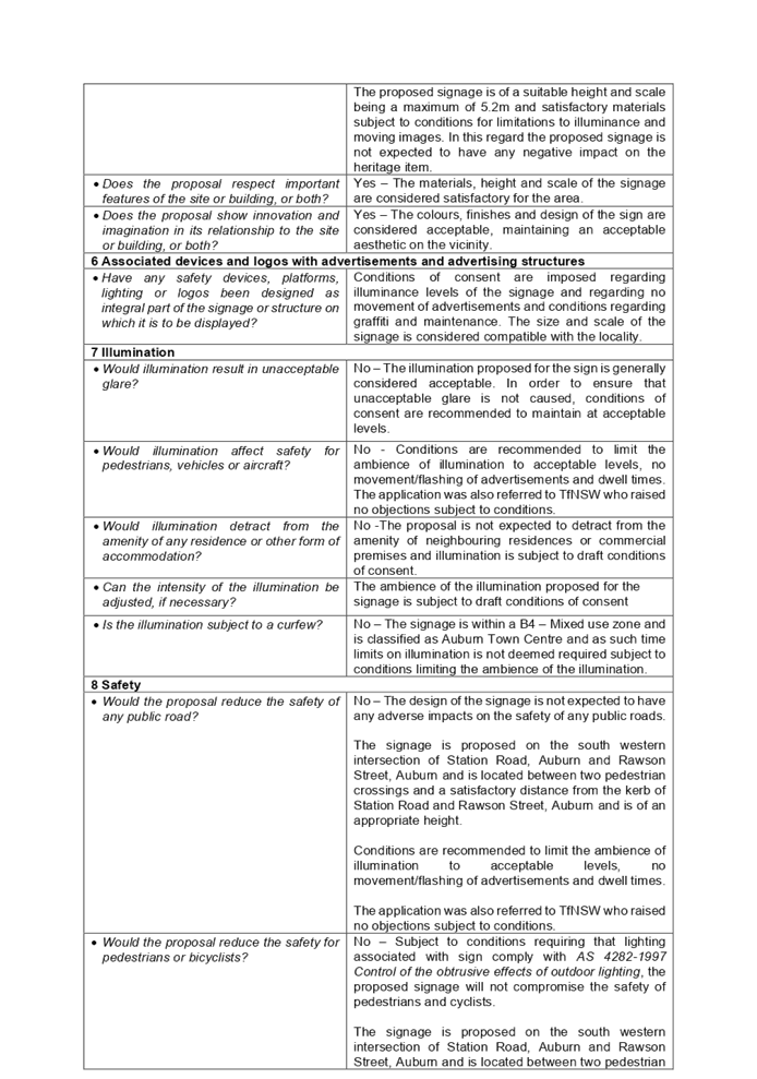
considered as being compliant with all the provisions subject to conditions.
A comprehensive State
Environmental Planning Policy No 64 – Advertising and Signage assessment
table is provided at attachment 3.
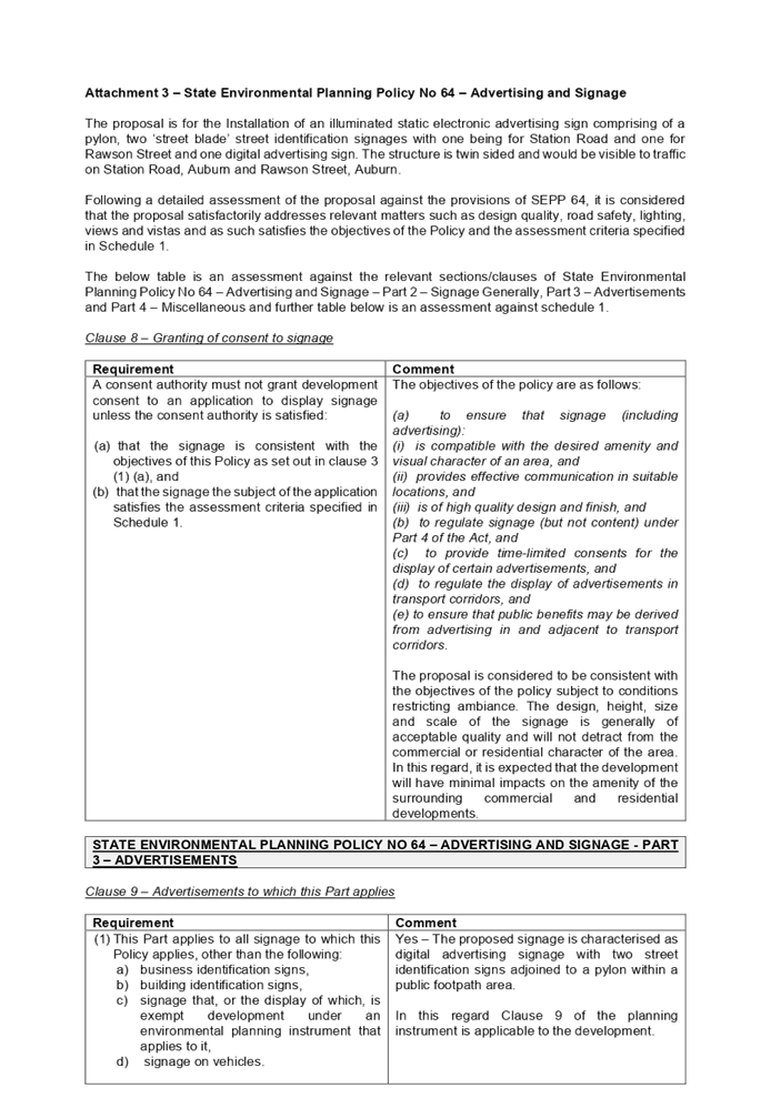
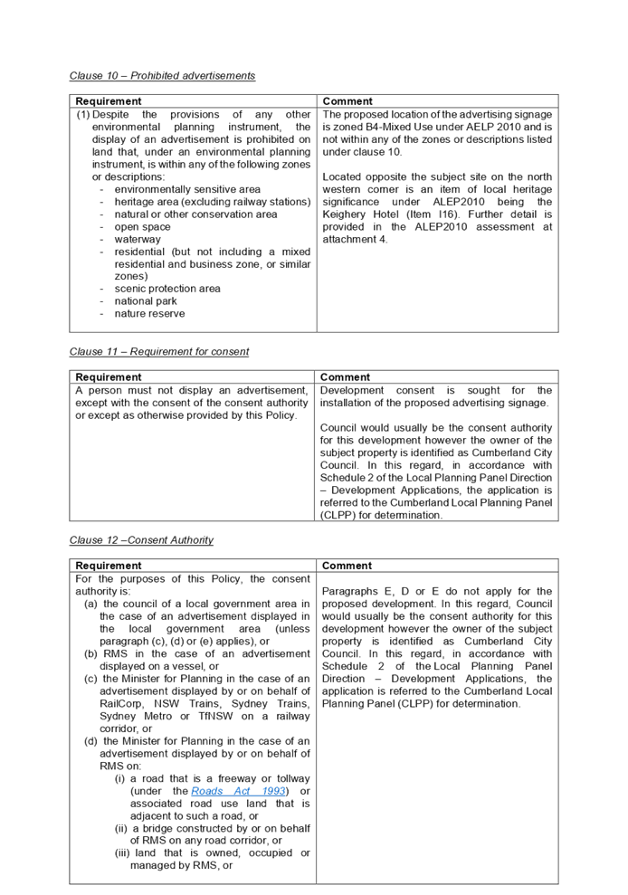
Clause 8 – Granting of
consent to signage
|
Requirement
|
Comment
|
|
A consent authority must not grant development consent to
an application to display signage unless the consent authority is satisfied:
(a) that
the signage is consistent with the objectives of this Policy as set out in
clause 3 (1) (a), and
(b) that
the signage the subject of the application satisfies the assessment criteria
specified in Schedule 1.
|
The objectives of the policy are as follows:
(a) to ensure that signage (including
advertising):
(i) is compatible with the desired amenity and
visual character of an area, and
(ii) provides effective communication in suitable
locations, and
(iii) is of high quality design and finish, and
(b) to regulate signage (but not content) under
Part 4 of the Act, and
(c) to provide time-limited consents for the
display of certain advertisements, and
(d) to regulate the display of advertisements in
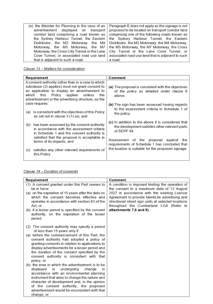
transport corridors, and
(e) to ensure that public benefits may be derived from
advertising in and adjacent to transport corridors.
The proposal is considered to be consistent with the
objectives of the policy subject to conditions restricting ambiance. The
design, height, size and scale of the signage is generally of acceptable
quality and will not detract from the commercial or residential character of
the area. In this regard, it is expected that the development will have
minimal impacts on the amenity of the surrounding commercial and residential
developments.
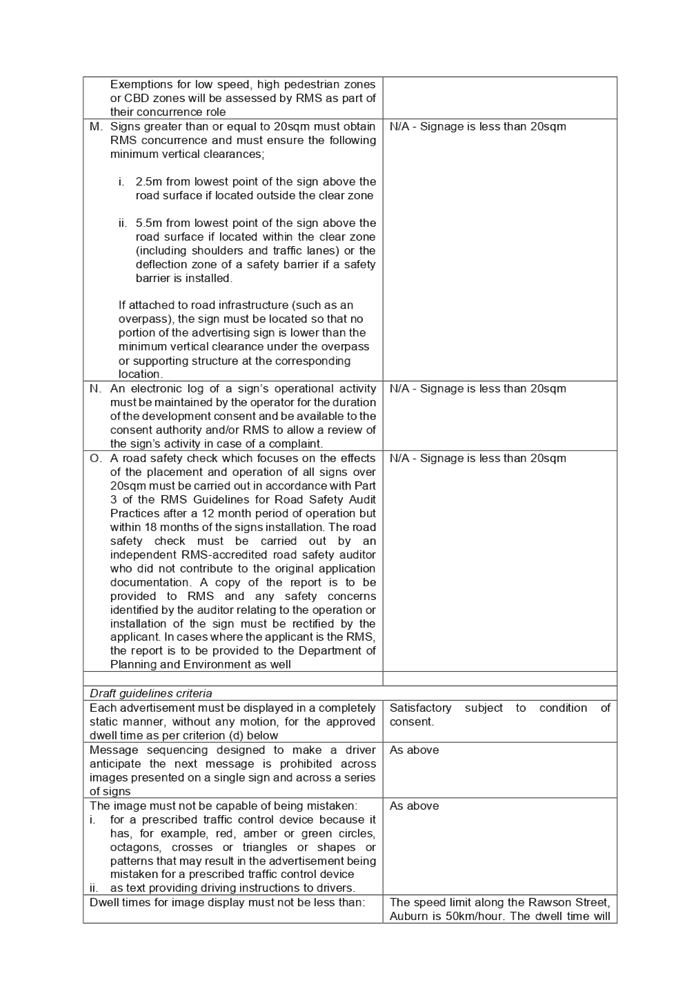
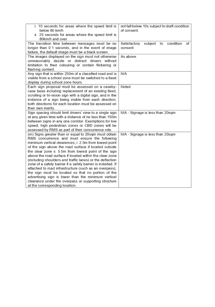
|
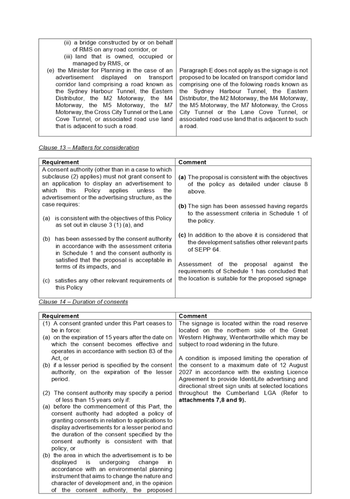
Clause 14 – Duration of
consents
|
Requirement
|
Comment
|
|
(1) A consent granted under this Part ceases to be
in force:
(a) on the expiration of 15 years after the
date on which the consent becomes effective and operates in accordance with
section 83 of the Act, or
(b) if a lesser period is specified by the
consent authority, on the expiration of the lesser period.
(2) The consent authority may specify a period of
less than 15 years only if:
(a) before the commencement of this Part, the
consent authority had, or
(b) the area in which the advertisement is to
be displayed is undergoing change in accordance with an environmental
planning instrument that aims to change the nature and character of development
and, in the opinion of the consent authority, the proposed advertisement
would be inconsistent with that change, or
(c) the specification of a lesser period is
required by another provision of this Policy.
|
There is no specified policy adopted by Council in
relation to granting consents for applications to display advertisements for
a lesser period than 15 years, the subject signage is part of an existing
license agreement between Council and the applicant, to provide IdentiLite
advertising and directional street sign units at selected locations
throughout the Cumberland LGA (Refer to attachments 7,8 and 9).
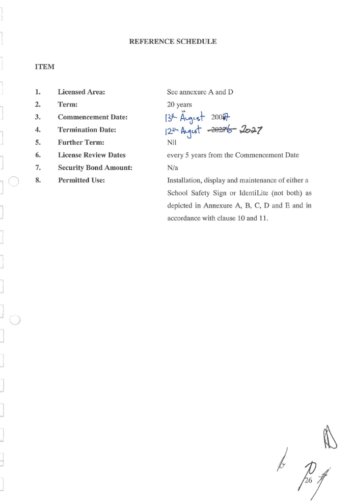
The license agreement specifies a termination date of the
license agreement of 12 August 2027.
In this regard, a condition is imposed limiting the
operation of the consent to expire on 12 August 2027.
|
Regional Environmental Plans
The proposed development is
affected by the following Regional Environmental Plans:
(a) Sydney
Regional Environmental Plan (Sydney Harbour Catchment) 2005
The subject site is identified as
being located within the area affected by the Sydney Regional Environmental
Plan (Sydney Harbour Catchment) 2005. The proposed development raises no issues
as no impact on the catchment is envisaged.
(Note: - the subject site is not
identified in the relevant map as ‘land within the ‘Foreshores and
Waterways Area’ or ‘Wetland Protection zone’, is not a
‘Strategic Foreshore Site’ and does not contain any heritage items.
Hence the majority of the SREP is not directly relevant to the proposed
development).
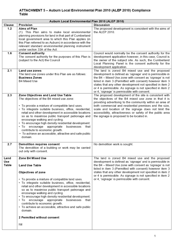
Local Environmental Plans
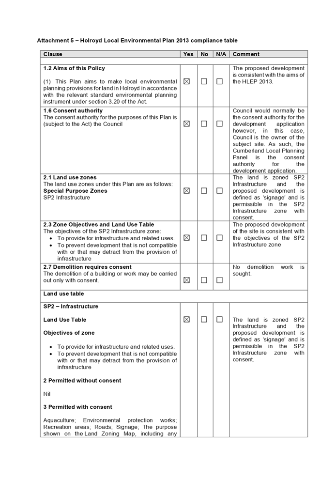
(b) Auburn
Local Environmental Plan 2010 (ALEP 2010)
The provision of the AELP 2010 is
applicable to the development proposal. The proposed development is defined as
‘signage’ and is permissible in the B4 – Mixed Use zone with
consent.
The Auburn Local Environmental
Plan 2010 defines signage as the following:
signage means any sign, notice,
device, representation or advertisement that advertises or promotes any goods,
services or events and any structure or vessel that is principally designed
for, or that is used for, the display of signage, and includes any of the
following—
(a) an
advertising structure,
(b) a
building identification sign,
(c) a
business identification sign,
but does not include a traffic
sign or traffic control facilities.
It is noted that the development
achieves compliance with the key statutory requirements of the Auburn LEP 2010
and the objectives of the B4 – Mixed Use. A comprehensive ALEP 2010
compliance table is provided at attachment 5.
Heritage – The adjoining
park being Auburn Memorial Park contains a heritage listed item being the
former Auburn RSL statue. It is noted that the statue in its current location
is not heritage listed under ALEP2010, however the statue is heritage listed
under ALEP2010 at its former location being the Auburn RSL club which was
located at 26-36 Northumberland Road Auburn. The site is also within the
vicinity of a heritage item of local significance located on the adjacent north
western corner at 51 Rawson Street, Auburn, and is identified in ALEP2010 as
Item I16 and is known as the Keighery Hotel.
The proposed signage will have no
impact on the statue or the Keighery Hotel as the proposed signage is of a
suitable height and scale being a maximum of 5.2m and of satisfactory materials
subject to conditions for limitations to illuminance and moving images. In this
regard the proposed signage is not expected to have any negative impact on the
heritage items.
The provisions of any proposed
instrument that is or has been the subject (EP&A Act s4.15 (1)(a)(ii))
(a) Draft
Cumberland Local Environmental Plan (CLEP)
The Draft Cumberland Local
Environmental Plan (Draft CLEP) has been prepared by Cumberland City Council to
provide a single planning framework for the future planning of Cumberland City.
The changes proposed seek to harmonise and repeal the three existing LEPs
currently applicable to the Cumberland City local government area, those being:
· Holroyd Local
Environmental Plan 2013
· Parramatta Local
Environmental Plan 2011.
· Auburn Local
Environmental Plan 2010.
The current planning controls for
the subject site, as contained within the ALEP, are not proposed to change
under the Draft CLEP.
The provisions of any
Development Control Plans (EP&A Act s4.15 (1)(a)(iii))
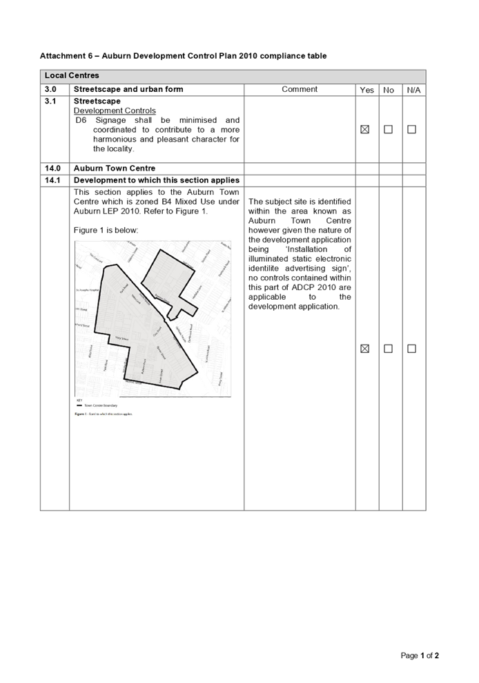
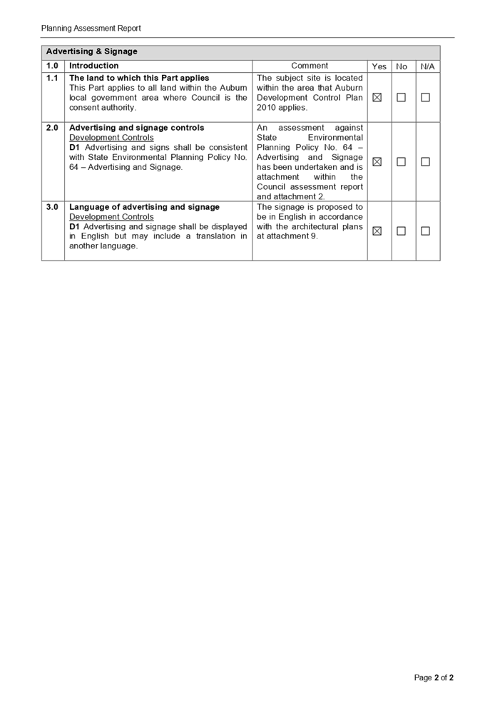
Auburn Development Control Plan
(ADCP) 2010 contains advertising and signage controls under Advertising and
signage section of Auburn DCP 2010 and the subject site is identified as being
within Auburn Local Centre as such controls apply within the Local Centres
section of ADCP2010.
A comprehensive ADCP 2010
compliance table is attached to this report at Attachment 6.
The provisions of any planning
agreement that has been entered into under section 7.4, or any draft planning
agreement that a developer has offered to enter into under section 7.4
(EP&A Act s4.15(1)(a)(iiia))
There is no planning agreement or
draft planning agreement associated with the subject Development Application
made under section 7.4 of the Environmental Planning and Assessment Act.
It is noted that Claude Outdoor
(The applicant) has an existing Licence Agreement to provide IdentiLite
advertising and directional street sign units at selected locations throughout
the Cumberland LGA. This development application is for additional signage but
within the agreed conditions of the standing agreement.
The agreement allows for 55
IdentiLite signages to be installed and it is identified that 39 have already
been installed by 2 November 2020 with another 5 under review (including the
signage proposed as per this development application). The licence agreement is
attached at attachment 7 and attachment 8 and a list of the currently installed
IdentiLite signage is at attachment 9.
The provisions of the
Regulations (EP&A Act s4.15 (1)(a)(iv))
The proposed development raises no
concerns as to the relevant matters arising from the Environmental Planning and
Assessment Regulations 2000 (EP&A Reg).
The Likely Environmental,
Social or Economic Impacts (EP&A Act s4.15 (1)(b))
It is considered that the proposed
development will have no significant adverse environmental, social or economic
impacts in the locality. The proposal is considered satisfactory with regard to
relevant matters such as design quality, landscaping, road safety, lighting and
views and vistas subject to the imposition of suitable conditions of consent to
satisfactorily control the development.
The suitability of the site for
the development (EP&A Act s4.15 (1)(c))
It is considered that the
development is suitable in the context of the site and surrounding locality.
Submissions made in accordance
with the Act or Regulation (EP&A Act s4.15 (1)(d))
|
Advertised (Council Website)
|
Mail
|
Sign
|
Not Required
|
In
accordance with Council’s Notification requirements contained within the
Holroyd DCP 2013, the proposal was publicly notified for a period of 14 days
between 13 November 2020 and 27 November 2020. No submissions were
received as a result of the notification.
The public interest (EP&A
Act s4.15(1)(e))
In view of the foregoing analysis,
it is considered that the development, if carried out subject to the conditions
set out in the recommendation below, will have no significant adverse impacts
on the public interest.
Cumberland Local Infrastructure Contribution Plan 2020
The proposed development does not attract the payment of any
development contributions in accordance with Cumberland Local Infrastructure
Contributions Plan 2020.
Disclosure of Political Donations and Gifts
The applicant and notification process did not result in any
disclosure of Political Donations and Gifts.
The application has been assessed
in accordance with the relevant requirements of the Environmental Planning and
Assessment Act 1979, State Environmental Planning Policy No 64 –
Advertising and Signage, Transport Corridor Outdoor Advertising and Signage
Guidelines, State Environmental Planning Policy (Infrastructure) 2007, Auburn
Local Environmental Plan 2010 and the Auburn Development Control Plan 2010, and
is considered to be satisfactory.
|
That Development Application
No. DA2020/0645 for the Installation of illuminated static electronic
identilite advertising sign on land at the south western Corner of Rawson
Street and Station Road, Auburn, be approved subject to conditions within the
draft notice of determination provided at Attachment 1.
|
1. Draft
Notice of Determination
2. Architectural
Plans
3. State
Environmental Planning Policy No 64 Advertising and Signage
4. Transport
Corridor Outdoor Advertising and Signage Guidelines
5. ALEP
2010 Compliance Table
6. ADCP
2010 Compliance Table
7. Schools
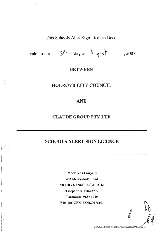
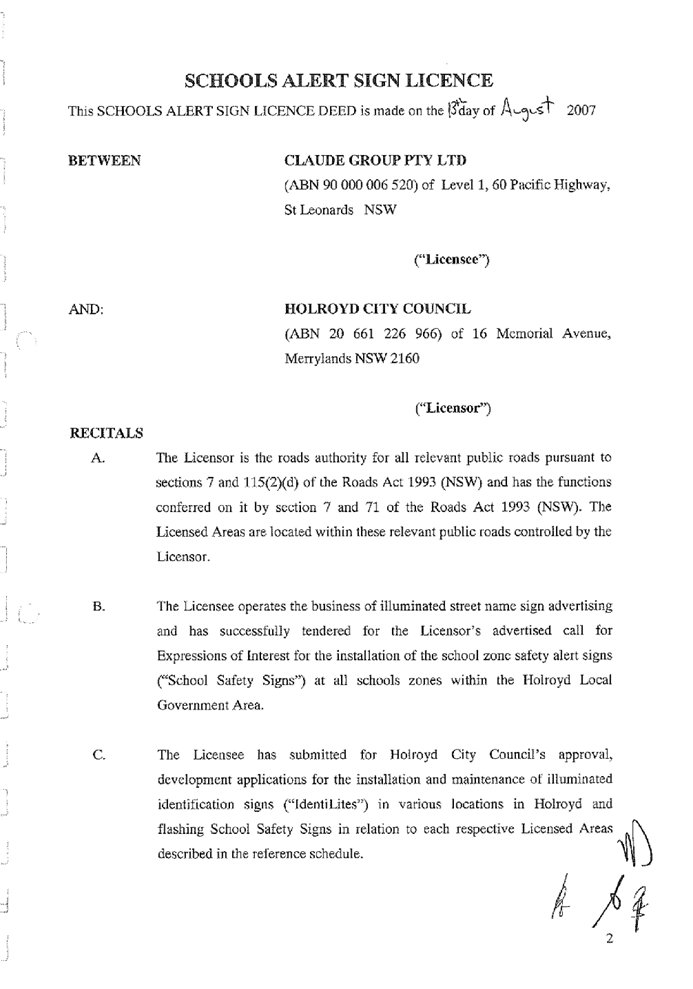
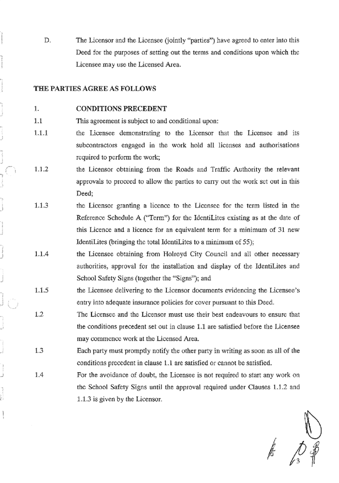
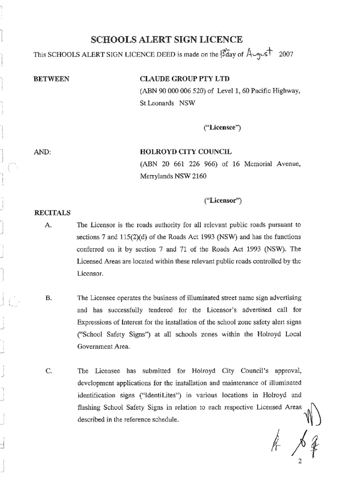
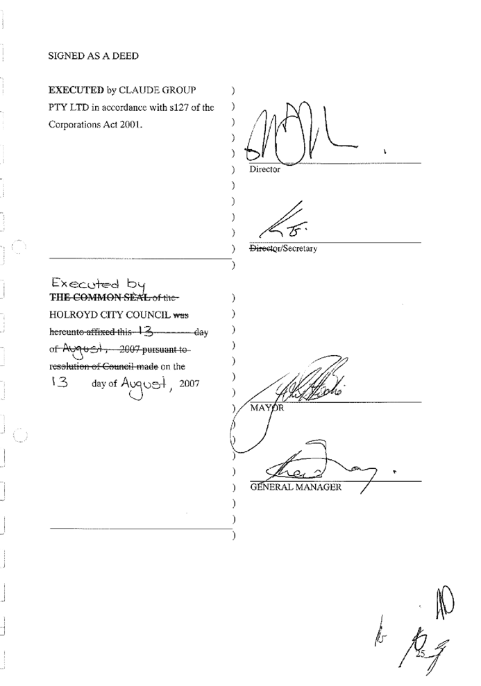
Alert Sign License Deed made on 13 August 2007
8. Deed
of Variation
9. Cumberland
Identities Lease Agreement - List of Signage Locations as of 2 November 2020
DOCUMENTS
ASSOCIATED WITH
REPORT LPP059/20
Attachment 1
Draft Notice of Determination
Cumberland Local Planning Panel Meeting
9 December 2020

DOCUMENTS
ASSOCIATED WITH
REPORT LPP059/20
Attachment 2
Architectural Plans
Cumberland Local Planning Panel Meeting
9 December 2020
DOCUMENTS
ASSOCIATED WITH
REPORT LPP059/20
Attachment 3
State Environmental Planning Policy No 64
Advertising and Signage
Cumberland Local Planning Panel Meeting
9 December 2020

DOCUMENTS
ASSOCIATED WITH
REPORT LPP059/20
Attachment 4
Transport Corridor Outdoor Advertising and Signage
Guidelines
Cumberland Local Planning Panel Meeting
9 December 2020
DOCUMENTS
ASSOCIATED WITH
REPORT LPP059/20
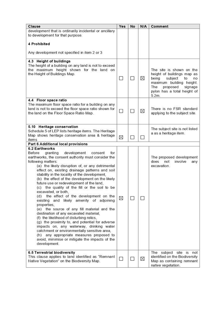
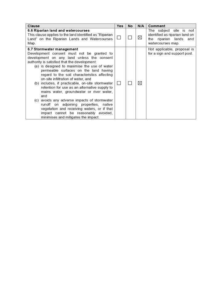
Attachment 5
ALEP 2010 Complaince Table
Cumberland Local Planning Panel Meeting
9 December 2020

DOCUMENTS
ASSOCIATED WITH
REPORT LPP059/20
Attachment 6
ADCP 2010 Compliance Table
Cumberland Local Planning Panel Meeting
9 December 2020
DOCUMENTS
ASSOCIATED WITH
REPORT LPP059/20
Attachment 7
Schools Alert Sign License Deed made on 13 August 2007
Cumberland Local Planning Panel Meeting
9 December 2020


DOCUMENTS
ASSOCIATED WITH
REPORT LPP059/20
Attachment 8
Deed of Variation
Cumberland Local Planning Panel Meeting
9 December 2020


DOCUMENTS
ASSOCIATED WITH
REPORT LPP059/20
Attachment 9
Cumberland Identities Lease Agreement - List of
Signage Locations as of 2 November 2020
Cumberland Local Planning Panel Meeting
9 December 2020

Cumberland
Local Planning Panel Meeting
9 December 2020
Item
No: LPP060/20
Development
Application for North Eastern Corner of Great Western Highway and Station
Street, Wentworthville
Responsible
Division: Environment
& Planning
Officer: Executive
Manager Development and Building
File
Number: DA2020/0646
|
Application lodged
|
29
October 2020
|
|
Applicant
|
Claude
Outdoor Pty Ltd
|
|
Owner
|
Cumberland
City Council
|
|
Application No.
|
DA2020/0646
|
|
Description of Land
|
North
eastern corner of Great Western Highway and Station Street, Wentworthville
NSW 2145
|
|
Proposed Development
|
Installation
of illuminated static electronic identilite advertising sign
|
|
Zoning
|
SP2
- Infrastructure
|
|
Disclosure of political donations and gifts
|
Nil
disclosure
|
|
Heritage
|
No
|
|
Principal Development Standards
|
N/A
|
|
Issues
|
The proposal does not seek any
non-compliances.
|
1. Development
Application No. DA2020/0646 was received on 29 October 2020 for the
installation of illuminated static electronic identilite advertising sign.
2. The
application was publicly notified to occupants and owners of the adjoining
properties for a period of 14 days between 13 November 2020 and 27 November
2020. In response, no submissions were received.
3. The
development application does not seek any variations or non-compliances.
4. The
owner of the subject property is identified as Cumberland City Council. In this
regard, in accordance with Schedule 2 of the Local Planning Panel Direction
– Development Applications, the application is referred to the Cumberland
Local Planning Panel (CLPP) for determination.
5. The
application is recommended for approval subject to the conditions as provided
in the attached schedule.
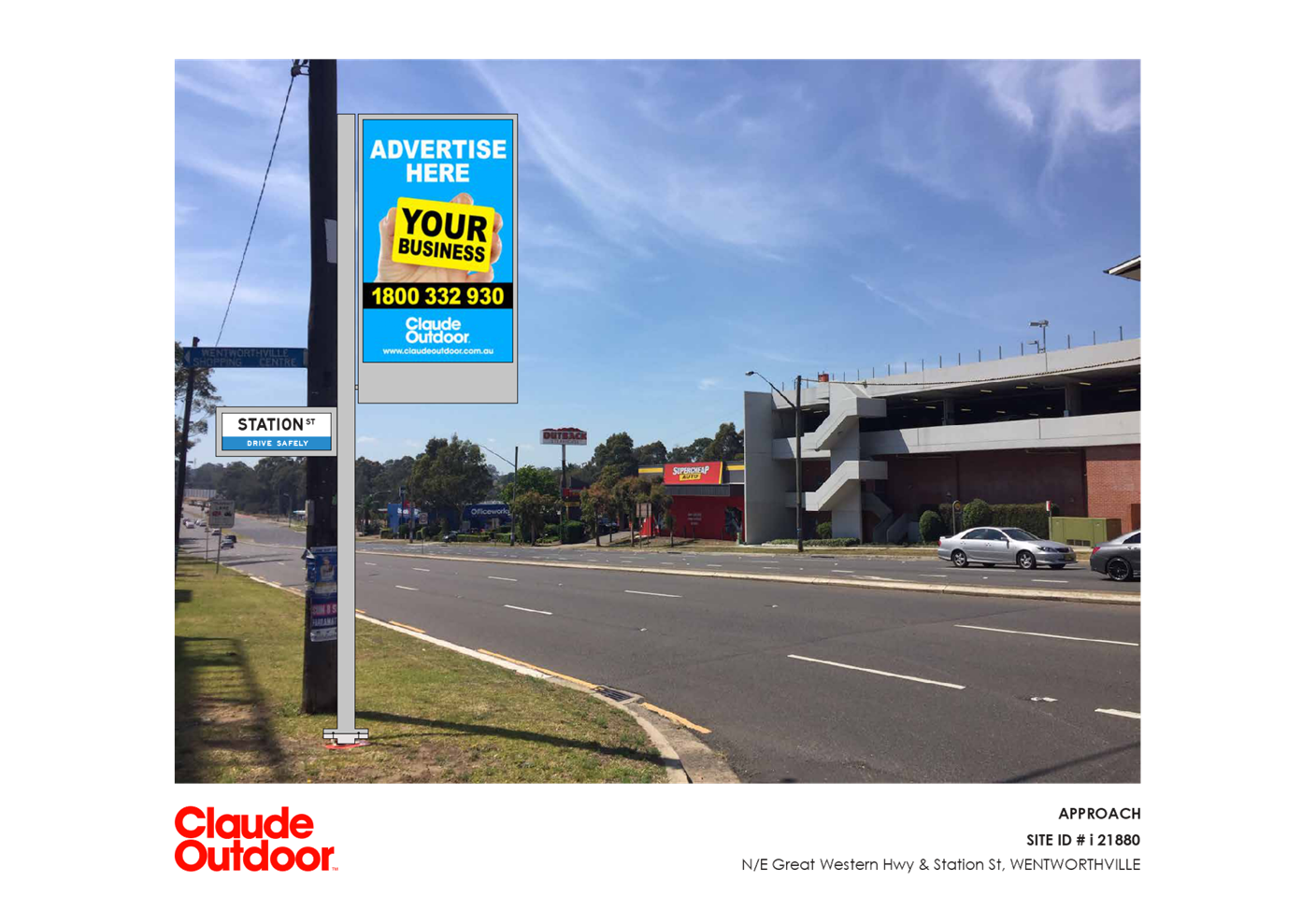
Subject Site and Surrounding
Area
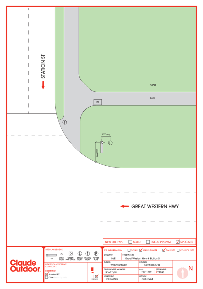
The site is located approximately
at the intersection of Station Street, Wentworthville and Great Western
Highway, Wentworthville within the Great Western Highway road reserve.
The locality of the area is
dominated by a variety of uses including:
- A
mixed use development to the immediate north,
- Great
Western Highway road reserve to the immediate east and residential flat units
and Wentworthville shopping plaza within the vicinity to the east.
- Great
Western Highway to the immediate south
- A
supermarket located on the opposite south eastern intersection corner.
- A
fast food outlet located on the adjacent south western intersection corner.
- Station
Street to the immediate west and an open car yard on the adjacent north western
corner.
It is noted that similar signage
to that proposed is located on the adjacent north western corner and south
western corner from the subject site.
The subject location for the
proposed signage is not developed with any structures other than a traffic
light and telegraph pole also located within the Great Western Highway road
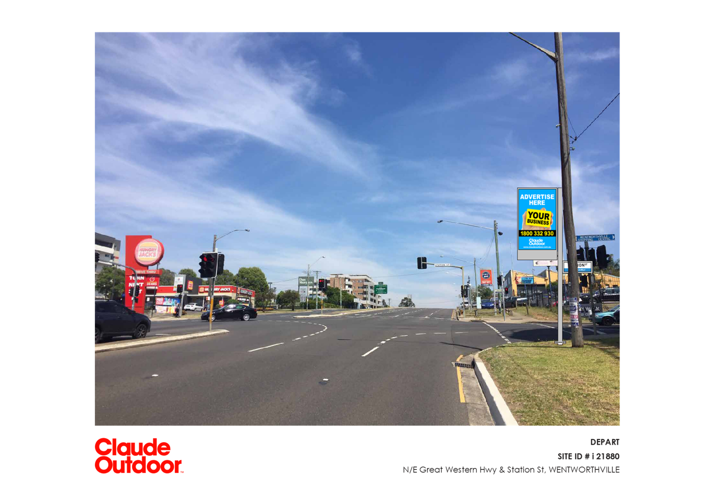
reserve at the intersection of Station Street, and the Great Western Highway.
The signage is proposed to be installed approximately 1m to the west of the
existing telegraph pole as per figure 2 below.
Figure
1 – Aerial view of subject site with the subject site indicated by green
marker and purple outline.
Figure
2 – Aerial view of subject site and location of proposed signage.
Figure
3 – Locality Plan of subject site indicated by green marker
Figure
4- View of the subject location of the proposed signage looking east.
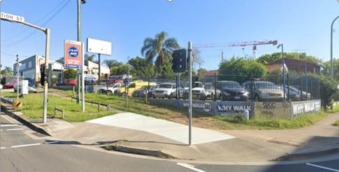
Figure
5- View of similar advertising signage installed on the adjacent north-western
intersection corner from the proposed signage location installed as per
existing License Agreement with Council
Description of the Proposed
Development
Council has received a development
application for the Installation of an illuminated static electronic identilite
advertising sign incorporating:
· Installation
of a pylon sign that has a height of 5.2 metres and a width of 150 mm. The
pylon shall consist of:
o Illuminated street identification
signage for Station Street connected to the pylon approximately. 2.5m from the
natural ground level on the northern elevation with dimensions of 390mm in
height by 970mm width and having an area of 0.378sqm.
o Illuminated street
identification signage for the Great Western Highway connected to the pylon
approximately. 2.78m from the natural ground level on the eastern elevation
with dimensions of 390mm in height by 970mm width and having an area of 0.378
sq m.
o A double sided static
electronic illuminated advertising sign connected to the pylon approximately.
2.98m from the natural ground level on the southern elevation with dimensions
of 1.8m in height by 1.2m width and having an area of 2.16sqm. The
advertisement is static however the advertisement can rotate between
advertisements and as such conditions of consent are imposed regarding dwell
times.
The advertising panel is proposed
to display the name, logo and other information of a local business which
sponsors the sign. The advertising panel and the street name signs are proposed
to be internally illuminated.
It is noted that there is an
existing Licence Agreement between Council and Claude Outdoor (the applicant)
to provide IdentiLite advertising and directional street sign units at selected
locations throughout the Cumberland LGA. This development application is for
additional signage but within the agreed conditions of the standing agreement.
As such a condition is imposed for the consent to be valid until 12 August 2027
in accordance with the existing agreement.
The agreement allows for 55
IdentiLite signages to be installed and as of 2 November 2020, 39 have been
installed with another 5 under review (including the signage proposed as per
this development application). The license agreement is attached at attachment
7 and attachment 8 and a list of the currently installed IdentiLite signage is
at attachment 9.
History
|
Date
|
Action
|
|
29 October 2020
|
DA2020/0646
was lodged with Council
|
|
13
November 2020 to 27 November 2020
|
Application
notified to surrounding properties, a sign was erected on the site, and an
advertisement was placed on Council’s website. No public
submissions were received as a result of the notification.
|
|
9
December 2020
|
Application referred to CLPP
for determination.
|
Applicants Supporting
Statement
The applicant has provided a
Statement of Environmental Effects prepared by Claude Outdoor which was
received by Council on 29 October 2020 in support of the application.
Contact with Relevant
Parties
Council has undertaken a site
inspection of the subject site and surrounding properties and has been in
contact with the applicant throughout the assessment process.
Internal Referrals
Development Engineer (Traffic)
The development application was
referred to Council’s Development Engineer for comment who has advised
that the development proposal is satisfactory subject to conditions.
Properties
The development application was
referred to Council’s properties section for comment who has advised that
the development proposal is satisfactory and can be supported subject to
recommended conditions of consent including that the development be
carried out in accordance with the agreement with Council outlined in the
Schools Alert Sign Deed made on 13 August 2007 (attachment 7) and the Deed of
Variation dated 1 May 2018 (Attachment 8).
External Referrals
Transport for NSW
The location of the signage is
located on a classified road. In this regard, the application was referred to
Transport for NSW (TfNSW) for concurrence, pursuant to clause 138(2) of the
Roads Act and for Council to be satisfied regarding clause 101 of State
Environmental Planning Policy (Infrastructure) 2007. The response received
dated 27 November 2020 which indicates that the proposal is satisfactory with
recommended conditions.
PLANNING COMMENTS
The provisions of any
Environmental Planning Instruments (EP&A Act s4.15 (1)(a)(i))
State Environmental Planning
Policies
The proposed development is
affected by the following State Environmental Planning Policies:
(a) State
Environmental Planning Policy No. 55 – Remediation of Land (SEPP 55)
Clause 7 of SEPP 55 requires
Council to be satisfied that the site is suitable or can be made suitable to
accommodate the proposed development. The matters listed within Clause 7 have
been considered in the assessment of the development application.
|
Matter for
Consideration
|
Yes/No
|
|
Does the application
involve re-development of the site or a change of land use?
|
Yes No
|
|
Does the application involve re-development of the site
or a change of land use?
|
Yes No
|
|
In the development
going to be used for a sensitive land use (e.g.: residential, educational,
recreational, childcare or hospital)?
|
Yes No
|
|
Does information
available to you indicate that an activity listed below has ever been
approved, or occurred at the site?
acid/alkali plant and formulation, agricultural/horticultural
activities, airports, asbestos production and disposal, chemicals manufacture
and formulation, defence works, drum re-conditioning works, dry cleaning
establishments, electrical manufacturing (transformers), electroplating and heat
treatment premises, engine works, explosive industry, gas works, iron and
steel works, landfill sites, metal treatment, mining and extractive
industries, oil production and storage, paint formulation and manufacture,
pesticide manufacture and formulation, power stations, railway yards, scrap
yards, service stations, sheep and cattle dips, smelting and refining,
tanning and associated trades, waste storage and treatment, wood preservation
|
Yes No
|
|
Is
the site listed on Council’s Contaminated Land database?
|
Yes No
|
|
Is
the site subject to EPA clean-up order or other EPA restrictions?
|
Yes No
|
|
Has
the site been the subject of known pollution incidents or illegal dumping?
|
Yes No
|
|
Does
the site adjoin any contaminated land/previously contaminated land?
|
Yes No
|
|
Has
the appropriate level of investigation been carried out in respect of
contamination matters for Council to be satisfied that the site is suitable
to accommodate the proposed development or can be made suitable to
accommodate the proposed development?
|
Yes No
|
|
Details of
contamination investigations carried out at the site:
The
site is identified as a road reserve and no excavation work is required. A
base is to be installed with the signage pylon attached to the base and
proposed signage and street identification signage attached to the pylon.
Given the nature of the development application, it is considered that the
development sought is acceptable for the purpose of the state policy.
|
(b) State
Environmental Planning Policy (Infrastructure) 2007 (ISEPP)
The provisions of the ISEPP 2007
have been considered in the assessment of the development application.
Clause 101 – Frontage to
classified road
The application is subject to
clause 101 of the ISEPP as the site has frontage to a classified road. The
application was referred to Transport for NSW (TfNSW) for comment. A response
was received from Transport for NSW (TfNSW) dated 25 November 2020 indicated
that the proposal is satisfactory without any recommended conditions.
It is noted that there is a red
light speed camera located on the adjacent south eastern intersection corner
facing west however the proposed signage will have no impact upon the camera.
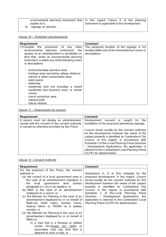
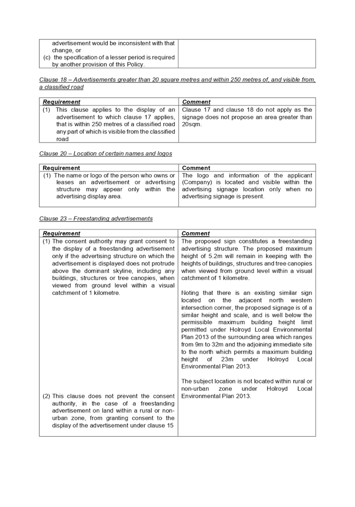
(c) State
Environmental Planning Policy No 64 – Advertising and Signage
A detailed assessment of the proposal
against the provisions of State Environmental Planning Policy No 64 –
Advertising and Signage including assessment against part 3 –
Advertisements and part 4 – Miscellaneous of the SEPP and schedule 1
– Assessment criteria was undertaken and the development proposal is
considered as being compliant with all the provisions subject to conditions..
A comprehensive State
Environmental Planning Policy No 64 – Advertising and Signage assessment
table is provided at attachment 3.
Clause 8 – Granting of
consent to signage
|
Requirement
|
Comment
|
|
A consent authority
must not grant development consent to an application to display signage
unless the consent authority is satisfied:
(a) that the signage is consistent with the
objectives of this Policy as set out in clause 3 (1) (a), and
(b) that the signage the subject of the
application satisfies the assessment criteria specified in Schedule 1.
|
The objectives of the
policy are as follows:
(a) to ensure
that signage (including advertising):
(i) is compatible
with the desired amenity and visual character of an area, and
(ii) provides
effective communication in suitable locations, and
(iii) is of
high quality design and finish, and
(b) to
regulate signage (but not content) under Part 4 of the Act, and
(c) to provide
time-limited consents for the display of certain advertisements, and
(d) to
regulate the display of advertisements in transport corridors, and
(e) to ensure that
public benefits may be derived from advertising in and adjacent to transport corridors.
The proposal is
considered to be consistent with the objectives of the policy subject to
conditions restricting ambiance. The design, height, size and scale of the
signage is generally of acceptable quality and will not detract from the commercial
or residential character of the area. In this regard, it is expected that the
development will have minimal impacts on the amenity of the surrounding
commercial and residential developments.
|
Clause 14 – Duration of
consents
|
Requirement
|
Comment
|
|
(1) A
consent granted under this Part ceases to be in force:
(a) on
the expiration of 15 years after the date on which the consent becomes
effective and operates in accordance with section 83 of the Act, or
(b) if
a lesser period is specified by the consent authority, on the expiration of
the lesser period.
(2)
The consent authority may specify a period of less than 15 years only if:
(a) before
the commencement of this Part, the consent authority had adopted a policy of
granting consents in relation to applications to display advertisements for a
lesser period and the duration of the consent specified by the consent
authority is consistent with that policy, or
(b) the
area in which the advertisement is to be displayed is undergoing change in
accordance with an environmental planning instrument that aims to change the
nature and character of development and, in the opinion of the consent
authority, the proposed advertisement would be inconsistent with that change,
or
(c) the
specification of a lesser period is required by another provision of this
Policy.
|
There is no specified policy adopted by Council in
relation to granting consents for applications to display advertisements for
a lesser period than 15 years, the subject signage is part of an existing
license agreement between Council and the applicant, to provide IdentiLite
advertising and directional street sign units at selected locations
throughout the Cumberland LGA (Refer to attachments 7,8 and 9).
The license agreement specifies a termination date of the
license agreement of 12 August 2027.
In this regard, a condition is imposed limiting the
operation of the consent to expire on 12 August 2027.
|
Regional Environmental Plans
The proposed development is
affected by the following Regional Environmental Plans:
(a) Sydney
Regional Environmental Plan (Sydney Harbour Catchment) 2005
The subject site is identified as
being located within the area affected by the Sydney Regional Environmental
Plan (Sydney Harbour Catchment) 2005. The proposed development raises no issues
as no impact on the catchment is envisaged.
(Note: - the subject site is not
identified in the relevant map as ‘land within the ‘Foreshores and
Waterways Area’ or ‘Wetland Protection zone’, is not a
‘Strategic Foreshore Site’ and does not contain any heritage items.
Hence the majority of the SREP is not directly relevant to the proposed
development).
Local Environmental Plans
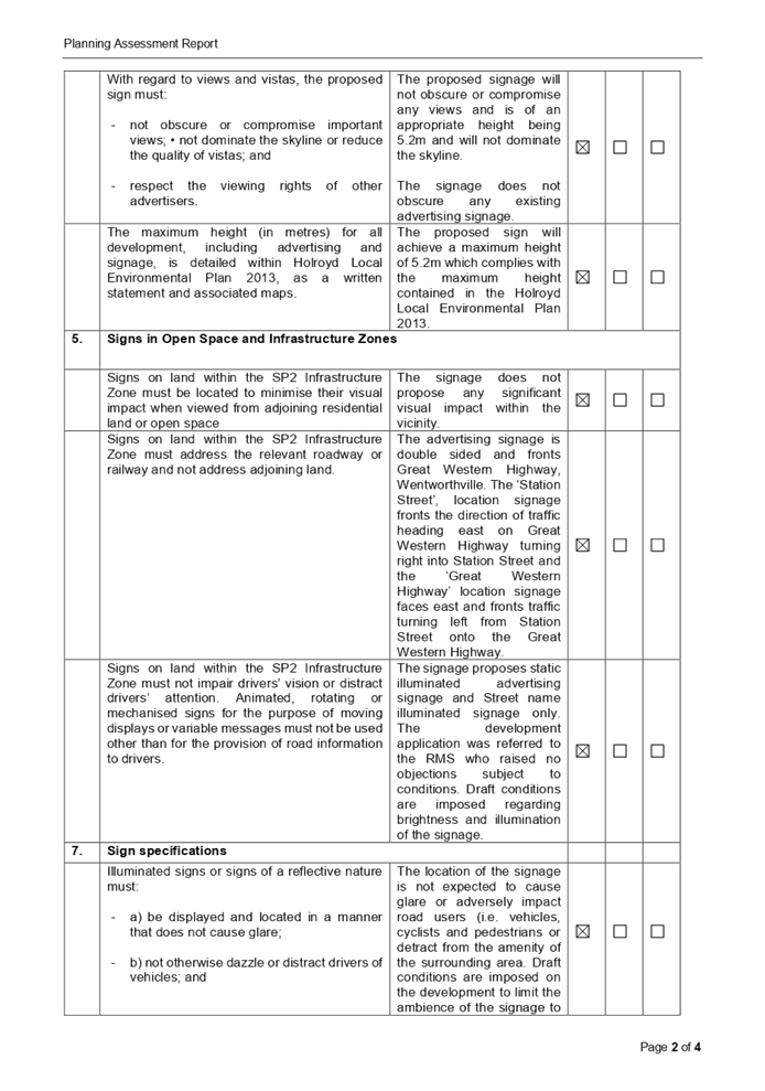
(b) Holroyd
Local Environmental Plan 2013 (HLEP 2013)
The provision of the HELP 2013 is
applicable to the development proposal. The proposed development is defined as
‘signage’ and is permissible in the SP2 - Infrastructure zone with
consent.
Holroyd Local Environmental Plan
2013 defines signage as the following:
signage means any sign, notice,
device, representation or advertisement that advertises or promotes any goods,
services or events and any structure or vessel that is principally designed
for, or that is used for, the display of signage, and includes any of the
following—
(a) an
advertising structure,
(b) a
building identification sign,
(c) a
business identification sign,
but does not include a traffic
sign or traffic control facilities.
It is noted that the development
achieves compliance with the key statutory requirements of the Holroyd LEP and
the objectives of the SP2 - Infrastructure zone. A comprehensive HLEP
compliance table is provided at attachment 5.
The provisions of any proposed
instrument that is or has been the subject (EP&A Act s4.15 (1)(a)(ii))
(a) Draft
Cumberland Local Environmental Plan (CLEP)
The Draft Cumberland Local
Environmental Plan (Draft CLEP) has been prepared by Cumberland City Council to
provide a single planning framework for the future planning of Cumberland City.
The changes proposed seek to harmonise and repeal the three existing LEPs
currently applicable to the Cumberland City local government area, those being:
· Holroyd Local
Environmental Plan 2013
· Parramatta Local
Environmental Plan 2011.
· Auburn Local
Environmental Plan 2010.
The current planning controls for
the subject site, as contained within the HLEP, are not proposed to change
under the Draft CLEP.
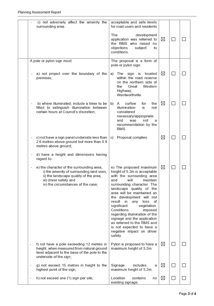
The provisions of any
Development Control Plans (EP&A Act s4.15 (1)(a)(iii))
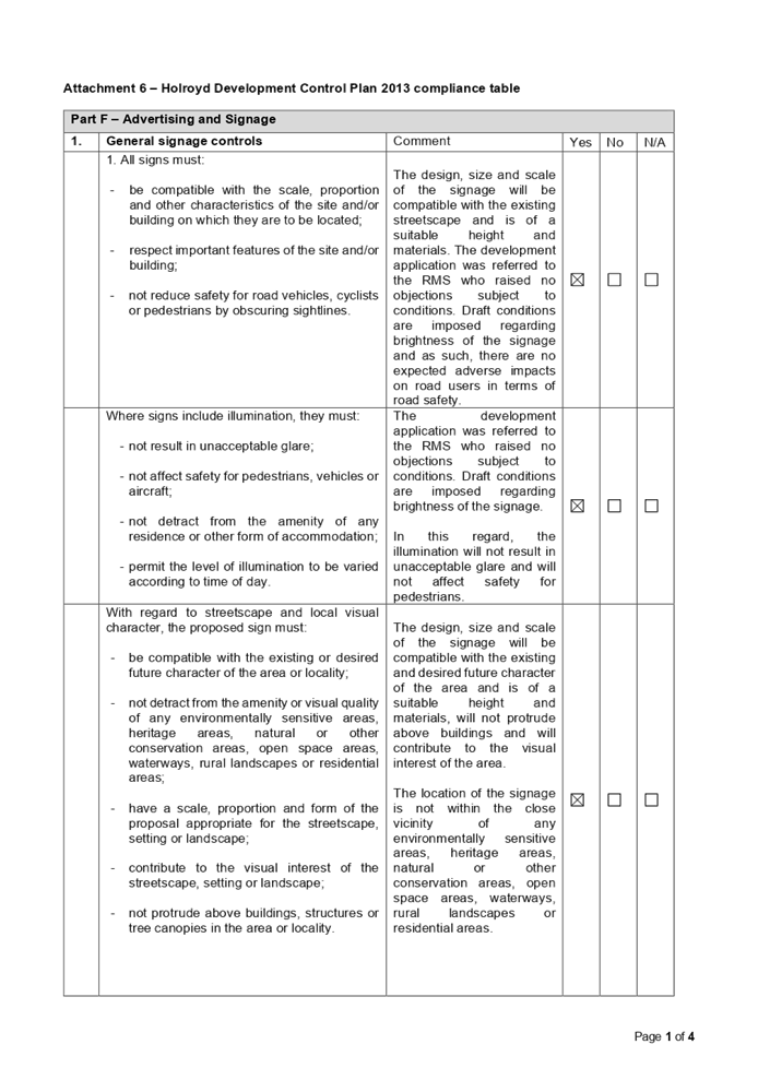
Holroyd Development Control Plan
(HDCP) 2013 contains signage controls under Part F. A detailed assessment using
the HDCP identifies that the proposed development is compliant with the
relevant provisions and no variations are identified.
A comprehensive HDCP compliance
table is attached to this report at Attachment 6.
The provisions of any planning
agreement that has been entered into under section 7.4, or any draft planning
agreement that a developer has offered to enter into under section 7.4
(EP&A Act s4.15(1)(a)(iiia))
There is no planning agreement or
draft planning agreement associated with the subject Development Application
made under section 7.4 of the Environmental Planning and Assessment Act.
It is noted that Claude Outdoor
(the applicant) has an existing Licence Agreement to provide IdentiLite
advertising and directional street sign units at selected locations throughout
the Cumberland LGA. This development application is for additional signage but
within the agreed conditions of the standing agreement.
The agreement allows for 55
IdentiLite signages to be installed and it is identified that 39 have already
been installed by 2 November 2020 with another 5 under review. (Including the
signage proposed as per this development application). The licence agreement is
attached at attachment 7 and attachment 8 and a list of the currently installed
IdentiLite signage is at attachment 9.
The provisions of the
Regulations (EP&A Act s4.15 (1)(a)(iv))
The proposed development raises no
concerns as to the relevant matters arising from the Environmental Planning and
Assessment Regulations 2000 (EP&A Reg).
The Likely Environmental,
Social or Economic Impacts (EP&A Act s4.15 (1)(b))
It is considered that the proposed
development will have no significant adverse environmental, social or economic
impacts in the locality. The proposal is considered satisfactory with regard to
relevant matters such as design quality, landscaping, road safety, lighting and
views and vistas subject to the imposition of suitable conditions of consent to
satisfactorily control the development.
The suitability of the site for
the development (EP&A Act s4.15 (1)(c))
It is considered that the
development is suitable in the context of the site and surrounding locality.
Submissions made in accordance
with the Act or Regulation (EP&A Act s4.15 (1)(d))
|
Advertised (Council Website)
|
Mail
|
Sign
|
Not Required
|
In
accordance with Council’s Notification requirements contained within the
Holroyd DCP 2013, the proposal was publicly notified for a period of 14
days between 13 November 2020 and 27 November 2020. No submissions were
received as a result of the notification.
The public interest (EP&A
Act s4.15(1)(e))
In view of the foregoing analysis,
it is considered that the development, if carried out subject to the conditions
set out in the recommendation below, will have no significant adverse impacts
on the public interest.
Cumberland Local
Infrastructure Contributions Plan 2020
The proposed development does not attract
the payment of any development contributions in accordance with Cumberland
Local Infrastructure Contributions Plan 2020.
Disclosure of Political
Donations and Gifts
The applicant and notification
process did not result in any disclosure of Political Donations and Gifts.
The application has been assessed
in accordance with the relevant requirements of the Environmental Planning and
Assessment Act 1979, State Environmental Planning Policy No 64 –
Advertising and Signage, Transport Corridor Outdoor Advertising and Signage
Guidelines, State Environmental Planning Policy (Infrastructure) 2007, Holroyd
Local Environmental Plan 2013 and the Holroyd Development Control Plan 2013,
and is considered to be satisfactory.
|
That Development Application
No. DA2020/0646 for the installation of illuminated static electronic
identilite advertising sign on land at the north eastern corner of the Great
Western Highway and Station Street, Wentworthville be approved subject to conditions
within the draft notice of determination provided at Attachment 1.
|
1. Draft Notice
of Determination
2. Architectural
Plans
3. State
Environmental Planning Policy No 64 Advertising and Signage
4. Transport
Corridor Outdoor Advertising and Signage Guidelines
5. HLEP
2013 Complaince Table
6. HDCP
2013 Compliance Table
7. Schools
Alert Sign License Deed made on 13 August 2007
8. Deed
of Variation
9. Cumberland
identiLites Lease Agreement - List of signage locations as of 2 November 2020
DOCUMENTS
ASSOCIATED WITH
REPORT LPP060/20
Attachment 1
Draft Notice of Determination
Cumberland Local Planning Panel Meeting
9 December 2020


DOCUMENTS
ASSOCIATED WITH
REPORT LPP060/20
Attachment 2
Architectural Plans
Cumberland Local Planning Panel Meeting
9 December 2020
DOCUMENTS
ASSOCIATED WITH
REPORT LPP060/20
Attachment 3
State Environmental Planning Policy No 64
Advertising and Signage
Cumberland Local Planning Panel Meeting
9 December 2020
DOCUMENTS
ASSOCIATED WITH
REPORT LPP060/20
Attachment 4
Transport Corridor Outdoor Advertising and Signage
Guidelines
Cumberland Local Planning Panel Meeting
9 December 2020
DOCUMENTS
ASSOCIATED WITH
REPORT LPP060/20
Attachment 5
HLEP 2013 Complaince Table
Cumberland Local Planning Panel Meeting
9 December 2020
DOCUMENTS
ASSOCIATED WITH
REPORT LPP060/20
Attachment 6
HDCP 2013 Compliance Table
Cumberland Local Planning Panel Meeting
9 December 2020

DOCUMENTS
ASSOCIATED WITH
REPORT LPP060/20
Attachment 7
Schools Alert Sign License Deed made on 13 August 2007
Cumberland Local Planning Panel Meeting
9 December 2020


DOCUMENTS
ASSOCIATED WITH
REPORT LPP060/20
Attachment 8
Deed of Variation
Cumberland Local Planning Panel Meeting
9 December 2020

DOCUMENTS
ASSOCIATED WITH
REPORT LPP060/20
Attachment 9
Cumberland identiLites Lease Agreement - List of
signage locations as of 2 November 2020
Cumberland Local Planning Panel Meeting
9 December 2020