9 December 2020
A Electronic meeting of the
Cumberland Local Planning Panel
will be held via Zoom on Wednesday, 9 December 2020.
Business as below:
Yours faithfully
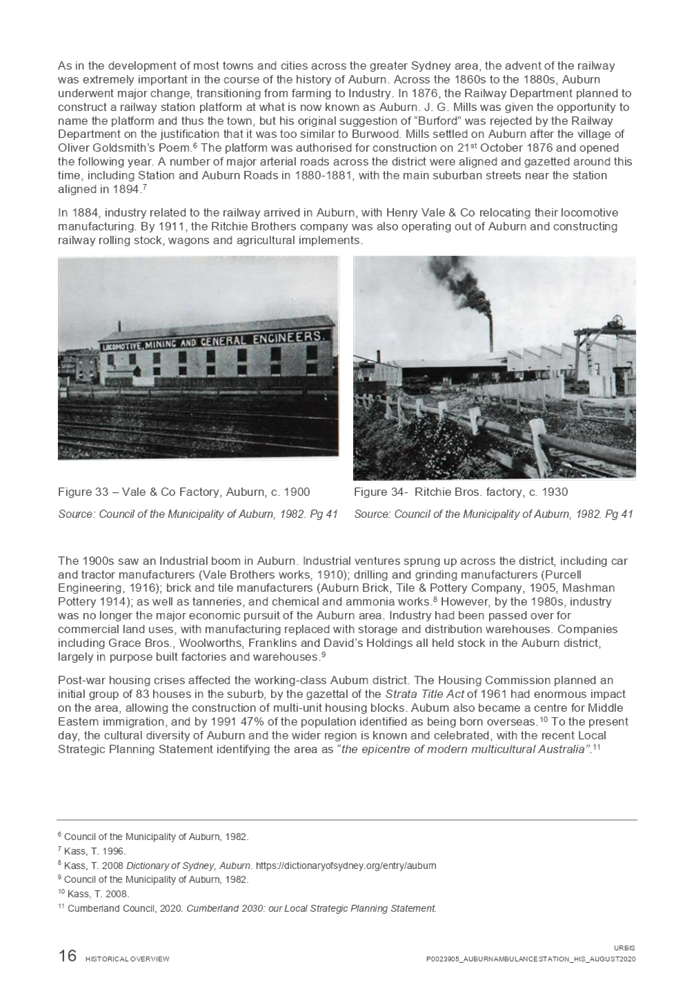
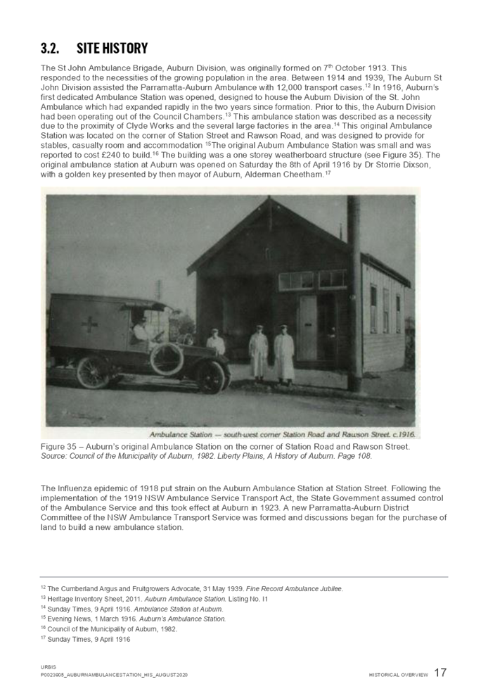
Hamish McNulty
General
Manager
ORDER OF BUSINESS
1. Receipt of Apologies
2. Confirmation of Minutes
3. Declarations of Interest
4. Address by invited
speakers
5. Reports:
- Development
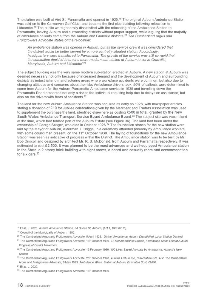
Applications
- Planning
Proposals
6. Closed Session Reports
Cumberland Local Planning Panel Meeting
9 December 2020
CONTENTS
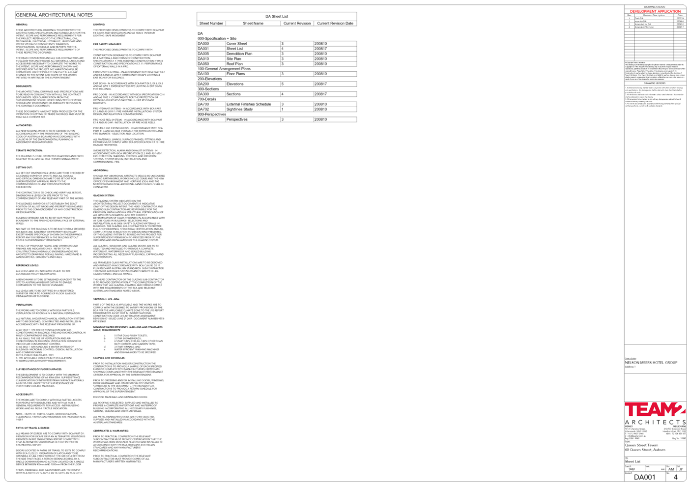
Report No. Name of Report Page
No.
Development Applications
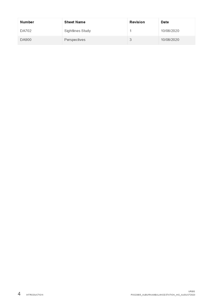
LPP056/20... Development Application
for 60 Queen Street, Auburn................................. 5
LPP057/20... Development Application
for 17 Brooks Circuit, Lidcombe....................... 143
LPP058/20... Development Application
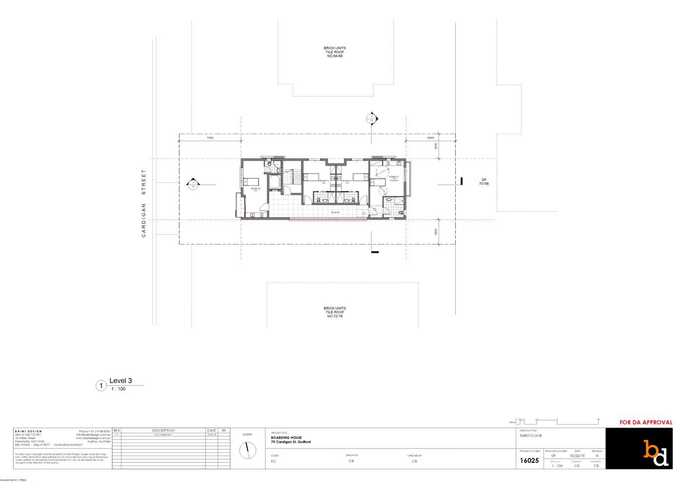
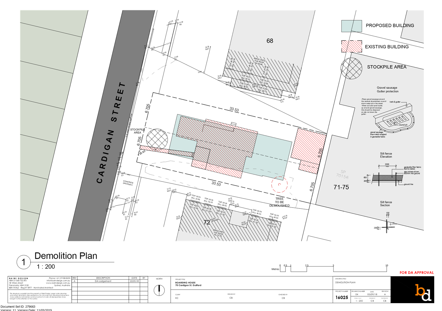
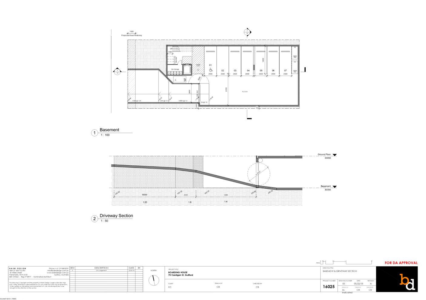
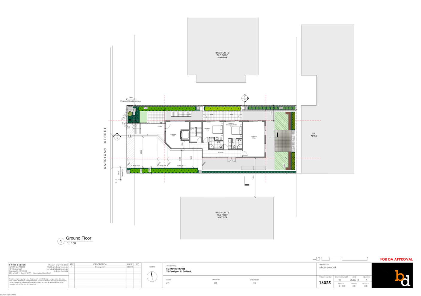
for 70 Cardigan street, Guildford...................... 307
Cumberland Local Planning Panel Meeting
9 December 2020
Cumberland Local Planning Panel Meeting
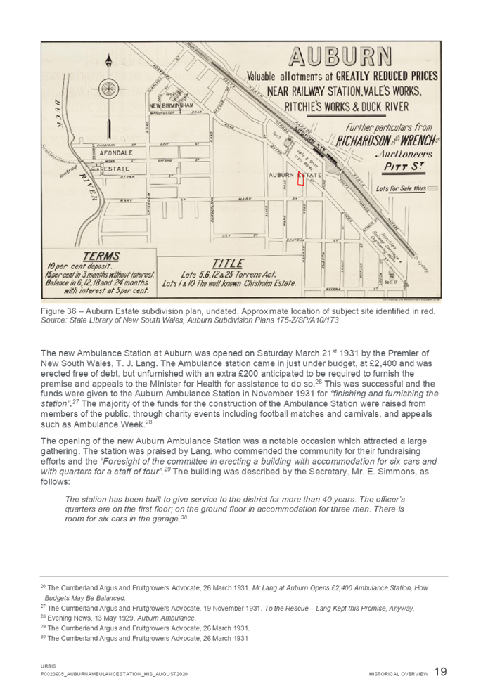
9 December 2020
Item
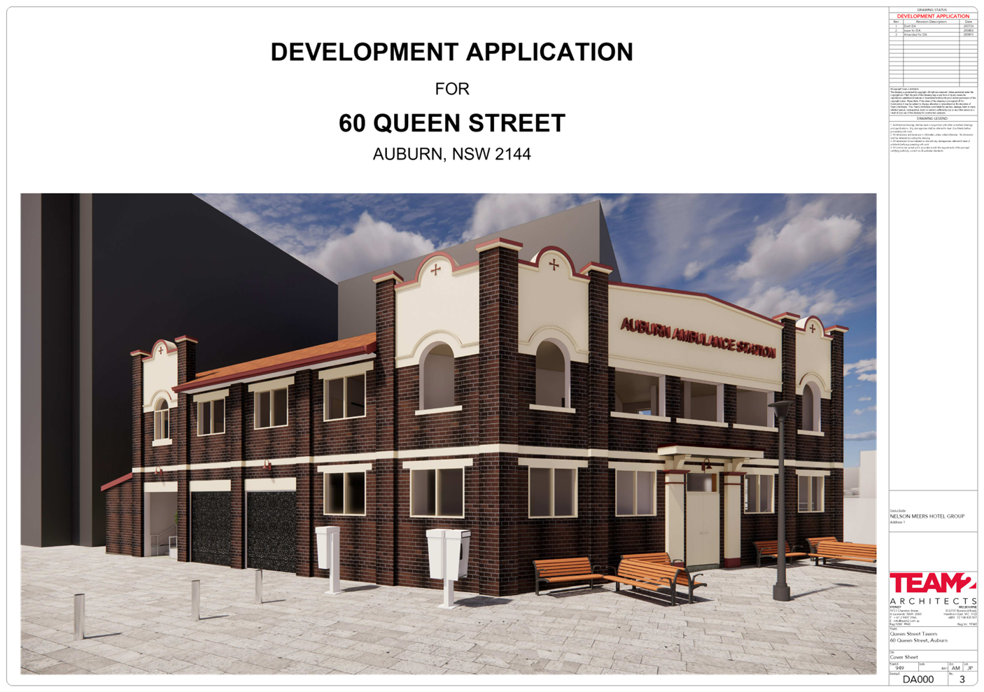
No: LPP056/20
Development
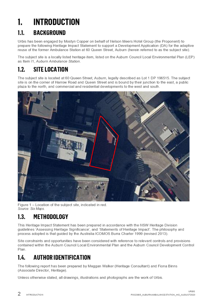
Application for 60 Queen Street, Auburn
Responsible
Division: Environment
& Planning
Officer: Executive
Manager Development and Building
File
Number: DA2020/0486
|
Application
lodged
|
26 August 2020
|
|
Applicant
|
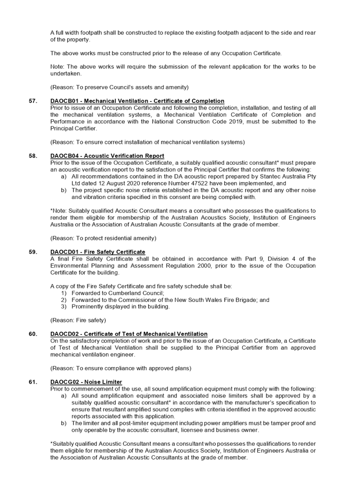
Vic On The Park Trust
|
|
Owner
|
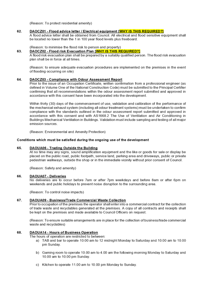
The Trust Company (Australia)
Pty Ltd
|
|
Application
No.
|
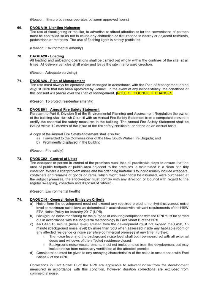
DA2020/0486
|
|
Description
of Land
|
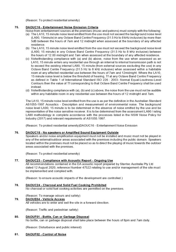
60 Queen Street Auburn being
Lot 1 in DP 196515.
|
|
Proposed
Development
|
Alterations and fit out of the
former Auburn Ambulance Station for use as a pub with TAB and bar to operate
10.00 am to 12:00 midnight Monday to Saturday and 10.00 am to 10.00 pm
Sunday; gaming room to operate 10.00 am to 4.00 am the following morning
Monday to Saturday and 10.00 am to 10.00 pm Sunday; and kitchen to operate
11.00 am to 10.00 pm Monday to Sunday.
|
|
Site
Area
|
360.4 Square metres.
|
|
Zoning
|
B4 Mixed Use zone.
|
|
Disclosure
of political donations and gifts
|
Nil disclosure.
|
|
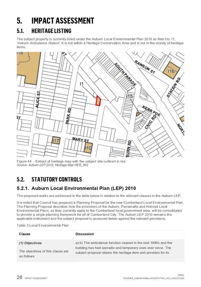
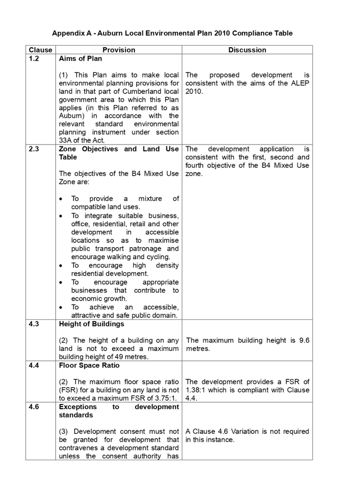
Heritage
|
Yes - Local Heritage Listing -
Item I1 in ALEP 2010.
|
|
Principal
Development Standards
|
Floor Space Ratio
Permissible:- 3.75:1.
Proposed:- 1.38:1 - Existing.
Height of Building
Permissible: 49 metres.
Proposed:- 9.6 metres -
Existing.
|
|
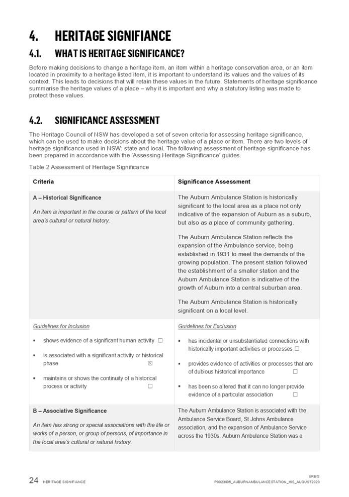
Issues
|
Heritage listed building.
Car parking numbers.
|
1. Development
Application 2020/0486 was received on 26 August 2020 for alterations and fit
out of the former Auburn Ambulance Station for use as a pub with TAB and bar to
operate 10.00 am to 12:00 midnight Monday to Saturday and 10.00 am to 10.00 pm
Sunday; gaming room to operate 10.00 am to 4.00 am the following morning Monday
to Saturday and 10.00 am to 10.00 pm Sunday and the kitchen to operate 11.00 am
to 10.00 pm Monday to Sunday.
2. The
application was publicly notified to occupants and owners of the adjoining properties
for a period of fourteen (14) days between the 9 September and the 23 September
2020. In response, one submission was received.
3. The
subject site is listed as a heritage item (Item Number I1 in the Auburn Local
Environmental Plan 2010).
4. The
variations are as follows:
|
Control
|
Required
|
Provided
|
% variation
|
|
Part 6.1 Auburn Development Control Plan 2010.
|
Car parking rates to be in accordance with the Parking and
Loading part of the Auburn Development Control Plan 2010.
Minimum 88 spaces.
|
“Nil”
|
100%.
|
5. The
application is recommended for deferred commencement consent subject to the
conditions as provided in the attached schedule.
6. The
application is referred to the Panel as the development application is for a
licensed premises.
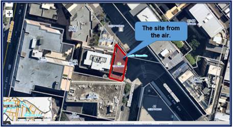
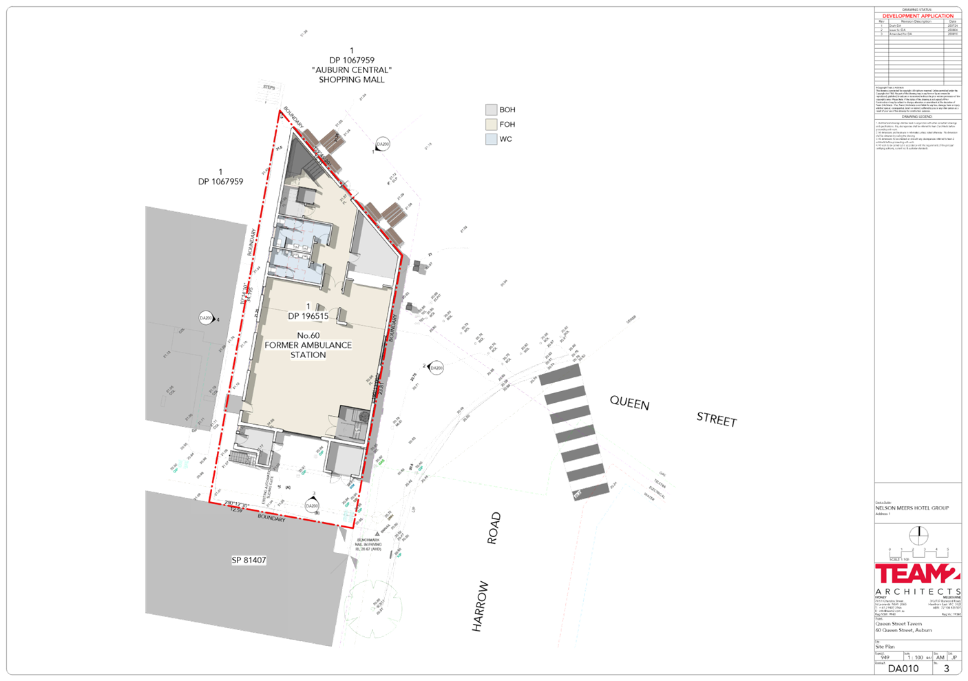
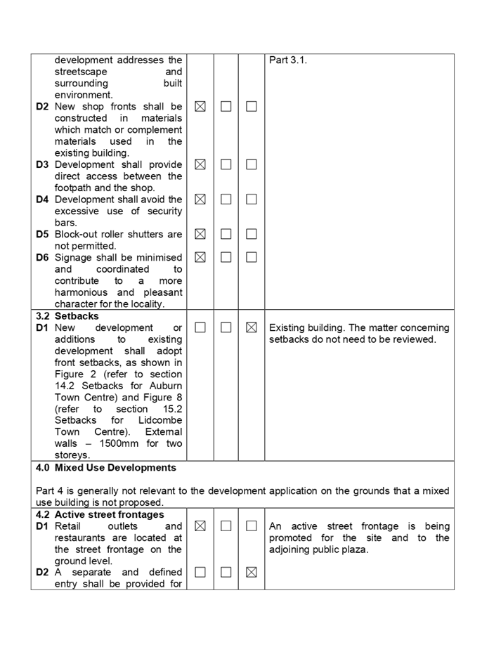
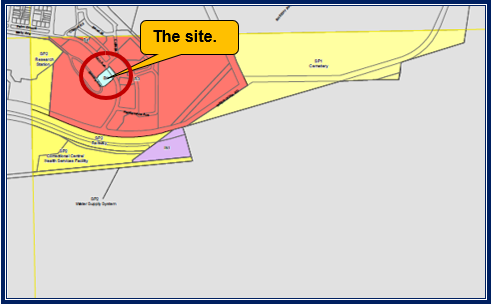
Subject Site and Surrounding
Area
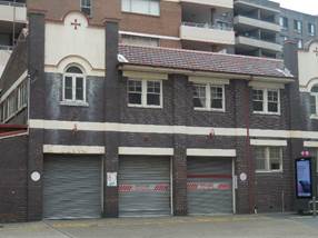
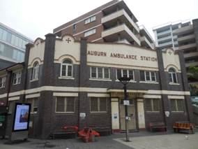
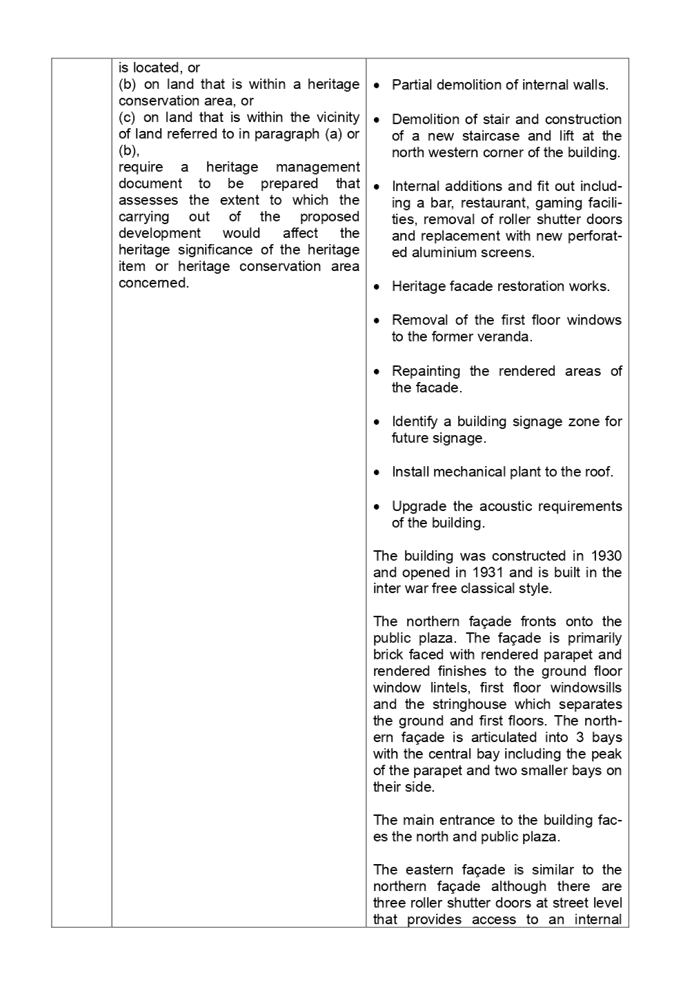
The site is known as the former
Auburn Ambulance Station which is listed as a local heritage item (Item I1)
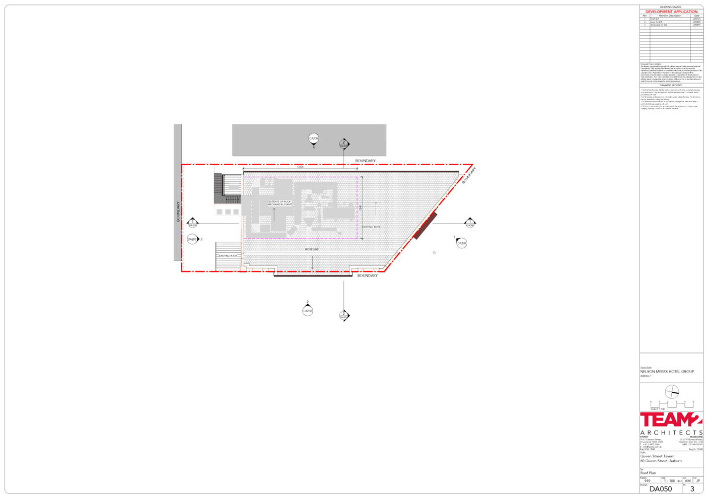
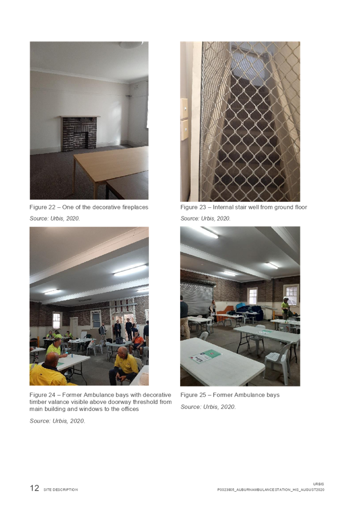
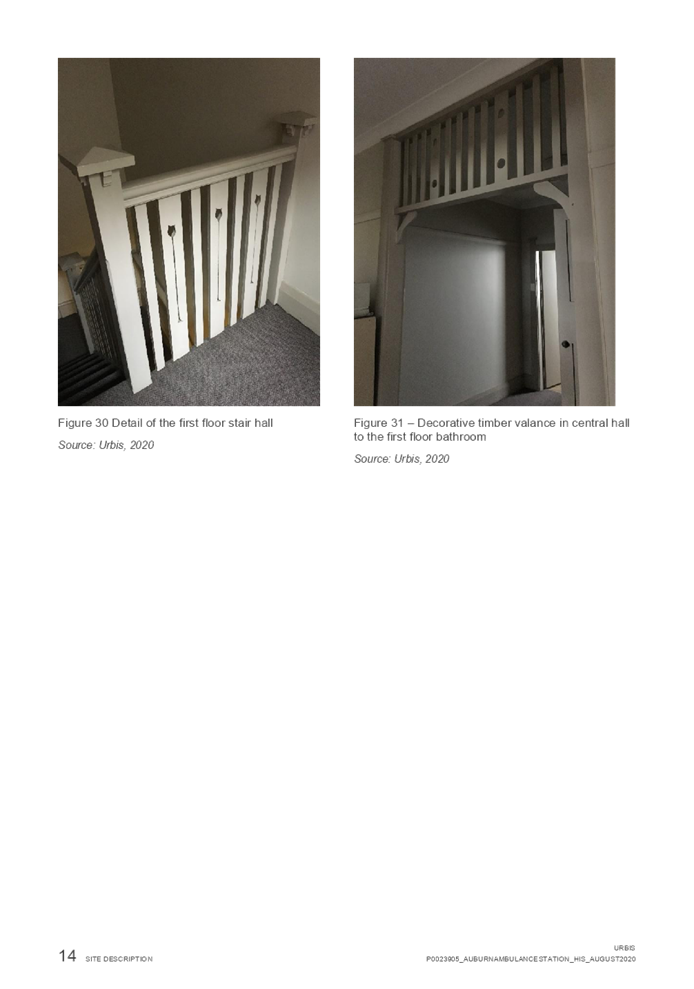
under the Auburn Local Environmental Plan 2010. The building on site is two
storeys in height which comprises a ground floor that occupies 258 square
metres and a first floor that occupies an area of 240 square metres.
The ground floor includes a garage
which was previously used to park ambulances. The garage has direct vehicle
access to Harrow Road. The ground floor also has offices and amenities. The
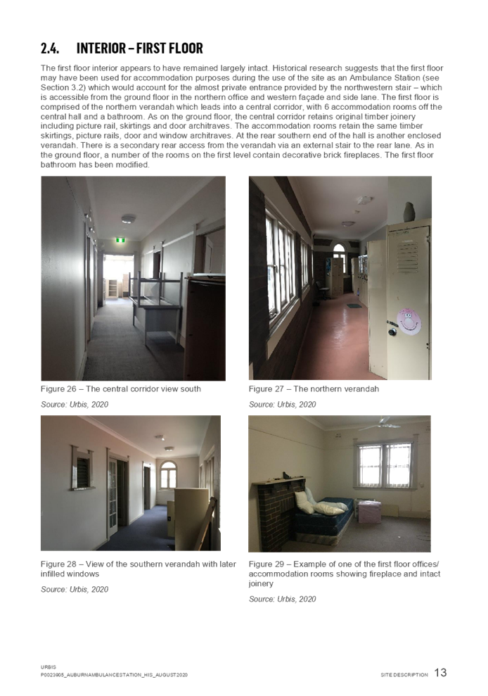
first storey is accessed via an internal stairwell and includes offices,
bathrooms and enclosed verandas.
The main entrance to the building
is from the public plaza situated on the northern side of the building. There
is a secondary access via a service alley situated on the western facade of the
building. The western facade entry provides access to the internal stair and
the first floor.
The site includes a driveway which
provides vehicle access from Harrow Road to the site and the adjoining site to
the west which is part of Auburn Central via a Right of Way. The driveway entry
area is covered by an awning structure. The benefitted lot is the subject site
and the burdened lot is Lot 1 in DP 1067959 which is the site to the west or
part of Auburn Central. The site is not provided with any on site car parking.
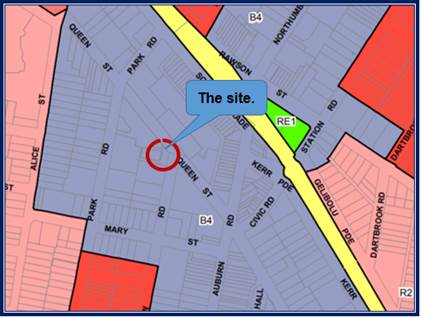
The site adjoins Auburn Central
which incorporates a Woolworths Supermarket and numerous smaller shop and
services as well as commercial premises, a school and apartments to the north
and west. Auburn Central is serviced with underground car parking with vehicle
access from Park Road and Queen Street.
The Auburn Village lies to the
east which incorporates basement car parking and a single storey mall as well
as a pub. It is known that development consent has been issued for the
redevelopment of the site although such works have not commenced. The applicant
contends that the existing pub at the Auburn Shopping Village is to be
relocated to the subject site.
A six storey building lies to the
south which is used for offices, a school and retail.
Generally, the site benefits from
the immediate proximity and walkable access to public transport such as the
Auburn Railway Station and bus stops.
The location of the site is shown
below.
The land use zoning map is provide
below.
Photos of the site are provided
below.
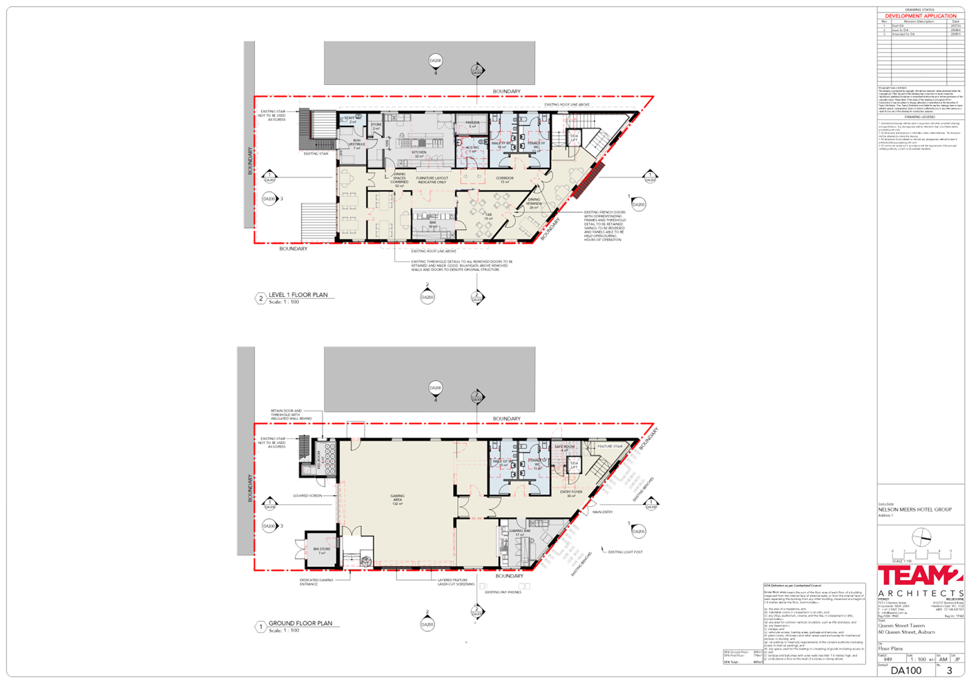
Description of the Proposed
Development
Development Application 2020/486
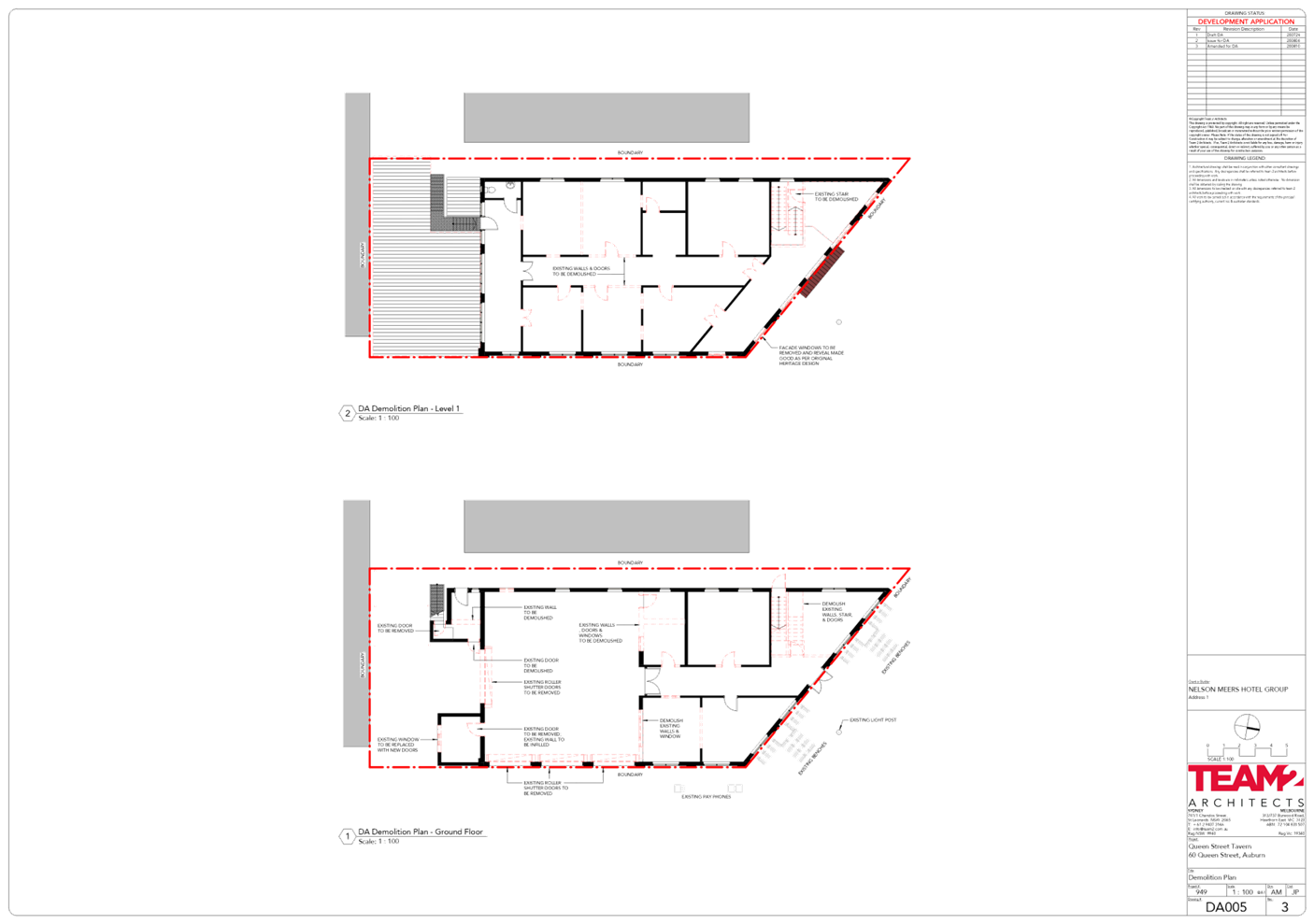
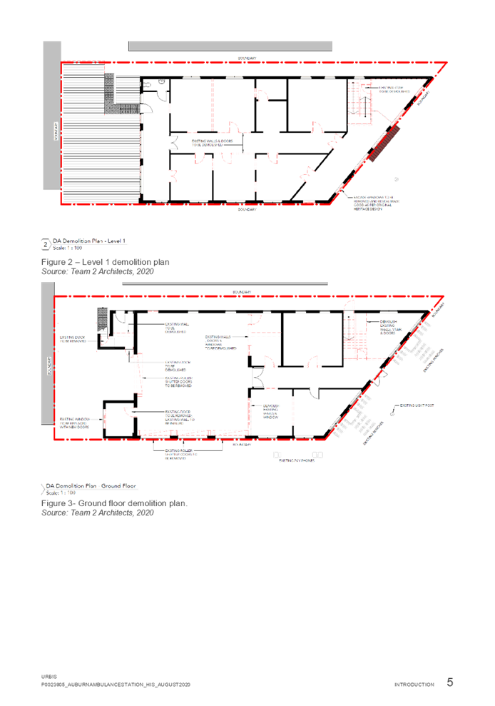
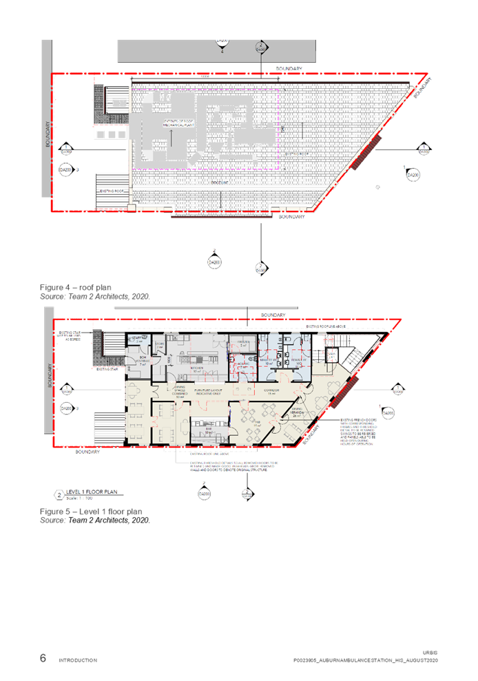
is proposing the change of use and fit out of the former ambulance station for
a pub. The works include the partial demolition of the existing building
including the removal of internal walls to facilitate the reconfiguration and
adaptive re use as a pub.
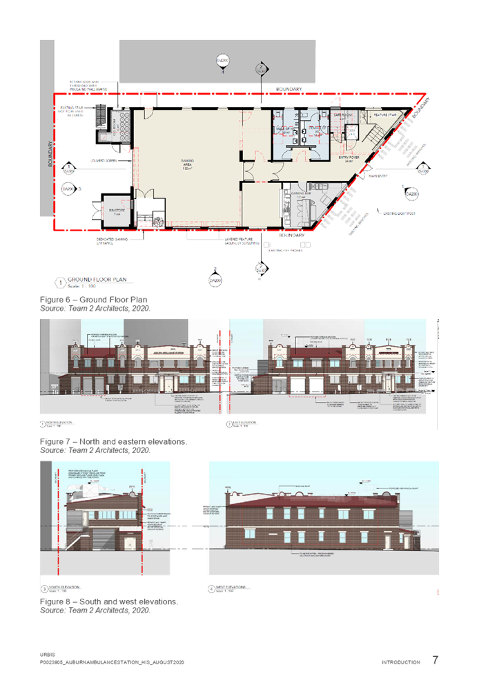
Ground floor
A main entry foyer from Queen
Street will be established as well as a gaming bar, bathrooms, staircase, a new
lift and a safe room. Minor demolition is also proposed to the existing
outbuilding additions at the rear of the site to accommodate storage rooms.
An existing room on the ground
floor situated on the south eastern side of the building will be converted to a
bin store.
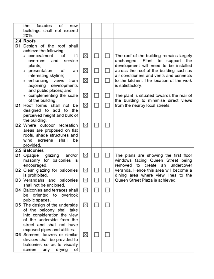
First floor
The first floor verandas will be
opened to allow dining, an indoor public dining area will be established, a
TAB, bar, kitchen, amenities and back of house amenities will be constructed.
Facade improvements
The following external works are
to occur:-
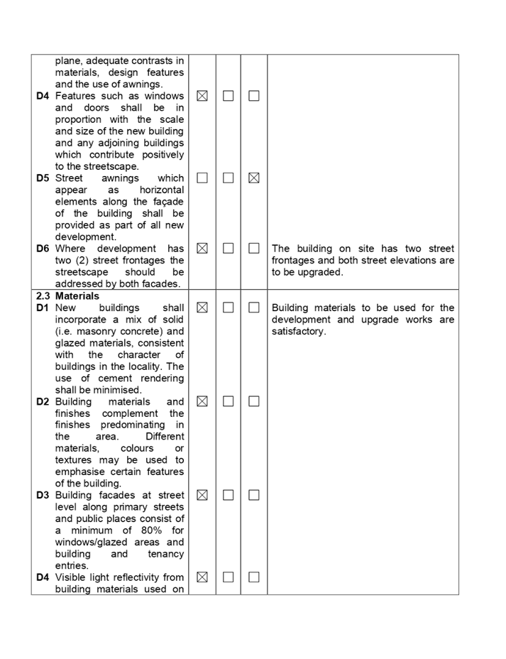
· Windows
and doors will be replaced to improve the appearance of the building.
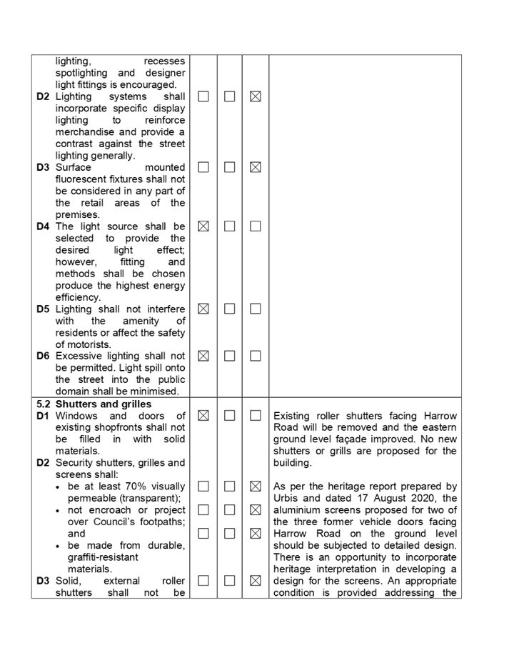
· The
roller shutter doors situated along the Harrow Road side of the building will
be removed and replaced with new aluminium screens.
· A
new pedestrian entry on the Harrow Road elevation will be constructed.
· New
signage zones to be created for business identification signs with one facing
Queen Street and one facing Harrow Road. No details of signage is provided and
the statement of effects specifies that a separate development application will
be lodged for future signage on site.
Roof top plant
New rooftop plant is proposed
which includes mechanical plant for the air conditioners and exhaust from the
kitchen.
Operational details
The proposed trading hours are:-
TAB / Bar on level 1
· 10.00
am to 12:00 midnight Monday to Saturday and 10.00 am to 10.00 pm Sunday.
Gaming room
· 10.00
am to 4.00 am the following morning Monday to Saturday and 10.00 am to 10.00 pm
Sunday.
Kitchen
· 11.00
am to 10.00 pm Monday to Sunday.
History
A concept design was presented to
Council officers on the 30 April 2020 and pre lodgement notes were issued on
the 1 May 2020. The applicant was required to address issues of heritage, car
parking and loading and upgrades to the building.
The development application
2020/0486 was lodged to the Council for determination on 26 August 2020.
Applicants Supporting
Statement
The applicant has provided a
Statement of Environmental Effects prepared by URBIS and dated 17 August 2020.
Contact with Relevant
Parties
The assessing officer has
undertaken a site inspection of the subject site and surrounding properties and
has been in regular contact with the applicant throughout the assessment
process.
Internal Referrals
Development Engineer
The development application was
referred to Council’s Development Engineer for comment who has advised
that the development application is supported on the grounds of car parking,
loading and stormwater management subject to deferred commencement consent
being the creation of a suitable easement to support the small rigid vehicle
unloading area. It is noted that the site is located within the Auburn Town
Centre and there is no opportunity to provide onsite car parking.
Council’s Heritage
Committee
The development application was
referred to Council’s Heritage Committee who responded on the 22 October
2020. The Committee does not object to the development application and the
adaptive reuse of the building as a pub.
Waste Management
The development application was
referred to Council’s Senior Waste Projects Officer for comment who has
advised that the proposed waste provisions is satisfactory. No conditions are
recommended although standard waste conditions are provided at Conditions 32,
67, 73 and 80 attached to the recommendation.
External Referrals
The development application was
referred to the Auburn Police Area Command who commented on the development
dated 11 September 2020 as follows:-
· Adequate
business identification signage is required.
· A
hold up / duress alarm and an internal alarm system is required on site.
· The
premise should be provided with suitable signage and lighting to deter
criminals.
· Security
officers should be considered.
· A
closed circuit television camera system should be installed.
· Outlaw
motorcycle related organisations should be prohibited at the premise.
Conditions numbered 36, 86 and 88
are attached to the recommendation that addresses the matters raised.
PLANNING COMMENTS
The provisions of any
Environmental Planning Instruments (EP&A Act s4.15 (1)(a)(i))
State Environmental Planning
Policies
The proposed development is
affected by the following State Environmental Planning Policies:
(a) State
Environmental Planning Policy No. 55 - Remediation of Land (SEPP 55)
Clause 7 of SEPP 55 requires
Council to be satisfied that the site is suitable or can be made suitable to
accommodate the proposed development. The matters listed within Clause 7 have
been considered in the assessment of the development application.
|
Matter for Consideration
|
Yes/No
|
|
Does the application involve re-development of the site or
a change of land use? Comment:- Change of land use only.
|
Yes
No
|
|
Is the development going to be used for a sensitive land
use (e.g.: residential, educational, recreational, childcare or
hospital)?
Comment:- Recreational.
|
Yes
No
|
|
Does information available to you indicate that an
activity listed below has ever been approved, or occurred at the site?
acid/alkali plant and
formulation, agricultural/horticultural activities, airports, asbestos
production and disposal, chemicals manufacture and formulation, defence
works, drum re-conditioning works, dry cleaning establishments, electrical
manufacturing (transformers), electroplating and heat treatment premises,
engine works, explosive industry, gas works, iron and steel works, landfill
sites, metal treatment, mining and extractive industries, oil production and
storage, paint formulation and manufacture, pesticide manufacture and
formulation, power stations, railway yards, scrap yards, service stations,
sheep and cattle dips, smelting and refining, tanning and associated trades,
waste storage and treatment, wood preservation
|
Yes
No
|
|
Is the site listed on
Council’s Contaminated Land database?
|
Yes
No
|
|
Is the site subject to EPA
clean-up order or other EPA restrictions?
|
Yes
No
|
|
Has the site been the subject of
known pollution incidents or illegal dumping?
|
Yes
No
|
|
Does the site adjoin any
contaminated land/previously contaminated land?
|
Yes
No
|
|
Has the appropriate level of
investigation been carried out in respect of contamination matters for
Council to be satisfied that the site is suitable to accommodate the proposed
development or can be made suitable to accommodate the proposed development?
|
Yes
No
|
|
Details of contamination investigations carried out at the
site:
The
site is not identified in Council’s records as being contaminated and
the building on site was constructed during 1930 / 1931. A site inspection
reveals the site does not have any obvious history of a previous land use
that may have caused contamination and there is no specific evidence that
indicates the site is contaminated. The building on site is retained and no
excavation is proposed. A detailed contamination audit is not required in
this instance.
|
(b) State
Environmental Planning Policy No 64 - Advertising and Signage
The development application
includes the provision for two signage zones which are marked on the plans as
being situated above the north facing door entrance of the building and above
the proposed screens that faces east. The signage zones do not impact the
windows or the architectural features of the building and as such no objection
is raised to the signage zones shown. No details of signage is provided and the
statement of effects specifies that a separate development application will be
lodged for future signage on site. As such, no assessment is required in
relation to signage and Condition 94 attached to the recommendation addresses
the need for a separate development application for signage for the
building.
Regional Environmental Plans
(a) Sydney
Regional Environmental Plan (Sydney Harbour Catchment) 2005
The subject site is identified as
being located within the area affected by the Sydney Regional Environmental
Plan (Sydney Harbour Catchment) 2005. The proposed development raises no issues
as no impact on the catchment is envisaged.
(Note: - the subject site is not
identified in the relevant map as ‘land within the ‘Foreshores and
Waterways Area’ or ‘Wetland Protection zone’, is not a
‘Strategic Foreshore Site’ and does not contain any heritage items.
Hence the majority of the SREP is not directly relevant to the proposed
development).
Local Environmental Plans
The provision of the Auburn Local
Environmental Plan 2010 is applicable to the development proposal. It is noted
that the development achieves compliance with the key statutory requirements of
the Auburn Local Environmental Plan 2010 and the objectives of the B4 Mixed Use
zone.
(a) Permissibility:-
The proposed development is
defined as a ‘Pub” which is defined as a “licensed premises
under the Liquor Act 2017, the principal purpose of which is the retail sale of
liquor for consumption on the premise, whether or not the premises include
hotel or motel accommodation and whether or not food is sold or entertainment
is provided on the premises.
Note. Pubs are a type of
food and drink premises - See the definition of that term in this Dictionary.
The development could also be
defined as a food and drink premises which includes “a pub”.
A pub is a permitted land use with
consent in the B4 Mixed Use zone.
|
DEVELOPMENT
STANDARD
|
COMPLIANCE
|
DISCUSSION
|
|
4.3 Height of Buildings
Permitted - 49 metres.
|
Yes
|
Existing. Maximum 9.6 metres.
|
|
4.4
Floor Space Ratio
Permitted - 3.75:1.
|
Yes
|
Existing. 1.38:1.
|
|
5.10 Heritage Conservation
|
Yes
|
The building is listed as a
local heritage item I1 within the Auburn Local Environmental Plan 2010.
The building is representative
as an intact example of the interwar free classical style as applied to an
important local utility. The building is now a notable landmark to the local
area due to its location.
The proposed development will
retain much of the original built form and the building is being renovated or
repaired.
New plant will need to be
installed onto the roof of the building to facilitate the use which is an
essential requirement.
The building will require fire
and Building Code of Australia upgrades to facilitate the use.
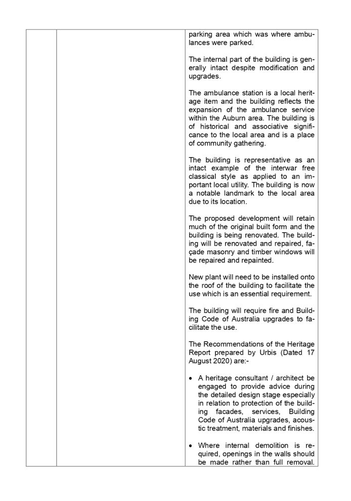
The Recommendations of the
Heritage Report prepared by Urbis (Dated 17 August 2020) are:-
· A heritage consultant / architect be engaged to provide
advice during the detailed design stage especially in relation to protection
of the building facades, services, Building Code of Australia upgrades,
acoustic treatment, materials and finishes.
· Where internal demolition is required, openings in the
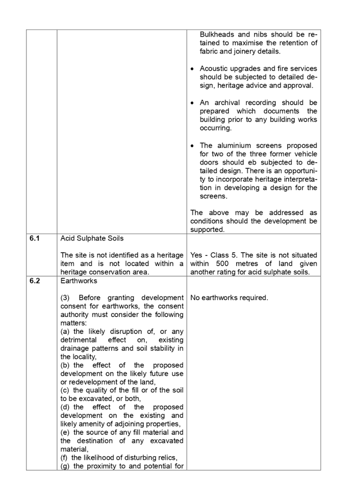
walls should be made rather than full removal. Bulkheads and nibs should be
retained to maximise the retention of fabric and joinery details.
· Acoustic upgrades and fire services should be subjected
to detailed design, heritage advice and approval.
· An archival recording should be prepared which documents
the building prior to any building works occurring.
· The aluminium screens proposed for two of the three
former vehicle doors should be subjected to detailed design. There is an
opportunity to incorporate heritage interpretation in developing a design for
the screens.
The recommendations made in the
report are supported by Council officers and conditions 5 and 14 are attached
to the recommendation addressing the conclusions made.
|
The provisions of any proposed
instrument that is or has been the subject (EP&A Act s4.15 (1)(a) (ii))
(a) Draft
Cumberland Local Environmental Plan (Draft CLEP)
The Draft Cumberland Local
Environmental Plan (Draft CLEP) has been prepared by Cumberland City Council to
provide a single planning framework for the future planning of Cumberland City.
The changes proposed seek to harmonise and repeal the three existing LEPs
currently applicable to the Cumberland local government area, those being:
· Holroyd Local
Environmental Plan 2013,
· Parramatta Local
Environmental Plan 2011, and
· Auburn Local
Environmental Plan 2010.
The current planning controls for
the subject site, as contained within the Auburn Local Environmental Plan 2010
are not expected to change. The development will be compliant with the
important elements of the draft local environmental plan on the grounds that
the building on site is being retained.
The provisions of any
Development Control Plans (EP&A Act s4.15 (1)(a)(iii))
The Auburn Development Control
Plan 2010 “Local Centres” chapter is relevant to the development
application as it provides guidance for the design and operation of development
to achieve the aims and objectives of the Auburn Local Environmental Plan 2010.
Most of the provisions will not
apply to the development application as the development is the adaptive reuse
of a heritage listed building which is earmarked to be retained. The following
table highlights non-compliances with the DCP, which relate primarily to car
parking and loading.
|
Part
|
Control
|
Proposed
|
Complies
|
|
6.1 Access Loading and Car parking requirements.
|
Car parking rates and loading and unloading to be in
accordance with the Parking and Loading part of the development control plan.
Require 88 car spaces at 1 space per 3.5 sq m of licensed
floor area.
Require 1 loading bay.
|
No car parking provided on site.
Variation 100%.
1 Loading bay provided.
|
No
Yes
|
As identified in Part 6.1, the
development application provides no onsite car parking. The building will offer
309 square metres of licensed floor area and would require 88 car parking
spaces which cannot be provided on site.
The variation is a result of a
rather onerous car parking rate that is applied to a “Pub” within
the Auburn Development Control Plan that being 1 space per 3.5 square metres of
licensed floor area. However, the applicant in the Traffic Assessment Report
prepared by TEF Consulting and dated 12 August 2020 has indicated that the number
of spaces being “Nil” is acceptable for the following reasons.
a) The
building is a heritage item and it is not possible to create any spaces on
site. This restriction would apply to any development or change of land use for
the site.
b) The
car parking rates are excessive. The rates are 10 years old and do not reflect
current contexts and the reduced parking demand of pubs due to more frequent
driver breath testing in recent years. Further, the rate does not recognise the
location of the pub close to other retail and commercial uses that attract the
same customers.
c) The
rate of 1 space per 3.5 square metres of licensed area assumes that patrons are
crowded within approximately 1 metre from each other and that all patrons drive
to the premises.
d) The
site is located within 200 metres of public transport including bus and rail
services.
e) The
application of the same rate yields a requirement for 91 spaces. There is no
dedicated car parking provision at this level or within the Auburn Shopping
Village which contains a car park for 145 vehicles. The Auburn Shopping Village
car park is used by customers of the shopping centre, staff and general public.
The car park is closed by 9 pm daily and thus does not provide for late night
patrons who have to seek parking elsewhere.
f) Under
the Auburn Local Environmental Plan 2010, a pub is a type of food and drink
premise which is categorised under ‘Retail premises”. Based on the
ALEP definition, car parking rates for retail premises also apply to the
development. Based on the rates under 6A of the Parking and Loading Chapter of
the Auburn Development Control Plan 2010, the development would need a minimum
of 5 spaces and a maximum of 7 spaces at a rate of:-
· Minimum
- 1 space per 60 square metres.
· Maximum
- 4 spaces per 40 square metres.
g) The
draft Cumberland Development Control Plan 2020 has excluded a specific rate for
pubs and has a specific town centre car parking rate for food and drink
premises. The car parking rate set out in Part G3 - Section 3 (Table 1) is Food
and drink premises Within town centres - 1 space per 40 square metres. The
development would need 7 spaces in this instance.
Comments
In relation to the above and the
applicant’s traffic study, the site is located within a Town Centre
setting and is close to the Auburn Railway Station and bus services.
Furthermore, Council engineers are not requiring car parking to be provided on
site given that there is no room for such parking.
Whilst Council supports the
development application, Council does not accept the applicant’s
justification in “f” and “g” above that the car parking
rate should be based on the Town Centre rate being a minimum of 1 space per 60
square metres and a maximum of 4 spaces per 40 square metres. This would yield
the need to provide 5 to 7 car parking spaces for the site.
It is Council’s view that a
pub does not fall within the grouping of Commercial / Retail area. A pub has a
specific rate at s5.1.4 of the Auburn Development Control Plan. The s5.1.4
rates are to be applied over the s5.1.5 rates. Therefore, the rate should be 1
space per 3.5 square metres of licensed floor area which would yield 88 spaces.
Council officers have however
considered the applicant’s traffic and parking impact report and the
recent survey of the existing adjoining pub undertaken on the Friday and
Saturday 3 and 4 July 2020 being the busiest times between 3.30 pm and 10.30 pm
which concludes:-
a) A
majority of people walked to the tavern (71.1% on a Friday and 64.5% on a
Saturday) and only a small number drove (18.3% on a Friday and 10.3% on a
Saturday).
b) Of
those who drove, 48.4% on a Friday and 26.7% on a Saturday had other purposes
for visiting the area. Of those who drove, most parked within nearby car parks
or local streets where parking restrictions applied.
c) Total
numbers who visited the site were 142 (Friday) and 107 (Saturday).
d) It
is estimated that the maximum number of patrons on the site will be 40 on a
Friday and 28 on a Saturday.
e) The
maximum car parking demand will be 6 to 7 spaces on a Friday and 2 to 3 spaces
on a Saturday.
Noting the above conclusions and
location of the site within the Auburn Town Centre, the variation to the car
parking rate of the Parking and Loading Chapter of the Auburn Development
Control Plan 2010 is considered acceptable on its merit.
Parking and Loading Chapter
The Parking and Loading Chapter of
the Auburn Development Control Plan is relevant to the development application.
Generally, the provision and issues of car parking is addressed above under
Part 6.1 of the “Local Centres” chapter.
Loading and unloading
Under Section 7 of the Parking and
Loading chapter of the Auburn Development Control Plan, the development is
required to have a minimum of 1 loading and unloading bay. The applicant states
that a loading and unloading bay is available within the easement / Right of
Way that benefits the site.
The applicant has requested that a
heavy rigid vehicle be used for loading and unloading purposes on an infrequent
basis however Council does not support the use of heavy rigid vehicle on site.
Council will support the use of small rigid vehicles for loading and unloading
operations subject to an appropriate right of way being created. Condition 1
attached to the recommendation addresses such matters.
The provisions of any planning
agreement that has been entered into under section 7.4, or any draft planning
agreement that a developer has offered to enter into under section 7.4
(EP&A Act s4.15(1)(a)(iiia))
There is no draft planning
agreement associated with the subject Development Application.
The provisions of the
Regulations (EP&A Act s4.15 (1)(a)(iv))
The proposed development raises no
concerns as to the relevant matters arising from the Environmental Planning and
Assessment Regulations 2000 (EP&A Reg).
The Likely Environmental,
Social or Economic Impacts (EP&A Act s4.15 (1)(b))
It is considered that the proposed
development will have no significant adverse environmental, social or economic
impacts in the locality.
The suitability of the site for
the development (EP&A Act s4.15 (1)(c))
The subject site and locality is
not known to be affected by any natural hazards or other site constraints
likely to have a significant adverse impact on the proposed development.
Accordingly, it is considered that the development is suitable in the context
of the site and surrounding locality.
Submissions made in accordance
with the Act or Regulation (EP&A Act s4.15 (1)(d))
|
Advertised (newspaper)
|
Mail
|
Sign
|
Not Required
|
In accordance with Council’s
Notification requirements contained within the Auburn Development Control Plan,
the development was publicly notified for a period of fourteen (14) days
between the 9 September and the 23 September 2020. The notification period generated
one (1) submission in respect of the development sought. The issues raised in
the public submission is summarised and commented on below:
|
Issue:
|
Council Comment:
|
|
The development does not fit the community needs and
provides no benefits. Instead, the building should be used as a community
centre.
|
The assessment of the development application identifies
that the change of use is satisfactory and appropriate conditions are to be
provided addressing site operations, hours of operation, noise, safety and
odours.
|
The public interest (EP&A
Act s4.15(1)(e))
In view of the foregoing analysis
it is considered that the development, if carried out subject to the conditions
set out in the recommendation below, will have no significant adverse impacts
on the public interest.
Cumberland Local
Infrastructure Contributions Plan 2020
The development would require the
payment of contributions in accordance with Cumberland Local Infrastructure
Contributions Plan 2020.
The development should it be
supported requires the payment of contributions in accordance with the
Cumberland Local Infrastructure Contributions Plan 2020. A figure of $29,778 is
calculated. This figure is subject to indexation as per the relevant plan. The
draft determination attached includes condition number 22 requiring payment of
the contribution prior to issue of a Construction Certificate.
Disclosure of Political
Donations and Gifts
The applicant and notification
process did not result in any disclosure of Political Donations and Gifts.
The development application has
been assessed in accordance with the relevant requirements of the Environmental
Planning and Assessment Act 1979, The Auburn Local Environmental Plan 2010 and
the Auburn Development Control Plan 2010. The development is considered to be
satisfactory for approval as a deferred commencement consent.
The proposed development is
appropriately located within the B4 Mixed use zone under the Auburn Local
Environmental Plan 2010 and a variation in relation to Part 6.1 Access Loading
and Car parking requirements of the Auburn Development Control Plan 2010 is
sought. Having regard to the assessment of the proposal from a merit
perspective, Council may be satisfied that the development has been responsibly
designed and provides for acceptable levels of amenity for future residents. It
is considered that the proposal successfully minimises adverse impacts on the
amenity of neighbouring properties. Hence the development, irrespective of the
departures noted above, is consistent with the intentions of Council’s
planning controls and represents a form of development contemplated by the
relevant statutory and non-statutory controls applying to the land.
For these reasons, it is
considered that the proposal is satisfactory having regard to the matters of
consideration under Section 4.15 of the Environmental Planning and Assessment
Act 1979, and the development may be approved as a deferred commencement
consent subject to conditions.
|
1. That
Development Application 2020/0486 for alterations and fit out of former
Auburn Ambulance Station for use as a pub with TAB and bar to operate 10.00
am to 12 midnight Monday to Saturday and 10.00 am to 10.00 pm Sunday; gaming
room to operate 10.00 am to 4.00 am the following morning Monday to Saturday
and 10.00 am to 10.00 pm Sunday; and kitchen to operate 11.00 am to 10.00 pm
Monday to Sunday on land at 60 Queen Street Auburn be approved as deferred
commencement consent subject to conditions as listed in the attached schedule.
2. Persons
whom have lodged a submission in respect to the application be notified of
the determination of the application.
|
1. Draft
Notice of Determination
2. Architectural
Plans
3. Redacted
Submission Received
4. Heritage
Impact Assessment
5. Appendix
A - Auburn Local Environmental Plan 2010 Compliance Table
6. Appendix
B Auburn DCP 2010 Assessment
DOCUMENTS
ASSOCIATED WITH
REPORT LPP056/20
Attachment 1
Draft Notice of Determination
Cumberland Local Planning Panel Meeting
9 December 2020
DOCUMENTS
ASSOCIATED WITH
REPORT LPP056/20
Attachment 2
Architectural Plans
Cumberland Local Planning Panel Meeting
9 December 2020
DOCUMENTS
ASSOCIATED WITH
REPORT LPP056/20
Attachment 3
Redacted Submission Received
Cumberland Local Planning Panel Meeting
9 December 2020

DOCUMENTS
ASSOCIATED WITH
REPORT LPP056/20
Attachment 4
Heritage Impact Assessment
Cumberland Local Planning Panel Meeting
9 December 2020


DOCUMENTS
ASSOCIATED WITH
REPORT LPP056/20
Attachment 5
Appendix A - Auburn Local Environmental Plan 2010
Compliance Table
Cumberland Local Planning Panel Meeting
9 December 2020
DOCUMENTS
ASSOCIATED WITH
REPORT LPP056/20
Attachment 6
Appendix B Auburn DCP 2010 Assessment
Cumberland Local Planning Panel Meeting
9 December 2020

Cumberland
Local Planning Panel Meeting
9 December 2020
Item
No: LPP057/20
Development
Application for 17 Brooks Circuit, Lidcombe
Responsible
Division: Environment
& Planning
Officer: Executive
Manager Development and Building
File
Number: DA2020/0361
|
Application
lodged
|
25 June 2020
|
|
Applicant
|
Revelop Building and
Developments Pty Ltd
|
|
Owner
|
Gundagai WW Pty Ltd
|
|
Application
No.
|
DA2020/0361
|
|
Description
of Land
|
17 Brooks Circuit Lidcombe
being Lot 4 in DP 270668.
|
|
Proposed
Development
|
Alterations and fitout works
to use part of an existing building as a centre based child care centre
catering for 53 children - Integrated Development (s58 of the Heritage Act
1977).
|
|
Site
Area
|
2,329 Square metres.
|
|
Zoning
|
B1 Neighbourhood Centre Zone.
|
|
Disclosure
of political donations and gifts
|
Nil disclosure.
|
|
Heritage
|
Yes - Former Lidcombe Hospital
Site - Heritage Conservation Area of State significance being item number C07144.
|
|
Principal
Development Standards
|
Height of Buildings
Permissible:- 12 metres.
Proposed:- Under 11 metres (No
change).
Floor space ratio
Permissible:- 1:1.
Proposed:- 0.938:1 (No
change).
|
|
Issues
|
1 - Heritage NSW approval.
2 - Simulated outdoor play
space inside the building.
3 - Car parking arrangements.
4 - Submissions.
|
1. Development
Application 2020/0361 was received on 25 June 2020 for alterations and fitout
works to use part of an existing building as a centre based childcare centre
for 53 children - Integrated Development (s58 of the Heritage Act 1977).
2. The
application was publicly notified to occupants and owners of the adjoining
properties for a period of 28 days between 8 July 2020 and 5 August 2020 and
again to additional residents within close proximity to the site between 6
August 2020 and the 20 August 2020. In response, there were 14 submissions with
11 being unique in nature.
3. The
subject site is listed as a State Heritage item and located within the heritage
conservation area known as the former Lidcombe Hospital site under the Auburn
Local Environmental Plan 2010 as Heritage Item C07144.
4. The
variations are as follows:
|
Control
|
Required
|
Provided
|
% variation
|
|
Part C31 of the Child Care Planning Guideline
August 2017 - Car parking.
(Provision also specified at Part 5.2 Parking
Performance Criteria of ADCP Child Care Centres chapter).
|
14 spaces as per the relevant DCP.
|
No onsite car parking available.
|
100%.
|
|
Part 4.11 - Child Care Planning Guideline August
2017 - Shade requirements.
(Also specified at Part 4.2 (Subpart D1 and
D2) of ADCP Child Care Centres chapter).
|
Outdoor shade may take the form of shade sails
or pergolas.
|
No outdoor shade structures shown.
|
100%.
|
|
Part 5.1 Subpart D1 - ADCP Child Care Centres
chapter.
|
Pick Up / Set down to occur within site.
|
Not provided.
|
100%.
|
5. The
application is referred to the Panel as the proposal is considered to be
contentious development.
6. The
application is recommended for deferred commencement consent subject to
conditions.
Subject Site and Surrounding
Area
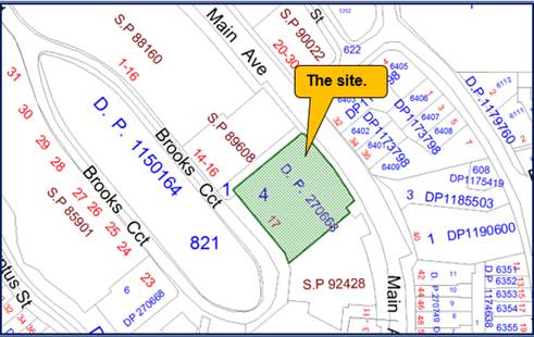
The site is identified as being
Lot 4 DP 270668 which forms part of the former Lidcombe Hospital site. The site
has a frontage onto two roads being Main Avenue to the east and Brooks Circuit
to the west. There is a pedestrian walkway (Bennedick Way) to the immediate north
that provides pedestrian access between Main Avenue and Brooks Circuit. The
walkway also separates the site from residential premises to the north at 1 to
16 Brooks Avenue.
The allotments to the south
comprise Strata Titled buildings, one of which is used for a sales office while
the rest are dwellings.
The development site comprises a
former dining hall and cottages erected in 1886, a mess hall and kitchen for
the Lidcombe Hospital. The building on site presently comprise two main wings
with a smaller connecting building situated around a small courtyard accessible
from Brooks Circuit.
The Lidcombe precinct comprises a
large land area and a variety of land uses developed over different time
periods. The original historic buildings associated with the construction of
the Boys Reformatory was erected around Brooks Circuit and adjoining streets
including Brooks Avenue and Sussex Street.
The wider locality has recently
been the subject of much residential development with the Village Green being
the focus of the development undertaken.
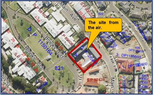
The location of the site is shown
below.
The
zoning of the site is provided below.
The
aerial photo of the site is shown below.
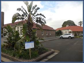
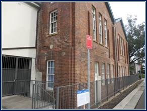
Photos
of the site taken in July 2020 are provided below.
Description of the Proposed
Development
The development application seeks
approval for alterations to the rear part of the building and use that part for
a childcare centre with a capacity for 53 children as follows:-
· 8
places for 0-2 years.
· 15
places for 2-3 years.
· 30
places for 3-5 years.
This is an adaptive reuse of a
heritage. The works include the following:-
· Establishment
of room one for children aged 3-5 years which occupies an area of 97.5 square
metres.
· Establishment
of room two for children aged 2-3 years which occupies an area of 48.8 square
metres.
· Establishment
of room three for children aged 0-2 years which occupies an area of 28 square
metres.
Rooms numbered one and two are
provided with storage facilities and access to toilets and direct access to the
simulated play space. Room numbered three includes a separate cot room, nappy
change room, a bottle preparation area and access to an outdoor play area.
The application is requesting the
establishment of a simulated outdoor play area inside the building that occupies
an area of 210 square metres. The internal playground is equipped with a play
area and access to toilets. There are skylights provided within the roof space
that provides daylight to the area which triggers the concurrence approval from
the New South Wales Department of Education which has been granted.
A managers office, reception,
kitchen, laundry and a staff room is included into the floor plans.
The plans show an outdoor
landscaped playground on the southern side of the building divided into two
separate areas, one for 0-2 years (occupies 56 square metres) and one for 2-3
years (occupies 150.6 square metres).
Access to the childcare facility
is situated along the southern side of the building.
To facilitate the child care
centre, a new decking structure will need to be constructed on the southern
side of the building, internal walls will need to be altered, skylights
inserted into the roof space, mechanical plant installed onto the roof of the
building and acoustic fencing along the southern side of the site.
History
Development Application No.
176/2006 (as modified)
Council, at its meeting of 20 June
2007 resolved to approve Development Application No. 176/2006 for
“Subdivision, demolition of Buildings 95A & 95B, site reshaping and compaction,
civil works including construction of roads, drainage and provision of site
services, landscaping of public domain areas and tree removal”.
This application is of relevance
to the subject application as it includes the provision of on-street public car
parking spaces within the vicinity of the site to meet the demand generated by
the future use of the buildings within the heritage precinct.
ALEP 2010 Amendment No. 12
The Auburn Local Environmental
Plan 2010 was amended on 1 August 2014 and rezoned the subject site from R3
Medium Density Residential to B1 Neighbourhood Centre, increased the maximum
FSR from 0.5:1 to 1:1 and the maximum building height from 9m to 12m.
Development Application
2018/110
Development consent 2018/110 for
alterations and fitout works to the existing building for use as a mixed use
development incorporating a neighbourhood supermarket, liquor shop, cafe,
medical centre and restaurant to operate 7am to 10pm daily and four (4) retail
tenancies to operate 9am to 6pm daily was approved by the Cumberland Local
Planning Panel at its meeting of 8 May 2019 subject to conditions.
This application originally
included the use of the subject site as a childcare centre, however this use
was removed from the proposal as concurrence could not be obtained from the
Department of Education for the simulated outdoor area.
Therefore, Condition 44 of the
development consent required a separate development application to be lodged to
the Council for determination for any child care centre to be constructed
within the building.
Applicants Supporting
Statement
The applicant has provided a
Statement of Environmental Effects prepared by Think Planners which is dated 25
May 2020 and received by Council on the 25 June 2020 to support the
application.
Contact with Relevant
Parties
The assessing officer has
undertaken a site inspection of the subject site and surrounding properties and
has been in regular contact with the applicant throughout the assessment
process.
Internal Referrals
Development Engineer
The development application was
referred to Council’s Development Engineer for comment who raised no
objection to the development.
· There are no
physical works to the building.
· The parking for
the precinct and arrangement is already accepted.
· The precinct is
heritage listed.
The matter concerning car parking
is described in detail below.
Health and Building
The development application was
referred to Council’s Health and Building Surveyor who provided advice
that the development application is supported subject to conditions.
Environment and Health
The development application was
referred to Council’s Environment and Health Officer for comment who has
advised that the development is satisfactory and is supported subject to
conditions.
Children Support Officer
The development application was
referred to Council’s Children Support Officer for assessment who
provided advice in relation to the need for appropriate outdoor shade, adequate
staffing, adequate storage facilities for children, toilets and suitable
facilities to support the nappy change room. The matters raised are capable of
being addressed as conditions should the development application be supported.
Waste Management
The development application was
referred to Council’s Waste Management Officer for comment who has
advised that the development proposal is satisfactory without the need for
conditions.
External Referrals
Heritage Office of New South
Wales
Integrated Development
The development application is
integrated development under Section 58 of the Heritage Act because an approval
from the New South Wales Heritage Office under the Heritage Act 1977 is
required. In this regard, there are demolition and construction works occurring
within a State heritage listed building.
The development application has
been referred to the Heritage Office for Integrated Development assessment and
on the 25 November 2020 the Heritage Office granted General Terms of Approval
subject to deferred commencement consent. The applicant being able to satisfy
the New South Wales Heritage Office that:-
a) No
other option is viable to provide adequate light and ventilation for the
proposed child care centre.
b) The
proposed number and size of the skylights is the minimum required to achieve
the result.
c) The
significant roof fabric is not impacted by the skylights.
d) The
existing roof structure is capable of supporting the roof services without
requiring additional support impacting on significant structure or the interior
spaces.
The relevant deferred commencement
conditions are provided at Condition 1 Schedule A and the General Terms of
conditions are provided at Condition 4 attached to the recommendation.
Department of Education
The development application was
referred to the Department of Education as Concurrence Development because the
applicant is seeking a waiver under Section 22 of State Environmental Planning
Policy (Educational Establishments and Childcare Facilities) 2017 for the
simulated outdoor play space inside the building.
The development should be provided
with 371 square metres of outdoor play space to support 53 children. However,
only 206.6 square metres of outdoor play space has been provided with another
210 square metres situated inside the childcare centre as simulated outdoor
play space. The Department of Education grants approval to the request for an
exemption to the play space requirements. The applicant is required to submit a
formal waiver application as part of any service approval application which is
addressed at Condition 5 attached to the recommendation.
Ausgrid
The development application was
referred to Ausgrid because the childcare centre is situated adjacent to an
electricity substation. As per comments of 12 August 2020, a decision is not
required because there is no impact on Ausgrid assets.
PLANNING COMMENTS
The provisions of any
Environmental Planning Instruments (EP&A Act s4.15 (1)(a)(i))
State Environmental Planning
Policies
The proposed development is affected
by the following State Environmental Planning Policies:
(a) State
Environmental Planning Policy No. 55 - Remediation of Land (SEPP 55)
Clause 7 of SEPP 55 requires
Council to be satisfied that the site is suitable or can be made suitable to
accommodate the proposed development. The matters listed within Clause 7 have
been considered in the assessment of the development application.
|
Matter for Consideration
|
Yes/No
|
|
Does the application involve re-development of the site or
a change of land use?
|
Yes
No
|
|
Is the development going to be used for a sensitive land
use (eg: residential, educational, recreational, childcare or hospital)?
|
Yes
No
|
|
Does information available to you indicate that an
activity listed below has ever been approved, or occurred at the site?
acid/alkali plant and
formulation, agricultural/horticultural activities, airports, asbestos
production and disposal, chemicals manufacture and formulation, defence
works, drum re-conditioning works, dry cleaning establishments, electrical
manufacturing (transformers), electroplating and heat treatment premises,
engine works, explosive industry, gas works, iron and steel works, landfill
sites, metal treatment, mining and extractive industries, oil production and
storage, paint formulation and manufacture, pesticide manufacture and
formulation, power stations, railway yards, scrap yards, service stations,
sheep and cattle dips, smelting and refining, tanning and associated trades,
waste storage and treatment, wood preservation.
|
Yes
No
|
|
Is the site listed on
Council’s Contaminated Land database?
|
Yes
No
|
|
Is the site subject to EPA
clean-up order or other EPA restrictions?
|
Yes
No
|
|
Has the site been the subject of
known pollution incidents or illegal dumping?
|
Yes
No
|
|
Does the site adjoin any
contaminated land/previously contaminated land?
|
Yes
No
|
|
Details of contamination investigations carried out at
the site:
Site Audit Statement No. 0301-1228R issued by Enviroview
Pty Ltd on 14 January 2013 certifies that Lots 3, 4, 5, and 8 of DP 270668
(the subject site is Lot 4) are suitable for the following uses:-
· Residential
with accessible soil, including garden (minimal home-grown produce
contributing less than 10% fruit and vegetable intake), excluding poultry.
· Day
care centre, preschool and primary school.
· Residential
with minimal opportunity for soil access including units.
· Secondary
school.
· Park,
recreational open space and playing field.
· Commercial
/ industrial.
1.
As per the updated statement of 1 November 2018 by
Enviroview, a review of the site conditions undertaken has determined that
the conclusions of the site audit statement are still relevant. As at August
2020, there are no changes and Council’s Environmental Health Officers
raised no objection to the development application.
|
|
Has the appropriate level of investigation been carried
out in respect of contamination matters for Council to be satisfied that the
site is suitable to accommodate the proposed development or can be made
suitable to accommodate the proposed development?
|
Yes
No
|
|
|
|
(b) State
Environmental Planning Policy (Infrastructure) 2007
The provisions of the SEPP 2007
have been considered in the assessment of the development application. The
development application is affected by Clause 45(1)(b)(ii) in which development
is occurring adjacent to an enclosed electricity substation. The electricity
substation is situated on the Main Avenue frontage as a separate structure to
the building. The development application was referred to Ausgrid 4/2/2019
although no objection is raised by the energy provider on the grounds that no
assets are affected by the proposed works.
(c) State
Environmental Planning Policy (Educational Establishments and Child Care
Facilities) 2017
The relevant provisions of the
SEPP Education are detailed in the following table:
|
Requirement
|
Comment
|
|
22 Centre-based child care facility—matters for
consideration by consent authorities
Before determining a development application for
development for the purpose of a centre-based child care facility, the
consent authority must take into consideration any applicable provisions of
the Child Care Planning Guideline, in relation to the proposed
development.
|
The applicable
provisions of the Child Care Planning Guideline are considered at Appendix B.
|
|
24 Centre-based
child care facility in Zone IN1 or IN2—additional matters for
consideration by consent authorities.
|
N/A - subject site is
zoned B1 - Neighbourhood Centre.
|
|
25 Centre-based
childcare facility—non-discretionary development standards
(a) location—the
development may be located at any distance from an existing or proposed early
education and care facility,
(b) indoor or outdoor space
(i) for development to which
regulation 107 (indoor unencumbered space requirements) or 108 (outdoor
unencumbered space requirements) of the Education and Care Services National
Regulations applies—the
unencumbered area of indoor space and the unencumbered area of outdoor space
for the development complies with the requirements of those regulations, or
(ii) for development to which
clause 28 (unencumbered indoor space and useable outdoor play space) of
the Children (Education and Care
Services) Supplementary Provisions Regulation 2012 applies—the development complies with the
indoor space requirements or the useable outdoor play space requirements in
that clause,
(c) site area and site
dimensions—the development may be located on a site of any size and
have any length of street frontage or any allotment depth,
(d) colour of building
materials or shade structures—the development may be of any colour
or colour scheme unless it is a State or local heritage item or in a heritage
conservation area.
|
The site is located
within a neighbourhood shopping centre which will support the local
residents.
The proposed
development complies with the indoor play space requirement of 53 x 3.25 sq m
per child (Minimum 172.25 sq m). The centre provides for 174.3 sq m of
unencumbered indoor play space.
The proposed
development complies with the outdoor play space requirement of 53 x 7 sq m
per child (Minimum 371 sq m). The centre provides for 416.6 sq m of
unencumbered indoor play space which includes 210 sq m of simulated outdoor
play space within the building.
|
Regional Environmental Plans
The proposed development is
affected by the following Regional Environmental Plans:
(a) Sydney
Regional Environmental Plan (Sydney Harbour Catchment) 2005
The subject site is identified as
being located within the area affected by the Sydney Regional Environmental
Plan (Sydney Harbour Catchment) 2005. The proposed development raises no issues
as no impact on the catchment is envisaged.
(Note: - the subject site is not
identified in the relevant map as ‘land within the ‘Foreshores and
Waterways Area’ or ‘Wetland Protection zone’, is not a
‘Strategic Foreshore Site’ and does not contain any heritage items.
Hence the majority of the SREP is not directly relevant to the proposed
development).
Local Environmental Plans
The Auburn Local Environmental
Plan 2010 is applicable to the development application. The development
application achieves compliance with the key statutory requirements of the B1
Neighbourhood Centre zone.
(a) Permissibility:-
The proposed development is
defined as a centre based childcare facility which is a permissible land use
within the B1 Neighbourhood Centre zone with consent. A centre based child care
centre is defined as:-
(a) a
building or place used for the education and care of children that provides any
one or more of the following—
i. long
day care,
ii. occasional
child care,
iii. out-of-school-hours
care (including vacation care),
iv. preschool
care, or
(b) an
approved family day care venue (within the meaning of the Children (Education
and Care Services) National Law (NSW),
Note - An approved family day care
venue is a place, other than a residence, where an approved family day care
service (within the meaning Children (Education and Care Services) National Law
(NSW), is provided.
but does not include -
(c) a
building or place used for home-based child care or school-based child care, or
(d) an
office of a family day care service (within the meanings of the Children
(Education and Care Services) National Law (NSW), or
(e)
a babysitting, playgroup or child-minding service that is organised informally
by the parents of the children concerned, or
(f) a
child-minding service that is provided in connection with a recreational or
commercial facility (such as a gymnasium) to care for children while the
children’s parents are using the facility, or
(g) a
service that is concerned primarily with providing lessons or coaching in, or
providing for participation in, a cultural, recreational, religious or sporting
activity, or providing private tutoring, or
(h) a
child-minding service that is provided by or in a health services facility, but
only if the service is established, registered or licensed as part of the
institution operating in the facility.
The relevant matters to be
considered under the Auburn Local Environmental Plan 2010 and the applicable
clauses for the proposed development are summarised below.
Auburn
Local Environmental Plan 2010 Compliance Table
|
DEVELOPMENT STANDARD
|
COMPLIANCE
|
DISCUSSION
|
|
4.3 Height of Buildings
Maximum height is 12 Metres.
The buildings on site have
heights that are less than 11 metres from natural ground level to the topmost
roof elements.
|
Yes
|
There is no change to building
height across the site.
|
|
4.4 Floor Space Ratio
The maximum floor spacer ratio
is 1:1.
The site has a floor space ratio
of 2,186.7 square metres or 0.938:1.
|
Yes
|
There is no change to building
height across the site.
|
|
5.10 Heritage Conservation
This is a State
Heritage item and located within the heritage conservation area known as the
former Lidcombe Hospital site under the Auburn Local Environmental Plan 2010
as Heritage Item C07144.
|
Yes
|
The Lidcombe Hospital Precinct
is a State Heritage listed building being the former Rookwood Asylum for the
aged and infirm, Rookwood State Hospital and asylum for men, Lidcombe
State Hospital & Home, Rookwood Boys Reformatory and Model Farm.
Due to the nature of the site and its history, the
development application is Integrated Development under Clause 58 of the
Heritage Act 1977.
The development application is supported by the New South
Wales Heritage Office as deferred commencement consent and as such, Council
is able to recommend to the Panel deferred commencement consent subject to
conditions.
|
The provisions of any proposed
instrument that is or has been the subject (EP&A Act s4.15 (1)(a)(ii))
(a) Draft
Cumberland Local Environmental Plan (Draft CLEP)
The Draft Cumberland Local
Environmental Plan (Draft CLEP) has been prepared by Cumberland City Council to
provide a single planning framework for the future planning of Cumberland City.
The changes proposed seek to harmonise and repeal the three existing LEPs
currently applicable to the Cumberland local government area, those being:
· Holroyd Local
Environmental Plan 2013,
· Parramatta Local
Environmental Plan 2011, and
· Auburn Local
Environmental Plan 2010.
The current planning controls for
the subject site, as contained within the Auburn Local Environmental Plan 2010
are not expected to change. In this regard, there are no changes to the
building height and or floor space ratio and as such, a discussion is not
required. The development would be satisfactory under the draft local
environmental plan.
The provisions of any
Development Control Plans (EP&A Act s4.15 (1)(a)(iii))
Auburn Development Control Plan
2010
The Auburn Development Control
Plan provides guidance for the design and operation of the development.
a) Former
Lidcombe Hospital Site:
The “Child Care
Centres” chapter is relevant to the development sought as follows and the
following variations are identified.
|
Part
|
Control
|
Proposed
|
Complies
|
|
Part 3.1
Subpart D2
Entry areas and foyer.
|
A covered area shall be provided at the entry of the
building to protect users from weather conditions.
|
Access point not covered due to State Heritage listing of
the building.
Building cannot be extended or enlarged.
|
No, however acceptable on heritage grounds.
|
|
Part 3.1
Subpart D4
Entry areas and foyer.
|
The entry area shall be enclosed with a childproof fence
and gate.
|
Not shown. May be addressed as a condition.
|
No
Condition Number 15a addresses the matter.
|
|
Part 3.4
Subpart D2
Storage facilities.
|
A room which facilitates open
lockers shall have hanging space for each child’s bag, belongings and
other personal articles.
|
No lockers or fixed shelving shown for play areas.
|
No
Condition Number 15c addresses the matter.
|
|
Part 3.12
Staff and Service Facilities
Subpart D8.
|
The laundry shall have a minimum
area of 10m2 and shall comply with the BCA.
|
Laundry floor area = 7.48 square metres.
|
No
However considered satisfactory.
|
|
Part 4.2
Outdoor shading
Subpart D1.
Subpart D2.
|
The outdoor play space must be adequately shaded in
accordance with the Children’s Services Regulations 2004.
Permanent shade cloth shall be provided for sandpits and climbing
equipment.
|
No shade structure for the southern play area.
|
No.
Condition Number 15d addresses the matter.
|
|
Part 5.0 Access and Car Parking
Objectives.
|
To ensure that off-street parking and pick up and set down
areas are located so as not to interfere with traffic flow and safety or
endanger pedestrian traffic on or off the site.
|
Off street parking not feasible for the site.
|
No
Satisfactory as discussed later in the report.
|
|
Part 5.1
Pick up / Set down
Subpart D1
|
The pickup and set down of children shall occur within the
site.
|
No on site pick up and set down area for children.
|
No
Satisfactory as discussed later in the report.
|
|
Part 5.2 Parking
Performance criteria
Subpart P2.
|
Onsite parking is provided for staff.
|
No onsite car parking available.
|
No
|
b) Local
Centres Chapter:
The Local Centres chapter is also
relevant to the site however no assessment is required because shops and
commercial premises are not proposed.
c) Parking
and Loading Chapter:
The Auburn Development Control
Plan 2010 chapter “Parking and Loading” is applicable to the
proposed development. The proposed childcare centre for 53 children requires 14
spaces at 1 space per 4 children.
The car parking rates for the
entire development on site including the approved shops and services under
Development Consent 2018/110 are:-
· The approved shops
- 18 spaces.
· The approved
restaurant and cafe - 8 spaces.
· The approved
medical centre - 6 spaces.
The approved uses require 32 car
parking spaces. Including the childcare centre, the entire site would require a
total of 46 car parking spaces.
The car parking spaces on street
are provided in designated spaces within the immediate locality surrounding the
Village Green and immediate environs.
The existing buildings occupy
almost the entire site and there is no opportunity to provide on-site car
parking including a drop off zone for children. The constraints within the
heritage precinct to provide on-site car parking were recognised by the developer
and DA-176/2006 (as amended) included the provision of on-street public car
parking spaces to meet the demand for parking within this precinct. At the time
of consideration of the original application, the applicant provided a detailed
schedule of indicative uses for each of the buildings within the precinct to
demonstrate that the on-street car parking spaces would satisfy the
requirements of Council’s DCP in respect of car parking provision. Since
the original application was approved, modifications to the design and number
of on-street car parking spaces have been approved. Development applications
have also been submitted / approved for all buildings within the heritage
precinct providing certainty of the end uses of the buildings and any reliance
on on-street car parking to satisfy the parking provision.
It is identified that there are
150 on street car parking spaces within close proximity to the site within Main
Avenue and Brooks Circuit including the area within the Village Green. It is
calculated in the study that in the event that 17 Brooks Circuit was to be used
to its maximum potential land use, 58 car parking spaces would be required. In
the present case, 46 spaces are required to support all the land uses (Approved
and proposed). As such, there is a surplus of car parking spaces within the
locality.
In relation to absence of a drop
off zone, Brooks Circuit is a “shared zone” and has a maximum speed
limit of 10 km/h which is enforceable. Parents will be able to use the
immediate on street car parking area within the Village Green area in relative
safety. As such, the absence of a drop off zone is not considered to have an
adverse impact to the operations of the centre.
Loading and unloading
A loading area for loading and
unloading and garbage removal is located on Main Avenue adjacent to the
building. The loading bay was designed subsequent to the community title
subdivision of the Heritage Precinct and is partially located over the roadway
(Main Avenue) which has since been dedicated to Council. The loading area is
designated for all the uses for the site.
Other provisions
There are other development
control plan chapters that apply to the development application as follows:-
· Access and
Mobility.
· Waste.
· Stormwater
Drainage.
The development application is
determined as being acceptable under all three chapters. In this regard:-
· The development
provides for adequate and appropriate provision for disability access including
a new lift and upgraded or new toilets.
· Adequate provision
is made for waste removal.
· Stormwater
drainage for the site is not changing.
The provisions of any planning
agreement that has been entered into under section 7.4, or any draft planning
agreement that a developer has offered to enter into under section 7.4
(EP&A Act s4.15(1)(a)(iiia))
There is no draft planning
agreement associated with the subject Development Application.
The provisions of the
Regulations (EP&A Act s4.15 (1)(a)(iv))
The proposed development raises no
concerns as to the relevant matters arising from the Environmental Planning and
Assessment Regulations 2000 (EP&A Reg).
The Likely Environmental,
Social or Economic Impacts (EP&A Act s4.15 (1)(b))
It is identified that the
applicant is required to satisfy to the New South Wales Heritage Office that
the proposed skylights will have no adverse impact to the State Heritage listed
building. Subject to this being achieved, it is considered that the proposed
development will have no significant adverse environmental, social or economic
impacts in the locality.
The suitability of the site for
the development (EP&A Act s4.15 (1)(c))
Similar to the comment above under
s4.15(1)(b)), the applicant is required to satisfy to the New South Wales
Heritage Office that the proposed skylights will have no adverse impact to the
State Heritage listed building. Subject to this being achieved, it is
considered that the development would be suitable for the site.
Submissions made in accordance
with the Act or Regulation (EP&A Act s4.15 (1)(d))
In accordance with the
notification requirements for Integrated Development, the development
application was publicly notified to occupants and owners of the adjoining
properties for a period of twenty eight days between 8 July 2020 and 5 August
2020 and again to additional residents within close proximity to the site
between 6 August 2020 and the 20 August 2020. In response, there were fourteen
(14) submissions, eleven (11) being unique in nature. The issues raised in the
public submissions are summarised and commented on as follows:
Legal issues
|
Issue
|
Comment
|
|
Attention is drawn to the Community Management Statement
and By Law 22.
Approval is required for building works or alterations and
that approval be granted by the Community Association prior to any
development application being made.
The Community Association has not been consulted in relation
to the proposed development and is a breach of the By Laws.
|
The site is owned by Gundagai WW Pty Ltd and the
development application is correctly made under the Environmental Planning
and Assessment Act 1979 and land owners consent is provided.
There is no requirement under the Act to obtain owners
consent under by laws established by Strata Managers / Body Corporates that
do not own the site.
|
|
Residents were not individually notified of the proposal
prior to the closing date of submissions.
There was only one notice placed outside 17 Brooks Circuit
which was not visible by everyone unless walking past it.
We received an additional notice giving us one week to
make submissions. Council has failed to do the right thing.
|
The development
application was publicly notified to occupants and owners of the adjoining
properties for a period of 28 days between 8 July 2020 and 5 August 2020 and
again to additional residents within close proximity to the site between 6
August and the 20 August 2020 following community representations.
The development
application was notified in the Council website and a sign placed on site for
the duration of the notification period.
|
Traffic and car parking
|
Issue
|
Comment
|
|
The existing limited parking available in Brooks Circuit,
Main Avenue and the area has already been allocated to the uses previously
approved for the overall building.
Parking is already very limited in an around the proposed
centre.
Double and illegal car parking will occur and motorists
will become agitated because a space cannot be found.
There will be inadequate car parking for the existing
commercial sites, customers accessing the site and for staff managing the
shops.
Due to residential development around Andrews Street,
Gallery Walk, Brooks Circuit, there is inadequate car parking for existing
residents.
|
Car parking for the approved uses and proposed childcare
centre is determined as being satisfactory as outlined in the main body of
the report under (c) Parking and Loading Chapter of the Auburn Development
Control Plan 2010.
|
|
The proposal only has on street parking for dropping off
and picking up children. No alternatives are provided.
During inclement weather, the safety and children to
negotiate Brooks Circuit as the only means of access is compromised.
There are no onsite car parking facilities and no loading
facilities. No new car parking facilities are proposed and all parking is
reliant on existing on street parking.
The current approvals given by Council are for a mixed use
commercial businesses which will likely cause significant traffic and parking
problems even without the childcare centre.
The dropping off and picking up of children at peak times
will lead to congestion and blockages, not just on Brooks Circuit but also on
Main Avenue and other surrounding streets.
With less designated parking for the childcare centre and
with no local footpaths, parents will be forced to walk longer distances on
the road with their children.
|
Car parking and traffic movements is determined as being
satisfactory as outlined in the main body of the report under (c) Parking and
Loading Chapter of the Auburn Development Control Plan 2010.
Brooks Circuit is designated as a “Shared
zone” with the speed limit for vehicles being 10 km/h which is
enforceable.
It is acknowledged that there is no specific car space for
the dropping off of children within the site or at the front. However, given
the location of car spaces within the Village Green area and how the local
road network functions, it is considered that the childcare centre can
operate safely on the site.
A truck loading bay has already been established at the
rear of the site on Main Avenue and no change is proposed. The loading zone
is designated for deliveries and garbage collection.
The operations of the childcare centre are considered
satisfactory given the location.
|
|
Brooks Circuit is a shared zone and having children,
elderly and cars sharing it with a childcare centre where parents rush to
pick up and drop off children is a recipe for disaster.
The speed limit is 10 km/h however drivers neglect to
adhere to the speed limit.
The shared zone is improperly constituted because there is
no appropriate signage or speed restrictions.
|
Council’s engineers have
reviewed the shared zones and have determined that the shared zones are
compliant with relevant guidelines. In this regard, the shared zone is
approved by the former Auburn Council Traffic Committee, staff, Police and
Roads and Maritime Services.
|
|
Future development of residential apartments along
Weeroona Road by Frasers will further exacerbate parking and traffic
congestion.
|
Any future developments that may occur along Weeroona Road
is not a relevant matter for determining the current development application
for the fit out and use of part of the building on site for a childcare
centre. Furthermore, it is expected that any residential developments would
provide onsite car parking for the apartments as per the requirements of the
relevant development control plan.
|
|
The nearby Scribbles and Giggles childcare centre has
successfully implemented their drop off and pick up areas as they have a
dedicated car park on Andrews Road (Rear access) and multiple spaces
available on the wider thoroughfare - Main Avenue.
|
This is noted however the operation of the nearby
childcare centre being Scribbles and Wiggles is not relevant to the outcome
of this application.
|
|
The existing childcare centre Scribbles and Giggles has
two designated parking areas which do not meet the requirement of their
customers. Many parents park on the opposite side of the road (Main Avenue)
causing parents and children to cross the road to access the childcare
centre. With another childcare centre directly opposite, the parking
requirement will be close to chaotic.
|
The car parking operations and traffic movements has
previously been assessed by Council engineers as being satisfactory.
|
|
The Onnuri Church is a very active church and there are
parking issues for residents on Sunday. Services are also held on Wednesday
evenings and worshippers park all along Main Avenue which creates further
issues for the childcare facility.
|
The operations of the church are a separate matter to the
childcare centre.
|
Landscaping and play areas
|
Issue
|
Comment
|
|
The site is devoid of natural landscaping and access to
appropriate natural outdoor recreation opportunities.
The outdoor spaces will not be an asset for learning
typically associated with centres in the outer suburbs of Sydney.
|
There is limited landscaping on the site and it is not
possible to increase the degree of landscaping that is available on site.
The applicant has provided a simulated outdoor play
environment for the children which has been supported by the Department of
Education.
|
|
There are inadequate opportunities for children to play
and run around.
|
It is considered that adequate play space is provided for
the children.
|
|
All children will need to remain in their one allocated
room or outdoor area at the teacher’s discretion thus not allowing the
young children to make such decisions themselves.
|
The comment is noted but not a reason to refuse the
development application upon.
|
|
There will be minimal access to sunlight given that the
courtyards are on the southern side of the building.
The playground is compromised due to poor ventilation,
excessive shade, inadequate sunlight and storage facilities.
|
The New South Wales Department of Education has assessed
the development application in relation to the play space provided. As per
correspondence dated 4 August 2020, the Department has supported the
development.
|
|
A proper account of unencumbered space is required. The
external playground space is unsuitable for 53 children.
|
The New South Wales Department of Education as per
correspondence dated 4 August 2020 has approved the request for a
dispensation to Section 22(1)(a) in relation to the playground and simulated
play area.
|
Building issues
|
Issue
|
Comment
|
|
The building is heritage listed and therefore a childcare
centre is not appropriate. Further, the development is not sympathetic to the
existing character of the area.
Alterations to the roof of the building are not permitted.
|
The development application has been assessed by the New
South Wales Heritage Office and as per correspondence of the 25 November
2020, deferred commencement consent is granted subject to the outstanding
matters with the skylights being resolved.
|
|
The development may not comply with current fire and
safety regulations.
|
Building Code of Australia issues are capable of being
addressed as conditions.
|
|
There is only one way in and one way out of the centre. If
there was a fire, there would be a catastrophe. The ability to evacuate the
centre in case of a fire is compromised due to the type of entrance shown.
The only accessway is via a side passage which is not
overly visible from the public domain. As such, the centre is not inviting as
it is concealed.
|
The Evacuation Plan is showing three methods for leaving
the centre in the event of a fire. Council’s Health and Building
Surveyor has supported the development subject to conditions.
The main pedestrian access to the childcare centre is
visible from the street.
|
|
The previous application was withdrawn due to a failure to
gain approval from the Department of Education.
One of the reasons for rejection by the Department was the
inadequate outdoor recreation space.
To overcome this, the applicant proposes a simulated
outdoor area inside the building with added skylights and other techniques.
This is not appropriate for the location. The skylights are not consistent
with the heritage classification of the area.
|
This matter has been satisfactorily addressed by the
applicant as detailed in the assessment report.
|
|
Certain facilities such as kitchen, laundry and nappy
change room have no natural ventilation and mechanical ventilation will
impact on the heritage character of the building.
|
Council’s Health and Building Surveyor has supported
the development subject to conditions.
|
|
The building may contain lead based paint and or asbestos.
As such, the building is not suitable for accommodating children.
|
The applicant has covered all relevant issues addressing
the State Policy and it is concluded that the building is suitable to
accommodate a childcare centre.
|
|
The plans do not show how the management of the shopping
centre will be conducted or how abandoned shopping trolleys will be
addressed.
|
The objection in relation to shopping trolleys and
management of the shops is not a relevant matter for determining the latest
development application.
|
|
The retention of solid historical walls creates enclosed
spaces and inhibits viewing opportunities throughout the centre.
|
Viewing opportunities are provided where possible
including the use of internal glazing. Children within Rooms Numbered 1 and 2
will have view lines to the simulated play space and a glazed panel is
provided for the wall separating the cot room with Room 3.
The Department of Education has granted its concurrence to
the development application following its assessment of all relevant matters.
|
|
Outdoor storage facilities are inadequate and indoor
storage is limited to one room out of three rooms.
Indoor storage facilities are inadequate and there is no
storage available for storing large items such as tables and chairs, play
equipment and the like.
|
There is a requirement for suitable indoor and outdoor
storage facilities which is addressed as Condition 15c attached to the
recommendation.
|
|
The opportunity for surveillance to the street is limited
owing to the adaptive reuse of the building. As such, viewing opportunities
to the street is poor.
|
Surveillance opportunities to Brooks Circuit is limited
from the childcare centre, however there are view lines to Main Avenue to the
east from the windows of the childcare centre.
There are shops facing Brooks Circuit as approved in
Development Consent 2018/110 which addresses surveillance opportunities to
both Brooks Circuit and Main Avenue.
|
Social issues
|
Issue
|
Comment
|
|
There is no proper supervision of children.
Supervision of the nappy change room is inadequate.
|
It is considered that adequate supervision is provided for
all children and toddlers.
The wall separating the cot room and Room 3 is to be
constructed mostly of glazed material to establish view lines between the two
rooms.
The New South Wales Department of Education has assessed
the plans and has raised no objection to the works sought.
A minimum of eight (8) staff is required on site to
supervise 53 children. The plans identify that 8 staff are required to
supervise the children.
|
|
The childcare centre represents an over development of the
site.
|
The childcare centre is not an over development of the
site on the grounds that the building is not being extended or enlarged. The
applicant is using existing internal floor area to establish the centre.
|
|
The centre represents a danger for residents and their
families accessing the Village Green where children play and families meet
for social activities and fitness programs.
The area will become inaccessible for people enjoying the
walk around.
|
The proposed childcare centre represents no known danger
to anyone using the Village Green and the park within the Village Green is
not impacted by the development sought.
|
|
There will be increased dangers for Ferguson Lodge and
those using wheelchairs entering and exiting the centre.
|
While there will be an increase in vehicles using Brooks
Circuit due to the presence of the child care centre, users of motor scooters
travelling within the locality to and from Ferguson Lodge are bound by the
road rules that apply and as such, must travel in an appropriate manner at
all times.
|
|
The development of another childcare centre in an area
serviced by two childcare centres is ill advised and not required.
|
The comment is noted however the development application
cannot be refused due to another childcare centre situated close by.
|
|
The existing childcare centre is only operating at 60%
capacity which suggests that the development of another childcare centre is
not viable.
|
This is noted but not relevant to the development
application under consideration.
|
|
It is not appropriate to have a childcare centre close to
a liquor outlet.
|
At the time Development Application 2018/110 was processed
in early 2019 for a childcare centre and a neighbourhood shopping centre, the
Flemington Police Command reviewed the application and raised no significant
issues with a childcare centre and a liquor outlet operating on the same
site.
The latest application reinstates the childcare centre.
Given that the conditions recommended by Flemington Police Command have
already been applied to Development Consent 2018/110, it is considered that
the childcare centre can operate safely on the same site as a childcare
centre.
|
|
The proposed opening hours of the shopping centre between
7 am and 10 pm will have a detrimental effect on those living in Brooks
Circuit.
|
Hours of operation of the shops were addressed under
Development Consent 2018/0110. The objection in relation to the hours of
operation of the shops is not a relevant matter for determining the latest
development application.
|
|
The childcare centre will perform poorly in respect of
sustainability considerations. The centre will be reliant on the use of
artificial heating cooling and lighting. The inclusion of skylights along the
southern face of the pitched roof would offer limited direct sunlight to the
external playground.
It is not clear how the building will be heated or cooled
and it is not clear where the external air conditioning units will be housed.
|
The development is provided with skylights within the roof
area which are internally operated.
The New South Wales Department of Education has supported
the development application and the simulated outdoor play space.
|
|
The proposed layout gives rise to lengthy travel distances
from the entry to the extremities of the centre. Travel paths require
teachers and children to walk through the outdoor courtyard to reach Room 1
which may disturb play activities.
|
Travel distances have been assessed as being satisfactory.
The internal layout of the childcare centre is considered satisfactory.
Travel paths are acceptable and compliant with the
Building Code of Australia.
|
|
A child care centre is not suited for the building because
it consumes valuable commercial land, involves the use of compromised spaces,
is disjointed from car parking opportunities requiring parents with prams
needing to park some distance from the centre and cross a roadway which will
be subjected to increase use.
|
A childcare centre is a permitted use for the site and
considered to be an appropriate use for the site.
|
The public interest (EP&A
Act s4.15(1)(e))
In view of the foregoing analysis
it is considered that the development subject to conditions, will have no
adverse significant impact on the public interest.
Cumberland Local
Infrastructure Contributions Plan 2020
This part of the Act relates to
the collection of monetary contributions from applicants for use in developing
key local infrastructure.
Comments:
The development requires the
payment of contributions in accordance with the Cumberland Local Infrastructure
Contributions Plan 2020. As at the 26 November 2020, a contribution amount of
$3,219 is payable. Condition number 21 attached to the recommendation addresses
the matter.
Disclosure of Political
Donations and Gifts
The applicant and notification
process did not result in any disclosure of Political Donations and Gifts.
The development application has
been assessed in accordance with the relevant requirements of the Environmental
Planning and Assessment Act 1979 and the following:-
· State
Environmental Planning Policy 55 “Remediation of Land”.
· State
Environmental Planning Policy “Infrastructure” 2007.
· State
Environmental Planning Policy (Educational Establishments and Child Care
Facilities) 2017 and the associated Child Care Planning Guideline 2017.
· Auburn
Local Environmental Plan 2010.
· Draft
Cumberland Local Environmental Plan.
· Auburn
Development Control Plan “Child Care Centres” Chapter.
· Auburn
Development Control Plan “Parking and Loading” Chapter.
The proposed development is
appropriately located within the B1 Neighbourhood Centre zone under the
provisions of the Auburn Local Environmental Plan 2010.
Having regard to the assessment of
the proposal from a merit perspective, Council may be satisfied that the
development has been responsibly designed and provides for acceptable levels of
amenity for the occupants of the childcare centre. It is considered that the
proposal successfully minimises adverse impacts on the amenity of neighbouring
properties. Hence the development, irrespective of the departures noted above,
is consistent with the intentions of Council’s planning controls and
represents a form of development contemplated by the relevant statutory and
non-statutory controls applying to the land.
For these reasons, it is
considered that the proposal is satisfactory having regard to the matters of
consideration under Section 4.15 of the Environmental Planning and Assessment
Act 1979, and the development may be approved as a deferred commencement
consent subject to conditions.
|
1. That
Development Application 2020/0361 for alterations and fitout works to use
part of an existing building as a centre based child care centre for 53
children - Integrated Development (s58 of the Heritage Act 1977) on land at
17 Brooks Circuit Lidcombe be approved as deferred commencement consent
subject to conditions in Attachment 1.
2. Persons
whom have lodged a submission in respect to the application be notified of
the determination of the application.
|
1. Draft Notice
of Determination
2. Architectural
Plans
3. Appendix
A - SEPP Educational Establishments and Child Care Centres 2017
4. Appendix
B - Child Care Planning Guideline
5. Appendix
C - Auburn Development Control Plan Child Care Centres
6. Redacted
Submissions Recieved
DOCUMENTS
ASSOCIATED WITH
REPORT LPP057/20
Attachment 1
Draft Notice of Determination
Cumberland Local Planning Panel Meeting
9 December 2020
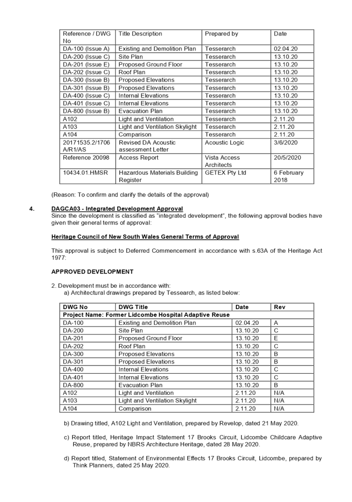
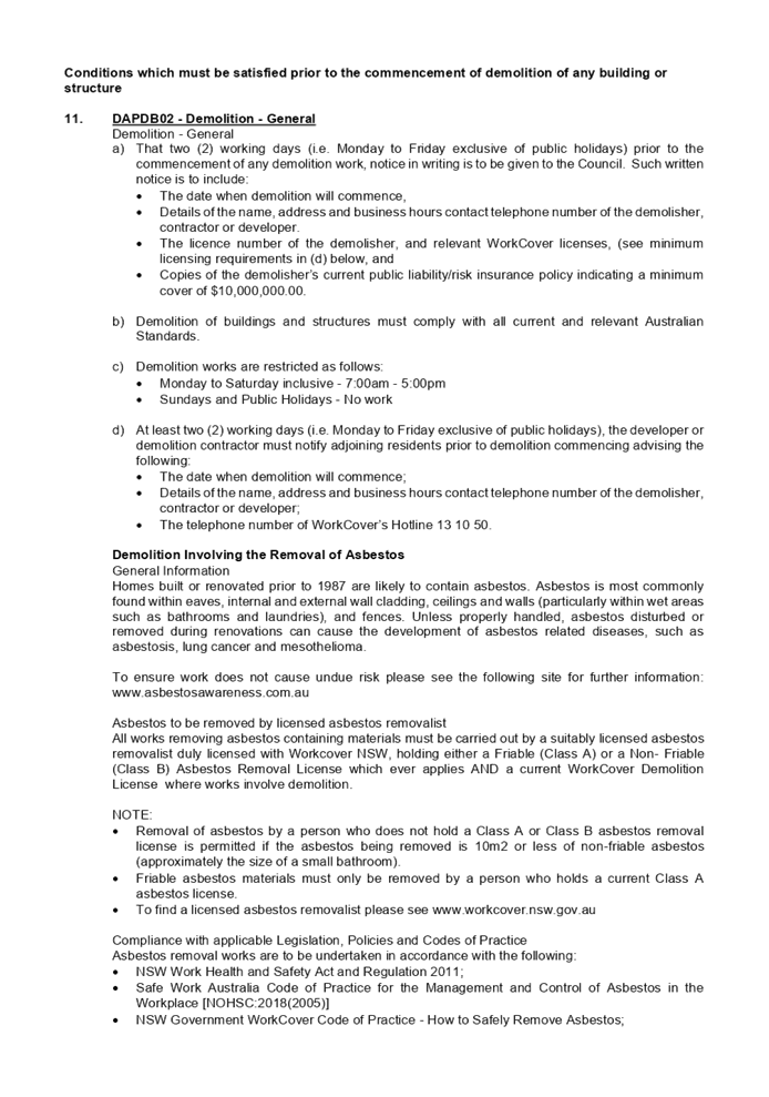
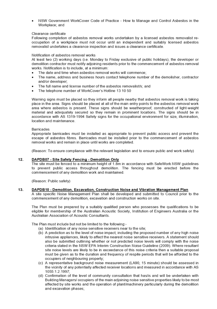
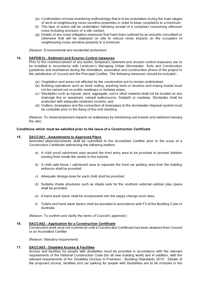
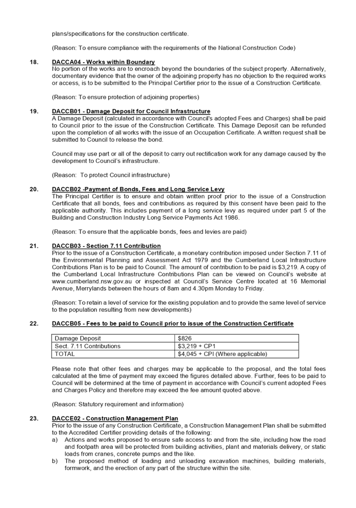
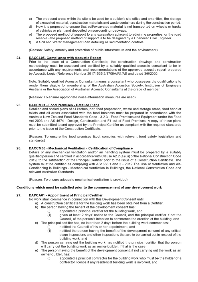
DOCUMENTS
ASSOCIATED WITH
REPORT LPP057/20
Attachment 2
Architectural Plans
Cumberland Local Planning Panel Meeting
9 December 2020
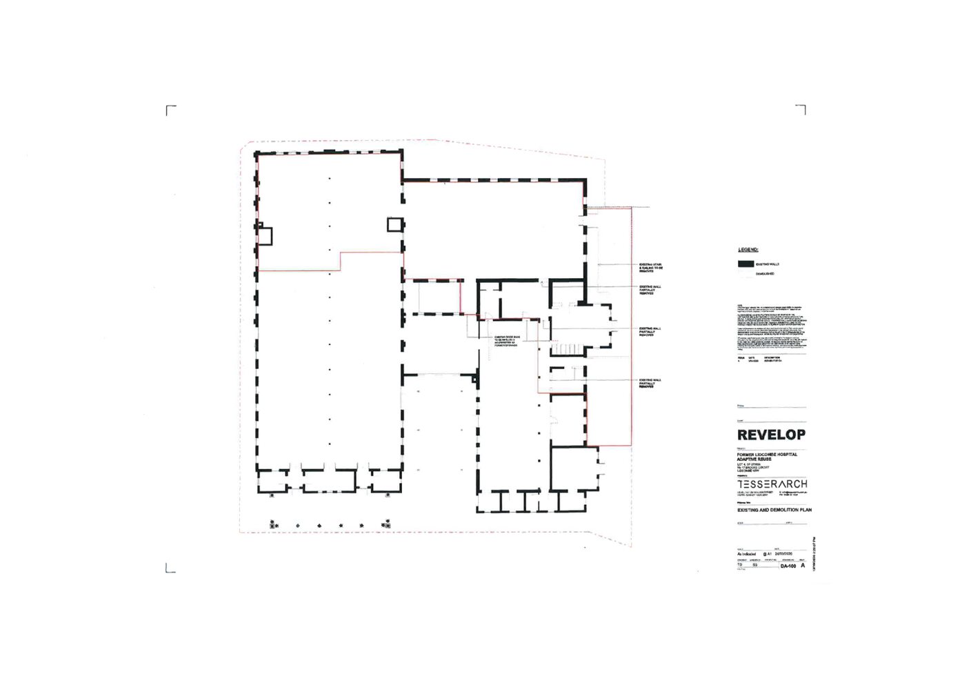
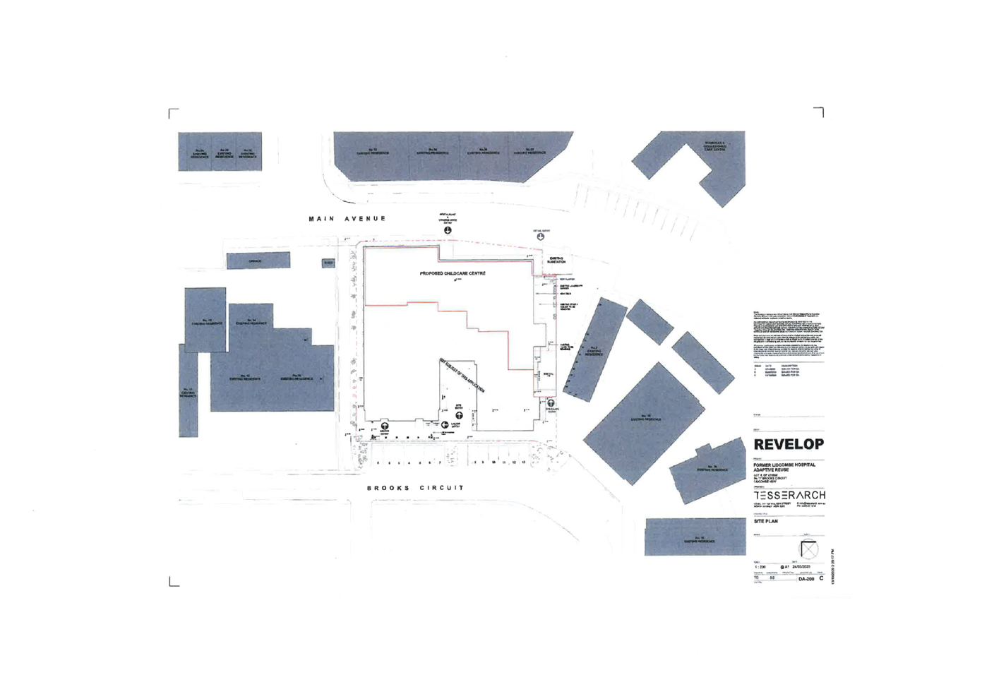
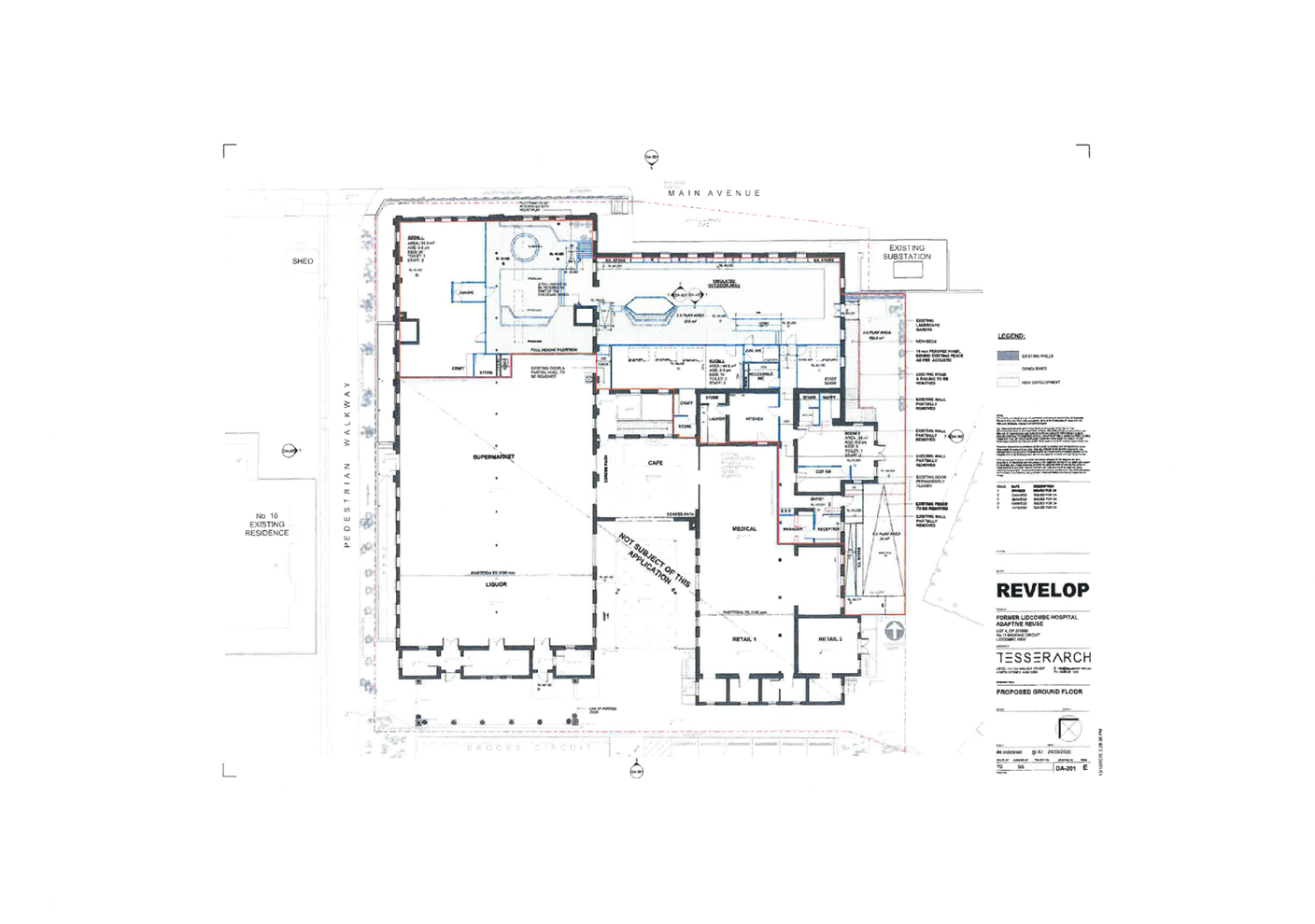
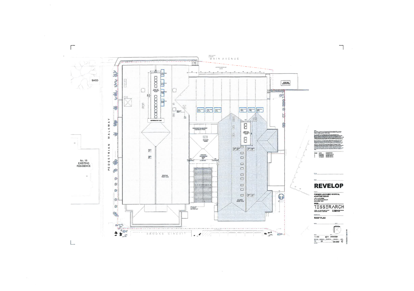
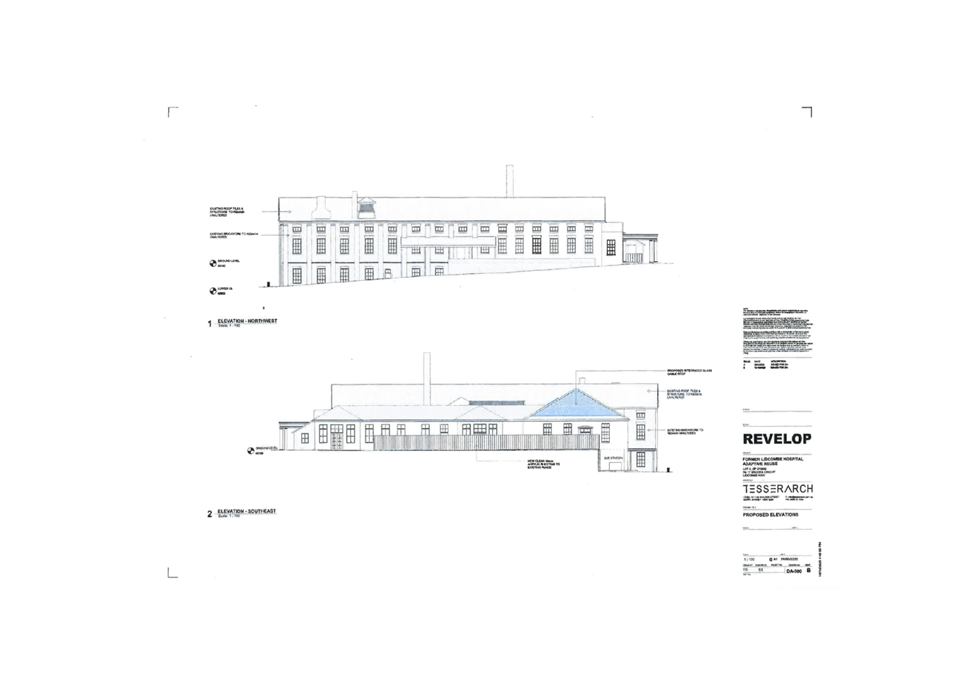
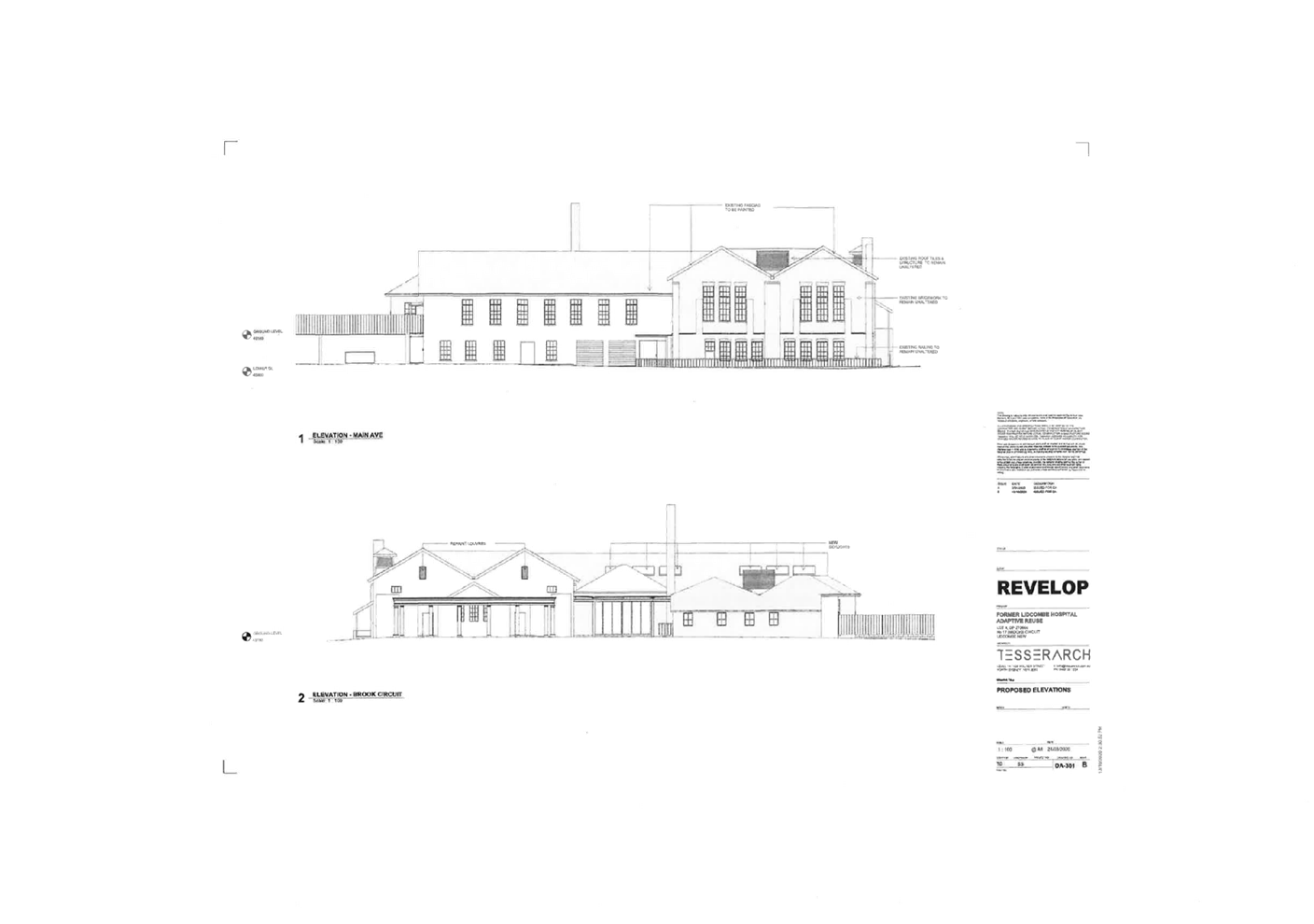
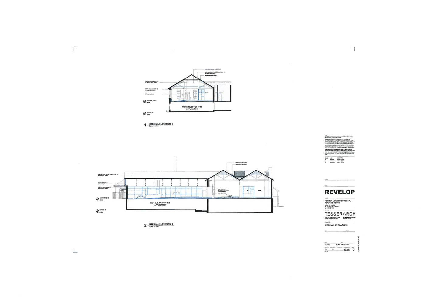
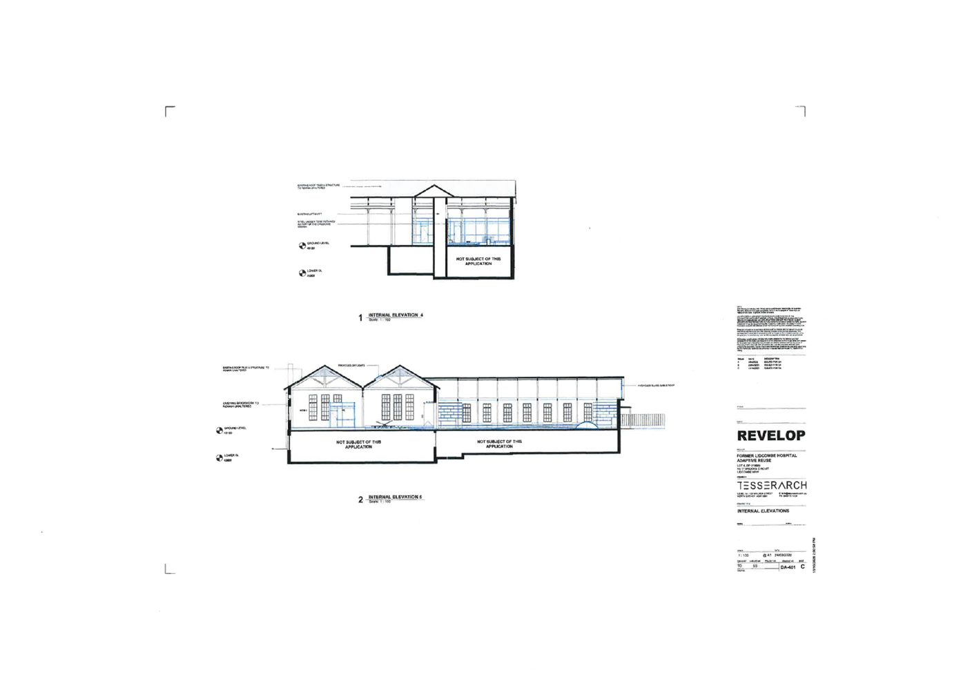
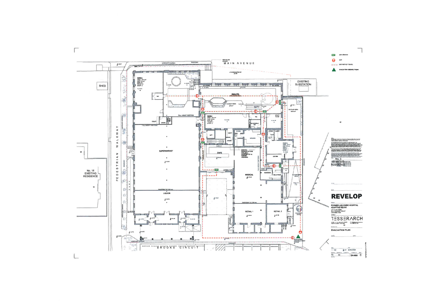
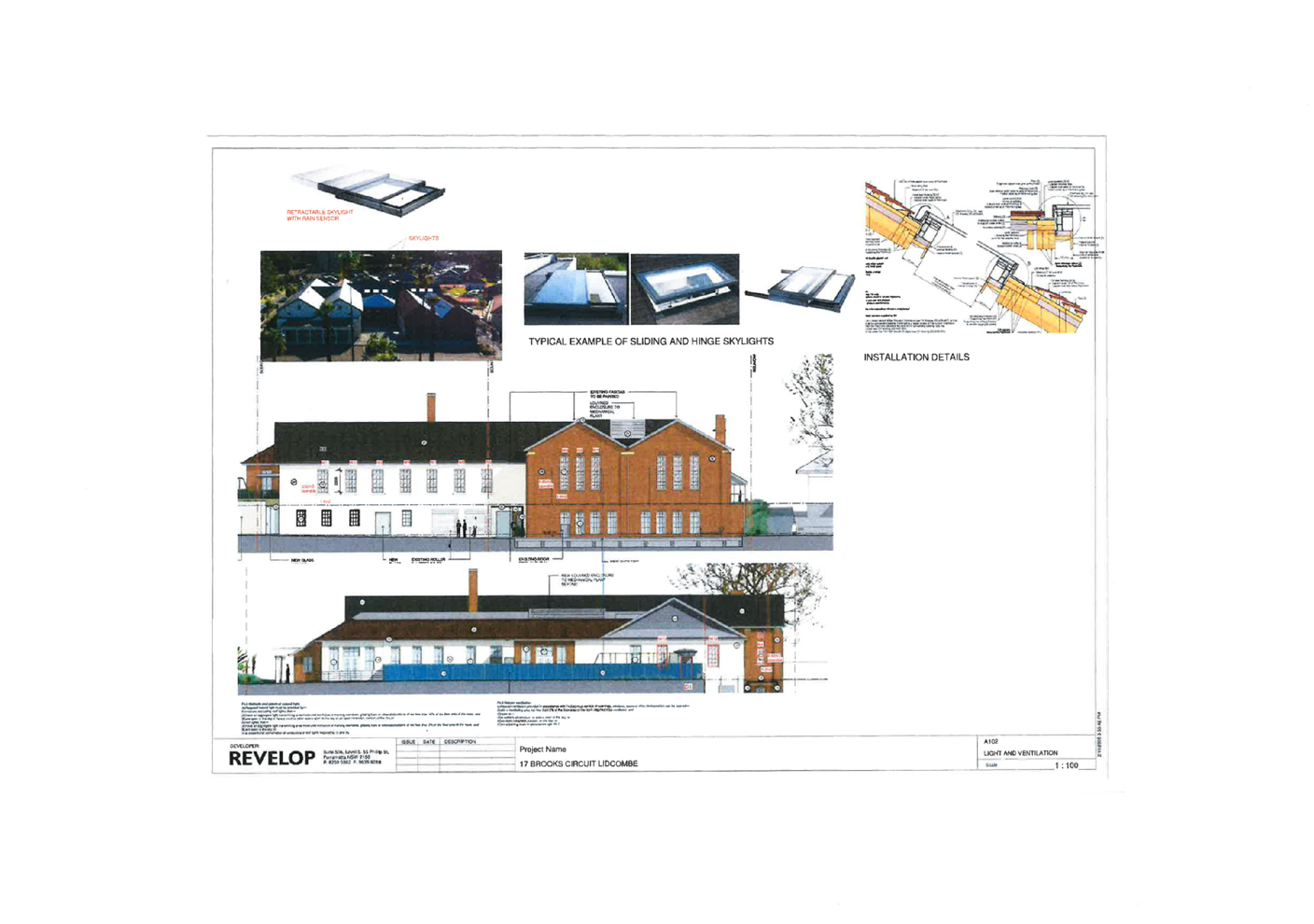
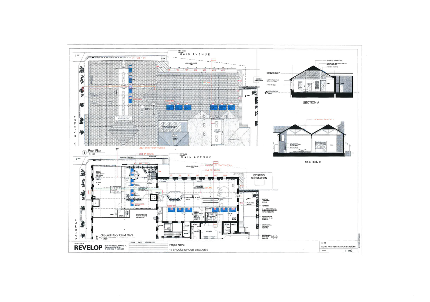
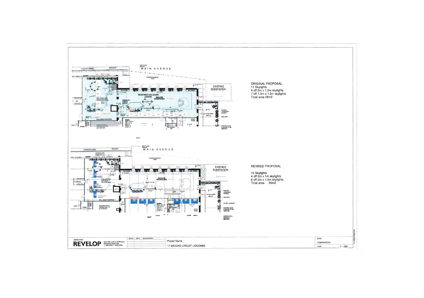
DOCUMENTS
ASSOCIATED WITH
REPORT LPP057/20
Attachment 3
Appendix A - SEPP Educational Establishments and Child
Care Centres 2017
Cumberland Local Planning Panel Meeting
9 December 2020
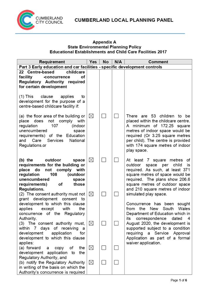
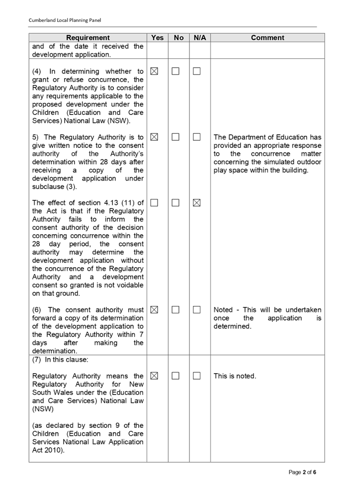
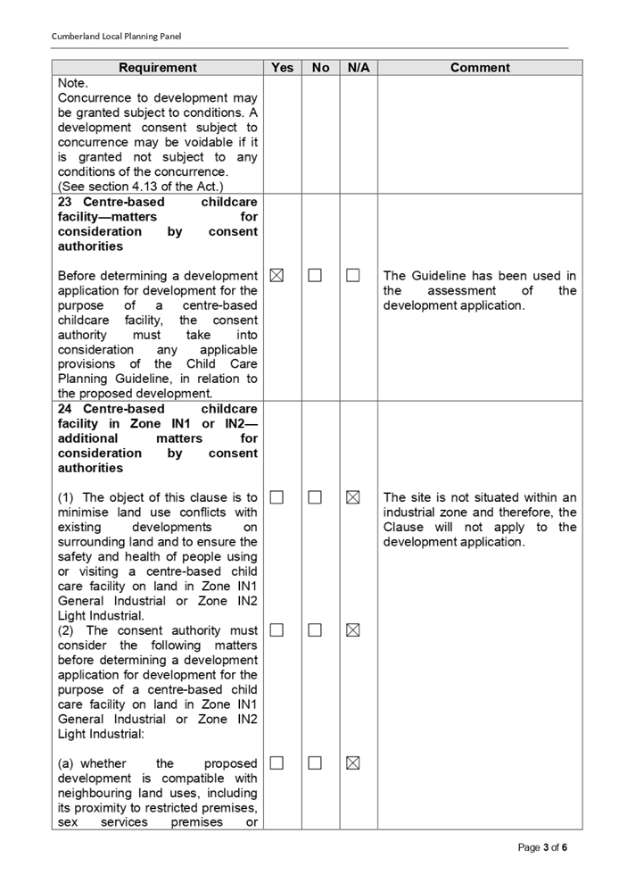
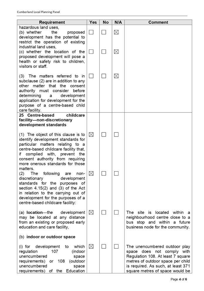
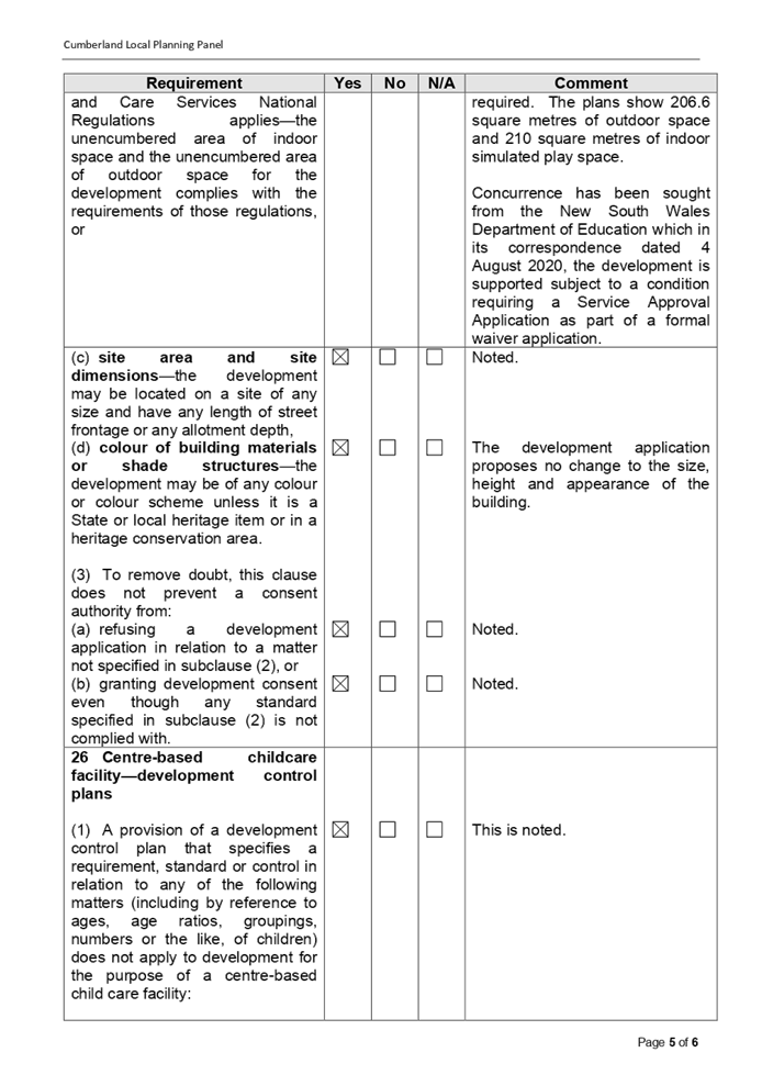
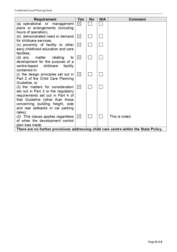
DOCUMENTS
ASSOCIATED WITH
REPORT LPP057/20
Attachment 4
Appendix B - Child Care Planning Guideline
Cumberland Local Planning Panel Meeting
9 December 2020
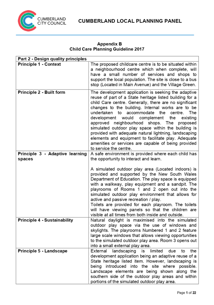
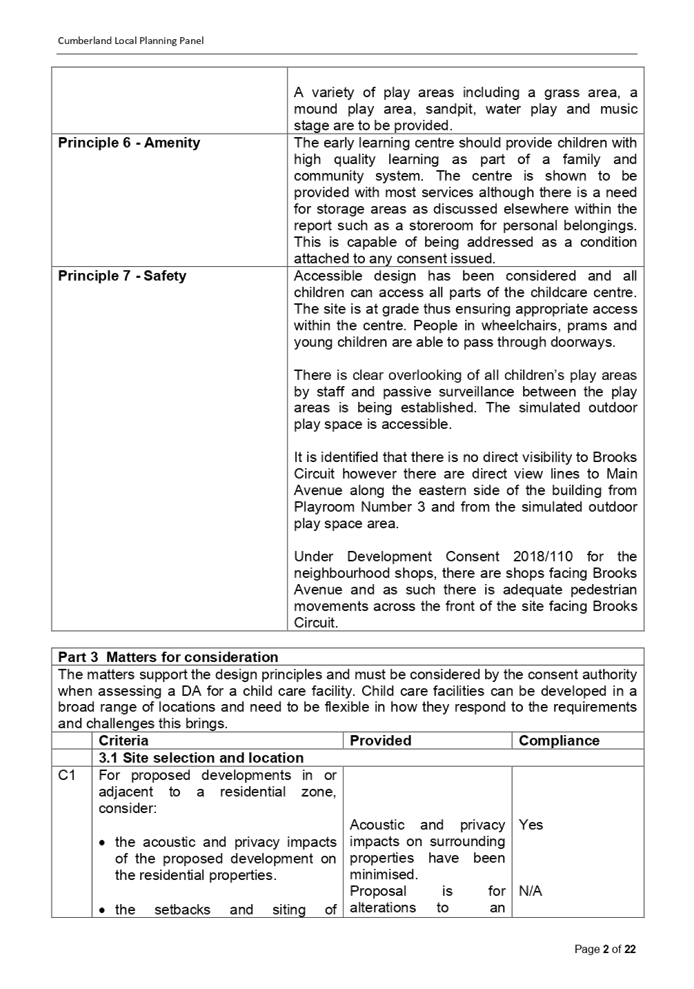
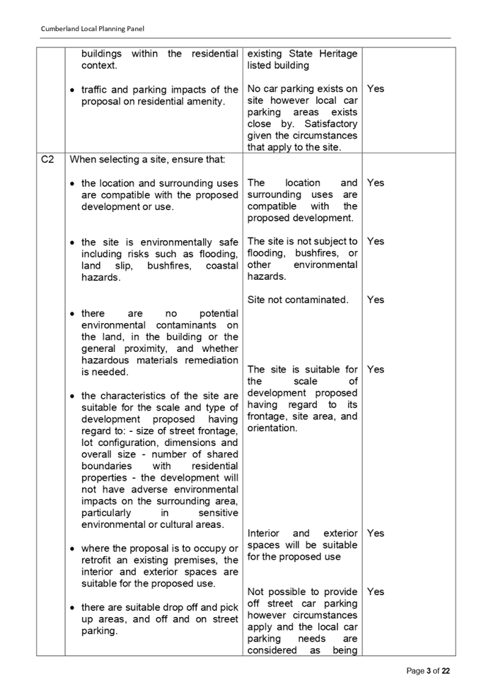
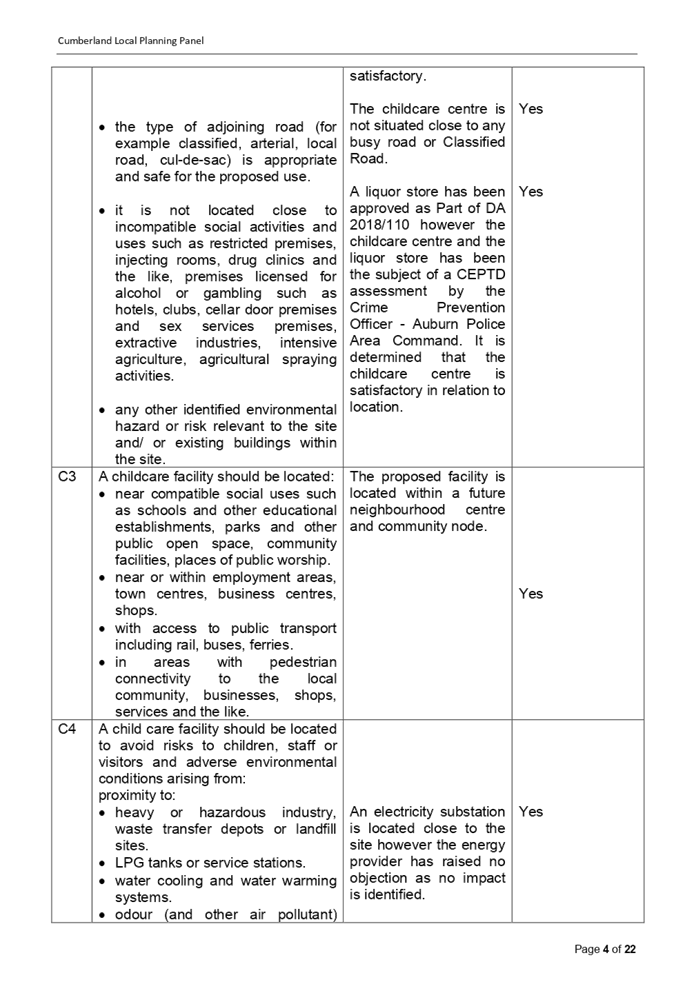
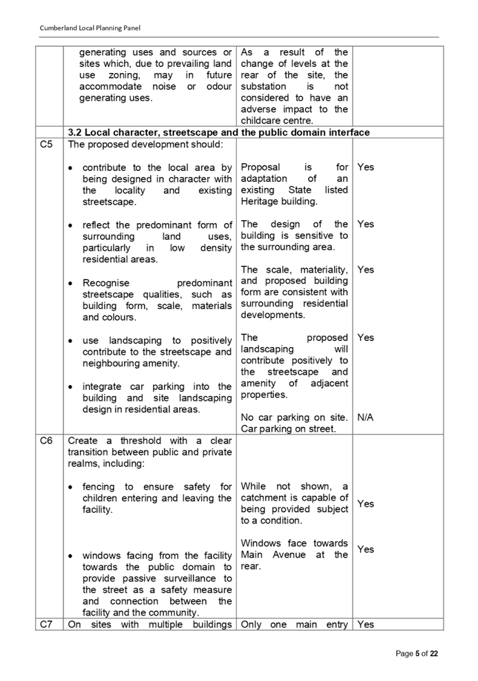
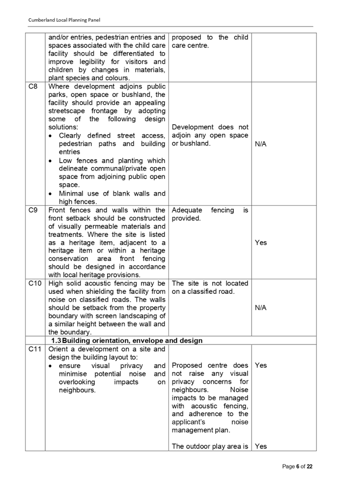
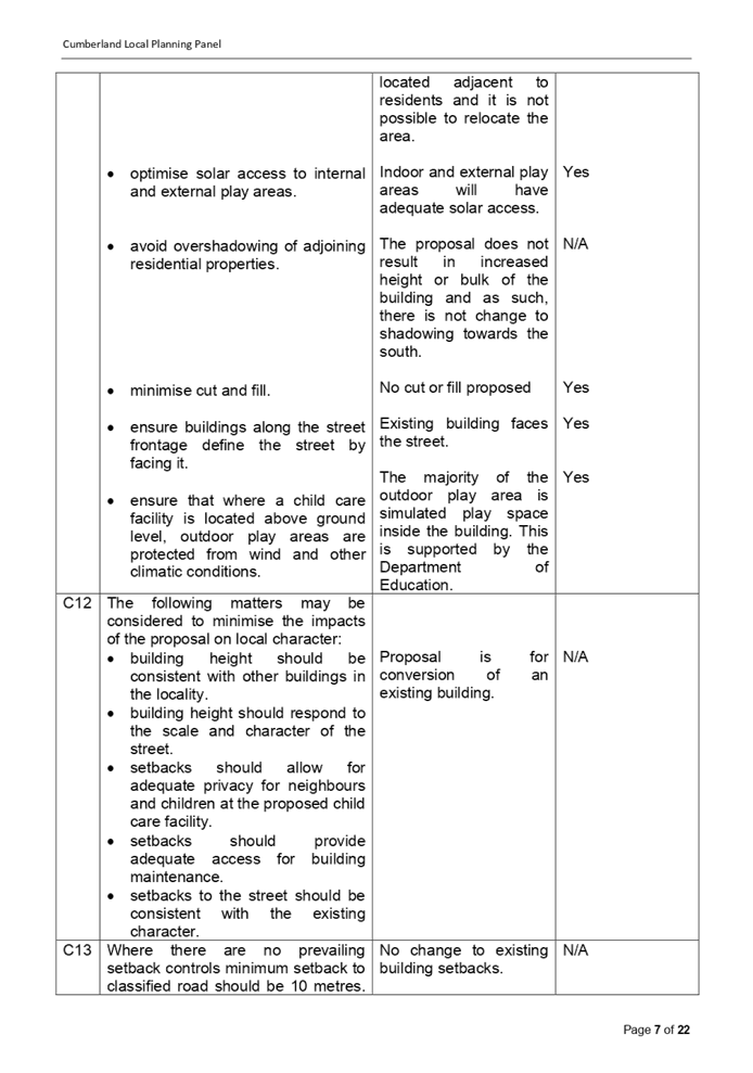
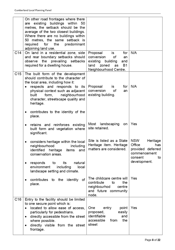
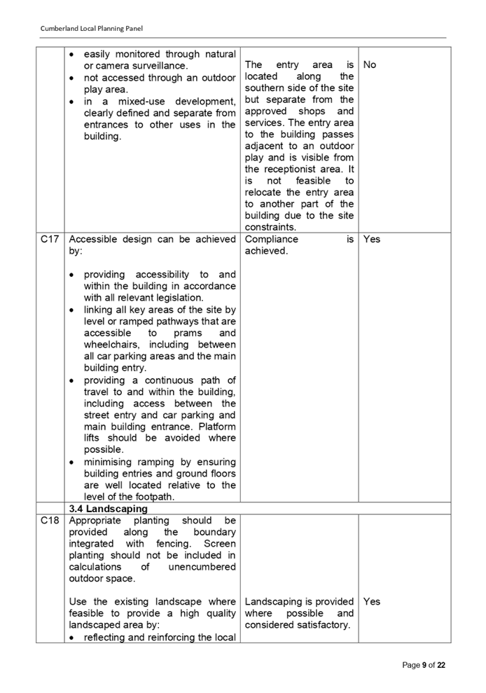
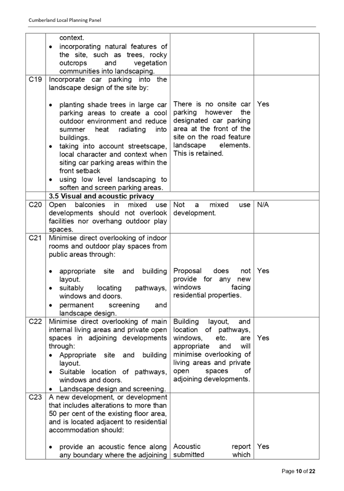
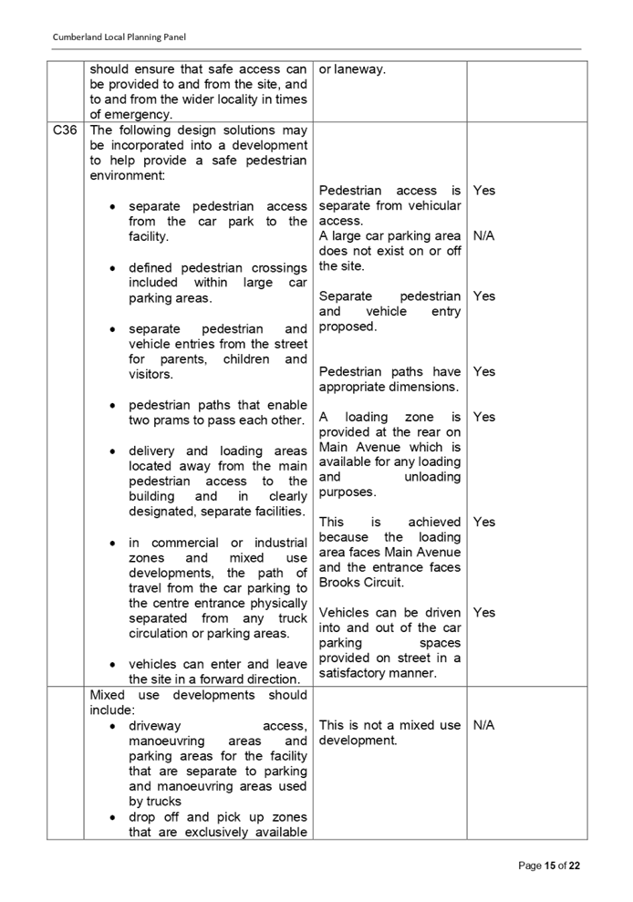
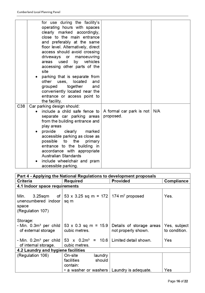
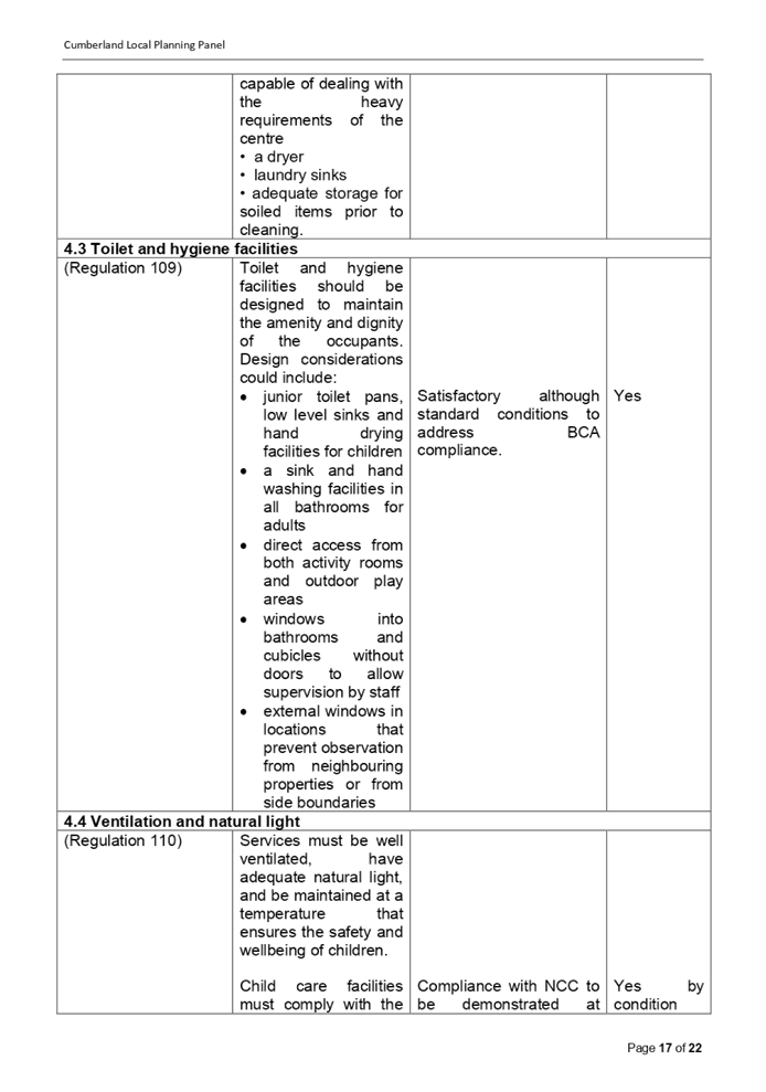
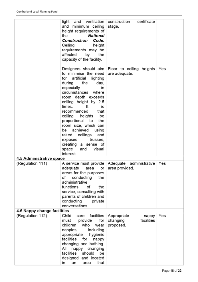
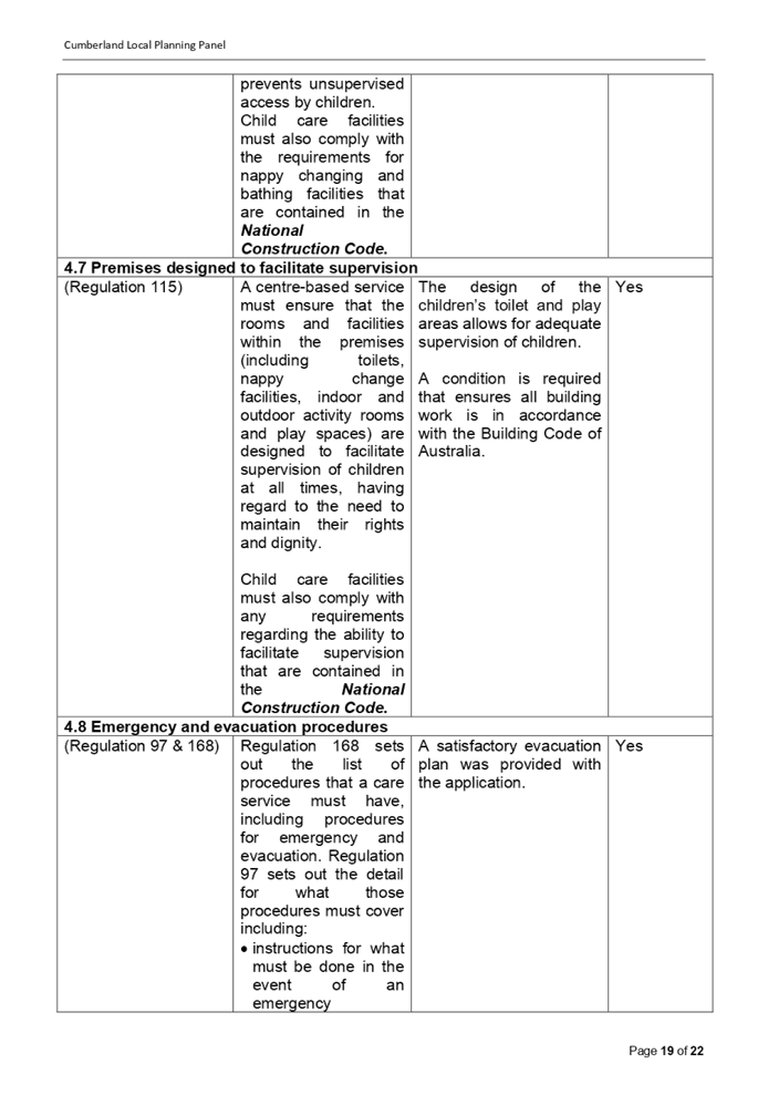
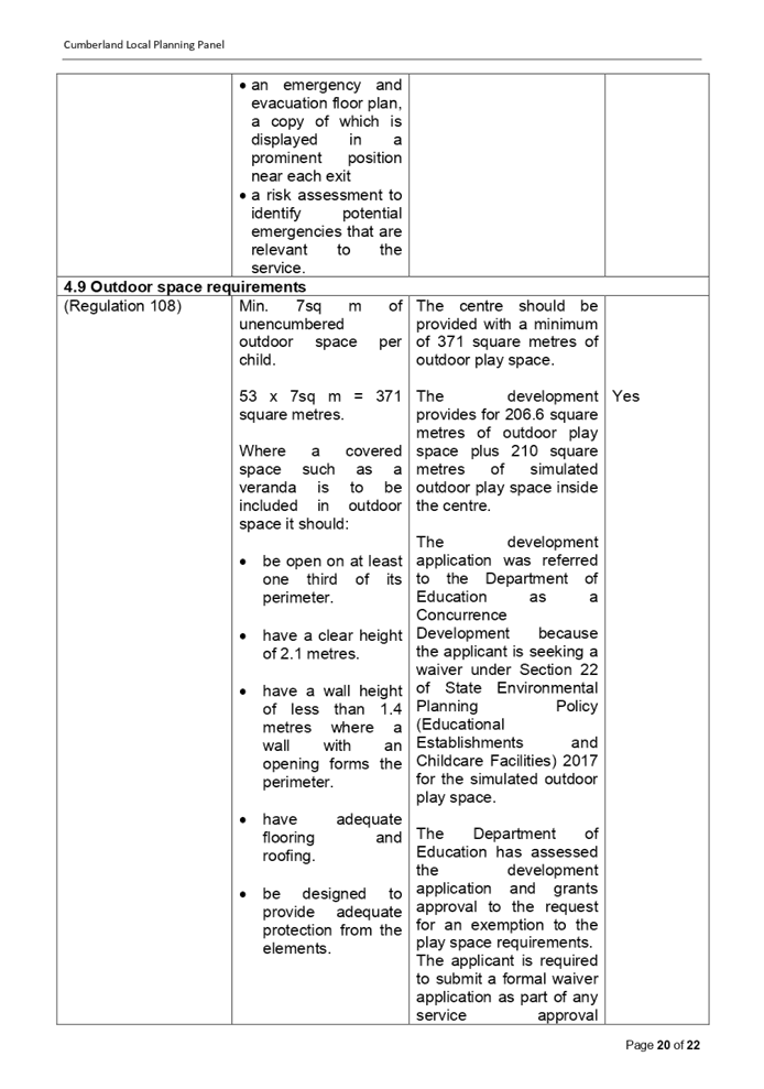
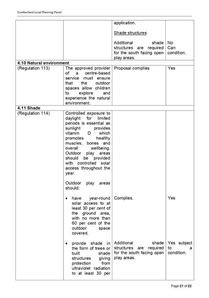
DOCUMENTS
ASSOCIATED WITH
REPORT LPP057/20
Attachment 5
Appendix C - Auburn Development Control Plan Child
Care Centres
Cumberland Local Planning Panel Meeting
9 December 2020
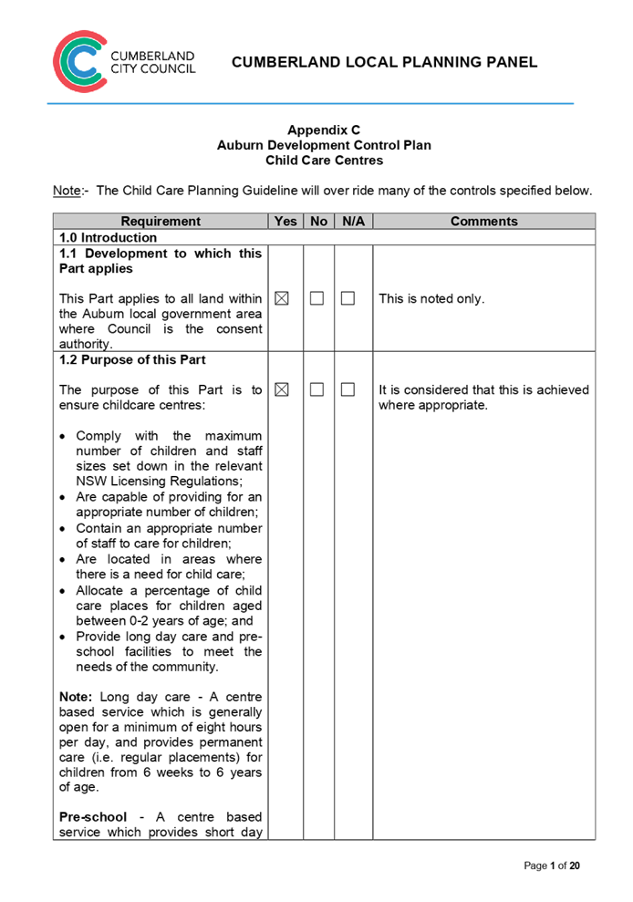
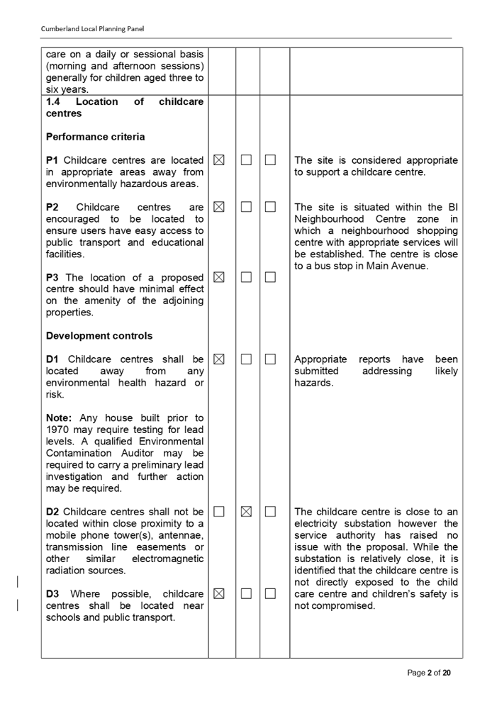
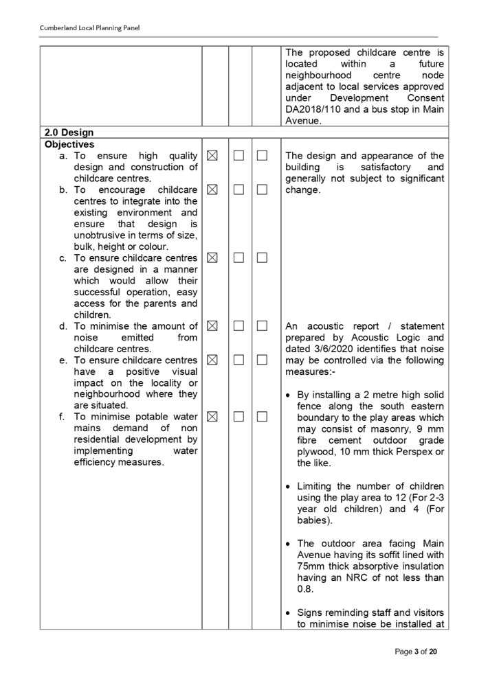
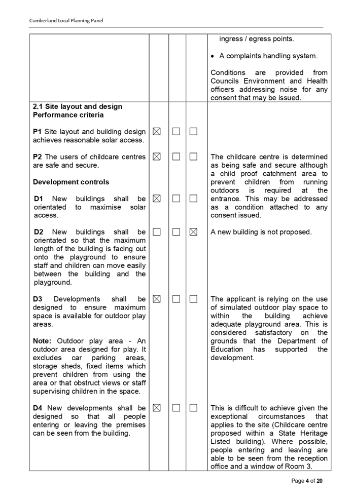
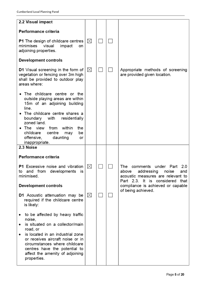
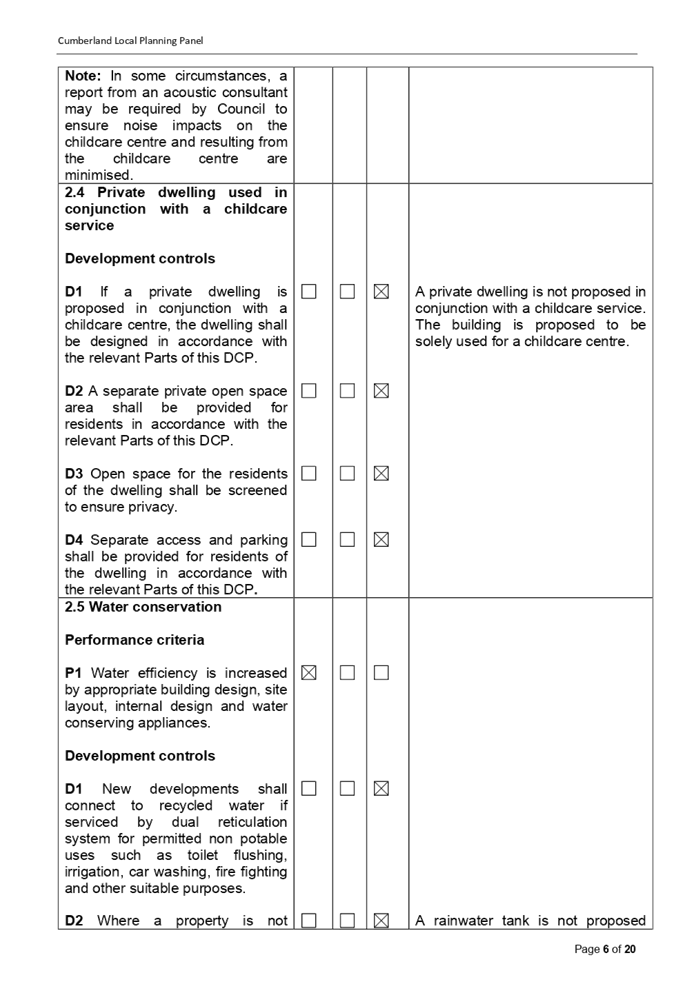
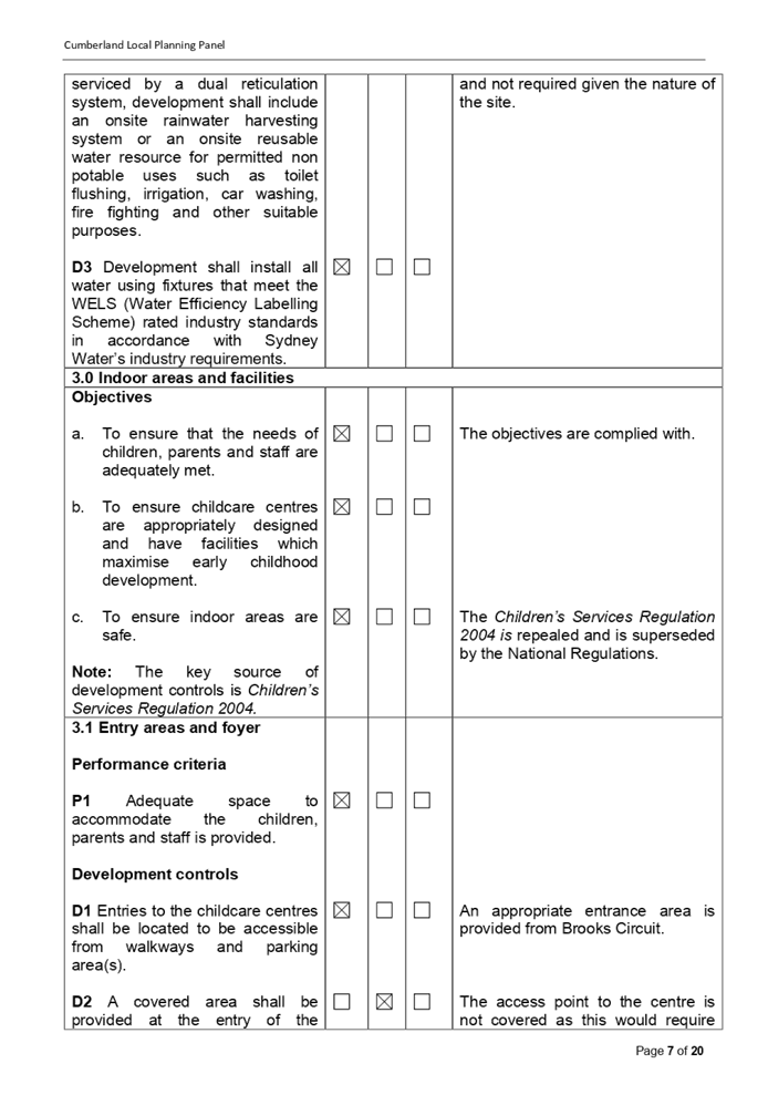
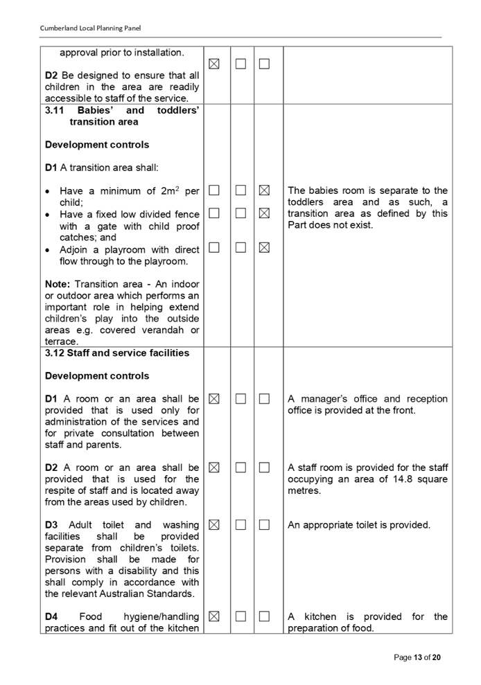
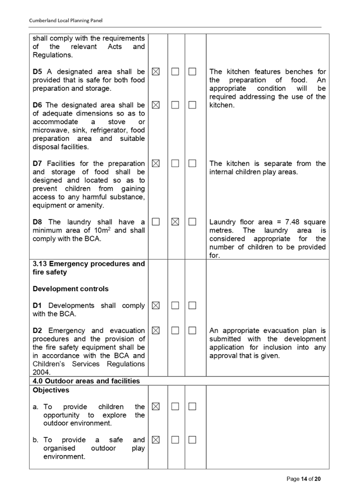
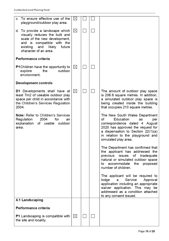
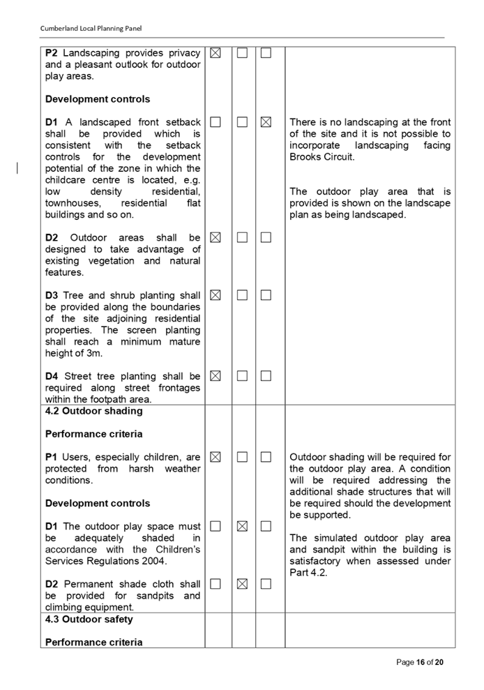
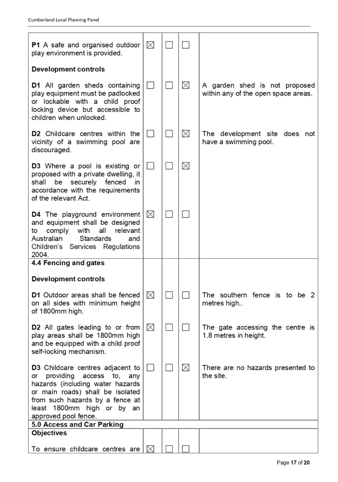
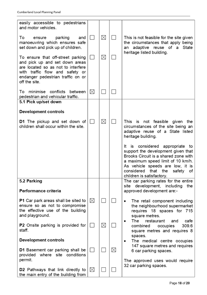
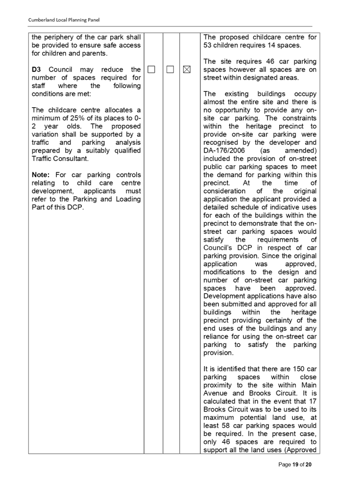
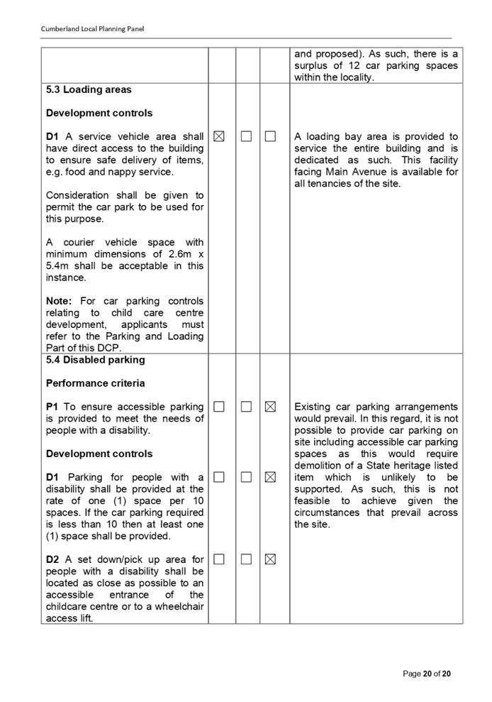
DOCUMENTS
ASSOCIATED WITH
REPORT LPP057/20
Attachment 6
Redacted Submissions Recieved
Cumberland Local Planning Panel Meeting
9 December 2020


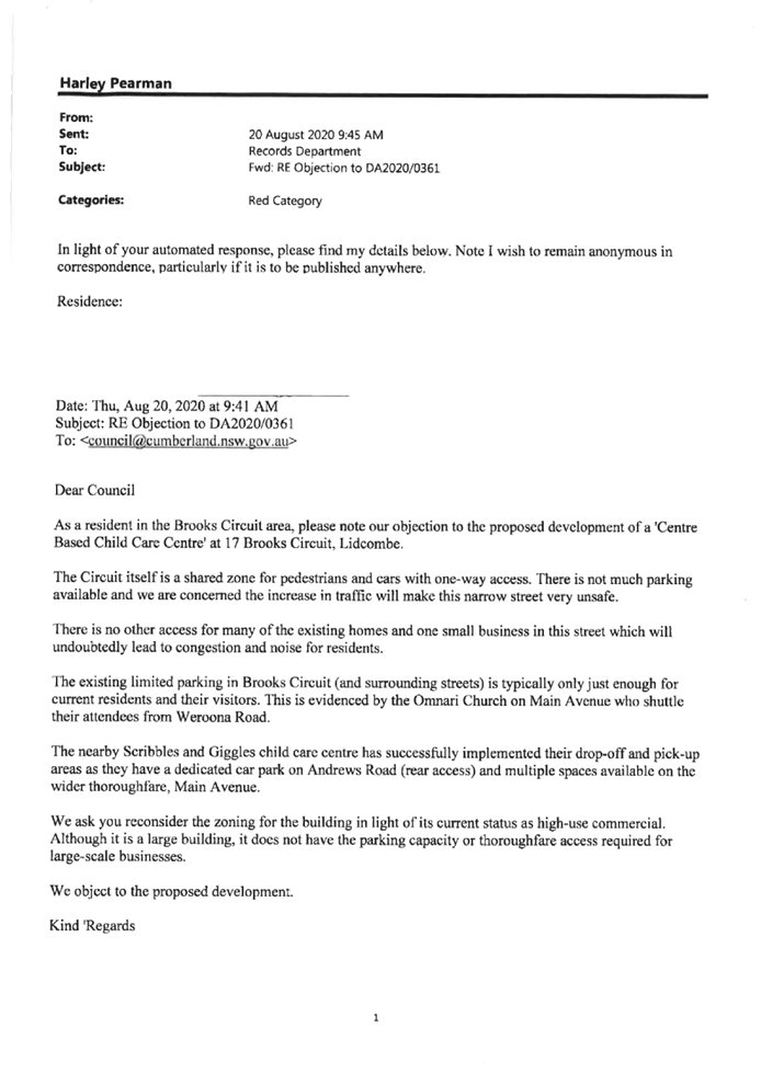


Cumberland
Local Planning Panel Meeting
9 December 2020
Item
No: LPP058/20
Development
Application for 70 Cardigan street, Guildford
Responsible
Division: Environment
& Planning
Officer: Executive
Manager Development and Building
File
Number: DA2020/0453
|
Application
lodged
|
3 August 2020
|
|
Applicant
|
Baini Design
|
|
Owner
|
Mr K Chaouk
|
|
Application
No.
|
DA2020/0453
|
|
Description
of Land
|
70 Cardigan Street Guildford
being Lot 26 and 27 Sec 7 in DP 734
|
|
Proposed
Development
|
Demolition of existing
structures and construction of a three (3) storey boarding house comprising
10 boarding rooms over basement car parking.
|
|
Site
Area
|
449.63 Square metres.
|
|
Zoning
|
R4 High Density Residential
Zone.
|
|
Disclosure
of political donations and gifts
|
Nil disclosure.
|
|
Heritage
|
No.
|
|
Principal
Development Standards
|
Floor Space Ratio
Permissible: 1.2:1. Increased
to 1.7:1 with bonus.
Proposed: 0.824:1.
Height of Building
Permissible: 15 metres.
Proposed: 10.55 metres.
|
|
Issues
|
Landlocked site.
Shadowing.
Width of site.
Site coverage.
Side and rear setbacks.
Submissions.
|
1. Development
Application DA2020/0453 was received on the 3 August 2020 for the demolition of
existing structures and construction of a three (3) storey boarding house
comprising 10 boarding rooms over basement car parking.
2. The
application was publicly notified to occupants and owners of the adjoining
properties for a period of fourteen (14) days between Wednesday 9 September
2020 and Wednesday 23 September 2020. In response, there were fourteen (14)
submissions with ten (10) being unique in nature.
3. The
variations are as follows:
|
Control
|
Required
|
Provided
|
% variation
|
|
Part B
Part 1.8 of the Holroyd Development Control Plan
2013 (Subpart C6) - Solar access.
|
Min. 3 hours solar access to
adjoining developments’ to at least one main living area between 9am
and 4pm in mid-winter.
|
North facing windows of development to the south
on Level 1 achieves approximately 2.5 hours of sunlight at winter solstice.
|
16% for Level 1.
|
|
Part B
Part 6.1 of the Holroyd Development Control Plan
2013 (Subpart C1) - Property frontage.
|
24 metres minimum.
|
13.1 metres.
Landlocked site.
|
44.2%.
|
|
Part B
Part 6.2 of the Holroyd Development Control Plan
2013 (Subpart C1) - Site coverage.
|
30%
|
34.5%
|
14.99%.
|
|
Part B
Part 6.3 of the Holroyd Development Control Plan
2013 (Subpart C5) - Building setbacks:-
Rear setback.
|
20% of site length or 6 metres whichever is greater.
Requires - 6.7 metres.
|
5 metres for the ground and first floor and 6
metres for the upper floor.
|
25% for ground and first level.
10.4% for Level 2.
|
|
Part B
Part 6.3 of the Holroyd Development Control Plan
2013 (Subpart C6) - Building setbacks:-
·
·
Side setback.
|
·
3 metres.
|
·
3 metres for most of building.
·
1 metre for parapet / roof element situated above the driveway.
|
·
·
·
66% for roof element over driveway.
|
|
Part B
Part 6.3 of the Holroyd Development Control Plan
2013 (Subpart C7) - Building setbacks:-
Building separation.
|
For buildings up to 4 storeys:-
12 metres
between habitable and non habitable rooms.
|
Northern setback between buildings is 7.6 metres.
Southern setback between buildings is 7.6 metres.
Eastern setback ranges from 10 metres to 11 metres.
|
36.6%.
36.6%.
16.6%.
|
|
Part B
Part 6.3 of the Holroyd Development Control Plan
2013 (Subpart C11) - Building setbacks:-
Use of setbacks.
|
Basements to be setback 3 metres from the side boundaries.
|
Basement setback 1 metre from northern boundary and 410 mm
from southern boundary.
|
66.6% to 86.3%.
|
4. The
application is referred to the Panel as the proposal is considered to be
contentious / sensitive development.
5. The
application is recommended for approval subject to the conditions as provided
in the attached schedule.
Subject Site and Surrounding
Area
The subject site is known as 70
Cardigan Street Guildford which comprises two allotments being Lot 26 and 27 in
DP 734. The site has dimensions of 13.41 metres to Cardigan Street and the
rear, is 33.53 metres in length and occupies an area of 442.6 square metres.
The site has a fall of between 100
mm and 1,800 mm from the rear to the front with the lowest point being situated
at the north west corner.
There is one small tree within the
rear yard that is proposed to be removed.
There is a single storey dwelling
house and outbuildings situated on the site. The site is isolated and left over
because the adjoining sites to the north and south have been developed for
three storey residential flat buildings.
There are single storey dwelling
houses along the western side of Cardigan Street although the site directly
opposite is vacant land.
The land zoning of the site is
shown below.
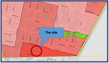
The site is shown below.
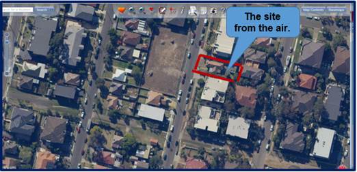
Photos
of the site are shown below.
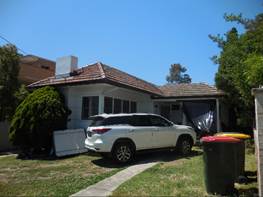
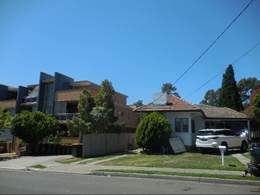
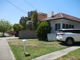
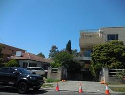
Description of the Proposed
Development
Development Application 2020/0453
is proposing the consolidation of the two allotments into one allotment,
demolition of the existing structures and construction of a three storey
boarding house accommodating 10 rooms (12 lodgers) over basement car parking
for five vehicles.
The development includes the
following:
Demolition work
The existing dwelling house and
outbuildings are to be demolished and a small tree within the rear yard is to
be removed.
Excavation work and
construction of a basement car park
Excavation work to a depth of 3.1 metres
is proposed to allow for the construction of a basement car park. The plans are
showing the basement car park as having the following:-
· Room for parking
five (5) vehicles and two (2) motor bikes.
· A bin storage
room.
· A bike rack.
· A lift and stair
access.
Construction of a new
generation boarding house
A new generation boarding house is
to be constructed which will be three (3) storeys in height and includes ten
(10) boarding rooms. The plans are showing eight (8) rooms accommodating one boarder
and two (2) rooms accommodating two boarders for a total of twelve (12)
boarders.
The boarding house is provided
with a common area facing the street and common area towards the rear. The
development includes stormwater drainage and landscaping of the site.
History
Development Application 2018/293
for the demolition of the existing structures, consolidation of two lots into
one allotment and construction of a four storey boarding house accommodating 11
rooms and managers accommodation over basement car parking was refused by the
Cumberland Local Planning Panel at its meeting of March 27 2019 for the
following reasons:-
Landscaped area
1. Clause
29(2)(b) of State Environmental Planning Policy (Affordable Rental Housing)
2009 *(SEPP (ARH)) requires the consent authority to consider whether the
landscape treatment of the front setback area of a proposed boarding house is
to be compatible with the streetscape in which the building is located. The
landscape treatment of the front setback area of the proposed development is
not considered to be compatible with the streetscape in that the majority of
the setback is paved and there is very limited soft landscaping provided.
Planners comment
The front landscape area has been
improved with additional landscaping provided including deep soil zone.
Solar access
2. Clause
29(2)(c) requires the consent authority to consider whether the communal living
room will receive a minimum of 3 hours direct solar access between 9 am and 3
pm at mid winter. The information provided indicates that the communal living
room will receive less than 3 hours direct solar access at mid winter.
Planners comment
The communal living room has been
relocated and now receives more than 3 hours of sunlight at mid winter.
Maximum size of boarding rooms
3. Clause
30(1)(a) requires that the consent authority must not consent to development
for a boarding house where any boarding room has a gross floor area (excluding
any area used for the purposes of private kitchen or bathroom facilities) of
more than 25 m2. Rooms 4 and 7 of the proposed development have a floor area
greater than 25 m2.
Planners comment
The boarding rooms have adequate
sizes and there are no rooms that have excessive internal floor areas.
Kitchen facilities
4. Clause
30(1)(d) requires that the consent authority must not consent to development
for a boarding house unless adequate bathroom and kitchen facilities will be
available within the boarding house for the use of each lodger. The kitchenette
facilities within each room are not sufficient and there are no common kitchen
facilities proposed.
Planners comment
Every boarding room proposed is
provided with adequate toilet and kitchenette areas.
Bicycle and motorcycle parking
5. Clause
30(1)(h) requires that the consent authority must not consent to development
for a boarding house unless a minimum of one parking space will be provided for
a bicycle and one will be provided for a motorcycle for every 5 boarding rooms.
The proposed development requires a minimum of 3 motorcycle spaces and 3
bicycle spaces and only two of each are proposed.
Planners comment
The basement floor plans show two
parking bays for motorbikes and bikes which is adequate to support the
development.
Character of the local area
6. Clause
30A of the SEPP (ARH) requires that the consent authority must not consent to
development for a boarding house unless it is satisfied that the proposal is
consistent with the character of the local area.
The proposed development is not
considered compatible with the character of the local area in terms of the
physical characteristics of the building, the overshadowing impacts on the
adjacent property to the south, and the relationship of the proposed building
to the site and streetscape.
Planners comment
The modified plans have been
assessed as being satisfactory under Clause 30A of SEPP (ARH) 2009 as
demonstrated in this report.
Holroyd Development Control
Plan (HDCP) 2013
7. The
development as proposed does not comply with the following provisions of the
HDCP 2013:
a. Section
4, Part A - Tree and Landscape works
The proposed landscaping does not
enhance the streetscape or setting of the development and does not allow for
appropriate screening of the development from the side boundaries.
Planners comment
Landscaping on site has been
improved and there is additional landscaping and deep soil zone at the front of
the site.
b. Section
6.3, Part A - Erosion and sediment control
An erosion and sediment control
plan was not submitted with the application.
Planners comment
A sediment and erosion control
plan has been prepared by Australian Consulting Engineers and considered as
being appropriate for approval.
c. Section
1.5, Part B - Landscape area
8.7% of the site is proposed to be
soft landscaped where a minimum of 30% is required.
Planners comment
Landscaping occupies 34.7% of the
site which is an improvement when compared to the original development
application.
d. Section
1.8, Part B - Sunlight access
The proposal results in
overshadowing of existing dwellings to the south such that they will receive no
solar access to their living areas or private open spaces at mid winter.
Planners comment
Overshadowing has been reduced
because the building has been lowered in height by one storey. Shadowing is
considered to be acceptable for this development.
e. Section
1.9, Part B - Cut and fill
HDCP requires that fill in excess
of 600 mm be contained within the building envelope. The proposal involves 1
metre of fill within the front setback and directly adjacent to the northern
boundary.
Planners comment
Any filling required is contained
within the building envelope. There is no excessive filling of the site.
f. Section
6.2, Part B - Site coverage
The proposal has site coverage of
35% where a maximum of 30% is permitted.
Planners comment
The site coverage of the
development has been reduced slightly to 34.5%. It is not possible to reduce
this further without adversely impacting on residential amenity. The variation
of 14.99% is considered to be acceptable and not adversely impacting on the
performance of the development.
g. Section
6.3, Part B - Setbacks and separation
The proposal provides for building
separation of 7.5 metres to the southern adjoining neighbour and 7 metres to
the northern adjoining neighbour where a minimum of 12 m is required.
Planners comment
Generally, the building on site
exhibits satisfactory side setbacks of 3 metres from the property boundaries
and 7.6 metres from the adjoining buildings. Side setbacks cannot be increased
as the site is landlocked between two adjoining apartment buildings and the
site has a width of 13.41 metres. It is considered that the degree of privacy
and amenity is satisfactory.
h. Section
6.7, Part B - Building appearance
The proposed design does not
provide for appropriate scale, rhythm or proportion and as such would have
adverse streetscape impacts.
Planners comment
The built form, design, materials
and height of the modified building is considered to be satisfactory.
i. Section
6.8, Part B - Building entry and pedestrian access.
The proposal does not provide for
disabled access from Cardigan Street to the building entry.
Planners comment
Condition 24(g) attached to the
recommendation requires a chair lift or similar device to be incorporated into
the front entry / step area to allow equitable access to the premises from the
street by person with a disability.
j. Section
7.0, Part B - Controls for landlocked sites
The proposed development does not
achieve a satisfactory level of solar access, privacy or amenity for either the
existing or adjacent dwellings or the proposed boarding rooms. The proposed
design would detract from the character of the streetscape.
Planners comment
The development is reduced in
height and floor space ratio and as a result, residential amenity and privacy
is improved and shadowing to the south is reduced. The applicant has lowered
the building by one storey when compared to the original development which
reduces the impacts of the development within the immediate locality.
Amenity of proposed boarding
house
8. The
development as proposed will not provide for adequate residential amenity for
future occupants as detailed below.
a. The
proposal provides for a total of two washing machines and one laundry tub
within the common laundry on Level 1. This is not considered sufficient for the
number of occupants proposed.
b. The
high sill windows proposed to habitable rooms on the northern elevation will
compromise light and outlook to those rooms.
Planners comment
The plans for the development
shows that every room is provided with laundry facilities.
The outlook from every room within
the development is satisfactory.
Suitability of the site for the
proposed development
9. The
subject site is not considered suitable for the development as proposed due to
the inadequacies detailed above (section 4.15(c) of the Environmental Planning
and Assessment Act 1979).
Planners comment
The development proposed for the
site has been significantly modified and the proposed intensity of use has been
reduced. In this regard, the number of rooms has been reduced from 11 to 10,
the height of the development has been reduced from four storeys to three
storeys and the number of car parking spaces required to support the
development has been reduced form 6 to 5. As such, residential amenity has been
improved and the development is considered to fit the streetscape.
Environmental Impact
10. Due
to the deficiencies detailed above, the likely environmental impacts of the
proposed development are considered to be unacceptable (section 4.15(1)(b) of
the Environmental Planning and Assessment Act 1979).
Planners comment
Due to the changes made, the
environmental impacts of the development has been reduced and the development
as shown in the plans is considered to be acceptable for the street.
Public Interest
11. Due
to the deficiencies detailed above, approval of the proposed development would
be contrary to the public interest (section 4.15(1)(d) & (e) of the
Environmental Planning and Assessment Act 1979).
Planners comment
The development sought has been
reduced in size and as such, the development is considered as being acceptable
to the streetscape and the public interest.
Development Application 2020/0453
was lodged with Council on 3 August 2020.
Applicants Supporting
Statement
The applicant has provided a Statement of Environmental
Effects prepared by Think Planners and dated 27 July 2020 in support of the
application.
Contact with Relevant
Parties
The assessing officer has
undertaken a site inspection of the subject site and surrounding properties and
has been in regular contact with the applicant throughout the assessment
process.
Internal Referrals
Development Engineer
The development application was
referred to Council’s Development Engineer for comment who has advised
that the development proposal is satisfactory subject to conditions.
Environment and Health
The development application was
referred to Council’s Environment and Health Officer for comment who has
requested additional information relating to acoustics.
Comment
In response to this, an acoustic
report has been submitted for assessment. Given that the intensity of use of
the development is not excessive being a maximum of 12 boarders and a maximum
of 5 car parking spaces, it is considered that noise issues will not be
excessive. Conditions numbered 23(b), 53 and 94 attached to the recommendation
addresses the acoustic matters.
All other matters such as land
contamination is satisfactory and conditions numbered 21, 73 and 75 addresses a
hazardous materials survey or land contamination..
Tree Management Officer
The development application was
referred to Council’s Tree Management Officer for assessment however no
objection has been raised in relation to the removal of the tree within the
rear yard of the property.
Waste Management
The development application was
referred to Council’s Waste Management Officer for comment who has
advised that the development proposal is satisfactory subject to a condition
that requires the bin tug not to impede access to the bins. In this regard,
Condition 23(a) addresses the matter for Panel consideration.
External Referrals
The development application was
referred to the Cumberland Police Area Command for assessment who advised on
the 9 September 2020 that the development is satisfactory although conditions
are required to address crime and safety. Conditions numbered 23(c), 85, 102,
103 and 114 addresses the relevant concerns raised.
PLANNING COMMENTS
The provisions of any
Environmental Planning Instruments (EP&A Act s4.15 (1)(a)(i))
State Environmental Planning
Policies
The proposed development is
affected by the following State Environmental Planning Policies:
(a) State
Environmental Planning Policy No. 55 - Remediation of Land (SEPP 55)
Clause 7 of SEPP 55 requires
Council to be satisfied that the site is suitable or can be made suitable to
accommodate the proposed development. The matters listed within Clause 7 have
been considered in the assessment of the development application.
|
Matter for
Consideration
|
Yes/No
|
|
Does the application involve re-development of the site or
a change of land use?
|
Yes
No
|
|
a.
Does the application involve
re-development of the site or a change of land use?
|
Yes
No
|
|
Is the development going to be used for a sensitive land
use (e.g.: residential, educational, recreational, childcare or hospital)?
Comment - Proposed residential use.
|
Yes
No
|
|
Does information available to you indicate that an
activity listed below has ever been approved, or occurred at the site?
acid/alkali plant and
formulation, agricultural/horticultural activities, airports, asbestos
production and disposal, chemicals manufacture and formulation, defence
works, drum re-conditioning works, dry cleaning establishments, electrical
manufacturing (transformers), electroplating and heat treatment premises,
engine works, explosive industry, gas works, iron and steel works, landfill
sites, metal treatment, mining and extractive industries, oil production and
storage, paint formulation and manufacture, pesticide manufacture and
formulation, power stations, railway yards, scrap yards, service stations,
sheep and cattle dips, smelting and refining, tanning and associated trades,
waste storage and treatment, wood preservation
|
Yes
No
|
|
Is the site listed on
Council’s Contaminated Land database?
|
Yes
No
|
|
Is the site subject to EPA
clean-up order or other EPA restrictions?
|
Yes
No
|
|
Has the site been the subject of
known pollution incidents or illegal dumping?
|
Yes
No
|
|
Does the site adjoin any
contaminated land/previously contaminated land?
|
Yes
No
|
|
Has the appropriate level of
investigation been carried out in respect of contamination matters for
Council to be satisfied that the site is suitable to accommodate the proposed
development or can be made suitable to accommodate the proposed development?
|
Yes
No
|
|
Details of contamination investigations carried out at
the site
A preliminary site investigation has been prepared by GCA
and dated 10 February 2020.
The investigation report has identified potential asbestos
containing materials within the residential dwelling house and that the site
has predominantly been used for residential purposes. The report identifies
that no filling has occurred.
The applicant is required to prepare a hazardous materials
survey and an unexpected finds protocol prior to the issue of a construction
certificate. Conditions numbered 21, 73 and 75 addresses a hazardous
materials survey or land contamination.
|
(b) State
Environmental Planning Policy (Vegetation in Non-Rural Areas) 2017
The development application
includes the removal of a small Pencil Pine tree within the rear yard. This is an
introduced species and having no value to the site. The development does not
exceed the biodiversity offsets scheme threshold. Therefore, the proposed
vegetation removal is considered acceptable.
(c) State
Environmental Planning Policy (Building Sustainability Index: BASIX) 2004
BASIX Certificate Number
949112M-03 which is dated 23 July 2020 and prepared by Outsource Ideas Pty Ltd
has been submitted. The certificate is determined as being generally
satisfactory for inclusion into any consent that is issued.
(d) State
Environmental Planning Policy (Affordable Rental Housing) 2009
·
|
Requirement
|
Yes
|
No
|
N/A
|
Comment
|
|
Division 3 Boarding houses
25 Definition
In this Division:
communal living room means a room within a
boarding house or on site that is available to all lodgers for recreational
purposes, such as a lounge room, dining room, recreation room or games room.
|
|
|
|
A communal room is provided on
the ground level adjacent to Room Number 01 and facing Cardigan Street.
|
|
26 Land to which Division applies
This Division applies to land within any of the following
land use zones or within a land use zone that is equivalent to any of those
zones:
(a) Zone R1 General Residential,
(b) Zone R2 Low Density Residential,
(c) Zone R3 Medium Density Residential,
(d) Zone R4 High Density Residential,
(e) Zone B1 Neighbourhood Centre,
(f) Zone B2 Local Centre,
(g) Zone B4 Mixed Use.
|
|
|
|
The site is within zone R4 High
Density Residential which permits boarding houses with consent.
|
|
27 Development
to which Division applies
(1) This Division applies
to development, on land to which this Division applies, for the purposes of
boarding houses.
(2) Despite subclause
(1), clauses 29, 30 and 30A do not apply to development on land within Zone
R2 Low Density Residential or within a land use zone that is equivalent to
that zone in the Sydney region unless the land is within an accessible area.
(3) Despite subclause (1), clauses 29, 30
and 30A do not apply to development on land within Zone R2 Low Density
Residential or within a land use zone that is equivalent to that zone that is
not in the Sydney region unless all or part of the development is within 400
metres walking distance of land within Zone B2 Local Centre or Zone B4 Mixed
Use or within a land use zone that is equivalent to any of those zones..
|
|
|
|
The development is proposed on
land zoned R4 High Density Residential.
|
|
28 Development
may be carried out with consent
Development to which this
Division applies may be carried out with consent.
|
|
|
|
Development consent is sought
for the boarding house.
|
|
29 Standards
that cannot be used to refuse consent
(1) A consent authority must
not refuse consent to development to which this Division applies on the
grounds of density or scale if the density and scale of the buildings when
expressed as a floor space ratio are not more than:
(a) the
existing maximum floor space ratio for any form of residential accommodation
permitted on the land, or
(b) if
the development is on land within a zone in which no residential
accommodation is permitted—the existing maximum floor space ratio for
any form of development permitted on the land, or
(c) if
the development is on land within a zone in which residential flat buildings
are permitted and the land does not contain a heritage item that is
identified in an environmental planning instrument or an interim heritage
order or on the State Heritage Register—the existing maximum floor
space ratio for any form of residential accommodation permitted on the land,
plus:
(i) 0.5:1,
if the existing maximum floor space ratio is 2.5:1 or less, or
(ii) 20%
of the existing maximum floor space ratio, if the existing maximum floor
space ratio is greater than 2.5:1.
|
|
|
|
The maximum permitted floor
space ratio is 1.2:1. The building has a floor space ratio of 0.824:1 which
is less than that permitted for the site. The development is compliant with
the floor space ratio provision.
A floor space ratio bonus of
0.5:1 may apply to the development however, the applicant has not requested a
bonus in this instance.
|
|
(2) A consent authority
must not refuse consent to development to which this Division applies on any
of the following grounds:
(a) building
height
if the building height of all proposed buildings is not more than the
maximum building height permitted under another environmental planning
instrument for any building on the land,
(b) landscaped
area
if the landscape treatment of the front setback area is compatible with the
streetscape in which the building is located,
(c) solar
access
where the development provides for one or more communal living rooms, if at
least one of those rooms receives a minimum of 3 hours direct sunlight
between 9am and 3pm in mid-winter,
(d) private
open space
if at least the following private open space areas are provided (other
than the front setback area):
(i) one
area of at least 20 square metres with a minimum dimension of 3 metres is
provided for the use of the lodgers,
(ii) if
accommodation is provided on site for a boarding house manager—one area
of at least 8 square metres with a minimum dimension of 2.5 metres is
provided adjacent to that accommodation,
(e) parking
if:
(i) in the case of development carried out by or on behalf of
a social housing provider in an accessible area—at least 0.2 parking
spaces are provided for each boarding room, and
(ii) in the
case of development carried out by or on behalf of a social housing provider
not in an accessible area, at least 0.4 parking spaces are provided for each
boarding room, and
(iia) in
the case of development not carried out by or on behalf of a social housing
provider—at least 0.5 parking spaces are provided for each boarding
room, and
(iii) in
the case of any development—not more than 1 parking space is provided
for each person employed in connection with the development and who is
resident on site,
(f) accommodation
size
if each boarding room has a gross floor area (excluding any area used for the
purposes of private kitchen or bathroom facilities) of at least:
(i) 12
square metres in the case of a boarding room intended to be used by a single
lodger, or
(ii) 16
square metres in any other case.
|
|
|
|
Maximum building height is 15
metres. Propose 10.55 metres.
Landscaping at the front is
compatible with the streetscape.
The common room is placed
within the front ground floor part of the building facing Cardigan Street.
The room will receive adequate sunlight penetration daily due to location.
A private open space area
occupying minimum dimensions of 11 metres x 3 metres is provided on site (33
sq m).
This excludes much of the
northern area adjacent to Rooms 01 and 02 as an opportunity exists to convert
the open space into two small private courtyards for use of the occupants of
these rooms.
A boarding house manager is not
required as the total number of occupants is not expected to exceed
twelve (12).
Car parking.
The
development is within an accessible area. The number of parking spaces
required for the proposed development is 10 x 0.5 spaces = 5 spaces.
The gross floor area for each
boarding room (excluding any area used for the purposes of private kitchen or
bathroom facilities) exceed 16 square metres for the double rooms and 12
metres for the single rooms. Generally, the rooms have satisfactory sizes.
|
|
(3) A boarding house may
have private kitchen or bathroom facilities in each boarding room but is not
required to have those facilities in any boarding room.
(4) A consent authority
may consent to development to which this Division applies whether or not the
development complies with the standards set out in subclause (1) or (2).
|
|
|
|
All boarding rooms are proposed
to contain open plan kitchenette arrangement and private bathroom facilities.
The proposed development
complies with the standards.
|
|
30 Standards
for boarding houses
(1) A consent authority must not consent to
development to which this Division applies unless it is satisfied of each of
the following:
(a) if a boarding house has 5 or more boarding
rooms, at least one communal living room will be provided,
(b) no boarding room will have a gross floor
area (excluding any area used for the purposes of private kitchen or bathroom
facilities) of more than 25 square metres,
(c) no boarding room will be occupied by more
than 2 adult lodgers,
(d) adequate bathroom and kitchen facilities
will be available within the boarding house for the use of each lodger,
(e) if the boarding house has capacity to
accommodate 20 or more lodgers, a boarding room or on site dwelling will be
provided for a boarding house manager,
(f) (Repealed)
(g) if the boarding house is on land zoned
primarily for commercial purposes, no part of the ground floor of the
boarding house that fronts a street will be used for residential purposes
unless another environmental planning instrument permits such a use,
(h) at least one parking space will be provided
for a bicycle, and one will be provided for a motorcycle, for every 5
boarding rooms.
(2) Subclause (1) does
not apply to development for the purposes of minor alterations or additions
to an existing boarding house.
|
|
|
|
There are 10 boarding rooms
proposed. Accordingly, a minimum of one communal room is provided.
All the rooms have areas of
less than 25 square metres. The largest room occupies 23 square metres with
the smallest room occupying 12 square metres.
No more than 2 lodgers per
boarding room is proposed.
Each boarding room contains a
kitchenette and bathroom.
The boarding house has the
capacity to accommodate a maximum of 12 lodgers. Accordingly, a boarding room
for a boarding house manager is not required.
The number of parking spaces
required for a bicycle = 2 and number of parking spaces required for a
motorcycle = 2.
The plans show 2 motor bike
spaces and 2 spaces suitable for bikes.
|
|
30A Character
of local area
A consent authority must not
consent to development to which this Division applies unless it has taken
into consideration whether the design of the development is compatible with
the character of the local area.
|
|
|
|
The matter concerning Clause
30A is addressed below and considered to be satisfactory.
|
|
Part 4 Miscellaneous
52 No
subdivision of boarding houses
A consent authority must not
grant consent to the strata subdivision or community title subdivision of a
boarding house.
|
|
|
|
No subdivision is proposed as
part of this application.
|
Clause 30A Character of the Local Area
A consent authority must not consent
to development to which this Division applies unless it has taken into
consideration whether the design of the development is compatible with the
character of the local area.
Discussion
State Environmental Planning
Policy “Affordable Rental Housing” 2009, does not provide guidance
on how to determine if a development is compatible with the local area. In this
regard case law in the Land and Environment Court has considered the merit
assessment of Clause 30A. In addition the Land and Environment Court’s
Planning Principle ‘Surrounding Development - Compatibility of proposal
with surrounding development’ (Project Venture Developments Pty Ltd v
Pittwater Council [2005] NSWLEC 191 provides for guidance on how to assess
compatibility of development with the character of local area. Using case law
and the Land and Environment Court Planning Principle, a merit assessment of
character of the local area should consider the following 3 steps:
·
·
Step 1 - Identify the local area.
·
Step 2 - Determine the character (present and future) of the
local area.
·
Step 3 - Determine if the development is compatible with the
character of the local area.
As assessment against each step is
provided below:
Step
1 - Identify the local area
This assessment identifies the
local area as primarily the visual catchment of the site (as viewed from within
the site and directly adjacent to the site on the street) which is shown in the
aerial view provided earlier in the report.
The local area for the purposes of
this application is outlined on the zoning map below:
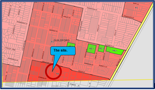
There are three storey residential
apartment buildings situated to the north and south of the site and apartments
to the rear. Land on the western side of Cardigan Street is also zoned R4 which
allows for apartment buildings to be constructed. Thus the immediate locality
is expected to be dominated by apartment buildings due to the proximity of the
Guildford Town Centre and public transport services.
Step 2 - Determine the
character (present and future) of the local area
The identified character of the area
is R4 High Density Residential. The locality is the subject of development
pressure in which single storey dwelling houses are being replaced with
apartment buildings. As such, the form of development being a 3 storey boarding
house development is compatible with the future intentions for the locality.
Step 3 - Determine if the
development is compatible with the character of the local area.
In accordance with the Land and
Environment Court’s ‘Planning Principle’ and recent case law
on the character test within Clause 30A of the ARHSEPP, compatibility is best
defined as ‘capable of existing together in harmony’. In order to
test compatibility two questions are to be considered. These questions as well
as a response to each are provided below:
Are the proposal’s
physical impacts on surrounding development acceptable? The physical impacts
include constraints on the development potential of surrounding sites.
The above question is relatively
objective. Physical impacts generally include privacy, overshadowing, visual
bulk and compatibility in the streetscape. In terms of the physical impacts of
the development to the adjoining buildings, the following is provided.
· The
development will cast a shadow impact across the lower floors of the apartment
building to the south however this is expected given the planning controls that
exists on site. It is identified that the proposed building is 4.45 metres
below the maximum height limit (the equivalent of 1 storey) imposed by the
planning controls for the site. This in turn reduces the shadow impact to the
south and improves amenity.
· The
building is setback at least 3 metres from the property boundaries. It is not
possible to increase this due to the size of the site and it is not feasible to
amalgamate the site with an adjoining development.
· The
proposed floor space ratio is less than what the planning controls permit.
· Privacy
impacts are determined as generally being satisfactory due to the form of
windows being used and the use of privacy screens.
· Minor
changes are required to improve the degree of privacy within the ground floor
such as converting outdoor space adjacent to rooms 01 and 02 into private
courtyards. Condition 23(f) addresses the matter raised.
Is the proposal’s
appearance in harmony with the buildings around it and the character of the
street?
The predominant building type
expected for the locality are three to four storey residential apartment
buildings and such developments are likely to continue within the immediate
future, especially along the western side of Cardigan Street.
The height of the proposed
boarding house is generally in harmony with the height of newer buildings
within the locality.
It is identified that the ground
floor of the development comprises a common room facing Cardigan Street and
there are rooms on the floors above facing the street. The car park is
contained within a basement. There is a built form element covering the
entrance of the car park and driveway which is situated 1 metre from the
property boundary. It is considered that the structure has no adverse impact to
the streetscape. It is considered that the building is consistent with the
streetscape which is compatible with the existing and future desired character
of the locality.
Regional Environmental Plans
(a) Sydney
Regional Environmental Plan (Sydney Harbour Catchment) 2005
The subject site is identified as
being located within the area affected by the Sydney Regional Environmental
Plan (Sydney Harbour Catchment) 2005. The proposed development raises no issues
as no impact on the catchment is envisaged.
(Note: - the subject site is not
identified in the relevant map as ‘land within the ‘Foreshores and
Waterways Area’ or ‘Wetland Protection zone’, is not a
‘Strategic Foreshore Site’ and does not contain any heritage items.
Hence the majority of the SREP is not directly relevant to the proposed
development).
Local Environmental Plans
Holroyd Local Environmental
Plan 2013
The Holroyd Local Environmental
Plan 2013 is applicable to the development application. The proposed
development is defined as a boarding house which is permitted with consent in
the R4 High Density Residential zone. A boarding house is defined as:-
“A building that:
(a) Is
wholly or partly let in lodgings, and
(b) Providers
lodgers with a principal place of residence for 3 months or more, and
(c) May
have shared facilities, such as a communal living room, bathroom, kitchen or
laundry, and
(d) Has
rooms, some of all which may have private kitchen and bathroom facilities, that
accommodate or more lodgers,
But does not include backpackers
accommodation, a group home, hotel or motel accommodation, seniors housing or a
serviced apartment”.
Note. Boarding houses are a type
of residential accommodation see the definition of that term in this Dictionary.
The relevant matters to be
considered under the Holroyd Local Environmental Plan 2013 and the applicable
clauses for the proposed development are summarised below.
|
DEVELOPMENT
STANDARD
|
COMPLIANCE
|
DISCUSSION
|
|
4.3 Height of Buildings.
15 metres.
|
Yes
|
The building has a maximum height of 10.55 metres.
|
|
4.4 Floor
Space Ratio.
1.2:1.
|
Yes
|
The building has a floor space ratio of 0.824:1.
|
The development is compliant with
the relevant provisions. A comprehensive LEP assessment is contained in
Appendix A.
The provisions of any proposed
instrument that is or has been the subject (EP&A Act s4.15 (1)(a)(ii))
(a) Draft
Cumberland Local Environmental Plan (Draft CLEP)
The Draft Cumberland Local
Environmental Plan (Draft CLEP) has been prepared by Cumberland City Council to
provide a single planning framework for the future planning of Cumberland City.
The changes proposed seek to harmonise and repeal the three existing LEPs
currently applicable to the Cumberland local government area, those being:
· Holroyd Local
Environmental Plan 2013,
· Parramatta Local
Environmental Plan 2011, and
· Auburn Local
Environmental Plan 2010.
The current planning controls for
the subject site, as contained within the Holroyd Local Environmental Plan 2013
are not proposed to change under the Draft Cumberland Local Environmental Plan.
As such, the development would be satisfactory when assessed using the draft
planning instrument.
The provisions of any
Development Control Plans (EP&A Act s4.15 (1)(a)(iii))
The Holroyd Development Control
Plan 2013 provides guidance for the design and operation of development to
achieve the aims and objectives of the Holroyd Local Environmental Plan 2013.
Whilst there are no specific
controls under the HDCP 2013, that are directly relevant to a boarding house
development, Part A - General Controls and Part B Residential Controls of the
HDCP 2013 have been considered in the assessment.
The proposal generally complies
with the requirements of the HDCP 2013 with the exception of the following
parts of Part B - Part 1.8 (Subpart C6) Solar access, Part 6.1 (Subpart C1) -
Property frontage, Part 6.2 (Subpart C1) - Site coverage and Part 6.3
(Residential Flat buildings) (Subparts C5, C6, C7 and C11) side and rear
setbacks including building separation which are considered acceptable on merit
as discussed in further detail below. Moreover, it should be noted that the
controls whilst relevant are of limited application in so far as the
development relates to a boarding house and not a residential flat building.
This is used to assist in guiding the development.
The non compliances are discussed
below.
Part B of the Holroyd
Development Control Plan 2013
Part 1.8 (Subpart C6) Solar
access.
A variation to Part 1.8 (Subpart
C6) is identified. However, it is considered that the applicant has minimised
the shadow impacts and the following is provided:
· The building has a
floor space ratio that is less than that permitted for the site.
· The height of the
development is 4.45 metres lower (equivalent of one storey) than that permitted
for the site.
· Side setbacks are
maximised as much as possible.
The planning controls allow the
form of development although the applicant is not maximising the development
potential of the site. The development is considered to be satisfactory given
the site constraints.
Part 6.1 (Subpart C1) -
Property frontage
The site should have a minimum
property frontage of 24 metres. The property frontage of 13.41 metres creates a
variation of 44.2%. It is not possible to consolidate the site into an
adjoining site to the north or south given that both sites have recently been
developed for three storey apartment buildings. The site is landlocked which
has impacted its development potential.
Additionally, smaller forms of
development such as dwelling houses and dual occupancies are not permissible on
the site given the zoning of the land. As such, there are limited options
available for the site. It is considered that a boarding house is a more
appropriate development given the site constraints that exists.
Part 6.2 (Subpart C1) - Site
coverage
The maximum permitted site
coverage is 30%. Instead a site coverage of 34.5% is proposed. The proposed
site coverage is considered satisfactory given the size of the building that is
proposed.
Part 6.3 (Subpart C5, C6, C7
and C11) - Building setbacks (Side and rear setbacks)
The minimum rear and side setbacks
are:-
a. Rear
- 20% of site length or 6 metres whichever is greater - Requires 6.7 metres.
b. Side
setbacks - 3 metres.
c. Building
setbacks (Between other apartment buildings):-
· 12 metres between
habitable and non habitable rooms.
· 9 metres between
habitable rooms and balconies and non habitable rooms.
· 6 metres between
non habitable rooms.
d. Basement
to be setback 3 metres from boundaries.
In relation to the above:-
· The rear setback
is 5 metres for the ground storey and first storey and 6 metres for the second
storey.
· A side setback of
3 metres is achieved however there is a roof element that encroaches to 1 metre
of the property boundary along the south west side of the building.
· The northern and
southern setback between buildings is 7.6 metres.
· The eastern
setback ranges from 10 metres to 11 metres.
· The basement
encroaches to within 3 metres of the property boundaries.
It is considered that the
variations be supported as the proposed development will not have adverse
visual amenity and create significant privacy issues. In addition, privacy
screens are to be used for the corridors, there are no habitable rooms facing
the southern side boundary, windows are carefully located to avoid direct views
onto the windows of adjoining properties and hi light windows are used as
appropriate. Where privacy concerns are raised such as the position of the
windows for rooms 01 and 02, the issues are able to be rectified. In this
regard, Condition 23(f) requires the outdoor space adjacent to rooms 01 and 02
to be converted to private courtyards to service the two rooms.
A comprehensive assessment and
compliance table is contained in Appendix B.
The provisions of any planning
agreement that has been entered into under section 7.4, or any draft planning
agreement that a developer has offered to enter into under section 7.4 EP&A
Act s4.15(1)(a)(iiia))
There is no draft planning
agreement associated with the subject Development Application.
The provisions of the
Regulations (EP&A Act s4.15 (1)(a)(iv))
The proposed development raises no
concerns as to the relevant matters arising from the Environmental Planning and
Assessment Regulations 2000 (EP&A Reg).
The Likely Environmental,
Social or Economic Impacts (EP&A Act s4.15 (1)(b))
It is considered that the proposed
development will have no significant adverse environmental, social or economic
impacts in the locality.
The suitability of the site for
the development (EP&A Act s4.15 (1)(c))
The subject site and locality is
not known to be affected by any natural hazards or other site constraints
likely to have a significant adverse impact on the proposed development.
Accordingly, it is considered that the development is suitable in the context
of the site and surrounding locality.
Submissions made in accordance
with the Act or Regulation (EP&A Act s4.15 (1)(d))
|
Advertised (newspaper)
|
Mail
|
Sign
|
Not Required
|
In accordance with Council’s
notification requirements contained within the Holroyd Development Control Plan
2013, the proposal was publicly notified for a period of fourteen (14) days
between Wednesday 9 September 2020 and Wednesday 23 September 2020. In response,
there were fourteen submissions with ten of those being unique in nature.
The issues raised in the public
submissions are summarised and commented on as follows:
Site issues, design and appearance
|
Issues
|
Planners comment
|
|
The block is not suitable for a boarding house because the
land is too small to have more than 1 family living on the property.
Our street should not be zoned for boarding houses.
It is ridiculous to have 10 rooms over such a small area
given the average size of houses in Guildford being 500 square metres.
|
A dwelling house is a prohibited development in the R4
High Density Residential zone.
A boarding house is a permitted development in the R4 High
Density Residential zone.
The land is zoned for high density development and as
such, no objections are raised to the proposed intensity of use given the
land use zoning of the site.
|
|
The construction of the basement car park may interfere
with current residential buildings and may cause damage.
|
Condition 48 addresses the requirement for a dilapidation
report should the Panel support the development application.
|
|
The BASIX Certificate on Page 3/14 suggests that a 4
storey building will be constructed. This is incorrect.
|
The Certificate is assessed as being satisfactory for inclusion
into any consent issued.
|
|
The building will be closer to the boundary line on
Cardigan Street. This is closer than any other building in the entire street.
The boarding house will be out of line with other
buildings and will not fit the streetscape. There is less green space on the
block.
|
The development complies with the setback requirement of 6
metres as per the relevant requirement of Part B - Part 6.3 of the Holroyd
Development Control Plan specific to street setbacks.
|
|
The development is not in keeping with the streetscape.
Medium density housing does not exceed 3 storeys and the development does not
harmonize with the current streetscape or fit the character of the street.
|
The development is 3 storeys in height. The height of the
building is consistent with the height of adjoining buildings.
|
|
There is no space between the proposed building and
neighbouring buildings.
|
Most of the building is setback 3 metres from the side
boundaries and 5 to 6 metres from the rear property boundary.
A roof / parapet element covering the driveway is situated
1 metre from the property boundary. It is considered that the side setbacks
are satisfactory.
|
|
There is no information provided that shows how water fed
to gardens will not seep into neighbouring building walls.
|
There is no evidence to suggest that irrigation water will
seep into the walls of the adjoining buildings.
|
|
A laundry or drying room is not provided.
|
Every room is provided with a washer / dryer facility.
|
|
During construction, there will be disturbance to the
street in the form of noise, vibration, dust and smoke. This will destroy the
peaceful environment of the building.
|
Conditions numbered 20 and 66 attached to the
recommendation addresses construction times and noise controls.
|
Social issues
|
Issues
|
Planners comment
|
|
A building this size will overshadow our block of units
taking all the sun and leaving it very dark inside.
This will impact on energy consumption and our plants will
not receive adequate sunlight.
I will not receive sunlight from sunrise to sunset on my
balcony.
|
It is identified that there is a shadow impact to the
south however this has been minimised given the site constraints. The
applicant is not developing the site to its full potential. As such, floor space
ratio and height of the building is lower than that envisaged by the
applicable planning controls. This in turn reduces shadowing to the south.
|
|
The privacy of our residents would be invaded with such a
tall structure.
The development towers over our properties. Tenants will
have views to our home / common property unless frosted windows are used.
|
The degree of privacy is satisfactory between residents /
occupants and the applicant has minimised privacy concerns between buildings.
|
|
Illegal dumping will increase.
|
There is no evidence to show illegal dumping will occur.
|
|
Our street will be disrupted by the noise of people coming
and going at all hours.
|
A plan of management that addresses behaviour is provided.
Condition Number 91 attached to the recommendation addresses the plan of
management.
|
|
The development will reduce our property values and is not
an asset to our area.
|
This is not a matter of consideration under the
Environmental Planning and Assessment Act 1979.
|
|
The people living in the building will be a threat to our
way of life.
We are concerned with the safety of our children and our
property.
|
There is no evidence to suggest that the residents will be
a threat to adjoining residents. The development application has been passed
before the Cumberland Police Area Command who have provided conditions
addressing crime and safety.
|
|
I did not see a sign posted at the front of the property
and fellow residents did not receive any letter.
Further, two weeks is not enough to make a submission.
|
The development application was correctly notified during
the notified period including a sign placed on site, letters being sent to
surrounding residents and notification on the Council website.
|
|
There have been other boarding houses built in the last couple
of years and friends and neighbours have indicated that they attract
undesirables and short term tenants who have no respect for the local
community.
|
The statement is noted however there are no facts or
details provided to prove the claims made.
|
|
The application is another attempt at placing a commercial
building in the middle of a residential neighbourhood. There is no care or
effort to improve the amenity or resolve all the issues.
|
The development is permitted with consent. Additionally,
the development is reduced in intensity of use when compared to the previous
application. There is a reduction in the number of boarding rooms, height,
floor area which in turn reduces the number of car parking spaces required to
support the development.
|
|
Boarding houses attract people of a lower socio economic
circumstances as they are designed to offer cheap accommodation. This brings
with it problems with alcohol and drug abuse as well as mental instability.
There have been recent thefts and issues of vandalism. This
development will increase this thus reducing the safety of local residents.
|
The development is providing for affordable rental housing
as per the State Policy. There is no evidence or proof to show that the
development will contribute to drug and alcohol issues within the locality.
b.
The Cumberland Police Area Command
has advised that the development is satisfactory although conditions are
required to address crime and safety.
|
|
We were not given adequate plans to work out the height.
|
Appropriate plans and details were given to neighbours as
part of the notification. Letters sent to residents outlined details where
plans can be obtained on Council’s website.
|
|
There is only one exit to the building which operates much
like a commercial entity.
The building is too close to our building.
The basement is provided with a garage door which means
residents have very limited alternate paths in case of fire.
Emergency vehicles would have to reply on street parking
in case of fire.
|
An emergency evacuation plan is provided as part of the
development application addressing evacuation in the event of a fire.
Additionally, there are no concerns in relation to the
exit point, side setbacks or exit from the basement.
In relation to where emergency vehicles park if required,
there is no requirement to have emergency vehicles such as ambulance or fire
brigade trucks to park on site during an emergency.
|
|
The noise from 20 plus residents in place where there used
to be a 1 storey house will be significantly greater and will not be
tolerated.
|
The maximum number of boarders is 12. Noise levels are not
expected to be significant.
|
|
It is unclear how 10 rooms will accommodate 12 boarders.
|
There are 8 rooms that will accommodate 1 occupant and 2
rooms that can accommodate couples for a total of 12 boarders at maximum
capacity.
|
|
There is no CCTV proposed for the building.
We are concerned with our privacy if CCTV cameras are
installed near our building.
|
A CCTV system will be required and installed. Condition
23(c) and 114 attached to the recommendation addresses CCTV cameras for the
building.
|
|
We believe smoking will be permitted within the building.
The building will form a cage like structure and all smoke will travel to its
neighbours. We have a large population of elderly people who have breathing
difficulties.
|
The plan of management addresses smoking and it is
expected that it will be banned.
|
|
The existing residents at 70 Cardigan Street have had a
number of parties and Police were called. We have seen swearing, smoking,
drinking and late night parties. This will continue.
|
This is a Police matter and not related to the development
application. A plan of management is provided that addresses anti social
behaviour.
|
Traffic and car
parking
|
Issues
|
Planners comment
|
|
There are enough issues with on street car parking. With
additional residents, it would be an absolute nightmare trying to find a car
parking space.
|
There is adequate car parking provided for the
development.
|
|
I would like to be advised about the vacant block of land
opposite the site. If this site is developed, parking will be a nightmare.
We don’t know what will happen to 71-75 Cardigan
Street. The site has been cleared for a while now.
Further, car parking is inadequate for the site and
boarders will be forced to park on the street.
The driveway is too close to our property
|
The vacant land opposite the site is noted but not
relevant to the assessment of the application at 70 Cardigan Street.
The proposed development at 70 Cardigan Street comprises a
basement car park which has adequate car parking and driveway access. The
position of the driveway is assessed as being satisfactory.
|
|
Increased traffic flow is not only a congestion issue, it
is also a safety issue. There is an intersection nearby and traffic flows
have been increasing due to more development. There is a danger to residents
of accidents.
|
The street is zoned for High Density Residential use and
matters concerning traffic flows in local streets would have been calculated
as part of studies undertaken prior to the land being zoned for such use.
The proposed development is relatively small and will not
contribute to excessive traffic flows in the local street.
|
|
The place has 1 parking space for every 5 boarding rooms.
|
The development is provided with 5 car parking spaces in
accordance with State Environmental Planning Policy “Affordable Rental
Housing” 2009.
|
|
The traffic report is incorrect on the grounds that the
traffic data provided is incorrect. The traffic flows are double of what they
are stated in the reports and there is no free parking at night.
A boarding house will generate more traffic than a motel
on the grounds that the residents will have acquaintances, friends and family
and require courier needs, food deliverers and cleaners.
I cannot find parking on the street at the front of my
home. Car parking at night is saturated with no room to park on the street.
There is a demand for on street parking.
|
It is appropriate to use the applicant’s surveys and
Council’s traffic assessment to determine the car parking impact of the
development within the locality.
It is concluded that the development is provided with
adequate off street car parking and that given the size of the development,
an adverse impact on the street will not occur.
While the concerns are noted, the suggestion that the new
development is the cause or will worsen the existing issues is not supported.
|
Engineering and
stormwater
|
Cardigan Street has been an area where blockages are
common. We have had overflow in a balcony of a unit every time there is a
thunderstorm. It took more than 2 years for the block to be cleared which has
addressed the situation.
We had stormwater issues associated with units 77 and 79
of Number 72-78 Cardigan Street.
The water system will become overloaded.
|
The issue of blockages every time during storm events on
adjoining premises is not related to this development.
Council engineers have determined that the development
achieves satisfactory stormwater drainage and conditions are provided.
|
|
There are inadequate facilities for waste management.
|
Council’s Waste Management Officer has advised that
the development proposal is satisfactory in relation to waste storage and
removal subject to a condition that requires the bin tug not to impede access
to the bins.
|
The public
interest (EP&A Act s4.15(1)(e))
In view of the foregoing analysis it is considered that the
development, if carried out subject to the conditions set out in the
recommendation below, will have no significant adverse impacts on the public
interest.
Cumberland Local
Infrastructure Contributions Plan 2020
This part of the Act relates to
the collection of monetary contributions from applicants for use in developing
key local infrastructure.
Comments:
The development requires the
payment of contributions in accordance with Council’s Cumberland Local
Infrastructure Contributions Plan 2020.
The calculation is based
on the provision of a boarding house with ten (10) rooms. As at the 7 October
2020, the fee payable is $39,830. The figure is subject to indexation as per
the relevant plan. The draft determination attached includes condition 29
requiring payment of the contribution prior to the issue of a Construction
Certificate.
Disclosure of
Political Donations and Gifts
The applicant and
notification process did not result in any disclosure of Political Donations
and Gifts.
The development application has
been assessed in accordance with the relevant requirements of the Environmental
Planning and Assessment Act 1979, State Environmental Planning Policy
Affordable Rental Housing 2009 and the Holroyd Local Environmental Plan 2013
and is considered to be satisfactory.
The proposed development is
appropriately located within the R4 High Density Residential zone of the Holroyd
Local Environmental Plan 2013.
The proposal is generally
consistent with all statutory and non-statutory controls applying to the
development. Minor non-compliances with Council’s controls have been
discussed in the body of this report. The development is considered to perform
adequately in terms of its relationship to its surrounding built and natural
environment, particularly having regard to impacts on adjoining properties.
Having regard to the relevant
matters of consideration under Section 4.15 of the Environmental Planning and
Assessment Act 1979, it is considered that the proposed development is
acceptable for the reasons as outlined within the report. It is recommended
that the development be approved subject to conditions.
|
1. That
Development Application 2020/0453 for demolition of existing structures and
construction of a three (3) storey boarding house comprising 10 boarding
rooms over basement car parking on land at 70 Cardigan Street Guildford be
approved subject to conditions as listed in the attached schedule.
2. Persons
whom have lodged a submission in respect to the application be notified of
the determination of the application.
|
1. Draft Notice
of Determination
2. Architectural
Plans
3. Stormwater/Engineering
Plans
4. Redacted
Unique Submissions
5. Appendix
A - Holroyd Local Environmental Plan 2013
6. Appendix
B - Holroyd Development Control Plan 2013
7. Refused
Architectural Plans
DOCUMENTS
ASSOCIATED WITH
REPORT LPP058/20
Attachment 1
Draft Notice of Determination
Cumberland Local Planning Panel Meeting
9 December 2020
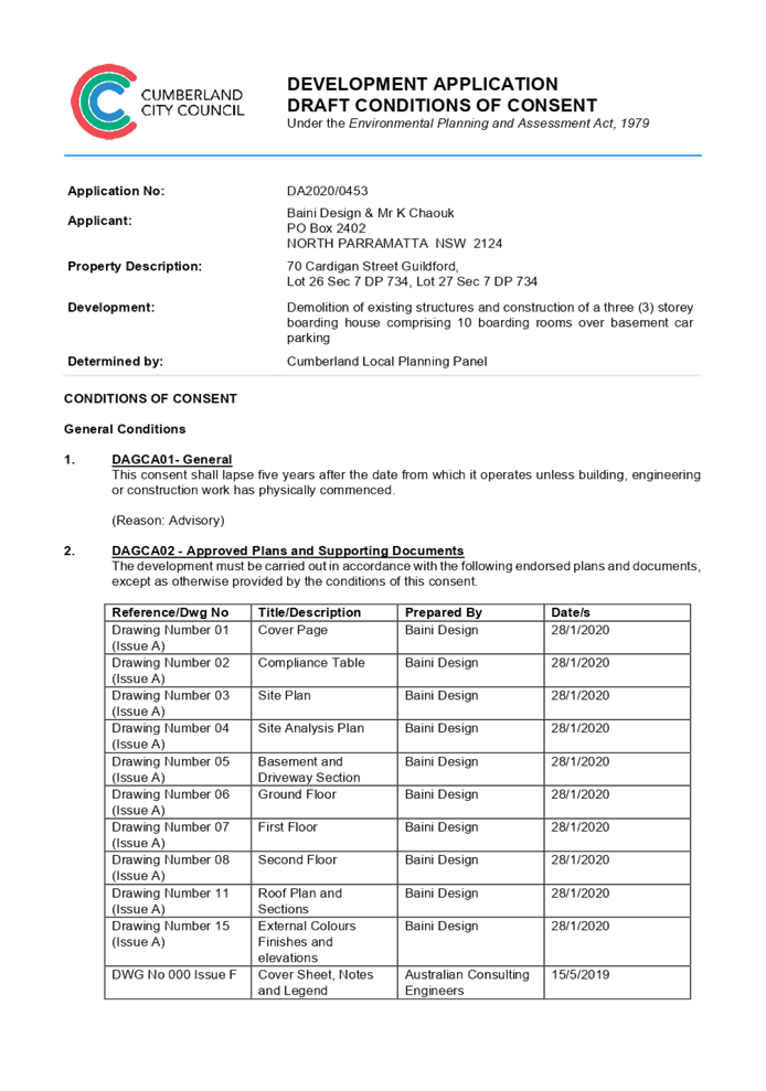
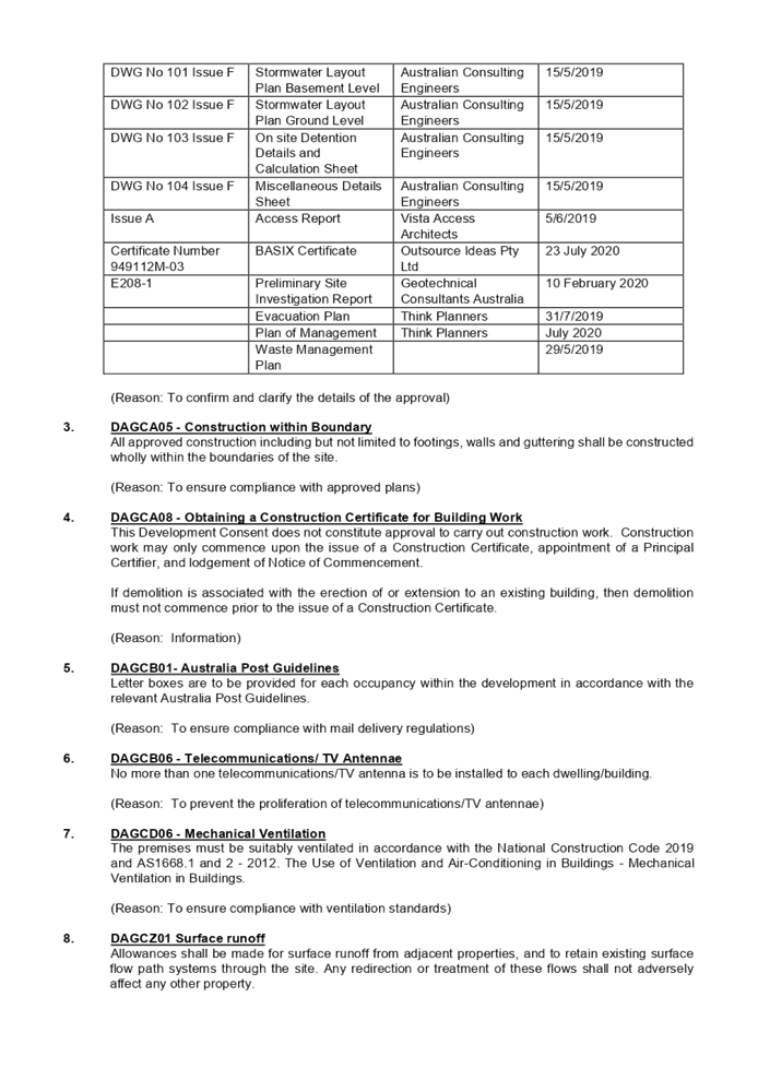
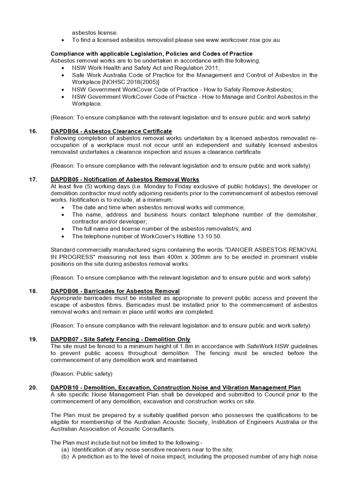
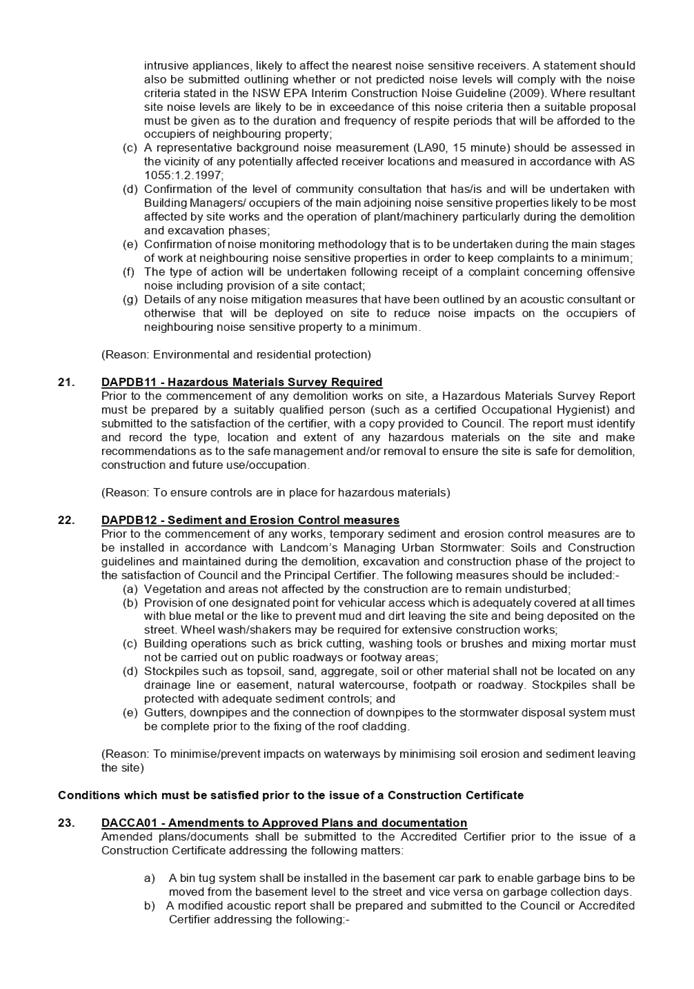
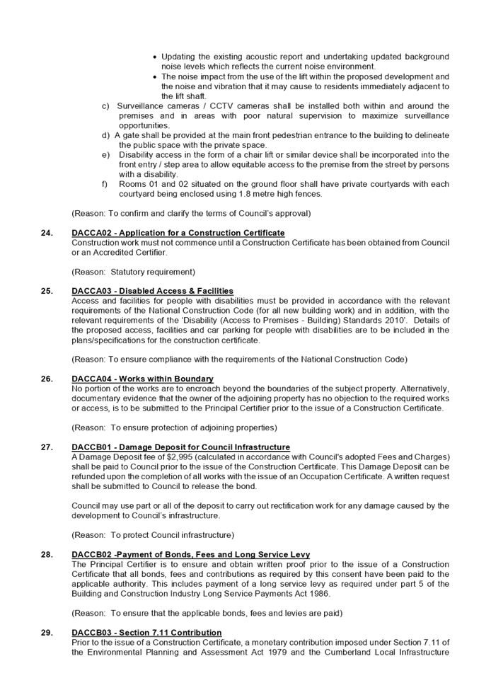
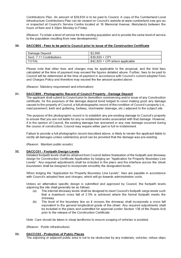
DOCUMENTS
ASSOCIATED WITH
REPORT LPP058/20
Attachment 2
Architectural Plans
Cumberland Local Planning Panel Meeting
9 December 2020
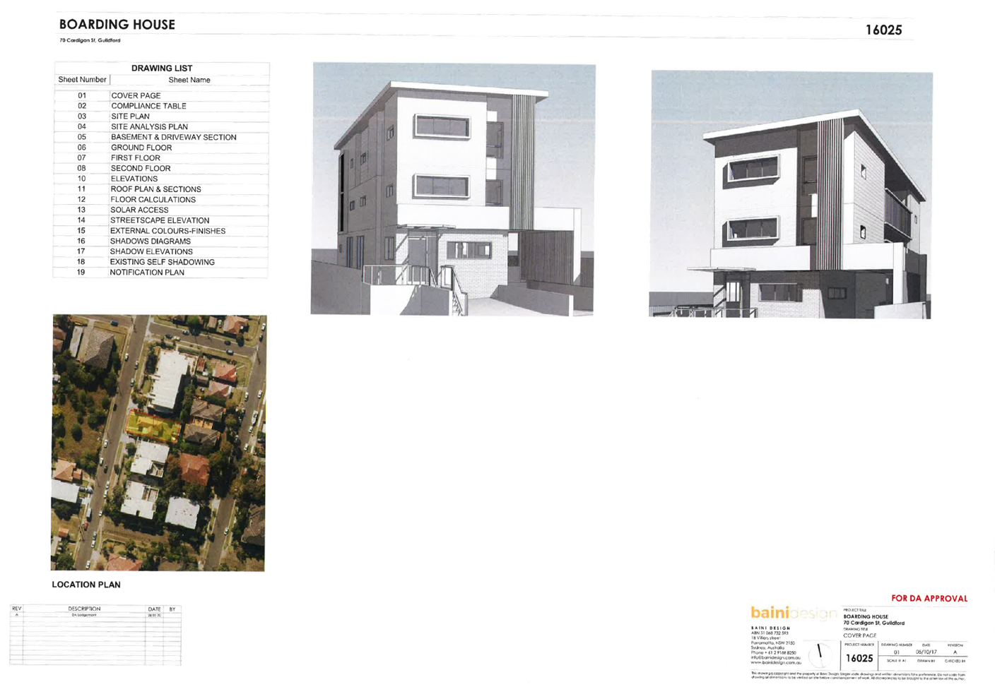
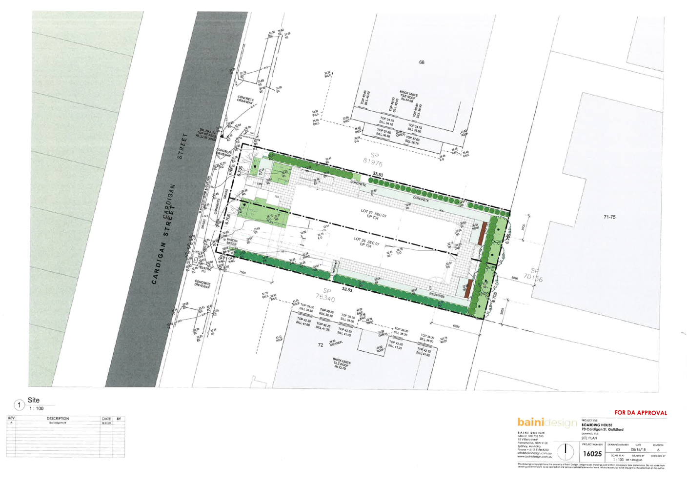
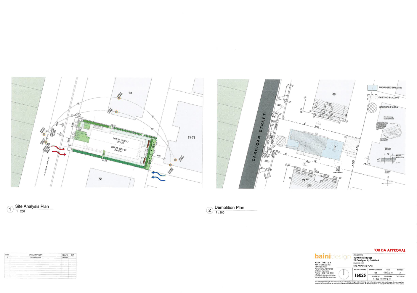
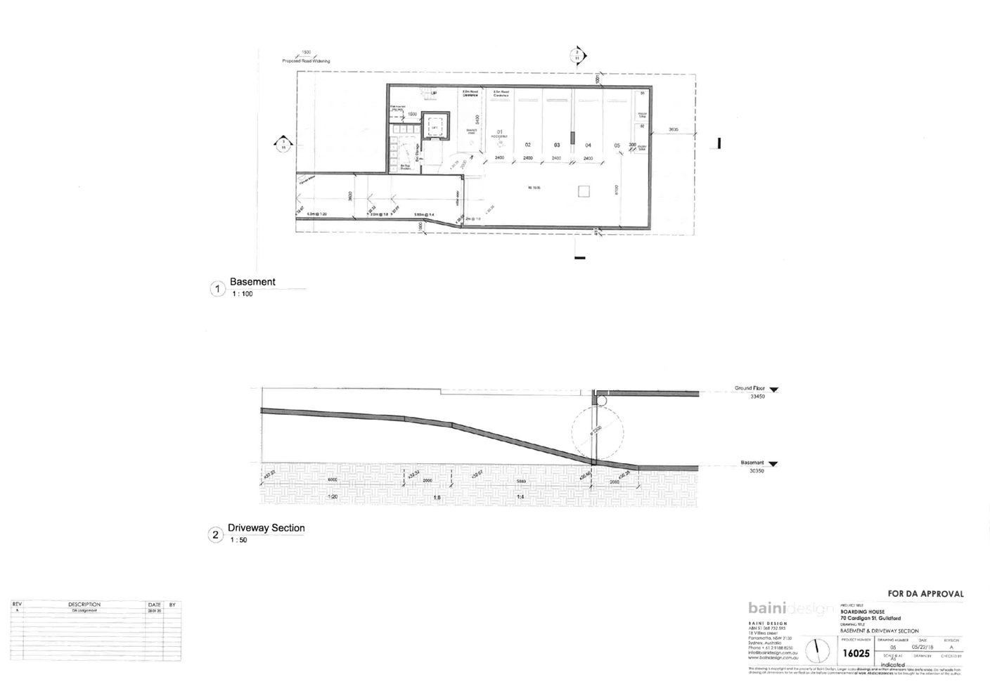
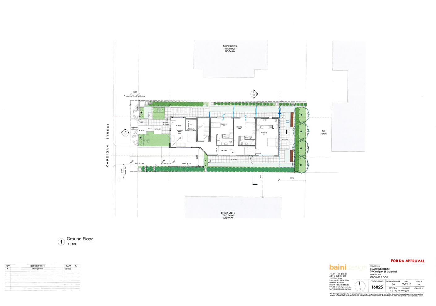
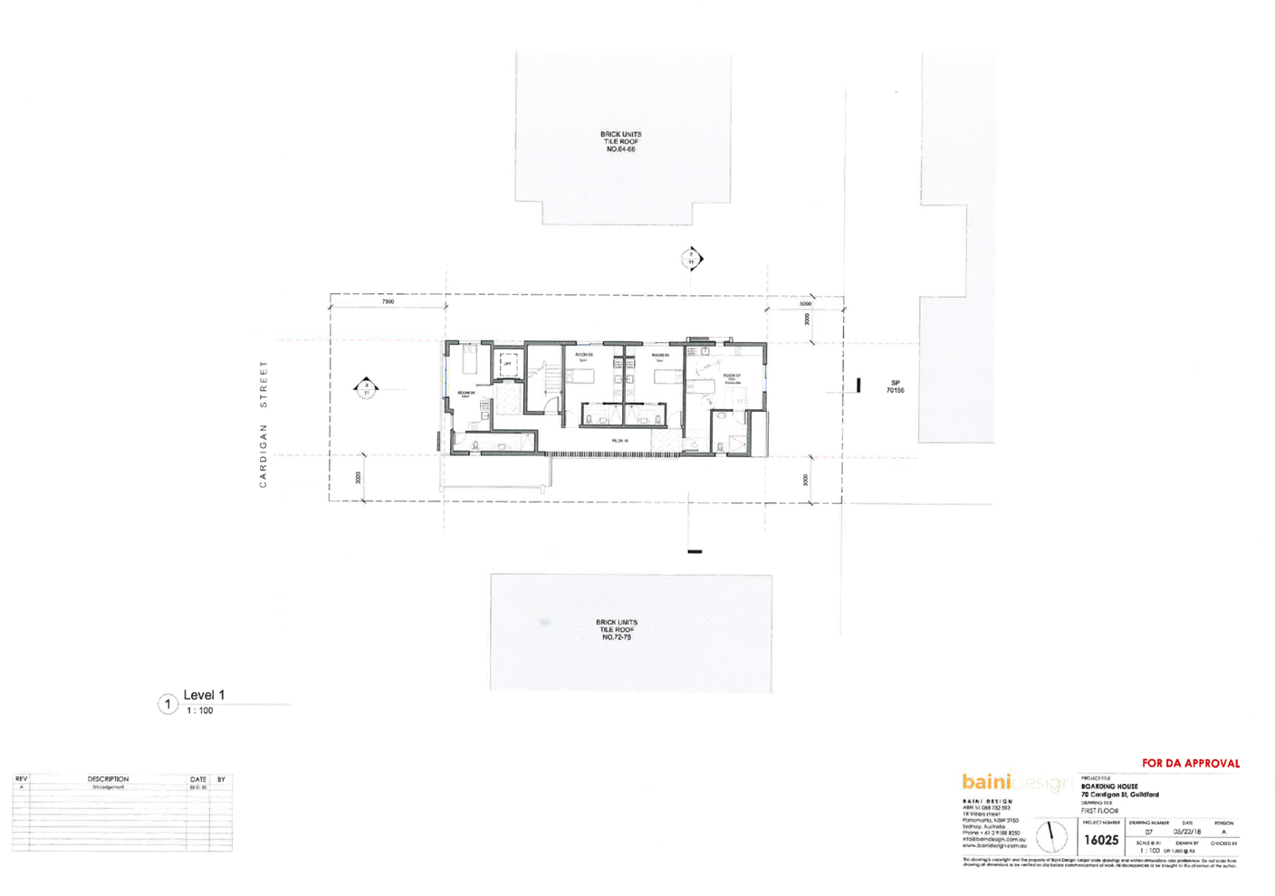
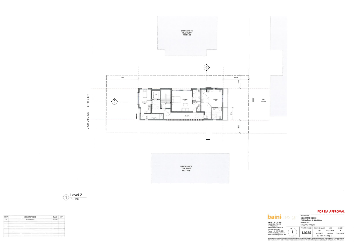
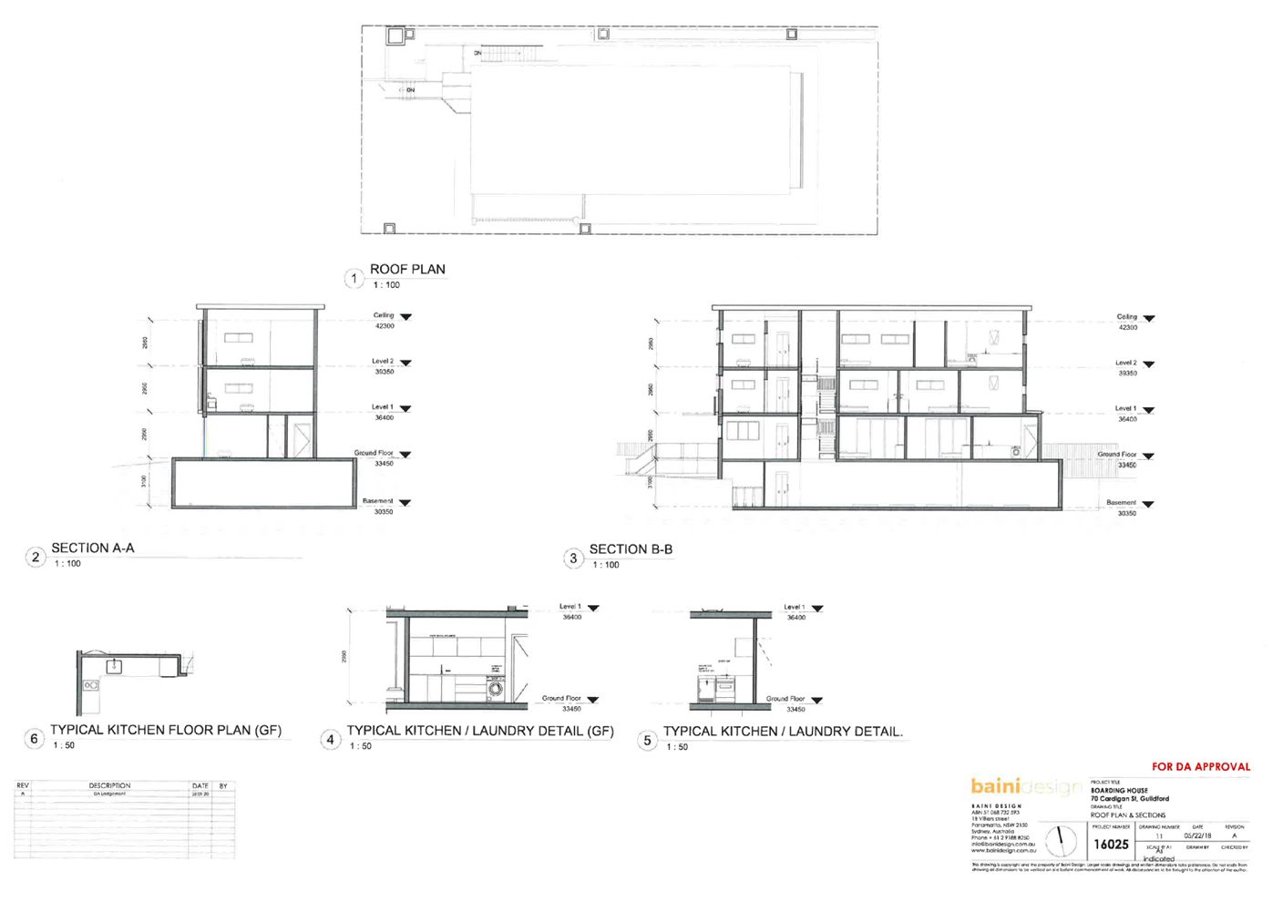
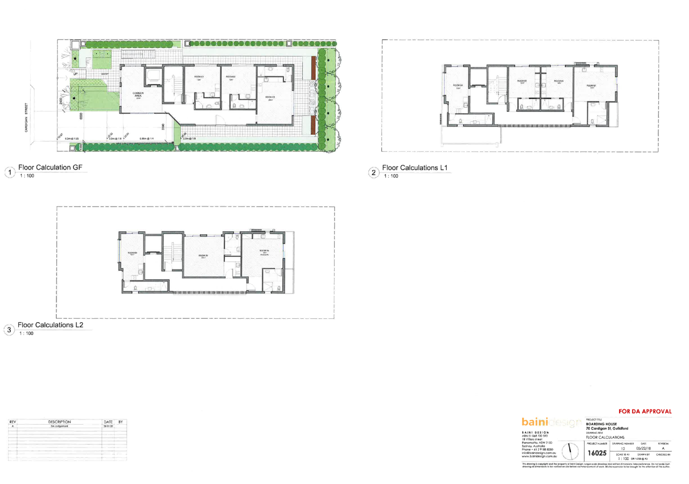
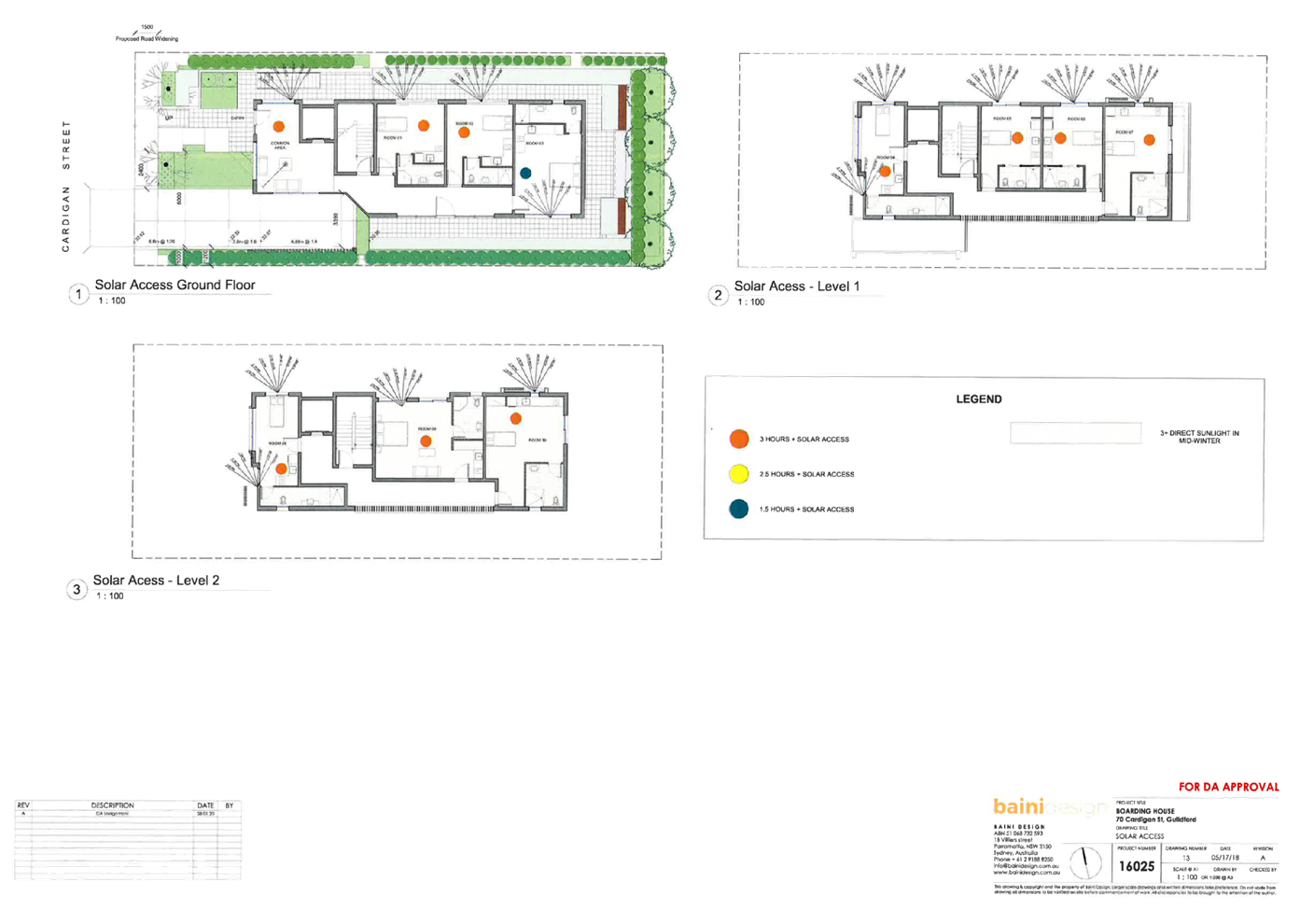
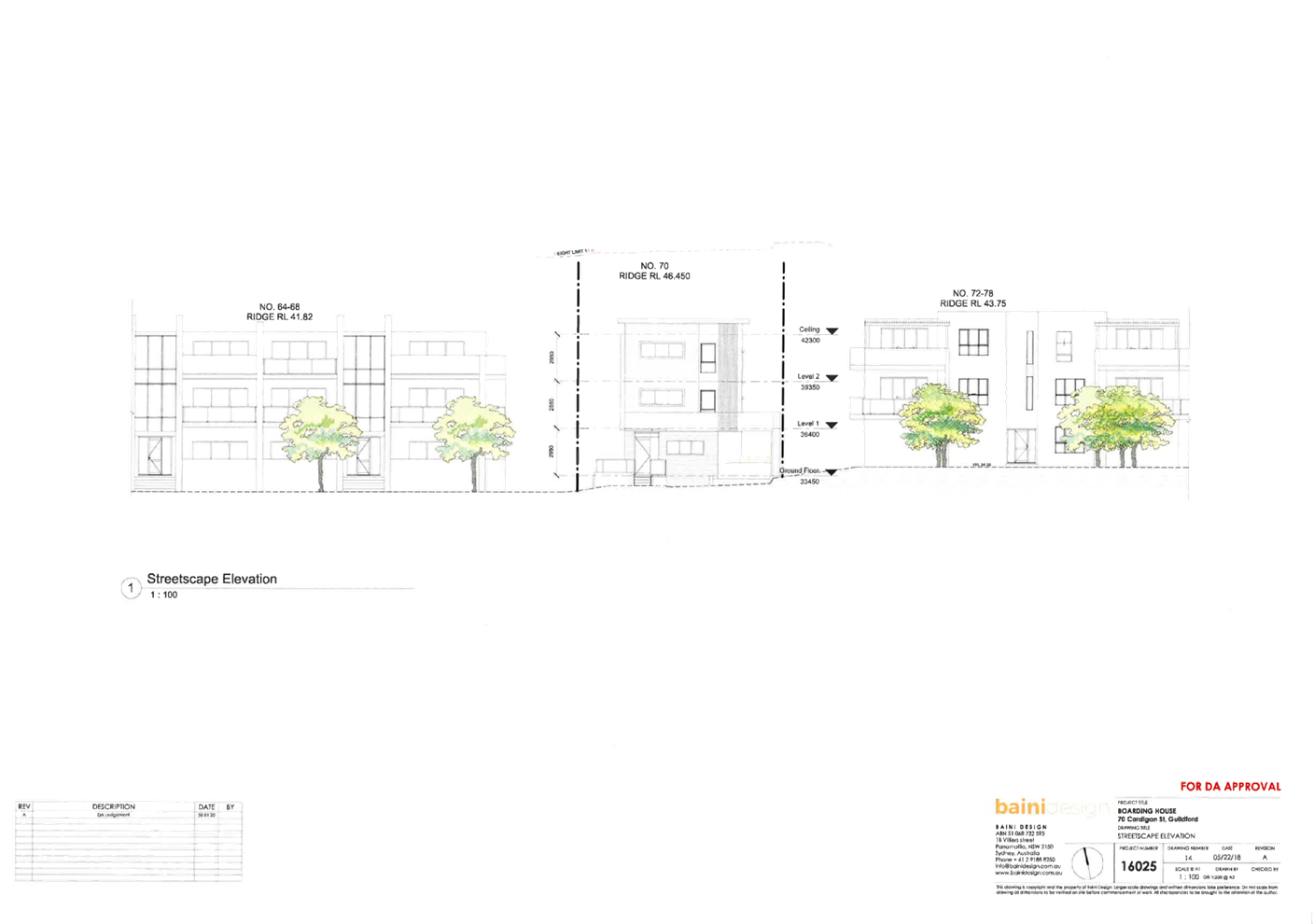
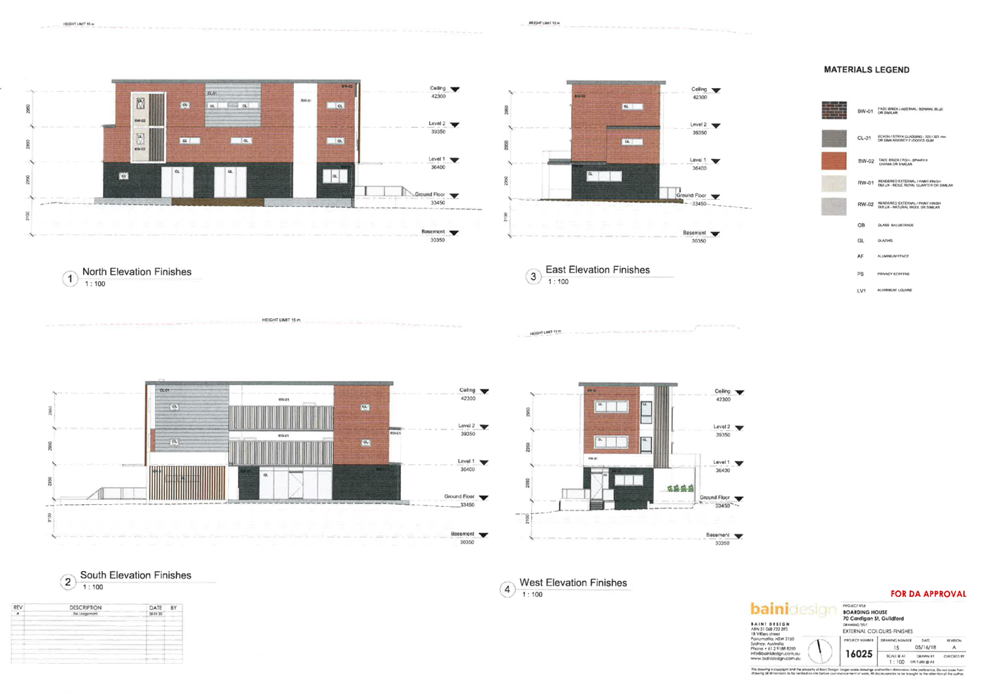
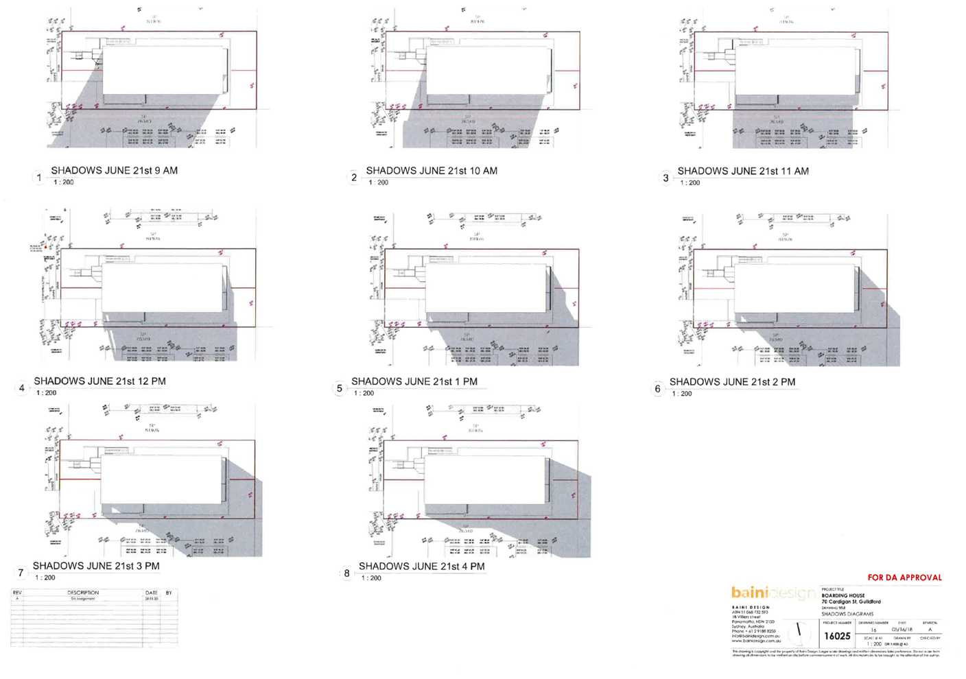
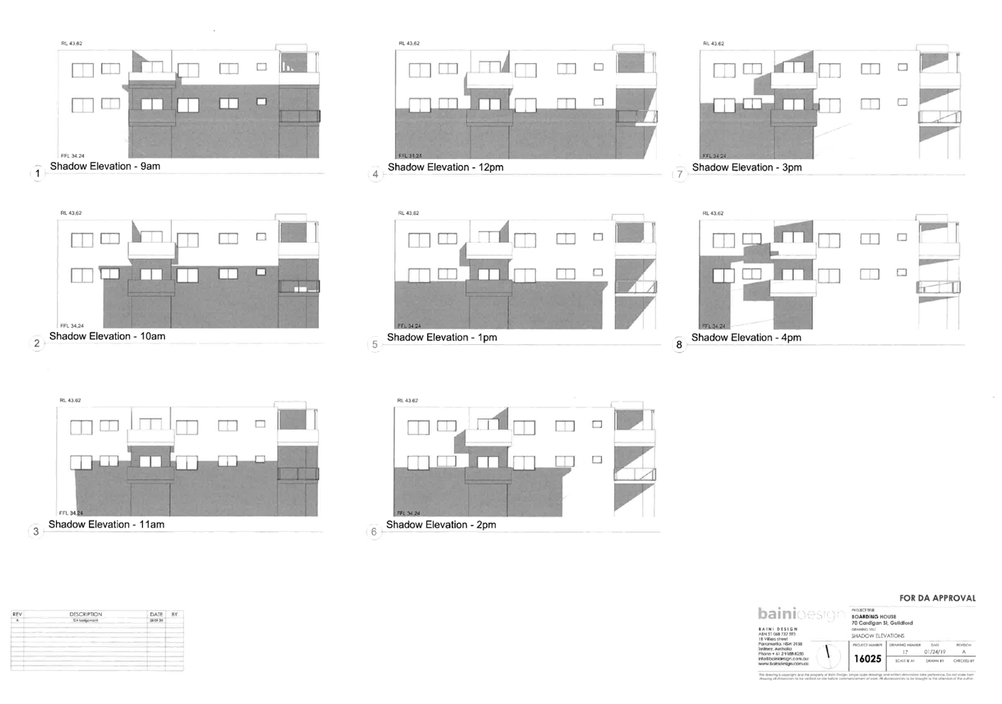
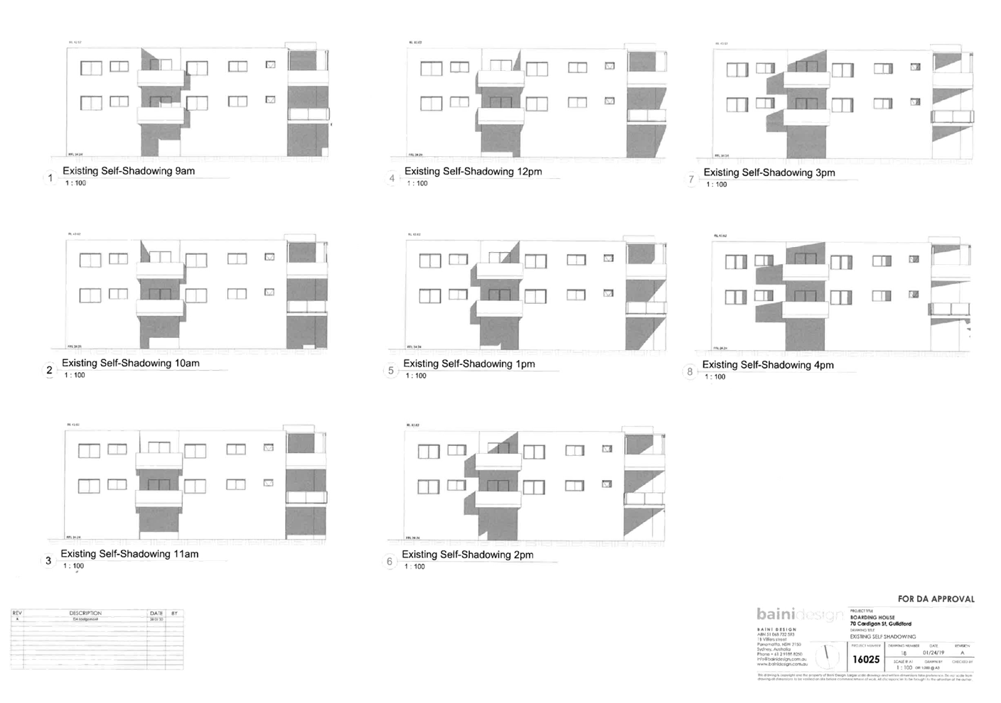
DOCUMENTS
ASSOCIATED WITH
REPORT LPP058/20
Attachment 3
Stormwater/Engineering Plans
Cumberland Local Planning Panel Meeting
9 December 2020
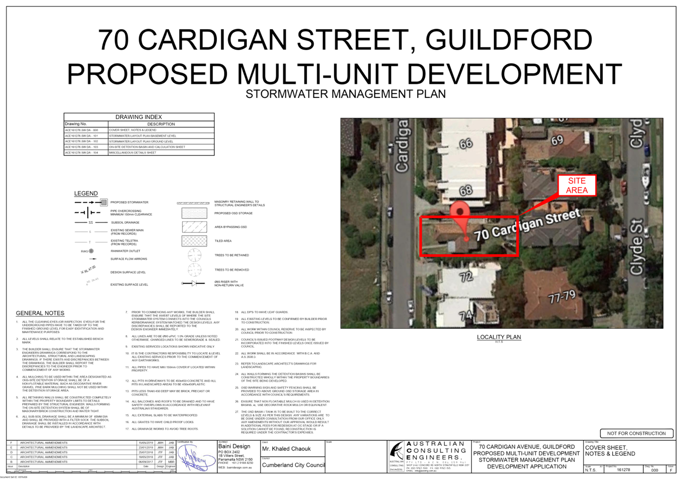
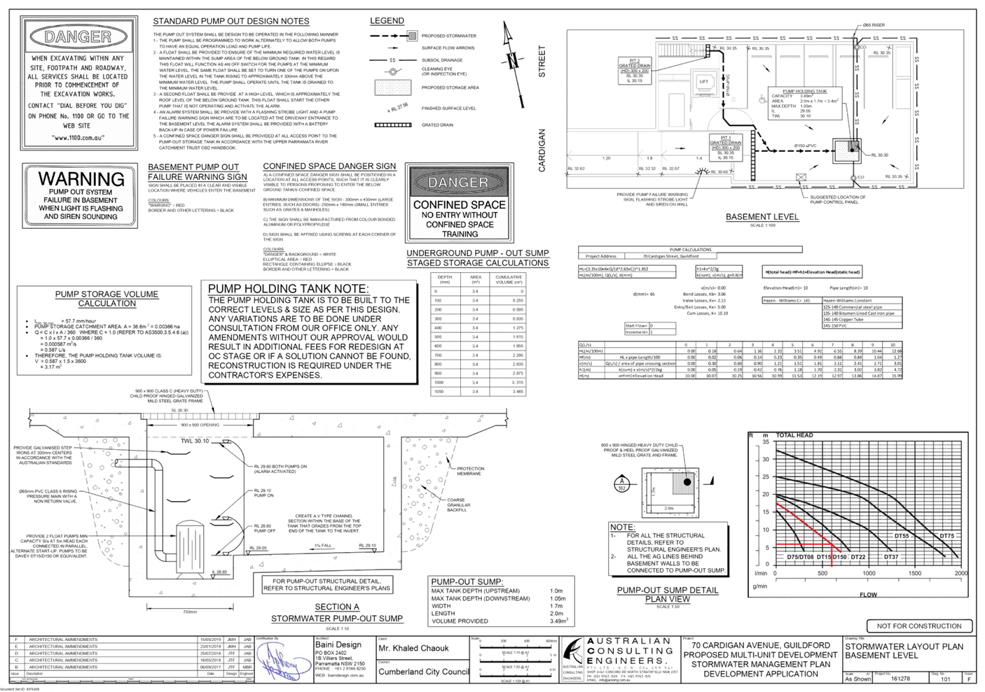
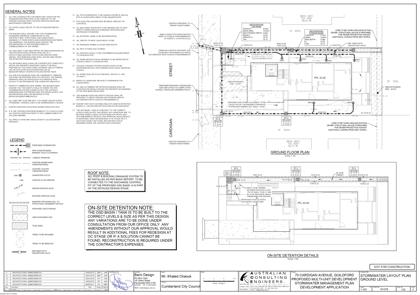
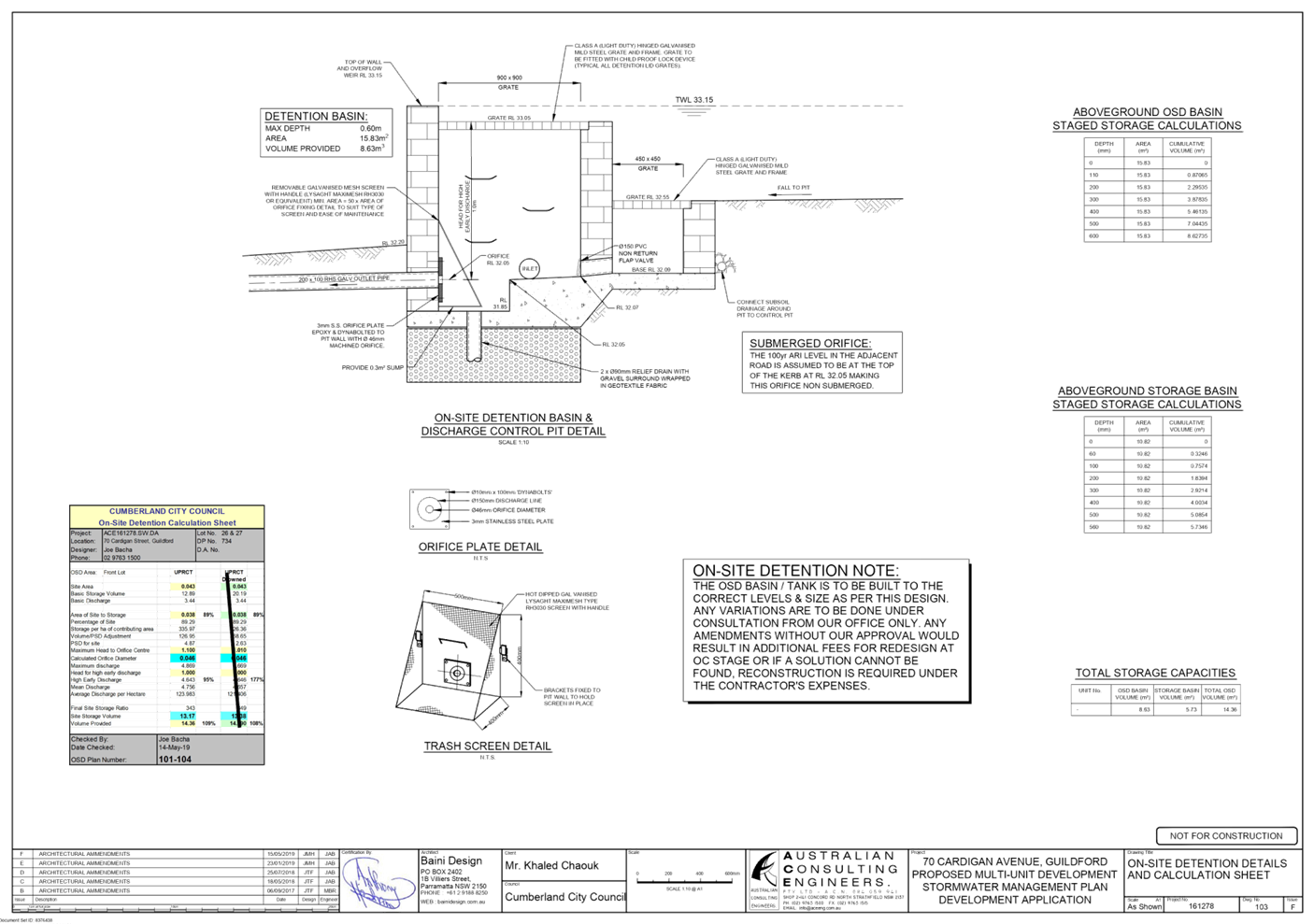
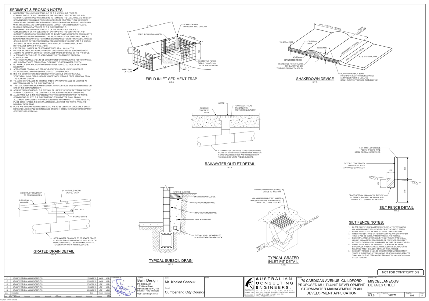
DOCUMENTS
ASSOCIATED WITH
REPORT LPP058/20
Attachment 4
Redacted Unique Submissions
Cumberland Local Planning Panel Meeting
9 December 2020
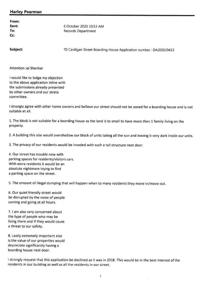

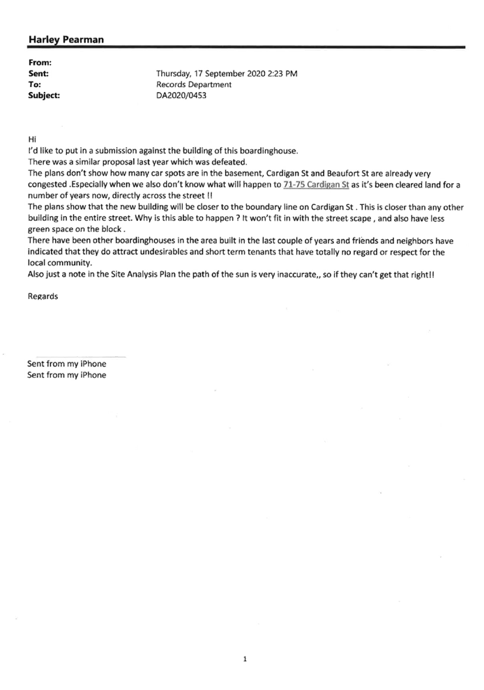
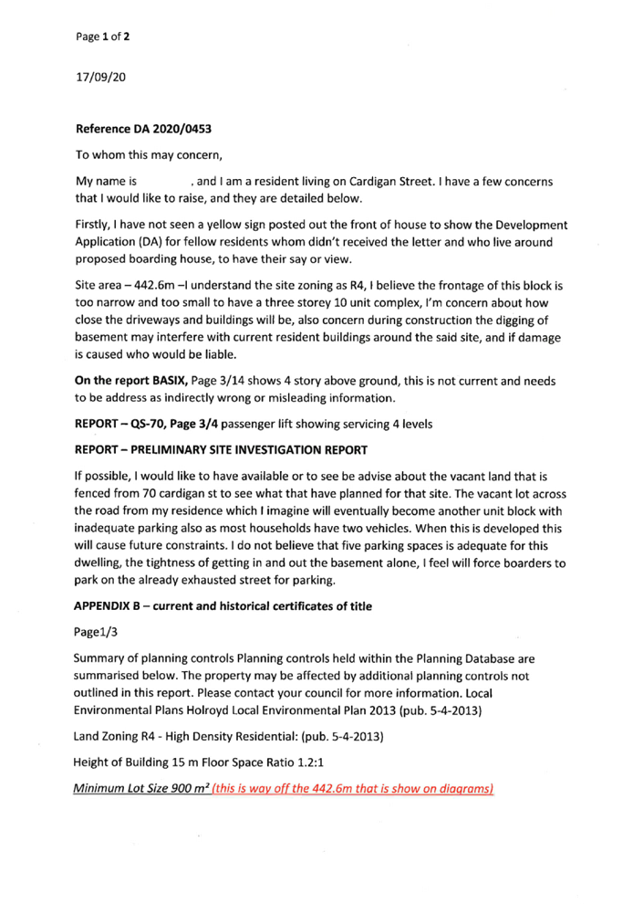
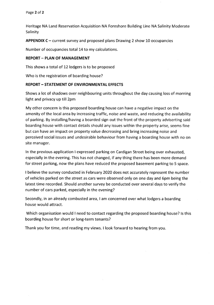
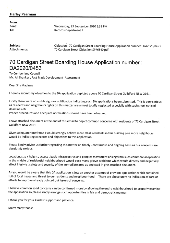
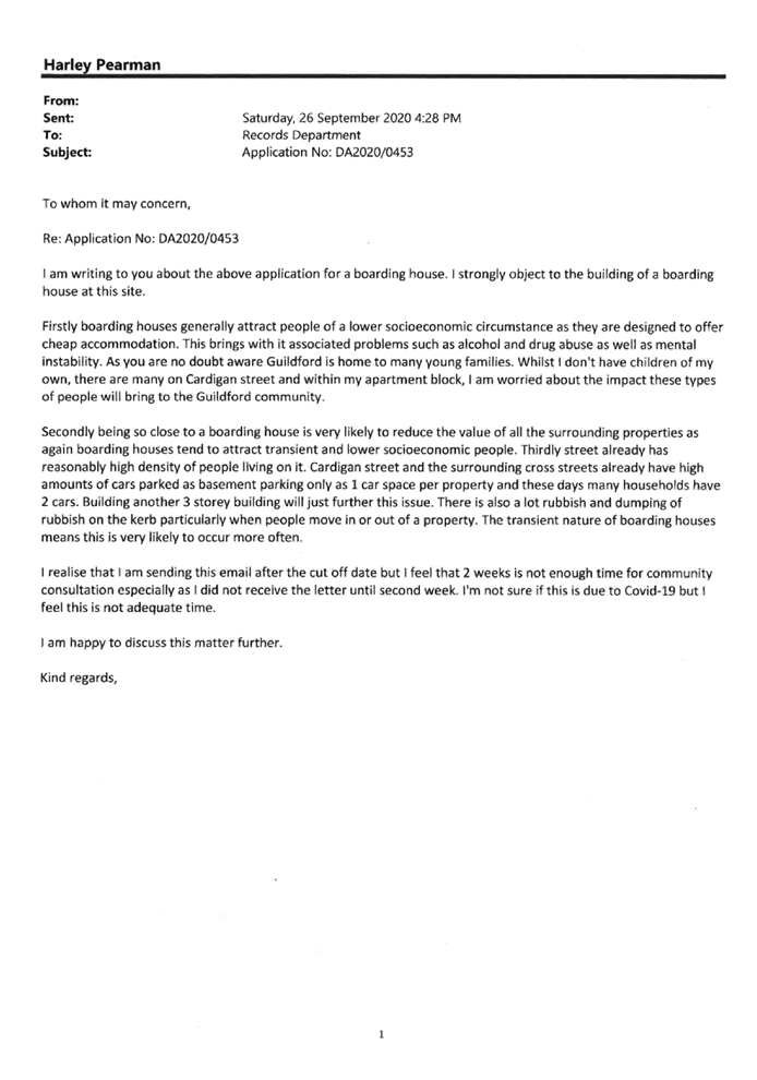

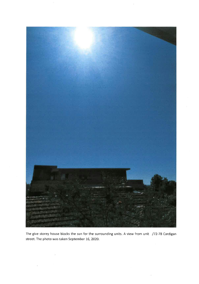
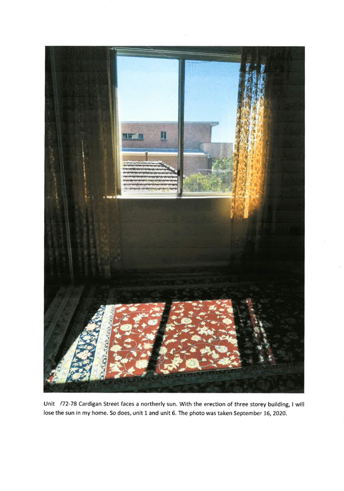
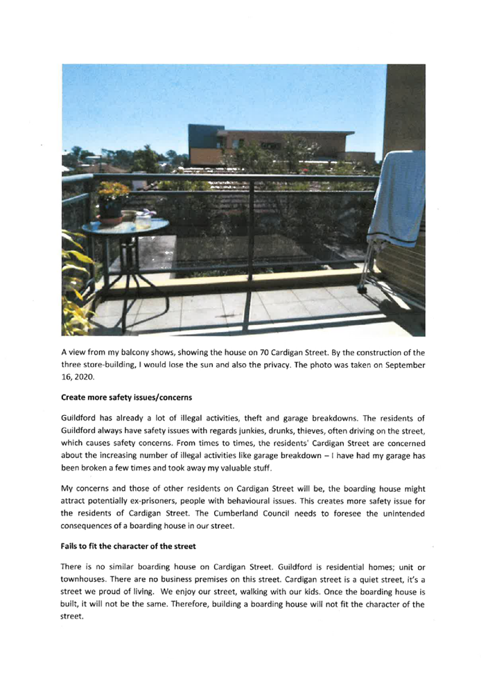


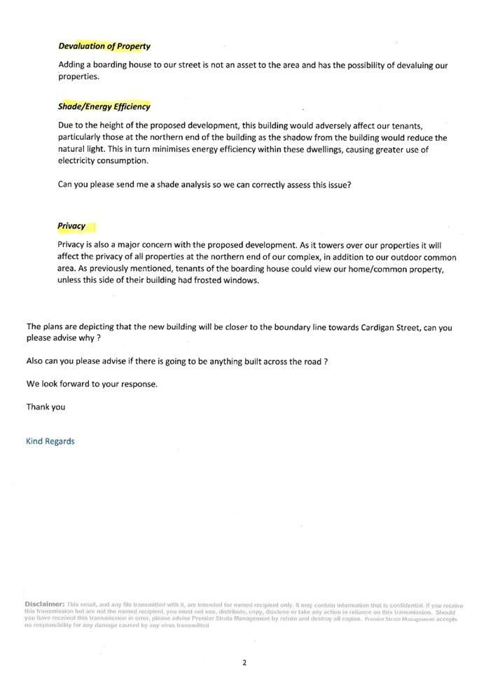


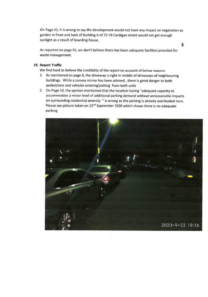
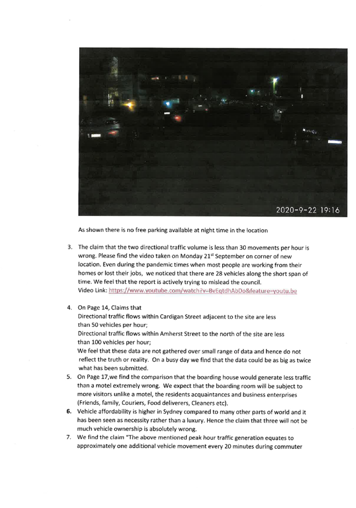
DOCUMENTS
ASSOCIATED WITH
REPORT LPP058/20
Attachment 5
Appendix A - Holroyd Local Environmental Plan 2013
Cumberland Local Planning Panel Meeting
9 December 2020
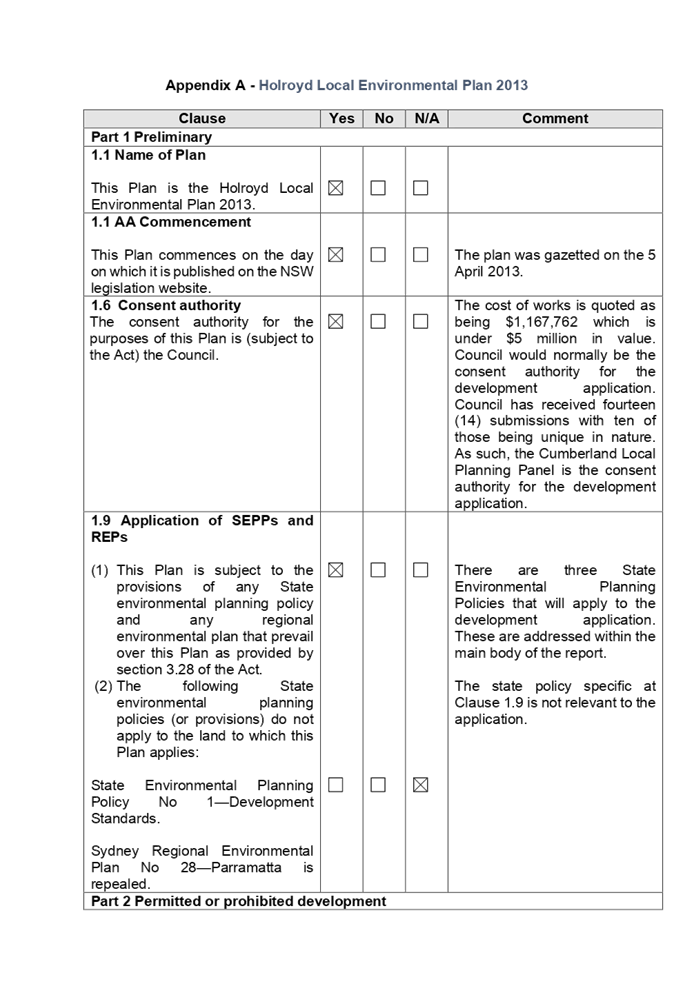
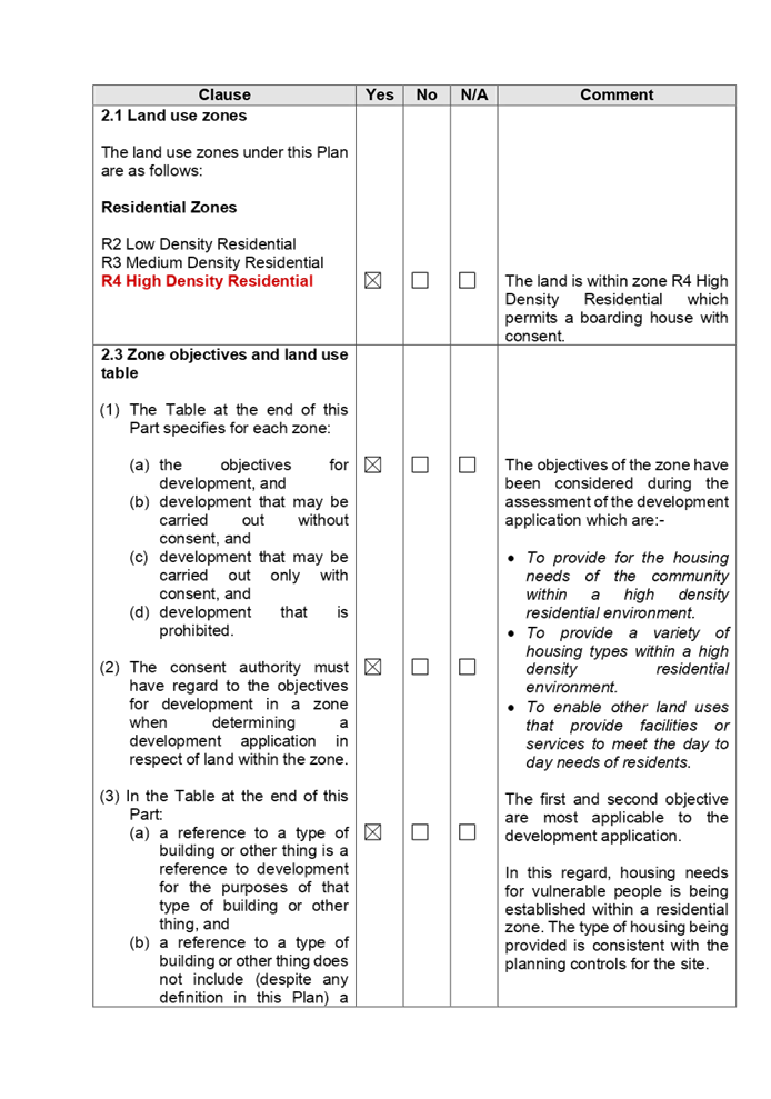
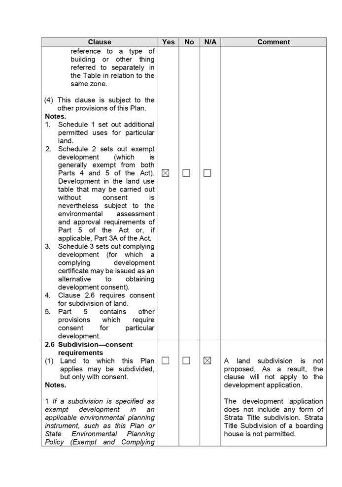
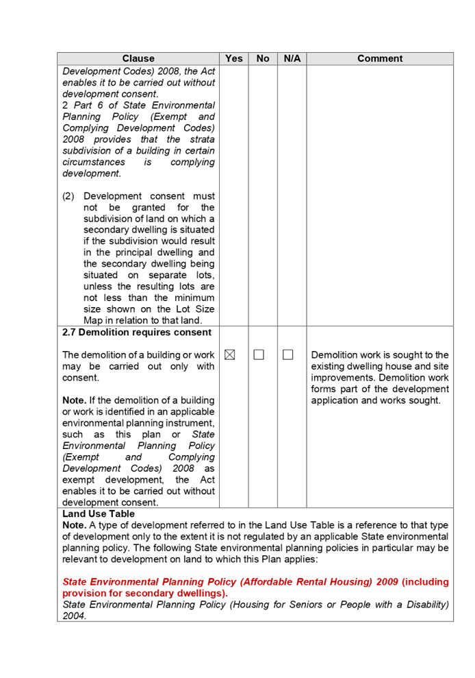
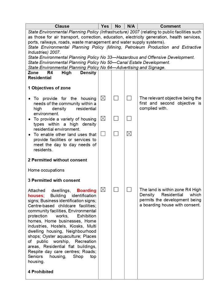
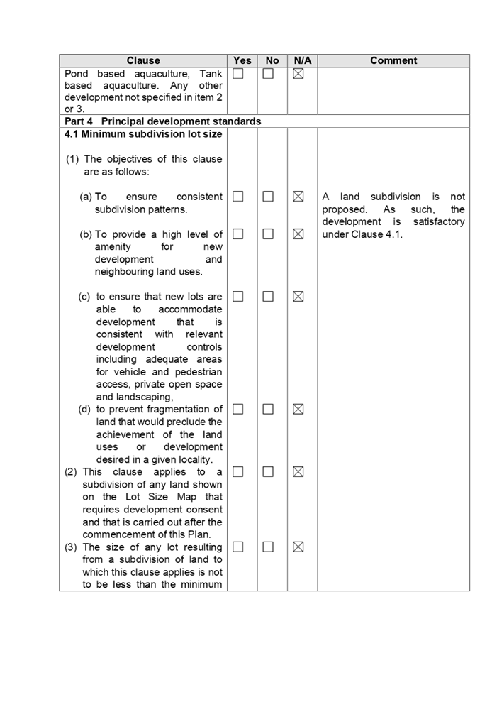
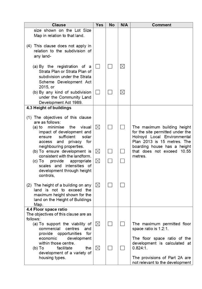
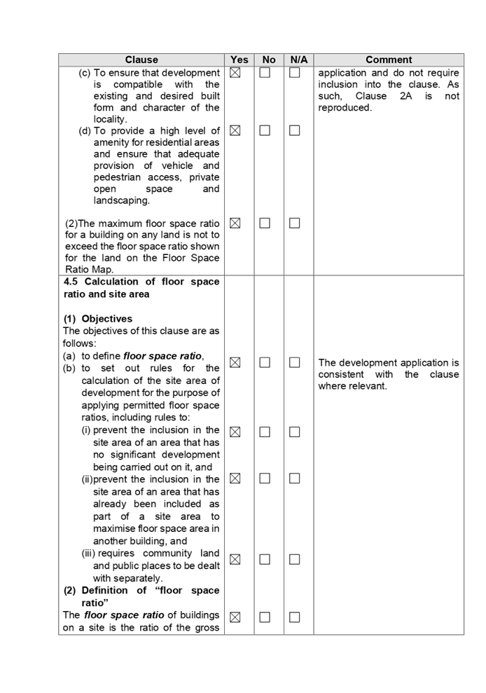
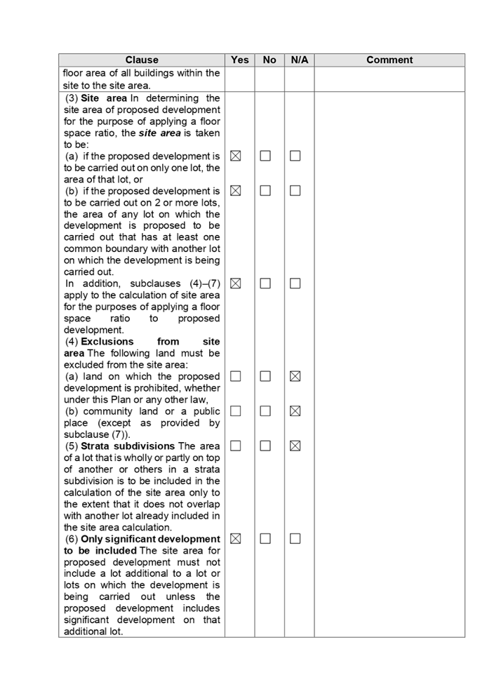
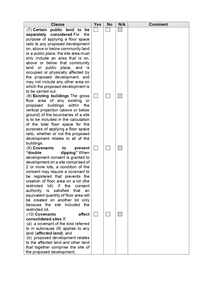
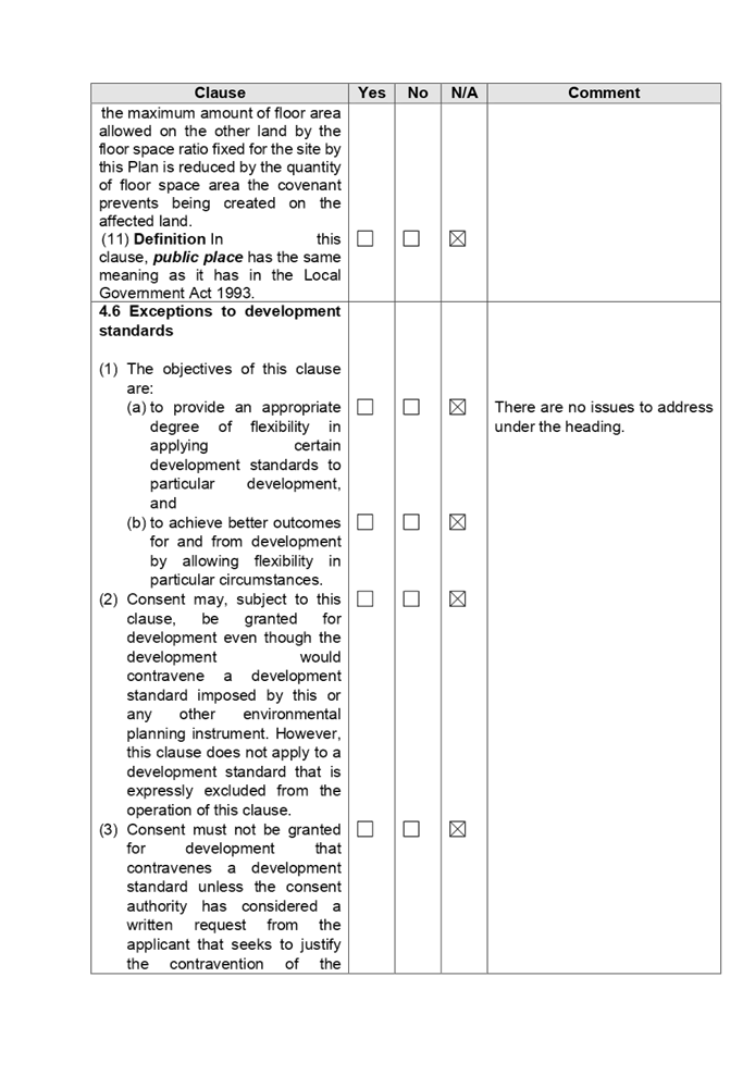
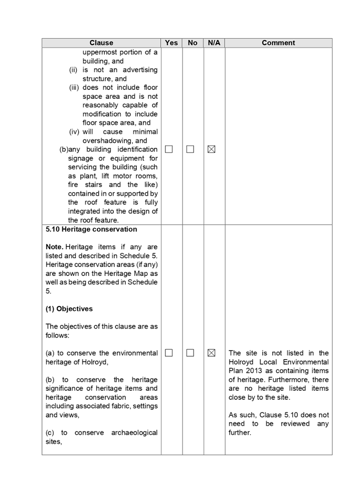
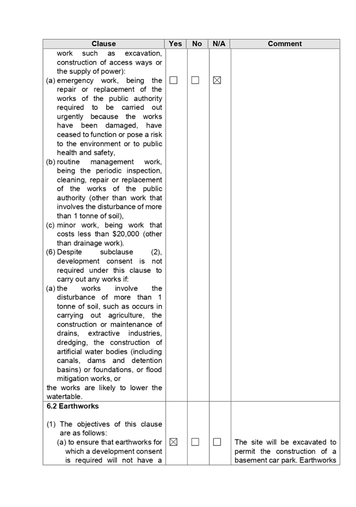
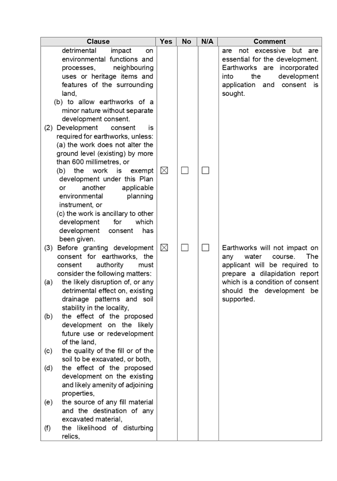
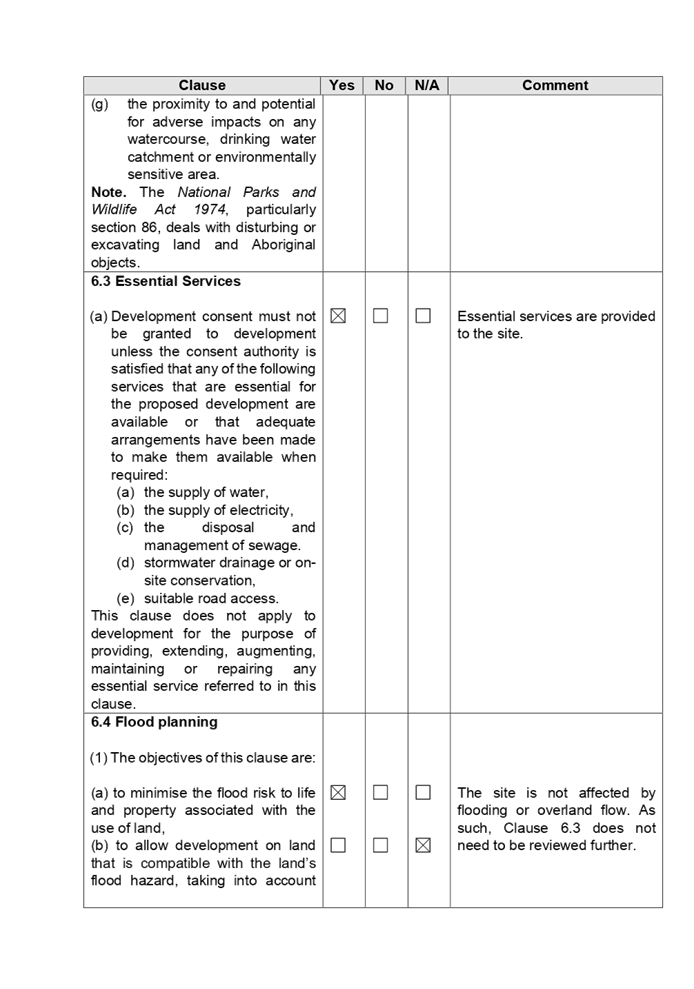
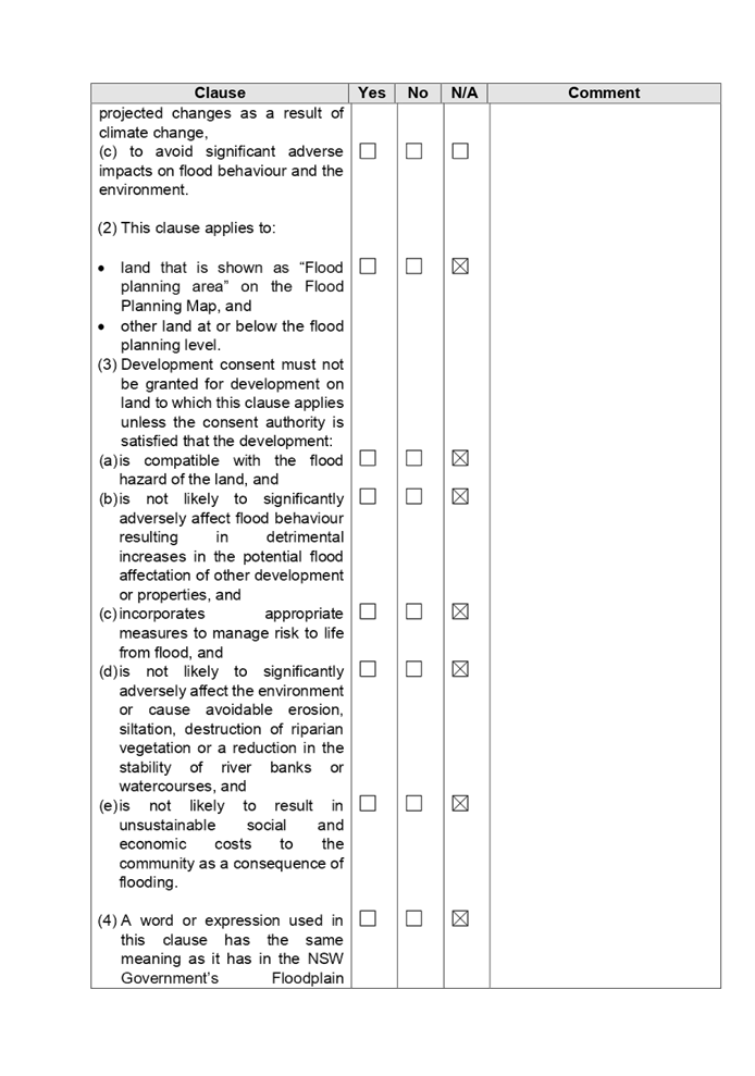
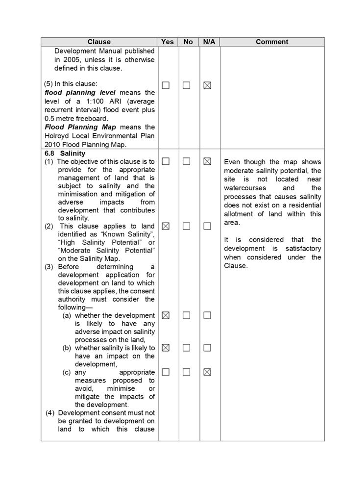
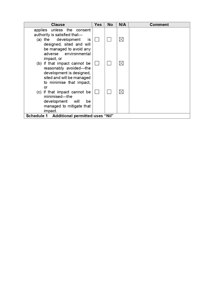
DOCUMENTS
ASSOCIATED WITH
REPORT LPP058/20
Attachment 6
Appendix B - Holroyd Development Control Plan 2013
Cumberland Local Planning Panel Meeting
9 December 2020
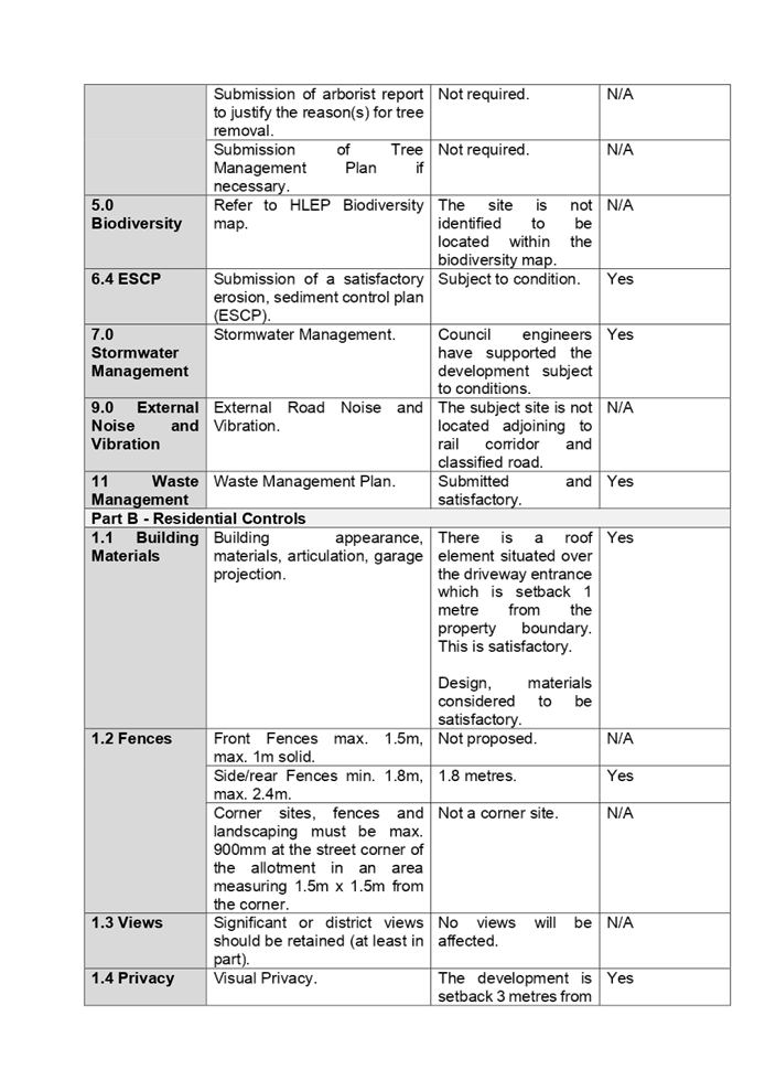
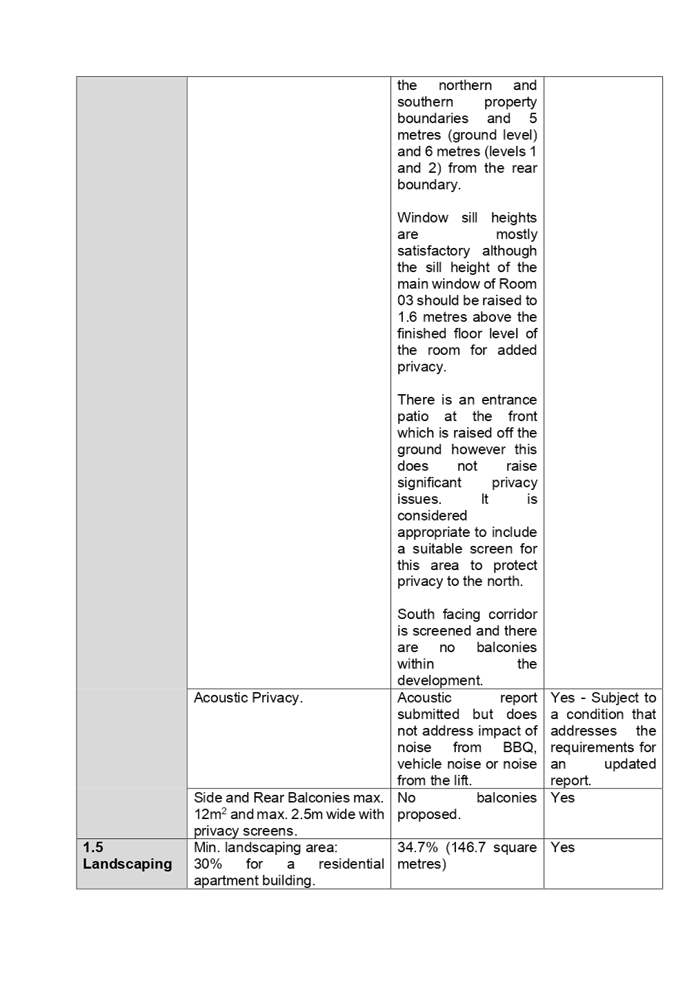
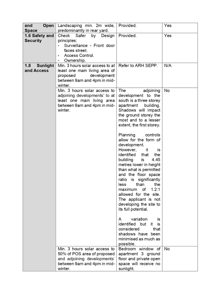
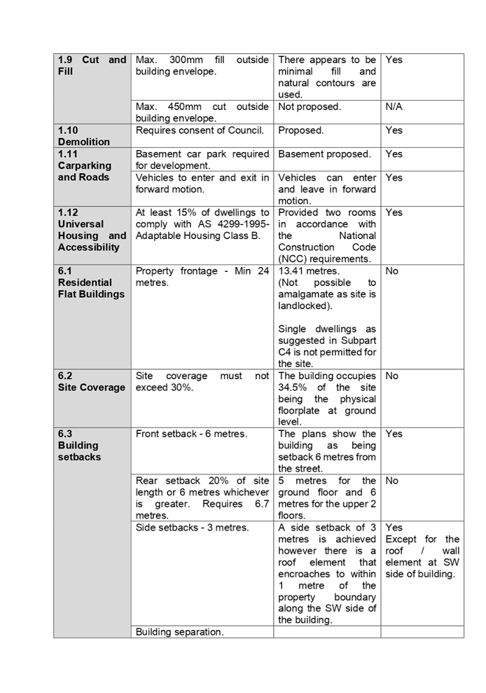
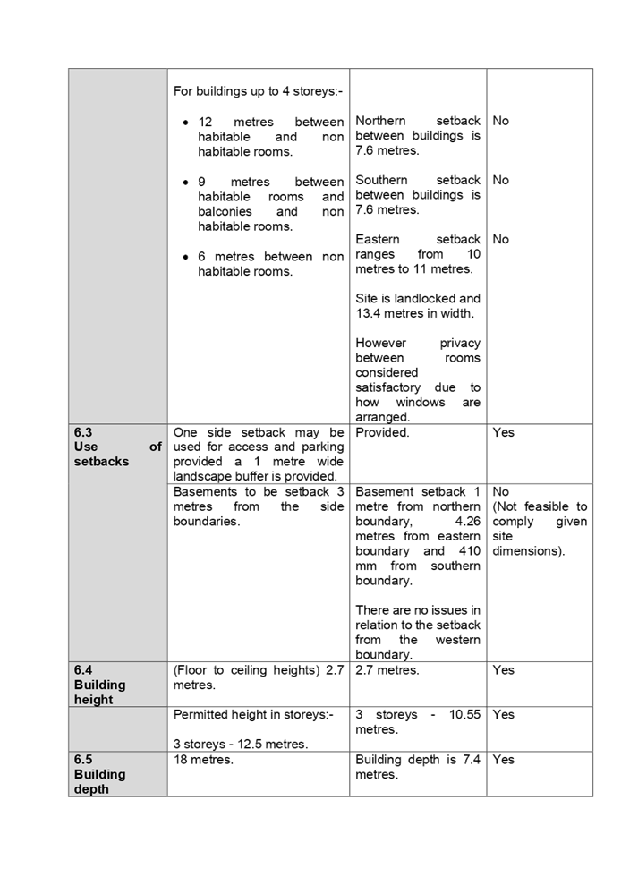
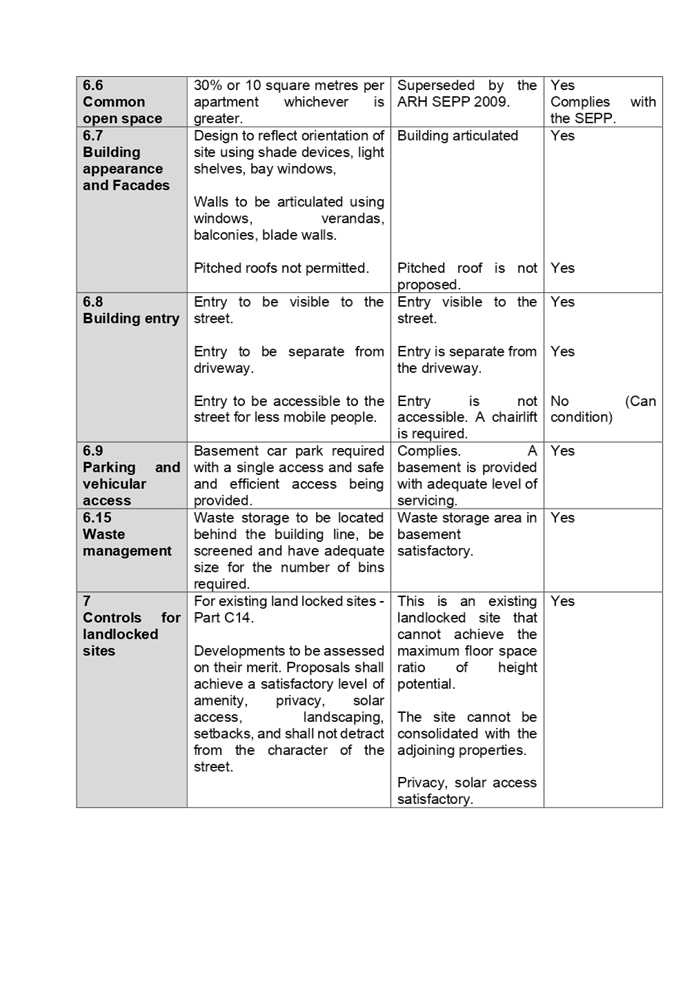
DOCUMENTS
ASSOCIATED WITH
REPORT LPP058/20
Attachment 7
Refused Architectural Plans
Cumberland Local Planning Panel Meeting
9 December 2020