14 October 2020
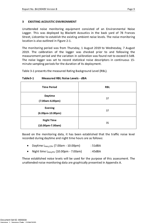
An Electronic meeting of the
Cumberland Local Planning Panel
will be held at 11:30a.m. via Zoom.
Business as below:
Yours faithfully
Hamish McNulty
General
Manager
ORDER OF BUSINESS
1. Receipt of Apologies
2. Confirmation of Minutes
3. Declarations of Interest
4. Address by invited
speakers
5. Reports:
- Development
Applications
- Planning
Proposals
6. Closed Session Reports
Cumberland Local Planning Panel Meeting
14 October 2020
CONTENTS
Report No. Name of Report Page
No.
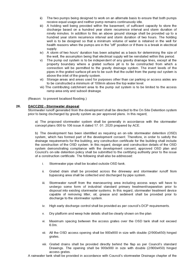
Development Applications
LPP049/20... Development Application
for 234-236 Cumberland Road, Auburn............ 5
LPP050/20... Development Application
for 78 Frances Street, Lidcombe..................... 209
LPP051/20... Modification Application
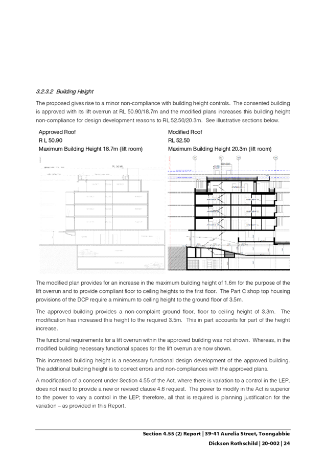
for 39 - 41 Aurelia Street, Toongabbie............. 399
Cumberland Local Planning Panel Meeting
14 October 2020
Item
No: LPP049/20
Development
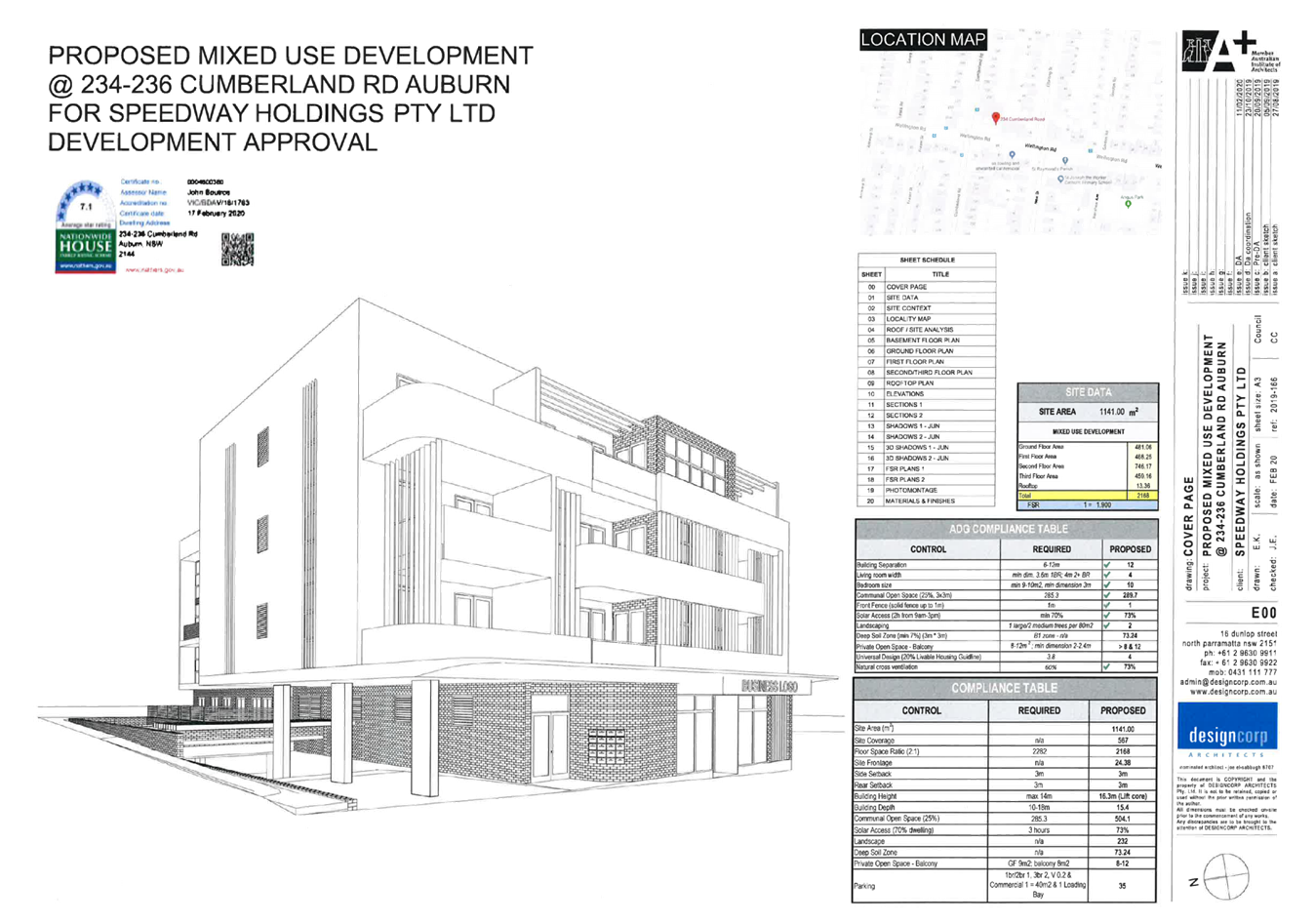
Application for 234-236 Cumberland Road, Auburn
Responsible
Division: Environment
& Planning
Officer: Acting
Executive Manager Development and Building
File
Number: DA2020/0080
|
Application lodged
|
19 February 2020.
|
|
Applicant
|
Speedway Holdings Property Co Pty Ltd, Designcorp
Architects Pty Ltd.
|
|
Owner
|
Speedway Holdings Property Co Pty LTD.
|
|
Application No.
|
DA 2020/0080.
|
|
Description of Land
|
234 and 236 Cumberland Road Auburn being Lot A in DP
39440, Lot B in DP 39440 and Lot E in DP 39440.
|
|
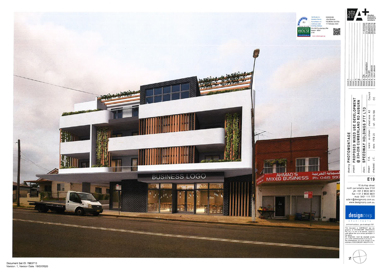
Proposed Development
|
Demolition of existing structures, lot consolidation and
the construction of a four storey mixed use development comprising of a
commercial premise on the ground floor, nineteen apartments and two levels of
basement car parking.
|
|
Site Area
|
1,140.83 Square metres.
|
|
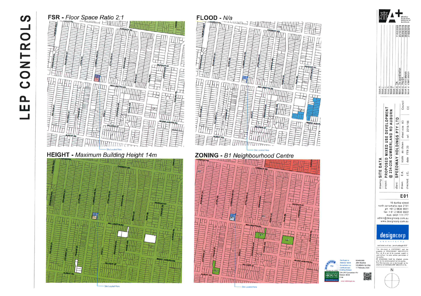
Zoning
|
B1 Neighbourhood Centre Zone.
|
|
Disclosure of political donations and gifts
|
Nil disclosure.
|
|
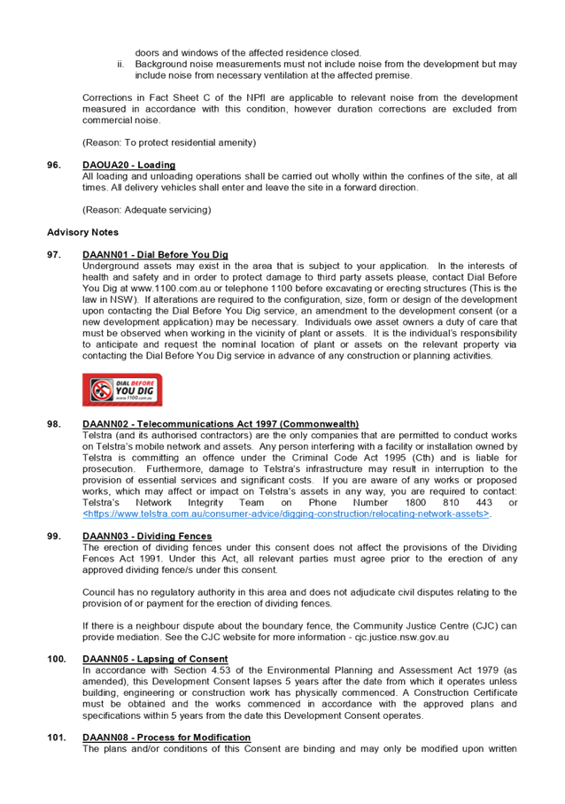
Heritage
|
No.
|
|
Principal Development Standards
|
Floor Space Ratio
Permissible: - 2:0.
Proposed: - 1.9:0
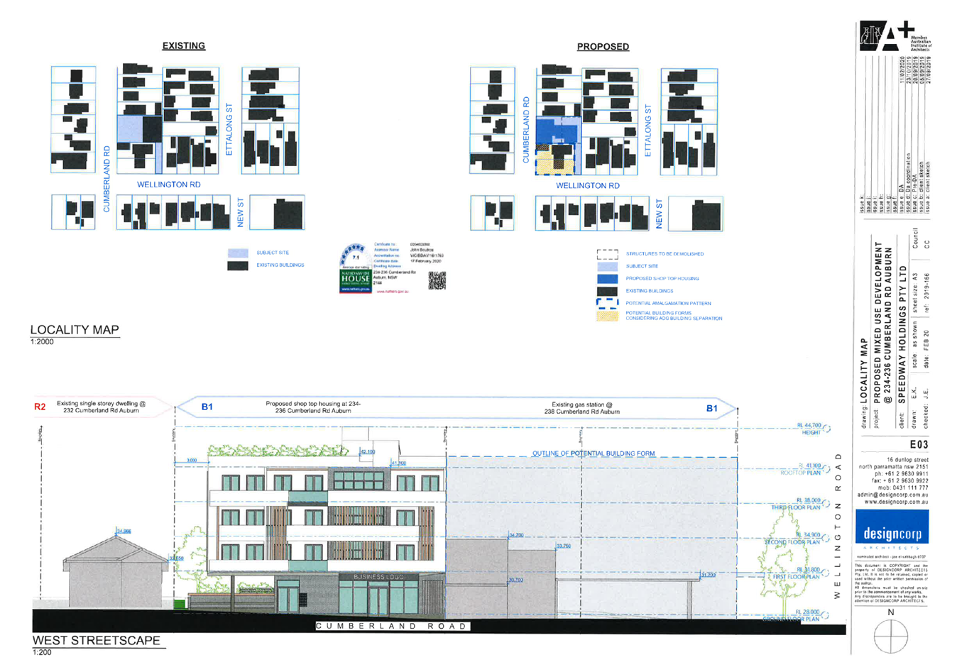
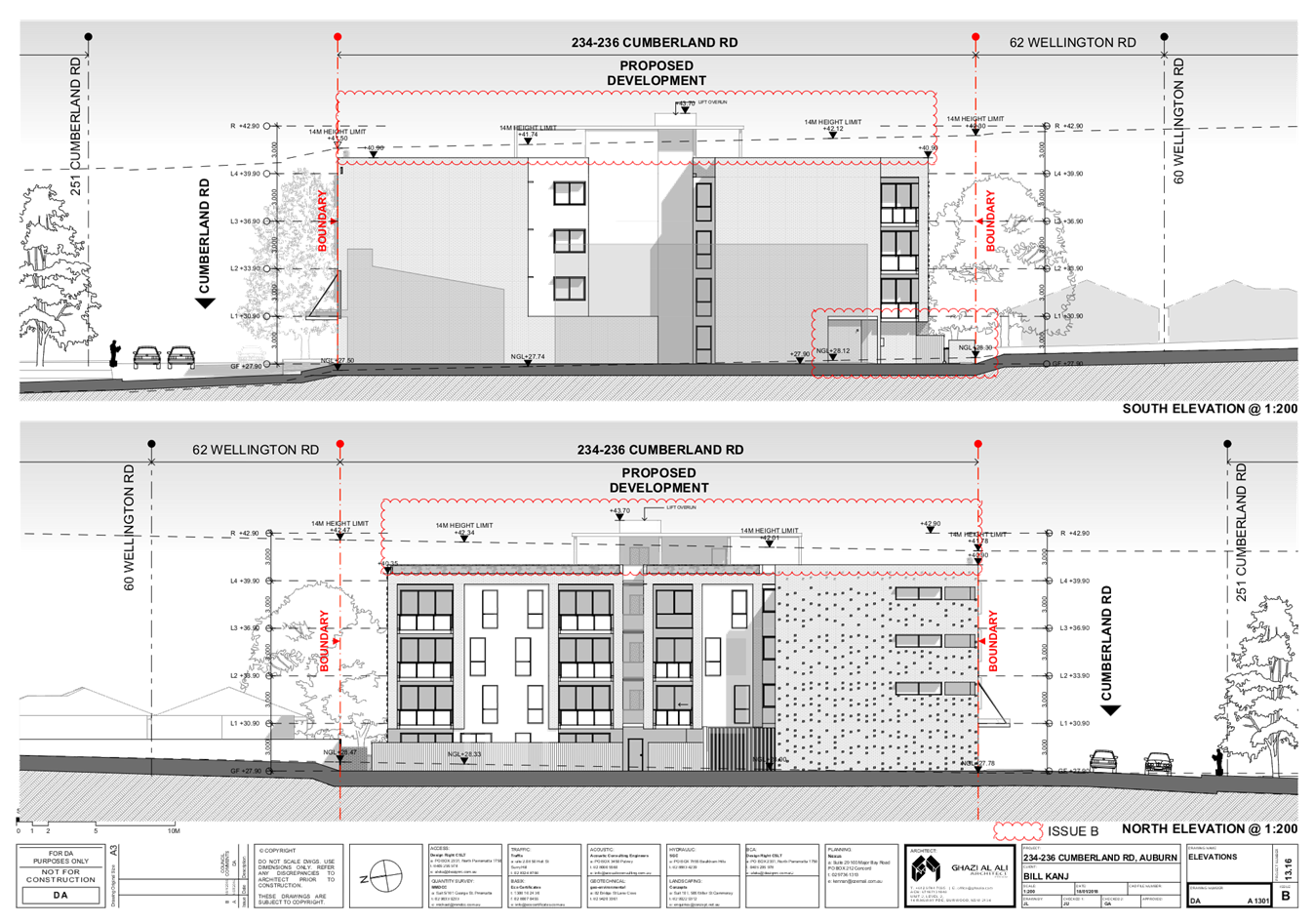
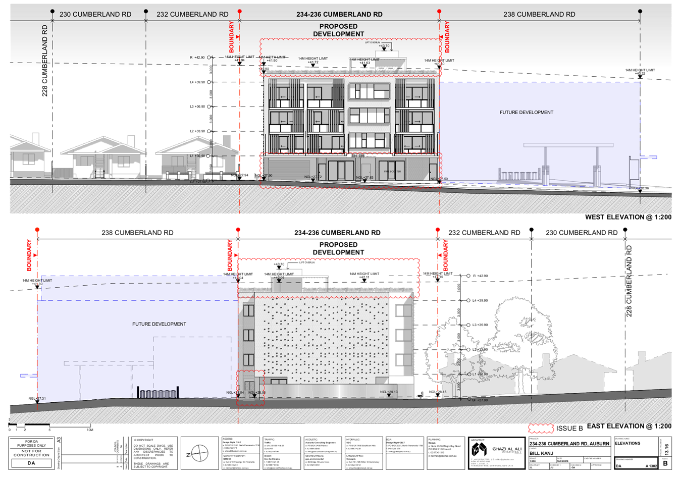
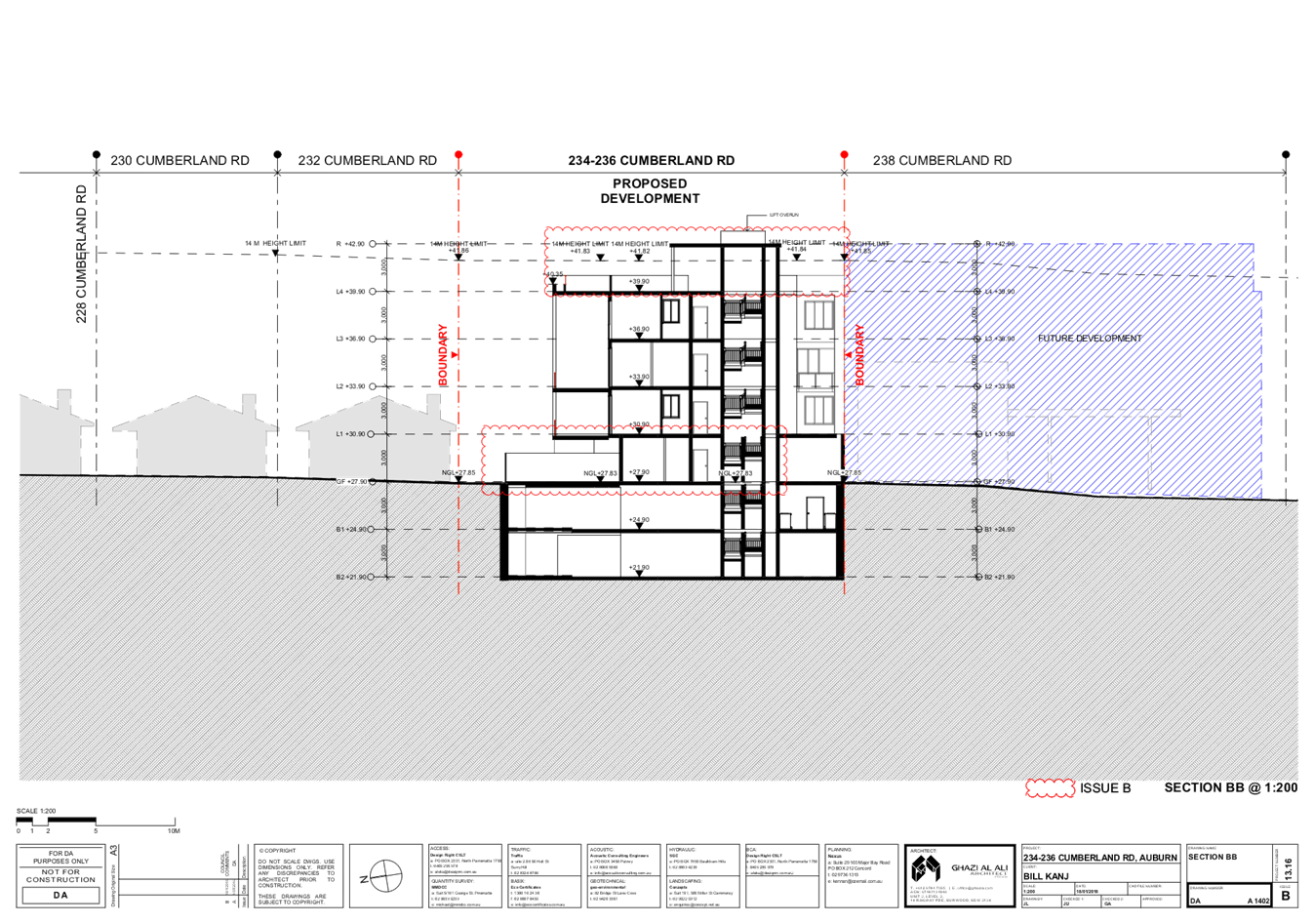
Height of Building
Permissible: - 14 metres.
Proposed: - 16.7 metres being a variation of 2.7 metres.
|
|
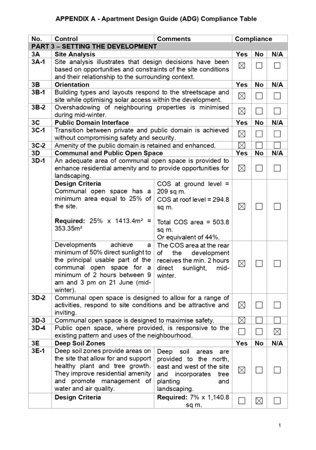
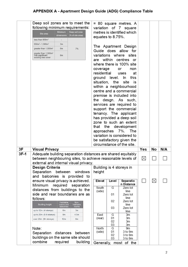
Issues
|
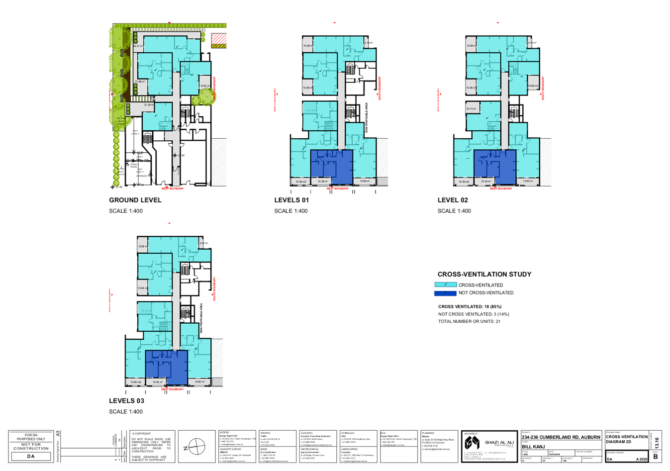
Building Separation.
Deep soil zone.
Site coverage.
Dwelling size.
Height.
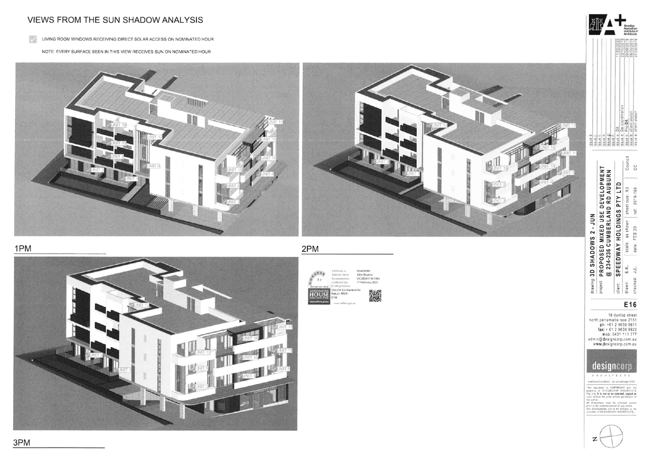
Solar access.
Proximity of the site to a service station.
Floor to ceiling heights of ground floor and Level 1
apartments.
|
1. Development
Application 2020/0080 was received on 19 February 2020 for the demolition of
existing structures, lot consolidation and the construction of a four storey
mixed use development comprising of a commercial premise on the ground floor,
nineteen apartments and two levels of basement car parking.
2. The
application was publicly notified to occupants and owners of the adjoining
properties for a period of fourteen (14) days between Tuesday 17 March 2020 and
Tuesday 31 March 2020. In response, there were no submissions received.
3. The
subject site adjoins a service station and a mechanic outlet and matters
concerning State Environmental Planning Policy 33 “Hazardous and
Offensive Development” and the “Liquefied Petroleum Gas Automotive
Retail Outlets” Hazardous Industry Locational Guidelines No 1 prepared by
the Department of Planning 1992 has been considered.
4. The
numerical variations are as follows:
|
Control
|
Required
|
Provided
|
% variation
|
|
Clause 4.3 ALEP 2010
Building height.
|
14 metres.
|
16.7 metres to the topmost roof.
|
19.28%.
|
|
Part 3E1 of the Apartment Design Guide.
Deep soil zone to be 7%.
|
(80 sq. m) however a variation is permitted where the
site is within a centre, is constrained or in a CBD area.
|
6.3% or 73 square metres.
Site within a neighbourhood centre zone with commercial
at grade.
|
8.75%.
|
|
Part 3F1 of the Apartment Design Guide.
Separation distances.
|
Up to 12 m (4 storeys).
6 m for habitable rooms and 3 m for non habitable rooms.
|
4 Storey building.
South
Ground Level, L1, L2, L3 - 0 metres.
(Solid wall and complies).
East
Ground Level, L1, L2, L3 - 3 metres.
Ensuite windows 3 m)
North
Ground 9 m.
L1, L2 and L3 - 3 to 9 m.
Ensuite windows 3 m
1 living room window facing north in 3 apartments with
louvres (Total 3).
|
Yes
Yes
Yes
Yes
No - 50%.
|
|
Part 4A-1 of the Apartment Design Guide.
Maximum 15% of apartments to receive no direct sunlight.
|
2.85 apartments
|
3 apartments or 15.8%.
|
0.05%.
|
|
Part 4C-1 of the Apartment Design Guide.
Floor to ceiling heights of ground floor and Level 1 apartments
for mixed use zones.
|
3.3 metres.
|
Floor to ceiling heights of apartments are 2.7 metres.
|
18%.
|
|
Part 2.2 (Subpart D1) of Auburn DCP Residential Flat
Buildings Chapter.
Site coverage.
|
Not to exceed 50%.
|
Site coverage at 91.2%. Site located in a B1 zone and
commercial on the ground floor.
|
82.4%.
|
|
Part 2.10 (Subpart D1) of Auburn DCP Residential Flat
Buildings Chapter.
Dwelling size.
|
1 Bedroom single aspect 63 sq. m.
2 Bedrooms 80 sq. m (Corner).
3 Bedrooms 115 sq. m.
|
53.6 to 59.4 sq. m.
75.3 sq. m to 77.4 sq. m.
99.3 sq. m.
(Apartment sizes comply with ADG).
|
9.4% to 15.8%.
3.2% to 5.9%.
11.6%.
|
|
Part 3.3 (Subpart D1) of Auburn DCP Residential Flat
Buildings Chapter.
Deep soil zone.
|
30%.
|
6.40%
|
78.6%.
|
5. The
development application is referred to the Panel as the proposal contravenes a
development standard by more than 10% and is an apartment building of which
State Environmental Planning Policy 65 “Design Quality of Residential
Apartment Development” applies.
6. The
development application is recommended for approval subject to conditions as
provided in the attached schedule.
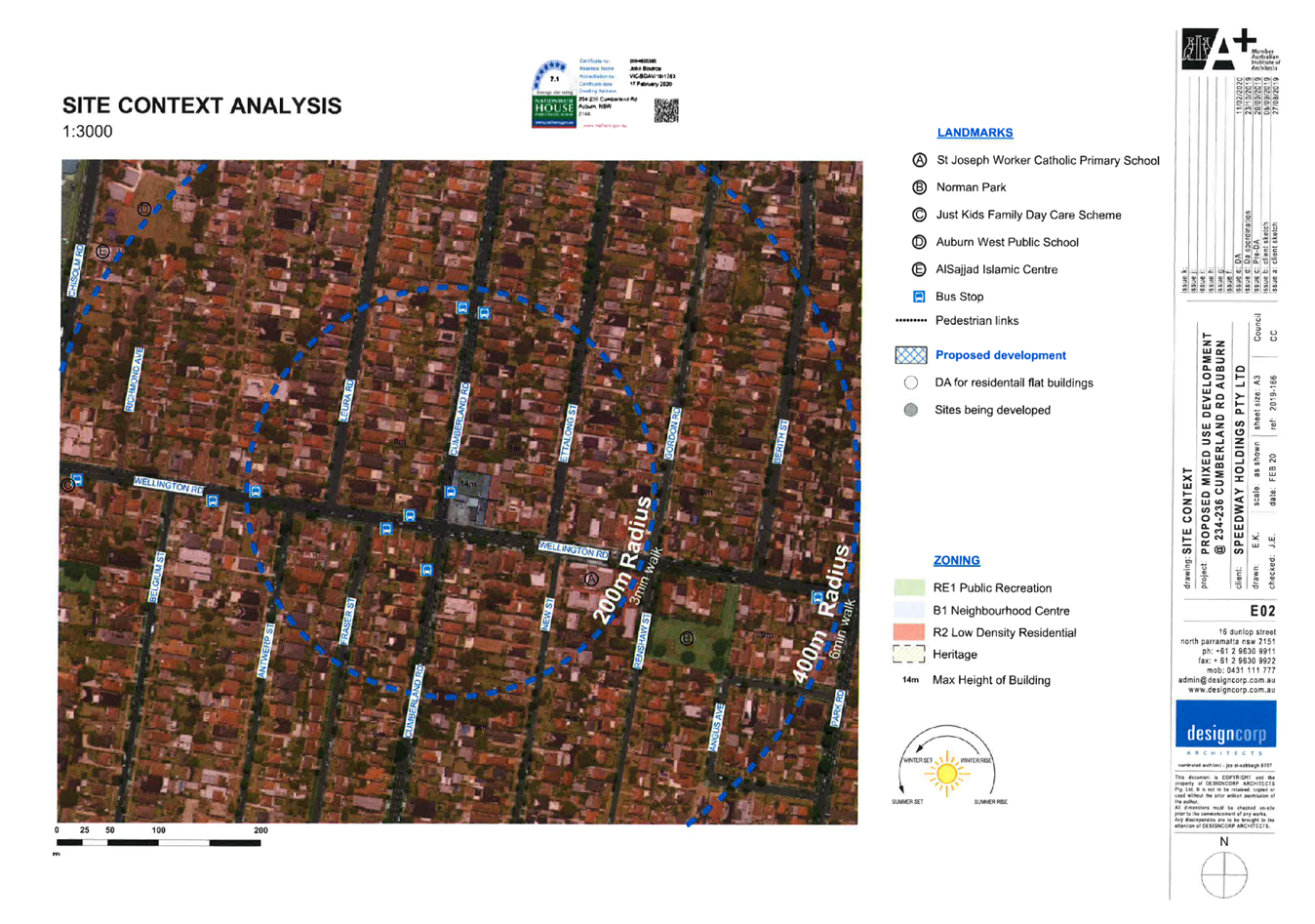
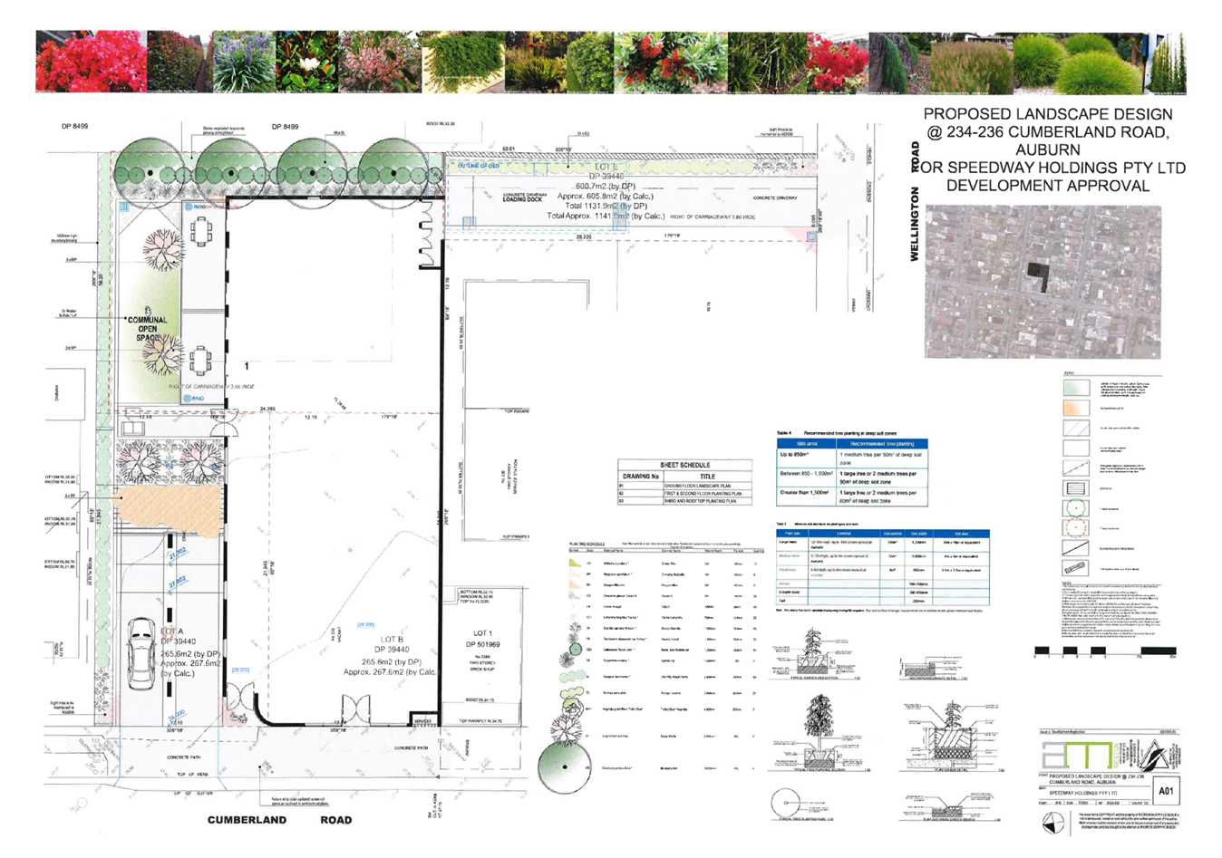
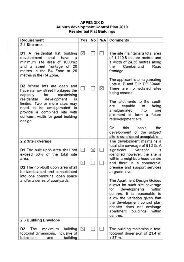
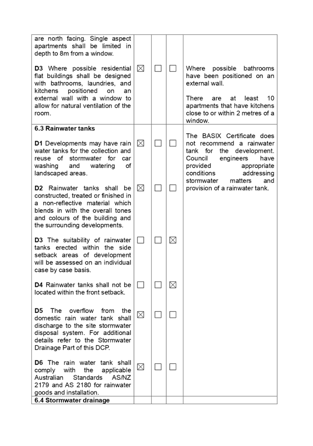
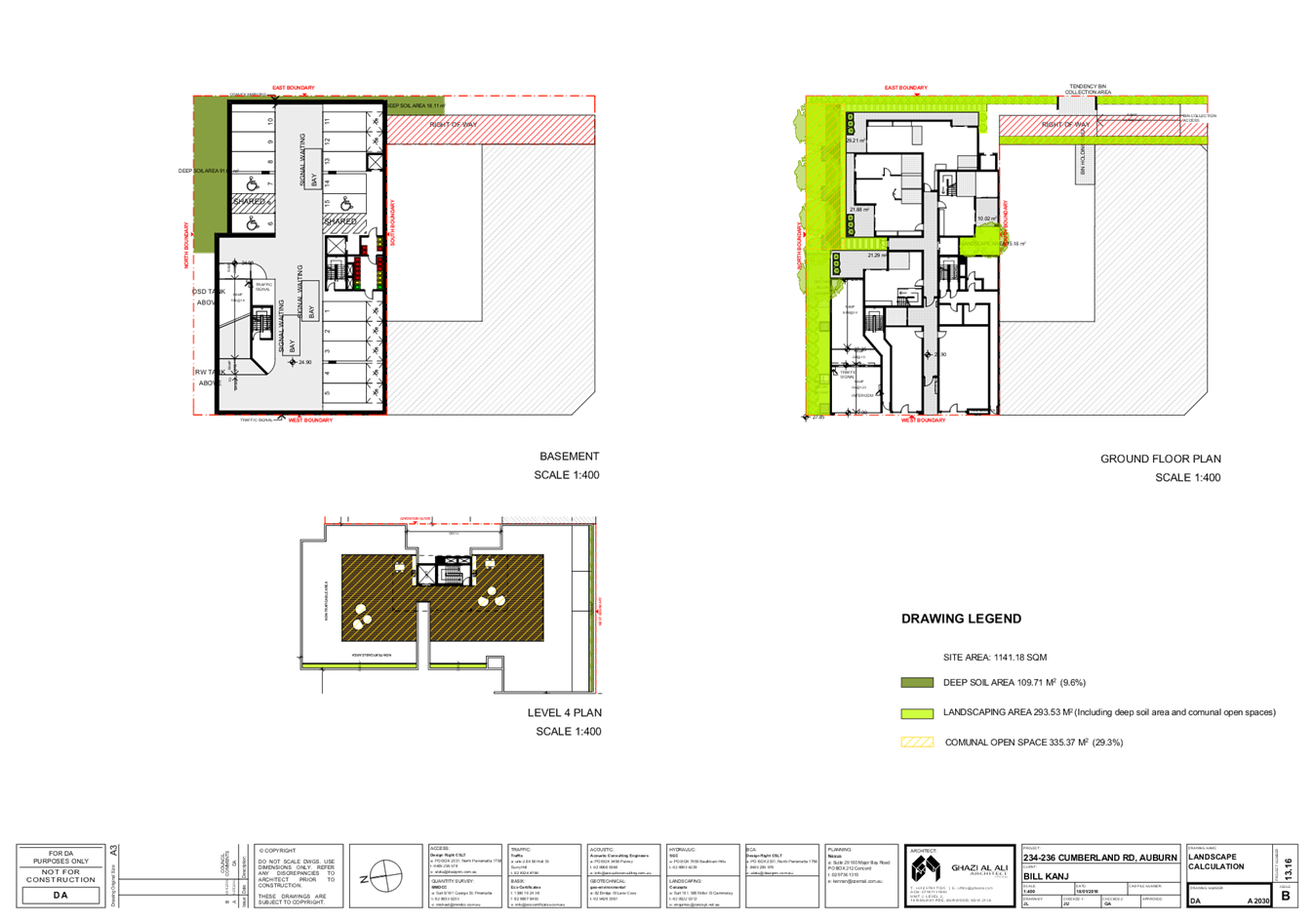
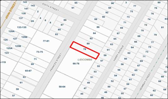
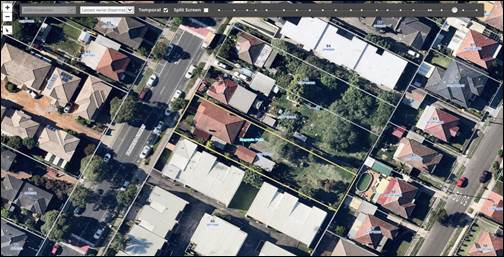
Subject Site and Surrounding Area
The subject site is legally known as Lot E in DP39440, Lot A
in DP39440 and Lot B in DP 394400 also known as 234-236 Cumberland Road,
Auburn. The three sites in combination forms a rectangular shape with an
accessible handle. The site has a frontage to Cumberland Road of 24.38 metre
and a 6.09m wide access handle to Wellington Road. The site occupies an area of
1,140 square metres.
The survey plan shows the site as being burdened by a 3.66
metre wide right away that connects the access handle on Wellington Road
through Lot E. According to known records, the right of way benefits Lots A, B
and D in DP 39440 and Lots 1 and 2 in DP 501969 (Former Lot C). The two front
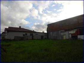
lots A and B are vacant while a two storey warehouse building is situated
across much of Lot E. Vehicle access to the warehouse building is via a driveway
access from Wellington Road.
The site including the adjacent corner site to the south are
zoned B1 Neighbourhood Centre and is completely surrounded by R2 Low Density
Residential zoned land. There is a small convenience shop to the immediate
south on Lot 1 in DP 501969 which is a separate allotment to the service
station which faces Cumberland Road.
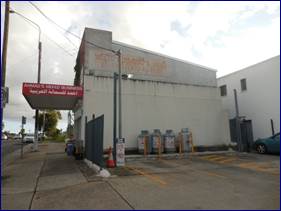
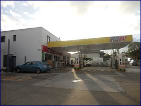
There is a service station at 238 Cumberland Road situated
on the corner with Wellington Road. There is also a mechanic outlet attached to
the service station and a shop. The corner of Cumberland Road with Wellington
Road is controlled by traffic signals.
All other properties surrounding the subject site are
generally residential in nature being single storey and two storey dwelling
houses.
The location of the site is shown below.
Photos of the site are provided
below.
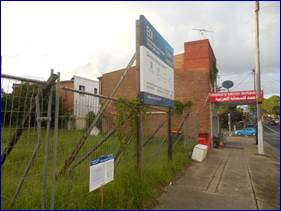
There is a service station and
mechanic outlet situated immediately to the south of the site at 238 Cumberland
Road as follows: -
Description of the Proposed
Development
Development application 2020/0080
is proposing the demolition of existing structures, lot consolidation, and the
construction of a four storey mixed use development comprising of a single
commercial premise on the ground floor, an apartment building with two
apartments on the ground floor and seventeen (17) apartments above and a two
storey basement car park. The development is described in detail below.
Demolition work
The two storey warehouse building
on Lot E (Rear allotment) will be demolished and the driveway access removed.
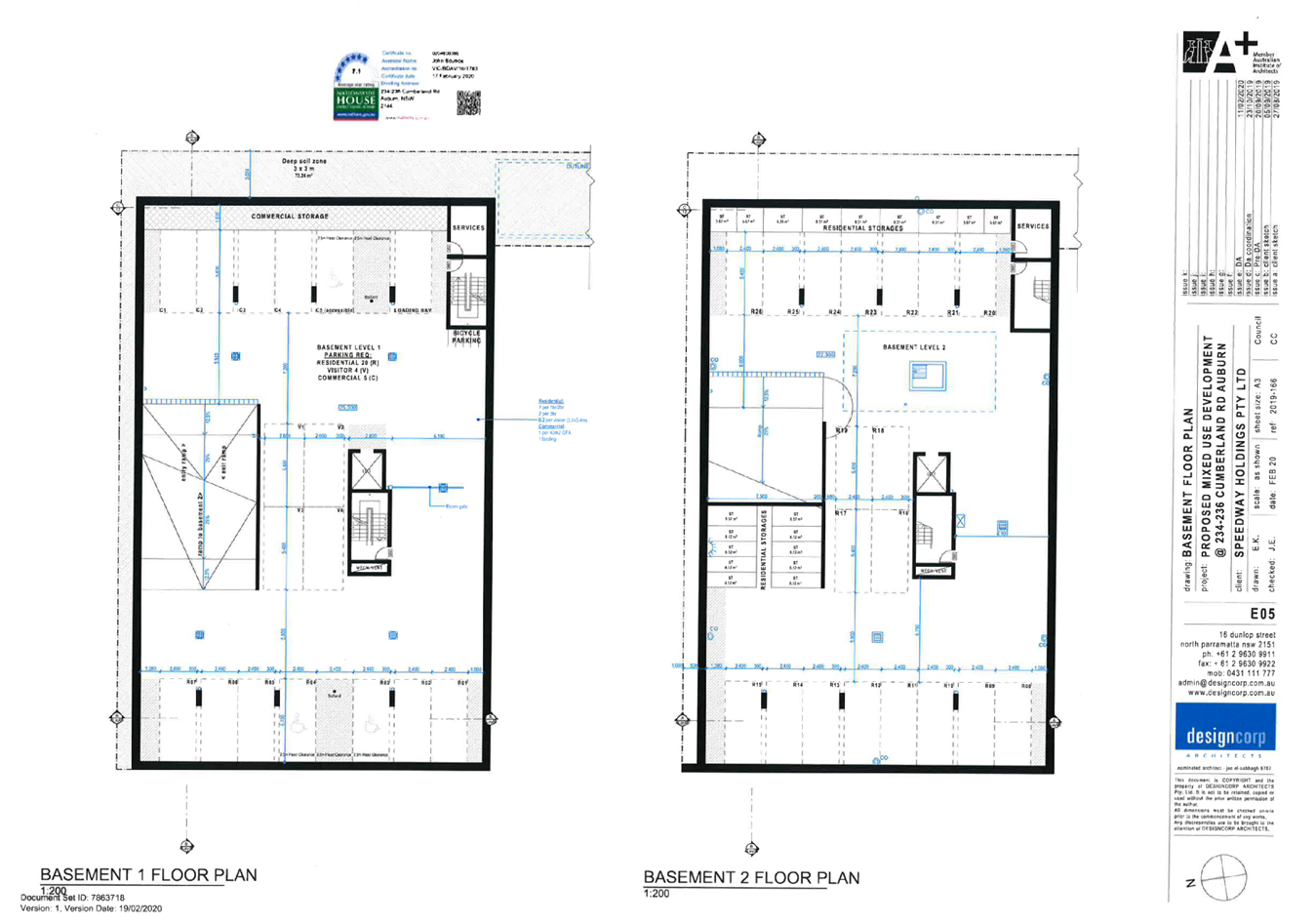
Excavation work
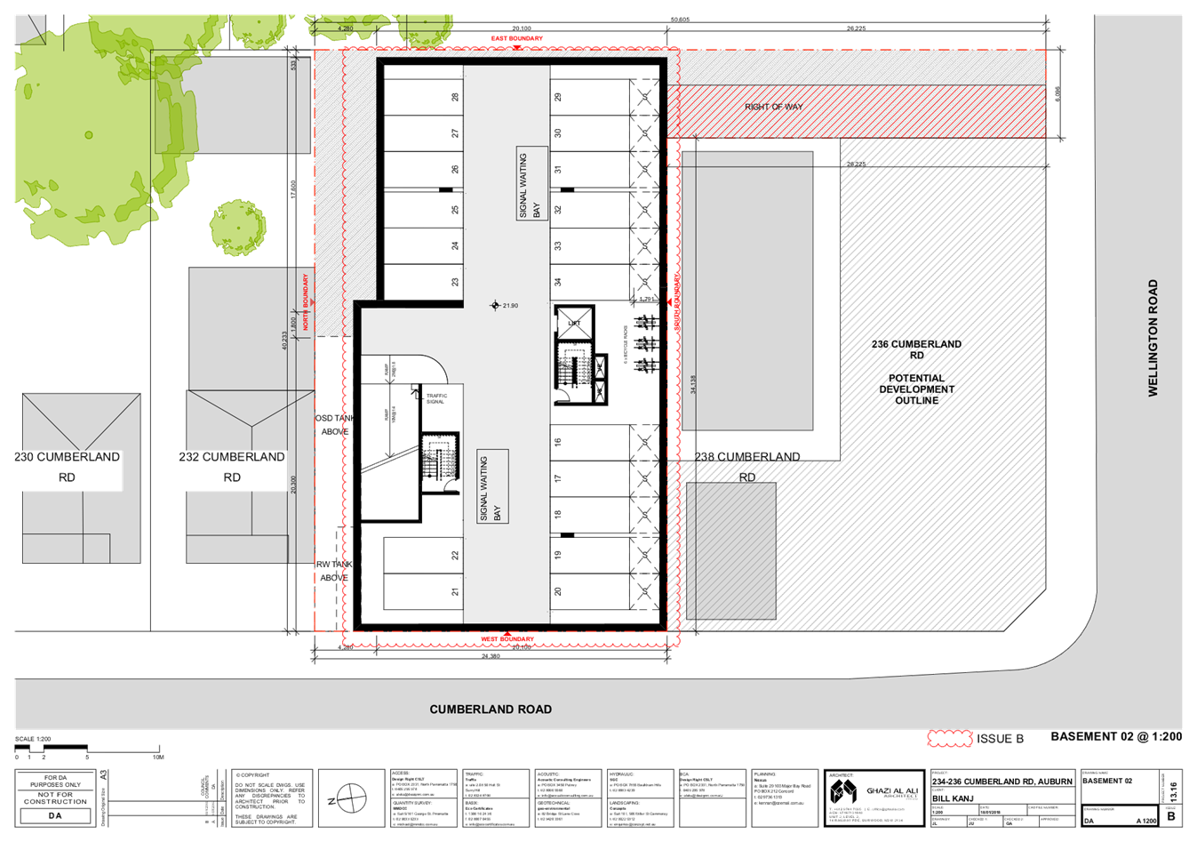
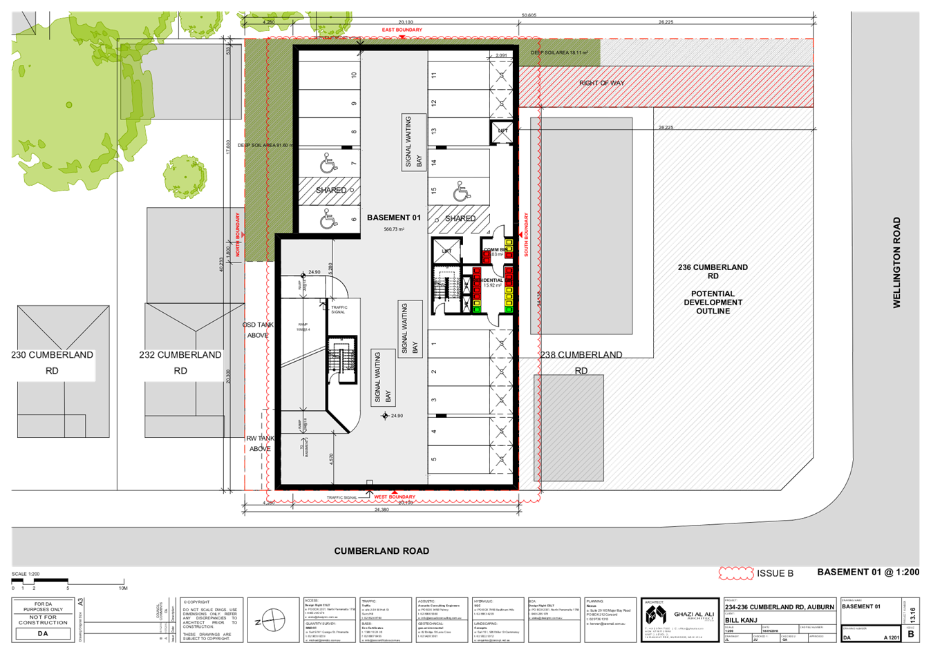
The site will be excavated to a
depth of 6 metres and a basement car park measuring 27.4 metres x 23.4 metres
will be constructed. At least 3,847 cubic metres of soil will need to be
removed to facilitate construction of a basement car parking.
Construction of a basement car
park
The basement car park will have
adequate room for parking thirty five (35) vehicles across two levels. The
basement car park incorporates the following: -
· Vehicle
access from Cumberland Road.
· Room
for parking thirty five (35) vehicles divided into: -
o 26 residential spaces
including two spaces for people with disabilities.
o 5 spaces for the
commercial premise including 1 space for people with disabilities.
o 4 spaces for visitor
use.
o 5 bicycle parking bays.
o 19 storage cages.
o Lift access.
o Storage space for the
commercial tenancy.
o Two service rooms to
support the building
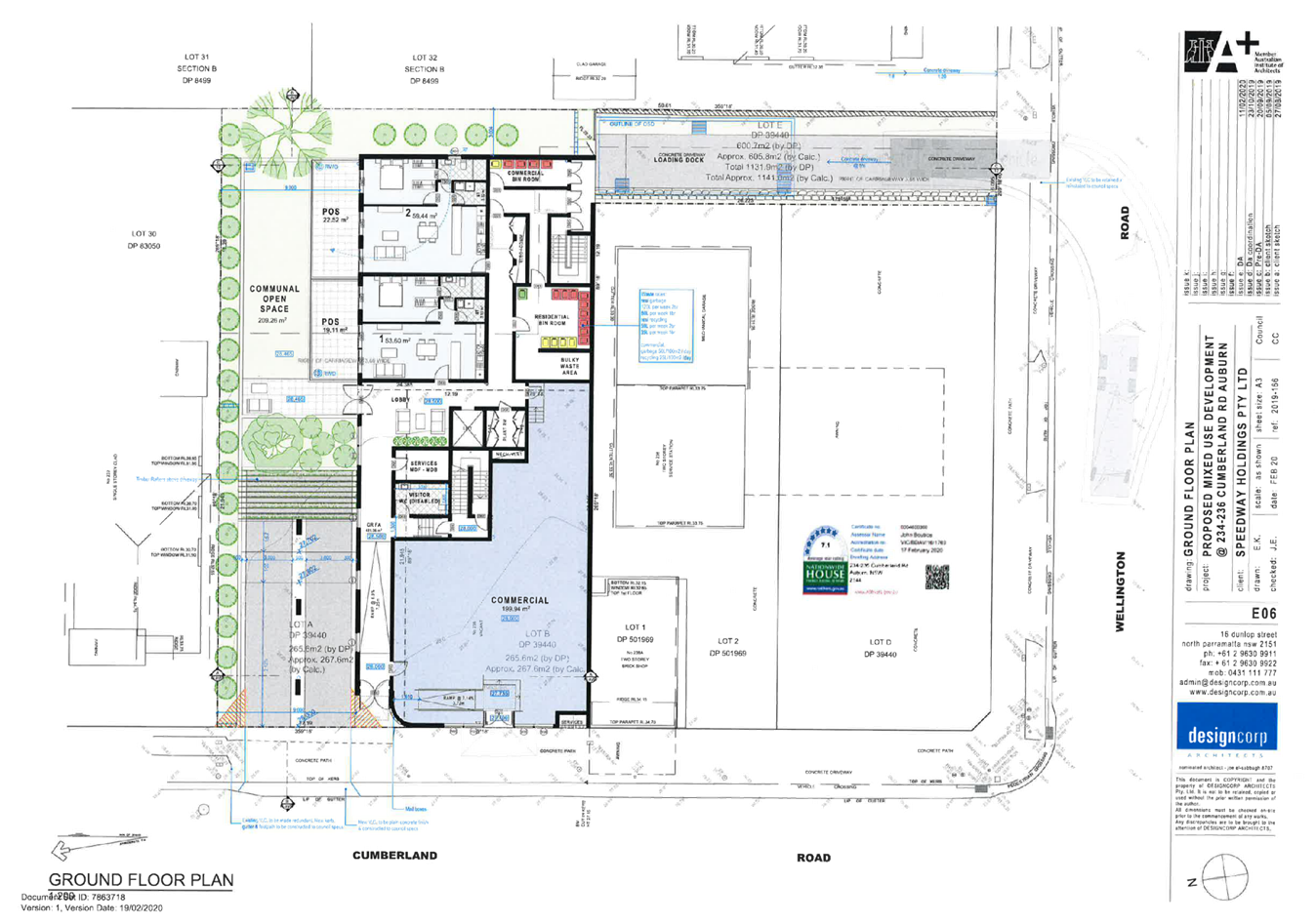
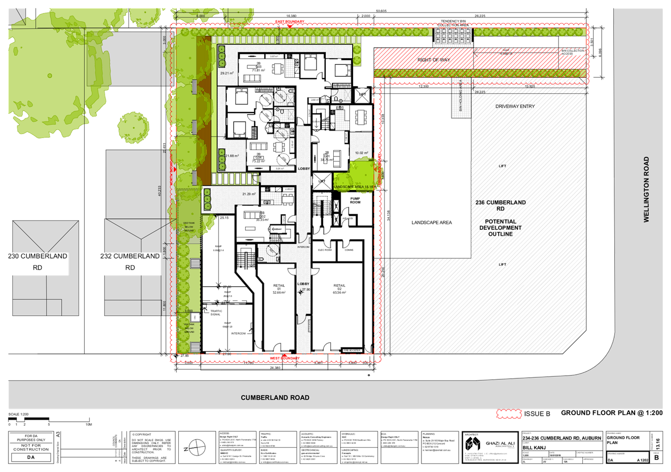
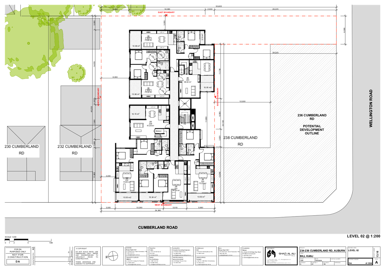
Ground floor
The ground floor encompasses a
large commercial tenancy occupying an area of 199.9 square metres with access
from Cumberland Road, two one bedroom apartments and various services required
to support the building including: -
· A
separate commercial and residential bin store.
· Toilet.
· Plant
room.
· Foyer
and lift access.
· A
separate unloading area with access from Wellington Road.
There is a ground floor common
area occupying 209 square metres along the northern curtilage of the site. The
ground level common area is separate from the ground level private courtyards
of the two ground floor apartments 1 and 2 via the use of a 1.8 metre high
fence comprising a solid base with perforated steel slats above for privacy
measures.
There is seating provided to
ensure passive use of the space.
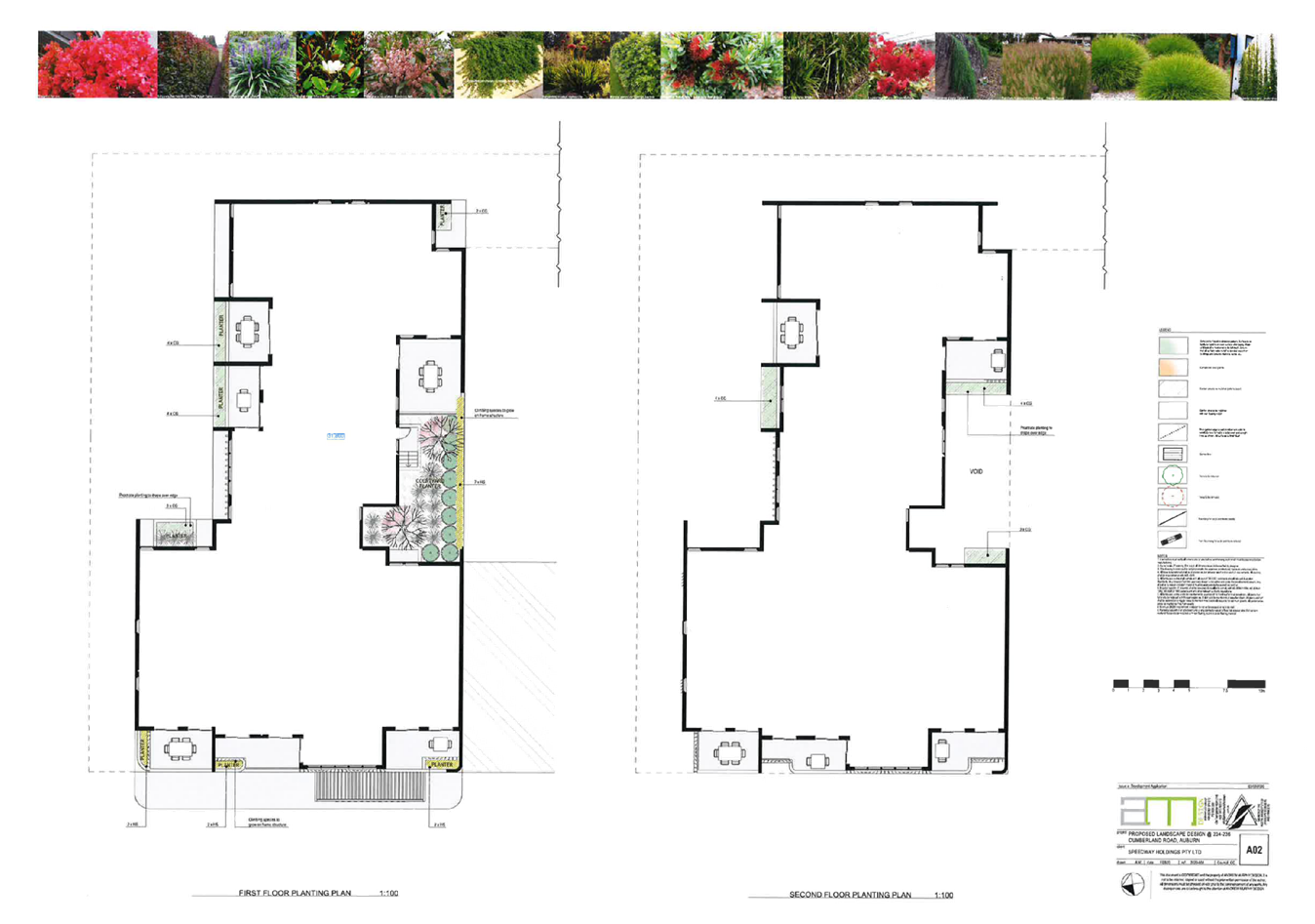
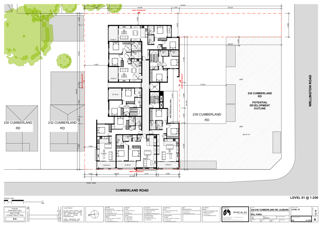
First floor
The first floor comprises six (6)
apartments with five apartments having two bedrooms and 1 apartment having 1
bedroom. All the apartments are provided with a balcony. There is a courtyard
facing south.
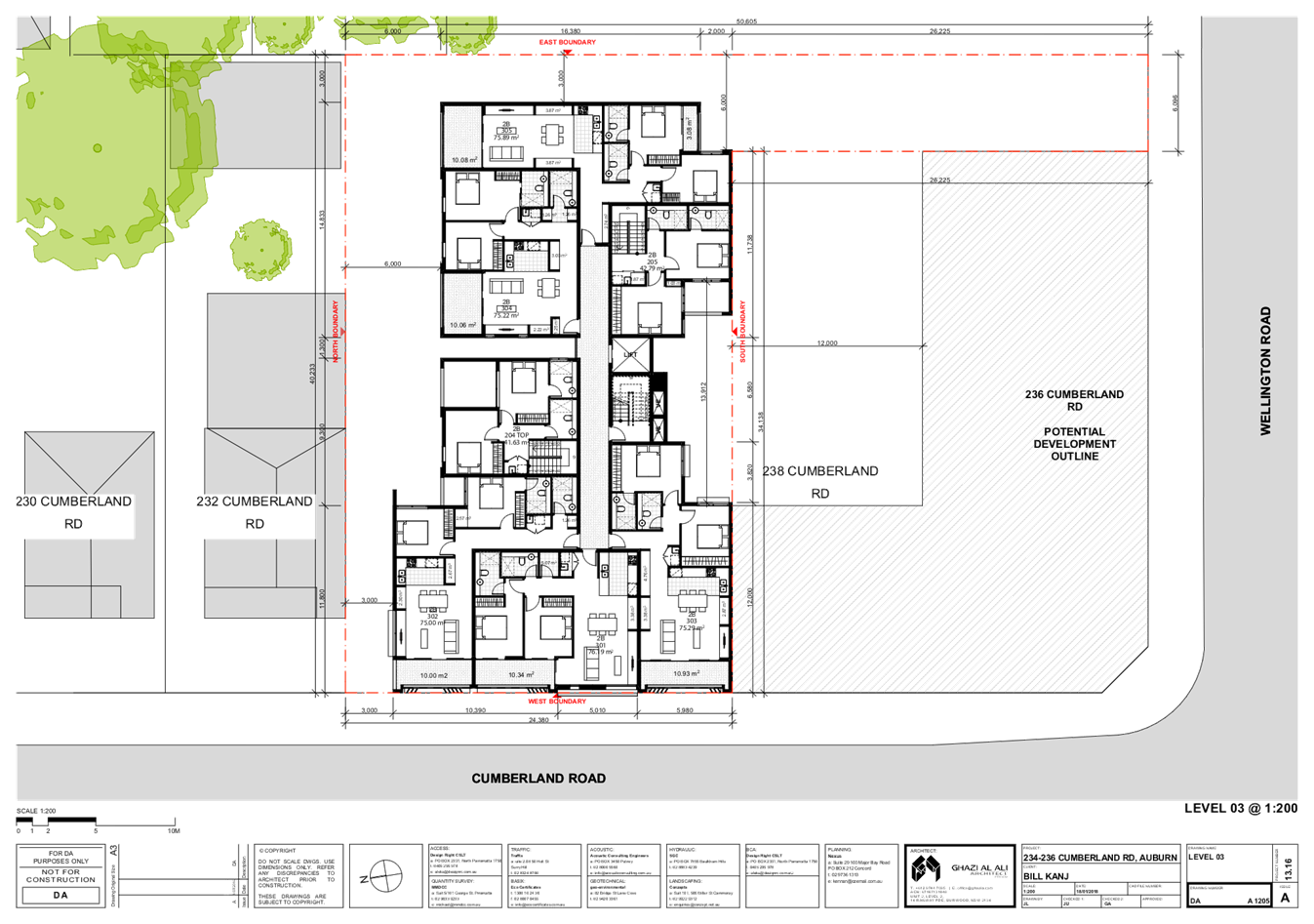
Second floor
The second floor comprises five
(5) apartments all of which have two bedrooms. A sixth apartment is two storeys
in height but is accessed from the third storey of the building. The apartment
numbered Apartment 12 is provided with three bedrooms. The bedrooms are
situated on level two while the living areas and balcony are situated on level
three.
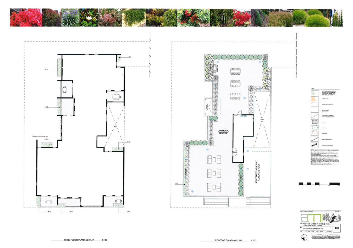
Third floor
The first floor comprises six (6)
apartments with five apartments having two bedrooms and 1 apartment being two
storeys in height and having three bedrooms. As discussed above, the three
bedroom apartment is two storeys in height with the living areas on level three
and the bedrooms situated on Level 2.
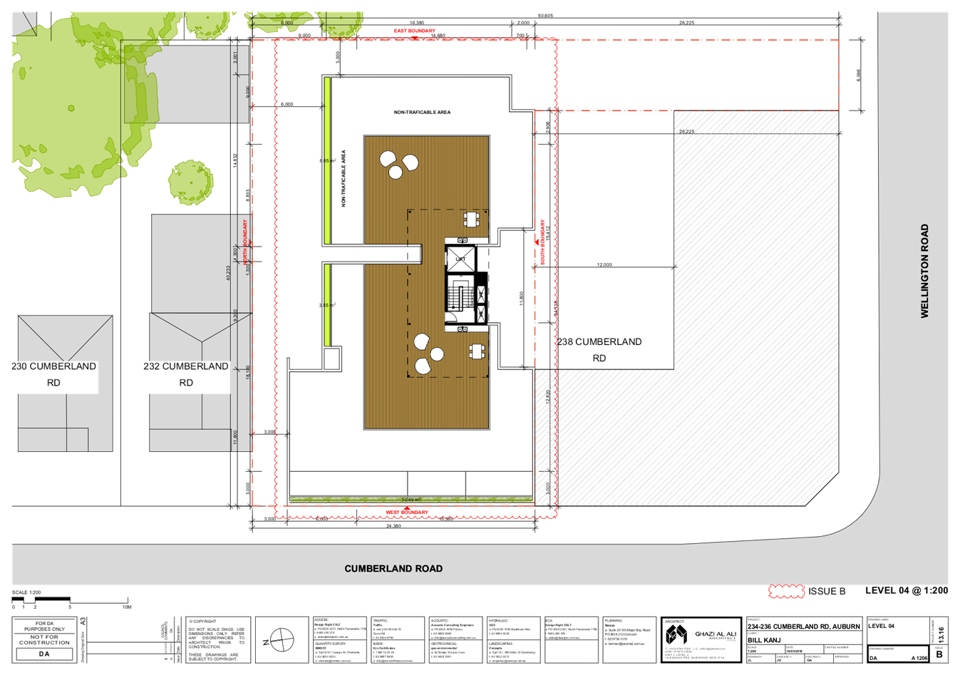
Roof area
The roof area incorporates a lift
access, stair access, a toilet and a common area occupying 294.8 square metres.
There are tables and chairs and a BBQ area to ensure the common area becomes
useable space for the residents of the building.
Other matters
The building is provided with the
following: -
· 3
x 1 bedroom apartments.
· 15
x 2 bedroom apartments.
· 1
x 3 bedroom apartment which crosses two storeys.
· 1
x commercial premise.
· A
floor space ratio of 1.9:0
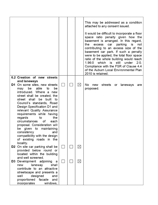
Lot consolidation
The development application
includes the consolidation of the three allotments into one allotment.
Proposed signage
The development application is
making provision for the erection of one business identification sign being a
sign board to be situated above the shop front door entrance facing Cumberland
Road with dimensions of 4.4 metres x 400 mm (Area 1.76 square metres). No
details of wording is available on the grounds that a tenant has not been
decided upon at the present time.
Proposed Sydney mural on the
southern elevation
The southern elevation plan is
showing a stencilled mural that depicts an image of Sydney. It will not be
possible to add or showcase the stencilled image along the southern wall due to
the presence of buildings along the southern side of the building that will
obscure any works. This is not assessed and will be conditioned as part of any
consent that it be deleted from the final plans. The applicant has been
informed of this in correspondence dated 27 March 2020 and no objection to this
has been raised.
History
The site has been the subject of
two recent development applications for similar style of developments over
recent years as follows: -
· Development
consent 175/2012 issued 10 April 2013 for demolition of the existing structures
and construction of a three storey mixed use development comprising of one
commercial/retail tenancy and 10 residential apartments over basement parking
subject to conditions. This consent has lapsed and no work ever commenced.
· Development
application 282/2017 to demolish all existing structures and construct a four
storey mixed use development comprising of 2 retail shops and 21 apartments
with 2 levels of basement parking. The development application was refused on
13 June 2018 by the Cumberland Local Planning Panel. The matter was then
appealed in the Land and Environment Court however the applicant withdrew the
Court proceedings prior to the matter advancing beyond the planned S34
conference.
The current application is an
improvement on the previous application. In this regard, the number of
apartments are reduced from 25 to 19, the setbacks from the northern property
boundary is increased which in turns improve the ground floor amenity of the
development and the ground floor services are improved such as the position of
the waste bin storage areas.
Applicants Supporting
Statement
The applicant has provided a
Statement of Environmental Effects prepared by Think Planners and dated 10
February 2020 in support of the development application.
Contact with Relevant
Parties
The assessing officer has
undertaken a site inspection of the subject site and surrounding properties and
has been in regular contact with the applicant throughout the assessment
process.
Internal Referrals
Development Engineer
The development application was
referred to Council’s Development Engineer for comment who has advised
that the development is generally satisfactory subject to conditions.
Environment and Health
The development application was
referred to Council’s Environment and Health Officer for comment who has
advised that the development proposal is satisfactory subject to conditions.
Waste
As per the comments dated
23/3/2020, the development application is satisfactory subject to conditions.
It is identified as per an email dated 3/8/2020 that bins are able to be
presented to the kerbside on Wellington Road if no dedicated area for waste bin
collection is allocated.
External Referral
The site is not situated on or
adjacent to a railway line and the development site is not impacted by power
lines or power poles. As such, a referral to any Government Authority, or
Ausgrid or the Police is not required.
Notwithstanding the above, the
applicant has made requests to the energy provider to determine whether a
substation is required to support the development. The applicant has provided
evidence showing no reply following a request. It is considered appropriate to
address this matter as a condition attached to any consent issued.
Planning Comments
The provisions of any
Environmental Planning Instruments (EP&A Act s4.15 (1)(a)(i))
State Environmental Planning
Policies
The proposed development is
affected by the following State Environmental Planning Policies:
(a) State
Environmental Planning Policy No. 55 - Remediation of Land (SEPP 55)
The requirement at clause 7 of
SEPP No. 55 for Council to be satisfied that the site is suitable or can be
made suitable to accommodate the proposed development has been considered in
the following table:
|
Matter
for consideration
|
Yes
|
No
|
|
Does
the application involve re-development of the site or a change of land use?
|
|
|
|
Is
the development going to be used for a sensitive land use (e.g. residential,
educational, recreational, childcare or hospital)?
|
|
|
|
Does
information available to you indicate that an activity listed below has ever
been approved, or occurred at the site?
Acid/alkali
plant and formulation, agricultural/horticultural activities, airports,
asbestos production and disposal, chemicals manufacture and formulation,
defence works, drum re-conditioning works, dry cleaning establishments, electrical
manufacturing (transformers), electroplating and heat treatment premises,
engine works, explosive industry, gas works, iron and steel works, landfill
sites, metal treatment, mining and extractive industries, oil
production and storage, paint formulation and manufacture, pesticide
manufacture and formulation, power stations, railway yards, scrap yards,
service stations, sheep and cattle dips, smelting and refining, tanning and
associated trades, waste storage and treatment, wood preservation
|
|
|
|
Is
the site listed on Council’s contaminated land database?
|
|
|
|
Is
the site subject to EPA clean-up order or other EPA restrictions?
|
|
|
|
Has
the site been the subject of known pollution incidents or illegal dumping?
|
|
|
|
Does
the site adjoin any contaminated land/previously contaminated
land?
|
|
|
|
Has
the appropriate level of investigation been carried out in respect of
contamination matters for Council to be satisfied that the site is suitable
to accommodate the proposed development or can be made suitable to
accommodate the proposed development?
|
|
|
|
Details
of contamination investigations carried out at the site:
A Stage 1 and 2 site investigation audit has been carried
out by Geo Environmental Engineering Ref G19037AUB-R01F and dated 16 January
2019. The report concludes that the site can be made suitable with
remediation of the surface and near-surface ACM. Therefore a remedial action
Plan is recommended for the site to make it suitable for its intended use,
and a validation report supporting the remediation works have been carried
out.
A
Remedial Action Plan has been prepared by Geo Environmental Engineering Pty Ltd
Reference G19037AUB-R02F dated 16 January 2020. The preferred remedial action
is to excavate the ACM impacted fill material at the site and to remove it to
a licenced facility.
The
reports were referred for Council’s Environmental Health Unit for review
and it was concluded that the remedial action plan is satisfactory for
approval.
|
(b) State
Environmental Planning Policy 33 “Hazardous and Offensive
Development”
State Environmental Planning
Policy 33 “Hazardous and Offensive Development is being considered
because there is a petrol station on an adjoining site to the south which
includes the storage of above ground liquid petroleum gas cylinders along the
northern side of the site. A petrol station and LPG storage and handling
facilities are captured by the State Policy with the risk being liquid spills
and fuel leaks for a petrol station and gas leaks for LPG storage and handling
facilities. The possible impact of both during a worst case scenario is fire
and an explosion.
A detailed assessment of the
service station is not required given that the development application is not
related to the service station.
Notwithstanding this, there are
four (4) above ground liquid petroleum gas (LPG) tanks situated along the
northern side of the site abutting the adjoining shop which would store
approximately 1.5 to 2 cubic metres (Approximately 1 tonne) of LPG. This
requires consideration given that LPG is classed as a 2.1 dangerous good.
Consent authorities must refer to the New South Wales Department of Planning
publication “Hazardous Industry Locational Guidelines No 1 Liquefied
Petroleum Gas Automotive Retail Outlets”.
According to the risk screening
method, the amount stored is significantly below 10 tonnes (16 cubic metres)
and hence the storage of such a volume will not be hazardous for the site and
or adjoining sites including 234 – 236 Cumberland Road.
In concluding the matter, the
volume of gas stored is significantly below the threshold for assessment under
the State Policy and as such, it is concluded that the intensity of use of the
development is acceptable within the location.
(c) State
Environmental Planning Policy (Infrastructure) 2007
The provisions of State
Environmental Planning Policy Infrastructure have been considered for the
development application.
The site is not situated on or
close to a major arterial road that carries more than 40,000 vehicles per day.
It is identified that Wellington
Road is a Classified Secondary Road (Number 2096) that connects Park Road with
Clyde Street. However, the road does not carry significant traffic volumes. It
is determined that a detailed assessment of the application under Clause 101,
102 and 103 of the State Policy is not required in this instance.
(d) State
Environmental Planning Policy (Vegetation in Non Rural Areas) 2017
The site is devoid of any
significant vegetation or trees and as such, the proposal does not exceed the
biodiversity offsets scheme threshold. Assessment using the state policy is not
required.
(e) State
Environmental Planning Policy 64 “Advertising and Signage”
State Environmental Planning
Policy 64 “Advertising and Signage” is relevant for the erection of
the business identification sign facing Cumberland Road. A sign board with
dimensions of 4.4 metres x 400 mm (Area 1.76 square metres) is proposed to be
situated above the door entrance to the commercial premise / retail premise. No
wording is available on the grounds that a tenant has not been chosen for the
tenancy. When assessed under the State Policy, it is considered that the proposed
sign is satisfactory under the relevant provisions.
A detailed assessed using the
State Policy is provided at Appendix B which is attached to the report.
(f) State
Environmental Planning Policy (Building Sustainability Index: BASIX) 2004
The applicant has submitted a
BASIX Certificate covering all nineteen apartments. The development achieves a
pass mark of 40 for water and 36 for energy use. The BASIX Certificate is
assessed as being satisfactory for approval.
(g) Statement
Environmental Planning Policy No. 65 - Design Quality of Residential Apartment
Development (SEPP 65)
State Environmental Planning
Policy 65 applies to the development as the building is 3 storeys or more and
contains more than 4 dwellings. A design statement addressing the design
quality principles prescribed by SEPP 65 was prepared by the project architect.
Integral to SEPP 65 is the Apartment Design Guide (ADG), which sets benchmarks
for the appearance, acceptable impacts and residential amenity of the
development.
Following a detailed assessment of
the proposal against the provisions of SEPP 65 and the ADG, it is considered
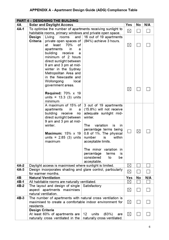
the proposal is generally compliant with the exception of Part 3E1 - Deep soil
zone, Part 3F1 - Separation distances and Part 4A-1 - Maximum of 15% of apartments
to receive no sunlight as follows.
|
Development Standard
|
Compliance
|
Discussion
|
|
Part 3E1 - Deep soil zones.
Deep soil zone to be 7% (80 sq. m) however a variation is
permitted where the site is within a centre, is constrained or in a CBD area.
|
No
|
6.3% or 73 square metres.
Site within a neighbourhood centre zone with commercial
at grade.
|
|
Part 3F1 (Building Separation) – Visual Privacy.
Separation distances to be: -
Up to 12 m (4 storeys) 6 m for habitable rooms and 3 m
for non habitable rooms.
No separation required for blank walls.
|
No
|
4 storey building.
North
1 living room window facing north in 3 apartments with
louvres (Total 3).
|
|
Part 4A-1 - Solar and Daylight Access.
Maximum 15% of apartments to receive no direct sunlight.
|
No (Minor variation)
|
15.8% or 3 apartments do not receive direct sunlight.
|
|
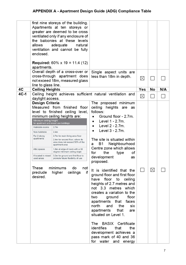
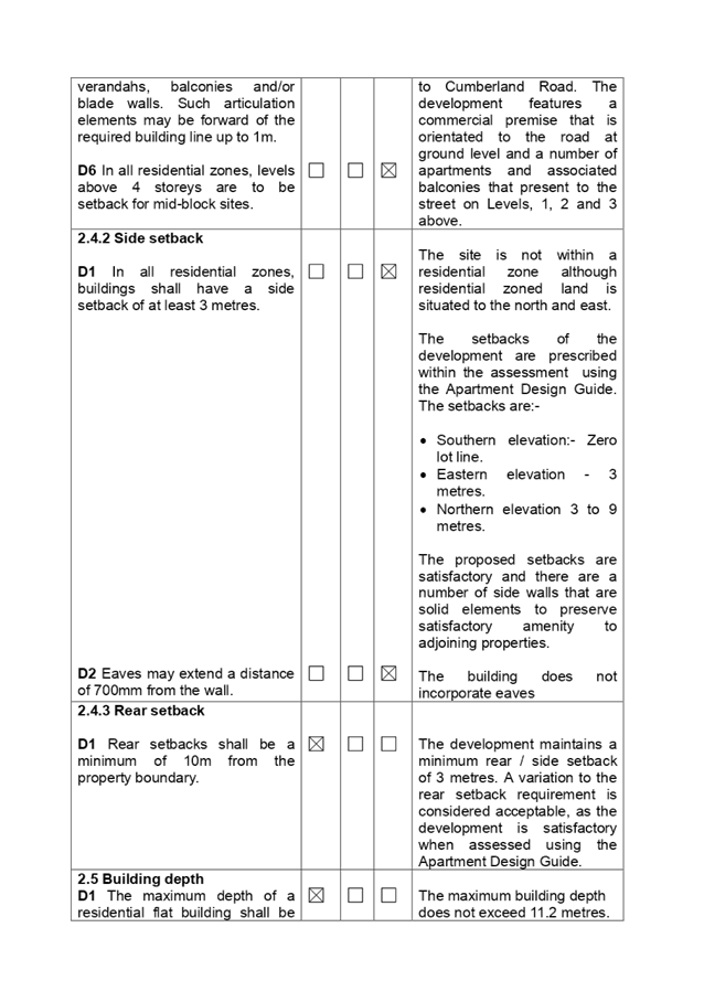
Part 4C-1 - Ceiling Heights.
Floor to ceiling heights for apartments on the ground
floor and Level 1 to be 3.3 metres in height if the development is located
within a mixed use zone.
|
No
|
The apartments on the ground floor and Level 1 have floor
to ceiling heights of 2.7 metres.
|
As indicated in the compliance
table above, the proposed development departs from Part 3E1 - Deep soil zone,
Part 3F1 - Separation distances, Part 4A-1 - Maximum of 15% of apartments to
receive no sunlight and Part 4C1 Ceiling heights. The variations to the above
are addressed below.
Part 3E1 - Deep soil zone
A variation of 8.75% is
identified. However, a variation is permitted where the site is within a centre,
is constrained or within a CBD area. The site is situated within a
Neighbourhood Centre B1 zone and the plans are showing a commercial premise
situated on the ground floor and a basement car park to support the entire
development. Additionally, there are support services for the commercial
tenancy such as a loading bay, toilet and commercial waste storage area. The
variation is generally consistent with the approaches adopted by the Apartment
Design Guide.
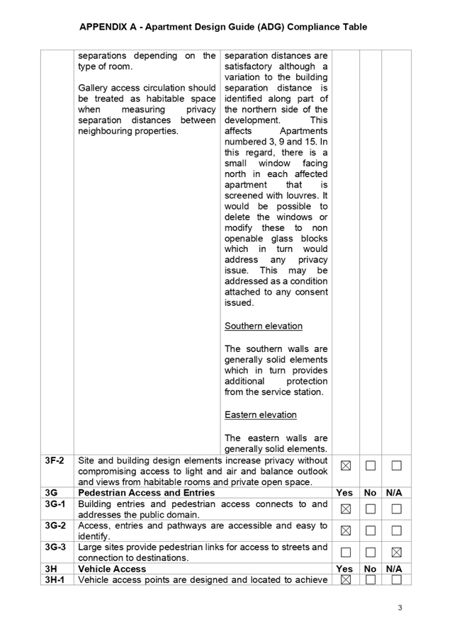
Part 3F1 (Building Separation)
- Visual Privacy.
Generally, the building achieves a
majority of compliance with the provisions and setbacks are mostly
satisfactory. A variation occurs to the three apartments numbered 3, 9 and 15
due to the presence of a living room window in each apartment being oriented to
the north. All three windows are obscured by louvres.
The main living rooms of each
apartment numbered 3, 9 and 15 are oriented to the west and street. It is
considered most practical to increase the sill heights of the windows to 1.6
metres above the floor level of each affected apartment. Such action would
address any potential privacy loss and may be addressed as a condition attached
to any consent issued.
Part 4A-1 - Solar and Daylight
Access.
A Maximum 15% of apartments to
receive no direct sunlight which would equate to 2.85 apartments. The applicant
has ensured that no more than three apartments being Apartments numbered 8, 14
and 19 receive no sunlight with the variation being minor in extent.
Part 4C-1 - Ceiling heights
It is identified that the ground
floor and first floor apartments have floor to ceiling heights of 2.7 metres
and not 3.3 metres. This creates a variation to the two ground floor apartments
that faces north and the six apartments that are situated on Level 1.
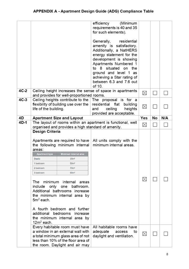
A NatHERS energy statement for the
development is showing Apartments Numbered 1 to 8 situated on the ground floor
and level 1 are achieving a Star rating of between 6.3 and 7.6 out of 10. As
such, residential amenity is generally satisfactory and no adverse impact in relation
to ceiling height is identified.
A comprehensive assessment against
SEPP 65 and the ADG is contained in Appendix A.
Regional Environmental Plans
(a) Sydney
Regional Environmental Plan (Sydney Harbour Catchment) 2005
The subject site is identified as
being located within the area affected by the Sydney Regional Environmental
Plan (Sydney Harbour Catchment) 2005. The proposed development raises no issues
as no impact on the catchment is envisaged.
(Note: - the subject site is not
identified in the relevant map as ‘land within the ‘Foreshores and
Waterways Area’ or ‘Wetland Protection zone’, is not a
‘Strategic Foreshore Site’ and does not contain any heritage items.
Hence the majority of the SREP is not directly relevant to the proposed
development).
Local Environmental Plans
The Auburn Local Environmental
Plan is applicable to the development. The development achieves compliance with
most of the key statutory requirements of the Auburn Local Environmental Plan
2010 except for the issue concerning Clause 4.3 (Height of Buildings). The
matter concerning height of buildings is addressed below.
(a) Permissibility
The proposed development is
defined as a mixed use development comprising a commercial premise (office or
retail premise) and an apartment building with a basement car park. A
commercial premise (including office or retail premise) and an apartment
building is a permitted form of development on the site subject to consent.
The relevant matters to be
considered under the Auburn Local Environmental Plan 2010 and the applicable
clauses for the proposed development are summarised below. A comprehensive LEP
assessment is contained in Appendix B.
Figure 1 - Auburn LEP Compliance
Table
|
Development Standard
|
Compliance
|
Discussion
|
|
4.3 - Height of Buildings.
Maximum height - 14 metres.
|
No
|
16.7 metres.
A variation of 2.7 metres or 19.3% is observed and a
Clause 4.6 variation is being requested.
|
|
4.4 - Floor Space Ratio.
Maximum floor space ratio - 2:1
|
Yes
|
1,168 square metres or 1.9:1.
|
|
5.10 - Heritage Conservation.
|
Yes
|
The site is not heritage listed and no heritage listed
sites are close by.
|
|
6.3 - Flood Planning.
|
Yes
|
The site is not flood prone or subject to overland flow.
|
(b) Clause
4.6 - Variation to Height of Buildings
Clause 4.6 allows the consent
authority to vary development standards in certain circumstances and provides
an appropriate degree of flexibility to achieve better design outcomes. The
consent authority may grant the exception as the Secretary’s concurrence
can be assumed where clause 4.6 is adopted as per the Department of Planning
Circular PS 18-003, dated 21 February 2018.
The applicant has submitted a
written request to vary the development standard for Clause 4.3 (Height of
buildings).
Based on various case laws
established by the Land and Environment Court of NSW such as Four2five P/L v
Ashfield Council [2015] NSWLEC 9, Randwick City Council v Micaul Holdings P/L
[2016] NSW LEC7 and Zhang and anor v Council of the City of Ryde [2016] NSWLEC
1179, a 3 part assessment framework for a variation request proposed under
clause 4.6 has been considered and an assessment of the proposed variance,
following the 3 part test is discussed in detail below.
The 3 preconditions which must be
satisfied before the application can proceed are as follows:
1. Is
the proposed development consistent with the objectives of the zone?
Applicant’s
justification:
The variation to the height limit
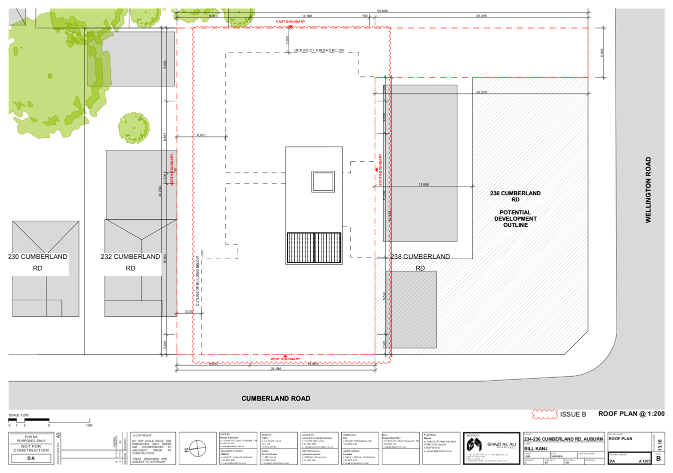
is limited to a section of building comprising the lift over run situated
within the central portion of the building and not directly visible from the
public domain. As such, the lift over run is generally not seen from the
streetscape. The habitable floor space is contained below the maximum building
height line. The variation does not achieve additional yield within the site
but is in response to the provision of additional amenity for the site being
the roof top common area.
The proposed development is in the
public interest as it remains consistent with the objectives of the B1 zone
which are: -
· "To
provide a range of small scale retail, business and community uses that serve
the needs of the people who live or work in the surrounding
neighbourhood".
· "To
ensure development does not adversely affect the amenity of the surrounding
neighbourhood”.
The proposal is consistent with
the objectives of the zone, insofar as the development is not antipathetic to
the zone. The development is consistent with the zone objectives noting that: -
· The
development will provide for small scale retail / business uses to meet the
needs of people who live and work in the neighbourhood.
· The
development contributes to a variety of housing types.
· The
development does not adversely affect the amenity of the surrounding
neighbourhood and in particular the height variation is not visible from the
street frontage.
· The
development is designed to minimize impact on amenity of the area and adjoining
properties.
Planner’s
comment
It is
considered that the applicants response has merit as follows: -
· The
development is compliant with the stated objectives.
· The
development is not seen to have adverse amenity impacts towards adjoining
properties. The service station and shop to the immediate south is not
adversely impacted by the development. The degree of privacy to the north at
232 Cumberland Road is also considered to be satisfactory.
· The
development will provide a floor area for a business to operate which in turn
will generate employment.
· The
development contributes to a variety of housing types.
· The
lift over run and roof top access is situated central to the building and as
such, is generally not seen from the public domain.
A rooftop parapet wall also
encroaches above the 14 metre height limit by as much as 400 mm. The parapet
wall forms part of a barrier that is required for the rooftop common area.
There are no significant planning or amenity issues to note and no changes to
the conclusions made above.
2. Is
the proposed development consistent with the objectives of the development
standard which is not met?
Applicant’s
justification
Compliance with the development
standard is unreasonable or unnecessary in the circumstances of the case as the
underlying objectives of the control and the objectives of the zone are
achieved despite the variation to the numerical standard.
The objectives of the building
height standard are: -
a) To
establish a maximum height of buildings to enable appropriate development
density to be achieved, and
b) to
ensure that the height of buildings is compatible with the character of the
locality.
The current development proposal
is predominantly consistent with the building height with the exception of the
fire stair structure and the lift over run. The development remains consistent
with the objectives based on the following: -
· The
development proposal is consistent with the intent of the maximum height
control with the proposed mixed use building contained below the maximum
building height with the non compliance contained to the lift overrun. The
variation is not discernibly different to a compliant form as viewed from the
street given the location of the variation being central to the building. The
building is four storeys when viewed from the public domain notwithstanding the
variation.
· The
variation occurs because additional amenity is incorporated into the rooftop
area which is appropriate being common open space.
The variation will not have any
adverse amenity impacts as follows: -
· The
variation is not noticeable and will not impact on the physical bulk, height
and scale of the building.
· The
variation will not result in a reduction of solar penetration on site or to
adjoining sites nor lead to sunlight or overshading issues.
· The
proposed variation will not result in a loss of views or interrupt views to and
from the site.
· The
proposed variation will not result in a loss of privacy afforded to existing
properties or future residents of the development.
· The
development will not obstruct existing view corridors.
The site will be developed to its
full potential whilst complimenting the future vision envisaged by the planning
controls. A suitable address for future residents is being created.
The scale of the development is
appropriate and will be consistent with the permitted building height to ensure
a positive streetscape presentation.
The development is appropriate
for the site and consistent with the desired character of the locality.
The scale of the development is
appropriate noting that floor space ratio is complied with. The variation is
limited to that part of the building that provides access to the common open
space area on the rooftop area.
Given the above, it is considered
that there are planning grounds to support the development.
Planner’s comment:
The comments stated above are
relevant to the discussion and are supported as follows: -
· A
majority of the building is below 14 metres in height and compliant with the
height limit applying to the site. The variation is limited to the lift over
run, the common area access and part of a parapet wall facing Cumberland Road.
· Generally,
the building is four storeys in height when viewed from Cumberland Road which
is generally consistent with the planning controls applying to the site.
· Additional
amenity is being incorporated into the building in the form of a roof top
terrace. The terrace area is provided with seating and a BBQ which ensures the
area will be used. It would be possible to achieve compliance by removing the
amenity feature but in this instance, it is considered reasonable to support
the variation knowing that residents are being given additional amenity in the
form of additional common outdoor space.
· There
is no adverse impact on the physical bulk, height and scale of the building and
the variation will does not contribute to any additional levels of
overshadowing created.
· The
proposed variation will not result in a loss of views or interrupt views to and
from the site.
· The
proposed variation will not result in a loss of privacy afforded to existing
properties or future residents of the development.
· The
scale of the development is appropriate and will be consistent with the
permitted building height to ensure a positive streetscape presentation is
achieved.
· The
development is appropriate for the site and consistent with the desired
character of the locality.
· The
floor space ratio is slightly less than that permitted being 1.9:1 whereas a
floor space ratio of 2:1 is allowed.
On the grounds presented above, it
is considered appropriate to support the development under the heading.
3. a)
Is compliance with the development standard unreasonable or unnecessary in the
circumstances of the case? and;
Applicant’s justification
· The
contravention of the height control does not raise any matter of significance
for state or regional environmental planning given the nature of the proposed
development.
· There
is no public benefit in maintaining the development standard as it relates to the
current proposal. The variation is acceptable in the circumstances of the case
given that the underlying objectives of the control are achieved and it will
not set an undesirable precedent for future development within the locality as
any future development on another site would require consideration of the
relevant merits and individual circumstances.
Strict compliance with the
prescribed building height requirement is unreasonable and unnecessary in the
context of the proposal and the unique circumstances. The proposed development
meets the underlying intent of the control and is a compatible form of
development that does not result in unreasonable environmental amenity impacts.
The design response aligns with
the intent of the control and provides for an appropriate transition to the
adjoining properties.
The proposed development promotes
the economic use and development of land consistent with the zone and its
purpose.
Planner’s comment:
It is considered that strict
compliance is unreasonable and unnecessary on the grounds that the development
is fully compliant with the relevant objectives of the zone that applies to the
site and the development standard. Additionally: -
· A
benefit is being provided in the form of additional common open space for the
residents.
· The
additional benefit does not create adverse amenity issues such as privacy and
overshadowing.
The proposed development is
consistent with the planning intentions for the site and the development
exhibits satisfactory design when viewed from the street.
b) Are there
sufficient environmental planning grounds to justify contravening the
development standard and therefore is the applicant’s written
justification well founded?
Applicant’s justification
The proposal remains consistent
with the underlying objectives of the control and there are satisfactory
planning grounds to support the variation.
The variation to the height
control enables a suitable rooftop common open space area for the residents to
maximise amenity and useability for residents appropriate for a B1 zone noting
that the Apartment Design Guide encourages rooftop common open space in
commercial areas.
Planner’s comment:
It is determined that the
development is consistent with the relevant objectives and consistent with the
Apartment Design Guide in relation to residential amenity and provision of
services. It is considered that an adequate level of residential amenity is
achieved. It is considered that there are adequate planning grounds to support
the development.
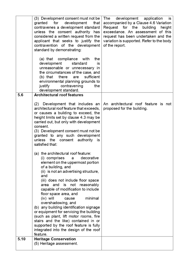
Conclusion:
Council officers are satisfied
that the applicant’s written request has adequately addressed the matters
required to be demonstrated by clause 4.6 subclause (3). Council is further
satisfied that the proposed development will be in the public interest because
it is consistent with the objectives of the particular standard and the
objectives for development within the zone in which the development is proposed
to be carried out.
It is the view of Council Officers
that the justification provided is satisfactory and having considered the
application on its merit, the exception to the maximum building height limit,
the development standard is considered acceptable in this instance.
The provisions of any proposed
instrument that is or has been the subject (EP&A Act s4.15 (1)(a)(ii))
(a) Draft
Cumberland Local Environmental Plan 2020
The Draft Cumberland Local
Environmental Plan 2020 (Draft CLEP) has been prepared by Cumberland Council to
provide a single planning framework for the future planning of Cumberland City.
The changes proposed seek to harmonise and repeal the three existing LEPs
currently applicable to the Cumberland local government area, those being:
· Holroyd Local
Environmental Plan 2013,
· Parramatta Local
Environmental Plan 2011, and
· Auburn Local
Environmental Plan 2010.
The current planning controls for
the subject site, as contained within the Auburn Local Environmental Plan 2010
are not proposed to change under the draft CLEP.
The provisions of any
Development Control Plans (EP&A Act s4.15 (1)(a)(iii))
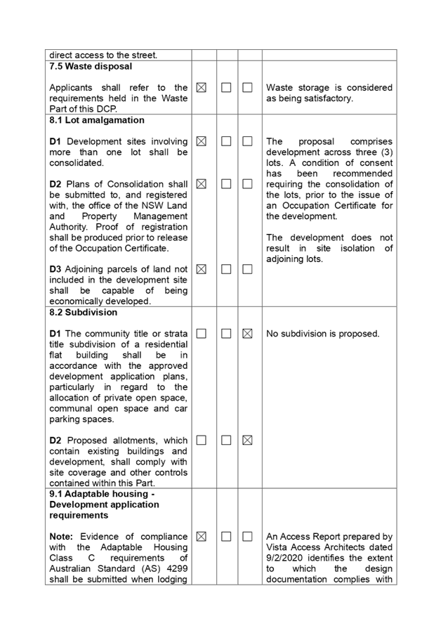
The Auburn Development Control
Plan 2010
The Auburn Development Control
Plan 2010 (Residential Flat Buildings) is relevant to the development
application. The development has been assessed using the Residential Flat
Buildings Chapter and the following variations are identified. A comprehensive
assessment is contained in Appendix D attached to the report.
|
Part
|
Control
|
Proposed
|
Complies
|
|
Part 2.2
|
Site coverage
D1 Built up area not
to exceed 50% of the total site area.
|
Site coverage at 91.2%. Site located in a B1 zone and
commercial on the ground.
|
No
|
|
Part 2.10
|
Dwelling Size
D1 Size of dwelling
determine the maximum number of bedrooms permitted.
1 Bedroom single aspect 63 sq. m.
2 Bedrooms 80 sq. m (Corner).
3 Bedrooms 115 sq. m.
|
53.6 to 59.4 sq. m.
75.3 sq. m to 77.4 sq. m.
99.3 sq. m.
(Apartment sizes comply with ADG).
|
No
No
No
|
|
Part 3.3
|
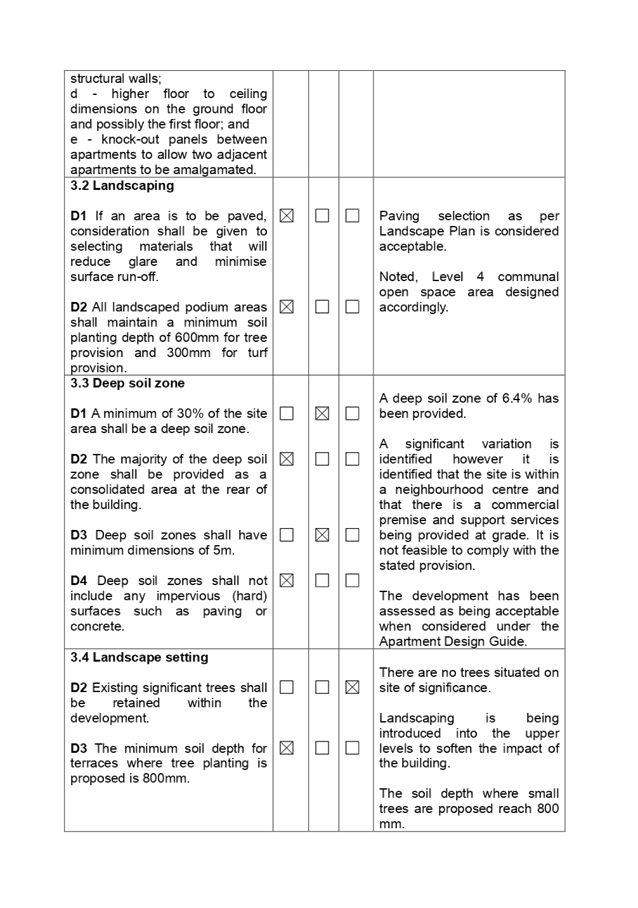
Deep soil zone
D1 A minimum of 30%
to be a deep soil zone.
|
Deep soil zone - 6.4%.
|
No
|
As indicated in the compliance table
above, the proposed development departs from Part 2.2 (Subpart D1), Part 2.10
(Subpart D1) and Part 3.3 (Subpart D1) relating to site coverage, dwelling size
and deep soil zone as specified above. The variations are considered to be
satisfactory for the following reasons: -
· The
Apartment Design Guide generally overrides Council's controls in relation to
the above mentioned variations.
· The
site is located within the B1 Neighbourhood Centre zone. The provisions stated
above address apartment buildings within the R4 High Density Residential zones
and do not address situations where commercial premises are incorporated into
such developments at ground level.
· The
development is providing satisfactory amenity for residents and the proposed
intensity of use is considered satisfactory for residents.
Irrespective of the variations, it
is considered that the proposal performs adequately from an environmental
planning viewpoint and may be supported. Furthermore, the development falls
under the following chapters of the Auburn Development Control Plan 2010.
· Local
Centres.
· Parking
and Loading.
· Stormwater
Drainage.
· Access
and Mobility.
· Waste.
The assessment demonstrates full
compliance with the stated development control plan chapters although further assessment
in relation to car parking numbers under the Parking and Loading Chapter of the
Auburn Development Control Plan is required.
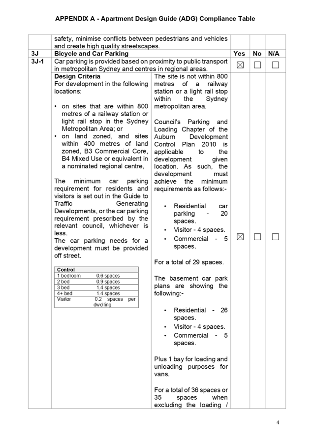
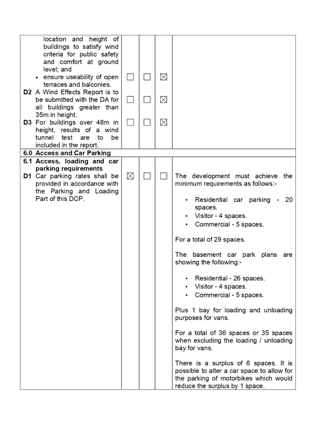
Parking and Loading Chapter
In relation to car parking, the
development is required to have the following car parking provisions.
· Residential
car parking - 20 spaces.
· Visitor
- 4 spaces.
· Commercial
- 5 spaces.
For a total of 29 spaces.
The basement car park plans are
showing the following: -
· Residential
- 26 spaces.
· Visitor
- 4 spaces.
· Commercial
- 5 spaces.
Plus 1 bay for loading and
unloading purposes for vans.
For a total of 35 spaces plus 1
loading / unloading bay for vans.
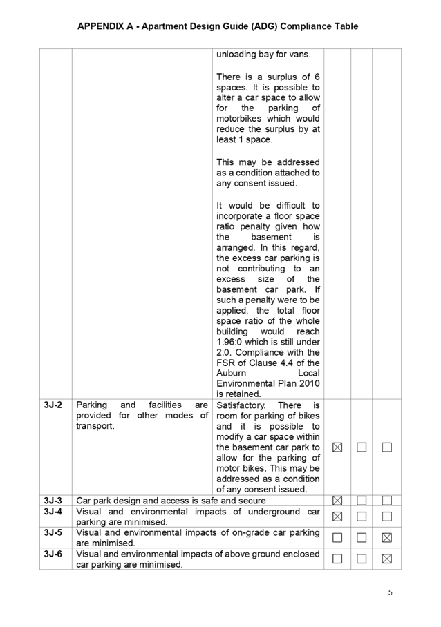
There is a surplus of 6 spaces and
it is possible to alter a car space to allow for the parking of motorbikes
which would reduce the surplus by 1 space to 5 spaces. This may be addressed as
a condition attached to any consent issued.
Further, there is a requirement to
incorporate a vehicle turning bay into the basement car park to allow vehicles
to be turned around and leave in forward motion. This is capable of being
achieved and will result in a final surplus of 4 car parking spaces within the
basement car park.
There is no objection to the
surplus of four car parking spaces as the excess is not contributing to an
excess size of the basement car park and there is no excess of bulk and scale
to the overall development. It is considered appropriate to allow for a surplus
of spaces given that the site is situated more than 1 km from the nearest
railway station being the Regents Park Railway Station. While there is a bus
stop within the vicinity of the site, residents will still be reliant on the
use of a motor car to access the town centres and associated services. It is
considered reasonable to support the development in this instance.
The provisions of any planning
agreement that has been entered into under section 7.4, or any draft planning
agreement that a developer has offered to enter into under section 7.4
(EP&A Act s4.15(1)(a)(iiia))
There is no draft planning
agreement associated with the subject Development Application.
The provisions of the
Regulations (EP&A Act s4.15 (1)(a)(iv))
The proposed development raises no
concerns as to the relevant matters arising from the Environmental Planning and
Assessment Regulations 2000 (EP&A Reg).
The Likely Environmental,
Social or Economic Impacts (EP&A Act s4.15 (1)(b))
It is considered that the proposed
development will have no significant adverse environmental, social or economic
impacts in the locality.
The suitability of the site for
the development (EP&A Act s4.15 (1)(c))
The subject site and locality are
not known to be affected by any natural hazards or other site constraints
likely to have a significant adverse impact on the proposed development
Accordingly, it is considered that the development is suitable in the context
of the site and surrounding locality.
Submissions made in accordance
with the Act or Regulation (EP&A Act s4.15 (1)(d))
Advertised
(newspaper) Mail
Sign Not Required
In accordance with Council’s
Notification requirements contained within the Auburn Development Control Plan
2010, the proposal was publicly notified for a period of fourteen (14) days
between Tuesday 17 March and Tuesday 31 March 2020. There were no submissions
or objections to the development that is sought.
The public interest (EP&A
Act s4.15(1)(e))
In view of the foregoing analysis
it is considered that the development, if carried out subject to the conditions
set out in the recommendation below, will have no significant adverse impacts
on the public interest.
Section 7.11 (Formerly S94)
Contribution Towards Provision or Improvement of Amenities or Services
This part of the Act relates to
the collection of monetary contributions from applicants for use in developing
key local infrastructure. The development requires the payment of contributions
in accordance with Section 7.11 of Cumberland Local Infrastructure Contribution
Plans. A figure of $286,397 is calculated for 3 x 1 bedroom apartments, 15 x 2
bedroom apartments and 1 x 3 bedroom apartment. The figure is subject to
indexation as per the relevant plan. The draft determination attached includes
a condition requiring payment of the contribution prior to issue of a
Construction Certificate.
Disclosure of Political
Donations and Gifts
The applicant and notification
process did not result in any disclosure of Political Donations and Gifts.
The development application has
been assessed in accordance with the relevant requirements of the Environmental
Planning and Assessment Act 1979 and the following planning instruments:
· State
Environmental Planning Policy 33 “Hazardous and Offensive
Development”.
· State
Environmental Planning Policy 55 "Remediation of Land".
· State
Environmental Planning Policy 64 "Advertising and Signage".
· Statement
Environmental Planning Policy No. 65 - Design Quality of Residential Apartment
Development (SEPP 65).
· State
Environmental Planning Policy "Infrastructure" 2007.
· State
Environmental Planning Policy (Vegetation in Non Rural Areas) 2017.
· State
Environmental Planning Policy (Building Sustainability Index: BASIX) 2004.
· Auburn
Local Environmental Plan 2010.
· Draft
Cumberland Local Environmental Plan 2020.
· Auburn
Development Control Plan 2010.
The proposed development is
appropriately located within the B1 Neighbourhood Centre zone under the
relevant provisions of the Auburn Local Environmental Plan 2010.
The proposal is consistent with
all statutory and non-statutory controls applying to the development. Minor
non-compliances with Council’s controls have been discussed in the body
of this report. The development is considered to perform adequately in terms of
its relationship to its surrounding built and natural environment, particularly
having regard to impacts on adjoining properties.
Having regard to the assessment of
the proposal from a merit perspective, Council may be satisfied that the
development has been responsibly designed and provides for acceptable levels of
amenity for future residents. It is considered that the proposal successfully
minimises adverse impacts on the amenity of neighbouring properties. Hence the
development, irrespective of the departures noted above, is consistent with the
intentions of Council’s planning controls and represents a form of
development contemplated by the relevant statutory and non-statutory controls
applying to the land.
For these reasons, it is
considered that the proposal is satisfactory having regard to the matters of
consideration under Section 4.15 of the Environmental Planning and Assessment
Act 1979, and the development may be approved subject to conditions.
|
That Development Application
2020/0080 for the demolition of existing structures, lot consolidation
and the construction of a four storey mixed use development, comprising of a
commercial premises on the ground floor, nineteen residential units and two
levels of basement car parking on land at 234-236 Cumberland Road Auburn be
approved subject to conditions as listed in the attached schedule.
|
1. Draft
Notice of Determination
2. Architectural
Plans
3. Elevations,
Sections and Shadow Diagrams
4. Landscape
Plan
5. Stormwater
/ Engineering Plans
6. 4.6
Variation Request
7. Appendix
A - ADG Compliance Table
8. Appendix
B - State Environmental Planning Policy 64 Table
9. Appendix
C - Auburn Local Environmental Plan 2010 Compliance Table
10. Appendix
D - Auburn Development Control Plan 2010
11. Appendix
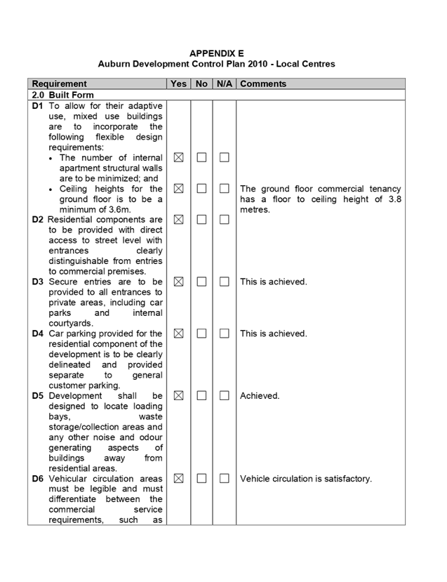
E - Auburn Development Control Plan 2010 - Local Centres
12. Refused
Plans for DA2017/282
DOCUMENTS
ASSOCIATED WITH
REPORT LPP049/20
Attachment 1
Draft Notice of Determination
Cumberland Local Planning Panel Meeting
14 October 2020

DOCUMENTS
ASSOCIATED WITH
REPORT LPP049/20
Attachment 2
Architectural Plans
Cumberland Local Planning Panel Meeting
14 October 2020

DOCUMENTS
ASSOCIATED WITH
REPORT LPP049/20
Attachment 3
Elevations, Sections and Shadow Diagrams
Cumberland Local Planning Panel Meeting
14 October 2020
DOCUMENTS
ASSOCIATED WITH
REPORT LPP049/20
Attachment 4
Landscape Plan
Cumberland Local Planning Panel Meeting
14 October 2020
DOCUMENTS
ASSOCIATED WITH
REPORT LPP049/20
Attachment 5
Stormwater / Engineering Plans
Cumberland Local Planning Panel Meeting
14 October 2020
DOCUMENTS
ASSOCIATED WITH
REPORT LPP049/20
Attachment 6
4.6 Variation Request
Cumberland Local Planning Panel Meeting
14 October 2020

DOCUMENTS
ASSOCIATED WITH
REPORT LPP049/20
Attachment 7
Appendix A - ADG Compliance Table
Cumberland Local Planning Panel Meeting
14 October 2020
DOCUMENTS
ASSOCIATED WITH
REPORT LPP049/20
Attachment 8
Appendix B - State Environmental Planning Policy 64
Table
Cumberland Local Planning Panel Meeting
14 October 2020
DOCUMENTS
ASSOCIATED WITH
REPORT LPP049/20
Attachment 9
Appendix C - Auburn Local Environmental Plan 2010
Compliance Table
Cumberland Local Planning Panel Meeting
14 October 2020

DOCUMENTS
ASSOCIATED WITH
REPORT LPP049/20
Attachment 10
Appendix D - Auburn Development Control Plan 2010
Cumberland Local Planning Panel Meeting
14 October 2020

DOCUMENTS
ASSOCIATED WITH
REPORT LPP049/20
Attachment 11
Appendix E - Auburn Development Control Plan 2010 -
Local Centres
Cumberland Local Planning Panel Meeting
14 October 2020
DOCUMENTS
ASSOCIATED WITH
REPORT LPP049/20
Attachment 12
Refused Plans for DA2017/282
Cumberland Local Planning Panel Meeting
14 October 2020
Cumberland
Local Planning Panel Meeting
14 October 2020
Item
No: LPP050/20
Development
Application for 78 Frances Street, Lidcombe
Responsible
Division: Environment
& Planning
Officer: Acting
Executive Manager Development and Building
File
Number: REV2020/0004
|
Application
lodged
|
12 June 2020
|
|
Applicant
|
MOMA Architects
|
|
Owner
|
3 Boys Holdings Pty Ltd
|
|
Application
No.
|
REV2020/0004
|
|
Description
of Land
|
78 Frances Street, LIDCOMBE
NSW 2141, Lot 1 DP 170277
|
|
Proposed
Development
|
Section 8.3 Review of the
Cumberland Local Planning Panel’s determination for the demolition of
existing structures and construction of a two storey boarding house
development comprising two separate buildings and a total of 25 boarding
rooms and 1 managers room, over basement car parking (State Environmental
Planning Policy (Affordable Rental Housing) 2009)
|
|
Site
Area
|
966.8m2
|
|
Zoning
|
R3 Medium Density Zone (ALEP
2010)
|
|
Disclosure
of political donations and gifts
|
Nil disclosure
|
|
Heritage
|
No
|
|
Principal
Development Standards
|
FSR
Permissible: 0.75:1
Proposed: 0.72:1
|
Height of Building
Permissible: 9m
Proposed: 8.23m
|
|
Issues
|
11 Submissions
|
1. Development
Application No. REV2020/0004 was received on 12 June 2020 for the Section 8.3
Review of the Cumberland Local Planning Panel’s determination for the
demolition of existing structures and construction of a two storey boarding
house development comprising two separate buildings and a total of 25 boarding
rooms and 1 managers room, over basement car parking (State Environmental
Planning Policy (Affordable Rental Housing) 2009).
2. The
application was publicly notified to occupants and owners of the adjoining
properties for a period of 14 days between 2 July 2020 and 16 July 2020. In
response, Council received a total of 11 unique submissions.
3. The
application is recommended for deferred commencement approval subject to the
conditions as provided in the attached schedule.
4. The
application is referred to the Panel as the proposal is considered to be a
contentious development.
Subject Site and Surrounding
Area
The subject site is legally
described as Lot 1 DP 170277 and is known as 78 Frances Street LIDCOMBE NSW
2141. The land is regular in shape with a frontage width of 15.24m and an
average depth of 63.49m, resulting in a total site area covering 966.8m2. The
site is located on the south eastern side of Frances Street. The site has a
moderate slope towards the rear with a fall of approximately 1.8m.
The site is currently occupied by
an existing single storey brick and fibro cottage with tile roof and associated
outbuilding including 2 detached carports and 2 detached metal sheds located on
the southern side of the site.
The character of the residential
development in the locality is undergoing transition from modest single storey
residential dwellings to larger two storey multi dwelling residential
developments. The existing developments adjoining the site include a multi
dwelling development directly to the south and a single storey dwelling house
directly to the north. Further north of the site is another multi dwelling
development at 84 Frances Street and several multi dwelling developments also
exist on the opposite side of Frances Street. The site is situated in an R3
zoning and adjoins an R2 zone boundary to the rear.
Figure
1 – Locality Plan of subject site
Figure
2 – Aerial view of subject site
Figure
3 – Street view of subject site

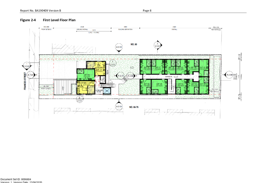
Description of the Proposed
Development
Council is in receipt of a
development application on 12 June 2020 seeking a review of the CLPP’s
determination of refusal for the demolition of existing structures and
construction of a two storey boarding house development comprising two separate
buildings containing 25 boarding rooms and 1 manager’s room, over
basement car parking. It should be noted that Council staff initially supported
the application by way of a deferred commencement approval.
Specific works of the proposed
development include:
· Demolish
existing single storey dwelling and ancillary structures including a detached
fibro shed and carports along the southern side boundary.
· Removal
of five (5) trees including Council’s street tree.
· Construct
a 2x2 storey boarding house development containing 26 boarding rooms
(comprising of 22 single rooms, 3 double rooms and 1 manager room)
accommodating a total of 29 lodgers. Each room is self-contained being equipped
with a kitchen, bathroom and laundry facility that is integrated into the
kitchen. The development also provides a communal room, a manager’s room
with separate courtyard attached and 3 boarding rooms which are nominated as
accessible rooms (G09, 110 and 117). A lift is also proposed to allow access
from the basement level to the ground & first floor levels.
· Construct
a basement level car park to accommodate 14 car spaces including 3 accessible
spaces with a turning bay, 6 motorcycle spaces, stairs for egress and a new
driveway via Frances Street.
· Site
drainage and landscaping works which include a communal open space area located
in the central courtyard with direct access from the communal room and
provision of 6 bicycle spaces.
The notable differences proposed
between the previous design and the current design are as follows:
a) Despite
there being no difference in the number of boarding rooms proposed, it is noted
that there is a slight decrease in the number of double rooms proposed from 7
to 3 and an increase in the number of single rooms proposed from 18 to 22 resulting
in an overall reduction in the maximum number of occupants/lodgers that can be
accommodated on site from 32 to 29.
b) Changes
to the architectural character of the building which now incorporates a pitched
roof form as opposed to a roof parapet design including changes to the
materials and finishes, additional fenestration and other façade design
features.
c) Increased
rear building setback from 4m to 10m
d) Removal
of the stair link resulting from the change in level to the landscaped central
communal open space area for level access.
e) Enlarge
the size of windows to the northern and southern side elevations with fixed
obscured glazing to lower pane of 1.6m above finished floor level.
History
On 13 May 2020, the Cumberland
Local Planning Panel resolved to refuse DA2019/286 for the construction of a
2x2 storey boarding house containing 26 rooms with basement level parking. The
reasons for the refusal were as follows:
a) The
Panel is not satisfied that the design of the development is compatible with the
character of the area, in particular:
i. the
elevations are institutional in character and inconsistent with the surrounding
residential developments
ii. the
bulk of the building is located to the rear of the site
iii. the
lack of architectural merit with the front façade of the building is
compounded by the dominant impact of the driveway
iv. the
materials and colours of the building materials
b) The
proposal has adverse shadowing impacts
c) The
amenity of the rooms is compromised by the desire to deal with privacy impacts
on adjoining properties.
On 12 June 2020, Council received
the subject s8.3 Review application seeking approval for the same development
(i.e. demolition of existing structures and construction of a two storey
boarding house development comprising two separate buildings and a total of 25
boarding rooms and 1 manager’s room, over basement car parking). The
proponent has sought to address the reasons for refusal by incorporating the
following design amendments:
a) Altering
the architectural character of the proposed building elevations to respond to
the residential nature, character and streetscape of the surrounding
developments in the area so as to demonstrate compatibility which includes a
new pitched roof form, changes to the materials and finishes that incorporates
of a neutral palate and an increase in the rear building setback of 10m from
the previous 4m.
b) Submission
of additional shadow study to demonstrate that the extent of shadow impact on
the private open space associated with townhouse units 6-11 is largely due to
the orientation of the site and therefore some level of overshadowing is
unavoidable. However, the shadow study also indicates that solar amenity into
the residential units on the northern side will not be lost as the morning sun
will still penetrate into the living areas of those townhouses affected.
Moreover, it is considered that the adjoining townhouse development would incur
similar overshadowing impacts to that of any two storey townhouse development,
if it were to be developed on the site instead.
c) Changes
to the fenestration details of the development to improve room amenity and
outlook with the provision of larger size windows containing fixed obscured
glazing to a minimum height of 1.6m. Appropriate conditions will be imposed to
reinforce this.
Applicants Supporting
Statement
The applicant has provided a
Statement of Environmental Effects prepared by MOMA Architects dated June 2020
and was received by Council on 12 June 2020 in support of the application.
Contact with Relevant
Parties
The assessing officer has
undertaken a site inspection of the subject site and surrounding properties and
has been in regular contact with the applicant throughout the assessment
process.
Internal Referrals
Development Engineer
The development application was
referred to Council’s Development Engineer for comment who has advised
that the development proposal is satisfactory and therefore can be supported
subject to recommended deferred commencement conditions of consent.
Environment and Health
The development application was
referred to Council’s Environment and Health Officer for comment who has
advised that the development proposal is satisfactory and therefore can be
supported subject to recommended conditions of consent.
Landscape/Tree Management
Officer
The development application was
referred to Council’s Landscape/Tree Management Officer for comment who
has advised that the development proposal is satisfactory and therefore can be
supported subject to recommended conditions of consent.
Waste Management
The development application was
referred to Council’s Waste Management Officer for comment who has
advised that the development proposal is satisfactory and therefore can be
supported subject to recommended conditions of consent.
External Referrals
NSW Police
The application was required to be
referred to NSW Police for comment. Council received formal correspondence on
6/07/2020 raising no objections to the proposed development subject to advisory
conditions being recommended to be imposed should consent be granted.
Planning Comments
The provisions of any
Environmental Planning Instruments (EP&A Act s4.15 (1)(a)(i))
The proposed development is
affected by the following Environmental Planning Instruments:
(a) State
Environmental Planning Policy No. 55 – Remediation of Land (SEPP 55)
Clause 7 of SEPP 55 requires
Council to be satisfied that the site is suitable or can be made suitable to
accommodate the proposed development. The matters listed within Clause 7 have
been considered in the assessment of the development application.
|
Matter for
Consideration
|
Yes/No
|
|
Does the application
involve re-development of the site or a change of land use?
|
Yes No
|
|
Does the application involve re-development of the site
or a change of land use?
|
Yes No
|
|
In the development
going to be used for a sensitive land use (e.g.: residential, educational,
recreational, childcare or hospital)?
|
Yes No
|
|
Does information
available to you indicate that an activity listed below has ever been
approved, or occurred at the site?
acid/alkali plant and formulation, agricultural/horticultural activities,
airports, asbestos production and disposal, chemicals manufacture and
formulation, defence works, drum re-conditioning works, dry cleaning
establishments, electrical manufacturing (transformers), electroplating and
heat treatment premises, engine works, explosive industry, gas works, iron
and steel works, landfill sites, metal treatment, mining and extractive
industries, oil production and storage, paint formulation and manufacture,
pesticide manufacture and formulation, power stations, railway yards, scrap
yards, service stations, sheep and cattle dips, smelting and refining,
tanning and associated trades, waste storage and treatment, wood preservation
|
Yes No
|
|
Is
the site listed on Council’s Contaminated Land database?
|
Yes No
|
|
Is
the site subject to EPA clean-up order or other EPA restrictions?
|
Yes No
|
|
Has
the site been the subject of known pollution incidents or illegal dumping?
|
Yes No
|
|
Does
the site adjoin any contaminated land/previously contaminated land?
|
Yes No
|
|
Has
the appropriate level of investigation been carried out in respect of
contamination matters for Council to be satisfied that the site is suitable
to accommodate the proposed development or can be made suitable to
accommodate the proposed development?
|
Yes No
|
|
Details of contamination investigations carried out at the
site:
A Preliminary Site Investigation
report prepared by Integral Environmental Solutions P/L, report no. 1403-19,
dated 5/09/19 has been submitted to accompany the application. The report did
not reveal any potential matters of concern with regard to contamination and
concludes that the site is suitable for its intended use. Further, the report
has been reviewed by Council’s EHU and the advice provided that the
proposal was satisfactory to proceed subject to recommended conditions to be
imposed on the consent.
|
(b) State
Environmental Planning Policy (Vegetation in Non-Rural Areas) 2017
The proposal does not exceed the
biodiversity offsets scheme threshold. Therefore, the proposed vegetation
removal is considered acceptable. Please refer to the DCP compliance table for
further discussion.
(c) State
Environmental Planning Policy (Building Sustainability Index: BASIX) 2004
BASIX Certificate 1036129M_02
dated issued on 12 June 2020 prepared by Outsource Ideas P/L has been submitted
with Council and is considered to be satisfactory.
(d) State
Environmental Planning Policy (Affordable Rental Housing) 2009
The relevant objectives and
provisions of the ARHSEPP 2009 has been considered in the assessment of the
application and the proposal is considered to be generally consistent with the
boarding house provisions under Division 3 of the plan. A comprehensive
assessment has been carried out and is provided in the compliance table below
including a detailed discussion in relation to the design of the development
being compatible with the local area is also considered.
|
Development Standards
|
Compliance with
Requirements
|
Consistency
Objectives
|
|
Division 3 – Boarding Houses
|
|
26 Land to which this division applies
This Division applies to land within any of the following
land use zones or within a land use zone that is equivalent to any of those
zones—
(a) Zone R1 General Residential,
(b) Zone R2 Low Density Residential,
(c) Zone R3 Medium Density Residential,
(d) Zone R4 High Density Residential,
(e) Zone B1 Neighbourhood Centre,
(f) Zone B2 Local Centre,
(g) Zone B4 Mixed Use.
|
Yes, the site is zoned
R3 Medium Density Residential as per the ALEP 2010. Development for the
purpose of a boarding house is permissible in accordance with this Plan
|
Yes
|
|
27 Development to which Division applies
(1) This Division applies to development, on land to which this
Division applies, for the purposes of boarding houses.
(2) Despite subclause (1), clauses 29, 30 and 30A do not apply
to development on land within Zone R2 Low Density Residential or within a
land use zone that is equivalent to that zone in the Sydney region unless the
land is within an accessible area.
(3) Despite subclause (1), clauses 29, 30 and 30A do not apply
to development on land within Zone R2 Low Density Residential or within a
land use zone that is equivalent to that zone that is not in the Sydney
region unless all or part of the development is within 400 metres walking
distance of land within Zone B2 Local Centre or Zone B4 Mixed Use or within a
land use zone that is equivalent to any of those zones.
|
Subclause 1 is noted.
Subclause 2 and 3 are
not relevant as the site is zoned R3.
|
Yes
|
|
28 Development may be carried out with consent
Development to which this
Division applies may be carried out with consent.
|
N/A. Consent is sought
for the development of a boarding house.
|
N/A
|
|
29 Standards that cannot be used to refuse consent
(1) A consent authority must not refuse consent to development
to which this Division applies on the grounds of density or scale if the
density and scale of the buildings when expressed as a floor space ratio are
not more than—
(a) the existing maximum floor space ratio for any form of
residential accommodation permitted on the land, or
(b) if the development is on land within a zone in which no
residential accommodation is permitted—the existing maximum floor space
ratio for any form of development permitted on the land, or
(c) if the development is on land within a zone in which
residential flat buildings are permitted and the land does not contain a
heritage item that is identified in an environmental planning instrument or
an interim heritage order or on the State Heritage Register—the
existing maximum floor space ratio for any form of residential accommodation
permitted on the land, plus—
(i) 0.5:1, if the existing maximum floor space ratio is
2.5:1 or less, or
(ii) 20% of the existing maximum floor space ratio, if the
existing maximum floor space ratio is greater than 2.5:1.
(2) A consent authority must not refuse consent to development
to which this Division applies on any of the following grounds—
(a) building height
if the building height of all proposed buildings is not
more than the maximum building height permitted under another environmental
planning instrument for any building on the land,
(b) landscaped area
if the landscape treatment of the front setback area is
compatible with the streetscape in which the building is located,
(c) solar access
where the development provides for one or more communal
living rooms, if at least one of those rooms receives a minimum of 3 hours
direct sunlight between 9am and 3pm in mid-winter,
(d) private open space
if at least the following private open space areas are
provided (other than the front setback area)—
(i) one area of at least 20 square metres with a
minimum dimension of 3 metres is provided for the use of the lodgers,
(ii) if accommodation is provided
on site for a boarding house manager—one area of at least 8 square
metres with a minimum dimension of 2.5 metres is provided adjacent to that
accommodation,
(e) parking
if—
(i) in the case of development
carried out by or on behalf of a social housing provider in an accessible
area—at least 0.2 parking spaces are provided for each boarding room,
and
(ii) in the case of development
carried out by or on behalf of a social housing provider not in an accessible
area—at least 0.4 parking spaces are provided for each boarding room,
and
(iia) in the case of development
not carried out by or on behalf of a social housing provider—at least
0.5 parking spaces are provided for each boarding room, and
(iii) in the case of any
development—not more than 1 parking space is provided for each person
employed in connection with the development and who is resident on site,
(f) accommodation size
if each boarding room has a gross floor area (excluding
any area used for the purposes of private kitchen or bathroom facilities) of
at least—
(i) 12 square metres in the case
of a boarding room intended to be used by a single lodger, or
(ii) 16 square metres in any
other case.
(3) A boarding house may have private
kitchen or bathroom facilities in each boarding room but is not required to
have those facilities in any boarding room.
(4) A consent authority may consent to
development to which this Division applies whether or not the development
complies with the standards set out in subclause (1) or (2).
(5) In this clause—
social
housing provider does not
include a registered community housing provider unless the registered
community housing provider is a registered entity within the meaning of
the Australian Charities and Not-for-profits Commission Act
2012 of the Commonwealth.
|
The maximum FSR
prescribed for the zone is 0.75:1 which is equivalent to 725.1m2.
The proposed GFA calculated for the buildings are 697.07m2 representing
an FSR of 0.72:1. This requirement has been achieved.
N/A
Maximum building height
across the site is limited to 9m as per ALEP 2010. Proposed development is
compliant with a maximum building height of 8.23m.
Proposed landscape area
within the front setback is consistent and compatible with the surrounding
developments and landscape setting.
The communal living
area is located at ground level with north facing windows for optimal
daylight and will receive the required 3 hours unimpeded sunlight between 9am
and 3pm in midwinter. The communal living room will also have direct access
via an east facing sliding door which opens directly to the outdoor common
open space area. The proposal achieves this requirement.
Communal open space is
provided in the central courtyard with minimum dimensions of 7m x 14m
measuring 98m2.
Separate private open
space area of 11.5m2 with minimum dimensions of 3.5m is provided
adjacent to the manager’s room.
Application not carried
out by or on behalf of a social housing provider in relation to (i) and (ii)
Complies.
0.5 x 25 rooms = 12.5
spaces.
1 manager room = 1
space.
Total required = 14
spaces (inclusive of disabled car spaces).
Number of parking space
proposed = 14.
Not more than 1 car
space will be allocated to the on-site manager.
All single rooms are a
minimum of 12m2 and double rooms are a minimum of 16m2.
All required services
are provided within the boarding room.
Noted.
N/A.
|
Yes
N/A
Yes
Yes
Yes
Yes
Yes
N/A
Yes
Yes
Yes
Yes
|
|
Standards for boarding houses
(1) A consent authority must not
consent to development to which this Division applies unless it is satisfied
of each of the following—
(a) if a boarding house has 5 or
more boarding rooms, at least one communal living room will be provided,
(b) no boarding room will have a
gross floor area (excluding any area used for the purposes of private kitchen
or bathroom facilities) of more than 25 square metres,
(c) no boarding room will be
occupied by more than 2 adult lodgers,
(d) adequate bathroom and kitchen
facilities will be available within the boarding house for the use of each
lodger,
(e) if the boarding house has
capacity to accommodate 20 or more lodgers, a boarding room or on site
dwelling will be provided for a boarding house manager,
(f) (Repealed)
(g) if the boarding house is on
land zoned primarily for commercial purposes, no part of the ground floor of
the boarding house that fronts a street will be used for residential purposes
unless another environmental planning instrument permits such a use,
(h) at least one parking space
will be provided for a bicycle, and one will be provided for a motorcycle,
for every 5 boarding rooms.
(2) Subclause (1) does not apply to
development for the purposes of minor alterations or additions to an existing
boarding house.
|
Yes. Communal living
room provided.
No boarding room
exceeds 25m2.
This can form part of a
condition of consent. All rooms are nominated as either single or double
rooms.
Yes. Each room is
equipped with a bathroom and kitchen facilities.
Yes. On site
manager’s boarding room is provided for the boarding house.
N/A. Land is not zoned
for commercial.
Yes. 26 boarding rooms
generate a minimum of 5.2 bicycle spaces and the same applies to motorbikes.
The development is compliant providing a total of 6 bicycle and 6 motorbike
spaces.
N/A. Proposal is for a
purpose-built boarding house.
|
Yes
|
|
30AA Boarding houses in Zone
R2 Low Density Residential
A consent authority must not
grant development consent to a boarding house on land within Zone R2 Low
Density Residential or within a land use zone that is equivalent to that zone
unless it is satisfied that the boarding house has no more than 12 boarding
rooms.
|
N/A. Site is zoned R3.
|
N/A
|
|
30A Character of local area
A
consent authority must not consent to development to which this Division
applies unless it has taken into consideration whether the design of the
development is compatible with the character of the local area.
|
Discussed in further detail below.
|
Yes
|
|
Part 4 Miscellaneous
|
|
52 No subdivision of boarding houses
A
consent authority must not grant consent to the strata subdivision or
community title subdivision of a boarding house.
|
Complies. No subdivision proposed as part of this
application. This will be reinforced as a condition on any consent issued.
|
Yes
|
Clause 30A Character of Local
Area
Division 3 of the SEPP contains
provisions and development standards that apply to the development for the
purpose of a boarding house. The development as proposed is considered to be
consistent with the relevant provisions and development standards of the
instrument at clause ‘30A Character of the local area’. This clause
specifies that ‘a consent authority must not consent to development to
which this Division applies unless it has taken into consideration whether the
design of the development is compatible with the character of the local
area’.
In order to determine the
compatibility of the proposal, an assessment of the character of the area and
application of the ‘character test’ for development derived from
the planning principle 11209 of 2005 Project Venture Development’s Pty
Ltd v Pittwater Council has been undertaken.
Step 1 – Identify the
local area:
The assessment identifies the
local area as primarily the visual catchment of the site (as viewed from within
the site and directly adjacent to the site on the street) which is shown in the
aerial view provided earlier in the report.
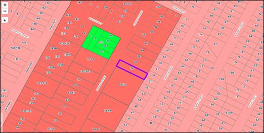
Zoning
Map of Locality
The site is located on the south
eastern side of Frances Street and is situated within an established medium
density residential area that is bounded by an R2 zoning interface. The
immediate locality is predominantly characterized by detached residential
dwellings interspersed with medium density housing and the existing building
form consists primarily of 1 and 2 storey single dwelling houses and multi
dwelling townhouses.
Step 2 – Determine the
character (future and present) of the local area
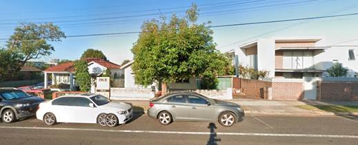
Subject
Site
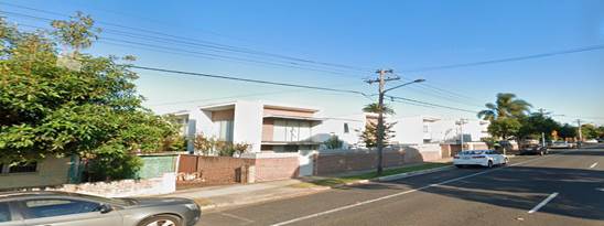
Adjoining
Development to the South
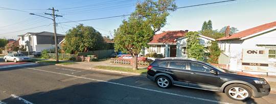
Adjoining
Development to the North
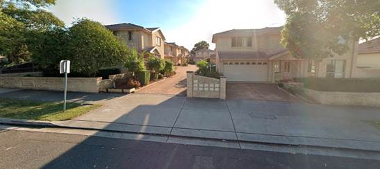
Development
located directly opposite subject site
The subject site is zoned R3
Medium Density Residential and is located on the southern side of Frances
Street between Edith Street to the north and Maud Street to the south. The
locality is characterised by a mix of residential land uses comprising of one
and two storey detached single dwellings and two storey multi dwelling
developments. The site is located approximately 800m to the south of the
Lidcombe town centre and public transport services.
Immediately adjacent to the south
side comprises of a two storey multi dwelling housing development and to the
north is a single storey dwelling. Further north of the site contains another
two storey multi dwelling development and several multi dwelling developments
also exists on the opposite side of Frances Street. The site also borders an R2
zone boundary to the rear which contain single storey dwellings.
The character of the residential
development in the immediate locality is undergoing transition from modest
single storey dwellings to larger two storey dwellings and multi dwelling
developments that is consistent with the R3 Medium Density Residential zone.
Step 3 – Determine if the
development is compatible with the character of the local area
In order to determine the
compatibility of the development with the established character of a local
area, the ‘character test’ derived from the Land and Environment
Court’s Planning Principle and case law – Project Venture
Development’s Pty Ltd v Pittwater Council can be applied. The character
test determines the compatibility of the development by asking whether the
physical impacts of the proposal on surrounding development is in harmony with
the buildings around it and the character of the area. These questions are
discussed in detail below.
Are the proposal’s
physical impacts on surrounding development acceptable?
The physical impacts include
constraints on the development potential of surrounding sites.
The physical impacts of the
proposal are assessed having regard to the impact of the development on the
amenity of surrounding properties. Amenity in this instance generally include
privacy, solar access, visual bulk and compatibility in the streetscape.
With regard to solar access, it is
noted that the development will shadow some of the adjoining townhouses
respective private open space immediately to the south (units 6-11). However,
the scale of the impact is considered reasonable based on the orientation of
the block (i.e. the townhouse development possesses a northern side boundary)
and therefore some level of overshadowing is unavoidable. Moreover, it is
considered that the adjoining townhouse development would incur similar
overshadowing impacts to that of any two storey townhouse development, if it
were to be developed on the site instead. Therefore, despite the overshadowing
of the private open spaces associated with townhouse units 6-11 (as they are
located along the northern boundary), it is noted that the north facing windows
of those townhouse units will still receive at least 2 hours solar access
between 9am and 11am as demonstrated in the shadow elevation plan provided. The
other remaining 12 townhouses within the complex (units 1-5 and 12-20) are
unaffected by the proposed development.
In terms of privacy, reasonable
building separation (through setbacks), side windows placements/sizes and
appropriate fencing is proposed to be provided to mitigate direct views and
overlooking. Further, privacy screening is also proposed to external stairs
adjacent to the lift so as to further minimise overlooking into adjoining
buildings.
The site shares a rear common
boundary to 57 and 59 Harry Avenue, zoned R2 which are currently occupied by
one storey detached dwellings. It is noted that the development provides a
greater setback of 10 metres from the rear boundary instead of the previous
complying setback of 4m to address the concerns raised by the panel. In this
regard, the visual bulk and scale of the development is considered to be
compatible and not dissimilar to other two storey residential developments
established in the area.
The northern neighbouring
properties at 80 and 82 Frances Street (detached single dwelling houses) are
located between the subject site and a multi dwelling housing complex at 84
Frances Street. The redevelopment of the site will not result in site isolation
of the northern neighbouring properties as the two properties can be
amalgamated and full development potential can still be achieved in the R3
Medium Density Residential zone.
Based on the above discussion, the
physical impact of the proposal on surrounding developments is considered
reasonable and therefore acceptable in this instance.
Step 4 - Is the
proposal’s appearance in harmony with the buildings around it and the
character of the street?
The main building types
established in the local area are one and two storey residential detached
single dwelling houses and multi dwelling developments. Given that the
predominant future character of the immediate area is to maintain the medium
density residential use in terms of use and building type, it is likely that
there will be upgrades to the residential housing stock via alterations and
additions, knock down rebuilds and new multi dwelling developments. As such,
the proposed two storey building form, materials and finishes are considered to
be consistent with the emerging development in the area and the proposal is
therefore considered to be compatible with the existing and future desired
character of the locality with minimal impacts on the neighbouring
developments.
(e) Sydney
Regional Environmental Plan (Sydney Harbour Catchment) 2005
The subject site is identified as
being located within the area affected by the Sydney Regional Environmental
Plan (Sydney Harbour Catchment) 2005. The proposed development raises no issues
as no impact on the catchment is envisaged.
(Note: - the subject site is not
identified in the relevant map as ‘land within the ‘Foreshores and
Waterways Area’ or ‘Wetland Protection zone’, is not a
‘Strategic Foreshore Site’ and does not contain any heritage items.
Hence the majority of the SREP is not directly relevant to the proposed
development).
(f) Auburn
Local Environmental Plan 2010
The provision of the ALEP 2010 is
applicable to the development proposal. It is noted that the development
achieves compliance with the key statutory requirements of the ALEP 2010 and
the objectives of the R3 Medium Residential Density Zone.
(i) Permissibility:-
The proposed development is
defined as a ‘boarding house’ and is permissible in the R3 Medium
Density Residential zone with consent.
A Boarding house means a building
that:
a) is
wholly or partly let in lodgings, and
b) provides
lodgers with a principal place of residence for 3 months or more, and
c) may
have shared facilities, such as a communal living room, bathroom, kitchen or
laundry, and
d) has
rooms, some or all of which may have private kitchen and bathroom facilities,
that accommodate one or more lodgers, but does not include backpackers’
accommodation, a group home, hotel or motel accommodation, seniors housing or a
serviced apartment.
i)
The relevant matters to be considered under ALEP 2010 and
the applicable clauses for the proposed development are summarised below.
Figure 4 –
Auburn Local Environmental Plan 2010 Compliance Table
|
Auburn Local Environmental
Plan 2010 (ALEP)
|
|
Is the development consistent
with the aims of the LEP?
|
Yes, the development remains
consistent with the aims of the LEP.
|
|
Is the development consistent
with the Zone objectives?
|
Yes, the development remains
consistent with the objectives of the zone.
|
|
Maximum height of building
– 9m
|
Complies – overall
building height is 8.23m measured to the highest point of the roof.
|
|
Floor space ratio (FSR) 0.75:1
|
GFA for the proposed buildings
are 697.07m2 representing an FSR of 0.72:1. Complies.
|
|
Heritage Conservation
|
N/A – the subject site
is not listed as an item or group of heritage significance or within a
conservation area listed as containing heritage item or group. The site is
not located in vicinity to any heritage items, groups or conservation area.
|
|
Acid Sulphate Soils
|
Yes – Class 5. (Nil
impact). The development is unlikely to lower the water table. A Geotechnical
report prepared by Grey Wacke Group P/L has also been submitted to accompany
the application and the findings of the report concluded that ‘groundwater
seepage was not encountered’ during testing.
|
|
Earthworks
|
Yes – earthworks
required to facilitate development will not result in any adverse impacts on
the existing drainage patterns and soil stability of the locality.
|
|
Flood Planning
|
No, the subject site is not
identified as being flood prone land.
|
The provisions of any proposed
instrument that is or has been the subject (EP&A Act s4.15 (1)(a)(ii))
(a) Draft
State Environmental Planning Policy (Environment)
The draft SEPP relates to the
protection and management of our natural environment with the aim of
simplifying the planning rules for a number of water catchments, waterways,
urban bushland, and Willandra Lakes World Heritage Property. The changes
proposed include consolidating the following seven existing SEPPs:
· State
Environmental Planning Policy No. 19 – Bushland in Urban Areas
· State
Environmental Planning Policy (Sydney Drinking Water Catchment) 2011
· State
Environmental Planning Policy No. 50 – Canal Estate Development
· Greater
Metropolitan Regional Environmental Plan No. 2 – Georges River Catchment
· Sydney
Regional Environmental Plan No. 20 – Hawkesbury-Nepean River (No.2-1997)
· Sydney
Regional Environmental Plan (Sydney Harbour Catchment) 2005
· Willandra
Lakes Regional Environmental Plan No. 1 – World Heritage Property.
The draft policy will repeal the
above existing SEPPs and certain provisions will be transferred directly to the
new SEPP, amended and transferred, or repealed due to overlaps with other areas
of the NSW planning system.
Changes are also proposed to the
Standard Instrument – Principal Local Environmental Plan. Some provisions
of the existing policies will be transferred to new Section 117 Local Planning
Directions where appropriate.
(b) Draft
Cumberland Local Environmental Plan 2020 (Draft CLEP)
The Draft Cumberland Local
Environmental Plan 2020 (Draft CLEP) has been prepared by Cumberland Council to
provide a single planning framework for the future planning of Cumberland City.
The changes proposed seek to harmonise and repeal the three existing LEPs
currently applicable to the Cumberland local government area, those being:
· Holroyd
Local Environmental Plan 2013,
· Parramatta
Local Environmental Plan 2011, and
· Auburn
Local Environmental Plan 2010.
The current planning controls for
the subject site, as contained within the ALEP 2010 are not proposed to change
under the Draft CLEP.
The provisions of any
Development Control Plans (EP&A Act s4.15 (1)(a)(iii))
Auburn Development Control Plan
2010
The Auburn DCP 2010 provides
guidance for the design and operation of developments to achieve the aims and
objectives of the ALEP 2010.
Whilst there are no specific
controls under the ADCP 2010 that are directly relevant to a boarding house
development, the following sections of the ADCP 2010 have been considered in
the assessment:
· Parking
and Loading
· Access
and Mobility
· Stormwater
Drainage
· Waste
· Multi
Dwellings
The proposal generally complies
with the requirements of the ADCP 2010, with the exception of the following
clauses of 2.1 and 2.8 of the Multi Dwellings section; relating to minimum
frontage width and setback requirements for below ground structures, which are
considered acceptable on merit as discussed in further detail below. Moreover,
it should be noted that the Multi Dwellings section whilst relevant, is of
limited application in so far as the development relates to a boarding house
and not a multi dwelling development and therefore is used only to assist in
guiding the development. The non-compliances noted are discussed below:
Multi dwellings:
2.1 – D1 Minimum frontage
width for Multi dwelling housing is 18m.
The proposal is for a
purpose-built boarding house development and as such is not considered to be
directly relevant to the type of land use proposed. The site has a minimum
frontage of 15.34m and the development is consistent with built form objectives
in relation to the form, scale and height and therefore responds appropriately
to the site characteristics and locality.
2.8 - D1 Below ground
structures shall comply with a side setback of 1.2m to provide for deep soil
planting and an adequate area for construction.
The development proposes a nil
boundary setback in the basement level. Despite the non-compliance noted, the
development still meets the objectives of this requirement for the purposes of
providing deep soil planting which has been proposed at the front and northern
portion of the site. A deep soil area of approximately 103sqm has been provided
on site and is considered adequate and complies with the minimum 10% deep soil
requirement.
The provisions of any planning
agreement that has been entered into under section 7.4, or any draft planning
agreement that a developer has offered to enter into under section 7.4
(EP&A Act s4.15(1)(a)(iiia))
There is no draft planning
agreement associated with the subject Development Application.
The provisions of the
Regulations (EP&A Act s4.15 (1)(a)(iv))
The proposed development raises no
concerns as to the relevant matters arising from the Environmental Planning and
Assessment Regulations 2000 (EP&A Rag).
The Likely Environmental,
Social or Economic Impacts (EP&A Act s4.15 (1)(b))
It is considered that the proposed
development will have no significant adverse environmental, social or economic
impacts in the locality.
The suitability of the site for
the development (EP&A Act s4.15 (1)(c))
The subject site and locality is
not known to be affected by any natural hazards or other site constraints
likely to have a significant adverse impact on the proposed development.
Accordingly, it is considered that the development is suitable in the context
of the site and surrounding locality.
Submissions made in accordance
with the Act or Regulation (EP&A Act s4.15 (1)(d))

In accordance with Council’s
Notification requirements contained within the Auburn DCP 2010, the proposal
was publicly notified for a period of 14 days between 2 July 2020 and 16 July
2020. The notification generated a total of eleven unique (11) submissions in
respect of the proposal with Nil disclosing a political donation or gift.
Previous objectors who made submissions against the original application were
also notified of the s8.3 Review application.
The issues raised in the public
submissions are summarised and commented on as follows:
Figure
5 – Submissions summary table
|
|
Concern
|
Comment
|
|
1
|
Concerns are raised with regard to the proposed
development being incompatible and out of character with the surrounding
developments as well as the impact of increased traffic generation, lack of
parking and overflow of street parking
|
The matter regarding the
developments compatibility with the local character has been discussed
throughout the report and is considered satisfactory. As evident in Frances
Street, several large multi dwelling developments have been established in
the mix of older one and two storey single detached dwelling houses. Given
that the predominant future character of the immediate area is to maintain
the medium density residential use, it is likely that there will be upgrades
to the residential housing stock via alterations and additions, knock down
rebuilds and new multi dwelling developments. As such, the proposed two
storey building form, materials and finishes are considered to be consistent
with the emerging development in the area. The development exhibits a
conservative building appearance from the street that is not dissimilar to
that of other development in the area. In this context, it is considered that
the proposal is compatible with the existing and future desired character of the
locality.
In relation to increased
traffic generation and lack of parking, overflowing to the street, the
proposal is considered satisfactory and provides adequate parking onsite in
accordance with the SEPP ARH 2009 parking requirements. The application has
also been accompanied by a Traffic Impact assessment report which has been
reviewed by Council’s Senior Development Engineer with regard to the
parking implications of the development and has raised no issues. On this
basis, the impact of the development on traffic and the availability of
on-street parking is not considered to be unreasonable in this instance.
|
|
2
|
Adverse overshadowing impacts and privacy concerns
|
The
proposal provides fixed opaque treatment to the lower pane up to 1.6m from
finished floor level to all the windows proposed on the side elevations,
privacy screens (louvres) to external stairways, reasonable building
separation (through setbacks) and appropriate fencing to avoid direct views
and overlooking. The development is therefore considered satisfactory with
regard to privacy.
With regard
to solar access, the development is limited to two storeys with a complying
building height of 8.23m. It is noted that the development will shadow the
adjoining townhouses respective private open space immediately to the south
(units 6-11). However, the scale of the impact is considered reasonable based
on the orientation of the block (i.e. the townhouse development possesses a
northern side boundary) and therefore some level of overshadowing is unavoidable.
Moreover, it is considered that the adjoining townhouse development would
incur similar overshadowing impacts to that of any two storey townhouse
development, if it were to be developed on the site instead. Therefore,
despite the overshadowing of the private open space associated with townhouse
units 6-11 (i.e. located along the northern boundary), it is noted however
that the north facing windows of those townhouse units will still receive at
least 2 hours solar access between 9am and 11am as demonstrated in the shadow
elevation plan provided.
|
|
3
|
Devalue properties in the area adversely impacting the
financial positions of current of residences
|
Depreciation in property values is not considered to be a
matter for consideration under section 4.15 of the EP&A Act.
|
|
4
|
Security concerns relating to nature of individuals living
in the boarding house posing a threat to unaccompanied children making their
way to schools and parks.
|
A boarding house is permissible in the R3 zone and there
are no restrictions in regard to boarding houses and its proximity to schools
and parks. The boarding house will be managed by an in-house manager who
shall implement the Plan of Management (House rules) endorsed by Council.
Furthermore, the development application was referred to the NSW Police Crime
Prevention Officer for comment who raised no issues with the proposal and
have provided conditions which will be included in the consent notice.
|
|
5
|
Unacceptable side and rear setbacks that do not meet the
requirements of NSW housing code.
|
The development proposal relates to a purpose-built
boarding house and the setbacks proposed to be provided are considered to be
satisfactory. The development has been assessed against the relevant
provisions under the SEPP ARH 2009 and the proposal complies in full.
|
|
6
|
Location of boarding house makes no sense as there are no
Universities or Tafe facilities in the area, nor is it close to the train
station.
|
A boarding house is permissible in the R3 zone under the
SEPP ARH 2009. There are no requirements for boarding houses in areas zoned
R3 to be in proximity to any educational establishments or public transport.
|
|
7
|
There is no guarantee what type of people will live in the
boarding house, what they will do and the potential for paedophiles is a
concern to many parents and elderly.
|
As previously addressed in the comments of issue 4.
Further, there is no evidence to suggest that the potential for such criminal
activity is only associated with tenants that reside in boarding houses.
|
|
8
|
Increase waste generation and concerns regarding storage
and collection of waste bins
|
The application has been assessed by Council’s Waste
Management Team and the advice provided indicated that the method of waste
disposal is satisfactory. The boarding house includes an enclosed waste
storage area which will house all the required bins.
|
|
9
|
Too many multiple dwellings on Frances Street and most of
these dwellings do not provide enough garages/parking which results in
overflow of street parking.
|
The site and the surrounding properties are zoned R3
medium density which permits multi dwellings as well as other forms of low to
medium density residential developments in the area, including boarding
houses. In relation to parking, the matter has been previously addressed
above in the comments provided under issue 1.
|
|
10
|
Concern is raised with regard to the proposed basement
wall being so close to the boundary which does not comply with the setback
requirement of 1.2m as per Council’s controls.
|
Standard conditions for underpinning works and a
dilapidation report will be imposed to ensure that basement excavation will
not negatively impact on the structural integrity of the immediate adjoining
developments.
The requirement of a 1.2m setback for basement relates to
a multi dwelling development and is not directly applicable to the proposal
for a boarding house development. Despite the non-compliance noted, the
development is still considered to meet the objectives of the setback
requirement for the purposes of providing deep soil planting where an area of
approximately 103sqm has been provided and complies with the minimum 10% deep
soil requirement.
|
|
11
|
Noise concerns associated with the boarding house
|
An acoustic report has been submitted to accompany the
proposal for a boarding house. The acoustic report has been reviewed by
Council’s Environment and Health Unit and the advice provided raised no
objections to the proposed development subject to conditions including
compliance with the acoustic report. It is noted that the acoustic report
recommends the use of outdoor communal area cease use after 10:00 pm on a
daily basis. Further, the Plan of Management which includes ‘House
rules’ details restrictions on the use of the communal area and outdoor
open space requiring prior approval from the boarding house manager for
social gatherings. Communal areas will be further passively controlled by
signage and actively managed by the manager of the boarding house who will
monitor and ensure that residents are made aware of the house rules and
behave in a reasonable and considerate manner. The proposal is therefore
considered to be satisfactory.
|
The public interest (EP&A
Act s4.15(1)(e))
In view of the foregoing analysis
it is considered that the development, if carried out subject to the conditions
set out in the recommendation below, will have no significant adverse impacts
on the public interest.
Section 7.11 (Formerly S94)
Contribution Towards Provision or Improvement of Amenities or Services
This part of the Act relates to
the collection of monetary contributions from applicants for use in developing
key local infrastructure.
Comments:
The development requires the
payment of contributions in accordance with Council’s Section 94
Contributions Plans (Auburn Development Contributions Plan 2007).
The calculation is based on:
· 26 x 1 bedroom,
less credit for 3 bedroom = $75,643.15.
As at 14/09/2020, the fee payable
is $75,643.15. This figure is subject to indexation as per the relevant plan.
The draft determination attached includes a condition requiring payment of the
contribution prior to issue of a Construction Certificate.
Disclosure of Political
Donations and Gifts
The applicant and notification
process did not result in any disclosure of Political Donations and Gifts.
The development application has
been assessed in accordance with the relevant requirements of the Environmental
Planning and Assessment Act 1979, State Environmental Planning Policy
(Affordable Rental Housing) 2009, Auburn LEP and Auburn DCP and is considered
to be satisfactory for deferred commencement approval subject to conditions.
The proposed development is
appropriately located within the R3 Medium Density Zone under the relevant
provisions of the Auburn LEP 2010. The proposal is generally consistent with
all statutory and non-statutory controls applying to the development. The
development is considered to perform adequately in terms of its relationship to
its surrounding built and natural environment, particularly having regard to
impacts on adjoining properties.
For these reasons, it is
considered that the proposal is satisfactory having regard to the matters of
consideration under Section 4.15 of the Environmental Planning and Assessment
Act 1979, and the development may be approved subject to deferred commencement
conditions.
|
1. That
Development Application No. REV2020/0004 for Section 8.3 Review of the
Cumberland Local Planning Panel’s determination for the demolition of
existing structures and construction of a two storey boarding house
development comprising two separate buildings and a total of 25 boarding
rooms and 1 managers room, over basement car parking (State Environmental
Planning Policy (Affordable Rental Housing) 2009) on land at 78 Frances
Street LIDCOMBE NSW 2141 be approved as deferred commencement
consent subject to conditions listed in the attached schedule.
2. Persons
whom have lodged a submission in respect to the application be notified of
the determination of the application.
|
1. Draft Notice
of Determination
2. Architectural
Plans including Shadow Plans and Evacuation Plan
3. Submissions
Received
4. Plan
of Management
5. Landscape
Plans
6. Stormwater
Plans
7. Acoustic
Report
8. Survey
Plan
9. (Refused)
Architectural Plans for Reference
DOCUMENTS
ASSOCIATED WITH
REPORT LPP050/20
Attachment 1
Draft Notice of Determination
Cumberland Local Planning Panel Meeting
14 October 2020
DOCUMENTS
ASSOCIATED WITH
REPORT LPP050/20
Attachment 2
Architectural Plans including Shadow Plans and
Evacuation Plan
Cumberland Local Planning Panel Meeting
14 October 2020
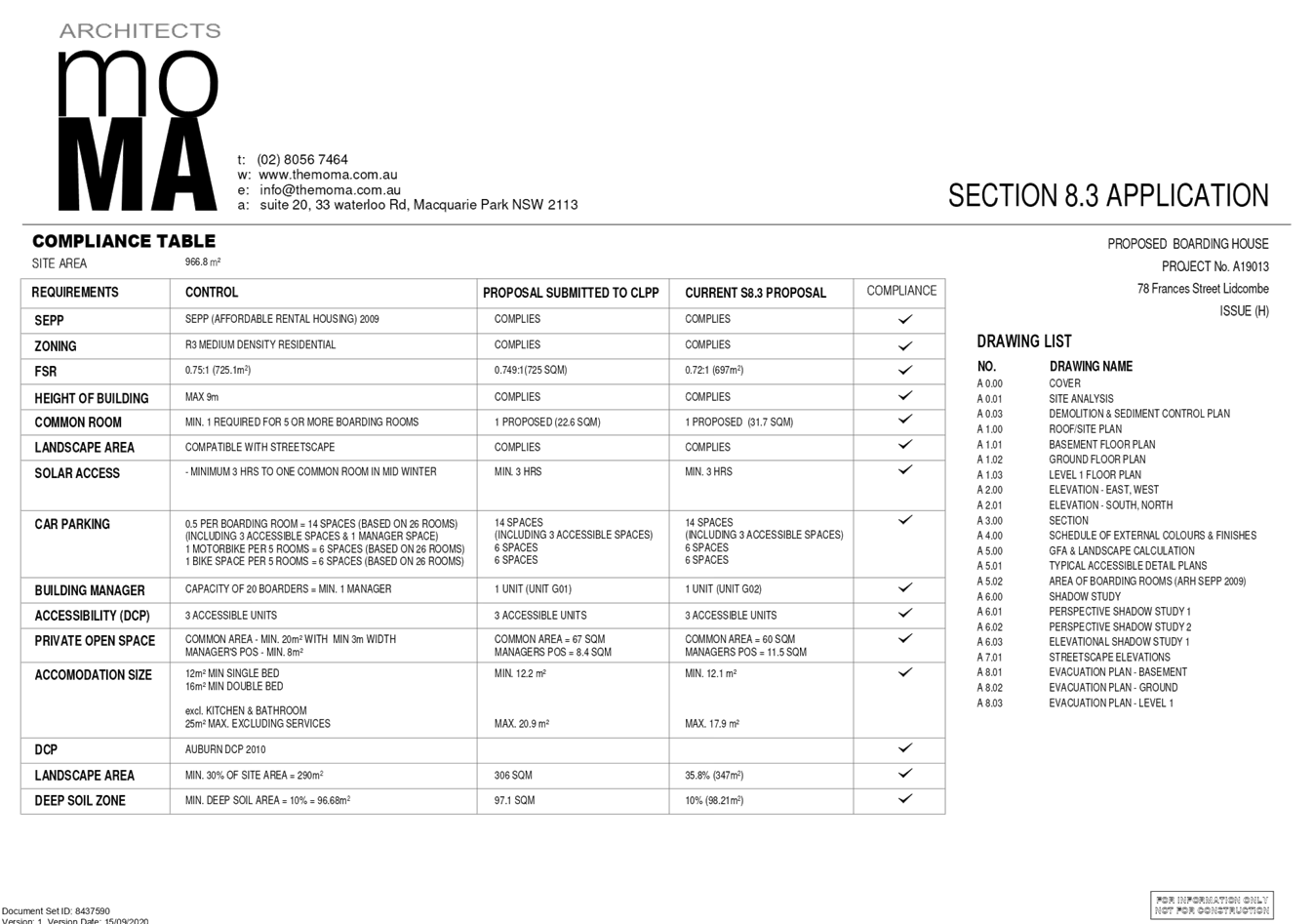
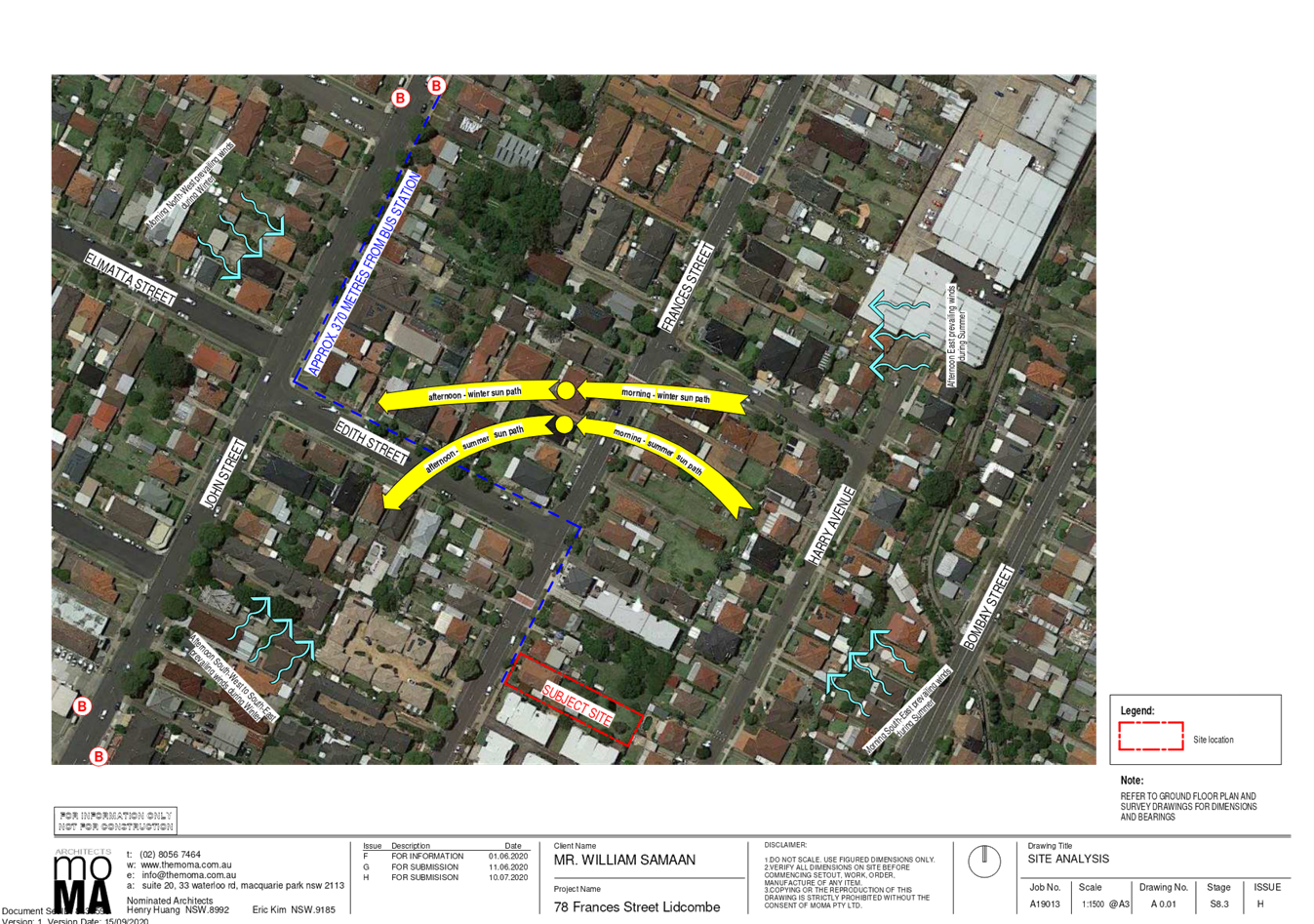
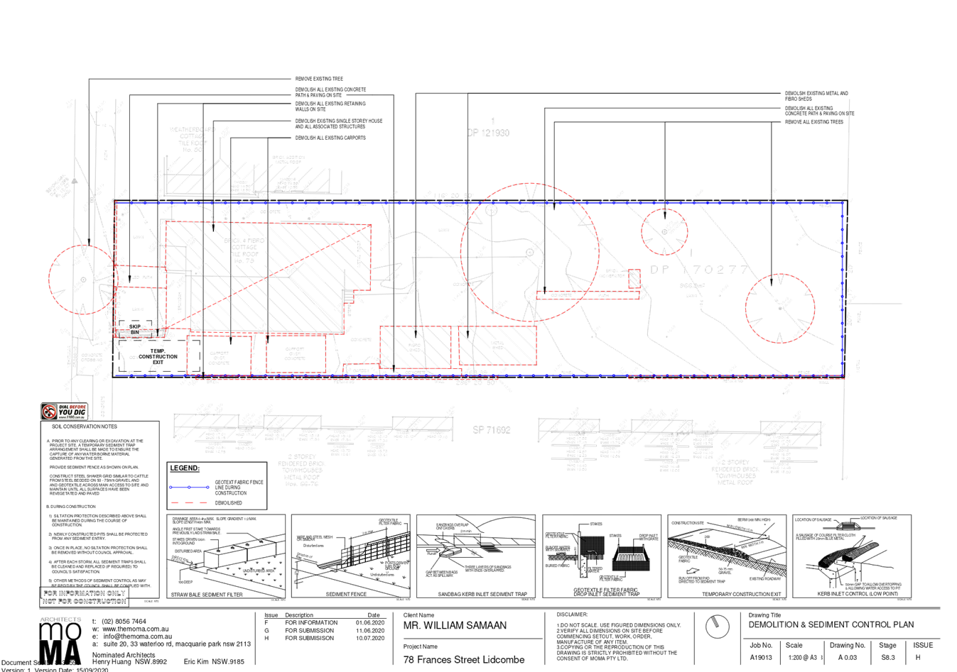
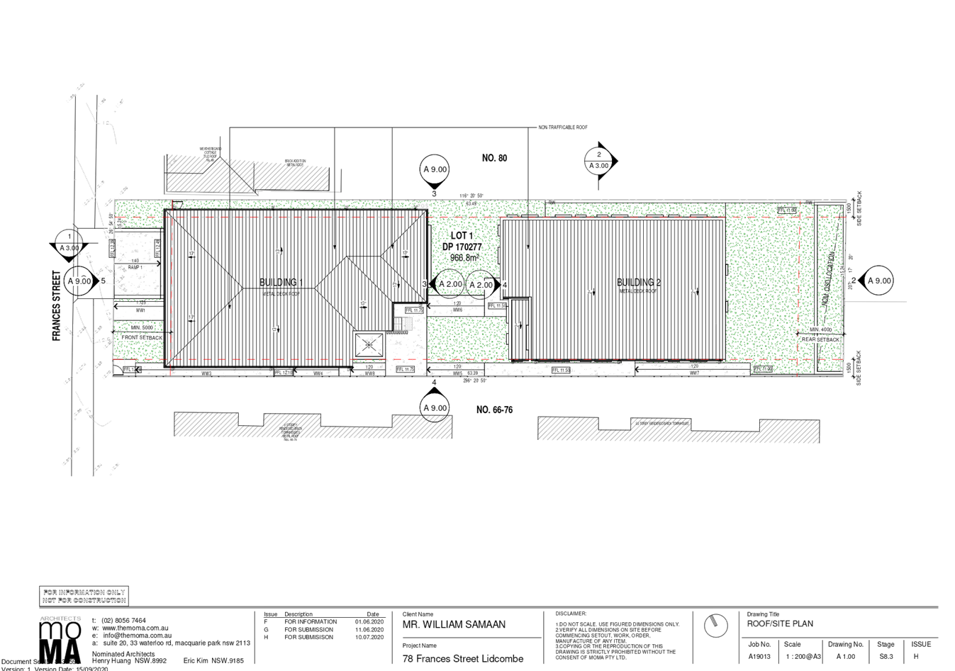
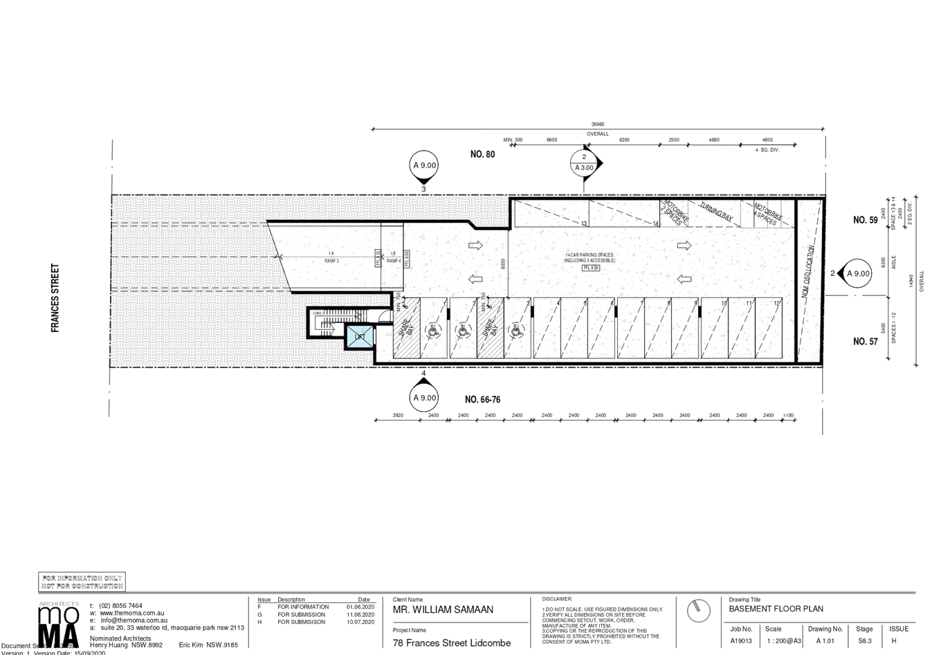
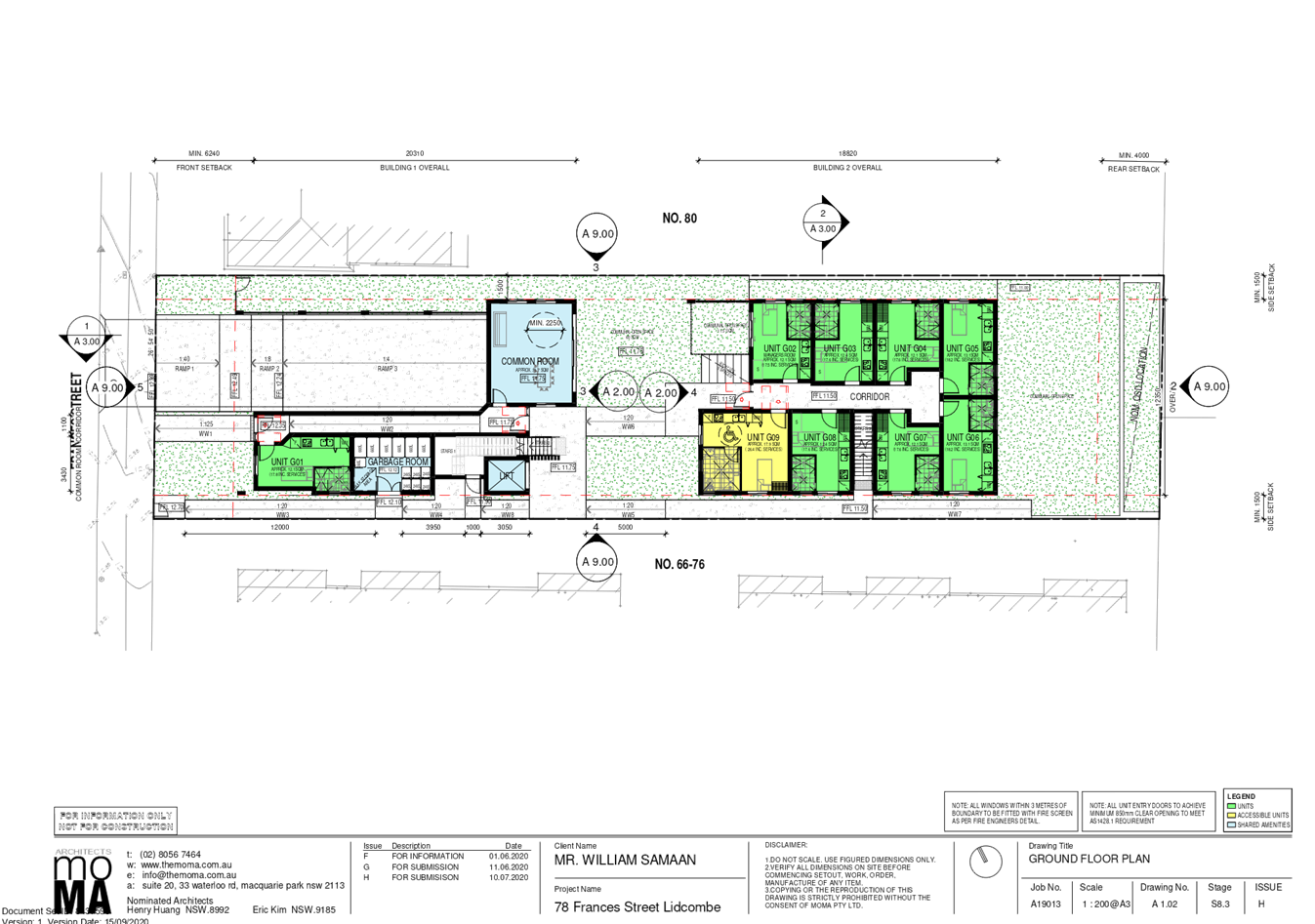
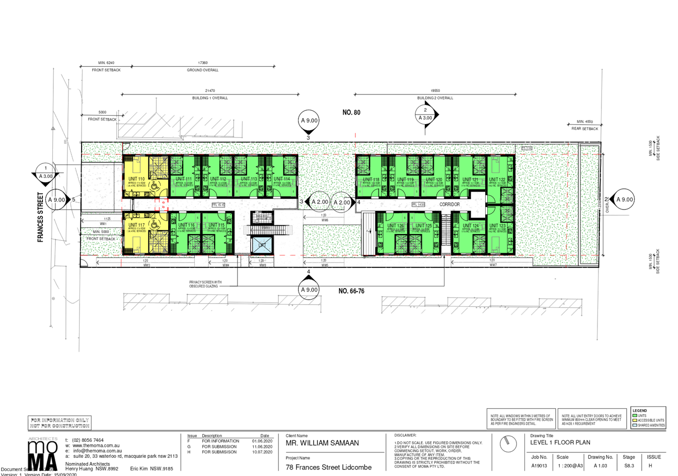
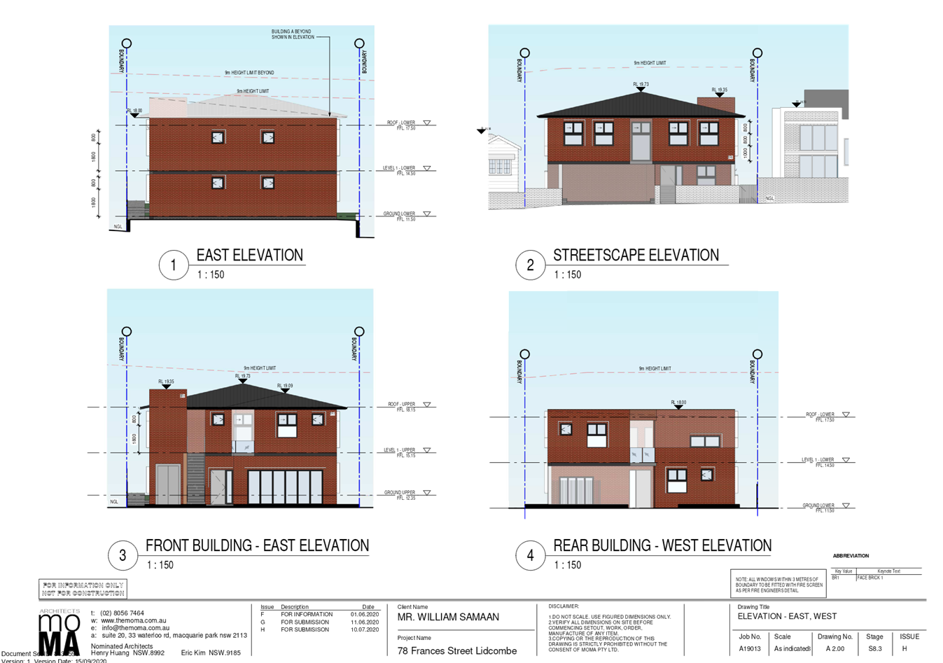
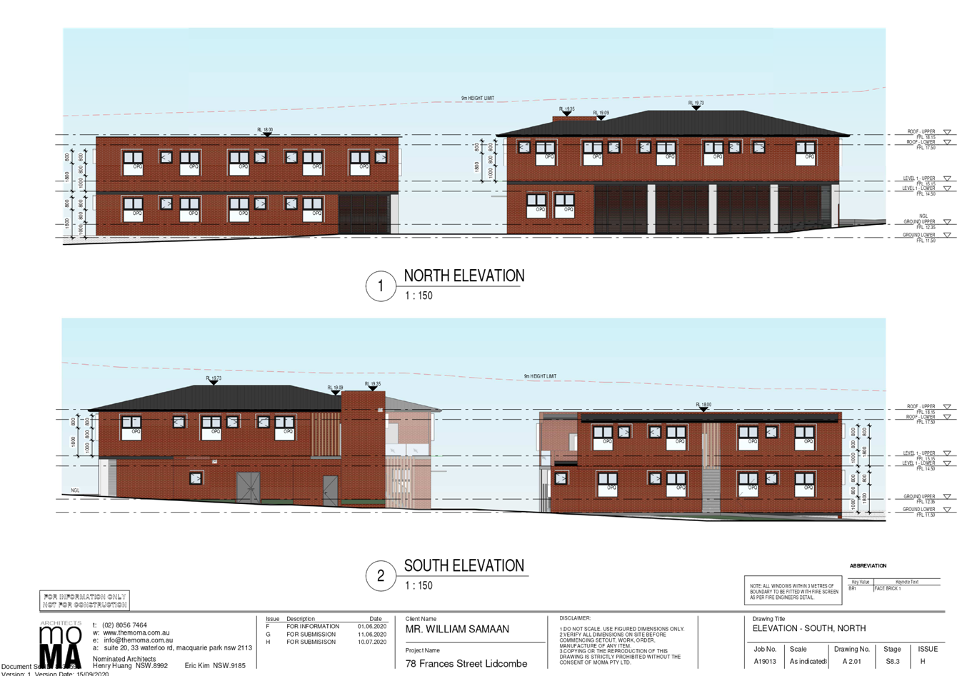
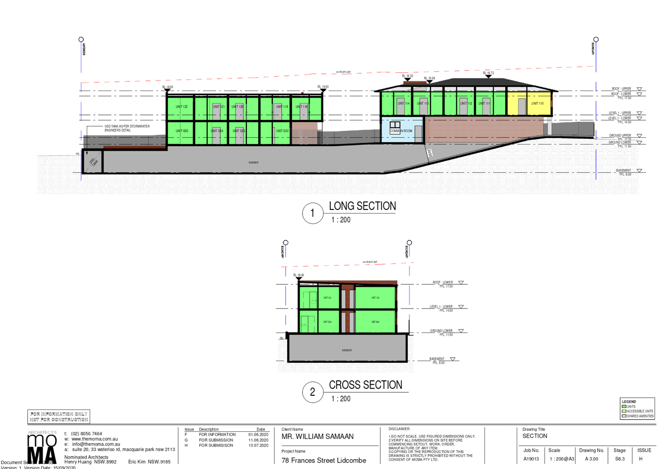
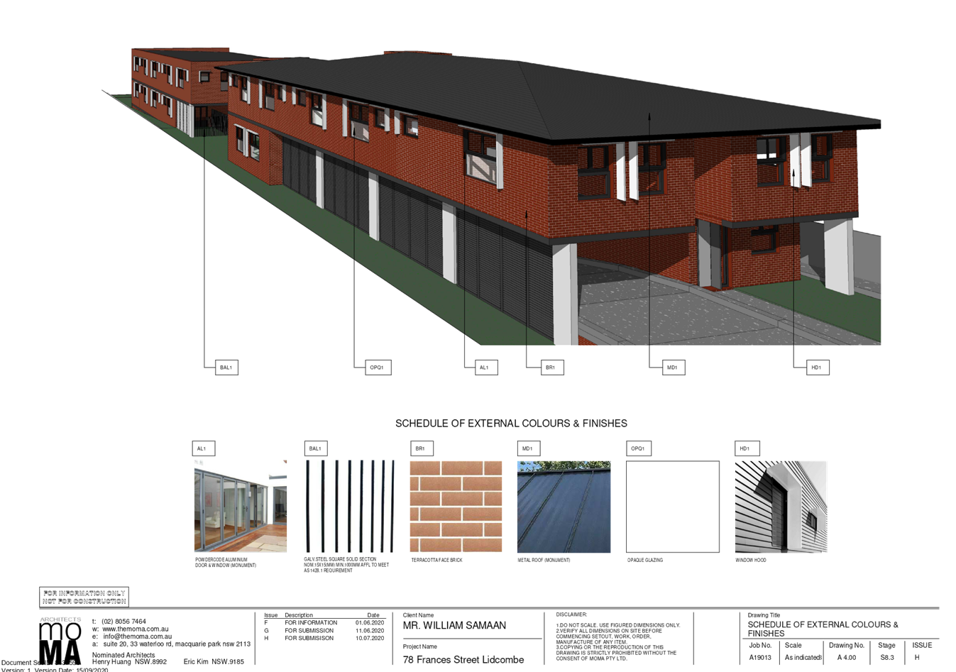
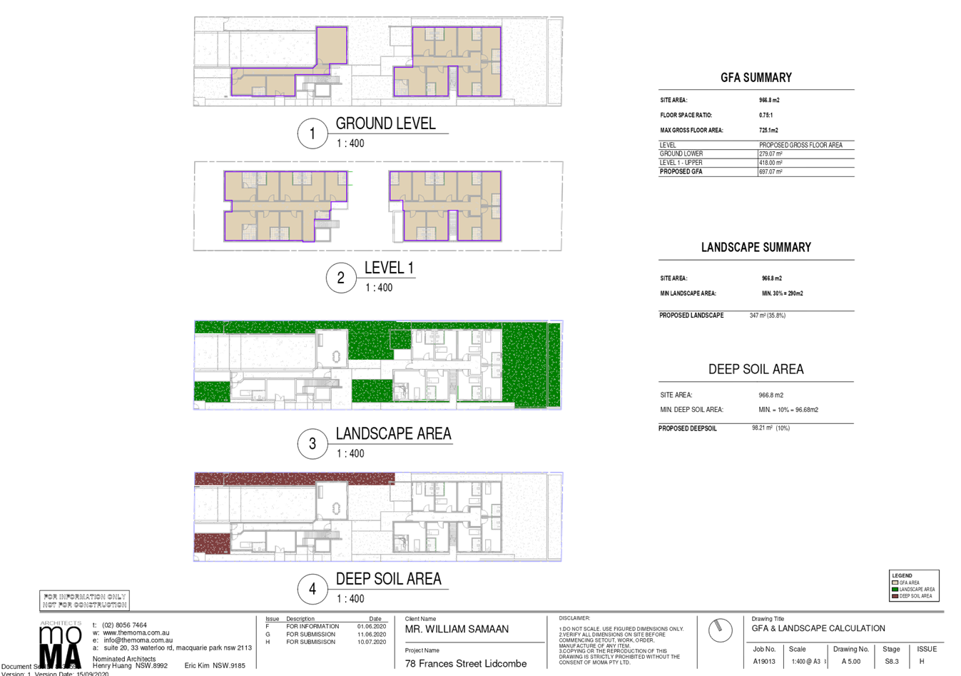
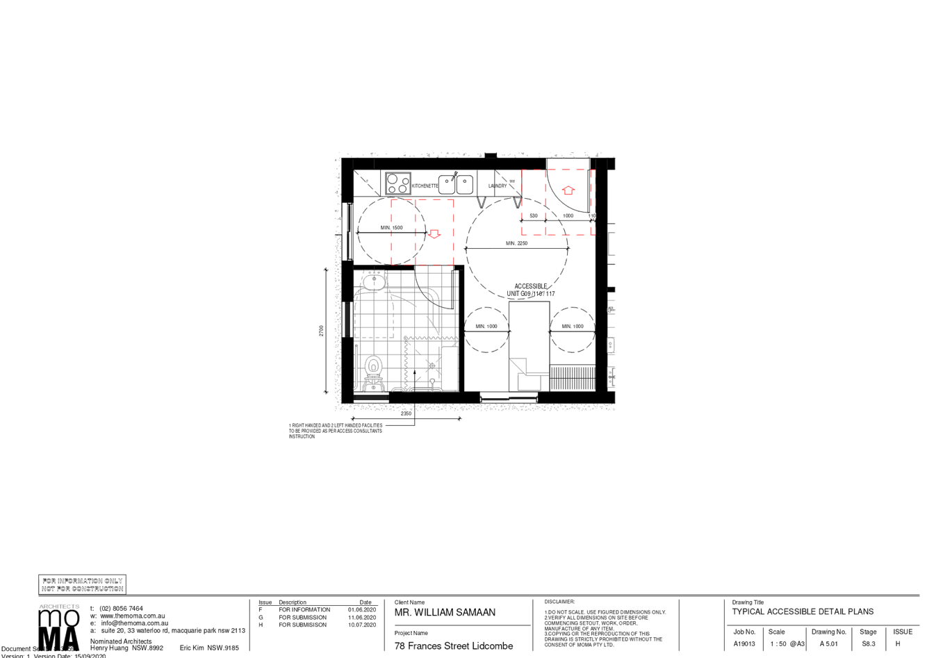
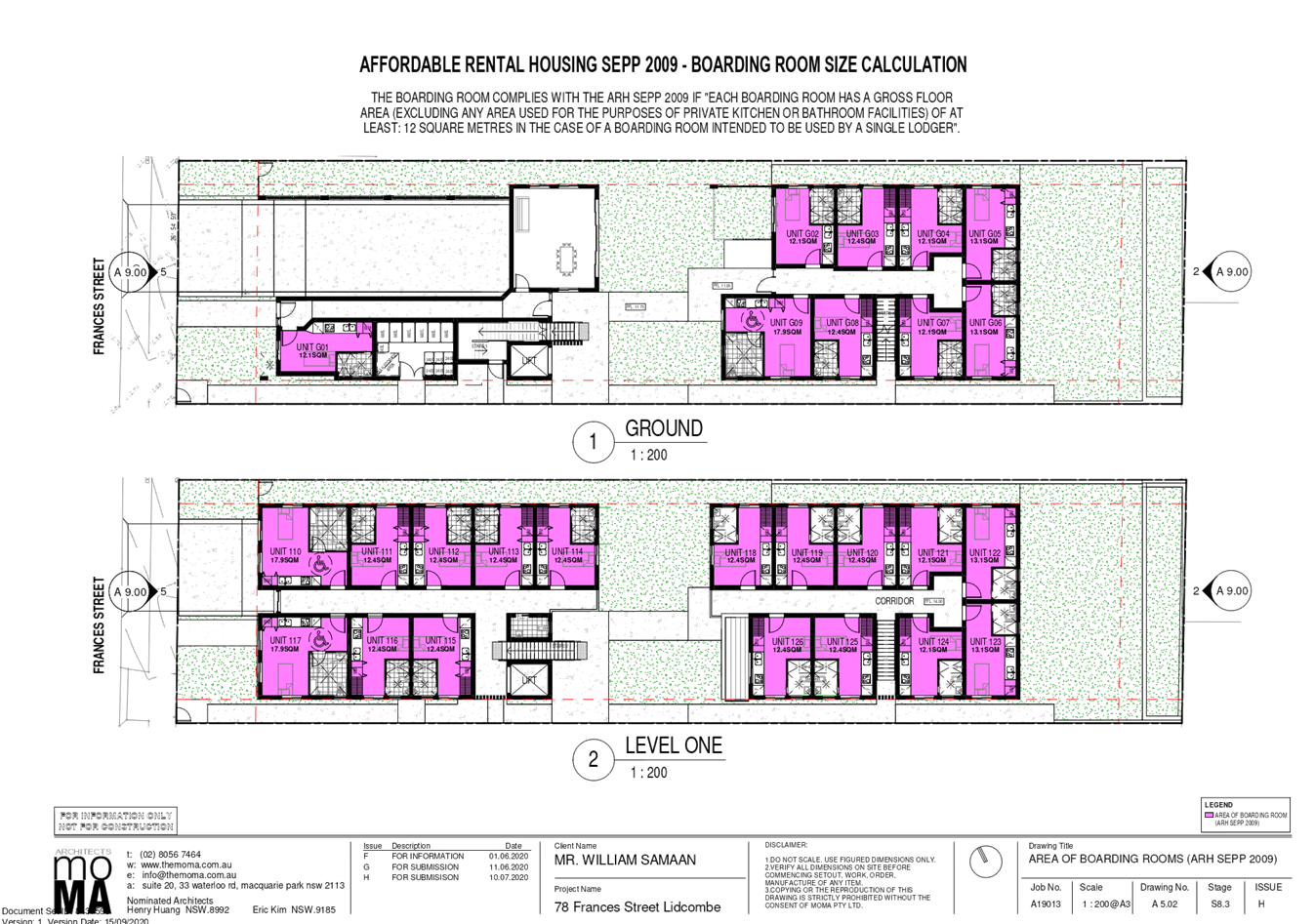

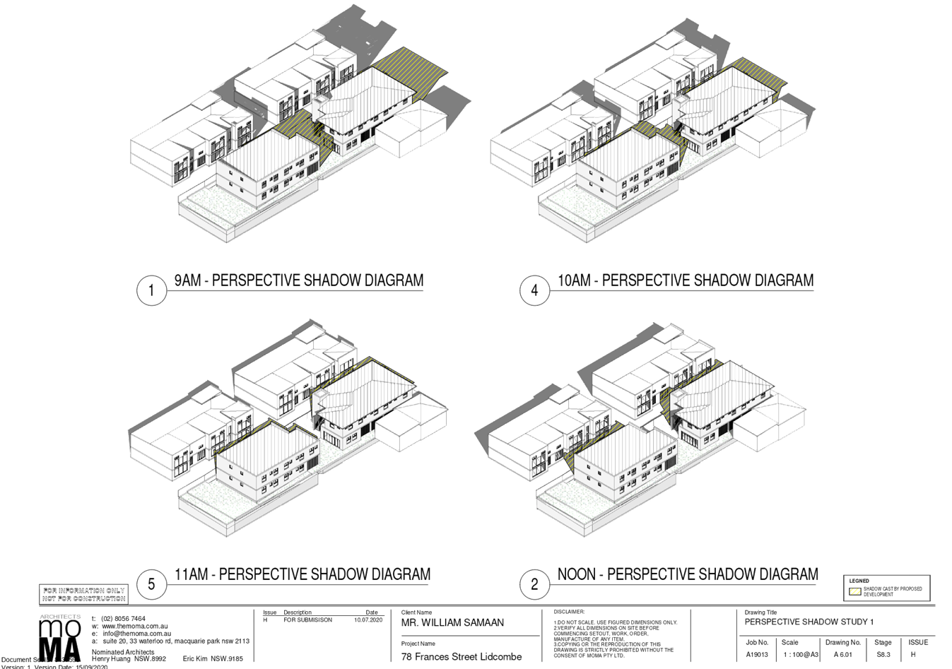
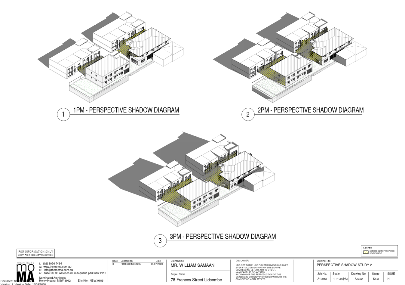
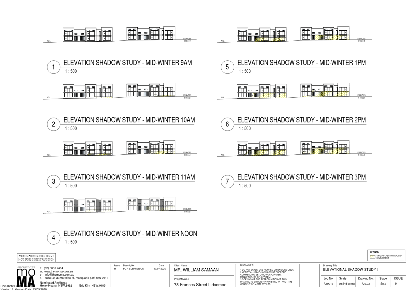
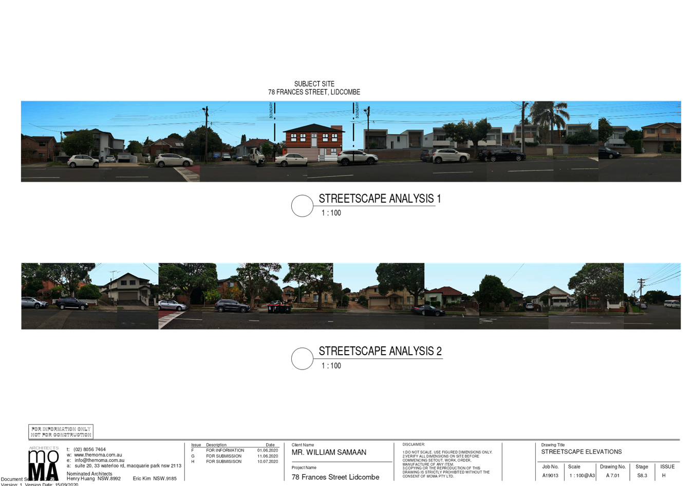
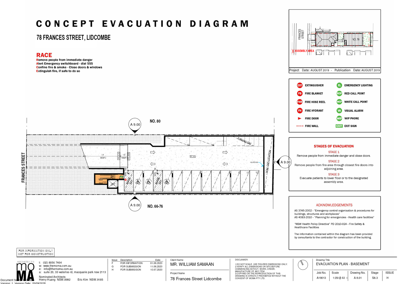
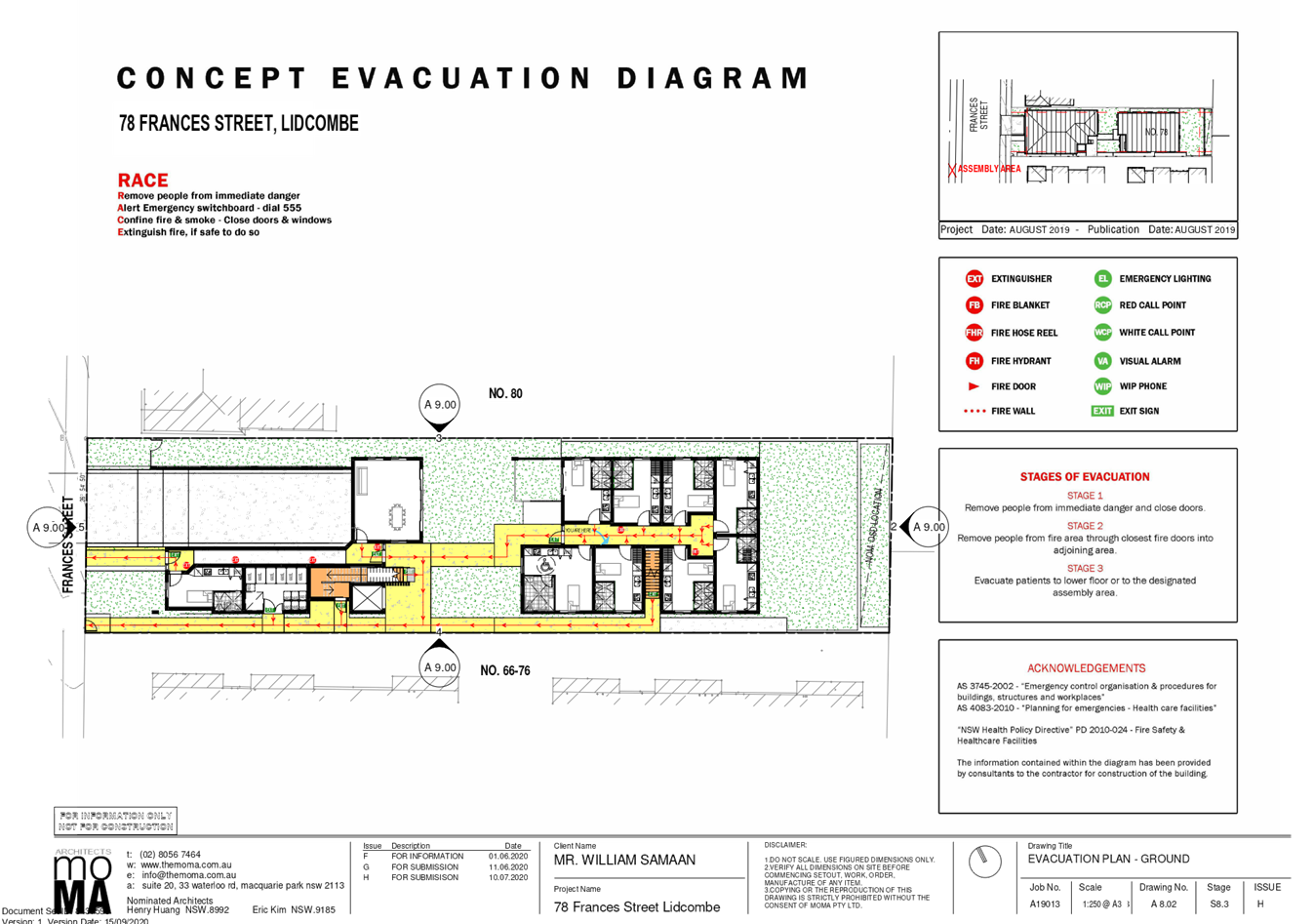
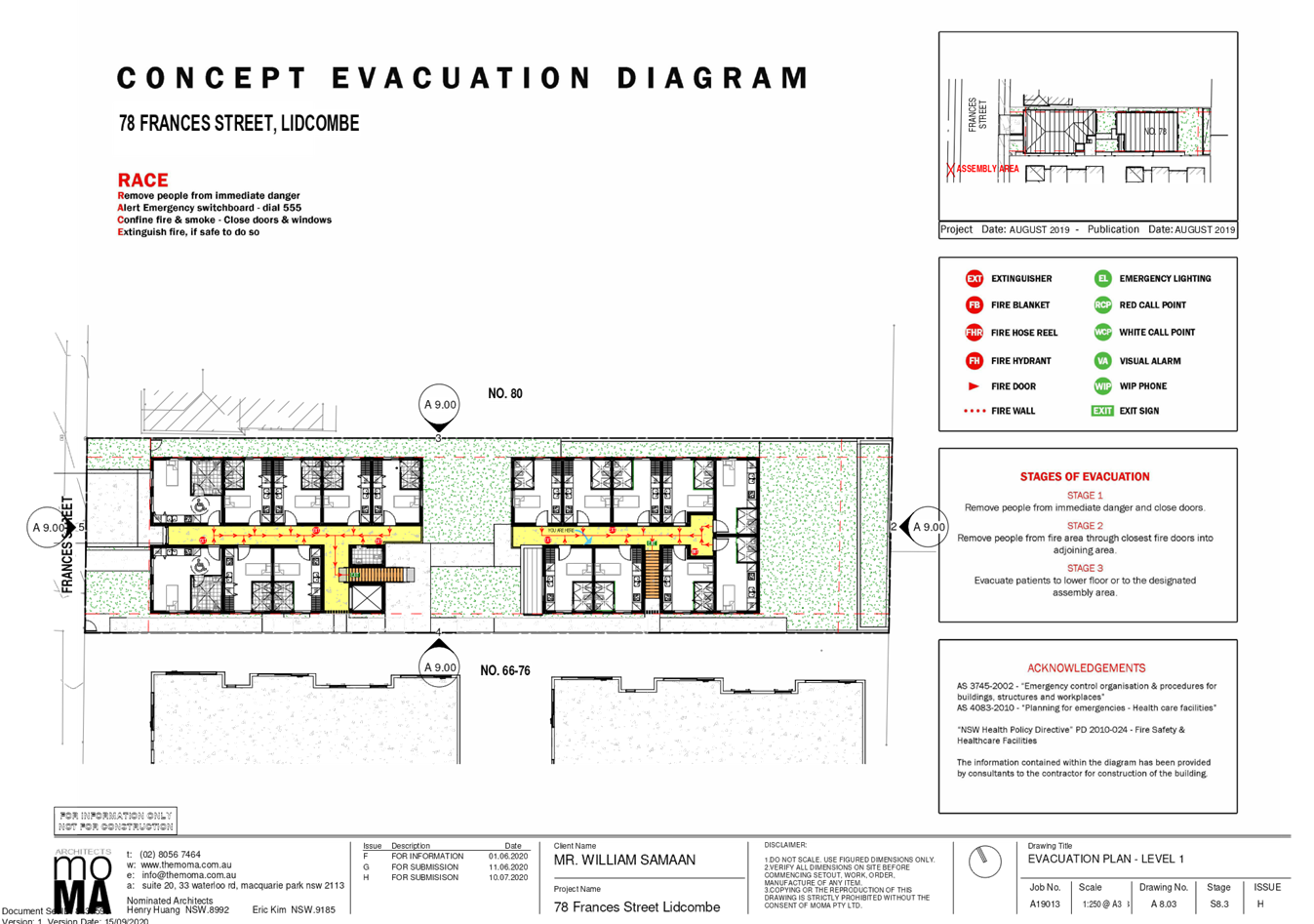
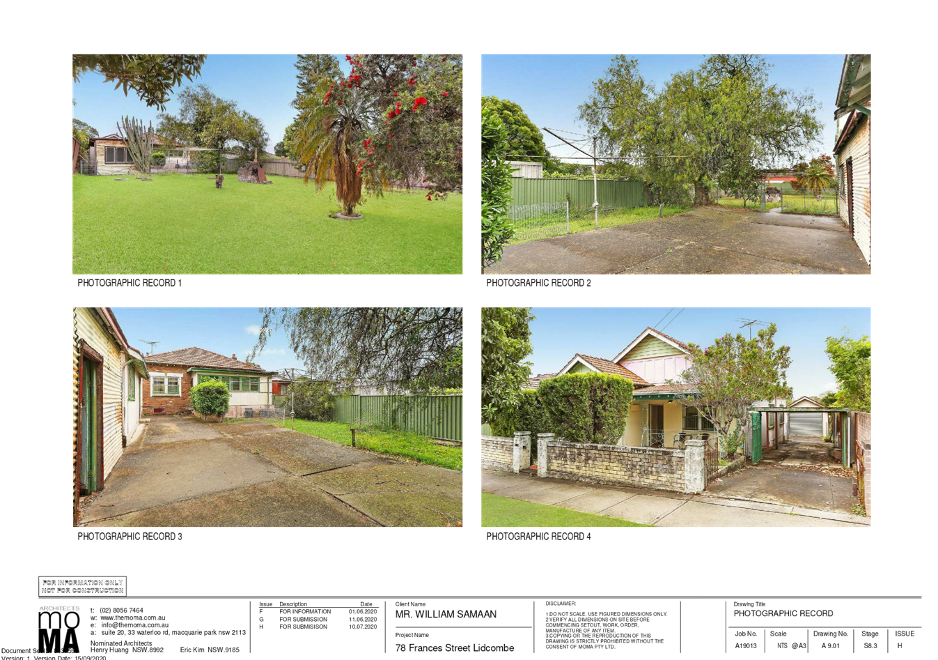
DOCUMENTS
ASSOCIATED WITH
REPORT LPP050/20
Attachment 3
Submissions Received
Cumberland Local Planning Panel Meeting
14 October 2020


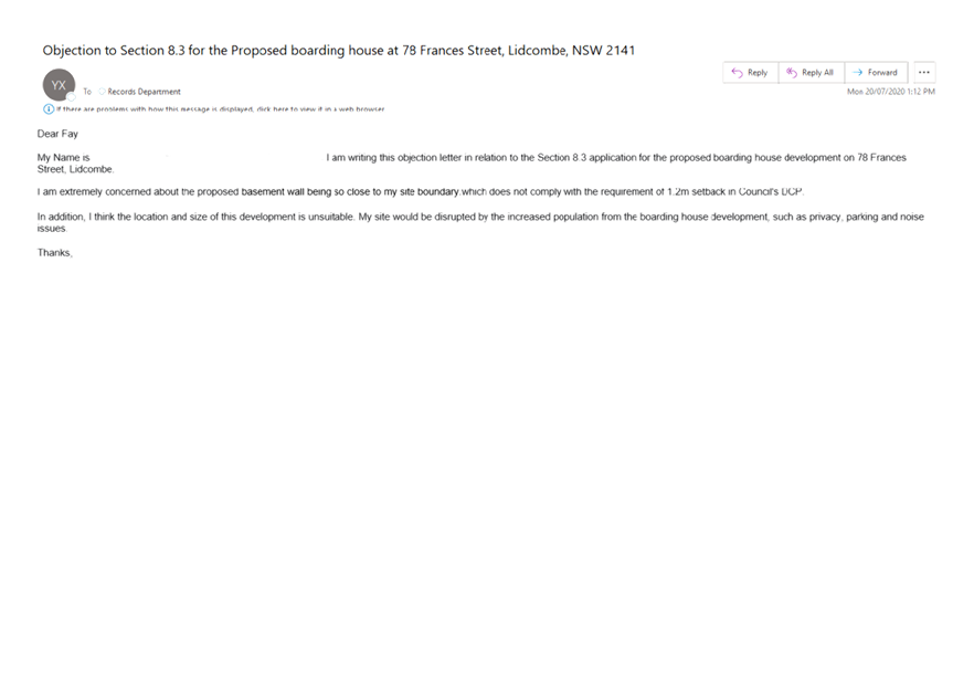
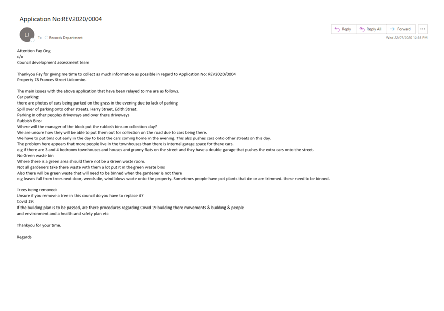
DOCUMENTS
ASSOCIATED WITH
REPORT LPP050/20
Attachment 4
Plan of Management
Cumberland Local Planning Panel Meeting
14 October 2020
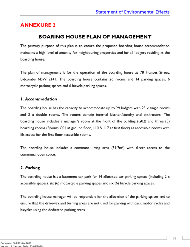
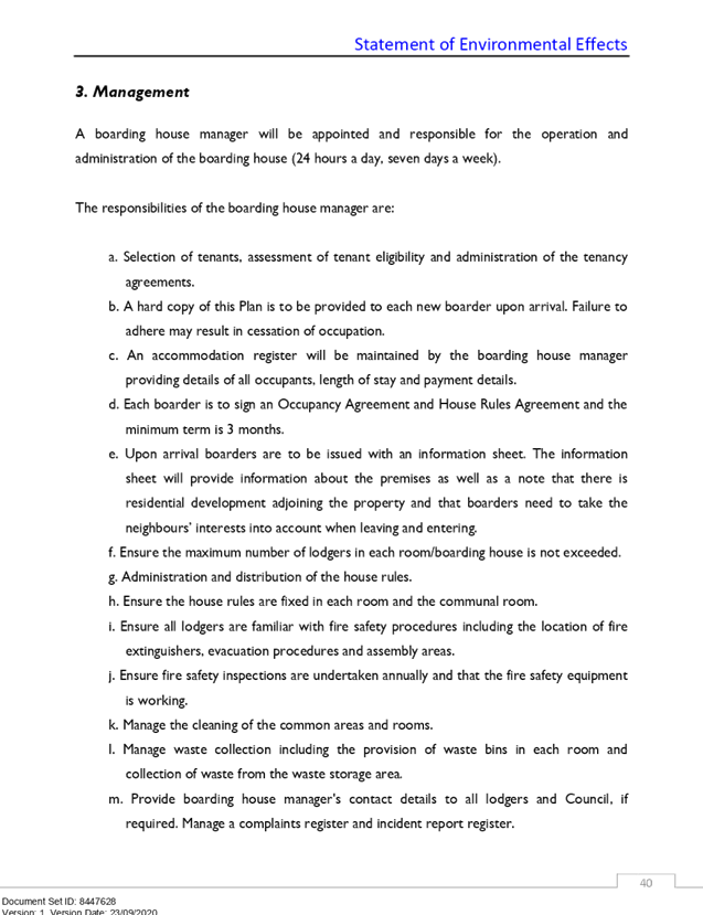
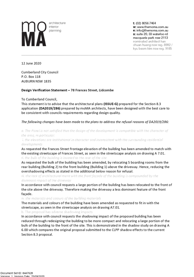

DOCUMENTS
ASSOCIATED WITH
REPORT LPP050/20
Attachment 5
Landscape Plans
Cumberland Local Planning Panel Meeting
14 October 2020
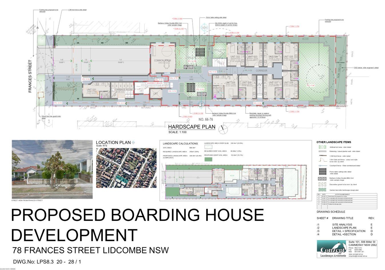
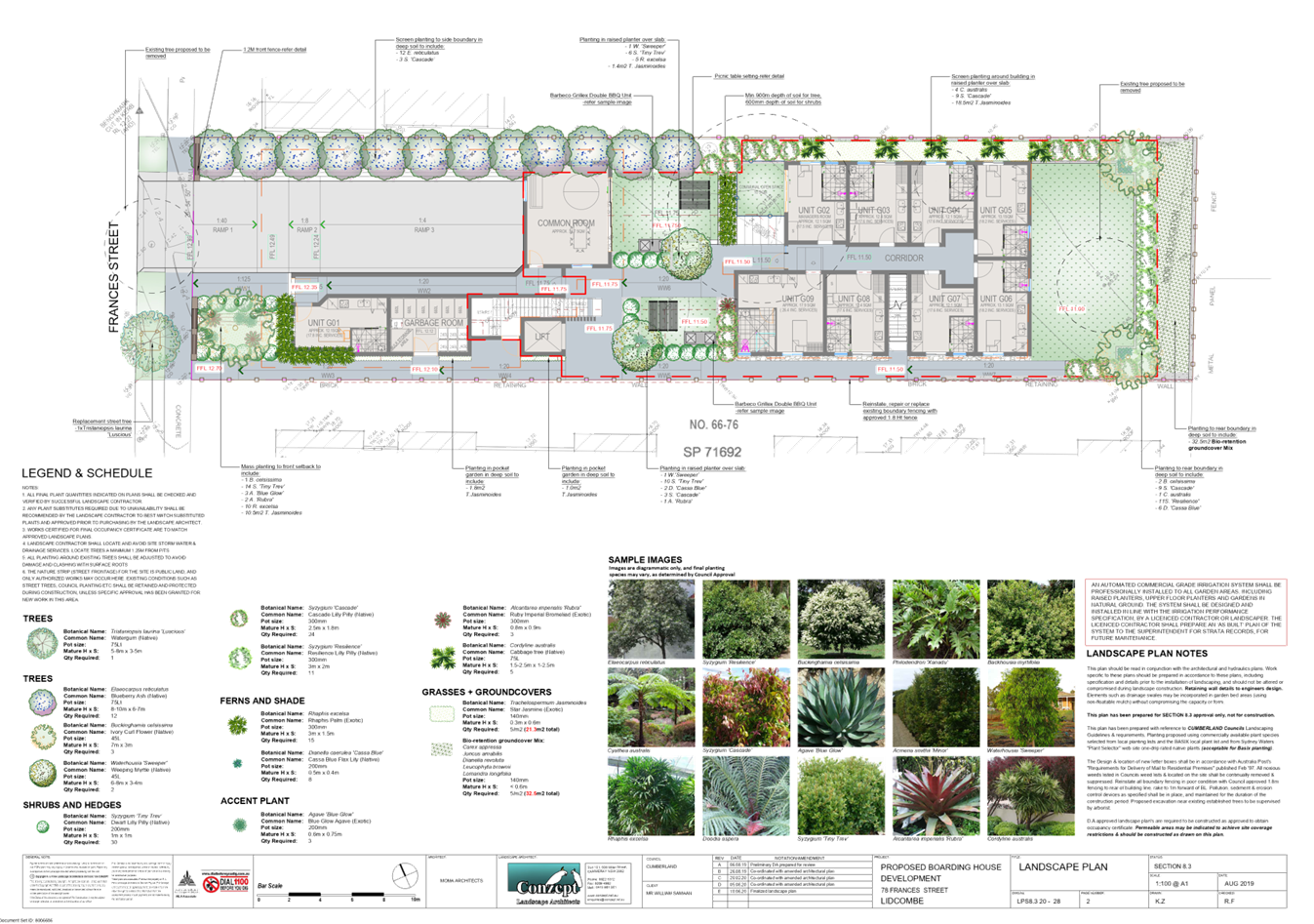
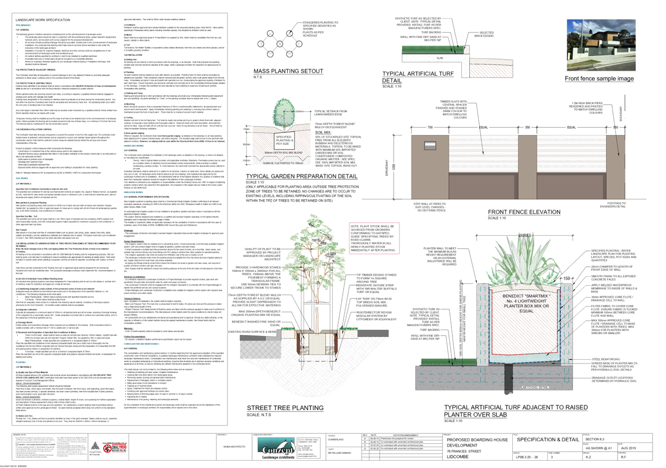
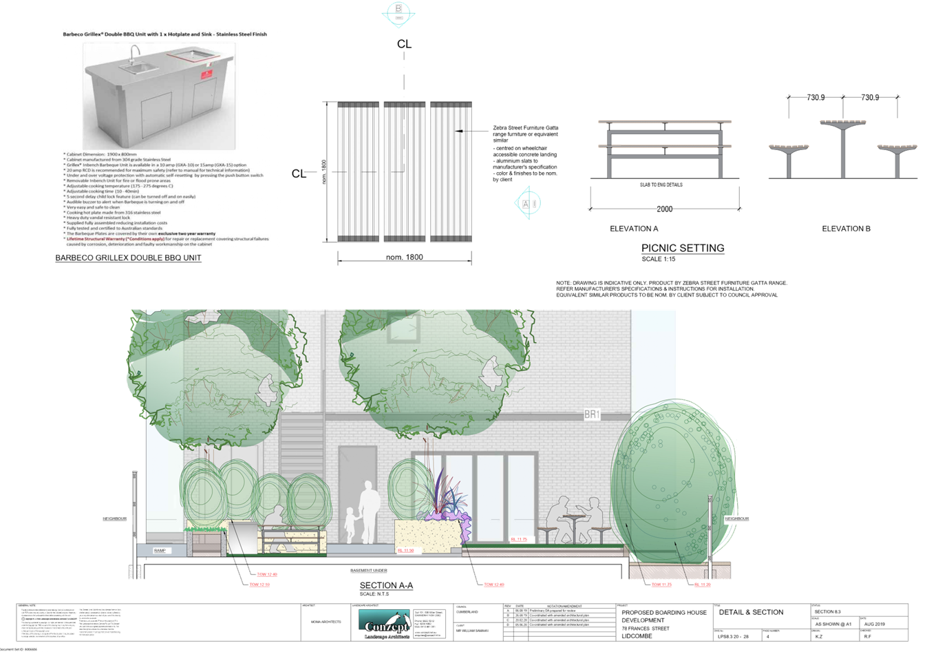
DOCUMENTS
ASSOCIATED WITH
REPORT LPP050/20
Attachment 6
Stormwater Plans
Cumberland Local Planning Panel Meeting
14 October 2020
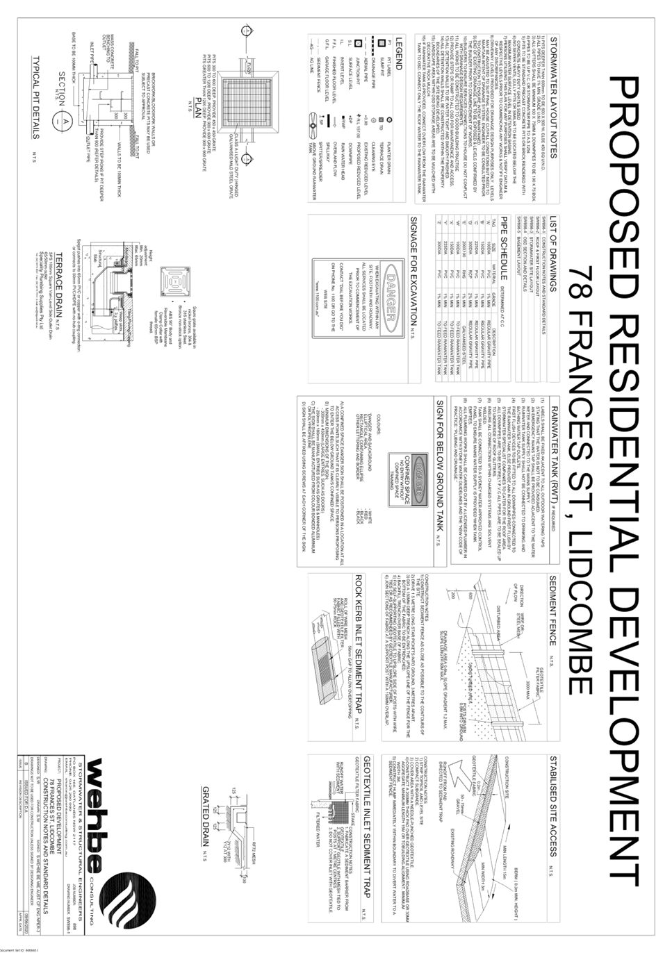
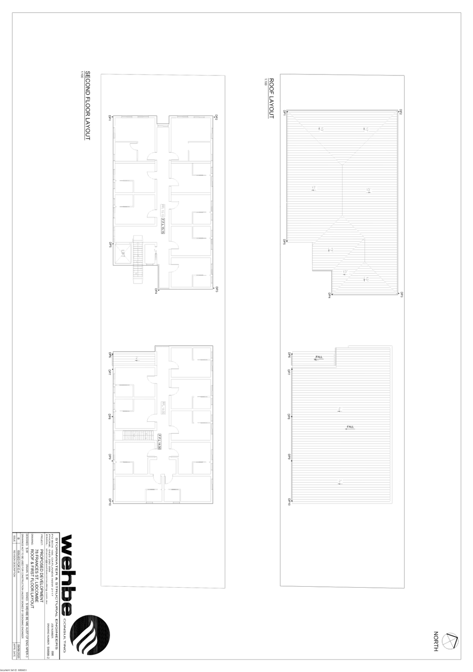
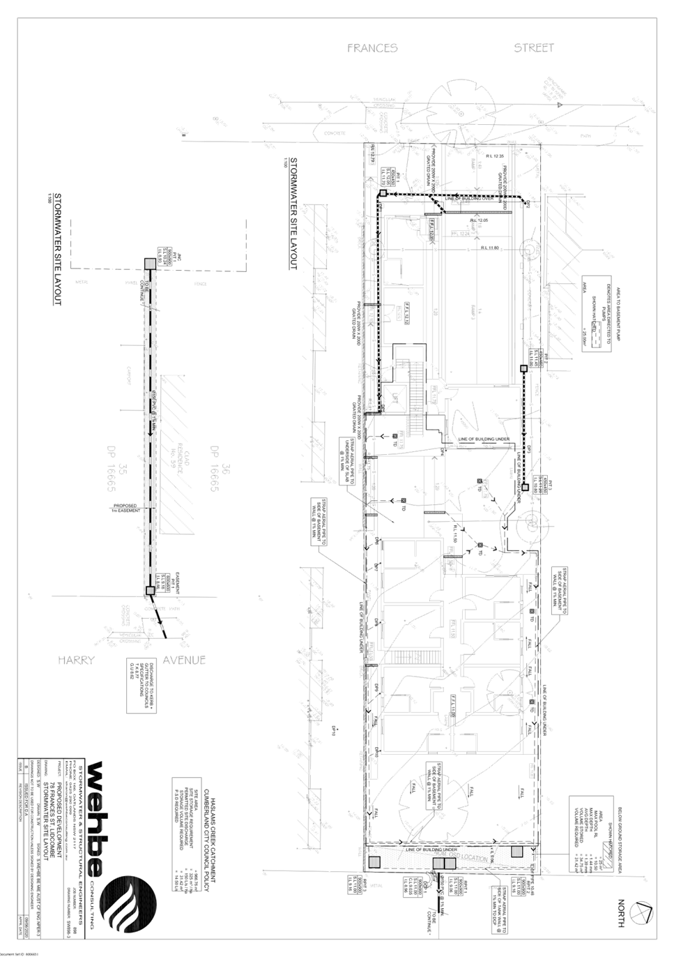
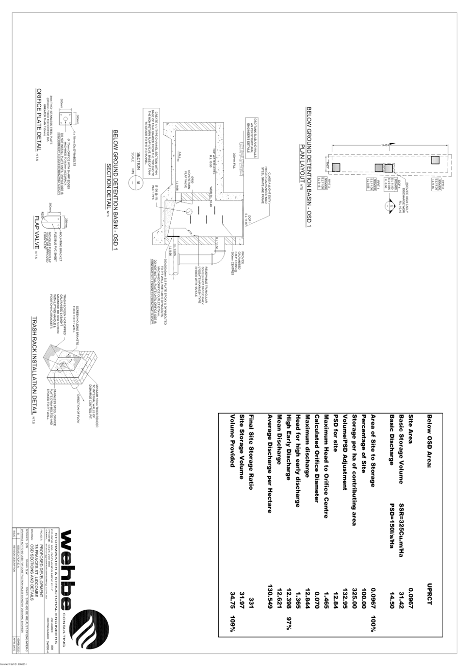
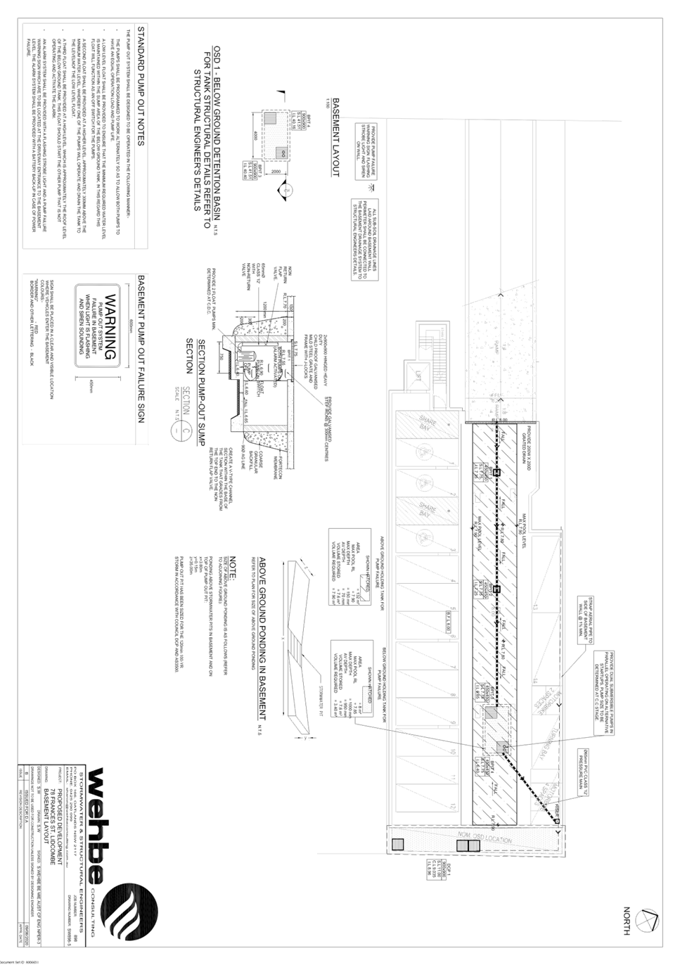
DOCUMENTS
ASSOCIATED WITH
REPORT LPP050/20
Attachment 7
Acoustic Report
Cumberland Local Planning Panel Meeting
14 October 2020
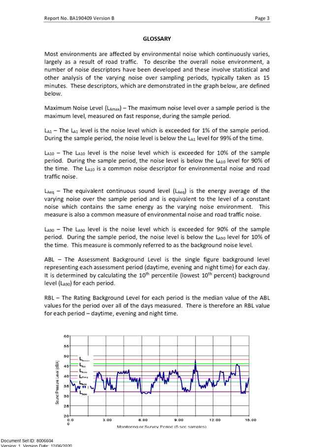
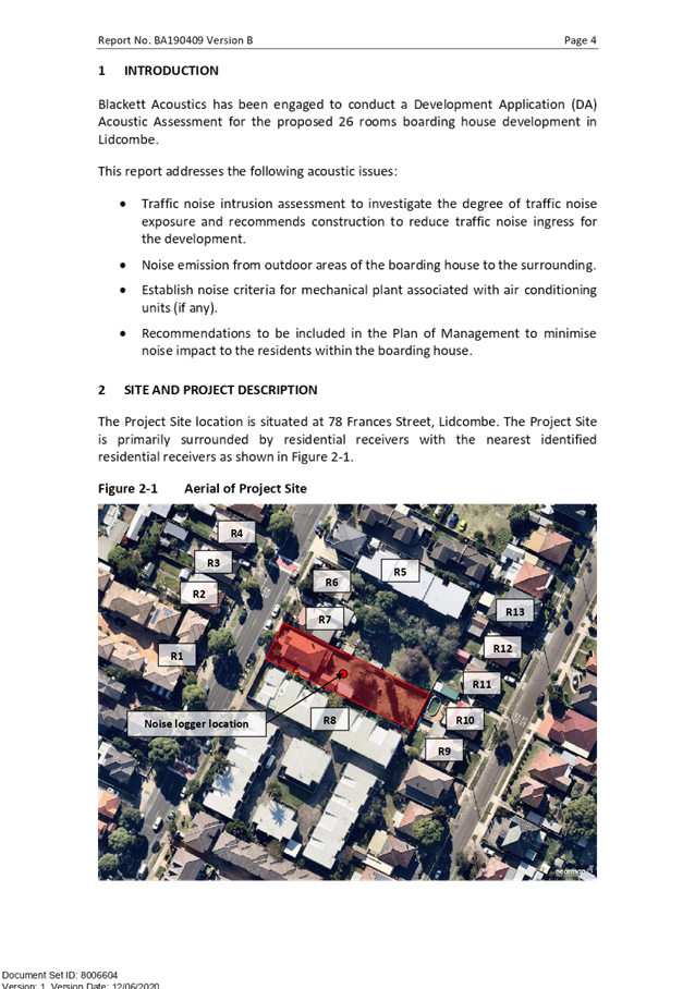

DOCUMENTS
ASSOCIATED WITH
REPORT LPP050/20
Attachment 8
Survey Plan
Cumberland Local Planning Panel Meeting
14 October 2020
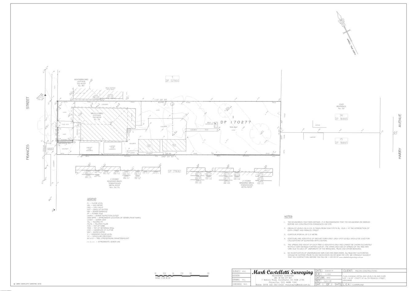
DOCUMENTS
ASSOCIATED WITH
REPORT LPP050/20
Attachment 9
(Refused) Architectural Plans for Reference
Cumberland Local Planning Panel Meeting
14 October 2020
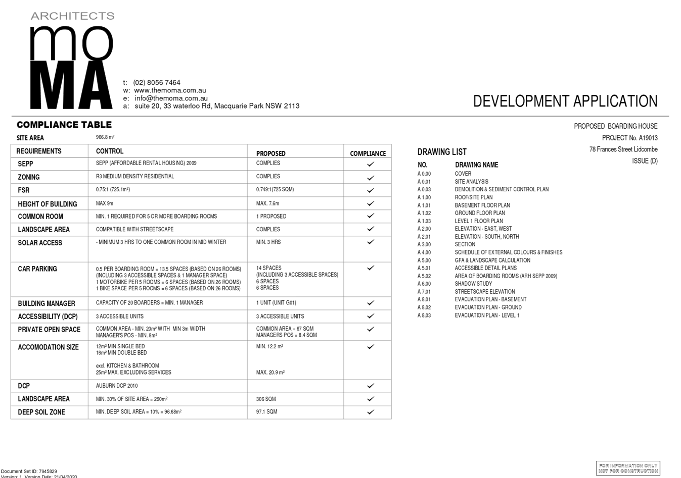

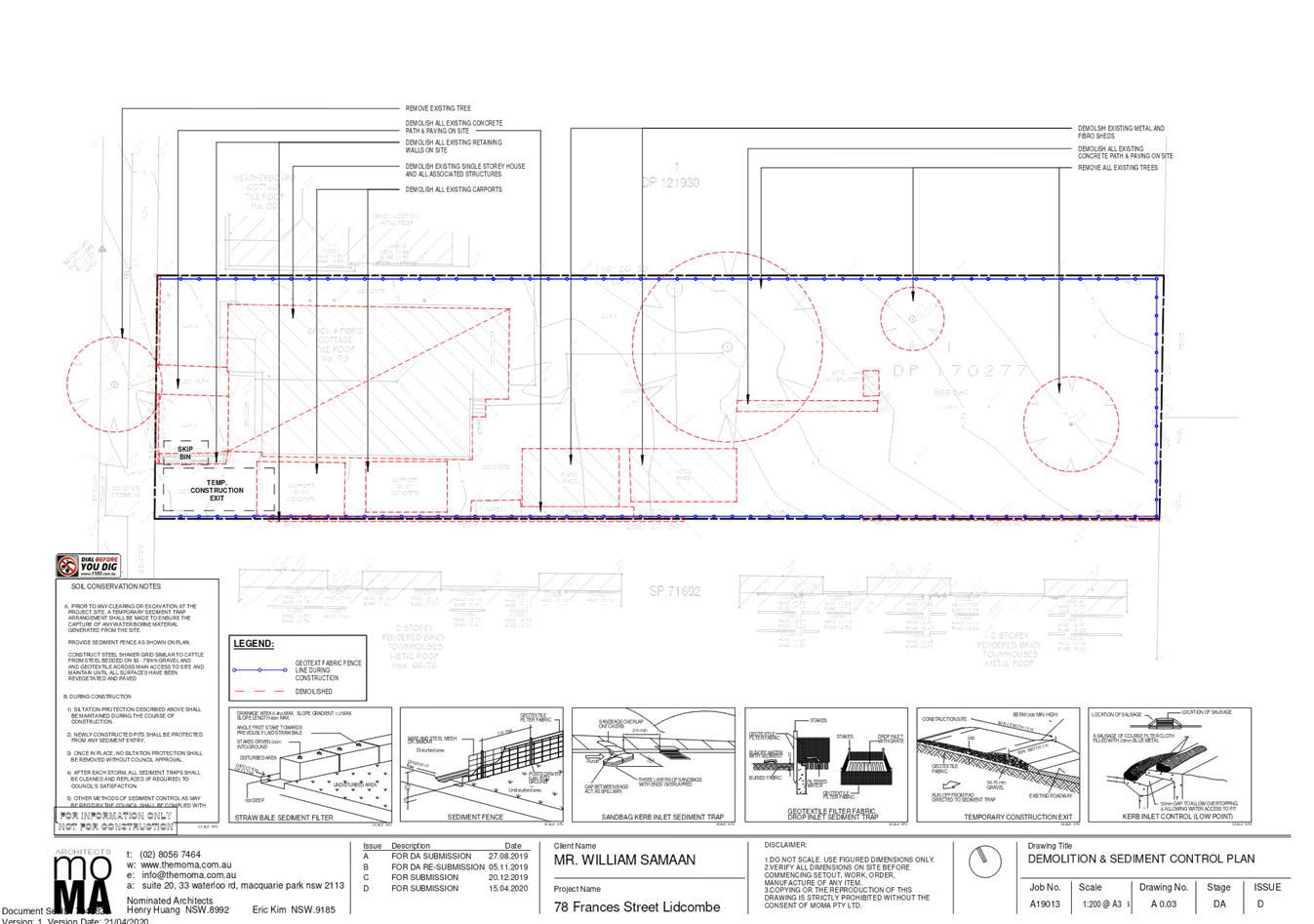
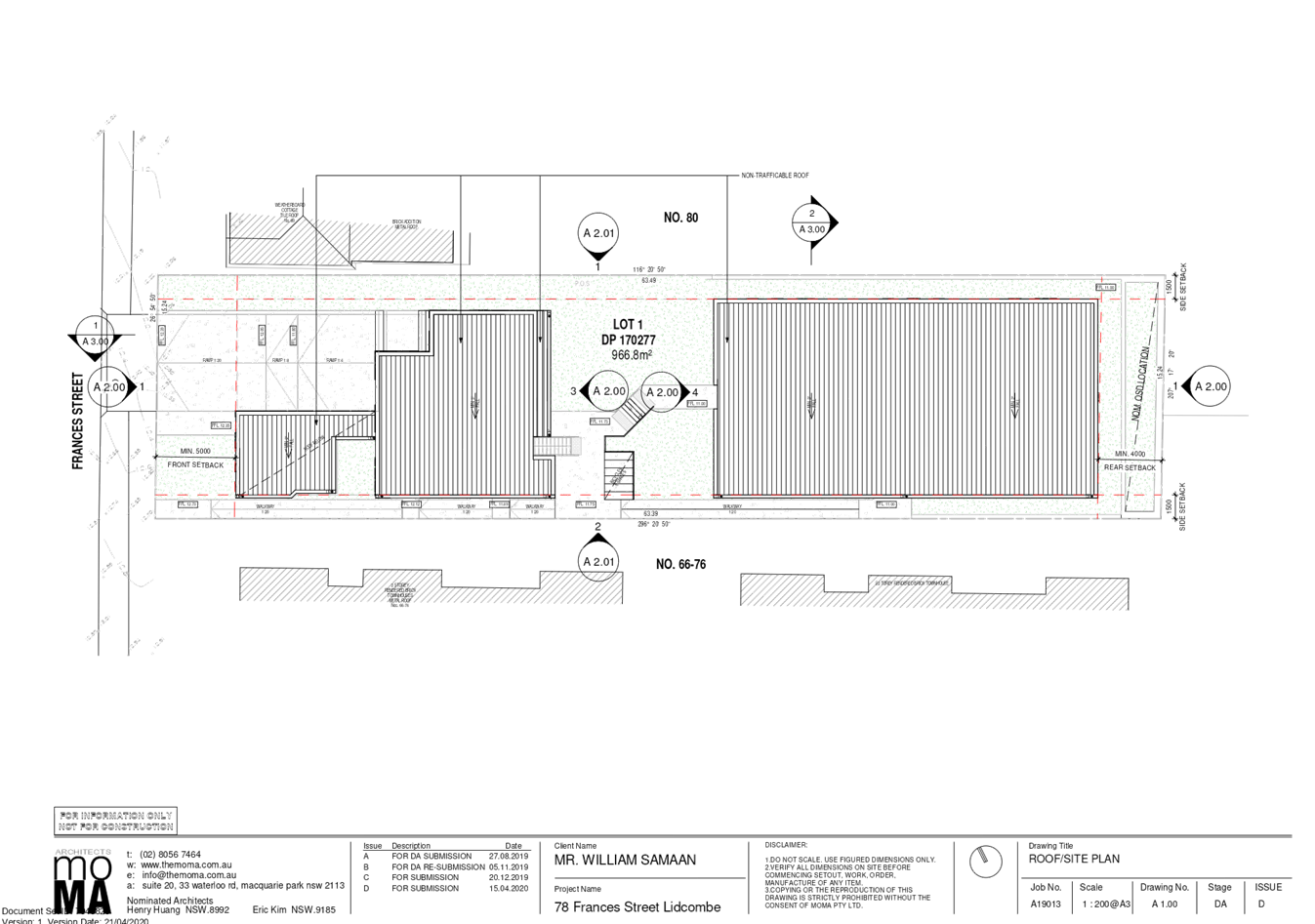
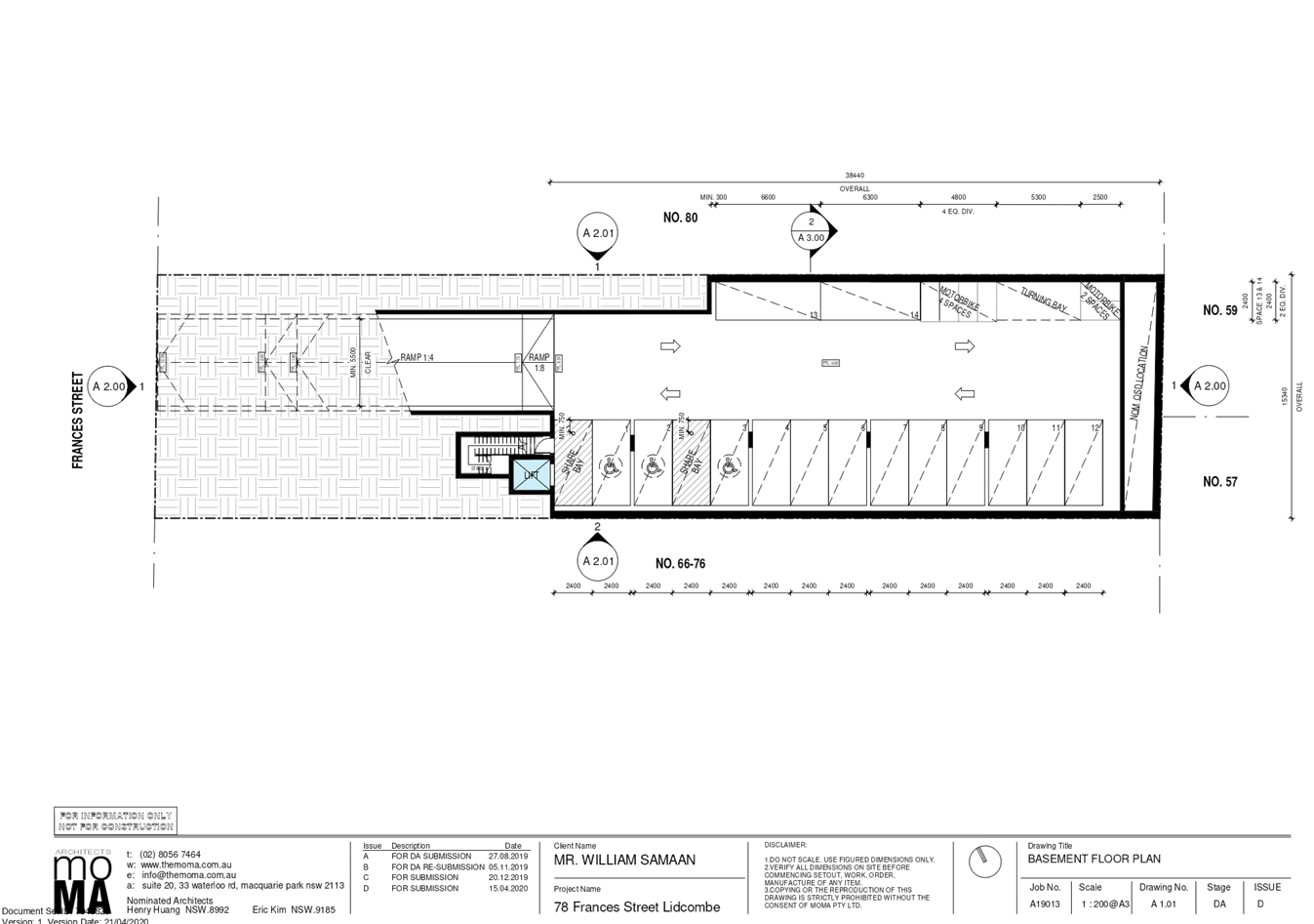
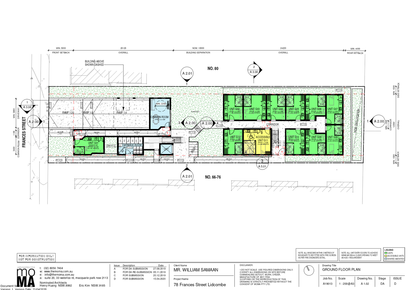
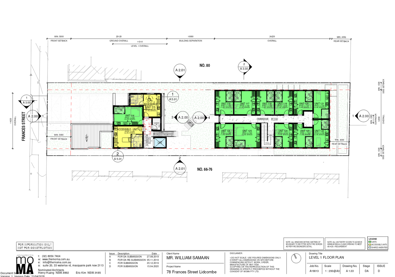
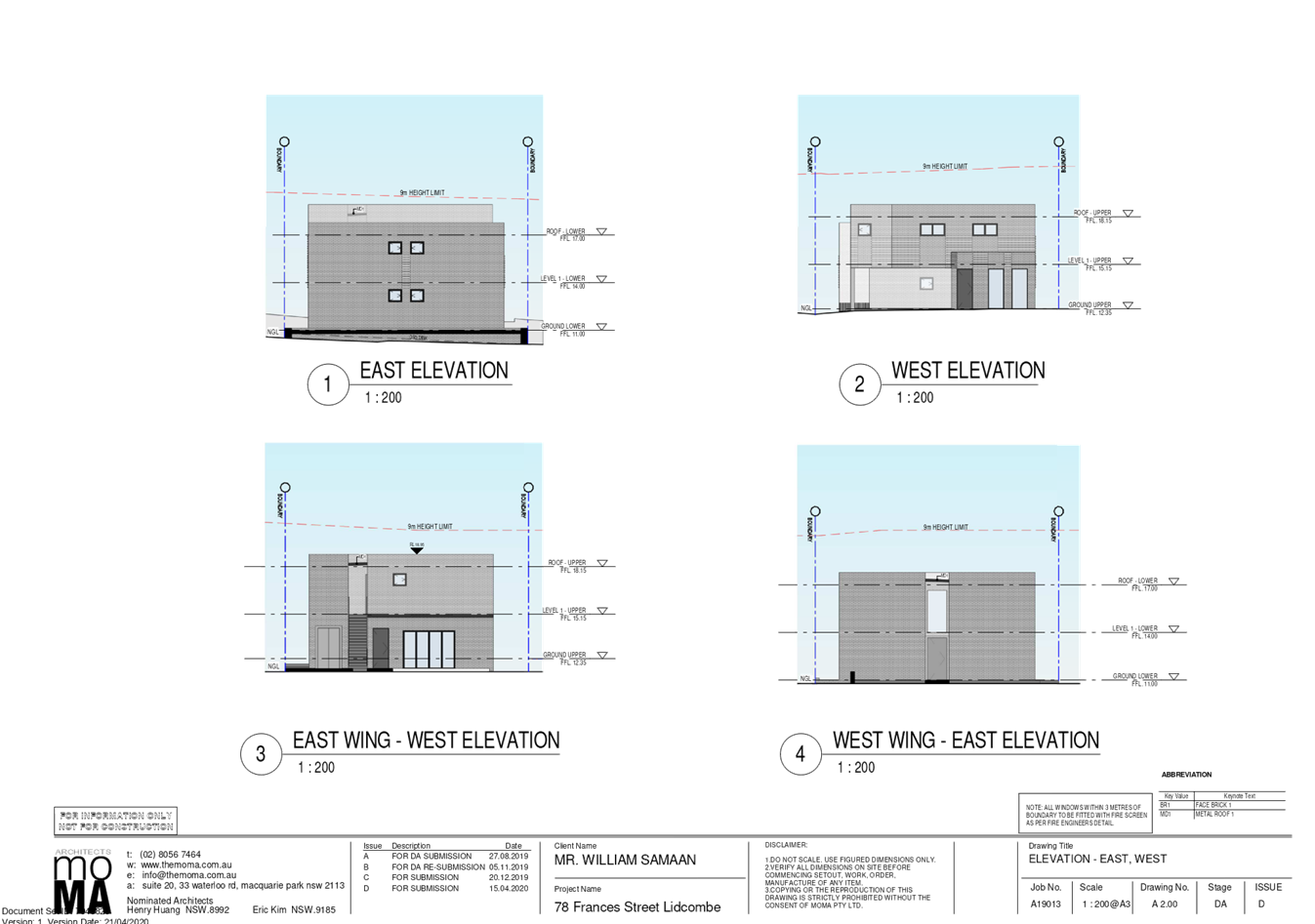
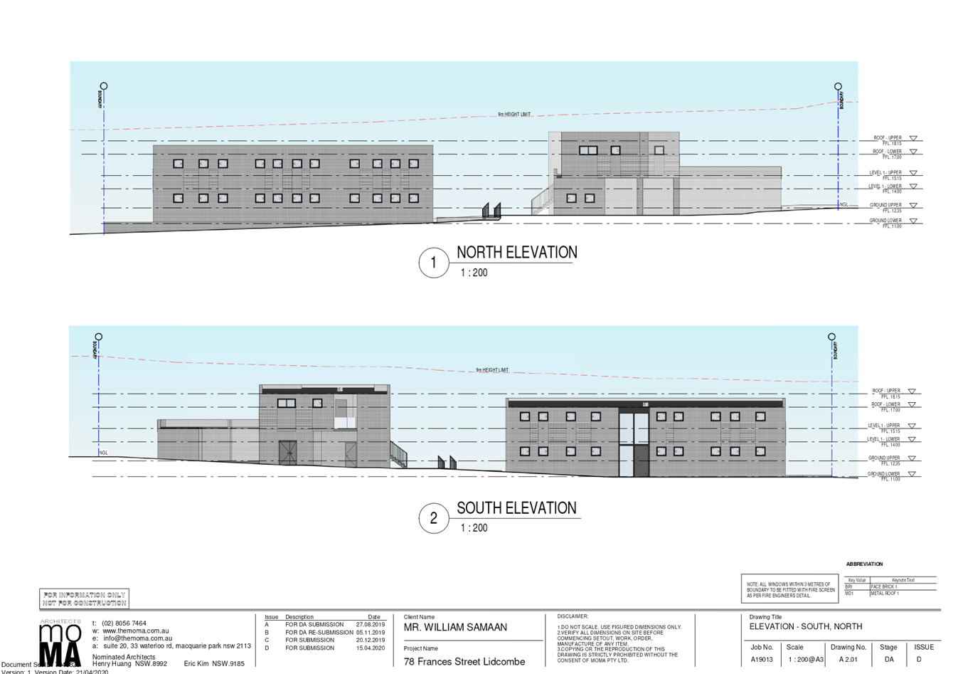
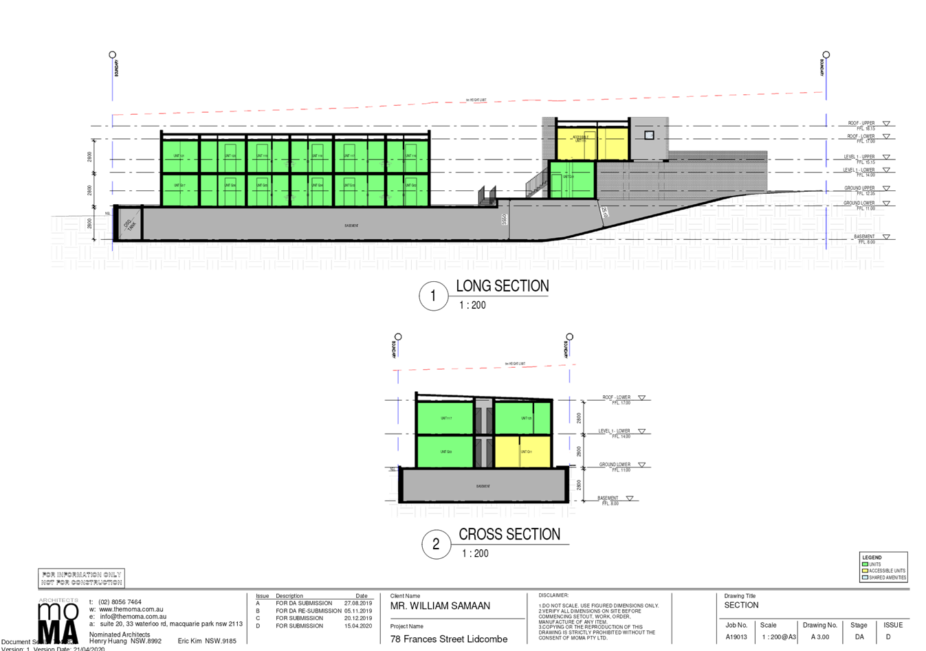
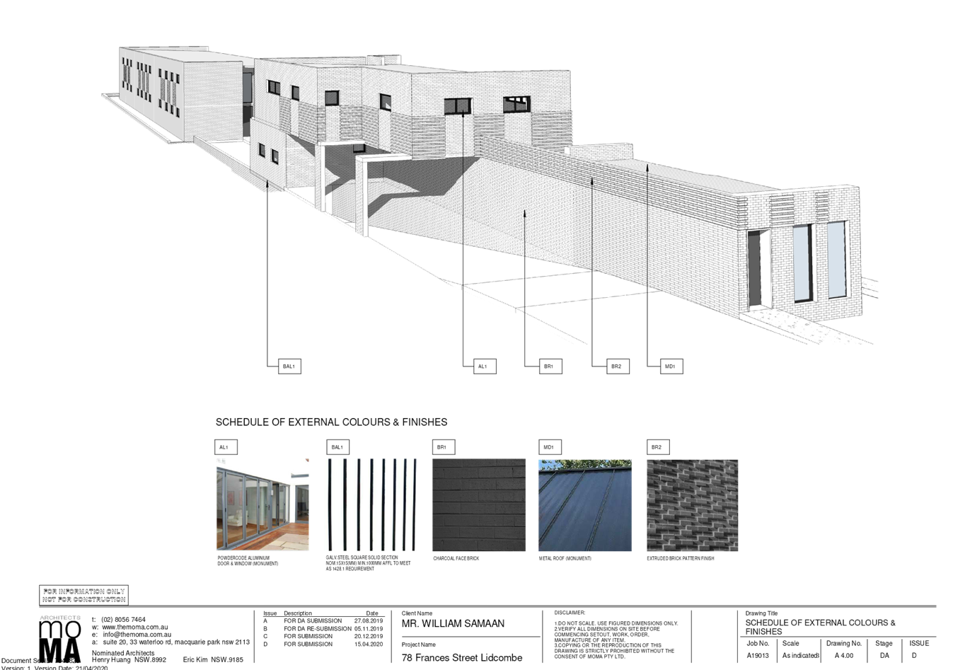
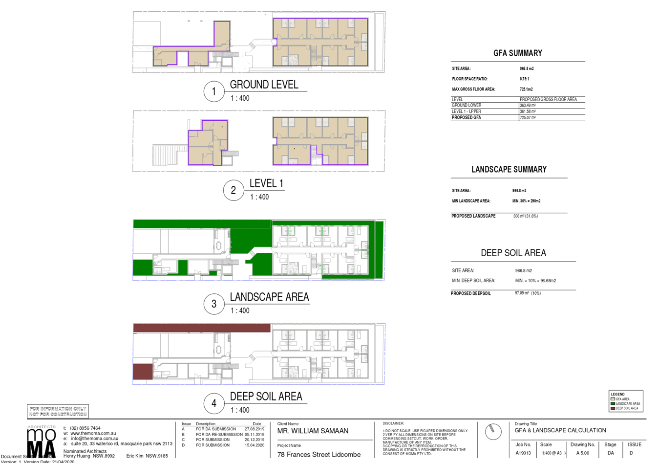
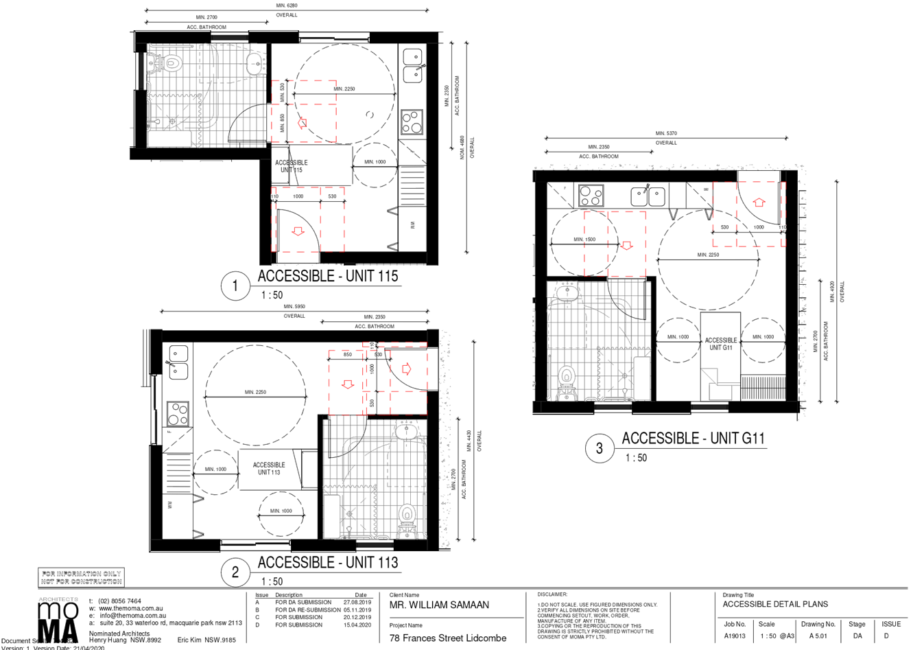
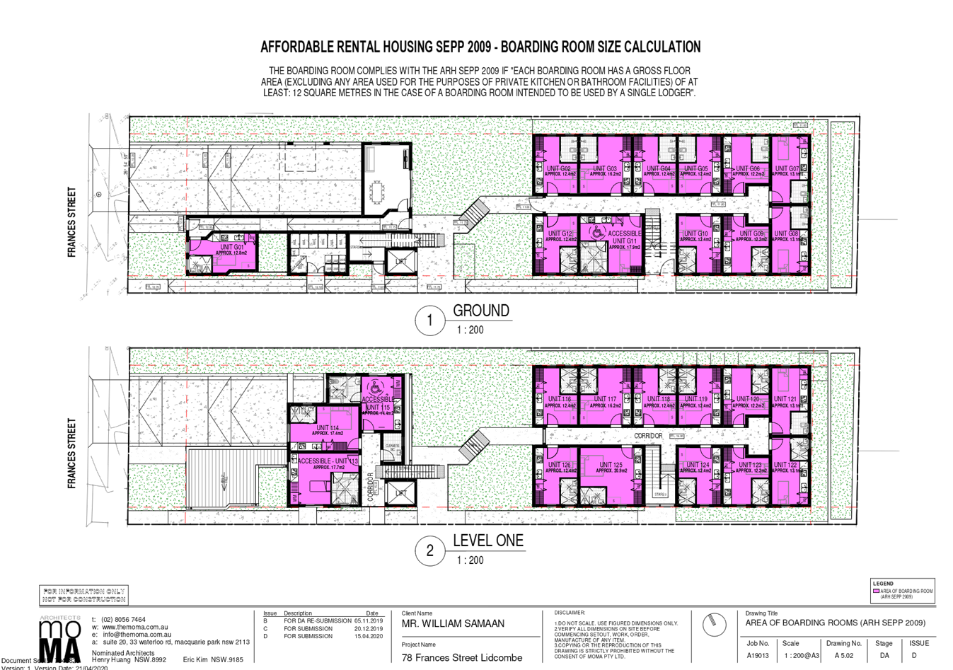
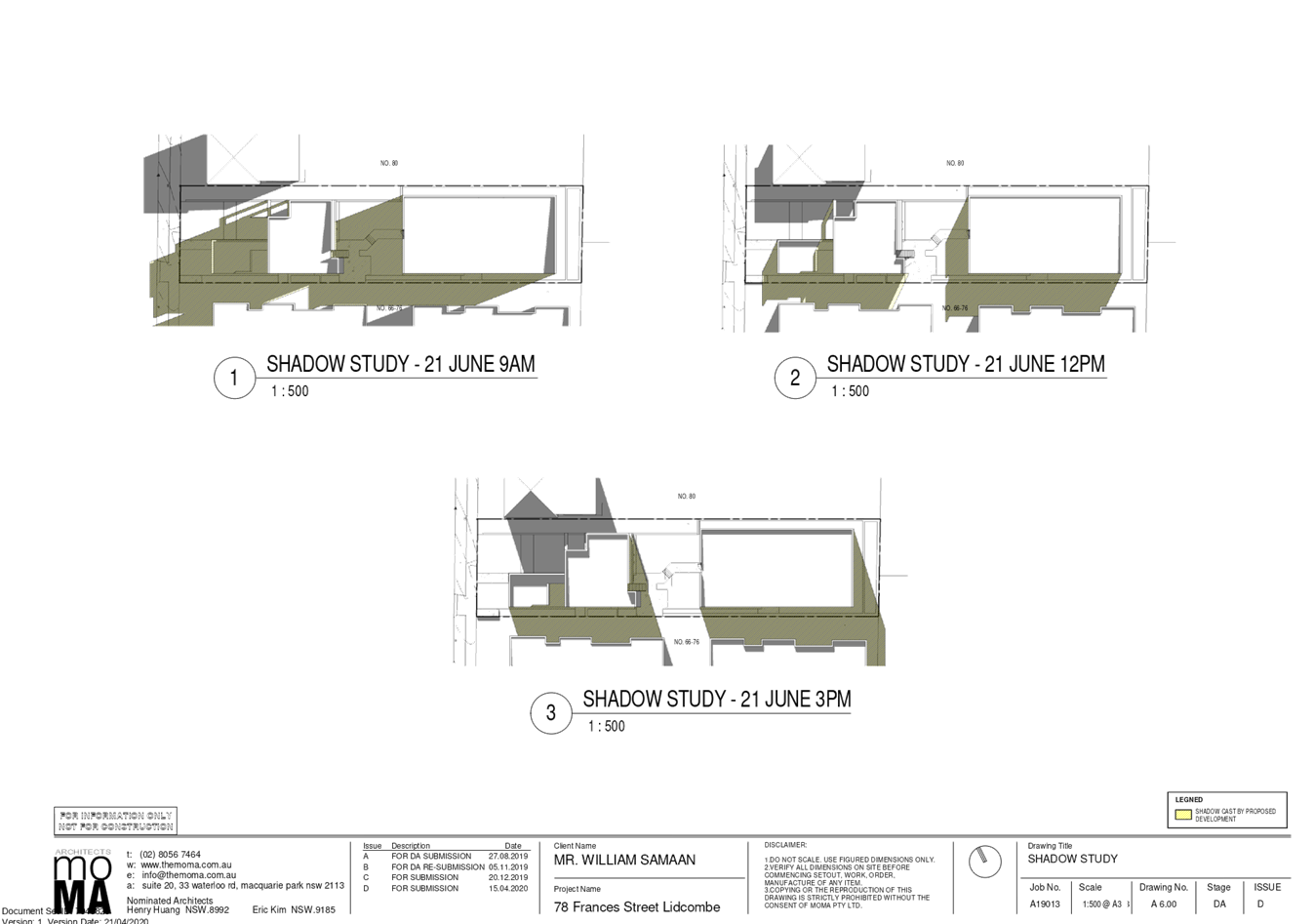
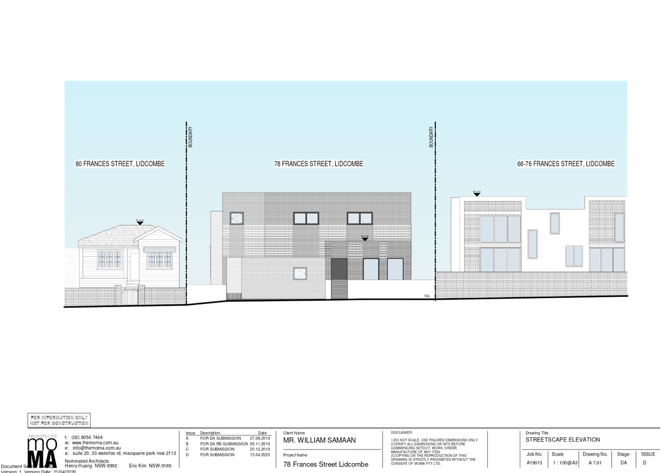
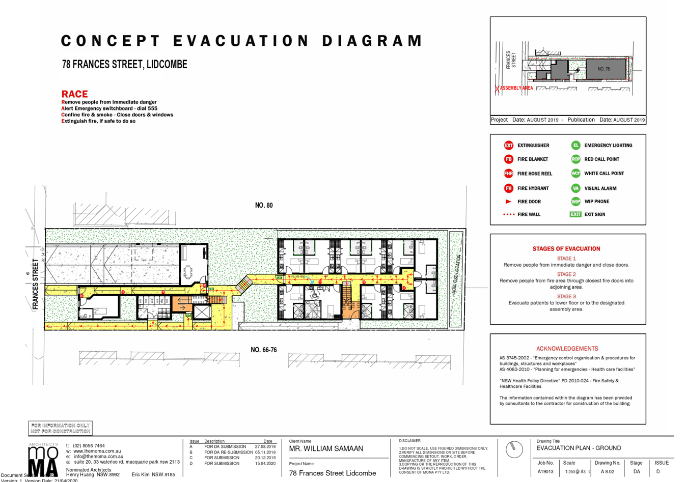
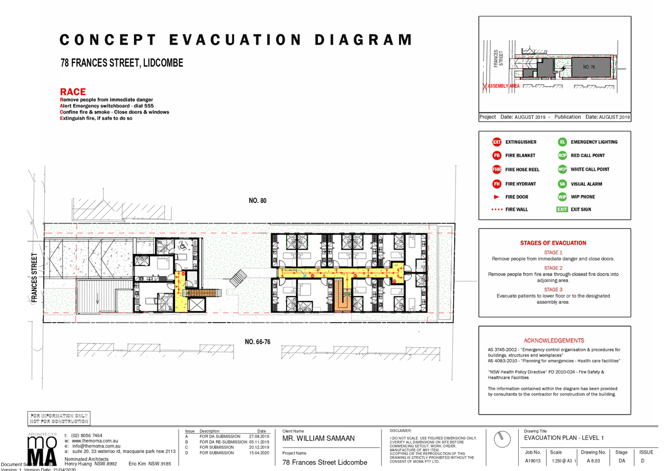
Cumberland
Local Planning Panel Meeting
14 October 2020
Item
No: LPP051/20
Modification Application
for 39 - 41 Aurelia Street, Toongabbie
Responsible
Division: Environment
& Planning
Officer: Acting
Executive Manager Development and Building
File
Number: MOD2020/0169
|
Application
lodged
|
4 June 2020
|
|
Applicant
|
Baini Design
|
|
Owner
|
Soeljo Pty Ltd
|
|
Application
No.
|
MOD2020/0169
|
|
Description
of Land
|
39 - 41 Aurelia Street
TOONGABBIE NSW 2146, Lot 38 and Lot 39 Sec C DP 10697
|
|
Proposed
Development
|
Section 4.55(2) modification for
various modifications to approved shop top housing development including reconfiguration of apartment mix and commercial
space to provide 33 residential units and 3 commercial ground floor spaces,
increase parking on-site to facilitate 52 cars, modify the rooftop
open space, increase in floor levels and overall height and changes to the
materials and finishes
|
|
Site
Area
|
1393.5m2
|
|
Zoning
|
B2- Local
Centre
|
|
Disclosure
of political donations and gifts
|
Nil disclosure
|
|
Heritage
|
Located within the vicinity of
a heritage item of local significance being “St Edna’s Church
Hall at No. 27-33 Aurelia Street, Toongabbie.
|
|
Principal
Development Standards
|
Floor Space Ratio (FSR)
Permissible: 2:1
Proposed: 2:1
Height of Building
Permissible:17m
Proposed: 20.3m
|
|
Issues
|
- Building separation
- Building height
|
1. Modification
Application No. MOD2020/0169 was received on 4 June 2020 for the Section
4.55(2) modification for various modifications to approved shop top housing
development including reconfiguration of apartment mix and commercial
space to provide 33 residential units and 3 commercial ground floor spaces,
increase parking on-site to facilitate 52 cars, modify the rooftop open space,
increase in floor levels and overall height and changes to the materials and
finishes.
2. The
application was publicly notified to occupants and owners of the adjoining
properties for a period of 21 days between 25 June 2020 and 16 July 2020. In
response, no submissions were received.
3. The
assessment of the application identified issues including ground floor layout,
basement reconfiguration and parking and as such the application was deferred
seeking additional information. Amended plans and information were provided to
Council on 25 September 2020. The amended plans did not warrant
re-notification.
4. The
application has been assessed against the relevant provisions of the
Environmental Planning and Assessment Act 1979, State Environmental Planning
Policy No 65 – Design Quality of Residential Apartment Development (SEPP
65), Holroyd Local Environmental Plan 2013 (HLEP), Apartment Design Guide and
Holroyd Development Control Plan 2013 (HDCP).
5. The
application involves the following non-compliances which are considered
supportable as discussed in detail in the body of this report:
|
Control
|
Required
|
Approved DA201
|
Proposed
|
% variation
|
|
Building separation (ADG)
|
ii)
Min. 9m -above 5 storeys
|
Level 4:
9m
|
Level 4:
5.9m- 6.68m
|
30%
|
|
Height of buildings (HLEP)
|
17m
|
18.7m(lift overrun)
|
20.3m (lift overrun)
|
19.4%
|
Note: Only new non-compliances
have been discussed within the body of the report which are proposed under the
subject modification application. The original consent with the approved
architectural plans is attached at Attachment 3.
6. The
application is being reported to the Cumberland Local Planning Panel (CLPP) for
determination as it is a development that contravenes a development standard by
more than 10% and exceeds Council’s delegation in relation to the
determination of modification.
7. The
application is recommended for approval subject to the conditions in the draft
notice of determination at Attachment 1.
Subject Site and Surrounding
Area
Introduction
The site forms Lot 39 and Lot 38
Sec C DP 10697 and is known as 39 - 41 Aurelia Street TOONGABBIE
NSW 2146. The site has an area of 1393.5m2 and a frontage to
Aurelia Street of 30.48m. The site is generally rectangular and flat. The
subject site and neighbouring allotments directly to the north east and
southwest are zoned B2- Local Centre. The rear of the site adjoins properties
which front Junia Avenue and are zoned R4- High Density Residential.
The existing developments
adjoining the site include 2 storey residential flat building to south west and
a single storey detached dwelling house to the north east. A recently
constructed 4 storey residential flat building is located to the north western
boundary. Toongabbie Train Station is 300m (approx.) from the subject site. The
site is located at the fringe of Toongabbie Town Centre.
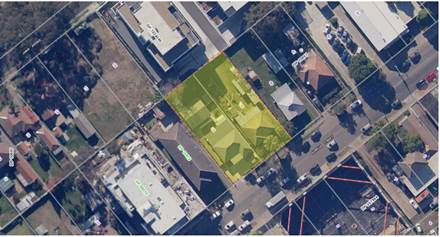
Figure
1 – Aerial view of subject site
Figure
2 – Locality Plan of subject site
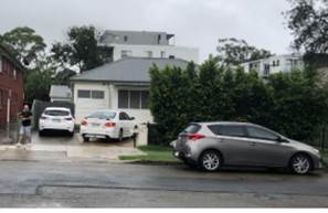
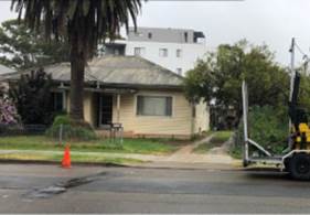
Figure
3 & 4 – Subject site
Description of the Proposed
Development
Council has received a
modification application involving the following works:
· Changes
to the external treatment and minor changes to façade articulation;
· Modification
of the communal open space and provision of demarcated spaces, furniture,
shading and improved planters;
· Modification
of the unit mix from 32 units to 33 units;
· Changes
to the units internal layout;
· A
reduction to the approved commercial floor area from 239.5m2 to 202.2m2
· Reconfiguration
of the basement and increase to the approved parking spaces from 41
to 54 car spaces.
· Relocation
of the vehicular access driveway approximately 9m south of the northern
property boundary.
The following table provides a
comparison of approved development and proposed modification:
|
|
Approved
|
Modified
|
|
Storeys
|
5-storeys Ground floor commercial residential above
|
5-storeys Ground floor commercial residential above
|
|
Maximum Building Height
|
18.7m - RL 50.9
|
20.3m - RL 52.5
|
|
Unit Mix
|
15 x 1bedroom units
17 x 2bedroom units
Total 32 Units
|
9 x 1 bedroom units
24 x 2 bedroom units
Total 33 Units
|
|
Commercial Floor Space
|
239.5m² with 5 tenancies
|
202.2m² with 3 tenancies
|
|
Car Parking Spaces
|
41 car spaces comprising:
Residential spaces = 25
Visitor spaces = 6
Commercial spaces = 9 and a designated
car wash
|
54 car spaces comprising:
Residential spaces = 36
Visitor spaces = 7
Commercial spaces = 10 and a designated
car wash
|
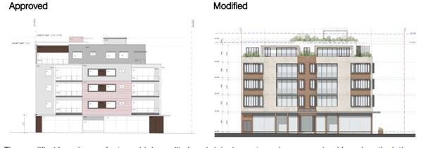
Figure
6- Comparison of approved and proposed façade.
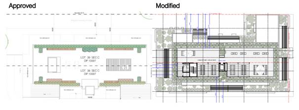
Figure
7- Comparison of approved and proposed roof top communal open space.
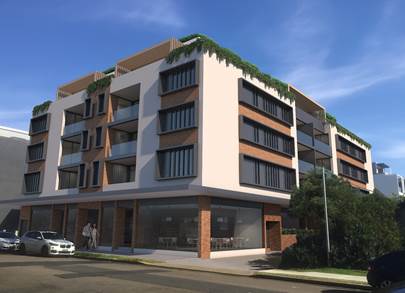
Figure
8- Photomontage
History
· A
pre lodgement meeting PDA/513 was held on 23 September 2015 for the demolition
of the existing structures and construction of a 5 storey shop top housing
development comprising 34 residential units and 2 commercial tenancies over 2
basement levels of parking accommodating 34 car parking spaces;
· Development
Application 2015/627/1 was refused on 11 April 2017 for the Demolition of
existing structures; consolidation of 2 lots into lot; construction of a 5
storey shop top housing development comprising 32 residential units; 5 ground
floor commercial units above 2 levels of basement parking accommodating 46
carparking spaces; and
· REV2015/627/1
was approved on 11/10/2017 for S82A Review of Council's refusal for
demolition of existing structures; consolidation of 2 lots into 1 lot; construction
of a 5 storey shop top housing development comprising 32 residential units; 4
ground floor commercial units above 2 levels of basement parking accommodating
41 carparking spaces.
· M2015/627/2
S4.55(1A) modification was approved on 5 April 2019 for alterations and
additions in association with the proposed turntable within the loading zone of
the approved shop top housing development.
· Schedule
“A” letter was issued on 9 October 2019.
· A
pre lodgement meeting PL2019/0072 was held on 13 February 2020 for alterations
and additions to the approved shop top housing.
The history of the subject
modification application is provided as below:
|
Date
|
Action
|
|
4/06/2020
|
The subject Development
Application was lodged.
|
|
19/06/2020
|
The Development Application was
referred to Council’s internal departments for review.
|
|
25/06/2020 to 16/0972020
|
Application placed on public
notification for 21 days. In response, no submission was received.
|
|
21/09/2020
|
The application was deferred
seeking additional information with regard to ground floor layout,
basement reconfiguration and parking
|
|
25/09/2020
|
Amended plans and additional information were received by
Council. Amended plans did not warrant re notification.
|
|
14/10/2020
|
Application referred to CLPP for
determination.
|
Applicants Supporting
Statement
The applicant has provided a
Statement of Environmental Effects prepared by Dickson Rothschild dated 19 June
2020 in support of the application.
Contact with Relevant
Parties
The assessing officer has
undertaken a site inspection of the subject site and surrounding properties and
has been in regular contact with the applicant throughout the assessment
process.
Internal Referrals
Development Engineer
The development application was
referred to Council’s Development Engineer for comment who has advised
that the development proposal is satisfactory having regard to stormwater
management and the changes proposed to the basement reconfiguration, including
parking provision, and the proposed modifications can therefore be supported,
subject to recommended conditions of consent, which have been included in the
recommended conditions of consent.
Waste Management
The development application was
referred to Council’s Waste Management Officer for comment who has
advised that the development proposal is satisfactory in terms of the proposed
waste collection, and therefore can be supported subject to recommended
conditions of consent, which have been included in the recommended conditions
of consent.
Environmental Health Unit
The development application was
referred to Council’s Environmental Health Unit for comment who has
advised that the proposal is satisfactory subject to recommended conditions of
consent, which have been included in the recommended conditions of consent.
Planning Comments
Section 4.55(2):
|
Requirement
|
Comments
|
|
Council is satisfied that the development to which the
consent as modified relates is substantially the same development as the
development for which the consent was originally granted and before that consent
as originally granted was modified (if at all), and
|
The development as proposed to be modified is
substantially the same as the original consent, as it relates to a minor
increase in the lift overrun height, and changes to the car parking arrangement
in the basement levels, and the overall building layout and façade.
The proposed amendments do not deviate from the approved mixed use
development on the subject site.
|
|
Council has consulted with the relevant Minister, public
authority or approval body (within the meaning of Division 5) in respect of a
condition imposed as a requirement of a concurrence to the consent or in
accordance with the general terms of an approval proposed to be granted by
the approval body and that Minister, authority or body has not, within 21
days after being consulted, objected to the modification of that consent, and
|
No Minister, public authority or other approval body was
required to be consulted regarding the proposed modification.
|
|
Council has notified the application in accordance with:
(i) the regulations, if the
regulations so require, or
(ii) a development control plan,
if the consent authority is a council that has made a development control
plan that requires the notification or advertising of applications for modification
of a development consent, and
|
See discussion on “Public Notification” in
this report.
|
|
Council has considered any submissions made concerning the
proposed modification within any period prescribed by the regulations or
provided by the development control plan, as the case may be.
|
See discussion on “Public Notification” in
this report.
|
|
Relevant matters referred to in Section 4.15(1) of the act
have been taken into consideration
|
Proposed modification is not contrary to the public
interest and the likely environmental impacts of the development as modified
are considered acceptable.
|
The provisions of any
Environmental Planning Instruments (EP&A Act s4.15 (1)(a)(i))
(a) State
Environmental Planning Policy No. 55 – Remediation of Land (SEPP 55)
The requirement at clause 7 of
SEPP 55 for Council to be satisfied that the site is suitable or can be made
suitable to accommodate the proposed development was considered under the
original application. The proposed modifications do not raise any new concerns
about potential contamination.
(b) Statement
Environmental Planning Policy No. 65 - Design Quality of Residential Apartment
Development (SEPP 65)
SEPP 65 applies to the development
as the building is 3 storeys or more, and contains more than 4 dwellings. A
design statement addressing the design quality principles prescribed by SEPP 65
was prepared by the project architect. Integral to SEPP 65 is the Apartment
Design Guide (ADG), which sets benchmarks for the appearance, acceptable
impacts and residential amenity of the development. A revised design
verification statement signed by registered architect Dickson Rothschild and
Philip Perrie Architect was submitted with the s4.55(2) application.
A comprehensive assessment against
the Apartment Design Guide (ADG) controls and SEPP 65 sets 9 design quality
principles are provided at Attachment 4. The following table sets out the ADG
non-compliances.
|
Part 3 - Siting the
Development
|
|
3F
|
Visual Privacy
|
|
Yes
|
No
|
N/A
|
|
3F-1
|
Adequate building separation
distances are shared equitably between neighbouring sites, to achieve
reasonable levels of external and internal visual privacy.
|
|
Design Criteria
|
Separation between windows and
balconies is provided to ensure visual privacy is achieved. Minimum required
separation distances from buildings to the side and rear boundaries are as
follows:
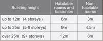
|
Up to 4 storeys:
It is noted that internal layout
of some of the units have been modified. However, building separation from
ground floor to Level 3 generally remains as approved.
The rear and south-west side elevations both have varied
setbacks of 4-4.6m for openings and balconies. These openings have
privacy treatments and site landscaping has been enhanced to provide
screening.
Level 4 (Fifth Floor)
South western boundary:
The balcony of penthouse 05
provides a setback of 6.68m.
The bedroom and bathroom
openings of penthouse 01 provide a setback of 5.9m.
However, this will not have any
adverse amenity impacts on the adjoining development at No. 43 Aurelia Street
noting it is maintained to a height of 2 storeys. Further, appropriate
privacy measures and planter boxes have been incorporated to mitigate any
potential privacy impacts on any future development on the subject adjoining
property as shown below:
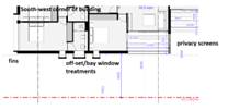
North east
Levels 4 & 5:
-9.1m
is provided for the habitable rooms
-6.7m
provided for the balconies, however privacy treatment provided to mitigate
any potential privacy impacts and is considered satisfactory.
|
|
|
|
|
|
|
|
|
|
|
|
(c) State
Environmental Planning Policy (Vegetation in Non-Rural Areas) 2017
Tree removal on site has been
approved in the original assessment. The proposal does not exceed the
biodiversity offsets scheme threshold. Therefore, the proposed vegetation
removal is considered acceptable.
(d) State
Environmental Planning Policy (Building Sustainability Index: BASIX) 2004
A revised BASIX certificate no.
1097342M dated 12 May 2020 was submitted by the applicant. The certificate
achieves target scores and is consistent with the architectural plans.
Regional Environmental Plans
The proposed development is
affected by the following Regional Environmental Plans:
(a) Sydney
Regional Environmental Plan (Sydney Harbour Catchment) 2005
Note: Will be superseded once
Draft SEPP Environment comes into effect.
The subject site is identified as
being located within the area affected by the Sydney Regional Environmental
Plan (Sydney Harbour Catchment) 2005. The proposed development raises no issues
as no impact on the catchment is envisaged.
(Note: - the subject site is not
identified in the relevant map as ‘land within the ‘Foreshores and
Waterways Area’ or ‘Wetland Protection zone’, is not a
‘Strategic Foreshore Site’ and does not contain any heritage items.
Hence the majority of the SREP is not directly relevant to the proposed
development).
Local Environmental Plans
Holroyd Local Environmental
Plan (HLEP) 2013
The provision of the Holroyd LEP
2013 is applicable to the development proposal. It is noted that the
development achieves compliance with the key statutory requirements of the
Holroyd LEP 2013 and the objectives of the B2 – Local centre zone.
(a) Permissibility:-
The proposed development is
defined as a ‘shop top housing’ and is permissible in the B2
– Local Centre zone with consent. The proposed modification will continue
the use of the development as approved being a shop top housing.
The relevant matters to be
considered under Holroyd LEP 2013 and the applicable clauses for the proposed
development are summarised below. A comprehensive LEP assessment is contained
in Attachment 5.
|
DEVELOPMENT STANDARD
|
COMPLY
|
DISCUSSION
|
|
4.3 Height of Buildings, max : 17m
|
No
|
Under DA2015/627/1, the Building height was approved for
18.7m to the top of the lift overrun (RL 50.90m AHD), which is a variation of
10% (1.7m) to the development standard.
The proposed modification will increase the height of lift
overrun to 20.3m (RL 52.50m AHD), which is an additional 1.6m from the
approved building height that equates to variation of 19.4% to the
development standard.
Clause 4.6
variation is not required for a s4.55 modification application. The applicant
submitted justification to further contravene the building height development
standard ( refer to Attachment 7), in which the additional height is
the result of the lift overrun and to provide a compliant floor to ceiling
height which was increased from 3.3m to 3.5m to comply with Holroyd DCP 2013.
The design of the building ensures that the habitable floor space is
contained below the maximum building height line. The variation is not considered to create unreasonable
amenity impacts to the adjoining properties via overshadowing or overlooking.
The presentation of the building is also not considered to be compromised by
the variation to the height control.
It is the view of Council Officers that justification
provided is satisfactory and having considered the application on its merit,
the variation to the maximum building height development standard is
considered acceptable in this instance.
|
|
4.4 Floor space ratio
Maximum Floor Space Ratio –
2:1
Site area
= 1393.5m2m2
Permitted
GFA = 2787 m2
|
Yes
|
Approved FSR = 2:1
Approved GFA = 2785.5m2
Provided GFA= 2786.2m2
Proposed FSR =
2:1
|
The provisions of any proposed
instrument that is or has been the subject (EP&A Act s4.15 (1)(a)(ii))
(a) Draft
State Environmental Planning Policy (Environment)
The draft SEPP relates to the
protection and management of our natural environment with the aim of
simplifying the planning rules for a number of water catchments, waterways,
urban bushland, and Willandra Lakes World Heritage Property. The changes
proposed include consolidating the following seven existing SEPPs:
· State
Environmental Planning Policy No. 19 – Bushland in Urban Areas
· State
Environmental Planning Policy (Sydney Drinking Water Catchment) 2011
· State
Environmental Planning Policy No. 50 – Canal Estate Development
· Greater
Metropolitan Regional Environmental Plan No. 2 – Georges River Catchment
· Sydney
Regional Environmental Plan No. 20 – Hawkesbury-Nepean River (No.2-1997)
· Sydney
Regional Environmental Plan (Sydney Harbour Catchment) 2005
· Willandra
Lakes Regional Environmental Plan No. 1 – World Heritage Property.
The draft policy will
repeal the above existing SEPPs and certain provisions will be transferred
directly to the new SEPP, amended and transferred, or repealed due to overlaps
with other areas of the NSW planning system.
Changes are also proposed to the
Standard Instrument – Principal Local Environmental Plan. Some provisions
of the existing policies will be transferred to new Section 117 Local Planning
Directions where appropriate.
(b) Draft
Cumberland Local Environmental Plan 2020 (Draft CLEP)
The Draft Cumberland Local
Environmental Plan 2020 (Draft CLEP) has been prepared by Cumberland Council to
provide a single planning framework for the future planning of Cumberland City.
The changes proposed seek to harmonise and repeal the three existing LEPs
currently applicable to the Cumberland local government area, those being:
· Holroyd
Local Environmental Plan 2013,
· Parramatta
Local Environmental Plan 2011, and
· Auburn
Local Environmental Plan 2010.
The relevant planning controls for
the subject site, as contained within the Holroyd Local Environment Plan, are
not proposed to change under the Draft CLEP.
The provisions of any
Development Control Plans (EP&A Act s4.15 (1)(a)(iii))
The Holroyd DCP 2013 provides
guidance for the design and operation of development to achieve the aims and
objectives of the DCP. A comprehensive assessment and compliance table is
contained in Attachment 7.
The proposed development generally
complies with the provisions of Holroyd DCP 2013 and is considered acceptable
from an environmental planning view point.
The proposed modification to
reconfigure car parking spaces within the basement will result in the
imposition of additional conditions by Council for the deletion of two proposed
car spaces to provide compliant visitor spaces and to allow for sufficient
manoeuvring area. The reduction in the numbers of car spaces from 54 to 52 will
continue to comply with Holroyd DCP 2013 car parking rates as provided in
Attachment 6.
The provisions of any planning
agreement that has been entered into under section 7.4, or any draft planning
agreement that a developer has offered to enter into under section 7.4
(EP&A Act s4.15(1)(a)(iiia))
There is no draft planning
agreement associated with the subject Development Application.
The provisions of the
Regulations (EP&A Act s4.15 (1)(a)(iv))
The proposed development raises no
concerns as to the relevant matters arising from the Environmental Planning and
Assessment Regulations 2000 (EP&A Reg).
The Likely Environmental,
Social or Economic Impacts (EP&A Act s4.15 (1)(b))
It is considered that the proposed
development will have no significant adverse environmental, social or economic
impacts in the locality.
The suitability of the site for
the development (EP&A Act s4.15 (1)(c))
The subject site and locality is
not known to be affected by any natural hazards or other site constraints
likely to have a significant adverse impact on the proposed development.
Accordingly, it is considered that the development is suitable in the context
of the site and surrounding locality.
Submissions made in accordance
with the Act or Regulation (EP&A Act s4.15 (1)(d))

In accordance with Council’s
Notification requirements contained within the Holroyd DCP 2013, the proposal
was publicly notified for a period of 21 days between 25 June 2020 and 16 July
2020. The notification generated no submissions in respect of the proposal.
The public interest (EP&A
Act s4.15(1)(e))
In view of the foregoing analysis
it is considered that the development, if carried out subject to the conditions
set out in the recommendation below, will have no significant adverse impacts
on the public interest.
Section 7.11 (Formerly S94)
Contribution Towards Provision or Improvement of Amenities or Services
The development requires the
payment of contributions in accordance with Holroyd Section 94 Contributions
Plans.
The calculation is based on:
· 9x
1 bedroom units = $80,684.00
· 24
x 2 bedroom units = $363,869.00
· Commercial
area = $202.2m2
· credit
for the existing 2 x 3-bedroom dwellings = $40,000
As at 14 October 2020, the fee
payable is $407, 201.00. This figure is subject to indexation as per the
relevant plan. The draft determination attached includes a condition requiring
payment of the contribution prior to issue of Construction Certificate.
Disclosure of Political
Donations and Gifts
The applicant and notification
process did not result in any disclosure of Political Donations and Gifts.
The development as modified is
appropriately located within the B2 – Local Centre zone under the
relevant provisions of the Holroyd LEP 2013, however variation in relation to
the additional building height sought. Having regard to the assessment of the
proposal from a merit perspective, Council may be satisfied that the
development has been responsibly designed and provides for acceptable levels of
amenity for future residents. It is considered that the proposal successfully
minimises adverse impacts on the amenity of neighbouring properties. Hence the
development, irrespective of the departures noted above, is consistent with the
intentions of Council’s planning controls and represents a form of
development contemplated by the relevant statutory and non-statutory controls
applying to the land.
For these reasons, it is
considered that the proposal is satisfactory having regard to the matters of
consideration under Section 4.15 and 4.55 of the Environmental Planning and
Assessment Act 1979, and the modified development may be approved subject to
conditions.
|
That Modification Application
No. MOD2020/0169 for Section 4.55(2) application for various modifications to
an approved shop top housing development including reconfiguration of
apartment mix and commercial space to provide for 33 residential units and 3
commercial ground floor spaces, increase parking on-site to facilitate 52
cars, modify the rooftop open space, increase in floor levels and overall
height and changes to the materials and finishes on land at 39 - 41 Aurelia
Street, Toongabbie NSW 2146 be approved subject to attached
conditions.
|
1. Draft Notice
of Determination
2. Architectural
Plans
3. Original
Development Consent
4. SEPP
65 Design Quality of Residential Apartment Development
5. Holroyd
LEP 2013
6. Holroyd
Development Control Plan
7. Applicant's
Justification to Building Height
DOCUMENTS
ASSOCIATED WITH
REPORT LPP051/20
Attachment 1
Draft Notice of Determination
Cumberland Local Planning Panel Meeting
14 October 2020
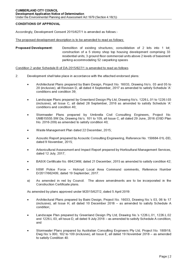
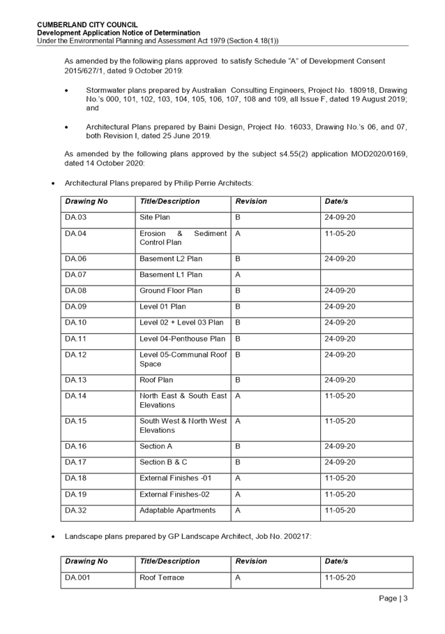
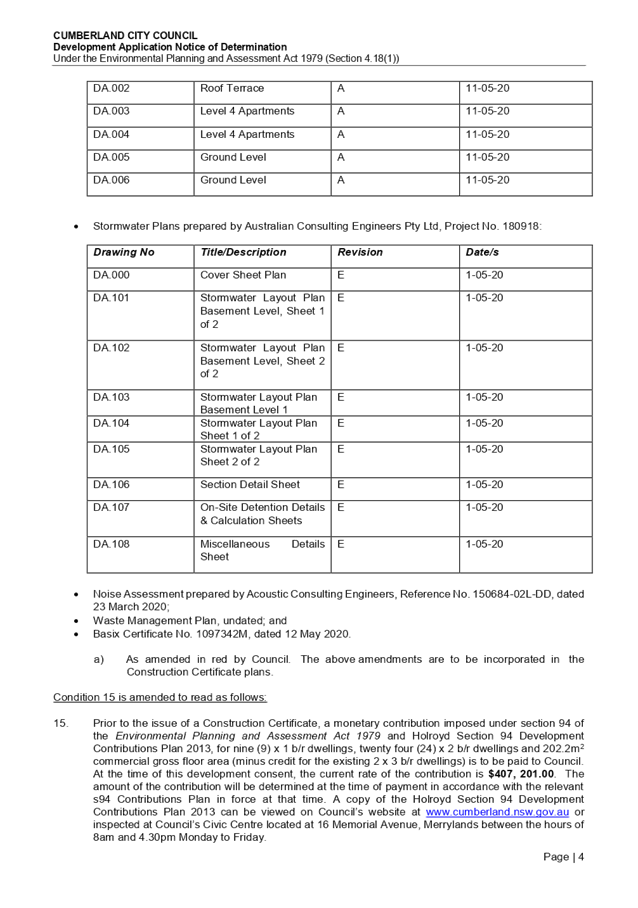
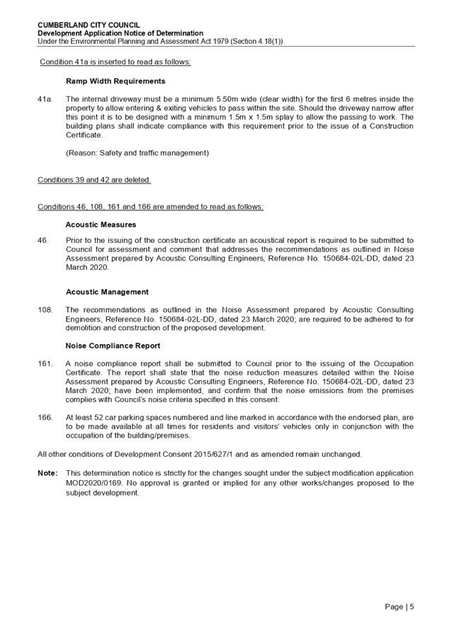
DOCUMENTS
ASSOCIATED WITH
REPORT LPP051/20
Attachment 2
Architectural Plans
Cumberland Local Planning Panel Meeting
14 October 2020
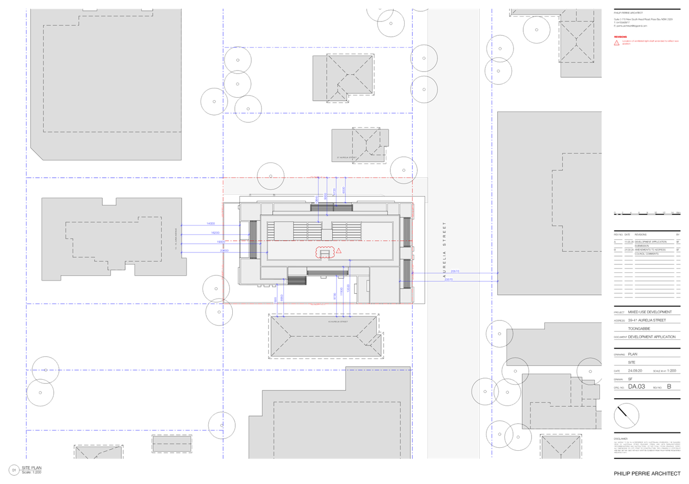
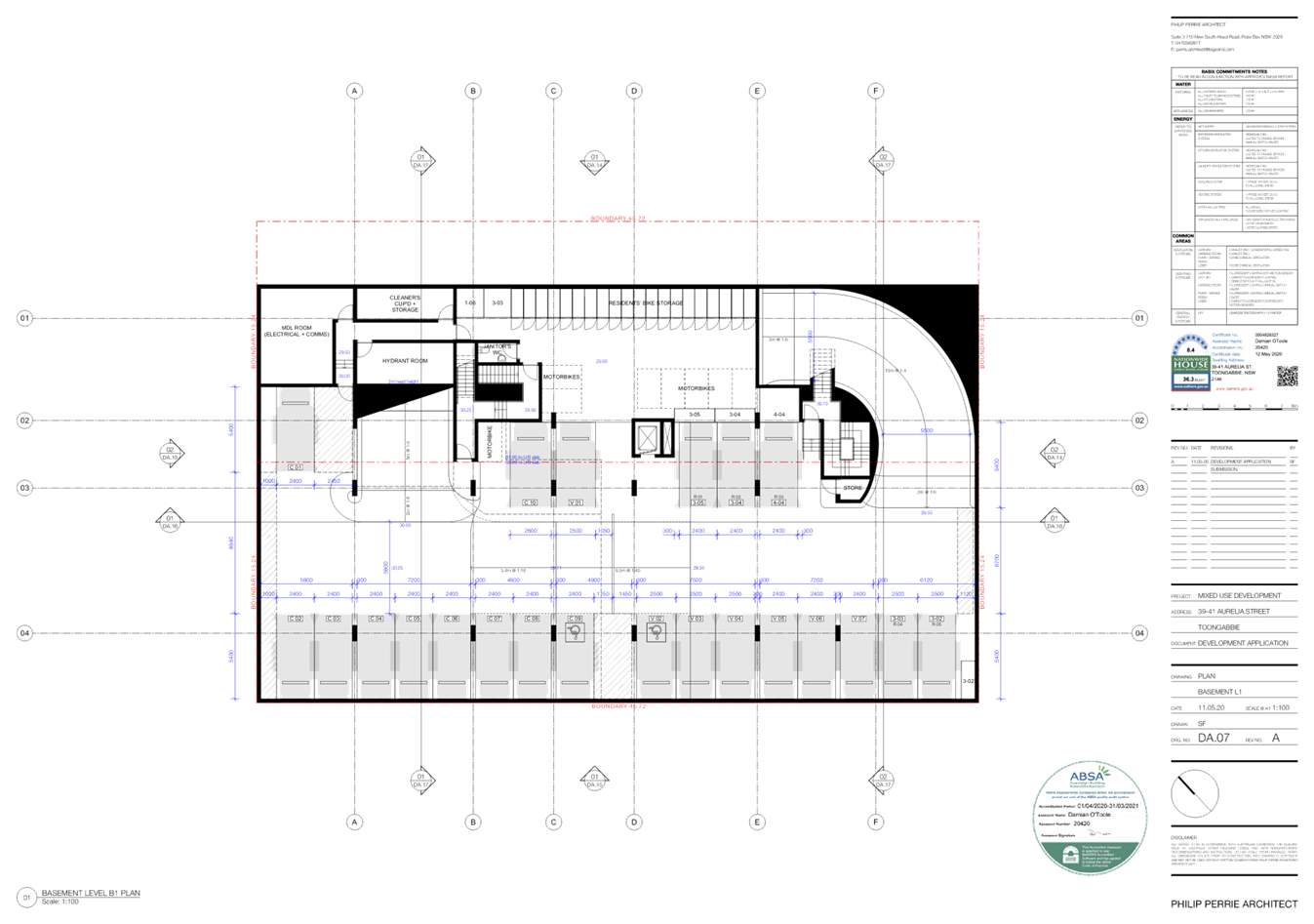
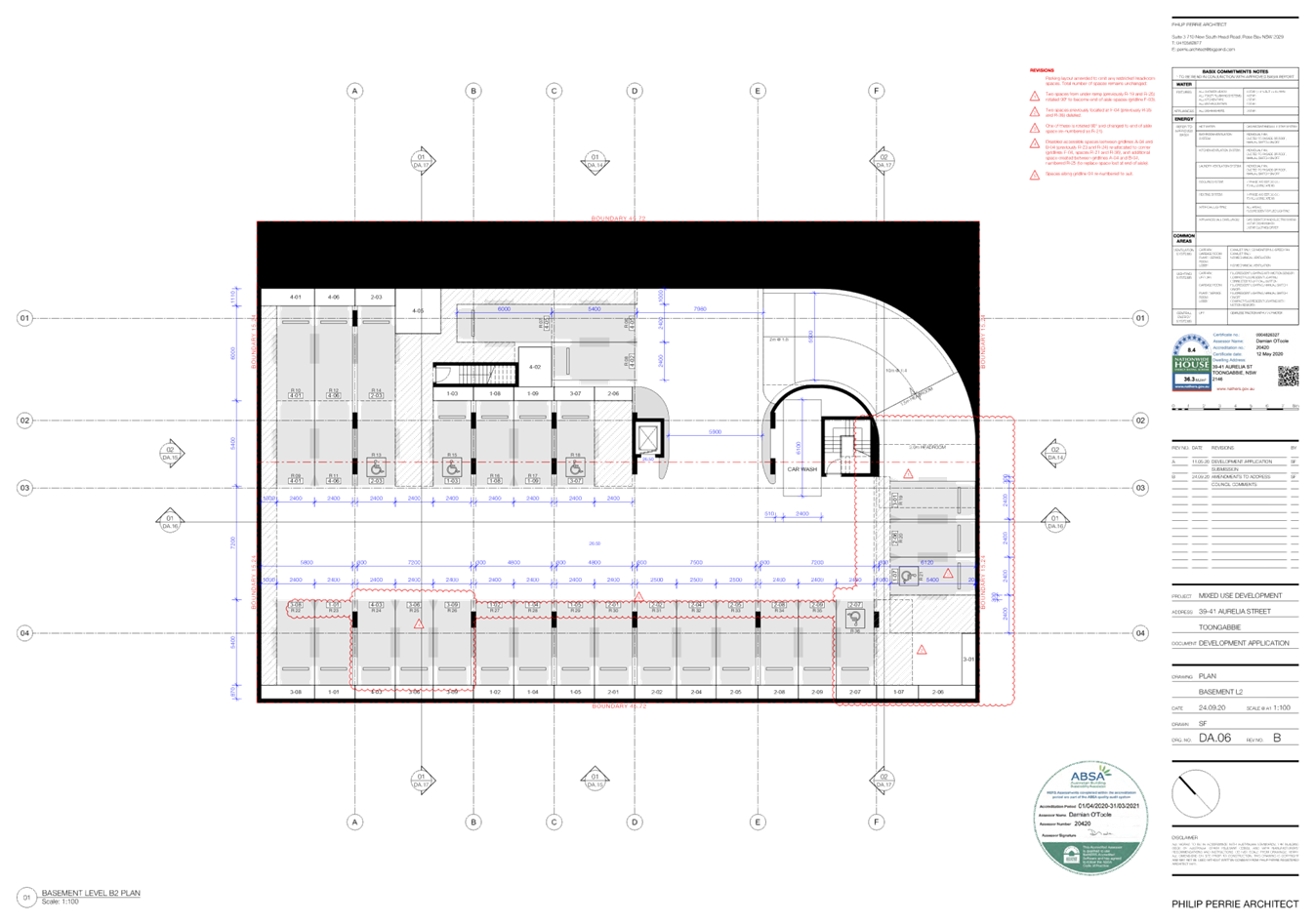
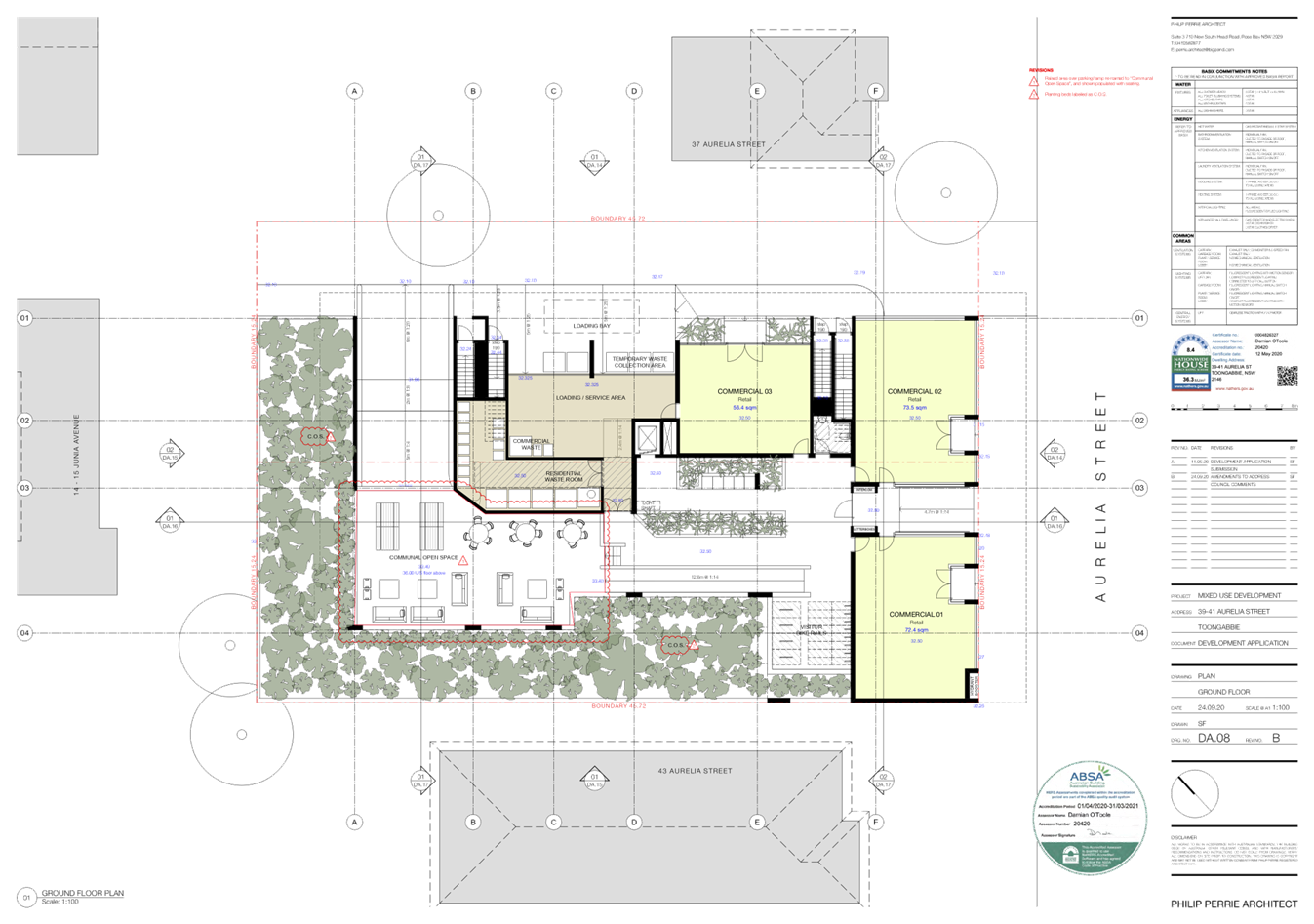
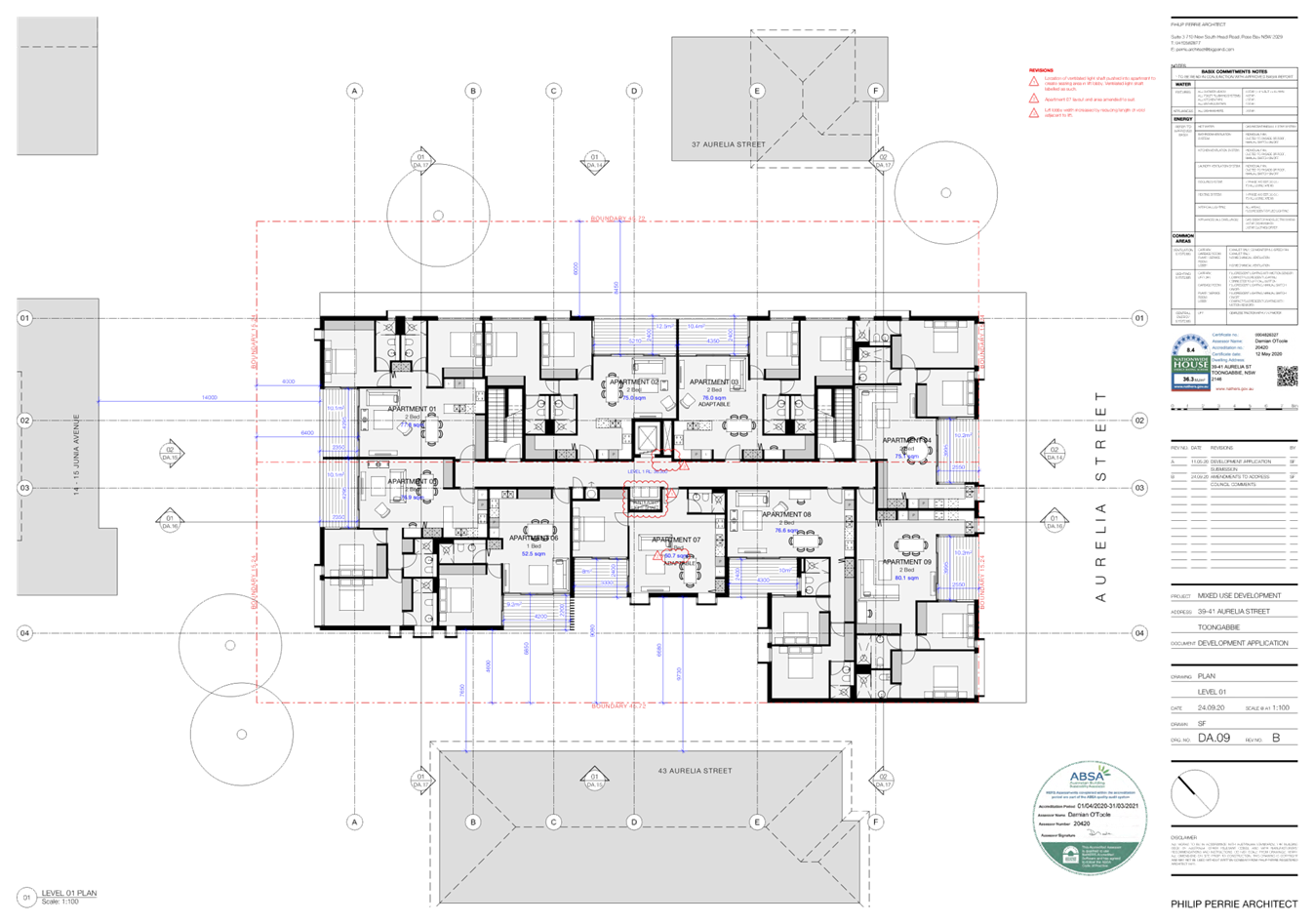

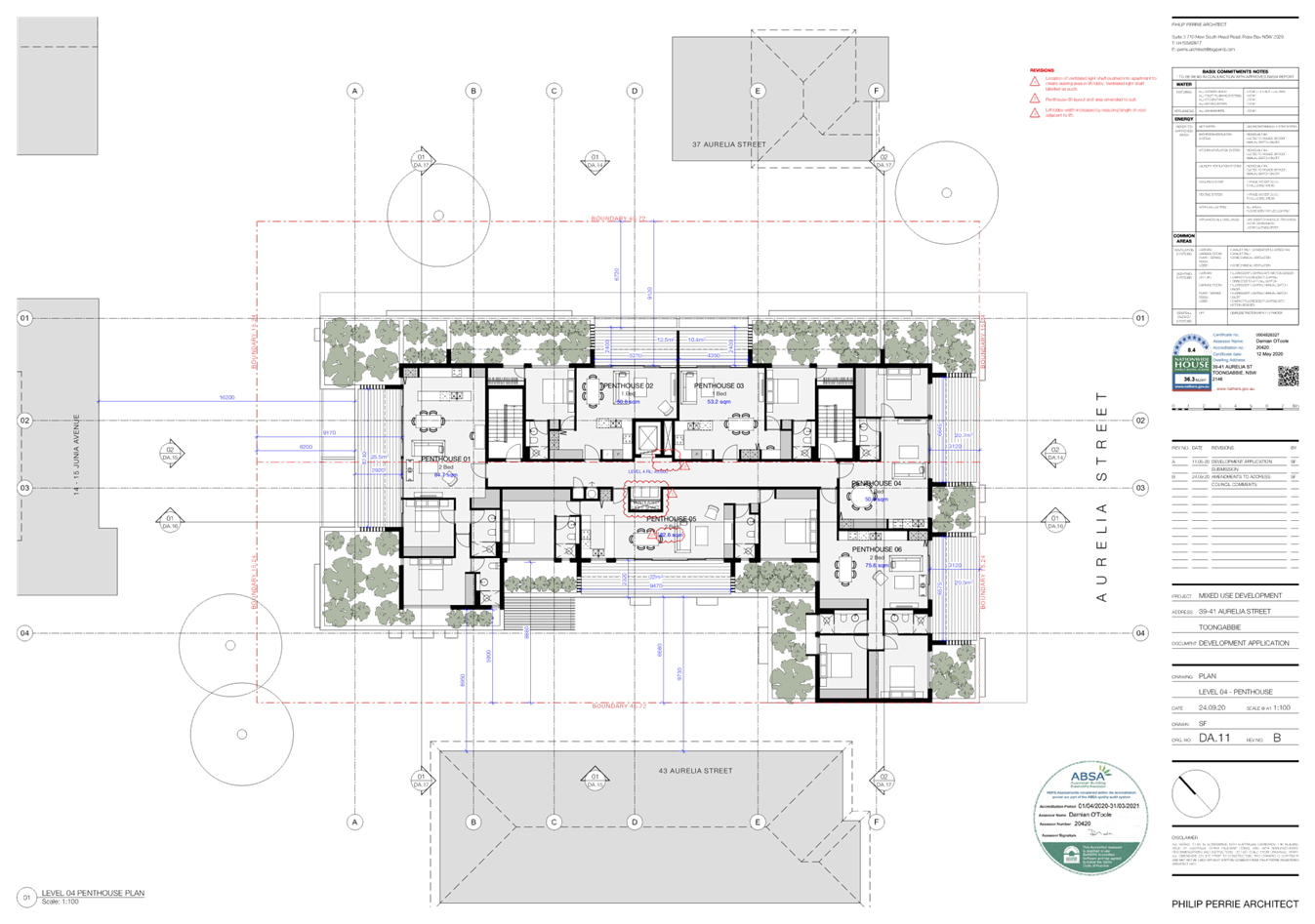
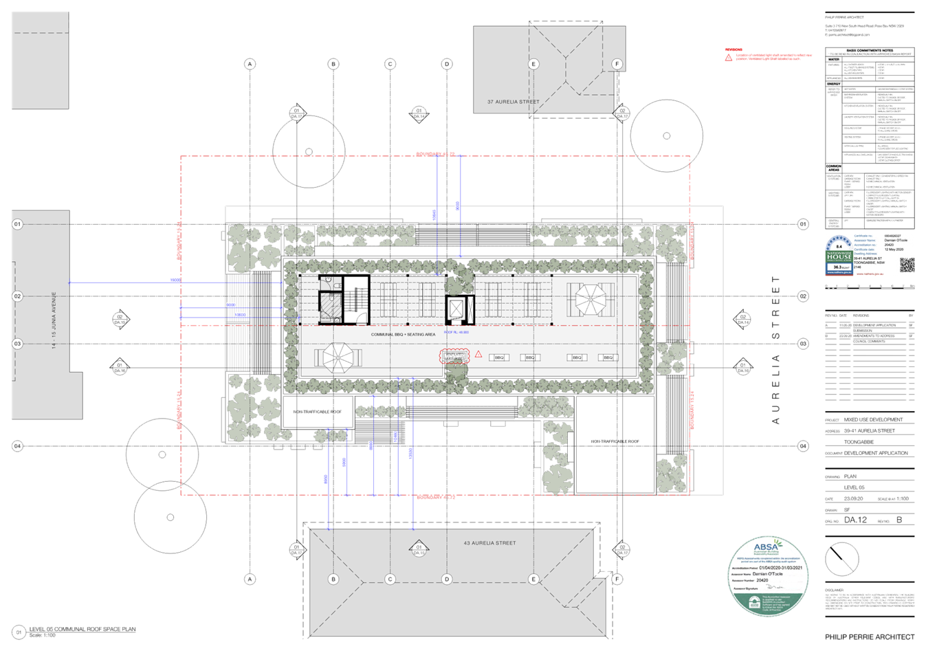
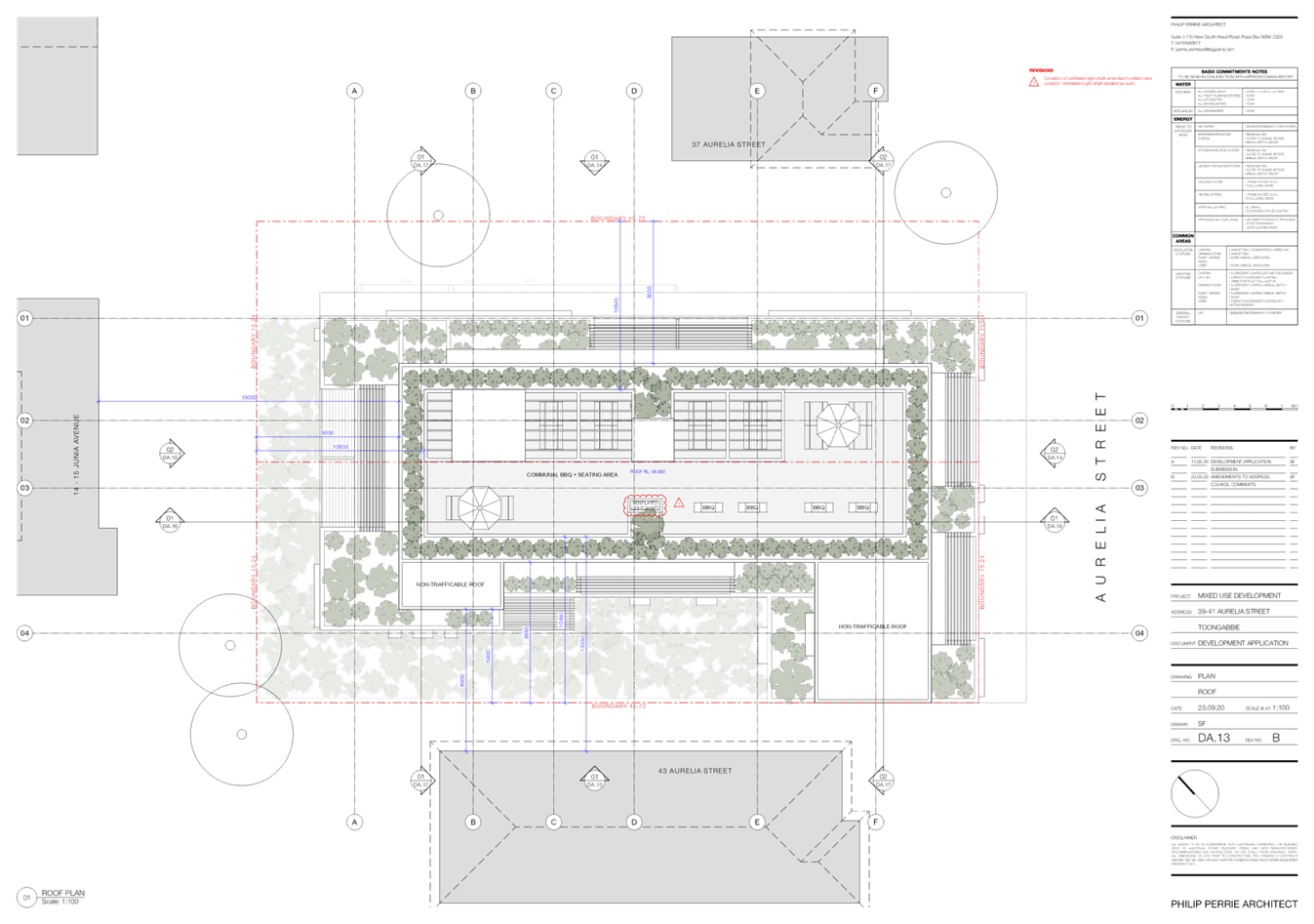
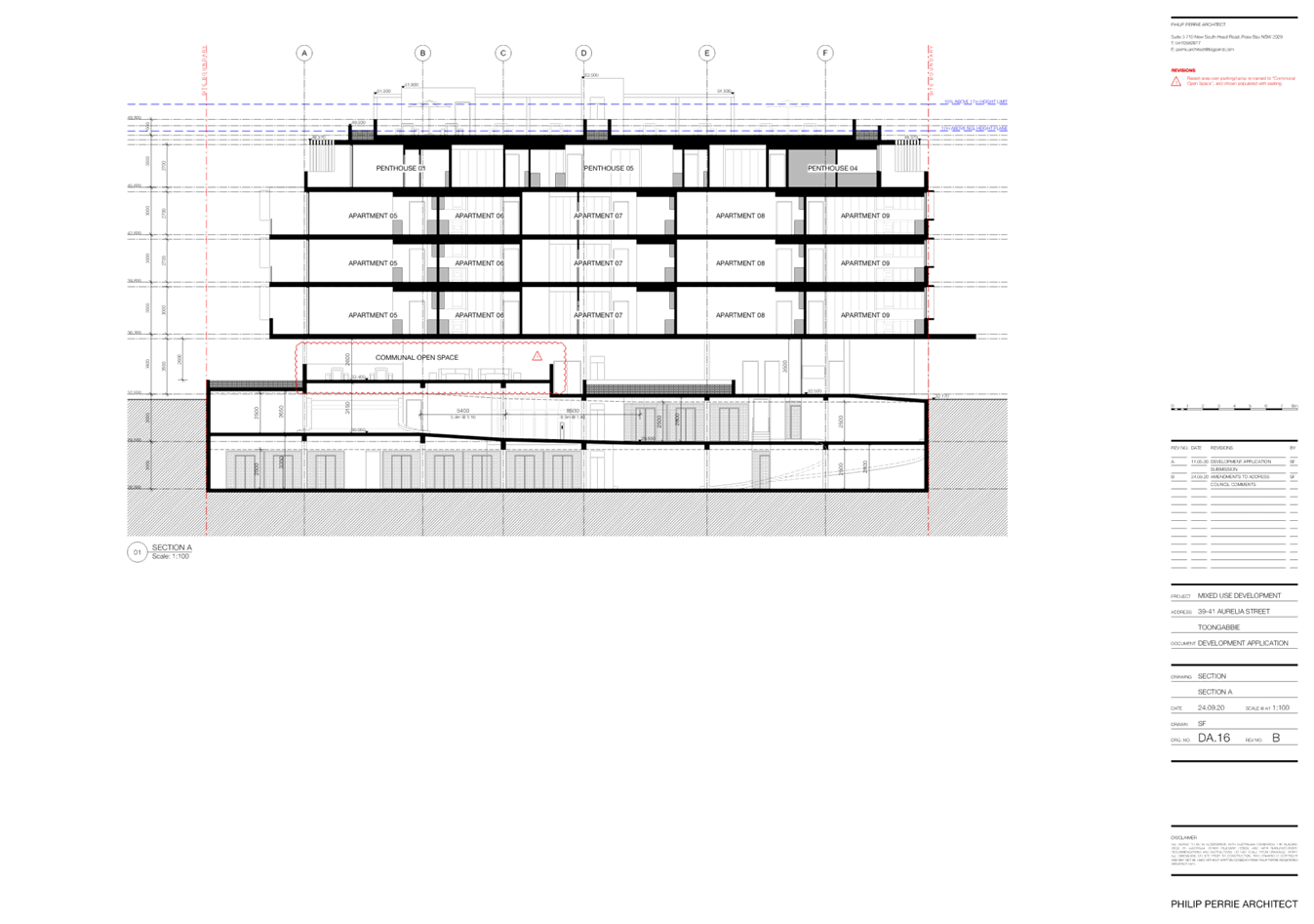
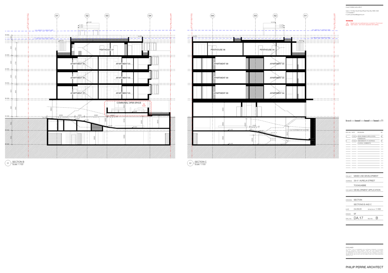
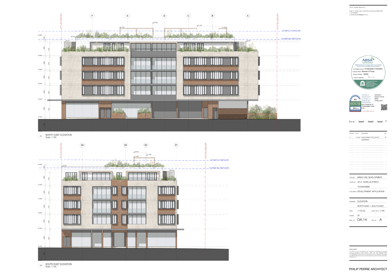
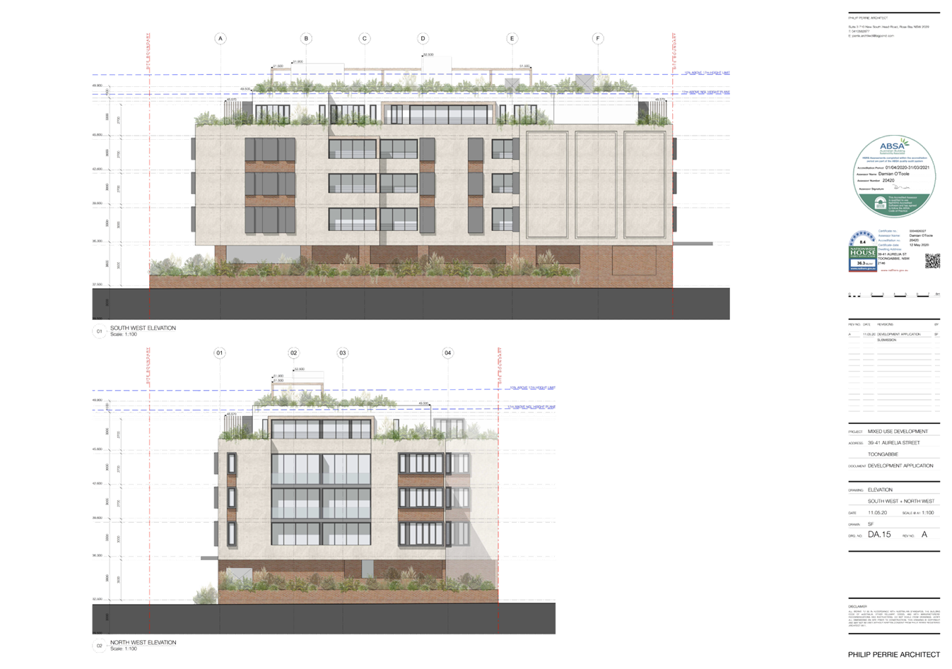
DOCUMENTS
ASSOCIATED WITH
REPORT LPP051/20
Attachment 3
Original Development Consent
Cumberland Local Planning Panel Meeting
14 October 2020


DOCUMENTS
ASSOCIATED WITH
REPORT LPP051/20
Attachment 4
SEPP 65 Design Quality of Residential Apartment
Development
Cumberland Local Planning Panel Meeting
14 October 2020
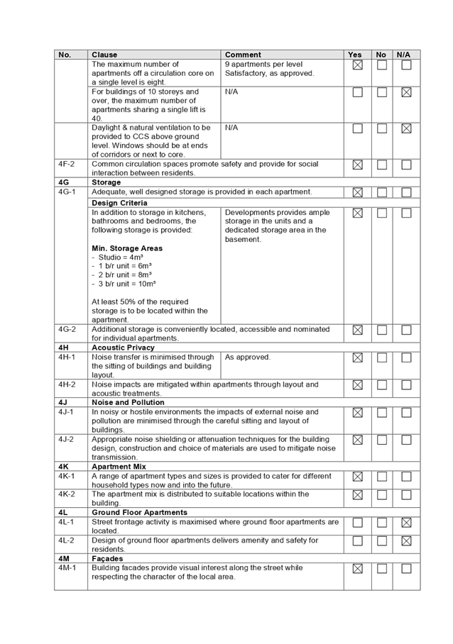
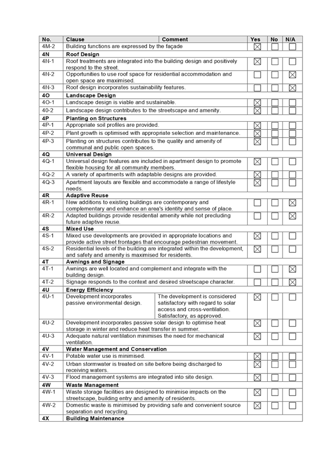

DOCUMENTS
ASSOCIATED WITH
REPORT LPP051/20
Attachment 5
Holroyd LEP 2013
Cumberland Local Planning Panel Meeting
14 October 2020
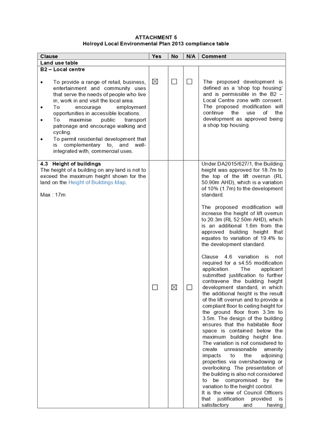
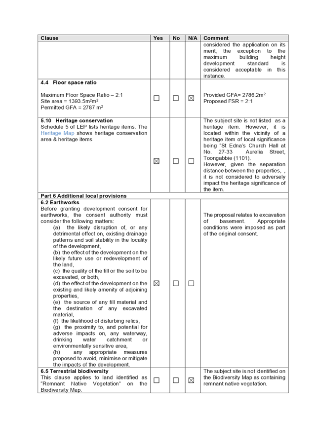
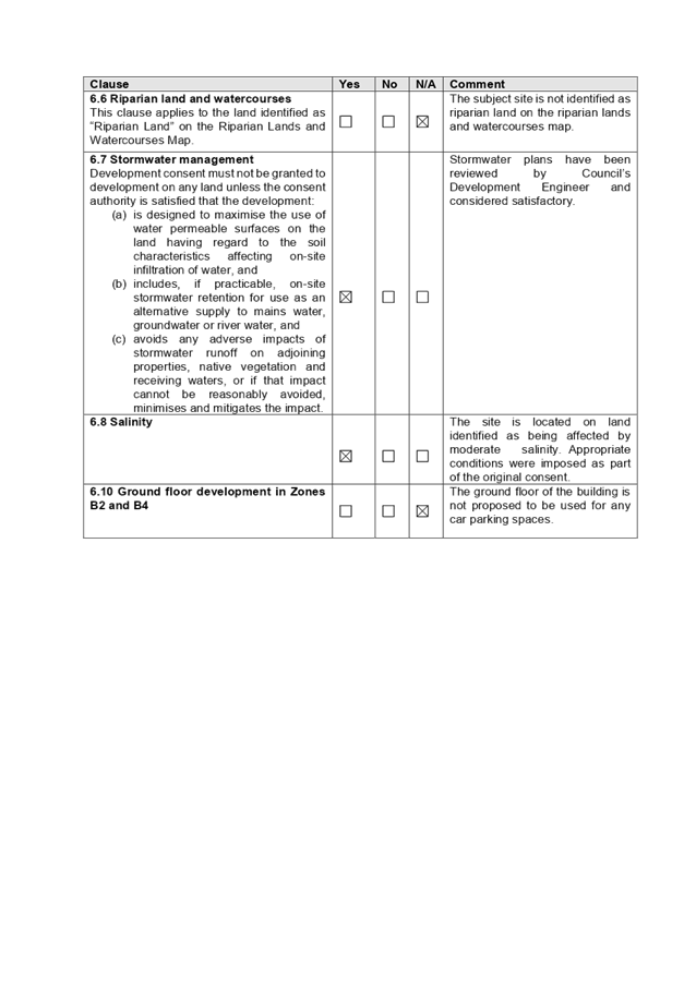
DOCUMENTS
ASSOCIATED WITH
REPORT LPP051/20
Attachment 6
Holroyd Development Control Plan
Cumberland Local Planning Panel Meeting
14 October 2020
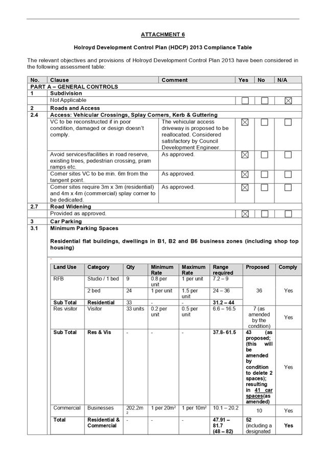
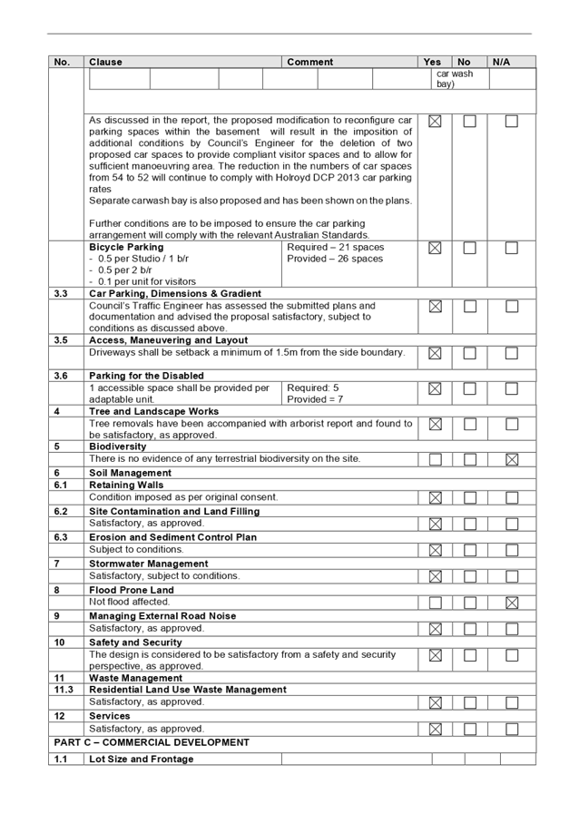
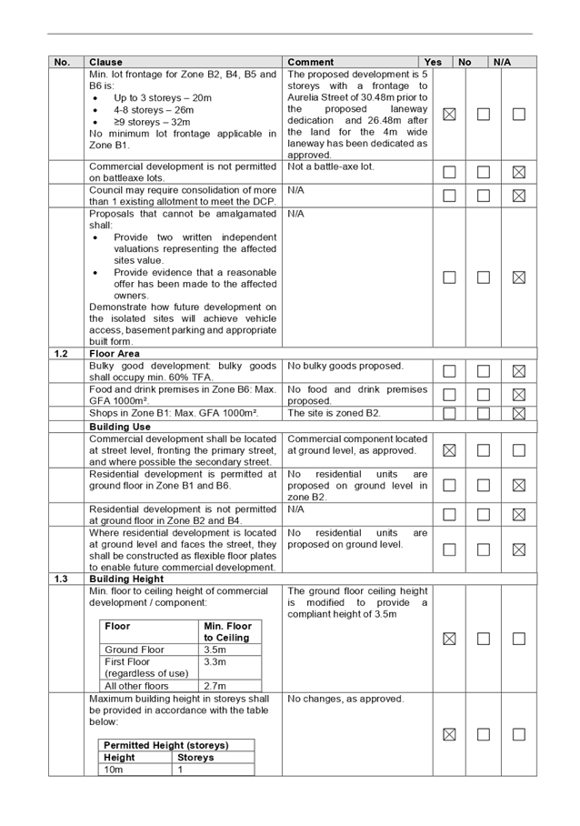
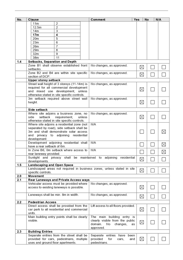
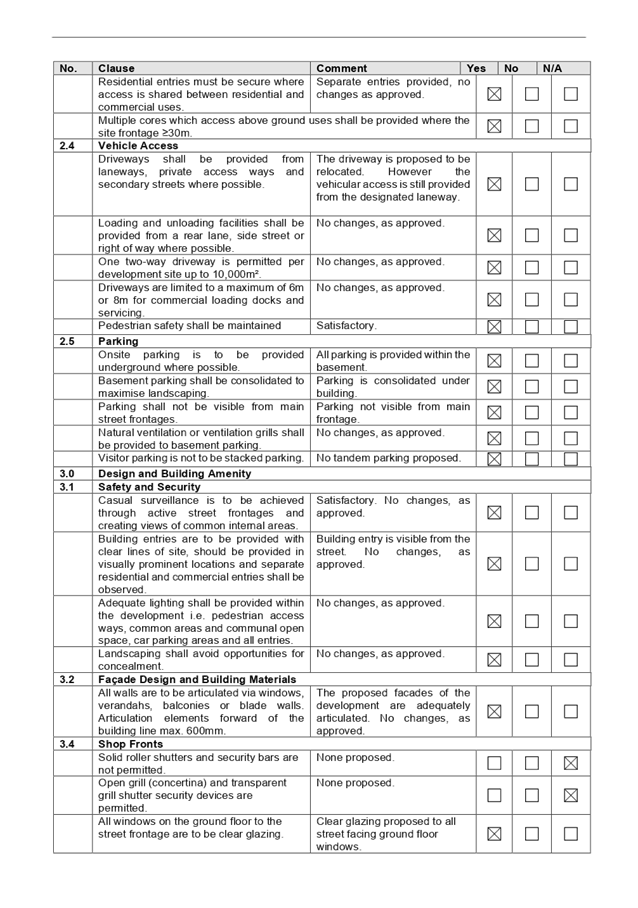
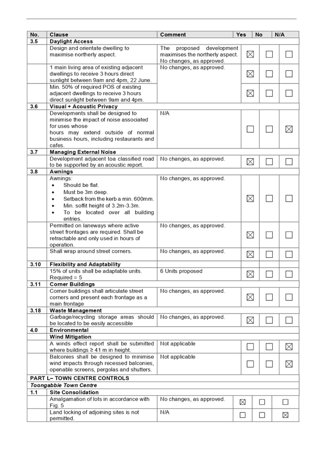
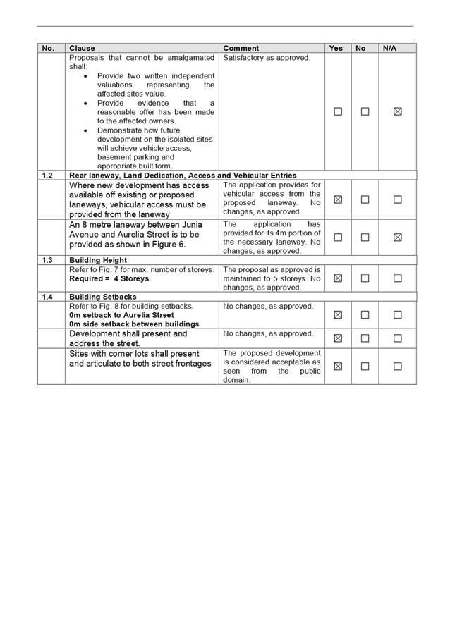
DOCUMENTS
ASSOCIATED WITH
REPORT LPP051/20
Attachment 7
Applicant's Justification to Building Height
Cumberland Local Planning Panel Meeting
14 October 2020