9 September 2020
An Electronic meeting of the
Cumberland Local Planning Panel
will be held via Zoom on Wednesday, 9 September 2020.
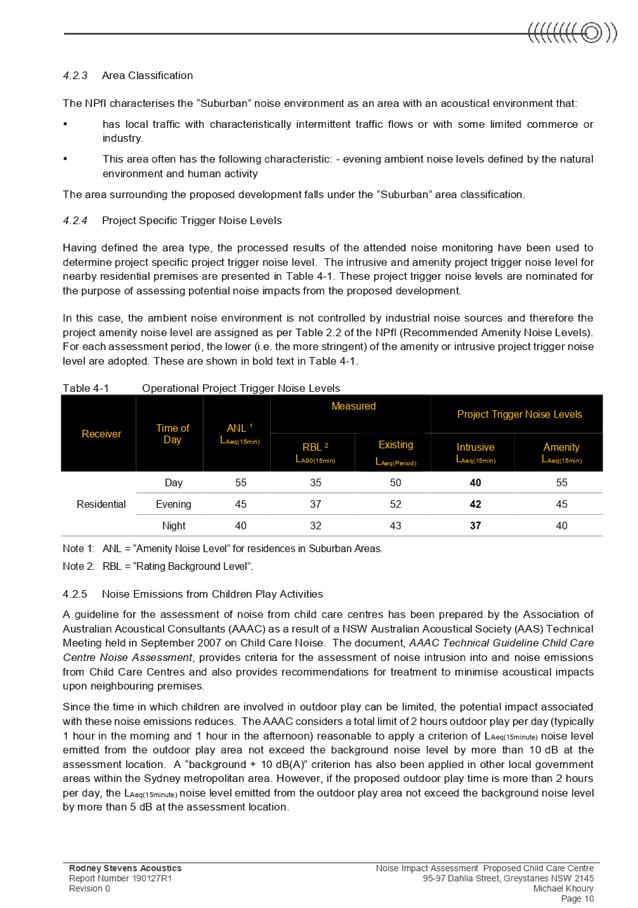
Business as below:
Yours faithfully
Hamish McNulty
General
Manager
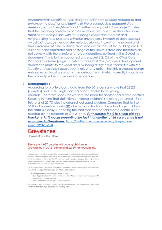
ORDER OF BUSINESS
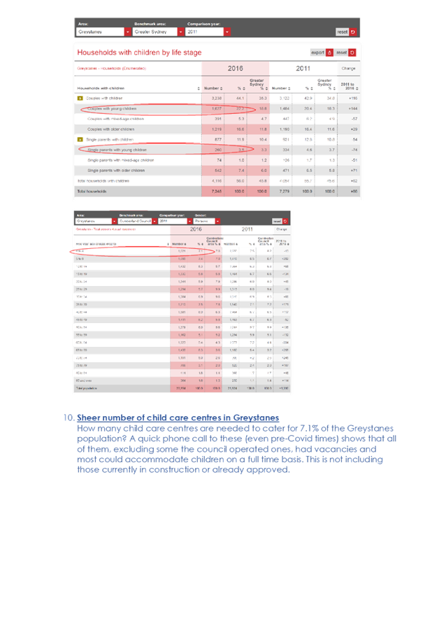
1. Receipt of Apologies
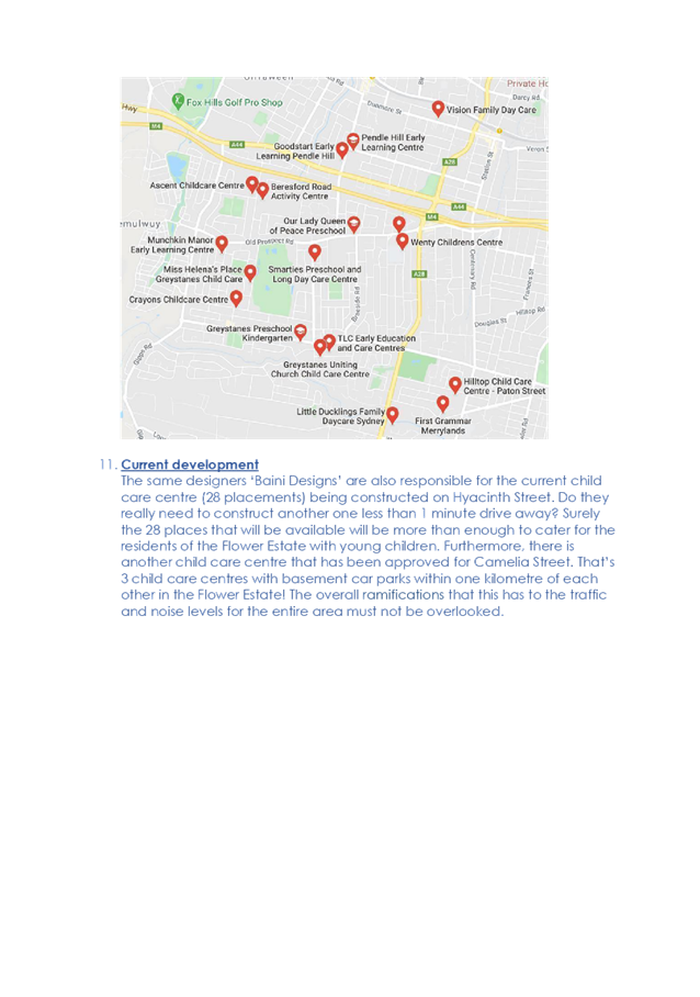
2. Confirmation of Minutes
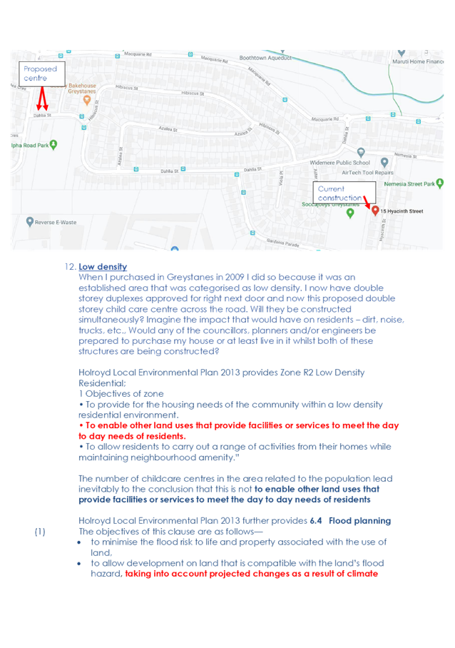
3. Declarations of Interest
4. Address by invited
speakers
5. Reports:
- Development
Applications
- Planning
Proposals
6. Closed Session Reports
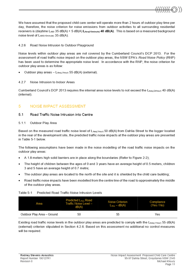
Cumberland Local Planning Panel Meeting
9 September 2020
CONTENTS
Report No. Name of Report Page
No.
Development Applications
LPP045/20... Delegations for
Modification Applications....................................................... 5
LPP046/20... Development Application
for 95-97 Dahlia Street, Greystanes................. 31
LPP047/20... Development Application
for 26 Mary Street, Auburn............................... 373
LPP048/20... Development Application
for 3 & 5 Haig Street, Wentworthville............. 443
Cumberland Local Planning Panel Meeting
9 September 2020
Item
No: LPP045/20
Delegations
for Modification Applications
Responsible
Division: General
Manager
Officer: General
Counsel
File
Number: 2041456
The purpose of this report is to:
(1) Inform
the Panel of delegations granted by Council following its consideration of the
recent direction issued under s.9.1 of the Environmental Planning and
Assessment Act 1979 in respect of the power to determine applications to
modify a development consent; and
(2) Confirm
arrangements for the control and direction of Land and Environment Court
appeals arising from determinations of the Panel.
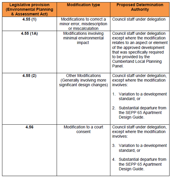
Delegation to Determine
Applications to Modify a Development Consent
On 5 September 2018, Council
resolved to delegate to the General Manager the authority to determine, in the
place of the Cumberland Local Planning Panel, s4.55(1), s.4.55(1A), s4.55(2)
and s4.56 (2) modification applications, except where the modification involves
(i) a variation to a development standard, or (ii) a substantial departure from
the SEPP 65 Apartment Design Guide, or (iii) a condition of consent that was
specifically imposed by the Cumberland Local Planning Panel (in addition to the
draft conditions). Subsequent to Council’s resolution, communications
between Council’s Executive Manager Development and Building and the
Panel chair took place in relation to delegation for the determination of
modification applications inclusive of the following table to set parameters
for when staff had the ability to determine modification applications:
Council’s General Counsel
has undertaken an overhaul of delegations under s.378 of the Local
Government Act 1993 for all operating areas of the Council. Implementation
of the new delegations, comprising some 100 operational and financial
delegations and 760 statutory based delegations, will be overseen by
Council’s Corporate Services team in the near future.
In relation to the power to
determine modification applications and arrangements outlined above, General
Counsel raised concern as to levels of uncertainty caused by (i) there being no
need to make a clause 4.6 submission to vary a development standard in respect
of modification applications and hence there is some ambiguity as to whether a
development standard is being varied and (ii) there is a level of subjectivity
and uncertainty as to what comprises a substantial departure from the SEPP 65
Apartment Design Guide.
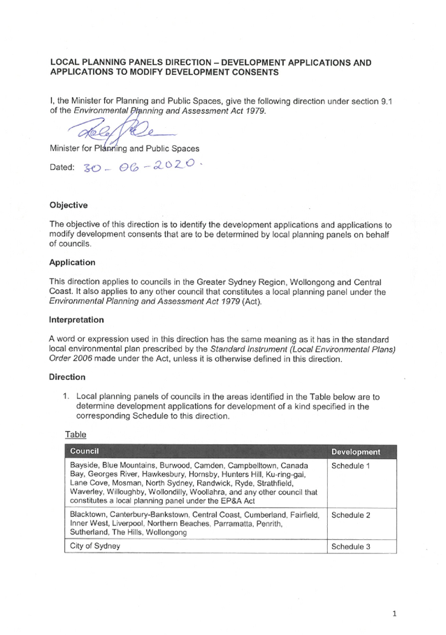
On 30 June 2020, the Minister for
Planning and Public Places issued a new direction under s.9.1 of the Act in
relation to powers to determine development applications and modification
applications. A copy of the direction is at Attachment 1. As the Panel is
likely aware, changes with respect to the power to determine development
applications as compared to the earlier s.9.1 direction issued on 23 February
2018 were minor only, with the addition of a
paragraph to explain what a unique submission is in the context of contentious
development whereby the receipt of 10 or more unique submissions triggers
consent authority functions for the Panel. Noting Council’s resolution of
20 November 2019 to rescind the Cumberland Local Planning Panel Policy and
the Cumberland Local Planning Panel Procedure, and to continue to rely
on the current provisions of the relevant Ministerial Directions for the
operation of Local Planning Panels, no further consideration of the development
application determination powers is necessary by the Council or the Panel.
The new s.9.1 direction, along
with ambiguities of existing delegation arrangements and Council’s
overall review of delegations made it timely to revisit delegations for
modification applications and to set new, certain, parameters that are
consistent with the Minister’s direction. Doing so will also assist
reducing or eliminating prospective challenges to consents on a ground that the
determining authority did not have delegation to determine the application.
In respect of applications to
modify a consent, the direction prescribes that local planning panels are to
determine applications under s.4.55(2) of the Act that:
· propose
amendments to a condition of development consent recommended in the council
assessment report but which was amended by the panel, or
· propose
amendments to a condition of development consent that was not included in the
council assessment report but which was added by the panel, or
· meet
the criteria for development applications set out in the schedules to the
direction relating to conflict of interest, contentious development or
departure from development standards.
The direction further notes that
council should make arrangements for the determination of all other
modification applications under s.4.55(2), as well as sections 4.55(1) and
4.55(1A) of the Act, by Council staff and that arrangements should also be made
for the determination of applications under s.4.56 by either the local planning
panel or council staff.
At its meeting on 5 August 2020,
Council considered a report on delegations for the determination of
modification applications (Attachment 2) and resolved as follows:
1. Delegate
power to the General Manager to determine all applications to modify a
development consent under s.4.55(1) and s.4.55(1A) of the Environmental
Planning and Assessment Act 1979.
2. Note
s.4.55(2) applications which must be determined by the Cumberland Local
Planning Panel pursuant to the direction issued under s.9.1 of the Environmental
Planning and Assessment Act 1979 by the Minister for Planning and Public
Spaces on 30 June 2020.
3. Delegate
power to the General Manager to determine all applications to modify a
development consent under s.4.55(2) of the Environmental Planning and
Assessment Act 1979 other than those applications which must be determined
by the Cumberland Local Planning Panel pursuant to the s.9.1 direction.
4. Delegate
power to the General Manager to determine all applications to modify a
development consent under s.4.56 of the Environmental Planning and
Assessment Act 1979 other than those applications which would be determined
by the Panel if the application was treated as a s.4.55(2) application, in
which case the Panel is to be the consent authority.
5. Note
s.4.55(2) applications which must be determined by the Sydney Central City
Planning Panel pursuant to clause 123BA of the Environmental Planning and
Assessment Regulation 2000 and the Instruction on Functions Exercisable
by Council on Behalf of Sydney District or Regional Planning Panels –
Applications to Modify Development Consents published on the NSW planning portal
on 30 June 2020.
No action or decision of the Panel
is required in relation to the new delegations to determine modification
applications. Council staff will ensure modification applications are referred
to the Panel for determination in line with the Minister’s direction and
the Council’s resolution.
Arrangements for Court Appeals
Where the Panel Was the Consent Authority
Section 8.15(4) of the Act
relevantly provides that if an appeal to the Land and Environment Court is
filed against a determination or decision of a local planning panel, the
Council for the area concerned is to be the respondent to the appeal but is
subject to the control and direction of the Panel in connection with the
conduct of the appeal. The section further provides that the council is to give
notice of the appeal to the Panel.
Established arrangements between
Council and the Panel chair are that:
· Council
will notify the Panel chair of the receipt of an appeal and afford an
opportunity for any specific directions in respect of the appeal.
· Failing
specific directions, Council will not provide the Panel with a copy of the
Statement of Facts and Contentions prior to filing, but contentions raised
within the Statement will reflect the Panel’s determination of the
application, including applicable grounds for refusal or conditions.
· Pending
the applicant proposing amendments to the development in an effort to overcome
the contentions in the proceedings, officers of the Council can provide final
instructions on whether or not to enter into a conciliated agreement or consent
orders.
· Subject
to the above, as a general rule the Panel or its chair will not be approached
for ongoing instructions, albeit the staff retain discretion to refer a matter
to the Panel or its chair if they see fit.
· Council
will provide the panel, via an email to the Panel chair, with a precis of the
outcome of conciliation conferences and judgments.
The above arrangements have served
Council well in terms of the running of appeals and consequently it is not
recommended that the substance of the arrangements be altered. However, as a
matter of good governance, it is proposed that the arrangements be formalised
by way of a delegation from the Panel.
The recommendation seeks to
formalise delegations for the conduct of court appeals in respect of decisions
of the Panel and for the Panel to note revised delegations to determine
applications to modify a development consent.
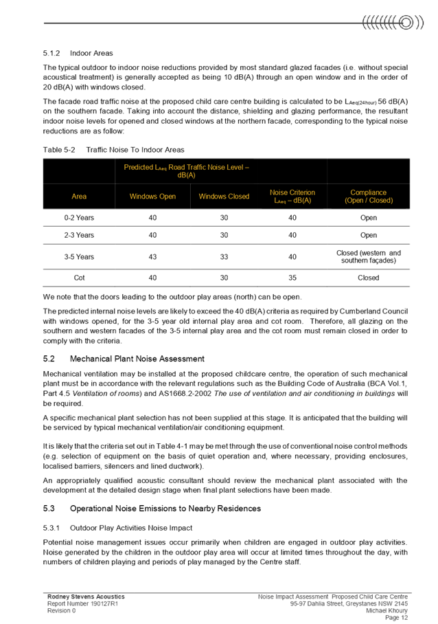
There are no consultation
processes for Council associated with this report.
Financial Implications:
Financial implications arise in terms of payments that are made to
panel members for attendance at panel meetings. The determination of
delegations should primarily be based on sound town planning and probity
reasons with financial implications given lesser weight.
Policy Implications:
There are no policy implications
for Council associated with this report.
Communication /
Publications:
There is no need to notify the
outcome of this matter in a local newspaper or other publication.
|
1) The
Panel note revised delegations to determine development applications arising
from the s.9.1 direction made on 30 June 2020 and Council’s resolution
of 5 August 2020, whereby:
1.1 Council
staff have delegated authority to determine all applications under s.4.55(1)
and s.4.55(1A).
1.2 The
Local Planning Panel is the consent authority for applications under
s.4.55(2) that involve any of the following:
(a) where
the applicant or land owner are any of:
(i) the
Council,
(ii) a
Councillor,
(iii) a
staff member principally involved in the exercise of functions under the
Environmental Planning and Assessment Act 1979,
(iv) a
member of the Commonwealth or NSW parliament,
(v) the
parent, grandparent, brother, sister, uncle, aunt, nephew, niece, lineal
descendant or adopted child of the person of any person referred to in (ii),
(iii) or (iv),
(vi) the
parent, grandparent, brother, sister, uncle, aunt, nephew, niece, lineal
descendant or adopted child of a person who is a spouse or defacto partner of
any person referred to in (ii), (iii) or (iv);
(vii) the
spouse or defacto partner of any person referred to in (v) or (vi).
not
being applications for any of the following:
- internal
alterations and additions to a building that is not a heritage item;
- advertising
signage;
- maintenance
and restoration of a heritage item; or
- minor
building structures projecting from the building facade over public land.
(b) where
10 or more unique objections were received. NB if more than one round of
notification took place, the cumulative number of submissions from all rounds
of notification are counted;
(c) a
form of development that varies a provision of an environmental planning
instrument that is a numerical development standard (irrespective that the
variation does not require consideration under clause 4.6 of the Local
Environmental Plan) by more than 10%; or
(d) a
form of development that varies a provision of an environmental planning
instrument that is a non-numerical development standard (irrespective that
the variation does not require consideration under clause 4.6 of the Local
Environmental Plan).
1.3 Council
staff have delegated authority to determine all applications under s.4.55(2),
other than those applications covered by 1.2 above.
1.4 Council
staff have delegated power to determine all applications to modify a
development consent under s.4.56 of the Environmental Planning and
Assessment Act 1979 other than those applications which would be
determined by the Panel if the application was treated as a s.4.55(2)
application, in which case the Panel is to be the consent authority.
2) That
pursuant to s.2.20(8) of the Environmental Planning and Assessment Act 1979
(the Act), the Cumberland Local Planning Panel delegates to the General
Manager, Director Environment and Planning, Executive Manager Development and
Building, Coordinator Major Development Assessment and Coordinator Fast Track
Development Assessment the power to provide day to day instructions and
directions in respect of the conduct of appeals before the Land and
Environment Court arising from determinations of the Panel including powers
to determine whether or not to enter into a conciliated agreement or consent
orders, noting procedures in place that:
(a) the
Panel chair will be notified of the receipt of an appeal and afforded an
opportunity to provide any specific directions in respect of the appeal;
(b) Failing
specific directions, Council will not provide the Panel with a copy of the
Statement of Facts and Contentions prior to filing, but contentions raised
within the Statement will reflect the Panel’s determination of the
application, including applicable grounds for refusal or conditions;
(c) as
a general rule the Panel or its chair will not be approached for ongoing
instructions, albeit the staff retain discretion to refer a matter to the
Panel or its chair if they see fit; and
(d) The
Panel chair will be provided with a precis of the outcome of conciliation
conferences and judgments.
|
1. Section
9.1 direction
2. Report
to Council of 5 August 2020
DOCUMENTS
ASSOCIATED WITH
REPORT LPP045/20
Attachment 1
Section 9.1 direction
Cumberland Local Planning Panel Meeting
9 September 2020
DOCUMENTS
ASSOCIATED WITH
REPORT LPP045/20
Attachment 2
Report to Council of 5 August 2020
Cumberland Local Planning Panel Meeting
9 September 2020


Cumberland
Local Planning Panel Meeting
9 September 2020
Item
No: LPP046/20
Development
Application for 95-97 Dahlia Street, Greystanes
Responsible
Division: Environment
& Planning
Officer: Acting
Executive Manager Development and Building
File
Number: DA2020/0207
|
Application
lodged
|
7 April 2020
|
|
Applicant
|
Baini Design
|
|
Owner
|
Mr M Khoury and Mrs N Khoury
|
|
Application
No.
|
DA2020/0207
|
|
Description
of Land
|
95-97 Dahlia Street Greystanes
Lots 16 & 17 in DP 236780
|
|
Proposed
Development
|
Demolition
of existing structures and construction of a two storey 66 place centre-based
childcare facility over basement car parking
|
|
Site
Area
|
1,157.2m2
(562.8m2 by title
for 95 Dahlia St and 594.4m2 by title for 97 Dahlia St)
|
|
Zoning
|
R2 – Low Density
Residential
|
|
Disclosure
of political donations and gifts
|
Nil disclosure
|
|
Heritage
|
The subject site does not
contain a heritage item and is not located within a heritage conservation
area.
Whilst not considered to be
within the immediate vicinity of the subject site, it is noted that there is
a heritage item of local significance located approximately 130m north of the
subject site, being ‘Boothtown Aqueduct’ (Item No. I52 of HLEP
2013). The proposed development is not expected to impact upon the heritage
item.
|
|
Principal
Development Standards
|
FSR
Permissible: 0.5:1
Proposed: 0.39:1
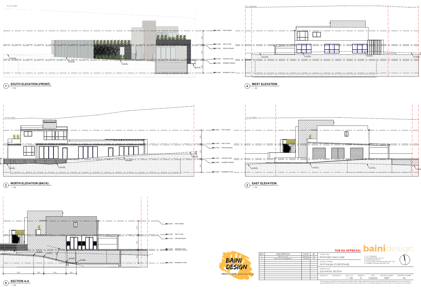
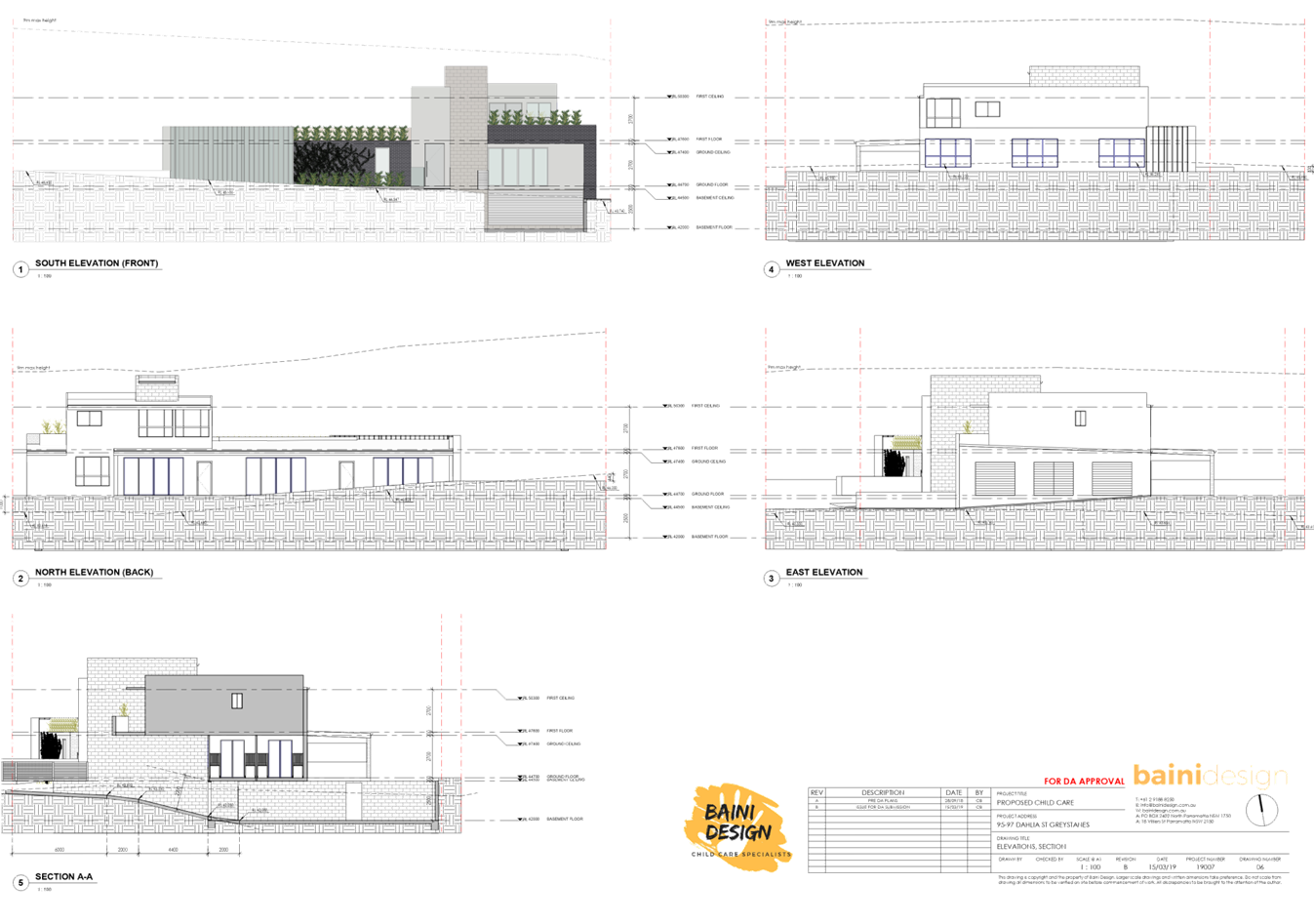
Height of Building
Permissible: 9m
Proposed: 8.4m (to top of lift
over run)
|
|
Issues
|
- Number of submissions
- Number
of children and outdoor unencumbered space
- Landscaping
|
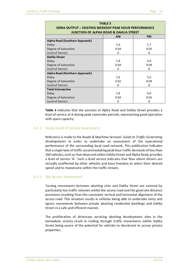
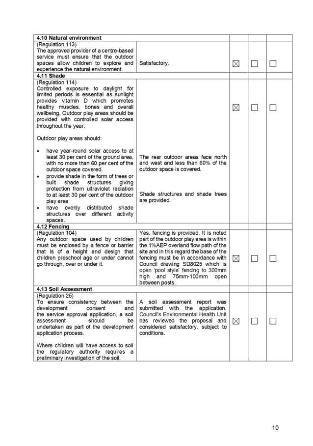
1. Development
Application No. DA2020/0207 was received on 5 May 2020 for the demolition of
existing structures and construction of a two storey 71 place centre-based
childcare facility over basement car parking.
2. The
application was publicly notified to occupants and owners of the adjoining
properties, online on Council’s website and a site notice was placed at
the property for a period of 14 days between 13 May 2020 and 27 May 2020.
3. The
application was renotified to occupants and owners of the adjoining properties
for a second period of 14 days between 1 June 2020 to 15 June 2020 as Council
received notice that notification letters were not received in an appropriate
timeframe and that the notification sign erected for the first notification
period was not erected adequately. In response, Council received a total of 55
submissions during both notification periods.
4. Council
through its assessment identified a number of concerns with the proposal
relating to flood mitigation measures, the provision of outdoor play space for
children and extent of fill proposed to within the overland flow path. These
matters have been appropriately addressed by the imposition of conditions of
consent requiring the submission of an updated flood study report, removal of
fill within the overland flow path, and the reduction in children placements
from 71 to 66.
5. There
are non-compliances with the proposed development having considered the provisions
of State Environmental Planning Policy (Educational Establishments and Child
Care Facilities) 2017, Child Care Planning Guideline (the Guideline) 2017, and
Holroyd Development Control Plan 2013 (HDCP).
6. The
proposed development seeks the following notable variations:
|
Control
|
Required
|
Provided
|
% variation
|
|
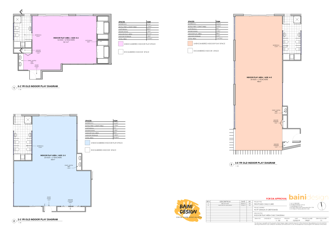
Number of children and outdoor unencumbered space
(regulation 108 and part 4.9 the Guideline)
|
7m² x 71 = 497m²
|
Proposed development = 497.1m²
Assessing officer’s calculation = 466.99m²
(excluding retaining walls and
low maintenance native shrubs and ground cover area proposed as per submitted
Landscape plan)
466.99m² / 7 = 66.7children
Recommendation = reduce number
of children from 71 to 66
|
6.04%
|
|
A child care centre proposed in an R2 Low Density
Residential zone is limited in size to accommodate not more than forty-five
(45) children
(HDCP 2013)
|
Maximum 45 Children
|
Proposed = 71 Children
Council’s recommendation is to amend the maximum
number of children to 66
|
57.8%
46.7%
|
|
Landscaping: 25% and minimum 2m dimensions
(HDCP 2013)
|
289.3sqm
|
222.44sqm landscaped area provided with min. 2m dimension.
|
23.11%
|
7. The
application has been referred to the Cumberland Local Planning Panel (CLPP) for
determination due to the number of submissions received during the notification
periods.
8. It
is recommended that the application be approved as a deferred commencement consent
for a maximum of 66 children (due to the available unencumbered outdoor
space/play area) subject to conditions provided in the Draft Notice of
Determination held at Attachment 1.
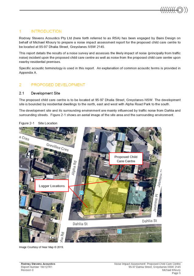
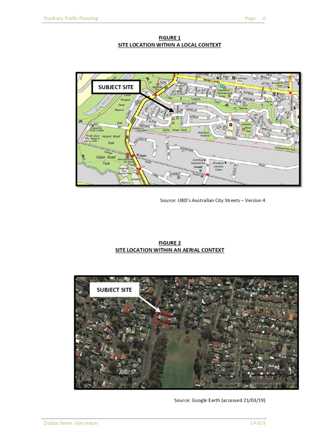
Subject Site and Surrounding
Area
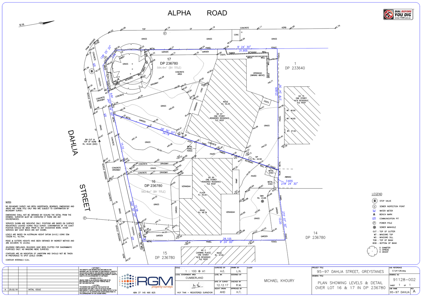
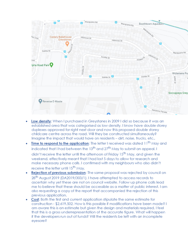
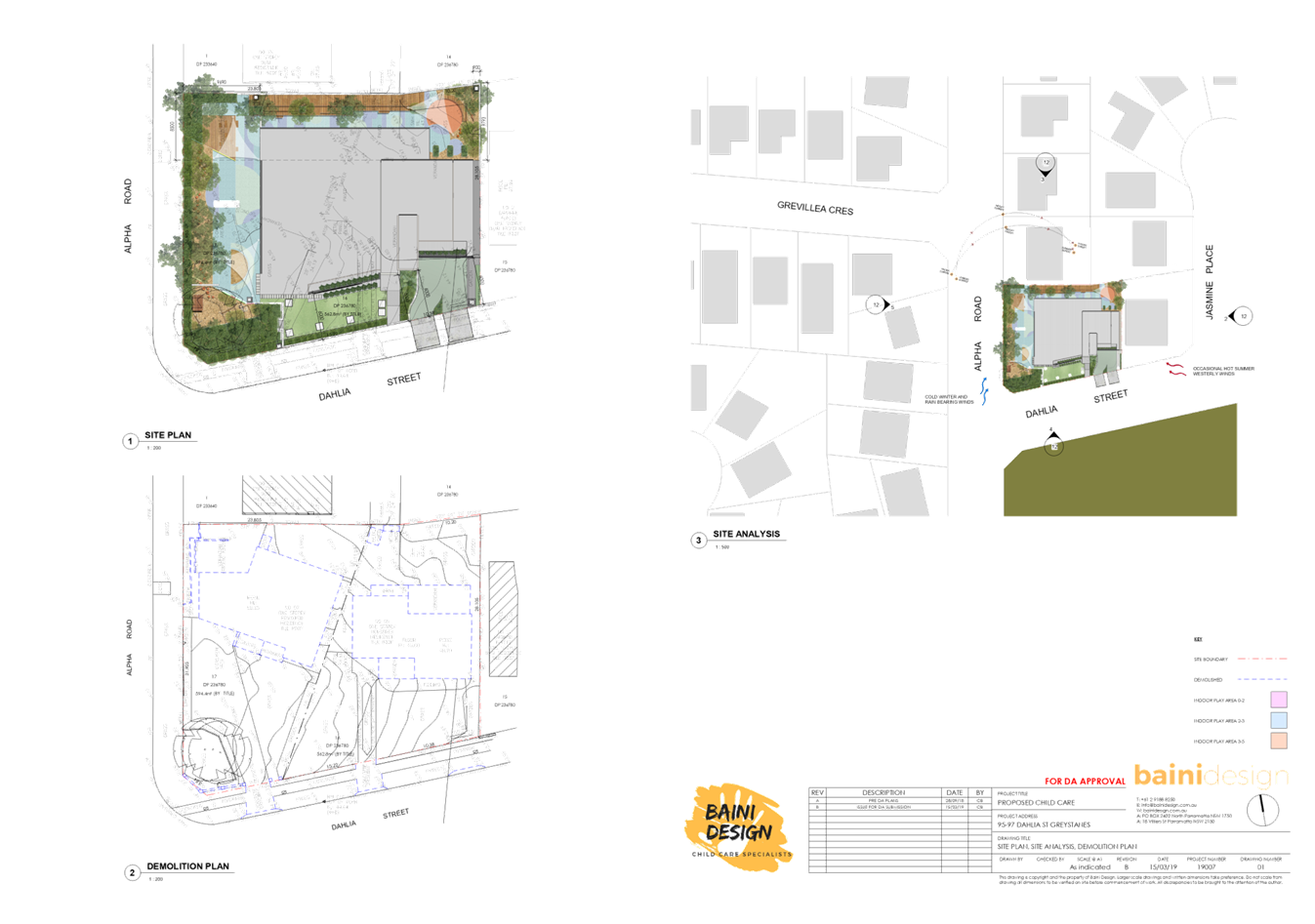
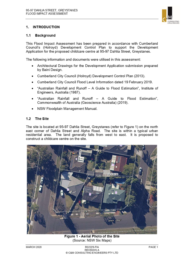
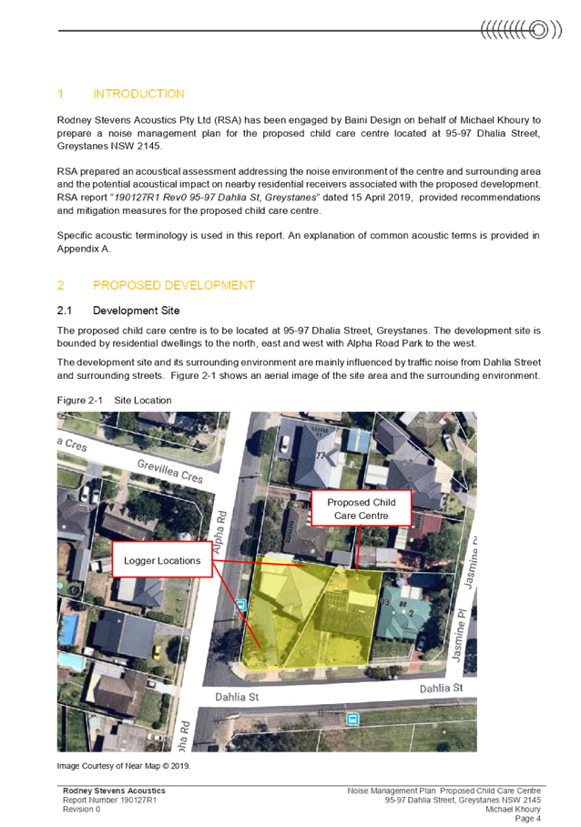
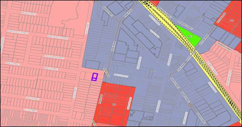
The subject site is known as 95-97
Dahlia Street Greystanes and is legally described as Lots 16 and 17 in DP
236780. The site is a corner allotment with a primary frontage to Dahlia Street
of 35.41m, secondary street frontage to Alpha Road of 31.905m, a splay of 3.84m
and a total site area of 1,157.2m².
The sites are currently each
occupied by a detached single storey rendered dwelling house and various
awnings. There is one large tree within the front setback (south-western
corner) of No. 97 Dahlia Street.
Directly opposite the site to the
south is Alpha Road Park. The sites directly to the east, west and north of the
site are detached dwelling houses. The immediate area is characterised by low
density housing, and a small group of commercial shops at the corner of Dahlia
Street and Hibiscus Street. The subject site and all immediate adjoining
properties are zoned R2 Low Density Residential, with the exception of Alpha
Road Park and commercial shops which are zoned RE1- Public Recreation and B1-
Neighbourhood Centre respectively.
Figure
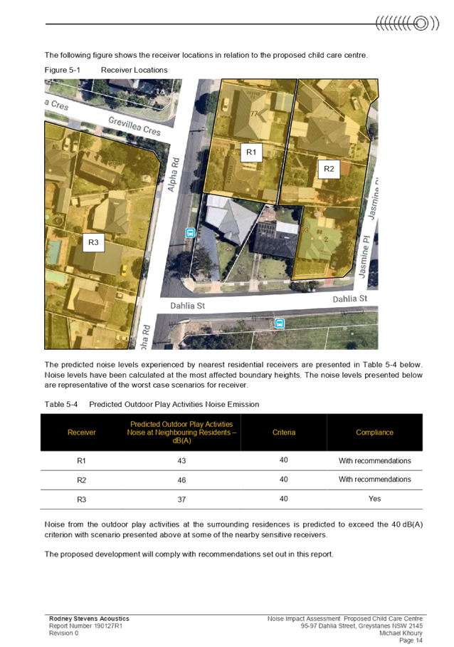
1 – Locality Plan of subject site indicated in purple outline.
Figure
2 – Aerial view of subject sites indicated by green marker/purple outline
Figure
3 – 95 Dahlia Street Greystanes

Figure
4 – 97 Dahlia Street Greystanes
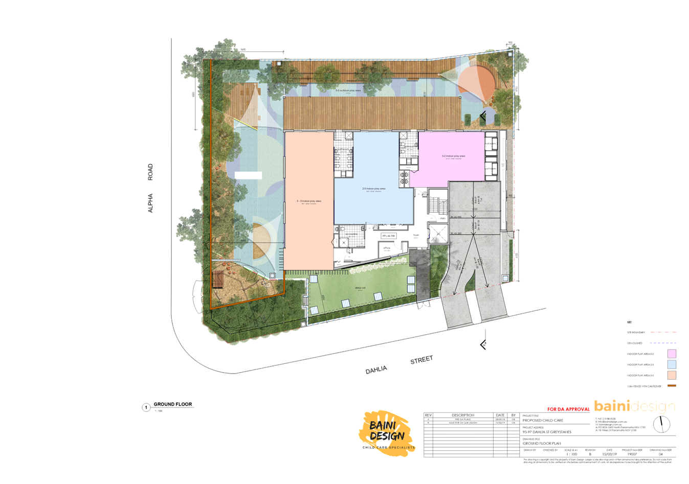
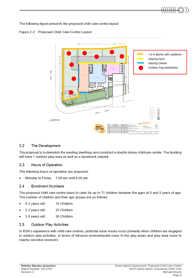
Description of The Proposed
Development
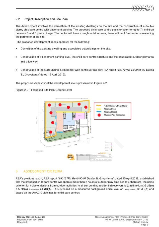
The proposed development, as
amended, involves the demolition of existing structures and construction of a
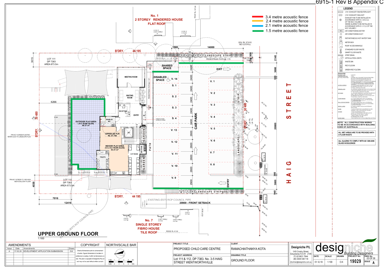
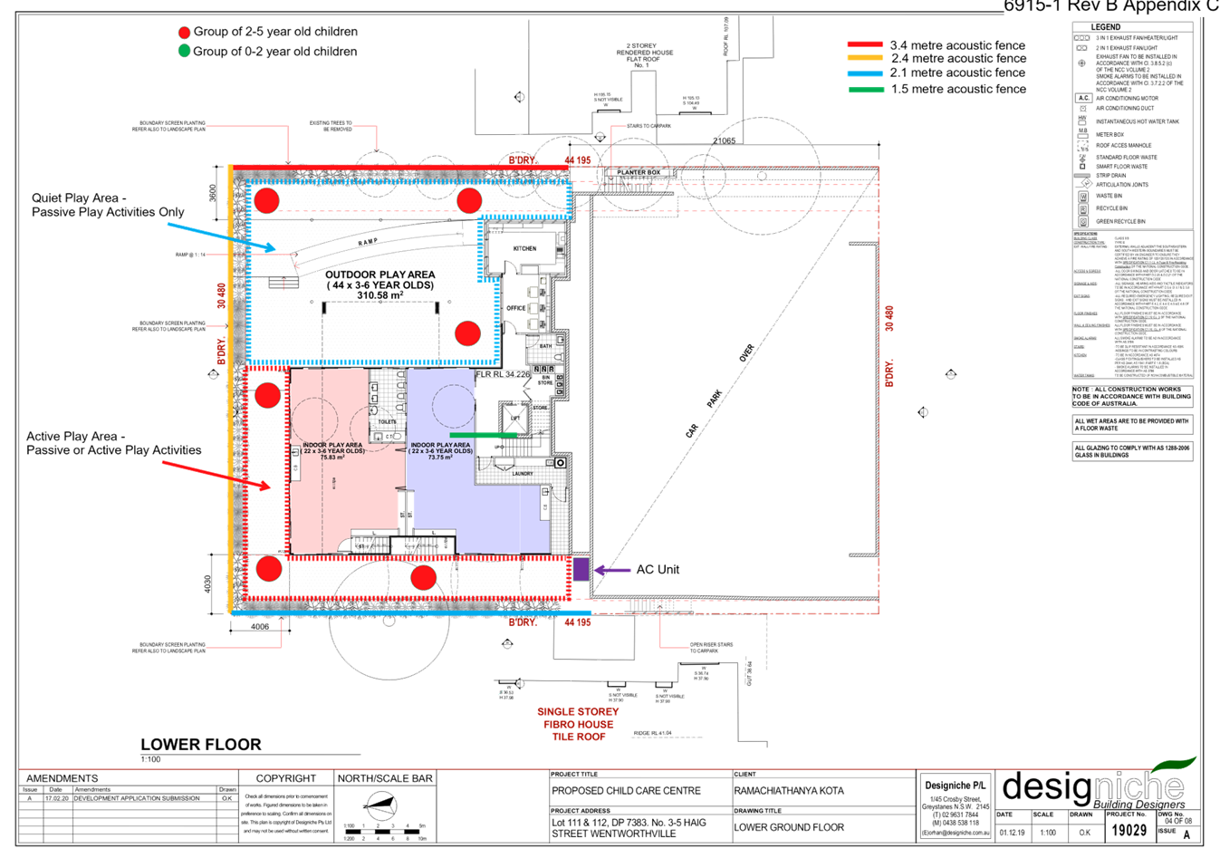
two storey 66 place centre-based childcare facility over basement car parking.
Key features of the development
proposal are as follows:-
· Demolition
of two single storey dwellings and all existing structures, and removal of one
large tree located in the south-western corner.
· Construction
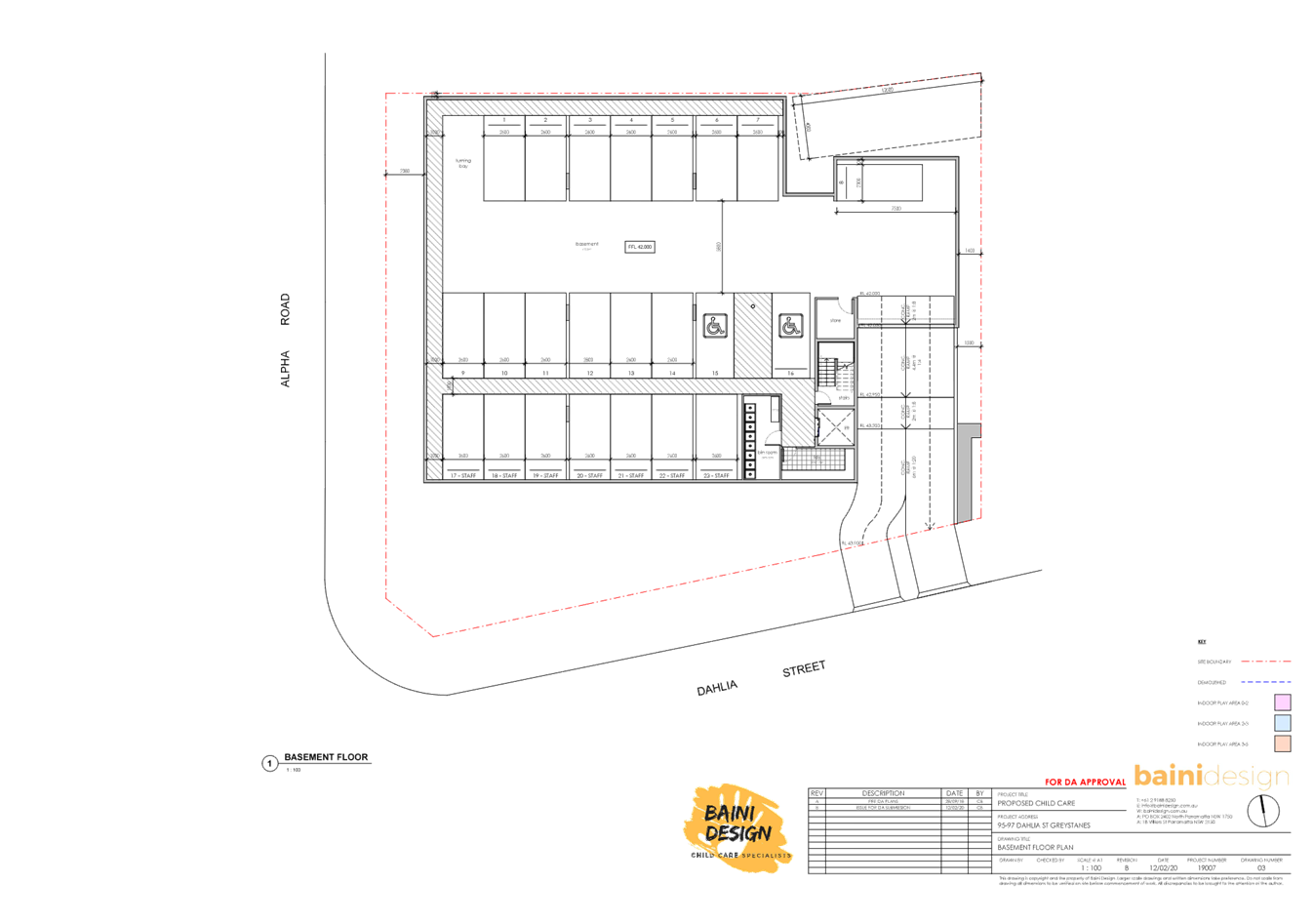
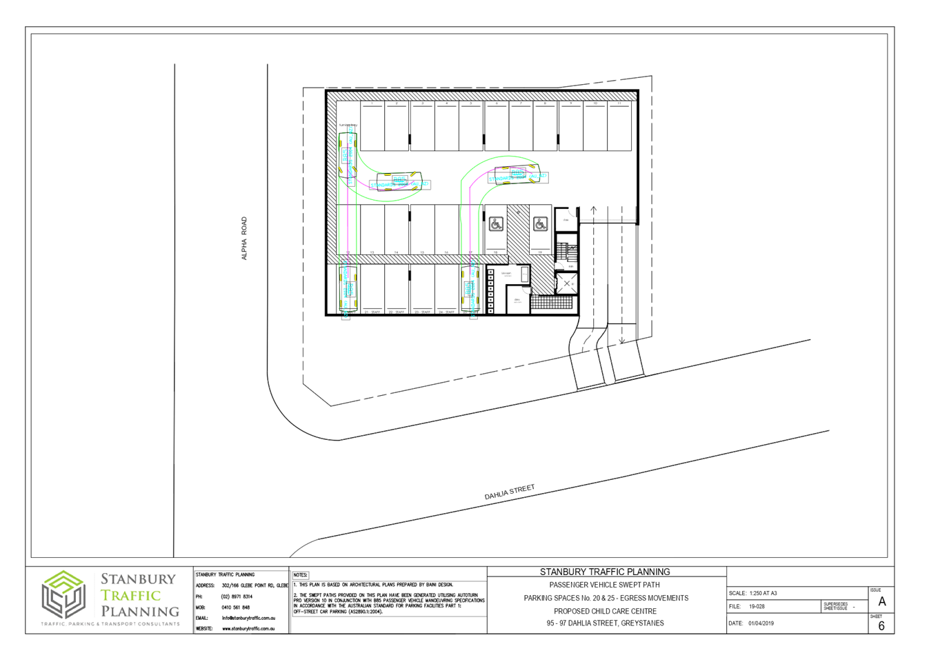
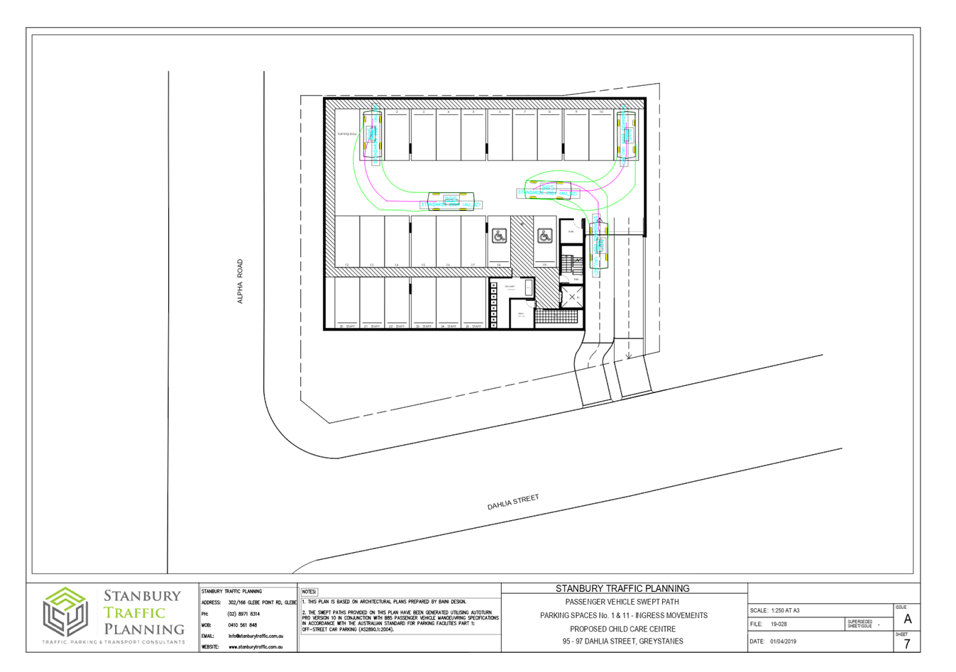
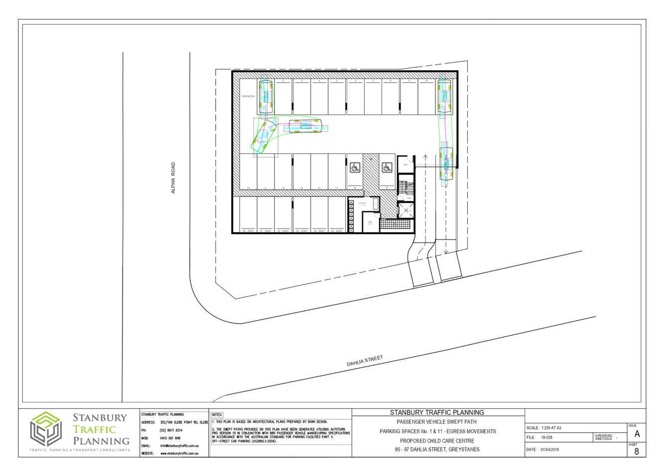
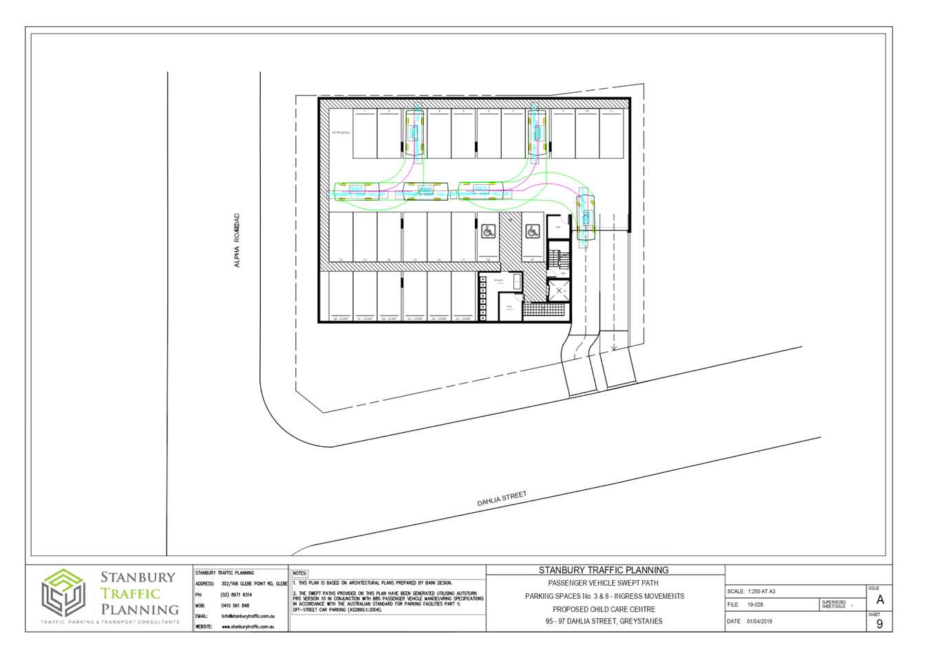
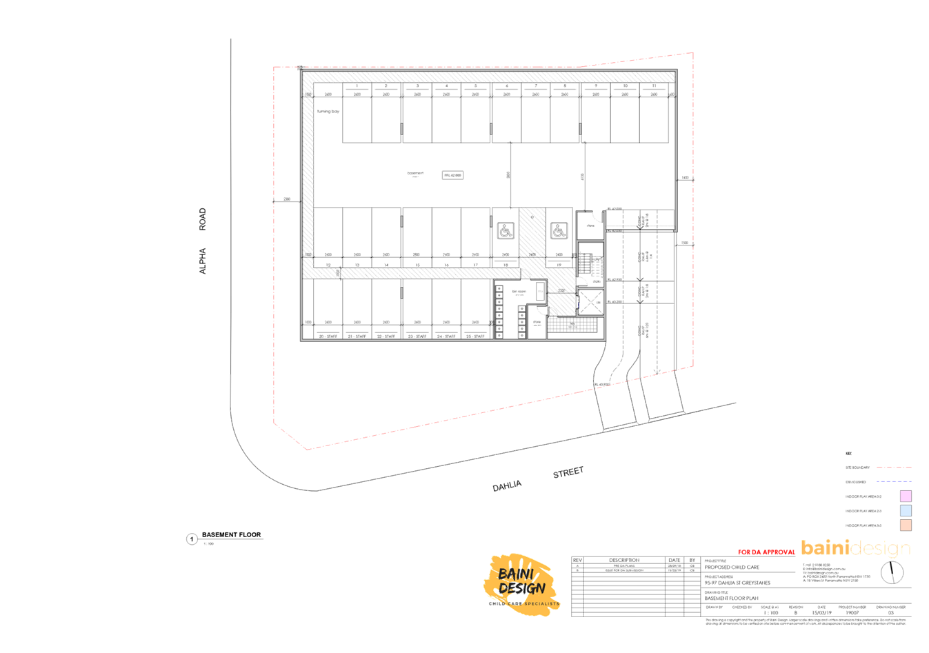
of a two-storey childcare facility accommodating 66 children.
· Construction
of a basement level car parking area including bin room, laundry room, two
storage rooms, stairs, one lift and accommodating 25 car parking spaces
allocated as follows:
- Staff:
6 spaces
- Visitors:
19 spaces (inclusive of 2 accessible car parking spaces)
- 1
turning bay
· Lot
consolidation of existing 2 allotments into 1 allotment.
· The
facility proposes to accommodate 71 children, as follows:
o 16 children – 0-2
yrs
o 25 children – 2-3
yrs
o 30 children – 3-5
yrs
Note: The number of children is
subject to reduction of a maximum of 66 children to correspond with proposed
unencumbered outdoor space/play area.
· The
proposed centre will operate from 7.00am to 6.00pm Monday to Friday (Excluding
public holidays) and will employ 12 staff.
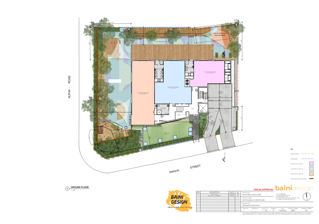
· The
ground floor level contains 3 bathrooms (including 1 accessible bathroom),
multiple storage areas, an office, 2 cot rooms, bottle preparation/craft bench
area, indoor and outdoor play areas and a lift/stairs.
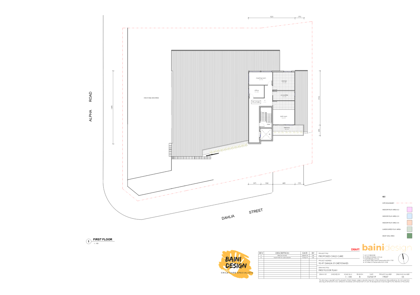
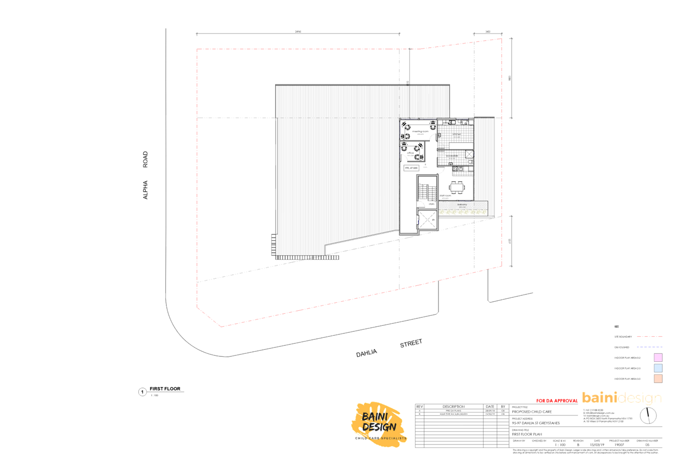
· The
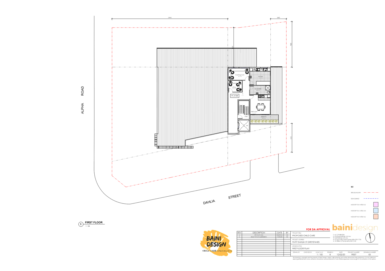
first floor level contains an office, accessible bathroom, staff room, meeting
room, kitchen, balcony fronting Dahlia Street and a lift/stairs.
· There
is no signage proposed as part of the application.
History
|
Date
|
Action
|
|
7 April
2020
|
Development
Application DA2020/0207 was received with Council.
|
|
5 May 2020
|
The
development application was formally accepted by Council.
|
|
7 May 2020
|
The
application was referred to Council’s internal departments and
externally to Endeavour Energy for review.
|
|
13 May
2020
|
The
application was publicly notified to adjoining and opposite owners, a notice
was placed on Council’s website and a site notice was placed at the
property for 14 days.
|
|
1-15 June
2020
|
Council
received concerns that the site notification notice had been removed/not
adequately displayed, and as such, the application was publicly notified for
a second period to adjoining and opposite owners, including a notice on
Council’s website and a new site notice was placed on the site for 14
days.
In
response, Council received a total of 55 submissions during both notification periods.
|
|
4 August
2020
|
Application
was deferred for a Survey Plan for 97 Dahlia Street.
|
|
5 August
2020
|
Survey
Plan for 97 Dahlia Street was received by Council.
|
|
9
September 2020
|
Application referred to CLPP for determination.
|
Applicants Supporting
Statement
The applicant has provided a
Statement of Environmental Effects prepared by Think Planners Pty Ltd dated 16
July 2019 in support of the application.
Contact with Relevant
Parties
Council has undertaken a site inspection of the subject
sites and surrounding properties and has been in regular contact with the
applicant throughout the assessment process.
Internal Referrals
Development Engineer
The development application was referred to Council’s
Development Engineering section for comment who has advised that the
development is supportable with respect to overland flood mitigation and
stormwater drainage subject to compliance with the recommended conditions of
consent, which includes updated details to be provided within the submitted
flood report and removal of fill within the flood affected area of the site.
Tree Management Officer
The development application was referred to Council’s
Tree Management Officer for comment who has advised that the development is
supportable subject to the imposition of conditions requiring an amended
landscape plan, and conditions relating to the removal of the existing large
tree within the front south-western corner of the site (Corner of Alpha Road
and Dahlia Street).
Waste Management Officer
The development application was referred to Council’s
Waste Management Officer for comment who has advised that the development is
supportable subject to conditions requiring amended plans to be submitted with
the Construction Certificate application, to demonstrate that the bin storage
room can accommodate the bin tug, and that there are no obstructions (i.e. Door
width, shared zones, bollards) manoeuvring the bins to Council’s
collection point.
Environmental Health Officer
The development application was referred to Council’s
Environmental Health Officer for comment who has advised that the development
is supportable in regards to fit-out for food preparation area, acoustic
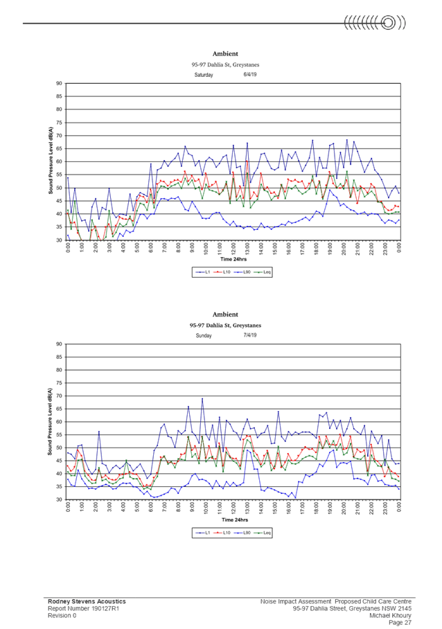
assessment, noise attenuation measures, soil assessment, and site
contamination, subject to conditions.
Children’s Services
The development application was referred to Council’s
Children’s Services section for comment who has advised that the
development is supportable in regards to compliance with the provisions of
Education and Care Services National Regulations and Law, subject to
conditions.
External Referrals
Endeavour Energy
The development application was
referred externally to Endeavour Energy who raised no objections.
Planning Comments
The provisions of any
Environmental Planning Instruments (EP&A Act s4.15 (1)(a)(i))
(a) State
Environmental Planning Policy No. 55 – Remediation of Land (SEPP 55)
Clause 7 of SEPP 55 requires
Council to be satisfied that the site is suitable or can be made suitable to
accommodate the proposed development. The matters listed within Clause 7 have
been considered in the assessment of the development application.
|
Matter for Consideration
|
Yes/No
|
|
Does the application involve re-development of the site or
a change of land use?
|
Yes
No
|
|
In the development going to be used for a sensitive land
use (e.g.: residential, educational, recreational, childcare or hospital)?
|
Yes
No
|
|
Does information available to you indicate that an
activity listed below has ever been approved, or occurred at the site?
acid/alkali plant and
formulation, agricultural/horticultural activities, airports, asbestos
production and disposal, chemicals manufacture and formulation, defence
works, drum re-conditioning works, dry cleaning establishments, electrical
manufacturing (transformers), electroplating and heat treatment premises,
engine works, explosive industry, gas works, iron and steel works, landfill
sites, metal treatment, mining and extractive industries, oil production and
storage, paint formulation and manufacture, pesticide manufacture and
formulation, power stations, railway yards, scrap yards, service stations,
sheep and cattle dips, smelting and refining, tanning and associated trades,
waste storage and treatment, wood preservation
|
Yes
No
|
|
Is the site listed on
Council’s Contaminated Land database?
|
Yes
No
|
|
Is the site subject to EPA
clean-up order or other EPA restrictions?
|
Yes
No
|
|
Has the site been the subject of
known pollution incidents or illegal dumping?
|
Yes
No
|
|
Does the site adjoin any
contaminated land/previously contaminated land?
|
Yes
No
|
|
Has the appropriate level of
investigation been carried out in respect of contamination matters for
Council to be satisfied that the site is suitable to accommodate the proposed
development or can be made suitable to accommodate the proposed development?
|
Yes
No
|
|
A Preliminary Site
Investigation report prepared by Geotechnical Consultant Australia, dated 4
May 2020, which includes a soil assessment, was submitted with the
application. The report did not reveal any potential matters of concern with regard
to contamination and concludes that the site is suitable for its intended
use, subject to compliance with the recommendations of the report, which are
to be imposed as conditions of consent. Council’s Environmental Health
department has also reviewed the report and determined that the site is
suitable for such a development given that the report provides that the site
is suitable for the proposed use.
|
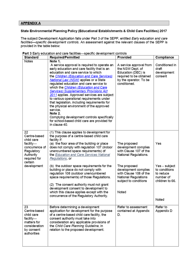
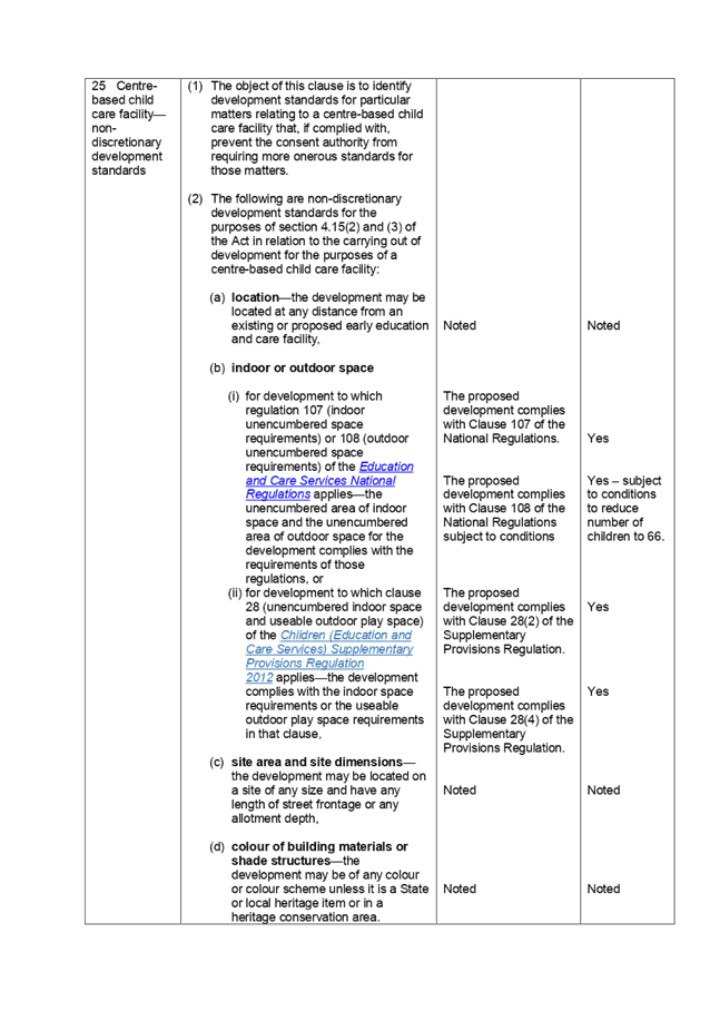
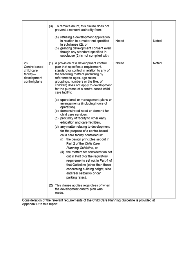
(b) State
Environmental Planning Policy (Educational Establishments and Child Care
Facilities) 2017
The relevant provisions of the
SEPP have been considered in the assessment of the Application.
It is noted that State
Environmental Planning Policy (Educational Establishments And Child Care
Facilities) 2017 commenced on 1 September 2017. The SEPP applies to any
proposals for new schools or child care centres or proposed alterations and
additions to existing centres. The relevant provisions of the SEPP have been
considered in the assessment of the Application.
A comprehensive assessment and
compliance table is attached to this report in Appendix A, which indicates that
there are non-compliances with the SEPP 2017 with regard to the number of
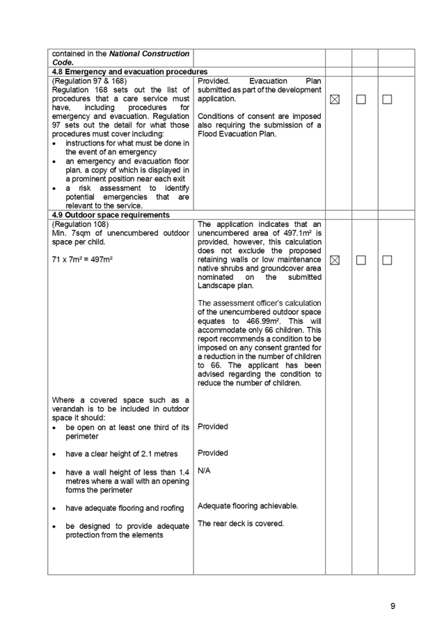
children proposed and outdoor unencumbered space as stated below:
|
Control
|
Required
|
Provided
|
|
Number of children and outdoor unencumbered space
(regulation 108 SEPP 2017 and part 4.9 the Guideline)
|
7m² x 71 = 497m²
|
The application indicates that
an unencumbered area of 497.1m² is provided, however, this calculation
does not exclude the proposed retaining walls or low maintenance native
shrubs and groundcover area nominated on the submitted Landscape plan. The
assessment officer’s calculation of the unencumbered outdoor space
equates to 466.99m². This will accommodate only 66 children. This report
recommends a condition to be imposed on any consent granted for a reduction
in the number of children to 66. The applicant has been advised
regarding the condition to reduce the number of children.
|
(a) Statement
Environmental Planning Policy No 19 - Bushland in Urban Areas
The subject site does not directly
adjoin land zoned or reserved for public open space. However, the subject site
is located adjacent to a Council Reserve known as Alpha Road Park. The proposal
does result in any adverse impacts to land at Alpha Road Park.
(b) State
Environmental Planning Policy (Vegetation in Non-Rural Areas) 2017
Council’s Tree Management
officer has recommended the removal of one (1) large tree located within the
front south-western corner of the site. Council’s Tree Management Officer
has reviewed the proposal and raised no objections subject to the imposition of
conditions including the removal of 1 large tree. In addition, the proposal
does not exceed the biodiversity offsets scheme threshold. Therefore, the
proposed vegetation removal is considered acceptable.
Regional Environmental Plans
(Deemed State Environmental Planning Policies)
(c) Greater
Metropolitan Regional Environmental Plan No 2 – Georges River Catchment
The subject site is
identified as being located within the area affected by the Greater
Metropolitan Regional Environmental Plan No 2 – Georges River Catchment.
The proposed development raises no issues as no impact on the catchment is
envisaged.
Local Environmental Plans
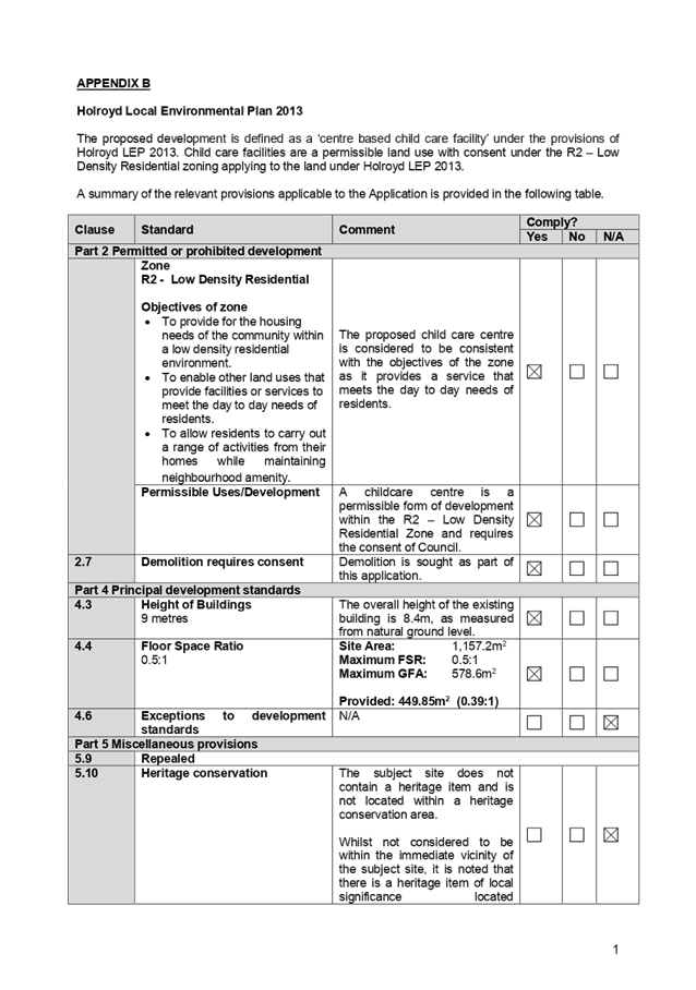
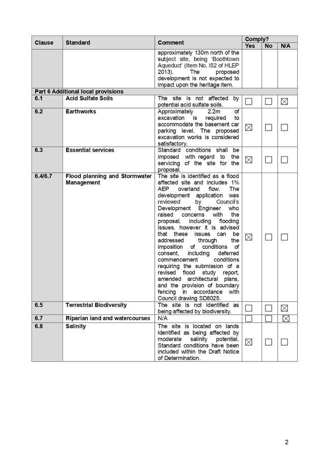
(a) Holroyd
Local Environmental Plan (LEP) 2013
The proposed development is
defined as a ‘centre based child care facility’ under the
provisions of Holroyd Local Environmental Plan (LEP) 2013. Centre based child
care facilities are a permissible land use with consent under the R2 – Low
Density Residential zoning applying to the land under Holroyd LEP 2013.
A comprehensive assessment and
compliance table is attached to this report in Appendix B which demonstrates
the development proposal’s compliance with the relevant planning controls
that are applicable to the site under the Holroyd LEP 2013.
The provisions of any draft
Environmental Planning Instruments (EP & A Act Section 4.15(1)(a)(ii))
(b) Draft
Cumberland Local Environmental Plan 2020 (Draft CLEP)
The Draft Cumberland Local
Environmental Plan 2020 (Draft CLEP) has been prepared by Cumberland City
Council to provide a single planning framework for the future planning of
Cumberland City. The changes proposed seek to harmonise and repeal the three
existing LEPs currently applicable to the Cumberland local government area,
those being:
· Holroyd
Local Environmental Plan 2013,
· Parramatta
Local Environmental Plan 2011, and
· Auburn Local
Environmental Plan 2010.
The current planning controls for
the subject site, as contained within the Holroyd Local Environmental Plan 2013
are not proposed to change under the Draft CLEP.
The provisions of any
Development Control Plans (Environmental Planning & Assessment Act Section
4.15(1)(a)(iii))
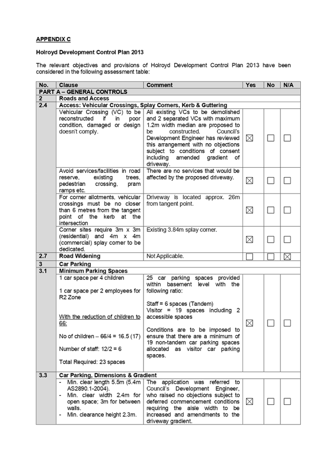
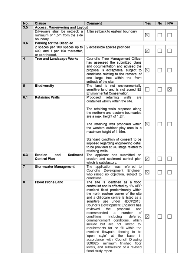
(c) Holroyd
Development Control Plan (HDCP) 2013
The Holroyd DCP 2013 provides
guidance for the design and operation of development within Holroyd to achieve
the aims and objectives of Holroyd LEP 2013.
The proposed development is
generally compliant with the relevant provisions, subject to the imposition of
conditions. Parts A, B & I of HDCP 2013 apply to the proposal. A
comprehensive assessment and compliance table is attached to this report at
Appendix C which demonstrates the development proposal’s compliance with
the relevant planning controls that are applicable to the site.
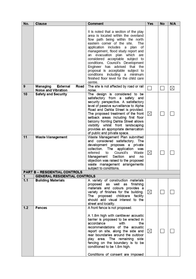
The assessment provided in
Appendix C indicates that there are some minor non-compliances with the HDCP
2013 with regard to landscaped area, cut and fill and the maximum number of
children for a childcare facility within R2 – Low Density Residential
zoned land, which are discussed in the following section:
|
No.
|
Clause
|
Comment
|
Yes
|
No
|
N/A
|
|
PART B – RESIDENTIAL CONTROLS
|
|
1
|
GENERAL
RESIDENTIAL CONTROLS
|
|
1.5
|
Landscaped
Area
Min.
25% = 289.3m2
|
Area of 19.22% (222.44m²) is provided with min. 2m
dimension.
Landscaped area with dimension of less than 2m equates to
64.51m².
Total landscaped area provided on site is 286.95m²,
or 24.8%.
This represents a minor non-compliance of 2.35m², or
0.2%.
Variation to the required landscaped area and minimum
dimensions is deemed acceptable as the proposed acoustic barrier is located
off the western side boundary reducing the required 2m dimensions for
landscaping and contains retaining walls, and various decked areas.
|
|
|
|
|
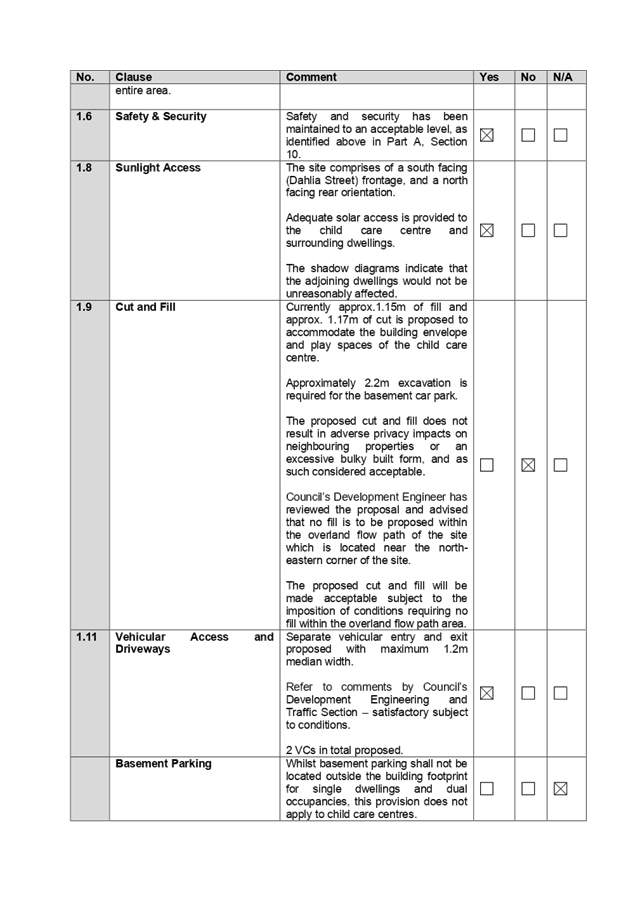
1.9
|
Cut
and Fill
Cut
and fill shall not create a detrimental impact on the overland flow of the
site.
Fill,
up to 300mm, is permitted within 900mm of side or rear boundaries. Fill,
600mm or greater is to be contained within the building envelope.
Cut
is permitted to a maximum of 1 metre. Cut is to be limited to 450mm where it
is within 900mm of the rear or side boundaries.
|
Currently approx.1.15m of fill
and approx. 1.17m of cut is proposed to accommodate the building envelope and
play spaces of the child care centre.
Approximately 2.2m excavation is
required for the basement car park.
The proposed cut and fill does
not result in adverse privacy impacts on neighbouring properties or an
excessive bulky built form, and as such considered acceptable.
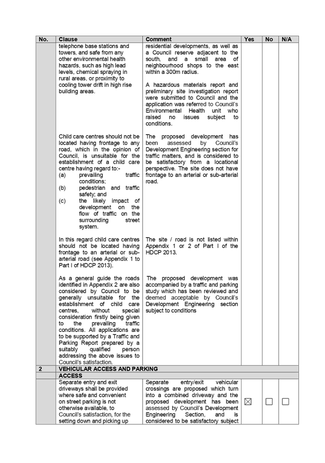
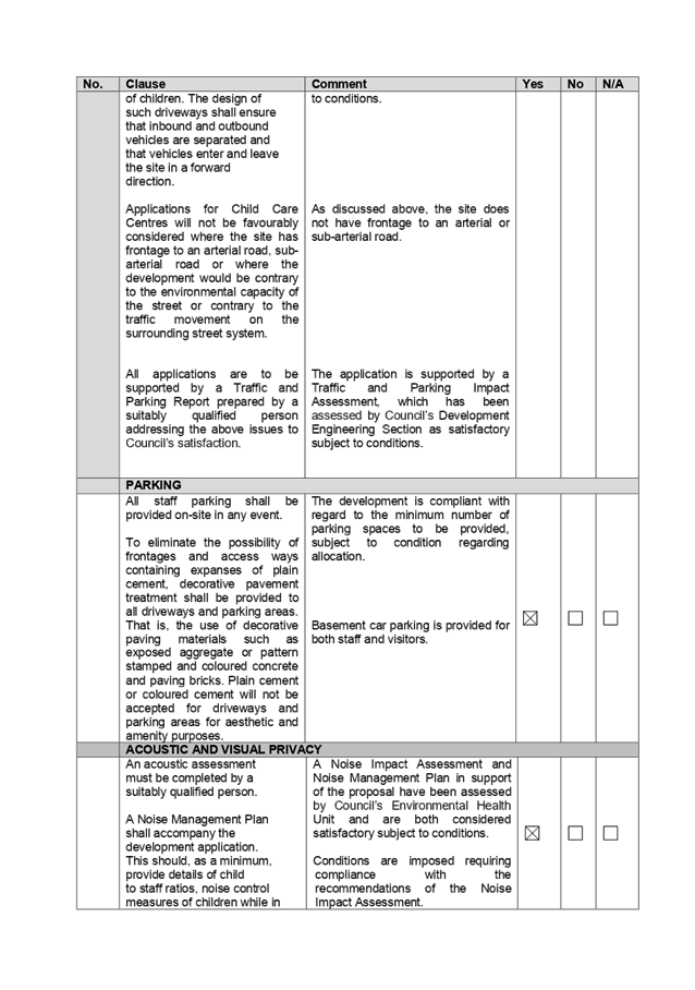
Council’s Development
Engineer has reviewed the proposal and advised that no fill is to be proposed
within the overland flow path of the site which is located near the
north-eastern corner of the site.
The proposed cut and fill will
be made acceptable subject to the imposition of conditions requiring no fill
within the overland flow path area.
|
|
|
|
|
PART I –
CHILDCARE CENTRES
|
|
1
|
SIZE, DENSITY AND
LOCATION
|
|
|
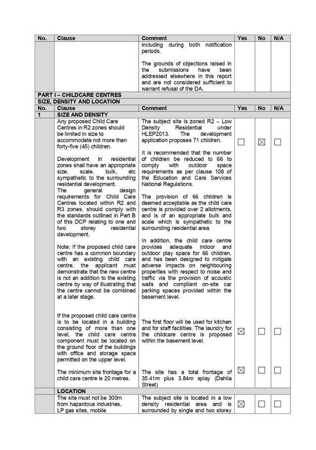
Any proposed Child Care
Centres in R2 zones
should
be limited in size to
accommodate not more
than
forty-five (45)
children.
|
The subject site is zoned R2 – Low Density
Residential under HLEP 2013. The development application proposes 71
children.
It is recommended that the number of children be reduced
to 66 to comply with outdoor space requirements as per clause 108 of the
Education and Care Services National Regulations.
The provision of 66 children is deemed acceptable as the
child care centre is provided over 2 allotments, and is of an appropriate
bulk and scale which is sympathetic to the surrounding residential area.
In addition, the child care centre provides adequate
indoor and outdoor play space for 66 children, and has been designed to
mitigate adverse impacts on neighbouring properties with respect to noise and
traffic via the provision of acoustic walls and compliant on-site car parking
spaces provided within the basement level.
|
|
|
|
The provisions of any planning
agreement that has been entered into under section 7.4, or any draft planning
agreement that a developer has offered to enter into under section 7.4
(EP&A Act s4.15(1)(a)(iiia))
There is no draft planning
agreement associated with the subject Development Application.
The provisions of the
Regulations (EP&A Act s4.15 (1)(a)(iv))
The proposed development raises no
concerns as to the relevant matters arising from the Environmental Planning and
Assessment Regulations 2000 (EP&A Reg).
The Likely Environmental,
Social or Economic Impacts (EP&A Act s4.15 (1)(b))
It is considered that the proposed
development will have no significant adverse environmental, social or economic
impacts in the locality.
The suitability of the site for
the development (EP&A Act s4.15 (1)(c))
The subject site and locality is
not known to be affected by constraints likely to have a significant adverse
impact on the proposed development. Accordingly, it is considered that the
development is suitable in the context of the site and surrounding locality.
Submissions made in accordance
with the Act or Regulation (EP&A Act s4.15 (1)(d))
Advertised (Council Website) Mail
Sign Not
Required
In accordance with Council’s
Notification requirements contained within Holroyd DCP 2013, the proposal was
publicly notified for a period of 14 days between 13 May 2020 and 27 May 2020.
The application was renotified to
occupants and owners of the adjoining properties for a second period of 14 days
between 1 June 2020 to 15 June 2020 as Council received notice that
notification letters were not received in an appropriate timeframe and that the
notification sign erected for the first notification period was not erected
adequately. In response, Council received a total of 55 submissions during both
notification periods, with nil submission disclosing a political donation or
gift.
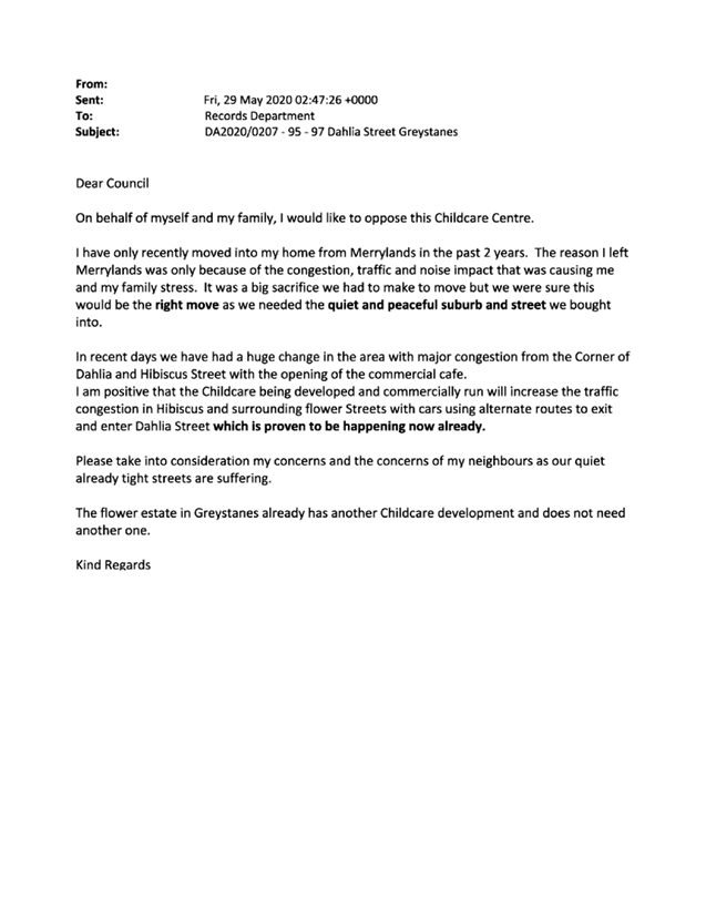
The issues raised in the public
submissions are summarised and commented on as follows.
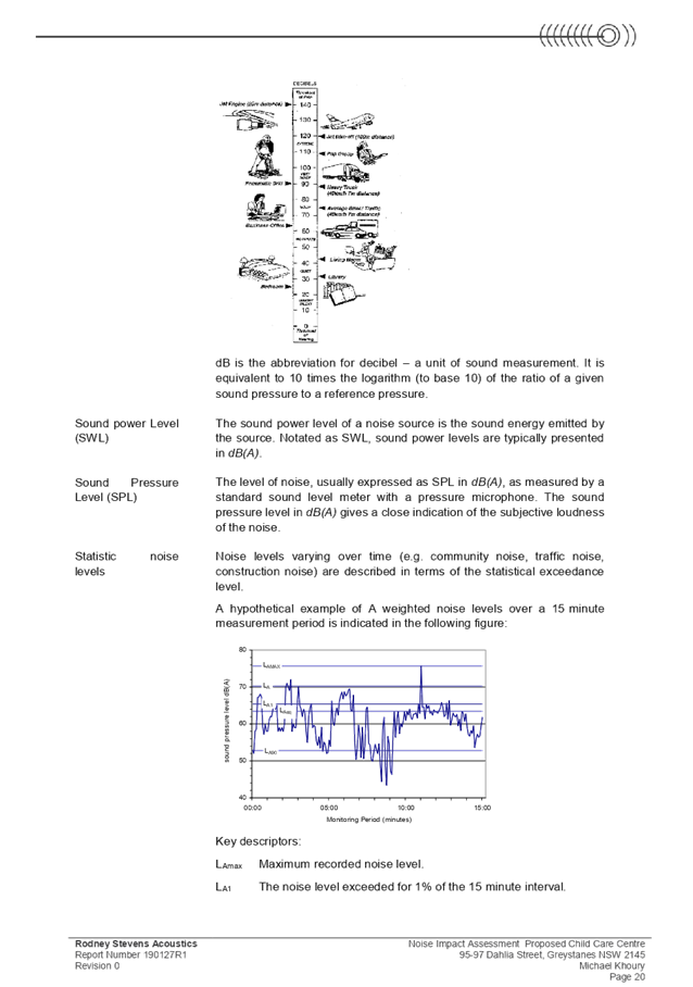
Figure
5 – Submissions summary table
|
|
Concern
|
Comment
|
|
1
|
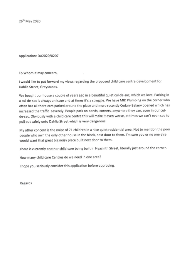
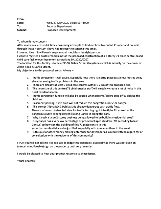
The proposed child care is not suitable for the street and
area, and there is no demand for the proposal having regard to the
demographic of the immediate population does not predominantly comprise of
young families or pre-school aged children.
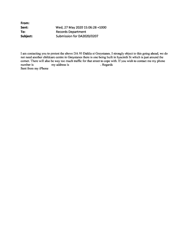
There is already an oversupply of child care centres in
the Greystanes areas. Approval of the proposal will hinder the success of
established child care centres within the locality.
|
The site permits the construction
of the child care centre, and the proposed development generally satisfies
the requirements contained within Holroyd DCP 2013, the criteria under the Child
Care Planning Guideline and relevant regulations stipulated under the
Educational Establishments and Child Care Facilities SEPP 2017, with respect
to site selection and location.
The existing demography of the
area is not a matter of consideration under the Child Care Planning
Guideline and relevant regulations stipulated under the Educational
Establishments and Child Care Facilities SEPP 2017.
In relation to the child care
centre quality, it is the operator’s responsibility to satisfy the
relevant child care provider requirements and comply with the regulations to
maintain its licence and business operation.
|
|
2
|
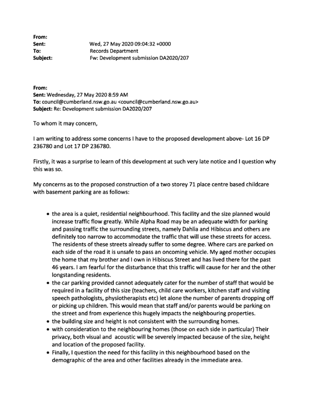
The location of the child care centre on a corner
allotment is not suitable having regard to vehicular and pedestrian safety.
|
The driveway location of the child care centre is greater
than 6m away from the tangent point of Alpha Road and Dahlia Street, to
achieve suitable sightlines at the corner of the site and T-intersection.
Separate vehicular driveways are provided to the basement
car park, with a 1.2m wide median between the vehicular accesses to enable
parents and pedestrians to safely stop when crossing the vehicular entry and
exit, and provide adequate sightlines for motorists entering and exiting the
basement car park.
|
|
3
|
The design of the child care centre is not in keeping with
the area. The proposal is three levels including the basement level.
|
The proposed development may not appear
similar to existing dwelling houses within the street, as it is designed as a
childcare centre. However, the design of the child care centre is not
considered out of character with the immediate area. It is noted that the R2
zoned area is undergoing a transition and older housing stock is in the
process of being replaced by contemporary-style development.
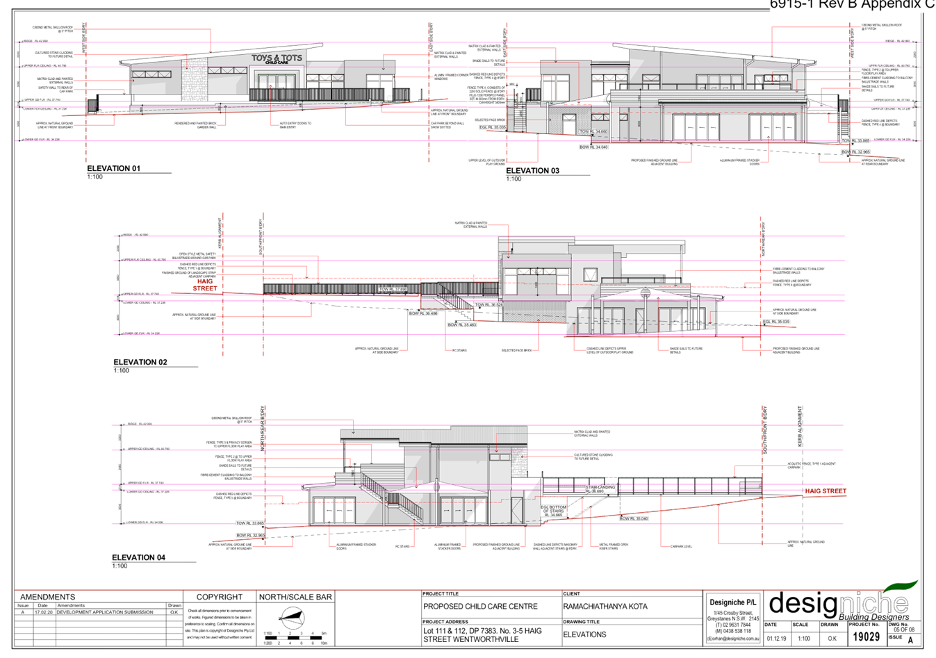
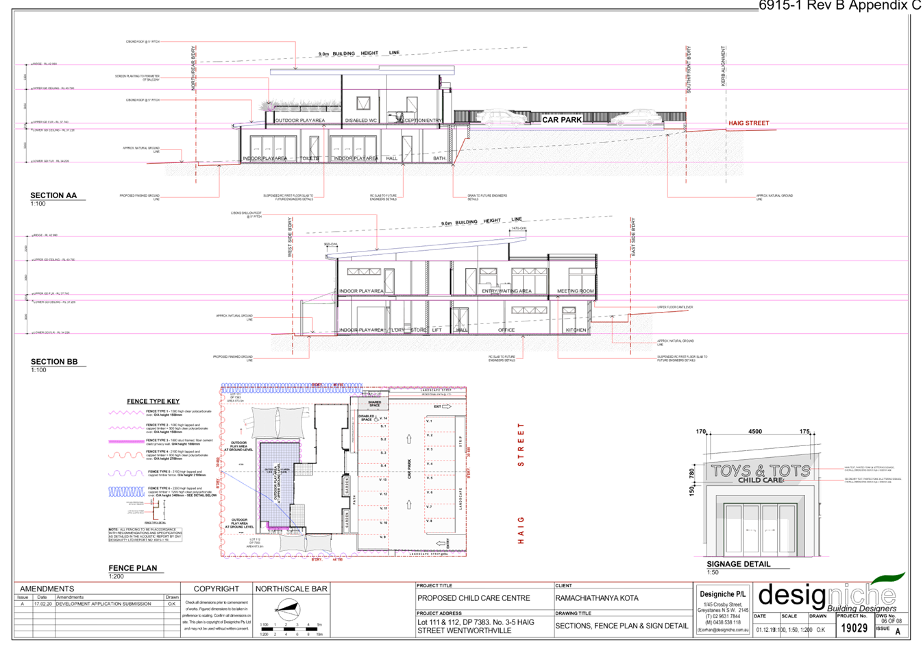
The maximum building height
permitted at the subject site is 9m. The proposed development provides a
maximum building height of 8.4m, and is two storeys in height, over basement
car parking.
|
|
4
|
The proposed child care centre is for 71 children
placements and exceeds the maximum 45 children placements prescribed in HDCP
2013.
|
The subject site is zoned R2 – Low Density
Residential under HLEP 2013. The development application proposes 71
children.
It is recommended that the number of children be reduced
to 66 to comply with outdoor space requirements as per clause 108 of the
Education and Care Services National Regulations.
The provision of 66 children is deemed acceptable as the
child care centre is provided over 2 allotments, and is of an appropriate
bulk and scale which is sympathetic to the surrounding residential area.
In addition, the child care centre provides adequate
indoor and outdoor play space for 66 children, and has been designed to
mitigate adverse impacts on neighbouring properties with respect to noise and
traffic via the provision of acoustic walls and compliant on-site car parking
spaces provided within the basement level.
|
|
5
|
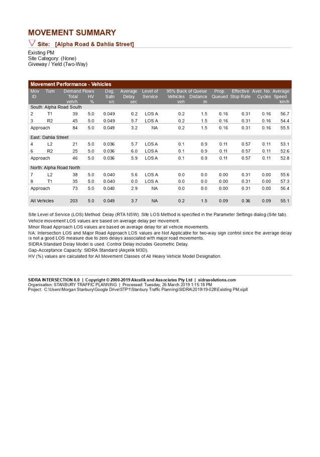
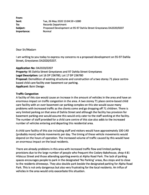
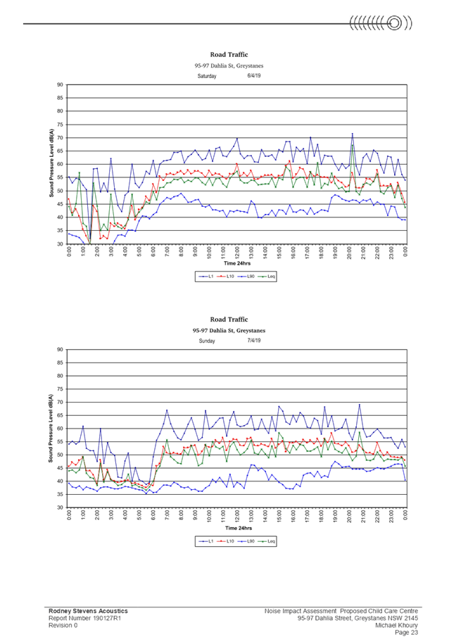
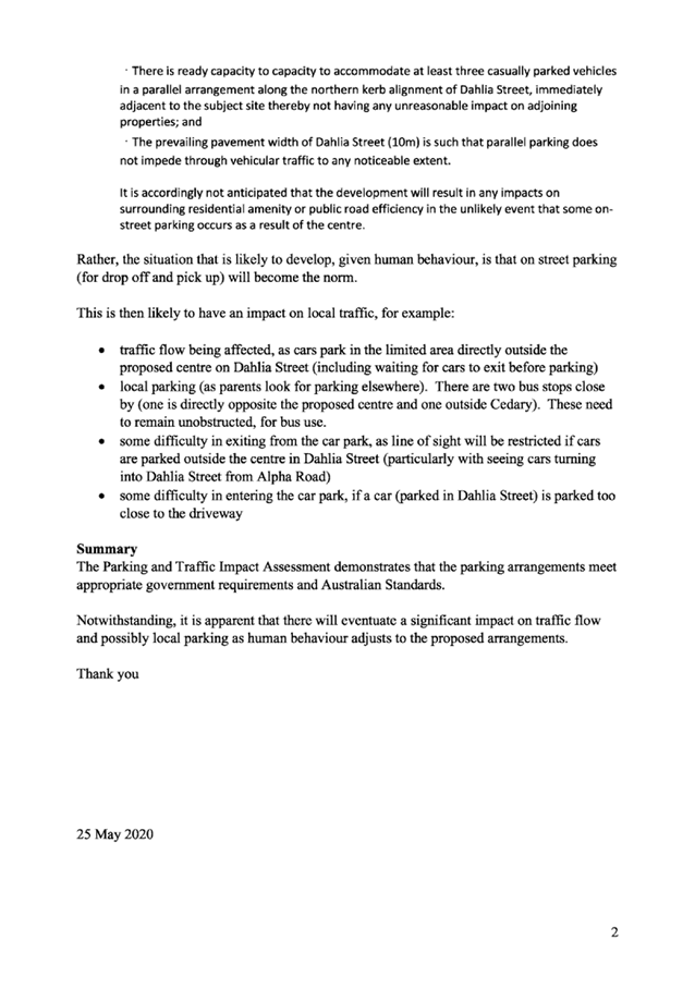
The submitted Parking & Traffic Impact Statement is
dated May 2019 and carried out traffic counts on 19 March 2019, which is a
Tuesday. During this time, several shops at the corner of Hibiscus Street and
Dahlia Street were vacant. Currently the Cedary Bakehouse has brought
increased traffic to both Dalia Street and Hibiscus Street which has not been
accounted for.
|
The submitted Parking &
Traffic Impact Statement has been carried out based on surveys during peak
times AM and PM between 7.00am-9.00am and 4.00pm-6.00pm on Tuesday 19 March
2019. Council noted that the additional traffic to be generated by the
proposal and findings from the Parking and Traffic Impact Statement. The
proposed development is a low trip generator and can be accommodated in the
locality without affecting performance of on Dahlia Street, or on the
existing road network with respect to delays or queues of nearby
intersection/s and complies with Council’s parking requirements.
The entry/exit driveway is at
an obvious location that will not be missed by parents and caregivers. The
parents and caregivers will be regular visitors to the centre knowing in
advance the location of car parking. An Operational management plan (OMP)
shall be enforced by way of conditions to encourage the use of the basement
parking facility. All pickup and drop-off are expected to take place within
the basement and it is not considered to create any adverse impact on the
public space.
It is further noted that
Cedary Bakehouse operates 7.00am-3.00pm, Tuesday to Sunday (inclusive). In
this regard, Cedary Bakehouse does not operate during the peak PM pick up
times of the child care centre. In addition, the child care centre does not
operate on weekends.
|
|
6
|
Basement parking is provided. However, it is envisaged
that on-street parking will occur which will impact on both the local parking
and limited street parking.
Six (6) staff parking spaces are not sufficient for 12
teachers. Tandem parking spaces will not be used by staff.
Parents parking adjacent to the centre at parking spaces
at Alpha Road Park also raises safety concerns with parents crossing the road
with young children. The Alpha Road Park parking spaces have been used for
parking calculations for the child care centre.
There is a lack of crossings for parents and children in
the area.
|
Under HDCP 2013, the
required parking rate for child care centres is 1 space per 4 children and 1
space per 2 staff, which equates to total of 23 spaces (6 staff and 17
visitor spaces) required for the reduced 66 children placement. This rate has
been provided on site, which takes into account staff and visitor parking
demands. The proposal provides 6 staff and 19 visitor parking spaces which
equates to 2 additional visitor parking spaces within the basement, which
assists with providing additional parking on-site.
It
is noted that Council’s rate of 1 car space per 4 children is
consistent with the NSW State Government document - Child Care Planning
Guideline, in which the rate of 1 space per 4 children encompasses the
whole centre including all staff.
A
condition is to be imposed to ensure that ratio of staff and visitor parking
is allocated accordingly, which is at least 25 spaces for on-site parking
spaces (surplus of 2 spaces) based on 66 children.
The
Alpha Road Park parking spaces have not been included to achieve compliant
car parking for the child care centre in accordance with HDCP 2013 and the
Child Care Planning Guideline.
An
Operational management plan (OMP) shall be enforced by way of conditions to
encourage the use of the basement parking facility. All pickup and drop-off
are expected to take place within the basement, and the volume of street
parking is anticipated to be low, and during times where the basement parking
is full, noting that basement parking enables parents to walk children
directly into the child care centre to avoid the need to cross the
road.
|
|
7
|
The existing bus stops on the Alpha Road frontage of the
site, and opposite the site at Alpha Road Park shall not be obstructed at any
times, including during construction.
|
The two existing bus stops shall not be obstructed at any
times by any vehicles including demolition/construction and waste vehicles.
|
|
8
|
Concerns are raised relating to difficulties of vehicles
entering and exiting the basement if cars are parked too close to the
vehicular access point.
|
In the event of unauthorised parking occurring on
driveways, this can be reported to Council’s compliance section for
action. The provision of separate driveways for entry and exit allow all
vehicles to enter and leave in a forward direction and provide adequate sight
distance.
|
|
9
|
One of the dwellings at the corner of Jasmine Place and
Dahlia Street has been rezoned/used as a commercial premise being a plumbing
business. If the subject site is approved, the residential properties along
the northern side of Dahlia Street, from Alpha Road to Hibiscus Street shops
will be commercial premises with the exception of one dwelling house.
|
Residential properties
along the northern side of Dahlia Street, from Alpha Road to Hibiscus Street
shops are all zoned R2 – Low Density Residential pursuant to HLEP 2013.
Centre based child care facilities are a permissible land
use with consent under the R2 – Low Density Residential zoning applying
to the land under HLEP 2013.
|
|
10
|
The proposal will result in traffic congestion in the
residential area at the T-intersection of the site, and increase vehicles
accessing Gipps Road from both Alpha Road and Macquarie Road, which will
worsen the traffic impact on the surrounding road network.
|
Council’s Development
Engineer has reviewed the traffic and parking impacts of the proposal to be
acceptable based on 71 children. It is noted that the children placement will
be reduced to a maximum of 66 children which would reduce the number of trips
to and from the centre. The proposed use of the site for the purposes of a
child care centre is identified as a low trip generator which can be
accommodated in the locality without affecting the performance of Dahlia
Street, result in delays or queues of nearby intersections, and complies with
Council’s parking requirements.
|
|
11
|
Dahlia Street is sometimes restricted to one-way traffic
due to parked vehicles visiting the corner shops. The proposal will further
restrict access within Dahlia Street.
|
Given the operation of the child care centre will be
wholly contained in the subject site, it is not anticipated that the proposal
would directly result in greater loss of on-street parking as conditions are
imposed to encourage the use of the basement car parking facility by parents
and caregivers.
|
|
12
|
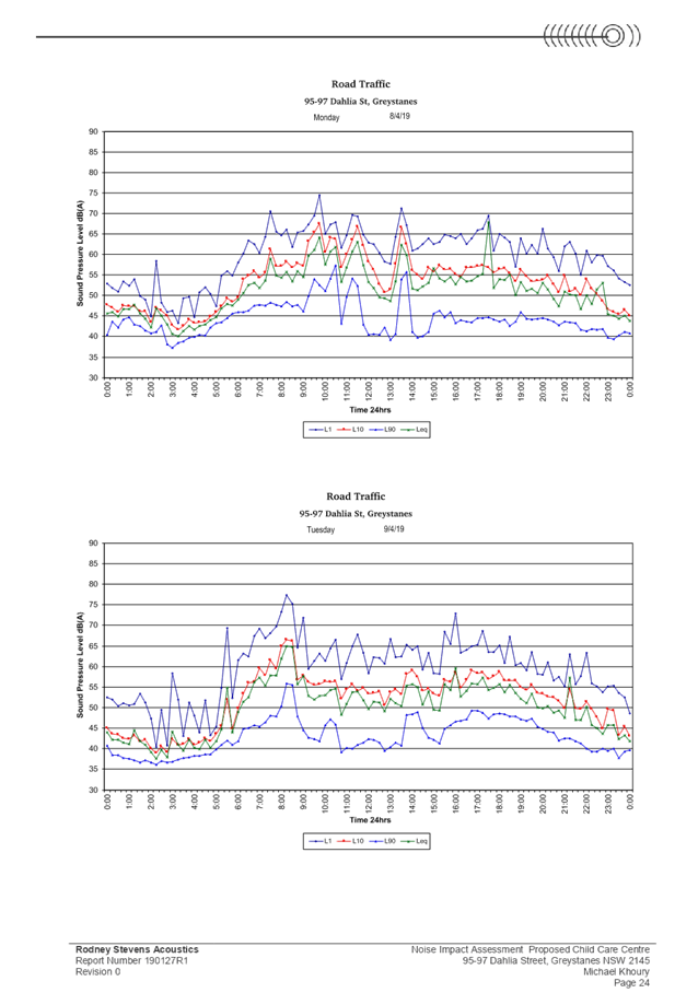
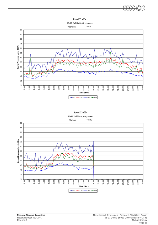
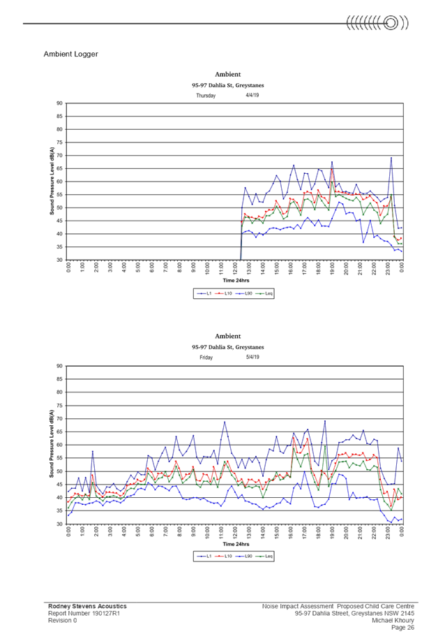
The proposed child care centre will be a noise nuisance to
surrounding properties. Concerns are raised regarding how noise from traffic
flows during peak times will be controlled.
Concerns are also raised to the noise impacts associated
with demolition and construction of the child care centre.
|
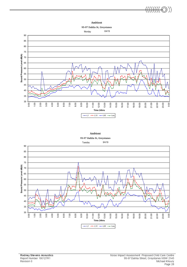
Design of acoustic
fencing location, height and thickness, and the submitted Noise Impact
Assessment report and Noise Management Plan have been reviewed by
Council’s Environmental Health officer and are considered satisfactory
to comply with the relevant noise control provisions. The Noise Impact
Assessment demonstrates that the proposed centre can be accommodated on the
site without noise nuisance to adjoining and surrounding properties, as the
noise generated from both indoor and outdoor play activities can comply with
the relevant environmental noise guidelines with the imposition of a Noise
Management Plan submitted with the application and the installation of
relevant noise mitigation measures such as acoustic fencing. The acoustic
consultant recommendation is captured within the
Noise Management Plan.
In addition, conditions are imposed requiring all demolition,
excavation and construction works carried out on the premises to be carried
out in accordance with the Noise Management Plan to mitigate adverse noise
impacts on surrounding properties.
|
|
13
|
There will be an increased in waste on the street from the
child care centre and increased activity in the area.
Odour impacts associated with waste generated by the child
care centre and the additional waste truck trips required.
|
The waste storage room is located within the basement
level of the centre. Waste will be collected by licenced contractors on a
weekly basis, and only be presented on the Dahlia Street frontage, west of
the basement vehicular access, on collection day. Regular bin cleaning by the
operator following bin collection is also recommended within the submitted
Waste Management Plan.
Conditions are imposed requiring the implementation of
requirements of the Waste Management Plan during demolition, construction and
the on-going operations of the child care centre to ensure residential
amenity is maintained to surrounding properties with respect to odour and
waste management.
|
|
14
|
Having a child care centre at the subject site will reduce
property values significantly as it does not fit in the nature and landscape
of the street and area.
|
There is no evidence which
suggests that the proposal will reduce property values. This is not a matter
for consideration under Section 4.15 of the Environmental Planning and
Assessment Act 1979.
The proposed development with its
commercial nature is a permissible land use within the R2 – Low Density
Residential zone.
|
|
15
|
There is a sewerage pipe across 75 Alpha Road and 95
Dahlia Street. There will a risk of contamination with the basement
construction for the child care centre.
|
A Preliminary Site Investigation report prepared by
Geotechnical Consultant Australia, dated 4 May 2020, which includes a soil
assessment, was submitted with the application. The report did not reveal any
potential matters of concern with regard to contamination and concludes that
the site is suitable for its intended use, subject to compliance with the
recommendations of the report, which are to be imposed as conditions of
consent. Council’s Environmental Health department has also reviewed
the report and determined that the site is suitable for such a development
given that the report provides that the site is suitable for the proposed
use.
|
|
16
|
Impact of truck movements during construction.
|
Conditions are imposed requiring the submission of a
Construction Management Plan (CMP) prior to the issue of a Construction
Certificate. The CMP shall demonstrate how construction and delivery vehicles
will access the site during demolition, excavation and the construction phase
of the development, including the route map of truck/construction vehicles to
the site. Locations of any construction zones along the site frontage and
alternate pedestrian paths are also to be detailed to minimise impacts of on
adjoining properties during the demolition and construction phase of the
development.
|
|
17
|
The proposal will adversely overshadow neighbouring
properties.
|
The subject site has a north-south orientation and does
not result in adverse overshadowing of 75 Alpha Road and 4 Jasmine Place.
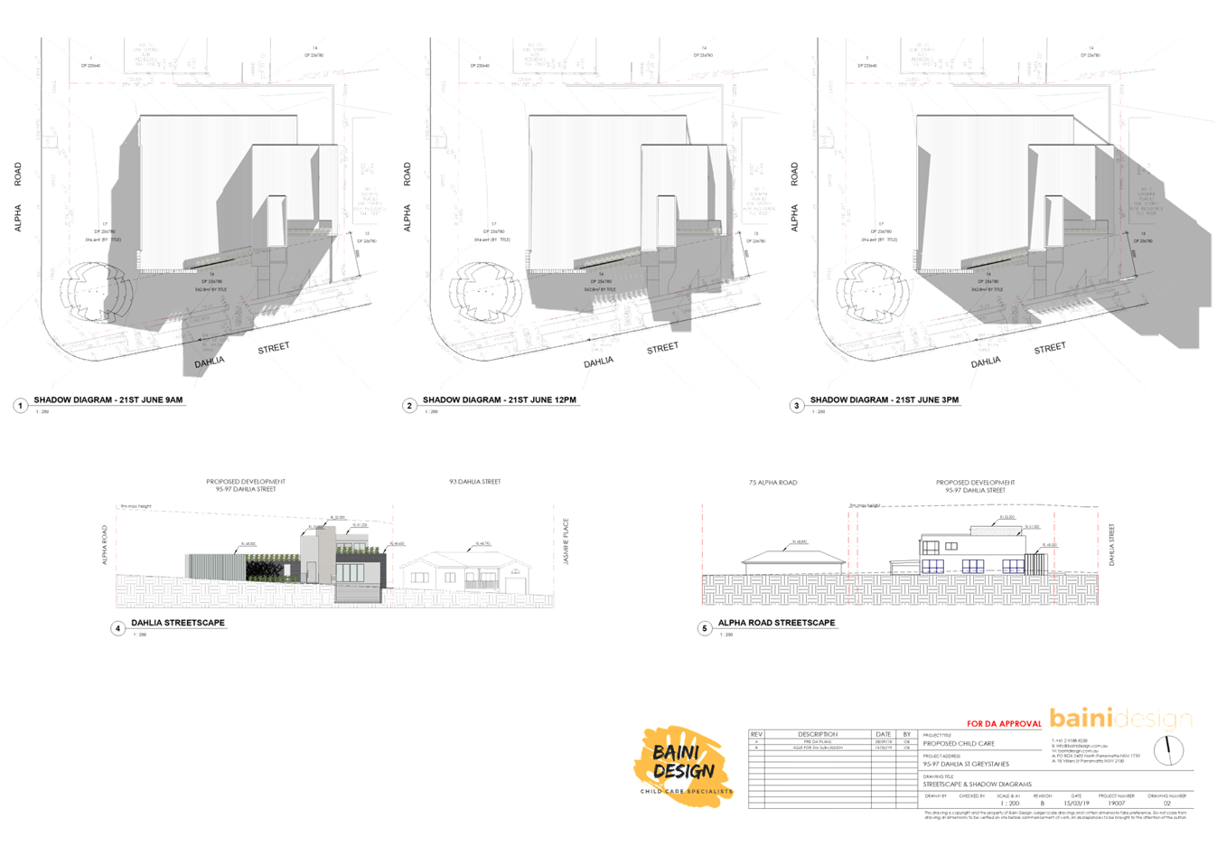
The proposal overshadows Dahlia Street from 9am-Noon,
mid-winter. Overshadowing of 95 Dahlia Street occurs from Noon-3pm,
mid-winter.
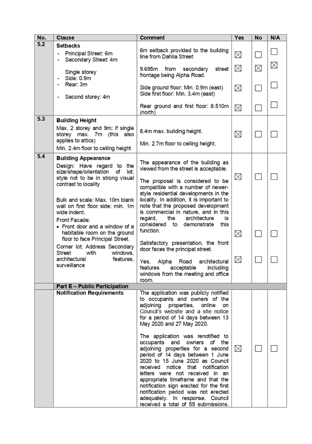
In accordance with Clause 6, Section 1.8 Sunlight Access
within Part B of HDCP 2013, the shadow effect from a proposed development
on existing adjacent dwellings must be such that a minimum of 3 hours of
direct sunlight between 9.00am and 4.00pm at the winter solstice (22 June) is
to be provided to at least one main living area and at least 50% of the
required private open space areas.
At least one main living area and at least 50% of the
private open space area of 95 Dahlia Street will receive a minimum of 3 hours
direct sunlight between 9am-Noon, mid-winter, which complies with the solar
access requirements contained within HDCP 2013.
|
|
18
|
Loss of privacy from the first floor of the child care
centre.
|
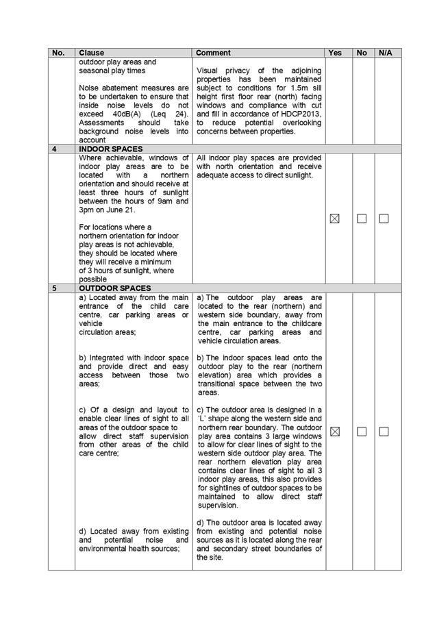
Conditions are imposed requiring the two first floor
windows along the northern/rear elevation to be amended to a minimum sill
height of 1.5m measured from the first floor level, to ensure privacy is
maintained between properties. It is also noted that the first floor is
setback a minimum of 8.51m from the rear boundary.
Only a first floor bathroom window is proposed along the
eastern elevation, which would be fixed with obscured glazing and as such
does not pose privacy concerns.
|
|
19
|
Child care centres are classified as a ‘sensitive
use development’ and it is stated that sensitive use developments are
not permitted in flood prone land affected by the 100 year flood. The Child
Care Planning Guideline outlines that when selecting a site, ensure that the
site is environmentally safe, including risks such as flooding.
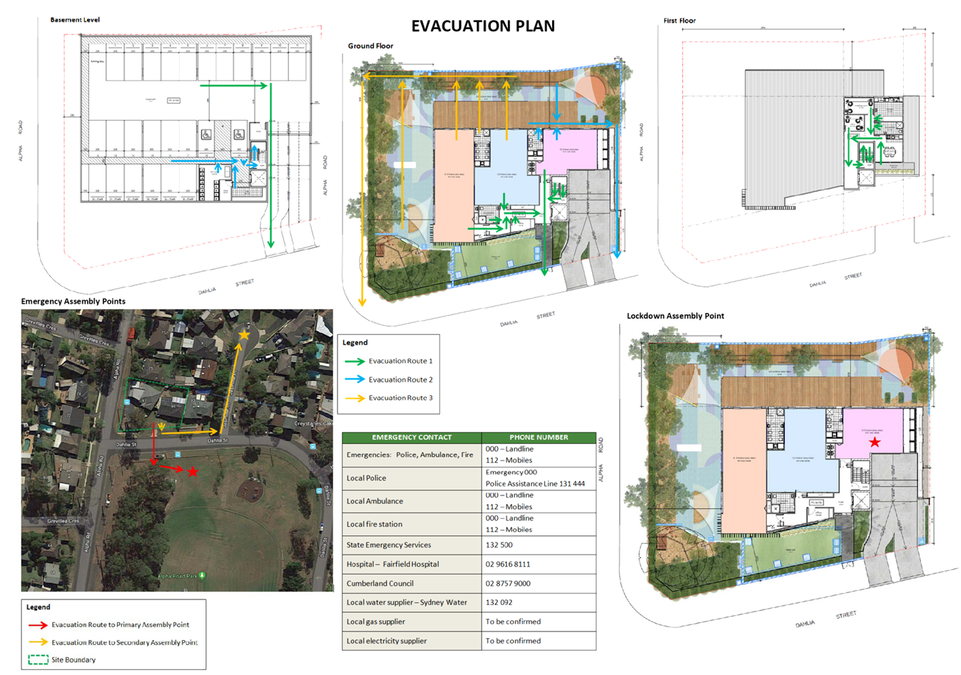
There is no evacuation plan submitted and evacuation
during a large storm/flood event has not been addressed.
|
The site is identified as a flood affected site and
includes 1% AEP overland flow. The development application was reviewed by
Council’s Development Engineer who raised concerns with the proposal,
including flooding issues, however it is advised that these issues can be
addressed through the imposition of conditions of consent, including deferred
commencement conditions requiring updated details to be included within the
submitted flood study report, and the provision of boundary fencing in
accordance with Council drawing SD8025.
The application has been accompanied by an Evacuation Plan
prepared by Benbow Environmental, dated 18 July 2019. The evacuation plan
details procedures for staff in the event of an evacuation/emergency and
assembly points. Notwithstanding the submitted evacuation plan,
Council’s Development Engineer has imposed conditions also requiring
the submission of a Flood Evacuation Plan, which shall incorporate requirements
in line with the updated Flood Study Report.
In this regard, it is considered that the property is
environmentally safe for the proposed child care centre, subject to
conditions.
|
|
20
|
DA2019/303 for a child care centre at the subject site was
lodged to Council and rejected for a Detailed Site Investigation, Survey and
Flood Report. These matters have not been addressed as part of the subject
DA.
The subject DA has the same costs of works as DA2019/303.
What happens if developers run out of funds to complete construction?
|
The subject application (DA2020/0207) has been accompanied
with a revised Preliminary Site Investigation dated 4 May 2020, detailed
survey plan for both properties, and Flood Study Report, in response to the
rejection letter issued for DA2019/303, to enable lodgement of the subject
application.
The development as proposed under DA2019/303 remains as a
two storey child care centre over basement parking, consistent with the
current proposal as sought under the subject DA2020/0207. As such, the
approximate costs of works outlined by both applications are consistent.
In accordance with Section 4.53 of the Environmental
Planning and Assessment Act 1979, a development consent lapses 5 years from
the date which is operates, and as such it is considered that there is
adequate timing for any consent to be activated in a manner from start to
completion.
|
|
21
|
Construction of the proposal will result in damage to
foundations due the minimal setbacks of the basement to neighbouring property
boundaries.
|
Conditions are imposed requiring a dilapidation report to
be prepared for any adjoining or nearby properties that may be subject to
potential damage as a result of any works being undertaken on the development
site. The dilapidation report provides a record of the state of neighbouring
properties prior to any works commencing and is designed to assist all
parties should damage occur as a result of development works.
|
The public interest (EP&A
Act s4.15(1)(e))
The public interest is served by
permitting the orderly and economic development of land, in a manner that is
sensitive to the surrounding environment and has regard to the reasonable
amenity expectations of surrounding land users.
In view of the foregoing analysis
it is considered that the development, if carried out subject to the conditions
set out in the Draft Notice of Determination, would not result in adverse
impacts in the locality, contrary to the public interest.
Section 7.12 Contribution
Towards Provision or Improvement of Amenities or Services
This part of the Act relates to
the collection of monetary contributions from applicants for use in developing
key local infrastructure. The subject DA was lodged after 15 January 2020.
Therefore, the Cumberland Local Infrastructure Contribution Plan 2020 applies
to the proposal.
Cumberland Local Infrastructure
Contribution Plan 2020 states that a 1% contribution applies for development
with a cost of works of $200,000 or more, under section 7.12. The development
application has a cost of works valued at $2,619,502.00, therefore a
contribution of $26,195.00 is payable.
It is recommended that conditions
be imposed on any consent requiring the payment of these contributions prior to
the issue of any Construction Certificate for the development.
Disclosure of Political
Donations and Gifts
The applicant and notification
process did not result in any disclosure of Political Donations and Gifts.
The Application has been assessed
in accordance with the relevant requirements of the Environmental Planning and
Assessment Act 1979, State Environmental Planning Policy No. 55 –
Remediation of Land, State Environmental Planning Policy (Educational
Establishments and Child Care Facilities) 2017, Education and Care Services
National Regulations, Draft Cumberland Local Environmental Plan 2020, Holroyd
Local Environmental Plan 2013 and the Holroyd Development Control Plan 2013,
and is considered to be satisfactory for approval via a deferred commencement
consent, subject to a reduction in the number of children to 66 (to comply with
the outdoor unencumbered space) and the recommended draft conditions.
|
1. That
Development Application No. DA2020/0207 for demolition of existing structures
and construction of a two storey 66 place centre-based childcare facility
over basement car parking be approved as a deferred commencement consent
subject to attached conditions, provided at Attachment 1.
2. Persons
whom have lodged a submission in respect to the application be notified of
the determination of the application.
|
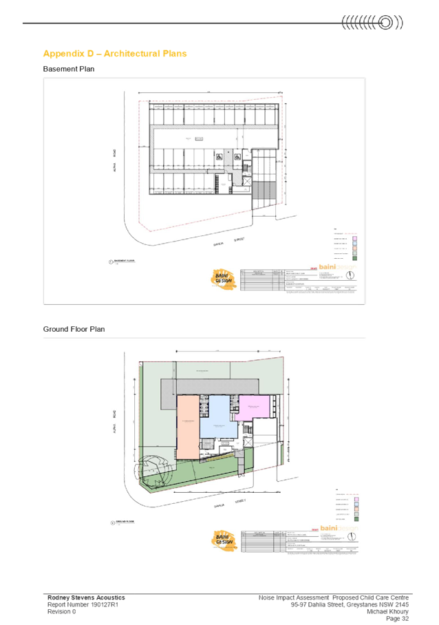
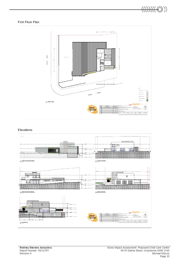
1. Draft Notice
of Determination
2. Architectural
Plans
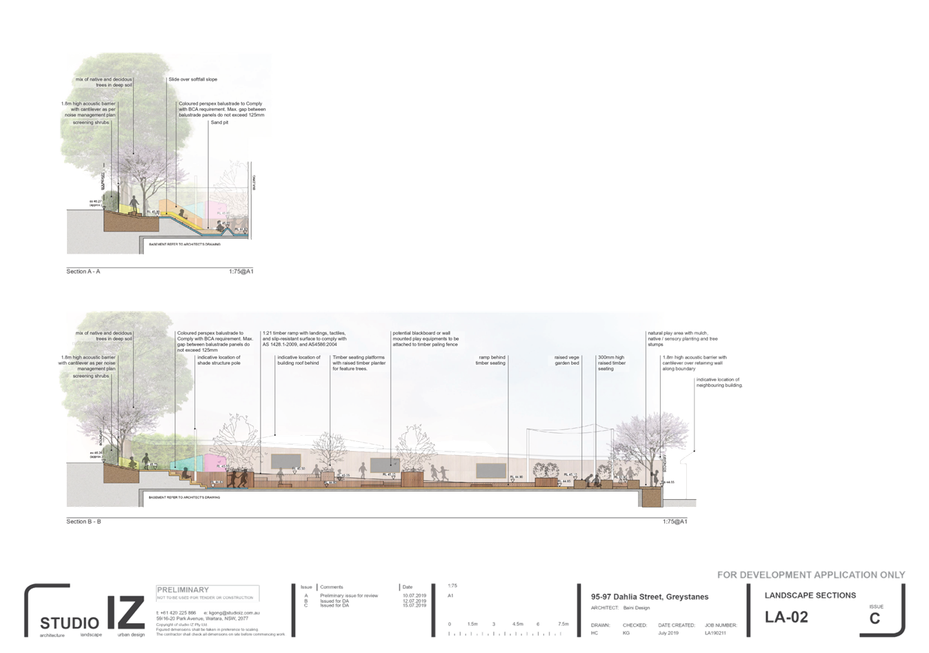
3. Landscape
Plans
4. Flood
Study Report
5. Noise
Impact Assesment
6. Noise
Management Plan
7. Parking
& Traffic Impact Assessment
8. Appendix
A - SEPP (Edu & Child Care) 2017
9. Appendix
B - Holroyd Local Environmental Plan 2013
10. Appendix
C - Holroyd Development Control Plan 2013
11. Appendix
D - Child Care Planning Guideline 2017
12. Submissions
Received
DOCUMENTS
ASSOCIATED WITH
REPORT LPP046/20
Attachment 1
Draft Notice of Determination
Cumberland Local Planning Panel Meeting
9 September 2020

DOCUMENTS
ASSOCIATED WITH
REPORT LPP046/20
Attachment 2
Architectural Plans
Cumberland Local Planning Panel Meeting
9 September 2020
DOCUMENTS
ASSOCIATED WITH
REPORT LPP046/20
Attachment 3
Landscape Plans
Cumberland Local Planning Panel Meeting
9 September 2020


DOCUMENTS
ASSOCIATED WITH
REPORT LPP046/20
Attachment 4
Flood Study Report
Cumberland Local Planning Panel Meeting
9 September 2020

DOCUMENTS
ASSOCIATED WITH
REPORT LPP046/20
Attachment 5
Noise Impact Assesment
Cumberland Local Planning Panel Meeting
9 September 2020


DOCUMENTS
ASSOCIATED WITH
REPORT LPP046/20
Attachment 6
Noise Management Plan
Cumberland Local Planning Panel Meeting
9 September 2020


DOCUMENTS
ASSOCIATED WITH
REPORT LPP046/20
Attachment 7
Parking & Traffic Impact Assessment
Cumberland Local Planning Panel Meeting
9 September 2020


DOCUMENTS
ASSOCIATED WITH
REPORT LPP046/20
Attachment 8
Appendix A - SEPP (Edu & Child Care) 2017
Cumberland Local Planning Panel Meeting
9 September 2020
DOCUMENTS
ASSOCIATED WITH
REPORT LPP046/20
Attachment 9
Appendix B - Holroyd Local Environmental Plan 2013
Cumberland Local Planning Panel Meeting
9 September 2020
DOCUMENTS
ASSOCIATED WITH
REPORT LPP046/20
Attachment 10
Appendix C - Holroyd Development Control Plan 2013
Cumberland Local Planning Panel Meeting
9 September 2020
DOCUMENTS
ASSOCIATED WITH
REPORT LPP046/20
Attachment 11
Appendix D - Child Care Planning Guideline 2017
Cumberland Local Planning Panel Meeting
9 September 2020
DOCUMENTS
ASSOCIATED WITH
REPORT LPP046/20
Attachment 12
Submissions Received
Cumberland Local Planning Panel Meeting
9 September 2020


Cumberland
Local Planning Panel Meeting
9 September 2020
Item
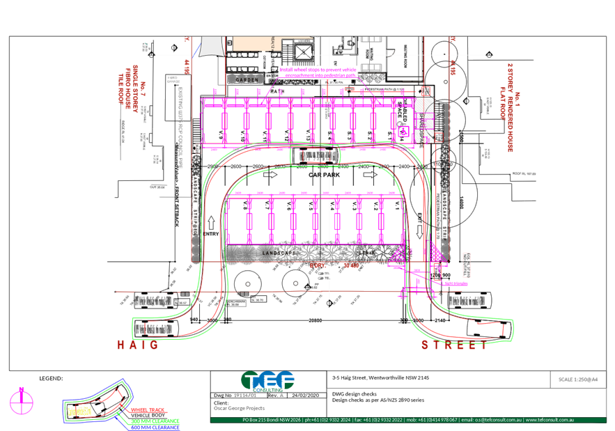
No: LPP047/20
Development
Application for 26 Mary Street, Auburn
Responsible
Division: Environment
& Planning
Officer: Acting
Executive Manager Development and Building
File
Number: DA2020/0210
|
Application lodged
|
8
April 2020
|
|
Applicant
|
Mr
D Thomson
|
|
Owner
|
LG
Finance Pty Ltd
|
|
Application No.
|
DA2020/0210
|
|
Description of Land
|
26
Mary Street AUBURN NSW 2144, Lot B DP 73573, Lot C DP 73573
|
|
Proposed Development
|
Internal
alterations to existing building at the front of the site for use as a
medical centre (methadone clinic)
|
|
Site Area
|
620sqm
|
|
Zoning
|
R2
Residential Low Density
|
|
Disclosure of political donations and gifts
|
Nil
disclosure
|
|
Heritage
|
No
|
|
Principal Development Standards
|
Building
height (9m)
Proposed
building height (No change to existing)
FSR
(N/A)
|
|
Issues
|
Parking
provision
Proximity
to sensitive land uses
Inadequacy
of submitted information
Submissions
|
1. Development
Application No. DA2020/0210 was received on 8 April 2020 for internal
alterations to existing building at the front of the site for use as a
methadone clinic.
2. The
application was publicly notified to occupants and owners of the adjoining
properties for a period of 14 days between 13 May 2020 and 27 May 2020. The
application was re-notified for a period of 14 days between 10 June 2020 to 24
June 2020 to expand the area of notification. In response to the exhibition periods,
a total of 27 unique submissions were received.
3. The
subject site is located within an R2 Residential low density zone and is
located in close proximity to a variety of residential uses, schools, aged care
facilities.
4. The
application seeks a variation to the following control:
|
Control
|
Required
|
Provided
|
% variation
|
|
Auburn Development
Control Plan 2010 – Parking and Loading
5.1.4 Onsite parking
3 spaces per surgery
|
2 x consulting rooms
are proposed.
A minimum of 6 onsite
parking spaces are required.
|
1 onsite space.
|
83%
|
5. On
26 June 2020, a letter was sent advising the applicant to withdraw the
application as Council was unlikely to support the development. No response to
withdraw the application was received by Council.
6. The
application is referred to the Panel as the proposal is considered to be a
contentious development.
7. The
application is recommended for refusal for the reasons provided in the Draft
Notice of Determination at attachment ‘1’ of this report.
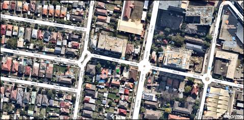
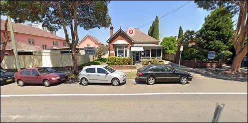
Subject Site and Surrounding
Area
The site comprises two lots
identified as Lot B DP 73573 and Lot C DP 73573 and is known as 26 Mary Street
Auburn. The site has an area of approximately 620sqm and a frontage to Mary
Street of 17.068m. It is rectangular in shape with a northern orientation.
A site inspection of the premises
carried out on 22 May 2020 confirmed that the site is currently occupied by a
vacant single storey dwelling house which previously operated as a medical
centre. This building faces Mary Street and is identified as Lot B. Lot C which
is located to the rear of Lot B contains a single storey building which
currently operates as a physiotherapy practice.
Auburn Town Centre is located to
the north east and Auburn Railway station is situated approximately 400m away.
The existing developments adjoining the site include a medical facility
(Westside Hearing Clinic) to the west, a commercial use (Islamic Science
Culture & Art Association) to the east and a dwelling house to the south.
Other uses in close proximity to the site include a high density mixed use
residential/commercial development on the opposing side of Mary Street, a
school (Trinity Catholic College), a Nursing Home, a private hospital and low
density residential uses.
Figure
1 – Locality Plan of subject site
Figure
2 – Aerial view of subject site
Figure
3 – Street view of subject site (Google maps)
Description of the Proposed
Development
Council has received a development
application for alterations and additions to an existing building for use as a
methadone clinic known as the Auburn Medical Referral Centre (AMRC).
Demolition and construction
Internal walls and doors are
proposed to be removed and new internal walls are to be constructed to
delineate rooms including two (2) consulting rooms, a staff area, a waiting
area, a pathology, a dispensing room and station, a staff toilet and a patient
toilet.
A disabled access ramp is to be
constructed at the rear of the building providing disabled pedestrian access
from the proposed car park area.
Details of use
The AMRC previously operated out
of 20 Mary Street Auburn which is located within the Auburn Town Centre. The
use of this site was the subject of a DA approval (DA1988/345) issued on 7
November 1988. This site contained provision for six (6) onsite parking spaces.
The proposed relocation to 26 Mary Street Auburn is situated outside the
boundaries of the Town Centre.
The AMRC will administer and
prescribe various restricted drugs for opiate treatment including Methadone
Syrup, Biodone, Buprenorphine, Subutex and Suboxone. The clinic currently has
over 215 patients who will be serviced at the new site. A pathology service is
also proposed at the new site.
Hours of operation are as follows:
- Monday
to Friday – 7.30am to 1.00pm and 4.00pm to 6.00pm; and
- Saturday,
Sunday and Public Holidays – 9.00am to 12.00pm.
There will be six (6) staff
members with a maximum of four (4) onsite at any one time. Staff members
include private ‘medical prescribers’ who operate independent of
each other onsite and nurses who operate the dosing clinic. There will be a
maximum of 5-6 patients at the centre at any given time and the duration of
patient visits is 15 minutes to 1 hour.
Parking provision
Two (2) onsite parking spaces are
proposed at the rear of the building with one space to be allocated to the
proposed use and the other to the existing use (Physiotherapy Clinic) located
at the rear of the site on Lot C. Access to the proposed spaces is provided via
an existing driveway that extends along the western side setback.
Loading and unloading
The applicant intends to utilise
the rear car parking area for the loading and unloading of goods to service the
clinic.
History
On 28 November 1962, Council
granted permission for the land (Lot B) to be used for the purpose of
‘professional rooms’.
On 28 July 1993, a development
application (DA1993/132) was approved for ‘Use of the existing building
as a youth resource centre involving counselling/assessment and referral of
clients’.
On 18 February 2003 a development application
(DA665/2002) was approved for a carport on the site. Information submitted with
this application suggests the building was intended to be used as a dwelling.
Applicants Supporting
Statement
The applicant has provided a
Statement of Environmental Effects prepared by Barker Ryan Stewart dated 19
March 2020 and was received by Council on 8 April 2020 in support of the
application.
Contact with Relevant
Parties
The assessing officer has undertaken a site inspection of
the subject site and surrounding properties and has been in regular contact
with the applicant throughout the assessment process.
Internal Referrals
Development Engineer
The development application was referred to Council’s
Development Engineer for comment who has advised that the development is
unsatisfactory with regard to the provision of onsite car parking. The matters
of concern raised by Council’s Development Engineer is summarised below.
- Insufficient
number of onsite parking spaces
i)
The proposal does not provide the minimum required number of
onsite parking spaces in accordance with Auburn Development Control Plans 2010
– Parking and Loading which specifies at least three (3) onsite spaces
per consulting room are required. The development proposes two (2) onsite parking
spaces, one of which is to be used by the existing use (physiotherapy) at the
rear of the site on Lot C.
- Design
of parking area
ii)
The proposed parking layout does not comply with the Australian
Standard AS2890.1 with regard to vehicle manoeuvrability.
iii)
Environment and Health
The development application was referred to Council’s
Environment and Health Officer for comment who has advised that the development
proposal is satisfactory subject to an assessment of the submitted Acoustic
Report and Operational Management Plan. It was therefore recommended that the
development be supported subject to conditions should consent be granted.
Waste Management
The development application was referred to Council’s
Waste Management Officer for comment who has advised that the development is
not supported on the basis that ongoing waste arrangements need to be provided
on the architectural plans. This may be resolved by condition should consent be
granted.
External Referrals
NSW Police
The development application was referred to NSW Police for
comment who raised concerns in relation to the proximity of the clinic to
adjoining uses including the ‘paediatric audiology clinic where mothers
and children are frequently in attendance’ and Trinity Catholic College
which is within walking distance. Concern was raised regarding the
‘demographic of crime within the area, generally due to the people
attending the location for the purpose of obtaining methadone. Most of these
people have historical and current drug related issues and it is common for
people with such problems to engage in other forms of criminal and anti-social
activity’.
Despite these concerns, the proposal was deemed acceptable
subject to a number of recommendations relating to signage, lighting, security
and occupational health and safety.
Planning Comments
The provisions of any
Environmental Planning Instruments (EP&A Act s4.15 (1)(a)(i))
State Environmental Planning
Policies
The proposed development is
affected by the following State Environmental Planning Policies:
(a) State
Environmental Planning Policy No. 55 – Remediation of Land (SEPP 55)
Clause 7 of SEPP 55 requires
Council to be satisfied that the site is suitable or can be made suitable to
accommodate the proposed development. The matters listed within Clause 7 have
been considered in the assessment of the development application.
|
Matter for
Consideration
|
Yes/No
|
|
Does the application
involve re-development of the site or a change of land use?
|
Yes No
|
|
In the development
going to be used for a sensitive land use (e.g.: residential, educational,
recreational, childcare or hospital)?
|
Yes No
|
|
Does information
available to you indicate that an activity listed below has ever been
approved, or occurred at the site?
acid/alkali plant and formulation, agricultural/horticultural
activities, airports, asbestos production and disposal, chemicals manufacture
and formulation, defence works, drum re-conditioning works, dry cleaning
establishments, electrical manufacturing (transformers), electroplating and
heat treatment premises, engine works, explosive industry, gas works, iron
and steel works, landfill sites, metal treatment, mining and extractive
industries, oil production and storage, paint formulation and manufacture,
pesticide manufacture and formulation, power stations, railway yards, scrap
yards, service stations, sheep and cattle dips, smelting and refining,
tanning and associated trades, waste storage and treatment, wood preservation
|
Yes No
|
|
Is
the site listed on Council’s Contaminated Land database?
|
Yes No
|
|
Is
the site subject to EPA clean-up order or other EPA restrictions?
|
Yes No
|
|
Has
the site been the subject of known pollution incidents or illegal dumping?
|
Yes No
|
|
Does
the site adjoin any contaminated land/previously contaminated land?
|
Yes No
|
|
Has
the appropriate level of investigation been carried out in respect of
contamination matters for Council to be satisfied that the site is suitable
to accommodate the proposed development or can be made suitable to
accommodate the proposed development?
|
Yes No
|
|
Details of
contamination investigations carried out at the site:
The site is not identified in Council’s records as
being contaminated. A site inspection reveals the site does not have any
obvious history of a previous land use that may have caused contamination and
there is no specific evidence that indicates the site is contaminated.
|
Regional Environmental Plans
The proposed development is
affected by the following Regional Environmental Plans:
(a) Sydney
Regional Environmental Plan (Sydney Harbour Catchment) 2005
The subject site is identified as
being located within the area affected by the Sydney Regional Environmental
Plan (Sydney Harbour Catchment) 2005. The proposed development raises no issues
as no impact on the catchment is envisaged.
(Note: - the subject site is not
identified in the relevant map as ‘land within the ‘Foreshores and
Waterways Area’ or ‘Wetland Protection zone’, is not a
‘Strategic Foreshore Site’ and does not contain any heritage items.
Hence the majority of the SREP is not directly relevant to the proposed development).
Local Environmental Plans
Auburn Local Environmental Plan
2010
The provision of the Auburn Local
Environmental Plan 2010 is applicable to the development proposal. It is noted
that the development achieves compliance with the key statutory requirements of
the R2 Residential Low Density zone.
(a) Permissibility:-
The proposed development is
defined as a ‘Medical Centre’ (specifically, a Methadone Clinic)
and is permissible in the R2 Residential Low Density zone with consent.
Medical centre means premises that
are used for the purpose of providing health services (including preventative
care, diagnosis, medical or surgical treatment, counselling or alternative
therapies) to out-patients only, where such services are principally provided
by health care professionals. It may include the ancillary provision of other
health services.
The relevant matters to be
considered under Auburn Local Environmental Plan 2010 and the applicable
clauses for the proposed development are summarised below.
Figure
4 – Auburn LEP 2010 Compliance Table
|
OBJECTIVE/DEVELOPMENT
STANDARD
|
COMPLIANCE
|
DISCUSSION
|
|
Zone R2 Low Density
Residential
1 Objectives of zone
· To
enable other land uses that provide facilities or services to meet the day to
day needs of residents.
|
No
|
The purpose of the
proposed methadone clinic is to provide opiate treatment to recovering drug
addicts which is not considered to be a service that meets the day to day
needs of the local residents in the area.
|
|
4.3 Height of Buildings
9m (max)
|
N/A
|
No change to the height of the existing building is proposed.
|
|
4.4 Floor Space Ratio
|
N/A
|
FSR does not apply to
development on land in the R2 land use zone.
|
The provisions of any proposed
instrument that is or has been the subject (EP&A Act s4.15 (1)(a)(ii))
(a) Draft
State Environmental Planning Policy (Environment)
The draft SEPP relates to the
protection and management of our natural environment with the aim of
simplifying the planning rules for a number of water catchments, waterways,
urban bushland, and Willandra Lakes World Heritage Property. The changes
proposed include consolidating the following seven existing SEPPs:
· State
Environmental Planning Policy No. 19 – Bushland in Urban Areas
· State
Environmental Planning Policy (Sydney Drinking Water Catchment) 2011
· State
Environmental Planning Policy No. 50 – Canal Estate Development
· Greater
Metropolitan Regional Environmental Plan No. 2 – Georges River Catchment
· Sydney
Regional Environmental Plan No. 20 – Hawkesbury-Nepean River (No.2-1997)
· Sydney
Regional Environmental Plan (Sydney Harbour Catchment) 2005
· Willandra
Lakes Regional Environmental Plan No. 1 – World Heritage Property.
The draft policy will repeal the
above existing SEPPs and certain provisions will be transferred directly to the
new SEPP, amended and transferred, or repealed due to overlaps with other areas
of the NSW planning system.
Changes are also proposed to the
Standard Instrument – Principal Local Environmental Plan. Some provisions
of the existing policies will be transferred to new Section 117 Local Planning
Directions where appropriate.
(b) Draft
Cumberland Local Environmental Plan 2020 (Draft CLEP)
The Draft Cumberland Local
Environmental Plan 2020 (Draft CLEP) has been prepared by Cumberland Council to
provide a single planning framework for the future planning of Cumberland City.
The changes proposed seek to harmonise and repeal the three existing LEPs
currently applicable to the Cumberland local government area, those being:
· Holroyd
Local Environmental Plan 2013,
· Parramatta
Local Environmental Plan 2011, and
· Auburn
Local Environmental Plan 2010.
The current planning controls for
the subject site, as contained within the Auburn Local Environmental Plan 2010,
are not proposed to change under the Draft CLEP.
The provisions of any
Development Control Plans (EP&A Act s4.15 (1)(a)(iii))
The Auburn Development Control
Plan 2010 provides guidance for the design and operation of development to
achieve the aims and objectives of the Auburn Local Environmental Plan 2010.
A comprehensive assessment and
compliance table is contained in Appendix A.
The following table highlights a
non-compliance with the DCP, which relates to parking provision. The variation
sought is considered unsatisfactory in this instance:
Figure
5 – Auburn DCP 2010 – Parking and Loading Compliance Table
|
Clause
|
Control
|
Proposed
|
Complies
|
|
5.1.4 Onsite parking
|
3 onsite parking spaces
per surgery.
6 onsite spaces
required (given 2 consulting rooms are proposed).
|
2 onsite parking
spaces.
1 space to be allocated
to each use on the site.
|
No
|
As indicated in the compliance
table above, the proposed development departs from the onsite parking
provisions of Council’s Parking and Loading DCP. Having regard to this
departure, it is considered that the proposal performs unsatisfactorily from an
environmental planning viewpoint for the reason discussed below:
The development will provide one
(1) onsite parking space for use by the proposed methadone clinic. This results
in a deficiency of five (5) spaces or 83% which is excessive. The staff and
patient numbers were also considered in the assessment. The submitted details
and referral advice suggest that four (4) staff, a minimum of two (2) patients
being served at any one time and security personnel (as recommended by NSW
Police) would be present at the clinic during operating hours.
Based on the proposed staff
numbers and the number of clients, it is considered that the provision of one
(1) parking space on the site would be inadequate to accommodate the proposed
use.
Issue is also raised with regard
to the conflict of the new disabled pedestrian ramp located at the rear of the
building. It is likely given the limited area at the rear of the building that
installation of the ramp will compromise vehicle manoeuvrability and result in
the deletion of an onsite parking space which is not supported.
The provisions of any planning
agreement that has been entered into under section 7.4, or any draft planning
agreement that a developer has offered to enter into under section 7.4
(EP&A Act s4.15(1)(a)(iiia))
There is no draft planning
agreement associated with the subject Development Application.
The provisions of the
Regulations (EP&A Act s4.15 (1)(a)(iv))
The proposed development raises no
concerns as to the relevant matters arising from the Environmental Planning and
Assessment Regulations 2000 (EP&A Reg).
The Likely Environmental,
Social or Economic Impacts (EP&A Act s4.15 (1)(b))
It is considered that the proposed
development will have a significant environmental impact in the locality noting
the carparking non compliance.
The suitability of the site for
the development (EP&A Act s4.15 (1)(c))
The subject site and locality is not known to be affected by
any natural hazards or other site constraints likely to have a significant
adverse impact on the proposed development. However, due to the significant
departure of Council’s parking requirements, the development is
considered unsuitable in the context of the site and surrounding locality.
Submissions made in accordance with
the Act or Regulation (EP&A Act s4.15 (1)(d))
Advertised
(newspaper) Mail
Sign
Not
Required
In accordance with Council’s
Notification requirements contained within the Auburn DCP 2010, the proposal
was publicly notified for a period of 14 days between 13 May 2020 and 27 May
2020 and was re-notified for a further 14 days between 10 June 2020 to 24 June
2020. The notification periods generated a total of 27 unique submissions in
respect of the proposal. The issues raised in the public submissions are
summarised and commented on as follows:
Figure
6 – Submissions summary table
|
Concern
|
Comment
|
|
The subject site is in close
proximity to sensitive land uses.
|
It is acknowledged that the
subject site is in close proximity to a number of sensitive land uses
including residential, schools, aged care facilities and various health
services that cater for the elderly, families and children.
|
|
Inadequate onsite parking is
provided on the site to accommodate the development and the application does
not consider the existing use on the site.
|
The development proposes
insufficient onsite parking to comply with the minimum requirement in Auburn
Development Control Plan 2010. The proposed onsite parking provision is
considered inadequate to accommodate the proposed use as explained in this
report.
|
|
Traffic congestion and lack of
on-street parking.
|
It is acknowledged that
traffic along this part of Mary Street becomes congested at times and demand
for on-street parking in the area is high. This is due to the scale and type
of uses in close proximity to the site including a school, high density
residential uses and various health related service providers. In addition, the
section of Mary Street fronting the subject site is a busy thoroughfare for
motorists given its linkage and close proximity to the Auburn Town Centre.
|
|
Vehicle accessibility
to the subject site is inadequate.
|
Vehicle access to the site is
an existing condition. It is noted however that the introduction of a new
disabled access ramp at the rear of the building is likely to present vehicle
manoeuvring issues and result in the deletion of a proposed parking space
which is not supported.
|
|
Incidence of crime and
safety of residents will be compromised. Loitering of patients and potential
trespassing on private property.
|
The development application
was referred to NSW Police for comment and concern was raised regarding the
incidence of crime resulting from the demographic that would make use of the
service. Nonetheless, NSW Police have raised no issue with the proposal
subject to the inclusion of conditions of consent should the proposal be
supported.
|
|
Declining property values.
|
No evidence has been provided
to support this claim.
|
|
Impact on existing businesses.
|
No evidence has been submitted
to suggest local business would be impacted by the proposed development.
|
|
Noise impact of the development.
|
An acoustic report was
submitted with the application and assessed by Council’s Environmental
Health Officer. No issue was raised regarding noise impact subject to the
inclusion of conditions should consent be granted.
|
|
Visual impact of barred windows
and doors.
|
The proposed works include the
removal and installation of internal walls and a disabled access ramp to the
rear of the building adjacent to the onsite parking area. No changes are
proposed to the existing windows and external doors of the building.
|
|
Operational management
plan is generic in its content.
|
Any deficiencies of the
operational management plan can be addressed via conditions should consent be
granted.
|
The public interest (EP&A
Act s4.15(1)(e))
In view of the foregoing analysis
it is considered that the development as proposed would not be consistent with
the public interest as it would result in a detrimental impact on on-street
parking availability.
Section 7.11 (Formerly S94)
Contribution Towards Provision or Improvement of Amenities or Services
This part of the Act relates to
the collection of monetary contributions from applicants for use in developing
key local infrastructure.
Comments: The development does not
require the payment of contributions in accordance with Cumberland Local
Infrastructure Contributions Plan 2020.
Disclosure of Political
Donations and Gifts
The applicant and notification
process did not result in any disclosure of Political Donations and Gifts.
Having regard to the relevant
matters of consideration under Section 4.15 of the Environmental Planning and
Assessment Act 1979, Auburn Local Environmental Plan 2010, Auburn Development
Control Plan 2010 and the Draft Cumberland Local Environmental Plan 2020, it is
considered that the proposed development is unacceptable for the reasons
outlined in this report. It is recommended that the development application be
refused.
|
1. That
Development Application No. DA2020/0210 for Internal alterations to existing
building at the front of the site for use as a medical centre (methadone
clinic) on land at 26 Mary Street AUBURN NSW 2144 be refused for
the reasons listed in the attached schedule.
2. Persons
whom have lodged a submission in respect to the application be notified of
the determination of the application.
|
1. Draft Notice
of Determination
2. Architectural
Plans
3. Submissions
Recieved
4. Appendix
A - Auburn Local Environmental Plan 2010
DOCUMENTS
ASSOCIATED WITH
REPORT LPP047/20
Attachment 1
Draft Notice of Determination
Cumberland Local Planning Panel Meeting
9 September 2020
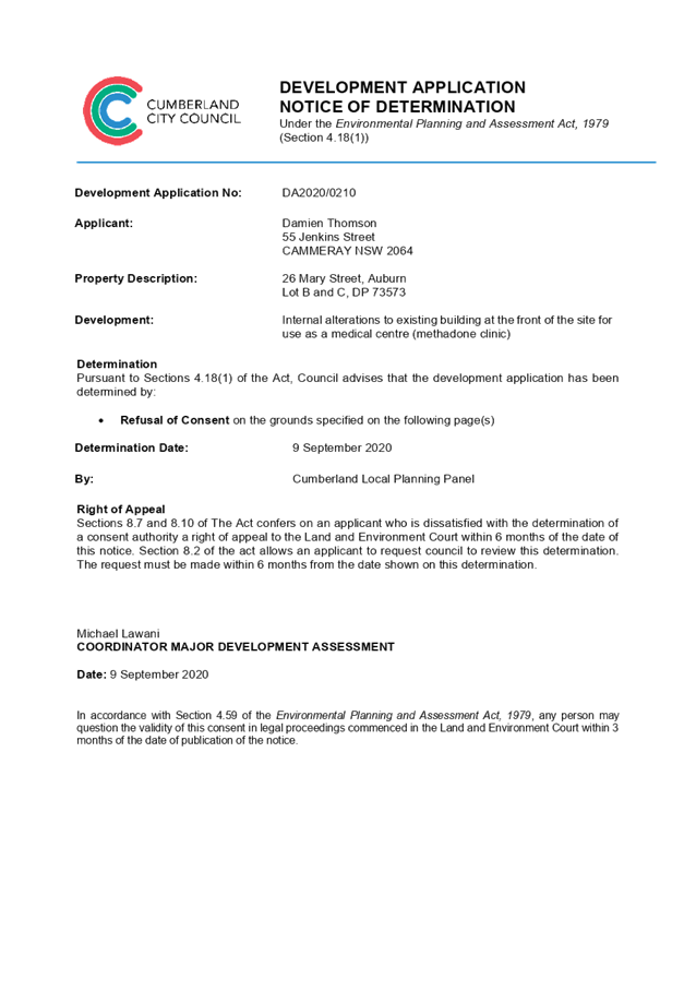
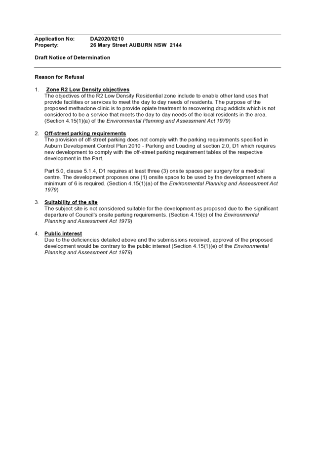
DOCUMENTS
ASSOCIATED WITH
REPORT LPP047/20
Attachment 2
Architectural Plans
Cumberland Local Planning Panel Meeting
9 September 2020
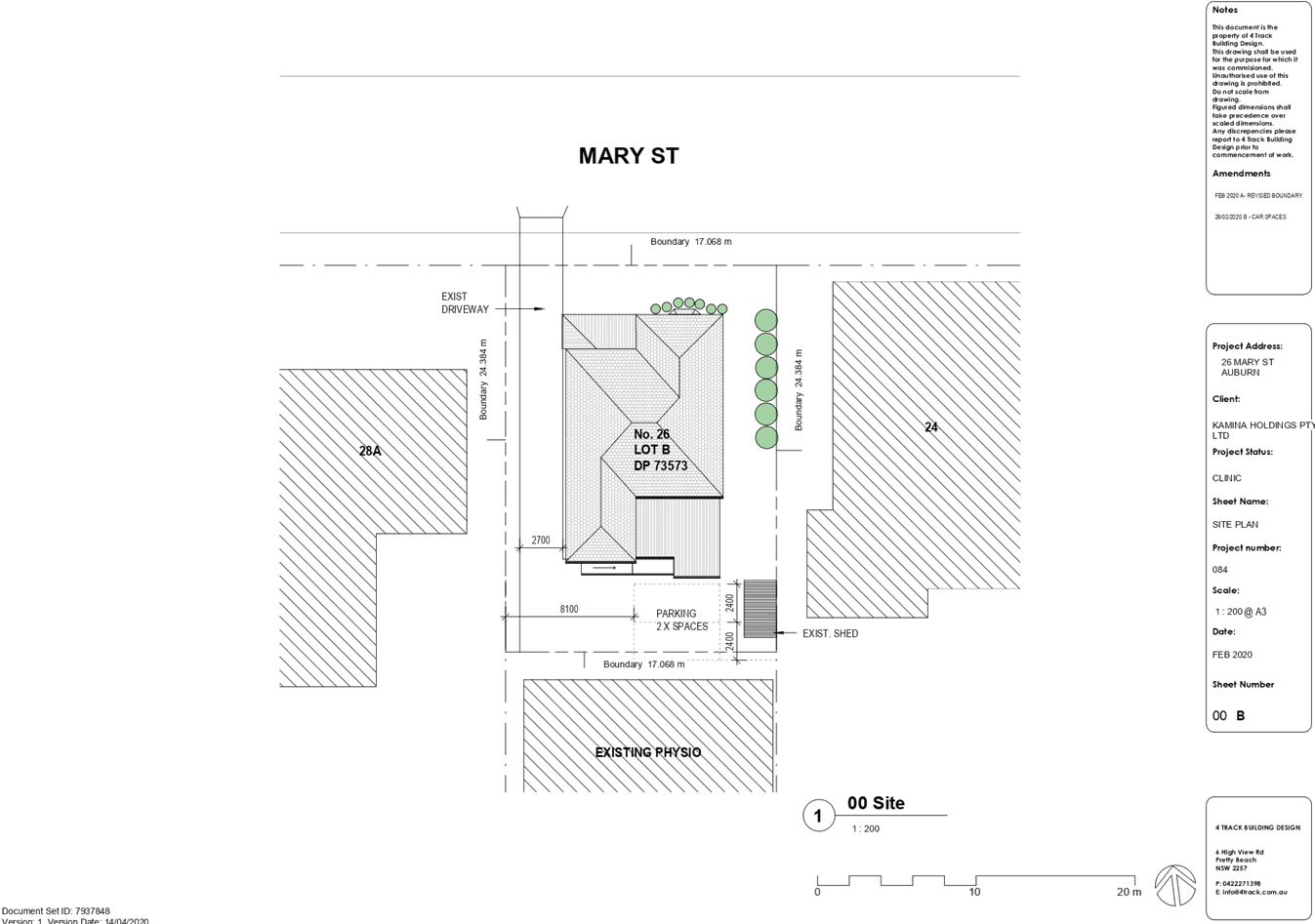
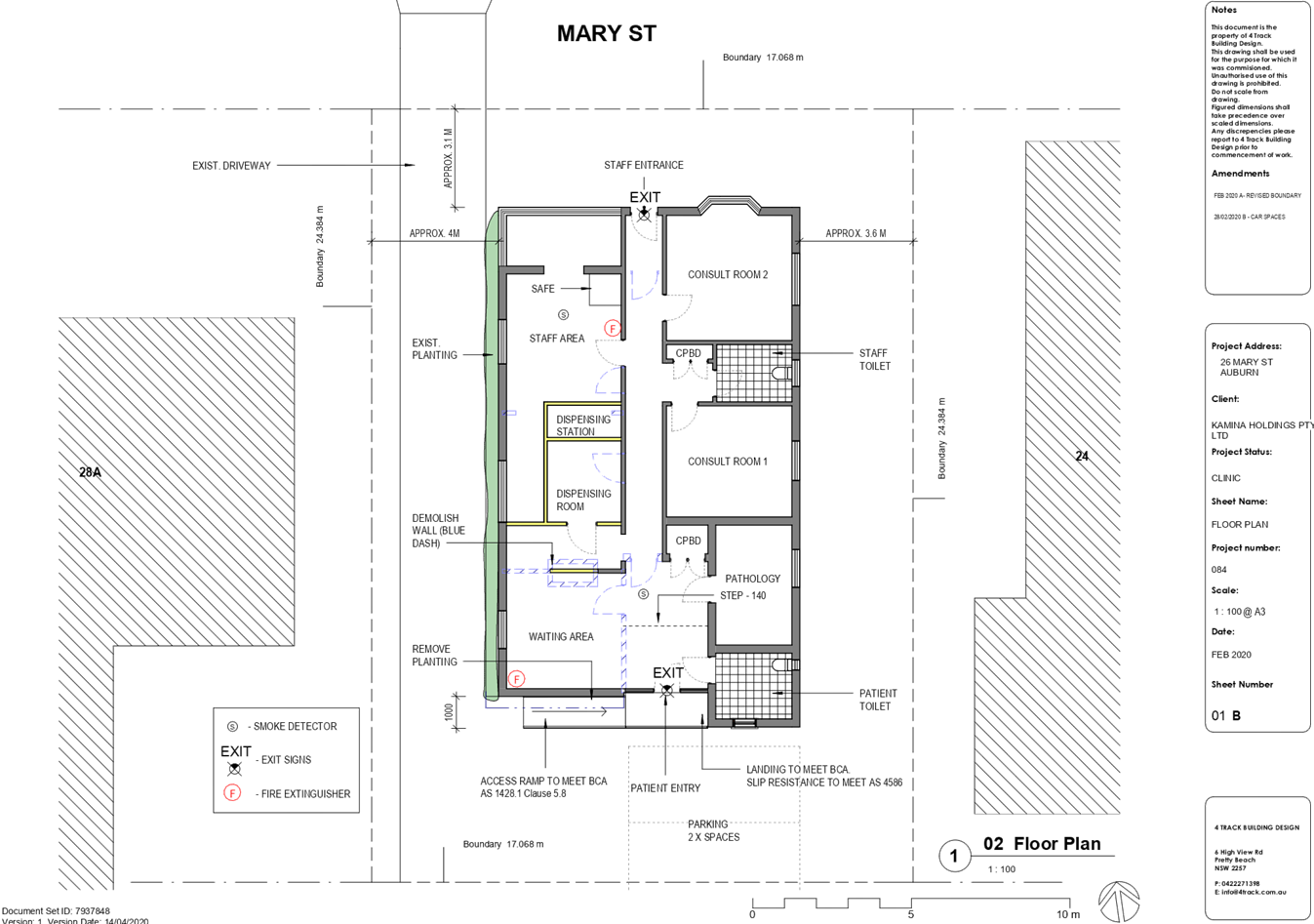
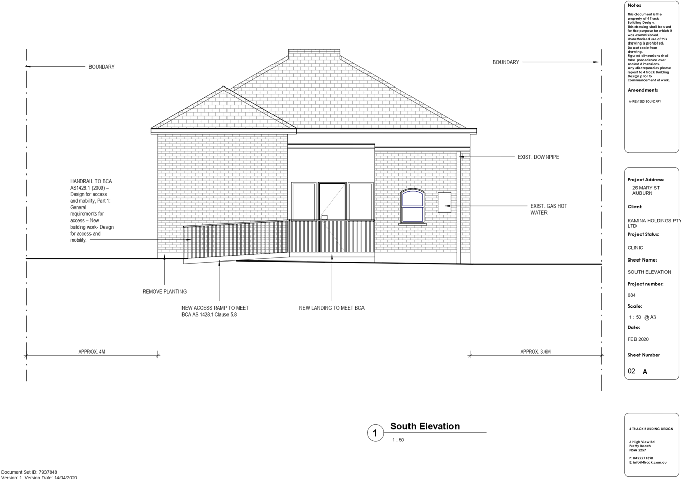
DOCUMENTS
ASSOCIATED WITH
REPORT LPP047/20
Attachment 3
Submissions Recieved
Cumberland Local Planning Panel Meeting
9 September 2020

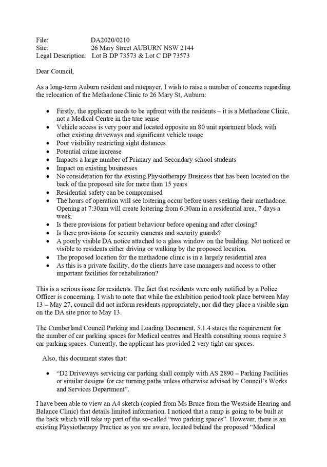
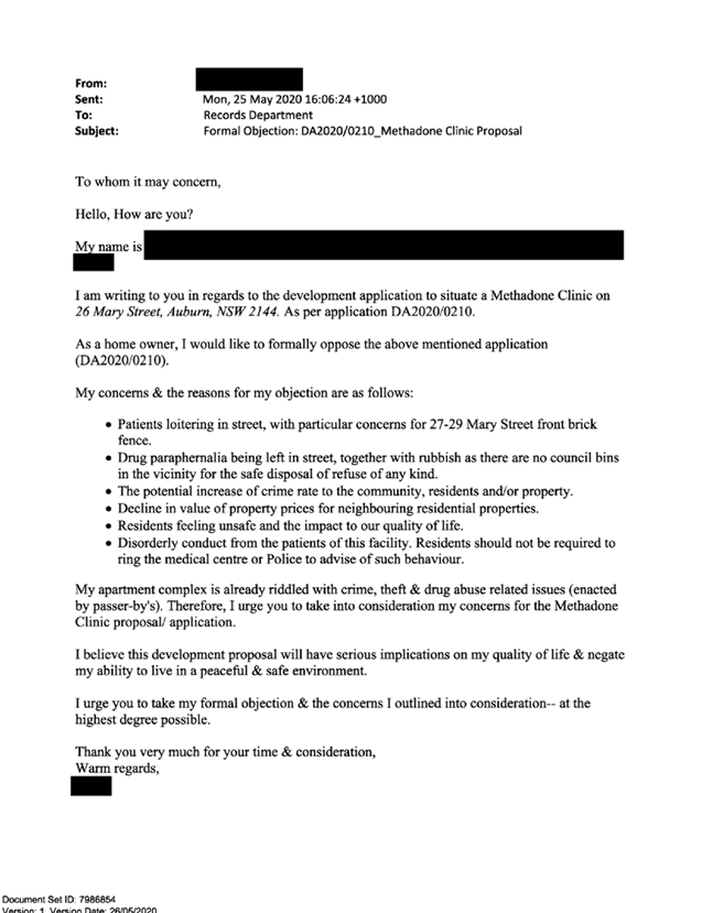
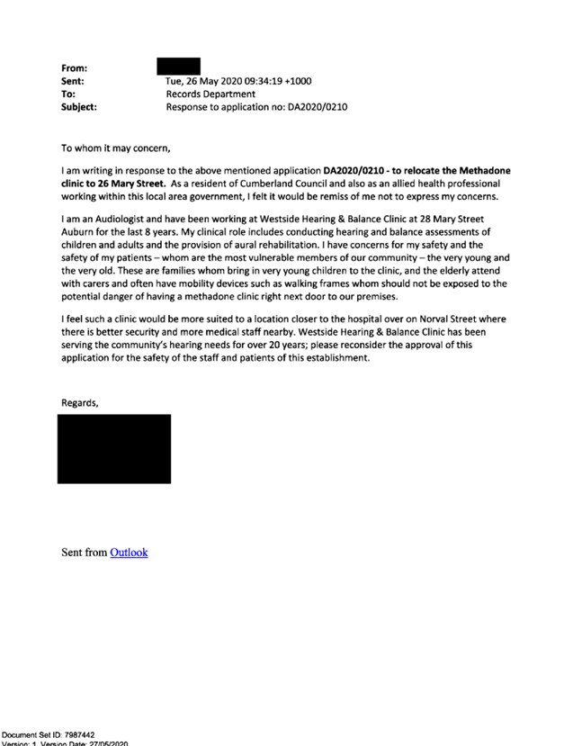
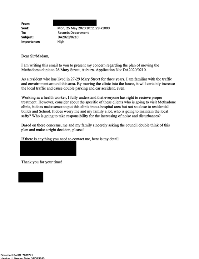
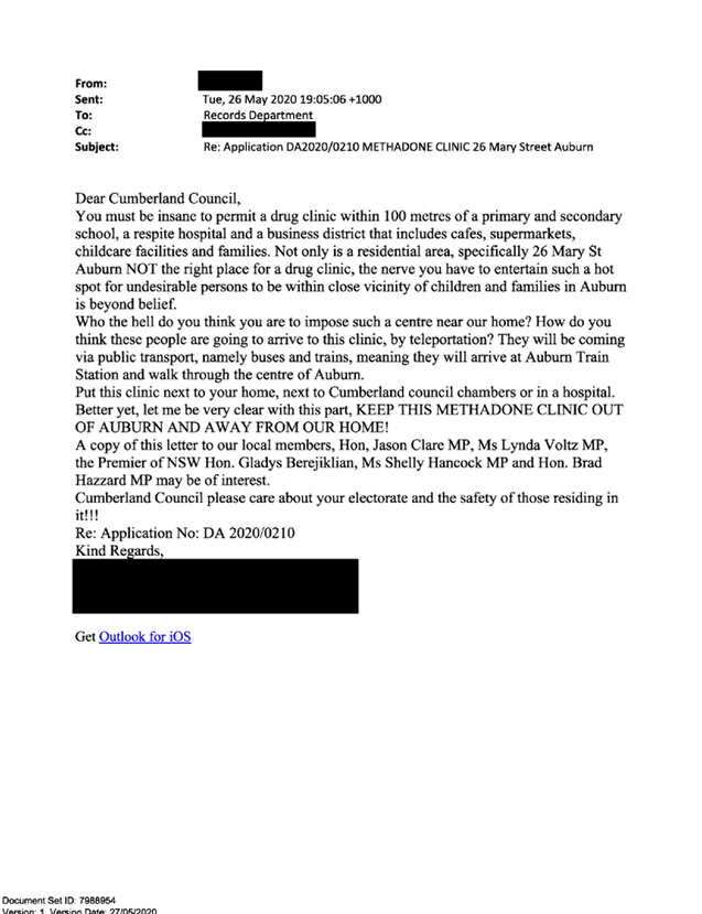


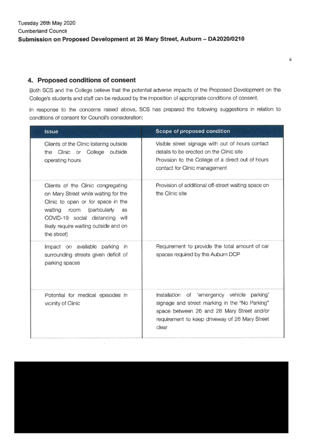


DOCUMENTS
ASSOCIATED WITH
REPORT LPP047/20
Attachment 4
Appendix A - Auburn Local Environmental Plan 2010
Cumberland Local Planning Panel Meeting
9 September 2020
Cumberland
Local Planning Panel Meeting
9 September 2020
Item
No: LPP048/20
Development Application
for 3 & 5 Haig Street, Wentworthville
Responsible
Division: Environment
& Planning
Officer: Acting
Executive Manager Development and Building
File
Number: DA2020/0145
|
Application
lodged
|
9 March 2020
|
|
Applicant
|
Mr R Kota
|
|
Owner
|
Mr R Kota
|
|
Application
No.
|
DA2020/0145
|
|
Description
of Land
|
3 & 5 Haig Street
WENTWORTHVILLE NSW 2145, Lot 111 and Lot 112 DP 7383
|
|
Proposed
Development
|
Demolition of existing
structures and construction of a 56 place child care centre with at-grade car
parking
|
|
Site
Area
|
1347m2
|
|
Zoning
|
R2- Low Density Residential
|
|
Disclosure
of political donations and gifts
|
Nil disclosure
|
|
Heritage
|
No
|
|
Principal
Development Standards
|
· Floor Space Ratio – 0.5:1
(HLEP 2013)
· Height of Buildings – 9m
|
|
Issues
|
- Site suitability
- Front
setback (inconsistent with the streetscape)
- Large
expense of hard stand area within the front setback
- Cut
and fill
- Retaining
walls
- Fencing
heights
- Amenity
impacts
- Pedestrian
access
- Shade
structures
- Inadequate
information
- Public
interest
|
1. Development
Application No. DA2020/0145 was received on 9 March 2020 for the demolition of
existing structures and construction of a 56 place child care centre with
at-grade car parking.
2. The
application was publicly notified to occupants and owners of the adjoining
properties for a period of 21 days between 1 April 2020 and 15 April 2020. The
notification period was extended for a further 7 day period as number of
objectors requested for extra time to submit their concerns due to the COVID 19
Pandemic. In response, a total of 20 unique submissions including a
petition containing 53 signatures and 2 x form letters were received, objecting
to the proposal.
3. Correspondence
was sent to the Applicant on 1 June 2020 advising that the application could
not be supported and inviting its withdrawal. That correspondence also set out
Council’s concerns with the application in detail. The issues included
site unsuitability, incompatibility with the streetscape, compliance with child
care centre provisions, excessive cut and fill, height of acoustic fencing,
amenity impacts, waste and engineering matters. The applicant elected not
to withdraw the application.
4. Amended
plans and additional information were provided to Council on 1 July 2020. The
amended plans did not warrant re-notification.
5. The
subject application has been assessed against the relevant provisions of the
Environmental Planning and Assessment Act 1979, State Environmental Planning Policy
(Educational Establishments and Child Care Facilities) 2017, Child Care
Planning Guideline (the Guideline) 2017, Holroyd Local Environmental Plan 2013
(HLEP) and Holroyd Development Control Plan 2013 (HDCP).
6. The
proposal seeks the following numerical non-compliances which are not supported:
|
Control
|
Required
|
Provided
|
Variation (%)
|
|
Shade (Child Care Planning
Guideline 2017 – Clause 4.11)
|
30% of the outdoor play
area shall be provided with shade (118.5m2 )
|
94.6 m2 is
provided with shade
|
20.2%
|
|
Driveway Setback (HDCP
2013)
|
Min. 1.5m
|
940mm for the one way
entry driveway
|
37.3%
|
|
Retaining walls (HDCP
2013)
|
Max 1m high
|
1.48m to 2m high
|
100%
|
|
Cut (HDCP 2013)
|
Cut: max. 1m; max. 0.45m
within 0.9m of side/rear boundary
|
Max cut: 930mm along the northern
boundary
|
106.6%
|
|
Fill (HDCP 2013)
|
Fill: 0.3m within 0.9m of
side/rear boundary
|
Max fill: 1.2m along the
eastern boundary
|
300%
|
|
Front setback (HDCP
2013)
|
Min setback of 6m and
should be consistent with the existing streetscape
|
Front setback of 20.9m
|
248.33%
|
|
First floor child care
centre component (HDCP 2013)
|
Childcare
centre component shall not be located on the upper level
|
Children play area (0-2
years old) is located on the upper floor
|
-
|
|
Acoustic Fence heights (HDCP 2013)
|
Max. 2m with a 1.8m traditional lapped and capped boundary
fence and the remaining height to be of thick, transparent Perspex.
|
Max 3.4m along the eastern boundary
|
70%
|
7. The
application has been referred to the Cumberland Local Planning Panel (CLPP) for
determination due to the number of submissions received during the notification
period.
8. The
application is recommended for refusal for the reasons provided in the Draft
Notice of Determination contained in Attachment 1 of this report.
Subject Site and Surrounding
Area
The subject site is known as 3
& 5 Haig Street, Wentworthville; and is legally described as Lot 111 and
Lot 112 in DP 7383. The site is located on the northern side of Haig Street.
The site is a rectangular block with a frontage of 30.48m, depth of 44.195m and
a total site area of 1347m².
The subject site includes two
dwelling houses with associated parking and vegetation. Existing
improvements on the site include a single-storey and double storey residential
dwellings with associated structures and outbuildings along the eastern and
western sides.
Adjoining developments consist of
one to two storey detached dwelling houses with landscaped front setbacks. The
site has a fall of approximately 4m from front to the rear.
Wentworthville Public School is located 1.2km from the site. The subject site
and the adjoining properties are zoned R2 Low Density Residential.
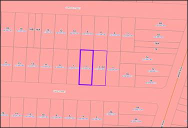
Figure
1 - Zoning map with the subject site. Source: Cumberland Council
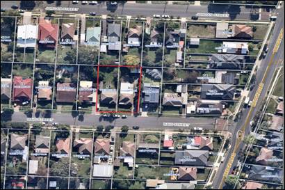
Figure
2- Aerial view of the locality with the subject site. Source: IntraMaps
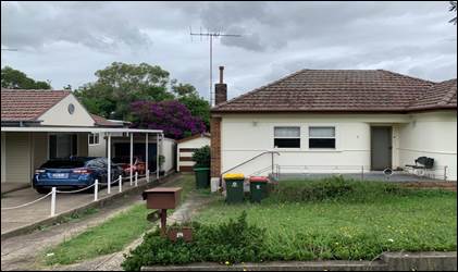
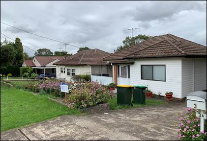
Figure
3 & 4- Site Photos
Description of the Proposed
Development
The proposed development involves
the demolition of existing structures and construction of a two storey, 56
place child care centre with at grade parking accommodating 18 car parking
spaces.
Key features of the development
proposal are as follows:-
· Demolition
of the existing structures
· Construction
of a two-storey child care facility accommodating 56 children.
· At
grade car parking area accommodating 18 car parking spaces, for staff and
visitors (including 1 accessible space)
· The
facility will accommodate 56 children, as follows:
o 12 children – 0-2
yrs
o 44 children – 3-6
yrs
· The
proposed centre will operate from 7.00am to 6.00pm Monday to Friday, and will
employ 8 staff; with staff ‘shoulder times’ of 6.30am to 6.30pm.
· The
upper ground floor level contains meeting room, waiting room, reception, main
entry from at grade car parking facing Haig Street, toilets, storage and indoor
and outdoor play areas.
· The
lower ground floor level contains indoor and outdoor play areas (3-6 yrs old),
office, toilets, kitchen, laundry, bin storage, store, lift and stairs.
· Consent
is not sought for signage as part of this application, rather, it is the
intention for signage to be addressed under the Exempt Development provisions
(as indicated in the Statement of Environmental Effects)
· Below
ground OSD system with associated OSD pits and retaining walls are proposed on
site.
History
|
Date
|
Action
|
|
9/03/2020
|
Development Application 2020/0145 was lodged.
|
|
19/03/2020
|
The application was referred to Council’s internal
and external departments for review.
|
|
1/04/2020 to 15/04/2020
|
The application was publicly
notified to adjoining and opposite owners, a notice was placed in the local
press and a notice placed on the site for 14 days. The notification
period was extended for a further 7 day period as number of objectors requested
for extra time to submit their concerns
due to COVID 19 Pandemic. In response, a total of 20 unique submissions including a petition
containing 53 signatures and 2 x form letters were received objecting to the
proposal.
|
|
1/06/2020
|
Application was deferred due to non-compliances with SEPP
(Educational Establishments and Child Care Facilities) 2017, Child Care
Planning Guideline 2017 and Holroyd Development Control Plan 2013.
|
|
1/07/2020
|
Amended plans and additional information were received by
Council. Amended plans did not warrant re notification.
|
|
15/07/2020 to 29/07/2020
|
The amended plans were re -referred to Council’s
internal departments for review.
|
|
6/08/2020
|
Correspondence was sent to the applicant advising that the
application could not be supported and inviting its withdrawal. That
correspondence detailed Council’s concerns with the application with
regard to site incompatibility, streetscape presentation, large hard stand
area within the front setback, retaining walls, height of boundary fencing
and amenity impacts. The applicant advised that the application would not be withdrawn.
|
|
09/09/2020
|
Application referred to CLPP for determination.
|
Applicants Supporting
Statement
The applicant has provided a
Statement of Environmental Effects prepared by Miletic-Mieler Development
Consultants Pty Ltd dated March 2020 in support of the application.
Contact with Relevant
Parties
The assessing officer has
undertaken a site inspection of the subject site and surrounding properties and
has been in regular contact with the applicant throughout the assessment
process.
Internal Referrals
Development Engineer
The development application was
referred to Council’s Development Engineer for comment who has advised
that the development is generally supportable in regards to stormwater
management and on-site detention provision, should the consent have been
granted. However, concern was raised regarding the submitted survey plan as it
shows an existing drainage easement is within the site. In this regard,
inadequate information is provided to demonstrate that the development is clear
of the easement.
Tree Management Officer
The development application was
referred to Council’s Tree Management Officer for comment who has advised
that inadequate information is provided to demonstrate that the proposed new
easement works will not have an adverse impact on the existing tree/s located
within the neighbouring properties.
Waste Management Officer
The development application was
referred to Council’s Waste Management Officer for comment who has raised
concern with regard to the ongoing management of waste as inadequate
information has been provided to ensure that the bin storage room/s has the
capacity to accommodate the bin arrangement in accordance with the waste
management plan. In addition, concern was also raised with regard to the
location of cot room adjacent to the proposed bin room.
Environmental Health Officer
The development application was
referred to Council’s Environmental Health Officer for comment who has
advised that the development is supportable in regards to fit-out for food
preparation area, acoustic assessment, noise management plan, noise attenuation
measure, soil assessment, and site contamination, subject to conditions, should
consent be granted.
Children, Youth and Families
The development application was
referred to Council’s Children, Youth and Families section for comment
who has raised concern in regards to compliance with the provisions of
Education and Care Services National Regulations and Law, specifically with
regard to supervision of the lower ground floor outdoor play area. However,
this could be imposed as condition of consent, should consent be granted.
External Referrals
Endeavour Energy
The development application was
referred to Endeavour Energy for comment who has advised that the development
is supportable in regards to electricity connection and sufficient clearance to
existing electricity asset, subject to conditions.
Planning Comments
The provisions of any
Environmental Planning Instruments (EP&A Act s4.15 (1)(a)(i))
State Environmental Planning
Policies
The proposed development is
affected by the following State Environmental Planning Policies.
(a) State
Environmental Planning Policy No. 55 – Remediation of Land
The requirement at Clause 7 of
SEPP No. 55 for Council to be satisfied that the site is suitable or can be
made suitable to accommodate the proposed development has been considered in the
following table:
|
Matters for consideration
|
Yes
|
No
|
N/A
|
|
Does the application involve
re-development of the site or a change of land use?
|
|
|
|
|
Is the development going to be
used for a sensitive land use (e.g.: residential, educational, recreational,
childcare or hospital)?
|
|
|
|
|
Does information available to
you indicate that an activity listed below has ever been approved, or
occurred at the site?
acid/alkali plant and
formulation, agricultural/horticultural activities, airports, asbestos
production and disposal, chemicals manufacture and formulation, defence
works, drum re-conditioning works, dry cleaning establishments, electrical
manufacturing (transformers), electroplating and heat treatment premises,
engine works, explosive industry, gas works, iron and steel works, landfill
sites, metal treatment, mining and extractive industries, oil
production and storage, paint formulation and manufacture, pesticide
manufacture and formulation, power stations, railway yards, scrap yards,
service stations, sheep and cattle dips, smelting and refining, tanning and
associated trades, waste storage and treatment, wood preservation.
|
|
|
|
|
Is the site listed on Council's
Contaminated Land Database?
|
|
|
|
|
Is the site subject to EPA
clean-up order or other EPA restrictions?
|
|
|
|
|
Has the site been the subject of
known pollution incidents or illegal dumping?
|
|
|
|
|
Does the site adjoin any contaminated
land/previously contaminated land?
|
|
|
|
|
Has the appropriate level of
investigation been carried out in respect of contamination matters for
Council to be satisfied that the site is suitable to accommodate the proposed
development or can be made suitable to accommodate the proposed development?
|
|
|
|
|
Details of contamination
investigations carried out at the site:
The site
is not identified in Council’s records as being contaminated. A site
inspection reveals the site does not have any obvious history of a previous
land use that may have caused contamination and there is no specific evidence
that indicates the site is contaminated. On this basis, SEPP 55 has no
further application. Notwithstanding, a soil
assessment report has been submitted in accordance with the Child Care
Planning Guideline issued by NSW Department of Planning and
Environment. Council’s Environmental Health Unit has
reviewed the proposal and considered satisfactory subject to imposition of
conditions; if the application were to be
approved.
|
(b) State
Environmental Planning Policy (Educational Establishments and Child Care
Facilities) 2017
The relevant provisions of the
SEPP have been considered in the assessment of the Application.
It is noted that State
Environmental Planning Policy (Educational Establishments And Child Care
Facilities) 2017 commenced on 1 September 2017. The SEPP applies to any
proposals for new schools or child care centres or proposed alterations and
additions to existing centres. The relevant provisions of the SEPP have been
considered in the assessment of the Application.
A comprehensive assessment and
compliance table is attached to this report in Attachment 5, which indicates
that there are non-compliances with the SEPP 2017 with regard to site and
context, pedestrian access, safety and amenity impacts and provision of
shade. Planning assessment of this application identifies concerns with
the following design quality principles:
|
Part 2 –
Design quality principles
|
|
Principle
1 – Context
|
The proposal does not respond
appropriately to the context of the site, adjoining properties and the
existing development in the vicinity in relation to context, siting, amenity
and safety.
|
|
Principle
3 – Adaptive learning spaces
|
The facility does not provide
compliant shade structures within the outdoor play areas. Children will be
unable to enjoy outdoor activities during all weather conditions, including
rainy and warmer weather and this is not considered acceptable.
|
|
Principle
6 – Amenity
|
The design of the centre
proposes significant amount of cut and fill and excessive retaining walls
along the boundaries. This is further exacerbated by the construction of
boundary fencing ranging between 2.1 to 3.4m high which will result in amenity impacts for the children as
well as occupants of neighbouring properties.
|
|
Principle
7 – Safety
|
The proposed facility does not
provide a safe pedestrian access from the carpark into the building which
will result in adverse safety impacts.
|
In this regard, the above non-compliances are considered
unacceptable and have informed the reasons for refusal in the draft Notice of
Determination.
|
Part 3 –
Matters for consideration
|
|
Control
|
Required
|
Provided
|
|
3.1 Site selection and location
|
For proposed developments in or adjacent to a residential
zone, consider the setbacks and siting of buildings within the residential
context.
|
The proposed front setback of 20.9m is inconsistent with
the existing streetscape and fails to integrate with the
existing setback pattern of the immediate locality. In this regard, the above non-compliance is considered
unacceptable.
|
|
3.2 Local character, streetscape and the public domain
interface
|
· The proposed development
should contribute to the local area by being designed in character with the
locality and existing streetscape.
· Should reflect the
predominant form of surrounding land uses, particularly in low density
residential areas.
|
The excessive front
setback, comprising a large expanse of hard stand area/parking is
considered incompatible with the established low-density residential
neighbourhood character. The development proposes an unacceptable streetscape
presentation.
|
|
3.3 Building, orientation, envelope and design
|
· The building
layout shall be designed to minimise cut and fill
· Setbacks to the
street shall be consistent with the existing character.
|
As discussed earlier, the design of the centre proposes a
significant amount of cut and fill and excessive retaining walls up to 2m
high along the boundaries.
The front setback of 20.9m is
inconsistent with the established character of the
locality.
|
|
3.8 Traffic, parking and pedestrian circulation
|
· Provide a safe
separate pedestrian access from the car park to the facility.
· Defined
pedestrian crossing included within large car parking areas
|
The proposed facility does not provide a safe
pedestrian access from the carpark into the proposed building which will
result in adverse safety impacts for the children.
|
|
Part 4 –
Applying the National Regulations to development proposals
|
|
4.7 Premises designed to facilitate supervision
|
A centre-based service must
ensure that the rooms and facilities within the premises (including indoor
and outdoor activity rooms and play spaces) are designed to facilitate
supervision of children at all times, having regard to the need to maintain
their rights and dignity.
|
Inadequate information is
provided to demonstrate that adequate supervision of the ground floor outdoor
play area will be provided, noting the layout of the play area.
However,
this could be imposed as condition of consent, should consent be granted.
|
|
4.11 Shade
|
Outdoor play areas should:
· provide
shade in the form of trees or built shade structures giving protection from
ultraviolet radiation to at least 30 per cent of the outdoor play area.
|
The proposed outdoor play areas
provides 2 x shade structures with a total area of 94.6sqm resulting
in a shortfall of 23.9sqm (equating to a variation of 20.2%).
|
(a) State
Environmental Planning Policy (Infrastructure) 2007 (ISEPP)
The provisions of the ISEPP 2007
have been considered in the assessment of the development application.
Clause 45 – Development
likely to affect an electricity transmission or distribution network
The development application was
referred to Endeavour Energy for comment. Endeavour Energy have advised that
the development is supportable in regards to electricity connection and
sufficient clearance to existing electricity asset, subject to conditions.
(b) State
Environmental Planning Policy (Vegetation in Non-Rural Areas) 2017
The proposal includes removal of
some existing trees within the subject site. However, this does not exceed the
biodiversity offsets scheme threshold. Therefore, the proposed vegetation
removal is considered acceptable. Please refer to the HDCP 2013 compliance
table at Attachment 7 for further comment regarding the proposed tree removal.
Regional Environmental Plans
The proposed development is
affected by the following Regional Environmental Plans:
(a) Sydney
Regional Environmental Plan (Sydney Harbour Catchment) 2005
The subject site is identified as
being located within the area affected by the Sydney Regional Environmental
Plan (Sydney Harbour Catchment) 2005. The proposed development raises no issues
as no impact on the catchment is envisaged.
(Note: - the subject site is not
identified in the relevant map as ‘land within the ‘Foreshores and
Waterways Area’ or ‘Wetland Protection zone’, is not a
‘Strategic Foreshore Site’ and does not contain any heritage items.
Hence the majority of the SREP is not directly relevant to the proposed
development).
Local Environmental Plans
The proposed development is
defined as a ‘centre based child care facility’ under the
provisions of Holroyd Local Environmental Plan (LEP) 2013. Centre based child
care facilities are a permissible land use with consent under the R2 –
Low Density Residential zoning applying to the land under Holroyd LEP 2013.
A comprehensive assessment and
compliance table is attached to this report in Attachment 6 which demonstrates
the development proposal’s compliance with the relevant planning controls
that are applicable to the site under the Holroyd LEP 2013.
|
4.3 Height
of buildings
9 metres
|
|
|
|
The maximum height of
the proposed building is 8.2m, as measured from natural ground level.
|
|
4.4
Floor Space Ratio
0.5:1
|
|
|
|
Site Area: 1347 m2
Maximum FSR:
0.5:1
Maximum GFA:
673.5m2
Provided: 0.36:1
or 484.2m2
|
The provisions of any proposed
instrument that is or has been the subject (EP&A Act s4.15 (1)(a)(ii))
(a) Draft
State Environmental Planning Policy (Environment)
The draft SEPP relates to the
protection and management of our natural environment with the aim of
simplifying the planning rules for a number of water catchments, waterways,
urban bushland, and Willandra Lakes World Heritage Property. The changes
proposed include consolidating the following seven existing SEPPs:
· State
Environmental Planning Policy No. 19 – Bushland in Urban Areas
· State
Environmental Planning Policy (Sydney Drinking Water Catchment) 2011
· State
Environmental Planning Policy No. 50 – Canal Estate Development
· Greater
Metropolitan Regional Environmental Plan No. 2 – Georges River Catchment
· Sydney
Regional Environmental Plan No. 20 – Hawkesbury-Nepean River (No.2-1997)
· Sydney
Regional Environmental Plan (Sydney Harbour Catchment) 2005
· Willandra
Lakes Regional Environmental Plan No. 1 – World Heritage Property.
The draft policy will repeal the
above existing SEPPs and certain provisions will be transferred directly to the
new SEPP, amended and transferred, or repealed due to overlaps with other areas
of the NSW planning system.
Changes are also proposed to the
Standard Instrument – Principal Local Environmental Plan. Some provisions
of the existing policies will be transferred to new Section 117 Local Planning
Directions where appropriate.
(b) Draft
Cumberland Local Environmental Plan 2020 (Draft CLEP)
The Draft Cumberland Local
Environmental Plan 2020 (Draft CLEP) has been prepared by Cumberland Council to
provide a single planning framework for the future planning of Cumberland City.
The changes proposed seek to harmonise and repeal the three existing LEPs
currently applicable to the Cumberland local government area, those being:
· Holroyd
Local Environmental Plan 2013,
· Parramatta
Local Environmental Plan 2011, and
· Auburn
Local Environmental Plan 2010.
The current planning controls for
the subject site, as contained within the Holroyd LEP 2013, are not proposed to
change under the Draft CLEP.
The provisions of any Development
Control Plans (EP&A Act s4.15 (1)(a)(iii))
(a) Holroyd
Development Control Plan (HDCP) 2013
The Holroyd DCP 2013 provides
guidance for the design and operation of development within Holroyd to achieve
the aims and objectives of Holroyd LEP 2013.
A comprehensive HDCP compliance
table is attached to this report at Attachment 7. A summary of the DCP
non-compliances is provided in the following table.
|
No.
|
Clause
|
Comment
|
Yes
|
No
|
N/A
|
|
PART A – GENERAL
CONTROLS
|
|
3.5
|
Access, Maneuvering and Layout
|
|
Driveways shall be setback a minimum of 1.5m from the side
boundary.
|
The proposed entry driveway along western boundary is
setback 940mm which is less than what is required.
|
|
|
|
|
The location of car parking areas shall ensure to minimise
their visual impact to the public domain.
|
The proposal provides extensive hard stand area for
parking within the front setback.
|
|
4
|
Tree and Landscape Works
|
|
|
Development proposals must consider existing trees
situated on adjacent properties with adequate setbacks to any works and
protection measures.
|
Council’s
Tree Management Officer has raised concerns as the Survey Plan and
Arborist Report fails to take into consideration the impacts of the proposed
easement works on neighbouring trees.
|
|
|
|
|
11
|
Waste Management
|
Council’s Waste Management Officer has reviewed the
proposal and advised that the waste arrangements are unsatisfactory with
regard to the capacity of the bin storage room to accommodate the required
bin arrangement in accordance with the waste management plan.
|
|
|
|
|
|
|
|
|
|
|
|
PART B
– RESIDENTIAL CONTROLS
|
|
1.5
|
Landscaping and Open Space
|
|
|
The clause requires that hard paved areas shall not
cover the entire front setback area.
|
The proposal provides a large hard stand area for at grade
car parking which is inconsistent with the character of the locality.
|
|
|
|
|
Adequate access shall be provided to private open
space for maintenance
|
Given the site topography, it is not indicated how the
rear outdoor area on the ground floor will be accessed for maintenance.
|
|
1.9
|
Cut and Fill
|
|
|
Cut: max. 1m; max. 0.45m
within 0.9m of side/rear boundary
|
Cut up to 835mm to 930 mm along the north eastern and western boundary
respectively, is proposed.
|
|
|
|
|
Fill: max. 0.3m within 0.9m
of side/rear boundary; ≥0.6m to be contained within the building; if
> 0.15m shall occupy max. 50% of the landscaped area.
|
The
proposal provides fill of up to 1.2m along the side boundaries which would
result in retaining walls up to 2m high and boundary fencing up to 3.4m high.
Such excessive heights create unreasonable amenity impacts on adjoining
neighbours.
|
|
2.3
|
Setbacks
|
|
|
Front setback= 6m
|
A front setback of 20.9m from the building line is
proposed which is inconsistent with the existing streetscape. The
proposal fails to contribute and integrate with the
established setback pattern of the immediate locality. The large hard
stand area/parking within the front setback is considered incompatible with
the neighbourhood character of low density residential area and streetscape
presentation.
|
|
|
|
|
PART I– CHILD CARE
CENTRE CONTROLS
|
|
1
|
Size, Density and Location
|
|
|
Childcare centre component
shall not be located on the upper level
|
The proposed
development provides indoor and outdoor play areas for 0-2 yrs children on
the first floor which will result in adverse amenity impacts.
|
|
|
|
|
2
|
Vehicular access and
parking
|
|
|
The design shall ensure to provide safe drop off and collection of
children and the safe movement.
|
A safe and secure
pedestrian access has not been provided from the carparking spaces into the
building, in particular for parking spaces (v1 -v8).
|
|
|
|
|
5
|
Outdoor Spaces
|
|
|
|
|
|
|
Outdoor spaces shall be safe, secure and functional and enable
adequate supervision of children at all times.
|
The development application was referred to
Council’s Children, Youth and Families section for comment who has raised concern in regards to compliance
with the provisions of Education and Care Services National Regulations and
Law, specifically with regard to supervision of the lower ground floor
outdoor play area. However, this could be imposed as condition of consent,
should consent be granted.
|
|
|
|
|
|
A minimum transitional
area of 4m in width shall be provided between the building and play area.
|
The first floor outdoor play area fails to provide the
required minimum width for sufficient activity zones with access space around
them.
|
|
|
|
|
7
|
Fencing
|
|
|
|
|
|
|
Acoustic fences should not be higher than 2m. If a fence higher than
2m is unavoidable it must be contained within the development site with a
1.8m traditional lapped and capped boundary fence and the remaining height to
be of thick, transparent perspex to ensure any views are maintained.
The fences shall complement the existing character of the streetscape.
|
The proposal
provides acoustic boundary fencing ranging between 2.1m high to
3.4m high. Given that excessive fill with high retaining walls are proposed,
the fencing will result in adverse amenity impacts on the adjoining
neighbours and children.
|
|
|
|
|
|
|
|
|
|
|
|
|
As indicated in the compliance
table above, the proposed development does not comply with the provisions of
Part A, B and I of the HDCP 2013. Having regard to these departures, the
proposed development is not supported.
The provisions of any planning
agreement that has been entered into under section 7.4, or any draft planning
agreement that a developer has offered to enter into under section 7.4
(EP&A Act s4.15(1)(a)(iiia))
There is no draft planning
agreement associated with the subject Development Application.
The provisions of the
Regulations (EP&A Act s4.15 (1)(a)(iv))
The proposed development fails to
address the relevant matters arising from the Environmental Planning and
Assessment Regulations 2000 (EP&A Reg), including the submission of
accurate plans and documentation demonstrating neighbouring properties and
existing trees on a Survey Plan and owner’s written consent from
adjoining property for the proposed stormwater easement.
The Likely Environmental,
Social or Economic Impacts (EP&A Act s4.15 (1)(b))
The environmental and cumulative
impacts of the proposed development on the natural and built environment are
addressed under the Holroyd Development Control Plan section of this report and
are considered unsatisfactory.
The suitability of the site for
the development (EP&A Act s4.15 (1)(c))
The proposed development is
considered unsuitable in the context of the site and surrounding locality.
Submissions made in accordance
with the Act or Regulation (EP&A Act s4.15 (1)(d))
Advertised (Council Website) Mail
Sign Not
Required
In accordance with Part E - Public
Participation of the Holroyd DCP 2013, the application was publicly notified to
adjoining and opposite owners, a notice was placed in the local press and a
notice placed on the site for 14 days from 1 April 2020 to 14 April 2020. The
notification was extended for one (1) additional week until 22 April 2020, due
to COVID 19 restrictions and request from the neighbours regarding insufficient
time to submit their concerns during the notification period. In response, a
total of 20 unique submissions including a petition containing 53 signatures
and 2 x form letters were received objecting to the proposal.
The issues raised in the public
submissions are summarised and commented on as follows:
|
Issues
|
Comments
|
|
Maximum number of children in R2 zone
|
Child care centres are permissible with consent within the
R2 Low Density Residential zone under the Holroyd Local Environmental Plan
(HLEP) 2013. The subject site is zoned R2 and the proposal for a 56 place
child care centre is permissible with consent. Further to this, it is noted
that State Environmental Planning Policy (Education and Child Care
Facilities) 2017 overrides DCP provisions including but not limited to
location, site selection, distance separation and capacity.
Notwithstanding, the proposal is considered to be incompatible with the
existing streetscape and established character of the locality as discussed
in the body of the report
|
|
Acoustic privacy impacts
|
The subject
proposal is accompanied by an Acoustic Report which assesses the noise
generated from the proposed development. The submitted acoustic report
demonstrates that the proposed centre can be accommodated on the site without
noise nuisance to adjoining and surrounding properties, as the noise
generated from both indoor and outdoor play activities and mechanical plant
can comply with the relevant environmental noise guidelines. Council’s
Environmental Health Officer has reviewed the report and found it to be
acceptable, subject to compliance with the recommendations of the Acoustic
Report and imposition of appropriate conditions, should the consent be
granted. From an amenity perspective, the proposed heights of the acoustic
fencing are considered excessive and are not supported. The application is
recommended for refusal.
|
|
Visual privacy impacts
|
The proposed development has been assessed to generally
comply with the privacy requirements under the HDCP 2013. The first floor
outdoor area provides a rear setback of 7.016m, side setback of 10m along the
eastern boundary and 6m along the western side boundary. The entire area is
provided with appropriate privacy measures along the rear and the side
boundaries in the form of landscape screening and 1.5m high acoustic fence.
Further, the first floor windows to the side boundaries
are generally provided with a sill height of 1.5m. A condition could have
been imposed, should consent be granted; for provision of obscure glazing to
all first floor windows to a minimum height of 1.5m above finished floor
level to maintain privacy, however the application is recommended for
refusal.
In relation to privacy impacts from the ground floor
outdoor play area, up to 2.1m high lapped and capped fence plus 600mm high
clear polycarbonate acoustic fencing is proposed to be erected around the
rear boundary of the subject external play area.
However, Council has noted that the excessive height of
the acoustic fencing will result in adverse amenity impacts on the adjoining
neighbours and the fencing is not supported.
|
|
Operational plan of management
|
An Operational Plan of Management Plan (OMP) has not been
submitted. However, this can be enforced by way of condition, should the
consent be granted.
|
|
Stormwater concept plan
|
In relation to drainage,
considering the natural topography of the entire street (from east to west),
stormwater would naturally be directed from the upstream to the downstream
properties. Council’s Development Engineering Section has assessed the subject
application and requires the stormwater to be drained via creation of a
drainage easement of the neighbouring property along the western
boundary in accordance with Holroyd DCP 2013.
The stormwater plans have been reviewed by Council’s Engineering Section
and assessed to be generally satisfactory subject to conditions requiring the
registration of the required drainage easement prior to the operation of the
approval. It is advised that easement creation is a
matter for the applicant to obtain the required easement through negotiations
with the relevant property owner pursuant to Section 88B/E of the
Conveyancing Act 1919. Notwithstanding, the application is recommended for
refusal.
|
|
Over development of the site
|
The subject site is zoned R2 Low Density Residential.
Child care centres are permissible with consent within the R2 zone under the
HLEP 2013. Additionally, a 9m height limit is prescribed for the subject site
under the HLEP 2013. The maximum building height of the proposal is 8.2m
which is compliant with the relevant development standard. Further, the
proposed FSR of 0.36:1 does not exceed the maximum FSR of 0.5:1 that applies
to housing development in the vicinity and on the subject site. Notwithstanding,
the proposed development is considered to be incompatible with the
neighbourhood character of low density residential area and streetscape
presentation as discussed in the body of the report.
|
|
Bulk and scale/ character
|
The proposed development is
considered out of character within the immediate area having regard to
unsatisfactory front setback, streetscape presentation and siting as
discussed in the report.
|
|
Commercial development in residential area
|
The subject site is zoned R2 Low Density Residential.
Child care centres are permissible with consent within the R2 zone under the
HLEP 2013.
|
|
Traffic and parking
|
Under the Holroyd
Development Control Plan 2013, the required parking rate for child care centres
is 1 space per 4 children and 1 space per 2 staff, which equates to total of
18 spaces required for 56 children. This rate has been provided on site,
which takes into account staff and visitor parking demands.
It
is noted that Council’s rate of 1 car space per 4 children is
consistent with the recently introduced NSW State Government document
entitled Child Care Planning Guideline, in which the rate of 1 space
per 4 children encompasses the whole centre including all staff.
The
proposed parking arrangement and swept path have been reviewed by
Council’s Engineer and considered satisfactory.
Traffic report accompanying
the application has been carried out based on surveys during peak times AM
and PM between 6.30am – 10.00am and 2.30pm – 6.30pm on 19
December 2019. Council noted the additional traffic to be generated by the
proposal and the findings from the Traffic and Parking Impact Assessment
Report. The proposed development is a low trip generator and can be
accommodated in the locality without affecting performance of existing
street, delays or queues of nearby intersections, and complies with
Council’s parking requirements.
Notwithstanding, the
application is recommended for refusal.
|
|
Incorrect
DA information/Omitting the granny flat on neighbouring property flat on the
plans
|
Council has noted the secondary dwelling on the adjoining
property at 1 Haig Street, Wentworthville and it has been considered
throughout the assessment of this application. It is acknowledged that the
details submitted by the Applicant has not included the secondary dwelling on
the adjoining lot.
|
|
The outdoor play area for 3-6 years age group is
non-compliant with the SEPP and the Guidelines
|
The proposal provides a minimum of 7sqm per child of
unencumbered outdoor play area exclusive of pathway or thoroughfare, car
parking area, external storage, laundry, and other spaces not suitable for
children such as hedge or dense planting along boundaries, OSD pits, columns,
retaining walls, steps and ramps. In this regard, the proposal complies with
the requirements of Clause 108 of the Education and Care Services National
Regulations and Section 4.9 of the Child Care Guidelines. Refer to compliance
table in Attachment 5.
|
|
Children safety
|
The safety of the children has been taken into
consideration as part of the assessment. The proposal provides suitable safe
and secure fencing to all outdoor areas which is considered satisfactory.
However, Council raises concern with regard to safe pedestrian access from
the car park into the building, and included this as a reason for refusal.
|
|
Parking of emergency vehicles and garbage trucks
|
Whilst it is noted that the proposed development will
result in increased traffic within the street, the proposal will not restrict
emergency vehicles and garbage trucks from accessing the street considering
the proposal provides compliant on site parking.
|
|
Insufficient landscape area
|
Under the Holroyd Development Control Plan 2013, the
required landscaped area is 25% of the site area. The proposal provides an
appropriate landscaped area of 389.3m2 (28.9%) which is compliant
with Holroyd DCP 2013.
|
|
Overland flow swale for the OSD water and stormwater
impact
|
The proposed development’s
drainage system is designed to retain stormwater run-off from site through an
underground on-site stormwater detention system to be constructed at the
site. This will assist in ensuring that stormwater run-off is managed
appropriately without resulting in any ponding within the site and not
impacting the children and the adjoining neighbours. The engineering plans
have been assessed by Council’s Development Engineers’ who are
satisfied that the proposed stormwater system is in accordance with the
requirements listed in the Holroyd Development Control Plan 2013. It
is noted that no swale is proposed within the site
boundaries.
|
|
Property devaluation
|
Council has not received any documentation to review that
there is likely to be a devaluation of the property value of the adjoining
properties as a result of the proposed development. Moreover, there is no
clear evidence to suggest that new development has negative impacts on
property values of adjoining sites.
|
|
Asbestos impact
|
The Preliminary Site Assessment conducted by EI Australia
Pty Ltd has been reviewed by Council’s Environmental Health Section and
considered to be satisfactory subject to imposition of condition requiring
submission of Hazardous Material Survey prior to demolition.
Notwithstanding, the application
is recommended for refusal.
|
|
Notification period
|
The application was notified to adjoining properties for a
period of fourteen (14) days in accordance with the Environmental Planning
and Assessment Act 1979, Environmental Planning and Assessment Regulation
2000 and Holroyd Development Control Plan 2013. The notification
period was extended for a further seven (7)-day period to afford residents a longer period in
which to prepare a submission due to the COVID 19 Pandemic.
|
|
Construction related impacts
|
Council imposes standard conditions of consent requiring
any development to be constructed to have minimal impacts on adjoining
properties. In any case where construction is not in accordance with the
conditions of consent or the approved plans, concerns shall be raised with
Council’s Compliance Department for further investigation and action.
Notwithstanding, this application is recommended for refusal.
|
|
Signage
|
It is advised that signage is not proposed under the
subject application as indicated within the applicant’s Statement of
Environmental Effects.
|
|
Oversupply of child care centres
|
It is noted that State Environmental Planning
Policy (Education and Child Care Facilities) 2017 prohibits Council
from refusing an application based on location or proximity to any existing
or proposed child care centres.
|
|
Hours of operation
|
The operating hours identified in the Statement of
Environmental Effects indicates that children will be at the centre from
7.00am to 6.00pm, whilst staff will arrive at 6.30am before children,
and will stay at the centre until 6.30pm after children leave.
|
The public interest (EP&A
Act s4.15(1)(e))
In view of the foregoing analysis
it is considered that the development as proposed would not be consistent with
the public interest.
Section 7.12 (Formerly S94A)
Fixed Development Consent Levies
This part of the Act relates to
the collection of monetary contributions from applicants for use in developing
key local infrastructure.
Comments:
The development would require the
payment of contributions in accordance with Cumberland Local Infrastructure
Contribution Plan.
The calculation is based on 1%
levy based on cost of works. In this regard, the fee payable is $20,153.00.
This figure is subject to indexation as per the relevant plan. Notwithstanding,
the application is recommended for refusal.
Disclosure of Political
Donations and Gifts
The applicant and notification process did not result in any
disclosure of Political Donations and Gifts.
The Application has been assessed
in accordance with the relevant requirements of the Environmental Planning and
Assessment Act 1979, State Environmental Planning Policy No. 55 –
Remediation of Land, State Environmental Planning Policy (Educational
Establishments and Child Care Facilities) 2017, Education and Care Services
National Regulations, Holroyd Local Environmental Plan 2013 and the Holroyd
Development Control Plan 2013 and Draft Cumberland Local Environmental
Plan 2020 and is considered to be unsatisfactory.
|
1. That
Development Application No. DA2020/0145 for Demolition of existing structures
and construction of a 56 place child care centre with at-grade car parking on
land at 3 & 5 Haig Street WENTWORTHVILLE NSW 2145 be refused for
the reasons listed in the attached schedule.
2. Persons
whom have lodged a submission in respect to the application be notified of
the determination of the application.
|
1. Draft Notice
of Determination
2. Architectural
Plans
3. Landscape
Plan
4. Stormwater/Engineering
Plans
5. State
Environmental Planning Policy (Educational Establishments & Child Care
Facilities) 2017
6. Holroyd
Local Environmental Plan 2013
7. Holroyd
Development Control Plan 2013
8. Child
Care Planning Guideline 2017
9. Acoustic
Report and Noise Management Plan
10. Traffic
Report
11. Submissions
Received
DOCUMENTS
ASSOCIATED WITH
REPORT LPP048/20
Attachment 1
Draft Notice of Determination
Cumberland Local Planning Panel Meeting
9 September 2020
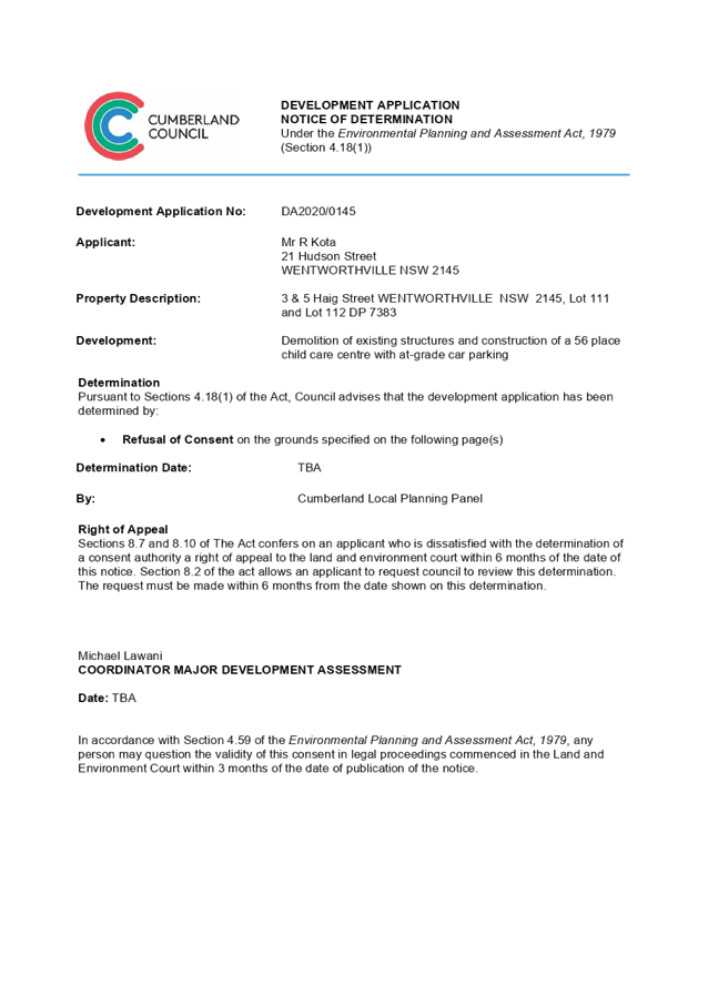
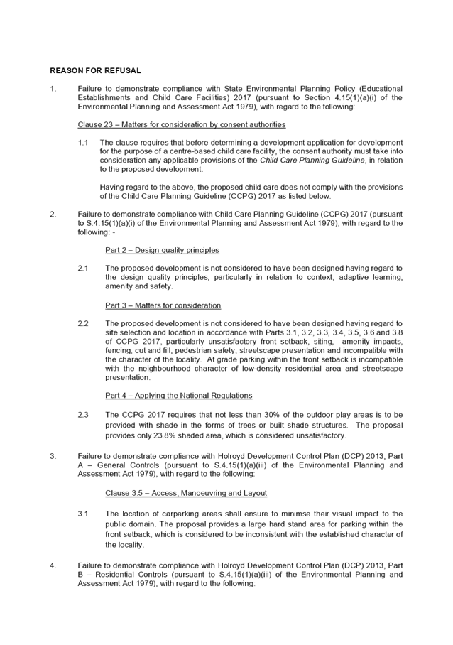
DOCUMENTS
ASSOCIATED WITH
REPORT LPP048/20
Attachment 2
Architectural Plans
Cumberland Local Planning Panel Meeting
9 September 2020
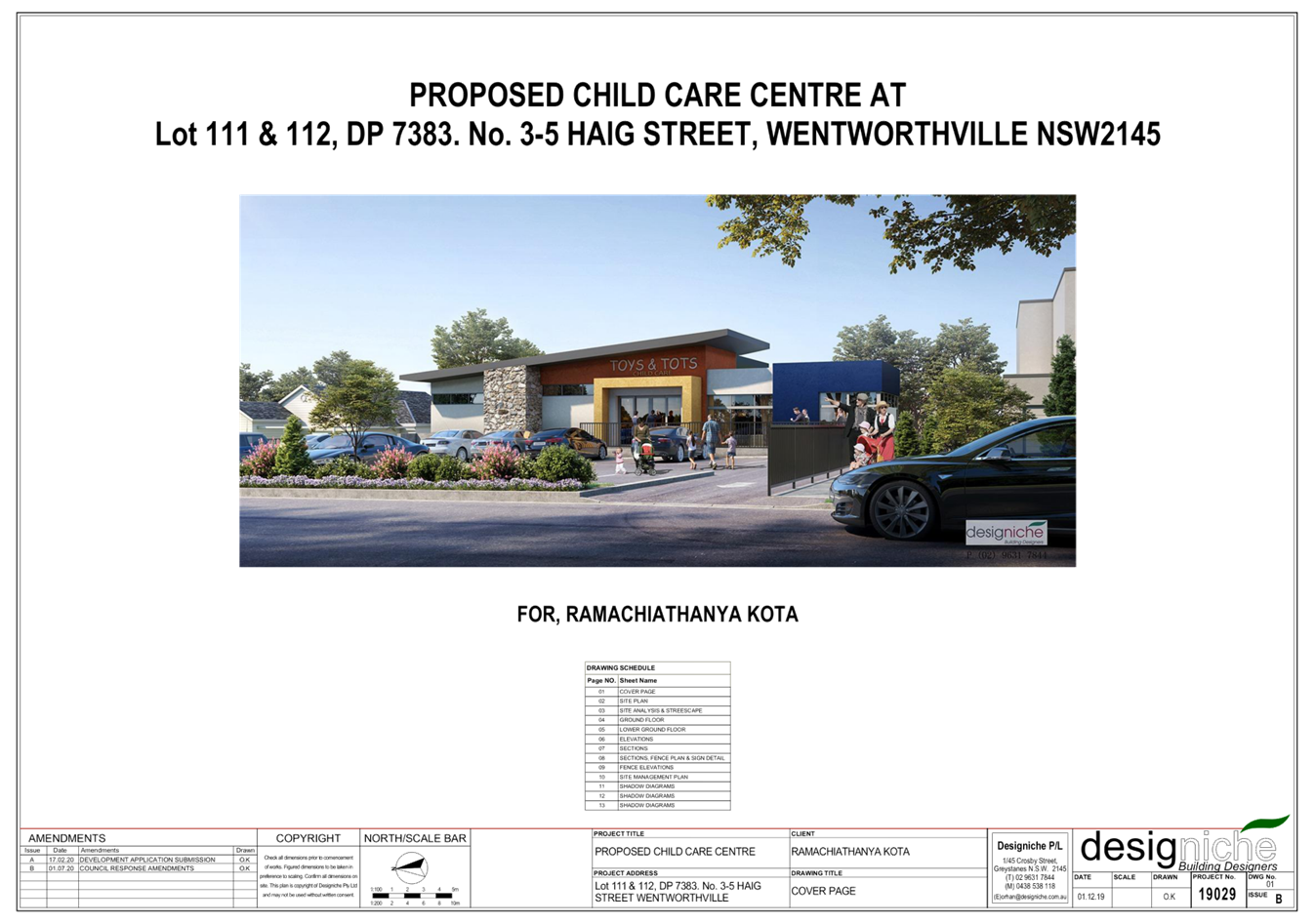
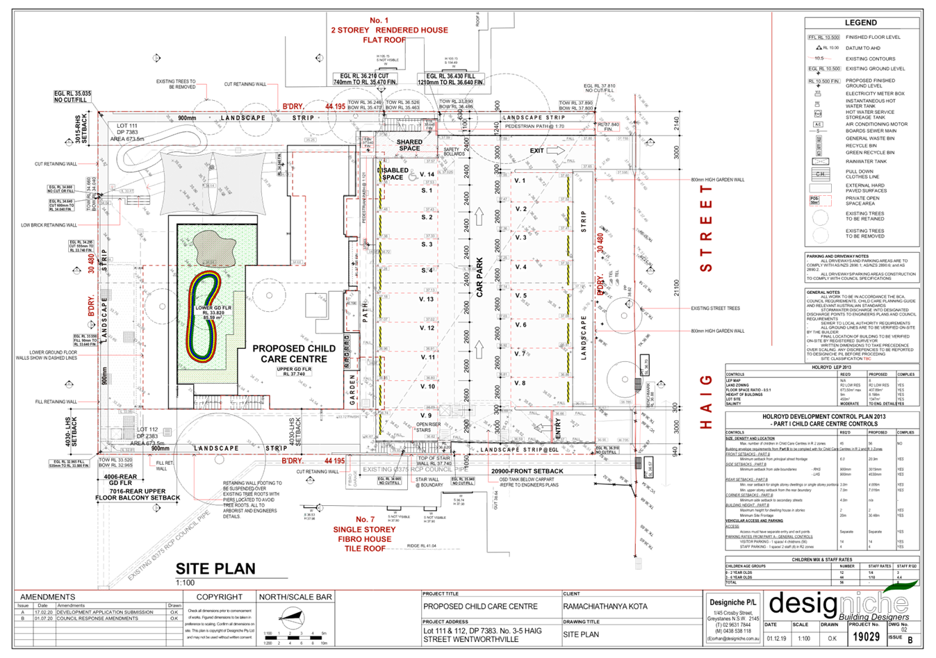
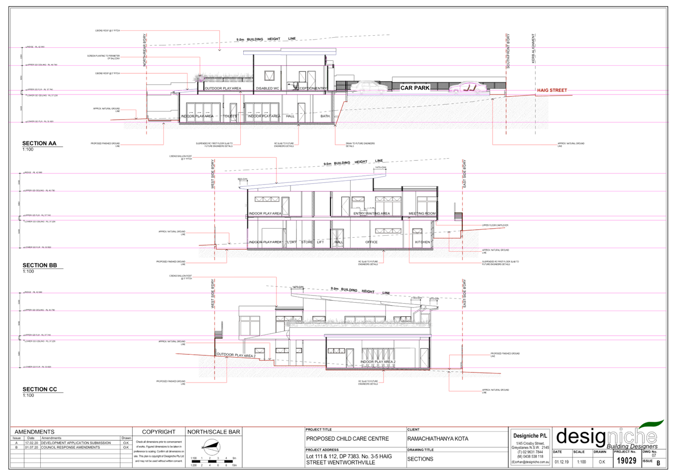
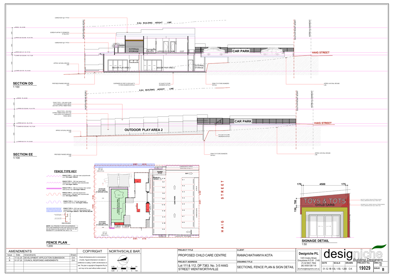
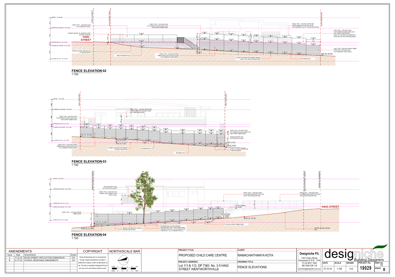
DOCUMENTS
ASSOCIATED WITH
REPORT LPP048/20
Attachment 3
Landscape Plan
Cumberland Local Planning Panel Meeting
9 September 2020
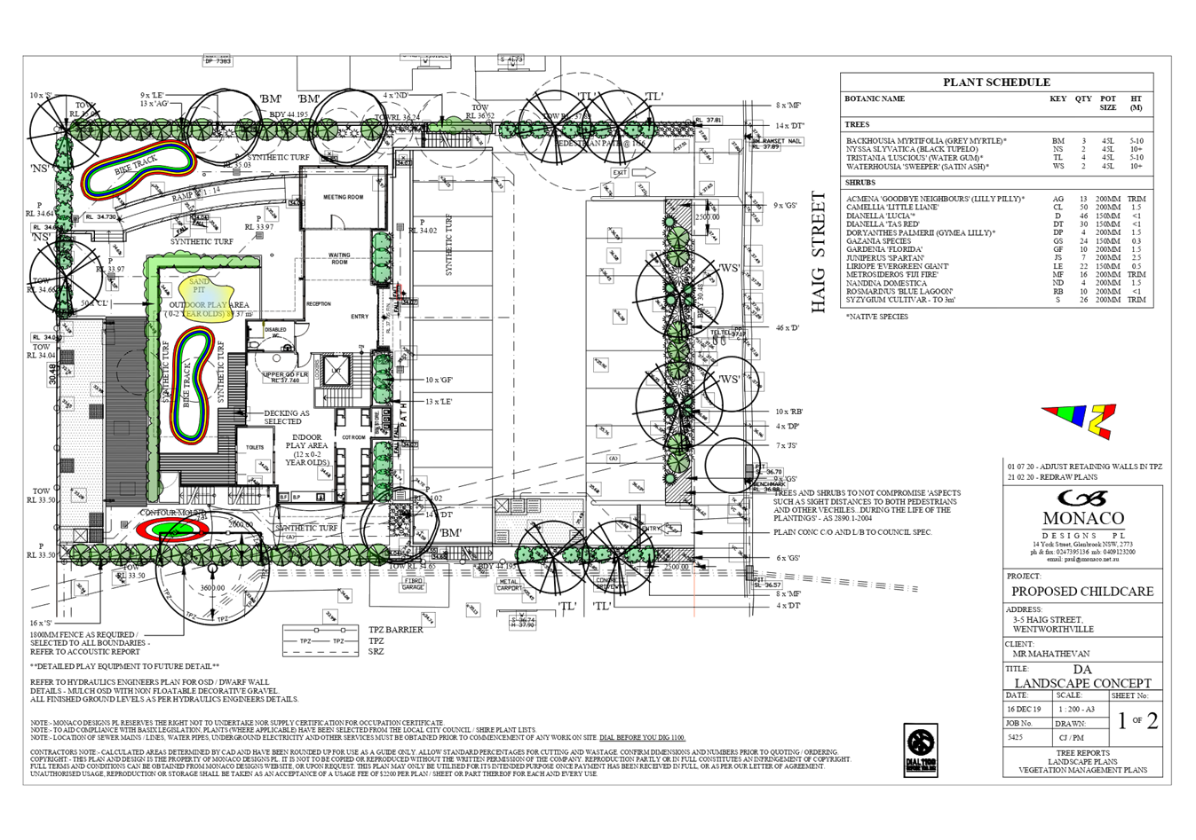
DOCUMENTS
ASSOCIATED WITH
REPORT LPP048/20
Attachment 4
Stormwater/Engineering Plans
Cumberland Local Planning Panel Meeting
9 September 2020
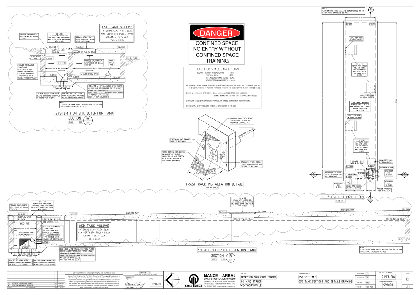
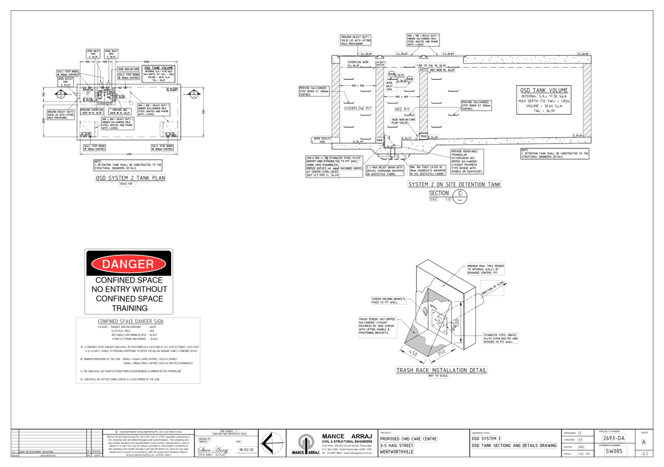
DOCUMENTS
ASSOCIATED WITH
REPORT LPP048/20
Attachment 5
State Environmental Planning Policy (Educational
Establishments & Child Care Facilities) 2017
Cumberland Local Planning Panel Meeting
9 September 2020

DOCUMENTS
ASSOCIATED WITH
REPORT LPP048/20
Attachment 6
Holroyd Local Environmental Plan 2013
Cumberland Local Planning Panel Meeting
9 September 2020
DOCUMENTS
ASSOCIATED WITH
REPORT LPP048/20
Attachment 7
Holroyd Development Control Plan 2013
Cumberland Local Planning Panel Meeting
9 September 2020
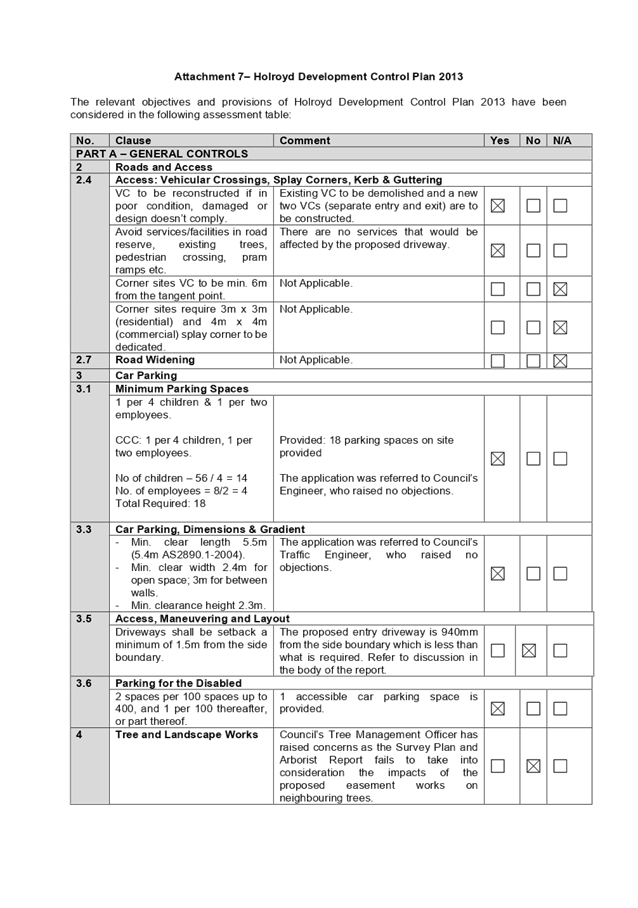
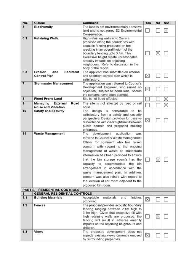
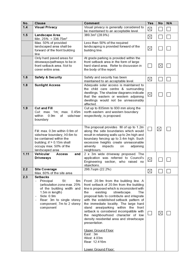
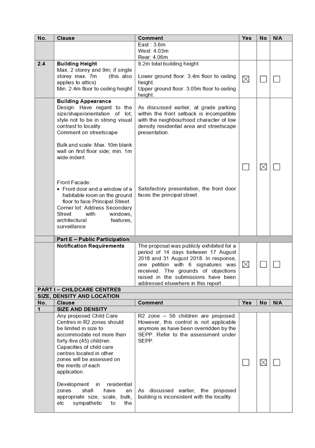
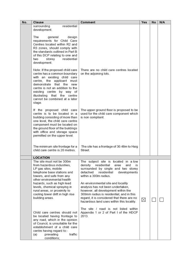
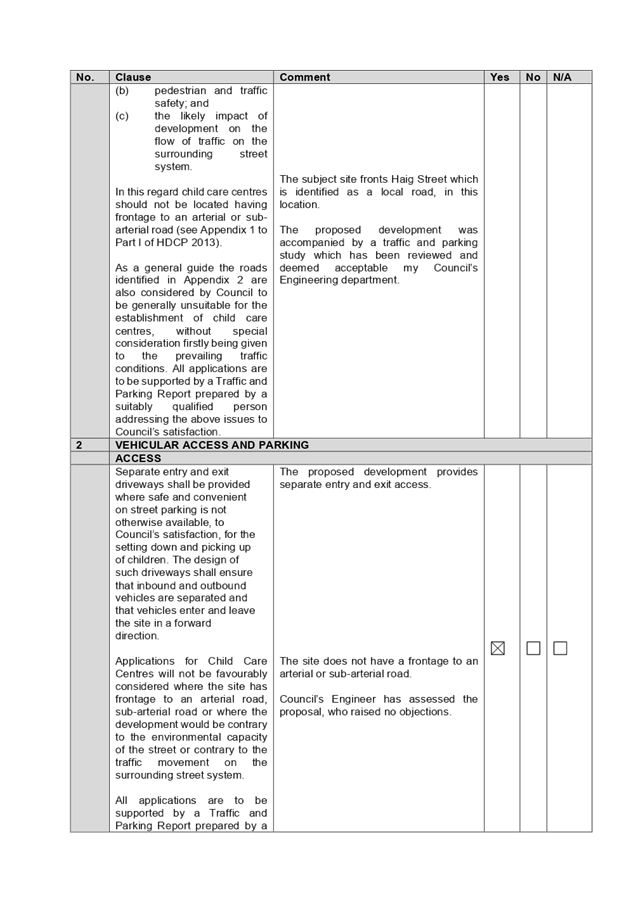
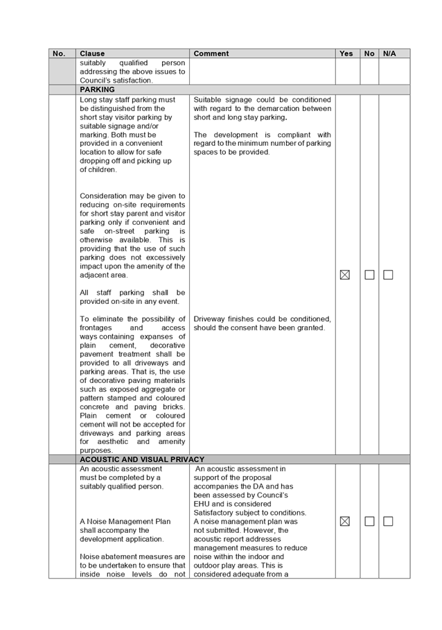
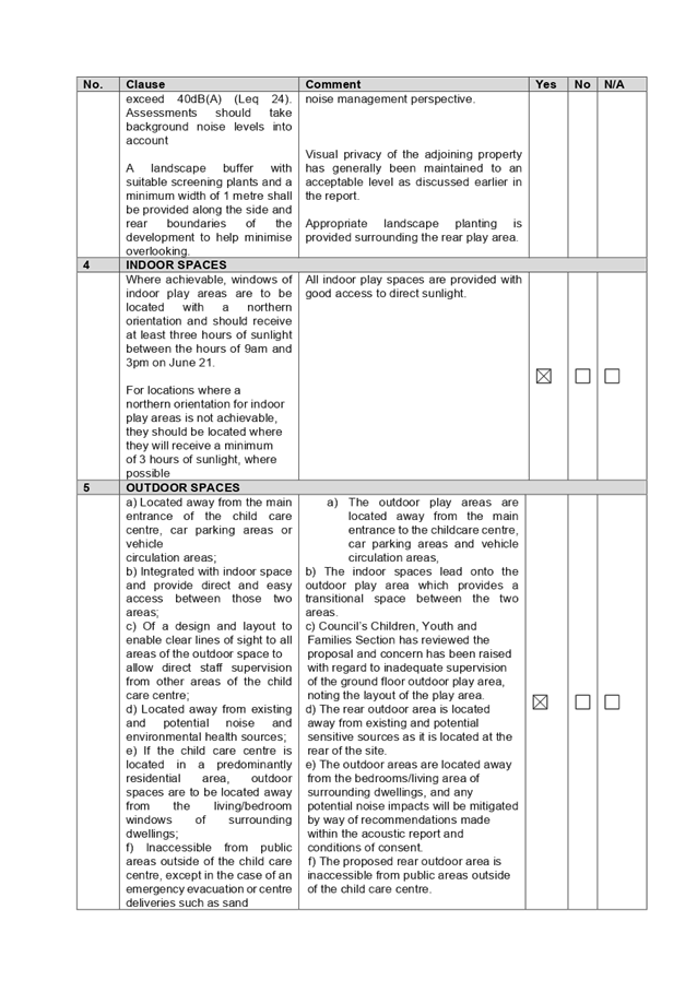
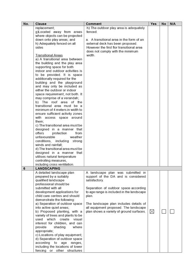
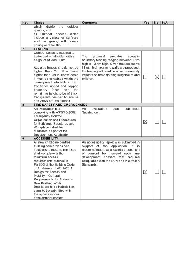
DOCUMENTS
ASSOCIATED WITH
REPORT LPP048/20
Attachment 8
Child Care Planning Guideline 2017
Cumberland Local Planning Panel Meeting
9 September 2020
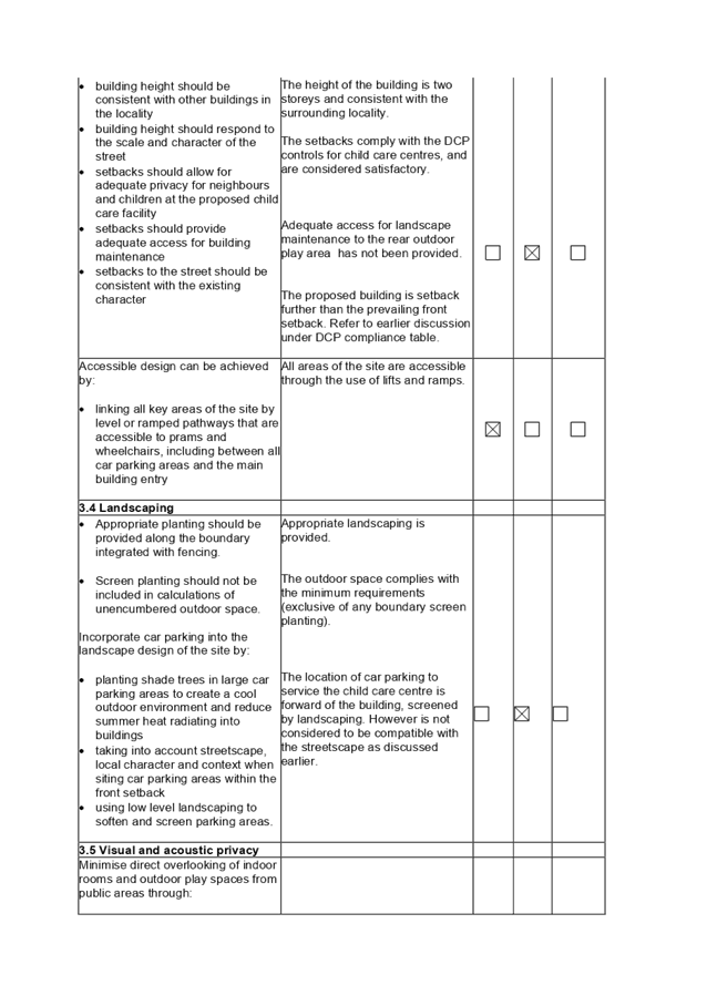
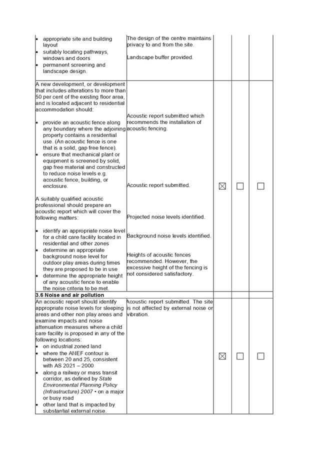
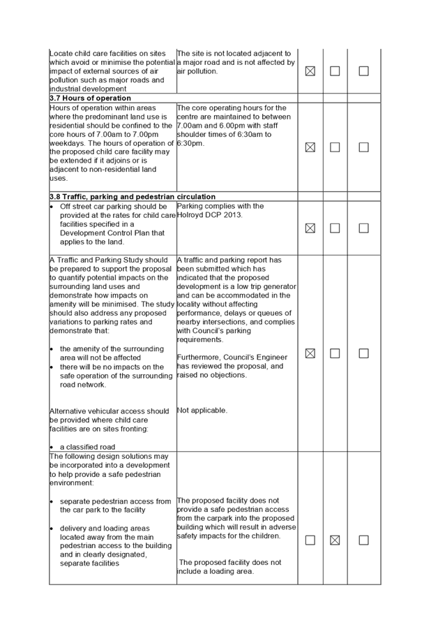
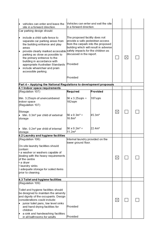

DOCUMENTS
ASSOCIATED WITH
REPORT LPP048/20
Attachment 9
Acoustic Report and Noise Management Plan
Cumberland Local Planning Panel Meeting
9 September 2020

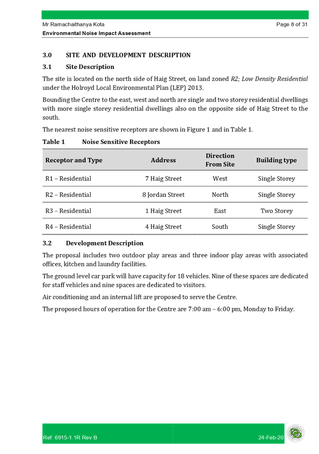
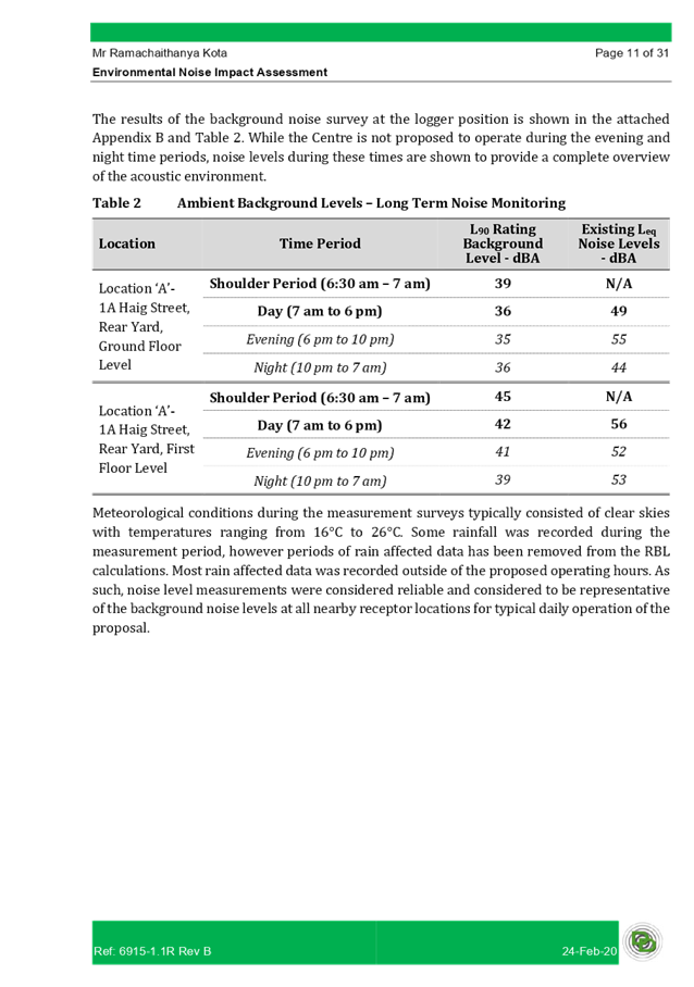

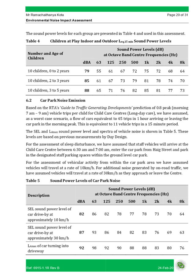
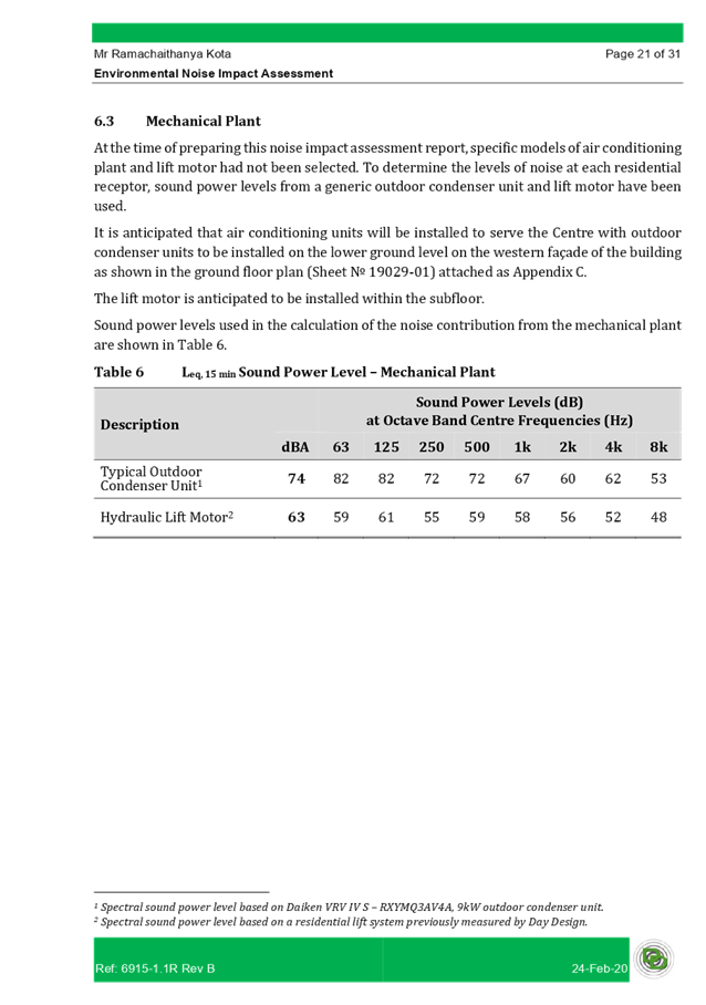
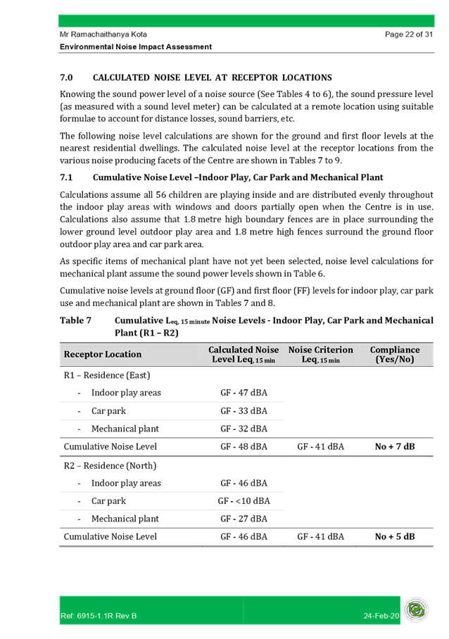
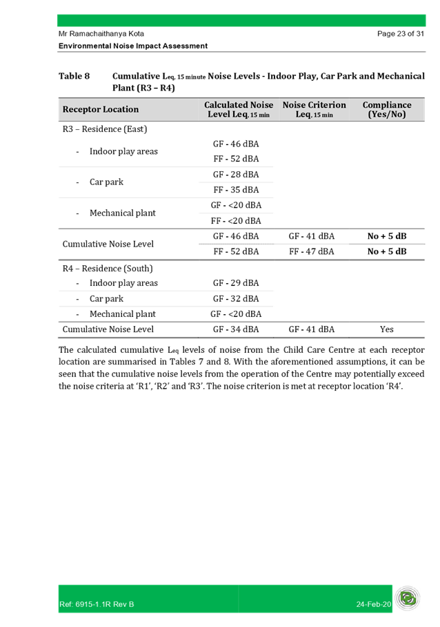
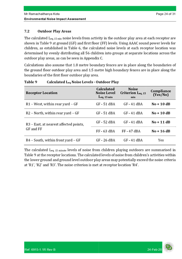
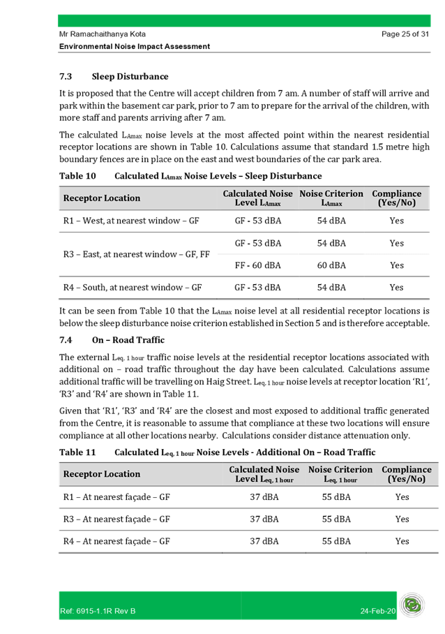
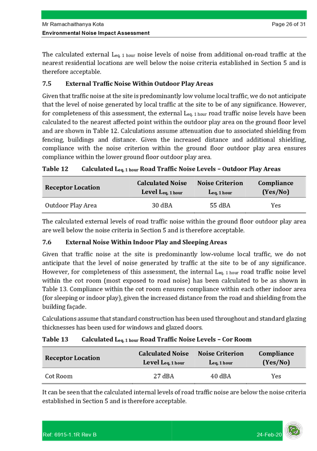

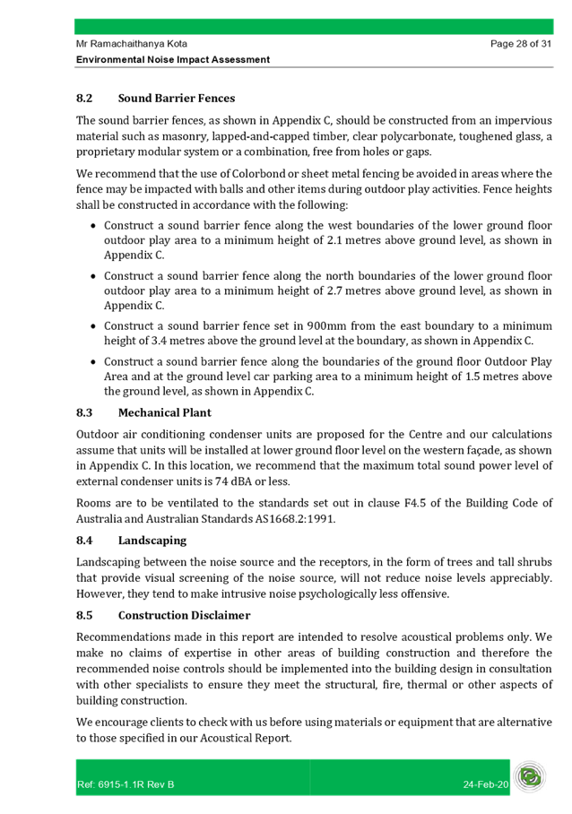
DOCUMENTS
ASSOCIATED WITH
REPORT LPP048/20
Attachment 10
Traffic Report
Cumberland Local Planning Panel Meeting
9 September 2020
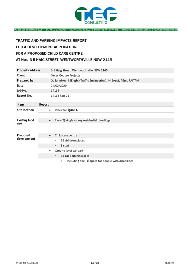
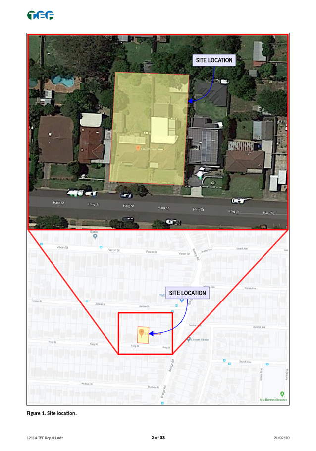
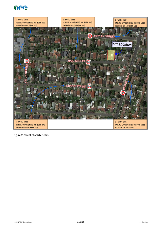
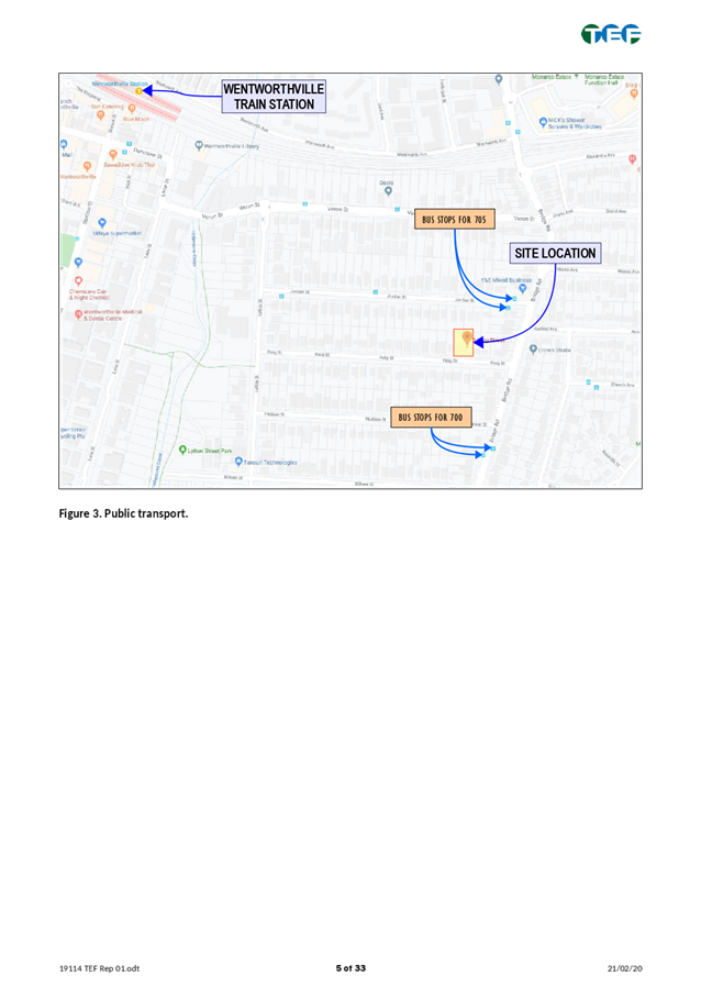
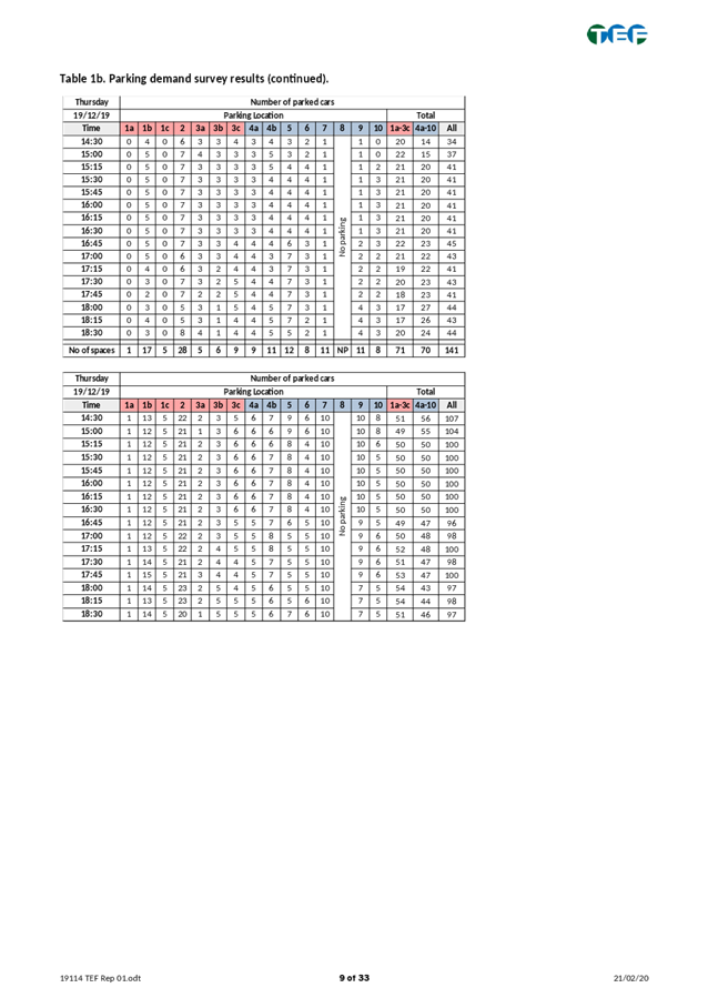
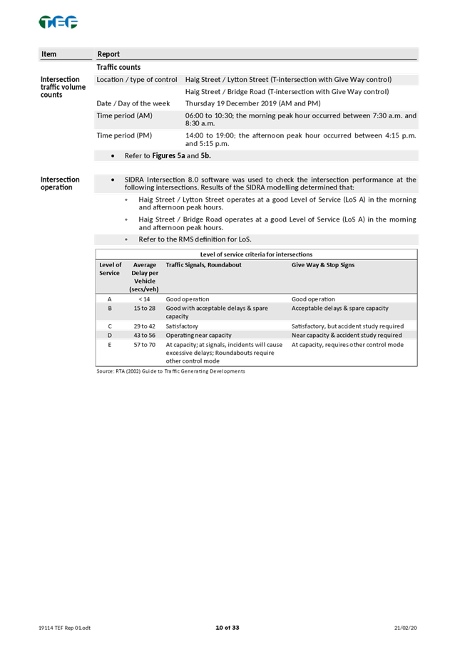
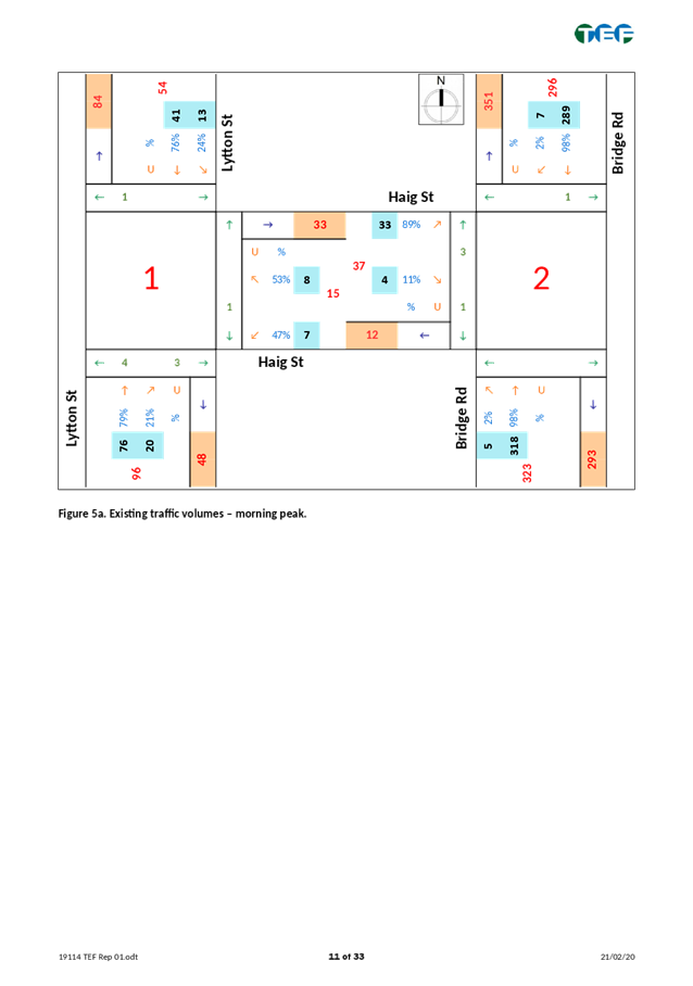
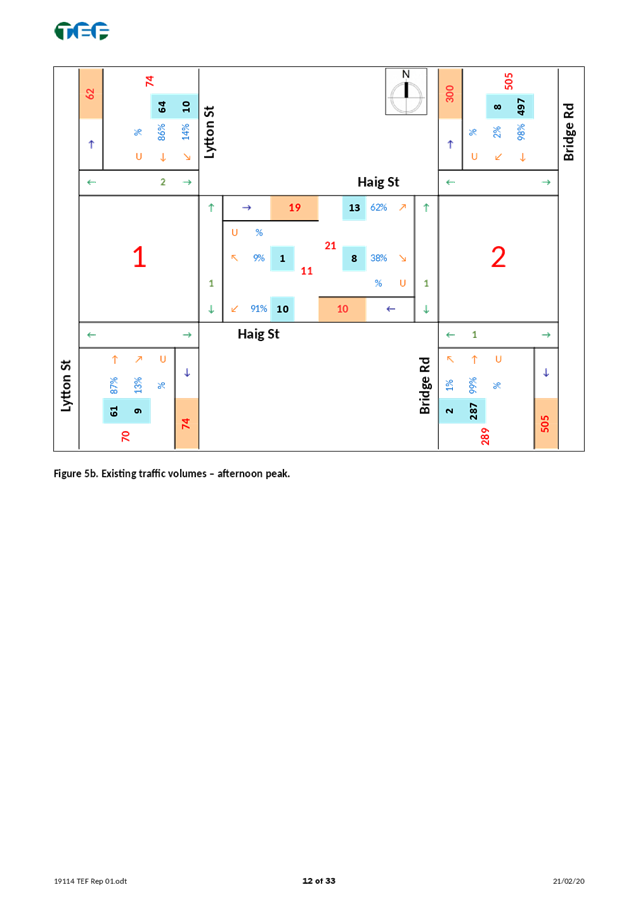

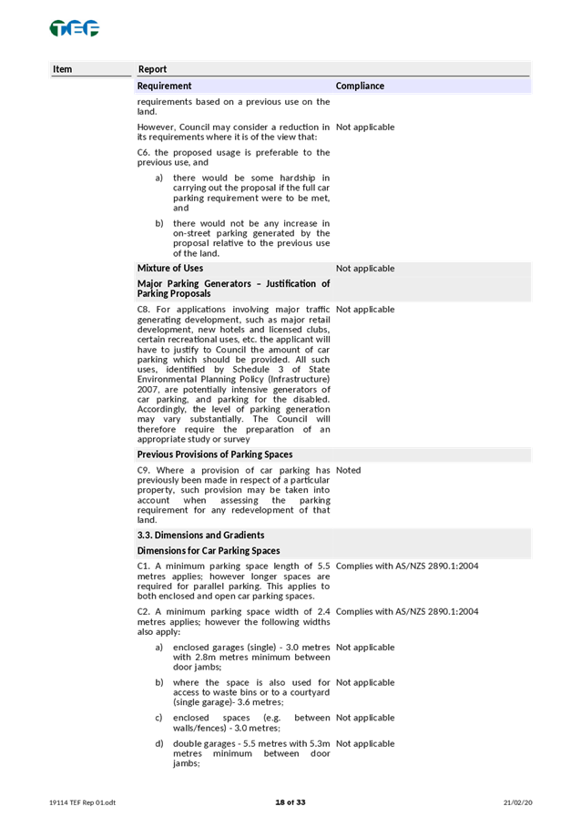
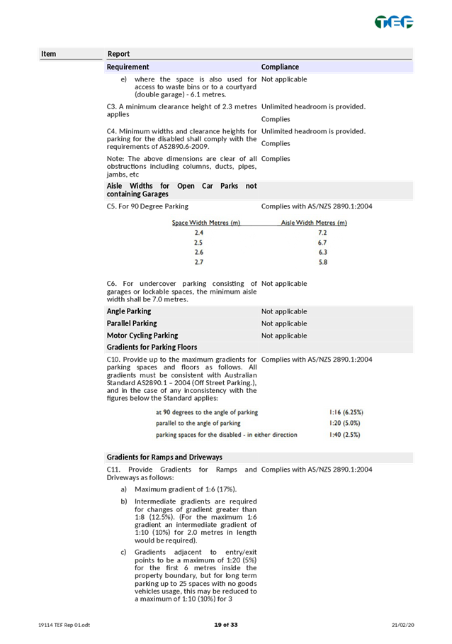
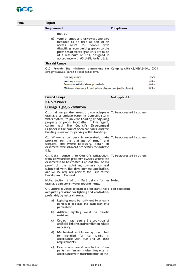
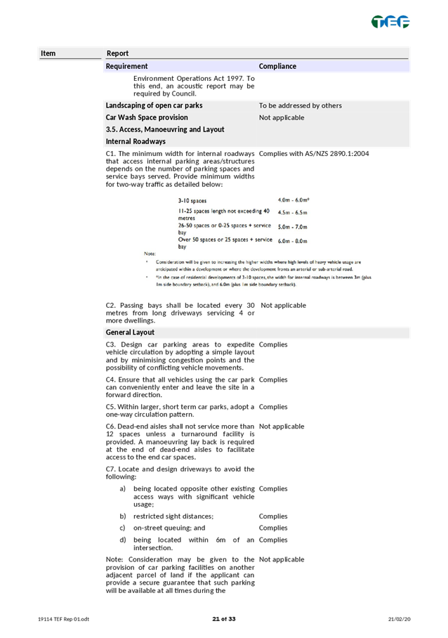

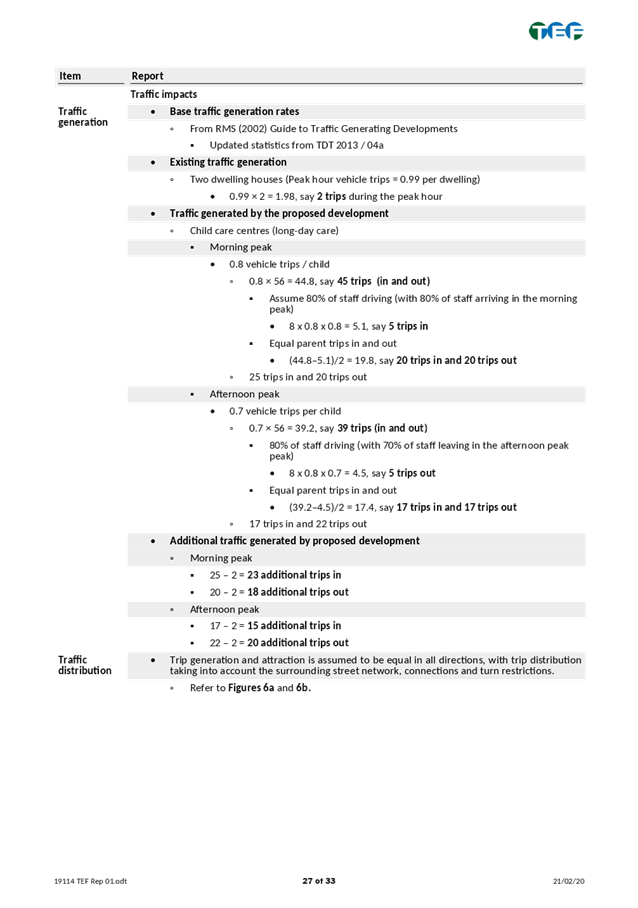
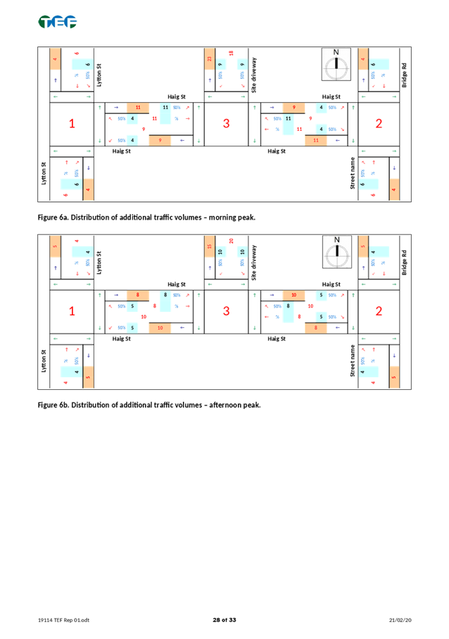
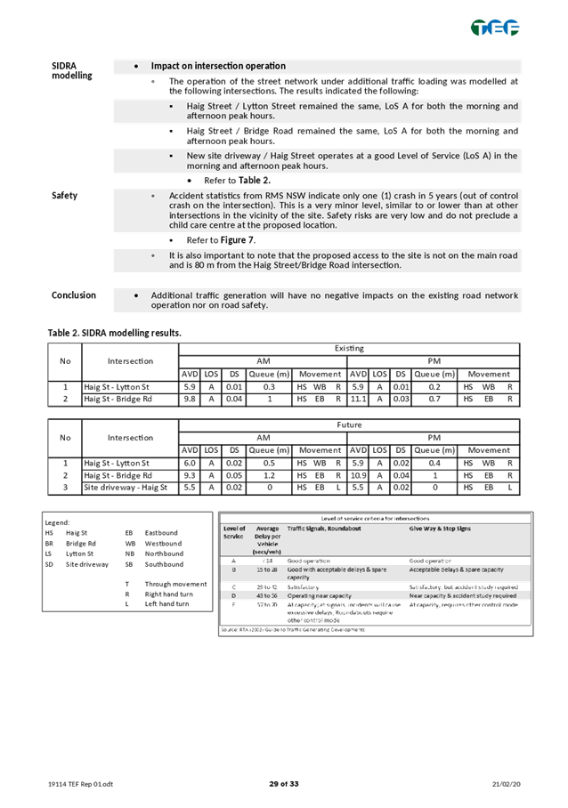
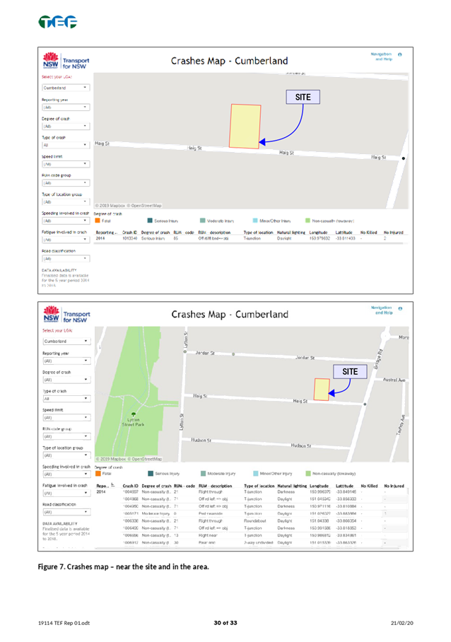


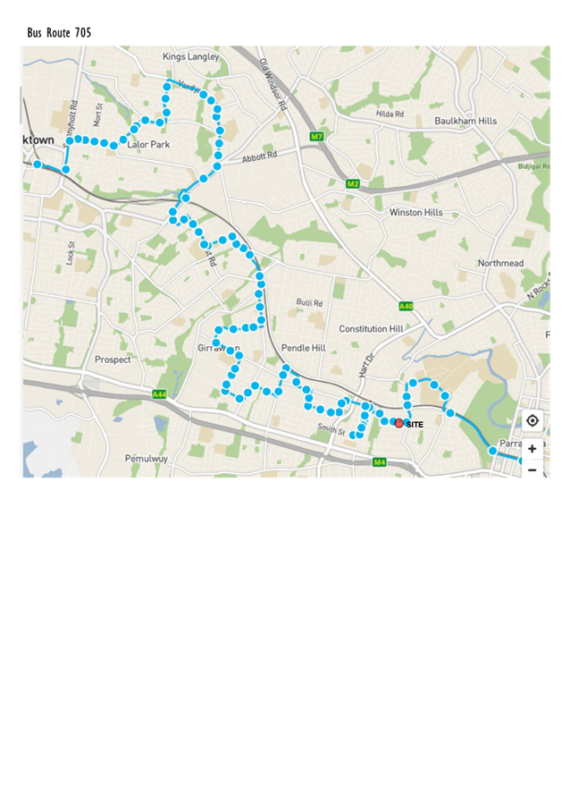
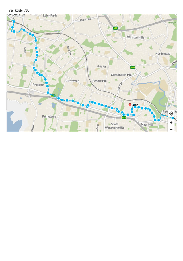
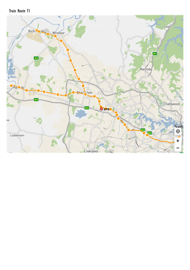
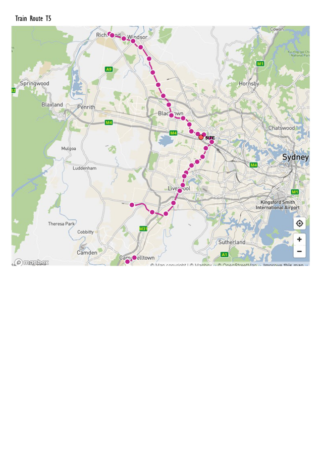
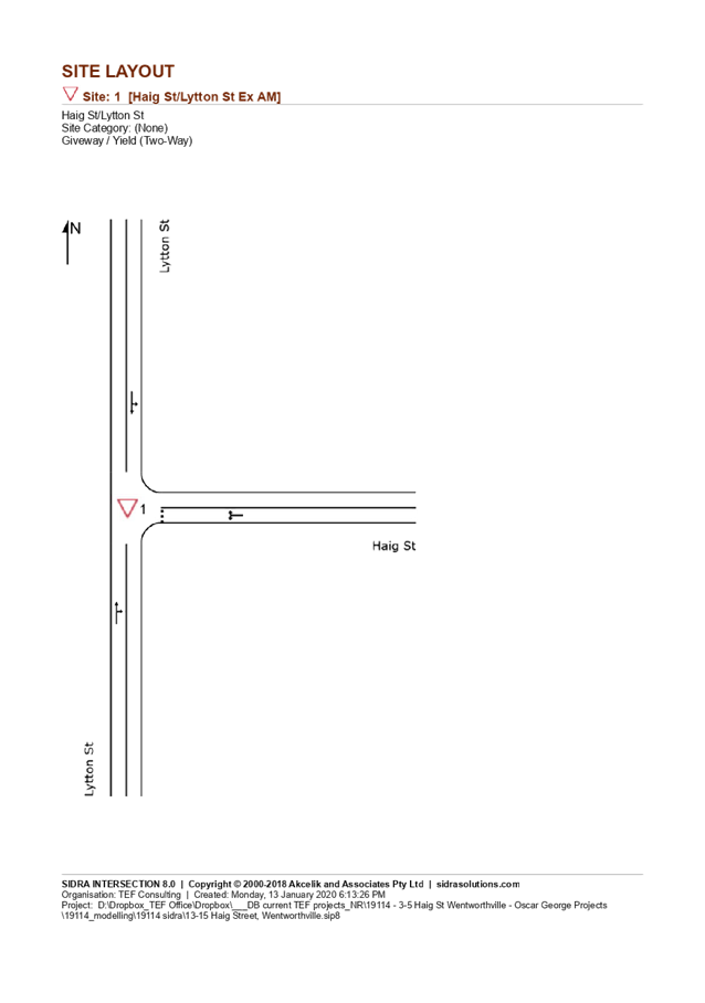


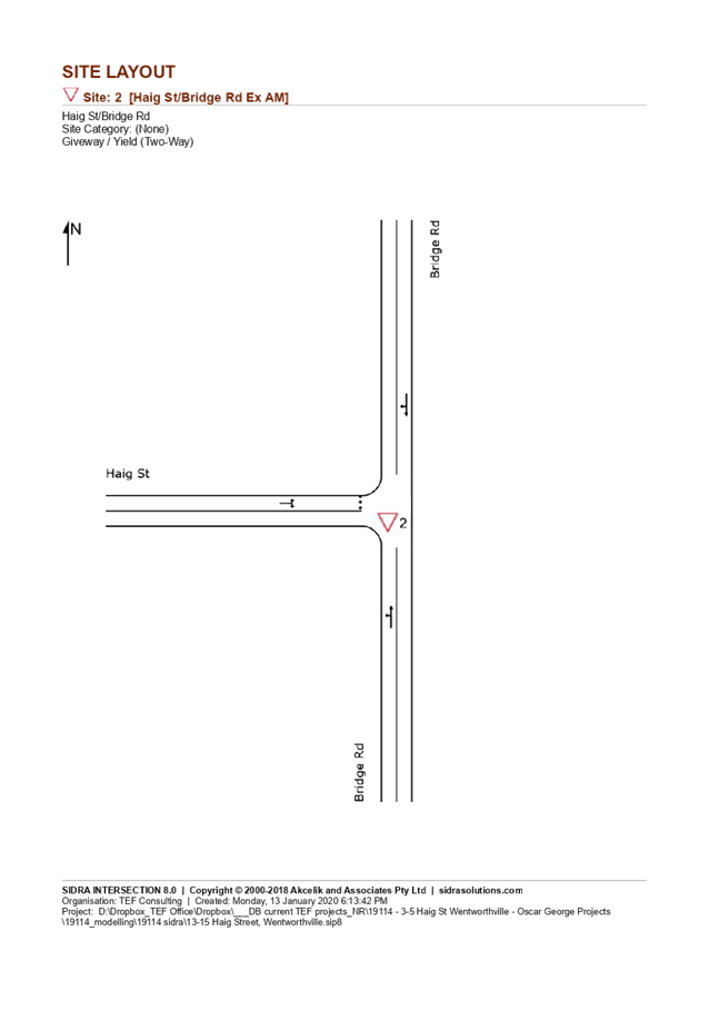


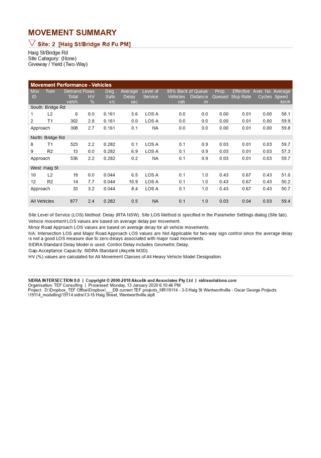
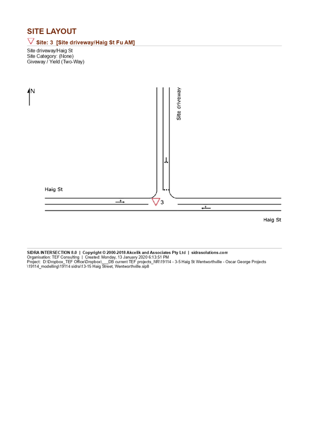
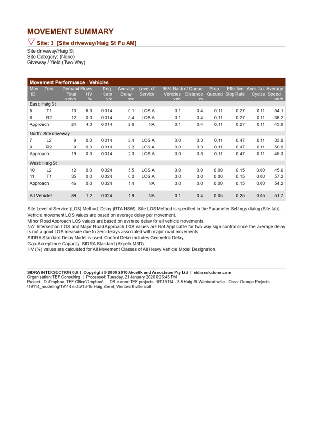

DOCUMENTS
ASSOCIATED WITH
REPORT LPP048/20
Attachment 11
Submissions Received
Cumberland Local Planning Panel Meeting
9 September 2020