10 June 2020
An
electronic meeting of the Cumberland Local Planning Panel will be held
at 11:30a.m. via Zoom on Wednesday, 10 June 2020.
Business as below:
Yours faithfully
Hamish McNulty
General
Manager
ORDER OF BUSINESS
1. Receipt of Apologies
2. Confirmation of Minutes
3. Declarations of Interest
4. Address by invited
speakers
5. Reports:
- Development
Applications
- Planning
Proposals
6. Closed Session Reports
Cumberland Local Planning Panel Meeting
10 June 2020
CONTENTS
Report No. Name of Report Page
No.
Development Applications
LPP027/20... Development Application
for Wyatt Park, Church Street, Lidcombe......... 23
LPP028/20... Development Application
for 72 Edgar Street, Auburn............................... 69
LPP029/20... Development Application
for 26 Wellington Road, South Granville...... 105
LPP030/20... Development Application
for 1 Robilliard Street, Mays Hill...................... 139
LPP031/20... Development Application
for Wyatt park Church Street, Lidcombe........ 289
LPP032/20... Development Application
for 652 Merrylands Road, Greystanes........... 359
Cumberland Local Planning Panel Meeting
10 June 2020
Item
No: LPP027/20
Development
Application for Wyatt Park, Church Street, Lidcombe
Responsible
Division: Environment
& Planning
Officer: Executive
Manager Development and Building
File
Number: DA2019/0524
|
Application lodged
|
23 December 2019
|
|
Applicant
|
Cumberland City Council
|
|
Owner
|
The Minister For Lands &
Cumberland City Council
|
|
Application No.
|
DA2019/0524
|
|
Description of Land
|
Wyatt Park Church Street
LIDCOMBE NSW 2141, Lot 2 in DP 581438
|
|
Proposed Development
|
Addition of a store room to
the existing netball clubhouse in Wyatt Park
|
|
Site Area
|
4,582m2
|
|
Zoning
|
RE1 Public Recreation Zone
|
|
Disclosure of political donations and gifts
|
Nil disclosure
|
|
Heritage
|
Yes – Heritage Listed
I40 - ‘Wyatt Park, Haslams Creek,
Lidcombe Pool, Lidcombe Oval, Stormwater Drain’ of local significance
|
|
Principal Development Standards
|
N/A
|
|
Issues
|
Nil
|
1. Development
Application No. DA2019/0524 was received on 23 December 2019 for the addition
of a store room to the existing netball clubhouse in Wyatt Park.
2. The
application was publicly notified to occupants and owners of the adjoining
properties for a period of fourteen (14) days between 10 March 2020 and 24
March 2020. In response, no submissions were received.
3. The
subject site is listed as a heritage item in the Auburn Local Environmental
Plan 2010, being I40 which comprises park land bounded by Olympic Drive and
Boorea Street, Percy Street and Church Street. The item is identified as
‘Wyatt Park, Haslams Creek, Lidcombe Pool, Lidcombe Oval, Stormwater
Drain’ and is of local significance. The proposed development will have
minimal impact on the heritage item and is considered satisfactory, having
regard to the provisions of Clause 5.10(4) of the Auburn Local Environmental
Plan 2010.
4. The
application is recommended for conditional approval, subject to the conditions
as provided in the attached schedule.
5. The
application is referred to the Cumberland Local Planning Panel for
determination as the development is proposed on land for which Council is the
landowner, resulting in a conflict of interest.
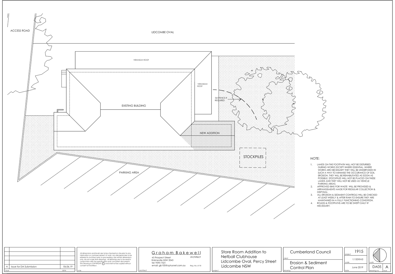
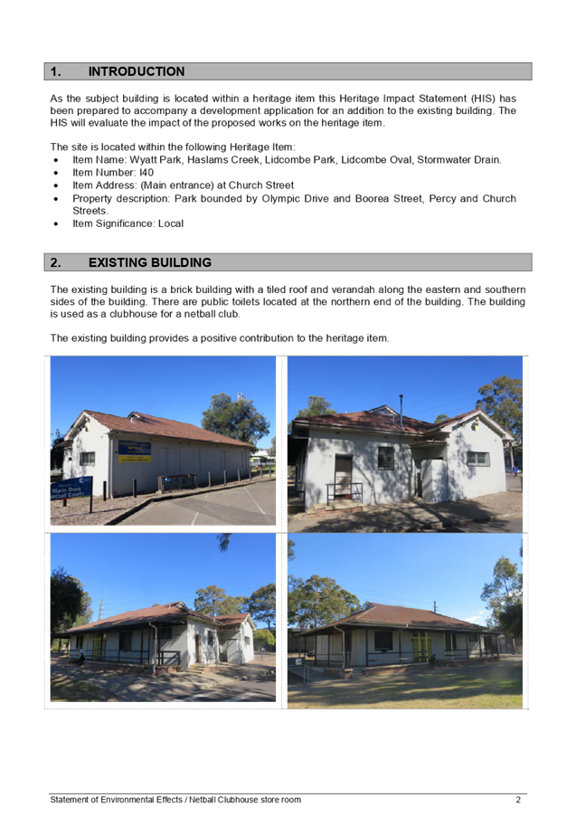
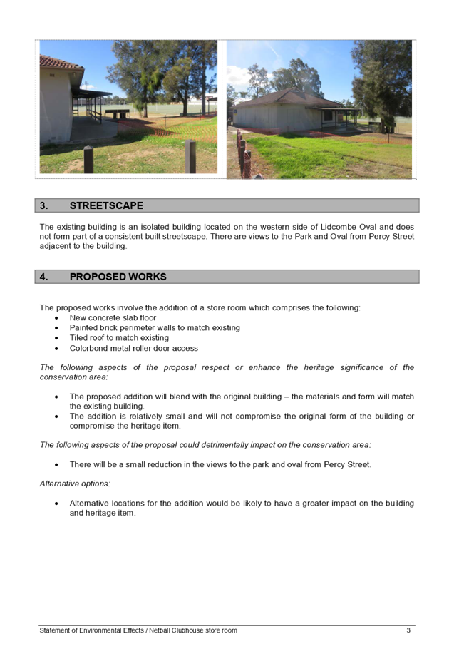
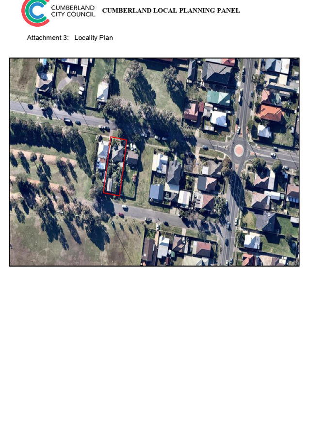
Subject Site and Surrounding
Area
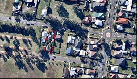
The subject site comprises Lot 2
in DP 581438 and has a total area of 4,582m2. Improvements on the site include
an existing single storey brick and tile building, with an attached awning,
which is used as a Netball Clubhouse, in association with the adjoining netball
courts to the east of the building. There is a small group of trees the south
of the existing building and a larger group of trees within the southern-most
portion of the site. Other improvements include picnic shelters and car
parking.
It is noted that the northern
corner of the existing Netball Clubhouse building is also partially located on
Lot 1 in DP 581438, however, no works are proposed on this lot as part of this
application.
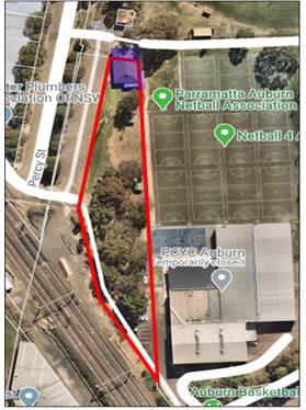
Figure
1: Aerial view of subject site - Lot 2 DP 581438 outlined red and
the existing Netball Clubhouse building shaded blue
Lot 2 DP 581438 forms part of a
larger landholding (including Lot 1 DP 581438), bound by Olympic Drive, Church
Street, Boorea Street and Percy Street which comprises Wyatt Park. The total
area of Wyatt Park is 216,352m2 and Lot 2 DP 581438 is situated in the
north-western portion of the park. Other features within Wyatt Park include:
· Lidcombe
Oval;
· PCYC
Auburn building;
· Auburn
Youth Centre;
· Netball
Courts;
· Auburn
Basketball Centre; and
· Auburn
Ruth Everuss Aquatic Centre.
The park is utilised for a range
of passive and active recreation uses.
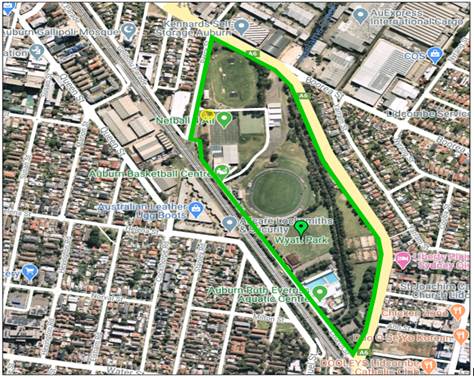
Figure 2: Locality
Plan of subject site in relation to Wyatt Park - Wyatt Park outlined in green
and location of the Netball Clubhouse building denoted by yellow circle
Description of the Proposed
Development
Council has received a development
application seeking consent for the construction of a store room addition to
the western-most southern elevation of the existing Netball Clubhouse building
situated adjacent to Lidcombe Oval. The storeroom addition is proposed in an
area clear of vegetation.
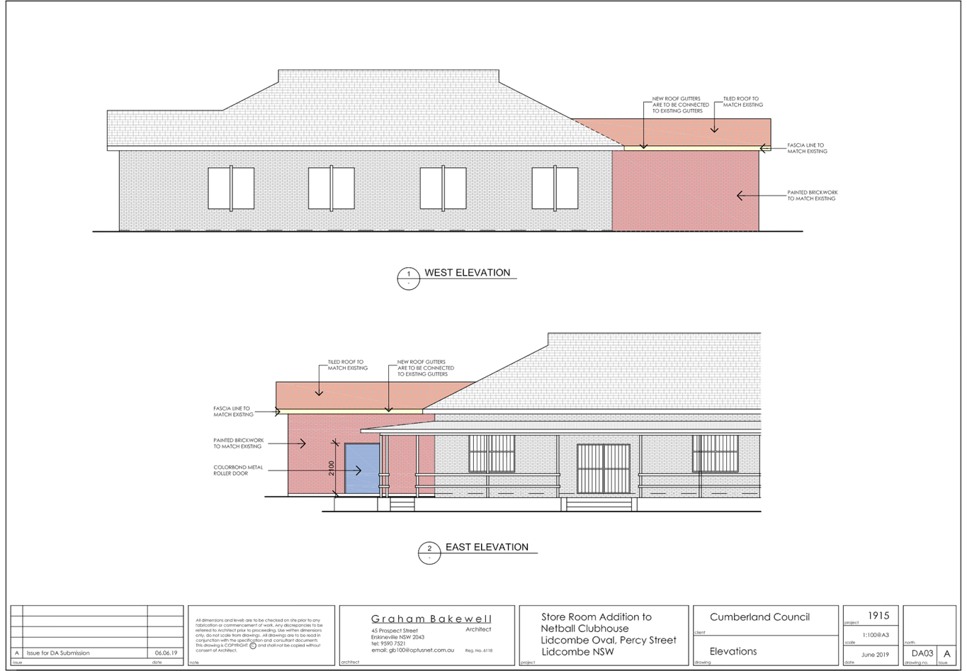
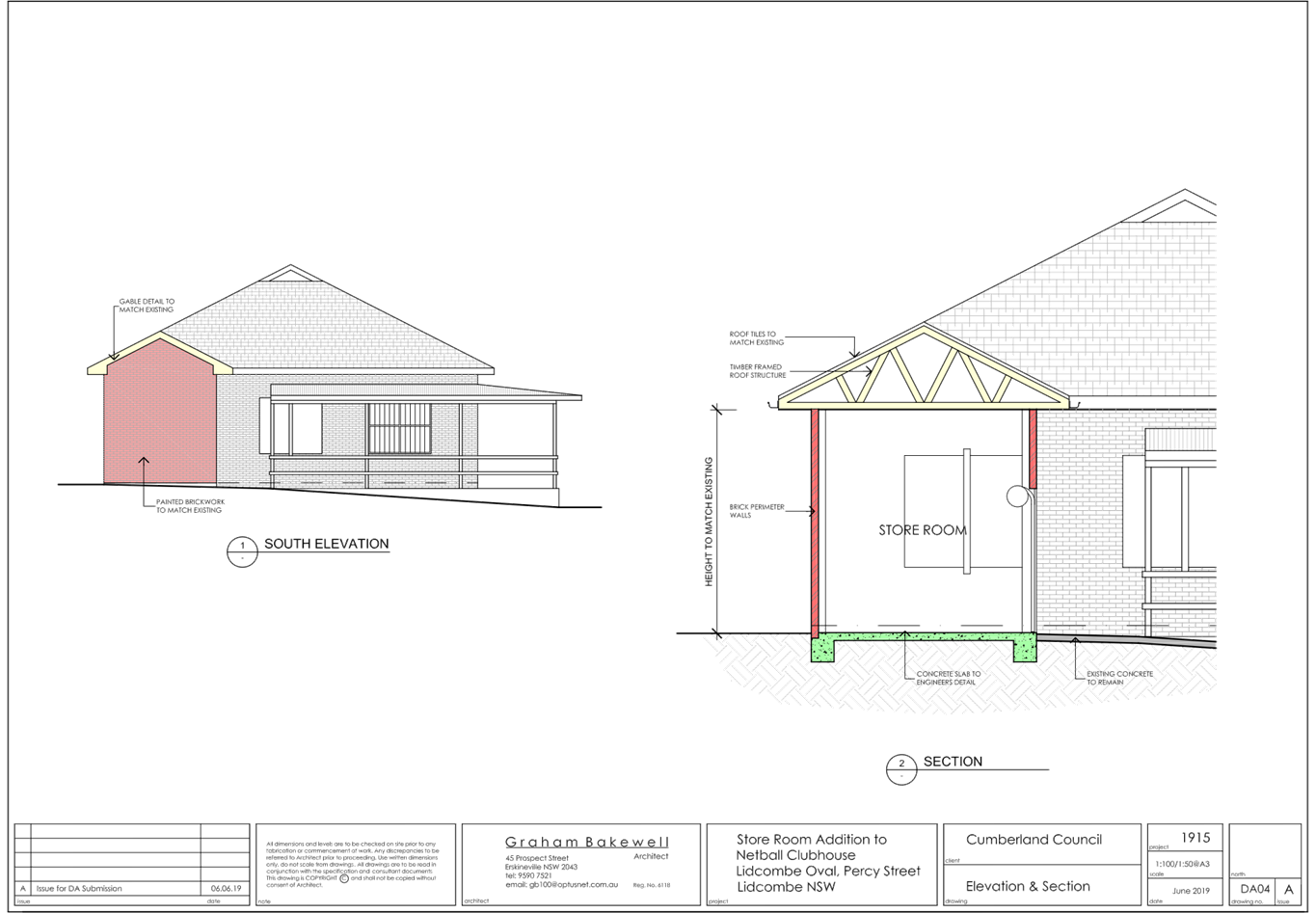
The proposed storeroom comprises a
total floor area of 21.07m2 and has the dimensions of 6.11m x 3.45m. The
storeroom construction does not involve any demolition works to the existing
building; the storeroom is proposed to abut the existing wall of the building
and be fully enclosed, with the exception of a roller door for access along the
eastern elevation of the addition. The storeroom will be covered by an
extension to the existing roof of the building.
The proposed addition is to be
constructed of painted brickwork to match the existing building and roof tiles
to match the existing roof. Gable detail will also be provided to the new roof,
to match the existing roof form.
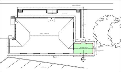
Figure
3: Proposed Addition (Graham Bakewell)
Applicants Supporting
Statement
The applicant has provided a Statement of Environmental
Effects prepared by Graham Bakewell Architect dated June 2019 and was received
by Council on 23 December 2019, in support of the application.
Contact with Relevant Parties
The assessing officer has undertaken a site inspection of
the subject site and surrounding properties and has been in regular contact
with the applicant throughout the assessment process.
Internal Referrals
Development Engineer
The development application was referred to Council’s
Development Engineer for comment who has advised that the development proposal
is satisfactory and therefore can be supported subject to recommended
conditions of consent.
External Referrals
The application was not required to be referred to any
external government authorities for comment.
PLANNING COMMENTS
The provisions of any Environmental Planning Instruments
(EP&A Act s4.15 (1)(a)(i))
State Environmental Planning Policies
The proposed development is affected by the following State
Environmental Planning Policies:
(a) State
Environmental Planning Policy No. 55 – Remediation of Land (SEPP 55)
Clause 7 of SEPP 55 requires
Council to be satisfied that the site is suitable or can be made suitable to
accommodate the proposed development. The matters listed within Clause 7 have
been considered in the assessment of the development application.
Figure 4 – SEPP
55 Compliance Table
|
Matter for
Consideration
|
Yes/No
|
|
Does the application
involve re-development of the site or a change of land use?
|
Yes No
|
|
In the development
going to be used for a sensitive land use (e.g.: residential, educational,
recreational, childcare or hospital)?
|
Yes No
|
|
Does information
available to you indicate that an activity listed below has ever been
approved, or occurred at the site?
acid/alkali plant and formulation, agricultural/horticultural
activities, airports, asbestos production and disposal, chemicals manufacture
and formulation, defence works, drum re-conditioning works, dry cleaning
establishments, electrical manufacturing (transformers), electroplating and
heat treatment premises, engine works, explosive industry, gas works, iron
and steel works, landfill sites, metal treatment, mining and extractive
industries, oil production and storage, paint formulation and manufacture, pesticide
manufacture and formulation, power stations, railway yards, scrap yards,
service stations, sheep and cattle dips, smelting and refining, tanning and
associated trades, waste storage and treatment, wood preservation
|
Yes No
|
|
Is
the site listed on Council’s Contaminated Land database?
|
Yes No
|
|
Is
the site subject to EPA clean-up order or other EPA restrictions?
|
Yes No
|
|
Has
the site been the subject of known pollution incidents or illegal dumping?
|
Yes No
|
|
Does
the site adjoin any contaminated land/previously contaminated land?
|
Yes No
|
|
Has
the appropriate level of investigation been carried out in respect of
contamination matters for Council to be satisfied that the site is suitable
to accommodate the proposed development or can be made suitable to
accommodate the proposed development?
|
Yes No
|
|
The
site is not identified in Council’s records as being contaminated. A
site inspection reveals the site does not have any obvious history of a
previous land use that may have caused contamination and there is no specific
evidence that indicates the site is contaminated. Notwithstanding, a standard
condition of consent has been recommended to manage any unexpected finds
encountered during the construction works.
|
(b) State
Environmental Planning Policy (Infrastructure) 2007 (ISEPP)
The provisions of the ISEPP 2007
have been considered in the assessment of the development application.
Clause 85 – Development
adjacent to railway corridors
The site is adjacent to an
existing rail corridor and the development has been assessed against the
provisions of Clause 85(1). The development is not likely to have an adverse
effect on rail safety, given the distance of the building works to the corridor
and the fact that the works are minor in nature. Further, the development does
not involve the placing of a metal finish, will not involve the use of a crane
in airspace above the rail corridor and is not located within 5 metres of an
exposed overhead electricity powerline that is used for the purpose of railways
or rail infrastructure facilities.
Clause 86 – Excavation
in, above, below or adjacent to rail corridors
The proposed development does not
involve any excavation works to a depth of 2 metres and the provisions of
Clause 86 are therefore not applicable.
Clause 87 – Impact of
rail noise or vibration on non-rail development
The proposed development is not
for the purpose of residential accommodation, a place of public worship, a
hospital or an educational establishment or centre-based child care facility
and the provisions of Clause 87 are therefore not applicable.
Clause 101 – Frontage to
classified road
The development does not maintain
a frontage to a classified road and the provisions of Clause 101 of the ISEPP
are therefore not applicable.
Clause 102 – Impact of
road noise or vibration on non-road development
The application is not subject to
clause 102 of the ISEPP.
Clause 104 – Traffic
generation developments
The development is not traffic
generating development, pursuant to the provisions of Schedule 3 of the ISEPP
and Clause 104 is therefore not applicable.
Regional Environmental Plans
The proposed development is
affected by the following Regional Environmental Plans:
(a) Sydney
Regional Environmental Plan (Sydney Harbour Catchment) 2005
The subject site is identified as
being located within the area affected by the Sydney Regional Environmental
Plan (Sydney Harbour Catchment) 2005. The proposed development raises no issues
as no impact on the catchment is envisaged.
(Note: - the subject site is not
identified in the relevant map as ‘land within the ‘Foreshores and
Waterways Area’ or ‘Wetland Protection zone’, is not a
‘Strategic Foreshore Site’ and does not contain any heritage items.
Hence the majority of the SREP is not directly relevant to the proposed
development).
Local Environmental Plans
Auburn Local Environmental Plan
2010
The provision of the Auburn Local
Environmental Plan 2010 (ALEP 2010) is applicable to the development proposal.
It is noted that the development achieves compliance with the key statutory
requirements of the ALEP 2010 and the objectives of the RE1 Public Recreation
land use zone.
(a) Permissibility:-
The proposed development comprises
additions to the existing Netball Clubhouse building which is ancillary to the
dominant use of the site as a recreation facility (outdoor):
Recreation facility (outdoor)
means a building or place (other than a recreation area) used predominantly for
outdoor recreation, whether or not operated for the purposes of gain, including
a golf course, golf driving range, mini-golf centre, tennis court, paint-ball
centre, lawn bowling green, outdoor swimming pool, equestrian centre, skate
board ramp, go-kart track, rifle range, water-ski centre or any other building
or place of a like character used for outdoor recreation (including any
ancillary buildings), but does not include an entertainment facility or a
recreation facility (major).
The development is therefore
permissible with consent in the RE1 land use zone.
The applicable clauses and
relevant matters to be considered under the ALEP 2010 for the proposed
development are summarised below.
Figure
5 – Auburn LEP 2010 Compliance Table
|
DEVELOPMENT STANDARD
|
COMPLIANCE
|
DISCUSSION
|
|
4.3 Height of Buildings - Nil
|
N/A
|
Whilst no maximum building
height is applicable to the site, the proposed addition is consistent in
height with the existing building, i.e. single storey and is considered
suitable for the site.
|
|
4.4 Floor Space Ratio - Nil
|
N/A
|
The development comprises the addition of 21.07m2
of floor area to the existing building. This increase to floor area is
considered minor and suitable for the building and site.
|
|
5.10 Heritage Conservation
|
Y
|
The site comprises land that
is within a heritage item of local significance, being park land bounded by Olympic Drive and Boorea
Street, Percy Street and Church Street. The item comprises ‘Wyatt Park,
Haslams Creek, Lidcombe Pool, Lidcombe Oval, Stormwater Drain’ (Item
no. I40).
Whilst the building the
subject of this application is not explicitly identified in the heritage
listing, as the site itself forms part of the heritage item, the development
has been accompanied by a Heritage Impact Statement (HIS) prepared by Graham
Bakewell Architect, dated June 2019.
Having regard to the
provisions of Clause 5.10(4), the HIS relevantly provides that:
The existing building is
part of a large heritage item and contributes positively to the item.
The proposed addition
complies with the objectives of the LEP, will have minimal impact on the
heritage item and is therefore compatible.
The development is considered
satisfactory having regard to the provisions of Clause 5.10(4).
A condition of consent has
been recommended stating that no works, other than those approved as part of
this development, are to be undertaken.
|
|
6.1 Acid sulfate soils
– Class 5
|
Y
|
The proposed work will not
impact the Class 5 acid sulfate soil affectation of the site.
Notwithstanding, a standard condition of consent has been recommended to
manage any acid sulfate soil impacts encountered during the construction
phase of the development.
|
|
6.2 Earthworks
|
N/A
|
The proposed works will not alter
the existing ground level by more than 600mm.
|
|
6.3 Flood planning
|
Y
|
The site is identified as being
within a flood planning area. Council’s Development Engineering
department has reviewed the proposed development and recommended a condition
of consent requiring a detailed plan to be submitted to the PCA,
demonstrating the provision of a floor level in accordance with
Council’s Flood Advice letter, prior to the issue of a Construction
Certificate. This satisfactorily addresses the flooding affectation of the
site.
|
|
6.4 Foreshore building line
|
N/A
|
Haslams Creek traverses the
eastern boundary of Wyatt Park and the eastern boundary of the park is
identified as comprising land below the foreshore line. The proposed
development is considered to be sufficiently removed from the foreshore
building line so as not to be impacted by the foreshore building line.
|
The provisions of any proposed
instrument that is or has been the subject (EP&A Act s4.15 (1)(a)(ii))
(a) Draft
Cumberland Local Environmental Plan 2020
The Draft Cumberland Local
Environmental Plan 2020 (Draft CLEP) has been prepared by Cumberland City
Council to provide a single planning framework for the future planning of
Cumberland City. The changes proposed seek to harmonise and repeal the three
existing LEPs currently applicable to the Cumberland local government area,
those being:
· Holroyd
Local Environmental Plan 2013;
· Parramatta
Local Environmental Plan 2011; and
· Auburn
Local Environmental Plan 2010.
The current planning controls for
the subject site, as contained within the ALEP 2010, are not proposed to change
under the Draft CLEP.
(b) Draft
State Environmental Planning Policy (Environment)
The draft SEPP relates to the
protection and management of our natural environment with the aim of
simplifying the planning rules for a number of water catchments, waterways,
urban bushland, and Willandra Lakes World Heritage Property. The changes
proposed include consolidating the following seven existing SEPPs:
· State
Environmental Planning Policy No. 19 – Bushland in Urban Areas
· State
Environmental Planning Policy (Sydney Drinking Water Catchment) 2011
· State
Environmental Planning Policy No. 50 – Canal Estate Development
· Greater
Metropolitan Regional Environmental Plan No. 2 – Georges River Catchment
· Sydney
Regional Environmental Plan No. 20 – Hawkesbury-Nepean River (No.2-1997)
· Sydney
Regional Environmental Plan (Sydney Harbour Catchment) 2005
· Willandra
Lakes Regional Environmental Plan No. 1 – World Heritage Property.
The draft policy will repeal the
above existing SEPPs and certain provisions will be transferred directly to the
new SEPP, amended and transferred, or repealed due to overlaps with other areas
of the NSW planning system.
Changes are also proposed to the
Standard Instrument – Principal Local Environmental Plan. Some provisions
of the existing policies will be transferred to new Section 117 Local Planning
Directions where appropriate.
The provisions of any
Development Control Plans (EP&A Act s4.15 (1)(a)(iii))
The Auburn Development Control
Plan 2010 (ADCP 2010) provides guidance for the design and operation of
development to achieve the aims and objectives of the ALEP 2010.
The following parts of the ADCP
2010 are applicable to the proposed development:
· Parking
and Loading;
· Access
and Mobility;
· Stormwater
Drainage;
· Waste.
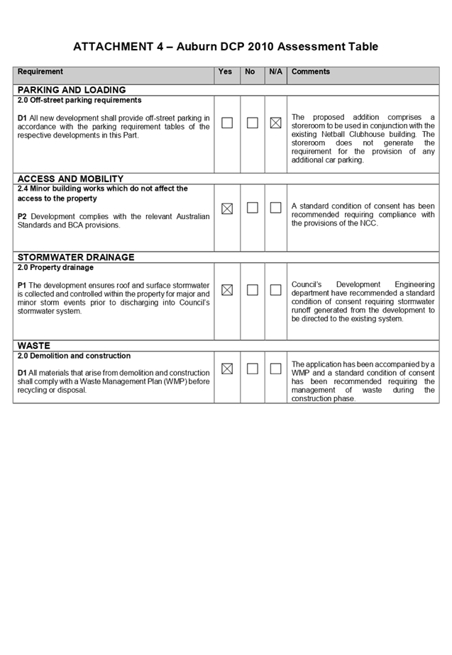
A comprehensive assessment and
compliance table is contained in Attachment 4.
The proposed development complies
with the provisions of Council’s ADCP 2010 and is considered acceptable
from an environmental planning view point.
The provisions of any planning
agreement that has been entered into under section 7.4, or any draft planning
agreement that a developer has offered to enter into under section 7.4
(EP&A Act s4.15(1)(a)(iiia))
There is no draft planning
agreement associated with the subject Development Application.
The provisions of the
Regulations (EP&A Act s4.15 (1)(a)(iv))
The proposed development raises no
concerns as to the relevant matters arising from the Environmental Planning and
Assessment Regulations 2000 (EP&A Reg).
The Likely Environmental,
Social or Economic Impacts (EP&A Act s4.15 (1)(b))
The development comprises a minor
addition to the existing Netball Clubhouse building for the purpose of storage.
The proposed works do not involve the removal of any vegetation and the
development has been assessed against the heritage provisions of the ALEP 2010
and are considered to have minimal impact on the heritage item.
It is considered that the proposed
development will have no significant adverse environmental, social or economic
impacts in the locality.
The suitability of the site for
the development (EP&A Act s4.15 (1)(c))
The subject site and locality is
not known to be affected by any natural hazards or other site constraints
likely to have a significant adverse impact on the proposed development.
Accordingly, it is considered that the development is suitable in the context
of the site and surrounding locality.
Submissions made in accordance
with the Act or Regulation (EP&A Act s4.15 (1)(d))
Advertised (newspaper) Mail
Sign
Not
Required
In accordance with Council’s
Notification requirements contained within the ADCP 2010, the proposal was
publicly notified for a period of fourteen (14) days between 10 March 2020 and
24 March 2020. The notification generated no submissions.
The public interest (EP&A
Act s4.15(1)(e))
In view of the foregoing analysis
it is considered that the development, if carried out subject to the conditions
set out in the recommendation below, will have no significant adverse impacts
on the public interest.
Section 7.11 (Formerly S94)
Auburn Council Development Contributions Plan 2007
The development does not require
the payment of contributions in accordance with Council’s Section 94
Contributions Plan.
Disclosure of Political
Donations and Gifts
The applicant and notification
process did not result in any disclosure of Political Donations and Gifts.
The development application has
been assessed in accordance with the relevant requirements of the Environmental
Planning and Assessment Act 1979, SEPP 55, ISEPP, Draft Cumberland LEP 2020,
ALEP 2010 and ADCP 2010 and is considered to be satisfactory for approval,
subject to conditions.
The proposed development is
appropriately located within the RE1 land use zone under the relevant
provisions of the ALEP 2010. The proposal is consistent with all statutory and
non-statutory controls applying to the development. The development is
considered to perform adequately in terms of its relationship to its
surrounding built and natural environment, particularly having regard to
impacts on adjoining properties.
For these reasons, it is
considered that the proposal is satisfactory having regard to the matters of
consideration under Section 4.15 of the Environmental Planning and Assessment
Act 1979, and the development may be approved subject to conditions.
|
That Development Application
No. DA2019/0524 for Addition of a store room to the existing netball
clubhouse on land at Wyatt Park, Church Street LIDCOMBE NSW 2141
be approved subject to attached conditions.
|
1. Attachment
1 - Draft Notice of Determination
2. Attachment
2 - Architectural Plans
3. Attachment
3 - Heritage Impact Statement
4. Attachment
4 - ADCP 2010 Assessment Table
DOCUMENTS
ASSOCIATED WITH
REPORT LPP027/20
Attachment 1
Attachment 1 - Draft Notice of Determination
Cumberland Local Planning Panel Meeting
10 June 2020

DOCUMENTS
ASSOCIATED WITH
REPORT LPP027/20
Attachment 2
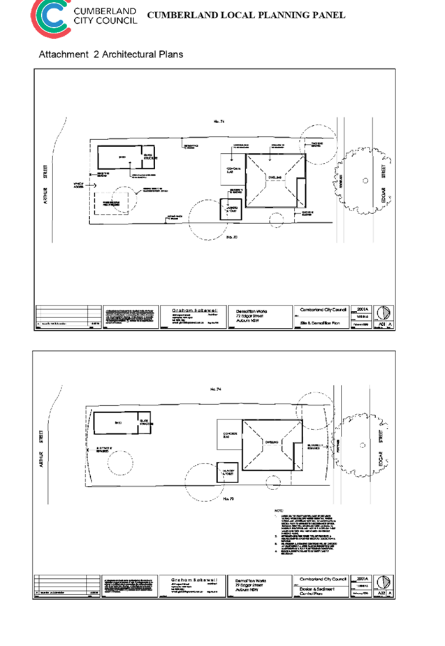
Attachment 2 - Architectural Plans
Cumberland Local Planning Panel Meeting
10 June 2020
DOCUMENTS
ASSOCIATED WITH
REPORT LPP027/20
Attachment 3
Attachment 3 - Heritage Impact Statement
Cumberland Local Planning Panel Meeting
10 June 2020
DOCUMENTS
ASSOCIATED WITH
REPORT LPP027/20
Attachment 4
Attachment 4 - ADCP 2010 Assessment Table
Cumberland Local Planning Panel Meeting
10 June 2020
Cumberland
Local Planning Panel Meeting
10 June 2020
Item
No: LPP028/20
Development
Application for 72 Edgar Street, Auburn
Responsible
Division: Environment
& Planning
Officer: Executive
Manager Development and Building
File
Number: DA2020/0119
|
Application
lodged
|
3 March 2020
|
|
Applicant
|
Cumberland City Council
|
|
Owner
|
Cumberland City Council
|
|
Application
No.
|
DA2020/0119
|
|
Description
of Land
|
72 Edgar Street AUBURN
NSW 2144, Lot 39 DP 8800
|
|
Proposed
Development
|
Demolition of existing
structures and associated trees
|
|
Site
Area
|
539.55m2
|
|
Zoning
|
RE1 Public Recreation
|
|
Disclosure
of political donations and gifts
|
Nil disclosure
|
|
Heritage
|
The subject site is not a
heritage-listed item and is not within a heritage conservation area.
|
|
Principal
Development Standards
|
N/A
|
|
Issues
|
Nil.
|
1. Development
Application No. DA2020/0119 was received on 3 March 2020 for the demolition of
existing structures and associated trees. A total of three (3) onsite trees are
proposed to be removed.
2. The
subject Development Application was not required to be publicly
exhibited/notified in accordance with the Environmental Planning Assessment Act
1979, Environmental Planning and Assessment Regulation 2000 and Auburn
Development Control Plan 2010 (Auburn DCP 2010).
3. The
application is recommended for conditional approval subject to the conditions
as provided in the attached schedule.
4. The
application is referred to the Panel as there is a declared conflict of
interest, whereby, Cumberland City Council is the owner of the subject site and
is the applicant for the Development Application.
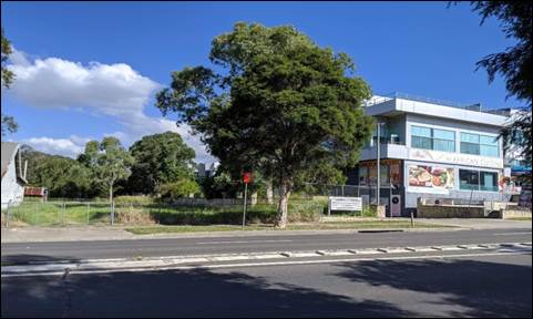
Subject Site and Surrounding
Area
The site forms Lot 39 DP 8800 and
is known as 72 Edgar Street, Auburn. The site comprises an area of 530.55m2 and
has two street frontages, situated between the southern side of Edgar Street
(primary street frontage) and the northern side of Arthur Street (secondary
street frontage). The following dimensions are provided:
· Northern
and southern (street and rear) boundaries: 13.41m
· Eastern
and western (side) boundaries: 40.235m
A site inspection was carried out
on 4 May 2020 and confirmed that the site consists of a single-storey
residential dwelling with two (2) detached outbuildings situated within the
property’s backyard. The site adjoins a single-storey residential dwelling
to the east and west and is within close proximity to a public reserve located
at the western end of Edgar Street called the Webbs Avenue Playing Fields. The
subject site is also located approximately 200 metres east of the Duck River
and is 360 metres north of the Auburn Botanic Gardens.
Figure
1 – Locality Plan of subject site (Nearmap 2020)
Figure
2 – Subject site taken from Edgar Street
Figure
3 – Webb Avenue Playing Fields
Description of the Proposed
Development
Council has received a development
application for demolition of existing structures and the removal of associated
onsite trees.
Structures to be demolished onsite
include:
· single-storey
dwelling house;
· detached
outbuildings (laundry/toilet and shed). Both outbuildings are located at the
rear of the subject site;
· concrete
slab;
· three
(3) onsite trees
· rear
fencing
The proposed demolition works will
allow the site to be incorporated with the surrounding public reserve, forming
part of the Regional Cumberland Open Space area.
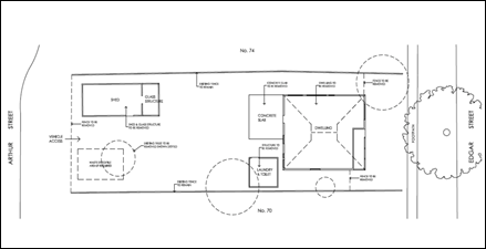
Figure
4 – Demolition Plan of existing structures and removal of trees
History
Nil.
Applicants Supporting
Statement
The applicant has provided a Statement of Environmental
Effects prepared by Graham Bakewell Architect dated February 2020 and was
received by Council on 3 March 2020 in support of the application.
Contact with Relevant
Parties
The assessing officer has undertaken a site inspection of
the subject site and surrounding properties and has been in regular contact with
the applicant throughout the assessment process.
Internal Referrals
Landscape Architect/Officer
The development application was
referred to Council’s Landscape Officer for comment who has advised that
the proposed tree removal is satisfactory and therefore can be supported
subject to recommended conditions of consent. It is noted that the existing
street tree shall be protected and retained throughout the demolition works.
External Referrals
The application was not required
to be referred to any external government authorities for comment.
PLANNING COMMENTS
The provisions of any
Environmental Planning Instruments (EP&A Act s4.15 (1)(a)(i))
State Environmental Planning
Policies
The proposed development is
affected by the following State Environmental Planning Policies:
(a) State
Environmental Planning Policy No. 55 – Remediation of Land (SEPP 55)
Clause 7 of SEPP 55 requires
Council to be satisfied that the site is suitable or can be made suitable to
accommodate the proposed development. The matters listed within Clause 7 have
been considered in the assessment of the development application.
|
Matter for Consideration
|
Yes/No
|
|
Does the application involve re-development of the site or
a change of land use?
|
Yes
No
|
|
Is the development going to be used for a sensitive land
use (e.g.: residential, educational, recreational, childcare or hospital)?
|
Yes
No
|
|
Does information available to you indicate that an
activity listed below has ever been approved, or occurred at the site?
acid/alkali plant and
formulation, agricultural/horticultural activities, airports, asbestos
production and disposal, chemicals manufacture and formulation, defence
works, drum re-conditioning works, dry cleaning establishments, electrical
manufacturing (transformers), electroplating and heat treatment premises,
engine works, explosive industry, gas works, iron and steel works, landfill
sites, metal treatment, mining and extractive industries, oil production and
storage, paint formulation and manufacture, pesticide manufacture and
formulation, power stations, railway yards, scrap yards, service stations,
sheep and cattle dips, smelting and refining, tanning and associated trades,
waste storage and treatment, wood preservation
|
Yes
No
|
|
Is the site listed on
Council’s Contaminated Land database?
|
Yes
No
|
|
Is the site subject to EPA
clean-up order or other EPA restrictions?
|
Yes
No
|
|
Has the site been the subject of
known pollution incidents or illegal dumping?
|
Yes
No
|
|
Does the site adjoin any
contaminated land/previously contaminated land?
|
Yes
No
|
|
Has the appropriate level of
investigation been carried out in respect of contamination matters for
Council to be satisfied that the site is suitable to accommodate the proposed
development or can be made suitable to accommodate the proposed development?
|
Yes
No
|
|
The
subject site adjoins contaminated land indicated on Council’s
Contaminated Land database and the property was subject to orders issued by
Cumberland Council for overgrown vegetation and accumulated waste. However,
as the subject site has been used for residential purposes and the
development involves demolition works only, further site investigations
relating to land contamination is not warranted.
|
(b) Statement
Environmental Planning Policy No 19 - Bushland in Urban Areas (SEPP 19)
The subject site is zoned RE1
Public Recreation however, no bushland or reserved public open spaces are
expected to be affected from the proposed of demolition works and associated
tree removal.
(c) State
Environmental Planning Policy (Vegetation in Non-Rural Areas) 2017
The proposal does not exceed the
biodiversity offsets scheme threshold. Therefore, the proposed vegetation
removal is considered acceptable.
(d) State
Environmental Planning Policy (Coastal Management) 2018
The subject site is not identified
as a coastal wetland or land identified as “proximity area for coastal
wetlands” or land identified as such by the Coastal Vulnerability Area
Map.
Regional Environmental Plans
The proposed development is
affected by the following Regional Environmental Plans:
(a) Sydney
Regional Environmental Plan (Sydney Harbour Catchment) 2005
The subject site is identified as
being located within the area affected by the Sydney Regional Environmental
Plan (Sydney Harbour Catchment) 2005. The proposed development raises no issues
as no impact on the catchment is envisaged.
Local Environmental Plans
Auburn Local Environmental Plan
2010
The provision of the Auburn Local
Environmental Plan 2010 is applicable to the development proposal. It is noted
that the development achieves compliance with the key statutory requirements of
the Auburn Local Environmental Plan 2010 and the objectives of the RE1 Public
Recreation Zone.
(a) Permissibility/Land
Use: -
The subject site is zoned RE1
Public Recreation and the proposed demolition works has been undertaken to
facilitate use of the land for future public recreation and shall be
incorporated with the surrounding public reserve. In this regard, the proposed
development is permissible and is considered to be consistent with the zone
objectives.
The relevant matters to be
considered under Auburn LEP 2010 and the applicable clauses for the proposed
development are summarised below.
Figure
5 – Auburn LEP 2010 Compliance Table
|
DEVELOPMENT STANDARD
|
COMPLIANCE
|
DISCUSSION
|
|
2.7
Demolition requires consent
|
Yes
|
Consent is sought for the
proposed demolition works as part of this application
|
|
5.10
Heritage conservation
|
N/A
|
N/A – the subject site is not a heritage listed item
or is located within a heritage conservation area
|
|
6.1
Acid Sulphate Soils
|
Yes
|
Class 5, nil impact
|
|
6.2
Earthworks
|
N/A
|
Demolition works proposed only
|
|
6.3
Flood Planning
|
N/A
|
The subject site is not a flood
affected lot
|
It is noted that matters
concerning Floor Space Ratio and Height of Buildings do not need to be
addressed because no work is proposed. The development application is purely
for demolition of buildings.
The provisions of any proposed
instrument that is or has been the subject (EP&A Act s4.15 (1)(a)(ii))
(a) Draft
Cumberland Local Environmental Plan 2020 (Draft CLEP)
The Draft Cumberland Local
Environmental Plan 2020 (Draft CLEP) has been prepared by Cumberland Council to
provide a single planning framework for the future planning of Cumberland City.
The changes proposed seek to harmonise and repeal the three existing LEPs
currently applicable to the Cumberland local government area, those being:
· Holroyd
Local Environmental Plan 2013,
· Parramatta
Local Environmental Plan 2011, and
· Auburn
Local Environmental Plan 2010.
The current planning controls for
the subject site, as contained within the Auburn Local Environmental Plan 2010,
are not proposed to change under the Draft CLEP.
The provisions of any
Development Control Plans (EP&A Act s4.15 (1)(a)(iii))
The Auburn DCP 2010 provides
guidance for the design and operation of development to achieve the aims and
objectives of the Auburn DCP 2010.
A comprehensive assessment and
compliance table is contained in Appendix A. The proposed development complies
with the provisions of Council’s Auburn DCP 2010 and is considered
acceptable.
The provisions of any planning
agreement that has been entered into under section 7.4, or any draft planning
agreement that a developer has offered to enter into under section 7.4
(EP&A Act s4.15(1)(a)(iiia))
There is no draft planning
agreement associated with the subject Development Application.
The provisions of the
Regulations (EP&A Act s4.15 (1)(a)(iv))
The proposed development raises no
concerns as to the relevant matters arising from the Environmental Planning and
Assessment Regulations 2000 (EP&A Reg).
The Likely Environmental,
Social or Economic Impacts (EP&A Act s4.15 (1)(b))
It is considered that the proposed
development will have no significant adverse environmental, social or economic impacts
in the locality.
The suitability of the site for
the development (EP&A Act s4.15 (1)(c))
The subject site and locality is
not known to be affected by any natural hazards or other site constraints
likely to have a significant adverse impact on the proposed development.
Accordingly, it is considered that the development is suitable in the context
of the site and surrounding locality.
Submissions made in accordance
with the Act or Regulation (EP&A Act s4.15 (1)(d))
In accordance with Council’s
Notification requirements contained within the Auburn Development Control Plan
2010, the development application was not required to be publicly notified.
The public interest (EP&A
Act s4.15(1)(e))
In view of the foregoing analysis
it is considered that the development, if carried out subject to the conditions
set out in the recommendation below, will have no significant adverse impacts
on the public interest.
Section 7.11 (Formerly S94)
Contribution Towards Provision or Improvement of Amenities or Services
This part of the Act relates to
the collection of monetary contributions from applicants for use in developing
key local infrastructure.
Comments:
The development does not require
the payment of contributions in accordance with Council’s Section 7.11 Contributions
Plans.
Disclosure of Political
Donations and Gifts
The applicant and notification
process did not result in any disclosure of Political Donations and Gifts.
The development application has
been assessed in accordance with the relevant requirements of the Environmental
Planning and Assessment Act 1979, Environmental Planning and Assessment
Regulation 2000, Auburn Local Environmental Plan 2010 and Auburn Development
Control Plan 2010 and is considered to be satisfactory for approval subject to
conditions.
The proposed development is
appropriately located within the RE1 Public Recreation zone under the relevant
provisions of the Auburn LEP 2010. The proposal is consistent with all
statutory and non-statutory controls applying to the development. The
development is considered to perform adequately in terms of its relationship to
its surrounding built and natural environment, particularly having regard to
impacts on adjoining properties.
For these reasons, it is
considered that the proposal is satisfactory having regard to the matters of
consideration under Section 4.15 of the Environmental Planning and Assessment
Act 1979, and the development may be approved subject to conditions.
|
That Development Application
No. DA2020/0119 for demolition of existing structures and associated trees on
land at 72 Edgar Street AUBURN NSW 2144 be approved subject to
attached conditions.
|
1. Draft Notice
of Determination
2. Architectural
Plans
3. Locality
Map
4. Appendix
A – Development Control Plan Assessment Table
DOCUMENTS
ASSOCIATED WITH
REPORT LPP028/20
Attachment 1
Draft Notice of Determination
Cumberland Local Planning Panel Meeting
10 June 2020


DOCUMENTS
ASSOCIATED WITH
REPORT LPP028/20
Attachment 2
Architectural Plans
Cumberland Local Planning Panel Meeting
10 June 2020
DOCUMENTS
ASSOCIATED WITH
REPORT LPP028/20
Attachment 3
Locality Map
Cumberland Local Planning Panel Meeting
10 June 2020
DOCUMENTS
ASSOCIATED WITH
REPORT LPP028/20
Attachment 4
Appendix A – Development Control Plan Assesment
Table
Cumberland Local Planning Panel Meeting
10 June 2020
Cumberland
Local Planning Panel Meeting
10 June 2020
Item
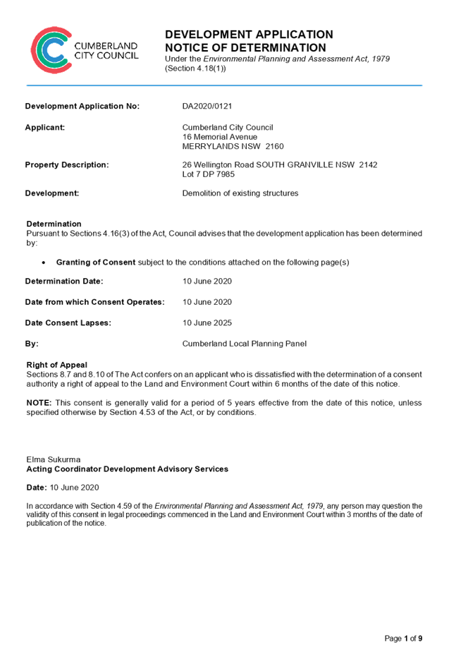
No: LPP029/20
Development
Application for 26 Wellington Road, South Granville
Responsible
Division: Environment
& Planning
Officer: Executive
Manager Development and Building
File
Number: DA2020/0121
|
Application
lodged
|
3 March 2020
|
|
Applicant
|
Cumberland City Council
|
|
Owner
|
Cumberland City Council
|
|
Application
No.
|
DA2020/0121
|
|
Description
of Land
|
26 Wellington Road SOUTH
GRANVILLE NSW 2142, Lot 7 DP 7985
|
|
Proposed
Development
|
Demolition of existing
structures
|
|
Site
Area
|
10116.8 m2
|
|
Zoning
|
E2 Environmental
Conservation
|
|
Disclosure
of political donations and gifts
|
Nil disclosure
|
|
Heritage
|
No
|
|
Principal
Development Standards
|
N/A
|
|
Issues
|
Nil
|
1. Development
Application No. DA2020/0121 was received on 3 March 2020 for the demolition of
existing structures.
2. The
application was publicly notified to occupants and owners of the adjoining
properties for a period of 14 days between 13 March 2020 and 27 March 2020. In
response, no submissions were received.
3. The
application is recommended for conditional approval subject to the conditions
as provided in the attached schedule.
4. The
application is referred to the Panel as there is a declared conflict of
interest, whereby, Cumberland City Council is the owner of the subject site and
the applicant for the Development Application.
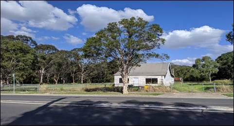
Subject Site and Surrounding
Area
The site forms Lot 7 DP 7985, and
is known as 26 Wellington Road, South Granville. The site comprises an area of
10116.8 m2 and the following site dimensions are provided:
· Northern
and Southern (street and rear) boundaries; 50.29m
· Eastern
and western (side) boundaries: 201.17m
The subject site is not affected
by stormwater flooding. The site is devoid of vegetation with a few existing
street trees on the footpath of Wellington Road. The site is also located
approximately 800 metres north of the Duck River and is 360 metres north of the
Auburn Botanic Gardens
A site inspection was carried out
on 4 March 2020 and confirmed that the site is currently occupied by a vacant
single dwelling with detached shed and fencing for a chicken enclosure. The
site adjoins general industrial developments to the west, recreational open
space to the north and land reserved for environmental conservation to the east
and south.
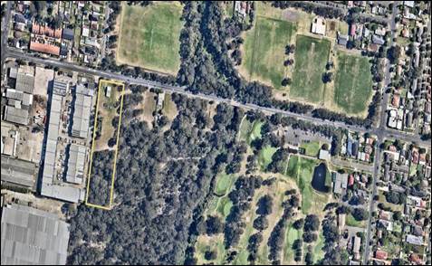
Figure
1 – Locality Plan of subject site (Nearmap 2020)
Figure
2 – Subject site taken from Wellington Street
Figure
3 – Street view
Description of the Proposed
Development
Council has received a development
application for demolition of existing structure and removal of ancillary
structures.
Structures to be demolition on
site includes;
· Dwelling
house
· The
removal of internal fencing
· Chicken
enclosure
· Shed
The proposed demolition works will
allow the site to be incorporated with the surrounding public reserve forming
part of the environmental conservation area.
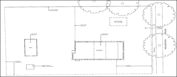
Figure
4 - Demolition Plan of existing structures
Applicants Supporting
Statement
The applicant has provided a
Statement of Environmental Effects prepared by Graham Bakewell Architect dated
February 2020 and was received by Council on 3 March 2020 in support of the
application.
Contact with Relevant
Parties
The assessing officer has undertaken a site inspection of
the subject site and surrounding properties and has been in regular contact
with the applicant throughout the assessment process.
Internal Referrals
No Internal referrals were required for the proposed
matter.
External Referrals
The application was not required to be referred to any
external government authorities for comment.
PLANNING COMMENTS
The provisions of any Environmental Planning Instruments
(EP&A Act s4.15 (1)(a)(i))
State Environmental Planning Policies
(a) State
Environmental Planning Policy No. 55 – Remediation of Land (SEPP 55)
Clause 7 of SEPP 55 requires
Council to be satisfied that the site is suitable or can be made suitable to
accommodate the proposed development. The matters listed within Clause 7 have
been considered in the assessment of the development application.
|
Matter for Consideration
|
Yes/No
|
|
Does the application involve re-development of the site or
a change of land use?
|
Yes
No
|
|
In the development going to be used for a sensitive land
use (e.g.: residential, educational, recreational, childcare or hospital)?
|
Yes
No
|
|
Does information available to you indicate that an
activity listed below has ever been approved, or occurred at the site?
acid/alkali plant and
formulation, agricultural/horticultural activities, airports, asbestos
production and disposal, chemicals manufacture and formulation, defence
works, drum re-conditioning works, dry cleaning establishments, electrical
manufacturing (transformers), electroplating and heat treatment premises,
engine works, explosive industry, gas works, iron and steel works, landfill
sites, metal treatment, mining and extractive industries, oil production and storage,
paint formulation and manufacture, pesticide manufacture and formulation,
power stations, railway yards, scrap yards, service stations, sheep and
cattle dips, smelting and refining, tanning and associated trades, waste
storage and treatment, wood preservation
|
Yes
No
|
|
Is the site listed on
Council’s Contaminated Land database?
|
Yes
No
|
|
Is the site subject to EPA
clean-up order or other EPA restrictions?
|
Yes
No
|
|
Has the site been the subject of
known pollution incidents or illegal dumping?
|
Yes
No
|
|
Does the site adjoin any
contaminated land/previously contaminated land?
|
Yes
No
|
|
Has the appropriate level of
investigation been carried out in respect of contamination matters for
Council to be satisfied that the site is suitable to accommodate the proposed
development or can be made suitable to accommodate the proposed development?
|
Yes
No
|
|
1.
The subject site adjoins
contaminated land indicated on Council’s Contaminated Land database.
However, as the subject site has been used for residential purposes and the
development involves demolition works only, further site investigations
relating to land contamination is not warranted.
|
(b) Statement
Environmental Planning Policy No 19 - Bushland in Urban Areas (SEPP 19)
The
subject site is zoned E2 – Environmental Conservation however, no
bushland or reserved public open spaces are expected to be affected from the
proposed of demolition works and associated tree removal.
(c) State
Environmental Planning Policy (Vegetation in Non-Rural Areas) 2017
i)
The
proposal does not exceed the biodiversity offsets scheme threshold. Therefore,
the proposed vegetation removal is considered acceptable.
Regional Environmental
Plans
The proposed development
is affected by the following Regional Environmental Plans:
(a) Sydney Regional
Environmental Plan (Sydney Harbour Catchment) 2005
The
subject site is identified as being located within the area affected by the
Sydney Regional Environmental Plan (Sydney Harbour Catchment) 2005. The
proposed development raises no issues as no impact on the catchment is
envisaged.
Local Environmental
Plans
Parramatta Local
Environmental Plan 2011
The provision of the
Parramatta Local Environmental Plan 2011 is applicable to the development
proposal. It is noted that the development achieves compliance with the key
statutory requirements of the Parramatta Local Environmental Plan 2011 and the
objectives of the E2 - Environmental Conservation Zone.
(a) Permissibility:-
The
subject site is zoned E2 Environmental Conservation and the proposed demolition
works has been undertaken to facilitate use of the land for future public
recreation and shall be incorporated with the surrounding reserve. In this
regard, the proposed development is permissible and is considered to be
consistent with the zone objectives.
The
relevant matters to be considered under Parramatta LEP 2011 and the applicable
clauses for the proposed development are summarised below.
Figure 5
–Parramatta LEP 2013 Compliance Table
|
DEVELOPMENT STANDARD
|
COMPLIANCE
|
DISCUSSION
|
|
2.7
Demolition requires consent
|
Yes
|
Consent is sought for the
proposed demolition works as part of this application
|
|
5.10
Heritage conservation
|
N/A
|
The subject site is not a
heritage listed item or is located within a heritage conservation area.
|
|
6.1
Acid Sulfate Soils
|
Yes
|
Class 5, Nil impact
|
|
6.2
Earthworks
|
N/A
|
Demolition works proposed only
|
|
6.3
Flood Planning
|
N/A
|
The subject site is not a flood
affected lot
|
It is noted that matters concerning Floor Space Ratio and
Height of Buildings do not need to be addressed because no work is proposed.
The development application is purely for demolition of buildings.
The provisions of any proposed instrument that is or has
been the subject (EP&A Act s4.15 (1)(a)(ii))
(a) Draft
Cumberland Local Environmental Plan 2020 (Draft CLEP)
The Draft Cumberland Local
Environmental Plan 2020 (Draft CLEP) has been prepared by Cumberland City
Council to provide a single planning framework for the future planning of
Cumberland City. The changes proposed seek to harmonise and repeal the three
existing LEPs currently applicable to the Cumberland local government area,
those being:
· Holroyd Local
Environmental Plan 2013,
· Parramatta Local
Environmental Plan 2011, and
· Auburn Local
Environmental Plan 2010.
The current planning controls for
the subject site, as contained within the Parramatta Local Environmental Plan
2011, are not proposed to change under the Draft CLEP.
The provisions of any Development Control Plans (EP&A
Act s4.15 (1)(a)(iii))
The Parramatta Development Control 2011 provides guidance
for the design and operation of development to achieve the aims and objectives
of the Parramatta Local Environmental Plan 2011
A comprehensive assessment and compliance table is contained
in Appendix A. The proposed development complies with the provisions of
Council’s Parramatta Development Control Plan 2011 and is considered
acceptable.
The provisions of any planning agreement that has been
entered into under section 7.4, or any draft planning agreement that a
developer has offered to enter into under section 7.4 (EP&A Act
s4.15(1)(a)(iiia))
There is no draft planning agreement associated with the
subject Development Application.
The provisions of the Regulations (EP&A Act s4.15
(1)(a)(iv))
The proposed development raises no concerns as to the
relevant matters arising from the Environmental Planning and Assessment
Regulations 2000 (EP&A Reg).
The Likely Environmental, Social or Economic Impacts
(EP&A Act s4.15 (1)(b))
It is considered that the proposed development will have no
significant adverse environmental, social or economic impacts in the locality.
The suitability of the site for the development (EP&A
Act s4.15 (1)(c))
The subject site and locality is not known to be affected by
any natural hazards or other site constraints likely to have a significant
adverse impact on the proposed development. Accordingly, it is considered that
the development is suitable in the context of the site and surrounding
locality.
Submissions made in accordance with the Act or Regulation
(EP&A Act s4.15 (1)(d))
Advertised (newspaper) Mail
Sign Not Required
In accordance with Council’s Notification requirements
contained within the Parramatta Development Control Plan 2011, the proposal was
publicly notified for a period of 14 days between 13 March 2020 and 27 March
2020. No submissions were received in respect of the proposed development.
The public interest (EP&A Act s4.15(1)(e))
In view of the foregoing analysis it is considered that the
development, if carried out subject to the conditions set out in the
recommendation below, will have no significant adverse impacts on the public
interest.
Section 7.12 (Formerly S94a) Fixed Development Consent
Levies
This part of the Act relates to the collection of monetary
contributions from applicants for use in developing key local infrastructure.
Comments:
The development does not require the payment of
contributions in accordance with Council’s Section 7.12 Contributions
Plans.
Disclosure of Political Donations and Gifts
The applicant and notification process did not result in any
disclosure of Political Donations and Gifts.
The development application has
been assessed in accordance with the relevant requirements of the Environmental
Planning and Assessment Act 1979, Parramatta Local Environmental Plan 2011 and
Parramatta Development Control Plan 2011 and is considered to be satisfactory
for approval subject to conditions.
The proposed development is
appropriately located within the E2 Environmental Conservation under the
relevant provisions of the Parramatta LEP 2011. The proposal is consistent with
all statutory and non-statutory controls applying to the development. The
development is considered to perform adequately in terms of its relationship to
its surrounding built and natural environment, particularly having regard to
impacts on adjoining properties.
For these reasons, it is
considered that the proposal is satisfactory having regard to the matters of
consideration under Section 4.15 of the Environmental Planning and Assessment
Act 1979, and the development may be approved subject to conditions.
|
That Development Application
No. DA2020/0121 for demolition of existing structures on land at 26
Wellington Road SOUTH GRANVILLE NSW 2142 be approved subject to
attached conditions.
|
1. Draft Notice
of Determination
2. Architectural
Plans
3. Locality
Map
4. Appendix
A - Development Control Plan Assessment Table
DOCUMENTS
ASSOCIATED WITH
REPORT LPP029/20
Attachment 1
Draft Notice of Determination
Cumberland Local Planning Panel Meeting
10 June 2020
DOCUMENTS
ASSOCIATED WITH
REPORT LPP029/20
Attachment 2
Architectural Plans
Cumberland Local Planning Panel Meeting
10 June 2020
DOCUMENTS
ASSOCIATED WITH
REPORT LPP029/20
Attachment 3
Locality Map
Cumberland Local Planning Panel Meeting
10 June 2020
DOCUMENTS
ASSOCIATED WITH
REPORT LPP029/20
Attachment 4
Appendix A - Development Control Plan Assessment Table
Cumberland Local Planning Panel Meeting
10 June 2020
Cumberland
Local Planning Panel Meeting
10 June 2020
Item
No: LPP030/20
Development Application
for 1 Robilliard Street, Mays Hill
Responsible
Division: Environment
& Planning
Officer: Executive
Manager Development and Building
File
Number: MOD2020/0085
|
Application lodged
|
20
March 2020
|
|
Applicant
|
Mr
E Moujalli, Eastern Pacific Pty Ltd
|
|
Owner
|
Great
Western Highway Developments Pty Ltd
|
|
Application No.
|
MOD2020/0085
|
|
Description of Land
|
1
Robilliard Street MAYS HILL NSW 2145, Lot 100 in DP 1256634
|
|
Proposed Development
|
Section
4.55(2) application for various modifications to approved mixed use
development including addition of a substation, reconfiguration of basement
car park, residential units and commercial suites, changes to external
finishes and increase in height of lift overrun
|
|
Site Area
|
3,687m2
|
|
Zoning
|
B6
– Enterprise Corridor Zone
|
|
Disclosure of political donations and gifts
|
Nil
disclosure
|
|
Heritage
|
Not
listed as heritage item and not located in heritage conservation area
|
|
Principal Development Standards
|
FSR
Permissible:
2:1
Proposed:
2:1
Height
of Building
Permissible:
23m – fronting Great Western Highway (Building A)
17m – middle section (part Building B)
15m – facing Robilliard Street (part Building B)
Proposed:
23.437m (Building A lift overrun), no changes to Building B
|
|
Issues
|
- Building
height
- Habitable
room depth
|
1. Modification
Application No. MOD2020/0085 was received on 20 March 2020 for the section
4.55(2) application for various modifications to approved mixed use development
including addition of a substation, reconfiguration of basement car park,
residential units and commercial suites, changes to external finishes and
increase in height of lift overrun.
2. The
application was publicly notified to occupants and owners of the adjoining
properties for a period of 14 days between 1 May 2020 and 15 May 2020. In
response, no submission was received.
3. The
variations are as follows:
|
Control
|
Required
|
Approved
DA2016/499/1
|
Proposed
|
% variation
|
|
Height of buildings
(HLEP)
|
23m – fronting
Great Western Highway
|
23.272m (lift overrun)
|
23.437m (lift overrun)
– additional 165mm
|
1.9%
|
|
Habitable room depth
(ADG)
|
8m maximum
|
8m
|
8.5m (kitchen to
window)
|
6.25%
|
Note: Only new non-compliances
have been discussed within the body of the report which are proposed under the
subject modification application.
4. The
application is being reported to the Cumberland Local Planning Panel (CLPP) for
determination as it is a modification to a development with more than 4 storeys
to which the State Environmental Planning Policy No 65 – Design Quality
of Residential Apartment Developments applies and exceeds Council delegation in
relation to the determination of modification.
5. The
application is recommended for approval subject to the conditions in the draft
notice of determination held at Attachment 1.
Subject Site and Surrounding
Area
The subject site forms Lot 100 in
DP 1256634, which previously comprised of 5 separate allotments (Lot 109 in DP
13239, Lot B in DP 367709, Lot 12 in DP 1052755, Lot 10 in DP 1052755, and Lot
11 in DP 1052755). The site is a corner lot that is known as 1 Robilliard
Street, Mays Hill. The site has an area of 3,687m2, a frontage to Robilliard
Street of 50.67m to the west, and a frontage to Great Western Highway of
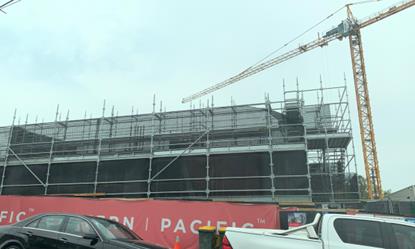
approximately 53.1m to the north. The site is located within B6 Enterprise
Corridor zone. The approved mixed use development on site is currently under
construction. The existing developments adjoining the site include an existing
petrol station to the west, and a mixture of single dwellings and residential
flat buildings to the south and east.
Figure
1 – Locality Plan of subject site
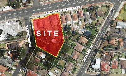
Figure
2 – Aerial view of subject site
Figure
3 – Street view of subject site
Description of the Proposed
Development
Council has received a
modification application involving the following works:
Basement levels
- Internal
reconfiguration of car parking spaces;
- Relocation
of substation;
Note: original application was
approved with 5 excess car parking spaces, the proposed modification
application will result in the deletion of 5 car parking spaces. Refer to
detailed discussions under Holroyd DCP 2013 below.
Ground floor level
- Internal
changes to approved commercial tenancies by increasing total gross leasable
area by 9m² and new amenities (kitchen and WC);
- Internal
reconfiguration of units AG01, AG02 and AG03;
- Relocation
of substation on Robilliard Street;
- First
floor to sixth floor levels
- Internal
reconfiguration of units A109 – A609;
Elevations
- Changes
to east and blank wall elevations material with CFC sheeting;
- Removal
of glass blocks in accordance with condition no. 37; and
- Increase
in lift overrun of building facing Great Western Highway from RL 62.00m to RL
62.20m (AHD).
History
Development consent DA2016/499/1
was issued by Council under delegated authority on 13 September 2017 for the
demolition of existing structures; consolidation of 5 lots into 1 lot;
construction of part 3 (Building B); part 7 storey (Building A) mixed use
development comprising 84 residential units; ground floor commercial space
above 2 levels of basement parking accommodating 125 carparking spaces at the
subject site.
Construction Certificate for
DA2016/499/1 was issued on 8 August 2019 by NW Building Certification (CC No.
NW17/2389).
S4.55(1A) application
(DA2016/499/3) was approved by Council on 4 November 2019 to modify floor to
floor heights of the ground and first floor levels.
S4.55(1A) application
(MOD2019/5272) seeking approval to relocate substation, modify shop and unit
layouts was withdrawn by the applicant on 5 March 2020.
S4.55(1A) application
(M2016/499/2) was approved by Council on 6 March 2020 to modify location of
on-site detention tank and stormwater drainage.
Applicants Supporting
Statement
The applicant has provided a
Statement of Environmental Effects prepared by Think Planners Pty Ltd dated 12
March 2020 in support of the application.
Contact with Relevant
Parties
The assessing officer has
undertaken a site inspection of the subject site and surrounding properties and
has been in regular contact with the applicant throughout the assessment
process.
Internal Referrals
Development Engineer
The development application was
referred to Council’s Development Engineer for comment who has advised
that the development proposal is satisfactory relating to the changes proposed
to the basement and OSD layouts, and therefore can be supported subject to
recommended conditions of consent. The relocation of substation resulted in
reconfiguration of car parking layout on 2 basement levels. Conditions imposed
will result in the deletion of surplus car parking spaces on the site to ensure
that sufficient aisle width will be maintained.
Building Surveyor
The development application was
referred to Council’s Building Surveyor for comment who has advised that
the development proposal could be supported subject to condition to obtain a
Building Certificate for any works which are inconsistent with original
approval and completed prior to the issue of this subject consent.
Waste Management
The development application was
referred to Council’s Waste Management Officer for comment who has
advised that the development proposal is satisfactory in terms of the proposed
waste collection, and therefore can be supported subject to recommended conditions
of consent.
External Referrals
Roads and Maritime Services
(RMS)
The development application was
referred to RMS for comment, however there were no changes proposed along Great
Western Highway or the vehicular access into the development. Therefore, RMS
comments are not warranted for the subject modification application.
Endeavour Energy
The applicant has submitted
documentary evidence to demonstrate that the proposal has satisfied the
requirements of the energy provider. The proposal therefore can be supported
subject to recommended conditions of consent.
Transgrid
The original proposal, in which
consistent with the proposed modification application, was referred to
Transgrid and therefore can be supported.
PLANNING COMMENTS
Section 4.55(2):
|
Requirement
|
Comments
|
|
Council is satisfied that the development to which the
consent as modified relates is substantially the same development as the
development for which the consent was originally granted and before that
consent as originally granted was modified (if at all), and
|
The development as proposed to be modified is
substantially the same as the original consent, as it relates to minor
increase in Building A lift overrun height, and changes to the car parking
arrangement in the basement levels, and the overall building layout and
façade, in which does not deviate from the approved mixed use
development on the subject site.
|
|
Council has consulted with the relevant Minister, public
authority or approval body (within the meaning of Division 5) in respect of a
condition imposed as a requirement of a concurrence to the consent or in
accordance with the general terms of an approval proposed to be granted by
the approval body and that Minister, authority or body has not, within 21
days after being consulted, objected to the modification of that consent, and
|
No Minister, public authority or other approval body was
required to be consulted regarding the proposed modification.
|
|
Council has notified the application in accordance with:
(i) the regulations, if the
regulations so require, or
(ii) a development control plan,
if the consent authority is a council that has made a development control
plan that requires the notification or advertising of applications for
modification of a development consent, and
|
See discussion on “Public Notification” in
this report.
|
|
Council has considered any submissions made concerning the
proposed modification within any period prescribed by the regulations or
provided by the development control plan, as the case may be.
|
See discussion on “Public Notification” in
this report.
|
|
Relevant matters referred to in Section 4.15(1) of the act
have been taken into consideration
|
Proposed modification is not contrary to the public
interest and the likely environmental impacts of the development as modified
are considered acceptable.
|
The provisions of any
Environmental Planning Instruments (EP&A Act s4.15 (1)(a)(i))
(a) State
Environmental Planning Policy No. 55 – Remediation of Land (SEPP 55)
Clause 7 of SEPP 55 requires
Council to be satisfied that the site is suitable or can be made suitable to
accommodate the proposed development. The matters listed within Clause 7 have
been considered in the assessment of the development application.
|
Matter for
Consideration
|
Yes/No
|
|
Does the application
involve re-development of the site or a change of land use?
|
Yes No
|
|
Does the application involve re-development of the site
or a change of land use?
|
Yes No
|
|
In the development
going to be used for a sensitive land use (e.g.: residential, educational,
recreational, childcare or hospital)?
|
Yes No
|
|
Does information
available to you indicate that an activity listed below has ever been
approved, or occurred at the site?
acid/alkali plant and formulation, agricultural/horticultural
activities, airports, asbestos production and disposal, chemicals manufacture
and formulation, defence works, drum re-conditioning works, dry cleaning
establishments, electrical manufacturing (transformers), electroplating and
heat treatment premises, engine works, explosive industry, gas works, iron
and steel works, landfill sites, metal treatment, mining and extractive
industries, oil production and storage, paint formulation and manufacture,
pesticide manufacture and formulation, power stations, railway yards, scrap
yards, service stations, sheep and cattle dips, smelting and refining,
tanning and associated trades, waste storage and treatment, wood preservation
|
Yes No
|
|
Is
the site listed on Council’s Contaminated Land database?
|
Yes No
|
|
Is
the site subject to EPA clean-up order or other EPA restrictions?
|
Yes No
|
|
Has
the site been the subject of known pollution incidents or illegal dumping?
|
Yes No
|
|
Does
the site adjoin any contaminated land/previously contaminated land?
|
Yes No
|
|
Has
the appropriate level of investigation been carried out in respect of
contamination matters for Council to be satisfied that the site is suitable
to accommodate the proposed development or can be made suitable to
accommodate the proposed development?
|
Yes No
|
|
The requirements under the
original application are unchanged by this modification application. Council
is satisfied that the site is suitable to be used for residential purpose.
|
(b) Statement
Environmental Planning Policy No. 65 - Design Quality of Residential Apartment
Development (SEPP 65)
SEPP 65 applies to the development
as the building is 3 storeys or more, and contains more than 4 dwellings. A
design statement addressing the design quality principles prescribed by SEPP 65
was prepared by the project architect. Integral to SEPP 65 is the Apartment
Design Guide (ADG), which sets benchmarks for the appearance, acceptable
impacts and residential amenity of the development. A revised design verification
statement signed by registered architect Ziad Boumelhem (Registration No. 8008)
was submitted with the s4.55(2) application.
Following a detailed assessment of
the proposal against the provisions of SEPP 65 and the ADG, it is considered
the proposal is generally compliant with the exception of maximum habitable
room depth. This variation is discussed below:
· Objective
4D-1
In an open plan layout where
living, dining and kitchen are combined, the maximum habitable room depth is 8m
to a window. The reconfiguration of units in Building A results in maximum room
depth of 8.5m to the kitchen wall. The proposed non-compliance is considered
acceptable, as the open plan layout has sufficient ceiling height and direct
access to full room width openings. The rooms cross ventilation circulation
will not be affected by the additional depth of the combined habitable room to
the kitchen wall. The minor non-compliance is therefore considered acceptable.
A comprehensive assessment against
SEPP 65 and the ADG is contained in Appendix A.
(c) State
Environmental Planning Policy (Infrastructure) 2007 (ISEPP)
The provisions of the ISEPP 2007
have been considered in the assessment of the development application.
Clause 45 - Development likely
to affect an electricity transmission or distribution network
The original application was
referred to Endeavour Energy and was considered satisfactory subject to the
conditions imposed. The current modification for relocation of substation on
the site has been also been approved by the electricity provider.
Clause 101 – Frontage to
classified road
The application is subject to
clause 101 of the ISEPP as the site has frontage to a classified road. The
original application was assessed under the provision of this clause and was considered
satisfactory subject to conditions imposed. The proposed modification does not
alter the outcome of the original assessment.
Clause 102 – Impact of
road noise or vibration on non-road development
The application is subject to
clause 102 of the ISEPP as the annual average daily traffic volume is greater
than 40,000 vehicles. The original application was assessed under the provision
of this clause and was considered satisfactory subject to conditions imposed.
The proposed modification does not alter the outcome of the original
assessment.
Clause 104 – Traffic
generation developments
The application is subject to
clause 104 as the proposal triggers the requirements for traffic generating
developments listed in Schedule 3 of the ISEPP. The original application was
assessed under the provision of this clause and was considered satisfactory
subject to conditions imposed. The proposed modification does not alter the
outcome of the original assessment.
(d) State
Environmental Planning Policy (Vegetation in Non-Rural Areas) 2017
Tree removal on site has been
approved in the original assessment. The proposal does not exceed the
biodiversity offsets scheme threshold. Therefore, the proposed vegetation
removal is considered acceptable.
(e) State
Environmental Planning Policy (Building Sustainability Index: BASIX) 2004
BASIX Certificate 689230M_03 dated
issued on 1 November 2016 prepared by Victor Lin & Associates Pty Ltd has
been submitted with Council and is considered to be satisfactory.
Regional Environmental Plans
The proposed development is
affected by the following Regional Environmental Plans:
(a) Sydney
Regional Environmental Plan (Sydney Harbour Catchment) 2005
Note: Will be superseded once
Draft SEPP Environment comes into effect.
The subject site is identified as
being located within the area affected by the Sydney Regional Environmental
Plan (Sydney Harbour Catchment) 2005. The proposed development raises no issues
as no impact on the catchment is envisaged.
(Note: - the subject site is not
identified in the relevant map as ‘land within the ‘Foreshores and
Waterways Area’ or ‘Wetland Protection zone’, is not a
‘Strategic Foreshore Site’ and does not contain any heritage items.
Hence the majority of the SREP is not directly relevant to the proposed development).
Local Environmental Plans
Holroyd Local Environmental
Plan (HLEP) 2013
The provision of the Holroyd LEP
2013 is applicable to the development proposal. It is noted that the
development achieves compliance with the key statutory requirements of the
Holroyd LEP 2013 and the objectives of the B6 – Enterprise Corridor zone.
(a) Permissibility:-
The proposed development is
defined as a ‘shop top housing’ and is permissible in the B6
– Enterprise Corridor zone with consent. The proposed modification will
continue the use of the development as approved being a shop top housing.
The relevant matters to be
considered under Holroyd LEP 2013 and the applicable clauses for the proposed
development are summarised below. A comprehensive LEP assessment is contained
in Appendix B.
Figure
4 – Holroyd LEP 2013 Compliance Table
|
DEVELOPMENT STANDARD
|
COMPLY
|
DISCUSSION
|
|
4.3 Height of Buildings, max
23m – fronting Great
Western Highway (Building A)
|
No
|
Under DA2019/499/1, Building A height was approved for 23.272m
to the top of the lift overrun (RL 62.00m AHD), which is a variation of 1.18%
(0.272m) to the development standard.
The proposed modification will increase the height of lift
overrun for Building A to 23.437m (RL 62.20m AHD), which is an additional
165mm from the approved building height that equates to variation of 1.9% to
the development standard.
Clause 4.6 variation is not required for a s4.55
modification application. The applicant submitted justification to further
contravene the building height development standard, in which the additional
height proposed will not adversely impact the locality given its location on
the building facing Great Western Highway. It is the view of Council Officers
that justification provided is satisfactory and having considered the
application on its merit, the exception to the maximum building height
development standard is considered acceptable in this instance.
|
The provisions of any proposed
instrument that is or has been the subject (EP&A Act s4.15 (1)(a)(ii))
(a) Draft
State Environmental Planning Policy (Environment)
The draft SEPP relates to the
protection and management of our natural environment with the aim of
simplifying the planning rules for a number of water catchments, waterways,
urban bushland, and Willandra Lakes World Heritage Property. The changes
proposed include consolidating the following seven existing SEPPs:
· State
Environmental Planning Policy No. 19 – Bushland in Urban Areas
· State
Environmental Planning Policy (Sydney Drinking Water Catchment) 2011
· State
Environmental Planning Policy No. 50 – Canal Estate Development
· Greater
Metropolitan Regional Environmental Plan No. 2 – Georges River Catchment
· Sydney
Regional Environmental Plan No. 20 – Hawkesbury-Nepean River (No.2-1997)
· Sydney
Regional Environmental Plan (Sydney Harbour Catchment) 2005
· Willandra
Lakes Regional Environmental Plan No. 1 – World Heritage Property.
The draft policy will repeal the
above existing SEPPs and certain provisions will be transferred directly to the
new SEPP, amended and transferred, or repealed due to overlaps with other areas
of the NSW planning system.
Changes are also proposed to the Standard
Instrument – Principal Local Environmental Plan. Some provisions of the
existing policies will be transferred to new Section 117 Local Planning
Directions where appropriate.
(b) Draft
Cumberland Local Environmental Plan 2020 (Draft CLEP)
The Draft Cumberland Local
Environmental Plan 2020 (Draft CLEP) has been prepared by Cumberland Council to
provide a single planning framework for the future planning of Cumberland City.
The changes proposed seek to harmonise and repeal the three existing LEPs currently
applicable to the Cumberland local government area, those being:
· Holroyd
Local Environmental Plan 2013,
· Parramatta
Local Environmental Plan 2011, and
· Auburn
Local Environmental Plan 2010.
The relevant planning controls for
the subject site, as contained within the Holroyd Local Environment Plan, are
not proposed to change under the Draft CLEP.
The provisions of any
Development Control Plans (EP&A Act s4.15 (1)(a)(iii))
The Holroyd DCP 2013 provides
guidance for the design and operation of development to achieve the aims and
objectives of the DCP. A comprehensive assessment and compliance table is
contained in Appendix C.
The proposed development complies
with the provisions of Holroyd DCP 2013 and is considered acceptable from an
environmental planning view point.
The proposed modification to
reconfigure car parking spaces due to the relocation of substation will result
in the imposition of conditions by Council for the deletion of five (5)
approved car spaces to increase aisle width and to allow for sufficient
manoeuvring area. The reduction in the numbers of car spaces will continue to
comply with Holroyd DCP 2013 car parking rates, as the original application was
approved with five (5) excess car parking spaces. Calculation of car parking required
on the site is as follows.
Part A Holroyd DCP 2013 –
Car parking rate
Required:
Residential - 83.2~84
spaces
Visitor – 16.8~17
spaces
Commercial (380/2)
– 19 spaces
Total = 120 spaces
Approved (DA2016/499/1):
Residential - 88 spaces
(extra 4 spaces)
Visitor – 17
spaces
Commercial –
20 spaces (extra 1 space)
Total = 125 spaces
Condition to be imposed
(deletion of 5 car spaces):
Residential – 84
spaces
Visitor – 17
spaces
Commercial – 19
spaces
Total = 120 spaces -
Complies.
The provisions of any planning
agreement that has been entered into under section 7.4, or any draft planning
agreement that a developer has offered to enter into under section 7.4
(EP&A Act s4.15(1)(a)(iiia))
There is no draft planning
agreement associated with the subject Development Application.
The provisions of the
Regulations (EP&A Act s4.15 (1)(a)(iv))
The proposed development raises no
concerns as to the relevant matters arising from the Environmental Planning and
Assessment Regulations 2000 (EP&A Reg).
The Likely Environmental,
Social or Economic Impacts (EP&A Act s4.15 (1)(b))
It is considered that the proposed
development will have no significant adverse environmental, social or economic
impacts in the locality.
The suitability of the site for
the development (EP&A Act s4.15 (1)(c))
The subject site and locality is
not known to be affected by any natural hazards or other site constraints
likely to have a significant adverse impact on the proposed development.
Accordingly, it is considered that the development is suitable in the context
of the site and surrounding locality.
Submissions made in accordance
with the Act or Regulation (EP&A Act s4.15 (1)(d))
Advertised (newspaper) Mail
Sign
Not
Required
In accordance with Council’s
Notification requirements contained within the Holroyd DCP 2013, the proposal
was publicly notified for a period of 14 days between 1 May 2020 and 15 May
2020. The notification generated no submissions in respect of the proposal.
The public interest (EP&A
Act s4.15(1)(e))
In view of the foregoing analysis
it is considered that the development, if carried out subject to the conditions
set out in the recommendation below, will have no significant adverse impacts
on the public interest.
Section 7.11 (Formerly S94)
Contribution Towards Provision or Improvement of Amenities or Services
This part of the Act relates to
the collection of monetary contributions from applicants for use in developing
key local infrastructure. The development requires the payment of contributions
in accordance with Holroyd Section 94 Contributions Plans.
Contribution rate applies on the
additional 9m² of commercial gross floor area. The fee payable is $234.00.
This figure is subject to indexation as per the relevant plan. The draft
determination attached includes a condition requiring payment of the
contribution prior to issue of Construction Certificate.
Disclosure of Political
Donations and Gifts
The applicant and notification
process did not result in any disclosure of Political Donations and Gifts.
The development as modified is
appropriately located within the B6 – Enterprise Corridor zone under the
relevant provisions of the Holroyd LEP 2013, however variation in relation to
the additional building height sought. Having regard to the assessment of the
proposal from a merit perspective, Council may be satisfied that the
development has been responsibly designed and provides for acceptable levels of
amenity for future residents. It is considered that the proposal successfully
minimises adverse impacts on the amenity of neighbouring properties. Hence the
development, irrespective of the departures noted above, is consistent with the
intentions of Council’s planning controls and represents a form of
development contemplated by the relevant statutory and non-statutory controls
applying to the land.
For these reasons, it is
considered that the proposal is satisfactory having regard to the matters of
consideration under Section 4.15 and 4.55 of the Environmental Planning and
Assessment Act 1979, and the modified development may be approved subject to
conditions.
|
That Modification Application
No. MOD2020/0085 for Section 4.55(2) application for various modifications to
approved mixed use development including addition of a substation,
reconfiguration of basement car park, residential units and commercial
suites, changes to external finishes and increase in height of lift overrun
on land at 1 Robilliard Street, Mays Hill NSW 2145 be approved
subject to attached conditions.
|
1. Draft Notice
of Determination
2. Architectural
Plans
3. Statement
of Environmental Effects and Design Verification Statement
4. Original
Development Consent
5. Appendix
A - SEPP 65 Design Quality of Residential Apartment Development
6. Appendix
B - Holroyd LEP 2013
7. Appendix
C - Holroyd Development Control Plan
DOCUMENTS
ASSOCIATED WITH
REPORT LPP030/20
Attachment 1
Draft Notice of Determination
Cumberland Local Planning Panel Meeting
10 June 2020
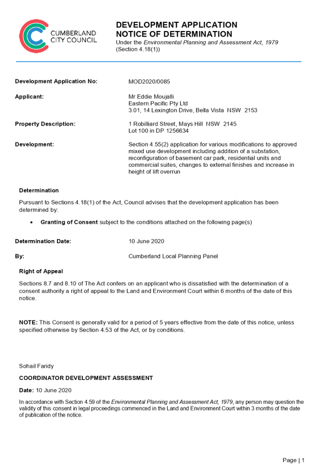
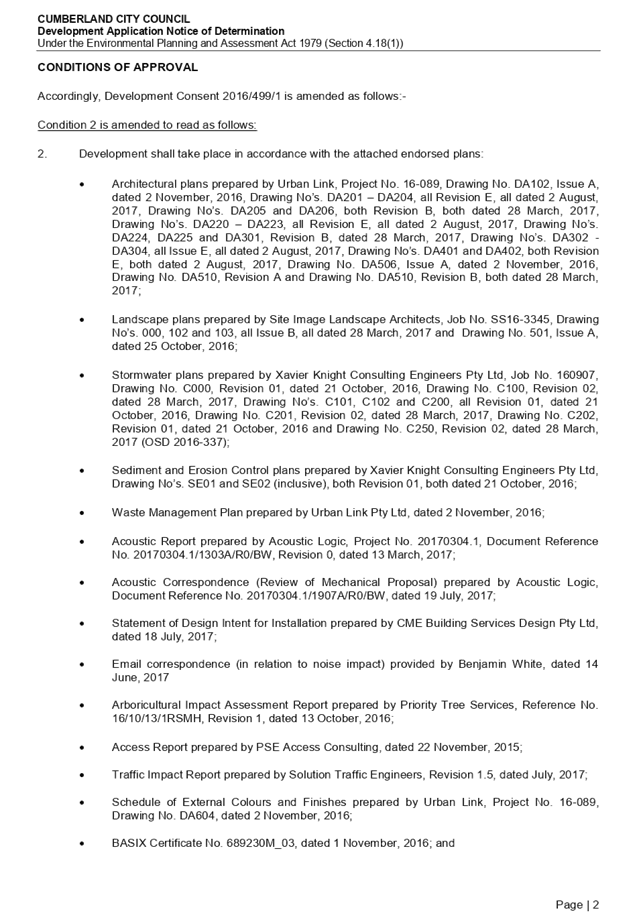
DOCUMENTS
ASSOCIATED WITH
REPORT LPP030/20
Attachment 2
Architectural Plans
Cumberland Local Planning Panel Meeting
10 June 2020
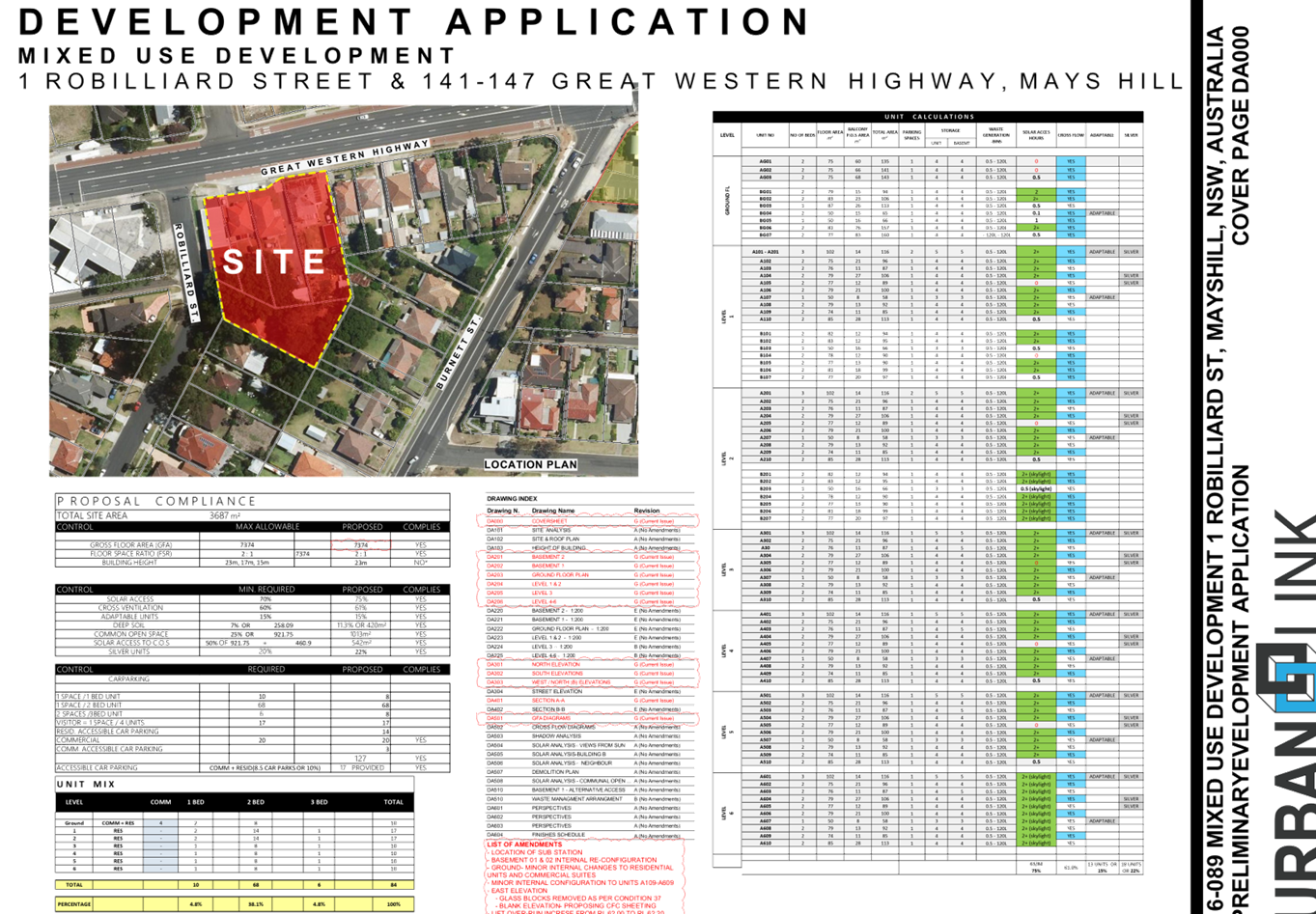
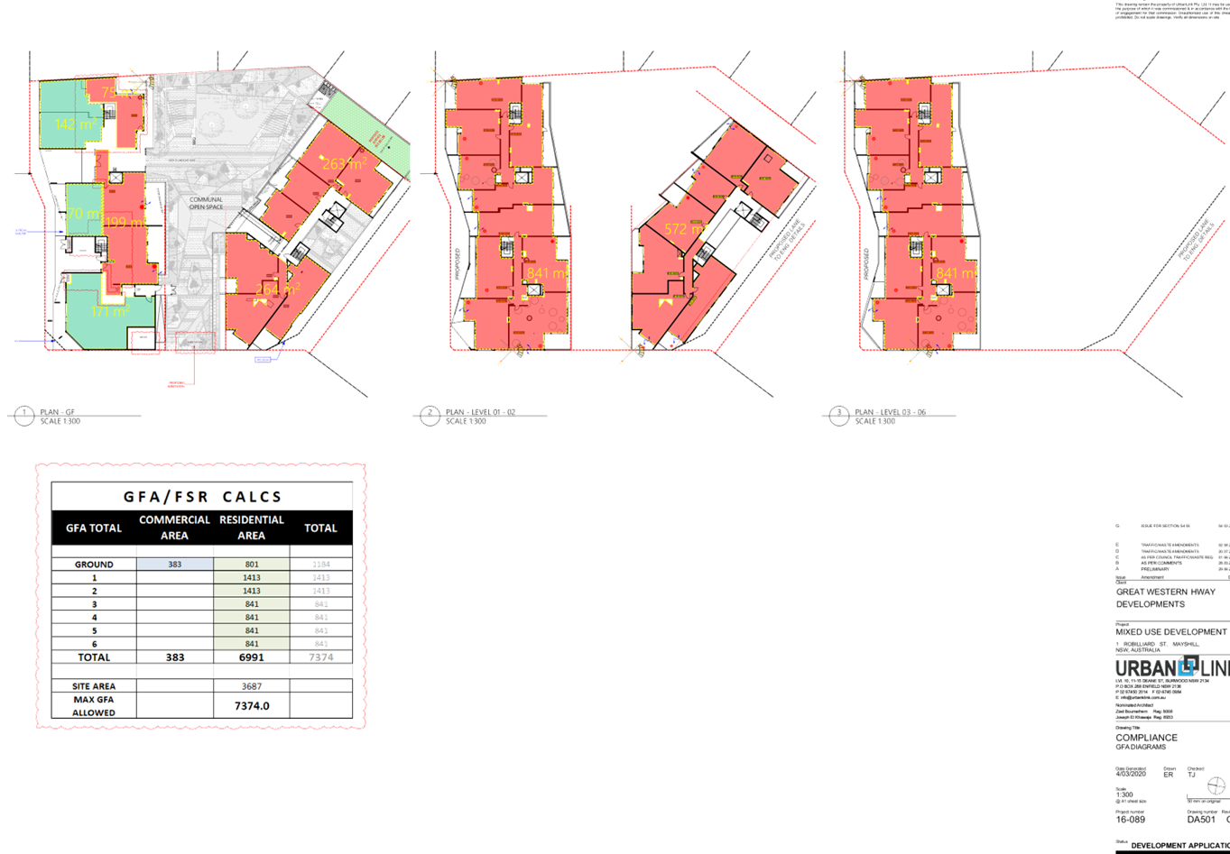
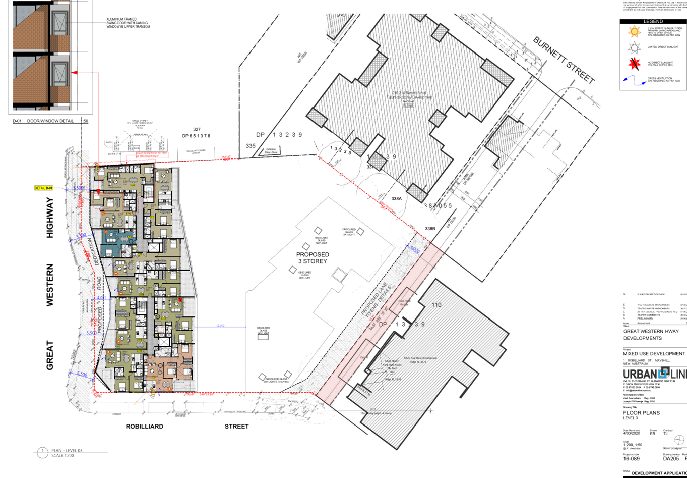
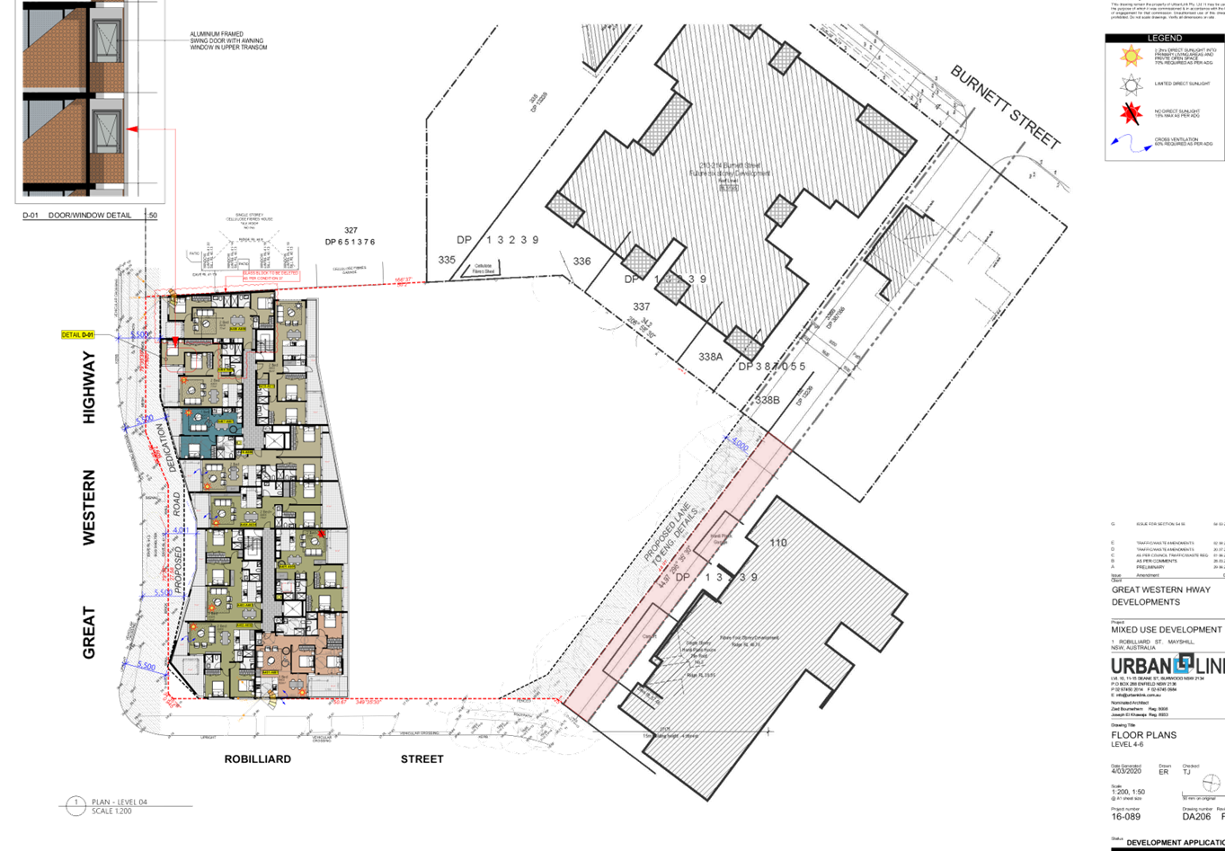
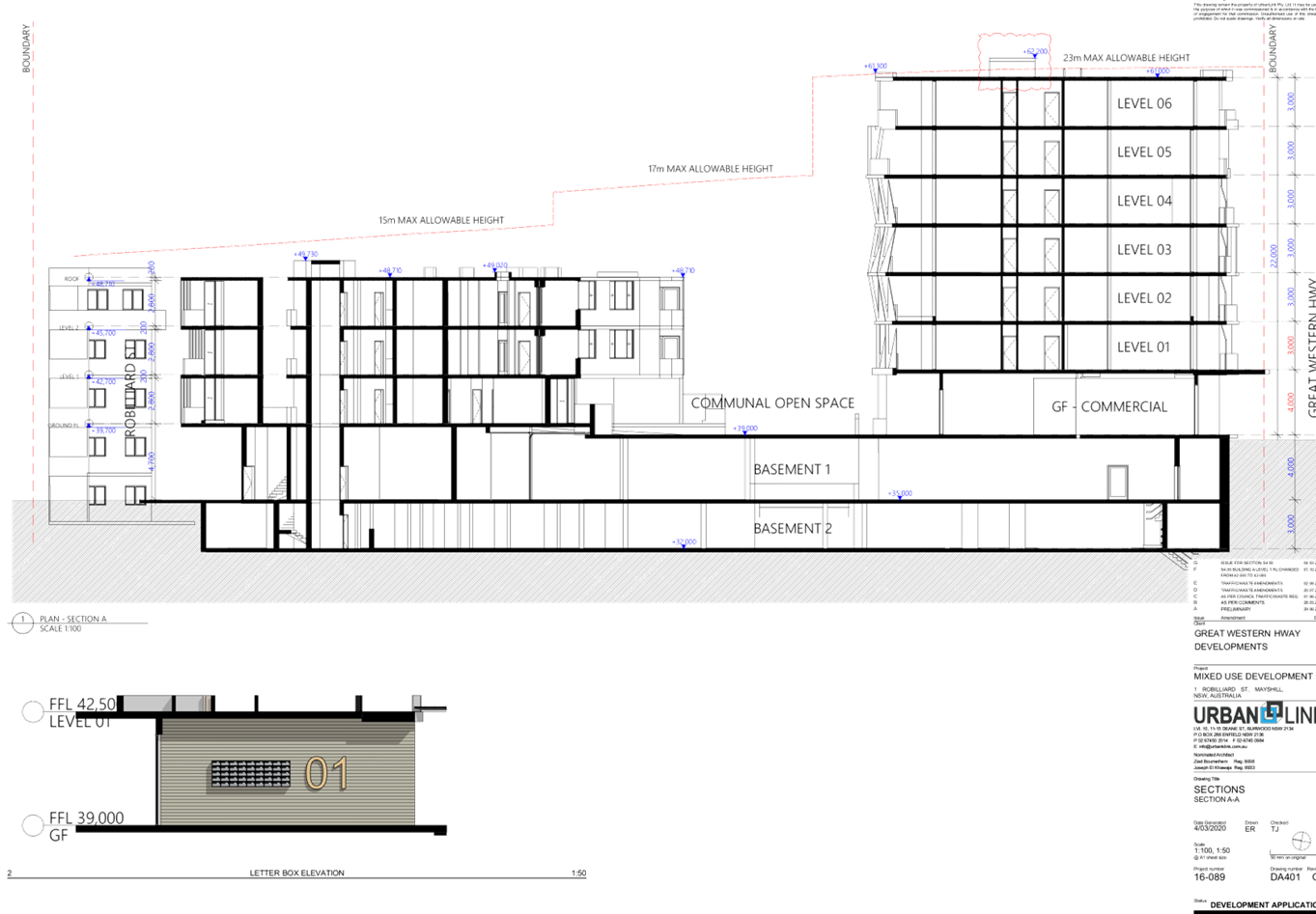
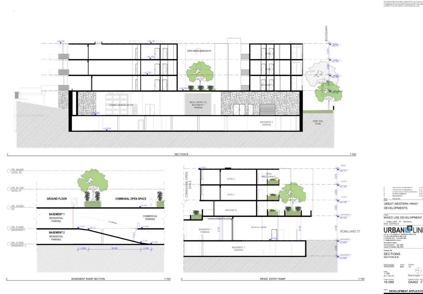
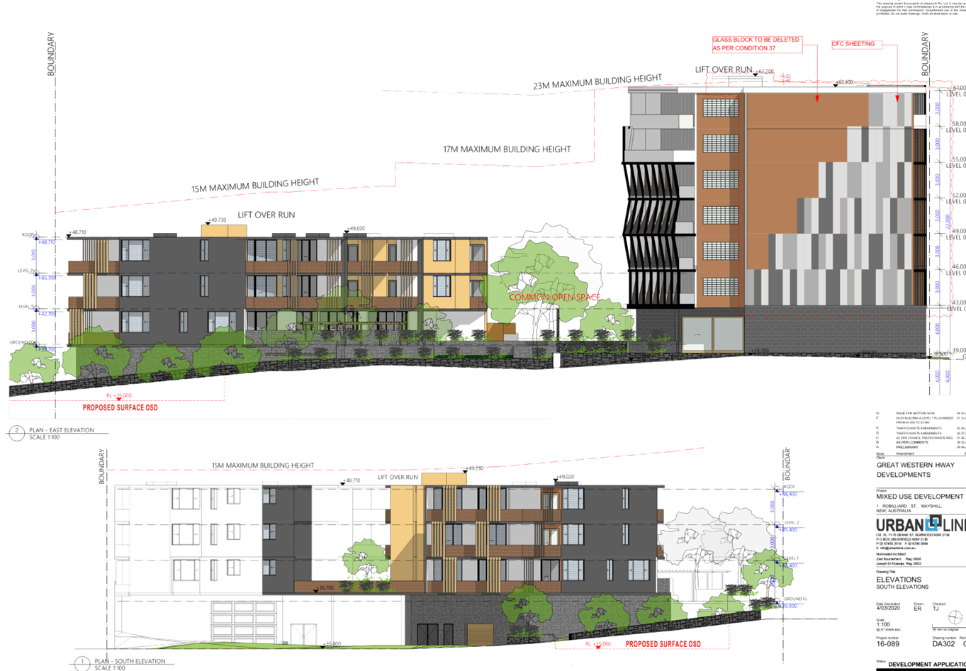
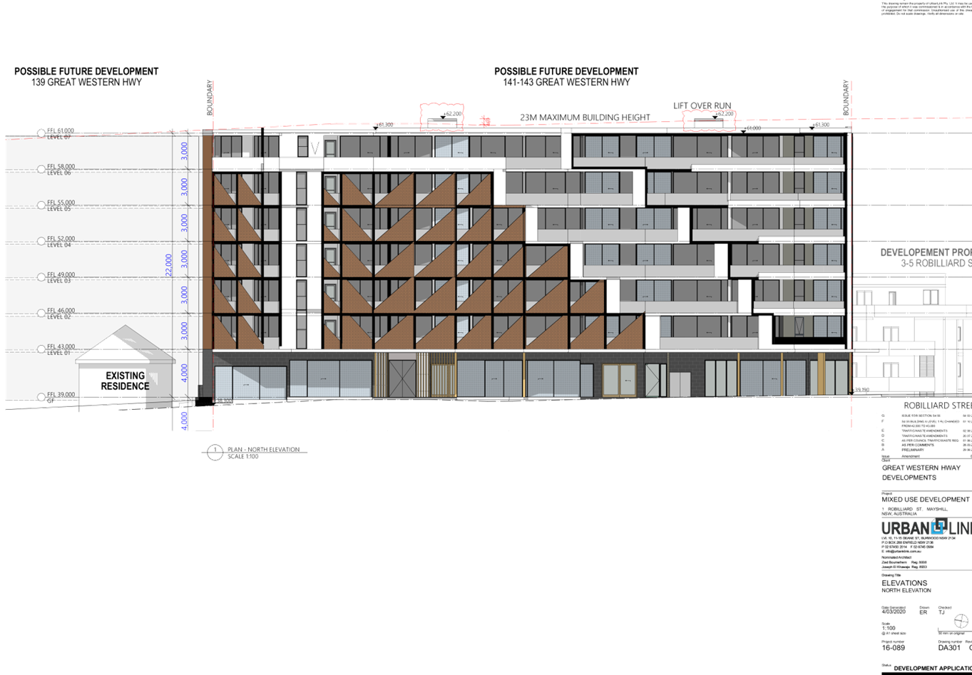
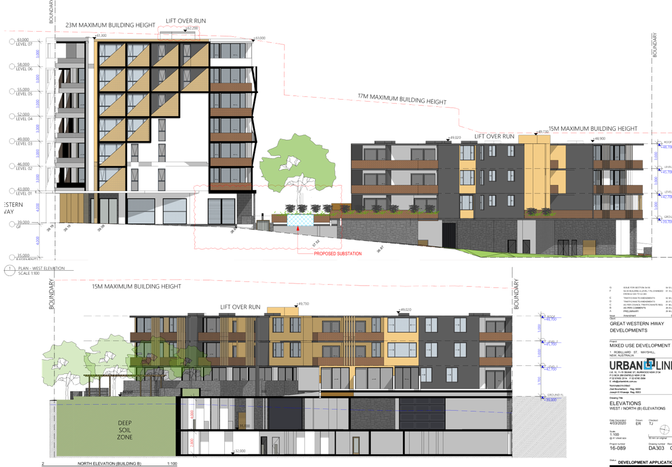
DOCUMENTS
ASSOCIATED WITH
REPORT LPP030/20
Attachment 3
Statement of Environmental Effects and Design
Verification Statement
Cumberland Local Planning Panel Meeting
10 June 2020
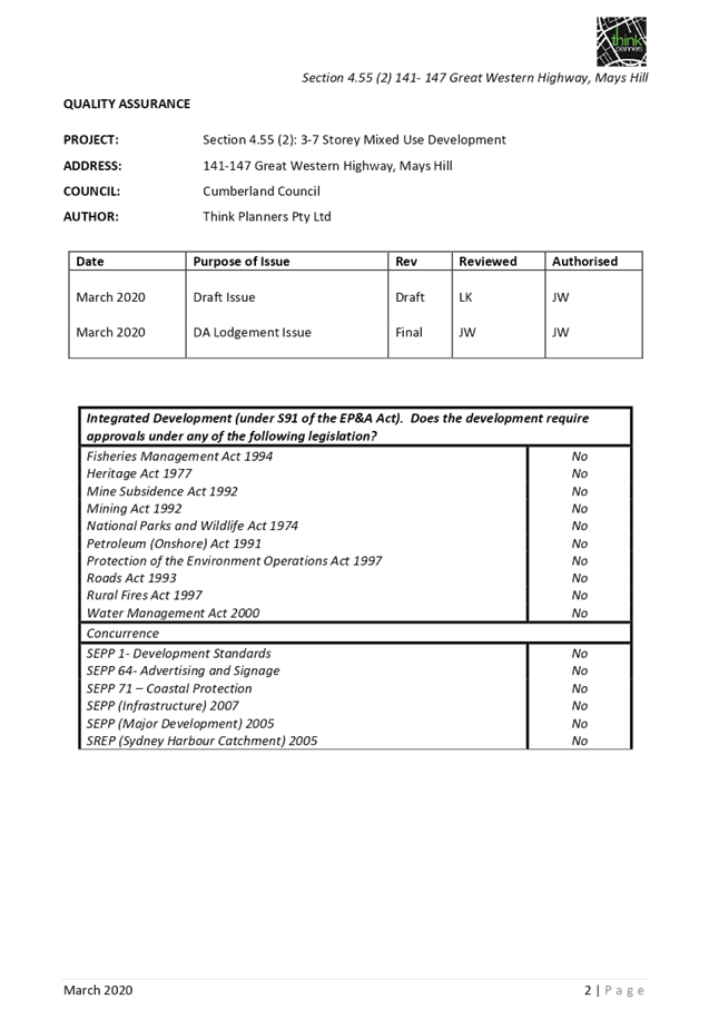
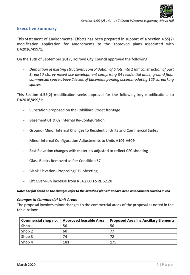
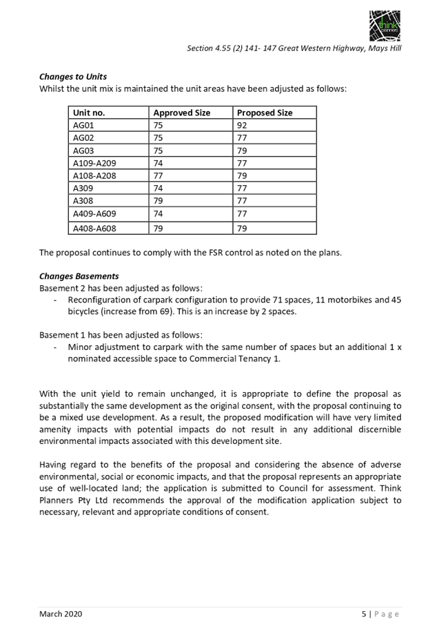
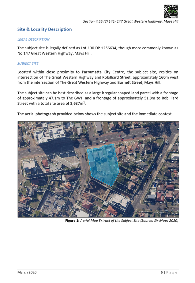
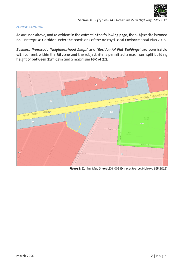


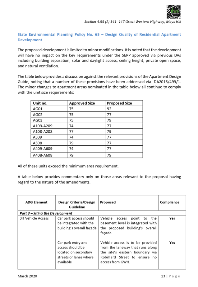
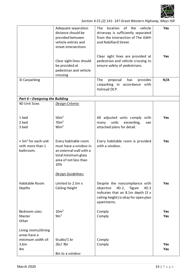
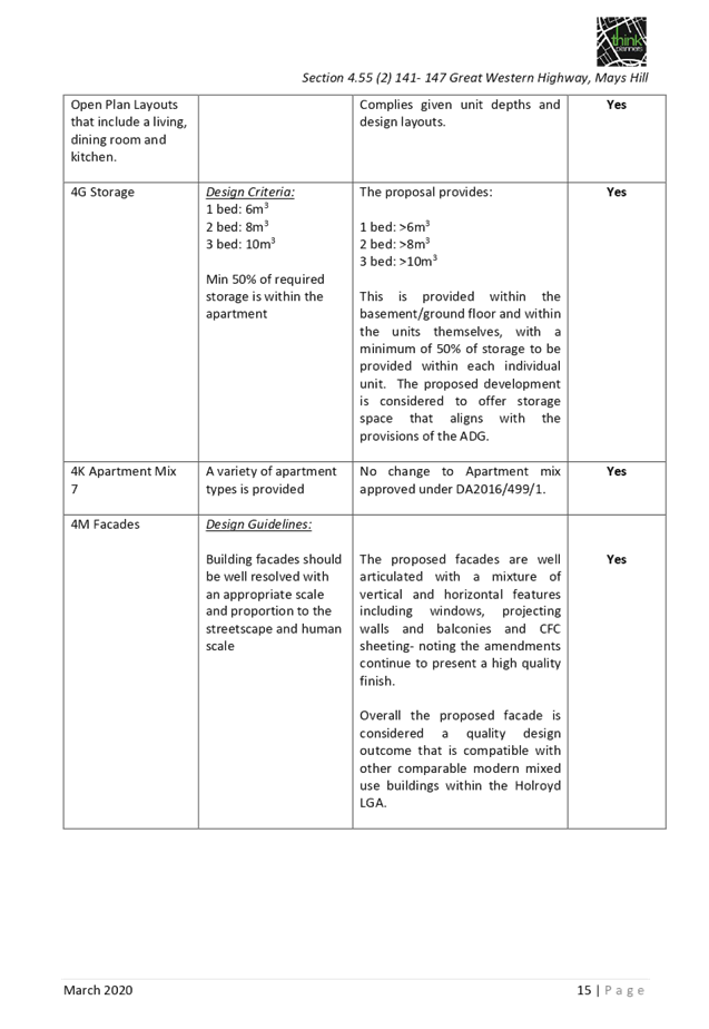
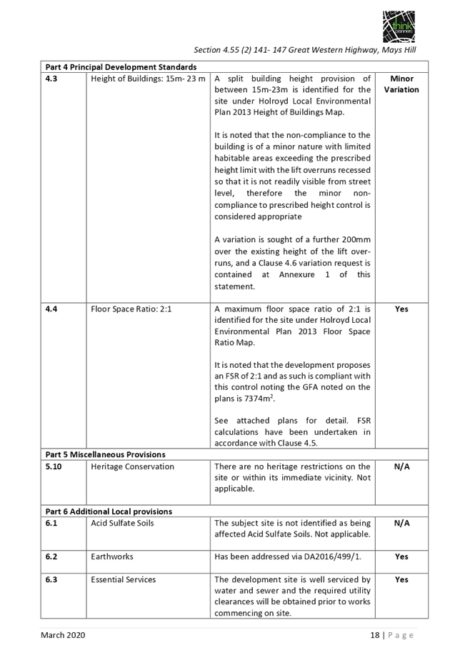
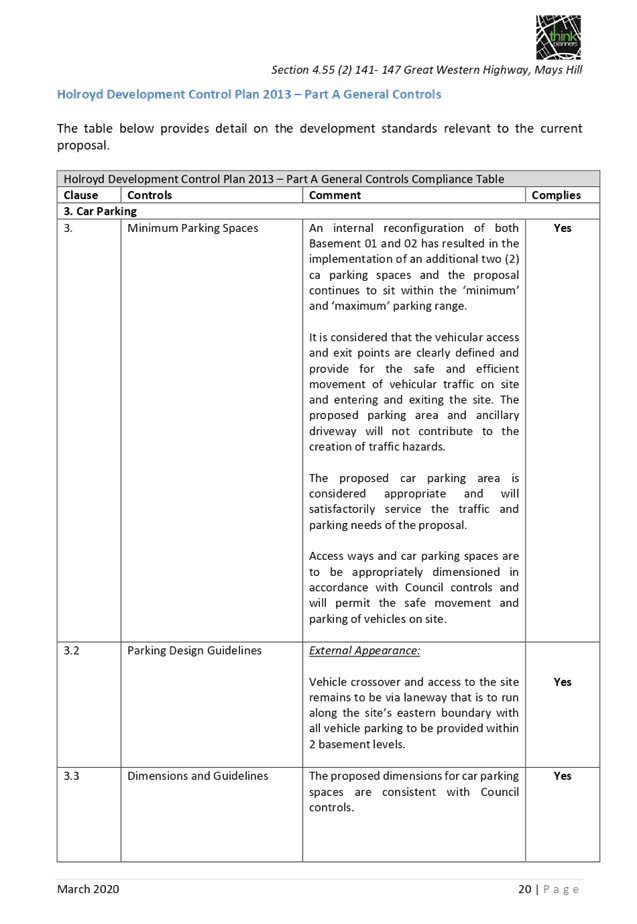
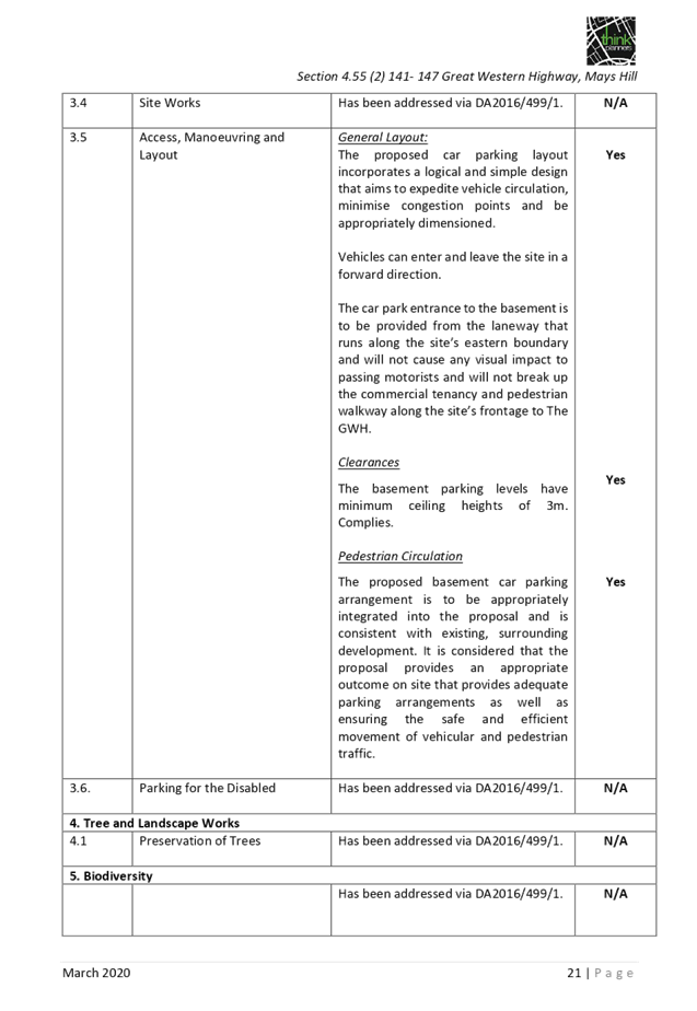
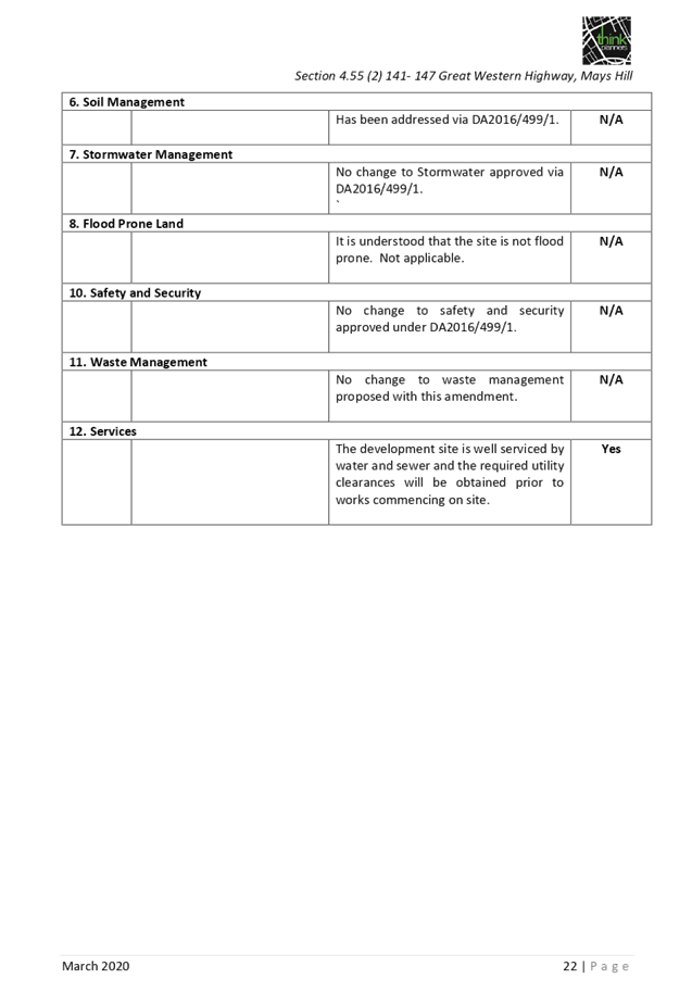
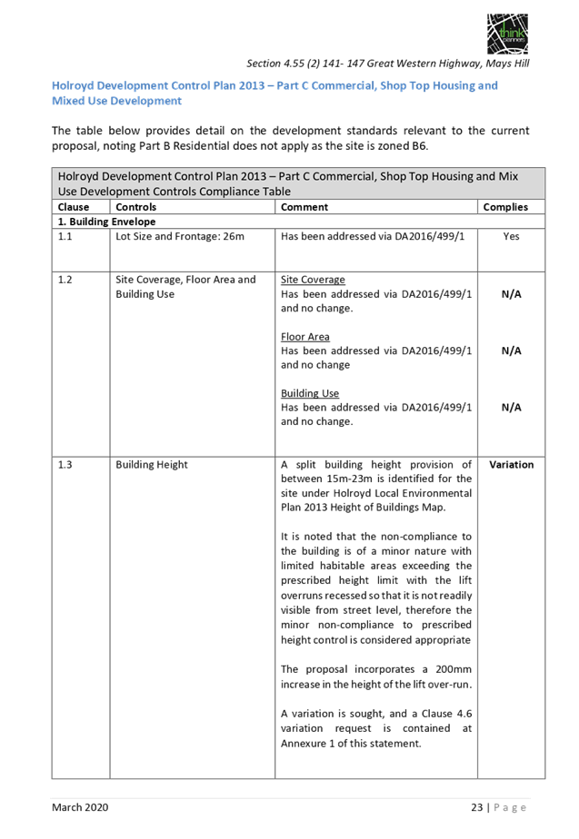
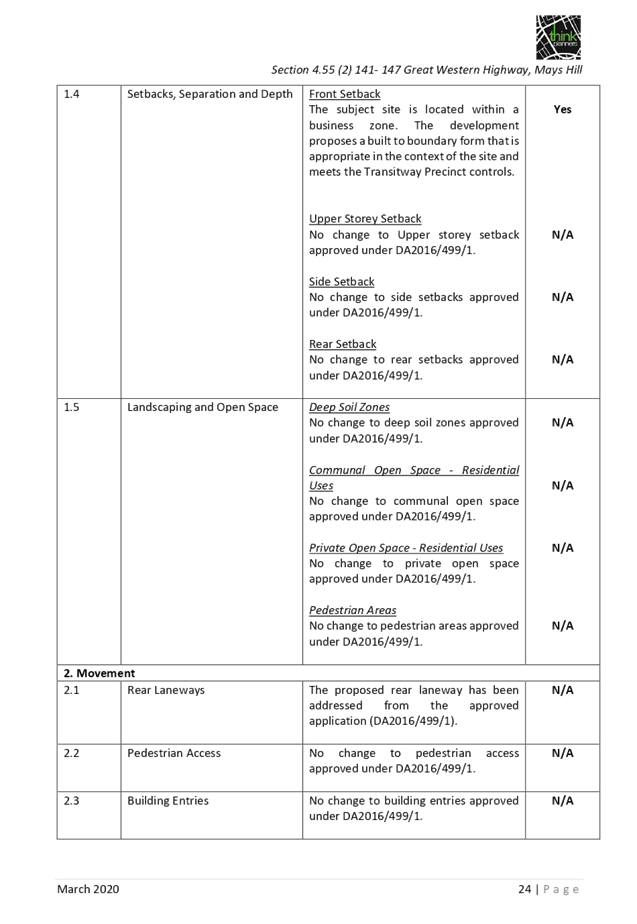
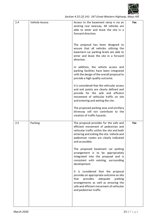
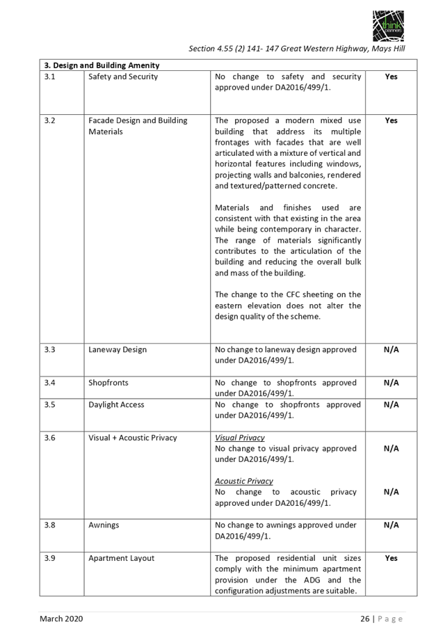
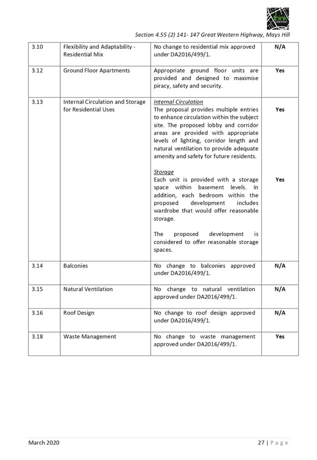
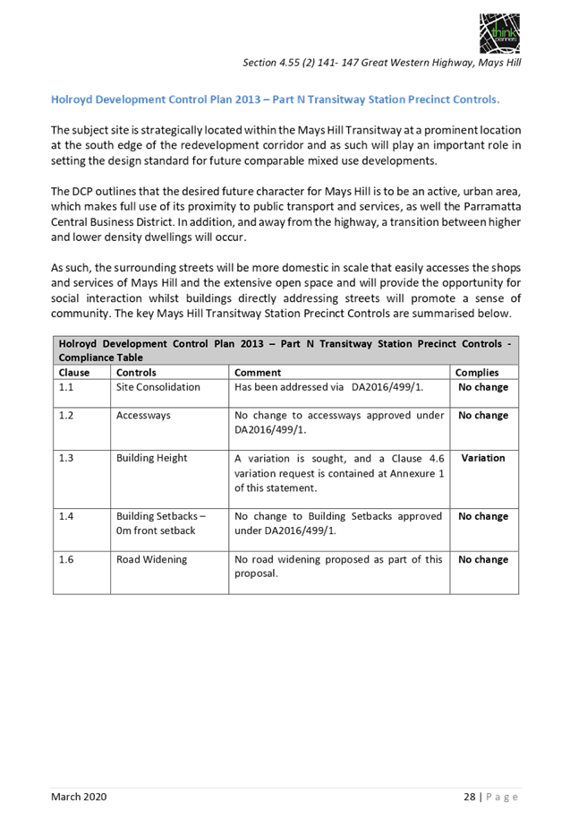

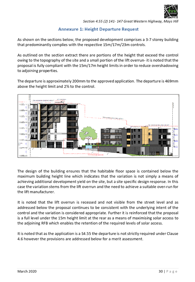

DOCUMENTS
ASSOCIATED WITH
REPORT LPP030/20
Attachment 4
Original Development Consent
Cumberland Local Planning Panel Meeting
10 June 2020
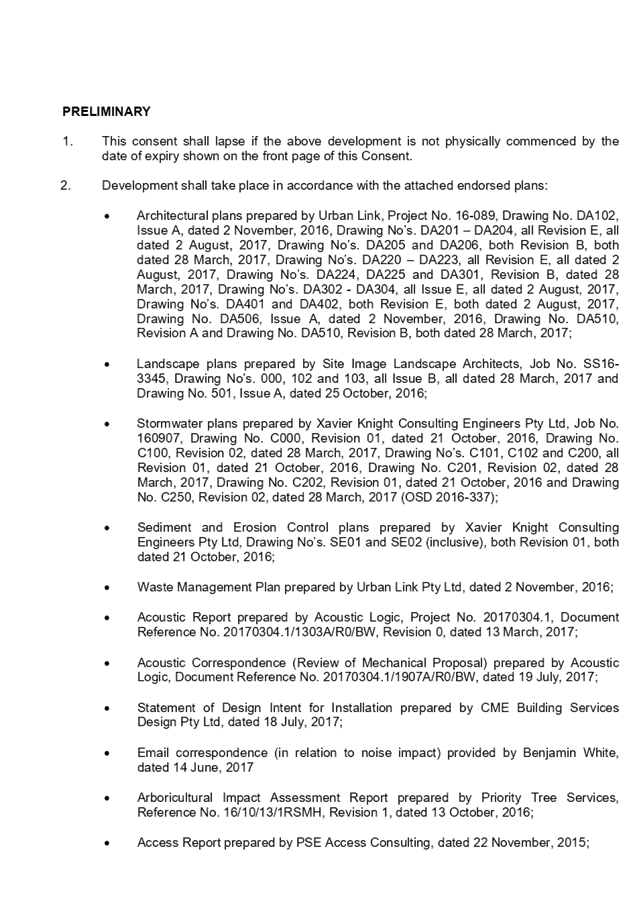
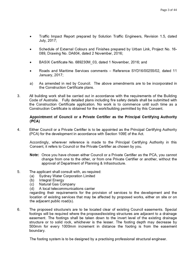


DOCUMENTS
ASSOCIATED WITH
REPORT LPP030/20
Attachment 5
Appendix A - SEPP 65 Design Quality of Residential
Apartment Development
Cumberland Local Planning Panel Meeting
10 June 2020
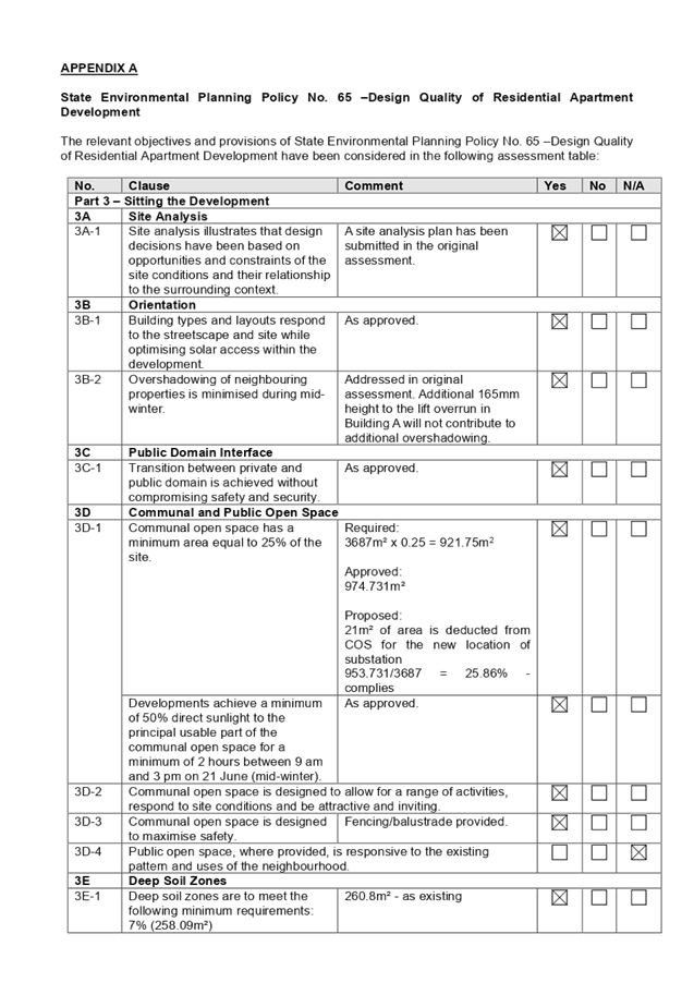
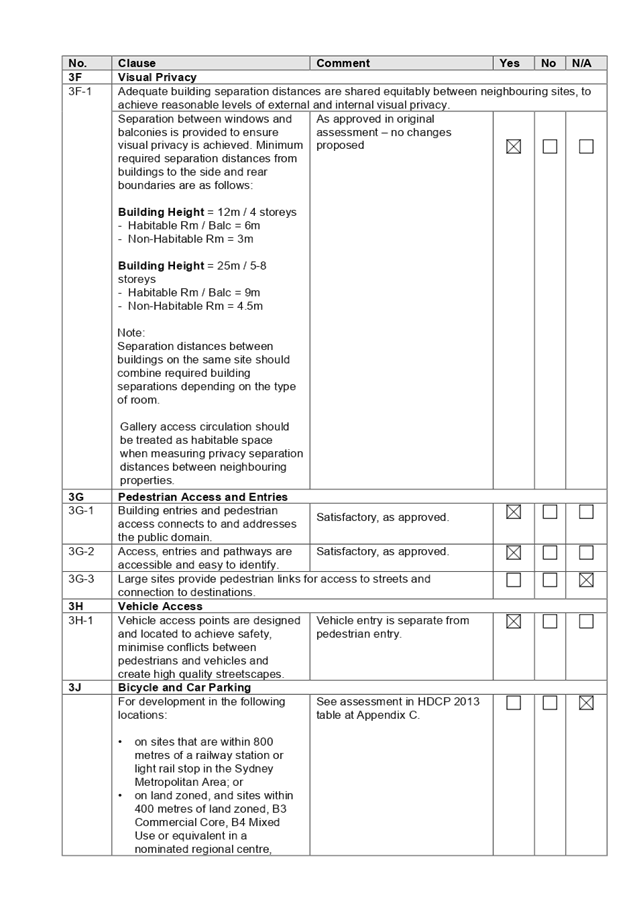
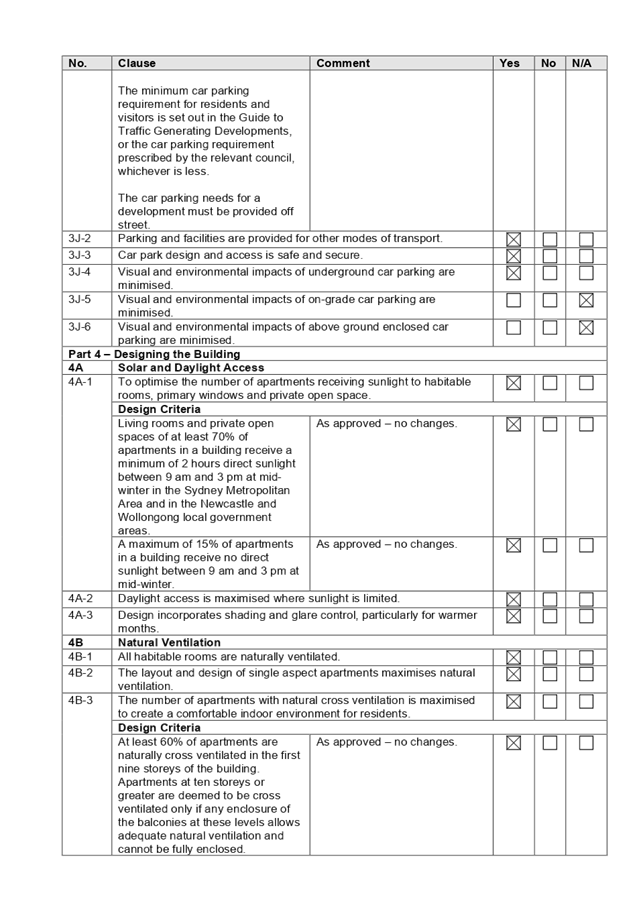
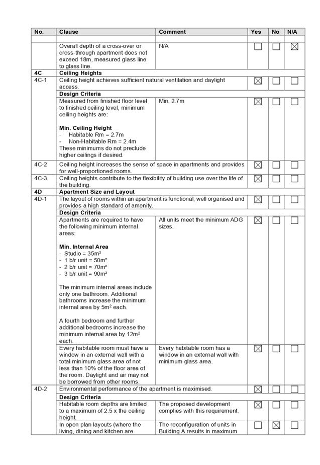
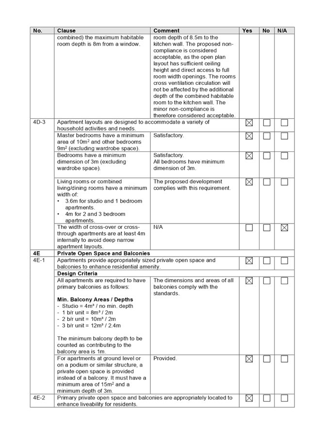

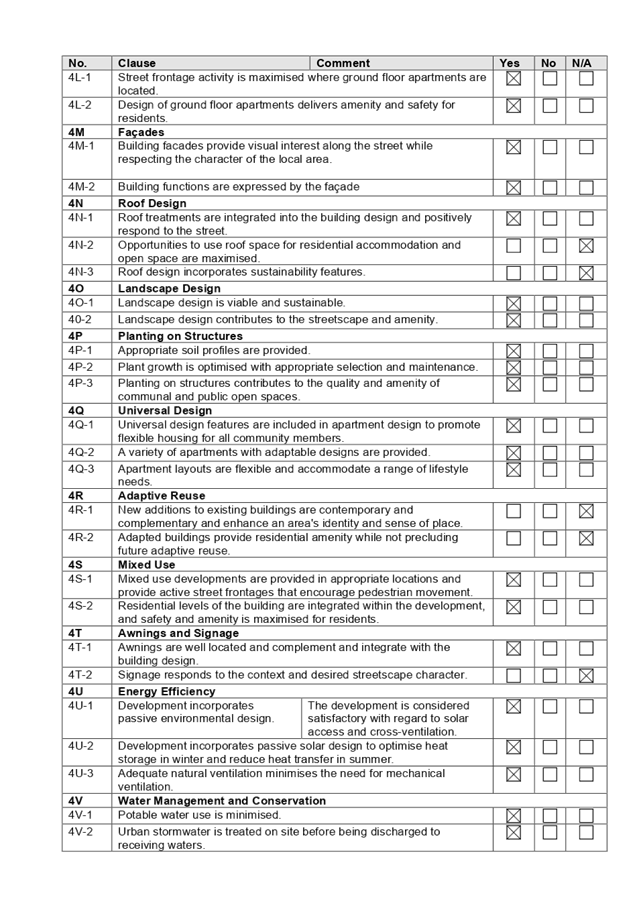

DOCUMENTS
ASSOCIATED WITH
REPORT LPP030/20
Attachment 6
Appendix B - Holroyd LEP 2013
Cumberland Local Planning Panel Meeting
10 June 2020
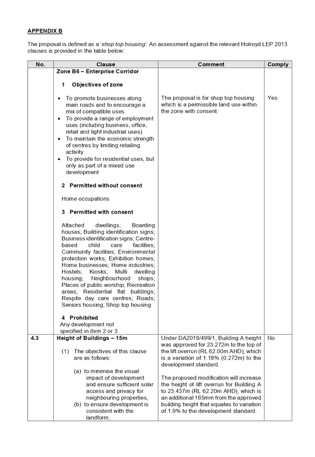
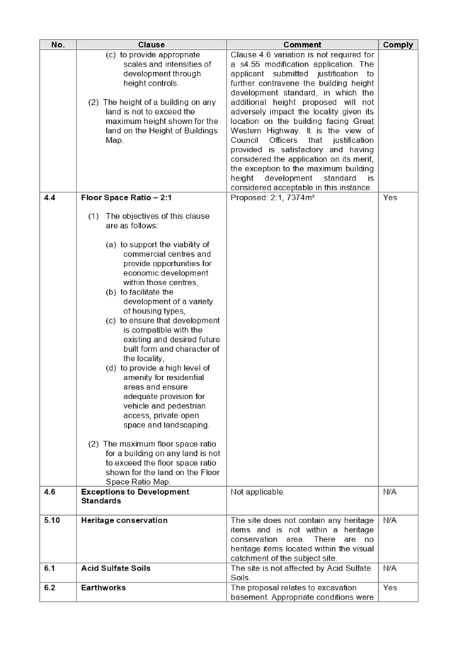

DOCUMENTS
ASSOCIATED WITH
REPORT LPP030/20
Attachment 7
Appendix C - Holroyd Development Control Plan
Cumberland Local Planning Panel Meeting
10 June 2020
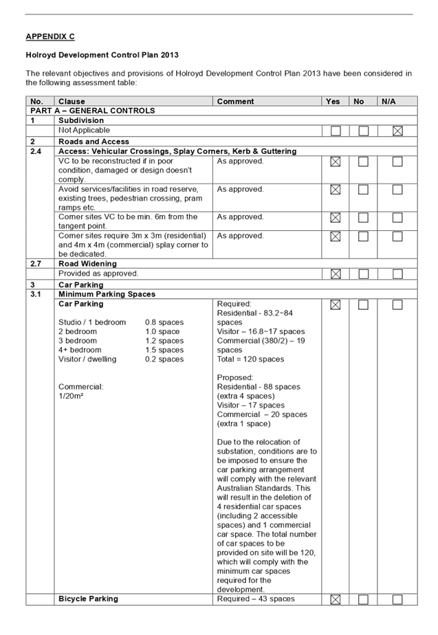
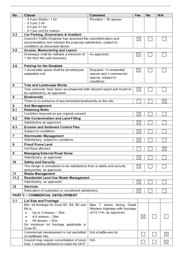
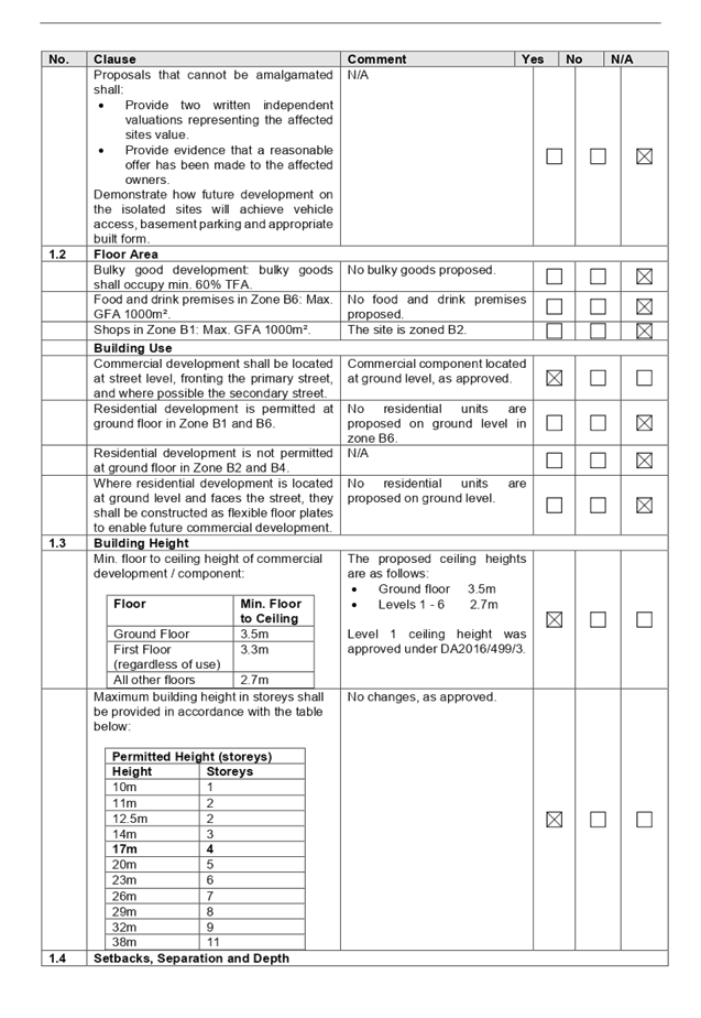
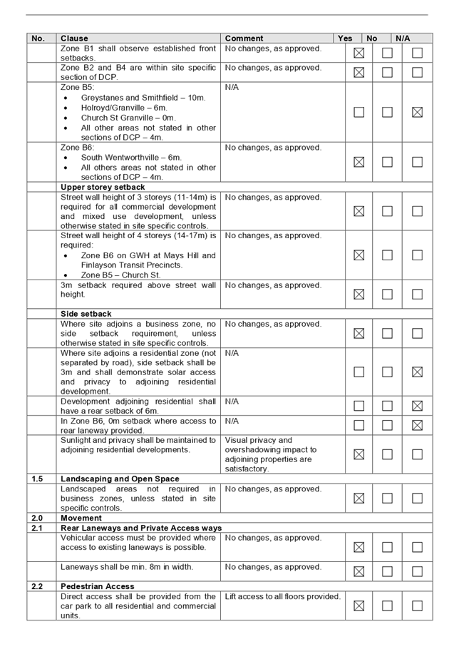
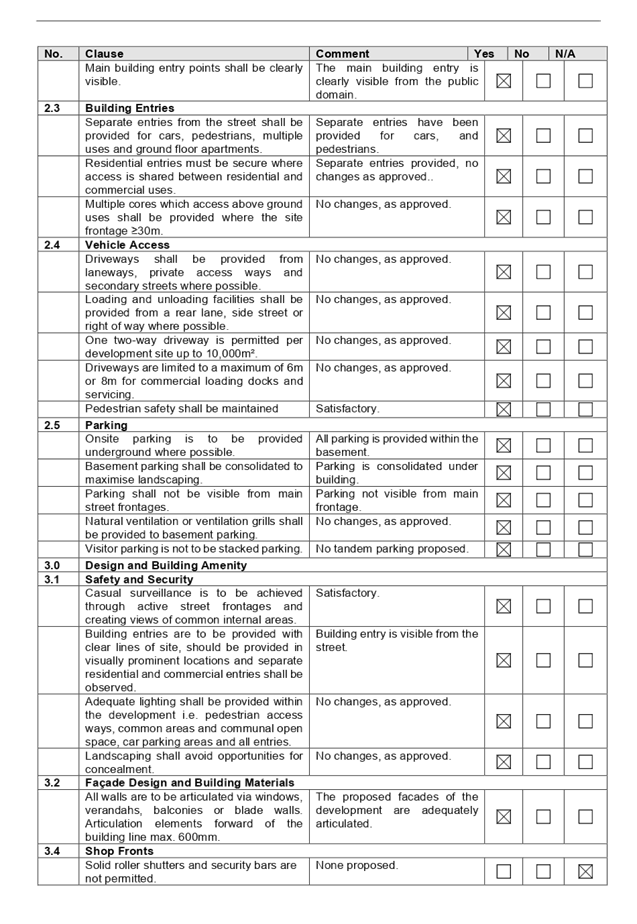

Cumberland
Local Planning Panel Meeting
10 June 2020
Item
No: LPP031/20
Development
Application for Wyatt park Church Street, Lidcombe
Responsible
Division: Environment
& Planning
Officer: Executive
Manager Development and Building
File
Number: DA2020/0154
|
Application lodged
|
12
March 2020
|
|
Applicant
|
Stimson
& Baker Planning
|
|
Owner
|
The
Minister For Lands & Cumberland City Council
|
|
Application No.
|
DA2020/0154
|
|
Description of Land
|
Wyatt
Park Church Street LIDCOMBE NSW 2141
Lot
1 DP 581438 & Lot 2 DP 581438
|
|
Proposed Development
|
Fitout and use of a portion of
the existing Police Citizens Youth Club (PCYC) as an out of school hours care
facility
|
|
Site Area
|
6.5
hectares
|
|
Zoning
|
RE1
Public Recreation Zone
|
|
Disclosure of political donations and gifts
|
Nil
disclosure
|
|
Heritage
|
Yes
– Heritage Listed I40 - ‘Wyatt
Park, Haslams Creek, Lidcombe Pool, Lidcombe Oval, Stormwater Drain’ of
local significance
|
|
Principal Development Standards
|
N/A
|
|
Issues
|
Nil
|
1. Development
Application No. DA2019/0524 was received on 12 March 2020 for the Fitout and
use of a portion of the existing Police Citizens Youth Club (PCYC) as an out of
school hours care facility.
2. The
application was publicly notified to occupants and owners of the adjoining
properties for a period of fourteen (14) days between 6 May 2020 and 20 May
2020. In response, no submissions were received.
3. The
subject site is listed as a heritage item in the Auburn Local Environmental
Plan 2010, being I40 which comprises park land bounded by Olympic Drive and
Boorea Street, Percy Street and Church Street. The item is identified as
‘Wyatt Park, Haslams Creek, Lidcombe Pool, Lidcombe Oval, Stormwater
Drain’ and is of local significance. The proposed development will have
minimal impact on the heritage item and is considered satisfactory, having
regard to the provisions of Clause 5.10(4) of the Auburn Local Environmental
Plan 2010.
4. The
application is recommended for conditional approval, subject to the conditions
as provided in the attached schedule.
5. The
application is referred to the Cumberland Local Planning Panel for
determination as the development is proposed on land for which Council is the
landowner, resulting in a conflict of interest.
Subject Site and Surrounding
Area
The subject site comprises Lots 1
and 2 in DP 581438 and has a total area in the order of 6.5 hectares.
Improvements on the site include the existing PCYC building (the subject of
this application), netball courts, basketball courts, oval and indoor
basketball centre on Lot 1 and an existing single storey brick and tile
building, with an attached awning, which is used as Netball Clubhouse on Lot 2.
Other improvements across the site include picnic shelters, amenities and car
parking. Car parking associated with the PCYC building is across both Lots 1
and 2.
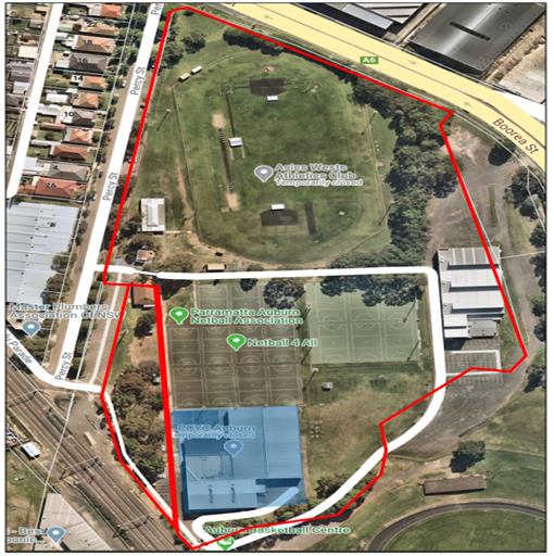
Figure
1: Aerial view of subject site – Lots 1 & 2 DP 581438
outlined red and the existing PCYC building shaded blue
Lots 1 and 2 in DP 581438 form
part of a larger landholding, bound by Olympic Drive, Church Street, Boorea
Street and Percy Street which comprises Wyatt Park. The total area of Wyatt
Park is 216,352m2 and Lots 1 and 2 are situated in the north-western portion of
the park. Other features within Wyatt Park include:
· Lidcombe
Oval;
· Netball
Clubhouse;
· Auburn
Youth Centre;
· Netball
Courts;
· Auburn
Basketball Centre; and
· Auburn
Ruth Everuss Aquatic Centre.
The park is utilised for a range
of passive and active recreation uses.
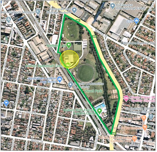
Figure
2: Locality Plan of subject site in relation to Wyatt Park - Wyatt
Park outlined in green and location of the existing PCYC building denoted by
yellow circle
Background
On 2 May 2014 Council granted
development consent to DA2014/91, for alterations and additions to the Anne
Clarke Netball Centre for purpose of a community facility for use by the Police
Citizens Youth Club (PCYC). The existing PCYC building has the approved hours
of operation of 6am to 11pm daily and a total of 50 off-street car parking
spaces were approved for the development.
There have been two (2) subsequent
modifications to DA2014/91, namely to address the preparation of food at the
premises, use of public address system, car parking layout and internal
alterations, including the installation of a kitchen.
The premises is currently subject
to a lease agreement with Council, as delineated in the plan below. This lease
is currently valid to 31 March 2036.

Figure 3: Existing
PCYC lease boundary shown hatched (extract of Draft Wyatt Park Plan of
Management)
Description of the Proposed Development
Council has received a development
application seeking consent for the use of part of the existing PCYC building
as an out of school hours care facility.
The existing PCYC building
comprises a community facility which provides sporting, recreation and youth
support services to the community.
Consent is sought as part of this
application to utilise part of the existing PCYC building for the purpose of an
out of school hours care facility for a maximum of 60 children. Kidzcare, a
government-subsidised after-school and vacation care program for children from
Kindergarten to Year 6, inclusive, are proposing to operate from the site. The
proposed out of school hours and vacation care use will utilise part of the
existing PCYC building, with no works proposed as part of this application.
The existing ground floor
amenities, canteen and office will be used as well as the first floor amenities
and three existing rooms, as illustrated in Figure 3 below.
The proposed hours of operation
are 3pm to 6pm during school term and 8.30am to 5.30pm Monday to Friday in
school holiday periods. During these hours children are involved in a number of
organised games and activities, including physical and creative activities in a
social environment.
The facility proposes to operate a
minibus service, which collects children from school of an afternoon and
transports them to the out of school hours care facility, with parents then
collecting children from the facility.
The minibus would drop the
children off at the far side of the building and walk the children around the
rear of the building to the entrance. This location was informed by a risk
assessment which determined that the location of bus drop of is less congested,
with minimal parked cars and is a better location for the bus to turn around
safely.
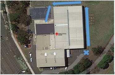
Figure
4: Proposed minibus drop off point with children to be walked
around the rear of the building to the entrance (Warwick Stimson)
No signage is proposed and no
vegetation removal is proposed.
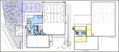
Figure 5: Proposed
use of existing building – ground floor amenities, office and canteen
shaded light blue, outdoor space shaded dark blue and first floor indoor play
rooms shaded yellow with associated first floor amenities shaded light blue
(Nimbus Architecture + Heritage)
An outdoor play area has been proposed including the
existing netball court area adjacent to the building as well as a vegetated
area to the west of the netball court. It is acknowledged that the vegetated
area is beyond the area of the existing PCYC lease. For this reason, as well as
the future plans identified for the vegetated area in Council’s Draft
Wyatt Park Plan of Management (POM), the netball court area has been considered
for the purpose of outdoor play area, as discussed further in this report.
Applicants Supporting Statement
The applicant has provided a Statement of Environmental
Effects prepared by Stimson & Baker Planning dated January 2019 and was
received by Council on 12 March 2020, in support of the application.
Contact with Relevant Parties
The assessing officer has undertaken a site inspection of
the subject site and surrounding properties and has been in regular contact
with the applicant throughout the assessment process.
Internal Referrals
Development Engineer
The development application was referred to Council’s
Development Engineer for comment who has advised that the development proposal
is satisfactory and therefore can be supported subject to recommended
conditions of consent.
Building Surveyor
The development application was referred to Council’s
Building Surveyor for comment who has advised that the development proposal is
satisfactory and therefore can be supported subject to recommended conditions
of consent. Council’s Building Surveyor has confirmed that the existing
building class does not change, i.e. it remains Class 9b.
Landscape
The development application was referred to Council’s
Tree Management Officer for comment who has reviewed the proposed development
having regard to the provisions of Council’s Draft Wyatt Park POM
(Revision 3, 2018) and advised the following:
· the
current proposal conforms with the multi use compatibility objectives outlined
in the draft POM, particularly in relation to the retrofitting and re-purposed
use of an existing built structure.
· Other
relevant objectives of the POM include minimisation of fencing generally.
· The
Landscape Masterplan within the draft POM proposes a public play facility in
the near vicinity to the proposed outdoor area. Whilst the proposed public play
facility and outdoor area are compatible, dividing the space with a fence
enclosure would not be a favourable outcome.
· The
Draft POM, Figure 7 (p.54): Existing and recently expired use and management
agreements, details a Police Citizens Youth Club NSW (expires 31.03.36) lease
area which does not fully coincide with the proposed outdoor area as proposed
in the application. The contradiction between the proposed outdoor area and
current lease area needs to be reviewed and/or rationalised.
Having regard to the above, as part of the assessment
process, it has been deemed necessary to amend the proposed scope of the
outdoor play area, to ensure that it is contained within the existing lease
boundary, i.e. the netball court area. The area is identified in the Draft POM
for a future public play facility. Further, the landscape comments stating that
the fencing of this space would not present a favourable outcome, raises
concerns with respect to the safety of children in this area, due to the
proximity of the vegetated area to the existing car parking area, being in the
order of 5 metres. For these reasons, it is considered appropriate to reduce
the scope of the play area and a condition of consent has been recommended
accordingly.
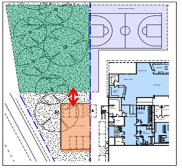
Figure 6: Proposed
vegetated outdoor play area shaded green and existing carparking area shaded
orange, to demonstrate distance of proposed play area to carpark
Environmental Health Unit
The development application was referred to Council’s
Environmental Health Unit for comment who have advised that the development
proposal is satisfactory and therefore can be supported subject to recommended
conditions of consent.
External Referrals
The application was not required to be referred to any
external government authorities for comment.
PLANNING COMMENTS
The provisions of any Environmental Planning Instruments
(EP&A Act s4.15 (1)(a)(i))
State Environmental Planning Policies
The proposed development is affected by the following State
Environmental Planning Policies:
(a) State
Environmental Planning Policy No. 55 – Remediation of Land (SEPP 55)
Clause 7 of SEPP 55 requires
Council to be satisfied that the site is suitable or can be made suitable to
accommodate the proposed development. The matters listed within Clause 7 have
been considered in the assessment of the development application.
Figure 4 – SEPP
55 Compliance Table
|
Matter for
Consideration
|
Yes/No
|
|
Does the application
involve re-development of the site or a change of land use?
|
Yes No
|
|
In the development
going to be used for a sensitive land use (e.g.: residential, educational,
recreational, childcare or hospital)?
|
Yes No
|
|
Does information available to you indicate that an
activity listed below has ever been approved, or occurred at the site?
acid/alkali plant and
formulation, agricultural/horticultural activities, airports, asbestos
production and disposal, chemicals manufacture and formulation, defence
works, drum re-conditioning works, dry cleaning establishments, electrical
manufacturing (transformers), electroplating and heat treatment premises,
engine works, explosive industry, gas works, iron and steel works, landfill
sites, metal treatment, mining and extractive industries, oil production and
storage, paint formulation and manufacture, pesticide manufacture and
formulation, power stations, railway yards, scrap yards, service stations,
sheep and cattle dips, smelting and refining, tanning and associated trades,
waste storage and treatment, wood preservation
|
Yes No
|
|
Is
the site listed on Council’s Contaminated Land database?
|
Yes No
|
|
Is
the site subject to EPA clean-up order or other EPA restrictions?
|
Yes No
|
|
Has
the site been the subject of known pollution incidents or illegal dumping?
|
Yes No
|
|
Does
the site adjoin any contaminated land/previously contaminated land?
|
Yes No
|
|
Has the appropriate level of
investigation been carried out in respect of contamination matters for
Council to be satisfied that the site is suitable to accommodate the proposed
development or can be made suitable to accommodate the proposed development?
|
Yes No
|
|
The
site is not identified in Council’s records as being contaminated. A
site inspection reveals the site does not have any obvious history of a
previous land use that may have caused contamination and there is no specific
evidence that indicates the site is contaminated.
It
is acknowledged that the application was accompanied by a Preliminary Site
Investigation (PSI) prepared by Geotechnique Pty Ltd, which provided a
contamination assessment for the vegetated land to the west of the existing
netball courts, proposed to be included in the outdoor play area. Through the
assessment of the application, it was determined that, as this area is beyond
the existing PCYC lease area, this land would not form part of the
recommended approved development.
On
this basis, the site is considered suitable for the proposed development,
having regard to the provisions of Clause 7 of SEPP 55.
|
(b) State
Environmental Planning Policy (Infrastructure) 2007 (ISEPP)
The provisions of the ISEPP 2007
have been considered in the assessment of the development application.
Clause 85 – Development
adjacent to railway corridors
The site is adjacent to an
existing rail corridor and the development has been assessed against the
provisions of Clause 85(1). The development is not likely to have an adverse
effect on rail safety; no works are proposed and the development is seeking
consent for the use of part of the existing building. Further, the development
does not involve the placing of a metal finish, will not involve the use of a
crane in airspace above the rail corridor and is not located within 5 metres of
an exposed overhead electricity powerline that is used for the purpose of
railways or rail infrastructure facilities.
Clause 86 – Excavation
in, above, below or adjacent to rail corridors
The proposed development does not
involve any excavation works to a depth of 2 metres and the provisions of
Clause 86 are therefore not applicable.
Clause 87 – Impact of
rail noise or vibration on non-rail development
The proposed development is for
the purpose of a centre-based child care facility and the provisions of Clause
87 are therefore applicable. The application has been reviewed by
Council’s Environmental Health Unit (EHU) who have advised that taking
into account the specifics of this proposal and the NSW Planning document
Development near rail corridors and busy roads – Interim Guideline, the
EHU will not be requesting a formal acoustic assessment as it is satisfied that
it is unlikely that the proposed development will be adversely impacted by rail
noise or vibration at this site.
Clause 101 – Frontage to
classified road
The development does not maintain
a frontage to a classified road and the provisions of Clause 101 of the ISEPP
are therefore not applicable.
Clause 102 – Impact of
road noise or vibration on non-road development
The application is not subject to
clause 102 of the ISEPP.
Clause 104 – Traffic
generation developments
The development is not traffic
generating development, pursuant to the provisions of Schedule 3 of the ISEPP
and Clause 104 is therefore not applicable.
(c) State
Environmental Planning Policy (Educational Establishments and Child Care
Facilities) 2017 – (Education SEPP)
The Education SEPP sets out a new
reform process for certain types of education and child care facilities to be
determined under exempt and complying development that will make it easier for
child-care providers, schools, TAFEs and universities to build new facilities
and improve existing ones by streamlining the planning process to save time and
money and deliver greater consistency across NSW.
Having regard to the above, the
application is identified as a ‘centre based child care’ and the
provisions of Part 3 of the Education SEPP are applicable to this application.
In this regard, the relevant provisions of Part 3 are discussed below:
|
Requirement
|
Yes/No
|
Comments
|
|
Part 3 Early education and care
facilities—specific development controls
|
|
22 Centre-based child care
facility—concurrence of Regulatory Authority required for certain development
(1) This clause applies to development for the
purpose of a centre-based child care facility if:
(a) the floor area of the
building or place does not comply with regulation
107 (indoor unencumbered space requirements) of the Education and Care Services National Regulations, or
(b) the
outdoor space requirements for the building or place do not comply
with regulation 108 (outdoor unencumbered space requirements) of those
Regulations.
|
N/A
|
The proposal complies with regulation 107 and 108 of the
Education and Care Services National Regulations and therefore does not
require concurrence from the Regulatory Authority.
Complies. The proposal
is consistent with these clauses as follows:
Indoor
|
Required 3.25m2
per child
|
Proposed
|
|
60 x 3.25 = 195m2
|
416m2
|
It is noted that a condition of consent has been
recommended requiring the installation of storage in the three play rooms.
Given the excess of indoor space provided, the installation of the storage
will still result in the proposal achieving compliance with this requirement.
Outdoor
|
Required 7m2
per child
|
Proposed
|
|
60 x 7 = 420m2
|
561m2
|
Indoor and outdoor
space has been calculated in accordance with the requirements, i.e. only
unencumbered space has been included towards the area calculations.
It is noted that the
outdoor space area has been reduced to the existing netball court area, to
ensure that the play area is wholly contained within the existing PCYC lease
boundary, the area above reflects the amended area.
|
|
23 Centre-based
child care facility—matters for consideration by consent authorities
Before determining a development application for
development for the purpose of a centre-based child care facility, the
consent authority must take into consideration any applicable provisions of
the Child Care Planning Guideline, in
relation to the proposed development.
|
Yes
|
An assessment of the development against the provisions of
the Child Care Planning Guideline is provided at Attachment 3 to this report.
|
|
24 Centre-based child care facility in Zone
IN1 or IN2—additional matters for consideration by consent authorities
|
N/A
|
Subject site is not located in these zones.
|
|
25
Centre-based child care facility—non-discretionary development
standards
(1)
The object of this clause is to identify development standards for particular
matters relating to a centre-based child care facility that, if complied
with, prevent the consent authority from requiring more onerous standards for
those matters.
(2)
The following are non-discretionary development standards for the purposes of
section 4.15 (2) and (3) of the Act in relation to the carrying out of
development for the purposes of a centre-based child care facility:
(a)
location—the development may be located at any distance from an
existing or proposed early education and care facility,
(b)
indoor or outdoor space
(i) for development to which regulation 107 (indoor
unencumbered space requirements) or 108 (outdoor unencumbered space
requirements) of the Education and Care Services National Regulations
applies—the unencumbered area of indoor space and the unencumbered area
of outdoor space for the development complies with the requirements of those
regulations, or
(ii) for development to which clause 28
(unencumbered indoor space and useable outdoor play space) of the Children
(Education and Care Services) Supplementary Provisions Regulation 2012
applies—the development complies with the indoor space requirements or
the useable outdoor play space requirements in that clause,
(c)
site area and site dimensions—the development may be located on a site
of any size and have any length of street frontage or any allotment depth,
(d)
colour of building materials or shade structures—the development may be
of any colour or colour scheme unless it is a State or local heritage item or
in a heritage conservation area.
(3)
To remove doubt, this clause does not prevent a consent authority from:
(a)
refusing a development application in relation to a matter not specified in
subclause (2), or
(b)
granting development consent even though any standard specified in subclause
(2) is not complied with.
|
Noted
Noted
Yes
N/A
Yes
Noted
Noted
|
Complies as discussed above.
N/A
The site is considered to be of a suitable area and width
to accommodate the proposed out of school hours care facility.
|
|
26
Centre-based child care facility—development control plans
(1)
A provision of a development control plan that specifies a requirement,
standard or control in relation to any of the following matters (including by
reference to ages, age ratios, groupings, numbers or the like, of children)
does not apply to development for the purpose of a centre-based child care
facility:
(a)
operational or management plans or arrangements (including hours of
operation),
(b)
demonstrated need or demand for child care services,
(c)
proximity of facility to other early education and care facilities,
(d)
any matter relating to development for the purpose of a centre-based child
care facility contained in:
(i) the design principles set out in Part 2 of the
Child Care Planning Guideline, or
(ii) the matters for consideration set out in Part
3 or the regulatory requirements set out in Part 4 of that Guideline (other
than those concerning building height, side and rear setbacks or car parking
rates).
(2)
This clause applies regardless of when the development control plan was made.
|
Noted
|
|
The Child Care Planning Guidelines also list matters for
consideration for this development application. This development application is
considered to satisfactorily address those matters listed. A full assessment
table is attached in Attachment 3 to this report.
Regional Environmental Plans
The proposed development is affected by the following
Regional Environmental Plans:
(a) Sydney
Regional Environmental Plan (Sydney Harbour Catchment) 2005
The subject site is identified as
being located within the area affected by the Sydney Regional Environmental
Plan (Sydney Harbour Catchment) 2005. The proposed development raises no issues
as no impact on the catchment is envisaged.
(Note: - the subject site is not
identified in the relevant map as ‘land within the ‘Foreshores and
Waterways Area’ or ‘Wetland Protection zone’, is not a
‘Strategic Foreshore Site’ and does not contain any heritage items.
Hence the majority of the SREP is not directly relevant to the proposed
development).
Local Environmental Plans
Auburn Local Environmental Plan 2010
The provision of the Auburn Local Environmental Plan 2010
(ALEP 2010) is applicable to the development proposal. It is noted that the
development achieves compliance with the key statutory requirements of the ALEP
2010 and the objectives of the RE1 Public Recreation land use zone.
(a) Permissibility:-
The proposed development is comprises the use of part of the
existing PCYC building as a ‘centre-based child care facility’,
which includes ‘out-of-school-hours care (including vacation care’:
centre-based child care facility means—
(a) a
building or place used for the education and care of children that provides any
one or more of the following—
(i) long
day care,
(ii) occasional
child care,
(iii) out-of-school-hours
care (including vacation care),
(iv) preschool
care, or
(b) an
approved family day care venue (within the meaning of the Children (Education
and Care Services) National Law (NSW)),
i)
but does not include—
(c) a
building or place used for home-based child care or school-based child care, or
(d) an
office of a family day care service (within the meanings of the Children
(Education and Care Services) National Law (NSW)), or
(e) a
babysitting, playgroup or child-minding service that is organised informally by
the parents of the children concerned, or
(f) a
child-minding service that is provided in connection with a recreational or
commercial facility (such as a gymnasium) to care for children while the
children’s parents are using the facility, or
(g) a
service that is concerned primarily with providing lessons or coaching in, or
providing for participation in, a cultural, recreational, religious or sporting
activity, or providing private tutoring, or
(h) a
child-minding service that is provided by or in a health services facility, but
only if the service is established, registered or licensed as part of the
institution operating in the facility.
The development is therefore permissible with consent in the
RE1 land use zone.
The applicable clauses and relevant matters to be considered
under the ALEP 2010 for the proposed development are summarised below.
Auburn LEP 2010
Compliance Table
|
DEVELOPMENT STANDARD
|
COMPLIANCE
|
DISCUSSION
|
|
4.3 Height of Buildings - Nil
|
N/A
|
Whilst no maximum building
height is applicable to the site, it is acknowledged that the existing
approved building height does not change as a result of the
development.
|
|
4.4 Floor Space Ratio - Nil
|
N/A
|
The development comprises the use of part of the existing
building, with no additional floor space proposed.
|
|
5.10 Heritage Conservation
|
Y
|
The site comprises land that
is within a heritage item of local significance, being park land bounded by Olympic Drive and Boorea
Street, Percy Street and Church Street. The item comprises ‘Wyatt Park,
Haslams Creek, Lidcombe Pool, Lidcombe Oval, Stormwater Drain’ (Item
no. I40).
Whilst the building the
subject of this application is not explicitly identified in the heritage
listing, as the site itself forms part of the heritage item.
Having regard to the
provisions of Clause 5.10(4), it is acknowledged that no building works are
proposed as part of this application, which would alter the external fabric
or appearance of the existing building, from what was approved pursuant to
DA2014/91.
On this basis, the development
is not considered to have any impact on the heritage item, having regard to
the provisions of Clause 5.10(4).
|
|
6.1 Acid sulfate soils
– Class 5
|
Y
|
The proposed development will
not impact the Class 5 acid sulfate soil affectation of the site, as no works
are proposed.
|
|
6.2 Earthworks
|
N/A
|
No works are proposed.
|
|
6.3 Flood planning
|
Y
|
The site is identified as being within
a flood planning area. Council’s Development Engineering department has
reviewed the proposed development and recommended a condition of consent
requiring a flood advice letter to be obtained from Council and the
preparation of a Flood Evacuation Plan, prior to the use of the building.
This satisfactorily addresses the flooding affectation of the site.
|
|
6.4 Foreshore building line
|
N/A
|
Haslams Creek traverses the
eastern boundary of Wyatt Park and the eastern boundary of the park is
identified as comprising land below the foreshore line. The proposed
development is considered to be sufficiently removed from the foreshore
building line so as not to be impacted. Further, the development is proposing
the use of an existing building, with no structural changes proposed.
|
The provisions of any proposed instrument that is or has
been the subject (EP&A Act s4.15 (1)(a)(ii))
(a) Draft
Cumberland Local Environmental Plan 2020
The Draft Cumberland Local
Environmental Plan 2020 (Draft CLEP) has been prepared by Cumberland City
Council to provide a single planning framework for the future planning of
Cumberland City. The changes proposed seek to harmonise and repeal the three existing
LEPs currently applicable to the Cumberland local government area, those being:
· Holroyd
Local Environmental Plan 2013;
· Parramatta
Local Environmental Plan 2011; and
· Auburn
Local Environmental Plan 2010.
The current planning controls for
the subject site, as contained within the ALEP 2010, are not proposed to change
under the Draft CLEP.
(b) Draft
State Environmental Planning Policy (Environment)
The draft SEPP relates to the
protection and management of our natural environment with the aim of
simplifying the planning rules for a number of water catchments, waterways,
urban bushland, and Willandra Lakes World Heritage Property. The changes
proposed include consolidating the following seven existing SEPPs:
· State
Environmental Planning Policy No. 19 – Bushland in Urban Areas
· State
Environmental Planning Policy (Sydney Drinking Water Catchment) 2011
· State
Environmental Planning Policy No. 50 – Canal Estate Development
· Greater
Metropolitan Regional Environmental Plan No. 2 – Georges River Catchment
· Sydney
Regional Environmental Plan No. 20 – Hawkesbury-Nepean River (No.2-1997)
· Sydney
Regional Environmental Plan (Sydney Harbour Catchment) 2005
· Willandra
Lakes Regional Environmental Plan No. 1 – World Heritage Property.
The draft policy will repeal the
above existing SEPPs and certain provisions will be transferred directly to the
new SEPP, amended and transferred, or repealed due to overlaps with other areas
of the NSW planning system.
Changes are also proposed to the
Standard Instrument – Principal Local Environmental Plan. Some provisions
of the existing policies will be transferred to new Section 117 Local Planning
Directions where appropriate.
The provisions of any Development Control Plans (EP&A
Act s4.15 (1)(a)(iii))
The Auburn Development Control Plan 2010 (ADCP 2010)
provides guidance for the design and operation of development to achieve the
aims and objectives of the ALEP 2010.
The following parts of the ADCP 2010 are applicable to the
proposed development:
· Child
Care Centres
· Parking
and Loading; and
· Waste.
Having regard to the Parking and Loading section of the ADCP
2010, the existing approved 50 car parking spaces approved under DA2014/91 are
considered adequate for the following reasons:
The proposed use has capacity for a total of 60 children,
which equates to the need for 15 car parking spaces, at a rate of 1 space per 4
children.
Given that the proposed use generates the requirement for 15
car parking spaces through occupying part of the approved PCYC building, the
existing approved 50 car parking spaces on the site are considered acceptable
for the following reasons:
· the
service will operate a minibus to transport children to the facility, reducing
the number of vehicles attending the site between the 3pm and 6pm period;
· parent
pick up times are likely to be staggered and comprise short stays;
· the
existing basketball and gymnastics uses are the biggest programs in the
afternoons. These programs do not start until after 4pm and run through past 7pm,
reducing the potential for conflict with pick up from the out of school hours
and vacation care use.
Further, the minibus operation proposes to drop the children
off at the far side of the building and walk the children around the rear of
the building to the entrance. This location was informed by a risk assessment
which determined that the location of bus drop of is less congested, with
minimal parked cars and is a better location for the bus to turn around safely.
A comprehensive assessment and compliance table is contained
in Attachment 4.
The proposed development generally complies with the
provisions of Council’s ADCP 2010 and is considered acceptable from an
environmental planning view point.
The provisions of any planning agreement that has been
entered into under section 7.4, or any draft planning agreement that a
developer has offered to enter into under section 7.4 (EP&A Act
s4.15(1)(a)(iiia))
There is no draft planning agreement associated with the
subject Development Application.
The provisions of the Regulations (EP&A Act s4.15
(1)(a)(iv))
The proposed development raises no concerns as to the
relevant matters arising from the Environmental Planning and Assessment
Regulations 2000 (EP&A Reg).
The Likely Environmental, Social or Economic Impacts
(EP&A Act s4.15 (1)(b))
The development comprises the use of the existing PCYC
building, with no works proposed and no vegetation removal proposed. Further,
the development has been assessed against the heritage provisions of the ALEP
2010 and are not considered to impact on the heritage item.
It is considered that the proposed development will have no
significant adverse environmental, social or economic impacts in the locality.
The suitability of the site for the development (EP&A
Act s4.15 (1)(c))
The subject site and locality is not known to be affected by
any natural hazards or other site constraints likely to have a significant
adverse impact on the proposed development. Accordingly, it is considered that
the development is suitable in the context of the site and surrounding
locality.
Submissions made in accordance with the Act or Regulation
(EP&A Act s4.15 (1)(d))
Advertised (newspaper) Mail Sign Not Required
In accordance with Council’s Notification requirements
contained within the ADCP 2010, the proposal was publicly notified for a period
of fourteen (14) days between 6 May 2020 and 20 May 2020. The notification
generated no submissions.
The public interest (EP&A Act s4.15(1)(e))
The proposed development provides an out of school hours and
vacation care service for children and parents within the local government
area, which compliments the existing community use operating from the
site.
In view of the foregoing analysis it is considered that the
development, if carried out subject to the conditions set out in the
recommendation below, will contribute positively to the public interest.
Section 7.11 (Formerly S94) Contribution Towards
Provision or Improvement of Amenities or Services
This part of the Act relates to the collection of monetary
contributions from applicants for use in developing key local infrastructure.
Comments:
The development does not require the payment of
contributions in accordance with Council’s Contributions Plan.
Disclosure of Political Donations and Gifts
The applicant and notification process did not result in any
disclosure of Political Donations and Gifts.
The development application has
been assessed in accordance with the relevant requirements of the Environmental
Planning and Assessment Act 1979, SEPP 55, ISEPP, Education SEPP, Draft
Cumberland LEP 2020, ALEP 2010 and ADCP 2010 and is considered to be
satisfactory for approval, subject to conditions.
The proposed development is
appropriately located within the RE1 land use zone under the relevant
provisions of the ALEP 2010. The proposal is consistent with all statutory and
non-statutory controls applying to the development. The development is
considered to perform adequately in terms of its relationship to its
surrounding built and natural environment, particularly having regard to
impacts on adjoining properties.
For these reasons, it is
considered that the proposal is satisfactory having regard to the matters of
consideration under Section 4.15 of the Environmental Planning and Assessment
Act 1979, and the development may be approved subject to conditions.
|
1. That
Development Application No. DA2019/0524 for the fitout and use of a portion
of the existing Police Citizens Youth Club (PCYC) as an out of school hours
care facility on land at Wyatt Park, Church Street LIDCOMBE NSW
2141 be approved subject to attached conditions.
|
1. Draft Notice
of Determination
2. Architectural
Plans
3. Childcare
Planning Guildelines Assessment
4. Auburn
DCP 2010 Assessment Table
DOCUMENTS
ASSOCIATED WITH
REPORT LPP031/20
Attachment 1
Draft Notice of Determination
Cumberland Local Planning Panel Meeting
10 June 2020
DOCUMENTS
ASSOCIATED WITH
REPORT LPP031/20
Attachment 2
Architectural Plans
Cumberland Local Planning Panel Meeting
10 June 2020
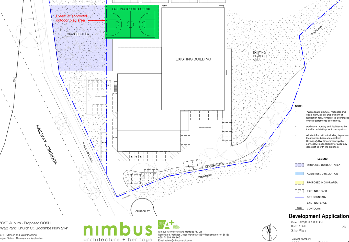
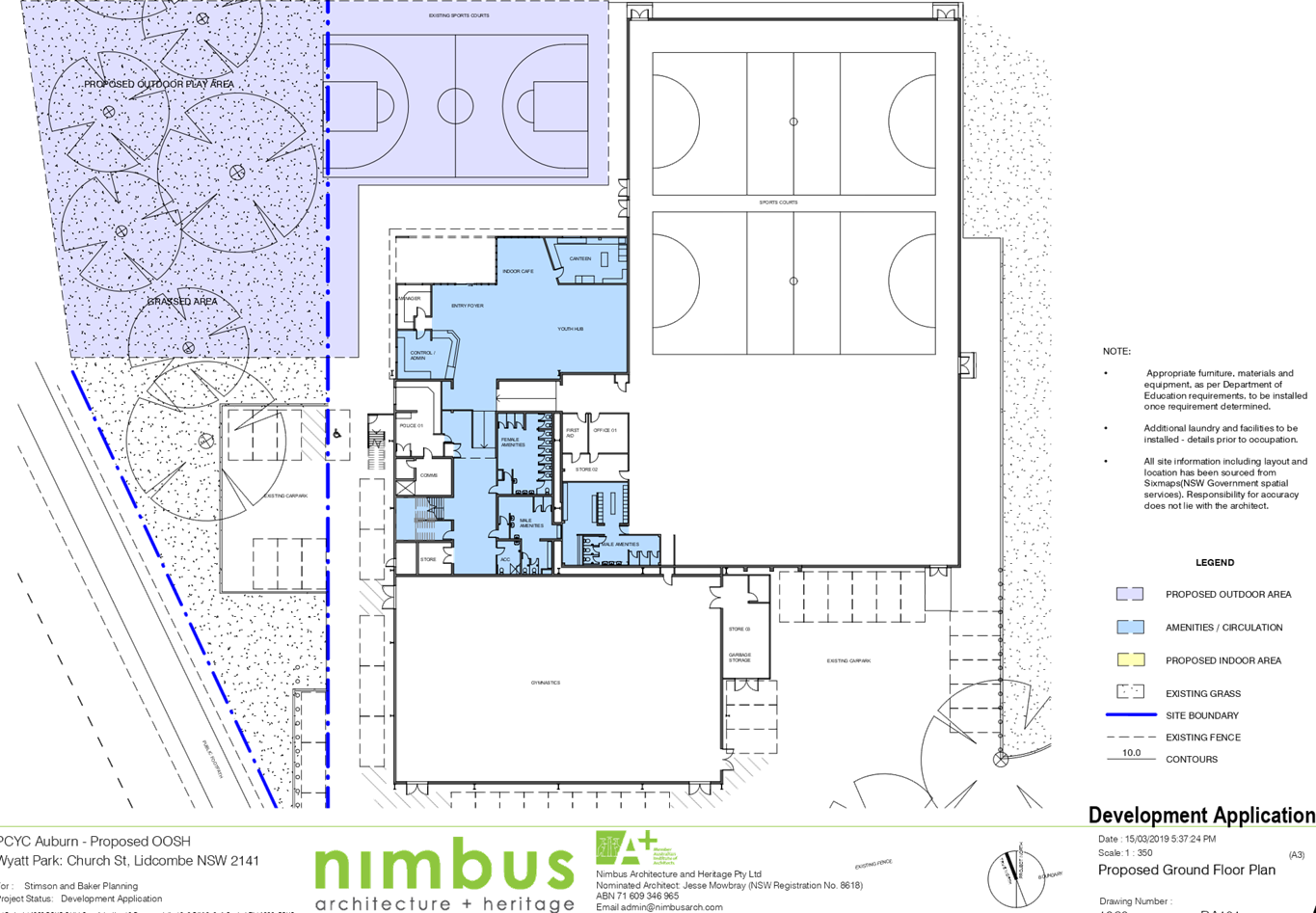
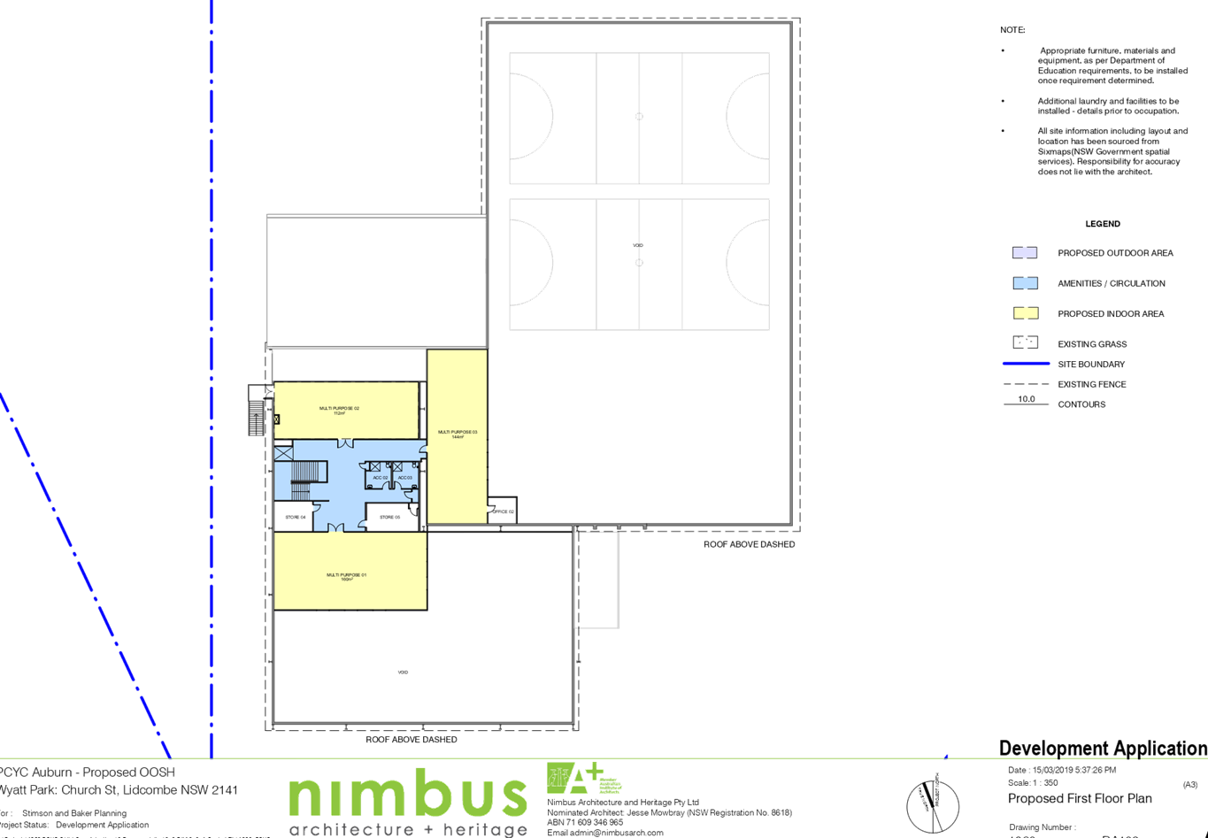
DOCUMENTS
ASSOCIATED WITH
REPORT LPP031/20
Attachment 3
Childcare Planning Guildelines Assessment
Cumberland Local Planning Panel Meeting
10 June 2020
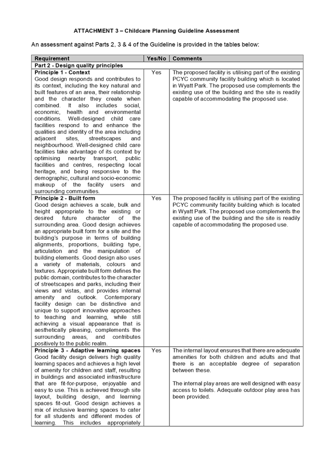
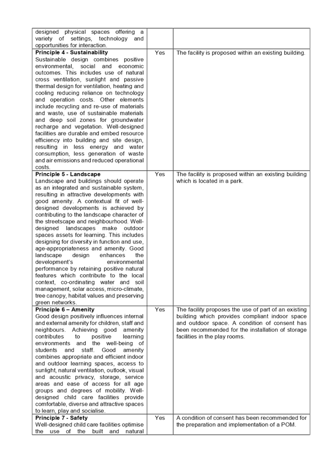
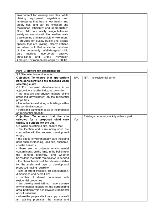
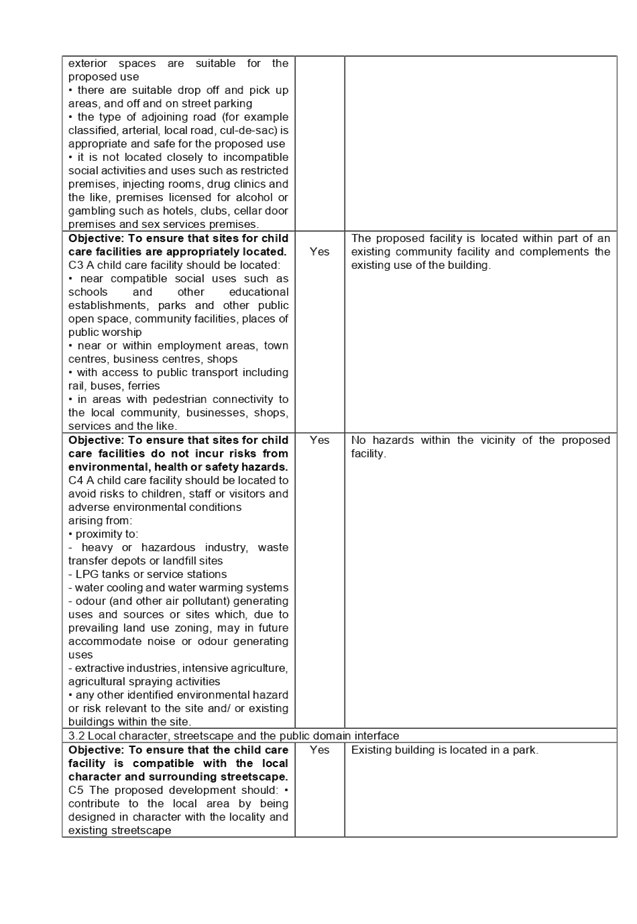
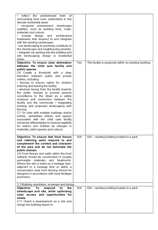
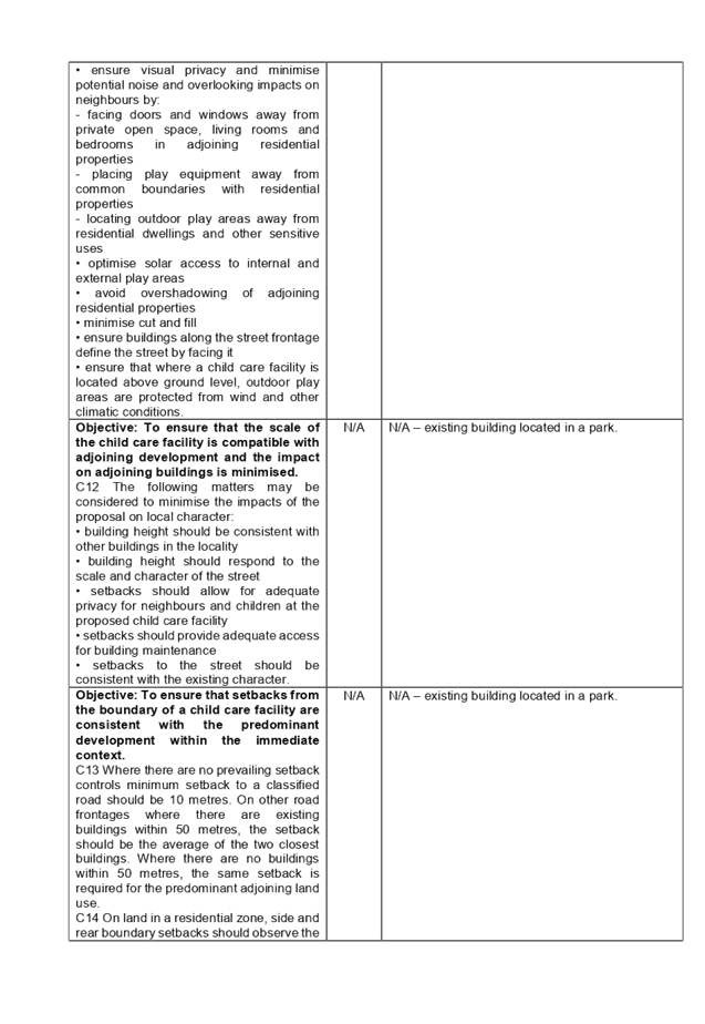
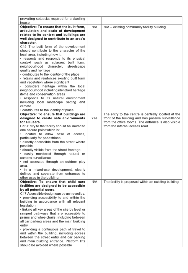
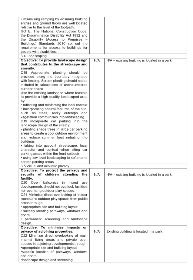
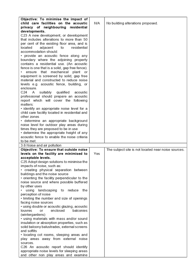
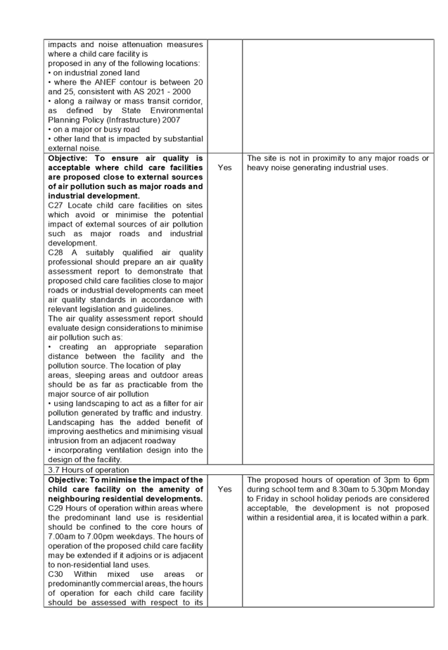
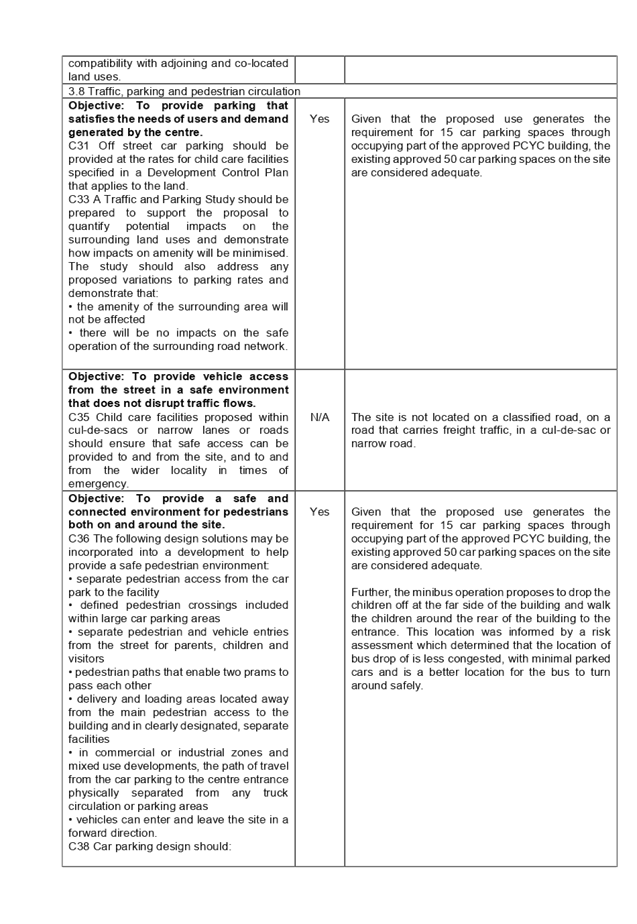

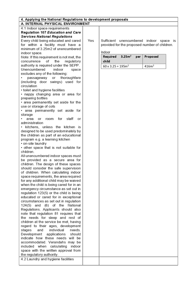
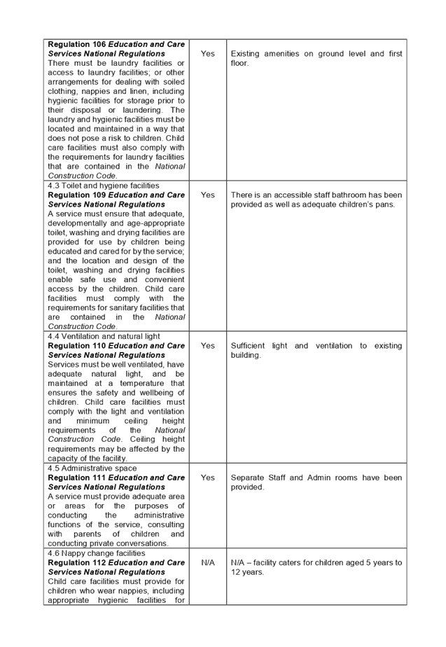
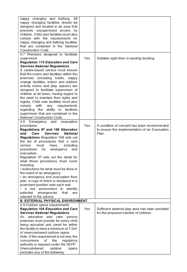
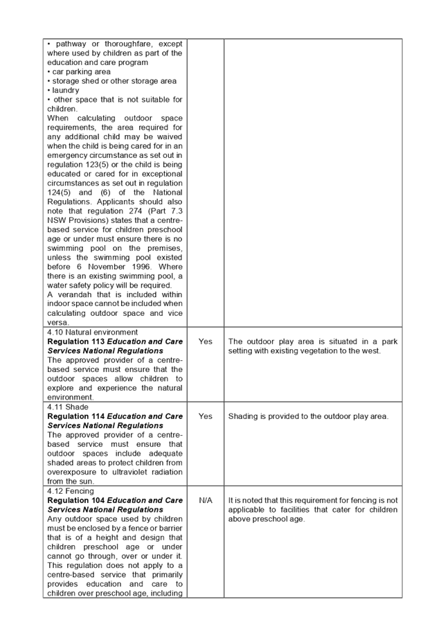

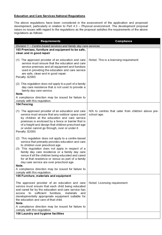
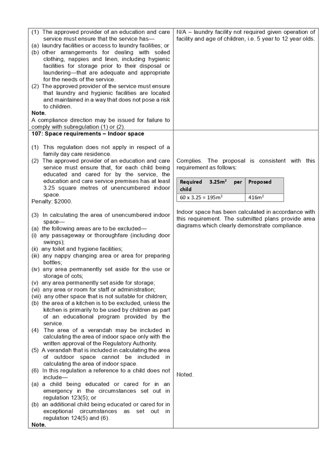
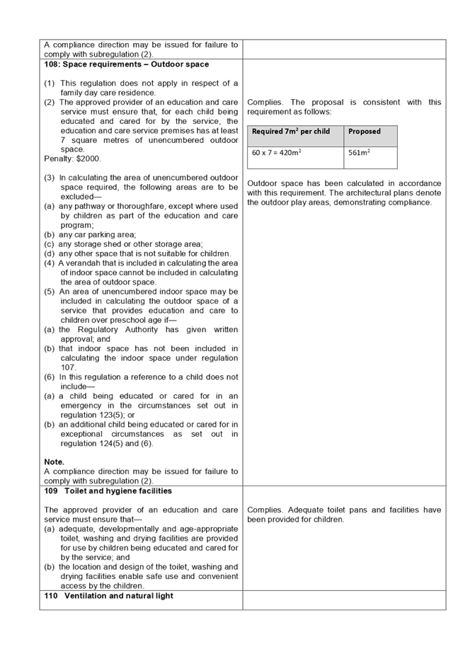
DOCUMENTS
ASSOCIATED WITH
REPORT LPP031/20
Attachment 4
Auburn DCP 2010 Assessment Table
Cumberland Local Planning Panel Meeting
10 June 2020
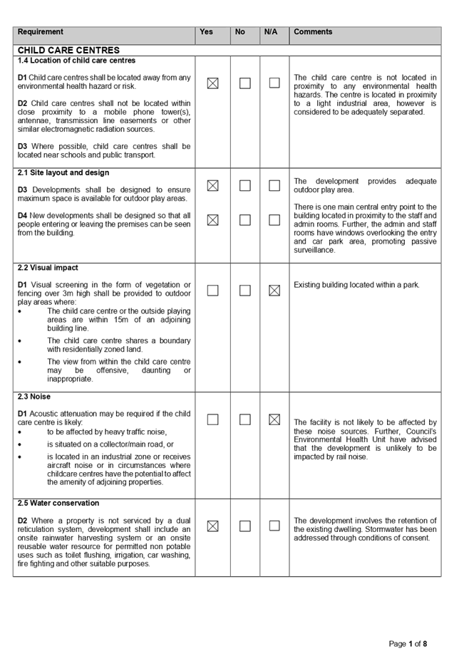
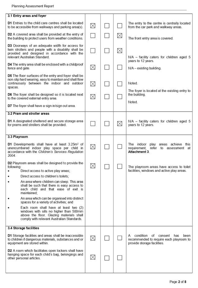
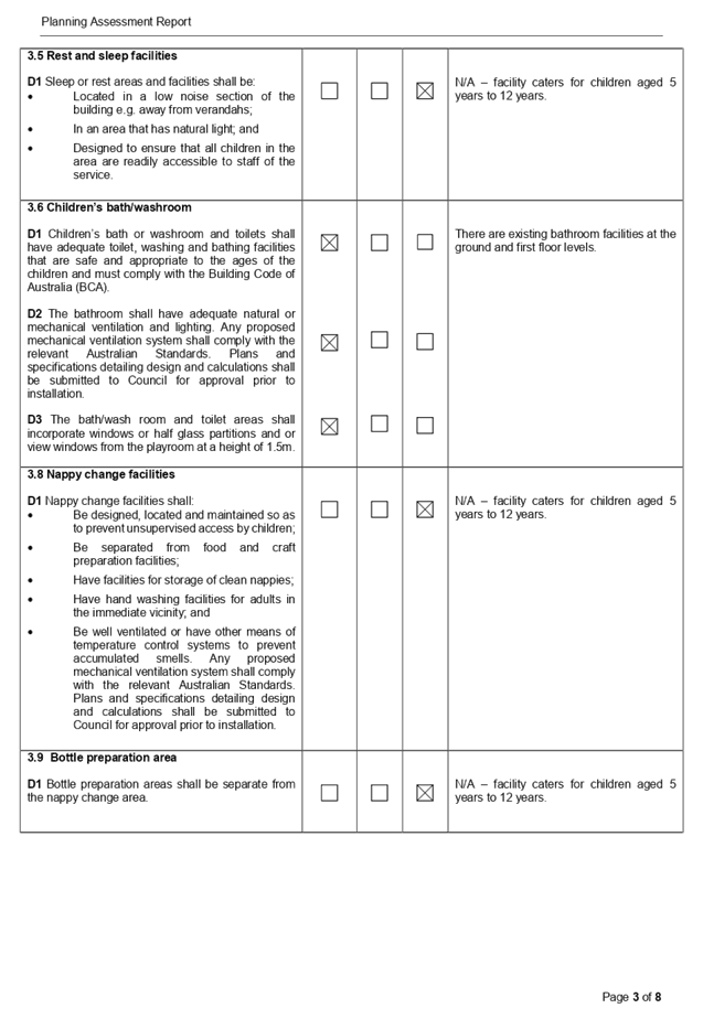
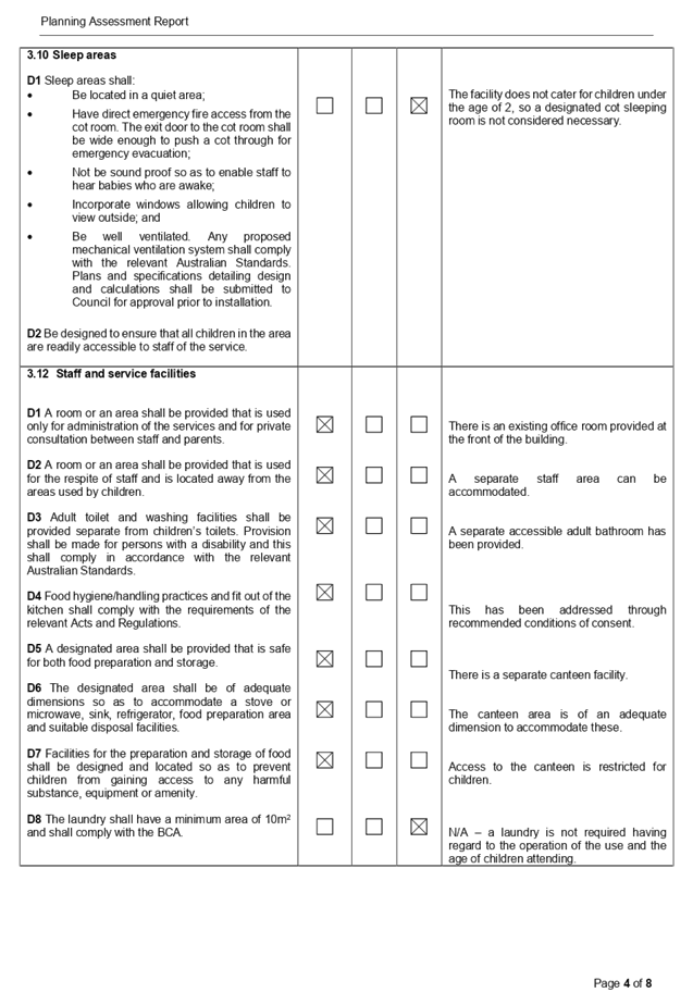
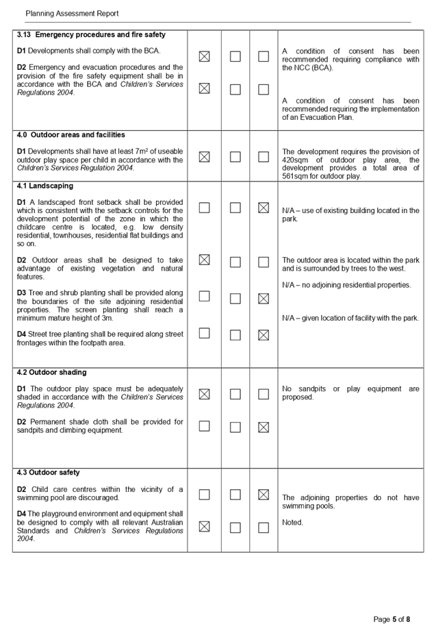
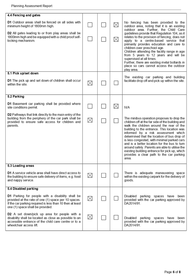
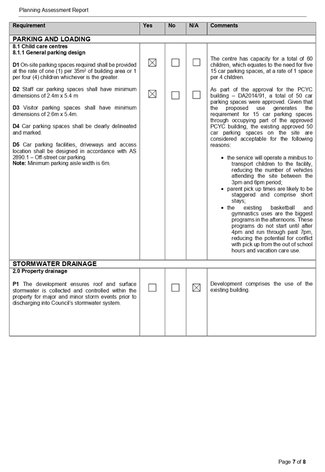
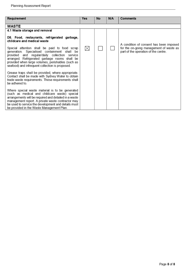
Cumberland
Local Planning Panel Meeting
10 June 2020
Item
No: LPP032/20
Development
Application for 652 Merrylands Road, Greystanes
Responsible
Division: Environment
& Planning
Officer: Executive
Manager Development and Building
File
Number: DA2020/011
|
Application
lodged
|
13 January 2020
|
|
Applicant
|
Mr Z Atie
|
|
Owner
|
Mrs S Fakes & Mr Z Atie
|
|
Application
No.
|
DA2020/0011
|
|
Description
of Land
|
652 Merrylands Road GREYSTANES
NSW 2145, Lot 10 DP 221671
|
|
Proposed
Development
|
Demolition of existing
structures, construction of a 2 storey attached dual occupancy with basement
storage and Torrens title subdivision into 2 lots
|
|
Site
Area
|
557.4m2
|
|
Zoning
|
R2: Low Density Residential
|
|
Disclosure
of political donations and gifts
|
Nil disclosure
|
|
Heritage
|
No
|
|
Principal
Development Standards
|
N/A
|
|
Issues
|
N/A
|
1. Development
Application No. DA2020/0011 was received on 13 January 2020 for the Demolition
of existing structures, construction of a 2 storey attached dual occupancy with
basement storage and Torrens title subdivision into 2 lots.
2. The
application was publicly notified to occupants and owners of the adjoining
properties for a period of 14 days between 25 February 2020 and 10 March 2020.
In response, 1 submission was received.
3. There
are no significant non-compliances with the proposed development having
considered the provisions of the Holroyd Local Environmental Plan 2013 (LEP)
and Holroyd Development Control Plan 2013 (DCP).
4. The
application is recommended for conditional approval via deferred commencement
subject to the conditions as provided in the attached schedule.
5. The
application is referred to the Panel as the applicant and part owner of the
subject site is the relative of a sitting Councillor of Cumberland City
Council.
Subject Site and Surrounding
Area
The subject site is known as 652
Merrylands Road, Greystanes and is legally defined as Lot 10, DP 221671. The
site is located on the southern side of Merrylands Road within the R2 Low
Density Residential Zone. The site is a regular shaped block with a frontage of
15.24 metres to Merrylands Road. The subject site has a depth of 36.575 metres
along the east and west sides, and a 15.24 metre rear southern boundary. The
total site area is 557.4m2 by calculation. The site currently contains a single
storey dwelling house with a detached rear shed. The topography of the site is
a consistent fall of approximately 1.9m from north to south. Adjoining
developments to the subject site include a two storey dwelling to the east and
a single storey dwelling to the west.
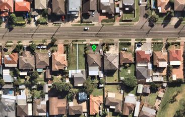
Figure
1 – Aerial view of subject site
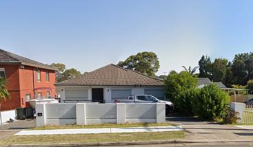
Figure
2 – Street view of subject site
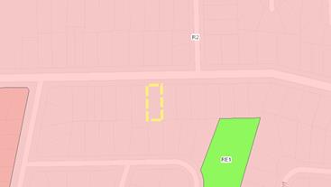
Figure
3 – Zoning of subject site
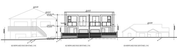
Figure
4 – Streetscape perspective from Merrylands Road, looking south (Source:
Cad Plans Pty Ltd, 2019)
Description of the Proposed
Development
Council has received a development
application DA2020/0011 for “Demolition of existing structures,
construction of a 2 storey attached dual occupancy with basement storage and
Torrens title subdivision into 2 lots”.
The detailed breakdown of the
proposal is as below:
Demolition:
· Single
storey dwelling
· Rear
detached shed
Construction:
· Two
storey attached dual occupancy
o Unit 1- Four (4) bedrooms, three (3)
bathrooms, basement storage area and single car garage
o Unit 2- Four (4) bedrooms, three (3)
bathrooms, basement storage area and single car garage
History
There is no applicable history of
development for the subject site.
Applicants Supporting
Statement
The applicant has provided a
Statement of Environmental Effects prepared by CAD Plans Pty Ltd and was
received by Council on 13 January 2020 in support of the application.
Contact with Relevant
Parties
The assessing officer has
undertaken a site inspection of the subject site and surrounding properties and
has been in regular contact with the applicant throughout the assessment
process.
Internal Referrals
The application was not required
to be referred to any internal departments for comment.
External Referrals
The application was not required
to be referred to any external government authorities for comment.
PLANNING COMMENTS
The provisions of any
Environmental Planning Instruments (EP&A Act s4.15 (1)(a)(i))
State Environmental Planning
Policies
The proposed development is
affected by the following State Environmental Planning Policies:
(a) State
Environmental Planning Policy No. 55 – Remediation of Land (SEPP 55)
The requirement at clause 7 of
SEPP 55 for Council to be satisfied that the site is suitable or can be made
suitable to accommodate the proposed development. The site is not identified in
Council’s records as being contaminated. A site inspection reveals the
subject site is currently used for residential purposes ad that the site does
not have any obvious history of a previous land use that may have caused
contamination and there is no specific evidence that indicates the site is
contaminated.
(b) State
Environmental Planning Policy (Infrastructure) 2007 (ISEPP)
The provisions of the
Infrastructure SEPP (ISEPP) 2007 have been considered in the assessment of the
development application and does not apply to this application.
(c) State
Environmental Planning Policy (Vegetation in Non-Rural Areas) 2017
ii)
The proposal does not exceed the biodiversity offsets scheme
threshold. Therefore, the proposed vegetation removal is considered acceptable.
Please refer to the DCP compliance table for further discussion.
(d) State
Environmental Planning Policy (Coastal Management) 2018
The subject site is not identified
as a coastal wetland or land identified as “proximity area for coastal
wetlands” and/or land identified as such by the Coastal Vulnerability
Area Map.
(e) State
Environmental Planning Policy (Building Sustainability Index: BASIX) 2004
BASIX Certificates No. 1062113S
and No. 1062092S issued on 26 November 2019 prepared by CAD Plans Pty Ltd has
been submitted with Council and is considered to be satisfactory.
Regional Environmental Plans
The proposed development is
affected by the following Regional Environmental Plans:
(a) Sydney
Regional Environmental Plan (Sydney Harbour Catchment) 2005
The subject site is identified as
being located within the area affected by the Sydney Regional Environmental
Plan (Sydney Harbour Catchment) 2005. The proposed development raises no issues
as no impact on the catchment is envisaged.
(Note: - the subject site is not
identified in the relevant map as ‘land within the ‘Foreshores and
Waterways Area’ or ‘Wetland Protection zone’, is not a
‘Strategic Foreshore Site’ and does not contain any heritage items.
Hence the majority of the SREP is not directly relevant to the proposed
development).
Local Environmental Plans
Holroyd Local Environment Plan
2013
The provision of the Holroyd Local
Environment Plan 2013 is applicable to the development proposal. It is noted
that the development achieves compliance with the key statutory requirements of
the Holroyd Local Environment Plan 2013 and the objectives of the R2 Low
Density Residential Zone.
(a) Permissibility:-
The proposed development is
defined as a “dual occupancy” and is permissible in the R2 zone
with consent.
A dual occupancy (attached) means
2 dwellings on one lot of land that are attached to each other but does not
include a secondary dwelling.
The relevant matters to be
considered under the HLEP 2013 and the applicable clauses for the proposed
development are summarised below.
Figure
5 – Holroyd Local Environment Plan 2013 Compliance Table
|
DEVELOPMENT STANDARD
|
COMPLIANCE
|
DISCUSSION
|
|
4.1 Minimum subdivision lot size
|
No
|
However,
complies with Clause 4.1A
|
|
4.1A Exceptions to minimum lot sizes for certain residential
development
|
Yes
|
Proposal is for the purpose of a dual occupancy
development
|
|
4.1B Minimum lot sizes for dual occupancies
|
No
However, saving provisions apply as this DA was lodged
before the gazettal of minimum lot size.
|
Cumberland Local Environmental
Plan Amendment (Dual Occupancies) 2020 increased the
minimum lot size required for a dual occupancy development to 585sqm in
residential zones (R2 Low Density Residential and R3 Medium Density
Residential) and came into effect 8 May 2020. The subject DA was lodged on 13 January 2020 prior to the LEP
Amendment. The subject site has an area of 557.4sqm complying with the
minimum lot size required for dual occupancy developments at the time of
lodgement.
|
|
4.3 Height of Buildings
Max. 9m
|
Yes
|
7.75m
proposed
|
|
4.4 Floor
Space Ratio
Maximum 0.5:1
|
Yes
|
0.5:1 proposed
(278.7sqm)
|
|
4.6 Exceptions to
development standards
|
N/A
|
N/A
|
A comprehensive LEP assessment is
contained in Appendix A.
The provisions of any proposed
instrument that is or has been the subject (EP&A Act s4.15 (1)(a)(ii))
(a) Draft
State Environmental Planning Policy (Environment)
The draft SEPP relates to the
protection and management of our natural environment with the aim of
simplifying the planning rules for a number of water catchments, waterways,
urban bushland, and Willandra Lakes World Heritage Property. The changes
proposed include consolidating the following seven existing SEPPs:
· State
Environmental Planning Policy No. 19 – Bushland in Urban Areas
· State
Environmental Planning Policy (Sydney Drinking Water Catchment) 2011
· State
Environmental Planning Policy No. 50 – Canal Estate Development
· Greater
Metropolitan Regional Environmental Plan No. 2 – Georges River Catchment
· Sydney
Regional Environmental Plan No. 20 – Hawkesbury-Nepean River (No.2-1997)
· Sydney
Regional Environmental Plan (Sydney Harbour Catchment) 2005
· Willandra
Lakes Regional Environmental Plan No. 1 – World Heritage Property.
The draft policy will repeal the
above existing SEPPs and certain provisions will be transferred directly to the
new SEPP, amended and transferred, or repealed due to overlaps with other areas
of the NSW planning system.
Changes are also proposed to the
Standard Instrument – Principal Local Environmental Plan. Some provisions
of the existing policies will be transferred to new Section 117 Local Planning
Directions where appropriate.
The proposed development is not
affected by any of the above Draft Environmental Planning Instruments.
(b)
Draft Cumberland Local Environmental Plan 2020 (Draft CLEP)
The Draft Cumberland Local
Environmental Plan 2020 (Draft CLEP) has been prepared by Cumberland City
Council to provide a single planning framework for the future planning of
Cumberland City. The changes proposed seek to harmonise and repeal the three
existing LEPs currently applicable to the Cumberland local government area,
those being:
· Holroyd
Local Environmental Plan 2013,
· Parramatta
Local Environmental Plan 2011, and
· Auburn
Local Environmental Plan 2010.
The relevant planning controls for
the subject site, as contained within the Holroyd Local Environment Plan, are
not proposed to change under the Draft CLEP.
The provisions of any
Development Control Plans (EP&A Act s4.15 (1)(a)(iii))
The Holroyd Development Control
Plan 2013 provides guidance for the design and operation of development to
achieve the aims and objectives of the Holroyd Local Environment Plan 2013.
The provisions of the HDCP 2013 is
applicable to the development proposal. It is noted that the development
achieves general compliance with the key controls of the HDCP 2013. The
following Parts of the HDCP 2013 are applicable to the proposed development:
o Part A - General
Controls
o Part B - Residential
Controls
A comprehensive assessment and
compliance table is contained in Appendix B.
The following table highlights
non-compliances with the DCP, which relate primarily to the solar access to the
main living areas of the proposed dwellings, and the variation sought is
considered satisfactory on merit in this instance:
Figure
7 – Holroyd DCP 2013 Compliance Table
|
Clause
|
Control
|
Proposed
|
Complies
|
|
1.8
|
New dwellings shall be designed to ensure direct sunlight
access for a minimum of 3 hours between 9.00am and 4.00pm at the winter
solstice (22 June) is provided to at least one main living area of the
proposed dwelling/s.
|
The proposed living areas of unit 1 and unit 2 do not receive the
required 3 hours solar access from 9am to 4pm in mid-winter due to the
orientation of the lot and location of living rooms and adjoining alfresco
area at the rear.
To mitigate this non-compliance skylights have been conditioned to be
fixed within the rear alfresco area providing the living areas with solar
access in accordance with HDCP 2013.
|
No, but considered acceptable through condition requiring skylights
|
As indicated in the compliance
table above, the proposed development departs from the Part B provisions of
Council’s Holroyd DCP 2013.
The proposed development complies
with the provisions of Council’s Holroyd Development Control Plan 2013
and is considered acceptable from an environmental planning view point.
The provisions of any planning
agreement that has been entered into under section 7.4, or any draft planning
agreement that a developer has offered to enter into under section 7.4
(EP&A Act s4.15(1)(a)(iiia))
There is no draft planning
agreement associated with the subject Development Application.
The provisions of the
Regulations (EP&A Act s4.15 (1)(a)(iv))
The proposed development raises no
concerns as to the relevant matters arising from the Environmental Planning and
Assessment Regulations 2000 (EP&A Reg).
The Likely Environmental,
Social or Economic Impacts (EP&A Act s4.15 (1)(b))
It is considered that the proposed
development will have no significant adverse environmental, social or economic
impacts in the locality.
The suitability of the site for
the development (EP&A Act s4.15 (1)(c))
The subject site and locality is
not known to be affected by any natural hazards or other site constraints
likely to have a significant adverse impact on the proposed development.
Accordingly, it is considered that the development is suitable in the context
of the site and surrounding locality.
Submissions made in accordance
with the Act or Regulation (EP&A Act s4.15 (1)(d))
Advertised (newspaper)
Mail
Sign
Not
Required
In accordance with Council’s
Notification requirements contained within the, the proposal was publicly
notified for a period of 14 days between 25 February 2020 and 10 March 2020.
The notification generated 1 submission in respect of the proposal with no
disclosing a political donation or gift. The issues raised in the public
submissions are summarised and commented on as follows:
Figure
7 – Submission summary table
|
Issue
|
Concern is raised to
the setback proposed to the eastern side boundary
|
|
Planner’s comment:
|
The setback provided to the eastern boundary is 915mm
which complies with Holroyd Development Control Plan 2013 part B which
specifies:
Setbacks from the side boundaries are to be a minimum of
900mm.
The proposed eastern side setback of 915mm exceeds the
minimum requirement of 900mm under HDCP 2013 and is considered appropriate
for the proposed development. Additionally, visual privacy and solar access
the adjoining developments is maintained in accordance with HDCP 2013.
|
The public interest (EP&A
Act s4.15(1)(e))
In view of the foregoing analysis
it is considered that the development, if carried out subject to the conditions
set out in the recommendation below, will have no significant adverse impacts
on the public interest.
Section 7.11 (Formerly S94)
Contribution Towards Provision or Improvement of Amenities or Services
This part of the Act relates to
the collection of monetary contributions from applicants for use in developing
key local infrastructure.
Comments:
The development requires the
payment of contributions in accordance with Council’s Section 94
Contributions Plans.
As at 10 June 2020, the fee
payable is $12,413.00. This figure is subject to indexation as per the relevant
plan. The draft determination attached includes a condition requiring payment
of the contribution prior to issue of a Construction Certificate.
Disclosure of Political
Donations and Gifts
The applicant and notification
process did not result in any disclosure of Political Donations and Gifts.
The development application has
been assessed in accordance with the relevant requirements of the Environmental
Planning and Assessment Act 1979, the Holroyd DCP 2013 and Holroyd LEP 2013 and
is considered to be satisfactory for deferred commencement approval subject to
conditions.
The proposed development is
appropriately located within the R2 Low Density Residential Zone under the
relevant provisions of the Holroyd LEP 2013. The proposal is consistent with
all statutory and non-statutory controls applying to the development. Minor
non-compliances with Council’s controls have been discussed in the body
of this report. The development is considered to perform adequately in terms of
its relationship to its surrounding built and natural environment, particularly
having regard to impacts on adjoining properties.
Having regard to the assessment of
the proposal from a merit perspective, Council is satisfied that the
development has been responsibly designed and provides for acceptable levels of
amenity for future residents. It is considered that the proposal successfully
minimises adverse impacts on the amenity of neighbouring properties. Hence the
development, irrespective of the departure noted above, is consistent with the
intentions of Council’s planning controls and represents a form of
development contemplated by the relevant statutory and non-statutory controls
applying to the land.
For these reasons, it is
considered that the proposal is satisfactory having regard to the matters of
consideration under Section 4.15 of the Environmental Planning and Assessment
Act 1979, and the development may be approved subject to conditions.
|
1. That
Development Application No. DA2020/0011 for Demolition of existing
structures, construction of a 2 storey attached dual occupancy with basement
storage and Torrens title subdivision into 2 lots on land at 652 Merrylands
Road GREYSTANES NSW 2145 be approved via deferred commencement subject
to attached conditions.
2. Persons
whom have lodged a submission in respect to the application be notified of
the determination of the application.
|
1. Draft Notice
of Determination
2. Architectural
Plans
3. Submission
Letter
4. Appendix
A - Holroyd Local Environmental Plan 2013 - Compliance Assessment
5. Appendix
B - Holroyd Development Control Plan 2013
DOCUMENTS
ASSOCIATED WITH
REPORT LPP032/20
Attachment 1
Draft Notice of Determination
Cumberland Local Planning Panel Meeting
10 June 2020
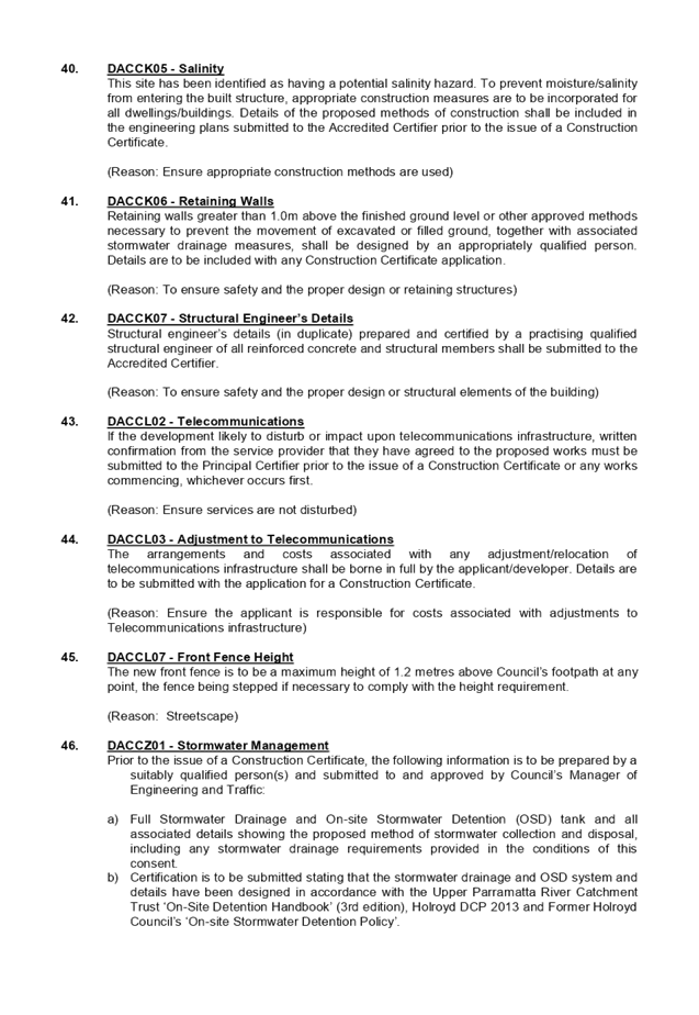

DOCUMENTS
ASSOCIATED WITH
REPORT LPP032/20
Attachment 2
Architectural Plans
Cumberland Local Planning Panel Meeting
10 June 2020
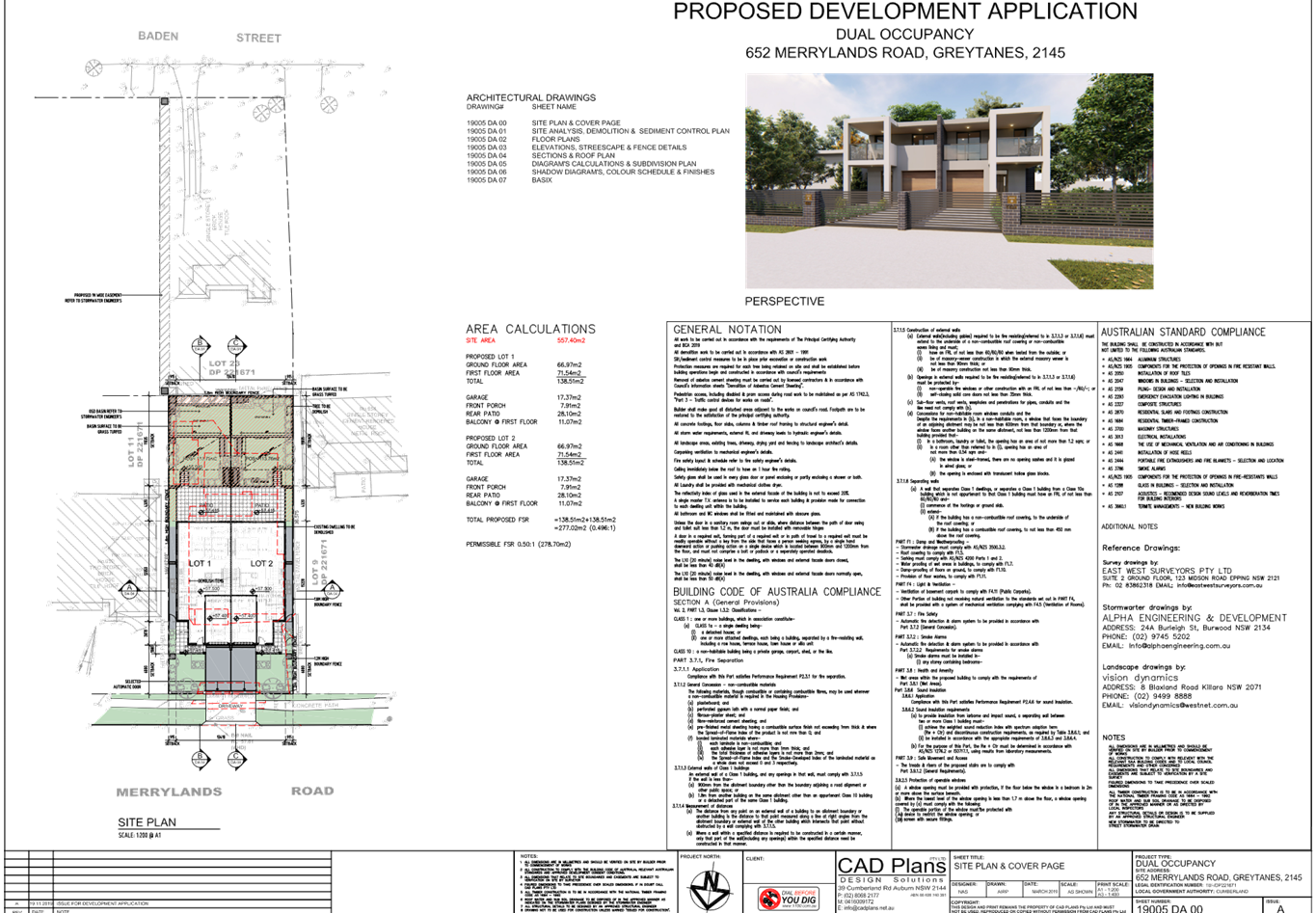
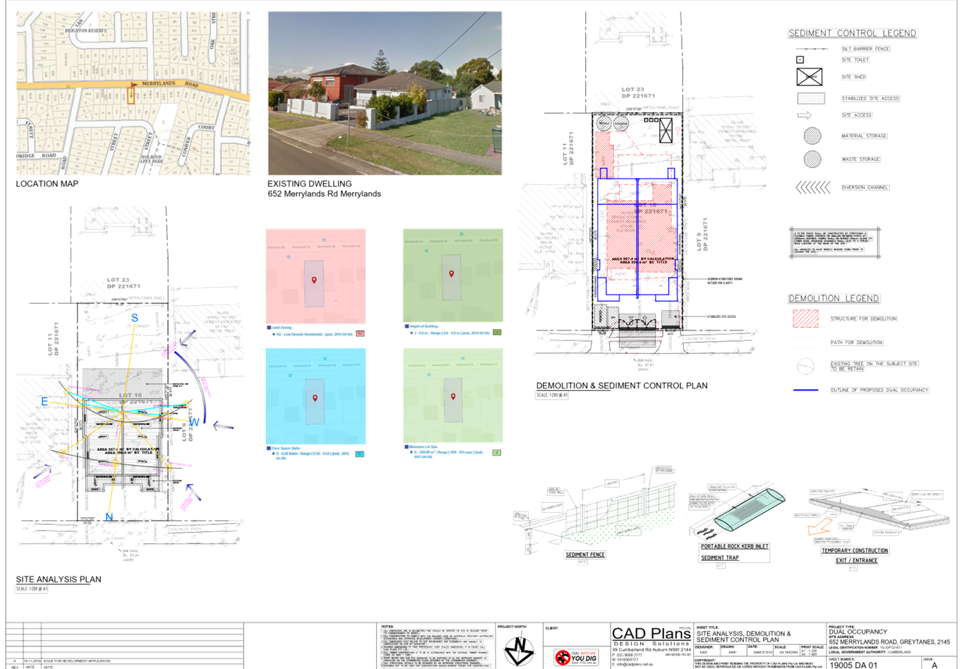
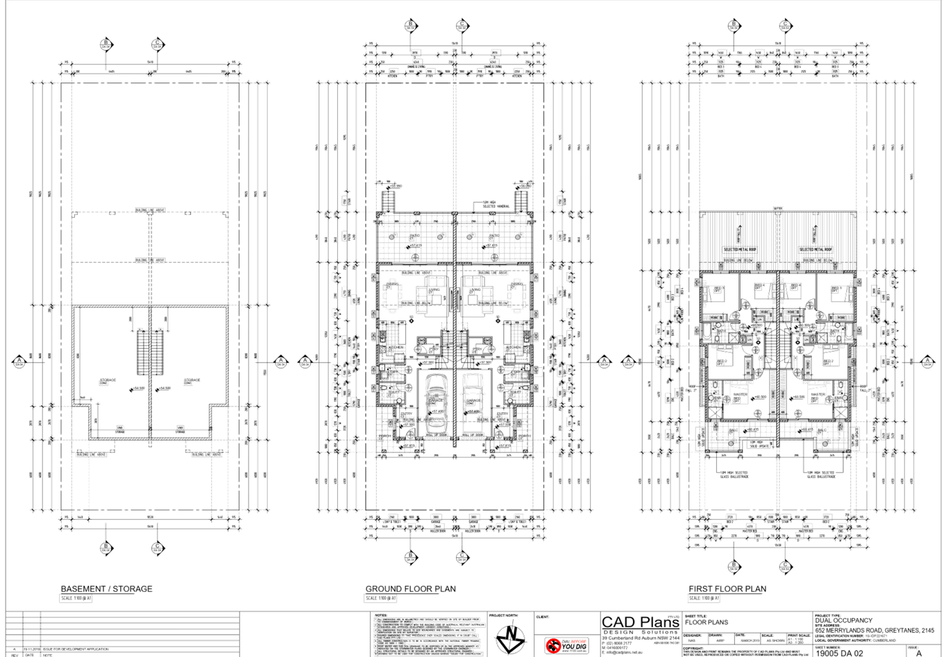
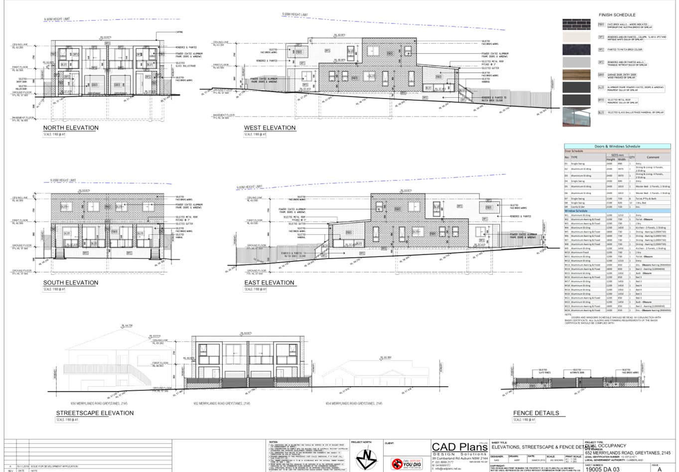
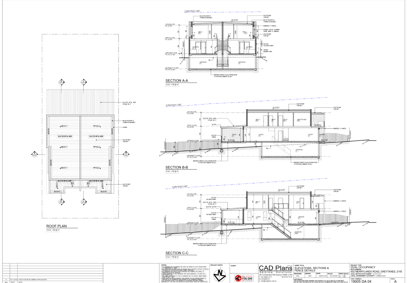
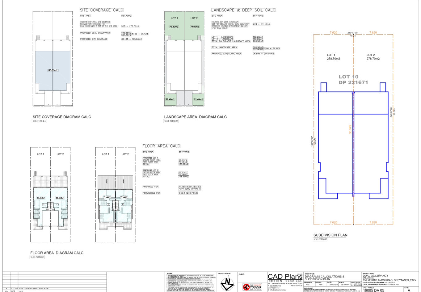
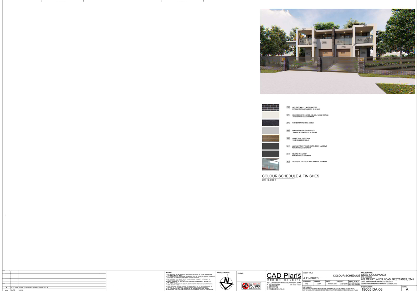
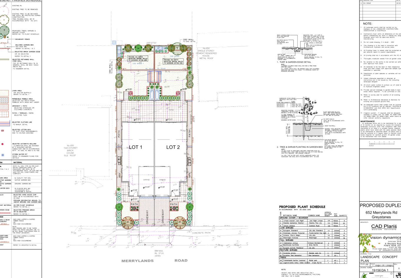
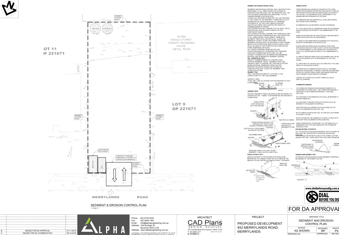
DOCUMENTS
ASSOCIATED WITH
REPORT LPP032/20
Attachment 3
Submission Letter
Cumberland Local Planning Panel Meeting
10 June 2020
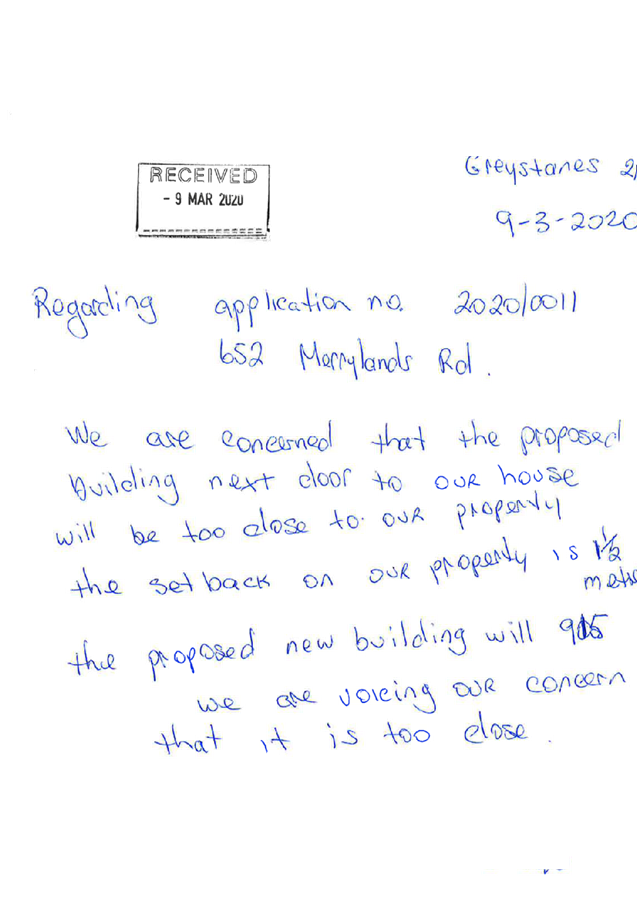
DOCUMENTS
ASSOCIATED WITH
REPORT LPP032/20
Attachment 4
Appendix A - Holroyd Local Environmental Plan 2013 -
Compliance Assessment
Cumberland Local Planning Panel Meeting
10 June 2020
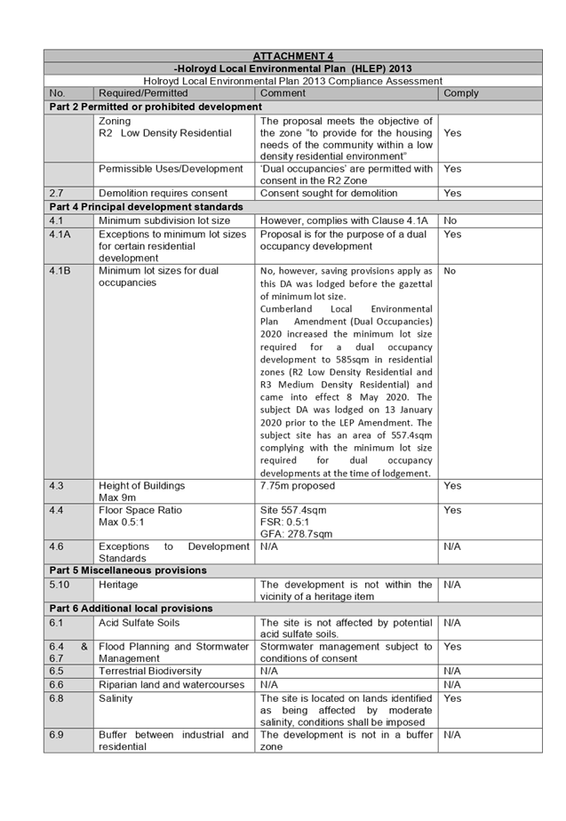
DOCUMENTS
ASSOCIATED WITH
REPORT LPP032/20
Attachment 5
Appendix B - Holroyd Development Control Plan 2013
Cumberland Local Planning Panel Meeting
10 June 2020