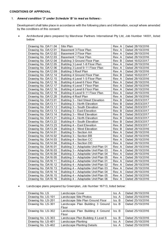
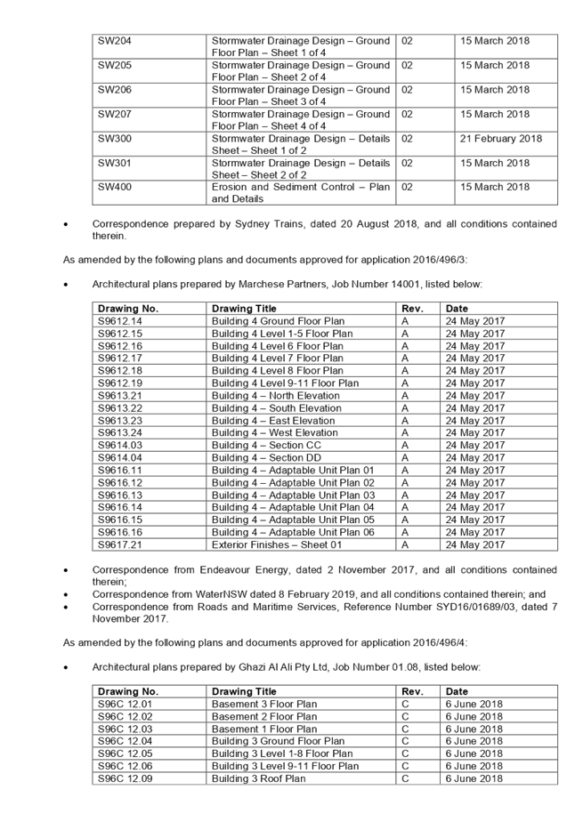
27 May 2020
An
Extraordinary Meeting of Cumberland Local Planning Panel will be held at 11:30am via Zoom
on Wednesday, 27 May 2020.
Business as below:
Yours faithfully
Hamish McNulty
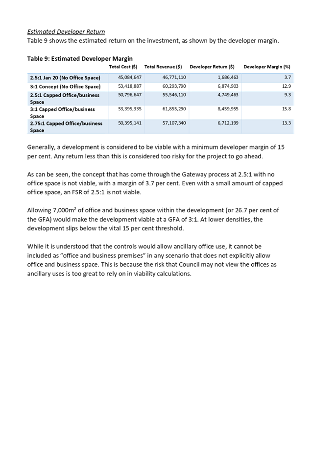
General
Manager
ORDER OF BUSINESS
1.
Receipt of Apologies
2.
Declaration of Interest
3.
Address by invited speakers
4.
Reports
- Development
Applications
- Planning
Proposals
5. Closed
Session Reports
Extraordinary
Cumberland Local Planning Panel Meeting
27 May 2020
CONTENTS
Report No. Name of Report Page
No.
Development Applications
ELPP021/20 Development Application for
20-22 Dressler Court, Merrylands.................. 5
ELPP022/20 Development Application for
27-29 Toongabbie Road, Toongabbie..... 101
ELPP023/20 Development Application for
363-373 Guildford Road, Guildford.......... 231
ELPP024/20 Alteration to the Gateway
Determination for the Planning Proposal for 2 Bachell Avenue, Lidcombe........................................................................................... 327
Extraordinary Cumberland Local Planning
Panel Meeting
27 May 2020
Item
No: ELPP021/20
Development
Application for 20-22 Dressler Court, Merrylands
Responsible
Division: Environment
& Planning
Officer: Executive
Manager Development and Building
File
Number: M2016/496/8
|
Application Lodged:
|
18
November 2019
|
|
Application Number:
|
M2016/496/8
|
|
Responsible Officer:
|
William Attard
|
|
Description of Land:
|
20-22
Dressler Court, MERRYLANDS NSW 2160 / Lot 3, DP 1248018
|
|
Proposed
Development:
|
Section
4.56 modification seeking internal and external alterations to Buildings 3
and 4, including changes to basement levels, rearrangement of apartments to
introduce additional dual key apartments, enlargement of Building 3
footprint, modification of roof form, reconfiguration of OSD tanks,
relocation of substation kiosk and changes to glazed areas
|
|
Site Area:
|
6,765m²
|
|
Zoning:
|
Part R4 High Density
Residential, and Part SP2 Infrastructure (Drainage), pursuant to the Holroyd
Local Environmental Plan 2013 (HLEP)
|
|
Permissibility:
|
Permissible – Residential
Flat Buildings
|
|
Applicant:
|
Landmark
Group Australia Pty Ltd
|
|
Owner:
|
Lot
11 Neil Street Pty Limited
|
|
Notification/Advertising:
|
26 February 2020 to 18
March 2020
|
|
Disclosure of
political donations / gifts
|
None disclosed on the
application form
|
|
Submissions:
|
One (1) submission
|
|
Principal
Development Standards:
|
Floor Space Ratio
(FSR)
|
Height of
Buildings (HOB)
|
|
Permissible: 3.5:1
Approved: 3.46:1
Proposed: 3.5:1
|
Permissible: 29m, 30m,
39m
|
|
Approved:
Building 3: 38.8m
Building 4: 38.85m
|
Proposed:
Building 3: No change
Building 4: 39.49m
|
|
Heritage:
|
The site is
located adjacent to a local heritage item to the north being the former
brickworks site known as Item I53 - Goodlet & Smith (brickmaking plant
and chimney, Hoffman kiln & chimney). The subject site is known as the
Millmaster Feeds site and is identified as a local Archaeological site
|
|
Variations:
|
- Exceedance to HOB Standard
- Solar Access and Daylight
|
- Apartment Size and Layout
|
|
Recommendation:
|
Approval, subject to
conditions
|
|
|
|
|
|
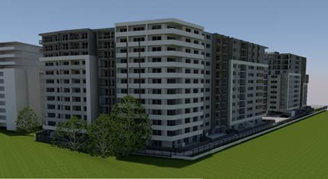
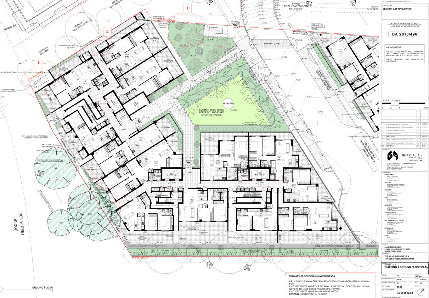
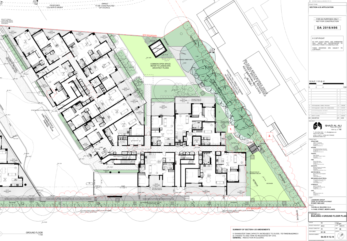
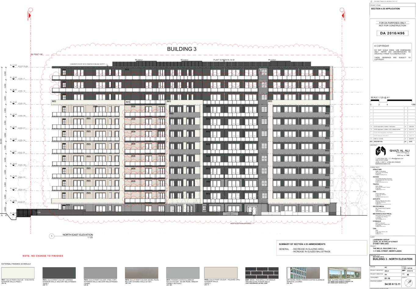
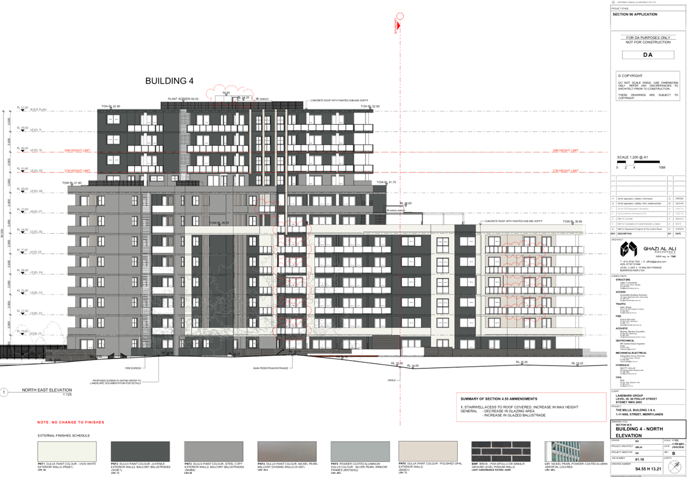
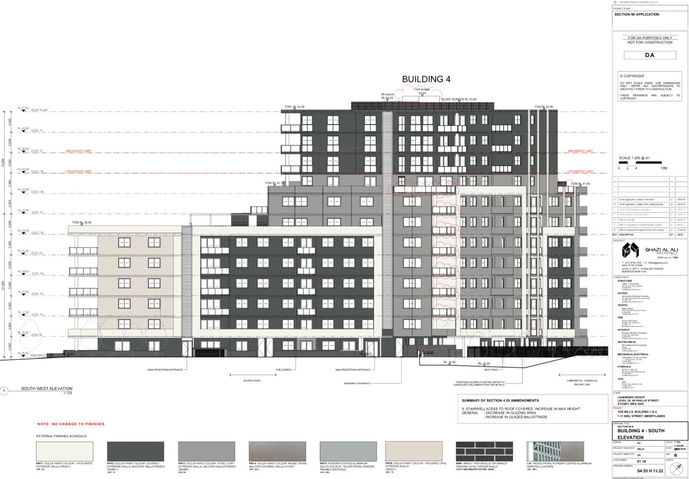
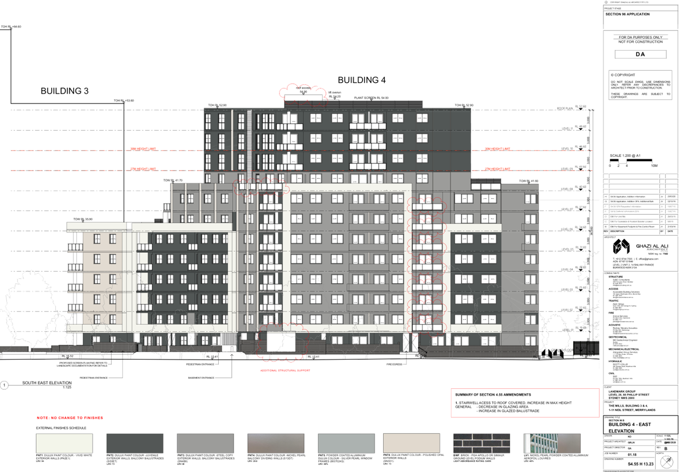
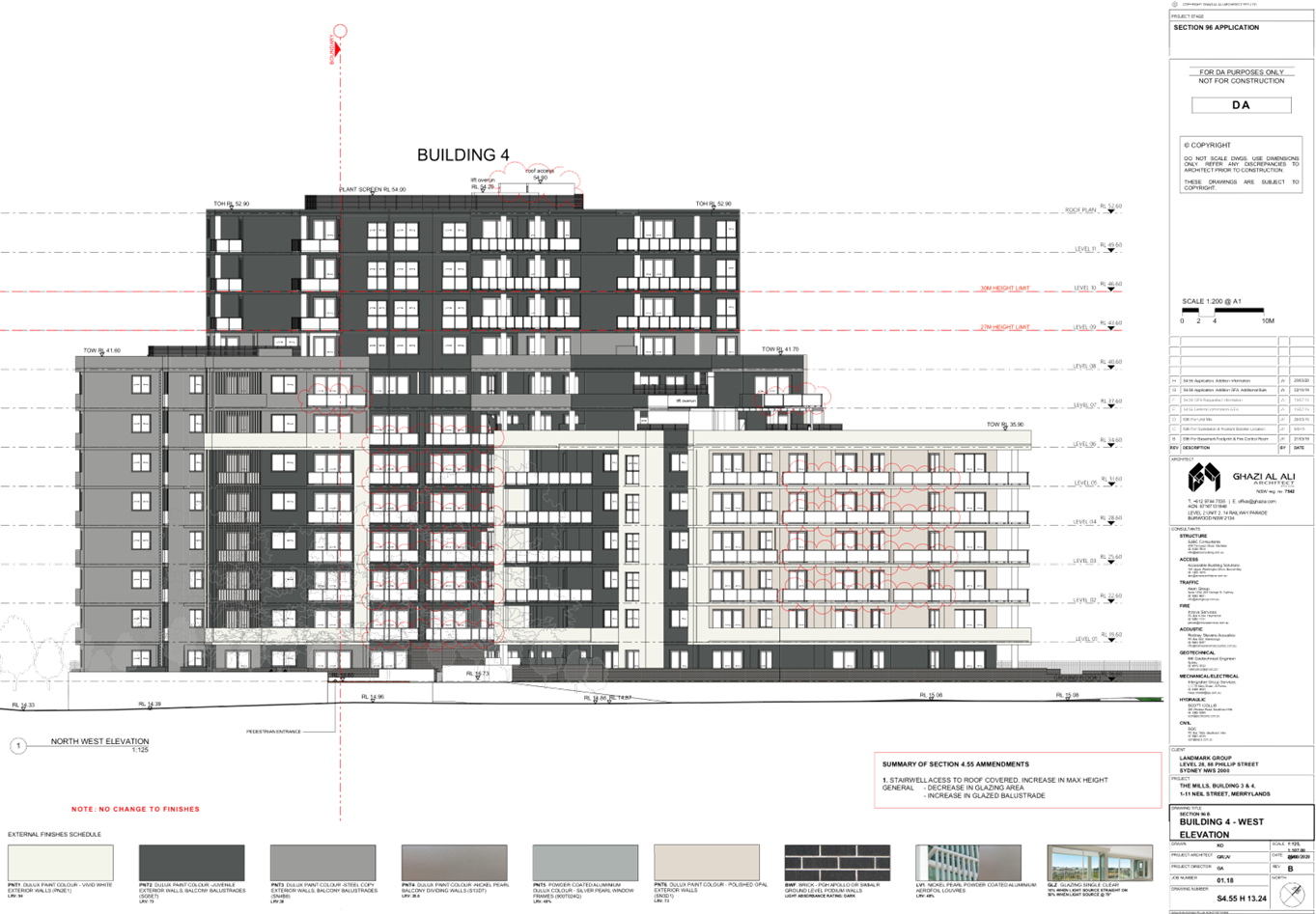
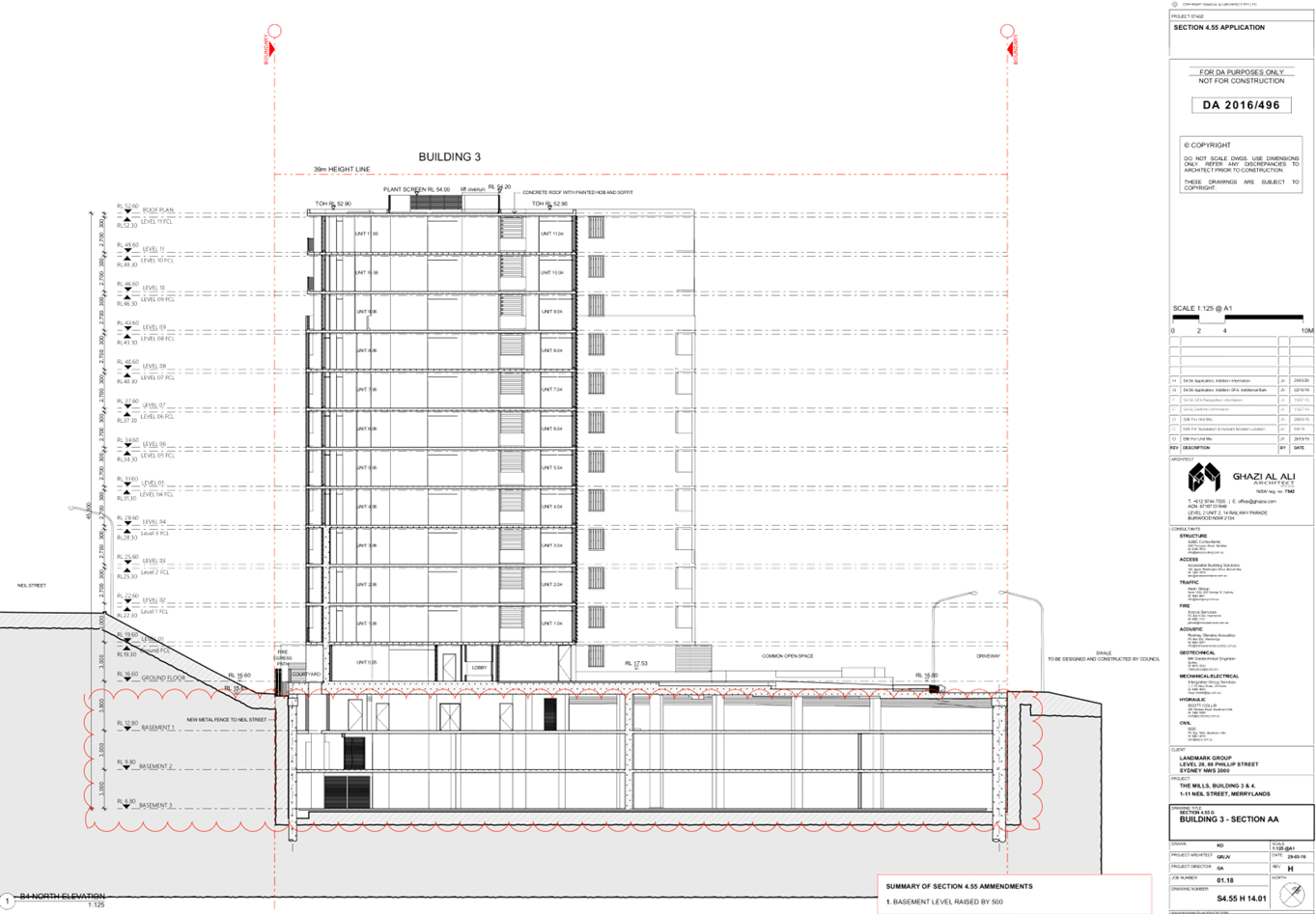
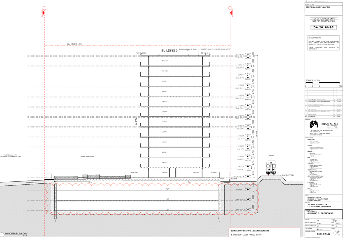
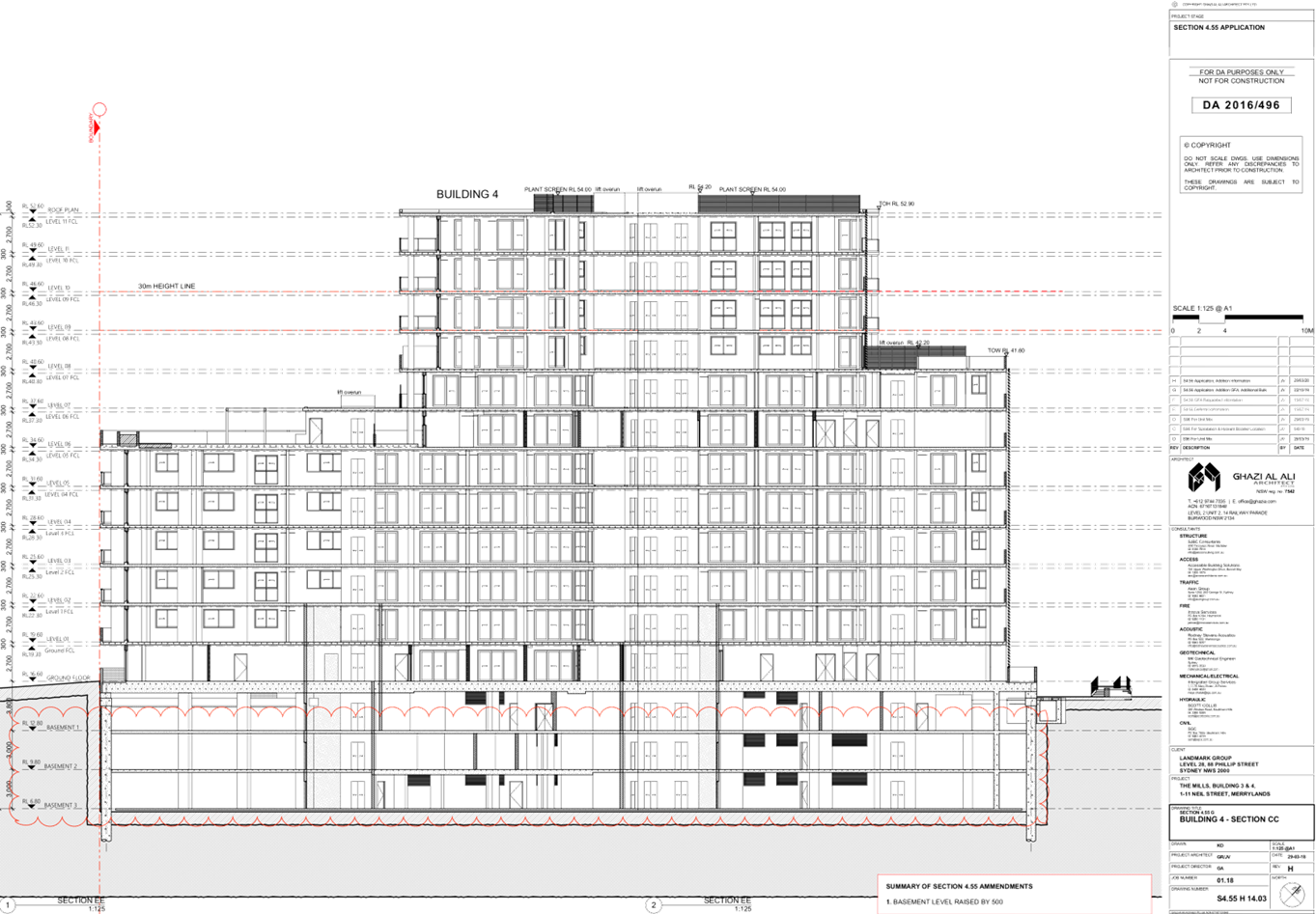
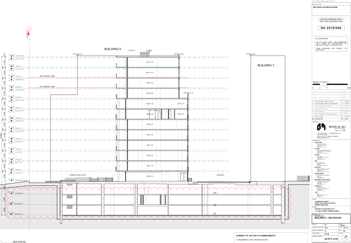
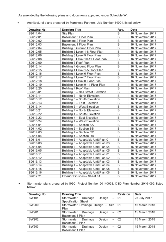
Figure 1 – Perspective of
Development Looking North-West (Source: Ghazi Al Ali, 2020)
Summary:
Council is in receipt of a Section
4.56 modification application 2016/496/8 from Landmark Group Australia Pty Ltd
seeking internal and external alterations to Buildings 3 and 4, including
changes to basement levels, rearrangement of apartments to introduce additional
dual key apartments, enlargement of Building 3 footprint, modification of roof
form, reconfiguration of OSD tanks, relocation of substation kiosk and changes
to glazed areas at 20-22 Dressler Court, Merrylands. The Architectural Plans
accompanying the application are provided as Attachment 1 to this report.
The site was formerly known as 1-7
& 9-11 Neil Street, Merrylands, which was changed to 20-22, 24, 24R &
27 Dressler Court, Merrylands, following the subdivision of the site. The
subject modifications proposed are limited to Buildings 3 and 4, maintained to
20-22 Dressler Court, Merrylands / Lot 3, DP 1248018.
The application was publicly
notified for a period of 21 days from 26 February 2020 to 18 March 2020. In
response, one (1) submission was received, objecting to the proposal.
The site is zoned part R4 High
Density Residential, and part SP2 Infrastructure (Drainage), pursuant to the
Holroyd Local Environmental Plan 2013 (HLEP), with the proposed works limited
to the R4 High Density Residential zone. A Residential Flat Building is
permissible with development consent in the R4 High Density Residential zone.
The subject site is located
adjacent to a heritage item to the north being the former brickworks site known
as Item I53 - Goodlet & Smith (brickmaking plant and chimney, Hoffman kiln
& chimney) under the HLEP. The subject site is known as the Millmaster
Feeds site and is identified as a potential Archaeological site.
The proposal has been assessed
against State Environmental Planning Policy No 19 – Bushland in Urban
Areas, State Environmental Planning Policy No. 55 (Remediation of Land), State
Environmental Planning Policy No. 65 (Design Quality of Residential Apartment
Development), State Environmental Planning Policy (Building Sustainability
Index: BASIX) 2004, State Environmental Planning Policy (Coastal Management)
2018, State Environmental Planning Policy (Infrastructure) 2007, Sydney
Environmental Plan (Sydney Harbour Catchment) 2005, State Environmental
Planning Policy (Vegetation in Non-Rural Areas) 2017, Holroyd Local
Environmental Plan 2013 (HLEP), Draft State Environmental Planning Policy
(Environment), Draft Cumberland Local Environmental Plan 2020, and Holroyd
Development Control Plan 2013 (HDCP).
The modification application was
referred for comments externally to Endeavour Energy, and internally to
Council’s Development Engineer, to which the application is supported.
The proposed development has been
assessed against the relevant matters for consideration pursuant to Section
4.15 of the Environmental Planning and Assessment Act, 1979, including likely
impacts, the suitability of the site for the development, and the public
interest, and the proposed development is considered appropriate.
The variations sought via the
subject modification application are as follows:
|
Control
|
Required /
Permitted
|
Approved
|
Proposed
|
% Variation
|
|
Height of Buildings
(HOB)
|
Building 4 - 30m
|
38.85m
|
39.49m
|
1.6% (Approved HOB)
31.6% (HLEP HOB
Standard)
|
|
Solar &
Daylight Access
|
No sunlight to 15%
of units
|
18.7%
|
21.1%
|
12.83% (Approved
Figure)
38.8% (ADG Design
Criteria)
|
|
Apartment Size
& Layout
|
4m width for
cross-through units
|
4m
|
2.66m
|
33.5% (ADG Design
Criteria)
|
The application is being reported
to the Cumberland Local Planning Panel (CLPP) for determination, as pursuant to
the Local Planning Panels Direction – Development Applications issued by
the Minister for Planning on 23 February 2018, the application constitutes
‘sensitive development’ as it is development to which State
Environmental Planning Policy No. 65 – Design Quality of Residential
Apartment Development applies.
In light of the above, it is
recommended that the Cumberland Local Planning Panel (CLPP) approve the Section
4.56 application, subject to the draft notice of determination contained in
Attachment 2 to this report.
Subject Site and Surrounding
Area
The subject site is known as 20-22
Dressler Court, Merrylands, and is legally described as Lot 3, DP 1248018. The
land is an irregular shaped lot and has a frontage of 47.78 metres to the
southern Neil Street boundary, a 64.42 metre width along the northern boundary,
a 131.195 metre width along the eastern boundary shared with the railway
corridor, and a 129.035 metre width along the western boundary.
The subject site is located within
the ‘Merrylands Town Centre’ within the Merrylands Neil Street Precinct,
as identified in the Merrylands Centre Controls section of the Holroyd
Development Control Plan 2013 (HDCP). The site is adjacent to a railway
corridor that spans the eastern boundary of the site and approximately 350
metres north-east from Merrylands train station. The total site area is
6,765m², and is illustrated in Figure 2 below:
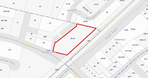
Figure
2 - Location Map (Source: Cumberland City Council, 2020)
The site is currently vacant, with
the exception of construction works associated with Building 4. The locality is
characterised by existing low rise former industrial premises to the west along
Neil Street, mixed use and residential flat building developments approved,
under construction, and recently completed to the west and north, commercial
and retail development to the south-west, and residential to the east and
south.
The topography of the site is
fairly consistent with a slight fall from south to north. The site adjoins the
A’Becketts Creek watercourse which traverses in a north to south
direction. Consequently, the land is affected by local overland stormwater
overflow. The subject site currently benefits from vehicular access directly
from Neil Street. Vehicular access to the development is dependent on a
proposed extension of Dressler Court to the north east of the site, which will
connect to a new road running through the site along the western side of the
A’Becketts Creek watercourse.
The site is zoned part R4 High
Density Residential, and part SP2 Infrastructure (Drainage), pursuant to the
Holroyd Local Environmental Plan 2013 (HLEP), with the proposed works limited
to the R4 High Density Residential zone, as shown in Figure 3 below:
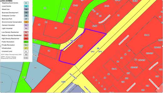
Figure 3 –
Zoning Map (Source: Cumberland City Council, 2020)
The subject site is situated to the north of Neil Street.
Figure 4 below illustrates an aerial perspective of the site and the general
surroundings.
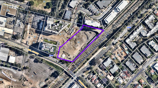
Figure 4 –
Aerial Photo (Source: Cumberland City Council, 2020)
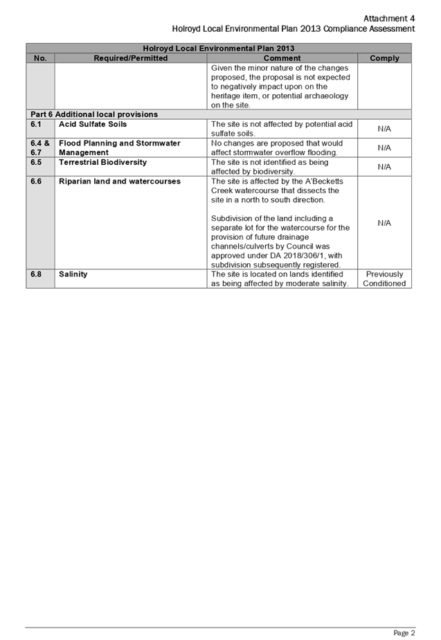
The site is located adjacent to a heritage item to the north
being the former brickworks site known as Item I53 - Goodlet & Smith
(brick-making plant and chimney, Hoffman kiln & chimney). The subject site
is known as the Millmaster Feeds site and is identified as a potential
Archaeological site. Figure 5 below illustrates the location of the heritage
items, listed above:
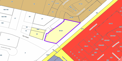
Figure 5 –
Heritage Map (Source: Cumberland City Council, 2020)
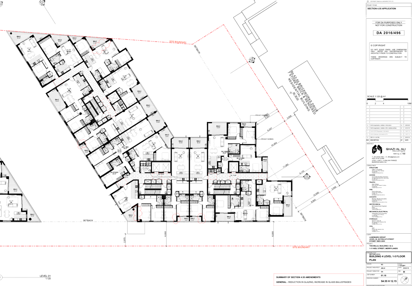
Description of the Proposed Development
The proposal seeks to modify Land and Environment Court
Appeal No. 2017/00132564 (Development Consent DA2016/496) via a Section 4.56
Application, and includes internal and external alterations to Buildings 3 and
4, including changes to basement levels, rearrangement of apartments to
introduce additional dual key apartments, enlargement of building 3 footprint,
modification of roof form, reconfiguration of OSD tanks, relocation of
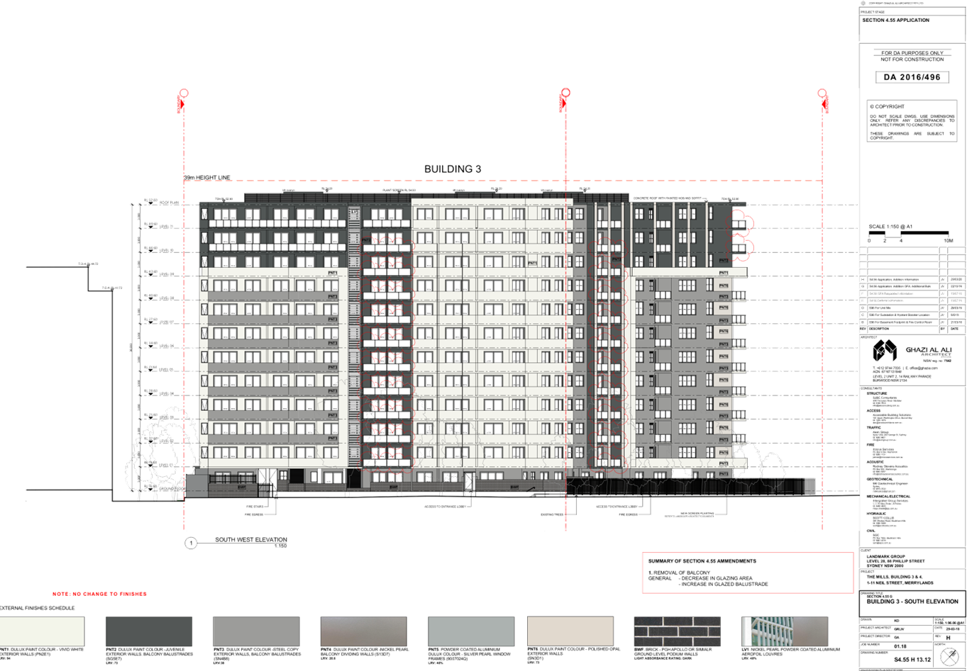
substation kiosk and changes to glazed areas.
In detail, the following description has been provided by
the Applicant within the Statement of Environmental Effects prepared by Chapman
Planning Pty Ltd, dated 29 October 2019:
Proposed Modifications
The Section 4.56 application seeks modification to the
development consent plans of the Court approved development for 2 x residential
flat buildings as subsequently modified.
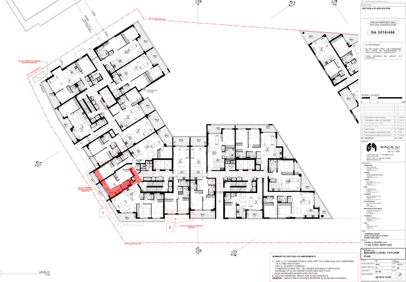
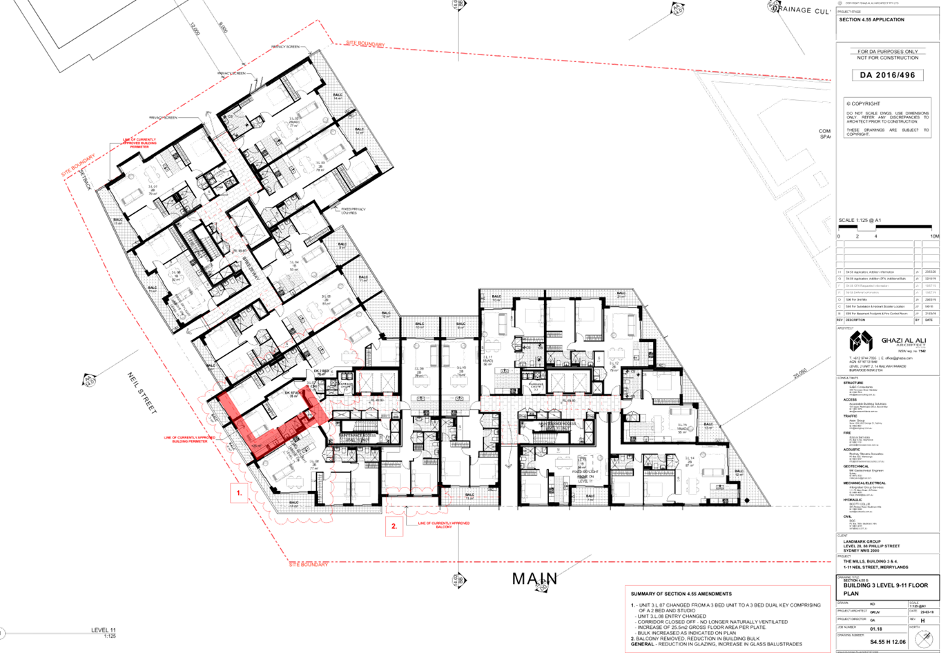
The modifications are details below:
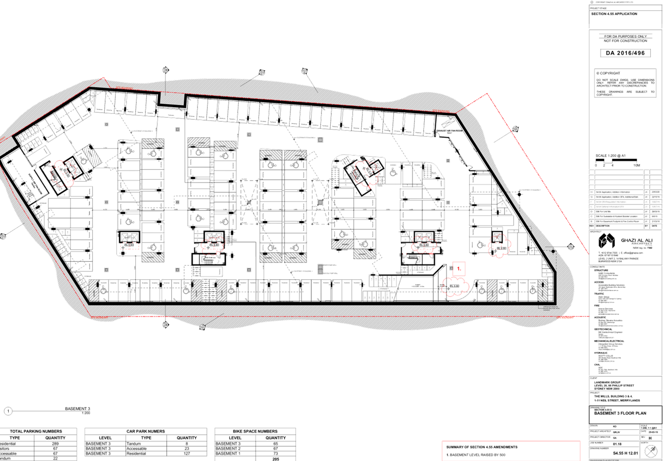
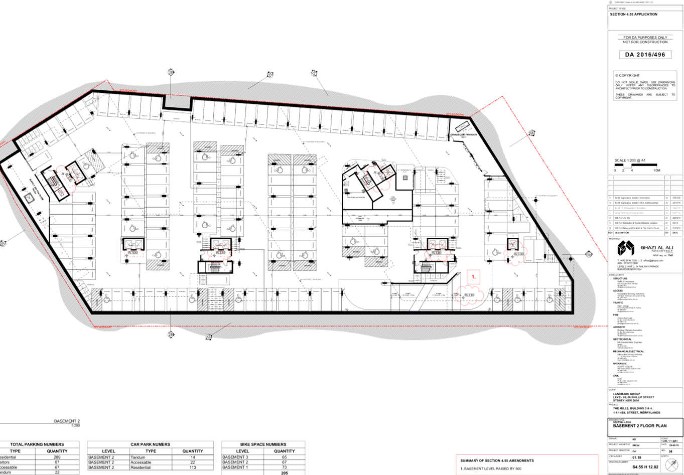
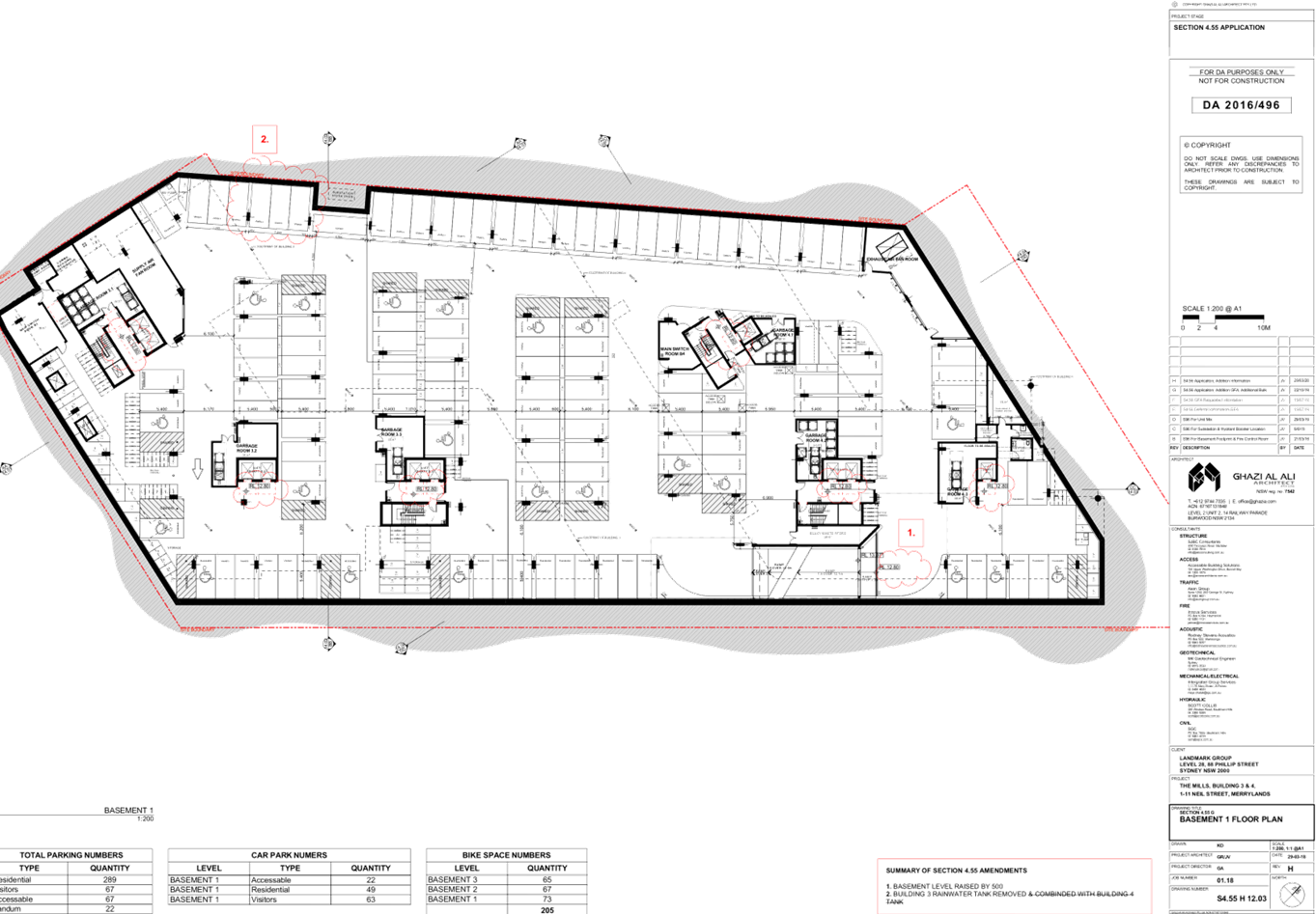
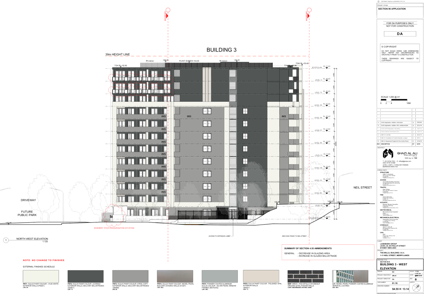
Building 3 – Basement 1, 2 and 3
- Raise
basement levels by 500mm.
- Rainwater
tank remove and combined with tank in Building 4.
Building 3 – Ground Floor
- Removal
of rainwater tank outside of the building footprint to the north-west of the
site and combined with tank in Building 4.
- Relocation
of substation to western corner of approved building site, adjacent to the
courtyard of Unit 3.0.01.
Building 3 – Levels 1-11
- Conversion
of 3 bedroom unit, Unit 3.L.07 at Levels 1-11 of Building 3 to a dual-key
apartment with a 2 bedroom and studio arrangement, with associated new
balconies at the south-western elevation.
- Modification
to common corridor for Units 3.L.07 and 3.L.08 to be incorporated into the
proposed dual-key apartment.
- Extension
of building envelope at the south-west elevation. The extension of the building
envelope accommodates a bedroom area, lounge and kitchen, and balcony area 1m
in width.
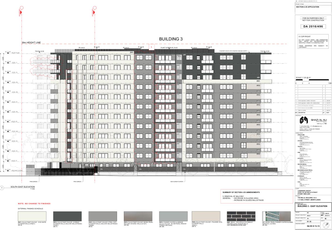
- Removal
of balconies at the south-east elevation at Levels 1-11.
- Relocation
of substation kiosk to south-western corner of the approved building footprint.
- Minor
alteration to building envelope at western corner of the approved building to
enable for relocation of substation at ground level.
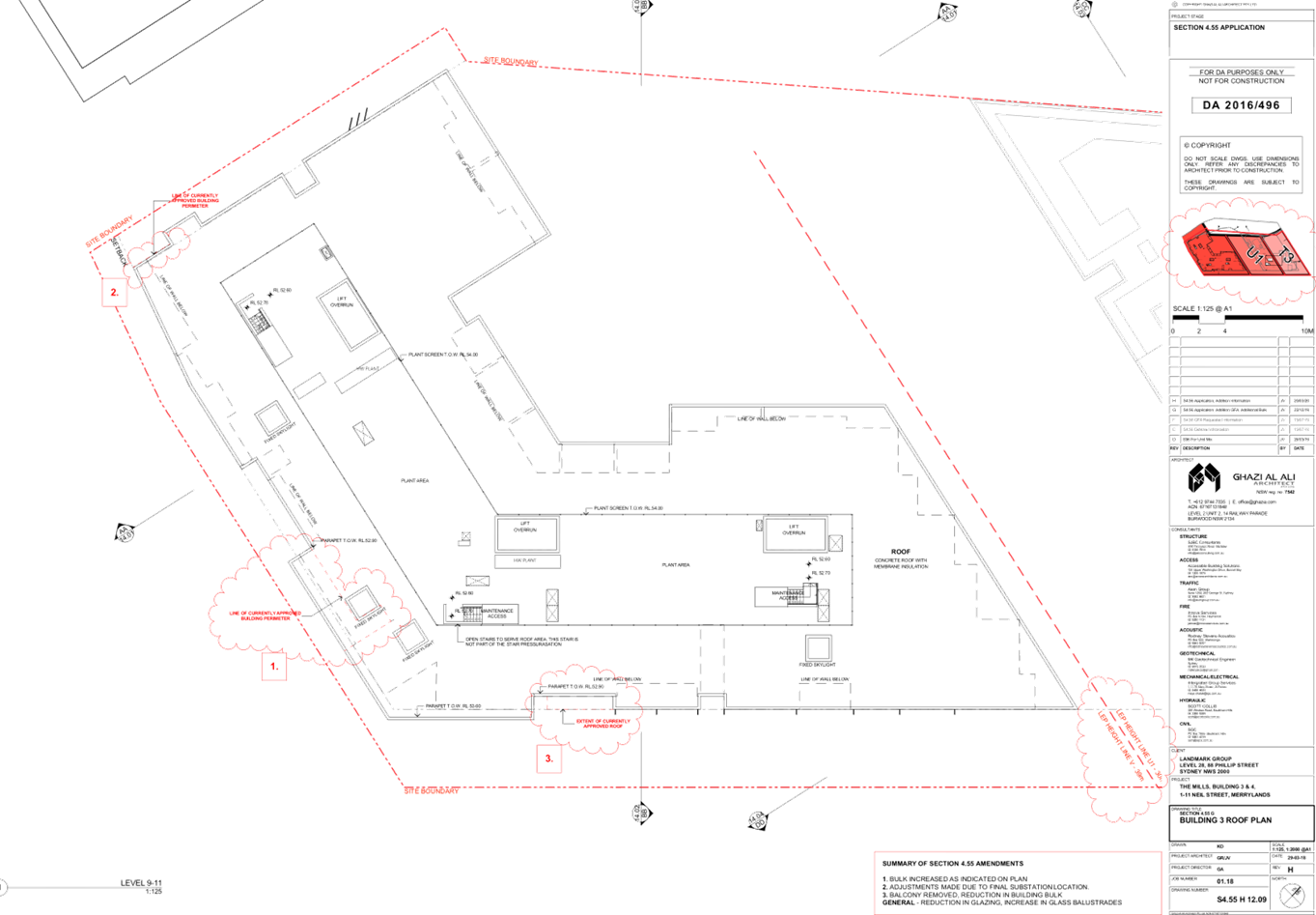
Building 3 – Roof Area
- Reduction
in roof form to the south-east of the building footprint as a result of removal
of balconies on lower levels.
- Minor
alteration to roof form at western corner of the approved building to enable
for relocation of substation at ground level.
i)
- Building
4 – Ground Floor
ii)
- Reconfiguration
to OSD tank beneath landscaped areas along the north and north-eastern
boundary.
- Increase
to rainwater tank capacity at north-eastern corner of building footprint.
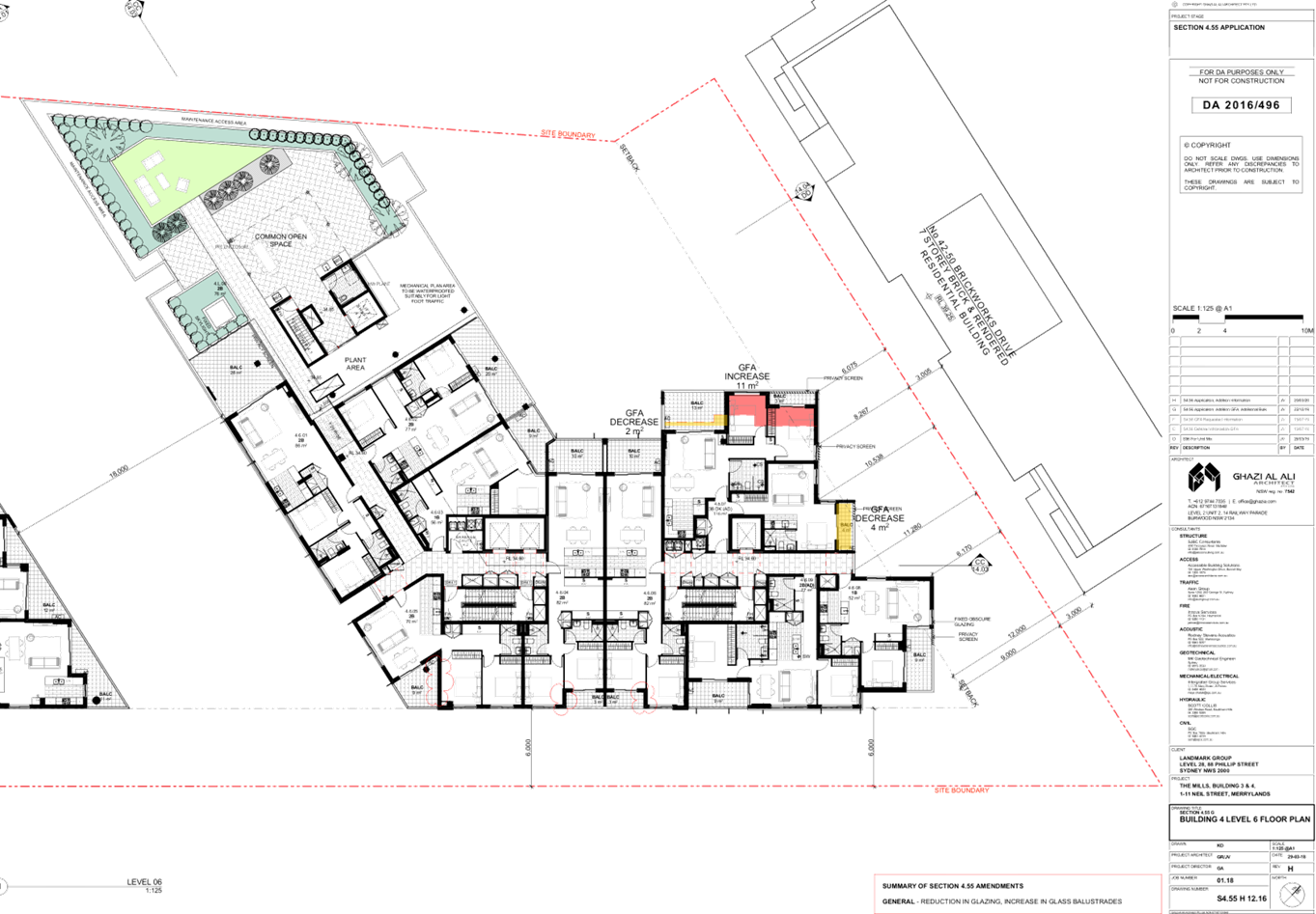
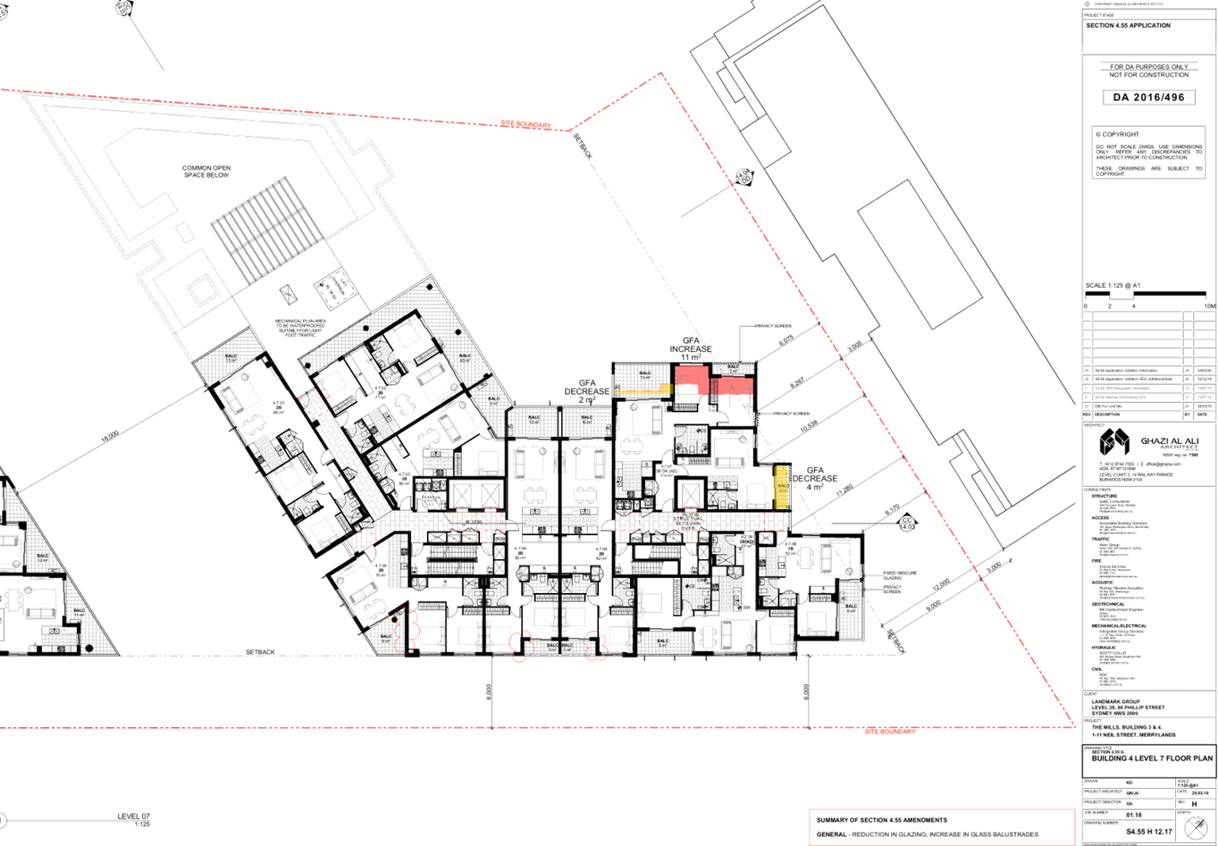
Building 4 – Roof Area
- The
roof at the south-west of the roof form is increased in height.
Building 4 – External Layout
- Reduction
in glazing area across overall building envelope.
- Increase
in glazed balustrades on all elevations of building envelope.
Materials and Finishes
- No
changes are proposed to the previously approved finishes and materials of
Building 3 with the development site which includes dark brick, painted render,
powder coated aluminium window frames and louvres. It is noted that the
modifications to the elevations show a decrease in glazing to windows,
increasing painted render and an increase in glass balustrades.
Following from the above, a numerical overview of the key
components of the development is provided below:
Numerical Overview of Key Components
|
Component
|
Required /
Permissible
|
Proposed
|
Complies
|
|
Site Area
|
N/A
|
6,765m² (No
Change)
|
N/A
|
|
Site Frontage
|
32m
|
Neil Street -
47.78m
(No change)
|
N/A
|
|
Gross Floor Area
(GFA)
|
23,677.5m²
|
23,664.9m²
|
Yes
|
|
Floor Space Ratio
(FSR)
|
3.5:1
|
3.5:1
|
Yes
|
|
Height of Buildings
(HOB)
|
Building 3
|
39m
|
38.8m (No Change)
|
N/A
|
|
Building 4
|
30m
|
39.49m
|
No, but Acceptable
on Merit
|
|
29m
|
|
Boundary Setbacks
|
North
|
9m
|
6m - 11.8m (No
change)
|
N/A
|
|
South
|
2.5m
|
2.5m (No change)
|
N/A
|
|
East
|
6m
|
6m (No change)
|
N/A
|
|
West
|
2.5m / 12m
|
0m / >12m
|
N/A
|
|
Building Separation
|
North
|
6m - 12m
|
6m - 11.8m (No
change)
|
N/A
|
|
South
|
12m - 24m
|
>24m (No change)
|
N/A
|
|
East
|
12m - 24m
|
>24m (No change)
|
N/A
|
|
West (Building 3)
|
12m - 24m
|
15m (No change)
|
N/A
|
|
West (Building 4)
|
12m - 24m
|
>24m (No change)
|
N/A
|
|
Between Buildings
3&4
|
12m - 24m
|
18m - 20m (No
change)
|
N/A
|
|
Apartment Numbers
|
Building 3
|
189 units
(Inclusive of 11
DKA)
|
N/A
|
|
Building 4
|
133 units
(Inclusive of 8
DKA)
|
|
Total
|
322 units
|
|
Apartment Mix
|
1 bedroom / Studio
|
119 units (37%)
|
N/A
|
|
2 bedroom
|
189 units (58.7%)
|
|
3 bedroom
|
14 units (4.3%)
|
|
Car Parking
|
Residential (ADG)
|
326 spaces
|
438 spaces (No
change)
|
N/A
|
|
Bicycle Parking
|
Residential (HDCP)
|
194 spaces
|
207 spaces (No
change)
|
N/A
|
|
Communal Open Space (COS)
|
1,691.25m²
|
1,853.4m² (No
change)
|
N/A
|
|
Deep Soil Zone
|
473.55m²
|
844m²
|
Yes
|
|
Solar Access (2hr)
|
226 units
|
229 units
|
Yes
|
|
Natural Ventilation
|
194 units
|
238 units
|
Yes
|
DKA – Dual Key Apartments
Note: The proposal converts 11 x 3 bedroom units to 11 x
dual key apartments comprising 11 x studio units and 11 x 2 bedroom units.
Dual key apartments are defined under the Apartment Design
Guide as:
An apartment with a common internal corridor and lockable
doors to sections within the apartment so that it is able to be separated into
2 independent units. Under the BCA, dual key apartments are regarded as two
sole occupancy units. They are also considered as two units when calculating
apartment mix.
The above definition has informed the assessment and unit
mix of the subject modification application.
Site History
- M2016/496/7
- Section 4.56 modification application seeking internal and external
alterations to Building 3 and 4, including reconfiguration of car parking
arrangement, balcony reconfiguration on the southern elevation of Building 3,
rearrangement of apartments on the northern elevation of Building 4 to
introduce dual key apartments and relocation of substation kiosk –
Approved on 28 August 2019 via the Cumberland Local Planning Panel.
- M2016/496/6
- Section 4.56 modification application seeking to remove the subdivision
component of the development – Approved on 4 October 2018 via Delegated
Authority.
- M2016/496/5
- Section 4.56 modification application seeking amendments to the approved
subdivision of the site from 7 lots to 6 lots – Approved on 14 August
2018 via Delegated Authority.
- M2016/496/4
- Section 4.56 modification application seeking internal and external
alterations to Buildings 3 and 4, and relocation of hydrant booster and
substation kiosk – Approved on 13 March 2019 via the Cumberland Local
Planning Panel.
- M2016/496/3
- Section 4.56 modification application seeking internal and external
alterations to Building 4 – Approved on 13 March 2019 via the Cumberland
Local Planning Panel.
- M2016/496/2
- Section 96AA modification application seeking minor alterations to an
approved residential flat building development – Approved on 11 September
2017 via Delegated Authority.
- DA2016/496
- Development Application for construction of a 2 x residential flat buildings
(Buildings 3 & 4) over 3 levels of basement parking accommodating a total
of 438 car parking spaces and 5 on-grade spaces; Building 3 being 12 storey
accommodating 178 units and Building 4 being Part 6, Part 8 and Part 12 storeys
accommodating 133 units. The application includes consolidation of 2 existing
lots making up the overall site of 1-11 Neil Street and re-subdivision of the
consolidated lot into 3 Torrens title lots and 4 Stratum Lots – Deferred
on 26 April 2017 following consideration by the Sydney West Central Planning Panel
(SWCPP).
The applicant subsequently lodged
a Class 1 Appeal against the deemed refusal of the Development Application with
the NSW Land and Environment Court (Appeal Number 2017/132564), which was
approved subject to Deferred Commencement Consent conditions.
Deferred Commencement matters were
resolved on 23 August 2018.
Applicant’s Supporting Statement
The applicant has provided a Statement of Environmental
Effects prepared by Chapman Planning Pty Ltd, dated 29 October 2019, and was
received by Council on 18 November 2019 in support of the application.
Additional correspondence was received by Planning Direction
Pty Ltd, dated 25 March 2020, in response to Council’s request for
amended plans and additional information.
Contact with Relevant Parties
The assessing officer has undertaken a site inspection of
the subject site and surrounding properties and has been in regular contact
with the Applicant throughout the assessment process.
Internal Referrals
Development Engineer
The modification application was referred to Council’s
Development Engineer for comments, who advised that the modified development
proposal is supported. No changes were sought to the approved conditions of
consent.
External Referrals
Endeavour Energy
The modification application was referred to Endeavour
Energy for comments, who advised that the modified development proposal is
satisfactory, subject to standard recommendations and comments.
Planning Comments
Section 4.56 of The Environmental Planning and
Assessment Act 1979 (Ep & A Act)
A consent authority may, on application being made by the
Applicant or any other person entitled to act on a consent granted by the Court
and subject to and in accordance with the regulations, modify the consent if:
|
Requirement
|
Comment
|
|
(a) it is satisfied that the development to
which the consent as modified relates is substantially the same development
as the development for which the consent was originally granted and before
that consent as originally granted was modified (if at all), and
|
The development as modified is
substantially the same as the development for which consent was originally
granted.
|
|
(b) it
has notified the application in accordance with:
(i) The
regulations, if the regulations so require, or
(ii) A
development control plan, if the consent authority is a council that has made
a development control plan that requires the notification or advertising of
applications for modification of a development consent, and
|
The application was publicly notified for a period of 21
days between 26 February 2020 and 18 March 2020 in accordance with the HDCP.
In response, one (1) submission was received.
|
|
(c) it has notified, or made reasonable
attempts to notify, each person who made a submission in respect of the
relevant development application of the proposed modification by sending
written notice to the last address known to the consent authority of the
objector or other person, and
|
All persons who made a submission in respect of the
original application were notified of the proposed modification.
|
|
(d) it has considered any submissions made concerning the proposed
modification within any period prescribed by the regulations or provided by
the development control plan, as the case may be.
|
The submission, which was received in response to the
notification of the subject application has been considered. Refer to
commentary below under the heading Submissions made in accordance with the
Act or Regulation (EP & A Act s4.15 (1)(d)).
|
|
(1A) In determining an application for modification
of a consent under this section, the consent authority must take into
consideration such of the matters referred to in section 4.15 (1) as are of
relevance to the development the subject of the application. The consent
authority must also take into consideration the reasons given by the consent
authority for the grant of the consent that is sought to be modified.
|
The
provisions of the applicable EPIs are discussed elsewhere in this report.
The
provisions of the applicable DCP are discussed elsewhere in this report.
There are no planning agreements or draft planning
agreements related to this application.
There are no relevant matters referred to in the
regulations.
The likely impacts of the development as modified are
considered minor in nature.
The site is considered to be suitable for the development
as modified.
One (1)
submission was received in response to the notification period, as noted
above, which has been considered in the assessment of the subject
application.
Approval of the
subject application is not contrary to the public interest.
|
|
(1C) The modification of a
development consent in accordance with this section is taken not to be the
granting of development consent under this Part, but a reference in this or any
other Act to a development consent includes a reference to a development
consent as so modified.
|
Noted.
|
|
(2) After determining an
application for modification of a consent under this section, the consent
authority must send a notice of its determination to each person who made a
submission in respect of the application for modification.
|
Noted.
|
Section 4.15 of The Environmental Planning and
Assessment Act 1979 (Ep & A Act)
The provisions of any Environmental Planning Instruments
(EP&A Act s4.15 (1)(a)(i))
The following Environmental Planning Instruments are
relevant to the assessment of the subject application:
(a) State
Environmental Planning Policy No 19 – Bushland in Urban Areas
The proposal does not propose to disturb bushland zoned or
reserved for public open space.
(b) State
Environmental Planning Policy No. 55 – Remediation of Land (SEPP 55)
The requirement at Clause 7 of SEPP 55 for the consent
authority to be satisfied that the site is suitable or can be made suitable to
accommodate the proposed development, was considered under the original
application. The proposed modifications do not raise any new concerns regarding
site contamination.
(c) State
Environmental Planning Policy No 65 – Design Quality of Residential
Apartment Development (SEPP 65)
State Environmental Planning Policy No 65 – Design
Quality of Residential Apartment Development (SEPP 65) applies to the
assessment of the subject application, as it includes a residential flat
building that is 3 storeys or more in height, and contains more than 4
dwellings. The modification application has been accompanied by a Design
Verification Statement from a Registered Architect.
SEPP 65 outlines 9 Design Quality Principles, which are
addressed as follows:
|
Design Quality
Principle
|
Comment
|
Yes
|
No
|
N/A
|
|
1. Context and
Neighbourhood Character
|
The site is zoned part R4 High Density Residential, and
part SP2 Infrastructure (Drainage), pursuant to the Holroyd Local
Environmental Plan 2013 (HLEP), with the proposed works limited to the R4
High Density Residential zone, with the subject development maintained to a
Residential Flat Building development, which is permitted with consent. The
Residential Flat Building development continues to be in harmony with nearby
buildings.
|
|
|
|
|
2. Built Form and
Scale
|
The building continues to respond with the existing
landform, providing for an appropriate building scale when viewed from the
public domain.
|
|
|
|
|
3. Density
|
The subject site is well
located with respect to existing public transport and community
facilities. The design of the development does not alter the perceived
density of the approved development.
|
|
|
|
|
4. Sustainability
|
A BASIX Certificate and relevant reports have been
submitted with the modification application. The certificate requires
sustainable development features to be installed into the development. The
proposal will incorporate features relating to Environmentally Sustainable
Design (ESD), inclusive of water efficient fixtures and energy saving
devices.
|
|
|
|
|
5. Landscape
|
No changes are proposed to the approved landscape design
of the development.
|
|
|
|
|
6. Amenity
|
The proposal will continue to deliver sufficient amenity
to residents of the building, with the proposal generally achieving
compliance with the Apartment Design Guide (ADG).
|
|
|
|
|
7. Safety
|
Suitable and secure access continues to be provided to all
parts of the building.
|
|
|
|
|
8. Housing Diversity
and Social Interaction
|
The apartment mix is as follows:-
· 119 x Studio / 1 bedroom units (37%);
· 189 x 2 bedroom units (58.7%); and
· 14 x 3 bedroom units (4.3%)
The number of adaptable units proposed is in accordance
with the HDCP.
|
|
|
|
|
9. Aesthetics
|
The proposed development has an attractive contemporary
appearance, utilising building elements that provide individuality to the
development, without compromising the streetscape or detracting from the
appearance of existing surrounding development.
|
|
|
|
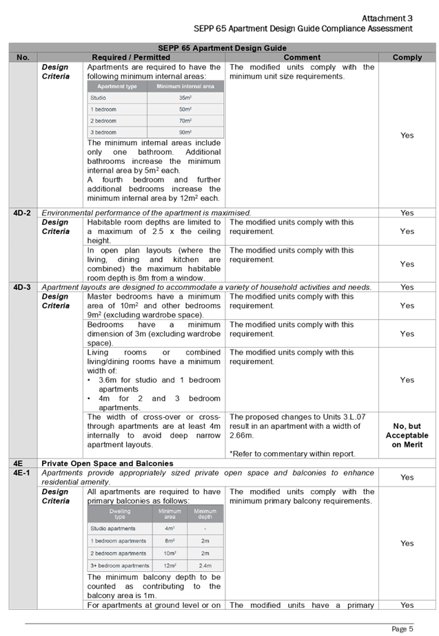
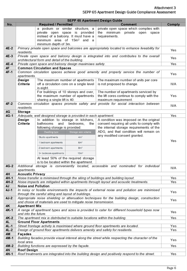
Pursuant to clause 28(2)(c) of SEPP 65, a consent authority
must consider the provisions of the Apartment Design Guide (ADG) in the
assessment of a residential apartment development. The proposed development has
been assessed to comply with the requirements of the ADG, with the exception of
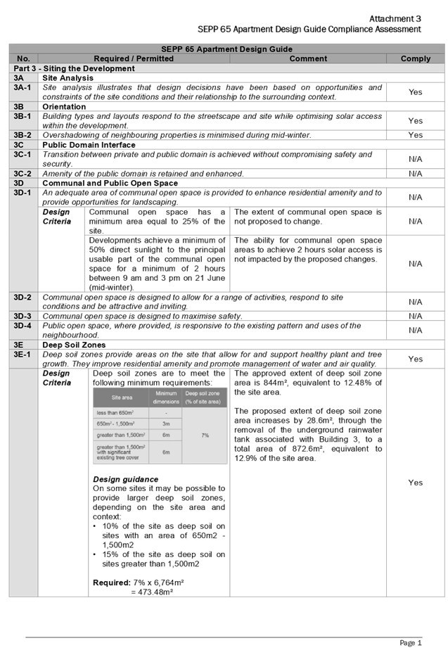
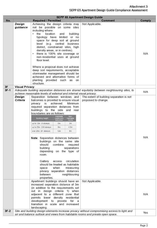
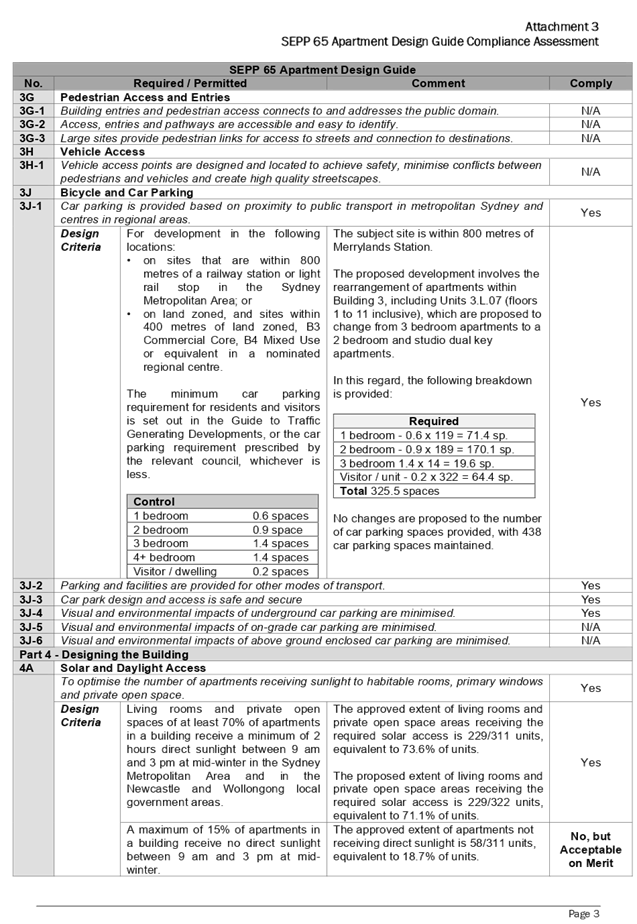
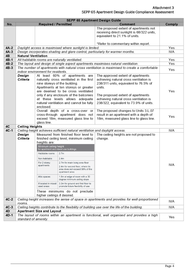
solar and daylight access, and apartment size and layout, which are discussed
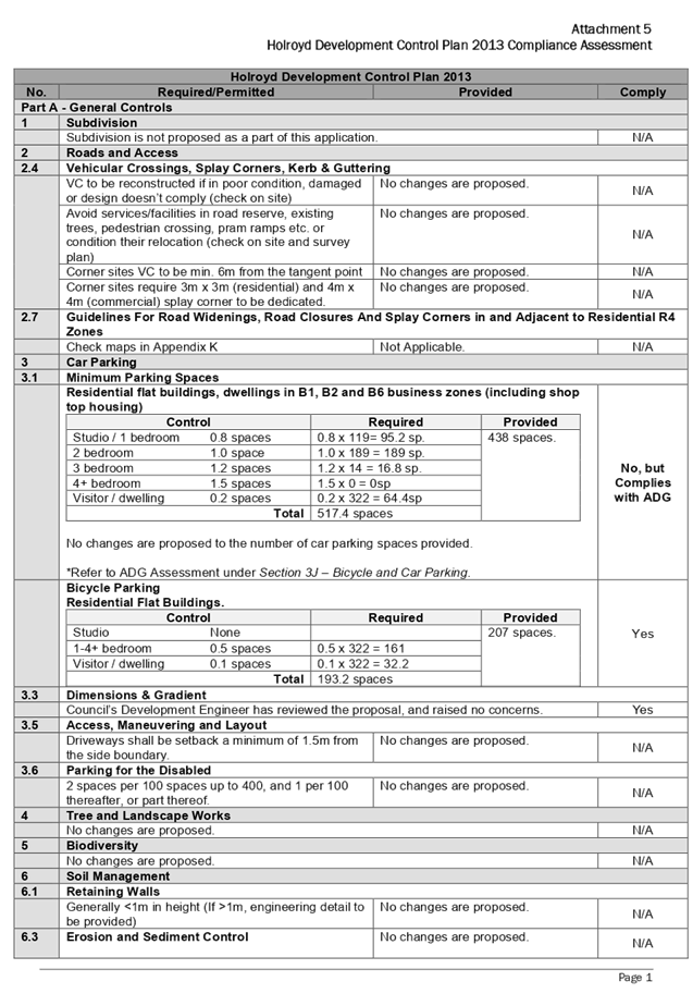
below. A comprehensive assessment against the ADG is contained in Attachment 3
to this report.
Variations Sought
Solar Access and Daylight
· The
ADG requires a maximum of 15% of apartments in a building may not receive
direct sunlight between 9am and 3pm midwinter. In this regard, the proposed
modification maintains 21.1% of units not receiving direct sunlight between 9am
and 3pm midwinter, representing a variation of 19 units. Importantly, the
approved development has been endorsed with a variation of 18.7% of units not
receiving direct sunlight between 9am and 3pm midwinter, representing an
approved variation of 9 units. In this regard, the proposed variation to the
approved development is maintained to 10 units.
Note: The percentage variations listed above are based upon
the number of approved and proposed units respectively.
The proposed variation achieves the aims of Objective 4A-1 -
Solar and Daylight Access, and is considered supportable on merits, noting:
o In accordance with
Design Criteria 4A-1 – Solar and Daylight Access of the ADG, living rooms
and private open spaces of at least 70% of apartments in a building shall
receive a minimum of 2 hours direct sunlight between 9am and 3pm at mid-winter.
In this regard, the proposed development maintains 229 units achieving 2 hours
solar access, equivalent to 71.1% of units.
o The non-compliance is a
result of the introduction of dual key apartment for Units 3.L.07 (totalling 11
apartments), which proposes to alter the approved 3 bedroom unit design to a 2
bedroom unit and studio unit. The proposed change allows the development to
achieve Objective 4K-1 – Apartment Mix, which aims to provide ‘a
range of apartment types and sizes to cater for different household types now
and into the future’.
Apartment Size and Layout
· The
ADG requires the width of cross-over and cross-through apartments to be at
least 4m internally, to avoid deep narrow apartment layouts. In this regard,
the proposed modification application proposes to reduce the width of Units
3.L.07 located within Building 3 to a width of 2.66m, representing a variation
of 33.5%.
The proposed variation achieves the aims of Objective 4D-3
– Apartment Size and Layout, and is considered supportable on merits, noting:
o The narrowed width is
maintained to a limited area of the unit, being the area associated with a
bedroom plus ensuite, and bathroom. The living areas within the unit continue
to achieve an appropriate level of amenity, with the combined living, dining
and lounge room continuing to comply with the minimum 4m width requirement.
o The non-compliance is a
result of the introduction of a dual key apartment for Units 3.L.07, which
proposes to alter the approved 3 bedroom unit design to a 2 bedroom unit and
studio unit. The proposed change allows the development to achieve Objective
4K-1 – Apartment Mix, which aims to provide ‘a range of apartment
types and sizes to cater for different household types now and into the
future’.
(d) State
Environmental Planning Policy (Building Sustainability Index: BASIX) 2004
A BASIX Certificate has been lodged as a part of the
modification application. The BASIX certificate indicates that the development
has been designed to achieve the required water, thermal comfort and energy
scores.
(e) State
Environmental Planning Policy (Coastal Management) 2018
The subject site is not identified as a coastal wetland and
is not or land identified as “proximity area for coastal wetlands”.
(f) (State
Environmental Planning Policy (Infrastructure) 2007 (ISEPP)
The provisions of State Environmental Planning Policy
(Infrastructure) 2007 (ISEPP) have been considered in the assessment of the
modification application.
Clause 45 - Development likely to affect an electricity
transmission or distribution network
The application is subject to Clause 45 of the ISEPP, as the
subject development occurs within 5 metres of an overhead electricity power
line and the original proposed development also included a substation, which is
proposed to be relocated. As such, the Consent Authority is required to give
written notice to an electricity supply authority. The modification application
was referred to Endeavour Energy, who advised that the modified development
proposal is supported, subject to standard recommendations and comments.
Clause 85 – Development adjacent to railway
corridors
The application is subject to Clause 85 of the ISEPP, as the
subject site is located adjacent to a railway corridor. No changes are proposed
to the development which would trigger a re-assessment against Clause 85 of the
ISEPP.
Clause 86 – Excavation in, above, below or adjacent
to rail corridors
The application is subject to Clause 86 of the ISEPP, as the
redevelopment of the site involves excavation to a depth of at least 2m below
ground level (existing), on land within 25m (measured horizontally) of a rail
corridor. No changes are proposed to the development which would trigger a
re-assessment against Clause 86 of the ISEPP.
Clause 87 – Impact of rail noise or vibration on
non-rail development
The application is subject to clause 87 of the ISEPP, as the
site is in or adjacent to a rail corridor or is likely to be adversely affected
by rail noise or vibration. No changes are proposed to the development which
would trigger a re-assessment against Clause 87 of the ISEPP.
Clause 101 – Frontage to classified road
The application is not subject to clause 101 of the ISEPP,
as the site does not have a frontage to a classified road.
Clause 102 – Impact of road noise or vibration on
non-road development
The application is not subject to clause 102 of the ISEPP,
as the annual average daily traffic volume of Neil Street is less than 40,000
vehicles.
Clause 104 – Traffic generation developments
The original development application proposed over 300
dwellings and over 400 parking spaces, and accordingly was referred to
Transport for NSW (formerly the RMS) for comment in accordance with Clause 104
of the ISEPP. No changes are proposed to the development which would trigger a
re-assessment against Clause 104 of the ISEPP.
(g) State
Environmental Plan (Sydney Harbour Catchment) 2005
The subject site is identified as being located within the
area affected by the Sydney Environmental Plan (Sydney Harbour Catchment) 2005.
The proposed development raises no issues, as no impact on the catchment is
envisaged.
Note: The subject site is not identified in the relevant map
as land within the ‘Foreshores and Waterways Area’ or
‘Wetland Protection Zone’, is not a ‘Strategic Foreshore
Site’ and does not contain any heritage items. Hence the majority of the
State Environmental Plan is not directly relevant to the proposed development.
(h) State
Environmental Planning Policy (Vegetation in Non-Rural Areas) 2017 (Vegetation
SEPP)
State Environmental Planning Policy (Vegetation in Non-Rural
Areas) 2017 (Vegetation SEPP) applies to the subject site. An assessment of the
proposal has revealed the proposed development complies with the requirements
of the Vegetation SEPP, noting:
· The
site is not located in a declared area of outstanding biodiversity value as
outlined within the Biodiversity Values Map;
· The
proposed modifications do not include tree removal, and therefore the area
clearing threshold for native vegetation pursuant to the Biodiversity
Conservation Act 2016 is not applicable; and
iii)
· The
proposal does not include tree removal, and therefore the test of significance
pursuant to Section 7.3 of the Biodiversity Conservation Act 2016 is not
applicable.
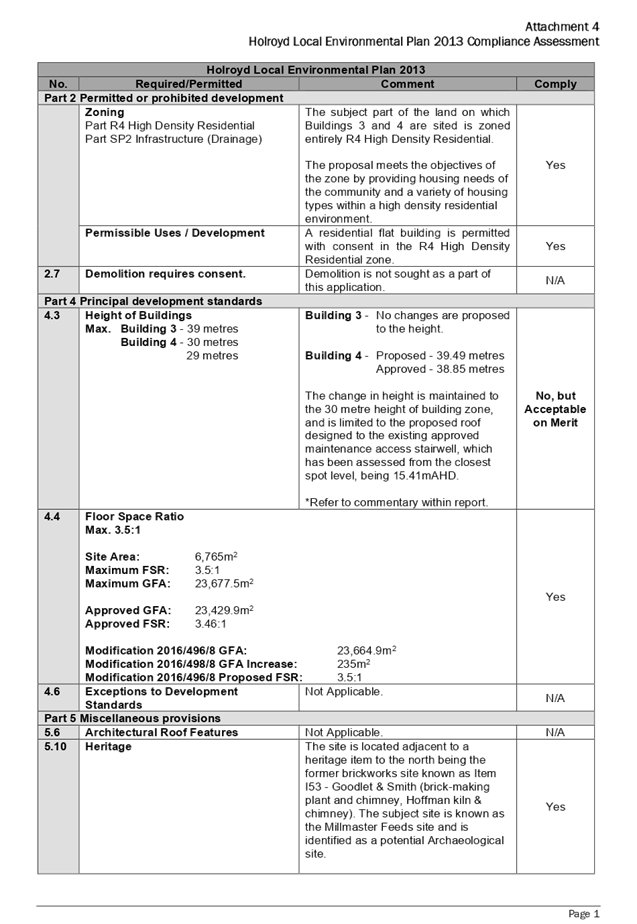
(i) Holroyd
Local Environmental Plan 2013 (HLEP)
The Holroyd Local Environmental Plan 2013 (HLEP) applies to
the subject site. The proposed development has been assessed to comply with the
requirements of HLEP, with the exception of the Height of Buildings (HOB)
development standard, which is discussed below. The relevant matters to be
considered under HLEP, and the applicable clauses for the proposed development,
are summarised below. A comprehensive assessment against the HLEP is contained
in Attachment 4 to this report.
Permissibility
The part of the land on which Buildings 3 and 4 are sited is
zoned R4 High Density Residential pursuant to the HLEP. The subject development
continues to be characterised as 2 x residential flat buildings.
Residential flat building means a building containing 3 or
more dwellings, but does not include an attached dwelling or multi dwelling
housing.
Note. Residential flat buildings is a type of residential
accommodation
Heritage
The subject site is located adjacent to a heritage item to
the north being the former brickworks site known as Item I53 - Goodlet &
Smith (brickmaking plant and chimney, Hoffman kiln & chimney) under the
HLEP. The subject site is known as the Millmaster Feeds site and is identified
as a potential Archaeological site.
Given the minor nature of the changes proposed, the proposal
is not expected to negatively impact upon on the heritage item, or potential
archaeology on the site.
Key Development Standards
The following key development standards are applicable:
|
Development
Standard
|
Maximum
|
Proposed
|
Compliance
|
|
Floor Space Ratio
(FSR)
|
3.5:1
|
3.5:1
|
Yes
|
|
Height of Buildings
(HOB)
|
Building 3 - 39m
Building 4 - 30m
29m
|
Building 3 - No
changes are proposed to the height.
Building 4 - Proposed
- 39.49m
Approved
- 38.85m
The change in height is
maintained to the 30 metre height of building zone, and is limited to the
proposed roof to the existing approved maintenance access stairwell, which
has been assessed from the closest spot level, being 15.41mAHD.
|
No,
but Acceptable on Merit
|
Variations Sought
Height of Buildings
|
Height of Buildings
|
Building 4 - 30m
|
38.85m
|
39.49m
|
1.6% (Approved HOB)
31.6% (HLEP HOB Standard)
|
The subject modification application proposes an increase in
the Height of Buildings (HOB) of Building 4 by 0.64m, which increases the HOB
variation from 38.85m (approved under Section 4.56 Application M2016/496/4) to
39.49m.
A Clause 4.6 request is not required as the application is
made under Section 4.56 of the Environmental Planning and Assessment Act, 1979,
however, Council has considered the proposed variation based on the various
case laws established by the Land and Environment Court of NSW such as
Four2five P/L v Ashfield Council [2015] NSWLEC 9, Randwick City Council v
Micaul Holdings P/L [2016] NSW LEC7 and Zhang and anor v Council of the City of
Ryde [2016] NSWLEC 1179. The above case laws set out a 3 part assessment
framework for a variation request, which is discussed in detail below.
The 3 preconditions which must be satisfied before the
application can proceed are as follows:
1. Is
the proposed development consistent with the objectives of the zone?
The modified development is considered to be consistent with
the R4 High Density Residential objectives, as it provides for the housing
needs of the community, and a variety of housing types within a high density
residential environment.
2. Is
the proposed development consistent with the objectives of the development
standard which is not met?
The modified development is considered to be consistent with
the Height of Building objectives as outlined within Clause 4.3 of the HLEP, as
it minimises the visual impact of the development, ensures sufficient solar
access and privacy for neighbouring properties is maintained, and provides an appropriate
scale of development.
3. a) Is
compliance with the development standard unreasonable or unnecessary in the
circumstances of the case? and;
Strict compliance with the development standard in this
instance is considered to be unreasonable and unnecessary in this instance as:
· The
site continues to be consistent with the high density residential character
envisaged by the R4 High Density Residential zone, and the sites’
proximity to public transport and the town centre.
· The
additional height is maintained to the proposed roof cover over the approved
stairwell access of Building 4, and will not result in noticeable bulk, as
viewed from the public domain.
· The
additional height does not change how the building will be read in the contact
of the overall development.
· The
additional height does not result in additional overshadowing, view loss or a
reduction in privacy.
b) Are there
sufficient environmental planning grounds to justify contravening the
development standard and therefore is the applicant’s written
justification well founded?
The circumstances of the case are
considered to warrant support of the departure. The development continues to
respond to the site, and does so without unduly compromising relationships with
adjoining development, and the development does not unduly compromise other
relevant controls. The proposal is considered to be consistent with the
objectives of the Height of Buildings development standard, and development
within the R4 High Density Residential zone. In this regard, the exception is
well founded and can be supported.
Council is satisfied that the proposed development will be
in the public interest, as it is consistent with the objectives of the
particular standard and the objectives for development within the zone in which
the development is proposed to be carried out.
It is the view of Council Officers that considering the
application on its merit, the variation to the maximum Height of Buildings
development standard is considered acceptable in this instance.
The provisions of any Proposed Instruments (EP & A
Act s4.15 (1)(a)(ii))
The following draft Environmental Planning Instruments are
relevant to the assessment of the subject application:
(a) Draft
State Environmental Planning Policy (Environment) (Draft ESEPP)
The Draft State Environmental
Planning Policy (Environment) (Draft ESEPP) relates to the protection and
management of our natural environment with the aim of simplifying the planning
rules for a number of water catchments, waterways, urban bushland, and
Willandra Lakes World Heritage Property. The changes proposed include
consolidating the following seven existing SEPPs:
· State
Environmental Planning Policy No. 19 – Bushland in Urban Areas.
· State
Environmental Planning Policy (Sydney Drinking Water Catchment) 2011.
· State
Environmental Planning Policy No. 50 – Canal Estate Development.
· Greater
Metropolitan Regional Environmental Plan No. 2 – Georges River Catchment.
· Sydney
Regional Environmental Plan No. 20 – Hawkesbury-Nepean River (No.2-1997).
· Sydney
Regional Environmental Plan (Sydney Harbour Catchment) 2005.
· Willandra
Lakes Regional Environmental Plan No. 1 – World Heritage Property.
The Draft ESEPP will repeal the
above existing SEPPs and certain provisions will be transferred directly to the
new SEPP, amended and transferred, or repealed due to overlaps with other areas
of the NSW planning system.
Changes are also proposed to the
Standard Instrument – Principal Local Environmental Plan. Some provisions
of the existing policies will be transferred to new Section 117 Local Planning
Directions where appropriate.
Refer to assessment above under
the heading ‘State Environmental Plan (Sydney Harbour Catchment)
2005’.
(b) Draft
Cumberland Local Environmental Plan 2020 (Draft CLEP)
The Draft Cumberland Local
Environmental Plan 2020 (Draft CLEP) has been prepared by Cumberland Council to
provide a single planning framework for the future planning of Cumberland City.
The changes proposed seek to harmonise and repeal the three existing LEPs
currently applicable to the Cumberland City local government area, those being:
· Holroyd
Local Environmental Plan 2013
· Parramatta
Local Environmental Plan 2011.
· Auburn
Local Environmental Plan 2010.
The current planning controls for
the subject site, related to Height of Buildings (HOB) and Floor Space Ratio
(FSR), as contained within the HLEP, are not proposed to change under the Draft
CLEP.
The Draft CLEP however de-lists
the subject site from the Cumberland Heritage List, as all structures and
remnants relating to its former uses have been removed and the site is
currently undergoing redevelopment. Any built features relating to its former
significance are no longer present, and any archaeological potential would be
considered low/nil and likely to be highly disturbed.
(c) Planning
Proposal for 20-22 Dressler Court, Merrylands (PP)
A Planning Proposal for 20-22
Dressler Court, Merrylands (PP) has been lodged with Council, which seeks to
amend the HLEP by:
· Amending
the Floor Space Ratio (FSR) development standard from 3.5:1 to 3.66:1; and
· Amend
the Height of Building (HOB) development standard for the southern portion of
the site from 39m to 50m.
· The
PP notes the intended outcomes for the planning proposal are as follows:
· Create
a strong urban corner to Neil Street, identifying and reinforcing this gateway
to the Merrylands Town Centre from Neil Street to the east;
· Establish
a building height which is generally consistent with the surrounding built
form;
· Present
a more suitable transition in building height from the higher scale mixed use
development in the core of the Merrylands town centre to the lower-scale
residential development and the Holroyd Gardens to the north;
· Create
variation in the height plane that currently sees a plateau of 12 storeys on
the site;
· Contribute
to the integration of development with public transport by creating higher
residential density 300m from the Merrylands Railway Station; and
· Provide
a mix of housing choices within the locality; and maintain and contribute to
the natural landscape by responding to dedication of land on the site to
provide a future public park and landscaped drainage swale corridor.
The following assessment under the development standards are
applicable:
|
Development
Standard
|
Maximum
|
Proposed
|
Compliance
|
|
Floor Space Ratio
(FSR)
|
3.66:1
|
3.5:1
|
Yes
|
|
Height of Buildings
(HOB)
|
Building 3 - 50m
|
No changes are
proposed to the height of Building 3.
|
N/A
|
The provisions of any Development Control Plans (EP &
A Act s4.15 (1)(a)(iii))
The following Development Control Plans are relevant to the
assessment of the subject modification application:
(a) Holroyd
Development Control Plan 2013 (HDCP)
The Holroyd Development Control
Plan 2013 (HDCP) provides guidance for the design and operation of development
to achieve the aims and objectives of the HLEP. The proposed development
complies with the relevant provisions of the HDCP and is considered acceptable
from an environmental planning view point. A detailed assessment against the
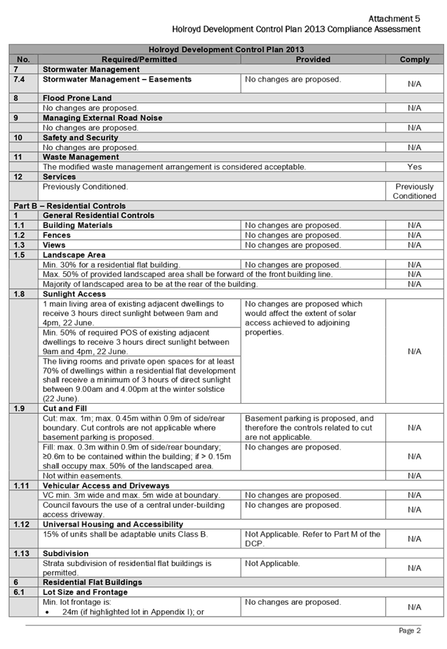
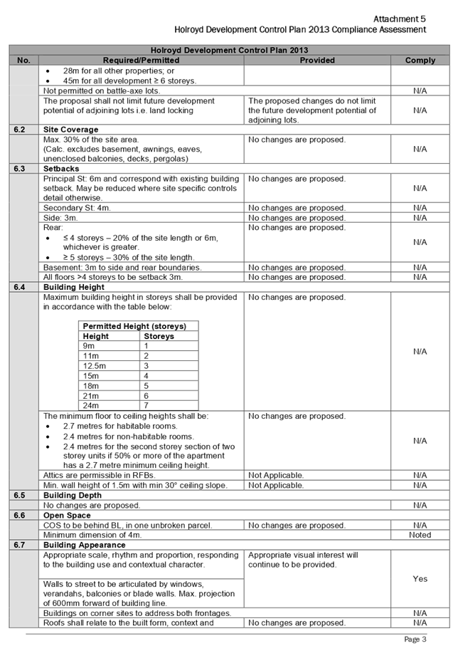
provisions of the HDCP is contained in Attachment 5 to this report.
The provisions of any planning agreement that has been
entered into under section 7.4, or any draft planning agreement that a
developer has offered to enter into under section 7.4 (EP & A Act
s4.15(1)(a)(iiia))
There is no planning agreements or draft planning agreements
associated with the subject modification application.
The provisions of the Regulations (EP & A Act s4.15
(1)(a)(iv))
The proposed development raises no concerns as to the
relevant matters arising from the Environmental Planning and Assessment
Regulations 2000 (EP & A Regs).
The Likely Environmental, Social or Economic Impacts (EP
& A Act s4.15 (1)(b))
It is considered that the proposed development will have no
significant adverse environmental, social or economic impacts in the locality.
The suitability of the site for the development (EP &
A Act s4.15 (1)(c))
The subject site and locality is not known to be affected by
any natural hazards or other site constraints likely to have a significant
adverse impact on the proposed development. The proposal seeks modification to
Buildings 3 and 4 of the approved residential flat building development.
Modifications are minor in nature and will not create adverse impacts on the
surrounding development. Accordingly, it is considered that the development is
suitable in the context of the site and surrounding locality.
Submissions made in accordance with the Act or Regulation
(EP & A Act s4.15 (1)(d))
Advertised (newspaper) Mail Sign Not Required
In accordance with Council’s Notification requirements
contained within the HDCP, the proposal was publicly notified for a period of
21 days between 26 February 2020 and 18 March 2020. In response, one (1)
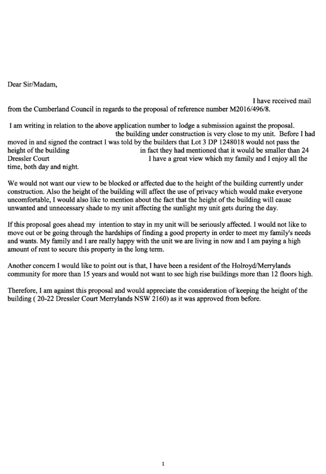
submission was received, which is contained within Attachment 6 to this report.
|
Issue
|
Planners Comment
|
|
Height
Concern is raised regarding the height of the building,
with reference to view loss, visual privacy and solar access.
|
The subject modification application proposes an increase
in the height of Building 4 by 0.64m, and is maintained to the proposed roof
cover over the approved stairwell access.
The proposed height increase has been considered within
the assessment of this application, and has been found to not result in additional
overshadowing, or reduction in privacy to adjoining properties.
Furthermore, the additional height is limited to an area
of 13.3m². Considering no other buildings in the vicinity of the site
are of the same height, view loss to surrounding properties is not expected
to occur.
|
The public interest (EP & A Act s4.15(1)(e))
The public interest is served by permitting the orderly and
economic use of land, in a manner that is sensitive to the surrounding
environment and has regard to the reasonable amenity expectations of
surrounding land users. In view of the foregoing analysis, it is considered
that approval of the proposed development would not be contrary to the public
interest.
Section 7.11 (Formerly S94 Contributions)
This part of the Act relates to the collection of monetary
contributions from Applicants for use in developing key local infrastructure.
The subject development requires the payment of contributions in accordance
with Holroyd Section 94 Development Contributions Plan 2013.
A condition was imposed on the original consent requiring
the payment of contributions, which has been satisfied with a Works-In-Kind
agreement entered into with Cumberland City Council. Modification application
2016/496/7 related to 20-22 Dressler Court, Merrylands, required the payment of
additional contributions to the amount of $82,632 (CPI based on August 2019),
noting the changes made to the unit mix of Building 4. Similarly, the subject
application requires the payment of additional contributions, noting the
changes made to the unit mix of Building 3.
In accordance with the currently indexed rates, the
following additional contributions apply:
- 11
x 1 bedroom units = $157,064
- 11
x 2 bedroom units = $265,624
- Credit
of 11 x 3 bedroom units = ($353,455)
The current rate of contributions applicable for the
proposed changes is $69,233. The draft Notice of Determination at Attachment 2
includes a recommendation to reflect the above contributions.
Disclosure of Political Donations and Gifts
The NSW Government has introduced disclosure requirements
for individuals or entities with a relevant financial interest as part of the
lodgement of various types of development proposals and requests to initiate
environmental planning instruments or development control plans.
The application and notification process did not result in
any disclosure of Political Donations or Gifts.
The proposed development has been
assessed against the matters for consideration listed in Section 4.15 of the EP
& A Act, 1979, and is considered to be satisfactory. Any likely impacts of
the development have been satisfactorily addressed and the proposal is
considered to be in the public interest. Further, the subject site continues to
be suitable for the development.
The proposed development is
appropriately located within the R4 High Density Residential zone under the
relevant provisions of the HLEP and is consistent with the zone objectives. The
development however proposes a variation to the solar and daylight access, and
apartment size and layout design criteria under the ADG, and further variation
to the Height of Buildings (HOB) development standard under the HLEP. The development
is considered to perform adequately in terms of its relationship to its
surrounding built and natural environment, particularly having regard to
impacts on adjoining properties.
The development, as proposed to be
modified, is considered to be substantially the same development as approved
and modified and therefore satisfactory for approval subject to conditions.
|
1. That
modification application M2016/496/8 seeking internal and external
alterations to Buildings 3 and 4, including changes to basement levels,
rearrangement of apartments to introduce additional dual key apartments,
enlargement of Building 3 footprint, modification of roof form,
reconfiguration of OSD tanks, relocation of substation kiosk and changes to
glazed areas at 20-22 Dressler Court, Merrylands, be approved, subject to the
conditions contained in the draft notice of determination contained in
Attachment 2 of this report.
iv)
2. Persons
whom have lodged a submission in respect to the application be notified of the
determination of the application.
|
1. Attachment
1 - Architectural Plans
2. Attachment
2 - Draft Notice of Determination
3. Attachment
3 - SEPP 65 Apartment Design Guide Compliance Assessment
4. Attachment
4 - Holroyd Local Environmental Plan 2013 Compliance Assessment
5. Attachment
5 - Holroyd Development Control Plan 2013 Compliance Assessment
6. Attachment
6 - Submission X 1
DOCUMENTS
ASSOCIATED WITH
REPORT ELPP021/20
Attachment 1
Attachment 1 - Architectural Plans
Extraordinary Cumberland Local Planning
Panel Meeting
27 May 2020
DOCUMENTS
ASSOCIATED WITH
REPORT ELPP021/20
Attachment 2
Attachment 2 - Draft Notice of Determination
Extraordinary Cumberland Local Planning
Panel Meeting
27 May 2020


DOCUMENTS
ASSOCIATED WITH
REPORT ELPP021/20
Attachment 3
Attachment 3 - SEPP 65 Apartment Design Guide
Compliance Assessment
Extraordinary Cumberland Local Planning
Panel Meeting
27 May 2020
DOCUMENTS
ASSOCIATED WITH
REPORT ELPP021/20
Attachment 4
Attachment 4 - Holroyd Local Environmental Plan 2013 Compliance
Assessment
Extraordinary Cumberland Local Planning
Panel Meeting
27 May 2020
DOCUMENTS
ASSOCIATED WITH
REPORT ELPP021/20
Attachment 5
Attachment 5 - Holroyd Development Control Plan 2013
Compliance Assessment
Extraordinary Cumberland Local Planning
Panel Meeting
27 May 2020
DOCUMENTS
ASSOCIATED WITH
REPORT ELPP021/20
Attachment 6
Attachment 6 - Submission X 1
Extraordinary Cumberland Local Planning
Panel Meeting
27 May 2020
Extraordinary
Cumberland Local Planning Panel Meeting
27 May 2020
Item
No: ELPP022/20
Development
Application for 27-29 Toongabbie Road, Toongabbie
Responsible
Division: Environment
& Planning
Officer: Executive
Manager Development and Building
File
Number: DA2019/0506
|
Application lodged
|
19
December 2019
|
|
Applicant
|
Dawn
Enterprise Pty Ltd
|
|
Owner
|
Mr
P Kumar & Mrs P Guglani
|
|
Application No.
|
DA2019/0506
|
|
Description of Land
|
27-29
Toongabbie Road, Toongabbie NSW 2146, Lots 40 & 41 Section B DP 10697
|
|
Proposed Development
|
Demolition
of existing structures, consolidation of 2 lots into 1 lot, and construction
of a residential flat building including a 3 storey building facing Cox Lane
and a 5 storey building facing Toongabbie Road over basement parking
accommodating 20 residential units and 25 parking spaces
|
|
Site Area
|
1393.5m2
|
|
Zoning
|
R4
– High Density Residential
|
|
Disclosure of political donations and gifts
|
Nil
disclosure
|
|
Heritage
|
The
site is not a heritage item and is not located within a heritage conservation
area
|
|
Principal Development Standards
|
Height
of Buildings – 15 m
Proposed:
16.7m (RL47.35 – RL30.65m AHD)
Floor
Space Ratio – 1.2:1
Proposed:
1.29:1 (1,810.3m²) pre-dedication
1.42:1 (1,810.3m²) post-dedication
|
|
Issues
|
· Building
Height
· FSR
· Deep
soil
· Building
separation/visual privacy
· Ground
floor private open space
· Number
of storeys
· Site
coverage
· Adaptable
unit and accessible car space
· Basement
design
· Driveway
setback
· Waste
management
· Stormwater
management
· Land
dedication
|
1. The
subject application was lodged on 19 December 2019 and notified to surrounding
properties from 11 March 2020 to 1 April 2020. No submissions were received as
a result of the notification.
2. Council
through its assessment identified number of concerns with the proposal and
requested amended plans and additional information on 30 March 2020. Additional
information and amended plans to address the deferral items were received by
Council on 16 April 2020. The amended plans do not warrant renotification.
3. Issues
relating to variation to building height and FSR, number of storeys, basement
design, waste management, stormwater management, ADG non-compliances (deep
soil, building separation/visual privacy and ground floor POS), adaptable units
and car spaces, and inadequate information remain unresolved.
4. The
application involves the following numerical non-compliances which are not
considered supportable as discussed in detail elsewhere in the report:
|
Control
|
Required
|
Proposed
|
% Variation
|
|
Building height (LEP)
|
15m
|
16.7m
for the 5 storey building facing Toongabbie Road
(RL47.35
– RL30.65m AHD)
|
11.3%
|
|
FSR (LEP)
Site area:
1,393.5m² pre-dedication
1,271.58m² post-dedication
|
1.2:1 (1,672.2m²)
|
GFA = 1,810.3m²
1.29:1
|
8.25%
|
|
1.2:1 (1,525.89m²)
|
1.42:1
|
18.63%
|
|
Deep soil (ADG)
Site area:
1,393.5m² pre-dedication
1,271.58m² post-dedication
|
7% (97.5m²)
|
Area = 33.8m²
2.42%
|
65.3%
|
|
7% (89m²)
|
2.65%
|
62%
|
|
Building separation/ visual privacy (ADG)
|
6m (up to 4 storey)
|
3.8m for the 3 storey building facing Cox Lane
|
36.6%
|
|
Ground floor POS (ADG)
|
15m², min depth 3m
|
9.6m², min depth 2.7m
|
36%
|
|
Number of storeys (DCP)
|
4
|
5
|
25%
|
|
Site coverage (DCP)
Site area:
1,393.5m² pre-dedication
1,271.58m² post-dedication
|
Max
30% (418.05m²)
|
Area = 624.92m²
44.8%
|
49.48%
|
|
30% (381.47m²)
|
49.14%
|
63.81%
|
|
Driveway setback (DCP)
|
1.5m
|
700mm
|
53.3%
|
|
Adaptable unit & accessible car space (DCP)
|
15% (3)
1 space per unit (3)
|
2
2
|
33.33%
33.33%
|
|
Land dedication (Cox Lane) (DCP)
|
4m
Total area: 4x30.48 = 121.92m²
|
0
|
100%
|
5. The
application is being reported to the Cumberland Local Planning Panel (CLPP) for
determination as it involves variation to development standard more than 10%
and is a development with 4 or more storeys to which the State Environmental
Planning Policy No. 65 – Design Quality of Residential Apartment
Developments applies.
6. Having
regard to the nature and extent of the above variations, the application is
recommended for refusal with the reasons provided in the Draft Notice of
Determination held at Attachment 1.
REPORT:
Subject Site and Surrounding
Area
The subject site is known as 27-29
Toongabbie Road, Toongabbie and is legally described as Lots 40 and 41 Section
B in DP 10697. The total site area is 1,393.5m2 with frontage of 30.48m on
Toongabbie Road. Improvements on site consist of a single storey and a two
storey dwelling with associated outbuildings located on each of the existing
sites. There are existing trees located on the subject site and within the
Council’s street verge. The site falls towards Toongabbie Road by
approximately 1m from the north to south.
The subject site is located within
the R4 – High Density Residential zone and borders the B2 – Local
Centre zone to the north. It is located approximately within 300m walking
distance to Toongabbie Railway Station and the town centre. Vehicular access to
the site is designated from Cox Lane to the north. Part of Cox Lane servicing
the property at 64-78 Aurelia Street, which was approved for mixed use
development with seniors living (DA2016/57), has been completed. Existing
developments adjoining the site include single storey dwelling houses located
to the eastern and western sides. Residential flat building development has
been approved at 23-25 Toongabbie Road under DA2016/75. Existing lot at 31
Toongabbie Road will be landlocked as a result of this subject application as
it is also burdened by the land dedication to form part of Cox
Lane.
Toongabbie Road is presently
undergoing transformation by replacing the older stock of residential dwellings
with multi dwelling development and residential flat buildings. The site does
not contain any heritage items and is not within a heritage conservation area.
There are no heritage items located within the visual catchment of the subject
site.
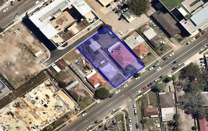
Aerial
view of the locality with subject site highlighted in dark blue. Source:
Nearmap 2020
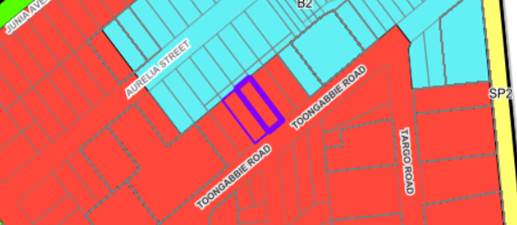
Zoning map with subject site marked in dark blue. Source:
Cumberland Council 2020
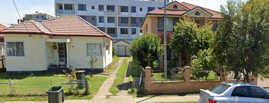
Subject
site – View from Toongabbie Road. Source: Cumberland Council 2020
Description of the Proposed
Development
DA2019/0506 proposes demolition of existing structures,
consolidation of 2 lots into 1 lot, and construction of a residential flat
building including a 3 storey building facing cox lane and a 5 storey building
facing Toongabbie Road over basement parking accommodating 20 residential units
and 25 parking spaces. Key features of the development proposal are as
follows:-
|
Level
|
Details
|
|
Basement
|
25 car spaces (including 2 accessible spaces), 1 car wash
bay, 16 bicycle spaces, storage, lift, staircases and service rooms
|
|
Ground floor
|
Lobby, postal boxes, communal open space, waste and fire
booster rooms
3 x 2-bedroom unit; 1 x 1-bedroom unit with study
Lift and staircases, private open space
|
|
First floor
|
1 x 1-bedroom unit; 1 x 1-bedroom unit with study; 2 x
2-bedroom unit; 1 x 2-bedroom unit with study; 1 x 3-bedroom unit
Lift and staircases, private open space
|
|
Second floor
|
1 x 1-bedroom unit with
study; 2 x 2-bedroom unit with study; 2 x 3-bedroom unit
Lift and staircases, private open space
|
|
Third floor
|
2 x 2-bedroom unit with
study; 1 x 3-bedroom unit
Lift and staircases, private open space
|
|
Fourth floor
|
2 x 2-bedroom unit
Lift and staircases, private open space
|
The proposed apartment mix is as follows:
· 4 x 1-bedroom
units (20%)
· 12 x 2-bedroom
units (60%)
· 4 x 3-bedroom
units (20%)
Application History
|
Date
|
Action
|
|
1 May 2019
|
The proposed development was privy to pre lodgement
meeting held at Council
|
|
13 December 2019
|
DA2019/361/1 for the demolition of existing structures and
construction of part 3, part 4 storey residential flat building comprising 20
residential units over ground floor car parking was withdrawn by the
applicant following number of concerns raised by Council.
|
|
19 December 2019
|
DA 2019/0506 lodged with Council
|
|
7 February 2020
|
Subject application referred to the following internal
sections for comment:
· Development
Engineering
· Landscaping/Tree
Management
· Waste Management
· Environmental
Health
|
|
7 February 2020
|
Subject application referred to the following external
agencies:
· Endeavour Energy
· Transgrid
· NSW Police
|
|
11 March 2020 to 1
April 2020
|
Subject application placed on public notification for 21
days
|
|
30 March 2020
|
Application deferred seeking additional information and
amended plans
|
|
16 April 2020
|
Amended plans and additional information received by
Council, which did not warrant renotification of the application
|
|
13 May 2020
|
Application referred to CLPP for determination
|
Applicant’s Supporting Statement
A Statement of Environmental Effects prepared by Think
Planners Pty Ltd dated 19 December 2019 was submitted with the application.
Contact with Relevant Parties
The assessing officer has undertaken an inspection of the
subject site and has been in contact with the applicant throughout the
assessment process.
Internal Referrals
Development Engineering
The application was referred to Council’s Development
Engineer for comment. Response received indicates that the proposal is not
satisfactory due to traffic and parking, basement design and stormwater
concerns. The matters raised are included in the reason for refusal.
Landscape and Tree Management
The application was referred to Council’s Tree
Management Officer for comment. Response indicates that the proposal could be
supported subject to conditions.
Environmental Health
The application was referred to Council’s
Environmental Health Officer for comment. The response received indicates that
the proposal could not be supported as a revised acoustic report to address
noise during construction, communal open space, and mechanical and basement
ventilations is required. If the proposal were to be supported, the revised
acoustic report could be conditioned. The matter raised is included in the
reason for refusal.
Waste Management
The application was referred to Council’s Waste
Management Officer for comment. The response received indicates that the
proposal, as amended, is not satisfactory due to odour impact from the proposed
openings of the waste storage room. The matter raised is included in the reason
for refusal.
External Referrals
Endeavour Energy
The application was referred to Endeavour Energy for comment
pursuant to clause 45 of the SEPP Infrastructure. The response received
indicates that Endeavour Energy does not object to the proposal, subject to
conditions.
Transgrid
The application was referred to Transgrid for comment. The
response indicates that Transgrid does not object to the proposal.
NSW Police
The application was referred to NSW Police for comment. The
response indicates that NSW Police does not object to the proposal, subject to
conditions.
Planning Assessment
The provisions of any Environmental Planning Instruments
(EP&A Act s4.15 (1)(a)(i))
The following Environmental Planning Instruments are
relevant to the assessment of the subject application:
(a) State
Environmental Planning Policy No 55 – Remediation of Land (SEPP 55)
The requirement at clause 7 of SEPP 55 for Council to be
satisfied that the site is suitable or can be made suitable to accommodate the
proposed development has been considered in the following table:
|
Matter
for consideration
|
Yes
|
No
|
|
Does the application involve re-development of the site or
a change of land use?
|
|
|
|
Is the development going to be used for a sensitive land
use (e.g. residential, educational, recreational, childcare or hospital)?
|
|
|
|
Does information available to you indicate that an
activity listed below has ever been approved, or occurred at the
site?
acid/alkali plant and formulation,
agricultural/horticultural activities, airports, asbestos production and
disposal, chemicals manufacture and formulation, defence works, drum
re-conditioning works, dry cleaning establishments, electrical manufacturing
(transformers), electroplating and heat treatment premises, engine works,
explosive industry, gas works, iron and steel works, landfill sites,
metal treatment, mining and extractive industries, oil production and
storage, paint formulation and manufacture, pesticide manufacture and
formulation, power stations, railway yards, scrap yards, service stations,
sheep and cattle dips, smelting and refining, tanning and associated trades,
waste storage and treatment, wood preservation
|
|
|
|
Is the site listed on Council's contaminated land
database?
|
|
|
|
Is the site subject to EPA clean-up order or other EPA
restrictions?
|
|
|
|
Has the site been the subject of known pollution incidents
or illegal dumping?
|
|
|
|
Does the site adjoin any contaminated land/previously
contaminated land?
|
|
|
|
Has the appropriate level of investigation been carried
out in respect of contamination matters for Council to be satisfied that the
site is suitable to accommodate the proposed development or can be made
suitable to accommodate the proposed development?
|
|
|
|
Details of
contamination investigations carried out at the site:
A Preliminary Site
Investigation prepared by Geotechnical Consultants Australia dated 6
September 2019 (E1961-1) was submitted with the application. The report
identified that the site is suitable for the proposed development, subject to
implementing recommendations in section 12 of the report, including the
completion of a Hazardous Materials Survey prior to the construction and
following the protocol of unexpected find. These matters could form part of
the conditions of consent, if the proposal were to be supported.
|
(b) State
Environmental Planning Policy (Building Sustainability Index: BASIX) 2004
BASIX certificate 1034598M_02 dated 16 December 2019 was
submitted with the application. The proposal achieves the target scores for
energy, water and thermal comfort and relevant commitments are shown on the
architectural plans.
(c) State
Environmental Planning Policy No 65 – Design Quality of Residential
Apartment Development (SEPP 65)
The proposal is classified as a residential apartment
development and SEPP 65 applies. A design verification statement signed by
registered architect Biljana Pop Stefanija (8789) was submitted with the
application.
The design quality principles from Schedule 1 of the SEPP
are considered in the following table:
|
Design quality
principle
|
Response
|
|
1. Context and
neighbourhood character
|
The design of
the residential flat buildings addressing Toongabbie Road and Cox Lane
facades with the addition of communal open space and landscaping provided in
the middle section has taken consideration of approved development at the
adjoining sites, 23-25 Toongabbie Road. The building façade consists
of articulated bedroom windows, moderate finishes and open style hallway and
lobby entry with metal railings. The proposed development will provide a
positive addition to the streetscape and character of the locality.
|
|
2. Built form and
scale
|
While the proposal adopts the general built from of
adjoining development, the overall excessive height and FSR makes it
inconsistent with the desired future character of the area.
|
|
3. Density
|
The proposal
does not comply with both of building height and FSR development standards
for the site.
|
|
4. Sustainability
|
A BASIX certificate was submitted with the application,
demonstrating that the building meets the applicable thermal comfort, energy
efficiency and water efficiency targets.
|
|
5. Landscape
|
The proposed development does not provide sufficient area
for deep soil to sustain the growth of canopy trees and positively contribute
to the landscaped area provision.
|
|
6. Amenity
|
The proposed development does not maintain amenity of the
residential units given the poor design of waste management room and
inadequate building separation on Cox Lane.
|
|
7. Safety
|
The proposal provides casual surveillance to the public
domain and communal areas whilst maintaining privacy for the proposed units
with well defined public and private areas and access within the development
is appropriately restricted to ensure safety of residents.
|
|
8. Housing diversity
and social interaction
|
The proposal provides for a mix of apartment sizes and
layouts for different types of housing needs. The provision of communal open
spaces and the design of the common circulation spaces will encourage social
interaction among residents.
|
|
9. Aesthetics
|
The proposal provides balanced
composition of building elements with a variety of colours and textures. The
external presentation of the building appearance has considered appropriate articulation that contribute
positively to the residents’ amenity and character of the locality.
|
Pursuant to clause 28(2)(c) of SEPP 65, a consent authority
must consider the provisions of the Apartment Design Guide (ADG) in the
assessment of a residential flat development.
The proposal involves the following non-compliances with the
ADG controls.
|
3F
|
Visual
Privacy
|
|
3F-1
|
Building
Height = 12m / 4 storeys
- Habitable Rm / Balc
= 6m
- Non-Habitable Rm =
3m
|
Habitable rooms and balconies
of 64-78 Aurelia Street has been provided with setback of 6m to Cox Lane
centre line. The subject development proposes
setback of 3.8m to Cox Lane centre line for the habitable rooms and
balconies, where 6m is required.
The proposed development does
not protect visual privacy between the adjoining properties across Cox Lane.
In this regard, the above non-compliance is considered
unacceptable and included as a reason for refusal in the draft notice of
determination.
|
|
3E
|
Deep
Soil Zones
|
|
3E-1
|
Deep soil zones provide areas
on the site that allow for and support healthy plant and tree growth. They
improve residential amenity and promote management of water and air quality.
Area of 7%
(97.5m²/pre-dedication,
89m²/post-dedication)
with minimum dimension of 3m
to be provided
|
The
area nominated for deep soil zone adjoining to Cox Lane is shown as OSD tank
on the stormwater plans. The actual area could be utilised as deep soil zone
with 3m dimension equates only to 33.8m², which is 2.24%
(pre-dedication) and 2.65% (post-dedication).
The proposed development does
not provide sufficient area for deep soil to sustain the growth of canopy
trees and positively contribute to the landscaped area provision.
In this regard, the above non-compliance is considered
unacceptable and included as a reason for refusal in the draft notice of
determination.
|
|
4E
|
Private Open Space and
Balconies
|
|
4E-1
|
For apartments at ground level
or on a podium or similar structure, a private open space is provided instead
of a balcony. It must have a minimum area of 15m2 and a minimum
depth of 3m.
|
Ground floor apartments (unit
1, 2, 3 and 4) have been provided with minimum POS of 9.6m² with minimum
depth of 2.7m.
In
this regard, the above non-compliance is considered unacceptable and included
as a reason for refusal in the draft notice of determination.
|
|
4W
|
Waste
Management
|
|
4W-1
|
Waste storage facilities are
designed to minimise impacts on the streetscape, building entry and amenity
of residents.
|
Waste storage room is to be located adjoining to unit 4
with openings next to the unit’s bedroom window. Waste storage
facilities location fails to consider adverse impacts on the amenity of
residents. If the proposal were to be supported, condition would be imposed
to delete the waste storage openings.
In this regard, the above
non-compliance is considered unacceptable and included as a reason for
refusal in the draft notice of determination.
|
A comprehensive ADG assessment is provided at Attachment 5.
(d) State
Environmental Planning Policy (Infrastructure) 2007
The provisions of the Infrastructure SEPP (ISEPP) 2007 have
been considered in the assessment of the development application.
Clause 45 - Development likely to affect an electricity
transmission or distribution network
The proposed development involves works within proximity to
the existing overhead power lines. As such, the application was referred to
Endeavour Energy for comment as the relevant electricity supply authority.
See discussion regarding the Endeavour Energy response under
‘external referrals’ above.
(e) Statement
Environmental Planning Policy No 19 - Bushland in Urban Areas
The proposal does not propose to disturb bushland zoned or
reserved for public open space.
(f) State
Environmental Planning Policy (Vegetation in Non-Rural Areas) 2017
The proposal includes removal of all existing trees within
the subject site. However, this does not exceed the biodiversity offsets scheme
threshold and the majority of the trees on site are exempt species. Therefore,
the proposed vegetation removal is considered acceptable. Please refer to the
HDCP 2013 compliance table at Attachment 5 for further comment regarding the
proposed tree removal.
(g) State
Environmental Planning Policy (Coastal Management) 2018
The subject site is not identified as a coastal wetland nor
is it ‘land identified as “proximity area for coastal
wetlands” as per Part 2, Division 1 of the SEPP Coastal Management 2018.
(h) Sydney
Regional Environmental Plan (Sydney Harbour Catchment) 2005
Note: Will be superseded once Draft SEPP Environment comes
into effect.
The subject site is identified as being located within the
area affected by the Sydney Regional Environmental Plan (Sydney Harbour
Catchment) 2005. The proposed development raises no issues as no impact on the
catchment is envisaged.
(Note: - the subject site is not identified in the relevant
map as ‘land within the ‘Foreshores and Waterways Area’ or
‘Wetland Protection zone’, is not a ‘Strategic Foreshore
Site’ and does not contain any heritage items. Hence the majority of the
SREP is not directly relevant to the proposed development).
(i) Holroyd
Local Environmental Plan 2013 (HLEP 2013)
The proposed development is defined as a ‘residential
flat building’ under the provisions of HLEP 2013. Residential flat
buildings are permitted with consent in the R4 – High Density Residential
zone which applies to the land. The proposed development results in the
following non-compliances.
|
DEVELOPMENT STANDARD
|
COMPLIANCE
|
DISCUSSION
|
|
4.3 Height of Buildings
15m
|
No
|
Proposed: 16.7m (RL47.35
– RL30.65m AHD)
Variation: 11.3%
Clause 4.6 variation request
accompanying the application states that the lift overrun exceeds the
building height standard by 0.6m. However, this height exceedance is measured
from the top of the roof that also exceeds the building height standard by
1.1m. The building height exceedance as measured from to the top of the lift
overrun is actually 1.7m, which applies to the building facing Toongabbie
Road. The building at the rear facing Cox Lane has a compliant building
height.
|
|
4.4 Floor Space Ratio
(FSR)
Max 1.2:1
(1,672.2m²) pre-dedication
Max 1.2:1
(1,525.89m²) post-dedication
|
No
|
The applicant’s GFA calculation shows that the total
GFA of the development is 1,671.7m².
Assessing Officer’s calculation:
Proposed GFA = 1,810.3m²
FSR = 1.29:1 (pre-dedication)
Variation: 8.25%
FSR = 1.42:1 (post-dedication)
Variation: 18.63%
Note: The applicant’s calculation has excluded lobby
area and waste storage room on the ground floor. The total GFA of the
proposed development in accordance with the assessing officer’s
calculation equates to 1,810.3m².
No clause 4.6 variation request has been submitted
accompanying the application for the breach in FSR.
|
|
4.6 Exceptions to
development standards
|
No
|
The applicant has not submitted an updated written request
to vary the development standard for height of buildings and floor space
ratio. Council is not satisfied that the applicant’s written request
has adequately addressed the matters required to be demonstrated by clause
4.6 subclause (3) due to the inadequate and conflicting information submitted
with the application. Council is not satisfied that the proposed development
will be in the public interest as it is inconsistent with the objectives of
the particular standard and the objectives for development within the zone in
which the development is proposed to be carried out.
The concurrence of the
Secretary can be assumed in the circumstances. However, the variation request
is not considered well-founded and this has been included as a reason of
refusal in the draft notice of determination.
|
|
6.3 Essential Services
|
No
|
Insufficient details have been provided in relation to the
location of substation for the proposed development to ensure adequate supply
of electricity on the subject site complying with the flood floor level
control.
|
|
6.7 Stormwater
Management
|
No
|
Amended stormwater plans have not addressed cross
ventilation openings required for the stormwater system. The openings are
proposed within the vehicles/garbage truck pull in bay, which will allow
contamination to seep into the OSD tank. The location of stormwater system
must also not be located within area to be dedicated as part of Cox Lane. In this regard, the location of OSD
tank is not supported, and insufficient stormwater management details raised
form part of the reasons for refusal contained within the draft notice of
determination.
|
A comprehensive LEP compliance table is provided at
Attachment 5.
The provisions of any proposed instrument that is or has
been the subject of public consultation (EP&A Act s4.15 (1)(a)(ii))
(a) Draft
Cumberland Local Environmental Plan 2020 (Draft CLEP)
The Draft Cumberland Local Environmental Plan 2020 (Draft
CLEP) has been prepared by Cumberland Council to provide a single planning
framework for the future planning of Cumberland City. The changes proposed seek
to harmonise and repeal the three existing LEPs currently applicable to the
Cumberland City local government area, those being:
· Holroyd
Local Environmental Plan 2013
· Parramatta
Local Environmental Plan 2011.
· Auburn
Local Environmental Plan 2010.
The current planning controls for the subject site, as
contained within the HLEP, are not proposed to change under the Draft CLEP.
(b) Draft
State Environmental Planning Policy (Environment)
The draft SEPP relates to the protection and management of
our natural environment with the aim of simplifying the planning rules for a
number of water catchments, waterways, urban bushland, and Willandra Lakes
World Heritage Property. The changes proposed include consolidating the
following seven existing SEPPs:
· State
Environmental Planning Policy No. 19 – Bushland in Urban Areas
· State
Environmental Planning Policy (Sydney Drinking Water Catchment) 2011
· State
Environmental Planning Policy No. 50 – Canal Estate Development
· Greater
Metropolitan Regional Environmental Plan No. 2 – Georges River Catchment
· Sydney
Regional Environmental Plan No. 20 – Hawkesbury-Nepean River (No.2-1997)
· Sydney
Regional Environmental Plan (Sydney Harbour Catchment) 2005
· Willandra
Lakes Regional Environmental Plan No. 1 – World Heritage Property.
The draft policy will repeal the above existing SEPPs and
certain provisions will be transferred directly to the new SEPP, amended and
transferred, or repealed due to overlaps with other areas of the NSW planning
system.
Changes are also proposed to the Standard Instrument –
Principal Local Environmental Plan. Some provisions of the existing policies
will be transferred to new Section 117 Local Planning Directions where
appropriate.
The provisions of any Development Control Plans (EP&A
Act s4.15 (1)(a)(iii))
(a) Holroyd
Development Control Plan 2013
HDCP 2013 contains general controls which relate to all
developments under Part A, and Residential Controls under Part B.
A comprehensive HDCP compliance table is attached to this
report at Attachment 5. A summary of the DCP non-compliances is provided in the
following table.
|
No.
|
Clause
|
Comment
|
Yes
|
No
|
N/A
|
|
PART A –
GENERAL CONTROLS
|
|
3.3
|
Car Parking,
Dimensions & Gradient
|
|
|
Council’s Traffic
Engineer has assessed the submitted plans and documentation and advised the
proposal is not satisfactory. The proposed basement arrangement has not
demonstrated proper vehicles manoeuvring to allow for sufficient passing and
turning bays as aisle width do not comply. Circulation manoeuvring clearance
is required to access entry/exist ramp.
|
|
|
|
|
3.5
|
Access, Manoeuvring
and Layout
|
|
|
Council’s Traffic
Engineer has assessed the submitted plans and documentation and advised the
proposal is not satisfactory.
|
|
|
|
|
|
Driveways shall be
setback a minimum of 1.5m from the side boundary.
|
The proposed driveway
and vehicular crossing is offset 700mm from the eastern side property
boundary. Clearance of at least 1m is required from the existing street light
column/light pole. Unsatisfactory.
|
|
|
|
|
3.6
|
Parking for the
Disabled
|
|
|
1 accessible space
shall be provided per adaptable unit.
|
2 accessible car spaces proposed, where 3 spaces are required.
|
|
|
|
|
7
|
Stormwater
Management
|
|
|
Amended stormwater
plans have not addressed cross ventilation openings required for the
stormwater system. The openings are proposed within the vehicles/garbage
truck pull in bay, which will allow contamination to seep into the OSD tank.
The location of stormwater system must not be located within area to be
dedicated as part of Cox Lane. In this regard, the location of OSD tank is not supported.
|
|
|
|
|
11
|
Waste Management
|
|
11.3
|
Residential Land Use Waste Management
|
|
|
Waste storage room is
to be located adjoining to unit 4 with openings next to the unit’s
bedroom window. Waste storage facilities location fails to consider adverse
impacts on the amenity of residents. If the proposal were to be supported,
condition would be imposed to delete the waste storage openings.
|
|
|
|
|
12
|
Services
|
|
|
Insufficient details
have been provided in relation to the location of substation for the proposed
development to ensure adequate supply of electricity on the subject site
complying with the flood floor level control.
|
|
|
|
|
PART B –
RESIDENTIAL CONTROLS
|
|
1.12
|
Universal Housing
and Accessibility
|
|
|
15% of units shall be
adaptable units Class B.
|
Required:
20 units x 0.15 = 3
units
Provided:
2 adaptable units
provided
|
|
|
|
|
6.0
|
Residential Flat
Buildings
|
|
6.2
|
Site Coverage
|
|
|
|
|
|
|
Maximum site coverage
of any residential flat development shall not exceed 30%
Max
0.3 x 1,393.5m² pre-dedication = 418.05m²
0.3 x 1,271.58m²
post-dedication = 381.47m²
|
Area: 625.92m²
44.8% pre-dedication
49.14% post dedication
|
|
|
|
|
6.4
|
Building height
|
|
|
|
|
|
|
Maximum
building height in storeys shall be provided in accordance with the table
below:
|
Permitted
Height (storeys)
|
|
Height
|
Storeys
|
|
9m
|
1
|
|
11m
|
2
|
|
12.5m
|
3
|
|
15m
|
4
|
|
18m
|
5
|
|
21m
|
6
|
|
24
m
|
7
|
|
5 storey
|
|
|
|
|
6.15
|
Waste management
|
|
|
|
|
|
|
Bin
storage must:
· Be
located behind the building line and screened from the street and any public
place.
· Be
accessible and relatively close to each dwelling.
· Not
impact upon the amenity of adjoining premises or dwellings within the
development, i.e. odour.
|
Waste storage room is
to be located adjoining to unit 4 with openings next to the unit’s
bedroom window. Waste storage facilities location fails to consider adverse
impacts on the amenity of residents. If the proposal were to be supported,
condition would be imposed to delete the waste storage openings.
|
|
|
|
|
PART L – TOWN
CENTRE CONTROLS
|
|
The site is located
within the Toongabbie Town Centre.
|
|
1.2
|
Rear Laneways, Land
Dedication, Access and Vehicular Entries
|
|
|
8m
laneway between Aurelia Street and Toongabbie Road is to be provided as shown
in Figure 6
4m
wide
Total
area: 4x30.48 = 121.92m²
|
Part of Cox Lane
towards the northern side has been constructed as part of the approved
development at 64-78 Aurelia Street. If the proposal were to be approved,
future dedication of land to form part of Cox Lane would be imposed. The
proposed development however has not taken consideration of land required for
dedication. The proposed building rear setbacks of 3.8m will be insufficient
to accommodate 4m width land dedication to form part of the Cox Lane.
|
|
|
|
|
1.3
|
Building Height
|
|
|
4
storeys (Figure 7)
|
5 storeys
|
|
|
|
In this regard, the above non-compliances are considered
unacceptable and included as reasons for refusal in the draft notice of
determination.
Any planning agreement that has been entered into under
section 7.4, or any draft planning agreement that a developer has offered to
enter into under section 7.4 (EP&A Act s 4.15(1)(a)(iiia))
There is no planning agreement or draft planning agreement
associated with the subject application.
The provisions of the Regulations (EP&A Act s4.15
(1)(a)(iv))
The proposed development fails to address the relevant
matters arising from the Environmental Planning and Assessment Regulations 2000
(EP&A Reg), including appropriately addressing clause 4.6 variation
request. Pursuant to clause 92 of the Regulation, the provisions of AS 2601
must be considered in the case of a development application for the demolition
of a building. Standard conditions would be included in the draft determination
if the proposal were to be supported.
The Likely Environmental, Social or Economic Impacts
(EP&A Act s4.15 (1)(b))
It is considered that the proposed development will not have
significant adverse social or economic impacts in the locality. However due to
the out of scale built form, insufficient deep soil provision, stormwater
system design detriment to the environment, adverse impacts from waste storage
design, inadequate laneway access, traffic parking and amenity of the future
occupants and the adjoining properties, the proposal would have an unacceptable
impact upon the existing and future built environment.
The suitability of the site for the development (EP&A
Act s4.15 (1)(c))
The proposed development is considered as an over
development and not suitable in the context of the site and surrounding
locality due to the out of scale built form, insufficient deep soil provision,
stormwater system design detriment to the environment, adverse impacts from
waste storage design, inadequate laneway access, traffic parking and amenity of
the future occupants and the adjoining properties.
Submissions made in accordance with the Act or Regulation
(EP&A Act s4.15 (1)(d))

In accordance with Part E - Public Participation of HDCP
2013, the proposal was publicly notified from 11 March 2020 to 1 April 2020. As
a result of the notification, no submissions were received.
The public interest (EP&A Act s4.15(1)(e))
In view of the foregoing analysis it is considered that the
development as proposed would not be consistent with the public interest, as it
will not provide compatible development within the existing locality.
Section 7.11 (Formerly S94) Contribution Towards
Provision or Improvement of Amenities or Services
This part of the Act relates to the collection of monetary
contributions from applicants for use in developing key local infrastructure.
The development requires the payment of contributions in accordance with
Council’s Section 94 Contributions Plans. If consent were to be granted,
a condition requiring payment of the contribution prior to issue of a
Construction Certificate will be imposed.
Disclosure of Political Donations and Gifts
The application and notification process did not result in
the disclosure of any political donations or gifts.
The development application has
been assessed in accordance with the relevant requirements of the Environmental
Planning and Assessment Act 1979, Environmental Planning and Assessment
Regulations 2000, SEPP 55, SEPP 65, ISEPP 2007, SEPP Vegetation in Non-Rural
Areas 2017, SEPP BASIX 2004, Draft Cumberland LEP 2020, Holroyd LEP 2013 and
Holroyd DCP 2013 and is considered to be unsatisfactory for approval, subject
to reasons for refusal.
Having regard to the relevant
matters of consideration under Section 4.15 of the Environmental Planning and
Assessment Act 1979, it is considered that the proposed development is
unacceptable for the reasons outlined in this report. It is recommended that
the development application be refused.
|
1. That
DA2019/0506 for the demolition of existing structures, consolidation of 2
lots into 1 lot, and construction of a residential flat building including
a 3 storey building facing Cox Lane and a 5 storey building facing
Toongabbie Road over basement parking accommodating 20 residential units and
25 parking spaces on land at 27-29 Toongabbie Road, Toongabbie be refused
with reasons provided within the draft notice of determination at Attachment
1.
|
1. Draft Notice
of Determination
2. Clause
4.6 Variation Request
3. Architectural
Plans
4. Stormwater
Concept Drawings
5. Stormwater
Letter of Response
6. Traffic
Report
7. Appendix
A - State Environmental Planning Policy No. 65 –Design Quality of
Residential Apartment Development
8. Appendix
B - Holroyd Local Environmental Plan 2013
9. Appendix
C - Holroyd Development Control Plan 2013
DOCUMENTS
ASSOCIATED WITH
REPORT ELPP022/20
Attachment 1
Draft Notice of Determination
Extraordinary Cumberland Local Planning
Panel Meeting
27 May 2020

DOCUMENTS
ASSOCIATED WITH
REPORT ELPP022/20
Attachment 2
Clause 4.6 Variation Request
Extraordinary Cumberland Local Planning
Panel Meeting
27 May 2020

DOCUMENTS
ASSOCIATED WITH
REPORT ELPP022/20
Attachment 3
Architectural Plans
Extraordinary Cumberland Local Planning Panel
Meeting
27 May 2020
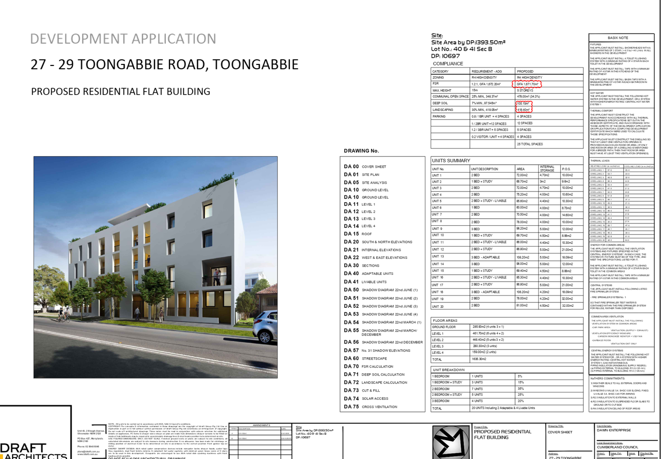

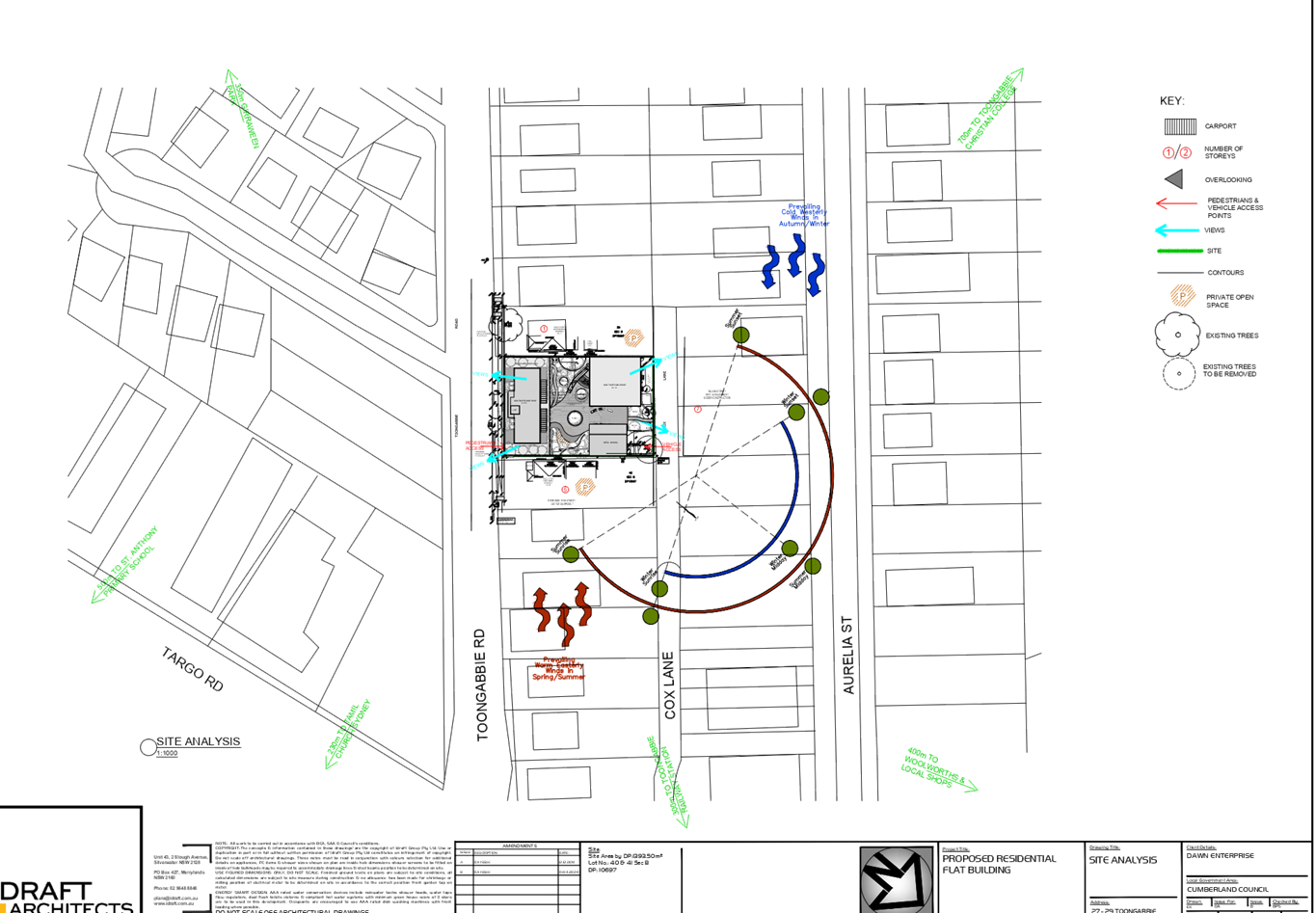
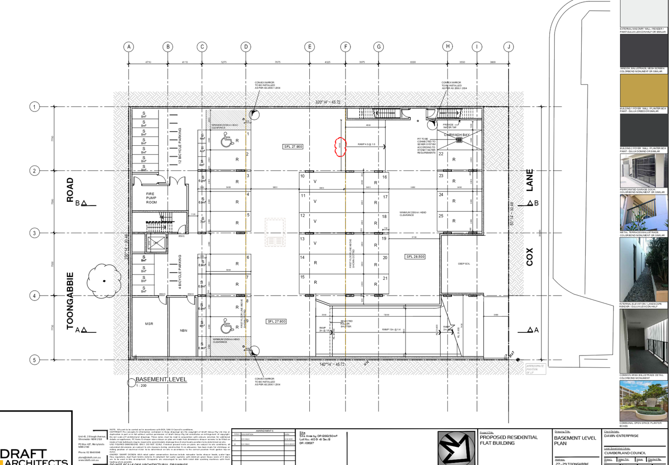
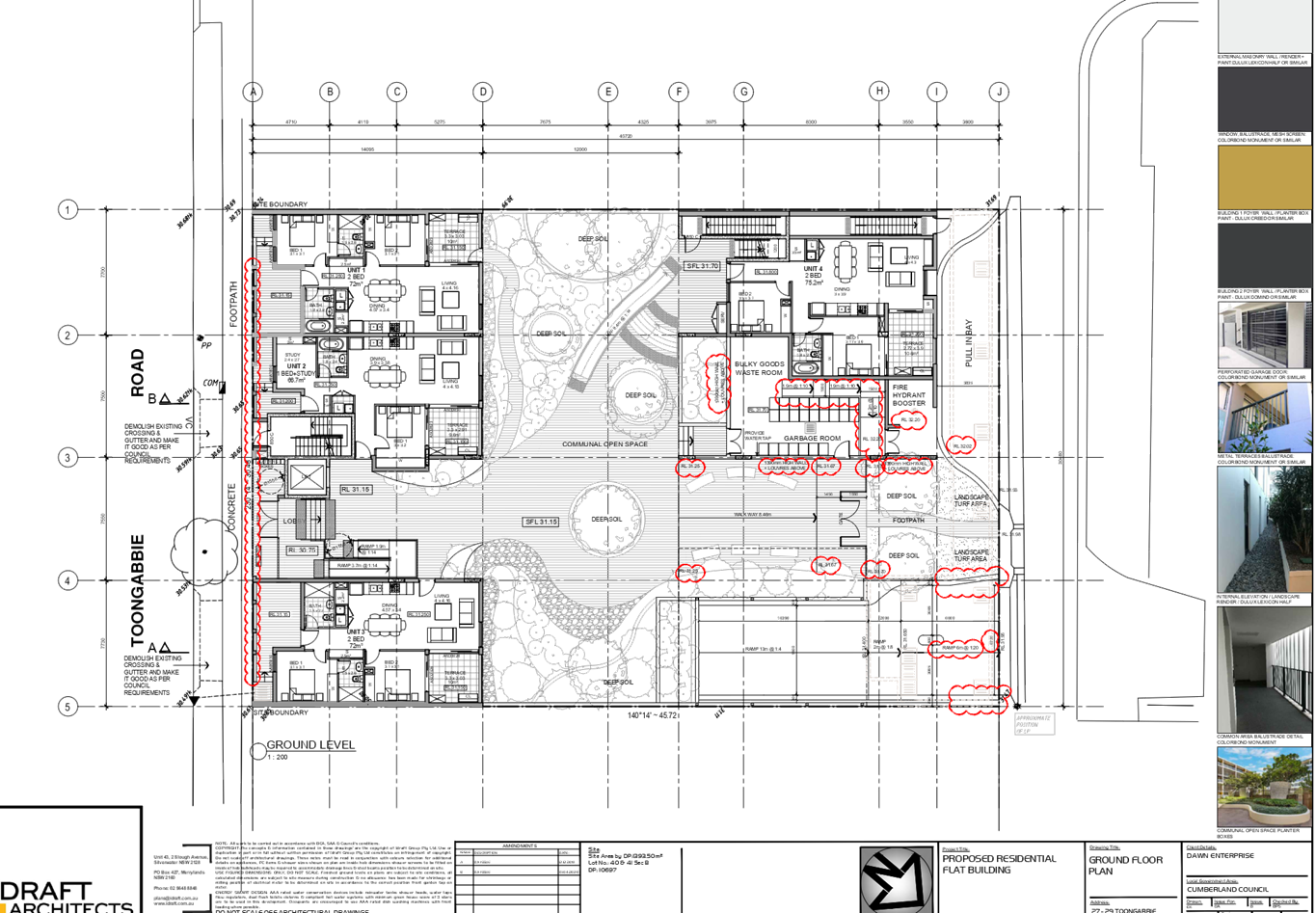
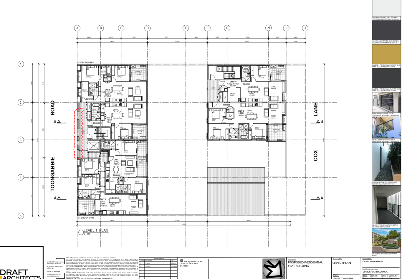
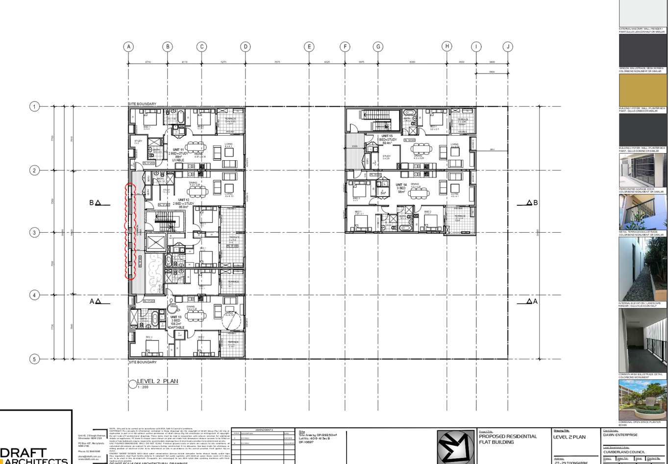

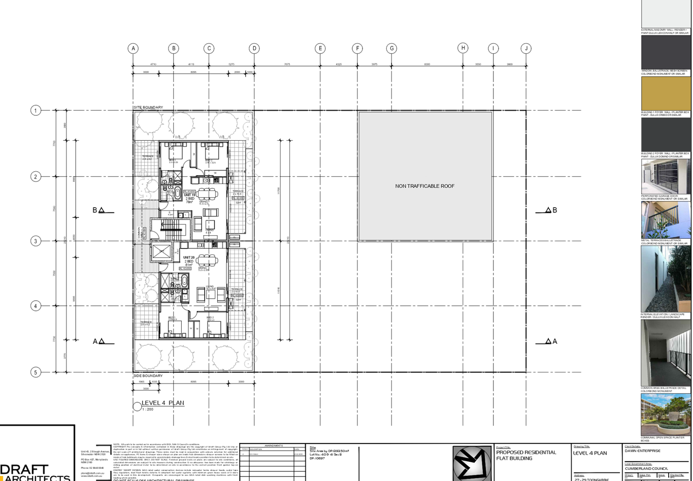
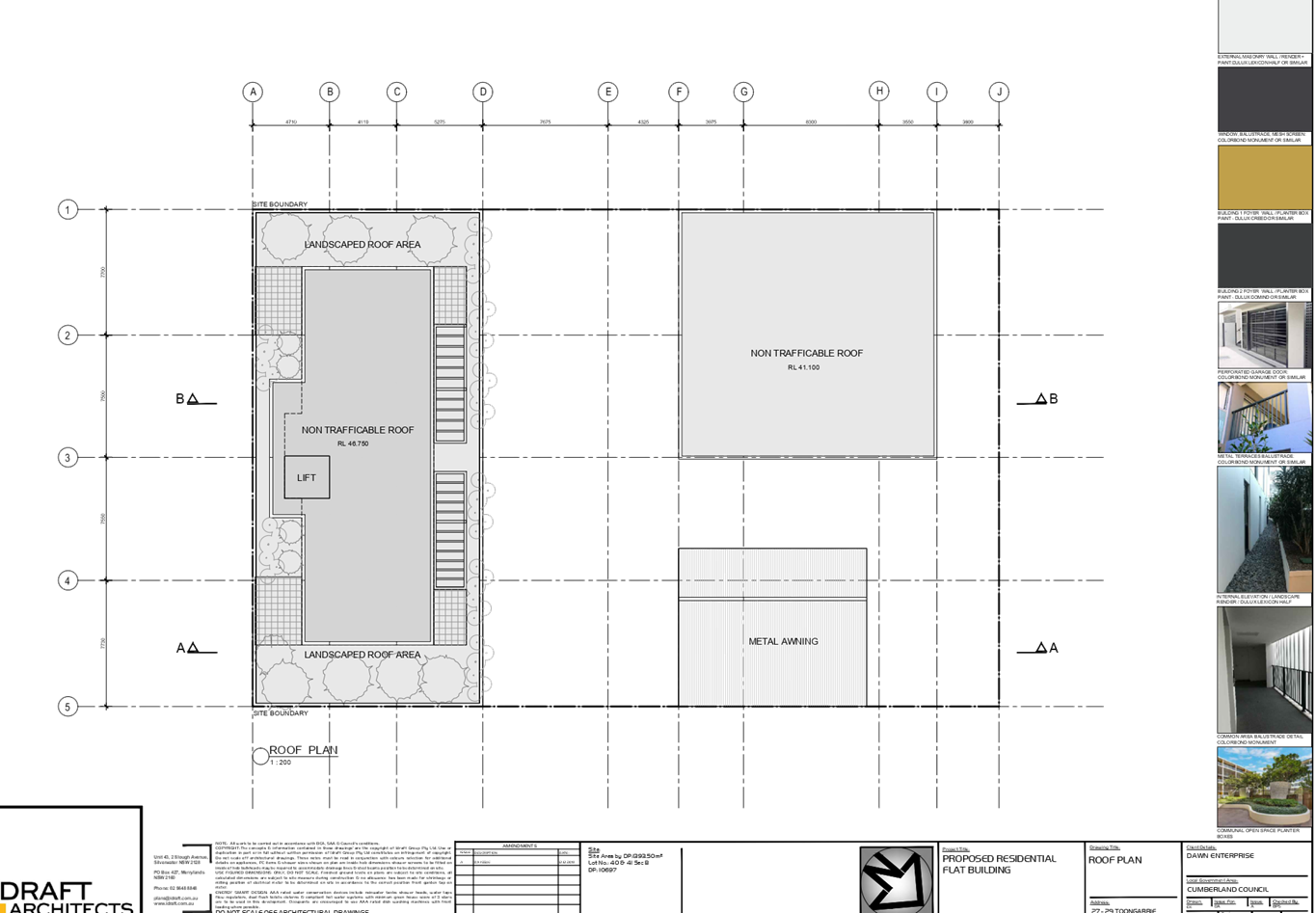
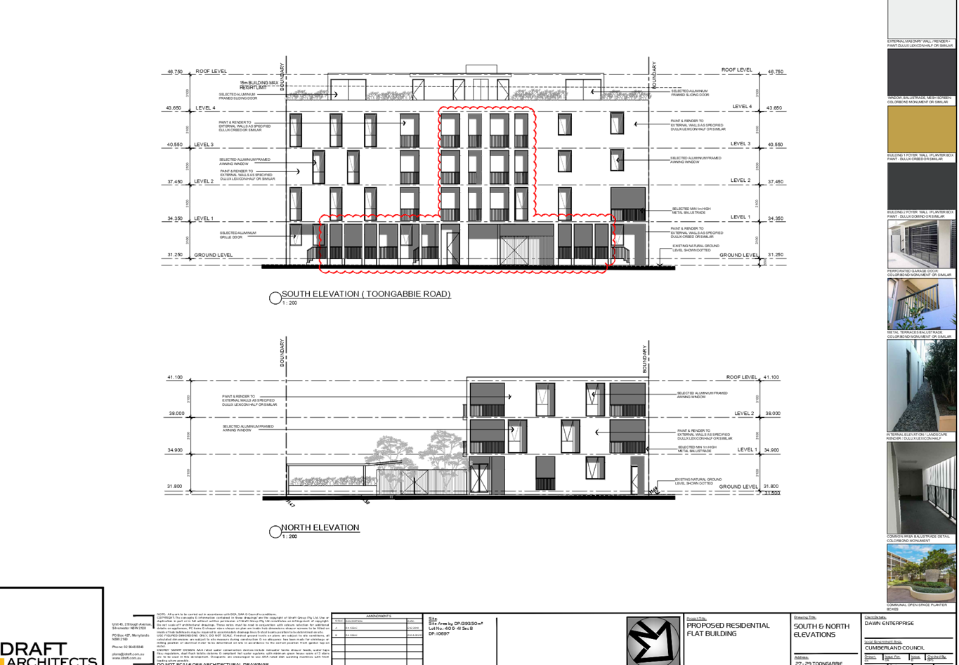

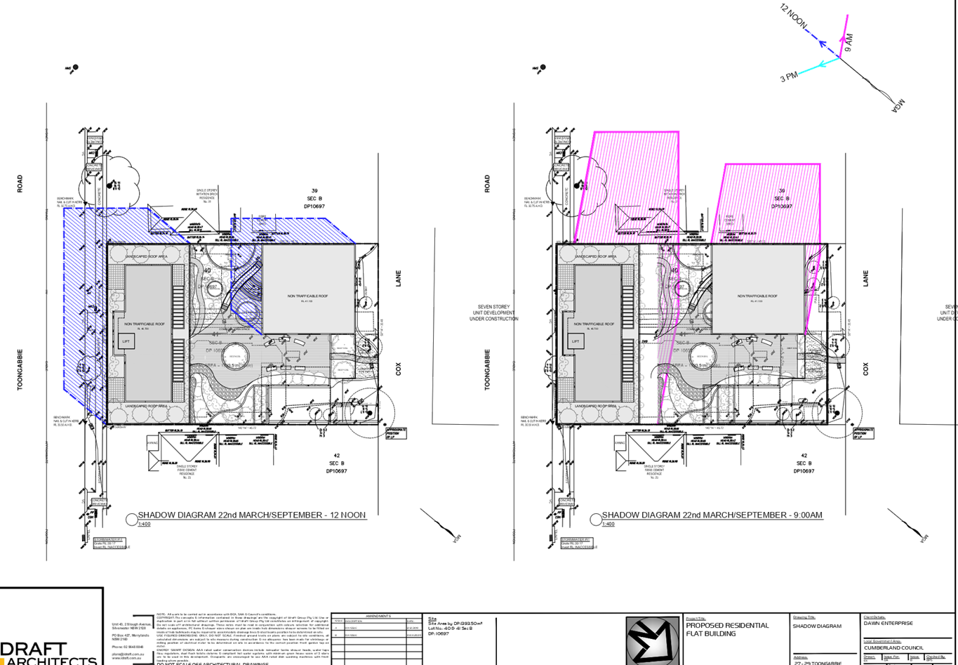
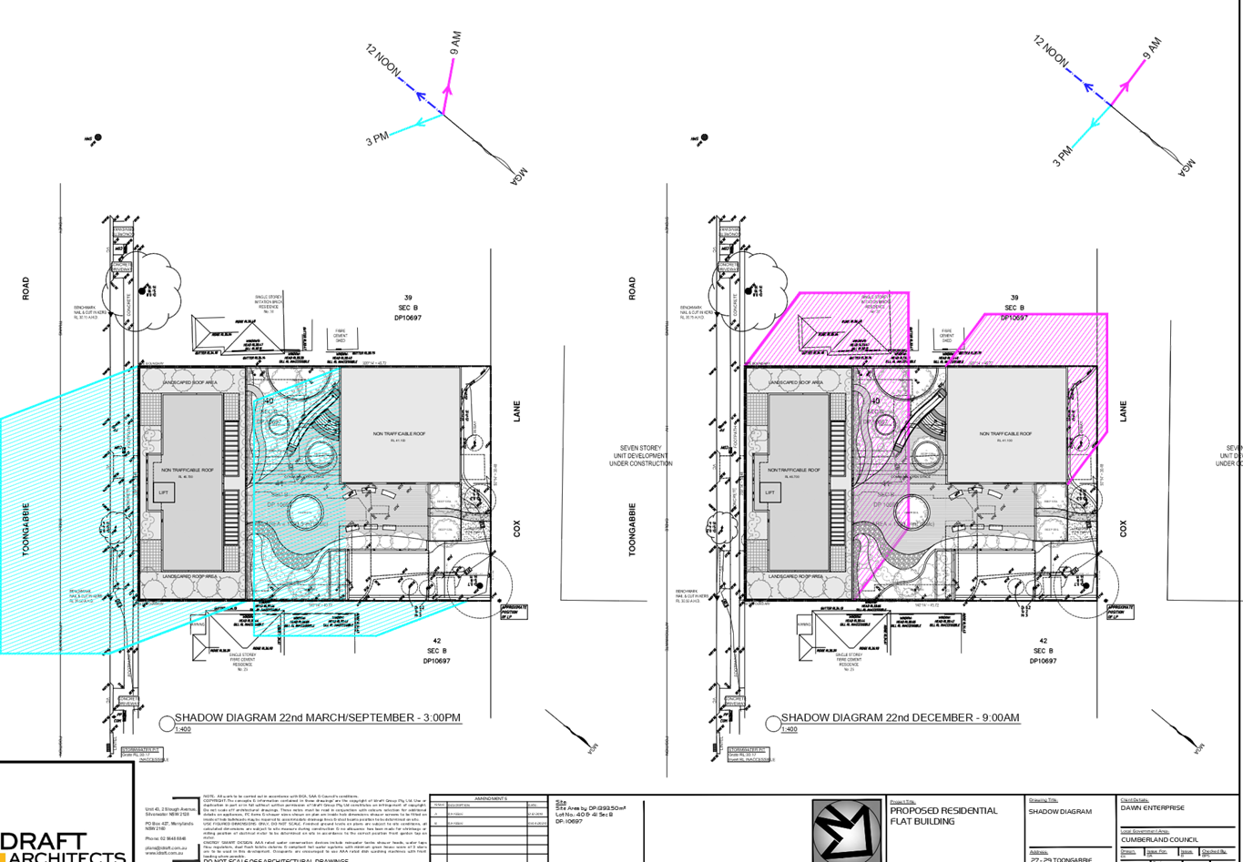
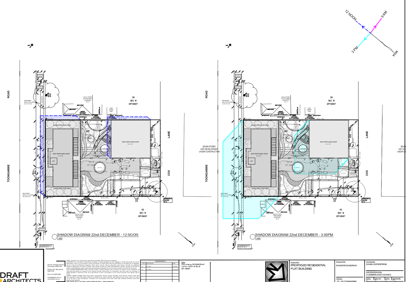
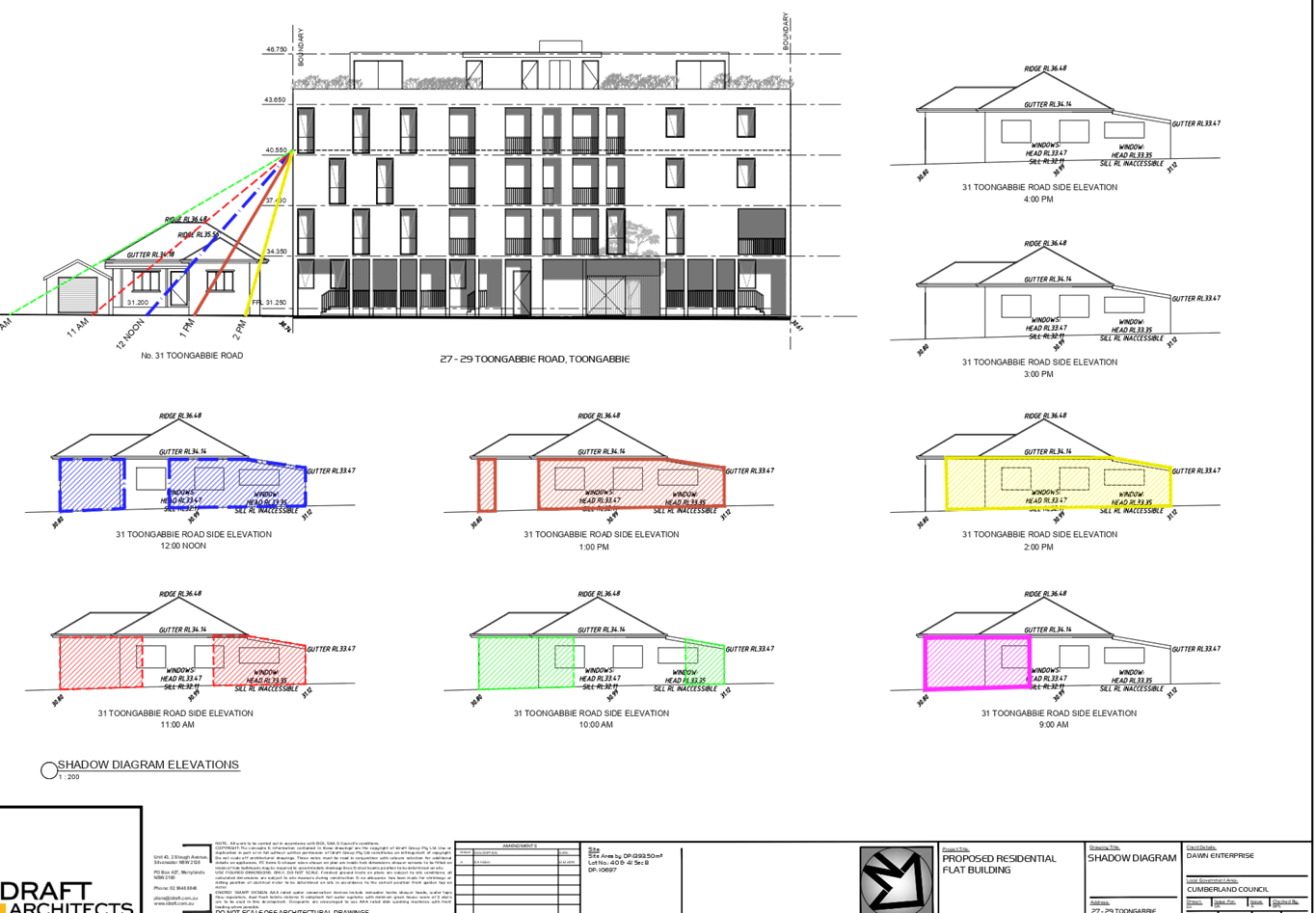
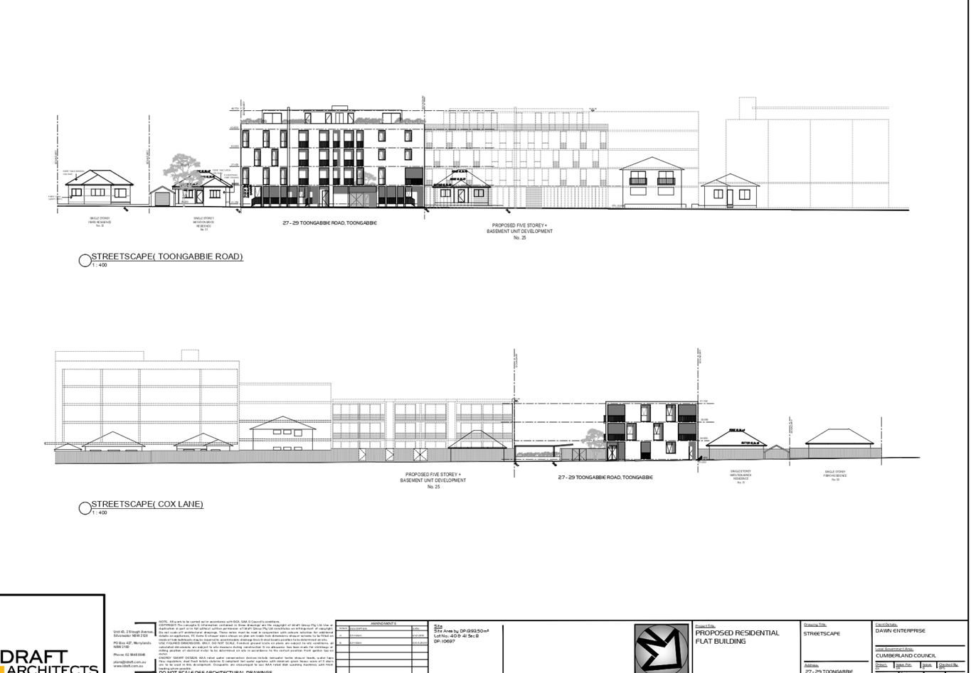
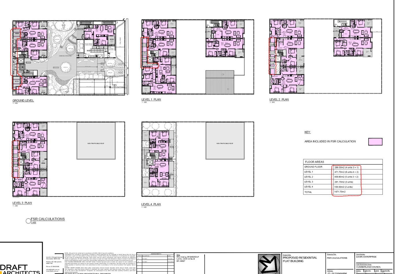
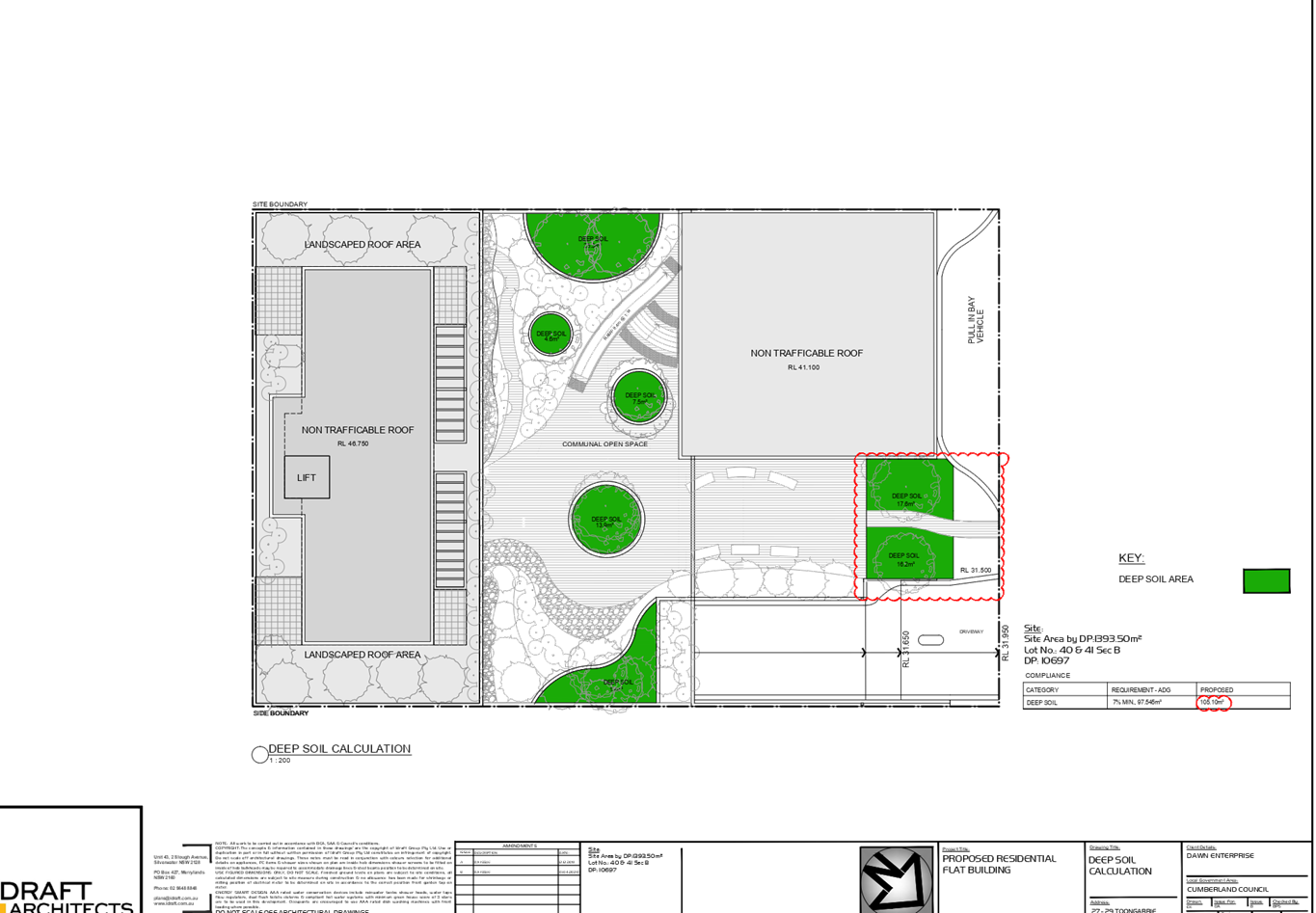
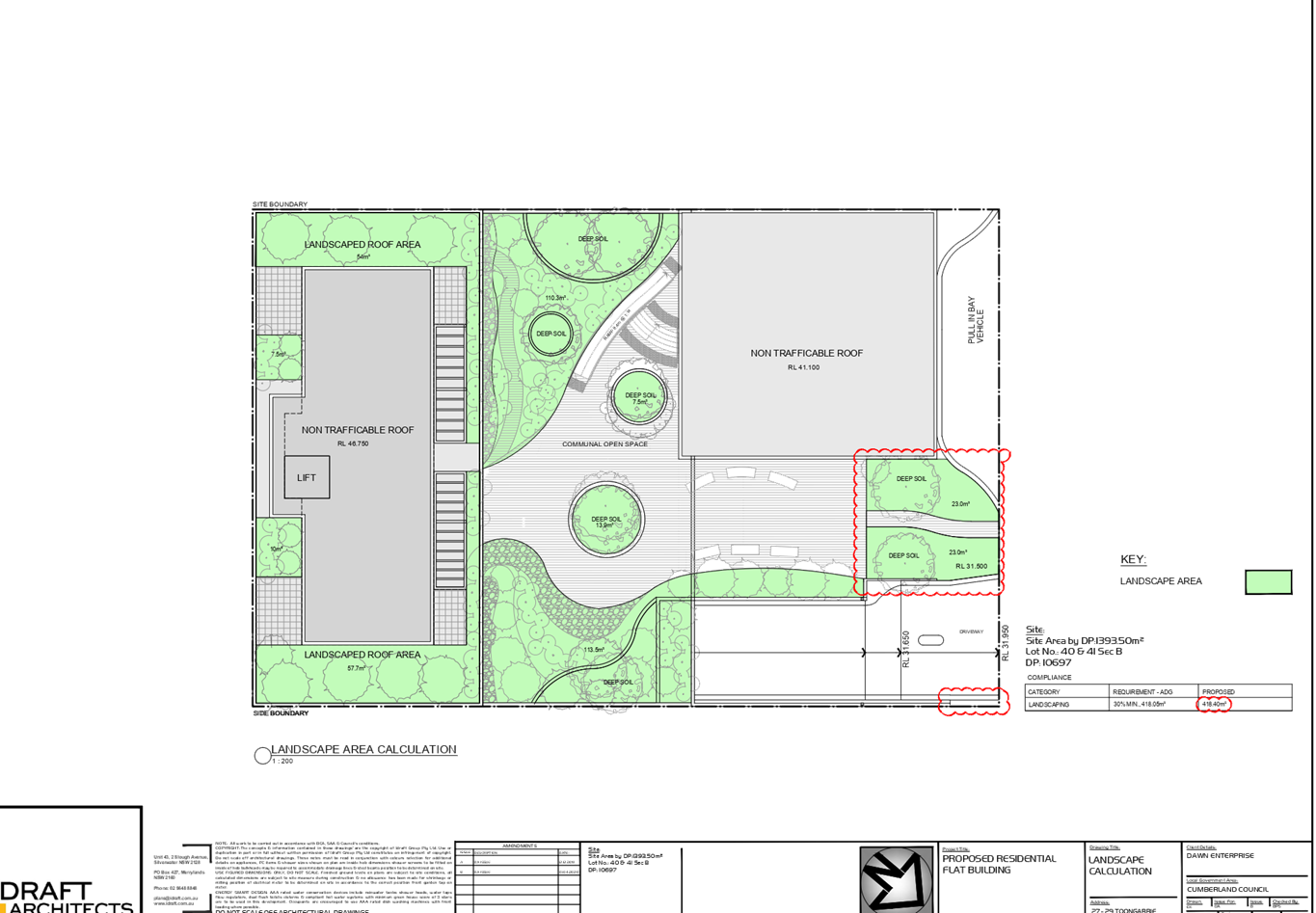
DOCUMENTS
ASSOCIATED WITH
REPORT ELPP022/20
Attachment 4
Stormwater Concept Drawings
Extraordinary Cumberland Local Planning
Panel Meeting
27 May 2020
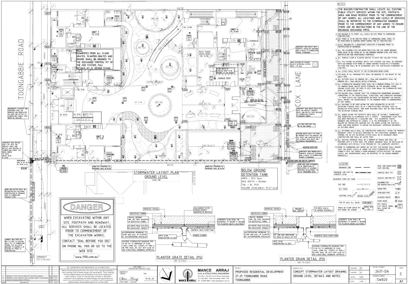
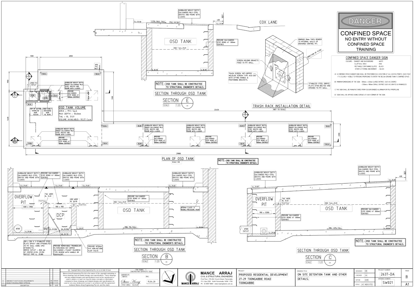
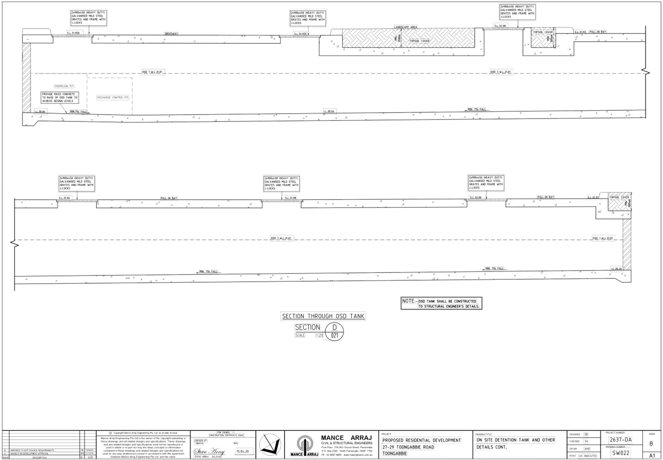
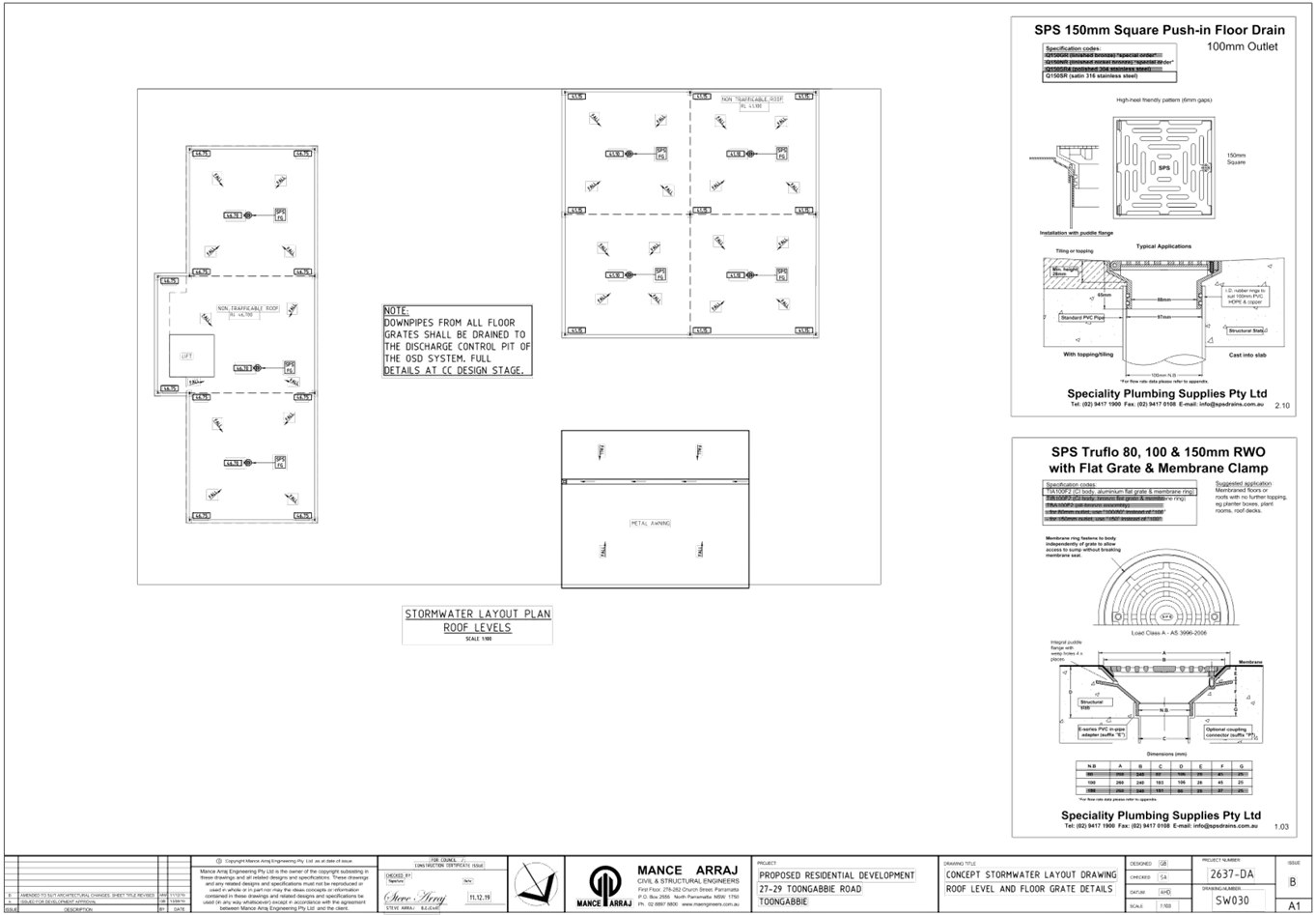
DOCUMENTS
ASSOCIATED WITH
REPORT ELPP022/20
Attachment 5
Stormwater Letter of Response
Extraordinary Cumberland Local Planning
Panel Meeting
27 May 2020


DOCUMENTS
ASSOCIATED WITH
REPORT ELPP022/20
Attachment 6
Traffic Report
Extraordinary Cumberland Local Planning
Panel Meeting
27 May 2020
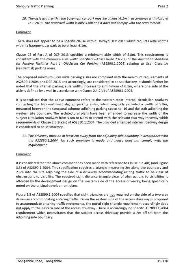
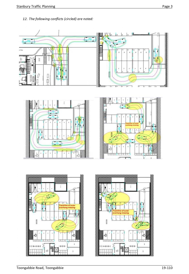


Extraordinary Cumberland Local Planning
Panel Meeting
27 May 2020
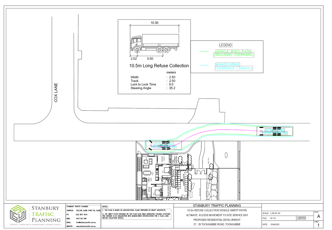

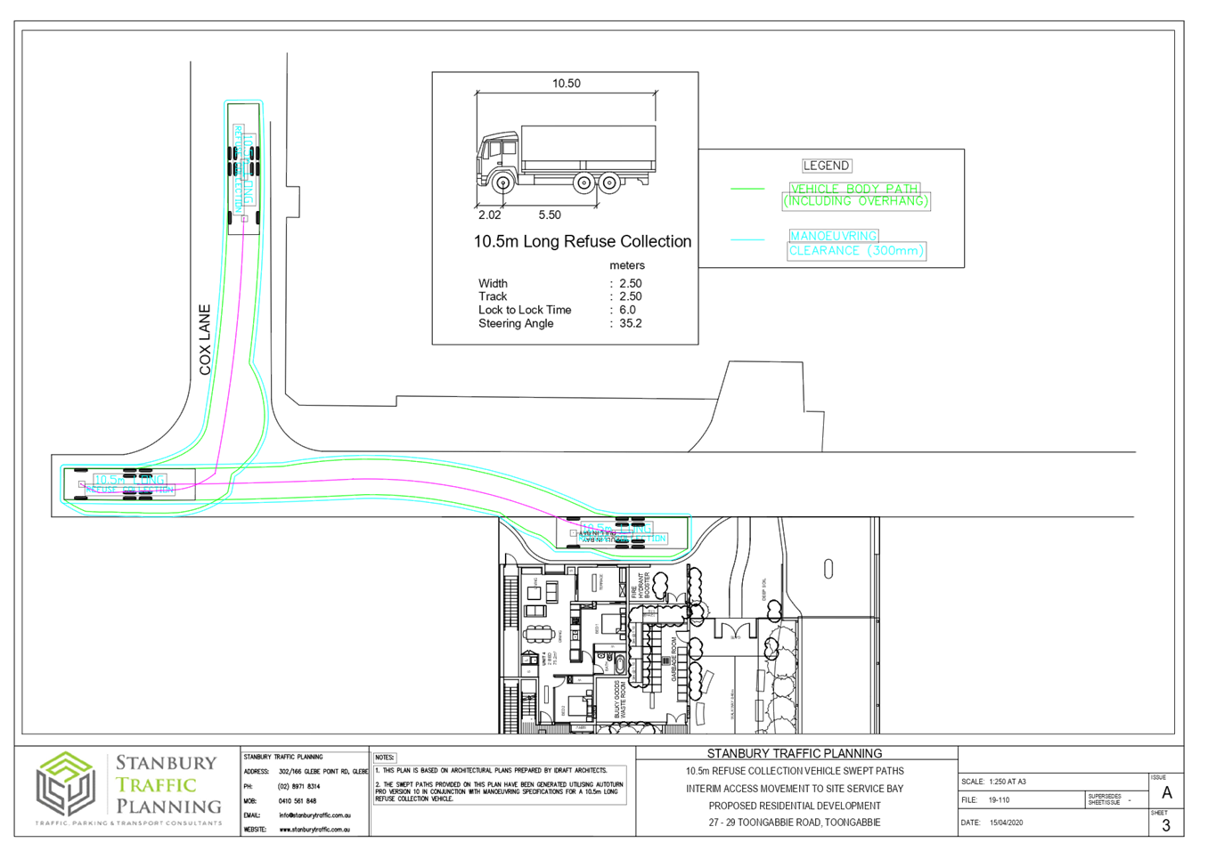
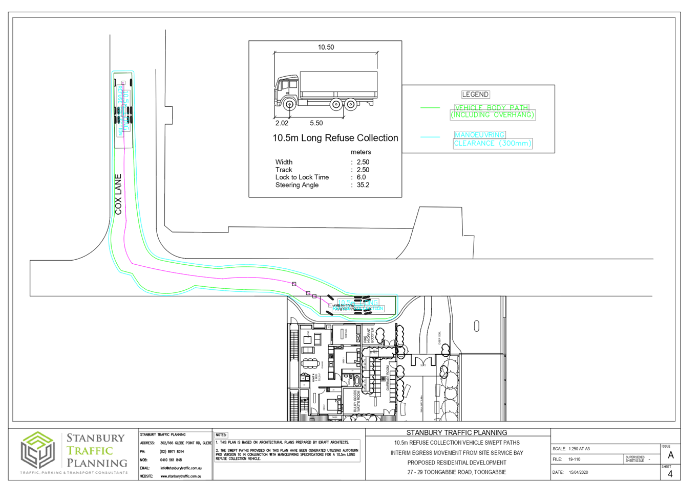
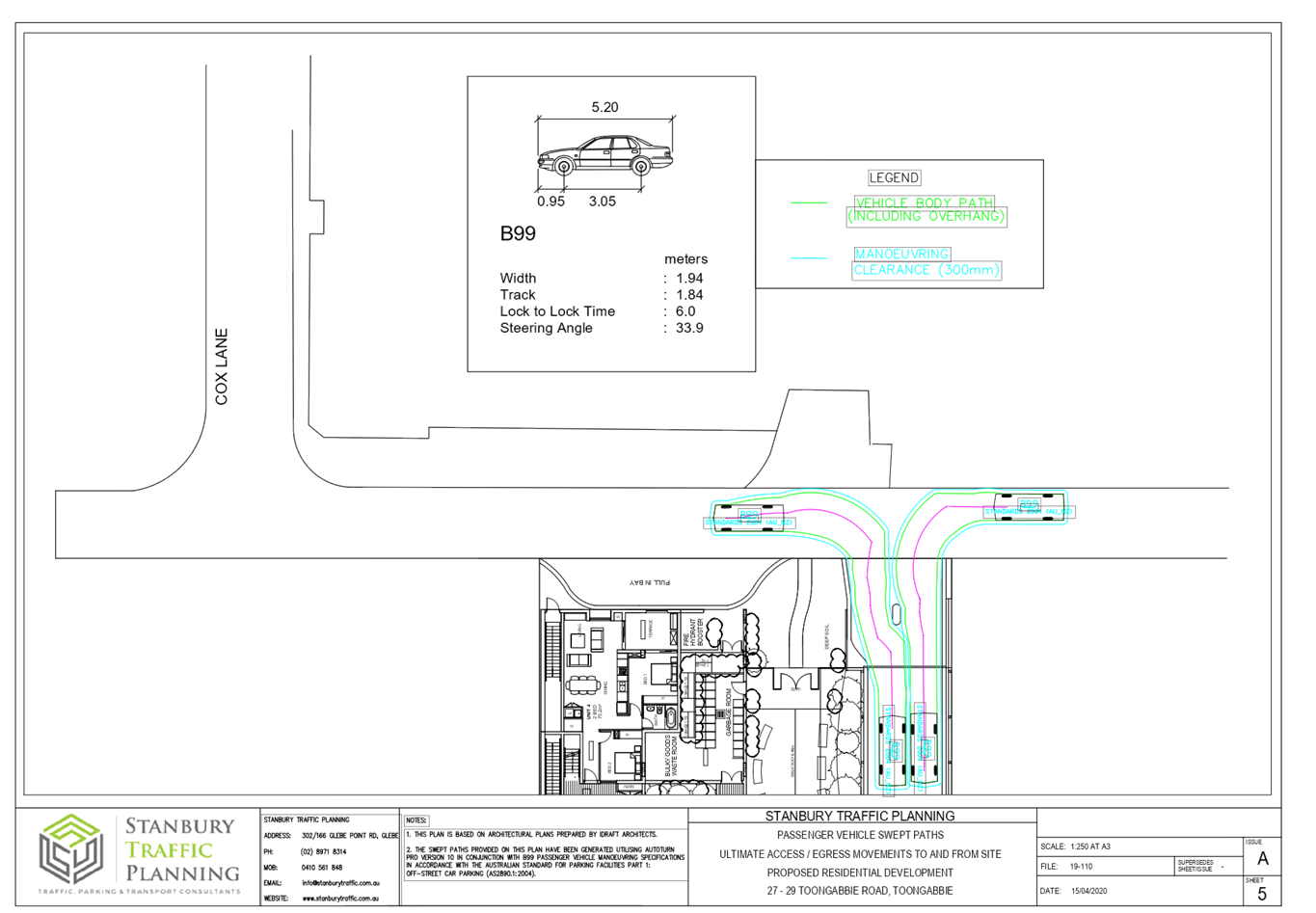
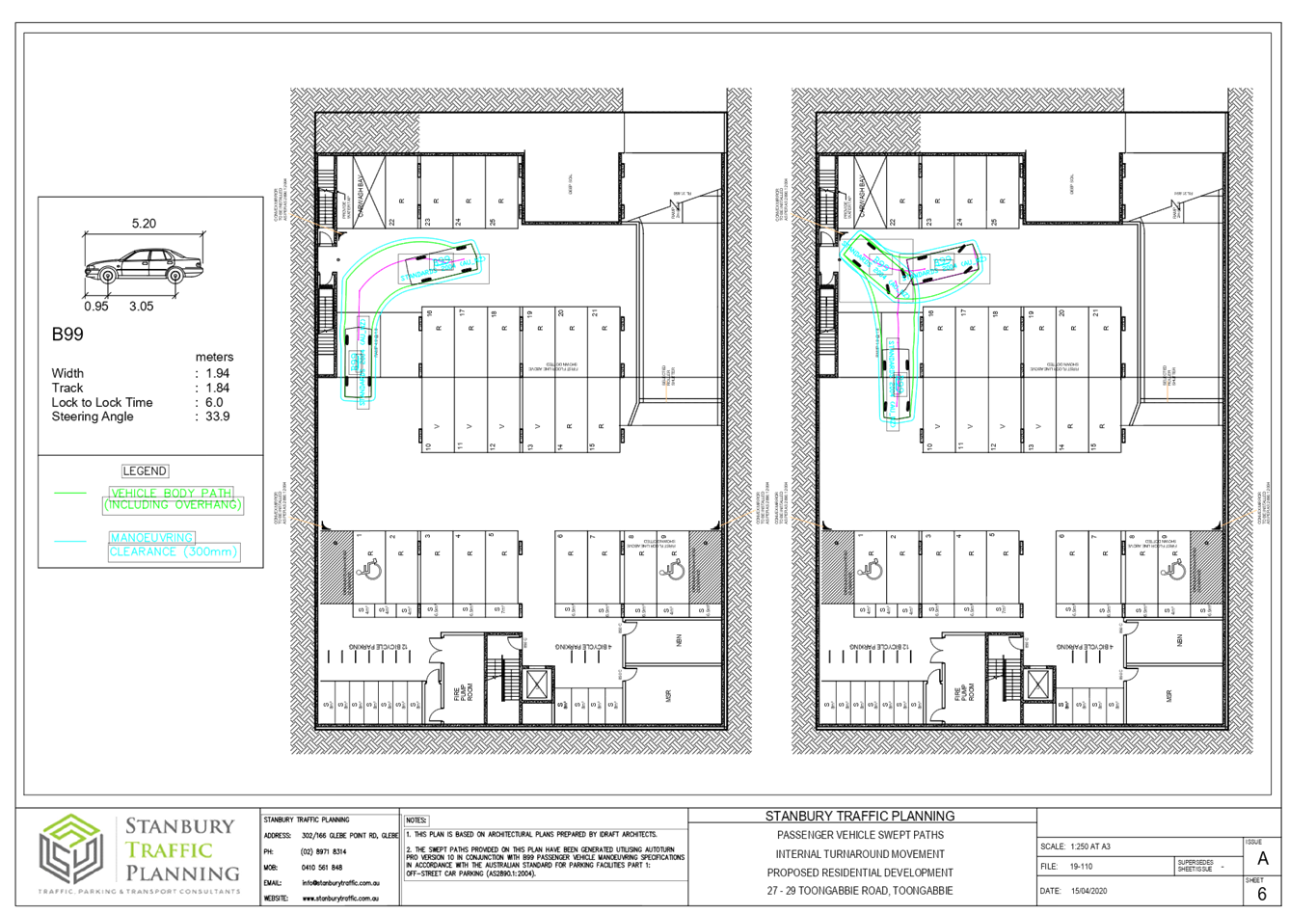
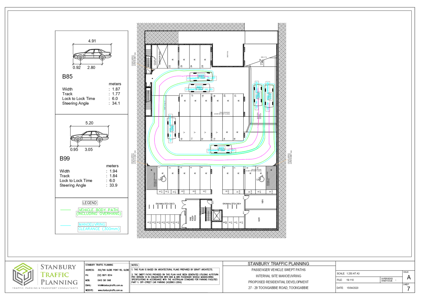
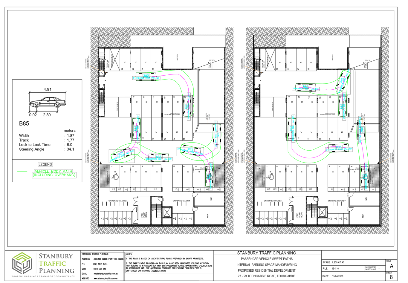
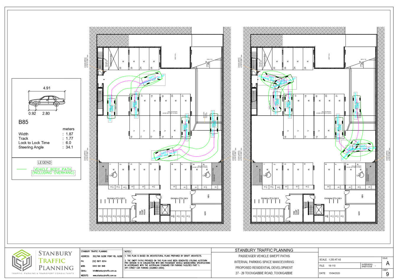
DOCUMENTS
ASSOCIATED WITH
REPORT ELPP022/20
Attachment 7
Appendix A - State Environmental Planning Policy No.
65 –Design Quality of Residential Apartment Development
Extraordinary Cumberland Local Planning
Panel Meeting
27 May 2020
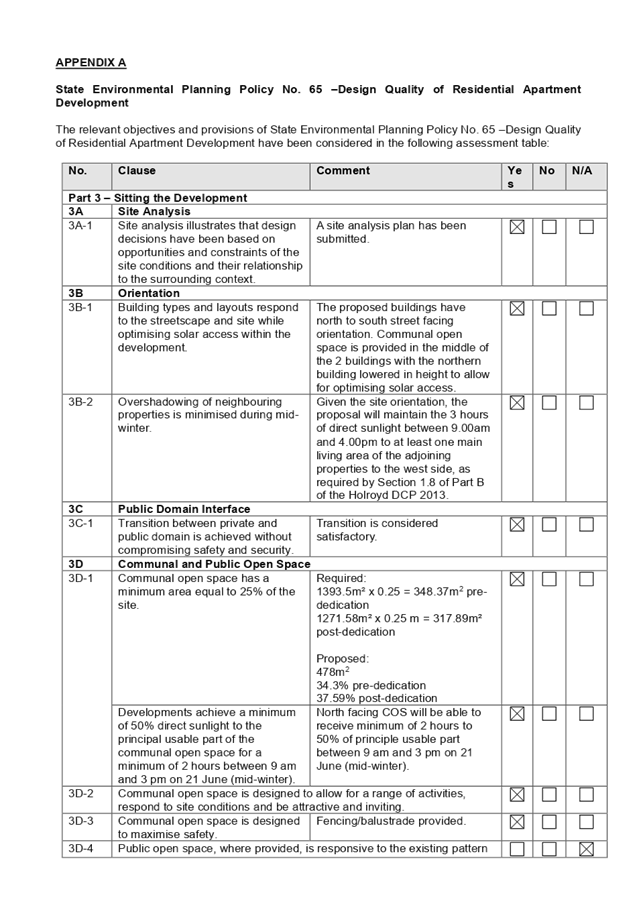
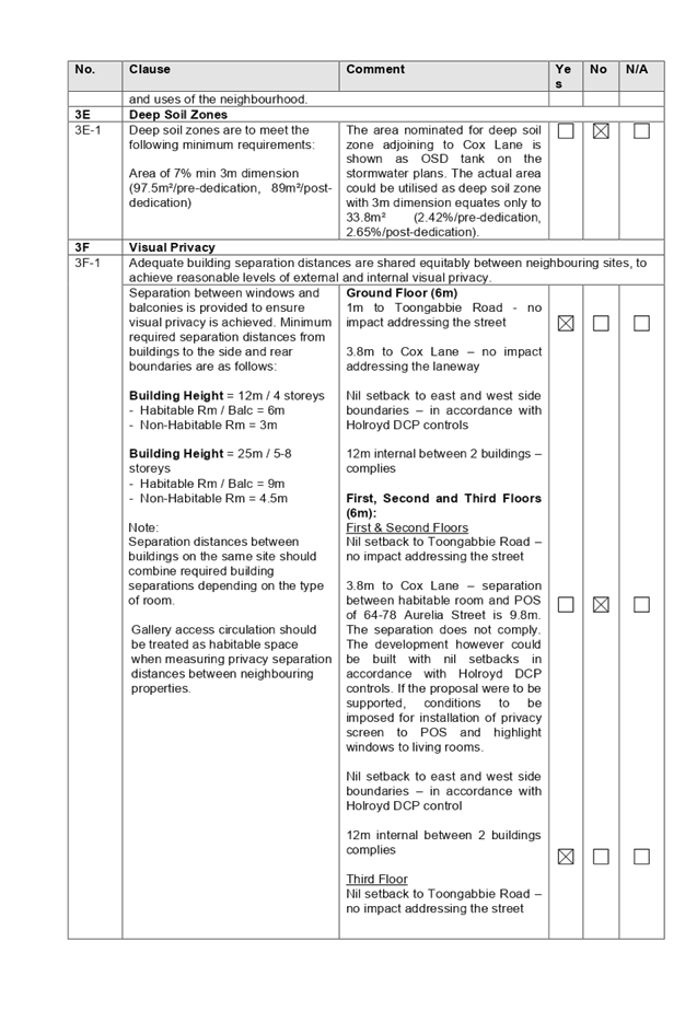
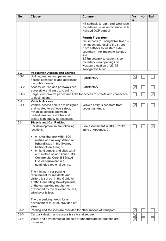
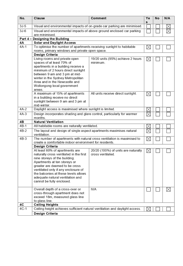
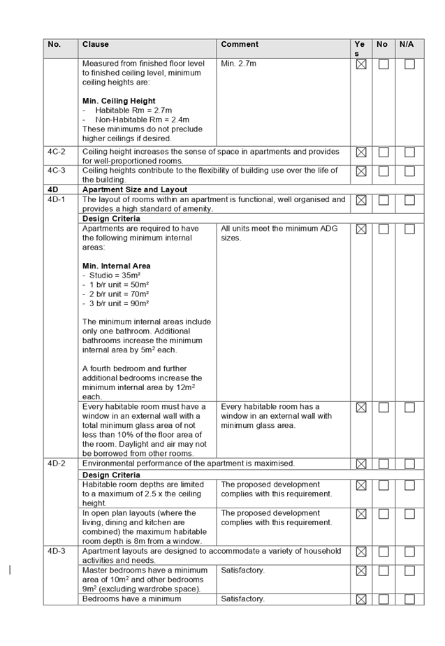
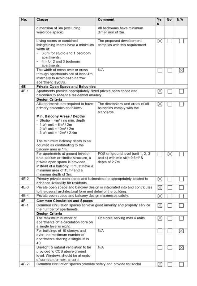
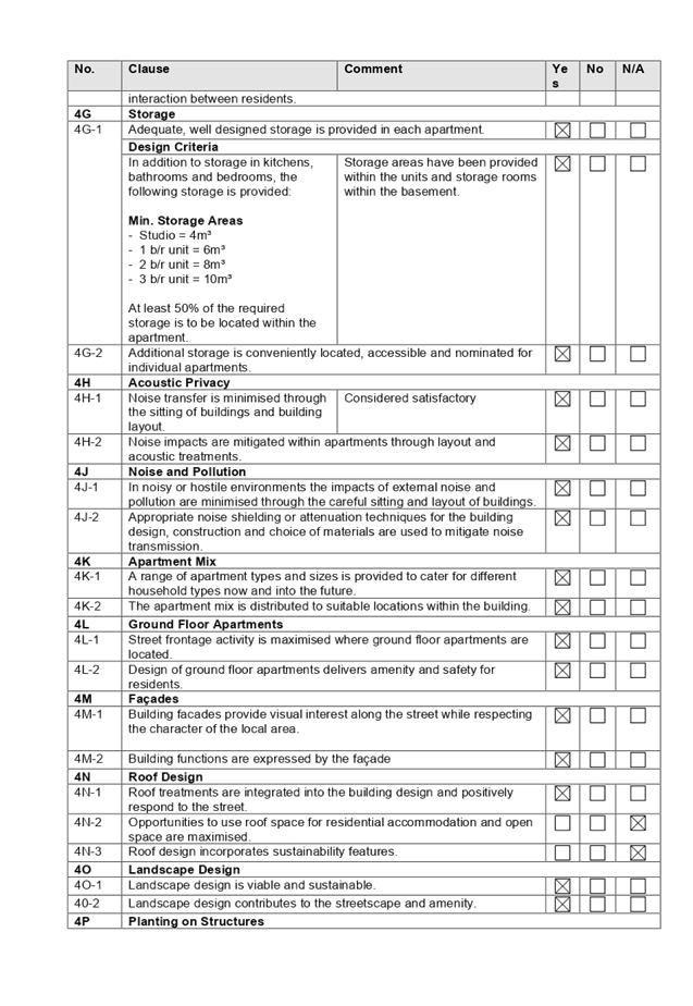
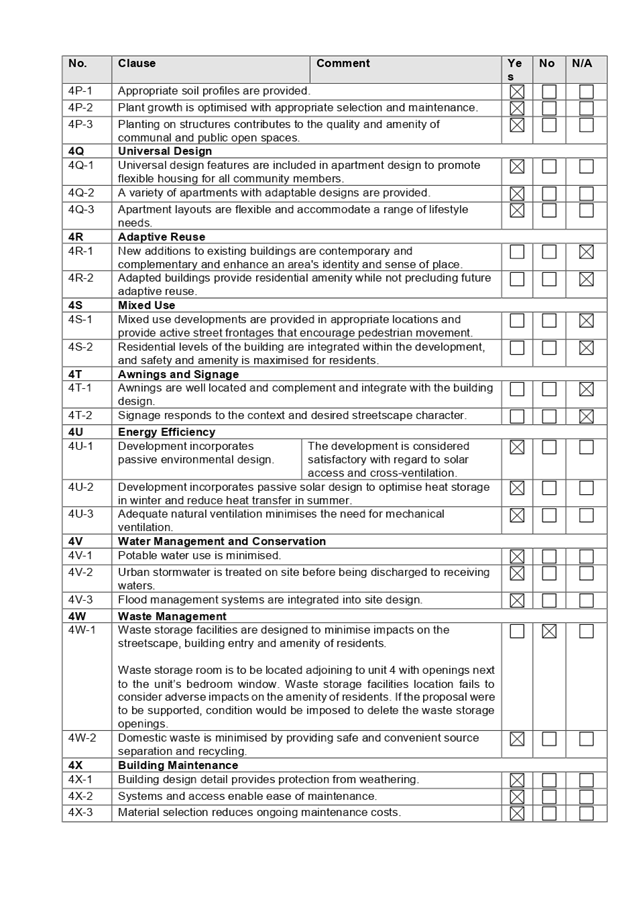
DOCUMENTS
ASSOCIATED WITH
REPORT ELPP022/20
Attachment 8
Appendix B - Holroyd Local Environmental Plan 2013
Extraordinary Cumberland Local Planning
Panel Meeting
27 May 2020
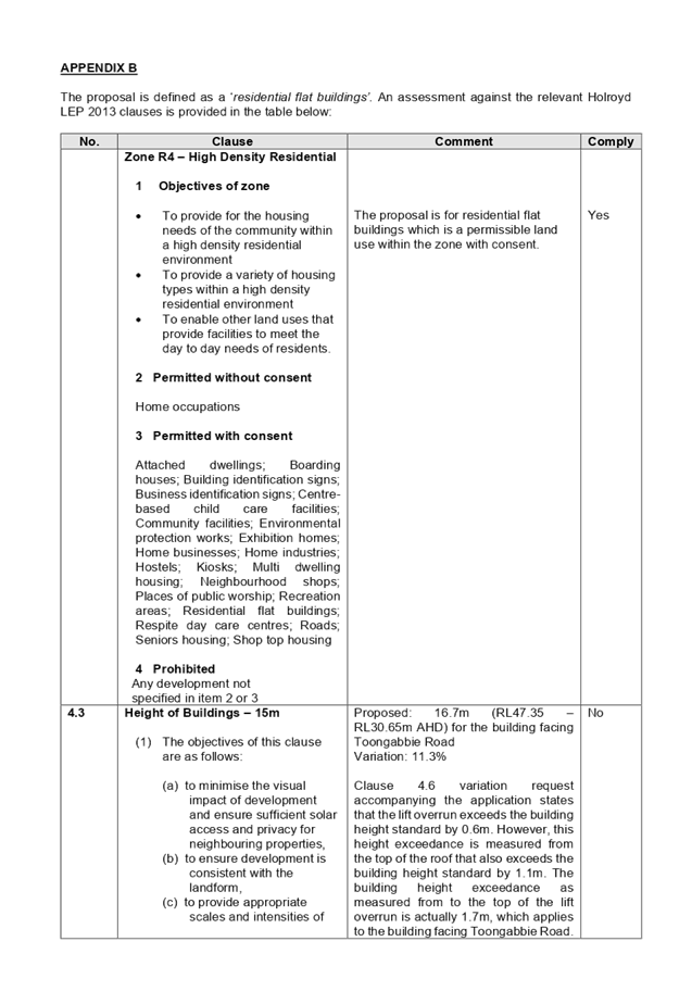
DOCUMENTS
ASSOCIATED WITH
REPORT ELPP022/20
Attachment 9
Appendix C - Holroyd Development Control Plan 2013
Extraordinary Cumberland Local Planning
Panel Meeting
27 May 2020
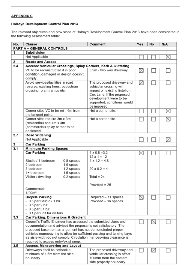
Extraordinary
Cumberland Local Planning Panel Meeting
27 May 2020
Item
No: ELPP023/20
Development
Application for 363-373 Guildford Road, Guildford
Responsible
Division: Environment
& Planning
Officer: Executive
Manager Development and Building
File
Number: DA2019/0525
|
Application
lodged
|
23 December 2019
|
|
Applicant
|
Cumberland City Council
|
|
Owner
|
Cumberland City Council
|
|
Application
No.
|
DA2019/0525
|
|
Description
of Land
|
363-373
Guildford Road GUILDFORD NSW 2161, Lot 2 DP 566791, Lot 1 DP 566791
|
|
Proposed
Development
|
Alterations and additions to
the signage layout and extension of hours of operation (Monday - Friday &
Sunday 8.00am to 10.00pm and Saturday & the day before a Public Holiday
8.00am to 12.00am)
|
|
Site
Area
|
2276m2
|
|
Zoning
|
B2 Local Centre Zone
|
|
Disclosure
of political donations and gifts
|
Nil disclosure
|
|
Heritage
|
No
|
|
Principal
Development Standards
|
N/A
|
|
Issues
|
N/A
|
1. Development
Application No. DA2019/0525 was received on 23 December 2019 for the
Alterations and additions to the signage layout and extension of hours of
operation (Monday - Friday & Sunday 8.00am to 10.00pm and Saturday &
the day before a Public Holiday).
2. The
application was publicly notified for a period of 14 days between 19 February
2020 and 4 March 2020. A notice was placed on site for the duration of the
notification period in accordance with Holroyd Development Control Plan 2013.
No submissions were received as a result of notification.
3. The
application is recommended for conditional approval subject to the conditions
as provided in the attached schedule.
4. The
application is referred to the Panel as the applicant and landowner is
Cumberland City Council.
Subject Site and Surrounding
Area
The subject site comprises of
Guildford Community Centre which is located at 363-373 Guildford Road Guildford
situated at the corner of Guildford Road and O’Neill Street and is
located within the Guildford Town Centre.
The Guildford Community Centre
provides rooms and facilities for meetings, training, community programs and
community services.
The subject site is located within
B2 Local Centre Zone. The objectives of the B2 Local Centre Zone are as
follows:
· To
provide a range of retail, business, entertainment and community uses that
serve the needs of people who live in, work in and visit the local area.
· To
encourage employment opportunities in accessible locations.
· To
maximise public transport patronage and encourage walking and cycling.
· To
permit residential development that is complementary to, and well-integrated
with, commercial uses.
The site is located approximately
120m from bus zones and the Guildford Railway Station. The adjoining sites
include a combination of both commercial and residential developments which is
consistent with the objectives of the zone as above.
Figure
1 – Locality Plan of subject site
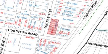
Figure
2 – Zoning map of subject site

Figure
3 – Aerial view of subject site
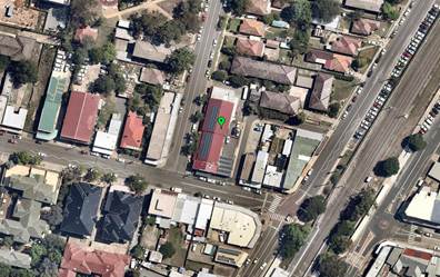
Figure
4 – Street view from Guildford Road
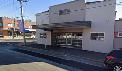
Figure
5 - Street view from O’Neill Street
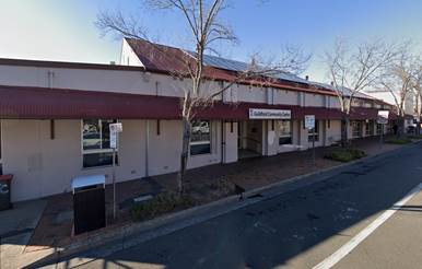
Description of the Proposed
Development
Council has received a development application for
alterations and additions to the signage layout and extension of hours of
operation (Monday - Friday & Sunday 8.00am to 10.00pm and Saturday &
Public Holidays 8.00am to 12.00am).
History
DA 2010/532/1 for Alterations and
additions to existing premises and use as a community youth centre approved on
5 January 2011.
Under DA 2010/532/1 the hours of
operation conditioned in the consent are:
Condition 76. As requested by the
applicant, the hours of operation of the premises are to be restricted to
between:-
10.00am and 6.00pm Mondays to
Fridays with no works on Saturdays, Sundays or Public Holidays.
Applicants Supporting
Statement
The applicant being Cumberland
City Council has provided a Statement of Environmental Effects prepared by
Architect Graham Bakewell dated November 2019 and was received by Council on 23
December 2019 in support of the application. A Noise Impact Assessment prepared
by Acoustic Logic has also been submitted in support of the application.
Contact with Relevant
Parties
The assessing officer has
undertaken a site inspection of the subject site and surrounding properties and
has been in regular contact with the applicant throughout the assessment
process.
Internal Referrals
Environment and Health
The development application was
referred to Council’s Environment and Health Officer for comment who
raised number of concerns with the associated noise. The application was
subsequently deferred seeking a revised acoustic report. The revised acoustic
report was submitted on 9 March 2020 and has since been reviewed by the
Environment and Health Officer. Following the second review, the Environment
and Health Officer has advised that the proposed development can be made
satisfactory subject to the relevant noise mitigation conditions and other
standard conditions as included in the draft notice of determination.
External Referrals
The development application was referred to NSW Police for
comment. The recommended Conditions of Consent provided by NSW Police shall be
approved under the endorsed documentation.
Planning Comments
The provisions of any Environmental Planning Instruments
(EP&A Act s4.15 (1)(a)(i))
State Environmental Planning Policies
The proposed development is affected by the following State
Environmental Planning Policies:
(a) State
Environmental Planning Policy No. 55 – Remediation of Land (SEPP 55)
The site is not identified in Council’s records as
being contaminated. A site inspection reveals the site does not have any
obvious history of a previous land use that may have caused contamination and
there is no specific evidence that indicates the site is contaminated. The
subject site is currently used for residential purposes and contamination is
not expected.
(b) State
Environmental Planning Policy No 64—Advertising and Signage
The application for proposed signage complies with the
relevant controls for the
State Environmental Planning Policy No 64—Advertising
and Signage. A comprehensive assessment against SEPP 64 is contained in
Appendix A in full.
Regional Environmental Plans
The proposed development is affected by the following
Regional Environmental Plans:
(a) Sydney
Regional Environmental Plan (Sydney Harbour Catchment) 2005
The subject site is identified as being located within the
area affected by the Sydney Regional Environmental Plan (Sydney Harbour
Catchment) 2005. The proposed development raises no issues as no impact on the
catchment is envisaged due to the nature of the proposal.
(Note: - the subject site is not identified in the relevant
map as ‘land within the ‘Foreshores and Waterways Area’ or
‘Wetland Protection zone’, is not a ‘Strategic Foreshore
Site’ and does not contain any heritage items. Hence the majority of the
SREP is not directly relevant to the proposed development).
Local Environmental Plans
Holroyd Local Environment Plan 2013
The provision of the Holroyd Local Environment Plan 2013 is
applicable to the development proposal. It is noted that the development
achieves compliance with the key statutory requirements of the Holroyd Local
Environment Plan 2013 and the objectives of the B2 Local Centre Zone.
(a) Permissibility:-
The proposed development is defined as ‘Community
facilities’ and is permissible in Zone B2 Local Centre with consent.
Community facility means a
building or place –
a) owned
or controlled by a public authority or non-profit community organisation, and
b) used
for the physical, social, cultural or intellectual development or welfare of
the community, but does not include an educational establishment, hospital,
retail premises, place of public worship or residential accommodation.
The relevant matters to be considered under Holroyd Local
Environment Plan 2013 the applicable clauses for the proposed development are
summarised below. A comprehensive LEP assessment is contained in Appendix B.
The provisions of any proposed instrument that is or has
been the subject (EP&A Act s4.15 (1)(a)(ii))
(a) Draft
State Environmental Planning Policy (Environment)
The draft SEPP relates to the protection and management of
our natural environment with the aim of simplifying the planning rules for a
number of water catchments, waterways, urban bushland, and Willandra Lakes
World Heritage Property. The changes proposed include consolidating the
following seven existing SEPPs:
· State
Environmental Planning Policy No. 19 – Bushland in Urban Areas
· State
Environmental Planning Policy (Sydney Drinking Water Catchment) 2011
· State
Environmental Planning Policy No. 50 – Canal Estate Development
· Greater
Metropolitan Regional Environmental Plan No. 2 – Georges River Catchment
· Sydney
Regional Environmental Plan No. 20 – Hawkesbury-Nepean River (No.2-1997)
· Sydney
Regional Environmental Plan (Sydney Harbour Catchment) 2005
· Willandra
Lakes Regional Environmental Plan No. 1 – World Heritage Property.
The draft policy will repeal the above existing SEPPs and
certain provisions will be transferred directly to the new SEPP, amended and
transferred, or repealed due to overlaps with other areas of the NSW planning
system.
Changes are also proposed to the Standard Instrument –
Principal Local Environmental Plan. Some provisions of the existing policies
will be transferred to new Section 117 Local Planning Directions where
appropriate.
The proposed development is not affected by any relevant
Draft Environmental Planning Instruments.
(b)
Draft Cumberland Local Environmental Plan 2020 (Draft CLEP)
The Draft Cumberland Local Environmental Plan 2020 (Draft
CLEP) has been prepared by Cumberland Council to provide a single planning
framework for the future planning of Cumberland City. The changes proposed seek
to harmonise and repeal the three existing LEPs currently applicable to the
Cumberland local government area, those being:
· Holroyd
Local Environmental Plan 2013,
· Parramatta
Local Environmental Plan 2011, and
· Auburn
Local Environmental Plan 2010.
The relevant planning controls for the subject site, as
contained within the Holroyd Local Environment Plan, are not proposed to change
under the Draft CLEP.
The provisions of any Development Control Plans (EP&A
Act s4.15 (1)(a)(iii))
(a) Holroyd
Development Control Plan (Holroyd DCP)
The Holroyd DCP 2013 provide guidance for the design and
operation of development to achieve the aims and objectives of the Holroyd LEP
2013.
A comprehensive assessment and compliance table is contained
in Appendix C.
The proposed development complies with the provisions of
Holroyd DCP 2013 and is considered acceptable from an environmental planning
view point.
The provisions of any planning agreement that has been
entered into under section 7.4, or any draft planning agreement that a
developer has offered to enter into under section 7.4 (EP&A Act
s4.15(1)(a)(iiia))
There is no draft planning agreement associated with the
subject Development Application.
The provisions of the Regulations (EP&A Act s4.15
(1)(a)(iv))
The proposed development raises no concerns as to the
relevant matters arising from the Environmental Planning and Assessment
Regulations 2000 (EP&A Reg).
The Likely Environmental, Social or Economic Impacts
(EP&A Act s4.15 (1)(b))
It is considered that the proposed development will have no
significant adverse environmental, social or economic impacts in the locality.
The suitability of the site for the development (EP&A
Act s4.15 (1)(c))
The subject site and locality is not known to be affected by
any natural hazards or other site constraints likely to have a significant
adverse impact on the proposed development. Accordingly, it is considered that
the development is suitable in the context of the site and surrounding
locality.
Submissions made in accordance with the Act or Regulation
(EP&A Act s4.15 (1)(d))
Advertised (newspaper) Mail
Sign
Not
Required
In accordance with Council’s Notification requirements
contained within the Holroyd DCP 2013 the proposal was publicly notified for a
period of 14 days between 19 February 2020 and 4 March 2020. No submissions
were received in respect of the proposed development.
In view of the foregoing analysis it is considered that the
development, if carried out subject to the conditions set out in the
recommendation below, will have no significant adverse impacts on the public
interest.
The Public Interest (EP&A Act S4.15(1)(e))
Draft Cumberland Development Control Plan (Draft DCP)
The Draft Cumberland Development Control Plan 2020 (Draft
DCP) has been prepared by Cumberland City Council to provide a single planning
framework for the future planning of Cumberland City.
The following sections of Draft DCP are relevant for the
development application:
· Part
G3 – Traffic, Parking, Transport and Access (Vehicle). Section 4.7
– Other Land Use of the Draft DCP states parking requirements for
Community Facilities.
· Part
E2 – Community Facilities. This section of the Draft DCP lists controls
for community facilities regarding bulk and scale, traffic, parking, transport,
landscaping, open space, and operational plan of management.
It is noted that the Draft DCP requires a traffic and
transport impact statement to ascertain the car parking rates for a community
facility. A traffic and transport impact statement is not warranted for the
subject application as the proposed works are minor in nature which do not
require additional car parking on the site.
It is noted that the Draft DCP does not list specific hours
of operation for community facilities. However, as the site is zoned B2 –
Local Centre, Part C, Section 3.11 of the draft DCP regarding the hours of
operation for development in business zones is relevant, even if this is mainly
for commercial and retail developments.
The proposed hours of operation for this development are
outside the standard hours of operation as outlined in the Draft DCP. Where
this is the case, the draft DCP requires the submission of an acoustic report
and a plan of management. An acoustic report and a plan of management has been
submitted with the application and are assessed to be satisfactory to justify
the proposed hours of operation. Furthermore, conditions have been included in
the draft conditions in relation to noise, crime prevention and operational
plan of management.
The proposed development complies with the provisions of the
draft Cumberland DCP and is considered acceptable from an environmental
planning view point.
Section 7.11 (Formerly S94) Contributions
Section 7.11 (Formerly S94) Contributions are not applicable
to the subject proposal.
Disclosure of Political Donations and Gifts
The applicant and notification process did not result in any
disclosure of Political Donations and Gifts.
The development application has
been assessed in accordance with the relevant requirements of the Environmental
Planning and Assessment Act 1979, State Environmental Planning Policy No 64,
Holroyd LEP 2013, Holroyd DCP 2013 and is considered to be satisfactory for
approval subject to conditions.
The proposed development is
appropriately located within the B2 Zone under the relevant provisions of the
Holroyd Local Environment Plan 2013. The proposal is consistent with all
statutory and non-statutory controls applying to the development. The
development is considered to perform adequately in terms of its relationship to
its surrounding built and natural environment, particularly having regard to
impacts on adjoining properties.
For these reasons, it is
considered that the proposal is satisfactory having regard to the matters of
consideration under Section 4.15 of the Environmental Planning and Assessment
Act 1979, and the development may be approved subject to conditions.
|
1. That
Development Application No. DA2019/0525 for alterations and additions to the
signage layout and extension of hours of operation (Monday - Friday &
Sunday 8.00am to 10.00pm and Saturday & Public Holidays 8.00am to
12.00am) on land at 363-373 Guildford Road GUILDFORD NSW 2161 be
approved.
|
1. Architectural
Plans
2. Plan
of Management
3. Acoustic
Report
4. Police
NSW Recommended Conditions
5. Appendix
A - State Environmental Planning Policy No 64 Assessment
6. Appendix
B - Local Environmental Plan Assessment
7. Appendix
C - Development Control Plans
8. Draft
Notice of Determination
DOCUMENTS
ASSOCIATED WITH
REPORT ELPP023/20
Attachment 1
Architectural Plans
Extraordinary Cumberland Local Planning
Panel Meeting
27 May 2020
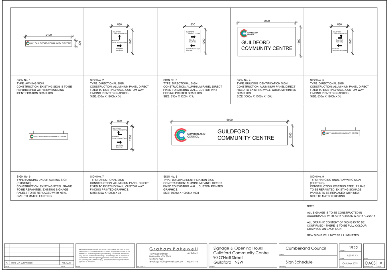
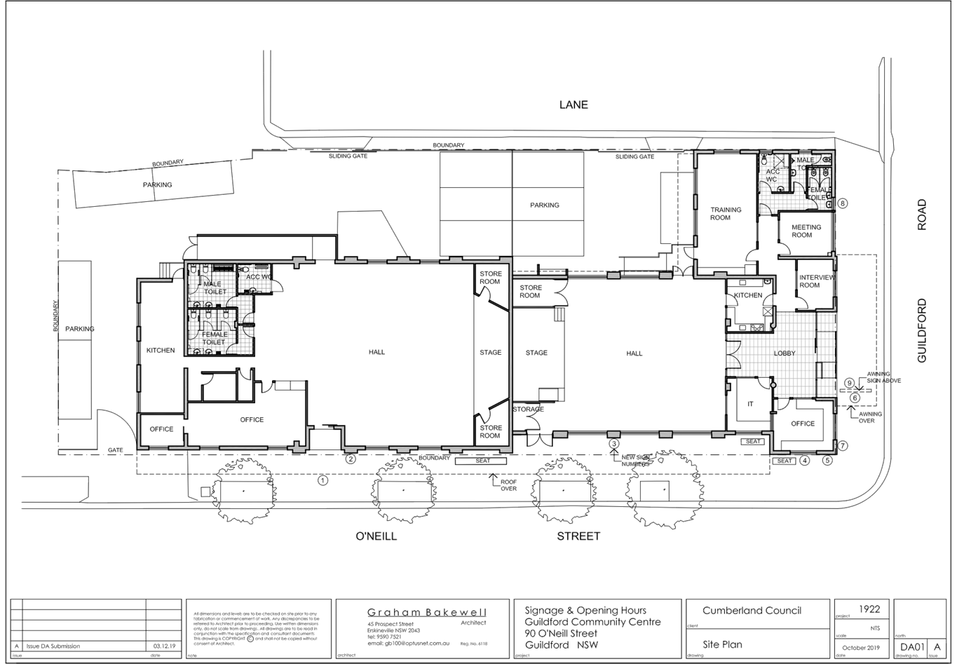
DOCUMENTS
ASSOCIATED WITH
REPORT ELPP023/20
Attachment 2
Plan of Management
Extraordinary Cumberland Local Planning
Panel Meeting
27 May 2020


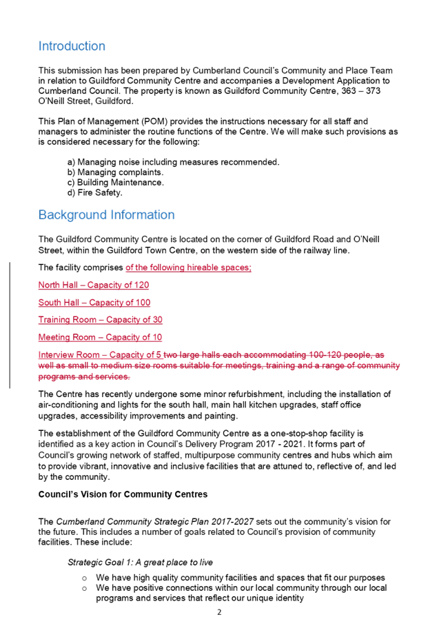
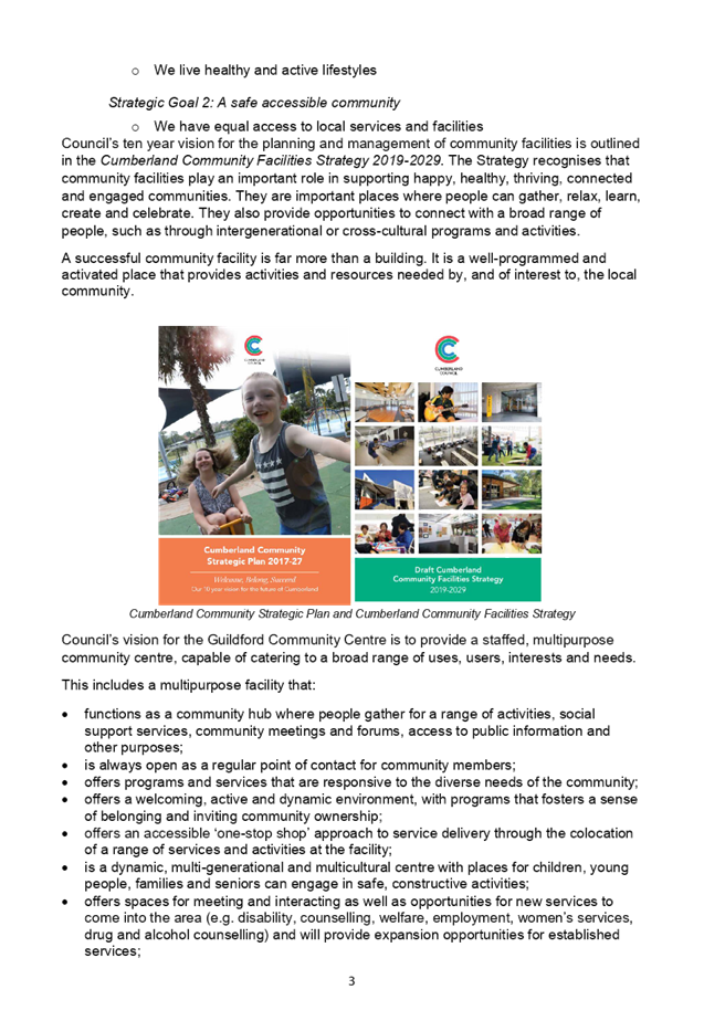


DOCUMENTS
ASSOCIATED WITH
REPORT ELPP023/20
Attachment 3
Acoustic Report
Extraordinary Cumberland Local Planning
Panel Meeting
27 May 2020

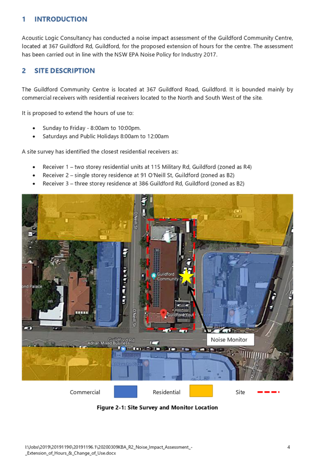
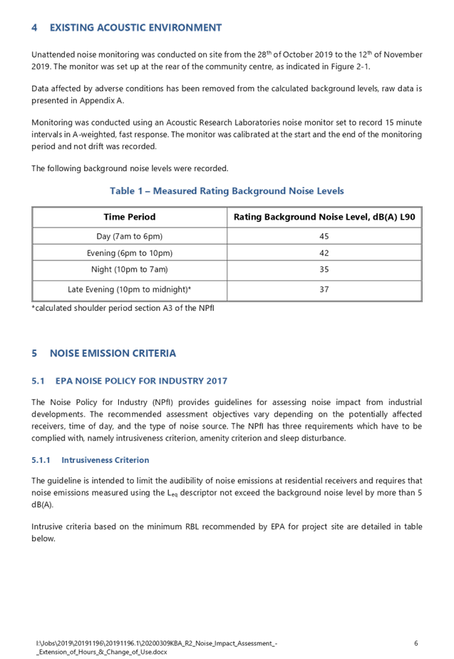
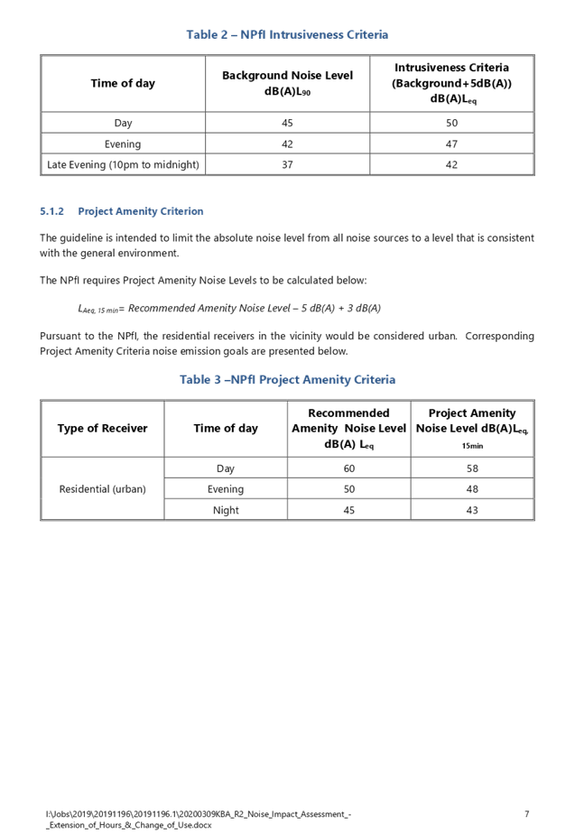


Extraordinary Cumberland Local Planning
Panel Meeting
27 May 2020


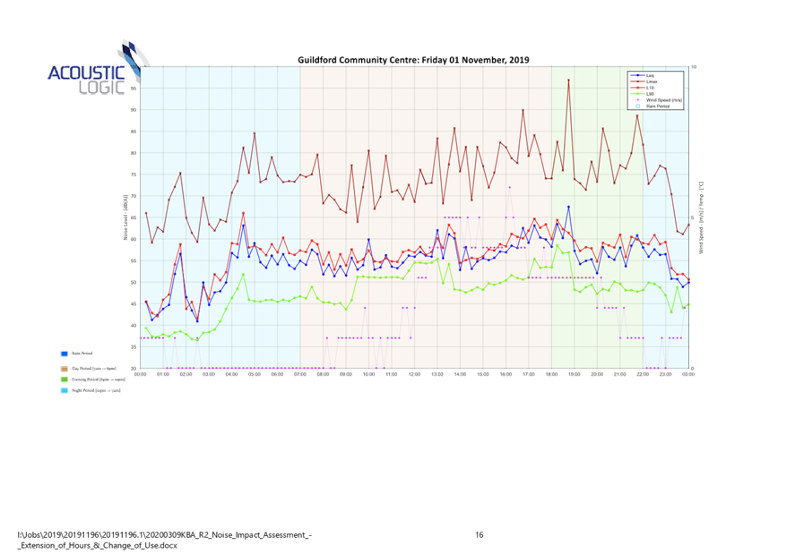
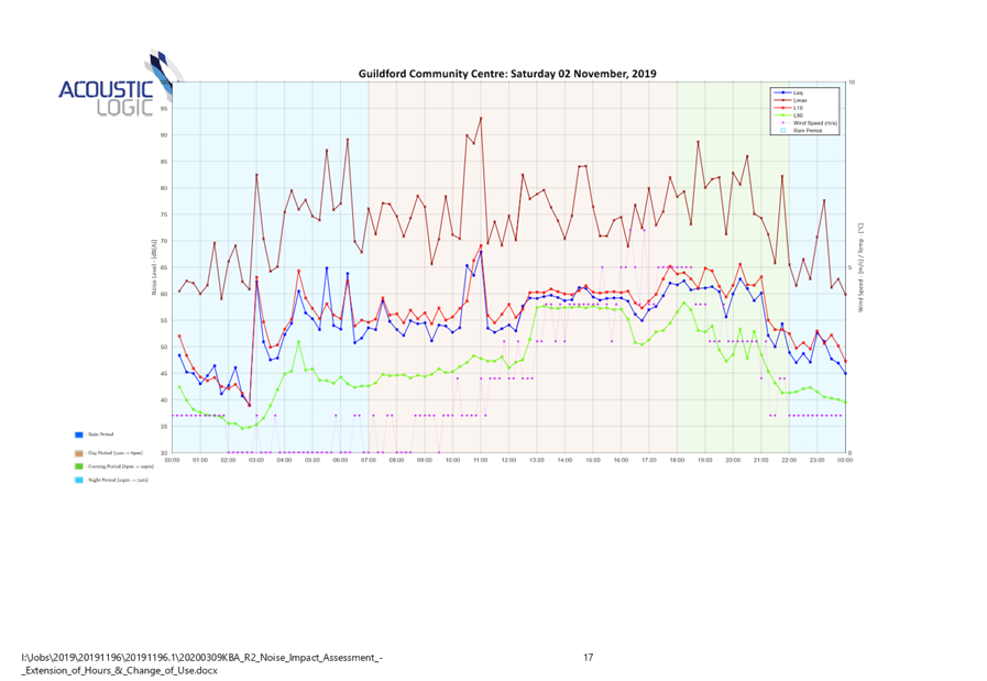
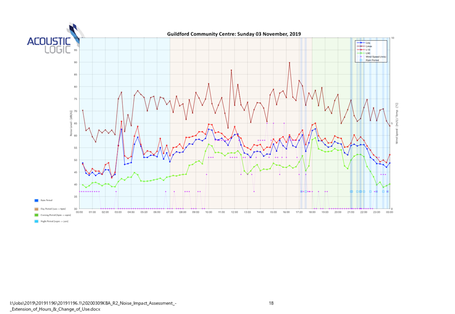
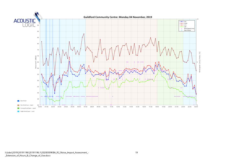
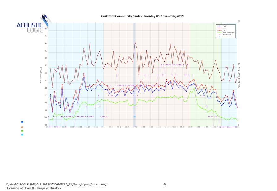
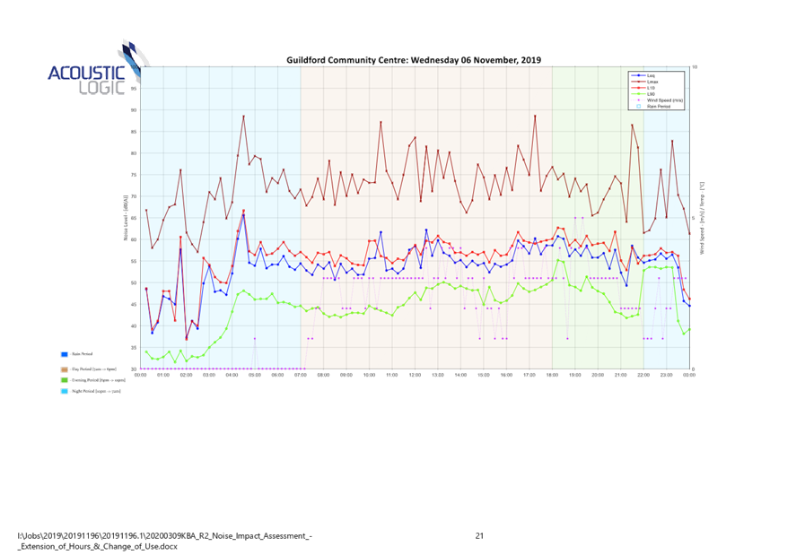
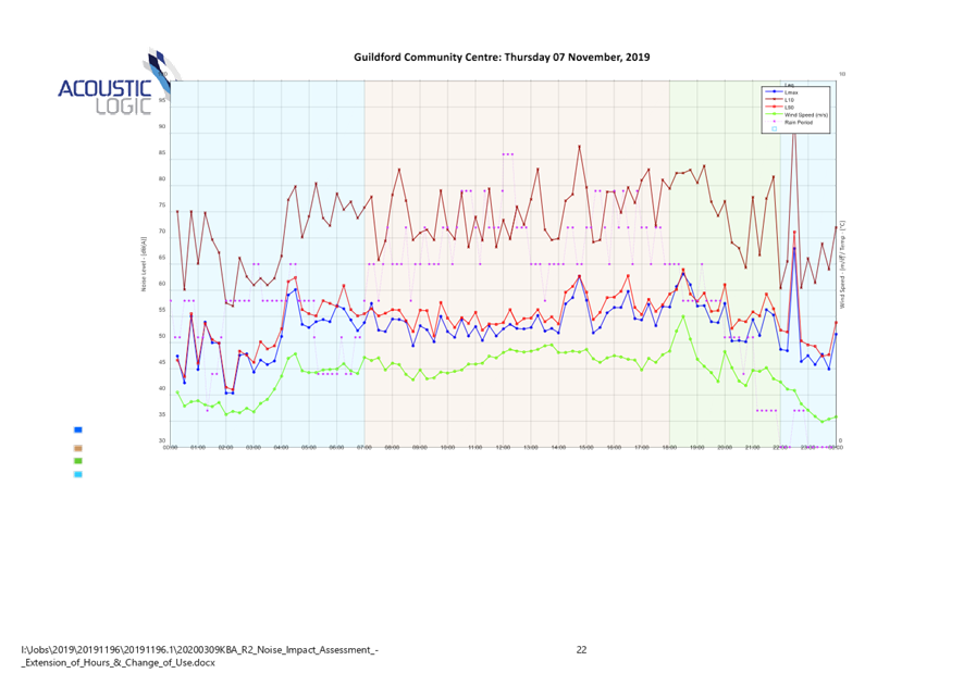

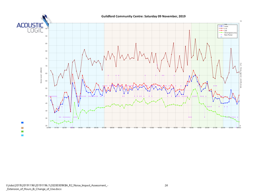
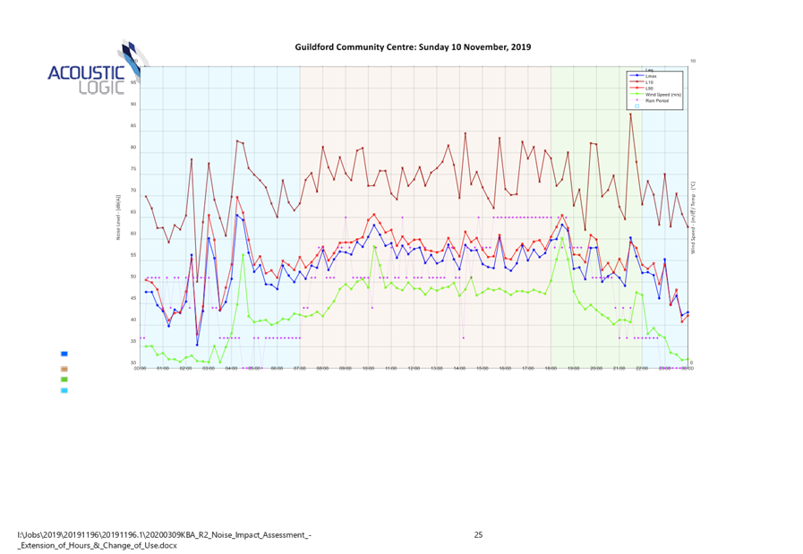
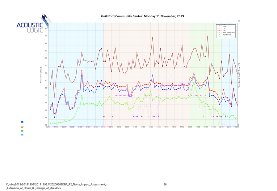
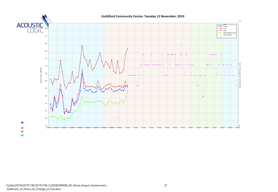

DOCUMENTS
ASSOCIATED WITH
REPORT ELPP023/20
Attachment 4
Police NSW Recommended Conditions
Extraordinary Cumberland Local Planning
Panel Meeting
27 May 2020
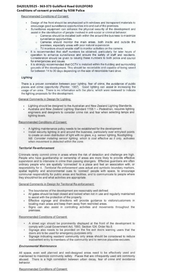
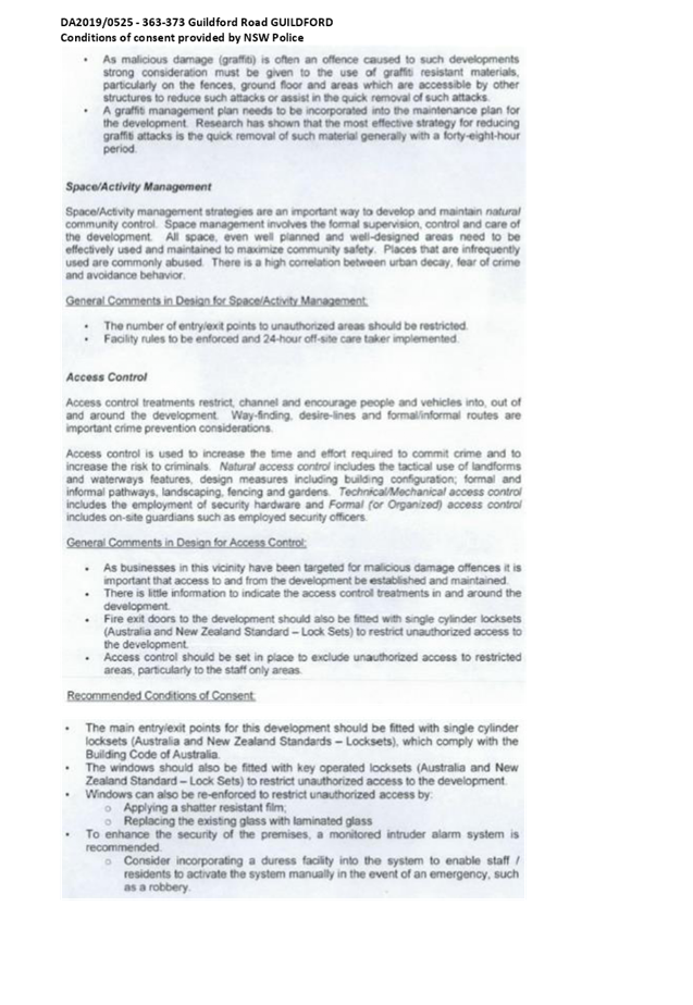
DOCUMENTS
ASSOCIATED WITH
REPORT ELPP023/20
Attachment 5
Appendix A - State Environmental Planning Policy No 64
Assessment
Extraordinary Cumberland Local Planning
Panel Meeting
27 May 2020
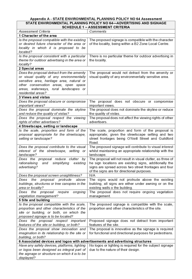
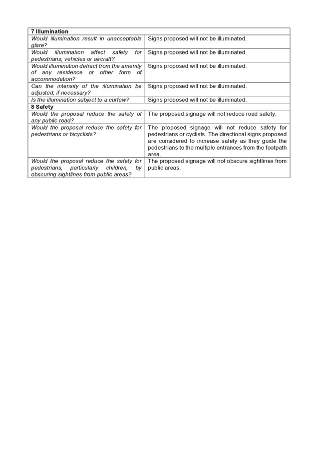
DOCUMENTS
ASSOCIATED WITH
REPORT ELPP023/20
Attachment 6
Appendix B - Local Environmental Plan Assessment
Extraordinary Cumberland Local Planning
Panel Meeting
27 May 2020
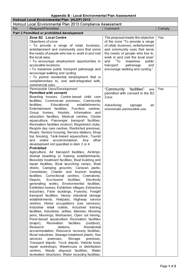

DOCUMENTS
ASSOCIATED WITH
REPORT ELPP023/20
Attachment 7
Appendix C - Development Control Plans
Extraordinary Cumberland Local Planning
Panel Meeting
27 May 2020
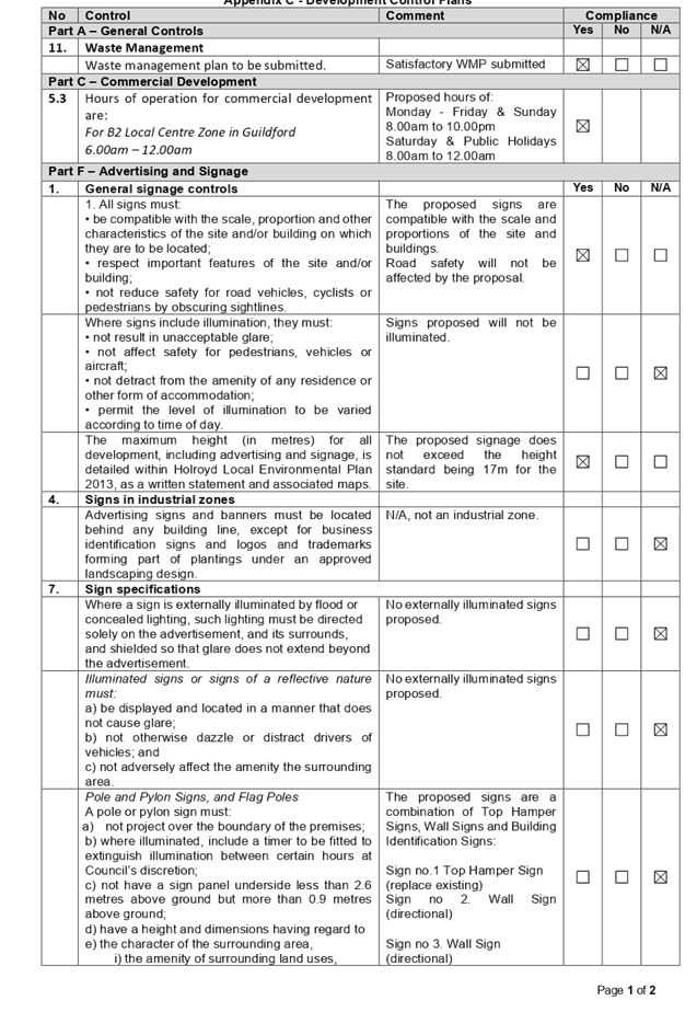

DOCUMENTS
ASSOCIATED WITH
REPORT ELPP023/20
Attachment 8
Draft Notice of Determination
Extraordinary Cumberland Local Planning
Panel Meeting
27 May 2020
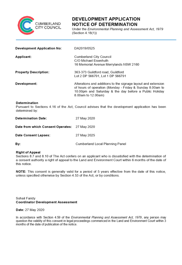
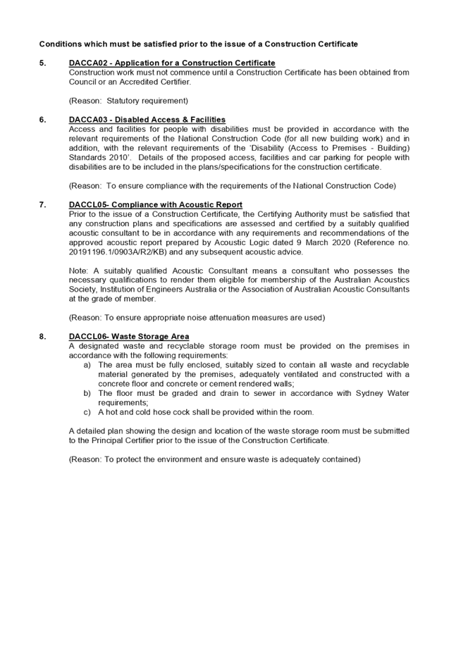

Extraordinary
Cumberland Local Planning Panel Meeting
27 May 2020
Item
No: ELPP024/20
Alteration to
the Gateway Determination for the Planning Proposal for 2 Bachell Avenue,
Lidcombe
Responsible
Division: Environment
& Planning
Officer: Executive
Manager Environment and Precincts
File
Number: PP-3/2018
|
Lodged
|
30 October 2018
|
|
Proponent
|
Pacific Planning
|
|
Owner
|
Raad Property Acquistion No 10 Pty Ltd
|
|
Site Address
|
2 Bachell Avenue Lidcombe (Lot 2 DP 219413)
|
|
Site Area
|
Approximately 8,750m2
|
|
Existing Use
|
The site contains a freestanding warehouse constructed in
1973 and has been used for a commercial laundromat since 2016. The site is
identified within the Flood Planning Area and includes a part of land
identified as below Foreshore Building Line. The existing stormwater
channel/culvert runs through the site in a south to north-west direction and
partly covered in adjacent to and below the freestanding warehouse.
|
|
Proposal
|
Seeks an alteration to the Gateway Determination to:
· Increase the floor
space ratio (FSR) control for the site from 2.5 to 3:1
· Increase the height of
building (HoB) control for the site from 14m and 28m to 14m, 18m and 38m
· Add Office and
Business Premises as additional permitted use
· Apply a floor space
cap of 7000m2 to the additional permitted use.
|
|
Existing Planning Controls
|
Zoning
|
IN1 General Industrial
|
|
Height of Building (HoB)
|
Nil
|
|
Floor Space Ratio (FSR)
|
1:1
|
|
Requested Planning Controls
|
Zoning
|
B5 Business Development
|
|
Height of Building (HoB)
|
Nil
|
|
Floor Space Ratio (FSR)
|
3:1
|
|
Controls recommmended by the CLPP
|
Zoning
|
B5 Business Development
|
|
Height of Building (HoB)
|
Consider applying height controls
|
|
Floor Space Ratio (FSR)
|
2:1
|
|
Controls endorsed by Council
|
Zoning
|
B5 Business Development
|
|
Height of Building (HoB)
|
14m
27m
|
|
Floor Space Ratio (FSR)
|
2.5:1
|
|
Gateway Determination
|
Zoning
|
B5 Business Development
|
|
Height of Building (HoB)
|
14m
27m
|
|
Floor Space Ratio (FSR)
|
2.5:1
|
|
Gateway Determination Alteration Request by Proponent
|
Zoning
|
B5 Business Development
|
|
Height of Building (HoB)
|
14m
18m
38m
|
|
Floor Space Ratio (FSR)
|
3:1
|
|
Heritage
|
|
Nil
|
|
Disclosure of political donations and gifts
|
|
Nil
|
|
Previous considerations
|
|
CLPP: 13 March 2019
Council: 15 May 2019
Gateway Determination: 16 December 2019
|
This report provides an overview
of a request from the proponent for an alteration to a Gateway Determination
for the planning proposal for 2 Bachell Avenue, Lidcombe. The alteration
to the Gateway Determination seeks to:
· Increase
the floor space ratio control for the site from 2.5 to 3:1
· Apply
a 38m height of building control to the majority of the site, with 14m and 18m
height of building controls applying to the frontage to Bachell Avenue
· Add
Office and Business Premises as additional permitted uses
· Apply
a floor space cap of 7000m2 to the additional permitted uses.
Other aspects associated with the
Gateway Determination, such as the change of zoning to B5 Business Development
and removal of the foreshore building line, are not proposed to be altered as
part of this request.
The status of the Planning
Proposal is outlined in Figure 1.
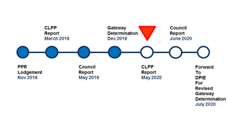
Figure 1 Planning
Proposal Status
1. The
Site And Its Context
The site is located at 2 Bachell
Avenue, Lidcombe (Figure 2). The site currently contains a freestanding
warehouse, utilised by a laundrette, with a footprint of approximately
2,500m². The warehouse is located in the middle of the site with land on
either side vacant. The site is an irregular triangular shape measuring
approximately 8,750m² in area.
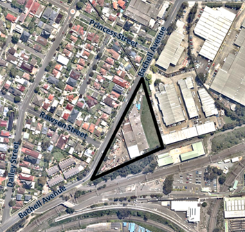
Figure
2 The Site
Local Context
The site is located on the
southern end of the Lidcombe East Industrial Precinct, and is adjacent to a
residential area (to the west) and railway infrastructure (to the south).
The site is located approximately
1 kilometres away on foot from Lidcombe Railway Station (approx. 15 minutes walking
distance).
Regional Context
The site is located in the suburb
of Lidcombe within the Local Government Area of Cumberland Council
approximately 6 kilometres east of Parramatta CBD and 16 kilometres west of the
Sydney CBD.
2. Planning
Controls (Auburn LEP 2010)
The site is currently zoned IN1
General Industrial with an FSR of 1:1. No height of building control applies to
the site. These are shown in Figures 3 to 5.
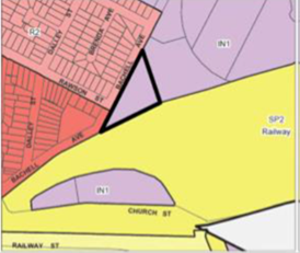
Figure
3 Current Zoning on Site
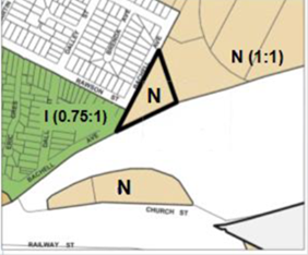
Figure
4 Current Floor Space Ratio on Site
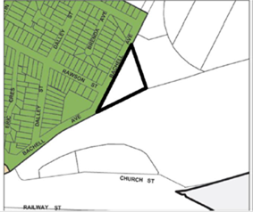
Figure
5 Current Height of Building Control on Site (note: no controls in place)
The site is also identified on the Flood Planning Area Map
and the Foreshore Building Line Map, as shown in Figures 6 and 7.
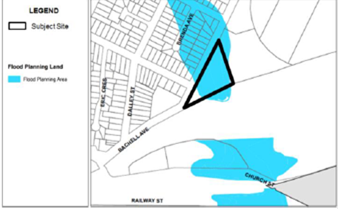
Figure
6 Flood Planning Map
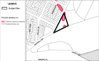
Figure
7 Foreshore Building Line Map
3. The
Planning Proposal
Original Planning Proposal
The original Planning Proposal
Request submitted to Council in November 2018 sought to:
· Rezone
the site from IN1 General Industrial to B5 Business Development
· Introduce
a new B5 Business Development zone to the Land Use Table of Auburn LEP 2010
· Amend
the floor space ratio control for the site from 1:1 to 3:1
· Remove
the Foreshore Building Line that applies to this site.
The Proposal was reported to the
Cumberland Local Planning Panel on 13 March 2019. The Panel:
· Supported
the change in zoning to B5 Business Development
· Was
of the view that insufficient evidence had been provided by the applicant to
justify a maximum floor space ratio of 3:1 based on the proposed mix of land
uses submitted with the proposal. However supported an increase in floor space
ratio and was of the view that an floor space ratio of 2:1 may be more
appropriate in the context of the site and surrounding land uses
· Recommended
consideration should be given to including height controls over the subject
site
· Recommended,
having regard to the above, the Planning Proposal Request proceed to the next
stage of assessment and be reported to Council seeking a resolution to forward
an amended planning proposal to the Department of Planning, Industry and
Environment for a Gateway Determination.
Proposed Planning Controls
Reported to Council
The proposal was reported to
Council on 15 May 2019 seeking a Gateway Determination for a planning proposal
that sought to:
· Rezone
the site from IN1 General Industrial to B5 Business Development
· Introduce
a new B5 Business Development zone to the Land Use Tables
· Amend
the floor space ratio control for the site from 1:1 to 2.5:1
· Apply
a height of building controls of 14m and 27m to the site
· Remove
the Foreshore Building Line that applies to this site.
A floor space ratio of 2.5:1 was
applied to the site. This floor space ratio was considered to be a compromise
between the floor space ratio of 2:1 recommended by the Panel and the floor
space ratio of 3:1 being sought by the proponent. The feasibility of a floor
space of 2.5:1 was supported by the proponent’s economic study.
Height of building controls of 14m
and 27m were applied to the site in response to the Panel’s recommendation.
The dual building heights were applied to ensuring the taller element of the
proponent’s concept plan were located to the rear of the site with the
lower elements fronting Bachell Avenue, creating a transition from the lower
density residential development on the north western side of Bachell Avenue.
Council resolved that the planning
proposal with the identified controls be forwarded for a Gateway Determination.
Gateway Determination
A Gateway Determination was issued
of 16 December 2019. Prior to public exhibition, the Gateway Determination
required:
· A
flood impact study to address potential impacts of realignment and enclosure of
the existing stormwater drainage channel
· The
supporting urban design report be updated to be consistent with the planning
proposal and clearly demonstrate the potential built form interface along
Bachell Avenue
· The
economic study be updated to be consistent with the planning proposal
· The
planning proposal be updated, if required, to be consistent with the outcomes
of the studies referred to above.
4. Alteration
To The Gateway Determination
An alteration to the Gateway
Determination has been requested by the proponent. The alteration seeks
to:
· Increase
the floor space ratio control for the site from 2.5 to 3:1
· Apply
a 38m height of building control to the majority of the site, with 14m and 18m
height of building control applying to the frontage to Bachell Avenue to create
a transition from neighbouring residential properties
· Add
‘Office and Business Premises’ as additional permitted use
· Apply
a floor space cap of 7000m2 to the additional permitted uses
Further details on the alterations
requested is provided in the table below.
|
Alteration Request
|
Details
|
|
Office and business premises as additional permitted uses
|
The proponent’s original background studies included
office and business premises as component of the redevelopment of the site,
although this was not clearly articulated in their original planning
proposal. Therefore, Council’s planning proposal did seek to include
the additional permitted uses.
The proponent has emphasised that it was always their
intention to seek office and business premise as an additional permitted use
as they are essential to the feasibility of the proposal. The proponent’s
updated economic study indicates that the redevelopment of the site is not
viable without office space being part of the redevelopment.
To limit the impact on competing locations such as the
Lidcombe Town Centre and the Parramatta Road Corridor, the proponent is
seeking a floor space cap of 7000m2 be applied to the additional
permitted uses.
|
|
Increase to the floor space ratio
|
The proponent has provided an updated economic study that
concludes that an FSR of 2.5:1 is not feasible. The economic study outlines
that an FSR below 3:1 does not provide a greater enough return to alleviate
the risks associated with redeveloping the site. The feasibility assessment
determines that FSR’s of below 3:1 returns less than the 15% return on
investment that is required to promote the redevelopment of the site
consistent with the proponent’s concept.
|
|
Height of building control
|
The proponent has revised their Urban Design Report and
are now seeking height of building controls of 38m be applied to the majority
of the site, with heights of 14m (approximately 4m wide) and 18m
(approximately 9m wide) applying to the frontage to Bachell Avenue.
|
Table
1 Details of Alteration Request to Gateway Determination
An indicative concept of the
proposal associated with the alteration to the Gateway Determination is
provided in Figure 8.
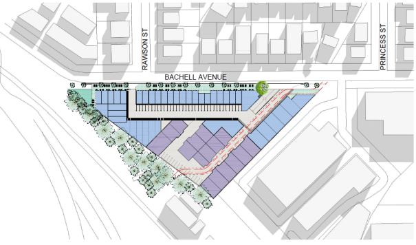
Figure
8 Indicative Concept of Proposal for the Site
5. Amended
Planning Proposal
Council has reviewed the
alteration request for the Gateway Determination in relation to the land uses
proposed on the site, as well as the built form components of floor space ratio
and height. Based on this review, an amended planning proposal is identified
for the site.
Land Uses Proposed on the Site
The proponent has provided
clarification regarding the role of office and business premises as a land use
that is intended on the site. This land use would complement other land
uses proposed on the site that are consistent with the B5 Business Development
zoning, such as high technology industries, warehousing and distribution. The
proponent is also seeking a floor space cap of 7000m2 for office and
business premises.
In relation to the proposed
additional permitted uses, while office and business premises is not included
in the Land Use Table for B5 Business Development under the draft Cumberland
Local Environmental Plan, it is considered appropriate for this location as it
would complement the range of other land uses identified in the proposal.
The inclusion of office and business premises as an additional permitted uses
would also support the renewal of employment at this location, consistent with
the outcomes of the Cumberland Employment and Innovation Lands Strategy.
In relation to the floor space cap
for office and business premises, the imposition of the cap is supported to
allow the viability of the development to be preserved, whilst protecting
office and business uses along Parramatta Road and the Lidcombe town
centre. The proposed floor space of 7000m2 represents a
minority of the floor area provided for the site, and is anticipated to provide
office and business premises needs for the employment lands in the Lidcombe
area, as distinct from the needs of the Lidcombe town centre.
Built Form Components
The proponent is seeking
amendments to some of the built form components of the site. This
includes an increase in the floor space ratio of the site from 2.5:1 to 3:1 and
changes to building heights, to enable a transition of height from 14m to 38m.
In relation to the density of the
site, a review of the economic study indicates that a floor space ratio below
3:1 does not provide a greater enough return to alleviate the risks associated
with redeveloping the site. The constraints of the site also require
alterations to drainage channels on the site (with an additional cost for the
development) to enable an effective use of the site and to remove the flood
burden for neighbouring residential properties. It is considered
appropriate that a floor space ratio of 3:1 is supported for this proposal.
In relation to the maximum height,
the proposal by the proponent of 38m is in relation to the office component of
the site. This height is considered to be inconsistent with height
controls for offices along the Parramatta Road corridor under current planning
controls (27m) and proposed planning controls for development identified in the
Parramatta Road Corridor Urban Transformation Strategy (27m). A review by
Council indicates that a maximum building height of 29.9m is more consistent
with the comparable controls and is aligned with the proponent’s
indicative concept.
In relation to the lower heights,
the proponent has also identified a transition of heights of 14m and 18m at the
site frontage along Bachell Avenue. While the transition of heights is
supported for the site, the inclusion of three tiers of height is not
considered to be effective mechanism in managing height on the site. It
is proposed that a similar arrangement to the current Gateway Determination is
retained, with a single maximum height at the street frontage, and that this
should be 18m in accordance with the indicative concept for the site.
Amended Planning Proposal
Based on the review, an amended
planning proposal is identified for the site with the following planning
controls as part of the alteration to the Gateway Determination:
· Increase
the floor space ratio control for the site from 2.5 to 3:1
· Apply
a 29.9m height of building control to the majority of the site, with a height
of building control of 18m applying to the frontage to Bachell Avenue
· Add
Office and Business Premises as additional permitted uses
· Apply
a floor space cap of 7000m2 to the additional permitted uses
The proposed planning controls for
the amended planning proposal in relation to floor space ratio and height of
building controls are provided in Figures 9 and 10.
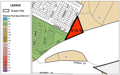
Figure
9 Proposed Floor Space Ratio Control with Amended Planning Proposal
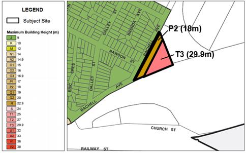
Figure
10 Proposed Height of Building Controls with Amended Planning Proposal
It is noted that the following
controls are retained as per the Gateway Determination:
· Introduction
of B5 Business Development Zone for the site
· Removal
of Foreshore Building Line that applies to the site
6. Strategic
Merit Assessment
Land Uses Proposed on Site
There is strategic merit in seeking
an alteration to the Gateway Determination for the amended planning proposal
as:
· The
additional permitted uses of office and business premises is appropriate at
this location and support the renewal of employment lands in Lidcombe,
consistent with the strategic directions outlined in the Cumberland Employment
and Innovation Lands Strategy, and provide a greater range of employment
activities on the site
· The
floor area cap of 7000m2 for the additional permitted uses balances
the viability of the development with the distinct land use needs of the local
area, including the Lidcombe town centre and employment lands in Lidcombe and
Parramatta Road.
Built Form Components
There is strategic merit in
seeking an alteration to the Gateway Determination for the amended planning
proposal as:
· The
amended floor space ratio for the site supports the economic viability of
future development of the site, realising the renewal of employment lands in
the Lidcombe area
· The
amended height of building controls retains lower height on the street frontage
with adjoining areas, and provides an appropriate maximum height towards the
rear of the site consistent with the outcomes being sought through the
indicative concept.
Consistency with Strategic
Merit Assessment for Planning Proposal with Gateway Determination
The amended planning proposal
identified for the alteration to the Gateway Determination continues to be
consistent with the strategic merit assessment with the planning proposal that
has received a Gateway Determination. This includes:
· Consistency
with strategic plans, including the Central City District Plan, Cumberland
2030: Our Local Strategic Planning Statement and the Cumberland Employment and
Innovation Lands Strategy
· Consistency
with technical issues identified, including the introduction of the B5 Business
Development zone, flood planning and foreshore building line, and traffic and
transport.
It is recommended that the amended
planning proposal, with revised building height controls of 18m and 29.9m, and
revised floor space ratio control of 3:1, be reported to Council seeking
alteration to the Gateway Determination. This recommendation is being made as:
· The
proposal will support the renewal of employment lands in Lidcombe, consistent with
the strategic directions of the Cumberland Local Employment Lands Strategy
· The
amended proposal clarifies the land use and built form for the site in a manner
that is generally consistent with the character of the surrounding area
· The
amended proposal continues to be consistent with strategic and technical
considerations identified in the original proposal that has received a Gateway
Determination.
The proposal was publicly
exhibited for a period of 28 days from 13 November 2018 to 11 December 2018, in
accordance with Cumberland Council’s Planning Proposal Notification
Policy.
In response to the exhibition,
Council received no written submissions during or after the exhibition period.
There are no financial
implications for Council associated with this report.
This report recommends that this
matter be reported to Council for further consideration. Should Council resolve
to forward this planning proposal to the Department of Planning, Industry and
Environment for a revised Gateway Determination, there will be a number of
policy implications associated with the subsequent stages of the planning
proposal process. These will be outlined in subsequent Council reports.
Communication /
Publications:
There are no
communication/publication implications for Council associated with this report.
|
That the Cumberland Local
Planning Panel (CLPP):
1. Recommend
that the request for an alteration to the Gateway Determination for 2 Bachell
Avenue, Lidcombe be reported to Council, seeking a resolution to seek a
revised Gateway Determination from the Department of Planning, Industry and
Environment that:
i) Increases
the floor space ratio control for the site from 2.5:1 to 3:1
ii) Applies
a 18m and 29.9m height of building control to the site
iii)
Adds Office and Business Premises as an additional permitted uses to the site
iv)
Applies a floor space cap of 7000m2 to the additonal permitted uses.
2. Note
that the following controls are to be retained as included in the Gateway
Determination for the proposal:
i) Introduction
of B5 Business Development Zone for the site
ii) Removal
of Foreshore Building Line that applies to the site.
|
1. Minutes from
CLPP Meeting 13 March 2019
2. Minutes
from Council Meeting 15 May 2019
3. Gateway
Determination 16 December 2019
4. Updated
Urban Design Report
5. Updated
Economic Study
DOCUMENTS
ASSOCIATED WITH
REPORT ELPP024/20
Attachment 1
Minutes from CLPP Meeting 13 March 2019
Extraordinary Cumberland Local Planning
Panel Meeting
27 May 2020
DOCUMENTS
ASSOCIATED WITH
REPORT ELPP024/20
Attachment 2
Minutes from Council Meeting 15 May 2019
Extraordinary Cumberland Local Planning
Panel Meeting
27 May 2020
DOCUMENTS
ASSOCIATED WITH
REPORT ELPP024/20
Attachment 3
Gateway Determination 16 December 2019
Extraordinary Cumberland Local Planning
Panel Meeting
27 May 2020
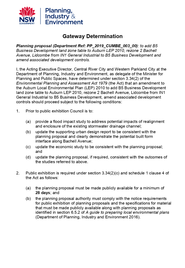
DOCUMENTS
ASSOCIATED WITH
REPORT ELPP024/20
Attachment 4
Updated Urban Design Report
Extraordinary Cumberland Local Planning
Panel Meeting
27 May 2020
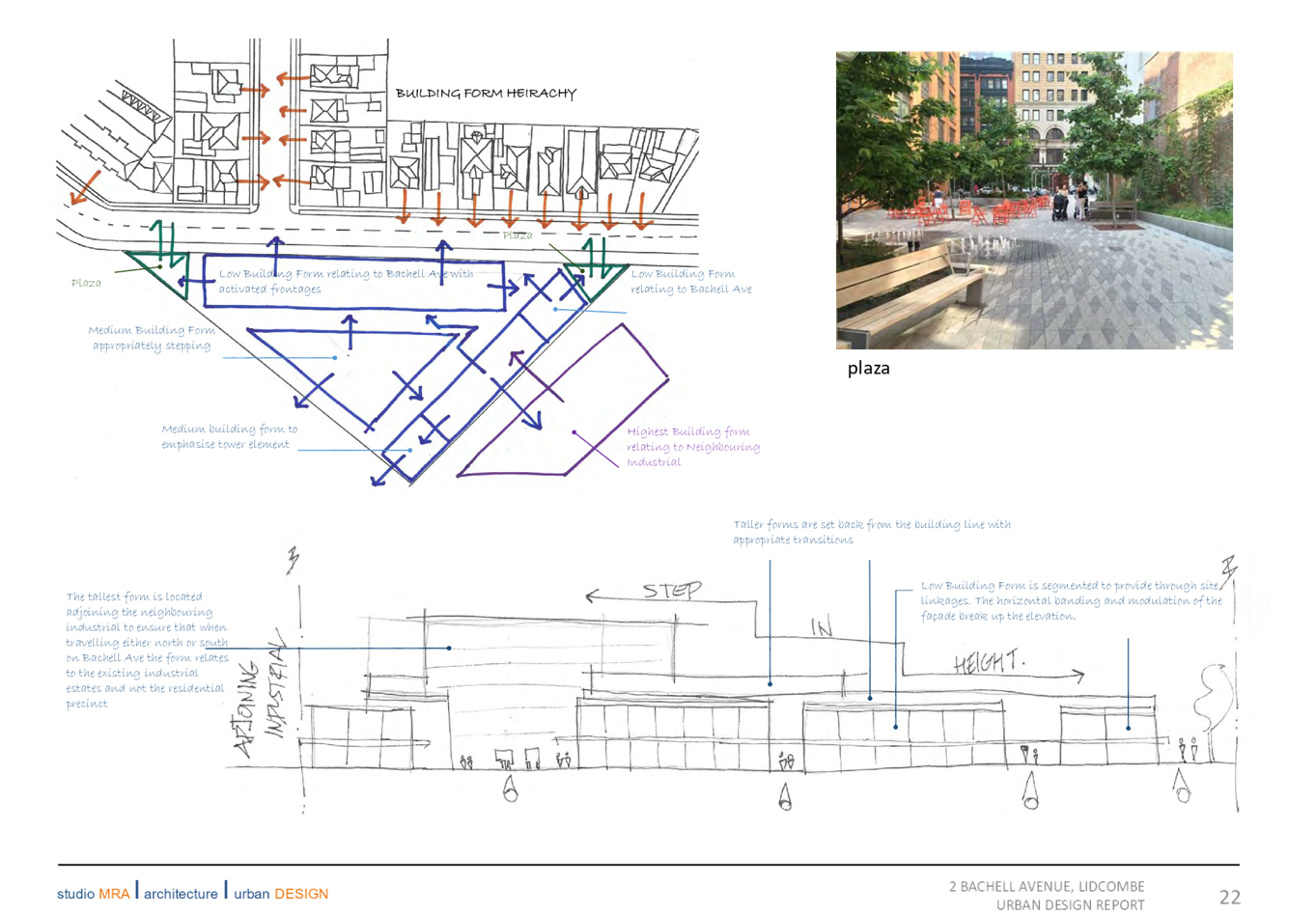
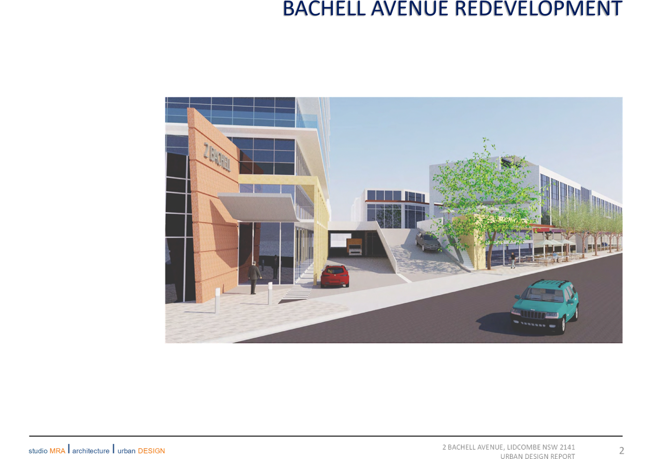
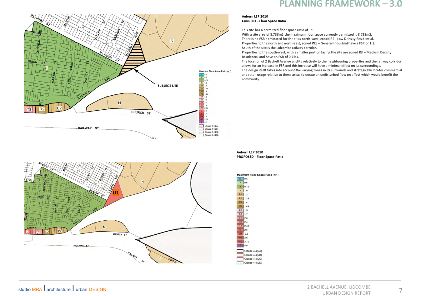
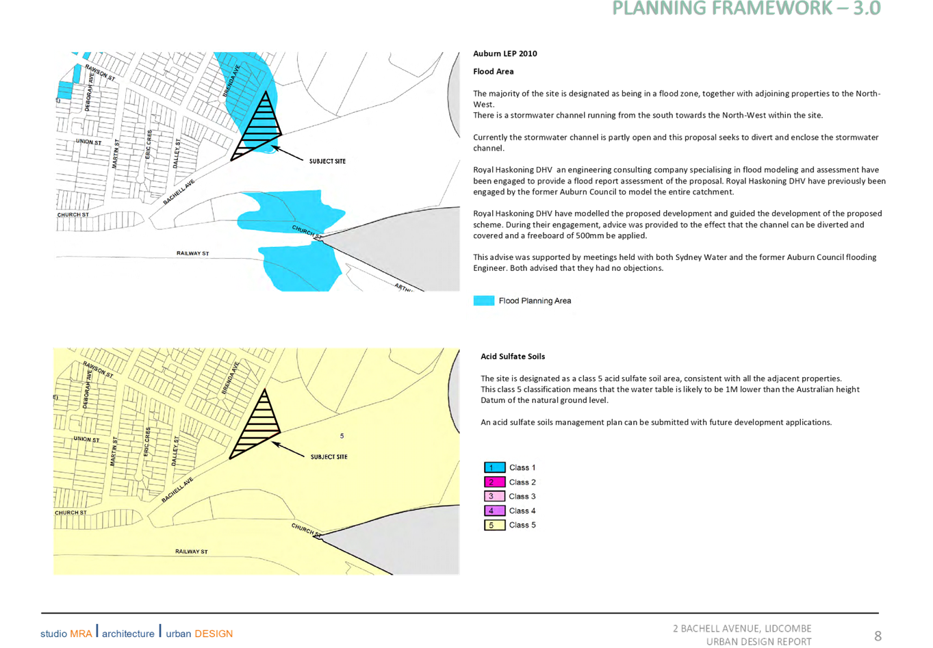
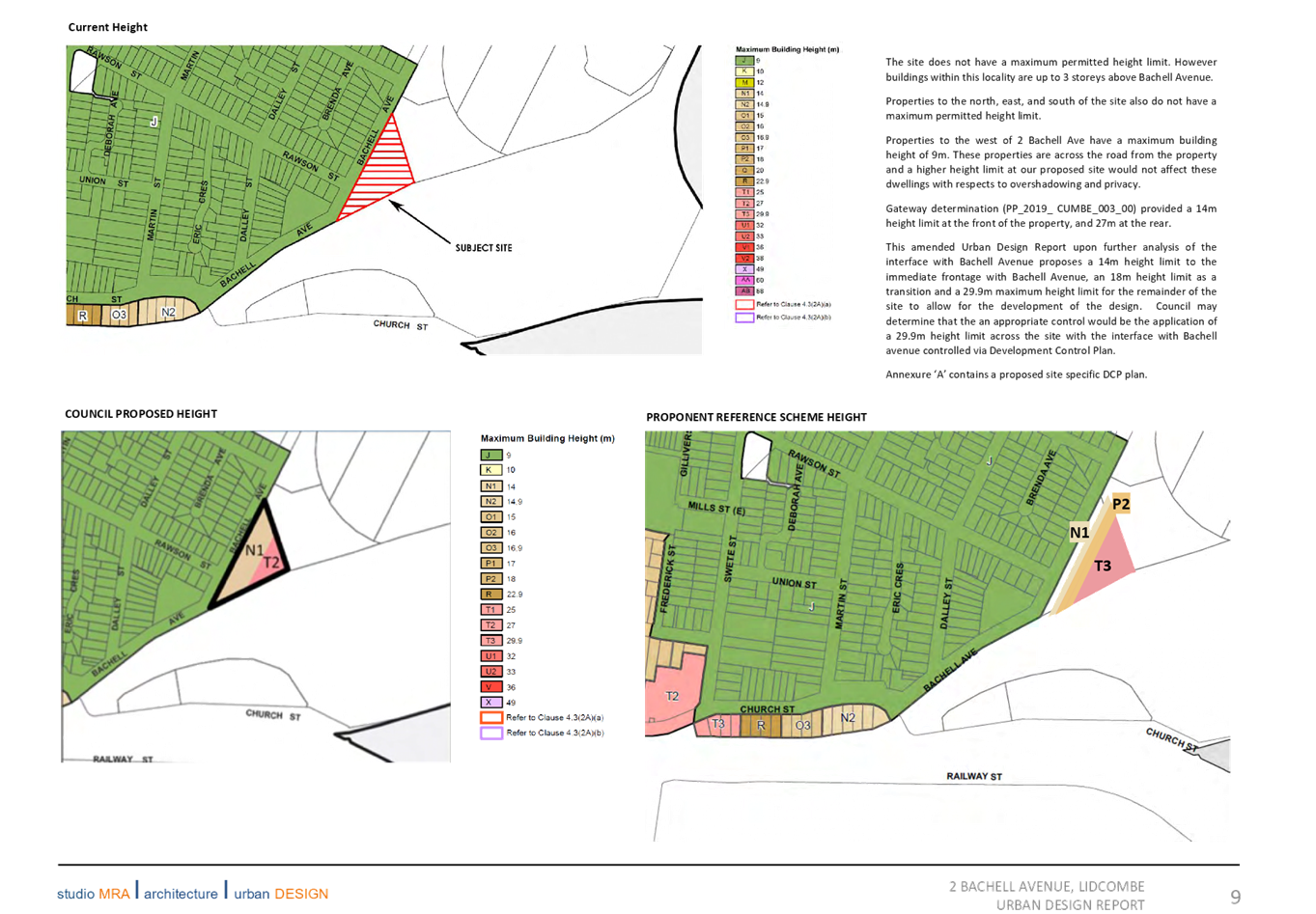
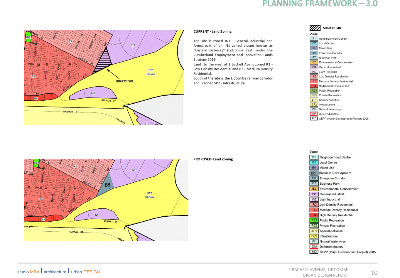
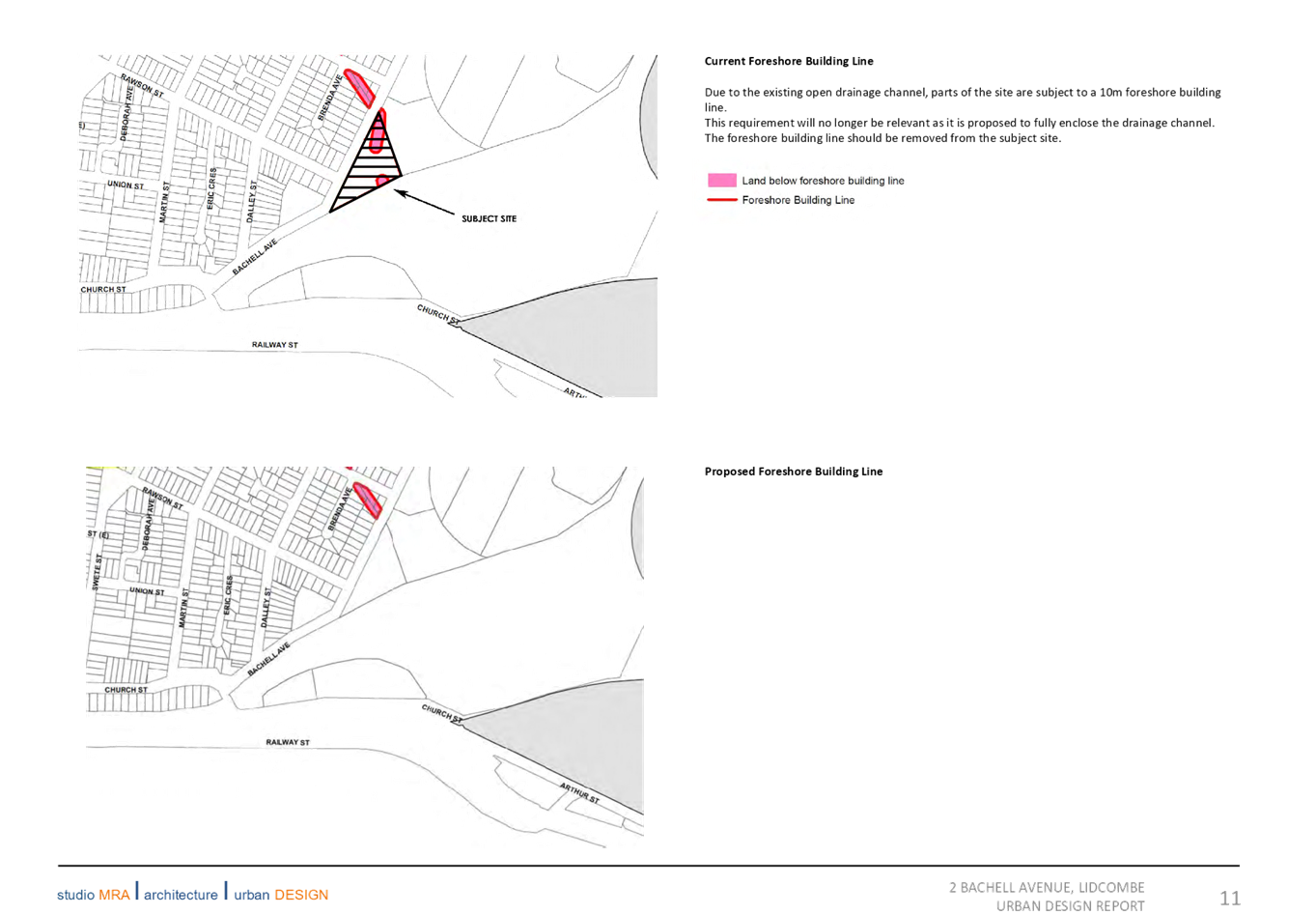
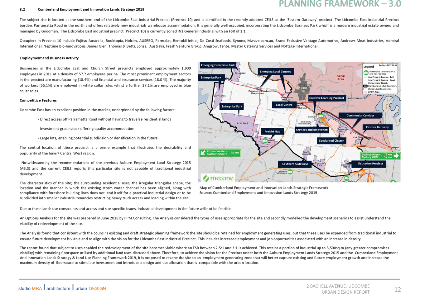
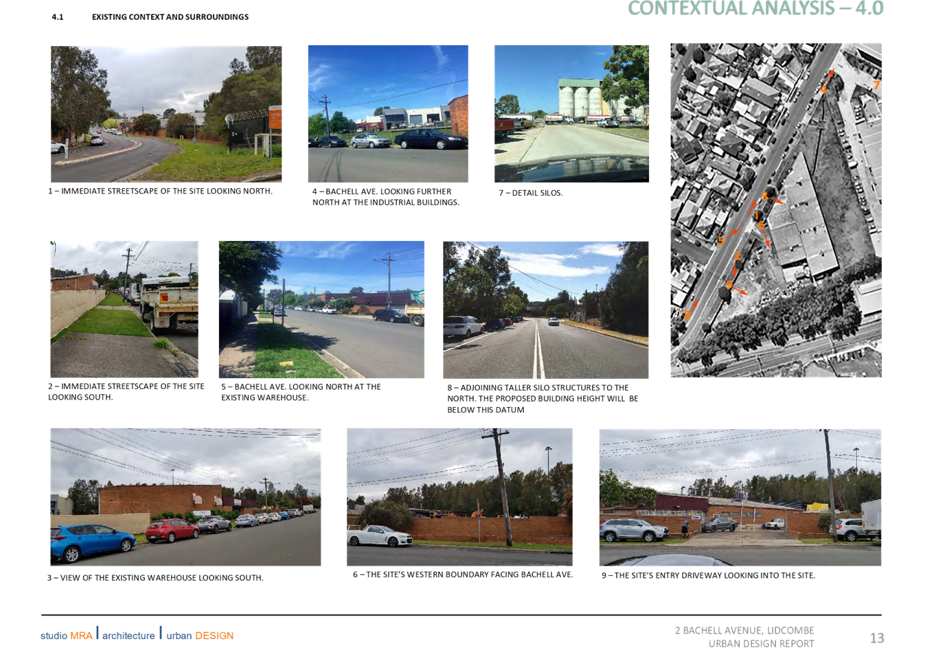
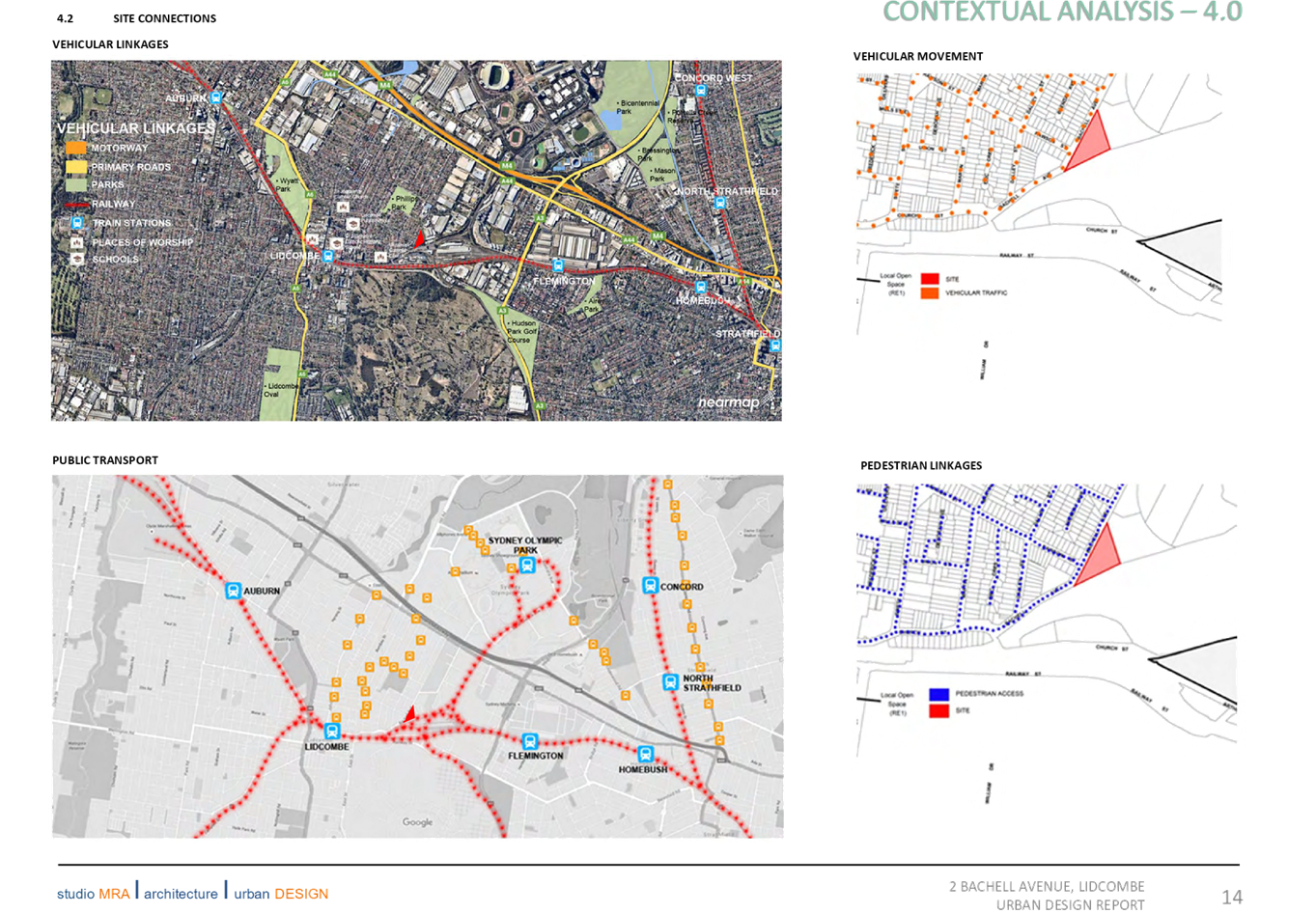
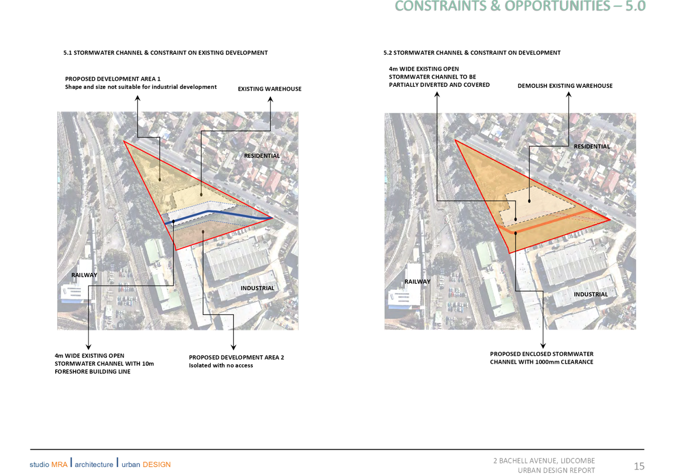
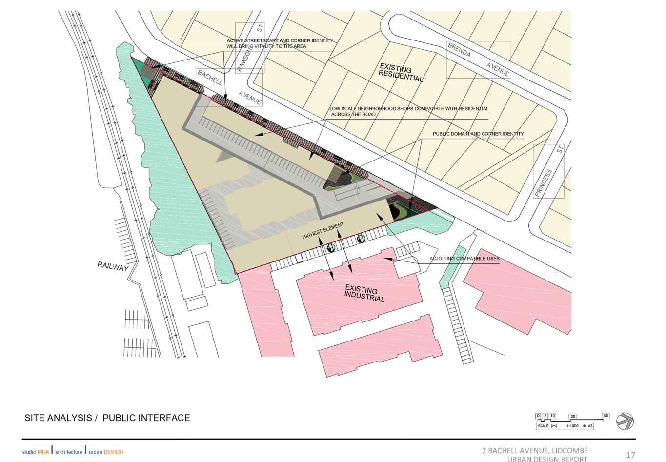
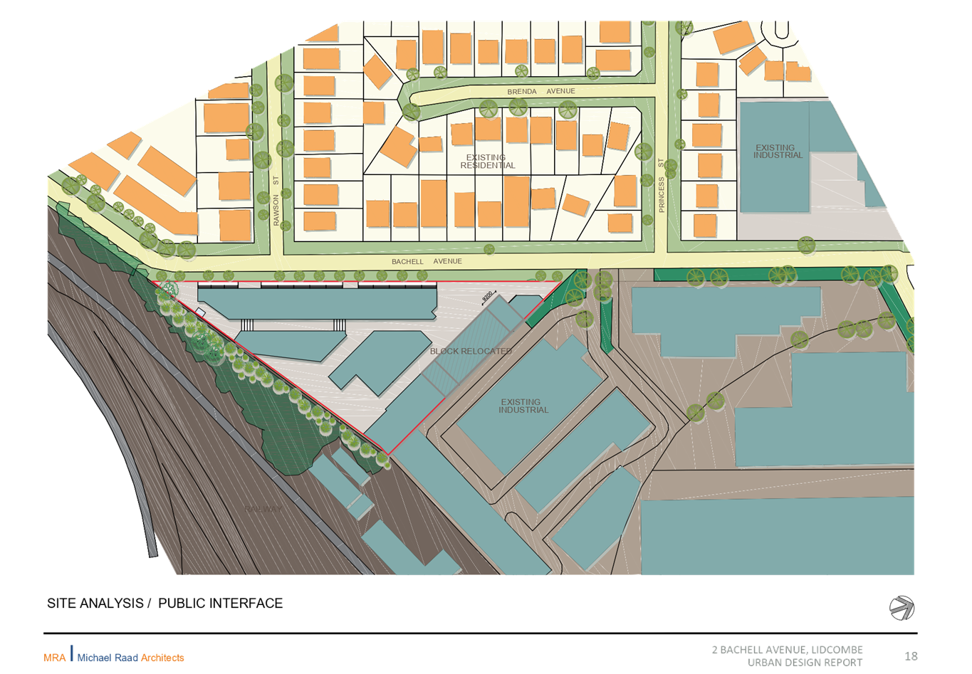
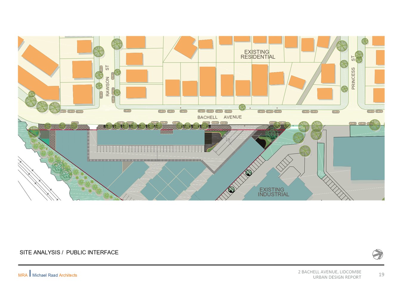
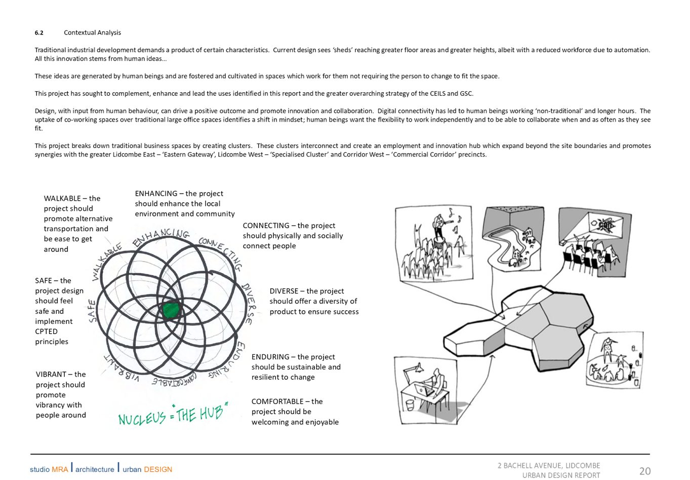
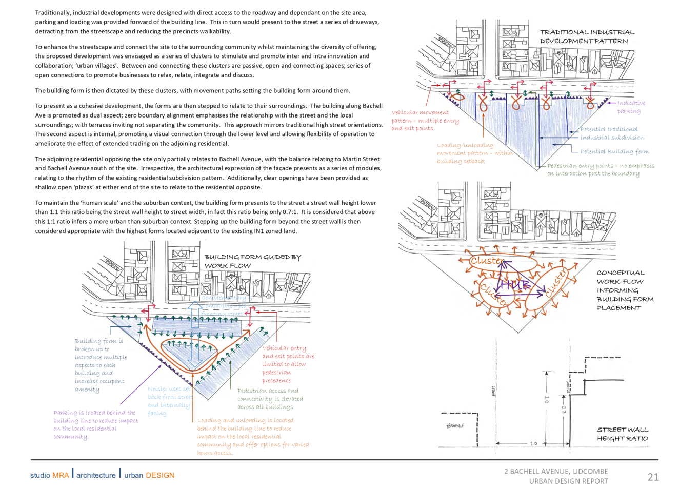
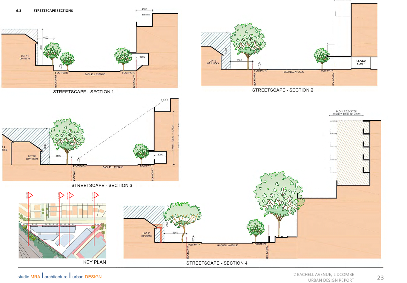
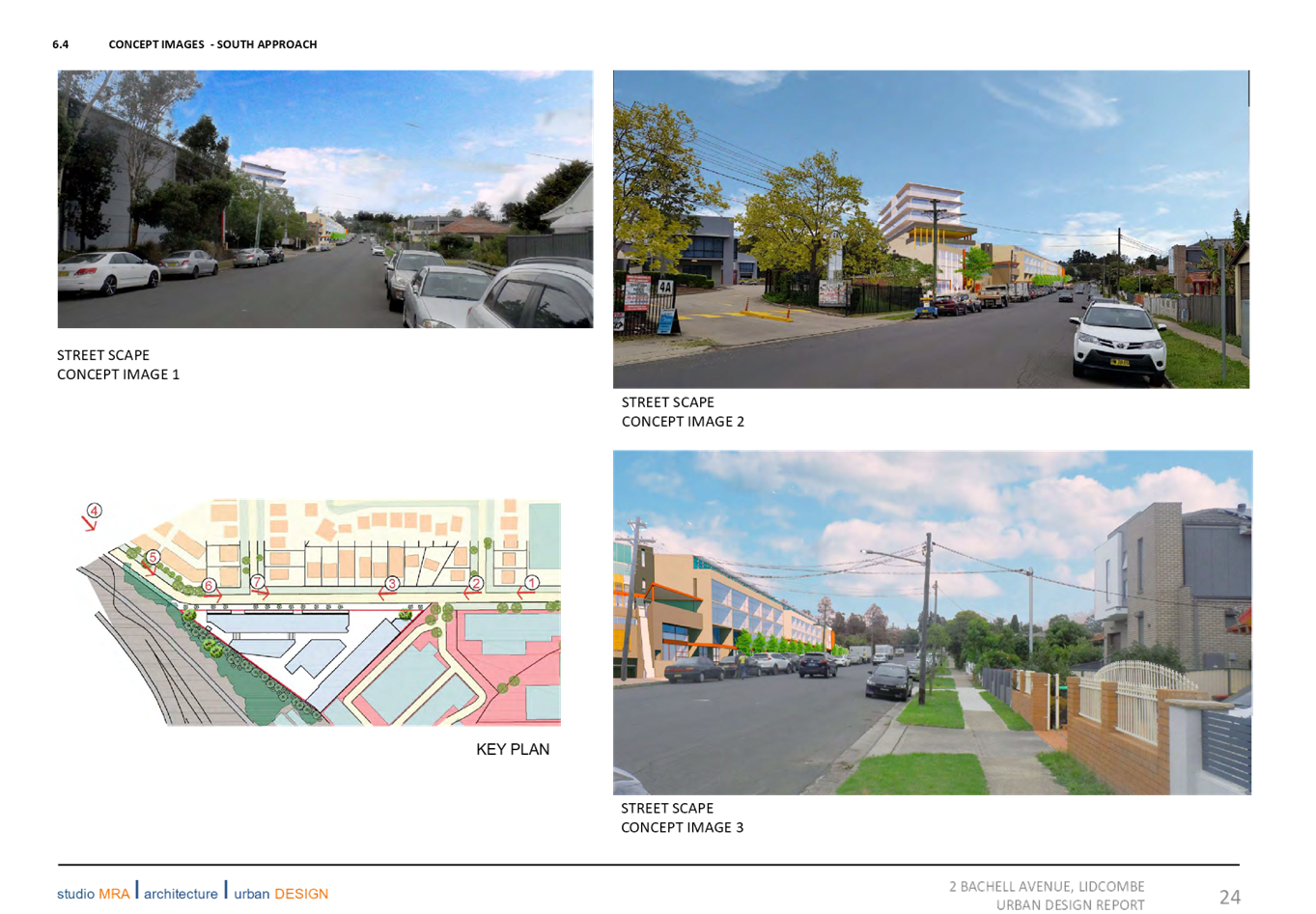
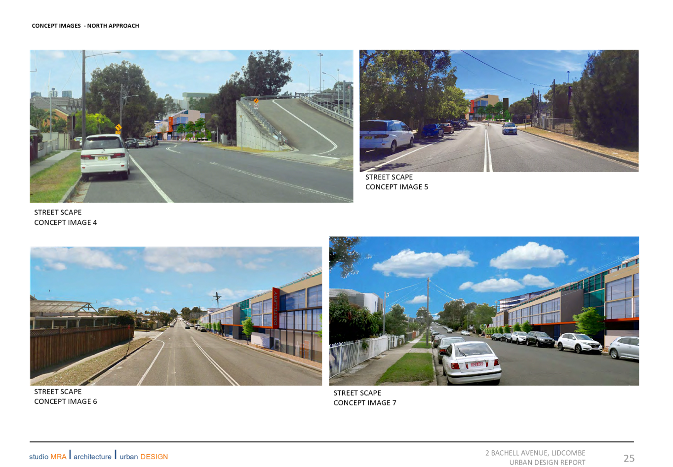
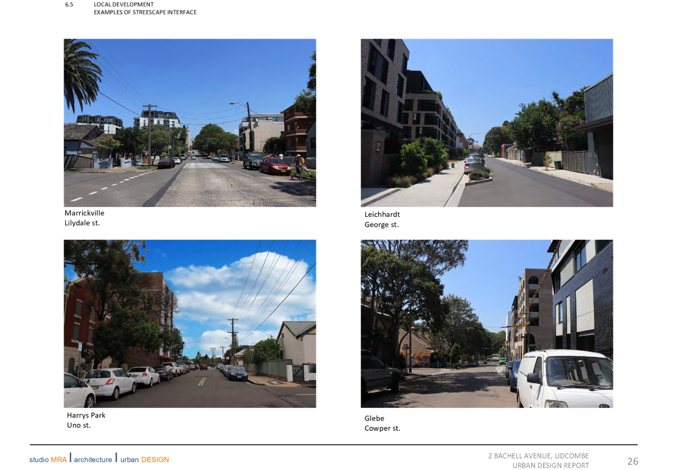

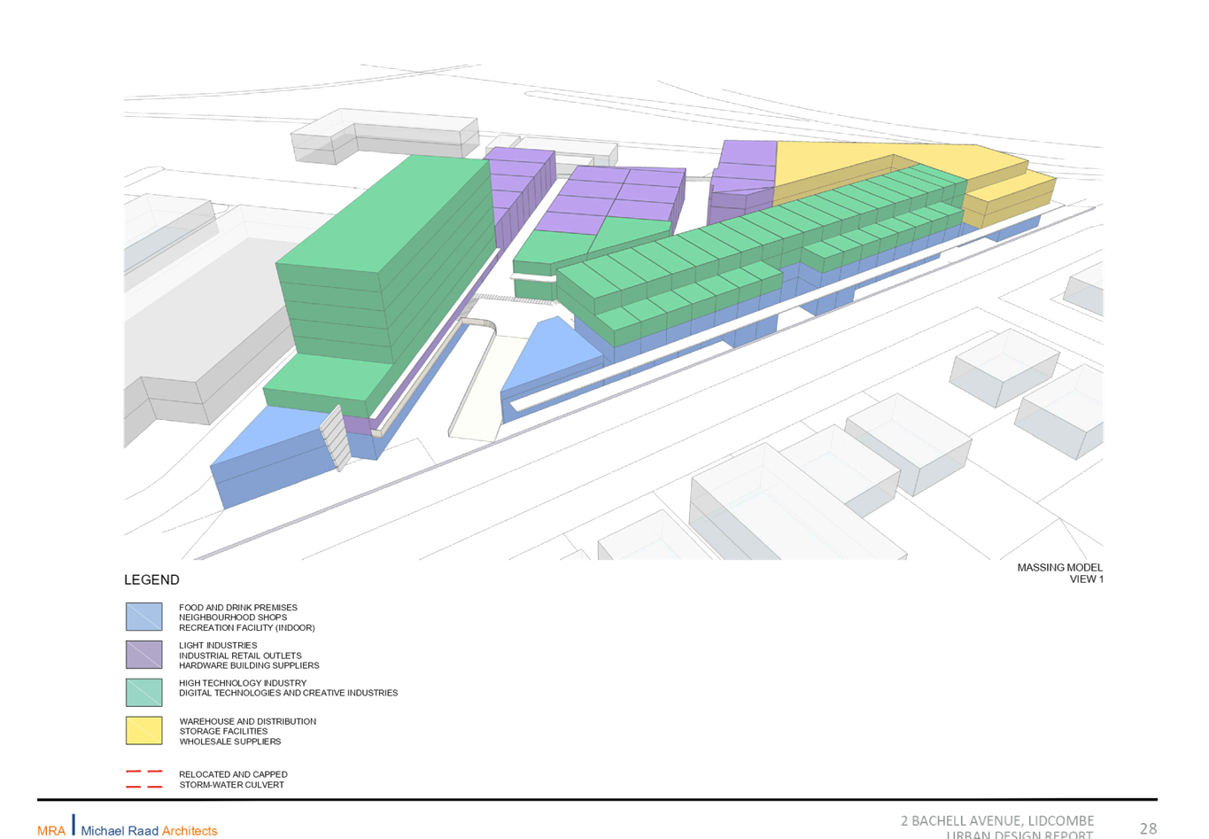
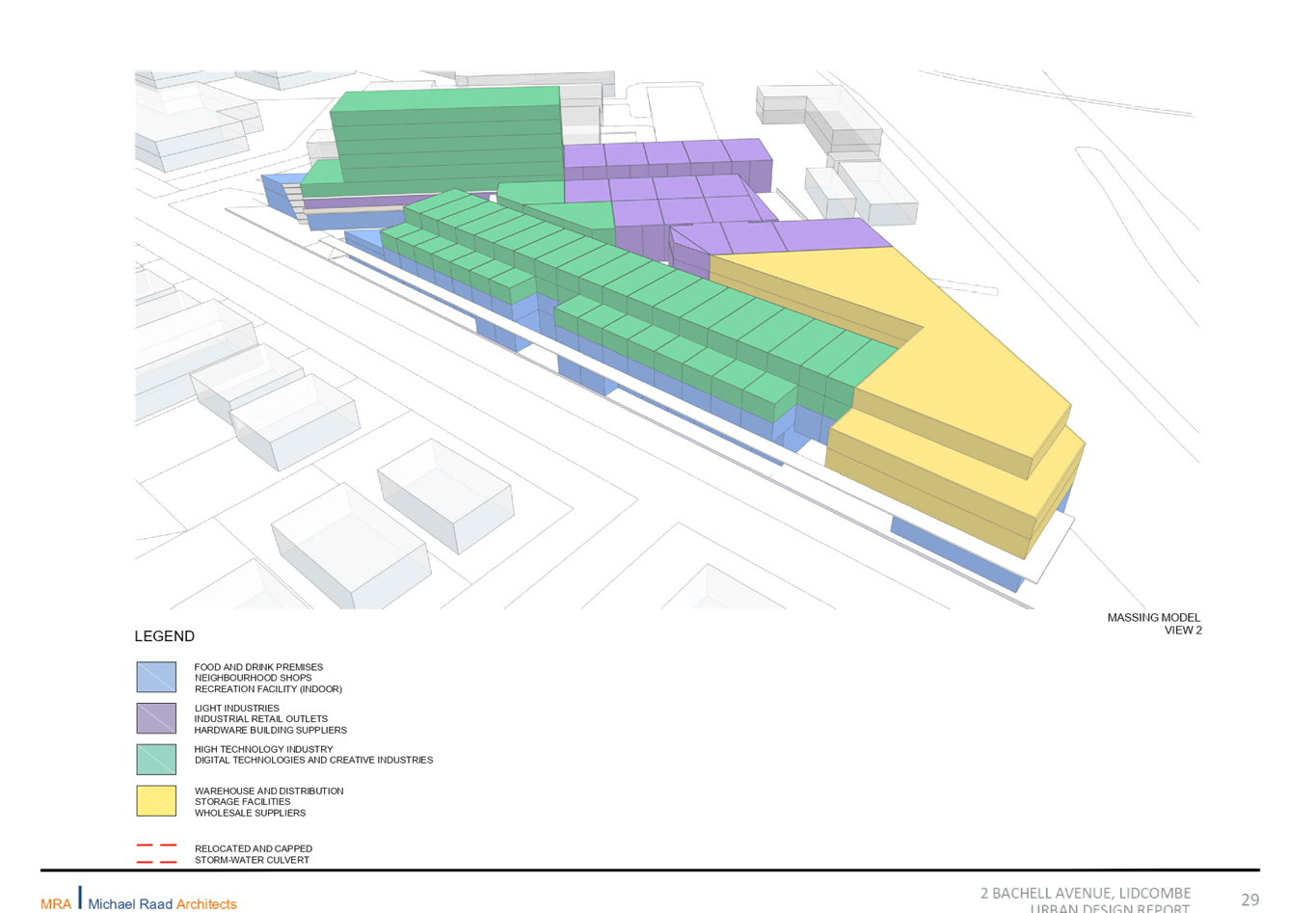
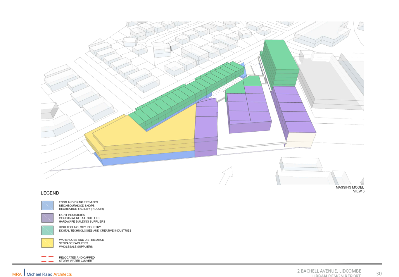
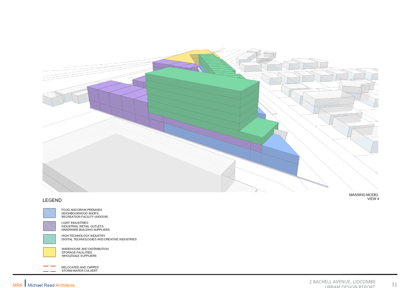
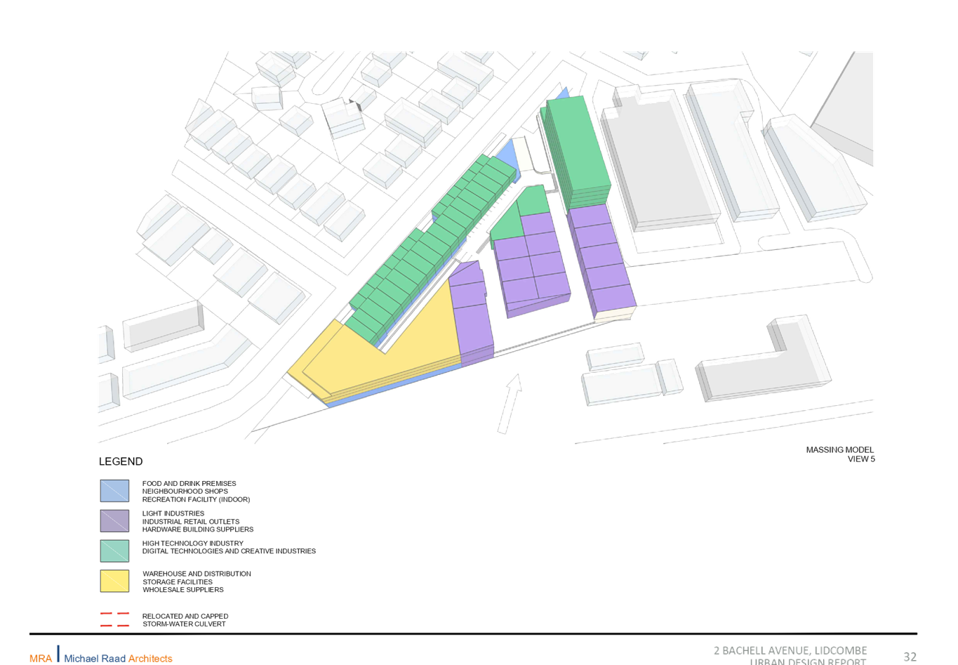

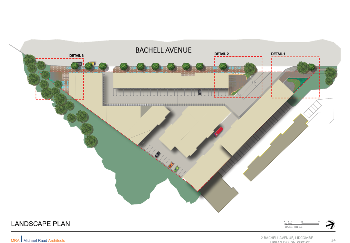
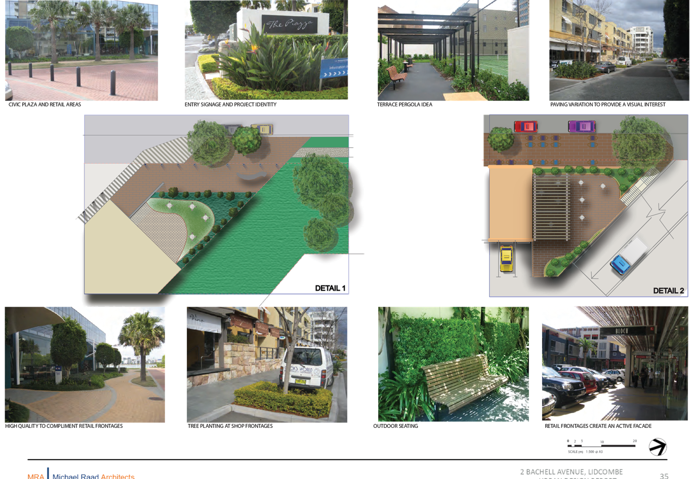
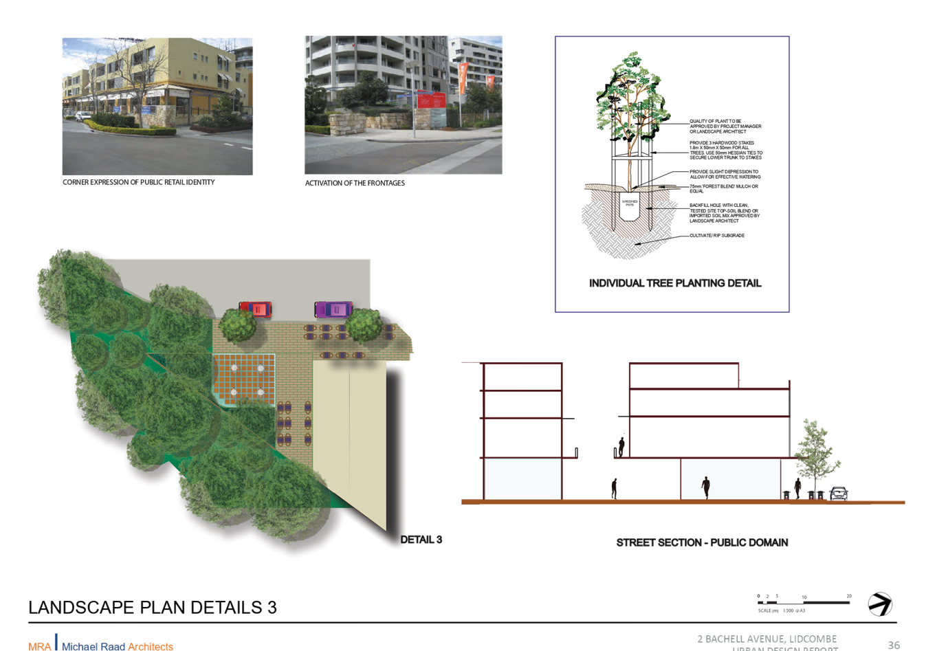

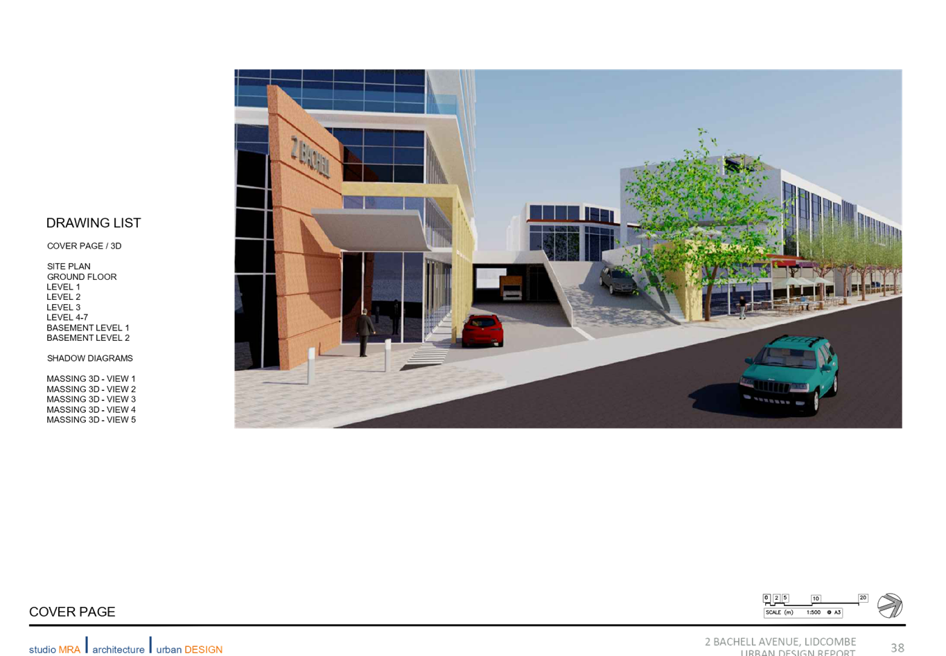
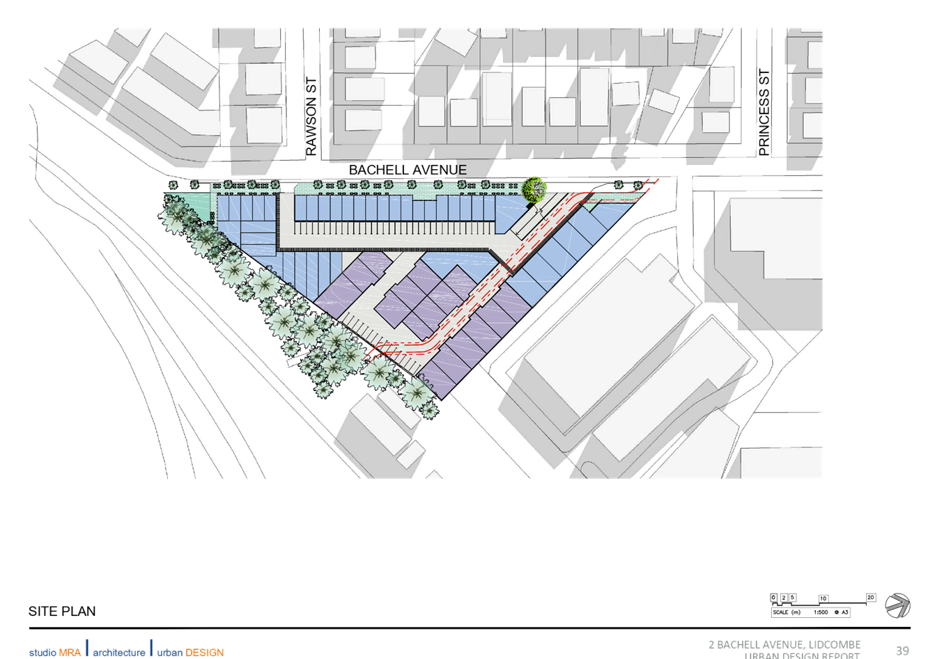
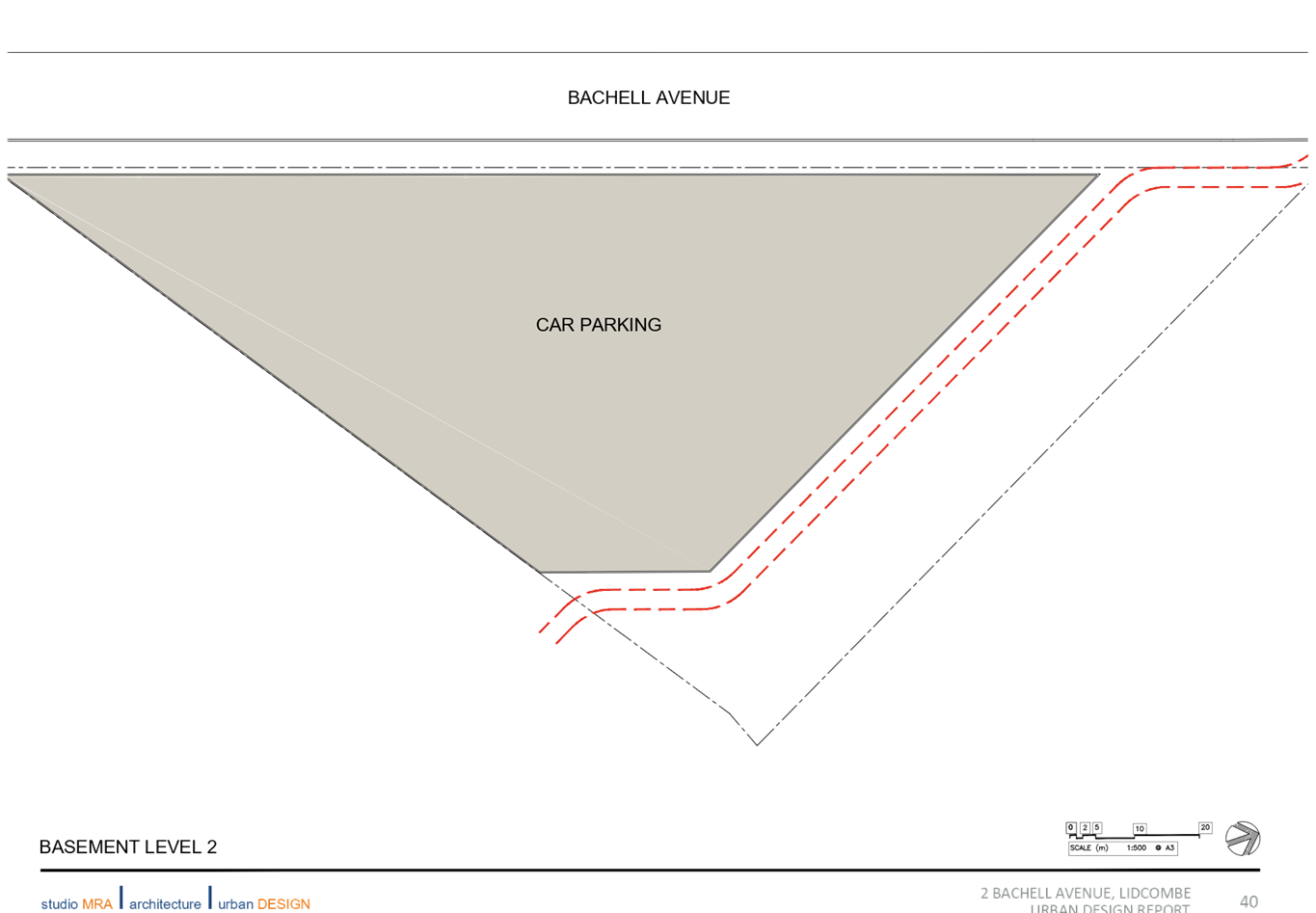
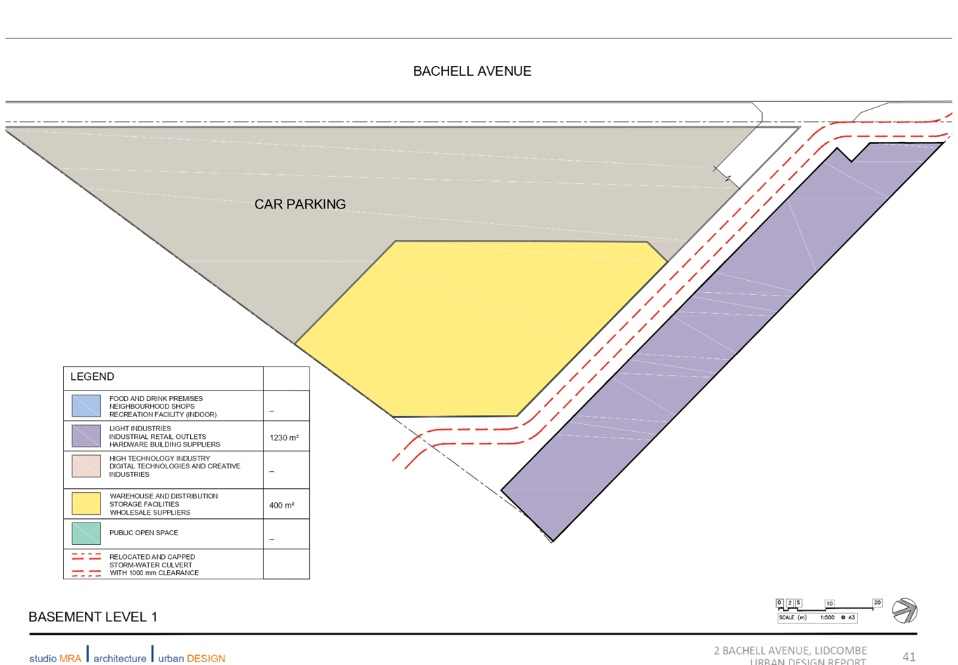
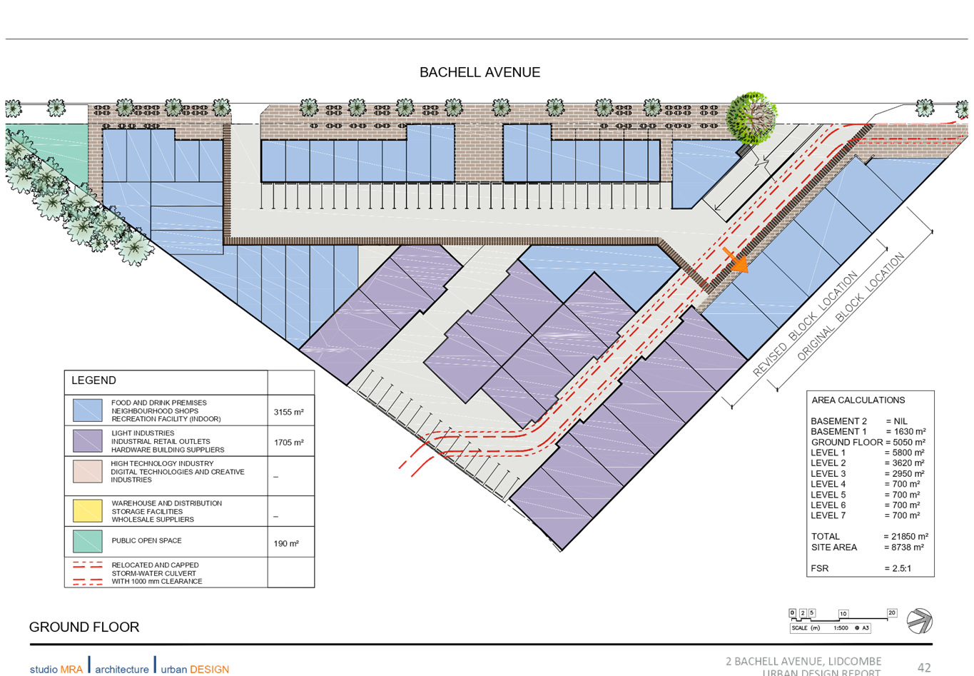
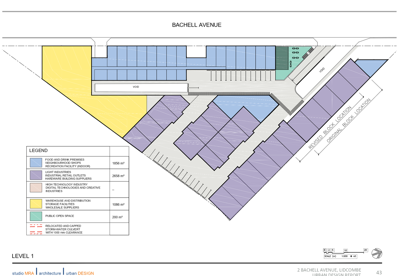
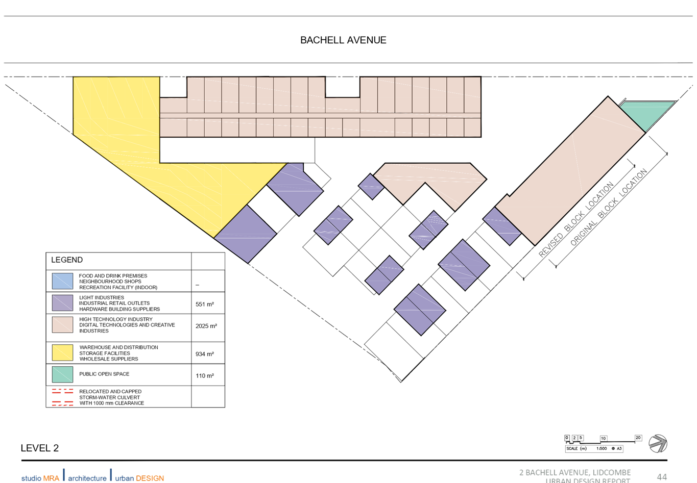
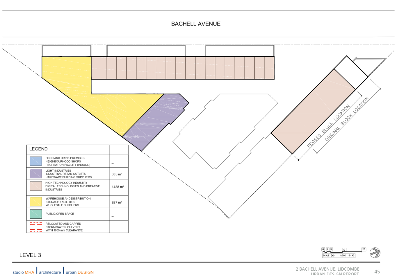
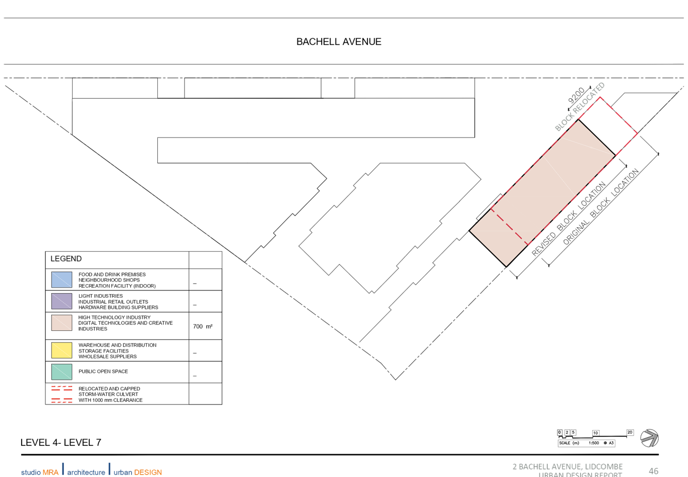
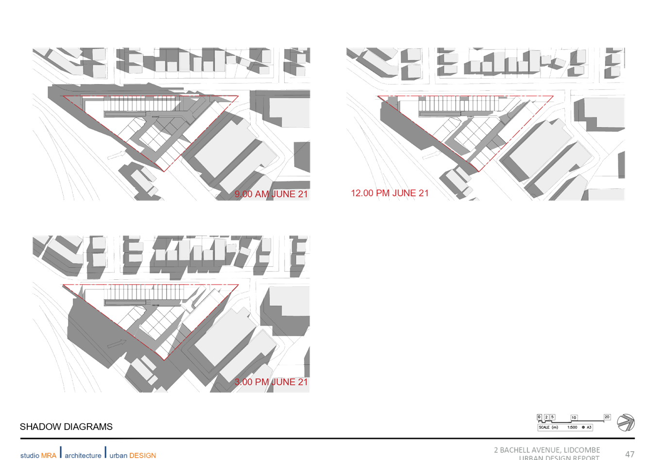
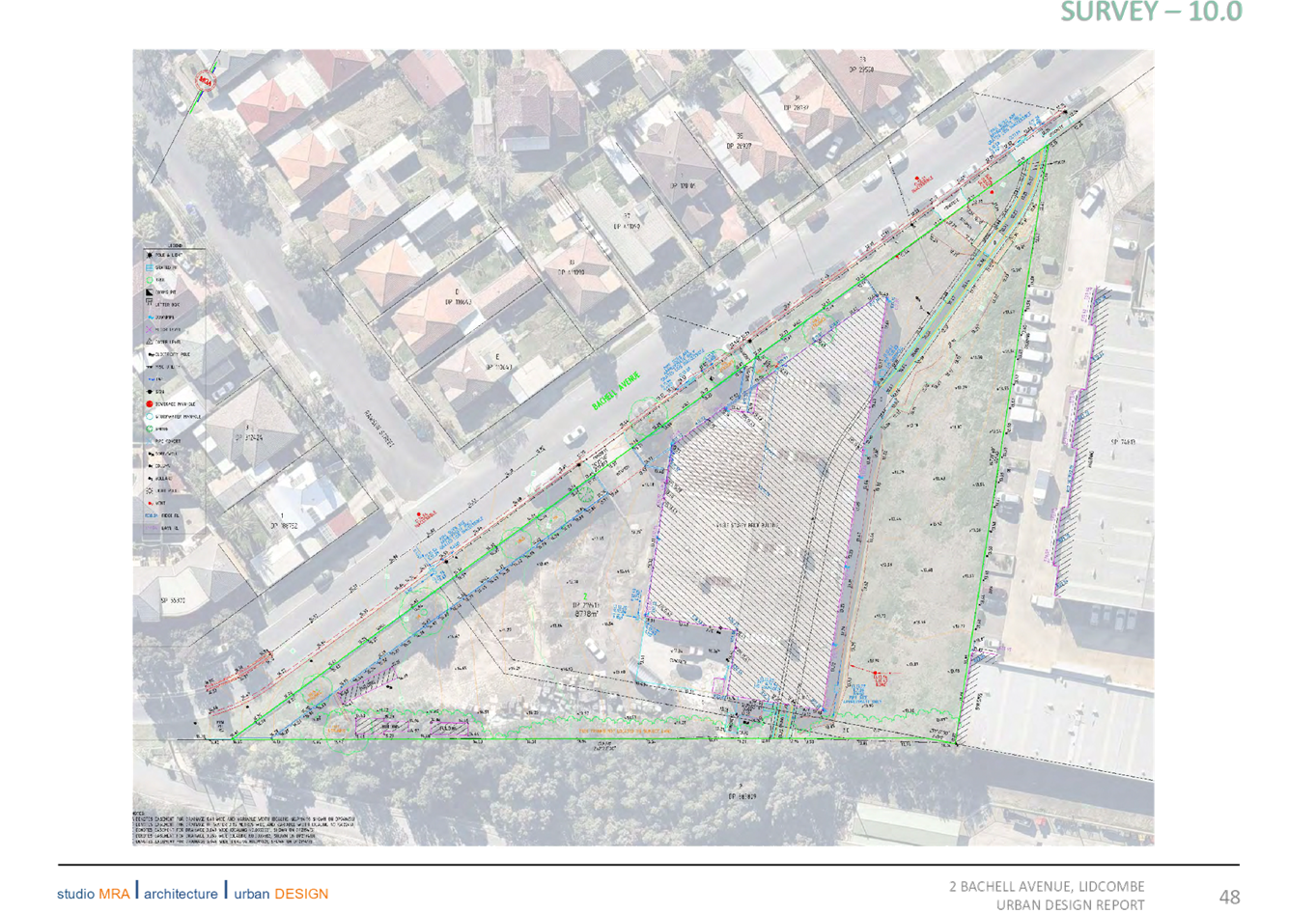
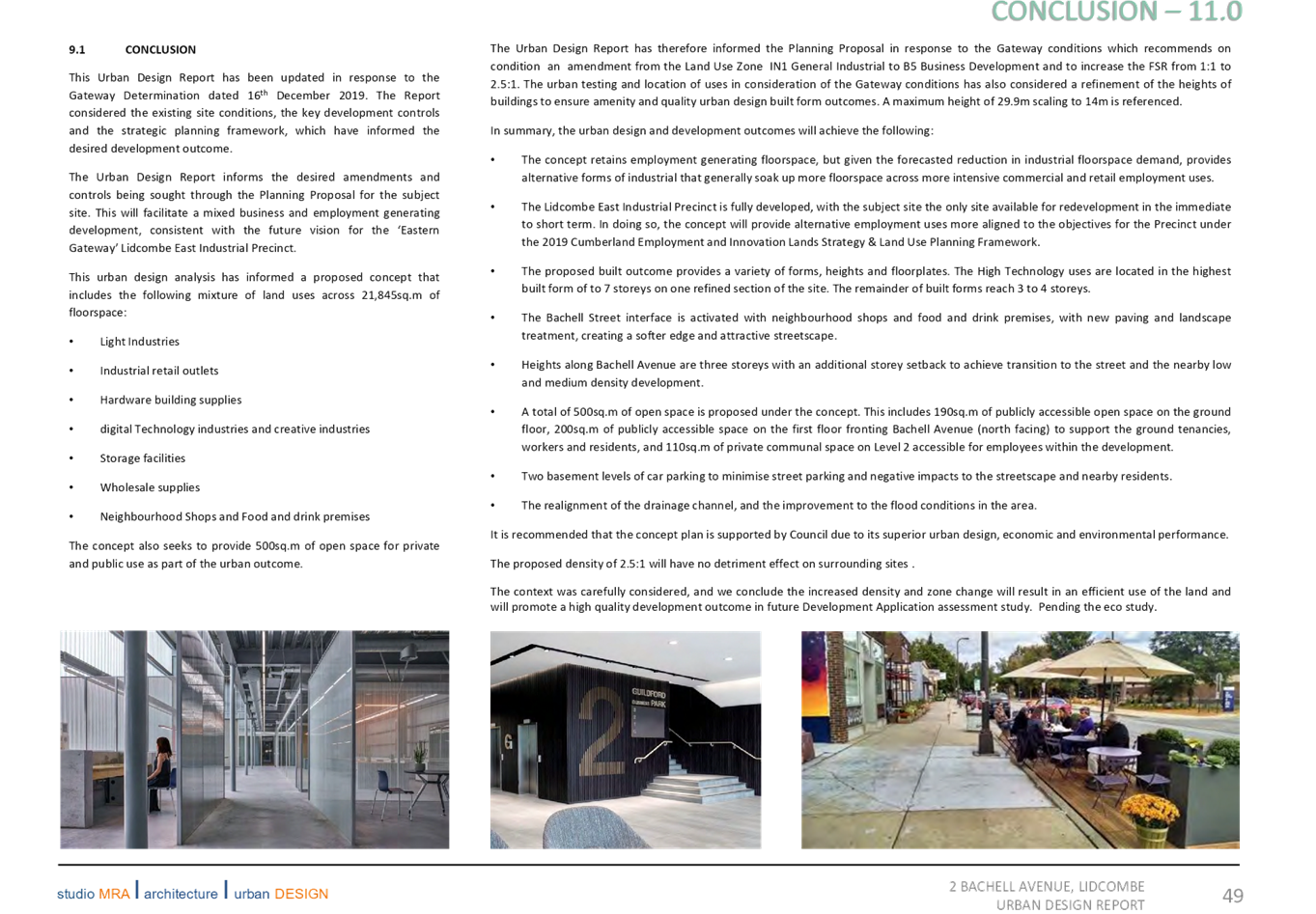

Extraordinary Cumberland Local Planning
Panel Meeting
27 May 2020
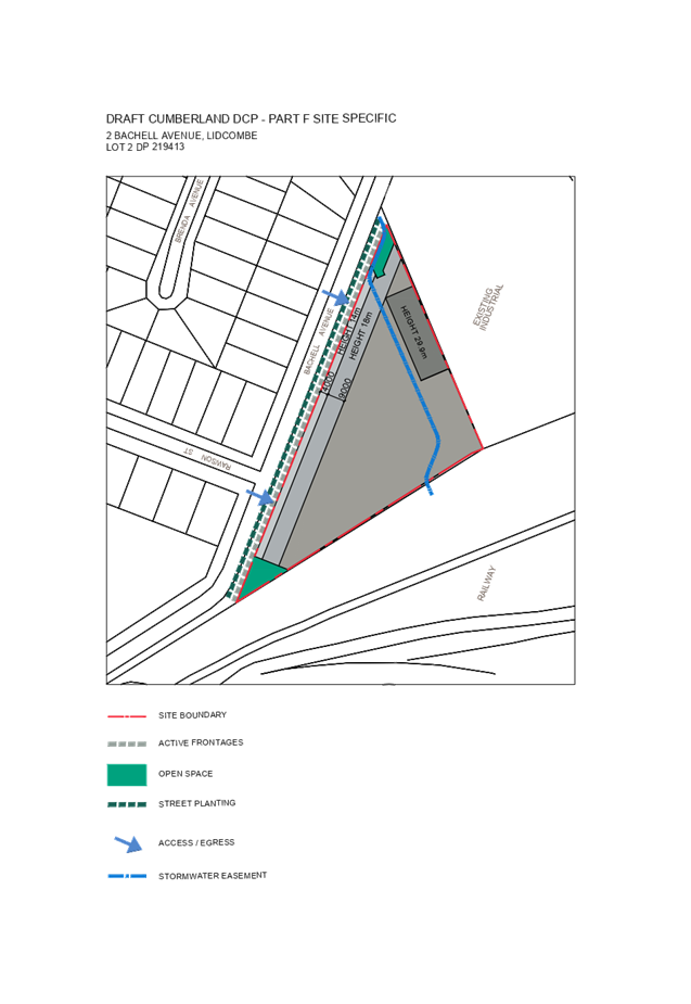
Extraordinary Cumberland Local Planning
Panel Meeting
27 May 2020

DOCUMENTS
ASSOCIATED WITH
REPORT ELPP024/20
Attachment 5
Updated Economic Study
Extraordinary Cumberland Local Planning
Panel Meeting
27 May 2020

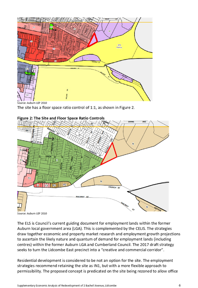
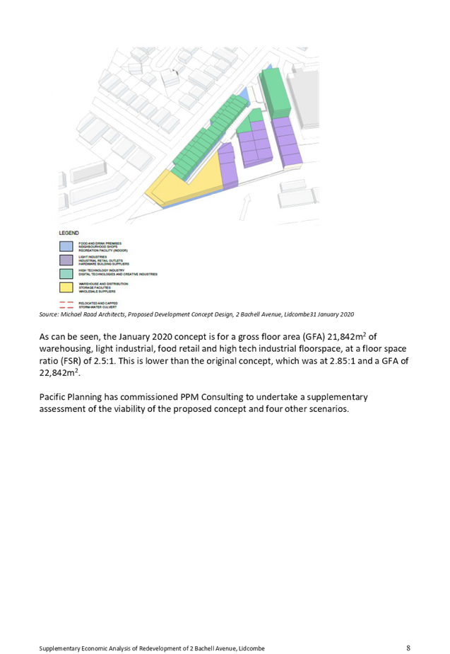
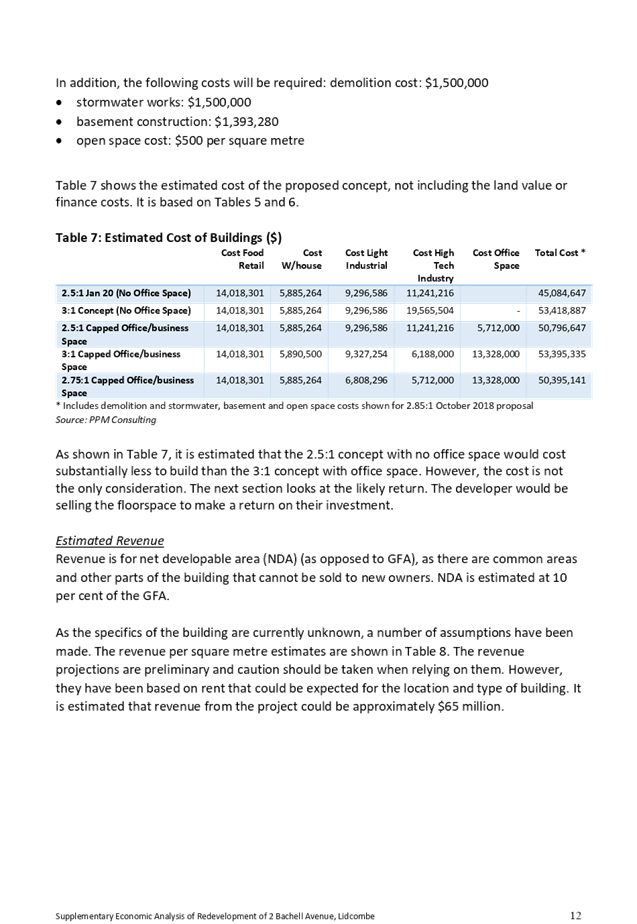
Extraordinary Cumberland Local Planning
Panel Meeting
27 May 2020
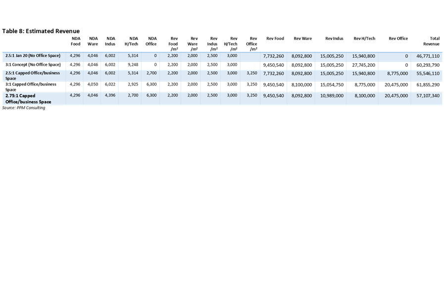
Extraordinary Cumberland Local Planning
Panel Meeting
27 May 2020