Council Meeting
Wednesday, 4 March 2020 at 6:30pm
Cumberland City Council Chambers
Merrylands Service Centre, 16 Memorial Avenue, Merrylands
Council Meeting
Wednesday, 4 March 2020 at 6:30pm
Cumberland City Council Chambers
Merrylands Service Centre, 16 Memorial Avenue, Merrylands
Councillor Contact Details
|
Granville Ward |
||
|
Clr Steve Christou (Mayor) |
0419 651 187 |
|
|
Clr Ola Hamed |
0405 070 007 |
|
|
Clr Joseph Rahme |
0418 995 471 |
|
|
Greystanes Ward |
||
|
Clr Greg Cummings |
0417 612 717 |
|
|
Clr Eddy Sarkis (Deputy Mayor) |
0418 306 918 |
|
|
Vacant |
- |
- |
|
Regents Park Ward |
||
|
Clr Ned Attie |
0419 583 254 |
|
|
Clr George Campbell |
0409 233 315 |
|
|
Clr Kun Huang |
0418 911 774 |
|
|
South Granville Ward |
||
|
Clr Glenn Elmore |
0418 459 527 |
|
|
Clr Paul Garrard |
0414 504 504 |
|
|
Clr Tom Zreika |
0400 805 303 |
|
|
Wentworthville Ward |
||
|
Clr Lisa Lake |
0418 669 681 |
|
|
Clr Suman Saha |
0419 546 950 |
|
|
Clr Michael Zaiter |
0418 432 797 |
|
For information on Council services and facilities please visit www.cumberland.nsw.gov.au
Council Meeting
4 March 2020
1 Opening Prayer / Acknowledgement of Country / National Anthem
2 Notice of Live Streaming of Council meeting
3 Apologies / Requests for Leave of Absence
4 Declarations of Pecuniary & Non Pecuniary Conflicts of Interest
5 Confirmation of Previous Minutes
C03/20-381 Minutes of the Ordinary Meeting of Council - 19 February 2020................................................................................. 5
Nil
7 Public Forum / Presentation of Petitions
8 Items Resolved by Exception
Nil
Nil
C03/20-382 Financial Sustainability and Planning Policy....................... 21
C03/20-383 Proposed Land Dealing at Victor Brazier Park................... 33
C03/20-384 Health Infrastructure Proposal for a Paramedic Response Point at 1-3 Peel Street, Holroyd...................................... 41
Director Community Development
C03/20-385 Quarterly Crime Prevention Report................................... 51
Director Environment & Planning
C03/20-386 Road Naming Proposal - Margaret Street, Merrylands....... 57
C03/20-387 Planning Proposal, Development Control Plan and Voluntary Planning Agreement - 4-12 Railway Street, Lidcombe........ 63
C03/20-388 Update on Planning Proposal for the New Cumberland Local Environmental Plan........................................................ 223
Director Works & Infrastructure
C03/20-389 Response to Notice of Motion - Responsible Pet Ownership Education Program........................................................ 241
C03/20-390 Draft Companion Animals Policy..................................... 245
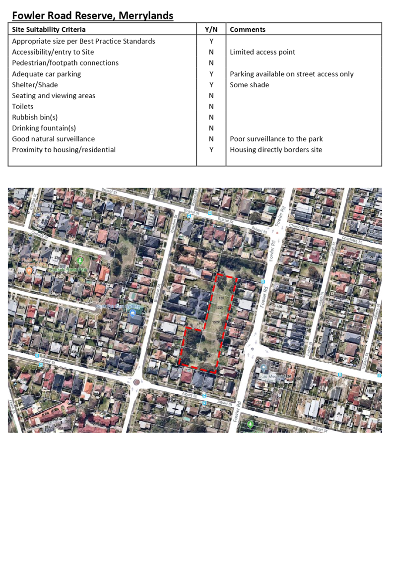
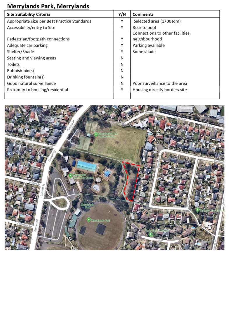
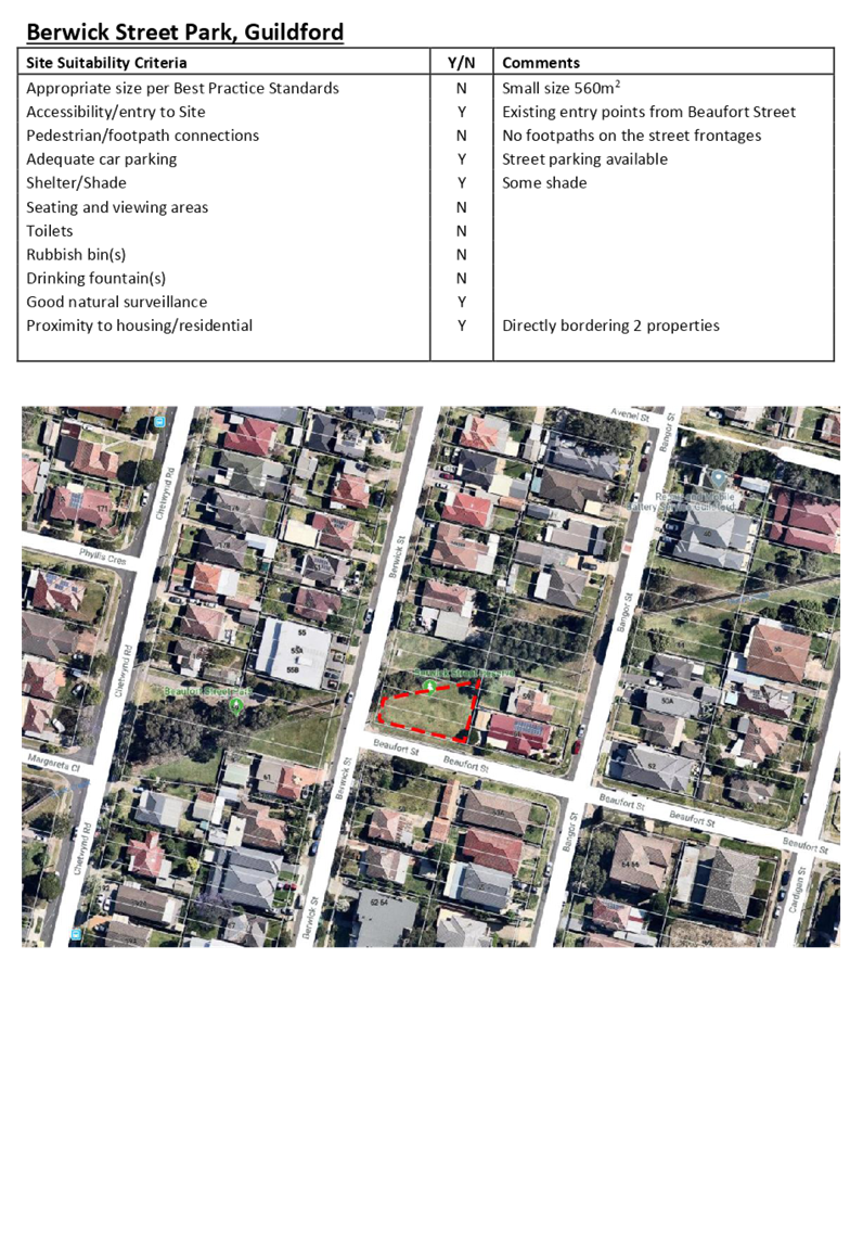
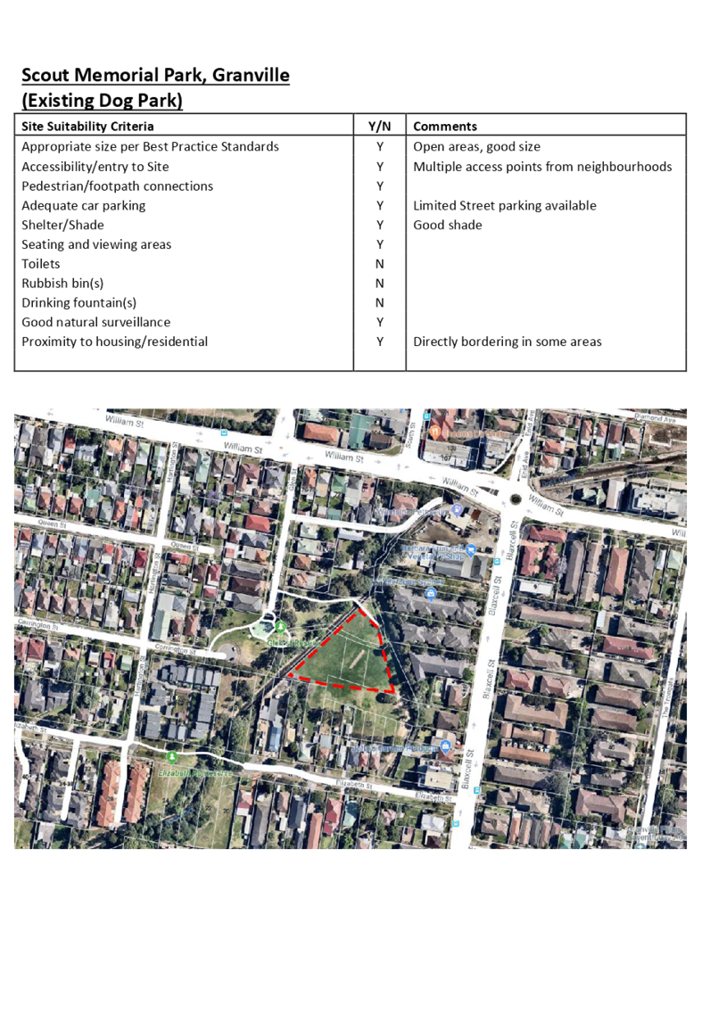
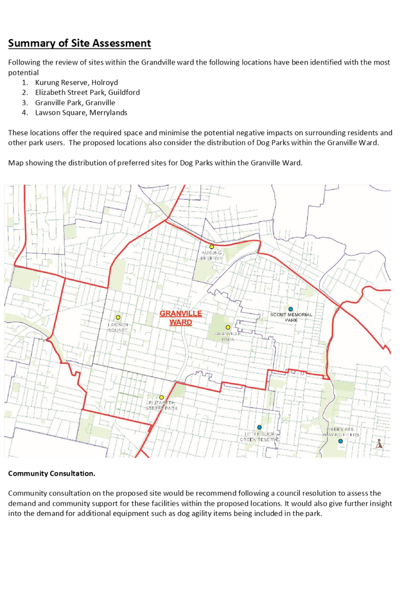
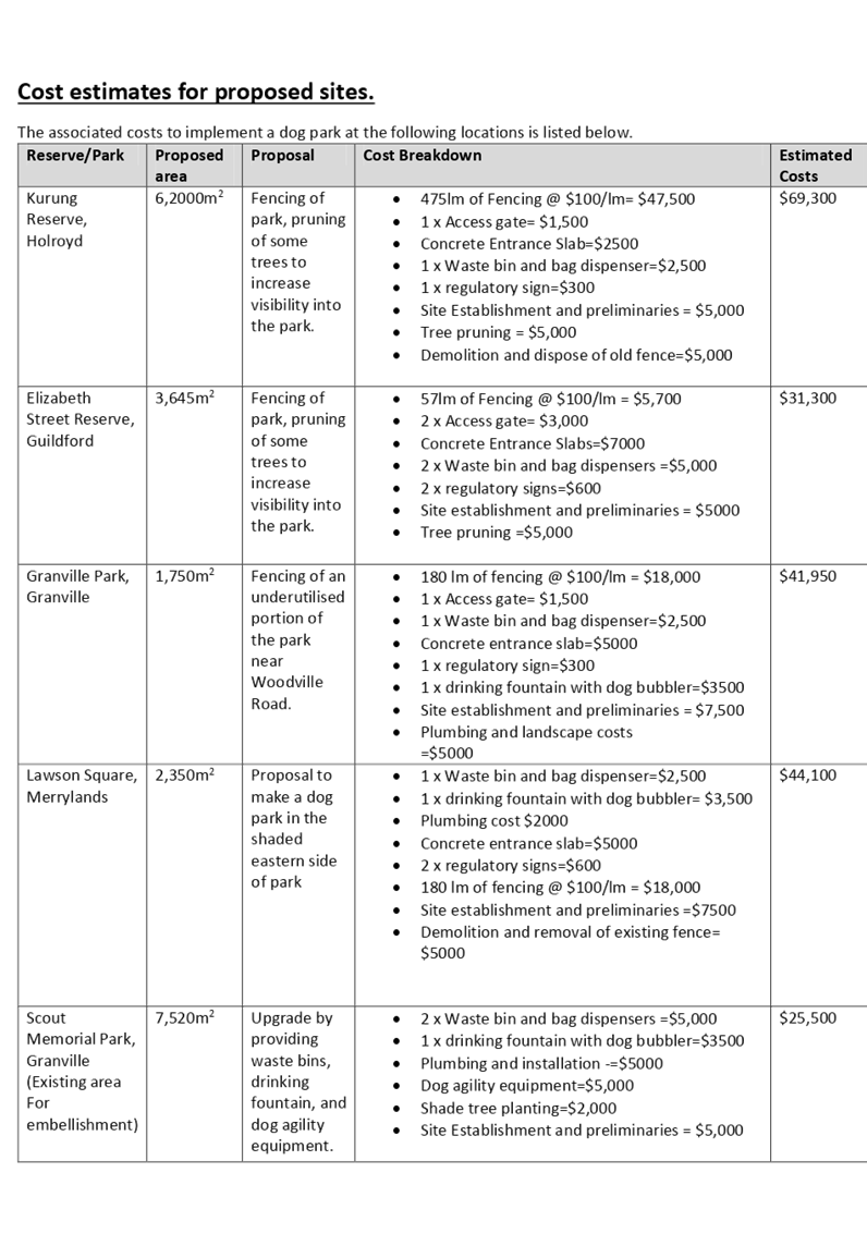
C03/20-391 Response to Notice of Motion - Dog Parks Granville Area 261
C03/20-392 Adoption of Environmental Health Strategy..................... 283
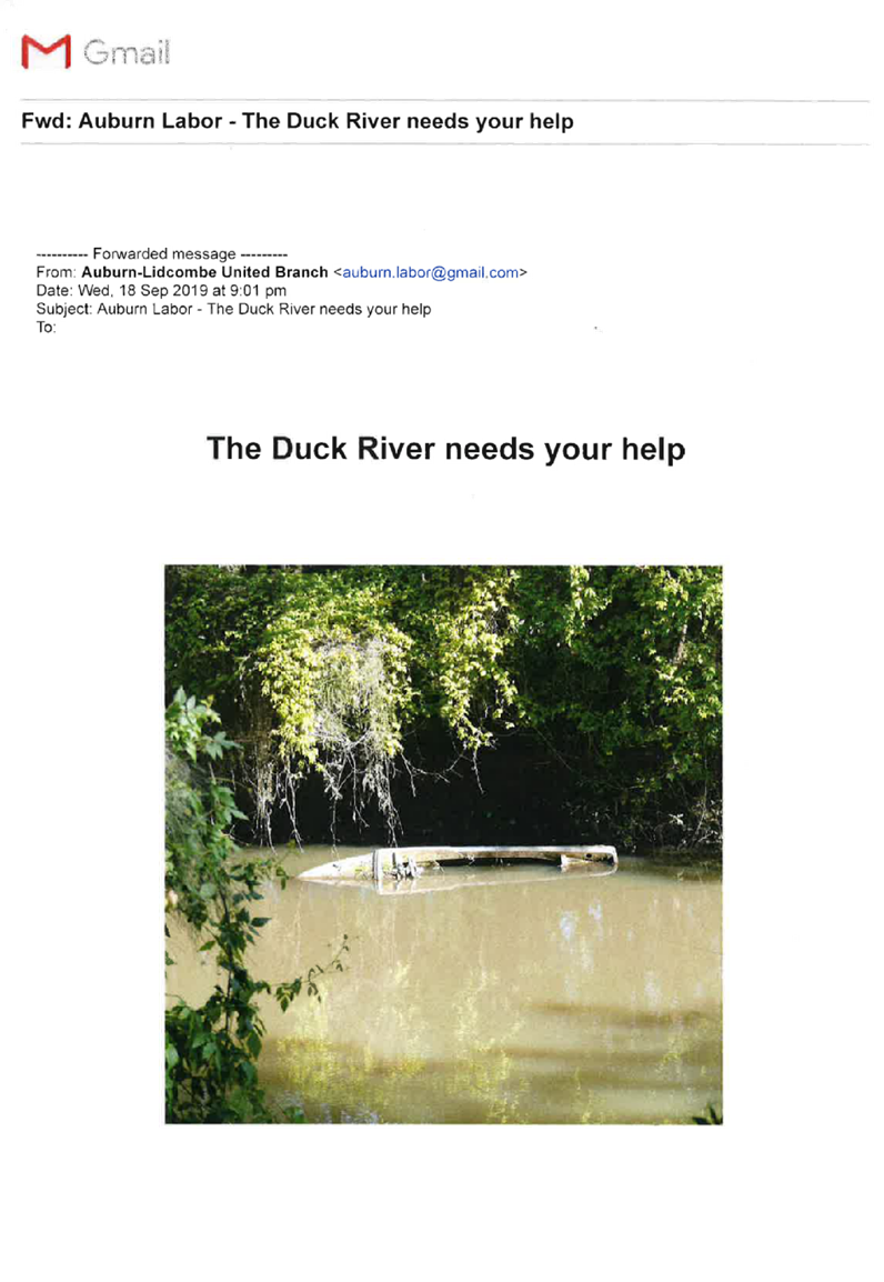
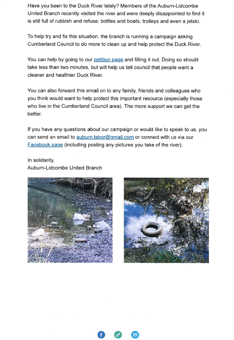
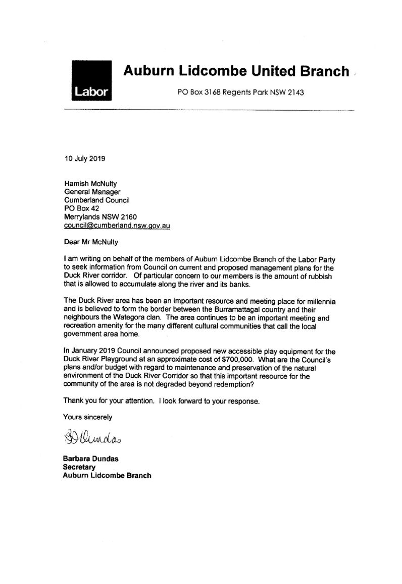
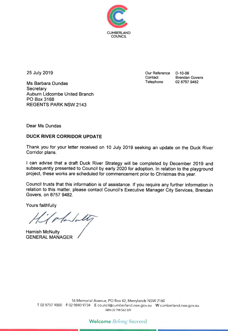
C03/20-393 Response to Matter of Urgency – Distribution of Clean-up of Duck River Political Material........................................... 319
10 Reports of Council Committees
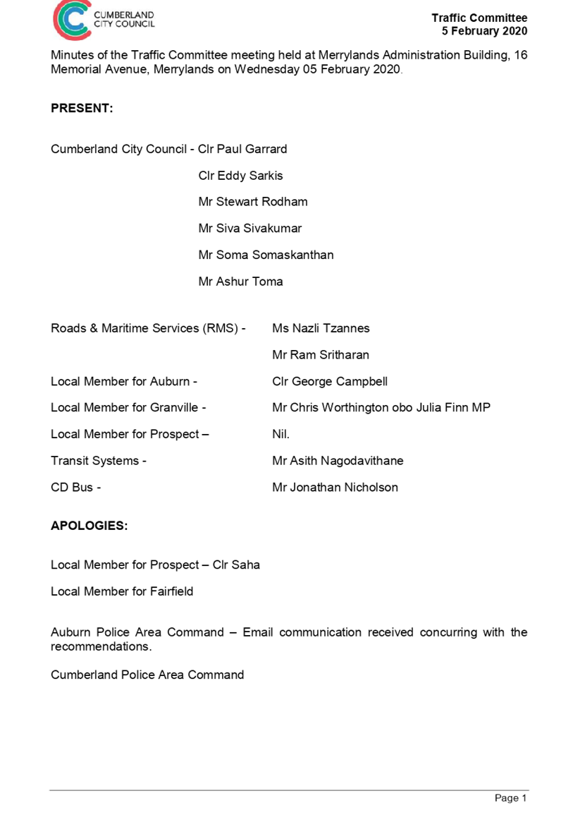
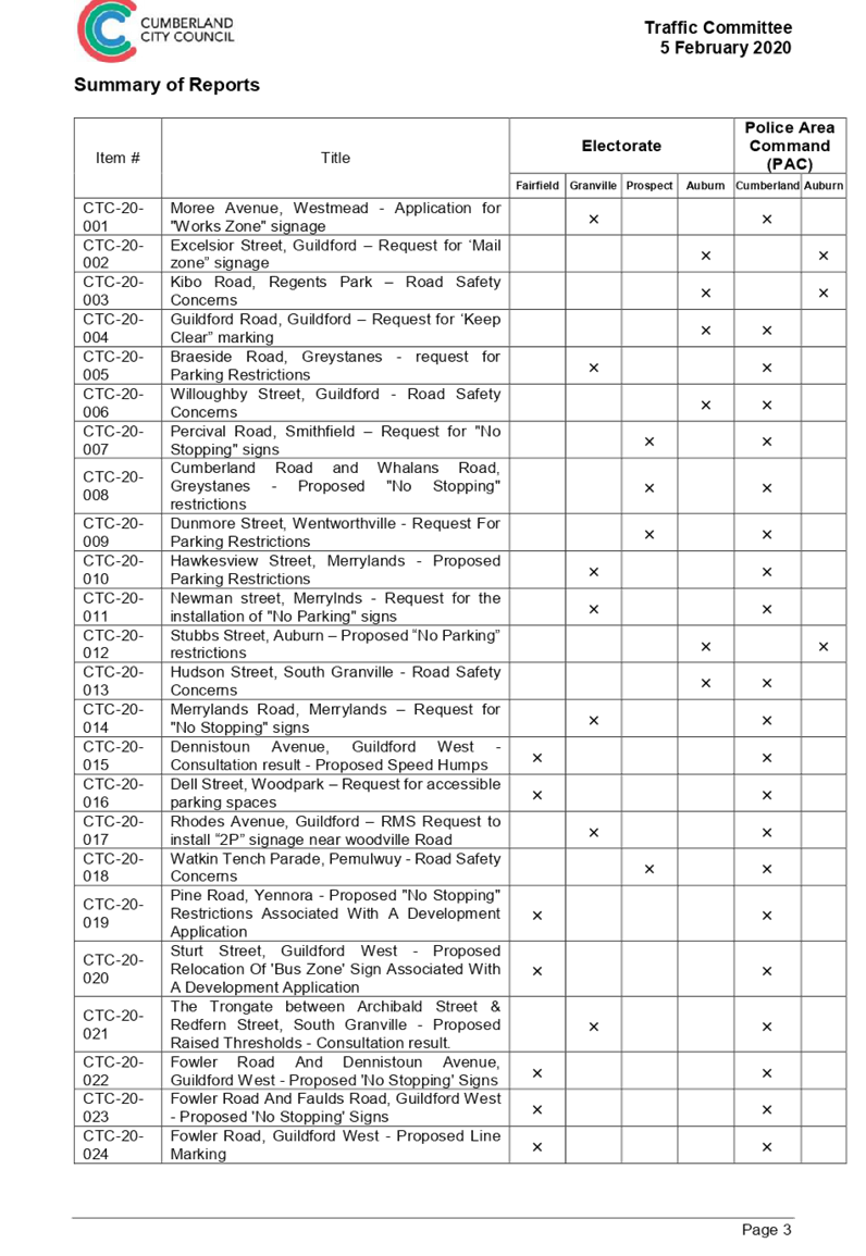
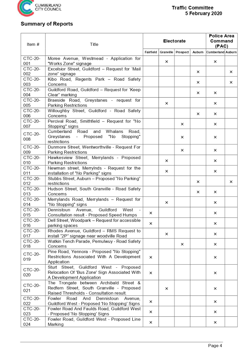
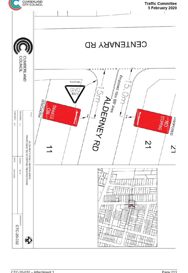
C03/20-394 Cumberland Traffic Committee - Minutes of Meeting held on 5 February 2020............................................................ 343
C03/20-395 Audit, Risk and Improvement Committee - Draft Minutes of Meeting Held on 10 February 2020................................. 657
Nil
Nil
Nil
C03/20-396 Budget Savings Initiatives
Note: Included in Closed Council in accordance with Section 10A(2)(a) of the Local Government Act as the information involves personnel matters concerning particular individuals (other than Councillors).
16 Close
Council Meeting
4 March 2020
Item No: C03/20-381
Minutes of the Ordinary Meeting of Council - 19 February 2020
Responsible Division: Finance & Governance
Officer: Director Finance & Governance
|
That Council confirm the minutes of the Ordinary Meeting of Council held on 19 February 2020. |
Attachments
DOCUMENTS
ASSOCIATED WITH
REPORT C03/20-381
Attachment 1
Draft Minutes - 19 February 2020
4 March 2020
Item No: C03/20-382
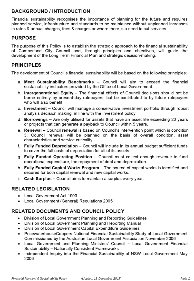
Financial Sustainability and Planning Policy
Responsible Division: Finance & Governance
Officer: Director Finance & Governance
File Number: 7862280
Community Strategic Plan Goal: Transparent and accountable leadership
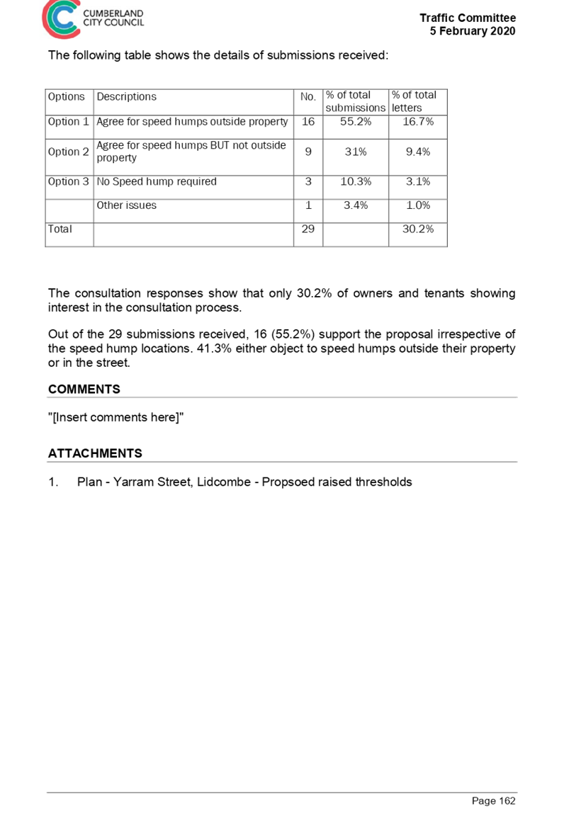
Summary
This report seeks to readopt the Financial Planning and Sustainability Policy, first adopted in 2017.
|
Recommendation That Council readopt the Financial Sustainability and Planning Policy. |
Report
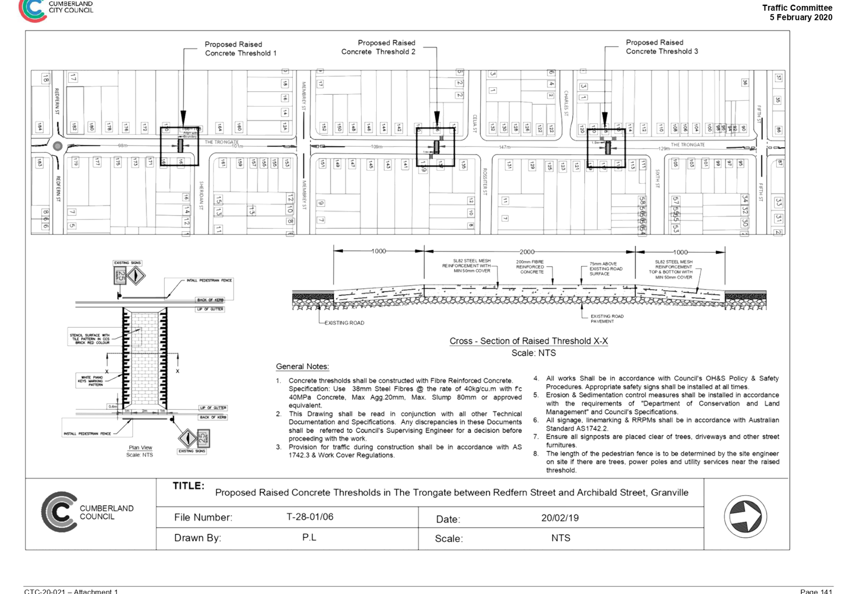
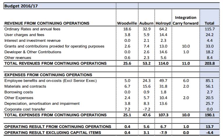
The Financial Planning and Sustainability Policy (Policy) was adopted in 2017. The Policy is based on sound financial planning principles, which need to be adhered to for Cumberland to remain financially sustainable.
Council has had several challenges post amalgamation; for example, in 2018-19 Council had a deficit of $6.3m or (5.3) % operating performance ratio due to large increases in costs.
The budget setting within Cumberland City Council is very different to the former Councils; the approach of Cumberland City Council is more transparent than the previous practice. The former Councils had varying approaches in relation to how they presented their budget positions, as per the below:
1) Former Auburn – Used a management accounting standard that aligned to the Accounting Standards.
2) Former Parramatta – Used a management accounting standard that aligned to the Accounting Standards.
3) Former Holroyd – Used a hybrid of Parramatta and Auburn, plus funds transfer in and out of various funding sources to balance the overall position. This made the financial performance appear more like a cash flow statement in the sense that it resulted in a balanced financial position. Whilst on paper a balanced financial position was reported, it appears that the mechanism by which these results were arrived at and reported did not meet the Accounting Standards. This method would have been improved if the budget was able to identify net cash flow from operations, investments, and financing. This would have allowed for a more thorough analysis of the challenges and would have been more transparent in relation to capital investments.
To align these approaches, Council has relied on the audited Financial Statements and Quarterly Financial Reviews to ensure they are compared in a consistent way.
Performance of the Former Entities
Parramatta has not been included as there was little significance in such a comparison due to the fact that Cumberland only received a 15% share of Parramatta Council’s budget as a result of the amalgamation.
The budgets for each year have been summarised as they are the most relevant numbers, as they closely align to the Financial Planning and Sustainability Policy.
Below are two of the principles covered in the Policy that can be further analysed and compared to the current financial position of Council.
The impact of an SRV is that it will improve financial performance but not increase cash at bank as the additional income received is then spent on the specific Capital Investments.
1) Financial Performance
The following displays the budget Surplus / (Deficit).
|
Budget $m |
FY 13 |
FY 14 |
FY 15 |
FY 16 |
|
|
Auburn |
|||||
|
Operating income |
56.4 |
59.4 |
66.5 |
64.9 |
|
|
Operating Expense |
61.2 |
63.4 |
65.0 |
64.9 |
Restructuring in FY 2015 |
|
Surplus/ (deficit) |
(4.8) |
(4.4) |
1.3 |
0.0 |
|
|
Holroyd |
|||||
|
Operating income |
76.7 |
82.3 |
89.1 |
96.7 |
FY 14 Rates increased 8% totalling ~$3m per annum accumulated. |
|
Operating Expense |
91.8 |
97.8 |
96.5 |
106 |
|
|
Surplus/ (deficit) |
(15.1) |
(15.5) |
(7.4) |
(9.6) |
|
2) Asset Renewal
The renewal ratios have been extracted based on the budget papers and Quarterly Budget Review Statements. The financial sustainability model requires a surplus in terms of the funding for depreciation as this will allow for investment in infrastructure assets renewal of between 100 to 105% of depreciation.
|
Budget $m |
FY 13 |
FY 14 |
FY 15 |
FY16 |
|
|
Auburn |
|
||||
|
Renewal |
22.2 |
22.3 |
21.5 |
9.6 |
|
|
Depreciation |
12.1 |
12.5 |
13.0 |
13.3 |
|
|
% Renewal |
174.2 |
178.2 |
165.4 |
72.1 |
|
|
Holroyd |
|
||||
|
Renewal |
6.6 |
7.0 |
14.6** |
14.8 |
Increase due to SRV, FY15-FY18 |
|
Depreciation |
22.6 |
23.3 |
13.2* |
13.6 |
Decrease in depreciation due to a change in policy |
|
% Renewal |
29.0 |
29.8 |
110.0 |
108 |
|
* In FY15, the former Holroyd Council reduced depreciation by 43%.
The reduction in depreciation was based on following accounting policy:
1) Unit rates – A reduction in unit rates will reduce the replacement costs of assets and then reduce the value of depreciation.
2) Useful life – An increase of the useful life has the impact to spread out depreciation over more years and reduce the costs charged to the profit and loss.
** In FY14, the SRV commenced and then in FY15 the Renewals increased due to SRV income.
Due to this change, the former Council was able to improve the profitability and renewals ratios.
At Amalgamation
Depreciation
In FY17, Cumberland Council had to increase depreciation by $4.1m when the assets were realigned to a consistent policy measuring asset condition and depreciation rates. The increase in depreciation was not considered in the original amalgamation savings.
The following was presented to the Administrator on 1 March 2017, which summarises the opening profit position of the former Councils.
Current Financial Performance
For the past two years, Cumberland has anticipated a budget surplus in the budgeting process using the policy. Council has also projected asset renewals of 178% and 160% to ensure asset conditions can be improved.
Due to the large increase in investment and realignment of the policy, depreciation has increased from $25.7m to $33m in 4 years. This has also been a contributor to the current deficit position.
Council is now committed, in FY20/21, to bringing the budget back to surplus and returning the Investment on renewals back to a sustainable position. The Financial Planning and Sustainability Policy is key to ensuring Council achieves long-term financial sustainability.
Community Engagement
There are no changes to the Policy which was adopted in 2017. Therefore the Policy is recommended for direct readoption.
Policy Implications
There are no changes to the Policy adopted in 2017.
Risk Implications
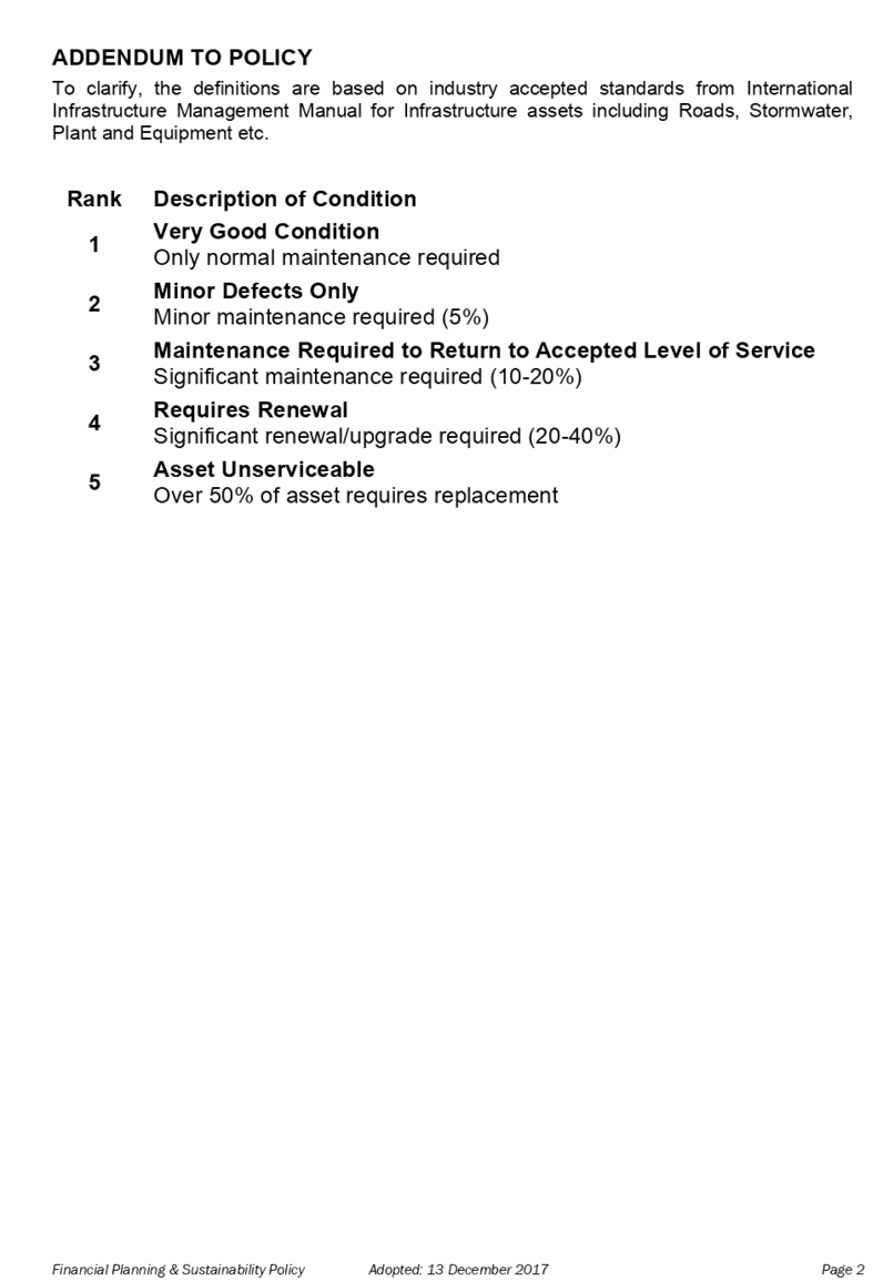
The risk of under investment in asset renewal is a major risk to Council to keep the infrastructure in a condition better than 3 out of 5. If the condition declines beyond this point, the deterioration of the asset will accelerate and the costs of maintenance and renewal will substantially increase.
Financial Implications
Compliance with this Policy will ensure Council can achieve long-term financial sustainability.
CONCLUSION
Cumberland City Council has increased the transparency and accuracy of financial reporting in comparison to the past practices. It was a policy decision of Council to hold itself to a higher standard so that Council’s true financial performance could be accurately reported. The Financial Planning and Sustainability Policy reinforces Council’s strong commitment to financial sustainability and holding itself accountable for the adoption of difficult decisions when required to maintain the balance.
Attachments
DOCUMENTS
ASSOCIATED WITH
REPORT C03/20-382
Attachment 1
Financial Planning and Sustainability Policy
4 March 2020
Item No: C03/20-383
Proposed Land Dealing at Victor Brazier Park
Responsible Division: Finance & Governance
Officer: Director Finance & Governance
File Number: 7863456
Community Strategic Plan Goal: A safe accessible community
Summary
This report has been prepared in response to the ongoing concerns by community park users and local residents about the illegal activities and anti-social behaviour caused by youth assembling at the Victor Brazier Park, in particular at the upper northwest portion of the park where it is relatively isolated with poor passive surveillance.
|
Recommendation That Council: 1. Prepare a planning proposal to reclassify a small portion of land through the Local Environmental Plan process and submit the planning proposal to the Department of Planning, Industry and Environment for a Gateway Determination.
2. A further report to be returned to Council regarding the preparation of the planning proposal. |
Report
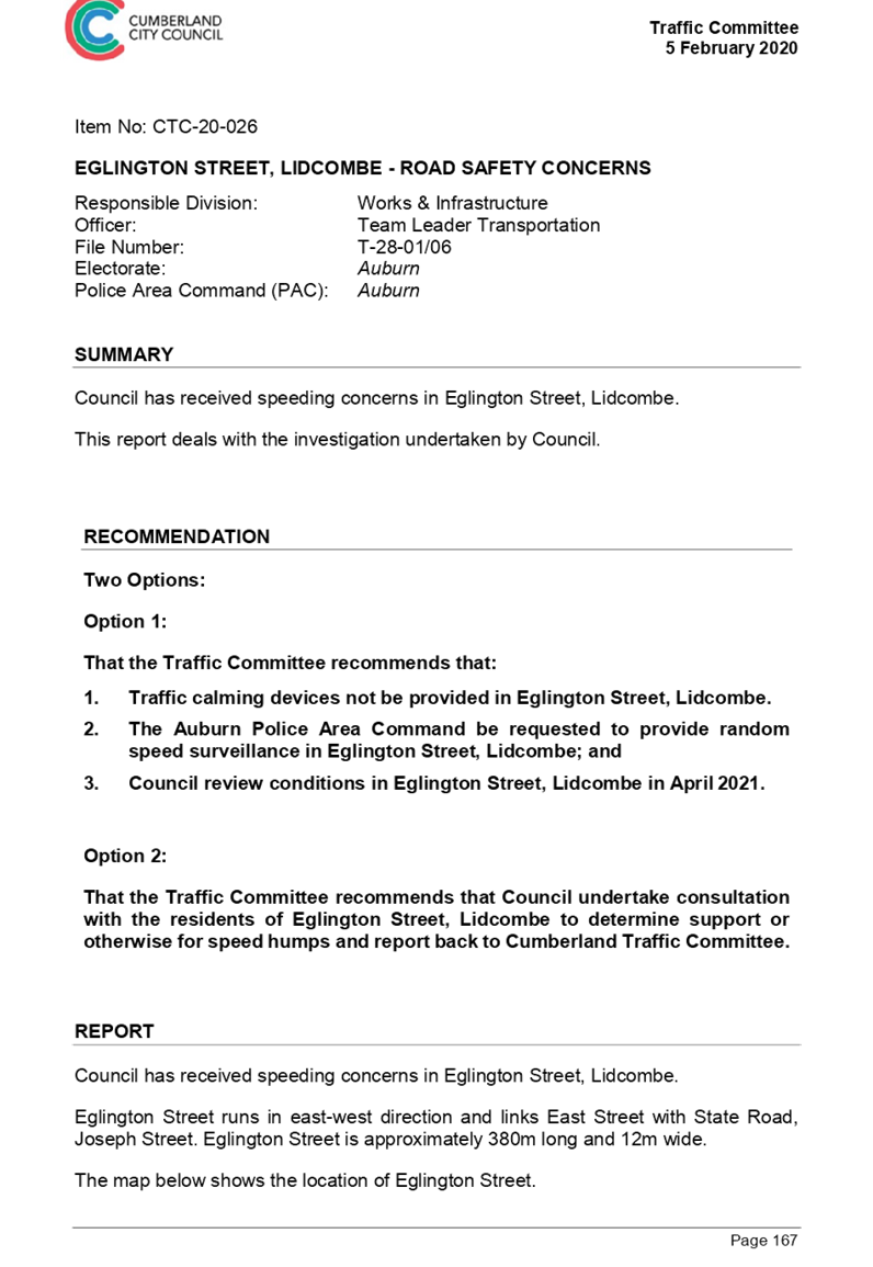
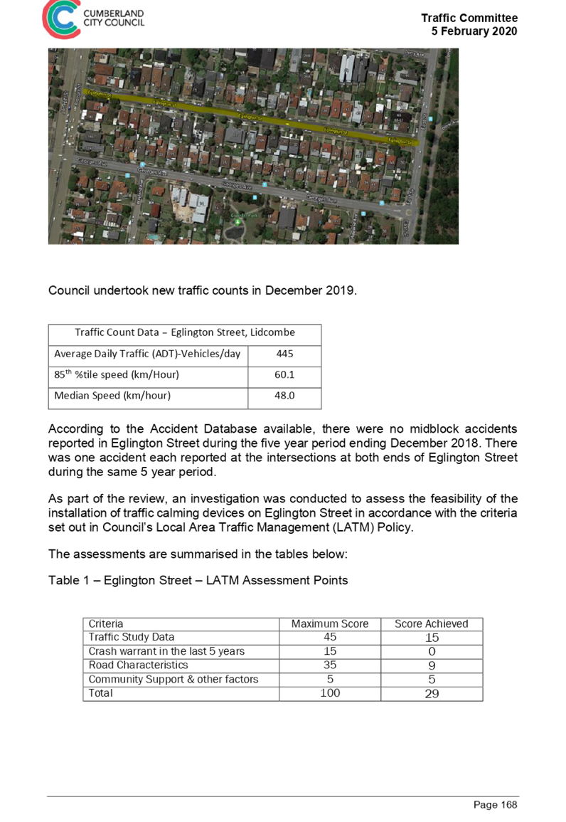
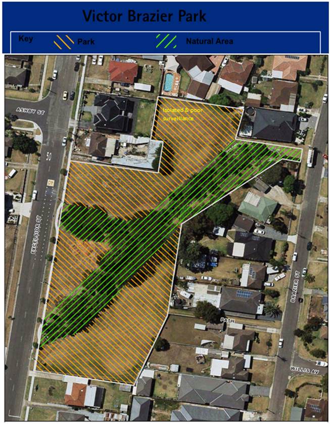
Victor Brazier Park is located on Excelsior Street, Guildford and has an area of approximately 7,840sqm. The park is made up of two allotments, being Lot 21 DP27820 and Lot 32 DP241618, and zoned RE1 Public Recreation and W1 Natural Waterways.
The Granville South Creative and Performing Arts High School is located across the road from the park. It has been reported that anti-social behaviour and illegal activities are a common occurrence at the park and nearby pedestrian laneways off Nadia Place, Caroline Street and Excelsior Street. There have been previous requests by the school to limit parking during the day in front of the park so the school has better visibility of potential issues occurring across the road.
The upper northwest portion of the park is relatively hidden and isolated. It has poor passive surveillance which makes it susceptible for groups of youth to congregate, without being detected, to undertake illegal and/or inappropriate activities such as drug use and vandalism which is a regular concern to the adjoining property owners.
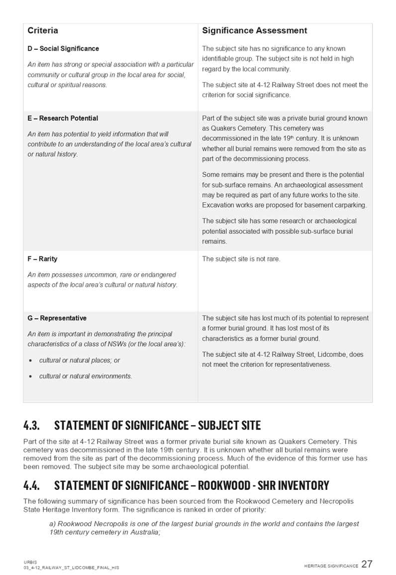
Victor Brazier Park site map:
Options for Consideration
Option 1
Council’s Parks and Recreation team was consulted on the ongoing issues occurring at the park and Council’s Landscape Architect has prepared a high-level concept plan to address the isolation of the northern portion of the park based on the four principles of Crime Prevention through Environmental Design:
· Surveillance - Proposed pruning, removal of weed species and crown lifting of vegetation to increase natural surveillance into the park and the problem area from Brazier Street. Currently this sightline is obscured. There is an opportunity for formal organised surveillance of the park from the school in the form of checks during break times.
· Access Control - Planting is proposed to provide natural access control to the concealed area and to prevent individuals from leaning against the back fences. The use of tough native plants that are visually spiky and prickly will further provide access control. Temporary fencing during the plant establishment period would be recommended to enable the plants to establish.
· Territorial Reinforcement - Remove existing graffiti on the fences to reinforce Council’s care and control of the park and remove the taggers’ ownership and association with the park.
· Space/Activity Management - Aside from the existing graffiti, the space appears to be well maintained. The proposed pruning and planting works will further add to the positive image of the space being managed by Council.
High-level Concept Plan – Stage 1 Works
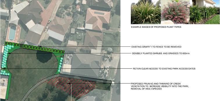
The following outlines the estimated costs involved in the proposed Stage 1 works:
|
Task |
Estimated Cost |
|
1. Services location and site establishment including temporary fencing |
$2,000 |
|
2. Graffiti removal |
$800 |
|
3. Tree pruning and disposal by a suitably qualified arborist |
$2,800 |
|
4. Garden bed preparation including cultivation, fertiliser and mulching |
$7,200 |
|
5. Native shrub and grass planting |
$3,800 |
|
6. Site restoration including installation of Kikuyu turf rolls on 50mm depth turf underlay as required |
$1,600 |
|
7. Establishment period and contingency |
$1,200 |
|
Total Project Estimate |
$19,400 |
Further activation of the space is proposed at the Stage 2 works with a pedestrian path to formalise the route through the park. A play space or outdoor gym is also proposed to bring more people to the park.
High-level Concept Plan – Stage 2 Works
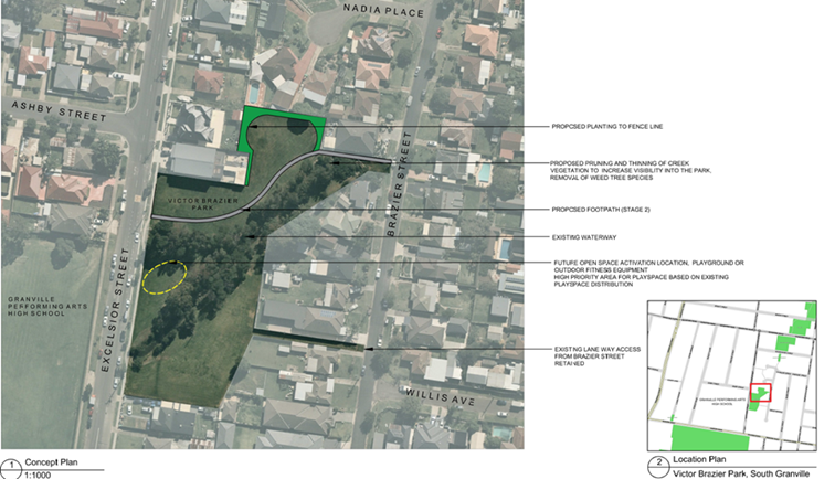
In addition, Council could look to purchase the two properties on Excelsior Street and/or a property on Brazier Street to expand and open up the park.
Option 2
An alternative option for Council to consider is to provide “in principle” agreement to reclassify the area of land on the upper northwest portion of the park for the eventual disposal on the open market. This would allow the new property owner to realign the property boundary in line with its neighbouring property and this may resolve the issues with youth congregating behind this hidden pocket of the park. Should Council proceed to reclassify the land, the standard practice of Council submitting a planning proposal to the Department of Planning, Industry and Environment (DPIE) for Gateway Determination would be required. Upon receipt of the Gateway Determination Council would conduct a public hearing in accordance with the Environmental Planning and Assessment Act 1979, consider submissions made to it and refer the proposal back to the DPIE for final determination.

The reclassification of public land through the Local Environmental Plan process would involve:
· Council preparing and submitting a Planning Proposal Request (PPR). As Council is the owner of the land, it is recommended that Council engage an external planning consultant to prepare and submit the PPR on behalf of Council;
· The PPR undergoes preliminary consultation;
· The PPR is reported to Cumberland Local Planning Panel and Council seeking endorsement to seek Gateway Determination;
· Gateway Determination is requested from DPIE;
· Should Gateway Determination be issued, statutory public exhibition of the planning proposal is held;
· Public Hearing on the reclassification of public land to be held;
· Report to Council post exhibition.
The rezoning and reclassification of land typically takes a minimum of 18-24 months to complete. A subdivision of the land is also required in order to obtain title to the land.
Should this be the preferred option then it is proposed that after completion of the rezoning and reclassification, Council undertake an Expression of Interest process for the disposal of the land and that all costs associated with the disposal such as survey, legal and valuation be borne by the successful purchaser as a condition of sale. The net proceeds from the sale of the land can be placed in property reserve and potentially used for further open space upgrades in the area.
Community Engagement
Should Council endorse the landscaping option, there is an opportunity to get school students involved with the planting process as well as consultation with home owners, community and the school to further develop the concept plan.
Should Council endorse the proposed reclassification of public land then the community will be consulted in accordance with the relevant statutory requirements and Council policy.
Policy Implications
Council’s draft Open Space and Recreation Strategy outlines the requirements for open space per person within the Cumberland Local Government Area (LGA) and the strategy has identified a lack of open space in this area of the LGA. Given the small size of the land and the anti-social activities associated with it, the proposal is not inconsistent with the strategy.
Risk Implications
With increasing high density living and a growing population, it is important to have access to open space as this will contribute to the community health and wellbeing. The draft Open Space and Recreation Strategy has benchmarks for access to open space per person and it states that some parts of the LGA currently have overall poor access to parks over 0.5ha in size including Guildford. In these areas, priorities should include expanding the size of existing open space, improving pedestrian access to existing open space and creating a network of smaller spaces that provide a range of recreation functions with active street connection between.
The portion of land that is proposed here does not add much value to potential open space as there is an uneven boundary line along the fence and it is creating problems for the residents in this area.
Financial Implications
Should Council endorse the landscaping option, it is estimated that an initial budget of $19,400 is required from the General budget to proceed with the proposed Stage 1 works which will form part of the Parks Renewal Program.
Should Council endorse the proposed reclassification of public land, it is expected that all costs associated with the reclassification and disposal of the land will be borne by the successful purchaser as a condition of sale including legal, survey and valuation cost.
CONCLUSION
This report is seeking Council’s direction and “in-principle” support to option 2 the reclassification of public land option for eventual disposal on the open market, to address the ongoing anti-social behaviour and illegal activities caused by youth assembling at the upper northwest portion of Victor Brazier Park.
Attachments
Nil
Council Meeting
4 March 2020
Item No: C03/20-384
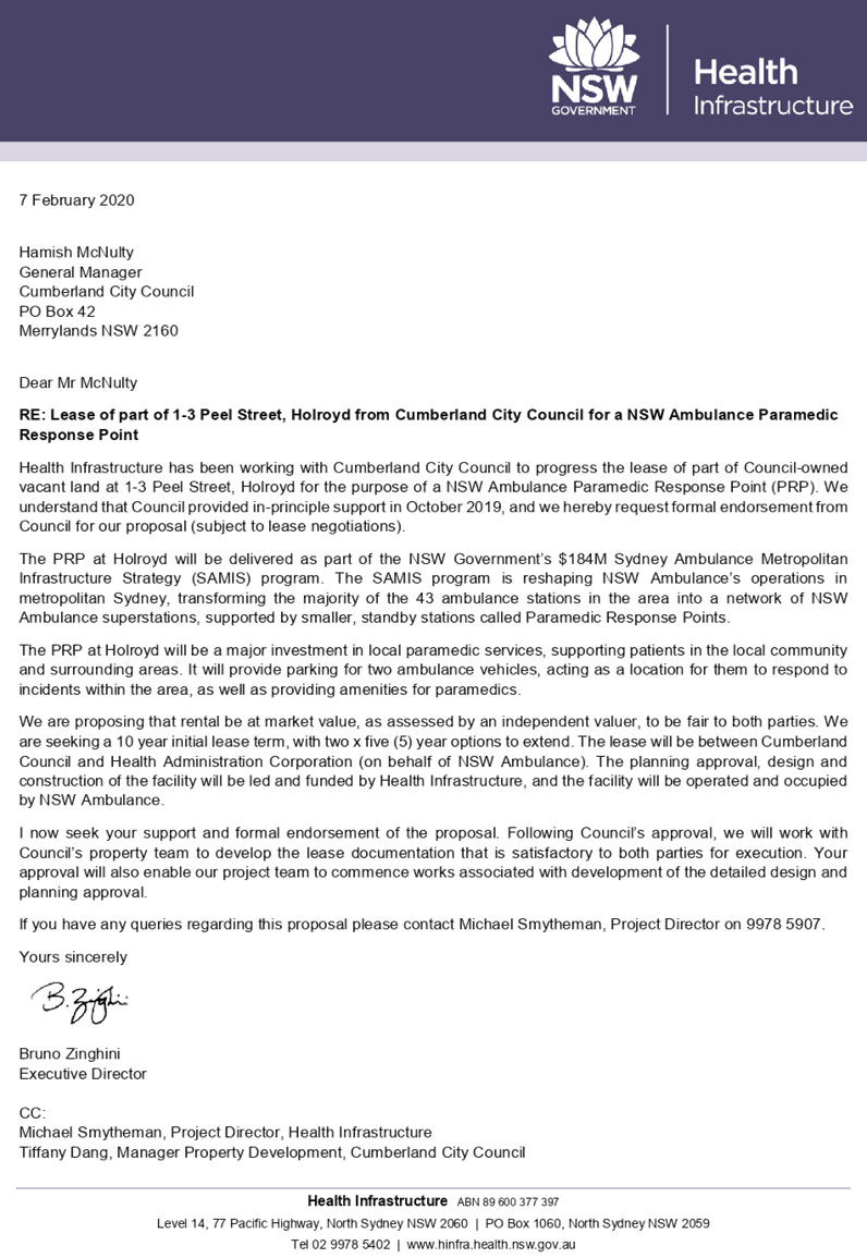
Health Infrastructure Proposal for a Paramedic Response Point at 1-3 Peel Street, Holroyd
Responsible Division: Finance & Governance
Officer: Director Finance & Governance
File Number: 7861233
Community Strategic Plan Goal: A great place to live
Summary
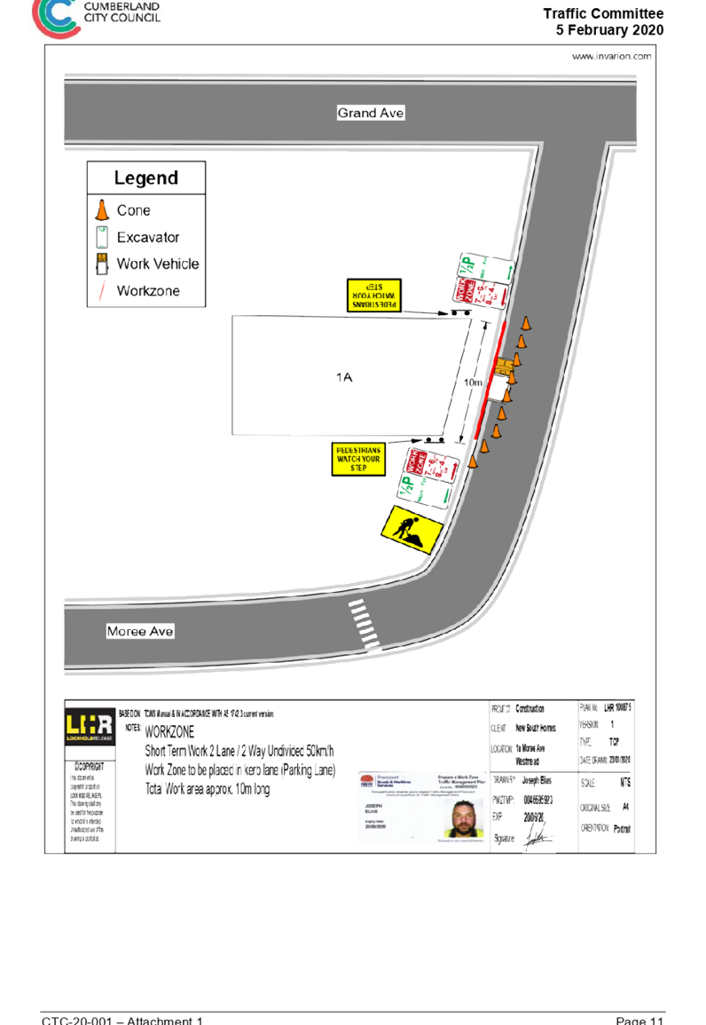
This report has been prepared in response to Health Infrastructure’s letter dated 7 February 2020, a copy of which is included in Attachment 1, wishing to progress the lease of part of Council-owned vacant land located at 1-3 Peel Street, Holroyd for the purposes of constructing a standby ambulance station known as a Paramedic Response Point (PRP).
|
Recommendation That Council: 1. Endorse the proposal from Health Infrastructure for the construction of a Paramedic Response Point on part of Council owned land at 1-3 Peel Street, Holroyd. 2. Authorise the General Manager to enter into a lease agreement with Health Administration Corporation (on behalf of NSW Ambulance) ABN 45 100 538 161 and execute all necessary documentation, in accordance with an independent market rental valuation and legal advice. |
Report
Background
In July 2019, Health Infrastructure approached Council to seek assistance in locating a suitable location for a PRP around the Guildford area. A number of Council-owned sites were identified and, after completing initial due diligence on the selected sites, Health Infrastructure confirmed that the site located at 1-3 Peel Street, Holroyd is worth pursuing further.
In October 2019, Council was briefed on Health Infrastructure’s proposal and provided in-principle support for a PRP at 1-3 Peel Street, Holroyd.
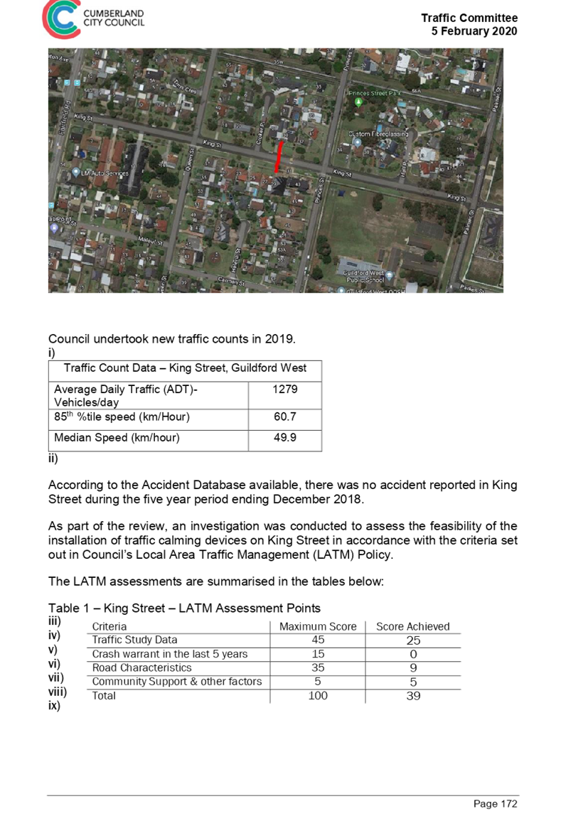
Paramedic Response Point
The Sydney Ambulance Metropolitan Infrastructure Strategy program aims to enhance NSW Ambulance infrastructure to better service the community and paramedics. The NSW Government is investing $184m to build and upgrade NSW Ambulance superstations and PRPs across metropolitan Sydney. A typical superstation would include parking bays for ambulance vehicles, an office administration area and amenities, on-site staff parking, a logistics and storage area, and an external washing bay. A typical PRP would include a small office area and two parking bays.
Health Infrastructure is working in partnership with NSW Ambulance to build the new NSW Ambulance infrastructure. Health Infrastructure is the state government agency responsible for the planning, design and delivery of health infrastructure capital works throughout NSW.
The PRPs are pre-fabricated buildings which can be relocated in the future if service modelling demands change, therefore require minimal excavation with minimal impact on site.
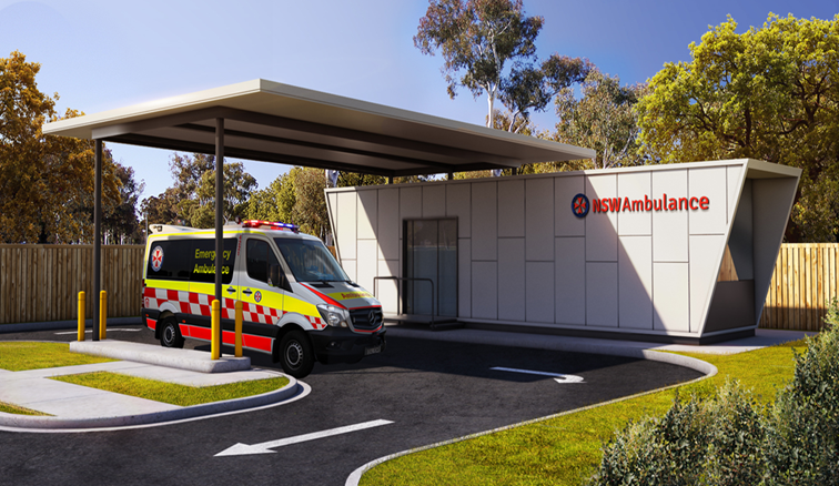
Artist Impression of a Paramedic Response Point
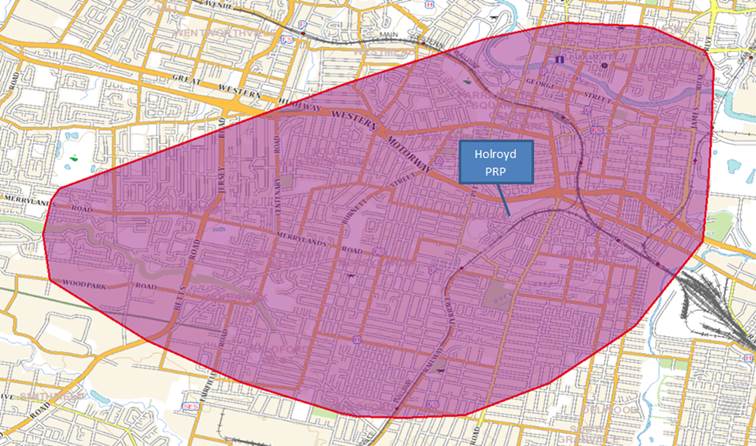
The location of 1-3 Peel Street, Holroyd has been identified by Health Infrastructure as the preferred location for a PRP. This PRP would form part of the Northmead Paramedic Response Network and be staffed by paramedics rostered within this response area.
The PRP would provide the closest response to residents that live within the response area, as identified in the map shown below. This is in addition to other responses from an ambulance that is already on the road or departing a hospital.
Proposed Response Area
Proposed Lease Terms
Health Infrastructure is proposing an initial 10-year lease term with two 5-year options to extend. Rent will be assessed at market value by an independent valuer based on rate per square metre of usable land area, approximately 650sqm of the site is required. Health Infrastructure will be responsible for obtaining all required authority approvals for the construction of the PRP. Upon termination of the lease agreement, Health Infrastructure will remove all structures and leave the site in a clean and tidy condition, with services capped off and terminated. The lease terms will form part of the commercial lease negotiations once Council has endorsed Health Infrastructure’s proposal.
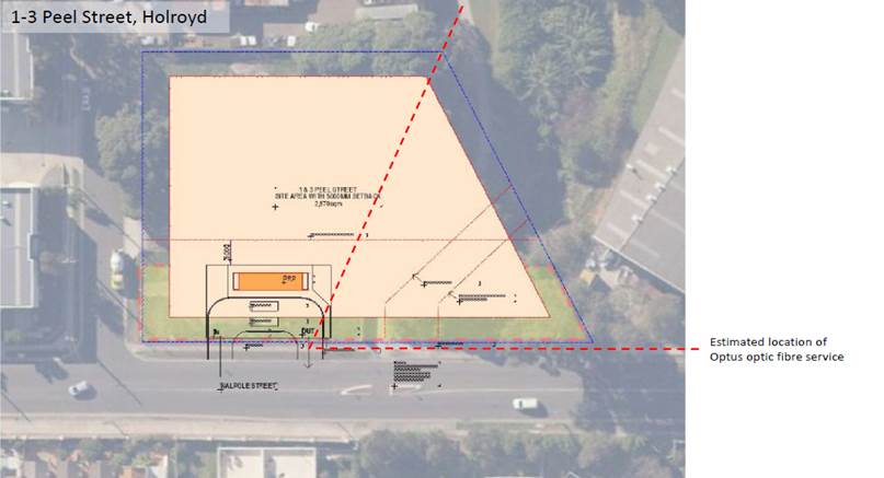
1-3 Peel Street, Holroyd is classified as operational land and has an area of approximately 4,400sqm. The site is located within the Holroyd industrial precinct, and is predominantly zoned IN2 Light Industrial and RE1 Public Recreation towards the eastern portion of A'Becketts Creek.
There is contamination on site primarily due to the historical use of the site as a night soil depot, machinery storage and maintenance depot, and suspected waste disposal in the northwest corner. Given the minor scale of the building works, Health Infrastructure has indicated that this will have minimal impact on their proposal and will remove any surface contamination from the proposed area to be leased prior to occupation.
Planning Approval Process
Health Infrastructure has indicated that they can approve their own ambulance station development under the Review of Environmental Factors (REF) and a Development Application to Council for the PRP is not required under Part 3 of the State Environmental Planning Policy (Infrastructure) (ISEPP) 2007. Under Part 3, development for emergency services facilities in prescribed zones can be undertaken by a public authority as development without consent. The site is in a Light Industrial zone, which is a prescribed zone, therefore it meets this criteria.
The site is made up of four lots and the building structure will be constructed across the two lots closest to Walpole Street. Clause 48 of the ISEPP 2007 does not permit the erection of any building that is closer than 5m to any property boundary. To comply with the 5m property boundary setback requirement, Health Infrastructure is proposing to remove the boundary and consolidate the two lots into one lot.
Following registration of the consolidated lots at the NSW Land Registry Service, Health Infrastructure would then be allowed to approve the REF for the ambulance station development as this would comply with the 5m property boundary setback condition. This would enable construction to commence, without being delayed awaiting a subdivision development approval.
Site Layout - Paramedic Response Point
Health Infrastructure has been trying to gain access for paramedics to turn right onto Woodville Road from Crescent Street when responding to an emergency. There is currently a “No Right Turn” sign at Crescent Street onto Woodville Road. Health Infrastructure has approached Road and Maritime Services and they are not supportive of allowing NSW Ambulance to have a dedicated right turn at this intersection. The blind corner makes this intersection difficult to navigate when vehicles are queued on Crescent Street. As an alternative solution, Health Infrastructure is seeking Council Traffic Committee’s consent to adjust parking on Merrylands Road during morning and afternoon peak times to make access from this road onto Woodville Road easier. At its meeting held on 6 February 2020, the Traffic Committee endorsed Health Infrastructure’s traffic access proposal.
Community Engagement
The REF is to be prepared by Health Infrastructure’s planning consultant and submitted to Health Infrastructure for approval as the Determining Authority under Part 5 of the Environmental Planning and Assessment Act 1979. Feedback will be sought from the community and Council, and any feedback received will be considered in the final REF.
Policy Implications
There are no policy implications for Council associated with this report.
Risk Implications
There are no risk implications for Council associated with this report.
Financial Implications
There are no financial implications for Council as all costs associated with the planning approval, design and construction of the building will be funded by Health Infrastructure.
The proposed lease will provide Council with a steady income for the next 10 years. Market rent will be assessed by an independent valuer once Council has endorsed Health Infrastructure’s proposal.
The land at 1-3 Peel Street has remained vacant for many years and has always been a difficult block of land due to historic uses. Following the completion of this lease Council will be able to assess the vacant portion of the operational land.
CONCLUSION
This report recommends that Council endorse the lease proposal from Health Infrastructure, to enable their project team to commence works associated with the development of the detailed design and planning approval for a Paramedic Response Point on part of Council-owned land located a 1-3 Peel Street, Holroyd.
This proposal has many benefits to the residents, including increase response time could be critical in an emergency and also activates a block of land that has been vacant for many years.
Attachments
DOCUMENTS
ASSOCIATED WITH
REPORT C03/20-384
Attachment 1
Health Infrastructure PRP Proposal Letter
4 March 2020
Item No: C03/20-385
Quarterly Crime Prevention Report
Responsible Division: Community Development
Officer: Acting Director Community Development
File Number: 7860492
Community Strategic Plan Goal: A safe accessible community
Summary
This report provides an update on community safety and crime prevention initiatives undertaken by Council during the period from November 2019 to January 2020.
|
Recommendation That the report be received. |
Report
The Cumberland Community Safety and Crime Prevention Plan 2018 - 2022 (the Plan) was adopted in July 2018. The Plan identifies ten priority areas and 74 strategic actions to address priority crime-related issues and improve community safety in Cumberland. The Plan is a whole-of-Council document which is overseen by Council’s Crime Prevention Officer.
The following provides a summary of some of the key community safety and crime prevention initiatives undertaken during the period from November 2019 to January 2020.
Safety Site Assessments Undertaken
Ten safety site assessments were undertaken by Council and Police in response to community or safety concerns.
These assessments focus on CPTED (Crime Prevention through Environmental Design) to identify opportunities to improve safety outcomes in an area.
The following actions have been implemented and/or the following recommendations for improved infrastructure have been identified as a result of the audits:
· Monterey Street Park (Wentworthville) - Faulty lighting in the park has been reported to the energy provider and improved lighting on the footpath has been recommended. Graffiti and an abandoned car have been removed from the park, cleaning and maintenance of the area undertaken and gates to the creek secured. Additional patrols have also been requested by the Police. Opportunities to improve activation of the Park and Scout Hall to improve incidental surveillance as well as consideration of changes to the walkway are also being explored.
· Wentworthville Community Garden - Opportunities to improve lighting in the garden are being explored.
· Auburn Park - Additional police patrols have been requested to monitor the area.
· Greystanes Library and Community Centre - Opportunities to improve lighting in the carpark are being explored.
· Fairfield Park, Yennora - The area is being monitored for any future issues.
· Remembrance Park (Lidcombe) - Opportunities to improve lighting in the park are being explored.
· Ted Burge Sportsground (Merrylands) - The area is being monitored for any future issues.
· Roberta Street (Greystanes) - Additional police patrols have been implemented to monitor the area and move people on which has improved the safety of the area.
· Guildford Car Park (Guildford) - The implementation of timed parking has been recommended to allow for more ‘accidental surveillance’ and more use of the area with a regular turnover of cars coming and going.
· Warnock Park (Guildford) - Additional police patrols have been implemented to monitor the area and move people on which has improved the safety of the area. Opportunities to improve lighting and maintenance are being explored.
· Benaud Street Laneway and adjacent park (Greystanes) - One graffiti tag has been removed, removal of dried ground foliage and pruning of vegetation and overhanging trees to improve sightlines, pathway lighting and visibility of signage has been completed. Lighting in the park was deemed adequate and operational. The need for additional CCTV was not identified as required. Residents have been encouraged to report any incidents using the Police Assistance Line or to Council.
Lighting Audits
Three lighting audits were undertaken at Greystanes Library and Community Centre, Benaud Street Laneway and Park and Remembrance Park.
Additional lighting requirements have been identified for the Greystanes Library Carpark. All lighting in the Benaud Street Laneway/Park and Remembrance Park was deemed adequate and operational.
Homelessness
Council has continued to respond to ongoing issues of rough sleeping, health and safety issues particularly in Merrylands, Granville and Lidcombe. Responses involve engaging local services, Council and Police to support referrals related to addressing complex issues such as health, anti-social behaviour and drug and alcohol issues.
Council staff undertook our first Homelessness Street Count in mid-February 2020 in partnership with the Department of Communities and Justice and local services. The count provided some insight into the number and key locations of people sleeping rough in the LGA, however this data needs to be considered in line with other relevant information sources, to provide a clearer picture about the quantum of this issue.
CCTV in Public Places
· CCTV camera relocations this quarter: 3
· CCTV footage extraction requests: 27
Steal from Motor Vehicle Signage
100 new Steal from Motor Vehicle signs have been installed in private and public carparks across the LGA in response to Police identified hotspots. The signs remind motorists to lock their car and check that they have removed valuables.
A communications campaign was rolled out concurrently with the installation of new signage as part of Council’s Living Safely in Cumberland education campaign. The locations will be monitored by the police to identify any areas for relocation.
Road and Pedestrian Safety at Schools
Council Rangers regularly patrol all schools across the LGA to identify unsafe parking practices and parking offences. Council also promotes the delivery of road safety workshops to schools. Where issues continue to persist, the Highway Patrol will monitor those particular schools. During the period, highway patrol requests have been implemented at Cerdon College (February 2020).
Domestic and Family Violence Prevention
Council finalised the Cumberland Domestic and Family Violence Sector Action Plan, a sector-wide plan to address domestic and family violence challenges in Cumberland. The Plan was developed following consultation with 60 local services and government agencies and will be implemented collaboratively with 18 organisations to support community-led initiatives. This Plan focuses on three key areas:
· Enhancing the capacity of community groups and services to respond to domestic and family violence,
· Designing primary prevention programs that drive change of norms, practices and structures that lead to gender inequality, and
· Encouraging greater collaboration amongst community groups and service.
Other initiatives implemented included:
· Delivery of a community education campaign in partnership with the NSW Police to align with the 16 Days of Activism against Gender Based Violence and White Ribbon Day. The campaign involved communication and a media campaign with messaging around preventing domestic and family violence. The campaign included the installation of 200 signs at key locations across the LGA in areas of high visibility such as pedestrian areas, Police stations, near schools, shopping centres, sports grounds and train stations.
· Training 20 local youth workers and 3 Council staff to deliver the Lovebites Program as part of the Cumberland Respectful and Resilient School Students project.
· Delivery of an 8 week Rock and Water program to 24 students at Pendle Hill Public School and a one day program to 30 students at Holy Trinity Primary School. The program teaches young people about self-control, self-awareness, how to deal with anger, personal boundaries, empathy and self-confidence.
Personal Safety Community Education Program
Following the successful pilot of Council’s ‘Living Safely in Cumberland’ personal safety education program, Council has continued to promote and roll out workshops across the LGA in partnership with Police from Cumberland and Auburn Police Area Commands.
The workshops educate community members on avoiding becoming victims of crime and encourage reporting to police tailored to the varying needs of the community. There are six workshop modules to choose from:
1. Protecting yourself against scams
2. Securing your home
3. Securing your vehicle
4. Safety out and about
5. Understanding Domestic and Family Violence
6. Reporting crime.
Seven workshops have been delivered to date with the remaining 36 to be delivered across the Cumberland LGA in 2020. The workshop can be delivered in English as well as 11 community languages.
Police Liaison and Responding to Community Safety Issues and Concerns
On average, Council’s Crime Prevention Officer responds to approximately three community safety reports or concerns per week from residents. These include a range of issues such as anti-social behaviour, vandalism, graffiti, drug and alcohol issues, homelessness, illegal building works and illegal dumping. Many of these issues are referred to the Police for joint action and to ensure a coordinated and appropriate level of response.
Council also regularly liaises with both the Cumberland and Auburn Police Area Commands (PACs) in relation to a range of community, Police or Council identified crime prevention and safety issues. This includes facilitating site assessments, requesting high visibility Police patrols, investigating damage to Council property and other matters. Council also regularly attends Police Community Precinct Meetings held by both PACs.
In December, Council supported the Police with a ‘Come and Play Touch Football’ game between Greystanes High School and Cumberland Police Area Command held at Darling Street Park. 600 students attended and 60 police participated in the event which sought to break down barriers and improve relationships between police and young people.
Policy Implications
Community safety is a key priority identified in the Community Strategic Plan, Goal 2: ‘A safe and accessible community’. Council’s Community Satisfaction Survey 2019 also identifies community safety/crime prevention as a key priority area for Council.
The initiatives outlined in this report align with the priorities and actions identified in the Cumberland Community Safety and Crime Prevention Plan 2018 - 2022.
Risk Implications
The key risks associated with responding to community safety concerns and crime prevention initiatives include:
· Council has a limited supply of relocatable CCTV cameras to install in locations in response to emerging community priorities as well as Police identified hotspots.
· The potential for time and resourcing involved in responding to emerging and individual community safety concerns to impact on the ability of Council to focus on other more strategic/LGA wide, evidence-based priorities.
· Council has limited capital budget allocation to immediately implement recommendations arising from Crime Prevention Through Environmental Design (CPTED) site assessments.
Financial Implications
Funding of $26,000 has been allocated in the approved Operational Budget 2019/20 to implement the Year 2 actions identified in the Community Safety and Crime Prevention Plan. Council has also received grant funding to support the implementation of initiatives such as community safety education and lighting upgrades.
During the period there was a high volume of antisocial behaviour occurring in parks and open spaces across the LGA resulting in damage to public amenities and other assets. Council is working with the Police High Visibility Team and exploring opportunities to minimise and deter these incidents, including investment in relocatable CCTV cameras and reviewing opening times of amenities as a more cost effective way to prevent damage and deter crime.
Council proactively seeks funding to support the implementation of community safety initiatives and the delivery of actions outlined in the Plan, however, Council has been unsuccessful to date in a number of State and Federal grants submitted to support the provision and expansion CCTV infrastructure. Council is currently awaiting the outcome of a Federal Government grant through the Safer Communities Fund Round Five 2019.
There is limited capital funding available to address lighting and CCTV infrastructure needs across Cumberland, which are frequently identified.
CONCLUSION
It is recommended that the information on Council’s recent community safety and crime prevention initiatives be received and noted. Council will continue to work with Police and the community to respond to priority and emerging community safety needs.
Council will also continue to identify suitable funding opportunities to support the implementation of local safety initiatives. There are also ongoing opportunities for Council to advocate to the NSW and Federal Government to support Council’s work in this area.
Attachments
Nil
Council Meeting
4 March 2020
Item No: C03/20-386
Road Naming Proposal - Margaret Street, Merrylands
Responsible Division: Environment & Planning
Officer: Director Environment & Planning
File Number: S-30-01/06
Community Strategic Plan Goal: A resilient built environment
Summary
This report seeks Council’s endorsement to commence the road naming process to rename two sections of Margaret Street, Merrylands, located south of the M4 Motorway, to Bolger Close and Donaldson Close. The remaining section north of the M4 Motorway would continue to be named Margaret Street under the proposal.
|
Recommendation That Council: 1. Endorse the proposed road names of Bolger Close and Donaldson Close for public exhibition; and 2. Proceed with finalisation of these proposed road names with the NSW Geographical Names Board (GNB), following exhibition, subject to no objections being received. If objections are received, a further report will be provided to Council. |
Report
Background
On 17 April 2019, Council supported a Notice of Motion to rename Margaret Street, Merrylands to Margaret Street North and Margaret Street South.
This notice of motion was moved as the arrival of an emergency service vehicle was delayed, due to an ambulance being directed to the wrong section of Margaret Street. Margaret Street comprises of three segments that are located both north and south of the M4 Motorway (refer to Figure 1).
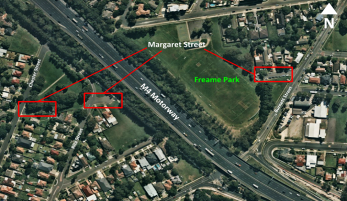
Figure 1: Margaret Street, Merrylands
Council sought preliminary advice from the Geographical Names Board (GNB) on 27 May 2019, regarding the proposal to rename Margaret Street to Margaret Street South and Margaret Street North. On 5 June 2019, the GNB provided Council with written advice that the use of directional indicators, such as North and South, does not comply with Section 6.7.8 of the NSW Addressing User Manual. This section of the manual states that a directional or similar device shall not be used as a suffix to uniquely define road extremities. Margaret Street South and Margaret Street North are an example of this.
The GNB also recommended that Council should consider unique names for two segments of Margaret Street south of the M4 Motorway, as these two segments contain the least number of addresses.
Council considered this advice at the 21 August 2019 meeting, and resolved that Council:
“1. No longer seek to rename Margaret Street, Mays Hill, to Margaret Street North and Margaret Street South.
2. Consider the application of unique road names for the two segments of Margaret Street located south of the M4 Motorway.”
Proposed Road Names
Council officers have undertaken a review of history of this area to identify potential road names for the Margaret Street area. A range of road naming options have been identified and are outlined below:
· Bolger Close: John Bolger was the first land grantee of the area of land, who was granted 38.45ha on 1 January 1810.
· Donaldson Close: historical research indicates that Margaret Street was most probably named after Robert Shannon’s eldest daughter Margaret Jane Donaldson (nee Shannon) (1883-1949). Margaret Street was part of Shannon’s Parramatta Heights Estate at Mays Hill in 1936. Other street names in this estate have some connection to the Shannon family.
· Crowe Close: Benjamin Joshua Crowe owned the land prior to the Shannon family owning the land (c. 1914-1921). Mr Crowe was also an Alderman of Prospect and Sherwood Municipal Council (later Holroyd, now Cumberland), 1904-11 & 1914-17 and was also Mayor of that Council, 1908-09.
· Joshua Close: Benjamin Crowe’s middle name.
· Archie Close: the Oakes family also owned this land (c. 1885-1905). There is already an Oakes Street in Westmead. However, Archie Irwin Oakes specifically owned the property in c. 1898-1905. Archie Oakes was another Alderman of Prospect and Sherwood Council, 1900-03.
Informal advice has been provided by the GNB on the suitability of these road names, and for the roads to be referred to as ‘Close’. This will be formally confirmed should the proposed road naming proceed to consultation.
Street numbering at these locations would also need to be amended should the road naming process be completed, and this would impact two private properties. This change would also be identified during public exhibition of the road naming proposal.
Next Steps
It is recommended that Council endorse the proposed road names of Bolger Close and Donaldson Close for the two segments of Margaret Street located south of the M4 Motorway (refer to Figure 2). The remaining section north of the M4 Motorway will continue to be named Margaret Street.
It is also recommended that Council proceed with finalisation of these proposed road names with the NSW Geographical Names Board (GNB), following exhibition, subject to no objections being received. If objections are received, a further report will be provided to Council.
Should Council not support any changes to the road names, no further action will be undertaken and the road continues to be referred to as Margaret Street.
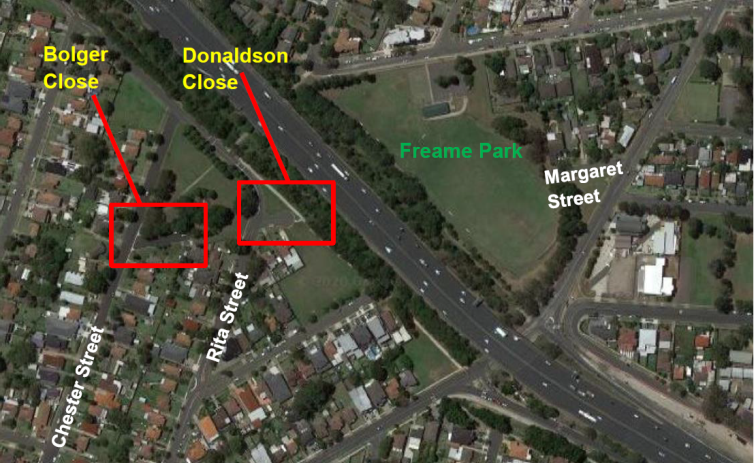
Figure 2: Proposed Road Names
Community Engagement
Public and authorities consultation will be undertaken, should the proposed road names receive formal approval from the GNB.
As per the NSW Roads Regulation 2008, the Council is required to:
· Advertise the proposal in the local newspaper
· Notify in writing to the immediate residents who directly utilise an address which will be affected by a change to the road name
· Serve notice of its proposal to the prescribed authorities listed in Regulation 7.1.
A minimum period of 15 working days is to be provided to the public and authorities to submit feedback to Council.
Policy Implications
There are no policy implications for Council associated with this report.
Risk Implications
There are no risk implications for Council associated with this report.
Financial Implications
There are no financial implications for Council associated with this report.
CONCLUSION
Following Council’s resolutions on the naming of Margaret Street, Merrylands, it is recommended that Council commence the road naming process for two sections of this road, south of the M4 Motorway, to be renamed Bolger Close and Donaldson Close. The remaining section north of the M4 Motorway will continue to be named Margaret Street.
Attachments
Council Meeting
4 March 2020
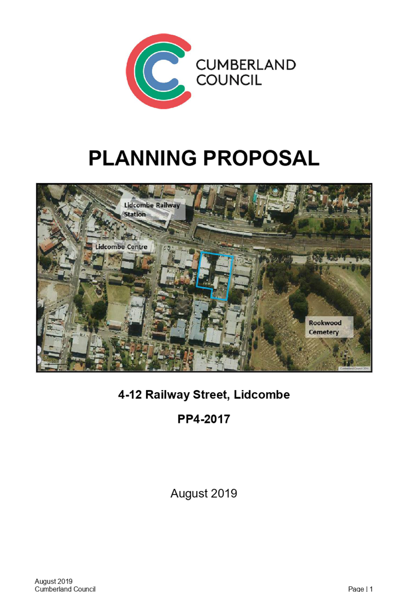
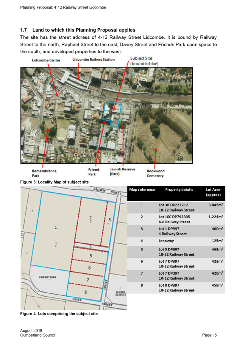
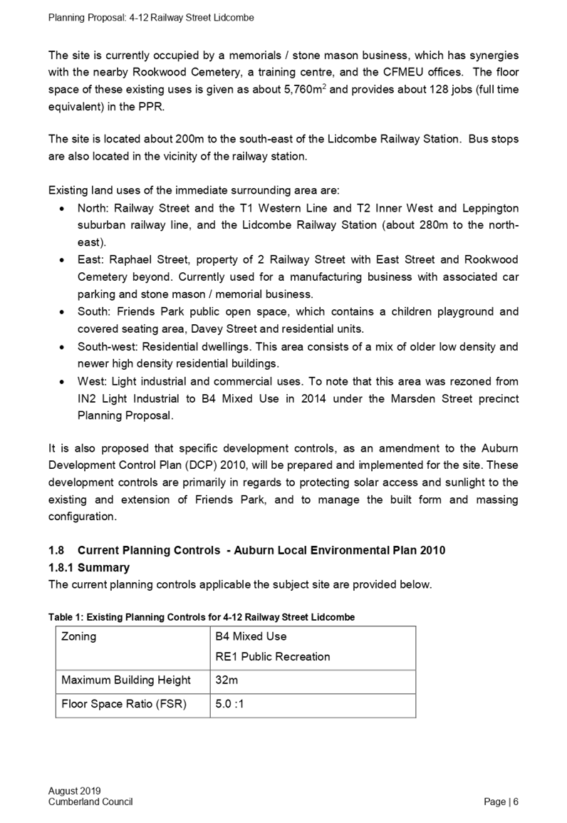
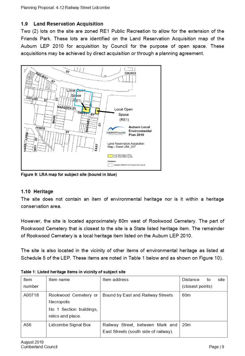
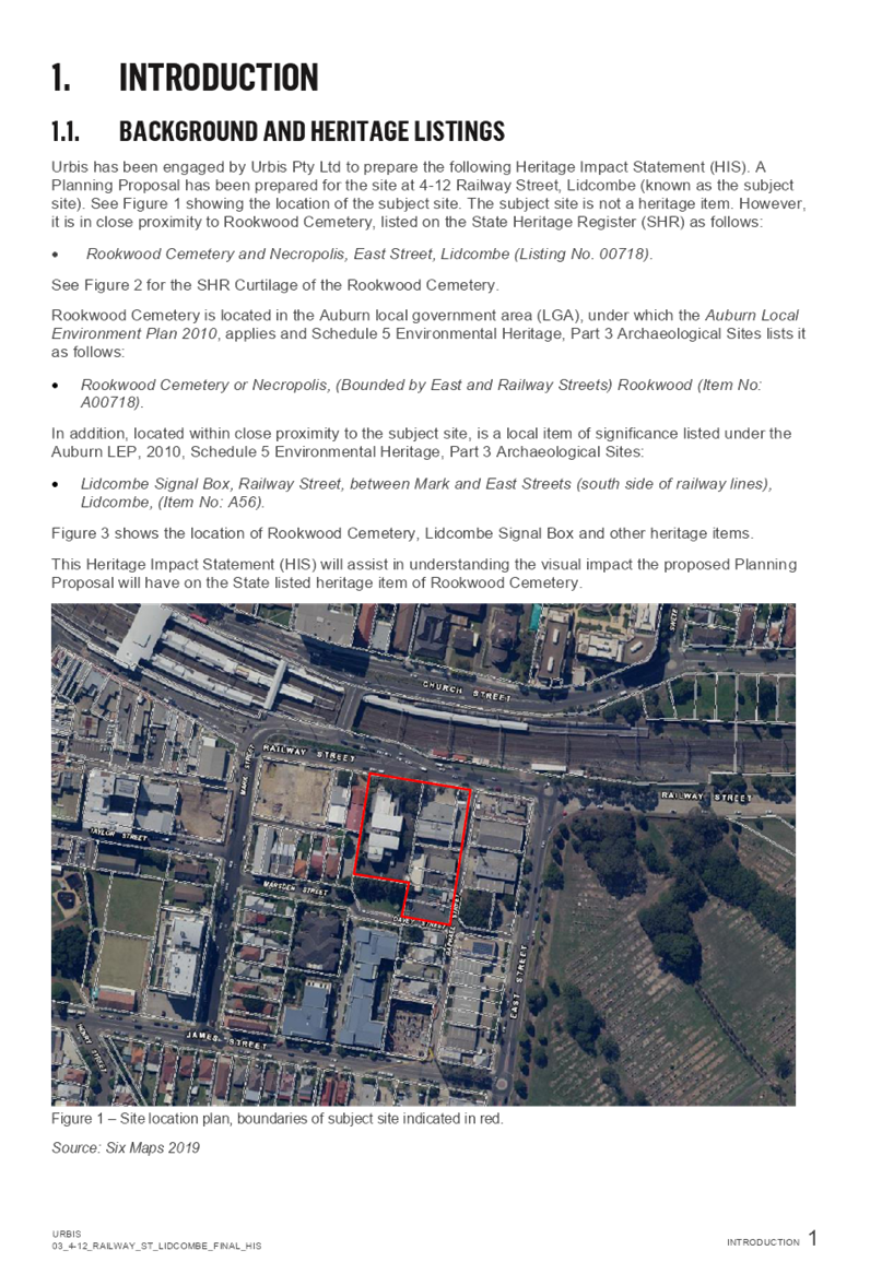
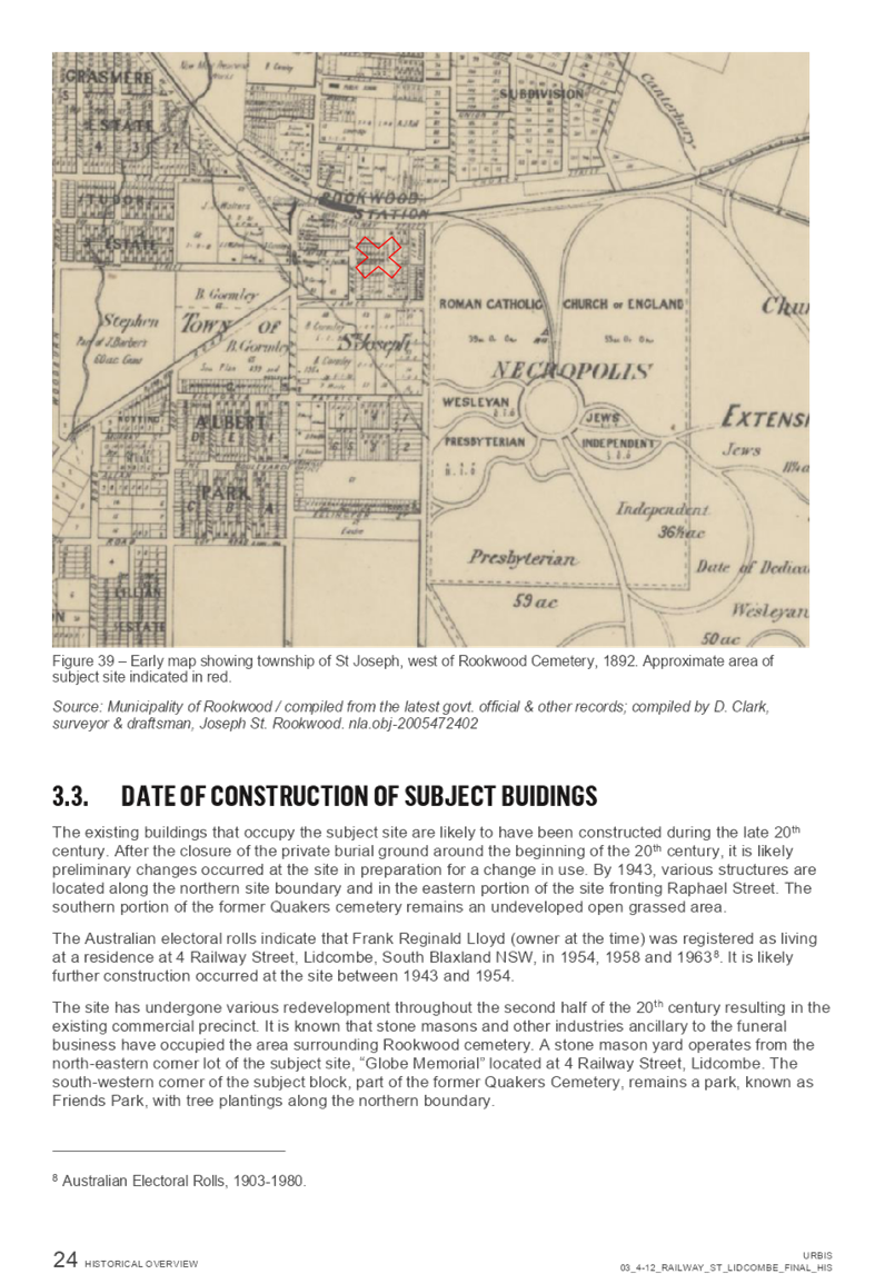
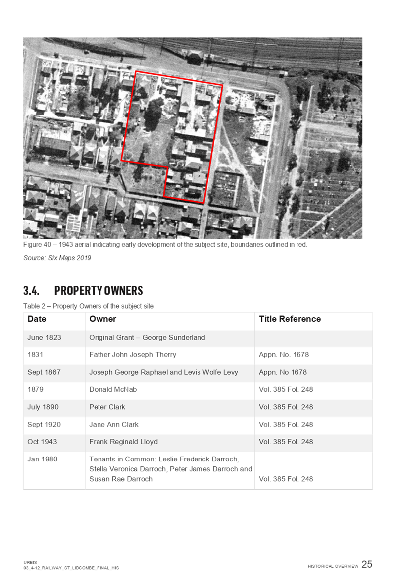
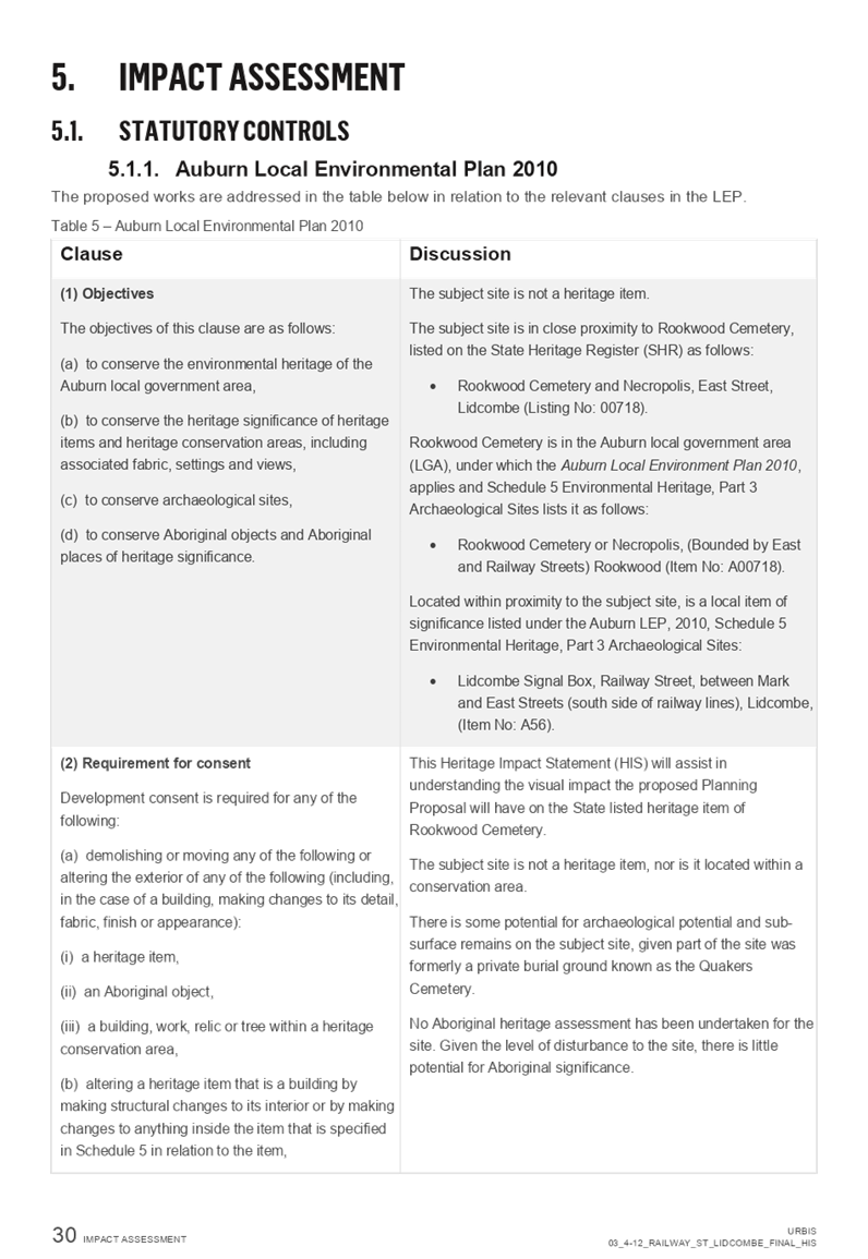
Item No: C03/20-387
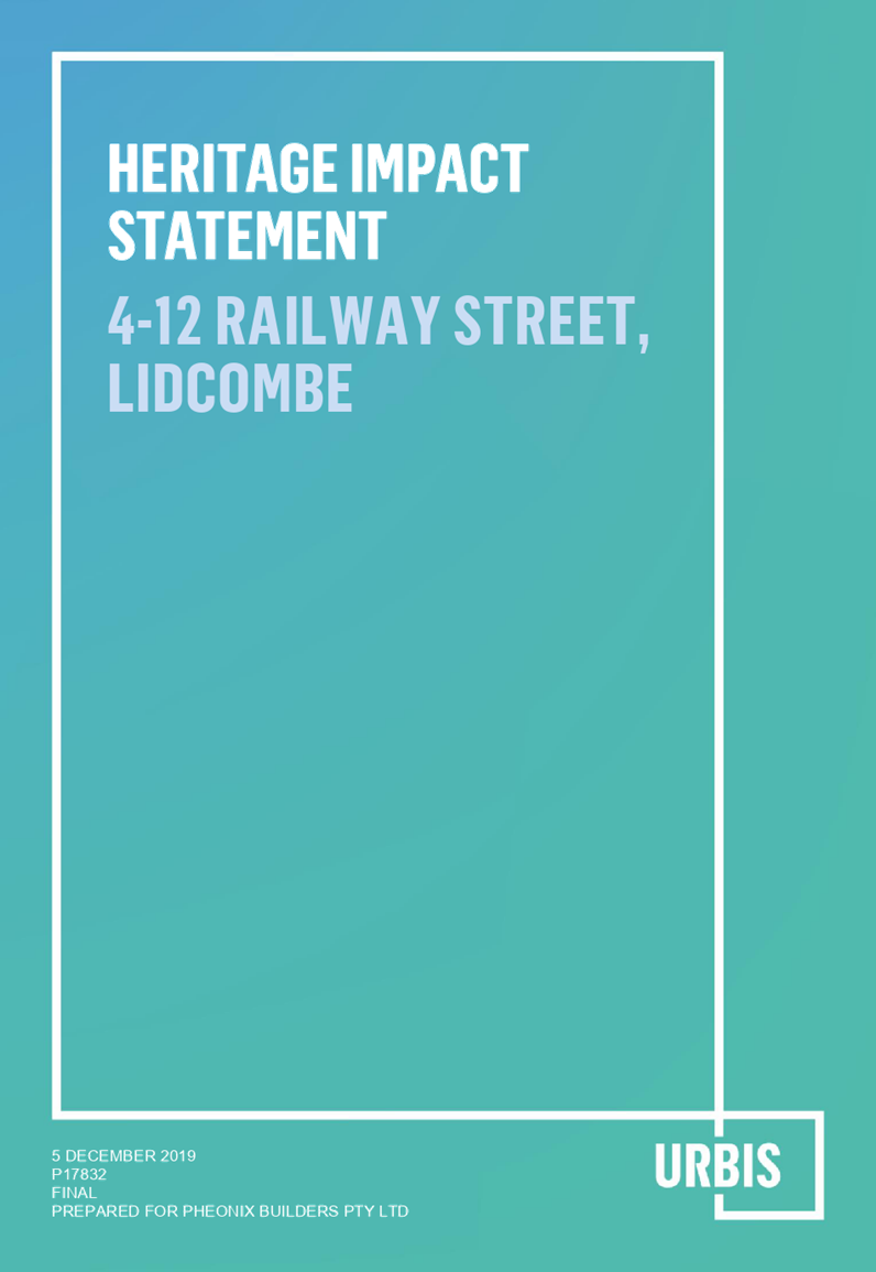
Planning Proposal, Development Control Plan and Voluntary Planning Agreement - 4-12 Railway Street, Lidcombe
Responsible Division: Environment & Planning
Officer: Director Environment & Planning
File Number: PP-4/2017
Community Strategic Plan Goal: A resilient built environment
Summary
The planning proposal for 4-12 Railway Street, Lidcombe, was endorsed by Council in October 2018 for a Gateway Determination. The resolution also required the preparation of an acceptable Voluntary Planning Agreement and site-specific Development Control Plan to finalise the planning proposal.
The planning proposal, draft Voluntary Planning Agreement and draft site-specific Development Control Plan have been prepared and publicly exhibited for a period of 28 days. This report outlines the feedback received during exhibition.
It is recommended that the Voluntary Planning Agreement be executed and the Development Control Plan be adopted and Council finalise the planning proposal as delegated by the Minister.
|
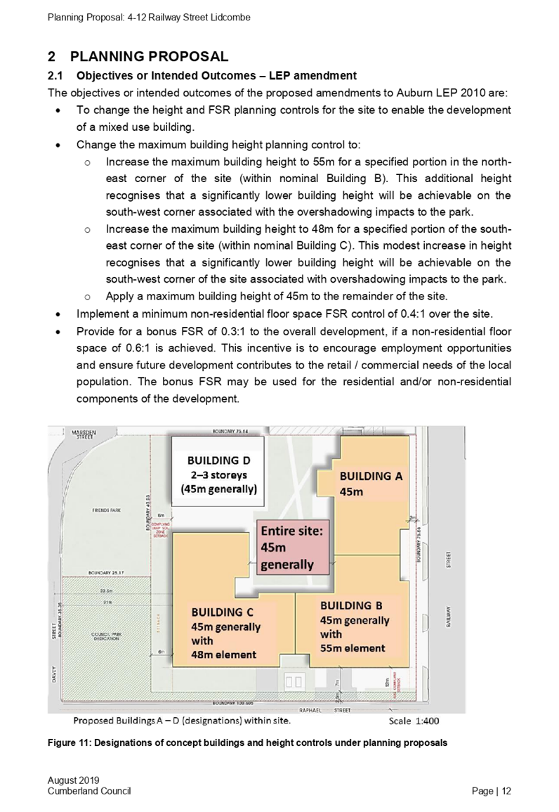
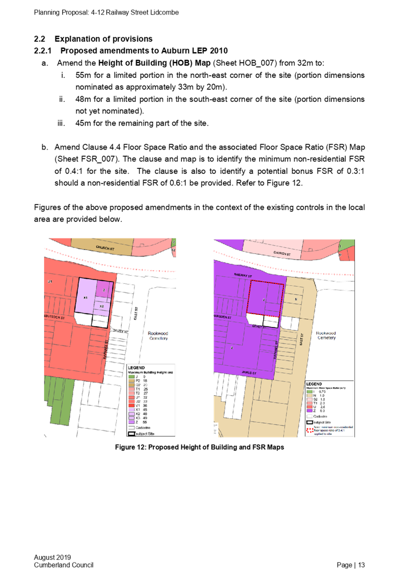
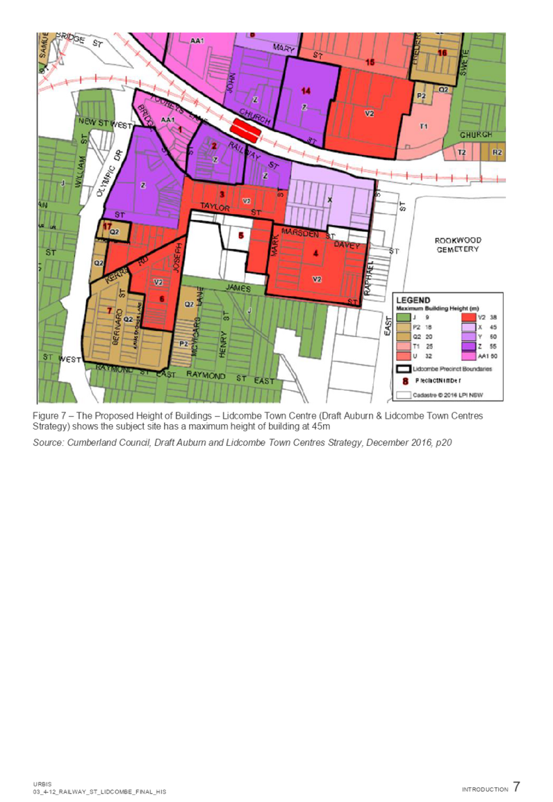
Recommendation That Council: 1. Adopt the recommended planning controls for 4-12 Railway Street, Lidcombe, as previously resolved by Council, being: a. the existing maximum Floor Space Ratio of 5:1 under Auburn Local Environmental Plan (LEP) 2010 being retained for the B4 zoned part of the subject site, with a minimum of 0.4:1 non-residential Floor Space Ratio to be provided; b. a provision for a bonus Floor Space Ratio of 0.3:1 for a minimum of 0.6:1 non-residential Floor Space Ratio, subject to the dedication of the RE1 zoned land to Council at no cost, and with an offset of section 7.11 contributions in lieu of this land dedication; c. a maximum building height of 45m apply to the site generally, with: i. a taller element up to a maximum of 55m for a limited portion in the north eastern corner of the site to be shown on the LEP Height of Buildings Map; and ii. a maximum building height of 48m for a limited portion of the south eastern corner of the site. 2. Finalise the planning proposal, as delegated by the Minister.
3. Note that this LEP amendment will be published in the Government Gazette upon finalisation.
4. Endorse and delegate authority to the Mayor and General Manager to execute the Voluntary Planning Agreement on behalf of Council for 4-12 Railway Street, Lidcombe, as provided in Attachment 3;
5. Adopt the revised site specific Development Control Plan as an amendment to the Auburn Development Control Plan, as provided in Attachment 2, with the Development Control Plan coming into effect on the date of notification (gazettal) of the LEP amendment;
6. Delegate to the General Manager the authority to make minor, non-policy corrections or formatting changes to the Development Control Plan controls, if required, prior to coming into effect; and 7. Endorse that the site specific Development Control Plan carry over to the new Cumberland Development Control Plan when this is in force. |
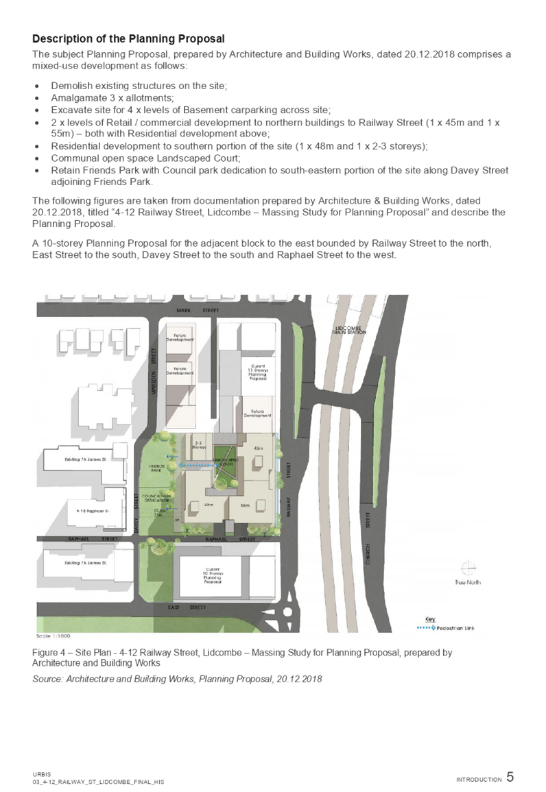
Report
Background
A planning proposal request (the original proposal) was lodged with Cumberland Council on 21 September 2017 for 4-12 Railway Street Lidcombe, which sought to increase the maximum height of buildings and floor space ratio (FSR) controls under the Auburn Local Environmental Plan (LEP) 2010.
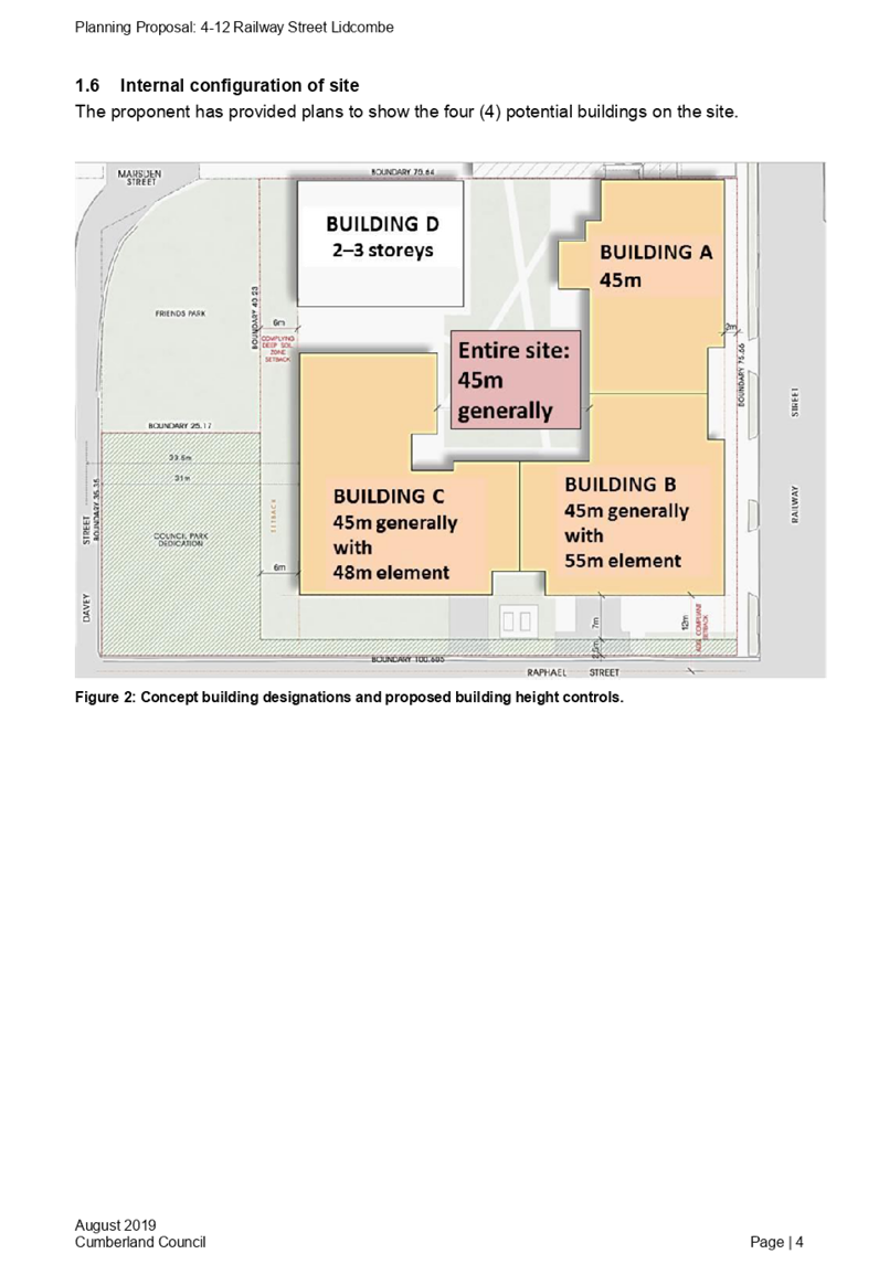
The proposal was considered by the Cumberland Local Planning Panel in August 2018. The proposal recommended by the Panel would deliver approximately 320 apartments and 2,300m² of commercial floor space.
The proposal was reported to Council in October 2018, with Council endorsing that a planning proposal be prepared that seeks to increase the maximum height of buildings control:
· 55m for a limited portion in the north east corner of the site.
· 48m for a limited portion in the south east corner of the site.
· 45m for the remainder of the site.
· Apply a minimum non-residential FSR of 0.4:1 to the site.
· A bonus FSR of 0.3:1 to the site, if a minimum non-residential FSR of 0.6:1 is provided.
Council also resolved to develop site specific Development Control Plan controls for building massing, setback and solar access controls that aim to minimise the overshadowing of Friends Park, as well as the preparation of a Voluntary Planning Agreement.
Public exhibition of the planning proposal, draft Development Control Plan and draft Voluntary Planning Agreement
The planning proposal, draft Development Control Plan and draft Voluntary Planning Agreement were placed on public exhibition from Wednesday 4 September 2019 to Tuesday 1 October 2019.
One public submission was received on the planning proposal, draft Development Control Plan and draft Voluntary Planning Agreement.
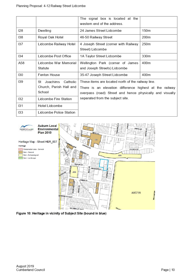
A requirement of the Gateway Determination was to notify the following public authorities: Heritage NSW; Roads and Maritime Services; and Transport for NSW. A late submission was received from Heritage NSW on the planning proposal. No submissions were received from the other authorities.
Planning Proposal
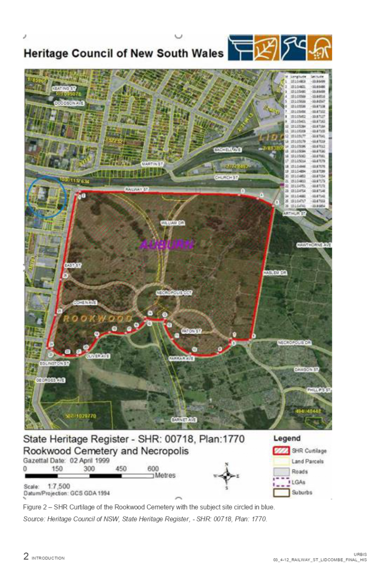
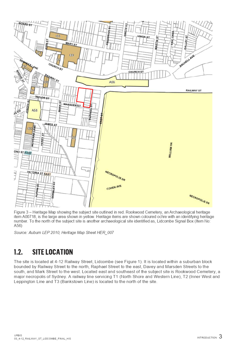
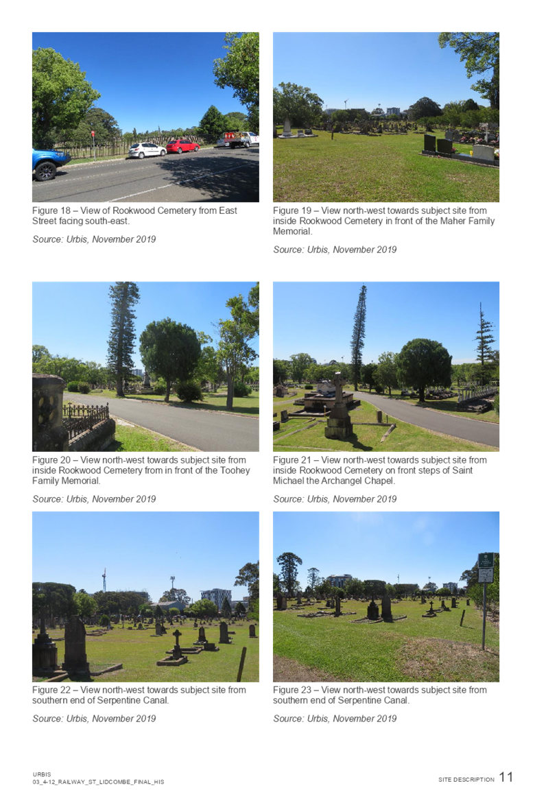
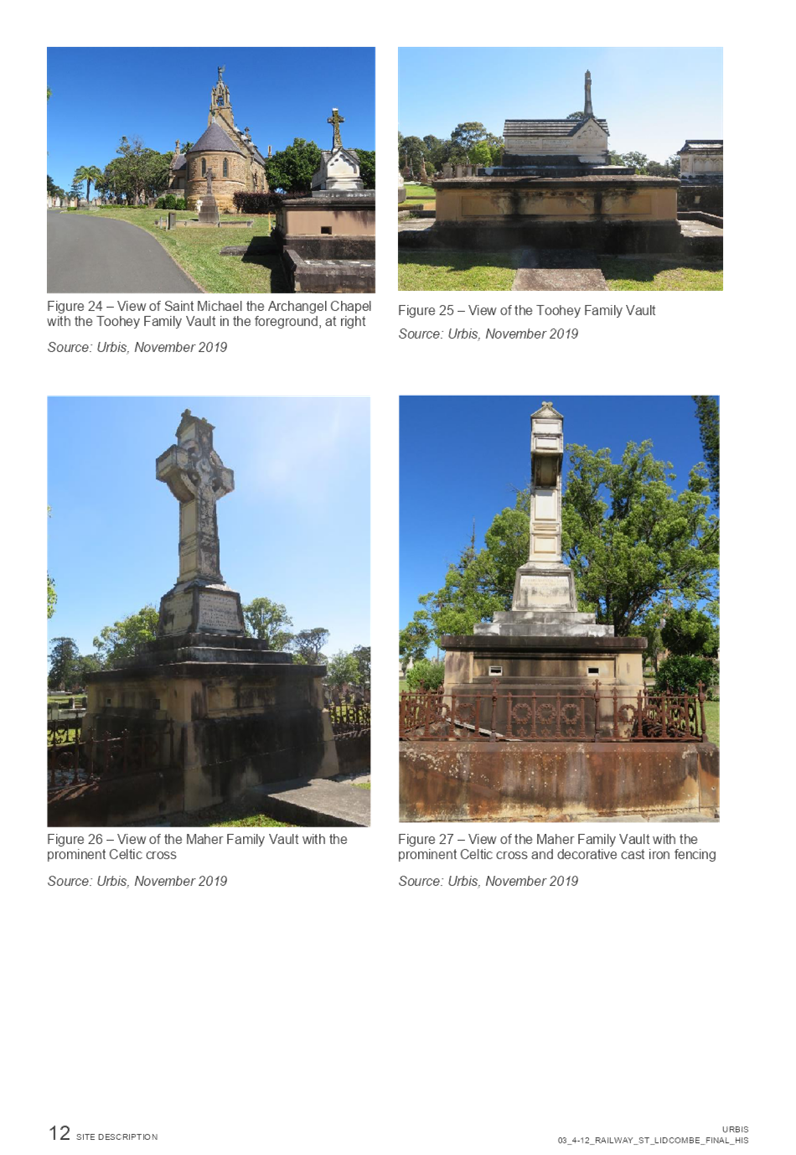
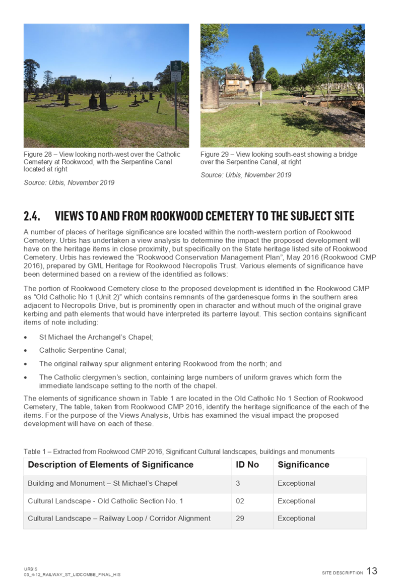
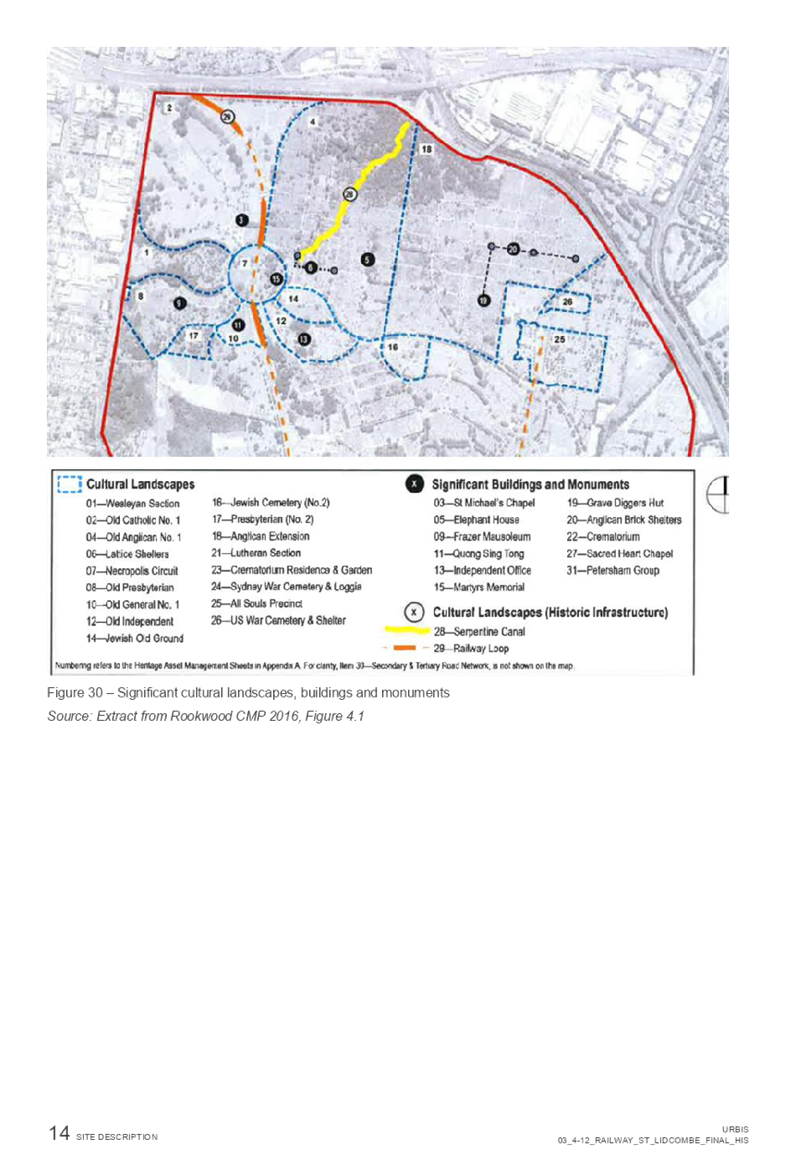
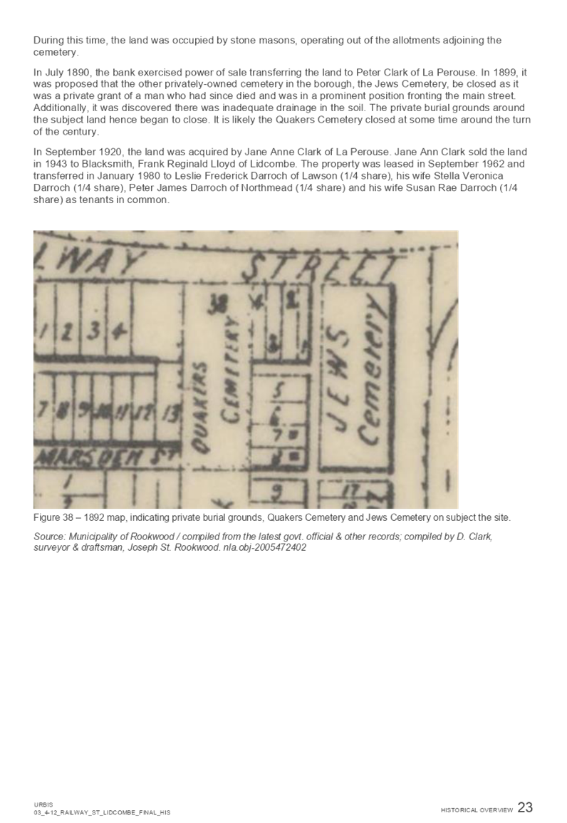
A submission on the planning proposal was received from Heritage NSW. Their submission suggested formal consideration should be given to the visual impact a building of the proposed heights may have on the setting of the cemetery and Necropolis, and whether the proposed height increase will impact on significant views to and from the cemetery. Their submission suggested that a Heritage Impact Statement is critical and will assist Council to respond to any concerns raised regarding the proposal.
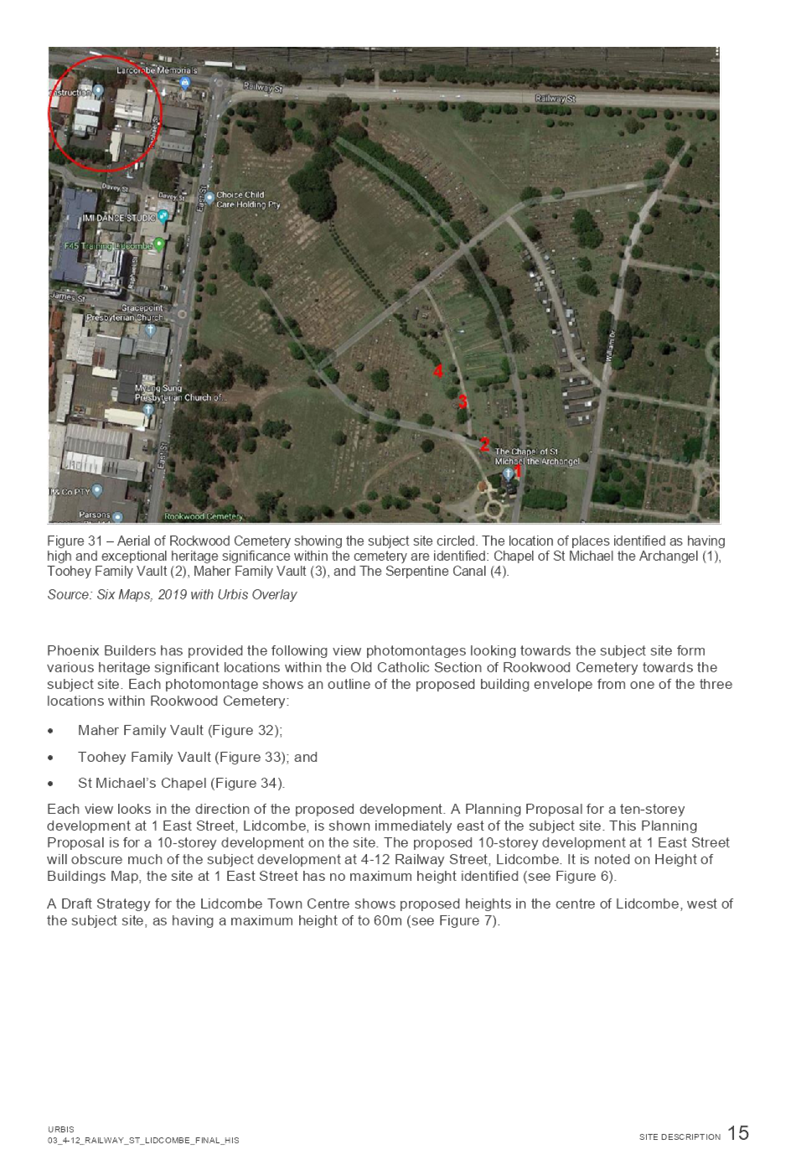
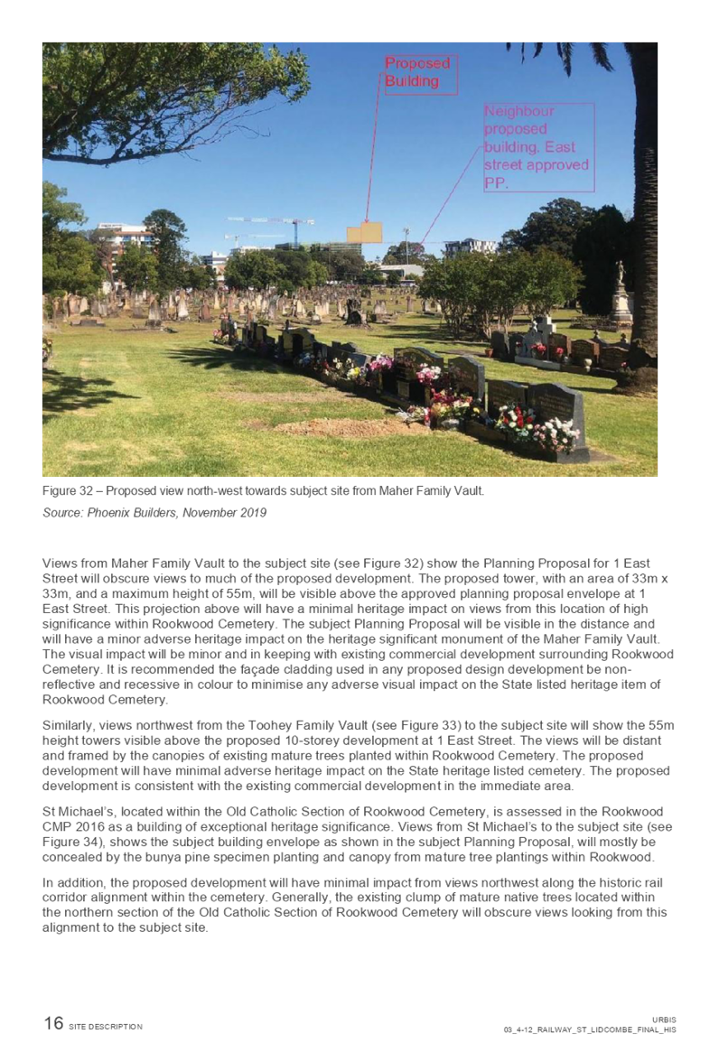
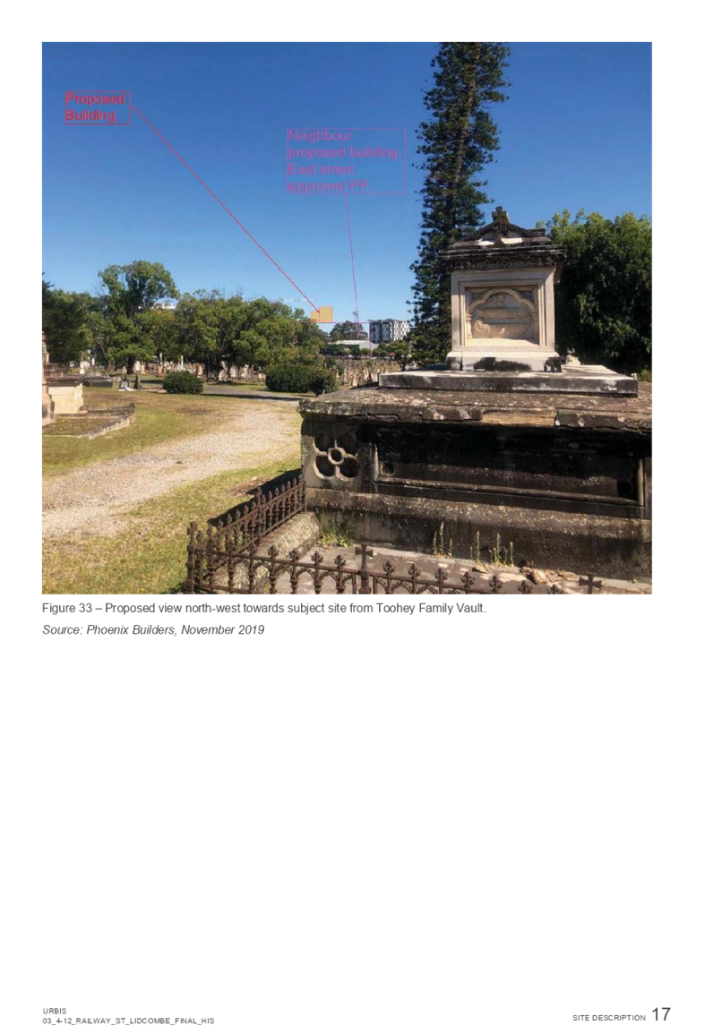
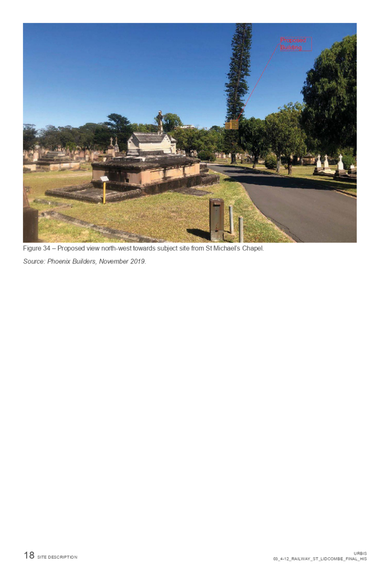
A Heritage Impact Statement was undertaken to address the issues raised by Heritage NSW. The Heritage Impact Statement determined that:
· While there will be some minor views to the subject site from locations that are in the south-eastern portion of the Old Catholic Section (on raised land), these views will be distant and not have an adverse heritage impact on the heritage item and significant elements within Rookwood.
· Views to the subject site from St Michael’s Chapel are generally obscured by tall tree plantings and mature tree canopy.
· Views to the subject site from the original railway spur alignment entering Rookwood from the north, will be obscured by existing clumps of mature tree plantings that run parallel and west of the former railway alignment.
· Generally, views northwest to the subject site from within the Old Catholic Section of the Cemetery will be concealed by the proposed 10-storey development located at 1 East Street, Lidcombe.
The Heritage Impact Statement determines that the proposal will have some minor but acceptable visual impact on heritage significance of Rockwood Cemetery.
As the proposal will only have a minor visual impact on the heritage significance of Rockwood Cemetery, the issues raised by Heritage NSW in their submission should not be considered to be a reason for not proceeding with the planning proposal.
Development Control Plan
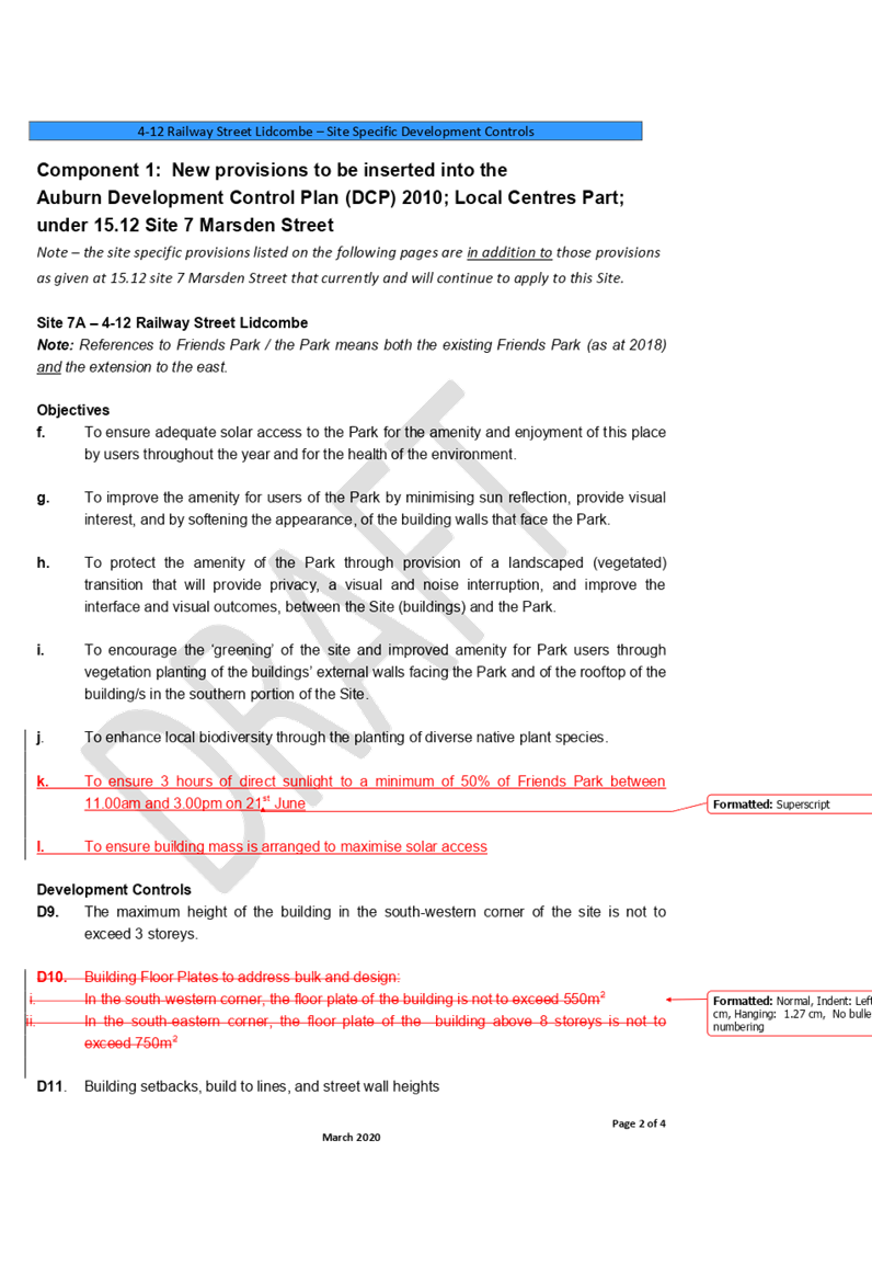
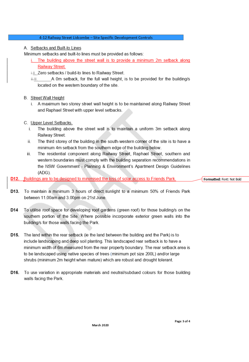
Council also resolved to develop site specific Development Control Plan controls for building massing, setback and solar access controls that aim to minimise the overshadowing of Friends Park.
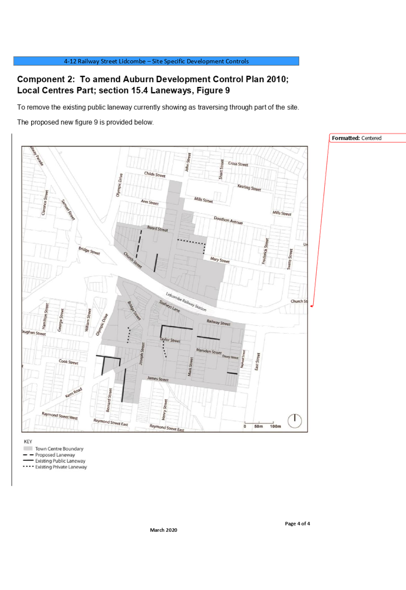
The site specific controls will be inserted into the Auburn Development Control Plan (2010) under Local Centres, 15.12 Site 7 Marsden Street.
One submission was received on the Development Control Plan on behalf of the proponent. The proponent sought changes to the proposed controls that specifically related to floor plates, setbacks and solar access, as these controls have the potential to limit and restrict the future development of the site.
The proponent’s submission sought change to the following development controls:
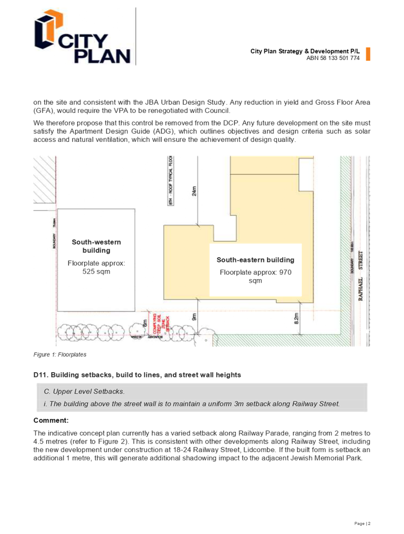
· D10 – (i) in the south western corner, the floor plate of the building is not to exceed 550m2
· D10 – (ii) in the south eastern corner, the floor plate of the building above 8 storeys is not to exceed 750m2
The proponent also sought that the following controls be removed from the Development Control Plan:
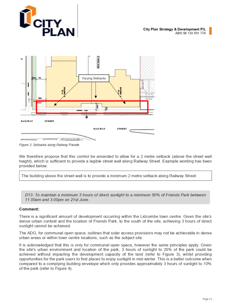
· D11 – C - The building above the street wall is to maintain a uniform 3m setback along Railway Street.
· The proponent is seeking that this control be reworded to “The building above the street wall is to provide a minimum 2 metre setback along Railway Street”.
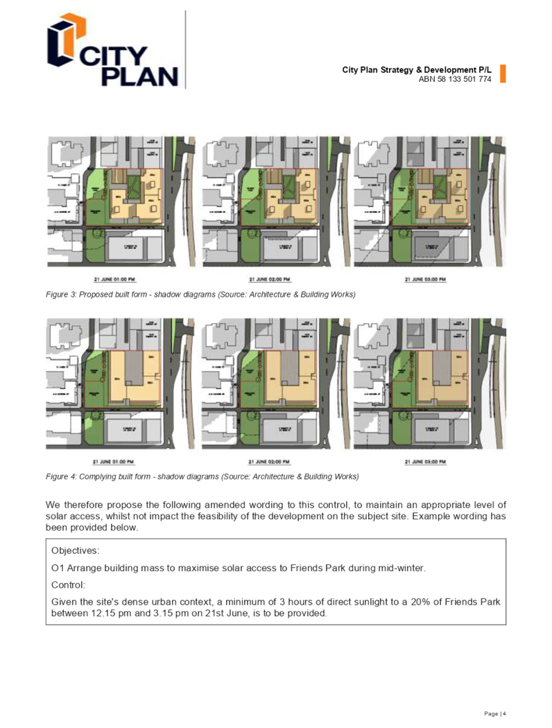
· D13: To maintain a minimum 3 hours direct sunlight to a minimum 50% of Friends Park between 11.00am and 3.00pm on 21 June.
· The proponent is seeking to add an objective O1 Arrange building mass to maximise solar access to Friends Park during mid-winter. The proponent is also seeking to amend D13 to “Given the site's dense urban context, a minimum of 3 hours of direct sunlight to 20% of Friends Park between 12.15 pm and 3.15 pm on 21st June, is to be provided”.
Council has reviewed the submission provided by the proponent. The issues raised by the proponent in their submission should be taken into consideration, as the public benefit offer has been determined based on an approximate yield of 320 apartments. This can be considered to be the proponent’s viable development yield and a site specific Development Control Plan needs to provide enough flexibility to assist the proponent to achieve this yield, while maintaining provisions that seek the greatest level of solar access to Friends Park.
Following a review by Council officers, it is recommended that the Development Control Plan be amended to:
· Remove exhibited controls D10 (i) and D10 (ii).
· Reword exhibited control D11 – C (i). The new wording will state ‘The building above the street wall is to provide minimum 2 metre setback along Railway Street.
· Reword exhibited control D13. The new wording will state ‘buildings are to be designed to minimise the loss of solar access to Friends Park’, and will be renamed as control D12.
· Include additional objectives that:
o Seek 3 hours solar access to 50% of Friends Park between 11.00am to 3.00pm on 21 June
o Seek building mass to be arranged to maximise solar access to Friends Park during mid-winter.
The identified amendments in the revised Development Control Plan maintain provisions for solar access to 50% on 21 June, but better align to the time of the day where this can be feasibly achieved with the intended development on the site.
It is recommended that Council adopt the revised site specific Development Control Plan for the site as an amendment to the Auburn Development Control Plan, as provided in Attachment 2. It is also recommended that the Development Control Plan carry over to the new Cumberland Development Control Plan when in force.
Voluntary Planning Agreement
Council’s resolution also required that a draft Voluntary Planning Agreement be prepared and exhibited with the Planning Proposal. A Voluntary Planning Agreement was negotiated between Council and the applicant, consistent with the Cumberland Planning Agreements Policy.
Council obtained an independent valuation of the potential increase in residual land value arising from the planning proposal. In accordance with Council policy, the total value of development contributions to be made under a planning agreement will be equivalent to 50% of the increase in residual land value arising from the development proposal. This has been achieved with the Voluntary Planning Agreement for the planning proposal.
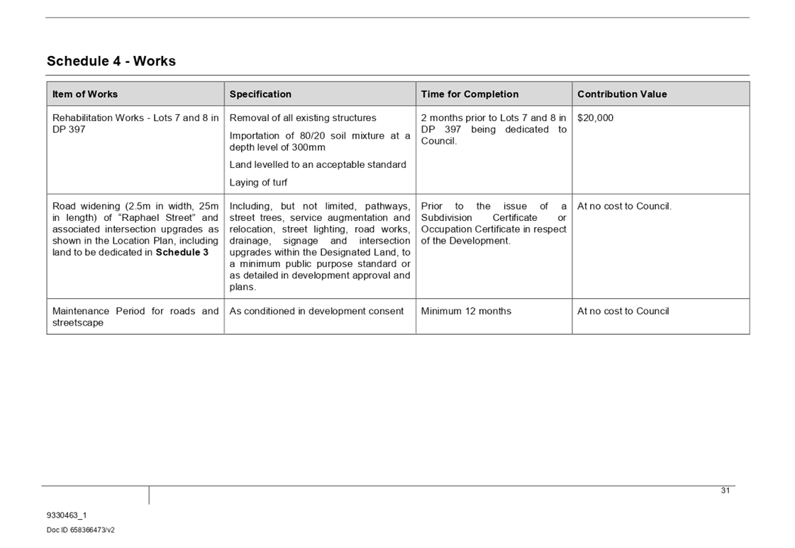
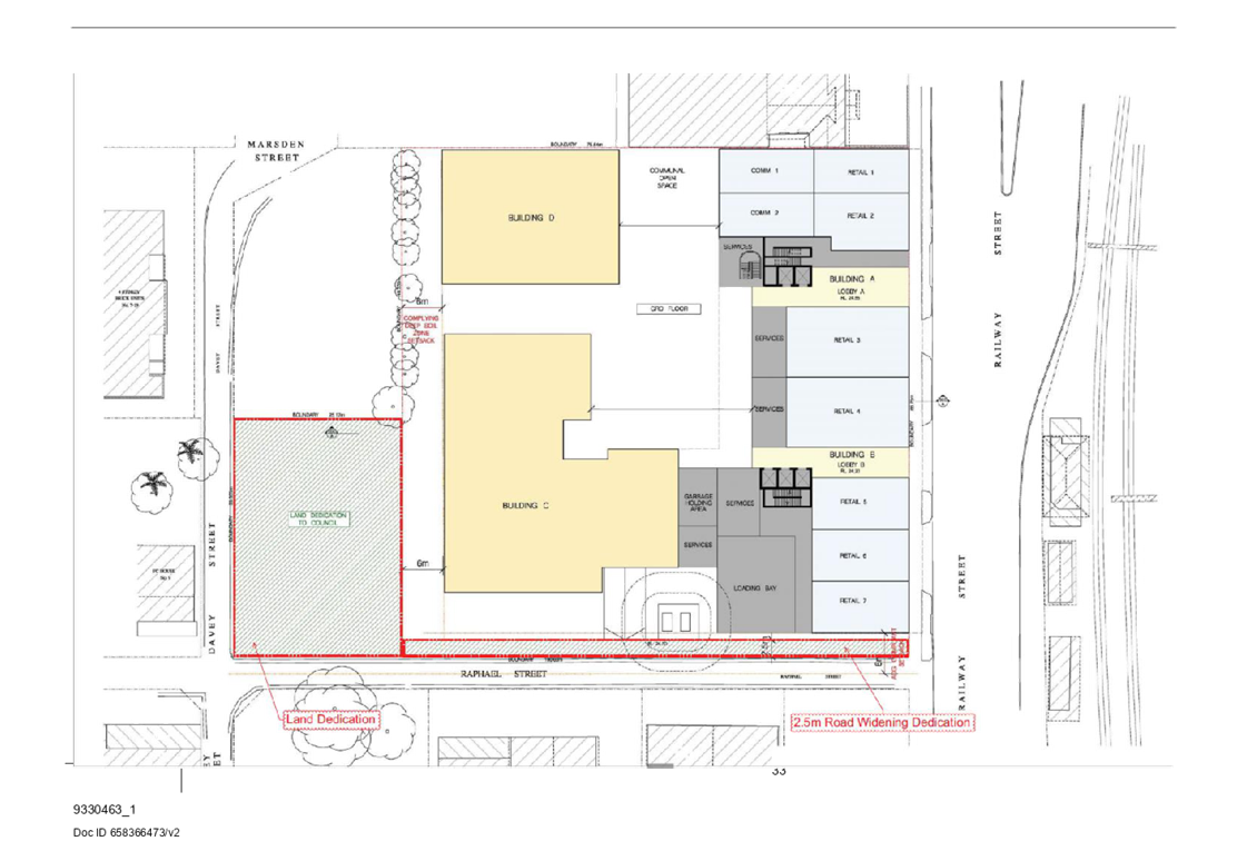
The offer included in the Voluntary Planning Agreement requires the proponent to:
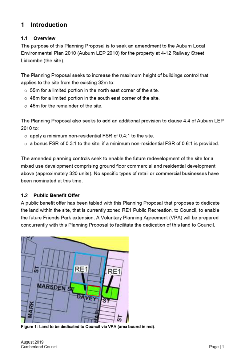
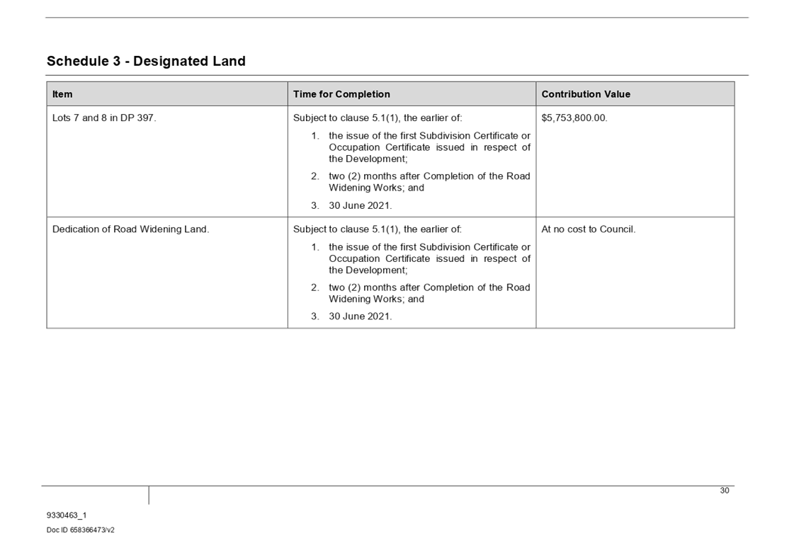
· Dedicate lots 7 and 8 in DP 397 free-of-cost to Council to allow for the expansion of Friends Park.
· Rehabilitate and embellish that land.
· Dedicate part of the land (defined as the ‘Road Widening Land’ in the Planning Agreement) for the purposes of widening Raphael Street free-of-cost to Council, including associated road widening, intersection upgrade works, and subsequent ongoing maintenance works in respect of that land by the Developer.
The offer formalises land for the purposes of open space and provides improvements to local roads in a manner that support the redevelopment of the Lidcombe Town Centre.
No changes have been made to the Voluntary Planning Agreement following notification during the public exhibition of the planning proposal.
It is recommended that Council endorse and, through the Mayor and General Manager, execute the Voluntary Planning Agreement, as provided in Attachment 3.
Community Engagement
The final outcome of this matter will be notified in the newspaper. The objectors will also be notified in writing of the outcome.
Policy Implications
The proposal involves amendments to the Auburn Local Environmental Plan 2010 and Auburn Development Control Plan 2010. With endorsement of the revised Development Control Plan by Council, finalisation will be undertaken including newspaper notifications and the Development Control Plan will come into effect on the date the Local Environmental Plan amendment is made. The development of the Voluntary Planning Agreement is consistent with Council’s Planning Agreements Policy.
Risk Implications
There are minimal risk implications for Council associated with this report. This report’s recommendation stipulates that the Voluntary Planning Agreement must be executed by both parties and registered on title prior to the Local Environmental Plan amendment being finalised. The Development Control Plan will come into effect once the Local Environmental Plan has been made (gazetted). All statutory and Council policy requirements have been met.
Financial Implications
There are no financial implications for Council associated with this report.
CONCLUSION
As required by Council’s resolution for the planning proposal in October 2018, the planning proposal, draft Voluntary Planning Agreement and a draft site specific Development Control Plan have been prepared and publicly exhibited for a period of 28 days. This report outlines the feedback received during exhibition.
It is recommended that the Voluntary Planning Agreement be executed and the Development Control Plan be adopted and Council finalise the planning proposal as delegated by the Minister.
Attachments
2. Revised Site Specific Development Control Plan
3. Voluntary Planning Agreement
5. Submission from Proponent on Development Control Plan
6. Submission from Heritage NSW on Planning Proposal
8. Minutes from Council Meeting 17 October 2018
9. Valuation advice - 4-12 Railway Street, Lidcombe (confidential)
DOCUMENTS
ASSOCIATED WITH
REPORT C03/20-387
Attachment 1
Planning Proposal
Attachment 2
Revised Site Specific Development Control Plan
DOCUMENTS
ASSOCIATED WITH
REPORT C03/20-387
Attachment 4
Gateway Determination
Attachment 5
Submission from Proponent on Development Control Plan
Attachment 6
Submission from Heritage NSW on Planning Proposal
Attachment 8
Minutes from Council Meeting 17 October 2018
4 March 2020
Item No: C03/20-388
Update on Planning Proposal for the New Cumberland Local Environmental Plan
Responsible Division: Environment & Planning
Officer: Director Environment & Planning
File Number: S-5750-01
Community Strategic Plan Goal: A resilient built environment
Summary
This report provides an update on the planning proposal for the new Cumberland Local Environmental Plan, including advice from the Cumberland Local Planning Panel and status of the Gateway Determination process.
|
Recommendation That Council: 1. Note the advice of the Cumberland Local Planning Panel on the planning proposal for the new Cumberland Local Environmental Plan; and
2. Note the status of the Gateway Determination process on the planning proposal for the new Cumberland Local Environmental Plan. |
Report
Background
In September 2019, Council resolved to endorse the draft Cumberland Local Environmental Plan (LEP) and submit the LEP planning proposal to the Department of Planning, Industry and Environment for a Gateway Determination [Min 686, Item C09/19-219]. The LEP planning proposal seeks to harmonise the three existing LEPs currently in operation across Cumberland, with the aim of creating a consolidated and clear planning framework under a single Cumberland LEP.
Cumberland Local Planning Panel
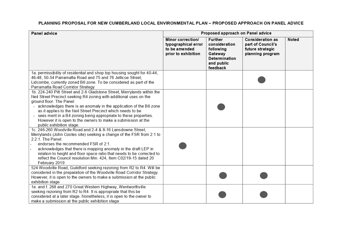
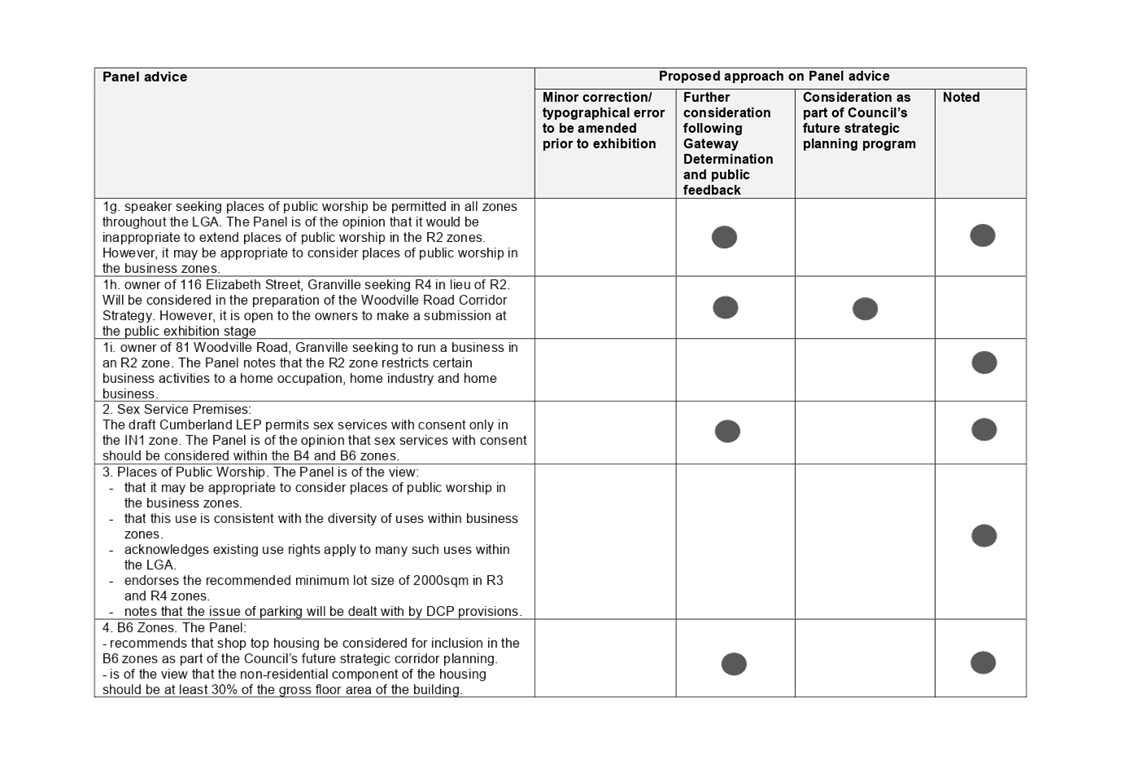
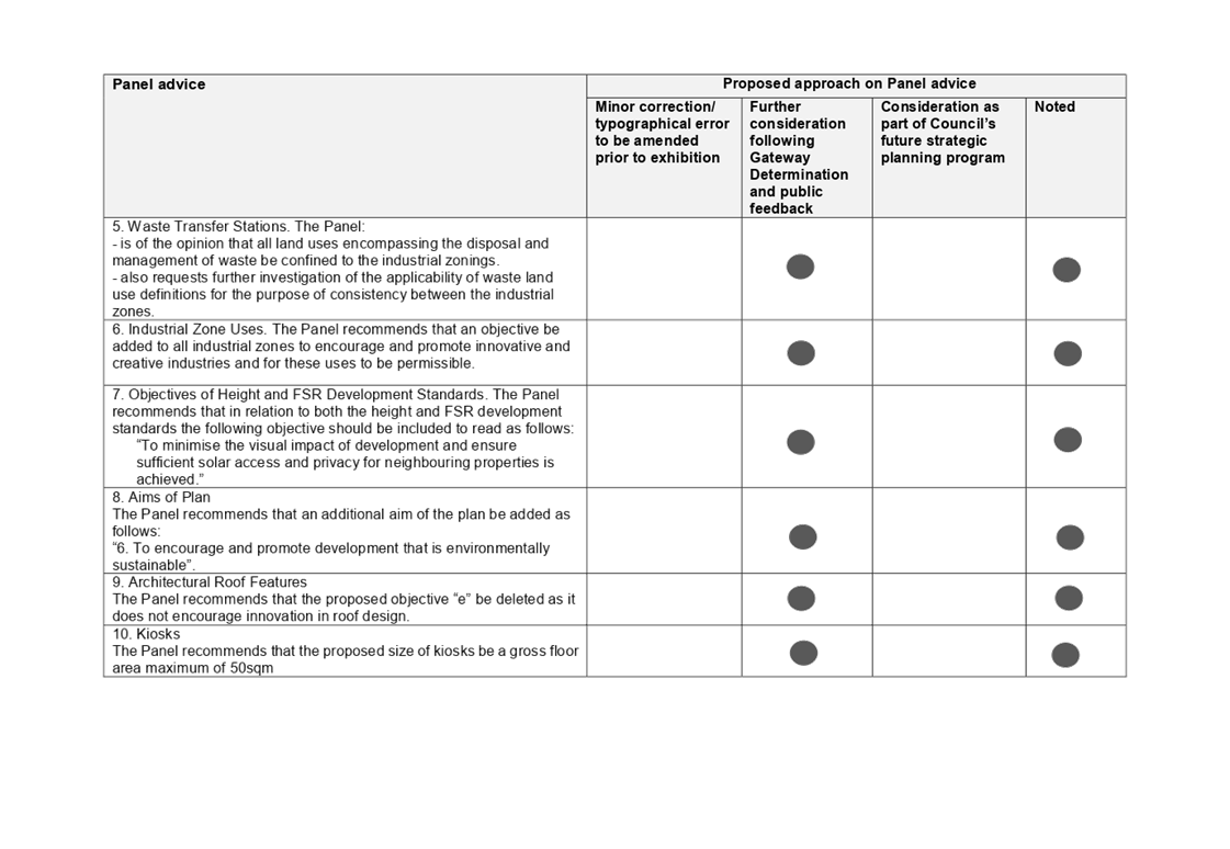
The planning proposal for the new Cumberland LEP was considered by the Cumberland Local Planning Panel on 20 February 2020. The Panel generally supported the proposal and its progression to a Gateway Determination.
The Panel noted that a number of requests for zoning and/or planning control changes, raised by speakers who addressed the Panel, would best be addressed as part of Council’s future planning for its strategic corridors and centres.
The Panel also provided further advice on a range of matters for further consideration by Council. These matters are best placed to be considered following Gateway Determination, informed by feedback received during public exhibition.
Further information on the Panel meeting is provided in Attachments 1 and 2.
Gateway Determination process
Council officers continue to liaise with the Department of Planning, Industry and Environment during the Gateway Determination process. A range of clarifications have been provided to the Department on the contents of the planning proposal for the new Cumberland LEP. Advice from the Cumberland Local Planning Panel and Council’s resolution on this paper will also be provided to the Department as part of the Gateway Determination process. It is anticipated that a Gateway Determination will be provided on the planning proposal in the near future.
Community Engagement
An extensive consultation program on the draft planning proposal for the new Cumberland LEP will be undertaken, subject to Gateway Determination by the Department of Planning, Industry and Environment. This consultation will be statutory consultation, and will be undertaken in accordance with the relevant conditions of the Gateway Determination.
Policy Implications
The preparation of the Cumberland LEP is required under the Environmental Planning and Assessment Act 1979. The Cumberland LEP aligns with the strategic directions outlined in Council’s Community Strategic Plan and Cumberland 2030: Our Local Strategic Planning Statement.
Risk Implications
Council is required to submit a planning proposal on the new Cumberland LEP to the Department of Planning, Industry and Environment for finalisation by 30 June 2020. The release of funds from the accelerated Local Environmental Plan funding grant provided by the NSW Government is also linked to this milestone. Support of the planning proposal by the Panel and noting of the advice by Council assists in meeting this milestone.
Financial Implications
Work undertaken on the Cumberland LEP, including strategic studies and planned community consultation activities, is funded by the accelerated Local Environmental Plan Funding Grant provided by the NSW Government. The planning proposal for the new Cumberland LEP is required to be submitted to the Department of Planning, Industry and Environment for finalisation by 30 June 2020, in accordance with funding and delivery commitments between Council and the Department.
CONCLUSION
This report provides an update on the planning proposal for the new Cumberland Local Environmental Plan, including status of the Gateway Determination process and advice from the Cumberland Local Planning Panel
Attachments
1. Cumberland Local Planning Panel – Minutes – 20 February 2020
2. Cumberland Local Planning Panel - Proposed Approach on Panel Advice
DOCUMENTS
ASSOCIATED WITH
REPORT C03/20-388
Attachment 1
Cumberland Local Planning Panel – Minutes – 20 February 2020
Attachment 2
Cumberland Local Planning Panel - Proposed Approach on Panel Advice
4 March 2020
Item No: C03/20-389
Response to Notice of Motion - Responsible Pet Ownership Education Program
Responsible Division: Works & Infrastructure
Officer: Director Works & Infrastructure
File Number: SC483
Community Strategic Plan Goal: A safe accessible community
Summary
This report provides a response to the Notice of Motion (C09/19-223, Min.689) considered at Council’s meeting of 18 September 2019, seeking a report into the development of a Responsible Pet Ownership Education Program.
|
Recommendation That Council receive the information contained within this report relating to an expanded Responsible Pet Ownership Education Program, for implementation across the Cumberland City Council area. |
Report
At Council’s meeting of 18 September 2019, Item C09/19-223, Min 689 contained a Notice of Motion relating to the development of a Responsible Pet Ownership Education Program. In considering this item, Council resolved the following:
“That Council:
1. Prepare a report on the development and delivery of an ongoing pet education program for members of the community that explains the responsibilities, costs and benefits associated with responsible pet ownership;
2. Investigate whether it is possible to provide an incentive to those that participate in Council’s pet education program, such as free or subsidised microchipping and animal de-sexing, that would encourage the uptake of the pet education program;
3. Investigate the issue of stray and feral cats in the local government area and devise a plan to efficiently and effectively control them in order to improve public health and safety; and
4. Undertake consultation with the Companion Animals Advisory Committee in relation to the items above.”
In response to this Notice of Motion, staff have reviewed existing pet education initiatives which at present involve interacting with the community through stall attendance at events, providing written information relating to responsible pet ownership (via Council’s website and dedicated pamphlets) and through general discussions with Council staff during the normal course of their duties when responding to companion animal matters. Additionally, community engagement is also undertaken through the operation of a Companion Animal Advisory Committee.
In order to further educate the community on the potential costs associated with pet ownership, it is important to recognise the host of changes proposed to be implemented by the NSW Government from 1 July 2020. In this regard, owners of cats that are not de-sexed by four months of age will be required to pay an $80 annual permit in addition to the one-off lifetime pet registration fee. Exemptions will be in place for cats that are registered before 1 July 2020 and for cats kept for breeding purposes by members of recognised breeding bodies. Furthermore, from 1 July 2020 owners of dogs that are of a restricted breed or declared to be dangerous will be required to pay a $195 annual permit in addition to their one-off lifetime pet registration fee. Information relating to these legislative changes are well covered on the Office of Local Government website and as part of a review of the content on Council’s newly launched website. Staff will ensure that a link is provided to this information and other relevant factsheets developed by the Office of Local Government.
An allocation of funding will allow for enhanced initiatives such as the subsidised microchipping of cats and dogs, which will assist in the identification of animals that may be found roaming and will allow for contact to be made with the registered owner for the animal to be returned in a prompt manner.
Initial trialling of this initiative at the PetFest event resulted in Council being able to offer this service at $30 per microchip through an agreed charge at a local veterinary facility. Although the cost of having an animal microchipped can vary from vet to vet, Council would look to partner with a local clinic in offering this service at a set rate (similar to previously achieved). In this regard and using $30 as an indicative cost per microchip, it is proposed that Council initially allocate $7,000 for this purpose meaning that approximately 230 microchipping vouchers could be offered to local residents.
Other costs associated with improving Council’s pet identification initiative include the purchase of a specialised engraving machine and animal identification tags. With these initiatives, it is envisaged that the basic identification of animals will assist greatly with the rehoming rates across Council.
Council Officers have also considered incentives to encourage the de-sexing of a cat or dog which from surveying local veterinary clinics was found to be approximately $140 on average. The costs associated with subsidising such a procedure are therefore considered to be outside of available budget at this time. It is therefore recommended that Council rely upon the host of legislative changes proposed to be implemented by the NSW Government from 1 July 2020 and that Council staff efforts be placed in providing information to the Cumberland community on the financial implications should they choose not to de-sex a cat or dog.
A summary of the estimated costs associated with each of the initiatives discussed throughout this report is outlined in Table 1 below:
Table 1
|
Item |
Cost |
|
Responsible Pet Ownership leaflets |
$2,000 |
|
Subsidise microchipping |
$7,000 |
|
Engraving Machine |
$7,000 |
|
Animal Tags |
$4,000 |
|
Total |
$20,000 |
It is also acknowledged that a strategic approach to Council’s management of companion animals should be considered and in this regard, a draft Companion Animals Policy has been prepared and will be presented to Council for consideration under a separate report. Public exhibition of the draft Policy would provide further opportunities for engagement with the local community on responsible pet ownership as areas such as community education, animal registration, de-sexing of companion animals, nuisance animals, the control of dogs, cats and feral cats are all considered within that document.
Community Engagement
The development of a Companion Animal Policy (as currently drafted) would be subject to Council’s standard public exhibition process. Other initiatives proposed within this report would be subject to a localised promotion at the time of events, or as determined time appropriate, to work in with other responsible pet ownership initiatives throughout the calendar year.
Policy Implications
As part of Council’s overall response to responsible pet ownership, a draft Companion Animal Policy has been developed for the consideration of Council (presented in a separate report).
Risk Implications
There are no risk implications for Council associated with this report.
Financial Implications
There are no financial implications for Council associated with this report, as the budget required for implementation of the initiatives highlighted within this report can be funded through efficiency savings.
CONCLUSION
Council staff have undertaken a review of current pet education programs in response to the Notice of Motion and considered additional methods to increase the awareness of responsible pet ownership across the Cumberland City Council area. It is therefore recommended that the initiatives detailed within this report be supported.
Attachments
Nil
Council Meeting
4 March 2020
Item No: C03/20-390
Draft Companion Animals Policy
Responsible Division: Works & Infrastructure
Officer: Director Works & Infrastructure
File Number: SC120-02
Community Strategic Plan Goal: A safe accessible community
Summary
This report seeks approval from Council to Exhibit the Cumberland City Council Companion Animals Policy.
|
Recommendation That Council: 1. Place the Draft Cumberland City Council Companion Animals Policy on public exhibition for a period of 28 days. 2. Receive a further report on submissions received and any amendments proposed, prior to adoption of a Cumberland City Council Companion Animals Policy. |
Report
At Council’s Meeting of 18 September 2019 (Min 689) the Notice of Motion – Responsible Pet Ownership Education Program was tabled for consideration. In formulating a response to this matter, it was identified that the Cumberland community would benefit from development of a strategic document that clearly outlines how Council manages companion animals across the Cumberland Local Government Area. The Draft Companion Animals Policy is considered that strategic document, which is now proposed to be placed on public exhibition for feedback to be received from the Cumberland Community.
Companion animals promote the health and happiness of their owners, and of those who come in contact with the animals. While most pet owners are responsible, certain owners do not behave responsibly or effectively control their animals. This can cause conflict in the community, particularly in open space areas where there are many competing uses.
The Companion Animals Policy recognises that effective management of domestic pets needs a balanced approach, due to the significant social and health benefits of pet ownership. The Companion Animals Policy intends to achieve this by:
• Implementing, wherever possible, a ‘Low Kill’ policy and working in conjunction with the ‘veterinary practitioners and Animal Holding Facilities to achieve this.
• Promoting the importance of companion animals to the wellbeing of people living in an urban environment and encouraging responsible pet management.
• Promoting responsible pet ownership through education, information and encouraging pet owners to register, microchip and de-sex their cats and dogs.
• Reducing the number of lost and wandering cats and dogs by educating pet owners about the importance of identifying, registering and maintaining control of their animals
• Meeting the requirements of the Companion Animals Act 1998 (NSW) in relation to dogs which may be considered a nuisance, menacing, or dangerous, as well as restricted dogs.
• Identifying, promoting, and assessing the suitability and sufficiency of off-leash parks and open space areas for dog exercise relative to continuing changes in population demographics.
• Monitoring compliance with the Companion Animals Act 1998 (NSW) and Companion Animals Regulation 2018 (NSW), and using enforcement sanctions where appropriate.
Community Engagement
The views of the Companion Animal Advisory Committee were considered in drafting the Policy.
The Draft Cumberland City Council Companion Animals Policy will be placed on public exhibition for a period of 28 days, inviting submissions through advertisement in local newspapers and on Council’s ‘Have Your Say’ community engagement website.
Policy Implications
There are no policy implications for Council associated with this report.
Risk Implications
There are no risk implications for Council associated with this report.
Financial Implications
There are no financial implications for Council associated with this report.
CONCLUSION
This report recommends that Council place the Draft Policy on Public Exhibition for a period of 28 days.
Attachments
DOCUMENTS
ASSOCIATED WITH
REPORT C03/20-390
Attachment 1
Draft Companion Animals Policy
4 March 2020
Item No: C03/20-391
Response to Notice of Motion - Dog Parks Granville Area
Responsible Division: Works & Infrastructure
Officer: Director Works & Infrastructure
File Number: C09/19-208
Community Strategic Plan Goal: A great place to live
Summary
This report provides a response to the Notice of Motion - Dog Parks Granville Area resolved at the Ordinary Meeting of Council on 18 September 2019 (Min.690 C09/19-208).
|
Recommendation
That Council:
1. Approve the construction of dog off-leash parks at the following locations: 1. Kurung Reserve, Holroyd 2. Elizabeth Street Park, Guildford 3. Granville Park, Granville 4. Lawson Square, Merrylands 2. The works be incorporated into Council’s 2020/2021 Capital Works Program. |
Report
Background
At Council’s meeting of 18 September 2019, Item C09/19-208, Min. 690, Council considered a Notice of Motion relating to Dog Parks in the Granville area. Council resolved the following:
“That Council:
1. Provide a report identifying potential locations of installing and constructing new dog parks within the current open space areas of Granville Ward.
2. That the report provide detailed costings of constructing the dog parks in the selected locations.”
Desktop Study
Following receipt of Council’s resolution, Council staff undertook an initial desktop study which reviewed existing open space areas to determine the initial feasibility of establishing additional Dog Off-Leash Areas in the Granville ward.
Active sportsgrounds, small parks and reserves with playgrounds have been eliminated from consideration due to potential conflicts with existing user groups and legislation that requires dogs to be a minimum of 10 metres away from play spaces. The distribution of the proposed areas within the Granville Ward were also considered against the location and the current distribution of existing Dog Off-Leash Areas.
Remaining sites were reviewed against a set of criteria to determine the overall suitability. This criteria included the size of the open space, accessibility, car parking availability, shelter and shade, infrastructure, services and the proximity of residential properties. Attachment 1 provides, in greater detail, the assessment undertaken by Council staff.
Site Assessment
Following the conclusion of the desktop study, site visits were performed to review the site conditions and the overall practicality of the sites.
Stormwater, flooding and service information was additionally sought for the shortlisted sites.
Several of the sites were eliminated due to poor natural surveillance which could result in anti-social behaviour and two further sites were considered too small. These sites are located in the Duck Creek Canal open space area in Guildford.
Proximity to residents was also a key consideration, with some of the areas bounded by many residents, which increases the opportunity for conflict and noise complaints.
Following the conclusion of the onsite assessments and subsequent review of the open space, four sites were identified as the preferred areas for a Dog Off-Leash Park. These are:
1. Kurung Reserve, Holroyd
2. Elizabeth Street Park, Guildford
3. Granville Park, Granville
4. Lawson Square, Merrylands
Community Engagement
Community consultation will be undertaken to determine the final locations of the off leash dog areas within the identified parks, and will also identify any specific needs or requests from the community.
Policy Implications
There are no policy implications for Council associated with this report.
Risk Implications
There are no risk implications for Council associated with this report.
Financial Implications
Initial cost estimates for proposed sites vary between $32,000 and $75,000, however it is proposed that the majority of the construction works would be undertaken utilising existing in house resources which will significantly reduce the proposed capital expenditure.
CONCLUSION
Following Council’s review of the overall feasibility of implementing off leash dog areas within the Granville area, four sites have been identified that would be considered feasible to proceed with.
It is recommended that Council approve the construction of the off leash areas at the preferred locations and the works be carried out as part of Council’s 2020/2021 capital works program.
Attachments
1. Assessment of Potential Dog Park Areas within the Granville Ward
DOCUMENTS
ASSOCIATED WITH
REPORT C03/20-391
Attachment 1
Assessment of Potential Dog Park Areas within the Granville Ward
4 March 2020
Item No: C03/20-392
Adoption of Environmental Health Strategy
Responsible Division: Works & Infrastructure
Officer: Director Works & Infrastructure
File Number: HC-11-01-4/09
Community Strategic Plan Goal: A safe accessible community
Summary
This report recommends adoption of the Draft Environmental Health Strategy following a period of public exhibition.
|
Recommendation That Council adopt the Environmental Health Strategy as attached. |
Report
At the Ordinary Meeting of 4 December 2019, Council resolved the following (C12/19-307 Min.822):
“That Council place the Draft Environmental Health Strategy on public exhibition for a period of 28 days, with a report to be provided back following the consultation of the public exhibition period.”
Consultation Outcome
The Draft Environmental Health Strategy was placed on public exhibition from 17 December 2019 to 4 February 2020, with the exhibition period extended to greater than 28 days as a result of the intervening Christmas / New Year period. This included placing the Draft Strategy on Council’s “Have Your Say” website and in local newspaper publications.
During this period, Council recorded 39 visits to the “Have Your Say” website, with 30 people downloading the Draft Environmental Health Strategy for perusal.
No submissions were received and on that basis, the Draft document is now put forward for formal adoption.
Community Engagement
Council placed the Draft Environmental Health Strategy on public exhibition for an extended period as detailed in the body of this report, with no submissions being received.
Policy Implications
There are no policy implications for Council associated with this report.
Risk Implications
There are inherent risk implications for Council and the Cumberland Community by not undertaking a strategic approach to the management of environmental health issues across the Cumberland area. The adoption of an appropriate Strategy is therefore beneficial and will place Cumberland City Council at the forefront of Local Government in the sphere of environmental health practice.
Financial Implications
There are no financial implications for Council associated with this report. The programs contained within the draft Strategy are currently undertaken by Council’s Environmental Health Team in accordance with operational plan commitments.
CONCLUSION
Council has publicly exhibited the Draft Environmental Health Strategy, with no public submissions received. The Strategy is now recommended for adoption.
Attachments
DOCUMENTS
ASSOCIATED WITH
REPORT C03/20-392
Attachment 1
Environmental Health Strategy
4 March 2020
Item No: C03/20-393
Response to Matter of Urgency – Distribution of Clean-up of Duck River Political Material
Responsible Division: Works & Infrastructure
Officer: Director Works & Infrastructure
File Number: HC-11-20-2
Community Strategic Plan Goal: A safe accessible community
Summary
This report provides a response to the Matter of Urgency – Distribution of Clean up Duck River Political Material resolved at the Ordinary Meeting of Council on 18 December 2019 (Min.845).
|
Recommendation That Council receive and note the report. |
Report
Council at its ordinary meeting held on 18 December 2019 considered a matter of urgency which concerned matters relating to the distribution of documents relating to the maintenance of the Duck River corridor.
During the consideration of this matter copies of two electronic newsletters with the subject heading(s) The Duck River needs your help (Attachment 1) and Duck River Cleaned Up (Attachment 2) were tabled.
Following the consideration of this matter of urgency, Council resolved the following;
“That Council:
1. Council as a matter of urgency investigate allegations made by members of the Auburn-Lidcombe branch of the Labor party including councillors affiliated with this organisation as to the nature of public documents in the form of emails and a press conference purporting to be lobbying Council to undertake a clean-up of the Duck River.
2. The investigation is to look at (however not limited to) the following;
a) The alleged petition and motion that were stated to have been provided to Council.
b) The depiction of before and after photographs that are not of the same area potentially misleading the public.
c) The possible unauthorised use of Council property for the purposes of an organised public gathering in the form of a press conference.
d) The details of the supposed grants that are being made available to Council as stated by the Federal Member for Blaxland Mr. Jason Clare.
e) The nature of the meeting between Council officers and representatives of the Auburn-Lidcombe branch and outcomes.
f) When and how many jet skis were removed from the Duck River as alleged occurred in response to the supposed campaign.
g) Clarification of how many thousand bottles and shopping trolleys were also removed from the Duck River during this lobbied clean up schedule.”
Subsequent to this resolution, Council staff undertook a review of internal records to inform the investigation. The outcome of the investigation is provided below.
Alleged Petition and Motion Provided to Council
A review of Council’s records indicate that Council has not received a petition regarding the maintenance of the Duck River. In addition other documents relating to the maintenance of the Duck River have also been reviewed and a letter dated 10 July 2019 from the Labor Auburn Lidcombe United Branch was identified (Attachment 3). This letter sought information on Council’s management plans for the Duck River, raised concerns about the amount of rubbish which had accumulated on the banks of the River and sought an update on the progress of the proposed Duck River Playground.
The correspondence received from the Auburn Lidcombe United Branch was responded to by Council Officers on the 25 July 2019 (Attachment 4).
Before and After Photographs
Council staff have reviewed the photographs in the documents tabled at the Council Meeting on 18 December 2019 (Attachments 1 and 2), and have determined it is difficult to pinpoint the precise locations where the photos were taken. As such Council is unable to determine whether or not photos are of a misleading nature.
Unauthorised Use of Council Property for Public Gathering or Press Conference
The resolution of Council refers to the possible unauthorised use of Council property for the purpose of a press conference.
Council staff have undertaken a review of the bookings system to determine if any bookings have been made which are consistent with press conference referred to in the document Duck River Cleaned Up (Attachment 2). No bookings have been identified within Council’s records system and no evidence exists within Council’s records that the press conference was undertaken on Council property.
Grants Made Available to Council
In January this year, Council was notified that it had been successful in obtaining grants under the Communities Environment Program (CEP). The table below provides a summary of successful grants identified by Electorate:
|
Program name |
Electorate |
Grant Funding |
Description |
|
Duck River Track Restoration |
Blaxland |
$20,000 |
Track Restoration near Ray Marshall Reserve |
|
Duck River GPT and Weed Removal |
Blaxland |
$20,000 |
GPT Efficiency or Clean up Activity |
|
Bat Colony Weed Removal and Revegetation |
Parramatta |
$18,000 |
Weed Removal and Revegetate Colony’s Habitat |
|
Campbell Hill Pioneer Reserve Community Planting Day |
Blaxland |
$17,000 |
Community Planting Day at Pioneer Hill Reserve |
The table highlights four (4) successful grant applications at the time of writing this report, three (3) of which could be determined to relate directly or indirectly to the maintenance or improvement of the Duck River corridor.
Meeting with Council Officers and the Auburn – Lidcombe Branch
On Friday, 18 October 2019, Council Officers met with some Councillors, members of the Labor Auburn Lidcombe United Branch and other community members to discuss concerns regarding the cleaning and general maintenance of the Duck River.
Prior to the meeting, electronic correspondence was sent to some Councillors and Council staff in September 2019 which provided a summary and outcomes of Councils current maintenance and cleaning program. This correspondence highlights Councils maintenance program for the period of July – September 2018.
Beyond the initial discussion concerning works undertaken by Council officers in the preceding year, enquiries were made as to whether Council could proactively increase its maintenance and cleaning program within the Duck River. It was noted by Council Officers that Council is not in a position to financially prioritise works of this nature. As an outcome of the meeting, it was agreed that Council staff would be deployed to the banks of the Duck River behind the Auburn Botanical Gardens to conduct routine maintenance and cleaning.
Jet Skis Removed from the Duck River
Council records indicate that a jet ski was removed from the Duck River in the period between July – September 2018.
Bottles and Shopping Trolleys Removed from the Duck River
Following on from the meeting held with Council Officers, members of the Labor Auburn Lidcombe United Branch and other community members, Council staff were deployed to undertake additional cleaning and general maintenance duties along the Duck River.
During these works, approx. 20 shopping trolleys, 1 motor bike, 1 small boat, 1 small dead tree and general rubbish were removed from the banks of the river. Additionally Council officers removed piles of weeds on behalf of local volunteer groups working within the Duck River corridor.
Following the completion of the work undertaken by Council Officers in October 2019, correspondence was received in November 2019 complimenting Council’s efforts in regards to the maintenance works which were undertaken.
Community Engagement
There are no consultation processes for Council associated with this report.
Policy Implications
There are no policy implications for Council associated with this report.
Risk Implications
There are no risk implications for Council associated with this report.
Financial Implications
The expenditure of funds associated with the works highlighted within this report are drawn from Council’s budget.
CONCLUSION
Following the Council resolution on this matter on 18 December 2019, Council staff undertook a review of internal records to inform the investigation. The outcome of the investigation is provided in this report.
Attachments
1. Electronic Newsletter The Duck River Needs Your Help
2. Electronic Newsletter Duck River Cleaned Up
3. Letter from Auburn Lidcombe United Branch, 10 July 2019
DOCUMENTS
ASSOCIATED WITH
REPORT C03/20-393
Attachment 1
Electronic Newsletter The Duck River Needs Your Help
Attachment 2
Electronic Newsletter Duck River Cleaned Up
Attachment 3
Letter from Auburn Lidcombe United Branch, 10 July 2019
4 March 2020
Item No: C03/20-394
Cumberland Traffic Committee - Minutes of Meeting held on 5 February 2020
Responsible Division: Works & Infrastructure
Officer: Director Works & Infrastructure
File Number: T-28-02/08
Community Strategic Plan Goal: A safe accessible community
Summary
This report presents the minutes of the Cumberland Traffic Committee meeting held on 5 February 2020.
|
Recommendation That the minutes of the Cumberland Traffic Committee meeting held on 5 February 2020 be received and the recommendations contained therein be approved. |
Report
A meeting of the Cumberland Traffic Committee was held on 5 February 2020. The minutes are presented for Council’s approval.
Community Engagement
Community consultation will occur in accordance with the recommendations of each report.
Policy Implications
There are no policy implications for Council associated with this report.
Risk Implications
There are no risk implications for Council associated with this report.
Financial Implications
The expenditure of funds associated with implementing the recommendations of each report will be allocated from Council’s current traffic facility construction budget.
Attachments
1. Minutes of the Cumberland Traffic Committee meeting of 5 February 2020
2. Agenda of the Cumberland Traffic Committee meeting of 5 February 2020
3. Late Agenda of the Cumberland Traffic Committee meeting of 5 February 2020
DOCUMENTS
ASSOCIATED WITH
REPORT C03/20-394
Attachment 1
Minutes of the Cumberland Traffic Committee meeting of 5 February 2020
Attachment 2
Agenda of the Cumberland Traffic Committee meeting of 5 February 2020
DOCUMENTS
ASSOCIATED WITH
REPORT C03/20-394
Attachment 3
Late Agenda of the Cumberland Traffic Committee meeting of 5 February 2020
Council Meeting
4 March 2020
Item No: C03/20-395
Audit, Risk and Improvement Committee - Draft Minutes of Meeting Held on 10 February 2020
Responsible Division: Finance & Governance
Officer: Director Finance & Governance
File Number: HC-06-03-28
Community Strategic Plan Goal: Transparent and accountable leadership
Summary
This report presents the Minutes of the Audit, Risk and Improvement Committee meeting held on 10th February 2020 for Council’s information.
|
Recommendation That Council receive the Draft Minutes of the Audit, Risk and Improvement Committee meetings held on 10 February 2020. |
Report
Council’s Audit, Risk and Improvement Committee recently held a meeting on 10 February 2020.
The minutes of this meeting will be formally adopted at the next Committee meeting being held in May 2020.
Minutes of these meetings are attached for Council’s information.
Community Engagement
There are no consultation processes for Council associated with this report.
Policy Implications
There are no policy implications for Council associated with this report.
Risk Implications
There are no direct risks associated with this report. However, the presentation of the meeting minutes to Council provides transparent oversight of Council activities.
Financial Implications
The operations of the Audit, Risk and Improvement Committee are coordinated by the Corporate Services division of Council utilising existing allocated resources. There are no additional financial implications for Council associated with this report.
CONCLUSION
The minutes of the Audit, Risk and Improvement Committee meeting are provided to Council for information purposes and to ensure that the review mechanisms of Council operate in an open and transparent manner. It is recommended that Council receive this information.
Attachments
1. Minutes - Audit, Risk and Improvement Committee Meeting 10 February 2020
DOCUMENTS
ASSOCIATED WITH
REPORT C03/20-395
Attachment 1
Minutes - Audit, Risk and Improvement Committee Meeting 10 February 2020