Cumberland Local Planning Panel Meeting
10 February 2021
Item
No: LPP001/21
Modification Application
for 15 Hyacinth Street, Greystanes
Responsible
Division: Environment
& Planning
Officer: Executive
Manager Development and Building
File
Number: MOD2020/0332
|
Application
lodged
|
29 September 2020
|
|
Applicant
|
Baini Design
|
|
Owner
|
Ishak Group Holdings Pty Ltd
|
|
Application
No.
|
MOD2020/0332
|
|
Description
of Land
|
15 Hyacinth Street
GREYSTANES NSW 2145, Lot 29 DP 239685
|
|
Proposed
Development
|
Section 4.55(2) application
for various modifications to approved child care centre including increasing
capacity from 28 to 40 places, reconfiguration of first floor to provide
indoor play area and addition of outdoor play area, reallocation of basement
car parking spaces, front facade changes and addition of signage
|
|
Site
Area
|
560.2m2
|
|
Zoning
|
R2 Low Density Residential
Zone
|
|
Disclosure
of political donations and gifts
|
Nil disclosure
|
|
Heritage
|
The subject site does not
contain a heritage item, and is not located within the vicinity of the
heritage item or heritage conservation area
|
|
Principal
Development Standards
|
Permissible:
Floor
Space Ratio – 0.5:1 (HLEP 2013)
Proposed:
0.48:1
Permissible:
Height of Buildings – 9m (HLEP 2013)
Proposed: 8.4m (no changes)
|
|
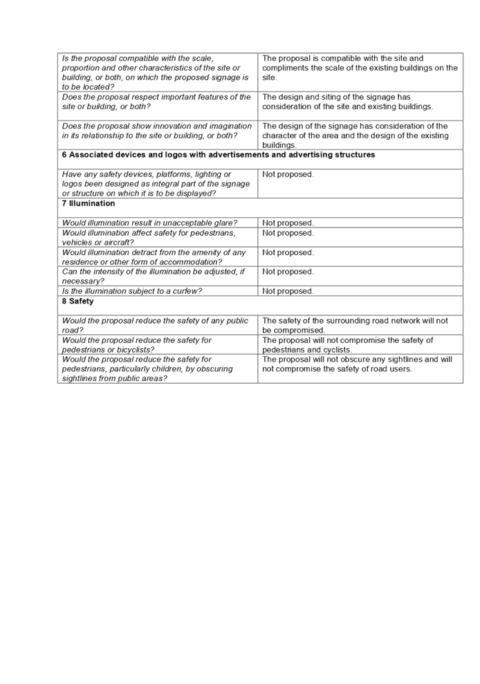
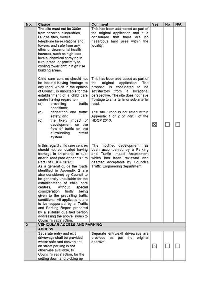
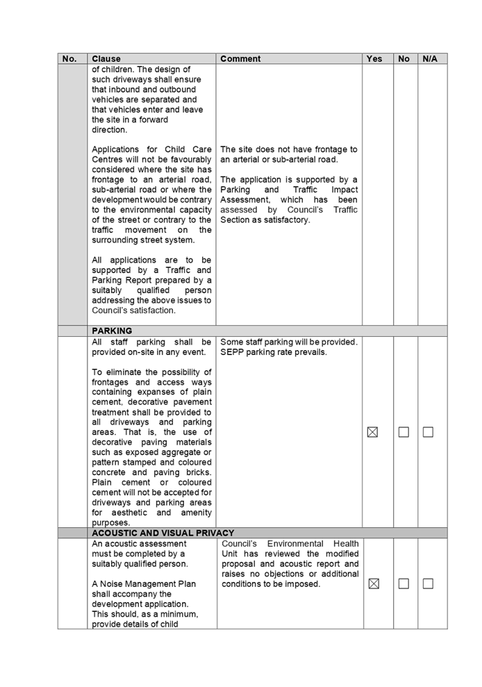
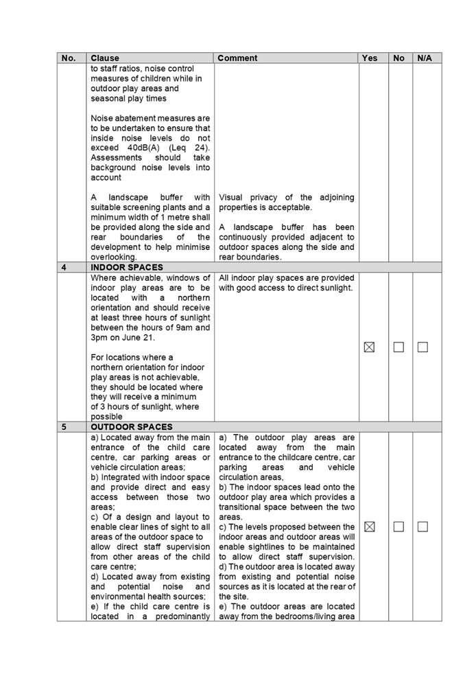
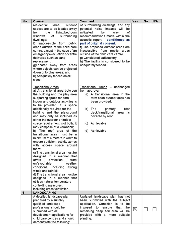
Issues
|
· Car
parking allocation;
· Basement
setback;
· Upper
level use; and
· Upper
level rear setback.
|
1. Modification
Application No. MOD2020/0332 was received on 29 September 2020 for the Section
4.55(2) application for various modifications to approved child care centre
including increasing capacity from 28 to 40 places, reconfiguration of first
floor to provide indoor play area and addition of outdoor play area,
reallocation of basement car parking spaces, front facade changes and addition
of signage.
2. The
application was publicly notified to occupants and owners of the adjoining
properties for a period of 14 days between 21 October 2020 and 4 November 2020.
In response, no submission was received.
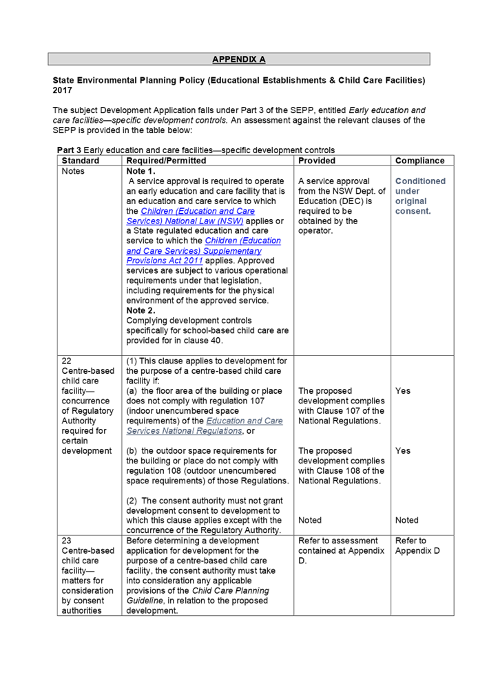
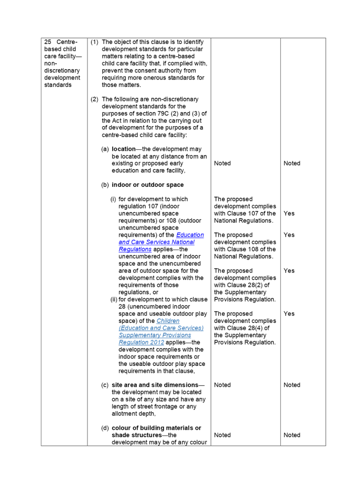
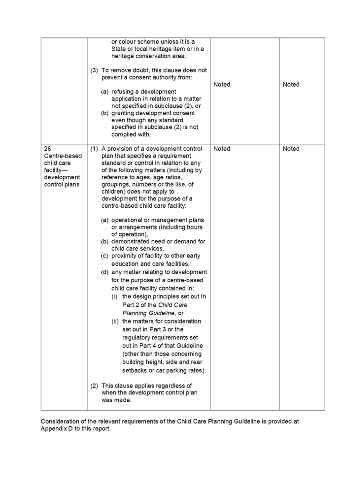
3. The
subject application has been assessed against the relevant provisions of State
Environmental Planning Policy (Educational Establishments and Child Care
Facilities) 2017, Child Care Planning Guideline (the Guideline) 2017, Holroyd
Local Environmental Plan 2013 and Holroyd Development Control Plan 2013 (HDCP).
4. The
numerical variations are as follows:
i)
|
Control
|
Required
|
Provided
|
% variation
|
|
Basement setback
|
0.9m
|
Nil
|
100%
|
|
Upper level rear setback
|
7m
|
5.2m
|
25.71%
|
5. The
application is referred to the Cumberland Local Planning Panel (CLPP) as the
modification seeks to alter a condition of approved development specifically
added by the Panel, being the size of deep soil area to accommodate mature
planting on the north-western corner of the rear yard.
6. The
application is recommended for conditional approval subject to the conditions
as provided in the attached schedule.
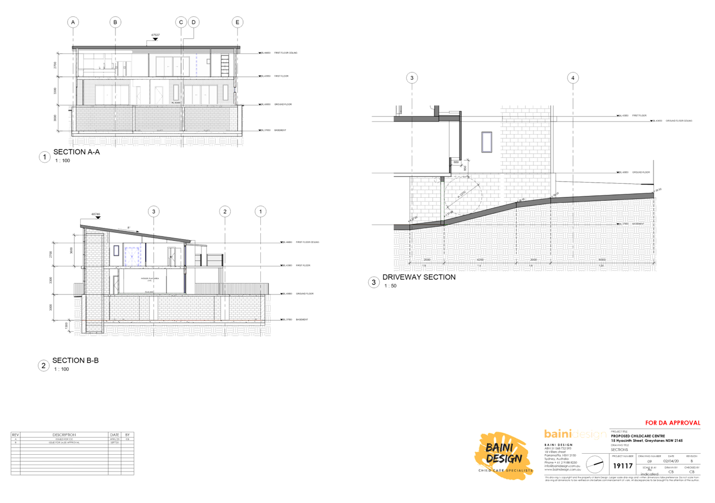
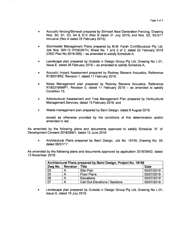
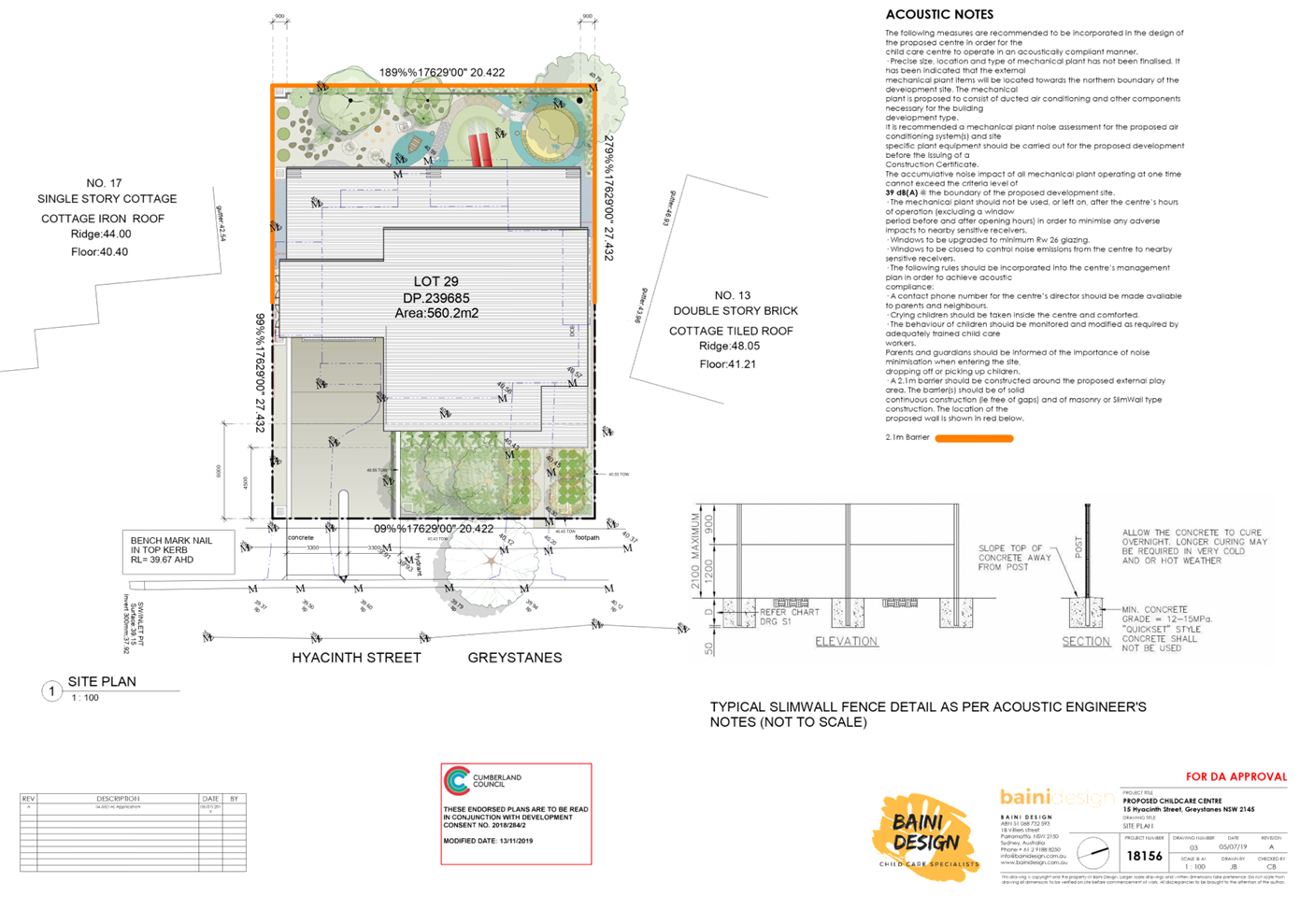
Subject Site and Surrounding
Area
The subject site is known as 15
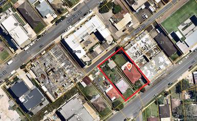
Hyacinth Street, Greystanes, and is legally described as Lot 29 in DP 239685.
The site is located on the western side of Hyacinth Street. The site is a
rectangular block with a frontage of 20.4m, depth of 27.4m and a total site
area of 560.2m². Single-storey dwelling with attached carport on the site
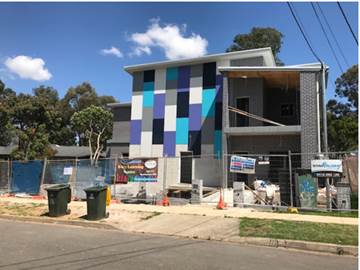
have been demolished. Construction for the child care centre is nearly
completed. Adjoining developments consist of one to two storey detached
dwelling houses with landscaped front setbacks. Widemere Public School directly
adjoins the subject site and shares its rear boundary. Nemesia Street Park is
located 100m walking distance north-east from the subject site. The subject
site and all of adjoining properties are zoned R2 Low Density Residential.
Figure
1 – Locality Plan of subject site
Figure
2 – Aerial view of subject site
Figure
3 – Street view of subject site
Description of the Proposed
Development
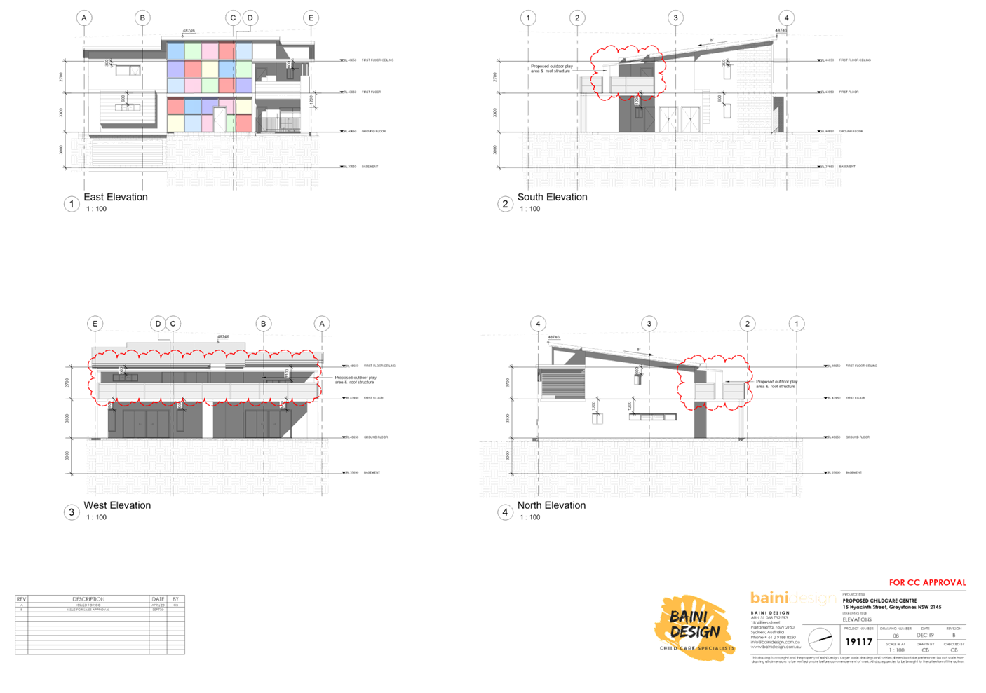
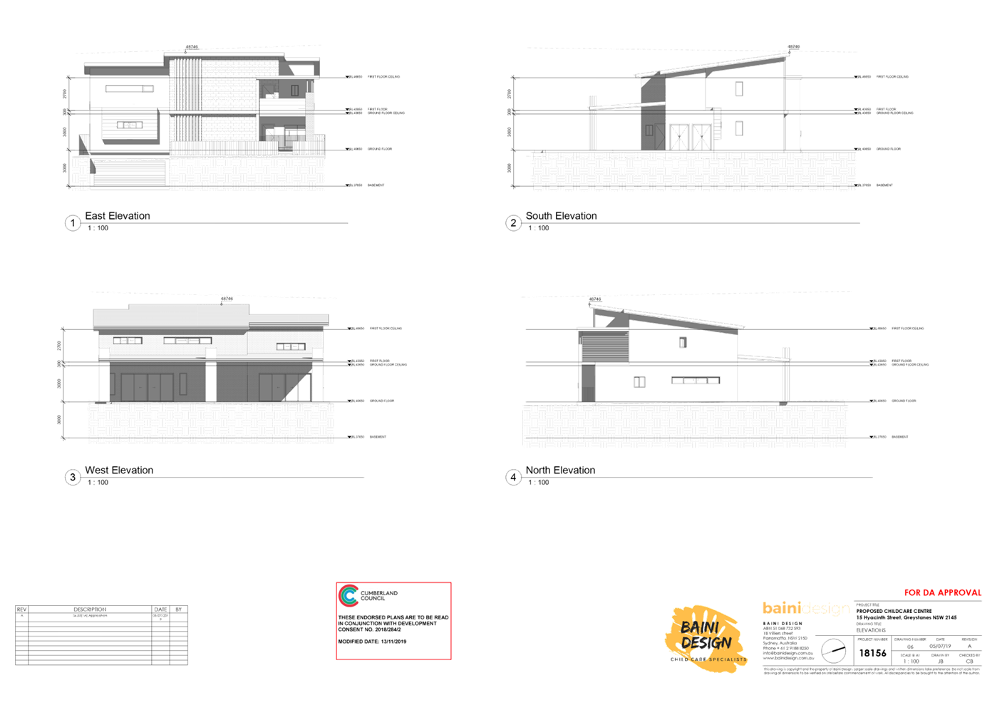
MOD2020/0332 is seeking various
modifications to an approved child care centre including increasing capacity
from 28 to 40 places, reconfiguration of first floor to provide indoor play
area and addition of outdoor play area, reallocation of basement car parking
spaces, front facade changes and addition of signage. Additional gross floor
area (GFA) of 1.7m² is proposed for the external storage on the first
floor level.
Key features of the development
proposal are as follows:-
|
Level
|
Previous Approval (DA2018/284/2)
|
Modified Proposal
|
|
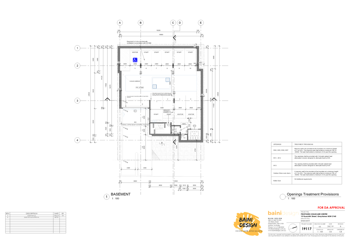
Basement Level
|
10 car parking spaces (2 staff and 8 visitor including 1
accessible)
Fire stairs, lift and bin room
Minimum side setbacks 415mm
|
Reallocation of car parking space to provide a total of 10
car parking spaces (3 visitor and 7 staff spaces including 1 accessible). The
car parking spaces allocation however is not supported by Council and the
plans need to be amended to accommodate 3 staff and 7 visitor spaces
including 1 accessible.
New columns between car parking spaces.
Works subject to this proposal have been completed. Should
approval be granted, the applicant will be required to obtain a BIC from
Council for the unauthorised works.
Minimum nil setbacks
|
|
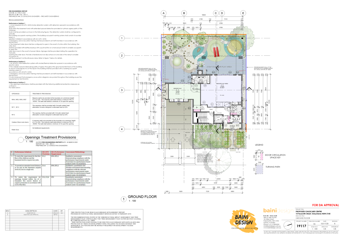
Ground Floor
|
Reception and office
2-3yr old indoor play area (10 children)
3-5yr old indoor play area (18 children)
Outdoor play area including landscaped area, external
storage, verandah and deep soil area
|
No changes.
Gradual reduction in deep soil area dimensions from:
- 5.7m (length) x 2.7m (width)
(DA2018/284/1) to,
- 5.7m (length) x 2m (width)
(M2018/284/2) to,
- 5.7m (length) x 1.1m (width)
(subject modification).
The deep soil area is required to accommodate a mature
planting as imposed by CLPP at its meeting on 16 April 2019 as a deferred commencement
condition. Planting of tree with size of 1 x 45L as indicated in condition
206A is therefore required. Refer to Council’s Tree Management Officer
comments for further details.
Works subject to this proposal have been completed. Should
approval be granted, the applicant will be required to obtain a BIC from
Council for the unauthorised works.
|
|
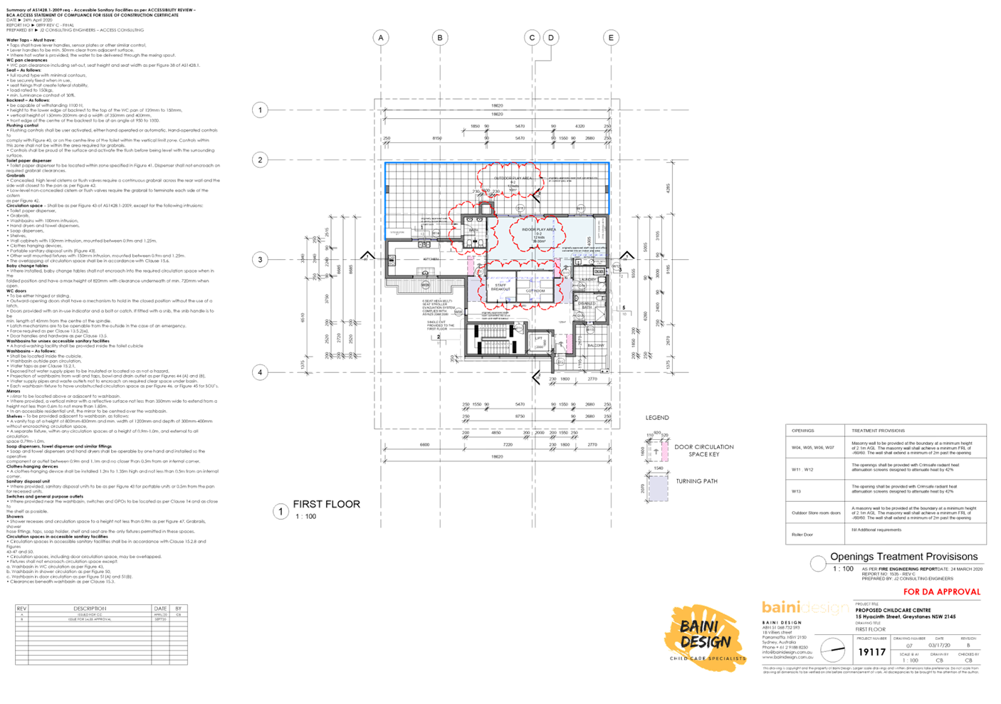
First Floor
|
Staff room, kitchen, office, laundry, front balcony and
bathroom
|
New signage with dimensions of 950mm (width) x 4m
(length).
Staff room, kitchen, laundry, front balcony, cot room,
0-2yr old indoor play area (12 children), rear facing balcony for outdoor
play area, external storage and disabled bathroom.
Works proposed have been completed. Should approval be
granted, the applicant will be required to obtain a BIC from Council for the unauthorised
works.
|
The modified child care centre
seeks to increase children placement from 28 to 40 children, as follows:
· 12
children – 0-2 yrs
· 10
children – 2-3 yrs
· 18
children – 3-5 yrs
The proposed centre will operate
from 7.00am to 6.00pm Monday to Friday and will employ minimum of 7 staff.
History
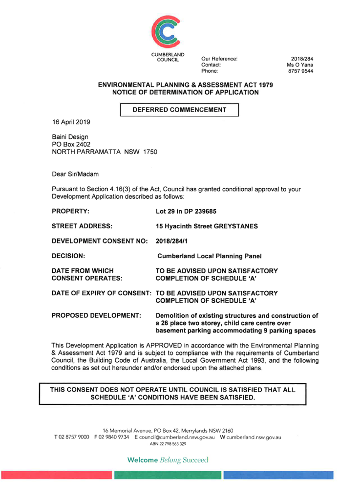
- DA2018/284/1
was approved by the CLPP on 16 April 2019 as deferred commencement consent for
the demolition of existing structures and construction of a 26 place two
storey, child care centre over basement parking accommodating 9 parking spaces.
Deep soil area with dimensions of approximately 5.7m (length) x 2.7m (width) to
be provided on the north-western corner of the rear yard to accommodate a
mature planting forms part of the deferred commencement condition.
- Operational
consent of DA2018/284/1 was issued by Council on 12 June 2019.
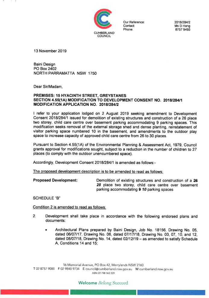
- M2018/284/2
was approved by the CLPP on 13 November 2019 as section 4.55(1A) modification
application seeking removal of the external storage shed and dense planting,
reinstatement of visitor parking space numbered 10 in the basement, and
amendments to the outdoor play space to increase the capacity of approved child
care centre from 26 to 28 places. Deep soil area with dimensions of
approximately 5.7m (length) x 2m (width) is proposed on the north-western
corner of the rear yard to accommodate a mature planting, which is subject to
condition 206A replicated as follows.
206A.
All trees installed within close proximity to the rear boundary fence line that
are 45L and greater in container size shall be appropriately maintained by a
qualified horticulturalist for a minimum period for 12 months from the date of
issue of the final Occupation Certificate, or until the respective trees reach
a height of 6m and greater, measured from the base of the tree.
- Construction
Certificate was issued on 6 February 2020 by the private certifier.
Applicants Supporting
Statement
The applicant has provided a
Statement of Environmental Effects prepared by Think Planners dated 18 September
2020 and was received by Council on 29 September 2020 in support of the
application.
Contact with Relevant
Parties
The assessing officer has
undertaken a site inspection of the subject site and surrounding properties and
has been in regular contact with the applicant throughout the assessment
process.
Internal Referrals
Development Engineer
The development application was
referred to Council’s Development Engineer for comment who has advised
that the development proposal is satisfactory in relation to the basement level
changes and car parking reallocation and therefore can be supported subject to
recommended conditions of consent.
Environment and Health
The development application was
referred to Council’s Environment and Health Officer for comment who has
advised that the development proposal is satisfactory in relation to the
acoustic impacts and therefore can be supported subject to recommended
conditions of consent.
Tree Management Officer
The development application was
referred to Council’s Tree Management Officer for comment who has advised
that the development proposal is satisfactory for further reduction to the deep
soil area width from 2m to 1.1m and therefore can be supported subject to
recommended conditions of consent, in which instead of 1 x 45L tree, 2 x 25 L
trees could be planted as replacement.
Children’s Services
The development application was
referred to Council’s Children’s Services for comment who has
advised that the development proposal is satisfactory and therefore can be
supported subject to recommended conditions of consent in complying with the
Education and Care Services National Regulations and Law requirements.
Building Surveyor
The development application was referred
to Council’s Building Surveyor for comment who has advised that should
the proposal be supported, building information certificate must be submitted
to Council for works that have been completed.
External Referrals
The application was not required to
be referred to any external government authorities for comment. Concurrence
from the NSW Department of Education for the proposed first floor level outdoor
play area for children aged 0-2 years is not required. The outdoor area is not
considered as simulated space given that the wall within the opening forms of
the perimeter has height less than 1.4m.
PLANNING COMMENTS
Section 4.55(2):
|
Requirement
|
Comments
|
|
Council is satisfied that the development to which the
consent as modified relates is substantially the same development as the
development for which the consent was originally granted and before that
consent as originally granted was modified (if at all), and
|
The development as proposed to be modified is
substantially the same as the original consent. That is, changes to the
approved built form of a two storey child care centre with additional 12
children proposed.
|
|
Council has consulted with the relevant Minister, public
authority or approval body (within the meaning of Division 5) in respect of a
condition imposed as a requirement of a concurrence to the consent or in
accordance with the general terms of an approval proposed to be granted by
the approval body and that Minister, authority or body has not, within 21
days after being consulted, objected to the modification of that consent, and
|
No Minister, public authority or other approval body was
required to be consulted regarding the proposed modification.
|
|
Council has notified the application in accordance with:
(i) the
regulations, if the regulations so require, or
(ii) a
development control plan, if the consent authority is a council that has made
a development control plan that requires the notification or advertising of
applications for modification of a development consent, and
|
See discussion on “Public Notification” in
this report.
|
|
Council has considered any submissions made concerning the
proposed modification within any period prescribed by the regulations or
provided by the development control plan, as the case may be.
|
See discussion on “Public Notification” in
this report.
|
|
Relevant matters referred to in Section 4.15(1) of the act
have been taken into consideration
|
ii)
The provisions of the applicable EPIs
are discussed elsewhere in this report.
The provisions
of the applicable DCP are discussed elsewhere in this report.
There are no planning agreements or draft planning
agreements related to this application.
There are no relevant matters referred to in the
regulations.
The likely impacts of the development as proposed to be
modified are considered satisfactory.
The site is considered to be suitable for the development
as proposed to be modified.
The Section 4.55(2) Modification was notified in
accordance with Holroyd Development Control Plan 2013. No submissions were
received.
Approval of the subject application is not contrary to
the public interest.
|
The provisions of any
Environmental Planning Instruments (EP&A Act s4.15 (1)(a)(i))
The proposed development is
affected by the following State Environmental Planning Policies:
(a) State
Environmental Planning Policy No. 55 – Remediation of Land
The requirement at Clause 7 of
SEPP 55 for the consent authority to be satisfied that the site is suitable or
can be made suitable to accommodate the proposed development was considered
under the original application. The proposed modifications do not raise any new
concerns regarding site contamination.
(b) State
Environmental Planning Policy (Educational Establishments and Child Care
Facilities) 2017
The relevant provisions of the
SEPP have been considered in the assessment of the Application. A comprehensive
assessment and compliance table is attached to this report in Appendix A which
demonstrates the development proposal’s compliance with the relevant
planning controls that are applicable to the site. The following table
indicates the play area proposed to accommodate the additional children.
|
Part 4 – Applying the
National Regulations to development proposals
|
|
4.1
Indoor space requirements
|
|
|
|
|
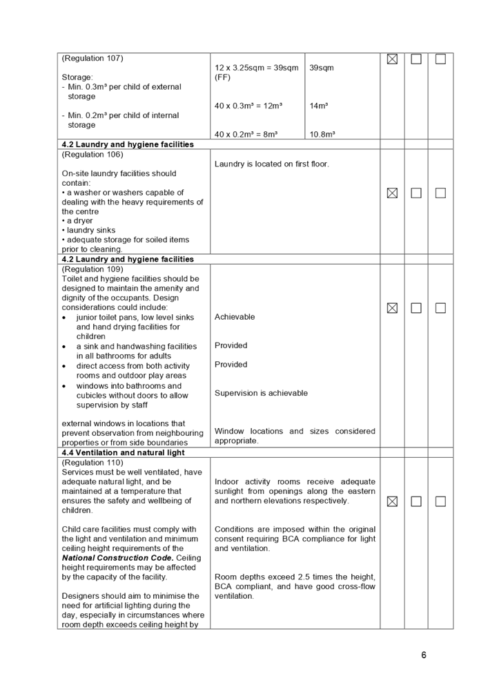
(Regulation 107)
Min. 3.25²m of unencumbered
indoor space
(Regulation 107)
|
Required:
28 x 3.25sqm = 91m² (GF)
12 x 3.25sqm = 39m² (FF)
|
Provided:
97.5m²
39m²
|
|
|
|
|
|
|
|
|
|
|
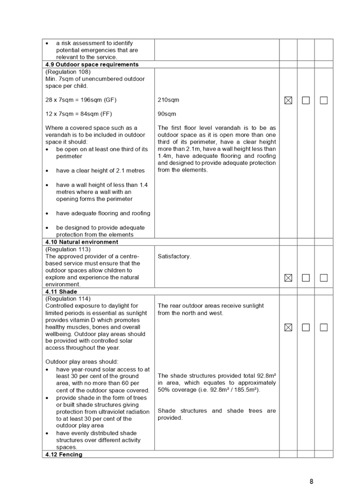
4.9 Outdoor
space requirements
|
|
|
|
|
(Regulation 108)
Min. 7sqm of unencumbered
outdoor space per child.
Where a covered space such as a verandah is to be included
in outdoor space it should:
· be
open on at least one third of its perimeter
· have
a clear height of 2.1 metres
· have
a wall height of less than 1.4 metres where a wall with an opening forms the
perimeter
· have
adequate flooring and roofing
· be
designed to provide adequate protection from the elements
|
28 x 7sqm = 196m² (GF)
12 x 7sqm = 84m² (FF)
|
210m²
90m²
The first floor level verandah
is to be as outdoor space as it is open more than one third of its perimeter,
have a clear height more than 2.1m, have a wall height less than 1.4m, have
adequate flooring and roofing and designed to provide adequate protection
from the elements.
|
|
|
|
|
|
|
|
|
|
(c) Statement
Environmental Planning Policy No 19 - Bushland in Urban Areas
The subject site does not adjoin
land zoned or reserved for public open space. The proposal does not propose to disturb
bushland zoned or reserved for public open space.
(d) State
Environmental Planning Policy (Vegetation in Non-Rural Areas) 2017
Tree removal was assessed as part
of the original application. No additional tree removal is sought as part of
this modification application. Council’s Tree Management Officer has
reviewed the proposed modification and raised no objections, subject to the
imposition of conditions.
(e) State
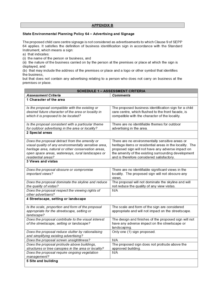
Environmental Planning Policy 64 – Advertising and Signage
The relevant provisions of the
SEPP have been considered in the assessment of the Application. A comprehensive
assessment and compliance table is attached to this report in Appendix B which
demonstrates the development proposal’s compliance with the relevant
planning controls that are applicable to the site. The proposed child care
centre signage is not considered as advertisements to which Clause 9 of SEPP 64
applies. It satisfies the definition of business identification sign in
accordance with the Standard Instrument with proposed dimensions of 950mm
(width) x 4m (length).
Regional Environmental Plans
The proposed development is
affected by the following Regional Environmental Plans:
(f) Sydney
Regional Environmental Plan (Sydney Harbour Catchment) 2005
Note: Will be superseded once
Draft SEPP Environment comes into effect.
The subject site is identified as
being located within the area affected by the Sydney Regional Environmental
Plan (Sydney Harbour Catchment) 2005. The proposed development raises no issues
as no impact on the catchment is envisaged.
(Note: - the subject site is not
identified in the relevant map as ‘land within the ‘Foreshores and
Waterways Area’ or ‘Wetland Protection zone’, is not a
‘Strategic Foreshore Site’ and does not contain any heritage items.
Hence the majority of the SREP is not directly relevant to the proposed
development).
Local Environmental Plans
(g) Holroyd
Local Environmental Plan (LEP) 2013
The proposed development is
defined as a ‘centre based child care facility’ as stipulated below
under the provisions of Holroyd Local Environmental Plan (LEP) 2013. Centre
based child care facilities are a permissible land use with consent under the
R2 – Low Density Residential zoning applying to the land under Holroyd
LEP 2013.
centre-based child care facility
means—
(a) a
building or place used for the education and care of children that provides any
one or more of the following—
(i) long day care,
(ii) occasional child care,
(iii) out-of-school-hours care (including
vacation care),
(iv) preschool care, or
(b) an
approved family day care venue (within the meaning of the Children (Education
and Care Services) National Law (NSW)),
Note:
An approved family day care venue
is a place, other than a residence, where an approved family day care service
(within the meaning of the Children (Education and Care Services) National Law
(NSW)) is provided.
but does not include—
(c) a
building or place used for home-based child care or school-based child care, or
(d) an
office of a family day care service (within the meanings of the Children
(Education and Care Services) National Law (NSW)), or
(e) a
babysitting, playgroup or child-minding service that is organised informally by
the parents of the children concerned, or
(f) a
child-minding service that is provided in connection with a recreational or
commercial facility (such as a gymnasium) to care for children while the
children’s parents are using the facility, or
(g) a service
that is concerned primarily with providing lessons or coaching in, or providing
for participation in, a cultural, recreational, religious or sporting activity,
or providing private tutoring, or
(h) a
child-minding service that is provided by or in a health services facility, but
only if the service is established, registered or licensed as part of the
institution operating in the facility.
The proposed modifications do not
result in any new non-compliances with the LEP. A comprehensive assessment and
compliance table is attached to this report in Appendix C which demonstrates
the development proposal’s compliance with the relevant planning controls
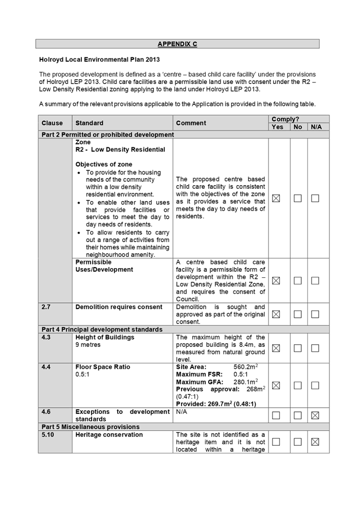
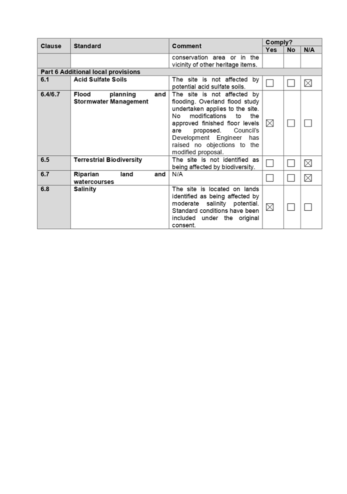
that are applicable to the site under the Holroyd LEP 2013.
The provisions of any draft Environmental
Planning Instruments (EP & A Act Section 4.15(1)(a)(ii))
(h) Draft
Cumberland Local Environmental Plan (Draft CLEP)
The Draft Cumberland Local
Environmental Plan (Draft CLEP) has been prepared by Cumberland City Council to
provide a single planning framework for the future planning of Cumberland City.
The changes proposed seek to harmonise and repeal the three existing LEPs
currently applicable to the Cumberland local government area, those being:
· Holroyd Local
Environmental Plan 2013,
· Parramatta Local
Environmental Plan 2011, and
· Auburn Local
Environmental Plan 2010.
The current planning controls for
the subject site, as contained within the Holroyd LEP 2013 are not proposed to
change under the Draft CLEP.
The provisions of any Development
Control Plans (Environmental Planning & Assessment Act Section
4.15(1)(a)(iii))
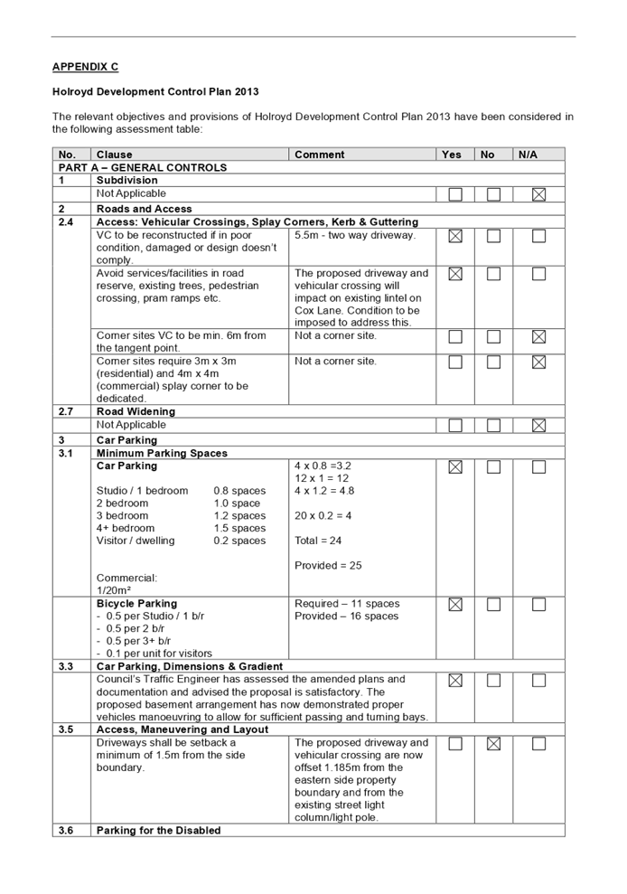
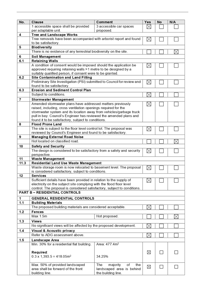
(i) Holroyd
Development Control Plan (HDCP) 2013
The Holroyd DCP 2013 provides
guidance for the design and operation of development within Holroyd to achieve
the aims and objectives of Holroyd LEP 2013.
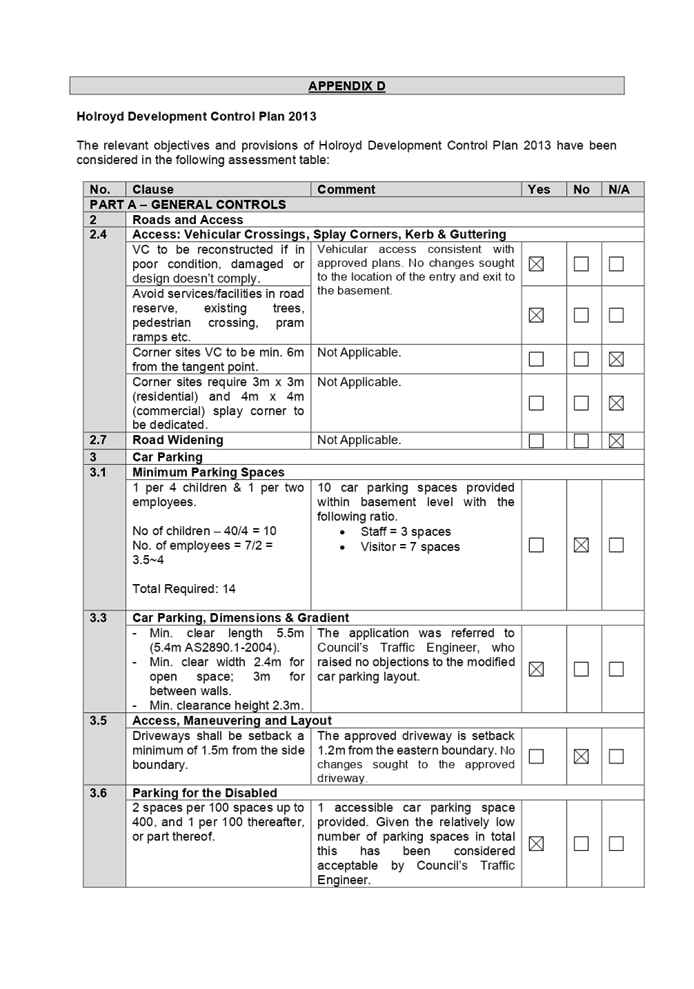
The proposed modifications will
result in new non-compliances with the relevant DCP controls as follows. Parts
A, B & I apply to the proposal. A comprehensive assessment and compliance
table is attached to this report at Appendix D.
|
Clause
|
Control
|
Proposed
|
Supported,
|
|
3.1 Minimum Parking Spaces
|
1 per 4 children & 1 per
two employees.
No of children – 40/4 =
10
No. of employees = 7/2 = 3.5~4
Total Required: 14
|
1 per 4 children in accordance with Childcare Planning
Guideline requirement
Required: 10
|
No, however, the proposal is relying on the car
parking rate as stipulated in the Childcare Planning Guideline and it
complies. The allocation between staff and visitors parking ratio need to be
amended on the plans, subject to condition, to accommodate 3 staff and 7
visitor spaces including 1 accessible, which is considered satisfactory and
supported by Council’s Development Engineer.
|
|
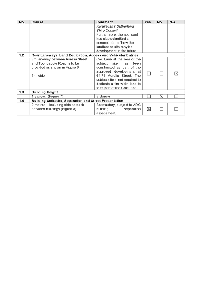
2.3 Setbacks (Part B)
|
Basement: 900mm to side boundary
Upper level: 7m to rear boundary
|
Basement: nil setbacks
Upper level: 5.2m
|
Yes, the expansion of basement footprint is required to
allow for the provision of columns required for the construction of the child
care centre. The impact of the proposed footprint is negligible to the
landscaped area on the ground floor level. Further to that the subject site
adjoins to the school’s yard at the rear. Non-compliance with the rear
setback requirement will not impact the amenity of the school. Non compliances
with the setback requirements are supported in this instance.
|
|
1 Size & Density (Part I)
|
Only office and storage space
permitted on the upper level.
|
Additional indoor and outdoor playroom proposed for
children aged 0 – 2 years old on the first floor.
|
Yes, the intent of the control to limit use of play area
on the ground floor and to ensure that during evacuation process, the
mobility of the children will be maintained. The proposal has been
accompanied with details of how the evacuation could be carried out for the 0
– 2 years old children with the multi seats child carrier stroller,
which is considered acceptable in case the lift is not useable during
emergency events. Acoustic report submitted states that the child care centre
operation can comply with the noise requirements for the proposed additional
outdoor play area on the upper level by managing the play time and
installation of acoustic barriers. Council’s Environment and Health
Officer has reviewed the acoustic report and found that the proposal is
satisfactory, subject to conditions.
|
The provisions of any planning
agreement that has been entered into under section 7.4, or any draft planning
agreement that a developer has offered to enter into under section 7.4
(EP&A Act s4.15(1)(a)(iiia))
There is no draft planning
agreement associated with the subject Development Application.
The provisions of the
Regulations (EP&A Act s4.15 (1)(a)(iv))
The proposed development raises no
concerns as to the relevant matters arising from the Environmental Planning and
Assessment Regulations 2000 (EP&A Reg).
The Likely Environmental,
Social or Economic Impacts (EP&A Act s4.15 (1)(b))
It is considered that the proposed
development will have no significant adverse environmental, social or economic
impacts in the locality.
The suitability of the site for
the development (EP&A Act s4.15 (1)(c))
The subject site and locality is
not known to be affected by any natural hazards or other site constraints
likely to have a significant adverse impact on the proposed development. Accordingly,
it is considered that the development is suitable in the context of the site
and surrounding locality.
Submissions made in accordance
with the Act or Regulation (EP&A Act s4.15 (1)(d))
|
Advertised (newspaper)
|
Mail
|
Sign
|
Not Required
|
In accordance with Council’s
Notification requirements contained within the Holroyd DCP 2013, the proposal
was publicly notified for a period of 14 days between 21 October 2020 and 4
November 2020. No submissions were received in respect of the proposed
development.
The public interest (EP&A
Act s4.15(1)(e))
In view of the foregoing analysis
it is considered that the development, if carried out subject to the conditions
set out in the recommendation below, will have no significant adverse impacts
on the public interest.
Section 7.11 (Formerly S94)
Contribution Towards Provision or Improvement of Amenities or Services
This part of the Act relates to
the collection of monetary contributions from applicants for use in developing
key local infrastructure. The development does not require the payment of
additional contributions in accordance with Holroyd Section 94 Contributions
Plan 2013.
Disclosure of Political
Donations and Gifts
The applicant and notification
process did not result in any disclosure of Political Donations and Gifts.
The Application has been assessed
in accordance with the relevant requirements of the Environmental Planning and
Assessment Act 1979, State Environmental Planning Policy No. 55 –
Remediation of Land, State Environmental Planning Policy (Educational
Establishments and Child Care Facilities) 2017, Education and Care Services
National Regulations, Holroyd Local Environmental Plan 2013 and the Holroyd
Development Control Plan 2013 and is considered to be satisfactory for addition
12 children and internal modification to the approved built form.
The proposal is generally
consistent with all statutory and non-statutory controls applying to the
development. Minor non-compliances with Council’s controls have been
discussed in the body of this report. The development is considered to perform
adequately in terms of its relationship to its surrounding built and natural
environment, particularly having regard to impacts on adjoining properties.
For these reasons, it is
considered that the proposal is satisfactory having regard to the matters of
consideration under Section 4.15 and 4.55 of the Environmental Planning and
Assessment Act 1979, and the modified development may be approved subject to
conditions.
|
That Modification Application
No. MOD2020/0332 for Section 4.55(2) application for various modifications to
approved child care centre including increasing capacity from 28 to 40
places, reconfiguration of first floor to provide indoor play area and
addition of outdoor play area, reallocation of basement car parking spaces,
front facade changes and addition of signage on land at 15 Hyacinth Street
GREYSTANES NSW 2145 be approved subject to attached conditions.
|
1. Draft
Notice of Determination
2. Architectural
Plans
3. Previous
Consent
4. Previous
Approved Plans
5. Previous
Cumberland Local Planning Panel Minutes
6. Appendix
A - State Environmental Planning Policy (Educational Establishments & Child
Care Facilities) 2017
7. Appendix
B - State Environmental Planning Policy 64 – Advertising and Signage
8. Appendix
C - Holroyd Local Environmental Plan 2013
9. Appendix
D - Holroyd Development Control Plan 2013
10. Appendix
E - Child Care Planning Guideline 2017
Cumberland
Local Planning Panel Meeting
10 February 2021
Item No: LPP002/21
Development
Application for 27-29 Toongabbie Road, Toongabbie
Responsible
Division: Environment
& Planning
Officer: Executive
Manager Development and Building
File
Number: REV2020/0006
|
Application
lodged
|
25 September 2020
|
|
Applicant
|
Dawn Enterprise Pty Ltd
|
|
Owner
|
Mr P Kumar & Mrs P Guglani
|
|
Application
No.
|
REV2020/0006
|
|
Description
of Land
|
27-29 Toongabbie Road,
Toongabbie NSW 2146, Lots 40 & 41 Section B DP 10697
|
|
Proposed
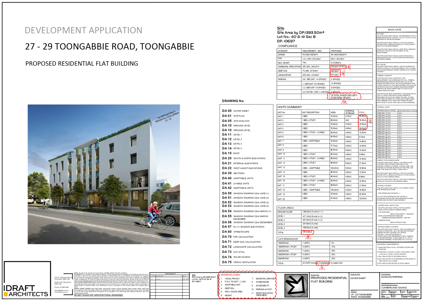
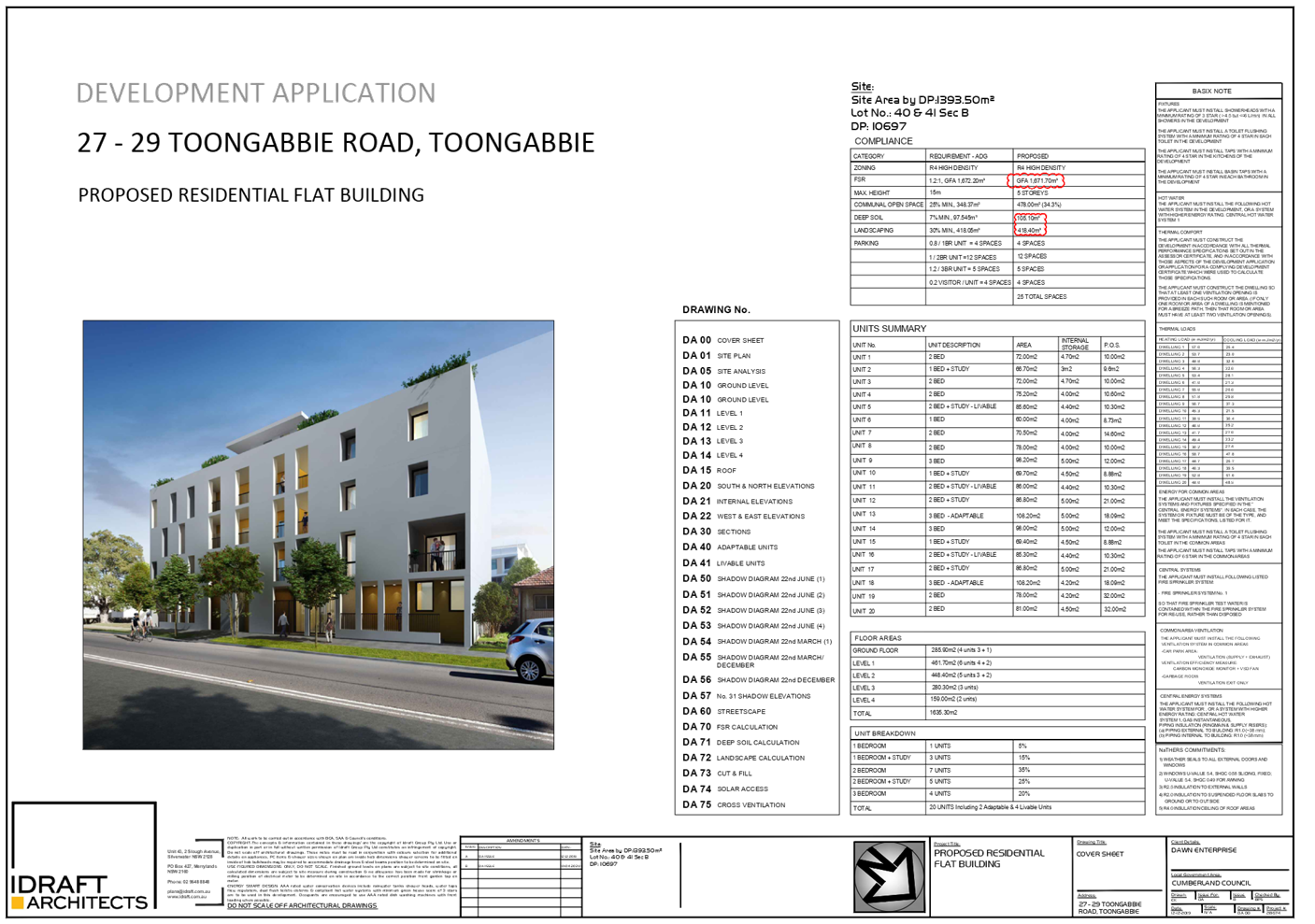
Development
|
Section 8.3 Review of the
Cumberland Local Planning Panel’s determination for the demolition of
existing structures, consolidation of 2 lots into 1 lot, and construction of
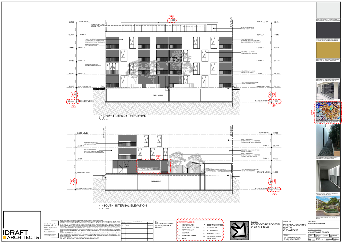
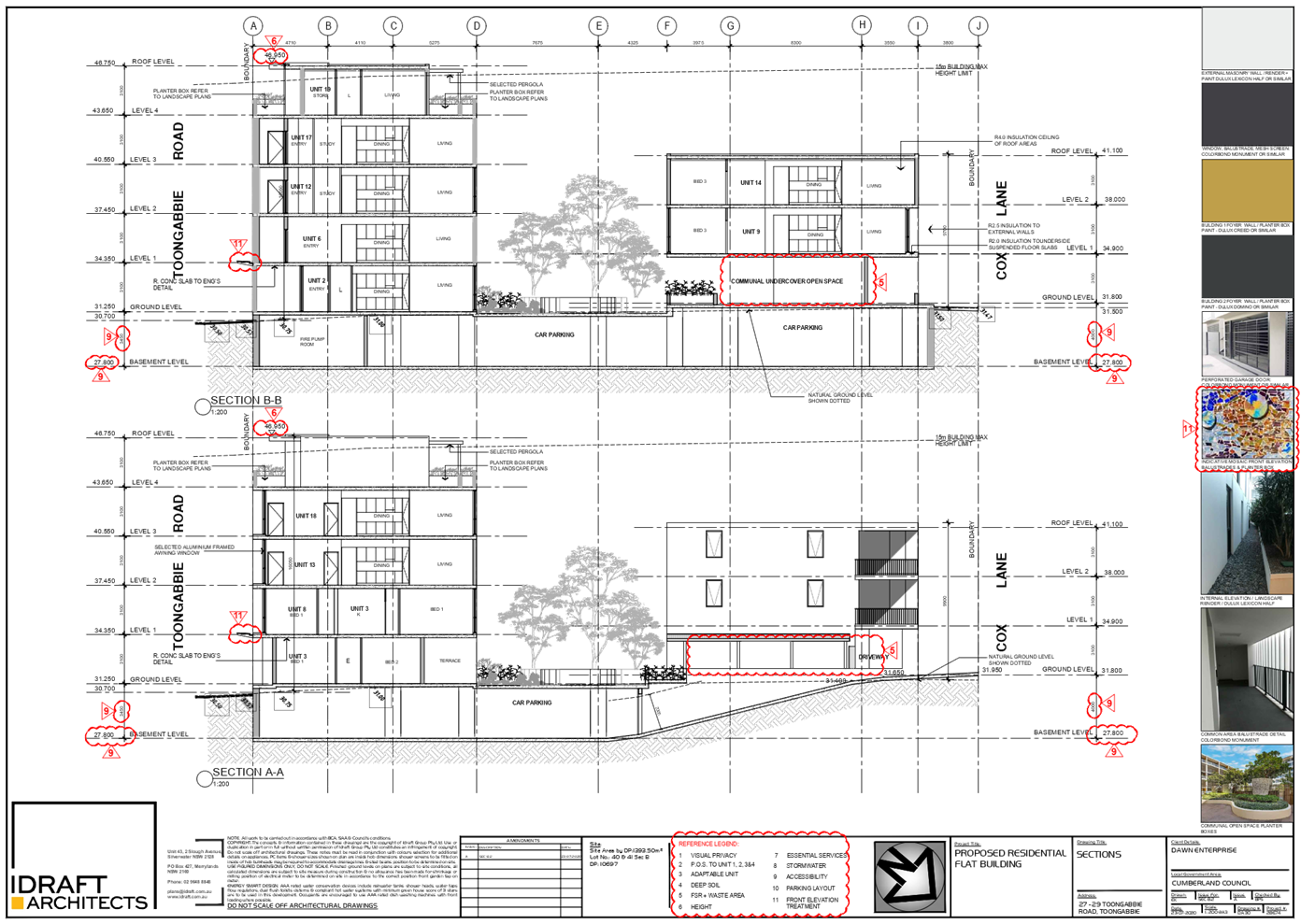
a residential flat building including a 3 storey building facing Cox Lane and
a 5 storey building facing Toongabbie Road over basement parking
accommodating 20 residential units and 25 parking spaces
|
|
Site
Area
|
1393.5m2
|
|
Zoning
|
R4 High Density Zone (HLEP
2013)
|
|
Disclosure
of political donations and gifts
|
Nil disclosure
|
|
Heritage
|
No
|
|
Principal
Development Standards
|
FSR
Permissible: 1.2:1
Proposed: 1.2:1
|
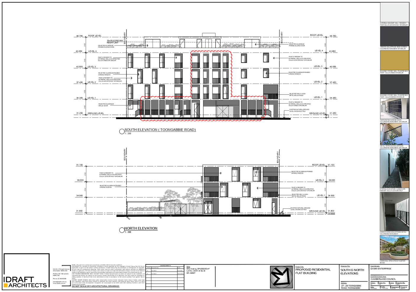
Height of Building
Permissible: 15m
Proposed: 16.13m
|
|
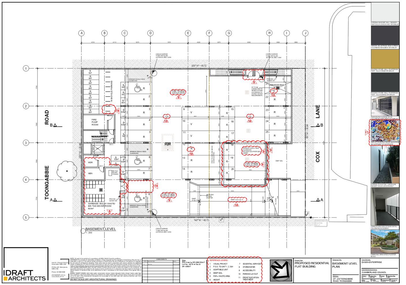
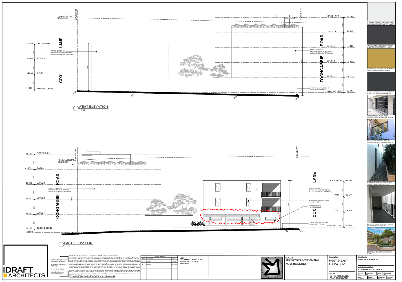
Issues
|
- Building height
- Deep soil
- Driveway setbacks
- Site Coverage
- Site Isolation
- Submission
|
1. Section
8.3 Review Application No. REV2020/0006 was received on 25 September 2020 for
the Section 8.3 Review of the Cumberland Local Planning Panel’s
determination for the demolition of existing structures, consolidation of 2
lots into 1 lot, and construction of a residential flat building including a 3
storey building facing Cox Lane and a 5 storey building facing Toongabbie Road
over basement parking accommodating 20 residential units and 25 parking spaces.
2. The
application was publicly notified to occupants and owners of the adjoining
properties for a period of 14 days between 14 October 2020 and 28 October 2020.
In response, Council received 1 submission.
3. The
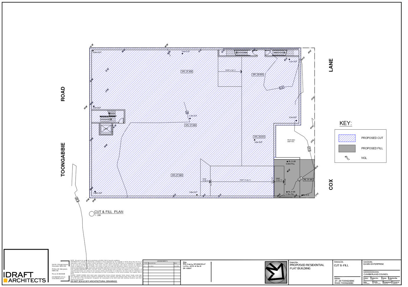
application involves the following numerical non-compliances as discussed in
detail elsewhere in the report:
|
Control
|
Required
|
Proposed
|
% Variation
|
|
Building height (LEP)
|
15m
|
16.13m for the 5 storey
building facing Toongabbie Road
|
7.53%
|
|
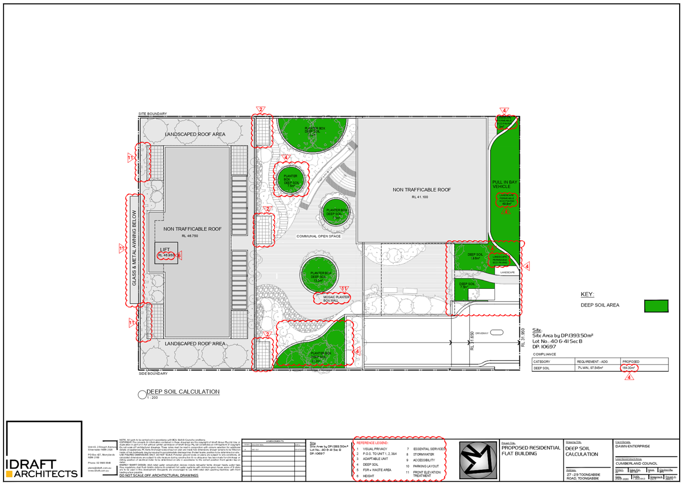
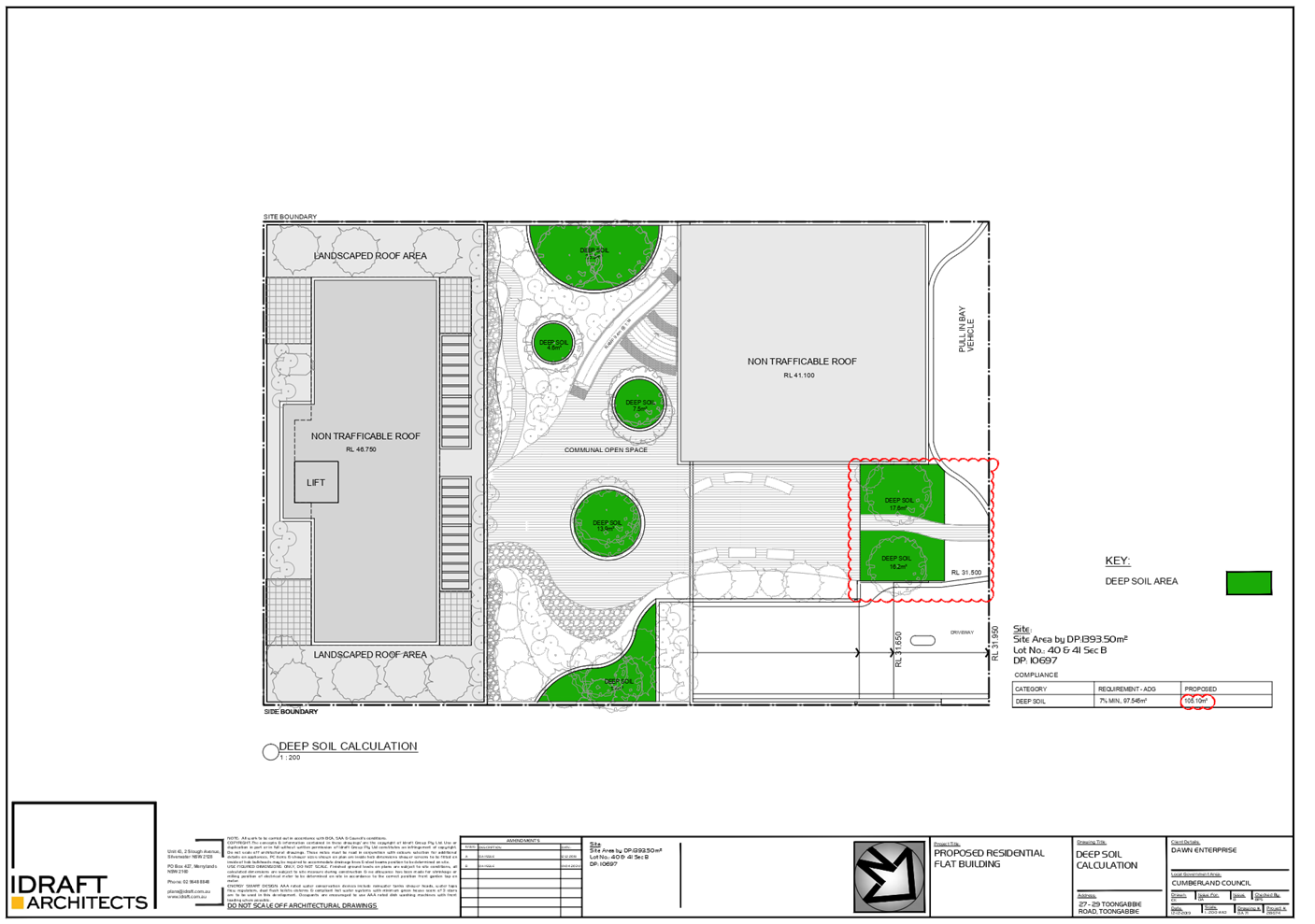
Deep soil (ADG)
Site area:
1,393.5m²
|
7% (97.5m²)
|
Area = 79.9m²
5.7%
|
18%
|
|
Number of storeys (DCP)
|
4
|
5
|
25%
|
|
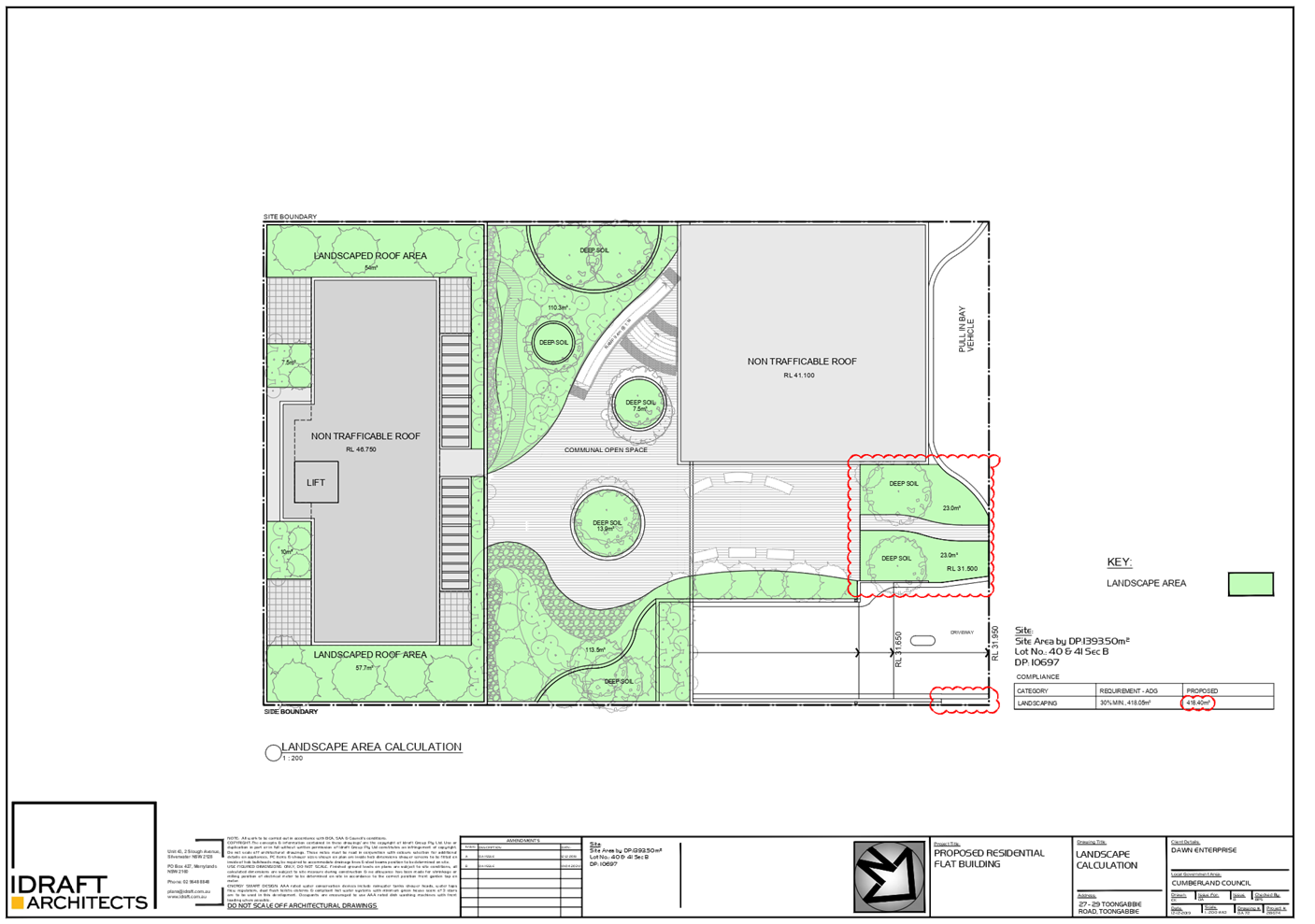
Site coverage (DCP)
Site area:
1,393.5m²
|
Max
30% (418.05m²)
|
Area = 560m²
40.18%
|
33.95%
|
|
Driveway setback (DCP)
|
1.5m
|
1.185m
|
21%
|
4. The
application is referred to the Panel as the proposal is a development with 4 or
more storeys to which the State Environmental Planning Policy No. 65 –
Design Quality of Residential Apartment Developments applies.
5. The
application is recommended for approval subject to the conditions as provided
in Attachment 1.
Subject Site and Surrounding
Area
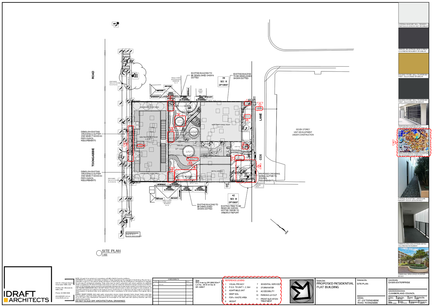
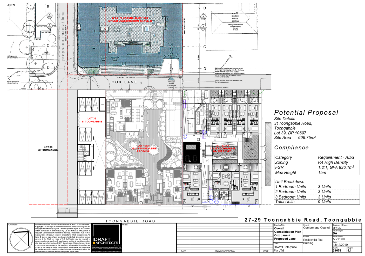
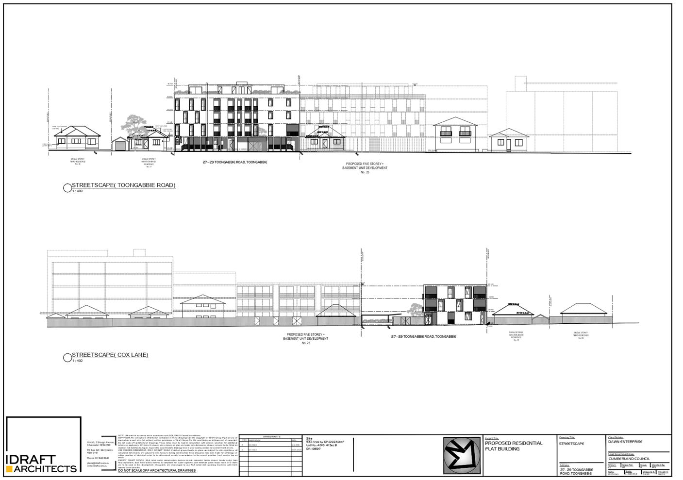
The subject site is known as 27-29
Toongabbie Road, Toongabbie and is legally described as Lots 40 and 41 Section
B in DP 10697. The total site area is 1,393.5m2 with frontage of 30.48m on
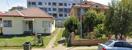
Toongabbie Road. Improvements on site consist of a single storey and a two
storey dwelling with associated outbuildings located on each of the existing
sites. There are existing trees located on the subject site and within the
Council’s street verge. The site falls towards Toongabbie Road by
approximately 1m from the north to south.
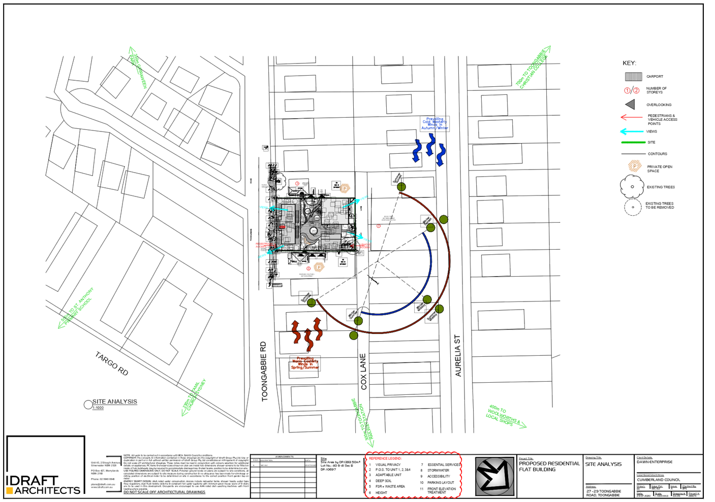
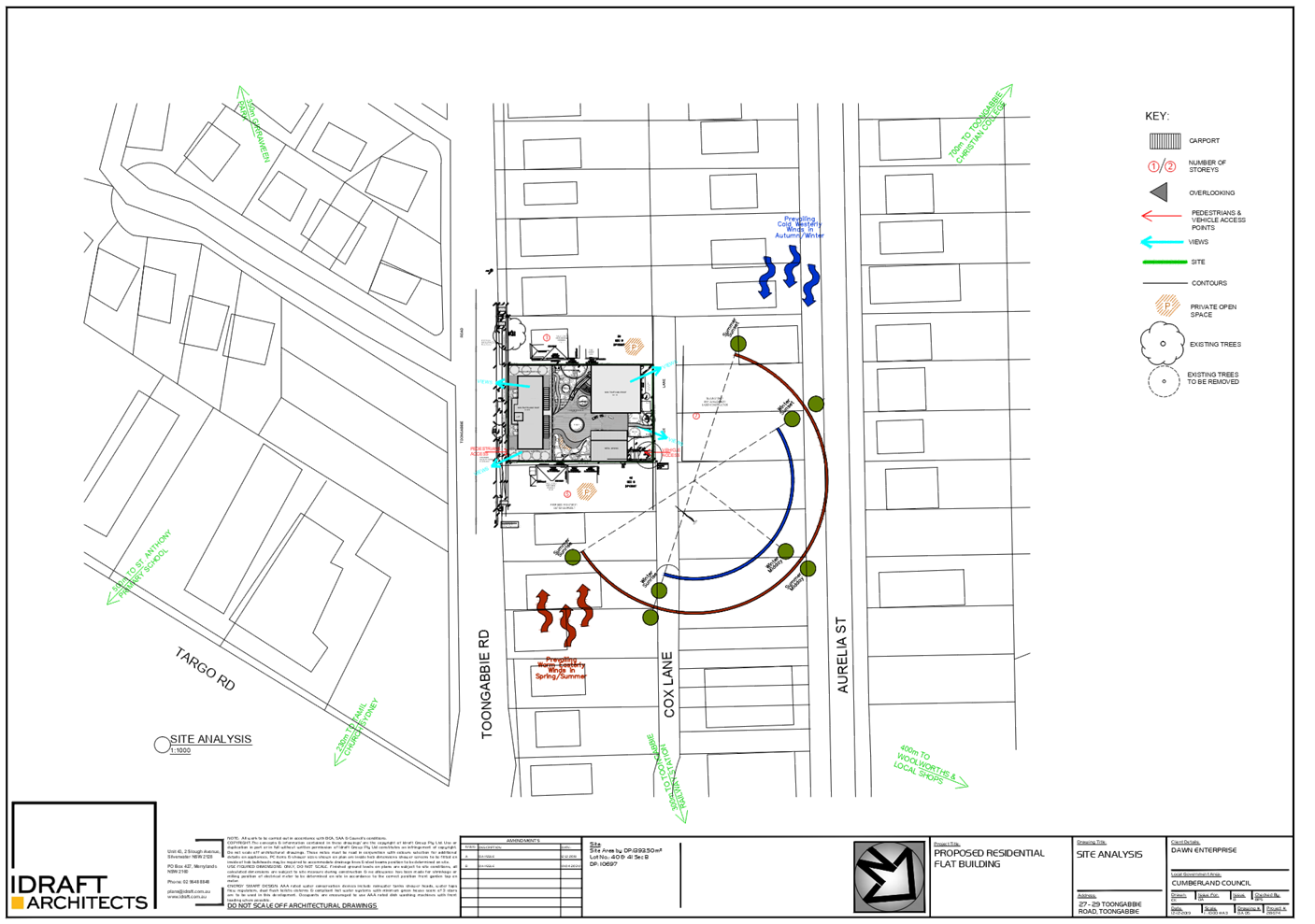
The subject site is located within
the R4 – High Density Residential zone and borders the B2 – Local
Centre zone to the north. It is located approximately within 300m walking
distance to Toongabbie Railway Station and the town centre. Vehicular access to
the site is designated from Cox Lane to the north. The construction of Cox Lane
servicing the property at 64-72 Aurelia Street, which was approved for mixed
use development (DA2016/57), has been completed. Existing developments
adjoining the site include single storey dwelling houses located to the western
side (31 and 33 Toongabbie Road). Residential flat building development, which
has been approved under DA2016/75 to eastern side at 23-25 Toongabbie Road, is
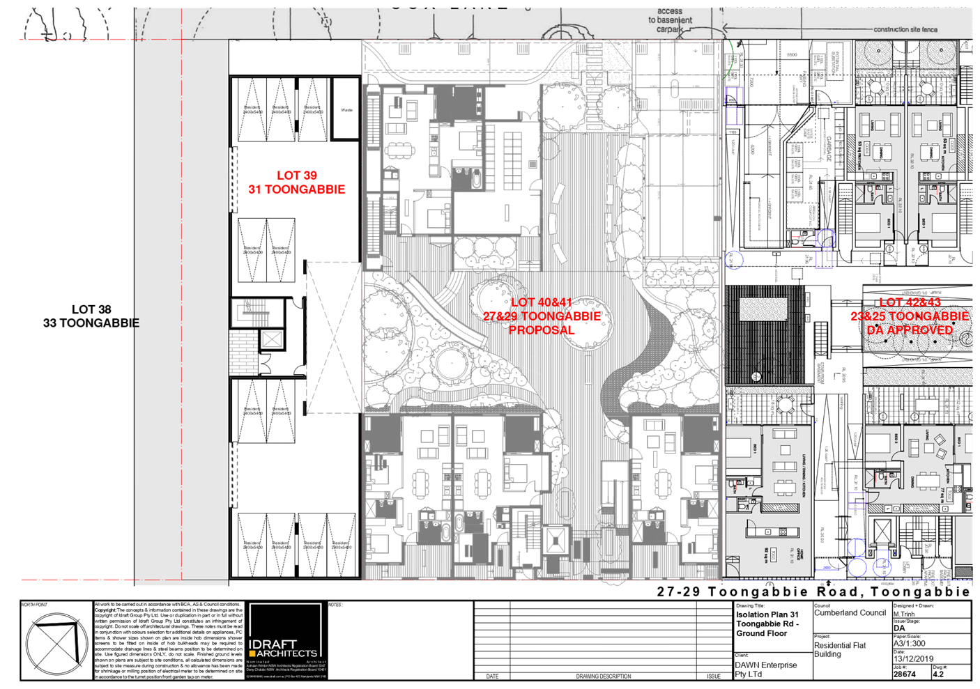
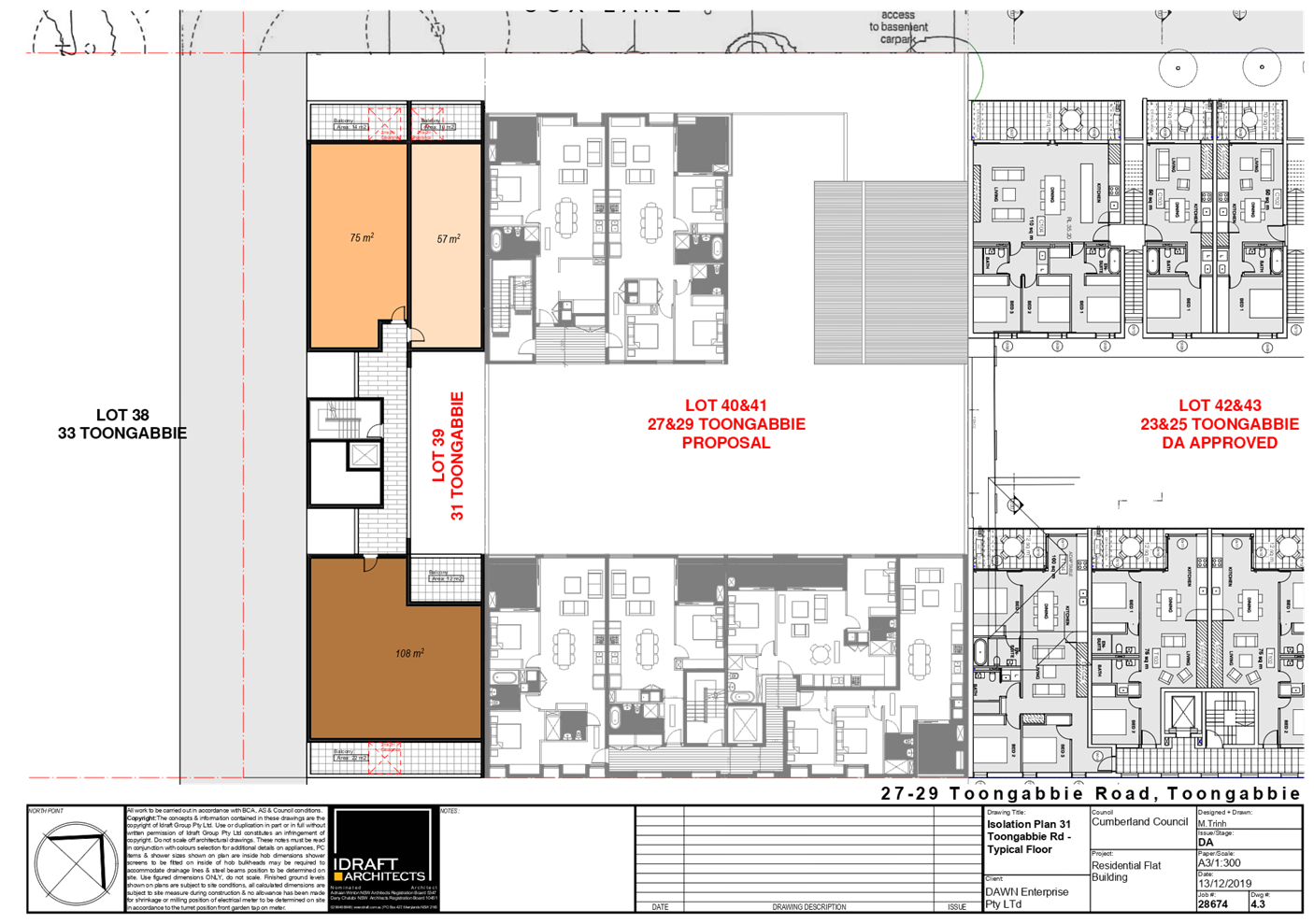
currently under construction. Existing lot at 31 Toongabbie Road will be
landlocked as a result of this subject application and it is also burdened by the
land dedication to form part of Cox Lane (refer to Figure 4). Existing lot at
33 Toongabbie Road was landlocked by the approved residential flat building
development at 35-43 Toongabbie Road, which was approved under DA2015/9. With
the exception of the laneway access to Toongabbie Road to be situated between
31 and 33 Toongabbie Road, the construction of Cox Lane has been completed at
the rear of the subject site with access to Aurelia Street. Any future
development of the properties at 31 and 33 Toongabbie Road must take into
consideration the proposed location of Cox Lane within both sites.
Toongabbie Road is presently
undergoing transformation by replacing the older stock of residential dwellings
with multi dwelling development and residential flat buildings. The site does
not contain any heritage items and is not within a heritage conservation area.
There are no heritage items located within the visual catchment of the subject
site.
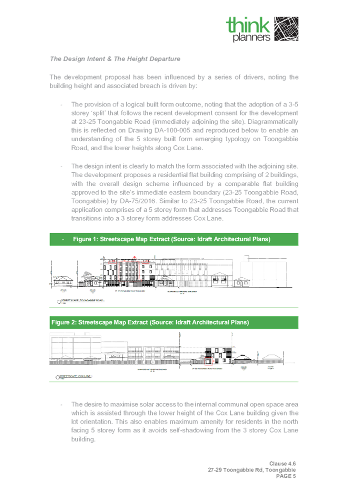
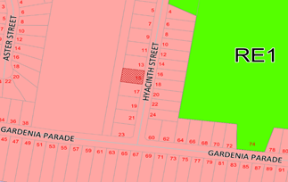
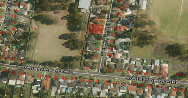
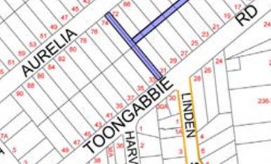
Figure
1 – Aerial view of subject site
Figure
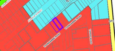
2 – Zoning map
Figure
3 – Street view of subject site
Figure
4 – Location of Cox Lane (marked in blue)
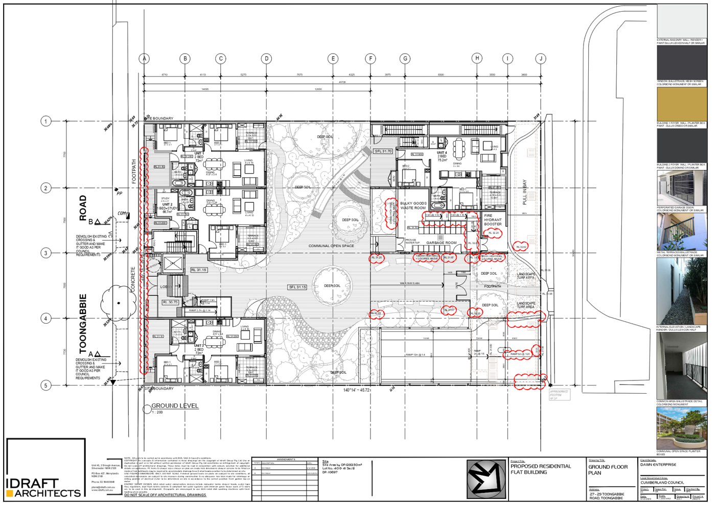
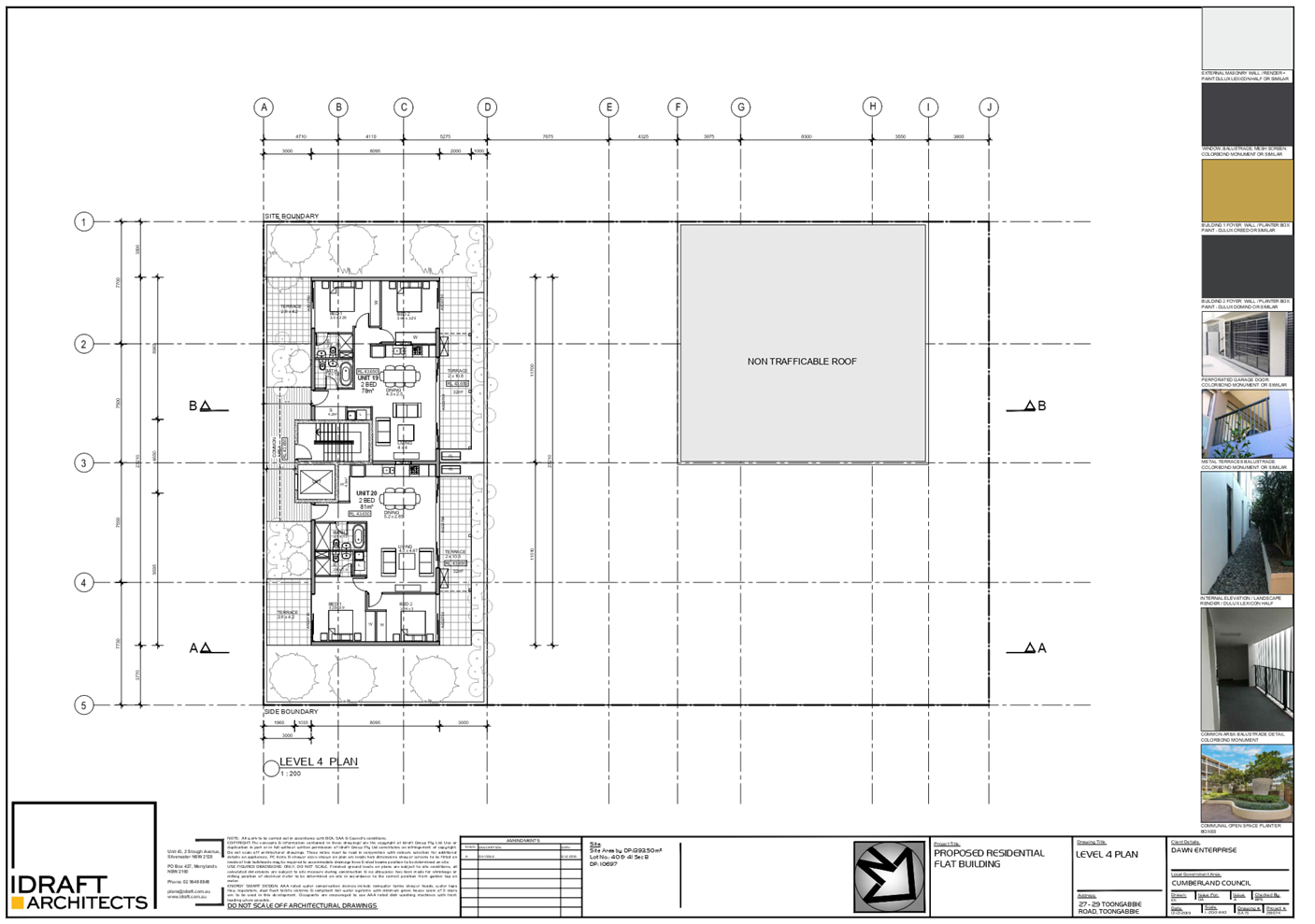
Description of the Proposed
Development
Council is in receipt of a Section
8.3 Review Application on 25 September 2020 seeking a review of the
CLPP’s determination of refusal for the demolition of existing
structures, consolidation of 2 lots into 1 lot, and construction of a
residential flat building including a 3 storey building facing Cox Lane and a 5
storey building facing Toongabbie Road over basement parking accommodating 20
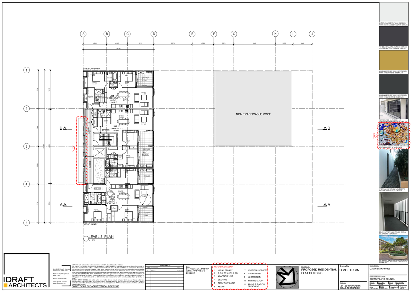
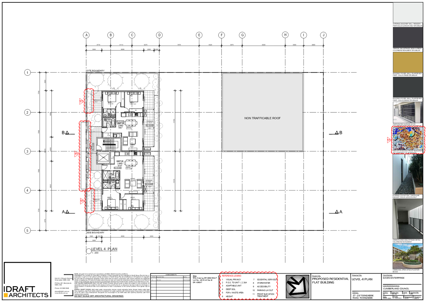
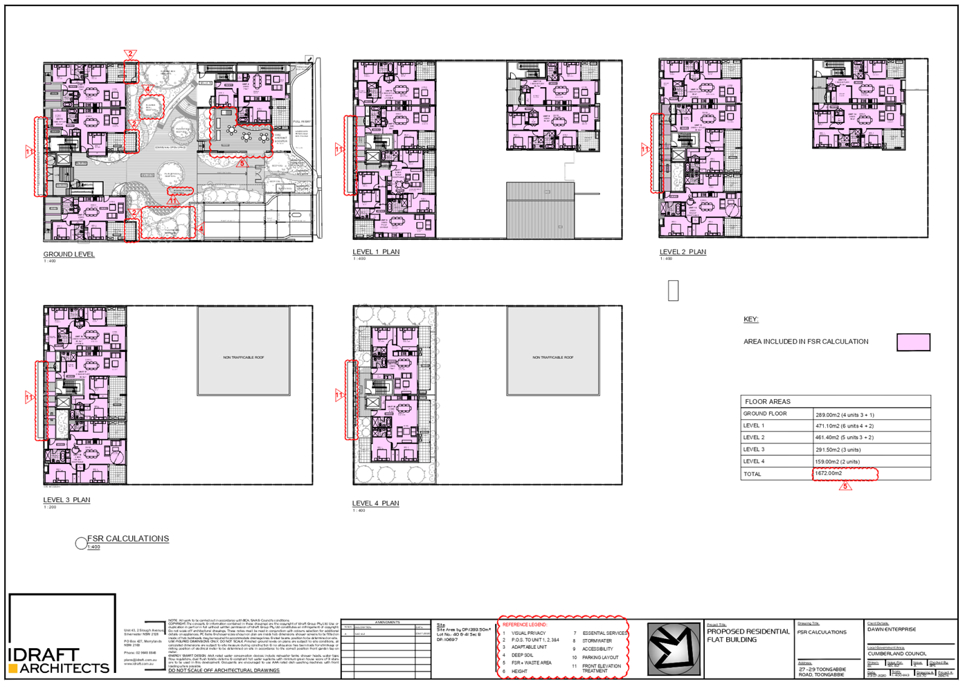
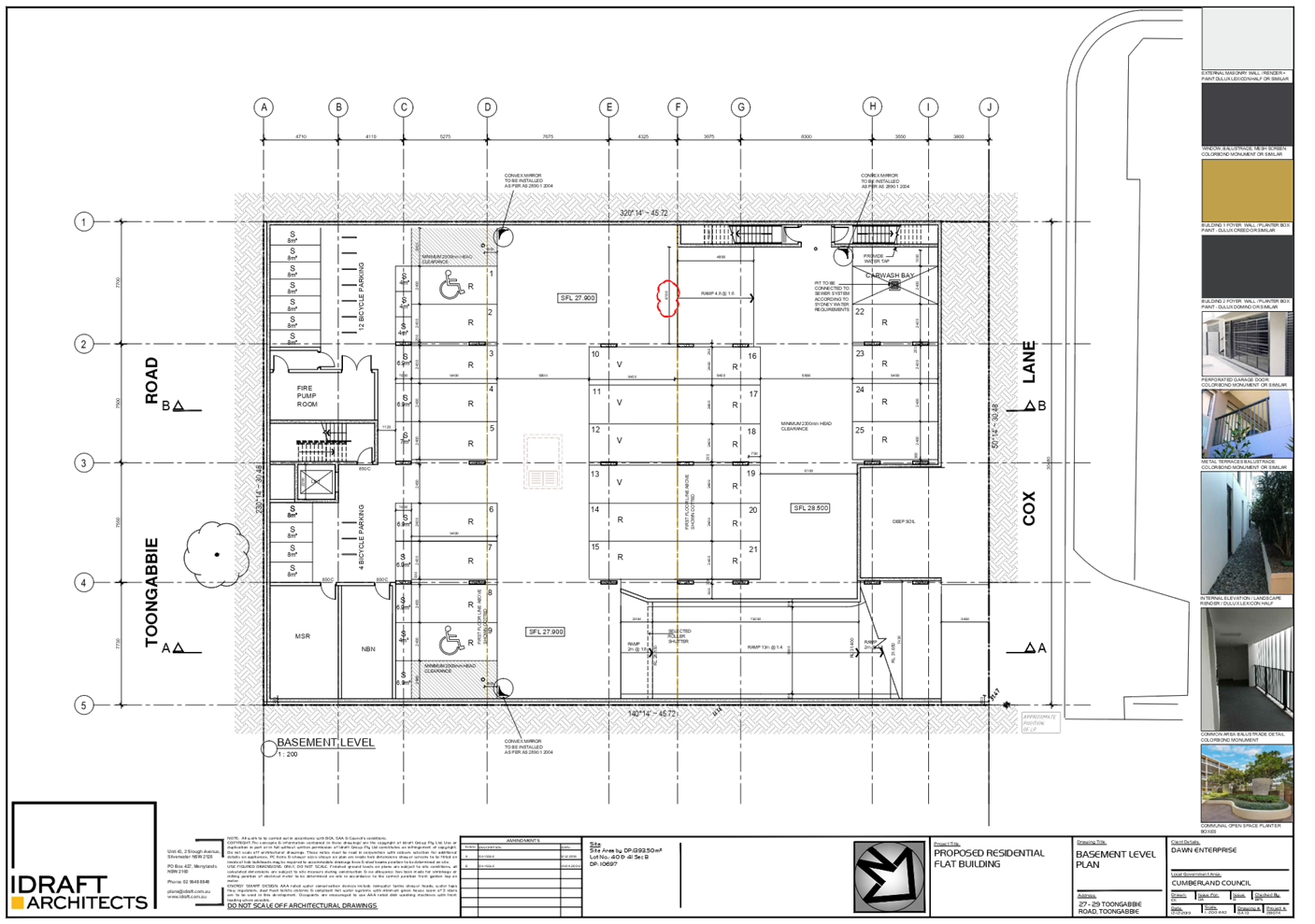
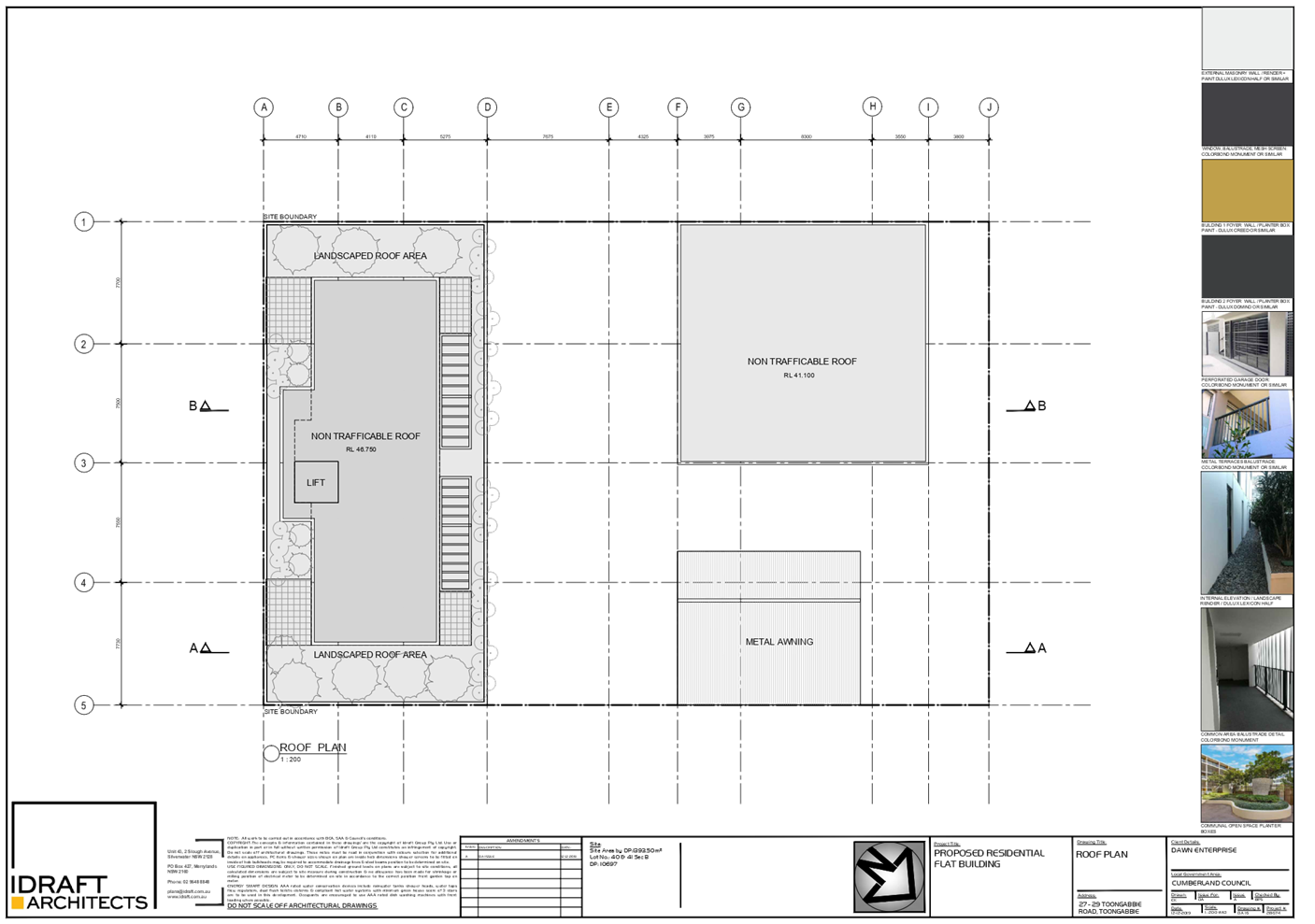
residential units and 25 parking spaces.
Specific works of the proposed
development include:
· Demolish
existing single storey and two storey dwelling houses and ancillary structures
including a detached fibro garage along the northern rear boundary.
· Removal
of two (2) trees along the northern rear boundary.
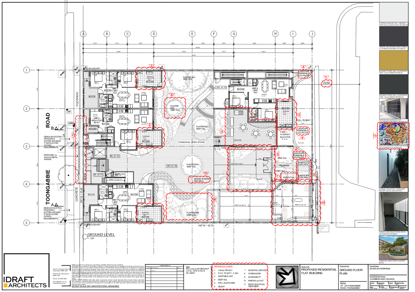
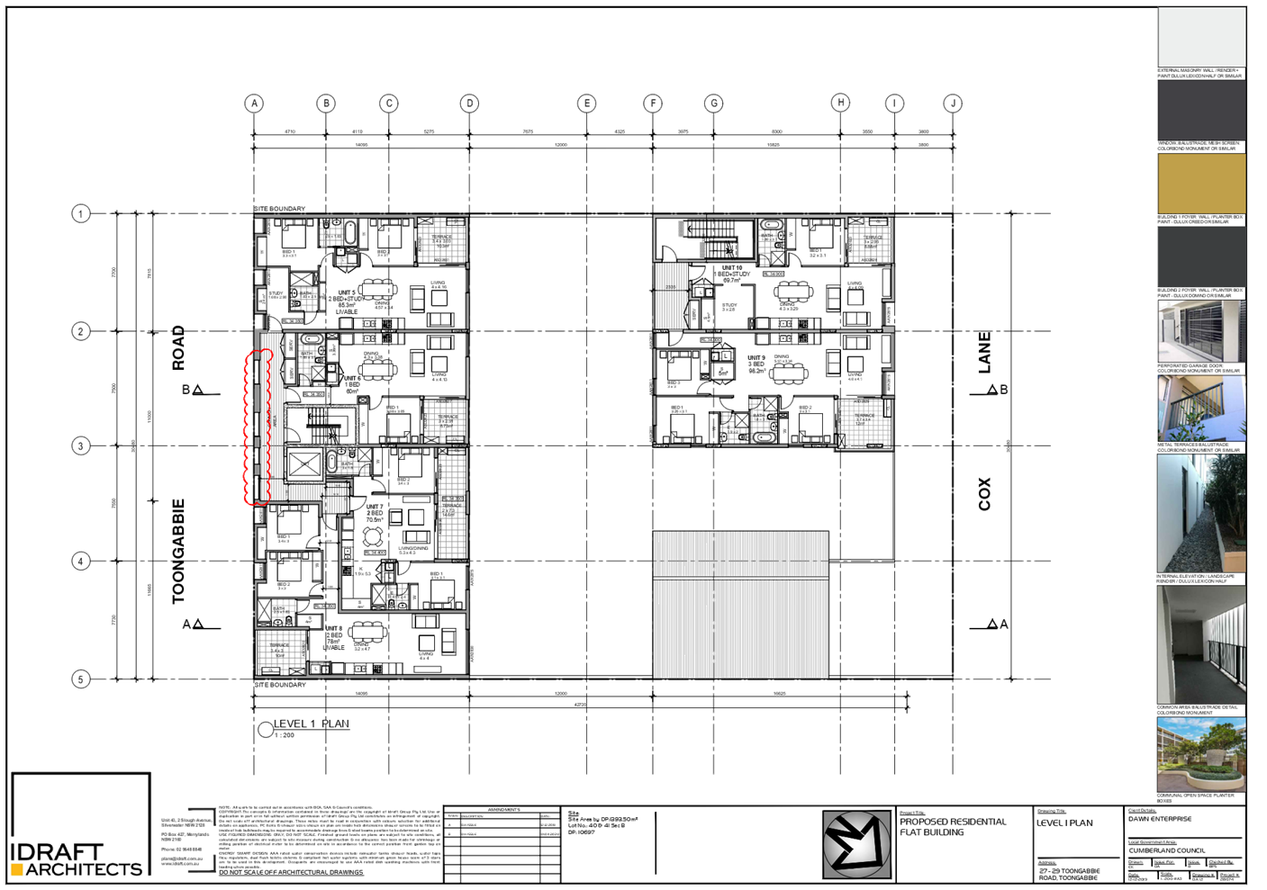
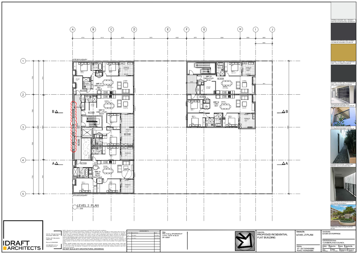
· Construct
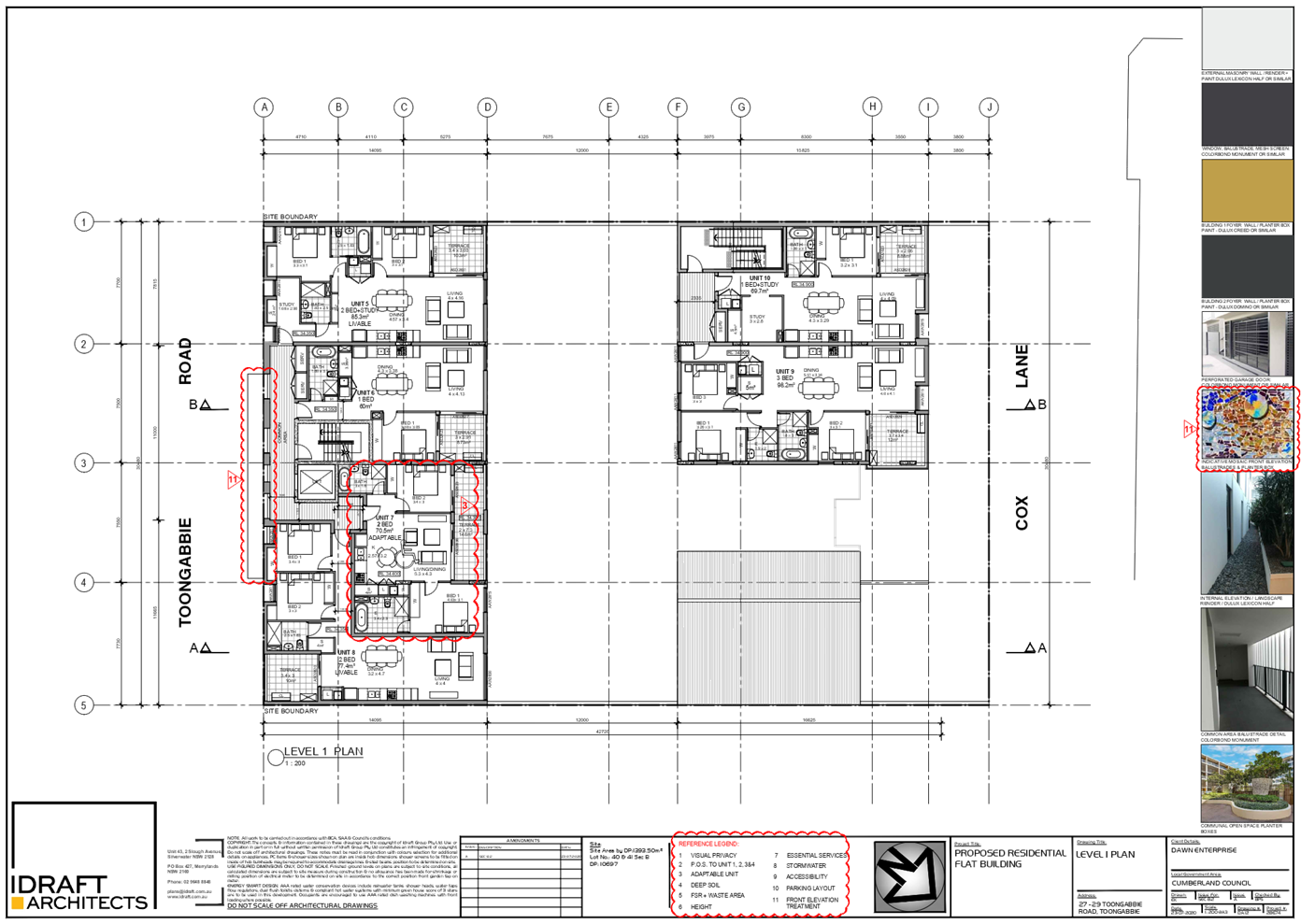
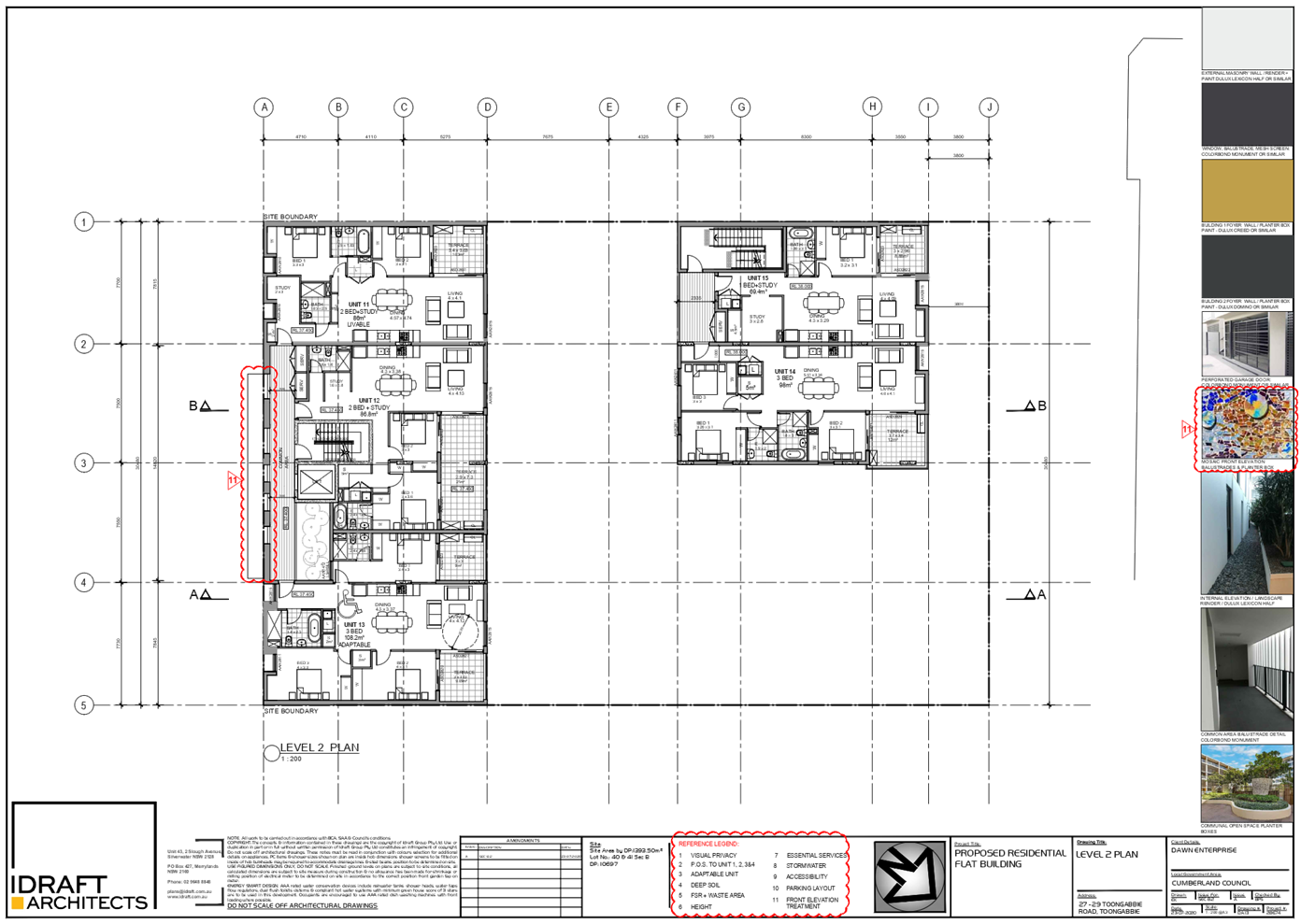
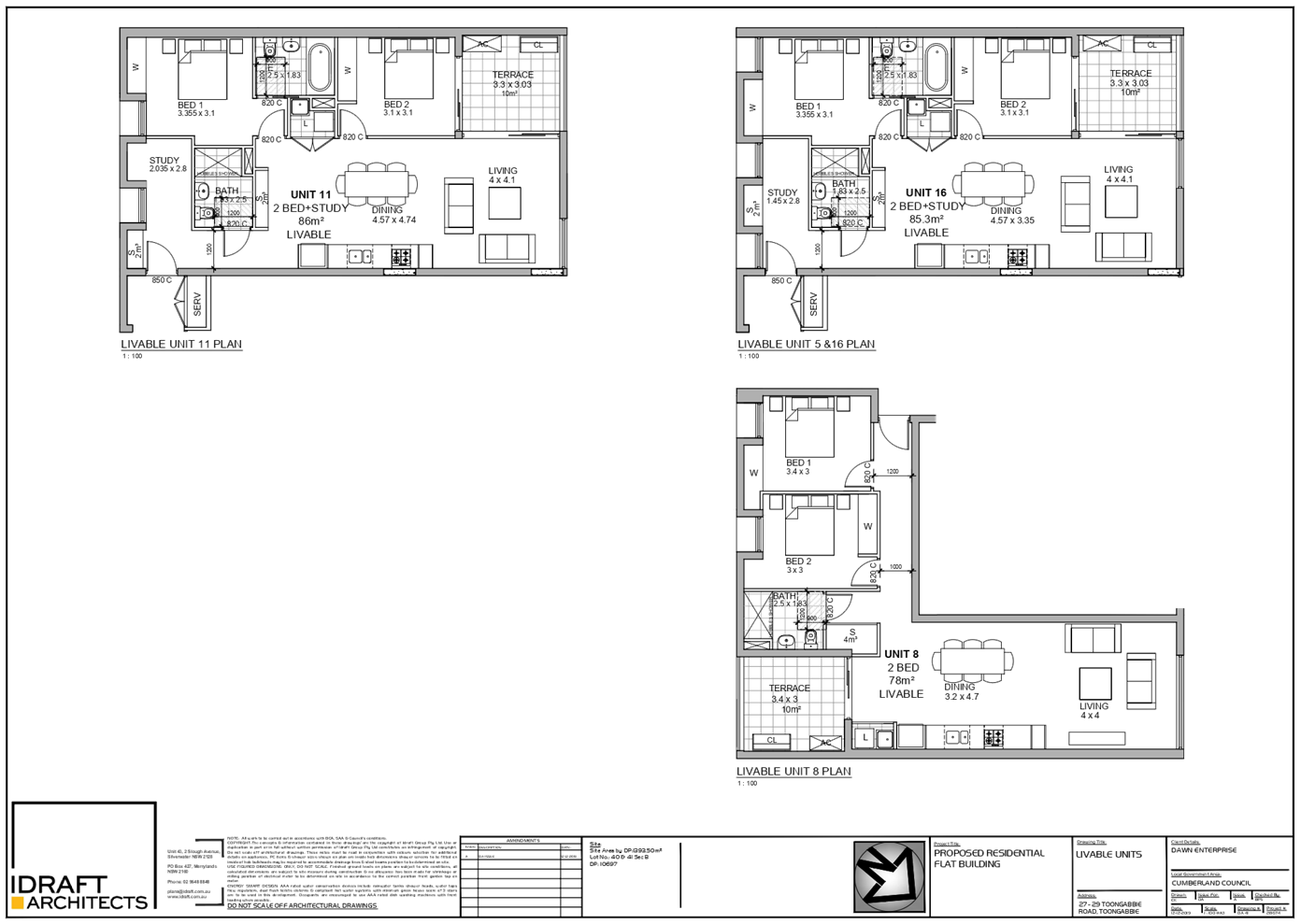
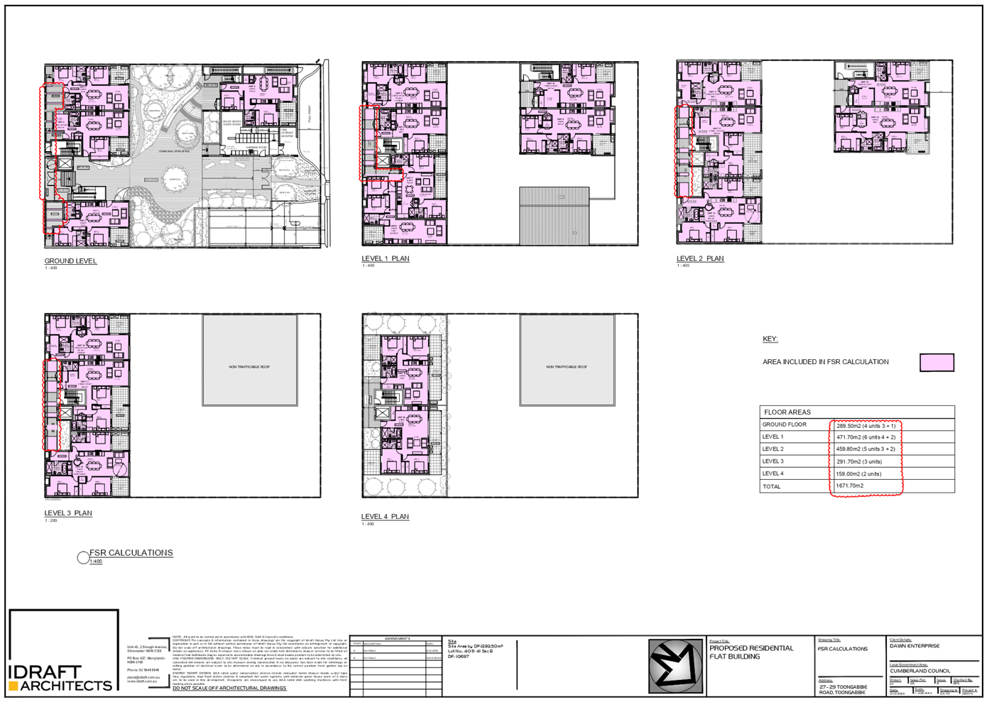
part 5 and part 3 residential flat buildings (comprising of 4 x 1 bedroom, 12 x
2 bedroom and 4 x 3 bedroom units) accommodating a total of 20 units. Access
into the site is viable from Toongabbie Road for pedestrians, and Cox Lane for
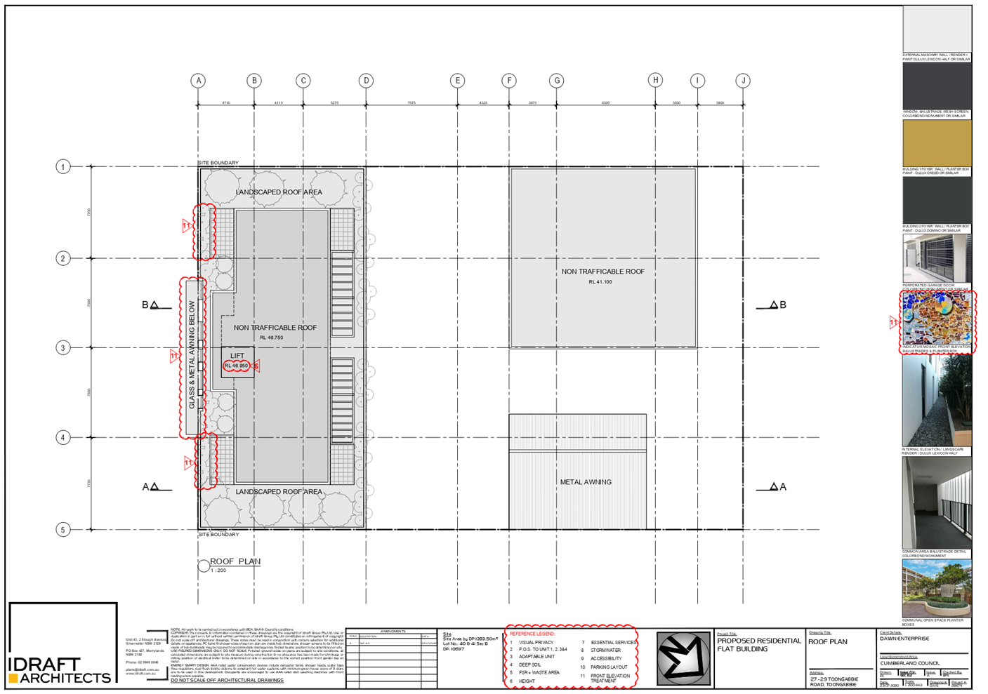
both pedestrians and vehicles. The development provides communal open space
with landscaping within the central courtyard and drainage system, pull in bay
and substation at the rear. A lift is also proposed to allow access from the
basement level of building facing Toongabbie Road.
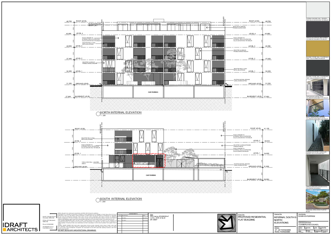
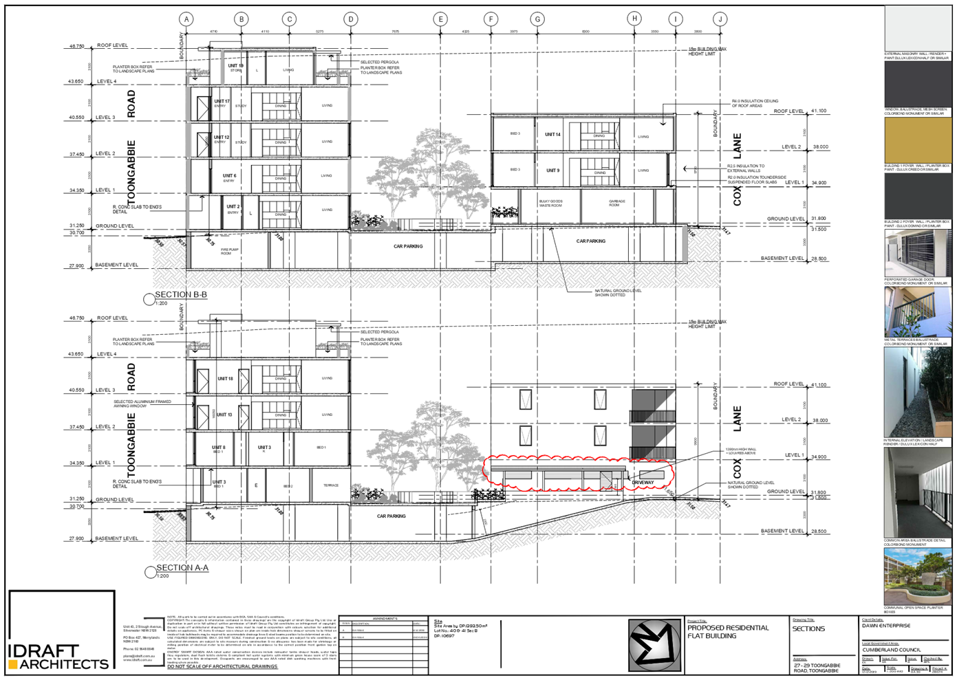
· Construct
a basement level car park to accommodate 25 car spaces including 3 accessible
spaces, 4 visitor parking, 1 car wash bay, 16 bicycle spaces, waste/bin room,
storage cages, plants and services, stairs for egress and a new driveway via
Cox Lane.
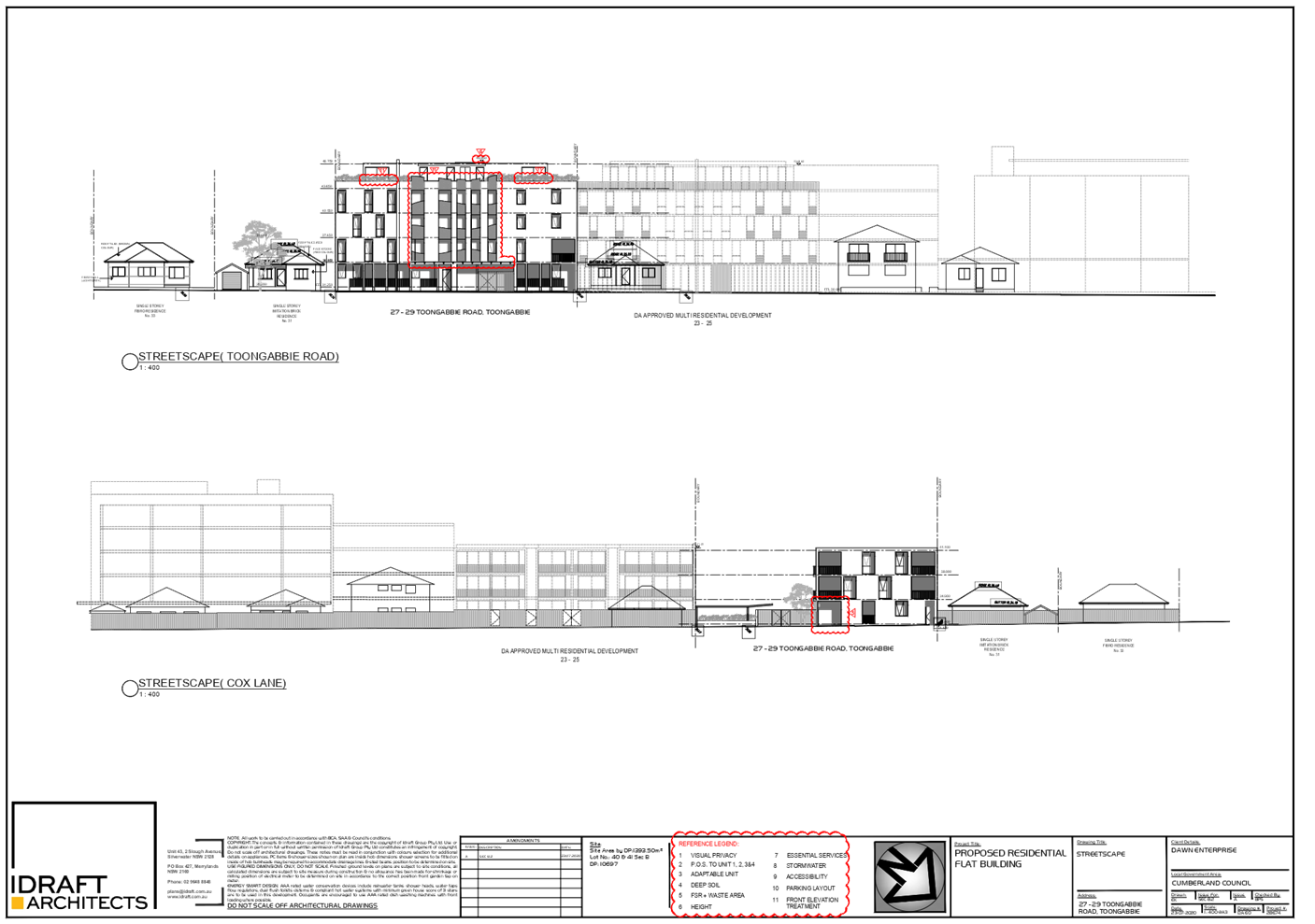
The notable differences proposed
between the previous design and the current design are as follows:
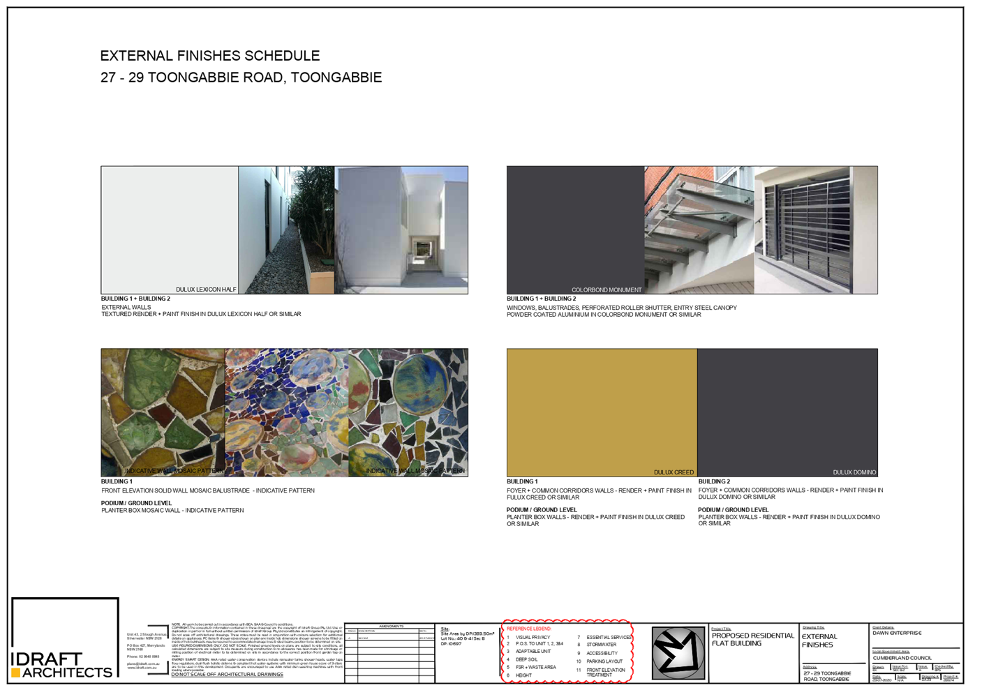
a) Changes
to the architectural character of the building incorporate improvement to the
materials and finishes and additional fenestration. Despite there being no
difference in the number of units proposed, the overall FSR for the development
has been reduced from 1.29:1 to 1.2:1. The reduction in floor area results from
relocation of the waste/bin room into the basement level and the lobby area on
the ground floor level is now an open breezeway within an outdoor area.
b) Slight
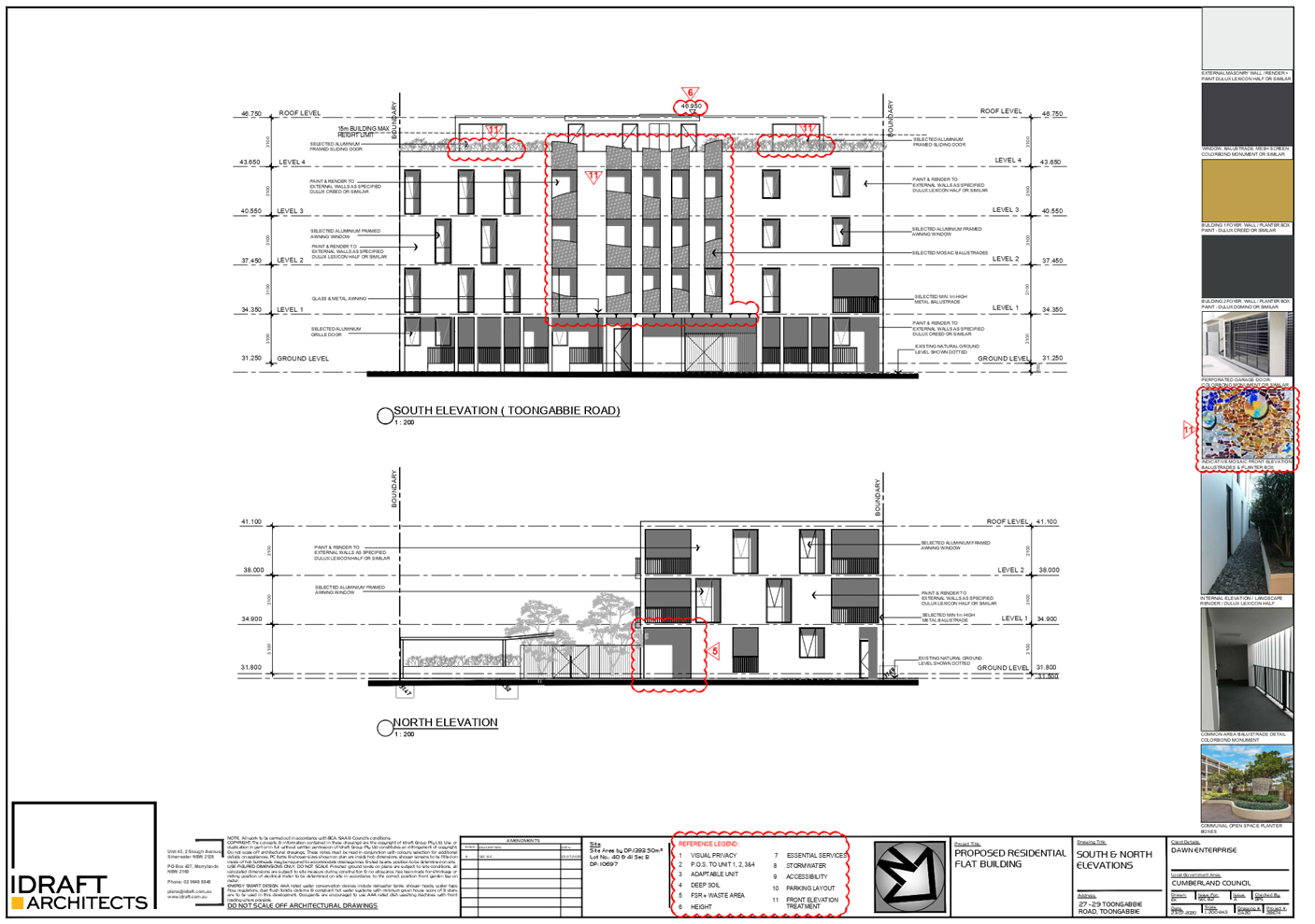
reduction in the building height by 400mm for the building facing Toongabbie
Road.
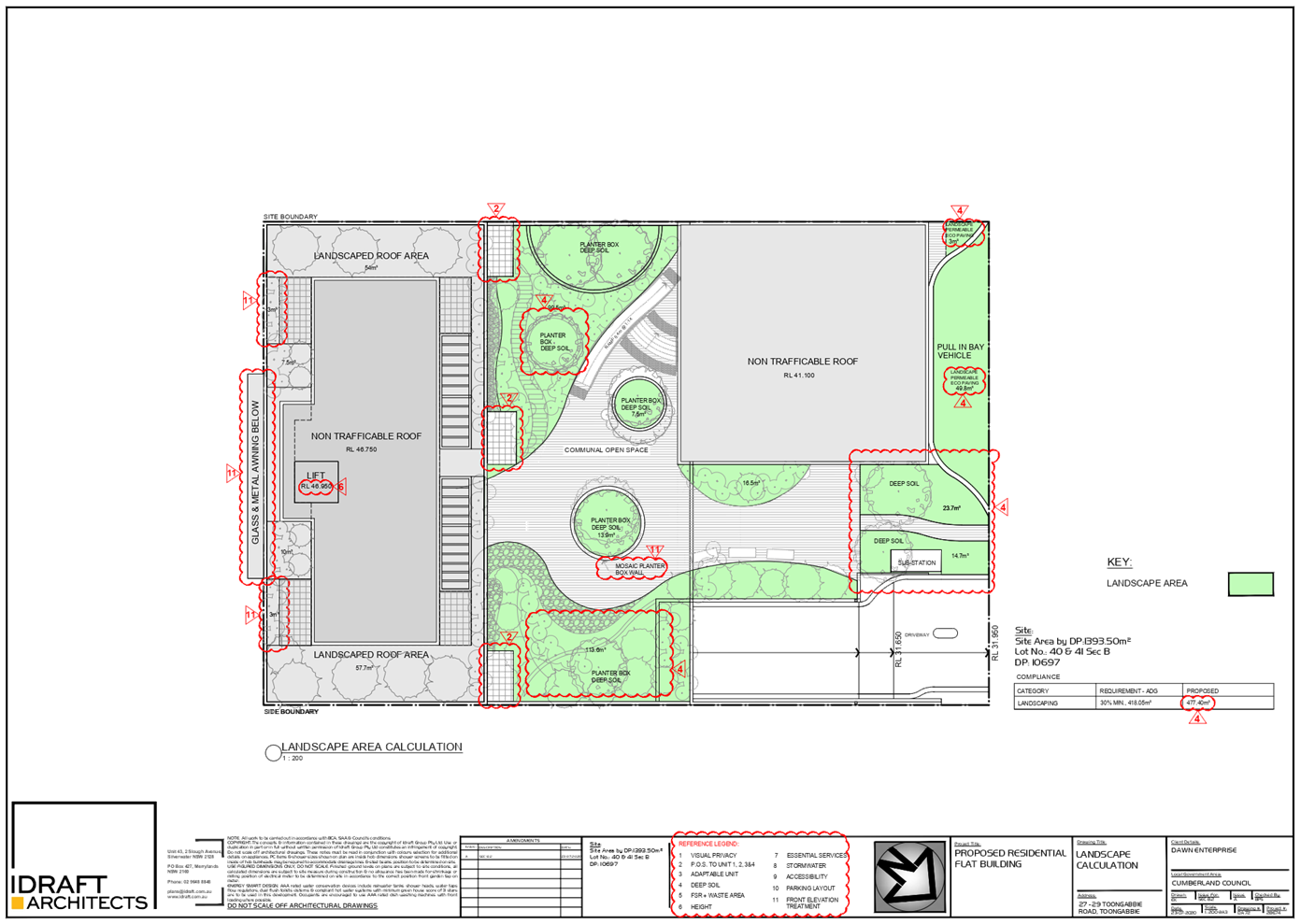
c) The
size of private open spaces of ground floor units has been increased from
9.6m² to 15m², and deep soil zone has been increased from 2.42% to
5.7%. Site coverage has been reduced from 44.8% to 40.18%.
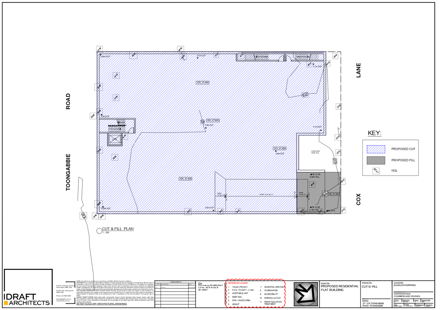
d) Basement
parking layout, driveway and stormwater management designs have been amended to
accommodate the development requirements.
e) Additional
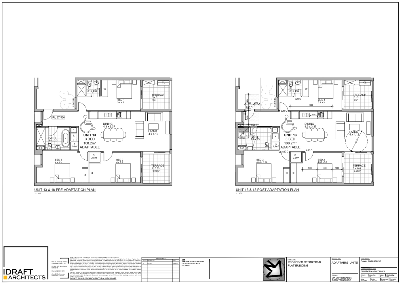
one (1) adaptable unit and one (1) accessible car parking space are proposed.
f) Additional
details have been submitted in relation to the building separation at the rear
of the site, acoustic impact from the development and flooding impact on the
location of substation.
History
On 27 May 2020, the Cumberland
Local Planning Panel resolved to refuse DA2019/0506 for the demolition of
existing structures, consolidation of 2 lots into 1 lot, and construction of a
residential flat building including a 3 storey building facing Cox Lane
and a 5 storey building facing Toongabbie Road over basement parking accommodating
20 residential units and 25 parking spaces. The reasons for the refusal were as
follows:
1. Failure
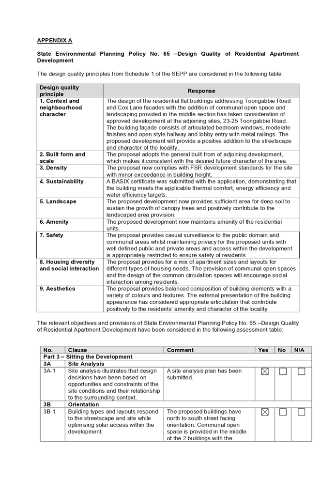
to demonstrate compliance with State Environmental Planning Policy No. 65
– Design Quality of Residential Apartment Development (pursuant to
S.4.15(1)(a)(i) of the Environmental Planning and Assessment Act 1979), with
regard to the following:-
Clause 28(2) –
Determination of Development Applications
1.1 In determining a
development application for consent to carry out development to which this
Policy applies, a consent authority is to take into consideration the
provisions of the Apartment Design Guide (ADG). The proposal is unsatisfactory
with regard to the following provisions of the ADG:
3F – Visual Privacy
1.1.1 By reason of the
provision of the 3.8m setback to Cox Lane, the proposal fails to protect visual
privacy between the adjoining properties. The applicant has not demonstrated
that a 12m building separation can be achieved as required by the ADG.
3E – Deep Soil Zones
1.1.2 By reason of the inadequate
provision of deep soil area of 2.42% where 7% is required, the development
fails to sustain planting of canopy trees to positively contribute to
landscaping on the subject site.
4E – Private Open
Space
1.1.3 By reason of the
inadequate private open space for units 1, 2, 3 and 4 on the ground floor level
of 9.6m² where 15m² is required, the development compromises amenity
of future residents.
4W – Waste Management
1.1.5 Design to waste
management area with openings is unsuitable as it is to be located adjoining to
unit 4 bedroom window. Waste storage facility design fails to consider adverse
impacts on the amenity of residents.
2. Failure
to demonstrate compliance with Holroyd Local Environmental Plan (HLEP) 2013
(pursuant to S.4.15(1)(a)(i) of the Environmental Planning and Assessment Act
1979), with regard to the following:-
Clauses 4.3 and 4.6 –
Variation to Height of Buildings
2.1 Pursuant to the Height of
Buildings Map referred to in Clause 4.3(2) of HLEP 2013, the maximum
permissible building height for the site is 15m. The maximum height of the
proposed building is 16.7m, which is 1.7m greater than the maximum building
height, representing a 11.3% variation to the development standard. The
development application has not adequately demonstrated the variation to the
building height would allow for the development that is complementary to, and
well-integrated with the high density residential development; as an amended
Clause 4.6 variation requested was not submitted.
The development application
must be refused because a written request pursuant to Clause 4.6 of HLEP 2013
in relation to the 1.7m contravention of the development standard in clause
4.3(2) of HLEP 2013 has not been submitted to demonstrate:
i. that
compliance with the development standard in clause 4.3(2) of HLEP 2013 is
unreasonable or unnecessary in the circumstances of the case,
ii. that
there are sufficient environmental planning grounds to justify contravening the
development standard in clause 4.3(2) of HLEP 2013, and
iii. that
the proposed development will be in the public interest because it is
consistent with the objective of the standard in clause 4.3(2) of HLEP 2013.
Clauses 4.4 and 4.6 –
Variation to Floor Space Ratio (FSR)
2.2 Pursuant to the Height of
Buildings Map referred to in Clause 4.4(2) of HLEP 2013, the maximum
permissible floor space ratio (FSR) for the site is 1.2:1. The maximum FSR of
the proposed building is 1.29:1 representing a 8.25% variation to the
development standard. The development application has not adequately
demonstrated the variation to the FSR would allow for the development that is
complementary to, and well-integrated with the high density residential
development; as a Clause 4.6 variation requested was not submitted.
The development application
must be refused because a written request pursuant to Clause 4.6 of HLEP 2013
in relation to the contravention of the development standard in clause 4.4(2)
of HLEP 2013 has not been submitted to demonstrate:
i. that
compliance with the development standard in clause 4.4(2) of HLEP 2013 is
unreasonable or unnecessary in the circumstances of the case,
ii. that
there are sufficient environmental planning grounds to justify contravening the
development standard in clause 4.4(2) of HLEP 2013, and
iii. that
the proposed development will be in the public interest because it is
consistent with the objective of the standard in clause 4.4(2) of HLEP 2013.
Clause 6.5 – Essential
Services
2.3 Inadequate information to
confirm the location of substation to enable the supply of electricity to be
provided wholly within the site.
Clause 6.7 –
Stormwater Management
2.4 The proposed stormwater
system will allow for contaminants to seep into the OSD tank, which is
detriment to environment. Inadequate information to confirm that stormwater
management could be provided wholly within the site.
3. Failure
to demonstrate compliance with Holroyd Development Control Plan (DCP) 2013,
Part A – General Controls (pursuant to S.4.15(1)(a)(iii) of the
Environmental Planning and Assessment Act 1979), with regard to the following:-
3.3 – Car Parking
Dimensions and 3.5 – Access Manoeuvring and Layout
3.1 The proposal fails to
provide proper vehicles manoeuvring to allow for adequate setback from the
existing lamp pole and side boundary, and sufficient passing and turning bays,
as the aisle widths do not comply.
3.6 – Parking for
Disabled
3.2 By the reason that 2
accessible spaces are provided where 3 spaces are required, the proposal fails
to provide the required parking spaces for disabled person.
4. Failure
to demonstrate compliance with Holroyd Development Control Plan (DCP) 2013,
Part B – Residential Controls (pursuant to S.4.15(1)(a)(iii) of the
Environmental Planning and Assessment Act 1979), with regard to the following:-
1.12 – Universal
Housing and Accessibility
4.1 By the reason that 2
adaptable units are provided where 3 units are required, the proposal fails to
provide the required parking spaces for disabled person.
6.2 – Site Coverage
4.2 The proposed site coverage
is 44.8% where maximum of 30% is permitted, which results in failure to provide
adequate deep soil area and stormwater management.
5. Failure
to demonstrate compliance with Holroyd Development Control Plan (DCP) 2013,
Part L – Town Centre Controls (pursuant to S.4.15(1)(a)(iii) of the
Environmental Planning and Assessment Act 1979), with regard to the following:-
6.3 - Building Height
5.1 The maximum number of
storeys for residential flat building on the subject site is 4 storeys.
However, the development proposes a maximum 5 storey building. Given that the
proposal has not been accompanied with appropriate justification and Clause 4.6
variation request for height of buildings, the storey exceedance is not
supported.
Traffic and Parking
6. The
development application should be refused because the design of the basement
and car parking provided is unacceptable and fails to meet the relevant
Australian Standards. There is inadequate information to demonstrate the
following:
i. That
dimensions of the proposed aisle width comply with the relevant Australian
Standards.
ii. That
two vehicles can pass each other at intersection points and at the entry and
exit of the ramp.
iii. That
details of the control device for the roller gates to ensure that the control
device shall not reduce the width of the access driveway or impact on the flow
of traffic and road safety.
iv. That
appropriate setback of driveway to the existing lamp post could be provided.
Inadequate Information
7. The
proposed development fails to address the relevant matters arising from the
Environmental Planning and Assessment Regulations 2000 (EP&A Reg) in
relation to documents required to be submitted to accompany a development
application pursuant to Section 4.15(1)(a)(iv) of the Environmental Planning
and Assessment Act 1979. The development application should be refused because
there is inadequate information submitted with regard to the following:
i. There
is inadequate information submitted to address issues raised with respect to
the design of the basement, setback from existing lamp pole, and traffic and
parking matters.
ii. There
is inadequate information submitted to address issues raised with respect to
the design of the stormwater management on site.
iii. A
revised acoustic report to address noise during construction, communal open
space, and mechanical and basement ventilations is required.
iv. There
is inadequate information submitted to ensure supply of electricity could be
provided wholly within the site.
Suitability of the site for
the proposed development
8. The
subject site is not considered suitable for the development as proposed due to
the inadequacies detailed above (section 4.15(c) of the Environmental Planning
and Assessment Act 1979).
Environmental Impact
9. Due
to the deficiencies detailed above, the likely environmental impacts of the
proposed development are considered to be unacceptable (section 4.15(1)(b) of
the Environmental Planning and Assessment Act 1979).
Public Interest
10. Due
to the deficiencies detailed above, approval of the proposed development would
be contrary to the public interest (section 4.15(1) (e) of the Environmental
Planning and Assessment Act 1979).
On 25 September 2020, Council
received the subject s8.3 Review application seeking approval for the same
development (i.e. demolition of existing structures, consolidation of 2 lots
into 1 lot, and construction of a residential flat building including a 3 storey
building facing Cox Lane and a 5 storey building facing Toongabbie Road over
basement parking accommodating 20 residential units and 25 parking spaces). The
proponent has sought to address the reasons for refusal by incorporating the
following design amendments:
a) Amending
the ground floor level design to reduce overall gross floor area and site
coverage whilst increasing deep soil area and private open spaces.
b) Improving
the driveway access, provision of accessible car spaces and manoeuvring area on
the basement level.
c) Submission
of additional information regarding on site detention system, building
separation at the rear, acoustic impact and substation.
Applicants Supporting
Statement
The applicant has provided a
Statement of Environmental Effects prepared by IDraft Architects dated 25
August 2020 and was received by Council on 25 September 2020 in support of the
application.
Contact with Relevant
Parties
The assessing officer has
undertaken a site inspection of the subject site and surrounding properties and
has been in regular contact with the applicant throughout the assessment
process.
Internal Referrals
Development Engineer
The development application was
referred to Council’s Development Engineer for comment who has advised
that the development proposal is satisfactory and therefore can be supported
subject to conditions.
Environment and Health
The development application was
referred to Council’s Environment and Health Officer for comment who has
advised that the development proposal is satisfactory and therefore can be
supported subject to recommended conditions of consent.
Landscape/Tree Management
Officer
The development application was
referred to Council’s Landscape/Tree Management Officer for comment who
has advised that the development proposal is satisfactory and therefore can be
supported subject to recommended conditions of consent.
Waste Management
The development application was
referred to Council’s Waste Management Officer for comment who has
advised that the development proposal is satisfactory and therefore can be
supported subject to recommended conditions of consent.
External Referrals
Endeavour Energy
The application was required to be
referred to Endeavour Energy for comment. Council received formal
correspondence on 13 October 2020 raising no objections to the proposed
development subject to advisory comments provided.
PLANNING COMMENTS
The provisions of any
Environmental Planning Instruments (EP&A Act s4.15 (1)(a)(i))
The proposed development is
affected by the following Environmental Planning Instruments:
(a) State
Environmental Planning Policy No. 55 – Remediation of Land (SEPP 55)
Clause 7 of SEPP 55 requires
Council to be satisfied that the site is suitable or can be made suitable to
accommodate the proposed development. The matters listed within Clause 7 have
been considered in the assessment of the development application.
|
Matter for Consideration
|
Yes/No
|
|
Does the application
involve re-development of the site or a change of land use?
|
Yes
No
|
|
a)
Does the application involve
re-development of the site or a change of land use?
|
Yes
No
|
|
In the development
going to be used for a sensitive land use (e.g.: residential, educational,
recreational, childcare or hospital)?
|
Yes
No
|
|
Does information available to you indicate that an
activity listed below has ever been approved, or occurred at the site?
acid/alkali plant and
formulation, agricultural/horticultural activities, airports, asbestos
production and disposal, chemicals manufacture and formulation, defence
works, drum re-conditioning works, dry cleaning establishments, electrical
manufacturing (transformers), electroplating and heat treatment premises,
engine works, explosive industry, gas works, iron and steel works, landfill
sites, metal treatment, mining and extractive industries, oil production and
storage, paint formulation and manufacture, pesticide manufacture and
formulation, power stations, railway yards, scrap yards, service stations,
sheep and cattle dips, smelting and refining, tanning and associated trades,
waste storage and treatment, wood preservation
|
Yes
No
|
|
Is the site listed on
Council’s Contaminated Land database?
|
Yes
No
|
|
Is the site subject to EPA
clean-up order or other EPA restrictions?
|
Yes
No
|
|
Has the site been the subject of
known pollution incidents or illegal dumping?
|
Yes
No
|
|
Does the site adjoin any
contaminated land/previously contaminated land?
|
Yes
No
|
|
Has the appropriate level of
investigation been carried out in respect of contamination matters for
Council to be satisfied that the site is suitable to accommodate the proposed
development or can be made suitable to accommodate the proposed development?
|
Yes
No
|
|
Details of contamination investigations carried out at the
site:
i.
ii.A
Preliminary Site Investigation prepared by Geotechnical Consultants Australia
dated 6 September 2019 (E1961-1) was submitted with the application. The
report identified that the site is suitable for the proposed development,
subject to implementing recommendations in section 12 of the report, including
the completion of a Hazardous Materials Survey prior to the construction and
following the protocol of unexpected find. Further, the report has been
reviewed by Council’s EHU and the advice provided that the proposal was
satisfactory to proceed subject to recommended conditions to be imposed on
the consent.
|
(b) State
Environmental Planning Policy (Vegetation in Non-Rural Areas) 2017
The proposal does not exceed the
biodiversity offsets scheme threshold. Therefore, the proposed vegetation
removal is considered acceptable. Please refer to the DCP compliance table for
further discussion.
(c) State
Environmental Planning Policy (Building Sustainability Index: BASIX) 2004
BASIX Certificate 1034598M_03
dated issued on 21 August 2020 prepared by Credwell Energy has been submitted
to Council and is considered to be satisfactory.
(d) State
Environmental Planning Policy No 65 – Design Quality of Residential
Apartment Development (SEPP 65)
The proposal is classified as a
residential apartment development and SEPP 65 applies. A design verification
statement signed by registered architect Biljana Pop Stefanija (8789) was
submitted with the application.
The relevant provisions of the
SEPP have been considered in the assessment of the Application. A comprehensive
assessment and compliance table is attached to this report in Appendix A which
demonstrates the development proposal’s compliance with the relevant
planning controls that are applicable to the site.
Pursuant to clause 28(2)(c) of
SEPP 65, a consent authority must consider the provisions of the Apartment
Design Guide (ADG) in the assessment of a residential flat development.
The proposal involves the
following non-compliance with the ADG controls.
|
3E
|
Deep
Soil Zones
|
|
3E-1
|
Deep soil zones provide areas
on the site that allow for and support healthy plant and tree growth. They
improve residential amenity and promote management of water and air quality.
Area of 7%
(97.5m²)
with minimum dimension of 3m
to be provided
|
Due
to the nil setback provision applying on the site, the area nominated for
deep soil zone adjoining to Cox Lane equates to 79.9m² or 5.7%. The
remaining deep soil area is in the form of planter boxes, which equates to
84.4m². Total deep soil area proposed is 164.3m² or 11.79%.
The proposed development
demonstrates that sufficient area for deep soil to sustain the growth of
canopy trees and positively contribute to the landscaped area provision could
be provided within the planter boxes proposed. Section plan has also been
submitted with the application to support this.
|
|
4D
|
Apartment
Size
|
|
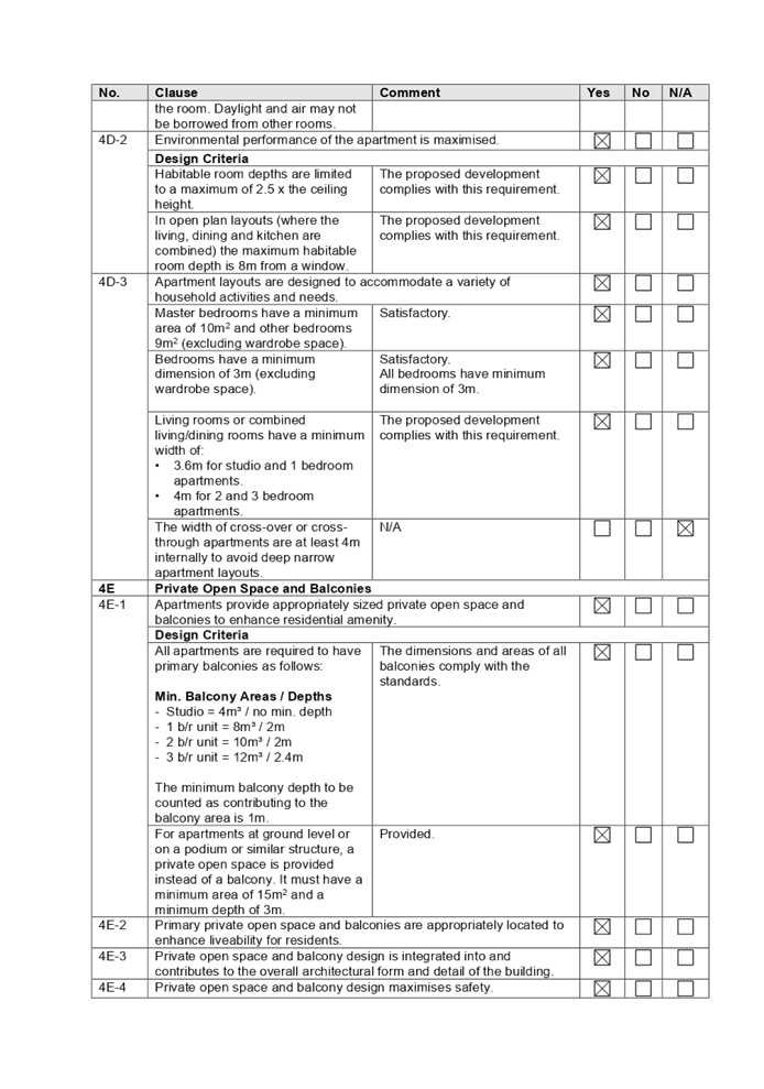
4D-1
|
Apartments are required to have the following minimum
internal areas:
Min. Internal Area
- Studio = 35m²
- 1 b/r unit = 50m²
- 2 b/r unit = 70m²
- 3 b/r unit = 90m²
The minimum internal areas include only one bathroom.
Additional bathrooms increase the minimum internal area by 5m2
each.
A
fourth bedroom and further additional bedrooms increase the minimum internal
area by 12m2 each.
|
All
units meet the minimum ADG sizes, with minor non compliances of 2 bedroom
with 2 bathrooms unit nos. 1, 3 and 7 as follows.
Unit
1 – 72m²
Unit
3 – 72m²
Unit
7 – 70.5m²
Without
reducing the dimensions of living area and bedrooms, unit 1 and 3 shall be
amended to 75m² in size, with the area apportioned from Unit 2 which has
additional floor area above the minimum standard.Unit 7 shall be provided
with only 1 bathroom to comply with size of 2 bedroom unit. Condition is to
be imposed to satisfy the minimum internal areas requirements accordingly.
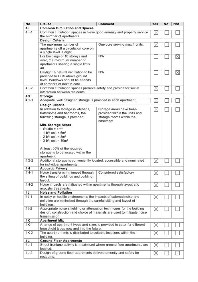
|
(e) State
Environmental Planning Policy (Infrastructure) 2007
The provisions of the
Infrastructure SEPP (ISEPP) 2007 have been considered in the assessment of the
development application.
Clause 45 - Development likely to
affect an electricity transmission or distribution network
The proposed development involves
works within proximity to the existing overhead power lines. As such, the
application was referred to Endeavour Energy for comment as the relevant
electricity supply authority.
See discussion regarding the
Endeavour Energy response under ‘external referrals’ above.
(f) Sydney
Regional Environmental Plan (Sydney Harbour Catchment) 2005
The subject site is identified as
being located within the area affected by the Sydney Regional Environmental
Plan (Sydney Harbour Catchment) 2005. The proposed development raises no issues
as no impact on the catchment is envisaged.
(Note: - the subject site is not
identified in the relevant map as ‘land within the ‘Foreshores and
Waterways Area’ or ‘Wetland Protection zone’, is not a
‘Strategic Foreshore Site’ and does not contain any heritage items.
Hence the majority of the SREP is not directly relevant to the proposed
development).
(g) Holroyd
Local Environmental Plan 2013
The proposed development is
defined as a ‘residential flat building’ under the provisions of
HLEP 2013 as follows. Residential flat buildings are permitted with consent in
the R4 – High Density Residential zone which applies to the land.
residential flat building means a
building containing 3 or more dwellings, but does not include an attached
dwelling or multi dwelling housing.
Note—
Residential flat buildings are a
type of residential accommodation—see the definition of that term in this
Dictionary.
The proposed development results
in the following non-compliance.
|
Development Standard
|
Proposal
|
Compliance
|
|
4.3 Height of Buildings
15m
|
Proposed:
16.13m (RL46.95 –
RL30.82m AHD) for the building facing Toongabbie Road
List of exceedances:
(according to the calculation
of the assessment planner):
Part of the awning –
1.13m (7.53%)
Lift overrun – 0.7m
(4.6%)
Variation: 4% to 7.53%
|
Clause 4.6 variation request
has been submitted accompanying the application for the breach in the
building height development standard by 4.6% or 700mm. It is the view of
Council Officers that the applicant’s written request, as stated below,
has adequately addressed the matters required to be demonstrated by clause
4.6 subclause (3), with the exception of the building height exceedance
within the habitable area. Further reduction in floor to floor height on each
level for the building facing Toongabbie Road by 0.1m will ensure that the
building height exceedance includes only part of the awning and lift overrun.
Condition is to be imposed accordingly.
|
A comprehensive HLEP assessment is
provided at Attachment 6.
Clause 4.6 – Variation to
Building Height
Clause 4.6 allows the consent
authority to vary development standards in certain circumstances and provides
an appropriate degree of flexibility to achieve better design outcomes. The
consent authority may grant the exception as the Secretary’s concurrence
can be assumed where clause 4.6 is adopted as per the Department of Planning
Circular PS 18-003, dated 21 February 2018.
The applicant has submitted a
written request to vary the development standards for exceedance of building
height facing Toongabbie Road with variation of 4.6% or 700mm. Based on various
case laws established by the Land and Environment Court of NSW such as
Four2five P/L v Ashfield Council [2015] NSWLEC 9, Randwick City Council v
Micaul Holdings P/L [2016] NSW LEC7 and Zhang and anor v Council of the City of
Ryde [2016] NSWLEC 1179, a 3 part assessment framework for a variation request
proposed under clause 4.6 has been considered and an assessment of the proposed
variance, following the 3 part test is discussed in detail below.
The 3 preconditions which must be
satisfied before the application can proceed are as follows:
1. Is
the proposed development consistent with the objectives of the zone?
Applicant’s
justification:
Zone Objectives of the R4 Zone
The relevant objectives are
prescribed as:
· To
provide for the housing needs of the community within a high density
residential environment.
· To
provide a variety of housing types within a high density residential
environment.
· To
enable other land uses that provides facilities or services to meet the day to
day needs of residents.
· The
proposal is consistent with the objectives of the zone, providing for the
housing needs of the community in a high density residential environment and
providing a variety of housing types in the development scheme.
Planner’s comment:
The development is consistent with
the zone objectives, as the proposal provides a variety of housing needs across
the site with a mixture of 1 to 3 bedrooms apartments.
2. Is
the proposed development consistent with the objectives of the development
standard which is not met?
Applicant’s
justification:
The objectives of the building
height development standard are stated as:
1. The
objectives of this clause are as follows:
(a) to
minimise the visual impact of development and ensure sufficient solar
access and privacy
for neighbouring properties,
(b) to
ensure development is consistent with the landform,
(c) to
provide appropriate scales and intensities of development through height controls.
The current development proposal
seeks to depart from the height control for small portions of the upper storey
of the building, and the ‘shifting’ of the height of the Cox Lane
building to the Toongabbie Road building to establish the 3-5 storey height
split on the site rather than a uniform 4/4 storey approach.
Despite this, the proposal
remaining consistent with the objectives of the clause because:
· The visual impact
of the non-compliance is limited noting the departure is as small portion of
the Toongabbie Road building that provides a suitable design response. The
transfer of height will reduce the visual impact of the development relative to
Cox Lane.
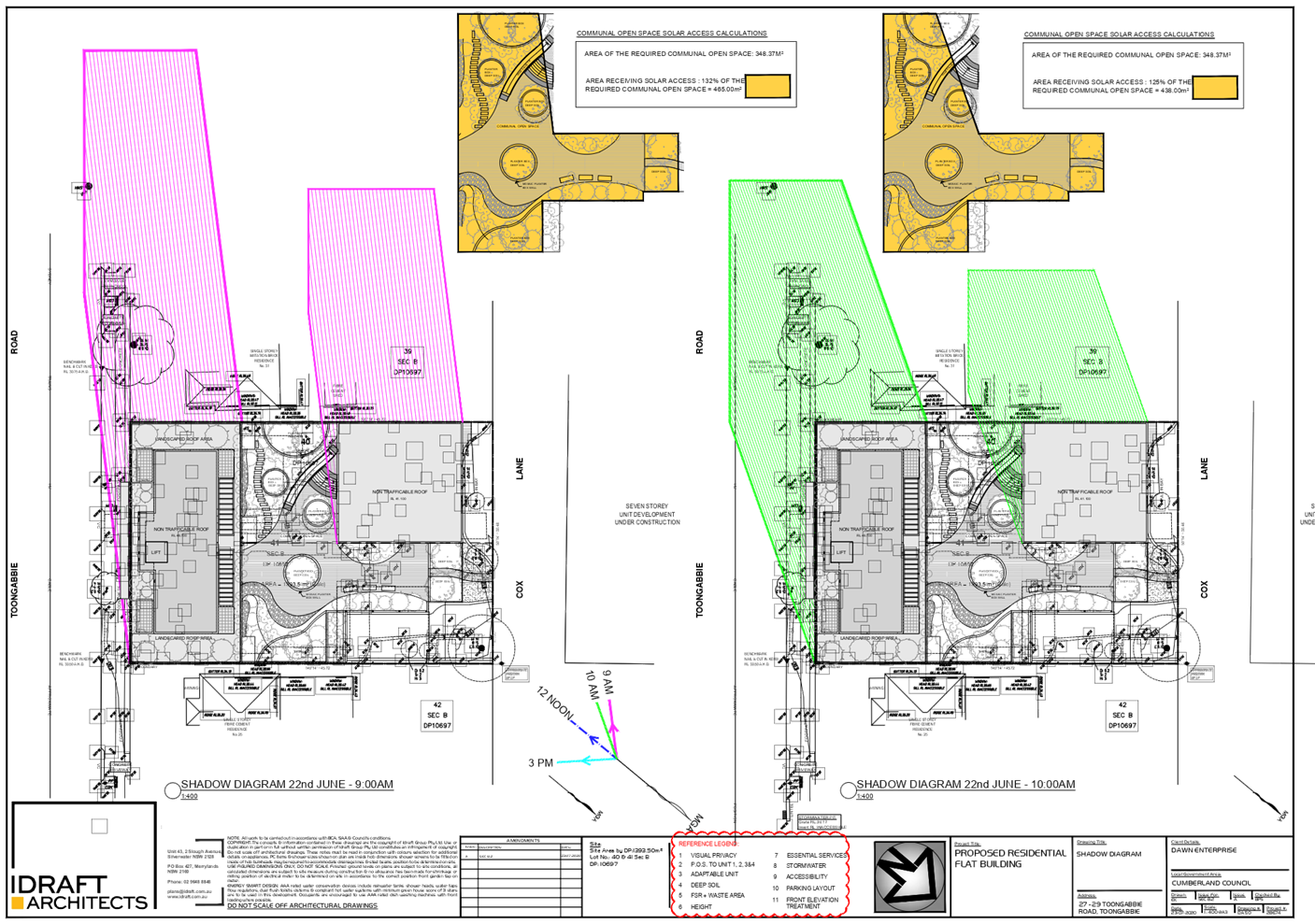
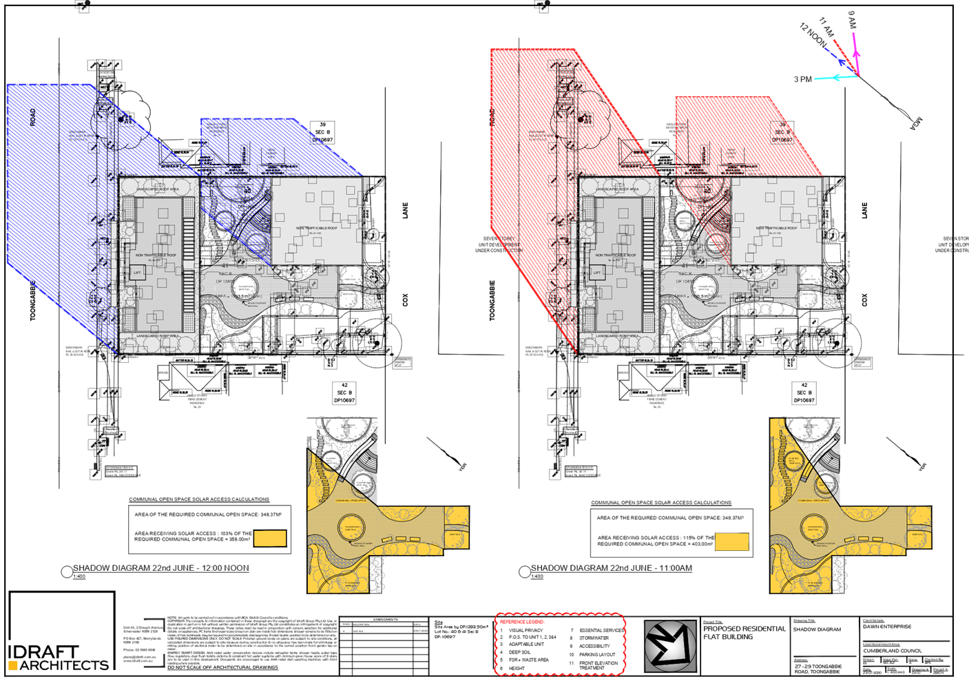
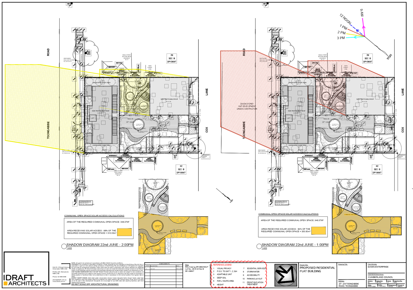
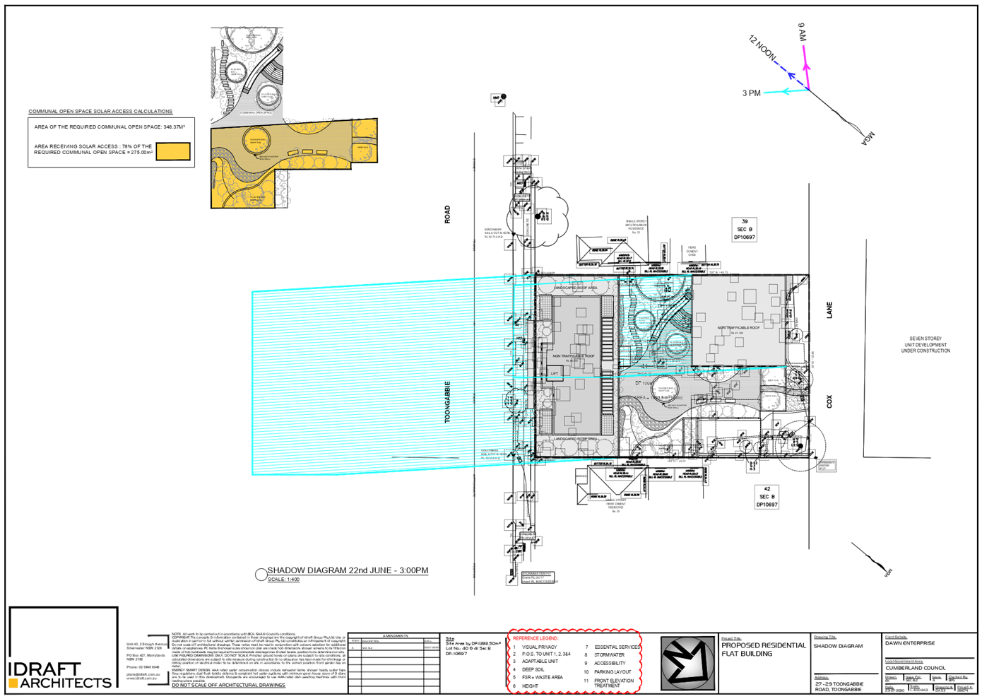
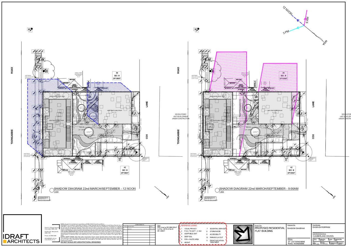
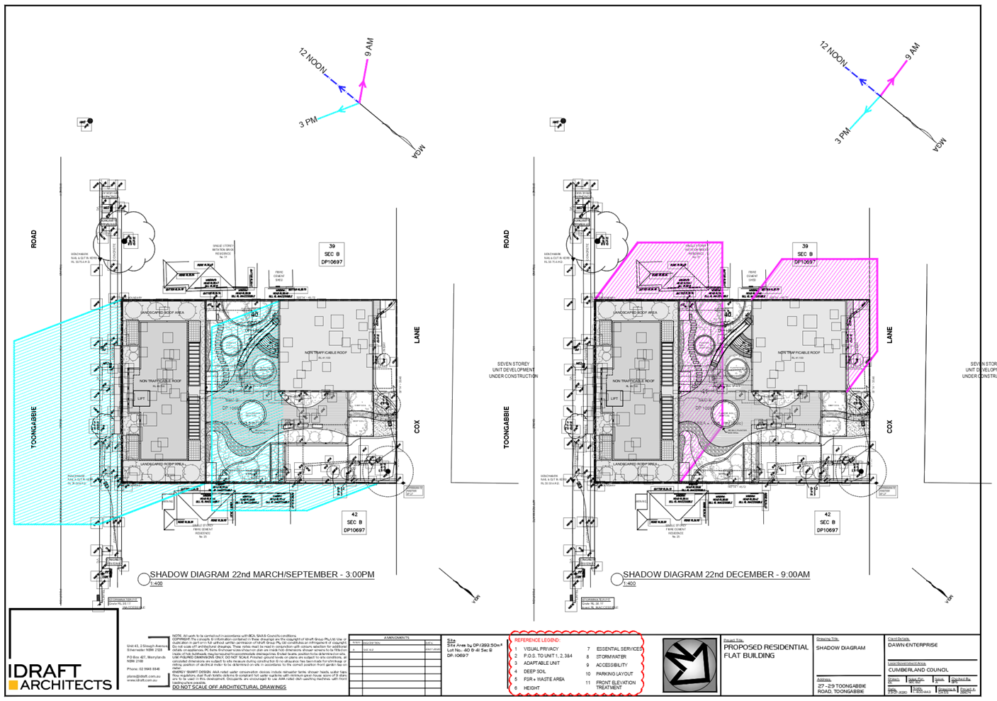
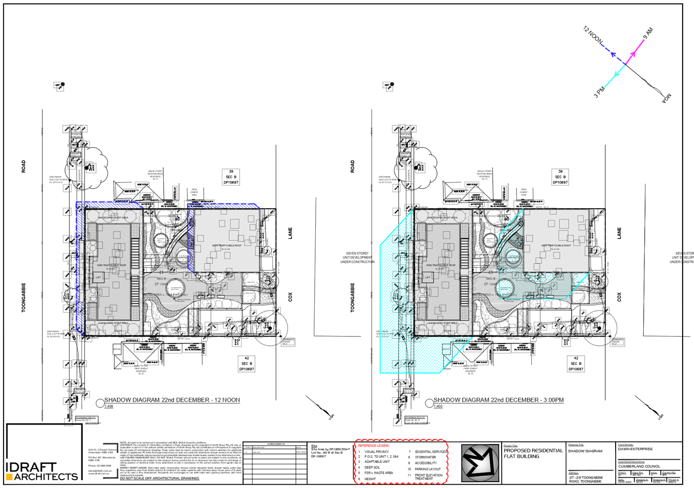
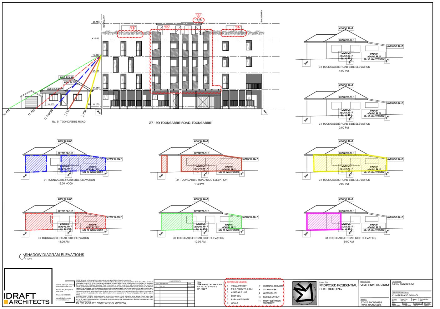
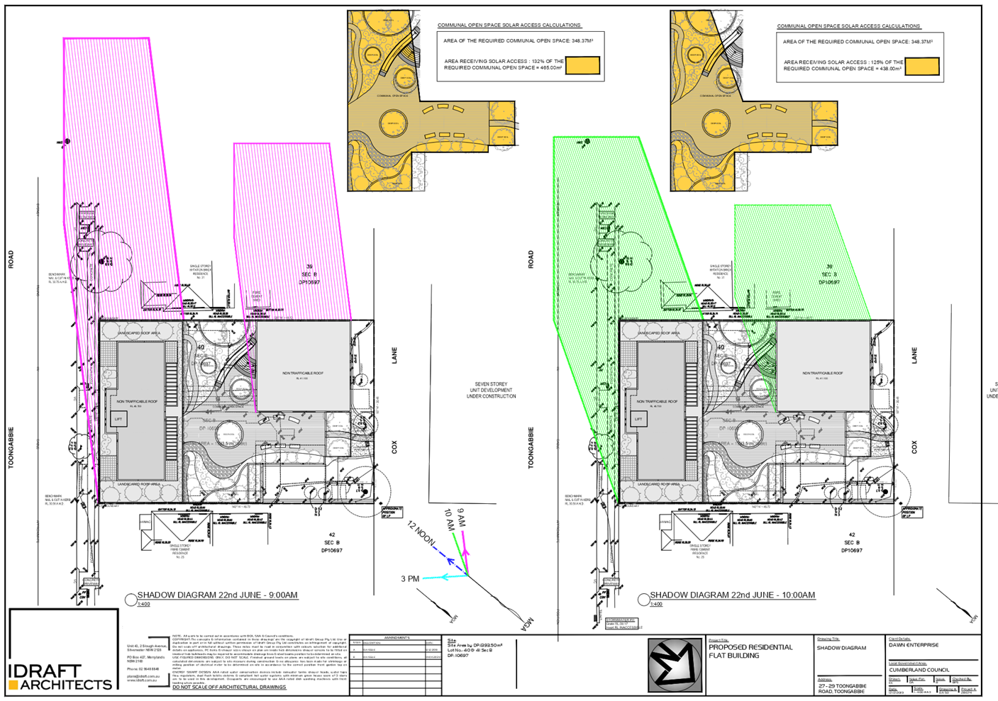
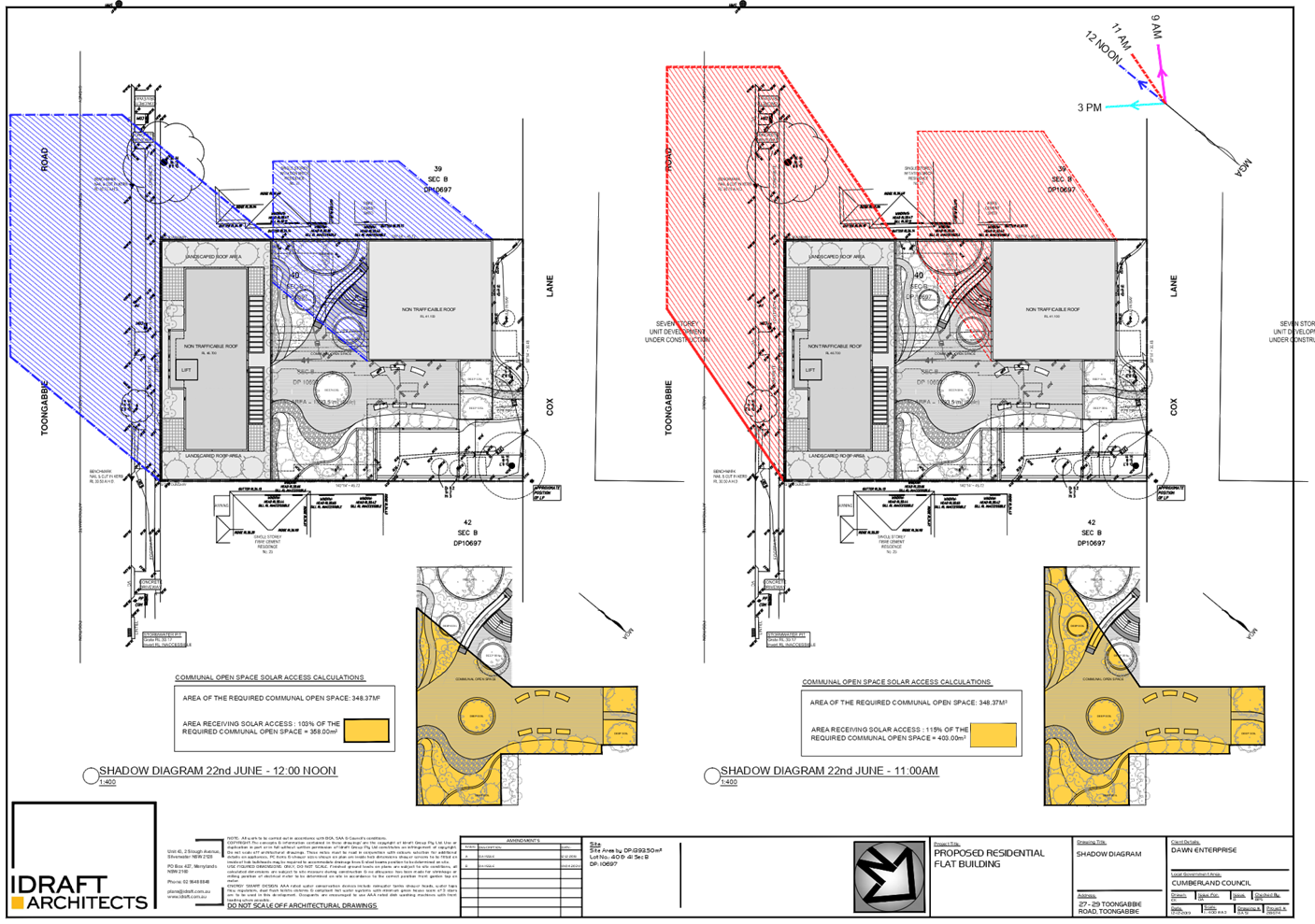
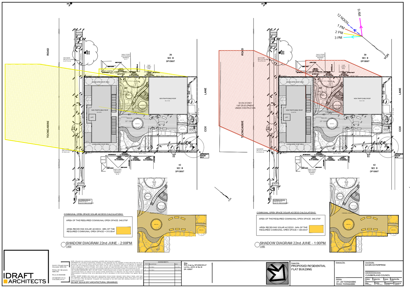
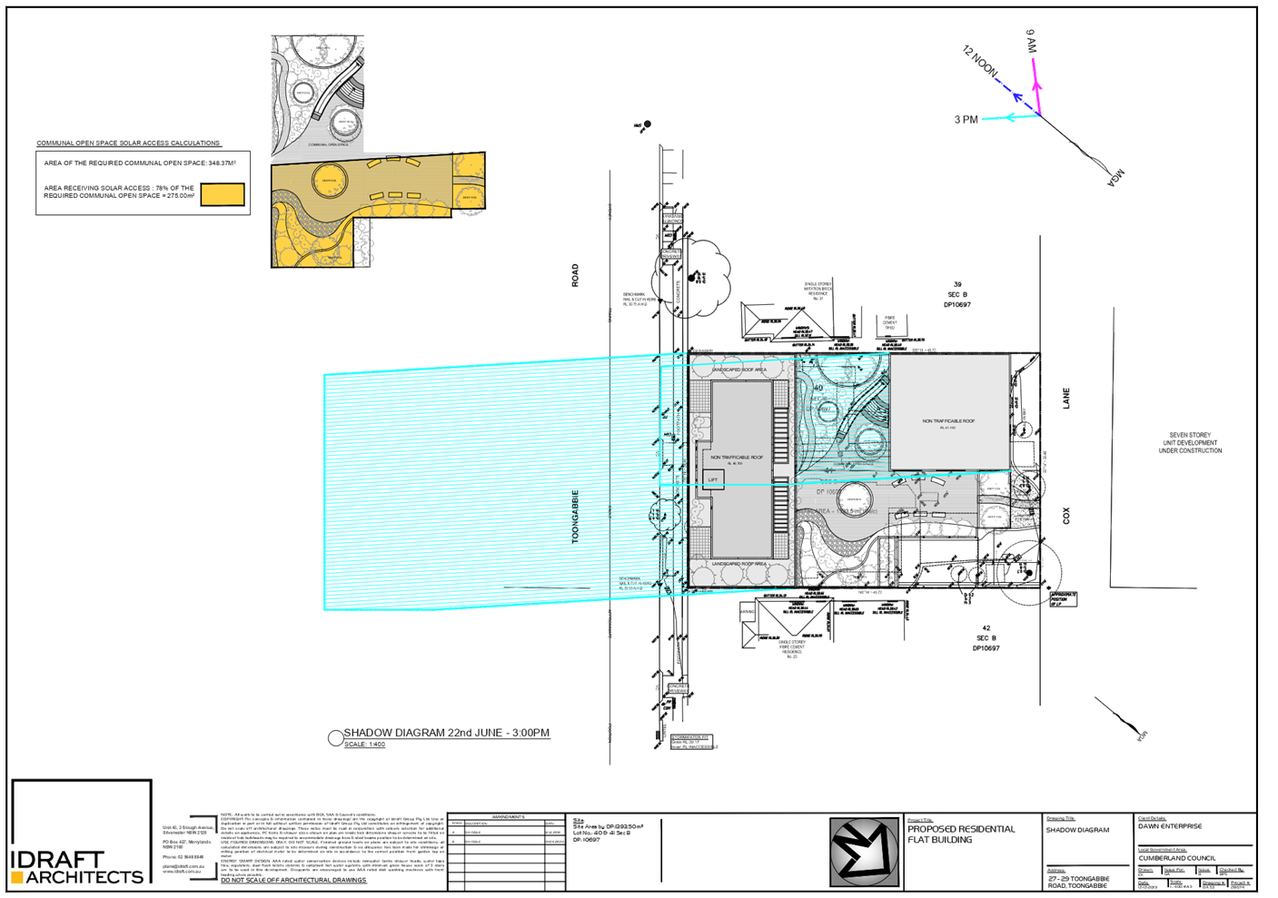
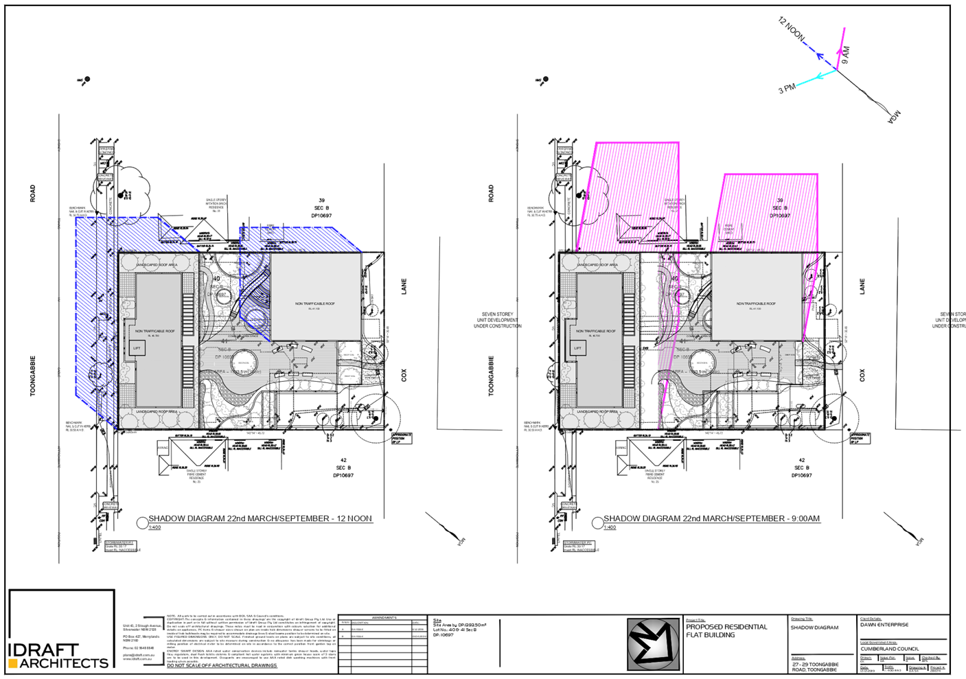
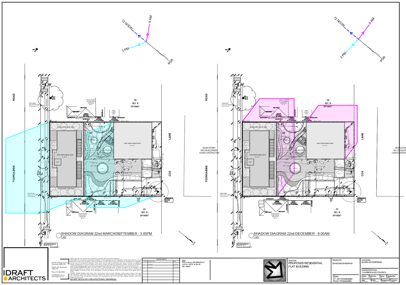
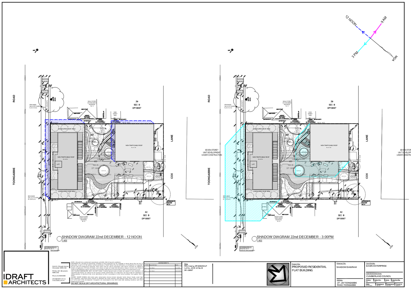
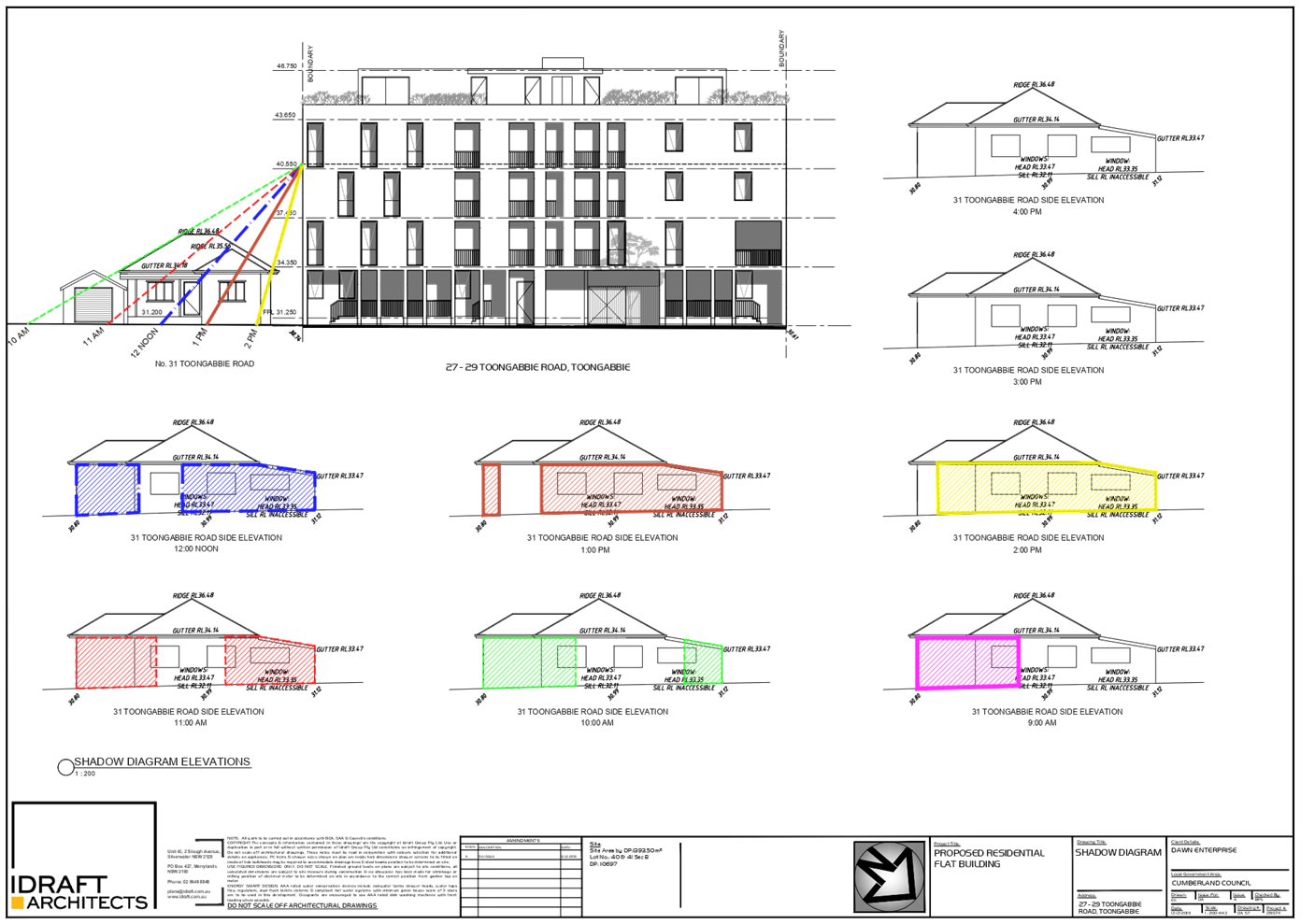
· The shadow
diagrams show the adjoining properties received adequate solar access, noting
the elements of non-compliance are limited to the Toongabbie. Road building
which actually shifts the height towards Toongabbie Road which reduces the
shadow impact to the adjoining properties given the lot orientation as the
shadow is then largely cast on the road.
· The departure will
not unreasonably impact on the solar access of adjoining properties or the
public areas in the vicinity of the site which satisfies objective
(c). The orientation of the site
means that there is self-shadowing from the
laneway building- hence
maintaining a 3 storey form in that the location
maximises solar access to the
common open space area and also avoids self-shadowing of the north facing
dwellings in the 5 storey building.
· The additional
height has no bearing on the privacy of neighbouring properties;
· The development is
designed to follow the landform.
· The development
provides an appropriate scale and intensity, noting consistency with the intent
of the Toongabbie Town Centre DCP through
following the
urban design principles established on the adjoining site with the 3/5 storey
split and noting the FSR is in compliance. In a compliant scheme the design
outcome results in the same yield- but a poorer planning outcome. It is
preferred to adopt a height much lower than the 15m to Cox Lane and transfer
this height to Toongabbie Road.
· The departure does
not impact on the achievement of suitable land use intensity and the proposal
maintains an appropriate height of 3-5 storeys, which satisfies objective (a)
and the stepped height of the development allows maximum solar access to the
site and a suitable bulk and scale to the lane (3 storeys) with the larger
building mass facing Toongabbie Road and aligns with the observed character
along Toongabbie Road to the east which is 5 storeys (either constructed or
approved including the site immediately to the east of this site.
Planner’s comment:
The proposed development is
consistent with the building height objectives as the built form is considered
to respond to the site topography and its location within the vicinity of the
Toongabbie Town Centre. The bulk and scale of the development is considered
acceptable and the development presents acceptable visual and solar access
impacts on the amenity of future development itself and the neighbouring
properties.
3. a)
Is compliance with the development standard unreasonable or unnecessary in the
circumstances of the case? And;
Applicant’s
justification:
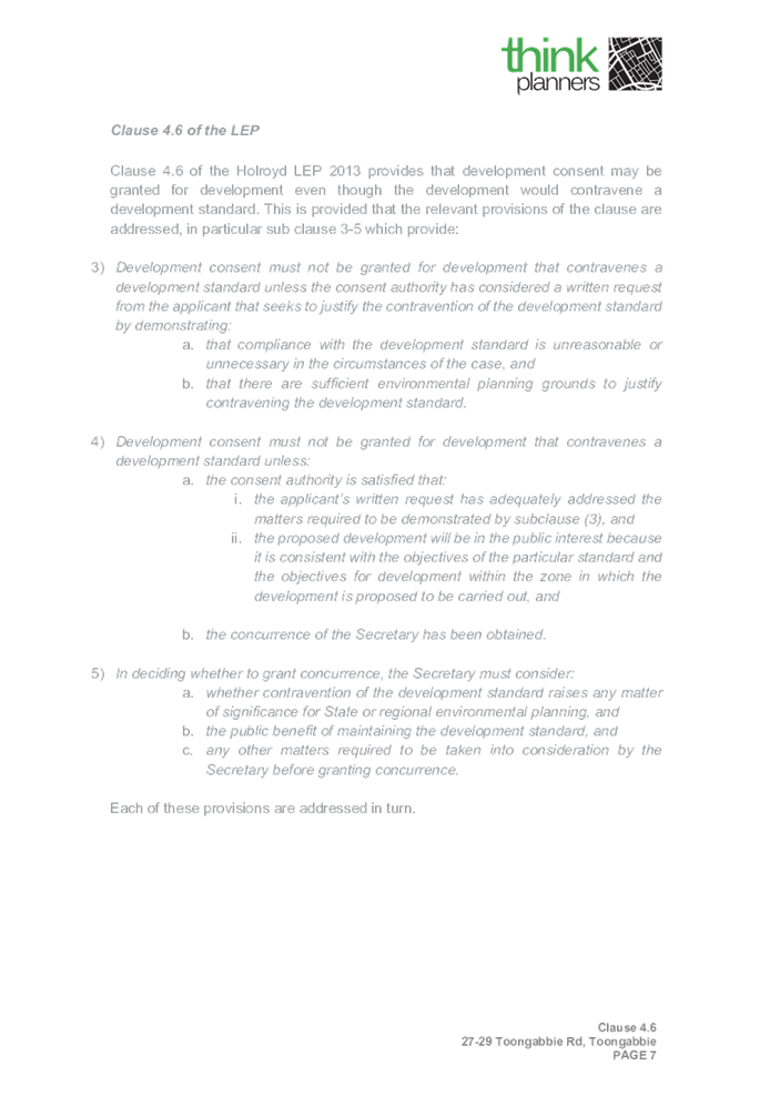
To adopt a compliant 4/4 storey
form, which would adopt the same yield, would reduce solar access, and also
result in a design outcome that is inconsistent with the approved 5/3 storey
split (noting construction on that site is imminent).Therefore, the design
response relates to the context of the site and the lot orientation as well as
Urban Design Principles of avoiding an overwhelming height and scale to the
built form on the narrow laneway alignment.
Planner’s comment:
Strict compliance with the maximum
building height requirement is considered unreasonable and unnecessary in the
context of the development as the built form is site responsive, particularly
with the approved adjoining development at 23-25 Toongabbie Road under
DA2016/75 adopting the similar yield with building height exceedance facing
Toongabbie Road. The development presents an acceptable bulk and scale within
the existing streetscape.
b) Are there sufficient
environmental planning grounds to justify contravening the development standard
and therefore is the applicant’s written justification well founded?
Applicant’s
justification:
In relation to environmental
planning grounds the variation to the height standard is satisfactory on these
grounds for the following reasons:
· The
additional height transferred to the Toongabbie Road building as proposed does
not result in detrimental environmental planning outcomes, as it does not give
rise to adverse solar access, view loss or visual or acoustic privacy impacts
on site, or to neighbouring properties and if anything it improves solar access
and reduces bulk to the laneway.
· The
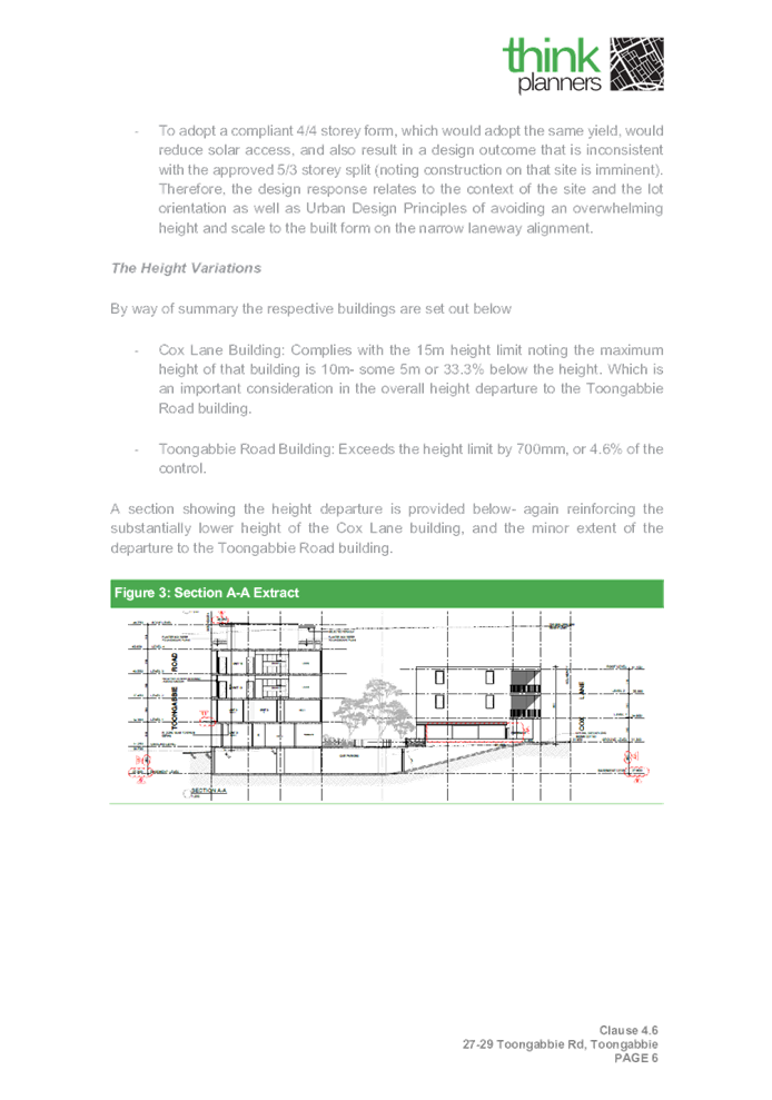
provision of a logical built form outcome, noting that the adoption of a 3-5
storey ‘split’ follows the recent development consent for the
development at 23-25 Toongabbie Road (immediately adjoining the site).
· The
design intent is clearly to match the form associated with the adjoining site.
The development proposes a residential flat building comprising of 2 buildings,
with the overall design scheme influenced by a comparable flat building
approved to the site’s immediate eastern boundary (23-25 Toongabbie Road,
Toongabbie) by DA-75/2016. Similar to 23-25 Toongabbie Road, the current
application comprises of a 5 storey form that addresses Toongabbie Road that
transition into a 3 storey form addresses Cox Lane.
· The
desire to maximise solar access to the internal communal open space area which
is assisted through the lower height of the Cox Lane building given the lot
orientation. This also enables maximum amenity for residents in the north
facing 5 storey form.
· The
departure to the height standard furthers the objects of the Environmental
Planning and Assessment Act 1979 as set out below:
· To
promote the orderly and economic use and development of land
· To
promote good design and amenity of the built environment through the provision
of a suitable contextual response with the 3/5 storey height split which
follows the adjoining site and maximises solar access to the subject site and
surrounding properties.Given the above, and as a result of the agreed laneway
interface of the adjoining property and the adoption of a 3/5 storey split the
flexible application of the Height standard is not inappropriate in this instance.
The above discussion demonstrates that there are sufficient environmental
planning grounds to justify the departure from the control.
Planner’s comment:
The variation to the maximum
building height development standard is considered acceptable on environmental
planning grounds and the Applicant’s written justification is well
founded.
Conclusion:
Council is satisfied that the
applicant’s written request has adequately addressed the matters required
to be demonstrated by clause 4.6 subclause (3). Council is further
satisfied that the proposed development will be in the public interest because
it is consistent with the objectives of the particular standard and the
objectives for development within the zone in which the development is proposed
to be carried out.
It is the view of Council Officers
that justification provided is satisfactory and having considered the
application on its merit, the exception to the maximum building height
development standard is considered acceptable in this instance.
The provisions of any proposed
instrument that is or has been the subject (EP&A Act s4.15 (1)(a)(ii))
(a) Draft
State Environmental Planning Policy (Environment)
The draft SEPP relates to the
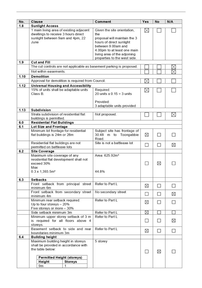
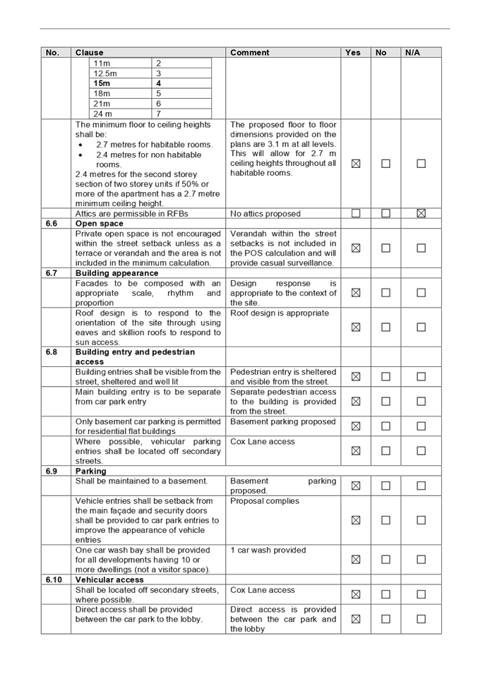
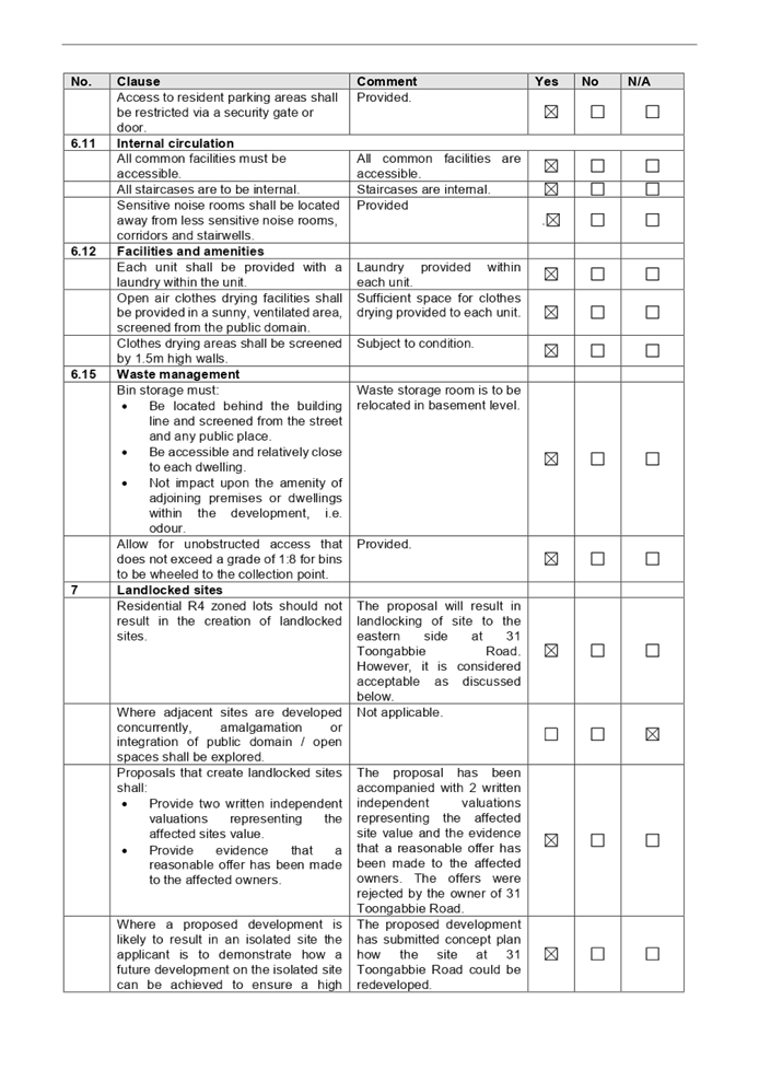
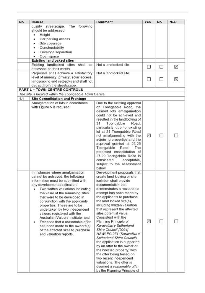
protection and management of our natural environment with the aim of
simplifying the planning rules for a number of water catchments, waterways,
urban bushland, and Willandra Lakes World Heritage Property. The changes
proposed include consolidating the following seven existing SEPPs:
· State
Environmental Planning Policy No. 19 – Bushland in Urban Areas
· State
Environmental Planning Policy (Sydney Drinking Water Catchment) 2011
· State
Environmental Planning Policy No. 50 – Canal Estate Development
· Greater
Metropolitan Regional Environmental Plan No. 2 – Georges River Catchment
· Sydney
Regional Environmental Plan No. 20 – Hawkesbury-Nepean River (No.2-1997)
· Sydney
Regional Environmental Plan (Sydney Harbour Catchment) 2005
· Willandra
Lakes Regional Environmental Plan No. 1 – World Heritage Property.
The draft policy will repeal the
above existing SEPPs and certain provisions will be transferred directly to the
new SEPP, amended and transferred, or repealed due to overlaps with other areas
of the NSW planning system.
Changes are also proposed to the
Standard Instrument – Principal Local Environmental Plan. Some provisions
of the existing policies will be transferred to new Section 117 Local Planning
Directions where appropriate.
(b) Draft
Cumberland Local Environmental Plan (Draft CLEP)
The Draft Cumberland Local
Environmental Plan (Draft CLEP) has been prepared by Cumberland Council to
provide a single planning framework for the future planning of Cumberland City.
The changes proposed seek to harmonise and repeal the three existing LEPs
currently applicable to the Cumberland local government area, those being:
· Holroyd
Local Environmental Plan 2013,
· Parramatta
Local Environmental Plan 2011, and
· Auburn
Local Environmental Plan 2010.
The current planning controls for
the subject site, as contained within the HLEP 2013 are not proposed to change
under the Draft CLEP.
The provisions of any Development
Control Plans (EP&A Act s4.15 (1)(a)(iii))
Holroyd Development Control
Plan 2013
HDCP 2013 contains general
controls which relate to all developments under Part A, Residential Controls
under Part B and Town Centre Controls under Part L.
A comprehensive HDCP compliance
table is attached to this report at Attachment 7. A summary of the DCP
non-compliances is provided in the following table.
|
No.
|
Clause
|
Proposal
|
Compliance
|
|
3.5
|
Access, Manoeuvring
and Layout
|
|
|
Driveways shall be
setback a minimum of 1.5m from the side boundary.
|
The proposed driveway
and vehicular crossing is offset 1.185m.
|
Minor non-compliance in
driveways setback is considered acceptable in this instance given that the
site is subject to nil setbacks control. The setbacks proposed will continue
to maintain sufficient sightlines for vehicular access to the basement level.
Council’s Development Engineer has reviewed the proposal and considered
it to be acceptable, subject to conditions.
|
|
6.2
|
Site Coverage
|
|
|
Maximum site coverage
of any residential flat development shall not exceed 30%
Max
0.3 x 1,393.5m² =
418.05m²
|
Area: 560m²
40.18%
|
The
amended scheme proposes to further reduce site coverage on the site and
increases landscaped area and private open spaces on the ground floor level.
Non-compliance with the site coverage is therefore considered acceptable.
|
|
6.4
|
Building Height
|
|
|
Maximum
building height in storeys shall be provided in accordance with the table
below:
4 storey
|
5 storey
|
Strict
compliance with the number of storeys permitted on the Toongabbie Road will
not be inconsistent with previously approved development, particularly on the
adjoining sites at 23-25 Toongabbie Road under DA2016/75. Non-compliance with
the number of storeys proposed is therefore considered acceptable.
The
additional height transferred to the Toongabbie Road building will not result
in detrimental environmental planning outcomes, as it does not give rise to
adverse solar access, view loss or visual or acoustic privacy impacts on
site, or to neighbouring properties given it reduces bulk to the laneway
being located on the northern side of the site.
|
|
1.1
|
Site
Consolidation
|
|
|
Amalgamation
of lots in accordance with Figure 5 is required
|
Due to the existing
approval on Toongabbie Road, the desired lots amalgamation could not be
achieved and would result in the landlocking of 31 Toongabbie Road.
|
Development
proposals that create land locking or site isolation shall provide
documentation that demonstrates a reasonable attempt has been made by the
applicants to purchase the land locked site(s), including written valuation
that represent the affected sites potential value.
Consistent with the
Planning Principle of Karavallas v Sutherland Shire Council [2004] NSWLEC
251 (Karavellas v Sutherland Shire Council), the application is
supported by an offer to the owner of the isolated property, with the offer
being based on two recent independent valuations. The offer is deemed a reasonable
offer by the Planning Principle of Karavallas v Sutherland Shire
Council.
Furthermore, the
applicant has also submitted a concept plan of how the landlocked site may be
development in the future , which has been reviewed and found to be
acceptable.
|
The provisions of any planning
agreement that has been entered into under section 7.4, or any draft planning
agreement that a developer has offered to enter into under section 7.4
(EP&A Act s4.15(1)(a)(iiia))
There is no draft planning
agreement associated with the subject Development Application.
The provisions of the
Regulations (EP&A Act s4.15 (1)(a)(iv))
The proposed development raises no
concerns as to the relevant matters arising from the Environmental Planning and
Assessment Regulations 2000 (EP&A Reg).
The Likely Environmental,
Social or Economic Impacts (EP&A Act s4.15 (1)(b))
It is considered that the proposed
development will have no significant adverse environmental, social or economic
impacts in the locality.
The suitability of the site for
the development (EP&A Act s4.15 (1)(c))
The subject site and locality is
not known to be affected by any natural hazards or other site constraints
likely to have a significant adverse impact on the proposed development.
Accordingly, it is considered that the development is suitable in the context
of the site and surrounding locality.
Submissions made in accordance
with the Act or Regulation (EP&A Act s4.15 (1)(d))
|
Advertised (newspaper)
|
Mail
|
Sign
|
Not Required
|
In accordance with Council’s
Notification requirements contained within the Holroyd DCP 2013, the proposal
was publicly notified for a period of 14 days between 14 October 2020 and 28
October 2020. The notification generated one (1) submission in respect of the
proposal with Nil disclosing a political donation or gift.
The issues raised in the public
submission are summarised and commented on as follows:
Figure
5 – Submissions summary table
|
No
|
Concern
|
Comment
|
|
1
|
Landlocking of 31 Toongabbie Road; incomplete sketch of
concept plan; burdening on 31 and 33 Toongabbie Road due to location of
laneway
|
The matter in relation to the landlocking of 31 Toongabbie
Road has been addressed in the assessment of this application in Holroyd DCP
2013 Part L. Offers based on valuation reports provided to 31 Toongabbie Road
were rejected. Council is satisfied that the application has undertaken the
steps required by Holroyd DCP 2013 including the submission of concept plan
for 31 Toongabbie Road. Should a development application be lodged to Council
for 31 Toongabbie Road, the onus is on the applicant of such development to
submit detailed architectural plans. Proposal to relocate the laneway would
require amendments to the Holroyd Development Control Plan and the relevant
process should be undertaken by the affected sites to achieve that.
Given the location of the laneway between 31 and 33, the
landlocking matter of 33 Toongabbie Road has been addressed by the assessment
of DA2015/9 for residential flat building development at 35-43 Toongabbie
Road.
|
The public interest (EP&A
Act s4.15(1)(e))
In view of the foregoing analysis
it is considered that the development, if carried out subject to the conditions
set out in the recommendation below, will have no significant adverse impacts
on the public interest.
Section 7.11 (Formerly S94)
Contribution Towards Provision or Improvement of Amenities or Services
This part of the Act relates to
the collection of monetary contributions from applicants for use in developing
key local infrastructure.
Comments:
The development requires the
payment of contributions in accordance with Holroyd Section 94 Contributions
Plans.
The calculation is based on:
· 4
x 1 bedroom + 12 x 2 bedroom + 4 x 3 bedroom, less credit for 2 x 3 bedroom =
$261,781.10.
This figure is subject to
indexation as per the relevant plan. The draft determination attached includes
a condition requiring payment of the contribution prior to issue of a
Construction Certificate.
Disclosure of Political
Donations and Gifts
The applicant and notification
process did not result in any disclosure of Political Donations and Gifts.
The development application has
been assessed in accordance with the relevant requirements of the Environmental
Planning and Assessment Act 1979, State Environmental Planning Policy No. 65,
Holroyd LEP and Holroyd DCP; and is considered to be satisfactory for approval
subject to conditions.
The proposed development is
appropriately located within the R4 High Density Zone under the relevant
provisions of the Holroyd LEP 2013. The proposal is generally consistent with
all statutory and non-statutory controls applying to the development. The
development is considered to perform adequately in terms of its relationship to
its surrounding built and natural environment, particularly having regard to
impacts on adjoining properties.
For these reasons, it is
considered that the proposal is satisfactory having regard to the matters of
consideration under Section 4.15 of the Environmental Planning and Assessment
Act 1979, and the development may be approved subject to deferred commencement
conditions.
|
1. That
the Clause 4.6 variation request to vary the Height development standard,
pursuant to the Holroyd LEP P 2013, be supported.
2. That
8.3 Review Application No. REV2020/0004 for Section 8.3 Review of the
Cumberland Local Planning Panel’s determination for the demolition of
existing structures, consolidation of 2 lots into 1 lot, and construction of
a residential flat building including a 3 storey building facing Cox Lane and
a 5 storey building facing Toongabbie Road over basement parking
accommodating 20 residential units and 25 parking spaces on land at 27-29
Toongabbie Road, Toongabbie NSW 2146 be approved subject to conditions listed
in the attached schedule.
3. Persons
whom have lodged a submission in respect to the application be notified of
the determination of the application.
|
1. Draft Notice
of Determination
2. Architectural
Plans
3. Clause
4.6 Variation Request
4. Refused
Architectural Plans
5. Previous
CLPP Minutes
6. Appendix
A - State Environmental Planning Policy No. 65 –Design Quality of
Residential Apartment Development
7. Appendix
B - Holroyd LEP 2013
8. Appendix
C - Holroyd Development Control Plan 2013
9. Redacted
Submission